SSESSMENT REPORT Prospecting Survey Gold Cutter ...
13
SSESSMENT REPORT on the Prospecting Survey of the Gold Cutter ProDem (NABA 1 to 4 Mineral Claims) Bonaparte Lake Ares KAMLOOPS MINING DMSION NTS 92PI8E & W, 92PllE & W Latitude 51 14 15.1 N Longitude 120 15 42.6 W BY Ron Bilquist September 2003
-
Upload
khangminh22 -
Category
Documents
-
view
1 -
download
0
Transcript of SSESSMENT REPORT Prospecting Survey Gold Cutter ...

SSESSMENT REPORT
on the
Prospecting Survey
of the
Gold Cutter ProDem
(NABA 1 to 4 Mineral Claims)
Bonaparte Lake Ares
KAMLOOPS MINING DMSION
NTS 92PI8E & W, 92PllE & W
Latitude 51 14 15.1 N Longitude 120 15 42.6 W
BY
Ron Bilquist
September 2003

TABLE OF CONTENTS
Page
1.00
2.00
3.00
4.00
c)
5.00
6.00
7.00
1
INTRODUCTION 1.10 Location and Access 1.20 Property 1.30 Physiogmphy 1.40 History of Exploration 1.50 Purpose of survey
GEOLOGY 2.10 Regional Geology 2.20 Property Geology 2.30 Mineralimtion
PROSPECTING SUMMARY
CONCLUSIONS
REFERENCES
STATEMENT OF EXPENDITURES
AUTHORS QUALIFICATIONS
Analysis
2 2 2
APPENDIX
2. Sample Descriptions
LIST OF ILLUSTRATIONS
Figure 1.
Figure 2.
Figure 3.
Figure 4.
Location Map after page 1
Regional Geology atIer page 2
Sample Locations (Au and Ag values) in pocket
Property Geology (with traverses) in pocket

1 .O INTRODUCTION Page 1
This report describes the results of the prospecting survey performed on the Gold Cutter property (NAHA 1 - 4, two-post claims) during August 2002. The property is situated north of Kamloops and south west of Little Fort in the Thompson Plateau.
1.10 Location and Access
The Gold Cutter 1 - 4 claims are located approximately 10 kilometers north west of the village of Barrier, B.C. in theKanloops Mining Division (Fig 1). The claims are centered near 51 14 15.1 N Latitude and 120 15 42.6 W Longitude on NTS reference maps 92P/8W & SE and 92PllW & 1E.
Access to the property is via highway 5, north from Kamloops, to Dariield, then a further 10 kilometers south westerly along a network of gravel surfaced forest service roads.
1.20 Properly
The NAHA 2-Post claims consist of (4) 2-post claims as listed below and as illustrated on the map within (Fig. 2).
Claim Name Tenure Number
NAHAl 395529 NAHA 2 395530 NAHA 3 395531 NAHA 4 395532
Record Date
July 20, 2002 July 20,2002 July 20, 2002 July 20,2002
1.30 Physiography
The topography of the claims is generally moderate. Elevation is about 1200 meters. The majority of the claims are covered in second growth fir and cedar Glacial outwash is abundant with occasional till exposed in some areas.
The climate is moderate, with the summers generally hot and dry. In winter snowfalls may reach 1 - 2 meters with temperatures rarely reaching -25 degrees Celsius.
1.40 History of Exploration
The regions surrounding the North Thompson river north of Kamloops have been the focus of sporadic exploration over the years, dating back to the late 1800’s. Placer gold has be found in some tributaries to the North Thompson. In recent years access has improved dramatically due to increased logging activity. The Minfile database reference for this includes a number of occurrences. More recently in the early 1980’s prospecting followed by a geochemical survey and diamond drilling were performed on the area. The results of this work are outlined in assessment reports 9381 and 10802 and a capsule comment with references can be found in I&file # 092HNE2 10.
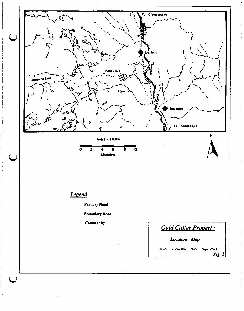
To Kamloops
- 0 2 4 6 8 Id
Klbrrcn
LeEend
Primary Road
Secooduy Road
Community
I Gold Cutter Prouertv

0 Page 2 1.50 Purpose of sulvey
The claims were staked to cover an area where mineralized float boulders with values in gold were discovered. Prospecting was designed to try locate the source of these boulders.
2.0 GEOLOGY
2.10 Regional Geology
The geologic setting for the area within which this report is focused can be found in Minlile (Fig 2). More detailed, and in depth, descriptions can be found in a number of government publications including; Geological Survey of Canada Memoir 363, R. B. Campbell and H. W. Tipper, 1971 and Open Fide 2002-4, Geology of the Nehalliston Plateau, P. Schiarizza, S. Israel, S. Heffeman, J. Zuber, 2002.
Regionally, the Gold Cutter area (Naha I to 4) is underlain by metasediimentay rocks of the late Paleozoic Harper Ranch Group, which include limestones, siltstones, shales, volcaniclastic sandstones and local volcanic rocks, and volcanic rocks of the Eocene Skull Hill Formation (Ramloops Group). The Skull Hill Formation is composed of dacite, tmchyte, basalt, andesite, rhyolite and related breccias (Geological Survey of Canada Memoir 363). The metasedimentary rocks are intruded by Mesozoic (?) age granites, diorites and syenites.
2.20 Property Geolom
Lb
The majority of the claim area is covered with outwash and till overburden; however, there are suflicient rock outcroppings on the property to provide a limited picture of the geology. The quartz veins and quartz stockworks are hosted predominately in syenites and, very rarely, granites and diorites. The intnrsives appear to intrude homfelsed and intensely pyritized sediments although no contacts were seen. There is minor chlorite alteration proximal to the quartz veins and stockworks with ‘ratty’ chloritized biotites and occasional epidote. The veins and stockworks are near vertical and generally trend in a southerly or south east direction.
2.30 Mineralization
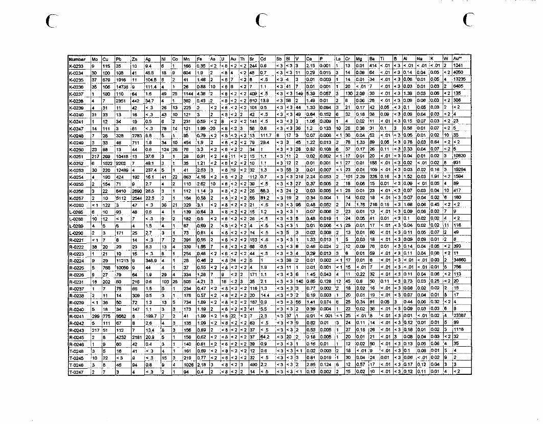
The mineralization in the veins includes coarse galena with mte and minor sphalerite and chalcopyrite Values. A total of 64 samples were analyzed by ICP with the majority anomalous in gold. Ten of the samples returned gold values greater than 10,000 pph with a high of 34,660 ppb. Silver values were coincidently high with five over 100 ppm and a high of 348.9 ppm.
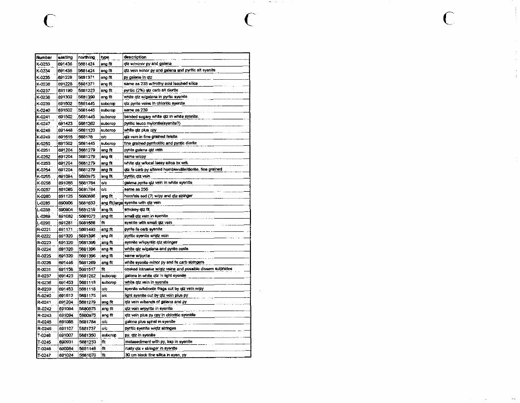
3.0 PROSPECTING SUMMARY
The discovery of hvo clusters of large (to 1 ton) angular sulphide bearing quartz boulders along a newly constructed logging road initiated the staking of the NAHA 1 to 4 two post mineral claims and subsequent prospecting of this area. A four man-day prospecting survey was carried out on the claims. 45 rock samples were taken and three soil geochemistry lines were run over the discovery area.
At the first cluster of quartz boulders, where the original discovery was made, it was noted that the apparent host rocks for most of the quartz float appears to be a white syenite and rarely a fine to medium diorite. A small outcropping of syenite was located in a ditch close to the “discovery” quartz boulders. The outcrop
CI!
has small, approximately 1 cm. wide, quartz stringers with occasional galena. The quartz stringers trend approximately the same direction as the road, which runs about 070 degrees. Values t?om six samples ran

DTrm
N hk1:loO+XNl
oi 5 LLlhrccn A
LePena
w TWtilWy Quaternary alluvial deposits
Ekv CelUWiC F,ocene volcanicr
DTrm upper Pdcozoii Devoniao metamorphic sediments
DTrv Upper Pakozoic Dwooian volcanic3 (layered)
PPFv Upper Pakazaic Permian vokaoics
TrJgd Mesozoic Upper Triassic-Lower Jurassic gt%ndiirite
Trhy Mesozoic Upper Triassic-Lower Jurassic syenite

u Page 3.
between 306 ppb and 13235 ppb gold with accompanying elevated silver values. Galena was present in half the samples but not always in samples with high gold values.
Detailed prospecting was carried out at the second cluster of angular boulders to determine if they were proximal and if they were derived from the same vein as the first cluster. Although no quartz vein bearing outcrops were found at this location it was concluded that the source is very close due to the fact that there are 20 to 25 very angular boulders within about 40 meters along the road. Some of the boulders appear to be in a” outwash. Values in gold from the eight samples taken are generally higher than those at the first cluster. Gold values ranged from 736 ppb to 34,660 ppb with five over 10,000 ppb with one isolated low gold of I35 ppb. Silver values were also coincidently high with the gold. Galena, and occasionally chakopyrite, was more evident in this cluster suggesting perhaps these boulders are derived from a second quartz vein.
The prospecting traverses in the northern area of the claims resulted in the discovery of a zone of quartz veins, veinlets and stockworks hosted in a medium grained white syenite. The system appears to trend approximately north south and could be traced over a” area of about 20 meters by 50 meters and is lost in overburden on ail sides. Occasional galena and sphalerite was noted. One sample gave a” elevated gold value of 417 ppb with 26.5 ppm silver.
There is considerable overburden in the southern area of the claims and it is hard to distinguish between what are large boulders and outcrop. One large quartz vein was located in place near the southeast comer of the claims. The vein trends in a northwesterly direction and could be traced for more than 300 meters. No samples were taken from this vein.
4.0 CONCLUSIONS
I. The angular quartz float is likely proximal and derived from a source, or sources, within the claim boundary.
2. Due to the difference in rock geochemistry, the two quartz float clusters likely represent two different quartz vein sowces.
3. If there are two sources for the anomalous boulders, the” there are at least four areas that need follow up work-the northern quartz veinIet/vein/stockwork system, the southern large quartz vein and the two separate discovery clusters.
5.0 REFERENCES
R. B. Campbell and H. W. Tipper, (1971) Geological Survey of Can& Memoir 363
P. S&i&, S. Israel, S. He&man, and J. Zuber, (2002) Open File 2002-4. Geology of fhe Nehalliston Plateau
Energy and Mine$ Government of B.C. Minfile

6.0 STATEMENT OF EXPENDITURES
Ron Bilquist - 4 days @ $250/day (Aug 4, 10, 11 and Ott 01,2002)
Kelly Bilquist - 3 days @ %200/day (Aug 4,9, and 10,2002)
Les Allen - 3 days @ $25O/day
Fuel
Meals/Groceries
Lodging
Page 4.
$1000.00
$600.00
$750.00 $2350.00 $2350.00
$169.82
$281.81
$148.35
Total $2949.98

Page 5,
7.0 AUTHORS QUALIFICATIONS
I have worked full time in the mining exploration business for a period of 33 years. During this time I have been self-employed as a prospector as well as employed by nwnerow exploration companies on both salary and contract basis. My duties have included prospecting, trenching, trench mapping, drilling and blasting, claim staking, line cutting, geochemical surveys, geophysical surveys, diamond drilling and drill supervision, geological draughting and research.
I have Mitten an exam to qualify as a prospector for the Department of Mines and Petroleum Resources. This exam took place at the department office in Nanaimo in 1975 and was supervised by W. C. Robinson, P. Eng.
In 1992 I successt%lly completed the Pefro&yfor Pnxpec~ors Course sponsored by the Ministry of Energy, Mines and Petroleum Resources: course instructor T. A. Richards, Ph.D.
Signed Ronald J. Bilquist
Dated at Gabriola, B.C. this 15” day of October, 2003
c‘ c
137 1679 jl916 111 141 Il.46 12 / C8 7 1 / c2 8 / e.5 c34 3 1 jO.01 10.003 11 114 IO.01 134 I<.01 I<3 IO.08 IO.01 IO.05 14 113235
IK-0249 b-133 1461711 Il.8 134 /IO 1454 jl.9 12 <6<2C279 29.4 ] 1 j 1 -=3 3 I 145 II.22 IO.013 12 178 Il.33 189 jO.05 jc3/0.76 IO.03 10.64 1~21~2 KU250 238B 13 44 0.6 124 26 76 3.3 <2 X8 <2 2 34 1 ~3 <3 28 0.82 0.108 6 37 0.17 26 0.11 +3 0.33 0.04 0.07 <2 5 K-0251 217 299 10418 13 37.6 3 1 28 0.91 <2 c* 11 c2 15 1.1 <3 11 2 0.02 0.002 z 1 17 0.01 20 c.01 c3 0.04 0.01 0.02 3 10820 K-0252 cl522 9202 7 49.1 3 1 35 1.21 s2 C8 c2 c2 10 1.1 <3 12 2 001 0.001 cl 27 0.01 188 c.01 ~3 0.02 c.01 0.02 8 931
z-0253 ,30 ,220 ,I2489 <4 ,237.4 5 ,3 ,41 ,253 ,3 ,cS,lS ,=2,32 ,I.3 *365 3 0.01 0.037 cl 23 0.01 109 ~01 ~3 0.03 0.02 016 3 19294
1 12 I3 jl71 125 12.7 13 11 173 IO.61 14 1~8 1~2 1~2 114 lc.5 lc3 15 13 IO.02 jO.w8 12 113 /O.Ol 160 I<.01 1~3 /O.ll lo.05 IO.07 12 149
111 1309 10.5 13 1 jl 178 0.57 c2 48 c2 c2 x) 14.4 <3 c3 2 j lo.19 I0.003 11 120 lo.01 119 lc.01 /c3 IO.07 10.04 IO.01 15 117 R-0239 1 <I36 50 72 11.3 13 5 734 1.89 142 c8/<2jC2 167 10.9 c3 <3 55 1.41 0.074 6 25 0.34 61 0.03 3 0.44 0.06 0.32 c2 4 R-0240 15 18 34 147 1.1 3 3 173 II.19 12 ~8 /=2 jC2 41 j-5.5 c3 <3 I 2 lo.39 lo.aJ4 1 I 22 I 0.02 38 c.01 ~3 0.09 0.03 0.03 6 8 R.024, 1299 775 8662 8 /I897 7 2 41 j l.ES c2 ‘8 22 C-L 7 12.3 c337 1 0.0, ~001 cl 25 ~01 j 8 jc.01 (c3 lo.01 /C.Ol /om 14 123367
IR&'42 -[5 jl l l 167 18 12.6 14 13 1 135 1.09 <2 <8 c2 c2 63 x.5 c3 <3 9 / IO.62 10.01 13 124 IO.11 /I4 jc.01 (<3/0.12 j0.M IO.01 15 193 I
0.08 0.04 0.03 42 32
/I6 /<.3 14 II /ISI jO.89 /<2 1<81<2/52/12 IO.6 / 43 c3 Cl 1 1 0.02 0.m 2 / I18 I<.01 19 / 4 .Ol <3 0.1 jo.08 IO.01 15 I < .3 115 13 / 219 0.77 ~2 ~8 e2 ~2 32 s.5 <3 <3 j 3 /0.81 IO.019 11 130 IO.04 124 /O.Ol /c3 /O.W (c.01 /OM 1'3 12
T-0246 13 18 146 194 / 0.8 9 14 11028 2.18 13 1 C8 / e2 I 3 1 490 (2.2 <3 43 2 2.85 0.124 6 12 0.57 17 ~01 ~3 0.17 0.12 0.04 3 3 I? I" OM <"I <3 01, or, <2
c
-.