Ecosystem Conservation and Management: The Concept of Large Marine Ecosystem

S
Ma
b
c
a
ARR2A
KUESELG
1
bekhtselaeuif
1d
Ecological Indicators 15 (2012) 122–130
Contents lists available at SciVerse ScienceDirect
Ecological Indicators
jo ur n al homep ag e: www.elsev ier .com/ locate /eco l ind
patial distribution of urban ecosystem health in Guangzhou, China
eirong Sua,∗, Brian D. Fathb,c
State Key Joint Laboratory of Environment Simulation and Pollution Control, School of Environment, Beijing Normal University, Beijing 100875, ChinaBiology Department, Towson University, Towson, MD 21252, USADynamic Systems Program, International Institute for Applied Systems Analysis, A-2361 Laxenburg, Austria
r t i c l e i n f o
rticle history:eceived 22 March 2011eceived in revised form6 September 2011ccepted 29 September 2011
eywords:rban ecosystem healthmergy-based ecological indicatorspatial distributionmergyand useuangzhou, China
a b s t r a c t
Methods and indicators are needed to assess the urban ecosystem health status, amongst which energyand material metabolism should be integrated to enhance understanding of ecological patterns and pro-cesses of urban ecosystems. Therefore, emergy synthesis combining energetics with systems ecologyis applied to assess systematically the health status of urban ecosystems. Combining ecosystem healthlevels with spatial geographical information of different land use subsystems, the spatial distribution ofurban ecosystem health is obtained, which is helpful for urban ecological regulation and spatial optimiza-tion. Taking the situation of Guangzhou, China in 2005 as a case study, the relative health states based onemergy indicators and set pair analysis is evaluated. Results show that the health levels of the cultivatedland, as well as areas with middle and low density buildings are relatively positive, while that of highdensity building and traffic areas are relatively weak. Through analysis of different land use subsystems,required factors of a healthy ecosystem are summarized, including moderate economic productivity butwithout much exploitation and disturbance, reasonable structure of energy and resources usage, mediumresilience under pressure, moderate ecosystem service provisioning, and small environmental impact onsurroundings. The spatial distribution of urban ecosystem health states is also obtained, such that the
northern part of Guangzhou is defined as the conservation area, the middle and southern parts are definedas the maintenance area, while the south central and south western parts are defined as the key regula-tion area where a suitable scheme should be implemented to control the population density and resolvethe concomitant problems. Moreover, the impact power of different indicators on the final health statusis classified into five levels when combining the indicator weights with the main assessment factors ofurban ecosystem health, which is useful for defining the regulation priority amongst a few indicators.. Introduction
Contributing to the simple but impressive theme “better city,etter life” stated by the Expo 2010 Shanghai, the issue of urbancosystems has been highlighted again, raising the question of whatind of city is desirable for high life quality. The dominant paradigmas stressed the maximum economic output as the most impor-ant target when evaluating the performance of socio-economicystems. In the past, people moved to cities because they gen-rally believed that they can get more wealth and enjoy higheriving standard in urban areas than rural areas. However, it waslso gradually apparent that those basic and essential demands, e.g.,njoying blue sky, clean water, beautiful grass, could not be met in
rban areas, although economic development had indeed broughtncreasing production and personal wealth. Humans have multi-aceted desires, e.g., clean environment, social contact, mental and
∗ Corresponding author. Tel.: +86 10 5880 0397; fax: +86 10 5880 0397.E-mail addresses: [email protected], [email protected] (M. Su).
470-160X/$ – see front matter © 2011 Elsevier Ltd. All rights reserved.oi:10.1016/j.ecolind.2011.09.040
© 2011 Elsevier Ltd. All rights reserved.
recreational enjoyment, status, and convenience, to name a few,and therefore, expect more than simply economic development. Amethod of analyzing urban systems in a holistic way, through whichmultiple factors including economic, societal and ecological itemscan be integrated, needs to be developed. Amongst many conceptsof describing urban ecosystems comprehensively, urban ecosys-tem health, which means the urban ecosystem’s integrated state,conditions or ability of satisfying reasonable human demand andrenewing and maintaining the ecosystem itself, is a typical and wel-come one since it links the essential social, economic, and humanhealth aspects and provides grounds for integrated environmentalmanagement (Rapport et al., 1998).
No matter where the city is located, in Asia, Europe, the Ameri-cas, Australia, or Africa; no matter what is the city’s socio-economicdevelopment situation, developing or developed; no matter whatis the city’s future planning, political, economic, or cultural ori-
entation, resource flows support the urban ecosystem. Energyand material metabolism are the essential driving force of urbanecosystem development. To comprehensively describe the urbanecosystem health status, various flows of energy and material in the
l Indic
urtfsfcaocJ2emssmodca
eocribaebrAotc
fha
M. Su, B.D. Fath / Ecologica
rban ecosystem need to be systematically integrated, so that theesource endowment of the urban ecosystem, the components andheir linkages represented by energy and material flows within dif-erent subsystems, and the urban ecosystem’s interaction with theurroundings can be characterized with respect to the biophysicaloundation. Therefore, the emergy synthesis method (Odum, 1983)ombining energetics with systems ecology is selected as a usefulpproach of measuring different flows in a common unit. Basedn the research integrating emergy synthesis into urban ecologi-al economic evaluation (Brown and Ulgiati, 2004; Cai et al., 2009;iang et al., 2009; Lan and Odum, 1994; Lee et al., 2009; Lei et al.,008; Liu et al., 2009; Lu and Campbell, 2009; Lu et al., 2003; Ulgiatit al., 2011; Zhang et al., 2009, 2011), the related theoretical andethodological development for emergy-based urban ecosystem
tudy can be further applied and expanded. Regarding the emergyynthesis as a helpful evaluation tool, the emergy-based assess-ent framework for urban ecosystem health was established in
ur earlier study (Su et al., 2009), in which the health states ofifferent urban ecosystems were compared by related emergy indi-ators when the whole urban ecosystem was regarded as the basicssessment unit.
Urban ecosystems can be analyzed from many different lay-rs with each analysis providing a special understanding from itswn viewpoint, e.g., a global city influencing world economy andulture, a capital dominating national politics, a regional center rep-esenting the local characteristics. In addition, the urban ecosystemtself also has its function. When regarding urban subsystems as aasic unit, this study will provide new ground for understandingnd managing of urban ecosystems. The health states of differ-nt urban subsystems are evaluated and compared in this papery selected emergy-based health indicators, through which theelationships amongst different subsystems can be investigated.ccording to the health assessment results, the spatial distributionf urban ecosystem health, which is useful for spatial optimiza-ion and ecological management, can be further acquired whenombining with spatial analysis techniques like GIS.
Any research encompassing urban ecosystem health must alsoace the uncertainty and relativity of the study. On one hand, aealth evaluation will vary with the changing human preferencesnd expectations for urban ecosystems (Odum, 1989; Su et al.,
Fig. 1. Procedure of emergy-based ecosystem healt
ators 15 (2012) 122–130 123
2010). On the other hand, urban ecosystem health itself is a mani-festation of process and orientation rather than a steady state (Suet al., 2010). Considering the uncertainty and relativity of urbanecosystem health, set pair analysis is applied in this paper to con-duct the data processing of emergy-based indicators. Based on thisapproach, the relative health states of urban subsystems can becompared.
2. Methodology
2.1. Emergy-based health indicators for urban land usesubsystems
There are a few standard ways for dividing an urban ecosys-tem into different subsystems, amongst which land use patternis selected in this paper, since it can reflect the economic devel-opment mode and affect the allocation of energy and resources.Also, it allows for easier subsystem boundary confirmation, whichis required for emergy synthesis (Huang et al., 2011). The urbanecosystem health evaluation and the health’s spatial distributionare then conducted when regarding the land use subsystems as thebasic units.
Two objectives are important for urban ecosystem healthassessment, (1) measuring the health status and (2) giving sug-gestions for practical urban management based on the researchresults. The chosen emergy-based indicator is a well-suited toolfor connecting theory with actual urban management, due to itslinkage characteristics (Müller and Lenz, 2006).
According to the emergy-based evaluation framework for urbanecosystem health assessment (Su et al., 2009), emergy synthesisis conducted at the scale of land use subsystems step-by-step. Asshown in Fig. 1, it includes establishing the subsystem boundaries,collecting data (e.g., renewable resources, nonrenewable resources,the import and export situations, etc.) to analyze the emergy flows,drawing the emergy flow diagram, creating an emergy synthe-sis table to summarize the main resource and economic flows
(Using the cultivated land subsystem in Guangzhou as an example,the main items are displayed in Table 1), and finally, calculatingemergy-based indicators to describe the health status of the landuse subsystem.h assessment for urban land use subsystems.
124 M. Su, B.D. Fath / Ecological Indicators 15 (2012) 122–130
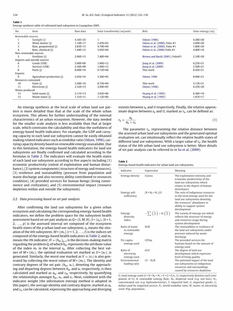
Table 1Emergy synthesis table of cultivated land subsystem in Guangzhou 2005.
No. Item Raw data Solar transformity (sej/unit) Refs. Solar emergy (sej)
Renewable sources1 Sunlight (J) 4.38E+20 1 Odum (1996) 4.38E+202 Wind, kinetic (J) 1.10E+17 2.45E+03 Odum et al. (2000), Folio #1 2.69E+203 Rain, geopotential (J) 3.83E+15 4.70E+04 Odum et al. (2000), Folio #1 1.80E+204 Rain, chemical (J) 1.44E+12 3.05E+04 Odum et al. (2000) Folio #1 4.40E+16
Non-renewable sources5 Fertilizer (J) 2.96E+15 7.40E+04 Brown and Bardi (2001), Folio#3 2.19E+20
Imports and outside sources6 Goods (US$) 5.90E+09 1.06E+12 Jiang et al. (2009) 6.25E+217 Services (US$) 2.36E+09 1.06E+12 Jiang et al. (2009) 2.50E+218 Fuels (J) 8.69E+16 9.72E+04 This work 8.45E+21
Exports9 Agriculture production (J) 2.65E+16 3.36E+05 Odum, 1996 8.90E+21
Resources consumed10 Fuels (J) 3.58E+16 8.75E+04 This work 3.13E+2111 Electricity (J) 2.32E+15 2.69E+05 Odum (1996) 6.25E+20
tecfseimrtsfoeb(wcnd
2
eia2hacmrougecictita
different land use subsystems. With a larger value of rk, the healthstatus of the kth urban land use subsystem is better. More detailsof set pair analysis can be referred to in Su et al. (2009).
Table 2Emergy-based health indicators for urban land use subsystems.
Indicator Expression Meaning
Emergy density U/area The exploitation intensity andeconomic productivity of theland use subsystems whichrelates to the degree of humandisturbance
Emergy self-sufficiency
(R + N0 + N1)/U The ratio of indigenous resourcesto the total emergy used for theland use subsystems denotingthe resources’ abundance orability to support systemdevelopment
Emergydiversityindex
−∑(
UiU
)× ln
(UiU
)The variety of emergy use whichreflects the structure of energyand resources usage duringsystem development
Ratio of wasteto renewableemergy
W/R The renewability or resilience ofthe land use subsystems underpressure induced by wastedischarge
Per capitaemergy used
U/Pop The provided services forhumans based on the amount ofemergy used
Ratio ofelectricityemergy used
el/U The degree of land usedevelopment which expresseslevel of living quality
Environmentalloading ratio
(U − R)/R The potential impact of the landuse subsystems on indigenousresources and surroundingscaused by resources depletion
Waste produced12 Solid waste (J) 2.11E+13 3.02E+0613 Waste water (J) 1.31E+11 1.12E+06
An emergy synthesis at the local scale of urban land use pat-ern is more detailed than that at the scale of the whole urbancosystem. This allows for further understanding of the internalharacteristics of an urban ecosystem. However, the data neededor the smaller scale analysis is less available than that at largercale, which constrains the calculability and thus the usefulness ofmergy-based health indicators. For example, the GDP and carry-ng capacity in each land use subsystem cannot be easily obtained
aking related indicators such as emdollar ratio (Odum, 1996), car-ying capacity density based on renewable emergy unavailable. Dueo this limitation, the emergy-based health indicators for land useubsystems are finally confirmed and calculated according to theormulas in Table 2. The indicators will evaluate the health statesf each land use subsystem according to five aspects including (1)conomic productivity (extent of exploitation and human distur-ance), (2) system components (structure of energy and resources),3) resilience and sustainability (pressure from population andaste discharge and also recovery ability contributed to resources
ondition), (4) provided services for human beings (living conve-ience and civilization), and (5) environmental impact (resourceepletion within and outside the subsystem).
.2. Data processing based on set pair analysis
After confirming the land use subsystems for a given urbancosystem and calculating the corresponding emergy-based healthndicators, we define the problem space for the subsystem healthssessment based on set pair analysis as Q = {S, M, H}, S = {sk}. (k = 1,, . . ., p) is the assessed interval set composed of the ecosystemealth states of the p urban land use subsystem, sk means the situ-tion of the kth subsystem; M = {mr} (r = 1, 2, . . ., l) is the indices setomposed of the emergy-based health indicators in Table 2, and mr
eans the rth indicator; H = (hkr)p×l is the decision-making matrixegarding the problem Q, of which hkr represents the attribute valuef the index mr in the interval sk. After collecting the best val-es of M = {mr}, the optimal evaluation set marked as U = {ur}, isenerated. Similarly, the worst one marked as V = {vr} is also gen-rated by collecting the worst values of M = {mr}. The identity andontrary degrees of the set pair {hkr, ur}, denoting the approach-ng and departing degrees between hkr and ur respectively, is thenalculated and marked as akr and ckr respectively, by quantifying
he relationships amongst hkr, ur, and vr . Next, combined with thendicator weight (the information entropy method is adopted inhis paper), the average identity and contrary degree, marked as aknd ck, can be calculated, expressing the approaching and divergingHuang et al. (1995) 6.38E+19Huang et al. (1995) 1.47E+17
extents between sk and U respectively. Finally, the relative approx-imate degree between sk and U, marked as rk, can be defined as:
rk = ak
ak + ck(1)
The parameter rk, representing the relative distance betweenthe assessed urban land use subsystems and the generated optimalevaluation set, can intuitionally reflect the relative health states of
U, total emergy used (U = R + N0 + N1 + F + G + P2I3, Ui respectively denotes each com-ponent of U); R, renewable emergy flow; N0, dispersal rural (e.g. soil loss); N1,concentrated use (e.g. hydroelectricity); F, imported fuel; G, imported goods; I3,dollars paid for imported service; P2, world emdollar ratio; W, waste; el, electricityused; Pop, population.

l Indicators 15 (2012) 122–130 125
2h
tuaabibbds
2h
wugtewte(tiaahfsmpt
2
cPiteiapMpawG
Fig. 2. Location of Guangzhou, China.
Table 4The value of emergy-based health indicators of Guangzhou 2005 and the indicatorweight.
Indicator Value (The cultivatedland subsystem)
Weight
Emergy density (1E+19 sej/km2) 1.08 0.2073Emergy self-sufficiency 0.54 0.0209Emergy diversity index 1.14 0.1229Ratio of waste to renewable emergy 0.15 0.1741Per capita emergy used (1E+14 sej) 4.50 0.1235
TL
Nt
M. Su, B.D. Fath / Ecologica
.3. Representation of the spatial distribution of urban ecosystemealth
Based on the interpretation of land use remote sensing images,he land use map showing the spatial distribution of different landse patterns is corrected and updated by referring to maps asdministrative area map, zoning map, or landforms map, as wells on-the-spot investigation. The land use map takes the role of thease map of the forthcoming health status distribution. By obtain-
ng the health assessment results of different land use subsystemsased on emergy synthesis and set pair analysis, the spatial distri-ution of the relative urban ecosystem health status can be visuallyisplayed. These results contribute to the further discussion of thepatial optimization of the urban ecosystem.
.4. Impact levels of different indicators on urban ecosystemealth
Odum and Barrett (2009) described an energy hierarchy inhich energy is transformed and concentrated from many scalednits into a fewer number of higher-level types of energy with areater ability to interact with and control smaller units. Whereashe energy hierarchy is a basic principle for systems ecology, differ-nt indicators also have different impacts on the assessment resultshich are described as the impact gradient. In fact, the informa-
ion entropy weight adopted in this paper, which is determined byach index’s differentiation ability for different assessed objectivesfor detailed formula refer to Su et al., 2009), denotes the indica-ors’ impact power on the final assessment results. Based on thendicator weight values, the software data processing system (Tangnd Feng, 2007) is applied to conduct the preliminary sequencingnd grading for the indicators’ impact power on urban ecosystemealth. Next, by classifying each indicator into their assessment
actors (economic productivity, system components, resilience andustainability, provided services for human beings, and environ-ental impact), the preliminary grading for the indicators’ impact
ower on urban ecosystem health can be modified at the scale ofhe aggregate factors.
.5. Study site
The methods and procedure described above were applied to aase study of Guangzhou, a city located in south central Guangdongrovince, China (Fig. 2). Note that in China a “city” is an admin-strative area that encompasses the dense urban core as well ashe surrounding countryside. This extends the concept of urbancosystem health to also include some of the surrounding support-ng ecosystem services. In this specific case, Guangzhou, with anrea of 7434.4 km2, is a modern metropolitan region which sup-orts a population over 7.8 million (2008 data from Guangzhouunicipal Statistics Bureau, 2010). It has abundant water resources,
lentiful minerals (granite, ceramic clay, salt mine, marble, etc.),s well as ample fruit, vegetables, flowers, aquatic products andild animals. It is the political, economic, and cultural center ofuangdong Province and serves as a commercial, financial, and
able 3and use system of Guangzhou 2005 (Unit: km2).
Pattern Forest Grassland
Area 2470.05 2108.10
Pattern Low density building Middle density bu
Area 609.06 304.53
ote: Low density building (plot ratio ≤1); middle density building (1< plot ratio ≤6); highe urban built-up area and residential area.
Ratio of electricity emergy used 0.04 0.1346Environmental loading ratio 3.98 0.2168
information center in South China. Its socio-economic status wascharacterized by US $ 119.3 billion in 2008 with a growth rate of16.1 percent. The annual per capita disposable income of urbanresidents amounted to US $ 3645.7 with a growth rate of 12.7 per-cent (Guangzhou Municipal Statistics Bureau, 2010). A 2005 landuse study identified nine coexisting patterns (Table 3 and Fig. 3)arising from the dynamic interplay of human activity and naturalprocesses.
3. Results
3.1. The relative health states of different urban land usesubsystems
Based on the values of the emergy-based health indicators(choosing the cultivated land subsystem as an example, the indi-cators’ values are listed in Table 4) and the subsequently acquired
Wetland Cultivated land River
881.91 1653.06 773.21
ilding High density building Traffic area
152.27 379.02
h density building (plot ratio >6); and all of these buildings are basically located in

126 M. Su, B.D. Fath / Ecological Indicators 15 (2012) 122–130
p of G
wssctrsc
TR
Fig. 3. Land use ma
eight of each indicator based on the information entropy method,et pair analysis is used to quantify and compare the healthtates of the nine urban land use subsystems in Guangzhouity. The final results are shown in Table 5 and Fig. 4. In ordero understand the health assessment results more clearly, the
elative health states of different land use subsystems are clas-ified into five levels as shown in Table 6 (the first and secondolumns).able 5elative health states of nine land use subsystems in Guangzhou.
Value Forest Grassland Wetland Cultivated land River Low dens
ak 0.4125 0.3735 0.3947 0.1171 0.2936 0.2712
ck 0.4357 0.4023 0.3810 0.0510 0.3707 0.1966
rk 0.4863 0.4814 0.5088 0.6969 0.4420 0.5798
uangzhou for 2005.
3.2. Spatial distribution of urban ecosystem health
The five levels of emergy-based health states are overlaid onthe land use maps of Guangzhou to show the spatial distribu-tion of ecosystem health (Fig. 5). Areas in the middle and south of
Guangzhou, i.e., the cultivated land, middle and low density build-ings (colored tawny and purple), have relatively high health levels.The south central and southwest regions of high density buildingity building Middle density building High density building Traffic area
0.3929 0.3531 0.20980.3357 0.5116 0.17310.5393 0.4084 0.5479

M. Su, B.D. Fath / Ecological Indicators 15 (2012) 122–130 127
Table 6The health levels of nine land use subsystems in Guangzhou using emergy-based health indicators and related characteristics of each subsystem.
Heath levels Land use subsystems Economic productivity/exploitation extent
Components and structure Resilience underpressure
Provided ecosystemservice
Environmentalimpact
I Cultivated land Certain Medium energyself-sufficiency and highenergy diversity
Medium Medium Small
II Middle densitybuilding, Low densitybuilding
High Low energy self-sufficiencyand relative high energydiversity
Low Very Large Big
III Forest, Wetland,Grassland, River
Low High energy self-sufficiencyand low energy diversity
High Some Very small
IV Traffic area Relative high Medium energyself-sufficiency and relativehigh energy diversity
Relative low Large Big
V High density building Very high Low energy self-sufficiencyive hig
Very low Huge Huge
awh
fitshflibtGfs
3
dfi
((i((
Fese
and relatdiversity
nd traffic have relatively low ecosystem health levels (coloredine and orange), while the northern regions exhibit mediumealth status (colored green).
Energy and material usually flow from natural areas (includingorest, wetland, grassland, and river) to constructive areas (includ-ng cultivated land, middle and low density buildings) and theno highly developed areas (including traffic areas and high den-ity building), during which energy gradually possesses higher andigher quality. It can be roughly concluded that along the energyowing from forest, wetland, grassland, and river (mainly located
n north Guangzhou) to cultivated land, middle and low densityuildings (mainly located in middle and south Guangzhou) then toraffic area and high density building (mainly located in southwestuangzhou), the health levels of the land use subsystems first rise
rom north to middle and south, and then drop from middle andouth to southwest.
.3. Impact levels of different factors on urban ecosystem health
Based on the indicator weight (see Table 4), the impact power ofifferent factors on the final assessment results are classified intove levels by using software data processing system that considers
(i) environmental loading ratio and emergy density,
ii) ratio of waste to renewable emergy,ii) ratio of electricity emergy used,iv) per capita emergy used and emergy diversity index, andv) emergy self-sufficiency.ig. 4. Relative health levels of nine land use subsystems in Guangzhou usingmergy-based health indicators (rk denotes the relative distance between the healthtate of kth assessed urban land use subsystem and that of the generated optimalvaluation set).
h energy
Considering the five assessment factors of urban ecosystemhealth, the impact levels of different indicators on the final healthresults are slightly modified. Choosing the indicator “emergy diver-sity index” in the fourth rank as an example, it is moved into thefifth rank in that it belongs to the same assessment factor “compo-nents and structure” as the indicator “emergy self-sufficiency” inthe fifth rank. As shown in Fig. 6, the impact power of indicatorsis finally graded into five levels, in which the order from high tolow is the factor of environmental impact, economic productivity,resilience, provided human service, and system components andstructure.
4. Discussion
4.1. Analysis of different urban land use subsystems
What induces different health levels of these land usesubsystems? Considering the representative meanings of theemergy-based health indicators as well as the practical require-ment of urban management, the performance of differentsubsystems is summarized and compared in Table 6 (from the thirdcolumn to the last). The summary is in terms of the five mentionedfactors of urban ecosystem health, i.e., economic productivity, sys-tem components, resilience and sustainability, provided servicesfor human beings, and environmental impact. As shown in Table 6,the ecosystem health status of cultivated land is level I due to itsmoderate economic productivity, reasonable structure of resourceendowment and usage, medium resilience, ecosystem services, andsmall pressure on the surroundings. With respect to the high den-sity building, in spite of high human services and high productivity,its health status is on level V because of very low resilience, andvery high environmental impact through mass resources depletionand dependency. In terms of the middle and low density buildings,the health states are on level II, since lower resilience and higherenvironmental impact compared with that of the cultivated land.Compared with the health state of the high density building, the sit-uation of the traffic area is a little better – level IV – due to higherresilience, smaller pressure, and higher energy self-sufficiency.
Based on the analysis of different land use subsystems, the nec-essary factors for a healthy ecosystem include moderate economicproductivity but without too much exploitation and disturbance,reasonable structure of energy and resources usage, mediumresilience under pressure, some ecosystem service provisioning,
and small environmental pressure on the surroundings. Accordingto these necessary factors, suitable regulation should enhance theefficiency of energy and material circulation, improve the produc-tivity, optimize the structure, reduce the dependence and impacts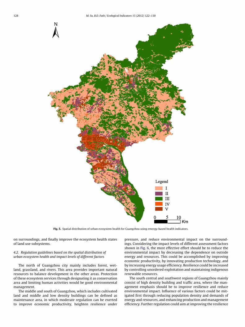
128 M. Su, B.D. Fath / Ecological Indicators 15 (2012) 122–130
th for
oo
4u
lroam
lmt
Fig. 5. Spatial distribution of urban ecosystem heal
n surroundings, and finally improve the ecosystem health statesf land use subsystems.
.2. Regulation guidelines based on the spatial distribution ofrban ecosystem health and impact levels of different factors
The north of Guangzhou city mainly includes forest, wet-and, grassland, and rivers. This area provides important naturalesources to balance development in the other areas. Protectionf these ecosystem services through designating it as conservationrea and limiting human activities would be good environmentalanagement.
The middle and south of Guangzhou, which includes cultivatedand and middle and low density buildings can be defined asaintenance area, in which moderate regulation can be exerted
o improve economic productivity, heighten resilience under
Guangzhou using emergy-based health indicators.
pressure, and reduce environmental impact on the surround-ings. Considering the impact levels of different assessment factorsshown in Fig. 6, the most effective effort should be to reduce theenvironmental impact by decreasing the dependence on outsideenergy and resources. This could be accomplished by improvingeconomic productivity, by innovating production technology, andby increasing energy usage efficiency. Resilience could be increasedby controlling unordered exploitation and maintaining indigenousrenewable resources.
The south central and southwest regions of Guangzhou mainlyconsist of high density building and traffic area, where the man-agement emphasis should be to improve resilience and reduce
environmental impact. Influence of various factors could be mit-igated first through reducing population density and demands ofenergy and resources, and enhancing production and managementefficiency. Further regulation could aim at improving the resilience
M. Su, B.D. Fath / Ecological Indicators 15 (2012) 122–130 129
rs on t
twTit
ciasddcl
4e
tampeticiauebmmgp
Fig. 6. Impact levels of different health indicato
hrough controlling human disturbance, reducing and recyclingaste, as well as forming environmental-friendly living patterns.
hese less healthy regions pose the most difficult pathway formprovement and also have the largest set of options for beginninghe restoration.
In summary, the south central and southwest of Guangzhouity should convert some areas for environmentally friendly liv-ng activities and efficient production, reduce the energy demands,nd decrease waste discharge; the center and south of Guangzhouhould heighten energy usage efficiency and economic pro-uctivity, maintain indigenous renewable resources and reduceependence on outside resources; while the north of Guangzhouity should be conserved strictly. These management actions areikely to help maintain or improve the ecosystem health in the area.
.3. Possible further analysis of spatial distribution of urbancosystem health
Regarding the uncertainty and relativity of urban ecosys-em health, set pair analysis, which emphasizes the relationshipmongst different components and describes uncertainty fromultiple aspects, is applied in this paper to conduct the data
rocessing of emergy-based indicators, through which the urbancosystem health status can be relatively assessed. However, dueo the inadequate recognition of the complexities of uncertaintyn the systems (Rapport and Singh, 2006), it raises the issue ofombining set pair analysis with other uncertainty methods toncorporate more elements of uncertainty. For example, set pairnalysis can be first employed to identify the uncertainty typesnder the analysis of energy and materials flows in the urbancosystem. Subsequently, other uncertainty methods that haveeen utilized successfully in energy and environmental manage-
ent, e.g., integrated multistage fuzzy-stochastic programmingethod (Huang et al., 2001), interval-valued fuzzy robust pro-ramming method (Cai et al., 2009a), interval chance-constrainedrogramming method (Cai et al., 2009b), and mixed integer fuzzy
he urban ecosystem health assessment results.
interval-stochastic programming method (Cai et al., 2011), shouldbe applied to measure quantitatively various uncertainties in theurban ecosystem. This will help acquire a deeper understandingof the driving mechanism of the energy and materials flows inthe urban ecosystem as well as the factors impacting the spatialdistribution of urban ecosystem health.
Furthermore, changing natural condition and continuing humanactivity play important roles for the urban land use pattern, whichwill change the integrated urban ecosystem health status and itsspatial distribution. Thus, with more long-term information onurban land use subsystems, further analysis of urban ecosystemhealth can be conducted by combining dynamic analysis methodssuch as system dynamics with spatial analysis techniques such asGIS, which will provide more practicable policy reference for spatialoptimization of urban ecosystems.
5. Conclusions
Even though urbanization has accelerated economic growthand improved human living standard, it also developed increasingproblems with resource shortages, waste disposal, fresh food dis-tribution, and epidemics (Guidotti, 1995). There is an urgent needfor valid indicators of systemic and objective health assessmentof urban ecosystems. Emergy synthesis, which can link the social,economical, and ecological factors of urban ecosystems and thenidentify the interactions and feedbacks of the whole system, is awell-suited tool for organizing the urban ecosystem health indica-tors.
Considering the great influence of land use patterns on urbanecosystem development, urban ecosystem health assessment isperformed in this paper based on the land use subsystem scaleto analyze the internal characteristics of energy and materialmetabolism within different subsystems. Combining the health
assessment results of different land use subsystems with the spa-tial geographical information of different subsystems, the spatialdistribution of urban ecosystem health status is visualized. It givesa clear picture of the urban ecosystem health and can help provide
1 l Indic
so
ifbspsaues(mcssiptafp
aaofcpitrm
gubaiomMdve
A
ZNT(smb4Taop
30 M. Su, B.D. Fath / Ecologica
uitable urban ecological regulation in view of spatial optimizationf population and resources.
Health assessment results of different land use subsystemsn Guangzhou city translate into the following factors neededor a healthy ecosystem, i.e., moderate economic productivityut with manageable exploitation and disturbance, reasonabletructure of energy and resources usage, medium resilience underressure, moderate provided services for human beings, andmall environmental impact on surroundings. It means that andequate resource basis and level of production and recoverynder medium exploitation are essential for a healthy urbancosystem through which moderation (relates with structure),mooth feedback (relates with process), and proportionalityrelates with function) can be summarized. Along with energy and
aterial flows from north to middle and south, and then to southentral and southwest of Guangzhou, the health levels of land useubsystems first rise and then drop. Combining with the land useubsystems and available resources, the north of Guangzhou citys identified as a conservation area, and the middle and southernarts are identified as a maintenance area, while the south cen-ral and south western parts are identified as a key regulationrea where more room should be created for environmental-riendly living activities and more efficient productionatterns.
Different indicators have different impact power on the finalssessment results. Combining the indicator weights with the mainssessment factors of urban ecosystem health, the impact powerf different indicators have been ranked into five levels, i.e., theactor of environmental impact has the highest impact, systemomponents and structure has the lowest impact, while economicroductivity, resilience and provided human service have medium
mpact on the health status of urban land use subsystems. Evenhough the ranking is still rough, it is helpful for defining theegulation priority to be considered for proper urban ecologicalanagement.The spatial distribution of urban ecosystem health is investi-
ated in view of the biophysical foundation when considering thencertainty and relativity of urban ecosystem health in this paper,y combining the emergy-based health indicators with set pairnalysis. Due to the current limited recognition of the complex-ties of uncertainty in urban ecosystems, it still raises the issuef combining set pair analysis with other uncertainty methods toeasure the uncertainty more comprehensively and accurately.oreover, time series analysis of urban ecosystem health can be
eveloped by combining system dynamics with GIS. It will pro-ide more practicable reference for spatial optimization of urbancosystems.
cknowledgements
The authors would like to express the heartfelt gratitude to Prof.hifeng Yang and Dr. Bin Chen (School of Environment, Beijingormal University) for their invaluable comments and kind help.he authors also gratefully thank Dr. Renzhi Liu and Dr. Xin‘an YinSchool of Environment, Beijing Normal University) for technicalupport; and Mr. Yiqing Shen (Shenzhen Academy of Environ-ental Science) for data support. Financial support was provided
y the National Natural Science Foundation of China (Grant No.0871056, 40901269), and Program for New Century Excellent
alents in University of Ministry of Education (NCET-09-0226). Theuthors would also thank the help of the Editor and the commentsf the Reviewers, which significantly improve the quality of theaper.ators 15 (2012) 122–130
References
Brown, M.T., Bardi, E., 2001. Folio #3: emergy of ecosystems. In: Handbook of EmergyEvaluation: A Compendium of Data for Emergy Computation Issued in a Seriesof Folios. Center for Environmental Policy, University of Florida, Gainesville, FL.
Brown, M.T., Ulgiati, S., 2004. Energy quality, emergy, and transformity: H.T. Odum’scontributions to quantifying and understanding systems. Ecological Modelling178, 201–213.
Cai, Y.P., Huang, G.H., Lu, H.W., Yang, Z.F., 2009a. I-VFRP: an interval-valued fuzzyrobust programming approach for environmental management planning underuncertainty. Engineering Optimization 41 (5), 399–418.
Cai, Y.P., Huang, G.H., Yang, Z.F., Lin, Q.G., Tan, Q., 2009b. Community-scale energysystems planning under uncertainty—An interval chance-constrained program-ming approach. Renewable and Sustainable Energy Reviews 13 (4), 721–735.
Cai, Z.F, Zhang, L.X., Zhang, B., Chen, Z.M., 2009. Emergy-based analysis ofBeijing–Tianjin–Tangshan region in China. Communications in Nonlinear Sci-ence and Numerical Simulation 14, 4319–4331.
Cai, Y.P., Huang, G.H., Tan, Q., Chen, B., 2011. Identification of optimal strategiesfor improving eco-resilience to floods in ecologically vulnerable regions of awetland. Ecological Modelling 222 (2), 360–369.
Guangzhou Municipal Statistics Bureau, 2010. Guangzhou Statistical Year book2009. Electronic document available at http://data.gzstats.gov.cn/gzStat1/chaxun/njsj.jsp (accessed 01.03.11).
Guidotti, T.L., 1995. Perspective on the health of urban ecosystems. Ecosystem Health1 (3), 141–149.
Huang, S.L., Chen, Y.H., Kuo, F.Y., Wang, S.H., 2011. Emergy-based evaluation of peri-urban ecosystem services. Ecological Complexity 8 (1), 38–50.
Huang, G.H., Sae-Lim, N., Liu, L., Chen, Z., 2001. An interval-parameter fuzzy-stochastic programming approach for municipal solid waste management andplanning. Environmental Modelling and Assessment 6, 271–283.
Huang, S.L., Wu, S.C., Chen, W.B., 1995. Ecosystem, environmental quality andecotechnology in the Taipei metropolitan region. Ecological Engineering 4 (4),233–248.
Jiang, M.M., Zhou, J.B., Chen, B., Yang, Z.F., Ji, X., Zhang, L.X., Chen, G.Q., 2009. Ecolog-ical evaluation of Beijing economy based on emergy indices. Communicationsin Nonlinear Science and Numerical Simulation 14, 2482–2494.
Lan, S.F., Odum, H.T., 1994. Emergy evaluation of the environment and economy ofHongkong. Journal of Environmental Science 6 (4), 432–439.
Lee, C.L., Huang, S.L., Chan, S.L., 2009. Synthesis and spatial dynamics of socio-economic metabolism and land use change of Taipei metropolitan region.Ecological Modelling 220 (21), 2940–2959.
Lei, K.P., Wang, Z.S., Ton, S.S., 2008. Holistic emergy analysis of Macao. EcologicalEngineering 32 (1), 30–43.
Liu, G.Y., Yang, Z.F., Chen, B., Ulgiati, S., 2009. Emergy-based urban health evaluationand development pattern analysis. Ecological Modelling 220 (18), 2291–2301.
Lu, H.F., Campbell, D.E., 2009. Ecological and economic dynamics of the Shundeagricultural system under China’s small city development strategy. Journal ofEnvironmental Management 90, 2589–2600.
Lu, H.F., Ye, Z., Zhao, X.F., Peng, S.L., 2003. A new emergy index for urban sustainabledevelopment. Acta Ecologica Sinica 23 (7), 1363–1368.
Müller, F., Lenz, R., 2006. Ecological indicator: theoretical fundamentals of consistentapplications in environmental management. Ecological Indicators 6, 1–5.
Odum, H.T., 1983. System Ecology: An Introduction. John Wiley & Sons, New York.Odum, E.P., 1989. Ecology and our Endangered Life-support Systems. Sinauer Asso-
ciates, Sunderland, MA.Odum, H.T., 1996. Environmental Accounting: Emergy and Environmental Decision
Making. John Wiley & Sons, New York.Odum, E.P., Barrett, G.W., Translated by Lu, J.J., Wang, W., Wang, T.W., He, W.S., Li,
X.Z., 2009. Fundamentals of Ecology, fifth ed. Higher Education Press, Beijing (inChinese).
Odum, H.T., Brown, M.T., Brandt-Williams, S., 2000. Folio #1: Introduction and GlobalBudget. In: Handbook of Emergy Evaluation: A Compendium of Data for EmergyComputation Issued in a Series of Folios. Center for Environmental Policy, Uni-versity of Florida, Gainesville, FL.
Rapport, D.J., Costanza, R., Epstein, P.R., Gaudet, C., Levins, R., 1998. EcosystemHealth. Blackwell Science, Malden and Oxford.
Rapport, D.J., Singh, A., 2006. An EcoHealth-based framework for state of environ-ment reporting. Ecological Indicators 6, 409–428.
Su, M.R., Fath, B.D., Yang, Z.F., 2010. Urban ecosystem health assessment: a review.Science of the Total Environment 408 (12), 2425–2434.
Su, M.R., Yang, Z.F., Chen, B., Ulgiati, S., 2009. Urban ecosystem health assessmentbased on emergy and set pair analysis—a comparative study of typical Chinesecities. Ecological Modelling 220 (18), 2341–2348.
Tang, Q.Y., Feng, M.G., 2007. Data Processing System—Experiment Design, StatisticalAnalysis and Data Exploration. Science Press, Beijing (in Chinese).
Ulgiati, S., Ascione, M., Zucaro, A., Campanella, L., 2011. Emergy-based complexitymeasures in natural and social systems. Ecological Indicators 11 (5), 1185–1190.
Zhang, L.X., Chen, B., Yang, Z.F., Chen, G.Q., Jiang, M.M., Liu, G.Y., 2009. Compari-son of typical mega cities in China using emergy synthesis. Communications inNonlinear Science and Numerical Simulation 14, 2827–2836.
Zhang, Y., Yang, Z.F., Liu, G.Y., Yu, X.Y., 2011. Emergy analysis of the urban metabolismof Beijing. Ecological Modelling 222 (14), 2377–2384.
Copyright © 2022 FDOKUMEN