Sources of potentially toxic elements and organic pollutants in an urban area subjected to an...
18
Environ Monit Assess (2012) 184:15–32 DOI 10.1007/s10661-011-1943-8 Sources of potentially toxic elements and organic pollutants in an urban area subjected to an industrial impact Anabela Cachada · Maria Eduarda Pereira · Eduardo Ferreira da Silva · Armando Costa Duarte Received: 16 November 2010 / Accepted: 9 February 2011 / Published online: 17 March 2011 © Springer Science+Business Media B.V. 2011 Abstract Urban and industrial development has caused a major impact on environmental soil qual- ity. This work assesses the extent and severity of contamination in a small urban area subjected to an industrial impact and identifies the ma- jor anthropogenic inputs. Twenty-six soil samples were collected from agricultural and urban sites, and concentrations of potentially toxic elements (As, Cd, Cu, Cr, Fe, Mn, Ni, Pb and Zn), PAHs and PCBs, were determined. In spite of the low median concentrations observed, some sites rep- resent a potential hazard for human health and ecosystems. Concentrations of contaminants were Electronic supplementary material The online version of this article (doi:10.1007/s10661-011-1943-8) contains supplementary material, which is available to authorized users. A. Cachada (B ) · M. E. Pereira · A. C. Duarte CESAM & Department of Chemistry, University of Aveiro, Campus de Santiago, 3810-193, Aveiro, Portugal e-mail: [email protected] E. Ferreira da Silva GeoBioTec-GeoBioSciences, Geotechnologies and Geoengineering Research Center, University of Aveiro, Campus de Santiago, 3810-193, Aveiro, Portugal higher than those found in a nearby city, indicat- ing that the study area is affected by the surroun- ding industry. The use of multivariate statistical analyses allowed for the identification of the main factors controlling the variability of potentially toxic elements and organic pollutants in the soils. The presence of Cr, Fe, Mn and Ni was associated with geogenic inputs, and Cu, Pb, Zn, As, PAHs and PCBs were associated with anthropogenic in- puts. Industry and traffic were the most important anthropogenic sources. Soil characteristics were identified as important factors controlling the spa- tial variability of elements, both from recognised natural and anthropogenic origin. Differences bet- ween land uses were observed, which may be attri- buted to both management practices and proximity to sources. Keywords Urban soils · Agricultural soils · Chemical plant · Potential toxic elements · Organic pollutants · Multivariate statistics Introduction Human activities, such as intensive agriculture, ur- banisation and industrialisation, contribute to soil damage and lead to irreversible loss of ecological function and negative consequences for quality of life. Local and diffuse contamination, deple- tion of nutrients and sealing of soil surfaces have
Transcript of Sources of potentially toxic elements and organic pollutants in an urban area subjected to an...

Environ Monit Assess (2012) 184:15–32DOI 10.1007/s10661-011-1943-8
Sources of potentially toxic elements and organicpollutants in an urban area subjectedto an industrial impact
Anabela Cachada · Maria Eduarda Pereira ·Eduardo Ferreira da Silva ·Armando Costa Duarte
Received: 16 November 2010 / Accepted: 9 February 2011 / Published online: 17 March 2011© Springer Science+Business Media B.V. 2011
Abstract Urban and industrial development hascaused a major impact on environmental soil qual-ity. This work assesses the extent and severityof contamination in a small urban area subjectedto an industrial impact and identifies the ma-jor anthropogenic inputs. Twenty-six soil sampleswere collected from agricultural and urban sites,and concentrations of potentially toxic elements(As, Cd, Cu, Cr, Fe, Mn, Ni, Pb and Zn), PAHsand PCBs, were determined. In spite of the lowmedian concentrations observed, some sites rep-resent a potential hazard for human health andecosystems. Concentrations of contaminants were
Electronic supplementary material The online versionof this article (doi:10.1007/s10661-011-1943-8) containssupplementary material, which is available toauthorized users.
A. Cachada (B) · M. E. Pereira · A. C. DuarteCESAM & Department of Chemistry,University of Aveiro, Campus de Santiago,3810-193, Aveiro, Portugale-mail: [email protected]
E. Ferreira da SilvaGeoBioTec-GeoBioSciences, Geotechnologiesand Geoengineering Research Center,University of Aveiro, Campus de Santiago,3810-193, Aveiro, Portugal
higher than those found in a nearby city, indicat-ing that the study area is affected by the surroun-ding industry. The use of multivariate statisticalanalyses allowed for the identification of the mainfactors controlling the variability of potentiallytoxic elements and organic pollutants in the soils.The presence of Cr, Fe, Mn and Ni was associatedwith geogenic inputs, and Cu, Pb, Zn, As, PAHsand PCBs were associated with anthropogenic in-puts. Industry and traffic were the most importantanthropogenic sources. Soil characteristics wereidentified as important factors controlling the spa-tial variability of elements, both from recognisednatural and anthropogenic origin. Differences bet-ween land uses were observed, which may be attri-buted to both management practices and proximityto sources.
Keywords Urban soils · Agricultural soils ·Chemical plant · Potential toxic elements ·Organic pollutants · Multivariate statistics
Introduction
Human activities, such as intensive agriculture, ur-banisation and industrialisation, contribute to soildamage and lead to irreversible loss of ecologicalfunction and negative consequences for qualityof life. Local and diffuse contamination, deple-tion of nutrients and sealing of soil surfaces have

16 Environ Monit Assess (2012) 184:15–32
significant impacts on the soil’s chemical, physicaland biological characteristics (Pouyat et al. 2008).Soil contamination can become a more severeproblem in areas where podzols are predomi-nant, due to a deep migration of contaminants(Hernandez et al. 2003; Tyler 2004). This soil con-tamination may result in further contamination ofthe groundwater and surface water, resulting in apotential hazard to the local population and to theecosystem.
Urbanised areas are geographical centres ofresource consumption and chemical emissions,which has a critical influence on the environmentand human health. In 2006, 75% of the Europeanpopulation lived in urban areas, and the coast ofPortugal had one of the highest rates of increasingurbanisation in the European Union (EEA 2006).As a result, the demand for land on the Portuguesecoast has dramatically increased. Because soil canbe considered both a source and a sink for conta-mination, it is important to assess the environmen-tal quality of urban areas to reduce and mitigatepotential risks to ecosystems and human health(Reis et al. 2009).
Many studies have examined the quality ofsoils from urban areas, though most of them havefocused on only one group of contaminants andwere performed in large urban areas (Biasioliet al. 2007; Cachada et al. 2009a; Ljung et al. 2006;Morillo et al. 2007; Pouyat et al. 2008; Rodrigueset al. 2009). In addition, it is sometimes difficultto compare them due to differences in the studies’methodological approaches (soil fraction, contam-inants studied and chemical extractions). The sizeof the city is not directly related to the level ofcontamination; this is because small urban areascan be very close industrial areas (Gallego et al.2002). For this reason, these urban areas can beaffected by the same anthropogenic pressures asbigger cities.
The purpose of this work is to assess the environ-mental quality of soils and to identify the majoranthropogenic inputs of contaminants in a small ur-ban area near a chemical plant, following the sameanalytical methodologies used in other Europeancities (Cachada et al. 2009a; Rodrigues et al. 2009):Aveiro (Portugal), Glasgow (Scotland), Ljubljana
(Slovenia), Turin (Italy) and Uppsala (Sweden).Thus, a general characterisation (pH, total Cand N, organic matter, cation exchange capacityand particle size distribution) of soils was firstperformed, followed by an examination of morespecific soil quality indicators, such as levels ofpotentially toxic elements (PTEs), polycyclic aro-matic hydrocarbons (PAHs) and polychlorinatedbiphenyls (PCBs). The organic pollutants (OPs)profile was studied to obtain some indication ofthe origin of these contaminants. Multivariate sta-tistical methods were applied to understand therelationships between multiple variables and eval-uate potential sources of contaminants (natural vs.anthropogenic inputs) (Peltola and Åström 2003).The main difficulties were related to the complexrelationship between variables, which were in-creased by the urban soil’s natural spatial variabil-ity. Additionally, the difficulty in addressing suchsources were enhanced by the small size of theurban area, which had an important direct source,in addition to other point and diffuse sources. Thisapproach sought to assess the environmental qual-ity of soils from an urbanised area and evaluatethe potential for human exposure.
Materials and methods
General characterisation of the study area
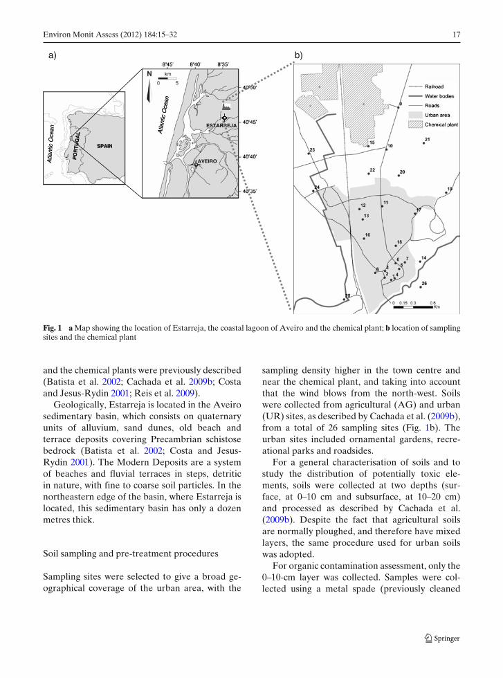
Estarreja is a small coastal town (7,000 inhab-itants) on the north-western Portuguese coast,close to the “Ria de Aveiro” lagoon, as shownin Fig. 1a. The coastal plain around this lagoonsupports an intensive and diversified agriculture,a variety of heavy and light industries and a pop-ulation of about half-a-million people, who aredependent on this ecosystem. A major branch ofthe chemical industry is located inside a complexcalled “Complexo Químico de Estarreja”, located1 km north of the Estarreja town centre. Thechemical plant includes, among others, a chlor-alkali plant and producers of aniline, nitroben-zene, PVC, isocyanide polymers of an aromaticbase and polystyrene polymers for thermal iso-lation. Details about the Estarreja urban area
Environ Monit Assess (2012) 184:15–32 17
Atla
ntic
Oce
an Atla
ntic
Oce
anAVEIRO
SPAIN
PO
RT
UG
AL
Atla
ntic
Oce
an Atla
ntic
Oce
an
ESTARREJA
SPAIN
PO
RT
UG
AL
b)a)
Fig. 1 a Map showing the location of Estarreja, the coastal lagoon of Aveiro and the chemical plant; b location of samplingsites and the chemical plant
and the chemical plants were previously described(Batista et al. 2002; Cachada et al. 2009b; Costaand Jesus-Rydin 2001; Reis et al. 2009).
Geologically, Estarreja is located in the Aveirosedimentary basin, which consists on quaternaryunits of alluvium, sand dunes, old beach andterrace deposits covering Precambrian schistosebedrock (Batista et al. 2002; Costa and Jesus-Rydin 2001). The Modern Deposits are a systemof beaches and fluvial terraces in steps, detriticin nature, with fine to coarse soil particles. In thenortheastern edge of the basin, where Estarreja islocated, this sedimentary basin has only a dozenmetres thick.
Soil sampling and pre-treatment procedures
Sampling sites were selected to give a broad ge-ographical coverage of the urban area, with the
sampling density higher in the town centre andnear the chemical plant, and taking into accountthat the wind blows from the north-west. Soilswere collected from agricultural (AG) and urban(UR) sites, as described by Cachada et al. (2009b),from a total of 26 sampling sites (Fig. 1b). Theurban sites included ornamental gardens, recre-ational parks and roadsides.
For a general characterisation of soils and tostudy the distribution of potentially toxic ele-ments, soils were collected at two depths (sur-face, at 0–10 cm and subsurface, at 10–20 cm)and processed as described by Cachada et al.(2009b). Despite the fact that agricultural soilsare normally ploughed, and therefore have mixedlayers, the same procedure used for urban soilswas adopted.
For organic contamination assessment, only the0–10-cm layer was collected. Samples were col-lected using a metal spade (previously cleaned
18 Environ Monit Assess (2012) 184:15–32
with distilled water and ethanol) and were storedin aluminium foil. Samples were later air-dried ina cold, dark place, sieved to <2 mm using a stain-less steel sieve, homogenised and frozen (−20◦C),wrapped in aluminium foil.
Analytical procedures and QA/QCmethodologies
General soil characterization The following setof parameters was selected to obtain a gen-eral characterisation of Estarreja soils: pH inCaCl2 (ISO10390:1994); total C (TC) and to-tal N (TN) percentages (microanalyser LECO,CNHS-932); organic matter (OM) content (losson ignition at 430◦C); cation exchange capacity(CEC, extraction with barium chloride solutionbuffered at pH = 8.1 using triethanolamine—ISO13536:1995); and particle size distribution byquantifying the sand, silt and clay fractions (Mi-cromeritics® Sedigraph 5100). CEC and particlesize were determined only for the surface layer.The samples were mineralogically characterisedin powders by X-ray diffraction using a PhilipsPW1130/90, X’Pert PW3040/60 equipment andCuKα radiation (λ = 1.54056 Å). The instrumentconditions were as follows: voltage 40 kV; current30 mA; and slit 0.5 nm. Scans were run between2–60◦ 2θ .
Potentially toxic elements The pseudo-total con-centrations of eight metals (Cd, Cu, Cr, Fe, Mn,Ni, Pb, Zn) were determined using Atomic Ab-sorption Spectrometry (Model GBC series 906AA). One gram of sample was digested withAqua Regia (3 mL HCl, 37% + 1 mL HNO3,65%) in a Teflon baker. The mixture was gentlyheated on a hotplate at 100◦C until dry, dissolvedin 10 mL HNO3 4 mol/L, transferred to a 25-mL volumetric flask and filled to volume withdemineralised water. Solutions were centrifuged(5 min at 4,000 rpm) and filtered by means ofMN 640 filter papers to 50-mL PVC flasks. To-tal As concentration was determined by ICP-MS(Thermo X Series) after digestion of 100 mg ofsoil with a mixture of HNO3:HF. Digestion wasperformed in Teflon pumps for 1.5 h in an oven
at 120◦C. Determinations of As were performedonly for the surface layer.
Organic pollutants This study focused on theanalysis of 16 PAHs and 19 PCBs, based on theUS EPA list. The 16 PAHs determined wereacenaphthene (ACE), acenaphthylene (ACY),anthracene (ANT), benzo(a)anthracene (BAA),benzo(b)fluoranthene (BBF), benzo(k)fluoran-thene (BKF), benzo(ghi)perylene (BGHI),benzo(a)pyrene (BAP), chrysene (CRY),dibenzo(ah)anthracene (DBAH), fluoranthene(FLA), fluorene (FLU), indeno(1,2,3-cd)pyrene(IND), naphthalene (NP), phenanthrene (PHE)and pyrene (PYR). The PCBs congeners (1, 5,18, 31, 44, 52, 66, 87, 101, 110, 138, 141, 151,153, 170, 180, 183, 187 and 206) represent thecommon Arochlor formulations. The extractionand clean-up procedure has been described byCachada et al. (2009a). Briefly, 10 g of soil wassoxhlet extracted with a hexane/acetone mixtureand submitted to a neutral alumina clean-up; thesolvent was then changed to dichloromethanefor PAHs and isooctane for PCBs analysis. Thedry weight was calculated, and the analysedmass was adjusted for each soil sample. Extractswere analysed using a Shimadzu CorporationGC/MS-QP5050A, equipped with a SPB-5 fusedsilica capillary column and helium as a carriergas. Detection was achieved with a mass selectivedetector using electron impact ionisation in theselected ion monitoring acquisition mode. Foranalysis of the 16 PAHs, the injector temperaturewas 290◦C, and the interface temperature was300◦C. The column temperature was programmedas follows: 35◦C for 2 min, increased at a rateof 10◦C/min until 220◦C, followed by 6◦C/minuntil 260◦C was reached, 3◦C/min until 300◦Cand was kept at 300◦C for 6 min. Details of thePCB analysis have been described by Cachadaet al. (2009a). Acquisition was performed usingone quantification ion and two confirmation ions.Quantification was performed using an internalstandard (a deuterated PAHs mixture for PAHsdetermination and PCB congener 209 for PCBs)multipoint calibration with five concentrationlevels. Internal standards were added to eachsample extract prior to analysis.
Environ Monit Assess (2012) 184:15–32 19
QA/QC methodologies QA/QC procedures in-cluded procedure blanks, duplicates and theanalysis of certified reference materials. Replicateanalysis of the soil samples gave an uncertaintyof <10% for general parameters and PTEs and<20% for OPs. Results of method blanks werealways below detection limits. For ElementalAnalysis (Total C, N), recoveries of referencematerials (Eurovector E11036 and EurovectorE11037) were 94 ± 9% (STDEV) for TC and105 ± 8% for TN. For CEC, the recoveries ofLufa Speyer 2.2 were 94 ± 4%. For the pseudo-total content of metals, recoveries of the certifiedreference materials IRMM BCR 141R and BCR142R ranged from 81 ± 5% for Cr to 107 ± 7%for Pb. Recoveries of total As were 106% ± 5%(NRC Mess-3, and CMI7002). The accuracy of theorganic contaminants determination method waschecked by analysing the LGC 6140 and RTC-CRM124 certified reference materials for PAHsand the LGC 6113 for PCBs. Recoveries rangedfrom 65 ± 3% to 100 ± 6% for PAHs and from97 ± 4% to 108 ± 3% for PCBs. The limits ofdetection for PTEs were 0.25 mg kg−1 for Cd,2.0 mg kg−1 for Ni, 2.5 mg kg−1 for Zn, 2.8 mg kg−1
for Cu, 3.5 mg kg−1 for Pb, 5 mg kg−1 for Asand Mn and 0.05% for Fe. For OPs, the limit ofdetection ranged from 0.15 to 0.74 μg kg−1 forPAHs and from 0.03 to 0.07 μg kg−1 for PCBs,depending on the specific compound.
Univariate and multivariate statistical analysis
Univariate statistical methods were initially per-formed to check the variability of the data and thepresence of anomalies. Box-plots were obtainedand normality was tested (Shapiro–Wilk’s test fornormality, skewness and kurtosis). Values belowthe detection limit were considered in the statis-tical analysis as one half of the detection limit(twelve samples for Cd and five samples for As).Because some parameters did not follow a normaldistribution, non-parametric statistics were used:Mann–Whitney U test (for comparisons betweenagricultural and urban soils and between the twodepth layers) and Spearman correlations (to testrelationships between variables).
Multivariate statistical methods were appliedto investigate relationships between the contami-nants and the factors controlling their distribution.As Hg has been identified in a previous study(Cachada et al. 2009b) as an important problemfor this area, data from this study were includedin the statistical analysis. Because multivariatestatistics is affected by the distribution of the dataand by the presence of outliers (Chen et al. 2008;Gallego et al. 2002), two transformations weretested to normalise the data: log transformationand box–cox transformation.
Cluster analysis was first performed to clas-sify similar observations into groups that wereinitially unknown. An agglomerative hierarchicalclustering method (Ward method with Euclideandistances), which maximises the variance betweengroups and minimises the variance between mem-bers of the same group, was used (Gallego et al.2002). Due to differences in units of measurement,data were normalized.
Factor analysis was then applied to surface soildata to obtain underlying factors that describethe covariance among variables; this aids in theidentification of groups with common character-istics (e.g. the same source). Due to differencesin units of measurement, factor analysis was con-ducted in a correlation matrix. The “Kaiser–Meyer–Olkin Measure of Sampling Adequacytest” and the “Bartlett test of Sphericity” wereperformed to determine whether the distribu-tion of results was adequate for a factor analy-sis. The extraction procedure was the PrincipalComponent Analysis, and several rotations weretested. Factor scores (standardised measures ofevery case in the factors), which gave the nec-essary information to scale the most and leastimportant factor for each sample, were then sub-jected to cluster analysis (Gallego et al. 2002).By combining these two methodologies, samplesclustered according to the hypothetical origin ofthe contaminants (group samples with a similarbehaviour).
Two different software packages were usedfor statistical analysis: SPSS® for descriptive andmultivariate statistics (Spearman correlations,cluster and factor analysis) and Statistica® forbox-cox transformation.

20 Environ Monit Assess (2012) 184:15–32
Results
Geochemical and mineralogical characterisationof soil samples
General characteristics of soil Soils in the areaunder study are mainly podzols, found in the sanddunes and low terraces (5–8 m); yet, Cambisolscan also be found. The mineralogical suite iden-tified is, for all sampling sites, dominated byquartz, mica/ilite, kaolinite and by some inter-stratified clay minerals (10–14 Å), such as ilite-vermiculite and clorite-vermiculite. K feldspars,plagioclases and calcite are also common as acces-sory minerals. Less common, and always in verysmall quantities, were pyrite, anhydrite, dolomite,siderite and goethite. The identified mineralog-ical suite is clearly similar to the fine fractions(<63 μm) mineralogy identified in the Vouga wa-tershed soils (Pereira 1989) and in sediments andmetasediments from the Aveiro region (Chaminéet al. 2001, 2002; Delgado et al. 1992; Rocha 1993).
A summary of the results of all the generalparameters determined is given in Table 1. Estar-reja soils are acidic, sandy loam or loamy sand(according to the United States Department ofAgriculture classes) and, thus, with a medium con-tent of TC, OM and CEC and a low TN content,as described previously by Cachada et al. (2009b).
No significant statistical difference was foundbetween the two land uses. Considering the twoland types individually (urban and agricultural),a significant difference was observed between the
two layers in urban soils for the following para-meters: TC (p = 0.003), TN (p < 0.001) and OM(p = 0.010).
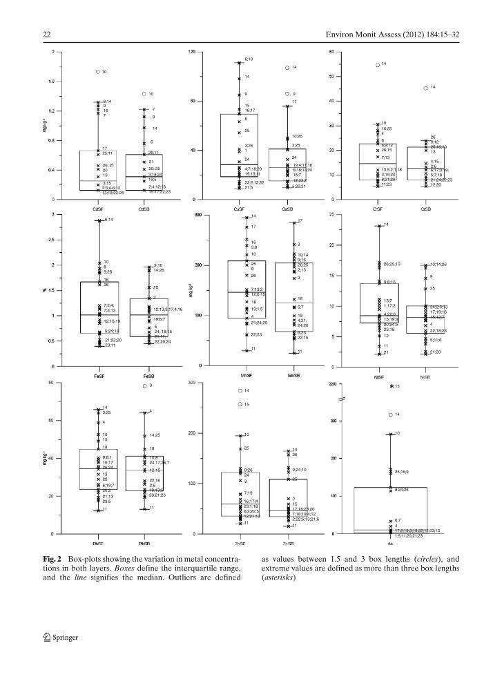
Levels of PTEs in the study area Table 2 showsthe median values and the range of PTEs in thestudy area, and a local reference value (LRV),based on the Foregs Geochemical Baseline Mapsfor topsoils of all Europe (Salminen 2005). Re-sults were also compared (Table 2) with theNetherlands Target Values (NTV), which areamong the most commonly applied (Tume et al.2008; Yesilonis et al. 2008) and reflect the baselineconcentration required to recover the functionalproperties of the soil and to obtain a sustainablesoil quality (VROM 2000). Table 2 also givesthe median values found in other European cities(Biasioli et al. 2007; Ljung et al. 2006; Rodrigueset al. 2009), where similar methodological ap-proaches were applied (sampling, sample pre-treatment and analytical methods), and in othercities strongly affected by industry (Gallego et al.2002; Peltola and Åström 2003; Nadal et al.2004a). Figure 2 shows the box plots, with themedian, interquartile range, outliers (between 1.5and 3 box lengths) and extreme values (more thanthree box lengths), of the PTEs concentrations forboth layers (except for As, which was determinedonly in the surface layer).
No significant statistical difference was foundbetween the two layers for any element. Therewere differences between land uses (Table 3) forthe elements Cr (p = 0.041) and Fe (p = 0.015)
Table 1 Summary results of all general parameters determined
pHCa TC (%) TN (%) OM (%) CEC Sand Silt Clay
SF SB SF SB SF SB SF SB (cmol/kg) (%) (%) (%)
TotalMedian 5.15 4.91 2.1 1.5 0.24 0.18 4.4 3.4 11 68 27 4.3Min 4.08 3.90 0.80 0.49 0.08 0.05 1.8 1.6 5.3 42 12 1.2Max 6.88 7.35 5.1 2.9 0.50 0.52 8.9 6.2 19 86 53 11
UrbanMedian 5.33 5.20 2.2 1.4 0.24 0.15 5.5 3.3 12 64 30 4.3Min 4.32 4.33 0.80 0.49 0.08 0.05 1.8 1.6 5.3 42 12 1.9Max 6.88 7.35 5.1 2.2 0.38 0.22 8.9 5.7 19 86 53 11
AgriculturalMedian 5.00 4.64 1.9 1.8 0.24 0.23 4.1 3.4 9.9 74 21 4.3Min 4.08 3.90 1.4 1.2 0.16 0.13 3.2 3.2 7.8 53 19 1.2Max 6.29 6.55 3.8 2.9 0.50 0.52 8.5 6.2 19 78 38 9.8

Environ Monit Assess (2012) 184:15–32 21
Tab
le2
Med
ian
conc
entr
atio
nan
dra
nge
ofP
TE
s(m
gkg
−1)
and
OP
s(μ
gkg
−1)
inE
star
reja
surf
ace
sam
ples
(0–1
0cm
),lo
cal
refe
renc
e,gu
idel
ine
valu
esan
dco
ncen
trat
ions
inot
her
citi
es Cd
Cu
Cr
Ni
Pb
Zn
As
∑16
PA
Hs
∑19
PC
Bs
Est
arre
ja0.
26(b
dl–1
.4)
28(9
–111
)15
(5–5
5)9
(2–2
3)35
(12–
66)
59(2
1–28
4)10
m(b
dl–2
,190
)98
(27–
2,01
6)8.
8(2
.3–5
5)L
RV
a0.
03–0
.06
6–12
15–2
25–
715
–21
48–6
19–
11m
––
NT
Vb
0.8
3610
035
8514
029
1,00
0p20
r
Ave
iro
(Por
tuga
l)c;d
–14
(3–6
9)9
(2–3
7)6
(2–1
2)22
(8–1
80)
37(1
3–62
13)
––
7.9
(0.6
–73)
Sevi
lla(S
pain
)e;f–
39(1
0–36
5)33
(11–
89)
29(1
6–53
)76
(15–
977)
87(2
1–32
5)–
425q
(90–
4,00
4)–
Lju
blja
na(S
love
nia)
c;e;g
–32
(15–
123)
29(1
2–16
5)26
(14–
38)
68(1
1–38
7)12
2(6
3–44
6)–
791q
(218
–4,4
90)
6.8
(2.8
–48)
Upp
sala
(Sw
eden
)c;h0.
21(0
.08–
0.71
)25
(11–
110)
32(1
4–62
)19
(7.2
–39)
26(8
–358
)84
(45–
149)
3.5
(1.5
–15)
–5.
7(2
.3–7
7)Ja
kobs
tad
(Fin
land
)i0.
25(0
.06–
2.52
)22
(4.7
–2,6
12)
23(1
7–38
8)7.
9(4
.5–3
86)
59(1
0–3,
439)
82(1
7–2,
368)
2.7
(1.4
–16)
––
Avi
lés
(Spa
in)j
2.4
(1–6
.2)
20(8
–59)
18(8
–32)
11(4
–32)
107(
49–4
28)
477(
169–
1337
)15
(6–3
5)–
–T
arra
gona
(Spa
in)k;l
0.21
n;0
.19o
–14
n;1
0o–
36n;6
6o–
5.5n
;4.2
o10
02n;1
66n;7
36o
–
Med
ian
valu
es,e
xcep
tin
Avi
lés
and
Tar
rago
naw
here
mea
nva
lues
are
pres
ente
dL
RV
loca
lref
eren
ceva
lue,
NT
VN
ethe
rlan
dsT
arge
tVal
ues,
bdlb
elow
dete
ctio
nlim
ita Sa
lmin
en(2
005)
bV
RO
M(2
000)
c Cac
hada
etal
.(20
09a)
dR
odri
gues
etal
.(20
09)
e Bia
siol
ieta
l.(2
007)
f Mor
illo
etal
.(20
08)
g Mor
illo
etal
.(20
07)
hL
jung
etal
.(20
06)
i Pel
tola
and
Åst
röm
(200
3)j G
alle
goet
al.(
2002
)kN
adal
etal
.(20
04a)
l Nad
alet
al.(
2004
b)m
Tot
alco
nten
tnIn
dust
rial
area
oR
esid
enti
alar
eap∑
10P
AH
sq∑
15P
AH
sr∑
7PC
Bs
22 Environ Monit Assess (2012) 184:15–32
10
8;149167
1725;11
26; 212019
3;15
10
7
9
26;11
21
14
6
20; 253;18;2419;5
2;3;4-6;1213;18;22-25
2;4;12;1315-17;22;23
6;10
14
9
1516;17
8
25
3;261
24
14
9
17
10;26
3;25
24
4;7;18;2019;13;11
23;2;12;2221;5
19;4;11;166;18;13;2015;712;23;25;22;21
14
14
1016;254
269;1225;16;1013
68;9;1226;15
7;134;152;6
13;5;2;1;183;19;248;21;2011;23
6;17;3;19;5;7;1821;24;22;2312;20
6;14
1089;25
1626
7;2;4;7;3;13
9;1014;26
25
2
12;15;19
5;24;18
21;22;2023;11
12;13;3;17;4;16
19;6;7
524; 18;1521;11;22;20;24
14
17
3
17
163;8
259
26
10
7;13;212;6;15
19;1;5
4
21;24;20
22;23
11
10;149;1626;252;13
2
18
5;7
194;21;24;20
6;2322;15
11
18
14
9
10;14;26
12
11
21
4;22;615;19;320;24;523;18
13;71;17;2
9;8;16
26;25;10
25
24;2;3;1317;19;1615;12;7
4
22;18;23
5;11;6
21;20
3
143;25
11
6;19;720;2
1222
9;8;116;1726;24
18
1015
4
21;1323;5
4
14;25
18
10;924;17;26;7
12;15
22;162;619;13;520;21;23
11
14
11
1517;16;23;207;18;19;4;122;22;5;13;21;6
3
25
9;24;10
10
25
9;2624
3
7;19
16;17;423;1;186;2;22;512;21;13
11
15
1426
14
25;16;9
10
8;24;26
6;7417;2;19;3;18;22;12;23;13
15x
1;5;11;20;21;23
Fig. 2 Box-plots showing the variation in metal concentra-tions in both layers. Boxes define the interquartile range,and the line signifies the median. Outliers are defined
as values between 1.5 and 3 box lengths (circles), andextreme values are defined as more than three box lengths(asterisks)
Environ Monit Assess (2012) 184:15–32 23
Table 3 Descriptive statistics of PTEs (mg kg−1, except for Fe %) and OPs (μg kg−1) in Estarreja soil samples, by land use,for both layers
Parameter Layer Urban (UR) Agricultural (AG)
Median Min Max Median Min Max
Cd SF 0.20 bdl 1.7 0.31 bdl 0.66SB 0.31 bdl 1.4 0.31 bdl 0.61
Cu SF 39 8.9 111 24 9.3 73SB 27 11 107 24 9.6 86
Cr SF 23 5.3 55 9.3 5.3 28SB 13 5.3 45 11 5.3 24
Fe (%) SF 1.2 0.40 2.9 0.66 0.45 1.8SB 1.1 0.45 1.9 0.83 0.45 2.0
Mn SF 151 29 295 115 61 276SB 152 25 241 92 53 284
Ni SF 10 3.4 23 8.1 2.1 17SB 7.7 3.9 17 8.8 2.1 17
Pb SF 38 12 66 34 18 64SB 31 13 78 36 19 52
Zn SF 54 21 284 69 30 256SB 37 15 164 56 28 157
As SF 20 bdl 316 9.2 bdl 2,190∑
16PAHs SF 72 27 526 111 34 2,016∑
19PCBs SF 6.1 2.3 17 11 4.7 55
bdl below detection limit
17
20
19
20
19
4
3
17
4
3
18
18
16
14;3;1520;25
12
23;19
7;17;421;26
6;24;10;8;9
2;13;22;5
1;11
3;2016;14
25;2115;19;26
a) b)
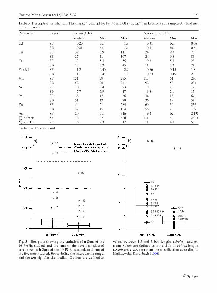
Fig. 3 Box-plots showing the variation of a Sum of the16 PAHs studied and the sum of the seven consideredcarcinogenic; b Sum of the 19 PCBs studied, and sum ofthe five most studied. Boxes define the interquartile range,and the line signifies the median. Outliers are defined as
values between 1.5 and 3 box lengths (circles), and ex-treme values are defined as more than three box lengths(asterisks). Lines represent the classification according toMaliszewska-Kordybach (1996)

24 Environ Monit Assess (2012) 184:15–32
in the surface layer and for Fe (p = 0.032) in thesubsurface layer.
Levels of OPs in the study area Table 2 showsthe median values and the range of OPs, and theNTV and values found in other European cities(Cachada et al. 2009a; Morillo et al. 2007, 2008;Nadal et al. 2004b). The box-plots showing thesum of the 16 PAHs (
∑16PAHs) concentrations
in Estarreja surface soils are presented in Fig. 3a.This figure also gives the Maliszewska-Kordybach(1996) PAHs classification for agricultural soils.When considering the sum of the seven carcino-genic PAHs (
∑7PAHs: BAA, BBF, BKF, BAP,
CRY, DBAH and IND, according to the EPA),it was observed that they represent 44% of thetotal concentration (Fig. 3a and Table S1, elec-tronic supplementary material, ESM). The PAHsprofile, which gives some indication about theirorigin, is dominated by FLA (20%) and PYR
(17%; Table S1, ESM). All samples except two(2.UR and 19.AG) had PHE/ANT ratios <10,and all samples except one (25.AG) had ratios ofFLA/PYR >1. No significant statistical differencebetween land uses could be observed (Table 3).
Figure 3b gives the box-plots of the sum ofthe 19 PCBs congeners (
∑19PCBs). The sum
of five PCBs (52, 101, 138, 153 and 180), whichare normally presented in most studies and inthe guidelines, are also presented in Fig. 3b.The PCBs profile of Estarreja (Table S2, ESM)is dominated by hexa-CB congeners (PCBs 138,141, 153), representing 11% of the total. No sta-tistical difference between land uses was found(Table 3).
Multivariate statistical analysis
Cadmium was omitted in the multivariate statis-tical analysis because a high number of samples
Fig. 4 Dendrogram ofthe cluster analysis usingthe following variables:a potentially toxicelements and organicpollutants; b potentiallytoxic elements, organicpollutants and silt
a)
b)
C1
C1
C2
C3
C2
C3

Environ Monit Assess (2012) 184:15–32 25
Table 4 Factor loadings of potential toxic elements, organic contaminants and silt, after Principal Component extractionand Equamax rotation
Variable Factor 1 Factor 2 Factor 3 Communality
Cu 0.619 0.609 0.066 0.758Cr 0.843 0.334 0.047 0.825Fe 0.935 0.285 0.002 0.955Mn 0.806 0.267 0.278 0.799Ni 0.760 0.431 0.062 0.767Pb 0.452 0.597 0.485 0.796Zn 0.357 0.818 0.291 0.811Hg 0.000 0.875 0.371 0.903As 0.486 0.807 0.030 0.888PAHs 0.067 0.027 0.863 0.750PCBs 0.017 0.260 0.789 0.691Silt 0.819 0.150 0.202 0.735% Variance 58 73 81
Coefficients higher than 0.5 are marked in bold. Coefficients between 0.4 and 0.5 are marked in italics. Communalities, thecummulative variance explained by the factors, is also shown
was below the respective detection limit. All PTEsshowed significant correlations (p < 0.05) be-tween them (Table S4, ESM), with the exceptionof Hg. Mercury only showed a significant cor-
relation with Cu, Pb, Zn and∑
PCBs, whereas∑PAHs was correlated with Pb, Zn and
∑PCBs.
Zinc and OPs did not show any correlation withthe general parameters (Table S5, ESM).
Fig. 5 Dendrogram offactor scores (from thefactor analysis, whichincluded potentially toxicelements, organicpollutants and silt)submitted for clusteranalysis
C3
C2
C1
A
B
C
D
E
F
26 Environ Monit Assess (2012) 184:15–32
The box-cox transformation was the mosteffective for data normalisation (Table S6, ESM)for the following reasons: skewness and kurtosiswere closer to 0, the significance of the Shapiro–Wilk’s test (p > 0.05), and outliers elimination.Even though As failed to pass the normalitytest (p < 0.05), its skewness and kurtosis wereeffectively reduced.
By observing the dendrogram (Fig. 4a) of clus-ter analysis, in which the distance to the axis rep-resents the degree of association between groupsof variables, it is possible to distinguish three main
clusters. Regarding the influence of general soilparameters on contaminants distribution, silt waschosen as a representative of the general parame-ters that might have some influence on contami-nant distribution (based on Spearman correlationresults—Table S3 and S5, ESM). The clusteranalysis dendrogram (Fig. 4b) remains similar,with silt grouped in cluster 1.
In the factor analysis, only the first three factorswere retained (based on eigenvalues and screeplot observation), which accounted for 81% ofthe total variance (Table 4). Equamax rotation,
Fig. 6 Spatial distributionof factor scores aftercluster analysis. Cluster 1has a high contribution offactor 2, cluster 2 of factor1 and cluster 3 of factor 2
Environ Monit Assess (2012) 184:15–32 27
which simultaneously maximises the sum of thevariances of the squared raw factor loadingsacross factors and variables, showed the best vari-able loadings. Factor loadings of each variable areshown in Table 4 (factor analysis, including thevariables PTEs, OPs and silt), with coefficientshigher than 0.5 marked in bold. Some elementsshowed an ambiguous behaviour and were par-tially represented in another factor (coefficientsbetween 0.4 and 0.5).
The factor scores matrix was submitted to clus-ter analysis, and the dendrogram (Fig. 5) showsthree clusters, according to the importance ofeach factor: cluster 1 is formed by samples with ahigher contribution of factor 2; cluster 2 is formedby samples with a great contribution of factor1; cluster 3 is formed by samples with a greatcontribution of factor 2. In addition, based on theclusters and on the factor scores (Table S7, ESM),it was possible to separate the samples into severalgroups (Fig. 5). The spatial distribution of theclusters is shown in Fig. 6.
Discussion
Soil environmental quality
In spite of the relatively low median concentra-tions of PTEs in the study area, some elements,such as Cd, Cu, Pb, Zn and As, may representa concern when comparing with the local refer-ence value (Table 2). In addition, when comparingresults with NTV values, it was observed that insome sites, the concentrations were much higherthan the baseline concentration, at which there is asustainable soil quality; however, the origin of thecontamination may be either geological or anthro-pogenic. This distinction between natural and an-thropogenic inputs will be further discussed basedon the multivariate statistics. After correction ofthe NTV for the site characteristics, 18 sites wereabove the recommended value for Cu (11 urbanand seven agricultural), 11 sites were above for Cd(nine urban and two agricultural), three agricul-tural sites for Ni, four sites for Pb (three urban andone agricultural), 12 sites for Zn (six urban andsix agricultural) and 12 sites for As (eight urbanand four agricultural). Concern for these levels
is verified when they are compared to concen-trations observed in the nearby non-industrialisedcity of Aveiro (73,500 inhabitants), located 15 kmsouth of Estarreja (Fig. 1 and Table 2). Given theproximity of the two towns, the similarity betweenthe socio-economic and geographical features andthe general soil properties, the impacts of industryin Estarreja is evident, as the two towns consid-erably differ in terms of industrial backgroundand size. In addition, compared to other cities(Table 2), Cu median concentrations are similarto those from Ljubljana (300,000 inhabitants) andUppsala (187,000 inhabitants), whereas Estarrejahad higher median concentrations of Pb and Asthan Uppsala. However, PTEs concentrations inthe present study were lower than in bigger cities,such as Sevilla (706,000 inhabitants). When look-ing to the levels found in Jakobstad (20,000 inhab-itants), which is a small but very industrialised city,it is possible to conclude that in spite of the simi-larities with Estarreja (except for As), Jakobstadhad much higher maximum values. ComparingPTEs levels in Estarreja with other industrializedcities in northern Spain, it is possible to observethat Cu showed higher concentrations in Estarrejathan in Avilés (100,000 inhabitants) as for As,which in spite of the lower median concentra-tions, showed a much higher maximum value inthe Portuguese city . In fact, when looking to allcities together, Estarreja is the one with highermaximum concentrations of As. Cadmium, Cr andPb showed similar concentrations in Estarreja andTarragona (300,000 inhabitants) industrial areas.
Considering the∑
PAHs results (Table 2 andFig. 3a), only a few sites may be of concern; twoagricultural samples can be considered heavilycontaminated, and two samples, representing oneurban- and one agricultural-land use type, wereconsidered weakly contaminated. In addition, me-dian concentrations found in the present studywere similar to the typical background concen-trations in European grasslands or remote sites(Desaules et al. 2008; Trapido 1999). Comparingthe median concentrations obtained in this studyto other European cities (Table 2), the lower val-ues of the former are obvious. Nevertheless, thePAHs distribution in urban areas can vary widely,as observed in the present study. The significantpercentage of carcinogenic PAHs represents a

28 Environ Monit Assess (2012) 184:15–32
potential health hazard. One sample (25.AG) hada remarkably higher percentage (72%) of thesecompounds, as this agricultural site was near astream that ends in the “Ria de Aveiro” lagoonand was used for receiving effluents from thechemical plant.
Regarding∑
PCBs, only five (52, 101, 138,153 and 180) of the seven PCBs from the NTVwere determined, and only one sample was abovethis value (Table 2 and Fig. 3b). The medianconcentration of PCBs was close to the valuesobserved in some non-disturbed areas (Desauleset al. 2008). Results obtained were comparableto those found in Aveiro, Ljubljana and Uppsala,though the median concentration of
∑PCBs was
slightly higher in Estarreja soils. Nevertheless, thevariability of results found in the present study isnotable, with some samples showing concentra-tions as high as those observed in other biggercities (Cachada et al. 2009a).
Natural and anthropogenic inputs of PTEsand OPs in soils
Multivariate statistics can provide interestinginformation on contaminant sources, by distin-guishing natural and anthropogenic inputs and byidentifying possible non-point sources (Chen et al.2008; Ljung et al. 2006).
Results from the cluster analysis (Fig. 4a) al-lowed associating the contaminants according totheir probable origin. The cluster formed by Cr-Fe-Mn-Ni includes elements commonly associatedwith the local geology. The cluster formed byPb-Hg-Zn-As-Cu includes typical anthropogenicelements of the chemical plant (Batista et al.2002; Cachada et al. 2009b; Costa and Jesus-Rydin2001). These associations are supported by thestrong correlation observed between these ele-ments (Table S4, ESM). Nevertheless, a positiveskew of the data and the presence of outliersand extreme values (Figs. 2, 3 and Table S6,ESM) were observed for both geogenic and an-thropogenic elements. This high spatial variabilityis typical of urban areas and indicates the presenceof point sources (Biasioli et al. 2007; Cachadaet al. 2009a; Ljung et al. 2006; Morillo et al. 2007;Rodrigues et al. 2009).
The high variability of the results may be dueto widespread anthropogenic inputs but it mayalso be a result of the natural variability of soils.The parent material is a very important factor thatwill influence not only the natural concentrations,but also the properties of the soil itself. Whensilt was included in the cluster analysis (Fig. 4b),it clustered with the geogenic elements (Cr-Fe-Mn-Ni), which is in agreement with the Spearmancorrelation results (Table S5, ESM). The factoranalysis applied to these parameters allowed fora better understanding of the relationship be-tween soil properties and contaminants distribu-tion, confirming the origin of the contaminantsand explaining their spatial variability. The highloading of Fe and Mn in factor 1 corroborates theresults from the cluster analysis and gives an indi-cation of the presence of Fe and Mn oxides. In ad-dition, the factor analysis showed that distributionof Cu, Pb and As is controlled by soil properties(factor 1) and by the presence of anthropogenicinputs, as they are partially represented in factor 2and factor 3. The behaviour of Cu and Pb hasbeen described by other authors (Pouyat et al.2008), who observed that they can be stronglybonded with organic matter and accumulate insoils. Arsenic can also be associated with the localgeology, as observed by the presence of pyrite inthe mineralogical suite.
Factor 2 is loaded with elements originatingfrom the chemical plant (Hg-Zn-As-Pb) and withCu and Ni. Together with Zn and Pb, Cu isnormally associated with traffic, but it can alsobe associated with other diffuse sources, such asindustrial plants (Biasioli et al. 2007). Therefore,Cu and Ni can also be associated with other indus-tries located near the chemical plant. The highestfactor scores of factor 2 were observed in samplesgrouped into cluster 1 (Fig. 5), which are themost contaminated samples, especially by PTEs,due to a direct influence from the chemical plantand the major road that crosses the city (Figs. 2and 6). Samples 9.UR, 10.UR and 15.AG, whichare close to the chemical plant (Fig. 6), showedvery high concentrations of Zn and As (Fig. 2)due to the proximity to the chemical plant andto a pyrite disposal site. Samples 9.UR, 10.URand 8.UR are also located near the major road.
Environ Monit Assess (2012) 184:15–32 29
Samples 25.AG and 24.AG, which are locatedclose to a canal (Vala de S. Filipe) that used toreceive effluents from the chemical plant, alsoshowed high concentrations of the contaminantsmentioned. These sites were previously identifiedas the most contaminated with Hg, due to effluentdischarge from the chemical plant (Cachada et al.2009b). Nevertheless, the sampling site that hadsome of the highest concentrations of PTEs (espe-cially Cr, Zn and As) was an urban park (sample14), which is often known to be inundated by ariver (Fig. 1b, 6) that receives discharges fromindustry situated upstream (mainly electroplatingand textile) and from untreated domestic sewage,thus affected by a specific point source. Sample16.UR is more likely to be affected by long-termdeposition, as this is a very old site.
Factor 3 represents the major organic contam-ination inputs. Despite the fact that the industrialproduction of PCBs has stopped, PCBs can stilloriginate from incineration processes or as by-products from chemical processes, such as thosein the chemical plant. The PCBs profile was rel-atively homogeneous (Table S2, ESM), which istypical of industrial sites, and the higher percent-age of Hexa-CBs can be considered a tracer oflong-term pollution due to changes over time (e.g.degradation or volatilisation). In addition, thehigh percentage of Hexa-CBs and Hepta-CBs re-semble Arochlor 1260. The correlation of
∑PCBs
with Hg, Pb and Zn, and the loading of thesecompounds in factor 3, emphasises the assumptionthat contamination with PCBs is related to thechemical plant. Therefore, the highest concentra-tions of the
∑19PCBs could be attributed to at-
mospheric deposition from the chemical plant (asthe wind blows from the northwest). Nevertheless,the possibility of an isolated PCBs spill in siteswhere very high values were observed, such insample 18.AG, cannot be disregarded. The pres-ence of typical elements from the chemical plantin both factors 2 and 3 reflects different pathwaysof contamination.
The∑
PAHs was not correlated with Hg(Table S4, ESM), but its association with Pbreflects diffuse contamination from traffic. De-spite the fact that Pb emissions have ceased inPortugal, this metal presents a long residence time
and is normally associated with traffic (Hernandezet al. 2003; Ljung et al. 2006). Results of the PAHsratios are in accordance with this assumption,as they indicate that the PAHs’ origin is frompyrolytic processes, such as fuel combustion inautomobiles (Wang et al. 2004). In addition, thepredominance of FLA and PYR (Table S1, ESM)is usually associated with the combustion of fossilfuel and other burnable materials (Desaules et al.2008; Morillo et al. 2008).
The highest factor scores of factor 3 were ob-served in samples that formed cluster 3 (Fig. 5),which are affected mainly by organic contamina-tion, including old urban (3, 4 and 12) and agricul-tural sites (18, 19, 20, 23), that might be affected byatmospheric deposition (diffuse pollution) fromindustry or traffic emissions (Fig. 6). Some ofthese agricultural sites were identified as outliersfor the PAHs concentrations. These samples arelocated southeast of the chemical plant and maybe the result of other, smaller, industries and theEstarreja main road through atmospheric deposi-tion. Nevertheless, the burning of organic materialmay also be a probable reason for the extremevalues observed. Samples 3 and 4, in addition tothe high concentration of
∑PAHs, also show a
high value of Pb (Figs. 2 and 3), both of whichare normally associated with traffic emissions. Thehigher contamination of historic sites has beenreported in other studies (Morillo et al. 2008), asthese sites receive airborne deposition for longerperiods of time.
Factors affecting contaminant distribution
The clustering of factor scores allowed groupingthe samples according to their degree of con-tamination (Fig. 5) and major sources (Fig. 6).In each cluster, samples were grouped, to someextent, according to their land use. Groups A,C and F generally include urban soils, and theinfluence of factor 1 in these samples (Table S7,ESM) corresponds to a greater importance of soilproperties on the contaminant distribution in ur-ban, rather than agricultural samples. The urbansoils showed a significant enrichment of Cr andFe and a higher median concentration of Cu, Mnand As (Table 3). Land use also influences some
30 Environ Monit Assess (2012) 184:15–32
general parameters, such as silt and organic matter(Table 1), which have an important role in conta-minant retention, as observed by the correlationsfound (Table S5, ESM). In addition, the topsoilof urban sites showed a higher content of somegeneral parameters (Table 1), which may also ex-plain the enrichment of PTEs in the surface layer(Table 3).
On the other hand, agricultural samples(groups B and E) were strongly affected by an-thropogenic inputs (factors 2 and 3) with noinfluence from soil properties (factor 1; Table S6,ESM). Agricultural sites showed higher medi-ans (Table 2) of Zn,
∑16PAHs and
∑19PCBs,
mainly due to the strong influence of industry,as described for Hg by Cachada et al. (2009b).In a previous study (Reis et al. 2009), it wasobserved that plants (Lolium perenne) in agricul-tural fields affected by Hg contamination showedhigher concentrations of Hg than plants fromnon-contaminated fields. Hence, these agricul-tural sites can be a source of contamination to thefood web.
Differences between land uses are attributedto both soil management practices and proximityto contaminant sources. The heterogeneity of thesoils’ physical–chemical parameters contributes tothe control of the distribution and levels of PTEs,both those with a recognised natural origin (Cr,Fe, Mn, Ni, As) and with an anthropogenic origin(Cu, Pb, As). The natural features of soils canresult in the occurrence of low concentrationsof most elements (Cluster 2 of Fig. 5). This ismost likely due to the lixiviation from soils, aspodzols are among the rare soils where a migra-tion to the depth of organometallic complexesis known, whether these metals are of naturalor anthropogenic origin (Hernandez et al. 2003;Tyler 2004). Migration to depth may result incontamination of the shallow quaternary aquifer(which is used for field irrigation and human con-sumption) and of the nearby lagoon, which is animportant ecosystem. Moreover, contamination ofgroundwater by Hg and OPs has been observedin previous studies (Miraldo 2007; Reis et al.2009). The contamination of soils is, therefore, apotential hazard to the local population and tothe ecosystem because there is a risk of ground-
water contamination and accumulation in thefood web.
Conclusions
In general, the PTEs and OPs median concentra-tions in Estarreja soils are not very high. Never-theless, levels of some PTEs were higher thanthe local reference value and higher than thosefound in a nearby larger city (Aveiro). In addition,PTEs and OPs concentrations were comparable toother, much larger cities.
The existence of sites with concentrationsabove the recommended value, especially for pol-lutants such as Cd, Cu, As and PCBs, can repre-sent a potential risk to the ecosystem. It should behighlighted that the highest levels of As, Zn andOPs were found in agricultural sites, increasingthe human exposure risk through the ingestionof contaminated crops. This potential health haz-ard is significant because a significant fraction ofPAHs are carcinogenic.
The possibility of an anthropogenic origin forsome elements, based on the high spatial vari-ability and the enrichment of some contaminantsabove background levels, was confirmed andclarified by multivariate statistics. A hypothesisconcerning the sources and pathways of PTEs canbe proposed: Mn, Cr, Ni and Fe have a geogenicorigin, whereas the origin of Cu, Pb, Zn and Asis anthropogenic (industry and roadways). Re-garding the OPs, industry was the main source ofPCBs, whereas the most probable origin for PAHsis from other, diffuse sources, such as traffic. Theorigin of OPs contamination was confirmed bytheir profiles.
For PTEs with recognised natural (Cr, Fe, Mn,Ni) and anthropogenic (Cu, Pb, As) origin, soilcharacteristics (e.g. soil texture and organic mattercontent) influence the soil’s capacity to trap andhold metals and appear to control the distributionand levels of PTEs in the study area. This re-sults in an enrichment of these elements in urbansoils, whereas other contaminants more associatedwith industry (Zn and
∑PCBs) were enriched in
agricultural sites due to proximity to the source.In some areas, the soil does not appear to retain
Environ Monit Assess (2012) 184:15–32 31
contaminants, which may result in a contamina-tion of the shallow quaternary aquifer and thelagoon.
Acknowledgements This work was supported by CE-SAM and by FCT (Fundação para a Ciência e Tecnologia),through the research project POCTI/CTA /44851/2002:SOLURB (“Towards a methodology for the assessmentof environmental quality in urban soils”) and a PhD grantattributed to A. Cachada (SFRH/BD/38418/2007). The au-thors would like to thank to the anonymous reviewers,whose comments and suggestions allowed an improvementof the paper.
References
Batista, A. C., Ferreira da Silva, E. A., Azevedo, M. C. C.,Sousa, A. J., & Cardoso Fonseca, E. (2002). Soil dataanalysis from central Portugal by Principal Compo-nent Analysis and geostatistical techniques. Geochem-istry: Exploration, Environment, Analysis, 2(1), 15–25.doi:10.1144/1467-787302-002.
Biasioli, M., Grcman, H., Kralj, T., Madrid, F., Díaz-Barrientos, E., & Ajmone-Marsan, F. (2007). Poten-tially toxic elements contamination in urban soils:A comparison of three European cities. Journalof Environmental Quality, 36, 70–79. doi:10.2134/jeq2006.0254.
Cachada, A., Lopes, L. V., Hursthouse, A. S., Biasioli, M.,Grcman, H., Otabbong, E., et al. (2009a). The variabil-ity of polychlorinated biphenyls levels in urban soilsfrom five European cities. Environmental Pollution,157(2), 511–518. doi:10.1016/j.envpol.2008.09.002.
Cachada, A., Rodrigues, S. M., Mieiro, C., Ferreira daSilva, E., Pereira, E., & Duarte, A. C. (2009b). Con-trolling factors and environmental implications ofmercury contamination in urban and agricultural soilsunder a long term influence of a chlor-alkali plant inthe North-West Portugal. Environmental Geology, 57,91–98. doi:10.1007/s00254-008-1284-2.
Chaminé, H., Rocha, F., Gomes, C., & Moço, L. P. (2001).Overview based on clay mineralogy and organic meta-morphism data of midlle Palaeozoic black shales fromAlbergaria-a-Velha-Coimbra region (Porto - Tomarshear zone, NW Portugal). Boletin Sociedad EspañolaMineralogia, 24-A, 53–54.
Chaminé, H., Rocha, F., Moço, L. P., Fernandes, J. P.,Flores, D., Gomes, C., et al. (2002). Middle and upperPalaeozoic basins from Estarreja - Coimbra - Tomarregion (Porto-Tomar-Ferreira do Alentejo shear zone,W Portugal): A clay mineralogy, organic metamor-phism, palynology and tectonostratigraphy review. InC. Gaillard, & P. Hantzperque (Eds.), 52 Strati’2002 -3eme Congrès Français de Stratigraphie (pp. 68–69).Docum. Labor. Géol. Lyon, 156.
Chen, T., Liu, X., Zhu, M., Zhao, K., Wu, J., Xu, J.,et al. (2008). Identification of trace element sourcesand associated risk assessment in vegetable soils ofthe urban-rural transitional area of Hangzhou, China.Environmental Pollution, 151, 67–78. doi:10.1016/j.envpol.2007.03.004.
Costa, C., & Jesus-Rydin, C. (2001). Site investigationon heavy metals contaminated ground in Estarreja –Portugal. Engineering Geology, 60, 39–47. doi:10.1016/S0013-7952(00)00087-9.
Delgado, H., Rocha, F., & Gomes, C. (1992). Evolutionof the Aveiro lagoon during the last 500 years basedon clay mineralogy. Mineralogie et Petrologie Acta,XXXV-A, 105–110.
Desaules, A., Ammann, S., Blum, F., Brandli, R. C.,Bucheli, T. D., & Keller, A. (2008). PAH and PCBin soils of Switzerland: Status and critical review.Journal of Environmental Monitoring, 10, 1265–1277.doi:10.1039/b807206j.
EEA (European Environment Agency) (2006). Urbansprawl in Europe—The ignored challenge. EEA Re-port No. 10/2006, Denmark, Copenhagen.
Gallego, J. L. R., Ordóñez, A., & Loredo, J. (2002). Investi-gation of trace element sources from an industrializedarea (Avilés, northern Spain) using multivariate statis-tical methods. Environment International, 27, 589–596.doi:10.1016/S0160-4120(01)00115-5.
Hernandez, L., Probst, A., Probst, J. L., & Ulrich, E.(2003). Heavy metal distribution in some French for-est soils: Evidence for atmospheric contamination.Science of Total Environment, 312(1–3), 195–219.doi:10.1016/S0048-9697(03)00223-7.
Ljung, K., Otabbong, E., & Selinus, O. (2006). Natural andanthropogenic metal inputs to soils in urban Uppsala,Sweden. Environmental Geochemistry and Health, 28,353–364. doi:10.1007/s10653-005-9031-z.
Maliszewska-Kordybach, B. (1996). Polycyclic aromatichydrocarbons in agricultural soils in Poland: Prelim-inary proposals for criteria to evaluate the level ofsoil contamination. Applied Geochemistry, 11, 121–127. doi:10.1016/0883-2927(95)00076-3.
Miraldo, C. (2007). Estudo da Contaminação do AquíferoSuperior na Região de Estarreja. MCs Thesis, Univer-sity of Coimbra, Portugal (in Portuguese).
Morillo, E., Romero, A. S., Maqueda, C., Madrid, L.,Ajmone-Marsan, F., Grcman, H., et al. (2007). Soilpollution by PAHs in urban soils: A comparison ofthree European cities. Journal of Environmental Mon-itoring, 9, 1001–1008. doi:10.1039/b705955h.
Morillo, E., Romero, A. S., Madrid, L., Villaverde, J., &Maqueda, C. (2008). Characterization and sources ofPAHs and potentially toxic metals in urban environ-ments of Sevilla (Southern Spain). Water, Air, and SoilPollution, 187, 41–51. doi:10.1007/s11270-007-9495-9.
Nadal, M., Schuhmacher, M., & Domingo, J. L. (2004a).Metal pollution of soils and vegetation in an area withpetrochemical industry. Science of the Total Environ-ment, 321, 59–69. doi:10.1016/j.scitotenv.2003.08.029.
Nadal, M., Schuhmacher, M., & Domingo, J. L. (2004b).Levels of PAHs in soil and vegetation samples from

32 Environ Monit Assess (2012) 184:15–32
Tarragona County, Spain. Environmental Pollution,132, 1–11. doi:10.1016/j.envpol.2004.04.003.
Peltola, P., & Åström, M. (2003). Urban geochemistry: Amultimedia and multielement survey of a small townin northern Europe. Environmental Geochemistryand Health, 25(4), 397–419. doi:10.1023/B:EGAH.0000004553.56489.0c.
Pereira, V. (1989). Contribuição para o conhecimentodos Cambissolos húmicos do Médio Vouga. Geociên-cias. Revista da Universidade de Aveiro, 4(1), 75–86(in Portuguese).
Pouyat, R. V., Yesilonis, I. D., Szlavecz, K., Csuzdi, C.,Hornung, E., Korsos, Z., et al.(2008). Response of for-est soil properties to urbanization gradients in threemetropolitan areas. Landscape Ecology, 23, 1187–1203. doi:10.1007/s10980-008-9288-6.
Reis, A. T., Rodrigues, S. M., Araujo, C., Coelho, J. P.,Pereira, E., & Duarte, A. C. (2009). Mercury con-tamination in the vicinity of a chlor-alkali plant andpotential risks to local population. Science of TotalEnvironment, 407, 2689–2700. doi:10.1016/j.scitotenv.2008.10.065.
Rocha, F. J. F. T. (1993). Argilas aplicadas a estudoslitoestratigráf icos e paleoambientais na bacia sedimen-tar de Aveiro. Ph.D. thesis, Universidade de Aveiro,Portugal.
Rodrigues, S., Urquhart, G., Hossak, I., Pereira, M. E.,Duarte, A. C., Davidson, C., et al. (2009). Theinfluence of anthropogenic and natural factors on ur-ban soil quality variability: A comparison betweenGlasgow, U.K. and Aveiro, Portugal. EnvironmentalChemistry Letters, 7, 141–148. doi:10.1007/s10311-008-0149-y.
Salminen, R. (Chief-editor) (2005). Geochemical atlas ofEurope. Part 1: Background information, method-
ology and maps. Geological Survey of Finland.Electronic version: http://www.gtk.fi/publ/foregsatlas/index.php.
Trapido, M. (1999). Polycyclic aromatic hydrocarbonsin Estonian soil: Contamination and profiles. Envi-ronmental Pollution, 105, 67–74. doi:10.1016/S0269-7491(98)00207-3.
Tume, P., Bech, J., Sepulveda, B., Tume, L., & Bech, J.(2008). Concentrations of heavy metals in urban soilsof Talcahuano (Chile): A preliminary study. Environ-mental Monitoring and Assessment, 140(1–3), 91–98.doi:10.1007/s10661-007-9850-8.
Tyler, G. (2004). Vertical distribution of major, minor,and rare elements in a Haplic Podzol. Geoderma,119(3–4), 277–290. doi:10.1016/j.geoderma.2003.08.005.
VROM (2000). Circular on target values and interventionvalues for soil remediation: BO/1999226863, Ministryof Housing, spatial planning and environmentdirectorates—General for environment protection.Department of Soil Protection, Netherlands Gov-ernment Gazette, No. 39. Electronic version: http://www2.minvrom.nl/Docs/internationaal/annexS_I2000.pdf.
Wang, G. D., Mielke, H. W., Quach, V., Gonzales, C.,& Mang, Q. (2004). Determination of polycyclic aro-matic hydrocarbons and trace metals in New Orleanssoils and sediments. Soil and Sediment Contamination,13(3), 313–327. doi:10.1080/10588330490445349.
Yesilonis, I. D., Pouyat, R. V., & Neerchal, N. K.(2008). Spatial distribution of metals in soils inBaltimore, Maryland: Role of native parent material,proximity to major roads, housing age and screeningguidelines. Environmental Pollution, 156(3), 723–731.doi:10.1016/j.envpol.2008.06.010.