Phylogeography of the Lutzomyia gomezi (Diptera: Phlebotominae) on the Panama Isthmus
Journal of Marine Systems 80 (2010) 219–234
Contents lists available at ScienceDirect
Journal of Marine Systems
j ourna l homepage: www.e lsev ie r.com/ locate / jmarsys
Source area determination of aeolian sediments at Jandia Isthmus (Fuerteventura,Canary Islands)
J. Alcántara-Carrió a,⁎, S. Fernández-Bastero b, I. Alonso c
a Dept. Ciencias Básicas y Oceanografía, Catholic University of Valencia, Valencia, Spainb Dept. Geociencias Marinas, University of Vigo, Pontevedra, Spainc Dept. Física, University of Las Palmas de Gran Canaria, Las Palmas G.C., Spain
⁎ Corresponding author.E-mail addresses: [email protected] (J. Alcánta
(S. Fernández-Bastero), [email protected] (I. Alonso)
0924-7963/$ – see front matter © 2009 Elsevier B.V. Aldoi:10.1016/j.jmarsys.2009.10.011
a b s t r a c t
a r t i c l e i n f oAvailable online 26 October 2009
Keywords:Aeolian transportGrain sizeMineralogyForaminiferaTrade WindsNatural tracers
The Jandia Isthmus (Fuerteventura, Canary Islands) is a complex aeolian system composed of Pliocene andPleistocene marine deposits, which are partially covered of carbonate crusts, palaeosols and sand sheets. Thearea has been greatly influenced by climate changes during the Quaternary. Nowadays this area presents anarid landscape dominated by the aeolian processes. Grain size, mineralogical and micropalaeontologicalanalyses have been carried out to identify the source area of these wind-blown materials, considering fivepossible sources: windward beaches, Pliocene dune cliffs, Upper Pleistocene aeolian deposits, carbonatecrusts and basaltic outcrops.Each one of these analyses has been used to discriminate between the possible sources. Especially useful hasbeen the use of foraminifera as natural tracers of the aeolian dynamics, as well as the application of theRietveld method to quantify the mineralogical composition from the X-ray diffraction analysis (XRD). Thesetechniques indicate that erosion of the Upper Pleistocene aeolian deposits — which partially cover theIsthmus surface — is the process that presently supplies most of the aeolian sediments that blow across theIsthmus. This study suggests the existence of extensive backshore surfaces westward of the presentshoreline, during both the Pliocene and the Upper Pleistocene. This backshore was the original source area ofaeolian materials transported by the Trade Winds, combined with the dust supply from Saharan desert.
ra-Carrió), [email protected].
l rights reserved.
© 2009 Elsevier B.V. All rights reserved.
1. Introduction
The identification of the source and depositional areas ofsediments is important to understanding the evolution and currentbehaviour of present sedimentary systems. Criteria to determinesediment provenance are based on comparing the different texturaland compositional properties of sediments from the system andnearby areas.
In accordance with textural criteria, sediments in aeolian deposi-tional environments tend to be better sorted than sediments fromtheir source area, and they are typically finer and more positivelyskewed. Nevertheless, this is not always the case, since models ofgrain size trends define several possibilities: a) grain size increases ordecreases in the sediment transport direction; b) skewness can bemore positive or negative in the sediment transport direction; and c)only the sorting usually is improved from the source area to thedepositional area (Gao and Collins, 1991; Chang et al., 2001; Le Rouxet al., 2002).
In contrast, according to compositional criteria, the mineralogy isusually similar between the sediments of the depositional system andthe sediments of the source area. However, the mineralogicalcomposition of the sedimentary system is not only related to themineralogy of sediments in the source area, but also to the chemicalprocesses in the system itself. Sometimes, the major elements arepresent in different possible source areas, and consequently, it may benecessary to include an analysis of minor elements. Compositionalanalysis is performed through the determination of the carbonatecontent, the determination of the mineralogical composition or theidentification of the microfossil content.
First, the presence of carbonates is determined using Bernard'svolumetric method (Wiesmann and Nehring, 1951), or coulometry(Engleman et al., 1985). In coastal studies, carbonate content is relatedtomarine biogenic sources (Calhoun et al., 2002), although it can be theresult of input from continental areas (Carranza-Edwards et al., 1996).
Second, the identification of the minerals and rock fragments thatconstitute the sediments can be obtained by observation of thinsections, using petrographic microscopy. This method allows thequantification of the average composition of sediments by graincounting to a total number of 300 to 500 observations in each thinsection (Galehouse, 1971). X-ray diffraction analysis following theRietveld method helps to quantify the relative proportion for each
220 J. Alcántara-Carrió et al. / Journal of Marine Systems 80 (2010) 219–234
mineral phase (Mumme et al., 1996), with greater accuracy than thinsection analysis.
Third, benthic foraminifera provide important information aboutthe long-term effects of sorting, energy levels, and source areas. Incoastal areas, they have been used to identify sediment provenance(Li et al., 1998; Alejo et al., 1999; Hippensteel and Martin, 1999; Cannet al., 2000; Glenn-Sullivan and Evans, 2001). The existence offoraminifera in marine deposits is not only related to input from thesediment source, but also to biological production within the system(Murray and Alve, 1999). Consequently, for the analysis of the marineenvironments, it is necessary to differentiate between allochthonousand autochthonous foraminifera (Jorissen and Wittling, 1999). Incontrast, the presence of foraminifera in aeolian deposits is simpler toanalyse, because it is only related to their presence in the provenancearea (Glennie and Singhvi, 2002). However, the foraminifera tracertechnique gives best results when used in conjunction with otherphysical observations that provide both complementary and con-firming evidence about the nature of associated transport processes(Scott et al., 2001).
Most provenance studies typically consider some of thesetechniques in order to determine the source area of sediments.However, results can differ according to the applied technique, as thisstudy shows. This suggests that a combination of different techniquesshould be applied in the source area determination studies, betterthan only one technique.
This paper presents the application of textural, mineralogical andmicropalaeontological criteria to determine the source area of modern
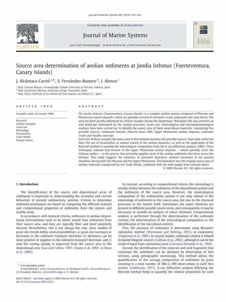
Fig. 1. Location of Jandia Isthmus and th
aeolian sediments at Jandia Isthmus, the most extensive aeoliansedimentary environment of the Canary Islands. This system is verycomplex, including ancient and modern aeolian deposits, palaeosols,and carbonate crusts, which gives place to palaeontological andpalaeoclimatic research projects funded by the IGCP (InternationalGeological Correlation Programme) and EPGC (Earth Processes inGlobal Change) programmes of UNESCO-IUGS. Moreover, presentaeolian processes and sink areas of this sedimentary systemhave beendescribed by Höllermann (1990), and Alcántara-Carrió and Alonso(2002). However, the source areas of the sediments have not yet beendetermined satisfactorily.
2. Study area
2.1. Geological setting
The Canary Islands are a volcanic intraplate archipelago located inthe Atlantic Ocean, between latitudes 27° 37′ and 29° 25′N, andlongitudes 13° 20′ and 18° 10′ W. The hotspot theory is generallyaccepted for the origin of the archipelago (Burke and Wilson, 1972;Schmincke, 1973; Geldmacher et al., 2001). Three stages have beendescribed in the formation of the Canary Islands: i) shield-stage, aninitial volcanic period that built more than 90% of the total volume, ii)erosional gap, and iii) post-erosional volcanism. Gran Canaria, Fuerte-ventura and Lanzarote islands are presently in the last stage,whereas LaGomera island is still undergoing erosion, and Tenerife, La Palma and ElHierro islands are in the shield-stage (Carracedo et al., 1998).
eir main geomorphologic features.

Fig. 2. Geological map of Jandia Isthmus (modified from ITGE, 1991 and Meco, 1993).
221J. Alcántara-Carrió et al. / Journal of Marine Systems 80 (2010) 219–234
The basement of Fuerteventura consists of Upper Cretaceousturbidites overlain by Albian–Oligocene sediments and submarinevolcanic rocks, which are intruded by a dense network of dikes andalkaline plutonic rocks (Coello et al., 1992). Volcanism during theMiocene formed the central, northern and southern volcaniccomplexes, which were built during long periods of successiveeruptions (22.7–12.8 Ma), separated by inactive gaps (Ancoecheaet al., 1996).
The geomorphology of Fuerteventura derives from this volcanicorigin, its proximity to the Sahara Desert (100 km to Cape Yubi), andthe arid climate of the island. Trade Winds are very strong inFuerteventura because of the smooth, low relief of the island. Therainy period covers from November to February, while the rest of theyear is very dry. The maritime climate is determined by the influenceof the Canary Current, which flows southerly, parallel to the Africancoast. Wave action is conditioned by the fetch distance due to theproximity to the continent, which determines the presence of high-energy environments along the northern and western coast lines, incontrast with the presence of low-energy environments along thesouthern and eastern shores. Valleys, pediments, and wadis wereformed during rainy periods (Criado, 1991), while marine actionproduced cliffs, coastal platforms and beaches (Meco, 1993). Finally,aeolian deposits are the result of Trade Winds blowing over exposedmarine sediments.
2.2. Geomorphologic evolution of the Jandia Isthmus
The Jandia Isthmus is located in the southern part of Fuerteventura,connecting the JandiaMassif (i.e., the southern volcanic complex)withthe rest of the island. It is the largest aeolian deposit of the CanaryIslands, with a great diversity of ancient and modern aeolian
environments over a total extension of 54.2 km2 (4.2–6.5 km wideby 10.5 km long, approximately). Moreover, some low dome hills arealso present, which are formed by volcanic structures covered inmanycases by carbonate crusts. Several short wadis cross the area in aNNW–SSE direction. The windward coast of the Isthmus is an activecliff, whereas the leeward coast has an inactive cliff with falling dunesand wide beaches (Fig. 1), which are receding, due to the lack of newsedimentary inputs and the influence of tourist resorts (Alonso et al.,2002).
The complex geological, climatic and geomorphologic evolution ofthe Isthmus explains the great diversity of sedimentary environments(Fig. 2). The Miocene rocks of the southern volcanic complex (20.7–14.2 Ma; Ancoechea et al., 1996) are exposed at the bottom of thewindward cliff and at some dome hills. Marine transgression duringthe Early Pliocene partially eroded the basalt and formed severalmarine terraces between 7 and 60 m.a.s.l. (Meco and Stearns, 1981;Meco et al., 1997) where bioclastic marine sands were deposited.During the subsequent regression, dunes reaching up to 30 mthickness were formed in some areas. Meco (1993) assigned thesedunes to the Pliocene according to the age of lava flows nearby, datedat 2.7±0.2 Ma (Abdel-Monem et al., 1971) and 1.83±0.24 Ma (Mecoand Stearns, 1981). Thereafter, a carbonate crust developed on top,which can presently be observed inmany areas of the Isthmus. Erosionof the Pliocene dunes was the source of sediments that allowed theformation of dunes during the middle Pleistocene to the present, afterCarracedo et al. (2002). The interdune areas show clay palaeosolsformed during rainy periods, with abundant Hymenoptera nests andsnail shell fragments (Meco, 1993). Meco (1993) distinguished threelevels on the Late Pleistocene aeolian sequence according to thecolour: grey, brown, and yellow dunes. Intense rains during the LatePleistocene eroded the carbonate crust and formed the wadis of the

Fig. 3. Present aeolian deposits at Jandia Isthmus are mainly sand sheets (A), with many shadow dunes (B), but they are also reversing dunes (C and D), and falling dunes (E and F).
222 J. Alcántara-Carrió et al. / Journal of Marine Systems 80 (2010) 219–234
Isthmus.Marine deposits in themouths of thesewadis (5 m.a.s.l.) withabundant Strombus bubonius and dated at 106±7 ka and 112±7 kahave been described by Meco et al. (1992).
Erosion of Upper Pleistocene dunes seems to be the source area forthe present aeolian sediments according to Meco (1993), whereasCarracedo (1989) proposes that the modern aeolian sediments arederived from the beaches located at the windward margin of theIsthmus, especially in the northern zone.
These modern unconsolidated aeolian deposits cover the greaterpart of the Isthmus, which reflects the importance of aeolian processesin the present sedimentary dynamics. Höllermann (1990) and Meco
(1993) describe the composition of these modern aeolian deposits,which contain fragments of calcareous algae, echinoids, molluscs, andforaminifera, with minor portions of carbonated crust fragments,quartz and basaltic material. Most of them consist of medium sand,poorly or moderately sorted, and symmetrical or negatively skewed.Sedimentary deposits in the study area include sand sheets andshadowdunes, aswell as falling and reversing dunes (Fig. 3), related tospatial differences of sediment availability (Alcántara-Carrió andAlonso, 2001). Therefore, local aeolian sediment transport is notlimited by the wind energy, but by the density and grain size of thesediments, as well as by anthropogenic infrastructures such as tourist
223J. Alcántara-Carrió et al. / Journal of Marine Systems 80 (2010) 219–234
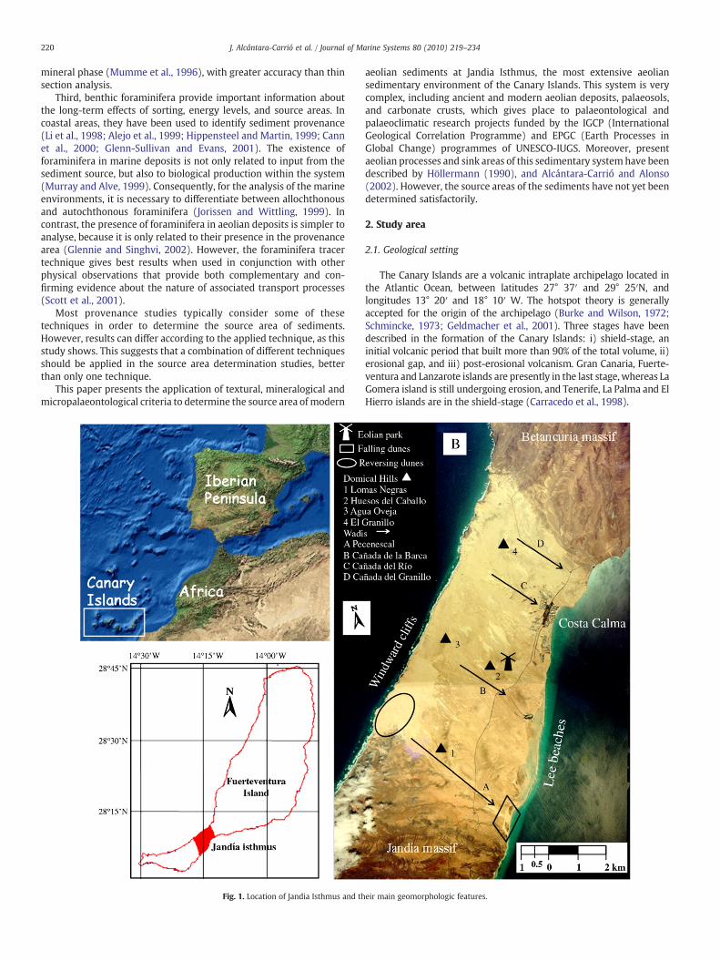
resorts and roads (Alonso et al., 2002). Sand traps and wind profilesstudies (Alcántara-Carrió and Alonso, 2002) have shown that presentaeolian sediments are blowing from the inland sector of the Isthmus toboth, the leeward (SE) and the windward (NW) coasts, by the TradeWinds and winter eastern winds respectively (Fig. 4). Trade Winds,from April to September, cross the Isthmus from NNW to SSE. Thischange in orientation, relative to the prevailing NNE direction of TradeWinds, is due to two topographic factors: i) the presence of theBetancuria and Jandia massifs in the NE and SW respectively; and ii)the NNW–SSE orientation of the wadis on the Isthmus (see Fig. 1).
3. Objectives
Previous studies propose several hypotheses about the origin ofpresent sediments in Jandia Isthmus: i) modern aeolian sediments arederived from the present beaches located at thewindwardmargin of theIsthmus, especially in the northern zone (Carracedo, 1989); ii) erosion of
Fig. 4. Monthly and annual wind roses of Jandia Isth
Upper Pleistocenedunes are the source for thepresent aeolian sediments(Meco, 1993); and iii) Pliocene aeolian deposits are the provenancedeposits for the whole Quaternary aeolian dunes and sand sheets ofJandia Isthmus (Carracedo et al., 2002). In the present study, all thesedeposits, together with erosion of carbonate crusts and volcanic rocks,are consideredaspossible source areas for thepresent aeolian sediments.
The main goal of this paper is to evaluate these hypotheses andtherefore, to determine the source area for the present aeoliansediments of Jandia Isthmus, their relation to the oldest aeolian depositsof Canary Islands (analysed by UNESCO-IUGS programmes), and theimplications for the geomorphologic long-time evolution of the system.
4. Methodology
To identify the source area of the modern aeolian sediments, allpossible source areas, according to the geological setting (Fig. 5), areconsidered. To this end, a total of twenty-five samples were collected
mus (after Alcántara-Carrió and Alonso, 2002).

Fig. 5. The possible source areas for the present aeolian sedimentary dynamics are the present beaches and Pliocene dune cliffs in the windward coast (A and B), and the UpperPleistocene dune deposits located in the surface inland of the Isthmus (C and D).
224 J. Alcántara-Carrió et al. / Journal of Marine Systems 80 (2010) 219–234
from the present aeolian environments and the possible source areasin order to analyse their sedimentary properties (Fig. 6): i) Threesamples correspond to the Pliocene dune cliffs, labelled Plio1–3, aftertheir stratigraphic succession from the bottom to the top; ii) fivesamples were taken from the Upper Pleistocene deposits locatedinland, in Huesos del Caballo Hill, labelled Plei1–5, in the same orderas before; iii) four samples were obtained from the present windwardbeaches, W1–4, from the NE to the SW respectively; iv) thirteensamples of modern aeolian sediment, Mod1–13, were obtainedwithinthe study area, and finally, v) some fragments of carbonate crusts andbasalts were also sampled. All samples were located using GPS withinan accuracy of ±5 m. Samples analysis include grain size, carbonate
Fig. 6. Location of samples taken from themodern unconsolidated aeolian sediments (●), thethe windward cliffs formed by Pliocene dune deposits (▲) over the digital elevation map (leleeward sides of the Isthmus (right).
content, thin section, X-ray diffraction, and foraminifera contentanalysis.
Grain size distributions are determined using a combination of drysieving at 0.5ϕ intervals, from−4 to+4ϕ, while X-ray nephelometry(Micromeritics, Sedigraph 500) is used for the finer fractions. Grainsize parameters (mean size, sorting, skewness and kurtosis) arecalculated and classified applying the graphic method of Folk andWard (1957). The dispersion diagram of mean size versus sortingpermits to compare between themodern sediments and their possiblesource areas. Carbonate content of the samples is obtained usingBernard's volumetric method. Statistical analysis is performed todetermine the 95% confidence intervals for the average values of the
windward beaches (■), a scarp on the inland Late Pleistocene aeolian deposits (+) andft), and the slope map showing the difference between the dipper windward and gentle
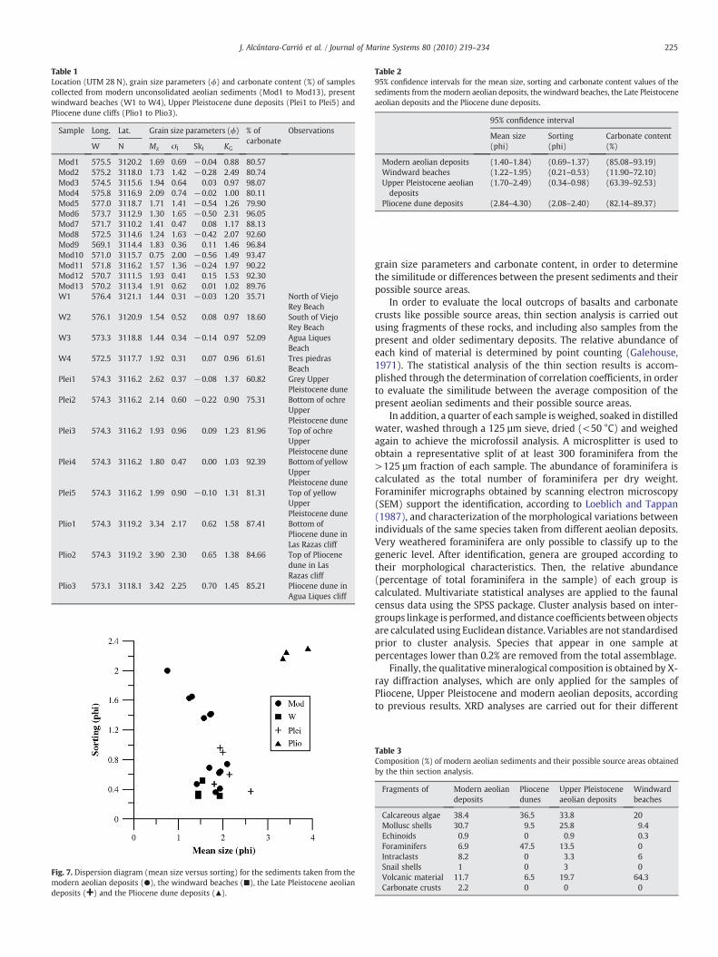
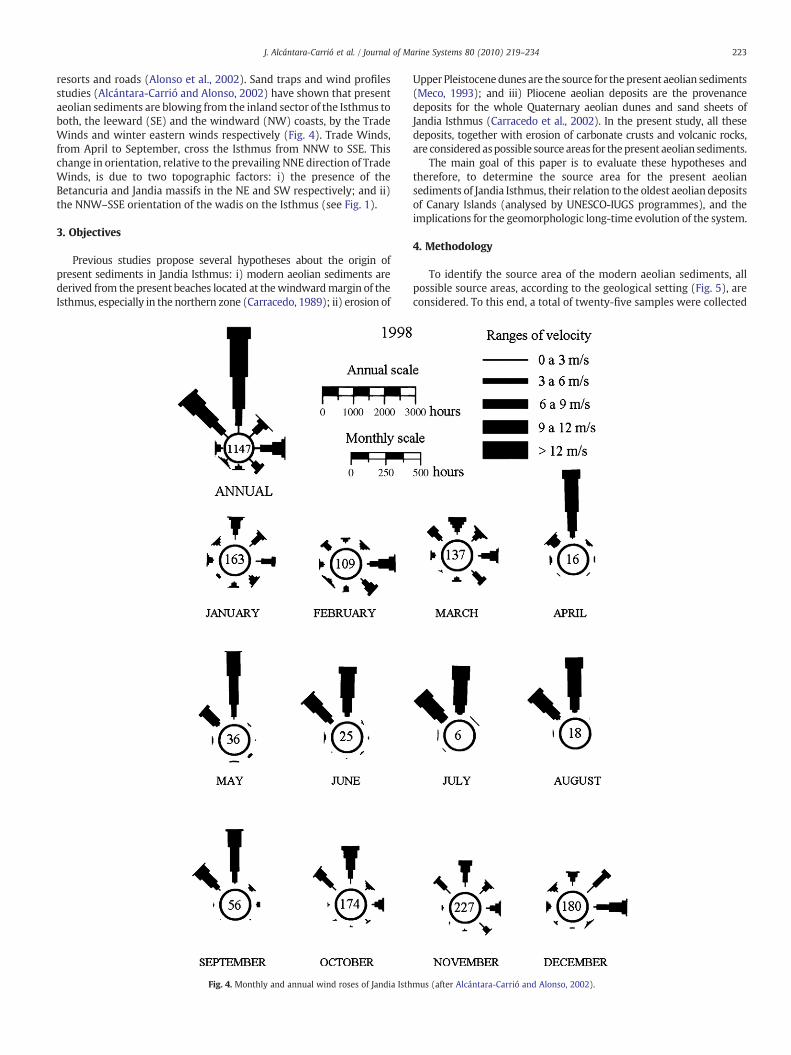
Table 1Location (UTM 28 N), grain size parameters (ϕ) and carbonate content (%) of samplescollected from modern unconsolidated aeolian sediments (Mod1 to Mod13), presentwindward beaches (W1 to W4), Upper Pleistocene dune deposits (Plei1 to Plei5) andPliocene dune cliffs (Plio1 to Plio3).
Sample Long. Lat. Grain size parameters (ϕ) % ofcarbonate
Observations
W N Mz σI SkI KG
Mod1 575.5 3120.2 1.69 0.69 −0.04 0.88 80.57Mod2 575.2 3118.0 1.73 1.42 −0.28 2.49 80.74Mod3 574.5 3115.6 1.94 0.64 0.03 0.97 98.07Mod4 575.8 3116.9 2.09 0.74 −0.02 1.00 80.11Mod5 577.0 3118.7 1.71 1.41 −0.54 1.26 79.90Mod6 573.7 3112.9 1.30 1.65 −0.50 2.31 96.05Mod7 571.7 3110.2 1.41 0.47 0.08 1.17 88.13Mod8 572.5 3114.6 1.24 1.63 −0.42 2.07 92.60Mod9 569.1 3114.4 1.83 0.36 0.11 1.46 96.84Mod10 571.0 3115.7 0.75 2.00 −0.56 1.49 93.47Mod11 571.8 3116.2 1.57 1.36 −0.24 1.97 90.22Mod12 570.7 3111.5 1.93 0.41 0.15 1.53 92.30Mod13 570.2 3113.4 1.91 0.62 0.01 1.02 89.76W1 576.4 3121.1 1.44 0.31 −0.03 1.20 35.71 North of Viejo
Rey BeachW2 576.1 3120.9 1.54 0.52 0.08 0.97 18.60 South of Viejo
Rey BeachW3 573.3 3118.8 1.44 0.34 −0.14 0.97 52.09 Agua Liques
BeachW4 572.5 3117.7 1.92 0.31 0.07 0.96 61.61 Tres piedras
BeachPlei1 574.3 3116.2 2.62 0.37 −0.08 1.37 60.82 Grey Upper
Pleistocene dunePlei2 574.3 3116.2 2.14 0.60 −0.22 0.90 75.31 Bottom of ochre
UpperPleistocene dune
Plei3 574.3 3116.2 1.93 0.96 0.09 1.23 81.96 Top of ochreUpperPleistocene dune
Plei4 574.3 3116.2 1.80 0.47 0.00 1.03 92.39 Bottom of yellowUpperPleistocene dune
Plei5 574.3 3116.2 1.99 0.90 −0.10 1.31 81.31 Top of yellowUpperPleistocene dune
Plio1 574.3 3119.2 3.34 2.17 0.62 1.58 87.41 Bottom ofPliocene dune inLas Razas cliff
Plio2 574.3 3119.2 3.90 2.30 0.65 1.38 84.66 Top of Pliocenedune in LasRazas cliff
Plio3 573.1 3118.1 3.42 2.25 0.70 1.45 85.21 Pliocene dune inAgua Liques cliff
Fig. 7. Dispersion diagram (mean size versus sorting) for the sediments taken from themodern aeolian deposits (●), the windward beaches (■), the Late Pleistocene aeoliandeposits (+) and the Pliocene dune deposits (▲).
Table 295% confidence intervals for the mean size, sorting and carbonate content values of thesediments from themodern aeolian deposits, the windward beaches, the Late Pleistoceneaeolian deposits and the Pliocene dune deposits.
95% confidence interval
Mean size(phi)
Sorting(phi)
Carbonate content(%)
Modern aeolian deposits (1.40–1.84) (0.69–1.37) (85.08–93.19)Windward beaches (1.22–1.95) (0.21–0.53) (11.90–72.10)Upper Pleistocene aeoliandeposits
(1.70–2.49) (0.34–0.98) (63.39–92.53)
Pliocene dune deposits (2.84–4.30) (2.08–2.40) (82.14–89.37)
225J. Alcántara-Carrió et al. / Journal of Marine Systems 80 (2010) 219–234
grain size parameters and carbonate content, in order to determinethe similitude or differences between the present sediments and theirpossible source areas.
In order to evaluate the local outcrops of basalts and carbonatecrusts like possible source areas, thin section analysis is carried outusing fragments of these rocks, and including also samples from thepresent and older sedimentary deposits. The relative abundance ofeach kind of material is determined by point counting (Galehouse,1971). The statistical analysis of the thin section results is accom-plished through the determination of correlation coefficients, in orderto evaluate the similitude between the average composition of thepresent aeolian sediments and their possible source areas.
In addition, a quarter of each sample is weighed, soaked in distilledwater, washed through a 125 µm sieve, dried (<50 °C) and weighedagain to achieve the microfossil analysis. A microsplitter is used toobtain a representative split of at least 300 foraminifera from the>125 µm fraction of each sample. The abundance of foraminifera iscalculated as the total number of foraminifera per dry weight.Foraminifer micrographs obtained by scanning electron microscopy(SEM) support the identification, according to Loeblich and Tappan(1987), and characterization of the morphological variations betweenindividuals of the same species taken from different aeolian deposits.Very weathered foraminifera are only possible to classify up to thegeneric level. After identification, genera are grouped according totheir morphological characteristics. Then, the relative abundance(percentage of total foraminifera in the sample) of each group iscalculated. Multivariate statistical analyses are applied to the faunalcensus data using the SPSS package. Cluster analysis based on inter-groups linkage is performed, and distance coefficients between objectsare calculated using Euclidean distance. Variables are not standardisedprior to cluster analysis. Species that appear in one sample atpercentages lower than 0.2% are removed from the total assemblage.
Finally, the qualitativemineralogical composition is obtained by X-ray diffraction analyses, which are only applied for the samples ofPliocene, Upper Pleistocene and modern aeolian deposits, accordingto previous results. XRD analyses are carried out for their different
Table 3Composition (%) of modern aeolian sediments and their possible source areas obtainedby the thin section analysis.
Fragments of Modern aeoliandeposits
Pliocenedunes
Upper Pleistoceneaeolian deposits
Windwardbeaches
Calcareous algae 38.4 36.5 33.8 20Mollusc shells 30.7 9.5 25.8 9.4Echinoids 0.9 0 0.9 0.3Foraminifers 6.9 47.5 13.5 0Intraclasts 8.2 0 3.3 6Snail shells 1 0 3 0Volcanic material 11.7 6.5 19.7 64.3Carbonate crusts 2.2 0 0 0

Table 4Analysis of correlation between the modern aeolian sediments and the possible sourceareas after thin section and X-ray diffraction analyses.
Coefficient of determination (R-squared)
Thin section analysis X-ray diffraction analysis
Mod versus Plei 0.87 0.80Mod versus Plio 0.20 0.14Mod versus W 0.07 N/A
226 J. Alcántara-Carrió et al. / Journal of Marine Systems 80 (2010) 219–234
grain size fractions: silt, very fine sand, fine sand, medium sand, andcoarse sand, using a Siemens D-5000 diffractometer with graphitemonochromator (CuKα). The relative percentage amount (wt.%) ofeach identified mineral phase is determined using the Rietveldmethod (Rietveld, 1969; Rodríguez-Carvajal et al., 1987).
The presence of quartz in the finest fractions is confirmed bytreating a sample of modern aeolian silt with hydrogen chloride toeliminate the carbonates. Afterwards, a shinning white grain of thesample is analysedwith a Philips XL-30 scanning electronmicroscope.Moreover, the atomic composition of this grain is determined byenergy dispersive spectroscopy (EDS).
The statistic analysis of the X-ray diffraction results, equal to theanalysis of the thin section results, consists in the determination of thecorrelation coefficients for the average composition, in order toevaluate again the similitude between the present aeolian sedimentsand their possible source areas.
5. Results and discussion
5.1. Grain size analysis
Grain size analyses indicate: i) modern aeolian sediments displaypoor tomoderate sorting andmedium grain size (see Alcántara-Carrióand Alonso, 2001 for grain size seasonal variations); ii) sedimentsfromwindward beaches are moderately to well sorted, medium sand;iii) Upper Pleistocene dune deposits also consist of moderately to wellsorted, medium to fine sand; iv) Pliocene dune deposits consist of verypoorly sorted and very fine sand (Table 1). In order to compare theseresults, the dispersion diagram (Fig. 7) and the 95% confidenceintervals for the mean size and sorting values (Table 2) show highersimilitude of the modern aeolian sediments with both the Pleistocenesediments and the present sediments from the windward beaches,while the Pliocene sediments are clearly different.
Very fine Pliocene materials cannot be considered as an effectivesource area for the modern medium sand aeolian sediments, unlessonly the coarser portion of the Pliocene deposits would contribute tothe present aeolian deposits. However, the Pliocene deposits are moreconsolidated than the Pleistocene ones, and consequently, erosionrates should be greater for the latter, under the same wind intensity.
Previous studies have shown that present-day surface sedimentshave unimodal, bimodal or even polymodal grain size distributions. Inthe case of polymodal curves, the minor mode is associated with thecoarser fraction, which consists of carbonate crust and basaltfragments (Alcántara-Carrió and Alonso, 2001). This indicates thatthe modern aeolian deposits may come from a combination of severalsources, on the basis of their different grain size fractions.
The large differences in grain size distributions are related to thegreat diversity of aeolian environments in the study area (Alcántara-Carrió and Alonso, 2002). This sedimentary diversity is very differentfrom the uniformity of marine and aeolian areas, where sedimenttransport trends have been tested (Gao and Collins, 1991; Chang et al.,2001; Le Roux et al., 2002). In fact, transport trend in the study area,obtained with these models, show circular fluxes around the domehills, in disagreement with both previous studies (Höllermann, 1990)
and sediment transport directions determined by sand traps andwindprofile studies (Alcántara-Carrió and Alonso, 2002).
It is suggested, therefore, that the supply of sediments to themodern aeolian deposits comes from a combination of severalsources, and that the Pliocene dunes are a minor source area.However, the results from grain size analysis are not conclusive andrequire to be complemented with compositional analysis.
5.2. Carbonate content analysis
The average carbonate content of the modern aeolian sediments isaround 90% for the medium sand fraction, which is associated withaeolian sand transport, whereas the gravel fraction shows valueslower than 65% (Alcántara-Carrió and Alonso, 2001). Consequently, itis confirmed that basaltic rocks are not the main source area for theaeolian sediments. The modern beaches deposits along the windwardcoast cannot be either the source area of modern aeolian, because theyshow lower carbonate values, ranging between 18.6 and 61.6%, withan average of 42% (Table 1).
In contrast, the Pliocene deposits are characterized by a very largecarbonate content (>85%), whereas the Upper Pleistocene depositsshow higher values than 75%, except for the basal grey unit. Thelikeness in the carbonate content of the modern and Pliocenedeposits, with very similar 95% confidence intervals (Table 2),indicates that Pliocene dune deposits can be the major source areaof the aeolian sediments, but Upper Pleistocene deposits or carbonatecrusts can also make an important contribution.
5.3. Petrographic analysis
Thin section analysis confirms that the modern aeolian sedimentsmostly consist of fragments of calcareous algae and molluscs. Thecalcareous algae have been identified as Melobesia sp., according tothe similarity of their reticular sections to the descriptions by Blanc(1986). On the contrary, basalt fragments, intraclasts and foraminiferaare less abundant. And finally, echinoid fragments, terrestrialgastropod and carbonate crust fragments are very rare (Table 3).
Windward beaches show content of volcanicmaterials higher than64%, while modern sediments present values lower than 12%.Consequently, inputs from the beaches can be neglected. Moreover,the predominance of calcareous algae and mollusc fragments in themodern aeolian sediments indicates that carbonate crusts can be onlya secondary source. Therefore, only Pliocene and Upper Pleistocenedunes can be the major source area. The statistical analysis show highcorrelation between the modern and Pleistocene sediments (R-squared of 0.87). In contrast, correlations of modern sediments versusboth the Pliocene sediments and thewindward beaches sediments arevery low (Table 4). In summary, thin section analysis indicates thaterosion of Upper Pleistocene deposits seems to be the main sourcearea for the present aeolian unconsolidated sediments.
5.4. Foraminifera analysis
The first study of foraminifera in Fuerteventura was carried out byColom (see Hausen, 1958), who associated the origin of foraminiferawithMiocene silt formed at a 50–100 mwater depth. Thereafter, thesesediments were transported to shallow zones, subjected to marineerosion, and finally exposed to wind action during amarine regression(Hausen, 1958). Samples analysed by Colom mainly contained Loba-tula lobatula and Textularia sagittula, as well as Amphistegina sp.,Triloculina sp.; Quinqueloculina sp., Elphidium complanatum and Ano-malina sp.Most of themhave been re-identified in our study. However,many of the foraminifera species identified in this study have neverbeen found before in the Canary Islands (Hernández-Otero andHernández-García, 2003; Alonso et al., 2006; Hernández et al., 2007)or in the surrounding area (Meggers et al., 2002).

Fig. 8. SEM photographs of foraminifers from ancient and modern aeolian sediments of the Jandia Isthmus: 1) Quinqueloculina lamarckiana d'Orbigny. 2) Quinqueloculina seminula(Linnaeus). 3) Miliolinella subrotunda (Montagu). 4) Gavelinopsis sp. 5) Rosalina globularis d'Orbigny. 6) Discorbinella sp. 7) Glabratellina sp. 8) Conorbella patelliformis (Brady) 9)Cibicides refulgens de Monfort.
227J. Alcántara-Carrió et al. / Journal of Marine Systems 80 (2010) 219–234
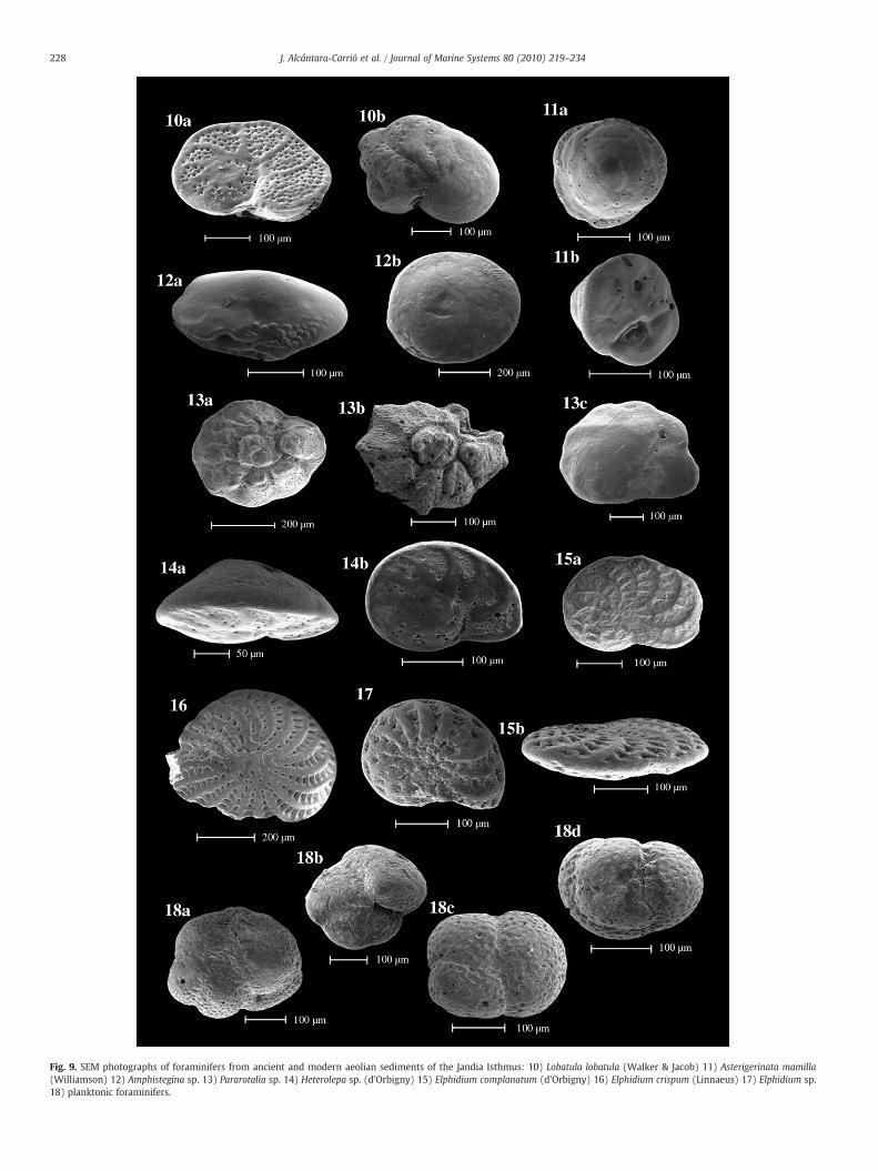
Fig. 9. SEM photographs of foraminifers from ancient and modern aeolian sediments of the Jandia Isthmus: 10) Lobatula lobatula (Walker & Jacob) 11) Asterigerinata mamilla(Williamson) 12) Amphistegina sp. 13) Pararotalia sp. 14) Heterolepa sp. (d'Orbigny) 15) Elphidium complanatum (d'Orbigny) 16) Elphidium crispum (Linnaeus) 17) Elphidium sp.18) planktonic foraminifers.
228 J. Alcántara-Carrió et al. / Journal of Marine Systems 80 (2010) 219–234
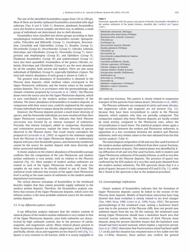
Table 5Taxonomic appendix with the genera and species of benthic foraminifers identified inthe aeolian sediments of the Jandia Isthmus, classified after Loeblich and Tappan(1987).
Miliolinella subrotunda (Montagu)Quinqueloculina lamarckiana d'OrbignyQuinqueloculina seminula (Linnaeus)Triloculina sp.Gavelinopsis sp.Neoconorbina terquemi (Rzehak)Rosalina globularis d'OrbignyCibicidoides sp.Discorbinella sp.Discorbinoides subpatelliniformis SaidovaGlabratellina sp.Conorbella patelliformis (Brady)Cibicides ungerianus (d'Orbigny)Cibicides refulgens de MonfortLobatula lobatula (Walker & Jacob)Asterigerinata mamilla (Williamson)Amphistegina sp.Heterolepa sp. (d'Orbigny)Pararotalia sp.Elphidium complanatum (d'Orbigny)Elphidium crispum (Linnaeus)Elphidium sp.
229J. Alcántara-Carrió et al. / Journal of Marine Systems 80 (2010) 219–234
The size of the identified foraminifera ranges from 125 to 250 μm.Most of them are benthic epifaunal foraminifera associated with algalsubstrata (Figs. 8 and 9, Table 5). However, planktonic foraminiferawere also found in several samples and there was, in addition, a smallgroup of individuals not determined, due to shell abrasion.
Foraminifera were classified into eleven groups according to theirmorphological similarities. Benthic foraminifers include: Quinquelo-culina, Triloculina and Milionella (Group 1); Gavelinopsis, Neoconor-bina, Conorbella and Glabratellina (Group 2), Rosalina (Group 3);Discorbinella (Group 4); Discorbinoides (Group 5); Cibicides, Lobatula,Heterolepa, and Cibicidoides (Group 6); Pararotalia (Group 7); Asteri-gerinata and Amphistegina (Group 8); and Elphidium (Group 9).Planktonic foraminifers (Group 10) and undetermined (Group 11)have also been quantified. Foraminifera of the genera Cibicides, Lo-batula, Heterolepa and Cibicidoides (Group 6) are the most abundantfor all the samples, both ancient and modern. There are also manyindividuals of Elphidium (Group 9), especially Elphidium crispum. Thetotal and relative abundance of each group is shown in Table 6.
The greatest total abundance of foraminifera is obtained in thePliocene dune deposits, while medium values correspond to theUpper Pleistocene sediments, and the lowest values to the modernaeolian deposits. This is in accordance with the geomorphologic andclimatic evolution proposed by Carracedo et al. (2002): the Pliocenedunes were the source area for the Upper Pleistocene deposits, whichin turn contributed to the modern aeolian environments of theIsthmus. The lower abundance of foraminifera in modern deposits, incomparison with their source area, could be explained by the ruptureof many individuals due to impact along the aeolian transport process.
However, the Pliocene deposits present a much lower diversity ofspecies, and the Pararotalia individuals are more weathered than theirUpper Pleistocene counterparts. This indicates that thick Pliocenesuccession was formed by an intense transport of sediments.Precisely, this intense transport, added to compaction, dissolutionand cementation processes, explain the lower diversity of speciesobserved in the Pliocene dunes. This result clearly contradicts theproposal of Carracedo et al. (2002) in regard to the sediment supplyfrom the Pliocene to the Upper Pleistocene deposits. A sedimentarydeposit with just a few foraminifer genera, and intensively weathered,cannot be the source for another deposit with more diversity andbetter-preserved individuals.
A cluster analysis on the relative abundance of foraminifera groupsconfirms that the composition of the Late Pleistocene and modernaeolian sediments is very similar, with no relation to the Pliocenematerial (Fig. 10). Most samples of modern aeolian sediments arerelated to each of the Upper Pleistocene levels, while only twosamples do not seem to be directly related to any of them. Thisstatistical result indicates that erosion of the upper-most Pleistocenelevel is acting as the main source of sediments to the modern aeoliandepositional environments.
The virtual absence nowadays of foraminifera in the windwardbeaches implies that they cannot presently supply sediment to themodern aeolian deposits. Therefore, the foraminifera analysis con-firms that erosion of the Upper Pleistocene deposits, which cover theIsthmus surface, is the most probable sediment source for the modernaeolian deposits.
5.5. X-ray diffraction pattern analysis
X-ray diffraction analysis indicates that the relative content ofmineral phases of themodern aeolian sediments is very similar to thatof the Upper Pleistocene deposits, since both sediments are charac-terized by high carbonate content, due to the presence of calcite,aragonite, and magnesium calcite. Minor mineral phases present inthese Quaternary deposits are silicates, plagioclases, and K-feldspars,andfinally, olivine,micas andmagnetite are less than 0.5 wt% (Fig. 11).Quartz is very common in silt fraction, while it is nearly negligible in
the sand-size fractions. This pattern is clearly related to suspensiontransport of fine particles from Sahara desert (Menéndez et al., 2009).
The Pliocene sediments are composed of calcite and some silicates,but magnesium calcite and aragonite are not present (Fig. 12),because they have been recrystallized to calcite in the Pliocenedeposits, which explains why they are partially compacted. Thiscompaction explains why these Pliocene deposits are hardly erodedby wind activity, compared to the Pleistocene ones, where therecrystallization is much lower. The statistical analysis shows again ahigh correlation between the modern and Pleistocene sediments, inopposition to a low correlation between the modern and Pliocenesediments, with very similar values to the ones obtained from the thinsection analysis (Table 4).
Themineralogical composition of silt and veryfine sand fractions ofthemodern aeolian sediments is different from their coarser fractions,due to the presence of quartz. This mineral phase was identified by X-ray diffraction of silt and very fine sand fractions, both in modern andUpper Pleistocene sediments of the Jandia Isthmus, as well as very fineand fine sand of the Pliocene deposits. The presence of quartz wasconfirmed by the EDS analysis of a very fine sand grain obtained fromthe modern aeolian sediments. The EDS spectrum shows that it is agrain of quartz, because it is only composed of O and Si (Fig. 13), whilethe C found in the spectrum is due to the analytical procedure.
5.6. Geomorphologic implications
Cluster analysis of foraminifera indicates that the formation ofUpper Pleistocene deposits cannot be linked to the erosion of thePliocene dune deposits. Models of beach/dune interaction have longshowed that dune evolution is closely related to sea level changes(Pye, 1984; Hesp, 1988; Carter et al., 1990; Psuty, 1992). The presentgeomorphology of the windward coast, lacking a backshore beachzone due to the presence of the Pliocene cliffs, does not permit newsediment inputs from the sea. On the contrary, the windward coastduring Upper Pleistocene should have a backshore beach area thatreceived marine sediments. The existence of thick Pliocene dunedeposits along the present shoreline means that the backshore zoneshould had been located seaward, which implies a regressive period.Zazo et al. (2002) determine that Fuerteventura island had been uplift1.7 cm/Ka and this situation has remained more or less stable over thelast ≈130ka. However, these authors also confirm the general

Table 6Total abundance (number of foraminifers per gr.) and relative abundance for each group (%).
Sample Total abundance Group 1 Group 2 Group 3 Group 4 Group 5 Group 6 Group 7 Group 8 Group 9 Group 10 Group 11
Mod1 692.64 2.02 23.23 2.02 0 1.01 52.53 1.01 3.03 10.10 0 5.05Mod2 163.41 1.83 12.20 0 0.61 1.83 64.63 3.66 1.22 11.59 1.22 1.22Mod3 585.64 3.41 19.53 0.90 2.15 0.72 64.34 0 1.25 6.81 0.18 0.72Mod4 244.70 0 21.66 0 0 3.18 57.32 3.82 4.46 7.64 0.64 1.27Mod5 260.57 0 11.89 0.70 0 3.50 74.13 0 4.90 3.50 1.40 0Mod6 437.71 3.03 10.10 0 2.02 1.01 71.21 0 1.01 8.59 1.01 2.02Mod7 618.56 3.33 19.44 0 2.78 1.67 66.11 0 2.78 3.89 0 0Mod8 107.93 6.15 9.74 0 3.59 0 69.74 0 1.54 6.15 1.03 2.05Mod9 672.88 0.80 20.00 1.60 3.20 0.80 64.00 1.60 2.40 3.20 0 2.40Mod10 191.16 5.83 6.31 3.40 1.94 0.49 71.84 0.49 2.91 1.94 0 4.85Mod11 753.26 1.87 20.56 3.27 0.93 0.93 62.15 0 1.40 7.48 0.47 0.93Mod12 756.51 2.19 15.30 2.19 1.09 1.09 67.21 0 4.37 6.01 0 0.55Mod13 824.39 2.06 20.10 0.52 4.64 0 65.46 0 1.55 3.09 0 2.58Plei1 452.44 0 15.33 0 0.73 0 72.26 0.73 2.19 5.84 0.73 2.19Plei2 1081.28 3.36 10.74 0 0 0 69.13 3.36 2.01 5.37 2.68 3.36Plei3 2692.31 0.75 6.77 0 0 3.76 78.20 0.75 0 3.76 3.76 2.26Plei4 1209.79 1.73 8.09 0 0.58 1.16 63.58 0.58 2.89 10.40 4.05 6.94Plei5 2543.86 2.43 14.56 2.43 1.94 0.97 65.53 0.97 2.43 3.88 0.49 4.37Plio1 16,770.18 0 0 0 0 0.37 55.19 37.04 0 4.44 1.11 1.85Plio2 25,611.11 0 0 0 0 0 57.49 38.46 0 3.64 0 0.40Plio3 19,107.14 0 0 0 0 0 64.48 27.57 0 3.27 0 4.67
See text for explanation of different groups.
230 J. Alcántara-Carrió et al. / Journal of Marine Systems 80 (2010) 219–234
climatic instability during the peak of MIS 5e (≈110 to 130ka), whereseveral sea level changes within a general transgressive cycle havebeen recorded. Small regressive pulses in a general transgressive cycleare just the most favourable situation to generating the coastal dunedeposits presently located in subaerial zones (Paskoff, 1985).
The stratigraphy of the area has not yet been studied in detail, butit is clear that the Pliocene deposits consist of thick sequences ofdunes, whereas the thinner Upper Pleistocene sediments areassociated with sand sheets. The predominant bedforms nowadaysin the Isthmus are sand sheets and shadow dunes associated withsparse shrubs, whereas dunes of metre-scale dimensions are onlylocated in the southwestern part of the windward and leeward coasts(Alcántara-Carrió and Alonso, 2002). Evolution of the system from
Fig. 10. Cluster graphic linking Pliocene (Plio), Upper Pleistocene (Plei) and mode
dunes to sand sheets implies that the ratio between wind energy andsediment availability has increased. Trade Winds probably were verystrong during the formation of the Pliocene dunes (Meco, 1993),while the present scarcity of sediments over a great part of the studyarea has been demonstrated by grain size, compositional and sandtrap studies (Alcántara-Carrió and Alonso, 2001, 2002).
5.7. Palaeoclimatic implications
The presence of quartz in modern and ancient aeolian deposits ofthe Jandia Isthmus is in accordance with the occurrence of Saharandust in marine sediments of the region over the last 250 Ka, whereinput rate variations between the glacial and interglacial stages seem
rn (Mod) aeolian sediments after the similitude in their foraminifer content.
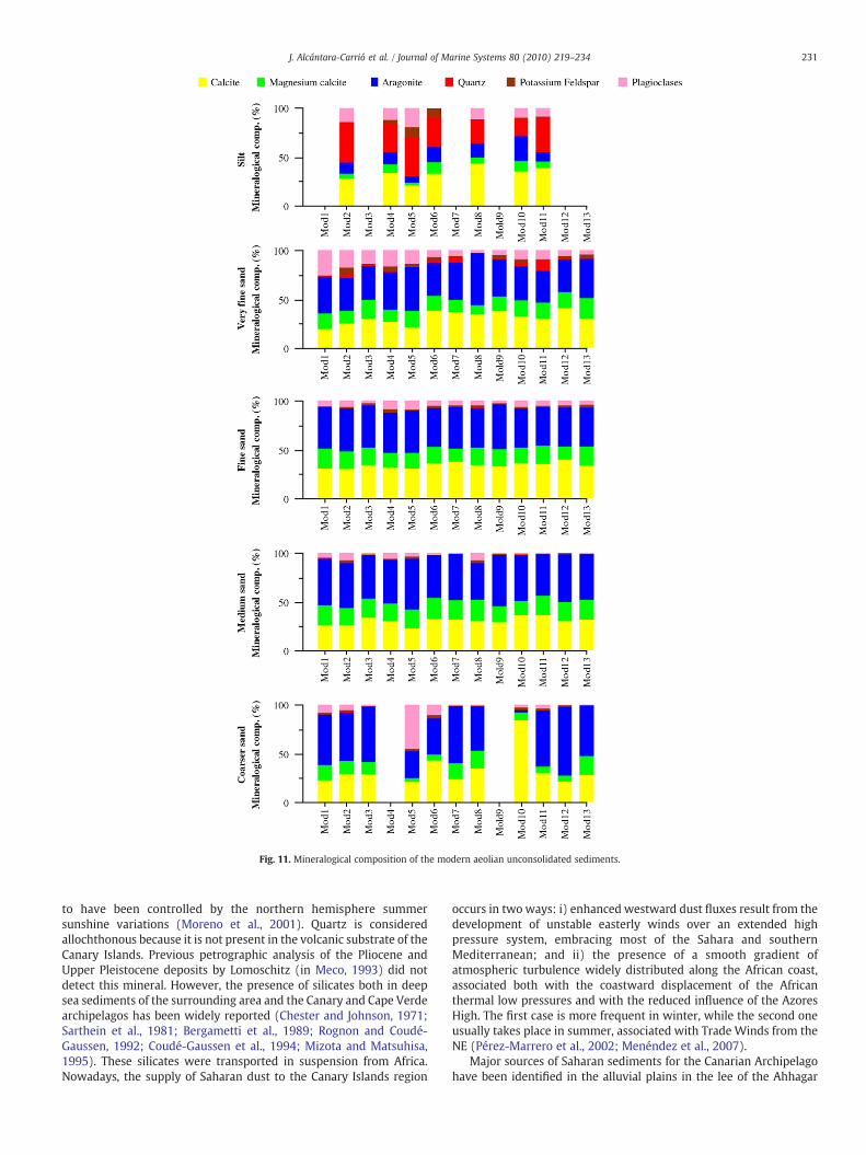
Fig. 11. Mineralogical composition of the modern aeolian unconsolidated sediments.
231J. Alcántara-Carrió et al. / Journal of Marine Systems 80 (2010) 219–234
to have been controlled by the northern hemisphere summersunshine variations (Moreno et al., 2001). Quartz is consideredallochthonous because it is not present in the volcanic substrate of theCanary Islands. Previous petrographic analysis of the Pliocene andUpper Pleistocene deposits by Lomoschitz (in Meco, 1993) did notdetect this mineral. However, the presence of silicates both in deepsea sediments of the surrounding area and the Canary and Cape Verdearchipelagos has been widely reported (Chester and Johnson, 1971;Sarthein et al., 1981; Bergametti et al., 1989; Rognon and Coudé-Gaussen, 1992; Coudé-Gaussen et al., 1994; Mizota and Matsuhisa,1995). These silicates were transported in suspension from Africa.Nowadays, the supply of Saharan dust to the Canary Islands region
occurs in two ways: i) enhanced westward dust fluxes result from thedevelopment of unstable easterly winds over an extended highpressure system, embracing most of the Sahara and southernMediterranean; and ii) the presence of a smooth gradient ofatmospheric turbulence widely distributed along the African coast,associated both with the coastward displacement of the Africanthermal low pressures and with the reduced influence of the AzoresHigh. The first case is more frequent in winter, while the second oneusually takes place in summer, associated with Trade Winds from theNE (Pérez-Marrero et al., 2002; Menéndez et al., 2007).
Major sources of Saharan sediments for the Canarian Archipelagohave been identified in the alluvial plains in the lee of the Ahhagar

Fig. 12. Mineralogical composition of the Pliocene and the Late Pleistocene aeolian sediments.
232 J. Alcántara-Carrió et al. / Journal of Marine Systems 80 (2010) 219–234
Massif, near the Tamanrasset region in Algeria, and in the Teneréregion (Kalu, 1979). These source areas are located 2000 and 2700 kmaway from Fuerteventura, respectively. Nevertheless, Criado andDorta (2003) concluded that the source area of a very dense dustyplume that affected the Canary Islands in January 1999 was located inthe Tiris area in Mauritania, 650 km away. Both cases are associatedwith enhanced westward fluxes.
Coudé-Gaussen and Rognon (1993) analysed differences betweenaeolian calcitic coatings and quartz dust from Fuerteventura. Theyconclude that carbonated sediments were blown during LatePleistocene low sea level stands, from a 4–9 km wide shelf, locatedto the west of Fuerteventura. In contrast, according to these authors,the quartz silt is only related to atmospheric circulation during the
Holocene, blowing from the Sahara Desert. It is an evidence of thedifferent climatic conditions that prevailed during the Late Pleisto-cene and Holocene in the study area.
The formation of the older aeolian deposits, with lower quartzcontent, should be due to intense Trade Winds blowing from NNW toSSE across the Isthmus (Meco, 1993). The great thickness of thisaeolian formation suggests the presence of a wide backshore areanorthward of the Isthmus, during the Pliocene, according to Meco(1993); whereas Coudé-Gaussen and Rognon (1993) suggest that a 4–9 km wide subaerial source area existed to the west of the study areaduring the Pleistocene.
Current bathymetry confirms the presence of a quite wide shelfalong the west coast of Fuerteventura, while there is no platform at all
Fig. 13. SEM image (left) and EDX spectrum (right) of a quartz grain from the very fine sand fraction of a modern aeolian sediment sample.
233J. Alcántara-Carrió et al. / Journal of Marine Systems 80 (2010) 219–234
at the southeast coast. Based on this evidence, and according to grainsize, petrograhic, foraminifera and X-ray diffraction analyses, wepropose that Pliocene dunes were formed by intense Trade Windsblowing over the sedimentary deposits that emerged during Pliocenelowstands. In contrast, the Upper Pleistocene deposits — which mustbe associated with new inputs of sediments during subsequentregressive sceneries — and the Holocene aeolian deposits — whichwere generated due to the erosion of the Upper Pleistocene ones —
seem to be related to lower intensity of Trade Winds, and,consequently, to a higher input of quartz by easterly winds from theSahara Desert during winter times.
6. Conclusions
The analysis of sediment source areas has become a useful tool todescribe the present aeolian dynamics of the Jandia Isthmus and evento enhance the knowledge about its complex geomorphologic andpalaeoclimatic evolution.
Several techniques have been employed to determine the sourcefor the ancient and modern aeolian sediments of the study area.The results of each specific technique are inconclusive, which leadsus to believe that a combination of techniques is required insediment provenance studies. Sorting and mean grain size valuesseem to indicate that Upper Pleistocene dunes, present windwardbeaches, or even a combination of them, could be the main sourcearea.
Analysis of the carbonate content excludes the possibility of amajor supply of sediments from basalt rocks. Petrographic studiesindicate that carbonate crusts could not have been the main sedimentsource, and show a high correlation of the composition between themodern aeolian sediments and the Upper Pleistocene dunes.
Foraminifer genera, their abundance, diversity and degree ofweathering in the aeolian deposits, suggest that sediment supply tomodern unconsolidated aeolian environments is associated with theerosion of Upper Pleistocene aeolian deposits. Moreover, many of theforaminifera species identified in this study have never been foundbefore in the Canary Islands or in the surrounding area. X-raydiffraction analysis confirms that the source of sediments for themodern aeolian deposits is the erosion of the Upper Pleistocene ones.
Furthermore, in contrast to previous studies, foraminifera analysishas shown that Upper Pleistocene deposits were not formed due toerosion of windward Pliocene cliffs, but associated with new inputs ofmarine sediments from windward beaches, during a Late Pleistocenemarine regression.
These relations between the modern and ancient deposits alsohave implications for the geomorphologic evolution of the Isthmus.The older dune deposits, presently cropping out in the windwardcliffs, were formed during a marine regression that probably exposeda large volume of sediments and, more importantly, generated abackshore zone to allow the inland aeolian transport by the TradeWinds.
The different foraminifera content of the Upper Pleistocene aeoliandeposits implies that backshore zones must also have been developedduring their formation, related to a marine regression. The presentgeomorphology of the windward coast, with small beaches backed bycliffs, instead of a smooth backshore surface, precludes any presentsediment input from the windward beaches, due to the present sealevel rise.
Trade Winds should have been more intense during the develop-ment of the thick oldest dunes, while they alternatedwith the easterlywinds from the Sahara during formation of the Late Pleistocene andmodern aeolian deposits. The thickness of the oldest dunes, incontrast with the present low availability of aeolian sediments inmany zones of the Isthmus, and the predominance of sand sheetssuggest different wind and geomorphologic conditions.
In summary, there is presently no input of sediments from thewindward beaches to the aeolian system of the Jandia Isthmus, butaeolian erosion of the Upper Pleistocene deposits, which partiallycover its surface, supply most of the sediments that are blown acrossthe Isthmus. Minor sediment sources are related to the erosion ofcarbonate crusts, basalt rocks and aeolian dune cliffs on the Isthmus,as well as Sahara dust.
Acknowledgments
The authors are indebted to Guillermo Francés, Paula Diz, IsoraSánchez, and Luis Gago, whose comments on foraminifera andmineralogical analyses improved the manuscript, and to GermánMartín and Angelo Santana for their collaboration with the statisticalanalyses, as well as to Robin Davidson-Arnott and Bernard O. Bauer fortheir reviews and suggestions. This paper is a contribution to researchprojects PI2002/08 funded by Canary Government, and SEJ2007-64959/GEOG funded by CICYT.
References
Abdel-Monem, A., Watkins, N.D., Gast, P.W., 1971. Potassium-argon ages, volcanicstratigraphy, and geomagnetic polarity history of the Canary Islands: Lanzarote.Fuerteventura, Gran Canaria, and La Gomera. Am. J. Sci. 271, 490–521.
Alcántara-Carrió, J., Alonso, I., 2001. Aeolian sediment availability in coastal areasdefined from sedimentary parameters. Application to a case study in Fuerteventura.Sci. Mar. 65 (Suppl. 1), 7–20.
Alcántara-Carrió, J., Alonso, I., 2002. Measurement and prediction of aeolian sedimenttransport at Jandia Isthmus (Fuerteventura, Canary Islands). J. Coastal Res. 18 (2),300–315.
Alejo, I., Austin, W.E.N., Francés, G., Vilas, F., 1999. Preliminary investigations of therecent foraminifera of Baiona Bay, N.W. Spain. J. Coastal Res. 15 (2), 413–427.
Alonso, I., Alcántara-Carrió, J., Cabrera, L., 2002. Tourist resort and their impact on beacherosion at Sotavento beaches, Fuerteventura, Spain. J. Coastal Res. S.I. 36, 1–7.
Alonso, I., Sánchez, I., Cabrera, L., Benavides, A., Alcántara-Carrió, J., Usera, J., 2006.Decadal evolution of a coastal dune field and adjacent beaches at North ofFuerteventura (Canary Islands, Spain). J. Coastal Res. S.I. 39, 198–203.
Ancoechea, E., Brandle, J.L., Cubas, C.R., Hernán, F., Huertas, M.J., 1996. Volcaniccomplexes in the eastern ridge of the Canary Islands: the Miocene activity of theislands of Fuerteventura. J. Volcanol. Geotherm. Res. 70, 183–204.
Bergametti, G., Gomes, L., Coudé-Gaussen, G., Rognon, P., Le Coustumer, M.N., 1989.African dust observed over Canary Islands: source-regions identification and
234 J. Alcántara-Carrió et al. / Journal of Marine Systems 80 (2010) 219–234
transport pattern for some summer situations. J. Geophys. Res. 94 (D12),14855–14864.
Blanc, J., 1986. Etudes du gres Jandien. In: Meco, J., Petit-Marie, N. (Eds.), Le Quaternairerécent des Iles Canaries. UNESCO-IUGS, Las Palmas-Marseille, pp. 23–42.
Burke, K., Wilson, J.T., 1972. Is the African plate stationary? Nature 239, 387–390.Calhoun, R.S., Fletcher, C.H., Harney, J.N., 2002. A budget of marine and terrigenous
sediments, Hanalei Bay, Kauai, Hawaiian Islands. Sediment Geol. 150, 61–87.Cann, J.H., Bourman, R.P., Barnett, E.J., 2000. Holocene foraminifera as indicators of
relative estuarine-lagoonal and oceanic influences in estuarine sediments of theRiver Murray, South Australia. Quat. Res. 53 (3), 378–391.
Carracedo, J.C., 1989. Evaluación de recursos canterables de áridos (arenas y rocasbasálticas) del Término Municipal de Pájara (Isla de Fuerteventura). Ayto. dePájara, Puerto del Rosario. 27 pp.
Carracedo, J.C., Day, S., Guillou, H., Rodríguez Badiola, E., Canas, J.A., Pérez-Torrado, F.J.,1998. Hotspot volcanism close to a passive continental margin: the Canary Islands.Geol. Mag. 135 (5), 591–604.
Carracedo, J.C., Pérez-Torrado, F.J., Ancoechea, E., Meco, J., Hernán, F., Cubas, C.R.,Casillas, R., Rodríguez Badiola, E., Ahijado, A., 2002. Cenozoic volcanism II: theCanary Islands. In: Moreno, T. (Ed.), The Geology of Spain: In: Gibson, En W. (Ed.),The Geological Society of London, pp. 439–472.
Carranza-Edwards, A., Rosales-Hoz, L., Santiago-Pérez, S., 1996. A reconnaissance studyof carbonates in Mexican beach sands. Sediment. Geol. 101, 261–268.
Carter, R.W.G., Hesp, P.A., Nordstrom, K.F., 1990. Erosional landforms in coastal dunes.In: Nordstrom, K.F., Psuty, N.P., Carter, R.W.G. (Eds.), Coastal Dunes: Form andProcess. John Wiley & Sons, Chichester, pp. 217–249.
Chang, Y.H., Scrimshaw, M.D., Lester, J.N., 2001. A revised grain-size trend analysisprogram to define net sediment transport pathways. Comput. Geosci. 27 (1),109–114.
Chester, R., Johnson, L.R., 1971. Atmospheric dust collected of the West African coast.Nature 229, 105–107.
Coello, J., Cantagrel, J.-M., Hernán, F., Fuster, J.-M., Ibarrola, E., Ancoechea, E., Casquet, C.,Jamond, C., Díaz de Terán, J.-R., Cendrero, A., 1992. Evolution of the eastern volcanicridge of the Canary Islands based on new K–Ar data. J. Volcanol. Geotherm. Res. 53,251–274.
Coudé-Gaussen, G., Rognon, P., 1993. Contrasting origin and character of Pleistoceneand Holocene dust falls on the Canary Islands and southern Morocco: genetic andclimatic significance. In: Pye, K. (Ed.), The Dynamics and Environmental Context ofAeolian Sedimentary Systems: Geol. Soc. Sp. Publ.. London, pp. 277–292.
Coudé-Gaussen, G., Rognon, P., Le Coustumer, M., 1994. Incorporation progressive depoussières sahariennes aux limons des îles orientales du Cap Vert. C. R. Acad. Sci.Paris 319 (série II), 1343–1349.
Criado, C. 1991. La evolución del relieve de Fuerteventura. Servicio de publicaciones delExcmo. Cabildo Insular de Fuerteventura. Puerto del Rosario. 318 pp.+maps.
Criado, C., Dorta, P., 2003. An unusual ‘blood rain’ over the Canary Islands (Spain). Thestorm of January 1999. J. Arid Environ. 55, 765–783.
Engleman, E.F., Jackson, L.L., Norton, D.R., 1985. Determination of carbonate content ingeological materials by coulometric tritation. Chem. Geol. 53, 125–128.
Folk, R.L., Ward, W.C., 1957. Brazos river bar. A study in the significance of grain sizeparameters. J. Sediment. Petrol. 27, 3–26.
Galehouse, J.S., 1971. Point counting. In: Carver, R.E. (Ed.), Procedures in SedimentaryPetrology. Willey-Interscience, pp. 385–407.
Gao, S., Collins, M., 1991. A critique of the “McLaren Method” for defining sedimenttransport paths — discussion. J. Sediment. Petrol. 61 (1), 143–146.
Geldmacher, J., Hoernle, K., Van der Bogaard, P., Zankl, G., Garbe-Schönberg, D., 2001.Earlier history of the 70-My-old Canary hotspot based on the temporal andgeochemical evolution of the Selvagen Archipelago and neighbouring seamounts inthe eastern North Atlantic. J. Volcanol. Geotherm. Res. 111 (1–4), 55–87.
Glennie, K.W., Singhvi, A.K., 2002. Event stratigraphy, paleoenvironment andchronology of SE Arabian deserts. Quat. Sci. Rev. 21, 853–869.
Glenn-Sullivan, E.C., Evans, I., 2001. The effects of time-averaging and taphonomy onthe identification of reefal sub-environments using larger foraminifera: Apo Reef,Mindoro, Philippines. Palaios 16, 399–408.
Hausen, H., 1958. Contribución al conocimiento de las formaciones sedimentarias deFuerteventura (Islas Canarias). Anu. Estud. Atl. 4, 37–84.
Hernández-Otero, J.M., Hernández-García, M., 2003. División Protozoa. In: Izquierdo, I.(Ed.), Lista de especies marinas de Canarias: algas, hongos, plantas y animales, p. 34.Consejería de Política Territorial y Medio Ambiente, Gobierno de Canarias.
Hernández, L., Alonso, I., Sánchez-Pérez, I., Alcántara-Carrió, J., Montesdeoca, I., 2007.Shortage of sediments in Maspalomas dune field (Gran Canaria, Canary Islands)deduced from analysis of aerial photographs, foraminiferal conten and sedimenttransport trends. J. Coastal Res. 23 (4), 993–999.
Hesp, P., 1988. Surfzone, beach and foredune interactions on the Australian southeastcoast. J. Coast. Res. S.I. 3, 15–25.
Hippensteel, S.P., Martin, R.E., 1999. Foraminifera as an indicator of overwash deposits,barrier island sediment supply, and barrier island evolution: Folly Island, SouthCarolina. Pal. Pal. Pal. 149, 115–125.
Höllermann, P., 1990. Zur Geoökodinamic von Dünen: eine Fallstudie aus Süd-Fuerteventura (Kanarische Inseln). Geoökodinamik 11 (2–3), 213–240.
ITGE. 1991.Mapageológico deEspaña. E. 1:25.000. Ref. 1.103-IV91-81 and1.103-III 91-82.
Jorissen, F.J., Wittling, I., 1999. Ecological evidence from live–dead comparison ofbenthic foraminiferal fauna of Cape Blanc (Northwest Africa). Pal. Pal. Pal. 149,151–170.
Kalu, A.E., 1979. The African dust plume: its characteristics and propagation acrossWest Africa in winter. In: Morales, C. (Ed.), Saharan Dust: Mobilization, Transport,Deposition. Willey, New York, pp. 95–118.
Le Roux, J.P., O'Brien, R.D., Rios, F., Cisternas, M., 2002. Analysis of sediment transportpaths using grain-size parameters. Comput. Geosci. 28 (5), 717–721.
Li, C., Jones, B., Kalbleisch, W.B.C., 1998. Carbonate sediment transport pathways basedon foraminifera: case study from Frank Sound, Grand Cayman, British West Indies.Sedimentology 45, 109–120.
Loeblich, A.R., Tappan, H., 1987. Foraminiferal Genera and Their Classification. VanNostrand Reinhold, New York, p. 970.
Meco, J., 1993. Testimonios paleoclimáticos en Fuerteventura. Tierra Tecnol. 6, 41–48.Meco, J., Stearns, Ch.E., 1981. Emergent littoral deposits in the Eastern Canary Islands.
Quat. Res. 15, 199–208.Meco, J., Petit-Marie, N., Reyss, J.L., 1992. Le courant des Canaries pendant le stade
isotopique 5 d'aprés la composition faunistique d'un haut niveau marin aFuerteventura (28º N). C. R. Acad. Sci. Paris 314 (serie II), 203–208.
Meco, J., Petit-Marie, N., Fontugne, M., Shimmield, G., Ramos, A.J., 1997. The Quaternarydeposits in Lanzarote and Fuerteventura (Eastern Canary Islands, Spain): anoverview. In: Meco, J., Petit-Marie, N. (Eds.), Climates of the Past. Servicio dePublicaciones de la Universidad de Las Palmas de Gran Canaria, pp. 123–136.
Meggers, H., Freudenthal, T., Nave, S., Targarona, J., Abrantes, F., Helmke, P., 2002.Assessment of geochemical and micropaleontological sedimentary parameters asproxies of surface water properties in the Canary Islands region. Deep-Sea Res. II:Topical Studies in Oceanography, vol. 49,(17), pp. 3631–3654.
Menéndez, I., Diaz-Hernandez, J.L., Mangas, J., Alonso, I., Sanchez-Soto, P.J., 2007.Airborne dust accumulation and soil development in the North-East sector of GranCanaria (Canary Islands, Spain). J. Arid Environ. 71, 57–81.
Menéndez, I., Cabrera, L., Sánchez-Pérez, I., Mangas, J., Alonso, I., 2009. Characterisationof two fluvio-lacustrine loessoid deposits on the island of Gran Canaria, CanaryIslands. Quat. Int. 196, 36–43.
Mizota, C., Matsuhisa, Y., 1995. Isotopic evidence for the eolian origin of quartz andmica in soils developed on volcanic materials in the Canary Archipelago. Geoderma66, 313–320.
Moreno, A., Targarona, J., Henderiks, J., Canals, M., Freudenthal, T., Meggers, H., 2001.Orbital forcing of dust supply to the North Canary Basin over the last 250 kyr. Quat.Sci. Rev. 20, 1327–1339.
Mumme, W.G., Tsambourakis, G., Madsen, I.C., Hill, R.J., 1996. Improved petrologicalmodal analysis from X-ray powder diffraction data by use of the Rietveld method.Part II. Selected sedimentary rocks. J. Sediment. Res. 66 (1), 132–138.
Murray, J.W., Alve, E., 1999. Natural dissolution of modern shallow water benthicforaminifera: taphonomic effects on the palaeoecological record. Pal. Pal. Pal. 146,195–209.
Paskoff, R., 1985. Les litoraux: impact des aménagements sur leur évolution. Masson,Paris. 184 pp.
Pérez-Marrero, J., Llinás, O., Maroto, L., Rueda, M.J., Cianca, A., 2002. Saharan duststorms over the Canary Islands during winter 1998 as depicted from the advancedvery high-resolution radiometer. Deep Sea Res. II: Topical Studies in Oceanography,vol. 49, (17), pp. 3465–3479.
Psuty, N.P., 1992. Spatial variation in coastal foredune development. In: Carter, R.W.G.,Curtis, T.G.F., Sheehy-Skeffington, M.J. (Eds.), Coastal dunes: Geomorphology,Ecology and Management for Conservation. Balkema, Rotterdam, pp. 3–13.
Pye, K., 1984. Models of transgressive coastal dune building episodes and theirrelationship to Quaternary sea level changes: a discussion with reference toevidence from eastern Australia. In: Clark, M. (Ed.), Coastal Research: U.K.Perspectives. Geo Books, Norwich, pp. 81–104.
Rietveld, H.M., 1969. A profile refinement method for nuclear and magnetic structures.J. Appl. Crystallogr. 2, 65–71.
Rodríguez-Carvajal, J. Anne, M and Pannetier, J. 1987. A system for time-resolved dataanalyis (Powder Diffraction Pattern). IIL Internal Report 87R014T ed. Institut MaxVon Laue Langevin. Grenoble. 127 pp.
Rognon, P., Coudé-Gaussen, G., 1992. Reconstitution des circulations atmosphériquesdu Pléistocène terminal et de l'Holocène au large de l'Afrique (15°–35°N).Palaeoecol. Afr. 23, 1–26.
Sarthein, M., Tetzlaff, G., Koompann, B., Wolter, K., Pflaumann, U., 1981. Glacial andinterglacial wind regimes over the eastern subtropical Atlantic and North-WestAfrica. Nature 293, 193–196.
Schmincke, H.U., 1973. Magmatic evolution and tectonic regime in the Canary, Madeira,and Azores island groups. Geol. Soc. Amer. Bull. 84, 633–648.
Scott, D.B., Medioli, F.S., Schafer, C.T., 2001. Monitoring in Coastal Environments usingForaminifera and Tecamoebian Indicators. Cambridge University Press, U.S.A, p. 177.
Wiesmann, H., Nehring, K., 1951. Agrikulturchemisches Praktikum. Paul Parey, Berlin.Zazo, C., Goy, J.J., Hillaire-Marcel, C., Gillot, P., Soler, V., González, J.A., Dabrio, C.J., Ghaleb,
B., 2002. Raised marine sequences of Lanzarote and Fuerteventura revisited — areappraisal of relative sea-level changes and vertical movements in the easternCanary Islands during the Quaternary. Quat. Sci. Rev. 21, 2019–2046.
Copyright © 2022 FDOKUMEN