Aeolian–fluvial interaction and climate change: source-bordering dune development over the past...
19
Quaternary Science Reviews 26 (2007) 386–404 Aeolian–fluvial interaction and climate change: source-bordering dune development over the past 100 ka on Cooper Creek, central Australia Jerry C. Maroulis a,b , Gerald C. Nanson b, , David M. Price b , Tim Pietsch b,c a Faculty of Education and Australian Centre for Sustainable Catchments, University of Southern Queensland, Toowoomba, Qld. 4350, Australia b School of Earth and Environmental Sciences, University of Wollongong, NSW 2522, Australia c OSL Laboratory, CSIRO Land and Water, Canberra, ACT 2601, Australia Received 25 October 2005; accepted 28 August 2006 Abstract This study provides an interpretation of interrelated Quaternary fluvial and aeolian activity related to climate change on Cooper Creek in the Lake Eyre Basin in southwestern Queensland, central Australia. The extensive muddy floodplain is characterised by buried sandy palaeochannels now almost entirely invisible but stratigraphically connected to source-bordering dunes that emerge as distinctive sandy islands through the floodplain surface. Luminescence dating has identified pronounced periods of fluvial activity represented by abundant sandy alluvium from Marine Isotope Stages (MIS) 8–3. While all these sandy fluvial episodes on Cooper Creek were much more powerful than anything subsequent, they appear to be ranked in order of declining activity. MIS 8–6 saw reworking of almost the entire floodplain whereas subsequent phases of reworking were far less extensive. Source-bordering dunes were derived from active sandy channels in late MIS 5 (85–80 ka) and mid MIS 3 (50–40 ka). After 40 ka sand-channel activity largely ceased and the floodplains and channels were inundated with mud, isolating the dunes as emergent features. Although aeolian reworking of the upper parts of some dunes has continued to the present, they show remarkable resilience, having survived without appreciable migration for at least 40 ka. Whilst the channels once determined the location of source-bordering dunes, in an interesting role reversal the remnant dunes now determine the position of many contemporary flood-channels and waterholes by deflection and confinement of overbank flows. r 2006 Elsevier Ltd. All rights reserved. 1. Introduction Dunes are the most extensive landform in Australia, covering 40% of the continent and making up about 40% of the world’s dunefields (Wasson et al., 1988). In many locations they are associated with sand provided from interior river systems, yet only two studies have examined the chronostratigraphy of Australian source-bordering dunes in any detail, one in the western Simpson Desert (Nanson et al., 1995) and the other on the Riverine Plain of the Murray Basin (Page et al., 2001). Based on detailed examples of luminescence chronostratigraphies specific to the Cooper Creek floodplain in the Lake Eyre Basin, this study interprets interrelated Quaternary fluvial and aeolian activity in the Channel Country of southwest Queensland (Fig. 1). It constructs a model of fluvial–aeolian source- bordering dune development that presents a revealing picture of central Australian climate and associated flow- regime changes from about the middle of Marine Isotope Stage 5 (MIS 5) (100 ka) to the present. The oxygen isotope stages used in this paper are those from Bassinot et al. (1994). 2. Quaternary aeolian activity and dune development in Australia An et al. (1986) provide evidence from ancestral ‘Lake Bungunnia’ in the Murray Basin (Fig. 1), indicating that relatively high rainfall conditions existed between the Tertiary–Quaternary transition at 2.5 Ma and 700 ka, with aridity increasing after the onset of the Brunhes Normal Chron at 780 ka (Bowler, 1983; Zheng et al., 1998). From lacustrine deposits in Lake Amadeus in the northwest Lake Eyre Basin (Fig. 1), Chen and Barton ARTICLE IN PRESS 0277-3791/$ - see front matter r 2006 Elsevier Ltd. All rights reserved. doi:10.1016/j.quascirev.2006.08.010 Corresponding author. Tel.: +61 2 4221 3631; fax: +61 2 4221 4250. E-mail address: [email protected] (G.C. Nanson).
-
Upload
wageningen-ur -
Category
Documents
-
view
0 -
download
0
Transcript of Aeolian–fluvial interaction and climate change: source-bordering dune development over the past...

ARTICLE IN PRESS
0277-3791/$ - se
doi:10.1016/j.qu
�CorrespondE-mail addr
Quaternary Science Reviews 26 (2007) 386–404
Aeolian–fluvial interaction and climate change: source-bordering dunedevelopment over the past �100 ka on Cooper Creek, central Australia
Jerry C. Maroulisa,b, Gerald C. Nansonb,�, David M. Priceb, Tim Pietschb,c
aFaculty of Education and Australian Centre for Sustainable Catchments, University of Southern Queensland, Toowoomba, Qld. 4350, AustraliabSchool of Earth and Environmental Sciences, University of Wollongong, NSW 2522, Australia
cOSL Laboratory, CSIRO Land and Water, Canberra, ACT 2601, Australia
Received 25 October 2005; accepted 28 August 2006
Abstract
This study provides an interpretation of interrelated Quaternary fluvial and aeolian activity related to climate change on Cooper Creek
in the Lake Eyre Basin in southwestern Queensland, central Australia. The extensive muddy floodplain is characterised by buried sandy
palaeochannels now almost entirely invisible but stratigraphically connected to source-bordering dunes that emerge as distinctive sandy
islands through the floodplain surface. Luminescence dating has identified pronounced periods of fluvial activity represented by
abundant sandy alluvium from Marine Isotope Stages (MIS) 8–3. While all these sandy fluvial episodes on Cooper Creek were much
more powerful than anything subsequent, they appear to be ranked in order of declining activity. MIS 8–6 saw reworking of almost the
entire floodplain whereas subsequent phases of reworking were far less extensive. Source-bordering dunes were derived from active sandy
channels in late MIS 5 (�85–80 ka) and mid MIS 3 (50–40 ka). After �40 ka sand-channel activity largely ceased and the floodplains and
channels were inundated with mud, isolating the dunes as emergent features. Although aeolian reworking of the upper parts of some
dunes has continued to the present, they show remarkable resilience, having survived without appreciable migration for at least 40 ka.
Whilst the channels once determined the location of source-bordering dunes, in an interesting role reversal the remnant dunes now
determine the position of many contemporary flood-channels and waterholes by deflection and confinement of overbank flows.
r 2006 Elsevier Ltd. All rights reserved.
1. Introduction
Dunes are the most extensive landform in Australia,covering 40% of the continent and making up about 40%of the world’s dunefields (Wasson et al., 1988). In manylocations they are associated with sand provided frominterior river systems, yet only two studies have examinedthe chronostratigraphy of Australian source-borderingdunes in any detail, one in the western Simpson Desert(Nanson et al., 1995) and the other on the Riverine Plain ofthe Murray Basin (Page et al., 2001). Based on detailedexamples of luminescence chronostratigraphies specific tothe Cooper Creek floodplain in the Lake Eyre Basin, thisstudy interprets interrelated Quaternary fluvial and aeolianactivity in the Channel Country of southwest Queensland(Fig. 1). It constructs a model of fluvial–aeolian source-
e front matter r 2006 Elsevier Ltd. All rights reserved.
ascirev.2006.08.010
ing author. Tel.: +612 4221 3631; fax: +61 2 4221 4250.
ess: [email protected] (G.C. Nanson).
bordering dune development that presents a revealingpicture of central Australian climate and associated flow-regime changes from about the middle of Marine IsotopeStage 5 (MIS 5) (�100 ka) to the present. The oxygenisotope stages used in this paper are those from Bassinotet al. (1994).
2. Quaternary aeolian activity and dune development in
Australia
An et al. (1986) provide evidence from ancestral ‘LakeBungunnia’ in the Murray Basin (Fig. 1), indicating thatrelatively high rainfall conditions existed between theTertiary–Quaternary transition at 2.5Ma and �700 ka,with aridity increasing after the onset of the BrunhesNormal Chron at �780 ka (Bowler, 1983; Zheng et al.,1998). From lacustrine deposits in Lake Amadeus in thenorthwest Lake Eyre Basin (Fig. 1), Chen and Barton

ARTICLE IN PRESS
Fig. 1. Map of Australia showing the study area on Cooper Creek, Lake Eyre Basin (stippled), Simpson Desert, Strzelecki Desert, Lake Amadeus, Lake
Lewis, Murray-Darling Basin, Channel Country, Diamantina and Georgina Rivers.
J.C. Maroulis et al. / Quaternary Science Reviews 26 (2007) 386–404 387
(1991) interpreted the onset of pronounced aridity incentral Australia at or before 0.9–1.6Ma, but withparticularly intense aridity appearing only since 500 ka(Gardner et al., 1987; Wasson and Clark, 1988). Climate inAustralia during the Middle to Late Pleistocene oscillatedbetween drier glacial or stadial and wetter interglacial orinterstadial episodes, broadly linked to worldwide climatefluctuations (Nanson et al., 1992a; Magee et al., 2004).
With each phase of aridity there have been pronouncedphases of aeolian activity and dune building in the LakeEyre Basin. Several studies of the Australian dunefieldshave yielded thermoluminescence (TL) ages as old as300–200 ka (Gardner et al., 1987; Nanson et al., 1988,1992a; Readhead, 1988). However, reworking of dunesduring phases of enhanced aeolian activity rejuvenatestheir age and, as a consequence, luminescence datingof sand dunes rarely exceeds 200 ka except on the less-active periphery of the arid zone and possibly at thebase of some of the more centrally located dunes. In
contrast, Twidale and Wopfner (1990) and Twidale et al.(2001) relied on early radiocarbon interpretations andreworked, near-surface luminescence samples to argue thatdunes in the Lake Eyre Basin were barely older thanHolocene.Rejuvenation of dunes in the Simpson Desert (Fig. 1) has
resulted in a Late Pleistocene to Holocene modal age of15–5 ka for a dunefield that is clearly very much older(Callen and Nanson, 1992; Nanson et al., 1992a, b, 1995;Hesse et al., 2004; Hollands et al., 2006).Wasson (1989) provided a palaeoclimatic explanation
for dune building during pluvial and subpluvial phases onthe basis of changes in windspeed (estimated to be 20%higher during dune building) and the ratio of potentialevapotranspiration and precipitation (an estimated 40%reduction in precipitation during dune building). Ash andWasson (1983) also attributed dune activation to periods ofincreased windiness. In contrast, Hesse et al. (2004) provideevidence to suggest that windiness did not change greatly

ARTICLE IN PRESSJ.C. Maroulis et al. / Quaternary Science Reviews 26 (2007) 386–404388
during the Middle Pleistocene to Holocene, and insteadsuggest that dune activity was related to variations invegetation controlled by the combined effects of directclimatic change and related atmospheric carbon dioxidevariations.
Dune-building episodes of quartzose, gypseous and clay-pellet dunes in the Lake Eyre Basin have been widelyreported between MIS 5 through to the Holocene, with themost intense aeolian activity in MIS 2 straddling the LastGlacial Maximum (LGM) (Wasson, 1983b; Bowler andWasson, 1984; Wasson and Donnelly, 1991; Callen andNanson, 1992; Nanson et al., 1992a; Hesse et al., 2004). Onthe basis of
14
C-dated charcoal fragments, the 25–13 ka agesof the Strzelecki dunes in the vicinity of Cooper Creekappear to correspond with the �LGM period of peakaridity (Wasson, 1983a).
Of particular relevance to this study, Williams (1994)contended that source-bordering dune development inwestern New South Wales (Fig. 1) was enhanced at timesof warmer and wetter climate by replenishment of thelocalised fluvial-sand supply and reactivation of the linearsource-bordering dunes. He maintained that a laggedsedimentary response time to climatic change may havebeen an important factor explaining why little aeolianstratigraphic evidence exists for the relatively brief MIS 4(71–57 ka) stadial. Probably flow regime changes asso-ciated with source-bordering dune development are aparticular focus of this investigation.
Source-bordering dunes of quartz sand derived fromrivers, and lunettes composed of clay-pelleted mud,gypseous and quartz sands derived from nearby lacustrinesources, have been widely reported in inland and south-eastern Australia (e.g., Bowler, 1976, 1983; Butler, 1974;Dare-Edwards, 1982; Wasson, 1983b; Chen et al., 1990,1991a, b, 1993, 1995; Williams et al., 1991; Williams, 1994;Page et al., 2001; English et al., 2001). Butler (1956) andBowler (1973) observed the development of clay aggregates(pellets) in lunettes on the lee side of playa lakes. Clay-richpelleted dunes of the Simpson and Strzelecki Deserts wereinterpreted by Bowler and Wasson (1984) to have resultedfrom pelletising of fine-grained sediment by the crystal-lisation of salts from rising saline water-tables, with the drypellets transported by aeolian processes onto adjacentfloodplains. Despite the abundance of mud aggregateson the Cooper floodplain, there are almost no mudpellets visible in the source-bordering dunes studied here(Maroulis, 2000; Coleman, 2002).
Source-bordering dunes have a complex history relatingto different Quaternary hydrological conditions andclimatic regimes in different regions (Hesse et al. 2004).Nanson et al. (1995) document phases of source-borderingdune building on the Finke River at around 100 ka andfrom 17 to 9 ka, with minor reworking of dune crests inthe Late Holocene. Near Wagga Wagga on the RiverinePlain (Fig. 1), Page et al. (2001) identified three episodes ofsource-bordering dune construction since MIS 5, eachclosely associated with phases of adjacent palaeochannel
activity (Page and Nanson, 1996; Page et al., 1996); theYarragundary Unit (120–80 ka) associated with theColeambally Phase, the Glenfield Unit (60–35 ka) asso-ciated with the Kerarbury Phase and the ClarendonUnit (25–15 ka) associated with the LGM and the YancoPhase.The broad objective of the paper is to examine the
relationships between fluvial activity and source-borderingdune formation in the Lake Eyre Basin. The specific aimsare first, to show stratigraphic associations between alluvialand aeolian deposits on Cooper Creek, second to obtain apicture of just when source-bordering dunes were forminghere during the Late Pleistocene, third to construct a modelshowing the evolution and stabilisation of source-border-ing dunes in the Basin, and finally to interpret the LatePleistocene climate and flow regime changes that led tothese conditions.
3. Age determination of dune and alluvial sediments
A considerable amount of the chronostratigraphic workwas undertaken in this study using TL while the opticallystimulated luminescence (OSL) technique was still beingdeveloped. Although usually not a problem for aeoliansamples in desert areas with abundant sunlight, TL cansuffer from incomplete bleaching for sediments transportedunder water. As a consequence, a comparative study hasbeen undertaken here to evaluate if TL results obtainedfrom alluvium within the Cooper Creek floodplain areindeed comparable to OSL determinations from the samesamples. The results of the TL/OSL comparison arepresented in Table 1 and discussed below, and the TLages are presented in Table 2.The TL procedures in the Wollongong laboratory have
been thoroughly described elsewhere (Nanson et al., 1991)and are not repeated here. Sample preparations for OSLanalyses were designed to isolate pure extracts of appro-priately sized quartz grains. Treatments were applied toremove carbonates, feldspars, organics, heavy minerals andacid soluble fluorides, all of which are contaminants thatcan interfere with the analysis procedure. Palaeodoses weredetermined on 5mm aliquots of 180–212 mm quartz, usingthe single aliquot regenerative-dose (SAR) protocol(Murray and Wintle, 2000). The reported OSL palaeodoseis the weighted average of 24 individual aliquot determina-tions. Thick source a-counting (for U and Th) incombination with flame photometry (for K) was used fordetermination of dose rate. Dose rates have been calculatedbased on the assumption of secular equilibrium in the 238Uand 232Th chains, using the conversion factors of Stokeset al. (2003). Cosmic dose rates were calculated fromPrescott and Hutton (1994). b-attenuation factors weretaken from Mejdahl (1979) and the effective internal a-doserate (applied to all samples) has been estimated using ana-efficiency ‘a’ value of 0.0470.02 (as measured previouslyfor quartz grains from southeastern Australia e.g., Bowleret al., 2003). An assumed long-term water content of
ARTICLE IN PRESS
Table 1
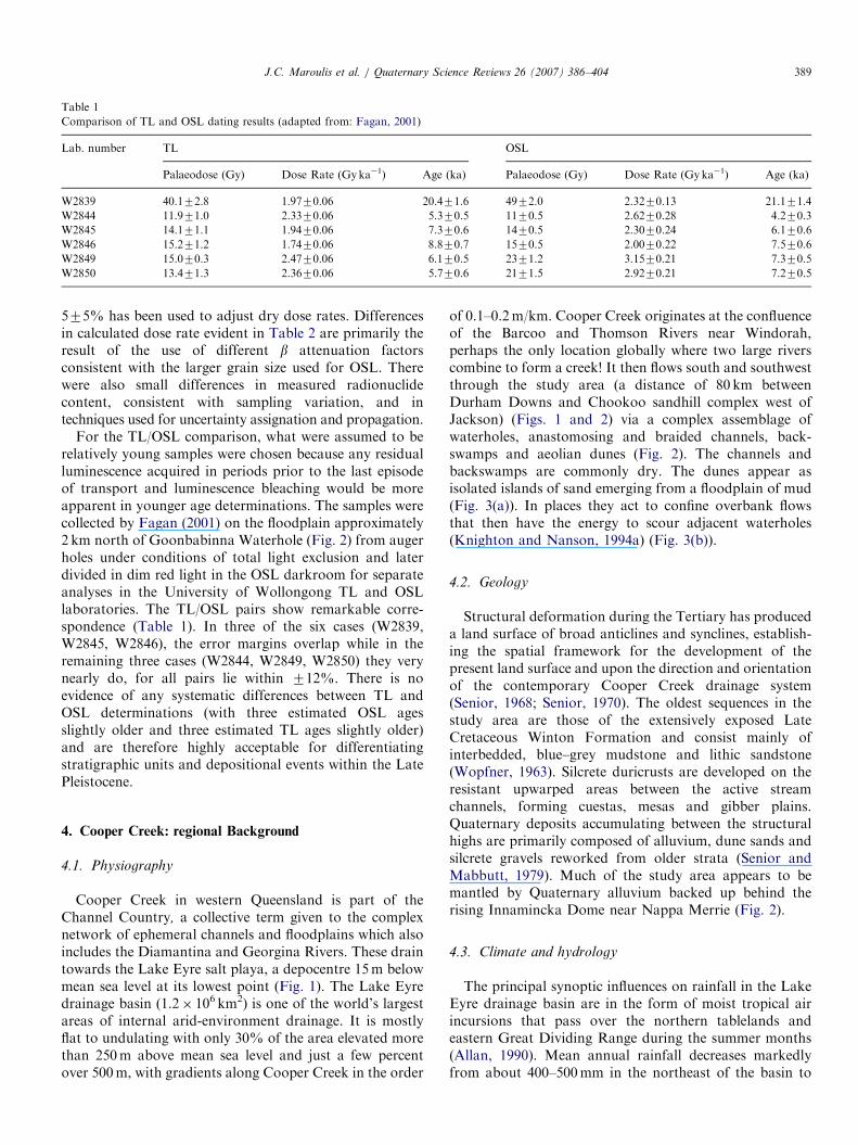
Comparison of TL and OSL dating results (adapted from: Fagan, 2001)
Lab. number TL OSL
Palaeodose (Gy) Dose Rate (Gyka�1) Age (ka) Palaeodose (Gy) Dose Rate (Gy ka�1) Age (ka)
W2839 40.172.8 1.9770.06 20.471.6 4972.0 2.3270.13 21.171.4
W2844 11.971.0 2.3370.06 5.370.5 1170.5 2.6270.28 4.270.3
W2845 14.171.1 1.9470.06 7.370.6 1470.5 2.3070.24 6.170.6
W2846 15.271.2 1.7470.06 8.870.7 1570.5 2.0070.22 7.570.6
W2849 15.070.3 2.4770.06 6.170.5 2371.2 3.1570.21 7.370.5
W2850 13.471.3 2.3670.06 5.770.6 2171.5 2.9270.21 7.270.5
J.C. Maroulis et al. / Quaternary Science Reviews 26 (2007) 386–404 389
575% has been used to adjust dry dose rates. Differencesin calculated dose rate evident in Table 2 are primarily theresult of the use of different b attenuation factorsconsistent with the larger grain size used for OSL. Therewere also small differences in measured radionuclidecontent, consistent with sampling variation, and intechniques used for uncertainty assignation and propagation.
For the TL/OSL comparison, what were assumed to berelatively young samples were chosen because any residualluminescence acquired in periods prior to the last episodeof transport and luminescence bleaching would be moreapparent in younger age determinations. The samples werecollected by Fagan (2001) on the floodplain approximately2 km north of Goonbabinna Waterhole (Fig. 2) from augerholes under conditions of total light exclusion and laterdivided in dim red light in the OSL darkroom for separateanalyses in the University of Wollongong TL and OSLlaboratories. The TL/OSL pairs show remarkable corre-spondence (Table 1). In three of the six cases (W2839,W2845, W2846), the error margins overlap while in theremaining three cases (W2844, W2849, W2850) they verynearly do, for all pairs lie within 712%. There is noevidence of any systematic differences between TL andOSL determinations (with three estimated OSL agesslightly older and three estimated TL ages slightly older)and are therefore highly acceptable for differentiatingstratigraphic units and depositional events within the LatePleistocene.
4. Cooper Creek: regional Background
4.1. Physiography
Cooper Creek in western Queensland is part of theChannel Country, a collective term given to the complexnetwork of ephemeral channels and floodplains which alsoincludes the Diamantina and Georgina Rivers. These draintowards the Lake Eyre salt playa, a depocentre 15m belowmean sea level at its lowest point (Fig. 1). The Lake Eyredrainage basin (1.2� 106 km2) is one of the world’s largestareas of internal arid-environment drainage. It is mostlyflat to undulating with only 30% of the area elevated morethan 250m above mean sea level and just a few percentover 500m, with gradients along Cooper Creek in the order
of 0.1–0.2m/km. Cooper Creek originates at the confluenceof the Barcoo and Thomson Rivers near Windorah,perhaps the only location globally where two large riverscombine to form a creek! It then flows south and southwestthrough the study area (a distance of 80 km betweenDurham Downs and Chookoo sandhill complex west ofJackson) (Figs. 1 and 2) via a complex assemblage ofwaterholes, anastomosing and braided channels, back-swamps and aeolian dunes (Fig. 2). The channels andbackswamps are commonly dry. The dunes appear asisolated islands of sand emerging from a floodplain of mud(Fig. 3(a)). In places they act to confine overbank flowsthat then have the energy to scour adjacent waterholes(Knighton and Nanson, 1994a) (Fig. 3(b)).
4.2. Geology
Structural deformation during the Tertiary has produceda land surface of broad anticlines and synclines, establish-ing the spatial framework for the development of thepresent land surface and upon the direction and orientationof the contemporary Cooper Creek drainage system(Senior, 1968; Senior, 1970). The oldest sequences in thestudy area are those of the extensively exposed LateCretaceous Winton Formation and consist mainly ofinterbedded, blue–grey mudstone and lithic sandstone(Wopfner, 1963). Silcrete duricrusts are developed on theresistant upwarped areas between the active streamchannels, forming cuestas, mesas and gibber plains.Quaternary deposits accumulating between the structuralhighs are primarily composed of alluvium, dune sands andsilcrete gravels reworked from older strata (Senior andMabbutt, 1979). Much of the study area appears to bemantled by Quaternary alluvium backed up behind therising Innamincka Dome near Nappa Merrie (Fig. 2).
4.3. Climate and hydrology
The principal synoptic influences on rainfall in the LakeEyre drainage basin are in the form of moist tropical airincursions that pass over the northern tablelands andeastern Great Dividing Range during the summer months(Allan, 1990). Mean annual rainfall decreases markedlyfrom about 400–500mm in the northeast of the basin to

ARTICLE IN PRESS
Table 2
Thermoluminescence (TL) ages and supporting data from the Cooper Creek study area
Reference Sample No. Temp.
Plateau
Region (1C)
Palaeodose
(Grays)
K Content
(%)
Moisture
Content (%)
U7Th Specific
Activity (Bq/kg)
Annual
Radiation
(Gy/yr)
TL age (ka)
DD1 1.7m W1033 300–500 8.670.8 0.54570.005 1.173 18.470.6 1111776 7.770.8
DD1 4.3m W1034 300–500 13.672.0 0.45070.005 0.773 11.270.4 856726 15.972.4
DD1 5.4m W1035 300–500 47.175.1 0.43570.005 1.073 16.270.5 913727 51.575.8
DD1 7.0m W1036 325–500 47.973.9 0.49070.005 0.973 13.570.4 905727 52.974.5
DD1 9.0m W1712 300–500 52.674.4 0.24070.005 1.773 13.270.4 607726 86.778.2
DD1 15.0m W1713 325–500 42.373.7 0.10570.005 20.073a 13.270.4 353722 118713
DD1 16.0m W1605 300–500 86.274.3 0.07070.005 15.073 17.770.6 421713 205712
DD3 3.0m W1606 300–500 126714 0.37070.005 1.973 27.770.9 1089728 116713
DD3 6.0m W1714 300–500 56.374.4 0.21070.005 0.373 12.170.4 589726 95.578.5
DD3 9.0m W1607 325–500 74.175.1 0.18570.005 20.073 11.970.4 431721 172715
CH-D 1.6-2.0m W1707 300–500 4.070.3 0.26570.005 4.073 21.870.6 852749 4.070.4
CH-D 4.5m W1708 300–500 19.071.6 0.29570.005 1.173 14.470.5 750726 25.272.3
CH-D 9.0m W1709 300–500 66.174.8 0.29570.005 1.373 19.170.6 788727 83.976.7
CH-D 15.0m W1710 325–500 151714 0.60070.005 10.173 54.671.6 1634731 92.479.0
CH-D 21.0m W1711 325–500 121710 0.11570.005 10.573 18.770.5 485713 250723
CH-G 3.0m W1715 325–500 105710 0.80070.005 12.273 58.471.6 1931730 54.275.2
CH-G 6.0m W1716 325–500 135711 0.95070.005 13.573 58.271.9 2014732 67.175.8
CH-G 9.2-9.4m W1717 325–500 113712 0.42070.005 3.973 33.671.0 1135718 99.2710.7
CH-G 11.5m W1718 325–500 132711 0.22070.005 13.273 30.670.9 815725 162714
CH-P 7m W1938 300–500 50.573.4 0.46570.005 1.273 26.970.9 1143728 44.173.2
CH-O 5m W1939 300–500 26.071.1 0.46570.005 1.273 22.170.7 1064727 24.471.2
CH-O 9m W1940 300–500 48.272.6 0.49570.005 0.973 19.570.6 1014727 47.572.9
CH-2 3.6m W2054 300–500 107711 0.55070.005 0.673 17.770.6 1085727 98.4710.5
CH-2 5.28m W2055 300–500 109710 0.49570.005 0.873 23.270.7 1123728 97.378.9
CH-3 3.7m W2056 300–500 90.476.9 1.30070.005 8.473 69.872.2 2712737 33.372.6
CH-3 3.9m W2057 300–500 66.675.6 0.35070.005 1.173 15.270.5 816727 81.677.4
CH-3 6.1m W2058 300–500 67.075.9 0.25570.005 0.573 13.070.4 654726 103710
CH-M 6.0m W2059 300–500 46.573.4 0.40570.005 0.573 20.070.6 958727 48.673.8
CH-S 2.0m W3565 300–500 15.370.8 0.55070.005 1.873 21.870.7 1175759 13.071.0
CH-S 6.0m W3566 300–500 52.373.7 0.55070.05 3.673 35.171.1 1372759 38.173.2
CH-S 9.0m W3567 275–500 89.474.1 0.75070.05 6.773 29.770.9 1408757 63.573.9
CH-S 15.0m W3568 300–450 16079 0.16570.005 5.873 19.770.6 600726 267719
NH1 4.5m W2029 300–500 72.974.1 0.08070.005 5.373 15.470.5 499725 146711
NH2 4.5m W2297 300–500 45.174.7 0.10570.005 4.573 14.170.4 490725 92.1710.6
NH3 1.0m W1041 300–500 14.571.5 0.38570.005 2.473 22.370.7 1003750 14.571.6
NH3 2.2m W1042 275–450 24.271.8 0.28070.005 0.773 15.070.5 763751 31.873.2
NH3 4.4m W1043 300–425 34.472.3 0.32070.005 1.273 15.870.5 792727 43.573.3
NH3 6.0m W1044 300–500 43.173.4 0.46570.005 2.573 29.270.9 1180728 36.573.0
Goon1 4.8m W2053 275–500 12.271.0 1.05070.005 10.273 62.471.9 2276734 5.370.4
TWD ~1m W1888 325–500 10376 0.49570.005 1.573 28.970.9 1264751 81.775.5
MH1 4.5m W2295 300–500 53.373.9 0.10070.005 0.273 15.670.5 556727 95.878.3
MH2/3 5.5m W2291 300–500 30.072.8 0.05070.005 0.573 15.970.5 499727 60.176.4
MH3 4.2m W2290 300–500 23.572.9 0.03070.005 0.173 9.970.3 372726 63.178.9
TL1 1.0m W2292 275–425 0.9070.12 1.00070.005 7.173 85.071.9 2781736 0.3370.04
TL2 2.5m W2293 275–500 6.770.5 1.00070.005 12.073 86.372.0 2632734 2.670.2
TL3 4.5m W2294 300–500 38.173.4 0.85070.005 15.173 79.671.9 2283732 16.771.5
Note: The specific activity of these specimens was measured by means of a calibrated thick source alpha counting over a 42mm scintillation screen. The
values shown assume secular equilibrium for both U and Th decay chains. The uncertainty levels indicated represents one standard deviation. Analysis
temperature 375 1C.aEstimated moisture content.
J.C. Maroulis et al. / Quaternary Science Reviews 26 (2007) 386–404390
about 100mm near Lake Eyre, with the variability ofrainfall being, because of the vagaries of tropical cyclonicand summer monsoonal rainfall in the headwaters, amongthe highest recorded in Australia (Kotwicki, 1986; Kotwickiand Isdale, 1991). Mean annual evaporation (Class A Pan)grades progressively from about 2400mm/a in the north-
east to more than 3600mm/a near Lake Eyre. Mean dailymaximum temperatures (2000–2006) at Ballera, 15 km westof the study area (Fig. 2) are 40.6 1C in January and 20.9 1Cin July, with mean daily minima in the same months,26.6 and 8.1 1C, respectively. Annual rainfall over thesame period has averaged 127mm/a with mean monthly

ARTICLE IN PRESS
Fig. 2. Fieldwork locations on the Cooper Creek floodplain in southwestern Queensland.
J.C. Maroulis et al. / Quaternary Science Reviews 26 (2007) 386–404 391

ARTICLE IN PRESS
Fig. 3. Floodplain dunes: (a) oblique aerial photograph north of the
Durham Downs Road looking eastward at an isolated dune surrounded
by floodplain muds with a zone of intermixed sand and mud in the form of
an indurated areola (�100m wide) around the margin of the dune. Acacia
and other shrubs and canegrass line the contact between unconsolidated
dune sand and the indurated areola interface. Vegetated dune circumfer-
ence is �470m. (b) Oblique aerial photograph to the southeast showing
both the Tooley Wooley and Little Tooley Wooley Waterholes at the
confluence of Cooper Creek and the Wilson River. The ‘islands’ of sand
dunes confine flood flows that have scoured adjacent waterholes into the
muddy floodplain.
J.C. Maroulis et al. / Quaternary Science Reviews 26 (2007) 386–404392
maximum of 24mm in January and a mean monthlyminimum of 2.4mm in July. The strongest winds at Ballera(2002–2006) were from the southwest and south.
Cooper Creek’s mean annual runoff is characterised byhigh streamflow variability with long periods of low or zeroflow and occasional periods of extremely high discharge.Mean annual runoff decreases downstream from 3.05 km3
at Currareva to 1.26 km3 at Nappa Merrie (Fig. 2),�420 km downstream, with high Cv values (hydrologicvariability) by world standards (1.61 and 2.20, respectively)(Knighton and Nanson, 1994a, 2001).
The largest flood on record occurred in January–February 1974, with maximum daily discharges of24,974m3/s at Currareva and 5812m3/s at Nappa Merrieand resulted in the simultaneous flooding of all majorwatercourses in the Lake Eyre drainage basin and the
subsequent inundation of Lake Eyre to its highest recordedlevel. The dominance of this flood at both Currareva andNappa Merrie contrasts with the mean annual flood whichis relatively small at both stations (96.7m3/s at Currarevaand 40.0m3/s at Nappa Merrie) and generates extremelysteep relative flood magnitude (Q/Q
2.33) curves (Knighton
and Nanson, 1994a, 2001). However, even the largestfloods only lap around the base of the floodplain dunes.
4.4. Soils and vegetation
Heavily cracked clays (vertisols) with a high proportionof smectite (montmorillonite) dominate the present Cooperfloodplain. With typically 450% clay (Northcote, 1965;Maroulis and Nanson, 1996), these soils exhibit shrink–well characteristics that form low-relief gilgai patterning atthe surface (Dawson and Ahern, 1974; Fagan, 2001; Faganand Nanson, 2004). After rainfall or flooding, swelling ofthe surface clays closes the cracks and forms a highlyeffective moisture seal that prevents further floodplaininfiltration (Nanson et al., 1986, 1988; Rust and Nanson,1989; Maroulis and Nanson, 1996). Immersion wettingduring overland flow causes irregular-shaped blocks ofsurface soil to disperse into water-stable, low-density, finesand-sized mud aggregates that play a vital role in thedevelopment of braid-like channels on the floodplainsurface (Nanson et al., 1986, 1988; Rust and Nanson,1986; Maroulis and Nanson, 1996). Importantly, almostnone of these mud aggregates have been incorporated inthe dunes. Coolabah (Eucalyptus microtheca) and river redgum (E. camaldulensis) form a narrow riparian woodlandthat dominates the anastomosing channels and waterholes(billabongs). On the base and lower slopes of the dunescanegrass (Zygochloa paradoxa) and several Acacia spp.with other desert shrubs grow, while forbes and grasses onthe upper slopes vary annually and seasonally in terms ofcover density.
5. Cooper Creek floodplain and source-bordering dune
complexes
The Cooper floodplain (Figs. 1 and 2), with its sporadicdistribution of sand dunes in an otherwise mud-dominatedfluvial environment, raises questions about the origin of thesand and how the dunes are related to past episodes offluvial activity and climate change. The floodplain chron-ostratigraphy has been studied in detail and is describedelsewhere (Nanson et al., 1986, 1988; Rust and Nanson,1986; Maroulis, 2000; Coleman, 2002). In summary, theQuaternary alluvial pile upstream of the Innamincka Domeis more than 50m deep and, based on TL dating from 27mdepth, has been accreting at approximately 0.035mm/asince about 740 ka, mostly with medium to coarse sand andfine gravel and a few clay lenses (Maroulis, 2000). Thisaccumulation is probably controlled by ongoing uplift ofthe dome where the floor of the channel is actively erodingbedrock well above the base of the Quaternary alluvium

ARTICLE IN PRESSJ.C. Maroulis et al. / Quaternary Science Reviews 26 (2007) 386–404 393
upstream. There are numerous meandering sandy palaeo-channels that have been infilled with mud. The entiresequence is capped with floodplain mud through whichsource-bordering dunes emerge (Fig. 3). Three of thesedune sites were investigated in detail: the Chookoo sandhillcomplex, the Durham homestead dunes and the NarberryWaterhole and dunes (Fig. 2).
5.1. Chookoo sandhill complex
The Chookoo sandhill complex is located on the westernside of the floodplain (14115403000E, 2713404500S), 6 kmsouth of the Shire Road and 1.5 km east of the westernedge of the floodplain (Fig. 2). The complex (�4 km2 inarea) comprises three sand dunes (Fig. 4). Dune 1 is 11mhigh, has a steeper lee face and is a prominent curved sandfeature �1 km in length with its crest aligned in anorthwest–southeast orientation. The active dune crest issparsely vegetated with a variety of shrubby Acacia spp.,vegetation density increasing towards the dune margins
Fig. 4. Oblique aerial photograph (a) and schematic map (b) of the
Chookoo sandhill complex showing Chookoo Dunes 1, 2 and 3, the large
Chookoo channel between Dunes 1 and 2 and a small Chookoo channel
between Dunes 2 and 3. View is to the southeast and flow from left to
right.
where moisture and fines accumulate. Dunes 2 and 3 arelocated �1 and �1.5km to the southwest of Dune 1 (Fig. 4),are smaller in area, �6m high and have less clearly definedcrest orientations. They lack steep faces and supportvarious shrub species.The stratigraphic relationship between the alluvium and
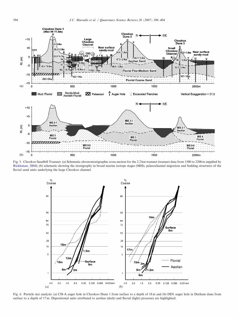
the dunes was conducted along a 2.2 km �N–S transectover Dunes 1–3 (Fig. 4). Twenty two auger holes up to23m deep were sunk in the dunes and adjacent floodplain,and three 1.0–1.5m wide trenches (CH 1–3) nearly 60m intotal length were excavated in the floodplain and Chookoochannel (CH 1: 8m long, 6.4m deep; CH 2: 20m long,6.2m deep; CH 3: 30m long, 6.2m deep: Fig. 5). Theseprovided detailed alluvial stratigraphic and chronologicaldata (Maroulis, 2000) summarised here and in Fig. 5.The trenches exposed sandy and muddy flow structures,
mud intraclasts and pebbles, all diagnostic of fluvialtransport. Interpreting the stratigraphy from auger-holeswith no visible structures proved problematic because ofthe difficulty differentiating between aeolian and fluvialsands. However, texturally the dunes exhibited unimodal,leptokurtic and finely skewed moderately well sorted fine tomedium sand (means from 0.125 to 0.25mm). In contrast,the alluvium commonly display a wider range of meansizes, are often bimodal, coarsely skewed and poorly sorted(Fig. 6(a)). Grain impact features were of little diagnosticvalue, probably because of the short distances of aeoliantransport, and the periodic interchange between aeolianand fluvial transport.The stratigraphy north of Chookoo Dune 1 and that
beneath the channel immediately south of Dune 1 (CH 1–3)revealed 0.8–2.3m of floodplain mud (thinnest in thechannel) overlying 45m of alluvial sand. Typically, themud unit is cracked, friable and dispersed in the upper0.3m, becoming compacted and very tough with depth.The sandy alluvial strata beneath are gradational fromcoarser trough cross-bed sets (10–25 cm) with pebbles(�1 cm) at �6m depth upwards to finer ripple sets. In CH3, a dipping sand body below 3.0m is evidence for point-bar accretion in a channel migrating away from Dune 1,the muddy unit above forming an abandoned meanderinfill, similar to lateral accretionary meandering sandy-channel processes and a muddy infill in a palaeochannel�250–230 ka in age near Naccowlah Waterhole �12 kmeast of Chookoo (Fig. 2) (Rust and Nanson, 1986).Augering in Dune 1 revealed red fine sands near the
surface grading to white and buff sands at depth, withmottled sandy-clay units appearing only at depths of16–19m (i.e., �9m below the present floodplain surface)and medium-coarse sand evident only below 19m (Fig. 5).The lack of floodplain clay or channel-infill clay underlyingDune 1 (Fig. 5) has important implications for sequencingchannel, dune and floodplain development at this siteduring the Late Pleistocene. It is apparent that the aeoliandune formed directly on channel sands, probably on apoint bar. Fluvial deposits north of the dune (CH 1) arefiner and appear to result from upstream flow ponded
ARTICLE IN PRESS
Fig. 5. Chookoo Sandhill Transect: (a) Schematic chronostratigraphic cross-section for the 2.2 km transect (transect data from 1500 to 2200m supplied by
Rickleman, 2004); (b) schematic showing the stratigraphy in broad marine isotope stages (MIS), palaeochannel migration and bedding structures of the
fluvial sand units underlying the large Chookoo channel.
Fig. 6. Particle size analysis: (a) CH-A auger hole in Chookoo Dune 1 from surface to a depth of 18m and (b) DD1 auger hole in Durham dune from
surface to a depth of 17m. Depositional units attributed to aeolian (dark) and fluvial (light) processes are highlighted.
J.C. Maroulis et al. / Quaternary Science Reviews 26 (2007) 386–404394

ARTICLE IN PRESSJ.C. Maroulis et al. / Quaternary Science Reviews 26 (2007) 386–404 395
against the base of the forming dune which appears to haveformed an obstruction to higher discharges and to havegenerated a depositional ‘tail’ of fluvially reworked aeoliansand downstream.
The stratigraphy between Dunes 1 and 2 reveals thatthere are two �6m deep palaeochannels some 300m apartnorth and south of the present Chookoo channel andinfilled with massive clays (Fig. 5). Interestingly, the latteris not a remnant of either palaeochannel but instead wassubsequently scoured by flow confined between the twodunes in the manner proposed by Knighton and Nanson(1994a) for similar channels adjacent to dunes alongCooper Creek.
The luminescence chronology (Table 2) of the Chookoosandhill complex presents a detailed story of fluvial andrelated aeolian activity from the Middle to Late Pleistocene(Fig. 5). Coarse gravely fluvial sands, some �10m belowthe floodplain and therefore sampled only by augering,have yielded TL ages of 162714 ka (W1718), 250723 ka(W1711) and 267+19 ka (W3568) indicating MIS 8–6fluvial systems were more powerful than at present. Theseare overlain by a very clearly defined and thoroughly datedMIS 5 alluvial deposit of fine to medium sand yielding 6TL dates that range from 103710 ka (W2058) to81.777.4 ka (W2057). Flow structures in this unit indicatea palaeochannel that migrated southwards, forming a pointbar from which aeolian sand was deflated in late MIS 5 toform Dune 1 with a basal age of 83.976.7 (W1709),remarkably close to the age of the youngest adjacentchannel sands. It is also very similar to an age of81.7718 ka (W1888) obtained in a source-bordering dunefrom a weakly indurated and partly eroded outcrop just1m above the floodplain, near the Tooley Wooley Water-hole (Fig. 3(b)). Channel activity and the associatedbuilding of Dune 1 appear to have terminated with infillingof the northern palaeochannel, the mud yielding TL datesof 67.175.8 ka (W1716) and 54.275.2 ka (W1715) (lateMIS 4 to early MIS 3). However, Dune 1 has continued tobe reworked, but not so greatly as to cause the dune tomigrate, with ages in the upper half ranging between theLGM and the present.
South of Dune 1 an MIS 3 palaeochannel has laterallyeroded into the MIS 5 alluvium beneath the currentChookoo channel, leaving an unconformity between thetwo (at about 800m on the Chookoo transect, Fig. 5). Apalaeochannel immediately south of Dune 2 was probablythe source of sand for this dune, the latter very similar inage to its underlying MIS 3 alluvium. Dune 3 at the mostsouthern end of the transect is also MIS 3 in age, but it isunderlain by older alluvium probably deposited in MIS 4, aperiod also known to at times have been relatively wet inthe Lake Eyre Basin (Magee et al., 1995, 2004; Nansonet al., 1998; Maroulis, 2000). Despite the presence ofpalaeochannels during MIS 4 on Cooper Creek, there is noevidence for source-bordering dune activity at this time(Maroulis, 2000; Coleman, 2002). The palaeochannel northof Dune 2 ceased to operate as a sandy system and started
filling with mud by at least late MIS 3 (33.372.6 ka;W2056) and, although down-wind of Dune 3, it mayrepresent the period of channel termination that cut off theaeolian sand supply to the MIS 3 dune. The channelimmediately north of Dune 3 terminated and infilled at anunknown time.The Chookoo sandhill complex with its underlying
alluvium shows Cooper Creek to have been a highly activefluvial system from about MIS 8 but, on the basis ofevidence of an upward decline in bed material size (Fig. 5)and the reduced lateral extent of floodplain reworking(Maroulis, 2000), it was one of declining flow strengthduring and following MIS 5. Source-bordering dunes wereformed adjacent to active channels in late MIS 5(�85–80 ka) and in mid MIS 3 (50–45 ka), indicatingseasonal flow conditions at times in both periods. Based onluminescence ages of �LGM and younger in the upper halfof the dunes, aeolian processes remained active, but onlyreworked the existing dunes. The mud infills suggest therewere no sandy channels to supply aeolian sediment to theChookoo sandhill complex after �40 ka. The crests of thedunes continued to be reworked during the LGM andHolocene.In contrast to the large waterholes on the Cooper system
described by Nanson et al. (1988) and Knighton andNanson (1994b, 2000), the large Chookoo channel bearsonly a superficial similarity. Stratigraphically, it does notreflect a remnant palaeochannel in the underlying sand-sheet and palaeoflow orientations in the sand body beneathit are SSW–SW (210–2201) compared with the orientationof the present channel to the W–SW (�2601). Evidence ofthe contemporary nature of this scour channel is supportedby the existence of a similar but much smaller examplebetween Dunes 2 and 3.In summary, the Chookoo sandhill complex reveals
extensive alluvial coarse sands and some fine gravels at410m depth dating in MIS 8–6. These underlie the dunecomplex and indicate laterally active channels morepowerful than anything subsequent. This alluvial strati-graphy is visible not only at Chookoo but has beendescribed north of Naccowlah Waterhole (Fig. 2) (Nansonet al., 1986, 1988; Rust and Nanson, 1986). Overlying thiscoarse alluvium at Chookoo is an extensive medium to finesandy system with mud intraclasts formed in MIS 5, lesspowerful but still actively meandering. From elsewhere onCooper Creek, MIS 5 is known to have been a lessextensive period of fluvial activity than those in MIS 6 andearlier (Maroulis, 2000). In the latter part of MIS 5(�85 ka), Dune 1 was formed from a sandy seasonallyactive palaeochannel immediately up-wind (south) that wasabandoned at �70 ka and then filled with mud. Anotherfluvial phase deposited sandy alluvium beneath Dune 3during MIS 4 (�63 ka) but this phase appears not to havebeen associated here with source-bordering dune formation.In MIS 3 (�50 ka) lateral channel activity eroded
into the MIS 5 and 4 alluvium. Dune 2 was formed atabout 50–40 ka (MIS 3) from sands derived from another

ARTICLE IN PRESSJ.C. Maroulis et al. / Quaternary Science Reviews 26 (2007) 386–404396
unrevealed palaeochannel, presumably immediately up-wind (south or southwest). Termination of this latterperiod of fluvial–aeolian interaction was associated with amuddy channel infill north of Dune 2, dating at �33 ka orsomewhat before. Chookoo Dune 3 is older than �40 ka atits base and sits on fluvial sands that are MIS 4 (�63 ka) inage. This, in combination with other evidence from theChookoo sandhill complex, indicates that source-borderingdunes were active at 85-80 ka and again from �50 ka to�40 ka, after which fluvial sand-transport and associateddune formation appears to have ceased, and the sandychannels filled with mud.
Extensive alluvial overbank muds covered the flood-plain, infilled some channels and had surrounded the dunesby at least �33ka. All three dunes have been reworked todepths of up to 7m from about 25 ka (early LGM) to theLate Holocene, and the crests are still active in placestoday. The relatively small size of each dune suggests thatconditions suitable for their formation were restricted tolimited periods of time in two separate marine isotopestages.
Despite no active source-bordering dune accretion herefor more than 40 ka, the dunes have not migrated or beenlost to wind or flood erosion over this period. However, theconfinement of river flow between Dunes 1 and 2 hasproduced the large Chookoo channel, a shallow scourfeature penetrating the alluvial muds by about 2min a location unrelated to the underlying MIS 5 and 3palaeochannels. A similar incipient feature (the small
Fig. 7. Durham Dune Site: (a) schematic chronostratigraphic cross-section of
isotope stages (MIS); (b) aerial photo showing the location of DD1, 2 and 3 au
the western valley side (Durham Downs Station).
Chookoo channel) appears to be still forming betweenDunes 2 and 3. While the locations of source-borderingdunes were determined by MIS 5 and MIS 3 palaeochan-nels and their associated point bars, in a reversal of roles,these emergent dunes across the Cooper floodplain nowconfine overbank flows and define the location of manymodern flood channels (Knighton and Nanson, 1994b).
5.2. Durham Dune
The Durham site covers an area of 1 km2, consists of twoadjoining sand dunes and is located at 14115404200E,2710304300S �1.5 km east of the Durham Downs homestead(Fig. 2). Both Durham dunes are well vegetated.Research focussed on the northern dune, which at 6.8m,
is the higher of the two. Three holes were augered at thesite: DD1 on the dune at an elevation of 4.9m, �25msoutheast of the dune crest; DD2 on the floodplain 110mnorth of the base of the dune and 140m from DD1, andDD3 located on the floodplain 240m northwest of DD2(Fig. 7). The generalised sub-surface stratigraphy fromthese three holes is presented in Fig. 7.As at Chookoo, despite the ubiquitous floodplain clays
down to 2.3m, there are no clay strata within or beneaththe Durham dune (Fig. 7). The exception being a thinindurated grey clay layer in auger hole DD1 at �14m RLthat is interpreted as probably the weathered bedrock ofthe underlying valley side (Fig. 7). The dune stratigraphy inboth DD1 and DD3 is dominated by reddish yellow
the northern Durham dune showing the TL ages and associated marine
ger holes, the proximity of the Durham dune to Tabbareah Waterhole and

ARTICLE IN PRESSJ.C. Maroulis et al. / Quaternary Science Reviews 26 (2007) 386–404 397
moderately well-sorted aeolian fine-medium sand at depthsof 0 to �6m, grading into yellow and light yellowishbrown fine-medium sands at �6 to �9m (Fig. 7). Mottledbrownish yellow to white poorly sorted coarse sands occurat depths below �10m. The Durham dune represents asource-bordering dune sitting on fluvial sands at about6m. Dune flanks are buried by recent muddy floodplainaccretion (Fig. 7).
While no mud-filled palaeochannels were located at theDurham dune site, the overall chronostratigraphy beneaththe dune and adjacent floodplain is remarkably similar tothat at Chookoo. Fluvial and aeolian sand in the augerholes was distinguished, as at Chookoo, on the basis oftexture (Fig. 6(b)). There is a basal unit of coarse fluvialsand that is evidence of relatively high-energy fluvialactivity in MIS 7 and 6 (205712 ka, W1605; 172715 ka,W1607). This is overlain by a 4–5m thick MIS 5 fluvial unitof finer medium sand TL dating at 118713 ka (W1713)and 95.578.5 ka (W1714). Aeolian sand at the base of thedune and aeolian sand at DD3 on the adjacent floodplaindates at 116713 ka (W1606) and 86.778.2 ka (W1712),with the dune becoming progressively younger towards thesurface near the crest. It appears as though the middleportion of the dune was added at about 53–50 ka duringMIS 3. The dune appears to have been larger in the pastwith the northern (upstream) flank eroded and overlainwith alluvial mud. As at Chookoo, the crest in particularremains partially active today.
In summary, the Durham dune site reveals the following:An extensive coarse alluvial sand deposit lies more than9m below the floodplain surface and dates at MIS 7 and 6.This is superimposed with an extensive 4–5m thick unit offiner medium fluvial sand that dates from MIS 5, whichsupplied sand for the overlying source-bordering dune, thebase of which lies 3–4m below the elevation of thefloodplain surface. Further sand was added to the dune,presumably from an adjacent palaeochannel during MIS 3.
Aeolian sand deposits underlie the floodplain to thenorth, suggesting that the dune was more extensive on itslee (upstream) side before being fluvially eroded and partlyinundated by accreting floodplain mud. The absence of anidentified palaeochannel infill makes it difficult to deter-mine just when the fluvial sand-supply ceased. However, asat Chookoo, the limited area of aeolian sand suggests thatconditions suitable for their formation were restricted tostrictly limited periods of time in two separate marineisotope stages. The upper part of the dune has beenreworked since the LGM but, as at Chookoo, not enoughto cause the dune to migrate or the sand to completelydisperse.
5.3. Narberry Waterhole and dunes
The Narberry site is located at 14115900000E, 2710402000S,�3 km N of the Durham Road in the centre of the Cooperfloodplain (Fig. 2) and is characterised by three small dunesand the ephemeral Narberry Waterhole (Fig. 8) with
mature coolabah trees (E. microtheca) lining its banks. Thewaterhole is 410m long with a maximum depth of 1.8mand a width-to-depth ratio of �45 over a bed of heavilycracked clays. The aeolian dunes are of low relief (o2m)and only the one to the west of South Narberry Waterholewas investigated (Fig. 8).The floodplain adjacent to the waterhole (auger hole
NH2) consisted of 2.1m of very dark greyish brownfloodplain clay grading into a 1.6m thick brown fluvialsandy-clay unit (Fig. 8). Between 3.7 and 12.0m, a 4m fineyellowish-brown fluvial sand unit graded into light yellow-ish-brown medium fluvial sand and then into white coarsefluvial sand. A TL age of 92.1710.6 ka (W2297) wasobtained from the middle of the fine sand unit at a depth of4m. An 8m deep auger hole (NH1) in the base of NarberryWaterhole passed through 1.0m of very dark grayish-brown floodplain clay overlying 1.0m of brown fluvialsandy-clay. The remaining 6m of the profile consisted of4.0m of yellowish-brown fine fluvial sand that dated at146711 ka (W2029), grading at 8m into 1.0m of palebrown medium fluvial sand and finally a 1.0m thick whitefluvial coarse sand (Fig. 8). While Narberry is named onmaps as a waterhole, it is in fact a shallow (�2m)scour channel caused by overbank flow confined betweenthe two low dunes (Knighton and Nanson, 1994b), a verysimilar situation to that at Chookoo where the dunesare higher. Although Narberry Waterhole was initiallybelieved to be the abandoned remnant of a muchlarger system, there is no evidence of a former deepwaterhole or palaeochannel infill. Indeed it is located overalluvium that is significantly older than that only 100m tothe east.Augering and TL dating of the South Narberry dune
(�2.5 km south of the Narberry Waterhole) provided anage of 14.571.7 ka (W1041) at a depth of 1m and43.573.3 ka (W1043) and 36.573.0 ka (W1044) (reversedbut almost overlapping ages) at depths of 4–6m. Com-pared with equivalent depths below the dune crest atChookoo and Durham, these are older and it appears thatmuch of the mobile near-surface dune sand has beenremoved from both the Narberry dunes, for they nowprotrude only just above the floodplain surface. Yet eventhis very subdued relief is sufficient to concentrate the1–2m of floodwaters across the floodplain and formNarberry Waterhole as a scour channel. It was never alarge waterhole. Vertical accretion of floodplain mudsmeasured at the Shire Road nearby gave rates of0.04–0.20mm/a (Maroulis, 2000), and this will undoubt-edly continue to bury the dunes gradually which, incombination with ongoing sand deflation, will see themdisappear slowly below the floodplain surface.In summary, the alluvium near Narberry represents
periods of fluvial activity in MIS 6 and 5 as recognised inthis study elsewhere on Cooper Creek. Aeolian activity hasresulted in source-bordering dune formation in MIS 3 atabout 40 ka, perhaps a little later than that at Chookoo.However, at Narberry, the palaeochannel associated with

ARTICLE IN PRESS
Fig. 8. Narberry Site: (a) oblique aerial photograph of the Pritchella and Narberry Waterholes. Also shown are the West and East Narberry dunes and an
alluvial splay at the southern end of the Pritchella Waterhole. Photograph was taken after a moderate flood event that filled the ephemeral Narberry
Waterhole and overtopped the anastomosing channel to the extent delineated by floodplain vegetation (dark) on the drier floodplain surface (light). Large
coolibah trees line the banks of the waterholes and ephemeral channels. View is to the northeast. Distance between Narberry and Pritchella Waterholes is
2 km; (b) Pritchella and Narberry Waterholes schematic map; (c) Narberry Transect: Schematic cross-section and auger hole chronostratigraphy of the
Narberry Transect located in (b) between Narberry Waterhole and South Narberry Waterhole.
J.C. Maroulis et al. / Quaternary Science Reviews 26 (2007) 386–404398
this episode has not been located but, based on the inferredwind regime at the time, was probably to the immediatesouth of the South Narberry dune (Fig. 8). The SouthNarberry dune appears to show that, in places, thesefeatures may have been reduced by erosion since theirformation in MIS 3.
6. The role of pelleted mud
Mud was certainly present on the Cooper floodplainthroughout the Middle to Late Pleistocene, as evident bythe presence of numerous intraclasts in the sandy alluviumof this period and by the presence of mud lenses and stratain the floodplain (Rust and Nanson, 1986; Maroulis, 2000).However, the absence of significant mud pellets in thedunes on the Cooper upstream of the Innamincka Domeindicates that floodplain mud was not an important sourceof aeolian sediment. Coleman (2002) confirmed theexistence of some mud pellets in the dunes downstream
of Innamincka, but even here the dunes contain o6%mud, and some of that would have been sourced from dustilluviated over many years into the dunes. There are alsosome low (o1.5m) flat-topped aeolian mounds north ofMoomba on the Cooper floodplain that are formed almostentirely of mud aggregates (Coleman, 2002). It is possiblethat the Strzelecki mud-pelleted lunettes reported byWasson (1983a) represent either the reworking of moresaline-enriched muddy alluvium, or that the more aridconditions down basin enhanced the aggregation process,making clay pellets more readily available in somelocations. Pelleted mud is not a component of aeoliandunes on Cooper Creek in southwestern Queensland.
7. Sand mobility and dune stability
Frequent impacts during aeolian transport should resultin substantial rounding of the grains and the formation ofimpact features, such as mechanical V-forms (Krinsley and

ARTICLE IN PRESSJ.C. Maroulis et al. / Quaternary Science Reviews 26 (2007) 386–404 399
Doornkamp, 1973). However, SEM analysis of quartz sandgrains at the surface and within the Durham and Chookoodunes revealed that the grains are mostly sub-angular withvery few such features. This, along with evidence of theconsiderable chemical alteration of the grain surfaces,suggests that the distance of aeolian transport fromchannel to dune has been very limited.
Wasson (1983b) contended that dune development in theSimpson and Strzelecki dunefields was largely a function oflocalised reworking of sand deposits and aggregated muds.While Wopfner and Twidale (2001) favour long distancetransport of aeolian sediment in the Australian dunefields,scanning electron microscope and sediment characteristicsdescribed by Pell and Chivas (1995), Newsome and Ladd(1999), Pell et al. (1999, 2000) and Hollands et al. (2006)have shown this to be highly unlikely. The group favouringno long-distance transport argues that there has beentransportation of quartz grains by river systems withindrainage basins and these are subsequently reworked onlyshort distances into local dunefields. Nanson et al. (1995)showed that while dunes along the Finke River containedsome surface sand that had travelled as much as 8 km sincethe LGM, the source-bordering dunes as distinct landformshad only migrated about 3–4 km. Hollands et al. (2006)similarly found evidence for very limited sand transportand downwind dune migration over the past 75 ka in thenortheastern Simpson Desert of Australia.
This study on Cooper Creek provides further evidence ofvery limited aeolian sand transport and dune migration inthe Late Pleistocene. Despite Chookoo and probablyDurham dunes not being supplied from an active channelfor at least the last 30 ka, they have remained significantfeatures in this otherwise flat landscape. Indeed, over thistime they have not migrated more than a few metres ontothe adjacent muddy floodplain. This raises the question asto how such fragile landforms in unconsolidated sedimentshave survived long periods without being completelydispersed by wind. Hesse et al. (2004) conclude thatwindiness has not changed greatly in the Middle to LatePleistocene and that dune activity has been related tovariations in vegetation controlled by the combined effectsof climatic and atmospheric carbon dioxide. While thismay partly explain the stability of these dunes, they havenevertheless survived the LGM and subsequent periodswhen linear dunes were particularly active (Wasson, 1989;Coleman, 2002; Hesse et al., 2004). While stabilisingvegetation is important today and would have been intimes past, sand supply must also have been a significantfactor. During times of abundant fluvial-sand transportand pronounced seasonal flow regimes, the deflation ofsand from exposed river bars would probably haveinundated any vegetation that was able to establish onthe source-bordering dunes. This would have enabled thedunes to remain active in a way not possible today. In thisrespect, source-bordering dunes are probably not goodindicators of the climatic conditions that led to activity inregional dunefields of central Australia. Rather they reflect
fluvial sand supply and the climatic conditions thatdetermined highly seasonal flow and sediment transportregimes on the inland rivers (Page et al., 1996, 2001).
8. A model of source-bordering dune development
The evolution of the Chookoo dune complex andassociated fluvial system during the last �250 ka issummarised in Fig. 9. MIS 8–6 were characterised bysandy, bedload transporting, laterally migrating, upward-fining meandering channel systems (Nanson et al., 1986,1988, 1992a; Rust and Nanson, 1986). Rainfall must havebeen greater and more widespread, and flow regimes wouldhave been more regular and predictable than at present,possibly perennial and certainly supporting more abundantvegetation. While this alluvium is dominantly sandy,observations by Rust and Nanson (1986; 1989) andMaroulis (2000) of mud intraclasts, mud balls and mudlenses suggest that substantial fine overbank depositionmust have occurred and been reworked by the laterallyactive channels.With increasing seasonality at various times in mid to
late MIS 5, the channel sands were readily entrained byprevailing south–southwesterly winds, similar in orienta-tion to those of today. This enabled the formation of thesource-bordering dunes on seasonally exposed sandbars onthe northern sides of these channels. Over time the dunesbecame larger but did not migrate far from their immediatesource of channel sand, probably because greater moisturethan today would have encouraged the growth of abundantdune vegetation away from the immediate sand-channelsource. Only close to the channel would the sand supplyinundate the vegetation and allow active dune building,much as occurs in some coastal situations. The absence ofan intervening mud unit between the underlying sandyalluvium and the overlying dune shows that the dunes weredeposited directly on river bars. The active channels wereprobably relatively wide and shallow and, unlike today,deposited very little within-channel mud. Following theabandonment and infilling with mud of the MIS 5palaeochannels, other sand-load channels became activein MIS 4. There is no evidence that these were associatedwith source-bordering dune activity. Further fluvial activ-ity in MIS 3 resulted in the last period of source-borderingdune formation. By late MIS 3, these channels were alsoabandoned and infilled. Subsequently, the dunes wereencroached on and partly buried by vertically accretingoverbank mud. More recent scour-channels have formedproximal to the dunes in positions unrelated to anypalaeochannels beneath (Fig. 9).Despite abundant alluviation in the Middle to Late
Pleistocene (Nanson et al., 1992a; Maroulis, 2000), source-bordering dunes on the Cooper floodplain are not similarlywidespread. They were probably formed in associationwith individual large point bars at times during mid to lateMIS 5 and again in MIS 3 when flows from northernAustralia were reducing and becoming markedly more

ARTICLE IN PRESS
Fig. 9. A model cross-section showing the evolution of source-bordering dunes since mid-Stage 5. Flow is perpendicular to the page.
J.C. Maroulis et al. / Quaternary Science Reviews 26 (2007) 386–404400
seasonal. The fluvial period in MIS 4 appears not to havebeen associated with source-bordering dune activity.Nanson et al. (1992a) obtained an average age of10974 ka for sandy alluviation during MIS 5 on theChannel Country rivers whereas there are almost nosource-bordering dune deposits of that age. While fluvialreworking of older dunes may be a factor, the paucity ofdunes on areas of the floodplain known not to have beenalluvially reworked since well before MIS 5 (Maroulis,
2000) suggests that the source-bordering dunes wereessentially a late MIS 5 and a MIS 3 phenomenon (Fig. 10).Their limited size suggests that they formed during specificrelatively short-lived conditions. Subsequent TL agesreflect only aeolian reworking, not active dune constru-ction. As shown by Hesse et al. (2004), the age distri-bution of linear dune activity in southern Australiais markedly different from that of source-borderingdunes.

ARTICLE IN PRESS
Fig. 10. Aeolian and fluvial TL dates from this study with uncertainty terms (Table 2).
J.C. Maroulis et al. / Quaternary Science Reviews 26 (2007) 386–404 401
We have identified a minor exception to the above modelof stable sandy dunes directly connected to the underlyingsandy alluvium on the Cooper Creek floodplain. A smalldune has been blown over the muddy floodplain surfacenear the Wilson River confluence on the eastern fringe ofthe floodplain (Fig. 2). Its origin is unclear but may havecome from an adjacent larger dune or from the valley sidewhere dunes are also located. It is only about one hectare inarea, o2.2m in maximum height, dating at 0.870.1 ka at0.8m depth and is underlain by floodplain mud. Comparedwith the much larger dunes on Cooper Creek, it representsa mobile anomaly. While it is likely that the main source-bordering dunes were originally larger and that aconsiderable volume of their sand has been dispersed bywind or floodwaters, the fact that they remain at all afterthey ceased forming at �40 ka is further evidence of theremarkable long-term stability of Australia’s desert andsource-bordering dunes (Nanson et al., 1992b, 1995; Pageet al., 2001; Hollands et al., 2006).
9. Conclusions
To our knowledge, active riverine source-bordering duneformation has not been described as occurring undercurrent climatic conditions globally. This does not meanthat they are not forming today somewhere, but suchconditions appear to be rare. The absence of active source-bordering dunes on present Australian rivers contrasts withtheir more widespread occurrence at times during the LatePleistocene when climatic conditions and sediment supplies
were favourable for their development (Nanson et al.,1995; Page et al., 2001). Few opportunities exist to study indetail the chronostratigraphy and development of source-bordering dunes over the period of the last full glacialcycle. Williams (1994) proposed that the development ofsource-bordering dunes in western New South Wales atthat time was enhanced at times of warmer and wetterclimate by replenishment of the localised fluvial-sandsupply. This paper presents evidence for the followingconclusions:
1.
The contemporary Cooper floodplain is characterised byburied sandy palaeochannels, almost entirely invisible atthe surface but stratigraphically connected to source-bordering dunes they once supplied and that nowemerge as distinctive sandy-islands on a floodplain ofubiquitous mud.2.
The formation of source-bordering dunes in the LakeEyre Basin is consistent with Late Pleistocene largesandy meandering rivers with beds seasonally exposed tothe prevailing winds.3.
The provision of abundant sand required seasonallymuch wetter conditions and more powerful rivers thanexist under today’s still seasonal but drier climate.However, the periods of source-bordering dune activityhere occurred at times when global temperatures weresignificantly below those of the present, so they appearto be the product of cool seasonally wet conditions.4.
The limited size and distribution of such dunes at mostlocations in the study area suggests that conditions were
ARTICLE IN PRESSJ.C. Maroulis et al. / Quaternary Science Reviews 26 (2007) 386–404402
localised, highly prescriptive and relatively short lived.
5. Luminescence dating has identified pronounced periodsof river activity in MIS 8, 7, 6, 5, 4 and 3, with source-bordering dunes forming in the latter part of MIS 5 andin MIS 3. This study produced no evidence of source-bordering dune formation prior to MIS 5.
6.
Although fluvial episodes in the Middle and LatePleistocene on Cooper Creek were much more powerfulthan flows of today, such episodes clearly declined inintensity during MIS 5 and 3, with sand-channel andsource-bordering dune activity ceasing in late MIS 3(�40 ka).7.
Aeolian reworking of the upper parts of some dunes hascontinued until today, but the dunes as a whole havesurvived largely without migration since MIS 3. This isfurther evidence of the remarkable stability of centralAustralian dunes.8.
During MIS 5 and 3, the channels determined theposition of source-bordering dunes whereas today theremnant dunes confine and concentrate overbank flows,determining the position of many contemporary flood-channels and waterholes.Acknowledgements
We thank Martin Gibling, Simon Fagan and DanielRickleman for willing assistance with various aspects offieldwork, Geoff Black for expert power augering andSantos Pty Ltd for access to their oil and gas lease andconsiderable logistical support in the field. The paper hasbeen significantly improved because of perceptive reviewsby Ken Page and John Magee. The project was funded byan ARC grants to Nanson and Price and a USQ grant toMaroulis.
References
Allan, R.J., 1990. Climate. In: Tyler, M.J., Twidale, C.R., Davies, M.,
Wells, C.B. (Eds.), Natural History of the North East Deserts. Royal
Society of South Australia, pp. 45–60.
An, Z.S., Bowler, J.M., Opdyke, N.D., Macumber, P.G., Firman, J.B.,
1986. Palaeomagnetic stratigraphy of Lake Bungunnia: Plio-Pleisto-
cene precursor of aridity in the Murray Basin, southeastern Australia.
Palaeogeography, Palaeoclimatology, Palaeoecology 54, 219–239.
Ash, J.E., Wasson, R.J., 1983. Vegetation and sand mobility in the
Australian desert dune field. Zeitschrift fur Geomorphologie, Supple-
mentband 45, 7–25.
Bassinot, F.C., Labeyric, L.D., Vincent, E., Quidelleur, X., Shackleton,
N.J., Lancelot, Y., 1994. The astonomical theory of climate and the
age of the Brunhes-Matuyama magnetic reversal. Earth and Planetary
Science Letters 126, 91–108.
Bowler, J.M., 1973. Clay dunes: their occurrence, formation and
environmental significance. Earth-Science Reviews 9, 315–338.
Bowler, J.M., 1976. Aridity in Australia: age, origins and expression in
aeolian landforms and sediments. Earth-Science Reviews 12, 279–310.
Bowler, J.M., 1983. Lunettes as indices of hydrologic change: a review of
Australian evidence. Proceedings of the Royal Society of Victoria 95,
147–168.
Bowler, J.M., Wasson, R.J., 1984. Glacial age environments of inland
Australia. In: Vogel, J.C. (Ed.), Late Cainozoic Palaeoclimates of the
Southern Hemisphere. Balkema, Rotterdam, pp. 183–208.
Bowler, J.M., Johnston, H., Olley, J.M., Prescott, J.R., Roberts, R.G.,
Shawcross, W., Spooner, N.A., 2003. New ages for human occupation
and climatic change at Lake Mungo, Australia. Nature 421, 837–884.
Butler, B.E., 1956. Parna: an aeolian clay. Australian Journal of Science
18, 145–151.
Butler, B.E., 1974. A contribution towards the better specification of
parna and some other aeolian clays in Australia. Zeitschrift fur
Geomorphologie, Supplementband 20, 106–116.
Callen, R.A., Nanson, G.C., 1992. Discussion—formation and age of
dunes in the Lake Eyre depocentre. Geologische Rundschau 81,
589–593.
Chen, X.Y., Prescott, J.R., Hutton, J.T., 1990. Thermoluminescence
dating on gypseous dunes of Lake Amadeus, central Australia.
Australian Journal Earth of Sciences 37, 93–101.
Chen, X.Y., Barton, C.E., 1991. Onset of aridity and dune-building in
central Australia: sedimentological and magnetostratigraphic evidence
from Lake Amadeus. Palaeogeography, Palaeoclimatology, Palaeoe-
cology 84, 55–73.
Chen, X.Y., Bowler, J.M., Magee, J.W., 1991a. Aeolian landscapes in
central Australia: gypsiferous and quartz dune environments from
Lake Amadeus. Sedimentology 38, 519–538.
Chen, X.Y., Bowler, J.M., Magee, J.W., 1991b. Gypsum ground: a new
occurrence of gypsum sediment in playas of central Australia.
Sedimentary Geology 72, 79–95.
Chen, X.Y., Bowler, J.M., Magee, J.W., 1993. Late Cenozoic stratigraphy
and hydrologic history of Lake Amadeus, a central Australian playa.
Australian Journal of Earth Science 40, 1–14.
Chen, X.Y., Chappell, J., Murray, A.S., 1995. High (ground)water levels
and dune development in central Australia: TL dates from gypsum and
quartz dunes around Lake Lewis (Napperby), Northern Territory.
Geomorphology 11, 311–322.
Coleman, M., 2002. Alluvial, aeolian and lacustrine evidence for climatic
and flow regime changes over the past 250 ka, Cooper Creek, near
Innamincka, South Australia. Ph.D. Thesis, University of Wollon-
gong, Wollongong.
Dare-Edwards, A.J., 1982. Clay pellets of clay dunes: types, mineralogy,
origin and effect of pedogenesis. In: Wasson, R.J. (Ed.), Quaternary
Dust Mantles of China, New Zealand and Australia. Australian
National University Press, Canberra, pp. 179–189.
Dawson, N.M., Ahern, C.R., 1974. Soils. In: Western arid region, land use
study, Part 1. Queensland Dept. Primary Industries Tech. Bull. 12,
Brisbane, pp. 18–46.
English, P., Spooner, N.A., Chappell, J., Questiaux, N.G., Hill, N.G.,
2001. Lake Lewis basin, central Australia: environmental evolution
and OSL chronology. Quaternary International 83–85, 81–101.
Fagan, S.D., 2001. Channel and floodplain characteristics of Cooper
Creek, central Australia. Ph.D. Thesis, University of Wollongong,
Wollongong.
Fagan, S.D., Nanson, G.C., 2004. The morphology and formation of
floodplain surface channels, Cooper Creek. Australia. Geomorphology
60, 107–126.
Gardner, G.J., Mortlock, A.J., Price, D.M., Readhead, M.L., Wasson,
R.J., 1987. Thermoluminescence and radiocarbon dating of Australian
desert dunes. Australian Journal of Earth Sciences 34, 343–357.
Hesse, P.P., Magee, J.W., van der Kaars, S., 2004. Late Quaternary
climates of the Australian arid zone: a review. Quaternary Interna-
tional 118–119, 87–102.
Hollands, C.B., Nanson, G.C., Jones, B.G., Price, D.M., Pietsch, T.J.,
Bristow, C.S., 2006. Aeolian–fluvial interaction: evidence for Late
Quateranry channel change and wind-rift linear dune formation in the
northwestern Simpson Desert, Australia. Quaternary Science Reviews
25, 142–162.
Knighton, A.D., Nanson, G.C., 1994a. Waterholes and their significance
in the anastomosing channel system of Cooper Creek, Australia.
Geomorphology 9, 311–324.
ARTICLE IN PRESSJ.C. Maroulis et al. / Quaternary Science Reviews 26 (2007) 386–404 403
Knighton, A.D., Nanson, G.C., 1994b. Flow transmission along an arid
zone anastomosing river, Cooper Creek, Australia. Hydrological
Processes 8, 137–154.
Knighton, A.D., Nanson, G.C., 2000. Waterhole form and process in the
anastomosing channel system of Cooper Creek, Australia. Geomor-
phology 35, 101–117.
Knighton, A.D., Nanson, G.C., 2001. An event-based approach to the
hydrology of arid-zone rivers in the Channel Country of Australia.
Journal of Hydrology 254, 102–123.
Kotwicki, V., 1986. Floods of Lake Eyre. Engineering and Water Supply
Department, Adelaide, p. 99.
Kotwicki, V., Isdale, P., 1991. Hydrology of Lake Eyre, Australia: El
Nino link. Palaeogeography, Palaeoclimatology, Palaeoecology 84,
87–98.
Krinsley, D.H., Doornkamp, J.C., 1973. Atlas of Quartz Sand Surface
Textures. Cambridge University Press, London.
Magee, J.W., Bowler, J.M., Miller, G.H., Williams, D.G.L., 1995.
Stratigraphy, sedimentology, chronology and palaeohydrology of
Quaternary lacustrine deposits at Madigan Gulf, Lake Eyre, South
Australia. Palaeogeography, Palaeoclimatology, Palaeoecology 113,
3–42.
Magee, J.W., Miller, G.H., Spooner, N.A., Questiaux, D., 2004.
Continuous 150,000 yr monsoon record from Lake Eyre, Australia:
insolation-forcing implications and unexpected Holocene failure.
Geology 32, 885–888.
Maroulis, J., 2000. Stratigraphy and Mid to Late Quaternary chronology
of the Cooper Creek floodplain, southwest Queensland. Australia.
Ph.D. Thesis, University of Wollongong, Wollongong.
Maroulis, J.C., Nanson, G.C., 1996. Bedload transport of aggregated
muddy alluvium from Cooper Creek, central Australia: a flume study.
Sedimentology 43, 771–790.
Mejdahl, V., 1979. Thermoluminescence dating: beta-dose attenuation in
quartz grains. Archaeometry 21, 61–72.
Murray, A.S., Wintle, A.G., 2000. Luminescence dating of quartz using an
improved single-aliquot regenerative-dose protocol. Radiation Measure-
ments 32, 57–73.
Nanson, G.C., Rust, B.R., Taylor, G., 1986. Coexistent mud braids and
anastomosing channels in an arid-zone river: Cooper Creek, central
Australia. Geology 14, 175–178.
Nanson, G.C., Young, R.W., Price, D.M., Rust, B.R., 1988. Strati-
graphy, sedimentology and Late-Quaternary chronology of the
Channel Country of western Queensland. In: Warner, R.F. (Ed.),
Fluvial Geomorphology of Australia. Academic Press, Sydney,
pp. 151–175.
Nanson, G.C., Young, R.W., Price, D.M., Short, S.A., Jones, B.G., 1991.
Comparative uranium–thorium and thermoluminescence dating of
weathered Quaternary alluvium in the tropics of northern Australia.
Quaternary Research 35, 347–366.
Nanson, G.C., Price, D.M., Short, S.A., 1992a. Wetting and drying of
Australia over the past 300 ka. Geology 20, 791–794.
Nanson, G.C., Chen, X.Y., Price, D.M., 1992b. Lateral migration,
thermoluminescence chronology and colour variation of longitudinal
dunes near Birdsville in the Simpson Desert, central Australia. Earth
Surface Processes and Landforms 17, 807–819.
Nanson, G.C., Chen, X.Y., Price, D.M., 1995. Aeolian and fluvial
evidence of changing climate and wind patterns during the past 100 ka
in the western Simpson Desert, Australia. Palaeogeography, Palaeo-
climatology, Palaeoecology 144, 281–305.
Nanson, G.C., Callen, R.A., Price, D.M., 1998. Hydroclimatic interpreta-
tion of quaternary shorelines on South Australian playas. Palaeo-
geography, Palaeoclimatology, Palaeoecology 113, 87–102.
Newsome, D., Ladd, P., 1999. The use of quartz grain microtextures in the
study of sand terrains in Western Australia. Catena 35, 1–17.
Northcote, K.H., 1965. A Factual Key for the Recognition of Australian
Soils, second ed. CSIRO, Aust. Div. Soils, Divisional Report, 2/65.
Page, K.J., Nanson, G.C., 1996. Stratigraphic architecture resulting from
Late Quaternary evolution of the Riverine Plain, south-eastern
Australia. Sedimentology 43, 927–945.
Page, K.J., Nanson, G.C., Price, D.M., 1996. Chronology of Murrum-
bidgee River palaeochannels on the Riverine Plain, southeastern
Australia. Journal of Quaternary Science 11, 311–326.
Page, K.J., Dare-Edwards, A.J., Owens, J.W., Fraser, P.S., Kellett, J.,
Price, D.M., 2001. TL chronology and stratigraphy of riverine source-
bordering dunes near Wagga Wagga, New South Wales, Australia.
Quaternary International 83–85, 195–210.
Pell, S.D., Chivas, A.R., 1995. Surface features of sand grains from the
Australian Continental Dunefield. Palaeogeography, Palaeoclimato-
logy, Palaeoecology 113, 119–132.
Pell, S.D., Chivas, A.R., Williams, I.S., 1999. Great Victoria Desert:
development and sand provenance. Australian Journal of Earth
Sciences 46, 289–300.
Pell, S.D., Chivas, A.R., Williams, I.S., 2000. The Simpson, Strzelecki and
Tirari Deserts: development and sand provenance. Sedimentary
Geology 130, 107–130.
Prescott, J.R., Hutton, J.T., 1994. Cosmic ray contributions to dose rates
for luminescence and ESR dating: large depths and long-term time
variations. Radiation Measurements 23, 497–500.
Readhead, M.L., 1988. Thermoluminescence dating study of quartz on
aeolian sediments from southeastern Australia. Quaternary Science
Reviews 7, 257–264.
Rickleman, D., 2004. Geomorphology as a determinant of near-surface
groundwater salinity, Cooper Creek floodplain, Queensland. B.Sc.
(Hons) Thesis, University of Wollongong, Wollongong.
Rust, B.R., Nanson, G.C., 1986. Contemporary and palaeochannel
patterns and the Late Quaternary stratigraphy of Cooper Creek,
southwest Queensland, Australia. Earth Surface Processes and Land-
forms 11, 581–590.
Rust, B.R., Nanson, G.C., 1989. Bedload transport of mud as pedo-
genic aggregates in modern and ancient rivers. Sedimentology 36,
291–306.
Senior, D., 1968. Explanatory Notes on the Durham Downs Geological
Sheet. Bureau of Mineral Resources, Geology and Geophysics,
Canberra, SG-54/15, p. 18.
Senior, D., 1970. Explanatory Notes on the Barrolka Geological Sheet.
Bureau of Mineral Resources, Geology and Geophysics, Canberra,
SG-54/11, p. 19.
Senior, B.R., Mabbutt, J.A, 1979. A proposed method of defining deeply
weathered rock units based on regional geological mapping in
southwest Queensland. Journal of the Geological Society of Australia
46, 237–254.
Stokes, S., Ingram, S., Aitken, M.J., Sirocko, F., Anderson, R.,
Leuschner, D., 2003. Alternative chronologies for Late Quaternary
(Last Interglacial–Holocene) deep sea sediment via optical dating of
silt-size quartz. Quaternary Science Reviews 22, 925–941.
Twidale, C.R., Wopfner, H., 1990. Dune fields. In: Tyler, M.J., Twidale,
C.R., Davies, M., Wells, C.B. (Eds.), Natural History of the North
East Deserts. Royal Society of South Australia, pp. 45–60.
Twidale, C.R., Prescott, J.R., Bourne, J.A., Williams, F.M., 2001. Age of
desert dunes near Birdsville, southwest Queensland. Quaternary
Science Reviews 20, 1355–1364.
Wasson, R.J., 1983a. The Cainozoic history of the Strzelecki and Simpson
dunefields (Australia), and the origin of the desert dunes. Zeitschrift
fur Geomorphologie, Supplementband 45, 85–115.
Wasson, R.J., 1983b. Dune sediment types, sand colour, sediment
provenance and hydrology in the Strzelecki-Simpson dunefield,
Australia. In: Brookfield, M.E., Ahlbrandt, T.S. (Eds.), Eolian
Sediments and Processes. Elsevier, Amsterdam, pp. 165–195.
Wasson, R.J., 1989. Desert dune building, dust raising and palaeoclimate
in the Southern Hemisphere during the last 280,000 years. In:
Donnelly, T.H., Wasson, R.J. (Eds.), CLIMANZ 3: Proceedings of
the Third Symposium on the Late Quaternary Climatic History of
Australasia. CSIRO Division of Water Resources, Canberra,
pp. 123–137.
Wasson, R.J., Clark, R.L., 1988. The Quaternary in Australia—past, present
and future. BMR Journal of Geology and Geophysics 282, 29–34.

ARTICLE IN PRESSJ.C. Maroulis et al. / Quaternary Science Reviews 26 (2007) 386–404404
Wasson, R.J., Donnelly, T.H., 1991. Palaeoclimatic reconstructions for
the last 30,000 years in Australia—a contribution to prediction of
future climate. Technical Memorandum 91/3, Division of Water
Resources, CSIRO, Canberra.
Wasson, R.J., Fitchett, K., Mackey, B., Hyde, R., 1988. Large-scale
patterns of dune type, spacing and orientation in the Australian
continental dunefield. Australian Geographer 19, 89–104.
Williams, M.A.J., 1994. Some implications of past climatic changes in
Australia. Transactions of the Royal Society of South Australia 118, 17–25.
Williams, M.A.J., Deckker, P.D., Adamson, D.A., Talbot, M.R., 1991.
Episodic fluviatile, lacustrine and aeolian sedimentation in a Late
Quaternary desert margin system, central western New South Wales.
In: Williams, M.A.J., Deckker, P.D., Kershaw, A.P. (Eds.), The
Cainozoic in Australia: A Re-appraisal of the Evidence, Special
Publication 18. Geological Society of Australia, pp. 258–287.
Wopfner, H., 1963. Post-Winton sediments of probable Upper Cretaceous
age in the Great Artesian Basin. Transactions of the Royal Society of
South Australia 86, 247–253.
Wopfner, H., Twidale, C.R., 2001. Australian desert dunes: windrift or
depositional in origin? Australian Journal of Earth Sciences 48,
239–244.
Zheng, H., Wyrwoll, K.-H., Li, Z., Powell, C.M., 1998. Onset of aridity in
southern Western Australia—a preliminary palaeomagnetic appraisal.
Global and Planetary Change 18, 175–187.