Renewable Energy Development in Algeria: Applications, Opportunities, and Challenges
Upload
independentresearcherCategory
view
1download
0
Palaeogeography, Palaeoclimatology, Palaeoecology 438 (2015) 146–159
Contents lists available at ScienceDirect
Palaeogeography, Palaeoclimatology, Palaeoecology
j ourna l homepage: www.e lsev ie r .com/ locate /pa laeo
The Cretaceous Continental Intercalaire in central Algeria: Subsurfaceevidence for a fluvial to aeolian transition and implications for the onsetof aridity on the Saharan Platform
A.J. Newell a,⁎, G.A. Kirby b, J.P.R. Sorensen a, A.E. Milodowski b
a British Geological Survey, Maclean Building, Wallingford, OX10 8BB, UKb British Geological Survey, Nicker Hill, Keyworth, Nottingham, NG12 5GG, UK
⁎ Corresponding author.E-mail address: [email protected] (A.J. Newell).
http://dx.doi.org/10.1016/j.palaeo.2015.07.0230031-0182/© 2015 Elsevier B.V. All rights reserved.
a b s t r a c t
a r t i c l e i n f oArticle history:Received 17 March 2015Received in revised form 9 July 2015Accepted 14 July 2015Available online 26 July 2015
Keywords:Continental IntercalaireLower CretaceousSaharan PlatformEl Biod-Hassi MessaourdKrechbaIn SalahTimimoun Basin
The Lower Cretaceous Continental Intercalaire of NorthAfrica is a terrestrial to shallowmarine continentalwedgedeposited along the southern shoreline of the Neotethys Ocean. Today it has a wide distribution across thenorthern Sahara where it has enormous socio-economic importance as a major freshwater aquifer. During theEarly Cretaceous major north-south trending basement structures were reactivated in response to renewedAtlantic rifting and in Algeria, faults along the El Biod-Hassi Messaourd Ridge appear to have been particularlyimportant in controlling thickness patterns of the Lower Cretaceous Continental Intercalaire. Subsurface datafrom the Krechba gas field in Central Algeria shows that the Lower Cretaceous stratigraphy is subdivided intotwo clear parts. The lower part (here termed the In Salah Formation) is a 200 m thick succession of alluvial de-posits with large meandering channels, clearly shown in 3D seismic, and waterlogged flood basins indicatedby lignites and gleyed, pedogenic mudstones. The overlying Krechba Formation is a 500 m thick succession ofquartz-dominated sands and sandstoneswhosemicrostructure indicates an aeolian origin, confirming earlier ob-servations from outcrop. These interbed with brick red, highly oxidised mudstones representing deposition intemporary lakes or lagoons under an arid climate. The switch from fluvial to aeolian sedimentation at Krechbaon the Saharan Platform occurred in the late Aptian and Albian and is thus synchronous to a comparable changeobserved by previous authors in Lower Cretaceous non-marine deposits of NE Spain. Thiswas probably driven bya combination of sea-level fall and the northward shift of global arid belts into western Neotethys caused byoceanic rifting between Africa and South America.
© 2015 Elsevier B.V. All rights reserved.
1. Introduction
The Early Cretaceous was a dynamic interval in the Mesozoic withthe ongoing breakup of Gondwana and the connection of the Northand South Atlantic leading to a major reorganisation of global climaticbelts (Hallam, 1985; Hu et al., 2012; Scotese, 2009). A general trend ofglobal warming throughout the Early Cretaceous was punctuated bymany short-lived temperature excursions related to elevated levels ofgreenhouse gases from magmatic activity (Hu et al., 2012). This culmi-nated in the Cenomanian-Turonian Thermal Maximum when globalsea-level reached an all-time highstand for the Phanerozoic, floodingmany continentalmargins (Hallam, 1985). Prior to the late Cenomanianmarine transgressions, many of these continental margins had beensites of terrestrial and paralic sedimentation which provide an impor-tant record of changing non-marine environments, faunas and florasduring the Early Cretaceous (Anderson et al., 2007).
The Lower Cretaceous of North Africa is a particularly extensive ex-ample of an Early Cretaceous terrestrial to shallow marine continental-margin wedge that was subsequently flooded during the Cenomaniantransgressions. The predominantly siliciclastic Lower Cretaceous de-posits, which are often referred to as the Continental Intercalaire andNubian Sandstone, extend from Morocco to Egypt across SaharanAfrica and were deposited along the southern shoreline of theNeotethyan Ocean (Guiraud et al., 2005). Early interest in the LowerCretaceous Continental Intercalaire of North Africa was driven by thepresence of dinosaur faunas (Kilian, 1931; Lapparent, 1960)whose evo-lution chart the breakup of Gondwana and the progressive isolation ofthe African continent (Anderson et al., 2007; Benton et al., 2000). TheLower Cretaceous Continental Intercalaire of North Africa is also ofenormous socio-economic importance as one of the world’s largestgroundwater systems in one of the most arid regions (Edmunds et al.,2003; Guendouz and Michelot, 2006). The over-exploitation andprotection of “fossil” groundwaters following expansive drillingprogrammes (Moulla et al., 2012) is one of a number of reasons whyour understanding of the stratigraphy of these vast Lower Cretaceouscoastal-plain deposits needs to be improved.
147A.J. Newell et al. / Palaeogeography, Palaeoclimatology, Palaeoecology 438 (2015) 146–159
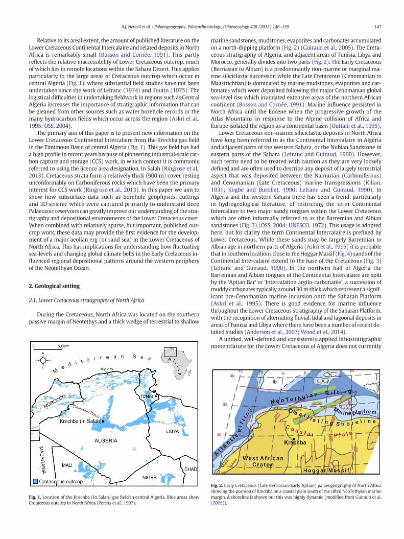
Relative to its areal extent, the amount of published literature on theLower Cretaceous Continental Intercalaire and related deposits in NorthAfrica is remarkably small (Busson and Cornée, 1991). This partlyreflects the relative inaccessibility of Lower Cretaceous outcrop, muchof which lies in remote locations within the Sahara Desert. This appliesparticularly to the large areas of Cretaceous outcrop which occur incentral Algeria (Fig. 1), where substantial field studies have not beenundertaken since the work of Lefranc (1974) and Toutin (1975). Thelogistical difficulties in undertaking fieldwork in regions such as CentralAlgeria increases the importance of stratigraphic information that canbe gleaned from other sources such as water borehole records or themany hydrocarbon fields which occur across the region (Askri et al.,1995; OSS, 2004).
The primary aim of this paper is to present new information on theLower Cretaceous Continental Intercalaire from the Krechba gas fieldin the Timimoun Basin of central Algeria (Fig. 1). This gas field has hada high profile in recent years because of pioneering industrial-scale car-bon capture and storage (CCS) work, in which context it is commonlyreferred to using the licence area designation, In Salah (Ringrose et al.,2013). Cretaceous strata form a relatively thick (900 m) cover restingunconformably on Carboniferous rocks which have been the primaryinterest for CCS work (Ringrose et al., 2013). In this paper we aim toshow how subsurface data such as borehole geophysics, cuttingsand 3D seismic which were captured primarily to understand deepPalaeozoic reservoirs can greatly improve our understanding of the stra-tigraphy and depositional environments of the Lower Cretaceous cover.When combined with relatively sparse, but important, published out-crop work, these data may provide the first evidence for the develop-ment of a major aeolian erg (or sand sea) in the Lower Cretaceous ofNorth Africa. This has implications for understanding how fluctuatingsea-levels and changing global climate belts in the Early Cretaceous in-fluenced regional depositional patterns around the western peripheryof the Neotethyan Ocean.
2. Geological setting
2.1. Lower Cretaceous stratigraphy of North Africa
During the Cretaceous, North Africa was located on the southernpassive margin of Neotethys and a thick wedge of terrestrial to shallow
Fig. 1. Location of the Krechba (In Salah) gas field in central Algeria. Blue areas showCretaceous outcrop in North Africa (Persits et al., 1997).
marine sandstones, mudstones, evaporites and carbonates accumulatedon a north-dipping platform (Fig. 2) (Guiraud et al., 2005). The Creta-ceous stratigraphy of Algeria, and adjacent areas of Tunisia, Libya andMorocco, generally divides into two parts (Fig. 2). The Early Cretaceous(Berriasian to Albian) is a predominantly non-marine or marginal ma-rine siliciclastic succession while the Late Cretaceous (Cenomanian toMaastrichtian) is dominated by marine mudstones, evaporites and car-bonates which were deposited following the major Cenomanian globalsea-level rise which inundated extensive areas of the northern Africancontinent (Busson and Cornée, 1991). Marine-influence persisted inNorth Africa until the Eocene when the progressive growth of theAtlas Mountains in response to the Alpine collision of Africa andEurope isolated the region as a continental basin (Outtani et al., 1995).
Lower Cretaceous non-marine siliciclastic deposits in North Africahave long been referred to as the Continental Intercalaire in Algeriaand adjacent parts of the western Sahara, or the Nubian Sandstone ineastern parts of the Sahara (Lefranc and Guiraud, 1990). However,such terms need to be treated with caution as they are very looselydefined and are often used to describe any deposit of largely terrestrialaspect that was deposited between the Namurian (Carboniferous)and Cenomanian (Late Cretaceous) marine transgressions (Kilian,1931; Kogbe and Burollet, 1990; Lefranc and Guiraud, 1990). InAlgeria and the western Sahara there has been a trend, particularlyin hydrogeological literature, of restricting the term ContinentalIntercalaire to two major sandy tongues within the Lower Cretaceouswhich are often informally referred to as the Barremian and Albiansandstones (Fig. 3) (OSS, 2004; UNESCO, 1972). This usage is adoptedhere, but for clarity the term Continental Intercalaire is prefixed byLower Cretaceous. While these sands may be largely Barremian toAlbian age in northern parts of Algeria (Askri et al., 1995) it is probablethat in southern locations close to theHoggarMassif (Fig. 4) sands of theContinental Intercalaire extend to the base of the Cretaceous (Fig. 3)(Lefranc and Guiraud, 1990). In the northern half of Algeria theBarremian and Albian tongues of the Continental Intercalaire are splitby the ‘Aptian Bar’ or ‘Intercalation argilo-carbonatée’, a succession ofmuddy carbonates typically around 30m thickwhich represent a signif-icant pre-Cenomanian marine incursion onto the Saharan Platform(Askri et al., 1995). There is good evidence for marine influencethroughout the Lower Cretaceous stratigraphy of the Saharan Platform,with the recognition of alternating fluvial, tidal and lagoonal deposits inareas of Tunisia and Libyawhere there have been a number of recent de-tailed studies (Anderson et al., 2007; Wood et al., 2014).
A unified, well-defined and consistently applied lithostratigraphicnomenclature for the Lower Cretaceous of Algeria does not currently
Fig. 2. Early Cretaceous (Late Berriasian-Early Aptian) palaeogeography of North Africashowing the position of Krechba on a coastal plain south of the rifted NeoTethyianmarinemargin. A shoreline is shown but this was highly dynamic (modified from Guiraud et al.(2005)).

Fig. 3. Schematic Early Cretaceous stratigraphy of Algeria from a southern, landward,position toward the marine north. The lithostratigraphical terms shown are fromLefranc (1974) and Outtani et al. (1995). (S.A. = Sidi Aich Formation; A.B. = Aptian Bar).
148 A.J. Newell et al. / Palaeogeography, Palaeoclimatology, Palaeoecology 438 (2015) 146–159
exist and much work combines informal terms, such as ContinentalIntercalaire, terminology which mixes chronostratigraphy and litho-stratigraphy (e.g. Albian Sandstone), and varied combinations of
Fig. 4. Location of theKrechba gasfield relative to somemajor physiographic andgeological featufrom Upper Cretaceous carbonates and flanked by an arcuate outcrop of Lower Cretaceous Coforms a southern boundary to the Cretaceous deposits and is cut bymajor north-south structurCretaceous strata of the Saharan Platform and the folded and thrusted Cretaceous of the Sahar
terms imported from Morocco, Tunisia and Libya (Askri et al.,1995). Due to the confused nomenclature it has been necessary tointroduce new lithostratigraphic terms for the Lower Cretaceousstratigraphy at Krechba which are described in following sections.
2.2. Early Cretaceous tectonics in North Africa
The Early Cretaceous was an important tectonic period for NorthAfrica with a new stage of active rifting along the Atlantic margin tothe west and in the Neotethys, or Alp Tethys, to the north (Stampfliet al., 2002). Tectonic stress from marine rifting was transmitted deepinto the SaharanPlatform resulting in the extensional or strike-slip reac-tivation of long-lived, crustal lineaments many of which are visible in,and propagate northwards, from the Hoggar Massif (Coward and Ries,2003; Smith et al., 2006) (Fig. 4). The major N-S trending Amguid andEssaouidi Mellene faults were particularly important with extensionor transtension generating subsiding basins in the vast continentalplain that lay to the east of the West African Craton and north of theHoggar (Coward and Ries, 2003) (Fig. 2). In the Lower Cretaceous suc-cessions of Tunisia and Libya, tectonic unconformities have beenrecognised in the Late Aptian and the Middle Albian. The Late Aptian,or Austrian unconformity, is placed at the end of the first phase of Cre-taceous rifting (Guiraud et al., 2005). The Late Cretaceous wascharacterised by uniform regional subsidence and minor tectonic com-pressional activity with onlap of Cenomanian and Turonian marine de-posits onto long-lived highs across North Africa. Into the Santonian, acompressional episode caused folding and inversion of the former ex-tensional basins along the North African margin and initialised thegrowth of the Saharan Atlas Mountains.
res of SaharanNorth Africa. TheKrechbafield sits on theTademait Plateauwhich is formedntinental Intercalaire (shown as grey diagonal hatching). The Precambrian Hoggar Massifal lineaments. The South Atlas Front forms a boundary between the relatively undeformedan Atlas.

149A.J. Newell et al. / Palaeogeography, Palaeoclimatology, Palaeoecology 438 (2015) 146–159
2.3. Distribution and thickness of the Lower Cretaceous ContinentalIntercalaire
The Lower Cretaceous Continental Intercalaire covers a large part ofthe Western Sahara Desert between the South Atlas Front and theHoggar Massif (Fig. 4). This area corresponds to the Saharan Platform,a tectonic domain of relatively weakly-deformedMesozoic and Cenozo-ic deposits resting unconformably on sub-Hercynian basement (Askriet al., 1995; Guiraud et al., 2005). Across the Saharan Platform theLower Cretaceous Continental Intercalaire extends in outcrop and insubcrop as a gently undulating blanket of relatively consistent thicknessover 600,000 km2 (Castany, 1981). To the north of the South Atlas Front,the Continental Intercalaire, together with marine strata of equivalentLower Cretaceous age, are folded and thrustedwithin the Atlas orogenicbelt (Outtani et al., 1995).
Themain outcrop of the Lower Cretaceous Continental Intercalaire islocated just to the north of the HoggarMassif, a vast expanse of exposedPrecambrian basement (Fig. 4). Here an arcuate belt of Lower Creta-ceous outcrop occurs around the flanks of the Tademait and Tinghert,a rocky plateau formed from Upper Cretaceous and Lower Tertiarycarbonates. Together with the M’zab and Jeffara escarpments, these el-evated areas encircle the low-lying depression of the Oued Mya Basin,where the Continental Intercalaire subcrops beneath a thick (up to1 km) cover of Late Cretaceous and Cenozoic deposits. A surface con-structed from published well data (UNESCO, 1972) shows that thebase of the Continental Intercalaire reaches a maximum depth ofaround 1500m below sea level in the OuedMya Basin, with Lower Cre-taceous strata dipping into this central basin from the south, west andeast (Fig. 5). The Continental Intercalaire at the Krechba gas field liesin a relatively shallow structural position relative to the Oued MyaBasin, in a southerly position close to the present eroded margin ofthe Cretaceous deposits. The Continental Intercalaire also occurs in thearea occupied by the Great Western Erg to the north of Krechba, buthere the bedrock is concealed beneath a cover of Quaternary alluvialfan and aeolian dune deposits (Fig. 4). This area is bounded to the
Fig. 5. Perspective view (toward the southwest) on the base of the Continental Intercalaire (hPlatform of central Algeria and adjacent areas of Tunisia and Libya. The base of the formation sthe El Biod-Hassi Messaoud structural high trending northward from the Hoggar Massif. Blackis shown as transparent beige. Elevation is in metres above or below sea level.
west by the Ougarta Range, where deformed Palaeozoic rocks are ex-posed at the surface. The El Biod-Hassi Messaoud structural highforms an eastern boundary to the Oued Mya Basin. This high extendsnorthward from the Hoggar Massif and is part of a major Pan-Africanfault system (5°E Shear Zone) thatwas repeatedly reactivated as normalor stike-slip faults during the Phanerozoic, particularly in the MidPalaeozoic, Late Palaeozoic (Hercynian) and Mid Mesozoic tectonicphases (Coward and Ries, 2003; Guiraud et al., 2005).
The El Biod-Hassi Messaoud High appears to have had an importantcontrol on the thickness distribution of the Lower Cretaceous Continen-tal Intercalaire. A thickness map constructed from published UNESCO(1972) borehole data shows that this predominantly sandy interval is500-800 m in the Oued Mya Basin, but east of the El Biod-HassiMessaoudHigh thins to typically less than 400m,with some local thick-ening into the Berkine (Ghadames) Basin (Fig. 6). This thickness patternis similar to that seen in the Upper Triassic when the north-southtrending Pan-African lineaments were reactivated as normal faults cre-ating two main sub-basins either side of the El Biod-Hassi MessaoudHigh (Eschard and Hamel, 2003). The Krechba gas field overlies thePalaeozoic Timimoun Basin (Fig. 6). Reactivation of faults to the westof the Allal High may have created a local depocentre during Early Cre-taceous extension, but there is insufficient well control at present to becertain.
3. Lower Cretaceous stratigraphy at the Krechba gas field
3.1. Location, geological setting and data availability
The Krechba gas field is located 200 km east of Timimoun and215 km north of In Salah on the Tademait, a bare rocky plateau whichreaches an elevation of around 600 metres above sea level (Fig. 4).The plateau is formed from Late Cretaceous carbonates, mudstonesand evaporites which form a series of step-like terraces (Fig. 7A). TheKrechba gas field is located on theminor secondary escarpment formedby the Dalle Turonienne Limestone which dips at an extremely low
ere defined as the base Barremian sandstone) across the relatively undeformed Saharanags into a central trough formed by the Oued Mya Basin, which is bounded to the east byvertical lines indicate well control points which are sourced from UNESCO (1972). Terrain
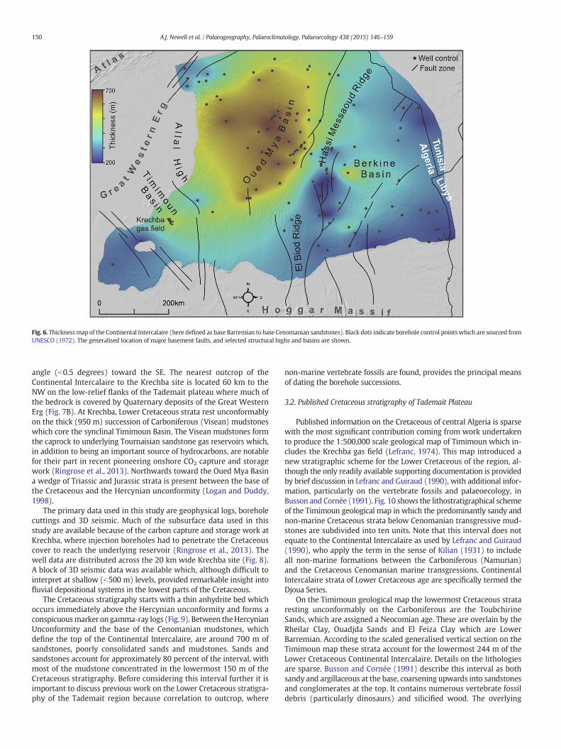
Fig. 6. Thicknessmap of the Continental Intercalaire (here defined as base Barremian to base Cenomanian sandstones). Black dots indicate borehole control points which are sourced fromUNESCO (1972). The generalised location of major basement faults, and selected structural highs and basins are shown.
150 A.J. Newell et al. / Palaeogeography, Palaeoclimatology, Palaeoecology 438 (2015) 146–159
angle (b0.5 degrees) toward the SE. The nearest outcrop of theContinental Intercalaire to the Krechba site is located 60 km to theNW on the low-relief flanks of the Tademait plateau where much ofthe bedrock is covered by Quaternary deposits of the Great WesternErg (Fig. 7B). At Krechba, Lower Cretaceous strata rest unconformablyon the thick (950 m) succession of Carboniferous (Visean) mudstoneswhich core the synclinal Timimoun Basin. The Visean mudstones formthe caprock to underlying Tournaisian sandstone gas reservoirs which,in addition to being an important source of hydrocarbons, are notablefor their part in recent pioneering onshore CO2 capture and storagework (Ringrose et al., 2013). Northwards toward the Oued Mya Basina wedge of Triassic and Jurassic strata is present between the base ofthe Cretaceous and the Hercynian unconformity (Logan and Duddy,1998).
The primary data used in this study are geophysical logs, boreholecuttings and 3D seismic. Much of the subsurface data used in thisstudy are available because of the carbon capture and storage work atKrechba, where injection boreholes had to penetrate the Cretaceouscover to reach the underlying reservoir (Ringrose et al., 2013). Thewell data are distributed across the 20 km wide Krechba site (Fig. 8).A block of 3D seismic data was available which, although difficult tointerpret at shallow (b500 m) levels, provided remarkable insight intofluvial depositional systems in the lowest parts of the Cretaceous.
The Cretaceous stratigraphy starts with a thin anhydrite bed whichoccurs immediately above the Hercynian unconformity and forms aconspicuousmarker on gamma-ray logs (Fig. 9). Between theHercynianUnconformity and the base of the Cenomanian mudstones, whichdefine the top of the Continental Intercalaire, are around 700 m ofsandstones, poorly consolidated sands and mudstones. Sands andsandstones account for approximately 80 percent of the interval, withmost of the mudstone concentrated in the lowermost 150 m of theCretaceous stratigraphy. Before considering this interval further it isimportant to discuss previous work on the Lower Cretaceous stratigra-phy of the Tademait region because correlation to outcrop, where
non-marine vertebrate fossils are found, provides the principal meansof dating the borehole successions.
3.2. Published Cretaceous stratigraphy of Tademait Plateau
Published information on the Cretaceous of central Algeria is sparsewith the most significant contribution coming from work undertakento produce the 1:500,000 scale geological map of Timimoun which in-cludes the Krechba gas field (Lefranc, 1974). This map introduced anew stratigraphic scheme for the Lower Cretaceous of the region, al-though the only readily available supporting documentation is providedby brief discussion in Lefranc and Guiraud (1990), with additional infor-mation, particularly on the vertebrate fossils and palaeoecology, inBusson and Cornée (1991). Fig. 10 shows the lithostratigraphical schemeof the Timimoun geological map in which the predominantly sandy andnon-marine Cretaceous strata below Cenomanian transgressive mud-stones are subdivided into ten units. Note that this interval does notequate to the Continental Intercalaire as used by Lefranc and Guiraud(1990), who apply the term in the sense of Kilian (1931) to includeall non-marine formations between the Carboniferous (Namurian)and the Cretaceous Cenomanian marine transgressions. ContinentalIntercalaire strata of Lower Cretaceous age are specifically termed theDjoua Series.
On the Timimoun geological map the lowermost Cretaceous strataresting unconformably on the Carboniferous are the ToubchirineSands, which are assigned a Neocomian age. These are overlain by theRheilar Clay, Ouadjda Sands and El Feiza Clay which are LowerBarremian. According to the scaled generalised vertical section on theTimimoun map these strata account for the lowermost 244 m of theLower Cretaceous Continental Intercalaire. Details on the lithologiesare sparse. Busson and Cornée (1991) describe this interval as bothsandy and argillaceous at the base, coarsening upwards into sandstonesand conglomerates at the top. It contains numerous vertebrate fossildebris (particularly dinosaurs) and silicified wood. The overlying
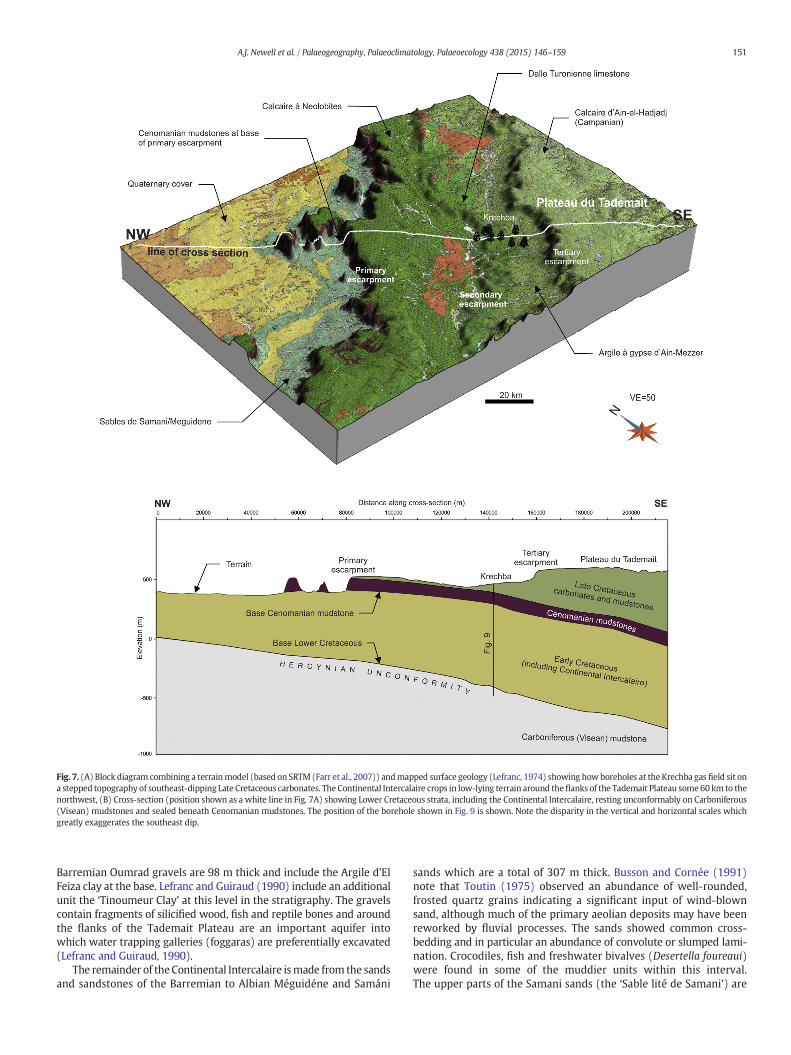
Fig. 7. (A) Block diagram combining a terrainmodel (based on SRTM(Farr et al., 2007)) andmapped surface geology (Lefranc, 1974) showing howboreholes at the Krechba gas field sit ona stepped topography of southeast-dipping Late Cretaceous carbonates. The Continental Intercalaire crops in low-lying terrain around theflanks of the Tademait Plateau some60 km to thenorthwest, (B) Cross-section (position shown as a white line in Fig. 7A) showing Lower Cretaceous strata, including the Continental Intercalaire, resting unconformably on Carboniferous(Visean) mudstones and sealed beneath Cenomanian mudstones. The position of the borehole shown in Fig. 9 is shown. Note the disparity in the vertical and horizontal scales whichgreatly exaggerates the southeast dip.
151A.J. Newell et al. / Palaeogeography, Palaeoclimatology, Palaeoecology 438 (2015) 146–159
Barremian Oumrad gravels are 98 m thick and include the Argile d’ElFeiza clay at the base. Lefranc and Guiraud (1990) include an additionalunit the ‘Tinoumeur Clay’ at this level in the stratigraphy. The gravelscontain fragments of silicified wood, fish and reptile bones and aroundthe flanks of the Tademait Plateau are an important aquifer intowhich water trapping galleries (foggaras) are preferentially excavated(Lefranc and Guiraud, 1990).
The remainder of theContinental Intercalaire ismade from the sandsand sandstones of the Barremian to Albian Méguidéne and Samáni
sands which are a total of 307 m thick. Busson and Cornée (1991)note that Toutin (1975) observed an abundance of well-rounded,frosted quartz grains indicating a significant input of wind-blownsand, although much of the primary aeolian deposits may have beenreworked by fluvial processes. The sands showed common cross-bedding and in particular an abundance of convolute or slumped lami-nation. Crocodiles, fish and freshwater bivalves (Desertella foureaui)were found in some of the muddier units within this interval.The upper parts of the Samani sands (the ‘Sable lité de Samani’) are

Fig. 8. Map showing the location of selected boreholes at the Krechba gas field. Thereference borehole KB-502 (Fig. 9) is located at 29°09’52” N and 02°11’45” E. The blackline shows the location of the well correlation panel (Fig. 12).
152 A.J. Newell et al. / Palaeogeography, Palaeoclimatology, Palaeoecology 438 (2015) 146–159
finer-grained and become argillaceous below the transgressiveCenomanian El Goléa clays.
Lefranc and Guiraud (1990) tentatively correlate a 20 m thickcalcareous sandstone in the Timimoun region, the Hassi el-HomeurSandstone, located 122 m below the top of the Continental Intercalairewith the marine carbonates of the Aptian Bar. The Aptian Bar is a well-defined marker unit of dolomitic limestones within the ContinentalIntercalaire further north in the Oued Mya Basin (Askri et al., 1995).
3.3. Surface to subsurface stratigraphic correlation
The generalised vertical section on the Timimoun geological map(Lefranc, 1974) indicates a total thickness of sub-Cenomanian Creta-ceous of 649 m which compares reasonably closely to the mean thick-ness of this interval (702 m) at the Krechba gas field. As discussedbelow, the general character of the stratigraphy can also be readilyrecognised in the borehole stratigraphy at Krechba, as might be expect-ed given that the gas field is located around 60 km from the nearest out-crop, a small distance relative to the vast sedimentary basin. However,there are a number of reasons why it is not possible to accurately andobjectively transfer the terms shown on the Timimounmap to the bore-holes at Krechba including the relatively fine-scale, and potentiallylocalised, nature of Lefranc’s (1974) subdivisions, the lack of alithostratigraphic hierarchy of groups, formations and members, andthe absence of readily-available and detailed documentation. For thepurposes of discussion, two new lithostratigraphic terms are introducedat Krechba (the In Salah and Krechba formations) which recognise afundamental two-fold subdivision of the sub-Cenomanian, Lower Creta-ceous stratigraphy. While the proliferation of lithostratigraphical termsis never desirable, the introduction of two new terms prevents themis-use of the relatively sparsely-documented terms established at outcropand highlights the clear and well-defined two-fold subdivision of theLower Cretaceous at Krechba. Many of the terms for individual sand-stone and mudstone units (e.g. Rheilar Clay, Ouadjda Sands etc) used
by Lefranc (1974) probably represent members within the two forma-tions that are described below.
3.4. In Salah Formation
3.4.1. DescriptionThe In Salah Formation describes the lowermost 200m of the Lower
Cretaceous stratigraphy. At Krechba the base of the formation ismarkedby a thin anhydrite bed overlying the Hercynian Unconformity whichforms a conspicuous low gamma-ray spike (Fig. 9). Above this is an in-terval that comprises approximately equal proportions of mudstoneand sandstone. Borehole cutting returns show that sandstones are dom-inated by quartz grains that are predominantly fine-grained, subangularto subrounded and brown, reddish brown or translucent in colour(Fig. 11A). Mudstones are micaeous and highly variable in colour in-cluding red, grey, green and brown (Fig. 11B). Lignite and pyrite arepresent, particularly toward the base of the formation, and some ofthe mudstones show possible small-scale root structures.
Geophysical logs show that the mudstones and sandstones are ar-ranged into coarsening-upward cycles which produce funnel-shapedprofiles on gamma-ray curves, with mudstones of high gamma-rayvalue at the base and sandstones of low gamma-ray value at the top(Fig. 9). It is probable that immediate gamma-ray values represent ad-mixtures, or thinly interbedded (below the resolution of the loggingtool), sandstone and mudstone. The coarsening-upward cycles rangefrom 20 to 40 m thick with 5 to 8 cycles making up the 200 m thick InSalah Formation. The proportion and thickness of sandstone makingup each cycle increases systematically upwards in each borehole, fromsandstones that are 5 m or less at the base of the formation, to sand-stones that are up to 25 m thick at the top of the formation (Fig. 12).
Thicker sandstones toward the top of the formation appear to havesharp, abrupt contacts with the underlying mudstones, suggestingthat they could be channels with scoured bases. Upward-fining withinsome of the sandstone bodies is suggested by the development of bell-shaped gamma-ray profiles, which often results from the lateral migra-tion of point bars within meandering channels. The presence ofmeandering channels is indicated by seismic analysis using a processedcoherency cube of the 3D seismic data. Enhancing lateral discontinuitiesreveals many examples of high-sinuousity channels, ranging from 80 toseveral hundred metres wide with meander amplitudes varying fromhundreds of metres (smaller channels) to several kilometres (Fig. 13).Seismic amplitudes within the channels are highly variable along theirlength, suggesting both varying thickness and the nature of the fill,probably being sand filled in one place, and mud filled elsewhere.
In terms of the published stratigraphy it is probable that the 200 mthick In Salah Formation is equivalent to the combined 243 m thicknessof the Toubchirine Sand, Ouadjda Sand and OumradGravel and their in-tervening clay members (Fig. 9). This would suggest a Neocomian toearly Aptian age for the Krechba Formation. The upward transitionfrom a mudstone-rich base to a sandy and gravelly top, which is clearlyshown in gamma-ray logs at Krechba, is not described in published lit-erature (Lefranc, 1974; Lefranc and Guiraud, 1990). This may indicatea more proximal position for the Toubchirine Sands, along the westernflanks of the Tademait Plateau, or simply problems with the lowerpart of the stratigraphy being obscured by Quaternary cover at outcrop(Lefranc and Guiraud, 1990). In this respect the borehole data may pro-vide a much higher stratigraphic resolution than outcrop.
3.4.2. InterpretationThe presence of large meandering river channels, grey mudstones
and lignite indicates that the In Salah Formation was deposited in arelatively wet lowland basin. Red, green and grey multicolouredclays probably indicate the development of palaeosols in areas thatwere subject to alternating intervals of gleying and oxidation (Newell,2014). The high sinuosity of the channels suggests deposition on avery low-gradient surface and this is consistent with the general
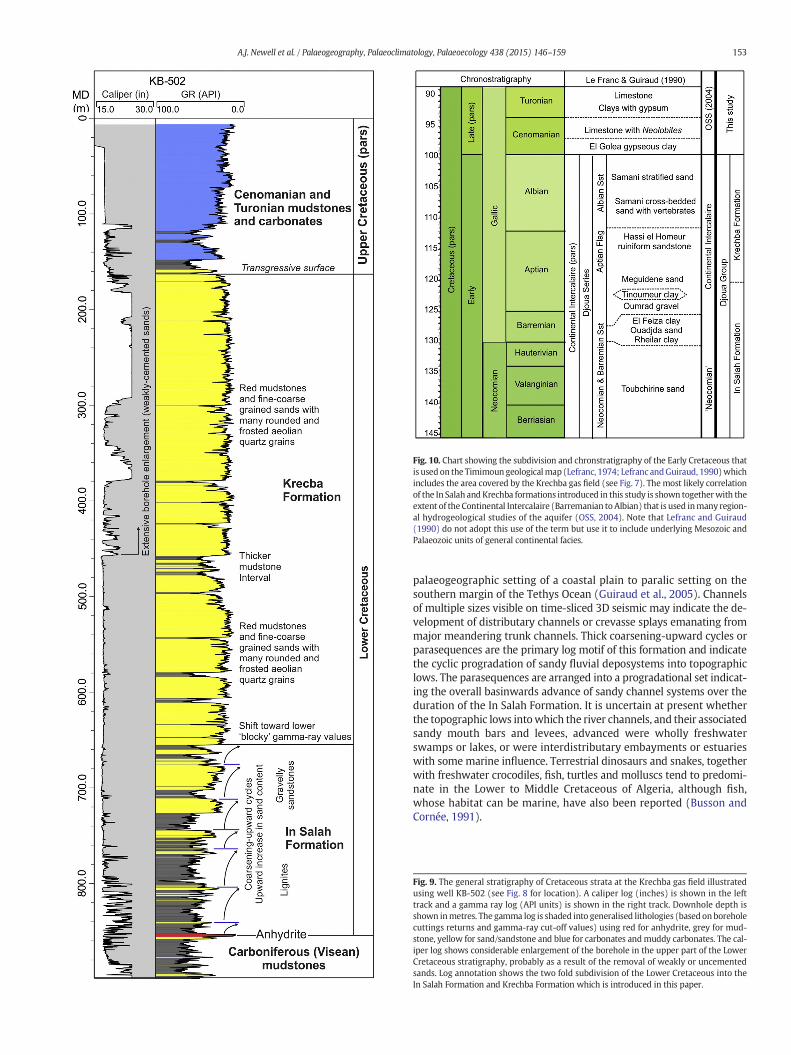
Fig. 10. Chart showing the subdivision and chronstratigraphy of the Early Cretaceous thatis used on the Timimoun geologicalmap (Lefranc, 1974; Lefranc andGuiraud, 1990)whichincludes the area covered by the Krechba gas field (see Fig. 7). The most likely correlationof the In Salah andKrechba formations introduced in this study is shown togetherwith theextent of the Continental Intercalaire (Barremanian to Albian) that is used inmany region-al hydrogeological studies of the aquifer (OSS, 2004). Note that Lefranc and Guiraud(1990) do not adopt this use of the term but use it to include underlying Mesozoic andPalaeozoic units of general continental facies.
153A.J. Newell et al. / Palaeogeography, Palaeoclimatology, Palaeoecology 438 (2015) 146–159
palaeogeographic setting of a coastal plain to paralic setting on thesouthern margin of the Tethys Ocean (Guiraud et al., 2005). Channelsof multiple sizes visible on time-sliced 3D seismic may indicate the de-velopment of distributary channels or crevasse splays emanating frommajor meandering trunk channels. Thick coarsening-upward cycles orparasequences are the primary log motif of this formation and indicatethe cyclic progradation of sandy fluvial deposystems into topographiclows. The parasequences are arranged into a progradational set indicat-ing the overall basinwards advance of sandy channel systems over theduration of the In Salah Formation. It is uncertain at present whetherthe topographic lows intowhich the river channels, and their associatedsandy mouth bars and levees, advanced were wholly freshwaterswamps or lakes, or were interdistributary embayments or estuarieswith somemarine influence. Terrestrial dinosaurs and snakes, togetherwith freshwater crocodiles, fish, turtles and molluscs tend to predomi-nate in the Lower to Middle Cretaceous of Algeria, although fish,whose habitat can be marine, have also been reported (Busson andCornée, 1991).
Fig. 9. The general stratigraphy of Cretaceous strata at the Krechba gas field illustratedusing well KB-502 (see Fig. 8 for location). A caliper log (inches) is shown in the lefttrack and a gamma ray log (API units) is shown in the right track. Downhole depth isshown inmetres. The gamma log is shaded into generalised lithologies (based onboreholecuttings returns and gamma-ray cut-off values) using red for anhydrite, grey for mud-stone, yellow for sand/sandstone and blue for carbonates andmuddy carbonates. The cal-iper log shows considerable enlargement of the borehole in the upper part of the LowerCretaceous stratigraphy, probably as a result of the removal of weakly or uncementedsands. Log annotation shows the two fold subdivision of the Lower Cretaceous into theIn Salah Formation and Krechba Formation which is introduced in this paper.

Fig. 11. Borehole cuttings returns from well KB-502 (Fig. 9) that are representative of the two Lower Cretaceous formations recognised in this study. (A) Loose, fine-grained,commonly subangular, quartz grains (sample depth = 700 m) and (B) grey micaeous mudstone (sample depth = 720 m) from the In Salah Formation. (C) Loose, translucent,very well rounded and frostedmedium- to coarse-quartz grains (sample depth= 420m) and (D) brick redmustones with grey silt-size quartz (sample depth= 480m) from theKrechba Formation.
Fig. 12.Well correlation panel (see Fig. 8 for location) showing the consistency in the thickness and geophysical log character of the In Salah and Krechba formations across anapproximately 20 km north-south transect of the Krechba gas field. Lateral extrapolations of the major mudstone (grey) and sandstone (yellow) intervals within each well(width is constrained to some extent by 3D seismic) are used to give an impression (or conceptual model) of the likely stratigraphic architecture of the two formations. Noteincreasing thickness and amalgamation of channel sandstone bodies toward the top of the In Salah Formation and the possibility of a relatively continuous belt of mudstonetoward the middle of the Krechba Formation.
154 A.J. Newell et al. / Palaeogeography, Palaeoclimatology, Palaeoecology 438 (2015) 146–159
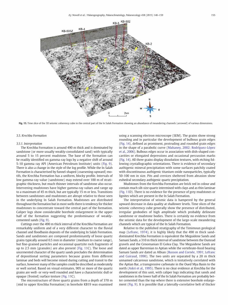
Fig. 13. Time slice of the 3D seismic coherency cube in the central part of the In Salah Formation showing an abundance of meandering channels (arrowed) of various dimensions.
155A.J. Newell et al. / Palaeogeography, Palaeoclimatology, Palaeoecology 438 (2015) 146–159
3.5. Krechba Formation
3.5.1. InterpretationThe Krechba Formation is around 490 m thick and is dominated by
sandstone (or more usually weakly-consolidated sand) with typicallyaround 5 to 15 percent mudstone. The base of the formation canbe readily identified on gamma-ray logs by a negative shift of around5-10 gamma ray API (American Petroleum Institute) units (Fig. 9).There is also a change in the style of the log profile. While the In SalahFormation is characterised by funnel-shaped (coarsening-upward) mo-tifs, the Krechba Formation has a uniform, blocky profile. Intervals oflow gamma-ray value (sandstone) may extend over 100 m of strati-graphic thickness, but much thinner intervals of sandstone also occur.Intervening mudstones have higher gamma-ray values and range upto a maximum of 45 m thick, but are typically 15 m or less. Transitionsbetween sandstones and mudstones are abrupt relative to those seenin the underlying In Salah Formation. Mudstones are distributedthroughout the formation but inmostwells there is tendency for thickermudstones to concentrate toward the central part of the formation.Caliper logs show considerable borehole enlargement in the upperhalf of the formation suggesting the predominance of weakly-cemented sands (Fig. 9).
Cuttings over the 490 m thick interval of the Krechba Formation areremarkably uniform and of a very different character to the fluvialchannel and floodbasin deposits of the underlying In Salah Formation.Sands and sandstones are composed predominantly of loose quartzgrains typically around 0.5 mm in diameter (medium to coarse range),but fine-grained particles and occasional quartzite rock fragments ofup to 2.5 mm (granules) are also present (Fig. 11C). The loose anduncemented character of the quartz sands precludes the determinationof depositional sorting parameters because grains from differentlaminae and beds will become mixed during cutting and transit to thesurface, howevermany of the samples could bedescribed asmoderatelyor well sorted. Based on visual estimates, 90% or more of the quartzgrains are well- or very-well rounded and have a characteristic dull oropaque (frosted) surface texture (Fig. 11C).
The microstructure of three quartz grains from a depth of 370 m(mid to upper Krechba Formation) in borehole KB19 was examined
using a scanning electron microscope (SEM). The grains show strongrounding and in particular the development of bulbous grain edges(Fig. 14), defined as prominent, protruding and rounded grain edgesin the shape of a parabolic curve (Mahaney, 2002; Rodríguez-Lópezet al., 2006). Bulbous edges occur in association with dish-shaped con-cavities or elongated depressions and occasional percussion marks(Fig. 14). All three grains display dissolution textures, with etching fol-lowing crystallographic orientations. There is evidence of secondaryauthigenic mineral precipitation with some surfaces patchily coatedwith discontinuous authigenic titanium oxide nanoparticles, typically50-100 nm in size. Pits and crevices sheltered from abrasion showeuhedral secondary authigenic quartz precipitation.
Mudstones from the Krechba Formation are brick red in colour andcontain much silt-size quartz intermixed with clays and as thin laminae(Fig. 11D). There is no evidence for the presence of grey mudstones orlignites which are present in the In Salah Formation.
The interpretation of seismic data is hampered by the generalupward decrease in data quality at shallower levels. Time slices of theseismic coherency cube generally show the presence of distributed,irregular geobodies of high amplitude which probably delineatesandstone or mudstone bodies. There is certainly no evidence fromthe seismic data for the development of the large-scale meanderingchannels which are typical of the In Salah Formation.
Relative to the published stratigraphy of the Timimoun geologicalmap (Lefranc, 1974), it is highly likely that the 490 m thick sand-dominated Krechba Formation is equivalent the Meguidene Sands andSamani Sands, a 310m thick interval of sandstone between the Oumradgravels and the Cenomanian El Golea Clay. The Meguidene Sands aredated as upper Barremian to Aptian while the vertebrate-fossil bearingSamani Sands are dated as Albian (Busson and Cornée, 1991; Lefrancand Guiraud, 1990). The two units are separated by a 20 m thickunnamed calcareous sandstone, which is tentatively correlated withthe Aptian Bar, a transgressive carbonate in the Oued Mya Basin to thenorth (Askri et al., 1995). There is no clear evidence at Krechba for thedevelopment of this unit, with caliper logs indicating that sands andsandstones in the lower half of the In Salah Formation are probably bet-ter cemented than the top where there is extensive borehole enlarge-ment (Fig. 9). It is possible that a laterally-correlative belt of thicker

Fig. 14. SEM images of quartz sand grains from the Krechba Formation, (a-c) Quartz grains showing strong rounding with low relief, bulbous edges and equidimensional or elongatedepressions (D), (d) Grain surface exhibiting several V-shaped impact marks (V), grooves (G) and extensive dissolution etching (E) along crystallographic orientations.
156 A.J. Newell et al. / Palaeogeography, Palaeoclimatology, Palaeoecology 438 (2015) 146–159
mudstones which occurs toward the middle of the Krechba Formation(Fig. 12) represents an inland correlative of the Aptian Bar.
3.5.2. InterpretationThe Krechba Formation is dominated by clean quartz sands, which
on gamma-ray logs form remarkably uniform, blocky intervals of lowvalue, punctuated by red mudstones. Several lines of evidence suggestthat the bulk of the sands and sandstoneswithin the Krechba Formationhave an aeolian origin including, (1) the rounding and surfacemorphol-ogy of quartz grains, (2) the lack of observed fluvial channels in 3D seis-mic, (3) the blocky gamma-ray response, (4) an association with red(highly oxidised) mudstones which lack lignite, and (5) observationsfrom adjacent outcrop around the Tademait Plateau that aeolian faciesoccur in the upper part of the Continental Intercalaire (Toutin, 1975).Rounding of quartz grains is a characteristic feature of wind-blownsands and experiments show that even limited saltation can achieveedge abrasion and rounding of particles (Rodríguez-López et al., 2006;Whalley et al., 1987). In particular the development of bulbous edgemorphology (Fig. 14) is considered highly diagnostic of aeolian environ-ments (Costa et al., 2013; Vos et al., 2014). This style of rounding of theedges and protrusions is attributed to the rotation of saltating grains andis typically shown by grains that are generally coarser than 150 μm, asfiner material is carried in suspension (Mahaney, 2002). Bulbousedges often occur in association with dish-shaped concavities or elon-gated depressionswhose formation is attributed to high-energy aeoliantransport where direct impacts between saltating or creeping grainsoccur (Vos et al., 2014). Most of the rounded quartz grains have a dull,
opaque (frosted) surface appearance and this has long been describedfrom quartz grains in deserts where it is related to the scattering or dif-fusion of light due to the presence of closely spaced surface irregularities(Folk, 1978). These include irregularities such as scratches and percus-sion cracks caused by violent impacts and abrasion during transport, to-gether with a regular and orientated chemical etching where solutionfollows the crystallographic orientation (Kuenen and Perdok, 1962;Margolis and Keinsley, 1971). Etch pits are generally linked to diagenet-ic processes and in particular to contact with alkaline fluids such as sea-water, particularly where this is concentrated by evaporative processes(Vos et al., 2014). The presence of such fluids is consistentwith the arid,coastal setting of the Saharan Platform in the mid- to late Cretaceous.
It is possible that quartz grains showing the signature of aeoliantransport can be reworked or recycled by fluvial and marine processes.In the current absence of downhole image logs, detailed description ofsmall-scale sedimentary structures from outcrop are required to deter-mine the types of aeolian bedform that were present and the extent towhich these were reworked by other processes. At present outcrop ob-servations are limited to those of Toutin (1975) from a location 65 kmnorthwest of the Krechba gas field. Toutin (1975) observed that in theupper part of the Continental Intercalaire (above the Oumrad Gravels)around half the sediment was composed of well-rounded and frostedgrains of aeolian origin. However, the presence of large-scale cross-bedding and extensive convolute lamination was noted and it wasthought that this might indicate extensive reworking of an aeoliandune hinterland by fluvial processes. The extent of the reworking is un-certain at present. At Krechba, grain surfaces do not show clear evidence

Fig. 15. Middle Cretaceous palaeogeography (generalised from Blakey (2011)) showingthe position of the northern hot arid belt and major wind directions around westernNeotethys (modified from Rodríguez-López et al. (2008)). Yellow stars show theapproximate location of Krechba in Algeria (A) relative to major aeolian ergs ofcomparable age in the Iberian Range of NE Spain (I) and China (C).
157A.J. Newell et al. / Palaeogeography, Palaeoclimatology, Palaeoecology 438 (2015) 146–159
for overprint by subaqueous processes (Vos et al., 2014), which canoccur relatively rapidly (Folk, 1978). Neither do the gamma-ray signa-tures nor 3D seismic provide evidence for fluvial channels which areclearly seen in the In Salah Formation. Inundation of dune fields byfloodwaters could account for the common occurrence of convolutelamination (Toutin, 1975) and this has been described from manycoastal erg settings where water ingress causes the destabilisation anddeformation of aeolian dune sands (Rodríguez-López et al., 2008).
The highly-oxidised brick-red mudstones of the Krechba Formationare very different from the grey, lignitic mudstones of the fluvial InSalah Formation. On the basis of poorly-resolved 3D seismic datathese appear to form irregular patches whichmay be several kilometresin width. It is probable that these mudstones were deposited from sus-pension in temporary water bodies which may have been lakes or la-goons in topographic lows between dune fields. Floodwaters couldhave been overland freshwater flows or, given the coastal plain setting,frommarine storm surges. At outcropmudstones within the correlativeSamani Sands contain vertebrate remains including a large crocodileskull and the freshwater bivalve Desertella foureaui (Busson andCornée, 1991).
4. Discussion
The Lower Cretaceous Continental Intercalaire of North Africa pro-vides an important record of Early Cretaceous terrestrial environmentsalong the southern periphery of the western Neotethyan Ocean(Anderson et al., 2007; Russell and Paesler, 2003). In recent years thebulk of research has been undertaken on the Lower Cretaceous succes-sions of Tunisia and Libya, which are generally fluvio-marine in charac-ter, relatively thin and punctuated bymajor unconformities (Aloui et al.,2012; Anderson et al., 2007; Fanti et al., 2012; Lazzez et al., 2008;Woodet al., 2014). This study is one of very few to have investigated theContinental Intercalaire on the Saharan Platform to the west of the ElBiod-Hassi Messaoud structural high, across which Lower Cretaceousstrata thicken markedly into the Oued Mya and Timimoun Basins.
Subsurface evidence from geophysical logs, cuttings and 3D seismicfrom the Krechba gas field show that the pre-Cenomanian stratigraphyhas a clear two-fold subdivision into a lower 200m thick fluvial succes-sion overlain by a 500m unit dominated by sands of aeolian origin. Thelowermost fluvial deposit, here termed the In Salah Formation, forms acoarsening-upward succession that culminates in thick gravellyand sandy channel fills. 3D seismic shows the development of majormeandering channels up to several hundred metres in width and pro-vides a remarkable visualisation of an Early Cretaceous coastal plainon the Saharan Platform. The presence of grey mudstones and lignitessuggests the development of water-logged floodbasins or lakes, whilegrey red and purple mottled mudstones are usually indicative of fluctu-ating pedogenic redox processes under a warm and humid climate(Newell, 2014).
Well-to-well correlation across a 20 km transect suggests the fluvialto aeolian changewas abrupt and is a relatively planar surface. This mayrepresent a composite wind deflation and sand-drift surface developedin response to a regional lowering of the groundwater level and a switchtoward a relatively arid climate. The primary limiting factor on the accu-mulation of thick aeolian deposits is the availability of an abundant sup-ply of dry, loose sand (Pye and Tsoar, 2009). The timing of the shift isconstrained by correlation to vertebrate-bearing successions at outcrop(Lefranc, 1974) which indicates it occurs around the middle of theAptian. Aeolian sedimentation continued until the Cenomanian marinetransgressionswhich capped the Continental Intercalairewith evaporit-icmuds and shallowmarine carbonates. Episodic flooding of the aeoliandune field, bymarine and possibly fluvial processes,may account for thereported abundance of convolute laminationwithin the aeolian sands atoutcrop (Toutin, 1975).
Aside from the brief notes of Toutin (1975), the possibility of amajoraeolian erg in the Lower Cretaceous of Algeria has not been considered
in any detail. It has considerable practical importance in estimating thevolume of the groundwater reserves in the Continental Intercalairebecause aeolian sandstones typically have a high porosity in additionto a high permeability. The extent of the aeolian deposits beyondKrechba and the Timimoun Basin needs to be established but it couldbe extensive. Accumulations of silt-size quartz, which are thought tohave been transported by aeolian processes, have been briefly describedfrom the Lower Cretaceous Continental Intercalaire of the Belezma Hillsof NE Algeria (Bureau and Douillet, 1972).
The character and timing of the fluvial to aeolian switch describedhere is similar to one that has recently been described from the midCretaceous of NE Spain (Rodríguez-López et al., 2008). During theEarly Cretaceous, Spain was located north of the narrow Neotethyanor Alp-Tethys (Stampfli et al., 2002) marine rift basin that separatedAfrica from Europe (Fig. 15). Here Rodríguez-López et al. (2006, 2008)describe amajor Late Aptian to Albian aeolian erg systemwith amarineerg margin which is around 300 m thick and extends over 4600 km2ofthe Iberian Range of NE Spain. Remarkably this was the first Cretaceouserg system to be reported from Europe and, before the significance ofthe outcrop in the IberianRangewas recognised, its occurrencewaspre-dicted by the presence of aeolian grains within coeval marine deposits(Rodríguez-López et al., 2006, 2008). The late Early Cretaceous stratigra-phy is similar to that seen at Krechba, with a thick aggradational aeoliansystem represented by the Utrillas Group of Late Aptian and Albian ageresting on a sharp deflation/sand-drift surface developed on coal-bearing, alluvial strata of the Aptian Escucha Formation (Barrón et al.,2015; Rodríguez-López et al., 2008) (Fig. 16). Rodríguez-López et al.(2006) relate the occurrence and timing of the Iberian erg to a phaseof global cooling and sea-level lowstand in themid Cretaceous, togetherwith the establishment of the northern hot arid belt. The mid Creta-ceouswas a time of marked perturbations in the Cretaceous δ13C isoto-pic record (Föllmi et al., 2006; Herrle et al., 2015) with a positive δ13Cshift and a climatic cold snap in the late Aptian possibly related to thesequestration of carbon in newly formed oceanic basins such as theSouth Atlantic, created as the African continent separated from SouthAmerica (McAnena et al., 2013) (Fig. 16). The connection of the Southand North Atlantic was also important in causing the breakdown ofthe intracontinental arid zone which had previously occupied centralGondwana (Scotese, 2009). This was replaced by an equatorial humidbelt which forced aridity from central Africa into the former tropicalhumid zones of the Saharan Platform and adjacent areas. The combina-tion of greater aridity and lowered sea levels, possibly increasing sandavailability on exposed shelves, may have been conducive to theformation of aeolian ergs around the periphery of western Neotethys.
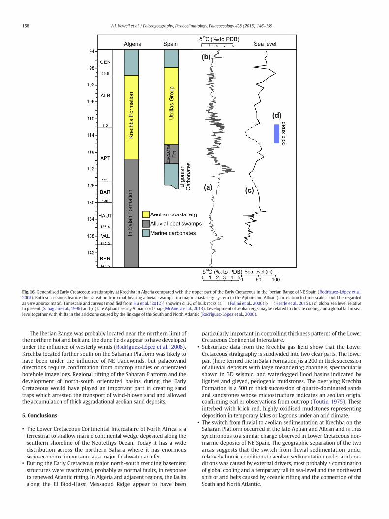
Fig. 16. Generalised Early Cretaceous stratigraphy at Krechba in Algeria compared with the upper part of the Early Cretaceous in the Iberian Range of NE Spain (Rodríguez-López et al.,2008). Both successions feature the transition from coal-bearing alluvial swamps to a major coastal erg system in the Aptian and Albian (correlation to time-scale should be regardedas very approximate). Timescale and curves (modified from Hu et al. (2012)) showing d13C of bulk rocks (a = (Föllmi et al., 2006) b = (Herrle et al., 2015), (c) global sea level relativeto present (Sahagian et al., 1996) and (d) late Aptian to early Albian cold snap (McAnena et al., 2013). Development of aeolian ergsmay be related to climate cooling and a global fall in sea-level together with shifts in the arid-zone caused by the linkage of the South and North Atlantic (Rodríguez-López et al., 2006).
158 A.J. Newell et al. / Palaeogeography, Palaeoclimatology, Palaeoecology 438 (2015) 146–159
The Iberian Range was probably located near the northern limit ofthe northern hot arid belt and the dune fields appear to have developedunder the influence of westerly winds (Rodríguez-López et al., 2006).Krechba located further south on the Saharian Platform was likely tohave been under the influence of NE tradewinds, but palaeowinddirections require confirmation from outcrop studies or orientatedborehole image logs. Regional rifting of the Saharan Platform and thedevelopment of north-south orientated basins during the EarlyCretaceous would have played an important part in creating sandtraps which arrested the transport of wind-blown sand and allowedthe accumulation of thick aggradational aeolian sand deposits.
5. Conclusions
• The Lower Cretaceous Continental Intercalaire of North Africa is aterrestrial to shallow marine continental wedge deposited along thesouthern shoreline of the Neotethys Ocean. Today it has a widedistribution across the northern Sahara where it has enormoussocio-economic importance as a major freshwater aquifer.
• During the Early Cretaceous major north-south trending basementstructures were reactivated, probably as normal faults, in responseto renewed Atlantic rifting. In Algeria and adjacent regions, the faultsalong the El Biod-Hassi Messaoud Ridge appear to have been
particularly important in controlling thickness patterns of the LowerCretaceous Continental Intercalaire.
• Subsurface data from the Krechba gas field show that the LowerCretaceous stratigraphy is subdivided into two clear parts. The lowerpart (here termed the In Salah Formation) is a 200m thick successionof alluvial deposits with large meandering channels, spectacularlyshown in 3D seismic, and waterlogged flood basins indicated bylignites and gleyed, pedogenic mudstones. The overlying KrechbaFormation is a 500 m thick succession of quartz-dominated sandsand sandstones whose microstructure indicates an aeolian origin,confirming earlier observations from outcrop (Toutin, 1975). Theseinterbed with brick red, highly oxidised mudstones representingdeposition in temporary lakes or lagoons under an arid climate.
• The switch from fluvial to aeolian sedimentation at Krechba on theSaharan Platform occurred in the late Aptian and Albian and is thussynchronous to a similar change observed in Lower Cretaceous non-marine deposits of NE Spain. The geographic separation of the twoareas suggests that the switch from fluvial sedimentation underrelatively humid conditions to aeolian sedimentation under arid con-ditions was caused by external drivers, most probably a combinationof global cooling and a temporary fall in sea-level and the northwardshift of arid belts caused by oceanic rifting and the connection of theSouth and North Atlantic.
159A.J. Newell et al. / Palaeogeography, Palaeoclimatology, Palaeoecology 438 (2015) 146–159
Acknowledgements
Members of the In Salah CO2 Storage Project (a joint venturebetween BP, Sonatrach and Statoil) are thanked for providing the welland seismic data on which this paper is based and for permissionto publish. John Midgely is thanked for his efforts in sourcing andsupplying borehole cuttings returns. The paper is published with thepermission of the Executive Director of the British Geological Survey.
References
Aloui, T., Dasgupta, P., Chaabani, F., 2012. Facies pattern of the Sidi Aïch Formation:Reconstruction of Barremian paleogeography of Central North Africa. J. Afr. EarthSci. 71, 18–42.
Anderson, P.E., Benton, M.J., Trueman, C.N., Paterson, B.A., Cuny, G., 2007.Palaeoenvironments of vertebrates on the southern shore of Tethys: The nonmarineEarly Cretaceous of Tunisia. Palaeogeogr. Palaeoclimatol. Palaeoecol. 243, 118–131.
Askri, H., Belmecheri, A., Benrabah, B., Boudjema, A., Boumendjel, K., Daoudi, M., Drid, M.,Ghalem, T., Docca, A.M., Ghandriche, H., Ghomari, A., Guellati, N., Khennous, M.,Lounici, R., Naili, H., Takherist, D., Terkmani, M., 1995. Geologie de l'Algeria (Geologyof Algeria). Sclumberger WEC Sonatrach (93 pp.).
Barrón, E., Peyrot, D., Rodríguez-López, J.P., Meléndez, N., López del Valle, R., Najarro, M.,Rosales, I., Comas-Rengifo, M.J., 2015. Palynology of Aptian and upper Albian(Lower Cretaceous) amber-bearing outcrops of the southern margin of the Basque-Cantabrian basin (northern Spain). Cretac. Res. 52 (Part A), 292–312.
Benton, M.J., Bouaziz, S., Buffetaut, E., Martill, D., Ouaja, M., Soussi, M., Trueman, C., 2000.Dinosaurs and other fossil vertebrates from fluvial deposits in the Lower Cretaceousof southern Tunisia. Palaeogeogr. Palaeoclimatol. Palaeoecol. 157, 227–246.
Blakey, R., 2011. Paleogeographic Views of Earth History, Paleogeographic maps,Reconstructing the Ancient Earth, Colorado Plateau Geosystems. http://cpgeosystems.com/.
Bureau, D., Douillet, P.D., 1972. Argillites et mames des Monts du Belezma (Algerie). CRAcad. Sci. Paris 275D, 2631–2633.
Busson, G., Cornée, A., 1991. The Sahara from the Middle Jurassic to the MiddleCretaceous: Data on environments and climates based on outcrops in the AlgerianSahara. J. Afr. Earth Sci. (Middle East) 12, 85–105.
Castany, G., 1981. Hydrogeology of deep aquifers: The hydrogeologic basin as the basis ofgroundwater management. Episodes 3, 18–22.
Costa, P.J.M., Andrade, C., Mahaney, W.C., Marques da Silva, F., Freire, P., Freitas, M.C.,Janardo, C., Oliveira, M.A., Silva, T., Lopes, V., 2013. Aeolian microtextures in silicaspheres induced in a wind tunnel experiment: Comparison with aeolian quartz.Geomorphology 180–181, 120–129.
Coward, M.P., Ries, A.C., 2003. Tectonic development of North African basins. Geol. Soc.Lond., Spec. Publ. 207, 61–83.
Edmunds, W.M., Guendouz, A.H., Mamou, A., Moulla, A., Shand, P., Zouari, K., 2003.Groundwater evolution in the Continental Intercalaire aquifer of southern Algeriaand Tunisia: trace element and isotopic indicators. Appl. Geochem. 18, 805–822.
Eschard, R., Hamel, A., 2003. Stratigraphic Architecture of the Triassic Basins in AlgeriaAAPG Search and Discovery Article #90016 AAPG Hedberg Conference, “Paleozoicand Triassic Petroleum Systems in North Africa”, February 18-20, 2003. Algiers,Algeria.
Fanti, F., Contessi, M., Franchi, F., 2012. The Continental Intercalaire of southern Tunisia:Stratigraphy, paleontology, and paleoecology. J. Afr. Earth Sci. 73, 1–23.
Farr, T.G., Rosen, P.A., Caro, E., Crippen, R., Duren, R., Hensley, S., Kobrick, M., Paller, M.,Rodriguez, E., Roth, L., Seal, D., Shaffer, S., Shimada, J., Umland, J., Werner, M., Oskin,M., Burbank, D., Alsdorf, D., 2007. The Shuttle Radar Topography Mission. Rev.Geophys. 45, RG2004.
Folk, R.L., 1978. Angularity and silica coatings of Simpson Desert sand grains, NorthernTerritory, Australia. J. Sediment. Res. 48, 611–624.
Föllmi, K.B., Godet, A., Bodin, S., Linder, P., 2006. Interactions between environmentalchange and shallow water carbonate buildup along the northern Tethyan marginand their impact on the Early Cretaceous carbon isotope record. Paleoceanography21, PA4211.
Guendouz, A., Michelot, J.-L., 2006. Chlorine-36 dating of deep groundwater fromnorthern Sahara. J. Hydrol. 328, 572–580.
Guiraud, R., Bosworth, W., Thierry, J., Delplanque, A., 2005. Phanerozoic geologicalevolution of Northern and Central Africa: An overview. J. Afr. Earth Sci. 43, 83–143.
Hallam, A., 1985. A review of Mesozoic climates. J. Geol. Soc. 142, 433–445.Herrle, J.O., Schröder-Adams, C.J., Davis, W., Pugh, A.T., Galloway, J.M., Fath, J., 2015. Mid-
Cretaceous High Arctic stratigraphy, climate, and Oceanic Anoxic Events. Geology 43,403–406.
Hu, X., Wagreich, M., Yilmaz, I.O., 2012. Marine rapid environmental/climatic change inthe Cretaceous greenhouse world. Cretac. Res. 38, 1–6.
Kilian, C., 1931. Des principaux complexes continentaux du Sahara Compte-rendusommaire et bulletin de la Société Géologique de France. 9 pp. 109–111.
Kogbe, C.A., Burollet, P.F., 1990. A review of continental sediments in Africa. J. Afr. EarthSci. (Middle East) 10, 1–25.
Kuenen, H., Perdok, W.G., 1962. Experimental Abrasion 5. Frosting and Defrosting ofQuartz Grains. J. Geol. 70, 648–658.
Lapparent, A.F., 1960. Les Dinosauriens du ‘Continental Intercalaire’ du Sahara central. N.S.Mem. Soc. geol. Fr 88A, 1–57.
Lazzez, M., Zouaghi, T., Ben Youssef, M., 2008. Austrian phase on the northern Africanmargin inferred from sequence stratigraphy and sedimentary records in southernTunisia (Chotts and Djeffara areas). Compt. Rendus Geosci. 340, 543–552.
Lefranc, J.P., 1974. Carte géologique de l'Algérie. In: Conrad, J., Lefanc, J.Ph. (Eds.),Feuille Timimoun (NH 31 SO) au 1 / 500 000 Edit. CN.R.SParis et Serv. géol.Algérie,Alger.
Lefranc, J.P., Guiraud, R., 1990. The continental intercalaire of northwestern Sahara and itsequivalents in the neighbouring regions. J. Afr. Earth Sci. (Middle East) 10, 27–77.
Logan, P., Duddy, I., 1998. An investigation of the thermal history of the Ahnet and Reg-gane Basins, Central Algeria, and the consequences for hydrocarbon generation andaccumulation. Geol. Soc. Lond., Spec. Publ. 132, 131–155.
Mahaney, W.C., 2002. Atlas of Sand Grain Surface Textures and Applications. OxfordUniversity Press, New York (237 pp.).
Margolis, S.V., Keinsley, D.H., 1971. Submicroscopic Frosting on Eolian and SubaqueousQuartz Sand Grains. Geol. Soc. Am. Bull. 82, 3395–3406.
McAnena, A., Flogel, S., Hofmann, P., Herrle, J.O., Griesand, A., Pross, J., Talbot, H.M.,Rethemeyer, J., Wallmann, K., Wagner, T., 2013. Atlantic cooling associated with amarine biotic crisis during the mid-Cretaceous period. Nat. Geosci. 6, 558–561.
Moulla, A., Guendouz, A., Cherchali, M.-H., Chaid, Z., Ouarezki, S., 2012. Updated geochem-ical and isotopic data from the Continental Intercalaire aquifer in the Great OccidentalErg sub-basin (south-western Algeria). Quat. Int. 257, 64–73.
Newell, A.J., 2014. Palaeogene rivers of southern Britain: climatic extremes, marineinfluence and compressional tectonics on the southern margin of the North SeaBasin. Proc. Geol. Assoc. 125, 578–590.
OSS, 2004. The North Western Sahara Aquifer System – A Basin Awareness; Hydrogeolo-gy. Sahara and Sahel Observatory (OSS) vol. II. Tunis, Tunisia.
Outtani, F., Addoum, B., Mercier, E., de Lamotte, D.F., Andrieux, J., 1995. Geometry andkinematics of the South Atlas Front, Algeria and Tunisia. Tectonophysics 249,233–248.
Persits, F., Ahlbrandt, T., Tuttle, M., Charpentier, R., Brownfield, M., Takahashi, K., 1997.Map showing geology, oil and gas fields, and geological provinces of Africa. USGSOpen-File Report 97-470A.
Pye, K., Tsoar, H., 2009. Aeolian Sand and Sand Dunes. Second printing with corrections.Springer, Berlin (476 pp. (first published by Springer in 1990)).
Ringrose, P.S., Mathieson, A.S., Wright, I.W., Selamac, F., Hansen, O., Bissell, R., Saoula, N.,Midgley, J., 2013. The In Salah CO2 storage project: lessons learned and knowledgetransfer. Energy Procedia 37, 6226–6236.
Rodríguez-López, J.P., De Boer, P.L., Meléndez, N., Soria, A.R., Pardo, G., 2006. Windblowndesert sands in coeval shallow marine deposits: a key for the recognition of coastalergs in the mid-Cretaceous Iberian Basin, Spain. Terra Nova 18, 314–320.
Rodríguez-López, J.P., Melendez, N., De Boer, P.L., Soria, A.R., 2008. Aeolian sand seadevelopment along the mid-Cretaceous western Tethyan margin (Spain): ergsedimentology and palaeoclimate implications. Sedimentology 55, 1253–1292.
Russell, D.A., Paesler, M.A., 2003. Environments of Mid-Cretaceous Saharan dinosaurs.Cretac. Res. 24, 569–588.
Sahagian, D., Pinous, O., Olferiev, A., Zakharov, V., 1996. Eustatic curve for the MiddleJurassic-Cretaceous based on Russian Platform and Siberian stratigraphy; zonalresolution. AAPG Bull. 80, 1433–1458.
Scotese, C.R., 2009. Paleomap project. Paleomap Project, TX, USA (See www.scotese.com(accessed 5 February 2015)).
Smith, B., Derder, M.E.M., Henry, B., Bayou, B., Yelles, A.K., Djellit, H., Amenna, M., Garces,M., Beamud, E., Callot, J.P., Eschard, R., Chambers, A., Aifa, T., Ait Ouali, R., Gandriche,H., 2006. Relative importance of the Hercynian and post-Jurassic tectonic phases inthe Saharan platform: A palaeomagnetic study of Jurassic sills in the Reggane Basin(Algeria). Geophys. J. Int. 167, 380–396.
Stampfli, G.M., Borel, G.D., Marchant, R., Mosar, J., 2002. Western Alps geologicalconstraints on western Tethyan reconstructions. In: Rosenbaum, G., Lister, G.S.(Eds.), Reconstruction of the evolution of the Alpine-Himalayan Orogen. Journal ofthe Virtual Explorer 7, pp. 75–104.
Toutin, N., 1975. Le Continental intercalaire de la gara Samani (Sahara algérien).Premières données sédimentologiques. CR Acad. Sci. Paris 280, 1665–1668.
UNESCO, 1972. Etude des ressources en eau du Sahara septentrional. Unesco Publications,Paris.
Vos, K., Vandenberghe, N., Elsen, J., 2014. Surface textural analysis of quartz grains byscanning electron microscopy (SEM): From sample preparation to environmentalinterpretation. Earth Sci. Rev. 128, 93–104.
Whalley, W.B., Smith, B.J., McAlister, J.J., Edwards, A.J., 1987. Aeolian abrasion of quartzparticles and the production of silt-size fragments: preliminary results. Geol. Soc.Lond., Spec. Publ. 35, 129–138.
Wood, J.D., Bodin, S., Redfern, J., Thomas, M.F.H., 2014. Controls on facies evolution in lowaccommodation, continental-scale fluvio-paralic systems (Messak Fm, SW Libya).Sediment. Geol. 303, 49–69.
Copyright © 2022 FDOKUMEN