Soils in Arid and Semiarid Regions: The Past as Key for the Future
16
269 S.A. Shahid et al. (eds.), Developments in Soil Classification, Land Use Planning and Policy Implications: Innovative Thinking of Soil Inventory for Land Use Planning and Management of Land Resources, DOI 10.1007/978-94-007-5332-7_13, © Springer Science+Business Media Dordrecht 2013 Abstract Growing populations, increasing food demand, and technological advances may soon lead to intensifying land use in semiarid and arid countries through the spread of irrigated agriculture. Improved water harvesting and desalini- zation technology, coupled with higher efficiency of regenerative energies, might allow to widely extend irrigated areas. While this is a positive development in the light of growing demands for water and food, it presents challenges for land-use planners. Negative examples like Lake Aral make clear that a careful analysis is required before embarking on large-scale irrigation projects. Soils are central for assessing the impacts of irrigation in the desert. For long- term projects as outlined above, it is insufficient to consider only the present soil distribution. It should also be considered how soils will change under irrigation. In this context, the past is a key for the future, since the modeling of future soil development can be calibrated using reconstructions. Soil surveys which consider the archival role of soils and sediments can partly be used to understand the landscape history and identify risk areas. Paleosols can be evaluated as indicators how changes of moisture availability will affect soil properties and which time frames are involved. This can be coupled with modeling of future soil development. A major methodological challenge for this approach is the use of different parameters and time frames in reconstruction and modeling, which have to be “translated” using experimentally determined relationships. B. Lucke (*) • R. Bäumler Institute of Geography, University of Erlangen-Nürnberg, Kochstr. 4/4, 91054 Erlangen, Germany e-mail: [email protected] I. Nikolskii Hidrociencias, Colegio de Postgraduados, Campus Montecillo, Texcoco, Mexico e-mail: [email protected] Chapter 13 Soils in Arid and Semiarid Regions: The Past as Key for the Future Bernhard Lucke, Iourii Nikolskii, and Rupert Bäumler
-
Upload
uni-erlangen -
Category
Documents
-
view
6 -
download
0
Transcript of Soils in Arid and Semiarid Regions: The Past as Key for the Future

269S.A. Shahid et al. (eds.), Developments in Soil Classifi cation, Land Use Planning and Policy Implications: Innovative Thinking of Soil Inventory for Land Use Planning and Management of Land Resources, DOI 10.1007/978-94-007-5332-7_13, © Springer Science+Business Media Dordrecht 2013
Abstract Growing populations, increasing food demand, and technological advances may soon lead to intensifying land use in semiarid and arid countries through the spread of irrigated agriculture. Improved water harvesting and desalini-zation technology, coupled with higher ef fi ciency of regenerative energies, might allow to widely extend irrigated areas. While this is a positive development in the light of growing demands for water and food, it presents challenges for land-use planners. Negative examples like Lake Aral make clear that a careful analysis is required before embarking on large-scale irrigation projects.
Soils are central for assessing the impacts of irrigation in the desert. For long-term projects as outlined above, it is insuf fi cient to consider only the present soil distribution. It should also be considered how soils will change under irrigation. In this context, the past is a key for the future, since the modeling of future soil development can be calibrated using reconstructions. Soil surveys which consider the archival role of soils and sediments can partly be used to understand the landscape history and identify risk areas. Paleosols can be evaluated as indicators how changes of moisture availability will affect soil properties and which time frames are involved. This can be coupled with modeling of future soil development. A major methodological challenge for this approach is the use of different parameters and time frames in reconstruction and modeling, which have to be “translated” using experimentally determined relationships.
B. Lucke (*) • R. Bäumler Institute of Geography , University of Erlangen-Nürnberg , Kochstr. 4/4 , 91054 Erlangen , Germany e-mail: [email protected]
I. Nikolskii Hidrociencias, Colegio de Postgraduados , Campus Montecillo , Texcoco , Mexico e-mail: [email protected]
Chapter 13 Soils in Arid and Semiarid Regions: The Past as Key for the Future
Bernhard Lucke , Iourii Nikolskii, and Rupert Bäumler

270 B. Lucke et al.
Long-term, large-scale irrigation in arid regions will mean a signi fi cant change of the environment and a departure from the conservative idea of sustainability, toward a concept which has been named “progressive development.” Its success chances depend largely on our understanding and correct prediction of the conse-quences of man-made changes of the environment.
Keywords Arid and semi-arid • Dry land • Fertility index • Paleosols • Sustainable development
13.1 Introduction
Most semiarid regions face strong population growth. Modern sanitation needs, industry, and irrigation led to exploding water demands, which can at this time only be met by tapping fossil water reserves like the Disi aquifer between Jordan and Saudi Arabia (Amery and Wolf 2000 ) . The availability of fossil water led to irriga-tion of the deserts which in the case of the Disi aquifer enabled Saudi Arabia to become the world’s sixth largest wheat exporter until 1992 (FAO 1997 ) . In 2008, the Saudi Arabian government had to stop all subsidies to agriculture in order to save the rapidly shrinking groundwater (Reuters 2008 ) , but the fossil irrigation water might in the future be replaced by sewage, more water harvesting, or desalinated water. In any case, it seems very likely that dry lands will face new and signi fi cant human land-use pressures, especially from irrigation.
“Sustainable development” is an important keyword regarding these pressures on the environment, which aims to preserve resource availability for future gen-erations by limiting their extraction to the amount which is naturally replenished. However, facing tremendous growth of population and resource needs, it was recently suggested to replace this concept with “progressive development”: actively changing the environment in order to improve the human resource basis (Issar 2008 ) .
If this concept is realized, dry lands might not be as marginal as they used to be. As demonstrated by the case of Saudi Arabia, these areas can be very productive as long as enough water is available. If we assume that new methods of water harvesting and desalination can provide this water, it will be important to ensure that large-scale irrigation projects in the dry lands do not lead to salinization and soil degrada-tion. This can be illustrated by the example of Lake Aral, where inef fi cient irrigation caused a tremendous environmental catastrophe and soil fertility was irreversibly lost due to saline groundwater rising to the surface (Aydarov et al. 1992 ) .
Soil surveys are an important tool to evaluate the land’s suitability, for example, for irrigated agriculture. If a suf fi ciently detailed database is available and consulted before putting areas under new land use, the risk of land degradation can be mini-mized. However, a soil database can provide even more: It can allow modeling how soil properties will change (Nikolskii et al. 2002 ) . A systematic modeling of soil development could not only provide recommendations to ensure that land use will

27113 Soils in Arid and Semiarid Regions: The Past as Key for the Future
not lead to soil degradation but could be used to develop strategies to improve soil properties over time. However, models often suffer from uncertainties regarding parameters which can be used as indicators and the involved time frames. These challenges can be addressed by calibrating predictions with reconstructions of past developments. Many dry lands were subject to climate changes during their history which are documented by paleosols. Systematically combining the investigation of these paleosols with the modeling of soil genesis will mutually improve both the precision of reconstructions and the reliability of models aiming to predict future changes of soil properties. However, although theoretically promising, the combina-tion of modeling and reconstruction is a new and challenging approach that requires a careful selection and evaluation of suited parameters.
13.1.1 Reconstructing Past Soil Development
Paleosols deliver long-term records of soil development and are a key for dealing with global warming, since they inform us how soils and landscapes changed under past land use and climate variations. In recent years, important progress was achieved regarding paleosols in semiarid regions of Jordan and the Levant, mostly limestone soils which are often obscured by calcareous material (Cordova et al. 2005 ; Maher 2005 ; Lucke 2008 ) . These studies of the past allow better discrimination between human and natural forcing, since the paleosol record covers periods with and without agriculture.
Gvirtzman and Wieder ( 2001 ) showed that paleosols are archives that are suited to document the crossing of thresholds in landscape dynamics, which makes them best suited to investigate deserti fi cation in the light of climatic variations. Paleosols are usually investigated using genetic parameters, such as color, pH, electrical con-ductivity, organic matter, CaCO
3 content, soil development indices based on iron
and manganese oxides, magnetic susceptibility, and texture (Lucke 2008 ) .
13.1.2 Modeling Future Soil Development
It is very important and dif fi cult to predict long-term soil alteration under irriga-tion because the productivity of agricultural lands strongly depends on soil fertility, which can be deteriorated under irrigation. Additionally, agricultural soils play an important role in the global ecosystem. Soil carbon sequestration can be impor-tant to mitigate the extent of global warming and soil degradation causing deserti fi cation.
There are well-known methodologies to predict the impact of irrigation on soils regarding the development of its salinity or alkalinity (Nikolskii 1996 ) . These phe-nomena materialize during relatively short periods (several years or few decades). But in general, the relationship between soil and irrigation is much more complicated

272 B. Lucke et al.
and materializes during long terms (at least several decades or centuries). Even with high-quality water, irrigation can have negative impacts on different soil-forming processes, such as microbiological activities, physical and chemical processes, and leaching and loss of useful chemical and physical substances.
A mathematical modeling of such processes during decades or centuries is not very reliable. A possible approach could be based on the geographic law of soil zonality (Dokuchaev 1883 ; Jenny 1941 ; Volobuev 1974 ; Grigor’ev 1954 ) and the establishment of a quantitative relationship between Budyko’s radiative index of dryness (I
2000 v ) and modal values of some regional biological and chemical soil
properties (f 2000
v ) (v: for virgin soils) for geomorphologically homogeneous soils (with similar texture and mineralogy of subsoil and with the same slope range of the surface) at the beginning of the twenty- fi rst century. The index ( I ) is dimensionless and is calculated in the following form:
[ ]SI Rn / L(Pr Ir)= - + (13.1)
where (Rn), (Pr), and ( S ) are mean annual values of net radiation (Kj cm –2 year –1 ), precipitation (mm year -1 ), and surface runoff (mm year -1 ), respectively; (Ir) is mean annual irrigation water requirement (mm year –1 ); ( L ) is a latent heat of evaporation (2.51 Kj cm –2 mm –1 ). Frequently, in arid zones, the value ( S ) can be ignored (it means S = 0). It is obvious that the value (Ir) is considered only under irrigation. Ir = 0 in formula ( 13.1 ) should be considered for rain-fed lands.
This approach is based on assumption that principal soil properties responsible for fertility are in equilibrium with the mean annual climate conditions (considering their rather slow change). These properties of irrigated lands should be also in equi-librium with microclimatic conditions if irrigation is maintained during long peri-ods at the same level (with the same technology, the same crops, and the same mean annual irrigated water consumption).
The f 2000
v ( I 2000
v ) relationship can be applied to predict agricultural soil fertility and its productivity change in future using existing climate change scenarios. According to each climate change scenario, the value ( I
future v ) is calculated, and the
soil fertility index (based on assessment of certain soil properties’ change [ f
future v – f
2000 v ] is used to predict the [ f
2000 v ( I
2000 v )] relationship. The same relationship
can be used to assess the annual irrigation requirements considering crop necessities and long-term soil degradation.
Irrigation has direct and indirect impacts on soils. The direct impact depends on the chemical and biological composition of the water, while the indirect impact is related to an alteration of soil structure and formation processes due to changes of hydrothermal conditions, expressed with the index I in formula ( 13.1 ). Using the [ f
2000 v ( I
2000 v )] relationship, where Ir > 0, the indirect impact of irrigation can be
predicted and the limited mean annual value Ir be assessed. The [ f
2000 v ( I
2000 v )] relationship can be also used in investigation of paleosols. For
example, if some paleosol property ( f past
v past
v) is known, its regional modal value can be statistically calculated. Using available [ f
past v ( I
2000 v )] relationships that were
established for the investigated region at the present time, it is possible to obtain a climatic index ( I
past v ) for the past. In cooperation with historical studies, informa-

27313 Soils in Arid and Semiarid Regions: The Past as Key for the Future
tion about past climate conditions can be used to analyze and understand the direct and indirect role of agriculture for changes of productivity.
13.2 Methodology
According to Volobuev ( 1974 ) , the distribution of some properties of main soil types correlates with mean annual values of net radiation ( R ) and precipitation (Pr) or with Budyko’s radiative index of dryness ( I ) which is expressed with formula ( 13.1 ), where Ir = S = 0. The mean annual values of ( I ) re fl ect climatic conditions: I <1 – humid, 1 £ I < 2 – semihumid, 2 £ I < 3 – semiarid, and I >3 – arid conditions.
It is possible to establish quantitative relationships between ( I ) and regional modal values of some soil properties ( f ), for example, organic matter content, ratio between humic and fulvic forms of organic matter, calcium carbonate content, cat-ion exchange capacity, base saturation, pH, exchangeable bases, available P and K, and clay content (focusing on the surface layer 0–10 or 0–20 cm inside the A horizon, since this is the part of the pro fi le which is the most affected and relevant for land use). The relationships f
2000 v ( I
2000 v ) should be established separately for geomorpho-
logically homogeneous groups of virgin soils with similar texture and subsoil mineralogy and within the same range of surface slopes.
The relationships [ f 2000
v ( I 2000
v )] can be obtained using sets of modern digital maps showing elevation, land use, hydrology, hydrogeology, and soils (1:50,000 and 1:250,000 scales). The procedure consists of the following steps; it should be noted that the symbols ( f ) and ( I ) are used instead of ( f
2000 v ) and ( I
2000 v ) for the sake of
simplicity:
1. Sites without agricultural land use, with similar geomorphologic conditions, and with the same range of surface slopes are selected. The absolute altitude of particular sites plays no role for these relationships because of the dependence of the radiative index of dryness ( I ) on the altitude and its according variation.
2. The properties ( f ) of typical soils (with subsoils of similar texture and mineral-ogy) are extracted. It is desirable to recollect soil sampling points covering different climatic conditions with a wide range of annual precipitation and temperatures and diverse vegetation communities. This permits identifying tendencies in changes of the regional modal values of the property ( f ) depend-ing on the climatic index ( I ) and considering natural variations of ( f ).
3. The radiative index of dryness ( I ) is calculated for each sampling point using interpolations of data from nearby weather stations.
4. A statistical treatment is applied to all data pairs of ( f ) and ( I ) corresponding to each sampling point. For that, the total range of ( I ) values is subdivided into several intervals. Within these relatively small intervals, the random variation of soil properties due to ( I ) should be insigni fi cant. Then the mean arithmetic values ( f
av ) of each analyzed soil property are calculated inside each selected interval of
( I ), and all particular values ( f ) are divided by ( f av
) in each selected interval of ( I ). This approach allows considering normalized data of soil properties ( f / f
av ) within

274 B. Lucke et al.
every particular interval of ( I ) as statistically homogeneous sample and then determining the type of statistical distribution of ( f / f
av ) values.
5. Graphical illustrations of absolute modal values of each soil property ( f ) on the ( I ) index are developed.
The resulting quantitative relationship between modal regional values of a soil property ( f ) and the mean annual radiative index of dryness ( I ) is schematically shown in Fig. 13.1 .
Such kinds of relationship can be used for different purposes, for example, to assess past climate conditions on the basis of selected paleosol properties. These could refer, for example, to organic matter content (OM)—not its absolute value (which is rarely preserved in paleosols) but its structure expressed as a ratio ( A
h / A
f ) between humic
( A h ) and fulvic ( A
f ) forms of organic matter. For this, it is necessary to be sure that:
The value of the soil property ( f –past
) really corresponds to the studied historical period.
Fig. 13.1 A schematic dependence between a regional modal value of soil property ( f ) and the climatic index ( I ) at present. I
past or I
future is the climatic index corresponding to rain-fed conditions
in the past or in the future, respectively, at one of the studied sites and calculated by formula ( 13.1 ) with Ir = 0 and S = 0. I
past irrigated or I
present irrigated is the climatic index corresponding to irrigation (in the
past or at present, respectively, at one of the studied sites calculated by formula ( 13.1 ) with Ir > 0). I
present is the climatic index under rain-fed conditions at one of the studied sites today. I
present ( f
present max )
is the climatic index under rain-fed conditions corresponding to the maximal value of the property ( f
present max ) on the graph f ( I ). f
present , f
past , f
future , and f
past irrigated are modal regional values of soil property
under rain-fed conditions corresponding to the present, past, and future at a studied site. f past
irrigated and f
future irrigated are modal regional values of soil property under irrigation, corresponding to the past
and future at a studied site

27513 Soils in Arid and Semiarid Regions: The Past as Key for the Future
The relationship between the model regional values of the soil property ( f –present
) and climatic index ( I
present ) should be fi rmly established for the present.
The dependence f present
( I present
) should correspond to geomorphologically homo-geneous virgin soils formed in conditions similar to the paleosols (e.g., alluvial soils or automorphous soils with deep water table, formed in situ in fl at lands). If ( f
past ) is
a modal value of paleosol property obtained from analysis of a number of samples taken from a climatically homogeneous region or at least from one studied site, it is possible to determine a climatic index ( I
past ) from the graph f ( I ) that was established
for the present. The index ( I past
) should re fl ect mean annual climate conditions in the past. If the mean annual temperature in the past is known, the mean annual net radiation ( R
past ) can be estimated using empiric relationships between ( R ) and annual
temperature (Sellers 1965 ; Tejeda et al. 1999 ; Torres 1995 ) . In case of irrigation, the index ( I irrigated ) in general should be calculated as
( )irrigated *I R / L Pr Iré ù= +ë û (13.2)
where ( R * ) is the mean annual net radiation for microclimatic condition under irrigation and Ir is the mean annual amount of irrigation water. It is possible to ignore the difference between ( R * ) and ( R ) and consider ( R * ) @ ( R ) in case of peri-odic alluvial fl ooding or relatively rare irrigation applications.
( I ) corresponds to irrigated conditions and is expressed by formula ( 13.2 ). For rain-fed lands, ( I ) is calculated by formula ( 13.1 ). If the property ( f
past ) corresponds
to a paleosol formed under rain-fed conditions, it is possible to obtain the climatic index ( I
past ) on the graph f ( I ) for the past and to describe it by formula ( 13.1 ). If the
property ( f past
irrigated ) re fl ects the paleosol formed under irrigation and the graph f ( I ) corresponds to alluvial soils, the index ( I
past irrigated ) is described by formula ( 13.2 ). If
modal values of property ( f past
) and ( f past
irrigated ) in the same geographical region with the same climate conditions are available, it is possible to assess the amount of irri-gated water applied in the past (Ir
past ) using the following calculation:
R
Lpast
past irrigatedpastpast
1Ir )
1
II(= -
(13.3)
The relationship f ( I ) can be used to predict the change of soil property ( f ) in rela-tion to the changes of the climatic index ( I ) during the twenty- fi rst century for expected scenarios of climate change. For example, if according to the climatic scenarios for certain periods (2025, 2050, or others) the index ( I ) in a studied geo-graphical site should be changed from ( I
present ) to ( I
future ), the modern regional value
of soil property (where the site is located) should change according to Fig. 13.1 from f
present to f
future . The change of a particular soil property [ f (local)] of the studied
site during the twenty- fi rst century can be assessed with the following formula:
( ) ( ) future presentfuture present
f local f local (f f )= + - (13.4)

276 B. Lucke et al.
where f (local) present
and f (local) future
are values of soil property of a studied site at present and in the future, respectively, and f
present and f
future are regional modal values
of the same soil property obtained on the graph f ( I ) for the present ( I present
) and future ( I
future ) climatic indexes, respectively.
In case of irrigated land characterized by a mean annual amount of irrigation water application (Ir
present ), the graph can be used to verify if the value (Ir
present ) points
to future soil degradation due to worse hydrothermal conditions of soil formation under irrigation. For this, it is necessary to remember that the climatic index of irri-gated lands ( I
present irrigated ) is calculated by formula ( 13.2 ). If the climatic index in the
site or region ( I present
) under rain-fed conditions or irrigation conditions equals ( I
present irrigated ), then the future value of the irrigated soil property ( f
future irrigated ), corre-
sponding to ( I present
irrigated ), can be greater or smaller than the present value ( f present
). The irrigation requirement can be approved if ( f
future irrigated ) ³ ( f
present ); otherwise, it
would mean that irrigation will indirectly lead to soil degradation due to a deteriora-tion of hydrothermal conditions.
13.3 Examples
Figure 13.2 shows the present dependence of the organic matter content (OM) in the 0–20-cm soil surface layer on the climatic index ( I ), corresponding to virgin soils of Mexico and the western part of the former Soviet Union (European part of Russia plus Central Asia).
All these soils are automorphous and formed in situ, located on rather fl at lands with surface slopes of less than 3%. The sampling points were located at altitudes ranging from 0 to 2,500 m, covered by virgin/native vegetation and characterized by similar geomorphologic conditions and subsoil properties. The variation of mean annual precipitation and temperature is 200–800 mm and 1–17°C in the former Soviet part and 100–3,000 mm and 6–27°C in Mexico. It is assumed that soil properties come to equilibrium when climate change is rather slow. According
Fig. 13.2 Dependence of regional modal values of organic matter content (OM) in 0–20-cm surface layer on the dimensionless climatic index ( I ). All soils are automorphous and correspond to lands covered by virgin vegetation, characterized by similar geomorphologic conditions and subsoil properties. 1 Data for the European part of Russia and Central Asia (Aydarov 1985 ) ; 2 Data for Mexico (Nikolskii et al. 2002 ; Castillo-Alvarez et al. 2007 )
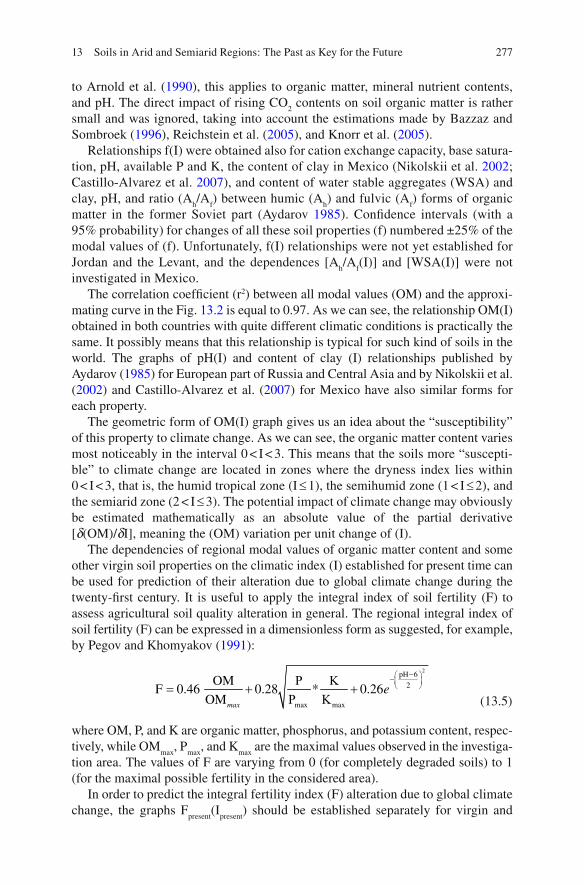
27713 Soils in Arid and Semiarid Regions: The Past as Key for the Future
to Arnold et al. ( 1990 ) , this applies to organic matter, mineral nutrient contents, and pH. The direct impact of rising CO
2 contents on soil organic matter is rather
small and was ignored, taking into account the estimations made by Bazzaz and Sombroek ( 1996 ) , Reichstein et al. ( 2005 ) , and Knorr et al. ( 2005 ) .
Relationships f ( I ) were obtained also for cation exchange capacity, base satura-tion, pH, available P and K, the content of clay in Mexico (Nikolskii et al. 2002 ; Castillo-Alvarez et al. 2007 ) , and content of water stable aggregates (WSA) and clay, pH, and ratio ( A
h / A
f ) between humic ( A
h ) and fulvic ( A
f ) forms of organic
matter in the former Soviet part (Aydarov 1985 ) . Con fi dence intervals (with a 95% probability) for changes of all these soil properties ( f ) numbered ±25% of the modal values of ( f ). Unfortunately, f ( I ) relationships were not yet established for Jordan and the Levant, and the dependences [ A
h / A
f ( I )] and [WSA( I )] were not
investigated in Mexico. The correlation coef fi cient ( r 2 ) between all modal values (OM) and the approxi-
mating curve in the Fig. 13.2 is equal to 0.97. As we can see, the relationship OM( I ) obtained in both countries with quite different climatic conditions is practically the same. It possibly means that this relationship is typical for such kind of soils in the world. The graphs of pH( I ) and content of clay ( I ) relationships published by Aydarov ( 1985 ) for European part of Russia and Central Asia and by Nikolskii et al. ( 2002 ) and Castillo-Alvarez et al. ( 2007 ) for Mexico have also similar forms for each property.
The geometric form of OM( I ) graph gives us an idea about the “susceptibility” of this property to climate change. As we can see, the organic matter content varies most noticeably in the interval 0 < I < 3. This means that the soils more “suscepti-ble” to climate change are located in zones where the dryness index lies within 0 < I < 3, that is, the humid tropical zone ( I £ 1), the semihumid zone (1 < I £ 2), and the semiarid zone (2 < I £ 3). The potential impact of climate change may obviously be estimated mathematically as an absolute value of the partial derivative [ d (OM)/ d I ], meaning the (OM) variation per unit change of ( I ).
The dependencies of regional modal values of organic matter content and some other virgin soil properties on the climatic index ( I ) established for present time can be used for prediction of their alteration due to global climate change during the twenty- fi rst century. It is useful to apply the integral index of soil fertility ( F ) to assess agricultural soil quality alteration in general. The regional integral index of soil fertility ( F ) can be expressed in a dimensionless form as suggested, for example, by Pegov and Khomyakov ( 1991 ) :
P K
P K
2pH 6
2
max max
OMF 0.46 0.28 * 0.26
OM
-æ ö-ç ÷è ø= + +
max
e
(13.5)
where OM, P, and K are organic matter, phosphorus, and potassium content, respec-tively, while OM
max , P
max , and K
max are the maximal values observed in the investiga-
tion area. The values of F are varying from 0 (for completely degraded soils) to 1 (for the maximal possible fertility in the considered area).
In order to predict the integral fertility index ( F ) alteration due to global climate change, the graphs F
present ( I
present ) should be established separately for virgin and

278 B. Lucke et al.
agricultural soils of rain-fed and irrigated lands. If the difference between these graphs is signi fi cant, the index of soil fertility ( F ) can be calculated as
agric agric max, agric max, nat nat nat
future present present present future presentF F (F / F )( F F )= + - (13.6)
where F present
agric and F future
agric are local integral fertility indexes of agricultural soil at present and in the future, respectively; F
present nat and F
future nat are regional integral fer-
tility indexes for virgin soils, corresponding on graph F ( I ) to climatic indexes at a studied site for the present ( I
present ) and future ( I
future ), respectively; and F
present max, agric
and F present
max, nat are maximal values of regional integral fertility indexes observed on the graphs F ( I ) and established for agricultural and virgin soils, respectively.
If there is no signi fi cant difference between graphs F ( I ) or if now F
present nat @ F
present agric , the predicted soil fertility index at a certain site F
future local will be
equal to
local local
future present future presentF F (F F )= + - (13.7)
where F present
local is the soil fertility index now at the same site. This approach was applied to predict variations of the virgin soil fertility index
( F ) in different climatic zones of Mexico at the end of twenty- fi rst century accord-ing to selected climate change scenarios assuming a doubling of the CO
2 content in
the atmosphere (Gay 2003 ) . The expected soil fertility change varies between moderate decrease (up to −30%) to low increase (up to 20%) depending on the climatic region. Moderate decrease (−20 to −30%) is expected in semiarid zone of Mexico, low decrease (−10 to −20%) and low increase (10–20%) in semihumid zone, and insigni fi cant change (−10 to 10%) in arid zone. It is clear that the reli-ability of such predictions depends on the reliability of the climatic scenarios.
The integral soil fertility index ( I ) can be used also to calculate agricultural crop productivity ( Y ). For example, according to FAO-IIASA ( 2000 ) and Pegov and Khomyakov ( 1991 ) , the crop productivity can be assessed as
K FmaxΥ Υ= (13.8)
where Y max is the maximum possible crop yield (kg ha –1 ) depending on the predicted monthly values of temperature, global radiation, and biological plant properties; K is a coef fi cient re fl ecting soil water availability and depending on predicted monthly values of temperature, global radiation, and precipitation; and F is the predicted integral agricultural soil fertility index. K and F are dimensionless and vary between 0 and 1. Some calculations of the vulnerability of wheat productivity in Mexico to climate change were conducted using formula ( 13.8 ). The calculations showed that irrigated crops are more vulnerable to climate change than in rain-fed agriculture, which is due to an expected change of water availability especially in arid zones. Consideration of the soil fertility alteration is very important in assessments of crop vulnerability to climate change. Ignorance of the fertility index alteration in predic-tions of crop productivity can cause errors up to 50% or more.
In discussing “progressive development” in arid and semiarid zones, it is impor-tant to consider the indirect impact of irrigation on soil fertility. Evaluating only

27913 Soils in Arid and Semiarid Regions: The Past as Key for the Future
agricultural crop requirements may lead to soil degradation: Figure 13.3 shows relationships between regional modal values of the integral soil fertility index ( F ) and the radiative index of dryness ( I ), separately for irrigated and rain-fed agricul-ture as well as for virgin soils. All lands have surface slopes less than 3%. Agricultural land use lasted for more than 50 years.
The comparison of modal values of the integral index of soil fertility ( F ) for virgin and rain-fed agricultural soils showed insigni fi cant differences. This is possibly due to the extensive use of the majority of rain-fed lands in Mexico in the case of maize and wheat production (without arti fi cial fertilizers and with insigni fi cant manure). Thus, in this fi gure, only one graph F ( I ) is shown for virgin and rain-fed agricultural soils.
As it can be noticed, the impact of irrigation on agricultural soils in arid zone ( I > 3) in Mexico is positive in general. The fertility index of irrigated soils is higher than that of nonirrigated and virgin soils. However, the irrigation practice in semi-arid (2 < I £ 3), and semihumid (1 < I £ 2) zones has a negative impact on agricul-tural soils, at least in the case of maize and wheat production. The fertility index of irrigated soils in these zones is lower than that of nonirrigated and virgin soils. These data are representative because they correspond to large areas of irrigated and nonirrigated lands in Mexico (about 3 × 10 6 ha for each one). The observed difference between fertility of irrigated and nonirrigated soils can be explained by the improvement of soil formation processes under irrigation in arid zones and
Fig. 13.3 Dependence of dimensionless integral index of soil fertility in the 0–20-cm surface layer on the dimensionless climatic index ( I ) in Mexico. 1 Virgin (with natural vegetation) and agricultural soils of rain-fed lands under maize and wheat; 2 Agricultural soils of irrigated lands under maize and wheat; 3 and 4 con fi dence intervals with a 95% probability

280 B. Lucke et al.
deterioration of soil formation process under irrigation in semiarid and especially in semihumid conditions, due to over-irrigation leading to excessive leaching of organic matter and mineral nutrients from the soils.
The difference between fertility indexes of irrigated and virgin soils can be used to evaluate the mean annual irrigation requirements, considering not only agricul-tural crop productivity (Ir crop ) but also long-term soil conservation (Ir soil ). Such con-siderations should be part of sustainable agriculture concepts. Regarding irrigated soil conservation, the irrigation requirement (Ir soil ) can be assessed using index ( I irrigated ), described by formula ( 13.2 ) as graph in Figs. 13.1 , 13.2 , and 13.3 . Obviously, in arid, semiarid, and partially semihumid zones where I > 1.5, the index ( I irrigated ) should be less than 1.5.
In this case
( ) ( )R soil soil1.5 / L Pr Ir or Ir R /1.5 L Pr for zones where I 1.5≥ é ù+ £ - >ë û (13.9)
According to Figs. 13.2 and 13.3 , in semihumid and partially humid zones where I < 1.5, the index ( I irrigated ) should not number more than index ( I ) that corre-sponds to the natural rain-fed conditions (Table 13.1 ). This means that in order to prevent soil degradation, the mean annual irrigation requirement should not be more than the mean annual water surface runoff in agricultural lands ( S ) and less than the difference between potential evaporation ( E
0 ) and precipitation without
surface runoff (Pr − S ):
soil soil
0Ir S and Ir (E S Pr) for zones where I 1.5≤ ≤ + - < (13.10)
A similar approach was proposed earlier by Aydarov ( 1985 ) . Examples for the determination of (Ir soil ) values for some irrigated districts of
Mexico are presented in n (the term dml means dimensionless). This example shows that in order to prevent possibly negative indirect impact
of irrigation on soil fertility during long periods (at least 10 years), it is necessary to reduce mean annual irrigation requirement (Ir crop ) but which traditionally only consider crop demand. The fi nal decision about mean annual irrigation require-ments which are then applied in practice (Ir practice ) depends on the climatic conditions and should be based on an economic justi fi cation considering the cost of water and
Table 13.1 Examples for a comparison of mean annual irrigation requirements (Ir crop ), applied today in practice, and recommendations for soil conservation (Ir soil ) in different climatic conditions of Mexico. Crop: wheat
Pr (mm year −1 ) T (°C) Ir crop (mm year -1 ) I (dml) I irrigated (dml) Ir soil (mm year -1 )
528.5 24.6 628 2.7 1.22 409 735.0 21.3 367 1.6 1.11 250 400.0 19.5 540 2.8 1.19 346 422.8 28.1 798 3.5 1.20 552
Note: Pr and T – mean annual precipitation and temperature; I and I irrigated – natural climatic and local microclimatic indexes calculated by formulas ( 13.1 ) and ( 13.2 ), respectively

28113 Soils in Arid and Semiarid Regions: The Past as Key for the Future
soil resources as well as direct bene fi ts related to agricultural production. With such an approach, the irrigation requirement (Ir practice ) is supposed to stay between (Ir crop ) and (Ir soil ): Ir soil < Ir practice < Ir crop .
13.4 Challenges and Potentials of Combining Modeling and Reconstruction of Soil Development
The above-mentioned modeling of soil properties can be validated regarding indi-vidual parameters by using their actual distribution. For example, the valley Wadi Ziqlab in Jordan can illustrate how temperature changes may be related to changing soil properties. While the mean annual precipitation is basically stable over the whole course of Wadi Ziqlab, temperatures vary strongly and follow an altitude gradient of 1,300 m over a valley length of 20 km (Fisher et al. 1966 ) . The soil and vegetation pattern gives a strong impression of increasing aridity with lower alti-tude. Precipitation cannot explain this trend: The contrasting character of the land-scape is due to temperature and evaporation (Fisher et al. 1966 ) . In this context, the soil and vegetation distribution in Wadi Ziqlab may to some degree allow descrip-tion of thresholds for permanent soil and vegetation change. Considering the water balance and vegetation, the direct impact of temperature and evaporation seems not as relevant as the indirect role of changing soil properties and local microclimatic controls. For example, it is known that higher temperatures can reduce soil aggre-gate stability and water retention (Imeson and Lavee 1998 ) . According to Bens et al. ( 2006 ) , increasing dryness may lead to hydrophobic behavior of soils, reducing in fi ltration and increasing runoff. As well, the soil’s resistance to root growth may increase, leading to reduced biomass. It is however unknown to which degree soil change is reversible and in which time frames it takes place.
One major challenge of modeling changing soil properties is the time factor: Since the model is based on the geographic law of soil zonality, it can only display currently existing relationships. In the previous section, we estimated time frames that could be involved in the modeled changes; however, so far, no systematic study exists that established these fi gures, and unfortunately, long-term monitoring of soil development was only rarely conducted. It is likely that the speed and intensity of soil properties change will vary according to parameters—for example, organic matter contents usually respond much faster to changing environments and land use than pedogenic iron oxides. But this makes it dif fi cult to assess the process of soil change and to predict soil fertility for a given point of time.
Here, the validation of models of soil development by paleosols could make an important contribution. Paleosols can provide a framework describing possible future soil development, since what already happened in the past may happen again. They also give insight into the time frames of soil development, and although the covered time spans are usually very long, recent research in archaeological contexts allowed targeting relatively short periods of centuries or decades (Khokhlova et al. 2004 ) .

282 B. Lucke et al.
A major challenge for combining the modeling of soil development with reconstruction is the use of different parameters as indicators. However, theoreti-cally, any parameter should be applicable in the model and could be determined in the following procedure: A quantitative relationship of soil properties (SP) and a mean annual climatic index (CI – expressed as relationship between mean annual values of net sun radiation, precipitation, and temperature) will be estab-lished. As well, regional modal values of the soil properties (SP) of modern soils (preferably virgin soils not used in agriculture) belonging to the same geomor-phological group will be de fi ned. This approach can rely on already established relationships SP(CI) for Mexican and the former USSR (European and Central Asian) soils (Nikolskii et al. 2006 ) . A statistical analysis of the soil properties of modern soils and the related climatic indices will be conducted and applied to the paleosols. The establishment of a statistical function expressing the relationship SP(CI) will allow to transfer the climatic index (CI) to paleosol properties (PSP), making it possible to describe a paleoclimatic index PSP(CI). This will allow to validate the projected soil development expressed by the index SP(CI), since the soundness of the PSP(CI) index and related climatic scenarios can be checked with the climate reconstruction on the basis of the paleosol analysis. The fore-casting of soil development will then be conducted and based on genetic modeling.
For example, Khresat and Taimeh ( 1998 ) investigated how CaCO 3 contents are
related to changing soil properties. Paleosols in today arid areas in Jordan docu-mented several climatic changes, and dry periods were connected with accumula-tion of calcium carbonate up to the formation of a hard crust. This led to a signi fi cant reduction of vegetation, too, and many soils in the present transition area to the desert are assessed to be in an incipient state of calcium carbonate accumulation, with related negative consequences for water retention, nutrient availability, and organic matter content (Khresat and Taimeh 1998 ) . Bäumler ( 2001 ) showed on a transect of present soils and paleosols of different source rocks and climates in the Himalaya, Central Asia, and Kamchatka how combining physical parameters (such as grain size) with chemical properties (such as iron oxides and weathering indexes) can be used for the reconstruction of soil development. Genetic modeling of soil development can thus be combined with the above-described forecasting of soil fertility and deserti fi cation: What are still missing are the connection of soil physical and chemical properties with organic matter and a translation of the more descriptive genetic approach into mathematical expressions.
In this context, validation of the above-described model of soil development based on the radiative index of dryness with paleosols faces the problem that most paleosols do not contain signi fi cant amounts of organic matter. Organic matter contents are however directly related to magnetic properties, pedogenic iron and manganese oxides, calcium carbonate contents, and particle sizes (Bäumler 2001 ; Lucke 2008 ) . As well, isotopes from pedogenic carbonates allow for conclusions about the dominant vegetation type during their formation (Bar-Matthews et al. 1998 ) . Considering virgin modern soils, it is possible to evaluate how the above-mentioned properties are related to organic matter contents. Focusing on young sediments and

28313 Soils in Arid and Semiarid Regions: The Past as Key for the Future
soils developed out of the debris on archaeological sites, relatively short time frames of soil development can be addressed as well. Finally, recent studies of soil magnetics in semiarid regions indicate that the magnetic susceptibility of soils might be useful as indicator of past organic matter contents (Lucke 2008 ) .
13.5 Conclusions
The relationship of agricultural soil properties, climate condition, and irrigation practice can be modeled according to mathematical formulas, which allow predicting the impact of speci fi c land-use technologies for given climatic scenarios. With such tools, it should be possible to plan “progressive development” well ahead as long as the necessary water supply can be ensured. However, uncertainties exist regarding the time frames of change and the development of individual parameters, since the modeling is based on geographic relationships at the present time. This makes it dif fi cult to predict soil fertility for a given point of time. However, the study of paleosols might allow addressing these dif fi culties by connecting genetic recon-structions of soil development with mathematical modeling. It requires “translat-ing” the parameters used for reconstructions to those used for modeling and investigating how changes of individual parameters are connected in feedbacks. While the combination of modeling and reconstruction of soil properties change still needs further investigation, soil surveys should address and document paleosols already now since the reliability of models depends largely on data availability.
References
Amery H, Wolf A (2000) Water in the Middle East. University of Texas Press, Austin Arnold RW, Szabolcs I, Targulian VO (eds) (1990) Global soil change. IIASA, Laxenburg, p 109 Aydarov IP (1985) Water, salt and nutrient soil regime management in arid zones. Agropromizdat,
Moscow (in Russian) Aydarov I, Nikolskii Y, Jachaturyan V, Korolkov A (1992) La crisis ecologica en la cuenca del Mar
Aral por el uso agrícola de los recursos hidraulicos. In: Agricultura Sostenible: Un Enfoque Ecologico, Socioeconomico y el Desarrollo Tecnologico. Memorias de/I Simposio y I Reunion Nacional, Guadalajara, Mexico, pp 79–83 (in Spanish)
Bar-Matthews M, Ayalon A, Kaufmann A (1998) Middle to late holocene (6500 yr period) paleo-climate in the Eastern Mediterranean region from stable isotopic composition of speleothems from Soreq Cave, Israel. In: Issar A, Brown N (eds) Water, environment and society in times of climatic change. Kluwer Academic, Dordrecht, pp 203–215
Bäumler R (2001) Vergleichende bodenkundliche Untersuchungen in Hochasien und Kamtschatka. Relief, Boden, Paläoklima 16, Gebrüder Bornträger, Munich
Bazzaz F, Sombroek W (1996) Global climate change and agricultural production: direct and indirect effects of changing hydrological, pedological and plant physiological processes. FAO, Rome
Bens O, Buczko U, Sieber S, Hüttl R (2006) Spatial variability of O layer thickness and humus forms under different pine beech-forest transformation stages in NE Germany. J Plant Nutr Soil Sci 169(1):5–15

284 B. Lucke et al.
Castillo-Alvarez M, Nikolskii-Gavrilov I, Ortiz-Solorio CA, Vaquera-Huerta H, Cruz-Bello G, Mejía-Sáenz E, González-Hernández A (2007) Alteración de la fertilidad del suelo por el cambio climático y su efecto en la productividad agrícola. Interciencia 32:368–376
Cordova C, Foley C, Nowell A, Bisson M (2005) Landforms, sediments, soil development and prehistoric site settings in the Madaba-Dhiban Plateau, Jordan. Geoarchaeology 20(1):29–56
Dokuchaev VV (1883) Russian chernozems (Russkii chernozem). Israel Prog Sci Trans, Jerusalem, 1967. Transl. from Russian by N Kraner. Available from US Dept of Commerce, Spring fi eld
FAO (1997) Irrigation in the near east region in fi gures. FAO, Rome FAO-IIASA (2000) Global agroecological zones. Methodology and results of the global agro-
ecological zones model. CD-ROM. Versión 1.0 Fisher W, Atkinson K, Beaumont P, Coles A, Gilchrist-Shaw D (1966) Soil survey of Wadi Ziqlab.
University of Durham, Durham Gay C (ed) (2003) Una visión hacia el siglo XXI. El cambio climático en México. UNAM, México,
p 220 Grigor’ev AA (1954) Some regularities of geographical zonality, vol 5, Ser Geogr. Izv. Akad.
Nauk SSSR, Moscow, pp 5–17 (in Russian) Gvirtzman G, Wieder M (2001) Climate of the last 53,000 years in the Eastern Mediterranean,
based on soil-sequence stratigraphy in the coastal plain of Israel. Quat Sci Rev 20:1827–1849 Imeson A, Lavee H (1998) Soil erosion and climate change: the transect approach and the in fl uence
of scale. Geomorphology 23:219–227 Issar A (2008) Progressive development in arid environments: adapting the concept of sustainable
development to a changing world. Hydrogeol J 16:1229–1231 Jenny H (1941) Factors of soil formation: a system of quantitative pedology. McGraw-Hill, New York Khokhlova OS, Khokhlov AA, Chichagova CC, Morgunova NL (2004) Radiocarbon dating of
calcareous accumulations in soils of the holocene chronosequence in the Ural river valley (Cis-Ural Steppe). Euras Soil Sci 37(10):1024–1038
Khresat S, Taimeh A (1998) Properties and characterization of vertisols developed on limestone in a semi-arid environment. J Arid Environ 40:235–244
Knorr W, Prentice IC, Holland EA (2005) Long-term sensitivity of soil carbon turnover to warming. Nature 433:298–301
Lucke B (2008) Demise of the decapolis: past and present deserti fi cation in the context of soil development, land use and climate. VDM, Saarbrücken
Maher L (2005) The epipaleolithic in context: paleolandscapes and prehistoric occupation in Wadi Ziqlab, Northern Jordan. Dissertation, Department of Anthropology, University of Toronto, Toronto
Nikolskii YN (1996) Ecological consequences of irrigation. ICID J 45:59–73 Nikolskii Yu N, Bakhlaeva OS, Contreraz-Benitez A, Ordaz-Chaparro V (2002) Assessment of
changes in soil properties as dependent on hydrothermic conditions of lowlands (by the example of Mexico). Euras Soil Sci 35:1031–1036
Nikolskii YN, Castillo-Alvares M, Bakhlaeva OS, Roman-Calleros XA, Maslov BS (2006) The in fl uence of the possible global climate change on the properties of Mexican soils. Euras Soil Sci 39(11):1164–1169
Pegov SA, Khomyakov PM (1991) Simulation of ecological systems alteration. Gidrometeoizdat, Leningrad (in Russian)
Reichstein M, Kätterer T, Andren O, Ciasis P, Schuize ED, Cramer E, Papale D, Valentini R (2005) Does the temperature sensitivity of decomposition vary with soil organic matter quality? Biogeosci Discuss 2:738–747
Reuters (2008) Saudi Arabia scraps wheat growing to save water. http://www.reuters.com/article/latestCrisis/idUSL08699206 . Accessed 31 Jan 2009
Sellers WD (1965) Physical climatology. University of Ontario Press, Chicago Tejeda MA, Vazquez IL, Rivas DA (1999) Algoritmos simples para estimar datos mensuales
de irradiacion solar y horarios termohigrometricos en la Republica Mexicana. Universidad Veracruzana, Veracruz
Torres RE (1995) Agrometeorologia. Editorial Trillas Sa De Cv, Mexico Volobuev VR (1974) Introduction into the energy of pedogenesis. Nauka, Moscow (in Russian)