Deltas in Arid Environments - MDPI
24
water Review Deltas in Arid Environments John Day 1, *, Reed Goodman 2 , Zhongyuan Chen 3 , Rachael Hunter 4 , Liviu Giosan 5 and Yanna Wang 3 Citation: Day, J.; Goodman, R.; Chen, Z.; Hunter, R.; Giosan, L.; Wang, Y. Deltas in Arid Environments. Water 2021, 13, 1677. https://doi.org/ 10.3390/w13121677 Academic Editor: Georg Umgiesser Received: 26 April 2021 Accepted: 9 June 2021 Published: 17 June 2021 Publisher’s Note: MDPI stays neutral with regard to jurisdictional claims in published maps and institutional affil- iations. Copyright: © 2021 by the authors. Licensee MDPI, Basel, Switzerland. This article is an open access article distributed under the terms and conditions of the Creative Commons Attribution (CC BY) license (https:// creativecommons.org/licenses/by/ 4.0/). 1 Department of Oceanography and Coastal Sciences, Louisiana State University, Baton Rouge, LA 70803, USA 2 Middle East Center, University of Pennsylvania, 3340 Walnut Street, Fisher-Bennett Hall, Suite 238, Philadelphia, PA 19104-6273, USA; [email protected] 3 State Key Laboratory of Estuarine and Coastal Research, East China Normal University, Shanghai 200062, China; [email protected] (Z.C.); [email protected] (Y.W.) 4 Comite Resources, P.O. Box 66596, Baton Rouge, LA 70896, USA; [email protected] 5 Woods Hole Oceanographic Institution, Falmouth, MA 02543, USA; [email protected] * Correspondence: [email protected] Abstract: Due to increasing water use, diversion and salinization, along with subsidence and sea- level rise, deltas in arid regions are shrinking worldwide. Some of the most ecologically important arid deltas include the Colorado, Indus, Nile, and Tigris-Euphrates. The primary stressors vary globally, but these deltas are threatened by increased salinization, water storage and diversion, eutrophication, and wetland loss. In order to make these deltas sustainable over time, some water flow, including seasonal flooding, needs to be re-established. Positive impacts have been seen in the Colorado River delta after flows to the delta were increased. In addition to increasing freshwater flow, collaboration among stakeholders and active management are necessary. For the Nile River, cooperation among different nations in the Nile drainage basin is important. River flow into the Tigris-Euphrates River delta has been affected by politics and civil strife in the Middle East, but some flow has been re-allocated to the delta. Studies commissioned for the Indus River delta recommended re-establishment of some monthly water flow to maintain the river channel and to fight saltwater intrusion. However, accelerating climate impacts, socio-political conflicts, and growing populations suggest a dire future for arid deltas. Keywords: salinization; climate change; Colorado river; Tigris-Euphrates river; Nile river; Indus river 1. Introduction Arid deltas, which often have arid drainage basins as well as delta plains, are among the most threatened deltas globally, with many already in an advanced state of deterio- ration [1]. In most arid drainage basins, there is a growing demand for water for human use while climate change is leading to further drying in most of these areas. To assess the status of arid deltas and the impacts of climate change, we reviewed the literature on four iconic deltas—the Colorado (Mexico), Indus (Pakistan), Nile (Egypt), and the Tigris- Euphrates (Iran, Iraq) (Table 1). For these four deltas, little fresh water regularly enters the sea. Even though the upper Nile basin is wet, the lower basin is dry, and little water reaches the Mediterranean. For the Colorado and Indus deltas, hypersaline conditions due to freshwater reductions have led to widespread wetland death [2–9]. Subsidence is sometimes increased by groundwater withdrawals. In the Nile delta, almost all river water is diverted into the delta to support agriculture that occupies most of the delta plain and dam construction in the basin further reduces discharge reaching the delta. Much of this agriculture is threatened due to subsidence, increasing salinization, and sea-level rise [5]. In the Tigris-Euphrates delta, river water was used as a political weapon when the Iraq government diverted water away from the delta to punish marsh Arabs [10]. Freshwater has now been reintroduced to some areas, and marshes are recovering [11]. Growing demand in drainage basins combined with climate impacts makes the sustainability of deltas in arid regions unlikely due to hyper-salinity and reduced basin inputs. Water 2021, 13, 1677. https://doi.org/10.3390/w13121677 https://www.mdpi.com/journal/water
-
Upload
khangminh22 -
Category
Documents
-
view
0 -
download
0
Transcript of Deltas in Arid Environments - MDPI

water
Review
Deltas in Arid Environments
John Day 1 Reed Goodman 2 Zhongyuan Chen 3 Rachael Hunter 4 Liviu Giosan 5 and Yanna Wang 3
Citation Day J Goodman R Chen
Z Hunter R Giosan L Wang Y
Deltas in Arid Environments Water
2021 13 1677 httpsdoiorg
103390w13121677
Academic Editor Georg Umgiesser
Received 26 April 2021
Accepted 9 June 2021
Published 17 June 2021
Publisherrsquos Note MDPI stays neutral
with regard to jurisdictional claims in
published maps and institutional affil-
iations
Copyright copy 2021 by the authors
Licensee MDPI Basel Switzerland
This article is an open access article
distributed under the terms and
conditions of the Creative Commons
Attribution (CC BY) license (https
creativecommonsorglicensesby
40)
1 Department of Oceanography and Coastal Sciences Louisiana State University Baton Rouge LA 70803 USA2 Middle East Center University of Pennsylvania 3340 Walnut Street Fisher-Bennett Hall Suite 238
Philadelphia PA 19104-6273 USA reedgsasupennedu3 State Key Laboratory of Estuarine and Coastal Research East China Normal University
Shanghai 200062 China zchenecnueducn (ZC) ynwangsklececnueducn (YW)4 Comite Resources PO Box 66596 Baton Rouge LA 70896 USA rhuntercomiterescom5 Woods Hole Oceanographic Institution Falmouth MA 02543 USA lgiosanyahoocom Correspondence johndaylsuedu
Abstract Due to increasing water use diversion and salinization along with subsidence and sea-level rise deltas in arid regions are shrinking worldwide Some of the most ecologically importantarid deltas include the Colorado Indus Nile and Tigris-Euphrates The primary stressors varyglobally but these deltas are threatened by increased salinization water storage and diversioneutrophication and wetland loss In order to make these deltas sustainable over time some waterflow including seasonal flooding needs to be re-established Positive impacts have been seen in theColorado River delta after flows to the delta were increased In addition to increasing freshwaterflow collaboration among stakeholders and active management are necessary For the Nile Rivercooperation among different nations in the Nile drainage basin is important River flow into theTigris-Euphrates River delta has been affected by politics and civil strife in the Middle East but someflow has been re-allocated to the delta Studies commissioned for the Indus River delta recommendedre-establishment of some monthly water flow to maintain the river channel and to fight saltwaterintrusion However accelerating climate impacts socio-political conflicts and growing populationssuggest a dire future for arid deltas
Keywords salinization climate change Colorado river Tigris-Euphrates river Nile river Indus river
1 Introduction
Arid deltas which often have arid drainage basins as well as delta plains are amongthe most threatened deltas globally with many already in an advanced state of deterio-ration [1] In most arid drainage basins there is a growing demand for water for humanuse while climate change is leading to further drying in most of these areas To assessthe status of arid deltas and the impacts of climate change we reviewed the literature onfour iconic deltasmdashthe Colorado (Mexico) Indus (Pakistan) Nile (Egypt) and the Tigris-Euphrates (Iran Iraq) (Table 1) For these four deltas little fresh water regularly entersthe sea Even though the upper Nile basin is wet the lower basin is dry and little waterreaches the Mediterranean For the Colorado and Indus deltas hypersaline conditionsdue to freshwater reductions have led to widespread wetland death [2ndash9] Subsidence issometimes increased by groundwater withdrawals In the Nile delta almost all river wateris diverted into the delta to support agriculture that occupies most of the delta plain anddam construction in the basin further reduces discharge reaching the delta Much of thisagriculture is threatened due to subsidence increasing salinization and sea-level rise [5]In the Tigris-Euphrates delta river water was used as a political weapon when the Iraqgovernment diverted water away from the delta to punish marsh Arabs [10] Freshwaterhas now been reintroduced to some areas and marshes are recovering [11] Growingdemand in drainage basins combined with climate impacts makes the sustainability ofdeltas in arid regions unlikely due to hyper-salinity and reduced basin inputs
Water 2021 13 1677 httpsdoiorg103390w13121677 httpswwwmdpicomjournalwater
Water 2021 13 1677 2 of 24
Table 1 Characteristics of arid deltas
DeltaSize ofDelta(km2)
AnnualPrecipitation
(cm)
Decrease in AverageHistorical RiverDischarge ()
Reaching Ocean
Decrease inDelta Size
()
Number ofDams in
Watershed
Anthropogenic Modificationsand Threats
Colorado 7800 267 75 8015 on Colorado
gt100 ontributaries
Dams Water consumption bymunicipalities and agriculture
Salinization
Nile 20000 5ndash10 gt95 25 4 underconstruction
Damming Dramatic waterreduction SalinizationIncreased subsidence
Eutrophication
Tigris-Euphrates-
Karun18500 139 96 85
14 on Tigris 12on Euphrates 6
on Karun gt50 ontributaries
Damming Water consumptionby transboundary
municipalities and agricultureSalinization Military conflictEffluent Wetland drainage
Eutrophication
Indus 41400 25ndash50 gt90 gt90 15Damming Dramatic reduction
in discharge SalinizationPollution
The objective of this review is to describe the current status and projected impactsof climate change for these four deltas We chose these deltas because of their importanceglobally and because of the abundance of literature We discuss changes in freshwaterinput habitat change and the impacts of changes in the basins We then generalize ourfindings to discuss the future of arid deltas
2 Colorado River Delta
The Colorado River Delta (CRD) was once one of the largest desert estuaries in theworld Historically the Colorado River discharged up to 6000 m3sec of water to thedelta supporting vast riparian forests fresh brackish and saline marshes and an extensiveestuary [12] The CRD covered 780000 ha of riparian wetlands and marshes mudflats andsand beaches that provided a stopover for millions of migratory birds on the Pacific Flywayand habitat for deer quail bobcat jaguar and waterfowl including clapper rails bitternsmallards teal and egrets [7] During a 1922 canoe trip to the CRD the naturalist AldoLeopold famously wrote that ldquoThe river was everywhere and nowhererdquo describing theway the river meandered and braided nourishing a fertile ldquomilk and honey wildernessrdquo ofldquoa hundred green lagoonsrdquo (httpswwwnatureorgen-usabout-uswhere-we-workpriority-landscapescolorado-riverrestoring-the-delta (accessed on 15 September 2020))Prior to anthropogenic modification the Colorado River flowed freely over 2250 km fromthe Rocky Mountains to the Gulf of California dropping 3050 m in elevation and draining626780 km2 in the US and 5180 km2 in Mexico [12] The drainage basin of the riverincludes all of Arizona parts of six US states and two Mexican states (Figure 1)
The CRD is located almost entirely in Northwestern Mexico in a desert region withmaximum summer temperatures of 40 C and minimum winter temperatures of minus5 CEvaporation rates are about 1 m per year and the annual average rainfall is only 68 mm [7]The CRD is a macrotidal estuary with strong tidal currents and the salinity ranges from35 psu in winter to 41 psu in the summer Salinity values are higher towards the head ofthe estuary than at the lower end and as a result some consider it an inverse-estuary [7]
Water 2021 13 1677 3 of 24
Water 2021 13 x FOR PEER REVIEW 3 of 24
Prior to the construction of Glenn Canyon and Hoover Dams Colorado River water continually reached the CRD and the Gulf of California providing nutrients and habitat for numerous species During this time the silt and water that the river brought to the delta were critical to sustaining dense wetland plant communities By the late 1970s hardly any water was reaching the CRD in most years This changed in the early 1980s due to increased precipitation from El Nino that filled reservoirs and allowed water to once again reach the CRD [13] However after 20 years of above-average rainfall in 2000 a drought occurred in the Southwest region causing water shortages and the CRD dried up again Because of the historical reduction in freshwater and sediment input the CRD is in a destructive phase with erosion reducing the size of the delta to about 20 of its historic size Carriquiry et al (2011) [7] examined sediment budgets for the CRD and con-cluded that the system was a net exporter of suspended sediment with export rates as high as 7 tons of sediment per tidal cycle
Figure 1 Drainage basin of the Colorado River in the Southwestern United States and Mexico (Publicdomain image from USGS)
Prior to the construction of Glenn Canyon and Hoover Dams Colorado River watercontinually reached the CRD and the Gulf of California providing nutrients and habitat fornumerous species During this time the silt and water that the river brought to the deltawere critical to sustaining dense wetland plant communities By the late 1970s hardly anywater was reaching the CRD in most years This changed in the early 1980s due to increasedprecipitation from El Nino that filled reservoirs and allowed water to once again reach theCRD [13] However after 20 years of above-average rainfall in 2000 a drought occurred inthe Southwest region causing water shortages and the CRD dried up again Because of thehistorical reduction in freshwater and sediment input the CRD is in a destructive phasewith erosion reducing the size of the delta to about 20 of its historic size Carriquiry et al(2011) [7] examined sediment budgets for the CRD and concluded that the system was anet exporter of suspended sediment with export rates as high as 7 tons of sediment pertidal cycle
Water 2021 13 1677 4 of 24
21 Anthropogenic Modifications
Today the Colorado River is one of the most manipulated and controlled rivers in theworld and the modifications began with the construction of the Hoover Dam in the 1930sThe purpose of the dam was to store high flows from spring runoff to be released duringtimes of low river flow Because it provided a steady supply of water year-round thecompletion of the dam in 1935 initiated numerous agricultural and construction projectson the river as well as use for human consumption [1214]
There are now more than 25 dams on the Colorado River and its many tributariesthat store water for use by more than 40 million people and over 55 million acres ofagriculture [1516] The dams store water and control the riverrsquos natural fluctuations andbecause of this they impact the habitat of numerous species [1417] For example oncedispersed cottonwood seeds remain viable for only 1ndash2 weeks and need bare moist mineralsubstrate in which to germinate These conditions are usually produced in the spring byhigh flows of snowmelt runoff [18] When flooding is controlled and overbank floodingis reduced the amount of suitable habitat for cottonwood germination is decreased Inthe absence of pulse flood the river banks have become salinized and overgrown by salt-tolerant shrubs and non-native tree species such as Tamarix sp and Russian olive resultingin loss of habitat value for birds and other wildlife [17]
Other environmental impacts of damming the Colorado River and its tributariesinclude lower mean water temperature and reduced nutrient and sediment concentrationsBefore the dams were built about 374 metric tons of sediment were carried downstreameach day but the sediment load was reduced 70 to 80 percent following dam construc-tion [19] The dams also significantly affect native fish species by blocking migrationpatterns and altering water temperature regimes which inhibits spawning and embryonicdevelopment depresses swimming performance and growth and reduces survival of earlylife stages [20]
During the 20th century river flow into the CRD was reduced nearly 75 due tostorage and consumption from an annual average of 206 billion m3 from 1896 to 1921 toan annual average of 52 billion m3 between 1984 and 1999 (httpsswdamswordpresscom20121203breaking-a-6-million-year-old-tradition (accessed on 15 September2020)) Flessa et al [21] estimated that only 19 billion m3 of water crossed the borderinto Mexico each year a reduction of nearly 75 in less than 15 years As a result of riverimpoundment and water diversions Colorado River water rarely flows all the way to theGulf of California altering the natural salinity balance decreasing the flow of nutrientsthat supports upper CRD fisheries and reducing the area of wetlands by 80 [1222]
22 Water Rights and Allocation
Every drop of water from the Colorado River is managed and allocated even over-allocated for use primarily by agriculture and municipalities [13] The river water wasfirst officially allocated in 1922 through the Colorado River Compact with 93 billion m3
to the Upper Basin and 105 billion m3 to the Lower Basin each year [15] About 20 yearslater under a 1944 treaty the United States promised Mexico 19 billion m3 annually (about10 percent of the Coloradorsquos average annual flow) plus 246 million m3 during flood yearsHowever by the time the river reaches Mexico nearly all of its water has been divertedfor agricultural and municipal use in the United States by 10 major dams and 80 smallerdiversions [13] Approximately 90 of Mexicorsquos water allocation from the Colorado Riveris diverted into Canal Reforma at Morelos Dam and distributed for agricultural irrigationthrough a series of canals [23] Thus in most years virtually no water reaches the CRDand the relict river channel is ephemeral with flows only from rainfall or in places wherethere is significant inflow from irrigation return channels or from groundwater seepinginto the river from irrigated areas [21]
Water 2021 13 1677 5 of 24
23 Salinity
Much of the Upper Colorado River Basin is underlain by geologic formations com-posed of sediments that were deposited or precipitated in ancient inland seas and wa-terways that concentrated salts in these formations The Colorado River picks up anddissolves salt along its path from about 50 mgL at its source to nearly 850 mgL as it flowsfrom the Rocky Mountains to Mexico Historically nearly 10 million tons of dissolved saltspassed down the river annually below the Hoover Dam causing significant environmentaland economic damages Natural and human activities also add to the salt load of theColorado River including out-of-basin exports agriculture and other consumptive usesevapotranspiration and evaporation from reservoir surfaces
Because of concerns over salt concentrations the seven Colorado River Basin statesworked with Federal agencies to pass the Colorado River Basin Salinity Control Act in1974 [14] This act was passed ldquoto authorize the construction operation and maintenanceof certain works in the Colorado River Basin to control the salinity of water delivered tousers in the United States and Mexicordquo Some of the programs outlined in the Act includedconstruction of a desalination plant near Yuma Arizon and basin-wide salinity controlprojects The desalination plant cost $250 million to build in 1992 and it was designedto take saline water from the agricultural drainage system and remove the salt It beganoperating in 1992 at one-third capacity but operations were suspended after the 500-yearflood on the Gila River in 1993 Since that time the plant has been maintained but largelynot operated due to water surplus andor average water supply conditions on the ColoradoRiver Recently as water demand increases and drought conditions occur in the ColoradoRiver Basin interest in plant operation has been renewed
24 Restoration of the Delta
Restoration of the CRD if possible must rely on collaboration between the UnitedStates and Mexico to designate and deliver water to the region along with help fromstate governments universities non-governmental organizations and philanthropies [24]Some marshes in the CRD have been restored and maintained with agricultural drainagesubsurface flows and effluent from wastewater treatment plants including the HardyRiver marsh Las Arenitas wastewater assimilation wetlands Cienega de Santa Clara Typhamarsh El Doctor wetlands and Mesa de Andrade wetlands (Figure 2) Portions of thesewetlands are located within the Upper Gulf of California and CRD Biosphere Reserveand all of them have been designated as Wetlands of International Importance under theRamsar Convention and Important Bird Areas [2225]
In 2012 Minute 319 to the 1944 Water Treaty was signed by the United States andMexico to guide future management of the Colorado River through 2017 Among otherthings this agreement included measures to promote the ecological health of the CRD Inkeeping with Minute 319 in 2014 105392 acre-feet of water was released into the CRDin a one-time event allowing water to reach the Gulf of California for the first time in13 years [26] The flow was designed to simulate historical pulse-flows into the CRD and toenhance wetlands in the area Minute 319 also provided for a base flow of 52696 acre-feetof water to be delivered at low flow rates over a longer period of time [27] Both thepulse flow and the base flow were expected to restore approximately 950 ha of habitat butmany of the positive impacts seen immediately following the pulse did not last long The2014 flow inundated approximately 1600 ha of the main channel and adjacent terraces ofthe CRD There was a 17 increase in Normalized Difference Vegetation Index (NDVI)ie greenness throughout the riparian corridor in 2014 following the water release butthis decreased after about one year [28] The abundance (+20) and diversity (+40) ofnesting and migratory waterbirds and nesting riparian land birds in the riparian corridorincreased following the pulse flow but declined after 2014 Only a small amount of theflow mixed with Gulf of California waters and thus hydrologic effects were not detectedin the estuary [29]
Water 2021 13 1677 6 of 24Water 2021 13 x FOR PEER REVIEW 6 of 24
Figure 2 Wetland restoration areas of the Colorado River Delta (adapted from Ref [22])
Other restoration activities are planned or completed on the CRD to increase fresh-water flows to the region and increase tidal exchange with the Gulf of California The lower CRD and the upper estuary receive freshwater from the Colorado River Ayala Drain (agricultural drainage) Hardy River (treated effluent and agricultural drainage) and other agricultural drains and seawater from the Gulf In 2012 and again in 2016 sed-iment was removed from a tidal sandbar barrier in the CRD to construct a pilot channel to improve river-sea connectivity increasing freshwater influx tidal flooding and drain-age [29]
In 2017 the United States and Mexican governments signed a supplemental agree-ment to the 1944 Water Treaty called Minute 323 that provided mechanisms for increased conservation and water storage in Lake Mead to help offset the impacts of drought and to prevent water shortage This agreement incorporated lessons learned during the river pulse in 2014 and dedicated 210000 acre-feet of water over nine years for ecological res-toration in the CRD
A little more than thirty years ago the CRD was considered all but a dead ecosystem However after flood flows in the 1980s and 1990s helped to revitalize some areas there was renewed interest in delta restoration Water is necessary for restoration but in the Colorado River Basin water is scarce and it will likely become scarcer over time In addi-tion to water however collaboration active management and science are also needed for sustainable restoration and to optimize the ecological and social benefits of the CRD [24] Projections for increasing arid conditions lower river discharge and greater demand in
Figure 2 Wetland restoration areas of the Colorado River Delta (adapted from Ref [22])
Other restoration activities are planned or completed on the CRD to increase fresh-water flows to the region and increase tidal exchange with the Gulf of California Thelower CRD and the upper estuary receive freshwater from the Colorado River Ayala Drain(agricultural drainage) Hardy River (treated effluent and agricultural drainage) and otheragricultural drains and seawater from the Gulf In 2012 and again in 2016 sediment wasremoved from a tidal sandbar barrier in the CRD to construct a pilot channel to improveriver-sea connectivity increasing freshwater influx tidal flooding and drainage [29]
In 2017 the United States and Mexican governments signed a supplemental agreementto the 1944 Water Treaty called Minute 323 that provided mechanisms for increasedconservation and water storage in Lake Mead to help offset the impacts of drought andto prevent water shortage This agreement incorporated lessons learned during the riverpulse in 2014 and dedicated 210000 acre-feet of water over nine years for ecologicalrestoration in the CRD
A little more than thirty years ago the CRD was considered all but a dead ecosystemHowever after flood flows in the 1980s and 1990s helped to revitalize some areas therewas renewed interest in delta restoration Water is necessary for restoration but in theColorado River Basin water is scarce and it will likely become scarcer over time Inaddition to water however collaboration active management and science are also neededfor sustainable restoration and to optimize the ecological and social benefits of the CRD [24]Projections for increasing arid conditions lower river discharge and greater demand in
Water 2021 13 1677 7 of 24
both the US Southwest and northwestern Mexico do not bode well for the sustainability ofthe CRD [1630]
3 Nile River Delta
Among deltas in the world the Nile Delta of NE Africa is characterized by its distinc-tive physio-geographical setting [3132] (Figure 3) The fan-shaped 20000 km2 subaerialNile delta is fed solely by the water and sediment from the African Plateau and EthiopianHighlands with rainfall from both the Indian and Atlantic oceans of ~1500ndash2000 mmyrwhereas the rainfall is only 50ndash100 mmyr in the lower Nile basin including its deltaHuman impacts have drastically changed input to the delta [433ndash35] particularly afterthe completion of the High Aswan Dam in 1964 The ongoing construction of the GrantEthiopian Renaissance Dam (GERD) on the Blue Nile will make the situation worse Thusthe Nile delta is increasingly suffering from serious environmental degradation becauseof reduced sediment and freshwater and increasing nutrients which have negatively im-pacted the eco-health of the Nile delta coast Egypt initially benefited by overextraction ofwater from Lake Victoria when a new hydroelectric dam was built in Uganda in the early2000s at the outlet of the lake that forms the White Nile River but once the lake level waslowered this benefit stopped [36] The pre-GERD Nile flow now supplies 97 of Egyptrsquospresent water needs with only 660 m3 per person per year About 86 of that water is forirrigation and industrial use so this is one of the worldrsquos lowest annual per person watershares Egyptrsquos population is expected to double in the next 50 years and this will lead tocountrywide freshwater shortages as early as 2025 after the GERD dam is completed Someform of arbitration is clearly needed to prevent a conflict over water between Egypt Sudanand Ethiopia (httpswwwnprorg20180227589240174in-africa-war-over-water-looms-as-ethiopia-nears-completion-of-nile-river-dam (accessed on 20 February 2021))
Water 2021 13 x FOR PEER REVIEW 8 of 24
Figure 3 The Nile River basin where Aswan dam site is shown (left) Lower Nile River and Nile Delta where 4 lagoon Lakes are indicated (right)
The population of Egypt increased rapidly from about 70 million in the 1980s to nearly 100 million at present About 90 of the Egyptian people live on the delta-coast relying extensively on the natural resources offered by the river catchment and delta However the rapid development of agriculture and industrialization in the 20th century in order to meet societal demands has dramatically altered the river-delta system [39] Dam construction over-use of bio-chemical fertilizers and change in land use has dra-matically modified the dynamics of delivery of riverine materials to delta coast A healthy deltaic habitat for both natural and human communities no longer exists as it was in pre-industrial times
31 Aswan High Dam and Related Environmental Issues The Aswan High Dam (AHD) was completed in 1964 in the lower Nile valley about
1000 km south of Cairo (Figure 3) Geologically the lower Nile River is contained within its valley and no more tributaries enter the river below the AHD Thus the construction of the AHD has dramatically altered the natural hydrological patterns of water and sedi-ment transport downstream to the delta coast It is estimated that prior to the construction of the AHD sediment delivery to delta and coast was about 200 times 106 t annually With the closure of the AHD in 1964 however sediment transport below the dam was reduced to nearly zero after damming and in the delta water turbidity decreased [40]
With the completion of the AHD freshwater discharge to delta and coast was dra-matically reduced As noted above even though the Nile Delta is in an arid climate it was nourished and sustained by the high freshwater discharge from the drainage basin Sea-sonal floods overflowed the delta and supported high agricultural productivity for thou-sands of years Since 1964 the AHD has fundamentally altered the hydrograph of the river (Figure 4) with little freshwater currently reaching the coast
Figure 3 The Nile River basin where Aswan dam site is shown (left) Lower Nile River and NileDelta where 4 lagoon Lakes are indicated (right)
The Nile Delta extends about 200 km from Cairo to the present coast and about250 km wide from west to east (Figure 3) The delta is characterized by low elevation land10ndash20 m or less above mean sea level (MSL) which occurs along a broader delta-coastof about 30ndash50 km wide The elevation then increases landward to about 15 m at Cairo
Water 2021 13 1677 8 of 24
The higher topography in inland parts of the delta was primarily caused by greater Nilefloods occurring during the early to middle Holocene during the Humid Africa Period(HAP) [37]
There are four large lagoons along the delta cost of the Nile and from east to westthey are the Manzala Burullus Edku and Mariut lagoons (Figure 3) Manzala lagoonis the largest (c 700 km2) [38] These lagoons formed c 7000 years ago when theHolocene sea level rose to nearly the present level The low tidal range (lt10 m) combinedwith strong littoral wave-driven currents has played a key role in long shore sedimenttransport forming the typical sand-spit barriermdashlagoon system along the Nile coast Thelagoons were important social-bio-ecological reservoirs for the early Egyptian agriculturalcivilization and this continues to the present [38]
The population of Egypt increased rapidly from about 70 million in the 1980s to nearly100 million at present About 90 of the Egyptian people live on the delta-coast relyingextensively on the natural resources offered by the river catchment and delta However therapid development of agriculture and industrialization in the 20th century in order to meetsocietal demands has dramatically altered the river-delta system [39] Dam constructionover-use of bio-chemical fertilizers and change in land use has dramatically modified thedynamics of delivery of riverine materials to delta coast A healthy deltaic habitat for bothnatural and human communities no longer exists as it was in preindustrial times
31 Aswan High Dam and Related Environmental Issues
The Aswan High Dam (AHD) was completed in 1964 in the lower Nile valley about1000 km south of Cairo (Figure 3) Geologically the lower Nile River is contained within itsvalley and no more tributaries enter the river below the AHD Thus the construction ofthe AHD has dramatically altered the natural hydrological patterns of water and sedimenttransport downstream to the delta coast It is estimated that prior to the construction ofthe AHD sediment delivery to delta and coast was about 200 times 106 t annually With theclosure of the AHD in 1964 however sediment transport below the dam was reduced tonearly zero after damming and in the delta water turbidity decreased [40]
With the completion of the AHD freshwater discharge to delta and coast was dra-matically reduced As noted above even though the Nile Delta is in an arid climate itwas nourished and sustained by the high freshwater discharge from the drainage basinSeasonal floods overflowed the delta and supported high agricultural productivity forthousands of years Since 1964 the AHD has fundamentally altered the hydrograph of theriver (Figure 4) with little freshwater currently reaching the coast
Water 2021 13 x FOR PEER REVIEW 9 of 24
Figure 4 Freshwater discharge before and after construction of the Aswan High Dam [41]
Water diversion has been a great concern in the Nile Delta system In addition to water use for agricultural irrigation urban development on the margins of the delta con-tiguous to the desert has been taking place These developments have considerable water demand Thus the water needs for urban development must now be balanced with agri-cultural demand This has become an urgent issue for an increasing population because gt90 freshwater released from the Aswan reservoir is already used for irrigation and much of it is lost to evaporation [40]
On the other hand nutrient transport basically nitrogen (N) and phosphorus (P) are not strongly affected by the dam since nutriets are mainly dissolved and do not accumu-late in the sediments However N and P flux increased due to increase fertilizer use N and P fertilizer use increased from about 200 times 106 kg N yrminus1 and 50 times 106 kg P yrminus1 in the 1 60 s to about 900 times 106 kg N yrminus1 and c 150 times 106 kg P yrminus1 in the 1990s [42] Thus N fertilizer use has increased by a factor of more than four and P-fertilizer has increased by a factor of three P-use declined after 1990 while N-use increased up until 2000 This indicates that before the AHD the Nile Delta aquatic ecosystems were N-limited but have become P-limited after the closure of the AHD in 1964 [43] Dissolved silicate (DSi) flux to the Nile Delta was also affected by dam construction Prior to construction of the AHD DSi flux from the AHD was about 110 times 103 t yrminus1 However DSi flux was reduced to about 15 times 103 t yrminus1 after dam construction [4445] More recently DSi flux has increased to about 35 times 103 t yrminus1 [46] The reduction in DSi flux and the increase in N and P fluxes has led to widespread eutrophication in delta waters
32 Delta Geo-Ecohydrological Responses Because of the changes described above the Nile Delta has been in a destructive
phase due to the drastic reduction in sediment and freshwater delivery to the delta as well as global climate change [47] The coastline has been diked especially at the promontories of the Rosetta and Damietta river mouths in order to prevent rapid shoreline retreat from coastal erosion For example the Rosetta promontory after the AHD had lost 1229 km2 of land between1973 and 2008 and the shoreline retreated southward by about 35 km [48] Most land loss and shoreline retreat occurred between 1973 and 1978 (055 km2 yrminus1 and 132 m yrminus1) The erosion between the river mouth promontories resulted in an overall smoothing of the coastline
In addition to the forcing from the AHD sea-level rise land subsidence storms and coastal protection works have intensified coastal retreat [49] Projections are for increasing salinization and subsidence in the delta Even under natural levels of sediment the Nile
Figure 4 Freshwater discharge before and after construction of the Aswan High Dam [41]
Water 2021 13 1677 9 of 24
Water diversion has been a great concern in the Nile Delta system In addition to wateruse for agricultural irrigation urban development on the margins of the delta contiguousto the desert has been taking place These developments have considerable water demandThus the water needs for urban development must now be balanced with agriculturaldemand This has become an urgent issue for an increasing population because gt90freshwater released from the Aswan reservoir is already used for irrigation and much of itis lost to evaporation [40]
On the other hand nutrient transport basically nitrogen (N) and phosphorus (P) arenot strongly affected by the dam since nutriets are mainly dissolved and do not accumulatein the sediments However N and P flux increased due to increase fertilizer use N andP fertilizer use increased from about 200 times 106 kg N yrminus1 and 50 times 106 kg P yrminus1 in the1960s to about 900 times 106 kg N yrminus1 and c 150 times 106 kg P yrminus1 in the 1990s [42] ThusN fertilizer use has increased by a factor of more than four and P-fertilizer has increasedby a factor of three P-use declined after 1990 while N-use increased up until 2000 Thisindicates that before the AHD the Nile Delta aquatic ecosystems were N-limited but havebecome P-limited after the closure of the AHD in 1964 [43] Dissolved silicate (DSi) flux tothe Nile Delta was also affected by dam construction Prior to construction of the AHDDSi flux from the AHD was about 110 times 103 t yrminus1 However DSi flux was reduced toabout 15 times 103 t yrminus1 after dam construction [4445] More recently DSi flux has increasedto about 35 times 103 t yrminus1 [46] The reduction in DSi flux and the increase in N and P fluxeshas led to widespread eutrophication in delta waters
32 Delta Geo-Ecohydrological Responses
Because of the changes described above the Nile Delta has been in a destructive phasedue to the drastic reduction in sediment and freshwater delivery to the delta as well asglobal climate change [47] The coastline has been diked especially at the promontoriesof the Rosetta and Damietta river mouths in order to prevent rapid shoreline retreat fromcoastal erosion For example the Rosetta promontory after the AHD had lost 1229 km2 ofland between 1973 and 2008 and the shoreline retreated southward by about 35 km [48]Most land loss and shoreline retreat occurred between 1973 and 1978 (055 km2 yrminus1 and132 m yrminus1) The erosion between the river mouth promontories resulted in an overallsmoothing of the coastline
In addition to the forcing from the AHD sea-level rise land subsidence storms andcoastal protection works have intensified coastal retreat [49] Projections are for increasingsalinization and subsidence in the delta Even under natural levels of sediment the NileDelta would not maintain its area with a 1-m sea-level rise [53450] The Nile Delta is sofundamentally changed that sustainable management will be extremely difficult giventhe trajectories of major 21st century environmental and socioeconomic trends Landreclamation has dramatically degraded the environment of coast Edku Lagoon in thewest-central delta has vanished after closure of the outlet to the sea
The reduced sediment and freshwater discharge and increasing nutrients in Nile Riverwater has directly impacted the eco-health of the Nile Delta The pattern of fish landingsoff the western Nile coast evidenced a unique change over the past half century There wasa rapid decrease in fish catch after completion of the AHD in 1964 followed by a gradualrecovery in 1980s and a significant recovery in 1990s [42] This pattern was the result ofincreasing nutrient delivery to the estuary and coastal sea due to agricultural runoff andurban wastewater effluent which offset the loss of nutrients due to the AHD leading tothe recovery of the fishery [4445] Improved fishing technology likely also contributed tothe recovery of the fishery
Water 2021 13 1677 10 of 24
Increasing N and P and reduced DSi has altered the NSiP ratio from prior-dam12201 to post-dam 14111 (data sourced from [4244ndash46] Therefore N- and Si-limitationof post-dam is evident referring to the optimum of Redfield ratio (16161) [51] Waterstorage in the AHD reservoir favors algae blooms down river due to reductions in DSiInterestingly riverine primary production increased dramatically after the 1980s due tothe changes in Redfield ratios The low DSi concentrations resulted in shifts from diatomsto non-silicate algal species including toxic dinoflagellates in coastal waters [52] Thiseutrophication led to low oxygen conditions in coastal water bodies [45] Low oxygen orhypoxia in coastal water has occurred worldwide [53]
Industrial development has led to significant toxic pollution in surficial sedimentin coastal lagoons after completion of the AHD [54] In general the upper 10ndash15 cm oflagoonal sediments deposited after dam completion has high levels of heavy metals Forexample Manzala Lagoon is severely polluted by Mn (Max ~600 times 104 ppm) Pb (Max~20 times 104 ppm) Zn (Max ~50 times 104 ppm) and Cd (Max ~10 times 104 ppm) [54] It receivesrunoff from the Cairo metropolitan area and surrounding urbanized areas where thepetrochemical industry is thought to be a major contributor Burullus Lagoon on the centraldelta coast has the lowest concentrations but Mn and Pb are increasing Edku Lagoonon the western delta coast seems remote from any major pollution sources but it hashigh levels of Mn Pb and Zn in the surficial sediments suggesting polluted runoff fromAlexandria Heavy metals are toxic for species living in the delta and for humans due tobio-magnification through food chains [5455]
33 Management Perspectives
The Nile Delta has been key to the development and sustainability of the Egyptiancivilization for over 4000 years Agricultural production in the delta supplied the greatmajority of Egyptrsquos food for millennia However the delta is now in danger due to globalclimate change reduced river discharge and intensifying anthropogenic impacts TheNile Delta is an example of deltaic non-sustainability in a hyper-arid climate settinghighlighting the urgency for environmental conservation Little rainfall and lower Niledischarge has resulted in the inability to maintain a healthy coastal environment which iseven more aggravated by a variety of human activities
In addition to ecological degradation sea-level rise in response to climate warmingis threatening the environmental security of the Nile Delta and Egyptian society Figure 5shows the vulnerability of extensive coastal lowland below three meters (~7000 km2) po-tentially to be affected by saltwater intrusion in coming decades (personal communicationProf Khaled Abd El-Kader Ouda)
Given the conditions discussed above there is a need for coordination among scientists(physical and social) governmental officials decision-makers and stakeholders towards asustainable strategy of delta management via policy development and implementationThere is a need for cooperation among all nations in the Nile drainage basin of integratedriver-basin and coastal management However given trajectories of climate change mis-management of the river and a growing population the future sustainability of the Niledelta is uncertain
Water 2021 13 1677 11 of 24Water 2021 13 x FOR PEER REVIEW 11 of 24
Figure 5 Coastal lowland of the Nile Delta an extensive area (c 7000 km2) ranging between 0ndash3 m above mean sea level is particularly vulnerable to the sea level rise
Given the conditions discussed above there is a need for coordination among scien-tists (physical and social) governmental officials decision-makers and stakeholders to-wards a sustainable strategy of delta management via policy development and imple-mentation There is a need for cooperation among all nations in the Nile drainage basin of integrated river-basin and coastal management However given trajectories of climate change mis-management of the river and a growing population the future sustainability of the Nile delta is uncertain
4 Tigris-Euphrates-Karun Delta The Mesopotamian Delta (also known as the Tigris-Euphrates-Karun Delta) repre-
sents a unique fluvio-deltaic complex of inland and marine deltas that have rapidly evolved throughout the Holocene While the Tigris and Euphrates rivers deposit most of their sediment into a spectacular system of marshes and lakes in southern Iraq they join the Karun river at Khorramshahr in Iran to form the Shatt al-Arab estuary before entering the Persian Gulf [5657] The Shatt Al-Arabrsquos relatively recent formation underscores the intricate yet understudied geomorphological history of the Deltarsquos transition between continental and marine waters The natural resource diversity of this ecotone encouraged the worldrsquos first complex societies [58ndash61] Today its watershed spans six countries drain-ing a combined area of over 106 km2 from Turkey in the north to Iraq in the south (Figure 6) [62] The rivers traverse an alluvial plain interspersed with wetlands that grade from fresh to brackish and end in an intertidal zone of sabkha and salt-encrusted mudflat [63]
Figure 5 Coastal lowland of the Nile Delta an extensive area (c 7000 km2) ranging between 0ndash3 m above mean sea level isparticularly vulnerable to the sea level rise
4 Tigris-Euphrates-Karun Delta
The Mesopotamian Delta (also known as the Tigris-Euphrates-Karun Delta) representsa unique fluvio-deltaic complex of inland and marine deltas that have rapidly evolvedthroughout the Holocene While the Tigris and Euphrates rivers deposit most of theirsediment into a spectacular system of marshes and lakes in southern Iraq they join theKarun river at Khorramshahr in Iran to form the Shatt al-Arab estuary before enteringthe Persian Gulf [5657] The Shatt Al-Arabrsquos relatively recent formation underscores theintricate yet understudied geomorphological history of the Deltarsquos transition betweencontinental and marine waters The natural resource diversity of this ecotone encouragedthe worldrsquos first complex societies [58ndash61] Today its watershed spans six countriesdraining a combined area of over 106 km2 from Turkey in the north to Iraq in the south(Figure 6) [62] The rivers traverse an alluvial plain interspersed with wetlands thatgrade from fresh to brackish and end in an intertidal zone of sabkha and salt-encrustedmudflat [63] Three wars catastrophic draining and unrelenting sectarian violence over thepast four decades have threatened this enchanting landscapersquos remarkable mix of flora andfauna and its recent inscription on UNESCOrsquos World Heritage List is an effort to preservewhat the historian Fred Donner [64] called ldquothe dichotomy between dry and wet a landwhich despite its aridity can appear in the late spring floods virtually submerged under ashallow wind-rippled seardquo
Water 2021 13 1677 12 of 24
Water 2021 13 x FOR PEER REVIEW 12 of 24
Three wars catastrophic draining and unrelenting sectarian violence over the past four decades have threatened this enchanting landscapersquos remarkable mix of flora and fauna and its recent inscription on UNESCOrsquos World Heritage List is an effort to preserve what the historian Fred Donner [64] called ldquothe dichotomy between dry and wet hellip a land which despite its aridity can appear in the late spring floods virtually submerged under a shallow wind-rippled seardquo
Figure 6 Drainage basin of the Mesopotamian Delta (Tigris Euphrates and Karun Rivers) and major dams (modified from [65])
41 Anthropogenic Modifications Archaeological surveys in Mesopotamia have shown that people manipulated levees
and built canals for gravity flow irrigation throughout the Delta by as early as 5000 BP [6667] Prior Neolithic communities likely settled along the valley sides of deeply incised Pleistocene rivers that emptied into the Gulf of Oman [68ndash70] Nonetheless it was not until the early first millennium CE that regional-scale hydrology systems and exploding population numbers permanently changed the landscape [71] From then until the latter half of the twentieth century the rise and fall of successive state-led irrigation regimes increased both the rate and extent of river avulsion and upstream sedimentation throughout the Mesopotamian Delta [72] As a result marsh extensification and gilgai soil formation are well documented in the Arabic literature and early colonial sources [73]
More recent damming and diversion in the region have transformed the natural wa-ter and sediment fluxes to the delta basin however Major construction projects such as the Ataturk Dam in southern Turkey have reversed conditions of the preindustrial past leading to the overall reduction and even disappearance of wetlands in the inner delta Figure 7) From 1976 to 2002 about 7600 km2 (85) of Iraqrsquos permanent marshes vanished while 11000 km2 of seasonal marsh were no longer recharged [74] The Iraq government even made a concerted effort to drain the Central and Al-Hammar marshes after the first Gulf War home to the famous marsh dwellers to assert control over a historically inde-pendent area and to expand agricultural lands for export production [75]
Figure 6 Drainage basin of the Mesopotamian Delta (Tigris Euphrates and Karun Rivers) and major dams (modifiedfrom [65])
41 Anthropogenic Modifications
Archaeological surveys in Mesopotamia have shown that people manipulated leveesand built canals for gravity flow irrigation throughout the Delta by as early as 5000 BP [6667]Prior Neolithic communities likely settled along the valley sides of deeply incised Pleis-tocene rivers that emptied into the Gulf of Oman [68ndash70] Nonetheless it was not until theearly first millennium CE that regional-scale hydrology systems and exploding populationnumbers permanently changed the landscape [71] From then until the latter half of thetwentieth century the rise and fall of successive state-led irrigation regimes increasedboth the rate and extent of river avulsion and upstream sedimentation throughout theMesopotamian Delta [72] As a result marsh extensification and gilgai soil formation arewell documented in the Arabic literature and early colonial sources [73]
More recent damming and diversion in the region have transformed the natural waterand sediment fluxes to the delta basin however Major construction projects such asthe Ataturk Dam in southern Turkey have reversed conditions of the preindustrial pastleading to the overall reduction and even disappearance of wetlands in the inner deltaFigure 7) From 1976 to 2002 about 7600 km2 (85) of Iraqrsquos permanent marshes vanishedwhile 11000 km2 of seasonal marsh were no longer recharged [74] The Iraq governmenteven made a concerted effort to drain the Central and Al-Hammar marshes after thefirst Gulf War home to the famous marsh dwellers to assert control over a historicallyindependent area and to expand agricultural lands for export production [75]
Water 2021 13 1677 13 of 24Water 2021 13 x FOR PEER REVIEW 13 of 24
Figure 7 Location of the Mesopatamian marshes in the Tigres-Euphrates-Kuran Delta showing the decrease in wetland area since 1979 (Modified from [76])
The ecological impacts of upstream damming and downstream drainage have been enormous The interconnected lakes and marshes in southern Iraq and southwestern Iran are home to several endemic or near-endemic species of birds fish reptiles and mammals At one time the region was home to the largest wetland ecosystem in southwest Asia roughly twice the size of Floridarsquos Everglades [77] Because these permanent wetlands are relatively recent in the geographical record they mark a biological hotspot where endemic speciation and subspeciation reflect radical evolutionary processes on account of a unique ecosystem [78] Their location also serves as a wintering and resting area for migratory birds and they fall within the largest flyway in the Middle East [79] Wetland decline has interfered with the breeding grounds of migratory waterbirds which also served as a nursery and destination for spawning migrations of coastal fish populations from the Gulf [8081] Finally the marshlands once a natural sponge and filter for waste and other pol-lutants from upstream sources are no longer shielding the Gulf from their effluent [77]
42 Water Rights and Allocation The Tigris and Euphrates rivers distribute water across a transboundary basin 46
percent of this distribution falls within Iraq 22 percent in Turkey 19 percent in Iran 11 percent in Syria 19 percent in Saudi Arabia and 003 percent in Jordan The Karun river distributes water across two countries where its drops down from the Iranian uplands to join the Shatt al-Arab in Iraq before entering the Gulf While the Tigris and Euphratesrsquo headwaters lie largely in Turkey the Karunrsquos are entirely within Iran resulting in a geo-politically fraught regime with Turkey and Iran strategically well placed against their downstream neighbors despite the centrality of the rivers and their combined deltas to the regional economy
The middle of the 20th century ushered in a zero-sum game of hydroelectric engi-neering projects between the riversrsquo three largest stakeholders namely Turkey Syria and Iraq [82] Construction of large dams such as the Keban in Turkey (1975) the Tabqa in
Figure 7 Location of the Mesopatamian marshes in the Tigres-Euphrates-Kuran Delta showing the decrease in wetlandarea since 1979 (Modified from [76])
The ecological impacts of upstream damming and downstream drainage have beenenormous The interconnected lakes and marshes in southern Iraq and southwestern Iranare home to several endemic or near-endemic species of birds fish reptiles and mammalsAt one time the region was home to the largest wetland ecosystem in southwest Asiaroughly twice the size of Floridarsquos Everglades [77] Because these permanent wetlands arerelatively recent in the geographical record they mark a biological hotspot where endemicspeciation and subspeciation reflect radical evolutionary processes on account of a uniqueecosystem [78] Their location also serves as a wintering and resting area for migratorybirds and they fall within the largest flyway in the Middle East [79] Wetland declinehas interfered with the breeding grounds of migratory waterbirds which also served asa nursery and destination for spawning migrations of coastal fish populations from theGulf [8081] Finally the marshlands once a natural sponge and filter for waste and otherpollutants from upstream sources are no longer shielding the Gulf from their effluent [77]
42 Water Rights and Allocation
The Tigris and Euphrates rivers distribute water across a transboundary basin 46 per-cent of this distribution falls within Iraq 22 percent in Turkey 19 percent in Iran 11 percentin Syria 19 percent in Saudi Arabia and 003 percent in Jordan The Karun river distributeswater across two countries where its drops down from the Iranian uplands to join the Shattal-Arab in Iraq before entering the Gulf While the Tigris and Euphratesrsquo headwaters lielargely in Turkey the Karunrsquos are entirely within Iran resulting in a geopolitically fraughtregime with Turkey and Iran strategically well placed against their downstream neighborsdespite the centrality of the rivers and their combined deltas to the regional economy
The middle of the 20th century ushered in a zero-sum game of hydroelectric engi-neering projects between the riversrsquo three largest stakeholders namely Turkey Syria andIraq [82] Construction of large dams such as the Keban in Turkey (1975) the Tabqa inSyria (1975) and the Haditha in Iraq (1984) increasingly led to uncoordinated water man-agement between and within countries By the turn of the millennium 20 largescale damsthroughout the Deltarsquos catchment served a range of intrastate goals from hydropower
Water 2021 13 1677 14 of 24
production and irrigation to flood protection [83] Their impacts on end-users particularlyin southern Iraq have been devasting In 1966 the wetlands of the inner MesopotamianDelta spanned some 7970 km2 by 1984 engineering projects upstream reduced them bya third [84] Saddam Husseinrsquos forced drainage of the Iraqi and Iranian marshes in theearly 1990s took away the little that was left [85] and in 2000 only 15 percent of theirmid-century extent remained [11]
Despite their slow but steady restoration following regime change water entering themarshes of the inner delta remain degraded from return flow irrigation and urban pollutionFurthermore the region still lacks adequate infrastructure for wastewater remediation [86]Pesticides nitrate and other nutrients and spent munitions threaten wetland ecology soilsand human populations in the basinrsquos southern reaches [87]
Political relations amongst the riparians have waxed and waned over the years Bilat-eral agreements for river management have recently increased but continued civil strifethroughout the Middle East coupled with disagreements over the basinrsquos basic hydrogra-phy (eg do the Tigris and Euphrates constitute separate rivers or single system) havestymied the institutionalization of transboundary water usage and regulation [88] Takentogether climate change volatile geopolitics and population increase call for basin coun-tries to enter trilateral and bilateral agreements to avoid future conflict and protect thedelta as a natural resource
43 Salinity
More than five millennia of villages cities and states have depended on the siltand salt content of the Tigris Euphrates and Karun rivers to create and nourish theirfloodplain [89] Today at peak flow the Euphrates carries 1000ndash4000 ppm of sedimentthe Tigris some 25000 ppm [90] In 1950 Cressey [91] stated that the Tigris moved some40000000 cubic meters of sediment below Baghdad per year most of it deposited in theupper and middle floodplain before its waters reached the southern marshes In fact boththe Tigris and Euphrates empty more than 90 of their content into the inner fluviatiledelta above Basra while the Karun River deposits its entire load into the Shatt al-Arabestuary and marine external delta
The chemical content (including salt lime and gypsum) of the Euphrates and Tigrisrivers averages 445 ppm and 250 ppm respectively So much water is withdrawn forirrigation purposes and lost from evaporation that their combined tributary the Shattal-Arab river averages 746 ppmmdashthis despite the latterrsquos greatly reduced volume [92]As evaporation losses on the irrigated lands of Iraq exceed 30 cubic kilometers of waterannually the 22000000 metric tons of dissolved chemicals are added to the irrigated areasyearly so [91] estimated a total accumulation of soluble salts at over a billion tons Severaldams were built in the Karun river basin between 1963 and 2010 reducing sedimentfluxes and further increasing salinity in the Shatt al-Arab Several prominent historiansand anthropologists have postulated that soil salinization in the inner delta triggered thecollapse of Mesopotamiarsquos great societies [93]
44 The Mesopotamian Delta through Time
The Delta lies in present day southern Iraq extending to the Khuzestan plain in IranThe climate is arid to semi-arid with mean yearly rainfall approaching 139 mm but rangingfrom 72 to 316 mm Temperatures vary from 0 to 50 degrees C Semi-permanent low-pressure zones form over the Gulf during summer months to direct hot dry winds acrossthe floodplain leading to severe dust storms The poor timing and overall scarcity of rainfall(predominantly between November and April) requires intense irrigation agriculture alongthe rivers before they converge into marsh and estuary near al-Qurna in southern Iraq
Water 2021 13 1677 15 of 24
The Tigris river begins at Lake Hazar in the Taurus Mountains where a small numberof tributaries drain a wide area of eastern Turkey and contribute one-third to half of theTigrisrsquos total annual water discharge (between 8 and 34 km3 out of ~50 km3) After flowingbeneath large basalt walls that partly encircle Diyarbakir it enters Iraq south of Cizre andreceives input from the Khabur River in Iraqi Kurdistan Other left bank tributaries includethe Greater Zab sourced from southeastern Turkey as well as the Lesser Zab the Adhaimand Diyala sourced from the Zagros Mountains in Iran Its total length is 1850 km
At 2800 km the Euphrates is the largest river in Southwest Asia Its headwatersoriginate from the Karasu and Murat rivers in the Armenian Highland of northeasternTurkey situated at 3290 and 3520 m asl respectively They join at Keban to form theEuphrates which drops from the Taurus Mountains onto southeastern Turkeyrsquos high plainand through the Karakaya and Atatuumlrk dams 88 to 98 of Euphrates water and sedimentrespectively derive from Turkey The Euphrates then flows southwest starting 160 kmfrom the Mediterranean Sea before bending south and southeast to reach Syriarsquos T abaqahDam The Euphratesrsquos reduced flow is then supplemented by the Balıkh and the Khaburrivers before winding its way to the SyriaIraq border at Abu Kamal and thence to theH adıthah Dam north of Hıt During particularly rainy seasons small seasonal wadis fromthe western desert contribute water to the Euphrates south of this position
The head of the inner delta begins at the line of Ramadi and Samarra in Iraq each citylocated about 100 kms from Baghdad It is here that the delta plain takes its wedge shapea tectonic depression formed when the Arabian Plate collided with and plunged belowthe Eurasian Plate during the Cenozoic This created a zone of subduction between theZagros Mountains to the east and the desert escarpment to the west resulting in a low andflat floodplain with a weak longitudinal slope From the point the Euphrates enters thisbasin it builds levees and flows above the plain splitting into two rivers downstream ofthe Hindiyya Dam (the Al-H illah and Al-Hindiyyah braches) before rejoining as a singlecourse at Samawah Once south of Nasiriyah the Euphrates reaches the Al-Hammarmarshes where it deposits its remaining sediment load and marks the mouth of the inlanddelta The Tigris on the other hand does not rise above the plain until it reaches Al-Kutsome 320 km downstream from Baghdad where a barrage diverts the river into the ShattAl-Gharraf This channel also empties into the marshes south of Nasiriyah depositingmost of its sediment before outflow of the Tigris and Euphrates from the marshes meet atAl-Qurnah to form the head of Shatt Al-Arab
The Karun River having the highest discharge of all rivers in Iran travels a tortuouscourse of 829 km from source to sink It begins in the Bakhtıarı Mountains where itsheadwaters represent 75 of its catchment before dividing into three parts first fromits headwaters to Gatvand where the river exits the mountains second from Gatvandto where the river is joined by the Dez tributary at Band Qır and third from Band Qırthrough Ahvaz and thence to the Shatt Al-Arab where it joins the Tigris and Euphratesand accounts for the majority of the riverrsquos sediment after Khorramshah
Finally the Shatt Al-Arab terminates in an estuarine delta as it fills a shallow andnarrow part of the Gulf with sediment [94] Slow tectonic subsidence counterbalancesprogradation and strong tidal action maintains the estuary resulting in an outer tide-dominated delta [95]
Earlier in the Holocene the Mesopotamian delta formed a more typical estuarinedelta During the last glacial period lowered sea levels left the Gulf dry except for a deeplyincised river (a precursor to todayrsquos Shatt Al-Arab) that directly emptied into the Gulf ofOman (Figure 8A) [96] As the continental icecaps melted sea level rose by fits and startsbringing about a punctuated marine transgression Scholars have long argued over theprecise timing and spatial conformation of the transgression in Mesopotamia especiallyits effect on settlement and the worldrsquos first cities such as Ur and Eridu (see [97] for areview) While an incursion of some 150 to 200 km is likely to have taken place between6000 and 4000 BP [98] conclusive evidence remains scarce and even less is known about
Water 2021 13 1677 16 of 24
the geomorphodynamics of what was surely then an estuarine delta other than the beliefthat the Tigris and Euphrates emptied directly into the sea as separate entities [67]
Water 2021 13 x FOR PEER REVIEW 16 of 24
review) While an incursion of some 150 to 200 km is likely to have taken place between 6000 and 4000 BP [98] conclusive evidence remains scarce and even less is known about the geomorphodynamics of what was surely then an estuarine delta other than the belief that the Tigris and Euphrates emptied directly into the sea as separate entities [67]
Though we do not know the exact timing the interior delta did not exist until mil-lennia later (see Figure 8B) Around 6000 BP the unified Tigris and Euphrates rivers con-tinued to run down the spine of an elongated delta fan by 4000 BP the two rivers split into separate channels displaced outward from the central axis by continued fan devel-opment Later the two main watercourses were further displaced to the margins of the floodplain before being forced back together by the constricting effect of the Pleistocene-aged Wadi Batin fan and the rapidly growing Karun fan impounding the Tigris and Eu-phratesrsquos outflow behind a berm that created marshes and eventually an inland delta (Fig-ure 9) [99] The Karun with reduced inputs from the Tigris and Euphrates flows through what is now Basra and builds out the present head of the Gulf through a complex interac-tion among progradation subsidence continued eustacy and tidal action [69100] The particulars of this process remain poorly understood and invite a targeted geological re-search program
Similar to the other deltas discussed in this paper the sustainability of Tigris-Eu-phates delta system is in question due to a combination of global climate change human impacts and geopolitical confrontations
Figure 8 (A) Progression of marine water into the Gulf basin from the Pleistocene to the early Holocene including the position of a precursor to the Shatt al-Arab that once emptied directly into todayrsquos Gulf of Oman (modified from [59]) For scale see Figure 7 (B) From left to right and top to bottom hypothetical geomorphodynamics of the formation of the modern deltaic complex during the Middle-Late Holocene 5000 BP 4000 BP 3000 BP and 2000 BP (modified from [101])
Figure 8 (A) Progression of marine water into the Gulf basin from the Pleistocene to the early Holocene including theposition of a precursor to the Shatt al-Arab that once emptied directly into todayrsquos Gulf of Oman (modified from [59]) Forscale see Figure 7 (B) From left to right and top to bottom hypothetical geomorphodynamics of the formation of themodern deltaic complex during the Middle-Late Holocene 5000 BP 4000 BP 3000 BP and 2000 BP (modified from [101])
Though we do not know the exact timing the interior delta did not exist until millennialater (see Figure 8B) Around 6000 BP the unified Tigris and Euphrates rivers continued torun down the spine of an elongated delta fan by 4000 BP the two rivers split into separatechannels displaced outward from the central axis by continued fan development Laterthe two main watercourses were further displaced to the margins of the floodplain beforebeing forced back together by the constricting effect of the Pleistocene-aged Wadi Batinfan and the rapidly growing Karun fan impounding the Tigris and Euphratesrsquos outflowbehind a berm that created marshes and eventually an inland delta (Figure 9) [99] TheKarun with reduced inputs from the Tigris and Euphrates flows through what is nowBasra and builds out the present head of the Gulf through a complex interaction amongprogradation subsidence continued eustacy and tidal action [69100] The particulars ofthis process remain poorly understood and invite a targeted geological research program
Similar to the other deltas discussed in this paper the sustainability of Tigris-Euphatesdelta system is in question due to a combination of global climate change human impactsand geopolitical confrontations
Water 2021 13 1677 17 of 24Water 2021 13 x FOR PEER REVIEW 17 of 24
Figure 9 Features of the Tigris-Euphrates-Karun Delta Black shading represents Tigris-Euphrates-Karun river catchment Orange arrows represent directional influence of alluvial fan systems on the Mesopotamian Deltarsquos hydrography Modi-fied from [6399]
5 The Indus Delta The expansive arid delta of the River Indus (Figure 10) is the result of a special set of
past extreme conditions that affect its current sustainability in conflicting ways Built by vast amounts of sediment accumulated at the coast during a distant wetter past the delta is now deprived of fluvial input from its remote headwaters This water and sediment starvation is not only due to a secular aridification trend combined with climatically-con-trolled loss of sediment toward its long alluvial plain but also by a vast array of irrigation works primarily for agriculture built to tackle such aridity The delta now severed most of the year from the river has become a relict landscape remodeled by tides waves and humans Perhaps more than for other large deltas the future geomorphic ecological and economic sustainability of the Indus delta depends on how interests in the drainage basin are reconciled with the natural and human needs in the delta
Figure 9 Features of the Tigris-Euphrates-Karun Delta Black shading represents Tigris-Euphrates-Karun river catchmentOrange arrows represent directional influence of alluvial fan systems on the Mesopotamian Deltarsquos hydrography Modifiedfrom [6399]
5 The Indus Delta
The expansive arid delta of the River Indus (Figure 10) is the result of a special set ofpast extreme conditions that affect its current sustainability in conflicting ways Built by vastamounts of sediment accumulated at the coast during a distant wetter past the delta is nowdeprived of fluvial input from its remote headwaters This water and sediment starvationis not only due to a secular aridification trend combined with climatically-controlled lossof sediment toward its long alluvial plain but also by a vast array of irrigation worksprimarily for agriculture built to tackle such aridity The delta now severed most ofthe year from the river has become a relict landscape remodeled by tides waves andhumans Perhaps more than for other large deltas the future geomorphic ecological andeconomic sustainability of the Indus delta depends on how interests in the drainage basinare reconciled with the natural and human needs in the delta
Water 2021 13 1677 18 of 24Water 2021 13 x FOR PEER REVIEW 18 of 24
Figure 10 (A) Morphology of the Indus alluvial mega-ridge and delta (after [69102]) displayed with SRTM altimetry binned at 1 m vertical intervals starting at sea level (light blue) then 1 color per 1 m interval with colors cycled every 10 m to a height of 100 m then black Topography below mean sea level is in shades of pink Extent of the Indus delta is indicated by long dashed black line and its early Holocene vs late Holocene sectors are separated by short-dashed line (B) Historical location of distributary channels and (C) Irrigation channel system with main water distribution stations
The Indus River has had a naturally large sediment load (ie 5th largest of all rivers with at least 250 Mtyear reaching its delta) in comparison to its relatively low water dis-charge (ie 20th largest in the world with ~90 km3year) These conditions prevalent be-fore dams were built on the river [9103] were the combined result of regional aridity and consequently a poorly vegetated drainage basin coupled with strong erosion of the high-relief tectonic units of the western Tibetan Plateau Karakoram and the Himalayas [102104ndash106] Before ca 4 to 3 thousand years ago sediment productivity was signifi-cantly higher due to enhanced seasonal precipitation from the South Asian monsoon and mid latitude Westerlies [107] During this sediment-rich past the Indus delta built as the extensive subaerial marine edge of a long continuum of fluvial sediment bodies accumu-lated along the river [102]
South of the confluence with its large Himalayan tributaries (ie Jhelum Chenab Ravi Beas and Sutlej) the Indus alluvial plain is a fluvial mega-ridge (Figure 10a) a uniquely long distributive-type fluvial system showing maximum aggradation near the modern channel belt and tapering out toward the plain edges (Figure 10ab) Before dam-ming for irrigation and especially during the wet early Holocene the flood-prone mon-soon-controlled Indus river lost about half of its sediment load all along this ridge before reaching the coast [105] either through avulsion or via spillover channels (Figure 10b see [9] and references therein) Although the secular trend of aridification over the late Holo-cene led to a decrease in sediment leakage before reaching the delta [6] avulsions and crevassing remained frequent enough to maintain multiple deltaic distributaries at the coast [9]
The large pre-engineering sediment load of the Indus led to the construction of a large subaerial and submarine delta [104105] in an arid sub-tropical climate The avulsion dynamics of the river controlled by intense sediment deposition resulted in a migration of the active delta from the eastern region near the mudflats of the Rann of Kutch in the early Holocene to the west in the last ca 4000 years (Figure 10a) Historically multiple distributary channels were active at the same time in the delta [9] with the modern coast-line now dissected by numerous tidally-reworked former river channels The tidal creek
Figure 10 (A) Morphology of the Indus alluvial mega-ridge and delta (after [69102]) displayed with SRTM altimetrybinned at 1 m vertical intervals starting at sea level (light blue) then 1 color per 1 m interval with colors cycled every 10 mto a height of 100 m then black Topography below mean sea level is in shades of pink Extent of the Indus delta is indicatedby long dashed black line and its early Holocene vs late Holocene sectors are separated by short-dashed line (B) Historicallocation of distributary channels and (C) Irrigation channel system with main water distribution stations
The Indus River has had a naturally large sediment load (ie 5th largest of all riverswith at least 250 Mtyear reaching its delta) in comparison to its relatively low waterdischarge (ie 20th largest in the world with ~90 km3year) These conditions preva-lent before dams were built on the river [9103] were the combined result of regionalaridity and consequently a poorly vegetated drainage basin coupled with strong ero-sion of the high-relief tectonic units of the western Tibetan Plateau Karakoram and theHimalayas [102104ndash106] Before ca 4 to 3 thousand years ago sediment productivity wassignificantly higher due to enhanced seasonal precipitation from the South Asian monsoonand mid latitude Westerlies [107] During this sediment-rich past the Indus delta builtas the extensive subaerial marine edge of a long continuum of fluvial sediment bodiesaccumulated along the river [102]
South of the confluence with its large Himalayan tributaries (ie Jhelum Chenab RaviBeas and Sutlej) the Indus alluvial plain is a fluvial mega-ridge (Figure 10a) a uniquely longdistributive-type fluvial system showing maximum aggradation near the modern channelbelt and tapering out toward the plain edges (Figure 10ab) Before damming for irrigationand especially during the wet early Holocene the flood-prone monsoon-controlled Indusriver lost about half of its sediment load all along this ridge before reaching the coast [105]either through avulsion or via spillover channels (Figure 10b see [9] and references therein)Although the secular trend of aridification over the late Holocene led to a decrease insediment leakage before reaching the delta [6] avulsions and crevassing remained frequentenough to maintain multiple deltaic distributaries at the coast [9]
The large pre-engineering sediment load of the Indus led to the construction of alarge subaerial and submarine delta [104105] in an arid sub-tropical climate The avulsiondynamics of the river controlled by intense sediment deposition resulted in a migrationof the active delta from the eastern region near the mudflats of the Rann of Kutch in theearly Holocene to the west in the last ca 4000 years (Figure 10a) Historically multipledistributary channels were active at the same time in the delta [9] with the modern coastlinenow dissected by numerous tidally-reworked former river channels The tidal creeknetwork is most extensive and mature in the older eastern part of the delta towards Kutchwhere wide channels penetrate deep inland with floods affecting wide areas during the
Water 2021 13 1677 19 of 24
summer monsoon [6] However the delta shoreline has been relatively straight under anenergetic wave climate typical for the northern Arabian Sea
Since the late 19th century the Indus River came gradually under human controlwith the systematic construction of continuous levees and the worldrsquos largest irrigationsystem sustained by mainstem dams (Figure 10c) The Indus Basin Irrigation System (IBIS)consists of 43 major canals with a total length of 57000 km and ca 89000 associatedwatercourses with a total length of 165 million km [103] According to the Indus Treatyon water redistribution [108] water is also extracted in India from the Indus tributariesto irrigate fields in Punjab The cumulative effect of engineering the river has been thecessation of fluvial water and sediment contributions to the delta for most of the year with areduction in the number of distributaries to a single channel Development of a dense tidalcreek networks has been the response to this distributary simplification with infilling ofolder channels as a subordinate phenomenon [9] A dominant coastal erosion regime of thedeltaic shoreline has been established over the last decades although some progradationoccurs locally due to nearshore sediment transfer processes under tidal currents and wavesTectonic subsidence and uplift associated with intra-continental seismicity in the Kutchregion also affects the delta
Current global warming conditions are expected to lead to heterogeneous glacier re-treat in the headwaters [109] and an increase in summer monsoon precipitation (eg [110])which would make Indus water flow more extreme leading to an increase in sedimentproduction However given the importance of upstream water extraction for irrigationin Pakistan and India it is not likely that augmented fluvial inputs to the Indus deltawould be re-established soon Geomorphic sustainability of the Indus delta is dependenton the drastic deficit of new fluvial sediment but long-term persistence of the easternhalf of the delta that was slowly being abandoned over the last millennia with minimalfluvial input in historical times [9] illustrates a high degree of geomorphic resilience of thedeltaic landscape Similar to other tidally influenced deltas [111] erosion and subsidenceis compensated in part by local channel infilling via tidal import of offshore sediment Inaddition typical of abandoned deltas [112] sediment transferred by waves from erosionalsectors of the coast supports local progradation elsewhere [6] In contrast to this geomor-phic resilience the freshwater deficit to the delta has strongly affected its ecological andeconomic sustainability as well as human habitability [2]
Water logging soil degradation sea water intrusion water table lowering and salin-ization as a result of upstream water use have already destroyed the once fertile richlyvegetated delta [103113114] All these problems as well as direct exploitation of biologicalresources in the delta have combined to cause a rapid decline of the deltaic mangroves andfisheries linked to mangrove creeks The largest contiguous mangrove ecosystem in theworld developed around the tidal creek network of Indus delta (see [115] and referencestherein) is now reduced by more than 60 Reductions in freshwater inflows have hadstrong impacts on mangrove ecology and on the fish populations that rely on them forbreeding and habitat The rural population of the delta depends directly or indirectlyon fishing as their main source of income and most of Pakistanrsquos commercial marinefishery operates in and around the mangrove creeks on the delta coast Declines in thecatch offshore of the delta have been attributed to the decline in the integrity of the deltaicmangrove ecosystem A rapid degradation of the deltaic agricultural system has alsotaken place affecting cultivation of red rice production of exotic fruit and the raising oflivestock [103]
Studies commissioned for the region (eg [116]) recommended reestablishment ofa modicum of monthly water flow to the delta to maintain the river channel to fightseawater intrusion and ameliorate fisheries and environmental sustainability Additionalflow combined with sediment bypassing dams was recommended to be restored tocompensate for delta erosion and mangrove loss However climate warming is expected todrive up water demands in addition to demand increases from population and economic
Water 2021 13 1677 20 of 24
growth In this context the future of the Indus delta looks bleak as its importance is smallcompared to the advantages provided by the irrigation to food production
6 Summary-Diminishing Sustainability of Deltas in Arid Environments
Arid deltas which often have arid drainage basins as well as delta plains are amongthe most threatened deltas globally with many already in an advanced state of deteriorationFor the Colorado Indus Nile and Tigris-Euphrates rivers as is the case for arid regiondeltas little freshwater regularly enters the sea Even though the upper Nile basin is wetthe lower basin is hyper-arid and little water reaches the Mediterranean due to the AswanHigh Dam For the Colorado and Indus deltas hypersaline conditions due to freshwaterreductions have led to widespread wetland death [2ndash947] Background rates of geologicsubsidence is often increased by groundwater withdrawals as well as drainage of wetlandsIn the Nile delta almost all river water is diverted into the delta to support agriculture thatoccupies most of the delta plain Much of this agriculture is threatened due to subsidenceincreasing salinization and sea-level rise [5] The GERD dam in Ethiopia will furtherreduce freshwater delivery to the delta and nearshore coastal area In the Tigris-Euphratesdelta river water was used as a political weapon when the Iraq government diverted wateraway from the delta to punish marsh Arabs [10] Freshwater has now been reintroducedto some areas and marshes are recovering [11] Based on our analysis of the four deltaswe draw the following conclusions that are applicable to most deltas in arid regions Inarid drainage basins there is a great demand for water for human use and climate changewill lead to further drying in most of these areas The growing freshwater demand indrainage basins and trapping of sediment behind dams combined with climate impactsmakes the sustainability of deltas in arid regions unlikely in terms of hyper-salinity andreduced basin inputs More efficient water use for agricultural industrial and domesticuse could increase water discharge to the coast Sediment bypassing dams can supplymore sediments to offset subsidence in deltas Judicious use of available freshwater andsediment resources can restore at least parts of arid deltas Wetland restoration can alsoincrease accretion via organic soil formation Delta restoration will also enhance fisheries
Author Contributions Conceptualization JD writingmdashoriginal draft preparation JD RG ZCRH LG YW writingmdashreview and editing JD RG ZC RH LG YW All authors have readand agreed to the published version of the manuscript
Funding This research received no external funding
Institutional Review Board Statement Not applicable
Informed Consent Statement Not applicable
Conflicts of Interest The authors declare no conflict of interest
References1 Day J Ramachandran R Giosan L Kemp P Delta winners and losers in the Anthropocene In Coasts and Estuaries-The Future
Wolanski E Day J Elliott M Ramachandran R Eds Elsevier Amsterdam The Netherlands 2019 pp 149ndash1632 Snedaker S Mangroves A summary of knowledge with emphasis on Pakistan In Marine Geology and Oceanography of Arabian Sea
and Coastal Pakistan Haq B Milliman J Eds Van Nostrand Reinhold New York NY USA 1984 pp 255ndash2623 Milliman JD Quraishee G Beg M Sediment discharge from the Indus River to the ocean Past present and future In Marine
Geology and Oceanography of Arabian Sea and Coastal Pakistan Haq B Milliman J Eds Van Nostrand Reinhold New York NYUSA 1984 pp 65ndash70
4 Milliman JD Broadus J Gable F Environmental and economic implications of rising sea level and subsiding deltas The Nileand Bengal examples Ambio 1989 18 340ndash345
5 Stanley D Subsidence in the northeastern Nile delta Rapid rates possible causes and consequences Science 1988 240 497ndash500[CrossRef]
6 Giosan L Constantinescu S Clift PD Tabrez AR Danish M Inam A Recent morphodynamics of the Indus delta shoreand shelf Cont Shelf Res 2006 26 1668ndash1684 [CrossRef]
7 Carriquiry JD Villaescusa JA Camacho-Ibar V Daessle LW Castro-Castro PG The effects of damming on the materialsflux in the Colorado River delta Environ Earth Sci 2011 62 1407ndash1418 [CrossRef]
Water 2021 13 1677 21 of 24
8 Gerlak AK Zamora-Arroyo F Kahler HP A delta in repair Restoration binational cooperation and the future of the ColoradoRiver Delta Environ Sci Policy Sustain Develop 2013 55 29ndash40 [CrossRef]
9 Syvitski JPM Kettner A Overeem I Giosan L Brakenridge R Hannon M Bilham R Anthropocene metamorphosis of theIndus delta and lower floodplain Anthropocene 2013 3 24ndash35 [CrossRef]
10 Al-Ansari N Knutsson S Ali A Restoring the garden of Eden J Earth Sci Geotech Eng 2012 2 53ndash8811 Richardson C Reiss P Hussain N Alwash A Pool D The restoration potential of the Mesopotamian marshes of Iraq Science
2005 307 1307ndash1311 [CrossRef] [PubMed]12 Briggs MK Cornelius S Opportunities for ecological improvement along the lower Colorado River and delta Wetlands 1998
18 513ndash529 [CrossRef]13 Cohn JP Colorado River Delta BioScience 2004 54 386ndash391 [CrossRef]14 Colorado River Basin Salinity Control Forum Colorado River Basin Salinity Control Program Briefing Document Colorado River
Basin Salinity Control Forum Bountiful UT USA 201915 Lochhead J Mulroy P The Colorado River Story In The Water Problem Climate Change and Water Policy in the United States
Mulroy P Ed Brookings Institution Press Washington DC USA 2017 pp 69ndash8616 Milly PCD Dunne KA Colorado River flow dwindles as warming-driven loss of reflective snow energizes evaporation
Science 2020 367 1252ndash1255 [CrossRef]17 Glenn EP Hucklebridge G Hinojosa-Huerta O Nagler PL Pitt J Reconciling environmental and flood control goals on an
arid-zone river Case study of the limitrophe region of the lower Colorado River in the United States and Mexico Environ Mngt2008 41 322ndash335 [CrossRef]
18 Shafroth PB Auble GT Scott ML Germination and establishment of the native plains cottonwood (Populus deltoids Marshallsubsp monilifera) and the exotic Russian olive (Elaegnus angustifolia L) Cons Biol 1995 9 1169ndash1175 [CrossRef]
19 Summitt AR Contested Waters The Environmental History of the Colorado River University Press of Colorado Boulder CO USA2012 220p
20 Clarkson RW Childs MR Schaefer SA Temperature effects of hypolimnial-release dams on early life stages of ColoradoRiver Basin big-river fishes Copeia 2000 2 402ndash412 [CrossRef]
21 Flessa KW Hinojosa-Huerta O Glenn E Ramirez-Hernandez J Flooding the Colorado River Delta A landscape-scaleexperiment EOS 2013 94 485ndash496 [CrossRef]
22 Hinojosa-Huerta O Guzman-Olachea R Butron-Mendez J Butron-Rodriguez JJ Calvo-Fonseca A Status of marsh birds inthe wetlands of the Colorado River delta Mexico Ecol Eng 2013 59 7ndash17 [CrossRef]
23 Carrillo-Guerrero Y Glenn EP Hinojosa-Huerta O Water budget for agricultural and aquatic ecosystems in the delta of theColorado River Mexico Implications for obtaining water for the environment Ecol Eng 2013 59 41ndash51 [CrossRef]
24 Pitt J Kendy E Schlatter K Hinojosa-Huerta O Flessa K Shafroth PB Ramirez-Hernandez J Nagler P Glenn EP ItTakes More than Water Restoring the Colorado River Delta Ecol Eng 2017 106 629ndash632 [CrossRef]
25 Garcia-Hernandez J Flessa K Santiago-Serrano E Romero-Hernandez S Zamora-Arroyo F Ramirez-Hernandez J Salinityresponses to inflow alterations in a 6500 ha Typha wetland Ecol Eng 2013 59 191ndash202 [CrossRef]
26 Nagler PL Jarchow CJ Glenn EP Remote sensing vegetation index methods to evaluate changes in greenness and evapotran-spiration in riparian vegetation in response to the Minute 310 environmental pulse flow to Mexico Proc IAHS 2018 380 45ndash54[CrossRef]
27 International Boundary and Water Commission United States and Mexico Fact Sheet Minute 319 Environmental Flow InternationalBoundary and Water Commission El Paso TX USA 2012
28 Jarchow CJ Nagler PL Glenn EP Greenup and evapotranspiration following Minute 319 pulse flow to Mexico An analysisusing Landsat 8 Normalized Difference Vegetation Index (NDVI) data Ecol Eng 2017 106 776ndash783 [CrossRef]
29 Flessa KW Kendy E Rodriguez-Burgueno JE Schlatter K Minute 319 Colorado River Limotrophe and Delta Environmental FlowsMonitoring Final Report The Environmental Work Group of the International Boundary and Water Commission El Paso TXUSA 2018 89p
30 Williams P Cook E Smerdon J Cook B Abatzoglou J Bolles K Baek S Badger A Levneh B Large contribution fromanthropogenic warming to an emerging North American megadrought Science 2020 368 314ndash318 [CrossRef]
31 Butzer KW Freeman LG Early Hydraulic Civilization in Egypt University of Chicago Press Chicago IL USA 197632 Said R The Geological Evolution of the River Nile Springer New York NY USA 1981 p 15133 Chen Z Salem A Xu Z Zhang W Ecological implications of heavy metal concentrations in the sediments of Burullus Lagoon
of Nile Delta Egypt Estuar Coast Shelf Sci 2010 86 491ndash498 [CrossRef]34 Stanley JD Clemente PL Increased land subsidence and sea-level rise are submerging Egyptrsquos Nile delta coastal margin GSA
Today 2017 27 4ndash11 Available online httpsphysorgnews2017-03-looming-crisis-decreased-fresh-water-egypthtmljCp(accessed on 10 June 2021) [CrossRef]
35 Chen Z A brief overview of ecological degradation of the Nile delta What we can learn In Coasts and EstuariesmdashThe FutureWolanski E Day J Elliott M Ramachandran R Eds Elsevier Amsterdam The Netherlands 2019 pp 233ndash236
36 Kiwango Y Wolanski E Papyrus wetlands nutrients balance fisheries collapse food security and Lake Victoria level decline in2000ndash2006 Wetl Ecol Manag 2008 16 89ndash96 [CrossRef]
Water 2021 13 1677 22 of 24
37 Revel M Ducassou E Grousset FE Bernasconi SM Migeon S Reacutevillon S Masclea J Murate A Zaragosib S BoschD 100000 years of African monsoon variability recorded in sediments of the Nile margin Quat Sci Rev 2010 29 1342ndash1362[CrossRef]
38 Rasmussen EK Petersen SO Thompson JR Flower RJ Ahmed MH Hydrodynamic-ecological model analyses of thewater quality of Lake Manzala (Nile Delta Northern Egypt) Hydrobiologia 2009 622 195ndash220 [CrossRef]
39 Chen Z Xu H Wang Y Ecological degradation of the Yangtze and Nile Delta-Estuaries in response to dam construction withspecial reference to Monsoonal and arid climate settings Water 2021 13 1145 [CrossRef]
40 Fanos AM Khafagy AA El Kady MM Variations of the Nile River discharge and sediment regime during the period from 1800to 2000 and its effects on the Nile Delta coast In Eighth International Symposium on River Sedimentation ISRS Cairo Egypt 2001
41 El Din SHS Effect of the Aswan High Dam on the Nile flood and on the estuarine and coastal circulation pattern along theMediterranean Egyptian coast Limn Ocean 1977 22 194ndash207 [CrossRef]
42 Nixon SW The artificial Nile Am Sci 2004 92 158ndash165 [CrossRef]43 Ludwig W Dumont E Meybeck M Heussner S River discharges of water and nutrients to the Mediterranean and Black Sea
Major drivers for ecosystem changes during past and future decades Prog Oceanogr 2009 80 199ndash217 [CrossRef]44 Oczkowski AJ Nixon SW Increasing nutrient concentrations and the rise and fall of a coastal fishery A review of data from
the Nile Delta Egypt Est Coast Shelf Sci 2008 77 309ndash319 [CrossRef]45 Oczkowski AJ Fertilizing the Land Lagoons and Sea A First Look at Human Impacts on the Nile Delta Fishery Egypt PhD
Thesis University of Rhode Island Kingston RI USA 200946 El-Sayed SK Hegab MH Mola HRA Ahmed NM Gohe ME An integrated water quality assessment of Damietta and
Rosetta branches (Nile River Egypt) using chemical and biological indices Environ Mont Assess 2020 192 228 [CrossRef]47 Stanley D Warne A Nile delta Recent geological evolution and human impacts Science 1993 260 628ndash634 [CrossRef]48 Hereher ME Mapping coastal erosion at the Nile Delta western promontory using Landsat imagery Environ Earth Sci 2011 64
1117ndash1125 [CrossRef]49 Darwish K Smith ST Torab M Monsef H Hussein O Geomorphological Changes along the Nile Delta Coastline between
1945 and 2015 Detected Using Satellite Remote Sensing and GIS J Coast Res 2017 33 786ndash794 [CrossRef]50 Stanley DJ Warne AG Nile Delta in Its Destruction Phase J Coast Res 1998 14 794ndash82551 Redfield AC Ketchum BH Richards FA The influence of organism on the composition of seawater Sea 1963 2 26ndash7752 Li MT Xu KQ Watanabe M Chen Z Long-term variations in dissolved silicate nitrogen and phosphorus flux from the
Yangtze River into the East China Sea and impacts on estuarine ecosystem Est Coast Shelf Sci 2007 71 3ndash12 [CrossRef]53 Diaz RJ Rosenberg R Spreading dead zones and consequences for marine ecosystems Science 2008 321 926ndash929 [CrossRef]54 Gu JW Salem A Chen Z Lagoons of the Nile delta Egypt heavy metal sink With a special reference to the Yangtze estuary
of China Est Coast Shelf Sci 2013 117 282ndash292 [CrossRef]55 Sallam KI Abd-Elghany SM Mohammed MA Heavy Metal Residues in Some Fishes from Manzala Lake Egypt and Their
Health-Risk Assessment J Food Sci 2019 84 1957ndash1965 [CrossRef] [PubMed]56 Gunatilaka A Kuwait and the northern Arabian Gulf A study in quaternary sedimentation Int J Geosci 1986 9 223ndash231
[CrossRef]57 Purser BH Al-Azzawi M Al-Hassani NH Baltzer F Hassan KM Orszag-Sperber F Plaziat J Yacoub SY Younis WR
Caractegraveres et eacutevolution du complexe deltaiumlque Tigre-Euphrate Meacutemoires De La Socieacuteteacute Geacuteologique De Fr 1982 14 207ndash21658 Al-Hamad SS Albadran BN Pournelle J Geological history of Shatt Al-Arab River South of Iraq Int J Sci Res 2017 6
2029ndash203959 Kennett DJ Kennett JP Influence of holocene marine transgression and climate change on cultural evolution in southern
mesopotamia In Climate Change and Cultural Dynamics Elsevier Berlin Germany 2007 pp 229ndash26460 Day J Gunn JD Folan WJ Day JW Jr Gunn JD Folan WJ Yaacutentildeez-Arancibia A Horton BP Emergence of complex
societies after sea level stabilized Eos Trans Am Geophys Union 2007 88 169ndash170 [CrossRef]61 Day J Gunn JD Folan WJ Day JW Jr Gunn JD Folan WJ Yaacutentildeez-Arancibia A Horton BP The influence of enhanced
post-glacial coastal margin productivity on the emergence of complex societies J Isl Coast Archaeol 2012 7 23ndash52 [CrossRef]62 Garzanti E Al-Juboury AI Zolikhaei Y Vermeesch P Jotheri J Akkoca DB Obaid AK Allen MB Ando S Limonta
M et al The Euphrates-Tigris-Karun river system Provenance recycling and dispersal of quartz-poor foreland-basin sedimentsin arid climate Earth Sci Rev 2016 162 107ndash128 [CrossRef]
63 Wilkinson TJ Archaeological Landscapes of the Near East University of Arizona Press Tucson AZ USA 200364 Donner FM The Arab Tribes in the Muslim Conquest of Iraq University of Chicago Press Chicago IL USA 197565 FAO Aquastat FAO Rome Italy 200866 Adams RM Nissen HJ The Uruk Countryside The Natural Setting of Urban Societies University of Chicago Press Chicago IL
USA 197267 Adams RM Heartland of Cities Surveys of Ancient Settlement and Land Use on the Central Foodplain of the Euphrates University of
Chicago Press Chicago IL USA 198168 Rose JI New light on human prehistory in the Arabo-Persian Gulf Oasis Current Anth 2010 51 849ndash883 [CrossRef]69 Sanlaville P The deltaic complex of the lower mesopotamian plain and its evolution through millennia In The Iraqi Marshlands
Politicorsquos Publishing London UK 2003 pp 133ndash150
Water 2021 13 1677 23 of 24
70 Sanlaville P Consideacuterations sur lrsquoeacutevolution de la basse Meacutesopotamie au cours des derniers milleacutenaires Paleacuteorient 1989 15 5ndash27[CrossRef]
71 Adams RM Strategies of maximization stability and resilience in Mesopotamian society settlement and agriculture Proc AmPhilos Soc 1978 52 329ndash335
72 Morozova GS A review of Holocene avulsions of the Tigris and Euphrates rivers and possible effects on the evolution ofcivilizations in lower Mesopotamia Geoarchaeology 2005 20 401ndash423 [CrossRef]
73 Eger A The Swamps of Home Marsh Formation and Settlement in the Early Medieval Near East J Near East Stud 2011 7055ndash79 [CrossRef]
74 Pournelle J Marshland of Cities Deltaic Landscapes and the Evolution of Early Mesopotamian Civilization PhD ThesisUniversity of California San Diego CA USA 2003
75 Partow H The Mesopotamian Marshlands Demise of an Ecosystem United Nations Environment Programme (UNEP) NairobiKenya 2001
76 UN-ESCWA and BGR 2013 Available online httpswwwresearchgatenetfigureTheEuphrates-UN-ESCWA-and-BGR-2013_fig1_323861838 (accessed on 10 June 2021)
77 Richardson CJ Hussain NA Restoring the Garden of Eden An ecological assessment of the marshes of Iraq BioScience 200656 477ndash489 [CrossRef]
78 Garstecki T Amr Z Biodiversity and Ecosystem Management in the Iraqi MarshlandsndashScreening Study on Potential World HeritageNomination IUCN (International Union for Conservation of Nature) Amman Jordan 2011 pp 55ndash57
79 Evans MI The ecosystem In The Iraqi Marshlands A Human and Environmental Study Politicorsquos Publishing London UK 200280 Maltby E An Environmental amp Ecological Study of the Marshlands of Mesopotamia Draft Consultative Bulletin AMAR Appeal Trust
London UK 199481 UNEP (United Nations Environment Programme) Desk Study on the Environment of Iraq UNEP Geneva Switzerland 200382 Kibaroglu A 4 Transboundary Water Relations in the Euphrates and Tigris Region In Water Law and Cooperation in the
Euphrates-Tigris Region Brill Nijhoff Leiden The Netherlands 2013 pp 61ndash8183 Cullmann J Water Law and Cooperation in the Euphrates-Tigris Region Brill Nijhoff Hydrology 2013 8 177ndash18984 Jones C Sultan M Yan E Milewski A Mothafer AHH Al-Dousari AE Salih SA Becker RH Hydrologic impacts of
engineering projects on the TigrisndashEuphrates system and its marshlands J Hydrol 2008 353 59ndash75 [CrossRef]85 Munro D Touron H The estimation of marshland degradation in southern Iraq using multitemporal Landsat TM images Int J
Remote Sens 1997 18 1597ndash1606 [CrossRef]86 Frenken K Irrigation in the Middle East Region in Figures AQUASTAT Survey 2008 Food and Agriculture Organization of the
United Nations Rome Italy 200987 Ahram A Development Counterinsurgency and the Destruction of the Iraqi Marshes Int J Middle East Stud 2015 47 447ndash466
[CrossRef]88 Kirschner AJ Tiroch K Sharing and Protecting the Euphrates and Tigris Legal Status Quo In Water Law and Cooperation in the
Euphrates-Tigris Region Brill Nijhoff Leiden The Netherlands 2013 pp 83ndash11889 Potts DT Mesopotamian Civilization The Material Foundations Cornell University Press New York NY USA 199790 Charles MP Irrigation in lowland Mesopotamia Bull Sumer Agric 1988 4 3991 Cressey GB The shatt al-arab basin Middle East J 1958 12 448ndash46092 Cressey GB Waters in the Desert Ann Assoc Am Geographers 1957 47 105ndash124 [CrossRef]93 Jacobsen T Adams RM Salt and silt in ancient Mesopotamian agriculture Science 1958 128 1251ndash1258 [CrossRef] [PubMed]94 Isaev V Mikhailova M The hydrography evolution and hydrological regime of the mouth area of the Shatt al-Arab River
Water Res 2009 36 380 [CrossRef]95 Goodbred SL Saito Y Tide-dominated deltas In Principles of Tidal Sedimentology Springer Berlin Germany 2012 pp 129ndash14996 Seibold E Ulrich J Zur Bodengestalt des nordwestlichen Golfs von Oman Meteor Forsch Reihe C Geol Und Geophys 1970 3
1ndash1497 Evans G An historical review of the Quaternary sedimentology of the Gulf (ArabianPersian Gulf) and its geological impact In
Quaternary Carbonate and Evaporite Sedimentary Facies and Their Ancient Analogues A Tribute to Douglas James Shearman KendallCG Alsarhan A Jarvis I Stevens T Eds Wiley Hoboken NJ USA 2010 pp 11ndash44
98 Larsen CE The Mesopotamian delta region A reconsideration of Lees and Falcon J Am Orient Soc 1975 1 43ndash57 [CrossRef]99 Sherratt A Environmental Change The Evolution of Mesopotamia ArchAtlas Version 41 2014 Available online http
wwwarchatlasorgEnvironmentalChangeEnvironmentalChangephp (accessed on 3 December 2014)100 Posamentier H Vail P Eustatic controls on clastic deposition IImdashsequence and systems tract models In Sea-Level Changesmdashan
Integrated Approach SEPM Special Publication Tulsa Oklahoma 1988 Volume 42 pp 125ndash154101 Twidale CR Analysis of Landforms John Wiley amp Sons Hoboken NJ USA 1976102 Giosan L Clift PD Macklin M Fuller D Constantinescu S Durcan JA Stevens T Duller GAT Tabrez AR Gangal K
et al Fluvial Landscapes of the Harappan Civilization Proc Natl Acad Sci USA 2012 109 26 [CrossRef]103 Inam A Clift P Giosan L Tabrez AR Tahir M Rabbani MM Danish M The Geographic Geological and Oceanographic
Setting of the Indus River In Large Rivers Geomorphology and Management Gupta A Ed John Wiley amp Sons Hoboken NJ USA2007 pp 333ndash346
Water 2021 13 1677 24 of 24
104 Giosan L Donnelly J Vespremeanu E Constantinescu S Filip F Ovejanu I Vespremeanu-Stroe A Duller G YoungDanube Delta documents stable black sea level since middle Holocene Morphodynamic paleogeographic and archaeologicalimplications Geology 2006 34 757ndash760 [CrossRef]
105 Clift PD Giosan L Sediment Fluxes and Buffering in the Post-Glacial Indus Basin Basin Res 2014 26 369ndash386 [CrossRef]106 Clift PD Giosan L Henstock TJ Tabrez AR Sediment storage and reworking on the shelf and in the canyon of the Indus fan
system since the Last Glacial Maximum Basin Res 2014 26 183ndash202 [CrossRef]107 Giosan L Orsi WD Coolen M Wuchter C Dunlea AG Thirumalai K Munoz SE Clift PD Donnelly JP Galy V et al
Neoglacial climate anomalies and the Harappan metamorphosis Clim Past 2018 14 1669ndash1686 [CrossRef]108 Asianics Agro-Dev International (Pvt) Ltd Tarbela Dam and Related Aspects of the Indus River Basin Pakistan Final Report World
Commission on Dams Cape Town South Africa 2000 p 212109 Nie Y Pritchard HD Liu Q Hennig T Wang W Wang X Liu S Nepal S Samyn D Hewitt K et al Glacial change
and hydrological implications in the Himalaya and Karakoram Nat Rev Earth Environ 2021 2 91ndash106 [CrossRef]110 Wang H Ji Z Zhu X Lin L Dong W Future changes in the Asian-Australian monsoon system with 15 C and 2 C rise in
temperature J Geo Res Atmos 2021 126 e2020JD032872111 Hoitink AJF Wang ZB Vermeulen B Huismans Y Kaumlstner K Tidal controls on river delta morphology Nat Geosci 2017
10 637ndash645 [CrossRef]112 Nienhuis JH Ashton AD Roos PC Hulscher SJMH Giosan L Wave reworking of abandoned deltas Geophys Res Lett
2013 40 5899ndash5903 [CrossRef]113 Salik K Jahangir S Zahdi WZ Hasson S Climate Change Vulnerability and Adaptation Options for the Coastal Communities
of Pakistan Ocean Coast Mngt 2015 112 61ndash73 [CrossRef]114 Young WJ Arif A Tousif B Edoardo B Stephen D William RG III Michael GE Christina L Lucy L Ian M et al
Pakistan Getting More from Water Water Security Diagnostics World Bank Group Washington DC USA 2019 Available onlinehttpdocumentsworldbankorgcurateden251191548275645649Pakistan-Getting-More-from-Water (accessed on 10 June 2021)
115 Kidwai S Ahmed W Tabrez SM Zhang J Giosan L Clift P Inam A The Indus DeltamdashCatchment River Coast andPeople In Coasts and Estuaries Elsevier Berlin Germany 2019 pp 213ndash232
116 Hinojosa-Huerta O Briggs M Carrillo-Guerrero Y Glenn EP Lara-Flores M Roman-Rodriguez M Community-basedrestoration of Desert Wetlands The Case of the Colorado River Delta USDA Washington DC USA 2005 pp 637ndash645
- Introduction
- Colorado River Delta
-
- Anthropogenic Modifications
- Water Rights and Allocation
- Salinity
- Restoration of the Delta
-
- Nile River Delta
-
- Aswan High Dam and Related Environmental Issues
- Delta Geo-Ecohydrological Responses
- Management Perspectives
-
- Tigris-Euphrates-Karun Delta
-
- Anthropogenic Modifications
- Water Rights and Allocation
- Salinity
- The Mesopotamian Delta through Time
-
- The Indus Delta
- Summary-Diminishing Sustainability of Deltas in Arid Environments
- References
-
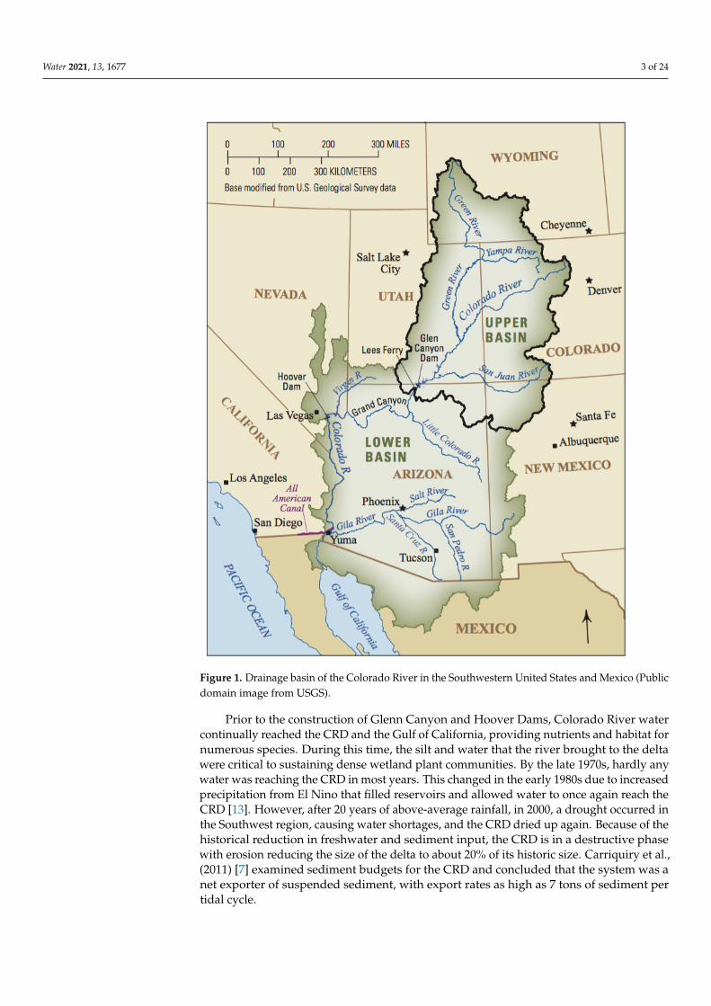
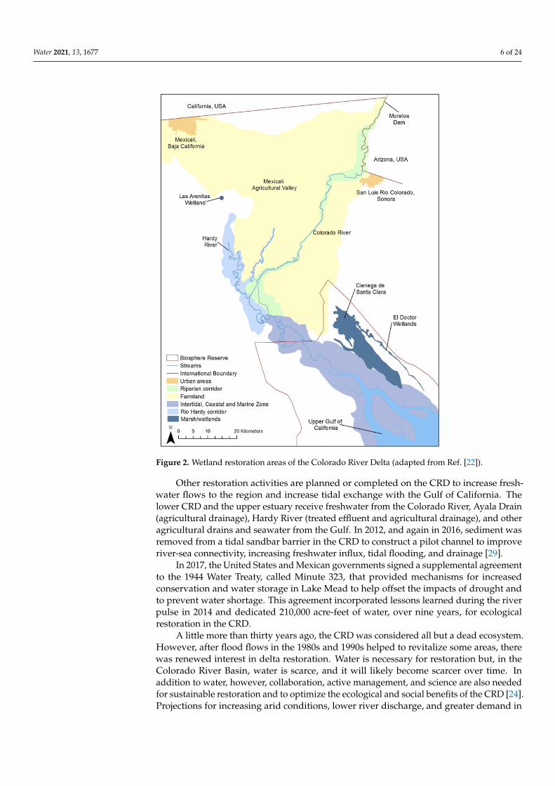
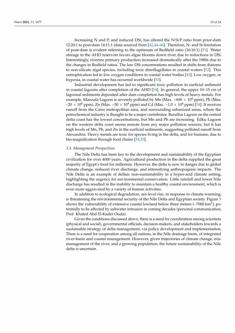
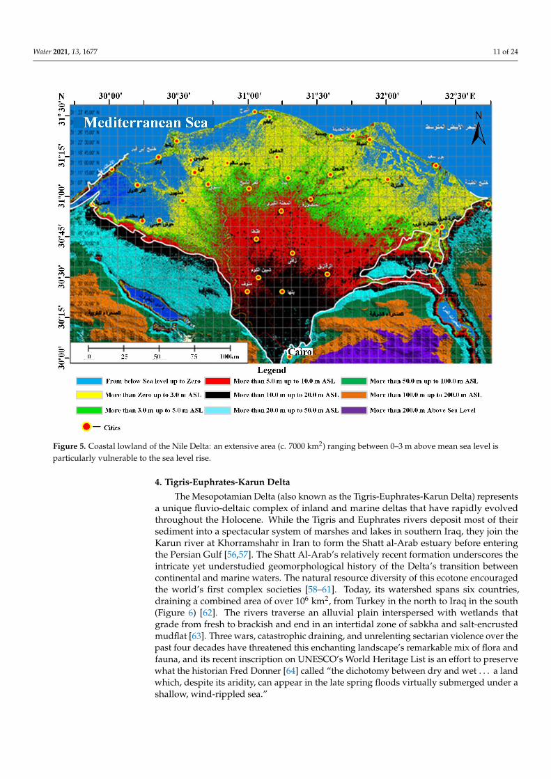
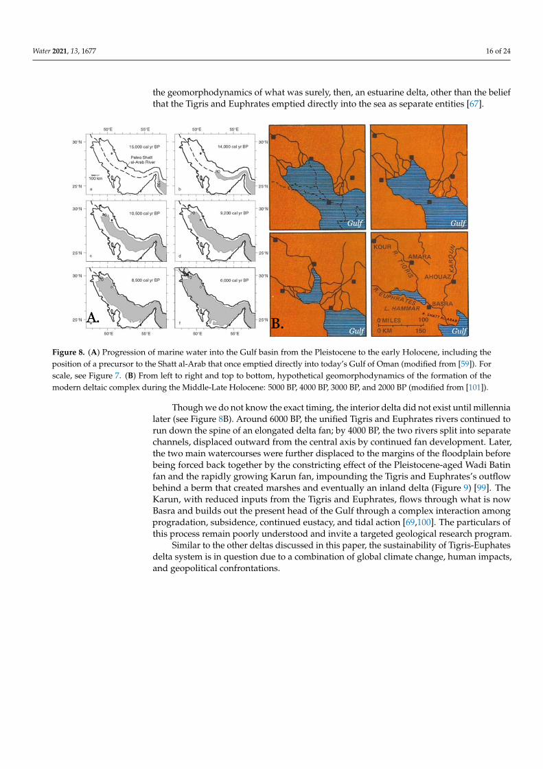
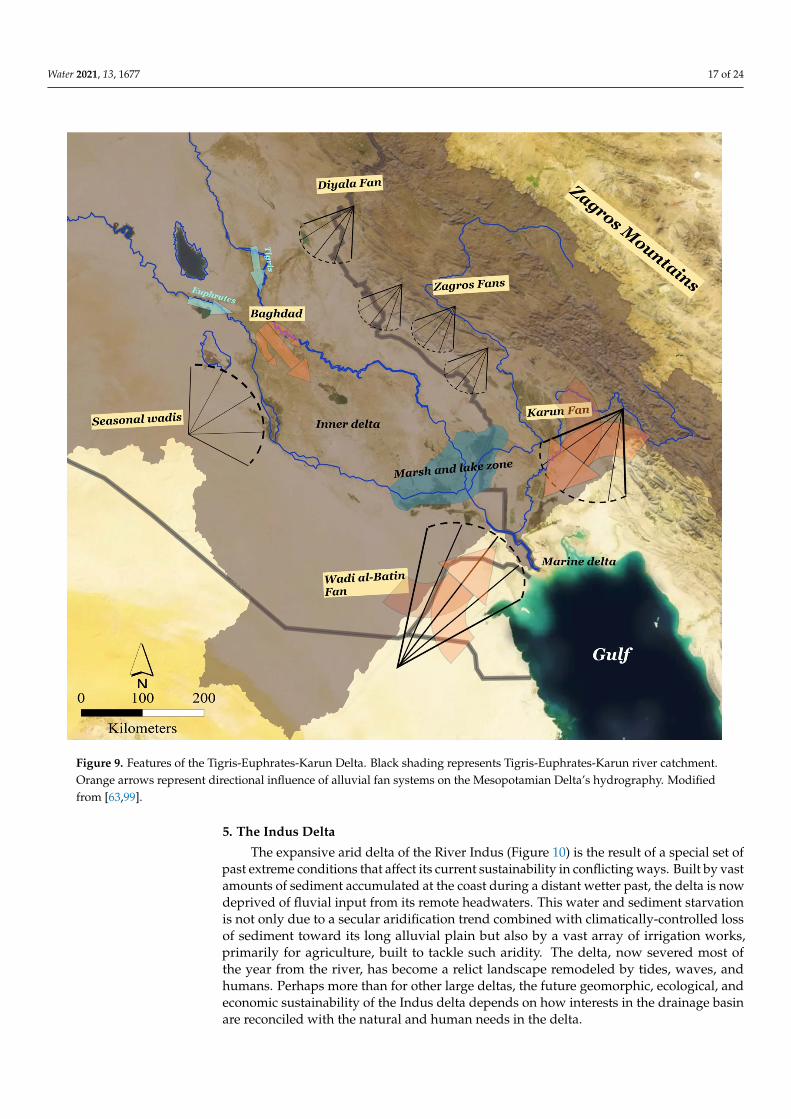