Soil-geomorphology and ``wet'' cycles in the Holocene record of North-Central Mexico
41
Soil-geomorphology and “wet” cycles in the Holocene record of North-Central Mexico Karl W. Butzer a, ⁎, James T. Abbott b , Charles D. Frederick a,c , Paul H. Lehman a, 1 , Carlos E. Cordova d , John F. Oswald a a Department of Geography and the Environment, University of Texas at Austin, AustinTX 78712-3100, United States b Environmental Affairs Division, Texas Department of Transportation, 125 E. 11th Street, Austin, TX 78701, United States c 2901 FM 1496, Dublin, TX 76446, United States d Department of Geography, Oklahoma State University, Stillwater OK 74078-4073, United States ABSTRACT ARTICLE INFO Article history: Received 18 August 2007 Received in revised form 9 May 2008 Accepted 9 May 2008 Available online 12 June 2008 Keywords: Floodplain soils “Wet” cycles Disequilibrium events Holocene Soil erosion Aridification The distinction between the impact of climatic periodicities or land-use practices on soil erosion is an important issue for Pre-Hispanic and Colonial Mexico. That question can best be addressed by first documenting the dynamics of changing “wet” cycles during the Holocene in the central Mexican region between the northern limits of Pre-Hispanic agriculture and its southern margins in northwestern Chihuahua. Consequently the Laguna Project targeted a 125,000 km 2 sector of North-Central Mexico, 250 km from north to south and 500 km from east to west, from Saltillo to Durango. Some 40 sedimentary profiles with multiple cumulic soils were studied in the field and laboratory, supported by 163 conventional 14 C and AMS dates on charcoal and soil humates. We distinguish: (1) wet floodplains (with humic paleosols, redox phenomena reflecting high water tables, channel- ponding sequences, and interbedded tufas) that imply aquifer recharge, sustained base flow, and mainly low- energy conditions; and (2) high-energy pulses of discharge that mobilized cobble gravels or forced channel entrenchment (“gullying”) and were tied to episodic, excessive rains that promoted valley and slope instability. In between such “wet” cycles and recurrent disequilibrium events, climate was similar to today, probably less humid, with limited geomorphologic change or slow soil formation. “Wet” cycles were rare at the end of the Pleistocene, but prominent during the Holocene. Disequilibrium proxies became common and dramatic after 2500 BP. The drainages from the Eastern and Western Sierra Madres responded in phase, but varied in detail. Around AD 1050–1200 “natural” erosion led to loss of soil organic carbon, as alternating severe droughts and heavy rains destroyed the ground cover and led to ecological aridification, well before arrival of Spanish miners and settlers. The evidence that human activity triggered Pre-Hispanic or Colonial erosion in Central Mexico should therefore be re-evaluated. Global comparisons and interpretations are discussed, but with caution, since no single theory can explain the whole of the record. The soil-geomorphology geoarchive of North-Central Mexico primarily is an environmental history of alternating “wet” cycles, rather than of sustained wet or dry climates. The critical differences between “soaking” and “excessive” rains, with their respective impacts, may be due to switching between winter and summer storm categories. © 2008 Elsevier B.V. All rights reserved. 1. Introduction 1.1. Questions Geomorphology intersects with environmental history in a number of ways. One possible application is the delineation of changing physical environments against long-term settlement his- tories, to examine whether abrupt changes may induce archaeological or historical disjunctions. Conversely, changing land use may result in biotic, soil, and hydrological change, as geomorphic processes activate a chain of feedbacks that can result in degradation. Both kinds of intersection are addressed in a growing literature, some of it responsible, some of it less. That can become an unfortunate by- product of greater attention to the historic dimension and to ecological concerns. Cross-disciplinary relationships are immensely complex, in social and systemic terms, so that mere temporal coincidence does not explain cause-and-effect (Butzer, 2005). At issue here is not, for example, the painstaking documentation that climatic forcing led to the abandonment of an irrigation network. The problems arise when big-picture authors (e.g. Sirocko et al., 1993; Geomorphology 101 (2008) 237–277 ⁎ Corresponding author. E-mail addresses: [email protected] (K.W. Butzer), [email protected] (P.H. Lehman). 1 For Table 1 please contact P.H. Lehman. 0169-555X/$ – see front matter © 2008 Elsevier B.V. All rights reserved. doi:10.1016/j.geomorph.2008.06.005 Contents lists available at ScienceDirect Geomorphology journal homepage: www.elsevier.com/locate/geomorph
-
Upload
independent -
Category
Documents
-
view
0 -
download
0
Transcript of Soil-geomorphology and ``wet'' cycles in the Holocene record of North-Central Mexico
Geomorphology 101 (2008) 237–277
Contents lists available at ScienceDirect
Geomorphology
j ourna l homepage: www.e lsev ie r.com/ locate /geomorph
Soil-geomorphology and “wet” cycles in the Holocene recordof North-Central Mexico
Karl W. Butzer a,⁎, James T. Abbott b, Charles D. Frederick a,c, Paul H. Lehman a,1,Carlos E. Cordova d, John F. Oswald a
a Department of Geography and the Environment, University of Texas at Austin, Austin TX 78712-3100, United Statesb Environmental Affairs Division, Texas Department of Transportation, 125 E. 11th Street, Austin, TX 78701, United Statesc 2901 FM 1496, Dublin, TX 76446, United Statesd Department of Geography, Oklahoma State University, Stillwater OK 74078-4073, United States
⁎ Corresponding author.E-mail addresses: [email protected] (K.W. But
[email protected] (P.H. Lehman).1 For Table 1 please contact P.H. Lehman.
0169-555X/$ – see front matter © 2008 Elsevier B.V. Aldoi:10.1016/j.geomorph.2008.06.005
A B S T R A C T
A R T I C L E I N F OArticle history:
The distinction between the Received 18 August 2007Received in revised form 9 May 2008Accepted 9 May 2008Available online 12 June 2008Keywords:Floodplain soils“Wet” cyclesDisequilibrium eventsHoloceneSoil erosionAridification
impact of climatic periodicities or land-use practices on soil erosion is an importantissue for Pre-Hispanic and Colonial Mexico. That question can best be addressed by first documenting thedynamics of changing “wet” cycles during the Holocene in the central Mexican region between the northernlimits of Pre-Hispanic agriculture and its southernmargins in northwestern Chihuahua. Consequently the LagunaProject targeted a 125,000 km2 sector ofNorth-CentralMexico, 250 km fromnorth to south and 500 km fromeastto west, from Saltillo to Durango. Some 40 sedimentary profiles with multiple cumulic soils were studied in thefield and laboratory, supported by 163 conventional 14C and AMS dates on charcoal and soil humates. Wedistinguish: (1) wet floodplains (with humic paleosols, redox phenomena reflecting high water tables, channel-ponding sequences, and interbedded tufas) that imply aquifer recharge, sustained base flow, and mainly low-energy conditions; and (2) high-energy pulses of discharge that mobilized cobble gravels or forced channelentrenchment (“gullying”) andwere tied to episodic, excessive rains that promoted valley and slope instability. Inbetween such “wet” cycles and recurrent disequilibriumevents, climatewas similar to today, probably lesshumid,with limited geomorphologic change or slow soil formation.“Wet” cycles were rare at the end of the Pleistocene, but prominent during the Holocene. Disequilibrium proxiesbecame common and dramatic after 2500 BP. The drainages from the Eastern and Western Sierra Madresresponded inphase, but varied indetail. AroundAD1050–1200 “natural” erosion led to loss of soil organic carbon,as alternating severe droughts andheavy rains destroyed the ground cover and led to ecological aridification,wellbefore arrival of Spanishminers and settlers. The evidence that human activity triggered Pre-Hispanic or Colonialerosion in Central Mexico should therefore be re-evaluated. Global comparisons and interpretations arediscussed, but with caution, since no single theory can explain the whole of the record. The soil-geomorphologygeoarchive of North-CentralMexico primarily is an environmental history of alternating “wet” cycles, rather thanof sustained wet or dry climates. The critical differences between “soaking” and “excessive” rains, with theirrespective impacts, may be due to switching between winter and summer storm categories.
© 2008 Elsevier B.V. All rights reserved.
1. Introduction
1.1. Questions
Geomorphology intersects with environmental history in anumber of ways. One possible application is the delineation ofchanging physical environments against long-term settlement his-
zer),
l rights reserved.
tories, to examine whether abrupt changes may induce archaeologicalor historical disjunctions. Conversely, changing land use may result inbiotic, soil, and hydrological change, as geomorphic processes activatea chain of feedbacks that can result in degradation. Both kinds ofintersection are addressed in a growing literature, some of itresponsible, some of it less. That can become an unfortunate by-product of greater attention to the historic dimension and toecological concerns. Cross-disciplinary relationships are immenselycomplex, in social and systemic terms, so that mere temporalcoincidence does not explain cause-and-effect (Butzer, 2005).
At issue here is not, for example, the painstaking documentationthat climatic forcing led to the abandonment of an irrigation network.The problems arise when big-picture authors (e.g. Sirocko et al., 1993;
238 K.W. Butzer et al. / Geomorphology 101 (2008) 237–277
Cullen et al., 2000; Drysdale et al., 2006) claim that (inferred) climaticchanges caused agricultural decline and socio-political collapse overentire regions (E.K. Butzer, 1997; K.W. Butzer, 1997; see also Liu, 2007).Instead we are concerned here with the difficult middle ground, ofhow to distinguish the impact of secular climatic variation, on the onehand, from injudicious land-use intervention, on the other, incontrolling ecological outcomes, especially in dry lands.
In Mexico, questions arise whether Spanish colonization led toecological degradation, but also whether or not Pre-Hispanic peopleshad a negative impact on the environment. Or did Spanish ecologicalpressures build on earlier, indigenous damage? It went almostunnoticed when Byrne and Horn (1989) published a thoroughpalynological study showing major deforestation in the coastal plainsnear Tuxtla during Classical times, well before the arrival of theSpaniards. But attention has been riveted by the limnological analysisof O'Hara et al. (1993) of multiple cores in highland Lake Pátzcuaro,demonstrating accelerated sedimentation during periods of adjacentPre-Hispanic settlement since ~1900 BC. By comparison, soil erosionin Colonial times seemed more subdued. Fisher et al. (2003) disputethese findings, however, and instead attribute accelerated erosion toinitial disturbance and landscape abandonment in the early Colonialera. We return to this important discourse in Section 9.4.
Another picture emerges in the Bajío region of Central Mexico.Here a large sedentary site is recorded at Villa de Reyes (probably LateClassic, ~AD 600–900). Intensive occupation had significant impact onrates of sedimentation in the adjacent stream, with accumulation of3–4.5 m of alluvium in less than 400 years (dates on fill of ~AD 650–1030), with abundant cultural remains throughout. Yet the larger,Lajas drainage was unaffected, although here Colonial land use left amajor and extensive record of accelerated mobilization (Frederick,1995: 138–156, 195–197). This confirms the value of combined site-specific geoarchaeology and Quaternary watershed studies (seeButzer and Harris, 2007). Archival records further document theland cover of the Bajío during the 1500s and show widespreaddeforestation around older areas of indigenous settlement, especiallyaround the large lakes—before the arrival of the Spaniards (Butzer andButzer, 1997).
Although further studies of lake cores have been undertaken,Frederick's (1995) record for the northern Bajío suggests the need fornuanced alluvial studies, to identify the agents of soil erosion, and tocompare the scale and intensity of indigenous versus Colonialdisturbance. It is also critical to isolate the effects of climatic change,by examining alluvial and soil sequences north of the maximumexpansion of Mesoamerican agriculture (Villa de Reyes; La Quemada[Nelson, 1997]), but south of the sedentary Casas Grandes archae-ological cluster in the far northwest of Mexico. Before Spanishintrusion, except for the western Sierras, this vast area was onlyoccupied by hunter–gatherers. It also represents a significant gap interms of Quaternary research (see Section 9.3).
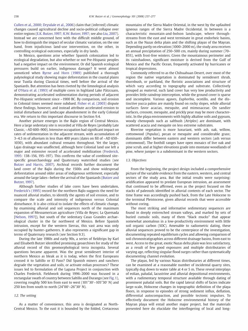
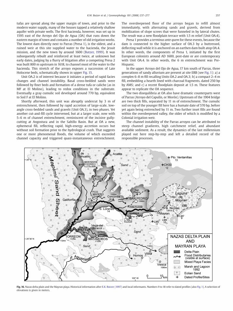
During the late 1980s and early 90s, a series of fieldtrips by Karland Elisabeth Butzer identified promising geoarchives for study of thealluvial record of this geomorphological terra incognita. Severalquestions became apparent. Was the great semidesert interior ofnorthern Mexico as bleak as it is today, when the first Europeanscrossed it to Saltillo or El Paso? Did Spanish miners and ranchersdegrade the vegetation and soils, or activate eolian processes? Theseissues led to formulation of the Laguna Project in conjunction withCharles Frederick. Fieldwork during 1996–2000 was focused in arectangular swath of country between Saltillo and Durango (see Fig.1),covering roughly 500 km from east to west (101°30′–105°30′ N) and250 km from south to north (24°00′–26°30′ N).
1.2. The setting
As a matter of convenience, this area is designated as North-Central Mexico. To the east it is bounded by the folded, Cretaceous
mountains of the Sierra Madre Oriental, in the west by the upfaultedigneous ranges of the Sierra Madre Occidental. In between is acharacteristic mountain-and-bolson landscape, where through-streams from the east and west terminate in great endorheic basins,such as the Nazas delta plain and the shifting playas of the Mayran.Depending partly on elevation (1000–2000m), the study area receivesan annual precipitation of 250–500 cm, mainly during summer (70–85%), with frost-free winters. Given the mountainous perimeter andits rainshadows, significant moisture is derived from the Gulf ofMexico and the Pacific Ocean, frequently activated by hurricanes ortropical depressions.
Commonly referred to as the Chihuahuan Desert, over most of theregion the native vegetation is dominated by semidesert shrub,thornbush, or parkland, the floristic associations and structure ofwhich vary according to topography and substrate. Collectivelygrouped as matorral, such land cover has very low productivity andprovides little raindrop interception, while the ground cover is sparseand incomplete. Various agaves, Euphorbia, ocotillo, and the dis-tinctive yucca palms are mainly found on rocky slopes, while alluvialsurfaces favor acacias, mesquite, and mimosaceae. On sandiersurfaces, creosote, mesquite, and prickly pear may be more character-istic. In the playa environments with highly alkaline soils and gypsum,woody chenopods such as saltbush (Atriplex) are dominant, withscattered acacia and mesquite on less extreme substrates.
Riverine vegetation is more luxuriant, with ash, oak, willow,cottonwood (Populus), pecan or mesquite and considerable grass;dominants differ between eastern and western sectors (ash versuscottonwood). The foothill ranges have open mosaics of live oak andpine scrub, and at higher elevations grade into montane woodlands ofpine, where juniper is a subdominant in the western sectors.
1.3. Objectives
From the beginning, the project design included a comprehensivepicture of the variable evidence from the eastern, western, and centralsectors of the study area. But the initial results were surprising:aridification appeared to predate European intrusion, an assessmentthat continued to be affirmed, even as the project focused on thestacks of paleosols identified in alluvial contexts of each sector. Thetime frame was accordingly pushed back, from the Late Holocene tothe terminal Pleistocene, given alluvial records that were accessiblewithout coring.
The most striking and informative sedimentary sequences arefound in deeply entrenched stream valleys, and marked by sets ofburied cumulic soils, many of them “black mucks” that appearsomewhat anomalous in a low-productivity environment with littlesoil organic carbon (SOC). Amenable to radiometric dating, thesealluvial sequences proved to be the centerpiece of the investigation,documenting repeated equilibrium cycles and allowing comparison ofsoil chronostratigraphies across different drainage basins, from east towest. Access to the great, exotic Nazas delta plainwas less satisfactory,as a result of few good exposures and multiple distributaries ofvarying age, reflecting singular flood surges rather than systematicallydocumenting channel evolution.
The playas, fed by various Nazas distributaries at different times,can be examined at a reasonable number of incidental quarry sites,typically dug down to water table at 4 or 5 m. These reveal interplaysof eolian, paludal, lacustrine and alluvial depositional environments,with a rudimentary temporal structure available through dating ofprominent paludal soils. But the rapid lateral shifts of facies indicatelarge-scale, Holocene changes in topographic definition of the playafloors, in response to episodes of strong sediment influx, deflation,differential autocompaction, and possible tectonic impulses. Toeffectively document the Holocene environmental history of theMayran playa will entail another major project, but the materialspresented here do elucidate the interfingering of local and long-
Fig. 1. The Laguna Project in northernMexico, showing the major sites studied. The internal frame is shownwith detail in Fig.16. Casas Grandes and Babícora are located northwest ofthe map, north of latitude 29°.
239K.W. Butzer et al. / Geomorphology 101 (2008) 237–277
distance sediments between the eastern and western sectors of thestudy area.
The final objective of the project was to develop a Holocene recordfor this little-studied area, so as to (1) better understand the linkagesbetween the U.S. Southwest and Central Mexico; (2) re-examine thepremises for human-induced degradation in Mexico; and (3) considerthe place of this vast region in current discourse on global climaticchange.
1.4. Methods
Some 40 sedimentary profiles were recorded, including stratifica-tion and contacts, structure, consistency and cementation, carbonatemorphology, and illuvial features, nodules, mottling or ferruginousconcentrations. Over 430 samples were processed at the University ofTexas Laboratory of Applied Geomorphology and Geoarchaeology,with textural analyses by hydrometer and sieving, the results of whichwere graphed and converted to the standard analytic parameters.Organic matter was approximated by loss on ignition (LOI), after firstremoving matric and hygroscopic water, the results of which co-varywith those of the chemical Walkley–Black procedure (Schulte andHopkins, 1996). Calcium carbonate equivalent (CCE) was approxi-mated by the Chittick technique, although this method tends tounder-represent CCE when values nominally exceed 20 or 30%.Magnetic susceptibility and pH were also determined, the latter
fluctuating in a fairly narrow range from 7.0–8.6. An additional suite ofover 200 samples was run by Frederick at the University of Sheffield,using Cilas laser textural techniques on cube-based samples.
Because clays and silts are the key diagnostic textural variableshere, and relatively clean sands are rare, textures are reported in theinternational soils terminology; this also lends itself well to initial fieldapproximation. In cases where precise textural parameters arematerial, φ and σ values are listed in the graphical representation.Horizons are designated according to common Quaternary and Soilsusage (see USDA, 1999). Colors are dry Munsell readings.
Suites of samples for diatoms and ostracods were collected frommany profiles and analyzed by Barbara Winsborough and M. Palacios-Fest (private consultants) respectively, but preservation was mainlypoor and the results limited, much like Holocene diatoms were alsorare at Babícora in northern Chihuahua (Metcalfe et al., 2002). Smallgastropod shells and less common bivalves are present in the k-horizons beneath many soils, but have not yet been consigned to aspecialist, because such sporadic units are not representative. Thecharaphytes (green algal silicic skeletons) encountered in many bedsat Saltillo also deserve specialist study. Sporadic finds of animal bonewere identified courtesy of Ernest W. Lundelius (University of Texas).Archaeological materials at the surface or within the profiles wererecorded and photographed, as possible, but were not removed, incompliance with Mexican antiquity laws. Vegetation cross-sectionswere recorded by Carlos Cordova. A comprehensive palynological
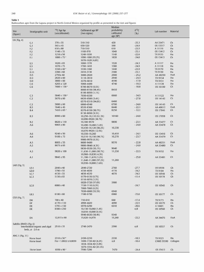
Table 1Radiocarbon ages from the Laguna project in North-Central Mexico organized by profile as presented in the text and figures
240 K.W. Butzer et al. / Geomorphology 101 (2008) 237–277
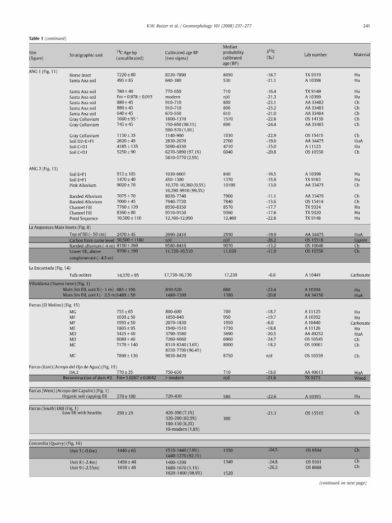
Table 1 (continued)
(continued on next page)
241K.W. Butzer et al. / Geomorphology 101 (2008) 237–277
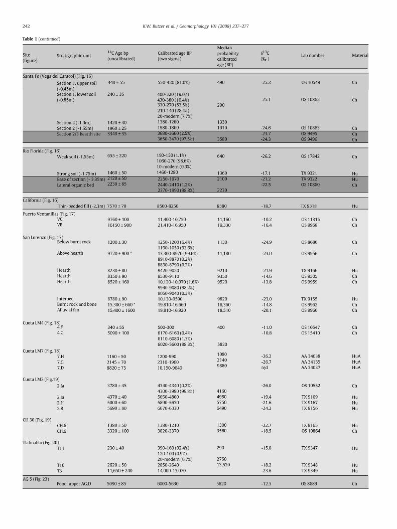
Table 1 (continued)
242 K.W. Butzer et al. / Geomorphology 101 (2008) 237–277
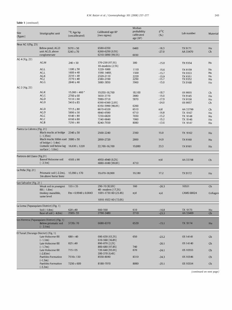
Table 1 (continued)
(continued on next page)
243K.W. Butzer et al. / Geomorphology 101 (2008) 237–277
Table 1 (continued)
All dates (with 3 exceptions) are calibrated with CALIB 5.1 using the IntCal04 dataset (Reimer et al., 2004).All charcoal dates were calibrated with a 30 year moving average, and all humate and carbonate dates a 200 year moving average.The 3 exceptions are dates from CAMS whose calibrations are provided by T. Stafford (using OxCal and IntCal04).Material codes: Ch = charcoal AMS; Hu = conventional humate; HuA = AMS humate.Dark gray background indicates dates not presented in the article. Medium gray background indicates dates discussed in the text, but not shown on a figure.* Indicates out of sequence dates.
244 K.W. Butzer et al. / Geomorphology 101 (2008) 237–277
program is nearing completion by Bruce Albert, and will be reportedseparately, as will results for the stable carbon isotopes.
A total of 163 radiometric ages were obtained by the Project, in aneffort to achieve precision dating that would allow close comparisonfor the large number of profiles. The Wood's Hole OceanographicInstitute reactor [NOSAMS] provided 79 AMS ages on charcoal, whilethe University of Texas and University of Arizona laboratoriesdetermined 79 ages on bulk humates, in good part by AMS, as wellas two assays on calcareous tufas. A further three AMS ages on bonecollagen were processed by Stafford Research Laboratories. Althoughthe charcoal ages are occasionally out of sequence as a result oferosional reworking, and some of the humate ages may be slightly tooold because of allogenic organic matter, an effort was made to selectsamples to provide for cross-checking of results; stratigraphically-associated ages on the charcoal and humate samples are usuallysurprisingly consistent. A limited number of optically stimulatedluminescence (OSL) ages from the Mayran area were run at theSheffield Centre for International Drylands Research luminescencelaboratory, courtesy of Mark Bateman. These are reported in calendaryears from measurement (2001), but we lack sufficient parallelsequences to test them. Full details of the OSL data and associatedtechnology will be reported separately.
The dates quoted are shown in the graphics, all in δ13C correctedbut uncalibrated radiocarbon years (bp), with charcoal or humatesspecified. This deliberate choice was made to allow listing of a simple,if somewhat arbitrary number. The full corpus of dating information,with error and calibration ranges is presented in the supporting datescollated in Table 1) at the end. Uncalibrated dates evidently distortHolocene time scales, and are badly compressed between 2400 and4700 bp, arbitrarily “shortening” mid-Holocene time. In the conclud-ing discussions of cyclic environmental changes, however, calibrateddates (BP) are used in their proper place, with reference to thesupplementary data of Table 1.
Finally, this study comprises a large corpus of primary, field andlaboratory data from a little-studied area, to provide the necessarydepth and breadth. For publication that has required a compromisebetween minimal reporting, on the one hand, and detail, on theother.
2. The Saltillo Basin
2.1. Introduction
Saltillo is a rapidly growing city in a semiarid rainshadow oftectonic origin. The defining feature is a major SSW–NNE transversefault (Fig. 2). To the east, strongly folded limestones of the LowerCretaceous and Jurassic, broken byW–E linear faults, dip under a bodyof late Cenozoic conglomerates toward the transverse fault, tocontinue beneath folded, Upper Cretaceous shales and sandstones.Themajor drainage line, the Arroyo del Pueblo, parallels the same faultfor some 40 km, tapping an artesian aquifer that explains the ecologyof urban location. With a mean channel gradient of 0.0133, this low-sinuosity stream commonly exposes 10–15 m of Holocene alluvium.
Five geoarchives were recorded in the basin (Fig. 2), three of themanalyzed in detail. The Arroyo del Pueblo has some base flow of springorigin, downstream of profile LMS, but further upstream discharge isepisodic while the proportion of bedload in the alluvial sequenceincreases. From BWD upstream to La Angostura, late Quaternaryfloodplain width typically is 500–700 m, but much narrowerelsewhere.
2.2. The Upper Arroyo profile (UA)
The hallmark sedimentary profile of the Saltillo Basin, desig-nated as UA (Figs. 3–4) and with a thickness of 8–12 m, is anchoredat its southern end by an early Colonial diversion dam. A 140 m-long profile was drawn of the natural face, which cuts the channelobliquely as it comes out of a bend. Such a wide exposure providesa significant sample of the floodplain and insight into the processesthat operated there. The lowest units, dated at N9900 bp, resteither on schistose bedrock (fault contact alteration) or on 1.5 m ofvisible, cemented Pleistocene deposits (colluvium, redox sands,and a calcified sandstone conglomerate, capped by a scouredpavement).
At UA, six beds (A.1–A.6) are grouped as Unit A and include a set oflow-energy deposits dominated by channel-ponding, with weakcumulic paleosols, several redox horizons, and three zones of
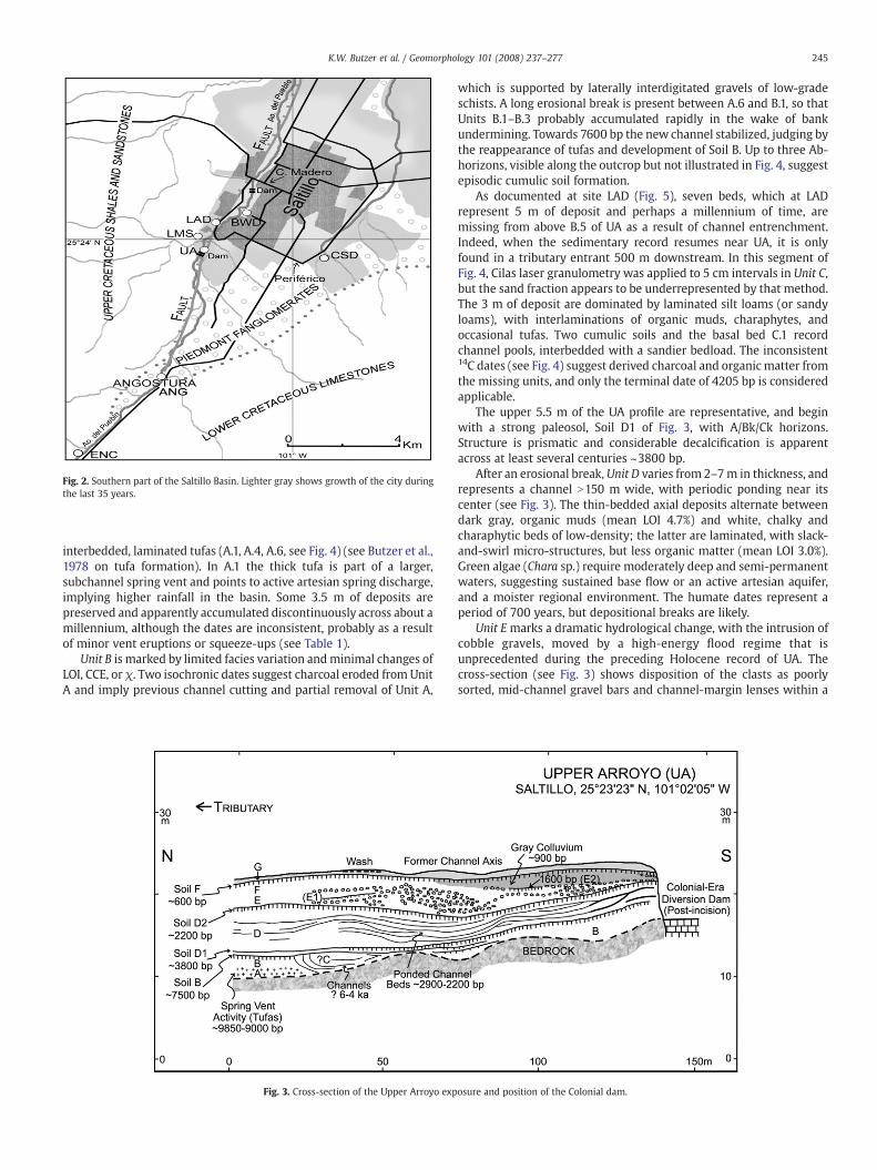
Fig. 2. Southern part of the Saltillo Basin. Lighter gray shows growth of the city duringthe last 35 years.
245K.W. Butzer et al. / Geomorphology 101 (2008) 237–277
interbedded, laminated tufas (A.1, A.4, A.6, see Fig. 4) (see Butzer et al.,1978 on tufa formation). In A.1 the thick tufa is part of a larger,subchannel spring vent and points to active artesian spring discharge,implying higher rainfall in the basin. Some 3.5 m of deposits arepreserved and apparently accumulated discontinuously across about amillennium, although the dates are inconsistent, probably as a resultof minor vent eruptions or squeeze-ups (see Table 1).
Unit B is marked by limited facies variation andminimal changes ofLOI, CCE, or χ. Two isochronic dates suggest charcoal eroded from UnitA and imply previous channel cutting and partial removal of Unit A,
Fig. 3. Cross-section of the Upper Arroyo exp
which is supported by laterally interdigitated gravels of low-gradeschists. A long erosional break is present between A.6 and B.1, so thatUnits B.1–B.3 probably accumulated rapidly in the wake of bankundermining. Towards 7600 bp the new channel stabilized, judging bythe reappearance of tufas and development of Soil B. Up to three Ab-horizons, visible along the outcrop but not illustrated in Fig. 4, suggestepisodic cumulic soil formation.
As documented at site LAD (Fig. 5), seven beds, which at LADrepresent 5 m of deposit and perhaps a millennium of time, aremissing from above B.5 of UA as a result of channel entrenchment.Indeed, when the sedimentary record resumes near UA, it is onlyfound in a tributary entrant 500 m downstream. In this segment ofFig. 4, Cilas laser granulometry was applied to 5 cm intervals in Unit C,but the sand fraction appears to be underrepresented by that method.The 3 m of deposit are dominated by laminated silt loams (or sandyloams), with interlaminations of organic muds, charaphytes, andoccasional tufas. Two cumulic soils and the basal bed C.1 recordchannel pools, interbedded with a sandier bedload. The inconsistent14C dates (see Fig. 4) suggest derived charcoal and organic matter fromthe missing units, and only the terminal date of 4205 bp is consideredapplicable.
The upper 5.5 m of the UA profile are representative, and beginwith a strong paleosol, Soil D1 of Fig. 3, with A/Bk/Ck horizons.Structure is prismatic and considerable decalcification is apparentacross at least several centuries ~3800 bp.
After an erosional break, Unit D varies from 2–7m in thickness, andrepresents a channel N150 m wide, with periodic ponding near itscenter (see Fig. 3). The thin-bedded axial deposits alternate betweendark gray, organic muds (mean LOI 4.7%) and white, chalky andcharaphytic beds of low-density; the latter are laminated, with slack-and-swirl micro-structures, but less organic matter (mean LOI 3.0%).Green algae (Chara sp.) require moderately deep and semi-permanentwaters, suggesting sustained base flow or an active artesian aquifer,and a moister regional environment. The humate dates represent aperiod of 700 years, but depositional breaks are likely.
Unit E marks a dramatic hydrological change, with the intrusion ofcobble gravels, moved by a high-energy flood regime that isunprecedented during the preceding Holocene record of UA. Thecross-section (see Fig. 3) shows disposition of the clasts as poorlysorted, mid-channel gravel bars and channel-margin lenses within a
osure and position of the Colonial dam.
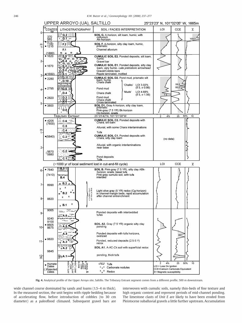
Fig. 4. Analytical profile of the Upper Arroyo site, Saltillo. The Tributary Entrant segment comes from a different profile, 500 m downstream.
246 K.W. Butzer et al. / Geomorphology 101 (2008) 237–277
wide channel course dominated by sands and loams (1.5–4 m thick).In the measured section, the unit begins with ripple bedding becauseof accelerating flow, before introduction of cobbles (to 30 cmdiameter) as a paleoflood climaxed. Subsequent gravel bars are
interwoven with cumulic soils, namely thin-beds of fine texture andhigh organic content and represent periods of mid-channel ponding.The limestone clasts of Unit E are likely to have been eroded fromPleistocene suballuvial gravels a little further upstream. Accumulation
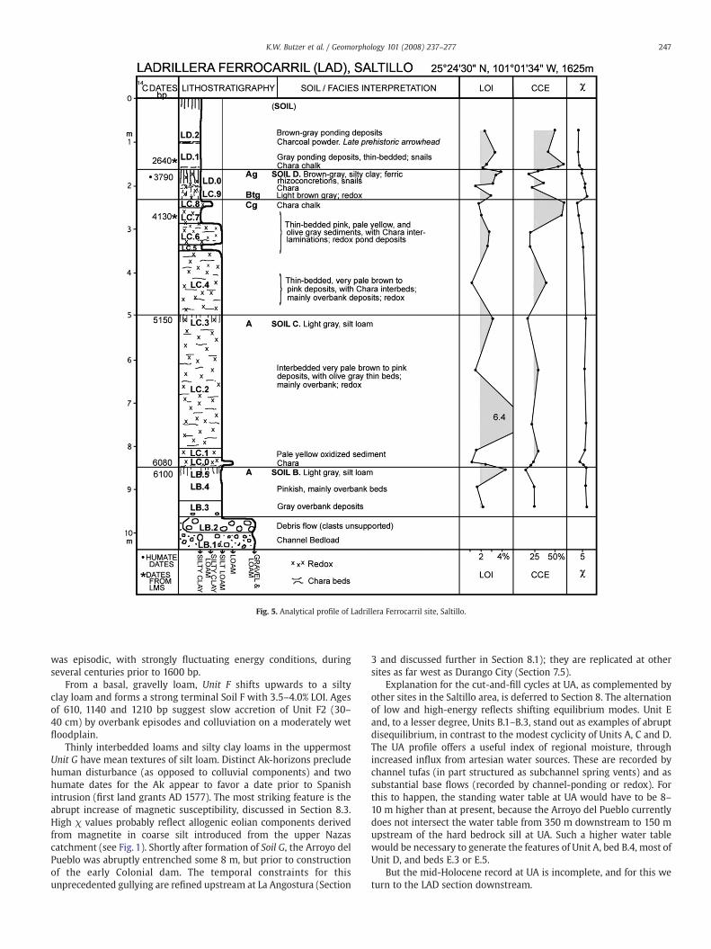
Fig. 5. Analytical profile of Ladrillera Ferrocarril site, Saltillo.
247K.W. Butzer et al. / Geomorphology 101 (2008) 237–277
was episodic, with strongly fluctuating energy conditions, duringseveral centuries prior to 1600 bp.
From a basal, gravelly loam, Unit F shifts upwards to a siltyclay loam and forms a strong terminal Soil F with 3.5–4.0% LOI. Agesof 610, 1140 and 1210 bp suggest slow accretion of Unit F2 (30–40 cm) by overbank episodes and colluviation on a moderately wetfloodplain.
Thinly interbedded loams and silty clay loams in the uppermostUnit G have mean textures of silt loam. Distinct Ak-horizons precludehuman disturbance (as opposed to colluvial components) and twohumate dates for the Ak appear to favor a date prior to Spanishintrusion (first land grants AD 1577). The most striking feature is theabrupt increase of magnetic susceptibility, discussed in Section 8.3.High χ values probably reflect allogenic eolian components derivedfrom magnetite in coarse silt introduced from the upper Nazascatchment (see Fig. 1). Shortly after formation of Soil G, the Arroyo delPueblo was abruptly entrenched some 8 m, but prior to constructionof the early Colonial dam. The temporal constraints for thisunprecedented gullying are refined upstream at La Angostura (Section
3 and discussed further in Section 8.1); they are replicated at othersites as far west as Durango City (Section 7.5).
Explanation for the cut-and-fill cycles at UA, as complemented byother sites in the Saltillo area, is deferred to Section 8. The alternationof low and high-energy reflects shifting equilibrium modes. Unit Eand, to a lesser degree, Units B.1–B.3, stand out as examples of abruptdisequilibrium, in contrast to the modest cyclicity of Units A, C and D.The UA profile offers a useful index of regional moisture, throughincreased influx from artesian water sources. These are recorded bychannel tufas (in part structured as subchannel spring vents) and assubstantial base flows (recorded by channel-ponding or redox). Forthis to happen, the standing water table at UA would have to be 8–10 m higher than at present, because the Arroyo del Pueblo currentlydoes not intersect the water table from 350 m downstream to 150 mupstream of the hard bedrock sill at UA. Such a higher water tablewould be necessary to generate the features of Unit A, bed B.4, most ofUnit D, and beds E.3 or E.5.
But the mid-Holocene record at UA is incomplete, and for this weturn to the LAD section downstream.
248 K.W. Butzer et al. / Geomorphology 101 (2008) 237–277
2.3. The Ladrillera Ferrocarril Brickyard (LAD)
Active and abandoned brickyards extend along the Arroyo delPueblo for ~20 km, mainly on the western side, before the exposedthickness of Holocene alluvium rapidly tapers off north of latitude25°25′. Although obscured by recent construction on top of exhaustedbrickyards, the last downstreamoutcropswere observed near the CalleMadero bridge. Quarries for brick kilns and “Saltillo tiles” exploit siltyclay loams or silty clays, rich in organic matter and CCE. Informantsstressed that the raw material was used without admixing tempers.The deeper silt loams are not systematically excavated, probablybecause they include too much sand or too little organic matter. EarlyHolocene levels are, therefore, exposed only where a brickyardoperates by stepping-back steep, high outcrops, such as at LAD.
A brickyard SW of the railroad crossing over the Arroyo del Pueblo(LAD, see Figs. 2 and 5) exposes a more or less complete MiddleHolocene record. Topping at 15 m above modern floodplain, thecomposite profile is ~10 m thick. An intricate warren of smallworkings, targeted at selected seams, was shown us through thecourtesy of the foreman, Juan Rivera Iracheta.
The sequence begins with a gravelly channel-floor (LB.1), partlycovered by a debris flow of unsupported clasts (LB.2). This dramaticinitiation of a new cycle of sedimentationwas followed by ~6 m of siltloams (LB.3–LC.4), representing thin-bedded slackwater deposits,with two weak cumulic soils (B and C), many Chara interbeds, andprominent redox phenomena, ranging from gray or olive gray to paleyellow or pink in color (Munsell hues 5Y to 7.5YR). Changes in CCE orχ are subdued, but the LOI curve fluctuates considerably, up to 6.4%.
Variability increases in levels LC.5–LC.9 (1.6 m thick), with textureranging from silt loam to silty clay. Mottling is more conspicuous, andbed LC.9, in between Chara chalks, is a 40 cm Btg horizon thatpreserves the thin-bedding of the parent material. Above that is aconspicuous, 25 cm Ag-horizon (LD.0) with reddish yellow, ferricrhizoliths.
Beds LD.1–2 are 1.5–2.5 m thick. These are dark silty clays, thin-bedded, with considerable organic matter, attributed to ponding in amarginal sector of the former floodplain. A late prehistoric arrowheadwas observed in a charcoal-rich lens between the two levels.
The Ag/Btg profile at the contact of Units LC and LD is 70 cm thick,with evidence of oxide segregation, strong redox conditions, andformation or accumulation of a heavy clay. The clay fraction of the Ag-horizon is 53%, that of the Btg 57%, and the Cg 35%. This is a gleyed
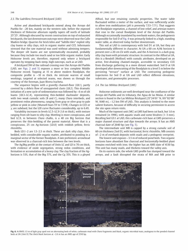
Fig. 6. At BWD, 1.5 m of light gray spoil rest on alternating beds of white, carbonate mud witbeds at UA (Unit D) The thick black horizon at −2.6 m has an AMS age of 2510 bp.
Alfisol, but one retaining cumulic properties. The water tablefluctuated within a meter of the surface, and was sufficiently acidicto allow iron mobilization (pH is presently 7.53–7.71). That suggestsrich floodplain vegetation, a channel of low relief, and artesian watersthat rose to the coeval floodplain level of the Arroyo del Pueblo.Although occasionally inundated by overbankwaters, the pedogenesisresponsible for Soil D of Fig. 4 was primarily linked to a high, standingwater table, as observed today further downstream.
This soil at LAD is contemporary with Soil D1 at UA, but they arefundamentally different in character. At UA a 60 cm A/Ak horizon ispresent over a 20 cm Ck with snails, and the A-horizon is a dark gray,silty clay loamwith prismatic structure. In contrast to the Alfisol at UA,this is a Rendoll (Mollisol) with cumulic attributes, developed on anactive, free-draining channel-margin, accessible to secondary CCEfrom discharge gathering in a more distant watershed. Soil D at UAdeveloped after downcutting of the floodplain to a level 5 m below thepersisting “terrace” surface at LAD. The contrasting pedogenictrajectories for Soil D at UA and LAD reflect different elevations,substrates, and geomorphic processes.
2.4. The Las Miñitas Brickyard (LMS)
Holocene sediments are well developed near the confluence of theArroyo del Pueblo and its tributary, the Agua de las Mulas. A similarsection is found in the Las Miñitas Brickyard (25°24′01″ N, 101°02′08″W, 1640 m), ~1.2 km SW of LAD.. This analysis is limited to the moresalient features, because of difficulty in securing permission to accessthe site upon return visits.
Much of the topmost unit (MC) at LMS had been cut back, but 1.6 mremained (in 1996), with aquatic snails and some bivalves (1–3 mm).Recalling bed LD.1 at LAD, this carbonate-rich base at LMS preserves amajor channel structure and dips towards the arroyo. It has an AMScharcoal date of 2640 bp (see Fig. 5).
The intermediate unit MB is capped by a strong cumulic soil of60 cm thickness (Soil D), with horizontal, ferric rhizoliths. MB consistsof ~2 m of overbank deposits with snails and a pedogenic overprint.
The lowest unit exposes ~3.5 m of reduced pond beds. Two organichorizons have abundant fine charcoal and horizontally-bedded plantremains enriched with iron; the higher has an AMS date of 4130 bp.This unit has many snails, and thickens toward the valley axis.
On its eastern side, the whole LMS profile has slumped toward thearroyo, and a fault disrupted the strata of MA and MB prior to
h Chara fragments and black, organic microbial mats, analogous to the ponded channel
249K.W. Butzer et al. / Geomorphology 101 (2008) 237–277
accumulation of MC. In effect, the two older units were underminedby channel incision of the Arroyo del Pueblo, just after development ofSoil D at LMS. In combination, LMS and LAD record stable and wetconditions from before 6100 to 3800 bp, prior to downcutting by 5 m.
2.5. Ponding at site BWD
In a recreational area modified by mechanical grading, aninteresting exposure is present on the eastern bank at 25°24′42″ N,101°01′09″ W (BWD). The top 1.5 m is suffused with trash, includingthe tibia and astragulus of a domesticated horse (Texas MemorialMuseum [TMM]No. 43547). Below that are N2.5m of alternating, thin-beds of white or light gray Chara chalk and black organic mats (Fig. 6).
These two facies, which replicate those of UA Unit D, were studiedby BarbaraWinsborough. She describes the low-density, light colored,porous material as a carbonate mud, consisting of small fragments of agreen macro alga (Chara or Nitella), encrusted with micritic calcite.These suggest rapid deposition in shallow, alkaline ponds. The darkhorizons are formed as microbial mats impregnated or encrusted withiron, laid down in muddy water undersaturated in bicarbonate.
The alternating beds may, therefore, be partly explained by watersalternatingly supersaturated or undersaturated in calcium bicarbo-nate. In the latter case, iron compounds would be mobilized bycyanobacteria (blue–green algae), and Winsborough found abundantred bacteria in sediment samples from LAD. These features pose issuesfor more specialized analysis. Equivalencewith UAUnit D is supportedby an AMS date of 2510 bp at 2.6 m depth.
2.6. The CSD Arroyo, eastern Saltillo
The piedmont alluvial plain east of Saltillo represents a very differentsedimentary environment. When first visited by Butzer in 1982, this
Fig. 7. The CSD Arro
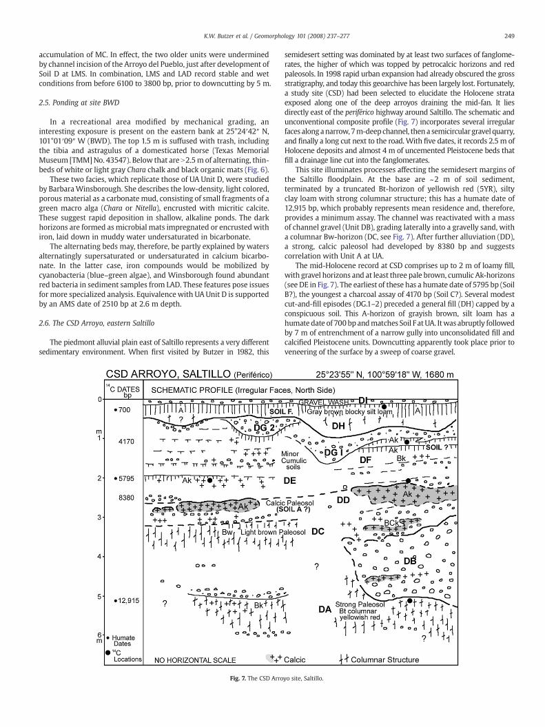
semidesert setting was dominated by at least two surfaces of fanglome-rates, the higher of which was topped by petrocalcic horizons and redpaleosols. In 1998 rapid urban expansion had already obscured the grossstratigraphy, and today this geoarchive has been largely lost. Fortunately,a study site (CSD) had been selected to elucidate the Holocene strataexposed along one of the deep arroyos draining the mid-fan. It liesdirectly east of the periférico highway around Saltillo. The schematic andunconventional composite profile (Fig. 7) incorporates several irregularfaces alonganarrow, 7m-deepchannel, thena semicircular gravel quarry,and finally a long cut next to the road.With five dates, it records 2.5 m ofHolocene deposits and almost 4 m of uncemented Pleistocene beds thatfill a drainage line cut into the fanglomerates.
This site illuminates processes affecting the semidesert margins ofthe Saltillo floodplain. At the base are ~2 m of soil sediment,terminated by a truncated Bt-horizon of yellowish red (5YR), siltyclay loam with strong columnar structure; this has a humate date of12,915 bp, which probably represents mean residence and, therefore,provides a minimum assay. The channel was reactivated with a massof channel gravel (Unit DB), grading laterally into a gravelly sand, witha columnar Bw-horizon (DC, see Fig. 7). After further alluviation (DD),a strong, calcic paleosol had developed by 8380 bp and suggestscorrelation with Unit A at UA.
The mid-Holocene record at CSD comprises up to 2 m of loamy fill,with gravel horizons and at least three pale brown, cumulic Ak-horizons(see DE in Fig. 7). The earliest of these has a humate date of 5795 bp (SoilB?), the youngest a charcoal assay of 4170 bp (Soil C?). Several modestcut-and-fill episodes (DG.1–2) preceded a general fill (DH) capped by aconspicuous soil. This A-horizon of grayish brown, silt loam has ahumate date of 700bpandmatches Soil FatUA. Itwas abruptly followedby 7 m of entrenchment of a narrow gully into unconsolidated fill andcalcified Pleistocene units. Downcutting apparently took place prior toveneering of the surface by a sweep of coarse gravel.
yo site, Saltillo.
250 K.W. Butzer et al. / Geomorphology 101 (2008) 237–277
The CSD profile indicates that major activation of the piedmontdates back to Late Pleistocene times. The Holocene record is moremodest and has been simplified by the attrition of manyminor cuttingepisodes. But it does suggest that the basic pulses of fluvial responsewere analogous to those of the Arroyo del Pueblo—even though theCSD Arroyo drains into a piedmont stream, which in turn runsnorthward for 15 km before turning west toward the main floodplain.Thus, the CSD profile should primarily reflect climatic inputs ratherthan base level changes.
3. The Angostura badlands
3.1. Introduction
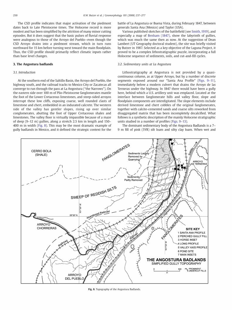
At the southern end of the Saltillo Basin, the Arroyo del Pueblo, thehighway south, and the railroad tracks to Mexico City or Zacatecas allconverge to run through the pass at La Angostura (“the Narrows”). Onthe eastern side over 100 m of Plio-Pleistocene fanglomerates mantlethe foot of the Lower Cretaceous limestones, and steep-sided arroyosinterrupt these low cliffs, exposing coarse, well rounded clasts oflimestone and chert, embedded in an indurated calcrete. The westernside of the valley has gentler slopes, rising up over similarconglomerates, abutting the foot of Upper Cretaceous shales andlimestones. The valley floor is virtually impassible because of a mazeof deep (9–12 m) gullies, along a stretch 2.5 km in length and 150–400 m in width (Fig. 8). This may be the most dramatic example ofgully badlands in Mexico, and it defined the strategic context for the
Fig. 8. Topography of the
battle of La Angostura or Buena Vista, during February 1847, betweengenerals Santa Ana (Mexico) and Taylor (USA).
Various published sketches of the battlefield (see Smith, 1919), andespecially a map of Benham (1847), show the labyrinth of gullies,which was much the same then as now. At the suggestion of DeanLambert (UT Geography doctoral student), the site was briefly visitedby Butzer in 1987. Selected as a key objective of the Laguna Project, itproved to be a complex lithostratigraphic puzzle, incorporating a fullHolocene sequence of sediments, soils, and cut-and-fill cycles.
3.2. Sedimentary units at La Angostura
Lithostratigraphy at Angostura is not provided by a quasi-continuous column, as at Upper Arroyo, but by a number of discretesegments exposed around our “Santa Ana Profile” (Figs. 9–11),immediately below a modern culvert that drains the Arroyo de lasTerneras under the highway. In 1847 there would have been a gullyhere, behind which a U.S. artillery unit was emplaced. Located at theinterface between fanglomerate hills and valley floor, slope andfloodplain components are interdigitated. The slope elements includederived limestone and chert cobbles of the original fanglomerates,together with calcite-cemented sands and coarse silts reworked fromdisaggregated matrix that has been incompletely decalcified. Whatfollows is a synthetic description of the mainly Holocene stratigraphicunits studied in a number of profiles (Figs. 9–13).
The dominant sedimentary body of the Angostura Badlands is a 7–9 m fill of pink (5YR) silt loam and silty clay loam. When wet and
Angostura Badlands.
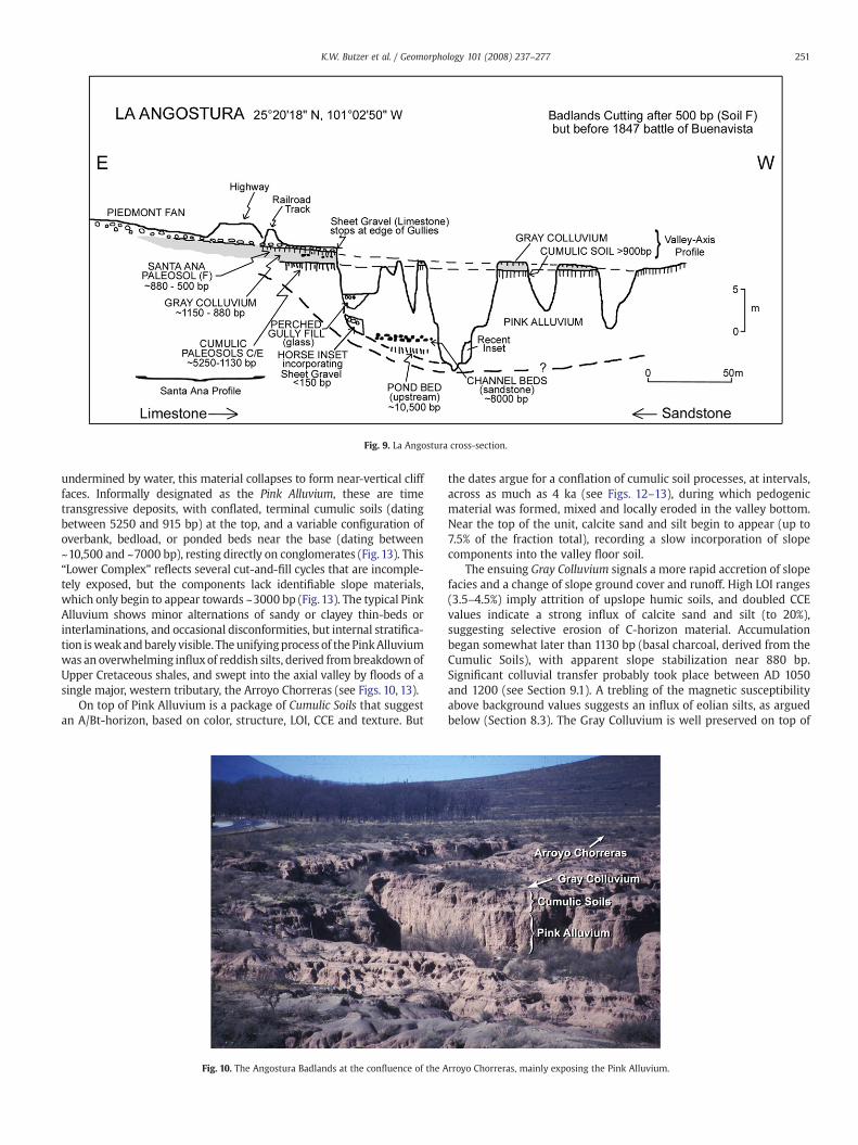
Fig. 9. La Angostura cross-section.
251K.W. Butzer et al. / Geomorphology 101 (2008) 237–277
undermined by water, this material collapses to form near-vertical clifffaces. Informally designated as the Pink Alluvium, these are timetransgressive deposits, with conflated, terminal cumulic soils (datingbetween 5250 and 915 bp) at the top, and a variable configuration ofoverbank, bedload, or ponded beds near the base (dating between~10,500 and ~7000 bp), resting directly on conglomerates (Fig. 13). This“Lower Complex” reflects several cut-and-fill cycles that are incomple-tely exposed, but the components lack identifiable slope materials,which only begin to appear towards ~3000 bp (Fig.13). The typical PinkAlluvium shows minor alternations of sandy or clayey thin-beds orinterlaminations, and occasional disconformities, but internal stratifica-tion isweakandbarely visible. Theunifyingprocess of the PinkAlluviumwas an overwhelming influxof reddish silts, derived from breakdown ofUpper Cretaceous shales, and swept into the axial valley by floods of asingle major, western tributary, the Arroyo Chorreras (see Figs. 10, 13).
On top of Pink Alluvium is a package of Cumulic Soils that suggestan A/Bt-horizon, based on color, structure, LOI, CCE and texture. But
Fig. 10. The Angostura Badlands at the confluence of the A
the dates argue for a conflation of cumulic soil processes, at intervals,across as much as 4 ka (see Figs. 12–13), during which pedogenicmaterial was formed, mixed and locally eroded in the valley bottom.Near the top of the unit, calcite sand and silt begin to appear (up to7.5% of the fraction total), recording a slow incorporation of slopecomponents into the valley floor soil.
The ensuing Gray Colluvium signals a more rapid accretion of slopefacies and a change of slope ground cover and runoff. High LOI ranges(3.5–4.5%) imply attrition of upslope humic soils, and doubled CCEvalues indicate a strong influx of calcite sand and silt (to 20%),suggesting selective erosion of C-horizon material. Accumulationbegan somewhat later than 1130 bp (basal charcoal, derived from theCumulic Soils), with apparent slope stabilization near 880 bp.Significant colluvial transfer probably took place between AD 1050and 1200 (see Section 9.1). A trebling of the magnetic susceptibilityabove background values suggests an influx of eolian silts, as arguedbelow (Section 8.3). The Gray Colluvium is well preserved on top of
rroyo Chorreras, mainly exposing the Pink Alluvium.
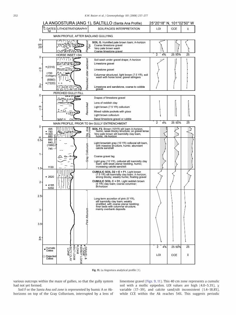
Fig. 11. La Angostura analytical profile (1).
252 K.W. Butzer et al. / Geomorphology 101 (2008) 237–277
various outcrops within the maze of gullies, so that the gully systemhad not yet formed.
Soil F or the Santa Ana soil zone is represented by humic A or Ak-horizons on top of the Gray Colluvium, interrupted by a lens of
limestone gravel (Figs. 9, 11). This 40 cm zone represents a cumulicsoil with a mollic epipedon. LOI values are high (4.0–5.3%), χvariable (17–39), and calcite sand/silt inconsistent (1.4–18.8%),while CCE within the Ak reaches 54%. This suggests periodic
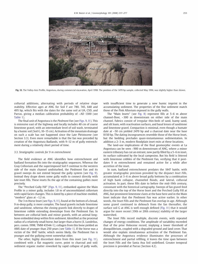
Fig. 12. The Valley-Axis Profile, Angostura, during commercial excavation, April 1998. The position of the 1470 bp sample, collected May 1996, was slightly higher than shown.
253K.W. Butzer et al. / Geomorphology 101 (2008) 237–277
colluvial additions, alternating with periods of relative slopestability. Effective ages at ANG for Soil F are 780, 745, 640 and495 bp, which fits with the dates for the same soil at UA, CSD, andParras, giving a median calibration probability of ~AD 1300 (seeTable 1).
The final unit of Angostura is the Piedmont Fan (see Figs. 9, 11). Thisis extensive east of the highway and locally includes 40 cm of coarselimestone gravel, with an intermediate level of soil wash, terminatedby a humic soil (Soil G,10–15 cm). Activation of themountain drainageon such a scale has not happened since the Late Pleistocene (seeSection 3.3). Even more remarkable is that the fan was preceded bycreation of the Angostura Badlands, with 9–12 m of gully entrench-ment during a relatively short period of time.
3.3. Stratigraphic controls for 9 m entrenchment
The field evidence at ANG identifies how entrenchment andbadland formation fits into the stratigraphic sequences. Whereas theGray Colluvium and the superimposed Soil F continue to the westernside of the main channel undisturbed, the Piedmont Fan and itsgravel sweeps do not extend beyond the gully system (see Fig. 9).Instead they drape down some gully walls to connect directly withlate inset fills. These insets fix the age of the containing gullies moreprecisely.
The “Perched Gully Fill” (Figs. 9, 11), embanked against the MainProfile in a minor gully, includes 1.8 m of unconsolidated colluviumwith rapid facies changes. This is dated by a piece of machine-molded,“modern” glass at ~1.2 m.
The 3mHorse Inset (see Figs. 9, 11), found at the bottom of a broad,9 m-deep gully, is more complex. The basal gravels include limestoneand sandstone, whereas the closing gravels link directly to drapes oflimestone rubble extending downslope from the Piedmont Fan. Inbetween are colluvial beds and minor gravels, with an animal long-bone embedded deepwithin firm sediment. Identified as the proximalradius of a relatively small horse, but larger than a burro (E. Lundelius,pers. comm. 1998; TMM 43544-1); collagen from this bone yielded anAMS date of younger than 250 years (see Table 1). If the horse was avictim of the 1847 battle, which seems likely, the Piedmont Fan isyounger and the gullying event somewhat older.
The other, highly discordant dates from this inset (see Fig. 11),combined with a flat magnetic curve, point to charcoal and soil/sediment organic matter reworked by rapid collapse of gully walls,
with insufficient time to generate a new humic imprint in theaccumulating sediment. The properties of the fine sediment matchthose of the Pink Alluvium exposed in the gully walls.
The “Main Insets” (see Fig. 8) represent fills at 5–6 m abovechannel-floor, ~300 m downstream on either side of the mainchannel. Fabrics consist of irregular thin-beds of sand, loamy sand,and silt loam, with reactivation surfaces, and basal lenses of sandstoneand limestone gravel. Compaction is minimal, even though a humatedate at ~50 cm yielded 2470 bp and a charcoal date near the base8150 bp. The dating incongruences resemble those of the Horse Inset,but the bedding precludes quasi-instantaneous sedimentation. Inaddition a 2–3 m, modern floodplain inset exits at these locations.
The land-use implications of the final geomorphic events at LaAngostura can be seen ~900 m downstream of ANG, where a minoreastern tributary has cut an entrant, now partly filled by a 5–6m inset,its surface cultivated by the local campesino. But his field is litteredwith limestone cobbles of the Piedmont Fan, verifying that it post-dates 9 m entrenchment and remained active for a while afteraccretion of the inset.
In sum, badland entrenchment predates the 1847 battle, withgreater stratigraphic precision provided by the disjunct Inset Fills,accumulated at 3–6 m above broad gully bottoms by a combinationof high bank collapse, channeled floods, and lateral, colluvialactivation. In part, these fills date to before the mid-19th century,consonant with the historical cartography. Sweeps of fan gravel feeddirectly into the top of the Horse Inset and the Perched Gully Fill atANG, but prominent limestone clasts at the base here and in theMainInset indicate that the Piedmont Fan was active earlier. In otherwords, the Inset Fills and the Piedmont Fan overlap in age. Althoughsome gravel continued to debouch from the fan thereafter, thesurface soil G at ANG is well enough defined (Fig. 11) that it wouldargue for more recent (19th or 20th century) stability of the largerwatershed.
The Inset Fills record multiple, discrete events, with repeatedchanges of energy conditions. The amplitude of variability exceededthat of the prior Holocene record, implying a lower threshold ofdisequilibrium, coupled with a degraded ground and land cover. Thatwould also explain simultaneous activation of the Piedmont Fan.Although the Angostura evidence illuminates the processes ofentrenchment and partial refilling, it leaves the time span betweenthe Inset Fills and the Santa Ana Soil undefined. Greater temporalprecision is provided at Parras (Section 4.2).
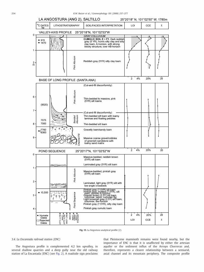
Fig. 13. La Angostura analytical profile (2).
254 K.W. Butzer et al. / Geomorphology 101 (2008) 237–277
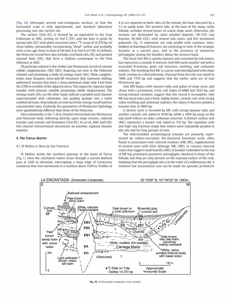
3.4. La Encantada railroad station (ENC)
The Angostura profile is complemented 4.2 km upvalley, inseveral shallow quarries and a deep gully near the old railwaystation of La Encantada (ENC) (see Fig. 2). A roadside sign proclaims
that Pleistocene mammoth remains were found nearby, but theimportance of ENC is that it is unaffected by either the artesianaquifer or the sediment influx of the Arroyo Chorreras and,therefore, represents a clearer relationship between a semiarid,axial channel and its mountain periphery. The composite profile
255K.W. Butzer et al. / Geomorphology 101 (2008) 237–277
(Fig. 14) telescopes several non-contiguous sections, so that thehorizontal scale is only approximate, and standard laboratoryprocessing was not carried out.
The surface (Unit EG) is formed by an equivalent to the GrayColluvium at ANG, resting on Soil E (EF), and the base is given byspring tufas (EC) with plant structures and a 14C assay of 14,370 bp onclean oolites, presumably incorporating “dead” carbon and probablywith a true age closer to that of UA Unit A or Soil A at CSD. So defined,the Holocene record here also includes overbank silts (EE) and pondedchannel beds (ED), that form a shallow counterpart to the PinkAlluvium at ANG.
Of particular interest is the visible Late Pleistocene record of calcretecobble conglomerates (EB1, EB3), fingering out next to the Holocenechannel and postdating a body of cienega marls (EA). These conglom-erates have frequent scour-and-fill structures that represent shifting,ephemeral streams that drain a steep piedmont slope only 4 km fromthe2700mcrestlineof the adjacent sierra. This argues for vigorous slopetransfer with extreme rainfalls promoting cobble displacement. Thecienega marls (EA), on the other hand, indicate a ponded axial channel,supersaturated with carbonates, but grading upslope into a redoxmottled silt loam; they indicate an interval of low-energy runoff and lessconcentrated rains. Evidently the parameters of Pleistocene hydrologywere quantitatively different than those of the Holocene.
Also noteworthy is the 7–8 m channel entrenched into Pleistoceneand Holocene beds, following directly upon slope erosion, colluvialtransfer and cumulic soil formation (Unit EF). As at LA, ANG and CSD,this channel entrenchment documents an extreme, regional climaticimpulse.
4. The Parras district
4.1. El Molino or Boca de San Francisco
El Molino marks the northern gateway to the basin of Parras(Fig. 1). Here the catchment waters drain through a narrow bedrockpass at 1245 m elevation, interrupting a steep ridge of Cretaceoussandstone that rises westwards to a crestline above 1500m. Profiles of
Fig. 14. La Encantada com
4 m are exposed on both sides of the stream, the base obscured by a1.5 m sandy inset. The western side, at the base of the steep, rockyhillside, includes several lenses of coarse slope wash. Otherwise, thesections are dominated by calcic ponded deposits (30–55% clayfraction, 30–60% CCE), with several tufa zones, and five prominentpaleosols. Fig. 15 represents our only profile with common, inter-bedded archaeological features, not surprising in view of the strategiclocation at a narrow pass, and in the presence of numerouspetroglyphs among the boulders above the western bank.
The basal Unit MA is poorly exposed and cemented by tufa lenses,but represents a cumulic A-horizon. Unit MBmarks another soil with atruncated B-horizon, good soil structure, mottling, and carbonatenodules. The overlying bedMC is coarser and interdigitated with slopewash, resting on a disconformity. Charcoal from the unit was dated to7890 and 7170 bp and suggests that the earlier units are of LatePleistocene age.
Unit MD begins with massive tufas and pulses of slope scree, andcloses with a prominent, vertic soil. Dates of 6080 and 3425 bp, andstrong textural variation, suggest that this record is incomplete. UnitME has basal tufas and a thick, highly humic, cumulic soil, with strongredox mottling and carbonate nodules; the clayey A-horizon yielded ahumate date of 1805 bp.
A shorter cycle is recorded by MF, with strong laminar tufas andanother cumulic soil, dated to 1030 bp, while a 1995 bp assay on thetufa itself reflects an older carbonate reservoir. A distinct surface unit(MG) represents a weaker soil, dated to 755 bp. The repetitive soilsand high clay fractions imply that waters were repeatedly ponded atthis site and for long periods of time.
The interstratified archaeological remains are primarily repre-sented by carbon-encrusted, fire-fractured limestone rocks, oftenfound in association with charcoal residues (MB, ME), supplementedin several cases with lithic debitage (MC, MD), or concave charcoalstains that suggest small hearths (MD). A boulder embedded in the topof MF has prominent geometric petroglyphs, identical to those of thehillside, but they are only present on the exposed surface of the rock,implying that the petroglyph site is in the order of a millennium old. Atentative but inconclusive case can be made for sporadic prehistoric
posite cross-section.
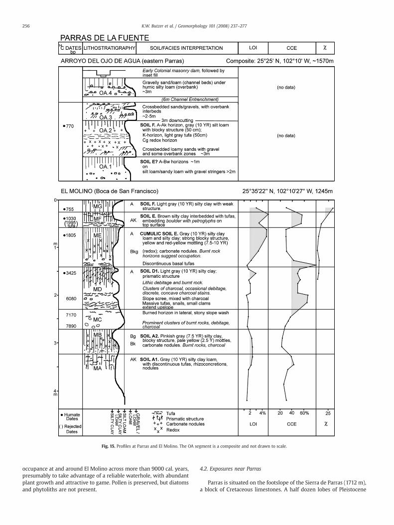
Fig. 15. Profiles at Parras and El Molino. The OA segment is a composite and not drawn to scale.
256 K.W. Butzer et al. / Geomorphology 101 (2008) 237–277
occupance at and around El Molino across more than 9000 cal. years,presumably to take advantage of a reliable waterhole, with abundantplant growth and attractive to game. Pollen is preserved, but diatomsand phytoliths are not present.
4.2. Exposures near Parras
Parras is situated on the footslope of the Sierra de Parras (1712 m),a block of Cretaceous limestones. A half dozen lobes of Pleistocene
257K.W. Butzer et al. / Geomorphology 101 (2008) 237–277
tufas are spread along the upper margin of town, and prior to themodern water supply, many of the houses tapped a relatively shallowaquifer with private wells. The first hacienda, however, was set up in1595 east of the Arroyo del Ojo de Agua (OA) that runs down theeastern margin of town and contains a number of old irrigationworks.The lowest dam directly next to Parras (Presa 1), is the oldest, and aruined weir at this site supplied water to the hacienda, the Jesuitmission, and the new town by around 1600 (Butzer, 1999). It wassubsequently rebuilt and reinforced at least twice, at unknown butearly dates, judging by a flurry of litigation after a competing Presa 2was built 800 m upstream in 1618, to channel most of the water to thehacienda. This stretch of the arroyo exposes a succession of LateHolocene beds, schematically shown in upper Fig. 15.
Unit OA.2 is of interest because it initiates a period of rapid facieschanges and channel instability. Basal cross-bedded sands werefollowed by finer beds and formation of a dense tufa or caliche (as inMF at El Molino), leading to redox conditions in the substrate.Eventually a gray cumulic soil developed around 770 bp, equivalentto Soil F at El Molino.
Shortly afterward, this unit was abruptly undercut by 3 m ofentrenchment, then followed by rapid accretion of large-scale, low-angle cross-bedded sands and gravels (Unit OA.3), in two phases. Yetanother cut-and-fill cycle intervened, but at a larger scale, now with5–6 m of channel entrenchment, reminiscent of the incisive gully-cutting at Angostura and in the Saltillo Basin. But at OA a new,ephemeral fill, reflecting rapid, high-energy accretion occurs butwithout soil formation prior to the hydrological crash. That suggestsone or more phenomenal floods, the volume of which exceededchannel capacity and triggered quasi-instantaneous entrenchment.
Fig. 16. Nazas delta plain and the Mayran playa. Historical information after E.K. Butzer (1997elevations is given in meters.
The overdeepened floor of the arroyo began to refill almostimmediately, with alternating sands and gravels, derived frommobilization of slope screes that were funneled in by lateral chutes.The result was a new floodplain terrace with 1.5 m relief (Unit OA.4).
Presa 1 provides a terminus ante quem for these events, because thedam is connected to the higher surface of OA.3 by a buttressed,deflecting wall while it is anchored on an earthen dam built atop OA.4.In other words, the components of Presa 1, initiated by the firstEuropean colonists around AD 1600, post-date or are contemporarywith Unit OA.4. In other words, the 6 m entrenchment was Pre-Hispanic.
In the upper Arroyo del Ojo de Agua, 17 km south of Parras, threegenerations of sandy alluvium are present at site ERB (see Fig. 1): a) acomplex 6–8 m fill recalling Units OA.2 and OA.3; b) a compact 2–4 mfill, embedding a hearth lined with charcoal fragments, dated 250 bpby AMS; and c) a recent floodplain deposit at 1.5 m. These featuresappear to replicate the OA sequence.
The two disequilibria at OA also have dramatic counterparts westof Parras (Arroyo del Capulín, or Morón). Upstream of the 1904 bridgeare two thick fills, separated by 11 m of entrenchment. The cumulicsoil on top of the younger fill here has a humate date of 570 bp, beforeyet again being entrenched by 11 m. Two further inset fills are foundwithin the overdeepened valley, the older of which is modified by aColonial irrigation weir.
The channel instability of the Parras arroyos can be attributed tosteep channel gradients, high catchment relief, and abundantavailable sediment. As a result, the dynamics of the last millenniumplayed out here step-by-step and left a detailed record of theresponsible processes.
) and local informants. Numbers 9 to 18 refer to dated profiles (also Fig. 1). A selection of
258 K.W. Butzer et al. / Geomorphology 101 (2008) 237–277
5. Alluvial fans of the Laguna margins
The Saltillo Basin, Angostura, and Parras give access to themedium-scale Holocene environmental history of the eastern half ofthe study area. Fragments of a Late Pleistocene record suggest thatdominant processes were different than during the Holocene, but thebigger picture does not emerge. For this purpose we turn to the big-canvas landscape of the Mayran–Nazas plains (Figs. 1 and 16),alternatively known as the Desierto or Laguna del Mayran. Threeexamples are singled out.
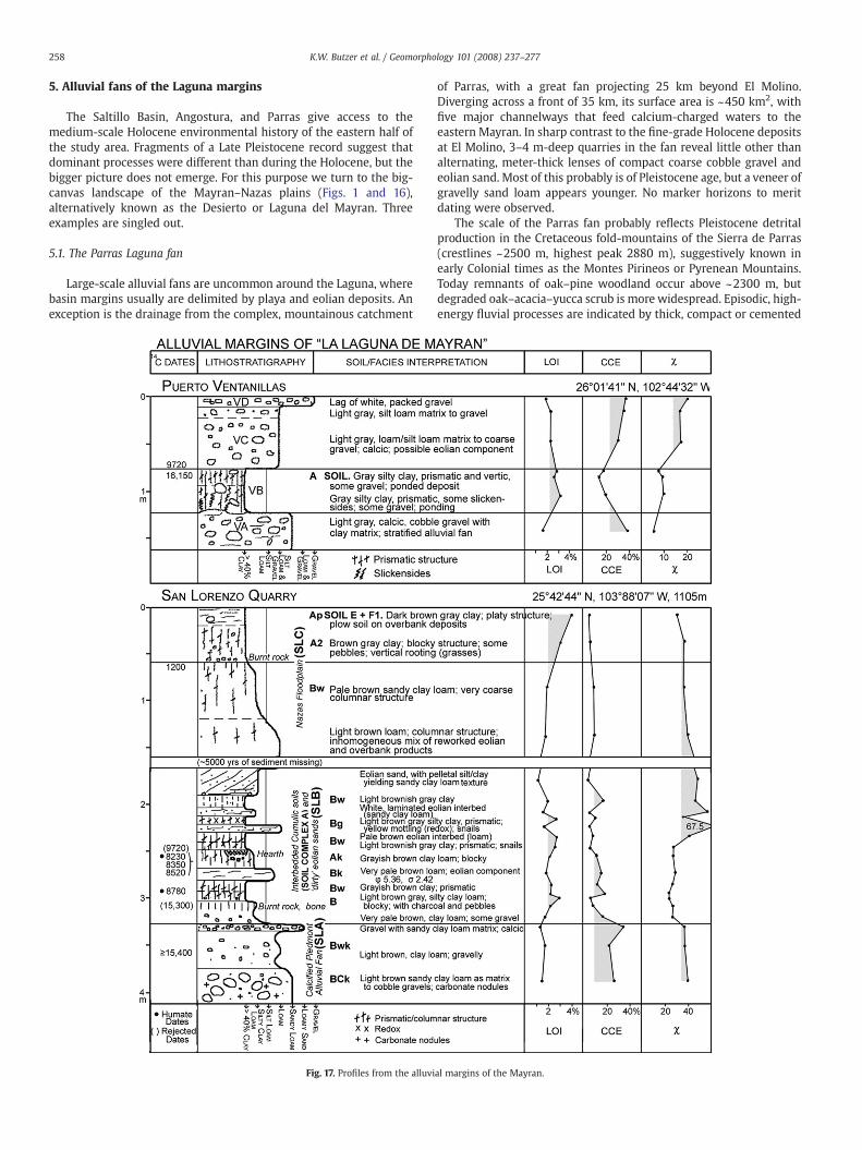
5.1. The Parras Laguna fan
Large-scale alluvial fans are uncommon around the Laguna, wherebasin margins usually are delimited by playa and eolian deposits. Anexception is the drainage from the complex, mountainous catchment
Fig. 17. Profiles from the alluvi
of Parras, with a great fan projecting 25 km beyond El Molino.Diverging across a front of 35 km, its surface area is ~450 km2, withfive major channelways that feed calcium-charged waters to theeastern Mayran. In sharp contrast to the fine-grade Holocene depositsat El Molino, 3–4 m-deep quarries in the fan reveal little other thanalternating, meter-thick lenses of compact coarse cobble gravel andeolian sand. Most of this probably is of Pleistocene age, but a veneer ofgravelly sand loam appears younger. No marker horizons to meritdating were observed.
The scale of the Parras fan probably reflects Pleistocene detritalproduction in the Cretaceous fold-mountains of the Sierra de Parras(crestlines ~2500 m, highest peak 2880 m), suggestively known inearly Colonial times as the Montes Pirineos or Pyrenean Mountains.Today remnants of oak–pine woodland occur above ~2300 m, butdegraded oak–acacia–yucca scrub is more widespread. Episodic, high-energy fluvial processes are indicated by thick, compact or cemented
al margins of the Mayran.
259K.W. Butzer et al. / Geomorphology 101 (2008) 237–277
slope screes, and by thick, stratified conglomerates that form ~20–25 m alluvial terraces down and upstream in the Arroyo del Ojo deAgua. Fragments of another such fill are present at intermediateelevations. We assume that the great Parras fan was part of this widerPleistocene system.
5.2. Puerto Ventanillas fan complex
At the northeastern corner of the Mayran, Coahuila Hwy. 30ascends from the playa flats to the mountains via the Ventanillas Passon its way to Cuatrocienegas (Fig. 17). Here a set of superposed,petrocalcic fans is exposed in a number of 5m-deep quarries for gravel(Unit VA). A calcic, but uncemented, fan also spreads a sheet oflimestone cobbles to the edge of the mudflats (Fig. 16); the distal partpreserves pockets of paludal deposits (N40% clay fraction) (VB) inhollows. Above that is a matrix-supported gravel (VC) that suggests asporadic beach deposit to ~1086 m. A lag gravel (VD) veneers thesurface.
The lower part of the paludal palimpsest designated VB hasslickensides, while the upper is vertisolic, with a charcoal AMS date of16,150 bp. A charcoal fragment embedded atop VB is dated 9720 bp.Given the discrete shore zones around the mudflat (with a surfacesample of calcic, silty clay loam; LOI 2.6%), Unit VB indicates a low-energy body of water, episodically present in the adjacent playa, afterfan accumulation had terminated. Part of Unit VC represents a stormbeach.
5.3. An alluvial margin near San Lorenzo
Located at the contact of the Nazas floodplain and a footslope ofminor alluvial fans, a suite of Late Pleistocene to Late Holocene beds isexposed in quarries east of San Lorenzo (see Figs. 16–17). Three grossunits are displayed: 1) the sedimentary architecture of a LatePleistocene alluvial fan (suite SLA); 2) an interfingering of Nazasoverbank deposits, cumulic soils, and eolian sands during thePleistocene–Holocene transition (SLB); and 3) a body of Nazasfloodplain sediments, beginning with reworked eolian sands andterminating with overbank clays (SLC), dating to ~1200 bp.
The fan deposits of Unit SLA are exposed to a thickness 2–5 m and,towards the base of the exposures, include the prominent, medium-scale, low-angle cross-bedding of former ephemeral channels. Finerinterbeds of sandy clay loam or clay loam, and gravel, vary in colorfrom very pale brown (10YR hues) to light brown (7.5YR hues).Calcification, with respect to a former phreatic level, includes micriticcalcite and CaCO3 nodules. A charcoal AMS date of ~15,400 bp, incombination with an aberrant date of ~15,300 bp reworked in SLB,suggests termination of high-energy, local alluvial activity by ~15 ka,i.e., midway in Marine Isotope Stage (MIS) 2. The finer, end-Pleistocene components of SLA represent reworking of Nazas over-bank material, or incorporation of fresh or old eolian pelletal silt/clay.
SLB is a thin-bedded complex of Nazas overbank deposits, cumulicsoils, and eolian components, mainly of pelletal aggregates blown outof the Nazas floodplain. Only the youngest subunit has eolian cross-bedding. A number of archaeological features, including a small hearthpit, are dated at ~9–8 ka bp.
Macro-unit SLC follows a sedimentary hiatus of some 5 ka, andsuggests culmination of Nazas delta plain accretion towards 1200 bp.Subsequent overbank discharge did not crest quite as high.
The Ventanillas and San Lorenzo profiles suggest that the smallerpiedmont alluvial fans around the Laguna basin were active duringmid-MIS 2 but ceased activity towards ~15 ka. Local precipitation hadbecome ineffective. By ~9700 bp Nazas river influx had increased tothe point that it supported periodic, local playa lakes in the Mayran—at about the same time that the Pink Alluvium began to aggrade at LaAngostura, and only slightly later than the activation of the channel-floor artesian springs at Saltillo (UA, Unit A). In other words, Holocene
hydrology was inaugurated simultaneously, shortly after 10,000 bp(~11,500 cal. BP), in the western and eastern Sierra Madre. That seemsa reasonable working definition for the Pleistocene–Holocene bound-ary in the study area.
6. Interpretation of facies and paleosols in the Mayran playa
6.1. The problem
The Nazas delta plain and Mayran playa represent a very largeplace, where productive exposures are widely spaced, equilibrium is adicey concept, and facies are not always what they appear to be.
Fine-grained flood deposits do not provide many useful sedimen-tological indices. Silts and clays are commonly aggregated by calcite,clay–humic compounds, gypsum or common salt; if deflated, suchpelletal, silt/clay aggregates can be transported and deposited muchlike quartz, and may qualify as an eolian facies. But if pretreated inacid, calcic aggregates dissolve into the basic constituents, whilegypsum will, to some degree, dissolve in water. As in the case ofmacro-unit SLB at San Lorenzo (see Fig. 17), textural analyses then givespurious results. This can be avoided by not decalcifying samples, butother than thin-sections, little can be done to diagnose eoliancomponents in beds of gypsic aggregates.
The textural qualities of several suites of samples from quarryprofiles were studied, including distributary levees and the 1992 flooddeposits on the Nazas delta plain, although no salient quantitativeparameters were detected. Sediments are overwhelmingly in the siltfraction (typically 60–65%, up to almost 80%), so that even exceptionalfloods leave only a localized or diluted fine sand fraction, as dischargepromptly goes into overbank mode. When such surges of silt aredeposited into the playa zone, they accumulate in sheets or shallowdepressions, and may subsequently be deflated to blow as dust intostanding waters or marsh to form loess; a cycle later, coagulated anddried pellets of silt bound by calcite or gypsum can be remobilized anddeposited as eolian pseudo-sands.
Four Mayran profiles are selected to illustrate the problems ofseparatingeolian, paludal, lacustrineor alluvial beds in theMayran. Theyalso inform the climato-stratigraphic record by virtue of the datedpaleosols.Oxidation is often slow, andburial rapid, so that somepollen ispreserved except in more extreme geochemical micro-environments.
6.2. Cuota site LM4
Along the southern side of the Mayran the toll-road (cuota) fromTorreón to Saltillo is accompanied at intervals by large borrow pits.Nine of them were examined along a 30 km stretch east of the SanPedro tollgate, three of these studied in detail. Site LM4 (km 76.9, seeFig. 18) was selected as an example of clean quartz sand with eoliancross-bedding; 30 samples were examined by Cilas laser, four bytraditional hydrometer and sieving. One charcoal and three OSL datessuggest that such eolian sands have been active at intervals for muchof the Holocene. Sands are primarily developed in the southwesternMayran, derived from the main Nazas channel between the smalltowns of Tacubaya and Mayran, mainly by deflation (compare Muhset al., 2003). The thickest mantle runs southward to the village ofVillita (see Fig. 16) while near LM4 sands take the form of shallow W-dunes, under a scatter of coppice dunes.
Construction crews had bulldozed a roadway here, to reveal ashallow but primary archaeological site. We deepened the section toexpose the pre-occupation levels. The basal unit (4.A) begins with athin-bedded silt loam, marked by repeated alternating beds of 5–30%sand, and a reducing environment with traces of gypsum. Apermanently wet subsoil with periodic movement of fresh surfacewater is suggested for the Early Holocene.
Unit 4.B is poorly structured and sorted, mainly a sandy loam,without abrupt internal boundaries. It suggests a transitional eolian-
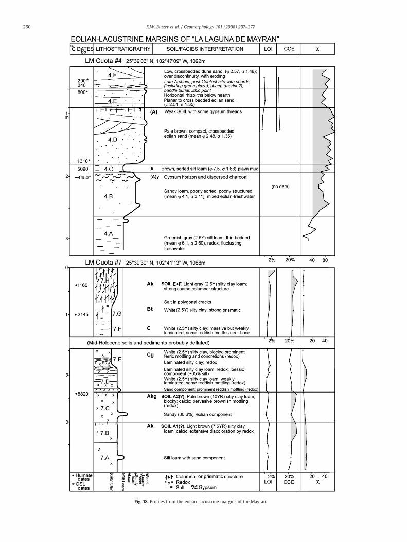
Fig. 18. Profiles from the eolian–lacustrine margins of the Mayran.
260 K.W. Butzer et al. / Geomorphology 101 (2008) 237–277
261K.W. Butzer et al. / Geomorphology 101 (2008) 237–277
freshwater deposit (with 20–30% silt and 4–7% clay), reflectingrainwater ponding within interdunal swales or occasional freshwaterinflux from the adjacent piedmont zone.
Unit 4.C has onlyminor gypsum threads, but the 30 cm below it areheavily impregnated with gypsum (15–20% fillings in 3–5 mm pores),with a gypsum crust at the top of 4.B. Unit 4.C is a deflated palimpsestof playa mud, rather than a cumulic soil. The OSL date directly above itis 1310 BP and below it 4450 BP, the latter younger than a charcoalAMS date of 5090 bp.
The top three units (175 cm) are homogeneous, low-angle, cross-bedded eolian sands with very highmagnetic susceptibility (Units 4.D,E, F). They rest on 15 cm of well-sorted silt loam bounded by straightcontacts.
The archaeological site was occupied on top of a low dune, at thedisconformity between units E and F (Fig. 18), and between boundingOSL dates of 800 and 200 BP. This protohistoric site includes the horncore of a domesticated sheep, possibly merino (according to E.Lundelius; TMM 43546); a hearth with charcoal and burnt rock;abundant fragmented animal bone; many poorly-fired potsherds, twowith interior green (lead) glaze; lithics, including two thumb scrapersand a triangular bird point; perforated mussel shells; and an adjacent,extended, human “bundle” burial, which had been badly damaged bythe time of our second visit. The hearth has an AMS date of 340±55 bp(with a median calibrated probability age of AD 1650), and the δ13C of−11.0‰ implies that semidesert shrubs (saltbush?) served as fuel. Ifthe mussels came from the Nazas River, the paleoecological implica-tions could be significant.
The Spanish intrusion began during the 1590s (Jesuit missions alongthe Nazas and a hacienda at Parras), arguing for an early 17th centuryframe to account for contact phenomena such as sheep or lead glazes.The presence of this site at this timemeans that eolian sandswere activeat the time of Spanish intrusion—and had been dominant here for manycenturies before that. Surface sites are fairly common in this sector andcall for salvage archaeology and test excavations before they are lost.
6.3. Cuota site LM7
Site LM7 (at km 86.9, see Fig. 18) is located adjacent to playa beds,on flats withmore vegetation (saltbush, Suaeda, scattered acacias) andlacking eolian veneers. Not surprisingly, the 4 m quarry profile isdominated throughout by silty clays and silty clay loams, but a mid-Holocene record is missing and probably has been deflated.
The Early Holocene part of the profile is heavily gleyed andincludes two weak soils, as well as two wavy, laminated beds with achalky feel, but without CCE peaks. They may reflect running water.The sandy thin-beds record brief eolian intrusions of the playa flats;the basal subunit may go back to the terminal Pleistocene.
The Late Holocene segment represents a prominent paleosol withan Ak/Bt-horizon of 120 cm and humate ages of 1160 and 2145 bp. Thetopmost 10 cm are more organic and have 62% silt, suggesting recentmodification and blowing dust. The strong columnar structure of thelight gray A-horizon grades down into a polygonal cracking zone, withprismatic structure and salt, but with N40% clay fraction, probably aBt-horizon. Below that is a massive-bedded silty clay, with strongredox features, separated by a disconformity.
The dates and changing environment suggest a conflated, cumulicsoil, perhaps representing Soils D2, E2 and F. The salt crystals, mainlyhalite, reflect post-depositional penetration of soil cracks, down to thetop of the massive-bedded silty clay.
LM7 provides a discontinuous record of the evolution of a typicalplaya environment in the Mayran.
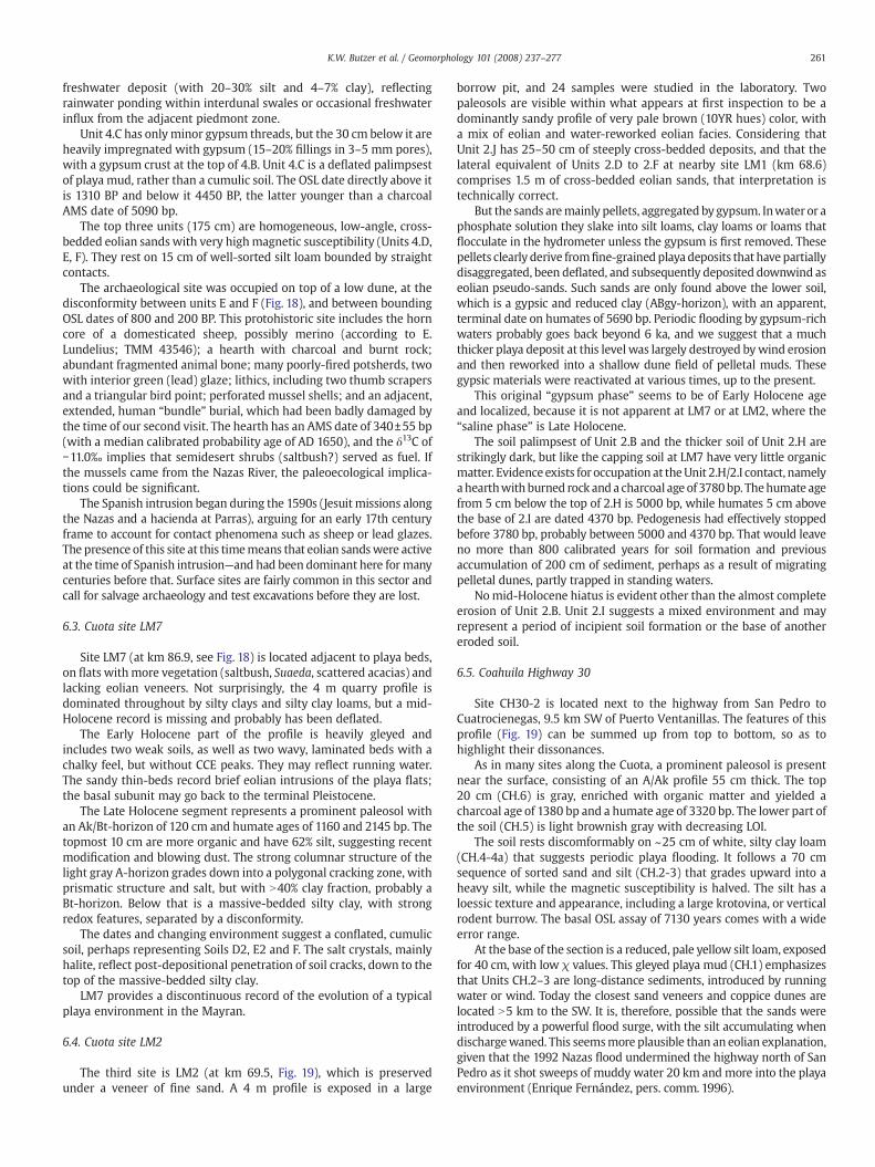
6.4. Cuota site LM2
The third site is LM2 (at km 69.5, Fig. 19), which is preservedunder a veneer of fine sand. A 4 m profile is exposed in a large
borrow pit, and 24 samples were studied in the laboratory. Twopaleosols are visible within what appears at first inspection to be adominantly sandy profile of very pale brown (10YR hues) color, witha mix of eolian and water-reworked eolian facies. Considering thatUnit 2.J has 25–50 cm of steeply cross-bedded deposits, and that thelateral equivalent of Units 2.D to 2.F at nearby site LM1 (km 68.6)comprises 1.5 m of cross-bedded eolian sands, that interpretation istechnically correct.
But the sands aremainly pellets, aggregated bygypsum. Inwater or aphosphate solution they slake into silt loams, clay loams or loams thatflocculate in the hydrometer unless the gypsum is first removed. Thesepellets clearly derive fromfine-grainedplaya deposits that have partiallydisaggregated, been deflated, and subsequently deposited downwind aseolian pseudo-sands. Such sands are only found above the lower soil,which is a gypsic and reduced clay (ABgy-horizon), with an apparent,terminal date on humates of 5690 bp. Periodic flooding by gypsum-richwaters probably goes back beyond 6 ka, and we suggest that a muchthicker playa deposit at this level was largely destroyed bywind erosionand then reworked into a shallow dune field of pelletal muds. Thesegypsic materials were reactivated at various times, up to the present.
This original “gypsum phase” seems to be of Early Holocene ageand localized, because it is not apparent at LM7 or at LM2, where the“saline phase” is Late Holocene.
The soil palimpsest of Unit 2.B and the thicker soil of Unit 2.H arestrikingly dark, but like the capping soil at LM7 have very little organicmatter. Evidence exists for occupation at theUnit 2.H/2.I contact, namelyahearthwith burned rock anda charcoal age of 3780bp. Thehumate agefrom 5 cm below the top of 2.H is 5000 bp, while humates 5 cm abovethe base of 2.I are dated 4370 bp. Pedogenesis had effectively stoppedbefore 3780 bp, probably between 5000 and 4370 bp. That would leaveno more than 800 calibrated years for soil formation and previousaccumulation of 200 cm of sediment, perhaps as a result of migratingpelletal dunes, partly trapped in standing waters.
Nomid-Holocene hiatus is evident other than the almost completeerosion of Unit 2.B. Unit 2.I suggests a mixed environment and mayrepresent a period of incipient soil formation or the base of anothereroded soil.
6.5. Coahuila Highway 30
Site CH30-2 is located next to the highway from San Pedro toCuatrocienegas, 9.5 km SW of Puerto Ventanillas. The features of thisprofile (Fig. 19) can be summed up from top to bottom, so as tohighlight their dissonances.
As in many sites along the Cuota, a prominent paleosol is presentnear the surface, consisting of an A/Ak profile 55 cm thick. The top20 cm (CH.6) is gray, enriched with organic matter and yielded acharcoal age of 1380 bp and a humate age of 3320 bp. The lower part ofthe soil (CH.5) is light brownish gray with decreasing LOI.
The soil rests discomformably on ~25 cm of white, silty clay loam(CH.4-4a) that suggests periodic playa flooding. It follows a 70 cmsequence of sorted sand and silt (CH.2-3) that grades upward into aheavy silt, while the magnetic susceptibility is halved. The silt has aloessic texture and appearance, including a large krotovina, or verticalrodent burrow. The basal OSL assay of 7130 years comes with a wideerror range.
At the base of the section is a reduced, pale yellow silt loam, exposedfor 40 cm, with low χ values. This gleyed playa mud (CH.1) emphasizesthat Units CH.2–3 are long-distance sediments, introduced by runningwater or wind. Today the closest sand veneers and coppice dunes arelocated N5 km to the SW. It is, therefore, possible that the sands wereintroduced by a powerful flood surge, with the silt accumulating whendischargewaned. This seemsmore plausible than an eolian explanation,given that the 1992 Nazas flood undermined the highway north of SanPedro as it shot sweeps of muddy water 20 km and more into the playaenvironment (Enrique Fernández, pers. comm. 1996).
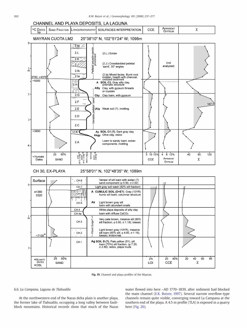
Fig. 19. Channel and playa profiles of the Mayran.
262 K.W. Butzer et al. / Geomorphology 101 (2008) 237–277
6.6. La Campana, Laguna de Tlahualilo
At the northwestern end of the Nazas delta plain is another playa,the former lake of Tlahualilo, occupying a long valley between fault-block mountains. Historical records show that much of the Nazas
water flowed into here ~AD 1770–1839, after sediment had blockedthe main channel (E.K. Butzer, 1997). Several narrow overflow-typechannels remain quite visible, converging toward La Campana at thesouthern end of the playa. A 4.5 m profile (TLA) is exposed in a quarryhere (Fig. 20).
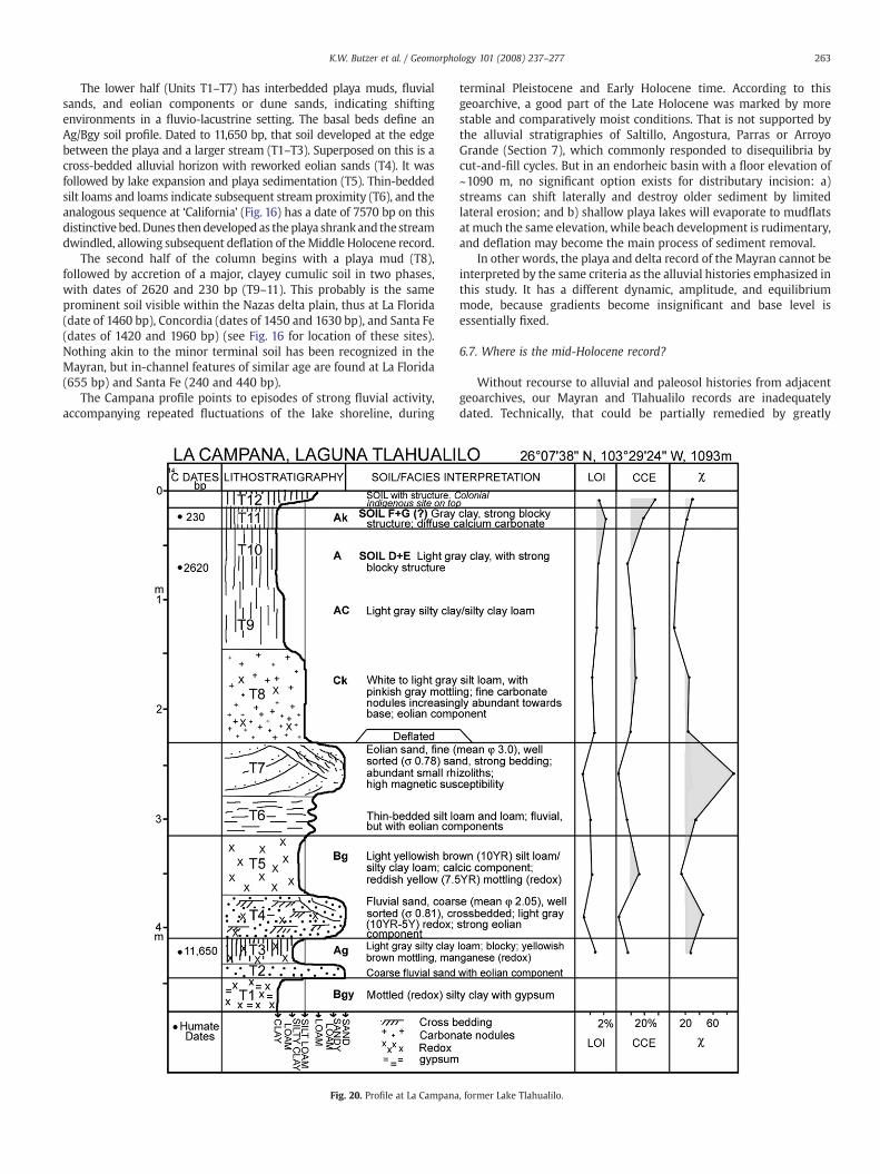
263K.W. Butzer et al. / Geomorphology 101 (2008) 237–277
The lower half (Units T1–T7) has interbedded playa muds, fluvialsands, and eolian components or dune sands, indicating shiftingenvironments in a fluvio-lacustrine setting. The basal beds define anAg/Bgy soil profile. Dated to 11,650 bp, that soil developed at the edgebetween the playa and a larger stream (T1–T3). Superposed on this is across-bedded alluvial horizon with reworked eolian sands (T4). It wasfollowed by lake expansion and playa sedimentation (T5). Thin-beddedsilt loams and loams indicate subsequent stream proximity (T6), and theanalogous sequence at ‘California’ (Fig. 16) has a date of 7570 bp on thisdistinctive bed.Dunes thendeveloped as theplaya shrank and thestreamdwindled, allowing subsequent deflation of theMiddle Holocene record.
The second half of the column begins with a playa mud (T8),followed by accretion of a major, clayey cumulic soil in two phases,with dates of 2620 and 230 bp (T9–11). This probably is the sameprominent soil visible within the Nazas delta plain, thus at La Florida(date of 1460 bp), Concordia (dates of 1450 and 1630 bp), and Santa Fe(dates of 1420 and 1960 bp) (see Fig. 16 for location of these sites).Nothing akin to the minor terminal soil has been recognized in theMayran, but in-channel features of similar age are found at La Florida(655 bp) and Santa Fe (240 and 440 bp).
The Campana profile points to episodes of strong fluvial activity,accompanying repeated fluctuations of the lake shoreline, during
Fig. 20. Profile at La Campana
terminal Pleistocene and Early Holocene time. According to thisgeoarchive, a good part of the Late Holocene was marked by morestable and comparatively moist conditions. That is not supported bythe alluvial stratigraphies of Saltillo, Angostura, Parras or ArroyoGrande (Section 7), which commonly responded to disequilibria bycut-and-fill cycles. But in an endorheic basin with a floor elevation of~1090 m, no significant option exists for distributary incision: a)streams can shift laterally and destroy older sediment by limitedlateral erosion; and b) shallow playa lakes will evaporate to mudflatsat much the same elevation, while beach development is rudimentary,and deflation may become the main process of sediment removal.
In other words, the playa and delta record of the Mayran cannot beinterpreted by the same criteria as the alluvial histories emphasized inthis study. It has a different dynamic, amplitude, and equilibriummode, because gradients become insignificant and base level isessentially fixed.
6.7. Where is the mid-Holocene record?
Without recourse to alluvial and paleosol histories from adjacentgeoarchives, our Mayran and Tlahualilo records are inadequatelydated. Technically, that could be partially remedied by greatly
, former Lake Tlahualilo.
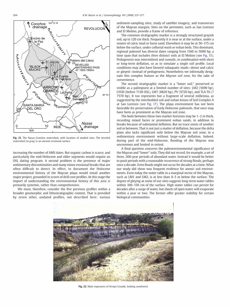
Fig. 21. The Nazas–Conchos watershed, with location of studied sites. The beveledwatershed (in gray) is an ancient erosional surface.
264 K.W. Butzer et al. / Geomorphology 101 (2008) 237–277
increasing the number of AMS dates. But organic carbon is scarce, andparticularly the mid-Holocene and older segments would require anOSL dating program. A second problem is the presence of majorsedimentary discontinuities andmanyminor erosional breaks that areoften difficult to detect. In effect, to document the Holoceneenvironmental history of the Mayran playa would entail anothermajor project, grounded in scores of drill core profiles. At this stage theimport of understanding the environmental history of this area isprimarily systemic, rather than comprehensive.
We must, therefore, consider the five previous profiles within abroader geomorphic and lithostratigraphic context. That is providedby seven other, undated profiles, not described here; various
Fig. 22. Main exposures of Arroyo
sediment-sampling sites; study of satellite imagery; and transversesof the Mayran margins. Sites on the perimeter, such as San Lorenzoand El Molino, provide a frame of reference.
The common stratigraphic marker is a strongly structured grayishsoil, up to 120 cm thick. Frequently it is near or at the surface, under aveneer of calcic mud or loose sand. Elsewhere it may be at 50–175 cmbelow the surface, under colluvial wash or eolian beds. This dominant,regional paleosol has diverse dates ranging from 1160 to 5000 bp, atime span that includes three distinct soils at El Molino (see Fig. 15).Pedogenesis was intermittent and cumulic, in combinationwith shortor long-term deflation, so as to simulate a single soil profile. Localconditions may also have favored subaquatic muds—dense and calcicor gleyed—instead of pedogenesis. Nonetheless we informally desig-nate this complex feature as the Mayran soil zone, for the sake ofconvenience.
The second stratigraphic marker is a “lower soil,” preserved orvisible as a palimpsest at a limited number of sites: LM2 (5690 bp),CH30 (before 7130 OSL), LM7 (8820 bp), PV (9720 bp), and TLA T6 (?7570 bp). It too represents but a fragment of several millennia, assuggested by the interbedded soil and eolian lenses of Soil Complex Aat San Lorenzo (see Fig. 17). The playa environment has not beenfavorable for preservation of Early Holocene paleosols, that once mayhave been as prominent as the Mayran soil zone.
The beds between these two marker horizons may be 1–2 m thick,recording mixed facies or prominent eolian sands, in addition tobreaks because of substantial deflation. But no trace exists of anothersoil in between. That is not just a matter of deflation, because the deltaplain also lacks significant soils below the Mayran soil zone, in asedimentary environment without large-scale deflation. Indeed,during part of the mid-Holocene, flooding of the Mayran wasuncommon and limited in extent.
A final question concerns the paleoenvironmental significance oftheMayran and “lower” soils. They did not record, for example, a set ofthree, 500-year periods of abundant water. Instead it would be betterto posit periods with a reasonable recurrence of strong floods, perhapsonce a decade. Even floodsmight not occur for decades at a time.Whatour study did show was frequent evidence for anoxic soil environ-ments. Even today the water table in a marginal sector of the Mayran,such as LM1 and LM2, is at less than 4–5 m below the surface. Thedegree of gleying at some of our sites suggests long-termwater tableswithin 100–150 cm of the surface. High water tables can persist fordecades after a surge of water, but sheets of openwater will evaporatewithin a year or two. The former offer greater stability for certainbiological communities.
Grande, looking southwest.
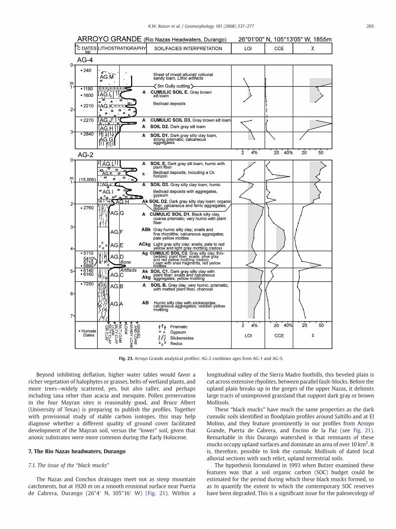
Fig. 23. Arroyo Grande analytical profiles: AG-2 combines ages from AG-1 and AG-5.
265K.W. Butzer et al. / Geomorphology 101 (2008) 237–277
Beyond inhibiting deflation, higher water tables would favor aricher vegetation of halophytes or grasses, belts of wetland plants, andmore trees—widely scattered, yes, but also taller, and perhapsincluding taxa other than acacia and mesquite. Pollen preservationin the four Mayran sites is reasonably good, and Bruce Albert(University of Texas) is preparing to publish the profiles. Togetherwith provisional study of stable carbon isotopes, this may helpdiagnose whether a different quality of ground cover facilitateddevelopment of the Mayran soil, versus the “lower” soil, given thatanoxic substrates were more common during the Early Holocene.
7. The Rio Nazas headwaters, Durango
7.1. The issue of the “black mucks”
The Nazas and Conchos drainages meet not as steep mountaincatchments, but at 1920 m on a smooth erosional surface near Puertade Cabrera, Durango (26°4′ N, 105°16′ W) (Fig. 21). Within a
longitudinal valley of the Sierra Madre foothills, this beveled plain iscut across extensive rhyolites, betweenparallel fault-blocks. Before theupland plain breaks up in the gorges of the upper Nazas, it delimitslarge tracts of unimproved grassland that support dark gray or brownMollisols.
These “black mucks” have much the same properties as the darkcumulic soils identified in floodplain profiles around Saltillo and at ElMolino, and they feature prominently in our profiles from ArroyoGrande, Puerta de Cabrera, and Encino de la Paz (see Fig. 21).Remarkable in this Durango watershed is that remnants of thesemucks occupy upland surfaces and dominate an area of over 10 km2. Itis, therefore, possible to link the cumulic Mollisols of dated localalluvial sections with such relict, upland terrestrial soils.
The hypothesis formulated in 1993 when Butzer examined thesefeatures was that a soil organic carbon (SOC) budget could beestimated for the period during which these black mucks formed, soas to quantify the extent to which the contemporary SOC reserveshave been degraded. This is a significant issue for the paleoecology of
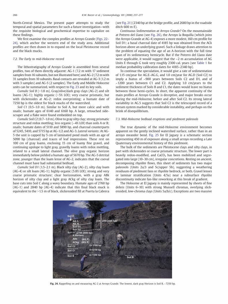
266 K.W. Butzer et al. / Geomorphology 101 (2008) 237–277
North-Central Mexico. The present paper attempts to study thetemporal and spatial parameters for such a future investigation—withthe requisite biological and geochemical expertise to capitalize onthese findings.
We first examine the complex profiles at Arroyo Grande (Figs. 22–24), which anchor the western end of the study area. Additionalprofiles are then drawn in to expand on the local Pleistocene recordand the black mucks.
7.2. The Early to mid-Holocene record
The lithostratigraphy of Arroyo Grande is assembled from severalprofiles, two of them directly adjacent: AG-1 (7.2 m with 17 sedimentsamples from16 subunits, but not illustrated here) and AG-2 (7.2mwith31 samples from 10 subunits. Basal contacts are revealed at AG-3 (1.2 mwith 3 samples) and AG-5 (2 samples). The Early and Middle Holoceneunits can be summarized, with respect to Fig. 23 and its key soils.
Cumulic Soil B (N1.8 m). Gray/olive/dark gray clays (AG-2) and siltloams (AG-1); highly organic (N5% LOI); very coarse prismatic, butwith slickensides at AG-2; redox overprinting; a humate date of7250 bp is the oldest for black mucks of the watershed.
Soil C1 (0.5–1.0 m). Similar to Soil A, but more calcic and withsnails; humate ages of 6140 and 6160 bp. A large, retouched side-scraper and a flake were found embedded on top.
Cumulic Soil C2 (0.7–1.0m). Olive to gray silty clay; strong prismaticstructure and redox mottling; less organic (~4% LOI) than soils A or B;snails; humate dates of 5110 and 5890 bp, and charcoal counterpartsof 5245, 5410, and 5715 bp at AG-1/2 and AG-3. Lateral variants: At AG-5 the unit is capped by 5 cm of laminated pond muds with an age of5090 bp (charcoal) and traces of leaf impressions. These rest on100 cm of gray loams, enclosing 15 cm of loamy fine gravel, andcontinuing upslope to light gray, gravelly loams with redox mottling,related to a small lateral channel. The olive gray organic horizonimmediately below yielded a humate age of 5670 bp. The AG-5 detritalzone, younger than the loam lense of AG-2, indicates that the coevalchannel must have had substantial bedload.
Cumulic Soil D1 (1.5–2.1 m). Black silty clay (AG-2), silty clay loam(AG-4) or silt loam (AG-1); highly organic (5.8% LOI); strong and verycoarse prismatic structure; clear horizonation, with a gray ABkhorizon of silty clay and a light gray ACkg of silty clay loam. Thebase cuts into Soil C along a wavy boundary. Humate ages of 2760 bp(AG-1) and 2840 bp (AG-4) indicate that this final black muck isequivalent to the N1.5 m of black, slickensided fill at Puerta la Cabrera
Fig. 24. Rappelling on and measuring AG-2 at Arroyo Gran
(see Fig. 21) (2340 bp at the bridge profile, and 2680 bp in the roadsideditch 600 m E).
Continuous Sedimentation at Arroyo Grande? On the mountainsideat Potrero del Llano (see Fig. 26), the Arroyo la Boquilla (which joinsthe Arroyo Grande at AG-4) exposes a more modest, 160 cm profile forSoil D1; a basal charcoal date of 4185 bp was obtained from the ACkhorizon above an underlying gravel. Such a linkage draws attention tothe problem of equating the age of an A-horizon with the full timespan of its sedimentary hemicycle. But if the Potrero del Llano datewere applicable, it would suggest that the ~2 m accumulation of AGUnits E through G took very roughly 2300 cal. years (see Table 1 formedian probability calibration dates for 4185–2340 bp).
To continue the speculation, it would give a rate of sedimentationof 1.15 cm/year for AG.E–AG.G, and 1.0 cm/year for AG.D (Soil C2) toimply a hiatus of ~900 years between Soils C2 and D1, and of~1200 years between C1 and C2. Applying 1.0 cm/years to thesediment thickness of Soils B and C1, the dates would leave no hiatusbetween those hemi-cycles. In short, the apparent continuity of themain profiles at Arroyo Grande is deceptive, and major breaks occurduring the mid-Holocene, before and after Soil C2. Its strong lateralvariability in AG.5 suggests that Soil C2 is the telescoped record of astream systemmarked by considerable instability, and perhaps on thebrink of disequilibrium.
7.3. Mid-Holocene bedload eruptions and piedmont paleosols
The true dynamic of the mid-Holocene environment becomesapparent on the gently inclined watershed surface, rather than in anarroyo meander bend. Fig. 25 for El Jaguey is a schematic sectionrepresenting 450 m of exposure along a small arroyo recording a LateQuaternary environmental history of this piedmont.
The bulk of the sediments are Pleistocene clays and silty clays, inpart with slickensides or coarse prismatic structure. The lower part isheavily redox-modified, and CaCO3 has been mobilized and segre-gated into large (10–30 cm), irregular concretions. Resting on ancient,decomposing rhyolite flows, this sheet of sediments has two majorpaleosols (Units 2a/3 and 5c/upper 5b), suggesting a weatheringresiduum of piedmont fans or rhyolite bedrock, or both. Gravel lensesor laminar stratification (Units 4/5a) near a subsurface rhyolitediscontinuity indicate fan-like reworking at this break of gradient.
The Holocene at El Jaguey is mainly represented by sheets of finedebris (Units 6–10) with strong Munsell chromas, overlying slick-ensided, low-chroma clays (Units 5a/b/c). Exceptions are two massive
de. The lowest, dark gray Horizon is Soil B, ~7250 bp.
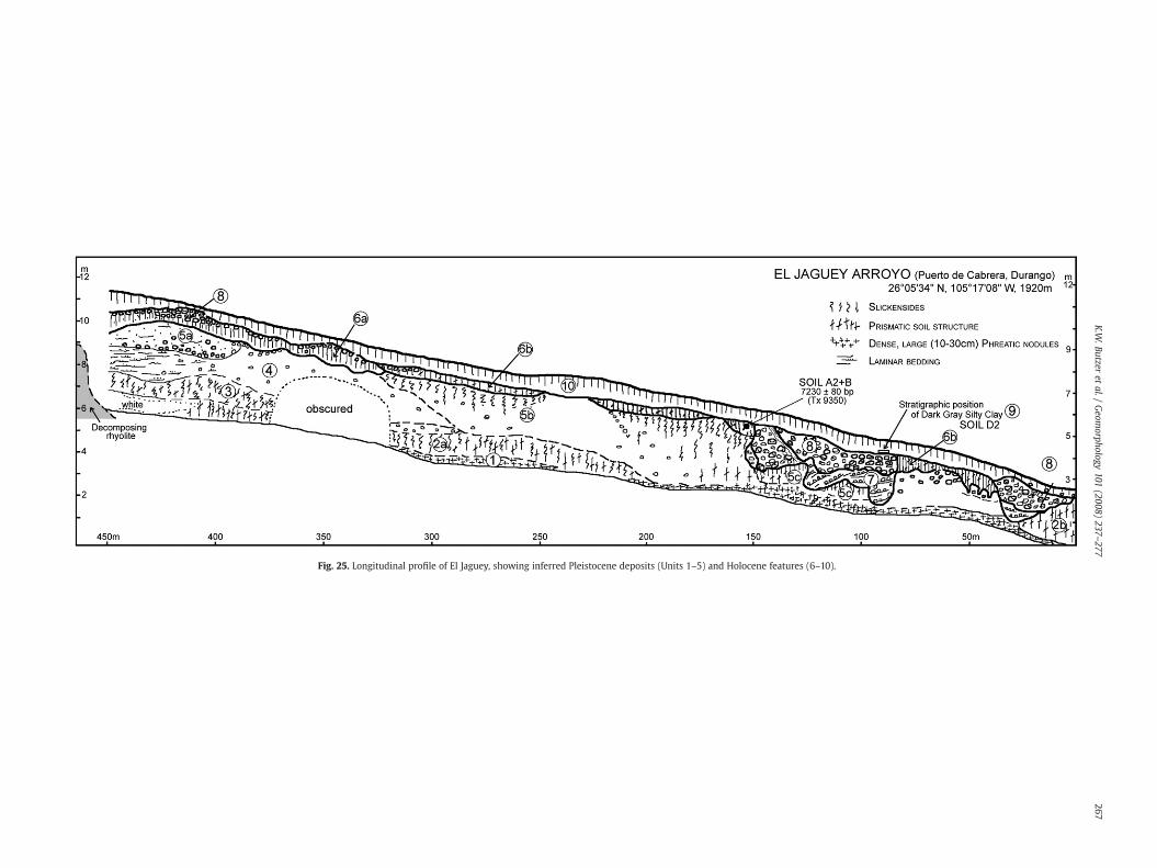
Fig. 25. Longitudinal profile of El Jaguey, showing inferred Pleistocene deposits (Units 1–5) and Holocene features (6–10).
267K.W
.Butzeret
al./Geom
orphology101
(2008)237
–277
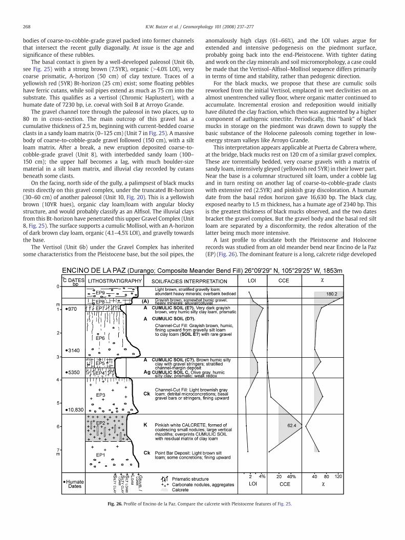
268 K.W. Butzer et al. / Geomorphology 101 (2008) 237–277
bodies of coarse-to-cobble-grade gravel packed into former channelsthat intersect the recent gully diagonally. At issue is the age andsignificance of these rubbles.
The basal contact is given by a well-developed paleosol (Unit 6b,see Fig. 25) with a strong brown (7.5YR), organic (N4.0% LOI), verycoarse prismatic, A-horizon (50 cm) of clay texture. Traces of ayellowish red (5YR) Bt-horizon (25 cm) exist; some floating pebbleshave ferric cutans, while soil pipes extend as much as 75 cm into thesubstrate. This qualifies as a vertisol (Chromic Haplustert), with ahumate date of 7230 bp, i.e. coeval with Soil B at Arroyo Grande.
The gravel channel tore through the paleosol in two places, up to80 m in cross-section. The main outcrop of this gravel has acumulative thickness of 2.5 m, beginning with current-bedded coarseclasts in a sandy loammatrix (0–125 cm) (Unit 7 in Fig. 25). A massivebody of coarse-to-cobble-grade gravel followed (150 cm), with a siltloam matrix. After a break, a new eruption deposited coarse-to-cobble-grade gravel (Unit 8), with interbedded sandy loam (100–150 cm); the upper half becomes a lag, with much boulder-sizematerial in a silt loam matrix, and illuvial clay recorded by cutansbeneath some clasts.
On the facing, north side of the gully, a palimpsest of black mucksrests directly on this gravel complex, under the truncated Bt-horizon(30–60 cm) of another paleosol (Unit 10, Fig. 20). This is a yellowishbrown (10YR hues), organic clay loam/loam with angular blockystructure, and would probably classify as an Alfisol. The illuvial claysfrom this Bt-horizon have penetrated this upper Gravel Complex (Unit8, Fig. 25). The surface supports a cumulic Mollisol, with an A-horizonof dark brown clay loam, organic (4.1–4.5% LOI), and gravelly towardsthe base.
The Vertisol (Unit 6b) under the Gravel Complex has inheritedsome characteristics from the Pleistocene base, but the soil pipes, the
Fig. 26. Profile of Encino de la Paz. Compare the
anomalously high clays (61–66%), and the LOI values argue forextended and intensive pedogenesis on the piedmont surface,probably going back into the end-Pleistocene. With tighter datingandwork on the clayminerals and soil micromorphology, a case couldbe made that the Vertisol–Alfisol–Mollisol sequence differs primarilyin terms of time and stability, rather than pedogenic direction.
For the black mucks, we propose that these are cumulic soilsreworked from the initial Vertisol, emplaced in wet declivities on analmost unentrenched valley floor, where organic matter continued toaccumulate. Incremental erosion and redeposition would initiallyhave diluted the clay fraction, which thenwas augmented by a highercomponent of authigenic smectite. Periodically, this “bank” of blackmucks in storage on the piedmont was drawn down to supply thebasic substance of the Holocene paleosols coming together in low-energy stream valleys like Arroyo Grande.
This interpretation appears applicable at Puerta de Cabrera where,at the bridge, black mucks rest on 120 cm of a similar gravel complex.These are torrentially bedded, very coarse gravels with a matrix ofsandy loam, intensively gleyed (yellowish red 5YR) in their lower part.Near the base is a columnar structured silt loam, under a cobble lagand in turn resting on another lag of coarse-to-cobble-grade clastswith extensive red (2.5YR) and pinkish gray discoloration. A humatedate from the basal redox horizon gave 16,630 bp. The black clay,exposed nearby to 1.5 m thickness, has a humate age of 2340 bp. Thisis the greatest thickness of black mucks observed, and the two datesbracket the gravel complex. But the gravel body and the basal red siltloam are separated by a disconformity, the redox alteration of thelatter being much more intensive.
A last profile to elucidate both the Pleistocene and Holocenerecords was studied from an old meander bend near Encino de la Paz(EP) (Fig. 26). The dominant feature is a long, calcrete ridge developed
calcrete with Pleistocene features of Fig. 25.
269K.W. Butzer et al. / Geomorphology 101 (2008) 237–277
on channel beds; the petrocalcic cap (EP2) was formed by coalescingof small calcareous nodules and large vertical rhizoliths, to overprint acumulic soil of clay loam.
At a later point, after extensive erosion, a channel-cut fill (EP3) wasembanked against the calcrete, beginning ~10,830 bp. After renewedentrenchment, two distinct cumulic soils (EP4, 5) of organic silty clayformed upon a channel-margin slope. The older of these has a date of5350 bp. Following further cutting there was deposition of anotherchannel-cut fill (EP6), once more fining upward from a basal date of3140 bp. This is capped by a third cumulic soil (EP7), a prismatic,blackish silty clay loam with a date of 970 bp. The sequence isterminated by two superficial deposits, EP8 with colluvial compo-nents, and EP9 a channel-margin overbank deposit, with stronglyincreasing magnetic susceptibility.
Encino de la Paz seems to have a different Holocene rhythm thanArroyo Grande, but its 10 units are compressed within 3 m,recording four or five cut-and-fill cycles in a low-gradient channelconducive to graded bedding. Three black mucks are found there, thelast representing the Late Holocene, and Unit EP6 has terminalpedogenic features consonant with a fourth cumulic soil of humicclay loam (see Fig. 25). This profile demonstrates the dynamism ofthe mid-Holocene.
The basal calcrete recalls the poorly-drained, terminal Pleistoceneunits at El Jaguey, but is identical in facies and aspect to a pre-Holocene, petrocalcic fill at Potrero del Llano—where it is found in awell-drained context.
7.4. The Late Holocene at Arroyo Grande
For roughly 6 ka (N7250 to ~2500 bp) the Arroyo Grande at theholotype appears to have been in dynamic equilibrium, even asshallow streams on the plain of the watershed were interrupted bycut-and-fill cycles or surges of bedload. The active channel shiftedalmost imperceptiblywithin a ~70m-wide valley axis. But then, over aspace of ~1200 years, sands and gravels were periodically injected intothe channel, leading to rapid alternations of bedload deposits andmore modest cumulic soils during the Late Holocene. In that timespan, seven distinct beds were deposited at AG-1, nine at AG-4, and 14at AG-2, each with a cumulative preserved thickness of 2 m. Thatcompares with 9 or 10 subunits during the Early to mid-Holocene,with a thickness of 5.5 m: the rate of sedimentation had almostdoubled.
Profiles AG-1, AG-2, and AG-4 record the Late Holocene lithos-tratigraphy, with humate ages of 2270, 2210, 1600 and 1180 bp (in AG-4, see Fig. 19), although the earliest subunit (AG.H) is undated.Anomalous is “desert rose” gypsum in AG.H and at the base of AG.I.The ostracods of AG.1 and AG.H indicate “saline” conditions (M.Palacios-Fest, pers. comm.). But the diatoms of AG.G and AG.H point to“fresh, flowing water”, less alkaline than today (B. Winsborough, pers.comm.) (modern pH of AG.G to AG.I ranges from 7.82 to 8.03). Theabsence of gypsum in other profiles or units indicates a very local andperhaps temporary situation, in a stream where base flow wasminimal and floods episodic. Alternatively the gypsum penetrated AG.H from above. After ~2500 bp the valley bottom appears no longer tohave been stabilized by a dense aquatic or marshy vegetation.
Events subsequent to ~1000 bp (Soil E) recall La Angostura but aremore difficult to date or fix stratigraphically. Initially the arroyo wasincised by ~5–6 m.
A major inset of ~3 m accumulated in the newly incised channel ofArroyo Grande. It has planar cross-bedding, with lenses finingupwards from gravelly sands to sandy loams. Accretion took placeafter a finite number of high-volume floods, so that carbon recycling islikely and precluded an attempt at dating.
After renewed incision, a minor inset was deposited, with shiftingfacies, including well-stratified muds, sands, and gravels, older than a~2.5 m cobble point bar. The complexity of these subrecent deposits is
evident 3.7 km downvalley at the mouth of Arroyo San Salvador (seeFig. 21). Here darkmuds are interbeddedwith fan gravels and embed adonkey mandible (Equus asinus, TMM 43543), dated by adjacentcharcoal to 155 bp; bone collagen gave a similar AMS age (Table 1). Thebed in question was subsequently cut and refilled with channelgravels, but even with several phases the minor inset cannot be olderthan a few centuries, much like analogous features at La Angostura.
A 90 cm drape of colluvium at the top of AG-4 profile comes downfrom the adjacent hillslope. It is an irregularly bedded sandy loam,with gravel stringers. The upper half has a humate date of 240 bp,which calibrates to roughly AD 1650 (see Table 1). This colluviumreflects a degraded ground cover, and is broadly contemporary withthe minor inset.
The contemporary channel is sufficiently well defined to allow arange estimate of the paleohydrology linked to the minor inset. TheRotnicki–Manning equation (Rotnicki, 1983) was employed to estimatestreamflow, and predicts a peak discharge of 107m3/s with a velocity of3.2 m/s. On occasion this was a vigorous little stream, with a channelwidth of 32mandhydraulic radius of 1.1m. To “upgrade” this channel toaccount for themajor inset would require amuch larger channel, with alowerwidth to depth ratio (broad and shallow) and a hydraulic radius of2.1. But that would greatly increase the peak discharge, although themore frequent bankfull discharge was unlikely to have significantlyincreased because meander wavelength did not substantially change(currently 160 m). Thus, this hydraulic simulation suggests that themajor inset would have formed rapidly because of extreme floods,although baseflow was not significantly increased.
7.5. Late Holocene events in the Sierra Madre Occidental
To expand information on the Late Holocene, a number of otherstreams were sampled within the Sierra Madre Occidental (Fig. 1). Thecity of Durango lies adjacent to the large Guadiana valley, watered bythe Río del Tunal, emerging from the mountains as a braided river.Along the southernmargin is an 8m alluvial body, originally describedby Albritton (1958) as the Pueblito Formation and considered to be theyoungest Quaternary unit in the area. We studied this feature at andaround 23°57′49″ N, 104°38′43″ W (1878 m) (site TU), but our AMSages of 7250, 7510 and 9270 bp are inconsistent, indicating reworkingof charcoal during flood pulses. Most of the exposed beds are youngerthan ~7500 bp, and they close with two conspicuous paleosols,recalling the Pink Alluvium at La Angostura.
After this Early to mid-Holocene fill was abruptly entrenched byN8m, amuchyounger, unconsolidatedfill of 3.5mwas aggraded rapidlyby threemajor floods. The first surge deposited a current-bedded loamysand (N80 cm),with some shallow pockets of gravel, and anAMSdate of715 bp on charcoal. The second left a sand (80 cm)with some low-angleforeset beds, and a closing lens of rip-up clasts, mudballs, and charcoalwith an 825 bp date. The third flood unit (55 cm) is identical, with aterminal date of 680 bp. Above that are unstratified loamy sands andsandy loams, dispersed pebbles, with more organic matter (twice theLOI level), representing a colluvial wash.
The 2σ calibrations overlap at AD 1260–1280, so that thepaleofloods could have taken place within as little as 20 years.Significant is that after entrenchment the Tunal River reboundedalmost immediately with rapid aggradation, as at Parras (see Fig. 15).
This is confirmed along the Ramos and Tepehuanes rivers, north ofPapasquiaro, where Late Pleistocene fills are 8–10m thick, and includevolcanic tephra, while the Holocene unit is much lower, at 4 m. At LaLoma (25°08′16″ N, 105°26′34″ W, 1698 m) (site LL) and Los Herrera(25°10′ N, 105°27′15″ W, 1684 m) (site LM), mid-Holocene sedimentswere partly eroded and the capping paleosol (as young as 620 bp)covered by ameter of uncompacted, current-bedded sandy loam, withgravel stringers. This packagewas again incised by 4 m, after which aninset of coarse-to-cobble-grade gravel was deposited to a similar level.Finally thesewere downcut by 4m for a third time, before aggradation
270 K.W. Butzer et al. / Geomorphology 101 (2008) 237–277
of the modern floodplain, which links to gravel bars 1.5–2.0 m abovelow water of the Ramos. Although dating control is inadequate, twominor, post-entrenchment and Late Holocene alluvial bodies occur inthe Papasquiaro district, within a frame of repeated cut-and-fill cycles,like at Parras, in a similar mountainous setting.
The major inset at Arroyo Grande post-dates the last majorHolocene paleosol as well as major entrenchment, and may be relatedto catastrophic flood surges such as those of the Tunal River ~700 bp.Together with La Loma, El Tunal, and Parras, two periods of rapidentrenchment may have occurred in short order, rather than one, thecourse of events playing out differently at different sites, depending onthe local threshold of disequilibrium and the sequence of weatherperturbations.
8. Issues of interpretation
An unusually large database of some 40 major and minorstratigraphic profiles has been described and analyzed, and it remainsto elaborate points of interpretation, before attempting a syntheticoverview.
8.1. The terminal Pleistocene
In some sectors of Arroyo Grande the Holocene sequence restsdirectly on cemented gravels (at AG-3), and a charcoal age of15,000 bp in AG.K (see Fig. 23) could be reworked from suchconglomerates. But the end-Pleistocene contacts are more subtle.
At AG-5 the presumed base of Unit AG.A rests on a 50 cm calcreteand a 130 cm zone of prismatic structured and calcic sandy loam, withgravel and a highmagnetic susceptibility (χ 88). The calcrete, althoughless lithified than at EP2 (Fig. 26), has a residual texture of silt loam, 60%CCE, and χ 52. The gravels only outcrop below this couplet.
At Encino de la Paz a conglomerate may be suballuvial, underN2.5 m of other, late Pleistocene beds. In the long Jaguey recording(Fig. 25) 4 m of clayey beds with two major paleosols are found belowUnit 6b, and again no visible basal gravel. Here the major faciesdifference with EP2 is the carbonate recycling and resegregation intovery large nodules, to leave less than 2% CCE in thematrix of Unit 5b oronly 0.3% CCE in that of the mega-nodule horizon, Unit 1.
The conglomerate also fails to appear in a Late Pleistocene fill of6 m at La Peña, 2.8 km downstream of Arroyo Grande (see Fig. 18),which is separated from the local Holocene units here by a hemicycleof downcutting. This older fill has four paleosols among white andgray muds, mainly with prismatic structure, above 2 m of interbeded,gleyed silt loams and sandy loams, with some gravel lines. Embeddedwithin the basal interbeds at a depth of 5.1 m were the tibia andattached lateral cuneiform of an extinct Pleistocene horse (Equus sp.,TMM 43545). Small aquatic snails and bivalves here point to amicrohabitat with flowing water. The main, dark gray prismatic soil(at −2.2 m), with a charcoal AMS age of 15,990, rests on a partlydecalcified calcrete. This mainly low-energy sequence recalls Unit VBat Puerto Ventanillas (between 16,150 and 9720 bp). The basal sectionat La Peña may, therefore, approach 20 ka in age.
Such scattered data points suggest a discontinuous accumulationof low-energy deposits ~16–10 ka bp (~19–11.5 ka BP) at La Peña, ElJaguey (Units 3–4?), Puerto Ventanillas, San Lorenzo, and Angostura.This would imply several, perhaps widely separated episodes ofmoisture. Prior to that, massive mobilization of carbonates formedpetrocalcic horizons under semiarid conditions, some later partiallydissolved as soil waters circulated freely (e.g., EP1; El Jaguey 1–2; AG-5; PV.A). Older still are basal conglomerates (AG-1, 2, 5; Puerto Cabrera≥16.6 ka bp; San Lorenzo; UA; AG; petrocalcic fan at PV) that markepisodes of high-energy stream activity well back into MIS2.
These poorly understood events suggest end-Pleistocene climaticcycles of greater amplitude and longer wavelength, quantitativelydifferent from those of the Holocene.
8.2. Stream entrenchment or deep gullying
Cut-and-fill cycles are a standard feature of historical, fluvialgeomorphology. They may reflect little more that minor readjust-ments of channel slope and sediment load, but they can also point tosignificant interruptions of dynamic equilibrium, in response toclimatic perturbations, human interference, or tectonic events. Therecord reviewed here includes a number of dramatic equilibriumshifts, observed over much of the study area, and accompanied byquantitative changes of sediment caliber.
The most incisive of these was the very rapid entrenchment thatcreated the Angostura Badlands towards AD 1400 (cal.) (see Fig. 27).Some 6–12 m of channel downcutting affected the length of theArroyo del Pueblo, from upstream of ENC to the northern exit from theSaltillo Basin. The semidesert arroyo at CSD, only indirectly connectedto the axial river, also “crashed” at about the same time. AroundParras, two episodes of 11 m entrenchment occurred west of town,before and after ~AD 1400; at OA two spasms of downcutting areverified after ~AD 1240. The stratigraphy is quite precise, and even ifsome 14C dates are faulty, a secure AD 1600 terminus ante quem isbased on the age of the historical dam. At Durango (site TU) 8 m ofentrenchment took place shortly before ~AD 1280, while at La Lomathree episodes of downcutting, each by 4m, followed amajor soil withan age of ~AD 1340.
In short, the stratigraphy indicates a pattern ofmajor entrenchmentacross North-Central Mexico, in one or two stages, completed before adam structure dated historically to ~AD 1600, but after a cluster ofmedian probability dates of about AD 1300 (see Fig. 27). Clearly one ormoremajor climatic perturbations unleashed deluges ofwater that thestreams were ill-equipped to handle. To accommodate the unprece-dented discharge, streams abruptly entrenched their channels (com-pare Butzer 2005; Butzer and Helgren, 2005; Frederick, 2001).
The scale of this event can be roughly estimated. Today the mainchannel at Angostura typically averages 11.5 m deep and 40 m wide,bank to bank. During the last five centuries, this channel will havewidened through bank undermining and collapse, and the channeldeepened further. Notches in the walls of tributary channels suggestan early stage 7.5 m deep, and assuming that the channel has widenedby over a third, an original width of perhaps 25 m suggests a cross-sectional area of 187 m2 and a hydraulic radius of 4.675. With thelargest accessible clasts (at depth) being ~4 cm in length, channelroughness (n) equals 0.0227. By the modified Manning equation, thechannel forming velocity would be in the order of 11.8 m/s, and by theRotnicki (1983) formula, peak formative discharge could be estimatedat 2080 m3/s. These are no more than gross orders of magnitude,which unrealistically assume a single event, because removal of somuch sediment along the length of the stream, including thePleistocene conglomerates at ENC, would have required many similarrainstorms. But clearly the Angostura Badlands were formed by someextreme “gully washers”.
It is speculative to estimate peak discharge of the earlier channel butto do so is heuristically useful. The channel responsible for depositingthe PinkAlluviumwouldhave been broad, very shallow, andundulating,say 25mwide and 0.75mdeep, yielding a hydraulic radius of 0.89.Witha local gradient of 0.0093 and a channel roughness estimate of 0.01769,this would give a velocity of 5 m/s and a peak discharge of 85 m3/s. Thedischarge responsible for cutting of the Angostura Badlands would thenhave been in the order of 25 times greater than that of previous majorfloods. This indeedwas a phenomenal series of events unprecedented inthe prior Holocene record.
8.3. Bedload eruptions
Although channels of sand, gravel or cobbles today are common-place in North-Central Mexico, coarse bedload deposits are almostinvisible in the Saltillo and Angostura records between the debris flow
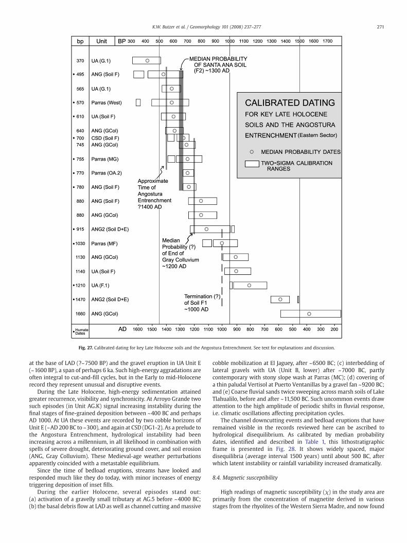
Fig. 27. Calibrated dating for key Late Holocene soils and the Angostura Entrenchment. See text for explanations and discussion.
271K.W. Butzer et al. / Geomorphology 101 (2008) 237–277
at the base of LAD (?~7500 BP) and the gravel eruption in UA Unit E(~1600 BP), a span of perhaps 6 ka. Such high-energy aggradations areoften integral to cut-and-fill cycles, but in the Early to mid-Holocenerecord they represent unusual and disruptive events.
During the Late Holocene, high-energy sedimentation attainedgreater recurrence, visibility and synchronicity. At Arroyo Grande twosuch episodes (in Unit AG.K) signal increasing instability during thefinal stages of fine-grained deposition between ~400 BC and perhapsAD 1000. At UA these events are recorded by two cobble horizons ofUnit E (~AD 200 BC to ~300), and again at CSD (DG1-2). As a prelude tothe Angostura Entrenchment, hydrological instability had beenincreasing across a millennium, in all likelihood in combination withspells of severe drought, deteriorating ground cover, and soil erosion(ANG, Gray Colluvium). These Medieval-age weather perturbationsapparently coincided with a metastable equilibrium.
Since the time of bedload eruptions, streams have looked andresponded much like they do today, with minor increases of energytriggering deposition of inset fills.
During the earlier Holocene, several episodes stand out:(a) activation of a gravelly small tributary at AG.5 before ~4000 BC;(b) the basal debris flow at LAD as well as channel cutting andmassive
cobble mobilization at El Jaguey, after ~6500 BC; (c) interbedding oflateral gravels with UA (Unit B, lower) after ~7000 BC, partlycontemporary with stony slope wash at Parras (MC); (d) covering ofa thin paludal Vertisol at Puerto Ventanillas by a gravel fan ~9200 BC;and (e) Coarse fluvial sands twice sweeping across marsh soils of LakeTlahualilo, before and after ~11,500 BC. Such uncommon events drawattention to the high amplitude of periodic shifts in fluvial response,i.e. climatic oscillations affecting precipitation cycles.
The channel downcutting events and bedload eruptions that haveremained visible in the records reviewed here can be ascribed tohydrological disequilibrium. As calibrated by median probabilitydates, identified and described in Table 1, this lithostratigraphicframe is presented in Fig. 28. It shows widely spaced, majordisequilibria (average interval 1500 years) until about 500 BC, afterwhich latent instability or rainfall variability increased dramatically.
8.4. Magnetic susceptibility
High readings of magnetic susceptibility (χ) in the study area areprimarily from the concentration of magnetite derived in variousstages from the rhyolites of the Western Sierra Madre, and now found
272 K.W. Butzer et al. / Geomorphology 101 (2008) 237–277
in the eolian sand sheets of the Mapimí or south of the Nazas Rivertowards Villita (see Fig. 16). Magnetic sand grains are also carried byrivers, with the highest readings in eolian beds, reworked fromchannel sands, coming from thewestern drainages. On the other hand,the limestone catchments have next to no autochthonous magnetite.It is not surprising that readings of 25 to over 150 are found in almostall units of most western profiles, namely TU, LL, EP, Santa Fe, CA, FL,and Concordia. Consequently attention is directed to (a) profiles in thewestern drainage that have low values, and (b) sites in the easterndrainages where they only increase late in the record.
At Arroyo Grande, except for a high blip at ~4700 BC, readingsfluctuate between5 and20, but at ~200 BCabruptly jumptobetween30and 55. Either no fluvial sand was entering a closed system, or allogeniceolian silt was not blowing in. At LM7 in the Mayran, susceptibilityvalues remain below 10 throughout the column, suggesting thatmagnetite was not getting this far eastward. At LM2, CH30, San Lorenzo(upper SLA), and T7, readings are particularly high between ~7000 and~4800 BC, possibly reflecting surges of Nazas flood silts.
The pattern is clearer in the local, limestone catchments. At Parras(MF, MG), values increase from under 10 to 35 at ~AD 1000, while nearSaltillo (UA, F.2/G.1) these readings explode from less than 5 to morethan 100 ~AD 1350. On the other hand, at Angostura, values rise from15 to 30with Soil D, and run near 40 in the Gray Colluvium, after aboutAD 1050. In these cases, eolian silts with fine magnetite particles are
Table 2Synoptic review of Holocene paleosols in North-Central Mexico
SOIL G. ~AD 1500–1800. Most recent humic soil, with texture and structure dominaintercepts, but all younger than Angostura Entrenchment, in part forming oReworking of alluvium as Inset Fills.Abrupt channel entrenchment during catastrophic rainfall event(s), creatingloss. Approximate date AD 1400 (Fig. 27), and earlier than Colonial dam of Abackground of metastable equilibrium.
SOIL F2. AD 1250–1400. More distinctive soil with weak structure, representing partiSlope soil erosion (Gray Colluvium, ANG, Figs. 9, 11) by high-intensity rains, pbiological aridification.
SOIL F1. AD 750–1000. A heavier soil with strong blocky structure, especially where thlower OA.2) where there are interbedded tufas.
SOIL E AD 200–700. More diversified soils with strong structure, including UA (unitMayran (LM4, CH30), with humic soils in channels and overbank suites of thhalf of Soil E interbedded with or on top of high-energy bedload deposits (UAand western Sierra Madre.
SOIL D2. 1050–100 BC. Three different facies document carbon sinks or smectite enricANG). In upper Nazas, organic, black prismatic clays (AG), attain thickness opersistent wetlands at strategic locations, and low climatic periodicity. TwoHiatus of ~350 years suggests drier period without datable humic horizons.
Soil D1. ~3000–1400 BC. A long period of ~1500 years, half of which has no datable seincreasing two-sigma ranges, indicate intermittently wet-floodplain habitatconditions were mainly dry. Entrenched channel at UA (Soil D1) with cumulicat LAD (Soil D); and modest soil at CSD. Prismatic silty clay at Parras (MD);intermittent deflation.Hiatus of ~700 years indicates another dry period without humic horizons.
SOIL C. ~5200–3700 BC. Sustained redox conditions in the easternwatersheds, combsoil at CSD. Slope screes interbedded with ponds and tufas at Parras (lowerverified by playa muds or often thick soils with protracted redox, despite locmainly wetter conditions. Dating tighter than for Soil D1.A hiatus of perhaps 600 years, with channel cutting at UA, debris flow at LA
SOIL B. ~6600–5800 BC. Core of period relatively wet, with up to three AB or ABk soilsreflecting subchannel artesian vents and a high water table. At AG, Soil B recombinationwith redox features. But earlier at UA (lower unit B), alluviation pchanging energy conditions, following high-energy gravelly bed. Except for bdiversion to TLA (major alternate channel at CA and T6, Fig. 16, ~6400 BC); suButzer, 1997).Hiatus of ~600 years.
SOILS A1 andA2.
~9400–9100 BC and 8600–7200 BC. Dates at UA inconsistent due to erosionairrespective of stratigraphy, they cluster tightly. Both Soils A1 and A2, despitvariable redox; i.e. persistent base flow, high water tables, and artesian ventsCaCO3, but at Parras (MB) a striking Bg/Bk profile, while at San Lorenzo (SLBactivity. Redox and ferric concretions common in the Mayran, with wavy-lamslickensides at Puerto Ventanillas. Nothing exposed at AG, but Bt pockets of Cwetter than today in both east and west, with different hydrology recorded
Chronostratigraphy inferred from graphic representation for clustering of median probabili
the only reasonable explanation, and we have observed a spring duststorm near AG. We suggest that eolian materials were being activatedon a regional scale, beginning with disequilibrium after ~200 BC, andshallow dunes were advancing over the Mayran floor at LM4 ~AD 700.Even the most humidmicrohabitats were affected by the 14th centuryAD. It will require systematic mineralogical analysis and moresophisticated, magnetic susceptibility methods (as are being appliedto the loesses of North China, Deng et al., 2005) to prove thisinterpretation, but it appears to support our contention of increasingperiodicity and episodes of disequilibrium during the course of theLate Holocene.
8.5. Cumulic soils and wet floodplains
Abundant floodplain moisture is typically linked to low-energychannel response. Key criteria in the study area include cumulic soils,“banded” varieties of ponded channel beds, interlaminated tufas, andredox-modified subsoils. Greatest variety is found around Saltillo andat El Molino (Parras), linked to limestone bedrock and subchannelsprings—artesian at the former, and compressional in the constrictedbedrock channel at the latter. With sustained base flow and upwellingwaters, fluctuating biotic activity and calcium bicarbonate concentra-tions can result in tufas interbedded with clays or organic matsalternating with algal chalks. Collectively these features imply higher
ted by parent material and slope. Dating complicated by three or four calibrationn Inset Fills. Key examples: UA, ANG, TLA, AG.
Angostura Badlands and continuing ecological aridification by soil destruction and SOCD 1600 at Parras. But older (~AD 1250) at Tunal, suggesting regional differences against
al slope stabilization. Key examples: ANG, CSD, Parrasrobably following severe droughts that impaired groundcover ~AD 1050–1200. Onset of
ere is no clear break between Soils F1 and E. Key examples: UA, ANG, and Parras (MF and
F.1, and Soils E1 and E2) and A/Bkg soil at Parras (ME). Playa muds prominent in thee Nazas delta plain (SL, FL, Concordia, Santa Fe, Fig. 16), or a cumulic soil at AG. The first, AG), implying oscillating energy conditions and hydrological instability in both eastern
hment. In Saltillo Basin, humic pond muds alternate with algal chalks (UA, BWD, LAD,f over 1.5 m (PC). In the Mayran, gray prismatic silty clays (LM7, CH30, also TLA). Fairlydate clusters indicate two moisture peaks ~800 and ~250 BC.
dimentary record. Three clusters of dates (3000–2700, 2300–2100,1800–1300 BC), withs in the east and the Mayran, but a record is missing in the western Sierras, whereMollisol; ponding in UA tributary; cumulic Alfisols with strong redox on alluvial terraceseveral strongly structured soils in Mayran (LM2, CH30), but with indirect evidence of
ined with brief periods of soil formation, ponding or tufa development (UA, LAD), but AkMD) imply both wet conditions and colluvial activity. In the Mayran, periodic floodingal gypsum (LM2, LM4, CH30). In upper Nazas, prismatic clays prone to redox highlight
D, and cobble mobilization at El Jaguey.at UA (upper unit B), marked by prismatic structure, ferric rhizoliths, and tufa interbeds
cords a seasonally very wet setting, with organic, prismatic clays and slickensides, inroceeded between gravel bars, despite redox; at ANG “banded alluvium” implies rapidlyasal playa muds (CH30), absence of Mayran paleosols may indicate considerable Nazasch a diversion occurred ~AD 1770–1839 due to sediment blockage of main channel (E.K.
l reworking (loss of upper half of record) and channel squeeze-ups, but if groupede 500 year break, record channel-ponding, tufa interbedding, weak cumulic soils andonwet floodplain. Semidesert stream at CSD (DD) argues for significant base flow, rich in) a sequence of B-horizons, a gley, repeated calcification, and interruptions by eolianinated clays or k-horizons at LM7. A high playa stand recorded by prismatic clays withhromic Vertisol at El Jaguey penetrate deep into substrate. Much of Early Holocene wasby subchannel spring activity, tufas, and ponding.
ty dates and two-sigma ranges (see Table 1, INTCAL 104.14c, and Reimer et al., 2004).
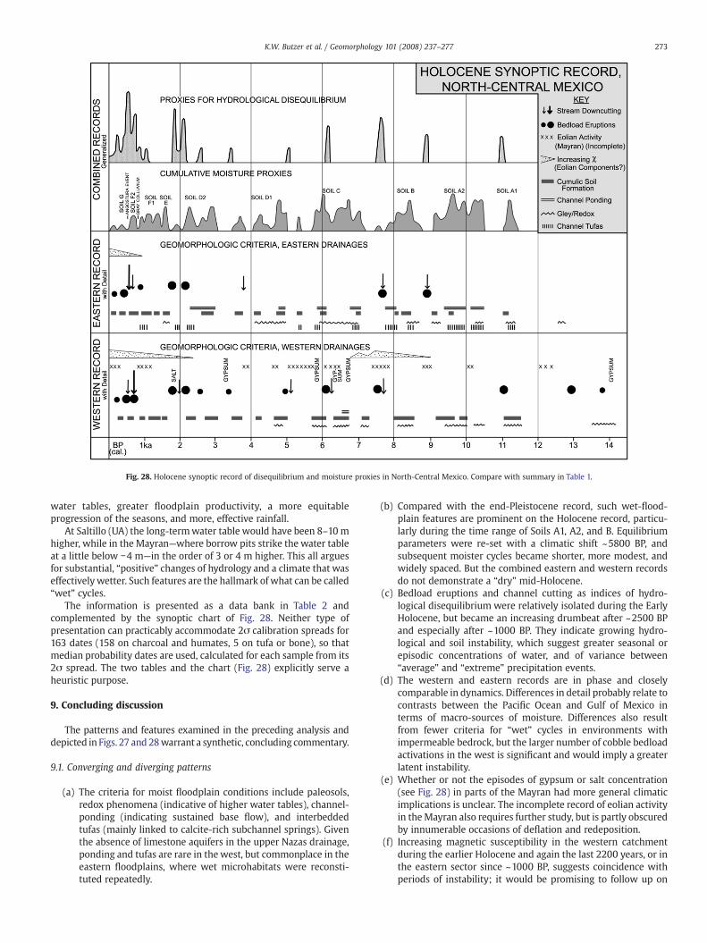
Fig. 28. Holocene synoptic record of disequilibrium and moisture proxies in North-Central Mexico. Compare with summary in Table 1.
273K.W. Butzer et al. / Geomorphology 101 (2008) 237–277
water tables, greater floodplain productivity, a more equitableprogression of the seasons, and more, effective rainfall.
At Saltillo (UA) the long-termwater table would have been 8–10 mhigher, while in the Mayran—where borrow pits strike the water tableat a little below −4 m—in the order of 3 or 4 m higher. This all arguesfor substantial, “positive” changes of hydrology and a climate that waseffectively wetter. Such features are the hallmark of what can be called“wet” cycles.
The information is presented as a data bank in Table 2 andcomplemented by the synoptic chart of Fig. 28. Neither type ofpresentation can practicably accommodate 2σ calibration spreads for163 dates (158 on charcoal and humates, 5 on tufa or bone), so thatmedian probability dates are used, calculated for each sample from its2σ spread. The two tables and the chart (Fig. 28) explicitly serve aheuristic purpose.
9. Concluding discussion
The patterns and features examined in the preceding analysis anddepicted in Figs. 27 and 28warrant a synthetic, concluding commentary.
9.1. Converging and diverging patterns
(a) The criteria for moist floodplain conditions include paleosols,redox phenomena (indicative of higher water tables), channel-ponding (indicating sustained base flow), and interbeddedtufas (mainly linked to calcite-rich subchannel springs). Giventhe absence of limestone aquifers in the upper Nazas drainage,ponding and tufas are rare in the west, but commonplace in theeastern floodplains, where wet microhabitats were reconsti-tuted repeatedly.
(b) Compared with the end-Pleistocene record, such wet-flood-plain features are prominent on the Holocene record, particu-larly during the time range of Soils A1, A2, and B. Equilibriumparameters were re-set with a climatic shift ~5800 BP, andsubsequent moister cycles became shorter, more modest, andwidely spaced. But the combined eastern and western recordsdo not demonstrate a “dry” mid-Holocene.
(c) Bedload eruptions and channel cutting as indices of hydro-logical disequilibrium were relatively isolated during the EarlyHolocene, but became an increasing drumbeat after ~2500 BPand especially after ~1000 BP. They indicate growing hydro-logical and soil instability, which suggest greater seasonal orepisodic concentrations of water, and of variance between“average” and “extreme” precipitation events.
(d) The western and eastern records are in phase and closelycomparable in dynamics. Differences in detail probably relate tocontrasts between the Pacific Ocean and Gulf of Mexico interms of macro-sources of moisture. Differences also resultfrom fewer criteria for “wet” cycles in environments withimpermeable bedrock, but the larger number of cobble bedloadactivations in the west is significant and would imply a greaterlatent instability.
(e) Whether or not the episodes of gypsum or salt concentration(see Fig. 28) in parts of the Mayran had more general climaticimplications is unclear. The incomplete record of eolian activityin theMayran also requires further study, but is partly obscuredby innumerable occasions of deflation and redeposition.
(f) Increasing magnetic susceptibility in the western catchmentduring the earlier Holocene and again the last 2200 years, or inthe eastern sector since ~1000 BP, suggests coincidence withperiods of instability; it would be promising to follow up on
274 K.W. Butzer et al. / Geomorphology 101 (2008) 237–277
whether more blowing dust did characterize the region during“drier” climatic trends.
(g) Although the end-Pleistocene record is highly incomplete andsuggests climatic cycles with longer wavelengths, the millen-nia before ~14,000 BP must have been less humid. It isprobable that Soil A at CSD is much older that its single date,to match the last activation of marginal alluvial fans at SanLorenzo and Puerto Ventanillas. This also implies that localprecipitation around the Mayran and Nazas delta plain hasbeen ineffective for geomorphological change during the last18 ka. In other words, considerably more runoff debouchedfrom lower elevation catchments earlier in MIS 2. But thenotion that the end-Pleistocene was “wet” in northernMexico, continuing thus into a “wet” Early Holocene, mustbe reconsidered.
9.2. Revisiting the black mucks
A large number of profiles with dark clayey paleosols have beenevaluated above. Most of these appear to be cumulic, and probably theresult of lateral translocation between a channel and a wet floodplain,complemented by transfer along the axial channel. In such cases thecarbon and clays may be largely authigenic. But the Nazas watershedopens up other possibilities, with a large tract of black mucks stillpreserved on the upland piedmont that drains into the Arroyo Grande(see Fig. 21). Here, a possibility exists to link relict upland soils withvalley paleosols, and to sketch a methodology to study the formationand attrition of soil organic carbon across a watershed duringHolocene times.
The Chromic Haplustert at El Jaguey (see Fig. 25), with a terminaldate of 8060 BP, developed on a substrate of slickensided clays. Theoriginal, prismatic, heavy clay soil must have formed over millennia,but was gradually eroded and reworked across the piedmont byshallow rills, to accumulate in gentle declivities. In this process, coarsematerials will have diluted the clay fraction until a new cycle ofpedogenesis favored humification and authigenic clay mineralformation, with an increasing component of smectite. With repeatedincremental erosion and redeposition, Bt-horizons would havethinned, while cumulic processes thickened the increasingly organicand clayey A/AB-horizons. Eventually such profiles would resemble acumulic Mollisol, but with vertic properties, as can be seen in thesmall basin at Puerta de Cabrera (2360–2800 BP).
The slickensides at the base of Soil B at AG probably reflect an earlyphase of attrition of the original watershed Vertisol, while at El Jagueythe younger Alfisol with strong illuvial features may represent amodel for an intermediate condition. These questions of pedogenicevolution recall those surrounding the transformation of reddish,kaolinitic upland soils to black, smectite Vertisols in the poorly-drained savanna plains of Africa (see Thomas, 1974; Butzer,1976:ch.20).
The black mucks of the AG profile were, in part, periodicallyderived from the “bank” of black soils that formed and remained instorage on the watershed. Mobilization in the suspended load of thestream continued at intervals from before 8000 to about 1100 BP, andsuggests interrelationships of soils and sediments that remainaccessible in time and space.
It would be possible to sample representative grids of the variouswatershed soils, as well as the valley paleosols, for vertical sequencesof organic components, δ13C changes, micromorphology, clayminerals, and geochemistry. In combination with the forthcomingpalynological results from AG, it should then be feasible to modelSOC in storage, net productivity, and depletion (e.g., Peng et al.,1998). That will require a team of collaborating specialists, but anunderstanding of SOC flux during Holocene time would haveimportant implications for the dynamics of the regional biota. Itmight also open new avenues to integrate fluvial and soils
geomorphology within global investigations of the biosphere andits semiquantitative transformation.
9.3. Comparisons with the U.S. Southwest
The results of the Laguna Project do not stand in isolation, and canbe compared with innovative external studies on the Late Holocene.For example, Ely (1997) examined a suite of flood deposits in Arizonaand southern Utah and concluded that formative floods were alsoclustered in particular periods. Large floods were absent ~2200–400 BC, but increased thereafter, to a peak at ~AD 1000–1200, before apronounced drop ~AD 1200–1400. After AD 1400, flood frequencyexploded, unlike in North-Central Mexico.
Waters (1988) focused on a 20 km stretch of the Santa Cruz Riversouth of Tucson. A salient feature here is the refilling of a deeplyentrenched (~6.5m) channel after AD 1400. This record, although verydistant (900 km), has similar complexity and ages as the LateHolocene sequence of Fig. 28, even though hydrological andpedogenic expression varies in detail.
The features recorded by Nordt (2003) in the Casas Grandes andSan Pedro valleys of northwestern Chihuahua have many similaritieswith those presented here, in particular some six paleosols datingroughly 9000–1350 BP. But his interpretations are radically different,and attribute paleosols to warmer and drier conditions, or alluvial fillsto cooler and wetter climate with high-magnitude floods.
Basin-wide Late Holocene incision events during the time spanbetween perhaps 1200 and 600 BP also have been noted by a numberof researchers in the southern Great Plains (e.g., Hall,1990; Blum et al.,1994; Waters and Nordt, 1995; Nordt, 2004). Although the interpreta-tion advanced for the climatic trigger varies, all of these authors agreethat changes in climatic parameters were responsible for disruptingsystem equilibrium and initiating these widespread channel cuttingevents.
Constructional beach ridges in playa basins just south of theMexico–New Mexico border indicate persistent high lake stands~8500–8200 BP, ~6700–6100 BP, ~4250–3800 BP and (very briefly)~200 BP, which are attributed to increased precipitation and coolertemperatures, following southward shifts in winter storm tracks(Castighia and Fawcett, 2006). These time spans resemble those ofSoils B, C and D1 of the Laguna Project region, but no evidence exists oftrue lake formation in the Mayran, compared with these huge lakesand fluctuating depths of 5–20 m. In the Babícora Basin of northernChihuahua, a 4.7 m core indicates a deep but fluctuating lake before20,000 BP, but it dried out after 9500 BP; no Holocene pollen ordiatom record is preserved (Metcalfe et al., 2002), with pollen alsoabsent in the Holocene record of Cuatro Cienegas (Meyer,1973), whererenewed palynological investigation is now underway. Earlier work onsurface exposures at Babícora appears to suggest lacustrine conditionsduring the Late Pleistocene (before 9600 bp), while the Holocenerecord is rich in organic matter as well as eolian sediments, thatcollectively are interpreted as paludal (Ortega-Ramírez et al., 1998);the inferences to warmer or cooler conditions are conjectural.
The Hueco Basin, near Chihuahua but on the Texas–New Mexicoborder, has been sampled for pedogenic carbonate development andstable carbon isotopes (Buck andMonger, 1999). Unfortunately the 14Cages are from pedogenic carbonates. The carbonate morphologyshows little or no consistent change, as in the Laguna profiles, butcarbon isotopes show interesting variation, attributed to simple shiftsbetween grasses and desert scrub on the basin floor.
Major potential resources for paleoecological evidence are thebotanical remains from packrat middens. The problem is that theavailable 14C ages are inadequate for the complexity of the cave or rockoverhang stratigraphy, and the problem of disturbance by burrowsappears to linger. Changes over time are glossed over inmillennia. Thiscaveat applies to such deposits at Puerto Ventanillas and near Torreón(see Fig.16) (Van Devender,1990), as well as amore recent study at the
275K.W. Butzer et al. / Geomorphology 101 (2008) 237–277
Mexico–New Mexico border, where parallel but discordant pollendata are given (Holmgren et al., 2003). It appears that woodland wasdisplaced by desert scrub by 10,000 BP, except for creosote, whicharrived later, but at varying times.
Tree-ring studies have been carried out for long-lived Douglas fir atfive sites in Durango (Cleaveland et al., 2003; D.W. Stahle, pers. comm..1996). The oldest record goes back to AD 1386, but this taxon issensitive to winter precipitation and its measured variation shows nosimilarity to the historical Nazas or Mayran records (E.K. Butzer, 1997),which reflect summer discharge of the Nazas River in that time range.
But we can usefully draw on one explicit and nuanced tree-ringrecord, from El Malpaís Monument, New Mexico (Grissino-Mayer,1995). Although dendroclimatology is a very different kind of proxy,and has superb chronological control, this 2100-year record relates toshort-term trends or events, at a multidecadal scale or less, butembedded in century-scale cycles. That is also true for our soil-hydrology proxy record of the last 2 ka. The New Mexico tree-ringsequences identify an unusually long span of strong droughts ~AD300–490, perhaps relevant to our bedload eruptions early during SoilE. More pertinent are high variances and alternations between verywet or very dry weather in central New Mexico ~AD 950–1400 (alsoMeko et al., 2007), a period of evident instability in North-CentralMexico. But for ~AD 1400–1800 the New Mexico record stands out byits remarkably low variability and generally dry conditions, compa-tible with the subdued change evident in the Laguna proxy record, butin contrast to the Arizona paleofloods of Ely (1997). Finally, statisticalmodification of the New Mexico dendroclimatology as a 30-yearrunning mean identifies a unique peak of effective moisture ~AD1400, coinciding with a similar peak in a foraminiferal record of theGulf of Mexico (Poore et al., 2005). This would point to “monsoonal”linkages between the Gulf, North-Central Mexico, and New Mexico.
9.4. Ecological aridification versus human degradation
The Gray Colluvium at La Angostura points to a hydrologicaldisequilibrium between Soils F1 and F2 that dates ~AD 1050–1200. Itincorporates a good amount of SOC (steady LOI readings of ~4.0%through 1.6 m of sediment) and of disaggregated conglomeraticmatrix, indicative of soil erosion attacking both A and C-horizons onthe slopes. Ground cover was being destroyed, presumably as a resultof alternating severe droughts and episodes of heavy rain. Thatattrition set the stage for the Angostura Entrenchment, after a briefand incomplete recovery (the Santa Ana soil zone). A deluge of waterwas unleashed by excessive rainstorms, that completely overwhelmedthe existing channels, which responded by entrenchment and ongoingbank collapse. Downcutting would have begun downstream, movingheadward (see Figs. 2 and 8), and upstream of Saltillo this processexcavated a channel of similar dimensions at ENC (see Fig. 14), herecutting through tough, conglomeratic seams. Millions of tons of siltwere entrained and swept downstream, so that the loss of SOC to theSaltillo Basin will have been immense.
Progressive attrition and then catastrophic entrenchment musthave destroyed groundcover, riverine habitats, and soils. The resultingecological aridification (rather than “desertification”) is fully docu-mented at ANG, and will have been replicated in other study areasaround Saltillo, Parras, the upper Nazas and Ramos watersheds, andDurango. Subsequent recouping of SOC has been modest, and thebiotic landscape has remained impoverished.
When the Spanish stockraisers, miners and missionaries arrived acentury or so later (1577–1596), they already encountered a “degraded”countryside. While their activities may have exacerbated the situation,human forcing of environmental change played no role in the increasingvariability of severe droughts and excessive rains in North-CentralMexico prior to AD 1600. That said, the question of whether and whenhuman activity triggered Pre-Hispanic erosion near Lake Pátzcuaro (seeO'Hara et al., 1993; Fisher et al., 2003) deserves to be reopened.
Returning for a moment to the northern Bajío, a variety of profiles inthe Lajas and Puerto Nieto drainages provide two stratigraphicsequences (Frederick, 1995: Sections 4.3 and 5.4). Five basic unitsbetween ~12.5 ka BP and the present are represented in each. The oldestfollows upon a strong vertic paleosol, and consistsmainly of low-energyclays and muds, modified in turn by a weaker Vertisol. The next twounits consist of loams and muds from the mid-Holocene, separated bymodest paleosols, in part calcic. But themost striking is a highly organiccomplex of low-energy fills, ranging from massive overbank muds (2–3m) to thin-bedded sandy deposits. Accumulation of this “cienega unit”began during the secondmillennium BC and terminated a little after AD1000. Subsequently 4–6 m entrenchment followed. A final, higherenergy unit (50–300 cm) includes strong colluvial components andwasa response to Colonial landscape intrusion.
Although not well dated, the “cienega unit” suggests similarenvironmental inputs as Soils D2, E and F1 in North-Central Mexico,namely protracted ponding and soil formation. During this time span,no significant agricultural settlement existed in the wider Lajasdrainage, despite separated, Classic to Early Postclassic, site clusters tothe north (Villa de Reyes), west, and south. The impact of the Villa deReyes settlement nucleus created a different, high-energy response(Frederick, 1995: 4.3.4, 5.3). Although Pre-Hispanic sedimentationalong the Lajas after 2000 BC was related to climatic inputs, it also wascoeval with accelerated sedimentation—attributed by various authorsto soil degradation—in more than 10 small or large basins inMichoacan (see Frederick, 1995: Fig. 5.8).
The earliest period of landscape instability in Lake Pátzcuaro, withthe appearance of maize pollen, is dated ~1900–1250 BC, the second~600 BC to AD 650 (O'Hara et al., 1993), although population onlyincreased significantly thereafter (Fisher et al., 2003). Depending onwhether the small number of 14C/AMS ages are accepted or not, majorerosion set in either about AD 1200 or after 1520 (O'Hara et al., 1993versus Fisher et al., 2003). A part of the problem also relates todifferent sampling strategies, namely dispersed sediment cores fromseveral parts of the lake (by O'Hara), versus excavation and coring inone embayment with a concentration of settlement and landscapemodification (by Fisher). More specifically, pointwise erosion waslinked to disturbance at Pre-Hispanic archaeological sites, whereasColonial intrusion apparently led to landscape-wide colluviation as aresult of land abandonment (Fisher et al., 2003).
Recent detailed work in northern Guatemala, however, indicatesthat most rapid erosion occurred during initial land clearance(700 BC–AD 250), not at the time of greatest population density(Anselmetti et al., 2007; Beach et al., 2008, this volume), confirmingthe results of earlier work by Dunning et al. (2002). Against this onemust interject that, just as in the Lajas Basin, there were ongoingclimatic changes, documented by significant fluctuations of lake levelbetween AD 120 and ~1200 (O'Hara et al., 1993; Fisher et al., 1999).Lake Pátzcuaro sedimentation may therefore have been controlled byboth climatic impulses and land-use practices or changes.
This raises legitimate questions about the Pátzcuaro interpretationand that of other, adjacent basins. A mix of discriminating,geomorphic catchment studies and more precise, site-specificgeoarchaeological investigation is called for. This must be accompa-nied by a robust chronology that includes OSL dates.
9.5. The Laguna project in global context
Explanation is a difficult but tempting arena for partial solutionsthat do not account for the record as a whole. The environmentalhistory elaborated here includes: (a) a marked increase of precipita-tion in the eastern and western Sierra Madre at the very beginning ofthe Holocene; (b) a relatively wet Early Holocene at a time when sea-surface temperatures (SSTs) were lower and tropical cyclones fewer;(c) a basic distinction between effective rains that recharged aquifersversus excessive rainfall and runoff events that mobilizedmajor floods
276 K.W. Butzer et al. / Geomorphology 101 (2008) 237–277
to remodel the fluvial geomorphology or surge into the Mayranplayas; (d) an increasing variability and decreasing wavelength ofalternating wet and dry perturbations during the course of theHolocene, although information on seasonality is lacking; (e) theprobability that hurricanes or lingering tropical storms from the Gulfof Mexico and the Pacific Ocean had becomemajor channel and slope-modifying forces by the later Holocene; and (f) a superposed cyclicityof landscape stability and instability, facilitated by or leading tochanges of effective land or ground cover.
These points draw attention to some of the doubts and concerns ageomorphologist might have about universalizing, single explanations,not to mention bold hypotheses that shift atmospheric circulation beltsto fit preconceived assumptions. Fortunately, the tide is turning, aspaleoclimatic interpretations focus onmultiscale variability and shortertimespans, illuminatedby specifickinds of proxy records. Recent studiesemphasize the role of centennial, multidecadal, and decadal oscillations,basedonGreenland ice cores, deep-sea sediment columns, and tree-ringderived reconstructions (Gray et al., 2004; Poore et al., 2005; Richey etal., 2007). At this smaller scale, changes in the strength of the oceanicthermohaline circulation are one primary factor for SST oscillations thataffectmultiyear precipitation or temperature anomalies differently overvarious continents, and apparently modulate or confound linear ENSOglobal teleconnections (Gray et al., 2004; Brönnimann, 2007; Kerr,2000). Atmospheric circulation anomalies, which favor storminess overthe North Atlantic and Eurasia, drive the Loop Current in the Caribbeanthat carries warmer surface waters into the Gulf, accounting for a 3 °Cdifference in SST during the last 1400 years, between the MedievalWarmPeriod and the Little Ice Age (Richeyet al., 2007). Interestingly, AD1400 alsomarks an abrupt switch of circulationpatterns overGreenlandand Eurasia, apparently related to solar forcing and coupled ocean–atmosphere associations (Meeker and Mayweski, 2002). With coolerSSTs in the Gulf, fewer excessive rainfall events should be expected inNorth-Central Mexico.
At a larger scale, wavelet power-spectrum analysis of a HoloceneENSO record from Ecuador shows a fluctuating but dramatic increaseof ENSO variability, that peaks after 2 ka (Moy et al., 2002; see alsoMagilligan et al., 2008, this volume); this event series is surprisinglyhomologous to the disequilibrium proxy record of our Fig. 28. Possiblythis long-term trend of ENSO variance is tied to orbitally-inducedchanges of insolation (Moy et al., 2002). But more significant is theapparent link of our Mexico disequilibria to the “mechanics,” ratherthan the linear manifestations of the ENSO.
Turning the analogs inside out, the moisture proxies of Fig. 28provide a similar, discontinuous trace to that of Holocene Nile floodlevels (reconstructed in K.W. Butzer, 1997), which have been(incorrectly, see Stager et al., 2007) claimed to be a linear ENSOproxy in earlier research. In effect, tropical and North Atlantic parallelsto the Laguna Project record are apparent. But exactly how that workswill require further study, including the role of solar irradiance.
For example, a greater incidence of hurricanes would notadequately explain the Mexico record. Hurricane Gilbert in 1988 wasone of the most powerful rainstorms in well over a century, travelingfar inland but bringing only 130 mm of rain to the rainshadow ofSaltillo. Significant rainfall in the eastern half of the study area is oftenassociated with moisture derived from Pacific storms. Perhaps if aPacific hurricane first provides a thick plume of mid-to high-levelmoisture, followed directly by a strong Gulf hurricane, enoughinstability might develop to deliver extreme runoff events as farwest as Parras, where flood debris of Hurricane Gilbert (1988) wasfound lodged in brush up to 4 m above channel-floor.
Directly or implicitly, current explanations are focused onsummer rains, which will not be adequate for Early Holocenereconstructions. Large-scale flooding can also affect the Rio Grandevalley during winter or the transitional seasons. This is likely tohappen with quasi-stationary upper air troughs or cut-off lows overthe Southwest, spinning off multiple cyclonic swirls into converging
streams of Pacific and Gulf moisture. But these are more likely to bethe “soaking” rains that sustain aquifers and wetlands. Suchsynoptic patterns are also related to tightly twisted (meridional)jet stream loops that are part of the repertoire of Atlanticmultidecadal oscillations. Embedded within this interplay of tropicaland subtropical dynamic categories, a switching between “summer”and “winter” storm categories may have occurred, with differentimpacts on the ground. That could help explain an earlier recordwith redox and high water tables, giving way to one with periodic,very heavy rains and greater landscape instability. The proxiessuggest increasing variability and shorter wavelengths, but whatmay instead have changed could be the dominant, dynamicvariables, that is, the synoptic patterns controlling the incidenceand character of heavy rains.
The soil-geomorphology record of North-Central Mexico isprimarily a history of changing “wet” cycles, rather than of wet ordry climates. These had major ecological impacts, which is alsoevident from the forthcoming palynological evidence. Given thatpaleoclimatic interpretation cannot yet be structured in a unifyingtheory, geomorphologists should react critically to oversimplificationsof the systemic whole.
Acknowledgements
Elisabeth Butzer contributed at all stages to the historical andarchival background to flooding in theNazas Basin, and she is grateful toLuis Ferniza García, Enrique Fernández, Teresa Babún, and other localinformants in San Pedro de las Colonias, and Virginia Rocha Saeñz ofParral del Hidalgo. Mariah F. Wade and William E. Doolittle (both UTAustin) helped prepare the field trip for the Conference of Latin–Americanist Geographers to northern Mexico (January 2000). TaylorHouston, John Geiselbrecht, and Alexandra Myers assisted in thelaboratory work. Ernest W. Lundelius, Jr. (Texas Memorial Museum),identified the fossil bones, and Barbara Winsborough (WinsboroughConsulting, Austin) investigated the diatoms and offered specialistinsights on the organic accumulations. Troy Kimmel (UTAustin) offeredadvice on the synoptic patterns. M. Palacios-Fest (University of Arizona)tested a suite of samples for ostracods. Bruce M. Albert (Corinth, TX)investedmuch time and expertise on the palynological study,whichwillbepublished separately upon completion.DavidHelgren (San José State)provided critical feedback and information, as did Tim Beach (George-town), Nicholas Dunning (University of Cincinnati), and Paul Hudson(University of Texas). Rosemary Sherriff (University of Kentucky) gavesuggestions on the Southwestern literature. The former University ofTexas Radiocarbon Laboratory, the University of Arizona Laboratory ofIsotope Geochemistry, the University of Arizona AMS Facility, theNational Ocean Sciences AMS Facility (Woods Hole, MA), and StaffordResearch Laboratories provided the 14C and AMS dates; we areparticularly appreciative of close collaboration with Sam Valastro(Austin) and Chris Eastoe and Austin Long (Tucson). Mark Bateman(Sheffield University) made available OSL ages, details which will bepublished separately. The Laguna Project was supported by the TexasHigher Education Coordinating Board, Advanced Technology ProgramGrant 003658-473, and by the endowment of the R.C. DicksonCentennial Professorship of Liberal Arts.
References
Anselmetti, F.S., Hodell, D.A., Ariztegui, D., Brenner, M., Rosenmeier, M.F., 2007.Quantification of soil erosion rates related to ancient Maya deforestation. Geology35, 915–918.
Albritton, C.C., 1958. Quaternary stratigraphy of the Guadiana Valley, Durango, Mexico.Geological Society of America Bulletin 69, 1197–1216.
Beach, T., Luzzadder-Beach, S., Dunning, N., Cook, D., 2008. Human and natural impactson fluvial and karst depressions of the Maya lowlands. Geomorphology.
Benham, H.W., 1847. The field of Buena Vista corrected by Lieut. Benham. Pencilmanuscript, Univ. of Texas at Arlington Libraries, Henry W. Benham Family Papers,Collection AR 388, Map Annex 108/1.
277K.W. Butzer et al. / Geomorphology 101 (2008) 237–277
Blum, M.D., Toomey, R.S., Valastro, S., 1994. Fluvial response to Late Quaternary climaticand environmental change, Edwards Plateau, Texas. Palaeogeography, Palaeocli-matology, Palaeoecology 108, 1–21.
Brönnimann, S., 2007. Impact of El Niño-Southern Oscillation on European climate.Review of Geophysics 45 (3), RG3003.
Buck, B.J., Monger, H.C., 1999. Stable isotopes and soil-geomorphology as indicators ofHolocene climate change, northern Chihuahuan Desert. Journal of Arid Environ-ments 43, 357–373.
Butzer, E.K., 1997. Archival documentation of extreme climatic events, Northern Mexico(16th–19th centuries). Abstracts, Assoc. of Amer. Geog., Annual Meeting FortWorth,TX, p. 35.
Butzer, K.W., 1997. Sociopolitical discontinuity in the Near East c. 2200 BCE: Scenariosfrom Palestine and Egypt. In: Dalfes, N., Kukla, G., Weiss, H. (Eds.), ThirdMillenniumB.C. Abrupt Climatic Change and Old World Social Collapse. NATO ASI Series,Springer, pp. 245–295.
Butzer, K.W., 1976. Geomorphology from the Earth. Harper Row, New York.Butzer, K.W., 1999. Technología de irrigatión tlaxcalteca: Mito o realidad? In: Monroy
Castillo, M.I. (Ed.), Constructores de la nacion: La migración tlaxcalteca en el nortede la Nueva España. Biblioteca Tlaxcalteca, El Colegio de San Luís, San Luís Potosí,pp. 135–140.
Butzer, K.W., 2005. Environmental history in the Mediterranean world: cross-disciplinary investigation of cause-and-effect for degradation and soil erosion.Journal of Archaeological Science 3, 1773–1800.
Butzer, K.W., Butzer, E.K., 1997. The ‘natural’ vegetation of the Mexican Bajío: archivaldocumentation of a 16th-century savanna environment. Quaternary International43/44, 161–172.
Butzer, K.W., Harris, S.E., 2007. Geoarchaeological approaches to the environmentalhistory of Cyprus: explication and critical evaluation. Journal of ArchaeologicalScience 34, 1932–1952.
Butzer, K.W., Helgren, D.M., 2005. Livestock, landcover, and environmental history: theTablelands of New South Wales, Australia, 1820–1920. Annals Association ofAmerican Geographers 95, 80–111.
Butzer, K.W., Stuckenrath, R., Bruzewicz, A.J., Helgren, D.M., 1978. Late Cenozoicpaleoclimates of the Gaap Escarpment, Kalahari Margin, South Africa. QuaternaryResearch 10, 310–339.
Byrne, R., Horn, S.P., 1989. Prehistoric agriculture and forest clearance in the Sierra de lasTuxtlas, Vera Cruz, Mexico. Palynology 13, 181–193.
Castighia, P.J., Fawcett, P.J., 2006. Large Holocene lakes and climate change in theChihuahuan Desert. Geological Society of America Bulletin 34, 113–116.
Cleaveland, M.K., Stahle, D.W., Therrell, M.D., Villanueva-Díaz, J., Burns, B.J., 2003. Tree-ring reconstructed winter precipitation and tropical teleconnections in Durango,Mexico. Climatic Change 59, 369–388.
Cullen, H., de Menocal, P., Hemming, S., Hemming, G., Brown, F.H., Guilderson, T.,Sirocko, F., 2000. Climate change and the collapse of the Akkadian empire: evidencefrom the deep sea. Geology 28, 379–382.
Deng, C., Vidic, N.J., Verosub, K.L., Singer, M.J., Liu, Quingsong, Shaw, J., Zhu, Rixiang,2005. Mineral magnetic variation of Jiaodao Chinese loess/paleosol sequence andits bearing in long-term climatic variability. Journal of Geophysical Research 110,B03103. doi:10.1829/2004aJB00 3451.
Dunning, N.P., Luzzadder-Beach, S., Beach, T., Jones, J., Scarborough, V., Culbert, T.P.,2002. Arising from the Bajos: the evolution of a Neotropical landscape and rise ofMaya civilization. Annals of the Association of American Geographers 92, 267–283.
Drysdale, R., Zanchetta, R., Hellstrom, J., Maas, R., Fallik, A., Pickett, M., Cartwright, I.,Piccini, L., 2006. Late Holocene drought responsible for the collapse of Old Worldcivilizations is recorded in an Italian cave flowstone. Geological Society of AmericaBulletin 34, 101–104.
Ely, L.L., 1997. Response of extreme floods in the southwestern United States to climaticvariations in the Late Holocene. Geomorphology 19, 175–201.
Fisher, C.T., Pollard, H.P., Frederick, C., 1999. Intensive agriculture and socio-politicaldevelopment in the Lake Pátzcuaro Basin, Michoacán, Mexico. Antiquity 73,642–649.
Fisher, C.T., Pollard, H.P., Israde, I., Garduño, V., Banerjee, S.K., 2003. A reexamination ofhuman-induced environmental change within the Pátzcuaro Basin, Michoacán,Mexico. Proceedings National Academy of Sciences. doi:10.1073/pnas 0630493100.
Frederick, C.D., 1995. Fluvial response to Late Quaternary climate change and land use inCentral Mexico. Ph.D. Dissertation, Univ. of Texas Austin.
Frederick, C.D., 2001. Evaluating causality of landscape change: examples fromalluviation. In: Goldberg, P., Holliday, V., Ferring, R. (Eds.), Earth Sciences andArchaeology. Kluwer Academic, New York, pp. 55–76.
Gray, S.T., Graumlich, L.J., Betancourt, J.L., Pederson, G.T., 2004. A tree-ring basedreconstruction of the Atlantic Multidecadal Oscillation since 1567 AD. GeophysicalResearch Letters 31, LI2205. doi:10.1029/2004GLO19932.
Grissino-Mayer, H. D., 1995. Tree-ring reconstructions of climate and fire history at ElMalpaísNationalMonument,NewMexico. Ph.D.Dissertation,Univ. ofArizona, Tucson.
Hall, S.A., 1990. Channel trenching and climate change in the Southern U. S. Great Plains;with Suppl. Data 90-89. Geology 18, 342–345.
Holmgren, C.A., Peñalba, M.C., Rylander, K.A., Betancourt, J.L., 2003. A 16,000 14C yr B.P.packrat midden series from the USA–Mexico borderlands. Quaternary Research 60,319–329.
Kerr, R.A., 2000. A North Atlantic climatic pacemaker for the centuries. Science 288,1984–1986.
Liu, J., et al., 2007. Complexity of coupled human and natural systems. Science 317,1513–1516.
Magilligan, F.J., Goldstein, P.B., Fisher, G.B., Bostick, B.C., Manners, R.B., 2008. LateQuaternary hydroclimatology of a hyper-arid Andean watershed: Climate change,floods, and hydrologic responses to the El Niño-Southern Oscillation in the AtacamaDesert. Geomorphology 101, 14–32.
Meeker, L.D., Mayweski, P.A., 2002. A 1400-year high-resolution record of atmosphericcirculation over the North Atlantic and Asia. The Holocene 12.3, 257–266.
Meko, D.M., Woodhouse, C.A., Baisan, C.A., Knight, T., Lukas, J.J., Hughes, M.K., Salzer, M.W.,2007. Medieval drought in the upper Colorado River Basin. Geophysical ResearchLetters 34, L10705. doi:10.1029/2007GL029988.
Metcalfe, S., Say, A., Black, S., McCulloch, R., O'Hara, S., 2002. Wet conditions during theLast Glaciation in the Chihuahuan Desert, Alto Babícora Basin, Mexico. QuaternaryResearch 57, 91–101.
Meyer, E.R., 1973. Late Quaternary paleoecology of the Cuatro Cienegas Basin, Coahuila,Mexico. Ecology 54, 982–995.
Moy, C.M., Seltzer, G.O., Rodbell, D.T., Anderson, D.M., 2002. Variability of El Niño/Southwestern Oscillation activity at millennial timescales during the Holoceneepoch. Nature 420, 162–165.
Muhs, D.R., Reynolds, R.L., Been, J., Skipp, G., 2003. Eolian sand transport pathways inthe southwestern United States: importance of the Colorado River and localsources. Quaternary International 104, 3–18.
Nelson, B.A., 1997. Chronology and stratigraphy of La Quemada, Zacatecas, Mexico.Journal of Field Archaeology 24, 85–109.
Nordt, L.E., 2003. Late Quaternary fluvial landscape evolution in desert grasslands ofnorthern Mexico. Geological Society of America Bulletin 115, 596–606.
Nordt, L.E., 2004. Late Quaternary alluvial stratigraphy of a low-order tributary incentral Texas, USA and its response to climate and sediment supply. QuaternaryResearch 62, 289–300.
O'Hara, S., Street-Perrott, F.A., Burt, T.P., 1993. Accelerated soil erosion around aMexicanhighland lake caused by Prehispanic agriculture. Nature 362, 48–51.
Ortega-Ramírez, J.R., Valiente-Banuet, A., Urrutia-Fucugauchi, J., Mortera-Gutiérrez, C.A.,Alvarado-Valdez, G., 1998. Paleoclimatic changes during the Late Pleistocene–Holocene in Laguna Babícora, near the Chihuahuan Desert, Mexico. CanadianJournal of Earth Sciences 35, 1168–1179.
Peng, C.H., Guiot, J., Van Campo, E., 1998. Estimating changes in terrestrial vegetationand carbon storage: the use of regression analyses. Quaternary Science Reviews 17,719–735.
Poore, R.Z., Pavich, M.J., Grissino-Mayer, H.D., 2005. Record of the North Americansouthwest monsoon from Gulf of Mexico sediment cores. Geology 3, 209–212.
Reimer, P.J., et al., 2004. IntCal04 terrestrial Radiocarbon age calibration 0–26 cal kyr BP.Radiocarbon 46, 1029–1058.
Richey, J.N., Poore, R.Z., Flower, B.P., Quinn, T.M., 2007. 1400 yr multiproxy record ofclimate variability from the northern Gulf of Mexico. Geology 35, 423–426.
Rotnicki, K., 1983. Modelling past discharges of meandering rivers. In: Gregory, K.J. (Ed.),Background to Paleaohydrology. Wiley, New York, pp. 321–354.
Schulte, E.E., Hopkins, B.G., 1996. Estimation of soil organic matter by weight-loss-on-ignition. Soil Organic Matter: Analysis and Interpretation. Soil Science SocietyAmerica Special Publication Number, vol. 46, pp. 357–373.
Sirocko, F., Sarnthein, M., Erlenkeuser, H., Lange, H., Arnold, M., Duplessy, J.C., 1993.Century-scale events in monsoonal climate over the past 24,000 years. Nature 364,322–324.
Smith, J.H., 1919. The War with Mexico. Macmillan, New York.Stager, J.C., Ruzmaikin, A., Conway, D., Verburg, P., Mason, P.J., 2007. Sunspots, El Niño,
and the levels of Lake Victoria, East Africa. Journal of Geophysical Research 112(D15). doi:10.1029/2006JD008362.
Thomas, M.F., 1974. Tropical Geomorphology: A Study in Weathering and LandformDevelopment in Warm Climates. Macmillan, London.
USDA, 1999. Soil Taxonomy: A Basic System of Making and Interpreting Soil Surveys.United States Department of Agriculture, Washington, DC.
Van Devender, T.R., 1990. Late Quaternary vegetation and climate of Chihuahuan Desert,United States and Mexico. In: Betancourt, J.L., Van Devender, T.R., Martin, P. (Eds.),Packrat Middens: The Last 40,000 years of Biotic Change. Univ. Arizona Press,Tucson, pp. 105–133.
Waters, M.R., 1988. Holocene alluvial geology and geoarchaeology of the San Xavierreach of the Santa Cruz River, Arizona. Geological Society of America Bulletin 100,479–491.
Waters, M.R., Nordt, L.G., 1995. Late Quaternary floodplain history of the Brazos River ineast–central Texas. Quaternary Research 43, 211–319.