Geomorphology and Saline Intrusion
17
Geomorphology and Groundwater salinity of Coastal aquifers Dr. C.P. Priju Scientist B, Groundwater Division CWRDM, Kozhikode
Transcript of Geomorphology and Saline Intrusion

Geomorphology and Groundwater salinity of Coastal aquifers
Dr. C.P. PrijuScientist B, Groundwater Division
CWRDM, Kozhikode

Introduction
Salinity – Major groundwater pollution in coastal regionsEncroachment of sea water to aquifers - surface and subsurface pathwaysHigh mineral content – saltsExcessive use (pumping) of groundwater in coastal regionInfluence of hydrogeological and geomorphological factors of the areaChanges in climate, land use pattern altering rate of groundwater rechargeInfluence of tidal oscillations and sea level rise

Coastal Geomorphology of Kerala
Divided into three geographical regions - Highlands (>80 m), Midlands(6-80m) and Lowlands(< 6m)Lowlands (coastal plain) – mainly river deltas, backwaters and seashoreCoastal geomorphic units – beaches, beach cliffs, stacks, islands, shore platforms, spits, bars, beach ridges, estuaries, lagoons, inlets, mudflats, tidal flats and deltaic plainsMajor landforms – backwaters and lagoons, sea inlets has major role in saline water ingress to aquifersCoastal landforms – made of sand and alluvium, generally elongated parallel to the coastStrandlines (ancient shorelines) and beach ridges mainly made upof sand form good freshwater aquifers

Geomorphological features of the Central Kerala coast

Schematic section of the coastal land

Hydrogeology of Kerala
Physiography and geological setting – major control on occurrence and movement of groundwaterGeologically mainly underlain by crystalline rocks with sedimentary formations and coastal alluvium in the mid and low land regionsGroundwater occurrence - phreatic, semi-confined and confined conditionsTertiary and coastal plain aquifers – sedimentary formationsTertiary Vaikom and Warkali beds- potential freshwater aquifersCoastal alluvium (thickness few meters to 100 m) – ground water in phreatic and semi-confined conditions (depth to water table < 1 m to 6 m)

Stratigraphic succession of Kerala
AGE FORMATION LITHOLOGY
Recent Alluvium Sand, Clay, riverine alluvium etc.
Sub-Recent Laterite Derived from crystallines andsedimentaries
Tertiary
WarkaliQuilonVaikom
Alleppey
Sand stone, clays with ligniteLime stone, marl and claySandstone with pebbles, clay and ligniteCarbonaceous clay and fine sand
Undated Intrusives Dolerite, Gabbro, Granites,Quartzo-feldspathic Veins
ArchaeanWayanad groupCharnockitesKhondalites
Granitic gneiss, Schists etc.Charnockites and associated rocksKhondalite suite of rocks and its associates

Groundwater and seawater intrusion
Ghyben-Herzberg relation
z = 40 x h, where h = water level above sea levelz = thickness of fresh water below sea level

Saltwater intrusion due to drawdown and upconing
Unconfined aquifer
Confined aquifer

Aquifer geometry in Island and coastal marine environments
Marine Island Coastal marine environment

Groundwater salinity-Interpretation tools
Hydrochemistry- Chloride vs. Water level elevations- Chloride vs. Conductivity- Piper Diagram
Geo-electrical Investigation- Schlumberger Array- Wenner Array (2D Resistivity profiling)

Chloride vs. Water level elevations
Hydrochemical Tools

Chloride vs. Conductivity

Piper Diagram

Vertical Electrical Sounding – Schlumberger array
Geophysical Tools
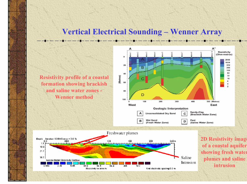
Vertical Electrical Sounding – Wenner Array
Resistivity profile of a coastal formation showing brackish
and saline water zones -Wenner method
2D Resistivity image of a coastal aquifer showing fresh water plumes and saline
intrusion