Size and depth of ancient magma reservoirs under atolls and islands of French Polynesia using...
19
JOURNAL OF GEOPHYSICAL RESEARCH, VOL. 105, NO. B4,PAGES 8173-8191, APRIL 10, 2000 Size and depth of ancient magma reservoirs under atolls and islands of French Polynesia using gravity data Valdrie Clouard and Alain Bonneville Laboratoire de Gdosciences Marineset T•ldd•tection, Universitd de la Polyndsie Fran<•aise Papeete, Tahiti, French Polynesia HansG. Barsczus, 1 GBE- UMR 5569- CNRS and Universit•de Montpellier II, Montpellier, France Abstract. New insights into the structural and tectonicevolutionof islands and atolls in French Polynesia are derived from the analysis of gravitydata. Free-air anomaly mapswereconstructed using gravity data from land surveys of 25 islands combined with free-airanomaly data derived from satellite altimetry and shipborne gravimeters. Residual isostatic anomalies werecalculated using a three-dimensional (3-D), four-layer crustal model taking into account the bathymetry of the seafloor, the topography of the islands,and the deflection of the lithosphere under the load of the volcanoes. Twenty of the 25 islands yield a positive residual anornaly, ranging between 9 and 60 mGal. Negativeresidual anomalies over four islands probably correspond either to limestone deposits or to fragmented materialfrom aerialvolcanism. The occurrence of a positive anomaly provides some evidence that there is a solidified magma chamberat depth beneath each of several islandsin French Polynesia. A linear relation between the amplitude of the positive gravity anomaly and islandvolume is alsoobserved. Geological features whichgenerate these positive anomalies are described by simple geometric models (3-D ellipsoidal dense bodies) which leadto a rough estimate of the size anddepth of the magma chambers. We then propose a simplelinear relation between the volume of such magma chambersand the volume of islands that can be used for other extinct intraplatebasaltic volcanoes. The diameter of the inferred magma chamber and its projection on the surface of the islands imply that calderas correspond mostly to collapses of the flanks of the edifices rather than to caldera vertical subsidence. 1. Introduction French Polynesia (Figure1) is located to the south of the central part of the Pacific Plate, between latit- udes 5øSand 30øS and longitudes 130øW and 160øW. The Austral, Society, Pitcairn-Gambler, and Tuamotu island chains trend N120 ø, the same directionof the present PacificPlate motion. The Marquesas Islands have a N140 ø strike. The region is crossed by the Aus- tral andMarquesas Fracture Zones (FZ) with a N70 ø strike. These FZs are the main tectonic features of the seafloor and are related to the Farallon Ridge, which became extinct 9 Myr ago [Mammerickx et al., 1980]. The average velocity of Pacific Plate motion is 11 cm 1Also at Centre IRD, Montpellier, France Copyright 2000 by the American Geophysical Union. Paper number 1999JB900393. 0148-0227/00/1999JB900393509.00 yr -• [Herron, 1972; Minster and Jordan, 1978]. The Austral,Society, Pitcairn-Gambier, and Marquesas is- land chains are composed mainlyof islands, whilethe Tuamotu archipelago is composed entirely of atolls. All together, French Polynesia consists of 34 islands and 84 atolls. Theislands rise ~4500 m above theseafloor, and their maximum elevation above sea level, at Tahiti, is 2200 m. To a first approximation, island ages andmorpho- logies areconsistent with a hotspot theory: the age of each island within a chain increases from the southeast to thenorthwest, based on radiometric dating ofvolcan- ism from the present to about 16 Ma (Table 1). The age ofthe oceanic crust ranges between 45and 85Ma [Her- ron, 1972; Mayes et al., 1990; Munschy et al., 1996]. The Tuamotu Islands are separated from the other is- landchains by basins exceeding 5000 m in depth.The origin of the Tuamotu Islands, which riseabove a broad plateau, is uncertain but has been attributed to an abor- ted ridge [Pautot, 1975], a hotspot [Okal and Cazenave, 8173
-
Upload
independent -
Category
Documents
-
view
4 -
download
0
Transcript of Size and depth of ancient magma reservoirs under atolls and islands of French Polynesia using...
JOURNAL OF GEOPHYSICAL RESEARCH, VOL. 105, NO. B4, PAGES 8173-8191, APRIL 10, 2000
Size and depth of ancient magma reservoirs under atolls and islands of French Polynesia using gravity data Valdrie Clouard and Alain Bonneville Laboratoire de Gdosciences Marines et T•ldd•tection, Universitd de la Polyndsie Fran<•aise Papeete, Tahiti, French Polynesia
Hans G. Barsczus, 1 GBE- UMR 5569 - CNRS and Universit• de Montpellier II, Montpellier, France
Abstract. New insights into the structural and tectonic evolution of islands and atolls in French Polynesia are derived from the analysis of gravity data. Free-air anomaly maps were constructed using gravity data from land surveys of 25 islands combined with free-air anomaly data derived from satellite altimetry and shipborne gravimeters. Residual isostatic anomalies were calculated using a three-dimensional (3-D), four-layer crustal model taking into account the bathymetry of the seafloor, the topography of the islands, and the deflection of the lithosphere under the load of the volcanoes. Twenty of the 25 islands yield a positive residual anornaly, ranging between 9 and 60 mGal. Negative residual anomalies over four islands probably correspond either to limestone deposits or to fragmented material from aerial volcanism. The occurrence of a positive anomaly provides some evidence that there is a solidified magma chamber at depth beneath each of several islands in French Polynesia. A linear relation between the amplitude of the positive gravity anomaly and island volume is also observed. Geological features which generate these positive anomalies are described by simple geometric models (3-D ellipsoidal dense bodies) which lead to a rough estimate of the size and depth of the magma chambers. We then propose a simple linear relation between the volume of such magma chambers and the volume of islands that can be used for other extinct intraplate basaltic volcanoes. The diameter of the inferred magma chamber and its projection on the surface of the islands imply that calderas correspond mostly to collapses of the flanks of the edifices rather than to caldera vertical subsidence.
1. Introduction
French Polynesia (Figure 1) is located to the south of the central part of the Pacific Plate, between latit- udes 5øS and 30øS and longitudes 130øW and 160øW. The Austral, Society, Pitcairn-Gambler, and Tuamotu island chains trend N120 ø, the same direction of the present Pacific Plate motion. The Marquesas Islands have a N140 ø strike. The region is crossed by the Aus- tral and Marquesas Fracture Zones (FZ) with a N70 ø strike. These FZs are the main tectonic features of the
seafloor and are related to the Farallon Ridge, which became extinct 9 Myr ago [Mammerickx et al., 1980]. The average velocity of Pacific Plate motion is 11 cm
1Also at Centre IRD, Montpellier, France
Copyright 2000 by the American Geophysical Union.
Paper number 1999JB900393. 0148-0227/00/1999JB900393509.00
yr -• [Herron, 1972; Minster and Jordan, 1978]. The Austral, Society, Pitcairn-Gambier, and Marquesas is- land chains are composed mainly of islands, while the Tuamotu archipelago is composed entirely of atolls. All together, French Polynesia consists of 34 islands and 84 atolls.
The islands rise ~4500 m above the seafloor, and their maximum elevation above sea level, at Tahiti, is 2200 m. To a first approximation, island ages and morpho- logies are consistent with a hotspot theory: the age of each island within a chain increases from the southeast to the northwest, based on radiometric dating of volcan- ism from the present to about 16 Ma (Table 1). The age of the oceanic crust ranges between 45 and 85 Ma [Her- ron, 1972; Mayes et al., 1990; Munschy et al., 1996]. The Tuamotu Islands are separated from the other is- land chains by basins exceeding 5000 m in depth. The origin of the Tuamotu Islands, which rise above a broad plateau, is uncertain but has been attributed to an abor- ted ridge [Pautot, 1975], a hotspot [Okal and Cazenave,
8173
8174 CLOUARD ET AL- GRAVITY SIGNATURE OF MAGMA RESERVOIRS
10'S
20'S
30'S 150'w 140'w
I I I I .............................. I I I
-6000 -5000 -4000 -3000 -2000 - 1000 0
meters
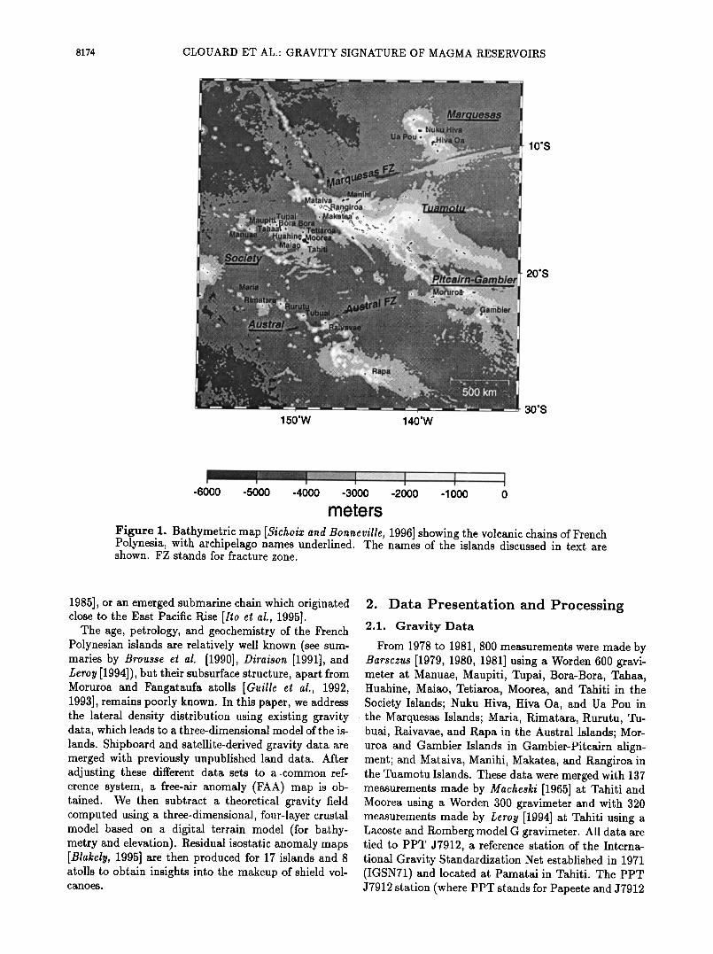
Figure 1. Bathymetric map [$ichoix and Bonneville, 1996] showing the volcanic chains of French Polynesia, with archipelago names underlined. The names of the islands discussed in text are shown. FZ stands for fracture zone.
1985], or an emerged submarine chain which originated close to the East Pacific Rise [Ito et al., 1995].
The age, petrology, and geochemistry of the French Polynesian islands are relatively well known (see sum- maries by Brousse et al. [1990], Diraison [1991], and Leroy [1994]), but their subsurface structure, apart from Moruroa and Fangataufa atolls [Guille et al., 1992, 1993], remains poorly known. In this paper, we address the lateral density distribution using existing gravity data, which leads to a three-dimensional model of the is- lands. Shipboard and satellite-derived gravity data are merged with previously unpublished land data. After adjusting these different data sets to a-common ref- erence system, a free-air anomaly (FAA) map is ob- tained. We then subtract a theoretical gravity field computed using a three-dimensional, four-layer crustal model based on a digital terrain model (for bathy- metry and elevation)'. Residual isostatic anomaly maps [Blakely, 1995] are then produced for 17 islands and 8 atolls to obtain insights into the'makeup of shield vol- canoes.
2. Data Presentation and Processing 2.1. Gravity Data
From 1978 to 1981, 800 measurements were made by Barsczus [1979, 1980, 1981] using a Worden 600 gravi- meter at Manuae, Manpiti, Tupai, Bora-Bora, Tahaa, Huahine, Maiao, Tetiaroa, Moorea, and Tahiti in the Society Islands; Nuku Hiva, Hiva Oa, and Ua Pou in the Marquesas Islands; Maria, Rimatara, Rurutu, Tu- buai, Raivavae, and Rapa in the Austral Islands; Mor- uroa and Gambier Islands in Gambier-Pitcairn align- ment; and Mataiva, Manihi, Makatea, and Rangiroa in the Tuamotu Islands. These data were merged with 137 measurements made by Macheski [1965] at Tahiti and Moorea using a Worden 300 gravimeter and with 320 measurements made by Leroy [1994] at Tahiti using a Lacoste and Romberg model G gravimeter. All data are tied to PPT J7912, a reference station of the Interna- tional Gravity Standardization Net established in 1971 (IGSN71) and located at Pamatai in Tahiti. The PPT J7912 station (where PPT stands for Papeete and J7912
CLOUARD ET AL.: GRAVITY SIGNATURE OF MAGMA RESERVOIRS 8175
Table 1. Radiometric Ages of Aerial Volcanism in French Polynesian Studied Islands
Island Longitude W Latitude S Age, Ma Reference
RaJvavae
Rapa Rimatara
Rurutu
TubuaJ
Hiva Oa
Nuku Hiva
Bora Bora
Huahine
Maupiti Moorca Tahaa
Tahiti-iti Tahiti-nut
Austral
147039 ' 23052 ' 5.6-7.6 144020 ' 27036 ' 5.9-5.2
152 o 48' 22ø39 ' (4.8-28.6) 151 o 21 ' 22o29 ' 0.6-12.3
149030' 23023 ' 8.5-10.6
Marquesas
139003 ' 09045 ' 1.6-2.5 140012 ' 08054 ' 3.0-4.3
Society
151044 ' 16030 ' 3.1-3.4 151000 ' 16ø45 ' 2.0-2.6 152o16 ' 16o27 ' 4.0-4.5 149o50 ' 17o33 ' 1.5-1.7 151o30 ' 16o39 ' 2.6-3.2 149o30 ' 17o36 ' 0.4-0.5 149 o 15' 17048' 0.19-1.37
Gambier (Manureva) 134057' Moruroa 138054'
Pitcairn-Gambler
23009 ' 6.2 21051 ' 11.0
Duncan and McDougall [1976] Krummenacher and Noetzlin [1966] Turner and Jarrard [1982] Dalrymple et al. [1975], Duncan and McDougall [1976], and Turner and Jarrard [1982] Duncan and McDougall [1976]
Duncan and McDougall [1974] Duncan and McDougall [1974]
Duncan and McDougall [1976] Duncan and McDougall [1976] Duncan and McDougall [1976] Duncan and McDougall [1976] Duncan and McDougall [1976] Leroy [ 1994] Leroy [1994]
Guillou et al. [1994] Gillot et al. [1992]
means that it was the twelth station made in 1979) was established by a Japanese team during a circum- Pacific gravimetric connections campaign [Nakagawa e! al., 1983]. From this total "land data set", a FAA was then calculated using the GRS80 ellipsoid model. The experimental error e related to this land data set can be expressed as the sum of the measurement error em es- timated to be 0.35 mGal (standard deviation [Barsczus, 1980]) and a function of the barometric leveling error dz estimated to be 10 m, as follows:
e =em + 0.3086 dz •- 3.5 regal. (1)
Marine gravity data for the area compiled by $ichoix and Bonneville [1996] include 27 tracks (116,171 points) from the National Geophysical Data Center (NGDC) database which was obtained with good satellite navig- ation accuracy. After the removal of uncontrolled peaks, this set was tied to a Seasat and ERS-1 satellite-derived
FAA grid [Smith and Sandwell, 1995]. We have ad- ded data from recent cruises in French Polynesia to the $ichoix and Bonneville [1996] data set: EW9602 on the R/V Maurice Ewing to the southeast of the Austral Islands [McNut! e! al., 1997] and two cruises on the R/V L'Atalante, ZEPOLYF1, south of the Society Is- lands [Bonneville e! al., 1997] and ZEPOLYF2, north
of the Austral Islands (A. Bonneville, personal commu- nication, 1999). The entire offshore data set is referred to here as the "marine data set." The error on FAA
satellite-derived data was estimated to be 5 mGal by Sandwell [1992]. The shipboard data error is I to 2 mGal. Consequently, a maximum error of 5 mGal for the whole marine data set is assumed.
2.2. •ree-air Anomaly Maps
When preparing composite FAA maps, the first ad- justment of land and marine gravity data is controlled visually. Close to lands, the values in the marine data set, composed mainly of satellite data, appear systemat- ically lower by a few tens of milliGals than the ground data set. This discrepancy may be related to (1) the hanging of radar beams on island flanks [Barriot, 1987]; (2) a bias introduced from the method to produce grav- ity fields from the geoid signal due to crossover of un- evenly spaced ground tracks, especially in the vicinity of islands where data have been removed [Filmer, 1991]; and (3) the size of the island itself when its diameter ranges from 5 to 15 km, which is close to the resolution of the satellite (20-30 km, [Sandwell, 1992]).
To adjust these two data sets, we used only shipboard data in the vicinity of islands (up to 6 km offshore, ex-
8176 CLOUARD ET AL.: GRAVITY SIGNATURE OF MAGMA RESERVOIRS
m • • mm mm • mm
:":'"' ..... • ............. • .... ' •.:?.--":!!."':'!•?•'/'-'"•......'•'.'•i:.'•.• m . . !y..:......:.....:.:.?;;•!}•,•.•ii.•::
I ..... .... I ' ............ •.'.:.':::•' ...• ':•:•,.:::..- ..• ••....
...... ß '" • ß ,-•.-.-•. ............. •'•' - - ß ............. .'::.-.-•:-:.,:::•*•:.•; •.,•kY:•'z•'•'..•::. -: ß ' :":":*'"'5;*;'•:,...::4Z•!•':':.•;•i•i•i• ;3•::•::•:•::•J•*•::• '..
......... :.. ..... .... ;.:...'::::.:;: ..... .'..; '. .• • 3j?:•::5 ;:'•. ":'"';'.•...:,:•.•::::. :•J•:::•: .-•:. :: .-:. .... '-':::•:-•.'-;•'2•.:.: • ß •(, ' •e):• •.
•..5'. -: :• • ..... a•, ;:::•:5: .......
•,,.. .... •:•::.,•:...:::•; ...... •::.•:.•:•y:•:•: •.•-.. . ::::::::::::::::::::::::::::... •j•;• - ........ , .... ..?... •,.- , .'.-•"•;j•j• •
ß .. .... I ............. .................... '"'F : ?'•F•;;;(•:;:•'?•.::•i::•'?": ";•::':;•:'::'::';':'::':::::::::::::::::::::::::::::::: ' .... :.:: ?L '•4:•½½•!;•$•;•
150øW 149øW 150• 149øW
-50 -25 0 25 50 75 100 125 150 175 200
mGal
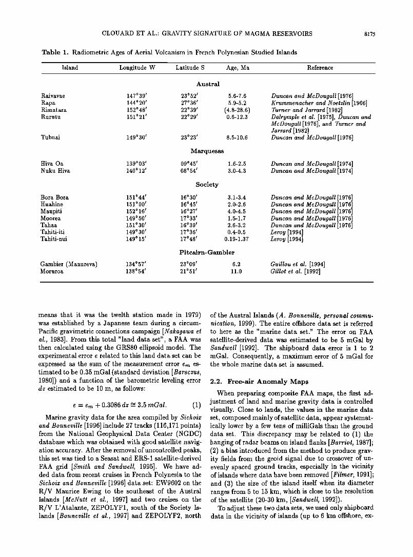
Figure 2. Example of the derivation of the FAA map for the Tetiaroa, Moorea, and Tahiti islands. (left) Gravity satellite data only [Smith and Sandwell, 1995]. The thin black lines represent the shipboard profiles along which the measured gravity values were used to produce an improved field within the polygons shown as white lines. (right) Final FAA map produced by merging the satellite data outside the polygons with the shipborne data within the polygons. Note the improvement in anomaly resolution over and near the islands. Contour interval is 25 regal.
cept for Tahiti where this limit is extended to 60 km) because these data have the same reference bases as
the ground data and thus their datum are comparable (Figure 2). Using a continuous curvature "splines-in- tension" algorithm (GMT [$milh and }Vessel, 1990]), the land data set and shipboard data in the vicinity of islands were merged with the complete marine data set minus the data around the islands to obtain two types of grids. The first grid corresponds to the complete FAA map of French Polynesia, which is a coarse grid 2•x2 •, such as is shown in the small region around the island of Tahiti in Figure 2. The second type corres- ponds to a set of finer grids covering each island, which were used in calculating the properties and geometry of magma chambers. These are 30"x30"grids, constrained by good spatial coverage on land (1352 measurements for 2350km 2, averaging about two stations within a 60"x60" area). (All the grids are available at URL http://www. ip gp .j ussieu. fr/UF P / download. ht ml. )
2.3. Topographic Maps
We used the synthesized database of bathymetry compiled by Sichoix and Bonneville [1996] that was based on ~82 cruises plus additional soundings from the French Service Hydrographique et Oc•anographique de la Marine, all acquired with satellite navigation since
1967. Data were carefully checked for quality and subjected to a crossover analysis, similar to the one used by Smith [1993], but using Global Positioning Sys- tem (GPS) navigated expeditions for reference. The most recent bathymetric profiles used, including multi- beam soundings from EW9602 and ZEPOLYF1 cruises, are denser, often with a spacing of •500 m along the shiptrack. The older profiles have a typical spacing of >2 km.
Elevation data on islands were obtained by digitiz- ing topographic maps of French Polynesia [ Service de l'Urbanisme, 1992] and from maps of the Atlas de la Polyn•sie Fran;aise [ORSTOM, 1993]. For the island of Tahiti we used a digital terrain model derived by G•oimage (Sophia Antipolis, France) from two stereo- scopic SPOT images. The elevation on atolls was arbit- rarily set at 0 m over the lagoon (for depths between 1 and 40 m) and at 1 m above sea level on the coral rim (for heights between 1 and 5 m). Topographic land data and bathymetric data were then combined and gridded to produce a 2•x2 • grid for the whole area, and several 30"x30" grids covering each island.
2.4. Flexural Model
Previous studies of the gravity and topography of the Hawaiian archipelago [e.g., Walcott, 1970] show that

CLOUARD ET AL.- GRAVITY SIGNATURE OF MAGMA RESERVOIRS 8177
volcanic loads on the oceanic lithosphere are supported regionally rather than locally. In response to applied loads the lithosphere acts as a thin elastic plate overly- ing an inviscid fluid [Watts et al., 1980]. The amplitude of the deflexion depends on both the size of the volcanic load and the effective flexural rigidity of the thin elastic plate [Watts et al., 1975]. The flexural rigidity is linked to the elastic thickness of the lithosphere that corres- ponds to the upper part of the lithosphere and depends mainly on the temperature, and hence on the age of the lithosphere at the time of loading [Watts, 1978].
Watts and Ribe [1984] obtained several values of the flexural rigidity in various tectonic contexts. McNutt [1984] introduced the concept of the "effective thermal age," which corresponds to the thermal age at the time of loading. It can be less than the lithospheric age if the plate has been reheated, which is common for regions
of intraplate volcanism. Calmant and Cazenave [1986] and Young and Hill [1986] invoke this concept to explain rigidity anomalies obtained below the Cook, Austral, and Society Islands and below the Cape Verde rise.
The numerical and three-dimensional approach de- veloped by Watts et al., [1975] is used here to solve the classical equation governing the deformation w (positive downward) of an elastic layer under a volcanic load:
+ - - u) (2)
where pt is the load density, pm is the mantle density, D the flexural rigidity of the lithosphere, V is the bi- harmonic operator, q(x, y) is the vertical load derived from the topographic grid obtained previously, and g is the acceleration due to gravity (g = 9.81 ms-2).
In our study the value of D has been carefully chosen for each island group using two methods. In the first
se;water
crust
Pc
aerial
topography
. bathymetry
/; flexure L ..... :-r•,•:..• •:•:•:.•.:•:.•.%.:.:.:.,,•.:•:;•:½•.•,.•.• .:•;...•:•½:•!•.•:.: .•.•:.:::•;• :.•:•.•.•:•,•:•:..: .•.;•::• ......
mm mm mm mmmmm mm
Figure 3. The theoretical FAA is obtained by computing the gravity effect of volcanic construc- tion above a deflected crust. (top) The model involves six layers, with different densities p. The assumed densities for crust (pc), mantle (p,•), and water (p,o) are 2900, aaao and 1030 kg m respectively. The deflection is estimated using a 3-D model for a thin elastic plate loaded by the topography (see text). The volcanic load is modeled by three layers: the subaerial volcanic construction (pa), the submarine volcanic construction (p,), the material filling the flexure with pa < p, < pf. (bottom) The geometry of the system is modeled by elementary prisms.
8178 CLOUARD ET AL' GRAVITY SIGNATURE OF MAGMA RESERVOIRS
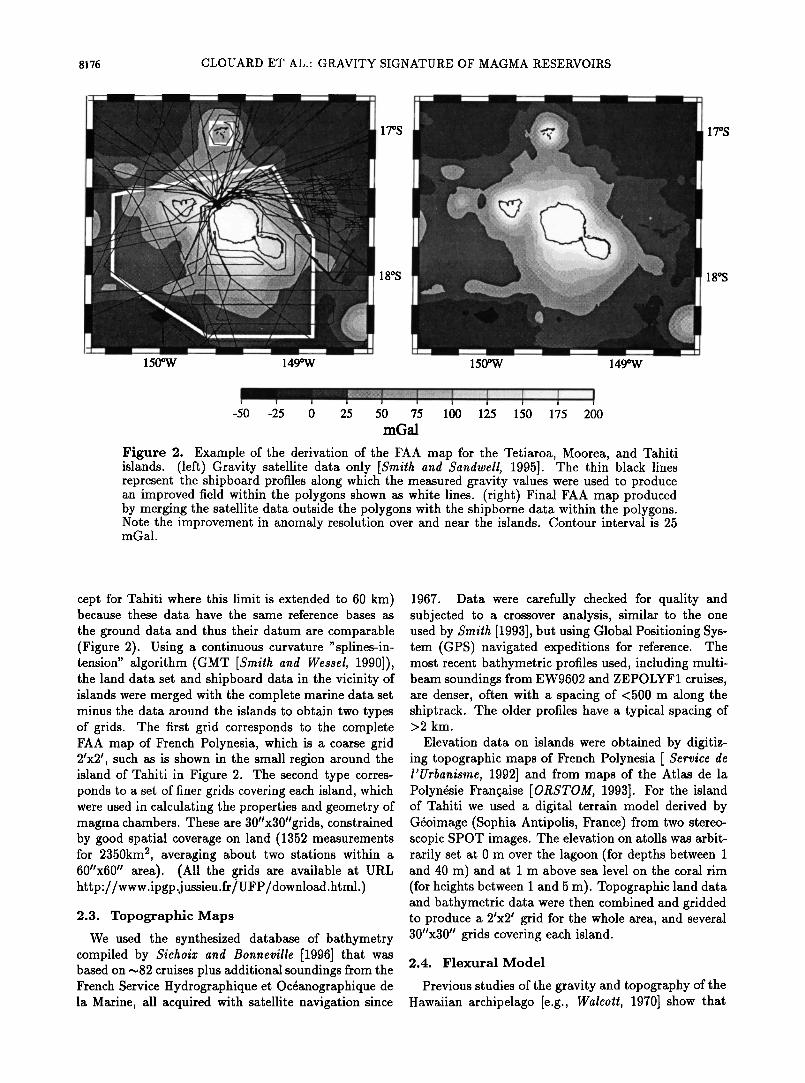
method, seismic refraction profiles provide the Moho depth (Society and west Tuamotu Islands [Danobeatia et al., 1995; Talandier and Okal, 1987] and Marque- sas Islands [Caress et al., 1995]). After this depth is compared with the Moho depth based on the flexural model we select the D value that minimizes the differ-
ence between observations and model. In the second
method, employed when seismic reflection data are un- available, we used published D values. Typical values of D vary from 1.5 x 10²• N m to 8.0 x 10²² N m for the south central Pacific area [e.g. Calmant and Cazenave, 1987; Filmer et al., 1993; Goodwillie and Watts, 1993]. These are much lower than the values expected for the range of crustal ages concerned [Watts et al., 1980]. Complete discussions of the choice of flexural rigidity values for our region are given by McNutt [1998] and Sichoix [1997]. The following values for the flexural ri- gidity were selected: 4.0 x 10²² N m for Society and Marquesas Islands, 3.5 x 10²• N m for Pitcairn-Gambier Islands, 1.2 x 10²² N m for western Austral Islands, 3.5 x 10²• N m for the eastern Austral Islands, and 8.0 x 10²• N m for Tuamotu Islands. We assume that the representative densities of the mantle and the load are p,• = 3350 kg m -3 and pt = 2700 kg m -3 respect- ively [Caress et al., 1995; Sichoix, 1997]. The deflection w is then computed for all the nodes (2•x2 •) of the to- pographic grid.
2.5. Isostatic Residual Anomaly
A three-dimensional, four-layer crustal model (Fig- ure 3) is used to compute a theoretical FAA. The in- terface between the ocean and seafloor is given by the bathymetric grid (Figure 1). The interface between the volcanic load, divided into three density layers, and the oceanic crust is given by the deflection grid, which is assumed also to define the interface between crust and
mantle. The crust is assumed to have a constant thick-
ness of 6000 m. This thickness has been determined
from seismic refraction studies in the Society-Tuamotu area [Danobealia e! al., 1995] and the Marquesas area [Caress et al., 1995]. The material filling the depres- sions under the load is assumed to have a higher dens- ity (pf) than the overlying volcanic material (p•) and the aerial part of the volcano (pa). The seafloor normal depth is given by the deepest point of the bathymet- tic grid within the particular area being studied. The model is divided into 2•x2 • square prisms extending to Moho depth. The zero FAA is given by a fiat oceanic crust at the sea floor normal depth. The theoretical FAA is then computed for each node of the 2•x2 • grid by summing the gravity effects of all the prisms [Plouff, 1976] produced by the density contrasts shown in Fig- ure 3. A similar computation was made for each island using the finer grid (30"x30").
By subtracting the theoretical FAA grid from the observed anomaly, an isostatic residual gravity field [Blakely, 1995], similar to an isostatic Bouguer field (Figure 4), is determined and investigated below as to
(b)
_• 200 & (c) • 100
ß -100 152•W 151•W 150•W 149•W
'• E (d)
I it 0
-50
152øw 151øw 150øw 149øw
Figure 4. Residual isostatic anomaly over the Soci- ety Islands obtained by subtracting the modeled FAA from the observed. (a) Bathymetric map of the Soci- ety Islands. Data along the profile AA' (solid dashed line) are shown in Figures 4b, 4c and 4d; (b) the crustal model used to compute the modeled FAA. The elastic thickness is adjusted using the Moho depth given by seismic refraction profiles; (c) comparison between ob- served (thick dashes) and computed FAA (thin line) along AA'; and (d) isostatic residual gravity anomaly along AA'.
its utility to provide new insights on the makeup of is- lands. According to Figure 3, only contrasts between mantle and crustal densities and between crust and infill densities are relevant in the model, not their absolute values. As the density contrasts are regional paramet- ers rather than specific to each island, we determined these contrasts by minimizing the difference between computed and observed gravity anomaly for each ar- chipelago. The best estimate of the mantle-crust dens- ity contrast is everywhere 450 kg m -3. Assuming a value of 3350 kg m -3 for the mantle density, the crust density is then 2900 kg m -a. Thus the volcano submar-
CLOUARD ET AL' GRAVITY SIGNATURE OF MAGMA RESERVOIRS 8179
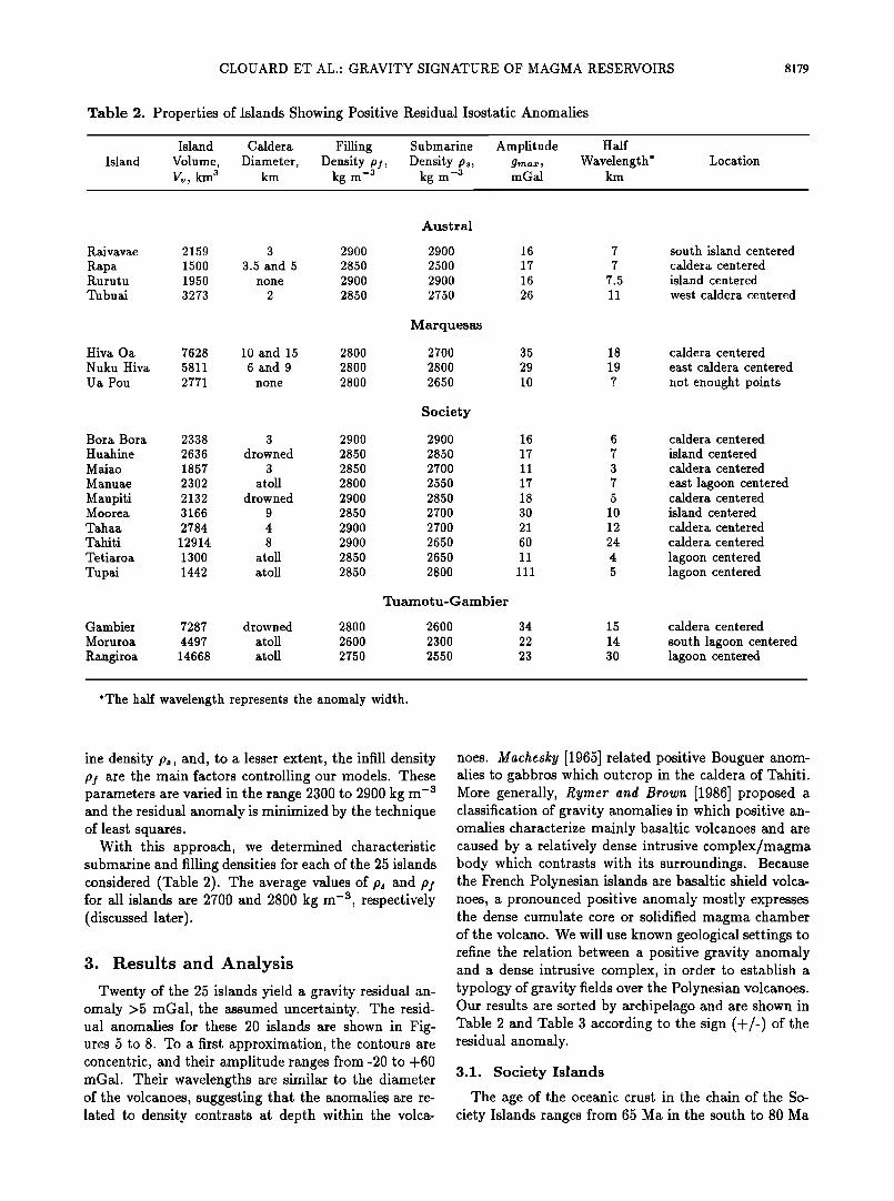
Table 2. Properties of Islands Showing Positive Residual Isostatic Anomalies
Island Island Caldera Filling Submarine Amphtude Half
Volume, Diameter, Density p;, Density ps, gmax, Wavelength* V•,, kma km kg m -a kg m -a m Gal km
Location
Austral
Raivavae 2159 3 2900 2900 16
Rapa 1500 3.5 and 5 2850 2500 17 Rut ut u 1950 none 2900 2900 16 Tubuai 3273 2 2850 2750 26
Marquesas
Hiva Oa 7628 10 and 15 2800 2700 35 Nuku Hiva 5811 6 and 9 2800 2800 29 Ua Pou 2771 none 2800 2650 10
Society
Bora Bora 2338 3 2900 2900 16 Huahine 2636 drowned 2850 2850 17 Maiao 1857 3 2850 2700 11 Manuae 2302 atoll 2800 2550 17
Maupiti 2132 drowned 2900 2850 18 MooreL 3166 9 2850 2700 30
Tahaa 2784 4 2900 2700 21 Tahiti 12914 8 2900 2650 60
Tetiaroa 1300 atoll 2850 2650 11
Tupai 1442 atoll 2850 2800 111
Tuamotu-Gambier
Gambier 7287 drowned 2800 2600 34 Moruroa 4497 atoll 2600 2300 22
Rangiroa 14668 atoll 2750 2550 23
7 south island centered 7 caldera centered
7.5 island centered 11 west caldera centered
18 caldera centered 19 east caldera centered
? not enought points
6 caldera centered 7 island centered 3 caldera centered
7 east lagoon centered 5 caldera centered
10 island centered 12 caldera centered 24 caldera centered
4 lagoon centered 5 lagoon centered
15 caldera centered
14 south lagoon centered 30 lagoon centered
*The half wavelength represents the anomaly width.
ine density p,, and, to a lesser extent, the infill density pf are the main factors controlling our models. These parameters are varied in the range 2300 to 2900 kg m -a and the residual anomaly is minimized by the technique of least squares.
With this approach, we determined characteristic submarine and filling densities for each of the 25 islands considered (Table 2). The average values of p• and pf for all islands are 2700 and 2800 kg m -a, respectively (discussed later).
3. Results and Analysis
Twenty of the 25 islands yield a gravity residual an- omaly >5 mGal, the assumed uncertainty. The resid- ual anomalies for these 20 islands are shown in Fig- ures 5 to 8. To a first approximation, the contours are concentric, and their amplitude ranges from-20 to +60 mGal. Their wavelengths are similar to the diameter of the volcanoes, suggesting that the anomalies are re- lated to density contrasts at depth within the volca-
noes. Machesky [1965] related positive Bouguer anom- alies to gabbros which outcrop in the caldera of Tahiti. More generally, Rymer and Brown [1986] proposed a classification of gravity anomalies in which positive an- omalies characterize mainly basaltic volcanoes and are caused by a relatively dense intrusive complex/magma body which contrasts with its surroundings. Because the French Polynesian islands are basaltic shield volca- noes, a pronounced positive anomaly mostly expresses the dense cumulate core or solidified magma chamber of the volcano. We will use known geological settings to refine the relation between a positive gravity anomaly and a dense intrusive complex, in order to establish a typology of gravity fields over the Polynesian volcanoes. Our results are sorted by archipelago and are shown in Table 2 and Table 3 according to the sign (+/-) of the residual anomaly.
3.1. Society Islands
The age of the oceanic crust in the chain of the So- ciety Islands ranges from 65 Ma in the south to 80 Ma
8180 CLOUARD ET AL.: GRAVITY SIGNATURE OF MAGMA RESERVOIRS
c)
17ø00'S
-30 -20 -10 -5 0 5 10 •5 20 25 30 40 50 mGal
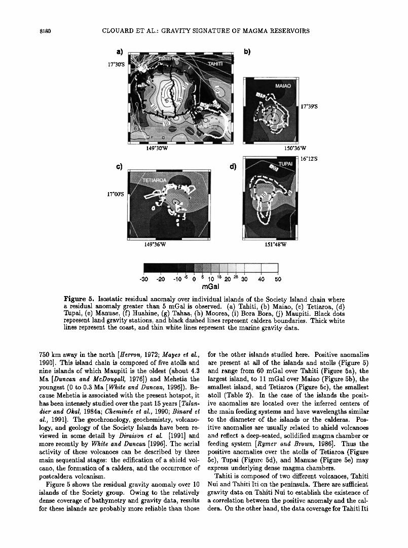
Figure 5. Isostatic residual anomaly over individual islands of the Society Island chain where a residual anomaly greater than 5 regal is observed. (a) Tahiti, (b) Maiao, (c) Tetiaroa, (d) Tupai, (e) Manuae, (f) Huahine, (g) Tahaa, (h) Moorea, (i) Bora Bora, (j) Maupiti. Black dots represent land gravity stations, and black dashed lines represent caldera boundaries. Thick white lines represent the coast, and thin white lines represent the marine gravity data.
750 km away in the north [Herron, 1972; Mayes et al., 1990]. This island chain is composed of five atolls and nine islands of which Maupiti is the oldest (about 4.3 Ma [Duncan and McDougall, 1976]) and Mehetia the youngest (0 to 0.3 Ma [White and Duncan, 1996]). Be- cause Mehetia is associated with the present hotspot, it has been intensely studied over the past 15 years [Talan- diet and Okal, 1984a; Cheminge et al., 1990; Binard et al., 1991]. The geochronology, geochemistry, volcano- logy, and geology of the Society Islands have been re- viewed in some detail by Diraison et al. [1991] and more recently by White and Duncan [1996]. The aerial activity of these volcanoes can be described by three main sequential stages: the edification of a shield vol- cano, the formation of a caldera, and the occurrence of postcaldera volcanism.
Figure 5 shows the residual gravity anomaly over 10 islands of the Society group. Owing to the relatively dense coverage of bathymetry and gravity data, results for these islands are probably more reliable than those
for the other islands studied here. Positive anomalies
are present at all of the islands and atolls (Figure 5) and range from 60 regal over Tahiti (Figure 5a), the largest island, to 11 regal over Maiao (Figure 5b), the smallest island, and Tetiaroa (Figure 5c), the smallest atoll (Table 2). In the case of the islands the posit- ive anomalies are located over the inferred centers of
the main feeding systems and have wavelengths similar to the diameter of the islands or the calderas. Pos-
itive anomalies are usually related to shield volcanoes and reflect a deep-seated, solidified magma chamber or feeding system [Rymer and Brown, 1986]. Thus the positive anomalies over the atolls of Tetiaroa (Figure 5c), Tupai (Figure 5d), and Manuae (Figure 5e) may express underlying dense magma chambers.
Tahiti is composed of two different volcanoes, Tahiti Nui and Tahiti Iti on the peninsula. There are sufficient gravity data on Tahiti Nui to establish the existence of a correlation between the positive anomaly and the cal- dera. On the other hand, the data coverage for Tahiti Iti
CLOUARD ET AL.' GRAVITY SIGNATURE OF MAGMA RESERVOIRS 8181
154 ø 36'W
151 o 00'w
16 ø 30'S
151 ø 48'W
16ø48'S
151ø36'W
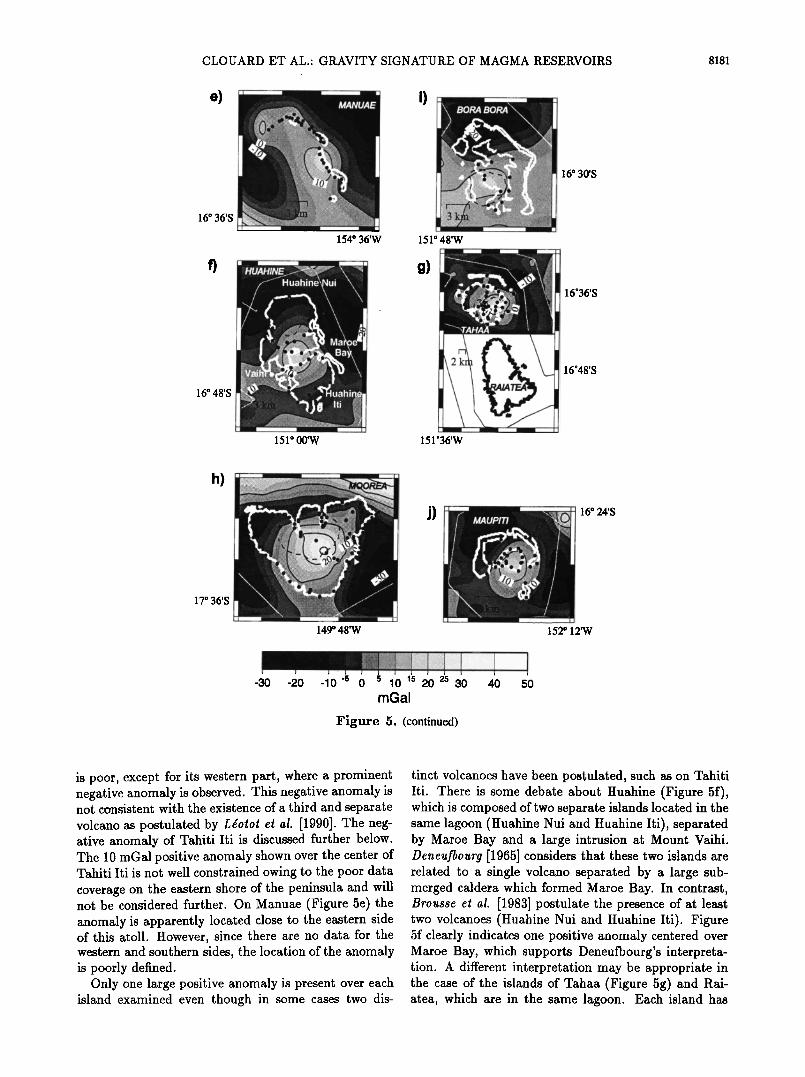
-30 -20 -10 -5 0 5 10 •5 20 25 30 40 50 mGal
Figure 5. (continued)
is poor, except for its western part, where a prominent .... 4:.... 1 ' . ,,c•,•,,• anoma,y ,o observed This negative not consistent with the existence of a third and separate volcano as postulated by Ldotot et al. [1990]. The neg- ative anomaly of Tahiti Iti is discussed 'further below. The 10 regal positive anomaly shown over the center of Tahiti Iti is not well constrained owing to the poor data coverage on the eastern shore of the peninsula and will not be considered further. On Manuae (Figure 5e) the anomaly is apparently located close to the eastern side of this atoll. However, since there are no data for the western and southern sides, the location of the anomaly is poorly defined.
Only one large positive anomaly is present over each island examined even though in some cases two dis-
tinct volcanoes have been postulated, such as on Tahiti Iti. Thero; ..... •o•,•t,• •,•,,,, Huahine (Figure 5f), which is composed of two separate islands located in the same lagoon (Huahine Nui and Huahine Iti), separated by Maroe Bay and a large intrusion at Mount Vaihi. Deneufbourg [1965] considers that these two islands are related to a single volcano separated by a large sub- merged caldera which formed Maroe Bay. In contrast, Brousse el al. [1983] postulate the presence of at least two volcanoes (Huahine Nui and Huahine Iti). Figure 5f clearly indicates one positive anomaly centered over Maroe Bay, which supports Deneufbourg's interpreta- tion. A different interpretation may be appropriate in the case of the islands of Tahaa (Figure 5g) and Rai- atea, which are in the same lagoon. Each island has
8182 CLOUARD ET AL- GRAVITY SIGNATURE OF MAGMA RESERVOIRS
a)
b)
23ø48'S
22ø30'S
147ø36'W
144ø24'W
27'36'S
d)
23'24'S
151'24'W
ß I . ß
;72•'?•;L•.."% '•::: .......... ' ...... ' ..... •;•-•:•....: ............ .;• .
149ø24'W
-30 -20 -•0'5 0 5 •0 •5 20 25 30 40 50 mGal
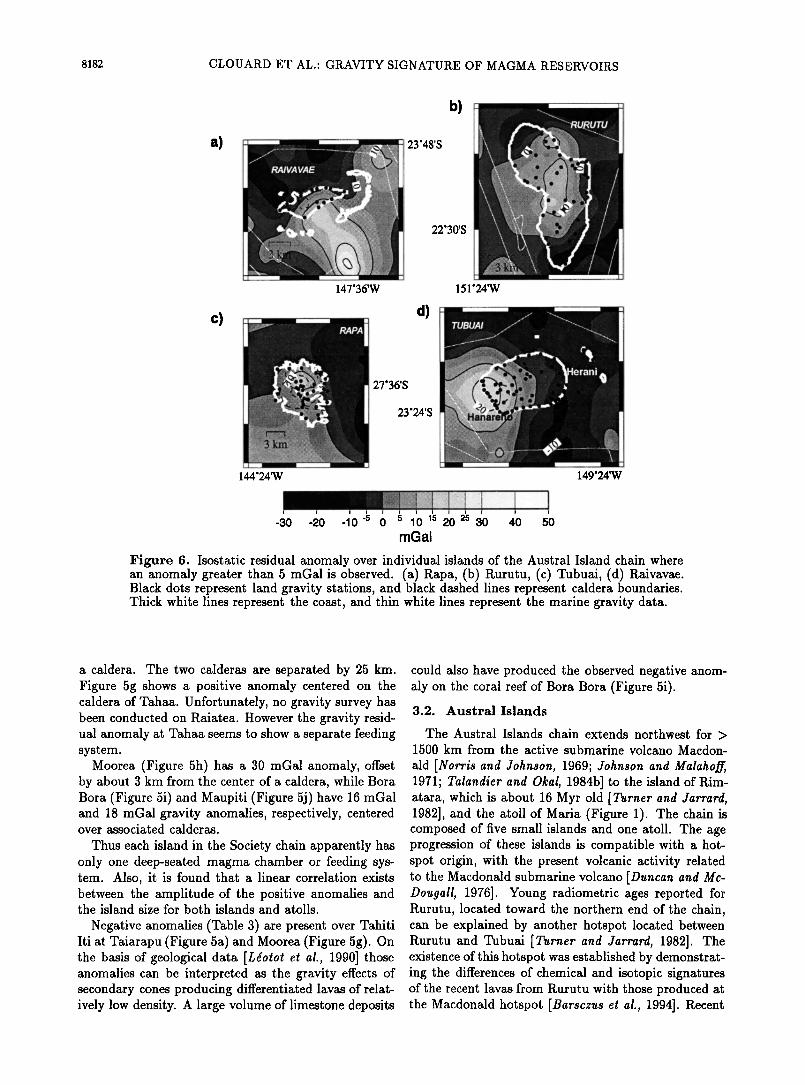
Figure 6. Isostatic residual anomaly over individual islands of the Austral Island chain where an anomaly greater than 5 regal is observed. (a) Rapa, (b) Rurutu, (c) Tubuai, (d) Raivavae. Black dots represent land gravity stations, and black dashed lines represent caldera boundaries. Thick white lines represent the coast, and thin white lines represent the marine gravity data.
a caldera. The two calderas are separated by 25 km. Figure 5g shows a positive anomaly centered on the caldera of Tahaa. Unfortunately, no gravity survey has been conducted on Raiatea. However the gravity resid- ual anomaly at Tahaa seems to show a separate feeding system.
Moorea (Figure 5h) has a 30 regal anomaly, offset by about 3 km from the center of a caldera, while Bora Bora (Figure 5i) and Maupiti (Figure 5j) have 16 mGal and 18 mGal gravity anomalies, respectively, centered over associated calderas.
Thus each island in the Society chain apparently has only one deep-seated magma chamber or feeding sys- tem. Also, it is found that a linear correlation exists between the amplitude of the positive anomalies and the island size for both islands and atolls.
Negative anomalies (Table 3) are present over Tahiti Iti at Taiarapu (Figure 5a) and Moorea (Figure 5g). On the basis of geological data [Ldotot et at., 1990] those anomalies can be interpreted as the gravity effects of secondary cones producing differentiated lavas of relat- ively low density. A large volume of limestone deposits
could also have produced the observed negative anom- aly on the coral reef of Bora Bora (Figure 5i).
3.2. Austral Islands
The Austral Islands chain extends northwest for > 1500 km from the active submarine volcano Macdon-
ald [Norris and Johnson, 1969; Johnson and Malahoff, 1971; Talandier and Okal, 1984b] to the island of Rim- atara, which is about 16 Myr old [Turner and Jarfatal, 1982], and the atoll of Maria (Figure 1). The chain is composed of five small islands and one atoll. The age progression of these islands is compatible with a hot- spot origin, with the present volcanic activity related to the Macdonald submarine volcano [Duncan and Mc- Dongall, 1976]. Young radiometric ages reported for Rurutu, located toward the northern end of the chain, can be explained by another hotspot located between Rurutu and Tubuai [Turner and Jarfatal, 1982]. The existence of this hotspot was established by demonstrat- ing the differences of chemical and isotopic signatures of the recent lavas from Rurutu with those produced at the Macdonald hotspot [Barsczus et at., 1994]. Recent
CLOUARD ET AL.- GRAVITY SIGNATURE OF MAGMA RESERVOIRS 8183
a)
l [ "" 1 9o24,s 140ø.00'W
139'00'W
8 ø48'S
140ø00'W
-30 -20 -10-5 0 5 10 15 20 25 30 40 50 mGal
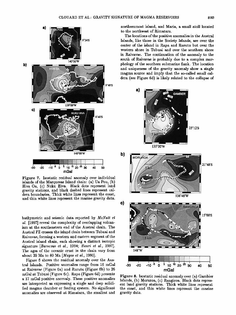
Figure 7. Isostatic residual anomaly over individual islands of the Marquesas Island chain: (a) Ua Pou, (b) Hiva Oa, (c) Nuku Hiva. Black dots represent land gravity stations, and black dashed lines represent cal- dera boundaries. Thick white lines represent the coast, and thin white lines represent the marine gravity data.
bathymetric and seismic data reported by McNut! a! al. [1997] reveal the complexity of overlapping volcan- ism at the southeastern end of the Austral chain. The
Austral FZ crosses the island chain between Tubuai and
Raivavae, forming a western and eastern segment of the Austral island chain, each showing a distinct isotopic signature [Barsczus at at., 1994; Hauri at at., 1997]. The ages of the oceanic crust in the chain vary from about 35 Ma to 80 Ma [Mayas at at., 1990].
Figure 6 shows the residual anomaly over the Aus- tral Islands. Positive anomalies range from 16 mGal at Raivavae (Figure 6a) and Rurutu (Figure 6b) to 26 mGal at Tubuai (Figure 6c). Rapa (Figure 6d) presents a 17 mGal positive anomaly. These positive anomalies are interpreted as expressing a single and deep solidi- fied magma chamber or feeding system. No significant anomalies are observed at Rimatara, the smallest and
northernmost island, and Maria, a small atoll located to the northwest of Rimatara.
The locations of the positive anomalies in the Austral Islands, like those in the Society Islands, are over the center of the island in Rapa and Rurutu but over the western shore in Tubuai and over the southern shore
in Raivavae. The continuation of the anomaly to the south of Raivavae is probably due to a complex mor- phology of the southern submarine flank. The location and uniqueness of the gravity anomaly show a single magma source and imply that the so-called small cal- dera (see Figure 6d) is likely related to the collapse of
b)
c)
a)
23ø12'S
138ø48'W
148øW
21ø48'S
15000'S
-30 -20 -10 -5 0 5 10 45 20 25 30 40 50 mGal
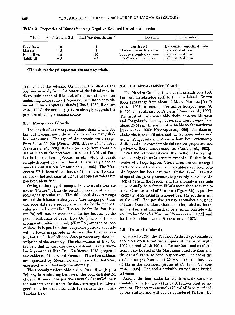
Figure 8. Isostatic residual anomaly over (a) Gainbier Islands, (b) Moruroa, (c) Rangiroa. Black dots repres- ent land gravity stations. Thick white lines represent the coast, and thin white lines represent the marine gravity data.
8184 CLOUARD ET AL.: GRAVITY SIGNATURE OF MAGMA RESERVOIRS
Table 3. Properties of Islands Showing Negative Residual Isostatic Anomalies
Island Amphtude, mGal Half Wavelength, km * Location Interpretation
Bora Bora -20 4 north reef Moorea -10 3 Maraarii secondary cone Nuku Hiva -30 10 Topuke strombohan cone Tahiti I6 -10 6.5 NW secondary cones
low density superficial bodies differentiated lava
differentiated lava differentiated lava
*The half wavelength represents the anomaly width.
the flanks of the volcano. On Tubuai the offset of the
positive anomaly from the center of the island may in- dicate subsidence of this part of the island due to an underlying dense source (Figure 6c), similar to that ob- served in the Marquesas Islands [Chubb, 1930; Barsczus et al., 1992]; the anomaly pattern strongly suggests the presence of a single magma source.
3.3. Marquesas Islands
The length of the Marquesas island chain is only 350 km, but it comprises a dozen islands and as many shal- low seamounts. The age of the oceanic crust ranges from 50 to 55 Ma [Krusa, 1988; Mayas at al., 1990; Munschy at al., 1996]. K-Ar ages range from about 5.5 Ma at Eiao in the northwest to about 1.5 Ma at Fatu
Iva in the southeast [Broussa at al., 1990]. A basalt sample dredged 50 km southeast of Fatu Iva yielded an age of about 0.5 Ma [Dasonia at al., 1993]. The Mar- quesas FZ is located southeast of the chain. To date, no active hotspot generating the Marquesas volcanism has been identified.
Owing to the rugged topography, gravity stations are sparse (Figure 7), thus the resulting interpretations are somewhat speculative. The shipboard data coverage around the islands is also poor. The merging of these two poor data sets probably accounts for the non cir- cular residual anomalies. The results for Ua Pou (Fig- ure 7a) will not be considered further because of the poor distribution of data. Hiva Oa (Figure 7b) has a prominent positive anomaly (35 mGal) over the Atuona caldera. It is possible that a separate positive anomaly with a lower magnitude exists over the Puamau val- ley, but the lack of offshore data prevents any clear de- scription of the anomaly. The observations at Hiva Oa indicate that at least one deep, solidified magma cham- ber is present at Hiva Oa. Oballianna [1955] proposed two calderas, Atuona and Puamau. These two calderas are separated by Mount Ootua, a trachytic diatreme, expressed as 5 mGal negative anomaly.
The anomaly pattern obtained at Nuku Hiva (Figure 7c) may be misleading because of the poor distribution of data. However, the positive anomaly (29 mGal) over the southern coast, where the data coverage is relatively good, may be associated with the caldera that forms Taiohae Bay.
3.4. Pitcairn-Gambier Islands
The Pitcairn-Gambier island chain extends over 1650 km from Hereheretue atoll to Pitcairn Island. Known
K-Ar ages range from about 11 Ma at Moruroa [Guilla at al., 1993] to zero in the active hotspot area, 70 to 100 km southeast of Pitcairn [Binard at al., 1992]. The Austral FZ crosses this chain between Moruroa
and Fangataufa. The age of oceanic crust ranges from about 25 Ma in the southeast to 55 Ma to the northwest
[Mayas at al., 1990; Munschy at al., 1996]. The chain in- cludes the islands Pitcairn and the Gambier and several
atolls. Fangataufa and Moruroa have been extensively drilled and thus considerable data on the properties and geology of these islands exist [see Guilla et al., 1993].
Over the Gambier Islands (Figure 8a), a large posit- ive anomaly (34 mGal) occurs over the 10 islets in the center of a large lagoon. These islets are the emerged parts of an old volcano, and a caldera centered over the lagoon has been assumed [Guilla, 1974]. The fiat shape of the gravity anomaly is probably related to the lack of data in the lagoon, and the anomaly magnitude may actually be a few milliGals more than that indic- ated. Over the atoll of Moruroa (Figure 8b), a positive anomaly of 22 mGal is centered over the southern rim of the atoll. The positive gravity anomalies along the Pitcairn-Gambier island chain are interpreted as the re- mains of ancient magma chambers, which coincide with caldera locations for Moruroa [Buiguas at al., 1992], and for the Gambier Islands [Broussa at al., 1972].
3.5. Tuamotu Islands
Oriented N120 ø, the Tuamotu Archipelago consists of about 60 atolls along two subparallel chains of length 1200 km and width 400 kin. Its northern and southern
termini are located at the Marquesas Fracture Zone and the Austral Fracture Zone, respectively. The age of the seafloor ranges from about 30 Ma in the southeast to 65 Ma in the northwest [Mayas at al., 1990; Munschy et al., 1996]. The atolls probably formed atop buried volcanoes.
Among the four atolls for which gravity data are available, only Rangiroa (Figure 8c) shows positive an- omalies. The eastern anomaly (23 mGal) is only defined by one station and will not be considered further. By
CLOUARD ET AL' GRAVITY SIGNATURE OF MAGMA RESERVOIRS 8185
''111
-101.__._..• Crest • Mantle
i
0 20 •0 •0 •lO •00 (km)
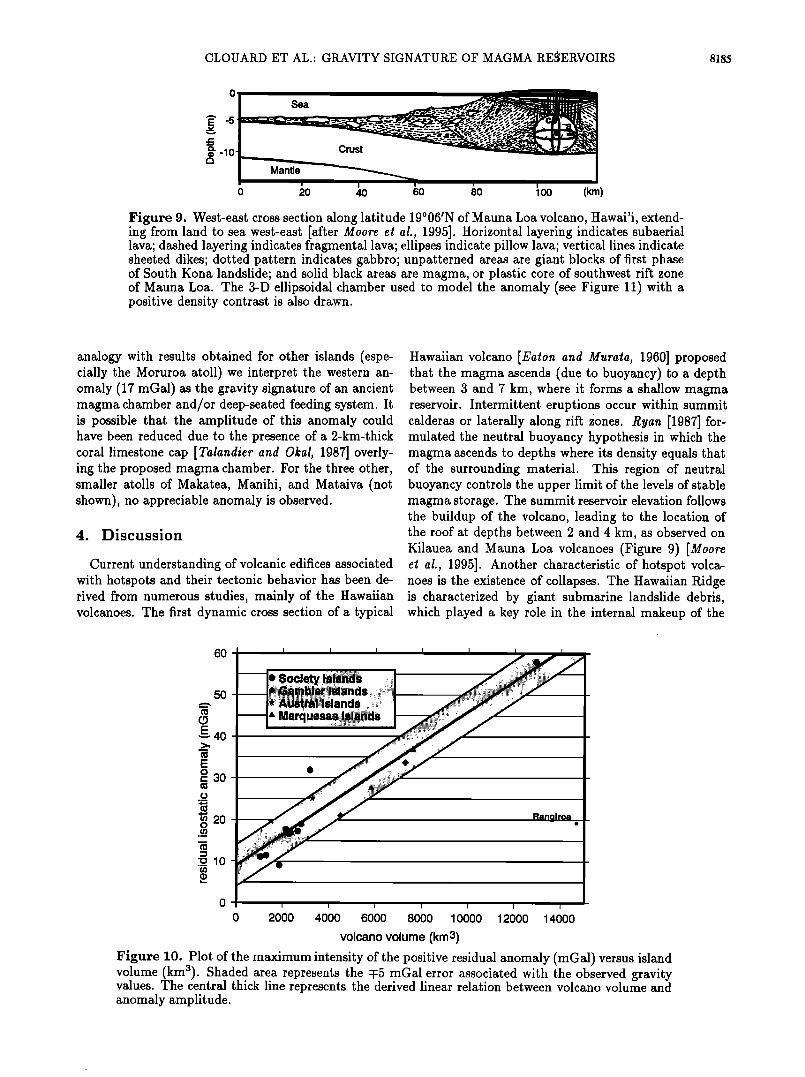
Figure 9. West-east cross section along latitude 19ø06/N of Mauna Loa volcano, Hawai'i, extend- ing from land to sea west-east [after Moore et al., 1995]. Horizontal layering indicates subaerial lava; dashed layering indicates fragmental lava; ellipses indicate pillow lava; vertical lines indicate sheeted dikes; dotted pattern indicates gabbro; unpatterned areas are giant blocks of first phase of South Kona landslide; and solid black areas are magma, or plastic core of southwest rift zone of Mauna Loa. The 3-D ellipsoidal chamber used to model the anomaly (see Figure 11) with a positive density contrast is also drawn.
analogy with results obtained for other islands (espe- cially the Moruroa atoll) we interpret the western an- omaly (17 mGal) as the gravity signature of an ancient magma chamber and/or deep-seated feeding system. It is possible that the amplitude of this anomaly could have been reduced due to the presence of a 2-km-thick coral limestone cap [Talandier and Okal, 1987] overly- ing the proposed magma chamber. For the three other, smaller atolls of Makatea, Manihi, and Mataiva (not shown), no appreciable anomaly is observed.
4. Discussion
Current understanding of volcanic edifices associated with hotspots and their tectonic behavior has been de- rived from numerous studies, mainly of the Hawaiian volcanoes. The first dynamic cross section of a typical
Hawaiian volcano [Eaton and Murata, 1960] proposed that the magma ascends (due to buoyancy) to a depth between 3 and 7 km, where it forms a shallow magma reservoir. Intermittent eruptions occur within summit calderas or laterally along rift •ones. Ryan [1987] for- mulated the neutral buoyancy hypothesis in which the magma ascends to depths where its density equals that of the surrounding material. This region of neutral buoyancy controls the upper limit of the levels of stable magma storage. The summit reservoir elevation follows the buildup of the volcano, leading to the location of the roof at depths between 2 and 4 km, as observed on Kilauea and Mauna Loa volcanoes (Figure 9) [Moore et al., 1995]. Another characteristic of hotspot volca- noes is the existence of collapses. The Hawaiian Ridge is characterized by giant submarine landslide debris, which played a key role in the internal makeup of the
6O
5O
E,• 40
E o ,- 30
o ._
m 20 o
-o10
0 2000 4000 6000 8000 10000 12000 14000
volcano volume (km3)
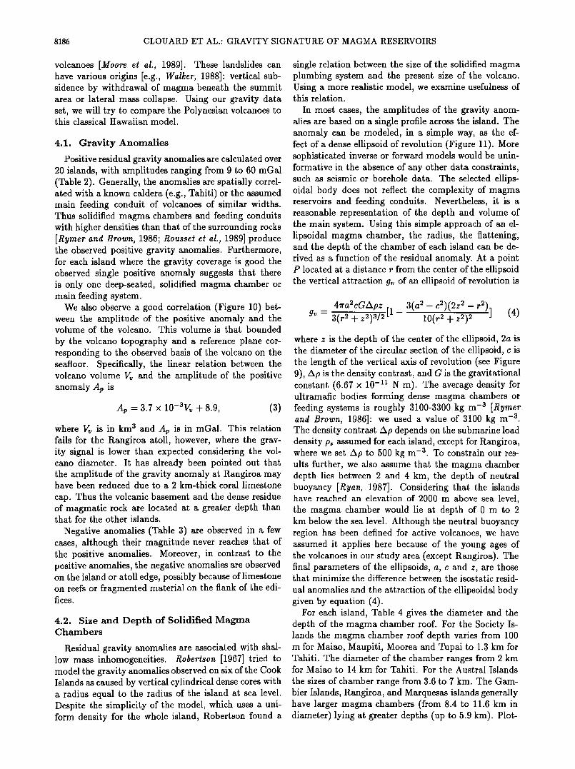
Figure 10. Plot of the maximum intensity of the positive residual anomaly (mGal) versus island volume (km3). Shaded area represents the :F5 mGal error associated with the observed gravity values. The central thick line represents the derived linear relation between volcano volume and anomaly amplitude.
8186 CLOUARD ET AL.: GRAVITY SIGNATURE OF MAGMA RESERVOIRS
volcanoes [Moore et al., 1989]. These landslides can have various origins [e.g., Walker, 1988]: vertical sub- sidence by withdrawal of magma beneath the summit area or lateral mass collapse. Using our gravity data set, we will try to compare the Polynesian volcanoes to this classical Hawaiian model.
4.1. Gravity Anomalies
Positive residual gravity anomalies are calculated over 20 islands, with amplitudes ranging from 9 to 60 mGal (Table 2). Generally, the anomalies are spatially correl- ated with a known caldera (e.g., Tahiti) or the assumed main feeding conduit of volcanoes of similar widths. Thus solidified magma chambers and feeding conduits with higher densities than that of the surrounding rocks [Rymer and Brown, 1986; Rousset et al., 1989] produce the observed positive gravity anomalies. Furthermore, for each island where the gravity coverage is good the observed single positive anomaly suggests that there is only one deep-seated, solidified magma chamber or main feeding system.
We also observe a good correlation (Figure 10) bet- ween the amplitude of the positive anomaly and the volume of the volcano. This volume is that bounded
by the volcano topography and a reference plane cor- responding to the observed basis of the volcano on the seafloor. Specifically, the linear relation between the volcano volume V• and the amplitude of the positive anomaly Ap is
Ap -3.7 x 10-aVv + 8.9, (3)
where Vv is in km a and Ap is in mGal. This relation fails for the Rangiroa atoll, however, where the grav- ity signal is lower than expected considering the vol- cano diameter. It has already been pointed out that the amplitude of the gravity anomaly at Rangiroa may have been reduced due to a 2 km-thick coral limestone
cap. Thus the volcanic basement and the dense residue of magmatic rock are located at a greater depth than that for the other islands.
Negative anomalies (Table 3) are observed in a few cases, although their magnitude never reaches that of the positive anomalies. Moreover, in contrast to the positive anomalies, the negative anomalies are observed on the island or atoll edge, possibly because of limestone on reefs or fragmented material on the flank of the edi- fices.
4.2. Size and Depth of Solidified Magma Chambers
Residual gravity anomalies are associated with shal- low mass inhomogeneities. Robertson [1967] tried to model the gravity anomalies observed on six of the Cook Islands as caused by vertical cylindrical dense cores with a radius equal to the radius of the island at sea level. Despite the simplicity of the model, which uses a uni- form density for the whole island, Robertson found a
single relation between the size of the solidified magma plumbing system and the present size of the volcano. Using a more realistic model, we examine usefulness of this relation.
In most cases, the amplitudes of the gravity anom- alies are based on a single profile across the island. The anomaly can be modeled, in a simple way, as the ef- fect of a dense ellipsoid of revolution (Figure 11). More sophisticated inverse or forward models would be unin- formative in the absence of any other data constraints, such as seismic or borehole data. The selected ellips- oidal body does not reflect the complexity of magma reservoirs and feeding conduits. Nevertheless, it is a reasonable representation of the depth and volume of the main system. Using this simple approach of an el- lipsoidal magma chamber, the radius, the flattening, and the depth of the chamber of each island can be de- rived as a function of the residual anomaly. At a point P located at a distance r from the center of the ellipsoid the vertical attraction gv of an ellipsoid of revolution is
4•'a2cGApz 3(a 2 - c2)(2z 2 - r2)] g• - 3-• •-•-•5 [1 - 10(r 2 + z2)2 (4)
where z is the depth of the center of the ellipsoid, 2a is the diameter of the circular section of the ellipsoid, c is the length of the vertical axis of revolution (see Figure 9), Ap is the density contrast, and G is the gravitational constant (6.67 x 10 -• N m). The average density for ultramafic bodies forming dense magma chambers or feeding systems is roughly 3100-3300 kg m -a [Rymer and Brown, 1986]: we used a value of 3100 kg m -a. The density contrast Ap depends on the submarine load density ps assumed for each island, except for Rangiroa, where we set Ap to 500 kg m -a. To constrain our res- ults further, we also assume that the magma chamber depth lies between 2 and 4 km, the depth of neutral buoyancy [Ryan, 1987]. Considering that the islands have reached an elevation of 2000 m above sea level, the magma chamber would lie at depth of 0 m to 2 km below the sea level. Although the neutral buoyancy region has been defined for active volcanoes, we have assumed it applies here because of the young ages of the volcanoes in our study area (except Rangiroa). The final parameters of the ellipsoids, a, c and z, are those that minimize the difference between the isostatic resid-
ual anomalies and the attraction of the ellipsoidal body given by equation (4).
For each island, Table 4 gives the diameter and the depth of the magma chamber roof. For the Society Is- lands the magma chamber roof depth varies from 100 m for Maiao, Maupiti, Moorea and Tupai to 1.3 km for Tahiti. The diameter of the chamber ranges from 2 km for Maiao to 14 km for Tahiti. For the Austral Islands
the sizes of chamber range from 3.6 to 7 km. The Gam- bler Islands, Rangiroa, and Marquesas islands generally have larger magma chambers (from 8.4 to 11.6 km in diameter) lying at greater depths (up to 5.9 kin). Plot-
CLOUARD ET AL' GRAVITY SIGNATURE OF MAGMA RESERVOIRS 8187
80
•' 60
E 40 o
._z,
• 20
Observed residual anomaly Gravity induced by a buried ellipsoidal body
o 17 30's ,4- •,.. 149w
E •-4
-8
I I I I I I I I I I
0 4 8 12 16 20 24 28 32 36 40
Length of the profile across Tahiti (km)
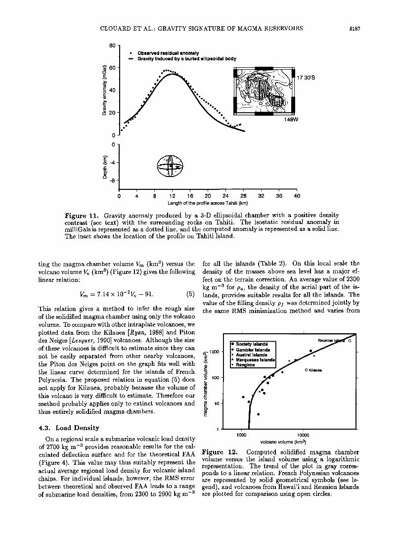
Figure 11. Gravity anomaly produced by a 3-D ellipsoidal chamber with a positive density contrast (see text) with the surrounding rocks on Tahiti. The isostatic residual anomaly in milliGals is represented as a dotted line, and the computed anomaly is represented as a solid line. The inset shows the location of the profile on Tahiti Island.
ting the magma chamber volume Vr• (km a) versus the volcano volume Vv (km a) (Figure 12) gives the following linear relation:
V.• - 7.14 x 10⁻²Vv - 91. (5)
This relation gives a method to infer the rough size of the solidified magma chamber using only the volcano volume. To compare with other intraplate volcanoes, we plotted data from the Kilauea [Ryan, 1988] and Piton des Neiges [Lesquer, 1990] volcanoes. Although the size of these volcanoes is difficult to estimate since they can not be easily separated from other nearby volcanoes, the Piton des Neiges point on the graph fits well with the linear curve determined for the islands of French
Polynesia. The proposed relation in equation (5) does not apply for Kilauea, probably because the volume of this volcano is very difficult to estimate. Therefore our method probably applies only to extinct volcanoes and thus entirely solidified magma chambers.
4.3. Load Density
On a regional scale a submarine volcanic load density of 2700 kg m -a provides reasonable results for the cal- culated deflection surface and for the theoretical FAA
(Figure 4). This value may thus suitably represent the actual average regional load density for volcanic island chains. For individual islands, however, the RMS error between theoretical and observed FAA leads to a range of submarine load densities, from 2300 to 2900 kg m -a
for all the islands (Table 2). On this local scale the density of the masses above sea level has a major ef- fect on the terrain correction. An average value of 2300 kg m -a for pa, the density of the aerial part of the is- lands, provides suitable results for all the islands. The value of the filling density p! was determined jointly by the same RMS minimization method and varies from
•., lOOO E
v
E
o > 100
E
• •o E
I I
I' Søcietylsland" I I I *I: Gambi•r Islan:ds/ -•,•"- L I* AuStral ISlandS : ::::::1 i ß :Marquesas:ISlandS I I' Ran9 :irøa ! •
: • f. 0 Kilauea
lOOO 1 oooo
volcano volume (kin 3)
Figure 12. Computed solidified magma chamber volume versus the island volume using a logarithmic representation. The trend of the plot in gray corres- ponds to a linear relation. French Polynesian volcanoes are represented by solid geometrical symbols (see le- gend), and volcanoes from Hawai'i and Reunion Islands are plotted for comparison using open circles.
8188 CLOUARD ET AL.: GRAVITY SIGNATURE OF MAGMA RESERVOIRS
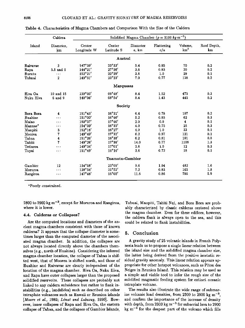
Table 4. Characteristics of Magma Chambers and Comparison With the Size of the Caldera
Caldera Solidified Magma Chamber (p = 3100 kg m -a)
Island Diameter, Center Center Diameter Flattening Volume, Roof Depth, km Longitude W Latitude S a, km c/a km 3 km
Austral
Raivavae 3 147 ø 39' 23 ø 53' 5.4 0.85 70 0.2 Rapa 3.5 and 5 144021 ' 27036 ' 3.6 0.83 20 0.2 Rurutu .. ß 152 ø 21' 22029 ' 3.8 1.0 29 0.1 Tu bu ai 2 149 ø 31 ' 23023 ' 7.0 0.77 138 0.2
Marquesas
Hiva Oa 10 and 15 139003 ' 09048 ' 8.4 1.52 473 0.3 Nuku Hiva 6 and 9 140006 ' 08054 ' 8.4 1.43 443 0.2
Society
Bora Bora 4 151045 ' 16031 ' 6.4 0.78 107 0.2 Huahine .. ß 151 o 00' 16 ø 46' 5.2 0.85 62 0.3 M aiao .. ß 150 ø 37' 17 ø 40' 2.0 0.9 4 0.1 Manuae* .. ß 154ø 39' 16 ø 32' 4.0 0.75 25 0.3 Manpiti 3 152 ø 16' 16ø27 ' 4.0 1.0 33 0.1 Moorea 7 149 ø 49' 17 ø 32' 6.2 0.97 121 0.1 Tahaa 4 151 o 28' 16 ø 38' 6.2 0.81 101 0.8 Tahiti 7 149ø 26' 17 ø 38' 14.0 0.77 1108 1.3 Tetiaroa ... 149 ø 34' 17 ø 01' 2.8 1.0 12 0.3 Tupai ß ß ß 151 o49, 16 ø 16' 3.6 0.72 18 0.1
Tuamotu-Gambier
Gambier 12 134ø 58' 23 ø 09' 9.6 1.04 482 1.6 Moruroa ß .. 138 ø 54' 21 o 52' 7.2 0.83 163 1.8
Rangiroa ß ß ß 147 ø 48' 15 o 05' 11.6 0.86 705 5.9
* Poorly constrained.
2800 to 2900 kg m -3, except for Moruroa and Rangiroa, where it is lower.
4.4. Calderas or Collapses?
Are the computed locations and diameters of the an- cient magma chambers consistent with those of known calderas? It appears that the collapse diameter is some- times larger than the computed diameter of the associ- ated magma chamber. In addition, the collapses are not always located directly above the chambers them- selves (e.g., north of Huahine). Considering the inferred magma chamber location, the collapse of Tahaa is shif- ted west, that of Moorea is shifted north, and those of Huahine and Raivavae are clearly independent of the location of the magma chamber. Hiva Oa, Nuku Hiva, and Rapa have outer collapses larger than the proposed solidified reservoirs. These collapses are probably not linked to any caldera subsidence but rather to flank in- stabilities (e.g., landslides) such as described on other intraplate volcanoes such as Hawaii or Reunion islands [Moore et al., 1989; L•nat and Labazuy, 1990]. How- ever, inner collapses of Rapa and Hiva Oa, the eastern collapse of Tahaa, and the collapses of Gambier Islands,
Tubuai, Maupiti, Tahiti Nui, and Bora Bora are prob- ably characterized by classic calderas centered above the magma chamber. Even for these edifices, however, the caldera flank is always open to the sea, and this could be related to flank instabilities.
5. Conclusion
A gravity study of 25 volcanic islands in French Poly- nesia leads us to propose a single linear relation between the island size and the solidified magma chamber size, the latter being derived from the positive isostatic re- sidual gravity anomaly. This linear relation appears ap- propriate for other hotspot volcanoes, such as Piton des Neiges in Reunion Island. This relation may be used as a simple and viable tool to infer the rough size of the solidified magmatic feeding system for extinct oceanic intraplate volcano.
The results also illustrate the wide range of submar- ine volcanic load densities, from 2300 to 2900 kg m -3, and confirm the importance of the increase of density with depth, from 2300 kg m -3 for subaerial lava to 2900 kg m -• for the deepest part of the volcano which fills
CLOUARD ET AL.: GRAVITY SIGNATURE OF MAGMA RESERVOIRS 8189
the flexure of the oceanic crust. On a regional scale the best fitting load density is ~2700 kg m -a.
At the island scale the residual isostatic anomaly helps to define the actual location of volcanoes. For example, previous studies assume multiple volcanoes on the same island (e.g., Huahine, Tubuai, Tahiti Iti). However, our results clearly demonstrate the presence of a single volcanic system for these islands and for the atolls, except for the Marquesas Islands. Finally, we show that the majority of the so-called calderas are re- lated to flank instabilities which induce huge landslides, rather than to caldera subsidence. Thus the caldera
center may often be a poor indicator of the locations and other attributes of now consolidated and inactive
ancient magma reservoirs.
Acknowledgments. We are grateful for ORSTOM in- stitute, now IRD, that funded all the gravity surveys con- ducted by one of us (H.G.B.) in French Polynesia between 1978 and 1981 and to I. Leroy who made the complete grav- ity survey of Tahiti in 1994. V.C. is supported by a grant of the ZEPOLYF program. We thank particularly the associ- ate editor, T. Hildenbrand, whose remarks and suggestions have greatly improved this paper. This work also benefited of the constructive reviews made by J.F. L•nat, M.P. Ryan, and H. Rymer.
References
Barriot, J.P., La d•termination du g•oide par altim•trie oc•anique et gravim•trie ß Quelques aspects du traitement et interpretation g•ologique sur l'Ocdan Indien (partie NO) et M•diterrann•e occidentale. Ph.D. thesis, 240 pp, Univ. des Sciences et Techniques du Languedoc, Mont- pellier, France, 1987.
Barsczus, H.G., R•sultats provisoires de quelques mesures et liaisons gravim•triques effectu•es en Polyn•sie Fran•a.lse, Intern. Rep., Cent. ORSTOM de Papeete, Tahiti, 1979.
Barsczus, H.G., Reconnaissance gravim•trique de Tubuai (Iles Australes), Intern. Rep., Cent. ORSTOM de Pa- peete, Tahiti, 1980.
Barsczus, H.G., Reconnaissance gravim4trique de Maiao (Tupai-Manu), Intern. Rep., Cent. ORSTOM de Pa- peete, Tahiti, 1981.
Barsczus, H.G., P.E. Filmer, and D.L. Desonie, Cataclys- mic collapses and mass wasting processes in the Marque- sas (abstract), Eos Trans. AGU, 73 (14), Spring Meet. Suppl., 313, 1992.
Barsczus, H.G., G. Guille, R.C. Maury, C. Chauvel, and H. Guillou, Two magmatic sources at Rurutu Island (Aus- tral Islands, French Polynesia) and the Austral "Hotline" (abstract), Eos Trans. AGU, 75(44), Fall Meet. Suppl., 323, 1994.
Binard, N., R. H•kinian, J.L. Chemin•e, R.C. Searle, and P. Stoffers, Morphological and structural studies of the Society and Austral hot spot regions in the South Pacific, Tectonophysics, 186, 293-312, 1991.
Binard, N., R. H•kinian, and P. Stoffers, Morphostructural study and type of volcanism of submarine volcanoes over the Pitcairn hotspot in the South Pacific, Tectonophysics, œ06, 245-264, 1992.
Blakely, R.J., Potential Theory in Gravity and Magnetic Ap- plications, 441 pp., Cambridge Univ. Press, New York, 1995.
Bonneville, A., V. Clouard, P. Beuzart, I. Klaucke, R. Le Suave, B. Loubrieu, P. Saget, and Y. Thomas, Possible
control of Society Islands volcanism by a preexisting vol- canic chain (abstract), Eos Trans. AGU, 78,(45), Fall Meet. Suppl., F725, 1997.
Brousse, R., J.C. Philippet, G. Guille, and H. Bellon, G•o- chronom•trie des iles Gambier (Ocean Pacifique), C. R. Acad. Sci., Set. D, œ7,i, 1995-1998, 1972.
Brousse, R., C. Macherey, E. Berger, and G. Boutault, L'ile de Huahine: trois volcans successifs (Archipel de la Soci•td, Polyn•sie), C. R. Acad. Sci., Set. II, œ96, 1559- 1562, 1983.
Brousse, R., H.G. Barsczus, H. Bellon, J.M. Cantagrel, C. Diraison, H. Guillou, and C. L•otot, Les Marquises (Polyn•sie Fran•aise): Volcanologie, g•ochronologie, dis- cussion d'un module de point chaud, Bull. Soc. G•ol. Ft., 6, 933-949, 1990.
Buigues, D., A. Gachon, and G. Guille, L'atoll de Moruroa (Polyn4sie Fran•aise): Structure et •volution g•ologique, Bull. Soc. Gdol. Ft., 5, 645-657, 1992.
Calmant, S., and A. Cazenave, The effective elastic litho- sphere under the Cook Austral and Society Islands, Earth Planet. Sci. Lett., 77,, 187-202, 1986.
Calmant, S., and A. Cazenave, Anomalous elastic thickness of the oceanic lithosphere in the south central Pacific, Nature, 3œ8, 236-238, 1987.
Caress, D.W., M.K. McNutt, R.C. Detrick, and J.C. Mutter, Seismic imaging of hotspot-related crustal underplating beneath the Marquesas Islands, Nature, 373, 600, 1995.
Chemin4e, J.L., R. H4kinian, J. Talandier, F. Albar•de, C.W. Devey, J. Francheteau, and Y. Lancelot, Campagne Teahitia-1, G4ologie d'un point chaud actif: Teahitia- Mehetia, iles de la Soci4t• (Pacifique Central Sud), Ocea- nol. Acta, 10, 225-239, 1990.
Chubb, L.J., The geology of the Marquesas Islands, Bull. 68, B.P. Bishop Mus., Honolulu, Hawaii, 1930.
Dalrymple, G.B., R.D. Jarrard, and D.A. Clague, Potas- sium-argon ages of some volcanic rocks from the Cook and Austral Islands, Geol. Soc. Am. Bull., 86, 1463-1467, 1975.
Danobeitia, J.J., et al., Deep seismic reconnaissance beneath Society Archipelago (South Pacific), paper presented at EGS Assembly, Eur. Geophys. Soc., Hamburg, Germany, 1995.
Deneufbourg, G., Carte g•ologique, Notice explicative sur la feuille Huahine, Bur. des Rec. Gdol. et Minigr., Paris, 1965.
Desonie, D. L., R.A. Duncan, and J.H. Natland, Temporal and geochemical variability of volcanic products of the Marquesas hotspot, J. Geophys. Res., 98, 17,649-17,665, 1993.
Diraison, C., Le volcanisme a4rien des archipels polyndsiens de la Soci•td, des Marquises et des Australes-Cook, Ph.D. thesis, 413 pp, Univ. de Bret•.gne Occidentale, Brest, France, 1991.
Diraison, C., H. Bellon, C. Leotot, R. Brousse, and H. Barsczus, L'alignement de la Soci•td (Polyn•sie fran•aise): Volcanologie, g•ochronologie, proposition d'un module de point chaud, Bull. Soc. Gdol. Ft., 16œ, 479-496, 1991.
Duncan, R.A., and I. McDougall, Migration of volcanism with time in the Marquesas Islands, French Polynesia, Earth Planet. Sci. Lett., œ1,414-420, 1974.
Duncan, R.A., and I. McDougall, Linear volcanism in French Polynesia, J. Volcanol. Geotherm. Res., 1(3), 197-227, 1976.
Duncan, R.A., M.R. Fisk, W.M. White, and R.L. Nielsen, Tahiti: Geochemical evolution of a French Polynesian vol- cano, J. Geophys. Res., 99, 24,341-24,357, 1994.
Eaton, J.P., and K.J. Murata, How volcanoes grow, Science, 13œ, 925-938, 1960.
Filmer, P.E., Flexure of the oceanic lithosphere in the vicin-
8190 CLOUARD ET AL.: GRAVITY SIGNATURE OF MAGMA RESERVOIRS
ity of the Marquesas Islands, Ph.D. thesis, 234 pp, Mass. Inst. of Technol., Cambridge, 1991.
Filmer, P.E., M.K. McNutt, and C.J. Wolfe, Elastic thick- ness of the lithosphere in the Marquesas and Society Is- lands, J. Geophys. Res., 98, 19,565-19,577, 1993.
Gillot, P.Y., Y. Cornette, and G. Guille, Age (K-Ar) et con- ditions d'•dification du soubassement volcanique de l'atoll de Moruroa (Pacifique Sud), C. R. Acad. Sci., Set. II, 31•, 393-399, 1992.
Goodwillie, A.M., and A.B. Watts, An altimetric and ba- thymetric study of elastic thickness in the central Pacific Ocean, Earth Planet. Sci. Left., 118, 311-326, 1993.
Guille, G., Contribution k l'•tude g•ologique des iles de Polyn•sie fran•aise: Les Gambiers, Ph.D. thesis, 215 pp, Univ. Paris XI, Orsay, France, 1974.
Guille, G., R.C. Maury, D. Buigues, H. Bellon, A. Gachon, and M. Caroff, L'Atoll de Moruroa (Polyn4sie fran•aise); III, Conclusions g•n•rales, Bull. Soc. Geol. Ft., 163, 681-685, 1992.
Guille, G., G. Gouti•re, and J.F. Sornein, Les atolls de Mururoa et de Fangataufa (Polyn•sie Franqaise), vol L G•ologie, P•trologie, Hydrog•ologie, 168 pp., Masson, Pa- ris, 1993.
Guillou, H., P.Y. Gillot, and G. Guille, Age (K-Ar) et posi- tion des iles Gambier dans l'alignement du point chaud de Pitcairn (Pacifique Sud), C. R. Acad. Sci., Ser. II, 318, 635-641, 1994.
Hauri, E.H., J.C. Lassiter, and H.G. Barsczus, Lithospheric controls on the compositions of Austral Islands lavas: Iso- topic evidence from Raivavae and the southern Australs (abstract), Eos Trans. AGU, 78(46), Fall Meet. Suppl., F828, 1997.
Herron, E.M., Sea-floor spreading and the cenozoic history of the east-central Pacific, Geol. Soc. Am. Bull., 83, 1671- 1692, 1972.
Ito, G., M. McNutt, and R.L. Gibson, Crustal structure of the Tuamotu Plateau, 15øS, implications for its origin, J. Geophys. Res., 100, 8097-8114, 1995.
Johnson, R.H., and A. Mahaloff, Relation of Macdonald vol- cano to migration of volcanism along the Austral chain, J. Geophys. Res., 76, 3282-3290, 1971.
Krummenacher, D., and J. Noetzlin, Datations de couldes druptives dans diffdrents archipels de la Polyn•sie Fran- •aise, Bull. Soc. Geol. Fr., 3, 131, 1966.
Kruse, S.E., Magnetic lineations on the flanks of the Mar- quesas swell: Implications for the age of the seafloor, Geo- phys. Res. Lett., 15, 573-576, 1988.
L•nat, J.F., and P. Labazuy, Submarine morphologies and structures of Reunion, in Le Volcanisme de la R•union- Monographie, edited by J.F. L•nat, pp. 43-74, Cent. Rech. Volcanol., Clermont-Ferrand, France, 1990.
L•otot, C., P.Y Gillot, F. Guichard, and R. Brousse, Le volcan de Taravao (Tahiti): Un exemple de volcanisme polyphasique associd it une structure d'effondrement, Bull. Soc. Geol. Ft., 6, 951-961, 1990.
Leroy, I., Evolution des volcans en syst•me de point chaud: Ile de Tahiti, archipel de la Socidt• (Polyn•sie Fran•aise), Ph.D. thesis, 271 pp, Univ. Paris XI, Orsay, France, 1994.
Lesquer, A., Deep structure of Reunion Island from grav- ity data, in Le volcanisme de la R•union-Monographie, edited by J.F. L•nat, pp 19-27, Cent. Rech. Volcanol., Clermont-Ferrand, France, 1990.
Macheski, L.F., Gravity relations in American Samoa and the Society Islands, Pacific Sci., 19, 367-373, 1965.
Mammerickx, J., E. Herron, and L. Dorman, Evidence for two fossil spreading ridges in the southeast Pacific, Geol. Soc. Am. Bull., 91, 263-271, 1980.
Mayes, C.L., L.A. Lawver, and D.T. Sandwell, Tectonic his-
tory and new isochron chart of the south Pacific, J. Geo- phys. Res., 95 8543-8567, 1990.
McNutt, M.K., Lithospheric flexure and thermal anomalies, J. Geophys. Res., 89, 11,180-11,194, 1984.
McNutt, M.K., Superswells, Rev. Geophys., 36(2), 211-244, 1998.
McNutt, M.K., D.W. Caress, J. Reynolds, K.A. Jordahl, and R.A.Duncan, Failure of plume theory to explain midplate volcanism in the southern Austral islands, Nature, 389, 479-482, 1997.
Minster, J.B., and T.G. Jordan, Present-day plate motions, J. Geophys. Res., 83, 5331-5354, 1978.
Moore, J.G., D.A. Clague, R.T. Holcomb, P.W. Lipman, W.R. Normark, and M.E. Torresan, Prodigious submarine landslides on the Hawaiian ridge, J. Geophys. Res., 9•i, 17,465-17,484, 1989.
Moore, J.G., W.B. Bryan, M.H. Besson, and W.R. Nor- mark, Giant blocks in the South Kona landslide, Hawaii, Geology, œ3, 125-128, 1995.
Munschy, M., C. Antoine, and A. Gachon, Evolution tecto- nique de la r4gion des Tuamotu, oc4an Pacifique central, C. R. Acad. Sci., Set. II, 3œ3, 941-948, •996.
Nakagawa, I., et al., Precise cahbration of scale values of Lacoste & Romberg gravimeters and international gravi- metric connections along the circum-Pacific zone, Tech. Rep. Kyoto Univ., Kyoto, Japan, 1983.
Norris, A., and R.H. Johnson, Submarine volcanic eruptions recently located in the Pacific by SOFAR hydrophones, J. Geophys. Res., %/, 650-664, 1969.
Obellianne, J.M., Contribution k l'•tude g•ologique des iles des Etablissements Fran•ais de l'Oc•anie. Sci. Terre, 3, 1-146, 1955.
Okal, E.A., and A. Cazenave, A model for the plate tec- tonic evolution of the east-central Pacific based on Seasat
investigations, Earth Planet. Sci. Left., 72, 99-116, 1985. ORSTOM, Atlas de la Polyn•sie Fran•aise, Paris, 1993. Pautot, G., Analyse structurale de l'archipel des Tuamotu:
Origine volcano-tectonique, paper presented at 3•me Col- loque des Sciences de la Terre, Univ. Montpellier, Mont- pellier, France, 1975.
Plouff, D., Gravity and magnetic fields of polygonal prisms and application to magnetic terrain corrections, Geophys- ics, •il (4), 727-741, 1976.
Robertson, E.I., Gravity effects of volcanic islands, N. Z. J. Geol. Geophys., i0(6), 1466-1483, 1967.
Rousset, D., A. Lesquer, A. Bonneville, and J.F. L•nat, Complete gravity study of Piton de la Fournaise volcano, Reunion Island, J. Volcanol. Geotherm. Res., 36, 37-52, 1989.
Ryan, M.P., Neutral buoyancy and the mechanical evolution of magmatic systems, in Magmatic Processes: Physico- chemical Principles, edited by B.O. Mysen, Geoch. Soc. Spec. Pub. 1, 259-287, 1987.
Ryan, M.P., The mechanics and three-dimentional internal structure of active magmatic systems: Kilauea Volcano, Hawaii, J. Geophys. Res., 93, 4213-4248, 1988.
Rymer, H. and G.C. Brown, Gravity fields and the inter- pretation of volcanic structures: Geological discrimina- tion and temporal evolution, J. Volcano. Geotherm. Res., 27, 229-254, 1986.
Sandwell, D.T., Antattic marine gravity field from high- density satellite altimetry, Geophys. J. Int., 109, 437-448, 1992.
Service de l'Urbanisme, Carte topographique 1:20,000, Pa- peete, Tahiti, French Polynesia, 1992.
Sichoix, L., Le vol•anisme de Polyn•sie Fran•aise ß Ca- ract4risation des points chauds et du superbombement
CLOUARD ET AL.: GRAVITY SIGNATURE OF MAGMA RESERVOIt•S 8191
• pa.rtir d'une nouvelle synth[se bathym•trique, Ph.D. thesis, 297 pp, Univ. Fr. du Pac., Papeete, Tahiti, 1997.
Sichoix, L., and A. Bonneville, Prediction of bathymetry in French Polynesia constrained by shipboard data. Geo- phys. Res. Lett., 23, 2469-2472, 1996.
Smith, W.H.P., On the accuracy of digital bathymetric data, J. Geophys. Res., 98, 9591-9603, 1993.
Smith, W.H.P., and D.T. Sandwell, Marine gravity field from declassified Geosat and ERS-1 altimetry (abstract), Eos Trans. AGU, 76 (46), Fall Meet. Suppl., F156, 1995.
Smith, W.H.P., and P. Wessel, Gridding with continuous curvature splines in tension, Geophysics, 55, 293-305, 1990.
Talandier, J., and E.A. Okal, The volcanoseismic swarms of 1981-1983 in the Tahiti-Mehetia area, French Polynesia, J. Geophys. Res., 89, 11,216-11,234, 1984a.
Talandier, J., and E.A. Okal, New surveys of Macdon- ald seamount, southcentral Pacific, following volcanoseis- mic activity, 1977-1983,Geophys. Res. Lett., 11, 813-816, 1984b.
Talandier, J., and E.A. Okal, Crustal structure in the Soci- ety and Tuamotu Islands, French Polynesia, Geophys. J. R. Astron. Soc., 88, 499-528, 1987.
Turner, D.L., and R.D. Jarrard, K-Ar dating of the Cook- Austral island chain: A test of the hot spot hypothesis, J. Volcano. Geotherm. Res., 12, 187-220, 1982.
Walcott, R.I., Flexure of the lithosphere at Hawaii, Tectono- physics, 9, 435-446, 1970.
Walker, G.P.L., Three Hawaiian calderas: An origin through loading by shallow intrusions?, J. Geophys. Res., 93, 14,773-14,784, 1988.
Watts, A.B., An analysis of isostasy in the world's oceans, 1, Hawaiian-Emperor seamount chain, J. Geophys. Res., 83, 5989-6004, 1978.
Watts, A.B., and N.M. Ribe, On geoid heights and flexure of the lithosphere at seamounts, J. Geophys. Res., 89, 11,152-11,170, 1984.
Watts, A.B., J.R. Cochran, and G. Selzer, Gravity anom- alies and flexure of the lithosphere: A three-dimensional study of the Great Meteor Seamount, northeast Atlantic, J. Geophys. Res., 80, 1391-1399, 1975.
Watts, A.B., J.H. Bodine, and N.M. Ribe, Observations of flexure and the geological evolution of the Pacific Ocean basin, Nature, 283, 532-537, 1980
White, W.M., and R.A. Duncan, Geochemistry and geo- chronology of the Society Islands: New evidence for deep mantle reclycling, in Earth Processes: Reading the Iso- topic Code, Geophys. Monogr. Set. vol 95, edited by A. Basu and S. Hart, pp. 183-206, AGU, Washington, D.C., 1996.
Young, R.Y., and I.A. Hill, An estimate of the effective elastic thickness of the Cape Verde Rise, J. Geophys. Res., 91, 4854-4866, 1986.
V. Clouard and A. Bonneville, Laboratoire de Gdoscien- ces Marines et T•ldddtection, Universitd de la Polyndsie Fran•aise, BP 6570 Faaa Adroport, Tahiti, French Polyne- sia. ( [email protected]; [email protected])
H.G. Barsczus, GBE- UMR 5569- CNRS, and Universitd de Montpellier II, 34095 Montpellier Cedex 5, France. (e- mail: [email protected])
(Received January 29, 1998; revised October 8, 1999; accepted November 4, 1999.)