
SETS 6000 (13 11 10) Riga
301
Темы для сдачи на 3его и помошника в Латвийской морской а Пр Pollution Prevention Seaworthiness Stability Ship Construction Monitor Compliance with Legislative Requirements MARPOL ISM Code Celestrian navigation Terrestial and Coastal Navigation Compasses, Steering Contrl Meteorology Keeping a Nav Watch, Routeing Rule of the Road and Buoyage Respond to Emergencies Ship Manoeuvring and Handling Radar Navigation - Operational level Basic Fire Fighting Prevention Вопросы по темам в Латвийской морской администрации ---
Transcript of SETS 6000 (13 11 10) Riga
Темы для сдачи на 3его и помошника в Латвийской морской администрации.
Проходной бал 70%Pollution Prevention Seaworthiness Stability Ship Construction Monitor Compliance with Legislative RequirementsMARPOL ISM Code Celestrian navigation Terrestial and Coastal Navigation Compasses, Steering Contrl Meteorology Keeping a Nav Watch, RouteingRule of the Road and Buoyage Respond to Emergencies Ship Manoeuvring and HandlingRadar Navigation - Operational level Basic Fire Fighting Prevention
Вопросы по темам в Латвийской морской администрации --- http://www.jurasadministracija.lv/index.php?action=443

Вопросы по темам в Латвийской морской администрации --- http://www.jurasadministracija.lv/index.php?action=443
Pollution
Page 3
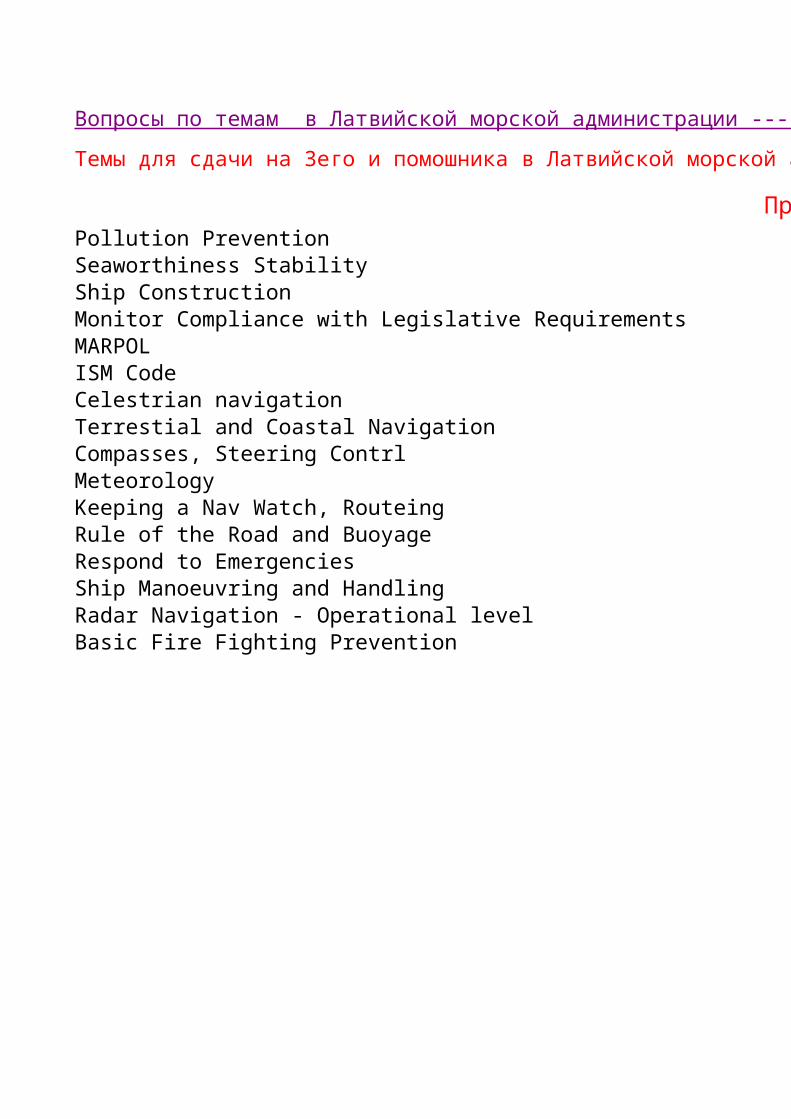
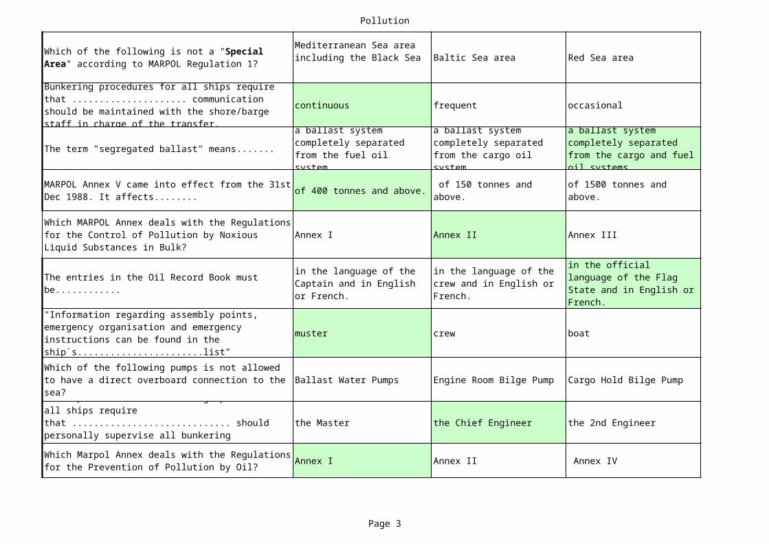
Baltic Sea area Red Sea area
continuous frequent occasional
The term "segregated ballast" means.......
of 400 tonnes and above.
Annex I Annex II Annex III
muster crew boat
Ballast Water Pumps Engine Room Bilge Pump Cargo Hold Bilge Pump
the Master the Chief Engineer the 2nd Engineer
Annex I Annex II Annex IV
Which of the following is not a "Special Area" according to MARPOL Regulation 1?
Mediterranean Sea area including the Black Sea
Bunkering procedures for all ships require that ..................... communication should be maintained with the shore/barge staff in charge of the transfer. a ballast system
completely separated from the fuel oil system.
a ballast system completely separated from the cargo oil system.
a ballast system completely separated from the cargo and fuel oil systems.
MARPOL Annex V came into effect from the 31st Dec 1988. It affects........
of 150 tonnes and above.
of 1500 tonnes and above.
Which MARPOL Annex deals with the Regulations for the Control of Pollution by Noxious Liquid Substances in Bulk?
The entries in the Oil Record Book must be............
in the language of the Captain and in English or French.
in the language of the crew and in English or French.
in the official language of the Flag State and in English or French.
"Information regarding assembly points, emergency organisation and emergency instructions can be found in the ship`s.......................list"Which of the following pumps is not allowed to have a direct overboard connection to the sea?Basic procedures for bunkering operations on all ships require that ............................. should personally supervise all bunkering operations.Which Marpol Annex deals with the Regulations for the Prevention of Pollution by Oil?
Pollution
Page 4
Baltic Sea area Red Sea areaWhich of the following is not a "Special Area" according to MARPOL Regulation 1?
Mediterranean Sea area including the Black Sea
six months. one year. two years.
totally prohibited.
The disposal of plastics at sea is.......... strictly prohibited.
The entries in the Oil Record Book must be............
in the language of the Captain and in English or French.
in the language of the crew and in English or French.
in the official language of the Flag State and in English or French.
The Garbage Record Book must be open for inspection at all times and kept for a minimum of...........
Cross connections between the fuel and ballast systems are.................. .
allowed at the fuel system manifold in the engine room.
allowed at the fuel system manifold on the main deck.
Bunkering procedures on all ships require that the deck officer on watch is informed prior to the starting of bunkering. This is because ............. .
the time needs to be recorded exactly.
he is responsible for all communication with the shore or barge.
appropriate precautions have to be taken by the deck department.
allowed anywhere outside the designated Special Areas.
allowed as long as the ship is no less than 12 nautical miles from the coast.
* * * NOTHING FOLLOWS * * *
Pollution
Page 5
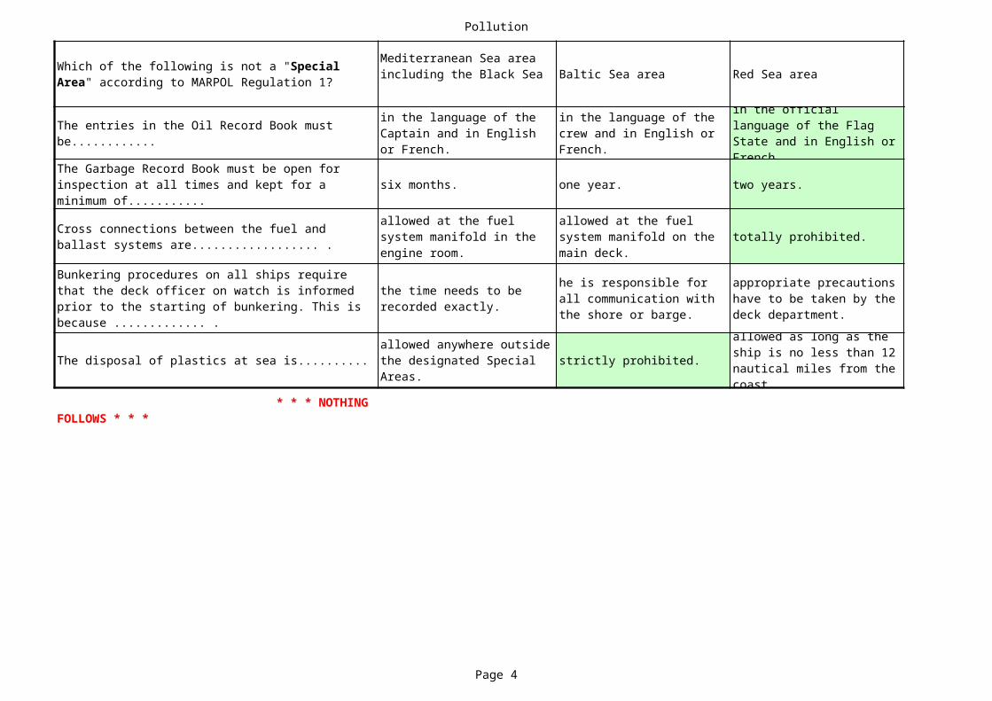
Caribbean Sea area
intermittent
Annex V
emergency
Sludge Pump
a responsible person
Annex V
none of the other options.
carrying 12 or more passengers.
in any language comprehensible by the Port State Control officers.

Pollution
Page 6
Caribbean Sea area
five years.
in any language comprehensible by the Port State Control officers.
allowed at the ballast system manifold in the engine room.the bunkering flag has to be hoisted and the oil spill recovery team put on stand-by.allowed as long as they have passed through a comminutor.
Stability
Page 7
1
What are the "Stresses" that effect a ship?
What is a "Shear Force" in a ship?
What is a "Bending Moment" in a ship?
What is a "Metacentre?" 6
What is a "Moment", in terms of stability?
9
11
What is a "Ship's Rolling Period''?
What is the "Change of Trim''?
What is "relative or specific gravity?"
16
What is the principle of Archimedes?
19
Sideways movement. Fore and aft movement. Free surface effect.
21
The vessel is sagged. The vessel is hogged.
What causes ships to experience "Stresses?"
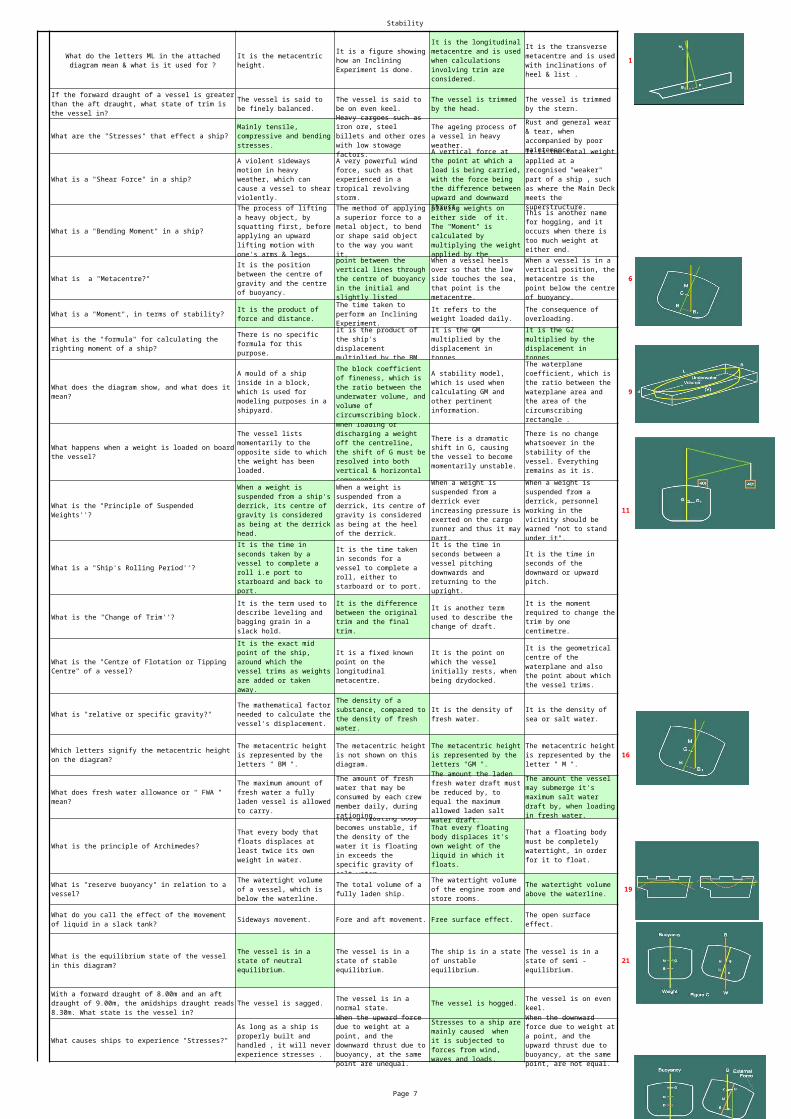
What do the letters ML in the attached diagram mean & what is it used for ?
It is the metacentric height.
It is a figure showing how an Inclining Experiment is done.
It is the longitudinal metacentre and is used when calculations involving trim are considered.
It is the transverse metacentre and is used with inclinations of heel & list .
If the forward draught of a vessel is greater than the aft draught, what state of trim is the vessel in?
The vessel is said to be finely balanced.
The vessel is said to be on even keel.
The vessel is trimmed by the head.
The vessel is trimmed by the stern.
Mainly tensile, compressive and bending stresses.
Heavy cargoes such as iron ore, steel billets and other ores with low stowage factors.
The ageing process of a vessel in heavy weather.
Rust and general wear & tear, when accompanied by poor maintenance.
A violent sideways motion in heavy weather, which can cause a vessel to shear violently.
A very powerful wind force, such as that experienced in a tropical revolving storm.
A vertical force at the point at which a load is being carried, with the force being the difference between upward and downward thrust.
It is the total weight applied at a recognised "weaker" part of a ship , such as where the Main Deck meets the superstructure.The process of lifting
a heavy object, by squatting first, before applying an upward lifting motion with one's arms & legs.
The method of applying a superior force to a metal object, to bend or shape said object to the way you want it.
placing weights on either side of it. The "Moment" is calculated by multiplying the weight applied by the
This is another name for hogging, and it occurs when there is too much weight at either end.
It is the position between the centre of gravity and the centre of buoyancy.
point between the vertical lines through the centre of buoyancy in the initial and slightly listed
When a vessel heels over so that the low side touches the sea, that point is the metacentre.
When a vessel is in a vertical position, the metacentre is the point below the centre of buoyancy.
It is the product of force and distance.
The time taken to perform an Inclining Experiment.
It refers to the weight loaded daily.
The consequence of overloading.
What is the "formula" for calculating the righting moment of a ship?
There is no specific formula for this purpose.
It is the product of the ship's displacement multiplied by the BM.
It is the GM multiplied by the displacement in tonnes.
It is the GZ multiplied by the displacement in tonnes.
What does the diagram show, and what does it mean?
A mould of a ship inside in a block, which is used for modeling purposes in a shipyard.
The block coefficient of fineness, which is the ratio between the underwater volume, and volume of circumscribing block.
A stability model, which is used when calculating GM and other pertinent information.
The waterplane coefficient, which is the ratio between the waterplane area and the area of the circumscribing rectangle .
What happens when a weight is loaded on board the vessel?
The vessel lists momentarily to the opposite side to which the weight has been loaded.
When loading or discharging a weight off the centreline, the shift of G must be resolved into both vertical & horizontal components.
There is a dramatic shift in G, causing the vessel to become momentarily unstable.
There is no change whatsoever in the stability of the vessel. Everything remains as it is.
What is the "Principle of Suspended Weights''?
When a weight is suspended from a ship's derrick, its centre of gravity is considered as being at the derrick head.
When a weight is suspended from a derrick, its centre of gravity is considered as being at the heel of the derrick.
When a weight is suspended from a derrick ever increasing pressure is exerted on the cargo runner and thus it may part.
When a weight is suspended from a derrick, personnel working in the vicinity should be warned "not to stand under it".
It is the time in seconds taken by a vessel to complete a roll i.e port to starboard and back to port.
It is the time taken in seconds for a vessel to complete a roll, either to starboard or to port.
It is the time in seconds between a vessel pitching downwards and returning to the upright.
It is the time in seconds of the downward or upward pitch.
It is the term used to describe leveling and bagging grain in a slack hold.
It is the difference between the original trim and the final trim.
It is another term used to describe the change of draft.
It is the moment required to change the trim by one centimetre.
What is the "Centre of Flotation or Tipping Centre" of a vessel?
It is the exact mid point of the ship, around which the vessel trims as weights are added or taken away.
It is a fixed known point on the longitudinal metacentre.
It is the point on which the vessel initially rests, when being drydocked.
It is the geometrical centre of the waterplane and also the point about which the vessel trims.
The mathematical factor needed to calculate the vessel's displacement.
The density of a substance, compared to the density of fresh water.
It is the density of fresh water.
It is the density of sea or salt water.
Which letters signify the metacentric height on the diagram?
The metacentric height is represented by the letters " BM ".
The metacentric height is not shown on this diagram.
The metacentric height is represented by the letters "GM ".
The metacentric height is represented by the letter " M ".
What does fresh water allowance or " FWA " mean?
The maximum amount of fresh water a fully laden vessel is allowed to carry.
The amount of fresh water that may be consumed by each crew member daily, during rationing.
The amount the laden fresh water draft must be reduced by, to equal the maximum allowed laden salt water draft.
The amount the vessel may submerge it's maximum salt water draft by, when loading in fresh water.
That every body that floats displaces at least twice its own weight in water.
That a floating body becomes unstable, if the density of the water it is floating in exceeds the specific gravity of salt water.
That every floating body displaces it's own weight of the liquid in which it floats.
That a floating body must be completely watertight, in order for it to float.
What is "reserve buoyancy" in relation to a vessel?
The watertight volume of a vessel, which is below the waterline.
The total volume of a fully laden ship.
The watertight volume of the engine room and store rooms.
The watertight volume above the waterline.
What do you call the effect of the movement of liquid in a slack tank?
The open surface effect.
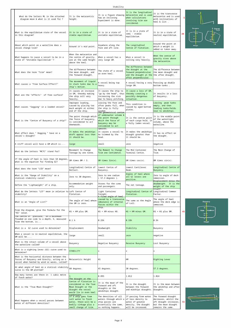
What is the equilibrium state of the vessel in this diagram?
The vessel is in a state of neutral equilibrium.
The vessel is in a state of stable equilibrium.
The ship is in a state of unstable equilibrium.
The vessel is in a state of semi - equilibrium.
With a forward draught of 8.00m and an aft draught of 9.00m, the amidships draught reads 8.30m. What state is the vessel in?
The vessel is in a normal state.
The vessel is on even keel.
As long as a ship is properly built and handled , it will never experience stresses .
When the upward force due to weight at a point, and the downward thrust due to buoyancy, at the same point are unequal.
Stresses to a ship are mainly caused when it is subjected to forces from wind, waves and loads.
When the downward force due to weight at a point, and the upward thrust due to buoyancy, at the same point, are not equal.
Stability
Page 8
1What do the letters ML in the attached diagram mean & what is it used for ?
It is the metacentric height.
It is a figure showing how an Inclining Experiment is done.
It is the longitudinal metacentre and is used when calculations involving trim are considered.
It is the transverse metacentre and is used with inclinations of heel & list .
24
Around it's mid point.
What does the term "Trim" mean?
What causes a "Free Surface Effect?"
What are the "effects" of free surface?
What causes "Sagging" in a loaded vessel?
What is the "Centre of Buoyancy of a ship?"
A stiff vessel will have a GM which is.... large small zero negative
What do the letters "MCTC" stand for?
GM times BM / 3. GM times Sin(x). GM times cos(x). BM times sin(x).
What does the term "LCB" mean?
Zero to 30 degrees.
Define the "Lightweight" of a ship. The net tonnage.
What is an "Angle of List?"
KG = KM plus GM. KG = KM minus KB. KG = KM minus GM. KG = KG plus BM. 41
0.1 h 0.25h 0.33h 0.5h
What is a GZ curve used to determine? Displacement Deadweight Stability Buoyancy
large small zero negative
Buoyancy Negative Buoyancy Reserve Buoyancy Lost Buoyancy
STABILITY x x x
Metacentric Height KG KM Righting Lever
60 degrees. 45 degrees. 30 degrees. 57.3 degrees.
1 0.895 1.012 1.024
What is the "True Mean Draught?"
51
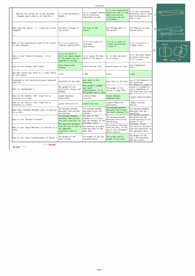
What is the equilibrium state of the vessel in this diagram?
It is in a state of stable equilibrium.
It is in a state of unstable equilibrium.
It is in a state of semi - stable equilibrium.
It is in a state of neutral equilibrium.
About which point on a waterline does a vessel change trim?
Anywhere along the fore and aft line.
The Longitudinal Centre of Flotation.
Around the point at which a weight is added or taken away.
What happens to cause a vessel to be in a state of "Unstable Equilibrium''?
When the metacentre and the centre of gravity, are at the same height above the keel.
When a vessel has a very large GM.
When a vessel is rolling very heavily.
When the centre of gravity rises above the metacentre.
The difference between the mean draught, and the forward draught.
The state of a vessel on even keel.
The difference between the draught at the forward perpendicular and the draught at the after perpendicular.
The difference between the mean draught and the after draught.
The movement of liquid in slack tanks due to a ship's motion.
A vessel being top heavy.
A vessel having a very large GM.
Pressing up double bottom tanks .
It causes an increase in GM, thereby making the ship roll very heavily.
It causes the ship to "go by the head", thus increasing the risk due to heavy pitching.
It cause a loss of GM, thereby creating a possibly dangerous situation.
It results in a loss of bouyancy.
Improper loading, caused by placing too much weight at either end of the ship.
Leaving the fore and after peaks full, when the ship is fully loaded.
This condition is caused by aged bottom plates.
Leaving peak tanks empty, and then loading tanks/holds near to amidships.
The point through which the force of buoyancy, is considered to act downwards.
The geometrical centre of underwater volume & the point through which the force of buoyancy may be considered to act upwards.
It is the centre point of each cargo hold, in a fully laden vessel.
It is the middle point of the watertight volume, above the waterline.
What effect does " Hogging " have on a vessel's draught?
It makes the amidships draft appear less than it should be.
It causes a vessel to be trimmed by the head.
It makes the amidships draught greater than it should be.
It has no effect on the draught.
Movement to Change Tonnage by one tonne.
The Moment to Change Trim one Centimetre.
The Mid Container Terminal Centre.
The Main Change of Trim.
If the angle of heel is less than 10 degrees, what is the equation for finding GZ?
Longitudinal Centre of Ballast.
Lowest Centre of Buoyancy.
Lowest Cantilever Beam.
Longitudinal Centre of Buoyancy.
What is the "Range of Stability" on a statical stability curve?
Zero to one radian ( 57.3 degrees ).
Angles of heel where all GZ levers are positive.
Zero to angle of deck immersion.
Accommodation weight only.
Stores for the crew and passengers.
Displacement minus the deadweight. It is the weight of the ship itself.
What do the letters "LCF" mean in relation to stability?
Left Centre of Flotation.
Light Container Freight.
Longitudinal Centre of Flotation.
Longitudinal Common Factor.
The angle of heel where the GM is zero.
A fixed angle of heel caused by a transverse imbalance of internal forces within the ship.
The same as the Angle of Loll.
The angle of heel where the deck edge is immersed.
From the diagram, give the formula for the "KG" value.The centre of pressure, on a bulkhead flooded on one side to a depth, h, measured from the bottom, is...
When a vessel is in neutral equilibrium, the GM will be....
What is the intact volume of a vessel above the waterline called?
What is a righting lever (GZ) curve used to determine?
What is the horizontal distance between the forces of Buoyancy and Gravity, acting on a vessel when heeled by wind or waves, called?
At what angle of heel on a statical stability curve is the GM plotted?
How many tonnes are there in 1 cubic metre of fresh water? The draught at the
Centre of Flotation is considered as the True Mean Draught or the draught the vessel would lie in even keel conditions.
It is the mean of the forward and aft draughts or the amidships draught.
It is the draught between the forward and midships draughts.
It is the mean between the amidship and after draughts.
What happens when a vessel passes between water of different densities?
If a ship goes from salt water to fresh water, there will be a bodily sinkage plus a small change of trim.
The densities of all waters through which a ship passes are essentially the same, so nothing happens.
If passing from water of less density to water of greater density, the draught will be increased.
The forward draught decreases, whilst the aft draught increases, but the mean draught remains the same.
Stability
Page 9
1What do the letters ML in the attached diagram mean & what is it used for ?
It is the metacentric height.
It is a figure showing how an Inclining Experiment is done.
It is the longitudinal metacentre and is used when calculations involving trim are considered.
It is the transverse metacentre and is used with inclinations of heel & list .
52
53
What do the letters "GRT" mean? Grave Reverse Trim. Ground Rules of Trim.
1.015 1.008 0.925 1.025
waterline to the keel. main deck to the keel.
What is "Deadweight"?
Largest Beam Possible.
Latest Official Act. Length Over All.
What is the "Breadth Extreme?"
What does the letter " T " stand for in the diagram?
The Gross Tonnage of the vessel.
The Trim of the vessel.
The Tonnage Mark of the vessel.
The Terminus or most forward point.
What is the equilibrium state of the vessel in this diagram?
It is in a state of "Neutral Equilibrium".
It is in a state of "Unstable Equilibrium".
It is in a state of "Stable Equilibrium". G vyshe M
It is a vessel in a "Tender State".
What is the "Centre of Gravity", of an object?
It is the point at which the whole weight of the object may be regarded as acting.
It is always the mid - point of the object.
It is the end point of an object.
It is the point where an object will snap, if it is bent.
Gross Registered Tonnage.
Grain Regulatory Tests.
How many tonnes are there in 1 cubic metre of salt water?
Freeboard is the vertical distance measured from the......
main deck to the waterline.
top of the bulwarks to the waterline.
The weight of the provisions, stores and bunkers.
the vessel's loaded and light displacements. It is the weight that a ship
The weight of the vessel's cargo only.
The amount of cargo a vessel is allowed to carry, depending on the Load Line Zone she in.
What do the letters "LBP" stand for in relation to a ship?
Lloyds Buoyancy Particulars.
Loadline Beam Position.
Length Between Perpendiculars.
What do the letters "LOA" stand for in relation to a ship?
Longest Objective Attainable.
Largest Outside Article.
What does "Breadth Moulded" mean in relation to a ship?
The maximum breadth measured from outside the plating.
The maximum breadth measured across the hatches.
The maximum breadth measured from inside the shell plating P to S.
The maximum breadth measured from the waterline.
The maximum breadth measured from outside the shell plating P to S.
The mean of the breadth at # 1 hatch and the breadth at the aftermost hatch.
The maximum breadth measured from inside the plating.
The maximum breadth measured from the inside plating at the bottom of the centremost hatch.
What is the "Depth Moulded" in relation to a ship?
The vertical distance from the top of keel to the uppermost continuous deck at side.
The vertical distance from the keel to the main deck.
The vertical distance from the keel, to the top of the centremost hatch coaming.
The vertical distance from the waterline, to the uppermost deck.
What is the "Ship's Displacement in Tonnes''? The weight of the ship's cargo.
The weight of all the enclosed spaces.
The actual entire weight of the ship.
The weight of the hull, the machinery and the stores.
* * * NOTHING FOLLOWS * * *
Ship Construction
Page 10
stringer frame beam
Panting & Pounding Panting & Racking Water Pressure
racking. panting. pounding.
Transverse Longitudinal Combination
construction sequence tank capacities hydrostatic information
Three Four Five
stringers. deck girders. side girders.
Hogging Sagging Racking
Fillet Butt Vee Butt
Mooring Hawser Spurling
Flat Bar Tee Angle
Racking Slamming Pounding
Gross tonnage is defined as.... earning capacity. internal capacity. light displacement.
The lower end of the stem bar of a ship is attached to a........What stresses are the vessel's structure forward of the collision bulkhead stiffened to resist?Additional bottom stiffening is required immediately aft side of the collision bulkhead to resist........
What is the type of framing shown in the ship cross section?
A General Arrangement drawing gives details of a vessel's....What is the minimum number of transverse bulkheads required for a vessel with machinery aft?Racking stresses in a ship can be reduced by fitting a good system of......What stress are the frames and beams designed to resist?
What is the type of weld shown in the figure?What is the pipe which directs the anchor cable from the windlass to the chain locker called?In the figure, what is the section marked 4 called?
What is distortion of a vessel's structure caused by rolling called?
Ship Construction
Page 11
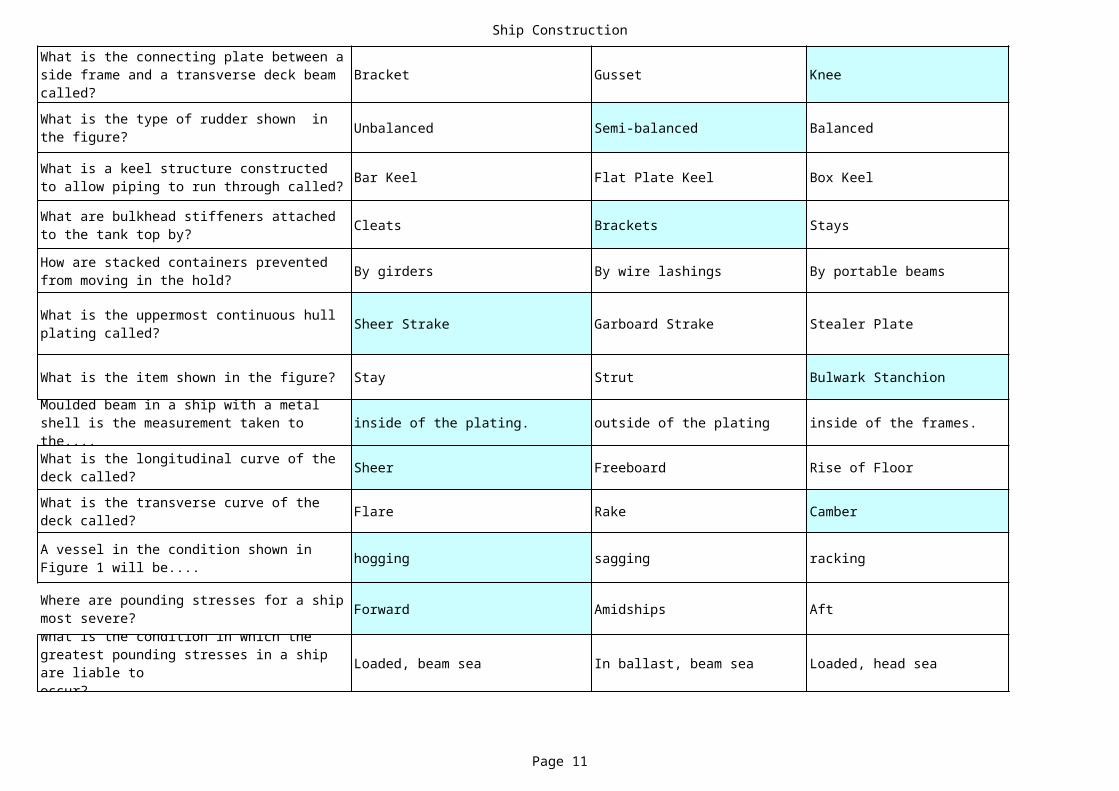
Bracket Gusset Knee
Unbalanced Semi-balanced Balanced
Bar Keel Flat Plate Keel Box Keel
Cleats Brackets Stays
By girders By wire lashings By portable beams
Sheer Strake Garboard Strake Stealer Plate
What is the item shown in the figure? Stay Strut Bulwark Stanchion
inside of the plating. outside of the plating inside of the frames.
Sheer Freeboard Rise of Floor
Flare Rake Camber
hogging sagging racking
Forward Amidships Aft
Loaded, beam sea In ballast, beam sea Loaded, head sea
What is the connecting plate between a side frame and a transverse deck beam called?What is the type of rudder shown in the figure?
What is a keel structure constructed to allow piping to run through called?
What are bulkhead stiffeners attached to the tank top by?
How are stacked containers prevented from moving in the hold?
What is the uppermost continuous hull plating called?
Moulded beam in a ship with a metal shell is the measurement taken to the....What is the longitudinal curve of the deck called?What is the transverse curve of the deck called?
A vessel in the condition shown in Figure 1 will be....
Where are pounding stresses for a ship most severe?What is the condition in which the greatest pounding stresses in a ship are liable tooccur?
Ship Construction
Page 12
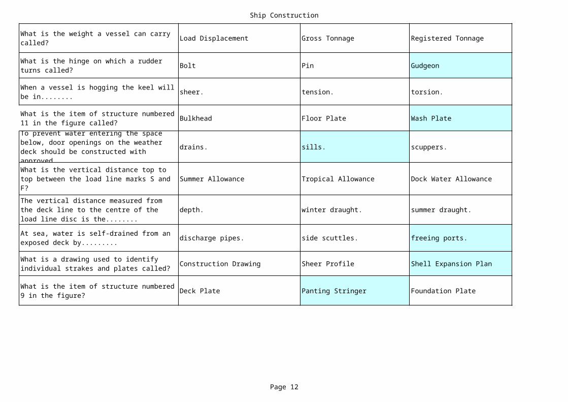
Load Displacement Gross Tonnage Registered Tonnage
Bolt Pin Gudgeon
sheer. tension. torsion.
Bulkhead Floor Plate Wash Plate
drains. sills. scuppers.
Summer Allowance Tropical Allowance Dock Water Allowance
depth. winter draught. summer draught.
discharge pipes. side scuttles. freeing ports.
Construction Drawing Sheer Profile Shell Expansion Plan
Deck Plate Panting Stringer Foundation Plate
What is the weight a vessel can carry called?
What is the hinge on which a rudder turns called?
When a vessel is hogging the keel will be in........
What is the item of structure numbered 11 in the figure called?To prevent water entering the space below, door openings on the weather deck should be constructed with approved........What is the vertical distance top to top between the load line marks S and F?The vertical distance measured from the deck line to the centre of the load line disc is the........
At sea, water is self-drained from an exposed deck by.........
What is a drawing used to identify individual strakes and plates called?
What is the item of structure numbered 9 in the figure?

Ship Construction
Page 13
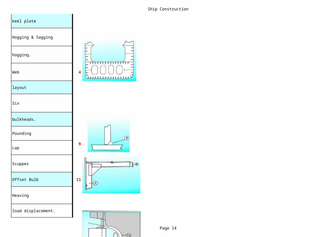
Boss Plate Stern Bearing Stern Post
Diameter pitch slip
Chocks Bilge Brackets Knees
Breast Hook Diamond Plate Bracket
* * * NOTHING FOLLOWS * * *
What is the item of structure numbered 12 in the figure called?
In ideal conditions, the forward distance a propeller will move in one revolution of the shaft is the:
In the figure, what are the items marked 6 called?
What is the item of structure numbered 10 in the figure called?
Ship Construction
Page 14
keel plate
Hogging & Sagging
hogging.
Web 4
layout
Six
bulkheads.
Pounding
Lap9
Scupper
Offset Bulb 11
Heaving
load displacement.

Ship Construction
Page 15
Stiffener
Spade 15
Duct Keel
Chocks
By cell guides
Stringer Plate
Stiffener20
inside of the ceiling.
Rake
Tumblehome
twisting 24
Between the bulkheads
In ballast, head sea
Ship Construction
Page 16
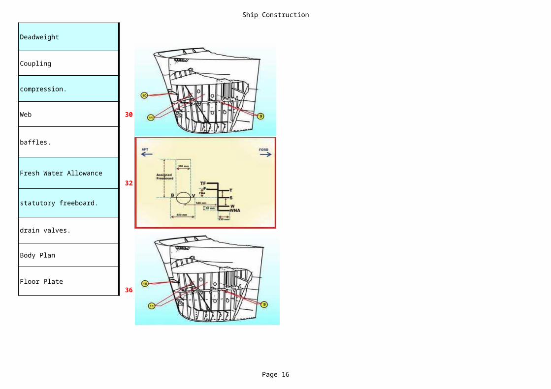
Deadweight
Coupling
compression.
Web 30
baffles.
Fresh Water Allowance32
statutory freeboard.
drain valves.
Body Plan
Floor Plate36
Ship Construction
Page 17
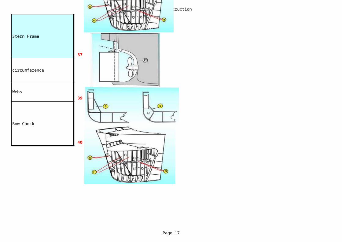
Stern Frame
37
circumference
Webs39
Bow Chock
40
Monitor Complince Legislative
Page 18
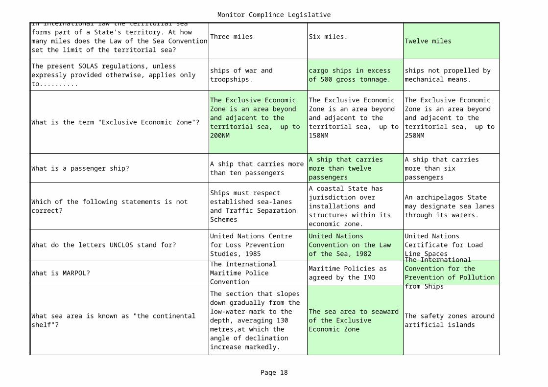
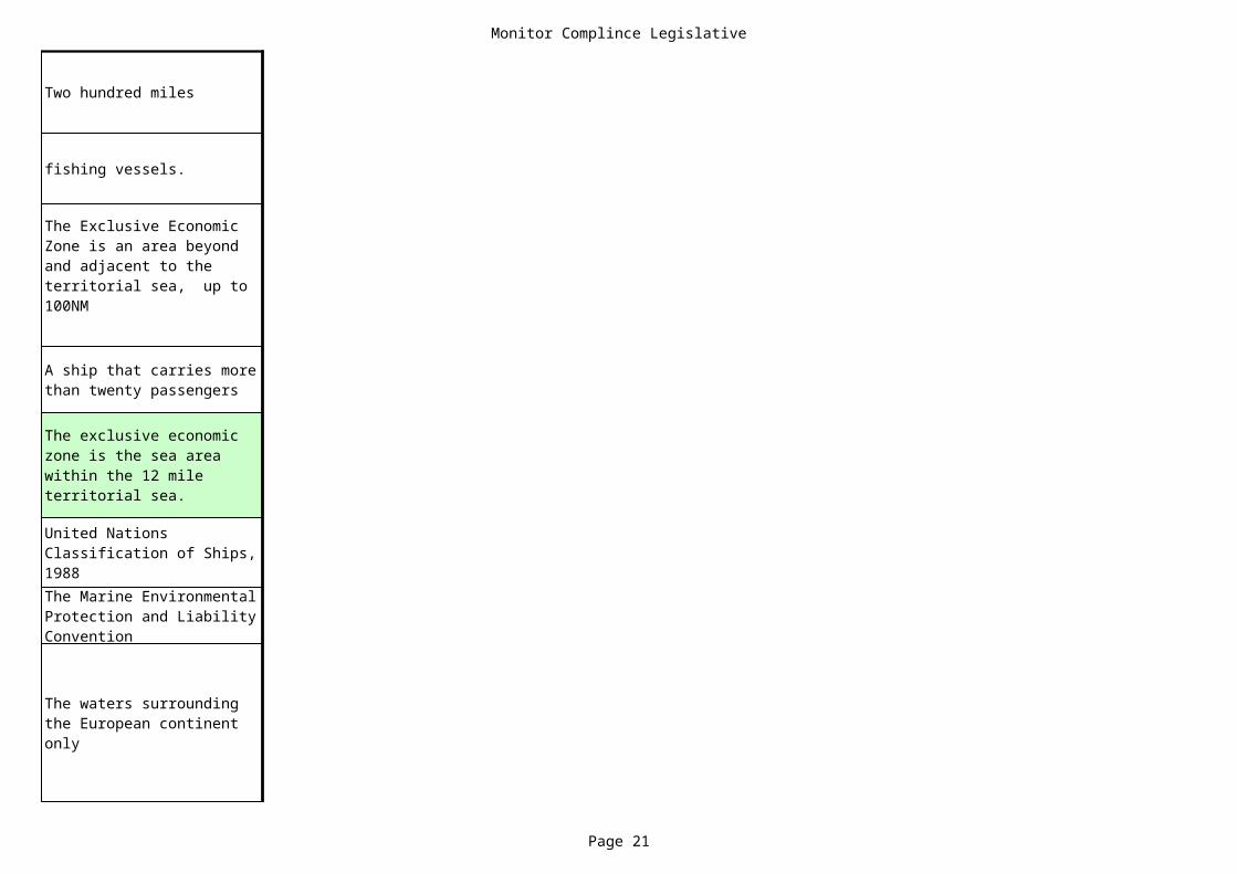
Twelve miles
What is the term "Exclusive Economic Zone"?
What is a passenger ship?
What do the letters UNCLOS stand for?
What is MARPOL?
In international law the territorial sea forms part of a State's territory. At how many miles does the Law of the Sea Convention set the limit of the territorial sea?
Three miles Six miles.
The present SOLAS regulations, unless expressly provided otherwise, applies only to..........
ships of war and troopships.
cargo ships in excess of 500 gross tonnage.
ships not propelled by mechanical means.
The Exclusive Economic Zone is an area beyond and adjacent to the territorial sea, up to 200NM
The Exclusive Economic Zone is an area beyond and adjacent to the territorial sea, up to 150NM
The Exclusive Economic Zone is an area beyond and adjacent to the territorial sea, up to 250NM
A ship that carries more than ten passengers
A ship that carries more than twelve passengers
A ship that carries more than six passengers
Which of the following statements is not correct?
Ships must respect established sea-lanes and Traffic Separation Schemes
A coastal State has jurisdiction over installations and structures within its economic zone.
An archipelagos State may designate sea lanes through its waters.
United Nations Centre for Loss Prevention Studies, 1985
United Nations Convention on the Law of the Sea, 1982
United Nations Certificate for Load Line Spaces
The International Maritime Police Convention
Maritime Policies as agreed by the IMO
The International Convention for the Prevention of Pollution from Ships
What sea area is known as "the continental shelf"?
The section that slopes down gradually from the low-water mark to the depth, averaging 130 metres,at which the angle of declination increase markedly.
The sea area to seaward of the Exclusive Economic Zone
The safety zones around artificial islands
Monitor Complince Legislative
Page 19
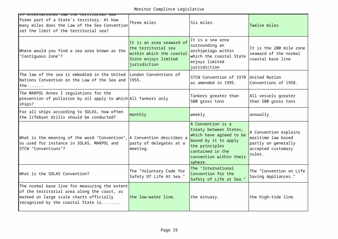
Twelve miles
In international law the territorial sea forms part of a State's territory. At how many miles does the Law of the Sea Convention set the limit of the territorial sea?
Three miles Six miles.
All Tankers only
monthly weekly annually
What is the SOLAS Convention?
the low-water line. the estuary. the high-tide line.
Where would you find a sea area known as the "Contiguous Zone"?
It is an area seaward of the territorial sea within which the coastal State enjoys limited jurisdiction
It is a sea area surrounding an archipelago within which the coastal State enjoys limited jurisdiction
It is the 200 mile zone seaward of the normal coastal base line
The law of the sea is embodied in the United Nations Convention on the Law of the Sea and the.......
London Conventions of 1955. STCW Convention of 1978
as amended in 1995.United Nation Conventions of 1958.
The MARPOL Annex I regulations for the prevention of pollution by oil apply to which ships?
Tankers greater than 500 gross tons
All vessels greater than 500 gross tons
For all ships according to SOLAS, how often the lifeboat drills should be conducted?
What is the meaning of the word "Convention", as used for instance in SOLAS, MARPOL and STCW "Conventions"?
A Convention describes a party of delegates at a meeting.
A Convention is a treaty between States, which have agreed to be bound by it to apply the principles contained in the convention within their sphere.
A Convention explains maritime law based partly on generally accepted customary rules.
The "Voluntary Code for Safety Of Life At Sea."
The "International Convention for the Safety of Life at Sea."
The "Convention on Life Saving Appliances."
The normal base line for measuring the extent of the territorial area along the coast, as marked on large scale charts officially recognised by the coastal State is........
Monitor Complince Legislative
Page 20
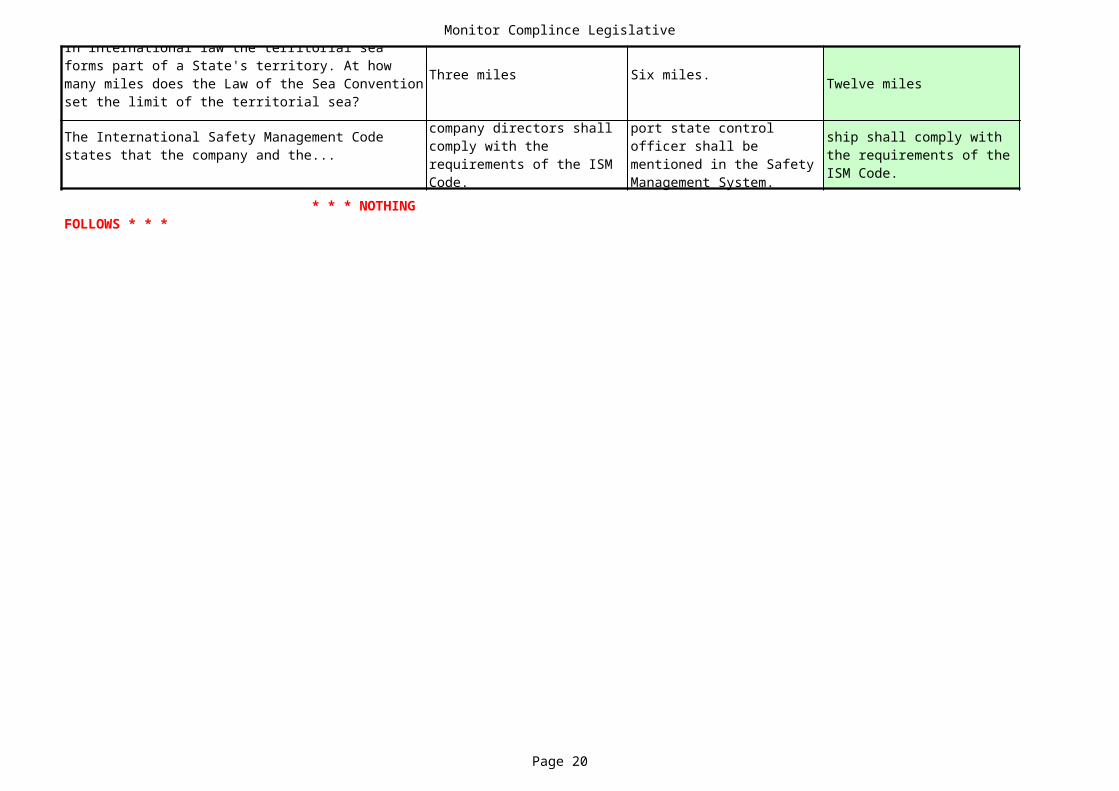
Twelve miles
In international law the territorial sea forms part of a State's territory. At how many miles does the Law of the Sea Convention set the limit of the territorial sea?
Three miles Six miles.
The International Safety Management Code states that the company and the...
company directors shall comply with the requirements of the ISM Code.
port state control officer shall be mentioned in the Safety Management System.
ship shall comply with the requirements of the ISM Code.
* * * NOTHING FOLLOWS * * *
Monitor Complince Legislative
Page 21
Two hundred miles
fishing vessels.
The Exclusive Economic Zone is an area beyond and adjacent to the territorial sea, up to 100NM
A ship that carries more than twenty passengers
The exclusive economic zone is the sea area within the 12 mile territorial sea.
United Nations Classification of Ships, 1988The Marine Environmental Protection and Liability Convention
The waters surrounding the European continent only

Monitor Complince Legislative
Page 22
Two hundred miles
quarterly
It is the area landward of the territorial sea; that is the estuaries and harbours
Geneva Conventions of 1958.
All ships, unless expressly provided otherwise
A Convention explains the enactment of national legislation giving effect to and enforcing its provisions.
The "International Life Saving Appliance Code."
the mean high water line.

Monitor Complince Legislative
Page 23
Two hundred miles
port State shall comply with the requirements of the ISM Code.

Marpol
Page 24
No Data No Data No Data
No Data No Data No Data
Dobble hull and bottom No Data No Data No Data
25 12 3 10
No data No data No data
Four Categories No data No data No data
Any grade of crude oil
No Data No Data No Data
Plastic No Data No Data No Data
No data No data No data
In the Master's cabin On the bridge In the ship's office
No data No data No data
No data No data No data
No data No data No data
50ppm 15ppm 30ppm 100ppm
No data No data No data
Port Authorities A Notary Public The Master
No data No data No data
No data No data No data
air polution certificate No data No data No data
No data No data No data
Emergency situations No data No data No data
To save human live No data No data No data
At least two slop tanks are required for....
Evrething exept plastic No data No data No data
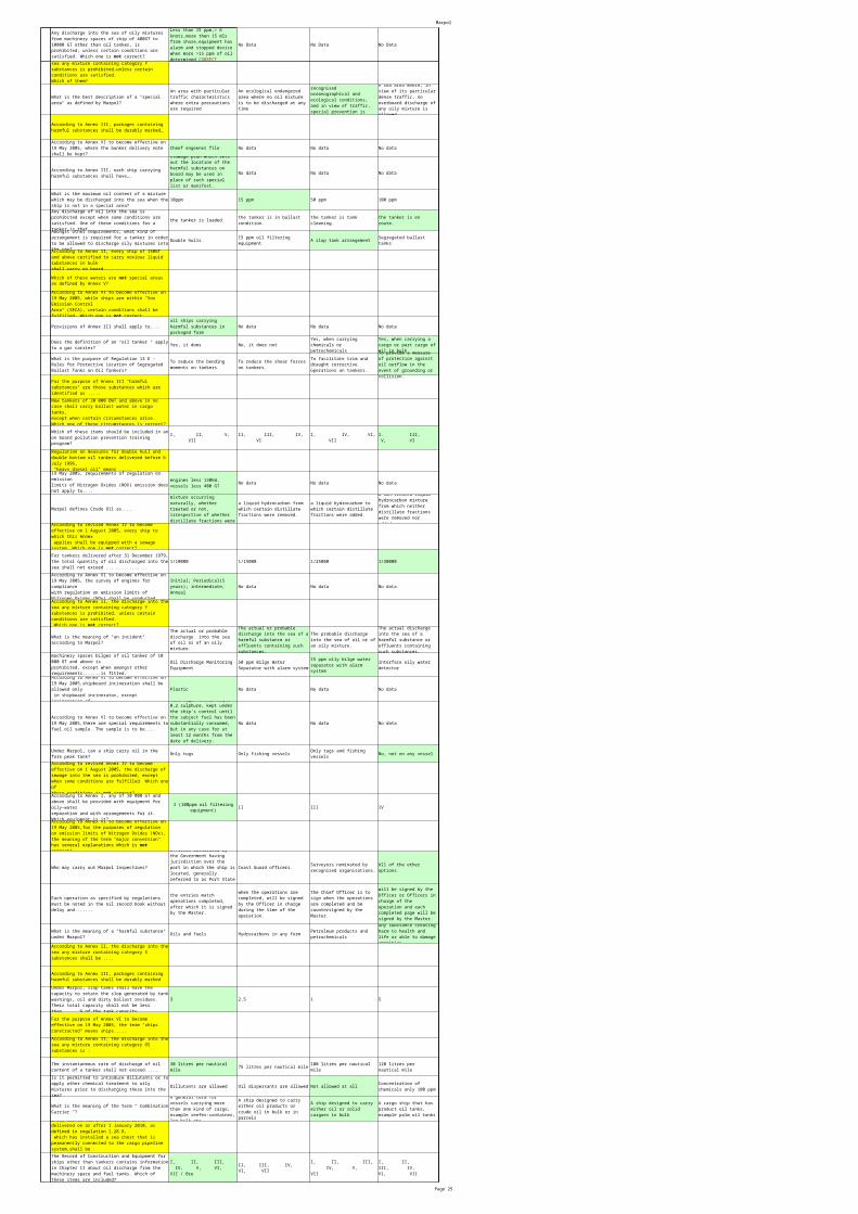
Any discharge into the sea of oily mixtures from machinery spaces of ship of 400GT to 10000 GT other than oil tanker, is prohibited, unless certain conditions are satisfied. Which one is not correct?
Less than 15 ppm,> 6 knots,more then 15 mls from shore,equipment has alarm and stopped device when more >15 ppm of oil determined CORRECT
Any failure of the oil filtering equipment shall be .....
Recorded in the oil record book (ORB)
According of Marpol Annex I, a category 2 or 3 oil tanker of 15 years and over after thedate of its delivery shall .....Garbage disposal regulations outside special areas specify that paper, crockery, glass, metal, food and rags, bigger in size than 25 mm may only be thrown overboard outside .......... miles offshore.
For the purpose of Annex VI to become effective on 19 May 2005, the term "SOx Emission ControlArea" means…..
area where the adoption of special mandatory measures for SOx emissions from ships is required to prevent, reduce and control air pollution from SOx and its attendant adverse impacts on land and sea areas.
Tank overflows while loading oil cargo or bunkering are one of the most common causes of oil pollution. Which five of these items are the main preventive measures against tank overflow?
I, II, III, VI, VII
II, III, V, VI, VII
I, III, IV, V, VI
II, IV, V, VI, VII
Which is nearest to the Marpol description of segregated ballast?
Ballast water that cannot be pumped through cargo oil piping and for which cargo pumps cannot be used
The ballast water introduced in a tank which is completely separated from the cargo or fuel oil system and permanently allocated to ballast
The clean ballast water which can only be pumped via segregated lines by the clean ballast pump
The ballast carried in the clean ballast tank, pumped via the segregated ballast pump
According to Annex V, the disposal of garbage into the sea within the special area is prohibited. Which one is the exception?
Paper ground up to less than 25 mm beyond 12 miles offshore.
Glass ground up to less than 25 mm beyond 25 miles offshore.
Paper, metal and glass ground up to less than 25 mm beyond 25 miles offshore.
Comminuted (ground up) food waste beyond 12 miles offshore.
For the purposes of the Annex II noxious liquid substances shall be divided into
According to Marpol, what does the term "oil " mean?
Any grade of crude oil or fuel oil
Any grade of crude oil, fuel oil or refined products
Petroleum in any form including crude oil, fuel oil, sludge oil, oil refuse and refined products
Any discharge into the sea of oily mixtures from any oil tanker is prohibited, unless certain conditions are satisfied. Which one is not correct?
Not in special Area; Vessel 50NM from the land; En loute;30LTR/mile; Slop tank; ODME fitted
What is the meaning of "slop tank" as defined by Marpol?
A tank used for tank cleaning provided with heating coils
Any tank where slops or sludges are collected
The two most aftward fitted wing tanks or the most aftward fitted centre tank
A tank specifically designed for the collection of tank drainings, washings or other oily mixturesAccording to Annex V, disposal of garbage
into the sea outside special area is prohibited, unlesscertain conditions are fulfilled. These conditions do not include the disposal of ..........
According to Annex III, each ship carrying harmful substances shall have….
a special list or manifest setting forth the harmful substances on board and the location thereof. A detailed stowage plan which sets out the location of the harmful substances on board may be used in place of such special list or manifest.
Where is the Oil Record Book to be kept on board?
At a place where it is readily available
Which description given is nearest to the description of clean ballast as defined by Marpol?
Its oil content is NIL and consequently would not leave any traces upon the surface of the water or emulsion beneath the water surface.
If discharged from a stationary ship in clean calm water on a clear day will not produce visible traces of oil on the water surface nor emulsion below
Its oil content is no more than 50 ppm and will not produce visible traces on adjoining shorelines, nor emulsion in the sea.
Its oil content is no more than 100 ppm and it will not produce visible traces on the shore lines.The initial Marpol (IOPP) survey carried out
before a ship enters service, in order to ensurecompliance with the applicable regulations, shall include.....
Oily filtering equipment,sewage plant,incinerator
When alterations to the ship's construction, equipment, materials , fittings or arrangements are carried out without sanction, the IOPP certificate ceases to be valid. What is the exception?
Improvement in ship's construction
The direct replacement of equipment and fittings
Modification of arrangements as long as purpose and lay-out does not deviate from Marpol requirements
Replacement of monitoring equipment as long as it is approved by the Administration
According to Annex VI to become effective on 19 May 2005,the bunker delivery note shall beaccompanied by.....
representative sample of the fuel oil delivered, taking into account Guidelines for the Sampling
According to Annex II, the discharge into the sea any mixture containing category Ysubstances is prohibited, unless certain conditions are satisfied. Which of them?
For the purpose of determining the capacity of the clean ballast tanks in tankers, which tanks may be included?
Segregated ballast tanks only
Fore and after peak tanks as well as segregated ballast tanks
Cofferdams as well as segregated ballast tanks
Segregated ballast tanks, fore and after peak tanks as well as cofferdams.
According to Marpol, what is the meaning of the term "oily mixture "?
A mixture with oil content above 15 ppm
A mixture with oil content above 50 ppm
A mixture with oil content above 100 ppm
A mixture with any oil content
In the event of accidental or exceptional discharges (for example allowed discharge in order to save life), a statement shall be made in the oil record book explaining what?
The amount and the specifications of the oil discharged
The report of the accident indicating precautions
The circumstances of and the reasons for the discharge
The amount discharged and the reasons for it
What does the "instantaneous rate of discharge of oil content " mean, according to Marpol?
The total quantity of oil discharged at any moment
The total rate of oil discharged per hour divided by 3600
The rate of oil discharge in litres per hour at any instant, divided by the speed of the ship in knots at the same instant
The total quantity of oil discharged, divided by the mileage covered during the time of discharge by the shipAccording to Annex VI to become effective on
19 May 2005, new installations, which contain ozonedepleting substances shall be prohibited on all ships. What is the exception?
New installation HCFCs (hydrochlorofluorocorbons) are permited until JAN 1st. 2020
For the purpose of Annex VI to become effective on 19 May 2005, the term "ozone depleting substances"means …..For the purposes of the Annex II, noxious liquid substances of category X, if dischargedinto the sea from tank cleaning or deballasting operations, would present .....Any ship of 400 GT to 10 000GT which does not carry ballast water in fuel oil tanks shall be fittedwith.............oil filtering equipment for engine bilge discharge.
According to Marpol, what is the meaning of the term "oil fuel"?
A cargo of heavy fuel oil , intermediate fuel or diesel oil
A cargo of refined oil for combustible purpose in thermal machinery or boilers
A cargo of refined oil with flashpoint above 60 degree C
Any oil used on board in connection with the propulsion and auxiliary machinery.
For the purposes of Annex II, term "noxious liquid substance" means…
Any noxious liquid carried in bulk
Who can certify true copies of Oil Record Books?
The Officers of the Flag State
According to revised Annex IV to become effective on 1 August 2005, the discharge of sewage intothe sea is prohibited, except when some conditions are fulfilled. Which one of these conditions is notcorrect?
Na novye suda;400 or more and have more 12persons;sewage dis. 3NM esli disinfected and 12 esli nedisinfected
Topping off during oil cargo loading or bunkering is the most critical operation and some of theseprecautions or actions should not be taken. Which one is not correct?
I, II, III, V, VIII
I, III, V, VI, VII (II,IV, VIII not corect)
II, IV, VI, VII, VIII
II, III, V, VI, VIII
The provisions of MARPOL permit the discharge into the sea of substances containing oil,approved by the Administration for purpose of combating specific pollution incidents into the sea.Under which of these conditions?
Save human live and damage of vessel
According to Annex VI to become effective on 19 May 2005,all tankers which are subjectto vapour emission control (VOC), shall.....According to Annex VI to become effective on 19 May 2005,......shall be issued, after survey to anyship of 400GT or above engaged in voyages to ports under the jurisdiction of other Parties.Which of these are not the requirements for an Oil Discharge Monitoring and Control System?
II, IV, V, VI, VII, VIII
I, II, III, IV, V, VI, VII, VIII, IX (9 requirements presented)!!!!
I, II, III, IV, VI, VII
I, II III, V, VI, VII, VIII
All oil tankers of 5,000 tonnes deadweight or more shall have .....
Penalties under the law for violation of Marpol requirements shall be.....
imposed to warn against the global problem of pollution.
adequate in severity to discourage violations and shall be equally severe irrespective of where the violation occurs.
imposed by all countries, the severity depending on where the violation occurs.
in all cases most severe.
According to Annex VI to become effective on 19 May 2005,shipboard incineration of polyvinylchlorides (PVCs) shall be prohibited, except
possible in incineratorsprovided with the Type Approval Certificate;2000yearAccording to Annex VI to become effective on
19 May 2005, operation of each diesel engine,which is coveredby requirements on restriction of Nitrogen Oxides (NOX) emission, is prohibited,except when....The provisions of MARPOL prohibit any discharge of oily mixture into the sea. It does notapply to the discharge resulting from damage to a ship, provided that …….
new and existing oil tankers above 150,000 tons dwt.
new oil tankers of 70,000 tons dwt and above.
new oil tankers of 40,000 tons dwt and above.
new oil tankers of 20,000 tons dwt and above.
According to Annex VI to become effective on 19 May 2005,shipboard incineration of the certain substancesshall be prohibited. This prohibition does not cover…
Marpol
Page 25
No Data No Data No Data
Any discharge into the sea of oily mixtures from machinery spaces of ship of 400GT to 10000 GT other than oil tanker, is prohibited, unless certain conditions are satisfied. Which one is not correct?
Less than 15 ppm,> 6 knots,more then 15 mls from shore,equipment has alarm and stopped device when more >15 ppm of oil determined CORRECT
Cheef engeener file No data No data No data
No data No data No data
10ppm 15 ppm 50 ppm 100 ppm
the tanker is loaded.
Double hulls A slop tank arrangement
Provisions of Annex III shall apply to.... No data No data No data
Yes, it does No, it does not
No data No data No data
Marpol defines Crude Oil as....
1/10000 1/15000 1/25000 1/30000
No data No data No data
Plastic No data No data No data
No data No data No data
Only tugs Only fishing vessels No, not on any vessel
II III IV
Who may carry out Marpol Inspections? Coast Guard officers.
Oils and fuels Hydrocarbons in any form
3 2.5 1 5
75 litres per nautical mile
Dillutants are allowed Oil dispersants are allowed Not allowed at all
According to Annex II, the discharge into the sea any mixture containing category Y substances is prohibited,unless certain conditions are satisfied.Which of them?
What is the best description of a "special area" as defined by Marpol?
An area with particular traffic characteristics where extra precautions are required
An ecological endangered area where no oil mixture is to be discharged at any time
A sea area where, for recognised oceanographical and ecological conditions, and in view of traffic, special prevention is required
A sea area where, in view of its particular dense traffic, no overboard discharge of any oily mixture is allowed
According to Annex III, packages containing harmful substances shall be durably marked…
According to Annex VI to become effective on 19 May 2005, where the bunker delivery note shall be kept?
According to Annex III, each ship carrying harmful substances shall have….
a special list or manifest setting forth the harmful substances on board and the location thereof. A detailed stowage plan which sets out the location of the harmful substances on board may be used in place of such special list or manifest.
What is the maximum oil content of a mixture which may be discharged into the sea when the ship is not in a special area?Any discharge of oil into the sea is prohibited except when some conditions are satisfied. One of these conditions for a tanker is that....
the tanker is in ballast condition.
the tanker is tank cleaning.
the tanker is en route.
Amongst other requirements, what kind of arrangement is required for a tanker in order to be allowed to discharge oily mixtures into the sea?
15 ppm oil filtering equipment
Segregated ballast tanks
According to Annex II, every ship of 150GT and above certified to carry noxious liquid substances in bulkshall carry on board..........
Which of these waters are not special areas as defined by Annex V?According to Annex VI to become effective on 19 May 2005, while ships are within "Sox Emission ControlArea" (SECA), certain conditions shall be fulfilled. Which one is not correct
all ships carrying harmful substances in packaged form
Does the definition of an "oil tanker " apply to a gas carrier?
Yes, when carrying chemicals or petrochemicals
Yes, when carrying a cargo or part cargo of oil in bulk
What is the purpose of Regulation 13 E - Rules for Protective Location of Segregated Ballast Tanks on Oil Tankers?
To reduce the bending moments on tankers.
To reduce the shear forces on tankers.
To facilitate trim and draught corrective operations on tankers.
To provide a measure of protection against oil outflow in the event of grounding or collision.
For the purpose of Annex III "harmful substances" are those substances which are identified as .....New tankers of 20 000 DWT and above in no case shall carry ballast water in cargo tanks,except when certain circumstances arise. Which one of these circumstances is correct?Which of these items should be included in an on board pollution prevention training program?
I, II, V, VII
II, III, IV, VI
I, IV, VI, VII
I. III, V, VI
Regulation on measures for double hull and double bottom oil tankers delivered before 6 July 1996, "heavy diesel oil" means .....According to Annex VI to become effective on 19 May 2005, requirements of regulation on emissionlimits of Nitrogen Oxides (NOX) emission does not apply to....
engines less 130kW, vessels less 400 GTa liquid hydrocarbon mixture occurring naturally, whether treated or not, irrespective of whether distillate fractions were removed or added.
a liquid hydrocarbon from which certain distillate fractions were removed.
a liquid hydrocarbon to which certain distillate fractions were added.
a non-treated liquid hydrocarbon mixture from which neither distillate fractions were removed nor added.According to revised Annex IV to become
effective on 1 August 2005, every ship to which this Annex applies shall be equipped with a sewage system. Which one is not correct?For tankers delivered after 31 December 1979, the total quantity of oil discharged into thesea shall not exceed ................According to Annex VI to become effective on 19 May 2005, the survey of engines for compliancewith regulation on emission limits of Nitrogen Oxides (NOx) shall be conducted…
Initial; Periodical(5 years); intermediate; Annual
According to Annex II, the discharge into the sea any mixture containing category Y substances is prohibited, unless certain conditions are satisfied. Which one is not correct?
What is the meaning of "an incident" according to Marpol?
The actual or probable discharge into the sea of oil or of an oily mixture.
The actual or probable discharge into the sea of a harmful substance or effluents containing such substances.
The probable discharge into the sea of oil or of an oily mixture.
The actual discharge into the sea of a harmful substance or effluents containing such substances.116.Any discharge of oily mixtures from
machinery spaces bilges of oil tanker of 10 000 GT and above isprohibited, except when amongst other requirements.......is fitted.
Oil Discharge Monitoring Equipment
50 ppm Bilge Water Separator with alarm system
15 ppm oily bilge water separator with alarm system
Interface oily water detector
According to Annex VI to become effective on 19 May 2005,shipboard incineration shall be allowed only in shipboard incinerator, except incineration of…
According to Annex VI to become effective on 19 May 2005,there are special requirements to fuel oil sample. The sample is to be....
meet Reg14 and 18 Req.; 0,2 sulphure, kept under the ship’s control until the subject fuel has been substantially consumed, but in any case for at least 12 months from the date of delivery.
Under Marpol, can a ship carry oil in the fore peak tank?
Only tugs and fishing vessels
According to revised Annex IV to become effective on 1 August 2005, the discharge ofsewage into the sea is prohibited, except when some conditions are fulfilled. Which one ofthese conditions is not correct?According to Annex I, any of 10 000 GT and above shall be provided with equipment for oily-waterseparation and with arrangements for it. Which equipment is it?
I (100ppm oil filtering equipment)
According to Annex VI to become effective on 19 May 2005,for the purposes of regulationon emission limits of Nitrogen Oxides (NOx), the meaning of the term "major conversion"has several explanations.Which is not correct? Officers authorised by
the Government having jurisdiction over the port in which the ship is located, generally referred to as Port State Inspectors.
Surveyors nominated by recognised organisations.
All of the other options.
Each operation as specified by regulations must be noted in the oil record book without delay and.......
the entries match operations completed, after which it is signed by the Master.
when the operations are completed, will be signed by the Officer in charge during the time of the operation.
the Chief Officer is to sign when the operations are completed and be countersigned by the Master.
will be signed by the Officer or Officers in charge of the operation and each completed page will be signed by the Master.
What is the meaning of a "harmful substance" under Marpol?
Petroleum products and petrochemicals
Any substance creating harm to health and life or able to damage amenities.According to Annex II, the discharge into the
sea any mixture containing category X substances shall be ....
According to Annex III, packages containing harmful substances shall be durably markedUnder Marpol, slop tanks shall have the capacity to retain the slop generated by tank washings, oil and dirty ballast residues. Their total capacity shall not be less than ......% of the tank capacity.For the purpose of Annex VI to become effective on 19 May 2005, the term "ships constructed" means ships.....According to Annex II, the discharge into the sea any mixture containing category OS substances is :
The instantaneous rate of discharge of oil content of a tanker shall not exceed.....
30 litres per nautical mile
100 litres per nautical mile
120 litres per nautical mile
Is it permitted to introduce dillutants or to apply other chemical treatment to oily mixtures prior to discharging these into the sea?
Concentration of chemicals only 100 ppm
What is the meaning of the term " Combination Carrier "?
A general term for vessels carrying more than one kind of cargo, example reefer-container, log-bulk etc.
A ship designed to carry either oil products or crude oil in bulk or in parcels
A ship designed to carry either oil or solid cargoes in bulk
A cargo ship that has product oil tanks, example palm oil tanks
Every oil tanker of 150 GT and above delivered on or after 1 January 2010, as defined in regulation 1.28.8, which has installed a sea chest that is permanently connected to the cargo pipeline system,shall beequipped withThe Record of Construction and Equipment for ships other than tankers contains information in Chapter II about oil discharge from the machinery space and fuel tanks. Which of these items are included?
I, II, III, IV, V, VI, VII / Все
II, III, IV, VI, VII
I, II, III, IV, V, VII
I, II, III, IV, VI, VII
Marpol
Page 26
No Data No Data No Data
Any discharge into the sea of oily mixtures from machinery spaces of ship of 400GT to 10000 GT other than oil tanker, is prohibited, unless certain conditions are satisfied. Which one is not correct?
Less than 15 ppm,> 6 knots,more then 15 mls from shore,equipment has alarm and stopped device when more >15 ppm of oil determined CORRECT
Collision or groundings Crew negligence
No data No data No data
Equipped by Sewage Plant No data No data No data
5mm 30 mm 25 mm 10mm
1/15000 1/25000 1/50000 1/100000
No data No data No data
No data No data No data
two years. two and a half years. three years. five years.
IOPP certificate No data No data No data
100 T 200 cubic metres 400 T 500 cubic metres
Who may carry out MARPOL Surveys? Coast Guard Inspectors
No data No data No data
The Midterm survey The Intermediate survey The Annual survey The Special survey
3 years No data No data No data
I, III, V I, II, III I, II, V
500, 1000 400, 700 250, 500 150, 400
Item V - does not belong
CO2,SO2,Nox No data No data No data
According to Annex II, the discharge into the sea any mixture containing category Z substances is prohibited,unless certain conditions are satisfied.Which of them?Marpol regulations prohibit oily mixture discharges at sea. The regulations do not apply if the discharge is the result of damage to the ship or its equipment. What is the exception?
Intent to cause damage, or recklessly and with knowledge that damage could probably result
Damage to ship and equipment due to operational error
Regulation on measures for existing oil tankers to become effective on 5 April 2005 shall apply to ......
When shall the IOPP Certificate cease to be valid?
If significant alterations have taken place in the ship's construction without sanction.
If significant alterations have taken place to fittings, equipment or arrangements without sanction.
If significant alterations have taken place to materials without sanction.
Any of the other options.
Which of these design requirements shall be met for oil filtering equipment fitted on shipsof 10 000 GT and above?
Stop discharge of oil mixture more 15 ppm and alarm
Where a cargo subject to the provisions of Annex I is carried in a cargo space of NLS
There is potential for pollution when starting to take ballast on non-SBT tankers, because oil may backflow into the sea via the sea chests. In order to prevent this, which notice should be placed on the ballast pump?
START PUMP BEFORE OPENING SEA SUCTION
ENSURE PIPING IS CLEANED PRIOR STARTING PUMP
FLUSH PIPING THROUGH PRIOR TO TAKING BALLAST
START PUMP WITH DISCHARGE VALVES CLOSED
According to revised Annex IV to become effective on 1 August 2005, the discharge of sewage into the sea is prohibited, except when the ship is....Garbage disposal regulations outside special areas specify that paper, crockery, rags, metal , glass and food may be thrown overboard within 3 to 12 miles offshore, provided it is ground to less than ......... in size.Any discharge of oil into the sea is prohibited, except when some conditions are satisfied. One of these conditions for an oil tanker is that ....
the tanker is more than 10 nautical miles from the nearest land.
the tanker is more than 25 nautical miles from the nearest land.
the tanker is more than 50 nautical miles from the nearest land./En route
the tanker is more than 100 nautical miles from the nearest land.
Every ship to which Annex II applies shall be provided with ......
There are 6 annexes to MARPOL 73/78 (Annex I to VI). They deal with pollution caused by........
I = Oil, II = Sewage, III = Garbage, IV = Harmful packaged substances, V = Noxious liquids in bulk, VI = Air pollution.
I = Sewage, II = Noxious liquids in bulk, III = Oil, IV = Harmful packaged substances, V = Air pollution, VI = Garbage.
I = Oil, II = Noxious liquid in bulk, III = Harmful packaged substances, IV = Sewage, V = Garbage, VI = Air pollution.
I = Garbage, II = Air pollution, III = Sewage, IV = Harmful packaged substances, V = Noxious liquid in bulk, VI = Oil.
For existing tankers, the total quantity of oil discharged into the sea should be no more than ..................... of the total quantity of the particular cargo of which the residue formed part.
Under Marpol, can a NLS tanker be considered an oil tanker?
According to Annex VI to become effective on 19 May 2005, "SOx Emission Control Area"shall include....
Baltic sea, North sea, English Channel
Where a cargo subject to the provisions of Annex I is carried in a cargo space of NLS tanker, .....No oil discharge monitoring equipment (ODME) is to be fitted on tankers if trading in specific areas or within 50 miles from nearest land, provided that certain conditions are fulfilled.These conditions do not include:
do not include SBT, two slop tanks, 100ppm oil separator
Garbage disposal regulations outside special areas specify that plastics......
cannot be thrown overboard within 25 miles offshore.
cannot be thrown overboard within 12 miles offshore.
cannot be thrown overboard within 3 miles offshore.
cannot be thrown overboard at any time.
In an existing tanker, which tanks can be designated as slop tanks?
Any tank fitted with overboard discharge facilities.
Any tank closed to the atmosphere and fitted with an oily water separation filter.
Any tank separated from the ship's side by a distance of at least 3 metres.
Any tank provided with adequate means for collecting dirty ballast residue and tank washings from the cargo tanks.Periodical Marpol surveys are to be carried
out at intervals as specified by the administration. These intervals are not to exceed.....According to Annex II, …..shall be issued after survey to any ship carrying noxious liquid substances in bulk and which is engaged in international voyages.If ships other than tankers have spaces constructed and utilised to carry oil in bulk of a capacity of .......... or more, the regulations of Annex I for oil tankers apply.
Port-State Control Inspectors
Surveyors nominated by Administrations or organisations recognised by Administrations
Approved ship's officers
According to Annex VI to become effective on 19 May 2005,who can certify true copies ofthe bunker delivery note?
Cheef engeener and bunker surveer
At least one survey must to be carried out during the validity of the IOPP certificate. This shall ensure that the equipment, pumps and piping systems including ODME are in order. What is this survey called?
Annex II of Marpol 73/78 deals mainly with......
the construction, ballast procedures, category of ballast and the operational procedures of petroleum tankers
the pollution hazards from chemical tankers and their arrangements for discharge of cargo residues
the labeling and packaging of harmful substances carried as packages
the handling and discharge of garbage
According to Annex VI to become effective on 19 May 2005,the bunker delivery note shallbe retained for the period of....
What does "discharge" means in relation to harmful substances as defined by Marpol?
Pumping, emptying or emitting from a ship.
Spilling, leaking or escaping from the ship.
Dumping or disposal from the ship.
Any release how ever caused.
How do the requirements of Marpol stand in relation to national or port regulations?
They are the same for any country which has ratified the Marpol convention
National regulations in the ports visited may be more stringent and must be complied with.
Only Japan and the United States have additional regulations to be complied with.
Only Australia has additional regulations to be complied with.
To prevent pollution you should look at how the operations that may lead to pollution are conducted on board your ship and ask yourself 3 questions. What are these questions?
II, IV, VI
Every oil tanker of ....... grt and above and every other ship of ...... grt and above shall be subject to Marpol (IOPP) surveys.
These items are standard inspection items for Marpol, as given in guidelines to inspectors and surveyors. Which item does not belong?
Item II - does not belong
Item VI - does not belong
Item VII - does not belong
Garbage disposal regulations outside special areas specify that dunnage, lining and packing materials that float......
may not be thrown overboard at any time.
may be thrown overboard outside 25 miles offshore.
may be thrown overboard outside 12 miles offshore.
may be thrown overboard outside 3 miles offshore.
For the purpose of Annex VI to become effective on 19 May 2005, the term "emission" means.......
Marpol garbage disposal regulations outside Special Areas specify that, within 3 miles from the nearest land and in all inland waters.....
you cannot throw paper, crockery, rags, glass metal or food overboard unless ground to less than 25 mm.
you cannot throw anything overboard.
you cannot throw plastics, dunnage, lining and packing materials that float overboard.
you cannot throw plastics overboard.
The Record of Construction and Equipment has a chapter about "Tanks for Oil Residues (Sludges)". What information is recorded in this chapter?
The location and capacity of the sludge tanks
The capacity of the sludge tanks and the pumping arrangements
The number and capacity of sludge tanks and means of connection to open deck sludge connection
The total tank capacity and the means for disposal of oil residue in addition to the provision of sludge tanksAccording to Annex II, the discharge into the
sea any mixture containing category Ysubstances is prohibited, unless certain conditions are satisfied. Which of them? * * * NOTHING FOLLOWS * * *

Marpol
Page 27
No Data No Data No Data
Any discharge into the sea of oily mixtures from machinery spaces of ship of 400GT to 10000 GT other than oil tanker, is prohibited, unless certain conditions are satisfied. Which one is not correct?
Less than 15 ppm,> 6 knots,more then 15 mls from shore,equipment has alarm and stopped device when more >15 ppm of oil determined CORRECT

ISM-CODE
Page 28
the size of the Company.
The Company should establish procedures for the ship's personnel to receive relevant information on the SMS and the amount of documentation should be determined by......
the requirements of the Charterers.
whatever is necessary to ensure that all appropriate shipboard personnel understand their respective roles.
Under ISM, what kind of support is to be provided to the Designated Person in order to carry out his functions?
An executive salary and a company car
Adequate resources and shore based support
Freedom to travel worldwide at will
The Master's review reporting on the Safety Management system should include any deficiencies and may include......
proposals for corrective action and recommendations for improving the SMS.
a list of unsatisfactory crew members who are not to be rehired by the Company.
a list of keen and safety and environmental aware crew members who are to be promoted.
The Company should have available shoreside organisational structure, resources means and procedures for communications and equipment for responding to a shipboard emergency. This means that......
a very large communications network is required.
the Company needs offices spread out over the globe.
a 24-hour contact has to be available.
The Company should establish and maintain procedures to control all documents which are relevant to the SMS. The Company should ensure that: 1) ................. 2) ................ 3) ....
1) Valid documents are available 2) Changes to documents are reviewed and approved by authorised personnel 3) Obsolete documents are removed promptly
1) Documents are in the Master's safekeeping only 2) Documents are authorised by the Classification Society 3) Documents are authorised by P & I Club.
1) Documents are kept confidential by the Master 2) the Master reviews the documents 3) the Master implements the contents of documents.
Under ISM, during assessment for issue and compliance with a DOC the auditor must be satisfied that the company is in control of.....
the subcontractors' insurance system.
all activities concerning the Safety Management System which have been subcontracted.
the subcontractors' personnel and resources.
ISM-CODE
Page 29
Prior to change of command
Document of Compliance Credibility Certificate
Fire, flooding, grounding
company regulations company newsletters
The Designated Person The Master The senior Officers
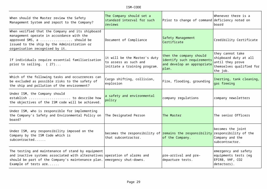
When should the Master review the Safety Management System and report to the Company?
The Company should set a standard interval for such reviews
Whenever there is a deficiency noted on board
When verified that the Company and its shipboard management operate in accordance with the approved SMS, a ................. should be issued to the ship by the Administration or organisation recognised by it.
Safety Management Certificate
If individuals require essential familiarisation prior to sailing. ( 27)...
it will be the Master's duty to assess as such and initiate a training program.
then the company should identify such requirements and develop an appropriate plan.
they cannot take shipboard duty at all until they prove themselves qualified for the job.
Which of the following tasks and occurrences can be excluded as possible risks to the safety of the ship and pollution of the environment?
Cargo shifting, collision, explosion
Inerting, tank cleaning, gas freeing
Under ISM, the Company should establish ...................... to describe how the objectives of the ISM code will be achieved.
a safety and environmental policy
Under ISM, who is responsible for implementing the Company's Safety and Environmental Policy on board?
Under ISM, any responsibility imposed on the Company by the ISM Code which is subcontracted......
becomes the responsibility of that subcontractor.
remains the responsibility of the Company.
becomes the joint responsibility of the Company and the subcontractor.
The testing and maintenance of stand by equipment and inactive systems associated with alternatives should be part of the Company's maintenance plan. Example of tests are......
operation of alarms and emergency shut-downs.
pre-arrival and pre-departure tests.
emergency and safety equipments tests (eg EPIRB, VHF, CO2 detectors).

ISM-CODE
Page 30
experts in familiarised with independent of
The Owner The Manager The Bareboat Charterer
Safety Management Certificate Document of Compliance
Every 2 to 3 months As may be necessary
Personnel carrying out audits should be ...................... the areas being audited.
The Company should have procedures established for corrective action. Corrective actions involve solutions which......
guarantyee that there is no recurrence of a non-conformity.
may reduce or prevent occurrence of a non-conformity.
investigate who was at fault and put the blame on the person(s) involved.
The Company should establish procedures under SMS to identify equipment and technical systems of which the sudden failure may result in hazardous operations. Once identified..
a rigid maintenance program is to be established for this equipment.
tests and other procedures should be established to ensure reliability.
it must be ensured that each and every component of these systems and equipment is carried as spare on board.
Under the ISM Code, what is understood by the Shipping Company or "The Company"?
A .................................. should be issued for every Company complying with the requirements of the ISM code by the Administration, or by the Organisation recognised by the Administration .
International Shipmanagement Certificate
Under ISM, is shipboard presence required by the Designated Person?
Frequent lengthy stays on board are required
What is meant by a major non-conformity under the ISM code?
A fire or explosion hazard or any hazard which poses a threat to life.
A serious threat to the environment due to the discharge of oil, chemicals or toxic substances from the ship.
A total lack of discipline on board whereby the authority of the master is diminished.
A company is expected to have documented emergency procedures applicable for use onboard the particular type ship being operated, including the duties and responsibilities of the crewmembers and......
the methods of rescue available.
shipboard communication methods available.
the methods of reporting casualties to the Authorities.
ISM-CODE
Page 31
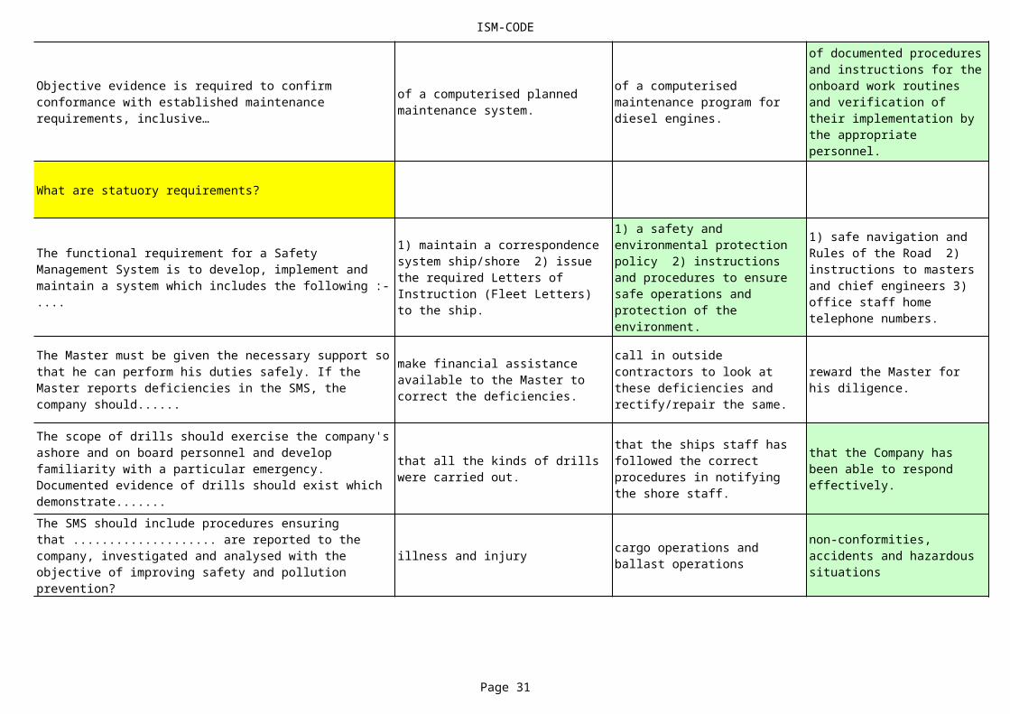
What are statuory requirements?
illness and injury
Objective evidence is required to confirm conformance with established maintenance requirements, inclusive…
of a computerised planned maintenance system.
of a computerised maintenance program for diesel engines.
of documented procedures and instructions for the onboard work routines and verification of their implementation by the appropriate personnel.
The functional requirement for a Safety Management System is to develop, implement and maintain a system which includes the following :- ....
1) maintain a correspondence system ship/shore 2) issue the required Letters of Instruction (Fleet Letters) to the ship.
1) a safety and environmental protection policy 2) instructions and procedures to ensure safe operations and protection of the environment.
1) safe navigation and Rules of the Road 2) instructions to masters and chief engineers 3) office staff home telephone numbers.
The Master must be given the necessary support so that he can perform his duties safely. If the Master reports deficiencies in the SMS, the company should......
make financial assistance available to the Master to correct the deficiencies.
call in outside contractors to look at these deficiencies and rectify/repair the same.
reward the Master for his diligence.
The scope of drills should exercise the company's ashore and on board personnel and develop familiarity with a particular emergency. Documented evidence of drills should exist which demonstrate.......
that all the kinds of drills were carried out.
that the ships staff has followed the correct procedures in notifying the shore staff.
that the Company has been able to respond effectively.
The SMS should include procedures ensuring that .................... are reported to the company, investigated and analysed with the objective of improving safety and pollution prevention?
cargo operations and ballast operations
non-conformities, accidents and hazardous situations
ISM-CODE
Page 32
by the SOLAS Convention.
inform the P & I club.
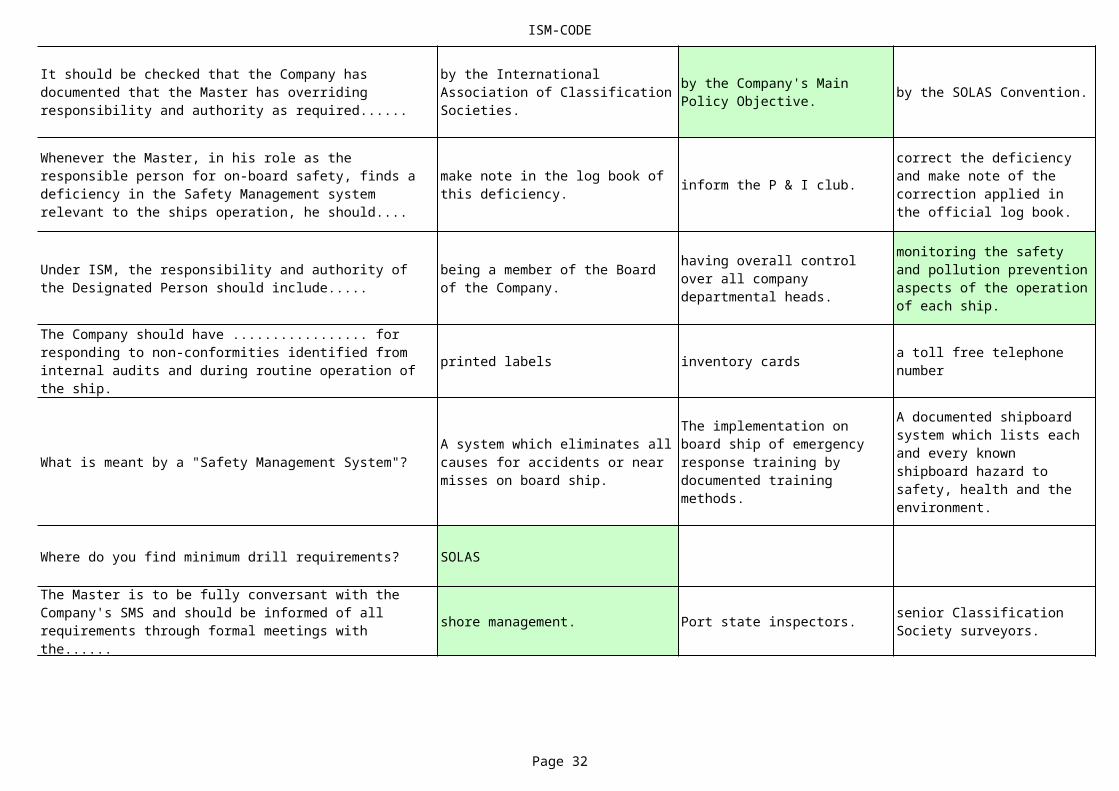
printed labels inventory cards
What is meant by a "Safety Management System"?
Where do you find minimum drill requirements? SOLAS
shore management. Port state inspectors.
It should be checked that the Company has documented that the Master has overriding responsibility and authority as required......
by the International Association of Classification Societies.
by the Company's Main Policy Objective.
Whenever the Master, in his role as the responsible person for on-board safety, finds a deficiency in the Safety Management system relevant to the ships operation, he should....
make note in the log book of this deficiency.
correct the deficiency and make note of the correction applied in the official log book.
Under ISM, the responsibility and authority of the Designated Person should include.....
being a member of the Board of the Company.
having overall control over all company departmental heads.
monitoring the safety and pollution prevention aspects of the operation of each ship.
The Company should have ................. for responding to non-conformities identified from internal audits and during routine operation of the ship.
a toll free telephone number
A system which eliminates all causes for accidents or near misses on board ship.
The implementation on board ship of emergency response training by documented training methods.
A documented shipboard system which lists each and every known shipboard hazard to safety, health and the environment.
The Master is to be fully conversant with the Company's SMS and should be informed of all requirements through formal meetings with the......
senior Classification Society surveyors.

ISM-CODE
Page 33
Yes, it is allowed. Yes, only for manning.
Damage. Defects, malfunctioning. Deficiencies.
the shipping business the manpower industry
the accommodation.
Concerning the ability of the ship's personnel to communicate effectively in the execution of their duties related to the SMS, documented evidence must be available......
on the procedures required for effective communication and what verification is carried out on board.
on the educational level of each crewmember.
on the medical examination of each crewmember.
Under ISM, can a company contract with third parties to manage specific ship related activities such as manning, technical support or maintenance?
No, it is not longer allowed.
Shipboard personnel, as part of day to day operation of the ship, should be expected to correct non-conformities whenever possible. In this respect, what are "Non-Conformities"?
What is the status of company policy, rules and regulations?
Safety Management System should ensure in the first place
Instructions which are essential must be identified, documented and given to newly assigned personnel prior to sailing. What are "essential instructions"?
Those that clearly define the crew members role within the SMS and insure that they are prepared prior taking up their duties on board
SMS manual extracts, the safety manual to be read by each incoming crewmember
The role in the shipboard organisation, dayworker or watchkeeper, which watch assigned to.
Under the ISM code, what is meant by a non-conformity?
Lack of comfort leading to health risks.
Not conforming with safe working practices which may lead to accidents.
A situation which indicates the non-fulfillment of a specific requirement.
Manning requirements and qualifications are part of ................. with which the Company should be familiar.
National and International requirements
Under the SMS, as part of shipboard responsibilities, there should be routine inspections of.....
all machinery and ships equipment in use.
machinery, ships equipment and structural integrity of the ship.

ISM-CODE
Page 34
fire drills in port. boat drills at sea.
owns has chartered has mortgaged
Through written instructions.
Under ISM, if the Company has subcontracting arrangements for manning, technical support or maintenance, how many Documents of Compliance are to be issued?
Only one DOC can be issued to the Company.
One DOC is issued to the Company and one for each subcontractor.
One DOC is issued to the company and one DOC is issued to the manning company only.
Under the ISM code the Company must ensure that the Safety and Environmental Policy is ....
known and implemented by all masters and chief engineers.
known by all ships officers.
known and implemented by all Officers and members of the ships crew.
What is the status of the rules of the SOLAS convention?
In addition to routine drills prescribed in International and National regulations, drills should also include......
emergency situations such as identified potential emergency shipboard situations.
What are the best means of verifying that specified requirements (procedures and instructions) regarding the Safety Management System are observed?
By inspecting the Deck and Engine work book daily by the Master.
By computerising all specified requirements and have an officer assigned as input controller.
By use of a check list for verification of actions/activities of crew members.
Under ISM, the holder of the DOC or Document of Compliance is the company which......................... the ship.
The Company should ensure that all personnel involved in the SMS have an adequate understanding of relevant rules, regulations, codes and guidelines. How could such information be communicated?
Described in the job responsibilities.
Formal discussions with company representatives.
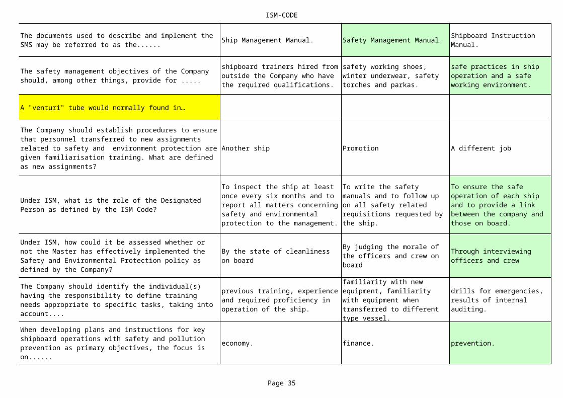
ISM-CODE
Page 35
Ship Management Manual. Safety Management Manual.
A "venturi" tube would normally found in…
Another ship Promotion A different job
economy. finance. prevention.
The documents used to describe and implement the SMS may be referred to as the......
Shipboard Instruction Manual.
The safety management objectives of the Company should, among other things, provide for .....
shipboard trainers hired from outside the Company who have the required qualifications.
safety working shoes, winter underwear, safety torches and parkas.
safe practices in ship operation and a safe working environment.
The Company should establish procedures to ensure that personnel transferred to new assignments related to safety and environment protection are given familiarisation training. What are defined as new assignments?
Under ISM, what is the role of the Designated Person as defined by the ISM Code?
To inspect the ship at least once every six months and to report all matters concerning safety and environmental protection to the management.
To write the safety manuals and to follow up on all safety related requisitions requested by the ship.
To ensure the safe operation of each ship and to provide a link between the company and those on board.
Under ISM, how could it be assessed whether or not the Master has effectively implemented the Safety and Environmental Protection policy as defined by the Company?
By the state of cleanliness on board
By judging the morale of the officers and crew on board
Through interviewing officers and crew
The Company should identify the individual(s) having the responsibility to define training needs appropriate to specific tasks, taking into account....
previous training, experience and required proficiency in operation of the ship.
familiarity with new equipment, familiarity with equipment when transferred to different type vessel.
drills for emergencies, results of internal auditing.
When developing plans and instructions for key shipboard operations with safety and pollution prevention as primary objectives, the focus is on......

ISM-CODE
Page 36
videos and books.
Procedures for key shipboard operations should have safety and pollution prevention as primary objectives and should include, among other things.....
methods to lower the lifeboats.
measures to mitigate identified risks.
efficiency of the propulsion machinery.
Should the Master's authority be emphasized in the Safety Management system?
The overriding responsibility of the Master is self evident and need not to be repeated in the SMS.
The Company should ensure that the SMS operating on board the ship contains a clear statement emphasizing the Master's authority.
The Master is to be mentioned as the juridical person in command of the vessel.
The ISM code aims to ensure that safe practices are taken into account in ship operation through written procedures. These requirements include the following information:- ......
the defined levels of authority and lines of communication between and amongst shore and shipboard personnel.
the procedures for reporting accidents and non-conformities with the provisions of the Code.
the provisions to prepare for and respond to emergency situations and procedures for internal audits and management review.
Under ISM, the company should define and document the responsibility, authority and interrelation of all personnel who manage, perform and verify work relating to and affecting safety and pollution prevention. How?
By wall posters in the accommodation of the affected ships.
By notice sheets to be posted on the notice boards in the Crews and Officers Messroom.
By legal notices in the media, defining the Company Board responsibility and command flow chart.
What is most important when people are working in tanks or closed spaces?
Test tanks or closed spaces for oxygen
The ISM code aims to ensure that safe practices are taken into account in ship operation through .....
written procedures and work instructions.
training by qualified instructors.
The safety management objectives of the Company should, among other things, include .....
continuous improvement of safety management skills of personnel including preparing for emergencies related to safety and environmental protection.
hiring of outside training companies to conduct on-board safety training of its shipboard personnel.
holding life boat drills on alternate lifeboats where boats are lowered into the water every week.
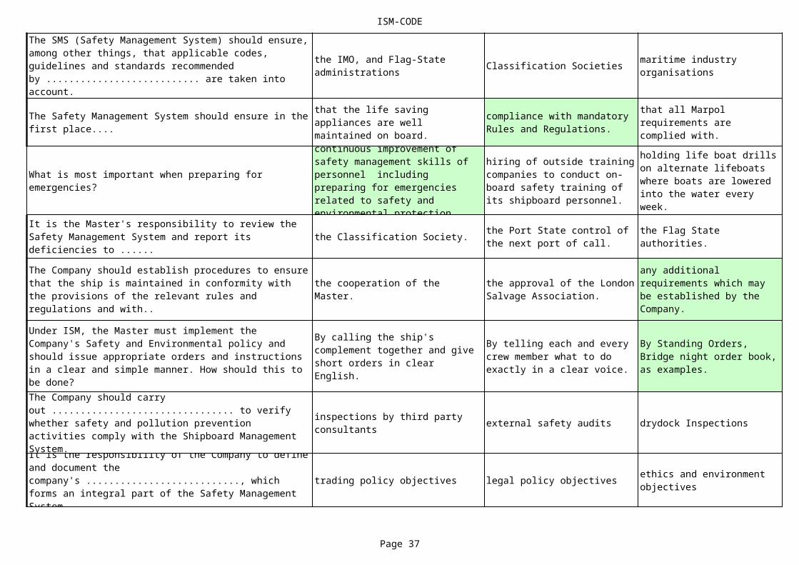
ISM-CODE
Page 37
Classification Societies
the Classification Society.
external safety audits drydock Inspections
trading policy objectives legal policy objectives
The SMS (Safety Management System) should ensure, among other things, that applicable codes, guidelines and standards recommended by ........................... are taken into account.
the IMO, and Flag-State administrations
maritime industry organisations
The Safety Management System should ensure in the first place....
that the life saving appliances are well maintained on board.
compliance with mandatory Rules and Regulations.
that all Marpol requirements are complied with.
What is most important when preparing for emergencies?
continuous improvement of safety management skills of personnel including preparing for emergencies related to safety and environmental protection.
hiring of outside training companies to conduct on-board safety training of its shipboard personnel.
holding life boat drills on alternate lifeboats where boats are lowered into the water every week.
It is the Master's responsibility to review the Safety Management System and report its deficiencies to ......
the Port State control of the next port of call.
the Flag State authorities.
The Company should establish procedures to ensure that the ship is maintained in conformity with the provisions of the relevant rules and regulations and with..
the cooperation of the Master.
the approval of the London Salvage Association.
any additional requirements which may be established by the Company.
Under ISM, the Master must implement the Company's Safety and Environmental policy and should issue appropriate orders and instructions in a clear and simple manner. How should this to be done?
By calling the ship's complement together and give short orders in clear English.
By telling each and every crew member what to do exactly in a clear voice.
By Standing Orders, Bridge night order book, as examples.
The Company should carry out ................................ to verify whether safety and pollution prevention activities comply with the Shipboard Management System.
inspections by third party consultants
It is the responsibility of the Company to define and document the company's ..........................., which forms an integral part of the Safety Management System.
ethics and environment objectives

ISM-CODE
Page 38
in normal circumstances.
potential theoretical assumed
A university degree A master's certificate
encouraged and supported.
reminding him time to time.
medical examination. drug and alcohol test.
The choice and level of detail to assist familiarisation to new or newly assigned crewmembers will depend upon ....
the rank of the newly assigned crewmember.
the intelligence quotient of the newly assigned crewmember.
the individual experience with the new assignment and the job responsibilities.
Concerning developing plans and instructions for key shipboard operations, it is expected that the Company has identified risks associated with......
the shipping industry's cost structure.
the carriage of liquid oil cargoes in bulk.
the particular type of vessel and it's trade.
Under ISM, the overriding authority of the Master applies....
in emergency and extreme circumstances.
in case of oil spill clean-ups.
The Company should establish procedures to identify, describe and respond to ...emergency shipboard operations.
Under ISM, what qualifications are required by the Designated Person?
Twenty years seagoing experience
A Company's safety management objectives and requirements, which are set above the standards of the ISM code, should be ....
totally disregarded since not enforceable.
erased as far as excessive standards are concerned.
The Company should ensure that the Master is informed of all requirements relating to safety and environmental protection by......
having the Designated Person sent on board at specified intervals.
including such requirements in operating instructions.
Verification of the Master's qualifications should be done firstly by....
interview of the candidate with emphasis on safety and environmental awareness.

ISM-CODE
Page 39
The Master The Master and Officers The Designated Person.
safety conscious and diligent intelligent and healthy
* * * NOTHING FOLLOWS * * *
Under ISM, which methods can the Master use to implement the Company's Safety and Environmental policy?
Implementation of all existing IMO and Marpol rules
At his own discretion taking into account the trading pattern and the workload on the ship, as well as weather conditions
As defined and documented by the Company
Safety management objectives of the Company should, among other things, establish .....
a dictatorial regime on board.
a cooperative and informative atmosphere on board.
sources of information concerning operational pollution prevention for joint departmental use and consultation in case of emergency.
It is the Master's responsibility to verify that the specific requirements (procedures and instructions) regarding the Safety Management System are observed. Who should actually verify this on board?
What is the ISM or International Safety Management Code?
An international management code for the safe operation of ships and for pollution prevention as adopted by the IMO.
The International Ship Management Association's code for navigational safety.
The international code for accident prevention and safe working practices.
Familiarisation for personnel transferred or on new assignments could be accomplished by.......
on board training in a supernumerary capacity.
observing overlap while vessel in port.
visual aids such as manuals, operating instructions and videos.
The Company should ensure that each ship is manned with ........................ seafarers in accordance with national and international requirements.
drug and alcohol abstaining
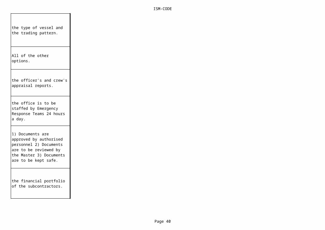
ISM-CODE
Page 40
the type of vessel and the trading pattern.
All of the other options.
the officer's and crew's appraisal reports.
the office is to be staffed by Emergency Response Teams 24 hours a day.
1) Documents are approved by authorised personnel 2) Documents are to be reviewed by the Master 3) Documents are to be kept safe.
the financial portfolio of the subcontractors.
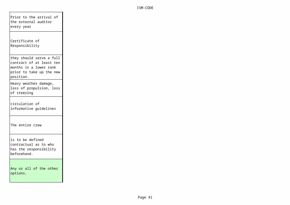
ISM-CODE
Page 41
The entire crew
Prior to the arrival of the external auditor every year
Certificate of Responsibility
they should serve a full contract of at least ten months in a lower rank prior to take up the new position.Heavy weather damage, loss of propulsion, loss of steering
circulation of informative guidelines
is to be defined contractual as to who has the responsibility beforehand.
Any or all of the other options.

ISM-CODE
Page 42
very conversant
Is not required at all
punish the persons guilty of neglect without taking any other action afterwards.
these items are checked at least once a week by the Master.
Could be any of the other options.
Safety and Environmental Protection Certificate
A deviation from the ISM code which poses a serious threat to safety of the ship or personnel or to the environment.
the ways of combating a worst case scenario.

ISM-CODE
Page 43
crew changes
of keeping work record books and inventories of deck and engine departments up to date.
1) contact addresses and telephone numbers of Port-State Control of countries visited 2) contact addresses of Flag State authorities.
respond to identified deficiencies in the SMS.
that all shore staff, office staff and subcontractors, manning agents and repair outfits were effectively involved .

ISM-CODE
Page 44
inform the Company.
procedures
by the Shipowner's Trust Fund.
final control over all shipboard operations and maintenance activities.
A structured and documented system enabling personnel on board to implement the company safety and environment protection policy.
P & I club representatives.

ISM-CODE
Page 45
on the ability of each crewmember to read and write in English.
Yes, only for technical support and manning, not for maintenance.
Any one the other options.
Allotting crew cabin, linen, towels, instruction as to use of messrooms and bathrooms
A situation where safety awareness or safety equipment is lacking.
crew management responsibilities
all crews belongings, luggage and items stowed in crew cabins.

ISM-CODE
Page 46
One DOC is issued to the Company and one DOC is required for the maintenance as well as for the technical support company, not for manning.known and maintained at all levels of the organisation both ship based as well as shore based.
diving exercises under the ship.
By dividing the responsibility amongst officers who have to keep their own Safety Work Book.
has assumed responsibility for the operation of
All of the other options.

ISM-CODE
Page 47
Ship Maintenance Manual.
All of the other options
response to accidents.
supply of all safety equipment within one month of requisition date.
To monitor and if necessary to build up better safety relationships between the Authorities and the ship's staff.
By looking at the lifeboats, fire fighting equipment and at the oily water separator
All of the other options.

ISM-CODE
Page 48
accuracy of the trim and stability calculations.
The Master is to be mentioned as the Responsible Person in charge of implementing the SMS.
All of the other options.
By charts and/or job descriptions to identify positions related to safety and pollution prevention activities for each functional area.
regular on board inspections by the Company's shore based personnel.
conducting a campaign on board against smoking and introduce smoke free areas on board.
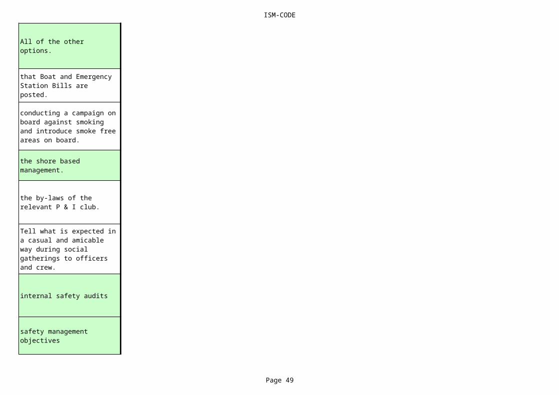
ISM-CODE
Page 49
internal safety audits
All of the other options.
that Boat and Emergency Station Bills are posted.
conducting a campaign on board against smoking and introduce smoke free areas on board.
the shore based management.
the by-laws of the relevant P & I club.
Tell what is expected in a casual and amicable way during social gatherings to officers and crew.
safety management objectives

ISM-CODE
Page 50
occuring
discouraged.
the age of the seaman and the number of years worked at sea.
drugs and alcohol misuse.
in both normal and extreme circumstances.
Appropriate knowledge and experience associated with verification and control of safety and pollution prevention requirements of the ISM code
having the Superintendents prepare monthly information sheets.confirmation of the validity of his certificates in compliance with the STCW convention.
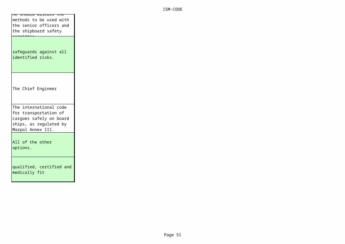
ISM-CODE
Page 51
The Chief Engineer
He should discuss the methods to be used with the senior officers and the shipboard safety committee
safeguards against all identified risks.
The international code for transportation of cargoes safely on board ships, as regulated by Marpol Annex III.
All of the other options.
qualified, certified and medically fit
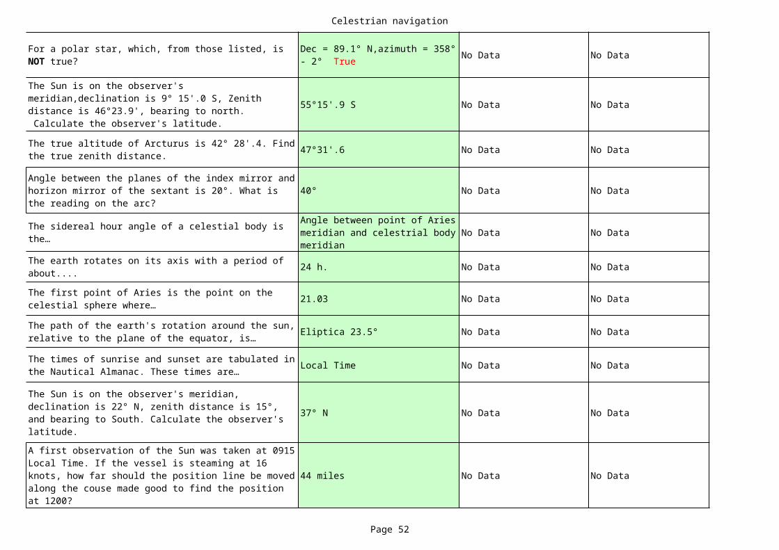
Celestrian navigation
Page 52
No Data No Data
55°15'.9 S No Data No Data
47°31'.6 No Data No Data
40° No Data No Data
No Data No Data
24 h. No Data No Data
21.03 No Data No Data
Eliptica 23.5° No Data No Data
Local Time No Data No Data
37° N No Data No Data
44 miles No Data No Data
For a polar star, which, from those listed, is NOT true?
Dec = 89.1° N,azimuth = 358° - 2° True
The Sun is on the observer's meridian,declination is 9° 15'.0 S, Zenith distance is 46°23.9', bearing to north. Calculate the observer's latitude.
The true altitude of Arcturus is 42° 28'.4. Find the true zenith distance.
Angle between the planes of the index mirror and horizon mirror of the sextant is 20°. What is the reading on the arc?
The sidereal hour angle of a celestial body is the…
Angle between point of Aries meridian and celestrial body meridian
The earth rotates on its axis with a period of about....
The first point of Aries is the point on the celestial sphere where…
The path of the earth's rotation around the sun, relative to the plane of the equator, is…
The times of sunrise and sunset are tabulated in the Nautical Almanac. These times are…
The Sun is on the observer's meridian, declination is 22° N, zenith distance is 15°, and bearing to South. Calculate the observer's latitude.
A first observation of the Sun was taken at 0915 Local Time. If the vessel is steaming at 16 knots, how far should the position line be moved along the couse made good to find the position at 1200?
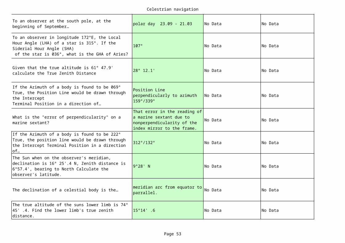
Celestrian navigation
Page 53
polar day 23.09 - 21.03 No Data No Data
107° No Data No Data
28° 12.1' No Data No Data
No Data No Data
No Data No Data
312°/132° No Data No Data
9°28' N No Data No Data
The declination of a celestial body is the… No Data No Data
15°14' .6 No Data No Data
To an observer at the south pole, at the beginning of September…
To an observer in longitude 172°E, the Local Hour Angle (LHA) of a star is 315°. If the Siderial Hour Angle (SHA) of the star is 036°, what is the GHA of Aries?
Given that the true altitude is 61° 47.9' calculate the True Zenith Distance
If the Azimuth of a body is found to be 069° True, the Position Line would be drawn through the InterceptTerminal Position in a direction of…
Position Line perpendicularly to azimuth 159°/339°
What is the "error of perpendicularity" on a marine sextant?
That error in the reading of a marine sextant due to nonperpendicularity of the index mirror to the frame.
If the Azimuth of a body is found to be 222° True, the position line would be drawn through the Intercept Terminal Position in a direction of…The Sun when on the observer's meridian, declination is 16° 25'.4 N, Zenith distance is 6°57.4', bearing to North Calculate the observer's latitude.
meridian arc from equator to parrallel.
The true altitude of the suns lower limb is 74° 45' .4. Find the lower limb's true zenith distance.
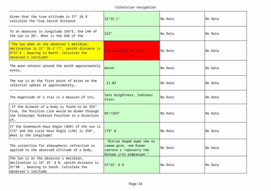
Celestrian navigation
Page 54
32°35.1' No Data No Data
222° No Data No Data
not solvable N,S ??? No Data No Data
month No Data No Data
21.03 No Data No Data
The magnitude of a star is a measure of its… No Data No Data
85°/265° No Data No Data
175° W No Data No Data
No Data No Data
47°55'.4 N No Data No Data
Given that the true altitude is 57° 24.9' calculate the True Zenith Distance
To an observer in longitude 164°E, the LHA of the sun is 26°. What is the GHA of the
'The Sun when on the observer's meridian, declination is 21° 28.4'???, zenith distance is 6°57.4', bearing to North. Calculate the observer's latitude?
The moon rotates around the earth approximately every…
The sun is at the first point of Aries on the celestial sphere at approximately…
less brightness, luminous stars
'If the Azimuth of a body is found to be 355° True, the Position Line would be drawn through the Intercept Terminal Position in a direction of…
If the Greenwich Hour Angle (GHA) of the sun is 173° and the Local Hour Angle (LHA) is 358°, what is the longitude?
The correction for atmospheric refraction as applied to the observed altitude of a body…
"Всегда видим выше чем на самом деле, чем ближе светило к горизонту тем больше угол рефракции."
The Sun is on the observer's meridian, declination is 16° 25'.4 N, zenith dsitance is 31°30' , bearing to South. Calculate the observer's latitude.

Celestrian navigation
Page 55
66,5° N No Data No Data
21°52'.2 S No Data No Data
No Data No Data
No Data No Data
27° S No Data No Data
22.12 No Data No Data
No Data No Data
index error No Data No Data
160°/340° No Data No Data
185°/005° No Data No Data
At the winter solstice, the sun will not rise at all (Polar Night) in the latitudes higher than…
'The Sun when on the observer's meridian, declination is 17° 22'.1 N, Zenith distance is 39° 14.3', bearing to North. Calculate the observe r's latitude.
The moon rotates around its axis with a period of…
Star month 27.3 days, moon nonth 29.5 days
At sunrise and sunset, the effect of atmospheric refraction is to…
Мы видим солнце на горизонте, но если считать по формуле то оно уже зашло. Из за рефракции мы видим солнце, но на самом деле оно уже зашло.The Sun is on the observer's meridian,
declination is 21°S, zenith distance is 6°, bearing to North. Calculate the observer's latitude.
The summer solstice in the southern hemisphere is approximately on…
From those listed, how can the index error be detected in a marine sextant?
by Horizont,by Star,by Sun. "Off arc + , Onn arc - "
Which one of the following errors of the sextant would you attempt to remove?
A position line drawn in the direction 070°/250° could correspond to an azimuth of the observed body of…
A position line drawn in the direction 095°/275° co uld correspond to an azimuth of the observed body of…
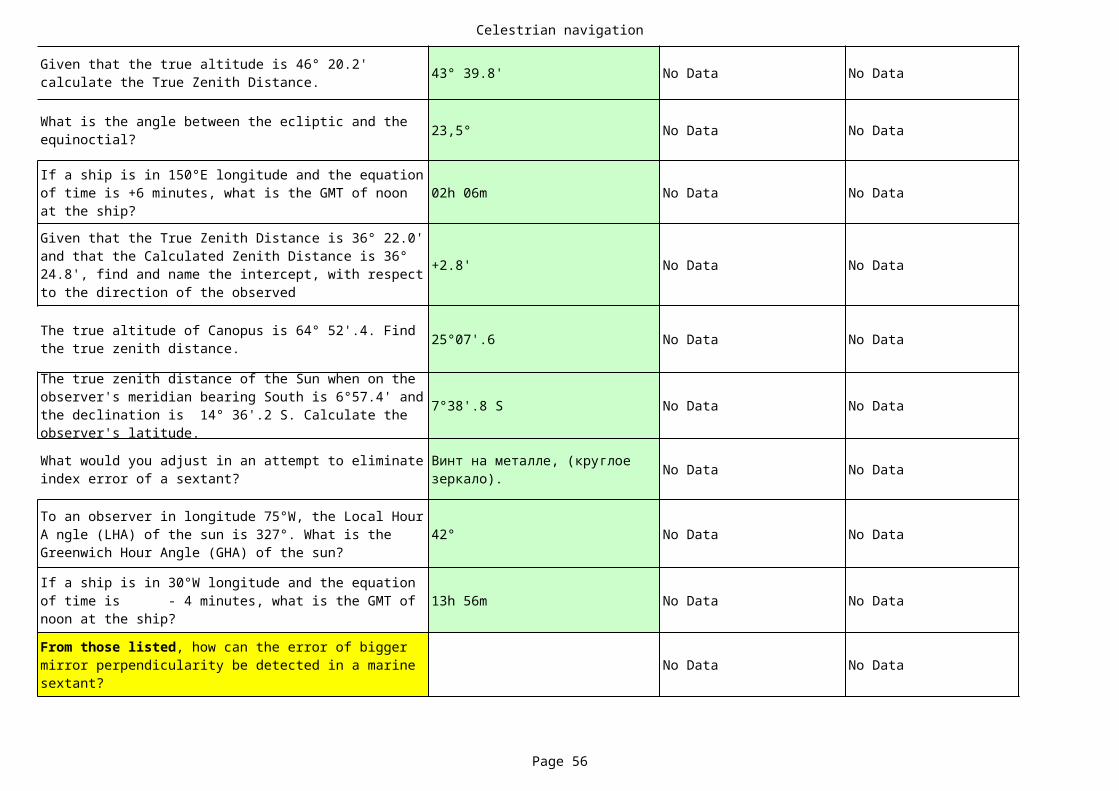
Celestrian navigation
Page 56
43° 39.8' No Data No Data
23,5° No Data No Data
02h 06m No Data No Data
+2.8' No Data No Data
25°07'.6 No Data No Data
7°38'.8 S No Data No Data
No Data No Data
42° No Data No Data
13h 56m No Data No Data
No Data No Data
Given that the true altitude is 46° 20.2' calculate the True Zenith Distance.
What is the angle between the ecliptic and the equinoctial?
If a ship is in 150°E longitude and the equation of time is +6 minutes, what is the GMT of noon at the ship?
Given that the True Zenith Distance is 36° 22.0' and that the Calculated Zenith Distance is 36° 24.8', find and name the intercept, with respect to the direction of the observed
The true altitude of Canopus is 64° 52'.4. Find the true zenith distance.
The true zenith distance of the Sun when on the observer's meridian bearing South is 6°57.4' and the declination is 14° 36'.2 S. Calculate the observer's latitude.
What would you adjust in an attempt to eliminate index error of a sextant?
Винт на металле, (круглое зеркало).
To an observer in longitude 75°W, the Local Hour A ngle (LHA) of the sun is 327°. What is the Greenwich Hour Angle (GHA) of the sun?
If a ship is in 30°W longitude and the equation of time is - 4 minutes, what is the GMT of noon at the ship?
From those listed, how can the error of bigger mirror perpendicularity be detected in a marine sextant?
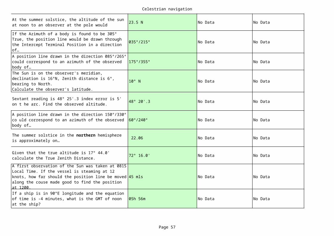
Celestrian navigation
Page 57
23.5 N No Data No Data
035°/215° No Data No Data
175°/355° No Data No Data
10° N No Data No Data
48° 20'.3 No Data No Data
60°/240° No Data No Data
22.06 No Data No Data
72° 16.0' No Data No Data
45 mls No Data No Data
05h 56m No Data No Data
At the summer solstice, the altitude of the sun at noon to an observer at the pole would
If the Azimuth of a body is found to be 305° True, the position line would be drawn through the Intercept Terminal Position in a direction of…A position line drawn in the direction 085°/265° could correspond to an azimuth of the observed body of…The Sun is on the observer's meridian, declination is 16°N, Zenith distance is 6°, bearing to North.Calculate the observer's latitude.
Sextant reading is 48° 25'.3 index error is 5' on t he arc. Find the observed altitude.
A position line drawn in the direction 150°/330° co uld correspond to an azimuth of the observed body of…
The summer solstice in the northern hemisphere is approximately on…
Given that the true altitude is 17° 44.0' calculate the True Zenith Distance.A first observation of the Sun was taken at 0815 Local Time. If the vessel is steaming at 12 knots, how far should the position line be moved along the couse made good to find the position at 1200.If a ship is in 90°E longitude and the equation of time is -4 minutes, what is the GMT of noon at the ship?
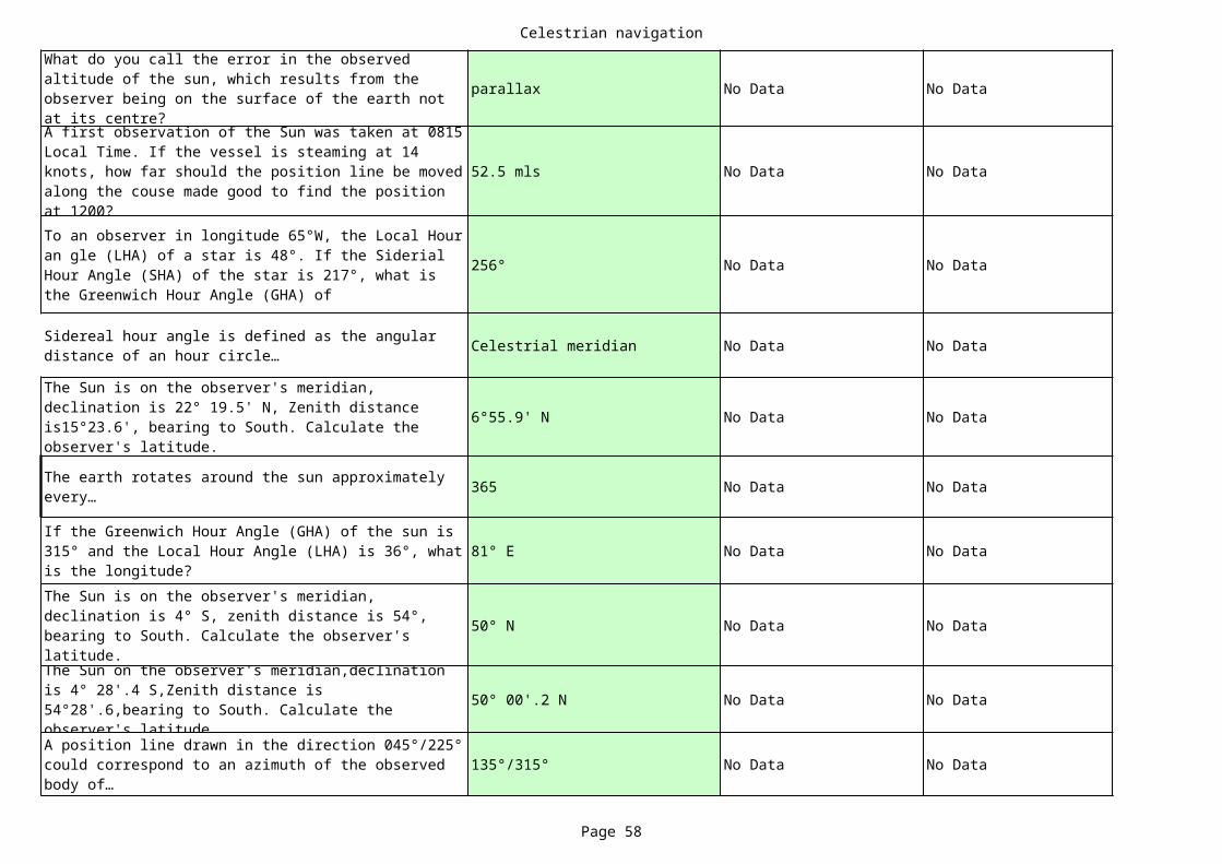
Celestrian navigation
Page 58
parallax No Data No Data
52.5 mls No Data No Data
256° No Data No Data
Celestrial meridian No Data No Data
6°55.9' N No Data No Data
365 No Data No Data
81° E No Data No Data
50° N No Data No Data
50° 00'.2 N No Data No Data
135°/315° No Data No Data
What do you call the error in the observed altitude of the sun, which results from the observer being on the surface of the earth not at its centre?A first observation of the Sun was taken at 0815 Local Time. If the vessel is steaming at 14 knots, how far should the position line be moved along the couse made good to find the position at 1200?To an observer in longitude 65°W, the Local Hour an gle (LHA) of a star is 48°. If the Siderial Hour Angle (SHA) of the star is 217°, what is the Greenwich Hour Angle (GHA) of
Sidereal hour angle is defined as the angular distance of an hour circle…
The Sun is on the observer's meridian, declination is 22° 19.5' N, Zenith distance is15°23.6', bearing to South. Calculate the observer's latitude.
The earth rotates around the sun approximately every…
If the Greenwich Hour Angle (GHA) of the sun is 315° and the Local Hour Angle (LHA) is 36°, what is the longitude?The Sun is on the observer's meridian, declination is 4° S, zenith distance is 54°, bearing to South. Calculate the observer's latitude.The Sun on the observer's meridian,declination is 4° 28'.4 S,Zenith distance is 54°28'.6,bearing to South. Calculate the observer's latitude.A position line drawn in the direction 045°/225° could correspond to an azimuth of the observed body of…
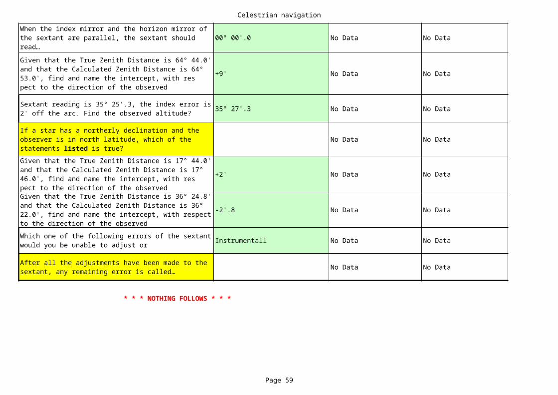
Celestrian navigation
Page 59
00° 00'.0 No Data No Data
+9' No Data No Data
35° 27'.3 No Data No Data
No Data No Data
+2' No Data No Data
-2'.8 No Data No Data
Instrumentall No Data No Data
No Data No Data
* * * NOTHING FOLLOWS * * *
When the index mirror and the horizon mirror of the sextant are parallel, the sextant should read…Given that the True Zenith Distance is 64° 44.0' and that the Calculated Zenith Distance is 64° 53.0', find and name the intercept, with res pect to the direction of the observed
Sextant reading is 35° 25'.3, the index error is 2' off the arc. Find the observed altitude?
If a star has a northerly declination and the observer is in north latitude, which of the statements listed is true?Given that the True Zenith Distance is 17° 44.0' and that the Calculated Zenith Distance is 17° 46.0', find and name the intercept, with res pect to the direction of the observedGiven that the True Zenith Distance is 36° 24.8' and that the Calculated Zenith Distance is 36° 22.0', find and name the intercept, with respect to the direction of the observedWhich one of the following errors of the sextant would you be unable to adjust or
After all the adjustments have been made to the sextant, any remaining error is called…

Celestrian navigation
Page 60
No Data
No Data
No Data
No Data
No Data
No Data
No Data
No Data
No Data
No Data
No Data

Celestrian navigation
Page 61
No Data
No Data
No Data
No Data
No Data
No Data
No Data
No Data
No Data

Celestrian navigation
Page 62
No Data
No Data
No Data
No Data
No Data
No Data
No Data
No Data
No Data
No Data

Celestrian navigation
Page 63
No Data
No Data
No Data
No Data
No Data
No Data
No Data
No Data
No Data
No Data

Celestrian navigation
Page 64
No Data
No Data
No Data
No Data
No Data
No Data
No Data
No Data
No Data
No Data

Celestrian navigation
Page 65
No Data
No Data
No Data
No Data
No Data
No Data
No Data
No Data
No Data
No Data

Celestrian navigation
Page 66
No Data
No Data
No Data
No Data
No Data
No Data
No Data
No Data
No Data
No Data

Celestrian navigation
Page 67
No Data
No Data
No Data
No Data
No Data
No Data
No Data
No Data
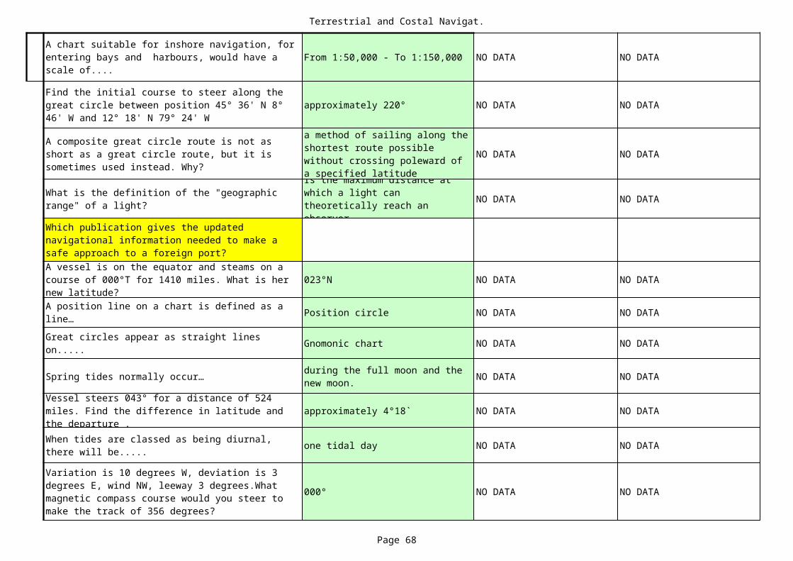
Terrestrial and Costal Navigat.
Page 68
From 1:50,000 - To 1:150,000 NO DATA NO DATA
approximately 220° NO DATA NO DATA
NO DATA NO DATA
NO DATA NO DATA
023°N NO DATA NO DATA
Position circle NO DATA NO DATA
Gnomonic chart NO DATA NO DATA
Spring tides normally occur… NO DATA NO DATA
approximately 4°18` NO DATA NO DATA
one tidal day NO DATA NO DATA
000° NO DATA NO DATA
A chart suitable for inshore navigation, for entering bays and harbours, would have a scale of....
Find the initial course to steer along the great circle between position 45° 36' N 8° 46' W and 12° 18' N 79° 24' W
A composite great circle route is not as short as a great circle route, but it is sometimes used instead. Why?
a method of sailing along the shortest route possible without crossing poleward of a specified latitude
What is the definition of the "geographic range" of a light?
Is the maximum distance at which a light can theoretically reach an observer
Which publication gives the updated navigational information needed to make a safe approach to a foreign port?A vessel is on the equator and steams on a course of 000°T for 1410 miles. What is her new latitude?A position line on a chart is defined as a line…Great circles appear as straight lines on.....
during the full moon and the new moon.
Vessel steers 043° for a distance of 524 miles. Find the difference in latitude and the departure .When tides are classed as being diurnal, there will be.....
Variation is 10 degrees W, deviation is 3 degrees E, wind NW, leeway 3 degrees.What magnetic compass course would you steer to make the track of 356 degrees?
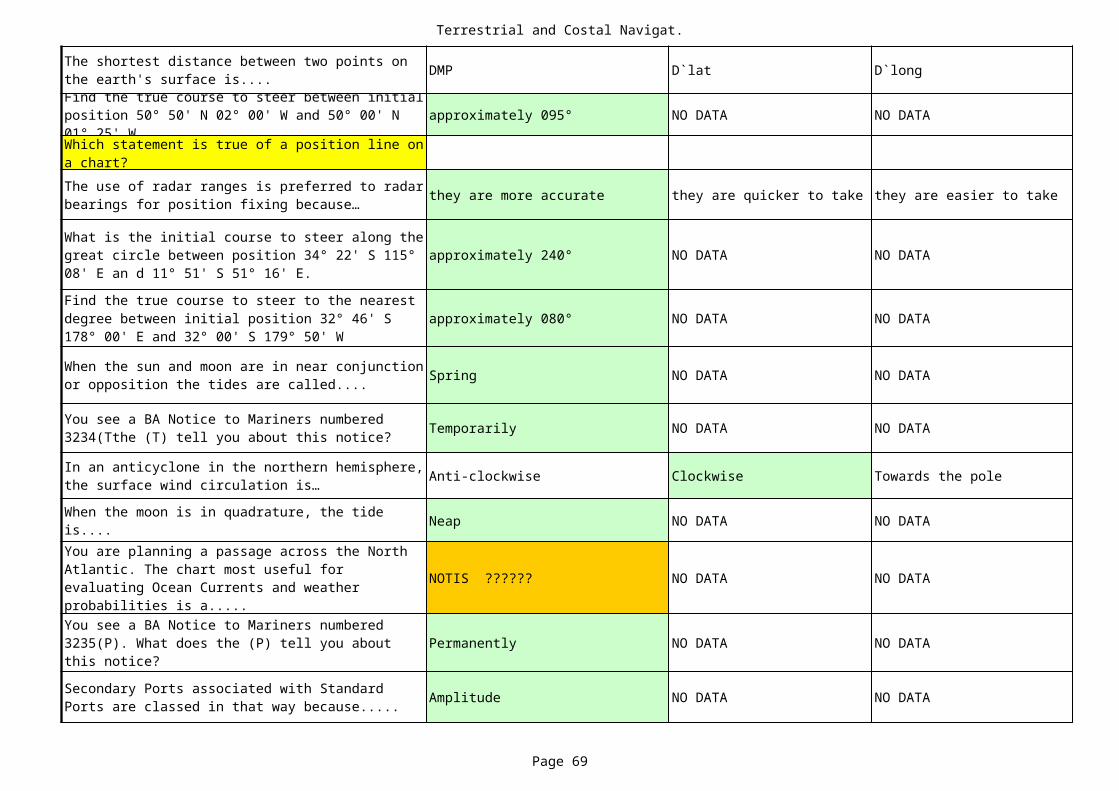
Terrestrial and Costal Navigat.
Page 69
DMP D`lat D`long
approximately 095° NO DATA NO DATA
they are more accurate they are quicker to take they are easier to take
approximately 240° NO DATA NO DATA
approximately 080° NO DATA NO DATA
Spring NO DATA NO DATA
Temporarily NO DATA NO DATA
Anti-clockwise Clockwise Towards the pole
Neap NO DATA NO DATA
NOTIS ?????? NO DATA NO DATA
Permanently NO DATA NO DATA
Amplitude NO DATA NO DATA
The shortest distance between two points on the earth's surface is....Find the true course to steer between initial position 50° 50' N 02° 00' W and 50° 00' N 01° 25' WWhich statement is true of a position line on a chart?The use of radar ranges is preferred to radar bearings for position fixing because…
What is the initial course to steer along the great circle between position 34° 22' S 115° 08' E an d 11° 51' S 51° 16' E.
Find the true course to steer to the nearest degree between initial position 32° 46' S 178° 00' E and 32° 00' S 179° 50' W
When the sun and moon are in near conjunction or opposition the tides are called....
You see a BA Notice to Mariners numbered 3234(Tthe (T) tell you about this notice?
In an anticyclone in the northern hemisphere, the surface wind circulation is…When the moon is in quadrature, the tide is....You are planning a passage across the North Atlantic. The chart most useful for evaluating Ocean Currents and weather probabilities is a.....You see a BA Notice to Mariners numbered 3235(P). What does the (P) tell you about this notice?
Secondary Ports associated with Standard Ports are classed in that way because.....

Terrestrial and Costal Navigat.
Page 70
175° 00' W NO DATA NO DATA
221° NO DATA NO DATA
Mariners handbook
Two visual bearings Two radar bearings
Keep looking out Stop engines Alter course
The pilot The pilot and master
Ocean passages for the world
The magnetic compass The gyro compass The satellite navigator
A vessel in initial position 40° 30' N 179° 00' W steams due east for 240 miles.Find the new longitude.The gyro compass error is 1 deg. minus. A North wind causes 3 deg. leeway. What course would you steer to make good the track of 217 degrees?You are on watch at night, your main engines are under repair, and you don't make any way through water. What changes would you make to your navigational lights?
Switch the steaming lights off
Switch on three vertical red lights
Switch on two vertical red lights and switch off all other navigational lights.
You see a two flag signal on a ship close-by. What publication would you consult to discover its meaning?
International code of signal
Admirality list of radio signals
Why should the largest scale chart available be used for navigational purposes?
Because it uses larger symbols.
Because it uses better colour.
Because it shows more accurate information.
Which is the more accurate means of position fixing?
A visual bearing and a radar range
You expect to sight land at 2100. By 2120 no land has been sighted, the visibility is good. What action should OOW take?
A vessel is under pilotage approaching a European port. Who is responsible for the safe navigation of the vessel?
The master an duty officer
Where would you find information about a vessel reporting system for a port which you are about to enter?
International code of signal
Admirality list of radio signals
Your vessel is carrying a full cargo of scrap steel. Which item of bridge equipment is likely to be unreliable?
Which of the following options would be considered "good seamanship"?
Using radar when proceeding at full speed in fog.
Sounding a fog signal when in clear weather,but approaching a fog bank.
Using deck and accommodation lights to indicate the presence of your ship in poor visiblity.
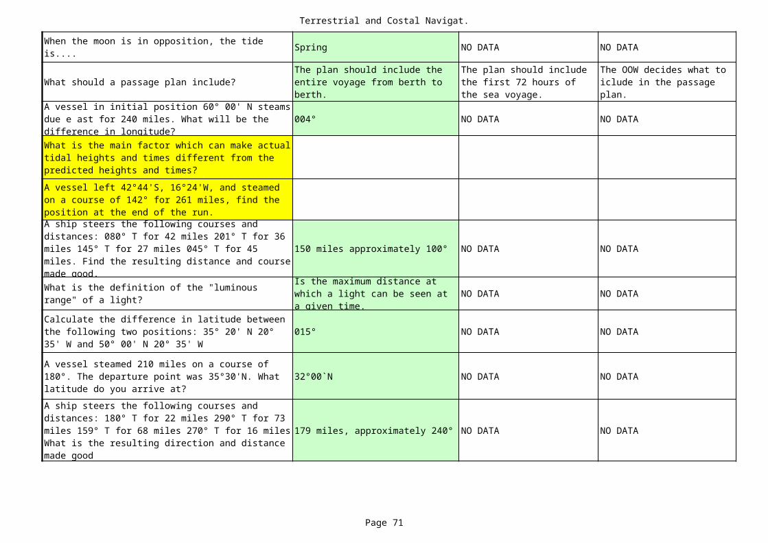
Terrestrial and Costal Navigat.
Page 71
Spring NO DATA NO DATA
What should a passage plan include?
004° NO DATA NO DATA
150 miles approximately 100° NO DATA NO DATA
NO DATA NO DATA
015° NO DATA NO DATA
32°00`N NO DATA NO DATA
179 miles, approximately 240° NO DATA NO DATA
When the moon is in opposition, the tide is....
The plan should include the entire voyage from berth to berth.
The plan should include the first 72 hours of the sea voyage.
The OOW decides what to iclude in the passage plan.
A vessel in initial position 60° 00' N steams due e ast for 240 miles. What will be the difference in longitude?What is the main factor which can make actual tidal heights and times different from the predicted heights and times?A vessel left 42°44'S, 16°24'W, and steamed on a course of 142° for 261 miles, find the position at the end of the run.A ship steers the following courses and distances: 080° T for 42 miles 201° T for 36 miles 145° T for 27 miles 045° T for 45 miles. Find the resulting distance and course made good.What is the definition of the "luminous range" of a light?
Is the maximum distance at which a light can be seen at a given time.
Calculate the difference in latitude between the following two positions: 35° 20' N 20° 35' W and 50° 00' N 20° 35' W
A vessel steamed 210 miles on a course of 180°. The departure point was 35°30'N. What latitude do you arrive at?A ship steers the following courses and distances: 180° T for 22 miles 290° T for 73 miles 159° T for 68 miles 270° T for 16 miles What is the resulting direction and distance made good
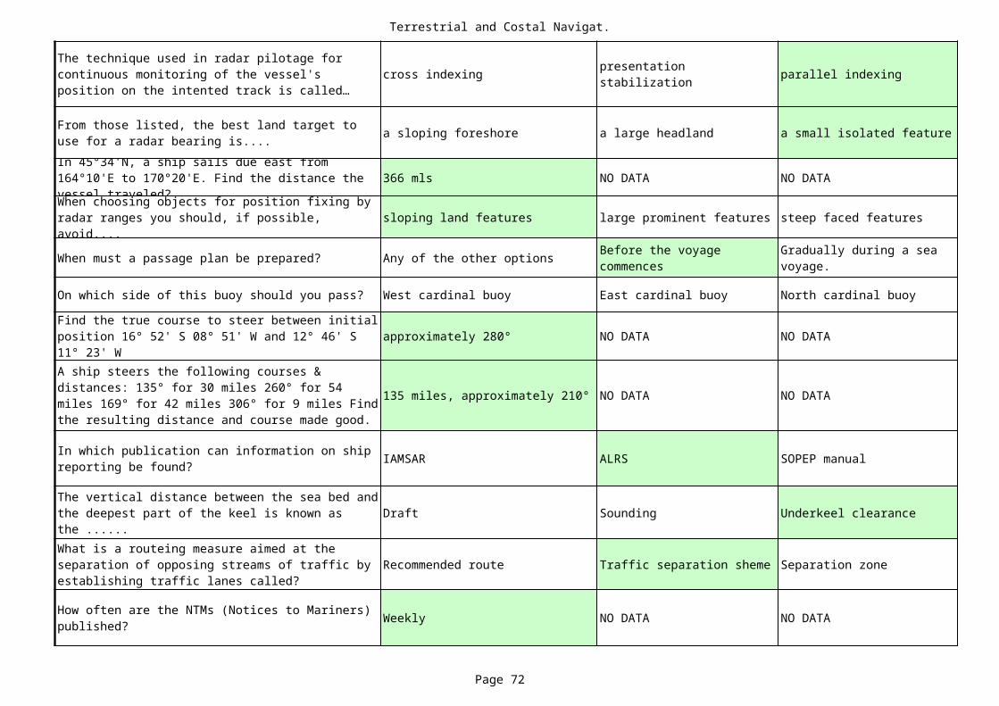
Terrestrial and Costal Navigat.
Page 72
cross indexing parallel indexing
a sloping foreshore a large headland a small isolated feature
366 mls NO DATA NO DATA
sloping land features large prominent features steep faced features
When must a passage plan be prepared? Any of the other options
On which side of this buoy should you pass? West cardinal buoy East cardinal buoy North cardinal buoy
approximately 280° NO DATA NO DATA
135 miles, approximately 210° NO DATA NO DATA
IAMSAR ALRS SOPEP manual
Draft Sounding Underkeel clearance
Recommended route Traffic separation sheme Separation zone
Weekly NO DATA NO DATA
The technique used in radar pilotage for continuous monitoring of the vessel's position on the intented track is called…
presentation stabilization
From those listed, the best land target to use for a radar bearing is....In 45°34'N, a ship sails due east from 164°10'E to 170°20'E. Find the distance the vessel traveled?When choosing objects for position fixing by radar ranges you should, if possible, avoid....
Before the voyage commences
Gradually during a sea voyage.
Find the true course to steer between initial position 16° 52' S 08° 51' W and 12° 46' S 11° 23' WA ship steers the following courses & distances: 135° for 30 miles 260° for 54 miles 169° for 42 miles 306° for 9 miles Find the resulting distance and course made good.
In which publication can information on ship reporting be found?
The vertical distance between the sea bed and the deepest part of the keel is known as the ......What is a routeing measure aimed at the separation of opposing streams of traffic by establishing traffic lanes called?
How often are the NTMs (Notices to Mariners) published?
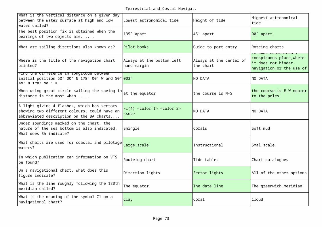
Terrestrial and Costal Navigat.
Page 73
Lowest astronomical tide Height of tide
135` apart 45` apart 90` apart
What are sailing directions also known as? Pilot books Guide to port entry Roteing charts
003° NO DATA NO DATA
at the equator the course is N-S
NO DATA NO DATA
Shingle Corals Soft mud
Large scale Instructional Smal scale
Routeing chart Tide tables Chart catalogues
Direction lights Sector lights All of the other options
The equator The date line The greenwich meridian
Clay Coral Cloud
What is the vertical distance on a given day between the water surface at high and low water called?
Highest astronomical tide
The best position fix is obtained when the bearings of two objects are......
Where is the title of the navigation chart printed?
Always at the bottom left hand margin
Always at the center of the chart
In some conveninent, conspicuous place,where it does not hinder navigation or the use of it.Find the difference in longitude between
initial position 50° 00' N 178° 00' W and 50° 00' N 179° 00 ' E.When using great circle sailing the saving in distance is the most when......
the course is E-W nearer to the poles
A light giving 4 flashes, which has sectors showing two different colours, could have an abbreviated description on the BA charts....
Fl(4) <color 1> <color 2> <sec>
Under soundings marked on the chart, the nature of the sea bottom is also indicated. What does Sh indicate?
What charts are used for coastal and pilotage waters?
In which publication can information on VTS be found?
On a navigational chart, what does this figure indicate?
What is the line roughly following the 180th meridian called?
What is the meaning of the symbol Cl on a navigational chart?
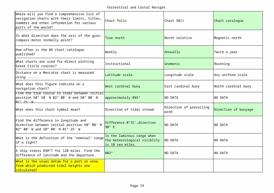
Terrestrial and Costal Navigat.
Page 74
Chart folio Chart 5011 Chart catalogue
True north North relative Magnetic north
Weekly Annually Twice a year
Instructional Gnomonic Routeing
Latitude scale Longitude scale Any uniform scale
West cardinal buoy East cardinal buoy North cardinal buoy
approximately 095° NO DATA NO DATA
What does this chart symbol mean? Direction of tidal stream Direction of buoyage
NO DATA NO DATA
NO DATA NO DATA
002° NO DATA NO DATA
Where will you find a comprehensive list of navigation charts with their limits, titles, numbers and other information for various parts of the world?
In what direction does the axis of the gyro-compass motor normally point?
How often is the BA chart catalogue published?
What charts are used for direct plotting Great Circle courses?
Distance on a Mercator chart is measured using ......
What does this figure indicate on a navigation chart?Find the true course to steer between initial position 50° 50' N 02° 00' W and 50° 00' N 01° 25' W
Direction of prevailing wind
Find the difference in longitude and direction between initial position 50° 00' N 02° 00' W and 50° 00' N 01° 25' W
Difference 0°35',direction 90° E
What is the definition of the "nominal" range of a light?
Is the luminous range when the meteorological visiblity is 10 sea miles.
A ship steers 030°T for 120 miles. Find the difference of latitude and the departure.What is the usual datum for a port or area from which predicted tidal heights are calculated?
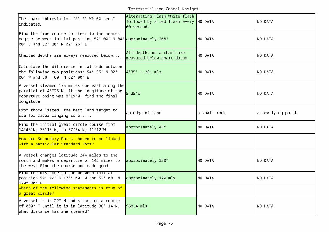
Terrestrial and Costal Navigat.
Page 75
NO DATA NO DATA
approximately 268° NO DATA NO DATA
Charted depths are always measured below.... NO DATA NO DATA
4°35' - 261 mls NO DATA NO DATA
5°25'W NO DATA NO DATA
an edge of land a small rock a low-lying point
approximately 45° NO DATA NO DATA
approximately 330° NO DATA NO DATA
approximately 120 mls NO DATA NO DATA
968.4 mls NO DATA NO DATA
The chart abbreviation "Al Fl WR 60 secs" indicates…
Alternating Flash White flash followed by a red flash every 60 seconds
Find the true course to steer to the nearest degree between initial position 52° 00' N 04° 00' E and 52° 20' N 02° 26' E
All depths on a chart are measured below chart datum.
Calculate the difference in latitude between the following two positions: 54° 35' N 02° 00' W and 50 ° 00' N 02° 00' W
A vessel steamed 175 miles due east along the parallel of 48°25'N. If the longitude of the departure point was 8°19'W, find the final longitude.
From those listed, the best land target to use for radar ranging is a.....
Find the initial great circle course from 14°48'N, 78°18'W, to 37°54'N, 11°12'W.
How are Secondary Ports chosen to be linked with a particular Standard Port?
A vessel changes latitude 244 miles to the north and makes a departure of 145 miles to the west.Find the course and made good.Find the distance to the between initial position 50° 00' N 178° 00' W and 52° 00' N 179° 30' EWhich of the following statements is true of a great circle?A vessel is in 22° N and steams on a course of 000° T until it is in latitude 38° 14'N. What distance has she steamed?
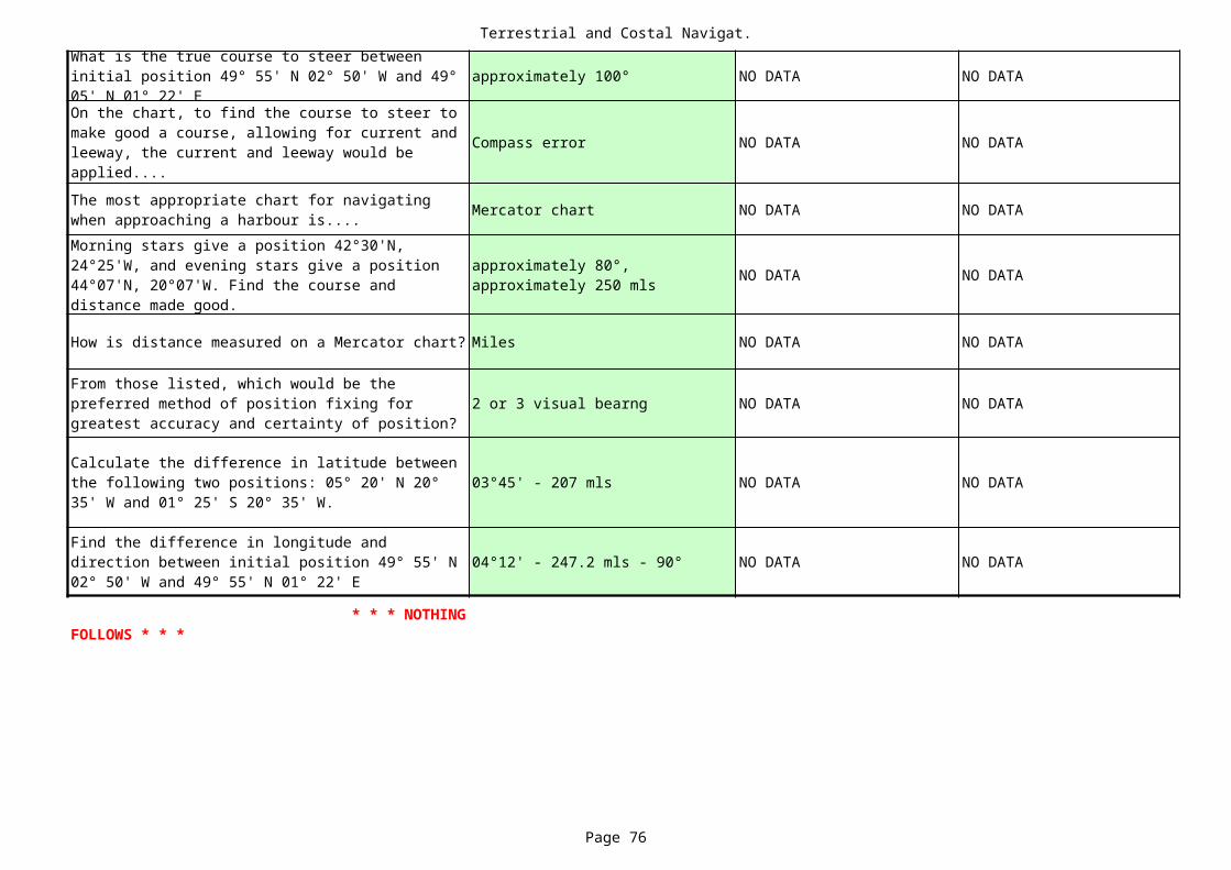
Terrestrial and Costal Navigat.
Page 76
approximately 100° NO DATA NO DATA
Compass error NO DATA NO DATA
Mercator chart NO DATA NO DATA
NO DATA NO DATA
How is distance measured on a Mercator chart? Miles NO DATA NO DATA
2 or 3 visual bearng NO DATA NO DATA
03°45' - 207 mls NO DATA NO DATA
04°12' - 247.2 mls - 90° NO DATA NO DATA
What is the true course to steer between initial position 49° 55' N 02° 50' W and 49° 05' N 01° 22' EOn the chart, to find the course to steer to make good a course, allowing for current and leeway, the current and leeway would be applied....The most appropriate chart for navigating when approaching a harbour is....Morning stars give a position 42°30'N, 24°25'W, and evening stars give a position 44°07'N, 20°07'W. Find the course and distance made good.
approximately 80°, approximately 250 mls
From those listed, which would be the preferred method of position fixing for greatest accuracy and certainty of position?
Calculate the difference in latitude between the following two positions: 05° 20' N 20° 35' W and 01° 25' S 20° 35' W.
Find the difference in longitude and direction between initial position 49° 55' N 02° 50' W and 49° 55' N 01° 22' E
* * * NOTHING FOLLOWS * * *

Terrestrial and Costal Navigat.
Page 77
NO DATA
NO DATA
NO DATA
NO DATA
NO DATA
NO DATA
NO DATA
NO DATA
NO DATA
NO DATA
NO DATA

Terrestrial and Costal Navigat.
Page 78
Departure
NO DATA
NO DATA
NO DATA
NO DATA
NO DATA
Towards the equator
NO DATA
NO DATA
NO DATA
NO DATA
suitable targets are easier to find

Terrestrial and Costal Navigat.
Page 79
NO DATA
NO DATA
Call the master
The trafic controller
Mariners handbook
The echo sounder
Switch on two vertical red lights and switch off steaming lights.
International Code of signal
Because the brightest lights are shown.A radar range and bearing
Proceeding on the port side of a narrow channel to take advantage of a favourable current.

Terrestrial and Costal Navigat.
Page 80
NO DATA
NO DATA
NO DATA
NO DATA
NO DATA
NO DATA
NO DATA
The plan should cover the first half of the sea voyage.

Terrestrial and Costal Navigat.
Page 81
a coastal indentation
NO DATA
small isolated features
South cardinal buoy 52
NO DATA
NO DATA
Ship routeing
Depth
Traffic lane
NO DATA
presentation unstabilisation
Whenever requested by a pilot
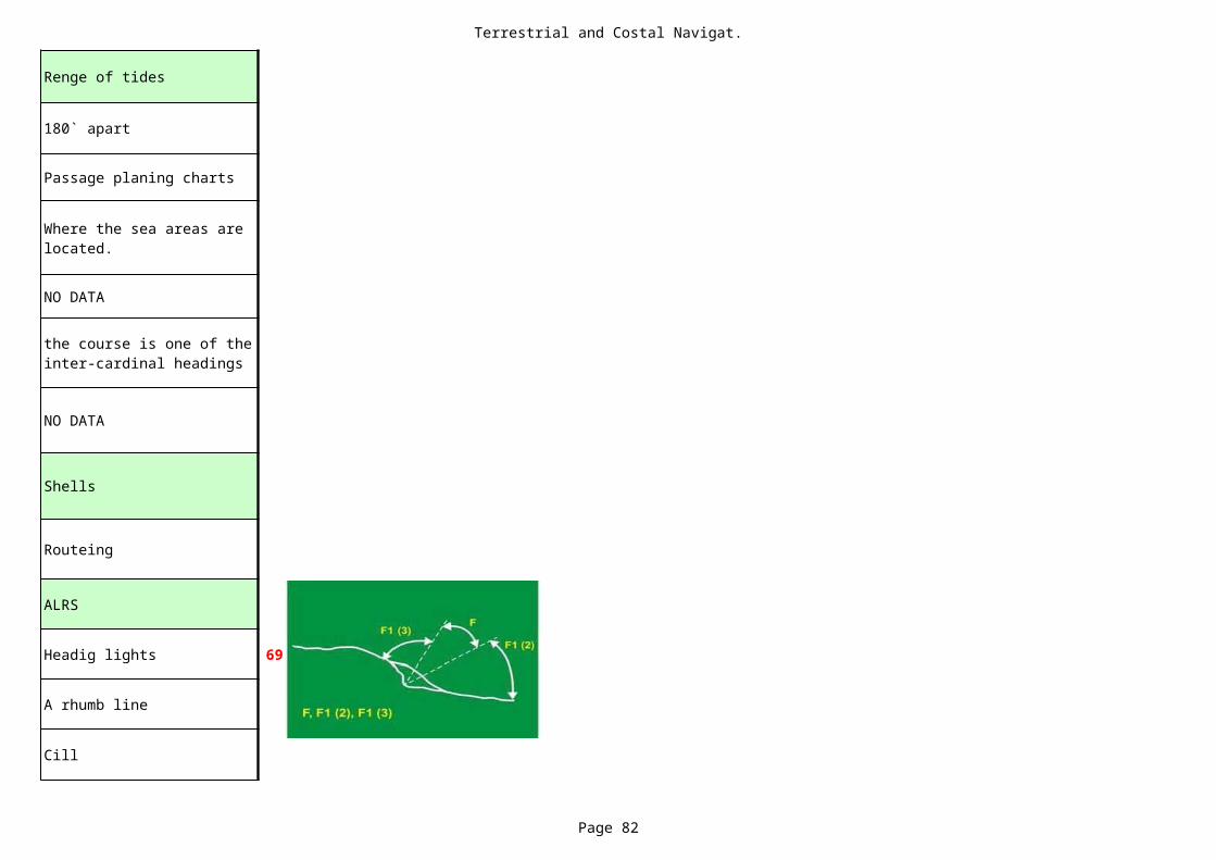
Terrestrial and Costal Navigat.
Page 82
Renge of tides
180` apart
Passage planing charts
NO DATA
NO DATA
Shells
Routeing
ALRS
Headig lights 69
A rhumb line
Cill
Where the sea areas are located.
the course is one of the inter-cardinal headings
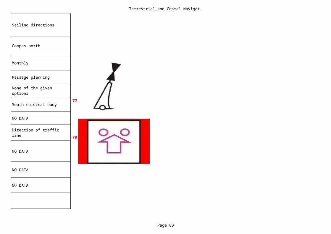
Terrestrial and Costal Navigat.
Page 83
Sailing directions
Compas north
Monthly
Passage planning
South cardinal buoy77
NO DATA
79
NO DATA
NO DATA
NO DATA
None of the given options
Direction of traffic lane
Terrestrial and Costal Navigat.
Page 84
NO DATA
NO DATA
NO DATA
NO DATA
NO DATA
a cliff face
NO DATA
NO DATA
NO DATA
NO DATA

Terrestrial and Costal Navigat.
Page 85
NO DATA
NO DATA
NO DATA
NO DATA
NO DATA
NO DATA
NO DATA
NO DATA
wheel-over position.
330°
Magnetic north
True North
The magnetic equator is…
5E
The point at which the helm must be applied to achieve a required course alteration is called the ......
With reference to magnetism, soft iron means that it....
Железо которое, намагнитившись, сохраняет свойства магнита только пока на него действует магнитная сила, называется мягким
The gyro course is 332° and the gyro error is 2° minus. What is the true course?Magnetic variation changes its value with…The ship's magnetic compass should be adjusted following certain circumstances. Fromthose listed, which is NOT one of those circumstances?
How often the manual steering should be tested?
12 hours before departure of the ship or steering gear need only be made once in week.
Magnetic variation for a particular place on the Earth slowly and constantly changes because…
Complex fluid motion in the outer core of the Earth causes the magnetic field to change slowly with time. This change is known as secular variation.
Gyroscopic inertia means that the spin axis of a free gyroscope…
стремится сохранить первоначально заданное ей направление относительно мирового пространства.
The angle between the magnetic north and the true north is ......
MAGNETIC VARIATION or DECLINATION
In what direction does the axis of the gyro compass motor normally point?
From those listed, which of the statements about magnetic variation is NOT true?
Precession in relation to a free gyroscope is…
the phenomenon in which the axis of a spinning object "wobbles" when a torque is applied to itthe angle made by a compass needle with the horizontal at any point on the Earth's surface
Magnetic compass - Var = 7W ; Dev = 12E ; What is the compass error?
168°
Magnetic compass error is… variation and deviation
rigidity and precession
deviation.
Isogonic lines.
128°
variation.
40
What is the main purpose of frequent record of the ship's compasses courses and errors in alog or compass deviation book?
For checking technical condition of compass.
From those listed, which is NOT a way of destroying magnetism?
A free gyroscope is said to have "three degres of freedom". From those listed, which isNOT one of these?
3 степени свободы: он может совершать 3 независимых поворота вокруг осей, пересекающихся в центре подвеса, который остаётся по отношению к основанию неподвижным. True
Where do you find a note of the annual rate of change in the magnetic variation at a
Magnetic Variation Charts or declination maps.
Magnetic Compass - If var =6E ; dev =3W, What is the compass error?
3 E
The gyro course is 165° and the gyro error is 3° plus. What is the true course?
The two unique properties of a free gyroscope are…The ship's magnetic compass should be especially checked for error following certaincircumstances. From those listed, which is NOT one of those circumstances?To convert a compass course to a magnetic course, it is necessary to apply.....
Latitude, course and speed error of a gyro compass…
A gyro-compass is subject to a latitude-speed error; an error increasing with latitude and speed of the ship. Also known as "latitude-speed-error"
Curves on charts showing values of equal variation are called…
From those listed, which are "soft iron" correctors?
magnet, opposite to the effects of the magnetic material in the shipLeading lights are in line.True bearing
is 126°. If the gyro error is 2° plus, what would thegyro bearing of the leading lights be?To convert a magnetic course to a true course, it is necessary to apply ....
How many points of the compass are there?
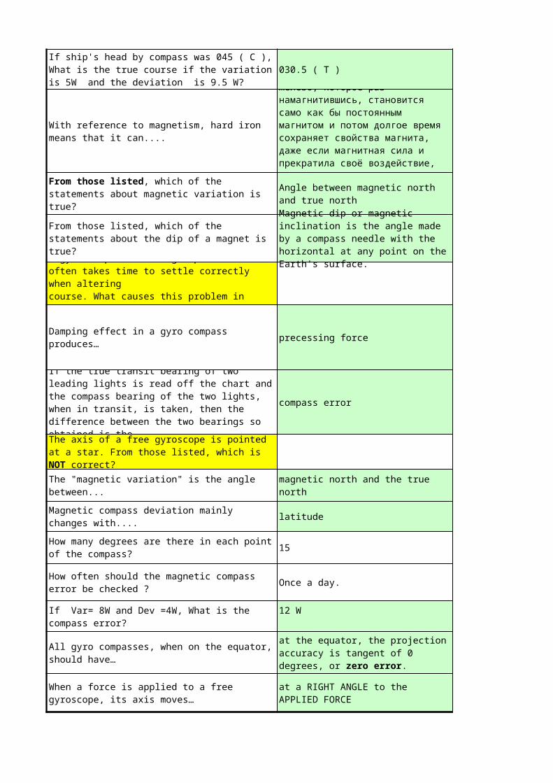
030.5 ( T )
precessing force
compass error
latitude
15
Once a day.
If ship's head by compass was 045 ( C ), What is the true course if the variation is 5W and the deviation is 9.5 W?
With reference to magnetism, hard iron means that it can....
Железо, которое раз намагнитившись, становится само как бы постоянным магнитом и потом долгое время сохраняет свойства магнита, даже если магнитная сила и прекратила своё воздействие, называется твердым.From those listed, which of the
statements about magnetic variation is true?
Angle between magnetic north and true north
From those listed, which of the statements about the dip of a magnet is true?
Magnetic dip or magnetic inclination is the angle made by a compass needle with the horizontal at any point on the Earth's surface.A gyro compass on a high-speed craft
often takes time to settle correctly when alteringcourse. What causes this problem in general?
Damping effect in a gyro compass produces…
If the true transit bearing of two leading lights is read off the chart and the compass bearing of the two lights, when in transit, is taken, then the difference between the two bearings so obtained is the ......The axis of a free gyroscope is pointed at a star. From those listed, which is NOT correct?The "magnetic variation" is the angle between...
magnetic north and the true north
Magnetic compass deviation mainly changes with....How many degrees are there in each point of the compass?
How often should the magnetic compass error be checked ?
If Var= 8W and Dev =4W, What is the compass error?
12 W
All gyro compasses, when on the equator, should have…
at the equator, the projection accuracy is tangent of 0 degrees, or zero error.
When a force is applied to a free gyroscope, its axis moves…
at a RIGHT ANGLE to the APPLIED FORCE

* * * NOTHING FOLLOWS * * *
way-point. abort-point.
NO DATA NO DATA
NO DATA NO DATA
NO DATA NO DATA
NO DATA NO DATA
NO DATA NO DATA
NO DATA NO DATA
NO DATA NO DATA
NO DATA NO DATA
NO DATA NO DATA
NO DATA NO DATA
5W 19E

NO DATA NO DATA
NO DATA NO DATA
NO DATA NO DATA
3W 9E
NO DATA NO DATA
NO DATA NO DATA
NO DATA NO DATA
variation. compass error.
NO DATA NO DATA
NO DATA NO DATA
NO DATA NO DATA
NO DATA NO DATA
deviation. compass error.
24 32

054.5 ( T ) 059.5 ( T )
NO DATA NO DATA
NO DATA NO DATA
NO DATA NO DATA
NO DATA NO DATA
deviation. variation.
NO DATA NO DATA
NO DATA NO DATA
11.25 17.5
Twice a day.
4W 4E
NO DATA NO DATA
NO DATA NO DATA
Once a watch and after a major course alteration.

drift-point.
NO DATA
NO DATA
NO DATA
NO DATA
NO DATA
NO DATA
NO DATA
NO DATA
NO DATA
NO DATA
19W
NO DATA
NO DATA
NO DATA
9W
NO DATA
NO DATA
NO DATA
none of the other answers.
NO DATA
NO DATA
NO DATA
NO DATA
none of the other options.
36

050 ( T )
NO DATA
NO DATA
NO DATA
NO DATA
magnetic bearing.
NO DATA
NO DATA
12
12E
NO DATA
NO DATA
After each major alteration of course.
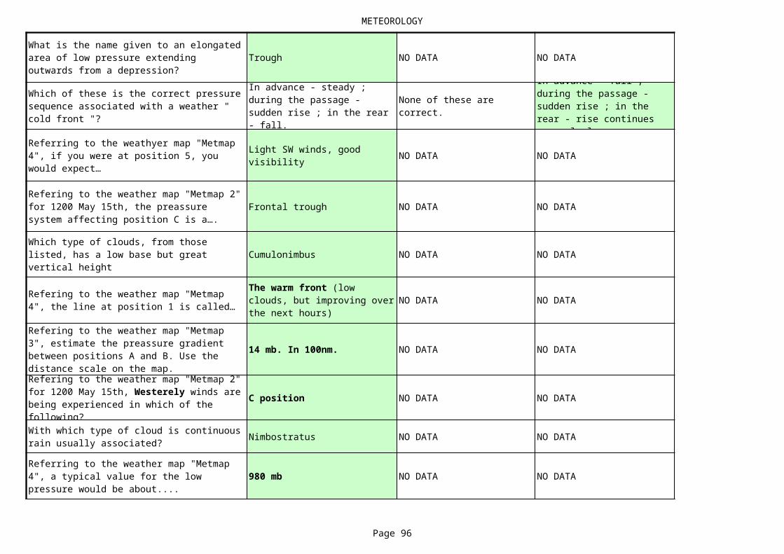
METEOROLOGY
Page 96
Trough NO DATA NO DATA
NO DATA NO DATA
Frontal trough NO DATA NO DATA
Cumulonimbus NO DATA NO DATA
NO DATA NO DATA
14 mb. In 100nm. NO DATA NO DATA
C position NO DATA NO DATA
Nimbostratus NO DATA NO DATA
980 mb NO DATA NO DATA
What is the name given to an elongated area of low pressure extending outwards from a depression?
Which of these is the correct pressure sequence associated with a weather " cold front "?
In advance - steady ; during the passage - sudden rise ; in the rear - fall.
None of these are correct.
In advance - fall ; during the passage - sudden rise ; in the rear - rise continues more slowly.
Referring to the weathyer map "Metmap 4", if you were at position 5, you would expect…
Light SW winds, good visibility
Refering to the weather map "Metmap 2" for 1200 May 15th, the preassure system affecting position C is a….
Which type of clouds, from those listed, has a low base but great vertical height
Refering to the weather map "Metmap 4", the line at position 1 is called…
The warm front (low clouds, but improving over the next hours)
Refering to the weather map "Metmap 3", estimate the preassure gradient between positions A and B. Use the distance scale on the map.Refering to the weather map "Metmap 2" for 1200 May 15th, Westerely winds are being experienced in which of the following?With which type of cloud is continuous rain usually associated?
Referring to the weather map "Metmap 4", a typical value for the low pressure would be about....
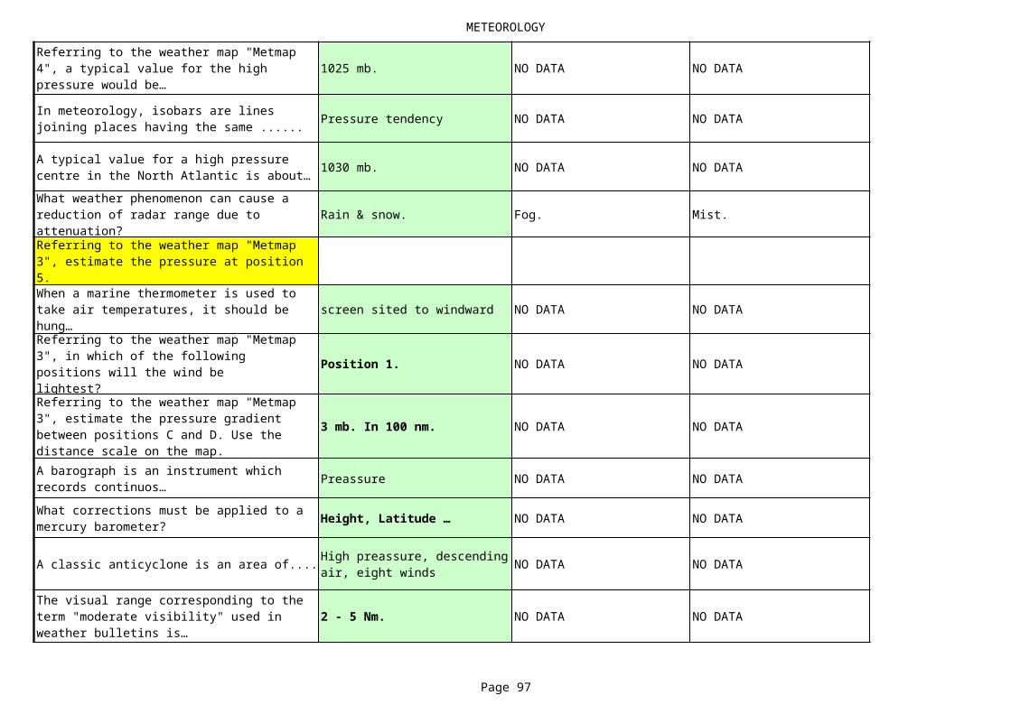
METEOROLOGY
Page 97
1025 mb. NO DATA NO DATA
Pressure tendency NO DATA NO DATA
1030 mb. NO DATA NO DATA
Rain & snow. Fog. Mist.
screen sited to windward NO DATA NO DATA
Position 1. NO DATA NO DATA
3 mb. In 100 nm. NO DATA NO DATA
Preassure NO DATA NO DATA
Height, Latitude … NO DATA NO DATA
A classic anticyclone is an area of.... NO DATA NO DATA
2 - 5 Nm. NO DATA NO DATA
Referring to the weather map "Metmap 4", a typical value for the high pressure would be…
In meteorology, isobars are lines joining places having the same ......
A typical value for a high pressure centre in the North Atlantic is about…What weather phenomenon can cause a reduction of radar range due to attenuation?Referring to the weather map "Metmap 3", estimate the pressure at position 5.When a marine thermometer is used to take air temperatures, it should be hung…Referring to the weather map "Metmap 3", in which of the following positions will the wind belightest?Referring to the weather map "Metmap 3", estimate the pressure gradient between positions C and D. Use the distance scale on the map.A barograph is an instrument which records continuos…What corrections must be applied to a mercury barometer?
High preassure, descending air, eight winds
The visual range corresponding to the term "moderate visibility" used in weather bulletins is…
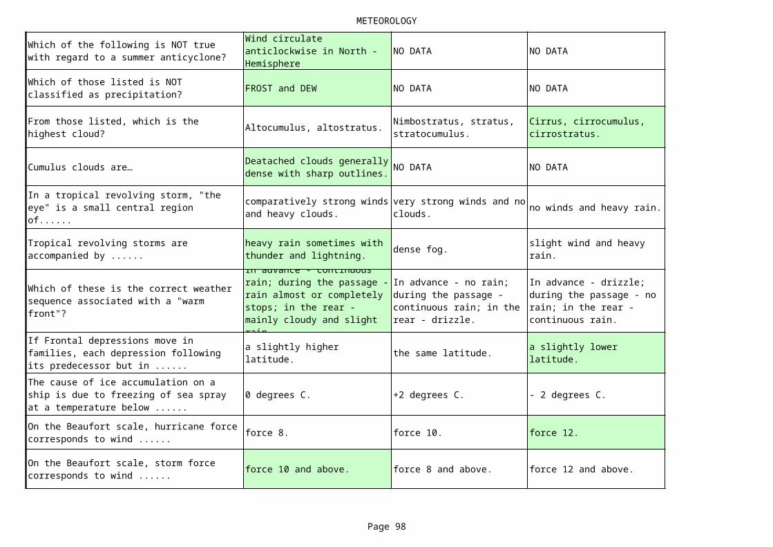
METEOROLOGY
Page 98
NO DATA NO DATA
FROST and DEW NO DATA NO DATA
Altocumulus, altostratus.
Cumulus clouds are… NO DATA NO DATA
no winds and heavy rain.
dense fog.
the same latitude.
0 degrees C. +2 degrees C. - 2 degrees C.
force 8. force 10. force 12.
force 10 and above. force 8 and above. force 12 and above.
Which of the following is NOT true with regard to a summer anticyclone?
Wind circulate anticlockwise in North - Hemisphere
Which of those listed is NOT classified as precipitation?
From those listed, which is the highest cloud?
Nimbostratus, stratus, stratocumulus.
Cirrus, cirrocumulus, cirrostratus.
Deatached clouds generally dense with sharp outlines.
In a tropical revolving storm, "the eye" is a small central region of......
comparatively strong winds and heavy clouds.
very strong winds and no clouds.
Tropical revolving storms are accompanied by ......
heavy rain sometimes with thunder and lightning.
slight wind and heavy rain.
Which of these is the correct weather sequence associated with a "warm front"?
In advance - continuous rain; during the passage - rain almost or completely stops; in the rear - mainly cloudy and slight rain.
In advance - no rain; during the passage - continuous rain; in the rear - drizzle.
In advance - drizzle; during the passage - no rain; in the rear - continuous rain.
If Frontal depressions move in families, each depression following its predecessor but in ......
a slightly higher latitude.
a slightly lower latitude.
The cause of ice accumulation on a ship is due to freezing of sea spray at a temperature below ......
On the Beaufort scale, hurricane force corresponds to wind ......
On the Beaufort scale, storm force corresponds to wind ......
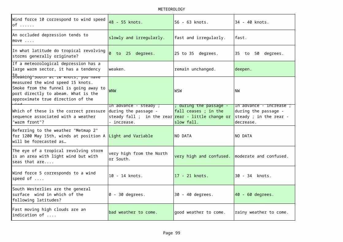
METEOROLOGY
Page 99
48 - 55 knots. 56 - 63 knots. 34 - 40 knots.
slowly and irregularly. fast and irregularly. fast.
0 to 25 degrees. 25 to 35 degrees. 35 to 50 degrees.
weaken. remain unchanged. deepen.
WNW WSW NW
Light and Variable NO DATA NO DATA
very high and confused. moderate and confused.
10 - 14 knots. 17 - 21 knots. 30 - 34 knots.
0 - 30 degrees. 30 - 40 degrees. 40 - 60 degrees.
bad weather to come. good weather to come. rainy weather to come.
Wind force 10 correspond to wind speed of ......
An occluded depression tends to move ....
In what latitude do tropical revolving storms generally originate?If a meteorological depression has a large warm sector, it has a tendency to ......Steaming South at 10 knots, you have measured the wind speed 15 knots. Smoke from the funnel is going away to port directly to abeam. What is the approximate true direction of the wind.Which of these is the correct pressure sequence associated with a weather "warm front"?
In advance - steady ; during the passage - steady fall ; in the rear - increase.
In advance - steady fall ; during the passage - fall ceases ; in the rear - little change or slow fall.
In advance - increase ; during the passage - steady ; in the rear - decrease.
Referring to the weather "Metmap 2" for 1200 May 15th, winds at position A will be forecasted as…
The eye of a tropical revolving storm is an area with light wind but with seas that are....
very high from the North or South.
Wind force 5 corresponds to a wind speed of ....
South Westerlies are the general surface wind in which of the following latitudes?
Fast moving high clouds are an indication of ....
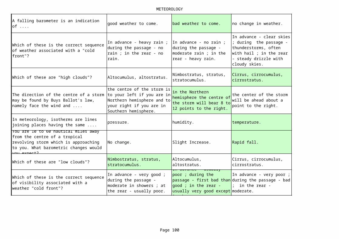
METEOROLOGY
Page 100
good weather to come. bad weather to come. no change in weather.
Which of these are "high clouds"? Altocumulus, altostratus.
pressure. humidity. temperature.
No change. Slight Increase. Rapid fall.
Which of these are "low clouds"?
A falling barometer is an indication of ....
Which of these is the correct sequence of weather associated with a "cold front"?
In advance - heavy rain ; during the passage - no rain ; in the rear - no rain.
In advance - no rain ; during the passage - moderate rain ; in the rear - heavy rain.
In advance - clear skies ; during the passage - thunderstorms, often with hail ; in the rear - steady drizzle with cloudy skies.
Nimbostratus, stratus, stratocumulus.
Cirrus, cirrocumulus, cirrostratus.
The direction of the centre of a storm may be found by Buys Ballot's law, namely face the wind and ....
the centre of the storm is to your left if you are in Northern hemisphere and to your right if you are in Southern hemisphere.
in the Northern hemisphere the centre of the storm will bear 8 to 12 points to the right.
the center of the storm will be ahead about a point to the right.
In meteorology, isotherms are lines joining places having the same ....You are 10 to 60 nautical miles away from the centre of a tropical revolving storm which is approaching to you. What barometric changes would you expect?
Nimbostratus, stratus, stratocumulus.
Altocumulus, altostratus.
Cirrus, cirrocumulus, cirrostratus.
Which of these is the correct sequence of visibility associated with a weather "cold front"?
In advance - very good ; during the passage - moderate in showers ; at the rear - usually poor.
In advance - usually poor ; during the passage - first bad than good ; in the rear - usually very good except in showers.
In advance - very poor ; during the passage - bad ; in the rear - moderate.

METEOROLOGY
Page 101
Warm occlusion Cold occlusion Warm front
No data No data
Travel with current No data No data
Meteorology - what does the figure indicate?Where, in warm sector depression, are fog patches and light drizzle most likely to occur?
in the warm sector of depression
If the atmosphere contains less water vapour than it is capable of holding at that temperature, it is said to be...Sea waves will increase in height in certain conditions. From those listed, which is NOT one of those conditions?
On this weather routeing chart, what does the upper figure indicate?
The number of observations.
The percentage frequency of variables winds.
The number of observed calms.
upper figure?
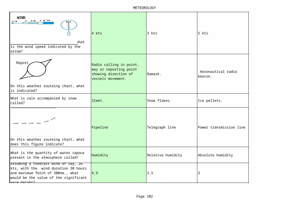
METEOROLOGY
Page 102
4 kts 3 kts 5 kts
Ramark.
Sleet. Snow flakes. Ice pellets.
Pipeline Telegraph line Power transmission line
Humidity Relative humidity Absolute humidity
4.9 3.5 3
On this weather routeing chart, what is the wind speed indicated by the arrow?
On this weather routeing chart, what is indicated?
Radio calling in point, way or reporting point showing direction of vessels movement.
Aeronautical radio beacon.
What is rain accompanied by snow called?
On this weather routeing chart, what does this figure indicate?
What is the quantity of water vapour present in the atmosphere called?Assuming a forecast wind of say, 26 kts, with the wind duration 30 hours and maximum fetch of 300nm., what would be the value of the significant wave height?
WIND
Report
METEOROLOGY
Page 103
with cumulonimbus
squall cyclone storm
40kts 20kts 30kts
cold front. warm front. occluded front.
Troposphere 1 Stratosphere 2 Mesosphere 3
Humidity Dew Fog
Anti-clockwise Clockwise Towards the pole
30 kts 15 kts 60 kts
To the left Ahead
NO DATA NO DATA
Which type of cloud is associated with thunderstorms?A sudden rising strong wind, or sudden increase of wind usually followed immediately by a shower of rain or snow is called a ......Dense sea fog is most likely to form when the wind changes direction to bring air from a…
warm air mass over a relatively colder sea surface
In which area will the isobars be spaced closest, given the wind speeds indicated?A squall line of sharp changes of wind, is very often associated with ......Which of these atmospheric layers is closest to the earth?
What is water content of the atmosphere (usually expressed as a percentage) known as?In what direction does the wind blow around a cyclonic storm in the northern hemisphere?If the distance between two consecutive isobars (drawn at intervals of 4mb) is found to be 100 n.m. and the latitude is 50 deg, what is the geostrophic wind speed?If an observer is facing the wind in the northern hemisphere, where does the low pressure lie?
To the right
What is the instrument used for atmosphe relative humidity measurement?
psychrometer or hygrometer.
METEOROLOGY
Page 104
Cold front Warm front Occluded front
Anemometer Barometer Tachometer
Rain Squalls
be affected by sea breezes No data No data
Stratocumulus Cumulus Stratus
The warm sector No data No data
An Anticyclone NO DATA NO DATA
SSW NO DATA NO DATA
Evaporation NO DATA NO DATA
What does this indicate on a weather map?
When visibility is considerably reduced we usually call it…
What instrument is used for measuring the velocity of the wind?What weather conditions are likely to result from the movement of warm air mass over a relatively colder sea surface?
Fog
Referring to the weather map "Metmap 2" for 1200 May 15th, at position D, the winds can be expected to…
What type of clouds are shown in the picture?
Referring to the weathyer map "Metmap 4", the area at position 3 is called
Referring to the weather map "Metmap 2" for 1200 May 15th, what is the predominant weather system over the UK at 1200 June 26th?Referring to the weather map "Metmap 3", estimate the wind direction at position 3.The temperature of the wet bulb thermometer falls according to the rate of...
METEOROLOGY
Page 105
To WSW, increase 35 knots NO DATA NO DATA
1010 mb. NO DATA NO DATA
SW, 35 knots. NO DATA NO DATA
NO DATA NO DATA
Continuous heavy rain NO DATA NO DATA
An isobar is NO DATA NO DATA
NO DATA NO DATA
Secondary depression NO DATA NO DATA
Cumulonimbus ? NO DATA NO DATA
pressure. temperature. humidity
Referring to the weather map "Metmap 3", the forecast states "the low pressure system to the NW of the British Isles is moving slowly SE." How would you expect the wind to change at position X?Which of these pressures would be described as "average" in temperate latitudes?
Referring to the weather map "Metmap 3", what is the forecast wind direction and strength at position Z?
Referring to the weather map "Metmap 4", if you were at position 1, you would expect…
(Low clouds, rain, but improving over the next hour) The warm front
In the Beaufort weather notation, what is the meaning of the symbol RR?
Position have the same tendency
Referring to the weather map "Metmap 4", if you were at position 2, you would expect in few hours....
The cold front (the wind veer to the west, visibility to improve)
Referring to the weather map "Metmap 1" for 0700 July 4th, identify the predominant pressure system over the UK.With which type of cloud is hail usually associated?How does a current flowing in the same direction as the wind affect the sea wave length and height?In the Northern hemisphere, the wind at sea level rotates around a depression in…In meteorology, isobars are lines joining places having the same ......
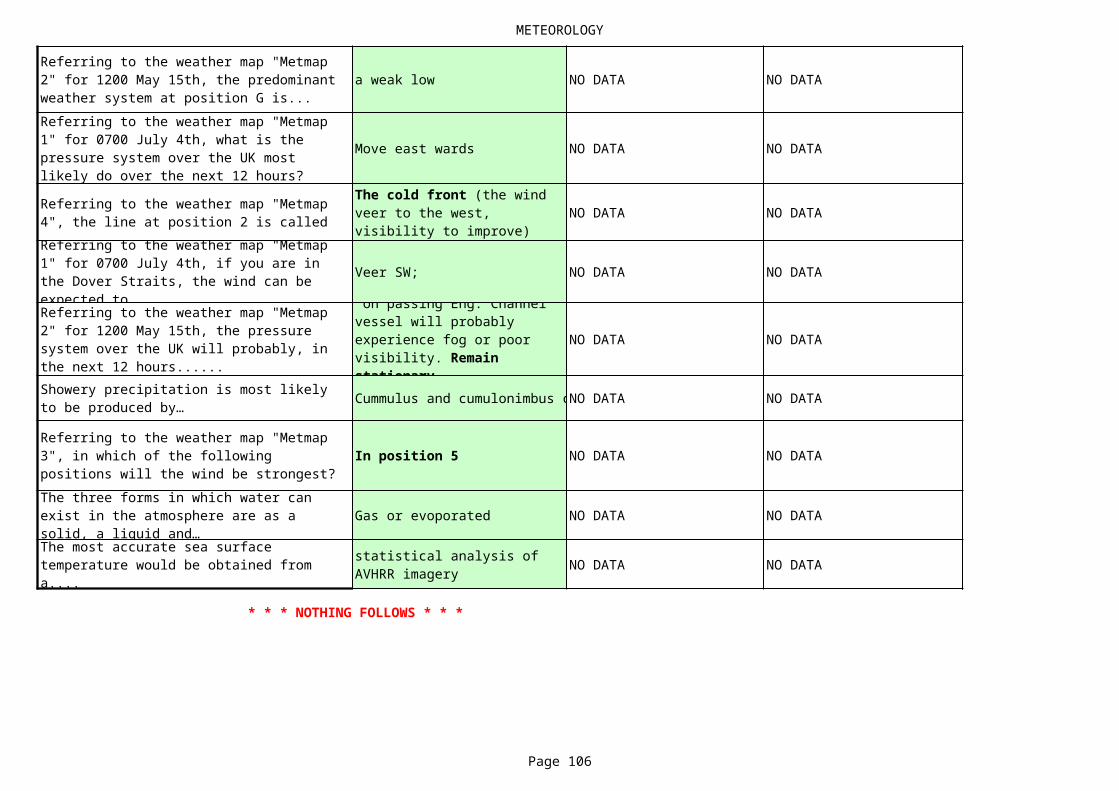
METEOROLOGY
Page 106
a weak low NO DATA NO DATA
Move east wards NO DATA NO DATA
NO DATA NO DATA
Veer SW; NO DATA NO DATA
NO DATA NO DATA
Cummulus and cumulonimbus cNO DATA NO DATA
In position 5 NO DATA NO DATA
Gas or evoporated NO DATA NO DATA
NO DATA NO DATA
Referring to the weather map "Metmap 2" for 1200 May 15th, the predominant weather system at position G is...Referring to the weather map "Metmap 1" for 0700 July 4th, what is the pressure system over the UK most likely do over the next 12 hours?
Referring to the weather map "Metmap 4", the line at position 2 is called
The cold front (the wind veer to the west, visibility to improve)
Referring to the weather map "Metmap 1" for 0700 July 4th, if you are in the Dover Straits, the wind can be expected to...Referring to the weather map "Metmap 2" for 1200 May 15th, the pressure system over the UK will probably, in the next 12 hours......
on passing Eng. Channel vessel will probably experience fog or poor visibility. Remain stationary.
Showery precipitation is most likely to be produced by…
Referring to the weather map "Metmap 3", in which of the following positions will the wind be strongest?The three forms in which water can exist in the atmosphere are as a solid, a liquid and…The most accurate sea surface temperature would be obtained from a....
statistical analysis of AVHRR imagery
* * * NOTHING FOLLOWS * * *

METEOROLOGY
Page 107
Metmap-1 Metmap 2
Metmap 3
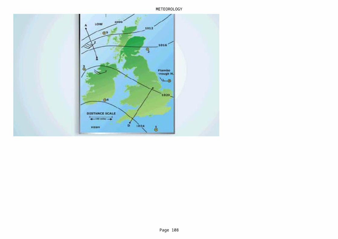
METEOROLOGY
Page 108

METEOROLOGY
Page 109
NO DATA
NO DATA Metmap 4
NO DATA Metmap 2
NO DATA
NO DATA Metmap 4
NO DATA Metmap 3
NO DATA Metmap 2
NO DATA
NO DATA Metmap 4
In advance - sudden fall; during the passage - sudden rise; in the rear - steady.

METEOROLOGY
Page 110
NO DATA Metmap 4
NO DATA
NO DATA
Rough seas.
Metmap 3
NO DATA
NO DATA Metmap 3
NO DATA Metmap 3
NO DATA
NO DATA
NO DATA
NO DATA

METEOROLOGY
Page 111
NO DATA
NO DATA
Cumulonimbus.
NO DATA
-5 degrees C.
force 14.
force 6 and above.
comparatively light winds and little clouds.
very cold air and sometimes hail.
In advance - showers; during the passage - thunderstorms / in the rear - clear skies.
a much higher latitude.
METEOROLOGY
Page 112
28 - 33 knots.
slowly.
50 to 65 degrees.
move fast.
SW
NO DATA Metmap 2
25 - 29 knots.
60 - 90 degrees.
unchanged weather.
In advance - sharply falling ; during the passage - rise and fall ; in the rear - slowly rising.
very high from the East or West.

METEOROLOGY
Page 113
rainy weather to come.
Cumulonimbus.
iceberg density.
Rapid Increase.
Megastratus.
In advance - usually some rain and perhaps thunder ; during the passage - rain, often heavy ; in the rear - heavy rain for a short period than fair .
the center of the storm will be right behind you about a point on your left.
In advance - very good ; during the passage - very poor ; in the rear - moderate.

METEOROLOGY
Page 114
Cold front
No data
No data
None of the other options.
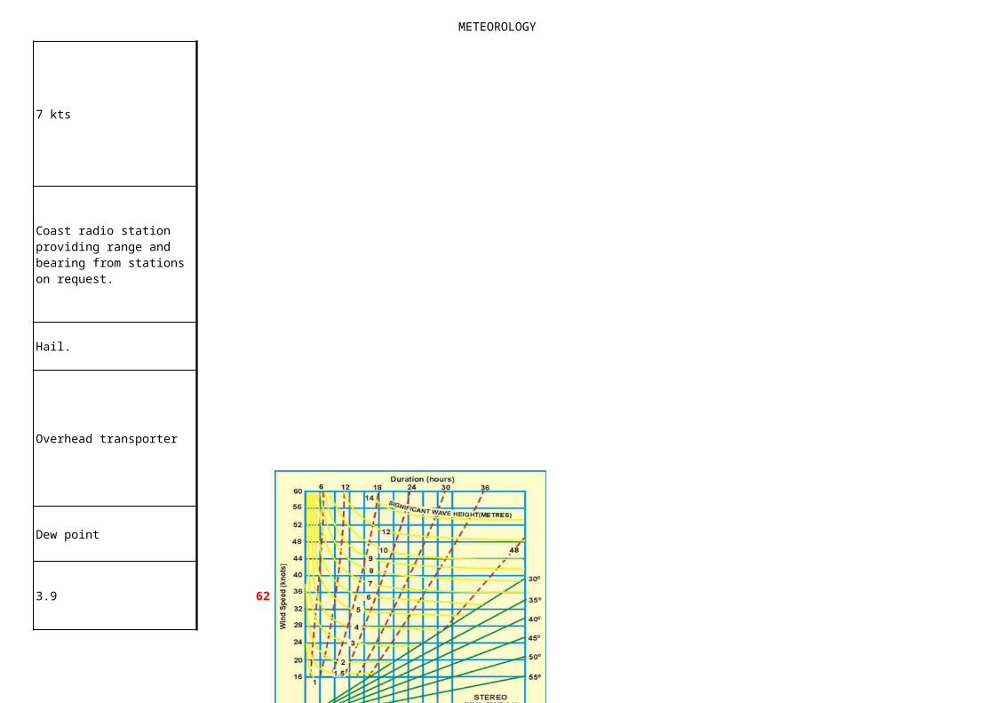
METEOROLOGY
Page 115
7 kts
Hail.
Overhead transporter
Dew point
3.9 62
Coast radio station providing range and bearing from stations on request.
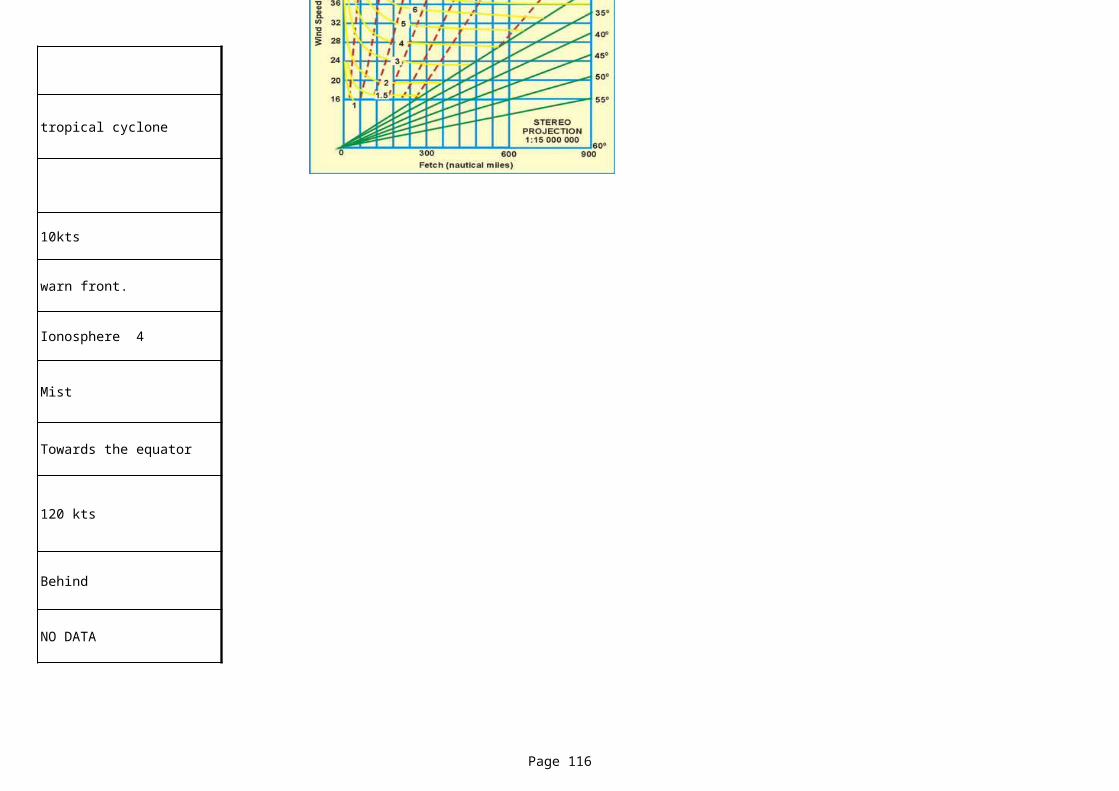
METEOROLOGY
Page 116
tropical cyclone
10kts
warn front.
Ionosphere 4
Mist
Towards the equator
120 kts
Behind
NO DATA
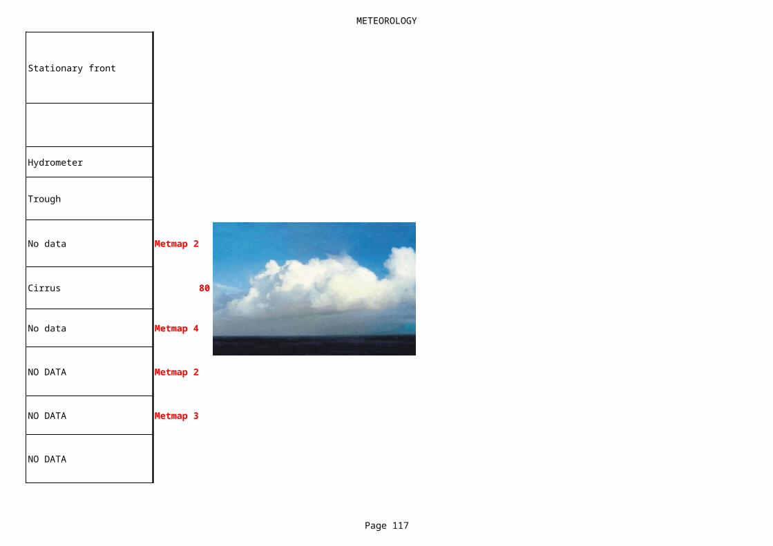
METEOROLOGY
Page 117
Stationary front
Hydrometer
Trough
No data Metmap 2
Cirrus 80
No data Metmap 4
NO DATA Metmap 2
NO DATA Metmap 3
NO DATA
METEOROLOGY
Page 118
NO DATA Metmap 3
NO DATA
NO DATA Metmap 3
NO DATA Metmap 4
NO DATA
NO DATA
NO DATA Metmap 4
NO DATA Metmap 1
NO DATA
iceberg density.
METEOROLOGY
Page 119
NO DATA Metmap 2
NO DATA Metmap 1
NO DATA Metmap 4
NO DATA Metmap 1
NO DATA Metmap 2
NO DATA
NO DATA Metmap 3
NO DATA
NO DATA
Metmap 4
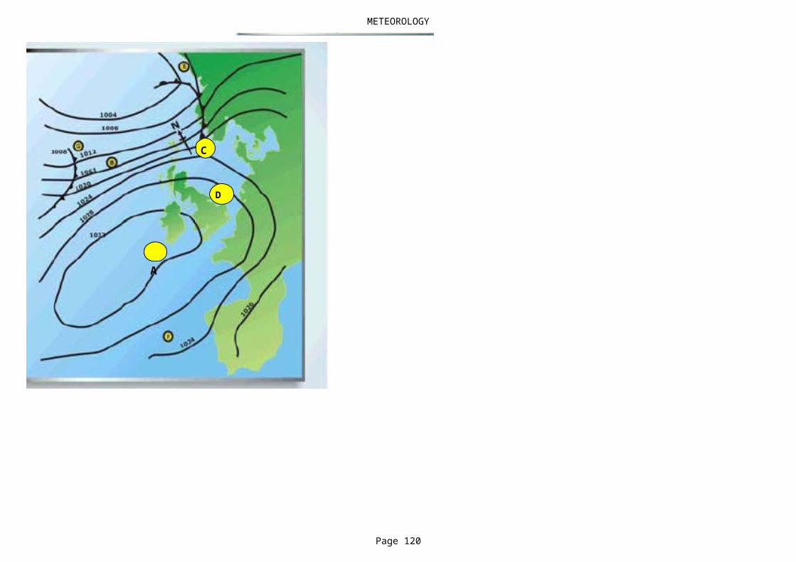
METEOROLOGY
Page 120
C
A
D
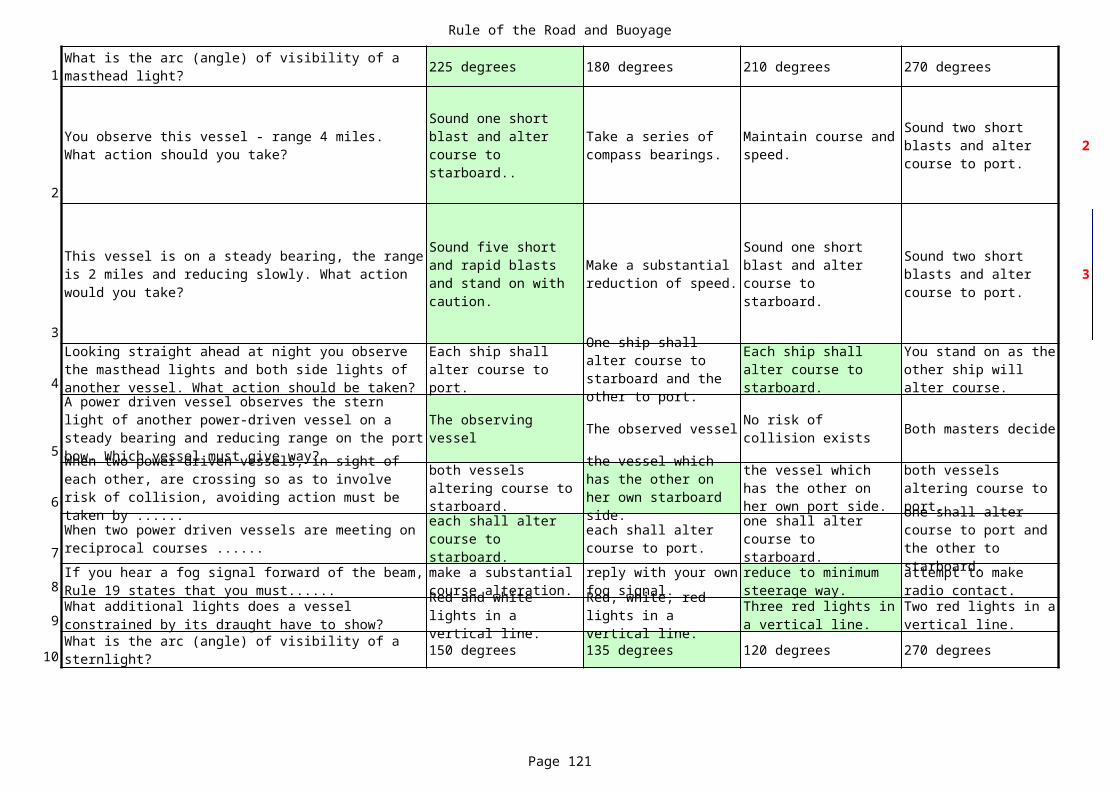
Rule of the Road and Buoyage
Page 121
1 225 degrees 180 degrees 210 degrees 270 degrees
2
2
3
3
4
5The observed vessel Both masters decide
6
7
8
9
10 150 degrees 135 degrees 120 degrees 270 degrees
What is the arc (angle) of visibility of a masthead light?
You observe this vessel - range 4 miles. What action should you take?
Sound one short blast and alter course to starboard..
Take a series of compass bearings.
Maintain course and speed.
Sound two short blasts and alter course to port.
This vessel is on a steady bearing, the range is 2 miles and reducing slowly. What action would you take?
Sound five short and rapid blasts and stand on with caution.
Make a substantial reduction of speed.
Sound one short blast and alter course to starboard.
Sound two short blasts and alter course to port.
Looking straight ahead at night you observe the masthead lights and both side lights of another vessel. What action should be taken?
Each ship shall alter course to port.
One ship shall alter course to starboard and the other to port.
Each ship shall alter course to starboard.
You stand on as the other ship will alter course.
A power driven vessel observes the stern light of another power-driven vessel on a steady bearing and reducing range on the port bow. Which vessel must give way?
The observing vessel
No risk of collision exists
When two power-driven vessels, in sight of each other, are crossing so as to involve risk of collision, avoiding action must be taken by ......
both vessels altering course to starboard.
the vessel which has the other on her own starboard side.
the vessel which has the other on her own port side.
both vessels altering course to port.
When two power driven vessels are meeting on reciprocal courses ......
each shall alter course to starboard.
each shall alter course to port.
one shall alter course to starboard.
one shall alter course to port and the other to starboard.If you hear a fog signal forward of the beam,
Rule 19 states that you must......make a substantial course alteration.
reply with your own fog signal.
reduce to minimum steerage way.
attempt to make radio contact.
What additional lights does a vessel constrained by its draught have to show?
Red and white lights in a vertical line.
Red, white, red lights in a vertical line.
Three red lights in a vertical line.
Two red lights in a vertical line.
What is the arc (angle) of visibility of a sternlight?
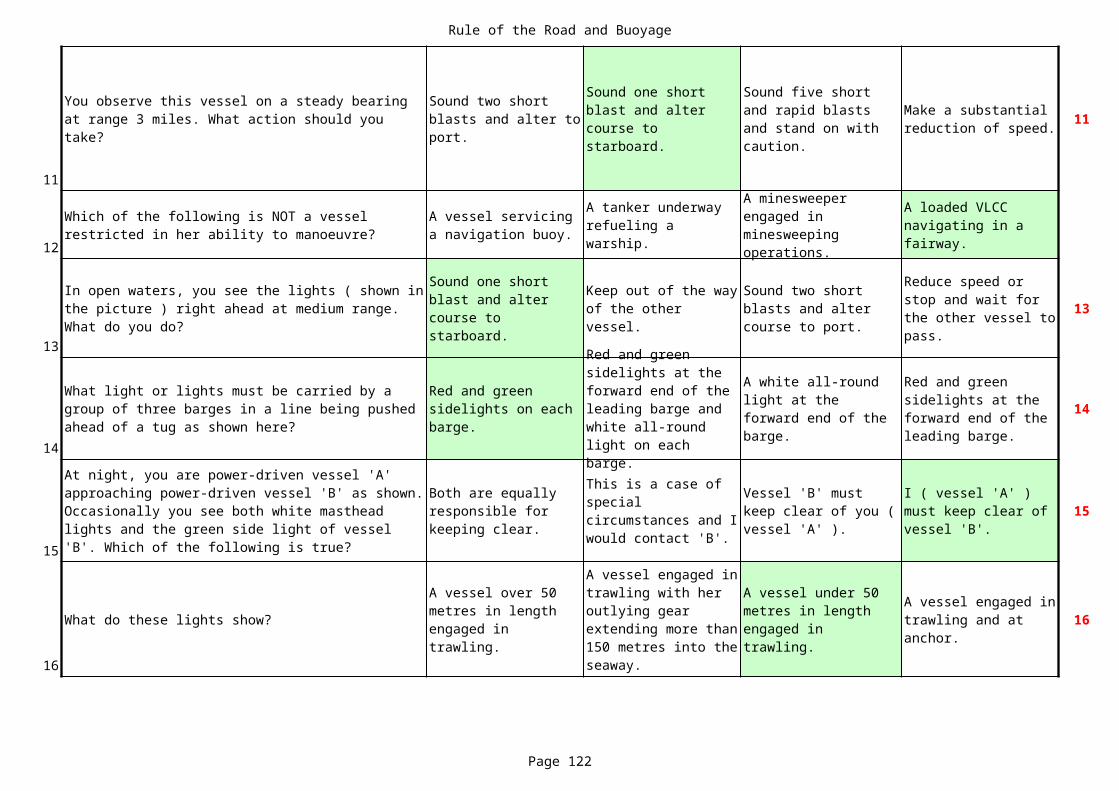
Rule of the Road and Buoyage
Page 122
11
11
12
13
13
14
14
15
15
16
What do these lights show? 16
You observe this vessel on a steady bearing at range 3 miles. What action should you take?
Sound two short blasts and alter to port.
Sound one short blast and alter course to starboard.
Sound five short and rapid blasts and stand on with caution.
Make a substantial reduction of speed.
Which of the following is NOT a vessel restricted in her ability to manoeuvre?
A vessel servicing a navigation buoy.
A tanker underway refueling a warship.
A minesweeper engaged in minesweeping operations.
A loaded VLCC navigating in a fairway.
In open waters, you see the lights ( shown in the picture ) right ahead at medium range. What do you do?
Sound one short blast and alter course to starboard.
Keep out of the way of the other vessel.
Sound two short blasts and alter course to port.
Reduce speed or stop and wait for the other vessel to pass.
What light or lights must be carried by a group of three barges in a line being pushed ahead of a tug as shown here?
Red and green sidelights on each barge.
Red and green sidelights at the forward end of the leading barge and white all-round light on each barge.
A white all-round light at the forward end of the barge.
Red and green sidelights at the forward end of the leading barge.
At night, you are power-driven vessel 'A' approaching power-driven vessel 'B' as shown. Occasionally you see both white masthead lights and the green side light of vessel 'B'. Which of the following is true?
Both are equally responsible for keeping clear.
This is a case of special circumstances and I would contact 'B'.
Vessel 'B' must keep clear of you ( vessel 'A' ).
I ( vessel 'A' ) must keep clear of vessel 'B'.
A vessel over 50 metres in length engaged in trawling.
A vessel engaged in trawling with her outlying gear extending more than 150 metres into the seaway.
A vessel under 50 metres in length engaged in trawling.
A vessel engaged in trawling and at anchor.
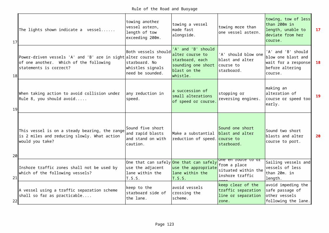
Rule of the Road and Buoyage
Page 123
17
The lights shown indicate a vessel...... 17
18
18
19
19
20
20
21
22
towing another vessel astern, length of tow exceeding 200m.
towing a vessel made fast alongside.
towing more than one vessel astern.
towing, tow of less than 200m in length, unable to deviate from her course.
Power-driven vessels 'A' and 'B' are in sight of one another. Which of the following statements is correct?
Both vessels should alter course to starboard. No whistles signals need be sounded.
'A' and 'B' should alter course to starboard, each sounding one short blast on the whistle.
'A' should blow one blast and alter course to starboard.
'A' and 'B' should blow one blast and wait for a response before altering course.
When taking action to avoid collision under Rule 8, you should avoid.....
any reduction in speed.
a succession of small alterations of speed or course.
stopping or reversing engines.
making an alteration of course or speed too early.
This vessel is on a steady bearing, the range is 2 miles and reducing slowly. What action would you take?
Sound five short and rapid blasts and stand on with caution.
Make a substantial reduction of speed.
Sound one short blast and alter course to starboard.
Sound two short blasts and alter course to port.
Inshore traffic zones shall not be used by which of the following vessels?
One that can safely use the adjacent lane within the T.S.S.
One that can safely use the appropriate lane within the T.S.S.
One en route to or from a place situated within the inshore traffic zone.
Sailing vessels and vessels of less than 20m. in length.
A vessel using a traffic separation scheme shall so far as practicable....
keep to the starboard side of the lane.
avoid vessels crossing the scheme.
keep clear of the traffic separation line or separation zone.
avoid impeding the safe passage of other vessels following the lane.
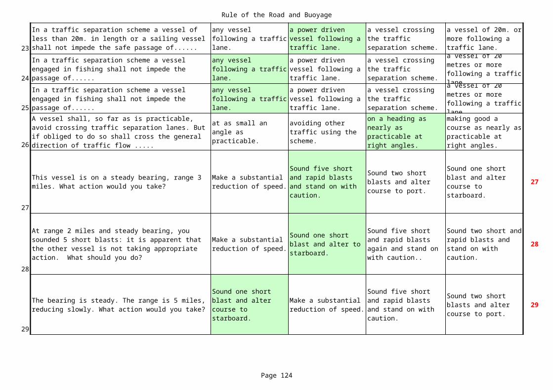
Rule of the Road and Buoyage
Page 124
23
24
25
26
27
27
28
28
29
29
In a traffic separation scheme a vessel of less than 20m. in length or a sailing vessel shall not impede the safe passage of......
any vessel following a traffic lane.
a power driven vessel following a traffic lane.
a vessel crossing the traffic separation scheme.
a vessel of 20m. or more following a traffic lane.
In a traffic separation scheme a vessel engaged in fishing shall not impede the passage of......
any vessel following a traffic lane.
a power driven vessel following a traffic lane.
a vessel crossing the traffic separation scheme.
a vessel of 20 metres or more following a traffic lane.
In a traffic separation scheme a vessel engaged in fishing shall not impede the passage of......
any vessel following a traffic lane.
a power driven vessel following a traffic lane.
a vessel crossing the traffic separation scheme.
a vessel of 20 metres or more following a traffic lane.
A vessel shall, so far as is practicable, avoid crossing traffic separation lanes. But if obliged to do so shall cross the general direction of traffic flow .....
at as small an angle as practicable.
avoiding other traffic using the scheme.
on a heading as nearly as practicable at right angles.
making good a course as nearly as practicable at right angles.
This vessel is on a steady bearing, range 3 miles. What action would you take?
Make a substantial reduction of speed.
Sound five short and rapid blasts and stand on with caution.
Sound two short blasts and alter course to port.
Sound one short blast and alter course to starboard.
At range 2 miles and steady bearing, you sounded 5 short blasts: it is apparent that the other vessel is not taking appropriate action. What should you do?
Make a substantial reduction of speed.
Sound one short blast and alter to starboard.
Sound five short and rapid blasts again and stand on with caution..
Sound two short and rapid blasts and stand on with caution.
The bearing is steady. The range is 5 miles, reducing slowly. What action would you take?
Sound one short blast and alter course to starboard.
Make a substantial reduction of speed.
Sound five short and rapid blasts and stand on with caution.
Sound two short blasts and alter course to port.
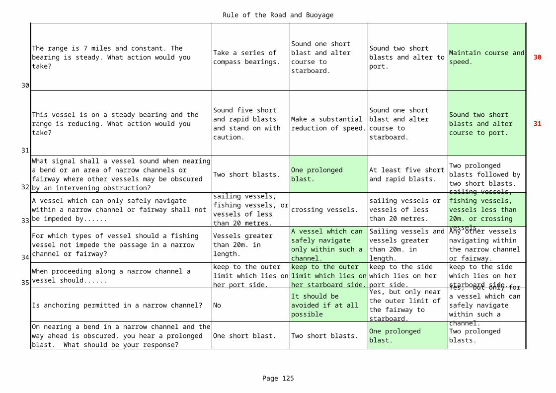
Rule of the Road and Buoyage
Page 125
30
30
31
31
32Two short blasts.
33crossing vessels.
34
35
Is anchoring permitted in a narrow channel? No
One short blast. Two short blasts.
The range is 7 miles and constant. The bearing is steady. What action would you take?
Take a series of compass bearings.
Sound one short blast and alter course to starboard.
Sound two short blasts and alter to port.
Maintain course and speed.
This vessel is on a steady bearing and the range is reducing. What action would you take?
Sound five short and rapid blasts and stand on with caution.
Make a substantial reduction of speed.
Sound one short blast and alter course to starboard.
Sound two short blasts and alter course to port.
What signal shall a vessel sound when nearing a bend or an area of narrow channels or fairway where other vessels may be obscured by an intervening obstruction?
One prolonged blast.
At least five short and rapid blasts.
Two prolonged blasts followed by two short blasts.
A vessel which can only safely navigate within a narrow channel or fairway shall not be impeded by......
sailing vessels, fishing vessels, or vessels of less than 20 metres.
sailing vessels or vessels of less than 20 metres.
sailing vessels, fishing vessels, vessels less than 20m. or crossing vessels.
For which types of vessel should a fishing vessel not impede the passage in a narrow channel or fairway?
Vessels greater than 20m. in length.
A vessel which can safely navigate only within such a channel.
Sailing vessels and vessels greater than 20m. in length.
Any other vessels navigating within the narrow channel or fairway.
When proceeding along a narrow channel a vessel should......
keep to the outer limit which lies on her port side.
keep to the outer limit which lies on her starboard side.
keep to the side which lies on her port side.
keep to the side which lies on her starboard side.
It should be avoided if at all possible
Yes, but only near the outer limit of the fairway to starboard.
Yes, but only for a vessel which can safely navigate within such a channel.On nearing a bend in a narrow channel and the
way ahead is obscured, you hear a prolonged blast. What should be your response?
One prolonged blast.
Two prolonged blasts.

Rule of the Road and Buoyage
Page 126
at anchor. fishing. 38
39
What do these lights indicate? 41
A white light. A stern light.
Does this signal indicate that the vessel is......
underway and making way through the water.
underway, but stopped.
You observe this vessel on a steady bearing at range 3 miles. What action should you take?
Sound two short blasts and alter to port.
Sound one short blast and alter course to starboard.
Sound five short and rapid blasts and stand on with caution.
Make a substantial reduction of speed.
You see a vessel displaying a black cylinder on her starboard yardarm. At night, what lights would the same vessel be showing, in addition to those for a power-driven vessel underway?
Two all-round red lights in a vertical line.
Three all-round lights in a vertical line, the upper and lower red and the middle one white.
Two all-round lights in a vertical line, the upper one red and the lower one white.
Three all-round red lights in a vertical line.
A vessel towing a barge
A power-driven vessel of over 50m in length
A power-driven vessel of under 50m
A dredger indicating the clear side free from obstructions
At night, in addition to her sidelights, what else must a sailing vessel show?
Red over green masthead lights.
A white light in the direction of an approaching vessel.
When should a sailing vessel keep out of the way of a power driven vessel?
When both vessels are crossing.
When the power driven vessel is overtaking..
When the sailing vessel is overtaking.
When both vessels are meeting end on.
In the Collision Regulations, the Government of any State can make provision for special rules allowing the use of additional whistle signals between which vessels?
Warships and vessels sailing under convoy.
Tugs and their tows.
Pilot vessels and vessels requiring pilots.
All of the other options.
In the Collision Regulations, the Government of any State can make provision for special rules allowing the use of additional whistle signals between which vessels?
Warships and vessels sailing under convoy.
Tugs and their tows.
Pilot vessels and vessels requiring pilots.
All of the other options.
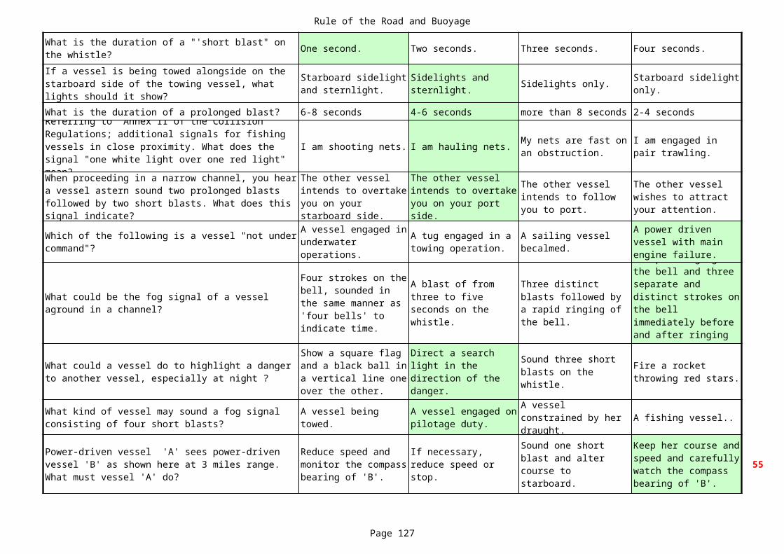
Rule of the Road and Buoyage
Page 127
One second. Two seconds. Three seconds. Four seconds.
Sidelights only.
What is the duration of a prolonged blast? 6-8 seconds 4-6 seconds more than 8 seconds 2-4 seconds
I am shooting nets. I am hauling nets.
A fishing vessel..
55
What is the duration of a "'short blast" on the whistle?If a vessel is being towed alongside on the starboard side of the towing vessel, what lights should it show?
Starboard sidelight and sternlight.
Sidelights and sternlight.
Starboard sidelight only.
Referring to Annex II of the Collision Regulations; additional signals for fishing vessels in close proximity. What does the signal "one white light over one red light" mean?
My nets are fast on an obstruction.
I am engaged in pair trawling.
When proceeding in a narrow channel, you hear a vessel astern sound two prolonged blasts followed by two short blasts. What does this signal indicate?
The other vessel intends to overtake you on your starboard side.
The other vessel intends to overtake you on your port side.
The other vessel intends to follow you to port.
The other vessel wishes to attract your attention.
Which of the following is a vessel "not under command"?
A vessel engaged in underwater operations.
A tug engaged in a towing operation.
A sailing vessel becalmed.
A power driven vessel with main engine failure.
What could be the fog signal of a vessel aground in a channel?
Four strokes on the bell, sounded in the same manner as 'four bells' to indicate time.
A blast of from three to five seconds on the whistle.
Three distinct blasts followed by a rapid ringing of the bell.
A rapid ringing of the bell and three separate and distinct strokes on the bell immediately before and after ringing of the bell.
What could a vessel do to highlight a danger to another vessel, especially at night ?
Show a square flag and a black ball in a vertical line one over the other.
Direct a search light in the direction of the danger.
Sound three short blasts on the whistle.
Fire a rocket throwing red stars.
What kind of vessel may sound a fog signal consisting of four short blasts?
A vessel being towed.
A vessel engaged on pilotage duty.
A vessel constrained by her draught.
Power-driven vessel 'A' sees power-driven vessel 'B' as shown here at 3 miles range. What must vessel 'A' do?
Reduce speed and monitor the compass bearing of 'B'.
If necessary, reduce speed or stop.
Sound one short blast and alter course to starboard.
Keep her course and speed and carefully watch the compass bearing of 'B'.
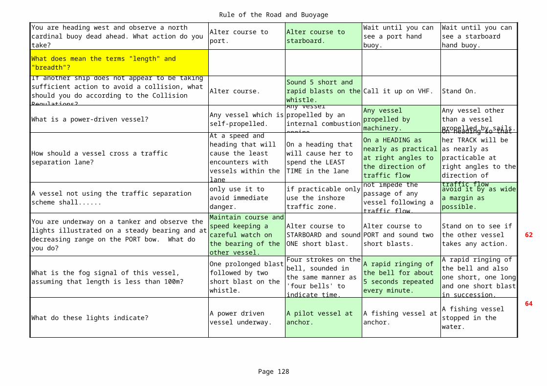
Rule of the Road and Buoyage
Page 128
Alter course. Call it up on VHF. Stand On.
What is a power-driven vessel?
62
What do these lights indicate?
64
You are heading west and observe a north cardinal buoy dead ahead. What action do you take?
Alter course to port.
Alter course to starboard.
Wait until you can see a port hand buoy.
Wait until you can see a starboard hand buoy.
What does mean the terms "length" and "breadth"?If another ship does not appear to be taking sufficient action to avoid a collision, what should you do according to the Collision Regulations?
Sound 5 short and rapid blasts on the whistle.
Any vessel which is self-propelled.
Any vessel propelled by an internal combustion engine.
Any vessel propelled by machinery.
Any vessel other than a vessel propelled by sails.
How should a vessel cross a traffic separation lane?
At a speed and heading that will cause the least encounters with vessels within the lane
On a heading that will cause her to spend the LEAST TIME in the lane
On a HEADING as nearly as practical at right angles to the direction of traffic flow
On heading so that her TRACK will be as nearly as practicable at right angles to the direction of traffic flow
A vessel not using the traffic separation scheme shall......
only use it to avoid immediate danger.
if practicable only use the inshore traffic zone.
not impede the passage of any vessel following a traffic flow.
avoid it by as wide a margin as possible.
You are underway on a tanker and observe the lights illustrated on a steady bearing and at decreasing range on the PORT bow. What do you do?
Maintain course and speed keeping a careful watch on the bearing of the other vessel.
Alter course to STARBOARD and sound ONE short blast.
Alter course to PORT and sound two short blasts.
Stand on to see if the other vessel takes any action.
What is the fog signal of this vessel, assuming that length is less than 100m?
One prolonged blast followed by two short blast on the whistle.
Four strokes on the bell, sounded in the same manner as 'four bells' to indicate time.
A rapid ringing of the bell for about 5 seconds repeated every minute.
A rapid ringing of the bell and also one short, one long and one short blast in succession.
A power driven vessel underway.
A pilot vessel at anchor.
A fishing vessel at anchor.
A fishing vessel stopped in the water.
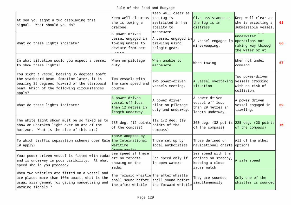
Rule of the Road and Buoyage
Page 129
65
What do these lights indicate? 66
When towing 67
What do these lights indicate? 69
70
A safe speed
At sea you sight a tug displaying this signal. What should you do?
Keep well clear as she is towing a dracone.
Keep well clear as the tug is restricted in her ability to manoeuvre.
Give assistance as the tug is in distress.
Keep well clear as she is escorting a submersible vessel.
A power-driven vessel engaged in towing unable to deviate from her course.
A vessel engaged in trawling using pelagic gear.
A vessel engaged in minesweeping.
A vessel engaged in underwater operations not making way through the water or at anchor.
In what situation would you expect a vessel to show these lights?
When on pilotage duty
When unable to manoeuvre
When not under command
You sight a vessel bearing 35 degrees abaft the starboard beam. Sometime later, it is bearing 35 degrees forward of the starboardbeam. Which of the following circumstances apply?
Two vessels with the same speed and course.
Two power-driven vessels meeting.
A vessel overtaking situation.
Two power-driven vessels crossing with no risk of collision.
A power driven vessel off less than 12 metres in length underway.
A power driven pilot on pilotage duty and underway.
A power driven vessel off less than 20 metres in length underway.
A power driven vessel engaged in trawling.
The white light shown must be so fixed as to show an unbroken light over an arc of the horizon. What is the size of this arc?
135 deg. (12 points of the compass)
112 1/2 deg. (10 points of the compass)
360 deg. (32 points of the compass)
225 deg. (20 points of the compass)
To which traffic separation schemes does Rule 10 apply?
Those adopted by the International Maritime Organization
Those set up by local authorities
Those defined on navigational charts
All of the other options
Your power-driven vessel is fitted with radar and is underway in poor visibility. At what speed should you proceed?
Sea speed if there are no targets showing on the radar
Sea speed only if in open waters
Sea speed with the engines on standby, keeping a close radar watch
When two whistles are fitted on a vessel and are placed more than 100m apart, what is the usual arrangement for giving manoeuvring and warning signals ?
The forward whistle shall sound before the after whistle
The after whistle shall sound before the forward whistle
They are sounded simultaneously
Only one of the whistles is sounded
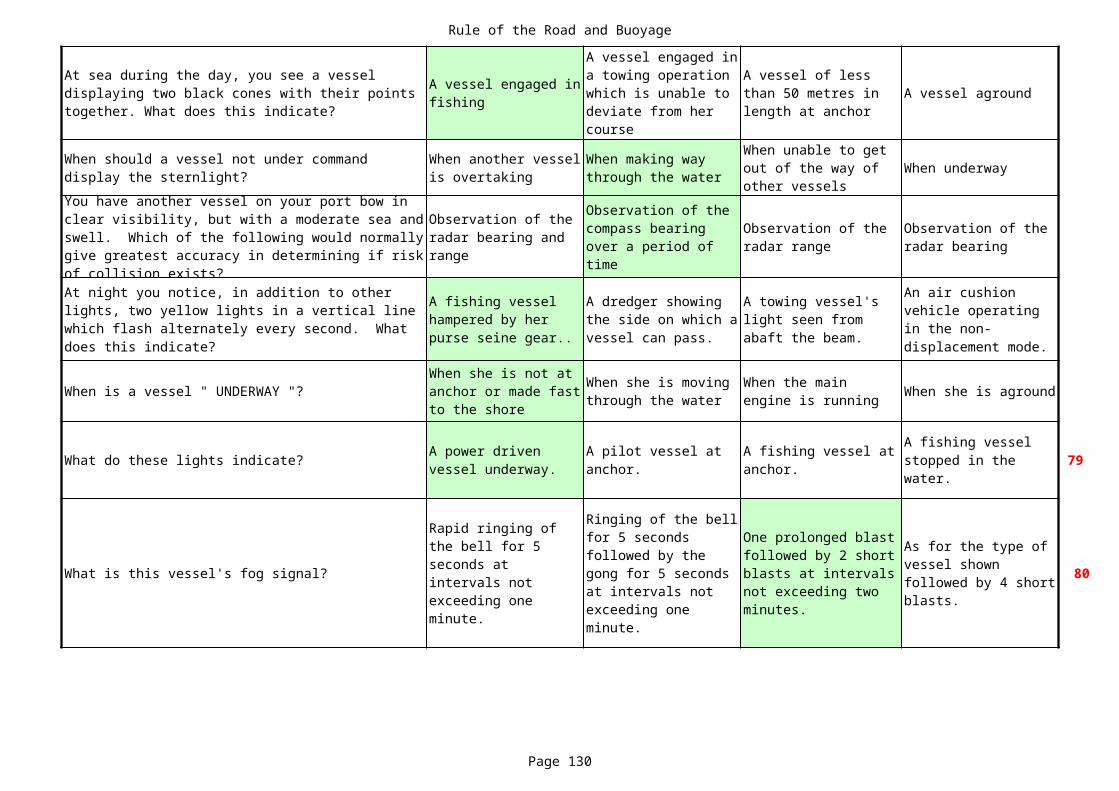
Rule of the Road and Buoyage
Page 130
A vessel aground
When underway
When is a vessel " UNDERWAY "? When she is aground
What do these lights indicate? 79
What is this vessel's fog signal? 80
At sea during the day, you see a vessel displaying two black cones with their points together. What does this indicate?
A vessel engaged in fishing
A vessel engaged in a towing operation which is unable to deviate from her course
A vessel of less than 50 metres in length at anchor
When should a vessel not under command display the sternlight?
When another vessel is overtaking
When making way through the water
When unable to get out of the way of other vessels
You have another vessel on your port bow in clear visibility, but with a moderate sea and swell. Which of the following would normally give greatest accuracy in determining if risk of collision exists?
Observation of the radar bearing and range
Observation of the compass bearing over a period of time
Observation of the radar range
Observation of the radar bearing
At night you notice, in addition to other lights, two yellow lights in a vertical line which flash alternately every second. What does this indicate?
A fishing vessel hampered by her purse seine gear..
A dredger showing the side on which a vessel can pass.
A towing vessel's light seen from abaft the beam.
An air cushion vehicle operating in the non-displacement mode.
When she is not at anchor or made fast to the shore
When she is moving through the water
When the main engine is running
A power driven vessel underway.
A pilot vessel at anchor.
A fishing vessel at anchor.
A fishing vessel stopped in the water.
Rapid ringing of the bell for 5 seconds at intervals not exceeding one minute.
Ringing of the bell for 5 seconds followed by the gong for 5 seconds at intervals not exceeding one minute.
One prolonged blast followed by 2 short blasts at intervals not exceeding two minutes.
As for the type of vessel shown followed by 4 short blasts.

Rule of the Road and Buoyage
Page 131
What type of vessel is shown here? A trawler. A pilot vessel. 81
What type of vessel is shown here? A pilot vessel. 82
83
What type of vessel is shown here? A pilot vessel. 84
A power driven vessel.
A vessel restricted in her ability to manoeuvre.
A power driven vessel.
A vessel restricted in her ability to manoeuvre.
A vessel engaged in towing.
What information is given about the tow shown here?
The tow is 200 metres or more.
The tow is less than 200 metres.
The vessel is hampered by tow - tow less than 200 metres.
The vessel is hampered by tow - tow more than 200 metres.
A vessel restricted in her ability to manoeuvre.
A power driven vessel.
A vessel constrained by draught.
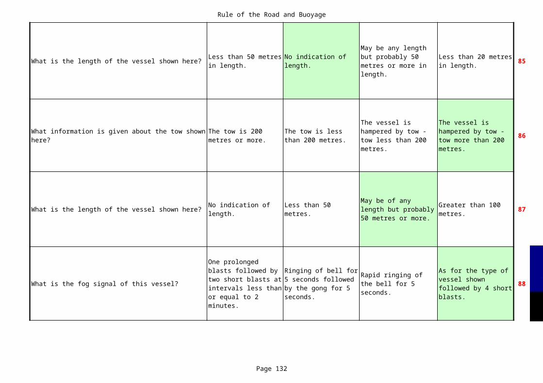
Rule of the Road and Buoyage
Page 132
What is the length of the vessel shown here? 85
86
What is the length of the vessel shown here? 87
What is the fog signal of this vessel? 88
Less than 50 metres in length.
No indication of length.
May be any length but probably 50 metres or more in length.
Less than 20 metres in length.
What information is given about the tow shown here?
The tow is 200 metres or more.
The tow is less than 200 metres.
The vessel is hampered by tow - tow less than 200 metres.
The vessel is hampered by tow - tow more than 200 metres.
No indication of length.
Less than 50 metres.
May be of any length but probably 50 metres or more.
Greater than 100 metres.
One prolonged blasts followed by two short blasts at intervals less than or equal to 2 minutes.
Ringing of bell for 5 seconds followed by the gong for 5 seconds.
Rapid ringing of the bell for 5 seconds.
As for the type of vessel shown followed by 4 short blasts.
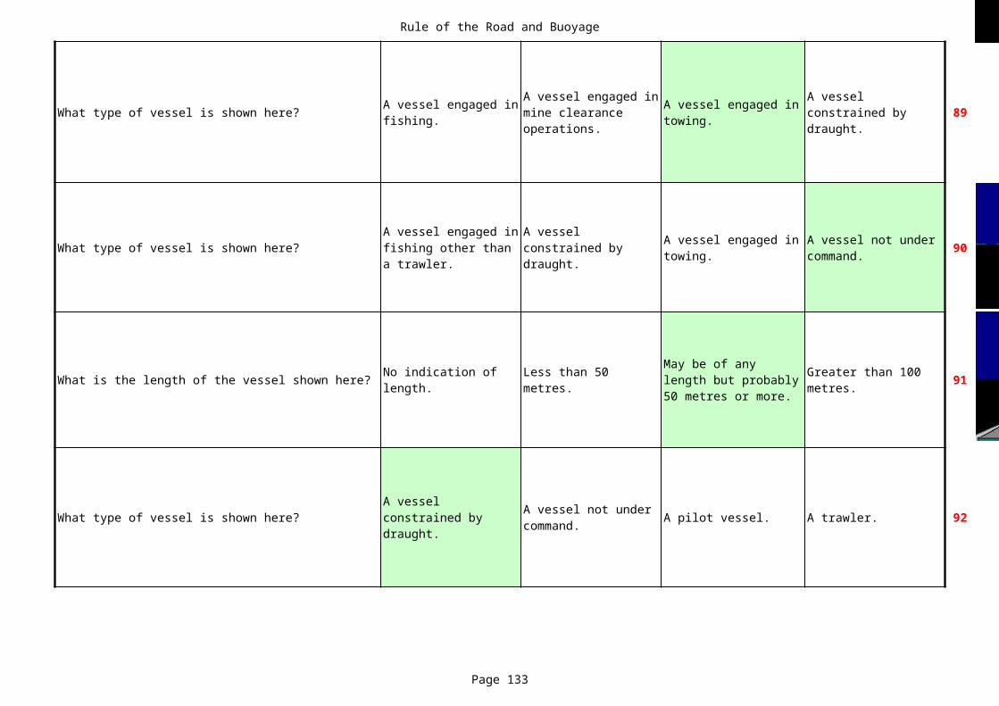
Rule of the Road and Buoyage
Page 133
What type of vessel is shown here? 89
What type of vessel is shown here? 90
What is the length of the vessel shown here? 91
What type of vessel is shown here? A pilot vessel. A trawler. 92
A vessel engaged in fishing.
A vessel engaged in mine clearance operations.
A vessel engaged in towing.
A vessel constrained by draught.
A vessel engaged in fishing other than a trawler.
A vessel constrained by draught.
A vessel engaged in towing.
A vessel not under command.
No indication of length.
Less than 50 metres.
May be of any length but probably 50 metres or more.
Greater than 100 metres.
A vessel constrained by draught.
A vessel not under command.

Rule of the Road and Buoyage
Page 134
What type of vessel is shown here? A pilot vessel. A trawler. 93
What type of vessel is shown here? A trawler. 94
What type of vessel is shown here? A sailing vessel. A vessel at anchor. 95
What type of vessel is shown here? 96
A vessel constrained by draught.
A vessel not under command.
A vessel not under command.
A vessel engaged in fishing other than a trawler.
A vessel constrained by draught.
A vessel engaged in dredging or underwater operations.
A vessel engaged in mine clearance.
A power driven vessel.
A vessel not under command.
A vessel constrained by draught.
A vessel engaged in towing.
Rule of the Road and Buoyage
Page 135
What type of vessel is shown here? 97
What type of vessel is shown here? A trawler. 99
What type of vessel is shown here? 100
101
A power driven vessel.
A vessel not under command.
A vessel constrained by draught.
A vessel engaged in towing.
Vessels as far as possible should avoid anchoring......
in a traffic separation scheme or in areas near it's terminations.
in a traffic separation scheme.
in a traffic separation zone.
near the terminations of a traffic separation scheme.
A vessel not under command.
A vessel engaged in fishing other than a trawler.
A vessel constrained by draught.
A vessel constrained by draught.
A vessel which is aground.
A vessel engaged in fishing.
A vessel engaged in towing.
This vessel sounds one short blast. What does this mean?
I intend to overtake you on your port side.
I am operating stern propulsion.
I am altering my course to starboard.
I am altering my course to port.
Rule of the Road and Buoyage
Page 136
102
103
104
105
You intend overtaking a vessel in a narrow channel and signal your intentions. The vessel ahead sounds 5 short and rapid blasts. What does this mean?
I am operating stern propulsion.
I do not understand your intentions/actions.
I am altering my course to starboard.
I am altering my course to port.
Whilst proceeding along a narrow channel, the vessel astern sounds two prolonged blasts followed by two short blasts. What does this mean?
I am altering my course to starboard.
I am altering my course to port.
I intend to overtake you on your port side.
I intend to overtake you on your starboard side.
This vessel is signaling two flashes at intervals. What is the meaning of this signal?
I am altering my course to port.
I intend to overtake you on your starboard side.
I intend to overtake you on your port side.
I do not understand your intentions / actions.
Whilst proceeding along a narrow channel the vessel astern sounds two prolonged blasts followed by one short blast. What does this mean?
I intend to overtake you on your starboard side.
I intend to overtake you on your port side.
I am operating stern propulsion.
I am altering my course to port.
Rule of the Road and Buoyage
Page 137
106
What does this shape indicate? A vessel at anchor. A vessel aground. 107
What is the length of the vessel shown here? 108
What type of vessel is shown here? 109
The observed vessel sounds three short blasts. What does this mean?
I am altering my course to starboard.
I am altering my course to port.
I do not understand your intentions / actions.
I am operating stern propulsion.
A vessel engaged in fishing.
A vessel engaged in mine clearance operations.
Less than 50 metres in length.
No indication of length.
May be any length but probably 50 metres or more in length.
Less than 20 metres in length.
A vessel engaged in fishing other than a trawler.
A vessel constrained by draught.
A vessel engaged in towing.
A vessel not under command.
Rule of the Road and Buoyage
Page 138
What type of vessel is shown here? 110
What type of vessel is shown here? 111
What type of vessel is shown here? A pilot vessel. 112
What type of vessel is shown here? 113
A vessel engaged in fishing.
A vessel engaged in mine clearance operations.
A vessel engaged in towing.
A vessel constrained by draught.
A power driven vessel.
A vessel not under command.
A vessel constrained by draught.
A vessel engaged in towing.
A vessel restricted in her ability to manoeuvre.
A power driven vessel.
A vessel constrained by draught.
A vessel not under command.
A vessel engaged in towing.
A power driven vessel.
A vessel constrained by draught.
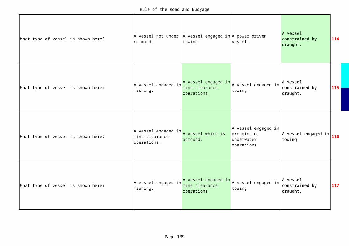
Rule of the Road and Buoyage
Page 139
What type of vessel is shown here? 114
What type of vessel is shown here? 115
What type of vessel is shown here? 116
What type of vessel is shown here? 117
A vessel not under command.
A vessel engaged in towing.
A power driven vessel.
A vessel constrained by draught.
A vessel engaged in fishing.
A vessel engaged in mine clearance operations.
A vessel engaged in towing.
A vessel constrained by draught.
A vessel engaged in mine clearance operations.
A vessel which is aground.
A vessel engaged in dredging or underwater operations.
A vessel engaged in towing.
A vessel engaged in fishing.
A vessel engaged in mine clearance operations.
A vessel engaged in towing.
A vessel constrained by draught.
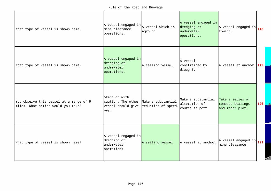
Rule of the Road and Buoyage
Page 140
What type of vessel is shown here? 118
What type of vessel is shown here? A sailing vessel. A vessel at anchor. 119
120
What type of vessel is shown here? A sailing vessel. A vessel at anchor. 121
A vessel engaged in mine clearance operations.
A vessel which is aground.
A vessel engaged in dredging or underwater operations.
A vessel engaged in towing.
A vessel engaged in dredging or underwater operations.
A vessel constrained by draught.
You observe this vessel at a range of 9 miles. What action would you take?
Stand on with caution. The other vessel should give way.
Make a substantial reduction of speed.
Make a substantial alteration of course to port.
Take a series of compass bearings and radar plot.
A vessel engaged in dredging or underwater operations.
A vessel engaged in mine clearance.
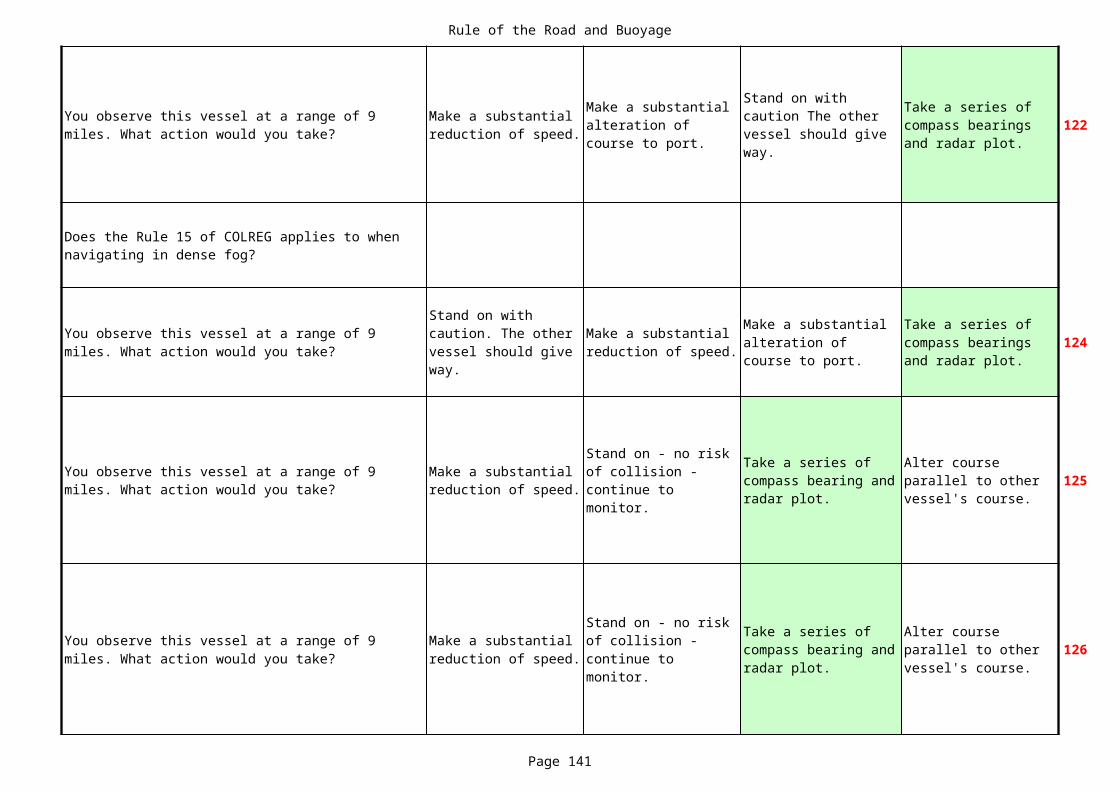
Rule of the Road and Buoyage
Page 141
122
124
125
126
You observe this vessel at a range of 9 miles. What action would you take?
Make a substantial reduction of speed.
Make a substantial alteration of course to port.
Stand on with caution The other vessel should give way.
Take a series of compass bearings and radar plot.
Does the Rule 15 of COLREG applies to when navigating in dense fog?
You observe this vessel at a range of 9 miles. What action would you take?
Stand on with caution. The other vessel should give way.
Make a substantial reduction of speed.
Make a substantial alteration of course to port.
Take a series of compass bearings and radar plot.
You observe this vessel at a range of 9 miles. What action would you take?
Make a substantial reduction of speed.
Stand on - no risk of collision - continue to monitor.
Take a series of compass bearing and radar plot.
Alter course parallel to other vessel's course.
You observe this vessel at a range of 9 miles. What action would you take?
Make a substantial reduction of speed.
Stand on - no risk of collision - continue to monitor.
Take a series of compass bearing and radar plot.
Alter course parallel to other vessel's course.

Rule of the Road and Buoyage
Page 142
127
What type of vessel is shown here? A sailing vessel. A vessel at anchor. 128
129
What is the length of the vessel shown here? 130
You observe this vessel at a range of 9 miles. What action would you take?
Alter course parallel to other vessel's course.
Take a series of compass bearings and radar plot.
Stand on - no risk of collision - continue to monitor.
Make a substantial reduction of speed.
A vessel engaged in dredging or underwater operations.
A vessel constrained by draught.
You observe this vessel at a range of 9 miles. What action would you take?
Make a substantial reduction of speed.
Stand on but continue to monitor.
Take a series of compass bearings and radar plot.
Stand on with caution.
Less than 50 metres in length.
No indication of length.
May be any length but probably 50 metres or more in length.
Less than 20 metres in length.

Rule of the Road and Buoyage
Page 143
131
132
133
134
You observe this vessel at a range of 6 miles. What action would you take?
Make a substantial alteration of course to starboard.
Make a substantial reduction of speed.
Make a substantial alteration of course to port.
Stand on - with caution. The other vessel should give way.
You observe this vessel at a range of 9 miles. What action would you take?
Make a substantial reduction of speed.
Stand on - no risk of collision - continue to monitor.
Take a series of compass bearing and radar plot.
Alter course parallel to other vessel's course.
You observe this vessel at a range of 9 miles. What action would you take?
Alter course to parallel the other vessel's course.
Stand on - no risk of collision - continue to monitor.
Make a substantial reduction of speed.
Stand on with caution. The other vessel should give way.
You observe this vessel at a range of 9 miles. What action would you take?
Make a substantial reduction of speed.
Stand on - no risk of collision - continue to monitor.
Take a series of compass bearing and radar plot.
Alter course parallel to other vessel's course.
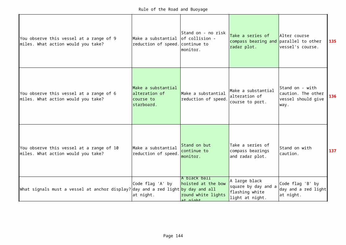
Rule of the Road and Buoyage
Page 144
135
136
137
What signals must a vessel at anchor display?
You observe this vessel at a range of 9 miles. What action would you take?
Make a substantial reduction of speed.
Stand on - no risk of collision - continue to monitor.
Take a series of compass bearing and radar plot.
Alter course parallel to other vessel's course.
You observe this vessel at a range of 6 miles. What action would you take?
Make a substantial alteration of course to starboard.
Make a substantial reduction of speed.
Make a substantial alteration of course to port.
Stand on - with caution. The other vessel should give way.
You observe this vessel at a range of 10 miles. What action would you take?
Make a substantial reduction of speed.
Stand on but continue to monitor.
Take a series of compass bearings and radar plot.
Stand on with caution.
Code flag 'A' by day and a red light at night.
A black ball hoisted at the bow by day and all round white lights at night.
A large black square by day and a flashing white light at night.
Code flag 'B' by day and a red light at night.
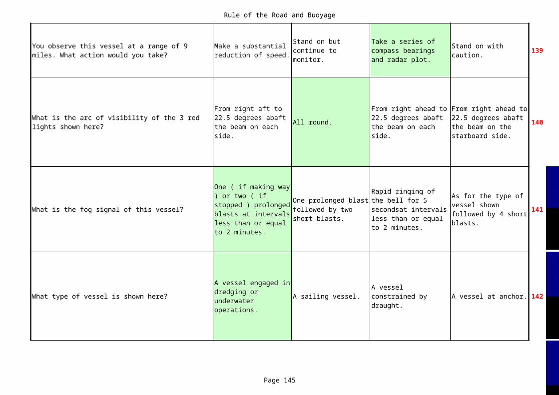
Rule of the Road and Buoyage
Page 145
139
All round. 140
What is the fog signal of this vessel? 141
What type of vessel is shown here? A sailing vessel. A vessel at anchor. 142
You observe this vessel at a range of 9 miles. What action would you take?
Make a substantial reduction of speed.
Stand on but continue to monitor.
Take a series of compass bearings and radar plot.
Stand on with caution.
What is the arc of visibility of the 3 red lights shown here?
From right aft to 22.5 degrees abaft the beam on each side.
From right ahead to 22.5 degrees abaft the beam on each side.
From right ahead to 22.5 degrees abaft the beam on the starboard side.
One ( if making way ) or two ( if stopped ) prolonged blasts at intervals less than or equal to 2 minutes.
One prolonged blast followed by two short blasts.
Rapid ringing of the bell for 5 secondsat intervals less than or equal to 2 minutes.
As for the type of vessel shown followed by 4 short blasts.
A vessel engaged in dredging or underwater operations.
A vessel constrained by draught.
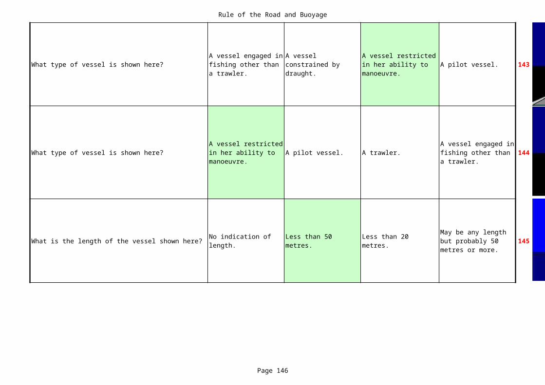
Rule of the Road and Buoyage
Page 146
What type of vessel is shown here? A pilot vessel. 143
What type of vessel is shown here? A pilot vessel. A trawler. 144
What is the length of the vessel shown here? 145
A vessel engaged in fishing other than a trawler.
A vessel constrained by draught.
A vessel restricted in her ability to manoeuvre.
A vessel restricted in her ability to manoeuvre.
A vessel engaged in fishing other than a trawler.
No indication of length.
Less than 50 metres.
Less than 20 metres.
May be any length but probably 50 metres or more.
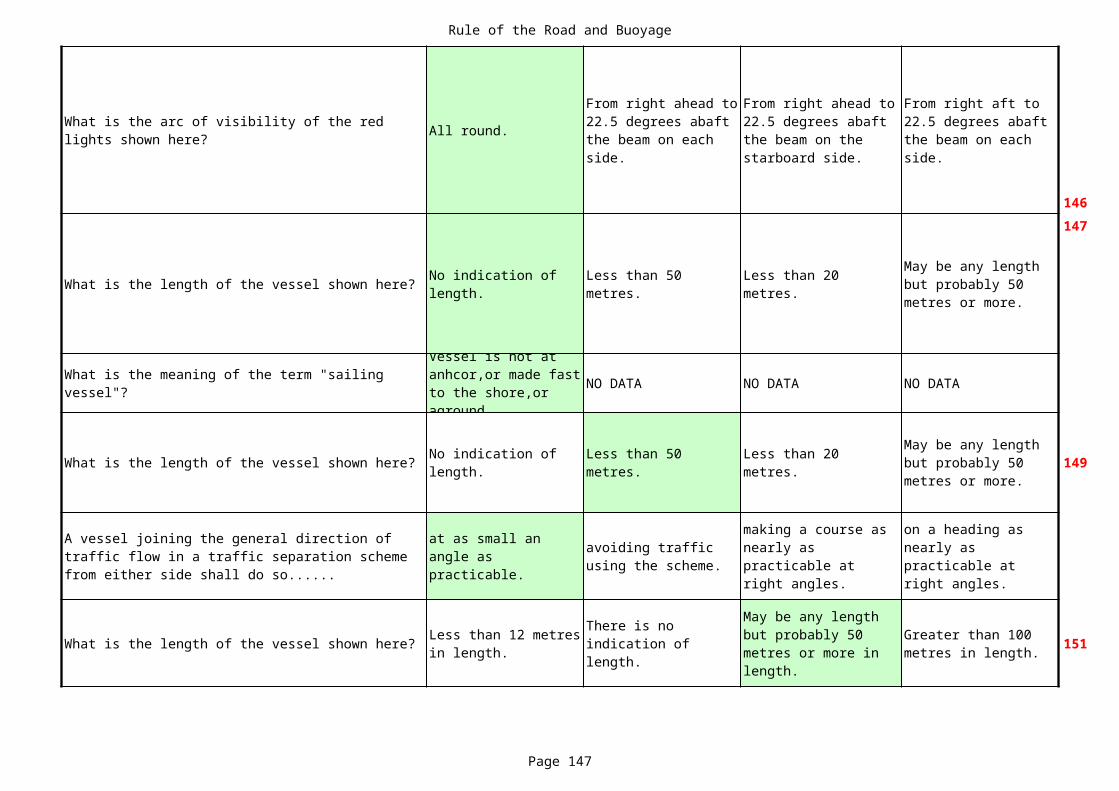
Rule of the Road and Buoyage
Page 147
All round.
146
What is the length of the vessel shown here?
147
NO DATA NO DATA NO DATA
What is the length of the vessel shown here? 149
What is the length of the vessel shown here? 151
What is the arc of visibility of the red lights shown here?
From right ahead to 22.5 degrees abaft the beam on each side.
From right ahead to 22.5 degrees abaft the beam on the starboard side.
From right aft to 22.5 degrees abaft the beam on each side.
No indication of length.
Less than 50 metres.
Less than 20 metres.
May be any length but probably 50 metres or more.
What is the meaning of the term "sailing vessel"?
Vessel is not at anhcor,or made fast to the shore,or aground.
No indication of length.
Less than 50 metres.
Less than 20 metres.
May be any length but probably 50 metres or more.
A vessel joining the general direction of traffic flow in a traffic separation scheme from either side shall do so......
at as small an angle as practicable.
avoiding traffic using the scheme.
making a course as nearly as practicable at right angles.
on a heading as nearly as practicable at right angles.
Less than 12 metres in length.
There is no indication of length.
May be any length but probably 50 metres or more in length.
Greater than 100 metres in length.
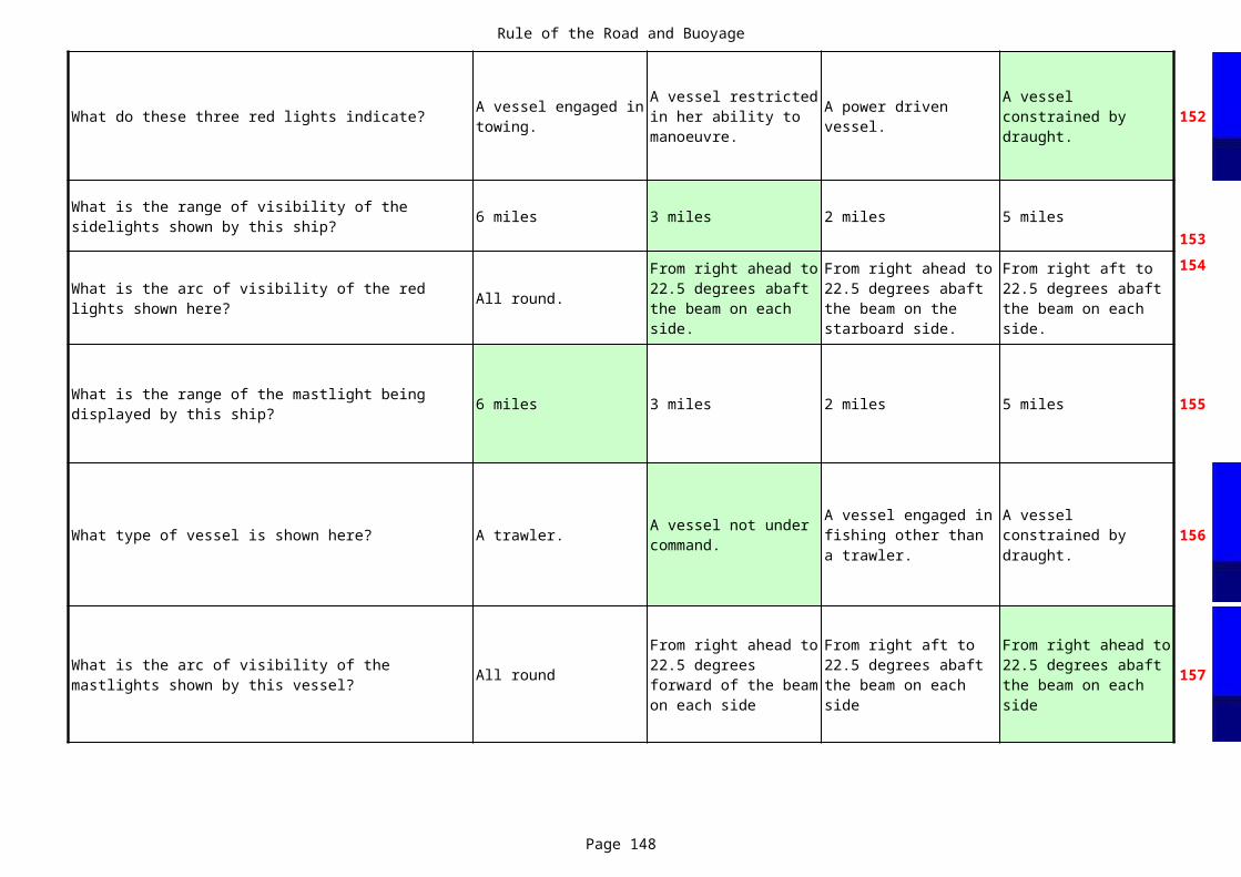
Rule of the Road and Buoyage
Page 148
What do these three red lights indicate? 152
6 miles 3 miles 2 miles 5 miles153
All round.
154
6 miles 3 miles 2 miles 5 miles 155
What type of vessel is shown here? A trawler. 156
All round 157
A vessel engaged in towing.
A vessel restricted in her ability to manoeuvre.
A power driven vessel.
A vessel constrained by draught.
What is the range of visibility of the sidelights shown by this ship?
What is the arc of visibility of the red lights shown here?
From right ahead to 22.5 degrees abaft the beam on each side.
From right ahead to 22.5 degrees abaft the beam on the starboard side.
From right aft to 22.5 degrees abaft the beam on each side.
What is the range of the mastlight being displayed by this ship?
A vessel not under command.
A vessel engaged in fishing other than a trawler.
A vessel constrained by draught.
What is the arc of visibility of the mastlights shown by this vessel?
From right ahead to 22.5 degrees forward of the beam on each side
From right aft to 22.5 degrees abaft the beam on each side
From right ahead to 22.5 degrees abaft the beam on each side

Rule of the Road and Buoyage
Page 149
What type of vessel is shown here?
258
All round.
159
A vessel engaged in fishing other than a trawler.
A vessel constrained by draught.
A vessel engaged in towing.
A vessel not under command.
What is the arc of visibility of the 3 white lights shown here?
From right ahead to 22.5 degrees abaft the beam on the starboard side.
From right ahead to 22.5 degrees abaft the beam on each side.
From right aft to 22.5 degrees abaft the beam on each side.
* * * NOTHING FOLLOWS * * *

Rule of the Road and Buoyage
Page 150

Rule of the Road and Buoyage
Page 151
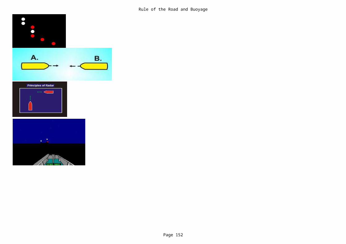
Rule of the Road and Buoyage
Page 152

Rule of the Road and Buoyage
Page 153

Rule of the Road and Buoyage
Page 154

Rule of the Road and Buoyage
Page 155

Rule of the Road and Buoyage
Page 156

Rule of the Road and Buoyage
Page 157

Rule of the Road and Buoyage
Page 158

Rule of the Road and Buoyage
Page 159

Rule of the Road and Buoyage
Page 160

Rule of the Road and Buoyage
Page 161

Rule of the Road and Buoyage
Page 162

Rule of the Road and Buoyage
Page 163

Rule of the Road and Buoyage
Page 164

Rule of the Road and Buoyage
Page 165

Rule of the Road and Buoyage
Page 166

Rule of the Road and Buoyage
Page 167

Rule of the Road and Buoyage
Page 168

Rule of the Road and Buoyage
Page 169

Rule of the Road and Buoyage
Page 170

Rule of the Road and Buoyage
Page 171

Rule of the Road and Buoyage
Page 172

Rule of the Road and Buoyage
Page 173

Rule of the Road and Buoyage
Page 174

Rule of the Road and Buoyage
Page 175
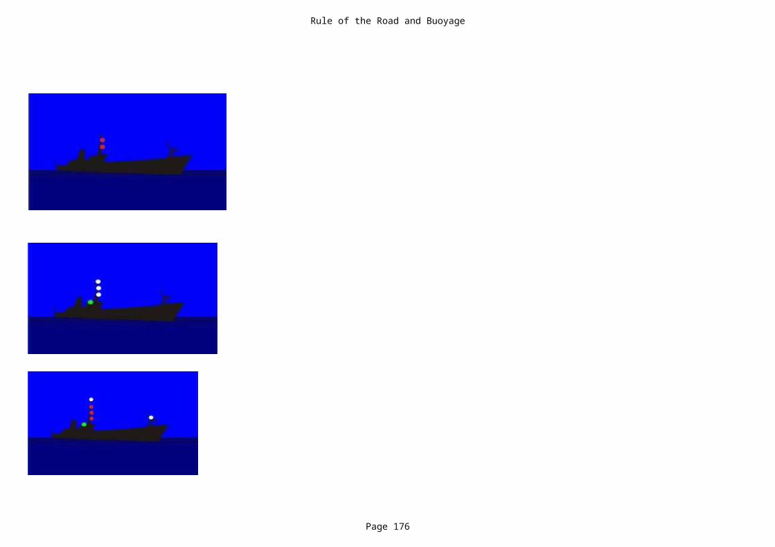
Rule of the Road and Buoyage
Page 176
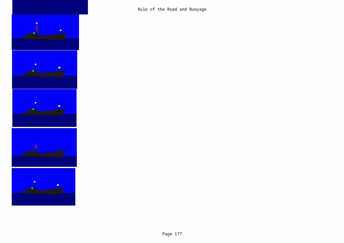
Rule of the Road and Buoyage
Page 177

Rule of the Road and Buoyage
Page 178
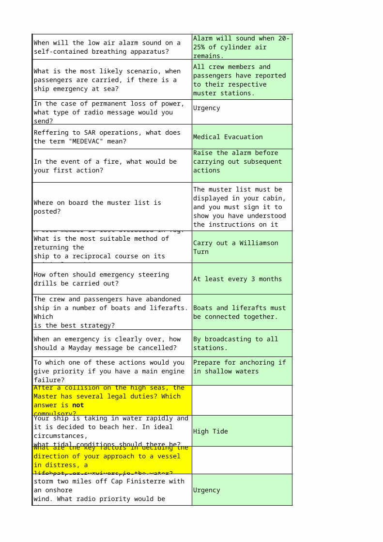
Medical Evacuation
At least every 3 months
High Tide
Urgency
When will the low air alarm sound on a self-contained breathing apparatus?
Alarm will sound when 20-25% of cylinder air remains.
What is the most likely scenario, when passengers are carried, if there is a ship emergency at sea?
All crew members and passengers have reported to their respective muster stations.
In the case of permanent loss of power, what type of radio message would you send?
Urgency
Reffering to SAR operations, what does the term "MEDEVAC" mean?
In the event of a fire, what would be your first action?
Raise the alarm before carrying out subsequent actions
Where on board the muster list is posted?
The muster list must be displayed in your cabin, and you must sign it to show you have understood the instructions on it
A crew member is lost overboard in fog. What is the most suitable method of returning theship to a reciprocal course on its original track?
Carry out a Williamson Turn
How often should emergency steering drills be carried out?
The crew and passengers have abandoned ship in a number of boats and liferafts. Whichis the best strategy?
Boats and liferafts must be connected together.
When an emergency is clearly over, how should a Mayday message be cancelled?
By broadcasting to all stations.
To which one of these actions would you give priority if you have a main engine failure?
Prepare for anchoring if in shallow waters
After a collision on the high seas, the Master has several legal duties? Which answer is notcompulsory?Your ship is taking in water rapidly and it is decided to beach her. In ideal circumstances,what tidal conditions should there be?What are the key factors in deciding the direction of your approach to a vessel in distress, alifeboat, or survivors in the water?Your propeller has dropped off in a storm two miles off Cap Finisterre with an onshorewind. What radio priority would be chosen?
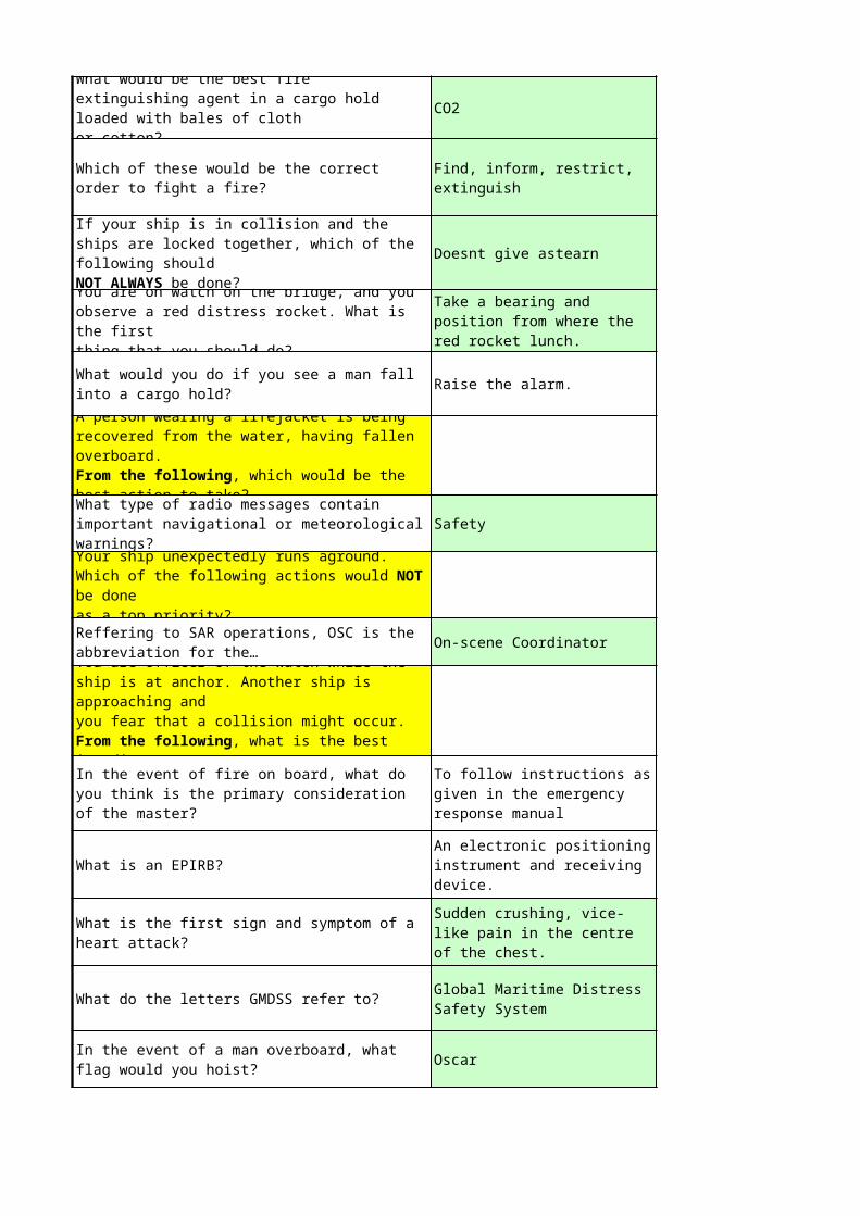
CO2
Doesnt give astearn
Raise the alarm.
Safety
On-scene Coordinator
What is an EPIRB?
What do the letters GMDSS refer to?
Oscar
What would be the best fire extinguishing agent in a cargo hold loaded with bales of clothor cotton?
Which of these would be the correct order to fight a fire?
Find, inform, restrict, extinguish
If your ship is in collision and the ships are locked together, which of the following shouldNOT ALWAYS be done?You are on watch on the bridge, and you observe a red distress rocket. What is the firstthing that you should do?
Take a bearing and position from where the red rocket lunch.
What would you do if you see a man fall into a cargo hold?A person wearing a lifejacket is being recovered from the water, having fallen overboard.From the following, which would be the best action to take?What type of radio messages contain important navigational or meteorological warnings?Your ship unexpectedly runs aground. Which of the following actions would NOT be doneas a top priority?Reffering to SAR operations, OSC is the abbreviation for the…You are officer of the watch while the ship is at anchor. Another ship is approaching andyou fear that a collision might occur. From the following, what is the best immediateIn the event of fire on board, what do you think is the primary consideration of the master?
To follow instructions as given in the emergency response manual
An electronic positioning instrument and receiving device.
What is the first sign and symptom of a heart attack?
Sudden crushing, vice-like pain in the centre of the chest.
Global Maritime Distress Safety System
In the event of a man overboard, what flag would you hoist?
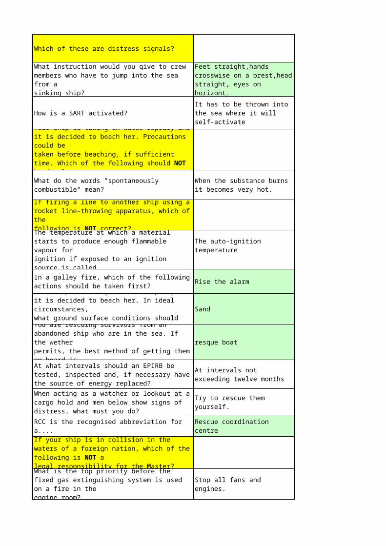
Which of these are distress signals?
How is a SART activated?
Rise the alarm
Sand
resque boat
What instruction would you give to crew members who have to jump into the sea from asinking ship?
Feet straight,hands crosswise on a brest,head straight, eyes on horizont.It has to be thrown into the sea where it will self-activate
Your ship is taking in water rapidly and it is decided to beach her. Precautions could betaken before beaching, if sufficient time. Which of the following should NOT be done?What do the words "spontaneously combustible" mean?
When the substance burns it becomes very hot.
If firing a line to another ship using a rocket line-throwing apparatus, which of thefollowing is NOT correct?The temperature at which a material starts to produce enough flammable vapour forignition if exposed to an ignition source is called....
The auto-ignition temperature
In a galley fire, which of the following actions should be taken first?Your ship is taking in water rapidly and it is decided to beach her. In ideal circumstances,what ground surface conditions should there be?You are rescuing survivors from an abandoned ship who are in the sea. If the wetherpermits, the best method of getting them on board is…At what intervals should an EPIRB be tested, inspected and, if necessary have the source of energy replaced?
At intervals not exceeding twelve months
When acting as a watcher or lookout at a cargo hold and men below show signs of distress, what must you do?
Try to rescue them yourself.
RCC is the recognised abbreviation for a....
Rescue coordination centre
If your ship is in collision in the waters of a foreign nation, which of the following is NOT alegal responsibility for the Master?What is the top priority before the fixed gas extinguishing system is used on a fire in theengine room?
Stop all fans and engines.
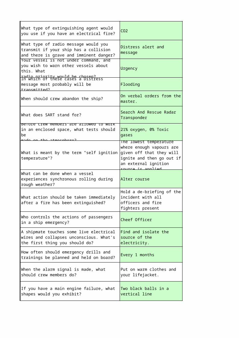
CO2
Urgency
Flooding
When should crew abandon the ship?
What does SART stand for?
Alter course
Cheef Officer
Every 1 months
What type of extinguishing agent would you use if you have an electrical fire?
What type of radio message would you transmit if your ship has a collision and there is grave and imminent danger?
Distress alert and message
Your vessel is not under command, and you wish to warn other vessels about this. Whatradio priority would be chosen?In which of these cases a Distress message most probably will be transmitted?
On verbal orders from the master.
Search And Rescue Radar Transponder
Before crew members are allowed to work in an enclosed space, what tests should bemade on the atmosphere?
21% oxygen, 0% Toxic gases
What is meant by the term "self ignition temperature"?
The lowest temperature where enough vapours are given off that they will ignite and then go out if an external ignition source is applied.
What can be done when a vessel experiences synchronous rolling during rough weather?
What action should be taken immediately after a fire has been extinguished?
Hold a de-briefing of the incident with all officers and fire fighters present
Who controls the actions of passengers in a ship emergency?
A shipmate touches some live electrical wires and collapses unconscious. What's the first thing you should do?
Find and isolate the source of the electricity.
How often should emergency drills and trainings be planned and held on board?
When the alarm signal is made, what should crew members do?
Put on warm clothes and your lifejacket.
If you have a main engine failure, what shapes would you exhibit?
Two black balls in a vertical line

Your ship is in heavy weather and you have to abandon ship. If oil is to be used to provide calmer water for launching survival craft,which is the best?If you were at the entrance to an enclosed space and you lost communication with a crewmember inside, what should you do?
Wait for a few minutes in case the crewmember is busy.
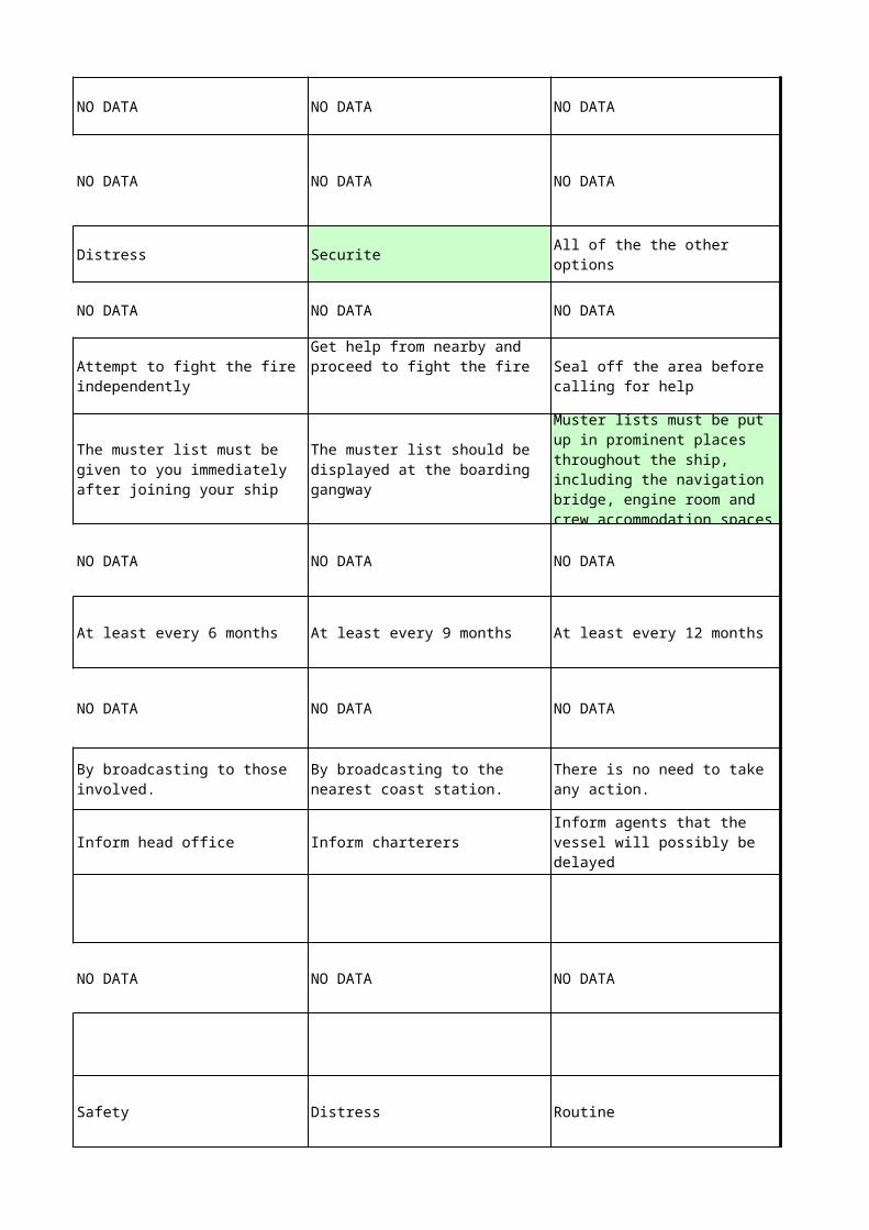
NO DATA NO DATA NO DATA
NO DATA NO DATA NO DATA
Distress Securite
NO DATA NO DATA NO DATA
NO DATA NO DATA NO DATA
At least every 6 months At least every 9 months At least every 12 months
NO DATA NO DATA NO DATA
Inform head office Inform charterers
NO DATA NO DATA NO DATA
Safety Distress Routine
All of the the other options
Attempt to fight the fire independently
Get help from nearby and proceed to fight the fire Seal off the area before
calling for help
The muster list must be given to you immediately after joining your ship
The muster list should be displayed at the boarding gangway
Muster lists must be put up in prominent places throughout the ship, including the navigation bridge, engine room and crew accommodation spaces
By broadcasting to those involved.
By broadcasting to the nearest coast station.
There is no need to take any action.
Inform agents that the vessel will possibly be delayed
NO DATA NO DATA NO DATA
NO DATA NO DATA NO DATA
NO DATA NO DATA NO DATA
Get the first aid kit. Get a stretcher and rope.
Urgency Distress All of the other options
NO DATA NO DATA NO DATA
The safety of the crew To save the ship
Frothing at the mouth. Strong and painful pulse.
NO DATA NO DATA NO DATA
NO DATA NO DATA NO DATA
Find, restrict, inform, extinguish
Find, restrict, extinguish, inform
Find, extinguish, inform, restrict
Go to the man and try to assist as much as possible.
To liaise with the head office and shore authorities
A- smoke generator used to indicate the position of a ship or boat in distress.
An electronic emergency position-indicating radio beacon.
An emergency receiving beacon.
Skin may be red and loss of movements in the right arm may occur.
Securite
The melting point The flashpoint The ignition temperature
NO DATA NO DATA NO DATA
NO DATA NO DATA NO DATA
NO DATA NO DATA NO DATA
NO DATA NO DATA NO DATA
Close down boilers. Close all openings.
It has to be switched on by the Master when the order to abandon ship is given
It will be activated by the nearest coast station
It is carried into the survival craft and switched on by the occupants
The substance is very difficult to set alight, even when it is very hot.
When this substance burns it burns completely and does not leave any residue or ash.
At intervals not exceeding six months
At intervals not exceeding three months
At the weekly mustering and boat drills
Lower additional breathing equipment.
Raise the alarm immediately.
Don a B.A. set and enter the space.
Make sure that the compartment has been evacuated.
Foam Soda acid Steam
Urgency message Safety message Distress relay
Distress Routine Safety
Steering failure Main engine failure Electrical failure
NO DATA NO DATA NO DATA
NO DATA NO DATA NO DATA
Alter speed Maintain course and speed
NO DATA NO DATA NO DATA
NO DATA NO DATA NO DATA
A cylinder Ball- diamond- ball Single diamond
On hearing the general emergency alarm signal..
When one feels there is a threat to the ship.
On orders from the owners.
The lowest temperature where enough vapours are given off that they will ignite and keep burning if an external ignition source is applied.
The lowest temperature where the vapours given off will automatically ignite without the presence of an external ignition source.
The lowest temperature that a liquid will start giving off vapours.
Lower the GM of the vessel
Establish a continuous watch at the fire area against re-ignition and remove any smouldering material
Report the incident to the vessel operator and flag state authorities
Write a non-conformance report in compliance with chapter 9 of the International Safety Management Code
Put rubber soled shoes on your feet.
Immediately check for signs of breathing and a pulse.
Dampen the victim with a wet towel.
Ignore the signal unless you have been told there will be a drill.
Telephone the bridge for advice.
Report to your muster station.

Put on a BA set and enter the enclosed space.
Holding your breath, enter the enclosed space to see if you can spot the crewman.
Raise the alarm with the bridge or other officers in the area.
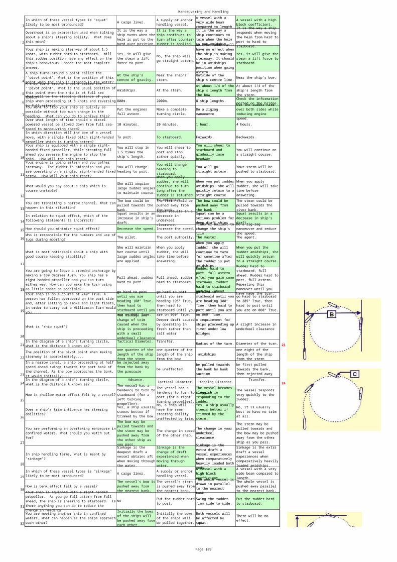
Manoeuvering and Handling
Page 189
1A cargo liner.
2
3
4Near the ship's bow.
5Amidships. At the stern.
6 800m. 2000m. 8 ship lengths.
7
810 minutes. 20 minutes. 1 hour. 4 hours.
9To port. To starboard. Forwards. Backwards.
10
11
12
13
14
15 How should you minimize squat effect? Decrease the speed. Increase the speed.
16 The pilot. The port authority. The master. The agent.
17
18
19
20
What is "ship squat"?
21 Radius of the turn. Diameter of the turn. 21
22 amidships
23be unaffected
24 Tactical Diameter. Stopping Distance. 24
25How is shallow water effect felt by a vessel?
26
27
28
29A cargo liner.
30How is bank effect felt by a vessel?
31No.
32
In which of these vessel types is "squat" likely to be most pronounced?
A supply or anchor handling vessel.
A vessel with a very wide beam compared to length.
A vessel with a high block coefficient.
Overshoot is an expression used when talking about a ship's steering ability. What does this mean?
It is the way a ship turns when the helm is put to the hard over position.
It is the way a ship continues to turn after counter-rudder is applied.
It is the way a ship continues to turn when the helm is put amidship.
It is the way a ship responds when moving the helm from hard to port to hard to starboard.
Your ship is making sternway of about 1.5 knots, with rudder hard to starboard. Will this rudder position have any effect on the ship's behaviour? Choose the most complete answer.
Yes, it will give the stern a lift force to port.
No, the ship will go straight astern.
No, the rudder will have no effect when the ship is making sternway. It should be in amidships position when going astern.
Yes, it will give the stern a lift force to starboard.
A ship turns around a point called the ''pivot point". What is the position of this point when the ship is stopped in the water?
At the ship's centre of gravity.
Near the ship's stern.
Outside of the ship's centre line.
A ship turns around a point called the ''pivot point". What is the usual position of this point when the ship is at full sea speed?
At about 1/4 of the ship's length from the bow.
At about 1/4 of the ship's length from the stern.What will be the stopping distance of your
ship when proceeding at 8 knots and reversing to full astern?
Check the information posted on the bridge.
You want to stop your ship as quickly as possible without too much change in the heading. What can you do to achieve this?
Put the engines full astern.
Make a complete turning circle.
Do a zigzag manoeuvre.
Use the rudder hard over both sides while reducing engine speed.Over what length of time should a diesel
powered vessel be slowed down from full sea-speed to manoeuvring speed?In which direction will the bow of a vessel move, with a single fixed pitch right-handed propeller which is turning astern? Your ship is equipped with a single right-handed fixed propeller. While steaming full ahead you reverse the engine to stop the ship. How will the ship react?
You will stop in 1.5 times the ship's length.
You will sheer to port and stop rather quickly.
You will sheer to starboard and gradually lose headway.
You will continue on a straight course.
Your engine is going astern and you gather sternway. The rudder is amidships and you are operating on a single, right-handed fixed screw. How will your ship react?
You will change heading to port.
You will change heading to starboard.
You will go straight astern.
Your stern will be pushed to starboard.
What would you say about a ship which is course unstable?
She will require large rudder angles to maintain course.
When you apply rudder, she will continue to turn long after the rudder is returned to amidships.
When you put rudder amidships, she will quickly return to a straight course.
When you apply rudder, she will take time before answering.
You are transiting a narrow channel. What can happen in this situation?
The bow could be pulled towards the bank.
The stern could be pushed away from the bank.
The bow could be pushed away from the bank.
The stern could be pulled towards the river bank.
In relation to squat effect, which of the following statements is incorrect?
Squat results in an increase in ship's draft.
Squat results in a decrease in underkeel clearance.
Squat can be a serious problem for deep draft ships.
Squat results in a decrease in ship's draft.Transfer ballast to
change the ship's trim.
Do a zig-zag manoeuvre and reduce the speed.Who is responsible for the numbers and use of
tugs during mooring?
What is most noticeable about a ship with good course keeping stability?
She will maintain her course until large rudder angles are applied.
When you apply rudder, she will take time before answering.
When you apply rudder, she will continue to turn for sometime after the rudder is put amidships.
When you put the rudder amidships, she will quickly return to a straight course.
You are going to leave a crowded anchorage by making a 180 degrees turn. You ship has a right handed propeller and you can turn either way. How can you make the turn using as little space as possible?
Full ahead, rudder hard to port.
Full ahead, rudder hard to starboard.
Rudder hard to port, full astern. After you gain some sternway, rudder hard to starboard and full ahead.
Rudder hard to starboard, full ahead. Rudder hard to port, full astern. Repeating this maneuver until you have made the turn.Your ship is on a course of 240° True. A
person has fallen overboard on the port side and, after letting go smoke and light floats, in order to carry out a Williamson Turn would you.....
go hard to port until you are heading 180° True, then hard to starboard until you are on 060° True.
go hard to port until you are heading 195° True, then hard to starboard until you are on 060° True.
go hard to starboard until you are heading 300° True, then hard to port until you are on 060° True.
go hard to starboard to 285° True, then hard to port until you are on 060° True.
The sinkage and change of trim caused when the ship is proceeding with a small underkeel clearance
Deeper draft caused by operating in fresh rather than salt water
A requirement for ships proceeding up river under low bridges
A slight increase in underkeel clearance
In the diagram of a ship's turning circle, what is the distance B known as?
Tactical Diameter. Transfer.
The position of the pivot point when making sternway is approximately....
one quarter of the length of the ship from the stern
one quarter of the length of the ship from the bow
one eight of the length of the ship from the stern
In a narrow canal, a ship proceeding at half speed ahead swings towards the port bank of the channel. As the bow approaches the bank, it would initially....
be rejected away from the bank by the pressure
be pulled towards the bank by bank suction
be first pulled towards the bank, then rejected away
In the diagram of a ship's turning circle, what is the distance A known as?
Advance. Transfer.The vessel has a tendency to turn to starboard (for a left turning propeller).
The vessel has a tendency to turn to port (for a right turning propeller).
The vessel becomes sluggish in responding to the rudder.
The vessel responds very quickly to the rudder.
Does a ship's trim influence her steering abilities?
Yes, a ship usually steers better if trimmed by the bow.
No, a ship will have the same steering ability unaffected by trim.
Yes, a ship usually steers better if trimmed by the stern.
No, it is usually best to have no trim at all.
You are performing an overtaking manoeuvre in confined waters. What should you watch out for?
The bow may be pulled towards and the stern may be pushed away from the other ship as you pass.
The change in speed of the other ship.
The change in your underkeel clearance.
The stern may be pulled towards and the bow may be pushed away from the other ship as you pass.
In ship handling terms, what is meant by "sinkage"?
Sinkage is the deepest draft a vessel obtains aft when moving through the water.
Sinkage is the change of draft experienced when moving through water.
Sinkage is the extra draft a vessel experiences when comparatively heavily loaded both ends.
Sinkage is the extra draft a vessel experiences when comparatively heavily loaded amidships.
In which of these vessel types is "sinkage" likely to be most pronounced?
A supply or anchor handling vessel.
A vessel with a high block coefficient.
A vessel with a very wide beam compared to length.
The vessel's bow is pushed away from the nearest bank.
The vessel's stern is pushed away from the nearest bank.
The whole vessel is drawn in parallel to the nearest bank.
The whole vessel is pushed away parallel to the nearest bank.Your ship is equipped with a right handed
propeller. As you go full astern from full ahead, the ship is sheering to starboard. Is there anything you can do to reduce the change in heading?
Put the rudder hard to port.
Swing the rudder from side to side.
Put the rudder hard to starboard.
You are meeting another ship in confined waters. What can happen as the ships approach each other?
Initially the bows of the ships will be pushed away from each other.
Initially the bows of the ships will be pulled together.
Both vessels will be affected by squat.
There will be no effect.
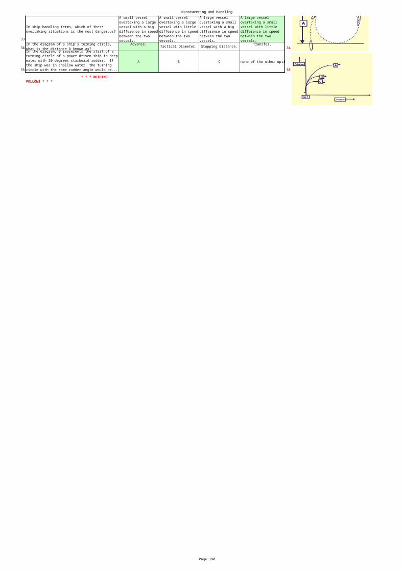
Manoeuvering and Handling
Page 190
33
34 Tactical Diameter. Stopping Distance. 34
35
A B C none of the other opti
35
In ship handling terms, which of these overtaking situations is the most dangerous?
A small vessel overtaking a large vessel with a big difference in speed between the two vessels.
A small vessel overtaking a large vessel with little difference in speed between the two vessels.
A large vessel overtaking a small vessel with a big difference in speed between the two vessels.
A large vessel overtaking a small vessel with little difference in speed between the two vessels.
In the diagram of a ship's turning circle, what is the distance A known as?
Advance. Transfer.
In the diagram, B represents the start of a turning circle of a power driven ship in deep water with 20 degrees starboard rudder. If the ship was in shallow water, the turning circle with the same rudder angle would be...
* * * NOTHING FOLLOWS * * *
Radar
Page 191
Attenuation is likely to cause .... 1
Radar Manual Vol. 2 2
rain. fog. hail. snow.3
the sides of waves.4
The radar transceiver must be .... 5
6
shadow or blind sectors.
multiple target echoes.
reduced detection ranges.
increased detection ranges.
The requirements for using radar for collision avoidance are described in....
Marine Orders Part 21
Admiralty List of Radio Signals
International Regulations for Prevention of Collisions at Sea
Clutter echoes are not usually caused by ....
Sea clutter is caused by reflections from ....
small craft and buoys.
the blank surface of the sea.
areas of precipitation.
at a safe distance from the magnetic compass.
as close to the power supplies as possible.
on the fore-and-aft line of the vessel.
directly underneath the scanner.
If possible the radar display should be sited ....
as close as possible to the compass.
as far forward as possible in the ship.
so it can be viewed facing forward.
so that it is on the fore-and-aft line.
Radar
Page 192
Attenuation is likely to cause .... 1shadow or blind sectors.
multiple target echoes.
reduced detection ranges.
increased detection ranges.
Sub-refraction commonly occurs where.... 7
The magnetron is sited in the .... display unit. scanner unit. transceiver unit. power supply unit. 8
9
1011
a cold air layer lies over a warm sea surface
upper air disturbances are common
strong wintrer gales are common
a warm air layer lies over a cold sea surface
Second trace echoes appear on the radar display at....
correct ranges and bearings
false ranges and bearings
false bearings at the correct range
false ranges on the correct bearing
An operational check you should carry out when a radar set is installed is to ....
check the accuracy of the heading marker.
measure the duration of pulse length.
check the adjustment of the parallel index.
measure the frequency of the magnetron.
An operation check required on installation is to....
determine the length of waveguide
determine the limits of shadow sectors
measure the frequency of the local oscillator
measure the peak power output
Radar
Page 193
Attenuation is likely to cause .... 1shadow or blind sectors.
multiple target echoes.
reduced detection ranges.
increased detection ranges.
A radar log should record.... 12
13
operator's manual ship's log radar log safety manual 14
15
a listing of radar aids to navigation
the procedure for regular maintenance routines
the details of repairs and services carried out
the details of ships' power supplies
Sea clutter echoes appear on the radar screen as....
a group of echoes within a shadow sector
a mass of small echoes with an irregular shape
a group of echoes at a constant range
a mass of small echoes around the screen centre
Radar maintenance should be carried out in accordance with procedures in the....
The bright spot which forms the trace or timebase moves across the radar screen at a speed equivalent to......
half the speed of the radar waves.
the speed of the radar waves.
a continuously variable speed.
twice the speed of the radar waves.

Radar
Page 194
Attenuation is likely to cause .... 1shadow or blind sectors.
multiple target echoes.
reduced detection ranges.
increased detection ranges.
16
Multiple radar echoes are caused by.... 17
18
19
20
Second trace echoes are more likely to occur when ....
a low P.R.F. is used..
a high P.R.F. is used.
a short pulse length is used.
a long pulse length is used.
reflections from the surface of the sea
reflections from the side lobes of the radar beam
reflection from an obstruction on your own ship
reflection between own ship and a large close target
Side echoes appear on the radar display as.....
a symmetrical arc of echoes.
echoes in shadow sectors.
lines radiating from the centre.
a line of echoes on one bearing.
When side echoes are displayed, the true target echo will appear.....
closer than the false echoes.
farther than the false echoes.
at the centre of the pattern.
at the edge of the pattern.
Indirect echoes are caused by reflections from.....
targets on the beam.
targets directly ahead.
the surface of the sea.
obstructions close to the scanner.

Radar
Page 195
Attenuation is likely to cause .... 1shadow or blind sectors.
multiple target echoes.
reduced detection ranges.
increased detection ranges.
Indirect echoes appear on the display.... 21
Multiple echoes appear on the screen.... 22
Sub-refraction is likely to result in.... 23
24
25
on the true bearing, but at a false range
on the true range, but on a false bearing
on the true range and bearing
on a false range and bearing
on the correct bearing but half the true range
on the correct range but a false bearing
on the correct bearing at double the true range
on a false bearing and range
increased target detection ranges
reduced target detection ranges
inaccurate detection range
no effect on detection ranges
The most common cause of radar interference is....
other radar transmissions on a similar frequency
electromagnetic storms or disturbances
defective electrical equipment on the ship experiencing interference
the power of radar transmissions from your own ship
Under Rule 5; the radar should be used for keeping a proper lookout....
during night-time hours
when the background lights obscure visibility
when the radio is unserviceable
whenever it may help

Radar
Page 196
Attenuation is likely to cause .... 1shadow or blind sectors.
multiple target echoes.
reduced detection ranges.
increased detection ranges.
26
The cause of shadow or blind sectors is.... 27
Super-refraction is most likely to cause....28
Super-refraction is normally caused by.... strong winds29
bent upwards30
Ducting of the radar beam is caused by....31
If your radar suffers from shadow sectors you should....
warn approaching vessels in fog
determine and record their limits
consult your operator's manual
report the fact to your marine authority
electromagnetic interference
obstructions on your own ship
rough weather conditions
side lobes of the radar beam
increased target detection ranges
decreased target detection ranges
inaccurates in detection range
no effect on detection ranges
warm air over cool sea surface
disturbances in the upper atmosphare
cool air over a warm sea surface
When ducting occurs, the radar beam is.... carried for long distances
affected by the duration of daylight
affected by sunspot activity
extreme sub-refraction conditions
extreme super-refraction conditions
mild sub-refraction conditions
mild super-refraction conditions
Radar
Page 197
Attenuation is likely to cause .... 1shadow or blind sectors.
multiple target echoes.
reduced detection ranges.
increased detection ranges.
along a curved line on a false bearing 32
true motion relative motion fixed play centre 33
Clutter echoes are often caused by.... dust storms sand storms smoke and haze rain 34
a sloping foreshore a large headland3536
relative motion 37
Multiple echoes can be recognised because they appear....
at constant range intervals
around the arc of a circle
A radar presentation feature which is useful in radar pilotage is....
radar shadow sector determination
The best land target to use for a radar bearing is....
a small isolated feature
a coastal indentation
When choosing objects for position fixing by radar ranges you should, if possible, avoid....
sloping land features
large prominent features
steep faced features
small isolated features
A radar presentation feature which can often be used to advantage for position fixing is....
beamwidth distortion
an off-centred display
an unstabilised presentation
Radar
Page 198
Attenuation is likely to cause .... 1shadow or blind sectors.
multiple target echoes.
reduced detection ranges.
increased detection ranges.
low accuracy NO DATA NO DATA NO DATA 38
39
cross indexing parallel indexing 40
41
42
Low and sandy beaches should be avoided if possible when position fixing by radar because of....
The use of radar ranges in preference to radar bearings for position fixing is because....
they are more accurate
they are quicker to take
they are easier to take
suitable targets are easier to find
The technique used in radar pilotage for continuously monitoring a vessel's position is called....
presentation stabilization
presentation unstabilisation
The preferred method of radar position fixing for greatest accuracy is....
taking several radar ranges
taking several radar bearings
taking a radar range and radar bearing
taking a radar range and visual bearing
When using the radar for coastal position fixing the main concern is to....
obtain the most accurate fix
avoid radar interference
allow for beamwidth distortion
avoid radar shadow effect
Radar
Page 199
Attenuation is likely to cause .... 1shadow or blind sectors.
multiple target echoes.
reduced detection ranges.
increased detection ranges.
43
The signal from a racon.... 44
The principle of a racon is that it....
45
Less than 0.9 mile Between 4-5 miles Between 1-2 miles 47
48
On a radar display, the return from a racon....
gives a distinctive echo on the display
is transmitted continuously
cannot be seen in a clutter area
cannot be seen during hours of darkness
enables the beacon to be identified
does not provide identification
only provides range data
only provides bearing data
transmits continuously on X band
transmits at fixed time intervals
transmits when activated by an operator
transmits on receipt of ship's radar pulse
Radar reflectors are fitted to some buoys and small craft in order to....
avoid mutual radar preference
obtain more accurate ranges
make them better radar targets
provide positive identification
What is the closest point of approach of target A ?
Between 3-3.9 miles
The technique of parallel indexing is usually used when navigating.....
a selsyn generator on the scanner
transistors in parallel in the transceiver
a rotatable mask mounted on the display and marked with parallel lines
a T/R cell in the waveguide

Radar
Page 200
Attenuation is likely to cause .... 1shadow or blind sectors.
multiple target echoes.
reduced detection ranges.
increased detection ranges.
A basic radar plot can be used to .... 49
5051
5253
54
an edge of land a small rock a low-lying point a cliff face 55
determine the effect of own ship proposed avoiding action.
obtain the rate of change of aspect.
indicate target's most likely action.
estimate the speed of target.
A vessel fitted with an operational radar must use it under Rule 6 to....
assess the course and speed of other vessels
identify itself to approaching vessels
ensure compliance with traffic separation schemes
help determine safe speed in prevailing conditions
Under Rule 7, proper use of radar to determine risk of collision includes....
use of true motion to determine target movement
correct use of anti-clutter controls
short range scanning for small targets
radar plotting or equivalent systematic observation
In restricted visibility, risk of collision can best be assessed by....
posting additional lookouts
watching the target's radar bearing and range
establishing radio communication with the target
listening for the target's sound signals
Under Rule 19, if you get into a close quarters situation with a vessel forward of the beam in restricted visibility, you must....
reverse your engine until all way is lost
post a forward lookout
activate a second radar, if fitted
navigate with caution until danger of collision is over
Rule 19 says that, if you detect another vessel by radar alone, you must....
determine if risk of collision exists
switch to manual steering
continue to observe the other vessel
maintain a steady course and speed
The best land target to use for radar ranging is....
Radar
Page 201
Attenuation is likely to cause .... 1shadow or blind sectors.
multiple target echoes.
reduced detection ranges.
increased detection ranges.
56
57
An A.R.P.A. is an....
59
radar tables collision rules ship's data book radar plot 60
A true motion radar display shows.... 51
To establish additional target data other than the Closest Point of Approach on a relative plot, you must ....
draw a relative velocity triangle.
plot your own future track.
extend the target's relative track.
draw a line perpendicular to the target's track.
A target with a "rough" surface is likely to......
give a good echo at any aspect.
reflect all the energy in one direction.
give only a very weak echo.
appear very smooth to a 3 cm radar.
Actual Radar Position Analyser
Anti-collision Radar Performance Aid
Automatic Radar Plotting Aid
Additional Radar Pilotage Assignment
There is a risk of collision with another vessel if....
her bearing is steady and the range is increasing
her bearing is changing and the range is increasing
her bearing is steady and the range is decreasing
her bearing is changing and the range is decreasing
The alteration of own ship's course or speed required to give a desired Closest Point of Approach (CPA) can be obtained from the....
own ship's movement relative to own ship
a target's movement relative to own ship
a target's actual movement
a target stopped at the screen centre
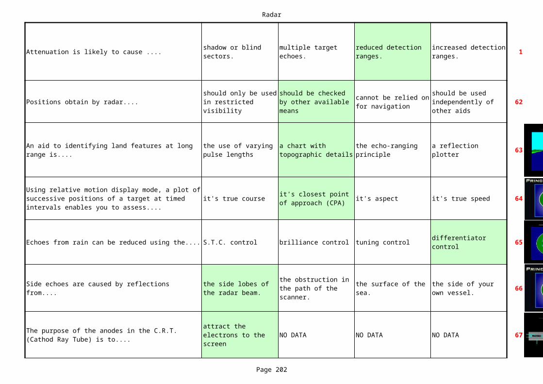
Radar
Page 202
Attenuation is likely to cause .... 1shadow or blind sectors.
multiple target echoes.
reduced detection ranges.
increased detection ranges.
Positions obtain by radar.... 62
63
it's true course it's aspect it's true speed 64
Echoes from rain can be reduced using the.... S.T.C. control brilliance control tuning control 65
66
NO DATA NO DATA NO DATA 67
should only be used in restricted visibility
should be checked by other available means
cannot be relied on for navigation
should be used independently of other aids
An aid to identifying land features at long range is....
the use of varying pulse lengths
a chart with topographic details
the echo-ranging principle
a reflection plotter
Using relative motion display mode, a plot of successive positions of a target at timed intervals enables you to assess....
it's closest point of approach (CPA)
differentiator control
Side echoes are caused by reflections from....
the side lobes of the radar beam.
the obstruction in the path of the scanner.
the surface of the sea.
the side of your own vessel.
The purpose of the anodes in the C.R.T. (Cathod Ray Tube) is to....
attract the electrons to the screen
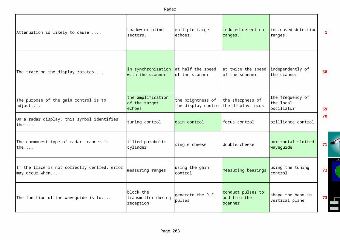
Radar
Page 203
Attenuation is likely to cause .... 1shadow or blind sectors.
multiple target echoes.
reduced detection ranges.
increased detection ranges.
The trace on the display rotates.... 68
69
tuning control gain control focus control brilliance control70
single cheese double cheese 71
measuring ranges measuring bearings 72
The function of the waveguide is to.... 73
in synchronization with the scanner
at half the speed of the scanner
at twice the speed of the scanner
independently of the scanner
The purpose of the gain control is to adjust....
the amplification of the target echoes
the brightness of the display control
the sharpness of the display focus
the frequency of the local oscillator
On a radar display, this symbol identifies the....
The commonest type of radar scanner is the....
tilted parabolic cylinder
horizontal slotted waveguide
If the trace is not correctly centred, error may occur when....
using the gain control
using the tuning control
block the transmitter during reception
generate the R.F. pulses
conduct pulses to and from the scanner
shape the beam in vertical plane
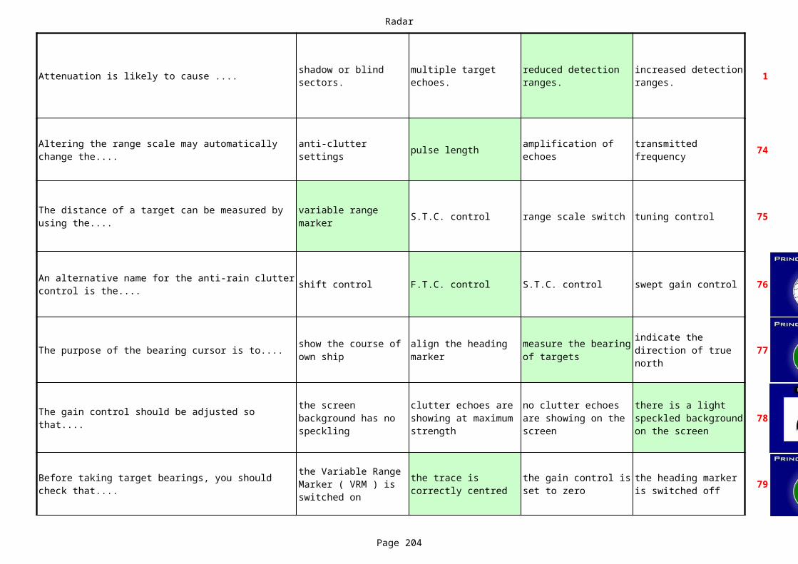
Radar
Page 204
Attenuation is likely to cause .... 1shadow or blind sectors.
multiple target echoes.
reduced detection ranges.
increased detection ranges.
pulse length 74
S.T.C. control range scale switch tuning control 75
shift control F.T.C. control S.T.C. control swept gain control 76
The purpose of the bearing cursor is to.... 77
78
79
Altering the range scale may automatically change the....
anti-clutter settings
amplification of echoes
transmitted frequency
The distance of a target can be measured by using the....
variable range marker
An alternative name for the anti-rain clutter control is the....
show the course of own ship
align the heading marker
measure the bearing of targets
indicate the direction of true north
The gain control should be adjusted so that....
the screen background has no speckling
clutter echoes are showing at maximum strength
no clutter echoes are showing on the screen
there is a light speckled background on the screen
Before taking target bearings, you should check that....
the Variable Range Marker ( VRM ) is switched on
the trace is correctly centred
the gain control is set to zero
the heading marker is switched off

Radar
Page 205
Attenuation is likely to cause .... 1shadow or blind sectors.
multiple target echoes.
reduced detection ranges.
increased detection ranges.
The tuning control adjusts.... 80
speed amplitude frequency wavelength 81
The purpose of radar is to enable....
83
Target ranges are obtained from...... the heading marker. the range marker. the bearing marker. 84
8586
the amplification of target echoes
the transmitted frequency
the frequency of the local oscillator
the amplification of power output
The number of cycles of a radio wave which pass a fixed point in a given time is called the....
the wave-lengths of radio waves to be calculated.
the echoes of targets to be separated.
the range and bearing of objects to be obtained.
the speed of radio waves to be measured.
Radar does not transmit continuously because it would......
prevent detection of targets.
cause interference to other vessels.
reduce the life of components.
make the equipment get very hot.
the pulse repetition frequency.
To provide accurate target bearings the radar beam must be......
wide in the horizontal plane.
narrow in the horizontal plane.
narrow in the vertical plane.
wide in the vertical plane.
Accurate target bearings are obtained by......
making the radar beam wide vertically.
synchronizing the radar beam and the trace.
making the radar beam wide horizontally.
rotating the trace intermittently.
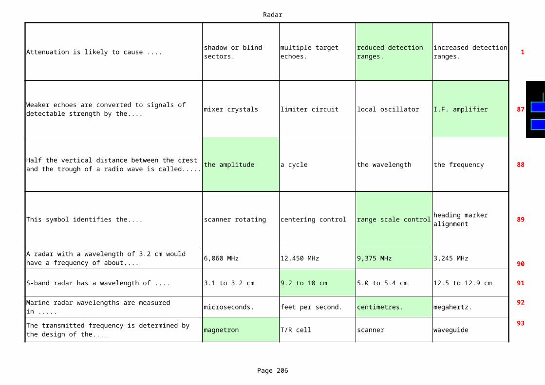
Radar
Page 206
Attenuation is likely to cause .... 1shadow or blind sectors.
multiple target echoes.
reduced detection ranges.
increased detection ranges.
mixer crystals limiter circuit local oscillator I.F. amplifier 87
the amplitude a cycle the wavelength the frequency 88
This symbol identifies the.... scanner rotating centering control range scale control 89
6,060 MHz 12,450 MHz 9,375 MHz 3,245 MHz90
S-band radar has a wavelength of .... 3.1 to 3.2 cm 9.2 to 10 cm 5.0 to 5.4 cm 12.5 to 12.9 cm 91
microseconds. feet per second. centimetres. megahertz. 92
magnetron T/R cell scanner waveguide93
Weaker echoes are converted to signals of detectable strength by the....
Half the vertical distance between the crest and the trough of a radio wave is called.....
heading marker alignment
A radar with a wavelength of 3.2 cm would have a frequency of about....
Marine radar wavelengths are measured in .....
The transmitted frequency is determined by the design of the....

Radar
Page 207
Attenuation is likely to cause .... 1shadow or blind sectors.
multiple target echoes.
reduced detection ranges.
increased detection ranges.
antenna power supply magnetron cathode ray tube 94
display unit transmitter unit scanner unit receiver unit 95
the amplitude the wavelength a cycle the frequency 96
97
Pulse length 98
The main component of the transmitter is the....
The magnetron sends the R.F. pulses to the....
The horizontal distance between the adjacent crests of a radio wave is called....
The distance of the radar horizon is largely determined by......
the state of the sea surface.
the downward refraction of radar waves.
the width of the scanner.
the amount of cloud cover.
Range discrimination depends mainly on which of the following?
Pulse repetition frequency
Transmitted frequency
Scanner rotation speed
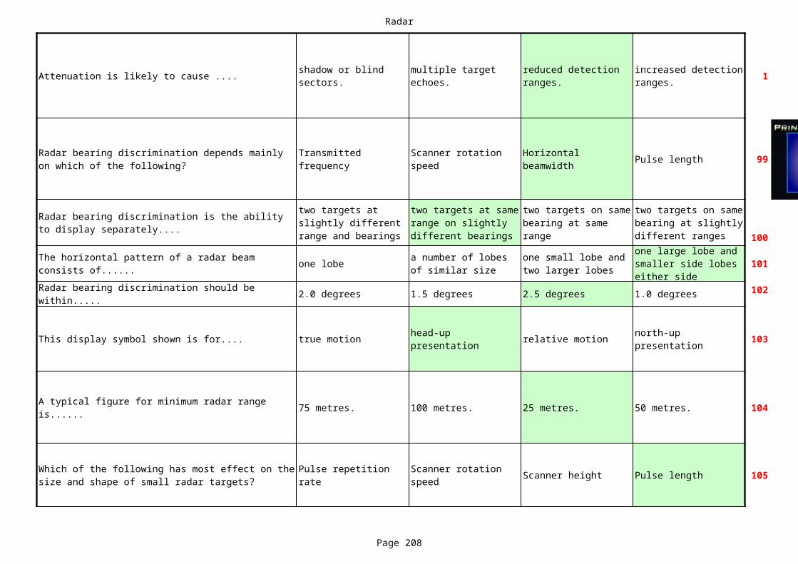
Radar
Page 208
Attenuation is likely to cause .... 1shadow or blind sectors.
multiple target echoes.
reduced detection ranges.
increased detection ranges.
Pulse length 99
100
one lobe 101
2.0 degrees 1.5 degrees 2.5 degrees 1.0 degrees 102
This display symbol shown is for.... true motion relative motion 103
75 metres. 100 metres. 25 metres. 50 metres. 104
Scanner height Pulse length 105
Radar bearing discrimination depends mainly on which of the following?
Transmitted frequency
Scanner rotation speed
Horizontal beamwidth
Radar bearing discrimination is the ability to display separately....
two targets at slightly different range and bearings
two targets at same range on slightly different bearings
two targets on same bearing at same range
two targets on same bearing at slightly different ranges
The horizontal pattern of a radar beam consists of......
a number of lobes of similar size
one small lobe and two larger lobes
one large lobe and smaller side lobes either side
Radar bearing discrimination should be within.....
head-up presentation
north-up presentation
A typical figure for minimum radar range is......
Which of the following has most effect on the size and shape of small radar targets?
Pulse repetition rate
Scanner rotation speed
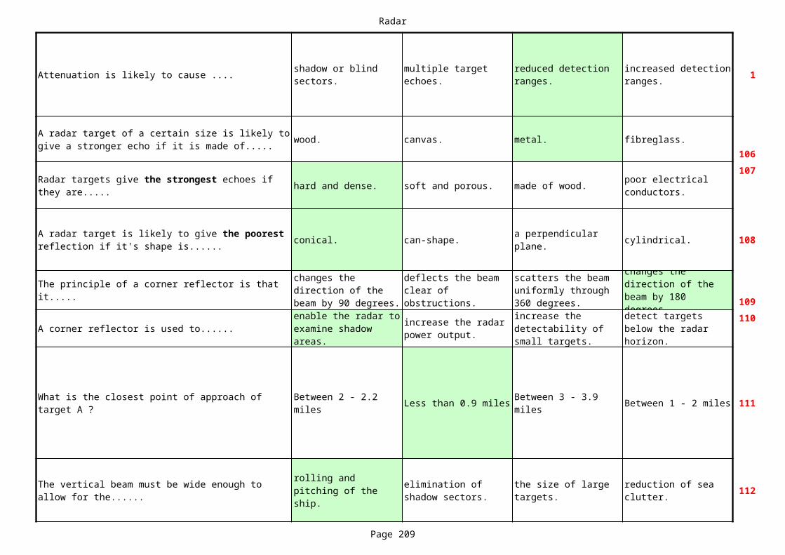
Radar
Page 209
Attenuation is likely to cause .... 1shadow or blind sectors.
multiple target echoes.
reduced detection ranges.
increased detection ranges.
wood. canvas. metal. fibreglass.106
hard and dense. soft and porous. made of wood.107
conical. can-shape. cylindrical. 108
109
A corner reflector is used to......110
Less than 0.9 miles Between 1 - 2 miles 111
112
A radar target of a certain size is likely to give a stronger echo if it is made of.....
Radar targets give the strongest echoes if they are.....
poor electrical conductors.
A radar target is likely to give the poorest reflection if it's shape is......
a perpendicular plane.
The principle of a corner reflector is that it.....
changes the direction of the beam by 90 degrees.
deflects the beam clear of obstructions.
scatters the beam uniformly through 360 degrees.
changes the direction of the beam by 180 degrees.enable the radar to
examine shadow areas.
increase the radar power output.
increase the detectability of small targets.
detect targets below the radar horizon.
What is the closest point of approach of target A ?
Between 2 - 2.2 miles
Between 3 - 3.9 miles
The vertical beam must be wide enough to allow for the......
rolling and pitching of the ship.
elimination of shadow sectors.
the size of large targets.
reduction of sea clutter.
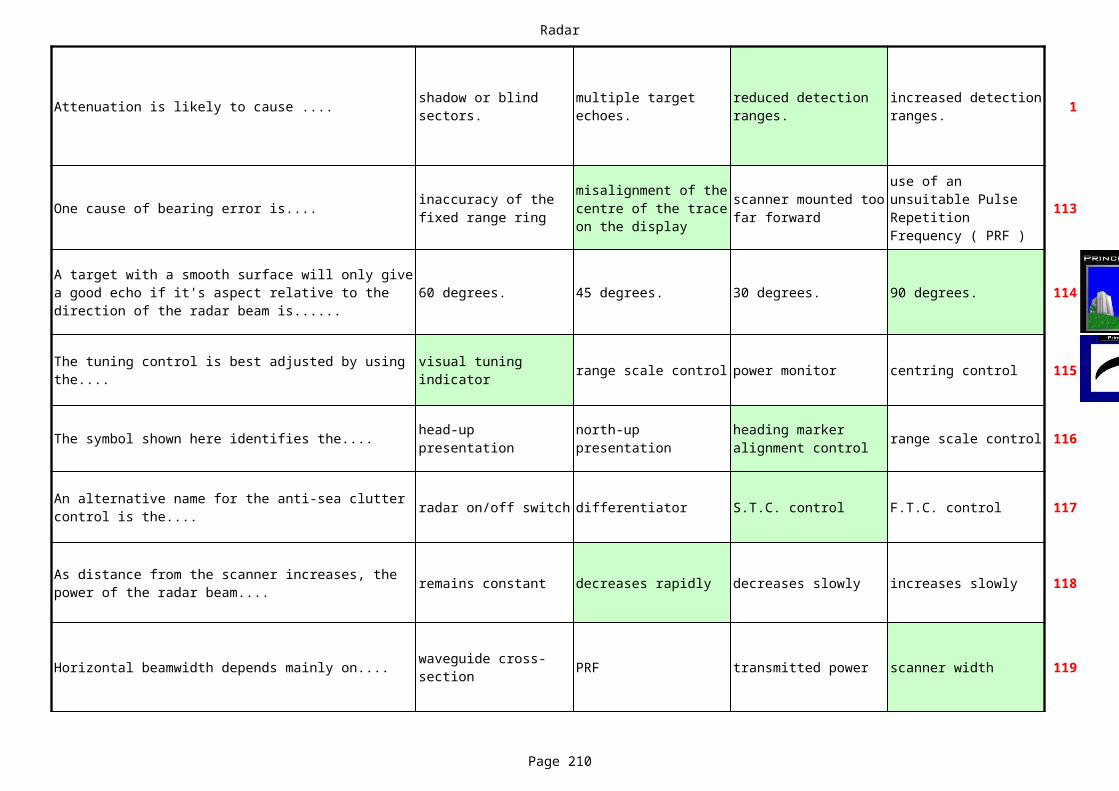
Radar
Page 210
Attenuation is likely to cause .... 1shadow or blind sectors.
multiple target echoes.
reduced detection ranges.
increased detection ranges.
One cause of bearing error is.... 113
60 degrees. 45 degrees. 30 degrees. 90 degrees. 114
range scale control power monitor centring control 115
The symbol shown here identifies the.... range scale control 116
radar on/off switch differentiator S.T.C. control F.T.C. control 117
remains constant decreases rapidly decreases slowly increases slowly 118
Horizontal beamwidth depends mainly on.... PRF transmitted power scanner width 119
inaccuracy of the fixed range ring
misalignment of the centre of the trace on the display
scanner mounted too far forward
use of an unsuitable Pulse Repetition Frequency ( PRF )
A target with a smooth surface will only give a good echo if it's aspect relative to the direction of the radar beam is......
The tuning control is best adjusted by using the....
visual tuning indicator
head-up presentation
north-up presentation
heading marker alignment control
An alternative name for the anti-sea clutter control is the....
As distance from the scanner increases, the power of the radar beam....
waveguide cross-section
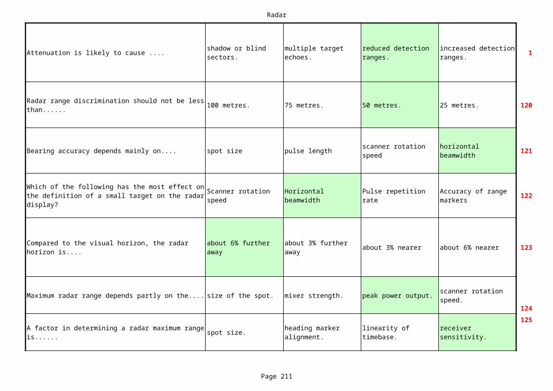
Radar
Page 211
Attenuation is likely to cause .... 1shadow or blind sectors.
multiple target echoes.
reduced detection ranges.
increased detection ranges.
100 metres. 75 metres. 50 metres. 25 metres. 120
Bearing accuracy depends mainly on.... spot size pulse length 121
122
about 3% nearer about 6% nearer 123
Maximum radar range depends partly on the.... size of the spot. mixer strength. peak power output.124
spot size.125
Radar range discrimination should not be less than......
scanner rotation speed
horizontal beamwidth
Which of the following has the most effect on the definition of a small target on the radar display?
Scanner rotation speed
Horizontal beamwidth
Pulse repetition rate
Accuracy of range markers
Compared to the visual horizon, the radar horizon is....
about 6% further away
about 3% further away
scanner rotation speed.
A factor in determining a radar maximum range is......
heading marker alignment.
linearity of timebase.
receiver sensitivity.

Radar
Page 212
Attenuation is likely to cause .... 1shadow or blind sectors.
multiple target echoes.
reduced detection ranges.
increased detection ranges.
Minimum radar range depends mainly on...... scanner height. pulse length. vertical beamwidth. 126
Radar range accuracy should be within...... 127
128
Vertical beamwidth is determined by.... 129
Between 1-2 miles Between 4 - 5 miles Less than 1 mile Between 2-4 miles 130
receiver sensitivity.
1.5 % of the range scale in use.
0.5 % of the range scale in use.
3.5 % of the range scale in use.
2.5 % of the range scale in use.
The effect of the anti-rain clutter control is to....
reduce the size of all echoes
reduce the strength of close range echoes
reduce the strength of all echoes
reduce the size of close range echoes
the height of the scanner
the transmitted wavelength
the design of the scanner
the number of slots in the scanner
What is the closest point of approach of target A ?
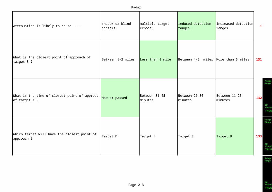
Radar
Page 213
Attenuation is likely to cause .... 1shadow or blind sectors.
multiple target echoes.
reduced detection ranges.
increased detection ranges.
Between 1-2 miles Less than 1 mile Between 4-5 miles More than 5 miles 131
Now or passed 132
Target D Target F Target E Target B 133
What is the closest point of approach of target B ?
What is the time of closest point of approach of target A ?
Between 31-45 minutes
Between 21-30 minutes
Between 11-20 minutes
Which target will have the closest point of approach ?
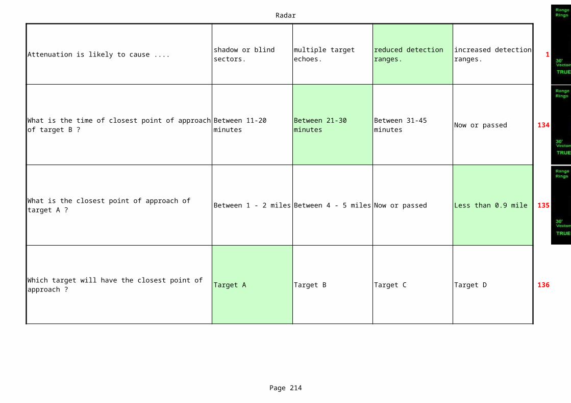
Radar
Page 214
Attenuation is likely to cause .... 1shadow or blind sectors.
multiple target echoes.
reduced detection ranges.
increased detection ranges.
Now or passed 134
Between 1 - 2 miles Between 4 - 5 miles Now or passed Less than 0.9 mile 135
Target A Target B Target C Target D 136
What is the time of closest point of approach of target B ?
Between 11-20 minutes
Between 21-30 minutes
Between 31-45 minutes
What is the closest point of approach of target A ?
Which target will have the closest point of approach ?
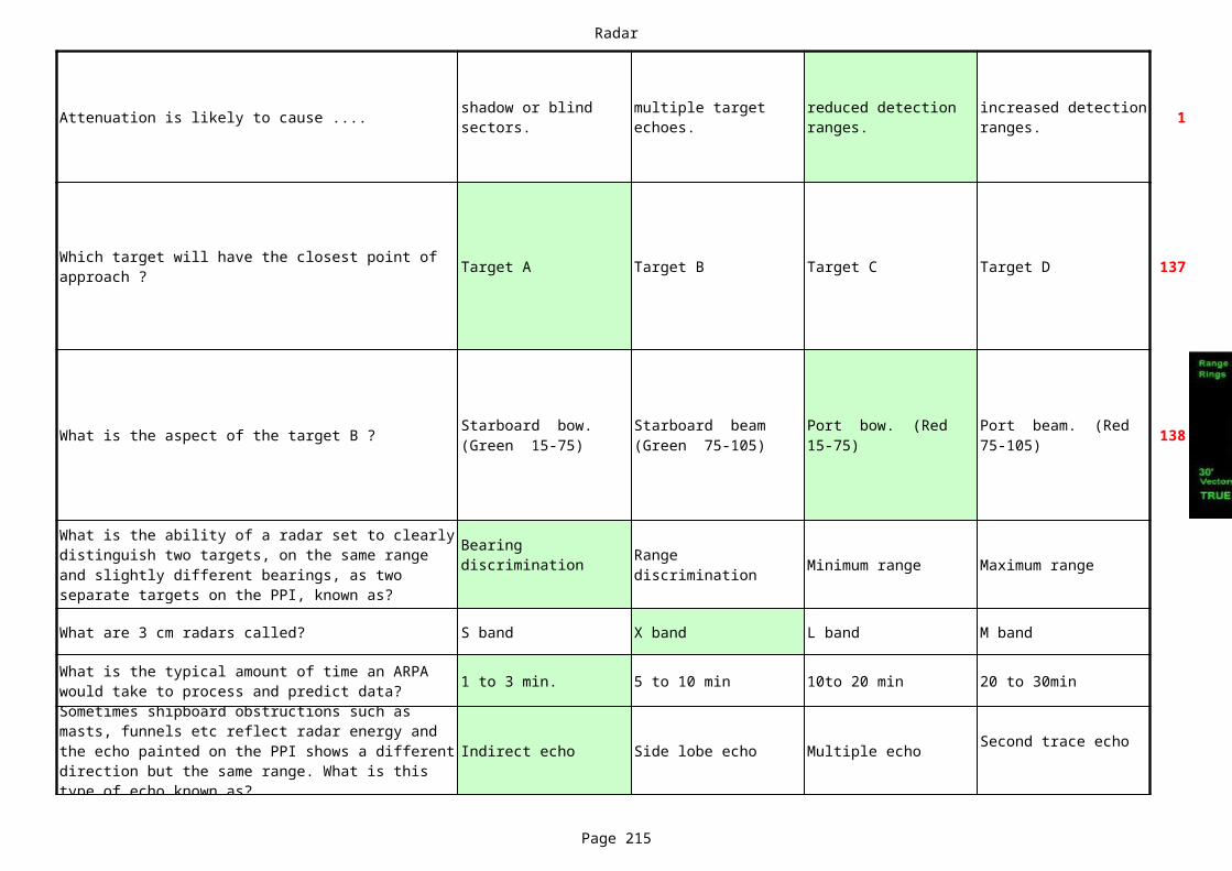
Radar
Page 215
Attenuation is likely to cause .... 1shadow or blind sectors.
multiple target echoes.
reduced detection ranges.
increased detection ranges.
Target A Target B Target C Target D 137
What is the aspect of the target B ? 138
Minimum range Maximum range
What are 3 cm radars called? S band X band L band M band
1 to 3 min. 5 to 10 min 10to 20 min 20 to 30min
Indirect echo Side lobe echo Multiple echo
Which target will have the closest point of approach ?
Starboard bow. (Green 15-75)
Starboard beam (Green 75-105)
Port bow. (Red 15-75)
Port beam. (Red 75-105)
What is the ability of a radar set to clearly distinguish two targets, on the same range and slightly different bearings, as two separate targets on the PPI, known as?
Bearing discrimination Range
discrimination
What is the typical amount of time an ARPA would take to process and predict data?Sometimes shipboard obstructions such as masts, funnels etc reflect radar energy and the echo painted on the PPI shows a different direction but the same range. What is this type of echo known as?
Second trace echo
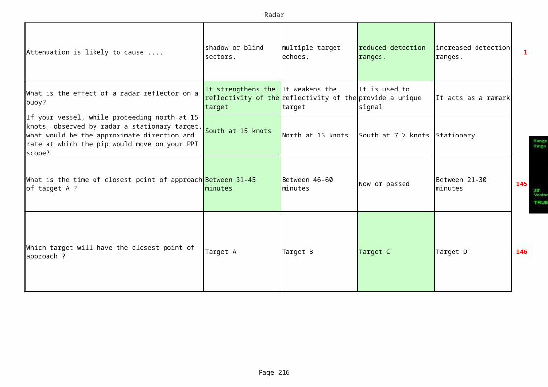
Radar
Page 216
Attenuation is likely to cause .... 1shadow or blind sectors.
multiple target echoes.
reduced detection ranges.
increased detection ranges.
It acts as a ramark
North at 15 knots South at 7 ½ knots Stationary
Now or passed 145
Target A Target B Target C Target D 146
What is the effect of a radar reflector on a buoy?
It strengthens the reflectivity of the target
It weakens the reflectivity of the target
It is used to provide a unique signal
If your vessel, while proceeding north at 15 knots, observed by radar a stationary target, what would be the approximate direction and rate at which the pip would move on your PPI scope?
South at 15 knots
What is the time of closest point of approach of target A ?
Between 31-45 minutes
Between 46-60 minutes
Between 21-30 minutes
Which target will have the closest point of approach ?

Radar
Page 217
Attenuation is likely to cause .... 1shadow or blind sectors.
multiple target echoes.
reduced detection ranges.
increased detection ranges.
Less than 0.9 miles Between 1 - 2 miles 147
Less than 0.9 miles Between 1 - 2 miles148
Now or passed149
Between 2-2.9 miles Between 3 - 4 miles Less than 0.9 miles Between 1-2 miles
150
What is the aspect of the target B ?151
What will be the closest point of approach of target A ?
Between 2 - 2.2 miles
Between 3 - 3.9 miles
What will be the closest point of approach of target A ?
Between 2 - 2.2 miles
Between 3 - 3.9 miles
What is the time of closest point of approach of target A ?
Between 31-45 minutes
Between 46-60 minutes
Between 21-30 minutes
What is the closest point of approach of target A ?
Starboard bow. (Green 15-75)
Starboard beam (Green 75-105)
Port bow. (Red 15-75)
Port beam. (Red 75-105)

Radar
Page 218
Attenuation is likely to cause .... 1shadow or blind sectors.
multiple target echoes.
reduced detection ranges.
increased detection ranges.
Between 1 - 2 miles Now or passed 152
Target C Target A Target E Target B 153
Sub-refraction NO DATA NO DATA NO DATA
More than 5 miles155
Now or passed 156
What is the aspect of the target C ? 157
158
What is the closest point of approach of target A ?
Between 2 - 2.9 miles
Between 3 - 3.9 miles
Which target will have the closest point of approach ?
What type of refraction will be experienced, when a cold breeze blows over a relatively warm sea?What is the closest point of approach of target C ?
Between 0.5 -1.5 miles
Between 4 - 5 miles.
Between 2 - 2.9 miles
What is the time of closest point of approach of target C ?
Between 31 - 45 minutes
Between 21 - 30 minutes
Between 0 - 10 minutes
Stern or nearly astern
Port bow. (Red 15-75)
Starboard bow. (Green 15-75)
End on or nearly end on
If the visibility is restricted, what action should be taken in this situation ?
A broad alteration to port
A broad alteration of course to starboard
A substantial reduction of peed
Stand on with caution
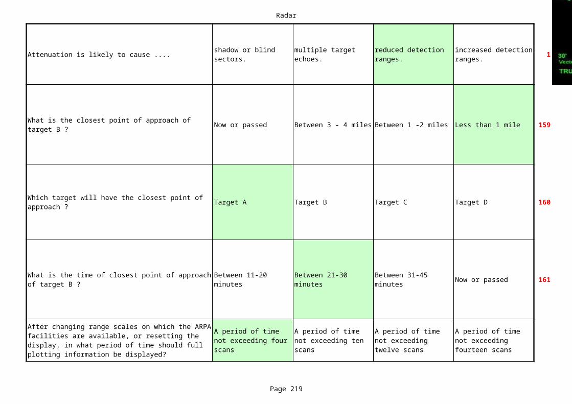
Radar
Page 219
Attenuation is likely to cause .... 1shadow or blind sectors.
multiple target echoes.
reduced detection ranges.
increased detection ranges.
Now or passed Between 3 - 4 miles Between 1 -2 miles Less than 1 mile 159
Target A Target B Target C Target D 160
Now or passed 161
What is the closest point of approach of target B ?
Which target will have the closest point of approach ?
What is the time of closest point of approach of target B ?
Between 11-20 minutes
Between 21-30 minutes
Between 31-45 minutes
After changing range scales on which the ARPA facilities are available, or resetting the display, in what period of time should full plotting information be displayed?
A period of time not exceeding four scans
A period of time not exceeding ten scans
A period of time not exceeding twelve scans
A period of time not exceeding fourteen scans
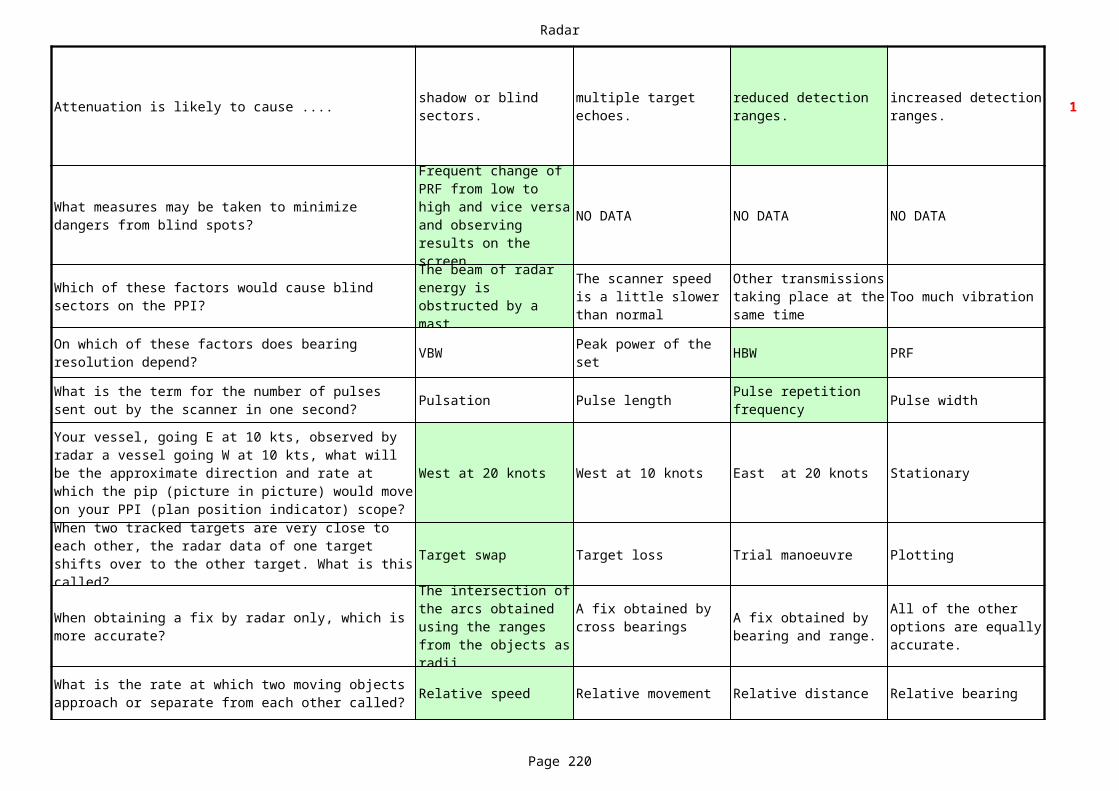
Radar
Page 220
Attenuation is likely to cause .... 1shadow or blind sectors.
multiple target echoes.
reduced detection ranges.
increased detection ranges.
NO DATA NO DATA NO DATA
Too much vibration
VBW HBW PRF
Pulsation Pulse length Pulse width
West at 20 knots West at 10 knots East at 20 knots Stationary
Target swap Target loss Trial manoeuvre Plotting
Relative speed Relative movement Relative distance Relative bearing
What measures may be taken to minimize dangers from blind spots?
Frequent change of PRF from low to high and vice versa and observing results on the screen
Which of these factors would cause blind sectors on the PPI?
The beam of radar energy is obstructed by a mast
The scanner speed is a little slower than normal
Other transmissions taking place at the same time
On which of these factors does bearing resolution depend?
Peak power of the set
What is the term for the number of pulses sent out by the scanner in one second?
Pulse repetition frequency
Your vessel, going E at 10 kts, observed by radar a vessel going W at 10 kts, what will be the approximate direction and rate at which the pip (picture in picture) would move on your PPI (plan position indicator) scope?When two tracked targets are very close to each other, the radar data of one target shifts over to the other target. What is this called?
When obtaining a fix by radar only, which is more accurate?
The intersection of the arcs obtained using the ranges from the objects as radii
A fix obtained by cross bearings A fix obtained by
bearing and range.
All of the other options are equally accurate.
What is the rate at which two moving objects approach or separate from each other called?
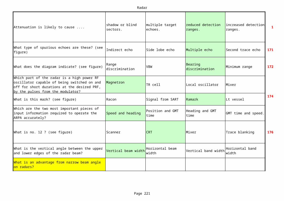
Radar
Page 221
Attenuation is likely to cause .... 1shadow or blind sectors.
multiple target echoes.
reduced detection ranges.
increased detection ranges.
Indirect echo Side lobe echo Multiple echo Second trace echo 171
What does the diagram indicate? (see figure) VBW Minimum range 172
TR cell Local oscillator Mixer
What is this mark? (see figure) Racon Signal from SART Ramark Lt vessel174
Speed and heading GMT time and speed.
What is no. 12 ? (see figure) Scanner CRT Mixer Trace blanking 176
Vertical beam width Vertical band width
What type of spurious echoes are these? (see figure)
Range discrimination
Bearing discrimination
Which part of the radar is a high power RF oscillator capable of being switched on and off for short durations at the desired PRF, by the pulses from the modulator?
Magnetron
Which are the two most important pieces of input information required to operate the ARPA accurately?
Position and GMT time
Heading and GMT time
What is the vertical angle between the upper and lower edges of the radar beam?
Horizontal beam width
Horizontal band width
What is an advantage from narrow beam angle on radars?
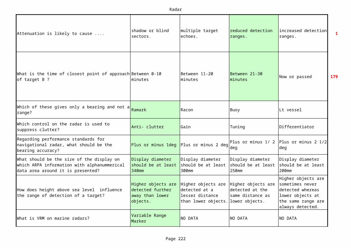
Radar
Page 222
Attenuation is likely to cause .... 1shadow or blind sectors.
multiple target echoes.
reduced detection ranges.
increased detection ranges.
Now or passed 179
Ramark Racon Buoy Lt vessel
Anti- clutter Gain Tuning Differentiator
Plus or minus 1deg Plus or minus 2 deg
What is VRM on marine radars? NO DATA NO DATA NO DATA
What is the time of closest point of approach of target B ?
Between 0-10 minutes
Between 11-20 minutes
Between 21-30 minutes
Which of these gives only a bearing and not a range?
Which control on the radar is used to suppress clutter?
Regarding performance standards for navigational radar, what should be the bearing accuracy?
Plus or minus 1/ 2 deg
Plus or minus 2 1/2 deg
What should be the size of the display on which ARPA information with alphanummerical data area around it is presented?
Display diameter should be at least 340mm
Display diameter should be at least 300mm
Display diameter should be at least 250mm
Display diameter should be at least 200mm
How does height above sea level influence the range of detection of a target?
Higher objects are detected further away than lower objects.
Higher objects are detected at a lesser distance than lower objects.
Higher objects are detected at the same distance as lower objects.
Higher objects are sometimes never detected whereas lower objects at the same range are always detected.
Variable Range Marker

Radar
Page 223
Attenuation is likely to cause .... 1shadow or blind sectors.
multiple target echoes.
reduced detection ranges.
increased detection ranges.
CPA warnings Target lost warning
sub refraction normal refraction super refraction ducting
12 miles 18miles
What are 10cm radars called? S band X band L band M band
Performance monitor Range selector Centre shift
Gain Differentiator Brilliance Focus
Less than 0.9 mile Between 4-5 miles Between 1-2 miles 195
What is used to warn the observer if any distinguishable target closes to a chosen range or transits a zone chosen by the observer?
Guard rings and zones
Collision course warning
The detection range of surface targets is decreased when radar waves touch the earth's surface at a point closer than the standard horizon. What type of refraction is this?Which of these range scales would you use in a congested channel?
1 to 6 miles 24 miles
What should be the performance standards of a radar so that it should function without deterioration in performance when the vessel is rolling or pitching?
Upto +/-10deg Rolling or pitching Upto +/-20deg
Rolling or pitchingUpto +/-25deg Rolling or pitching
Upto +/-30deg Rolling or pitching
Which are the four main elements of a radar system?
Transmitter, antenna, receiver, display
Transmitter, servo link, antenna, target
Transmitter, servo link, antenna , display
Transmitter, servo link, target,display
Which of these controls is provided to check the overall efficiency of the radar?
Pulse length selector
Atmospheric density gradients bend radar rays as they travel to and from target.How this is called?What is used to control the amplification of echoes received?
What is the closest point of approach of target A ?
Between 3-3.9 miles
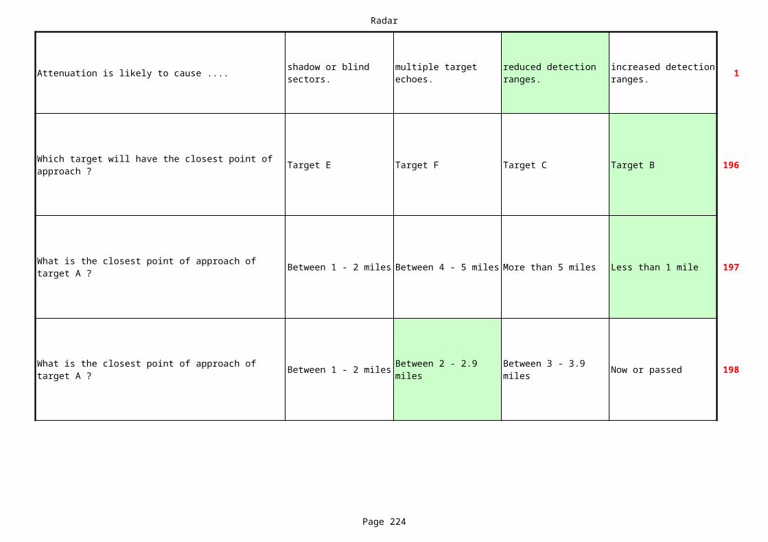
Radar
Page 224
Attenuation is likely to cause .... 1shadow or blind sectors.
multiple target echoes.
reduced detection ranges.
increased detection ranges.
Target E Target F Target C Target B 196
Between 1 - 2 miles Between 4 - 5 miles More than 5 miles Less than 1 mile 197
Between 1 - 2 miles Now or passed 198
Which target will have the closest point of approach ?
What is the closest point of approach of target A ?
What is the closest point of approach of target A ?
Between 2 - 2.9 miles
Between 3 - 3.9 miles

Radar
Page 225
Attenuation is likely to cause .... 1shadow or blind sectors.
multiple target echoes.
reduced detection ranges.
increased detection ranges.
Between 1-2 miles Between 4 - 5 miles Less than 1 mile Between 2-4 miles 199
Between 1-2 miles Between 4 - 5 miles Less than 1 mile Between 2-4 miles 200
201
What is the closest point of approach of target A ?
What is the closest point of approach of target A ?
What is the time of closest point of approach of target A ?
Between 0-10 minutes
Between 11-20 minutes
Between 21-30 minutes
Between 31-40 minutes
Radar
Page 226
Attenuation is likely to cause .... 1shadow or blind sectors.
multiple target echoes.
reduced detection ranges.
increased detection ranges.
Between 1-2 miles Less than 0.9 miles Between 4-5 miles 202
Between 1-2 miles Less than 0.9 miles Between 4-5 miles 203
Between 4-5 miles Between 2-4 miles More than 5 miles Less than 0.9 miles
204
Now or Passed205
What is the closest point of approach of target A ?
Between 2.1-3.9 miles
What is the closest point of approach of target A ?
Between 2.1-3.9 miles
What is the closest point of approach of target C ?
What is the time of closest point of approach of target C ?
Between 20 -30 minutes
Between 5 - 15 minutes
Between 31-45 minutes
Radar
Page 227
Attenuation is likely to cause .... 1shadow or blind sectors.
multiple target echoes.
reduced detection ranges.
increased detection ranges.
Target A Target C Target B All Equal 206
Between 4-5 miles Between 2-4 miles More than 5 miles Less than 0.9 miles 207
Between 1-2 miles Between 4-5 miles Less than 1 mile Between 2-4 miles 208
Which target will have the closest point of approach?
What is the closest point of approach of target C ?
What is the closest point of approach of target B ?
Radar
Page 228
Attenuation is likely to cause .... 1shadow or blind sectors.
multiple target echoes.
reduced detection ranges.
increased detection ranges.
Target C All equal Target A Target B 209
Between 1-2 miles Between 4 - 5 miles Less than 1 mile Between 2-4 miles 210
Less than 0.9 miles Between 4-5 miles Between 2 - 3 miles 211
What is another name for a calibration ring?
Between 1-2 miles Between 4-5 miles Less than 0.9 miles 213
Which target will have the closest point of approach?
What is the closest point of approach of target A ?
What is the closest point of approach of target A ?
Between 3-3.9 miles
Fixed electronic range
What wil be the closest point of approach of target A ?
Between 3-3.9 miles
Radar
Page 229
Attenuation is likely to cause .... 1shadow or blind sectors.
multiple target echoes.
reduced detection ranges.
increased detection ranges.
Between 1-2 miles Less than 0.9 miles Between 4-5 miles 214
Less than 0.9 miles Between 4-5 miles Between 2 - 3 miles 215
Between 1-2 miles Between 4-5 miles Less than 0.9 miles 216
Between 1-2 miles Between 4 - 5 miles Less than 1 mile Between 2-4 miles 217
What is the closest point of approach of target A ?
Between 3-3.9 miles
What is the closest point of approach of target A ?
Between 3-3.9 miles
What is the closest point of approach of target A ?
Between 3-3.9 miles
What is the closest point of approach of target A ?
Radar
Page 230
Attenuation is likely to cause .... 1shadow or blind sectors.
multiple target echoes.
reduced detection ranges.
increased detection ranges.
What is the aspect of the target A ? 218
Between 1-2 miles Between 4-5 miles Less than 1 mile Between 2-4 miles 219
More than 5 miles Less than 0.9 mile Between 4 - 5 miles Between 1 - 2 miles220
Now or passed 221
What is the aspect of the target A ? 222
Starboard bow (Green 15-75)
Starboard quarter (Green 105-160)
Port bow (Red 15-75)
Port quarter (Red 105-160)
What is the closest point of approach of target B ?
What is the closest point of approach of target A ?
What is the time of closest point of approach of target A ?
Between 31-45 minutes
Between 21-30 minutes
Between 11-20 minutes
Starboard bow (Green 15-75)
Starboard quarter (Green 105-160)
Port bow (Red 15-75)
Port quarter (Red 105-160)
Radar
Page 231
Attenuation is likely to cause .... 1shadow or blind sectors.
multiple target echoes.
reduced detection ranges.
increased detection ranges.
Less than 0.9 miles Between 4-5 miles Between 2 - 3 miles 223
Between 1-2 miles Between 4-5 miles Less than 0.9 mile 224
Less than 0.9 miles Between 4-5 miles Between 2 - 3 miles 225
What is the closest point of approach of target A ?
Between 3-3.9 miles
What is the closest point of approach of target A ?
Between 3-3.9 miles
What is the closest point of approach of target A ?
Between 3-3.9 miles
Radar
Page 232
Attenuation is likely to cause .... 1shadow or blind sectors.
multiple target echoes.
reduced detection ranges.
increased detection ranges.
Now or passed 226
Target D Target C Target B Target E 227
Target D All the same Target F Target B 228
What is the time of closest point of approach of target A ?
Between 31-45 minutes
Between 46-60 minutes
Between 21-30 minutes
Which target will have the closest point of approach ?
Which target will have the closest point of approach ?
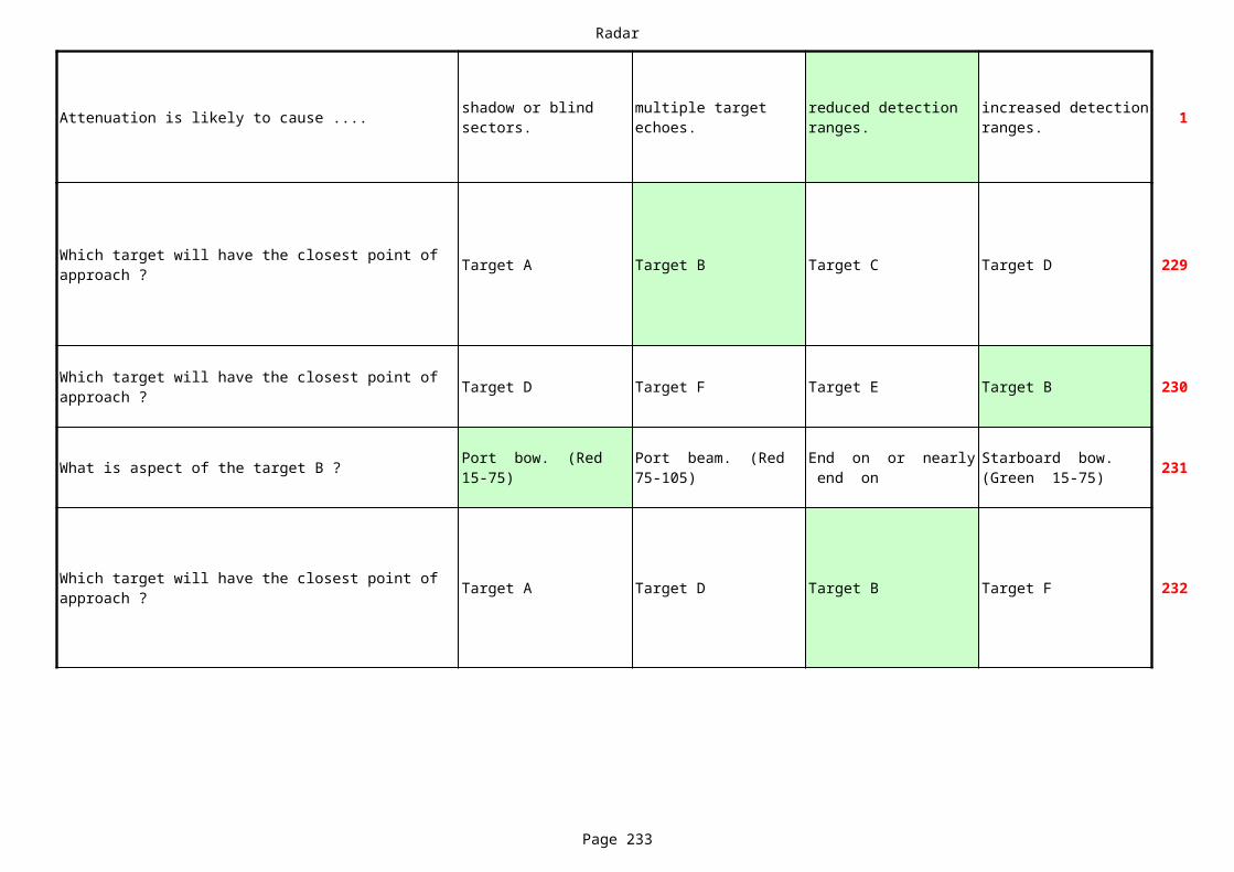
Radar
Page 233
Attenuation is likely to cause .... 1shadow or blind sectors.
multiple target echoes.
reduced detection ranges.
increased detection ranges.
Target A Target B Target C Target D 229
Target D Target F Target E Target B 230
What is aspect of the target B ? 231
Target A Target D Target B Target F 232
Which target will have the closest point of approach ?
Which target will have the closest point of approach ?
Port bow. (Red 15-75)
Port beam. (Red 75-105)
End on or nearly end on
Starboard bow. (Green 15-75)
Which target will have the closest point of approach ?
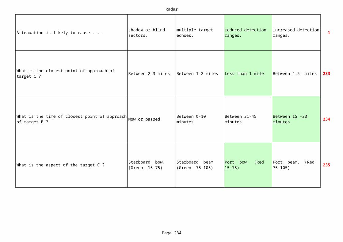
Radar
Page 234
Attenuation is likely to cause .... 1shadow or blind sectors.
multiple target echoes.
reduced detection ranges.
increased detection ranges.
Between 2-3 miles Between 1-2 miles Less than 1 mile Between 4-5 miles 233
Now or passed 234
What is the aspect of the target C ? 235
What is the closest point of approach of target C ?
What is the time of closest point of approach of target B ?
Between 0-10 minutes
Between 31-45 minutes
Between 15 -30 minutes
Starboard bow. (Green 15-75)
Starboard beam (Green 75-105)
Port bow. (Red 15-75)
Port beam. (Red 75-105)
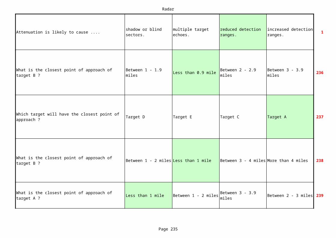
Radar
Page 235
Attenuation is likely to cause .... 1shadow or blind sectors.
multiple target echoes.
reduced detection ranges.
increased detection ranges.
Less than 0.9 mile 236
Target D Target E Target C Target A 237
Between 1 - 2 miles Less than 1 mile Between 3 - 4 miles More than 4 miles 238
Less than 1 mile Between 1 - 2 miles Between 2 - 3 miles 239
What is the closest point of approach of target B ?
Between 1 - 1.9 miles
Between 2 - 2.9 miles
Between 3 - 3.9 miles
Which target will have the closest point of approach ?
What is the closest point of approach of target B ?
What is the closest point of approach of target A ?
Between 3 - 3.9 miles
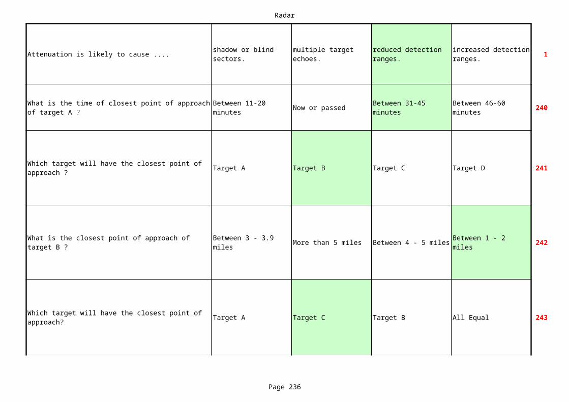
Radar
Page 236
Attenuation is likely to cause .... 1shadow or blind sectors.
multiple target echoes.
reduced detection ranges.
increased detection ranges.
Now or passed 240
Target A Target B Target C Target D 241
More than 5 miles Between 4 - 5 miles 242
Target A Target C Target B All Equal 243
What is the time of closest point of approach of target A ?
Between 11-20 minutes
Between 31-45 minutes
Between 46-60 minutes
Which target will have the closest point of approach ?
What is the closest point of approach of target B ?
Between 3 - 3.9 miles
Between 1 - 2 miles
Which target will have the closest point of approach?
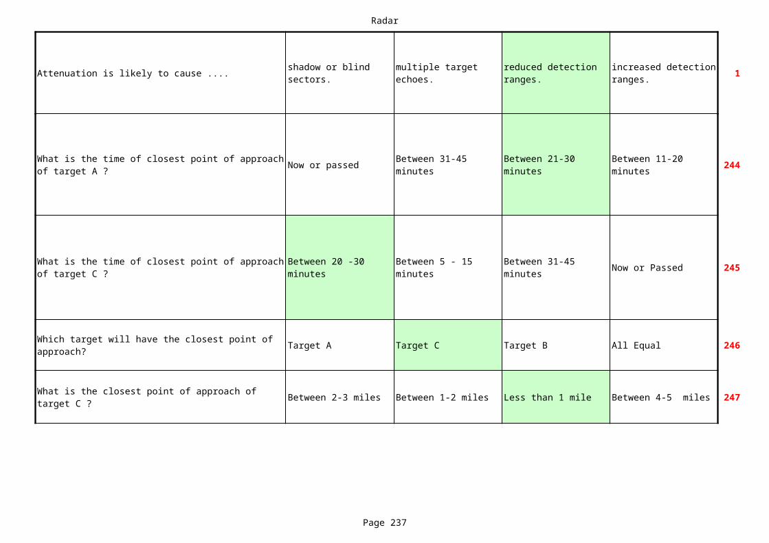
Radar
Page 237
Attenuation is likely to cause .... 1shadow or blind sectors.
multiple target echoes.
reduced detection ranges.
increased detection ranges.
Now or passed 244
Now or Passed 245
Target A Target C Target B All Equal 246
Between 2-3 miles Between 1-2 miles Less than 1 mile Between 4-5 miles 247
What is the time of closest point of approach of target A ?
Between 31-45 minutes
Between 21-30 minutes
Between 11-20 minutes
What is the time of closest point of approach of target C ?
Between 20 -30 minutes
Between 5 - 15 minutes
Between 31-45 minutes
Which target will have the closest point of approach?
What is the closest point of approach of target C ?
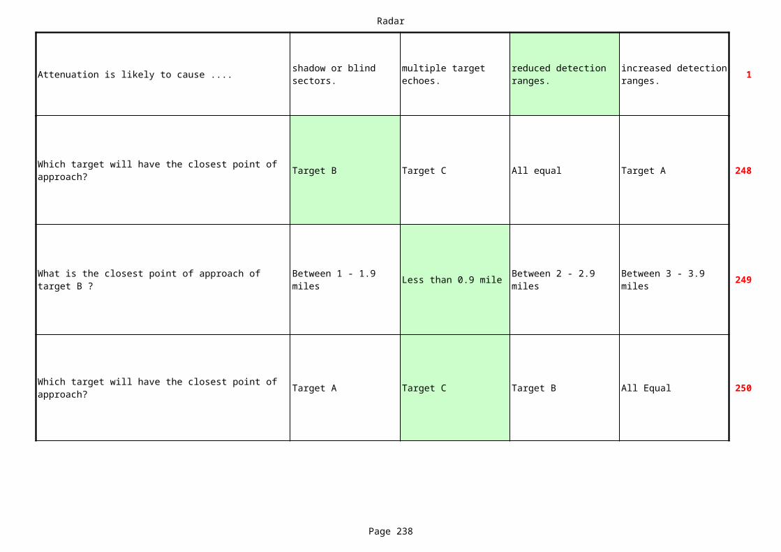
Radar
Page 238
Attenuation is likely to cause .... 1shadow or blind sectors.
multiple target echoes.
reduced detection ranges.
increased detection ranges.
Target B Target C All equal Target A 248
Less than 0.9 mile 249
Target A Target C Target B All Equal 250
Which target will have the closest point of approach?
What is the closest point of approach of target B ?
Between 1 - 1.9 miles
Between 2 - 2.9 miles
Between 3 - 3.9 miles
Which target will have the closest point of approach?
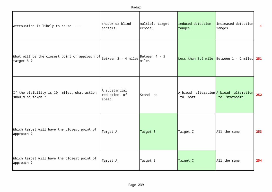
Radar
Page 239
Attenuation is likely to cause .... 1shadow or blind sectors.
multiple target echoes.
reduced detection ranges.
increased detection ranges.
Between 3 - 4 miles Less than 0.9 mile Between 1 - 2 miles 251
Stand on 252
Target A Target B Target C All the same 253
Target A Target B Target C All the same 254
What will be the closest point of approach of target B ?
Between 4 - 5 miles
If the visibility is 10 miles, what action should be taken ?
A substantial reduction of speed
A broad alteration to port
A broad alteration to starboard
Which target will have the closest point of approach ?
Which target will have the closest point of approach ?
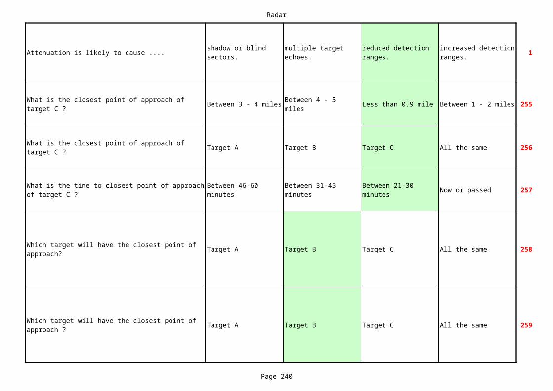
Radar
Page 240
Attenuation is likely to cause .... 1shadow or blind sectors.
multiple target echoes.
reduced detection ranges.
increased detection ranges.
Between 3 - 4 miles Less than 0.9 mile Between 1 - 2 miles 255
Target A Target B Target C All the same 256
Now or passed 257
Target A Target B Target C All the same 258
Target A Target B Target C All the same 259
What is the closest point of approach of target C ?
Between 4 - 5 miles
What is the closest point of approach of target C ?
What is the time to closest point of approach of target C ?
Between 46-60 minutes
Between 31-45 minutes
Between 21-30 minutes
Which target will have the closest point of approach?
Which target will have the closest point of approach ?

Radar
Page 241
Attenuation is likely to cause .... 1shadow or blind sectors.
multiple target echoes.
reduced detection ranges.
increased detection ranges.
* * * NOTHING FOLLOWS * * *
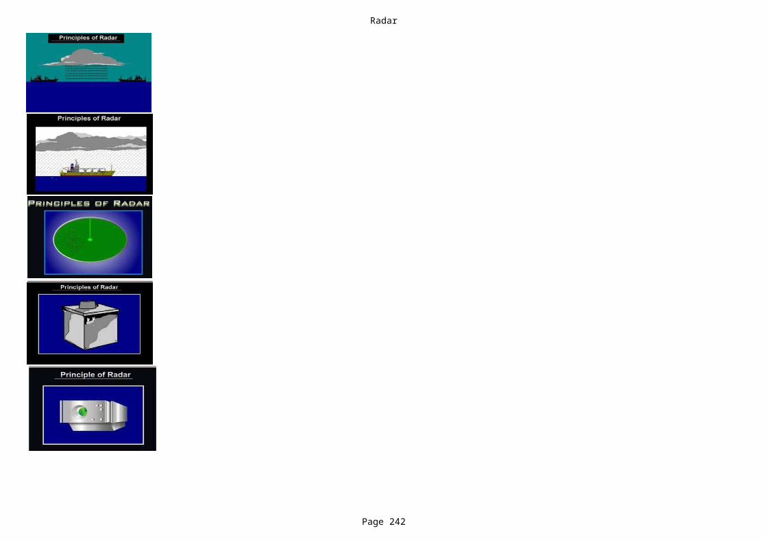
Radar
Page 242

Radar
Page 243

Radar
Page 244
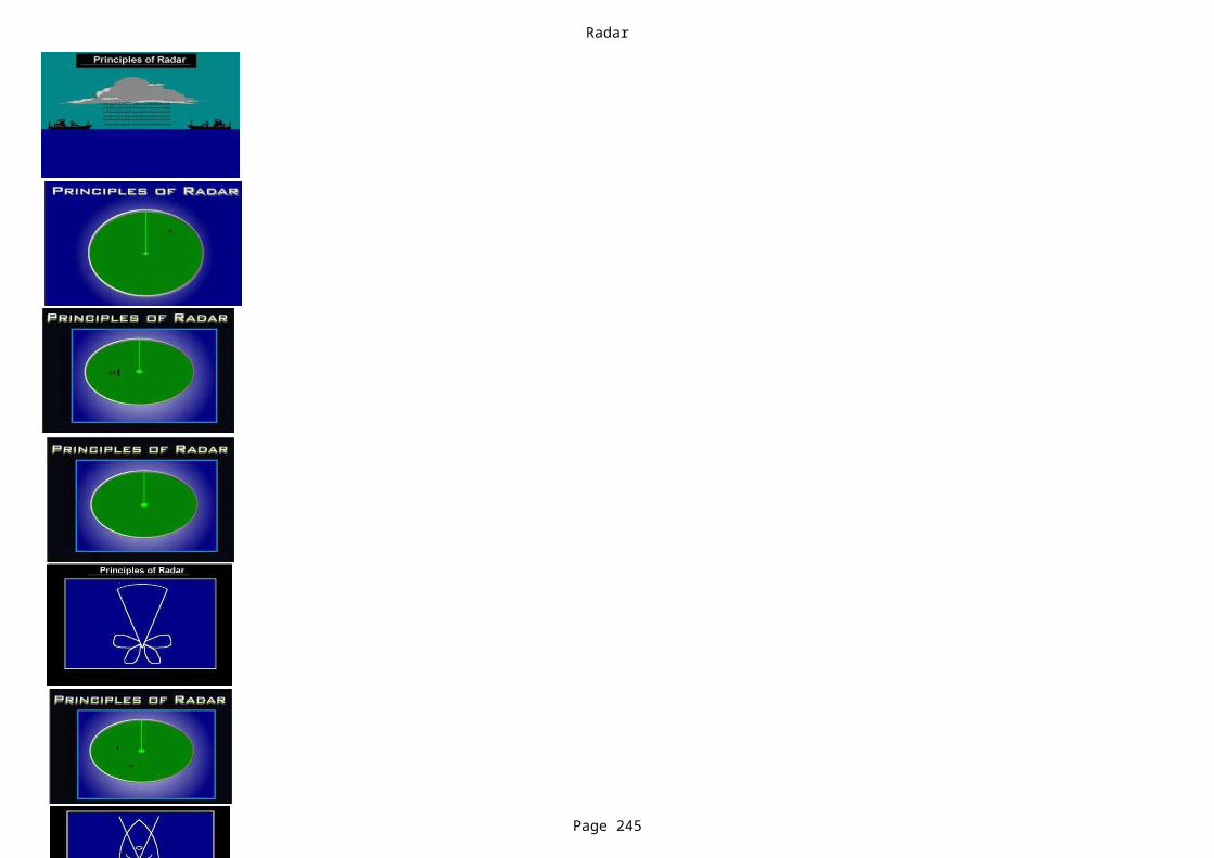
Radar
Page 245
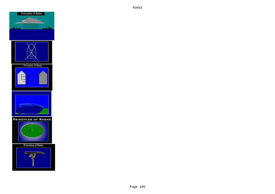
Radar
Page 246

Radar
Page 247

Radar
Page 248

Radar
Page 249
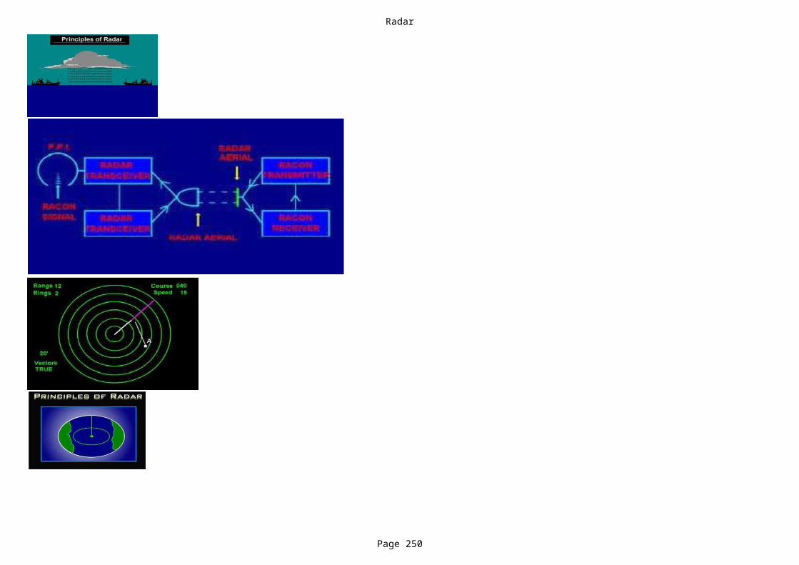
Radar
Page 250
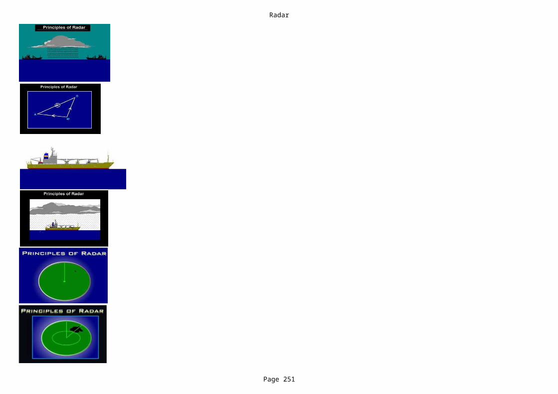
Radar
Page 251

Radar
Page 252

Radar
Page 253

Radar
Page 254
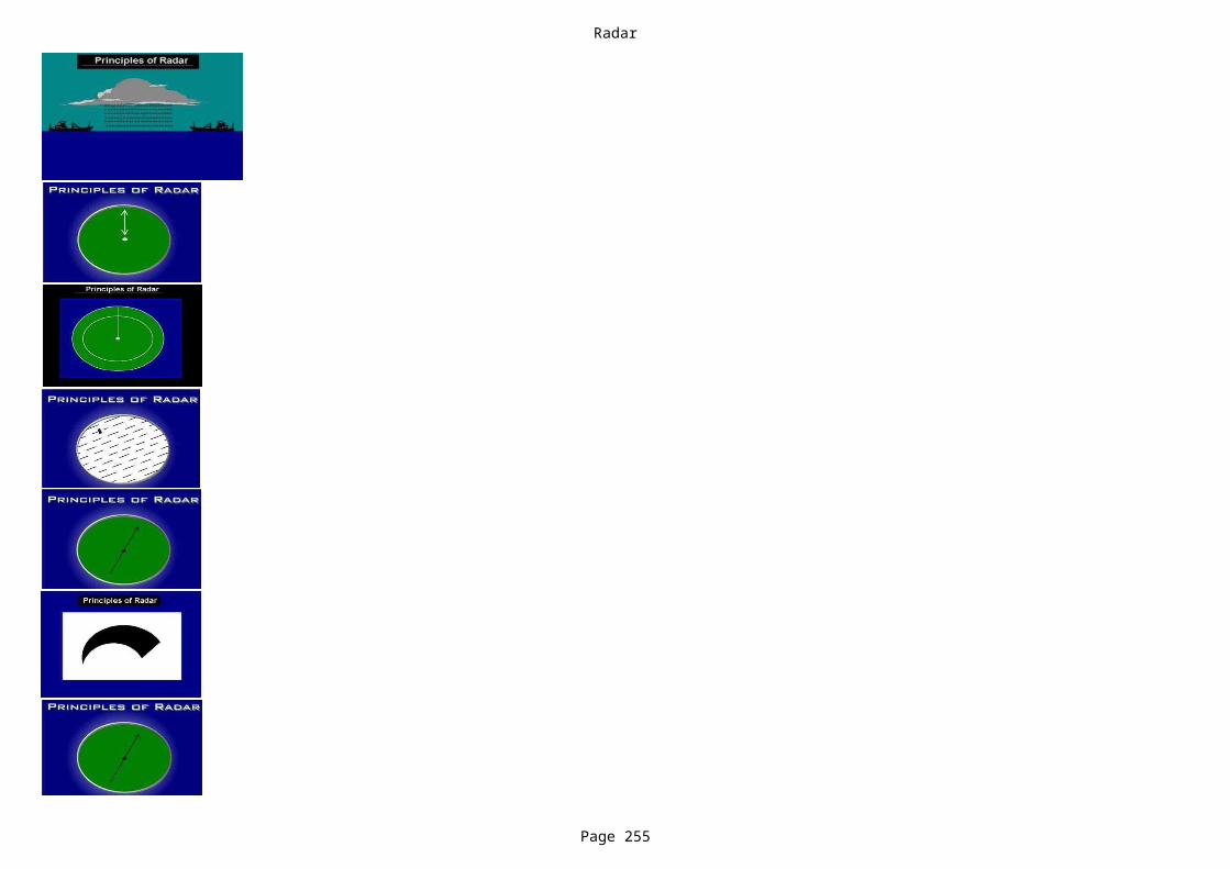
Radar
Page 255

Radar
Page 256
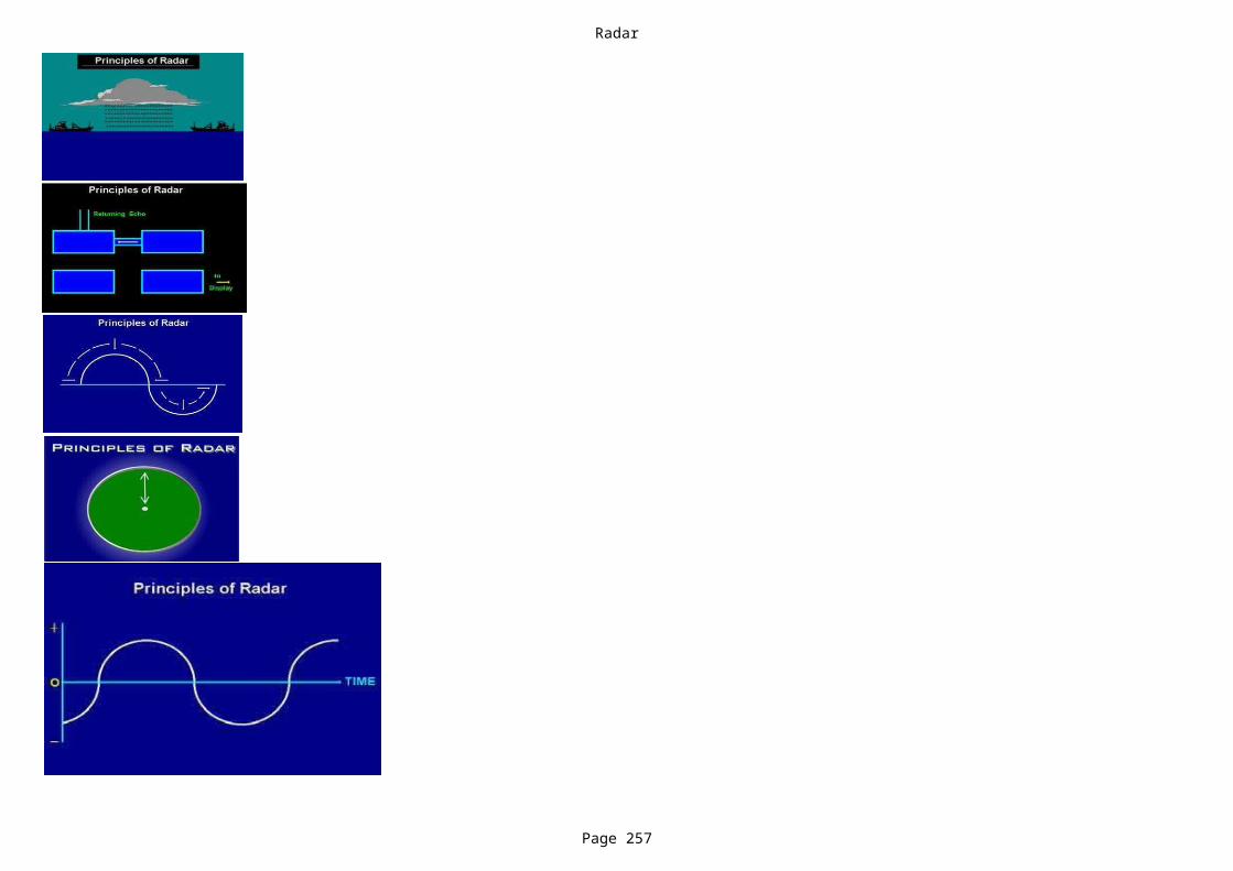
Radar
Page 257
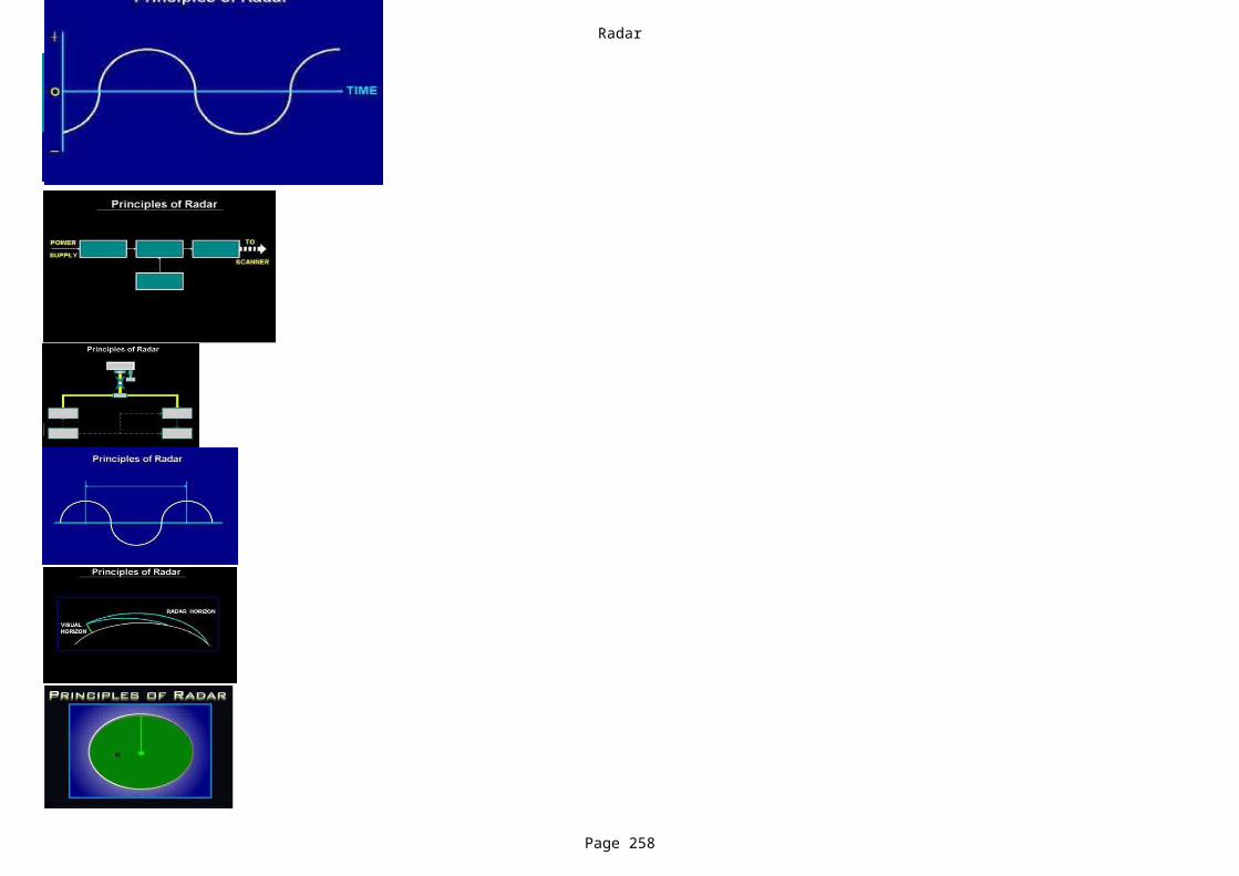
Radar
Page 258
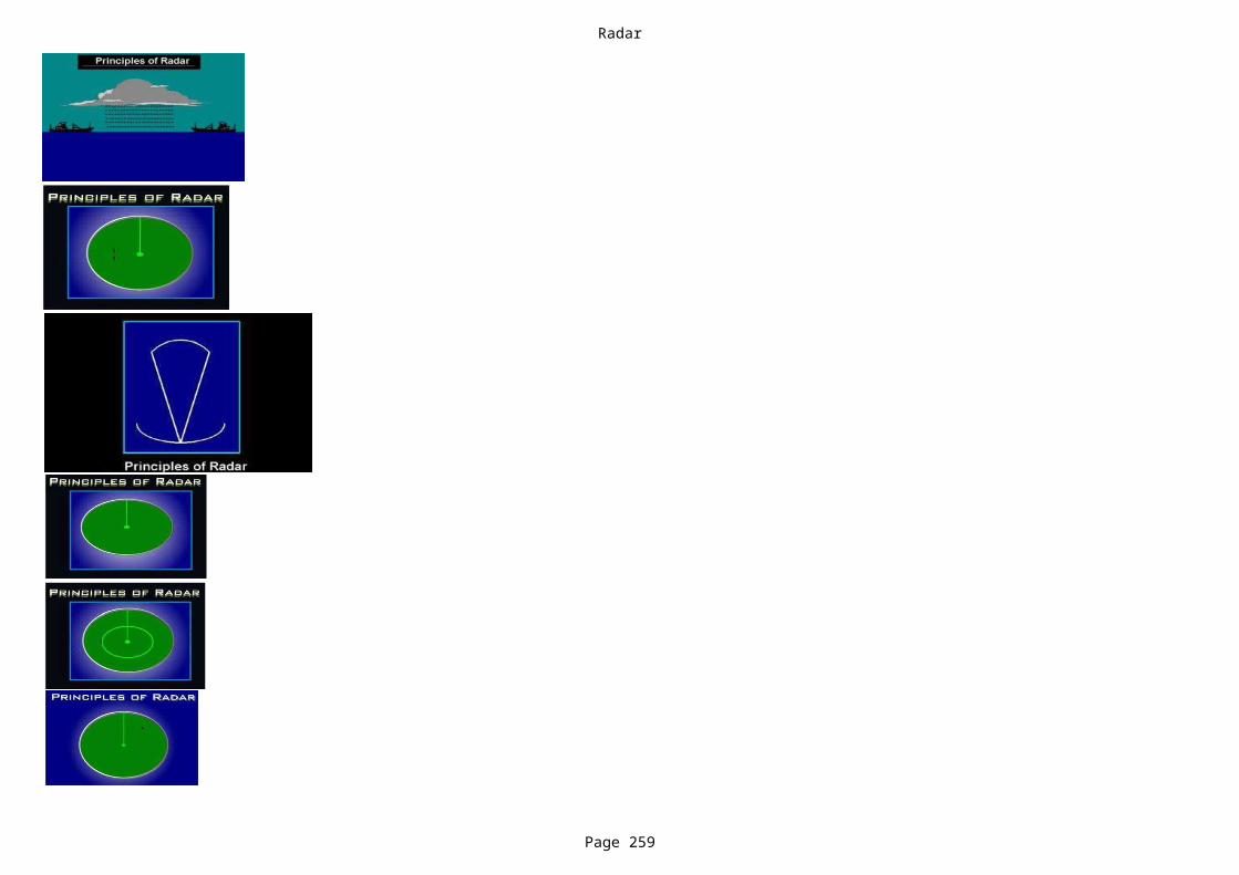
Radar
Page 259

Radar
Page 260
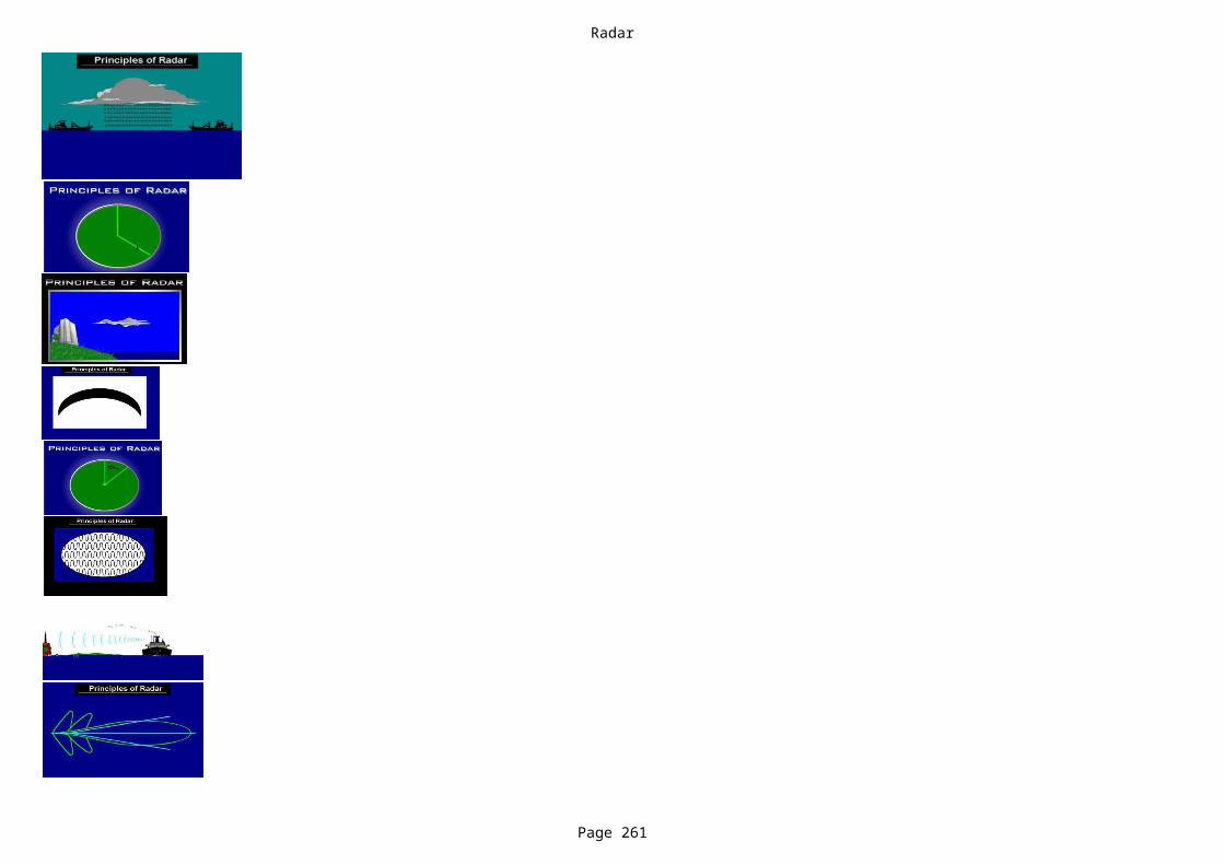
Radar
Page 261
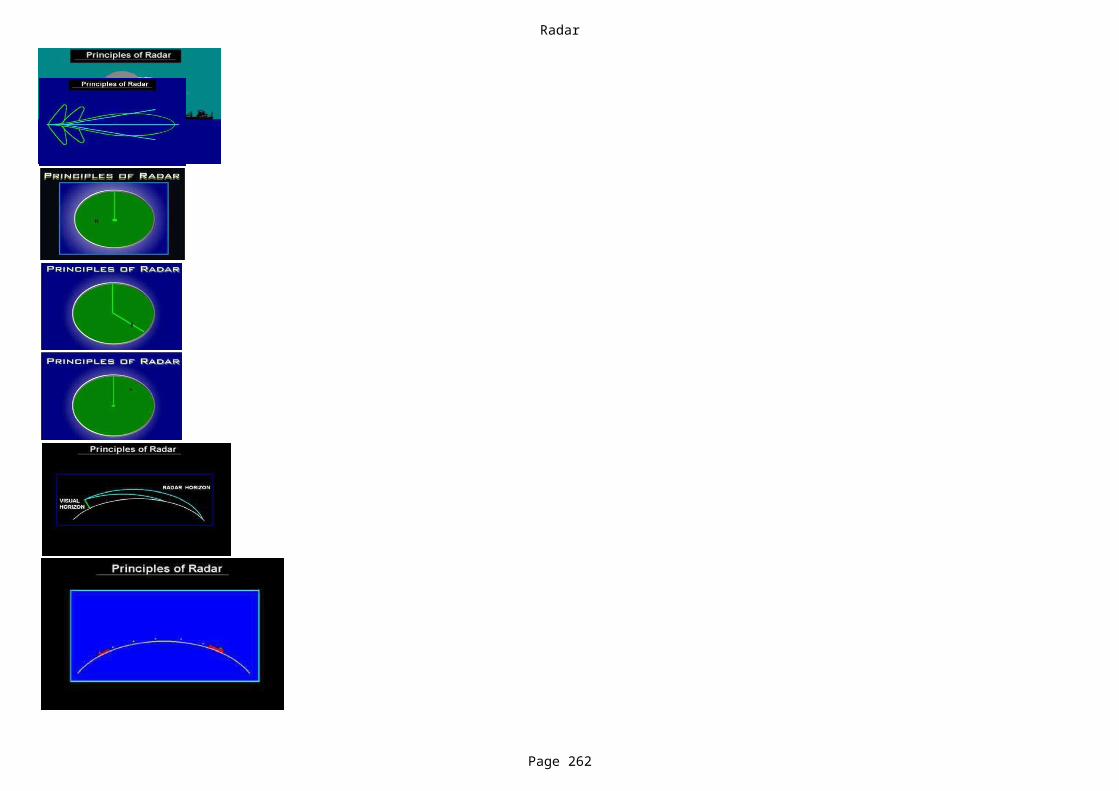
Radar
Page 262

Radar
Page 263
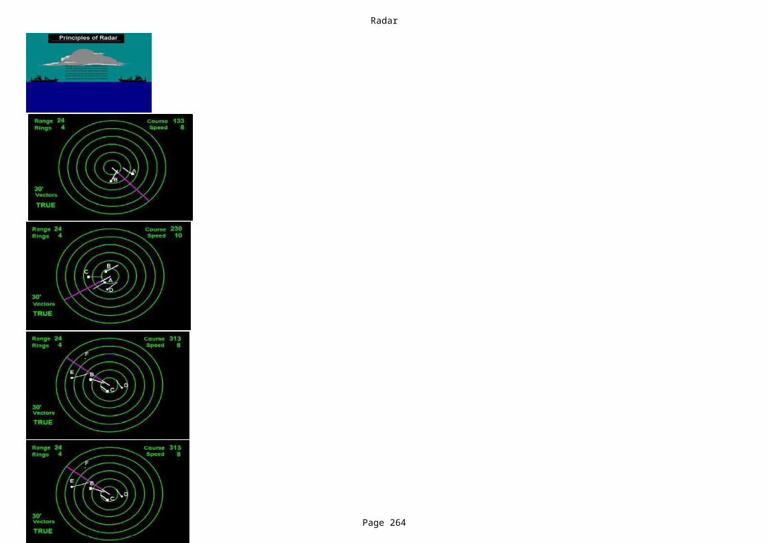
Radar
Page 264

Radar
Page 265
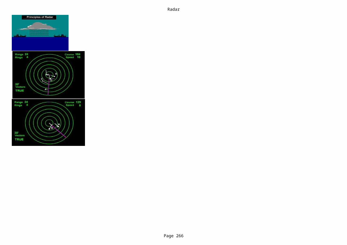
Radar
Page 266
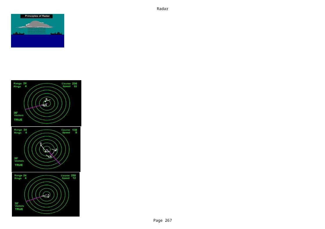
Radar
Page 267

Radar
Page 268
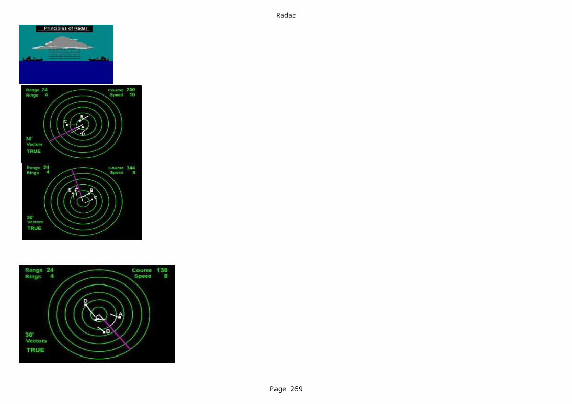
Radar
Page 269
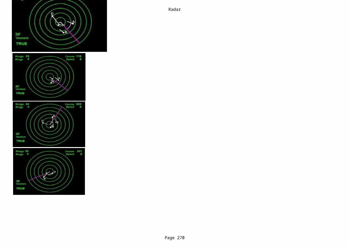
Radar
Page 270
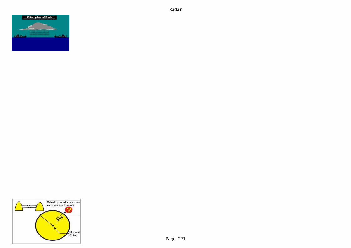
Radar
Page 271
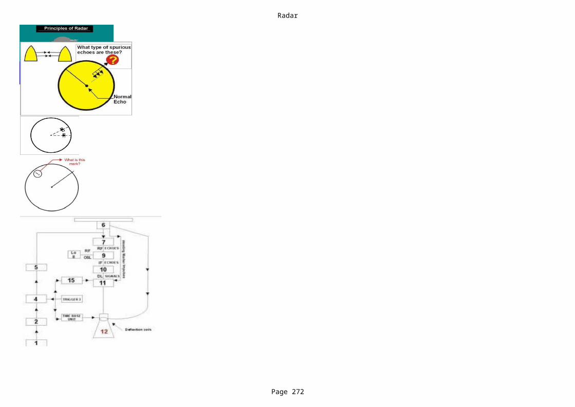
Radar
Page 272
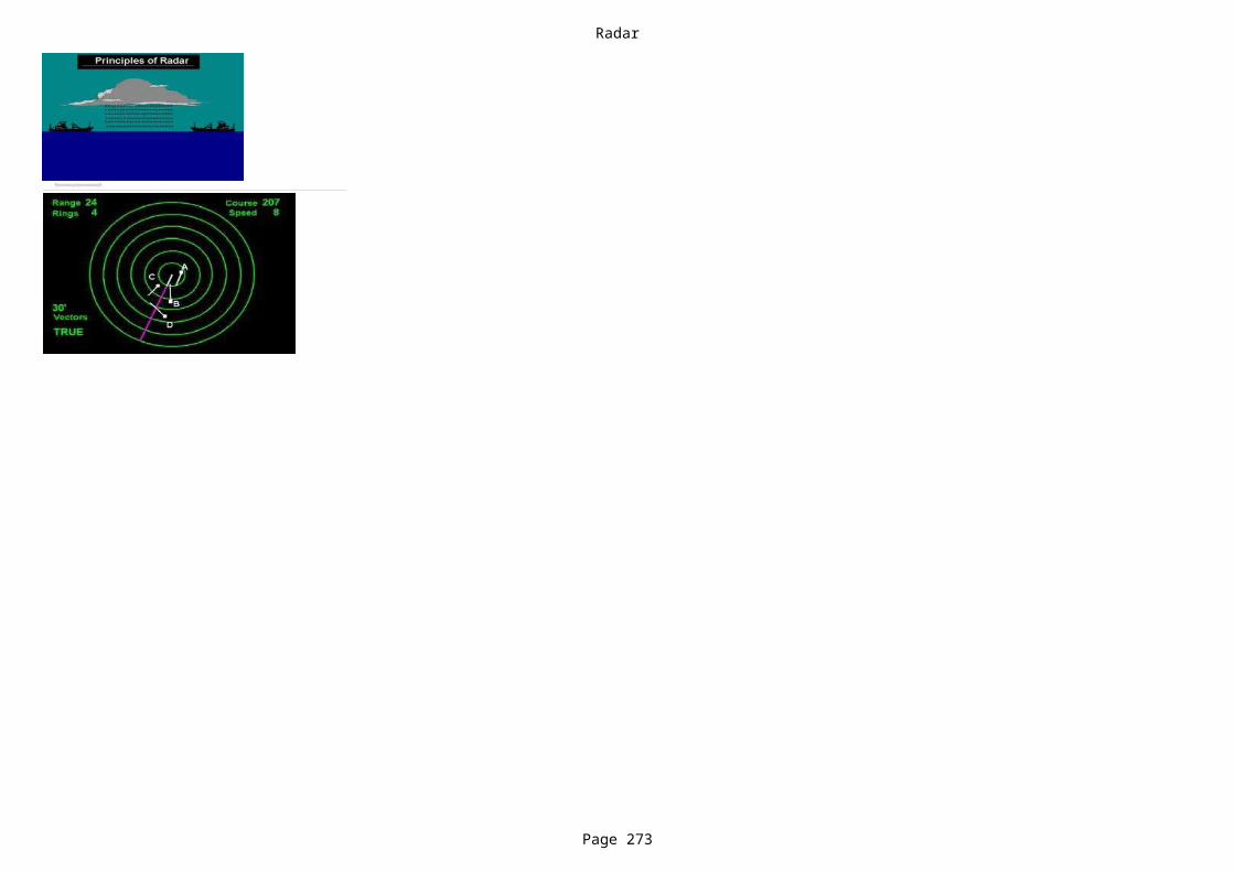
Radar
Page 273
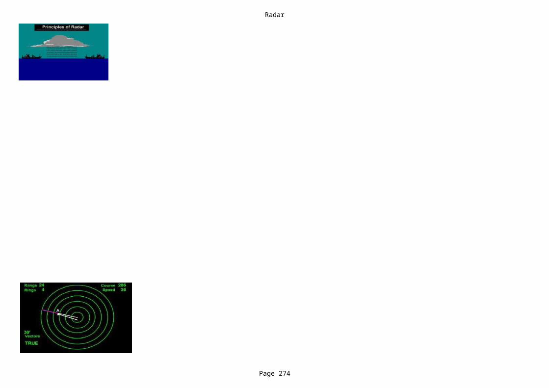
Radar
Page 274

Radar
Page 275

Radar
Page 276
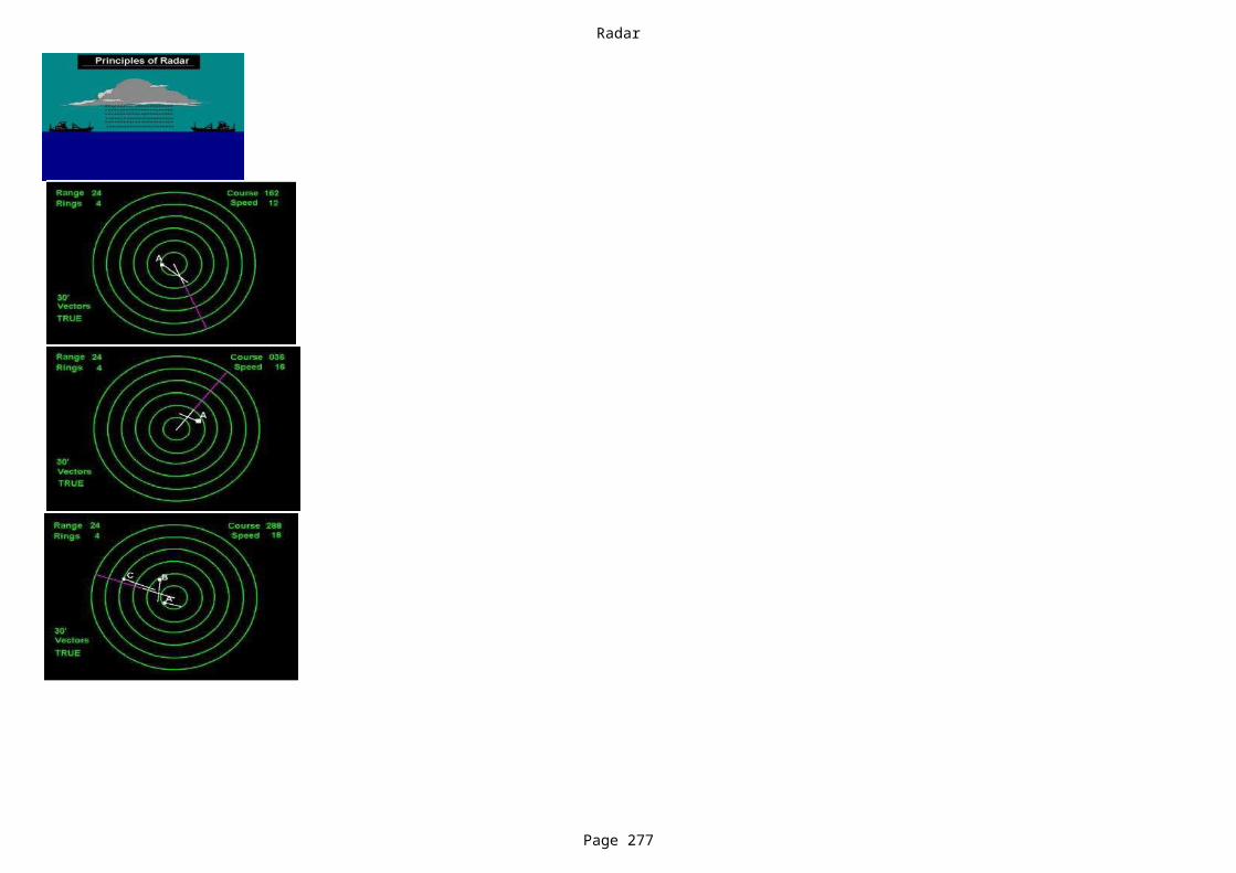
Radar
Page 277

Radar
Page 278
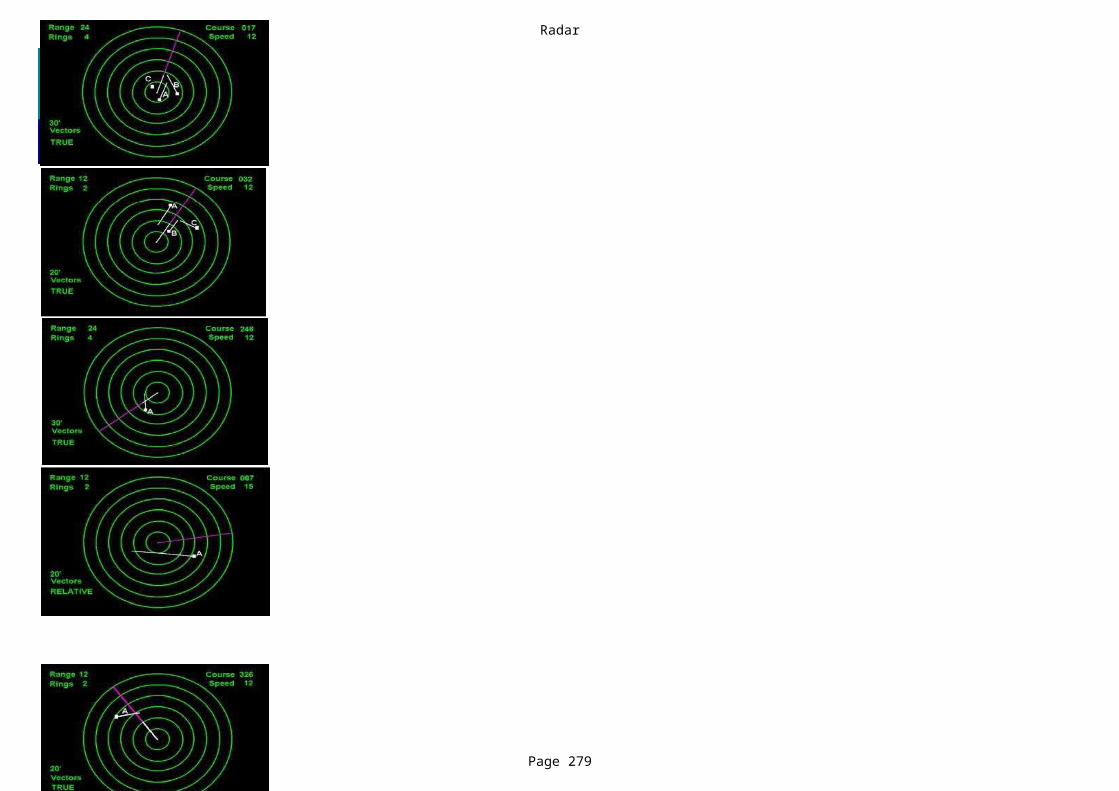
Radar
Page 279
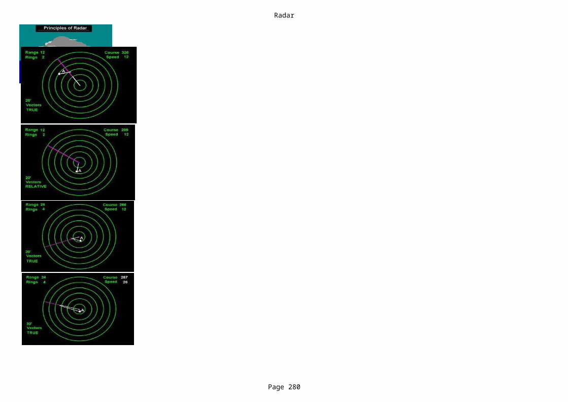
Radar
Page 280
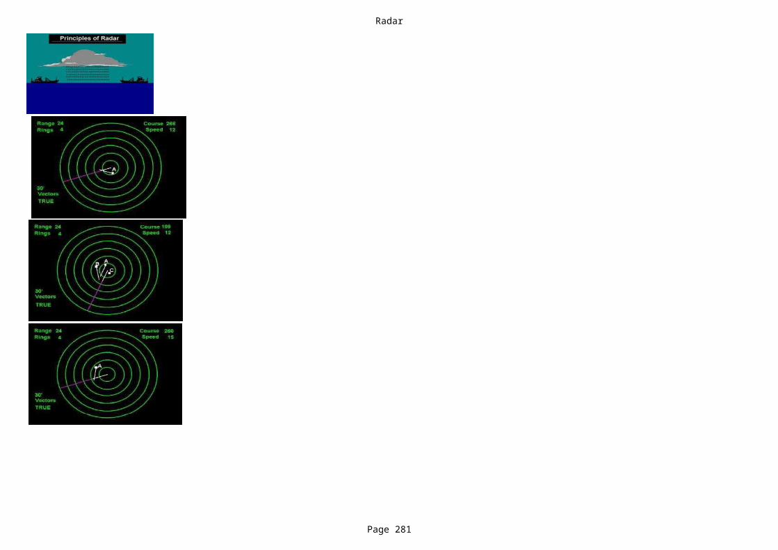
Radar
Page 281
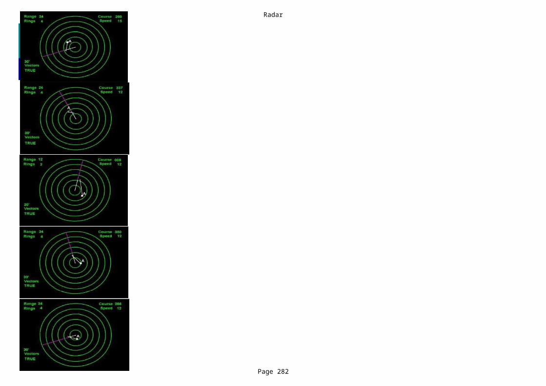
Radar
Page 282
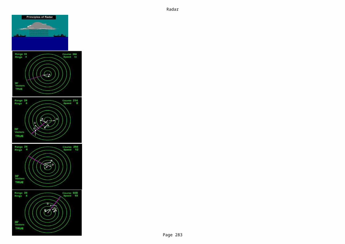
Radar
Page 283
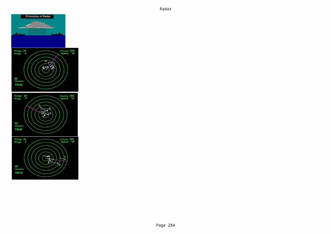
Radar
Page 284

Radar
Page 285
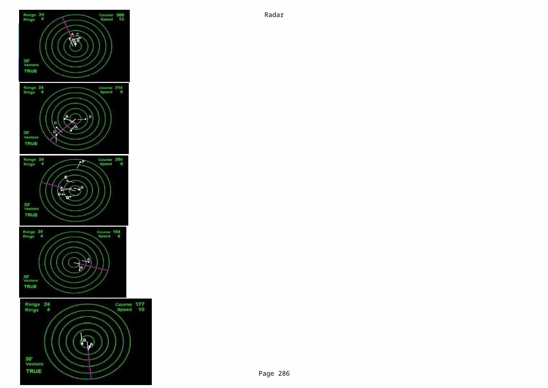
Radar
Page 286

Radar
Page 287
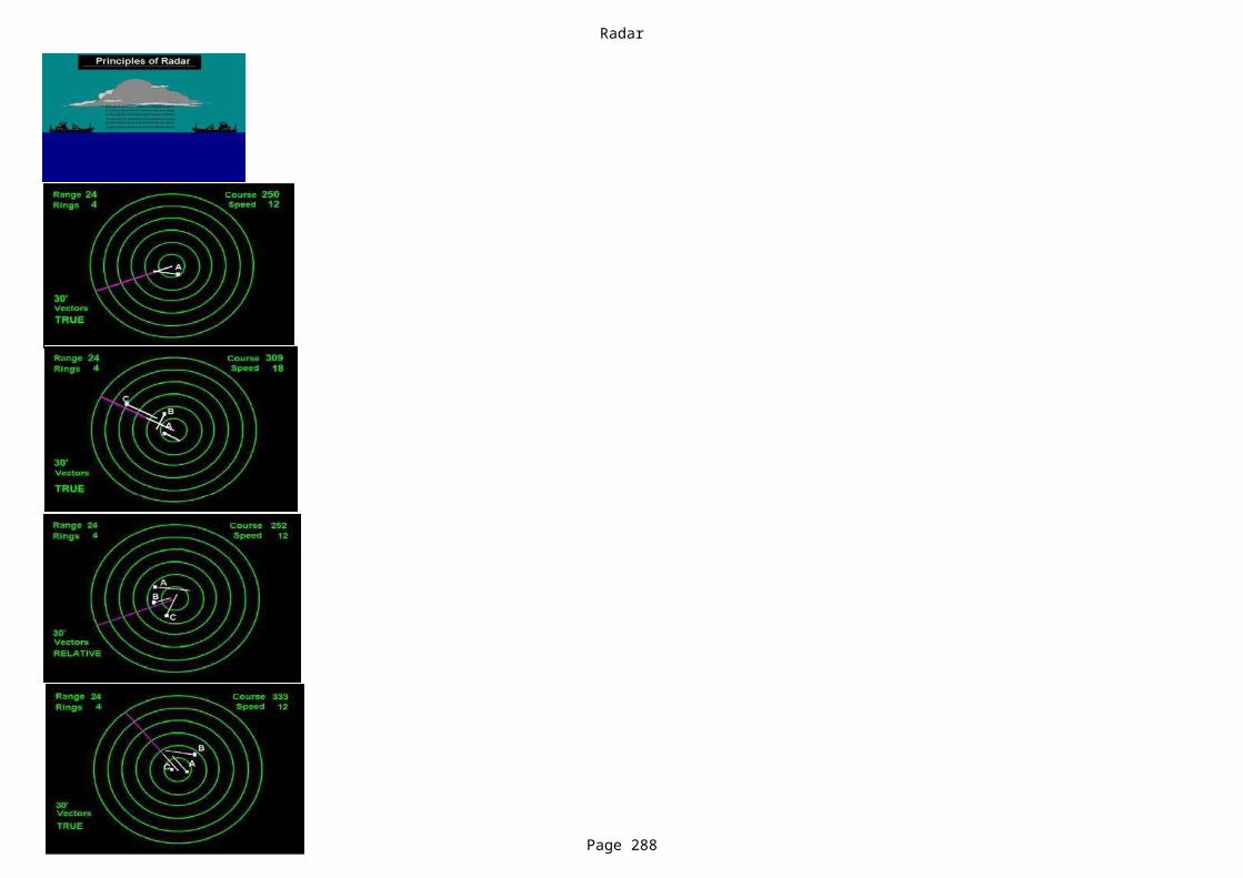
Radar
Page 288
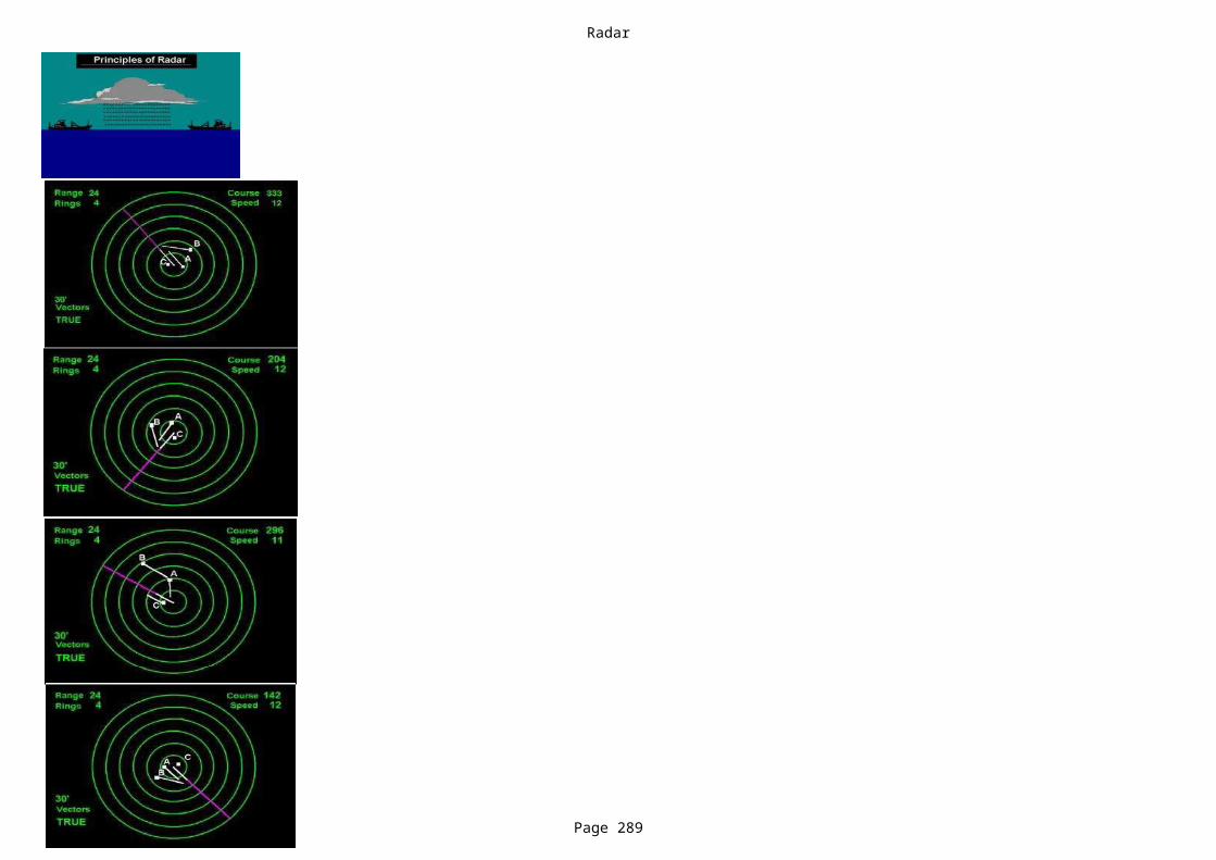
Radar
Page 289
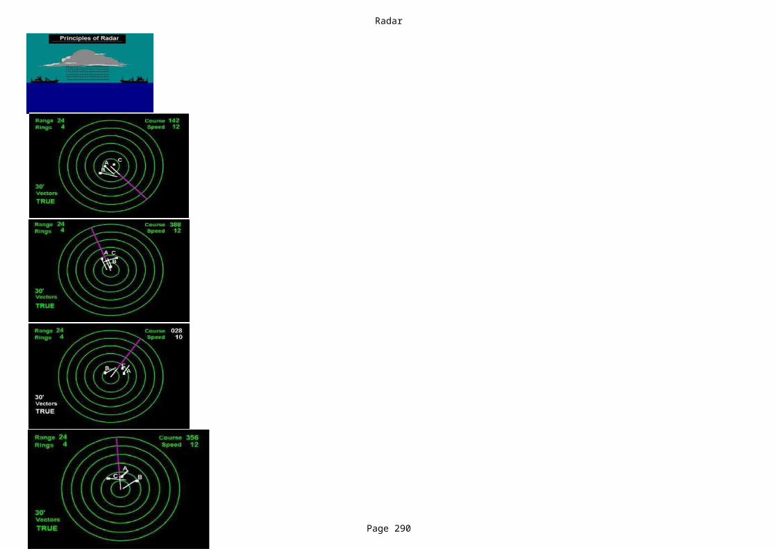
Radar
Page 290

Radar
Page 291

Go and find a fire hose.
Burning
Emergency switch
How should deck fire hoses be stowed? In fire boxes
The same (Amp + Volt)
Into the flame
What does this sign mean? Flammable.
A series of 5 long rings.
Activate a fire alarm.
What is a "flammable mixture"?
Cooling.
Jet.
What would you do if someone's clothes catch fire?
Another term or word for combustion is....
The switch isolating all the power to electrical equipment is called a....
When you are fighting a fire in an enclosed space, you should keep low, primarily in order to....
For low smoke,better visiblity
A fuse that blows should be replaced with a fuse of.....During extremely cold weather conditions, what must be done to fire mains on deck to keep them from freezing?
Drain main fire piping system in low points
You find a fire in the crew's accommodation. The first thing you should do is....
Push fire alarm button and inform the bridge
When using a carbon dioxide fire extinguisher, the discharge should be directed…
What alarm signal is sounded by the ship's alarm bells in the event of fire onboard?
What action should be taken first when discovering a fire on board?
How do you direct a fire nozzle under full water pressure?
Direct the nozzle horizontally.
A mixture of vapour and oil in an inerted tank.
If oxygen is removed from the fire triangle, what is this called?
What setting are these firefighters use on their nozzle?

Water.
Cooling.
Cooling.
The introduction of fuel.
Air, earth, and water.
Powder.
Foam.
A fire blanket.
fuel
Which of these extinguishing agents is it best to use on a fire involving a burning cabin that had been electrically isolated ?
Carbon dioxide (CO2).
Which of these portable fire extinguishers are found on the Bridge, in the Radio Room and in the Engine Control Room, because they are extremely effective with fires involving live electrical and electronic equipment?
Carbon Dioxide (CO2).
On fires involving burning liquids, which of these extinguishers is considered most effective?
If fuel is removed from the fire triangle, what is this called?
If heat is removed from the fire triangle, what is this called?
Which side of the fire triangle most commonly causes a fire?For fire to occur, which of the following sets of elements must be combined?Which of these fire extinguishing media is most effective against an open oil fire?Which of these fire extinguishing agent is preferred to fight a fire in an electrical installation (eg. the main switchboard)?What item of fire extinguishing equipment, usually found in the galley, is particularly effective on fires involving hot cooking oil?When would you adjust a fire hose nozzle to provide a solid stream of water?
All except fuel and electrical equipment
If you discover a fire, what is the most important action to take?
Close doors and windows to remove the air supply
What should you do if a pan of fat or cooking oil catches fire in the galley?
Pour it down the nearest drain
What type of extinguisher is most suitable for dealing with fires involving carbonaceous materials?
CO2 extinguisher
For fire to occur, the three elements found in the "Fire Triangle" must be present. These are heat, air and....
Why should a CO2 extinguisher be used with caution in confined areas?
It will increase the oxygen present in the confined area to a dangerous level
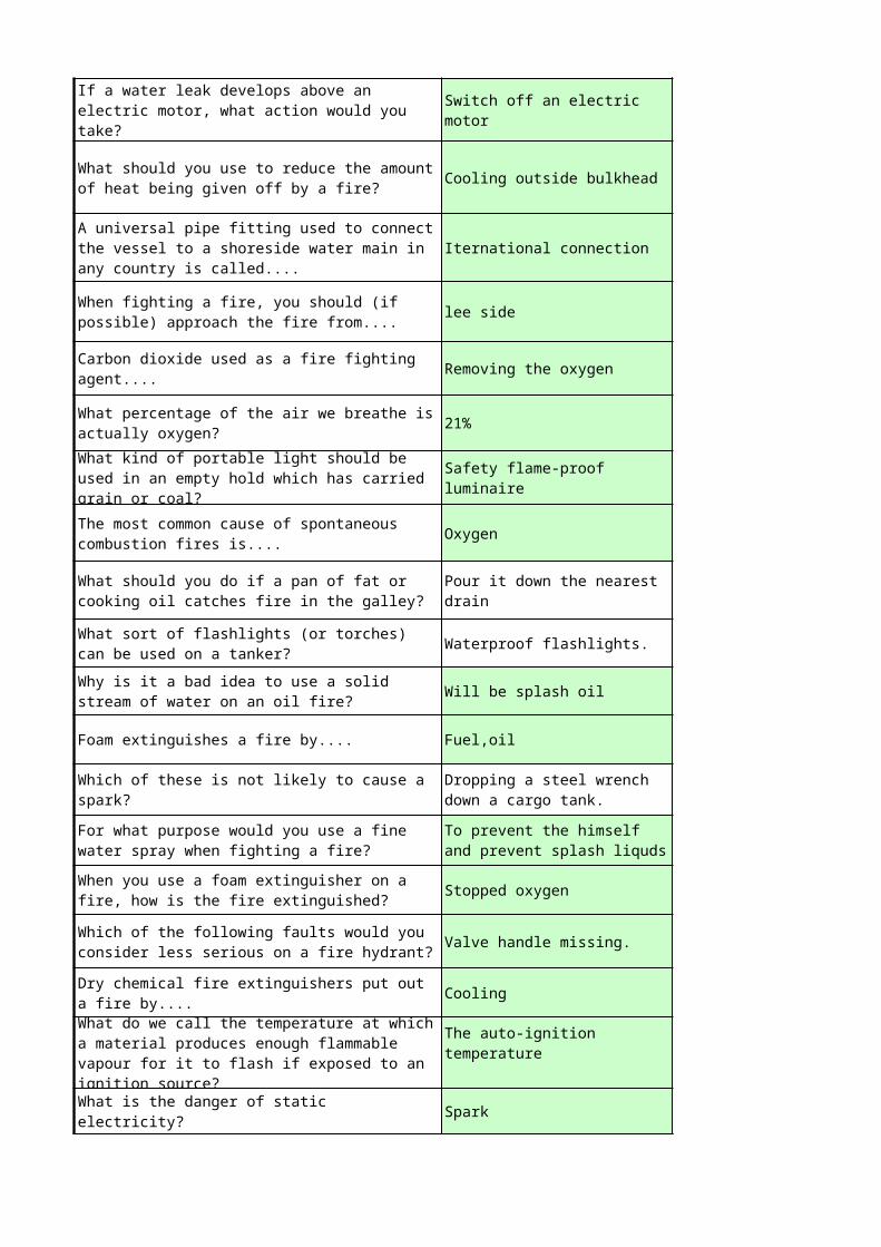
Cooling outside bulkhead
Iternational connection
lee side
Removing the oxygen
21%
Oxygen
Waterproof flashlights.
Will be splash oil
Foam extinguishes a fire by.... Fuel,oil
Stopped oxygen
Valve handle missing.
Cooling
Spark
If a water leak develops above an electric motor, what action would you take?
Switch off an electric motor
What should you use to reduce the amount of heat being given off by a fire?
A universal pipe fitting used to connect the vessel to a shoreside water main in any country is called....
When fighting a fire, you should (if possible) approach the fire from....
Carbon dioxide used as a fire fighting agent....
What percentage of the air we breathe is actually oxygen?What kind of portable light should be used in an empty hold which has carried grain or coal?
Safety flame-proof luminaire
The most common cause of spontaneous combustion fires is....
What should you do if a pan of fat or cooking oil catches fire in the galley?
Pour it down the nearest drain
What sort of flashlights (or torches) can be used on a tanker?Why is it a bad idea to use a solid stream of water on an oil fire?
Which of these is not likely to cause a spark?
Dropping a steel wrench down a cargo tank.
For what purpose would you use a fine water spray when fighting a fire?
To prevent the himself and prevent splash liquds
When you use a foam extinguisher on a fire, how is the fire extinguished?
Which of the following faults would you consider less serious on a fire hydrant?
Dry chemical fire extinguishers put out a fire by....What do we call the temperature at which a material produces enough flammable vapour for it to flash if exposed to an ignition source?
The auto-ignition temperature
What is the danger of static electricity?

Never to smoke in bed.What is the basic principle of fire prevention?
What is the first thing you should do if you find an electrical fire?
Switch off electrical power
* * * NOTHING FOLLOWS * * *

Telephone the bridge.
NO DATA NO DATA NO DATA
NO DATA NO DATA NO DATA
NO DATA NO DATA NO DATA
NO DATA NO DATA NO DATA
NO DATA NO DATA NO DATA
NO DATA NO DATA NO DATA
NO DATA NO DATA NO DATA
NO DATA NO DATA NO DATA
Explosive. Radioactive. Dangerous gas.
A series of 5 short rings.
Blowing. Smothering. Starving.
Stream. Fountain. Spray.
Smother the flames with a blanket or jacket.
Shout for help while getting the first aid kit.
One long ring followed by seven short rings.
Continuous ringing of the bell.
Look for the nearest fire extinguisher.
Go to your cabin and gather your belongings.
Go to your emergency muster station.
Direct the nozzle slightly upwards.
Direct the nozzle slightly downwards.
Direct the nozzle vertically.
Any mixture that can ignite on its own.
A mixture that has large amounts of vapour but not enough oxygen molecules.
A mixture that has vapour and oxygen from the air in sufficient quantities to ignite.
Dry Powder - Dry Chemical. Foam. Water.
Foam. A.F.F.F.
Dry Powder. Foam. CO2.
Starving. Smothering. Suffocating.
Wetting. Smothering. Starving.
The introduction of air. The introduction of heat.
Air, fuel and oxygen. Heat, fuel and oxygen.
Foam. Gas. Water.
Sprinkler. Water fog. Powder.
A bucket of water. A fire hose.
NO DATA NO DATA NO DATA
Dry powder extinguisher Foam extinguisher Water extinguisher
flame electricity spark
Dry Chemical - Dry Powder.
The introduction of oxygen.
Conduction, convection & radiation.
A water filled extinguisher.
Tackle the fire with the nearest fire extinguisher
Find the seat of the fire Report it by raising the alarm
Tip a bucket of water over it
Cover it with a fire blanket
Spray it with a CO2 extinguisher
It will not operate effectively in confined areas
It may explode when exposed to heat
It will displace the air and reduce the amount of oxygen available
NO DATA NO DATA NO DATA
NO DATA NO DATA NO DATA
NO DATA NO DATA NO DATA
NO DATA NO DATA NO DATA
NO DATA NO DATA NO DATA
NO DATA NO DATA NO DATA
NO DATA NO DATA NO DATA
NO DATA NO DATA NO DATA
Water-cooled flashlights.
NO DATA NO DATA NO DATA
NO DATA NO DATA NO DATA
NO DATA NO DATA NO DATA
NO DATA NO DATA NO DATA
Not greased. No hydrant cap fitted. Leaking.
NO DATA NO DATA NO DATA
The melting point The flashpoint The ignition temperature
NO DATA NO DATA NO DATA
Tip a bucket of water over it
Cover it with a fire blanket
Spray it with a CO2 extinguisher
Regular tightly sealed flashlights.
Intrinsically safe flashlights.
Steel striking another piece of steel.
Steel striking against copper.
Dropping a rubber mallet down a cargo hatch.

NO DATA NO DATA NO DATA
Remove one of the three components of the "fire triangle."
Keep all spaces throughout the vessel well ventilated.
Inspect the vessel at the end of each watch.
10
16