Sediment drifts and deep-sea channel systems, Antarctic Peninsula Pacific Margin
20
The series of twelve large sedimentary mounds, elongated orthog- onal to the Antarctic Peninsula Pacific continental margin, are examples of mixed drift systems produced by the interaction of downslope and alongslope processes. The margin has been exten- sively studied over the past decade by a series of Italian, German, British and joint research programmes, and has also been the focus of DSDP and ODP drilling. This paper focuses on Drift 7, an elongate body some 200 km long, 70 km wide and up to 1 km thick (Table 1, Fig. 1). It synthesises the principal results derived from study of a variety of data types, including detailed bathy- metric and swath bathymetric data, seismic reflection profiles and sub-bottom (TOPAS) profiles, seabed photos, and sediment core samples. Geological and oceanographic setting The Pacific Margin of the Antarctic Peninsula has been charac- terised by rapid terrigenous sedimentation since the late Miocene (Tucholke et al. 1976; Larter & Barker 1989). Glacially-derived sediment has been redistributed downslope and alongslope by turbidity currents and bottom currents. West of Drake Passage, the axis of the eastward-flowing Antarctic Circumpolar Current (ACC) lies about 60°S (Nowlin & Klinck 1986). A narrow counter current flows south-westward close to the margin (Gordon 1966; Nowlin & Zenk 1988; Camerlenghi et al. 1997a). On the continental rise, in water depths of 2700–3700 m, there are 12 large sediment mounds elongated orthogonally to the margin (Fig. 1). They are thought to be formed of material originally supplied from turbidity currents flowing in deep-sea channels extending from the margin to the abyssal plain, and redistributed by south-westerly-flowing bottom currents (Rebesco et al. 1994, 1996; McGinnis & Hayes 1995). Present day bottom current flow in the area of drift 7, one of the largest drifts (Fig. 2) was reconstructed (Camerlenghi et al. 1997a; A. Crise, pers. comm.) from data recorded in three deep moorings deployed by the R/V OGS-Explora during two cruises of the Progetto Nazionale Ricerche in Antartide (PNRA). Mooring ST- 01 was deployed at 3475 m depth on the south-west, steeper side of drift 7, Mooring ST-02 at 3338 m depth on the gentler north- eastern side, and Mooring ST-03 (equipped with two current meters at 8 m and 60 m above the sea bed respectively) at 3580 m on the distal north-western side. The direction of the bottom water flow is controlled by drift topography, as shown by the mean current direction. The general SW flowing circulation follows the isobaths and appears to be geostrophically adjusted at least for a large part of the year (Fig. 2). The mean current velocity 8 m above the seabed is between 4 cm s –1 at ST-03 and 6.2 cm s –1 at ST-01 (± 2.8 cm s –1 ), and speed never exceeded 20 cm s –1 . This flow is capable of transporting fine sediment particles, but not of eroding the sediment. The potential temperature is remarkably stable between 0.11 ± 0.01ºC and 0.13 ± 0.02ºC. These values, even in the absence of salinity records, suggest that the bottom layer consists of modified Circumpolar Deep Water (CDW), which constitutes the largest volume of water in the Southern Ocean (Carmack 1990). The observed bottom water flow is consistent with deposition of Holocene hemipelagic sediments during a ‘drift maintenance’ stage. Indicators of palaeoceanographic conditions during glacial periods are at present too scarce to fully understand how the past oceanographic conditions influenced the evolution of the drifts. 353 Sediment drifts and deep-sea channel systems, Antarctic Peninsula Pacific Margin M. REBESCO 1 , C. J. PUDSEY 2 , M. CANALS 3 , A. CAMERLENGHI 1 , P. F. BARKER 2 , F. ESTRADA 3 & A. GIORGETTI 1 1 Istituto Nazionale di Oceanografia e di Geofisica Sperimentale (OGS), Borgo Grotta Gigante 42/c, 34010 Sgonico (TS), Italy (e-mail: [email protected]) 2 British Antarctic Survey, Madingley Road, Cambridge CB3 0ET, UK 3 Universitat de Barcelona, Campus de Pedralbes, Barcelona E-08028, Spain Abstract: Twelve sedimentary mounds are identified on the upper continental rise of the Pacific Margin of the Antarctic Peninsula. All these mounds are produced by a varying degree of interaction of along-slope bottom water flow with down- slope turbidity currents. These mounds provide a complete range of intermediates between two end members: the sediment drift and the channel levee. Surface sediments on drift 7 suggest that the mechanisms for the supply and transport of sediment include entrainment of material from turbidity currents within ambient bottom currents, and pelagic settling from the sea surface, including biogenic and glacially derived material. The long-lasting activity of these mechanisms is docu- mented by the data provided by four DSDP and ODP drill sites. Bathymetric and seismic data, both at a large, comprehen- sive scale and at a small, detailed scale, show the geometry of the sedimentary mounds and their relationships with the adjacent turbidity current channel systems. These data allow the determination of some diagnostic criteria to identify the sediment drifts. From: STOW, D. A. V., PUDSEY, C. J., HOWE, J. A., FAUGÈRES, J.-C. & VIANA, A. R. (eds) Deep-Water Contourite Systems: Modern Drifts and Ancient Series, Seismic and Sedimentary Characteristics. Geological Society, London, Memoirs, 22, 353–371. 0435-4052/02/$15.00 © The Geological Society of London 2002. Table 1. Principal characteristics Location: Antarctic Peninsula Pacific Margin Setting: Upper continental rise Age: Mid Miocene-Present Drift type: Detached drift (with influence of turbidity currents) Dimensions: Up to about 200 70 1 km Seismic facies and attributes: Asymmetric, with a gentler side underlain by conformable reflectors and a steeper side underlain by more discontinuous reflectors with frequent unconformities and erosional truncations. Sediment facies and attributes: Very fine-grained, showing glacial- interglacial cycles in composition, texture and sedimentary structures (interglacials are bioturbated, contain ice-rafted debris and biogenic silica and carbonate; glacials are laminated clays). SF27 Rebesco (to/d) 12/18/02 12:23 PM Page 353
Transcript of Sediment drifts and deep-sea channel systems, Antarctic Peninsula Pacific Margin
The series of twelve large sedimentary mounds, elongated orthog-onal to the Antarctic Peninsula Pacific continental margin, areexamples of mixed drift systems produced by the interaction ofdownslope and alongslope processes. The margin has been exten-sively studied over the past decade by a series of Italian, German,British and joint research programmes, and has also been thefocus of DSDP and ODP drilling. This paper focuses on Drift 7,an elongate body some 200 km long, 70 km wide and up to 1 kmthick (Table 1, Fig. 1). It synthesises the principal results derivedfrom study of a variety of data types, including detailed bathy-metric and swath bathymetric data, seismic reflection profiles andsub-bottom (TOPAS) profiles, seabed photos, and sediment coresamples.
Geological and oceanographic setting
The Pacific Margin of the Antarctic Peninsula has been charac-terised by rapid terrigenous sedimentation since the late Miocene(Tucholke et al. 1976; Larter & Barker 1989). Glacially-derivedsediment has been redistributed downslope and alongslope byturbidity currents and bottom currents. West of Drake Passage,the axis of the eastward-flowing Antarctic Circumpolar Current(ACC) lies about 60°S (Nowlin & Klinck 1986). A narrow countercurrent flows south-westward close to the margin (Gordon 1966;Nowlin & Zenk 1988; Camerlenghi et al. 1997a).
On the continental rise, in water depths of 2700–3700 m, thereare 12 large sediment mounds elongated orthogonally to themargin (Fig. 1). They are thought to be formed of materialoriginally supplied from turbidity currents flowing in deep-seachannels extending from the margin to the abyssal plain, andredistributed by south-westerly-flowing bottom currents (Rebescoet al. 1994, 1996; McGinnis & Hayes 1995).
Present day bottom current flow in the area of drift 7, one of thelargest drifts (Fig. 2) was reconstructed (Camerlenghi et al. 1997a;A. Crise, pers. comm.) from data recorded in three deep mooringsdeployed by the R/V OGS-Explora during two cruises of theProgetto Nazionale Ricerche in Antartide (PNRA). Mooring ST-01 was deployed at 3475 m depth on the south-west, steeper sideof drift 7, Mooring ST-02 at 3338 m depth on the gentler north-eastern side, and Mooring ST-03 (equipped with two currentmeters at 8 m and 60 m above the sea bed respectively) at 3580 mon the distal north-western side.
The direction of the bottom water flow is controlled by drifttopography, as shown by the mean current direction. The generalSW flowing circulation follows the isobaths and appears to begeostrophically adjusted at least for a large part of the year (Fig.2). The mean current velocity 8 m above the seabed is between4 cm s–1 at ST-03 and 6.2 cm s–1 at ST-01 (± 2.8 cm s–1), and speednever exceeded 20 cm s–1. This flow is capable of transporting finesediment particles, but not of eroding the sediment. The potentialtemperature is remarkably stable between 0.11 ± 0.01ºC and 0.13± 0.02ºC. These values, even in the absence of salinity records,suggest that the bottom layer consists of modified CircumpolarDeep Water (CDW), which constitutes the largest volume ofwater in the Southern Ocean (Carmack 1990).
The observed bottom water flow is consistent with deposition ofHolocene hemipelagic sediments during a ‘drift maintenance’stage. Indicators of palaeoceanographic conditions during glacialperiods are at present too scarce to fully understand how the pastoceanographic conditions influenced the evolution of the drifts.
353
Sediment drifts and deep-sea channel systems, Antarctic Peninsula Pacific Margin
M. REBESCO1, C. J. PUDSEY2, M. CANALS3, A. CAMERLENGHI1, P. F. BARKER2, F. ESTRADA3 &A. GIORGETTI1
1Istituto Nazionale di Oceanografia e di Geofisica Sperimentale (OGS), Borgo Grotta Gigante 42/c, 34010 Sgonico (TS),Italy (e-mail: [email protected])
2British Antarctic Survey, Madingley Road, Cambridge CB3 0ET, UK3Universitat de Barcelona, Campus de Pedralbes, Barcelona E-08028, Spain
Abstract: Twelve sedimentary mounds are identified on the upper continental rise of the Pacific Margin of the AntarcticPeninsula. All these mounds are produced by a varying degree of interaction of along-slope bottom water flow with down-slope turbidity currents. These mounds provide a complete range of intermediates between two end members: the sedimentdrift and the channel levee. Surface sediments on drift 7 suggest that the mechanisms for the supply and transport ofsediment include entrainment of material from turbidity currents within ambient bottom currents, and pelagic settling fromthe sea surface, including biogenic and glacially derived material. The long-lasting activity of these mechanisms is docu-mented by the data provided by four DSDP and ODP drill sites. Bathymetric and seismic data, both at a large, comprehen-sive scale and at a small, detailed scale, show the geometry of the sedimentary mounds and their relationships with theadjacent turbidity current channel systems. These data allow the determination of some diagnostic criteria to identify thesediment drifts.
From: STOW, D. A. V., PUDSEY, C. J., HOWE, J. A., FAUGÈRES, J.-C. & VIANA, A. R. (eds)Deep-Water Contourite Systems: Modern Drifts and Ancient Series, Seismic and Sedimentary Characteristics.Geological Society, London, Memoirs, 22, 353–371. 0435-4052/02/$15.00 © The Geological Society of London 2002.
Table 1. Principal characteristics
Location: Antarctic Peninsula Pacific MarginSetting: Upper continental riseAge: Mid Miocene-PresentDrift type: Detached drift (with influence of
turbidity currents)Dimensions: Up to about 200 � 70 � 1 kmSeismic facies and attributes: Asymmetric, with a gentler side
underlain by conformable reflectorsand a steeper side underlain by morediscontinuous reflectors with frequentunconformities and erosionaltruncations.
Sediment facies and attributes: Very fine-grained, showing glacial-interglacial cycles in composition,texture and sedimentary structures(interglacials are bioturbated, containice-rafted debris and biogenic silica andcarbonate; glacials are laminated clays).
SF27 Rebesco (to/d) 12/18/02 12:23 PM Page 353

Bathymetry
General bathymetry
The bathymetric map of Figure 3, which covers the entire conti-nental margin from shelf to abyssal plain, shows the main physio-graphic characteristics of this glacial system. Like other parts of
the Antarctic continental margin (Cooper et al. 1991) the conti-nental shelf is over-deepened with a seafloor that generally dipslandward. Shelf bathymetric relief is high (up to 1000 m) due tothe presence of overdeepened basins (Domack et al. 1994;Rebesco et al. 1998a) and glacial troughs carved by ice streams(Pope & Anderson 1992; Pudsey et al. 1994; Canals et al. 2000).Four main lobes, defined by oceanward-convex trends of the
354 M. REBESCO ET AL.
Fig. 1. Location map of the study area. Sediment drifts and mounds of the continental rise are shaded in light grey and progressively numbered from northto south according to the system used by Rebesco et al. (1996). Deep sea channels, indicated by dark grey arrows, are newly named in this paper.Prograding lobes of the continental shelf break are shaded in dark grey and numbered from north to south according to Larter et al. (1997). Glacial troughsare indicated by black arrows. Main fracture zones are indicated by dashed lines. Seismic profiles are shown as black lines. Location of DSDP and ODPsites and cores are also shown.
SF27 Rebesco (to/d) 12/18/02 12:23 PM Page 354

continental shelf break, can be correlated with prograding wedgesconsisting of coalescing banks of the outer shelf (Larter & Cun-ningham 1993; Larter et al. 1997; Rebesco et al. 1998b). These fourlobes are separated by large symmetric, U-shaped troughs withgentle sides (Vanney & Johnson 1976a, b; Pope & Anderson 1992;Rebesco et al. 1998b). The continental slope (about 500 to 3000 mwater depth) is very steep. The gradient of the four lobes (>13º) isgenerally steeper than that of the slope at the mouth of thetroughs. Despite such steepness, there is no evidence of present-day major slope failure, nor of major canyons cutting into theslope.
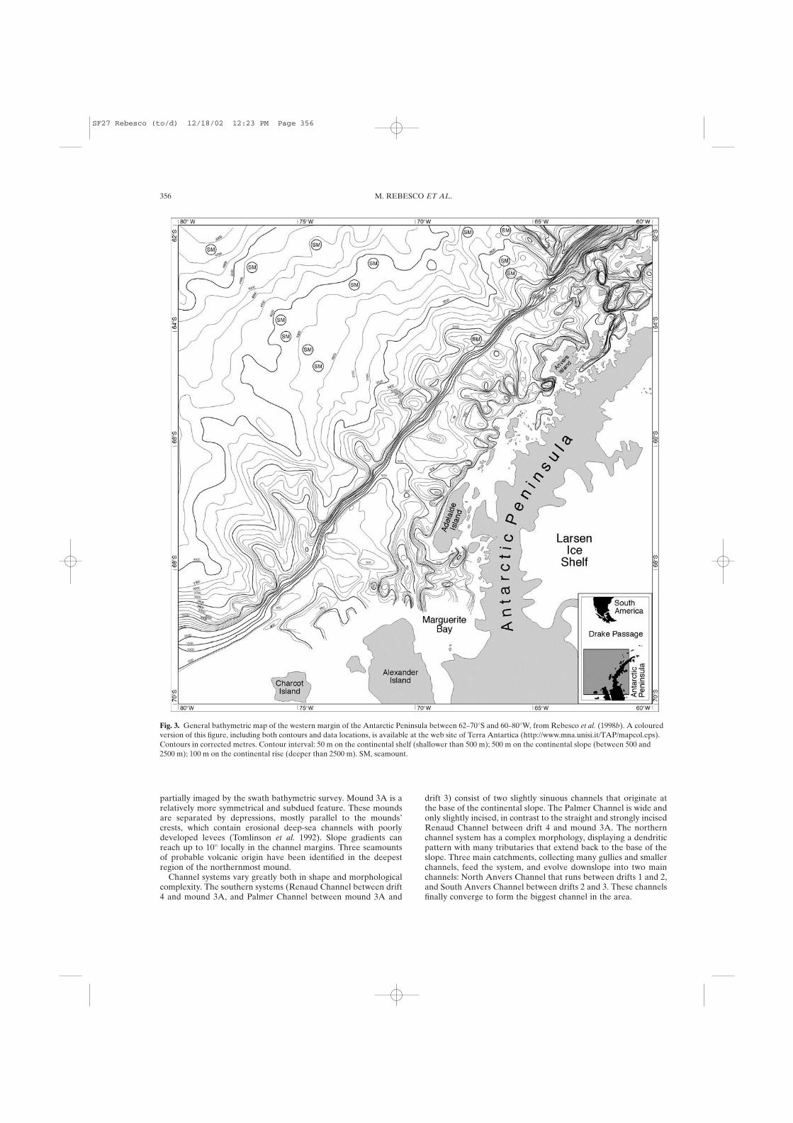
The upper limit of the continental rise south of 67ºS is deeper(almost 3500 m) than in the northeast part (around 3000 m) as aconsequence of a major step (in correspondence of the TulaFracture Zone) within the stepwise younging of basement agenortheastward along the margin (Tucholke & Houtz 1976). TheBellingshausen Abyssal Plain lies below 4800 m (Vanney &Johnson 1976a, b). The irregular relief of the upper continentalrise results from the 12 sediment mounds separated by deep-seachannel systems, originating at the base of the slope between thelobes. The channels are named for the first time in this paper(Fig. 1).
Since some of the channels run parallel to the margin for tensof kilometres before turning seaward towards the outer rise, thesediment mounds are commonly separated from the continentalslope by a broad 10–20 km wide erosional depression. All the 12mounds have a distinct bathymetric expression. Nine of them
were numbered progressively from north to south and interpretedas sediment drifts, with varying degree of interaction of bottomcurrents with downslope turbidity current processes (Rebesco etal. 1994, 1996, 1998b; McGinnis & Hayes 1995; McGinnis et al.1997). Three additional mounds (mounds 3A, 4B, and 5A) arenewly mapped here, mainly on the basis of swath bathymetry andseismic data. All the sediment mounds share many commonfeatures, though each one is different from the others. They arepreferentially located between the shelf lobes (i.e. in front of theshelf troughs). They are elongated in a direction approximatelyorthogonal to the margin, with a wider, thicker central body andtwo narrow ends. The largest mounds have their summits at anaverage depth of 2700 m, are up to 200 km long by 70 km wide,and attain an elevation of nearly 1 km above the adjacentchannels. The majority of the mounds are asymmetric with a steepside (typically sloping 2º) and a gently-dipping side (typically 0.8º)that meet to form a long and narrow crest. Most mounds (drift 1,2, 3, 4A, 6 and 7) have their steep side oriented toward thesouthwest.
The mounds merge into the lower continental rise, at a depth ofabout 3500 m northeast of the Tula Fracture Zone, and about 4000m farther southwest. The lower continental rise north of the TulaFracture Zone is a gently sloping region where the 3600 to 4000 misobaths show an outward-convex curvature (Palmer deep sea fanof Vanney & Johnson 1976a, b). The 4100 to 4600 m isobaths areroughly SW–NE striking and correspond to a more uneven areawhere numerous seamounts protrude through a thin drape of sedi-mentary cover (Tucholke & Houtz 1976; Vanney & Johnson1976a, b; Larter & Barker 1991a). The 4700 m deep SouthShetland Trench, limited to the southwest by the Hero FractureZone, belongs to the active part of the margin and is not discussedhere.
Swath bathymetry
The detailed swath bathymetric map of Figure 4, collected duringthe GEBRAP’96 cruise onboard BIO Hesperides covers themargin west of Palmer Archipelago from the outer shelf (325 mwater depth) to the upper continental rise (3800 m).
The outer continental shelf is a relatively flat, landward-dippingarea crossed by glacial troughs, marked by iceberg scours andincluding some shallow banks that correspond to till deltas(Canals et al. 1998). Water depth ranges from 325 m to 450 m, withthe north-eastern sector being particularly uneven. The shelf edgeis sinuous with two main seaward convex lobes. These lobes cor-respond to the prograding lobes 1 and 2 of Larter et al. (1997).The swath bathymetry map reveals that, in detail, the northeast-ernmost lobe (Lobe 1) is actually made up of two minor lobes.Farther to the north of Lobe 1 there is another minor shelf lobe,indicated by a change in the steepness of the continental slope.The northeast trending continental slope of Lobe 1 is narrow (10km) and very steep (up to 22°), following the sinuous outline ofthe shelf edge. The slope is incised by small straight gullies that donot extend up to the shelf edge. The depth of the base of the con-tinental slope ranges from approximately 2500 m in the south,down to 3000 m in the north.
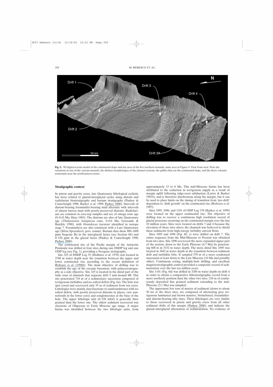
The upper continental rise is characterised by five elongatesediment mounds whose NW-trending crests are roughly orthogo-nal to the shelf edge. Four of these mounds correspond to drifts 1,2, 3, and 4 of Rebesco et al. (1996). A new mound (mound 3A) ishere identified between drifts 3 and 4. The largest imaged moundis drift 3, some 125 km wide between the Palmer and SouthAnvers channels to either side (Fig. 1). The gentler sides of themounds are mostly undisturbed, as exemplified by the levelsurface north of the crest of drift 3 (Fig. 5). Conversely, the crestsand steep sides of the mounds are commonly affected by smallcurved scarps. Drifts 1, 2, and 3 have a steeper SW side than NEside. Drift 4, which apparently displays a steep NE side, is only
SEDIMENT DRIFTS AND DEEP-SEA CHANNEL SYSTEMS, ANTARCTIC PENINSULA PACIFIC MARGIN 355
Fig. 2. Location map of current-moorings on drift 7. See location inFigure 1. The mean direction of the current measured 8 m above theseabed is indicated with arrows at the location of the three moorings. Theinferred bottom water flow path along the isobath between the mooringsis shown by a dashed line.
SF27 Rebesco (to/d) 12/18/02 12:23 PM Page 355
partially imaged by the swath bathymetric survey. Mound 3A is arelatively more symmetrical and subdued feature. These moundsare separated by depressions, mostly parallel to the mounds’crests, which contain erosional deep-sea channels with poorlydeveloped levees (Tomlinson et al. 1992). Slope gradients canreach up to 10° locally in the channel margins. Three seamountsof probable volcanic origin have been identified in the deepestregion of the northernmost mound.
Channel systems vary greatly both in shape and morphologicalcomplexity. The southern systems (Renaud Channel between drift4 and mound 3A, and Palmer Channel between mound 3A and
drift 3) consist of two slightly sinuous channels that originate atthe base of the continental slope. The Palmer Channel is wide andonly slightly incised, in contrast to the straight and strongly incisedRenaud Channel between drift 4 and mound 3A. The northernchannel system has a complex morphology, displaying a dendriticpattern with many tributaries that extend back to the base of theslope. Three main catchments, collecting many gullies and smallerchannels, feed the system, and evolve downslope into two mainchannels: North Anvers Channel that runs between drifts 1 and 2,and South Anvers Channel between drifts 2 and 3. These channelsfinally converge to form the biggest channel in the area.
356 M. REBESCO ET AL.
Fig. 3. General bathymetric map of the western margin of the Antarctic Peninsula between 62–70°S and 60–80°W, from Rebesco et al. (1998b). A colouredversion of this figure, including both contours and data locations, is available at the web site of Terra Antartica (http://www.mna.unisi.it/TAP/mapcol.eps).Contours in corrected metres. Contour interval: 50 m on the continental shelf (shallower than 500 m); 500 m on the continental slope (between 500 and2500 m); 100 m on the continental rise (deeper than 2500 m). SM, seamount.
SF27 Rebesco (to/d) 12/18/02 12:23 PM Page 356

SEDIMENT DRIFTS AND DEEP-SEA CHANNEL SYSTEMS, ANTARCTIC PENINSULA PACIFIC MARGIN 357
Fig. 4. Multibeam coloured bathymetric map of the five northern mounds (contour interval 25 m). See location in Figure 1. The upper inset is a locationmap superposed on the GEBCO bathymetry. The lower inset is an interpretation of the main morphosedimentary features.
SF27 Rebesco (to/d) 12/18/02 12:23 PM Page 357
Stratigraphic context
In piston and gravity cores, late Quaternary lithological cyclicityhas been related to glacial-interglacial cycles using diatom andradiolarian biostratigraphy and barium stratigraphy (Pudsey &Camerlenghi 1998; Barker et al. 1999; Pudsey 2000). Intervals ofdiatom-bearing foraminifer-bearing mud alternate with intervalsof almost barren mud with poorly-preserved diatoms. Radiolari-ans are common in core-top samples and are of omega zone age(0–0.43 Ma; Hays 1965). The diatoms are also of late Quaternaryage (Thalassiosira lentiginosa zone, 0–0.6 Ma; Gersonde &Burckle 1990), with Hemidiscus karstenii identified in isotopestage 7. Foraminifera are also consistent with a Late Quaternaryage (Silvia Spezzaferri, pers. comm). Barium data show 900–1600ppm biogenic Ba in the interglacial facies (see Section 6b) and0–150 ppm in the glacial facies (Pudsey & Camerlenghi 1998;Pudsey 2000).
The continental rise of the Pacific margin of the AntarcticPeninsula was drilled at four sites during one DSDP leg and oneODP leg (see Fig. 1), providing a Neogene stratigraphy.
Site 325 of DSDP Leg 35 (Hollister et al. 1976) was located in3748 m water depth near the transition between the upper andlower continental rise according to the recent definition ofRebesco et al. (1998b). The main objective of drilling was toestablish the age of the oceanic basement, with palaeoceanogra-phy as a side objective. Site 325 is located in the distal part of thewide zone of channels that separate drift 5 and mound 4B. Thissite penetrated 718 m of a sedimentary succession composed ofterrigenous turbidites and ice-rafted debris (Fig. 6a). The hole wasspot cored and recovered only 35 m of sediment from ten cores.Lithologies were mainly clay/claystone to sand/sandstones with icerafted debris, with poorly preserved diatoms in places, rare nan-nofossils in the lower cores and conglomerates at the base of thehole. The upper lithologic unit (0–528 mbsf) is generally finergrained than the lower one. The oldest sediment recovered wasclaystone of Oligocene to Early Miocene age range. A majorhiatus was identified between the two lithologic units, from
approximately 15 to 8 Ma. This mid-Miocene hiatus has beenattributed to the reduction in terrigenous supply as a result ofmargin uplift following ridge-crest subduction (Larter & Barker1991b), and is therefore diachronous along the margin, but it canbe used to place limits on the timing of transition from ‘pre-drift’deposition to ‘drift growth’ on the continental rise (Rebesco et al.1997).
Sites 1095, 1096, and 1101 of ODP Leg 178 (Barker et al. 1999)were located on the upper continental rise. The objective ofdrilling was to recover a continuous high resolution record ofglacial processes occurring on the continental margin over the last10 million years. Sites were located on drifts 7 and 4 because theelevation of these sites above the channels was believed to shieldthese sediments from high-energy turbidity current flows.
Sites 1095 and 1096 (Fig. 6b, c) were drilled on drift 7. Theentire sequence from the Mid-Miocene to Present was obtainedfrom two sites. Site 1096 recovered the more expanded upper partof the section, down to the Early Pliocene (4.7 Ma) by penetrat-ing 608 m in 3152 m water depth. The more distal Site 1095 waslocated in 3842 m water depth at the transition between sedimentdrift and turbiditic lobe. It sampled 570 m of a more condensedsuccession at least down to the Late Miocene (10 Ma and possiblyolder). Continuous coring, multiple-hole drilling, and excellentmagnetostratigraphic control provided a composite record of sedi-mentation over the last ten million years.
Site 1101 (Fig. 6d) was drilled in 3280 m water depth on drift 4in order to obtain a comparative lithostratigraphic record from amore northerly position than the other two sites. 218 m of contin-uously deposited fine grained sediment extending to the mid-Pliocene (3.1 Ma) was sampled.
The uppermost few tens of metres of sediment (down to about50 m) at the three sites, are composed of alternating grey ter-rigenous laminated and brown massive, bioturbated, foraminifer-and diatom-bearing silty clays. These lithologies are very similarto those recovered in piston and gravity cores from all othersediment drifts of this margin (Pudsey 2000), and indicate theglacial–interglacial alternation of sedimentation. No evidence of
358 M. REBESCO ET AL.
Fig. 5. 3D digital terrain model of the continental slope and rise area of the five northern mounds, same area as Figure 4. View from west. Note thevariations in size of the various mounds, the distinct morphologies of the channel systems, the gullies that cut the continental slope, and the three volcanicseamounts near the northeastern corner.
N
Seamounts
Drift 1
Drift 2
Drift 3
Drift 3A
Drift 4
50 km
SF27 Rebesco (to/d) 12/18/02 12:23 PM Page 358

turbiditic deposition can be found in these sediments, and depo-sition appears to be dominated by redeposition of suspended finesfrom terrigenous turbidity currents in deep sea channels duringglacials, and by hemipelagic/pelagic deposition during inter-glacials.
Deeper in the sections colour changes are less obvious, andparallel-laminated silt and mud turbidites become common. AtSite 1096, a mixed contourite-turbidite succession occurs from32.8 to 173.0 mbsf, with generally low biogenic content. Turbiditesilts are thin, and subordinate to muds of likely contouritic origin.From 143–608 mbsf, very thinly laminated and generally non-bioturbated clays deposited from dilute turbidity currents
alternate with intensely bioturbated homogenous silty clays. AtSite 1095, thick and repetitive sequences of green laminated siltand mud were recovered, becoming dark greenish grey laminatedclaystones towards the base of the recovered section. Sharp-based,graded, variably laminated fine sands and silts and laminated siltyclays, interbedded with more massive facies, represent a largelyturbiditic succession. At Site 1101, foraminifer-bearing layersalternate with barren laminated or massive intervals between 53.3and 142.7 mbsf. Deeper in the section, the biogenic component islow, and massive clayey silt and diamict occur. Ice-rafted debris isscattered throughout the facies drilled at the three sites, andappears concentrated within bioturbated intervals.
SEDIMENT DRIFTS AND DEEP-SEA CHANNEL SYSTEMS, ANTARCTIC PENINSULA PACIFIC MARGIN 359
Fig. 6. Location of DSDP and ODP sites onmultichannel seismic profiles, with estimatedpenetration on a two-way travel time scale.See location in Figure 1. (a) DSDP Site 325re-positioned on a modern seismic profile(modified after Larter & Barker 1991b); (b),(c), and (d) ODP sites located on Leg 178 sitesurvey profiles (Barker, Camerlenghi, Actonet al. 1999).
SF27 Rebesco (to/d) 12/18/02 12:23 PM Page 359
In summary, deposition at these three sites was different,ranging from dominantly hemipelagic on the drift crest and centreto dominantly turbiditic at the distal site. All sites revealed a moreor less pronounced cyclicity in turbidite abundance, bioturbationand ice-rafted debris, reflected in cyclicity in colour, magnetic sus-ceptibility, and bulk density. This is considered to reflect the cyclicprovision of glacial sediments to the uppermost continental slope.Sedimentation rates (see Fig. 7) were highest on the drift crest(18 cm ka–1 in Unit III, Site 1096) and lowest on the distal flank(5 cm ka–1 in the time equivalent units of Site 1095). At all threesites, the rates decreased through the Pliocene and into thePleistocene (as low as 2.5 cm ka–1 in the Late Pleistocene of Site1095). The gradual decrease in the rate of sedimentation observedat all rise sites is believed to reflect an overall trend of decreasing
input of glacial sediment from the continental shelf, rather thanchanging palaeoceanographic conditions (i.e. bottom currentdirection and intensity) in the deep sea (cf. Barker 1995).
Seismic characteristics
Reflection profiles
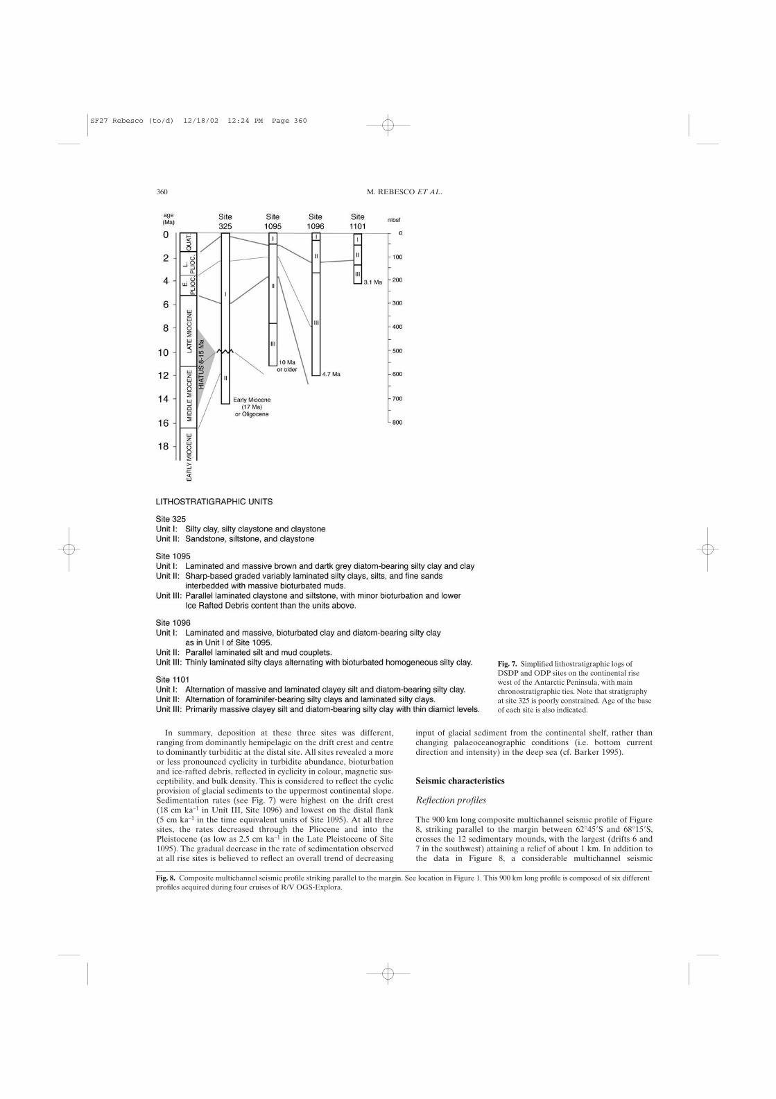
The 900 km long composite multichannel seismic profile of Figure8, striking parallel to the margin between 62°45�S and 68°15�S,crosses the 12 sedimentary mounds, with the largest (drifts 6 and7 in the southwest) attaining a relief of about 1 km. In addition tothe data in Figure 8, a considerable multichannel seismic
360 M. REBESCO ET AL.
Fig. 8. Composite multichannel seismic profile striking parallel to the margin. See location in Figure 1. This 900 km long profile is composed of six differentprofiles acquired during four cruises of R/V OGS-Explora.
Fig. 7. Simplified lithostratigraphic logs ofDSDP and ODP sites on the continental risewest of the Antarctic Peninsula, with mainchronostratigraphic ties. Note that stratigraphyat site 325 is poorly constrained. Age of the baseof each site is also indicated.
SF27 Rebesco (to/d) 12/18/02 12:24 PM Page 360

SEDIMENT DRIFTS AND DEEP-SEA CHANNEL SYSTEMS, ANTARCTIC PENINSULA PACIFIC MARGIN 361
Fig. 9. Seismic profile I95-130a showing the crest of drift 6. The internal structure of the drift is different on either side. The steeper side (SW) ischaracterized by high reflectivity, abundant terminations and undulations of reflectors. A prominent change in reflectivity parallel to the sea bottom isparticularly evident on this side of the drift. In contrast, the gentler side (NE) is relatively smooth, and underlain by continuous, highly reflective units, withlinear, parallel or sub-parallel internal reflectors conformable with the sea floor.
SF27 Rebesco (to/d) 12/18/02 12:24 PM Page 361

reflection coverage exists for this margin, acquired mainly onboard R/V OGS Explora in 1990, 1992, 1995, and 1997 but withminor contributions also from UK, USA and Spanish cruises. Thenortheastern half is covered also by GLORIA sidescan and single-channel (watergun) seismic survey reported by Tomlinson et al.(1992) and Rebesco et al. (1996).
The majority of the mounds (drifts 1, 2, 3, 4A, and 7) have anasymmetric external shape with a steeper, rougher SW side and agentler, smoother NE side. Two mounds (drifts 5 and 8) have theopposite geometry (NE sides are steeper). Drift 6 and possiblydrift 4 both consist of a concave-up plateau formed by the gentler
sides of two coalesced drifts. The remaining three mounds(mounds 3A, 4B and 5A) are smaller and more symmetrical. Dipseismic profiles show that the mounds generally have gently-dipping NW sides merging with the lower continental rise, andsteeply-dipping SE sides facing the continental slope.
The internal structure of these mounds is different beneath thegentle and the steeper sides (Fig. 9). The steeper sides are charac-terized by high reflectivity, abundant lateral terminations andundulations, and sea-floor terminations of reflectors, by eithererosion or non-deposition. Prominent changes in reflectivityparallel to the seafloor, probably produced by a diagenetic change
362 M. REBESCO ET AL.
Fig. 10. Seismic profile I95-130a showing Alexander Channel that separates drift 6 and 7. The acoustic facies of the channel levee systems is very differentfrom that of the drift. The channel system, composed by two branches, is evidenced by high amplitude, discontinuous, reflectors at its floor, surrounded bytransparent facies. A levee, evident on the NE of the channel, is characterized by relatively well stratified and rapidly wedging-out deposits. Older, buriedchannels with dimensions comparable to the modern one are possibly detectable within the inter-drift area.
SF27 Rebesco (to/d) 12/18/02 12:24 PM Page 362

deep in the sediments, are particularly evident on the steep sidesof the mounds. In contrast, the gentler sides are relatively smooth,and are underlain by continuous, highly reflective units, withlinear, parallel or sub-parallel internal reflectors conformable withthe sea floor.
The mounds are separated by deep-sea channels traversing thedeep areas between mounds. Channels are only evident betweenthe mounds and not on the mounds themselves. The acousticfacies of these channel levee systems is very different from that ofthe mounds. Channel floors are characterised by high amplitude,discontinuous, reflectors, surrounded by transparent facies (Fig.10). Levees, where present, are shown by relatively well stratifieddeposits abruptly wedging out at the side of the channel. Buriedchannels with dimensions comparable to the modern ones aredetectable in seismic profiles within the three upper sequences.They show a limited lateral shift and are confined to the inter-mound areas. In the three deeper seismic sequences, the channelsare replaced by enigmatic northeast dipping seismic reflectors thatappear to cut across other horizons. These are interpreted torepresent the traces of local, diachronous hiatuses of limitedtemporal extent enclosed within continuous depositional areas(Rebesco et al. 1997).
The history of sedimentation on the continental rise was recon-structed by Rebesco et al. (1997), who identified six major seismicunits. Units were dated (very approximately in some cases) bycorrelation with DSDP Site 325 and known tectonic events, andby regional climatic events. This history is summarized in a three-stage scheme, as follows: (1) a ‘Drift-maintenance Stage’ (5 Ma tothe present) characterized by preservation and enhancement ofthe elevation of the drifts; (2) a ‘Drift-growth Stage’ (15–5 Ma)showing substantial variations in thickness as a consequence ofincreasing bottom current activity and larger glacial sedimentsupply from the margin; (3) a ‘Pre-drift Stage’ (36–15 Ma) charac-terized mainly by subparallel reflectors representing a dominantlyturbiditic sequence.
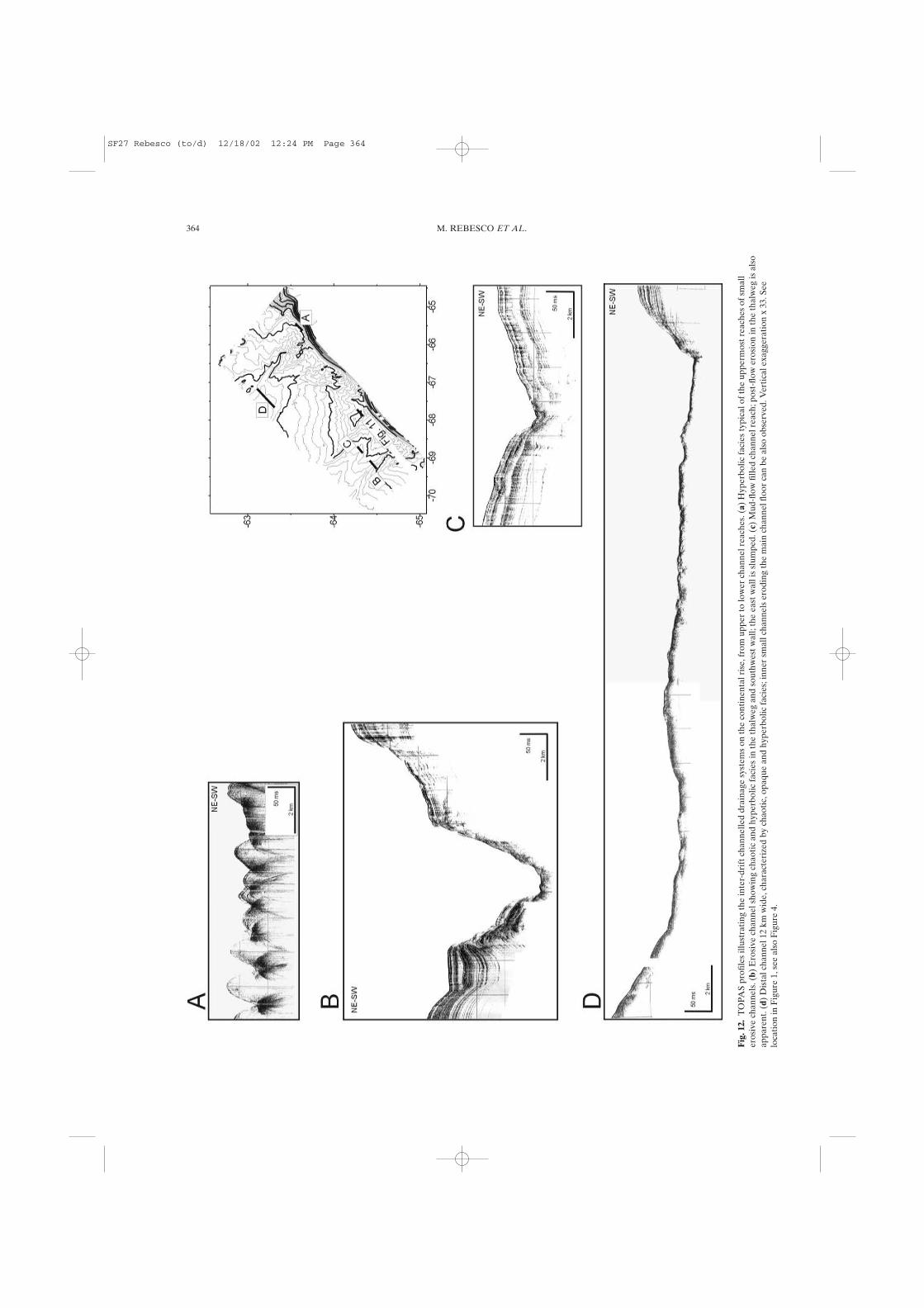
Sub-bottom profiles
The forty parametric source (TOPAS) profiles acquired duringthe GEBRAP’96 cruise onboard BIO Hesperides show that theouter continental shelf and slope are characterized by opaque andhyperbolic acoustic facies, while the continental rise displaysmainly parallel stratified and chaotic acoustic facies, supple-
mented by opaque and hyperbolic facies. The mounds are mostlyrepresented by parallel stratified facies. The generally high lateralcontinuity of this facies is locally interrupted by sheet and lensshaped bodies characterized by chaotic to transparent facies (Fig.11). The crests of the mounds commonly have small scarps onboth sides. Channel heads are mainly occupied by opaque andhyperbolic acoustic facies (Fig. 12a). Channels become highlyerosive downslope (Fig. 12b), although they can also be filled andsmoothed by massive deposits showing chaotic and transparentfacies (Fig. 12c). Opaque acoustic facies prevail in the deepest,widest channel reaches (Fig. 12d).
Sediments
Sediments: seabed photos
Studies of bottom photographs from the area by Hollister &Heezen (1967), Sullivan et al. (1973) and Dangeard et al. (1977)showed evidence for strong bottom currents (in the form of alignedmotile organisms, partly obliterated bioturbation structures, andscours round small obstacles) on the continental slope nearAdelaide Island and in the vicinity of the Polar Front. Turbidbottom water was observed on the lower continental rise west of90°W. Elsewhere on the continental rise, bottom photographsshowed abundant tracks, trails and faecal structures, with scatteredice-rafted pebbles, suggesting weak bottom currents (Fig. 13).
Sediments: core description and facies
A total of 17 gravity cores have been collected from drift 7 and 15from the other drifts (Camerlenghi et al. 1997b; Pudsey & Camer-lenghi 1998; Pudsey 2000; Lucchi et al. in press). The sedimentscored on drift 7 are predominantly terrigenous in composition andvery fine-grained; sediment facies confirm the extent of the driftinferred from seismic data. Cores show a cyclicity between brown,bioturbated, diatom-bearing mud with foraminifera (core tops andadditional thin units downcore) and grey, laminated, barren mud(thicker units between the brown layers). Contacts betweenbrown and grey units are gradational and bioturbated. Ice-rafteddebris is present but generally sparse. Cores on the steep sides ofthe drift recovered a condensed section with thinner cycles andprobable hiatuses.
SEDIMENT DRIFTS AND DEEP-SEA CHANNEL SYSTEMS, ANTARCTIC PENINSULA PACIFIC MARGIN 363
Fig. 11. Parametric source (TOPAS) profileacross the crest of drift 3. Note the dominantparallel stratified facies, and the chaotic andtransparent facies near the surface on the NEside, related to local lateral instability. Verticalexaggeration x 33. See location in Figure 1 (seealso Figures 4 and 12).
SF27 Rebesco (to/d) 12/18/02 12:24 PM Page 363
364 M. REBESCO ET AL.
Fig
. 12.
TO
PAS
profi
les
illus
trat
ing
the
inte
r-dr
ift c
hann
elle
d dr
aina
ge s
yste
ms
on th
e co
ntin
enta
l ris
e, fr
om u
pper
to lo
wer
cha
nnel
rea
ches
. (a)
Hyp
erbo
lic fa
cies
typi
cal o
f the
upp
erm
ost r
each
es o
f sm
all
eros
ive
chan
nels
. (b)
Ero
sive
cha
nnel
sho
win
g ch
aoti
c an
d hy
perb
olic
faci
es in
the
thal
weg
and
sou
thw
est w
all;
the
east
wal
l is
slum
ped.
(c)
Mud
-flow
fille
d ch
anne
l rea
ch; p
ost-
flow
ero
sion
in th
e th
alw
eg is
als
oap
pare
nt. (
d) D
ista
l cha
nnel
12
km w
ide,
cha
ract
eriz
ed b
y ch
aoti
c, o
paqu
e an
d hy
perb
olic
faci
es; i
nner
sm
all c
hann
els
erod
ing
the
mai
n ch
anne
l floo
r ca
n be
als
o ob
serv
ed. V
erti
cal e
xagg
erat
ion
x33
. See
loca
tion
in F
igur
e 1,
see
als
o F
igur
e 4.
SF27 Rebesco (to/d) 12/18/02 12:24 PM Page 364

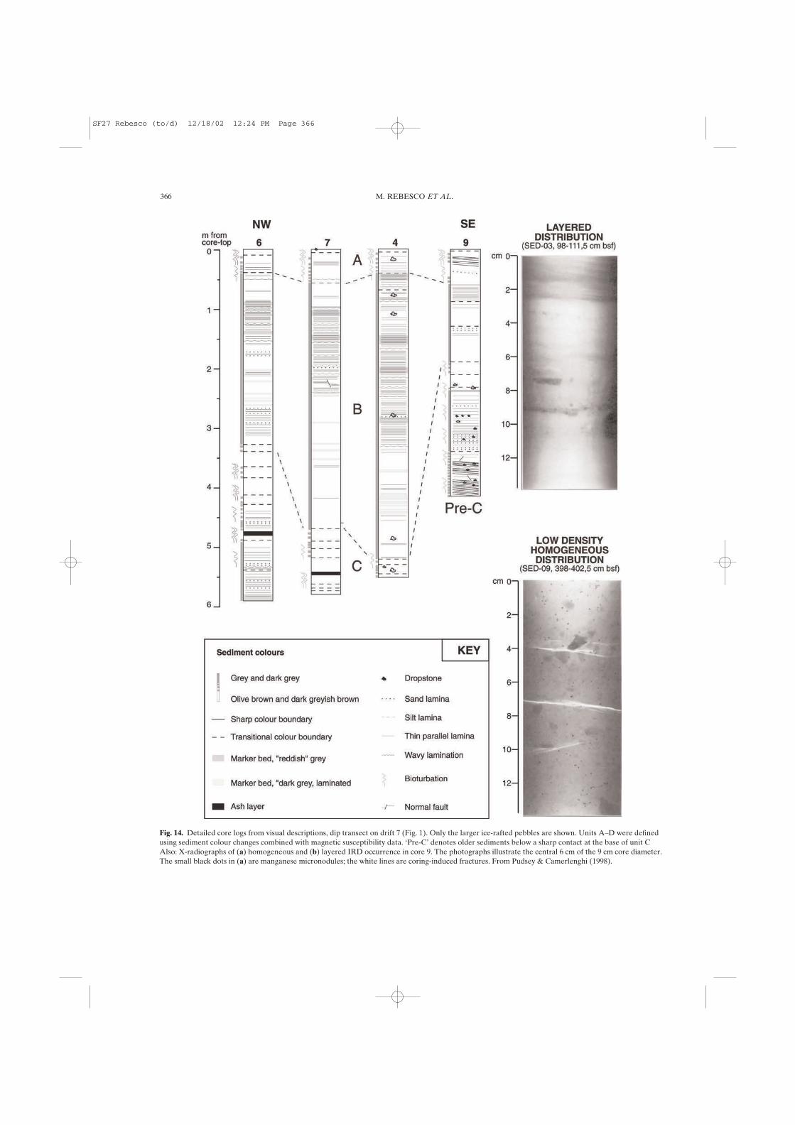
The top of each core (Unit A of Pudsey & Camerlenghi 1998)consists of 0.1–0.2 m of structureless olive brown diatom-bearingmud with common dispersed IRD, overlying 0.2–0.4 m of olivebrown to grey or dark grey bioturbated, faintly laminated mud.Carbonate content (foraminifer fragments) is 0.4–0.8% andorganic carbon up to 0.4%, both decreasing downwards in theunit. The burrows are mainly of Planolites type and parallel tobedding.
Below Unit A, grey and dark grey silty clay forms a thick unit(2.2–5.5 m thick) in each core, designated Unit B. Parallel tolenticular lamination and thin bedding are outlined by slightcontrasts in colour and in X-ray absorption. The lamination israther indistinct and irregular; there are neither sharp-basedgraded units nor any signs of erosion. Bioturbation is rare and the
burrows are very small (1–2 mm). Some distinctive reddishmarker layers 1–5 cm thick can be correlated from core to core; inX-radiographs, these layers are seen to be laminated on a sub-millimetre scale. Wavy lamination is common in the upper part ofUnit B in most cores, while the lower part tends to be more homo-geneous. IRD is less common than in Unit A and occurs in thinlayers (3–15 mm) rather than being dispersed. Unit B is thickestnear the centre and north-east side of the drift, and thins markedlyto the southeast, southwest and northwest.
The next brown unit, Unit C, attains a thickness of 1.0 m incores 6 and 7; in core 9 its apparent base may be a hiatus (Fig. 14).It consists of light olive brown mud (8–12% diatoms, 4–6%foraminiferal carbonate) overlying olive grey to greyish brownmud (2–5% diatoms, 1% carbonate) then olive brown to light
SEDIMENT DRIFTS AND DEEP-SEA CHANNEL SYSTEMS, ANTARCTIC PENINSULA PACIFIC MARGIN 365
Fig. 13. Seabed photos taken in 1963–1964from USNS Eltanin (Goodell 1964, 1965). (a)Eltanin 5–16 (63° 58�S, 67° 56�W, 2950 m waterdepth) Pale brown clayey silt (4.3% sand,71.1% silt, 24.6% clay). Many echinoid trailsand worm tracks can be seen. Sparse pebbles,no evidence for current activity; (b) Eltanin5–22 (65° 06�S, 70° 41�W, 3109 m) Darkyellowish brown clayey silt (7.0% sand andgravel, 60.7% silt, 32.3% clay). Echinoid trailsand worm tracks similar to above; note alsopatchy distribution of coarse angular ice-rafteddebris.
SF27 Rebesco (to/d) 12/18/02 12:24 PM Page 365
366 M. REBESCO ET AL.
Fig. 14. Detailed core logs from visual descriptions, dip transect on drift 7 (Fig. 1). Only the larger ice-rafted pebbles are shown. Units A–D were definedusing sediment colour changes combined with magnetic susceptibility data. ‘Pre-C’ denotes older sediments below a sharp contact at the base of unit CAlso: X-radiographs of (a) homogeneous and (b) layered IRD occurrence in core 9. The photographs illustrate the central 6 cm of the 9 cm core diameter.The small black dots in (a) are manganese micronodules; the white lines are coring-induced fractures. From Pudsey & Camerlenghi (1998).
SF27 Rebesco (to/d) 12/18/02 12:24 PM Page 366

SEDIMENT DRIFTS AND DEEP-SEA CHANNEL SYSTEMS, ANTARCTIC PENINSULA PACIFIC MARGIN 367
Fig
. 15.
Gra
in-s
ize
data
, mea
sure
d by
sie
ving
(sa
nd %
) an
d Se
digr
aph
(silt
and
cla
y). (
a) C
ores
4 a
nd 7
, spl
iced
toge
ther
at t
op o
f Uni
t C (
arro
w).
Siz
e fr
eque
ncy
hist
ogra
ms
of th
e fin
e fr
acti
on (
100%
= to
tal
sedi
men
t) a
t 0.2
5�cl
ass
inte
rval
at c
ore
top
(0.0
1 m
), 3
.99
m a
nd 5
.58
m c
orre
spon
d to
the
star
sym
bols
on
the
dow
ncor
e pl
ot. N
ote
that
ther
e is
30–
45%
of m
ater
ial fi
ner
than
the
Sedi
grap
h m
easu
rem
ent l
imit
of 1
1�. T
here
is c
omm
only
a m
ode
near
the
silt
-cla
y bo
unda
ry. (
b) C
ore
6, in
clud
ing
size
freq
uenc
y hi
stog
ram
s fo
r un
its
C a
nd D
. The
sam
ple
at 5
.28
m c
onta
ins
38%
san
d. (
c) C
ore
9, m
ost o
f Uni
t C s
how
sne
gati
ve s
kew
ness
. The
ver
y fir
m s
edim
ents
und
erly
ing
Uni
t C a
re a
ll ve
ry p
oorl
y so
rted
, but
hav
e va
riab
le s
and:
silt
:cla
y ra
tios
and
med
ian
diam
eter
s. T
hey
have
mor
e m
ediu
m a
nd c
oars
e si
lt (
10–1
5% in
the
rang
e 4–
6�)
than
the
othe
r co
res,
and
mos
t sam
ples
hav
e a
mod
e in
the
rang
e 5.
5–6�
. Fro
m P
udse
y &
Cam
erle
nghi
(19
98).
SF27 Rebesco (to/d) 12/18/02 12:24 PM Page 367

olive brown mud (20–27% diatoms, 4–16% carbonate). Theplanktonic foraminifer Neogloboquadrina pachyderma (sinistral)is the most common species. Colour transitions are gradational,and any original sedimentary structures have been obliterated bybioturbation. Dispersed IRD is common (Fig. 14c).
Core 6 (lowest 1.6 m) recovered another unit of grey laminatedmud, Unit D, also seen in the lowest 0.1 m of core 7. Unit D isfaintly laminated and bioturbated and the contact with Unit C isgradational and burrowed. IRD is common and occurs mainlydispersed in the upper half of the unit, and in thin layers in thelower half. Additional cores from the distal part of drift 7 and inthe adjacent channels contain coarse-grained turbidite beds.
Sediments: summary analytical results
Particle size analyses on selected cores from drift 7 show thesediments are fine-grained and very poorly sorted. We present thedata as downcore plots of sand-silt-clay, median diameter, sortingand skewness, with representative size frequency histograms ofthe fine fraction, in Figure 15.
Unit A was measured in all core tops except core 9, anddowncore in core 4 (Fig. 15a). It contains 2–4% sand, 21–29% siltand 67–77% clay. There is no evident relationship between grainsize and position of the core on the drift. Median grain size isabout 10 �, there is a mode in the range 8–9 � and sorting is verypoor (�G about 3).
Unit B generally has less than 1% sand, 21–28% silt, and >70%clay (Fig. 15a, b). Median grain size is 10–10.5 � and the mode isin the range 7.3–8.4 � with very poor sorting (�G about 3.5). Somesamples have up to 32% silt with a weak secondary mode at6–6.5 �. Throughout Units A and B, the proportion of mediumand coarse silt (4–6 �) is very low, generally <8% of totalsediment. Unit C contains 2–6% sand (locally up to 30–40%),30–37% silt and 60–68% clay. Up to half of the sand is coarse(>0.5 mm), angular and interpreted as ice-rafted. Core 6 hassomewhat less silt and more clay. Median grain size is 9–9.5 � andthe mode is at 7.5–8 �, commonly with a secondary mode at5.5–6 �. Sorting is very poor with �G of 2.5–3.5.
Unit D in core 6 has generally less than 1% sand except in twothin layers at 4.58 and 5.28 m, where both the sand and the finefraction are extremely poorly sorted (Fig. 15b). Elsewhere siltforms 18–28% and clay 72–82%. Median diameter is 10–11.2 �,mode 8–8.5 � and sorting is very poor (�G = 3–3.5).
Discussion
Supply and transport of sediment in the late Quaternary
As shown by core data, drift 7 sediments are predominantly ter-rigenous, very fine-grained, very to extremely poorly sorted, andgenerally lack a mode in the silt size range. These features pointto deposition from suspension with negligible current winnowing.In particular, the positive (fine) skewness throughout most coresattests to the absence of any process that removed fine material.The indistinct, parallel to lenticular lamination in Units B and Dsuggests small and irregular fluctuations in the supply andtransport of suspended mud. The style of lamination is verysimilar to ‘plumites’ on the Labrador continental margin (Hesse etal. 1997). Such lamination may also have been present in Units Aand C, prior to thorough bioturbation. These sediments are tran-sitional between hemipelagites and muddy contourites. Theabsence of graded laminated units (see Stow & Bowen 1980), orindeed of any sharp-based silt-sand beds except in condensedsections from the steep sides of the drift, indicates a turbiditeorigin is unlikely.
The similarity of fine-fraction size distributions downcoresuggests there was little variation in bottom current strength
between glacial and interglacial parts of cycles. In each core, unitC has the coarsest median grain size and least poor sorting, whichis evidence for marginally stronger currents in Unit C time. Grain-size variations that are more clearly attributable to bottom-current activity occur only in cores on the steep sides of the drift,where sandy, negatively skewed samples may have had finematerial winnowed out by currents. Their texture contrasts withthe unsorted sandy muds in Unit D in core 6, which have near-zero skewness and are thought to result from ice-rafting withoutcurrent sorting.
The benthic nepheloid layer can be supplied with suspendedsediment by a number of mechanisms, including: (1) currenterosion farther upstream; (2) entrainment of material fromturbidity currents; and (3) pelagic settling from the sea surface,including biogenic and glacially derived material (McCave 1986).On the Antarctic Peninsula Pacific margin, bottom currents areweak and rather steady, so mechanism (1) is probably insignifi-cant. Mechanisms (2) and (3) are both important, and the amountand type of sediment supply are likely to have varied over glacial-interglacial cycles (Pudsey & Camerlenghi 1998).
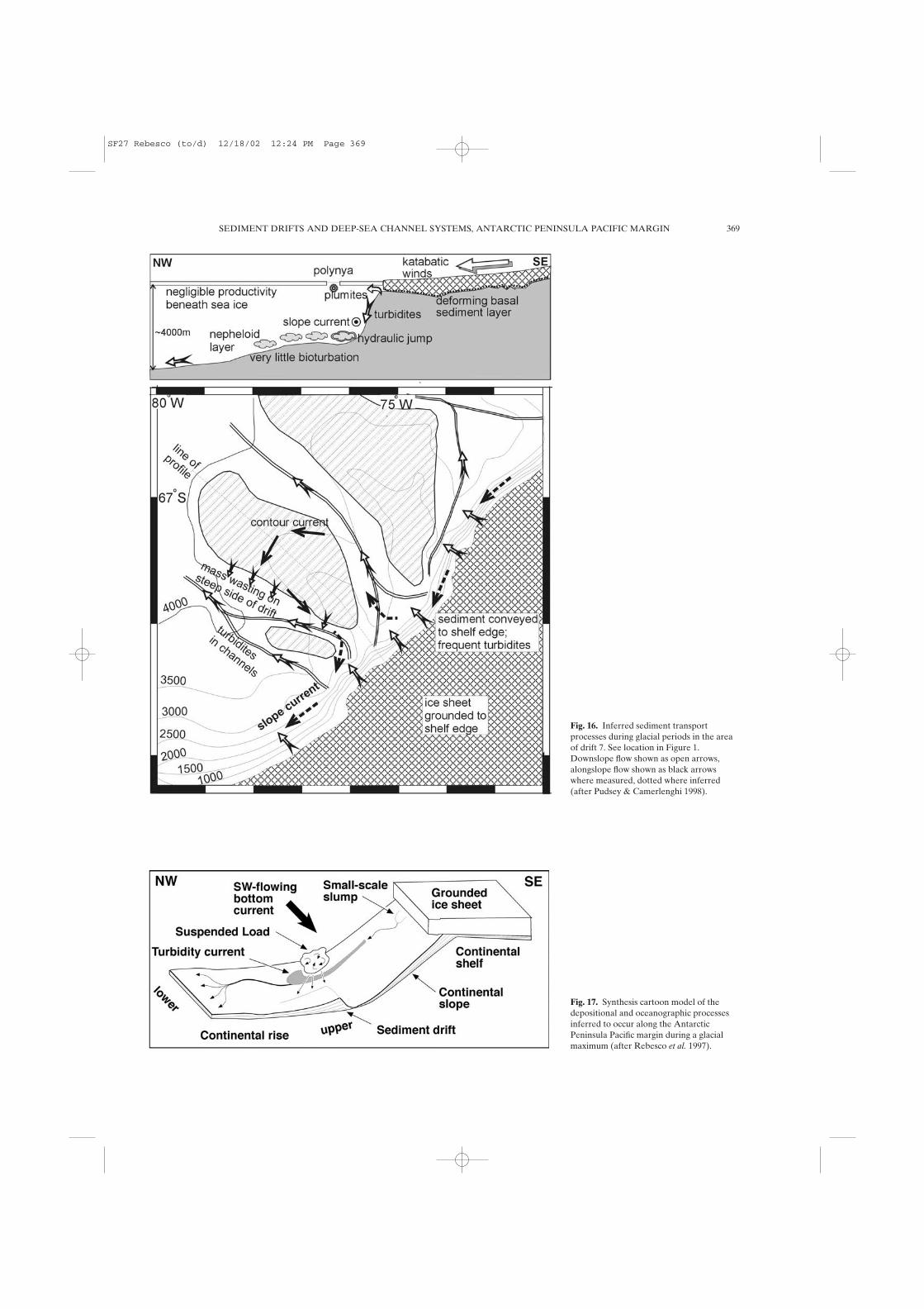
Glacial Unit B is thickest near the centre and northeast side ofdrift 7, and thins to the southeast, southwest and northwest. Thissuggests that most fine sediment was supplied to the contour-following current and nepheloid layer near the slope, or from thechannel on the north-east side of the drift (consistent with theentrainment of the fine fraction of turbidity currents; Fig. 16). Therelative importance of supply to the nepheloid layer by turbiditycurrents and by meltwater plumes is, as yet, unknown.
Large scale geometry and depositional model
As pointed out by Rebesco et al. (1996), the largest mounds aremost plausibly interpreted as sediment drifts. They cannot beexplained as large levees on the northeastern side of the channels,because the Coriolis effect would cause overbank depositionsouthwest of the channels, with a short, steep northeast slope,which is the opposite of what we observe.
A generic model (Fig. 17), applicable to the (Plio-Pleistocene)drift maintenance stage, and most probably also to the precedingstage of rapid drift growth (late Miocene), was proposed byRebesco et al. (1997). It takes into account the entrainment ofmaterial from turbidity currents as the major source of supply tothe benthic nepheloid layer. The model shows a section throughthe axis of a progradational lobe and the adjacent drift duringglacial maximum when a grounded ice stream transportedunsorted basal till to the continental shelf edge. Small-scaleslumps on the uppermost slope undergo downslope transition intodebris flows, then turbidity currents feeding the main channel viatributaries on the uppermost rise. Suspended fines are entrainedin SW-flowing bottom currents and deposited down-current todevelop and maintain the drifts. However, subsequent turbiditycurrent flow in the channels and slope instability on the steeperdrift slopes tend to remove sediment from those areas, leaving apermanent sediment increment only on the gentle sides of thedrifts.
The 12 mounds are hence generally interpreted as sedimentdrifts controlled by along slope bottom-water flow with varyingdegree of interaction with downslope turbidity current processes.These mounds provide a complete range of intermediary stepsbetween two end members: the sediment drift (best representedby drift 7) and the channel levee (best represented by mound 5A,the SW levee of the north Tula channel).
The criteria that we consider as diagnostic to distinguishsediment drifts from channel-levees are the following:
(a) asymmetry: drifts have one side distinctly steeper than theother;
(b) orientation of the steep side: in the drifts, the steep side is the
368 M. REBESCO ET AL.
SF27 Rebesco (to/d) 12/18/02 12:24 PM Page 368
SEDIMENT DRIFTS AND DEEP-SEA CHANNEL SYSTEMS, ANTARCTIC PENINSULA PACIFIC MARGIN 369
Fig. 16. Inferred sediment transportprocesses during glacial periods in the areaof drift 7. See location in Figure 1.Downslope flow shown as open arrows,alongslope flow shown as black arrowswhere measured, dotted where inferred(after Pudsey & Camerlenghi 1998).
Fig. 17. Synthesis cartoon model of thedepositional and oceanographic processesinferred to occur along the AntarcticPeninsula Pacific margin during a glacialmaximum (after Rebesco et al. 1997).
SF27 Rebesco (to/d) 12/18/02 12:24 PM Page 369

370 M. REBESCO ET AL.
SW one, hence not facing the NE upstream (feeding)channel;
(c) large dimensions: drifts are generally wider than 40 km;(d) large elevation above the adjacent channels: the crest of the
drifts rises at least 400 m above the adjacent thalweg;(e) internal geometry: drifts have continuous, subparallel, con-
formable reflectors beneath the gentler side, and truncated,chaotic reflectors beneath the steeper side;
(f) relationship with the adjacent continental slope: drifts aremostly separated from the slope by erosive depressions;
(g) location: drifts are preferentially located in correspondenceto the present-day shelf troughs, in between the shelf lobes.
This work has been funded by the Progetto Nazionale Ricerche inAntartide (PNRA) through the SEDANO (Sediment Drifts of theAntarctic Offshore) Project, the British Natural Environment ResearchCouncil (NERC), and the Spanish cooperative project 99120 from‘Comisión de Intercambio Cultural, Educativo y Científico entre España ylos Estados Unidos de América’. Kristeen Roessig at the AntarcticResearch Facility, Florida State University, kindly supplied the photo-graphs in Figure 13.
References
BARKER, P. F. 1995. The proximal marine sediment record of Antarcticclimate since the late Miocene. In: COOPER, A. K., BARKER, P. F. &BRANCOLINI, G. (eds) Geology and Seismic Stratigraphy of theAntarctic Margin. American Geophysical Union, Antarctic ResearchSeries, 68, 25–58.
BARKER, P. F., CAMERLENGHI, A., ACTON, G. D., ET AL. 1999. Proc. ODP,Init. Repts., 178 [CD-ROM]. Available from: Ocean Drilling Program,Texas A&M University, College Station, TX 77845-9547, U.S.A.
CAMERLENGHI, A., CRISE, A., ACCERBONI, E., LATERZA, R., PUDSEY, C. J. &REBESCO, M. 1997a. Ten-month observation of the bottom currentregime across a sediment drif of the Pacific margin of the AntarcticPeninsula. Antarctic Science, 9, 424–431.
CAMERLENGHI, A., REBESCO, M. & PUDSEY, C. J. 1997b. High resolutionterrigenous sedimentary record of a sediment drift on the continentalrise of the Antarctic Peninsula pacific margin (initial results of the‘SEDANO’ Program). In: RICCI, C. A. (ed.) The Antarctic Region:Geological Evolution and Processes. Terra Antarctica Publication,Siena, 705–710.
CANALS, M., ESTRADA, F., URGELES, R. & GEBRAP 96/97 TEAM 1998.Very high-resolution seismic definition of glacial and postglacialsediment bodies in the continental shelves of the northern TrinityPeninsula region, Antarctica. Annals of Glaciology, 27, 260–264.
CANALS, M., URGELES, R. & CALAFAT, A. M. 2000. Deep sea-floor evidenceof past ice streams off the Antarctic Peninsula. Geology, 28, 31–34.
CARMACK E. C. 1990. Large-scale physical oceanography of the polarocean. In: SMITH, W. O. JR (ed.) Polar Oceanography. Academic Press,London.
COOPER, A. K., BARRETT, P. J., HINZ, K., TRAUBE, V., LEITCHENKOV, G. &STAGG, H. M. J. 1991. Cenozoic prograding sequences of the Antarcticcontinental margin: a record of glacio-eustatic and tectonic events,Marine Geology, 102, 175–213.
DANGEARD, L., VANNEY, J. R. & JOHNSON, G. L. 1977. Affleurements,courants et facies dans la Zone Antarctique du Pacifique orientale(Mers de Bellingshausen et d’Amundsen). Annales de l’Institutocéanographique, Paris, 53, 105–124.
DOMACK, E. W., MCCLENNEN, C., MANLEY, P. & ISHMAN, S. 1994. Very highresolution stratigraphy of the Late Quaternary glacial marinesediments in fjords and offshore basins, Antarctic Peninsula. TerraAntartica, 1, 269–270.
GERSONDE, R. & BURCKLE, L. H. 1990. Neogene diatom biostratigraphy ofODP Leg 113, Weddell Sea. In: BARKER, P. F, KENNETT, J. P. ET AL.(eds) Proceedings of the Ocean Drilling Program, Scientific Results,113. Ocean Drilling Program, College Station, Texas, 761–789.
GOODELL, H. G. 1964. Marine Geology of the Drake Passage, Scotia Seaand South Sandwich Trench (USNS Eltanin cruises 1–8). PhD thesis,Florida State University, Tallahassee, Florida.
GOODELL, H. G. 1965. Marine Geology: USNS Eltanin cruises 9–15. FloridaState University, Tallahassee, Florida.
GORDON, A. L. 1966. Potential temperature, oxygen and circulation ofbottom water in the Southern Ocean. Deep-Sea Research, 13,1125–1138.
HAYS, J. D. 1965. Radiolaria and late Tertiary and Quaternary history ofAntarctic Seas. In: LLANO, G. A. (ed.) Biology of the Antarctic SeasII. American Geophysical Union, Antarctic Research Series, 5,125–184.
HESSE, R., KHODABAKHSH, S., KLAUCKE, I. & RYAN, W. B. F. 1997. Asym-metrical turbid-plume deposition near ice-outlets of the PleistoceneLaurentide ice sheet in the Labrador Sea. Geo-Marine Letters, 17,179–187.
HOLLISTER, C. D. & HEEZEN, B. C. 1967. The floor of the BellingshausenSea. In: HERSEY, J. B. (ed.) Deep-Sea Photography. Johns HopkinsPress, Baltimore, 177–189.
HOLLISTER, C. D. CRADDOCK, C., ET AL. 1976. Initial Reports of the DeepSea Drilling Project, 35, Washington (U.S. Govt Printing Office),930 pp.
LARTER, R. D. & BARKER, P. F. 1989. Seismic stratigraphy of the AntarcticPeninsula Pacific margin: A record of Pliocene-Pleistocene ice volumeand paleoclimate. Geology, 17, 731–734.
LARTER, R. D. & BARKER, P. F. 1991a. Effects of ridge crest-trench inter-action on Antarctic-Phoenix spreading: forces on a young subductingplate. Journal of Geophysical Research, 96, 19583–19607.
LARTER, R. D & BARKER, P. F. 1991b. Neogene interaction of tectonic andglacial processes at the Pacific margin of the Antarctic Peninsula. Inter-national Association of Sedimenologists, Special Publications, 12,165–186.
LARTER, R. D. & CUNNINGHAM, A. P. 1993. The depositional pattern anddistribution of glacial- interglacial sequences on the AntarcticPeninsula Pacific Margin. Marine Geology, 109, 203–219.
LARTER, R. D., REBESCO, M., VANNESTE, L. E., GAMBOA, L. A. P. &BARKER, P. F. 1997. Cenozoic Tectonic, Sedimentary and GlacialHistory of the Continental Shelf West of Graham Land, AntarcticPeninsula. In: COOPER, A. K. & BARKER, P. F. (eds) Geology andSeismic Stratigraphy of the Antarctic Margin, Part 2. American Geo-physical Union, Antarctic Research Series, 71, 1–27.
LUCCHI, R. G., REBESCO, M., BUSETTI, M., CABURLOTTO, A., COLIZZA, E. &FONTOLAN, G. in press. Sedimentary Processes and Glacial Cycles onthe Sediment Drifts of the Antarctic Peninsula Pacific Margin:Preliminary Results of SEDANO-II Project. In: GAMBLE, J., SKINNER,D. & HENRYS, S. (eds) Proceedings of the VIII° InternationalSymposium on Antarctic Earth Sciences. New Zealand Journal ofGeology and Geophysics, Royal Society of New Zealand.
MCCAVE, I. N. 1986. Local and global aspects of the bottom nepheloidlayer in the world ocean. Netherlands Journal of Sea Research, 20,167–181.
MCGINNIS, J. P. & HAYES, D. E. 1995. The roles of down-slope and along-slope depositional processes: southern Antarctic Peninsula margin.In: COOPER, A. K., BARKER, P. F. & BRANCOLINI, G. (eds) Geology andSeismic Stratigraphy of the Antarctic Margin. American GeophysicalUnion, Antarctic Research Series, 68, 141–156.
MCGINNIS, J. P., HAYES, D. E. & DRISCOLL, N. W. 1997. Sedimentaryprocesses across the continental rise of the southern AntarcticPeninsula. Marine Geology, 141, 91–109.
NOWLIN, W. D. JR. & KLINCK, J. M. 1986. The physics of the Antarctic Cir-cumpolar Current, Reviews of Geophysics, 24, 469–491.
NOWLIN, W. D. & ZENK, W. 1988. Westward bottom currents along themargin of the South Shetland Island Arc. Deep Sea Research, 35,269–301.
POPE, P. G. & ANDERSON, J. B. 1992. Late Quaternary glacial history of thenorthern Antarctic Peninsula’s western continental shelf: evidencefrom the marine record. In: ELLIOT, D. H. (ed.) Contributions toAntarctic Research III. American Geophysical Union, AntarcticResearch Series, 57, 63–91.
PUDSEY, C. J. 2000. Sedimentation on the continental rise west of theAntarctic Peninsula over the last three glacial cycles. Marine Geology,167, 313–338.
PUDSEY, C. J., BARKER, P. F. & LARTER, R. D. 1994. Ice sheet retreat fromthe Antarctic Peninsula shelf. Continental Shelf Research, 14,1647–1675.
SF27 Rebesco (to/d) 12/18/02 12:24 PM Page 370

SEDIMENT DRIFTS AND DEEP-SEA CHANNEL SYSTEMS, ANTARCTIC PENINSULA PACIFIC MARGIN 371
PUDSEY, C. J. & CAMERLENGHI, A. 1998. Glacial-interglacial deposition ona sediment drift on the Pacific margin of the Antarctic Peninsula.Antarctic Science, 10, 286–308.
REBESCO, M., LARTER, R. D., BARKER, P. F., CAMERLENGHI, A. &VANNESTE, L. E. 1994. The history of sedimentation on the continen-tal rise west of the Antarctic Peninsula. Terra Antartica, 1, 277–279.
REBESCO M., LARTER R. D., CAMERLENGHI, A. & BARKER, P. F. 1996. Giantsediment drifts on the continental rise west of the AntarcticPeninsula. Geo-Marine Letters, 16, 65–75.
REBESCO, M., LARTER, R. D., BARKER, P. F., CAMERLENGHI, A. &VANNESTE, L. E. 1997. History of Sedimentation on the ContinentalRise West of the Antarctic Peninsula. In: COOPER, A. K. & BARKER,P. F. (eds) Geology and Seismic Stratigraphy of the Antarctic Margin(Part 2). American Geophysical Union. Antarctic Research Series, 71,29–49.
REBESCO, M., CAMERLENGHI, A., DE SANTIS, L., DOMACK, E. & KIRBY, M.1998a. Seismic stratigraphy of Palmer Deep: a fault bounded LateQuaternary sediment trap on the inner continental shelf, AntarcticPeninsula Pacific margin. Marine Geology, 15, 89–110.
REBESCO, M., CAMERLENGHI, A. & ZANOLLA, C. 1998b. Bathymetry andmorphogenesis of the continental margin west of the AntarcticPeninsula. Terra Antartica, 5, 715–725.
STOW, D. A. V. & BOWEN, A. J. 1980. A physical model for the transport andsorting of fine-grained sediment by turbidity currents. Sedimentology,27, 31–46.
SULLIVAN, L., THORNDIKE, E., EWING, M. & EITTREIM, S. 1973. Nephelome-ter measurements, Hach turbidity measurements and bottom photo-graphs from Conrad Cruise 15. Lamont-Doherty GeologicalObservatory Technical Report 8-CU-8-73.
TOMLINSON, J. S., PUDSEY, C. J., LIVERMORE, R. A., LARTER, R. D. &BARKER, P. F. 1992. Long-range sidescan sonar (GLORIA) survey ofthe Antarctic Peninsula Pacific Margin. In: YOSHIDA, Y., KAMINUMA,K. & SHIRAISHI, K. (eds) Recent Progress in Antarctic Earth Science.Terra Sci Publications, Tokyo, 423–429.
TUCHOLKE, B. E. & HOUTZ, R. E. 1976. Sedimentary record of theBellingshausen Basin from seismic profile data. In: HOLLISTER, C. D.,CRADDOCK, C. ET AL. (eds) Initial Reports of the Deep Sea DrillingProject, 35, Washington (U.S. Govt Printing Office), 197–227.
TUCHOLKE, B. E., HOLLISTER, C. D., WEAVER, F. M. & VENNUM, W. R. 1976.Continental rise and abyssal plain sedimentation in the SoutheastPacific Basin – Leg 35 DSDP. In: HOLLISTER, C. D., CRADDOCK, C. ET
AL. (eds) Initial Reports of the Deep Sea Drilling Project, 35, Washing-ton (U.S. Govt Printing Office), 359–400.
VANNEY, J. R. & JOHNSON, G. L. 1976a. Geomorphology of the Pacific con-tinental margin of the Antarctic Peninsula. In: HOLLISTER, C. D.,CRADDOCK, C. ET AL. (eds) Initial Reports of the Deep Sea DrillingProject, 35, Washington (U.S. Govt Printing Office), 279–289.
VANNEY, J. R. & JOHNSON, G. L. 1976b. The Bellingshausen-Amundsenbasins (Southeastern Pacific): Major sea-floor units and problems.Marine Geology, 22, 71–101.
SF27 Rebesco (to/d) 12/18/02 12:24 PM Page 371