
Sediment drifts and erosional surfaces in the central Mediterranean: seismic evidence of...
14
Sedimentary Geology, 82 (1993) 207-220 207 Elsevier Science Publishers B.V,, Amsterdam Sediment drifts and erosional surfaces in the central Mediterranean: seismic evidence of bottom-current activity * M. Marani, A. Argnani, M. Roveri and F. Trincardi Istituto per la Geologia Marina--CNR, Via Zamboni 65, 40127 Bologna, Italy (Received January 4, 1991; revised version accepted March 10, 1992) ABSTRACT Marani, M., Argnani, A., Roveri, M. and Trincardi, F., 1993. Sediment drifts and erosional surfaces in the central Mediterranean: seismic evidence of bottom-current activity. In: D.A.V. Stow and J.-C. Faug~res (Editors), Contourites and Bottom Currents. Sediment. Geol., 82: 207-220. We present evidence, based on seismic reflection profiles, of sediment drift accumulation and deep submarine erosion driven by bottom currents in different physiographic settings of the central Mediterranean. The study shows that significant bottom-current activity is enhanced by the focussing effects of particular sea-floor morphologies where these interact with the established deep circulation. We cite occurrences from the Corsica Channel, the eastern Tyrrhenian slope basins, the Sicily Channel, the eastern flank of the Apulian swell and the deep Ionian Basin at the foot of the Malta Escarpment. Examples range from asymmetric, convex upwards sediment drift accumulation associated with a lateral moat, as in the Tyrrhenian slope basins or the Sicily Channel (600/800 m depth), to the large-scale bedforms at 2000 m depth in the Ionian Basin. A more complex upslope-migrating sediment drift sequence, bounded by diverse unconformities occurs in the Corsica Channel (300 m depth). The identified features occur in the uppermost portion of the sediment column and commonly control the present-day sea-bottom morphology. Bottom-current-related sedimentary processes seem to be more widespread than previously thought in the Mediter- ranean. These processes make a significant contribution to sediment accumulation of Quaternary age in marginal basin settings and their potential for generating unconformities of various magnitudes should be taken into account when inferring depositional histories. Introduction Bottom currents exert pronounced effects on the nature and distribution of deep-sea sedimen- tation. Contourites and associated deep currents have been extensively studied in the North At- lantic Ocean where the development of bottom circulation throughout the Cenozoic produced huge sediment drifts and basin-wide hiatuses. This has made the North Atlantic a type area for contourite sedimentation processes (Faug~res et * Contribution No. 870. Correspondence to: M. Marani, Istituto per la Geologia Ma- rina--CNR, Via Zamboni 65, 40127 Bologna, Italy. al., 1979; Stow and Lovell, 1979; McCave et al., 1980; Lovell and Stow, 1981; Lonsdale, 1982; Stow, 1982; Stow and Holbrook, 1984; McCave and Tucholke, 1986; Pickering et al., 1989). Con- tourites have been also identified from all the world's oceans in diverse tectonic settings (Heezen, 1977; Lonsdale, 1977, 1978; Reed et al., 1987). In this paper we present examples from the central Mediterranean of sediment reworking and deposition induced by bottom currents. These include simple, asymmetric mounded drifts, mul- tistage upslope drift migration and large-scale, deep-water bedforms. Widespread erosional sur- faces and sub-bottom unconformities are coupled to the development of most of these deposits. 0037-0738/93/$06.00 © 1993 - Elsevier Science Publishers B.V. All rights reserved
-
Upload
independent -
Category
Documents
-
view
1 -
download
0
Transcript of Sediment drifts and erosional surfaces in the central Mediterranean: seismic evidence of...
Sedimentary Geology, 82 (1993) 207-220 207 Elsevier Science Publishers B.V,, Amsterdam
Sediment drifts and erosional surfaces in the central Mediterranean: seismic evidence of bottom-current activity *
M . M a r a n i , A . A r g n a n i , M. R o v e r i a n d F . T r i n c a r d i
Istituto per la Geologia Marina--CNR, Via Zamboni 65, 40127 Bologna, Italy
(Received January 4, 1991; revised version accepted March 10, 1992)
ABSTRACT
Marani, M., Argnani, A., Roveri, M. and Trincardi, F., 1993. Sediment drifts and erosional surfaces in the central Mediterranean: seismic evidence of bottom-current activity. In: D.A.V. Stow and J.-C. Faug~res (Editors), Contourites and Bottom Currents. Sediment. Geol., 82: 207-220.
We present evidence, based on seismic reflection profiles, of sediment drift accumulation and deep submarine erosion driven by bottom currents in different physiographic settings of the central Mediterranean. The study shows that significant bottom-current activity is enhanced by the focussing effects of particular sea-floor morphologies where these interact with the established deep circulation. We cite occurrences from the Corsica Channel, the eastern Tyrrhenian slope basins, the Sicily Channel, the eastern flank of the Apulian swell and the deep Ionian Basin at the foot of the Malta Escarpment.
Examples range from asymmetric, convex upwards sediment drift accumulation associated with a lateral moat, as in the Tyrrhenian slope basins or the Sicily Channel (600/800 m depth), to the large-scale bedforms at 2000 m depth in the Ionian Basin. A more complex upslope-migrating sediment drift sequence, bounded by diverse unconformities occurs in the Corsica Channel (300 m depth). The identified features occur in the uppermost portion of the sediment column and commonly control the present-day sea-bottom morphology.
Bottom-current-related sedimentary processes seem to be more widespread than previously thought in the Mediter- ranean. These processes make a significant contribution to sediment accumulation of Quaternary age in marginal basin settings and their potential for generating unconformities of various magnitudes should be taken into account when inferring depositional histories.
Introduction
B o t t o m cur ren t s exer t p r o n o u n c e d effects on
the na tu r e and d i s t r ibu t ion of d e e p - s e a sed imen-
ta t ion. Con tour i t e s and assoc ia ted d e e p cur ren t s
have been extensively s tud ied in the N o r t h At -
lant ic O c e a n where the d e v e l o p m e n t of b o t t o m
c i rcula t ion t h roughou t the Cenozoic p r o d u c e d
huge s e d i m e n t dr i f ts and bas in-wide hiatuses. This
has m a d e the N o r t h At l an t i c a type a r ea for
con tour i t e s ed imen ta t i on processes (Faug~res et
* Contribution No. 870. Correspondence to: M. Marani, Istituto per la Geologia Ma- rina--CNR, Via Zamboni 65, 40127 Bologna, Italy.
al., 1979; Stow and Lovell , 1979; McCave et al.,
1980; Lovell and Stow, 1981; Lonsda le , 1982;
Stow, 1982; Stow and Holb rook , 1984; McCave
and Tucholke , 1986; P icker ing et al., 1989). Con-
tour i tes have been also ident i f ied f rom all the
w or ld ' s oceans in d iverse t ec ton ic se t t ings
(Heezen , 1977; Lonsda le , 1977, 1978; R e e d et al.,
1987).
In this p a p e r we p r e se n t examples f rom the
cen t ra l M e d i t e r r a n e a n of s ed imen t rework ing and
depos i t ion induced by b o t t o m currents . These
inc lude s imple, a symmet r i c m o u n d e d drifts, mul-
t i s tage ups lope dr if t mig ra t ion and large-scale ,
d e e p - w a t e r bedforms . W i d e s p r e a d e ros iona l sur-
faces and sub -bo t tom unconfo rmi t i e s a re coup led
to the d e v e l o p m e n t of most of these deposi ts .
0037-0738/93/$06.00 © 1993 - Elsevier Science Publishers B.V. All rights reserved
4 0 "
35*
3 0 *
{ . . . . . . . i i
V t St. Oev. cm/s ~'~ 300 m depth WINTER MEAN ANNUAL MEAN
16,2 ~ 13.3 8.4 ± 11.0
_ {Aitrll0i el I l l . 19gO)
J /
g,
SICILY C H A N N E L S ILL
v. cm/s; CROSS-CHANN£1. SPATIAL AVERAGE W ~ MEAN SUMIVER MEAN
1E 5 ( M a n z e l l a e t 9L, 1 9 9 0 )
| MEDITERRANEAN i
200 m ISOBATH SKETCH MAP ] f
b INTERMEDIATE LEVANTINE WATER F L O W PATHS j A B Y S S A L PLAINS / BAS IN (DEPTHS IN METRES) ' I~
H
MOO. AFTER WIJQT, 1gel; I J ~ WKI T C ~ 1 9 7 2
! ' l ' l '~5o ~. 4. ,~. A . 20. 25. 3'0. 35.
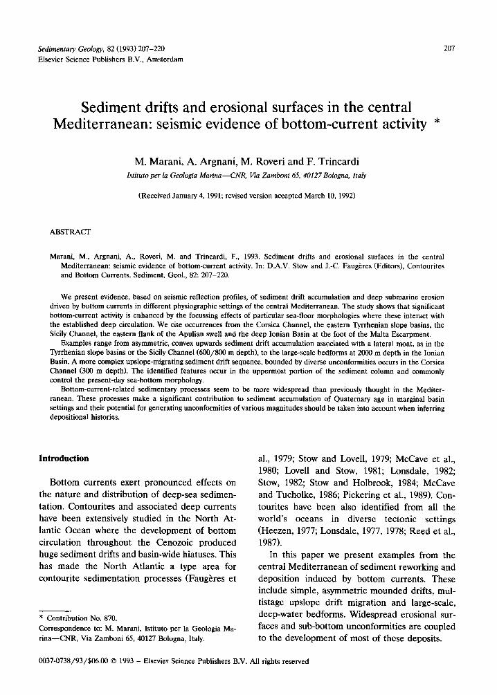
Fig. 1. Mediterranean 200 m isobath sketch map with indications of known current velocities in areas discussed in the text.
Circulation and bathymetry
Circulation patterns in the Mediterranean
Deep circulation data are not numerous in the Mediterranean and current velocity measure- ments are scattered and in scalar form. The pio- neer studies of Wust (1961) and Ovchinnikov (1966) produced circulation charts that remain substantially valid after integration with later data (Lacombe and Tchernia, 1972; Katz, 1972; Millot, 1987).
Three main water masses are recognised in the
western and central Mediterranean Sea--Atlantic Water (AW) entering from the Atlantic Ocean via the Strait of Gibraltar, Levantine Intermedi- ate water (LIW) formed in the eastern Mediter- ranean and Western Mediterranean Deep Water (WMDW) formed in winter in the northwestern Mediterranean (Ligurian Sea). In general, the bottom water mass is usually represented by LIW in the central Mediterranean as a whole, al- though there is no control on water mass types in the Tyrrhenian Sea and peri-Tyrrhenian basins.
Recent data from the Western Mediterranean Circulation Experiment (WMCE) (La Violette,
TABLE 1
Summary of morphological and available oceanographic data concerning the areas discussed in the text
Area Morphology Sediment features Depth a of Current occurrence velocity (m) (mean, cm/s )
Otranto Channel confining slope simple mound 1200 n.a. Paola Basin confining slope simple mound 600 n.a. Corsica Channel sill gap migrating mounds 300 (500) 17 Cefalu Basin sill gap large-scale bedforms 1200 (300) n.a. Messina Rise confining slope large-scale bedforms 2300 n.a. Sicily Channel sill gap/cf , slope scours 900 (700) 15
a Figures in brackets express the bathymetric constriction taken as the difference between sill depth and the depth of surrounding nearby basin.
SEDIMENT DRIERS AND EROSIONAL SURFACES IN THE CENTRAL MEDITERRANEAN 209
1985) provide new information on the structure and velocity of bottom waters in several of the areas in the central Mediterranean investigated by the present study (Artale and Gasparini, 1990; Astraldi et al., 1990; Manzella et al., 1990; Manzella and La Violette, 1990). Bottom-current velocities derived from the WMCE are available for the Corsica and Sicily Channels. In the former area, northerly directed flow has a mean winter velocity of 17 cm/s at 320 m depth reaching peaks of over 35 cm/s (Artale and Gasparini, 1990); in the Sicily Channel maximum values reach over 20 cm/s during winter, reversing be- tween northwesterly and southeasterly flow, with mean winter values of 15 cm/s at 150 m depth (Manzella et al., 1990).
A general summary of circulation and current velocity data is presented in Fig. 1 and Table 1.
Bathymetry of the investigated areas
Three end-member bottom morphologies seem to exert major control on bottom-current activity
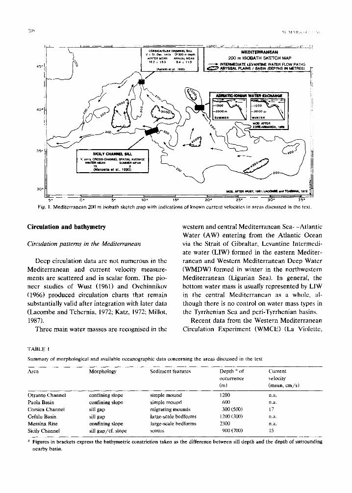
in the central Mediterranean: (1) confining slopes which focus bottom flow as boundary currents; (2) topographic constrictions which accelerate bottom flow through sill gaps; and (3) narrow passages which accelerate bottom flow through lateral restriction. Within each of these morpho- logical types, features indicative of bottom-cur- rent activity have been found (Table 1, Figs. 2, 3, 4).
Methods of study
Marine-based studies have provided most of the present-day information concerning the inter- nal geometry and spatial dimensions of con- tourites. Techniques range from direct observa- tions and underwater photography to plan views of the sea bottom with side-looking instruments and sections of the sub-surface using reflection seismic data at different scales. Direct sampling of contourite deposits, although not representa- tive of the thickness of the larger drifts, has enabled workers to identify characteristic sedi-
8" 10" 12" 14" 16" 18" 20"
Fig. 2. General bathymetry of the central Mediterranean and seismic line locations in the studied areas.
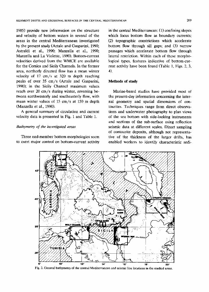
40
a
39 18
// ~',
'°o~,~ ~
19 2O
43 b
I
11 12
Fig. 3. Bathymetry, seismic line locations and current accelerating morphologies: (a) Otranto Channel, Adriatic Sea outflow along the eastern flank of the Apulian Platform; (b) Corsica Channel, sill gap between the Tytrhenian and Ligurian Seas; (c) Sicily
Channel, confined basin and sill gap between the Ionian and Tyrrhenian Seas.
mentary facies (Stow and Lovell, 1979; Stow and Holbrook, 1984; Pickering et al., 1989).
In the present study we have reviewed the
existing seismic reflection and echo-sounding database of the central Mediterranean, spanning more than fifteen years of data collection by the
SEDIMENT DRIFFS AND EROSIONAL SURFACES IN THE CENTRAL MEDITERRANEAN 211
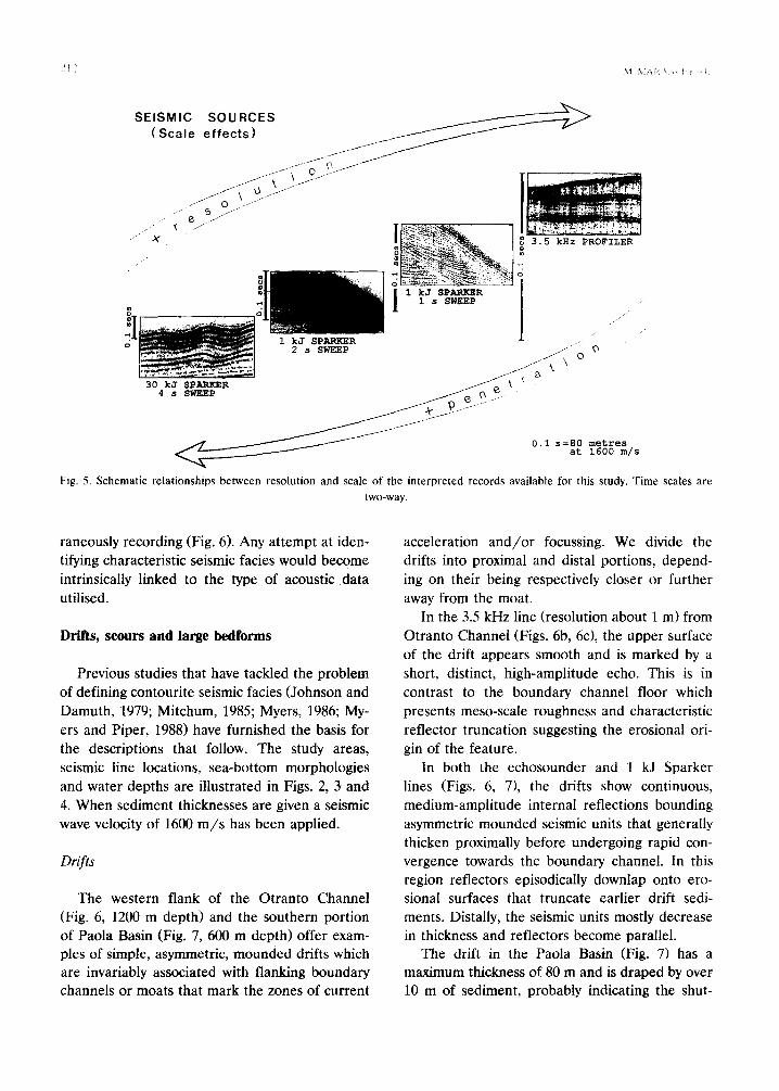
Istituto per la Geologia Marina in Bologna. The seismic data are in the form of single-channel Sparker seismic reflection profiles shot with ei- ther a 1 kJ (200-600 Hz frequency band-pass filtered) or 30 kJ (60-150 Hz frequency band-pass filtered) energy source and, from 1976 onwards, 3.5 kHz echo-sounder lines. All lines are analogi- cally recorded at 1- or 2-s vertical sweeps in the 1 kJ lines, 4- or 8-s sweeps in 30 kJ lines and 0.25- or 0.5-s sweeps in 3.5 kHz lines.
Since no data-set for a particular portion of
the study area encompasses all three acoustic energy types, identification of characteristic de-
positional geometries related to bottom currents had to be made at widely varying two-dimen- sional scales and seismic resolutions (Fig. 5). The possibility of misinterpreting or even totally miss- ing important bottom-current-induced features soon became evident in areas where two instru- ments with differing resolutions were contempo-
' . .
N 20 ~
3E oo
13 40 14 oo 14 20 38
b
km 0 25
37
kmOi " I i i I ~0
15 16
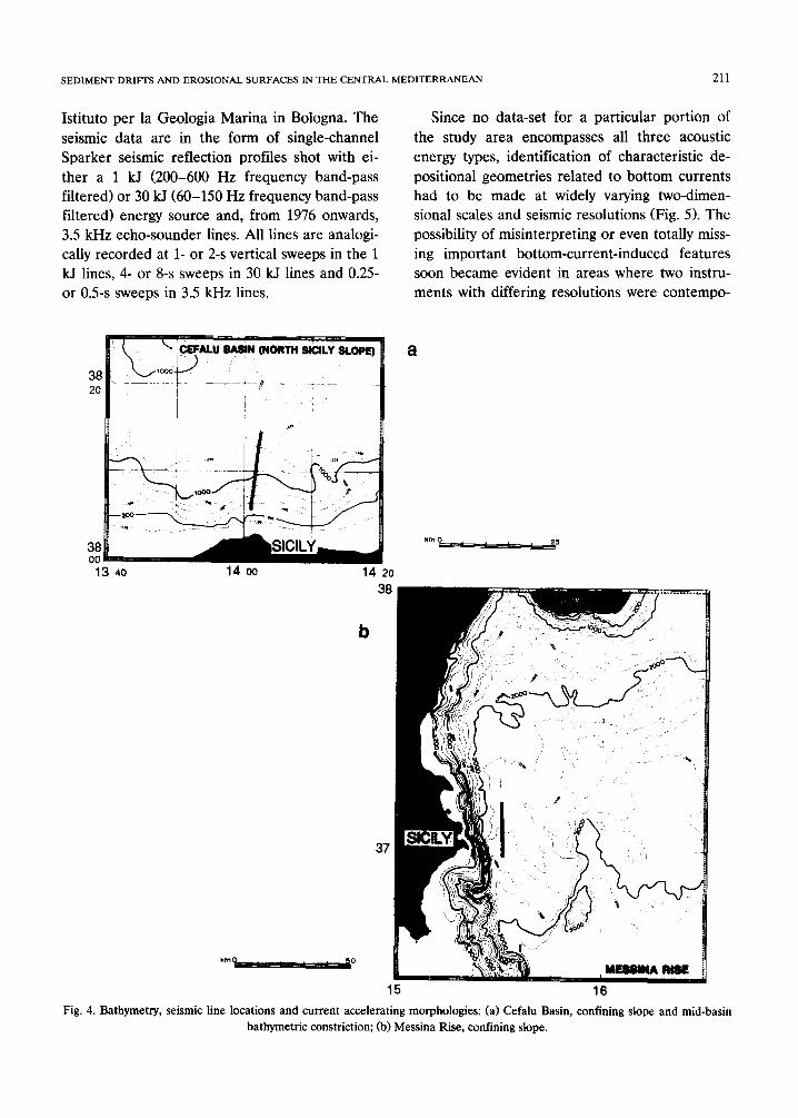
Fig. 4. Bathymetry, seismic line locations and current accelerating morphologies: (a) Cefalu Basin, confining slope and mid-basin bathymetric constriction; (b) Messina Rise, confining slope.
SEISMIC SOURCES (Scale effects) ~ _ ~
~ j J
~,;~;~:_e'a?:~ ;:~ ~ o 3.5 kHz PROFILER
| 1 kJ SPARKER [
1 ~ , ~EP 1 ~
30 kJ SPARKER ~ ~
metres 1600 m/s
Fig. 5. Schematic relationships between resolution and scale of the interpreted records available for this study. Time scales are two-way.
raneously recording (Fig. 6). Any attempt at iden- tifying characteristic seismic facies would become intrinsically linked to the type of acoustic data utilised.
Drifts, scours and large bedforms
Previous studies that have tackled the problem of defining contourite seismic facies (Johnson and Damuth, 1979; Mitchum, 1985; Myers, 1986; My- ers and Piper, 1988) have furnished the basis for the descriptions that follow. The study areas, seismic line locations, sea-bottom morphologies and water depths are illustrated in Figs. 2, 3 and 4. When sediment thicknesses are given a seismic wave velocity of 1600 m / s has been applied,
Drifts
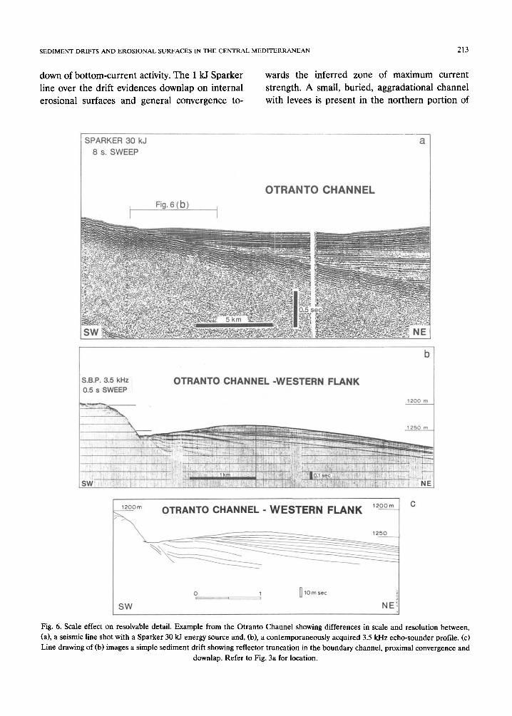
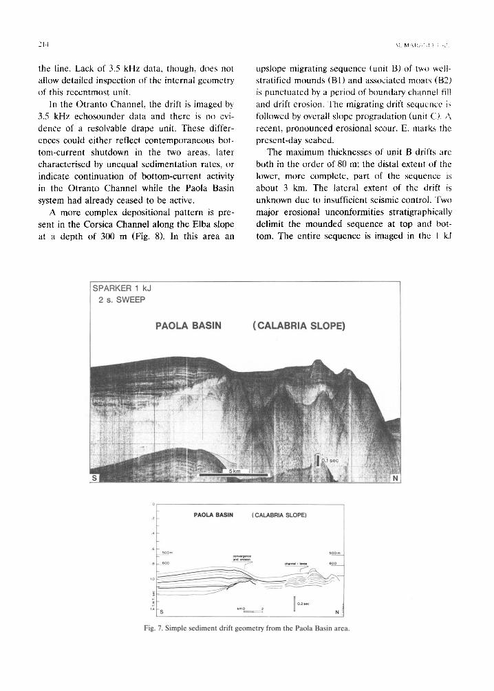
The western flank of the Otranto Channel (Fig. 6, 1200 m depth) and the southern portion of Paola Basin (Fig. 7, 600 m depth) offer exam- ples of simple, asymmetric, mounded drifts which are invariably associated with flanking boundary channels or moats that mark the zones of current
acceleration and/or focussing. We divide the drifts into proximal and distal portions, depend- ing on their being respectively closer or further away from the moat.
In the 3.5 kHz line (resolution about 1 m) from Otranto Channel (Figs. 6b, 6c), the upper surface of the drift appears smooth and is marked by a short, distinct, high-amplitude echo. This is in contrast to the boundary channel floor which presents meso-scale roughness and characteristic reflector truncation suggesting the erosional ori- gin of the feature.
In both the echosounder and 1 kJ Sparker lines (Figs. 6, 7), the drifts show continuous, medium-amplitude internal reflections bounding asymmetric mounded seismic units that generally thicken proximally before undergoing rapid con- vergence towards the boundary channel. In this region reflectors episodically downlap onto ero- sional surfaces that truncate earlier drift sedi- ments. Distally, the seismic units mostly decrease in thickness and reflectors become parallel.
The drift in the Paola Basin (Fig. 7) has a maximum thickness of 80 m and is draped by over 10 m of sediment, probably indicating the shut-
S E D I M E N T D R I F T S A N D E R O S I O N A L S U R F A C E S IN T H E C E N T R A L M E D I T E R R A N E A N 213
down of bot tom-current activity. The 1 kJ Sparker
line over the drift evidences downlap on internal
erosional surfaces and general convergence to-
wards the inferred zone of maximum current
strength. A small, buried, aggradational channel
with levees is present in the northern portion of
SPARKER 30 kJ 8 s. SWEEP
a
Fig. 6 (b) I L
O T R A N T O C H A N N E L
b
s.s:P; a;s km O ~ - . N ~ o , s ~ ; . . . .
~ ~t'lt3 m
m OTRANTO CHANNEL - W E S T E R N F L A N K 1200m t C
- - ~ 1250 t I
SW NE!
Fig. 6. Scale effect on resolvable detail. Example from the Otranto Channel showing differences in scale and resolution between, (a), a seismic line shot with a Sparker 30 kJ energy source and, (b), a contemporaneously acquired 3.5 kHz echo-sounder profile. (c) Line drawing of (b) images a simple sediment drift showing reflector truncation in the boundary channel, proximal convergence and
downlap. Refer to Fig. 3a for location.
2 ] ~ ",1. M , \ i 4 \ : , ! } i
the line. Lack of 3.5 kHz data, though, does no! allow detailed inspection of the internal geometry. of this recentmost unit.
In the Otranto Channel, the drift is imaged by 3.5 kHz echosounder data and there is no evi-
dence of a resolvable drape unit. These differ-
ences could either reflect contemporaneous bot- tom-current shutdown in the two areas, later
characterised by unequal sedimentation rates, or
indicate continuation of bottom-current activity in the Otranto Channel while the Paola Basin
system had already ceased to be active.
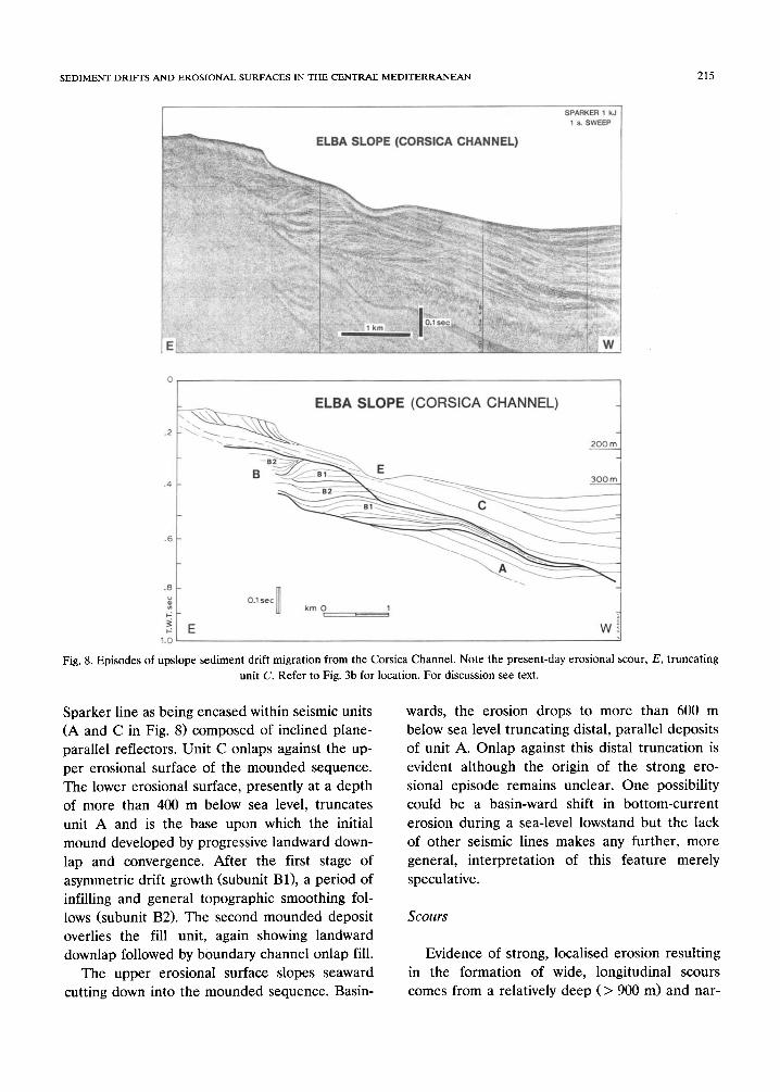
A more complex depositional pattern is pre- sent in the Corsica Channel along the Elba slope
at a depth of 300 m (Fig. 8). In this area an
upslope migrating sequence (unit B) of two well- stratified mounds (B1) and associated moats (B2) is punctuated by a period of botmdary channel fill
and drift erosion. The migrating drift sequence is
followed by overall slope progradation (unit C). A
recent, pronounced erosional scour, E, marks the
present-day seabed. The maximum thicknesses of unit B drifts are
both in the order of 80 m; the distal extent of the lower, more complete, part of the sequence is
about 3 km. The lateral extent of the drift is
unknown due to insufficient seismic control. Two
major erosional unconformities stratigraphically delimit the mounded sequence at top and bot-
tom. The entire sequence is imaged in the 1 k3
SPARKER 1 kJ 2 s. SWEEP
,~[ . . . . . . . . . . . . . . . . . . . .
~ PAOLA BASIN (CALABRIA SLOPE)
e ~ 5oo~ ~ o g m
~ a n d ~ B eoo - ~ ~n~14 : ~ s o o .
,~ ~ o _ . ~ N
Fig. 7. Simple sediment drift geometry from the Paola Basin area.
SEDIMENT DRIFTS AND EROSIONAL SURFACES IN THE CENTRAE MEDITERRANEAN 215
° ~ ELBA SLOPE (CORSICA CHANNEL) t
.4..i B - - ~ - - f l l _.._~ - - -~ 300 m_
O.1 s e c Ill ~ k m O 1
p: i , ,
E W 1.O
Fig. 8. Episodes of upslope sediment drift migration from the Corsica Channel. Note the present-day erosional scour, E, truncating unit C. Refer to Fig. 3b for location. For discussion see text.
Sparker line as being encased within seismic units (A and C in Fig. 8) composed of inclined plane- parallel reflectors. Unit C onlaps against the up- per erosional surface of the mounded sequence. The lower erosional surface, presently at a depth of more than 400 m below sea level, truncates unit A and is the base upon which the initial mound developed by progressive landward down- lap and convergence. After the first stage of asymmetric drift growth (subunit B1), a period of infilling and general topographic smoothing fol- lows (subunit B2). The second mounded deposit overlies the fill unit, again showing landward downlap followed by boundary channel onlap fill.
The upper erosional surface slopes seaward cutting down into the mounded sequence. Basin-
wards, the erosion drops to more than 600 m below sea level truncating distal, parallel deposits of unit A. Onlap against this distal truncation is evident although the origin of the strong ero- sional episode remains unclear. One possibility could be a basin-ward shift in bottom-current erosion during a sea-level lowstand but the lack of other seismic lines makes any further, more general, interpretation of this feature merely speculative.
Scours
Evidence of strong, localised erosion resulting in the formation of wide, longitudinal scours comes from a relatively deep (> 900 m) and nar-
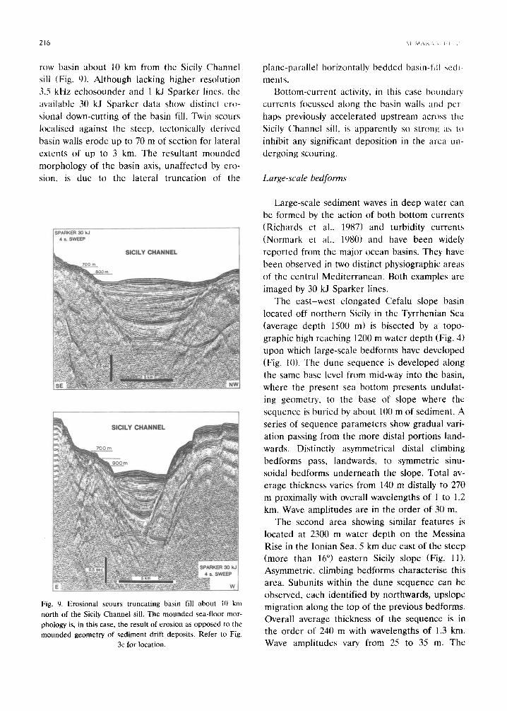
row basin about 10 km from the Sicily Channel sill (Fig. 9). Although lacking higher resolution 3.5 kHz echosounder and l kJ Sparker lines, the available 30 kJ Sparker data show distinct ero- sional down-cutting of the basin fill. Twin scours localised against the steep, tectonically derived basin walls erode up to 70 m of section for lateral extents of up to 3 kin. The resultant mounded morphology of the basin axis, unaffected by ero- sion, is due to the lateral truncation of the
4 s . m
llllal,¥ m
Fig. 9. Erosional scours truncating basin fill about 10 km
north of the Sicily Channel sill. The mounded sea-floor mor-
phology is, in this case, the result of erosion as opposed to the
mounded geometry of sediment drift deposits. Refer to Fig. 3c for location.
plane-parallel horizontally bedded basin-fill sedi- ments.
Bottom-current activity, in this case boundary currents focussed along the basin walls al:~d pcr- haps previously accelerated upstream across the Sicily Channel sill, is apparently so strong,, as Io inhibit any significant deposition in the area un- dergoing scouring.
Large-scale bedforms
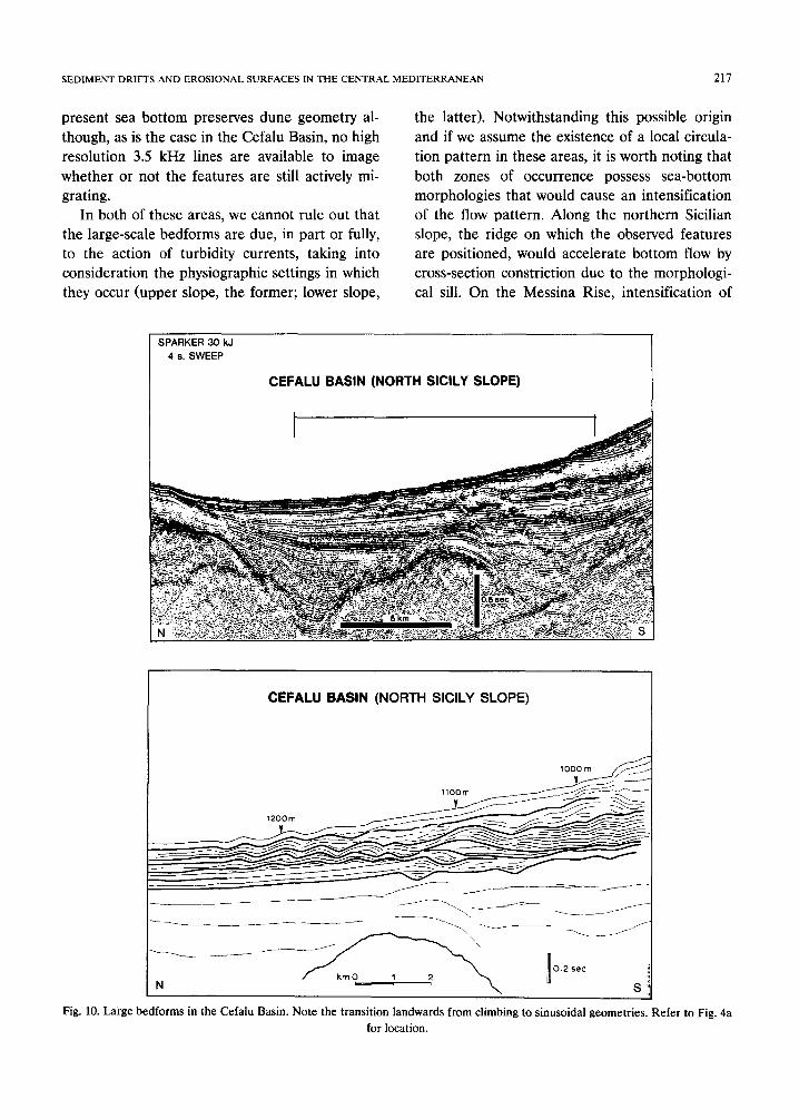
Large-scale sediment waves in deep water can be formed by the action of both bottom currents (Richards et al., 1987) and turbidity currents (Normark et al., 1980) and have been widely reported from the major ocean basins. They have been observed in two distinct physiographic areas of the central Mediterranean. Both examples are imaged by 30 kJ Sparker lines.
The east-west elongated Cefalu slope basin located off northern Sicily in the Tyrrhenian Sea (average depth 1500 m) is bisected by a topo- graphic high reaching 1200 m water depth (Fig. 4) upon which large-scale bedforms have developed (Fig. 10). The dune sequence is developed along the same base level from mid-way into the basin, where the present sea bottom presents undulat- ing geometry, to the base of slope where the sequence is buried by about 100 m of sediment. A series of sequence parameters show gradual vari- ation passing from the more distal portions land- wards. Distinctly asymmetrical distal climbing bedforms pass, landwards, to symmetric sinu- soidal bedforms underneath the slope. Total av- erage thickness varies from 140 m distally to 270 m proximally with overall wavelengths of l to 1.2 km. Wave amplitudes are in the order of 30 m.
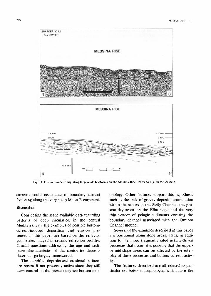
The second area showing similar features is located at 2300 m water depth on the Messina Rise in the Ionian Sea, 5 km due east of the steep (more than 16 °) eastern Sicily slope (Fig. 11). Asymmetric, climbing bedforms characterise this area. Subunits within the dune sequence can be observed, each identified by northwards, upslope migration along the top of the previous bedforms. Overall average thickness of the sequence is in the order of 240 m with wavelengths of 1.3 kin. Wave amplitudes vary. from 25 to 35 m. The
SEDIMENT DRIFTS AND EROSIONAL SURFACES IN THE CENTRAL MEDITERRANEAN 217
present sea bottom preserves dune geometry al- though, as is the case in the Cefalu Basin, no high resolution 3.5 kHz lines are available to image whether or not the features are still actively mi- grating.
In both of these areas, we cannot rule out that the large-scale bedforms are due, in part or fully, to the action of turbidity currents, taking into consideration the physiographic settings in which they occur (upper slope, the former; lower slope,
the latter). Notwithstanding this possible origin and if we assume the existence of a local circula- tion pattern in these areas, it is worth noting that both zones of occurrence possess sea-bottom morphologies that would cause an intensification of the flow pattern. Along the northern Sicilian slope, the ridge on which the observed features are positioned, would accelerate bottom flow by cross-section constriction due to the morphologi- cal sill. On the Messina Rise, intensification of
SPARKER 30 kJ 4 S. SWEEP
CEFALU BASIN (NORTH SICILY SLOPE)
~.~- . . . . . . . . . . . . . . . . . . . . ~:~m~:~ ~.~
CEFALU BASIN (NORTH SICILY SLOPE)
,oo
~ - - ~ ~ - ~ - ~ ~ _ j /
N S
Fig. 10. Large bedforms in the Cefalu Basin. Note the transition landwards from climbing to sinusoidal geometries• Refer to Fig. 4a for location.
SPARKER 30 kJ 8 s. SWEEP
~I M,,\l~-\)il i ! li
M E S S I N A R I S E
M E S S I N A R I S E
2 2 0 0 m 2 2 0 0 m
2300 2300 - -
0 . 5 s e c ill ..... - - - --
1' kmO 1 2 3 4 5
N i ~ ; - - ' ' - ~ S
Fig. 11. Distinct units of migrating large-scale bedforms on the Messina Rise. Refer to Fig. 4b for location.
currents could occur due to boundary current focussing along the very steep Malta Escarpment.
Discussion
Considering the scant available data regarding patterns of deep circulation in the central Mediterranean, the examples of possible bottom- current-induced deposition and erosion pre- sented in this paper are based on the reflector geometries imaged in seismic reflection profiles. Crucial questions addressing the age and sedi- ment characteristics of the contourite deposits described go largely unanswered.
The identified deposits and erosional surfaces are recent if not presently active since they still exert control on the present-day sea-bottom mor-
phology. Other features support this hypothesis such as the lack of gravity deposit accumulation within the scours in the Sicily Channel, the pre- sent-day scour on the Elba slope and the very thin veneer of pelagic sediments covering the boundary channel associated with the Otranto Channel mound.
Several of the examples described in this paper are positioned along slope areas. Thus, in addi- tion to the more frequently cited gravity-driven processes that occur, it is possible that the upper- or mid-slope areas can be affected by the inter- play of these processes and bottom-current activ- ity.
The features described are all related to par- ticular sea-bottom morphologies which have the
SEDIMENT DRIFTS AND EROSIONAL SURFACES IN THE CENTRAL MEDITERRANEAN 219
capacity of accelerating existing local deep circu- lation patterns so as to leave a mark within the sediment column in the form of deposits or ero- sional unconformities.
We can speculate as to whether this aggregate of morphological causes, inherently local in na- ture and necessary for the generation of con- tourite features in the central Mediterranean, is dominated by a regionally widespread control represented by glacio-eustatic fluctuations of sea level. Could cyclic variations in water mass and oceanographic parameters amplify the morpho- logical characters of the sea bottom, producing the necessary conditions for vigorous and signifi- cant bottom-current activity? If such a control is realistic, it is probably in restricted basins such as the central Mediterranean, where the morphol- ogy exerts a dominant influence, that we should expect to have bottom-current-induced features defining part of the eustatic record rather than in the oceans where contourite drifts are larger, deeper and less receptive.
Conclusions
We have shown examples from the central Mediterranean of bottom-current-related sedi- ment reworking, deposition and erosion, inter- preted from seismic lines and echo-sounder pro- files. Deposits range from simple, asymmetric mounded drifts to multistage drift migration and large-scale, deep-water bedforms. Erosional scours and sub-bottom unconformities are com- monly related to the development of most of these deposits.
Notwithstanding the lack of direct sea-bottom samples and the non-homogeneous scale of seis- mic coverage, several conclusions concerning the formation and location of contourite deposits and related erosional unconformities can be drawn.
(1) Sediment drifts and related erosional un- conformities occur at a broad range of scales. Their identification and correct interpretation is a function of the type of seismic reflection data utilised.
(2) Three main types of bottom-current fea- tures have been recognised on seismic reflection and echo-sounder lines:
(a) Simple or multiple sediment drifts; asym- metric, mounded features associated with flank- ing boundary channels that mark zones of current acceleration. Drifts are characterised by continu- ous, medium-amplitude internal reflections bounding asymmetric mounded seismic units that generally thicken proximally before undergoing rapid convergence towards the boundary channel. In this region reflectors episodically downlap onto erosional surfaces that truncate earlier drift sedi- ments. Distally, the seismic units decrease in thickness and reflectors become parallel.
(b) Erosional scours, detected against steep confining slopes. Lateral erosional truncation of reflectors along the slope-base produces a char- acteristic, localised unconformity, cutting into stratigraphically lower levels slope-wards.
(c) Large-scale bedforms have also been de- tected, bounded by undulating, medium- to high- amplitude, continuous reflections of either sym- metric or asymmetric external form. The former exhibit continuous, wavy, aggradational internal reflections while the latter contain discontinuous, parallel sets of reflections with climbing geome- try.
(3) In the central Mediterranean, bathymetry and sea-bottom morphology are the major factors that enhance the existing pattern of deep circula- tion.
(4) Contourites and related features can occur under the effect of continuous, morphologically accelerated, gravity-driven bottom currents and are thus not necessarily connected to contour- parallel flow.
(5) We speculate that in restricted basins, such as the central Mediterranean, the effects of local, bottom-current accelerating seabed topographies may be modulated by high-frequency fluctuations in sea level.
References
Artale, M. and Gasparini, G.P., 1990. Simultaneous tempera- ture and velocity measurements of the internal wave field in the Corsican Channel (Eastern Ligurian Sea). J. Geo- phys. Res., 95 (C2): 1635-1645.
Astraldi, M., Gasparini, G.P., Manzella, G.M.R. and Hopkins, T.S., 1990. Temporal variability of currents in the Eastern Ligurian Sea. J. Geophys. Res., 95 (C2): 1515-1522.
,22~ \i M\,: ,
Faug/eres, J.('. ct al., 1979. Evolution de la ~edimcntati~m
profondc au Quatcrnaire recent dans le Bassm nord-
Attantique: corps sedimentaires cl sedimentalion ubi
quiste, l-lull. Soc. Geol. France, Paris 21 (5): 585 (~0l,
]taq, t~.U., 1990. Sea level change and consequencc~, h~r tile
deep s e a - T h e erosive-corrosive cycle. 13lh l.S.('.. Nt~t-
tingham, 26-31 August 1991t, Abstr., p. 2(18.
Heezcn, B.C. (Editor), t977. Influence of abyssal circulation
on sedimentary accumulations in space and time. Mar.
(;col., 23 (special issue).
t tcezcn, B.C., Hollister, C D . and Ruddiman, W.F., t966.
Shaping of the continental rise by deep geostrophic con-
tour currents. Science. 152: 51)2-5(18.
Johnson. D.A. and Damuth. J.E.. 1979. Deep thermohaline
flow and current-controlled sedimentation in the Ami-
rante Passage: Western Indian Ocean. Mar. Geol., 33:
I 44.
Jopling, A.V. and Walker, R.G., 1968. Morphology and origin
of ripple-drift cross lamination, with examples from the
Pleistocene of Massachussetts. J. Sediment. Petrol., 38:
971-984.
Katz, E.J., 1972. The Levantine intermediate water between
the Strait of Sicily and the Strait of Gibraltar. Deep Sea
Res.. 19: 507-5211.
Lacombe. H. and Tchernia, P., 1972. Caract~res hydro-
togiques et circulation des eaux en Mdditerrande. In: D.J.
Stanley (Editor), The Mediterranean Sea. Dowden,
Hutchinson and Ross, Stroudsberg, Penn., pp. 26-36.
La Violette, P., 1985. The rationale for the Western Mediter-
ranean Circulation Experiment. W M C E Newsl., 4: l -4 .
Lonsdale, P.F., 1977. Inflow of bot tom water to the Panama
Basin. Deep Sea Res., 24: 1065-1101.
Lonsdale, P.F., 1978. Ecuadorian subduction system. Bull.
Am. Assoc. Pet. Geol., 62: 2454-2477.
Lxmsdale, P.F., 1982. Sediment drifts of the Northeast At-
lantic and their relationship to the observed abyssal cur-
rents. Bull. Inst. Geol. Bassin d'Aquitaine, Bordeaux, 31:
141-149.
Lovell, J.B.P. and Stow, D.A.V., 1981. Identification of an-
cient sandy contourites. Geology, 9: 347-349.
Manzella, G.M.R. and La Violette, P., 1990. The seasonal
variation of water mass content in the Western Mediter-
ranean and its relationship with the inflows through the
Strait of Gibraltar and Sicily. J. Geophys. Res.. 95 (C2):
I ~23-1626.
Manzella, G.M.R., Hopkins, T.S., Minnett, P.J. and Nacini,
E.. 19911. Antlantic water in the Strait of Sicily. J. Geophys.
Rcs., 95 (('2): 1569-1575.
McCavc, I.N. and Tucholke, B.E.. 1986. Deep current-con-
trolled sedimentation in the western North Atlantic. In:
P.R. Vogt and B,E. Tucholke (Editors), The Geology of
North America, Vol. M. Geol. Soc. Am., pp. 451-468.
McCavc, I.N., Lonsdale, P.F., Hollister, C.D. and Gardner,
W.D., 1980. Sediment transport over the t tattou and ~J~
dar contouritc drifts. J Sediment. Petrol., 5(): i04~)1tt~2.
Millot, ('., 1987. Circulation in tile Western Medxtcrranem~
Sea. Oceanol, Acla, ff) C): 143 i4~;
Mitchum, R.M. Jr,, I~185, Seismic stratigraphic exprcs,sion ,,71
submarine fans. In: Seismic Stratigraphy, II. An Integrated
Approach 1o Hydrocarbon Expioratkm. AAPG M c m , ",~1
117.-138.
Myers, R.A.. 1086. Late Cenozoic Sedimentation in the:
Northern Labrador Sea: A Seismo-Stratigraphic Analysis.
M.Sc. thesis, Dalhousie Univ., Flalifax, N.S.
Myers, R.A. and Piper, D.J.W., 1988. Seismic stratigraphy of
late Cenozoic sediments in the northern Labrador Sea: a
history of bottom circulation and glaciation. Can. J. Earth
Sci., 25: 21)59-2074.
Normark, W.R., Hess, G.R., Stow, D.A.V. and Bowen, A.J.,
b,~81l. Sediment waves on the Monterey Fan levee: a pre-
liminary physical interpretation. Mar. Geol. 37: I- 18.
Ovchinnikov, I.M.. 1966. Circulation in lhe surface and inter-
mediate layers of the Mediterranean. Oceanology, 6: 48-
59.
Pickering, K.T., tliscott, R.N. and Hein, F.J , 1989. Deep
Marine Environments. Unwin Hyman Ltd, London. 416
pp.
Reed, D.L., Meyer, A.W., Silver, E.A. and Prasetyo, 11., 1987,
Contourite sedimentation in an intraoceanic fl~rearc sys-
tem: Eastern Sunda Arc, Indonesia. Mar. Geol,, 76: 223-.
241.
Richards, P.C., Ritchie, J.D. and Thompson, A.R., 1987.
Ewflution of deep water climbing dunes in the Rockall
Trough-- impl ica t ions for overflow currents across the
Wyvi l le-Thompson Ridge in the (?) Late Miocene. Mar,
Geol.. 76: 177-183.
Robertson, A.H.F. and Ogg, J.G., 1986. Palaeoceanographic
setting of the Callovian North Atlantic. In: C.P. Summer-
hayes and N.J. Schackleton (Editors), North Atlantic
Palaeoceanography. Geol. Soc. Spec. Publ., 21: 283-298.
Stow, D.A.V., 1982. Bottom currents and contourites in the
North Atlantic. Bull. Inst. Geol. Bassin d'Aquitaine, 31:
151-166.
Stow, D.A.V. and Holbrook, J.A., 1984. North Atlantic con-
tourites: an overview. In: D.A.V. Stow and D,J.W. Piper
(Editors), Fine-Grained Sediments: Processes and Facies.
Geol. Soc. London, Spec. Publ., 15: 245-256.
Slow, D.A.V. and govelL J.B.P., 1979. Contourites: their
recognition in modern and ancient sediments. Earth Sci.
Rev., 14: 251-291.
Wust, G., 1961. On the vertical circulation of the Mediter-
ranean Sea. J, Geophys. Res., 66 (101: 3261-3271.
Zore-Armanda, M., 1969. Water exchange between the Adri-
atic and the eastern Mediterranean. Deep Sea Res,. 16
(21: 171-178.