Sea gravity data in the Gulf of Naples: a contribution to delineating the structural pattern of the...
12
Ž . Journal of Volcanology and Geothermal Research 82 1998 139–150 Sea gravity data in the Gulf of Naples: a contribution to delineating the structural pattern of the Vesuvian area Giovanna Berrino a, ) , Gennaro Corrado b,1 , Umberto Riccardi b a OsserÕatorio VesuÕiano, Via A. Manzoni 249, 80123 Naples, Italy b Dipartimento di Geofisica e Vulcanologia, UniÕersita ‘Federico II’, Largo San Marcellino 10, 80138 Naples, Italy ` Received 13 November 1996; accepted 5 February 1997 Abstract Three active volcanoes are located in the Neapolitan volcanic region of the Campanian Plain i.e. Somma–Vesuvius, Campi Flegrei and Ischia. Bathymetric and gravity surveys in the Gulf of Naples were made since 1987 in order to complete the off-shore Bouguer map. Eight hundred sixty-two stations were surveyed within the 400 m isobath and the project was concluded in 1994. The data have been processed with 2000 gravity values available on land to obtain a Bouguer anomaly map of the whole volcanic region. The global set of gravity data has been referred to the absolute gravity station established in Naples in 1986 and remeasured in 1994. The gravity anomalies have been computed according to the 1980 geodetic reference system; a density value of 2200 kgrm 3 has been used in the computation of the Bouguer and terrain effects. The anomaly map shows positive values ranging from 7 to 102 mGal with a mean value of 41 mGal. The Vesuvian area is characterized by a short wave length Bouguer anomaly, located at the southeastern edge of a large gravity minimum, north Ž . of Naples, interpreted as a tectonic depression Acerra depression . A strip of high gravity gradient runs south of Somma–Vesuvius with an E–W trend on land changing to a NE–SW trend in the Gulf of Naples. This strip borders two gravity minima located southwest of the Somma–Vesuvius and south of the Bay of Pozzuoli, respectively. A well defined minimum spans the Campi Flegrei and strong gravity gradients border the islands of Ischia and Procida. The interpretation of the gravity anomalies is based on 2.5D modelling along selected profiles crossing the investigated area. The models have been constrained with data obtained from deep wells and other geophysical information. Three main bodies have been modelled, i.e. the polygenic filling of the Campanian Plain, the sedimentary basement and the crystalline basement. The interpretative sections suggest that in the Neapolitan area the sedimentary basement is strongly displaced. Its top reaches the maximum depth of 3 km in the central part of the Gulf of Naples and in the Acerra depression. In the Vesuvian area the sedimentary basement is about 11 km thick with the top at a depth of 2 km. A complex system of faults surrounds the Somma–Vesuvius. q 1998 Elsevier Science B.V. All rights reserved. Keywords: Vesuvius; volcanism; structures; gravimetry ) Corresponding author. Fax: q39-81-5754239; e-mail: [email protected] 1 Fax: q39-81-5527631; e-mail: [email protected] 1. Introduction A sea gravity survey of the Gulf of Naples was started in 1987 to complete the gravity map already 0377-0273r98r$19.00 q 1998 Elsevier Science B.V. All rights reserved. Ž . PII S0377-0273 97 00061-9
Transcript of Sea gravity data in the Gulf of Naples: a contribution to delineating the structural pattern of the...

Ž .Journal of Volcanology and Geothermal Research 82 1998 139–150
Sea gravity data in the Gulf of Naples: a contribution todelineating the structural pattern of the Vesuvian area
Giovanna Berrino a,), Gennaro Corrado b,1, Umberto Riccardi b
a OsserÕatorio VesuÕiano, Via A. Manzoni 249, 80123 Naples, Italyb Dipartimento di Geofisica e Vulcanologia, UniÕersita ‘Federico II’, Largo San Marcellino 10, 80138 Naples, Italy`
Received 13 November 1996; accepted 5 February 1997
Abstract
Three active volcanoes are located in the Neapolitan volcanic region of the Campanian Plain i.e. Somma–Vesuvius,Campi Flegrei and Ischia. Bathymetric and gravity surveys in the Gulf of Naples were made since 1987 in order to completethe off-shore Bouguer map. Eight hundred sixty-two stations were surveyed within the 400 m isobath and the project wasconcluded in 1994. The data have been processed with 2000 gravity values available on land to obtain a Bouguer anomalymap of the whole volcanic region. The global set of gravity data has been referred to the absolute gravity station establishedin Naples in 1986 and remeasured in 1994. The gravity anomalies have been computed according to the 1980 geodeticreference system; a density value of 2200 kgrm3 has been used in the computation of the Bouguer and terrain effects. Theanomaly map shows positive values ranging from 7 to 102 mGal with a mean value of 41 mGal. The Vesuvian area ischaracterized by a short wave length Bouguer anomaly, located at the southeastern edge of a large gravity minimum, north
Ž .of Naples, interpreted as a tectonic depression Acerra depression . A strip of high gravity gradient runs south ofSomma–Vesuvius with an E–W trend on land changing to a NE–SW trend in the Gulf of Naples. This strip borders twogravity minima located southwest of the Somma–Vesuvius and south of the Bay of Pozzuoli, respectively. A well definedminimum spans the Campi Flegrei and strong gravity gradients border the islands of Ischia and Procida. The interpretation ofthe gravity anomalies is based on 2.5D modelling along selected profiles crossing the investigated area. The models havebeen constrained with data obtained from deep wells and other geophysical information. Three main bodies have beenmodelled, i.e. the polygenic filling of the Campanian Plain, the sedimentary basement and the crystalline basement. Theinterpretative sections suggest that in the Neapolitan area the sedimentary basement is strongly displaced. Its top reaches themaximum depth of 3 km in the central part of the Gulf of Naples and in the Acerra depression. In the Vesuvian area thesedimentary basement is about 11 km thick with the top at a depth of 2 km. A complex system of faults surrounds theSomma–Vesuvius. q 1998 Elsevier Science B.V. All rights reserved.
Keywords: Vesuvius; volcanism; structures; gravimetry
) Corresponding author. Fax: q39-81-5754239; e-mail:[email protected]
1 Fax: q39-81-5527631; e-mail: [email protected]
1. Introduction
A sea gravity survey of the Gulf of Naples wasstarted in 1987 to complete the gravity map already
0377-0273r98r$19.00 q 1998 Elsevier Science B.V. All rights reserved.Ž .PII S0377-0273 97 00061-9

( )G. Berrino et al.rJournal of Volcanology and Geothermal Research 82 1998 139–150140
existing on land. The project aimed to improve theknowledge of the structural pattern of an area wherethree active volcanic systems are located, i.e. Campi
Ž .Flegrei, Ischia and Somma–Vesuvius Fig. 1 .More than 850 off-shore stations have been sur-
veyed within the 400 m isobath to complement 2000Žstations already available on land Tribalto and
Maino, 1962; Maino et al., 1963; Oliveri del Castilloet al., 1964; Imbo et al., 1964; Maino and Tribalto,`1971; Cassano and La Torre, 1987a,b; Italian Geo-
Ž . .logical Survey SGI , unpubl. data . A compound setof 2876 gravity data was obtained.
The present paper is focused on delineating thestructural setting of the Somma–Vesuvius area,mainly in the sea-sector side of the volcano.
Somma–Vesuvius is a volcanic complex, aboutŽ .15 km southeast of Naples Fig. 1 , composed of an
Ž .older structure Mt. Somma and a nested youngerŽ .one Mt. Vesuvius . Its activity spans the last 25,000
years, alternating long periods of quiescence withplinian eruptions and relatively minor effusive–ex-
Žplosive events Delibrias et al., 1979; Carta et al.,.1981; Santacroce, 1987 . The last eruption occurred
in 1944.
Ž .Fig. 1. Satellite map of the Neapolitan volcanic region. COPYRIGHT q CNSE 02.04.86 SPOT R .

( )G. Berrino et al.rJournal of Volcanology and Geothermal Research 82 1998 139–150 141
Somma–Vesuvius is located in the CampanianPlain, a graben bordered by Mesozoic carbonateplatforms downfaulted during the Pliocene and per-haps Pleistocene as a consequence of the stretchingand thinning of the continental crust related to the
Žopening of the Tyrrhenian basin Ippolito et al.,1973; Ortolani and Aprile, 1978; Scandone, 1979;
.Ortolani and Pagliuca, 1987; Patacca et al., 1990 .The Campanian Plain is bordered to the northeast byNW–SE-trending faults and to the south and northby NE–SW-trending faults. This important graben isfilled by volcanic and clastic, continental and ma-
Ž .rine, deposits Balducci et al., 1985 .The buried geometry of the carbonate basement
Žwas delineated by gravity data on land Oliveri delCastillo, 1966; Carrara et al., 1973; Cameli et al.,1975; Luongo et al., 1988; Ferri et al., 1990; Cubel-
.lis et al., 1995 . It originates from Mt. Massico andŽdeepens into the Volturno graben Ortolani and
.Pagliuca, 1987 . This carbonate formation was notfound in deep wells to 3 km in the Campi Flegrei
Ž .area Rosi and Sbrana, 1987 and at the estuary ofŽ .the Volturno river Ippolito et al., 1973 . The graben
continues beyond the Campi Flegrei and ends at the‘Scoglio di Rovigliano’, which is a limestone forma-tion associated with the horst of the Sorrento Penin-
Žsula Mesozoic calcareous sequence Calligaris et al.,.1972; Cassano and La Torre, 1987a . The Sorrento
Peninsula is composed of an about 4 to 5 km thickoverlapped on a Meso-Cenozoic basinal formationŽD’Argenio et al., 1973; Ippolito et al., 1973;
.Mostardini and Merlini, 1986 . Both Mesozoic andMeso-Cenozoic formations are buried below theSomma–Vesuvius complex as outlined from a jointinterpretation of gravity, magnetic and geological
Ž .data Mostardini and Merlini, 1986 . The total thick-ness of the carbonate series below Mount Vesuvius
Ž .is about 5 to 6 km Imbo, 1949 . Information about`the sedimentary basement below the Vesuvius isprovided by the deep geothermal ‘Trecase’ well that
Žintercepts the limestone layer at about 1700 m be-. Ž .low sea level Balducci et al., 1985 . Further infor-
mation was obtained from the study of crustal xeno-liths found in several pyroclastic deposits from
Ž .Vesuvius Savelli, 1968; Barberi and Leoni, 1980 .Several authors investigated the tectonic setting of
the Campanian Plain to identify the main faults thatmay have controlled the volcanic activity of Vesu-
Ž .vius. Scandone et al. 1991 proposed a structuralmodel of the Campanian Plain based on the integra-
Ž .tion of gravity data Cassano and La Torre, 1987a ,Ž .seismic reflection profiles Finetti and Morelli, 1974
Žand geological data Barberi et al., 1978; Santacroce,.1987 . These authors suggested that the main feature
of the central part of the Campanian Plain is astructural depression, named the ‘Acerra depression’,inferred by a large negative Bouguer anomaly. Cas-
Ž .sano and La Torre 1987a recognized another grabensoutheast of Mount Vesuvius, called the ‘Pompei
Ž .graben’. Scandone et al. 1991 point out that theNeapolitan volcanic areas are settled along the flanksof buried grabens. A system of listric faults would beresponsible for the displacement of the carbonatebasement. Two main NE–SW-trending faults wouldcorrespond to the Mt. Massico and the western sideof the Acerra depression. The tectonic lineamentsthat seem to be related with the Vesuvius activity arecompletely different from the still active NW–SE-
Žtrending tectonic structures of the Appennines Del.Pezzo et al., 1983; Marzocchi et al., 1993 . Mount
Vesuvius is located on a NE–SW-trending listricfault, which borders the southeastern edge of the
Ž .Acerra depression Marzocchi et al., 1993 .Ž .Gravimetry on land Cassano and La Torre, 1987a
Žand seismic profiles at sea Finetti and Morelli,.1974; Finetti and Del Ben, 1986 show that this fault
displaced the most recent formations. Finetti andŽ .Morelli 1974 recognized at sea some volcanic vents
located on this fault, which has been the site ofhistoric volcanic activity with two flank eruptions in
Ž .1794 and 1861 Scandone et al., 1991 . Moreover,this tectonic setting is consistent with the water
Ž .chemistry of the vesuvian area Celico et al., 1994 .ŽThe most important hydrochemical anomalies high
salinity, relatively high temperature and high HCO ,3.Li, B and CO are localized along a NE–SW-trend-2
ing strip which well correlates with above NE–SW-trending fault.
2. Data collection
The off-shore gravity stations have been surveyedfrom 1988 to 1994 during five cruises of the‘Minerva’ and ‘Urania’ oceanographic ships of the
Ž .Italian National Research Council CNR .

( )G. Berrino et al.rJournal of Volcanology and Geothermal Research 82 1998 139–150142
Gravity measurements were carried out on a 0.5mile square grid. An increased number of measure-ments was made in some crucial areas like ‘Scogliodi Rovigliano’, close to Castellammare di Stabia, atthe boundary of the exposed carbonate basement andthe intersection of the main NE–SW- and NW–SE-trending tectonic lineaments. The Procida and Ischiachannels were also surveyed with greater detail.Eight hundred sixty-two stations were measured at adepth ranging from 10 to 400 m. Gravity values wereread by means of the La Coste and Romberg, modelHG, number 24, sea bottom gravity meter. TheHG-meter is equipped with a pressure transducerable to measure the depth with an error no greaterthan 0.1%. During the cruises carried out until 1990the coordinates of the stations were determined usingthe Motorola Mini Range III radio positioning sys-tem. A precision of about "10 m has been achievedusing a minimum of three fixed benchmarks belong-ing or linked to the Italian Geodetic Network asreference. During the 1994 survey, the position of
the stations was determined using the Global Posi-tioning System in differential mode. A telephone linkwith the reference station on land, located at theSurveillance Centre of the Osservatorio Vesuviano inNaples, was employed to obtain a ‘real-time’ deter-mination of the coordinates of the off-shore stations.The off shore gravity stations were linked to theabsolute Naples gravity station of the new Italian
Ž .‘Zero Order’ Gravity Net Berrino, 1995 . The grav-ity surveys were preceded by a bathymetric surveycarried out in 1987 in the Gulf of Pozzuoli by the
Ž .Osservatorio Vesuviano Berrino et al., 1991 .Bathymetric stations were marked every 50 m on 0.5mile-spaced profiles. More than 2500 depth measure-ments were taken with a Raytheon echo soundingand corrected for sea-tide by means of the records ofthe tidal stations in Naples and Pozzuoli. The esti-mated error on depth measurements is about "0.2m. The position of the bathymetric stations wasdetermined by means of the Motorola Mini-RangeIII system following the same criteria adopted for the
Fig. 2. Distribution of the off-shore and on land gravity stations.

( )G. Berrino et al.rJournal of Volcanology and Geothermal Research 82 1998 139–150 143
Table 1Densities estimated in sites with different lithologies
3Ž .Site Density kgrm
Gulf of Naples 2500"100Ischia 1860"20Procida 1900"200Campi Flegrei 1500"100Somma–Vesuvius 2000"40Sorrento Peninsula 2290"40
gravity surveys. The global set of bathimetric datahas been used to improve the terrain correction ofthe gravity data.
The gravity map of the Neapolitan area was ob-Ž .tained from 2876 stations Fig. 2 . It derived from
the integration of the off-shore measurements withthose already existing on land from previous surveysŽTribalto and Maino, 1962; Maino et al., 1963; Oliv-
eri del Castillo et al., 1964; Imbo et al., 1964; Maino`and Tribalto, 1971; Cassano and La Torre, 1987a,b;
Ž . .Italian Geological Survey SGI , unpubl. data . Thegravity anomalies were computed with reference to
Ž .the 1980 Ellypsoid Moritz, 1984 and a densityvalue of 2200 kgrm3 was used for the computationof the Bouguer and the terrain effects. This value isthe weighted mean of the densities estimated in areas
Ž .with different lithologies Table 1 . In each area thevalue of the density was computed as a function ofthe slope of the straight line correlating the free-air
Žanomaly and the height of the station Seguin and.Fridecki, 1989 .
The Bouguer anomaly map is shown in Fig. 3,where the isolines are drawn every 2.5 mGal. Anupper limit of 0.7 mGal was estimated for the erroraffecting the off-shore data. The gravity anomalyranges from 7 to 102 mGal with a mean value of 41
Fig. 3. Bouguer gravity map of the Neapolitan volcanic region.

( )G. Berrino et al.rJournal of Volcanology and Geothermal Research 82 1998 139–150144
mGal. To obtain, for the given area, the anomaly inthe 1930 reference system a constant value of 10.44mGal must be subtracted.
A strip of maximum gradient runs almost parallelto the Sorrento peninsula turns towards the south-west at the southern sector of Somma–Vesuvius andends in the southern part of the Gulf of Pozzuoli, in a
Ž .broad gravity minimum Berrino et al., 1991 .Somma–Vesuvius and Campi Flegrei volcanoes oc-cur at the southern edge of the large gravity mini-
Žmum, north of Naples Fig. 3; Cassano and La Torre,.1987a,b; Scandone et al., 1991 . The Vesuvian area
is characterized by a Bouguer anomaly of smallextension and amplitude, forming a tortuous patterndue to the presence of local minima and maxima. Avast gravity low southeast of Somma–Vesuvius isthe main feature in this area.
A well defined gravity minimum spanning theCampi Flegrei is readable. Strong gradients borderthe islands of Ischia and Procida.
3. Interpretative sections and results
The inversion of the gravity anomalies was car-Žried out by means of 2.5D modelling Won and
.Bevis, 1987; Fedi, 1988 along 10 selected profileshaving lengths from 30 to 65 km and crossing the
Ž .eastern part of the Neapolitan area Fig. 3 . Thelength and position of the interpretative sectionswere aimed at the off shore reconstruction of thestructural setting of the area hosting the Somma–Vesuvius. Two short profiles cross the ‘Scoglio di
Ž .Rovigliano’ Fig. 3 , where the limestone basementis exposed. The interpretative models have been
Žconstrained taking into account on land data Cas-sano and La Torre, 1987a,b; Carrara et al., 1972,
.1973; Mostardini and Merlini, 1986 .Three main bodies are considered to fit the gen-
eral trend of the gravity anomaly. The first bodycorresponds to the polygenic filling of the tectonicdepression of the Campanian Plain; the second one isthe underlying layer, mainly carbonates, superim-posed on the crystalline basement.
The volcano-sedimentary filling of the CampanianPlain is a polygenic body formed by three layershaving density of 2000, 2200 and 2400 kgrm3,respectively. These values are consistent with the
experimental determinations from wells in bothŽvesuvian and phlegraean areas Cassano and La.Torre, 1987a,b; Barberi et al., 1991 and with other
Žgeophysical data Carrara et al., 1973; Gardner et al.,1974; Finetti and Morelli, 1974; Nunziata and
.Rapolla, 1981 . The density increase could be mainlydue to the lithostatic load and, in the phlegraeanarea, to the effect of hydrothermal alteration causedby deposition of secondary minerals in porous tuffs
Žand tuffites, which sharply reduced porosity Cheliniand Sbrana, 1987; De Vivo et al., 1989; Barberi et
.al., 1991 . In the phlegraean area, the deepest layerfilling could be associated with tuffites–lavas com-plex detected by the Mofete and San Vito wellsŽ .Rosi and Sbrana, 1987 . Away from the phlegraeanarea the highest density layer may be identified withthe tuffites–lavas and conglomerate complexes over-lapping the Mesozoic carbonate basementŽ .Bernasconi et al., 1981; Santacroce, 1987 . Thislayer plays a key role in the modulation of theanomaly shape, allowing the qualitative discrimina-tion between shallow tectonic and deep structures.The boundary between carbonates and the crystallinebasement produces the greatest wave length compo-nents, such as to provide a ‘regional’ contribution.
The depth of each layer of the polygenic fillingŽhas been constrained by data from wells Ippolito et
.al., 1973; Rosi and Sbrana, 1987; Santacroce, 1987 .In the Vesuvian area a density value of 2400
3 Žkgrm was assumed for the lava Cassano and La. 3Torre, 1987a . A density of 2600 kgrm was as-
Žsigned to the sedimentary body Carrara et al., 1973;Johnson and Olhoeft, 1984; Mostardini and Merlini,1986; Luongo et al., 1988; Ferri et al., 1990; Cubel-
.lis et al., 1995 . This is a carbonate in the vesuvianarea, as inferred from the stratigraphy of the Trecasewell. Its morphology in the Gulfs of Naples andPozzuoli was constrained by reflection seismic
Ž .prospecting Finetti and Morelli, 1974 and gravitydata, while on land previous interpretations of geo-electric, magnetic and gravity data were consideredŽCassano and La Torre, 1987a,b; Carrara et al., 1972,
. 31973; Mostardini and Merlini, 1986 . A 2800 kgrmdensity was assigned to the crystalline basementŽWoolard, 1969; Johnson and Olhoeft, 1984; Mostar-
.dini and Merlini, 1986 . The depth of the basementwas inferred by a semi-quantitative interpretation of
Ž .aeromagnetic data Mostardini and Merlini, 1986

( )G. Berrino et al.rJournal of Volcanology and Geothermal Research 82 1998 139–150 145
Žand from previous gravity models Corrado and.Rapolla, 1981; Rapolla et al., 1989 . The quantitative
analysis of the Bouguer anomalies allowed to define
the geometry of the underlying layers, mainly of thecarbonate body, which is mainly responsible for thelong wavelength anomaly. In Figs. 4–6 some se-
Ž . ŽFig. 4. Interpretative sections along the P2 crossing the Campi Flegrei and the Somma–Vesuvius complex and the P3 crossing the. Ž .central part of the Gulf of Naples and the Somma–Vesuvius complex profiles Fig. 3 .

( )G. Berrino et al.rJournal of Volcanology and Geothermal Research 82 1998 139–150146
Ž .Fig. 5. Interpretative sections along the P7 and P8 profiles Fig. 3 .
lected interpretative sections are shown. Fig. 4 showsthe interpretative model along the P2 and P3 profiles
Ž .both crossing the Somma–Vesuvius Fig. 3 . Theprofiles have been drawn as far as the western edge
of the Neapolitan volcanic region to include theSomma–Vesuvius area in a more general picture. InFig. 5 two interpretative sections crossing the Gulf of
Ž .Naples Fig. 3 are represented. Along profile P2

( )G. Berrino et al.rJournal of Volcanology and Geothermal Research 82 1998 139–150 147
Fig. 6. Interpretative sections along the P1R and P2R profilesŽ .crossing the ‘Scoglio di Rovigliano’ Fig. 3 .
Ž .Fig. 4 the basement abruptly shifts upwards toabout 1 km at the eastern edge of the Campi Flegrei.In this area a well defined subcircular gravity mini-mum outlines the most important volcano-tectonic
Ž .feature Fig. 3 and the basement locally sinks to 3Žkm Nunziata and Rapolla, 1981; Cassano and La
Torre, 1987b; Aster and Meyer, 1988; Rapolla et al.,1989; Fedi et al., 1991; Aster et al., 1992; Cubellis et
.al., 1995 . A similar configuration occurs in theŽ .western part of the Gulf of Naples Fig. 3 where, in
correspondence of a relative gravity minimum, theŽ .basement deepens to 3 km Fig. 4, P3; Fig. 5, P7 . In
the eastern side of the area some dislocations abruptlyŽ .deepen the basement Fig. 4, P3; Fig. 5, P8 . A flat
basement, 2 km deep and 11 km thick, was foundunder the Somma–Vesuvius. The depth of the bot-tom of about 13 km, is consistent with the prelimi-nary interpretation of a 2D seismic tomography of
Ž .the volcano Zollo et al., 1996b indicating a reflec-tor 12–14 km deep. Denser bodies, which may beassociated with lavas, overlay the limestone base-
Ž .ment P2 and P3 . This interpretation is consistentwith the pattern of the magnetic field. This forms asub-circular anomaly ascribed to more than 1000 m
Žlava thickness below sea level Cassano and La.Torre, 1987a . The tortuous shape and the short
wavelength of the Bouguer anomaly centered on thevolcano, already discussed by Tribalto and MainoŽ .1962 , leads to hypothesize a shallow structure char-
Žacterized by lateral density contrast Fig. 4, P2 and.P3 . On the other hand, the 2D seismic tomography
outlines the occurrence of a high velocity lateralŽ .contrast in the volcano structure Zollo et al., 1996a .
The density and geometry of the bodies inside thevolcano have been chosen only in order to obtain anacceptable fitting of the observed anomaly, as theavailable gravity data on land are not sufficient toformulate a quantitative interpretation of small scaleanomalies.
Results coming from the short profiles crossingŽ .‘Scoglio di Rovigliano’ Fig. 6 show an abruptly
rising carbonatic bedrock surrounded by steep cliffs,confirming the observations along profiles P3 andP8. The interpretative model, in the light of thedifferent slopes of the escarpment, leads to hypothe-size a complex faulting mechanism due to a normalcomponent with tilting about south-southeast.
Taking into account the whole set of the interpre-tative sections, the carbonate substratum shows twomore deepest areas located in the Acerra area, wherethey reach a depth of about 3 km, and SE thevolcano, in the Pompei–Boscotrecase sector, as indi-
Žcated by other authors Cassano and La Torre, 1987a;.Scandone et al., 1991 .
4. Conclusions
The availability of the off-shore Bouguer anomalymap in the Neapolitan volcanic region has con-tributed to better define the structural setting of theSomma–Vesuvius area. The quantitative interpreta-tion of the gravity anomaly provided informationabout the shape and depth of the sedimentary base-
Ž 3.ment 2600 kgrm , overlain by the polygenic
( )G. Berrino et al.rJournal of Volcanology and Geothermal Research 82 1998 139–150148
Žvolcanic and clastic of continental and marine ori-.gin filling of the Campanian Plain, which displays
an uneven geometry due to the presence of highs andlows.
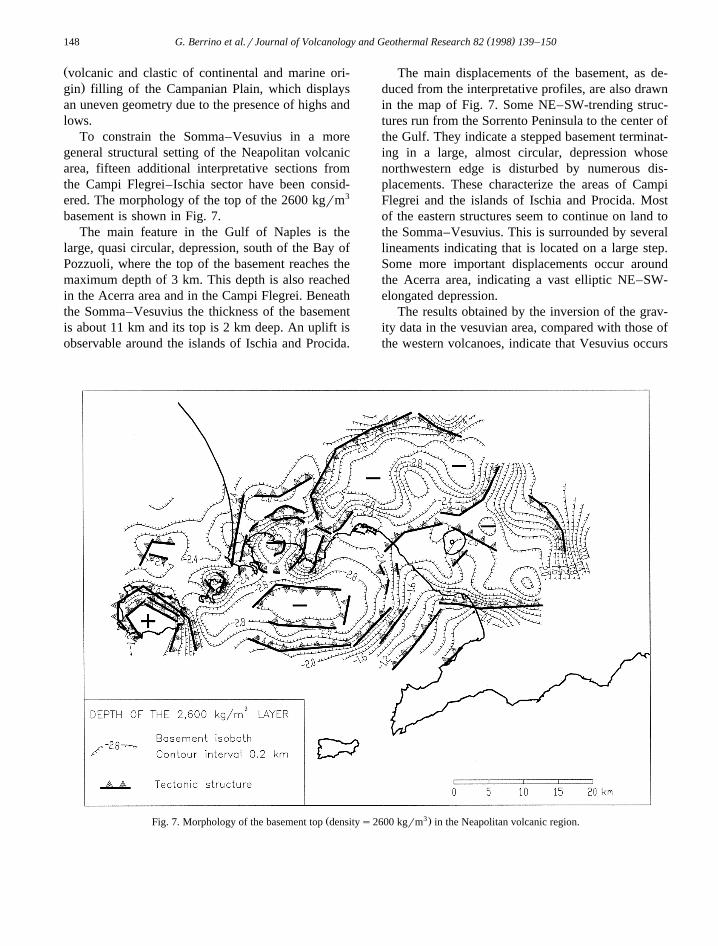
To constrain the Somma–Vesuvius in a moregeneral structural setting of the Neapolitan volcanicarea, fifteen additional interpretative sections fromthe Campi Flegrei–Ischia sector have been consid-ered. The morphology of the top of the 2600 kgrm3
basement is shown in Fig. 7.The main feature in the Gulf of Naples is the
large, quasi circular, depression, south of the Bay ofPozzuoli, where the top of the basement reaches themaximum depth of 3 km. This depth is also reachedin the Acerra area and in the Campi Flegrei. Beneaththe Somma–Vesuvius the thickness of the basementis about 11 km and its top is 2 km deep. An uplift isobservable around the islands of Ischia and Procida.
The main displacements of the basement, as de-duced from the interpretative profiles, are also drawnin the map of Fig. 7. Some NE–SW-trending struc-tures run from the Sorrento Peninsula to the center ofthe Gulf. They indicate a stepped basement terminat-ing in a large, almost circular, depression whosenorthwestern edge is disturbed by numerous dis-placements. These characterize the areas of CampiFlegrei and the islands of Ischia and Procida. Mostof the eastern structures seem to continue on land tothe Somma–Vesuvius. This is surrounded by severallineaments indicating that is located on a large step.Some more important displacements occur aroundthe Acerra area, indicating a vast elliptic NE–SW-elongated depression.
The results obtained by the inversion of the grav-ity data in the vesuvian area, compared with those ofthe western volcanoes, indicate that Vesuvius occurs
Ž 3.Fig. 7. Morphology of the basement top densitys2600 kgrm in the Neapolitan volcanic region.

( )G. Berrino et al.rJournal of Volcanology and Geothermal Research 82 1998 139–150 149
in an almost undisturbed area. The volcanic struc-tures are very shallow and the deepest ones could beof tectonic origin.
Acknowledgements
A. Confessore, R. Continisio, G. D’Alessandro,V. d’Errico, V. D’Isanto, A. La Rocca, R. Magliulo,B. Marquez Azua, G. Mele, C. Paparo, M. Pisani, A.Scotti and A. Serio participated to the marine sur-veys. Their intelligent and efficient team-work ishere acknowledged. The authors thank Professor R.Taddei who digitally processed the satellite image ofFig. 1, kindly provided by Nuova Telespazio, Italy.The A.A. are also grateful to the manager of theCodevintec Italiana srl, who provided the hardwareand the software for the GPS differential measure-ments free of charge. G. Berrino thanks the Oceano-graphic Ships Rigging Service of the Italian NationalResearch Council and the Captains V. LavaderaLubrano, R. Papandrea, A. Patane, F. Senegagliese,`and their crews, for their precious assistance. Thebathymetric and gravity surveys have been finan-cially supported by the Osservatorio Vesuviano. TheNational Group for Volcanology of the Italian Na-tional Research Council financed the 1994 surveyand data processing.
References
Aster, R.C., Meyer, R.P., 1988. Three-dimensional velocity struc-ture and Hipocenter distribution in the Campi Flegrei caldera,Italy. Tecnophysics 149, 195–218.
Aster, R.C., Meyer, R.P., De Natale, G., Zollo, A., Martini, M.,Del Pezzo, E., Scarpa, R., Iannaccone, G., 1992. Seismicinvestigation of Campi Flegrei: a summary and synthesis of
Ž .results. In: Gasparini, P., Scarpa, R., Aki. K. Eds. , VolcanicSeismology. IVACEI, Proc. Volcanol. 3, 462–483.
Balducci, S., Vasellini, M., Verdiani, G., 1985. Exploration wellin the ‘Ottaviano’ Permit, Italy; ‘Trecase 1’. In: Strub, A.S.,
Ž .Ungemach, P. Eds. , European Geothermal Update. Proc. 3rdInt. Seminar on the Results of EC Geothermal Energy Re-search, Reidel.
Barberi, F., Leoni, L., 1980. Metamorphic carbonate ejecta fromVesuvius plinian eruptions: evidence of the occurrence of
Ž .shallow magma chambers. Bull. Volcanol. 43 1 , 107–120.Barberi, F., Innocenti, F., Lirer, L., Munno, R., Pescatore, T.,
Santacroce, R., 1978. The Campanian ignimbrite: a majorŽ .prehistoric eruption in the Neapolitan area Italy . Bull. Vol-
Ž .canol. 41 1 , 1–22.
Barberi, F., Cassano, E., La Torre, P., Sbrana, A., 1991. Structuralevolution of Campi Flegrei caldera in light of volcanologicaland geophysical data. J. Volcanol. Geotherm. Res. 48, 33–49.
Bernasconi, A., Bruni, P., Gorla, L., Principe, C., Sbrana, A.,1981. Risultati preliminari dell’esplorazione geotermica pro-fonda nell’area vulcanica del Somma–Vesuvio. Rend. Soc.Geol. Ital. 4, 237–240.
Berrino, G., 1995. Absolute gravimetry and gradiometry on activeŽ .volcanoes of southern Italy. Boll. Geof. Teor. Appl. 146 37 ,
131–144.Berrino, G., Corrado, G., Luongo, G., 1991. Indagini gravimet-
riche a mare nelle aree vulcaniche napoletane. Proc. X Annu.Meet. GNGTS, Rome, pp. 763–775.
Calligaris, D., Morelli, C., Pisani, M., 1972. Rilievo gravimetricoŽ .e magnetico. In: Versino, L. Ed. , Relazione sui Rilievi
Effettuati nell’Area Flegrea nel 1970–72. CNR Quad. Ric.Sci. 83, 72–81.
Cameli, G.C., Rendina, M., Puxeddu, M., Rossi, A., Squarci, P.,Taffi, L., 1975. Geothermal research in Western CampaniaŽ .Southern Italy . Geological and geophysical results. Proc. 2ndU.N. Symposium of Development and Use of GeothermalResources, San Francisco, CA, pp. 315–328.
Carrara, E., Pinna, E., Rapolla, A., 1972. Indagini geofisiche nellearee vulcaniche italiane di interesse geotermico. Proc. Acc.
Ž .Pontaniana, 31 abstract .Carrara, E., Iacobucci, F., Pinna, E., Rapolla, A., 1973. Gravity
and magnetic survey of the campanian volcanic area, SouthernItaly. Boll. Geof. Teor. Appl. XV 57, 39–51.
Carta, S., Figari, R., Sartoris, G., Sassi, E., Scandone, R., 1981. Astatistical model from Vesuvius and its volcanological implica-
Ž .tions. Bull. Volcanol. 44 2 , 129–151.Cassano, E., La Torre, P., 1987a. Geophysics. In: Santacroce, R.
Ž . Ž .Ed. , Somma Vesuvius. CNR Quad. Ric. Sci. 114 8 , 175–196.
Cassano, E., La Torre, P., 1987b. Geophysics. In: Rosi, M.,Ž .Sbrana, A. Eds. . Phlegrean Fields. CNR Quad. Ric. Sci. 114
Ž .9 , 103–133.Celico, N., Celico, P., Ghiara, M.R., Piscopo, V., Stanzione, D.,
Sabino, A., 1994. Caratteristiche geochimiche delle acqueŽ .sotterranee dell’area del Somma–Vesuvio Campania, Italia .
Geol. Rom. XXX, 709–723.Chelini, W., Sbrana, A., 1987. Chapter 7. In: Rosi, M., Sbrana. A.
Ž . Ž .Eds. , Phlegrean Fields. Quad. Ric. Sci. 114 9 , 94–103.Corrado, G., Rapolla, A., 1981. The gravity field of Italy: analysis
of its spectral composition and delineation of a three-dimen-sional crustal model for central-southern Italy. Boll. Geof.Teor. Appl. XXIII 89, 17–29.
Cubellis, E., Ferri, M., Luongo, G., 1995. Internal structures ofCampi Flegrei caldera by gravimetric data. J. Volcanol.Geotherm. Res. 65, 147–156.
D’Argenio, B., Pescatore, T., Scandone, P., 1973. Schema geo-logico dell’Appennino Campano–Lucano. Acc. Naz. Lincei183, 49–72.
Del Pezzo, E., Iannaccone, G., Martini, M., Scarpa, R., 1983. The23 November 1980 southern Italy earthquake. Bull. Seismol.Soc. Am. 73, 187–200.
Delibrias, G., Di Paola, G.M., Rosi, M., Santacroce, R., 1979. La

( )G. Berrino et al.rJournal of Volcanology and Geothermal Research 82 1998 139–150150
storia eruttiva del complesso Somma–Vesuvio ricostruita dallesuccessioni piroclastiche del Monte Somma. Rend. Soc. Ital.Mineral. Petrogr. 35, 1–32.
De Vivo, B., Belkin, H.E., Barbieri, M., Chelini, W., Lattanzi, P.,Ž .Lima, A., Tolomeo, L., 1989. The Campi Flegrei Italy
geothermal system: a fluid inclusion study of Mofete and S.Vito fields. J. Volcanol. Geotherm. Res. 36, 303–326.
Fedi, M., 1988. Spectral expansion inversion of gravity data forŽ .2 D structures. Boll. Geof. Teor. Appl. 21 121 , 25–39.1r2
Fedi, M., Nunziata, C., Rapolla, A., 1991. The Campania–CampiFlegrei area: a contribution to discern the best structural modelfrom gravity interpretation. J. Volcanol. Geotherm. Res. 48,51–59.
Ferri, M., Cubellis, E., Luongo, G., 1990. Strutture crostali delgraben della Piana Campana da indagini gravimetriche. Proc.XI Annu. Meet. GNGTS, Rome, pp. 737–747.
Finetti, I., Del Ben, A., 1986. Geophysical study of the Tyrrhenianopening. Boll. Geof. Teor. Appl. XXVIII 110, 75–155.
Finetti, I., Morelli, C., 1974. Esplorazione di sismica a riflessionedei Golfi di Napoli e Pozzuoli. Boll. Geof. Teor. Appl. 16,175–222.
Gardner, G.H.F., Gardner, L.W., Gregory, A.R., 1974. Formationvelocity and density the diagnostic basic for stratigrafic traps.
Ž .Geophysics 39 6 , 770–780.Imbo, G., 1949. Successione e spessori delle formazioni geo-`
logiche nel basamento del Somma–Vesuvio. Ann. Oss. Ves.Ser. VI I, 151–161.
Imbo, G., Bonasia, V., Gasparini, P., 1964. Rilievo gravimetrico`dell’isola di Procida. Ann. Oss. Ves. 6, 117–138.
Ippolito, F., Ortolani, F., Russo, M., 1973. Struttura marginaletirrenica dell’Appennino Campano: reinterpretazione dei datidi antiche ricerche di idrocarburi. Mem. Soc. Geol. Ital. 12,27–250.
Johnson, G.R., Olhoeft, G.R., 1984. Density of Rocks and miner-Ž .als. In: Carmichael, R.S. Ed. , Handbook of Physical Proper-
ties of Rocks, 3. CRC Press, Boca Raton, FL, pp. 1–38.Luongo, G., Ferri, M., Cubellis, E., Grimaldi, M., Obrizzo, F.,
1988. Struttura superficiale della Piana Campana: Interpre-tazione del profilo Garigliano–Campi Flegrei. Proc. VII Annu.Meet. G.N.G.T.S., C.N.R., Rome, pp. 1221–1128.
Maino, A., Tribalto, G., 1971. Rilevamento gravimetrico di det-Ž .taglio dell’isola d’Ischia Napoli . Boll. Serv. Geol. Ital., 92,
109–122.Maino, A., Segre, A.G., Tribalto, G., 1963. Rilevamento gravi-
metrico dei Campi Flegrei e dell’Isola d’Ischia. Ann. Oss.Ves. Ser. VI 5, 229–312.
Marzocchi, W., Scandone, R., Mulargia, F., 1993. The tectonicsetting of Mount Vesuvius and the correlation between itseruptions and the earthquakes of the Southern Appennines. J.Volcanol. Geotherm. Res. 58, 27–41.
Moritz, A., 1984. Geodetic reference system 1980. In: TscherningŽ .Ed. . The Geodesist’s Handbook. C.C. Bull. Geod. 58, 388–398.
Mostardini, F., Merlini, S., 1986. Appennino centro-meridionale:sezioni geologiche e proposta di modello strutturale. Mem.Soc. Geol. Ital. 35, 177–202.
Nunziata, C., Rapolla, A., 1981. Interpretation of gravity and
magnetic data in the Phlegrean Fields geothermal area, Naples,Italy. J. Volcanol. Geotherm. Res. 9, 209–225.
Oliveri del Castillo, A., 1966. Some gravimetric considerations onŽthe campanian eruptive and sedimentary basin residual
. Ž .anomalies of ny1th order . Ann. Oss. Ves. VI 8 , 138–144.Oliveri del Castillo, A., Corrado, G., Percopo, E., 1964. Dis-
Žtribuzione gravimetrica di dettaglio ai Campi Flegrei Averno,. Ž .Lucrino e Mofete . Ann. Oss. Ves. VI 6 , 67–112.
Ortolani, F., Aprile, F., 1978. Nuovi dati sulla struttura profondadella Piana Campana a sud-est del Fiume Volturno. Boll. Soc.Geol. Ital. 13, 591–608.
Ortolani, F., Pagliuca, S., 1987. Relationships between volcanismand structures in Campania during the Quaternary. Rend. Acc.Sci. Fis. Mat. Napoli Spec. Iss., 215–231.
Patacca, E., Sartori, R., Scandone, P., 1990. Tyrrhenian Basin andAppenninic arcs: kinematic relations since late Tortonian times.Mem. Soc. Geol. Ital. 45, 425–451.
Rapolla, A., Fedi, M., Fiume, M.G., 1989. Crustal structure ofIschia–Phlegrean geothermal fields, near Naples, Italy, fromgravity and aeromagnetic data. Geophys. J. 97, 409–419.
Rosi, M., Sbrana, A., 1987. Phlegrean Fields. In: Rosi, M.,Ž .Sbrana, A. Eds. . Phlegrean Fields. CNR Quad. Ric. Sci. 114
Ž .9 , 175.Ž .Santacroce, R., 1987. Somma–Vesuvius. In: Santacroce, R. Ed. ,
Ž .CNR Quad. Ric. Sci. 114 8 , 251.Savelli, C., 1968. The problem of rock assimilation by Somma–
Vesuvius magma. Contrib. Mineral. Petrol. 18, 43–64.Scandone, P., 1979. Origin of the Thyrrenian Sea Arc. Boll. Soc.
Geol. Ital. 98, 27–34.Scandone, R., Bellucci, F., Lirer, L., Rolandi, G., 1991. The
structure of the Campanian Plain and the activity of theŽ .neapolitan volcanoes Italy . J. Volcanol. Geotherm. Res. 48,
1–31.Seguin, M.K., Fridecki, J., 1989. Densites et anomalies`
gravimetriques de l’intrusif du Mont Megantic. Geoexpl. 26,` `33–46.
Tribalto, G., Maino, A., 1962. Rilevamento gravimetrico dellazona circumvesuviana. Ann. Oss. Ves. Ser. VI 4, 134–172.
Won, J., Bevis, M., 1987. Computing the gravitational and mag-netic anomalies due to a polygon: Algorithms and Fortrtan
Ž .subroutines. Geophysics 52 2 , 232–238.Woolard, G.P., 1969. Standardizzation of gravity measurements.
Ž .In: Hart, P.J. Ed. , The Earth’s Crust and Upper Mantle. AGUGeophys. Monogr. 13, 283–293.
Zollo, A., Gasparini, P., Biella, G., De Franco, R., Buonocore, B.,Mirabile, L., De Natale, G., Milano, G., Pingue, F., Vilardo,G., Bruno, P.P., De Matteis, R., Le Meur, H., Iannaccone, G.,Dechamps, A., Virieux, J., Nardi, A., Frepoli, A., Hunstad, I.,Guerra, I., 1996a. 2D seismic tomography of Somma–Vesuvius. Description of the experiment and preliminary re-
Ž .sults. Ann. Geofis. XXXIX 3 , 471–486.Zollo, A., Gasparini, P., Virieux, J., De Natale, G., Biella, G.,
Boschi, E., Capuano, P., De Franco, R., Dell’Aversana, P., DeMatteis, R., Guerra, I., Iannaccone, G., Le Meur, H., Mirabile,L., Vilardo, G., 1996b. Seismic evidence for a low velocityzone in the upper crust beneath Mt. Vesuvius. Science 274Ž .5287 , 592–594.