Science guides search and rescue after the 2006 Philippine landslide
18
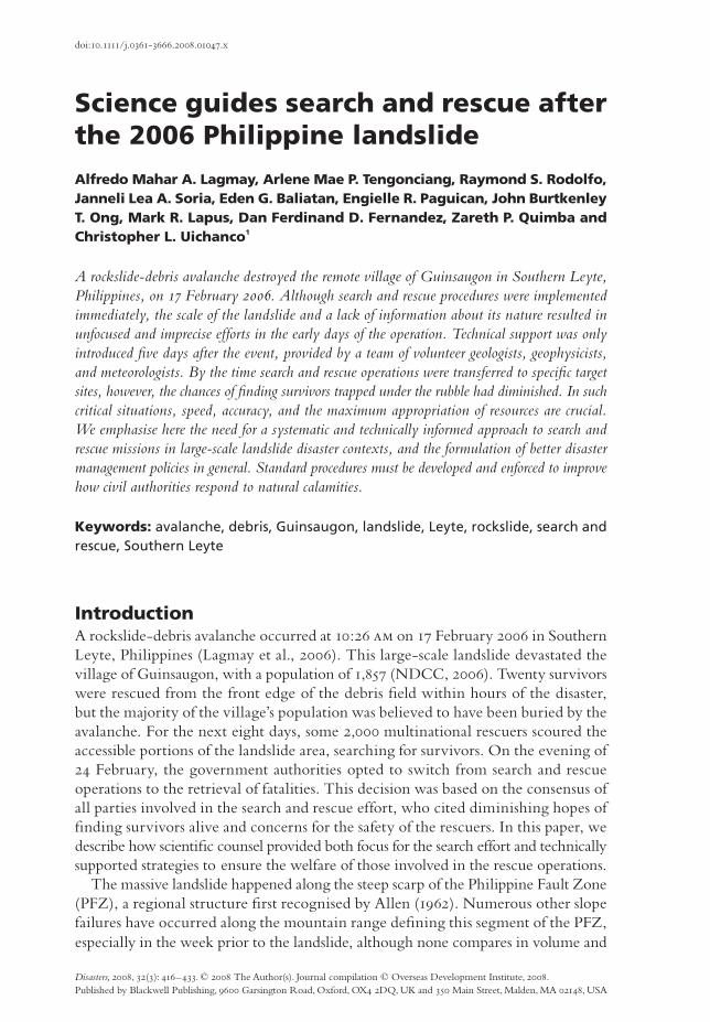
Science guides search and rescue after the 2006 Philippine landslide Alfredo Mahar A. Lagmay, Arlene Mae P. Tengonciang, Raymond S. Rodolfo, Janneli Lea A. Soria, Eden G. Baliatan, Engielle R. Paguican, John Burtkenley T. Ong, Mark R. Lapus, Dan Ferdinand D. Fernandez, Zareth P. Quimba and Christopher L. Uichanco 1 A rockslide-debris avalanche destroyed the remote village of Guinsaugon in Southern Leyte, Philippines, on 17 February 2006. Although search and rescue procedures were implemented immediately, the scale of the landslide and a lack of information about its nature resulted in unfocused and imprecise efforts in the early days of the operation. Technical support was only introduced five days after the event, provided by a team of volunteer geologists, geophysicists, and meteorologists. By the time search and rescue operations were transferred to specific target sites, however, the chances of finding survivors trapped under the rubble had diminished. In such critical situations, speed, accuracy, and the maximum appropriation of resources are crucial. We emphasise here the need for a systematic and technically informed approach to search and rescue missions in large-scale landslide disaster contexts, and the formulation of better disaster management policies in general. Standard procedures must be developed and enforced to improve how civil authorities respond to natural calamities. Keywords: avalanche, debris, Guinsaugon, landslide, Leyte, rockslide, search and rescue, Southern Leyte Introduction A rockslide-debris avalanche occurred at 10:26 am on 17 February 2006 in Southern Leyte, Philippines (Lagmay et al., 2006). This large-scale landslide devastated the village of Guinsaugon, with a population of 1, 857 (NDCC, 2006). Twenty survivors were rescued from the front edge of the debris field within hours of the disaster, but the majority of the village’s population was believed to have been buried by the avalanche. For the next eight days, some 2,000 multinational rescuers scoured the accessible portions of the landslide area, searching for survivors. On the evening of 24 February, the government authorities opted to switch from search and rescue operations to the retrieval of fatalities. This decision was based on the consensus of all parties involved in the search and rescue effort, who cited diminishing hopes of finding survivors alive and concerns for the safety of the rescuers. In this paper, we describe how scientific counsel provided both focus for the search effort and technically supported strategies to ensure the welfare of those involved in the rescue operations. The massive landslide happened along the steep scarp of the Philippine Fault Zone (PFZ), a regional structure first recognised by Allen (1962). Numerous other slope failures have occurred along the mountain range defining this segment of the PFZ, especially in the week prior to the landslide, although none compares in volume and doi:10.1111/j.0361-3666.2008.01047.x Disasters, 2008, 32(3): 416-433. © 2008 The Author(s). Journal compilation © Overseas Development Institute, 2008. Published by Blackwell Publishing, 9600 Garsington Road, Oxford, OX4 2DQ, UKand 350 Main Street, Malden, MA 02148, USA
-
Upload
independent -
Category
Documents
-
view
1 -
download
0
Transcript of Science guides search and rescue after the 2006 Philippine landslide
Science guides search and rescue after the 2006 Philippine landslide
Alfredo Mahar A. Lagmay, Arlene Mae P. Tengonciang, Raymond S. Rodolfo,
Janneli Lea A. Soria, Eden G. Baliatan, Engielle R. Paguican, John Burtkenley
T. Ong, Mark R. Lapus, Dan Ferdinand D. Fernandez, Zareth P. Quimba and
Christopher L. Uichanco1
A rockslide-debris avalanche destroyed the remote village of Guinsaugon in Southern Leyte,
Philippines, on 17 February 2006. Although search and rescue procedures were implemented
immediately, the scale of the landslide and a lack of information about its nature resulted in
unfocused and imprecise efforts in the early days of the operation. Technical support was only
introduced five days after the event, provided by a team of volunteer geologists, geophysicists,
and meteorologists. By the time search and rescue operations were transferred to specific target
sites, however, the chances of finding survivors trapped under the rubble had diminished. In such
critical situations, speed, accuracy, and the maximum appropriation of resources are crucial.
We emphasise here the need for a systematic and technically informed approach to search and
rescue missions in large-scale landslide disaster contexts, and the formulation of better disaster
management policies in general. Standard procedures must be developed and enforced to improve
how civil authorities respond to natural calamities.
Keywords: avalanche, debris, Guinsaugon, landslide, Leyte, rockslide, search and
rescue, Southern Leyte
IntroductionA rockslide-debris avalanche occurred at 10:26 am on 17 February 2006 in Southern
Leyte, Philippines (Lagmay et al., 2006). This large-scale landslide devastated the
village of Guinsaugon, with a population of 1,857 (NDCC, 2006). Twenty survivors
were rescued from the front edge of the debris field within hours of the disaster,
but the majority of the village’s population was believed to have been buried by the
avalanche. For the next eight days, some 2,000 multinational rescuers scoured the
accessible portions of the landslide area, searching for survivors. On the evening of
24 February, the government authorities opted to switch from search and rescue
operations to the retrieval of fatalities. This decision was based on the consensus of
all parties involved in the search and rescue effort, who cited diminishing hopes of
finding survivors alive and concerns for the safety of the rescuers. In this paper, we
describe how scientific counsel provided both focus for the search effort and technically
supported strategies to ensure the welfare of those involved in the rescue operations.
The massive landslide happened along the steep scarp of the Philippine Fault Zone
(PFZ), a regional structure first recognised by Allen (1962). Numerous other slope
failures have occurred along the mountain range defining this segment of the PFZ,
especially in the week prior to the landslide, although none compares in volume and
doi:10.1111/j.0361-3666.2008.01047.x
Disasters, 2008, 32(3): 416−433. © 2008 The Author(s). Journal compilation © Overseas Development Institute, 2008.
Published by Blackwell Publishing, 9600 Garsington Road, Oxford, OX4 2DQ, UKand 350 Main Street, Malden, MA 02148, USA

Science guides search and rescue after the 2006 Philippine landslide 417
size to the Guinsaugon event (Presidential Inter-Agency Committee Report, 2006).
Landsat imagery and shaded relief maps generated by National Aeronautics and
Space Administration (NASA) Shuttle Radar Topography Mission (SRTM) data
(Figure 1) show the main trace of the PFZ, oriented N17°W. Older landslide scars
were identified in the area, verified both by field investigations (Presidential Inter-
Agency Committee Report, 2006) and analysis of available satellite images (Lagmay
et al., 2006). The presence of these scars further demonstrates the long-term suscep-
tibility of this mountain range to mass wasting.
Figure 1 Location of the 2006 Guinsaugon landslide*
* A shaded relief map generated from Shuttle Radar Topography Mission digital elevation data shows the location of the
landslide—outlined in dark grey—with respect to the trace of the Philippine Fault. The small black circles identify the
earthquake epicentres reported by the Philippine Institute of Volcanology and Seismology (PHIVOLCS) and the
United States Geological Survey (USGS). The inset shows the location of Southern Leyte in the Philippines.
Source: authors.

Alfredo Mahar A. Lagmay et al.418
The timing of the landslide is still uncertain, although accounts of the events pro-
vided by witnesses converge at around 10:30 am (Lagmay et al., 2006; Suwa, 2006).
A telephone call made by Lita Siona, a Department of Agriculture technician and
one of the listed fatalities, probably offers the best approximation of the time and
duration of the incident. Siona placed a call to the Mayor of St. Bernard, Southern
Leyte, as the landslide transpired. According to the Mayor, the conversation started
with a query from the terrified technician: ‘Mayora, dakong anas . . . Aruy, asa mi
ron dagan?’ (Mayor, a big landslide . . . Oh no, where are we going to run?). The
records of the mobile telephone company show that this conversation started at
10:26:00, and that it lasted for 26 seconds. After a brief interruption, it was followed
by a second call, which started at 10:27:53 and lasted for 91 seconds before the con-
nection was cut again. These reported times, as verified by the mobile telephone
company, are based on the standard atomic clock time used by its computer servers.
* The figure shows the planform area of the landslide, reconstructed from an ASTER (METI-ERSDAC, 2006) image
and aerial photographs taken over the debris field. The landslide is overlain on a Landsat image of Guinsaugon (white)
and its vicinity. White dashed lines mark the trace of the Philippine Fault.
Source: authors.
Figure 2 Planform area of the landslide*

Science guides search and rescue after the 2006 Philippine landslide 419
The landslide has a planform area of 3,324,400 million square metres, a maximum
width of 1.52 kilometres, and a distance of 4.1 kilometres from crown to toe (Figure 2).
Independent reports place the volume of the deposit at 15–20 million cubic metres
(Lagmay et al., 2006) and 21 million cubic metres (Araiba, in Suwa, 2006). Based on
the duration of the telephone calls and the extent of the landslide deposit, the ava-
lanche is estimated to have travelled with a velocity of about 100 kilometres per hour.
Three factors are suspected of having triggered the avalanche. First is the exces-
sive amount of rain that fell in the days before the disaster, even though the landslide
happened on a sunny morning. Multi-satellite precipitation analysis from the NASA-
JAXA Tropical Rainfall Measuring Mission reported that 500 millimetres of rain
fell on Southern Leyte between 4 and 7 February. The Philippine Atmospheric,
Geophysical, and Astronomical Services Administration (PAGASA) rainfall station
at Otikon, located seven kilometres southwest of the landslide head, recorded 683.6
millimetres from 8–14 February. The highest amount of rainfall over this duration
was 171 millimetres, recorded on 12 February (Lagmay et al., 2006).
Second is an earthquake that occurred in Southern Leyte on 17 February 2006.
The Philippine Institute of Volcanology and Seismology (PHIVOLCS) recorded a
2.6 magnitude (Ms) earthquake 21 kilometres west of Guinsaugon at 10:35:30.99,
using seven of its unmanned satellite-telemetred seismic stations (PHIVOLCS, 2006a;
2006b). An earthquake was also recorded by the United States Geological Survey
(USGS) at 10:36:32.59 (PDE-W 2006), about two kilometres north of the landslide,
at a depth of 35 kilometres, and with a magnitude (Mb) of 4.3 (USGS, 2006a). Records
obtained from the F-net broadband seismograph network established and operated
by the National Research Institute for Earth Science and Disaster Prevention, Japan,
measured the occurrence of ground motion at 10:37. Yamanaka (2006) interprets
this record of ground motion as the Rayleigh wave generated by the landslide event.
Third is deformation of the slope prior to the landslide. Accounts described by
Suwa (2006) indicate that the slope had been experiencing deformation due to
creep. This phase of creep motion may have developed from secondary to tertiary
creep at the end of 2005 or in early 2006.
By 28 February 2006, 139 bodies had been recovered from the landslide—56 have
been identified and 83 remain unidentified. Two victims died in hospital, out of
the 33 treated for injuries. The number listed as missing and presumed dead is 980
(NDCC, 2006). The remaining residents of the village were not in the area at the
time of the disaster. In total, the official number of fatalities is 1,221.
Search and rescue operationsA team of geologists, geophysicists, and meteorologists provided technical advice
during the search and rescue operations following the landslide. Their combined
efforts resulted in an ad hoc Geographic Information System (GIS) that was used to
narrow the rescue mission down to certain sites within the debris field. In particu-
lar, search parties were directed to transfer operations from the original position of
Guinsaugon to 550–600 metres down slope, where the avalanche transported it. By
the time rescuers concentrated their efforts on the new search sites, the local water

Alfredo Mahar A. Lagmay et al.420
table had already risen due to persistent rainfall, decreasing the chances of finding
survivors trapped beneath the debris.
The village of Guinsaugon lay directly in the path of the downward-moving mass
of earth, near the base of the fault scarp of the Philippine Fault (Figure 2). Rescuers
focused their efforts during the first six days on the original location of the village,
assuming that the landslide had buried the community. An elementary school build-
ing with 248 students and teachers, believed to be 30 metres below the surface, was
the primary target of the rescue effort. Despite the daunting task of excavating an
enormous amount of debris, rescue efforts were sustained because of reports that
victims had sent mobile telephone messages to relatives and friends up to two days after
the event. One text message reportedly called on rescuers to hurry because the water
level was rising.
Figure 3 GPR profile*
* The figure shows the GPR line located at the first search site before rescue operations were shifted. The penetration
depth of the survey was about 18 metres; the depth of the landslide deposit at this point was estimated to be 30 metres.
An elevated water table was identified, caused by the ponding of water at several levels within the debris field.
Source: authors.

Science guides search and rescue after the 2006 Philippine landslide 421
The location of the school building was initially plotted on a 1:50,000 topographic
map by the first rescue teams that arrived. They used unscathed trees as triangulation
points to locate the original site of the school based on the accounts of local resi-
dents. The authors identified a more precise location on the sixth day by overlaying
a 2003 SPOT 5 JPEG satellite image and a cadastral plan on the topographic map.
The position of the school as determined after orthorectification of the SPOT image
and maps is 40 metres away from the earlier estimate determined through triangula-
tion. A ground control point measured with a differential global positioning system
(GPS) several years earlier was provided to the ground-based teams by PHIVOLCS
on the seventh day. This GPS point plots in the same position that was located by the
scientific advisory team using the co-registered satellite image, cadastral plan, and
topographic map.
After establishing the location of the school perimeter, a ground penetrating radar
(GPR) with a 100 megahertz (Mhz) antenna was used to identify buried structures,
while sound detectors and canine units were employed to detect signs of life. The
maximum depth of coherent penetration of the GPR within the landslide deposit was
only 18 metres, too shallow to reach the targeted 30-metre depth. The GPR detected
an elevated water table 14–15 metres beneath the surface of the deposit (Figure 3).
Observations within the debris field showed pools of water accumulating on the
surface at levels consistent with the water table identified from the GPR profile. This
* The figure shows a vertical aerial photograph of exposed clusters of houses within the debris field. Continuous rainfall
throughout the search and rescue operations further exposed these structures on the seventh day.
Source: authors.
Figure 4 Aerial photograph of debris in the landslide area*

Alfredo Mahar A. Lagmay et al.422
suggested that any possible survivors buried below that depth might have already
drowned.
Vertical and oblique aerial photography carried out on the seventh day revealed
clusters of buried houses and building debris exposed by runoff from continuous
rains (Figure 4). These structures were believed to contain air pockets that could
possibly host survivors at depth, informing initiatives to assign priority sites.
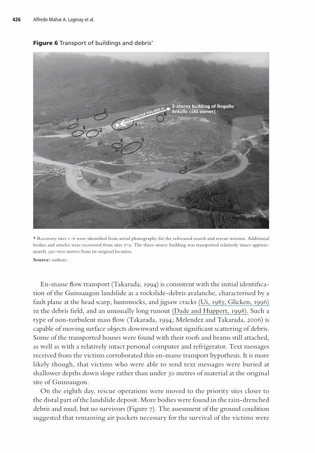
An inventory (Table 1) of survivors, recovered bodies, personal articles, and houses
was plotted on the maps and aerial photographs with the assistance of the rescue
teams that conducted the retrieval. Four residents were also asked to identify the
building remnants in the debris field and to establish their original positions on the
cadastral map. They were able to identify a half-buried three-storey concrete build-
ing, which was originally located in front of the school compound. Remnants of other
houses adjacent to this concrete building were also recognised down slope and were
arranged as before the landslide. The inventory and field validation plotted on the
aerial photographs constituted a GIS, which strongly suggested mass transport of
the community, 550–600 metres from its original location (Figures 5 and 6). This
database helped in focusing the search and rescue operation in areas with a higher
probability of containing survivors.
Table 1 Partial inventory of rescued persons, fatalities and articles within the debris field
Recovery sites
Date recovered
Description Identification Origin
2 19 February Arm – –
2 19 February Leg, 10 metres away from the arm – –
2 20 February Adult – –
2 21 February Adult male buried under collapsed structure (house)
– –
1 22 February Adult, female, buried one metre deep, in the process of decomposition, hairless, skin intact, swelling
– –
1 22 February Child, buried one metre deep, decapitated on impact
– –
1 22 February Chicken (alive), buried under a roof – –
1 22 February Three children, hairless, bodies complete and intact, buried less than one metre, in the process of decomposition
– –
1 22 February Four adult, bodies complete and intact, buried less than one metre, in the process of decomposition
– –
1 22 February Dream Satellite Antenna – Barangay Guinsaugon
1 22 February Grills/roofs – Barangay Guinsaugon
1 22 February Motorcycle parts – –

Science guides search and rescue after the 2006 Philippine landslide 423
1 22 February Large shelves – Barangay Guinsaugon
1 22 February Soft drink cans/bottles – –
3 22 February Intact body, child – –
3 22 February Intact body, child – –
3 22 February Body – –
4 22 February Adults, bodies complete and intact, buried approximately one-metre deep
– –
7 22 February Body – –
7 22 February Body – –
8 22 February Female, teenager – –
8 22 February Male, adult – –
9 22 February Intact body, child – –
1 23 February Body of a schoolgirl – –
1 23 February Relatively intact desktop computers – –
2 23 February Picture Evangellel Paler Barangay Guinsaugon
2 23 February School identification Obralen Miravales
Barangay Guinsaugon
2 23 February Algebra notes Joellen Miravalles Barangay Guinsaugon
2 23 February Old documents – –
2 23 February Letters Tortillano Cabadbad Bolasco
Barangay Guinsaugon
2 23 February Bible with identification Anecita Rubio Barangay Guinsaugon
2 23 February Income Tax Return, receipts Tortillano Cabadbad Bolasco
Barangay Guinsaugon
3 23 February Teenager (15 years old) – –
3 23 February Male, female – –
3 23 February Mother Geralyn Gorine Pagulong (?dead)
–
3 23 February Father, alive with three children (survivors) Libby Pagulong –
3 23 February Three missing children –
3 23 February One child of nine-member family is dead and retrieved, female, three years old
Kwin2/Ching2 Pagulong
–
1 24 February Helmet Jonhson Monghit Barangay Guinsaugon
1 24 February Picture frames – –
1 24 February Picture album Judy Labis, Venus Baylan
Barangay Guinsaugon
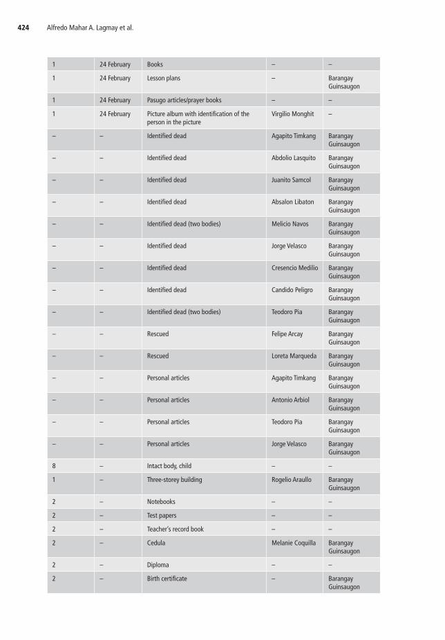
Alfredo Mahar A. Lagmay et al.424
1 24 February Books – –
1 24 February Lesson plans – Barangay Guinsaugon
1 24 February Pasugo articles/prayer books – –
1 24 February Picture album with identification of the person in the picture
Virgilio Monghit –
– – Identified dead Agapito Timkang Barangay Guinsaugon
– – Identified dead Abdolio Lasquito Barangay Guinsaugon
– – Identified dead Juanito Samcol Barangay Guinsaugon
– – Identified dead Absalon Libaton Barangay Guinsaugon
– – Identified dead (two bodies) Melicio Navos Barangay Guinsaugon
– – Identified dead Jorge Velasco Barangay Guinsaugon
– – Identified dead Cresencio Medilio Barangay Guinsaugon
– – Identified dead Candido Peligro Barangay Guinsaugon
– – Identified dead (two bodies) Teodoro Pia Barangay Guinsaugon
– – Rescued Felipe Arcay Barangay Guinsaugon
– – Rescued Loreta Marqueda Barangay Guinsaugon
– – Personal articles Agapito Timkang Barangay Guinsaugon
– – Personal articles Antonio Arbiol Barangay Guinsaugon
– – Personal articles Teodoro Pia Barangay Guinsaugon
– – Personal articles Jorge Velasco Barangay Guinsaugon
8 – Intact body, child – –
1 – Three-storey building Rogelio Araullo Barangay Guinsaugon
2 – Notebooks – –
2 – Test papers – –
2 – Teacher’s record book – –
2 – Cedula Melanie Coquilla Barangay Guinsaugon
2 – Diploma – –
2 – Birth certificate – Barangay Guinsaugon

Science guides search and rescue after the 2006 Philippine landslide 425
2 – Pencil case – Barangay
Guinsaugon
2 – Textbooks – Barangay
Guinsaugon
2 – Pasugo publication – Barangay
Guinsaugon
2 – Bible – –
2 – Philippine Benevolent Missionaries
Association (PBMA) booklets and
publications
– Barangay
Guinsaugon
2 – Wedding Invitations Judy Labis and
Venus Baylan
Barangay
Guinsaugon
2 – PBMA identification cards Virgilio Monghit Barangay
Guinsaugon
Note: Barangay Guinsaugon was the only community directly in the path of the debris avalanche.
Figure 5 Inventory of debris from the landslide field*
* A) Database of survivors, recovered bodies, personal articles, and houses. B) University of Philippines geologist
Raymond Rodolfo examining recovered items, and a three-storey building belonging to Rogelio Araullo, formerly
located in front of the school compound, and a mail pouch belonging to one of the former residents. C) Building
remnants and personal items that were concentrated near the toe of the landslide. D) Advanced Spaceborne Thermal
Emission and Reflection Radiometer (ASTER) image draped over a digital elevation map shows that Guinsaugon
moved 550–600 metres down slope from its original location.
Source: authors.
Alfredo Mahar A. Lagmay et al.426
Figure 6 Transport of buildings and debris*
* Recovery sites 1–6 were identified from aerial photography for the refocused search and rescue mission. Additional
bodies and articles were recovered from sites 7–9. The three-storey building was transported relatively intact approxi-
mately 550–600 metres from its original location.
Source: authors.
En-masse flow transport (Takarada, 1994) is consistent with the initial identifica-
tion of the Guinsaugon landslide as a rockslide-debris avalanche, characterised by a
fault plane at the head scarp, hummocks, and jigsaw cracks (Ui, 1983; Glicken, 1996)
in the debris field, and an unusually long runout (Dade and Huppert, 1998). Such a
type of non-turbulent mass flow (Takarada, 1994; Melendez and Takarada, 2006) is
capable of moving surface objects downward without significant scattering of debris.
Some of the transported houses were found with their roofs and beams still attached,
as well as with a relatively intact personal computer and refrigerator. Text messages
received from the victims corroborated this en-masse transport hypothesis. It is more
likely though, that victims who were able to send text messages were buried at
shallower depths down slope rather than under 30 metres of material at the original
site of Guinsaugon.
On the eighth day, rescue operations were moved to the priority sites closer to
the distal part of the landslide deposit. More bodies were found in the rain-drenched
debris and mud, but no survivors (Figure 7). The assessment of the ground condition
suggested that remaining air pockets necessary for the survival of the victims were
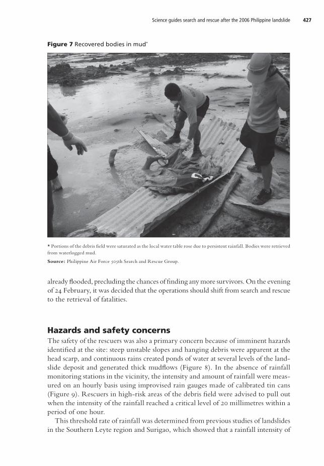
Science guides search and rescue after the 2006 Philippine landslide 427
already flooded, precluding the chances of finding any more survivors. On the evening
of 24 February, it was decided that the operations should shift from search and rescue
to the retrieval of fatalities.
Hazards and safety concernsThe safety of the rescuers was also a primary concern because of imminent hazards
identified at the site: steep unstable slopes and hanging debris were apparent at the
head scarp, and continuous rains created ponds of water at several levels of the land-
slide deposit and generated thick mudflows (Figure 8). In the absence of rainfall
monitoring stations in the vicinity, the intensity and amount of rainfall were meas-
ured on an hourly basis using improvised rain gauges made of calibrated tin cans
(Figure 9). Rescuers in high-risk areas of the debris field were advised to pull out
when the intensity of the rainfall reached a critical level of 20 millimetres within a
period of one hour.
This threshold rate of rainfall was determined from previous studies of landslides
in the Southern Leyte region and Surigao, which showed that a rainfall intensity of
Figure 7 Recovered bodies in mud*
* Portions of the debris field were saturated as the local water table rose due to persistent rainfall. Bodies were retrieved
from waterlogged mud.
Source: Philippine Air Force 505th Search and Rescue Group.

Alfredo Mahar A. Lagmay et al.428
Figure 8 Ponding of water at multiple levels*
* The figure shows water ponding at several levels and remobilisation of loose debris. Thick mudflows presented dan-
gers to search and rescue personnel.
Source: authors.
Figure 9 Onsite rainfall data*
* In the absence of detailed rainfall data, rainfall intensity was measured using calibrated tin cans (see inset image).
This data formed the basis of the decision to halt search and rescue operations, after the rainfall intensity exceeded the
threshold for landslides in the region.
Source: authors.

Science guides search and rescue after the 2006 Philippine landslide 429
about 15–20 millimetres per hour and sustained for six hours is required for land-
slides to occur (Daag et al., 2005). Short duration rainfall, requiring an intensity of
13.8 millimetres per hour, is known to trigger shallow soil slips and debris flows
(Larsen and Simon, 1993).
United States Marines witnessed at least two mudslides during the first suspension
as rescuers were airlifted out of the area. The intensity of rainfall decreased briefly
after the suspension and those who were still in the debris field continued their
operations. After the waning of rainfall for approximately one hour, the intensity
suddenly increased to 10 millimetres in six minutes, translating to a rate of 100 milli-
metres per hour. At this point, all of the rescue teams were ordered to halt their
search and rescue operations completely for the remainder of the day.
DiscussionThe role of government agencies
The Federal Emergency Management Agency (FEMA) is the US government organi-
sation tasked with disaster mitigation, preparedness, and response, as well as with
recovery planning. Under US law, FEMA, the USGS, and other appropriate federal
agencies are mandated to provide technical assistance to national and local govern-
ments to ensure the provision of timely and effective disaster warnings (FEMA, 2006;
USGS, 2006b).
In the Philippines, the nearest thing to FEMA is the National Disaster Coordinat-
ing Council (NDCC), which is composed of several national and local government
agencies. Among these agencies are three institutions that are capable of offering geo-
logical and meteorological advice during search and rescue operations: PHIVOLCS;
the Mines and Geosciences Bureau (MGB); and PAGASA. A review of their institu-
tional mandates shows that none is formally tasked with providing technical support
during the search and rescue phase of a landslide disaster.
During the February 2006 search and rescue operations, geologists from the MGB
were present in the calamity area but they were more involved in mapping existing
and potential landslides within Southern Leyte—10 other landslides occurred in the
region but these were smaller in scale (Presidential Inter-Agency Committee Report,
2006). Volunteers from the US Army Corps of Engineers were assisting the MGB
team. For this reason, the authors found themselves supplying onsite geological and
meteorological information to the search and rescue teams, in addition to conducting
GPR surveys to locate the elementary school building. In effect, instead of solely
providing peripheral support, the authors became technical advisors to the search
and rescue operations.
Lessons learned from the disaster
Our experience of the search and rescue operations pointed up critical points of con-
cern that need to be addressed. Government authorities can use them to improve
policies on disaster management.
Alfredo Mahar A. Lagmay et al.430
An immediate and efficient response by search and rescue missions to landslide
disasters requires a systematic approach. As learned from Guinsaugon, technical
advice can focus rescue efforts and lead to maximisation of employment of man-
power, equipment, and other resources. Scientists should be deployed to a site within
a few hours of a landslide event. A characterisation of the landslide must be provided
at the earliest possible time to determine the transport mechanism and its effect on
populated areas.
Ad hoc GIS strongly suggested the en-mass transport of the village of Guinsaugon,
about 550–600 metres down slope. Debris in high-energy landslides has been re-
ported as razing structures, rather than just burying them—see, for example, the
2005 La Conchita landslide in California ( Jibson, 2005). Furthermore, internal
structures found within deposits of large-scale volcanic debris avalanches suggest that
this type of landslide travels en-masse rather than as a turbulent flow (Takarada, 1994).
An aerial survey should be conducted immediately and used to plot the inventory
of recovered bodies, personal articles, and remnants of buildings. High-resolution
digital cameras can be used to take vertical photographs of the affected area. This
exercise does not necessarily require highly technical aerial survey equipment, such
as that used by professional surveyors. Available satellite imagery, existing topo-
graphic maps, and cadastral plans can be utilised to co-register the location of aerial
imagery. If available, ground control points determined from a differential global
positioning system (DGPS) of landslide-prone areas should be made readily acces-
sible and used along with all available maps and imagery. These initial steps narrow
down the search areas within a large debris field to specific sites.
To secure the safety of the search and rescue teams, instruments to monitor debris
flow hazards should be deployed on site without delay. Intense rainfall may cause
mudslides and trigger the collapse of unstable slopes. The threshold of rainfall can
vary from place to place. As noted, studies done prior to the Guinsaugon disaster
highlight that a rainfall intensity of about 15–20 millimetres per hour and sustained
for six hours is required for debris flows to occur (Daag et al., 2005).
Conclusions and recommendationsAfter a landslide disaster, a scientific team must be deployed at the earliest possible
moment to determine its characteristics. A description can be produced from aerial
and ground surveys and used to establish the extent of the disaster and the level of
damage. Subsequent aerial surveys can also be conducted to monitor the debris field
and to assess how it changes in the wake of additional rainfall and further mass move-
ment. Other data pertinent to the investigation of the devastated area, such as detailed
long-term climate data, satellite images, topographic maps, geohazard maps, cada-
stral plans, and ground control points, should be made readily available to the
technical advisors working at the site of the disaster. Additional information can be
collected from the site, including the relative positions of structures before and

Science guides search and rescue after the 2006 Philippine landslide 431
after the landslide, the state in which structures and private property are found, and
the position at which the highest numbers of survivors were recovered, in order to
illustrate the transport mechanism of the landslide. A synthesis of all these data can
be used to refine ongoing search and rescue operations, to redeploy them at loca-
tions where there is the highest probability of finding more survivors, and to iden-
tify other potential hazards that can endanger the personnel working within the
debris field.
If such procedures had been implemented early in the search and rescue phase at
Guinsaugon, we believe that more people could have survived. The rise of the local
water table several days after the catastrophic landslide is believed to have killed
people who were possibly still alive under the rubble. For the first five days after the
landslide, search and rescue operations focused on the original location of the village.
Operations only shifted down slope on the sixth day after GIS revealed the mass
transport of the community. Unfortunately, the decision to transfer operations came
much too late.
We emphasise the need for a systematic, technically informed approach to search
and rescue missions, as well as the formulation of better disaster management poli-
cies. The response of search and rescue units should befit the nature of the calamity.
For example, a large-scale landslide presents different challenges than an earthquake
disaster in terms of locating possible survivors. In such critical situations, speed,
accuracy, and the maximum appropriation of resources are crucial. Standard pro-
cedures must be developed and enforced to improve how civil authorities react to
natural hazards.
AcknowledgmentsWe would like to thank the following for supporting the search and rescue effort:
Southern Leyte Governor Rosette Lerias, the Luis A. Yulo Foundation, the Philippine
Army, the US Marines, the Philippine Long Distance Telephone Company, the
Philippine National Red Cross, the Provincial Disaster Coordinating Council, the
Armed Forces of the Philippines Reserve Command, the Department of Environment
and Natural Resources of the Philippines, Secretary Angelo Reyes, the Asian Disaster
Preparedness Center, Deutsche Gesellschaft für Technische Zusammenarbeit (German
Technical Cooperation, GTZ), Earthprobe Inc., the Republic Biscuit Company, the
civilian volunteers, and the rescue teams from Indonesia, Malaysia, the Philippines,
Spain, Taiwan, and Turkey. We are also grateful to Francia B. Avila, Armelle Reca
C. Remedio, Genevieve Rose H. Lorenzo, Jose Ramon T. Villarin, S.J., Daniel J.
McNamara, S.J., Emmanuel G. Anglo, Mariano A. Estoque, Dr. Celine Vicente,
Tristan Calasanz, Gerald A. Galgana, and Gemma T. Narisma of the Manila Observa-
tory for providing the field team with daily weather reports and technical advice.
The comments of David Petley, Carlo Bartolini, and an anonymous peer reviewer
significantly improved this manuscript.

Alfredo Mahar A. Lagmay et al.432
CorrespondenceAlfredo Mahar Francisco A. Lagmay, National Institute of Geological Sciences, C.P.
Garcia, University of the Philippines, Diliman Quezon City 1101, Philippines. E-mail:
Endnotes1 Alfredo Mahar A. Lagmay, Associate Professor, National Institute of Geological Sciences, Univer-
sity of the Philippines, Philippines; Arlene Mae P. Tengonciang, MSc Student/Geologist, National
Institute of Geological Sciences, University of the Philippines, Philippines; Raymond S. Rodolfo,
MSc Student/Geologist, National Institute of Geological Sciences, University of the Philippines,
Philippines; Janneli Lea A. Soria, MSc Student/Geologist, National Institute of Geological Sciences,
University of the Philippines, Philippines; Eden G. Baliatan, MSc Student/Geologist, National
Institute of Geological Sciences, University of the Philippines, Philippines; Engielle R. Paguican,
MSc Student, National Institute of Geological Sciences, University of the Philippines, Philippines;
John Burtkenley T. Ong, Researcher/Geophysicist, Manila Obervatory, Ateneo de Manila Univer-
sity, Philippines; Mark R. Lapus, MSc Student/Geologist, National Institute of Geological Sciences,
University of the Philippines, Philippines; Dan Ferdinand D. Fernandez, Researcher/Geologist,
Manila Obervatory, Ateneo de Manila University, Philippines; Zareth P. Quimba, MSc Student/
Geologist, National Institute of Geological Sciences, University of the Philippines, Philippines;
Christopher L. Uichanco, Geologist, National Institute of Geological Sciences, University of the
Philippines, Philippines.
References Allen, C.R. (1962) ‘Circum-Pacific faulting in the Philippine-Taiwan region’. Journal of Geophysical
Research. 67(12). pp. 4795–4812.
Daag, A.S., N.M. Tuñgol, M. Peralta and O.D. Cruz (2005) ‘Landslide critical rainfall threshold
determination and mapping landslide susceptibility’. Department of Science and Technology,
Quezon City.
Dade, W.B. and H.E. Huppert (1998) ‘Long runout rockfalls’. Geology. 26(9). pp. 803–806.
FEMA (Federal Emergency Management Agency) (2006) ‘FEMA: About FEMA’. http://www.fema.
gov/about/index.shtm (accessed 7 September 2006).
Glicken H. (1996) ‘Rockslide-Debris Avalanche of May 18, 1980, Mount St. Helens Volcano,
Washington’. United States Geological Survey (USGS) Open-File Report 96-667.
Jibson, R.W. (2005) ‘Landslide Hazards at La Conchita, California’. USGS Open-File Report
2005-1067.
Lagmay, A.M.F. et al. (2006) ‘Scientists investigate recent Philippine landslide’. Eos. 87(12). pp. 121–124.
Larsen, M.C. and A. Simon (1993) ‘A rainfall intensity-duration threshold for landslides in a humid-
tropical environment, Puerto Rico’. Geografiska Annaler. 75(1–2). pp. 13–23.
Melendez, C. and S. Takarada (2006) ‘Depositional characteristics and implications for the transport
mechanism of the 1792 debris avalanche generated by the collapse of Mayuyama lava dome, Japan’.
Proceedings of Cities on Volcanoes 4.
METI-ERSDAC (2006) ‘Landslide in Leyte Island, Philippines’. Ministry of Economy Trade and
Industry-Earth Remote Sesning Data Analysis Center (METI-ERSDAC). http://www.ersdac.
or.jp/ASTER_EDSimage/015/pict_e.html (accessed 20 April 2006).

Science guides search and rescue after the 2006 Philippine landslide 433
NDCC (National Disaster Coordinating Council) (2006) ‘NDCC Update No. 16 re: Landslide at
Brgy Guinsaugon, Saint Bernard, Southern Leyte’. http://ndcc.gov.ph/ndcc/index.php?module=
documents&JAS_DocumentManager_op=downloadFile&JAS_File_id=290 (accessed 17 August
2006).
PHIVOLCS (Philippine Institute of Volcanology and Seismology) (2006a) ‘Philippine Institute of
Volcanology and Seismology, Earthquake Information No. 2, 17 February 2006’. http://www.
phivolcs.dost.gov.ph/Earthquake/LatestEQ/2006/sogod leyte.htm (accessed 5 September 2006).
PHIVOLCS (2006b) ‘Event bulletin for 2006-02-17, Recorded Short-period Waveforms (Vertical
Component)’. http://www.phivolcs.dost.gov.ph/Earthquake/LatestEQ/2006/20060217_0236.htm
(accessed 5 September 2006).
Presidential Inter-Agency Committee Report (2006) ‘The 17 February 2006 Bgy. Guinsaugon,
Southern Leyte Landslide’.
Suwa, H. (2006) ‘Catastrophe caused by the 17 February 2006 Southern Leyte Landslide in the
Philippines’. Journal of Japan Society for Natural Disaster Science. 25(1). pp. 83–97.
Takarada, S. (1994) ‘Flow and deposition mechanisms of debris avalanches and pyroclastic flows’.
Unpublished PhD dissertation, Hokkaido University.
Ui, T. (1983) ‘Volcanic dry avalanche deposits – identification and comparison with non-volcanic
debris-stream deposits’. Journal of Volcanology and Geothermal Research. 18(1–4). pp. 135–150.
USGS (United States Geological Survey) (2006a) ‘NEIC Earthquake Search Catalog’. http://neic.
usgs.gov/ (accessed 5 September 2006).
USGS (2006b) ‘Laws and Regulations Governing U.S. Geological Survey Activities’. http://www.
usgs.gov/laws/index.html (accessed 7 September 2006).
Yamanaka, Y. (2006) ‘Website EIC Note of Seismology, Earthquake Research Institute, University
of Tokyo, February 23, 2006’. http://eri.u-tokyo.ac.jp/sanchu/Seismo_Note/060217.html (accessed
5 September 2006).