Macroinvertebrate Community Responses to Gravel Addition in a Southeastern Regulated River
Upload
khangminh22Category
view
4download
0
Draft Report on
Environmental Impact Assessment &
Environment Management Plan
Road Metal, Building Stone & Gravel Quarry 4.50 Ha. of Non-Forest Govt. Land
Sy. No. 1 of Marturu Village Anakapalli Mandal, Visakhapatnam District
Andhra Pradesh, INDIA (Monitoring Period October 2020 – December 2020)
Proponent Sri. K. Surendranath
Consultant(s) M/s Global Environment & Mining Services
Hospet, Bellary District, Karnataka
ACCREDITED BY NABET: Certificate No. NABET/EIA/1821/SA 100 Dt. 15th Jan. 2020
MARCH 2021

Sri. K. Surendranath
Draft EIA/ EMP Report for the Proposed Road Metal, Building Stone & Gravel Quarry in an Extent of 4.50 Ha. of Non-Forest
Govt. Land in Sy. No. 1 of Marturu Village, Anakapalli Mandal, Visakhapatnam District, A. P.
2 | P a g e

Sri. K. Surendranath
Draft EIA/ EMP Report for the Proposed Road Metal, Building Stone & Gravel Quarry in an Extent of 4.50 Ha. of Non-Forest
Govt. Land in Sy. No. 1 of Marturu Village, Anakapalli Mandal, Visakhapatnam District, A. P.
i | P a g e
C O N T E N T S
Sl. No. Particulars Page No.
Executive Summary 01-08 Compliance of ToR 09-20 1 Chapter 1: Introduction
1.1 Purpose of the report 21
1.2 Identification of the Project & Project Proponent 21-22
1.2.1 The Project 21
1.2.2 Project Proponent 22
1.3 Brief description of the nature, size, location of the project and its importance to the region
22
1.4 Scope of Study 22-23 2 Chapter 2: Project Description
2.1 Type of Project 24
2.2 Need of Project 24
2.3 Location 24-26
2.4 Size and Magnitude of Operation 26-32
2.4.1 Magnitude of Operations 27-28
2.4.2 Mining Related Activities 28
2.4.3 Extent of Mechanization 28-29
2.4.4 Drilling and Blasting 29-32
2.5 Proposed Schedule for approval and Implementation 32
2.6 Technology and Process Description 32
2.7 Project description 32-35
2.7.1 Location 32
2.7.2 Connectivity 32-33
2.7.3 Topography 33
2.7.4 Regional Geology 33-34
2.7.5 Local/ Mine Geology 34
2.7.6 Estimated Capital Cost of the Project 34-35
2.8 Description of Mitigation incorporated in Project to Meet Environmental Standards and Operating Conditions for EIA
35-36
2.9 Assessment of New and Untested Technology for Technology Failure
36
2.10 Environmental Setting 36-40
2.10.1 Basic Information 36-38
2.10.2 Details of other quarries present within the same cluster of 500 meter radius
38-40
2.11 Environmental Policy at Sri. K. Surendranath’s Quarry 40-43
2.12 Safeguards in Opencast Mine Working at Sri. K. Surendranath’s Quarry
43-44

Sri. K. Surendranath
Draft EIA/ EMP Report for the Proposed Road Metal, Building Stone & Gravel Quarry in an Extent of 4.50 Ha. of Non-Forest
Govt. Land in Sy. No. 1 of Marturu Village, Anakapalli Mandal, Visakhapatnam District, A. P.
ii | P a g e
Sl. No. Particulars Page No.
3 Chapter 3: Description of Environment
3.1 General 45
3.2 Terrestrial/ Land Environment 45-47
3.2.1 Landuse 45-46
3.2.2 Soil Quality 46-47
3.3 Air Environment 47-50
3.3.1 Air Pollutants 48
3.3.2 Monitoring Stations for Ambient Air Quality 48-50
3.4 Water Environment 50-55
3.4.1 Water Budget 50
3.4.2 Ground Water Potential 50-51
3.4.3 Ground Water Scenario 51-54
3.4.4 Water Quality 54-55
3.5 Noise Environment 56
3.6 Flora and Fauna 57-65
3.6.1 General 57-58
3.6.2 Predominant Crops 59
3.6.3 Flora of the Area 59-65
3.6.4 Common Fauna found in the Area 65
3.7 Socio-Economic Environment 65-72
3.7.1 Introduction 65-67
3.7.2 Methodology used for the Field survey 67
3.7.3 Methodology applied for selection of sample & data collection
67-68
3.7.4 Field Survey and Observations 68
3.7.5 Data Collection and Quality Assurance 68
3.7.6 Distribution of Population 68-69
3.7.7 Social Structure 69-70
3.7.8 Literacy Levels 70
3.7.9 Occupational Structure 70-71
3.7.10 Salient observation of survey/study area 72
3.8 Waste Generation 73
3.8.1 Solid Waste 73
3.8.2 Soil 73 4 Chapter 4: Anticipated Environmental Impacts and
Mitigation Measures
4.1 Land Environment 74-75
4.1.1 Anticipated Impacts 74-75
4.1.2 Mitigation Measures 75
4.2 Air Environment 75-76
4.2.1 Anticipated Impact 75
4.2.1.1 Emission Inventory 75
4.2.1.2 Prediction of Fugitive Emission in the project 75
4.2.2 Mitigation Measures 76

Sri. K. Surendranath
Draft EIA/ EMP Report for the Proposed Road Metal, Building Stone & Gravel Quarry in an Extent of 4.50 Ha. of Non-Forest
Govt. Land in Sy. No. 1 of Marturu Village, Anakapalli Mandal, Visakhapatnam District, A. P.
iii | P a g e
Sl. No. Particulars Page No.
4.3 Water Environment (Surface & Ground Water) 76-78
4.3.1 Impact on hydrology, alteration in natural drainage etc. 76
4.3.2 Anticipated Impacts 76
4.3.3 Mitigation Measures 77
4.3.4 Rain Water Harvesting Plan for Water Conservation 77-78
4.3.4.1 Rain Water Harvesting 77-78
4.4 Noise Environment 78
4.4.1 Anticipated Impacts 78
4.4.2 Mitigation Measures 78
4.5 Biological Environment 78
4.5.1 Anticipated Impacts 78
4.5.2 Mitigation Measures 78
4.6 Socio Economic Environment 79
4.6.1 Anticipated Impacts 79
4.6.2 Mitigation Measures 79
4.7 Mine Wastes 79
4.7.1 Anticipated Impacts 79
4.7.2 Mitigation Measures 79
4.8 Occupational Health Hazards 79-81
4.8.1 Physical Hazards 79-80
4.8.2 Biological Hazards 80
4.8.3 Ergonomic Hazards 80
4.8.4 Psychological Hazards 80
4.8.5 Mitigation Measures 80-81
4.9 Traffic Density 81-82
4.9.1 Anticipated Impacts 82
4.9.2 Mitigation Measures 82
4.10 Soil 82-83
4.10.1 Anticipated Impacts 82-83
4.10.2 Mitigation Measures 83 5 Chapter 5: Analysis of Alternatives (Technology & Site)
5.1 General 84
5.2 Site Studies 84
5.3 Alternative Method of Mining 84 6 Chapter 6: Environment Monitoring Programme
6.1 Environmental Monitoring Programme 85
6.2 Monitoring Programme 85-86
6.3 Plantation Programme 86

Sri. K. Surendranath
Draft EIA/ EMP Report for the Proposed Road Metal, Building Stone & Gravel Quarry in an Extent of 4.50 Ha. of Non-Forest
Govt. Land in Sy. No. 1 of Marturu Village, Anakapalli Mandal, Visakhapatnam District, A. P.
iv | P a g e
Sl. No. Particulars Page No.
7 Chapter 7: Additional Studies
7.1 Public Consultation 87
7.2 Risk Assessment and Disaster Management Plan 87-91
7.2.1 Hazard Identification and their analysis 88-90
7.2.1.1 Blasting 89
7.2.1.2 Overburden 89
7.2.1.3 Heavy Machinery 89
7.2.1.4 Storage of explosive 89
7.2.1.5 Fuel Storage 89
7.2.1.6 Water Logging 90
7.2.2 Safety Measures 90-91
7.2.2.1 Safety Measures at the Proposed Open Cast Mining Project 90
7.2.2.2 Measures suggested to avoid accidents due to blasting 90
7.2.2.3 Measures to prevent failure of overburden dump 91
7.2.2.4 Measures to prevent accidents due to trucks & dumpers 91
7.3 Emergency Response System 91
7.4 Natural Resource Conservation 91
7.5 R&R, Corporate Social Responsibility Action Plan 91
7.6 Corporate Social Responsibility 92
7.7 Corporate Environment Responsibility 92
8 Chapter 8: Project Benefits
8.1 Project Benefits 93 9 Chapter 9: Environmental Cost Benefit Analysis
9.1 Environmental Cost Benefit Analysis 94 10 Chapter 10: Environment Management Plan (EMP)
10.1 Administrative And Technical Management 95
10.2 Dust Control Plan 95-96
10.3 Village Biodiversity Conservation Plan 96-97
10.4 Cost for Implementation of EMP 97
10.5 Cluster Environment Management Plan 98-99 11 Chapter 11: Summary and Conclusion
11.1 Overall Justification for the Project 100
11.2 Proponent and Need of Project 100-101
11.3 Lease Details 101-103
11.4 Proposed Mining 103-104
11.5 EIA Monitoring 104-105
11.6 Impacts 105-107
11.7 Monitoring Schedule 107
11.8 Plantation 107
11.9 Occupational Health & safety Measures 107
11.10 Corporate Social Responsibility 108
11.11 Economics of the Project 108 12 Chapter 12: Disclosure of Consultants 109

Sri. K. Surendranath
Draft EIA/ EMP Report for the Proposed Road Metal, Building Stone & Gravel Quarry in an Extent of 4.50 Ha. of Non-Forest
Govt. Land in Sy. No. 1 of Marturu Village, Anakapalli Mandal, Visakhapatnam District, A. P.
v | P a g e
LIST OF TABLES
Table No. Description Page No.
Table -1 GPS Readings of the QL Area 26
Table -2 Estimated Reserves 26-27
Table -3 Proposed Production Plan during Plan Period 27
Table -4 Production Plan during Conceptual Period 28
Table-5 List of Machineries in proposed quarry 29
Table -6 Summary of Capital Cost of the Quarry 35
Table -7 Precautionary Measures-mining plan 35
Table-8 Existing Land Use & Land Use at the end of Lease Period 35-36
Table -9 Environmental Settings 37-38
Table -10 Details of other quarries falling in the same cluster 39-40
Table -11 Land Use Details for core zone & buffer zone (10 Km) 46
Table -12 Chemical Properties of Soil 47
Table -13 Particulars of Monitoring Stations 48
Table -14 Summary of AAQ Monitored Data 50
Table -15 Water Requirement 50
Table -16 Ground Water Potential 51
Table -17 Water Quality Data 55
Table- 18 Noise Monitoring Data 56
Table-19 List of the flora of the study area 59-65
Table-20 Demography in Study Area 66-67
Table -21 List of Sampling Villages 68
Table -22 Distribution of Population 68
Table -23 Distribution of Population by Social Structure 69
Table -24 Literacy Levels 70
Table -25 Occupational Structure of Study Area 71
Table -26 Construction Details of RWH System 77
Table -27 Occupational Safety & Health Programme 81
Table -28 Monitoring Programme 85
Table -29 Species proposed for plantation 86
Table -30 Greenbelt Programme Year-wise 86
Table -31 CSR Funds 92
Table -32 Summary of Control Measures 96
Table -33 Budget for implementation of Environmental Management Plan
97

Sri. K. Surendranath
Draft EIA/ EMP Report for the Proposed Road Metal, Building Stone & Gravel Quarry in an Extent of 4.50 Ha. of Non-Forest
Govt. Land in Sy. No. 1 of Marturu Village, Anakapalli Mandal, Visakhapatnam District, A. P.
vi | P a g e
ANNEXURES
No. Description Page No.
1 Terms of Reference (ToR) issued by SEIAA, A.P. 111-117
2 Letter of Intent (LOI) issued by Govt. of A.P 118-119
3 Extract of Topo-sheet 120
4 Environmental Policy 121
5 Organization Chart 122
6 Geological Map of Visakhapatnam District 123
7 Soil Map of Visakhapatnam District 124
8 Geomorphological Map of Visakhapatnam District 125
9 Land-Use Land-Cover Map of 10 km Buffer Zone 126
10 Satellite Imagery of 10 km Radius 127
11 Ambient Air Quality Data 128-129
12 Schematic Diagram 130
13 Surface Geological Plan and Sections 131
14 Production Development Plan And Sections 132
15 Conceptual Plan and Sections 133
16 Environmental Management Plan 134
17 Cluster Environment Management Plan 135-143
18 Micro-Meteorological Data during the Study Period 144-211

Sri. K. Surendranath
Draft EIA/ EMP Report for the Proposed Road Metal, Building Stone & Gravel Quarry in an Extent of 4.50 Ha. of Non-Forest
Govt. Land in Sy. No. 1 of Marturu Village, Anakapalli Mandal, Visakhapatnam District, A. P.
1 | P a g e
EXECUTIVE SUMMARY
o Sri. K. Surendranath, a resident of Visakhapatnam City, in Andhra Pradesh, was granted 1st Renewal of the quarry lease for extraction of Road Metal, Building Stone & Gravel, over an extent of 4.50 Hectares, in Non-Forest Government Land, bearing Sy. No. 1 of Marturu Village, Anakapalli Mandal, Visakhapatnam District, Andhra Pradesh, for a period of 10 years, w.e.f. 17.11.2018, by the Deputy Director of Mines & Geology, Visakhapatnam, vide Notice No.: 1314/Q2A/2019 dated 06/06/2019.
o The above Road Metal, Building Stone & Gravel Quarry is near Marturu (1.5 km)
Village, in Anakapalli Mandal of Visakhapatnam District, Andhra Pradesh, and is part of Sy. No. 1 of Marturu Village in Anakapalli Mandal of Visakhapatnam District. The proposed quarry area has been renewed in favour of the Proponent.
o The proposed Road Metal, Building Stone & Gravel Quarry Lease area, is located
between Latitude of 17° 44' 21.80153" N to 17° 44' 31.43891" N and Longitude of 83° 00' 29.12578" E to 83° 00' 40.68470" E. The proposed quarry lease area is surrounded by other Road Metal, Building Stone & Gravel quarries. There are 24 existing mining leases (incl. the above lease), within 500 m radial distance of the present quarry.
o Of the 24 existing quarry leases, within 500 radial distance of the present quarry,
21 leases with a total extent of 102.22 Hectares have been granted prior to 09th Sept. 2013, and hence are exempted from Cluster Effect, as per MoEFCC Notification No. S.O. 2269 (E), dated 01st July 2016. The remaining Three (03) leases (excluding the present lease) with a total extent of 17.63 Hectares are granted after 09th Sept. 2013. Hence, as per MoEFCC Notification No. S.O. 2269 (E), dated 01st July 2016, they become part of the cluster, for preparation of the cluster EMP. The total extent of the cluster, including the present lease area, will be 22.13 Ha > 5 Ha. Hence classified under B2 at Par with B1 category.
o There is no agriculture on the proposed mining land.
o The Proponent had applied for Environmental Clearance to State Environment
Impact Assessment Authority (SEIAA), Andhra Pradesh and they have issued the Terms of Reference (ToR), for carrying-out Environment Impact Assessment (EIA) studies and preparation of an EIA/ EMP (Environmental Management Plan), for the present Road Metal, Building Stone & Gravel Quarrying, vide Lr No. SEIAA/AP/VSP/MIN/02/2020/1678-327, dated 21.07.2020.
o M/s Global Environment & Mining Services, Hospet, Karnataka, have been
retained by the Proponent to carry-out EIA Studies and preparation of EIA/EMP report. The baseline data collection (environmental monitoring) was conducted as per MOEF & CC norms for Post-Monsoon Season (Oct. 2020 to Dec. 2020).
o Present summary is of the EIA report as per TOR and has been prepared as per
generic structure given in Appendix III of EIA notification 2006 by MOEF & CC.

Sri. K. Surendranath
Draft EIA/ EMP Report for the Proposed Road Metal, Building Stone & Gravel Quarry in an Extent of 4.50 Ha. of Non-Forest
Govt. Land in Sy. No. 1 of Marturu Village, Anakapalli Mandal, Visakhapatnam District, A. P.
2 | P a g e
o It is proposed to mine at a uniform rate of about 1,25,100 CuM/ Annum of
saleable Road Metal, Building Stone & Gravel, during the plan period of Five (05) years. The anticipated recovery is 90% of the mined mineral and with 10% waste.
o The method of mining is by semi-mechanized open cast mining method, with controlled sequential blasting.
o Road Metal, Building Stone & Gravel are important materials for the Construction Industry, both in building construction (houses, apartments, commercial buildings etc.) and also various infrastructure works (bridges, roads, irrigation tanks etc.).
o This is a renewal project & RQP has prepared the mining plan for mining of Road Metal, Building Stone & Gravel, by maintaining proper safety standards.
o Considering an estimated (proved) mineable reserves of 13,90,000 CuM of proved category (incl. Waste) of Road Metal & Building Stone, the anticipated life of the mine is about 10.46 years, The recovery of Road Metal & Building Stone (saleable) is about 90% of the total mined quantity, which amounts to 12,51,000 Cum. The resulting waste is about 10 % of the mined quantity, which is about 1,39,000 Cum.
o The Estimated Geological and Mineable Reserves, are as under:
Description Geological Reserves (CuM) Mineable Reserves (CuM)
Road Metal, Building Stone
& Gravel (incl. Waste)
17,60,626 13,90,000
Road Metal, Building Stone
& Gravel (Saleable)
15,84,563 12,51,000
o Regional Geology: The Eastern Ghats Mobile (EGMB) is occupied more than
600km in length from Srikakulam in the Northern to Ongole in the South. This belt is more than 100 km in width in Northern part and appears down to less than 20km in the south, it has broad actuated trend with west ward convexity. The NNE -SSW trend in the southern part of the belt changes NE-SW in the North, EGMB is divided into 3 longitudinal Zones.
o While in the Northern parts in Srikakulam, Vizianagaram & Visakhapatnam District the central Khondalite Zone occupies major part of the area, whereas western Charnockite Zone occurs in the Southern part. The Rocks in this belt and represented High Grade Granulite facies of Metamorphism and suffered by complex deformation.
o In Visakhapatnam District the EGMB is represented by vide ranges of Litho Units viz. Charnokites, Khondalites, two Pyroxene Granulites, Migmatites, Leptynites and Intrusive Porphyroblastic Charnokites. Large enclaves of

Sri. K. Surendranath
Draft EIA/ EMP Report for the Proposed Road Metal, Building Stone & Gravel Quarry in an Extent of 4.50 Ha. of Non-Forest
Govt. Land in Sy. No. 1 of Marturu Village, Anakapalli Mandal, Visakhapatnam District, A. P.
3 | P a g e
Charnokites, Khondalites and Meta-Basic rocks occur within Migmatites, which are largely seen in the area lying between R. Vamsadhara and coast line.
o Local Geology: Anakapalli and its surrounding area expose a variety of Rock forming a part of Migmatite Zone of the Eastern Ghats Mobile Belt. Prominent among them are Charnokites (Acidic, Basic & Intermediate varieties), Leptynites, Granitoid Gnesis etc. These Charnokites are being Quarried in Marturu, Rolugunta, Bowlavada, Thummapala and Mamidipalem in Visakhapatnam District. These Charnokites are Grey to Greasy in Colour, medium to Coarse Grained with Quartz, Plagioclase Feldspar, Pyroxenes, Biotite and Iron Oxides. These Charnockites are best suited for Road Metal and Building Stone, as they have low permeability, medium to height bearing capacity and good foundation characteristics. The Road Metal and Building Stone produced in the area cater to the needs of civil construction in and around Visakhapatnam for infrastructural works, construction projects etc.
o Topography of the site: The area is located on Toposheet No. 65 K/14. The Quarry Lease area is Topographically Highly Elevated area. The Maximum Elevation is 216 M and the Minimum Elevation is 126 M. Therefore the relief is 90 m. Notable Water bodies either seasonal or perennial are not present nearby area which may cause the inundation of Quarry. However, Suitable storm Water garland Drainage system will be adopted to divert the Rain Water into natural Drainage. Benches and Haul Roads will be sloped in such a way to allow the Rain Water into garland Drains. The Hillock covered with modest vegetation, while the Quarry area is covered with thorny bushes and shrubs.
o There are no sensitive receptors or ecosystems or water bodies in the core zone. There is one (01) first order stream passing on the west side of the proposed area at about 120 meters and is outside the lease area.
o Nearest Village Marturu is at 1.5 km, towards South of the lease area.
o There are no eco sensitive areas within 10 km of the lease. There are no major industries within this area.
Proposed Mining o There are no public buildings, places of importance and historical monuments,
the applicant will conduct the Quarry Operations duly adopting the restrictions regarding the safety Measures as per the Regulations 106 & 127 of Metalliferrous Mines Regulations, 1961.
o The applicant can excavate Road Metal, Building Stone & Gravel by Open Cast Method, since it is a Blanket deposit formed by Charnockites Rock, little need for blasting, excavation can be done manually are Semi Mechanized Methods as per Regulation 106 and 127 of MMR,1961 and necessary Permissions shall be obtained from the DGM&S, Hyderabad.
o The Road Metal, Building Stone & Gravel in the Quarry Lease area is exposed on
the surface. Hence, it is proposed to mine for Quarrying Open Cast, using Semi Mechanized Methods, by developing the Benches of 5-10M Height with 6-12M

Sri. K. Surendranath
Draft EIA/ EMP Report for the Proposed Road Metal, Building Stone & Gravel Quarry in an Extent of 4.50 Ha. of Non-Forest
Govt. Land in Sy. No. 1 of Marturu Village, Anakapalli Mandal, Visakhapatnam District, A. P.
4 | P a g e
Width. The development of Benches will be maintained not exceeding 400-500 safety slopes, as per the norms stipulated in MMR, 1961.
o Road Metal, Building Stone & Gravel Quarry work in the Quarry Lease area is already working and the proposed method of working is by Semi Mechanized Method of Open Cast Quarrying. Considering Mining parameter and the technical parameters like surface topography, Rock mechanism factor and quality variations Geo - Technical aspects, required rate of production available resources etc. small scale building Quarrying activity with Jack Hammer Drilling & Blasting.
o Due care will be taken on Mining and safety aspects in designing the Benches by straightening advancing the Benches for effective and economical operation of the Quarrying operations must be end before the Ground Water table. Since the Ground Water Table is much below and the rainfall is not very high during monsoon Drainage of Water inside the Pit will not pose problem.
o The ultimate pit depth will be 50 M from Top Most Level, for both Road Metal, Building Stone & Gravel. Benches can be around @ 5-10M Height & 6-12M width. And maintained for safety norms, Temporary internal roads (Kutcha Roads) maintained without steep slopes, pouring Water for proper maintenance, dust controlling etc., There is no Electricity available in this Mine area. So the Mining activity will be carried out Day time only.
Drilling and Blasting: o Drill holes of 1.5 – 3.0 m depth will be drilled in a staggered pattern at 6-12M
interval. The drill holes will be of 32mm diameter and generally drilled vertically in alignment. Detonator fuse type explosives will be used for blasting.
Proposed Production Plan: o The details of year wise excavation during the plan period, are as under:
Year
Road Metal, Building Stone & Gravel
Total tentative Excavation
Area/Influence (Sq.m/m)
Volume (cum)
WASTE 10%
Saleable 90%
ROM Waste ratio
1st 1390/100 1,39,000 13,900 1,25,100 9:1
2nd 1390/100 1,39,000 13,900 1,25,100 9:1
3rd 1390/100 1,39,000 13,900 1,25,100 9:1
4th 1390/100 1,39,000 13,900 1,25,100 9:1
5th 1390/100 1,39,000 13,900 1,25,100 9:1
TOTAL - 6,95,000 69,500 6,25,500
Average - 1,39,000 13,900 1,25,100
Max. - 1,39,000 13,900 1,25,100

Sri. K. Surendranath
Draft EIA/ EMP Report for the Proposed Road Metal, Building Stone & Gravel Quarry in an Extent of 4.50 Ha. of Non-Forest
Govt. Land in Sy. No. 1 of Marturu Village, Anakapalli Mandal, Visakhapatnam District, A. P.
5 | P a g e
o The Conceptual Mining Plan, is as under:
Period
Road Metal, Building Stone & Gravel
Total Excavation (m3)
Waste Mineral 10% (m3)
Saleable Mineral 90 % (m3)
Plan Period 6,95,000 69,500 6,25,500
1st Scheme 6,95,000 69,500 6,25,500
Total 13,90,000 1,39,000 1251,000
Base line environmental quality: Air:
• There are no major industrial gaseous emission sources. Predominant wind directions, during the study period (Oct. 2020 to Dec. 2020) are from North to South (42.95%), followed by from ENE to WSW (15.05%) Average wind speed is 2.24 meters /sec.
• Atmospheric stability class at Marturu / Anakapalli mandal area is “moderately unstable to slightly unstable” during the day. Area has rural setting.
• Concentrations of criteria pollutants were found to be well below National air
quality criteria viz. PM10, PM2.5, SO2 and NOx which are respectively 100, 60, 80
and 80 µg/m3. • Predominant emissions during open cast mining operations would be generation
of particulate matter during drilling, controlled blasting, loading/unloading and transportation activities.
Noise: Ld, Ln & Ldn values were typical of rural background.
Lease (Core) dB(A)
Buffer (Min.) dB(A)
Buffer (Max.) dB(A)
Ld 40.50 42.50 47.70
Ln 39.50
37.50 39.70
Ldn 59.08 57.19 59.30
Sources of noise would be during drilling, blasting and moving quarry equipment.
Water: There are no surface sources viz. rivers/ lake in the lease area, except one (01) seasonal (non-perennial) first order stream, originating outside the lease area, on the southern side. The average annual rainfall in Visakhapatnam District is about 1115-10Mm per year. As per the Ground Water Brochure prepared by Central Ground Water Board, GoI, the average ground water levels in Anakapalli Mandal Region is about 5-10m BGL (Pre-Monsoon) and 2-5m BGL (Post-Monsoon).
The ground water quality in and around the proposed lease area is slightly alkaline, with the pH levels ranging from 7.7 to 8.3. The total hardness is ranging from 196 to 530 mg/liter as CaCO3, whereas the Total Dissolved Solids content is varying between 551 to 885 mg/liter. The fluoride levels are ranging from 0.14 to 0.82 mg/liter and the nitrate levels are varying between 3.2 to 6.2 mg/liter. The sulphate levels are ranging from 76.0 to 212.0 mg/liter and the chloride levels are varying between 155.0 to 267.0

Sri. K. Surendranath
Draft EIA/ EMP Report for the Proposed Road Metal, Building Stone & Gravel Quarry in an Extent of 4.50 Ha. of Non-Forest
Govt. Land in Sy. No. 1 of Marturu Village, Anakapalli Mandal, Visakhapatnam District, A. P.
6 | P a g e
mg/liter. In general, the ground water quality in the study area, confirms to the permissible limits of IS:10500-2012 (Drinking Water Specification).
Solid waste: During the mining plan period, the mineral rejects are estimated to be 69,500 CuM and for the lease period, the total mineral rejection will be about 1,39,000 CuM Impacts:
Land: There is no top soil, in the proposed lease area. No agriculture is being carried-out in the proposed lease area. There are some existing quarry pits. Based on site topography, no pit will be made during the operational phase of the quarry. Instead, benches will be made from North side to South side. Also, the proposed area is at a higher elevation than the surrounding areas, by about 40-45 meters. Hence, there would not be any major adverse impact on topography/drainage or on land use or agriculture. The external appearance will continue to be as it is. Geological records on these deposits state that considerable quantity (probable) of Road Metal and Building Stone would be present in the pits after extracting during the lease period, as per approved mining plan. Proved mineable reserves would be mined till the conceptual period of mine. However, probable and possible mineral reserves may allow for continuation of mining, after the present lease period. Hence backfilling or reclamation of the mined out area is not proposed.
Thus, mined out area will be left as it is, till mining starts again
The Landuse details, in lease area, are as under: Land use details
Sl. No.
Particulars
Land use at start of the
Scheme (Ha.)
Landuse at the end of the
Scheme Period (Ha.)
Landuse at the end of the
Conceptual Period (Ha.)
1 Area under Mining 0.035 1.200 2.950
2 Buffer Zone (Storage for Top Soil)
0.025 0.350 0.600
3 Waste Dump 0.023 0.150 0.450
4 Mineral Storage - - -
5 Infrastructure (Workshop, Administrative Building etc.,)
- - -
6 Roads (Within the pits) 0.090 0.200 0.500
7 Afforestation - -
8 Untouched Area 4.327 2.600 -
Total 4.500 4.500 4.500

Sri. K. Surendranath
Draft EIA/ EMP Report for the Proposed Road Metal, Building Stone & Gravel Quarry in an Extent of 4.50 Ha. of Non-Forest
Govt. Land in Sy. No. 1 of Marturu Village, Anakapalli Mandal, Visakhapatnam District, A. P.
7 | P a g e
Air: Ground level concentrations as per the model for dispersion of air pollutants for lease area source show that there would not be any major adverse impact on ambient air quality. Water: There would not be any impact on aquatic environment including hydrology, drainage or quality because a) there is no drain in the lease, b) ground water table will not be intercepted, c) dewatering of pits will not be required and d) Road Metal, Building Stone & Gravel pit water is suitable for irrigation. Regular monitoring for fluoride content is required.
Noise: Sources during mine operation would be drilling and blasting. Drillers would be exposed to about 75-80 dB(A). In this case, controlled sequential blasting will be carried-out to reduce noise and vibration. Pit-walls would absorb the vibrations due to drilling and blasting. Hence, there would not be any adverse impact. There are no structures over the lease area, as well as within 1 km radius of the quarry lease area. Biological: There is no sensitive fauna and flora or endangered species within 10 km radius of the lease. Lease is a part of Non-Forest area. Also, this area is not known for any special kind of biodiversity. Project proponent will carry out plantation in scientific way. He will choose locally suitable species in consultation with local forest department.
Socioeconomic & health: There will not be any displacement on account of this project because land has already been notified in favour of the Project Proponent. It is proposed to a) prefer employment to deserving local persons in mining related trades like loading/unloading of Road Metal, Building Stone & Gravel, dust suppression, drilling etc., b) train residents of nearby villages for harvesting rain water, and sanitation practices etc., c) employment of local people for works related to development & maintenance of greenbelt and afforestation.
Monitoring schedule:
Env. segment Parameter Frequency
Water quality IS 10500 Quarterly
G.W. table Fluctuation in monsoon & post monsoon period
May & October
AAQ Particulate matter PM10 & PM2.5
during drilling, blasting Quarterly
Noise Equi. noise levels during drilling, blasting Quarterly
Health Pulmonary function, eye sight, audiometry, B.P., etc.
Annual record
Plantation Survival annual survival rate
Data analyses Efficiency of mitigation measures Half-Yearly

Sri. K. Surendranath
Draft EIA/ EMP Report for the Proposed Road Metal, Building Stone & Gravel Quarry in an Extent of 4.50 Ha. of Non-Forest
Govt. Land in Sy. No. 1 of Marturu Village, Anakapalli Mandal, Visakhapatnam District, A. P.
8 | P a g e
Plantation: The proposed quarry area and its buffer zone, has a rocky outcrop and hence it is not possible to take-up any plantation in the 7.5 m wide safety zone. However, it is proposed to take-up plantation, on either side of the approach road and also in the adjoining government land. It is proposed to plant about 500 locally suitable species, as part of green belt development. One cubic meter pits will be made on either side of the approach road and in the vacant govt. land. These pits will be filled with top soil from lease area. Refuse or garbage will be added as per availability. Growth in the first year will be observed. Species will be chosen depending on availability and suitability to local soil conditions.
Occupational Health & Safety Measures:
The employees working in the quarrying activity will be provided with suitable personnel protective equipment (PPE) like safety shoes, dust masks, helmets, etc. Also, they will be subjected to annual health check-up, particularly for hearing related illness and respiratory disorders. Protective shelters for workers with treated R.O. Water, First Aid facilities, Dining facility etc. will be provided.
Corporate Social Responsibility:
A few are mentioned below: (1) Supply of Drinking Water unit to the nearby Bowluvada Village, at a cost of Rs.
3.50 Lakhs.
(2) Project Proponent will organize annual health camp, in the nearby villages.
CSR – funds
Activity Anticipated funds
Supply of Drinking Water unit to Bowluvada Village
Rs. 3.50 Lakhs (1 time investment)
Annual Health camps in the nearby Marturu village
Rs. 1,00,000/- per camp per annum
Economics of project: Road Metal, Building Stone & Gravel deposits in the proposed quarry area, are suitable for civil construction works. It has high demand in the nearby areas. The proposed land has a rocky patch and is non-productive and unsuitable for agriculture. Therefore mining will be in the interest of State revenue and of the people around. Direct and indirect employment to locals is assured.
Lease is a rocky land in Non-Forest Govt. Land. It has some wild shrubs and thorny bushes. There will not be any kind of rain water accumulation, due to bench formation. Hence, there would not any damage to environmental quality.
Initiation of mining by Sri. K. Surendranath, will improve revenue to the state without deterioration in environmental quality. On the contrary population in nearby villages will become aware of importance of potable water quality and sanitation.
Openings for indirect employment to locals in plantation, loading/ unloading operations etc. are possible.

Sri. K. Surendranath
Draft EIA/ EMP Report for the Proposed Road Metal & Building Stone Quarry in an Extent of 4.50 Ha. of Non-Forest Govt. Land
in Sy. No. 1 of Marturu Village, Anakapalli Mandal, Visakhapatnam District, A. P.
Page | 9
Compliance To Terms of Reference (ToR) issued by SEIAA, A.P. vide Annexure-1
Sl. No.
Terms of Reference Compliance
A Standard Terms of Reference
1) Year-wise production details since 1994 should be given, clearly stating the highest production achieved in any one year prior to 1994. It may also be categorically informed whether there had been any increase in production after the EIA Notification, 1994 came into force w.r.t. the highest production achieved prior to 1994.
Not applicable in the present case as the project is coming for its EC for the first time. Also, the In-Principle Grant of Lease (LoI) for 1st Renewal was issued by DDMG, on 06th June 2019, for a period of 10 years, w.e.f. 17.11.2018.
2) A copy of the document in support of the fact that the Proponent is the rightful lessee of the mine should be given.
The Letter of Intent (LOI) issued by the Dept. of Mines & Geology, Govt. of A.P. is enclosed as Annexure-2, Page No. 118-119
3) All documents including approved mine plan, EIA and public hearing should be compatible with one another in terms of the mine lease area, production levels, waste generation and its management and mining technology and should be in the name of the lessee.
As per approved Mining Plan, the average/ maximum saleable production of Road Metal & Building Stone is about 1,25,100 CuM/ Annum. All the documents are compatible with one another, with reference to lease area, production levels, waste generation etc. and all documents are in the name of the lessee only.
4) All corner coordinates of the mine lease area, superimposed on a High Resolution Imagery/topography sheet, geomorphology and geology of the area should be provided. Such an Imagery of the proposed area should clearly show the land use and other ecological features of the study area (core and buffer zone).
We have enclosed the Topo-sheet extract (10 km radius), Landuse/Land Cover Map, Satellite imagery etc. showing the core zone and buffer zone of 10km radial distance around the proposed lease. Refer Annexure 3 (Page No. 120) for Toposheet; Annexure-9 (Page 126) for Landuse/Landcover Map of 10 km radius; Page 46 for Landuse Table (Table No. 11) of quarry area and Annexure 10 (Page 127) for satellite imagery (10 km radius).
5) Information should be provided on Survey of India Topo-sheet in 1:50,000 scale indicating geological map of the area, geomorphology of landforms of the area, existing minerals and mining history of the area, important water bodies, streams and rivers and soil characteristics.
Toposheet showing the project area, and 10 km buffer zone around it, in 1:50000 scale, has been enclosed, as Annexure-3 (Page No. 120). Also, the geological map of Visakhapatnam District is enclosed as Annexure-6 (Page No. 123); the soil map of Visakhapatnam District is enclosed as Annexure-7 (Page No. 124) and geomorphology map of Visakhapatnam District is enclosed as Annexure-8 (Page No. 125).

Sri. K. Surendranath
Draft EIA/ EMP Report for the Proposed Road Metal & Building Stone Quarry in an Extent of 4.50 Ha. of Non-Forest Govt. Land
in Sy. No. 1 of Marturu Village, Anakapalli Mandal, Visakhapatnam District, A. P.
Page | 10
Sl. No.
Terms of Reference Compliance
6) Details about the land proposed for mining activities should be given with information as to whether mining conforms to the landuse policy of the state, land diversion for mining should have approval from landuse board or the concerned authorities.
The proposed quarry area, is part of Non- Forest Government Land and the proponent has obtained the In-Principle Grant for first renewal of Quarry Lease, for continuing the mining activities, vide Notice No. 1314/Q2A/2019, dated 06th June 2019, for a period of 10 years, w.e.f. 17-11-2018
7) Does the company have a well laid down Environment Policy approved by its Board of Directors? If so, it may be spelt out in the EIA report with description of the prescribed operating process/ procedures to bring into focus any infringement/ deviation/violation of the environmental or forest norms/ conditions? The hierarchical system or administrative order of the Company to deal with the environmental issues and for ensuring compliance with the EC conditions may also be given. The system of reporting of non-compliances / violations of environmental norms to the Board of Directors of the Company and/or shareholders or stakeholders at large may also be detailed in the EIA report.
Yes, the Environmental Policy (approved by the Proponent) is enclosed, as Annexure-4 (Page No. 121) of this Report. Refer Para 2.11, Page 40-43.
8) Issues relating to Mine Safety, including subsidence study in case of underground mining and slope study in case of open cast mining, blasting study etc. should be detailed. The proposed safeguard measures in each case should also be provided.
In the proposed Road Metal, Building Stone & Gravel Quarry, there will be controlled sequential blasting. The parameters related to blasting have been given in Para No. 2.4.4, Page Nos. 29 to 32 of the report. Being an open cast mine, it is proposed to follow a bench slope of 45o by way of benches of 5-10M height and 6-12M width, to maintain the mine safety. For details refer Para No. 7.2.2 (Page 90 to 91)
9) The study area will comprise of 10 km zone around the mine lease from lease periphery and the data contained in the EIA such as waste generation etc. should be for the life of the mine / lease period.
Study is carried out for 10 Km area around mine lease for carrying out EIA. As per the Approved Mining Plan, 90% of the mined mineral is saleable and there is 10% waste generation.

Sri. K. Surendranath
Draft EIA/ EMP Report for the Proposed Road Metal & Building Stone Quarry in an Extent of 4.50 Ha. of Non-Forest Govt. Land
in Sy. No. 1 of Marturu Village, Anakapalli Mandal, Visakhapatnam District, A. P.
Page | 11
Sl. No.
Terms of Reference Compliance
10) Land use of the study area delineating forest area, agricultural land, grazing land, wildlife sanctuary, national park, migratory routes of fauna, water bodies, human settlements and other ecological use features should be indicated. Land use plan of the mine lease area should be prepared to encompass preoperational, operational and post operational phases and submitted. Impact, if any, of change of land use should be given.
Refer Chapter 3, Para 3.2.1 Page 45-46, Table No. 11 (Page 46)
11) Details of the land for any Over Burden Dumps outside the mine lease, such as extent of land area, distance from mine lease, its land use, R and R issues, if any, should be given.
No Over Burden Dumps are proposed outside the lease area. Also, the proposed lease area, being non-forest government land, without any habitation, no R & R issues are involved.
12) A Certificate from the Competent Authority in the State Forest Department should be provided, confirming the involvement of forest land, if any, in the project area. In the event of any contrary claim by the Project Proponent regarding the status of forests, the site may be inspected by the State Forest Department along with the Regional Office of the Ministry to ascertain the status of forests, based on which, the Certificate in this regard as mentioned above be issued. In all such cases, it would be desirable for representative of the State Forest Department to assist the Expert Appraisal Committees.
The proposed land being non-forest government revenue land, this condition is not applicable.
13) Status of forestry clearance for the broken up area and virgin forest land involved in the Project including deposition of net present value (NPV) and compensatory afforestation (CA) should be indicated. A copy of the forestry clearance should also be furnished.
The proposed land being non-forest government revenue land, this condition is not applicable.

Sri. K. Surendranath
Draft EIA/ EMP Report for the Proposed Road Metal & Building Stone Quarry in an Extent of 4.50 Ha. of Non-Forest Govt. Land
in Sy. No. 1 of Marturu Village, Anakapalli Mandal, Visakhapatnam District, A. P.
Page | 12
Sl. No.
Terms of Reference Compliance
14) Implementation status of recognition of forest rights under the Scheduled Tribes and other Traditional Forest Dwellers (Recognition of Forest Rights) Act, 2006 should be indicated.
The proposed land being non-forest government revenue land, this condition is not applicable. Also, there are no dwellers in the proposed quarry area.
15) The vegetation in the RF / PF areas in the study area, with necessary details, should be given.
The details of vegetation in the Study Area, are given Para No. 3.6, Page No. 57-65 and also Table No. 19 (Page No. 59-65)
16) A study shall be got done to ascertain the impact of the Mining Project on wildlife of the study area and details furnished. Impact of the project on the wildlife in the surrounding and any other protected area and accordingly detailed mitigative measures required, should be worked out with cost implications and submitted.
No wild life in the surrounding and other protected area is involved. Refer Para No. 3.6, Page No. 57-65 and also Table No. 19 (Page No. 59-65) flora and fauna observed / recorded during field survey.
17) Location of National Parks, Sanctuaries, Biosphere Reserves, Wildlife Corridors, Tiger/Elephant Reserves/(existing as well as proposed), if any, within 10 km of the mine lease should be clearly indicated, supported by a location map duly authenticated by Chief Wildlife Warden. Necessary clearance, as may be applicable to such projects due to proximity of the ecologically sensitive areas as mentioned above, should be obtained from the State Wildlife Department/Chief Wildlife Warden under the Wildlife (Protection) Act, 1972 and copy furnished.
No National Parks, Sanctuaries, Biosphere Reserves, Wildlife Corridors, Tiger/ Elephant Reserves are existing as well as proposed within 10 Km of mine lease area.
No clearance is required.

Sri. K. Surendranath
Draft EIA/ EMP Report for the Proposed Road Metal & Building Stone Quarry in an Extent of 4.50 Ha. of Non-Forest Govt. Land
in Sy. No. 1 of Marturu Village, Anakapalli Mandal, Visakhapatnam District, A. P.
Page | 13
Sl. No.
Terms of Reference Compliance
18) A detailed biological study of the study area [core zone and buffer zone (10 km radius of the periphery of the mine lease)] shall be carried out. Details of flora and fauna, duly authenticated, separately for core and buffer zone should be furnished based on such primary field survey, clearly indicating the Schedule of the fauna present. In case of any schedule-I fauna found in the study area, the necessary plan for their conservation should be prepared in consultation with State Forest and Wildlife Department and details furnished. Necessary allocation of funds for implementing the same should be made as part of the project cost. The Conservation Plan for Schedule-I species shall be approved by the Chief Wildlife Warden of the State Government.
Refer Para No. 3.6, Page No. 57-65 and also Table No. 19 (Page No. 59-65) observed / recorded during field survey.
19) Proximity to Areas declared as ‘Critically Polluted’ or the Project areas likely to come under the ‘Aravali Range’, (attracting court restrictions for mining operations), should also be indicated and where so required, clearance certifications from the prescribed Authorities, such as the SPCB or State Mining Dept. Should be secured and furnished to the effect that the proposed mining activities could be considered.
Proposed lease does not fall under Critically Polluted area or under “Aravali range”.
20) Similarly, for coastal Projects, A CRZ map duly authenticated by one of the authorized agencies demarcating LTL. HTL, CRZ area, location of the mine lease w.r.t CRZ, coastal features such as mangroves, if any, should be furnished. (Note: The Mining Projects falling under CRZ would also need to obtain approval of the concerned Coastal Zone Management Authority).
Not applicable since proposed lease does not fall under CRZ area.

Sri. K. Surendranath
Draft EIA/ EMP Report for the Proposed Road Metal & Building Stone Quarry in an Extent of 4.50 Ha. of Non-Forest Govt. Land
in Sy. No. 1 of Marturu Village, Anakapalli Mandal, Visakhapatnam District, A. P.
Page | 14
Sl. No.
Terms of Reference Compliance
21) R and R Plan/compensation details for the Project Affected People (PAP) should be furnished. While preparing the R and R Plan, the relevant State/National Rehabilitation and Resettlement Policy should be kept in view. In respect of SCs /STs and other weaker sections of the society in the study area, a need based sample survey, family-wise, should be undertaken to assess their requirements, and action programmes prepared and submitted accordingly, integrating the sectoral programmes of line departments of the State Government. It may be clearly brought out whether the village located in the mine lease area will be shifted or not. The issues relating to shifting of Village including their RandR and socio-economic aspects should be discussed in the report.
Not applicable since land is already notified in favour of the Project Proponent. R & R not applicable.
22) One season (non-monsoon) [i.e. March-May (Summer Season); October-December (post monsoon season); December-February (winter season)] primary baseline
data on ambient air quality as per CPCB Notification of 2009, water quality, noise level, soil, flora and fauna shall be collected and the AAQ and other data so compiled presented date-wise in the EIA and EMP Report. Site-specific meteorological data should also be collected. The location of the monitoring stations should be such as to represent whole of the study area and justified keeping in view the pre-dominant downwind direction and location of sensitive receptors. There should be at least one monitoring station within 500 m of the mine lease in the pre-dominant downwind direction. The Mineralogical composition of PM 10, particularly for free silica, should be given.
Refer Chapter 3, Table 12: Chemical Properties of Soil (Page 47). Annexure-18: Site Specific Meteorological Data (Page Nos. 144 to 211) Table 13: Particulars of Monitoring Stations (Page 48) Annexure-11 (Page 128-129) and Table 14: Summary of AAQ Data (Page 50). Table 17: Ground Water Quality Analysis (Page 55). Table 18: Noise Monitored Data (Page 56).

Sri. K. Surendranath
Draft EIA/ EMP Report for the Proposed Road Metal & Building Stone Quarry in an Extent of 4.50 Ha. of Non-Forest Govt. Land
in Sy. No. 1 of Marturu Village, Anakapalli Mandal, Visakhapatnam District, A. P.
Page | 15
Sl. No.
Terms of Reference Compliance
23) Air quality modeling should be carried out for prediction of impact of the project on the air quality of the area. It should also take into account the impact of movement of vehicles for transportation of mineral. The details of the model used and input parameters used for modeling should be provided. The air quality contours may be shown on a location map clearly indicating the location of the site, location of sensitive receptors, if any, and the habitation. The wind roses showing pre-dominant wind direction may also be indicated on the map.
The proposal involves controlled sequential blasting, with delayed electric detonators. It will be carried-out in open area, during a specific time of the day. The details of blasting parameters and the safety measures to be adopted in blasting are given in Page No. 29 to 32 in Para No. 2.4.4. Also, the proposed mining area being only 4.50 Ha., i.e. < 25 Ha., modelling is not mandatory.
24) The water requirement for the Project, its availability and source should be furnished. A detailed water balance should also be provided. Fresh water requirement for the Project should be indicated.
Refer Para 3.4.1 (Page 50), Table 15, Water Requirement, Page 50. Drinking water will be delivered by tankers from nearby stone crusher plant of the proponent.
25) Necessary clearance from the competent authority for drawl of requisite quantity of water for the Project should be provided.
Water will be sourced by tankers from the nearby stone crusher unit belonging to proponent. The proponent is in the process of applying for the necessary clearance from Ground Water Department, Govt. of A.P. Refer Para 4.3.4, Page 77-78.
26) Description of water conservation measures proposed to be adopted in the Project should be given. Details of rainwater harvesting proposed in the Project, if any, should be provided.
Refer Para 4.3.4, Page 77-78.
27) Impact of the project on the water quality, both surface and ground water should be assessed and necessary safeguard measures, if any required, should be provided.
Refer Para 4.3.2, Page 76 for anticipated impacts and Para 4.3.3, Page 77 for mitigation measures

Sri. K. Surendranath
Draft EIA/ EMP Report for the Proposed Road Metal & Building Stone Quarry in an Extent of 4.50 Ha. of Non-Forest Govt. Land
in Sy. No. 1 of Marturu Village, Anakapalli Mandal, Visakhapatnam District, A. P.
Page | 16
Sl. No.
Terms of Reference Compliance
28) Based on actual monitored data, it may clearly be shown whether working will intersect groundwater. Necessary data and documentation in this regard may be provided. In case the working will intersect groundwater table, a detailed Hydro Geological Study should be undertaken and Report furnished. Necessary permission from Central Ground Water Authority for working below ground water and for pumping of ground water should also be obtained and copy furnished.
The working depth of the proposed quarry, will not intersect with the ground water, due to the fact that the hillock is at a height of above 65m, from the surrounding ground level and the average ground water level is 15-20m BGL. Hence the permission from Central Ground Water Authority, is not required for this proposal.
29) Details of any stream, seasonal or otherwise, passing through the lease area and modification/ diversion proposed, if any, and the impact of the same on the hydrology should be brought out.
There are no any streams (seasonal or perennial) are flowing from the proposed Quarry Lease Area. There is one (01) first order stream passing at a distance of 120m on the west side of the proposed area and is outside the lease area. Precautions are proposed to ensure that the stream waters are not polluted.
30) Information on site elevation, working depth, groundwater table etc. Should be provided both in AMSL and BGL. A schematic diagram may also be provided for the same.
Schematic Diagram is enclosed as Annexure 12, Page No. 130.
31) A time bound progressive greenbelt development plan shall be prepared in a tabular form (indicating linear and quantitative coverage, plant species and time frame) and submitted keeping in mind, the same will have to be executed upfront on commencement of the project. Phase-wise plan of plantation and compensatory afforestation should be charted clearly indicating the area to be covered under plantation and the species to be planted. The details of plantation already done should be given. The plant species selected for greenbelt should have greater ecological value and should be of good utility value to the local population with emphasis on local and native species and the species which are tolerant to pollution.
Refer Para 6.3 Page 86, Table 29 & 30, Page No. 86

Sri. K. Surendranath
Draft EIA/ EMP Report for the Proposed Road Metal & Building Stone Quarry in an Extent of 4.50 Ha. of Non-Forest Govt. Land
in Sy. No. 1 of Marturu Village, Anakapalli Mandal, Visakhapatnam District, A. P.
Page | 17
Sl. No.
Terms of Reference Compliance
32) Impact on local transport infrastructure due to the Project should be indicated. Projected increase in truck traffic as a result of the Project in the present road network (including those outside the Project area) should be worked out, indicating whether it is capable of handling the incremental load. Arrangement for improving the infrastructure, if contemplated (including action to be taken by other agencies such as State Government) should be covered. Project proponent shall conduct Transportation Study as per Indian Road Congress
Based on estimated maximum annual saleable production of 1,25,100 m3 per annum of Road Metal & Building Stone, and considering 300 days of working year, the average quantity to be transported is about 417 m3 per day. Each truck carries about 6 m3 per trip and accordingly, the average no. of trips per day will be about 69-70 and considering a 10 hour operating schedule per day, there will not be any significant impact on the traffic.
33) Details of the onsite shelter and facilities to be provided to the mine workers should be included in the EIA report.
The facilities to be provided in the mines are detailed in Mines Rules 1955 (Draft amendments in 2019). Accordingly rest shelters, drinking water, sanitary facilities, canteen etc. will be provided.
34) Conceptual post mining land use and Reclamation and Restoration of mined out areas (with plans and with adequate number of sections) should be given in the EIA report.
Refer Table 11, Page 46 for Conceptual Land Use. The production plan during the conceptual period is given in Table 4 (Page No. 28) and conceptual plans & sections, are included as Annexure-15 (Page No. 133). Plan for reclamation and restoration of mined out area, will be submitted at the time of quarry closure.
35) Occupational Health impacts of the Project should be anticipated and the proposed preventive measures spelt out in detail. Details of pre-placement medical examination and periodical medical examination schedules should be incorporated in the EMP. The project specific occupational health mitigation measures with required facilities proposed in the mining area may be detailed.
Refer Para 4.8 page 79-81, For Risk Assessment and Disaster Management Plan, refer Para No. 7.2, Page No. 87-91
36) Public health implications of the Project and related activities for the population in the impact zone should be systematically evaluated and the proposed remedial measures should be detailed along with budgetary allocations.
The nearest habitation is Marturu village, at a distance of 1.5 km from the proposed lease area. Hence there will not be any public health implications due to the project. However, we are proposing an annual health camp as part of CSR for employees as well as general public (Para 7.6; Page 92)

Sri. K. Surendranath
Draft EIA/ EMP Report for the Proposed Road Metal & Building Stone Quarry in an Extent of 4.50 Ha. of Non-Forest Govt. Land
in Sy. No. 1 of Marturu Village, Anakapalli Mandal, Visakhapatnam District, A. P.
Page | 18
Sl. No.
Terms of Reference Compliance
37) Measures of socio economic significance and influence to the local community proposed to be provided by the Project Proponent should be indicated. As far as possible, quantitative dimensions may be given with time frames for implementation.
Refer Para 7.6, Page 92 a capital budget of Rs. 3.50 lacs with recurring budget of Rs. 1.00 Lacs is earmarked to address activities of socioeconomic concerns.
Refer Para 7.7, Page 92 a capital budget of 2 % of Project cost i.e. Rs. 1.50 Lakhs, is earmarked for taking-up works under CER (Corporate Environmental Responsibility)
38) Detailed environmental management plan to mitigate the environmental impacts which, should inter-alia include the impacts of change of land use, loss of agricultural and grazing land, if any, occupational health impacts besides other impacts specific to the proposed Project.
Refer Chapter 10, page 95-99 For Cluster Environment Management Plan, refer Annexure 17 (Page No. 135 to 143)
39) Public hearing points raised and commitment of the project proponent on the same along with time bound action plan to implement the same should be provided and also incorporated in the final EIA/EMP Report of the Project.
This document is prepared for public hearing only. Based on the feedback of PH, the budget for EMP, CSR etc. will be updated/ revised.
40) Details of litigation pending against the project, if any, with direction / order passed by any Court of Law against the project should be given.
No litigation or Court Case is pending against Project, in any Court of Law
41) The cost of the project (capital cost and recurring cost) as well as the cost towards implementation of EMP should clearly be spelt out.
Refer Para 2.7.6 (Page 34-35) & Table 6 (Page 35) for Capital Cost of the project. Refer Para 10.4 & Table 33 (Page 97) for EMP budget and Para 10.5 (Page 98-99) & Annexure-17 (Page 135-143) for Cluster Environment Management Plan.
42) A Disaster Management Plan shall be prepared and included in the EIA/ EMP Report
Refer Para 7.2, Page No. 87 to 91
43) Benefits of the Project, if the project is implemented should be spelt out. The benefits of the project shall clearly indicate environmental, social, economic, employment potential etc.
Refer Chapter 8 (Page No. 93) and Chapter 9 (Page No. 94)

Sri. K. Surendranath
Draft EIA/ EMP Report for the Proposed Road Metal & Building Stone Quarry in an Extent of 4.50 Ha. of Non-Forest Govt. Land
in Sy. No. 1 of Marturu Village, Anakapalli Mandal, Visakhapatnam District, A. P.
Page | 19
Sl. No.
Terms of Reference Compliance
44) Besides the above, the below mentioned general points are also to be followed
a) Executive Summary of the EIA/EMP Report
Refer Page No. 01 to 08
b) All documents to be properly referenced with index and continuous page numbering
Noted and taken due care in indexing and page numbering of all the documents.
c) Where data are presented in the Report especially in Tables, the period in which the data were collected and the sources should be indicated.
Noted and taken care.
d) Project Proponent shall enclose all the analysis/testing reports of water, air, soil, noise etc. using the MoEF&CC/ NABL accredited laboratories. All the original analysis/testing reports should be available during appraisal of the Project.
All analysis reports, are available, for appraisal purpose.
e) Where the documents provided are in a language other than English, an English translation should be provided.
All documents are in English language only.
f) The Questionnaire for environmental appraisal of mining projects as devised earlier by the Ministry shall also be filled and submitted.
Noted.
g) While preparing the EIA report, the instructions for the Proponents and instructions for the Consultants issued by MoEF&CC vide O.M. No. J-11013/ 41/2006-IA. II (I) dated 4th August, 2009, which are available on the website of this Ministry, should be followed.
Noted and followed.
h) Changes, if any made in the basic scope and project parameters (as submitted in Form-I and the PFR for securing the TOR) should be brought to the attention of MoEF&CC with reasons for such changes and permission should be sought, as the TOR may also have to be altered. Post Public Hearing changes in structure and content of the draft EIA/EMP (other than modifications arising out of the P.H. process) will entail conducting the PH again with the revised documentation.
As such there are no changes in the project parameters.

Sri. K. Surendranath
Draft EIA/ EMP Report for the Proposed Road Metal & Building Stone Quarry in an Extent of 4.50 Ha. of Non-Forest Govt. Land
in Sy. No. 1 of Marturu Village, Anakapalli Mandal, Visakhapatnam District, A. P.
Page | 20
Sl. No.
Terms of Reference Compliance
i) As per the circular no. J-11011/618/2010-IA.II(I) dated 30.5.2012, certified report of the status of compliance of the conditions stipulated in the environment clearance for the existing operations of the project, should be obtained from the Regional Office of Ministry of Environment, Forest and Climate Change, as may be applicable.
This is a renewal proposal, coming for the EC for the first time. Hence Certified Compliance Report from Regional Office of MoEFCC, is not applicable.
j) The EIA report should also include (i) surface plan of the area indicating contours of main topographic features, drainage and mining area, (ii) geological maps and sections and (iii) sections of the mine pit and external dumps, if any, clearly showing the land features of the adjoining area.
Refer Annexure 13; Page No. 131 (Surface Geological Plan and Cross-Sections of Proposed Area) and Annexure-14, Page No. 132 (Production & Development Plan and Cross-Sections of Proposed Area for the Plan Period). For conceptual plan & sections refer Annexure 15 (Page no. 133)

Sri. K. Surendranath
Draft EIA/ EMP Report for the Proposed Road Metal & Building Stone Quarry in an Extent of 4.50 Ha. of Non-Forest Govt. Land
in Sy. No. 1 of Marturu Village, Anakapalli Mandal, Visakhapatnam District, A. P.
Page | 21
CHAPTER 1: INTRODUCTION
1.1 Purpose of the Report: Project proponent Sri. K. Surendranath, is an individual, had proposed for extraction of Road Metal, Building Stone & Gravel, in an extent of 4.50 Hectares of Non-Forest Government Land, located in Sy. No. 1 of Marturu Village, in Anakapalli Mandal of Visakhapatnam District in Andhra Pradesh State. The Proponent has obtained the In-Principle 1st Renewal of Lease, in the form of a Letter of Intent (LoI), from the Department of Mines & Geology, Andhra Pradesh, vide Notice No. 1314/Q2A/2019, dated 06th June 2019, for a period of Ten (10) Years, w.e.f. 17.11.2018, subject to submission of Approved Mining Plan under Rule 7(a) of APMMC Rules, 1966 along with Consent for Establishment from A.P. Pollution Control Board & Environment Clearance from Ministry of Environment & Forests as per Environment Impact Assessment Notification through S.O. 1533, dated 14.09.2006. Copy of the LoI issued by the Dept. of Mines & Geology, Govt. of Andhra Pradesh is enclosed as Annexure-2.
Now, the Proponent had applied for Environmental Clearance (EC) from State level Environment Impact Assessment Authority (SEIAA), Andhra Pradesh. In line with the provisions of Environment Impact Assessment (EIA) Notification 2006 (incl. its amendments from time to time), the SEIAA, Andhra Pradesh had issued the Standard Terms of Reference (ToR) along with additional Terms of Reference, for carrying-out EIA Studies and preparation of an EIA/EMP Report, for onward submission to the State level Expert Appraisal Committee (SEAC), for appraisal for issue of Environmental Clearance. Copies of the ToR issued by SEIAA, Andhra Pradesh, is enclosed as Annexure 1. The proposed Quarry area has already been notified in favour of the proponent i.e. Sri. K. Surendranath (vide Annexure-2).
To carry-out the EIA Studies and to prepare the EIA/ EMP (Environment Management Plan) Reports, Sri. K. Surendranath, have engaged a consultant viz. M/s Global Environment & Mining Services, Hospet, Bellary District, Karnataka. Environmental monitoring was conducted as per MOEF & CC norms for winter season for the period October 2020 to December 2020. This EIA report contains information as per TOR and has been prepared as per generic structure given in Appendix III of EIA notification 2006 by MOEF & CC, Govt. of India.
1.2 Identification of the project & project proponent: 1.2.1 Project: This proposal is for mining of khondalitic boulders, using blasting techniques, for production of Road Metal, Building Stone & Gravel. The proposal involves a maximum (and average) saleable production of 1,25,100 m3 per Annum of Road Metal & Building Stone. The proposed mine will be a semi-mechanized open cast mining, from a lease of 4.50 Ha., granted in favour of Sri. K. Surendranath for a period of 10 years. The proposed Road Metal, Building Stone & Gravel Quarry area is part of Non-Forest Government Land, located in Sy. No. 1 of Marturu Village, in Anakapalli Mandal of Visakhapatnam District, Andhra Pradesh. The nearest village to the proposed area is Marturu, at a distance of 1.5 km. There is no agriculture on the proposed land.

Sri. K. Surendranath
Draft EIA/ EMP Report for the Proposed Road Metal & Building Stone Quarry in an Extent of 4.50 Ha. of Non-Forest Govt. Land
in Sy. No. 1 of Marturu Village, Anakapalli Mandal, Visakhapatnam District, A. P.
Page | 22
1.2.2 Project Proponent: Smt.. K. Katyayeni, is an individual and resident of Visakhapatnam, Andhra Pradesh. The contact details of the proponent, are as under: Name: Sri. K. Surendranath
Address: Sri. K. Surendranath
S/o Late Sri Appa Reddy, D. No.: 4-1-7/5(1), Uma Clinic Road, Peda Waltair, Visakhapatnam, Visakhapatnam District.
Contact Tel: + 91-9963993565
The Organization Chart of Sri. K. Surendranath’s Quarry, is given in Annexure-5.
Sri. K. Surendranath have engaged Dr. B. Krishna Rao, as their RQP, for preparation of the mining/ quarry plan for mining of Road Metal, Building Stone & Gravel from the 4.50 Ha. of lease area.
1.3 Brief description of the nature, size, location of the project and its importance to
region: It is proposed to mine about 1,25,100 m3 per Annum (max./avg.) of Road Metal & Building Stone, from an extent of 4.50 Hectares of Non-Forest Government Land located in Sy. No. 1 of Marturu Village, Anakapalli Mandal, Visakhapatnam District, Andhra Pradesh, by opencast semi-mechanized mining method (using controlled sequential blasting) as per approved mining plan. The recovery (saleable) of Road Metal & Building Stone, has been considered as 90% of the mined quantity, and there will be 10 % of waste generation. Based on an average annual quantity (ROM) of 1,39,000 m3 per Annum and considering the total proved mineable reserves 13,90,000 m3, the anticipated life of the quarry will be about 10.46 years. However, the Govt. of Andhra Pradesh, has accorded in-principle approval for a period of 10 years. There are no eco-sensitive areas, national parks, wildlife sanctuaries, bio-spheres, etc. within 10 km of the lease area. There are no major industries within this area.
This proposal of mining has been proposed due to the fact that there is enough demand for Road Metal & Building Stone in the surrounding areas, from the construction industry.
1.4 Scope of the study: Based on the application submitted by the proponent, the SEAC, Andhra Pradesh, has recommended for issue of Standard Terms of Reference (ToR), to carry-out the Environmental Impact Assessment (EIA) studies and prepare the EIA/ EMP (Environmental Management Plan). Accordingly, SEIAA had issued the ToR, vide their letter No. SEIAA/AP/VSP/MIN/02/2020/1677-327, dated 21.07.2020. The ToR issued by SEIAA, is the scope of EIA studies for region within 10 km radius from the proposed lease area. Copy of the ToR issued by SEIAA, Andhra Pradesh, is enclosed at Annexure 1.

Sri. K. Surendranath
Draft EIA/ EMP Report for the Proposed Road Metal & Building Stone Quarry in an Extent of 4.50 Ha. of Non-Forest Govt. Land
in Sy. No. 1 of Marturu Village, Anakapalli Mandal, Visakhapatnam District, A. P.
Page | 23
Baseline data pertaining to ambient air quality, information on hydrogeology and water quality, land use etc. was collected as per MOEF&CC criteria. Probable impacting activities during proposed mining activity were identified. Particulate matter emissions were predicted by emission factor approach for drilling, blasting, transportation activities etc. Impacts on water quality and quantity impacts were considered. Impact on land use, socio economic status during project activities have been considered.

Sri. K. Surendranath
Draft EIA/ EMP Report for the Proposed Road Metal, Building Stone & Gravel Quarry in an Extent of 4.50 Ha. of Non-Forest
Govt. Land in Sy. No. 1 of Marturu Village, Anakapalli Mandal, Visakhapatnam District, A. P.
Page | 24
CHAPTER 2 PROJECT DESCRIPTION
2.1 Type of project In the present Road Metal, Building Stone & Gravel Quarry, mining will be carried-out by semi-mechanized methods to produce about 1,25,100 m3 Per Annum (max./ avg.) of saleable Road Metal, Building Stone & Gravel from a lease area of 4.50 Hectares of Non-Forest Government Land is proposed. Sri. K. Surendranath, has obtained the in-principle 1st renewal in the form of Letter of Intent (LoI) from the Department of Mines & Geology, Govt. of Andhra Pradesh. The proposed lease area is part of Sy. No. 1 of Marturu Village, in Anakapalli Mandal of Visakhapatnam District, in the state of Andhra Pradesh. The Lease Period authorized by Govt. of Andhra Pradesh is 10 years, w.e.f. 17.11.2018 and considering the average annual saleable production of 1,25,100 m3/ annum, the anticipated life of the mine will be about 10.46 years. Sri. K. Surendranath has proposed to restart mining over the proposed area, starting from the year 2021-22 onwards, after securing all applicable statutory clearances.
2.2 Need of the project: Road Metal, Building Stone & Gravel, either in the form of boulders or aggregates, in general, has its importance all over the world, in the construction industry. Sri. K. Surendranath has opted for Road Metal, Building Stone & Gravel Quarrying in the present area, due to its proximity to nearby towns and cities like Vizianagaram, Visakhapatnam, Anakapalli etc.
2.3 Location: The proposed Road Metal, Building Stone & Gravel Quarry of Sri. K. Surendranath, is located in Marturu Village, of Anakapalli Mandal in Visakhapatnam District. The proposed Quarry Lease area, falls within a Latitude of 17° 44' 21.80153" N to 17° 44' 31.43891" N and Longitude of 83° 00' 29.12578" E to 83° 00' 40.68470" E. The proposed Quarry Lease area falls on the Survey of India Topo Sheet No. 65 K/14. The area is 1.5 km North-West of Marturu Village. The Quarry Lease area is situated of 7 Km Distance from RTC Complex of Anakapalli and the Quarry Lease area is approachable in all seasons. State Transport Bus Services from Marturu and Mamidipalem Village to Visakhapatnam. Private Auto Transport also available on this Road network. Anakapalli Railway Station is about to 6 km from the Quarry Lease area. Visakhapatnam Port is about 23 km from the Quarry Lease area. Nearest Air port Visakhapatnam with 29 km. The nearest road is Makavaram-Marturu Road, 0.8 km East of applied Quarry Lease area. The administrative map, showing the location of the proposed Road Metal, Building Stone & Gravel Quarry, is shown below:

Sri. K. Surendranath
Draft EIA/ EMP Report for the Proposed Road Metal, Building Stone & Gravel Quarry in an Extent of 4.50 Ha. of Non-Forest
Govt. Land in Sy. No. 1 of Marturu Village, Anakapalli Mandal, Visakhapatnam District, A. P.
Page | 25
Location Map of Sri. K. Surendranath, Road Metal, Building Stone & Gravel (4.50 Hectares) Quarry
LOCATION OF LEASE ON ADMINISTRATIVE MAP
Proposed Quarry Lease Area

Sri. K. Surendranath
Draft EIA/ EMP Report for the Proposed Road Metal, Building Stone & Gravel Quarry in an Extent of 4.50 Ha. of Non-Forest
Govt. Land in Sy. No. 1 of Marturu Village, Anakapalli Mandal, Visakhapatnam District, A. P.
Page | 26
The GPS coordinates of the lease boundary are given below in Table 1.
Table 1: GPS Readings of the QL Area
2.4 Size /magnitude of operations:
Lease is 4.50 Ha.
Table 2: Estimated Geological Reserves
GEOLOGICAL PROVED RESERVES
Cross Section
No
Sectional Gross
reserves Waste 10% Saleable 90%
Rock area Cross section
interval area of influence
In sq.mtr In mtrs In cum In cum In cum
A-A’ 9,850.796 100 9,85,079.60 98,507.96 8,86,571.64
B-B’ 6,179.021 100 6,17,902.10 61,790.21 5,56,111.89
C-C’ 1,576.447 100 1,57,644.70 15,764.47 1,41,880.23
Total Reserves 17,60,626.40 1,76,062.64 15,84,563.76
Mineable Reserves (Proved)
Cross Section
No
Sectional Gross
reserves Waste 10% Saleable 90%
Rock area Cross section
interval area of influence
In sq.mtr In mtrs In cum In cum In cum
A-A’ 7,845.652 100 7,84,565.20 78,456.52 7,06,108.68
B-B’ 5,254.05 100 5,25,405.00 52,540.50 4,72,864.50
C-C’ 1,438.826 100 1,43,882.60 14,388.26 1,29,494.34 Total Reserves 14,53,852.80 1,45,385.28 13,08,467.52
Reserves Available for Mining
Estimation for mineable reserves Waste 10% Saleable 90%
Geological reserves -i m³ 1,76,062.64 15,84,563.76
Reserves blocked (j) m³ 30,677.36 2,76,096.24
BP.NO LATITUDE LONGITUDE
1 17° 44’ 31.43981”N 83° 00' 36.26045" E
2 17° 44’ 28.35111”N 83° 00' 10.40918" E
3 17° 44’ 27.95052”N 83° 00' 40.68470" E
4 17° 44’ 24.65904”N 83° 00' 36.26698" E
5 17° 44’ 25.06504”N 83° 00' 35.98880" E
6 17° 44’ 21.80153”N 83° 00' 31.06738" E
7 17° 44’ 24.85795”N 83° 00' 29.12578" E

Sri. K. Surendranath
Draft EIA/ EMP Report for the Proposed Road Metal, Building Stone & Gravel Quarry in an Extent of 4.50 Ha. of Non-Forest
Govt. Land in Sy. No. 1 of Marturu Village, Anakapalli Mandal, Visakhapatnam District, A. P.
Page | 27
Total minable reserves h=i-j m³ 1,45,385.28 13,08,467.52
Total recoverable reserves for Road Metal, Building Stone & Gravel m³
1,45,385.28 13,08,467.52
Average annual saleable production for Road Metal, Building Stone & Gravel m³
13900 125100
Life of the mine in years 10.46
There are no sensitive receptors or ecosystems or water bodies like sanctuaries, biospheres etc. in core and buffer zones. Nearest village Marturu is at 1.5 km. There is no agriculture on the proposed lease area. Mining will be in an environment-friendly manner with a) water sprinkling for dust control, b) transportation of waste in covered vehicles and c) plantation on both sides of the approach road.
2.4.1 Magnitude of operations: ❖ Open cast Semi-mechanized method of mining, with controlled blasting ❖ Maximum saleable annual production: 1,25,100 m3 / year of Road Metal, Building
Stone & Gravel ❖ Average Saleable Annual Production: 1,25,100 m3 / year of Road Metal & Building ❖ Total Excavation during the Plan Period (ROM): 6,95,000 m3 of Road Metal, Building
Stone & Gravel ❖ Total Excavation during the Lease Period (10 years): 13,90,000 m3 of Road Metal,
Building Stone & Gravel (Proved Reserves) ❖ Resulting Top Soil: Nil ❖ Total Mineral Rejects/ Waste: 10% during the lease period. ❖ Saleable Mineral in Five Years (plan period) @ 90%: 6,25,500 m3 of Road Metal,
Building Stone & Gravel ❖ Saleable Mineral in Lease Period (10 years) @ 90%: 12,51,000 m3 of Road Metal,
Building Stone & Gravel
Table 3: Proposed Production Plan during Plan Period
Year
Road Metal, Building Stone & Gravel
Total tentative Excavation
Area/Influence (Sq.m/m)
Volume (cum)
WASTE 10%
Saleable 90%
ROM Waste ratio
1st 1390/100 1,39,000 13,900 1,25,100 9:1
2nd 1390/100 1,39,000 13,900 1,25,100 9:1
3rd 1390/100 1,39,000 13,900 1,25,100 9:1
4th 1390/100 1,39,000 13,900 1,25,100 9:1
5th 1390/100 1,39,000 13,900 1,25,100 9:1
TOTAL - 6,95,000 69,500 6,25,500
Avg/Max. - 1,39,000 13,900 1,25,100

Sri. K. Surendranath
Draft EIA/ EMP Report for the Proposed Road Metal, Building Stone & Gravel Quarry in an Extent of 4.50 Ha. of Non-Forest
Govt. Land in Sy. No. 1 of Marturu Village, Anakapalli Mandal, Visakhapatnam District, A. P.
Page | 28
Table 4: Proposed Production Plan during Conceptual Period
Period Road Metal, Building Stone & Gravel
Total Excavation (m3)
Waste Mineral 10% (m3)
Saleable Mineral 90 % (m3)
Plan Period 6,95,000 69,500 6,25,500
1st Scheme 6,95,000 69,500 6,25,500
Total 13,90,000 1,39,000 1251,000
2.4.2 Mining related activities: ➢ The Road Metal, Building Stone & Gravel in the quarry lease area is exposed on the
surface with sheet. ➢ Hence, it is proposed to quarry the sheet by open cast, semi-mechanized method
by developing the bench of 5-10M height with single slice of 1.5 to 6-12M bench width with shallow drilling and blasting.
➢ The development of benches in the sheet rock will be maintained @ 45-50o safety slopes
➢ Since, the annual saleable production (max.) is about 1,25,100 m3/Annum (incl. Road Metal, Building Stone & Gravel) and considering a working schedule of 300 days per year, the daily production will be about 417 m3 per day.
➢ Systematic mine development and mining of Road Metal, Building Stone & Gravel is planned up to a depth of 50 m (from the highest level within the lease area) in this Plan Period.
➢ Based on the disposition and the width of the Road Metal, Building Stone & Gravel, the ultimate pit limit is arrived accordingly.
➢ The mine is worked along the strike of Road Metal, Building Stone & Gravel. ➢ Specific permission from Directorate of Mines safety will be obtained for working
with heavy machinery for digging, excavation and removal of ore etc. under regulation 106.(2)(b) of Metalliferrous Mines Regulation 1961.
➢ Mining is going to be carried out using excavators after drilling and blasting. ➢ As per the approved mining plan, in the present proposal, there is 10% waste
generation. 90% of the mined quantity is saleable/ usable. ➢ During the plan period, it is proposed to maintain a uniform saleable Road Metal,
Building Stone & Gravel Production of 1,25,100 m3 per year. ➢ At the given rate of proposed production, the life of the mine is
(13,08,468/1,25,100) about 10.46 years.
2.4.3 Extent of Mechanization: The Method of mining shall continue to be semi-Mechanized method. There will not be changes in the proposed method of mining and deployment of machinery. The following machines are proposed to be hired and used in the mines.
List of Machineries are as under:

Sri. K. Surendranath
Draft EIA/ EMP Report for the Proposed Road Metal, Building Stone & Gravel Quarry in an Extent of 4.50 Ha. of Non-Forest
Govt. Land in Sy. No. 1 of Marturu Village, Anakapalli Mandal, Visakhapatnam District, A. P.
Page | 29
Table 5: List of Machineries in Proposed Quarry
Sl. No. Type of machine No
1 Compressor 4 2 JCB 2
3 Breakers 1 4 Tippers/Tractors 8
Total 15
2.4.4 Drilling & Blasting:
(i) Drilling: Drill holes of 1.5 – 3.0 m depth will be drilled in a staggered pattern at 6-12M interval:
❖ Drill hole diameter : 32 mm up to 1.5 – 3.0 m long ❖ Depth and inclination of drill hole: Generally drilled vertically in alignment. ❖ Explosive type : Detonator Fuse
ii) Blasting:
In the proposed quarry, there is no top soil. The sheet rock is exposed, from which the Road Metal, Building Stone & Gravel boulders can be extracted.
Considering the facts that the Road Metal, Building Stone & Gravel requires blasting for its extraction and class II explosives are to be used, the powder factor is estimated as 6 tonnes per Kg. of explosives.
The estimated average annual production (ROM) of Road Metal, Building Stone & Gravel, as per approved Mining Plan is 1,39,000 m3 per annum and considering a tonnage factor of 2.5 Tons/ m3, the estimated average annual production of Road Metal, Building Stone & Gravel will be about 3,47,500 Tons per annum.
The explosive required per annum at a powder factor of 6 tonnes/ kg will be 3,47,500 (average)/6t/kg = 57,917 kg/ annum (say). Number of holes required to be drilled will be 3,47,500/5 = 69,500.
It is proposed to use slurry explosive. The charge per hole is 5 Kg; charging will be by cordtex fuse and with the combination of electric detonators and slurry explosive.
Handling and blasting contract will be awarded to the license holders (explosive suppliers) who sell, possesses and use of explosives; system of initiation – ordinary detonators.
In addition, we require about 69,500 M of cordtex fuse and 69,500 numbers of electric detonators for initiation purpose. Controlled blasting will be carried out by:
1. Adopting sequential blasting by using delay detonators. 2. Restricting number of holes at a time blasting to only 10. 3. Detonating –Cord and Raydets/Nonel detonators will be used to prevent
ground vibrations.

Sri. K. Surendranath
Draft EIA/ EMP Report for the Proposed Road Metal, Building Stone & Gravel Quarry in an Extent of 4.50 Ha. of Non-Forest
Govt. Land in Sy. No. 1 of Marturu Village, Anakapalli Mandal, Visakhapatnam District, A. P.
Page | 30
4. Sand bags/ mud bags will be covered over the holes to prevent vertical through of flying fragments.
5. Tyre mats or steel mat will be used over the blasting area to prevent flying rocks.
Precautionary Measures to be adopted at the time of Blasting Period: ✓ The employer shall permit only authorized and qualified persons to handle
and use explosives. ✓ All persons within the premises of danger zone (500meters) shall be cleared
before blasting. ✓ Siren shall be horned before the blasting. Effective communication system shall
be established between all entries and the blasting personnel. ✓ All entries to the mine shall be guarded by security to prevent inadvertent
entry of persons in to the restricted area of blasting. ✓ Smoking, firearms, matches, open flame lamps, and other fires, flame or heat
producing devices and sparks shall be prohibited in or near explosive magazines or while explosives are being handled, transported or used.
✓ No person shall be allowed to handle or use explosives while under the influence of intoxicating liquors, narcotics, or other dangerous drugs.
✓ All explosives shall be accounted for at all times. Explosives not being used shall be returned to the magazine, unavailable to persons not authorized to handle them. The employer shall maintain an inventory and use record of all explosives. Appropriate authorities shall be notified of any loss, theft, or unauthorized entry into a magazine.
✓ No explosives or blasting agents shall be abandoned. ✓ No fire shall be fought where the fire is in imminent danger of contact with
explosives. All employees shall be removed to a safe area and the fire area guarded against intruders.
✓ Original containers, or Class II magazines, shall be used for taking detonators and other explosives from storage magazines to the blasting area.
✓ When blasting is done in congested areas or in proximity to a structure, railway, or highway, or any other installation that may be damaged, the blaster shall take special precautions in the loading, delaying, initiation, and confinement of each blast with mats or other methods so as to control the throw of fragments, and thus prevent bodily injury to employees.
✓ Employees authorized to prepare explosive charges or conduct blasting operations shall use every reasonable precaution including, but not limited to, visual and audible warning signals, flags, or barricades, to ensure employee safety.
✓ Insofar as possible, blasting operations above ground shall be conducted between sunrise and sunset.
✓ Due precautions shall be taken to prevent accidental discharge of electric blasting caps from current induced by radar, radio transmitters, lightning, adjacent power lines, dust storms, or other sources of extraneous electricity. These precautions shall include:

Sri. K. Surendranath
Draft EIA/ EMP Report for the Proposed Road Metal, Building Stone & Gravel Quarry in an Extent of 4.50 Ha. of Non-Forest
Govt. Land in Sy. No. 1 of Marturu Village, Anakapalli Mandal, Visakhapatnam District, A. P.
Page | 31
✓ Detonators shall be short-circuited in holes which have been primed and shunted until wired into the blasting circuit.
✓ The suspension of all blasting operations and removal of persons from the blasting area during the approach and progress of an electric storm;
✓ The prominent display of adequate signs, warning against the use of mobile radio transmitters, on all roads within 1,000 feet of blasting operations. Whenever adherence to the 1,000-foot distance would create an operational handicap, a competent person shall be consulted to evaluate the particular situation, and alternative provisions may be made which are adequately designed to prevent any premature firing of electric blasting caps. A description of any such alternatives shall be reduced to writing and shall be certified as meeting the purposes of this subdivision by the competent person consulted. The description shall be maintained at the construction site during the duration of the work, and shall be available for inspection by representatives of the Secretary of Labor.
✓ Specimens of signs which would meet the requirements of paragraph (k)(3) of this section are the following:
Powder factor: The detailed calculations showing the powder factor in this area is as follows. Spacing ………………… 3.0 m Burden ………………… 2.5 m Depth of the hole ………………… 3.0 m Density ………………… 2.5 t/m3 Blasting efficiency ………………… 95%
Therefore, the powder factor=3.00m x 2.50m x 3.0m x 2.5 (T/m3) x 0.95 = 53.4 tonnes for 5 kg. Explosives For 1 Kg Explosives = 53.4/5 say 11. tons/Kg
Therefore, each hole gives us =3.0m x 2.5m x 3.0 m x 0.95 x 2.5 Ton/m3 = 53.4 tonnes ROM
The ROM to be handled is 3,47,500 TPA.
No. of holes required for 3,47,500 TPA will be 3,47,500/53.4= 6508 Nos
Total drilling required will be 6508 X 3 =19,524 meters/ annum.

Sri. K. Surendranath
Draft EIA/ EMP Report for the Proposed Road Metal, Building Stone & Gravel Quarry in an Extent of 4.50 Ha. of Non-Forest
Govt. Land in Sy. No. 1 of Marturu Village, Anakapalli Mandal, Visakhapatnam District, A. P.
Page | 32
Whether secondary blasting is needed, if so, describe in brief: Feed size of the ROM to the crusher shall be 600mm. Bigger than the feed size are broken to the required size by using a Rock breaker. Drilling for secondary blasting will be carried out by using Jackhammers where ever required.
Storage of Explosive: Explosive will not be stored in the mine since the entire Handling of explosives and charging operations will be carried out by a licensed contractor who sell, possess and use of explosives having a magazine with license from the competent authority. Blasting operations will be carried out from a Blasting shelter provided in the lease. Wherever, it is permitted in the quarry lease by the person having a competent certificate. Otherwise the extraction is by heating and cracking process where ever required.
2.5 Proposed schedule for approval and implementation: Sri. K. Surendranath has followed the standard schedule for approval of this mining
project and is as given below:
a) Submission of mining plan to Dept. of Mines & Geology, Govt. of A.P. and obtaining the approval from the Dept.
b) Apply for TOR to SEIAA, Andhra Pradesh c) Presentation with SEAC, Andhra Pradesh for obtaining ToR d) Monitoring of base line environmental quality e) Preparation of Draft EIA and EMP Report f) Submission of draft EIA report to APPCB for Public Consultation g) Public Consultation will be done as per the guideline h) Receipt of Public Consultation minutes from the authority (APPCB) i) Submission of final EIA report to SEAC for E.C appraisal.
2.6 Technology and process description: The proposed mining will be Open-Cast Semi-Mechanized method, which includes drilling and blasting. Detailed mining process, has been explained in Para No. 2.4.2 above.
2.7 Project description: Lease details:
2.7.1 Location: This 4.50 Hectares of Road Metal, Building Stone & Gravel Quarry of Smt. K.Katyayeni, is located in Sy. No. 1 of Marturu Village in Anakapalli Mandal of Visakhapatnam District, Andhra Pradesh. The lease area is spread between Latitude of 17° 44' 21.80153" N to 17° 44' 31.43891" N and Longitude of 83° 00' 29.12578" E to 83° 00' 40.68470" E.
2.7.2 Connectivity: The area is 1.5 km North-West of Marturu Village. The Quarry Lease area is situated of 7 Km Distance from RTC Complex of Anakapalli and the Quarry Lease area is approachable in all seasons. State Transport Bus Services from Marturu and Mamidipalem Village to Visakhapatnam. Private Auto Transport also available on this Road network. Anakapalli Railway Station is about to 6 km from the Quarry Lease

Sri. K. Surendranath
Draft EIA/ EMP Report for the Proposed Road Metal, Building Stone & Gravel Quarry in an Extent of 4.50 Ha. of Non-Forest
Govt. Land in Sy. No. 1 of Marturu Village, Anakapalli Mandal, Visakhapatnam District, A. P.
Page | 33
area. Visakhapatnam Port is about 23 km from the Quarry Lease area. Nearest Air port Visakhapatnam with 29 km. The nearest road is Makavaram-Marturu road, 0.8 km East of applied Quarry Lease area
2.7.3 Topography: The area granted for quarrying is located in non-forest government land. The area is located on Toposheet No. 65 K/14. The Quarry Lease area is Topographically Highly Elevated area. The Maximum Elevation is 216 M and the Minimum Elevation is 126 M. Therefore the relief is 90 m. Notable Water bodies either seasonal or perennial are not present nearby area which may cause the inundation of Quarry. However, Suitable storm Water garland Drainage system will be adopted to divert the Rain Water into natural Drainage. Benches and Haul Roads will be sloped in such a way to allow the Rain Water into garland Drains. The Hillock covered with modest vegetation, while the Quarry area is covered with thorny bushes and shrubs. Ground nut, Rice, Cashew and Mangoes are the commercial crops that are cultivated in the nearby plain areas. The Quarry lease area comprises shrubs only. There are no prominent natural drainage channels in the area. The drainage pattern of the Quarry Lease area is sub-dendritic in nature. No perennial streams or any other water bodies are observed within the Quarry Lease area and in its vicinity. There is one (01) first order stream passing at a distance of 120m on from the western side of proposed area and is outside the lease area. No roads pass through the lease area. No human settlements within or in the vicinity of the lease area. The Surface Cum Geological Plan showing the topographic features is enclosed as Annexure-13.
2.7.4 Regional Geology: The Eastern Ghats Mobile (EGMB) is occupied more than 600km in length from Srikakulam in the Northern to Ongole in the South. This belt is more than 100 km in width in Northern part and appears down to less than 20km in the south, it has broad actuated trend with west ward convexity. The NNE -SSW trend in the southern part of the belt changes NE-SW in the North, EGMB is divided into 3 longitudinal Zone viz.
1 Western Charnockite Zone
2 Central - Khondalite Zone
3 Eastern - Migmatite Zone
While in the Northern parts in Srikakulam, Vizianagaram & Visakhapatnam District the central Khondalite Zone occupies major part of the area, whereas western Charnockite Zone occurs in the Southern part. The Rocks in this belt and represented High Grade Granulite facies of Metamorphism and suffered by complex deformation.
The Charnockite Group consists of Acid, Intermediate, and Basic Varieties. The Migmatite Group consists various rock types including Leptynite, Porphyroblastic Granitoid Gneiss, Garnet –Biotite- Hypersthene Gneiss, Quartzo Felspathic Mobilisates and other associated Hybrid Rocks.

Sri. K. Surendranath
Draft EIA/ EMP Report for the Proposed Road Metal, Building Stone & Gravel Quarry in an Extent of 4.50 Ha. of Non-Forest
Govt. Land in Sy. No. 1 of Marturu Village, Anakapalli Mandal, Visakhapatnam District, A. P.
Page | 34
The Stratigraphy succession of EGMB is as follows:
Recent Aluminum, Beach Sands, River Sand.
Quaternary Laterite, Lateritic Soils.
Upper Gondwana Sand Stone with Inter bedded Clays and Conglomerate.
Eastern Ghats
Migmatitic Super Group
Charnockite Derived Migmatites Khondalite Derived
Migmatites.
Precambrian
Charnockite Group
Hypersthene Gneiss and Pyroxene Gneiss.
Intrusive Layered Anorthosites and associated Mafics and Chromo
ferrous Ultra Mafics.
Charnockite Group Charnockite with Mega Crystal K Feldspar Charnockite
Two Pyroxene Granulite /Amphibolites.
Khondalite Group Calc - Silicate - Granulites
Garnet - Silliminite - Quartz – Biotite – K Feldspar-
Graphite Gneiss - Silliminite.
Granitoid Suite Granitoid with Mega Crystic – K Feldspar - Un - differed
PorPhyroblastic Granite and Gneiss, Garnet - Biotite
Homomorphous Granite / Gneiss, Leptynite.
In Visakhapatnam District the EGMB is represented by vide ranges of Litho Units viz. Charnokites, Khondalites, two Pyroxene Granulites, Migmatites, Leptynites and Intrusive Porphyroblastic Charnokites. Large enclaves of Charnokites, Khondalites and Meta-Basic rocks occur within Migmatites, which are largely seen in the area lying between R. Vamsadhara and coast line.
2.7.5 Local/ Mine Geology: Anakapalli and its surrounding area expose a variety of Rock forming a part of Migmatite Zone of the Eastern Ghats Mobile Belt. Prominent among them are Charnokites (Acidic, Basic & Intermediate varieties), Leptynites, Granitoid Gnesis etc. These Charnokites are being Quarried in Marturu, Rolugunta, Bowlavada, Thummapala and Mamidipalem in Visakhapatnam District. These Charnokites are Grey to Greasy in Colour, medium to Coarse Grained with Quartz, Plagioclase Feldspar, Pyroxenes, Biotite and Iron Oxides. These Charnockites are best suited for Road Metal and Building Stone, as they have low permeability, medium to height bearing capacity and good foundation characteristics. The Road Metal and Building Stone produced in the area cater to the needs of civil construction in and around Visakhapatnam for infrastructural works, construction projects etc.
2.7.6 Estimated Capital Cost of the Project: Considering the present domestic market conditions of the products, the cost of the project estimated to be around Rs. 60 Lakhs, with the concept of outsourcing some of the machineries. The item-wise break-up for the Capital Cost is as under:

Sri. K. Surendranath
Draft EIA/ EMP Report for the Proposed Road Metal, Building Stone & Gravel Quarry in an Extent of 4.50 Ha. of Non-Forest
Govt. Land in Sy. No. 1 of Marturu Village, Anakapalli Mandal, Visakhapatnam District, A. P.
Page | 35
Table 6: Summary of Capital Cost of the Quarry
# Description Amount (INR in Lakhs)
A Plant & Machinery 40.00
B Environmental Management Works 8.0
C Statutory Payments (like Env. Protection Fee, Advance Royalty etc.)
7.0
D Miscellaneous Expenses 5.0
Total Capital Cost for Quarry Works 60.00
2.8 Description of mitigation incorporated in the project to meet environmental standards and operating conditions for EIA
Open cast mining will be strictly as per approved mining plan. The table below includes precautionary measures given in the mining plan.
Table 7: Precautionary Measures-Mining Plan
Activity Mitigation Measures
Hole drilling Wet drilling; Ø-32mm, Depth: 3.0 m in Khondalite, at 0.5-10M spacing
Blasting A max. of 10 holes will be blasted, simultaneously, to reduce the vibration impact, that too with delayed detonators
Waste generation
Top soil
Nil
There is Top Soil generation, in the form of gravel
Transportation Will be in tipper trucks (4 no.) & Tractors (4 Nos.) over WBM road of 0.5 km length to reach the Crusher, thereafter a distance of 0.30 km to reach the black top road
Plantation 500 saplings (total) on either side of the approach road and in the vacant area of the government land surrounding the quarry site.
Dewatering of pits
Ground water table will not be intercepted thus dewatering of pits will not be required.
Table 8: Existing Land Use & Land Use at the end of mining plan period.
Land use details
Sl. No.
Particulars
Land use at start of the
Scheme (Ha.)
Landuse at the end of
the Scheme Period (Ha.)
Landuse at the end of the
Conceptual Period (Ha.)
1 Area under Mining 0.035 1.200 2.950
2 Buffer Zone (Storage for Top Soil)
0.025 0.350 0.600
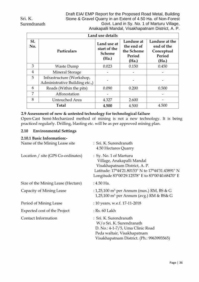
Sri. K. Surendranath
Draft EIA/ EMP Report for the Proposed Road Metal, Building Stone & Gravel Quarry in an Extent of 4.50 Ha. of Non-Forest
Govt. Land in Sy. No. 1 of Marturu Village, Anakapalli Mandal, Visakhapatnam District, A. P.
Page | 36
Land use details
Sl. No.
Particulars
Land use at start of the
Scheme (Ha.)
Landuse at the end of
the Scheme Period (Ha.)
Landuse at the end of the
Conceptual Period (Ha.)
3 Waste Dump 0.023 0.150 0.450
4 Mineral Storage - - -
5 Infrastructure (Workshop, Administrative Building etc.,)
- - -
6 Roads (Within the pits) 0.090 0.200 0.500
7 Afforestation - -
8 Untouched Area 4.327 2.600 -
Total 4.500 4.500 4.500
2.9 Assessment of new & untested technology for technological failure Open-Cast Semi-Mechanized method of mining is not a new technology. It is being practiced regularly. Drilling, blasting etc. will be as per approved mining plan.
2.10 Environmental Settings
2.10.1 Basic Information:- Name of the Mining Lease site : Sri. K. Surendranath 4.50 Hectares Quarry
Location / site (GPS Co-ordinates) : Sy. No. 1 of Marturu Village, Anakapalli Mandal Visakhapatnam District, A. P. Latitude: 17°44'21.80153" N to 17°44'31.43891" N Longitude 83°00'29.12578" E to 83°00'40.68470" E
Size of the Mining Lease (Hectare) : 4.50 Ha.
Capacity of Mining Lease : 1,25,100 m3 per Annum (max.) RM, BS & G 1,25,100 m3 per Annum (avg.) RM & BS& G
Period of Mining Lease : 10 years, w.e.f. 17-11-2018
Expected cost of the Project : Rs. 60 Lakh
Contact Information : Sri. K. Surendranath W/o Sri. K. Surendranath D. No.: 4-1-7/5, Uma Clinic Road Peda waltair, Visakhapatnam Visakhapatnam District. (Ph.: 9963993565)

Sri. K. Surendranath
Draft EIA/ EMP Report for the Proposed Road Metal, Building Stone & Gravel Quarry in an Extent of 4.50 Ha. of Non-Forest
Govt. Land in Sy. No. 1 of Marturu Village, Anakapalli Mandal, Visakhapatnam District, A. P.
Page | 37
Table 9: Environmental Settings
Sl. No.
Areas Distance in kilometer / Details
1 Distance of project site from nearest rail or road bridge over the concerned River
Not applicable, since the proposal is not for River Sand Mining.
2 Distance from infrastructural facilities
Railway Station Anakapalli: 6 km
National/ State Highway Tummapala-Bowluvada: 2.39 km
Nearest Black Top Road Makavaram-Marturu: 0.80 km
Any Other Road Quarry-Crusher (WBM) Road: 0.5 km Crusher-Black Top Road: 0.30 km
Electric transmission line pole or tower 0.5 km, near the crusher site
Canal or check dam or reservoirs or lake or ponds (Canal)
Marturu Cheruvu: 1.10 KM Sharada River: 3.50 KM
3 Areas protected under international conventions, national or local legislation for their ecological, landscape, cultural or other related value
None within 5 km radius
4 Areas which are important or sensitive for ecological reasons - Wetlands, watercourses or other water bodies, coastal zone, biospheres, mountains, forests
None within 5 km radius
5 Areas used by protected, important or sensitive species of flora or fauna for breeding, nesting, foraging, resting, over wintering, migration
None within 5 km radius Kambalakonda Wildlife Sanctuary: 32.54 km
6 Inland, coastal, marine waters Marturu Cheruvu: 1.10 KM Sharada River: 3.50 KM
7 State, National boundaries None within 5 km
8 Routes or facilities used by the public for access to recreation or other tourist, pilgrim areas
Tummapala-Bowluvada: 2.39 km Makavaram-Marturu Road: 0.8 km
9 Defense installations None within 10 km radial distance
10 Densely populated or built-up area, distance from nearest human habitation
Anakapalli: 7 km Marturu Village: 1.5 km
11 Areas occupied by sensitive man-made land uses(hospitals, schools, places of worship, community facilities)
Anakapalli: 7.0 km Visakhapatnam: 29 km

Sri. K. Surendranath
Draft EIA/ EMP Report for the Proposed Road Metal, Building Stone & Gravel Quarry in an Extent of 4.50 Ha. of Non-Forest
Govt. Land in Sy. No. 1 of Marturu Village, Anakapalli Mandal, Visakhapatnam District, A. P.
Page | 38
Sl. No.
Areas Distance in kilometer / Details
12 Areas susceptible to natural hazard which could cause the project to present environmental problems (earthquakes, subsidence, landslides, erosion, flooding or extreme or adverse climatic conditions)
Not within 10 km Study area
13 Is proposed mining site located over or near fissure / fracture for ground water recharge
No
14 Whether the proposal involves approval or clearance under the following Regulations or Acts, namely:-
No. The proposal doesn’t involve any kind of clearance under Forest (Conservation) Act, 1980; Wildlife (Protection) Act, 1972
and CRZ Notification 2011/2019
(a) The Forest (Conservation) Act, 1980;
(b) The Wildlife (Protection) Act, 1972;
(c) The Coastal Regulation Zone Notification, 2011.
If yes, details of the same and their status to be given.
15 Forest land involved (hectares) NIL
16 Whether there is any litigation pending against the project and/or land in which the project is propose to be set up?
No
(a) Name of the Court
(b) Case No.
(c) Orders or directions of the Court, if any, and its relevance with the proposed project
2.10.2 Details of other quarries present within the same cluster of 500m radius:
The present Road Metal, Building Stone & Gravel Quarry of Sri. K. Surendranath, with an extent of 4.50 Hectares, is located in Sy. No. 1 of Marturu Village in Anakapalli Mandal of Visakhapatnam District, Andhra Pradesh.
As per the Clause No. (b) (i) of the Gazette Notification No. S.O. 2269 (E), dated 01st July 2016, issued by the Ministry of Environment, Forests & Climate Change, Government of India (Amendment of the EIA Notification 2006), “A cluster shall be formed when the distance between the peripheries of one lease is less than 500 meters from the periphery of other lease in a homogeneous mineral area which shall be applicable to the mine leases or quarry licenses granted on and after 9th September, 2013”.

Sri. K. Surendranath
Draft EIA/ EMP Report for the Proposed Road Metal, Building Stone & Gravel Quarry in an Extent of 4.50 Ha. of Non-Forest
Govt. Land in Sy. No. 1 of Marturu Village, Anakapalli Mandal, Visakhapatnam District, A. P.
Page | 39
Further, as per Clause No. (5) of the said Notification, “The leases not operative for three years or more and leases which have got environmental clearance as on 15th January 2016, shall not be counted for calculating the area of cluster, but shall be included in the Environmental Management Plan and the Regional Environmental Management Plan”.
Accordingly, the proponent has obtained the Cluster Certificate from the Asst. Director, Dept. of Mines & Geology, Anakapalli, vide Letter No. 6060/Q/2011, dated 18-10-2019, which states that, there are Twenty Four (24) quarry leases existing within 500m from the lease boundary of the above proposed quarry. The details of these leases falling in the cluster, are as under:
Table 10: Details of other quarries falling in the same cluster
Sl. No
Lease Holder Name Lease From
Lease To
Extent in Hectares
Sy. No.
Village Mandal Status
1 Mahalakshmi Naidu 04-11-2007 03-11-2017 3.00 01 Marturu Anakapalli Working
2 N.Krishnayya 03-07-2007 02-07-2017 13.33 01 Marturu Anakapalli Working
3 M/s. Sri. Venkata Sasi Stone Crusher
18-01-2007 17-01-2017 7.44 01 Marturu Anakapalli Working
4 Sri. K. Vijaya Prasad 31-12-2005 30-12-2020 2.00 01 Marturu Anakapalli Working
5 M/s. Sri. Venkata Sasi Stone Crusher
14-07-2009 13-07-2024 7.90 01 Marturu Anakapalli Working
6 M/S Aparna Enterprises
27-12-2007 26-12-2017 2.55 01 Marturu Anakapalli Working
7 M/S Venkata Sasi Stone Crusher
04-06-2008 03-06-2018 8.00 01 Marturu Anakapalli Working
8 M/S Kartikeya nirmans pvt ltd
05-06-2008 04-06-2018 2.75 01 Marturu Anakapalli Working
9 P.Ashok Chandra Murthy Raju
07-06-2008 06-06-2018 2.25 01 Marturu Anakapalli Working
10 Sri. Venkatasasi Stone Crusher
21-07-2010 06-03-2018 6.50 01 Marturu Anakapalli Working
11 M/S Navodaya Granites
26-12-2007 25-12-2022 3.50 01 Marturu Anakapalli Working
12 M/S Ultratech Cement Ltd
17-02-2011 04-01-2018 6.00 01 Marturu Anakapalli Working
13 P.Kasibabu 29-10-2008 28-10-2018 1.00 01 Marturu Anakapalli Working
14 M/s K. Katyayeni 17-11-2018 16-11-2028 4.50 01 Marturu Anakapalli Working
15 M/s SGX minerals pvt ltd
04-05-2010 16-11-2018 9.00 01 Marturu Anakapalli Working
16 M/S Navodaya Granite Industries
23-05-2009 22-05-2024 1.60 01 Marturu Anakapalli Working
17 M/S Trendet Rocks Pvt Ltd
25-02-2010 18-11-2024 9.00 1 Marturu Anakapalli Working
18 M/s Aparna enterprises 05-03-2013 04-03-2023 6.00 1 Marluru Ankapalli Working

Sri. K. Surendranath
Draft EIA/ EMP Report for the Proposed Road Metal, Building Stone & Gravel Quarry in an Extent of 4.50 Ha. of Non-Forest
Govt. Land in Sy. No. 1 of Marturu Village, Anakapalli Mandal, Visakhapatnam District, A. P.
Page | 40
Sl. No
Lease Holder Name Lease From
Lease To
Extent in Hectares
Sy. No.
Village Mandal Status
19 Smt..T Vijayakumari 27-06-2015 26-06-2025 3.00 1 Marluru Ankapalli Working
20 M/S Gonthalamma Granites
07-06-2011 04-06-2018 2.50 1 Marluru Ankapalli Working
21 M/S Nauha Constructions
07-08-2012 04-06-2018 2.50 1 Marluru Ankapalli Working
22 M/S Madhucon Projects
27-10-2011 28-10-2026 4.50 1 Marluru Ankapalli Working
23 M Balaji 28-03-2013 27-03-2023 1.00 1 Marluru Ankapalli Working
24 M/S Rank Silicon Pvt Ltd
30-07-2015 01-02-2025 10.13 1 Marluru Ankapalli Working
Of the 24 existing quarry leases, within 500 radial distance of the present quarry, 21 leases with a total extent of 102.22 Hectares have been granted prior to 09th Sept. 2013, and hence are exempted from Cluster Effect, as per MoEFCC Notification No. S.O. 2269 (E), dated 01st July 2016. The remaining Three (03) leases with a total extent of 17.63 Hectares are granted after 09th Sept. 2013. Hence, as per MoEFCC Notification No. S.O. 2269 (E), dated 01st July 2016, they become part of the cluster, for preparation of the cluster EMP. The total extent of the cluster, including the present lease area, will be 22.13 Ha. < 25 Ha. Hence classified under B2 at Par with B1 category.
2.11 Environmental Policy at Sri. K. Surendranath’s Quarry
A] Objectives: ✓ Conduct mining and associated operations in an environmentally responsible
manner to comply applicable laws and other requirements related to environmental aspects and design projects with due consideration of sustainable development.
✓ Prevent pollution of surrounding habitation by continuous monitoring and adopt suitable measures for environmental protection.
✓ Ensure compliance of Environmental Clearance conditions and other statutory conditions issued by regulatory agencies.
✓ Implement Environmental Management Plan in the mine effectively to mitigate pollutions of air, water, noise and land caused by mining operations.
B] Strive to conserve Bio-diversity: ✓ Strive for continual improvement in our environmental performances by setting
targets, measuring progress and taking corrective actions. ✓ Great awareness about environment among the employees and local community
through proactive communication and training.
C] Strategies to implement Environmental Policy:
1] Mine planning on sustainable development: ✓ Mining activity will be designed on principal of sustainable development with due
consideration to environment, safety at the planning stage itself.

Sri. K. Surendranath
Draft EIA/ EMP Report for the Proposed Road Metal, Building Stone & Gravel Quarry in an Extent of 4.50 Ha. of Non-Forest
Govt. Land in Sy. No. 1 of Marturu Village, Anakapalli Mandal, Visakhapatnam District, A. P.
Page | 41
✓ Efforts will be given to use latest equipments and technologies which will be environmental friendly.
2] Environmental Impact Assessment and Management Plan: ✓ Mining will be carried out to comply the environmental standards of quality of
various pollutants within limit under NAAQM, acts and National Environmental Policy.
✓ Detailed Environmental Management Plan has been prepared and operations will be carried out as per clearances of SEIAA, APPCB and environment department of Andhra Pradesh State Government.
✓ Detailed mine closure plans is/shall be prepared as per IBM/ Dept. of Mines & Geology guidelines.
3] Compliance to statutory requirements ✓ Timely submission of returns/ compliance will be ensured with respect to
implementation of CFO, EMP and EC.
4] Measure to mitigate Pollution a] Air Pollution: ✓ Generation of dust will be marginal, in Road Metal, Building Stone & Gravel
Quarrying. However, the dust that gets generated will be controlled at source to possible extent with necessary measures during drilling, blasting, loading, unloading, transfer points etc. Dust generation will be minimized along transportation as per mitigation measures in EMP. Green belt will be developed around dust source and along the haulage road.
b] Mine Closure Plan: ✓ Mine closure plan is/will be prepared as progressive and at final stage. Appropriate
funds were deposited every year for its utilization for PMCP and FMCP. c] Monitoring:
✓ All receptors in and around mine will be monitored regularly to assess efficiency of pollution control measures.
✓ Effect of mining on hydrology of the area will be monitored through measurement of water level and its quality of nearby wells/bores. Conservation of water through rain water harvesting shall be taken up.
✓ Environmental cell will regularly interact with local area people related to environment to have corrective actions.
✓ Environmental monitoring and audit will be carried out regularly. ✓ Annual budget will be prepared based on action plan including monitoring and
implementation. Budget utilization will also be recorded.
d] Preservation of Bio-diversity: ✓ Selection of species for plantation shall be done in consultation with local
community to include the local species and their preferences if any. Technical help of experts like local forest departments will also be sought.

Sri. K. Surendranath
Draft EIA/ EMP Report for the Proposed Road Metal, Building Stone & Gravel Quarry in an Extent of 4.50 Ha. of Non-Forest
Govt. Land in Sy. No. 1 of Marturu Village, Anakapalli Mandal, Visakhapatnam District, A. P.
Page | 42
e] Awareness Program: ✓ Regular training programs will be organized for executives and workers to aware
the environmental policies and implementation, execution of EMP etc. D] Implementation of Policy: a] Manpower:
An environmental cell shall be setup, comprising (i) Proprietor (ii) Mines Manager (iii) Blaster (iv) Admin Officer (v) Representative of Workers
Mines Manager will be in charge of “Environment Cell” at Sri. K. Surendranath’s Road Metal, Building Stone & Gravel Quarry (4.50 Ha.) and will be responsible for compliance of the conditions stipulated in environmental clearance by State Environment Impact Assessment Authority, Andhra Pradesh.
Environment management plan has been prepared to ensure mining with least likely alterations in environmental quality. Needs as per review of impacting activities at Sri. K. Surendranath’s quarry are i) dust control from fugitive sources, ii) controlled sequential blasting (with delayed detonators) & noise control, iii) storage of material and iv) sustained health care of miners. Terms of reference for environmental cell during regular mine operations: ✓ Construction of macadamized /asphalted roads, ✓ Transportation of mined material in covered trucks, ✓ Provision of speed breakers over haulage roads. ✓ Water sprinkling and plantation along the roads, ✓ Plantation along the safety zone, Stabilization of dumps by plantation. ✓ Study efficiencies of control measures. ✓ Regular monitoring of ambient air quality, noise levels within 5 km radius as per
MoEF norms & conditions in the environmental clearance letter. ✓ An NABL - accredited agency will be engaged for monitoring. They will use
appliances like standard make high volume samplers, noise meter and collect micrometeorology data.
b] Roles and Responsibilities:
✓ This environmental cell will be responsible to implement policy, obtaining EC, undertaking mitigation measures, preparation of action plan every year and statutory compliances to regulatory agencies.
✓ This cell will be responsible for monitoring of work, budget allocation, its expenses, audits and will monitor cost effectiveness of environmental control measures undertaken and help to frame future budget allocations.

Sri. K. Surendranath
Draft EIA/ EMP Report for the Proposed Road Metal, Building Stone & Gravel Quarry in an Extent of 4.50 Ha. of Non-Forest
Govt. Land in Sy. No. 1 of Marturu Village, Anakapalli Mandal, Visakhapatnam District, A. P.
Page | 43
✓ Any noncompliance will be dealt as per procedure defined in OM J11013/41/2006 IA.II(I) dated 12.12.2012 and amendments thereof or notifications or time to time guidelines and court orders.
C] Review of Policy:
In view of fast changing social, environmental, economic scenario, this policy will be reviewed and revised every 5 years to incorporate statutory legal and other changes to acts, policies, standards prevailing at that time.
Copy of Environmental Policy of Sri. K. Surendranath’s Quarry, duly signed by him, is enclosed as Annexure-4. 2.12 Safeguards in Opencast Mine working at Sri. K. Surendranath’s Quarry: Basis & provisions of safeguards Metalliferous Mines Regulations, 1961
A] Opencast Workings
✓ Height of benches will not be more than digging height of machine used for digging, excavation, removal.
✓ Width of bench shall not be less than height of bench. Formation of bench will be from top to downwards
B] Roads for trucks/dumpers ✓ All roads and machinery like trucks, dumpers will be maintained in good condition
probably under AMC with OEM. ✓ If possible one way traffic / flagging for traffic management will be implemented. ✓ Benches will be designed in such a way that at corner/bends vehicle drives shall at
least have visibility 3 times of breaking distance. Speed limit restriction will be 20km/hr within mines.
✓ Haulage road shall be designed in such a way that it shall not have gradient more than 1 in 10.
C] Supervision ✓ Well qualified mining engineer will only supervise the operations. ✓ All drilling and cutting operations will be carried under supervision of qualified
Mining Engineer only as per standard drilling and cutting pattern.
D] Maintenance of machineries and vehicles ✓ Every HEMM will be maintained in good condition probably under supervision of
OEM. ✓ All the machineries and vehicles will be equipped with alarming systems, horns,
front and rear lights, efficient brakes, reverse alarms and trained operators. ✓ Code of instruction furnished by OEM regarding machinery operations,
maintenance, schedules etc. shall be strictly followed and recorded. ✓ Any machine found to be unfit for operation shall be boldly tagged as “OUT OF
SERVICE” to avoid any mishap. ✓ Powers will be disconnected when repairs made to any electrical machinery.

Sri. K. Surendranath
Draft EIA/ EMP Report for the Proposed Road Metal, Building Stone & Gravel Quarry in an Extent of 4.50 Ha. of Non-Forest
Govt. Land in Sy. No. 1 of Marturu Village, Anakapalli Mandal, Visakhapatnam District, A. P.
Page | 44
✓ Brakes for machinery/vehicles /dumpers shall be tested on regular interval as per schedule of OEM. Records shall be maintained.
✓ No person will be allowed to work under chassis when body will be on raised position. Chokes will be used during parking of machineries.
✓ All the machineries will be daily monitored, checks for preventive maintenance before their deployment to field by authorized persons. Record will be maintained on daily basis.
✓ No person/ helper will be deployed without permission of Mines Manager to any machinery/dumper.
✓ No vehicle without instruction of management will be allowed to Mines as a safety matter.
E] Duties of Machinery Operator: ✓ Operator will check his machinery on daily basis before operating it. ✓ All operators will be regularly monitored by authority for their fitness and skills. ✓ To prevent unauthorized driving ignition keys/cabin keys will be deposited to
store keeper. Store keeper will issue these key only on permission of Mines Manager to Operator or to Maintenance Supervisor.
✓ Code of Traffic Rules will be framed by Mines Manager for movement of HEMM, Dumpers, Trucks will be prominently displayed and complied with.
✓ Spoil bank will be designed and maintained scientifically away from railway track, public roads building or other permanent structures.
F] Precautions while drilling
✓ Position of every hole will be drilled strictly as marked by competent authority of Mines. These will be clearly visible.
✓ No person will be permitted within radius of 20m or 60m from same bench while dislodging the blocks from primary rock.
G] Miscellaneous Precautions
✓ Contractors’ persons will be guided and monitored as a safety point of view. No trailer will be allowed in the mine.
✓ Management will frame Safe Operating Procedures (SOP) for each operation and copy will be handed over to concerned personnel for implementation.
✓ All precautions and directives given by DGMS will be strictly followed.

Sri. K. Surendranath
Draft EIA/ EMP Report for the Proposed Road Metal, Building Stone & Gravel Quarry in an Extent of 4.50 Ha. of Non-Forest
Govt. Land in Sy. No. 1 of Marturu Village, Anakapalli Mandal, Visakhapatnam District, A. P.
Page | 45
CHAPTER 3 DESCRIPTION OF ENVIRONMENT
3.1 General: This chapter includes baseline environmental quality data in and around the present Road Metal, Building Stone & Gravel Quarry of Sri. K. Surendranath, which is the proposed open cast mining by semi- mechanized method over 4.50 Ha. of Non-Forest Government Land, in Sy. No. 1 of Marturu Village, in Anakapalli Mandal of Visakhapatnam District, Andhra Pradesh. The Baseline information was generated and also collected from secondary sources.
Present terrestrial/land use and status of aquatic/water, air quality, noise levels, biological, socio economic aspects of environment was studied. Mining operations are concerned with status of land, water, air, noise & vibration, biological, socio economic aspects directly or indirectly related.
a) Study area: Core zone is the proposed lease area itself. Buffer zone for this project is 10 km radius from the proposed area, as per Standard ToR, published by MoEFCC. Core and buffer zones for this project are marked on Survey of India Topo sheet No. 65 K/14 along with 5 km and 10 km from lease area (Annexure-3).
b) Monitoring period: Base line monitoring was conducted, as per Office Memo no J- 110134/2006-IA-II (Part), dated 29th August 2017. Monitoring period is from October 2020 to December 2020.
C) Components of environment which were examined and monitored included. o Land-use pattern, topography, geology/soil
o Air – Micrometeorology, concentrations of criteria pollutants within core zone as per wind direction, inventory of sources etc.
o Water- Inventory of surface, ground water sources, ground water potential, hydrogeological features e.g. ground water fluctuation, yield
o Noise: inventory of sources, receptors etc.
o Biological- flora, fauna, national park, wild life sanctuaries etc. and
o Socio economic- Demographic details, quality of life, land losers, R & R issues etc.
3.2 Terrestrial/land environment:
3.2.1 Land use Present status of Land-Use Land-Cover within in 10 km radius of the proposed area is shown in Annexure-9. Detailed classification of land use is given in Table 10.
The landuse classification, in the core zone, as well as the 10km radius (buffer zone) of the proposed Road Metal, Building Stone & Gravel Quarry, are as under:

Sri. K. Surendranath
Draft EIA/ EMP Report for the Proposed Road Metal, Building Stone & Gravel Quarry in an Extent of 4.50 Ha. of Non-Forest
Govt. Land in Sy. No. 1 of Marturu Village, Anakapalli Mandal, Visakhapatnam District, A. P.
Page | 46
Table 11: Landuse Details
2.12.1.1 Core Zone (Quarry Area):
Land use details
Sl. No.
Particulars
Land use at start of the
Scheme (Ha.)
Landuse at the end of
the Scheme Period (Ha.)
Landuse at the end of the
Conceptual Period (Ha.)
1 Area under Mining 0.035 1.200 2.950
2 Buffer Zone (Storage for Top Soil)
0.025 0.350 0.600
3 Waste Dump 0.023 0.150 0.450
4 Mineral Storage - - -
5 Infrastructure (Workshop, Administrative Building etc.,)
- - -
6 Roads (Within the pits) 0.090 0.200 0.500
7 Afforestation - -
8 Untouched Area 4.327 2.600 -
Total 4.500 4.500 4.500
2.12.1.2 Buffer Zone (10 km radius)
# Category Area (Ha.) Percentage (%)
1 Agricultural Land 13,113.16 44.70 %
2 Built-up Area 1,465.16 5.00 %
3 Mining Area 632.01 2.15 %
4 Forest Area (Green Areas) 13,411.96 45.72 %
5 Waste Lands/ Barren Lands 465.96 1.59 %
6 Water Bodies 246.23 0.84 %
Highest and lowest contours are 216M to 126m AMSL respectively. There is steep slope is from North to South. There is not much topsoil. It is proposed to handle about 69,500 m3 of waste during the plan period and a total of 1,39,000 m3 of waste during the lease period. It is proposed to utilize this waste for strengthening the approach roads and village roads. Excess quantity of waste will be dumped within the lease as shown in the plan. The proposed lease area is under low hazard seismic zone. There is no record of earthquake.
3.2.2 Soil quality: The major rivers flowing in the district are Sarada, Varaha and Tandava which flow from the east, with rivulets Meghadrigedda and Naravagedda. These rivers are ephemeral in nature and flow from north to south joining the sea. The Gosthani is an east flowing river from Ananthagiri hills and joins the Bay of Bengal. The area is mainly drained by Hanumanthavaka, Narvagedda, Peddagadda and other minor streams which have their origin in adjoining hills. The Tandava, Varaha, Sarada and Gosthani rivers and their

Sri. K. Surendranath
Draft EIA/ EMP Report for the Proposed Road Metal, Building Stone & Gravel Quarry in an Extent of 4.50 Ha. of Non-Forest
Govt. Land in Sy. No. 1 of Marturu Village, Anakapalli Mandal, Visakhapatnam District, A. P.
Page | 47
tributaries have contributed to the formation of extensive flood plain areas. There is not much surface drainage in the plains because of the high infiltration and permeable characteristics of the sediments. The drainage pattern is mainly sub-dendritic to dendritic type. According to the assessment made on the basis of the visit and some secondary data the area is covered by Red loamy soils, predominantly, which are light textured and are easily drained. Majority of the soils around the proposed site are shallow to medium deep in character. These are subjected to certain farming practices, which offer a good to moderate production status, as the area receives comparatively high rainfall (annual avg. rainfall of the district is 1200 mm).
As the soils are exposed to dryness and the problem of erosion is very serious due to sloppy and undulating topography. The steep slopes and marginal lands bordering hillocks face acute erosion in times of heavy rains. The cropping environment includes the rain-fed situation specially around the leased area.
As far as the proposed Road Metal, Building Stone & Gravel Quarry area is concerned, there is no agriculture over the proposed lease area. The chemical properties of soils, in the nearby areas are given in Table 11:
Table 12: Chemical Properties of Soil
# Parameters Unit S1 S2 S3 S4 S5 S6 S7 S8 S9
1 pH @ 250C - 5.8 6.0 6.5 7.6 7.3 7.8 7.2 6.7 5.9
2 Elect. Conductivity s/cm 114 175 170 130 110 250 180 140 210
3 Sodium mg/Kg 650 90 155 60 98 110 150 125 170
4 Potassium mg/Kg 32.0 43.0 76.0 29.0 48.00 54.0 73.0 60.0 84.0
5 Total Soluble Solids % 2.4 0.8 1.1 0.5 2.6 0.8 2.2 1.1 0.5
6 Organic Matter % 0.5 1.0 0.5 1.0 1.5 0.8 0.8 1.0 1.5
7 Water Content % 4.5 5.1 6.2 5.5 4.8 5.4 5.6 6.1 5.5
8 Nitrate Nitrogen mg/Kg 97 81 152 106 91 76 164 102 184
9 Phosphorus mg/Kg 10.0 34.0 19.0 24.0 38.0 43.0 29.0 14.0 24.0
Core Zone S1 – Mine Lease Area Buffer Zone S2: Papayya Santapalem S3: Makavaram S4: Marturu S5: Tummapala S6: Bavulavada S7: Uderu S8: Allikhandupalem S9: Gondhavaram
3.3 Air Environment: Micrometeorology: Anakapalli is the nearest Automatic Weather Station from the proposed Road Metal, Building Stone & Gravel Quarry Area. Site specific micro-meteorological data was collected for October-December 2020, for various parameters like temperature, rainfall, wind speed, wind direction, humidity etc. The collected data, is presented in Annexure-19.
Data Analysis Meteorological data collected during the study reveals the following status. Wind Direction: Predominant wind directions, during the study period (Oct. 2020 to Sept 2020) are from North to South (42.95%), followed by from ENE to WSW (15.05%).

Sri. K. Surendranath
Draft EIA/ EMP Report for the Proposed Road Metal, Building Stone & Gravel Quarry in an Extent of 4.50 Ha. of Non-Forest
Govt. Land in Sy. No. 1 of Marturu Village, Anakapalli Mandal, Visakhapatnam District, A. P.
Page | 48
Wind Speed: Wind velocity readings were ranging from 0.04 m/Sec to 10.3 m/ sec, with an average wind speed of 2.24 m/ sec, during the study period. Temperature: Temperature values were ranging from 14.0°C to 34.0°C, with an average temperature of 25.86°C, during the study period. Relative Humidity: The mean relative humidity value was found to be 76.73%. Cloud cover: Sky was covered with mist and haze during majority of the study period. Rainfall: A considerable rainfall of 203.83 mm (total) was recorded during the study period.
3.3.1 Air pollutants: Source inventory: There are no major industries within core and buffer zones and there are no stationary sources like stacks/chimneys. There is no agriculture in the core area. Nearest habitation is Marturu village and there are no fugitive sources of emissions.
3.3.2 Monitoring stations for ambient air quality (AAQ): AAQ monitoring sites were decided to cover all the directions, as practically as possible, to have a representative data. The details of monitoring stations are as under:
Table 13: Particulars of Monitoring Stations
Station Code
Village Distance (Km)
Direction
S1 Project Site
S2 Papayya Santapalem 2.884 NE
S3 Makavaram 1.572 E-NE
S4 Maruturu 0.709 S
S5 Tummapala 2.904 S-SW
S6 Bavulavada 3.202 W-SW
S7 Uderu 3.467 W-NW
S8 Allikhanudupalem 3.951 NW
S9 Gandavaram 4.533 N-NW
Air quality was monitored as per MOEF & CC norms. There are no sources of sulphur & nitrogen oxides, hydrocarbons or heavy metals etc. Road Metal, Building Stone & Gravel deposits do not contain trace/ heavy metals. Therefore air quality criteria pollutants for
this project are PM10, PM2.5, Sulphur dioxide and nitrous oxides in air were measured.
Calibrated Respirable Dust Samplers and Fine Particulate Samplers were used. 24 hour samples were collected twice a week for, 12 weeks at each station. Samples were collected and sent to a NABL recognized laboratory for analysis. Air quality monitoring data is given in Annexure-11.
The monitoring stations are shown below:

Sri. K. Surendranath
Draft EIA/ EMP Report for the Proposed Road Metal, Building Stone & Gravel Quarry in an Extent of 4.50 Ha. of Non-Forest
Govt. Land in Sy. No. 1 of Marturu Village, Anakapalli Mandal, Visakhapatnam District, A. P.
Page | 49
Data Analysis (October 2020 to December 2020) ➢ Area has rural setting. ➢ Predominant emissions during open cast mining project would generate
particulate matter during drilling, blasting, loading and transportation activities. ➢ The summary of ambient air quality status given in Annexure-11, is as below:

Sri. K. Surendranath
Draft EIA/ EMP Report for the Proposed Road Metal, Building Stone & Gravel Quarry in an Extent of 4.50 Ha. of Non-Forest
Govt. Land in Sy. No. 1 of Marturu Village, Anakapalli Mandal, Visakhapatnam District, A. P.
Page | 50
Table 14: Summary of AAQ Monitored Data
Para-meter
Min. value observed (μg/m3)
Max. value observed (μg/m3)
Avg. value observed (μg/m3)
Limit as per NAAQS 2009
(μg/m3) Core Zone
Buffer Zone
Core Zone
Buffer Zone
Core Zone
Buffer Zone
PM 2.5 29.5 30.9 36.2 52.0 32.15 39.1 60
PM 10 47.9 46.8 51.2 87.9 52.54 64.0 100
SO2 9.4 9.5 11.5 13.4 10.82 11.4 80
NOx 9.4 8.5 11.3 11.4 10.09 9.9 80
3.4 Water Environment:
3.4.1 Water Budget Water requirement for project, sources and ground water potential: Road Metal, Building Stone & Gravel mining will need water for drinking for the mine workers, dust control and plantation. Mining operations also need water for wet drilling etc.
There will not be any residential colony. Drinking water requirement for 20 workers would be 600 LPD (Liters per Day) @ 30 LPCD (Liters per Capita per Day). Water requirement for dust control would be 6 KLD (incl. wet drilling) and about 4 KLD will be required for plantation. Drinking water will be supplied from the nearby village after disinfection. Tankers will be used.
Table 15: Water Requirement
Use Source Quantity KLD Wastewater KLD
Disposal
Dust control Tankers/ Crusher Site 6 Nil --
Plantation Tankers/ Crusher Site 4 Nil --
Domestic Tankers/ Crusher Site 0.60 0.50 Septic Tank
Total -- 10.60 0.50
There are no surface sources viz. rivers/ lake within the proposed quarry lease area. There is one (01) first order stream originating from the south side of the proposed area and is outside the lease area. The nearest major water body to the proposed quarry lease area is Marturu Cheruvu at a distance of 1.10 km towards SE of the present Quarry Lease area and Sarada River is at a distance of 3.50 KM SSW. 3.4.2 Ground Water Potential:
Ground water resource in the Visakhapatnam region of which proposed quarry area is a part, as per hydrogeology report –CGWB is given below:

Sri. K. Surendranath
Draft EIA/ EMP Report for the Proposed Road Metal, Building Stone & Gravel Quarry in an Extent of 4.50 Ha. of Non-Forest
Govt. Land in Sy. No. 1 of Marturu Village, Anakapalli Mandal, Visakhapatnam District, A. P.
Page | 51
Table 16: Ground Water Potential
Net G.W. availability 71,689 Ha.M
Net Annual Draft 23,100 Ha.M
Balance Resource 48,589 Ha.M
Stage of G. W. Development (23,100/71,689) x 100= 32.22%
(Source: Ground Water Brochure, Visakhapatnam District, A.P., published by Central Ground Water Board, Govt. of India, Southern Region, Hyderabad, September 2013)
3.4.3 Ground Water Scenario: At the end of conceptual period, there will not be formation of any kind of pit. Based on site topography, benches will be made during the operational phase of the quarry. The proposed area is at a higher elevation than the surrounding areas, by about 50-55 meters and the proposed excavation will be within the lease area. Total mined out area will be 2.950 Ha., at the end of conceptual period, with the conceptual depth of 50 m from the top most level. At the end of conceptual period ultimate bottom level will be 160 m above MSL.
Climatologically the district experiences tropical sub-humid type of climate with moderate summer and good seasonal rainfall. The southwest monsoon sets in the second week of June and lasts till September end. October and November receive rainfall from northeast monsoon. Winter season with cool and fine weather prevails from December to February followed by summer season upto early June.
The average annual rainfall of the district is 1115-10Mm. and monthly rainfall ranges from nil rainfall in January to 207.5 mm in October. October is the wettest month of the year. The mean seasonal rainfall distribution is 673.5 mm. in southwest monsoon (June-September), 271.8 mm. in northeast monsoon (October-December), 10.9 mm. rainfall in Winter (Jan-Feb) and 126.5-10Mm in summer (March – May). The percentage distribution of rainfall, season-wise, is 60.36% in southwest monsoon, 24.36 % in northeast monsoon, 0.97 percentage in winter and 14.3 % in summer.
The district is underlain by variety of geological formations from the oldest Archaeans to Recent Alluvium. The Archaean group of rocks includes Khondalites and Charnockites of Eastern Ghat super group and Khondalitic gneisses of Migmatite group. The Gondwana rocks which are represented by sandstones are in very limited aerial extent. The recent alluvium is prevalent along the rivers. Prominent lineaments are trending in NE-SW, NW-SE and ENE-WSW.
Ground water occurs in almost all geological formations. From the ground water point of view, the aquifers in the district can be broadly classified into hard formations (khondalites, charnockites, khondalitic gneisses etc.) and soft formations (sand stones and alluvium). Ground water occurs under unconfined to semi-confined conditions in the hard formations, while it occurs under unconfined to confined conditions in soft formations. The yields in the weathered zones of hard formations range from 25 to 100 m3/day. The bore wells drilled in the hard formations, generally tap the fractured and fissured zones. The yields of the bore wells in these formations range between 5 to 25

Sri. K. Surendranath
Draft EIA/ EMP Report for the Proposed Road Metal, Building Stone & Gravel Quarry in an Extent of 4.50 Ha. of Non-Forest
Govt. Land in Sy. No. 1 of Marturu Village, Anakapalli Mandal, Visakhapatnam District, A. P.
Page | 52
m3/hr. Sand stones are exposed in the small isolated places around Nakkavanipalem and Elamanchili. In these formations, ground water occurs under both unconfined and confined conditions. The depth of dug wells in alluvium formations ranges from 2 to 10 mbgl and the yields generally ranges from 40 to 250 m3/day. The depth of filter points/tubewells varies from 9 to 35 m with discharges ranging from 15 to 30 m3/hour.
The transmissivity values of the aquifers in the consolidated formations generally vary from 1 to 772 m2/day, whereas specific capacity ranges from 1 to 290 lpm/mdd.
A map showing hydrogeological features of Visakhapatnam District is shown below:
Based on the water level data (year 2012) of ground water monitoring wells, pre and post-monsoon depth to water levels maps are prepared by CGWB and are presented below. The depth to water level maps shows varied water level zones due to underlying terrain and also different geological set up with complex type of

Sri. K. Surendranath
Draft EIA/ EMP Report for the Proposed Road Metal, Building Stone & Gravel Quarry in an Extent of 4.50 Ha. of Non-Forest
Govt. Land in Sy. No. 1 of Marturu Village, Anakapalli Mandal, Visakhapatnam District, A. P.
Page | 53
hydrogeomorphical structures present in the district. Pre- monsoon (May, 2012) depth to water level map reveals, in general, the water levels are deep particularly in the hilly area of the district. Depth to water levels varies from 5 to 10 m BGL, except at Chintapalli, where water level recorded 15.78 m BGL. In the southern part of the district i.e., near to the coast, the water levels are comparatively shallow (<5.00m) except in Payakaraopeta and Nakkapalli mandals where it is in between 5 and 10m BGL.
Pre-Monsoon Ground Water Levels in Visakhapatnam District
During the post monsoon period (November, 2012), in general, the water levels follow nearly same trend. Water levels in the most part of northern area show less than 5 m. except at Potinamallaya Palem (5.80 m). The Shallow water levels, <2m, were observed in South-Western part of the district. The shallow water level was recorded at Addaroddu (0.30 m). The shallow water levels in the area might be due to location of wells close to surface water bodies/ in topographic low levels. From the trend of both pre and post monsoon levels it can be safely concluded that the area, in general, is not prone to water logging.

Sri. K. Surendranath
Draft EIA/ EMP Report for the Proposed Road Metal, Building Stone & Gravel Quarry in an Extent of 4.50 Ha. of Non-Forest
Govt. Land in Sy. No. 1 of Marturu Village, Anakapalli Mandal, Visakhapatnam District, A. P.
Page | 54
Post-Monsoon Ground Water Levels in Visakhapatnam District
From the above, it is concluded that ground water level in the proposed quarry region, is varying in between 5m to 10m BGL, during pre-monsoon season and becomes 2m to 4m BGL, during post-monsoon season.
(Source: Ground Water Brochure, Visakhapatnam District, A.P., published by Central Ground Water Board, Govt. of India, Southern Region, Hyderabad, September 2013)
Hence it is also concluded that mining operation will not intersect ground water table of the proposed quarry lease area.
3.4.4 Water Quality: Ground Water Samples were collected from the nearby villages and from a stone crusher site near the proposed quarry site. The collected samples were analysed in a NABL accredited laboratory. Analysis of water samples are given in Table 17.

Sri. K. Surendranath
Draft EIA/ EMP Report for the Proposed Road Metal, Building Stone & Gravel Quarry in an Extent of 4.50 Ha. of Non-Forest
Govt. Land in Sy. No. 1 of Marturu Village, Anakapalli Mandal, Visakhapatnam District, A. P.
Page | 55
Table 17: Ground water quality
Sl. No.
Parameters
Unit
IS : 10500 - 2012 Results
Maximum
Acceptable Limit AL
Maximum Permissible Limit In
the absence of alternative source
PL
S1
S2
S3
S4
S5
S6
S7
S8
S9
1 Color Hazen 5 15 05 05 05 05 05 05 05 05 05
2 pH ----- 6.5 to 8.5 No Relaxation 7.7 8.3 7.7 8.1 8.2 8.3 8.0 7.7 7.9
3 Electrical Conductivity µS/cm 2250 2250 1715 1364 1351 1767 1367 1585 1687 1264 1547
4 Turbidity NTU 1 5 1.3 0.5 0.4 1.2 1.0 1.4 0.6 0.8 1.1
5 Alkalinity as CaCO3 mg/L 200 600 306 297 277 288 322 233 310 285 267
6 Total Dissolved Solids mg/L 500 2000 551 685 680 885 685 796 845 635 780
7 Total Hardness as
CaCO3 mg/L 200 600 196 206 530 487 247 252 237 226 214
8 Calcium as Ca+2 mg/L 75 200 67 75 109 97 82 75 90 78 88
9 Magnesium as Mg mg/L 30 100 36 23 31 33 28 23 35 48 35
10 Sulphate mg/L 200 400 105 107 212 188 93 76 175 122 84
11 Chloride as Cl mg/L 250 1000 205 186 246 191 188 155 157 267 170
12 Nitrate as NO3-N mg/L 45 No Relaxation 4.5 6.2 5.4 3.7 4.0 4.4 3.2 3.4 4.0
13 Total Iron mg/L 0.3 No Relaxation 0.09 0.12 0.14 0.08 0.20 0.21 0.16 0.12 0.20
14 Fluoride mg/L 1.0 1.5 0.14 0.50 0.65 0.36 0.72 0.48 0.65 0.82 0.56
S1 – Ground Water from nearby Crusher Buffer Zone S2: Papayya Santapalem S3: Makavaram S4: Marturu S5: Tummapala S6: Bavulavada S7: Uderu S8: Allikhandupalem S9: Gondhavaram
a) Observations on water quality: The ground water quality in and around the proposed lease area is slightly alkaline, with the pH levels ranging from 7.7 to 8.3. The total hardness is ranging from 196 to 530 mg/liter as CaCO3, whereas the Total Dissolved Solids content is varying between 551 to 885 mg/liter. The fluoride levels are ranging from 0.14 to 0.82 mg/liter and the nitrate levels are varying between 3.2 to 6.2 mg/liter. The sulphate levels are ranging from 76.0 to 212.0 mg/liter and the chloride levels are varying between 155.0 to 267.0 mg/liter. In general, the ground water quality in the study area, confirms to the permissible limits of IS:10500-2012 (Drinking Water Specification).
b) Wastewater: Continuous dewatering of pits during mining may be required, during monsoon, as the mining activity will lead to creation of one quarry pit. However, the mining depth will not intersect the ground water in the area. Sanitary wastewater will be generated. Toilet facility will be provided with septic tank and soak pit.

Sri. K. Surendranath
Draft EIA/ EMP Report for the Proposed Road Metal, Building Stone & Gravel Quarry in an Extent of 4.50 Ha. of Non-Forest
Govt. Land in Sy. No. 1 of Marturu Village, Anakapalli Mandal, Visakhapatnam District, A. P.
Page | 56
3.5 Noise environment: There are no industrial noise sources. There is no habitation over the lease. Ambient noise levels were measured at the ambient air monitoring stations. Day and night equivalent noise levels were measured using a standard noise meter. Observed values are given in Table 18.
Sources of noise would be during drilling, blasting and transportation of mined-out material from the lease area to the Stone Crusher, located at a distance of 0.5 km
Table 18: Noise levels Leq in dB(A)
Time S1 S2 S3 S4 S5 S6 S7 S8 S9
0600 38.2 37.5 36.9 42.5 36.3 42.1 39.6 42.3 43.1
0700 37.2 34.6 40.6 41.4 37.9 43 40.6 42.5 44.2
0800 37.5 35 42.6 40.3 39.3 41.1 41.3 45.3 39.6
0900 36.8 36.9 41.6 43.4 37.4 42 42.4 43.2 41.2
1000 37.2 37.2 36.7 39.5 39.4 41 43.2 44.3 42.9
1100 39.5 38.5 37.4 38.5 39 43 45.4 45.6 43.7
1200 41.9 38.2 46.4 39.5 40.1 40.8 44.3 43.7 45.8
1300 42.5 39.5 43.6 38.5 40.3 42.8 45.3 43.9 44.5
1400 43.2 41 47.5 37.5 41.3 39.2 43.2 45 43.5
1500 41.9 39.6 42.2 38.6 44.5 40.8 42.3 44.6 41.2
1600 41.2 40.2 43.7 37.5 44.2 42.3 45.3 44.4 42.5
1700 40.1 40.6 46.3 36.7 45.6 43.5 42.3 43 43.3
1800 38.9 41.8 47.4 45.3 46.5 43.6 39.8 48.5 45.3
1900 37.9 42.1 46.5 43.2 45.6 43.7 43.4 40.2 44.4
2000 40.5 45.6 46.7 42.5 47.7 44.6 45.3 43.5 44.9
2100 40.9 43.2 46.4 46.4 47.6 44.7 45.2 45.3 44.6
2200 39.3 45.3 40 46.5 48.6 45.5 45.8 44.3 44.3
2300 39.5 46.5 42.5 44.3 45.5 46.8 43.5 44.6 46.4
2400 38.2 47.7 43.6 43.4 46.6 37.6 44.5 44.6 45.6
0100 37.2 45.3 44.5 45.4 43.4 38.7 45.1 44.7 45.6
0200 37.1 47.4 43.6 44.5 42.4 39.5 45.2 39.6 37.3
0300 38.2 36.2 35.6 40.2 37 43.7 45.7 38.6 39.5
0400 39.1 43.6 37.6 39.5 38.5 45.3 45.8 39.6 39.1
0500 39.5 37.4 36.6 40.2 38.2 43.2 39.5 40.1 41.2
Min. 36.8 34.6 35.6 36.7 36.3 39.5 37.6 38.6 37.3
Max. 43.2 47.7 47.5 46.5 48.6 46.8 45.8 48.5 46.4
Ld 40.80 45.6 46.7 42.5 47.7 44.6 45.3 43.5 44.9
Ln 39.60 38.2 37.8 39.7 38.6 37.5 38.8 39.4 38.7
Ldn 59.18 57.91 57.57 59.30 58.38 57.19 58.48 58.94 58.37

Sri. K. Surendranath
Draft EIA/ EMP Report for the Proposed Road Metal, Building Stone & Gravel Quarry in an Extent of 4.50 Ha. of Non-Forest
Govt. Land in Sy. No. 1 of Marturu Village, Anakapalli Mandal, Visakhapatnam District, A. P.
Page | 57
3.6 Flora and Fauna
3.6.1 General: The vegetation of Visakhapatnam District can be broadly represented in three categories viz., i) Coastal vegetation, ii) Vegetation of the plains and iii) Vegetation of the agency area.
i) The coastal vegetation is roughly of 3 types: a) vegetation of open coast, b) the vegetation of the saline marshes and c) vegetation of the rocky coast. The plants of the open coast are Spinifex lititoreus Merr., Ipomoea pes-capra Sweet and Launea sarmentosa Alston, all acting as sand binders. Next to this zone are found Pandanus fascicularis Lamk., Borassus flubellifer Linn., along with plantations of Casuarina equisetifolia Frost. Next to this zone, in open places, Calatropis gigantea R. Br., Trachys muricata Pers., Phyla nudiflora (L.) Greene, Tephrosia purpurea (L.) Pers., T. villosa (L.) Pers. etc. are found. The plants found in the saline marshes are bushes of Avicinnia alba Bl., Sesuvium portulacastrum L., Acanthus ilicifolius Linn, etc. In the rocky coastal areas Synostemon bacciformis (L.) Webster, Streblus asper Lour., Echinops echinatus DC., Pisonia aculeata Linn., Maba bukifolia Pers., Plectronia parviflora Bedd. etc. are found.
ii) In the plains Barassus flabellifer L,, Phoenix sylvestris Roxb., Anacardium occidentale L,, Tamarindus indica L., Cassia fistula L., Wrighfia tinctoria R. Br. etc. are found along with the shrubby vegetation comprising of Carissa spinarum L,, Eugenia bracteata Roxb., Holarrhena antidysenterica (L.) Wall., Corisandra pinnata Gamble, Capparis zeylanica L., Zizyphus oenoplia Mill., Jatropha gossypifolia L., Pavetta indica L. etc. The herbs of the plains and cultivated fields are mostly weeds. On open waste places and road sides etc. the commonly found weeds are Cassia occidentalis L., C. tora Linn., Croton bonpladianum Baill., Indigofera ennaephylla L., Catharanthus roseus (L.) G. Don, Euphorbia hirta L., Argemone mexicana L., Gomphrena decumbens Jacq., Tribulus 'terrestris L., Phyllanthus fraternus webster etc. The weeds of the fields are different due to more availability of water. Among them mention may be made of Bacopa monnierii (L.) Pennel, Scoparia dulcis L., Ammania baccifera Linn., Eclipta prostrata (L.) L., Trianthema postulacastrum L., Hygrophila auriculata (Schumach) Heine., Sphaeranthus indicus L., Ludwigia parviflora Roxb. etc.
iii) The vegetation of the agency area was subject to indiscreet destruction due to shifting cultivation practised by the native tribals and grazing and burning as well over a number of years. As a result the present forests are of secondary origin. They are either (a) Southern secondary moist mixed deciduous forests or (b) dry savannah forests
a) Southern moist mixed deciduous forests: Survivors of the primary forest are occasionally encountered here and there, especially in damp hollows. More of the soft quick growing trees are common in these forests, whereas shrubs and thin grass form the ground cover. Wild mango is a characteristic of this type. Evergreen elements are found scattered. The top canopy is made by Magnifera indica L., Michelia champaka L., Schleichera olesa (Lour.) Oken, Bombax ceiba L., Syzygium cumini Skeels, Albizia chinensis (Osb.) Merr., A. odoratissima (L, f.) Benth., Toona ciliata Roem., Terminalia tomentosa Wight & Arn., T. bellirica (Gaertn.) Roxb., T. chebula Retz., Tamarindus indica L., Pterocarpus marsupium Roxb., Ficus racemosa L., F. cunia Ham. etc. The lower canopy is chiefly made up of Phyllanthus emblica L., Lagerstroemia parvflora Roxb., Mallotus philippensis Muel1.-Arg., Feronia limonia (L.) Swingle, Calicarpa arborea Roxb., Lannea coromandelica (Houtt.)

Sri. K. Surendranath
Draft EIA/ EMP Report for the Proposed Road Metal, Building Stone & Gravel Quarry in an Extent of 4.50 Ha. of Non-Forest
Govt. Land in Sy. No. 1 of Marturu Village, Anakapalli Mandal, Visakhapatnam District, A. P.
Page | 58
Merr., Dillenia pentagyna Roxb., Gmelina arborea Roxb. Wrightia tinctoria R. Dr., Careya arborea Roxb., Bridelia retusa (L.) Spreng., Cassia fistula L., Buchanania lanzan Spreng. etc.
The shrubby layer is composed of chiefly Woodfordia fruticosa (L.) Kurz., Leea robusta Roxb., Zizyphus oenoplia (L.) Mill, Casearia elliptica Willd., Tabernaemontana divaricata (L.) 'R. Br. ex Roem. & Schult., Grewia rothit DC., Mimosa rubicaulis Lamk, Gardenia gummifera L. f., Solanium erianthum D. Don, Clerodendrum serratum Spr., Sarcococca trinervia Wight, Securinega virosa (Roxb. ex Willd.) Pax & Hoffm., Murraya paniculata (L.) Jacq. etc. The undergrowth comprises of herbs and undershrubs such as Barleria cuspidata Heyne ex Nees, B. cristata L., Neopeltandra suberosa Gamble, Pilea microphylla (L.) Leibm., Byttneria herbacea Roxb., Knoxia sumatrensis (Retz.) DC., Curcuma pseudomontana Grah., Acalypha alnifoliu Klein ex Willd., Pouzolzia indica Gaud., Cynoglossum meeboldii Brand., Tephrosia purpurea Pers., Breynia retusa (Dennst.) Alston, Zingiber roseum Rosc., Curculigo orchioides Gaertn., Loucas linifolia Spr., Crotalaria calycina Schr. etc.
Woody climbers such as Phanera vahlii (Wight & Arn.) Benth., Hiptage benghalensis (L.) Kurz, Acacia sinuata (Lour.) Merr., A. intsia Willd. etc., are common. Gnetum ula Brogn, is also found near Sunkarimetta, Dharakonda etc. Some of the ferns commonly found in localities favourable for their growth are Pyrrosia porosa Wall., Adiantum caudatum Linn., Hemionites arifolia (Burm.) Moore, Lygodium flexuosum (L.) Sw., Cyathea spinulosa Wall. ex Hook., Dryopteris sparsa (D. Don) O. Ktze., Microlepia pilosella (Hook.) Moore and Thelypteris sp. etc. These forests are found in some parts around Sunkarimetta, Araku Valley, Jolaput and to a larger extent around Kilagada, Minumuluru and Gangarajumadugula.
b) Dry Savannah Forests: In these forests, the trees are few, stand far apart singly or in small groups in more or less heavy grass in which certain fire resistant plants persist. Bushy stemless phoenix humilis Royle var. pedunculata Becc. is characteristic of these forests. The trees are often unarmed and hollow. Phyllanthus emblica L., Terminalia chebula Retz., T. bellirica (Gaertn.) Roxb. and Syzygium cumini Skeels are common associated with Cassia fistula L., Anogeissus latifolia (Roxb.) Wall, ex Bedd., Pterocarpus marsupium Roxb. etc. The commonly found grasses are Artistida setacea Retz., Arundinella bengalensis (Spr.) Druce, Bothriochloa pertusa (L.) A. Camus, Brachiaria ramosa (L.) Stapf, B. setigera (Retz.) Hubb., Cymbopogon flexuosum (Nees ex Steud) Wats., Eragrostis coarctata Stapf, Hackelochloa granularis (L.) O. Ktze., Heteropogon contortus (L.) P. Beauv. ex Roem. & Schult., Ischaemum indicum (Houtt.) Merr., Panicum maximum Jacq., Paspalum scrobiculatum Linn., Setaria pallidefusca (Schumach.) Stapf & Hubb. etc. Such forests are found in several parts around Paderu, Sujanakota, Jolaput, Araku etc. and to a limited extent near Gangarajumadugula and Minumuluru.
The area is a rugged and undulating terrain with a varied elevation and slope. The core area is fully composed of stony hills, with very few crevasses. These places do offer some place for vegetation, however was very sparse and least biomass yield. These ones are thorny bushes, Acacias and grasses of minor importance. The buffer zone exposed with slight plane and happens with gradually. The land space here has very shallow and moderate shallow soils sediments and offers some vegetation. However these too have of least economic importance, in terms of its wood value. But have a considerable fuel value and of the interest of conservation and maintenance. The possible threat at present is not anyway much due to its poor biomass value too. In fact this has been an advantage over providing the possible biomass production with alternate plantation.
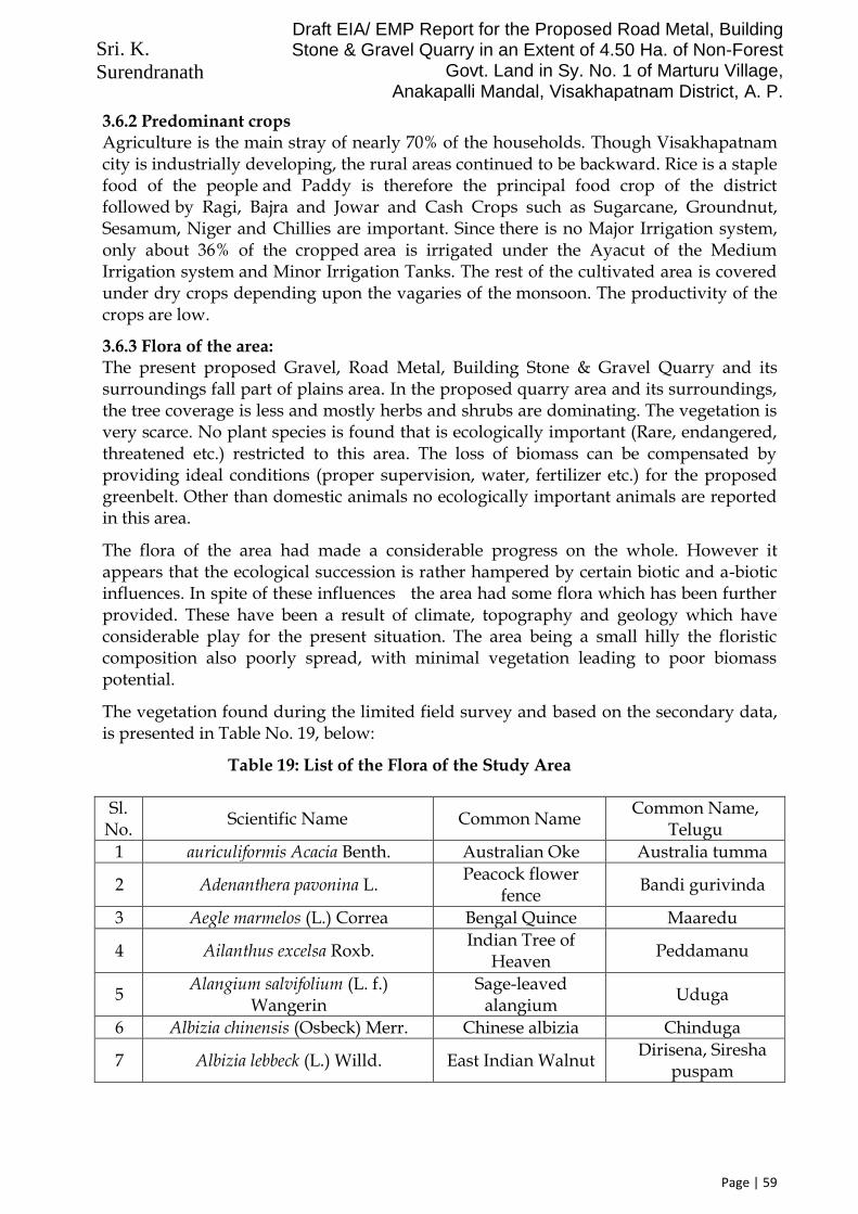
Sri. K. Surendranath
Draft EIA/ EMP Report for the Proposed Road Metal, Building Stone & Gravel Quarry in an Extent of 4.50 Ha. of Non-Forest
Govt. Land in Sy. No. 1 of Marturu Village, Anakapalli Mandal, Visakhapatnam District, A. P.
Page | 59
3.6.2 Predominant crops Agriculture is the main stray of nearly 70% of the households. Though Visakhapatnam city is industrially developing, the rural areas continued to be backward. Rice is a staple food of the people and Paddy is therefore the principal food crop of the district followed by Ragi, Bajra and Jowar and Cash Crops such as Sugarcane, Groundnut, Sesamum, Niger and Chillies are important. Since there is no Major Irrigation system, only about 36% of the cropped area is irrigated under the Ayacut of the Medium Irrigation system and Minor Irrigation Tanks. The rest of the cultivated area is covered under dry crops depending upon the vagaries of the monsoon. The productivity of the crops are low.
3.6.3 Flora of the area: The present proposed Gravel, Road Metal, Building Stone & Gravel Quarry and its surroundings fall part of plains area. In the proposed quarry area and its surroundings, the tree coverage is less and mostly herbs and shrubs are dominating. The vegetation is very scarce. No plant species is found that is ecologically important (Rare, endangered, threatened etc.) restricted to this area. The loss of biomass can be compensated by providing ideal conditions (proper supervision, water, fertilizer etc.) for the proposed greenbelt. Other than domestic animals no ecologically important animals are reported in this area.
The flora of the area had made a considerable progress on the whole. However it appears that the ecological succession is rather hampered by certain biotic and a-biotic influences. In spite of these influences the area had some flora which has been further provided. These have been a result of climate, topography and geology which have considerable play for the present situation. The area being a small hilly the floristic composition also poorly spread, with minimal vegetation leading to poor biomass potential.
The vegetation found during the limited field survey and based on the secondary data, is presented in Table No. 19, below:
Table 19: List of the Flora of the Study Area
Sl. No.
Scientific Name Common Name Common Name,
Telugu
1 auriculiformis Acacia Benth. Australian Oke Australia tumma
2 Adenanthera pavonina L. Peacock flower
fence Bandi gurivinda
3 Aegle marmelos (L.) Correa Bengal Quince Maaredu
4 Ailanthus excelsa Roxb. Indian Tree of
Heaven Peddamanu
5 Alangium salvifolium (L. f.)
Wangerin Sage-leaved
alangium Uduga
6 Albizia chinensis (Osbeck) Merr. Chinese albizia Chinduga
7 Albizia lebbeck (L.) Willd. East Indian Walnut Dirisena, Siresha
puspam

Sri. K. Surendranath
Draft EIA/ EMP Report for the Proposed Road Metal, Building Stone & Gravel Quarry in an Extent of 4.50 Ha. of Non-Forest
Govt. Land in Sy. No. 1 of Marturu Village, Anakapalli Mandal, Visakhapatnam District, A. P.
Page | 60
Sl. No.
Scientific Name Common Name Common Name,
Telugu
8 Albizia saman (Jacq.) Merr. Rain Tree Nidraganneru
9 Alstonia scholaris (L.) R.Br. Devil tree, white
cheesewood Edakula pala
10 Alstonia venenata R.Br. Poison Devil Tree Chinna edakula
pala
11 Anacardium occidentale L. Cashe Nut Zeedimamidi
12 Annona reticulata L. Bull's heart Rama phalam
13 Annona squamosa L. Custard apple Seeta phalam
14 Anogeissus acuminata (Roxb. ex
DC.) Guill. & Seneg. Button tree Pasi chettu
15 Anogeissus latifolia (Roxb. ex DC.)
Wall. Axlewood Sirimanu
16 Araucaria columnaris (Forst.) Hk. Monkey puzzle tree Christmas tree
17 Areca catechu L. Areca palm Pokachekka
18 Artocarpus heterophyllus Lam. Honey Jack tree Panasa
19 Azadirachta indica A. Juss. Neem Vepa
20 Bauhinia purpurea L. Pink bauhinia Devakanchanam
21 Bauhinia tomentosa L. yellow bauhinia
22 Bixa orellana L. Lipstick tree Mitayirangu
23 Bombax ceiba L. Red silk cotton Erra buruga
24 Borassus flabellifer L. Palmyra Palm Tati chettu
25 Brownea coccinia Jacq. Rose of
Venezuela
26 Butea monosperma (Lam.) Taub. Flame of the
forest Moduga
27 Caesalpinia coriaria (Jacq.) Willd. American Sumach
Divi Divi
28 Caesalpinia pulcherrima (L.) Peacock Flower Chinna turayi
29 Callistemon lanceolatus (Sm.) Sweet Bottle brush Bottle brush
30 Calophyllum inophyllum L. Alexandrian
laurel Ponna chettu
31 Carica papaya L. Papaya Boppayi
32 Caryota urens L. Fish tail palm Jeeluga
33 Cascabela thevitia (L.) Lippold Yellow oleander Pachha ganneru
34 Cassia fistula L. Golden shower Reela
35 Cassine glauca (Rottb.) O. Kuntze Ceylon Tea Nirija
36 Casuarina equisetifolia Forst. &
Forst f. Sae oke Sarugudu
37 Ceiba pentandra (L.) Gaertn. White silk
cotton Pachha buruga

Sri. K. Surendranath
Draft EIA/ EMP Report for the Proposed Road Metal, Building Stone & Gravel Quarry in an Extent of 4.50 Ha. of Non-Forest
Govt. Land in Sy. No. 1 of Marturu Village, Anakapalli Mandal, Visakhapatnam District, A. P.
Page | 61
Sl. No.
Scientific Name Common Name Common Name,
Telugu
38 Citrus aurantifolia (Christm.)
Swingle Limon Nimma
39 Citrus aurantium L. Orange Narinja
40 Citrus limon (L.) Burm. Lemon Dabba
41 Citrus sinensis (L.) Osbeck Sweet orang Bathai
42 Cocos nucifera L. Coconut plam Kobbari, tenkaya
43 Cordia dichotoma Forest. Earth cake tree Nakkeri
44 Cordia sebestena L. Aloe Wood tree
45 Couroupita guinensis Aubl. Cannon ball tree Naga lingam
46 Crateva magna (Lour.) DC. Sacred garlic
pear
47 Cycas circinalis L. Fern palm
48 Cycas revoluta Thunb. Japanese sago
palm Madana kamashi
49 Cycas sphaerica Roxb. Kodhada chettu
50 Delonix regia (Boj. ex Hook.) Rafin. Gulmohar Tureyi
51 Dichrostachys cinerea (L.) Wighth
& Arn. Sickle Bush Veluturu
52 Diospyros chloroxylon Roxb. Illenda
53 Diospyros ferrea (Willd.) Bakh. Black ebony Pisinika
54 Diospyros malabarica (Desr.)
Kostel. Malabar ebony Neeti tumiki
55 Dypsis lutescens (H.Wendl.)
Beentje & J.Dransf. Bamboo palm
56 Elaesis guuneensis Jacq. Oil palm Palm oil chettu
57 Enterolobium timbouva Mart. Earpod tree
58 Erioglossum rubiginosum Bl. Rusty sapindus
59 Erythrina variegata L. Indian Coral
tree Badita
60 Erythroxylum monogynum Roxb. Bastard Sandal,
Red cedar Devadari
61 Eucalyptus globulus Labill. Southern blue-
gum Jamail
62 Euphorbia antiqiorum L. Antique Spurge Jemudu
63 Euphorbia caducifolia Haines. Leafless Milk
Hedge Katte jemudu
64 Euphorbia pulcherrima Willd. ex
Klotzsch Christmas Star
65 Euphorbia tirucalli L. Pencil cactus Katimandu
66 Ficus amplissima Sm. Bat tree Jeechettu
67 Ficus benghalensis L. Indian Fig tree Marri

Sri. K. Surendranath
Draft EIA/ EMP Report for the Proposed Road Metal, Building Stone & Gravel Quarry in an Extent of 4.50 Ha. of Non-Forest
Govt. Land in Sy. No. 1 of Marturu Village, Anakapalli Mandal, Visakhapatnam District, A. P.
Page | 62
Sl. No.
Scientific Name Common Name Common Name,
Telugu
68 Ficus benjamina L. Weeping fig
69 Ficus elastica Roxb. Indian Rubber Rabbaru chettu
70 Ficus hispida L. f. Wild Fig Bodda marri
71 Ficus racemosa L. Cluster fig tree
72 Ficus religiosa L. Wisdom tree Raavi
73 Flacourtia indica (Burm.f.) Merr. Indian plum Kanavegu chettu
74 Flueggea virosa (Roxb. ex Willd.)
Royle Bushweed
75 Gardenia latifolia Ait. Papra Bikki
76 Gliricidia sepium (Jacq.) Kunth ex
Walp. Quickstick Madri
77 Grevillea robusta A. Cunn. ex R.Br. Silver Oke Silver oke
78 Guaiacum officinale L. Guaiacwood
79 Guazuma ulmifolia Lam. Bastard Ceder
80 Haldinia cordifolia (Roxb.) Ridsd. Haldu Kamba
81 Hamelia patens Jacq. Hamelia
82 Hibiscus mutabilis L. Cotton rosemallow Muddamandara
83 Hibiscus rosa-sinensis L. China rose Mandara
84 Hibiscus schizopetalus (Dyer) Hook.
f. Coral hibiscus
85 Hibiscus tiliaceus L. Coast cotton tree Etagogu
86 Hymenodictyon orixense (Roxb.)
Mabb. Bridal Couch,
bandaaru-chettu Dudippa
87 Ixora coccinia L. flame of the woods Rama banum
88 Ixora finlaysoniana Wall. ex G.Don Fragrant Ixora,
White Siamese Ixora
Tellaguttupulu
89 Ixora pavetta Andrews Torch tree Korivi
90 Jacaranda mimosifolia D. Jacaranda
91 Jacquinia ruscifolia Jacq. Jaqinia
92 Jatropha curcas L. Barbados nut Adavi amudam,
Pedda nepalam
93 Kigelia africana (Lam.) Benth. Susage tree Enugu kaaya
94 Lagerstroemia indica L. Bonnet flower Chinna gogu
95 Lagerstroemia speciosa (L.) Pers. Queen's pride Varagogu
96 Lannea coromandelica (Houtt.) Merr. Indian ash tree Gumpina
97 Lawsonia inermis L. Henna plant Gorinta
98 Leucaena leucocephala (Lam.) de Wit Subabul Chandra chettu
99 Licuala grandis Wndl. Ruffled Fan Palm
100 Litsea deccanensis Gamble Deccan Tallow
Laurel Naaramamidi

Sri. K. Surendranath
Draft EIA/ EMP Report for the Proposed Road Metal, Building Stone & Gravel Quarry in an Extent of 4.50 Ha. of Non-Forest
Govt. Land in Sy. No. 1 of Marturu Village, Anakapalli Mandal, Visakhapatnam District, A. P.
Page | 63
Sl. No.
Scientific Name Common Name Common Name,
Telugu
101 Madhuca indica J. Gmelin Indian Butter tree Ippa
102 Magnolia champaca (L.) Baill. ex
Pierre Champak Chettu champanga
103 Mangifera indica L. Mango Mamidi
104 Manihot glaziovii Müll. Arg. Ceara rubber tree Rabbaru chettu
105 Manilkara hexandra (Roxb.) Dubard Ceylon Iron wood Pala
106 Manilkara zapota (L.) P. Royen Sapodilla Sapota
107 Melaleuca bracteata F. Muell. Black tea-tree, River
tea-tree
108 Memecylon edule Roxb. Kaayam, Delek
bangas Alli
109 Millingtonia hortensis L. f. Cork tree Kada malle
110 Mimusops elengi L. Spanish cherry Pogadu
111 Mitragyna parviflora (Roxb.) Korth. Water cadamba Neer kadamba
112 Morinda coreia Buch.-Ham. Tohari wood Togaru
113 Moringa oleifera Lam. Drum Stick Munaga
114 Muntingia calabura L. Chinese Cherry BP paluu
115 Murraya koenigii (L.) Spreng. Curry leaf Karivepaku
116 Murraya paniculata (L.) Jack Orange Jasmine Puvelaga
117 Mussaenda erythrophylla Schum. &
Thonn. Red Flag Bush
118 Mussaenda frondosa L. Dhobi tree
119 Neolamarckia cadamba (Roxb.)
Bosser Kadam Kadamba
120 Nerium oleander L. Oleander Erra ganneru
121 Nyctanthes arbor-tristis L. Night-flowering
Jasmine Parijatam
122 Ochna obtusata DC. Ramdhan Champa,
Mickey-mouse
123 Ochna squarrosa L. Bird's-eye bush
124 Parkia biglandulosa Wight & Arn. Badminton Ball
Tree Tennis ball
125 Peltophorum pterocarpum (DC.)
Barker ex Heyne Rusty Shield Bearer Coffee pod
126 Phoenix sylvestris (L.) Roxb. Wield date palm Eeta
127 Phyllanthus acidus (L.) Skeels Star gooseberry Racha Usiri
128 Phyllanthus emblica L. Indian Goose Berry Usiri
129 Pisonia grandis R.Br. Lettuce tree Aravapappu kura
130 Pithecellobium dulce (Roxb.) Benth. Manilla tamarind Chema chinta
131 Plumeria alba L. Temple tree Nuru vahalu
132 Plumeria rubra L. Temple tree Deva ganneru

Sri. K. Surendranath
Draft EIA/ EMP Report for the Proposed Road Metal, Building Stone & Gravel Quarry in an Extent of 4.50 Ha. of Non-Forest
Govt. Land in Sy. No. 1 of Marturu Village, Anakapalli Mandal, Visakhapatnam District, A. P.
Page | 64
Sl. No.
Scientific Name Common Name Common Name,
Telugu
133 Polyalthia longifolia (Sonner) Thw. Ashoka Naramamidi, Asoka
134 Pongamia pinnata (L.) Pierre Indian Beech tree Ganuga/Kamu
135 Posoqueria latifolia Aubl. Monkey apple
136 Premna mollissima Roth Dusky leaved fire
brand Nelli
137 Prichardia pacifica Seem. & Wendl. Fiji Fan Palm
138 Prosopis chilensis (Molina) Stuntz Chilean mesquite Tella tumma,
Kanche tumma
139 Psidium guajava L. Guava Jama
140 Pterocarpus santalinus L. f. Red sandal Erra chandanam
141 Punica granatum L. Pomegranate Danimma
142 Putranjiva roxburghii Wall. Lucky Bean Tree Puttaranjivi
143 Ravenala madagascariensis Sonn. Travellar palm Travellar palm
144 Ricinus communis L. Caster Amudam
145 Roystonea regia (H.B. & K.) O.F.
Cook Royal palm Bojja chettu
146 Santalum album L. Sandal wood Chandanam,
Gandam
147 Sapindus emarginatus Vahl. Soap nut Konkudu, Ritta kaya
148 Saraca asoca (Roxb.) de Wilde Ashoka Tree Ashoka chettu
149 Semecarpus anacardium L. Marking nut Nallazeedi
150 Senna siamea (Lam.) H.S. Irwin &
Barneby Kassod tree Chetuu tangedu
151 Senna spectabilis (DC.) H.S. Irwin &
Barneby Yellow cassia
152 Sesbania sesban (L.) Egyptian
riverhemp Avisa
153 Shorea robusta Gaertn. f. Sal Guggilam
154 Spathodea campanulata P. Beauv. African tulip Tulip
155 Sterculia foetida L. Jangle Badam Seema badam
156 Sterculia urens Roxb. Gum karaya Kovela, Tapasi
157 Streblus asper Lour. Sand Paper Tree, Toothbrush tree
Barnika
158 Switenia mahagoni (L.) Jacq. Mahogany Mahagani
126 Syzygium cumini (L.) Skeels Indian Cherry Neredu
160 Tabebuia argentea (But. & K. Schum)
Britt. Silver Trumpet Tree
161 Tabebuia aurea (Silva Manso) Benth.
& Hook.f. ex S.Moore Caribbean trumpet
tree
162 Tabebuia rosea (Bertol.) DC. Rosy trumpet tree
163 Tamarindus indica L. Tamarind Chinta

Sri. K. Surendranath
Draft EIA/ EMP Report for the Proposed Road Metal, Building Stone & Gravel Quarry in an Extent of 4.50 Ha. of Non-Forest
Govt. Land in Sy. No. 1 of Marturu Village, Anakapalli Mandal, Visakhapatnam District, A. P.
Page | 65
Sl. No.
Scientific Name Common Name Common Name,
Telugu
164 Tecoma stans (L.) Kunth Yellow trumpet
flower Swarna ganneru
165 Tectona grandis L. f. Teak Teku
166 Terminalia arjuna (Roxb. DC.)
Wight. & Arn. Arjun tree Tella maddi
167 Terminalia bellirica (Gaertn.) Roxb. Beleric Tanikaya
168 Terminalia catappa L. Indian Almond Badam
169 Thespesia populnea (L.) Soland. ex
Correa India tulip tree Ganga raavi
170 Thuja orentalis L. Tree of life
171 Wendlandia heynei (Roem. & Schult.)
Santapau & Merchant Tilki Tellapucu
172 Wrightia tinctoria R.Br. Ivory wood Ankudu
173 Ziziphus mauritiana Lam. Chinese date Regu
3.6.4 Common Fauna found in the area: There are very few faunal composition is sited as the vegetation is medium to poor and the natural water resource is also poor. In fact no mammals have been sighted over the area. Few animals found were rodents and reptiles. However some species of birds do visit casually. Some were occasional visiting to area could be are Sloth-Bears, Jackals and Foxes.
Some lizards, and other reptiles were noticed. Amphibians as not there as it is very dry area. Monitor Lizard, Wall Lizards, and common garden lizards are present. Some non-poisonous snakes like rat snakes are common. Green snakes, water snakes, are found in the area.
There are no wild life sanctuaries in the area.
The bird life in general may be considered to be in better shape as the poachers are restricted. A good number of species live in and around area as well visits the area. The common birds those visit and harbor some time were Crows, Sparrows, Myna, Parrots, are checked in sometimes. Vultures are also seen 3.7 Socio-Economic Environment
3.7.1 Introduction: The study of socio-economic component of environment incorporates various facets, viz. demographic structure, availability of basic amenities such as housing, education, health and medical services, occupation, water supply, sanitation, communication and power supply, prevailing diseases in the region as well as features such as places of tourist attraction and monuments of archaeological importance. The study of these parameters helps in identifying predicting and evaluating the likely impacts due to project activity in the surrounding region.

Sri. K. Surendranath
Draft EIA/ EMP Report for the Proposed Road Metal, Building Stone & Gravel Quarry in an Extent of 4.50 Ha. of Non-Forest
Govt. Land in Sy. No. 1 of Marturu Village, Anakapalli Mandal, Visakhapatnam District, A. P.
Page | 66
In the 10 km radius study area map, as per 2011 census, the study area consists of 3,91,989 persons inhabited in 60 villages. The statistics regarding the list of villages, number of households and human population is given in Table 20.
TABLE 20 : DEMOGRAPHY IN STUDY AREA
Village Name
No. of House Holds
Total Population
1 Maruturu 300 1165
2 Makavaram 389 1441
3 Vooderu 754 2750
4 Makavaram 389 1441
5 Gurranapalem 947 3727
6 Mamidipalem 674 2690
7 Papayya Santha Palem 252 960
8 Papayya Palem 155 626
9 Kapushettivaripalem 2192 9412
10 Rebaka 743 2848
11 Sankaram 621 2431
12 Thummapala 8074 31035
13 Anakapalle (M) 22679 86519
14 Sirasapalle 646 2405
15 Sundarayyapeta 436 1709
16 Vetajangalapalem 362 1459
17 Mondipalem 121 495
18 Kundram 962 3791
19 Kunchangi 3 15
20 Dibbapalem 549 2097
21 Mettapalem 252 853
22 Muddurthi 512 1998
23 M.Kothapalle 177 672
24 Bhogapuram 329 1422
25 kannapalem 712 2754
26 Govada 798 3156
27 Rayapurajupeta 717 2524 28 Gajapathinagaram 556 2030
29 Juttada 617 2325
30 Thotada 1448 5053
31 Lakkavaram 1162 4273
32 Mallampeta 38 139
33 Gullepalle 652 2610
34 Garugubilli 308 1290
35 Bangarammapalem 414 1629
36 Aripaka 758 2939

Sri. K. Surendranath
Draft EIA/ EMP Report for the Proposed Road Metal, Building Stone & Gravel Quarry in an Extent of 4.50 Ha. of Non-Forest
Govt. Land in Sy. No. 1 of Marturu Village, Anakapalli Mandal, Visakhapatnam District, A. P.
Page | 67
Village Name
No. of House Holds
Total Population
37 Adduru 583 2300
38 Narasapuram 160 512
39 Amberupuram 992 3901
40 Allikhanudupalem 171 684
41 Sampathipuram 277 1031
42 Venkupalem 187 834
43 Kotturu 130 517
44 Rajupalem 1255 4578
45 Koppaka 471 1808
46 Maredupudi 905 3416
47 siramSettipalem 245 1011
48 Yerukunaidupalem 227 1061
49 Nallaregulapalem 206 729
50 Lagisettipalem 133 544
51 Gopalapuram 513 1991
52 Mallam Bhupathipalem 142 506
53 Koduru 1904 6597
54 Pisinikada 1149 4327
55 Ummalada 623 2401
56 Gandhavaram 650 2464
57 Gali Bhimavaram 295 1247
58 Sabbavaram 16221 67334
59 Kasimkota 17438 67262
60 Chodavaram (CT) 5426 20251
TOTAL 1,01,001 3,91,989
3.7.2 Methodology used for the Field survey In order to access and evaluate likely impacts arising out of any development projects on socio economic environment, it is necessary to gauge the apprehensions of the people in the study areas.
3.7.3 Methodology applied for selection of sample & data collection The methodology which is applied for primary source of data collection i.e. gathering data through field survey for socio-economic environment is depicted below:
A Sampling Method A judgmental and purposive sampling method was used for choosing respondents of various sections of the society i.e. Village Assistant, adult males and females, teachers, medical practitioners, businessmen, agriculture laborers, unemployed group etc. Judgmental and purposive sampling method includes the right cases from the total population that helps to fulfill the purpose of research needs.

Sri. K. Surendranath
Draft EIA/ EMP Report for the Proposed Road Metal, Building Stone & Gravel Quarry in an Extent of 4.50 Ha. of Non-Forest
Govt. Land in Sy. No. 1 of Marturu Village, Anakapalli Mandal, Visakhapatnam District, A. P.
Page | 68
B Data Collection Method For the process of data collection through primary source farming methods are used. 3.7.4 Field Survey and Observations Field survey and observations is made at each sampling village and the socio- economic status of that region is studied. Visits are made at hospitals, primary health centers and sub-centers to know the health status of the region. Various Governmental organizations such as Statistical Department, Census Department etc. were visited to collect the requisite details of that region.
Table 21: List of Sampling Villages
# Village Name
01 Papayya Santapalem
02 Makavaram
03 Marturu
04 Allikhandupalem
3.7.5 Data Collection and Quality Assurance The latest available data have been complied to generate the existing socio- economic scenario of the study area. Information on socio-economic profile was collected from the Primary Census Abstract CD 2011, including the population details of the region and Village Directory CD 2011, having the details of basic amenities available in the region.
3.7.6 Distribution of Population: The distribution of population in the study area is shown in Table: 22
TABLE 22: DISTRIBUTION OF POPULATION
Particulars Rural Urban Total
Total Population 2,37,142 1,54,847 3,91,989
Male Population (% with total population)
1,18,193 (50%)
76708 (49.53%)
1,94,901 (49.72%)
Female Population (% with total population)
1,18,949 (50%)
78139 (50.46)
1,97,088 (50.27%)
No. of Households 61916 39085 101001
Average Household Size 3.83006 3.961801 3.881041
Sex ratio (Female/1000 male) 1006.396 1018.655 1011.221
Source: Census of India 2011
The configuration of male and females indicates that the males constitute to about 49.72 % and females to about 50.27% of the study are Vishakapatnam District population. The sex ratio i.e. the number of females per 1000 males indirectly reveals certain sociological aspects in relation with female births, infant mortality among female children and single person family structure, a resultant of migration of industrial workers. The study area at an average has 1011 females per 1000 males.

Sri. K. Surendranath
Draft EIA/ EMP Report for the Proposed Road Metal, Building Stone & Gravel Quarry in an Extent of 4.50 Ha. of Non-Forest
Govt. Land in Sy. No. 1 of Marturu Village, Anakapalli Mandal, Visakhapatnam District, A. P.
Page | 69
3.7.7 Social Structure Majority of the people in the study area belong to Hindu religion. The study area also contains Scheduled Castes (SC) and Scheduled Tribes (ST). The distribution of population of socially weaker sections in the study area is shown in Table: 23
TABLE: 23 Distribution of Population by Social Structure
Category Population
Total Population 3,91,989 (92%)
Scheduled Castes 25,878 (6%)
Scheduled Tribes 6,253 (2%)
Total SC and ST 32,131(8.1%)

Sri. K. Surendranath
Draft EIA/ EMP Report for the Proposed Road Metal, Building Stone & Gravel Quarry in an Extent of 4.50 Ha. of Non-Forest
Govt. Land in Sy. No. 1 of Marturu Village, Anakapalli Mandal, Visakhapatnam District, A. P.
Page | 70
In the study area 6% of the population belongs to Scheduled Castes (SC) while 2% to Scheduled Tribes (ST), thus indicating that about 8.1% of the population is formed by SC and ST population. Scheduled Caste and Scheduled Tribe sections are predominant in this area. 3.7.8 Literacy Levels The distribution of literates and literacy rates in the study area are given in Table: 24 below:
TABLE 24: Literacy Level
Particulars Population
Total Population 3,91,989
Male population 1,94,901
Male literates 1,32,401
Female population 1,97,088
Female literates 1,04,390
Total literates 2,36,791
% of study area literates to total population 60.40756
Male literacy rate (%) 67.93244
Female literacy rate (%) 52.96619
The study area experiences a moderate literacy rate of 60%. The male literacy i.e. the percentage of literate males to the total males of the study area is observed as 67.93% while female literacy rate, which is an important indicator for social change, is observed as 52.39% in the study area. 3.7.9 Occupational Structure The occupational structure of the study area is studied with reference to main workers, marginal workers and non-workers. The main workers include 10 categories of workers defined by the Census Department consisting of cultivators, agricultural laborers, those engaged in live-stock, forestry, fishing etc. mining and quarrying; manufacturing,

Sri. K. Surendranath
Draft EIA/ EMP Report for the Proposed Road Metal, Building Stone & Gravel Quarry in an Extent of 4.50 Ha. of Non-Forest
Govt. Land in Sy. No. 1 of Marturu Village, Anakapalli Mandal, Visakhapatnam District, A. P.
Page | 71
processing and repairs in household industry; and other than household industry, construction, trade & commerce, transport & communication and other services.
Due to boom in mining in recent years majority of farmers as well as agriculture laborers are engaged in the mining activity. This information is not forthcoming from the Published Census Data.
The marginal workers are those engaged in some work for Vishakapatnam period of less than six months during the reference year prior to the census survey. The non-workers include those engaged in unpaid household duties, students, retired persons, dependents, beggars, vagrants etc.; institutional inmates or all other non-workers who do not fall under the above categories. The occupational structure of the study area is shown in Table: 25.
TABLE 25: Occupational Structure of Study Area
Occupation Total
Nos. % to population
Total Workers 1,67,200 42.65426
Casual Labor 16,815 4.289661
Agricultural laborers 37,696 9.616596
Household laborers 3,335 0.850789
Other workers 68,540 17.48518
Total main workers 1,33,749 34.1206
Marginal workers 33,451 8.533658
Non-workers 2,24,789 57.34574
Total population 3,91,989 100
Altogether the main workers work out to be 42.65% of the area population. The marginal workers and non-workers constitute to 8.53% and 57.34% of the population respectively. The distribution of workers by occupation indicates that the workers in the casual labor are 4.28% followed by agricultural laborers are 9.61% and other workers are 17.48% respectively. The occupational profile of total workers and their proportion to the total population of the study area is shown graphically in the figure below:

Sri. K. Surendranath
Draft EIA/ EMP Report for the Proposed Road Metal, Building Stone & Gravel Quarry in an Extent of 4.50 Ha. of Non-Forest
Govt. Land in Sy. No. 1 of Marturu Village, Anakapalli Mandal, Visakhapatnam District, A. P.
Page | 72
3.7.10 Salient Observation of the Survey/ Study Area ❖ House pattern: It is notable that nearly 85-90% of the houses were semi pakka
with good construction and others were pakka at survey area. ❖ Employment: Main occupation of the people in the study area was labour work
and some of agriculture. The labours were getting daily wage in the range of Rs. 200-300, depending on type of work involved.
❖ Fuel: Most of the villagers use fire woods and LPG for cooking purpose ❖ Main Crops: Rice is a staple food of the people and Paddy is therefore the
principal food crop of the district followed by Ragi, Bajra and Jowar and Cash Crops such as Sugarcane, Groundnut, Sesamum, Niger and Chillies are important. Since there is no Major Irrigation system, only about 36% of the cropped area is irrigated under the Ayacut of the Medium Irrigation system and Minor Irrigation Tanks. The rest of the cultivated area is covered under dry crops depending upon the vagaries of the monsoon.
❖ Migration: During survey it was found that local population were migrating for employment purpose. As well as others state peoples were came in that area for the labour work also.
❖ Sanitation: Toilet facility is one of the most basic facilities required in a house. The findings of the survey show that more than 85% of the households were having toilet facilities in their houses. There was open drainage system were seen at the surveyed villages. The overall condition of cleanliness was satisfactory.
❖ Drinking Water Facilities: Ground water is the major source of drinking water in the villages wherein hand pumps, tap water and dug wells are installed.
❖ Education Facilities: Most of the villages had education facilities in the form of Anganwadi and Primary Schools. Higher education facilities were available in the range of 2-3 km. Colleges and other diploma courses were available at district headquarters.
❖ Transportation Facility: For transportation purpose Auto, Public and Private Bus services were available. Transportation facilities were frequently available in the study area and connecting major cities. Private vehicles like Bicycles & Motor Cycles were mostly used by villagers for transportation purpose
❖ Road Connectivity: Most of the roads were pucca and connecting to villages. Blacktop and cement roads were commonly seen inside the villages
❖ Communication Facilities: For communication purpose mainly mobile phones, newspaper & post offices were seen in the villages.
❖ Medical Facilities: There were few health care facilities available in the study area. In some of the villages, Primary Health Sub-Centers were available. Hospitals and other better medical facilities were available in the range of 05-10 km at town/city place
❖ Electricity: All villages were availing electricity facility for all uses ❖ Market Facility: Study area was predominantly rural and semi urban type. In
villages, small shops were available for daily needs. Weekly market facility was available in some villages. Wholesale markets were available at town place.

Sri. K. Surendranath
Draft EIA/ EMP Report for the Proposed Road Metal, Building Stone & Gravel Quarry in an Extent of 4.50 Ha. of Non-Forest
Govt. Land in Sy. No. 1 of Marturu Village, Anakapalli Mandal, Visakhapatnam District, A. P.
Page | 73
3.8 Waste generation: 3.8.1 Solid Waste:
Mining plan has been prepared for period a five years and the period of lease is about 10 years. As per the approved mining plan, the estimated quantity of waste generation will be about 69,500 m3 for the plan period and is about 1,39,000 m3 for the lease period. This waste, being predominantly weathered rock, will be used for maintenance and strengthening of the approach road (between the quarry and crusher). Excess quantity of waste will be dumped within the lease as shown in the plan.
3.8.2 Leachates: Granitic Gneiss rejects are not hazardous and do not contain any toxic elements. Leachates will be innocuous because all soluble material has been washed out.
3.8.3 Soil: There is not much topsoil generation, due to the fact that, it is a quarry under renewal. If any quantity is generated, it will be used for plantation works.

Sri. K. Surendranath
Draft EIA/ EMP Report for the Proposed Road Metal, Building Stone & Gravel Quarry in an Extent of 4.50 Ha. of Non-Forest
Govt. Land in Sy. No. 1 of Marturu Village, Anakapalli Mandal, Visakhapatnam District, A. P.
Page | 74
CHAPTER 4 ANTICIPATED IMPACTS AND MITIGATION MEASURES
4.1 Land Environment:
4.1.1 Anticipated Impact On topography: Lease area is 4.50 Hectares, and is a part of hilly terrain. The proposed quarry land is not a grazing or agriculture land. It is part of Non-Forest Government Land, for which, the project authorities have obtained the in-principle grant (in the form of Letter of Intent) for 1st renewal, from the Dept. of Mines & Geology, Andhra Pradesh. The proposed quarry area, is renewed in favour of the proponent. Approx. 2,74,050 CuM has been excavated during the previous lease period. Only one (01) first order stream is passing at a distance of 120m from the western boundary of the proposed area and is outside the lease area. The present appearance of the proposed quarry area, is shown below:
It is seen that there is not much top soil, except some quantity scattered at places, within the present area. Hence, there is no agriculture within the present lease area and its immediate surroundings. The Quarry Lease area is Topographically Highly Elevated area. The Maximum Elevation is 216 M and the Minimum Elevation is 126 M. therefore the relief is 90 m. The quarry lease area is located on a hill raised with an elevation 216 M AMSL on Northern side, with the base level as 126 M AMSL on the Southern side, within the quarry lease area of 4.50 hectares. Working in these quarries along the present quarry, to eastern side to western side. At present the working is being undertaken above the ground surface, with Topo relief in East and West direction 90 m. The lowest contour is 126 M but GL as consider as 70m(GL) and highest contour is 216 M in Topo plan for the Quarry. The Quarry area is surrounded by many other Quarries, of which some are operational and some are non-operational. Sloping

Sri. K. Surendranath
Draft EIA/ EMP Report for the Proposed Road Metal, Building Stone & Gravel Quarry in an Extent of 4.50 Ha. of Non-Forest
Govt. Land in Sy. No. 1 of Marturu Village, Anakapalli Mandal, Visakhapatnam District, A. P.
Page | 75
towards south and west with gentle but eastern side slope is high. The hill tilted towards Southern direction.
The entire hillock is part of Sy. No. 1 of Marturu Village, devoid of any major vegetation. Plants of typical dry lands in Visakhapatnam District covers the foot of the lease area besides thorny shrubs. Since the present QL area, is at considerable height from the surrounding ground level, there would not be any adverse impact on a) topography/drainage or land use, b) agriculture etc. This being an open cast mining proposal subsidence in the nearby area is not expected. Also, being a hard khondalite mass, slope failures are also not anticipated. The external appearance will continue to be as it is.
4.1.2 Mitigation Measures: Geological records on khondalite deposits state that considerable quantity of khondalite, with fractured zones, would be present in the QL area. Extraction of this khondalitic boulders, will be done, as per the approved mining plan, which states that all recorded deposits as ‘proved mineable reserves’ would not be mined within the lease period/ conceptual period of mine. Hence, there will be considerable reserves will still be available even after the lease period. Further, the anticipated quantity of saleable gravel, Road Metal, Building Stone & Gravel is about 90% of the total quantity excavated, resulting in 10% waste.
4.2 Air Environment:
Flow chart for Road Metal, Building Stone & Gravel production proposed at Marturu Quarry, is shown below:
4.2.1 Anticipated Impact(s). 4.2.1.1 Emission Inventory: At present there is no activity over the proposed lease area. There are no sources of gaseous pollutants. Processing of Road Metal, Building Stone & Gravel, within the lease area is not proposed. There will not be any crushing & grinding etc. within the quarry area. Hence Sulphur dioxide, nitrous oxides will not be contributed during the quarrying operations.
4.2.1.2Prediction of Fugitive Emissions in the Project: In the proposed Road Metal, Building Stone & Gravel Quarry, it is envisaged to adopt wet drilling followed by controlled blasting for separation of boulders from the primary rock. Hence, there will be some nominal fugitive particulate matter emissions. However, the net increase in the Ground Level Concentrations, found to be negligible.
To control the fugitive emissions, the following mitigative measures will be followed:
QUARRY DRILLING
&
BLASTING
SPLITTING
TRANSPORT LOADING

Sri. K. Surendranath
Draft EIA/ EMP Report for the Proposed Road Metal, Building Stone & Gravel Quarry in an Extent of 4.50 Ha. of Non-Forest
Govt. Land in Sy. No. 1 of Marturu Village, Anakapalli Mandal, Visakhapatnam District, A. P.
Page | 76
4.2.2 Mitigation Measures:
During Mining ➢ Bore hole Drills of 32mm diameter will be used. Wet drilling is proposed. ➢ Personal protection equipment will be issued to drillers. ➢ Road in lease will be macadamized. ➢ Tipper trucks will be covered.
Greenbelt ➢ There are no major trees existing within the lease area, except some bushes and
thorny plants. ➢ The entire lease area, being a sheet rock, it is not possible for plantation, even in the
7.5m wide buffer zone/ safety zone of the QL area. ➢ It is proposed to take-up plantation, on both sides of approach road, and also in the
vacant government land, with trees of wide canopy like gulmohor, neem etc. ➢ There is some topsoil, scattered at places, within the lease area and will be utilized
for plantation purpose, on both sides of the approach road, to support trees.
4.3 Water Environment (surface & ground water)
4.3.1. Impact on hydrology, alteration in natural drainage etc. There are no surface sources viz. rivers/ lake within the proposed quarry lease area. There is only one (01) first order stream passing at a distance of 120m from the western boundary of the proposed area and is outside the lease area. This first order stream will have run-off only during monsoon. Apart from that, the nearest major water body to the proposed quarry lease area is Marturu Cheruvu at a distance of 1.10 KM SSE and Sarada River, at a distance of 3.50 km towards SSW. The present quarrying activity, will be limited to a maximum depth of 50m from top, which will still be above 45m from the surrounding ground level. Hence there will not be any kind of disturbance to ground water.
Dewatering of working pits will be required since there will be formation of one quarry pit. However, khondalite deposited pit water, doesn’t have any adverse impact on the health of animals or human beings. Also, ground water regime will not be disturbed.
Hydrology: Average rainfall: 1115 mm/year
4.3.2 Anticipated Impact: There are no surface sources and ground water regime will not be altered during mining. There would not be any impact if stored rainwater in the quarry pits is used for dust control.
Likelihood of washing-away of loose solid particles from the quarry lease area, into the nearby first order streams, originating from the proposed lease area, during monsoon, which ultimately flows into Marturu Cheruvu, located at a distance of 1.10 km towards SSE of the proposed quarry.
The nearest major water body to the proposed quarry lease area is Sarada River, at a distance of 3.50 km towards SSW, doesn’t have any significant impact on its hydrology, due to the fact that the flow pattern from the above proposed quarry lease area, doesn’t flow that side.

Sri. K. Surendranath
Draft EIA/ EMP Report for the Proposed Road Metal, Building Stone & Gravel Quarry in an Extent of 4.50 Ha. of Non-Forest
Govt. Land in Sy. No. 1 of Marturu Village, Anakapalli Mandal, Visakhapatnam District, A. P.
Page | 77
4.3.3 Mitigation Measures: I. With respect to the first order streams, it is proposed to construct garland drain,
gully plugs, using the boulders from the quarry, along the southern boundary of the quarry, to prevent soil erosion and consequent washing of loose particles into the first order stream, passing outside the quarry lease area on the west side.
II. It is proposed to provide silt traps, to the first order streams, before they join the second order stream.
III. Entry to un-authorized persons will be prohibited. IV. Ground water in khondalite deposit areas, will be free from fluoride. V. A Caution Board would be put at mine that mine pit water is unfit for drinking.
All well/hand pump water will be tested for fluoride and other parameters and suitability or otherwise will be displayed.
VI. In absence of alternate sources in nearby village, a water treatment plant will be installed at a hand pump for supply of drinking water. Treatment plant based on electrochemical method of treatment will be suitable.
VII. Unused/abandoned pits will be converted in to rain water harvesting structures so that ground water recharge is assured.
VIII. Mine water, if required for community drinking water supply, will be treated by a water treatment plant with following flow sheet.
- Pump
- Rapid sand filter
- Clear water tank storage after disinfection&
- Supply
4.3.4 Rainwater Harvesting and Plan for Water Conservation: Ground water recharge in not expected, as there is no scope for rain water collection.
Rain water collected on the quarry surface will flow down the hillock and will enter into the nearby streams. Hence, no accumulation of storm water is anticipated in the proposed quarry. However, as a responsible corporate citizen, we will do rain water harvesting pits in the nearby government land.
4.3.4.1 RAINWATER HARVESTING In the nearby villages open drains will be made to collect the storm waters for rain water harvesting. The designs and construction details that will be carried out, as follows:
Rain Water Harvesting Structure (RWHS) for Ground water Recharge:
Size: 1.0m x 1.0m x 1.5m Table 26: Construction Details of Rain Water harvesting system
Sr. No Volume, Cu.m Description
1 1.50 Excavation in Hard Gravelly and all available soils
2 0.75 65 mm metal
3 0.375 20 mm metal
4 0.175 Coarse sand
5 0.24 CRS masonry in 1:6 prop.

Sri. K. Surendranath
Draft EIA/ EMP Report for the Proposed Road Metal, Building Stone & Gravel Quarry in an Extent of 4.50 Ha. of Non-Forest
Govt. Land in Sy. No. 1 of Marturu Village, Anakapalli Mandal, Visakhapatnam District, A. P.
Page | 78
4.4 Noise Environment: 4.4.1 Anticipated Impact: There are no industrial noise sources in the lease. There are no sensitive receptors like hospitals, schools, old age homes etc., within 1 km radial distance. Only source during mine operation would be drilling, blasting and movement of quarrying machinery. Drillers would be exposed to about 75-80 dB(A).
4.4.2 Mitigation Measures: ➢ In case of Road Metal, Building Stone & Gravel Quarrying, there will be
involvement of blasting, for extraction of boulders. Due to this, moderate noise pollution is anticipated, intermittently. The vibrations during drilling will be absorbed by the mother rock. Hence, there would not be any major adverse impact.
➢ Drillers would be given personal protection equipment. ➢ There are no structures over the lease
4.5 Biological Environment: 4.5.1 Anticipated Impact:
There is no sensitive fauna and flora or endangered species in 10 km radius of the lease. Lease is not a part of any forest area. This area is not known for any kind of biodiversity.
4.5.2 Mitigation Measures: Project proponent will carry out plantation in scientific way. It will choose local species in consultation with local forest department. Secondly State Fisheries department will be requested to carry out fish culture in abandoned mine pits.

Sri. K. Surendranath
Draft EIA/ EMP Report for the Proposed Road Metal, Building Stone & Gravel Quarry in an Extent of 4.50 Ha. of Non-Forest
Govt. Land in Sy. No. 1 of Marturu Village, Anakapalli Mandal, Visakhapatnam District, A. P.
Page | 79
4.6 Socioeconomic &Health: 4.6.1 Anticipated Impacts:
There will not be any displacement on account of this project because land has already been granted (in-principle) in favour of Sri. K. Surendranath. Land is non –agriculture and is not being put to any use.
4.6.2 Mitigation Measures: It is proposed to a) prefer employment to deserving local persons in mining related trades like loading/unloading of boulders/ waste, drilling etc. b) train residents of nearby villages, for harvesting rain water, and sanitation practices etc., c) training in fish culture also is one activity which will be useful to local population.
4.7 Mine wastes: 4.7.1 Anticipated Impacts:
The expected waste generation will be about 69,500 m3 during the plan period and is about 1,39,000 m3 during the lease period. This being predominantly weathered rock, it is expected not to cause any adverse impact on prevailing mine lease environment. Leachates from dumps will not contain any toxic material.
4.7.2 Mitigation Measures: During proposed mining, major quantity of the waste generated will be used for maintenance and strengthening of the approach road. Excess waste, if any, will be stored in an area of 0.45 Hectares, earmarked within the lease area.
Physical stability of dump will be ensured since it will be designed as per I.B.M. norms. A garland drain will be provided to collect runoff from the dumps.
Reclamation/Closure Plan: Lease area is 4.50 Ha. and only 2.950 Hectares will be opened during the lease period, for execution of this project.
All mineable reserves are not expected to be exhausted at the end of present lease period. Hence, as per the prevailing practice, the lessee will apply for the extension of the lease period, in the form of renewal.
Reclamation or closure of mine will be planned only, at the time of the final closure of the quarry. There would not be any municipal waste since any residential colony is not proposed over the lease.
4.8 Occupational Health Hazards
4.8.1 Physical Hazards 1. Traumatic injury remains a significant problem and ranges from the trivial to the
fatal. Common causes of fatal injury include rock fall, mobile equipment accidents, falls from height, entrapment and electrocution.
2. Noise is almost ubiquitous in mining. It is generated by drilling, blasting, materials handling, and ore transportation. Controlling noise has proven difficult in mining and noise-induced hearing loss remains common.
3. Whole body vibration is commonly experienced whilst operating mobile equipment, such as load –haul –dump units, trucks, scrapers and diggers. This

Sri. K. Surendranath
Draft EIA/ EMP Report for the Proposed Road Metal, Building Stone & Gravel Quarry in an Extent of 4.50 Ha. of Non-Forest
Govt. Land in Sy. No. 1 of Marturu Village, Anakapalli Mandal, Visakhapatnam District, A. P.
Page | 80
can cause or exacerbate pre-existing spinal disorders. Poorly maintained roads and vehicles contribute to the problem. Hand –arm vibration syndrome is also encountered with the use of vibrating tools such as air leg rock drills.
4.8.2 Biological Hazards The risk of tropical diseases such as malaria and dengue fever is substantial at some remote mining locations. Leptospirosis and ankylostomiasis were common in mines, but eradication of rats and improved sanitation has controlled these hazards effectively.
4.8.3 Ergonomic Hazards Although mining has become increasingly mechanized, there is still a substantial amount of manual handling. Cumulative trauma disorders continue to constitute the largest category of occupational disease in mining and often result in prolonged disability. Broken ground is often encountered and can cause ankle and knee injuries.
4.8.4 Psychological Hazards Drug and alcohol abuse has been a difficult issue to deal with in mining. Debate continues about how to measure psychophysical impairment. Nevertheless, mining operations commonly require the measurement of urinary drug metabolites and breath or blood alcohol on pre-employment and following accidents. Remote locations are common in mining with mine employees separated from their families and communities during work periods.
Expatriate placements are also common in mining and the associated psychosocial hazards have been reviewed recently. Unfortunately, fatal and severe traumatic injuries continue to occur in mining and often have a profound impact on morale. Post-traumatic stress disorders sometimes develop in witnesses, colleagues and managers. Registered managers often feel personally responsible for such injuries, even in the absence of negligence, and face the ordeal of government inquiries and legal proceedings.
4.8.5 Mitigation Measures: Mining activities are associated with dust emissions and can be hazardous to workers particularly during drilling, blasting and loading. Associated health hazards will be respiratory/ pulmonary and some injury to eye may be likely. Therefore health status before commencement of mining (pre-employment medical check-up), record of each worker will be maintained. A competent doctor shall be engaged for bi-annual health evaluation during pre-mining and mining period. Data will be accrued and achieved as per the format mentioned below.
Name:
Present occupation: farmer, miner, any other specified.
Post applied for: miner, driller, operator, sorter/hand picking, loaders etc.
Past history; pneumonia, T.B, HIV, asthma, cough, alcohol, tobacco, etc.
Blood pressure, pulse:
Eye sight:

Sri. K. Surendranath
Draft EIA/ EMP Report for the Proposed Road Metal, Building Stone & Gravel Quarry in an Extent of 4.50 Ha. of Non-Forest
Govt. Land in Sy. No. 1 of Marturu Village, Anakapalli Mandal, Visakhapatnam District, A. P.
Page | 81
Hearing test:
Chest X–ray:
Others (If any):
Table 27: Occupational Safety and Health Program
Program Definition Study Elements
Surveillance Assessment for the condition of Occupational Hygiene and Factors in the organization with interpretation of health data.
Availability and use of PPE
Appropriate workers exposure to the work zone
Injury and illness
Improvement of data collection and surveillance system
Health Effect Study
Determination of the health outcomes of plant related activities through study of individual workers.
Epidemiology
Toxicology
Physical exposure (Heat, Noise, Vibration, Radiation, Others.)
Exposure Assessment Study
Measurement of the extent of exposure to Workers
Assessment tools
Assessment strategies
Intervention Study
Study comprises of all approaches to identify and control accidental risks
Control system (Engineering, Administrative and PPE)
Emergency preparedness and response (Communication, Escape ways, Others)
Work Organization (Innovative work schedule, Plant characteristics, etc.)
Policy and regulation
Community participation
Diffusion and dissemination (Effectiveness training and information)
Maintenance of data related to OH and S
Log book of workers health and available infrastructure
Training program
Computer program
Reports and papers
Workshop and seminars
4.9 Traffic Density: Maximum saleable production is 1,25,100 m3 / Annum of Road Metal, Building Stone & Gravel. Considering an operating calendar of 300 days per year, the average saleable production will be about 417 m3 per day, which is about 1043 Tons/ day (bulk density of 2.5 Tons/m3). Considering an average carrying capacity of truck as 17 Tons, the number of truck trips will be about 61-62 trips per day. Further, considering an operating hours of 10 hours per day, about 6-7 trips will be added to

Sri. K. Surendranath
Draft EIA/ EMP Report for the Proposed Road Metal, Building Stone & Gravel Quarry in an Extent of 4.50 Ha. of Non-Forest
Govt. Land in Sy. No. 1 of Marturu Village, Anakapalli Mandal, Visakhapatnam District, A. P.
Page | 82
the existing traffic of 18 Heavy vehicles per hour, on the nearby Makavaram-Marturu Road.
4.9.1 Anticipated Impact: The impact on traffic due to the proposed quarry has been divided into three stretches viz. a) between the quarry & crusher unit; b) between the Crusher Unit to the Makavaram-Marturu Road and the Makavaram-Marturu Road itself. a) Impact on the approach road between Quarry & Crusher Unit: This road, is an existing WBM road connecting the proposed quarry area to the crusher site and this will be exclusively used by the proposed quarry and other quarries being hired by the proponent. Hence it may not cause any significant impact on this approach road. b) Impact on the Road between Crusher Unit to Makavaram-Marturu Road: The Crusher unit, is processing the boulders from their existing quarries and also purchased from other sources nearby. The production from the proposed quarry will be an add-on to the existing capacity. The installed capacity of the Crusher unit is about 300 TPH and considering an operating schedule of 10 hours per day, the anticipated output will be about 3,000 Tons/Day. Considering an average truck capacity of 15 Tons/ Trip, the expected no. of trips will be about 200 trips per day and with an operating schedule of 10 hours per day, the anticipated increase in volume will be about 20 Trips per hour. The PCU factor for a 15 Ton tipper/trailer is about 4.5 (as per IRC), which will eventually result in a traffic volume of 90 PCU/ Hour. c) Impact on Traffic on Makavaram-Marturu Road: It is assumed that, 50 of the material will be sent towards Makavaram side, and the balance 50% will be sent towards Marturu side. Hence it may not have a significant impact on the existing traffic. Considering the road condition in Stretch a) and b) above, it may get damaged due to plying of 15 tonner tipper over a span of 0.5 km and 0.3 km respectively on a WBM road. Here it is important to mention that Makavaram-Marturu Road is capable to accommodate the incremental traffic density of 200 tippers a day, i.e. about 100 trips/ day each towards Makavaram Side and Marturu side.
4.9.2 Mitigation Measures Traffic will be regulated using flagging. The trucks carrying the materials will be covered with tarpaulins, to avoid any spillage along the haulage road. All tippers/ trucks will be periodically checked to confirm exhaust norms. Traffic signages will be provided. A flagger will manage traffic at convergence point of the approach road and national highway to avoid possible mishap. 4.10 Soil 4.10.1 Anticipated Impact As such there is not much top soil/ OB is expected to be generated during the lease period, due to the fact that the proposed quarry is under 1st renewal and was

Sri. K. Surendranath
Draft EIA/ EMP Report for the Proposed Road Metal, Building Stone & Gravel Quarry in an Extent of 4.50 Ha. of Non-Forest
Govt. Land in Sy. No. 1 of Marturu Village, Anakapalli Mandal, Visakhapatnam District, A. P.
Page | 83
operated during the previous lease period. The top soil, if any generated during the present lease period, will be used for plantation purposes on either side of the approach road. Also the gravel will be sold to the construction industry in the nearby towns and for road works.
They have not caused any adverse impact on prevailing mine lease environment. Leachates from dumps will not contain any toxic material.
During proposed mining 1,39,000 m3 of mineral rejects/ waste material will be generated, during the lease period. This, mainly being a weathered tock, will be used for strengthening of the approach road and other nearby village roads. Excess quantity, if any, will be stored over 0.450 hectares of land within the lease area and will be used for backfilling of the quarry pit. The dump height and other measures will be as per IBM norms.
4.10.2 Mitigation Measures A garland drain will be provided to collect runoff from the dumps. Also a storm water drain of 1m x 1m will be provided along the lease boundary so that runoff during rainy season cannot flow in to nearby area. This water will be collected in the quarry pit and utilized during mining operations.
There will be no potential of eroding in to and degrading any surface water.
Sum up: ✓ Mining activity will lead to creation of benches, on an extent of 2.950 Hectares,
with maximum cutting of 50 m, at the end of lease period. ✓ Environmental impacts can be managed by implementation of management
plan. ✓ Mining activity will create direct and indirect employment. ✓ Though interception of ground water is not involved. ✓ Mining activity will lead to create green belt. ✓ Up to some extent socioeconomic needs of village will be addressed through
project activities.

Sri. K. Surendranath
Draft EIA/ EMP Report for the Proposed Road Metal, Building Stone & Gravel Quarry in an Extent of 4.50 Ha. of Non-Forest
Govt. Land in Sy. No. 1 of Marturu Village, Anakapalli Mandal, Visakhapatnam District, A. P.
Page | 84
CHAPTER 5 ANALYSIS OF ALTERNATIVES
5.1 General: Present proposal is for Road Metal, Building Stone & Gravel Mining from 4.50 Hectares of non-forest government land. The proponents, Sri. K. Surendranath, have got the in-principle grant for 1st renewal, in the form of Letter of Intent (LOI), from the State Government. Sri. K. Surendranath’s officials are professional mining personnel. As per regulations they had engaged an RQP (Recognized Qualified Person) to prepare a mining plan for approval by Dept. of Mines & Geology. No choice for alternative for site is available due to identification and allotment of mineral lease to project proponent by the State Government.
5.2 Site Studies: Both Sri. K. Surendranath’s officials and the RQP have inspected the site and studied the occurrence of Road Metal, Building Stone & Gravel deposits at the site and other geological features in order that the same could be mined safely, economically and in an environment friendly manner. Mapping of Road Metal, Building Stone & Gravel was completed. Then section wise details of reserves were worked.
There is no mining being carried-over over the lease at present, except some test pits.
It was decided that it would be appropriate to opt for “Open Cast Semi-Mechanized Method” which would enable economical mining, at a maximum saleable production of 1,25,100 m3 per Annum of Road Metal, Building Stone & Gravel, with an average saleable production of 1,25,100 m3 per annum of Road Metal, Building Stone & Gravel.
5.3 Alternate Method of Mining: Other alternatives for method of opencast mining like manual mining would be unscientific and economically not viable. Use of surface-miner equipment is not possible for Road Metal, Building Stone & Gravel mining.

Sri. K. Surendranath
Draft EIA/ EMP Report for the Proposed Road Metal, Building Stone & Gravel Quarry in an Extent of 4.50 Ha. of Non-Forest
Govt. Land in Sy. No. 1 of Marturu Village, Anakapalli Mandal, Visakhapatnam District, A. P.
Page | 85
CHAPTER 6 Environmental Monitoring Programme
6.1 Environmental Monitoring Programme: Water Quality Monitoring: It has been decided that proposed lease being a khondalite deposit area water quality in pits, nearby wells and hand pumps may need not be regularly monitored. However, as a precautionary measure, water quality from the nearby sources will be verified and mitigation measures (if any required) will be implemented accordingly. Water quality measurement will be quarterly. Particulate Matter: PM emissions from fugitive sources will be quantified by measurement of ambient air quality during drilling and blasting by a competent agency. Dust control by water sprinkling will be ensured. AAQ monitoring in lease will be monitored on a quarterly basis, during active mining. Noise: A standard noise meter will be issued to mine manager who will measure noise levels and maintain a record. Occupational Health: Health record of miners will be entrusted to a registered medical doctor. He will maintain record as per industrial/occupational hygiene requirements. 6.2 Monitoring Programme:
Table 28: Monitoring Programme
Env. Segment Parameter Frequency
Water quality IS 10500 quarterly
G.W. table Fluctuation in monsoon & post monsoon period
May & October
AAQ Particulate matter PM10 & PM2.5
during mining-Quarterly
Noise Equivalent noise levels during drilling and blasting: Quarterly
Health Pulmonary function, eye sight, audiometry, B.P. etc.
Annual record
Plantation annual survival rate
Data analyses Efficiency of mitigation measures Half Yearly
Monitoring and analysis will be carried out as per monitoring and testing methods prescribed by MoEFCC & CPCB.

Sri. K. Surendranath
Draft EIA/ EMP Report for the Proposed Road Metal, Building Stone & Gravel Quarry in an Extent of 4.50 Ha. of Non-Forest
Govt. Land in Sy. No. 1 of Marturu Village, Anakapalli Mandal, Visakhapatnam District, A. P.
Page | 86
Year No. of trees
Location Peripheral lease in Acres
Along haul road Area in ha.
A budget of Rs. 2.00 Lakhs is earmarked for the activity.
6.3 Plantation Programme:
About 500 saplings will be planted on either side haulage road and also in the vacant government land. One cubic metre pits will be made and will be filled with local soils from lease. Refuse or garbage will be added as per availability. Growth in the first year will be observed. Species will be chosen from the following and depending on availability.
Table 29: Species proposed for plantation
Common name Botanical name
Sunari Cassia fistula
Kanchan Bahunia variegata & accuminate
Pink cassia Cassia nodasa & Cassia javanica
Baheda Terminalia bellirica
Neem Azadirachta indicia
Pangamia Pongamia pinnata
Table 30: Green Belt program Year wise
Year No of trees Location Total Area in ha
1st 250 trees Avenue plantation, on either side of the
approach road, between the Quarry-Crusher Site and Makavaram-Marturu Road and in the vacant government land adjoining the quarry
area
0.300
2nd 250 trees - Do -
TOTAL 500 trees 0.300 ha
A budget of Rs. 4,00,000 (Total) is earmarked for implementation of plantation programme.

Sri. K. Surendranath
Draft EIA/ EMP Report for the Proposed Road Metal, Building Stone & Gravel Quarry in an Extent of 4.50 Ha. of Non-Forest
Govt. Land in Sy. No. 1 of Marturu Village, Anakapalli Mandal, Visakhapatnam District, A. P.
Page | 87
CHAPTER 7: ADDITIONAL STUDIES
7.1 Public Consultation: This is the draft EIA report, prepared in line with the Terms of Reference (TOR) and additional Terms of Reference, issued by State Environment Impact Assessment Authority (SEIAA), Andhra Pradesh, following the SEAC (State Expert Appraisal committee) meeting. This report will be circulated prior to public hearing under the auspices of APPCB (Andhra Pradesh Pollution Control Board). Issues raised during public hearing will be addressed in the final EIA/EMP Report. 7.2 Risk Assessment and Disaster Management Plan: Any mines have dangers or risk like fires, inundation, failure of machinery, which need to be investigated, addressed and mitigated. Disaster management is formulated with an aim of taking precautionary steps to avert disaster and also to take such action after the disaster which limits the damage to the minimum. Preliminary Risk assessment is based on the philosophy that “Prevention is better than cure”. Mining operations may be carried to the utmost safety but there is always some element of danger or risk in it. No major disaster is envisaged. Only minor accidents may take place. No perennial source of surface water is present in the ML area. Blasting in ore body will be proposed. The mining operations will be carried out under supervision of statutory personnel’s as per provisions of MCR 1960, MCDR 1988, Mines Rules 1955, Mines Act 1952 & strictly following safety aspects as per MMR 1961 monitored by Directorate General of Mines Safety (DGMS). The lease area does not come under active seismic zone. Land slide, subsidence is not expected in view of opencast mining. No river is near the applied area and hence flood is not expected. Since opencast mining will be proposed, problems related with underground mines are not applicable. In case of eventuality, first aid will be given by the competent authority initially to the injured person. The competent person/ Mines manager or Mining Engineer will give notice of accident as per Rule-23 of Mines Act-1952. The persons/competent authorities named above will be responsible for co-ordinations between management district authorities / DGMS etc. Regarding general safety as per Rule-181 of MMR 1961, “No person shall negligently or willfully do anything likely to endanger life or limb in the mine, or negligible or will fully omit to do anything necessary for the safety of the mine or of the persons employed there in”. The workers will be provided with protective foot wear and safety helmets.
The complete mining operation will be carried out under the management control and direction of a qualified Mine Manager holding a Second Class Manager’s Certificate of competency to manage a metalliferous mine granted by the DGMS. The DGMS have been regularly issuing standing orders, model standing orders and circulars to be followed by the mine management in case of disaster, if any. Moreover, mining staff will be sent to refresher courses from time to time to keep them alert. However, following natural/industrial hazards may occur during normal operation.

Sri. K. Surendranath
Draft EIA/ EMP Report for the Proposed Road Metal, Building Stone & Gravel Quarry in an Extent of 4.50 Ha. of Non-Forest
Govt. Land in Sy. No. 1 of Marturu Village, Anakapalli Mandal, Visakhapatnam District, A. P.
Page | 88
➢ Accident due to explosives; ➢ Accident due to heavy mining equipment; and ➢ Sabotage in case of magazine.
In order to take care of above hazard/disaster, the following control measures will be adopted;
➢ All safety precautions and provisions of Mine Act, 1952, Metalliferous Mines Regulation, 1961 and Mines Rules, 1955 will be strictly followed during all mining operations;
➢ Entry of unauthorized persons will be prohibited; ➢ Firefighting and first aid provisions in the mines office complex and mining area ➢ Provisions of all the safety appliances such as safety boot, helmets, goggles etc.
will be made available to the employees and regular check for their use; ➢ Training and refresher courses for all the employees working in hazardous
premises; Under Mines vocational training rules all employees of mines shall have to undergo the training at a regular interval;
➢ Working of mine, as per approved mine plan and regularly updating the mine plans;
➢ Cleaning of mine faces will be regularly done; ➢ Handling of explosives, charging and blasting will be carried out by competent
persons only; ➢ Provisions of magazine at a safe place with fencing and necessary security
arrangement; ➢ Regular maintenance and testing of all mining equipment as per manufacturer’s
guidelines; ➢ Suppression of dust on the haulage roads; ➢ Adequate safety equipment will be provided at explosive magazine; and ➢ Increasing the awareness of safety and disaster through competitions, posters
and other similar drivers.
For any type of above disaster, a rescue team will be formed by training the mining staff with specialized training. 7.2.1 Hazard Identification and Their Analysis The identification of hazards has been done considering these operations. The hazards have been covered under three broad activities that are part of the proposed surface mining operations: winning the mineral, transporting the mineral, and processing the mineral. Mining is a hazardous operation and consists of considerable environmental, health and safety risk to miners. Unsafe conditions in mines lead to a number of accidents and cause loss and injury to human lives, damage to property, interruption in production etc. The following section presents the different hazards in surface mines, their precautions and statistics of accidents in mines.

Sri. K. Surendranath
Draft EIA/ EMP Report for the Proposed Road Metal, Building Stone & Gravel Quarry in an Extent of 4.50 Ha. of Non-Forest
Govt. Land in Sy. No. 1 of Marturu Village, Anakapalli Mandal, Visakhapatnam District, A. P.
Page | 89
7.2.1.1 Blasting Most of the accidents from blasting occur due to the projectiles, as they may sometime go even beyond the danger zone, mainly due to overcharging of the shot-holes as a result of certain special features of the local ground. Flying rocks are encountered during initial and final blasting operations. Vibrations also lead to damage of properties in nearby areas. Dust and noise are also problems commonly encountered blasting operations.
7.2.1.2 Overburden The overburden dumps may cause landslides. High overburden dumps created at the quarry edge may cause sliding of the overburden dump or may cause failure of the pit slope due to excessive loading, thereby causing loss of life and property. Siltation of surface water may also cause run-off from overburden dumps.
7.2.1.3 Heavy Machinery Most of the accidents during transport of dumpers proclaim and dozers and other heavy vehicles are often attributable to mechanical failure and human errors.
7.2.1.4 Storage of Explosive The applicant will take license from controller of explosive, to store explosive in magazine. The storage of explosives will be done in accordance with the Indian Explosive Act, 1984 and the Rules made there under. The explosives will be supplied by the explosive van of 10 ton capacity approved by Chief Controller of Explosive, Nagpur. The main hazard associated with the storage, transport and handling of explosives is fire and explosion.
7.2.1.5 Fuel Storage Most of the HEMM will operate on diesel. However, no major storage is envisaged at the mine Lase area. A diesel tanker will be provided for the crawler mounted machines operating in the mine.
Open Cast Mining
Drilling & Blasting
Transportation Of Ore to Crushing
Loading Weathered Rock/ Gravel
Removal
Exploitation Of Ore
Ecological Risk (Land,
Air & Water)
Dust Noise

Sri. K. Surendranath
Draft EIA/ EMP Report for the Proposed Road Metal, Building Stone & Gravel Quarry in an Extent of 4.50 Ha. of Non-Forest
Govt. Land in Sy. No. 1 of Marturu Village, Anakapalli Mandal, Visakhapatnam District, A. P.
Page | 90
7.2.1.6 Water Logging Water logging in the mine site have been avoided by adopting following measures;
➢ Correct marking of position of water bodies with their highest flood level and keeping the mine protected by suitable bunds
➢ Water from the surface water bodies shall not enter in the mines; ➢ Draining of mine water by suitable capacity pumps;
7.2.2 Safety Measures 7.2.2.1 Safety Measures at the Proposed Open Cast mining Project ➢ The opencast mine has been planned for working with shovel dumper system
which requires proper benching not only for slope stability but also for movement of dumpers and other heavy machinery. The inclination of the quarry
sides at the final stage i.e. at the dip most point will not exceed 45o to the horizontal. (This angle is measured between the line joining the toe of the bottom most bench to the crest of the top most bench and the horizontal line).
➢ The quarries will be protected by garland drains around the periphery for storm water drainage;
➢ A minimum safe distance of 100 m will be kept between the surface edge of the quarry and the nearest public building, roads etc. When the surface edge of the quarry approaches within a limit of 200 m from any road, public building special permission from DGMS will be taken to conduct controlled blasting to prevent damage/injury to public life and property;
➢ All mining operations both within the quarry and outside will be conducted as per the conditions laid down by DGMS and under strict supervision of competent persons appointed under Metalifierous Mine Regulation Act, 1961.
7.2.2.2 Measures Suggested to Avoid Accidents due to Blasting ➢ The blasting operation shall be supervised by a competent person appointed for
the purpose;
➢ The blasting operation shall be strictly conducted as per the guideline given in metalliferous mine regulation, 1961;
➢ Demarcation of danger zone area falling within a radius of 300 m from the blast site;
➢ All employee and equipment shall be cleared from the blast area and removed to a safe location prior to any scheduled blasting;
➢ To prevent unauthorized entry, guards shall be posted at all access points leading to the blast area; and
➢ Audible signals such as sirens, whistles, etc. shall be used to warn employees, visitors and neighbors about the scheduled blasting event.
➢ Only controlled blasting will be done to minimize damage to nearest structure

Sri. K. Surendranath
Draft EIA/ EMP Report for the Proposed Road Metal, Building Stone & Gravel Quarry in an Extent of 4.50 Ha. of Non-Forest
Govt. Land in Sy. No. 1 of Marturu Village, Anakapalli Mandal, Visakhapatnam District, A. P.
Page | 91
7.2.2.3 Measures to Prevent Failure of Overburden Dump ➢ In flat area where the dumping operations have come to an end, the slope angle
should be flattened by about 15o lower than the angle of repose which varies
from the site to site but not less than 25o.
➢ Planting vegetation as early as possible over the overburden dump slopes;
➢ Provide drainage channels along the overburden dump toe for additional protection, in such a way that a distance of 15 m should be maintained left between the overburden dump and the bench; and
➢ If a mine is abandoned, the bench and overburden dump should be separated from each other by digging a trench of 6 to 10 m width.
7.2.2.4 Measures to Prevent Accidents due to Trucks and Dumpers ➢ All transportation within the main working area should be carried out under the
direct supervision and control of the management;
➢ The vehicles must be maintained in good repairs and checked thoroughly at least once a week by a competent person authorized for this purpose by the management;
➢ Broad signs should be provided at each and every turning point specially for the guidance of the drivers at night;
➢ To avoid dangers while reversing the trackless vehicles, especially at the embankment and tripping points, all areas for reversing of lorries should, as for as possible, be made man free, and there should be a light and sound device to indicate reversing of trucks; and
➢ A statuary provision of the fence, constant education, training etc. will go a long way in reducing the incidence of such accidents.
7.3 Emergency response system A cell will be formed at Sri. K. Surendranath’s Quarry, for disaster management. Mine manager will be the Secretary. He will formulate a policy for the purpose of a) emergency steps at site during lightening conditions, b) deal with accidents, c) labour unrest etc.
7.4 Natural resource conservation: It has been decided to postpone mine closure plan in order to be able to conserve the khondalite reserves underneath the proposed depth in the present mining plan.
7.5 R & R, Corporate Social Responsibility action plan: Lease area is in possession of Sri. K. Surendranath. Therefore R & R plan per se is not required.

Sri. K. Surendranath
Draft EIA/ EMP Report for the Proposed Road Metal, Building Stone & Gravel Quarry in an Extent of 4.50 Ha. of Non-Forest
Govt. Land in Sy. No. 1 of Marturu Village, Anakapalli Mandal, Visakhapatnam District, A. P.
Page | 92
7.6 Corporate Social Responsibility: Sri. K. Surendranath, being a responsible citizen, will abide by all requirements of social responsibility. A few are mentioned below:
A few are mentioned below: (1) Supply of Drinking Water unit to the nearby Bowluvada Village, at an estimated
cost of Rs. 3.50 Lakhs (2) Project Proponent will organize annual health camp, in the nearby Marturu
village.
Table 31: CSR – funds
Activity Anticipated funds
Supply of Drinking Water unit to Bowluvada Village
Rs. 3.50 Lakhs (1 time investment)
Annual Health camps in the nearby Marturu village
Rs. 1,00,000/- per camp per annum
7.7 Corporate Environmental Responsibility: As per the provisions of MOEFCC office memorandum F-22-65/2017IA.III dated 1.05.2018, Sri. K. Surendranath, have earmarked an investment of Rs. 1,50,000/- towards CER (being 2% of the total capital cost) and this budget is earmarked for carrying out sanitation work and solid waste management for the village Marturu, by project proponent.

Sri. K. Surendranath
Draft EIA/ EMP Report for the Proposed Road Metal, Building Stone & Gravel Quarry in an Extent of 4.50 Ha. of Non-Forest
Govt. Land in Sy. No. 1 of Marturu Village, Anakapalli Mandal, Visakhapatnam District, A. P.
Page | 93
CHAPTER 8 PROJECT BENEFITS
8.1 Project Benefits Road Metal, Building Stone & Gravel deposits at Marturu area are of good quality. It has been being extracted by many lease holders, for quite some time. However, there is a very good market potential for Road Metal, Building Stone & Gravel from nearby Vizianagaram, Anakapalli and Visakhapatnam cities, from the construction industry. The proposed quarry lease area, is non- productive and unsuitable for agriculture.
Therefore mining will be in the interest of State revenue and of the people around. Direct and indirect employment to locals is assured.
● Improvement in Physical Infrastructure:
1. Implementation of time bound corporate social responsibility will lead to installation of drinking water plant in the nearby villages.
2. A provision for implementation of fish culture activity (optional) will lead to improve the skills of local needy people.
● Employment: Direct employment to 20 persons are expected. Out of which 15 persons will be of semiskilled and unskilled category and will be sourced from nearby villages. Indirect employment to 20-25 people is expected.
● Land Use There will be a small change in Land Use of the area due to the proposed mining activity. But Project activity will lead local socioeconomic benefit which will attract change in land use by developing small shops in the area, may be chance of developing better household infrastructures etc.

Sri. K. Surendranath
Draft EIA/ EMP Report for the Proposed Road Metal, Building Stone & Gravel Quarry in an Extent of 4.50 Ha. of Non-Forest
Govt. Land in Sy. No. 1 of Marturu Village, Anakapalli Mandal, Visakhapatnam District, A. P.
Page | 94
CHAPTER 9 ENVIRONMENTAL COST BENEFIT ANALYSIS
9.1 Environmental Cost Benefit Lease is a non-forest land. It has no major tree cover. There is sheet rock. Therefore there would not any damage to environmental quality.
Initiation of mining by Sri. K. Surendranath will improve revenue to the state without deterioration in environmental quality. On the contrary, population in nearby villages will become aware of importance of potable water quality and sanitation.
Openings for indirect employment to locals in plantation, fish culture (optional) are possible.
Project will create green inventory of 500 trees.
Apart from it project authority will implement village biodiversity conservation plan to conserve village flora, faunas etc.
Detailed budget is earmarked for the activities in Chapter 10. Recharge practices will lead to charge the aquifer.

Sri. K. Surendranath
Draft EIA/ EMP Report for the Proposed Road Metal, Building Stone & Gravel Quarry in an Extent of 4.50 Ha. of Non-Forest
Govt. Land in Sy. No. 1 of Marturu Village, Anakapalli Mandal, Visakhapatnam District, A. P.
Page | 95
CHAPTER 10 ENVIRONMENT MANAGEMENT PLAN
10.1 Administrative/ Technical Management Mines Manager of Sri. K. Surendranath’s Quarry, Visakhapatnam, will be the technical head for mining operations, who will be qualified mining engineer having awareness of prevailing environmental laws besides mining rules according to which open cast mining, management of wastes, water will have to be carried out.
Mine manager will adhere to the monitoring schedule included in Chapter 6. He will organize regular monitoring of ambient air and water quality and ensure enforcement of mitigation methods for control of particulate matter, as per DGMS norms.
Mine manager will keep a record of ground water quality in the nearby villages. Awareness camps on water quality and sanitation will be organized by mine manager.
A competent agency will be retained for environmental monitoring and for reports thereof which will be forwarded to APPCB/MoEFCC/SEIAA as per EC conditions.
10.2 Dust Control Plan Dust is the major pollutant generated from the mining operations. In case of Road Metal, Building Stone & Gravel mining, major dust would be generated during drilling, blasting and transportation of the material. However, the environmental control measures, proposed to control the fugitive emissions released during the production are given below:
Mines
• Dust masks will be provided to the workers especially working in the drilling operations.
• Excavation operations are proposed to be suspended during periods of very strong winds
• Emission from exhaust of compressors will be checked periodically to ascertain the engine efficiency
• Periodical monitoring through Respirable dust samplers shall be done to take corrective action.
• Plantation of wide leaf trees and tall grass along approach roads and on safety barrier zones will be done to suppress the spread of airborne dust.
• Afforestation over the inactive waste dump surfaces and over the backfilled areas shall be done
• Periodic health checkup for the workers as per OHS plan.
Haulage
• All haulage roads will be maintained regularly.
• Macadamizing of main approach roads will be carried out to reduce dust generation
• Water will be sprayed regularly on the roads by using water tankers. Carrying out experiments on dust suppressants and wetting agents and implementing the same if feasible.

Sri. K. Surendranath
Draft EIA/ EMP Report for the Proposed Road Metal, Building Stone & Gravel Quarry in an Extent of 4.50 Ha. of Non-Forest
Govt. Land in Sy. No. 1 of Marturu Village, Anakapalli Mandal, Visakhapatnam District, A. P.
Page | 96
• Regular and periodic maintenance of deployed machineries, to reduce smoke emission.
• Development of green barriers along the main approach roads.
• Avoiding over filling of tippers and consequent overturning on the roads
• Air quality will be regularly monitored both in the core zone and the buffer zone. A summary of control measures is given below.
Table 32: Summary of Control Measures
# Dust Source Control measure
1 Haulage Road • Compaction, gradation and drainage on both sides and development of greenbelts
• Proper maintenance. • Regular water spraying. • The main approach roads to the mine and waste
dumps will be macadamized.
2 Truck Movement • No overloading of trucks. • Enforcing speed limit. • Regular monitoring of the exhaust • Covering of the trucks with tarpaulin
3 Waste dumps • Peripheral dumping and compaction. • Water spraying on dump roads.
4 Mine pit • Regular water spraying in working areas. • Proper maintenance of HEMM • Proper height exhaust chimney to air compressor • Simultaneous backfilling of completely worked out
portions and plantation over the backfilled surface. • Provision of dust masks.
10.3 Village Biodiversity Conservation Plan: A detailed survey is carried out for flora and fauna at proposed quarry area and its surroundings. Detailed Inventory of flora and fauna, is given in Chapter No. 3 above (Para No. 3.6)
Village Biodiversity Conservation Plan: A program will be run by project proponent as part of Environmental Responsibility based on villagers’ participation to conserve existing biodiversity of the village area.
Methodology: A Panchayat level discussion will be called every year and village volunteers will be chosen. A list of species for plants, animals, birds, fishes according to their current status and importance will be prepared. This list will be totally based on villagers’ observations. Some scientific inputs required will be shared from experts if required and species population will be conserved, farmed as per action plan suggested below.
Action Plan: List of Species for conservation for a year will be tabulated as below:

Sri. K. Surendranath
Draft EIA/ EMP Report for the Proposed Road Metal, Building Stone & Gravel Quarry in an Extent of 4.50 Ha. of Non-Forest
Govt. Land in Sy. No. 1 of Marturu Village, Anakapalli Mandal, Visakhapatnam District, A. P.
Page | 97
Name of
Species
Scientific Name
Villagers Observation
Expert Opinion (if required)
Whether Endangered or
not
Analysis will be done as below:
Name of Species Root Cause species in danger
Suggested Response Action Plan
Action plan for Floral Species: 1] Awareness in local people for species to be conserved through meetings, volunteers, posters. 2] Target for plantation including identification of sites like road boundaries, waste lands, burial/crematorial area, gram panchayat, school peripheries etc. 3] Daily watering facility to planted saplings. 4] It will be ensured that no sapling will be planted below age of 2 years.
Action Plan for Fauna Species: 1] Awareness in local people for species to be conserved through meetings, volunteers, posters. 2] Awareness regarding importance of fauna in villagers. Advocacy to have good policy to save faunas. 3] Fauna habitat conservations. 4] Expert advice for conservation.
All these efforts will develop a culture to conserve village biodiversity apart from water, soil conservation.
10.4 Cost for Implementation of Environmental Management Plan
Table 33: Budget for implementation of Environmental Management Plan
Activity Capital investment, Rs. in lakhs
Recurring Budget, Rs. per Annum
Garland Drain, gully plugs, silt trap etc. for protection of 1st order streams, outside the quarry
0.50 10,000
Dust Suppression using water tanker
4.00 1,20,000
Environmental Monitoring - 60,000
Plantation Works 4.00 60,000
Health & Safety 1.00 50,000
Fire Prevention - 50,000
CSR 3.50 1,00,000
CER 1.50 --
Total Rs. 14.50 Lakhs Rs. 4,50,000

Sri. K. Surendranath
Draft EIA/ EMP Report for the Proposed Road Metal, Building Stone & Gravel Quarry in an Extent of 4.50 Ha. of Non-Forest
Govt. Land in Sy. No. 1 of Marturu Village, Anakapalli Mandal, Visakhapatnam District, A. P.
Page | 98
10.5 Cluster Environment Management Plan: The proposed Road Metal, Building Stone & Gravel Quarry of Sri. K. Surendranath, with an extent of 4.50 Hectares, is located in Sy. No. 1 of Marturu Village in Anakapalli Mandal of Visakhapatnam District, Andhra Pradesh.
As per the Clause No. (b) (i) of the Gazette Notification No. S.O. 2269 (E), dated 01st July 2016, issued by the Ministry of Environment, Forests & Climate Change, Government of India (Amendment of the EIA Notification 2006), “A cluster shall be formed when the distance between the peripheries of one lease is less than 500 meters from the periphery of other lease in a homogeneous mineral area which shall be applicable to the mine leases or quarry licenses granted on and after 9th September, 2013”.
Further, as per Clause No. (5) of the said Notification, “The leases not operative for three years or more and leases which have got environmental clearance as on 15th January 2016, shall not be counted for calculating the area of cluster, but shall be included in the Environmental Management Plan and the Regional Environmental Management Plan”.
Accordingly, the proponent has obtained the Cluster Certificate from the Asst. Director, Dept. of Mines & Geology, Anakapalli, vide Letter No. 6060/Q/2011, dated 18-10-2019, which states that, there are Twenty Four (24) quarry leases existing within 500m from the lease boundary of the above proposed quarry. The details of these leases falling in the cluster, are as under:
Details of other quarries falling in the same cluster
Sl. No
Lease Holder Name Lease From
Lease To
Extent in Hectares
Sy. No.
Village Mandal Status
1 Mahalakshmi Naidu 04-11-2007 03-11-2017 3.00 01 Marturu Anakapalli Working
2 N.Krishnayya 03-07-2007 02-07-2017 13.33 01 Marturu Anakapalli Working
3 M/s. Sri. Venkata Sasi Stone Crusher
18-01-2007 17-01-2017 7.44 01 Marturu Anakapalli Working
4 Sri. K. Vijaya Prasad 31-12-2005 30-12-2020 2.00 01 Marturu Anakapalli Working
5 M/s. Sri. Venkata Sasi Stone Crusher
14-07-2009 13-07-2024 7.90 01 Marturu Anakapalli Working
6 M/S Aparna Enterprises
27-12-2007 26-12-2017 2.55 01 Marturu Anakapalli Working
7 M/S Venkata Sasi Stone Crusher
04-06-2008 03-06-2018 8.00 01 Marturu Anakapalli Working
8 M/S Kartikeya nirmans pvt ltd
05-06-2008 04-06-2018 2.75 01 Marturu Anakapalli Working
9 P.Ashok Chandra Murthy Raju
07-06-2008 06-06-2018 2.25 01 Marturu Anakapalli Working
10 Sri. Venkatasasi Stone Crusher
21-07-2010 06-03-2018 6.50 01 Marturu Anakapalli Working
11 M/S Navodaya Granites
26-12-2007 25-12-2022 3.50 01 Marturu Anakapalli Working

Sri. K. Surendranath
Draft EIA/ EMP Report for the Proposed Road Metal, Building Stone & Gravel Quarry in an Extent of 4.50 Ha. of Non-Forest
Govt. Land in Sy. No. 1 of Marturu Village, Anakapalli Mandal, Visakhapatnam District, A. P.
Page | 99
Sl. No
Lease Holder Name Lease From
Lease To
Extent in Hectares
Sy. No.
Village Mandal Status
12 M/S Ultratech Cement Ltd
17-02-2011 04-01-2018 6.00 01 Marturu Anakapalli Working
13 P.Kasibabu 29-10-2008 28-10-2018 1.00 01 Marturu Anakapalli Working
14 M/s K. Katyayeni 17-11-2018 16-11-2028 4.50 01 Marturu Anakapalli Working
15 M/s SGX minerals pvt ltd
04-05-2010 16-11-2018 9.00 01 Marturu Anakapalli Working
16 M/S Navodaya Granite Industries
23-05-2009 22-05-2024 1.60 01 Marturu Anakapalli Working
17 M/S Trendet Rocks Pvt Ltd
25-02-2010 18-11-2024 9.00 1 Marturu Anakapalli Working
18 M/s Aparna enterprises 05-03-2013 04-03-2023 6.00 1 Marluru Ankapalli Working
19 Smt..T Vijayakumari 27-06-2015 26-06-2025 3.00 1 Marluru Ankapalli Working
20 M/S Gonthalamma Granites
07-06-2011 04-06-2018 2.50 1 Marluru Ankapalli Working
21 M/S Nauha Constructions
07-08-2012 04-06-2018 2.50 1 Marluru Ankapalli Working
22 M/S Madhucon Projects
27-10-2011 28-10-2026 4.50 1 Marluru Ankapalli Working
23 M Balaji 28-03-2013 27-03-2023 1.00 1 Marluru Ankapalli Working
24 M/S Rank Silicon Pvt Ltd
30-07-2015 01-02-2025 10.13 1 Marluru Ankapalli Working
Of the 24 existing quarry leases, within 500 radial distance of the present quarry, 21 leases with a total extent of 102.22 Hectares have been granted prior to 09th Sept. 2013, and hence are exempted from Cluster Effect, as per MoEFCC Notification No. S.O. 2269 (E), dated 01st July 2016. The remaining Three (03) leases (excluding the present lease) with a total extent of 17.63 Hectares are granted after 09th Sept. 2013. Hence, as per MoEFCC Notification No. S.O. 2269 (E), dated 01st July 2016, they become part of the cluster, for preparation of the cluster EMP. The total extent of the cluster, including the present lease area, will be 22.13 Ha > 5 Ha. (and less than 25 Ha.). Hence classified under B2 at Par with B1 category. Hence, as per the provisions notified under the Gazette Notification No. S.O. 2269 (E), dated 01st July 2016, issued by the Ministry of Environment, Forests & Climate Change, Government of India (Amendment of the EIA Notification 2006), the Cluster Environment Management Plan, has been prepared and enclosed as ANNEXURE-17, to this Report.

Sri. K. Surendranath
Draft EIA/ EMP Report for the Proposed Road Metal, Building Stone & Gravel Quarry in an Extent of 4.50 Ha. of Non-Forest
Govt. Land in Sy. No. 1 of Marturu Village, Anakapalli Mandal, Visakhapatnam District, A. P.
Page | 100
CHAPTER 11 SUMMARY & CONCLUSION
11.1 Overall Justifications for the Project Area around the proposed Road Metal, Building Stone & Gravel Quarry is known for khondalite deposits which are being used partially. Sri. K. Surendranath has decided to mine the available Road Metal, Building Stone & Gravel for production of aggregates, to cater to the demands of construction industry from nearby Visakhapatnam, Vizianagaram and Anakapalli towns.
RQP has prepared a mining plan to suit the type of deposits which are in the proposed area and can be mined by Open Cast Semi-Mechanized mining method without altering any tenet of environment. Lease is part of Non-Forest Government Land and is not an agricultural land or residential area. It has been leased-out by Sri. K. Surendranath
Mining rate will be 417 m3 per day (ROM, max.) with drilling and blasting.
11.2 Proponent and the need of the project ➢ Sri. K. Surendranath, a resident of Visakhapatnam City, in Andhra Pradesh, was
granted 1st Renewal of the quarry lease for extraction of Road Metal, Building Stone & Gravel, over an extent of 4.50 Hectares, in Non-Forest Government Land, bearing Sy. No. 1 of Marturu Village, Anakapalli Mandal, Visakhapatnam District, Andhra Pradesh, for a period of 10 years, w.e.f. 17.11.2018, by the Deputy Director of Mines & Geology, Visakhapatnam, vide Notice No.: 1314/Q2A/2019 dated 06/06/2019.
➢ Sri. K. Surendranath, is an individual, residing at Visakhapatnam City, Visakhapatnam District, Andhra Pradesh.
➢ The proposed Road Metal, Building Stone & Gravel Quarry Area is near Marturu Village, in Anakapalli Mandal of Visakhapatnam District, Andhra Pradesh, and is part of Sy. No. 1 of Marturu Village in Anakapalli Mandal of Visakhapatnam District. The proposed quarry area has been renewed in favour of the Proponent.
➢ The proposed Road Metal, Building Stone & Gravel Quarry Lease area, is located between Latitude of 17° 44' 21.80153" N to 17° 44' 31.43891" N and Longitude of 83° 00' 29.12578" E to 83° 00' 40.68470" E. The proposed quarry lease area is surrounded by other Road Metal, Building Stone & Gravel quarries. There are 24 existing mining leases, within 500 m radial distance of the present quarry.
➢ Of the 24 existing quarry leases, within 500 radial distance of the present quarry, 21 leases with a total extent of 102.22 Hectares have been granted prior to 09th Sept. 2013, and hence are exempted from Cluster Effect, as per MoEFCC Notification No. S.O. 2269 (E), dated 01st July 2016. The remaining Three (03) leases (excluding the present lease) with a total extent of 17.63 Hectares are granted after 09th Sept. 2013. Hence, as per MoEFCC Notification No. S.O. 2269 (E), dated 01st July 2016, they become part of the cluster, for preparation of the cluster EMP. The total extent of the cluster, including the present lease area, will be 22.13 Ha > 5 Ha. Hence classified under B2 at Par with B1 category.

Sri. K. Surendranath
Draft EIA/ EMP Report for the Proposed Road Metal, Building Stone & Gravel Quarry in an Extent of 4.50 Ha. of Non-Forest
Govt. Land in Sy. No. 1 of Marturu Village, Anakapalli Mandal, Visakhapatnam District, A. P.
Page | 101
➢ There is no agriculture on the proposed mining land.
➢ The Proponent had applied for Environmental Clearance to State Environment Impact Assessment Authority (SEIAA), Andhra Pradesh and they have issued the Terms of Reference (ToR), for carrying-out Environment Impact Assessment (EIA) studies and preparation of an EIA/ EMP (Environmental Management Plan), for the present Road Metal, Building Stone & Gravel Quarrying, vide Lr No. SEIAA/AP/VSP/MIN/02/2020/1677-327, dated 21.07.2020.
➢ The baseline data collection (environmental monitoring) was conducted as per MOEF & CC norms for post-monsoon season (October 2020 to December 2020).
➢ Present summary is of the EIA report as per TOR and has been prepared as per generic structure given in Appendix III of EIA notification 2006 by MOEF & CC.
➢ It is proposed to mine about 1,25,100 CuM/ Annum (maximum/ average) of saleable Road Metal, Building Stone & Gravel, during the plan period of Five (05) years. The anticipated recovery is 90% of the mined mineral and with 10% waste.
➢ The method of mining is by semi-mechanized open cast mining method, with controlled sequential blasting.
➢ Road Metal, Building Stone & Gravel are important materials for the Construction Industry, both in building construction (houses, apartments, commercial buildings etc.) and also various infrastructure works (bridges, roads, irrigation tanks etc.).
➢ This is a new project & RQP has prepared the mining plan for mining of Road Metal, Building Stone & Gravel, by maintaining proper safety standards.
➢ Considering an estimated (proved) mineable reserves of 14,53,853 CuM of proved category (incl. Waste) of Road Metal & Building Stone, the anticipated life of the mine is about 10.46 years, The recovery of Road Metal & Building Stone (saleable) is about 90% of the total mined quantity, which amounts to 13,08,468 Cum. The resulting waste is about 10 % of the mined quantity, which is about 1,39,000 Cum.
11.3 Lease Details: ➢ The Estimated Geological and Mineable Reserves, are as under:
Description Geological Reserves (CuM) Mineable Reserves (CuM)
Road Metal, Building Stone &
Gravel (incl. Waste)
17,60,626 14,53,853
Road Metal, Building Stone & Gravel (Saleable)
15,84,563 13,08,468
➢ Regional Geology: The Eastern Ghats Mobile (EGMB) is occupied more than 600km in length from Srikakulam in the Northern to Ongole in the South. This

Sri. K. Surendranath
Draft EIA/ EMP Report for the Proposed Road Metal, Building Stone & Gravel Quarry in an Extent of 4.50 Ha. of Non-Forest
Govt. Land in Sy. No. 1 of Marturu Village, Anakapalli Mandal, Visakhapatnam District, A. P.
Page | 102
belt is more than 100 km in width in Northern part and appears down to less than 20km in the south, it has broad actuated trend with west ward convexity. The NNE -SSW trend in the southern part of the belt changes NE-SW in the North, EGMB is divided into 3 longitudinal Zones.
While in the Northern parts in Srikakulam, Vizianagaram & Visakhapatnam District the central Khondalite Zone occupies major part of the area, whereas western Charnockite Zone occurs in the Southern part. The Rocks in this belt and represented High Grade Granulite facies of Metamorphism and suffered by complex deformation.
The Charnockite Group consists of Acid, Intermediate, and Basic Varieties. The Migmatite Group consists various rock types including Leptynite, Porphyroblastic Granitoid Gneiss, Garnet –Biotite- Hypersthene Gneiss, Quartzo Felspathic Mobilisates and other associated Hybrid Rocks.
In Visakhapatnam District the EGMB is represented by vide ranges of Litho Units viz. Charnokites, Khondalites, two Pyroxene Granulites, Migmatites, Leptynites and Intrusive Porphyroblastic Charnokites. Large enclaves of Charnokites, Khondalites and Meta-Basic rocks occur within Migmatites, which are largely seen in the area lying between R. Vamsadhara and coast line.
➢ Local Geology: Anakapalli and its surrounding area expose a variety of Rock forming a part of Migmatite Zone of the Eastern Ghats Mobile Belt.Prominent among them area Massive Charnockites (Acidic, Basic & Intermediate varieties) Leptynites, Granitoid Gnesis etc. These Massive Charnockites are being Quarried in Anakapalli Mandal in Visakhapatnam District. These Charnockite are Grey to Greasy in Colour medium to Coarse Grained with Quartz, Plagioclase Feldspar, Pyroxenes, Biotite and Iron Oxides. These Charnockites are best suited for Road Metal, Building Stone & Gravel as they have low permeability, medium to height bearing capacity and good foundation characteristics. The Road Metal, Building Stone & Gravel produced in the area cater to the needs of civil construction in and around Visakhapatnam for infrastructural works, construction for new projects etc.
➢ Topography of the site: The area is located on Toposheet No. 65 K/14. The Quarry Lease area is Topographically Highly Elevated area. The Maximum Elevation is 216 M and the Minimum Elevation is 126 M. therefore the relief is 90 m. Notable Water bodies either seasonal or perennial are not present nearby area which may cause the inundation of Quarry. However, Suitable storm Water garland Drainage system will be adopted to divert the Rain Water into natural Drainage. Benches and Haul Roads will be sloped in such a way to allow the Rain Water into garland Drains. The Hillock covered with modest vegetation, while the Quarry area is covered with thorny bushes and shrubs. Ground nut, Rice, Cashew and Mangoes are the commercial crops that are cultivated in the nearby plain areas.

Sri. K. Surendranath
Draft EIA/ EMP Report for the Proposed Road Metal, Building Stone & Gravel Quarry in an Extent of 4.50 Ha. of Non-Forest
Govt. Land in Sy. No. 1 of Marturu Village, Anakapalli Mandal, Visakhapatnam District, A. P.
Page | 103
➢ There are no sensitive receptors or ecosystems or water bodies in the core zone. There is one (01) first order stream passing at about 120m from the western boundary of the proposed area and is outside the lease area.
➢ Nearest Village Marturu is at 1.5 km, towards South of the lease area.
➢ There are no eco sensitive areas within 10 km of the lease. There are no major industries within this area.
11.4 Proposed Mining ➢ There are no public buildings, places of importance and historical monuments,
the applicant will conduct the Quarry Operations duly adopting the restrictions regarding the safety Measures as per the Regulations 106 & 127 of Metalliferrous Mines Regulations, 1961.
➢ The applicant can excavate Road Metal, Building Stone & Gravel by Open Cast Method, since it is a Blanket deposit formed by Charnockites Rock, little need for blasting, excavation can be done manually are Semi Mechanized Methods as per Regulation 106 and 127 of MMR,1961 and necessary Permissions shall be obtained from the DGM&S, Hyderabad.
➢ The Road Metal, Building Stone & Gravel in the Quarry Lease area is exposed on the surface. Hence, it is proposed to mine for Quarrying Open Cast, using Semi Mechanized Methods, by developing the Benches of 5-10M Height with 6-12M Width. The development of Benches will be maintained not exceeding 400-500 safety slopes, as per the norms stipulated in MMR, 1961.
➢ Road Metal, Building Stone & Gravel Quarry work in the Quarry Lease area is already working and the proposed method of working is by Semi Mechanized Method of Open Cast Quarrying. Considering Mining parameter and the technical parameters like surface topography, Rock mechanism factor and quality variations Geo - Technical aspects, required rate of production available resources etc. small scale building Quarrying activity with Jack Hammer Drilling & Blasting.
➢ Due care will be taken on Mining and safety aspects in designing the Benches by straightening advancing the Benches for effective and economical operation of the Quarrying operations must be end before the Ground Water table. Since the Ground Water Table is much below and the rainfall is not very high during monsoon Drainage of Water inside the Pit will not pose problem.
➢ The ultimate pit depth will be 50 M from the top most level, for both Road Metal, Building Stone & Gravel. Benches can be around @ 5-10M Height & 6-12M width. And maintained for safety norms, Temporary internal roads (Kutcha Roads) maintained without steep slopes, pouring Water for proper maintenance, dust controlling etc., There is no Electricity available in this Mine area. So the Mining activity will be carried out Day time only.
➢ The details of year wise excavation during the plan period, are as under:

Sri. K. Surendranath
Draft EIA/ EMP Report for the Proposed Road Metal, Building Stone & Gravel Quarry in an Extent of 4.50 Ha. of Non-Forest
Govt. Land in Sy. No. 1 of Marturu Village, Anakapalli Mandal, Visakhapatnam District, A. P.
Page | 104
o The Conceptual Mining Plan, is as under:
Period
Road Metal, Building Stone & Gravel
Total Excavation (m3)
Waste Mineral 10% (m3)
Saleable Mineral 90 % (m3)
Plan Period 6,95,000 69,500 6,25,500
1st Scheme 6,95,000 69,500 6,25,500
Total 13,90,000 1,39,000 1251,000
11.5 EIA Monitoring: ➢ Monitoring was conducted as per standard terms of reference for the mining
industry and those mentioned in the TOR issued by SEIAA, Andhra Pradesh. Area within 10 km radius from the lease was examined. Baseline ambient air quality, information on hydrogeology and water quality, land use etc. was collected as per MOEF&CC criteria.
➢ Probable impacting activities during proposed mining activity were identified.
➢ Impacts on water quality quantity impacts were considered. Impact on land use, socio economic status during project activities have been considered.
Base line environmental quality: Air: ➢ There are no major industrial gaseous emission sources. Predominant wind
directions, during the study period (Oct. 2020 to Dec. 2020) are from North to South (42.95%), followed by from ENE to WSW (15.05%) Average wind speed is 2.24 meters /sec.
➢ Atmospheric stability class at Marturu / Anakapalli mandal area is “moderately unstable to slightly unstable” during the day. Area has rural setting.
➢ Concentrations of criteria pollutants were found to be well below National air quality criteria viz. PM10, PM2.5, SO2 and NOx which are respectively 100, 60, 80 and 80 µg/m3.
Year
Road Metal, Building Stone & Gravel
Total tentative Excavation Area/Influe
(cum)
Volume O.B/WASTE 10%
Clean Ore (cum) 90%
ROM Waste ratio
1st 1390/100 1,39,000 13,900 1,25,100 9:1
2nd 1390/100 1,39,000 13,900 1,25,100 9:1
3rd 1390/100 1,39,000 13,900 1,25,100 9:1
4th 1390/100 1,39,000 13,900 1,25,100 9:1
5th 1390/100 1,39,000 13,900 1,25,100 9:1
TOTAL - 6,95,000 69,500 6,25,500
Avg/Max. - 1,39,000 13,900 1,25,100

Sri. K. Surendranath
Draft EIA/ EMP Report for the Proposed Road Metal, Building Stone & Gravel Quarry in an Extent of 4.50 Ha. of Non-Forest
Govt. Land in Sy. No. 1 of Marturu Village, Anakapalli Mandal, Visakhapatnam District, A. P.
Page | 105
➢ Predominant emissions during open cast mining operations would be generation of particulate matter during drilling, controlled blasting, loading/unloading and transportation activities.
Noise: Ld, Ln &Ldn values were typical of rural background.
Lease (Core) dB(A)
Buffer (Min.) dB(A)
Buffer (Max.) dB(A)
Ld 40.50 42.50 47.70
Ln 39.50
37.50 39.70
Ldn 59.08 57.19 59.30
Sources of noise would be during drilling, blasting and moving quarry equipment.
Water: There are no surface sources viz. rivers/ lake in the lease area, except one (01) seasonal (non-perennial) first order stream, originating outside the lease area, passing at about 120m on western side. The average annual rainfall in Visakhapatnam District is about 1115-10Mm per year. As per the Ground Water Brochure prepared by Central Ground Water Board, GoI, the average ground water levels in Anakapalli Mandal Region is about 5-10m BGL (Pre-Monsoon) and 2-5m BGL (Post-Monsoon).
The ground water quality in and around the proposed lease area is slightly alkaline, with the pH levels ranging from 7.7 to 8.3. The total hardness is ranging from 196 to 530 mg/liter as CaCO3, whereas the Total Dissolved Solids content is varying between 551 to 885 mg/liter. The fluoride levels are ranging from 0.14 to 0.82 mg/liter and the nitrate levels are varying between 3.2 to 6.2 mg/liter. The sulphate levels are ranging from 76.0 to 212.0 mg/liter and the chloride levels are varying between 155.0 to 267.0 mg/liter. In general, the ground water quality in the study area, confirms to the permissible limits of IS:10500-2012 (Drinking Water Specification).
Solid waste: During the mining plan period, the mineral rejects are estimated to be 69,500 CuM and for the lease period, the total mineral rejection will be about 1,39,000 CuM.
11.6 Impacts: Land: There is no top soil, in the proposed lease area. No agriculture is being carried-out in the proposed lease area. There are some existing quarry pits. Based on site topography, no pit will be made during the operational phase of the quarry. Instead, benches will be made from North side to South side. Also, the proposed area is at a higher elevation than the surrounding areas, by about 40-45 meters. Hence, there would not be any major adverse impact on topography/drainage or on land use or agriculture. The external appearance will continue to be as it is. Geological records on these deposits state that considerable quantity (probable) of Road Metal and Building Stone would be present in the pits after extracting during the lease period, as per approved mining plan. Proved

Sri. K. Surendranath
Draft EIA/ EMP Report for the Proposed Road Metal, Building Stone & Gravel Quarry in an Extent of 4.50 Ha. of Non-Forest
Govt. Land in Sy. No. 1 of Marturu Village, Anakapalli Mandal, Visakhapatnam District, A. P.
Page | 106
mineable reserves would be mined till the conceptual period of mine. However, probable and possible mineral reserves may allow for continuation of mining, after the present lease period. Hence backfilling or reclamation of the mined out area is not proposed. Thus, mined out area will be left as it is, till mining starts again
The Landuse details, in lease area, are as under:
Land use details
Sl. No.
Particulars
Land use at start of the
Scheme (Ha.)
Landuse at the end of
the Scheme Period (Ha.)
Landuse at the end of the
Conceptual Period (Ha.)
1 Area under Mining 0.035 1.200 2.950
2 Buffer Zone (Storage for Top Soil)
0.025 0.350 0.600
3 Waste Dump 0.023 0.150 0.450
4 Mineral Storage - - -
5 Infrastructure (Workshop, Administrative Building etc.,)
- - -
6 Roads (Within the pits) 0.090 0.200 0.500
7 Afforestation - -
8 Untouched Area 4.327 2.600 -
Total 4.500 4.500 4.500
Air: Ground level concentrations as per the model for dispersion of air pollutants for lease area source show that there would not be any adverse impact on ambient air quality.
Water: There would not be any impact on aquatic environment including hydrology, drainage or quality because a) there is no drain in the lease, b) ground water table will not be intercepted, c) dewatering of pits will not be required and d) Gravel, Road Metal, Building Stone & Gravel pit water is suitable for irrigation. Regular monitoring for fluoride content is required.
Noise: Sources during mine operation would be drilling and controlled blasting. Drillers would be exposed to about 75-80 dB(A). In this case, controlled sequential blasting will be carried-out to reduce noise and vibration. Pit-walls would absorb the vibrations due to drilling and blasting. Hence, there would not be any adverse impact. There are no structures over the lease area, as well as within 1 km radius of the quarry lease area.

Sri. K. Surendranath
Draft EIA/ EMP Report for the Proposed Road Metal, Building Stone & Gravel Quarry in an Extent of 4.50 Ha. of Non-Forest
Govt. Land in Sy. No. 1 of Marturu Village, Anakapalli Mandal, Visakhapatnam District, A. P.
Page | 107
Biological: There is no sensitive fauna and flora or endangered species within 10 km radius of the lease. Lease is part of non-forest area. Also, this area is not known for any special kind of biodiversity. Project proponent will carry out plantation in scientific way. He will choose locally suitable species in consultation with local forest department.
Socioeconomic & health: There will not be any displacement on account of this project because land has already been notified in favour of the Project Proponent. It is proposed to a) prefer employment to deserving local persons in mining related trades like loading/unloading of Road Metal, Building Stone & Gravel, waste handling, drilling etc., b) train residents of nearby villages for harvesting rain water, and sanitation practices etc., c) employment of local people for works related to development & maintenance of greenbelt and afforestation.
11.7 Monitoring Schedule:
Env. segment Parameter Frequency
Water quality IS 10500 Quarterly
G.W. table Fluctuation in monsoon & post monsoon period
May & October
AAQ Particulate matter PM10 & PM2.5
during drilling, blasting Quarterly
Noise Equi. noise levels during drilling, blasting Quarterly
Health Pulmonary function, eye sight, audiometry, B.P.,etc.
Annual record
Plantation Survival annual survival rate
Data analyses Efficiency of mitigation measures
Half-Yearly
11.8 Plantation: The proposed quarry area and its buffer zone, has a rocky outcrop and hence it is not possible to take-up any plantation in the 7.5 m wide safety zone. However, it is proposed to take-up plantation, on either side of the approach road and also in the adjoining government land. It is proposed to plant about 500 locally suitable species, as part of green belt development. One cubic meter pits will be made on either side of the approach road and in the vacant govt. land. These pits will be filled with top soil from lease area. Refuse or garbage will be added as per availability. Growth in the first year will be observed. Species will be chosen depending on availability and suitability to local soil conditions.
11.9 Occupational Health & Safety Measures: The employees working in the quarrying activity will be provided with suitable personnel protective equipment (PPE) like safety shoes, dust masks, helmets, etc. Also, they will be subjected to annual health check-up, particularly for hearing related illness and respiratory disorders. Protective shelters for workers with treated R.O. Water, First Aid facilities, Dining facility etc. will be provided.

Sri. K. Surendranath
Draft EIA/ EMP Report for the Proposed Road Metal, Building Stone & Gravel Quarry in an Extent of 4.50 Ha. of Non-Forest
Govt. Land in Sy. No. 1 of Marturu Village, Anakapalli Mandal, Visakhapatnam District, A. P.
Page | 108
11.10 Corporate Social Responsibility:
A few are mentioned below: (1) Supply of Drinking Water unit to the nearby Bowluvada Village, at a cost of Rs.
3.50 Lakhs.
(2) Project Proponent will organize annual health camp, in the nearby villages. CSR – funds
Activity Anticipated funds
Supply of Drinking Water unit to Bowluvada Village
Rs. 3.50 Lakhs (1 time investment)
Annual Health camps in the nearby Marturu village
Rs. 1,00,000/- per camp per annum
11.11 Economics of project: Road Metal, Building Stone & Gravel deposits in the proposed quarry area, are suitable for civil construction works. It has high demand in the nearby areas. The proposed land has a rocky patch and is non-productive and unsuitable for agriculture. Therefore mining will be in the interest of State revenue and of the people around. Direct and indirect employment to locals is assured. Lease is a rocky land in Non-Forest Govt. Land. It has some wild shrubs and thorny bushes. There will not be any kind of rain water accumulation, due to bench formation. Hence, there would not any damage to environmental quality. Initiation of mining by Sri. K. Surendranath, will improve revenue to the state without deterioration in environmental quality. On the contrary population in nearby villages will become aware of importance of potable water quality and sanitation.
Openings for indirect employment to locals in plantation, loading/ unloading operations etc. are possible.

Sri. K. Surendranath
Draft EIA/ EMP Report for the Proposed Road Metal, Building Stone & Gravel Quarry in an Extent of 4.50 Ha. of Non-Forest
Govt. Land in Sy. No. 1 of Marturu Village, Anakapalli Mandal, Visakhapatnam District, A. P.
Page | 109
CHAPTER 12 DISCLOSURE OF CONSULTANTS
1.
Name of consulting firm
M/s Global Environment & Mining Services Hospet, Bellary District, Karnataka Phone : 9480180099 E mail : [email protected]
2. Details Recognition & Accreditation
M/s Global Environment & Mining Services: Established: 2004 Accredited by QCI/NABET for Mining and Mineral Beneficiation and Accreditation No. QCI/NABET/EIA/ACO/19/1034.
M/s GLOBAL ENVIRONMENT & MINING SERVICES, Hospet, Bellary District, Karnataka is an ISO 9001:2008, OHSAS 18001:2007 certified company, offers International Multidisciplinary Consultancy and Services in Mining Engineering – Pre-feasibility reports, Geology, Mine Survey, Mine Evaluation & Mineral Economics, Mine Planning and Design, Mine Closure Plans, Environment, CSR Activities, Pre-Post-Current Statutory Clearances and various other aspects of Mining and
Quarrying.
Offers Innovative, Simple, Creative and Focused solutions to achieve “The
Best” results under time, and budget constraints. Total Solutions at all stages of the mine – from Evaluation of Remote location Green Field virgin mineral deposits, Pre-feasibility reports, Investment decisions, obtaining all Pre-operative statutory clearances, Exploration, Mine Planning & Development, Operations, Safety, Environment, CSR Activities, etc right upto Mine Closure and Post Mining Activities.
We assist in Strategic planning and execution of Mining and Environment projects with the ‘Smart (right) moves at the Right time’ approach, keeping the long term in the Perspective, to ensure environment friendly techno-economic operations with Optimum utilization of resources, Safety, Profitability, Sustainable development and Social awareness thereby giving a competitive edge to the mining projects and operations, to stand ahead as Industry Leaders in the changing and versatile economic and market conditions that the mineral industry is experiencing these days.
M/s Global Environment & Mining Services (GEMS), Hospet, has the following certifications/ accreditations: ✓ An ISO 9001-2008 and OHSAS 18001-2007 Certified Organization ✓ NABET Accredited for preparation of EIA/EMP for Mining and Beneficiation Projects ✓ IBM Certified for Preparation of Mining Plans and Mine Closure Plans ✓ NABL and MoEFCC Accredited Environmental Laboratory ✓ Recognized by Govt. of Maharashtra for DGPS Survey ✓ Recognized by Govt. of Karnataka for DGPS Survey ✓ Recognized by Govt. of Goa for DGPS Survey

Sri. K. Surendranath
Draft EIA/ EMP Report for the Proposed Road Metal, Building Stone & Gravel Quarry in an Extent of 4.50 Ha. of Non-Forest
Govt. Land in Sy. No. 1 of Marturu Village, Anakapalli Mandal, Visakhapatnam District, A. P.
Page | 110
A N N E X U R E S

Sri. K. Surendranath
Draft EIA/ EMP Report for the Proposed Road Metal, Building Stone & Gravel Quarry in an Extent of 4.50 Ha. of Non-Forest
Govt. Land in Sy. No. 1 of Marturu Village, Anakapalli Mandal, Visakhapatnam District, A. P.
Page | 111
Annexure-1 (Terms of Reference)

Sri. K. Surendranath
Draft EIA/ EMP Report for the Proposed Road Metal, Building Stone & Gravel Quarry in an Extent of 4.50 Ha. of Non-Forest
Govt. Land in Sy. No. 1 of Marturu Village, Anakapalli Mandal, Visakhapatnam District, A. P.
Page | 112

Sri. K. Surendranath
Draft EIA/ EMP Report for the Proposed Road Metal, Building Stone & Gravel Quarry in an Extent of 4.50 Ha. of Non-Forest
Govt. Land in Sy. No. 1 of Marturu Village, Anakapalli Mandal, Visakhapatnam District, A. P.
Page | 113
Standard Terms of Reference proposed for carrying out EIA Studies, for Non-Coal Mining
1) Year-wise production details since 1994 should be given, clearly stating the highest production achieved in any one year prior to 1994. It may also be categorically informed whether there had been any increase in production after the EIA Notification 1994 came into force, w.r.t. the highest production achieved prior to 1994.
2) A copy of the document in support of the fact that the Proponent is the rightful lessee of the mine should be given.
3) All documents including approved mine plan, EIA and Public Hearing should be compatible with one another in terms of the mine lease area, production levels, waste generation and its management, mining technology etc. and should be in the name of the lessee.
4) All corner coordinates of the mine lease area, superimposed on a High Resolution Imagery/ toposheet, topographic sheet, geomorphology and geology of the area should be provided. Such an Imagery of the proposed area should clearly show the land use and other ecological features of the study area (core and buffer zone).
5) Information should be provided in Survey of India Toposheet in 1:50,000 scale indicating geological map of the area, geomorphology of land forms of the area, existing minerals and mining history of the area, important water bodies, streams and rivers and soil characteristics.
6) Details about the land proposed for mining activities should be given with information as to whether mining conforms to the land use policy of the State; land diversion for mining should have approval from State land use board or the concerned authority.
7) It should be clearly stated whether the proponent Company has a well laid down Environment Policy approved by its Board of Directors? If so, it may be spelt out in the EIA Report with description of the prescribed operating process/procedures to bring into focus any infringement/deviation/ violation of the environmental or forest norms/ conditions? The hierarchical system or administrative order of the Company to deal with the environmental issues and for ensuring compliance with the EC conditions may also be given. The system of reporting of non-compliances / violations of environmental norms to the Board of Directors of the Company and/or shareholders or stakeholders at large, may also be detailed in the EIA Report.
8) Issues relating to Mine Safety, including subsidence study in case of underground mining and slope study in case of open cast mining, blasting study etc. should be detailed. The proposed safeguard measures in each case should also be provided.
9) The study area will comprise of 10 km zone around the mine lease from lease periphery and the data contained in the EIA such as waste generation etc. should be for the life of the mine / lease period.
10) Land use of the study area delineating forest area, agricultural land, grazing land, wildlife sanctuary, national park, migratory routes of fauna, water bodies, human settlements and other ecological features should be indicated. Land use plan of the mine lease area should be prepared to encompass preoperational, operational and post operational phases and submitted. Impact, if any, of change of land use should be given.
11) Details of the land for any Over Burden Dumps outside the mine lease, such as extent of land area, distance from mine lease, its land use, R&R issues, if any, should be given.
12) A Certificate from the Competent Authority in the State Forest Department should be provided, confirming the involvement of forest land, if any, in the project area. In the

Sri. K. Surendranath
Draft EIA/ EMP Report for the Proposed Road Metal, Building Stone & Gravel Quarry in an Extent of 4.50 Ha. of Non-Forest
Govt. Land in Sy. No. 1 of Marturu Village, Anakapalli Mandal, Visakhapatnam District, A. P.
Page | 114
event of any contrary claim by the Project Proponent regarding the status of forests, the site may be inspected by the State Forest Department along with the Regional Office of the Ministry to ascertain the status of forests, based on which, the Certificate in this regard as mentioned above be issued. In all such cases, it would be desirable for representative of the State Forest Department to assist the Expert Appraisal Committees.
13) Status of forestry clearance for the broken up area and virgin forestland involved in the Project including deposition of net present value (NPV) and compensatory afforestation (CA) should be indicated. A copy of the forestry clearance should also be furnished.
14) Implementation status of recognition of forest rights under the Scheduled Tribes and other Traditional Forest Dwellers (Recognition of Forest Rights) Act, 2006 should be indicated.
15) The vegetation in the RF / PF areas in the study area, with necessary details, should be given.
16) A study shall be got done to ascertain the impact of the Mining Project on wildlife of the study area and details furnished. Impact of the project on the wildlife in the surrounding and any other protected area and accordingly, detailed mitigative measures required, should be worked out with cost implications and submitted.
17) Location of National Parks, Sanctuaries, Biosphere Reserves, Wildlife Corridors, Ramsar site Tiger/ Elephant Reserves/(existing as well as proposed), if any, within 10 km of the mine lease should be clearly indicated, supported by a location map duly authenticated by Chief Wildlife Warden. Necessary clearance, as may be applicable to such projects due to proximity of the ecologically sensitive areas as mentioned above, should be obtained from the Standing Committee of National Board of Wildlife and copy furnished.
18) A detailed biological study of the study area [core zone and buffer zone (10 km radius of the periphery of the mine lease)] shall be carried out. Details of flora and fauna, endangered, endemic and RET Species duly authenticated, separately for core and buffer zone should be furnished based on such primary field survey, clearly indicating the Schedule of the fauna present. In case of any scheduled- I fauna found in the study area, the necessary plan along with budgetary provisions for their conservation should be prepared in consultation with State Forest and Wildlife Department and details furnished. Necessary allocation of funds for implementing the same should be made as part of the project cost.
19) Proximity to Areas declared as 'Critically Polluted' or the Project areas likely to come under the 'Aravali Range', (attracting court restrictions for mining operations), should also be indicated and where so required, clearance certifications from the prescribed Authorities, such as the SPCB or State Mining Department should be secured and furnished to the effect that the proposed mining activities could be considered.
20) Similarly, for coastal Projects, A CRZ map duly authenticated by one of the authorized agencies demarcating LTL. HTL, CRZ area, location of the mine lease w.r.t CRZ, coastal features such as mangroves, if any, should be furnished. (Note: The Mining Projects falling under CRZ would also need to obtain approval of the concerned Coastal Zone Management Authority).
21) R&R Plan/compensation details for the Project Affected People (PAP) should be furnished. While preparing the R&R Plan, the relevant State/National Rehabilitation & Resettlement Policy should be kept in view. In respect of SCs /STs and other weaker sections of the society in the study area, a need based sample survey, family-wise,

Sri. K. Surendranath
Draft EIA/ EMP Report for the Proposed Road Metal, Building Stone & Gravel Quarry in an Extent of 4.50 Ha. of Non-Forest
Govt. Land in Sy. No. 1 of Marturu Village, Anakapalli Mandal, Visakhapatnam District, A. P.
Page | 115
should be undertaken to assess their requirements, and action programmes prepared and submitted accordingly, integrating the sectoral programmes of line departments of the State Government. It may be clearly brought out whether the village(s) located in the mine lease area will be shifted or not. The issues relating to shifting of village(s) including their R&R and socio-economic aspects should be discussed in the Report.
22) One season (non-monsoon) [i.e. March-May (Summer Season); October-December (post monsoon season) ; December-February (winter season)]primary baseline data on ambient air quality as per CPCB Notification of 2009, water quality, noise level, soil and flora and fauna shall be collected and the AAQ and other data so compiled presented date-wise in the EIA and EMP Report. Site-specific meteorological data should also be collected. The location of the monitoring stations should be such as to represent whole of the study area and justified keeping in view the pre-dominant downwind direction and location of sensitive receptors. There should be at least one monitoring station within 500 m of the mine lease in the pre-dominant downwind direction. The mineralogical composition of PM10, particularly for free silica, should be given.
23) Air quality modeling should be carried out for prediction of impact of the project on the air quality of the area. It should also take into account the impact of movement of vehicles for transportation of mineral. The details of the model used and input parameters used for modeling should be provided. The air quality contours may be shown on a location map clearly indicating the location of the site, location of sensitive receptors, if any, and the habitation. The wind roses showing pre-dominant wind direction may also be indicated on the map.
24) The water requirement for the Project, its availability and source should be furnished. A detailed water balance should also be provided. Fresh water requirement for the Project should be indicated.
25) Necessary clearance from the Competent Authority for drawl of requisite quantity of water for the Project should be provided.
26) Description of water conservation measures proposed to be adopted in the Project should be given. Details of rainwater harvesting proposed in the Project, if any, should be provided.
27) Impact of the Project on the water quality, both surface and groundwater, should be assessed and necessary safeguard measures, if any required, should be provided.
28) Based on actual monitored data, it may clearly be shown whether working will intersect groundwater. Necessary data and documentation in this regard may be provided. In case the working will intersect groundwater table, a detailed Hydro Geological Study should be undertaken and Report furnished. The Report inter-alia, shall include details of the aquifers present and impact of mining activities on these aquifers. Necessary permission from Central Ground Water Authority for working below ground water and for pumping of ground water should also be obtained and copy furnished.
29) Details of any stream, seasonal or otherwise, passing through the lease area and modification / diversion proposed, if any, and the impact of the same on the hydrology should be brought out.
30) Information on site elevation, working depth, groundwater table etc. Should be provided both in AMSL and bgl. A schematic diagram may also be provided for the same.
31) A time bound Progressive Greenbelt Development Plan shall be prepared in a tabular form (indicating the linear and quantitative coverage, plant species and time frame)

Sri. K. Surendranath
Draft EIA/ EMP Report for the Proposed Road Metal, Building Stone & Gravel Quarry in an Extent of 4.50 Ha. of Non-Forest
Govt. Land in Sy. No. 1 of Marturu Village, Anakapalli Mandal, Visakhapatnam District, A. P.
Page | 116
and submitted, keeping in mind, the same will have to be executed up front on commencement of the Project. Phase-wise plan of plantation and compensatory afforestation should be charted clearly indicating the area to be covered under plantation and the species to be planted. The details of plantation already done should be given. The plant species selected for green belt should have greater ecological value and should be of good utility value to the local population with emphasis on local and native species and the species which are tolerant to pollution.
32) Impact on local transport infrastructure due to the Project should be indicated. Projected increase in truck traffic as a result of the Project in the present road network (including those outside the Project area) should be worked out, indicating whether it is capable of handling the incremental load. Arrangement for improving the infrastructure, if contemplated (including action to be taken by other agencies such as State Government) should be covered. Project Proponent shall conduct Impact of Transportation study as per Indian Road Congress Guidelines.
33) Details of the onsite shelter and facilities to be provided to the mine workers should be included in the EIA Report.
34) Conceptual post mining land use and Reclamation and Restoration of mined out areas (with plans and with adequate number of sections) should be given in the EIA report.
35) Occupational Health impacts of the Project should be anticipated and the proposed preventive measures spelt out in detail. Details of pre-placement medical examination and periodical medical examination schedules should be incorporated in the EMP. The project specific occupational health mitigation measures with required facilities proposed in the mining area may be detailed.
36) Public health implications of the Project and related activities for the population in the impact zone should be systematically evaluated and the proposed remedial measures should be detailed along with budgetary allocations.
37) Measures of socio economic significance and influence to the local community proposed to be provided by the Project Proponent should be indicated. As far as possible, quantitative dimensions may be given with time frames for implementation.
38) Detailed environmental management plan (EMP) to mitigate the environmental impacts which, should inter-alia include the impacts of change of land use, loss of agricultural and grazing land, if any, occupational health impacts besides other impacts specific to the proposed Project.
39) Public Hearing points raised and commitment of the Project Proponent on the same along with time bound Action Plan with budgetary provisions to implement the same should be provided and also incorporated in the final EIA/EMP Report of the Project.
40) Details of litigation pending against the project, if any, with direction /order passed by any Court of Law against the Project should be given.
41) The cost of the Project (capital cost and recurring cost) as well as the cost towards implementation of EMP should be clearly spelt out.
42) A Disaster management Plan shall be prepared and included in the EIA/EMP Report. 43) Benefits of the Project if the Project is implemented should be spelt out. The benefits of
the Project shall clearly indicate environmental, social, economic, employment potential, etc.
44) Besides the above, the below mentioned general points are also to be followed:- a) Executive Summary of the EIA/EMP Report b) All documents to be properly referenced with index and continuous page
numbering. c) Where data are presented in the Report especially in Tables, the period in which

Sri. K. Surendranath
Draft EIA/ EMP Report for the Proposed Road Metal, Building Stone & Gravel Quarry in an Extent of 4.50 Ha. of Non-Forest
Govt. Land in Sy. No. 1 of Marturu Village, Anakapalli Mandal, Visakhapatnam District, A. P.
Page | 117
the data were collected and the sources should be indicated. d) Project Proponent shall enclose all the analysis/testing reports of water, air, soil,
noise etc. using the MoEF&CC/NABL accredited laboratories. All the original analysis/testing reports should be available during appraisal of the Project.
e) Where the documents provided are in a language other than English, an English translation should be provided.
f) The Questionnaire for environmental appraisal of mining projects as devised earlier by the Ministry shall also be filled and submitted.
g) While preparing the EIA report, the instructions for the Proponents and instructions for the Consultants issued by MoEF&CC vide O.M. No. J-11013/41/2006-IA.II(I) dated 4th August, 2009, which are available on the website of this Ministry, should be followed.
h) Changes, if any made in the basic scope and project parameters (as submitted in Form-I and the PFR for securing the TOR) should be brought to the attention of MoEF&CC with reasons for such changes and permission should be sought, as the TOR may also have to be altered. Post Public Hearing changes in structure and content of the draft EIA/EMP (other than modifications arising out of the P.H. process) will entail conducting the PH again with the revised documentation.
i) As per the circular no. J-11011/618/2010-IA.II(I) dated 30.5.2012, certified report of the status of compliance of the conditions stipulated in the environment clearance for the existing operations of the project, should be obtained from the Regional Office of Ministry of Environment, Forest and Climate Change, as may be applicable.
j) The EIA report should also include (i) surface plan of the area indicating contours of main topographic features, drainage and mining area, (ii) geological maps and sections and (iii) sections of the mine pit and external dumps, if any, clearly showing the land features of the adjoining area.
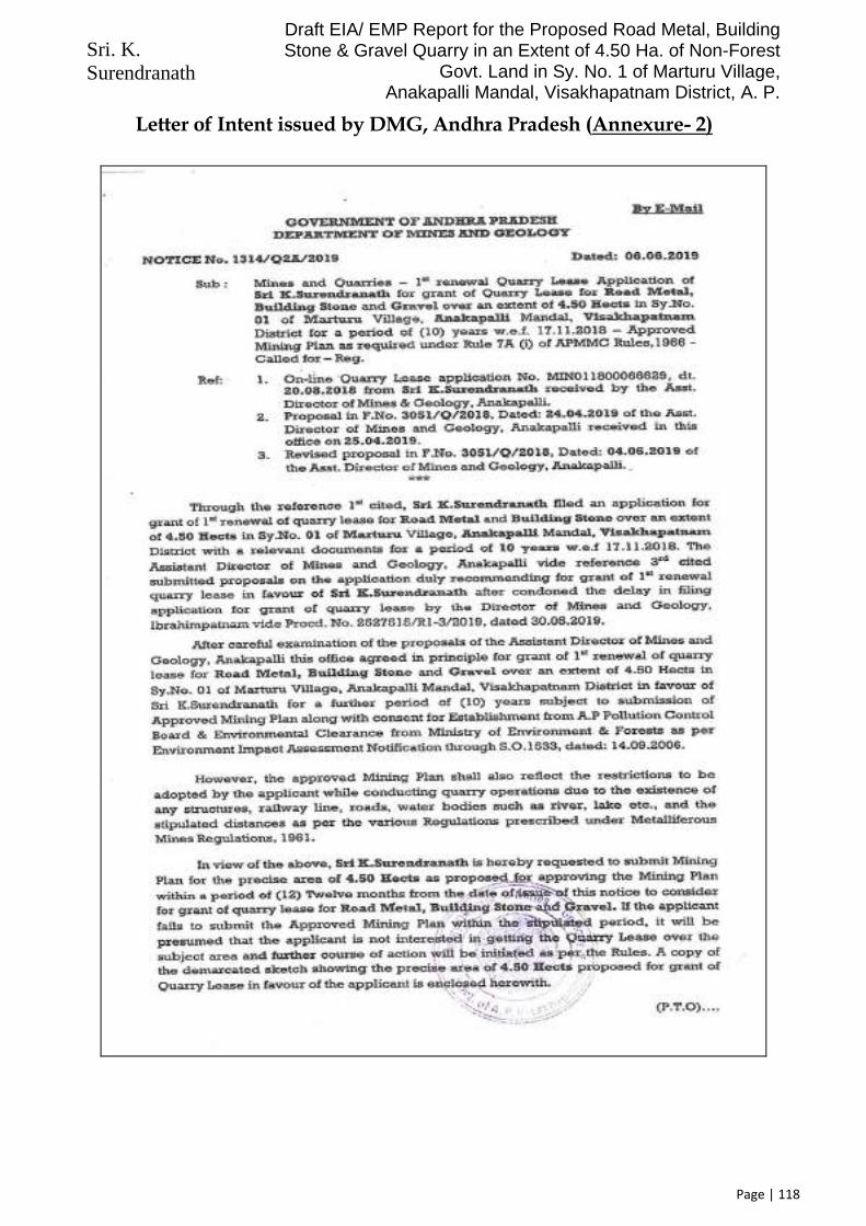
Sri. K. Surendranath
Draft EIA/ EMP Report for the Proposed Road Metal, Building Stone & Gravel Quarry in an Extent of 4.50 Ha. of Non-Forest
Govt. Land in Sy. No. 1 of Marturu Village, Anakapalli Mandal, Visakhapatnam District, A. P.
Page | 118
Letter of Intent issued by DMG, Andhra Pradesh (Annexure- 2)

Sri. K. Surendranath
Draft EIA/ EMP Report for the Proposed Road Metal, Building Stone & Gravel Quarry in an Extent of 4.50 Ha. of Non-Forest
Govt. Land in Sy. No. 1 of Marturu Village, Anakapalli Mandal, Visakhapatnam District, A. P.
Page | 119

Sri. K. Surendranath
Draft EIA/ EMP Report for the Proposed Road Metal, Building Stone & Gravel Quarry in an Extent of 4.50 Ha. of Non-Forest
Govt. Land in Sy. No. 1 of Marturu Village, Anakapalli Mandal, Visakhapatnam District, A. P.
Page | 120
Extract of Topo-Sheet (Annexure-3)

Sri. K. Surendranath
Draft EIA/ EMP Report for the Proposed Road Metal, Building Stone & Gravel Quarry in an Extent of 4.50 Ha. of Non-Forest
Govt. Land in Sy. No. 1 of Marturu Village, Anakapalli Mandal, Visakhapatnam District, A. P.
Page | 121
Environmental Policy (Annexure-4)

Sri. K. Surendranath
Draft EIA/ EMP Report for the Proposed Road Metal, Building Stone & Gravel Quarry in an Extent of 4.50 Ha. of Non-Forest
Govt. Land in Sy. No. 1 of Marturu Village, Anakapalli Mandal, Visakhapatnam District, A. P.
Page | 122
Organization Chart (Annexure-5) The Organization Chart of Sri. K. Surendranath’s Quarry at Marturu (Anakapalli Mandal) will be as under:
Semi-Skilled Workers (14 Nos.)
Supervisor (1 Nos.)
Mine’s Foreman (1 No.)
Sri. K. Surendranath (Lease Holder)
Unskilled Workers (04 Nos.)

Sri. K. Surendranath
Draft EIA/ EMP Report for the Proposed Road Metal, Building Stone & Gravel Quarry in an Extent of 4.50 Ha. of Non-Forest
Govt. Land in Sy. No. 1 of Marturu Village, Anakapalli Mandal, Visakhapatnam District, A. P.
Page | 123
Geological Map of Visakhapatnam District (Annexure- 6)

Sri. K. Surendranath
Draft EIA/ EMP Report for the Proposed Road Metal, Building Stone & Gravel Quarry in an Extent of 4.50 Ha. of Non-Forest
Govt. Land in Sy. No. 1 of Marturu Village, Anakapalli Mandal, Visakhapatnam District, A. P.
Page | 124
Soil Map of Visakhapatnam District (Annexure- 7)

Sri. K. Surendranath
Draft EIA/ EMP Report for the Proposed Road Metal, Building Stone & Gravel Quarry in an Extent of 4.50 Ha. of Non-Forest
Govt. Land in Sy. No. 1 of Marturu Village, Anakapalli Mandal, Visakhapatnam District, A. P.
Page | 125
Geomorphological Map of Visakhapatnam District (Annexure-8)

Sri. K. Surendranath
Draft EIA/ EMP Report for the Proposed Road Metal, Building Stone & Gravel Quarry in an Extent of 4.50 Ha. of Non-Forest
Govt. Land in Sy. No. 1 of Marturu Village, Anakapalli Mandal, Visakhapatnam District, A. P.
Page | 126
Land-Use Land-Cover Map of 10 KM Radius of Proposed Quarry Area (Annexure-9)

Sri. K. Surendranath
Draft EIA/ EMP Report for the Proposed Road Metal, Building Stone & Gravel Quarry in an Extent of 4.50 Ha. of Non-Forest
Govt. Land in Sy. No. 1 of Marturu Village, Anakapalli Mandal, Visakhapatnam District, A. P.
Page | 127
Satellite Imagery of 10 KM Radius of Proposed Quarry Site (Annexure-10)

Sri. K. Surendranath
Draft EIA/ EMP Report for the Proposed Road Metal, Building Stone & Gravel Quarry in an Extent of 4.50 Ha. of Non-Forest
Govt. Land in Sy. No. 1 of Marturu Village, Anakapalli Mandal, Visakhapatnam District, A. P.
Page | 128
Annexure-11 (Ambient Air Quality Data)
DATE
STATIONS
Project Site (S1) Papayya Santapalem (S2) Makavaram (S3) Marturu (S4) Tummapala (S5) Bavulavada (S6) Uderu (S7) Allikhandupalem (S8) Gondhavaram (S9)
PM 2.5 PM 10 SO2 Nox PM 2.5 PM 10 SO2 Nox PM 2.5 PM 10 SO2 Nox PM 2.5 PM 10 SO2 Nox PM 2.5 PM 10 SO2 Nox PM 2.5 PM 10 SO2 Nox PM 2.5 PM 10 SO2 Nox PM 2.5 PM 10 SO2 Nox PM 2.5 PM 10 SO2 Nox
05-10-2020 32.8 49.8 11.2 9.8 33.5 48.1 9.9 9.5 45.6 86.6 10.6 8.7 − − − − − − − − − − − − − − − − − − − − − − − −
06-10-2020 31.5 50.5 10.9 10.1 32.4 47.3 11.5 9.3 48.9 87.5 11.5 8.9 − − − − − − − − − − − − − − − − − − − − − − − −
07-10-2020 − − − − − − − − − − − − 34.5 59.2 9.9 9.8 35.1 60.3 10.8 10.2 35.4 62.1 11.2 9 − − − − − − − − − − − −
08-10-2020 − − − − − − − − − − − − 36.2 60.6 10.6 10.5 38.4 62.8 10.2 9.9 36.8 62.9 11.9 8.8 − − − − − − − − − − − −
09-10-2020 − − − − − − − − − − − − − − − − − − − − − − − − 41.9 74.5 11.9 9.5 37.5 56.3 11.5 10.9 41.2 60.5 11.8 10.6
10-10-2020 − − − − − − − − − − − − − − − − − − − − − − − − 43.6 76.3 12.5 9.3 38.2 57.9 12.6 11.3 42.8 62.4 12.5 10.5
12-10-2020 34.5 60.5 9.9 10.8 31.9 47.2 11.2 10.5 45.9 84.5 10.6 8.9 − − − − − − − − − − − − − − − − − − − − − − − −
13-10-2020 35.1 61.1 10.5 11.2 32.1 47.5 10.5 10.1 47.3 85.2 10.5 9.2 − − − − − − − − − − − − − − − − − − − − − − − −
14-10-2020 − − − − − − − − − − − − 34.5 59.5 9.8 10.8 34.6 61.8 10.3 10.3 36.4 61.8 11.1 8.8 − − − − − − − − − − − −
15-10-2020 − − − − − − − − − − − − 35.1 61.1 10.9 11.2 38.6 63.4 10.9 10.1 39.5 61.9 11.8 9.1 − − − − − − − − − − − −
16-10-2020 − − − − − − − − − − − − − − − − − − − − − − − − 43.6 76.3 12.5 9.3 38.2 57.9 11.6 10.5 42.9 61.6 11.9 10.2
17-10-2020 − − − − − − − − − − − − − − − − − − − − − − − − 45.1 77.2 12.9 9.1 38.4 55.8 12.6 11.3 42.8 62.4 12.5 10.5
19-10-2020 34.5 59.2 9.4 9.8 35.1 60.3 10.8 10.2 35.4 62.1 11.2 9.2 − − − − − − − − − − − − − − − − − − − − − − − −
20-10-2020 36.2 60.6 10.6 10.5 38.4 62.8 10.2 9.9 36.8 62.9 11.9 8.8 − − − − − − − − − − − − − − − − − − − − − − − −
21-10-2020 − − − − − − − − − − − − 34.5 61.2 9.9 9.8 35.1 61.3 10.8 10.2 35.4 61.1 11.6 8.8 − − − − − − − − − − − −
22-10-2020 − − − − − − − − − − − − 35.2 60.6 10.6 10.5 38.4 62.8 10.2 10.2 36.8 62.9 11.9 8.8 − − − − − − − − − − − −
23-10-2020 − − − − − − − − − − − − − − − − − − − − − − − − 43.2 76.6 12.2 9.2 36.7 56.2 11.6 10.5 41.9 61.9 11.4 10.5
24-10-2020 − − − − − − − − − − − − − − − − − − − − − − − − 45.1 75.2 12.5 9.1 38.4 55.6 12.1 10.9 42.7 62.4 12.4 10.4
26-10-2020 29.5 49.1 10.9 9.9 32.1 47.8 11.5 10.3 51.3 86.2 10.9 9.1 − − − − − − − − − − − − − − − − − − − − − − − −
27-10-2020 30.5 49.6 11.5 9.8 31.9 47.2 11.2 10.5 45.9 84.5 10.6 8.9 − − − − − − − − − − − − − − − − − − − − − − − −
28-10-2020 − − − − − − − − − − − − 35.1 61.1 10.9 11.2 38.6 62.8 10.2 9.9 36.8 62.9 11.9 8.8 − − − − − − − − − − − −
29-10-2020 − − − − − − − − − − − − 36.2 60.6 10.6 10.5 38.4 61.3 10.8 10.2 35.4 61.1 11.6 8.5 − − − − − − − − − − − −
30-10-2020 − − − − − − − − − − − − − − − − − − − − − − − − 44.2 76.6 12.2 9.2 37.7 56.2 11.4 10.5 42.9 61.5 11.9 10.2
31-10-2020 − − − − − − − − − − − − − − − − − − − − − − − − 45.1 77.2 12.9 9.1 38.4 55.8 12.5 10.9 41.7 62.4 12.4 10.4
02-11-2020 34.5 59.5 9.9 10.8 32.4 47.3 11.4 10.6 45.9 84.5 10.6 8.9 − − − − − − − − − − − − − − − − − − − − − − − −
03-11-2020 34.7 60.3 10.3 11.3 32.1 47.8 11.5 10.4 47.3 85.2 10.5 9.2 − − − − − − − − − − − − − − − − − − − − − − − −
04-11-2020 − − − − − − − − − − − − 35.9 59.2 9.9 9.8 35.1 61.3 10.8 10.2 35.4 62.1 11.2 9 − − − − − − − − − − − −
05-11-2020 − − − − − − − − − − − − 36.2 61.6 10.6 10.5 38.4 63.1 10 9.9 36.8 62.5 11.3 8.8 − − − − − − − − − − − −
06-11-2020 − − − − − − − − − − − − − − − − − − − − − − − − 44.2 76.6 12.2 9.2 37.7 56.2 11.9 10.5 42.9 60.6 11.9 10.2
07-11-2020 − − − − − − − − − − − − − − − − − − − − − − − − 43.1 78.9 12.5 9.1 38.4 55.8 12.5 10.9 41.7 62.4 12.4 10.3
09-11-2020 30.2 48.6 11.4 9.4 30.9 47.2 10.2 9.8 47.9 86.5 10.8 8.7 − − − − − − − − − − − − − − − − − − − − − − − −
10-11-2020 31.1 49.1 10.9 9.9 32.1 47.8 11.8 10.3 51.3 84.2 10.9 8.9 − − − − − − − − − − − − − − − − − − − − − − − −
11-11-2020 − − − − − − − − − − − − 34.5 60.5 9.9 10.8 33.6 61.8 10.3 10.3 36.4 61.8 11.1 8.7 − − − − − − − − − − − −
12-11-2020 − − − − − − − − − − − − 35.1 61.1 10.5 11.2 36.6 62.4 10.5 10.1 39.5 63.2 11.8 9.1 − − − − − − − − − − − −

Sri. K. Surendranath
Draft EIA/ EMP Report for the Proposed Road Metal, Building Stone & Gravel Quarry in an Extent of 4.50 Ha. of Non-Forest
Govt. Land in Sy. No. 1 of Marturu Village, Anakapalli Mandal, Visakhapatnam District, A. P.
Page | 129
DATE STATIONS
Project Site (S1) Papayya Santapalem (S2) Makavaram (S3) Marturu (S4) Tummapala (S5) Bavulavada (S6) Uderu (S7) Allikhandupalem (S8) Gondhavaram (S9)
PM 2.5 PM 10 SO2 Nox PM 2.5 PM 10 SO2 Nox PM 2.5 PM 10 SO2 Nox PM 2.5 PM 10 SO2 Nox PM 2.5 PM 10 SO2 Nox PM 2.5 PM 10 SO2 Nox PM 2.5 PM 10 SO2 Nox PM 2.5 PM 10 SO2 Nox PM 2.5 PM 10 SO2 Nox
13-11-2020 − − − − − − − − − − − − − − − − − − − − − − − − 45.1 75.2 12.5 9.1 38.5 56.9 12.4 10.5 42.9 61.6 11.9 10.2
14-11-2020 − − − − − − − − − − − − − − − − − − − − − − − − 43.6 76.3 12.5 9.3 38.2 57.9 12.6 11.3 42.8 62.4 12.5 10.5
16-11-2020 31.1 47.9 10.8 9.7 32.2 46.8 9.7 9.5 50.2 84.5 10.6 9.1 − − − − − − − − − − − − − − − − − − − − − − − −
17-11-2020 29.5 50.2 11.1 9.9 33.3 47.3 11.9 10.2 52.0 86.3 11.7 8.7 − − − − − − − − − − − − − − − − − − − − − − − −
18-11-2020 − − − − − − − − − − − − 36.4 59.7 9.5 11.1 34.5 60.6 10.6 9.9 36.6 62.2 11.1 8.8 − − − − − − − − − − − −
19-11-2020 − − − − − − − − − − − − 34.7 60.3 10.3 9.9 36.8 64.3 9.8 10.5 37.1 62.1 12 9.2 − − − − − − − − − − − −
20-11-2020 − − − − − − − − − − − − − − − − − − − − − − − − 44.4 76.7 11.2 9.5 37.8 55.2 10.9 10.9 41.1 60.9 11.9 10.3
21-11-2020 − − − − − − − − − − − − − − − − − − − − − − − − 46.6 77.2 12.8 9.7 38.5 57.9 12.8 11.2 42.6 59.5 12.4 10.5
23-11-2020 32.2 49.8 11.5 9.8 33.5 47.2 10.2 9.7 45.6 86.6 10.6 8.7 − − − − − − − − − − − − − − − − − − − − − − − −
24-11-2020 31.5 51.5 10.9 10.1 32.4 47.3 11.5 9.3 48.9 87.5 11.5 8.9 − − − − − − − − − − − − − − − − − − − − − − − −
25-11-2020 − − − − − − − − − − − − 34.5 59.2 9.7 9.8 34.5 59.7 10.5 10.2 36.4 62.1 11.2 9.2 − − − − − − − − − − − −
26-11-2020 − − − − − − − − − − − − 35.2 60.6 10.6 10.7 40.9 62.8 10.2 9.9 36.8 63.2 11.9 8.8 − − − − − − − − − − − −
27-11-2020 − − − − − − − − − − − − − − − − − − − − − − − − 43.6 76.3 12.5 9.8 37.2 57.9 12.6 10.5 42.9 61.8 11.9 10.2
28-11-2020 − − − − − − − − − − − − − − − − − − − − − − − − 45.1 77.2 12.9 9.3 38.2 55.9 12.1 11.3 43.9 62.4 12.5 10.5
02-12-2020 30.5 49.6 11.4 9.8 31.9 47.2 11.2 10.5 45.9 84.5 10.6 8.9 − − − − − − − − − − − − − − − − − − − − − − − −
03-12-2020 31.1 47.9 10.8 9.7 32.2 46.8 9.7 9.5 50.2 84.5 10.6 9.1 − − − − − − − − − − − − − − − − − − − − − − − −
04-12-2020 − − − − − − − − − − − − 36.2 58.7 10.6 10.5 34.6 61.3 10.8 10.2 35.4 61.1 11.6 9.1 − − − − − − − − − − − −
05-12-2020 − − − − − − − − − − − − 34.5 59.2 9.9 9.8 35.1 60.3 10.5 10.2 35.4 62.1 11.2 9 − − − − − − − − − − − −
07-12-2020 − − − − − − − − − − − − − − − − − − − − − − − − 45.1 75.2 12.5 9.1 38.4 55.2 12.1 10.9 40.6 62.4 12.4 10.4
08-12-2020 − − − − − − − − − − − − − − − − − − − − − − − − 47.9 76.6 12.2 9.2 39.7 56.2 11.6 10.5 42.9 61.6 11.9 10.2
09-12-2020 32.1 49.8 11.2 9.8 33.5 48.1 9.9 9.8 45.6 86.6 10.6 8.7 − − − − − − − − − − − − − − − − − − − − − − − −
10-12-2020 31.5 50.5 10.9 10.1 32.4 47.3 11.5 9.2 48.9 87.9 12.3 8.9 − − − − − − − − − − − − − − − − − − − − − − − −
11-12-2020 − − − − − − − − − − − − 35.2 60.6 11.6 10.5 34.5 62.8 10.2 10.1 36.8 62.9 11.9 8.8 − − − − − − − − − − − −
12-12-2020 − − − − − − − − − − − − 36.2 57.6 12 10.3 34.5 61.3 11.2 10.2 35.4 63.2 12.1 9.2 − − − − − − − − − − − −
14-12-2020 − − − − − − − − − − − − − − − − − − − − − − − − 43.3 77.6 12.2 9.4 37.7 58.2 11.5 10.5 41.1 59.8 11.8 10.6
15-12-2020 − − − − − − − − − − − − − − − − − − − − − − − − 45.5 78.1 13.2 9.5 38.2 56.7 13.4 11.4 42.6 62.4 12.7 10.8
16-12-2020 30.5 49.5 10.9 9.9 32.1 47.8 11.5 10.3 51.3 84.5 10.9 9.1 − − − − − − − − − − − − − − − − − − − − − − − −
17-12-2020 32.1 51.2 11.2 9.8 34.2 48.1 9.9 9.5 45.6 86.6 10.6 8.6 − − − − − − − − − − − − − − − − − − − − − − − −
18-12-2020 − − − − − − − − − − − − 34.5 59.5 9.9 10.8 34.5 61.8 10.3 10.3 36.4 61.8 10.8 8.8 − − − − − − − − − − − −
19-12-2020 − − − − − − − − − − − − 34.7 60.3 10.3 11.3 38.6 63.4 10.2 9.8 36.8 61.9 11.8 9.1 − − − − − − − − − − − −
21-12-2020 − − − − − − − − − − − − − − − − − − − − − − − − 41.5 76.6 12.2 9.2 37.7 56.2 11.6 10.4 42.9 61.6 11.9 10.2
22-12-2020 − − − − − − − − − − − − − − − − − − − − − − − − 45.1 77.2 12.9 9.1 38.4 58.9 12.5 10.9 41.7 63.1 12.4 10.4

Sri. K. Surendranath
Draft EIA/ EMP Report for the Proposed Road Metal, Building Stone & Gravel Quarry in an Extent of 4.50 Ha. of Non-Forest
Govt. Land in Sy. No. 1 of Marturu Village, Anakapalli Mandal, Visakhapatnam District, A. P.
Page | 130
Schematic Diagram (Annexure-12)

Sri. K. Surendranath
Draft EIA/ EMP Report for the Proposed Road Metal, Building Stone & Gravel Quarry in an Extent of 4.50 Ha. of Non-Forest
Govt. Land in Sy. No. 1 of Marturu Village, Anakapalli Mandal, Visakhapatnam District, A. P.
Page | 131
Surface Geological Plan and Sections (Annexure-13)

Sri. K. Surendranath
Draft EIA/ EMP Report for the Proposed Road Metal, Building Stone & Gravel Quarry in an Extent of 4.50 Ha. of Non-Forest
Govt. Land in Sy. No. 1 of Marturu Village, Anakapalli Mandal, Visakhapatnam District, A. P.
Page | 132
(Working )Production & Development Plan and Sections (Annexure-14)

Sri. K. Surendranath
Draft EIA/ EMP Report for the Proposed Road Metal, Building Stone & Gravel Quarry in an Extent of 4.50 Ha. of Non-Forest
Govt. Land in Sy. No. 1 of Marturu Village, Anakapalli Mandal, Visakhapatnam District, A. P.
Page | 133
Conceptual Plan and Sections (Annexure-15)

Sri. K. Surendranath
Draft EIA/ EMP Report for the Proposed Road Metal, Building Stone & Gravel Quarry in an Extent of 4.50 Ha. of Non-Forest
Govt. Land in Sy. No. 1 of Marturu Village, Anakapalli Mandal, Visakhapatnam District, A. P.
Page | 134
Environmental Management Plan (Annexure-16)

Sri. K. Surendranath
Draft EIA/ EMP Report for the Proposed Road Metal, Building Stone & Gravel Quarry in an Extent of 4.50 Ha. of Non-Forest
Govt. Land in Sy. No. 1 of Marturu Village, Anakapalli Mandal, Visakhapatnam District, A. P.
Page | 135
Cluster Environment Management Plan (Annexure-17)
1. Introduction Sri. K. Surendranath, was operating a Road Metal, Building Stone & Gravel Quarry, in an extent of 4.50 Hectares of Non-Forest Government Land bearing Sy. No. 1 of Marturu Village in Anakapalli Mandal of Visakhapatnam District, in the state of Andhra Pradesh. He had obtained the in-principle approval for 1st renewal of the above quarry, from the Dept. of Mines & Geology, vide Notice No. 1314/Q2A/2019 dated 06th June 2019, for a period of 10 years, w.e.f 17.11.2018. The proposed saleable annual output from the quarry will be about 1,25,100 CuM per Annum (avg.) of Road Metal, Building Stone & Gravel, with the maximum saleable annual production being 1,25,100 CuM per Annum. The estimated cost of the project is Rs. 60.00 Lakhs.
The above quarry lease area is surrounded by other Road Metal, Building Stone & Gravel quarries. There are some 24 existing mining leases, within 500 m radial distance of the present quarry. Of the 24 existing quarry leases, within 500 radial distance of the present quarry, 21 leases with a total extent of 102.22 Hectares have been granted prior to 09th Sept. 2013, and hence are exempted from Cluster Effect, as per MoEFCC Notification No. S.O. 2269 (E), dated 01st July 2016. The remaining Three (03) leases (excluding the present lease) with a total extent of 17.63 Hectares are granted after 09th Sept. 2013. Hence, as per MoEFCC Notification No. S.O. 2269 (E), dated 01st July 2016, they become part of the cluster, for preparation of the cluster EMP. The total extent of the cluster, including the present lease area, will be 22.13 Ha > 5 Ha. Hence classified under B2 at Par with B1 category. The details of these leases falling in the cluster are as under:
Details of other quarries falling in the same cluster
Sl. No
Lease Holder Name Lease From
Lease To
Extent in Hectares
Sy. No.
Village Mandal Status
1 Mahalakshmi Naidu 04-11-2007 03-11-2017 3.00 01 Marturu Anakapalli Working
2 N.Krishnayya 03-07-2007 02-07-2017 13.33 01 Marturu Anakapalli Working
3 M/s. Sri. Venkata Sasi Stone Crusher
18-01-2007 17-01-2017 7.44 01 Marturu Anakapalli Working
4 Sri. K. Vijaya Prasad 31-12-2005 30-12-2020 2.00 01 Marturu Anakapalli Working
5 M/s. Sri. Venkata Sasi Stone Crusher
14-07-2009 13-07-2024 7.90 01 Marturu Anakapalli Working
6 M/S Aparna Enterprises
27-12-2007 26-12-2017 2.55 01 Marturu Anakapalli Working
7 M/S Venkata Sasi Stone Crusher
04-06-2008 03-06-2018 8.00 01 Marturu Anakapalli Working
8 M/S Kartikeya nirmans pvt ltd
05-06-2008 04-06-2018 2.75 01 Marturu Anakapalli Working
9 P.Ashok Chandra Murthy Raju
07-06-2008 06-06-2018 2.25 01 Marturu Anakapalli Working
10 Sri. Venkatasasi Stone Crusher
21-07-2010 06-03-2018 6.50 01 Marturu Anakapalli Working
11 M/S Navodaya Granites
26-12-2007 25-12-2022 3.50 01 Marturu Anakapalli Working

Sri. K. Surendranath
Draft EIA/ EMP Report for the Proposed Road Metal, Building Stone & Gravel Quarry in an Extent of 4.50 Ha. of Non-Forest
Govt. Land in Sy. No. 1 of Marturu Village, Anakapalli Mandal, Visakhapatnam District, A. P.
Page | 136
Sl. No
Lease Holder Name Lease From
Lease To
Extent in Hectares
Sy. No.
Village Mandal Status
12 M/S Ultratech Cement Ltd
17-02-2011 04-01-2018 6.00 01 Marturu Anakapalli Working
13 P.Kasibabu 29-10-2008 28-10-2018 1.00 01 Marturu Anakapalli Working
14 M/s K. Katyayeni 17-11-2018 16-11-2028 4.50 01 Marturu Anakapalli Working
15 M/s SGX minerals pvt ltd
04-05-2010 16-11-2018 9.00 01 Marturu Anakapalli Working
16 M/S Navodaya Granite Industries
23-05-2009 22-05-2024 1.60 01 Marturu Anakapalli Working
17 M/S Trendet Rocks Pvt Ltd
25-02-2010 18-11-2024 9.00 1 Marturu Anakapalli Working
18 M/s Aparna enterprises 05-03-2013 04-03-2023 6.00 1 Marluru Ankapalli Working
19 Smt..T Vijayakumari 27-06-2015 26-06-2025 3.00 1 Marluru Ankapalli Working
20 M/S Gonthalamma Granites
07-06-2011 04-06-2018 2.50 1 Marluru Ankapalli Working
21 M/S Nauha Constructions
07-08-2012 04-06-2018 2.50 1 Marluru Ankapalli Working
22 M/S Madhucon Projects
27-10-2011 28-10-2026 4.50 1 Marluru Ankapalli Working
23 M Balaji 28-03-2013 27-03-2023 1.00 1 Marluru Ankapalli Working
24 M/S Rank Silicon Pvt Ltd
30-07-2015 01-02-2025 10.13 1 Marluru Ankapalli Working
Of the 24 existing quarry leases, within 500 radial distance of the present quarry, 21 leases with a total extent of 102.22 Hectares have been granted prior to 09th Sept. 2013, and hence are exempted from Cluster Effect, as per MoEFCC Notification No. S.O. 2269 (E), dated 01st July 2016. The remaining Three (03) leases (excluding the present lease) with a total extent of 17.63 Hectares are granted after 09th Sept. 2013. Hence, as per MoEFCC Notification No. S.O. 2269 (E), dated 01st July 2016, they become part of the cluster, for preparation of the cluster EMP. The total extent of the cluster, including the present lease area, will be 22.13 Ha > 5 Ha. Hence classified under B2 at Par with B1 category.
Hence, as per the provisions notified under the Gazette Notification No. S.O. 2269 (E), dated 01st July 2016, issued by the Ministry of Environment, Forests & Climate Change, Government of India (Amendment of the EIA Notification 2006), the Cluster Environment Management Plan, has been prepared.
The cluster letter issued by Dept. of Mines & Geology, is enclosed.
In accordance with the Clause No. (b) (i) of the Gazette Notification No. S.O. 2269 (E), dated 01st July 2016, issued by the Ministry of Environment, Forests & Climate Change, Government of India (Amendment of the EIA Notification 2006), “A cluster shall be formed when the distance between the peripheries of one lease is less than 500 meters from the periphery of other lease in a homogeneous mineral area which shall be applicable to the mine leases or quarry licenses granted on and after 9th September, 2013”.

Sri. K. Surendranath
Draft EIA/ EMP Report for the Proposed Road Metal, Building Stone & Gravel Quarry in an Extent of 4.50 Ha. of Non-Forest
Govt. Land in Sy. No. 1 of Marturu Village, Anakapalli Mandal, Visakhapatnam District, A. P.
Page | 137
Further, as per Clause No. (5) of the said Notification, “The leases not operative for three years or more and leases which have got environmental clearance as on 15th January 2016, shall not be counted for calculating the area of cluster, but shall be included in the Environmental Management Plan and the Regional Environmental Management Plan”.
In line with the EIA Notification 2006 (incl. its amendments), the proponent viz. Sri. K. Surendranath, had applied for Environmental Clearance from State level Environmental Impact Assessment Authority (SEIAA), Andhra Pradesh, and as per the provisions of EIA Notification (Amendment) dated 01st July 2016, the Cluster Environmental Management Plan (EMP) is being prepared for jointly taking-up the Environmental Protection Measures, for the kind perusal of SEIAA and SEAC, Andhra Pradesh.
2. Production Details Out of Twenty Four (24) leases, only Three (03) existing leases, with a total extent of 17.63 Hectares, fall under cluster. Including the present lease of the proponent, Sri. K. Surendranath, the total extent falling under cluster will be about 22.13 Hectares. Based on the quarry plan approved by Dept. of Mines & Geology, the production proposed in the quarry of Sri. K. Surendranath, is about 1,25,100 CuM per Annum (Max.) of Road Metal, Building Stone & Gravel. The anticipated production from other quarries in the cluster (Prorata according to the extent), is as under:
All units in CuM/ Annum
Description Total Extent Production Capacity (CuM Per Annum)
Present proposal of Proponent 4.50 Ha. 1,25,100
Other quarries in the cluster 17.63 Ha. 4,90,115
Max. output from the cluster 22.13 Ha. 6,15,215
Maximum Annual Production (in Tons) @ 2.5 T/m3 15,38,038 Tons/Annum
No. of operating days per annum 300 Days
Average Production per Day 5,127 Tons/ Day
3. ENVIRONMENTAL IMPACT OF THE CLUSTER Environmental impact of the cluster as a whole: a. Impact on air environment: i. Dust due to dispatch tractors /Lorries: All mines estimated production per day (working of 300 days a year) is about 5,127 Tons per day. Assuming an average carrying capacity of the truck as about 15 Tons per trip, no. of trips required is about 342 Nos. per day (5,127 Tons/ 15 Tons per Trip) and considering an operating hours of 10 hours per day, the approx. no. of trips is about 34 to 35 trips per hour.
ii. Exhaust fumes due to equipment in the cluster: The exhaust fumes will be generated due to the above trucks due to cluster operations apart from the in-quarry operations. The impact due to in-quarry operations were already described in the respective EMP. Since there is sufficient gap between each truck's movement and the area being an open area with enough space between the quarries, the accumulation of exhaust fumes in one place will not take place.

Sri. K. Surendranath
Draft EIA/ EMP Report for the Proposed Road Metal, Building Stone & Gravel Quarry in an Extent of 4.50 Ha. of Non-Forest
Govt. Land in Sy. No. 1 of Marturu Village, Anakapalli Mandal, Visakhapatnam District, A. P.
Page | 138
b. Impact on water environment: The area does not fall under any major catchment of any river or water course. Therefore the impact of cluster on water environment is not envisaged.
c. Impact of noise on persons working: The additional impact apart from that of the in-quarry impact is only due to trucks plying o n the common roads. As explained above there will be only one truck that will move in every 3 to 4 minutes which will carry dispatch material of all the quarries. There may not be any major impact of noise on persons working in the quarries due to the trucks moving out.
d. Impact due to vibration: Apart from the vibration impacts predicted in the respective EMPs there will not be any additional impact due to vibrations due to cluster operations conducted at the same time. Also, there will be mild blasting operations, in all the above quarries, at staggered timings, to reduce the cumulative impact on the surrounding environment. Hence, there will not be any significant impact due to vibrations.
e. Land degradation: Apart from the land degradation that is envisaged in the respective quarry plans, there will not be any additional land degradation due to cluster operations.
f. Safety of persons: Due to increase in movement of trucks on the common road, the accident proneness will increase to the persons moving on the road for quarry works.
4. Environmental Protection Measures
The individual Quarry Lease Holders shall be responsible for the day to day activities of their respective quarries. However, they should collectively take-up the activities proposed for Environmental Protection, which are summarized as below:
Topsoil Management: Beneficial microbes are present in the topsoil of quarry areas. Hence, the topsoil (if available) will be removed at the time of mining and will be used for Afforestation works.
Land Restoration/ Reclamation: Land restoration or reclamation of the area is very essential in any mining industry. Proper measures adopted during restoration will control most of the adverse environmental impacts of mining and also improve the aesthetic beauty of the area. Due to the Mining activities in this area the profile of the ground will change due to formation of benches/ pits. At the end of the mining operations, all solid wastes generated will be used in back filling of quarry pits in order to bring back original contour of the terrain as for as possible (wherever applicable). The separately staked topsoil will be used to spread over on the compacted back filled area in order to facilitate the re-vegetation process, which in turn controls silt flow towards the downstream.
Programme of Afforestation/ Development of Greenbelt: Enriched plantation will be adopted on top flat area & sloping area. It is proposed to develop vegetation all-round the quarry area (wherever possible) and also in the non-mineralized lease area. In addition, the place around the haulage road, outside the lease area after obtaining necessary permissions from concerned authorities. It is proposed to plant Neem, Pongamia, Neredu, Mango, Patti, Seethaphalam, Eucalyptus etc. of 1500 Nos. to be proposed for first year itself of tall & fruit yielding native species will be planted to

Sri. K. Surendranath
Draft EIA/ EMP Report for the Proposed Road Metal, Building Stone & Gravel Quarry in an Extent of 4.50 Ha. of Non-Forest
Govt. Land in Sy. No. 1 of Marturu Village, Anakapalli Mandal, Visakhapatnam District, A. P.
Page | 139
create a microclimate. Proper care will be taken for protection & growth of these saplings. The Bio-fuel saplings like pongamia, neem etc. are also proposed to plant around the quarry area. It is also proposed to dibble the grasses & other hemata seeds to stabilize the dumps.
In order to minimize the impact of mining on environmental components outside the quarry lease area, a buffer zone/ greenbelt zone of 7.5m width will be established around the quarry lease area for safety purpose. The greenbelt will act as a barrier to trap the suspended dust particles and also suppresses air pollutants and noise. It is also important to create a green belt with shrubs, medium & tall trees (Nerium, Curcus, Subable, Thespesicia, Neem etc..,) of fast growing species to hasten the process of greening the area. It is suggested that the areas which are not planted haul roads will be planted with the species.
The degree of pollution attenuation by a green belt depends on its height and width, foliage surface area and density. The main objective of green belt is as follows.
1. Mitigation of impacts due to fugitive emissions caused by vehicles 2. Attenuation of noise levels 3. Ecological restoration 4. Creation of aesthetic environment
Wild Life Protection: Presently, there are no wild animals spotted in the core zone. This quarry area does not form corridor for any of the major faunal species. The common species found are Rats, Rabbits & Reptiles etc., only. However, the practice of afforestation programme and other control measures shall bring greenery to the area and also the vegetation of mixed species and availability of water will form a natural habitat for these wild animals and helps in conservation of the flora and fauna of the area. It is proposed to erect fence & dig trench around the lease area to prevent the entry of cattle & other wild life. Suitable species like Agave, Euphorbia, cuttings will be planted on the mound.
Management of socio-economic activities: The quarry industry will improve the economic status of the people and the area. Continued Quarry activities, will benefit the local people due to provision of more infrastructural facilities provided by the mining industry. Adequate facility for drinking water, health, education, recreation and employment is provided to the workers.
Natural Vegetation: Area does not support good vegetation. The existing species are stunted growth due to lack of required soil & also moisture & there are grassy blanks here & there.
Disaster Management plan: Disaster management plan is envisaged with a goal to prevent hazards and accidents at work places by careful design, operation, maintenance and inspection of the mining machineries & equipments. All the quarry activities will be in accordance with the approved mining plan and directives of directorate general of mines safety. In future all the eligible employees will be sent to refresher courses from time to time on safety issues. The control measures will be adopted to take care of hazards/ disasters that may occur during quarry operation. Safety awareness through competitions, posters & organizing safety weeks every year fire fighting & first aid provisions will be provided in mines office & quarry lease area. All safety appliances are made available to all the staff.

Sri. K. Surendranath
Draft EIA/ EMP Report for the Proposed Road Metal, Building Stone & Gravel Quarry in an Extent of 4.50 Ha. of Non-Forest
Govt. Land in Sy. No. 1 of Marturu Village, Anakapalli Mandal, Visakhapatnam District, A. P.
Page | 140
Mitigation Measures to prevent accidental fire: To protect the vegetation & also to protect the breeding & hibernating sites of the fauna in the core area & buffer zone from the accidental fire a 6-12Mt wide area along the boundaries of all the quarry leases will be cleared, cleaned & burn the litter well in advanced as a precautionary measure to prevent accidental fire. Fire watchers at the cost of Project Proponents will be appointed to extinguish the accidental fire if any in the buffer zone
5. Budget for Implementation of Combined EMP
To implement the above suggested Environmental Protection Measures, it is essential to allocate sufficient financial resources and the Members of the Cluster Shall share these expenditures in proportion to the extent of their Quarry Lease(s). The estimated budget and its allocation is given below:
Description Total Amount
(₹)
Apportioned Cost of EMP (₹)
Sri. K. Surendranath Other Quarries in the cluster
4.50 Ha. 17.63 Ha. One Time Investment (Capital Cost, in Rs.)
Dust Suppression 16,00,000/ 4,00,000/ 12,00,000/
Garland Drain, gully plugs, silt trap etc.
2,50,000/ 50,000/ 2,00,000/
Occupational Health & Safety of employees
4,00,000/ 1,00,000/ 3,00,000/
Green Belt 16,00,000/ 4,00,000/ 12,00,000/ Total Provision in Capital Cost
38,50,000/ 9,50,000/ 29,00,000/
Recurring Cost (Rs. Per Annum)
Dust Suppression 4,80,000/ 1,20,000/- 3,60,000/
Annual maintenance of garland drain, gully plugs, silt trap etc. before monsoon
50,000/ 10,000/- 40,000/
Occupational Health & Safety of employees
2,00,000/ 50,000/- 1,50,000/
Green Belt Maintenance 2,40,000/ 60,000/- 1,80,000/
Fire prevention in summer season
2,00,000/ 50,000/- 1,50,000/
Environmental monitoring (Half Yearly Compliance Reporting)
2,40,000/ 60,000/- 1,80,000/
Total 14,10,000/ 3,50,000/ 10,60,000/

Sri. K. Surendranath
Draft EIA/ EMP Report for the Proposed Road Metal, Building Stone & Gravel Quarry in an Extent of 4.50 Ha. of Non-Forest
Govt. Land in Sy. No. 1 of Marturu Village, Anakapalli Mandal, Visakhapatnam District, A. P.
Page | 141

Sri. K. Surendranath
Draft EIA/ EMP Report for the Proposed Road Metal, Building Stone & Gravel Quarry in an Extent of 4.50 Ha. of Non-Forest
Govt. Land in Sy. No. 1 of Marturu Village, Anakapalli Mandal, Visakhapatnam District, A. P.
Page | 142

Sri. K. Surendranath
Draft EIA/ EMP Report for the Proposed Road Metal, Building Stone & Gravel Quarry in an Extent of 4.50 Ha. of Non-Forest
Govt. Land in Sy. No. 1 of Marturu Village, Anakapalli Mandal, Visakhapatnam District, A. P.
Page | 143

Sri. K. Surendranath
Draft EIA/ EMP Report for the Proposed Road Metal, Building Stone & Gravel Quarry in an Extent of 4.50 Ha. of Non-Forest
Govt. Land in Sy. No. 1 of Marturu Village, Anakapalli Mandal, Visakhapatnam District, A. P.
Page | 144
Micro-Meteorological Data during Study Period (Annexure-18)
Monitoring Period: October 2020 to December 2020

Sri. K. Surendranath
Draft EIA/ EMP Report for the Proposed Road Metal, Building Stone & Gravel Quarry in an Extent of 4.50 Ha. of Non-Forest
Govt. Land in Sy. No. 1 of Marturu Village, Anakapalli Mandal, Visakhapatnam District, A. P.
Page | 145
Date & Time Avg.
Temp (oC)
Min.
Temp (oC)
Max.
Temp (oC) Pressure
Humidity
(%)
Wind Speed
m/sec
Wind Direction Rainfall
(in mm)
Weather
Category Weather Description
Degrees Direction
2020-10-01 00:00:00 +0000 UTC 26.26 25.42 27.86 1001 100 1 0 N Mist mist
2020-10-01 01:00:00 +0000 UTC 26.24 25.33 27.74 1003 100 1 0 N Mist mist
2020-10-01 02:00:00 +0000 UTC 26.59 26 27.9 1003 100 1 0 N Mist mist
2020-10-01 03:00:00 +0000 UTC 27.46 27 28.24 1004 100 2.1 280 W Drizzle light intensity drizzle
2020-10-01 04:00:00 +0000 UTC 27.8 27 28.9 1005 94 3.6 270 W 0.5 Rain light rain
2020-10-01 05:00:00 +0000 UTC 27.87 26 30.12 1004 94 3.1 240 WSW Drizzle light intensity drizzle
2020-10-01 06:00:00 +0000 UTC 28.35 27 30.2 1004 94 2.6 230 SW Mist mist
2020-10-01 07:00:00 +0000 UTC 28.97 28 30.8 1003 88 1.5 230 SW Mist mist
2020-10-01 08:00:00 +0000 UTC 29.18 28 31.38 1002 88 1.5 270 W Mist mist
2020-10-01 09:00:00 +0000 UTC 29.55 29 31.34 1001 79 2.6 310 NW Mist mist
2020-10-01 10:00:00 +0000 UTC 28.58 27.24 29.76 1000 79 2.1 330 NNW Clouds broken clouds
2020-10-01 11:00:00 +0000 UTC 28.56 27.17 29.62 1000 79 2.1 310 NW Clouds broken clouds
2020-10-01 12:00:00 +0000 UTC 28.35 26.96 29.06 1001 83 1.5 330 NNW Clouds broken clouds
2020-10-01 13:00:00 +0000 UTC 27.66 26.51 28.63 1001 88 1 0 N Clouds broken clouds
2020-10-01 14:00:00 +0000 UTC 27.19 25.78 28 1003 88 1 0 N Clouds broken clouds
2020-10-01 15:00:00 +0000 UTC 27.18 25.94 28 1004 88 1 0 N Clouds broken clouds
2020-10-01 16:00:00 +0000 UTC 26.54 25.67 27.28 1004 88 1 0 N Clouds broken clouds
2020-10-01 17:00:00 +0000 UTC 26.22 25.04 27 1004 88 1 0 N Clouds broken clouds
2020-10-01 18:00:00 +0000 UTC 25.68 24.9 26.54 1003 94 1 0 N Clouds broken clouds
2020-10-01 19:00:00 +0000 UTC 25.74 25.11 26.44 1003 94 1 0 N Clouds broken clouds
2020-10-01 20:00:00 +0000 UTC 25.67 24.92 26.23 1003 94 1 0 N Clouds broken clouds
2020-10-01 21:00:00 +0000 UTC 25.12 24.72 26.06 1002 94 1 0 N Clouds broken clouds
2020-10-01 22:00:00 +0000 UTC 24.99 24.65 25.27 1002 94 1 0 N Clouds broken clouds
2020-10-01 23:00:00 +0000 UTC 24.52 24 25.42 1001 100 1 0 N Mist mist
2020-10-02 00:00:00 +0000 UTC 24.6 24 25.54 1002 100 1 0 N Mist mist
2020-10-02 01:00:00 +0000 UTC 25.1 24.76 25.7 1003 94 1 0 N Mist mist
2020-10-02 02:00:00 +0000 UTC 26.04 25.91 26.36 1004 94 1 0 N Mist mist
2020-10-02 03:00:00 +0000 UTC 27.15 26.12 28 1004 83 1 0 N Mist mist
2020-10-02 04:00:00 +0000 UTC 28.34 26.2 30 1004 74 2.1 290 WNW Haze haze
2020-10-02 05:00:00 +0000 UTC 29.34 26.75 31 1004 66 1.5 340 NNW Haze haze
2020-10-02 06:00:00 +0000 UTC 30.17 26.95 32 1004 62 1.5 350 NNW Haze haze
2020-10-02 07:00:00 +0000 UTC 30.5 27.22 32 1003 62 2.6 90 E Smoke smoke
2020-10-02 08:00:00 +0000 UTC 30.79 27.53 32 1002 59 2.1 100 E Smoke smoke

Sri. K. Surendranath
Draft EIA/ EMP Report for the Proposed Road Metal, Building Stone & Gravel Quarry in an Extent of 4.50 Ha. of Non-Forest
Govt. Land in Sy. No. 1 of Marturu Village, Anakapalli Mandal, Visakhapatnam District, A. P.
Page | 146
Date & Time Avg.
Temp (oC)
Min.
Temp (oC)
Max.
Temp (oC) Pressure
Humidity
(%)
Wind Speed
m/sec
Wind Direction Rainfall
(in mm)
Weather
Category Weather Description
Degrees Direction
2020-10-02 09:00:00 +0000 UTC 30.27 27.81 31 1001 62 1.5 80 ENE Haze haze
2020-10-02 10:00:00 +0000 UTC 30.22 29.19 31 1001 62 1.5 70 ENE Smoke smoke
2020-10-02 11:00:00 +0000 UTC 30.11 28.31 31 1001 62 1 0 N Haze haze
2020-10-02 12:00:00 +0000 UTC 29.53 27.54 30.2 1002 70 1 0 N Smoke smoke
2020-10-02 13:00:00 +0000 UTC 28.43 27.66 29.51 1002 83 1 0 N Mist mist
2020-10-02 14:00:00 +0000 UTC 28.26 27.94 28.86 1003 83 1 0 N Mist mist
2020-10-02 15:00:00 +0000 UTC 28.09 27.65 28.7 1004 83 1 0 N Mist mist
2020-10-02 16:00:00 +0000 UTC 28.02 27.67 28.57 1004 83 1 0 N Mist mist
2020-10-02 17:00:00 +0000 UTC 27.36 27 28.14 1004 88 1 0 N Mist mist
2020-10-02 18:00:00 +0000 UTC 27.3 27 27.93 1004 88 1 0 N Clouds overcast clouds
2020-10-02 19:00:00 +0000 UTC 27.22 26.94 27.82 1003 88 1 0 N Mist mist
2020-10-02 20:00:00 +0000 UTC 27.1 26.68 27.66 1003 94 1 0 N Mist mist
2020-10-02 21:00:00 +0000 UTC 27.06 26.59 27.6 1003 94 1 0 N Mist mist
2020-10-02 22:00:00 +0000 UTC 27.02 26.64 27.59 1003 94 1 0 N Mist mist
2020-10-02 23:00:00 +0000 UTC 26.97 26.46 27.65 1002 94 1 0 N Mist mist
2020-10-03 00:00:00 +0000 UTC 26.58 26 27.82 1003 100 1 0 N Mist mist
2020-10-03 01:00:00 +0000 UTC 26.63 26 27.83 1003 100 1 0 N Mist mist
2020-10-03 02:00:00 +0000 UTC 27.56 27 28.58 1004 94 1 0 N Smoke smoke
2020-10-03 03:00:00 +0000 UTC 29.17 27.39 30 1005 70 1 0 N Smoke smoke
2020-10-03 04:00:00 +0000 UTC 29.76 27.76 31 1005 62 1 0 N Haze haze
2020-10-03 05:00:00 +0000 UTC 30.76 27.86 32 1004 62 1 0 N Smoke smoke
2020-10-03 06:00:00 +0000 UTC 30.78 27.89 32 1004 62 1 0 N Haze haze
2020-10-03 07:00:00 +0000 UTC 30.3 28.21 31 1003 66 3.1 100 E Smoke smoke
2020-10-03 08:00:00 +0000 UTC 30.62 28.32 32 1002 66 4.1 130 SE Haze haze
2020-10-03 09:00:00 +0000 UTC 29.9 28.19 31 1002 70 4.6 130 SE Smoke smoke
2020-10-03 10:00:00 +0000 UTC 29.21 28.23 30 1002 79 4.1 100 E 0.5 Thunderstorm thunderstorm with light rain
2020-10-03 11:00:00 +0000 UTC 29.11 27.81 30 1002 79 1 0 N 1 Thunderstorm thunderstorm
2020-10-03 12:00:00 +0000 UTC 29.22 27.92 30 1003 79 1 0 N Mist mist
2020-10-03 13:00:00 +0000 UTC 28.18 28 28.66 1003 94 2.1 250 WSW Thunderstorm thunderstorm
2020-10-03 14:00:00 +0000 UTC 27.8 27.35 28 1004 94 1 0 N Mist mist
2020-10-03 15:00:00 +0000 UTC 27.09 26.57 28.04 1005 94 1 0 N Mist mist
2020-10-03 16:00:00 +0000 UTC 27.11 26.53 28.1 1005 94 1.5 300 WNW Mist mist
2020-10-03 17:00:00 +0000 UTC 27.01 26.25 28.03 1005 94 2.1 240 WSW Thunderstorm thunderstorm

Sri. K. Surendranath
Draft EIA/ EMP Report for the Proposed Road Metal, Building Stone & Gravel Quarry in an Extent of 4.50 Ha. of Non-Forest
Govt. Land in Sy. No. 1 of Marturu Village, Anakapalli Mandal, Visakhapatnam District, A. P.
Page | 147
Date & Time Avg.
Temp (oC)
Min.
Temp (oC)
Max.
Temp (oC) Pressure
Humidity
(%)
Wind Speed
m/sec
Wind Direction Rainfall
(in mm)
Weather
Category Weather Description
Degrees Direction
2020-10-03 18:00:00 +0000 UTC 26.87 26.1 27.46 1005 94 1 0 N Mist mist
2020-10-03 19:00:00 +0000 UTC 26.81 26.16 27.12 1004 94 1 0 N Mist mist
2020-10-03 20:00:00 +0000 UTC 26.29 26 27.13 1004 100 1 0 N Mist mist
2020-10-03 21:00:00 +0000 UTC 26.71 25.95 27.17 1003 94 1 0 N Mist mist
2020-10-03 22:00:00 +0000 UTC 26.39 26 27.26 1004 100 0.82 28 NNE Mist mist
2020-10-03 23:00:00 +0000 UTC 26.27 25.91 26.88 1003 100 2.1 270 W Mist mist
2020-10-04 00:00:00 +0000 UTC 26.49 26 27.22 1004 100 1 0 N Mist mist
2020-10-04 01:00:00 +0000 UTC 26.5 26 27.21 1004 100 1 0 N Mist mist
2020-10-04 02:00:00 +0000 UTC 27.21 27 27.79 1005 100 1 0 N Mist mist
2020-10-04 03:00:00 +0000 UTC 27.63 26.86 28 1005 94 1 0 N Mist mist
2020-10-04 04:00:00 +0000 UTC 29.17 27.18 31 1006 74 1 0 N Mist mist
2020-10-04 05:00:00 +0000 UTC 29.69 27.61 31 1006 74 1 0 N Haze haze
2020-10-04 06:00:00 +0000 UTC 29.34 28.02 30 1005 84 4.1 120 ESE Mist mist
2020-10-04 07:00:00 +0000 UTC 28.95 28.35 29.08 1004 83 3.6 130 SE Smoke smoke
2020-10-04 08:00:00 +0000 UTC 28.9 28.37 29.1 1003 83 4.1 110 ESE 3 Thunderstorm thunderstorm
2020-10-04 09:00:00 +0000 UTC 27.35 26 29.02 1003 94 4.1 310 NW 5 Thunderstorm thunderstorm with light rain
2020-10-04 10:00:00 +0000 UTC 26.22 25 28.1 1003 100 3.1 280 W 2 Thunderstorm thunderstorm
2020-10-04 11:00:00 +0000 UTC 26.51 26 27.12 1003 94 2.1 270 W Mist mist
2020-10-04 12:00:00 +0000 UTC 26.56 26 27.22 1003 94 3.1 240 WSW Mist mist
2020-10-04 13:00:00 +0000 UTC 26.51 26 27.15 1003 94 1 0 N Mist mist
2020-10-04 14:00:00 +0000 UTC 26.38 26 27.08 1004 94 1 0 N Mist mist
2020-10-04 15:00:00 +0000 UTC 26.29 26 26.9 1005 94 1 0 N Mist mist
2020-10-04 16:00:00 +0000 UTC 26.34 26 27.07 1005 94 1 0 N Mist mist
2020-10-04 17:00:00 +0000 UTC 26.2 25.66 27.23 1005 94 1 0 N Mist mist
2020-10-04 18:00:00 +0000 UTC 26.19 25.58 27.3 1005 94 1.5 270 W Mist mist
2020-10-04 19:00:00 +0000 UTC 25.74 25 27.35 1005 100 1 0 N Mist mist
2020-10-04 20:00:00 +0000 UTC 25.67 25 27.28 1004 94 1 0 N Mist mist
2020-10-04 21:00:00 +0000 UTC 25.62 25 27.35 1004 94 1 0 N Mist mist
2020-10-04 22:00:00 +0000 UTC 25.55 25 27.02 1004 94 1 0 N Mist mist
2020-10-04 23:00:00 +0000 UTC 24.91 24 26.29 1003 100 1 0 N Mist mist
2020-10-05 00:00:00 +0000 UTC 24.95 24 26.1 1004 100 1 0 N Mist mist
2020-10-05 01:00:00 +0000 UTC 26.02 25.7 26.35 1005 94 1 0 N Mist mist
2020-10-05 02:00:00 +0000 UTC 26.44 26 27.05 1005 94 1 0 N Mist mist

Sri. K. Surendranath
Draft EIA/ EMP Report for the Proposed Road Metal, Building Stone & Gravel Quarry in an Extent of 4.50 Ha. of Non-Forest
Govt. Land in Sy. No. 1 of Marturu Village, Anakapalli Mandal, Visakhapatnam District, A. P.
Page | 148
Date & Time Avg.
Temp (oC)
Min.
Temp (oC)
Max.
Temp (oC) Pressure
Humidity
(%)
Wind Speed
m/sec
Wind Direction Rainfall
(in mm)
Weather
Category Weather Description
Degrees Direction
2020-10-05 03:00:00 +0000 UTC 27.61 26.83 28 1006 83 1 0 N Mist mist
2020-10-05 04:00:00 +0000 UTC 28.7 27.18 30 1006 74 1 0 N Mist mist
2020-10-05 05:00:00 +0000 UTC 29.1 27.38 30 1006 74 1 0 N Mist mist
2020-10-05 06:00:00 +0000 UTC 28.72 27.5 29 1005 79 3.1 310 NW 0.5 Rain light rain
2020-10-05 07:00:00 +0000 UTC 27.75 27 28.75 1004 94 3.1 140 SE 1.5 Rain moderate rain
2020-10-05 08:00:00 +0000 UTC 28.71 27.75 29.94 1003 94 1.5 50 NE Drizzle light intensity drizzle
2020-10-05 09:00:00 +0000 UTC 29.78 28.05 30.06 1002 79 1 0 N Mist mist
2020-10-05 10:00:00 +0000 UTC 29.86 28.06 31 1002 70 1 0 N Haze haze
2020-10-05 11:00:00 +0000 UTC 29.42 28.18 30 1002 79 3.6 100 E Mist mist
2020-10-05 12:00:00 +0000 UTC 28.93 28.34 29.23 1003 83 2.6 90 E Mist mist
2020-10-05 13:00:00 +0000 UTC 28.44 28 29.42 1003 88 1.5 90 E Thunderstorm thunderstorm
2020-10-05 14:00:00 +0000 UTC 28.18 28 28.55 1004 88 1.5 60 ENE Mist mist
2020-10-05 15:00:00 +0000 UTC 28.03 27.77 28.35 1005 94 1 0 N Thunderstorm thunderstorm
2020-10-05 16:00:00 +0000 UTC 27.97 27.63 28.24 1006 94 1.5 160 SSE 0.5 Thunderstorm thunderstorm with light rain
2020-10-05 17:00:00 +0000 UTC 27.69 27.18 28 1005 94 1 0 N Thunderstorm thunderstorm
2020-10-05 18:00:00 +0000 UTC 27.52 26.79 28 1005 94 1 0 N Mist mist
2020-10-05 19:00:00 +0000 UTC 26.92 26.1 27.26 1005 100 1 0 N 1 Thunderstorm thunderstorm
2020-10-05 20:00:00 +0000 UTC 26.75 26.03 27 1004 100 1 0 N Mist mist
2020-10-05 21:00:00 +0000 UTC 26.75 26.17 27 1004 100 1 0 N 1 Thunderstorm thunderstorm
2020-10-05 22:00:00 +0000 UTC 26.41 25.69 27 1004 94 1 0 N 1 Mist mist
2020-10-05 23:00:00 +0000 UTC 26.43 25.61 27 1004 100 1 0 N 1 Thunderstorm thunderstorm with light rain
2020-10-06 00:00:00 +0000 UTC 26.02 25.5 26.45 1005 100 2.1 290 WNW 1 Thunderstorm thunderstorm with rain
2020-10-06 01:00:00 +0000 UTC 25.99 25.34 26.4 1006 100 1 0 N 1.5 Thunderstorm thunderstorm with rain
2020-10-06 02:00:00 +0000 UTC 26.14 25.44 26.71 1007 100 1 0 N 1 Thunderstorm thunderstorm with rain
2020-10-06 03:00:00 +0000 UTC 26.19 25.76 26.82 1007 100 1 0 N 1 Drizzle drizzle
2020-10-06 04:00:00 +0000 UTC 26.19 26 26.71 1007 100 1.5 270 W Mist mist
2020-10-06 05:00:00 +0000 UTC 27.21 26.53 27.81 1007 100 2.1 280 W Mist mist
2020-10-06 06:00:00 +0000 UTC 28.71 26.86 29.23 1006 83 1 0 N Mist mist
2020-10-06 07:00:00 +0000 UTC 28.92 27.43 29.52 1005 83 2.1 350 NNW Mist mist
2020-10-06 08:00:00 +0000 UTC 29.83 27.91 30.27 1004 74 1.5 50 NE Haze haze
2020-10-06 09:00:00 +0000 UTC 30.44 28.21 31 1003 70 3.1 110 ESE Haze haze
2020-10-06 10:00:00 +0000 UTC 30.17 28.39 31 1003 74 3.6 100 E Haze haze
2020-10-06 11:00:00 +0000 UTC 29.65 28.42 30 1003 79 2.1 100 E Mist mist

Sri. K. Surendranath
Draft EIA/ EMP Report for the Proposed Road Metal, Building Stone & Gravel Quarry in an Extent of 4.50 Ha. of Non-Forest
Govt. Land in Sy. No. 1 of Marturu Village, Anakapalli Mandal, Visakhapatnam District, A. P.
Page | 149
Date & Time Avg.
Temp (oC)
Min.
Temp (oC)
Max.
Temp (oC) Pressure
Humidity
(%)
Wind Speed
m/sec
Wind Direction Rainfall
(in mm)
Weather
Category Weather Description
Degrees Direction
2020-10-06 12:00:00 +0000 UTC 29.06 28.5 29.42 1004 83 2.6 100 E Mist mist
2020-10-06 13:00:00 +0000 UTC 28.47 28 29.06 1004 88 1 0 N Mist mist
2020-10-06 14:00:00 +0000 UTC 28.23 28 28.69 1005 88 1 0 N Thunderstorm thunderstorm
2020-10-06 15:00:00 +0000 UTC 27.54 27 28.48 1006 94 1 0 N Mist mist
2020-10-06 16:00:00 +0000 UTC 27.48 27 28.23 1007 100 1 0 N Thunderstorm thunderstorm
2020-10-06 17:00:00 +0000 UTC 27.32 27 28.02 1007 100 1 0 N Mist mist
2020-10-06 18:00:00 +0000 UTC 27.22 27 27.68 1007 100 1 0 N 0.5 Thunderstorm thunderstorm with light rain
2020-10-06 19:00:00 +0000 UTC 27.08 26.85 27.54 1006 100 1.5 150 SSE Thunderstorm thunderstorm
2020-10-06 20:00:00 +0000 UTC 26.77 26.42 27 1006 100 1 0 N 1 Mist mist
2020-10-06 21:00:00 +0000 UTC 25.7 25 26.74 1006 100 2.6 60 ENE 1.5 Thunderstorm thunderstorm with rain
2020-10-06 22:00:00 +0000 UTC 25.83 25 26.69 1005 100 1 0 N 0.5 Thunderstorm thunderstorm with light rain
2020-10-06 23:00:00 +0000 UTC 25.89 25 26.98 1005 100 1 0 N Thunderstorm thunderstorm
2020-10-07 00:00:00 +0000 UTC 26.37 26 26.86 1006 100 1 0 N Mist mist
2020-10-07 01:00:00 +0000 UTC 26.34 26 27.05 1006 100 1 0 N Mist mist
2020-10-07 02:00:00 +0000 UTC 26.65 26 27.54 1007 100 1 0 N Mist mist
2020-10-07 03:00:00 +0000 UTC 27.81 26.91 28 1008 94 1 0 N Mist mist
2020-10-07 04:00:00 +0000 UTC 28.86 27.33 30 1009 79 1 0 N Mist mist
2020-10-07 05:00:00 +0000 UTC 29.09 27.69 30 1008 79 1 0 N Mist mist
2020-10-07 06:00:00 +0000 UTC 29.31 27.79 30 1008 79 1.5 110 ESE 1 Drizzle drizzle
2020-10-07 07:00:00 +0000 UTC 29.44 28.02 30 1007 79 2.1 90 E 0.5 Rain light rain
2020-10-07 08:00:00 +0000 UTC 30.53 28.27 31 1005 70 3.1 110 ESE Mist mist
2020-10-07 09:00:00 +0000 UTC 31.09 28.52 32 1005 66 6.2 130 SE Smoke smoke
2020-10-07 10:00:00 +0000 UTC 30.14 28.44 31 1004 70 4.1 110 ESE Haze haze
2020-10-07 11:00:00 +0000 UTC 30.09 28.35 31 1004 74 3.1 90 E Mist mist
2020-10-07 12:00:00 +0000 UTC 29.42 28.4 30 1005 79 2.6 110 ESE Smoke smoke
2020-10-07 13:00:00 +0000 UTC 28.92 28.39 29.37 1006 83 2.1 160 SSE Thunderstorm thunderstorm
2020-10-07 14:00:00 +0000 UTC 28.61 27.9 29 1006 83 1 0 N Smoke smoke
2020-10-07 15:00:00 +0000 UTC 27.95 27.4 28.41 1008 94 2.6 300 WNW Mist mist
2020-10-07 16:00:00 +0000 UTC 27.96 27.53 28.3 1008 94 1 0 N Mist mist
2020-10-07 17:00:00 +0000 UTC 27.87 27.49 28.01 1008 94 1 0 N Mist mist
2020-10-07 18:00:00 +0000 UTC 27.78 27.48 28 1008 94 1 0 N Mist mist
2020-10-07 19:00:00 +0000 UTC 27.07 26.76 27.68 1008 100 1 0 N Mist mist
2020-10-07 20:00:00 +0000 UTC 26.8 26.3 27.34 1007 100 1 0 N Thunderstorm thunderstorm

Sri. K. Surendranath
Draft EIA/ EMP Report for the Proposed Road Metal, Building Stone & Gravel Quarry in an Extent of 4.50 Ha. of Non-Forest
Govt. Land in Sy. No. 1 of Marturu Village, Anakapalli Mandal, Visakhapatnam District, A. P.
Page | 150
Date & Time Avg.
Temp (oC)
Min.
Temp (oC)
Max.
Temp (oC) Pressure
Humidity
(%)
Wind Speed
m/sec
Wind Direction Rainfall
(in mm)
Weather
Category Weather Description
Degrees Direction
2020-10-07 21:00:00 +0000 UTC 27.01 26.65 27.65 1006 100 1 0 N Mist mist
2020-10-07 22:00:00 +0000 UTC 27.02 26.91 27.42 1006 100 1 0 N Mist mist
2020-10-07 23:00:00 +0000 UTC 26.95 26.6 27.44 1006 94 1 0 N Mist mist
2020-10-08 00:00:00 +0000 UTC 27.18 26.89 27.67 1006 94 1 0 N Mist mist
2020-10-08 01:00:00 +0000 UTC 27.26 26.99 27.87 1007 94 1 0 N Mist mist
2020-10-08 02:00:00 +0000 UTC 27.58 27 28.47 1008 100 1 0 N Mist mist
2020-10-08 03:00:00 +0000 UTC 28.57 27.44 29 1009 89 1 0 N Smoke smoke
2020-10-08 04:00:00 +0000 UTC 29.05 27.69 30 1009 84 3.1 110 ESE Mist mist
2020-10-08 05:00:00 +0000 UTC 29.94 27.72 31 1009 79 3.1 120 ESE Smoke smoke
2020-10-08 06:00:00 +0000 UTC 30.92 27.44 32 1008 70 4.1 130 SE 0.9 Rain shower rain
2020-10-08 07:00:00 +0000 UTC 30.68 27.46 32 1007 70 5.1 110 ESE Haze haze
2020-10-08 08:00:00 +0000 UTC 30.52 27.86 31.13 1006 70 4.6 120 ESE Smoke smoke
2020-10-08 09:00:00 +0000 UTC 30.44 28.04 31 1006 74 2.1 140 SE Haze haze
2020-10-08 10:00:00 +0000 UTC 30.14 28.5 31 1005 74 3.6 130 SE Mist mist
2020-10-08 11:00:00 +0000 UTC 29.76 28.5 30 1005 79 2.6 130 SE Smoke smoke
2020-10-08 12:00:00 +0000 UTC 29.59 28.08 30 1006 84 2.6 130 SE Mist mist
2020-10-08 13:00:00 +0000 UTC 29.17 28.05 29.86 1007 83 1.5 120 ESE Mist mist
2020-10-08 14:00:00 +0000 UTC 28.41 28 29.08 1008 88 1 0 N Thunderstorm thunderstorm
2020-10-08 15:00:00 +0000 UTC 28.23 27.98 28.84 1009 88 1 0 N Mist mist
2020-10-08 16:00:00 +0000 UTC 27.92 27.22 28.38 1009 88 1 0 N Thunderstorm thunderstorm
2020-10-08 17:00:00 +0000 UTC 27.76 26.89 28 1009 88 1 0 N Mist mist
2020-10-08 18:00:00 +0000 UTC 27.79 27.23 28.01 1008 88 1 0 N Mist mist
2020-10-08 19:00:00 +0000 UTC 27.76 27.28 28 1008 88 1 0 N Mist mist
2020-10-08 20:00:00 +0000 UTC 27.51 26.64 28 1008 88 1 0 N Mist mist
2020-10-08 21:00:00 +0000 UTC 27.02 26.77 27.46 1008 91 0.85 338 NNW Clouds scattered clouds
2020-10-08 22:00:00 +0000 UTC 26.83 26.17 27.49 1008 94 0.73 348 NNW Clouds scattered clouds
2020-10-08 23:00:00 +0000 UTC 26.48 26 27.26 1008 100 1 0 N Mist mist
2020-10-09 00:00:00 +0000 UTC 26.62 26 27.52 1008 100 1 0 N Mist mist
2020-10-09 01:00:00 +0000 UTC 26.41 26 27.36 1008 100 1 0 N Mist mist
2020-10-09 02:00:00 +0000 UTC 26.82 26 27.93 1009 100 1 0 N Mist mist
2020-10-09 03:00:00 +0000 UTC 27.39 26.67 28.08 1009 100 1 0 N Mist mist
2020-10-09 04:00:00 +0000 UTC 28.89 26.59 30 1010 84 1 0 N Mist mist
2020-10-09 05:00:00 +0000 UTC 30.36 26.7 32 1010 75 1 0 N Mist mist

Sri. K. Surendranath
Draft EIA/ EMP Report for the Proposed Road Metal, Building Stone & Gravel Quarry in an Extent of 4.50 Ha. of Non-Forest
Govt. Land in Sy. No. 1 of Marturu Village, Anakapalli Mandal, Visakhapatnam District, A. P.
Page | 151
Date & Time Avg.
Temp (oC)
Min.
Temp (oC)
Max.
Temp (oC) Pressure
Humidity
(%)
Wind Speed
m/sec
Wind Direction Rainfall
(in mm)
Weather
Category Weather Description
Degrees Direction
2020-10-09 06:00:00 +0000 UTC 29.62 27.09 30.38 1008 89 2.1 220 SW Drizzle light intensity drizzle
2020-10-09 07:00:00 +0000 UTC 30.8 27.49 32 1008 66 2.6 180 S Drizzle light intensity drizzle
2020-10-09 08:00:00 +0000 UTC 29.65 27.73 31.56 1006 89 2.1 320 NW Smoke smoke
2020-10-09 09:00:00 +0000 UTC 30.74 27.97 31.64 1006 74 1 0 N Mist mist
2020-10-09 10:00:00 +0000 UTC 29.61 28.25 30 1005 84 2.1 150 SSE 3 Rain shower rain
2020-10-09 11:00:00 +0000 UTC 29.58 28.34 30 1006 84 1 0 N Mist mist
2020-10-09 12:00:00 +0000 UTC 29.76 28.45 30 1006 84 1 0 N Mist mist
2020-10-09 13:00:00 +0000 UTC 29.12 28.47 29.52 1007 94 1 0 N Mist mist
2020-10-09 14:00:00 +0000 UTC 28.32 28 28.93 1008 100 1 0 N Mist mist
2020-10-09 15:00:00 +0000 UTC 28.15 28 28.55 1008 100 1 0 N Mist mist
2020-10-09 16:00:00 +0000 UTC 28.16 27.58 28.81 1009 100 1 0 N Mist mist
2020-10-09 17:00:00 +0000 UTC 27.84 27.19 28.18 1008 100 0.27 310 NW Mist mist
2020-10-09 18:00:00 +0000 UTC 27.8 27.32 28 1007 100 0.63 304 WNW Mist mist
2020-10-09 19:00:00 +0000 UTC 27.67 27.04 28 1007 100 1 0 N Mist mist
2020-10-09 20:00:00 +0000 UTC 27.01 26.58 27.5 1006 100 1 0 N Mist mist
2020-10-09 21:00:00 +0000 UTC 27.05 26.68 27.58 1006 100 0.72 321 NW Mist mist
2020-10-09 22:00:00 +0000 UTC 27 26.48 27.52 1006 100 1 0 N Mist mist
2020-10-09 23:00:00 +0000 UTC 27.04 26.52 27.55 1006 100 0.94 334 NNW Mist mist
2020-10-10 00:00:00 +0000 UTC 27.24 27 27.84 1006 100 1 0 N Mist mist
2020-10-10 01:00:00 +0000 UTC 27.25 27 27.87 1007 100 1 0 N Mist mist
2020-10-10 02:00:00 +0000 UTC 27.62 27 28.42 1007 100 1.5 290 WNW Mist mist
2020-10-10 03:00:00 +0000 UTC 28.59 27.01 29 1008 89 1.5 260 WSW Mist mist
2020-10-10 04:00:00 +0000 UTC 29.72 27.61 31 1008 74 2.1 290 WNW Haze haze
2020-10-10 05:00:00 +0000 UTC 30.06 27.82 31 1008 70 2.1 320 NW Haze haze
2020-10-10 06:00:00 +0000 UTC 30.87 27.54 32 1007 66 2.1 40 NE Haze haze
2020-10-10 07:00:00 +0000 UTC 30.45 26.53 32 1006 70 2.6 140 SE 1 Rain shower rain
2020-10-10 08:00:00 +0000 UTC 29.38 26.05 31 1005 74 3.1 150 SSE Mist mist
2020-10-10 09:00:00 +0000 UTC 29.22 25.82 31 1005 74 2.1 130 SE Smoke smoke
2020-10-10 10:00:00 +0000 UTC 28.93 26.9 30 1004 84 2.6 140 SE Drizzle drizzle
2020-10-10 11:00:00 +0000 UTC 28.93 27.03 30 1005 84 3.1 120 ESE 1 Drizzle drizzle
2020-10-10 12:00:00 +0000 UTC 27.78 26.89 28.19 1006 94 5.1 110 ESE 1 Rain light rain
2020-10-10 13:00:00 +0000 UTC 27.22 26.85 27.76 1006 100 4.1 120 ESE 2 Drizzle drizzle
2020-10-10 14:00:00 +0000 UTC 27.04 26.93 27.3 1007 100 1 0 N Mist mist

Sri. K. Surendranath
Draft EIA/ EMP Report for the Proposed Road Metal, Building Stone & Gravel Quarry in an Extent of 4.50 Ha. of Non-Forest
Govt. Land in Sy. No. 1 of Marturu Village, Anakapalli Mandal, Visakhapatnam District, A. P.
Page | 152
Date & Time Avg.
Temp (oC)
Min.
Temp (oC)
Max.
Temp (oC) Pressure
Humidity
(%)
Wind Speed
m/sec
Wind Direction Rainfall
(in mm)
Weather
Category Weather Description
Degrees Direction
2020-10-10 15:00:00 +0000 UTC 26.87 26.39 27.27 1007 100 2.1 280 W Mist mist
2020-10-10 16:00:00 +0000 UTC 26.79 26.3 27 1007 100 3.1 40 NE 4 Drizzle drizzle
2020-10-10 17:00:00 +0000 UTC 26.06 25.65 26.69 1006 100 3.1 50 NE Mist mist
2020-10-10 18:00:00 +0000 UTC 26.06 25.59 26.77 1006 100 5.1 40 NE 1 Drizzle light intensity drizzle
2020-10-10 19:00:00 +0000 UTC 26.06 25.62 26.75 1005 100 2.6 250 WSW 1 Rain light rain
2020-10-10 20:00:00 +0000 UTC 25.45 25 26.47 1004 100 2.6 250 WSW 1 Rain light rain
2020-10-10 21:00:00 +0000 UTC 25.95 25.52 26.27 1004 100 1 0 N 1 Drizzle drizzle
2020-10-10 22:00:00 +0000 UTC 25.93 25.59 26.32 1003 100 1.5 260 WSW Mist mist
2020-10-10 23:00:00 +0000 UTC 25.91 25.53 26.26 1003 100 1 0 N Mist mist
2020-10-11 00:00:00 +0000 UTC 25.98 25.69 26.36 1003 94 2.1 240 WSW Mist mist
2020-10-11 01:00:00 +0000 UTC 26.54 26.02 27 1004 88 1.5 220 SW Mist mist
2020-10-11 02:00:00 +0000 UTC 27.46 26.2 28 1005 83 2.6 40 NE Mist mist
2020-10-11 03:00:00 +0000 UTC 27.48 26.31 28 1006 83 2.1 60 ENE 1 Rain shower rain
2020-10-11 04:00:00 +0000 UTC 28.45 26.47 30 1006 74 5.1 70 ENE Clouds scattered clouds
2020-10-11 05:00:00 +0000 UTC 29.24 26.62 31 1006 66 4.6 70 ENE Clouds scattered clouds
2020-10-11 06:00:00 +0000 UTC 29.59 26.7 31 1004 70 4.1 60 ENE Clouds broken clouds
2020-10-11 07:00:00 +0000 UTC 28.42 27.3 29.58 1003 88 4.6 70 ENE 0.5 Rain light rain
2020-10-11 08:00:00 +0000 UTC 28.46 27.22 29 1002 83 4.1 60 ENE Clouds broken clouds
2020-10-11 09:00:00 +0000 UTC 29.35 27.08 31 1002 70 4.6 70 ENE Clouds broken clouds
2020-10-11 10:00:00 +0000 UTC 28.89 26.97 30 1001 79 5.1 80 ENE Clouds broken clouds
2020-10-11 11:00:00 +0000 UTC 28.75 27.41 30 1002 74 4.6 60 ENE 3 Rain shower rain
2020-10-11 12:00:00 +0000 UTC 28.75 26.97 30 1002 74 4.1 80 ENE Clouds broken clouds
2020-10-11 13:00:00 +0000 UTC 28.16 26.61 29 1003 83 4.1 60 ENE 1 Thunderstorm thunderstorm
2020-10-11 14:00:00 +0000 UTC 27.82 26.44 29 1003 79 5.7 40 NE 0.5 Thunderstorm thunderstorm with light rain
2020-10-11 15:00:00 +0000 UTC 26.17 26 26.63 1004 100 4.6 100 E 8 Thunderstorm thunderstorm with heavy rain
2020-10-11 16:00:00 +0000 UTC 25.74 25 26.83 1005 100 4.1 90 E 1.5 Thunderstorm thunderstorm with rain
2020-10-11 17:00:00 +0000 UTC 25.64 25 26.9 1004 100 4.1 260 WSW 1.5 Thunderstorm thunderstorm with rain
2020-10-11 18:00:00 +0000 UTC 25.6 25 26.53 1004 100 4.1 110 ESE 1.5 Thunderstorm thunderstorm with rain
2020-10-11 19:00:00 +0000 UTC 25.55 25 26.33 1004 100 2.6 220 SW 1 Thunderstorm thunderstorm with heavy rain
2020-10-11 20:00:00 +0000 UTC 25.54 25 26.45 1003 100 3.1 260 WSW 1 Thunderstorm thunderstorm with heavy rain
2020-10-11 21:00:00 +0000 UTC 25.64 25 26.73 1002 100 3.1 330 NNW 1 Thunderstorm thunderstorm with rain
2020-10-11 22:00:00 +0000 UTC 25.47 25 26.43 1001 100 2.6 260 WSW 1 Thunderstorm thunderstorm with rain
2020-10-11 23:00:00 +0000 UTC 25.46 25 26.34 1001 100 3.1 270 W 1 Drizzle drizzle

Sri. K. Surendranath
Draft EIA/ EMP Report for the Proposed Road Metal, Building Stone & Gravel Quarry in an Extent of 4.50 Ha. of Non-Forest
Govt. Land in Sy. No. 1 of Marturu Village, Anakapalli Mandal, Visakhapatnam District, A. P.
Page | 153
Date & Time Avg.
Temp (oC)
Min.
Temp (oC)
Max.
Temp (oC) Pressure
Humidity
(%)
Wind Speed
m/sec
Wind Direction Rainfall
(in mm)
Weather
Category Weather Description
Degrees Direction
2020-10-12 00:00:00 +0000 UTC 26.06 25.79 26.36 1001 100 3.1 30 NNE Drizzle drizzle
2020-10-12 01:00:00 +0000 UTC 27.27 26.35 28 1001 83 5.1 50 NE Drizzle drizzle
2020-10-12 02:00:00 +0000 UTC 26.92 26.66 27.09 1002 94 4.1 60 ENE 0.5 Rain light rain
2020-10-12 03:00:00 +0000 UTC 27.01 26.85 27.27 1002 83 3.6 20 NNE Drizzle light intensity drizzle
2020-10-12 04:00:00 +0000 UTC 27.1 27 27.33 1003 83 5.1 20 NNE 1 Drizzle drizzle
2020-10-12 05:00:00 +0000 UTC 27 26.86 27.16 1003 88 2.6 20 NNE Drizzle drizzle
2020-10-12 06:00:00 +0000 UTC 26.66 26 27.43 1002 88 2.6 350 NNW 1 Rain moderate rain
2020-10-12 07:00:00 +0000 UTC 26.66 26 27.59 1001 94 3.6 10 N 4 Rain moderate rain
2020-10-12 08:00:00 +0000 UTC 25.81 25 26.58 1000 100 5.1 10 N 2 Rain heavy intensity rain
2020-10-12 09:00:00 +0000 UTC 25.74 25 26.53 999 100 5.7 10 N 1 Rain moderate rain
2020-10-12 10:00:00 +0000 UTC 26.33 26 26.91 998 94 4.1 10 N 1 Rain light rain
2020-10-12 11:00:00 +0000 UTC 26.84 26.44 27.04 997 88 6.2 20 NNE 1 Rain light rain
2020-10-12 12:00:00 +0000 UTC 26.76 26.29 27 997 88 7.7 20 NNE 1 Rain moderate rain
2020-10-12 13:00:00 +0000 UTC 26.22 26 26.76 997 94 7.2 30 NNE 1 Thunderstorm thunderstorm with light rain
2020-10-12 14:00:00 +0000 UTC 26.27 26 26.84 997 94 7.2 30 NNE 1 Thunderstorm thunderstorm with light rain
2020-10-12 15:00:00 +0000 UTC 26.77 26.33 27 998 88 7.2 60 ENE 1 Thunderstorm thunderstorm with rain
2020-10-12 16:00:00 +0000 UTC 27.27 26.34 28 998 83 7.7 40 NE 1 Thunderstorm thunderstorm with rain
2020-10-12 17:00:00 +0000 UTC 26.74 26.4 27 998 94 9.8 50 NE 1 Thunderstorm thunderstorm with rain
2020-10-12 18:00:00 +0000 UTC 26.74 26.42 27 998 94 7.7 60 ENE 1 Thunderstorm thunderstorm with light rain
2020-10-12 19:00:00 +0000 UTC 26.23 26 26.63 998 100 8.7 70 ENE 3 Thunderstorm thunderstorm with heavy rain
2020-10-12 20:00:00 +0000 UTC 26.16 26 26.6 997 100 5.7 90 E 3 Thunderstorm thunderstorm with light rain
2020-10-12 21:00:00 +0000 UTC 26.69 26.03 27 997 94 4.1 80 ENE 3 Thunderstorm thunderstorm with light rain
2020-10-12 22:00:00 +0000 UTC 26.81 26.22 27.13 997 94 4.6 90 E 3 Thunderstorm thunderstorm with light rain
2020-10-12 23:00:00 +0000 UTC 27.27 26.16 28 997 88 5.7 90 E Mist mist
2020-10-13 00:00:00 +0000 UTC 27.34 26.05 28 998 88 4.1 80 ENE Mist mist
2020-10-13 01:00:00 +0000 UTC 26.98 26.05 27.91 999 94 4.1 70 ENE 1 Rain shower rain
2020-10-13 02:00:00 +0000 UTC 26.79 25.98 27.33 1000 94 7.2 140 SE 1 Rain light rain
2020-10-13 03:00:00 +0000 UTC 26.77 26.11 27.21 1001 94 6.2 110 ESE 1 Rain light rain
2020-10-13 04:00:00 +0000 UTC 27.35 26.45 28 1001 94 4.6 110 ESE Drizzle light intensity drizzle
2020-10-13 05:00:00 +0000 UTC 28.28 27.45 29 1001 83 4.6 140 SE Mist mist
2020-10-13 06:00:00 +0000 UTC 28.92 27.78 30 1001 79 5.1 120 ESE Mist mist
2020-10-13 07:00:00 +0000 UTC 28.84 27.43 30 1000 79 5.1 130 SE Haze haze
2020-10-13 08:00:00 +0000 UTC 29.63 27.96 31 1000 70 5.7 100 E Clouds broken clouds

Sri. K. Surendranath
Draft EIA/ EMP Report for the Proposed Road Metal, Building Stone & Gravel Quarry in an Extent of 4.50 Ha. of Non-Forest
Govt. Land in Sy. No. 1 of Marturu Village, Anakapalli Mandal, Visakhapatnam District, A. P.
Page | 154
Date & Time Avg.
Temp (oC)
Min.
Temp (oC)
Max.
Temp (oC) Pressure
Humidity
(%)
Wind Speed
m/sec
Wind Direction Rainfall
(in mm)
Weather
Category Weather Description
Degrees Direction
2020-10-13 09:00:00 +0000 UTC 29.08 27.97 30 999 74 5.1 140 SE Clouds broken clouds
2020-10-13 10:00:00 +0000 UTC 28.74 27.01 30 999 74 5.1 130 SE Clouds broken clouds
2020-10-13 11:00:00 +0000 UTC 28.86 27.36 30 999 74 4.1 110 ESE Clouds scattered clouds
2020-10-13 12:00:00 +0000 UTC 28.04 26.53 29 1000 79 4.1 110 ESE Clouds broken clouds
2020-10-13 13:00:00 +0000 UTC 27.45 26.4 28 1001 88 2.6 50 NE 1 Thunderstorm thunderstorm with light rain
2020-10-13 14:00:00 +0000 UTC 27.23 25.95 28 1001 88 1.5 80 ENE Clouds broken clouds
2020-10-13 15:00:00 +0000 UTC 26.81 25.98 27.3 1002 94 1 0 N Mist mist
2020-10-13 16:00:00 +0000 UTC 26.77 26.07 27 1003 100 1.5 90 E 0.5 Rain light rain
2020-10-13 17:00:00 +0000 UTC 26.56 25.66 27 1003 100 2.6 50 NE 1 Drizzle light intensity drizzle
2020-10-13 18:00:00 +0000 UTC 26.52 25.66 27 1003 100 3.6 100 E 1 Thunderstorm thunderstorm
2020-10-13 19:00:00 +0000 UTC 26.47 25.69 27 1002 100 1.5 60 ENE 2 Thunderstorm thunderstorm with light rain
2020-10-13 20:00:00 +0000 UTC 26.4 25.49 27 1002 94 1.5 40 NE 1 Thunderstorm thunderstorm
2020-10-13 21:00:00 +0000 UTC 25.93 25.38 26.36 1001 100 1 0 N Mist mist
2020-10-13 22:00:00 +0000 UTC 25.85 25.35 26.06 1002 100 1 0 N Mist mist
2020-10-13 23:00:00 +0000 UTC 25.88 25.36 26.25 1002 100 1 0 N Mist mist
2020-10-14 00:00:00 +0000 UTC 25.93 25.56 26.3 1002 100 1 0 N Mist mist
2020-10-14 01:00:00 +0000 UTC 26.05 25.63 26.41 1003 100 1 0 N 0.9 Rain shower rain
2020-10-14 02:00:00 +0000 UTC 26.29 26 26.84 1004 100 1 0 N Drizzle drizzle
2020-10-14 03:00:00 +0000 UTC 26.74 26.02 27 1005 100 1 0 N 1 Drizzle drizzle
2020-10-14 04:00:00 +0000 UTC 26.57 25.58 27 1005 94 2.1 120 ESE 2 Drizzle light intensity drizzle
2020-10-14 05:00:00 +0000 UTC 28.08 27.04 29 1005 83 1.5 30 NNE Mist mist
2020-10-14 06:00:00 +0000 UTC 28.71 26.95 30 1004 74 3.1 100 E Mist mist
2020-10-14 07:00:00 +0000 UTC 28.86 27.05 30 1003 79 2.1 80 ENE Mist mist
2020-10-14 08:00:00 +0000 UTC 29.25 27.24 30 1002 74 4.1 90 E Haze haze
2020-10-14 09:00:00 +0000 UTC 29.34 27.54 30 1002 70 2.1 90 E Mist mist
2020-10-14 10:00:00 +0000 UTC 28.08 27.09 29 1001 83 3.1 100 E Mist mist
2020-10-14 11:00:00 +0000 UTC 28.17 27.28 29 1002 83 2.6 110 ESE Clouds broken clouds
2020-10-14 12:00:00 +0000 UTC 27.68 27.11 28 1002 94 1.5 80 ENE Clouds broken clouds
2020-10-14 13:00:00 +0000 UTC 27.54 26.86 28 1003 94 1 0 N Clouds broken clouds
2020-10-14 14:00:00 +0000 UTC 27.23 26.21 28 1004 94 1 0 N Mist mist
2020-10-14 15:00:00 +0000 UTC 27.17 26 28 1005 94 1 0 N Mist mist
2020-10-14 16:00:00 +0000 UTC 26.67 25.91 27 1005 100 1 0 N Mist mist
2020-10-14 17:00:00 +0000 UTC 26.57 25.65 27 1005 100 1 0 N Mist mist

Sri. K. Surendranath
Draft EIA/ EMP Report for the Proposed Road Metal, Building Stone & Gravel Quarry in an Extent of 4.50 Ha. of Non-Forest
Govt. Land in Sy. No. 1 of Marturu Village, Anakapalli Mandal, Visakhapatnam District, A. P.
Page | 155
Date & Time Avg.
Temp (oC)
Min.
Temp (oC)
Max.
Temp (oC) Pressure
Humidity
(%)
Wind Speed
m/sec
Wind Direction Rainfall
(in mm)
Weather
Category Weather Description
Degrees Direction
2020-10-14 18:00:00 +0000 UTC 26.52 25.54 27 1005 94 1 0 N Mist mist
2020-10-14 19:00:00 +0000 UTC 26.54 25.52 27 1004 94 1 0 N Mist mist
2020-10-14 20:00:00 +0000 UTC 26.45 25.4 27 1004 94 1 0 N Mist mist
2020-10-14 21:00:00 +0000 UTC 26.43 25.42 27 1003 94 1 0 N Mist mist
2020-10-14 22:00:00 +0000 UTC 26.28 25.36 27 1004 94 1 0 N Mist mist
2020-10-14 23:00:00 +0000 UTC 25.92 25.53 26.26 1003 100 1 0 N 1 Thunderstorm thunderstorm with light rain
2020-10-15 00:00:00 +0000 UTC 26 25.85 26.31 1004 100 1 0 N 1 Thunderstorm thunderstorm with light rain
2020-10-15 01:00:00 +0000 UTC 26.01 25.87 26.34 1005 100 2.1 80 ENE 1 Rain light rain
2020-10-15 02:00:00 +0000 UTC 26.19 25.94 26.68 1006 100 1.5 100 E 1 Rain light rain
2020-10-15 03:00:00 +0000 UTC 26.12 26 26.52 1006 100 1 0 N 1 Rain light rain
2020-10-15 04:00:00 +0000 UTC 26.05 25.98 26.35 1007 100 1.5 58 ENE 1 Rain light rain
2020-10-15 05:00:00 +0000 UTC 26.26 26 26.77 1007 100 1.34 70 ENE 0.5 Rain light rain
2020-10-15 06:00:00 +0000 UTC 26.83 26.13 27 1006 94 1 0 N 1 Drizzle light intensity drizzle
2020-10-15 07:00:00 +0000 UTC 27.61 26.65 28 1005 88 2.1 260 WSW Drizzle light intensity drizzle
2020-10-15 08:00:00 +0000 UTC 28.57 26.92 29 1004 79 2.1 300 WNW Mist mist
2020-10-15 09:00:00 +0000 UTC 29.29 27.18 30 1003 74 2.1 260 WSW Mist mist
2020-10-15 10:00:00 +0000 UTC 29.16 27.81 30 1002 74 2.1 260 WSW Mist mist
2020-10-15 11:00:00 +0000 UTC 28.97 27.81 30 1002 74 1.5 280 W Haze haze
2020-10-15 12:00:00 +0000 UTC 28.46 27.75 29 1003 83 1 0 N Mist mist
2020-10-15 13:00:00 +0000 UTC 28.01 27.78 28.43 1004 88 1 0 N Mist mist
2020-10-15 14:00:00 +0000 UTC 27.73 27.06 28 1004 88 1 0 N Mist mist
2020-10-15 15:00:00 +0000 UTC 27 26.09 27.72 1005 100 1 0 N Mist mist
2020-10-15 16:00:00 +0000 UTC 26.96 26.49 27.43 1006 100 0.04 152 SSE Mist mist
2020-10-15 17:00:00 +0000 UTC 26.83 26.12 27.29 1006 100 1 0 N Mist mist
2020-10-15 18:00:00 +0000 UTC 26.7 26.11 27 1005 100 1 0 N Mist mist
2020-10-15 19:00:00 +0000 UTC 26.5 25.61 27 1005 100 1 0 N Mist mist
2020-10-15 20:00:00 +0000 UTC 26.03 25.6 26.57 1004 100 1 0 N Mist mist
2020-10-15 21:00:00 +0000 UTC 26.03 25.58 26.6 1004 100 1 0 N Mist mist
2020-10-15 22:00:00 +0000 UTC 25.79 25.4 26.11 1004 100 1 0 N Mist mist
2020-10-15 23:00:00 +0000 UTC 26.31 25.65 27 1004 100 1 0 N 0.5 Thunderstorm thunderstorm with light rain
2020-10-16 00:00:00 +0000 UTC 26.6 25.75 27 1005 100 1 0 N Drizzle light intensity drizzle
2020-10-16 01:00:00 +0000 UTC 26.61 26.05 27 1005 100 1.24 351 N Mist mist
2020-10-16 02:00:00 +0000 UTC 26.99 26.36 27.23 1006 100 2.1 30 NNE Mist mist

Sri. K. Surendranath
Draft EIA/ EMP Report for the Proposed Road Metal, Building Stone & Gravel Quarry in an Extent of 4.50 Ha. of Non-Forest
Govt. Land in Sy. No. 1 of Marturu Village, Anakapalli Mandal, Visakhapatnam District, A. P.
Page | 156
Date & Time Avg.
Temp (oC)
Min.
Temp (oC)
Max.
Temp (oC) Pressure
Humidity
(%)
Wind Speed
m/sec
Wind Direction Rainfall
(in mm)
Weather
Category Weather Description
Degrees Direction
2020-10-16 03:00:00 +0000 UTC 28.02 26.65 29 1006 89 2.1 310 NW Mist mist
2020-10-16 04:00:00 +0000 UTC 28.14 27.02 29 1007 83 1.5 270 W Mist mist
2020-10-16 05:00:00 +0000 UTC 28.09 27.09 28.62 1006 88 2.1 200 SSW 0.5 Rain light rain
2020-10-16 06:00:00 +0000 UTC 29.39 27.05 30 1005 79 3.1 80 ENE 0.9 Rain shower rain
2020-10-16 07:00:00 +0000 UTC 28.53 27.4 29.59 1005 88 2.1 70 ENE 1 Drizzle drizzle
2020-10-16 08:00:00 +0000 UTC 29.36 27.51 30.67 1003 83 2.6 110 ESE 0.9 Rain shower rain
2020-10-16 09:00:00 +0000 UTC 29.98 27.81 30.92 1003 79 4.1 120 ESE Clouds broken clouds
2020-10-16 10:00:00 +0000 UTC 29.15 27.6 30 1002 79 2.6 80 ENE 3 Rain shower rain
2020-10-16 11:00:00 +0000 UTC 29.05 27.48 30 1003 79 5.1 110 ESE 2 Rain shower rain
2020-10-16 12:00:00 +0000 UTC 27.82 27.04 28.2 1004 94 3.6 300 WNW 2 Rain shower rain
2020-10-16 13:00:00 +0000 UTC 26.83 26 28.03 1005 100 4.1 290 WNW 1.5 Rain moderate rain
2020-10-16 14:00:00 +0000 UTC 27.02 26.76 27.36 1005 94 2.1 300 WNW Mist mist
2020-10-16 15:00:00 +0000 UTC 26.46 26 27.26 1006 100 2.1 260 WSW Mist mist
2020-10-16 16:00:00 +0000 UTC 26.42 26 27.28 1007 100 1 0 N 0.5 Rain light rain
2020-10-16 17:00:00 +0000 UTC 26.28 26 26.9 1006 100 1 0 N Mist mist
2020-10-16 18:00:00 +0000 UTC 26.29 26 26.85 1007 100 1.5 290 WNW Mist mist
2020-10-16 19:00:00 +0000 UTC 26.26 26 26.89 1006 100 2.1 290 WNW Thunderstorm thunderstorm
2020-10-16 20:00:00 +0000 UTC 26.17 26 26.72 1005 100 1 0 N Mist mist
2020-10-16 21:00:00 +0000 UTC 26.15 26 26.71 1005 100 1 0 N Mist mist
2020-10-16 22:00:00 +0000 UTC 26.04 25.49 26.67 1005 100 1 0 N Mist mist
2020-10-16 23:00:00 +0000 UTC 26.09 25.58 26.71 1005 100 1 0 N Mist mist
2020-10-17 00:00:00 +0000 UTC 26.21 25.94 26.84 1005 100 1 0 N Mist mist
2020-10-17 01:00:00 +0000 UTC 26.27 26 26.94 1006 94 1 0 N Mist mist
2020-10-17 02:00:00 +0000 UTC 27.92 27.03 28.19 1007 83 1.5 80 ENE Mist mist
2020-10-17 03:00:00 +0000 UTC 28.57 27.52 29 1008 79 2.1 70 ENE Mist mist
2020-10-17 04:00:00 +0000 UTC 29.21 28.03 30 1008 70 2.1 40 NE Haze haze
2020-10-17 05:00:00 +0000 UTC 29.84 28.39 30.29 1007 70 3.1 60 ENE Haze haze
2020-10-17 06:00:00 +0000 UTC 31.21 28.61 32 1007 62 4.6 100 E Clouds scattered clouds
2020-10-17 07:00:00 +0000 UTC 31.32 28.77 32 1006 62 6.2 100 E Clouds scattered clouds
2020-10-17 08:00:00 +0000 UTC 30.89 28.8 31.84 1005 70 5.1 100 E Clouds scattered clouds
2020-10-17 09:00:00 +0000 UTC 30.67 28.75 31 1004 70 5.1 90 E Clouds scattered clouds
2020-10-17 10:00:00 +0000 UTC 30.24 28.92 31 1004 70 4.1 80 ENE Clouds scattered clouds
2020-10-17 11:00:00 +0000 UTC 29.69 29.05 30 1004 74 4.1 90 E Clouds scattered clouds

Sri. K. Surendranath
Draft EIA/ EMP Report for the Proposed Road Metal, Building Stone & Gravel Quarry in an Extent of 4.50 Ha. of Non-Forest
Govt. Land in Sy. No. 1 of Marturu Village, Anakapalli Mandal, Visakhapatnam District, A. P.
Page | 157
Date & Time Avg.
Temp (oC)
Min.
Temp (oC)
Max.
Temp (oC) Pressure
Humidity
(%)
Wind Speed
m/sec
Wind Direction Rainfall
(in mm)
Weather
Category Weather Description
Degrees Direction
2020-10-17 12:00:00 +0000 UTC 29.68 28.97 30 1005 74 3.6 90 E Clouds scattered clouds
2020-10-17 13:00:00 +0000 UTC 29.1 28.82 29.68 1006 83 1.5 70 ENE Thunderstorm thunderstorm
2020-10-17 14:00:00 +0000 UTC 28.84 28.39 29 1006 89 1 0 N Clouds scattered clouds
2020-10-17 15:00:00 +0000 UTC 28.56 27.89 29 1007 89 1 0 N Clouds scattered clouds
2020-10-17 16:00:00 +0000 UTC 28.27 27.22 29 1007 89 1 0 N Clouds scattered clouds
2020-10-17 17:00:00 +0000 UTC 27.57 26.89 28 1007 94 1 0 N Clouds scattered clouds
2020-10-17 18:00:00 +0000 UTC 27.57 26.93 28 1007 94 1 0 N Clouds scattered clouds
2020-10-17 19:00:00 +0000 UTC 27.45 26.69 28 1007 94 1 0 N Clouds scattered clouds
2020-10-17 20:00:00 +0000 UTC 27.41 26.53 28 1007 94 1 0 N Clouds scattered clouds
2020-10-17 21:00:00 +0000 UTC 26.31 25.87 26.79 1006 93 1.22 23 NNE Clouds broken clouds
2020-10-17 22:00:00 +0000 UTC 26.35 25.96 26.69 1007 91 1.27 8 N Clouds broken clouds
2020-10-17 23:00:00 +0000 UTC 26.42 25.91 26.81 1006 91 1.4 357 N Clouds broken clouds
2020-10-18 00:00:00 +0000 UTC 26.95 26.47 27.26 1007 100 1 0 N Mist mist
2020-10-18 01:00:00 +0000 UTC 27.01 26.67 27.3 1007 100 1 0 N Mist mist
2020-10-18 02:00:00 +0000 UTC 28.55 27.35 29 1007 83 3.1 330 NNW Mist mist
2020-10-18 03:00:00 +0000 UTC 28.64 27.54 29 1008 79 1 0 N Clouds scattered clouds
2020-10-18 04:00:00 +0000 UTC 29.8 27.99 31 1008 62 1.5 50 NE Clouds broken clouds
2020-10-18 05:00:00 +0000 UTC 31.04 28.49 32 1007 55 2.1 30 NNE Clouds broken clouds
2020-10-18 06:00:00 +0000 UTC 31.9 28.85 33 1007 52 2.1 30 NNE Clouds broken clouds
2020-10-18 07:00:00 +0000 UTC 32.07 29.17 33 1006 55 2.1 60 ENE Clouds broken clouds
2020-10-18 08:00:00 +0000 UTC 32.25 29.26 33 1004 55 4.1 90 E Clouds broken clouds
2020-10-18 09:00:00 +0000 UTC 31.65 29.13 32.34 1004 62 5.1 100 E Clouds broken clouds
2020-10-18 10:00:00 +0000 UTC 30.88 29.26 32 1004 62 4.1 100 E Clouds scattered clouds
2020-10-18 11:00:00 +0000 UTC 30.93 29.4 32 1004 62 4.1 90 E Clouds broken clouds
2020-10-18 12:00:00 +0000 UTC 29.94 29.22 30.37 1004 79 4.1 100 E Clouds broken clouds
2020-10-18 13:00:00 +0000 UTC 29.73 29 30 1005 79 3.1 100 E Clouds broken clouds
2020-10-18 14:00:00 +0000 UTC 29.26 28.25 30 1006 79 3.1 90 E Clouds broken clouds
2020-10-18 15:00:00 +0000 UTC 28.82 27.39 30 1007 79 3.1 100 E Mist mist
2020-10-18 16:00:00 +0000 UTC 28.67 27.25 30 1007 79 1 0 N Mist mist
2020-10-18 17:00:00 +0000 UTC 27.99 26.81 29 1007 89 1 0 N Mist mist
2020-10-18 18:00:00 +0000 UTC 27.47 26.65 28 1007 94 1.5 40 NE Drizzle drizzle
2020-10-18 19:00:00 +0000 UTC 26.96 26.43 27.48 1006 94 1 0 N Mist mist
2020-10-18 20:00:00 +0000 UTC 26.88 26.2 27.28 1005 94 1 0 N Thunderstorm thunderstorm

Sri. K. Surendranath
Draft EIA/ EMP Report for the Proposed Road Metal, Building Stone & Gravel Quarry in an Extent of 4.50 Ha. of Non-Forest
Govt. Land in Sy. No. 1 of Marturu Village, Anakapalli Mandal, Visakhapatnam District, A. P.
Page | 158
Date & Time Avg.
Temp (oC)
Min.
Temp (oC)
Max.
Temp (oC) Pressure
Humidity
(%)
Wind Speed
m/sec
Wind Direction Rainfall
(in mm)
Weather
Category Weather Description
Degrees Direction
2020-10-18 21:00:00 +0000 UTC 26.86 26.17 27.27 1005 94 1 0 N Mist mist
2020-10-18 22:00:00 +0000 UTC 26.25 26 26.94 1006 100 1 0 N Mist mist
2020-10-18 23:00:00 +0000 UTC 26.23 26 26.94 1005 100 1 0 N Mist mist
2020-10-19 00:00:00 +0000 UTC 26.82 26.44 27.13 1005 94 1.5 140 SE Mist mist
2020-10-19 01:00:00 +0000 UTC 26.83 26.43 27.12 1006 100 1 0 N Mist mist
2020-10-19 02:00:00 +0000 UTC 26.97 26.8 27.36 1007 100 1.5 310 NW Mist mist
2020-10-19 03:00:00 +0000 UTC 27.06 26.93 27.43 1007 94 1 0 N 1 Rain light rain
2020-10-19 04:00:00 +0000 UTC 28.12 27.06 29 1008 79 3.1 40 NE Mist mist
2020-10-19 05:00:00 +0000 UTC 29.21 27.3 30 1008 70 2.6 70 ENE Clouds broken clouds
2020-10-19 06:00:00 +0000 UTC 30 27.53 31 1007 66 3.6 60 ENE Haze haze
2020-10-19 07:00:00 +0000 UTC 30.63 27.82 32 1005 62 3.6 40 NE Haze haze
2020-10-19 08:00:00 +0000 UTC 30.84 27.24 32 1004 66 4.1 60 ENE Clouds broken clouds
2020-10-19 09:00:00 +0000 UTC 30.56 26.76 32 1004 66 4.1 60 ENE Clouds broken clouds
2020-10-19 10:00:00 +0000 UTC 27.93 27.66 28.32 1004 86 3.57 71 ENE 1 Rain light rain
2020-10-19 11:00:00 +0000 UTC 27.82 27.44 28.14 1004 86 2.37 69 ENE Clouds overcast clouds
2020-10-19 12:00:00 +0000 UTC 27.7 26.94 27.96 1004 85 2.25 62 ENE Clouds overcast clouds
2020-10-19 13:00:00 +0000 UTC 27.78 26.66 28 1005 88 1.5 60 ENE 1 Rain shower rain
2020-10-19 14:00:00 +0000 UTC 27.66 26.99 28 1006 88 1.5 60 ENE 0.9 Rain shower rain
2020-10-19 15:00:00 +0000 UTC 27.53 26.99 28 1006 88 2.1 60 ENE Thunderstorm thunderstorm
2020-10-19 16:00:00 +0000 UTC 27.49 26.77 28 1007 88 3.1 80 ENE 0.5 Thunderstorm thunderstorm with light rain
2020-10-19 17:00:00 +0000 UTC 26.31 26 26.91 1007 100 3.1 40 NE 0.5 Thunderstorm thunderstorm with light rain
2020-10-19 18:00:00 +0000 UTC 26.31 26 26.89 1006 100 1 0 N 0.5 Thunderstorm thunderstorm with light rain
2020-10-19 19:00:00 +0000 UTC 26.15 26 26.45 1006 100 1 0 N 1 Thunderstorm thunderstorm with light rain
2020-10-19 20:00:00 +0000 UTC 26.1 26 26.39 1005 100 1 0 N Thunderstorm thunderstorm
2020-10-19 20:00:00 +0000 UTC 26.1 26 26.39 1005 100 1 0 N Mist mist
2020-10-19 21:00:00 +0000 UTC 26.12 26 26.48 1005 100 1 0 N Thunderstorm thunderstorm
2020-10-19 22:00:00 +0000 UTC 25.84 25.24 26.13 1005 100 1 0 N Mist mist
2020-10-19 23:00:00 +0000 UTC 25.86 25.41 26.17 1004 100 1 0 N Mist mist
2020-10-20 00:00:00 +0000 UTC 26.49 25.91 27 1005 94 1 0 N Mist mist
2020-10-20 01:00:00 +0000 UTC 26.51 25.91 27 1005 94 1 0 N Mist mist
2020-10-20 02:00:00 +0000 UTC 27.33 26.18 28 1006 83 1.5 40 NE Mist mist
2020-10-20 03:00:00 +0000 UTC 27.82 26.28 29 1007 79 2.1 50 NE Clouds scattered clouds
2020-10-20 04:00:00 +0000 UTC 28.52 26.92 30 1007 74 2.6 60 ENE Clouds broken clouds

Sri. K. Surendranath
Draft EIA/ EMP Report for the Proposed Road Metal, Building Stone & Gravel Quarry in an Extent of 4.50 Ha. of Non-Forest
Govt. Land in Sy. No. 1 of Marturu Village, Anakapalli Mandal, Visakhapatnam District, A. P.
Page | 159
Date & Time Avg.
Temp (oC)
Min.
Temp (oC)
Max.
Temp (oC) Pressure
Humidity
(%)
Wind Speed
m/sec
Wind Direction Rainfall
(in mm)
Weather
Category Weather Description
Degrees Direction
2020-10-20 05:00:00 +0000 UTC 29.59 27.38 31 1007 70 4.1 70 ENE Clouds broken clouds
2020-10-20 06:00:00 +0000 UTC 30.66 27.81 32 1006 66 3.1 90 E Clouds broken clouds
2020-10-20 07:00:00 +0000 UTC 30.71 27.35 32 1005 66 3.6 80 ENE Clouds broken clouds
2020-10-20 08:00:00 +0000 UTC 30.74 26.9 32 1004 66 3.1 90 E Clouds broken clouds
2020-10-20 09:00:00 +0000 UTC 30.7 27.52 32 1003 66 4.6 100 E 0.9 Rain shower rain
2020-10-20 10:00:00 +0000 UTC 30.52 29.11 31 1003 70 3.1 100 E Clouds broken clouds
2020-10-20 11:00:00 +0000 UTC 30.41 29.04 31 1004 74 3.6 110 ESE Clouds broken clouds
2020-10-20 12:00:00 +0000 UTC 29.73 28.67 30 1004 74 2.6 90 E Clouds broken clouds
2020-10-20 13:00:00 +0000 UTC 29.53 28.54 30 1005 74 1.5 60 ENE Clouds broken clouds
2020-10-20 14:00:00 +0000 UTC 28.6 27.99 29 1006 58 1 0 N Thunderstorm thunderstorm
2020-10-20 15:00:00 +0000 UTC 28.38 27.49 29 1007 83 1 0 N Thunderstorm thunderstorm
2020-10-20 16:00:00 +0000 UTC 27.66 27.05 28 1007 94 1 0 N Thunderstorm thunderstorm
2020-10-20 17:00:00 +0000 UTC 27.48 26.69 28 1007 94 1 0 N Thunderstorm thunderstorm
2020-10-20 18:00:00 +0000 UTC 27.57 26.87 28 1006 94 1 0 N Clouds scattered clouds
2020-10-20 19:00:00 +0000 UTC 27.48 26.44 28 1006 94 1 0 N Clouds scattered clouds
2020-10-20 20:00:00 +0000 UTC 27.28 26.02 28 1005 94 1 0 N Clouds scattered clouds
2020-10-20 21:00:00 +0000 UTC 27.25 25.98 28 1004 94 1 0 N Clouds scattered clouds
2020-10-20 22:00:00 +0000 UTC 27.2 25.71 28 1004 94 1 0 N Clouds scattered clouds
2020-10-20 23:00:00 +0000 UTC 26.67 25.5 27.49 1004 100 1 0 N Clouds scattered clouds
2020-10-21 00:00:00 +0000 UTC 26.87 26.09 27.43 1005 100 1 0 N Clouds scattered clouds
2020-10-21 01:00:00 +0000 UTC 26.92 26.23 27.31 1005 94 1 0 N Mist mist
2020-10-21 02:00:00 +0000 UTC 27.86 27.55 28.02 1006 83 3.1 290 WNW Mist mist
2020-10-21 03:00:00 +0000 UTC 28.62 27.91 29 1007 79 2.6 230 SW Mist mist
2020-10-21 04:00:00 +0000 UTC 29.16 28.04 30 1007 70 1.5 300 WNW Haze haze
2020-10-21 05:00:00 +0000 UTC 29.56 28.54 30 1007 74 2.6 300 WNW Haze haze
2020-10-21 06:00:00 +0000 UTC 29.88 28.71 30.34 1006 74 1.5 290 WNW Haze haze
2020-10-21 07:00:00 +0000 UTC 30.56 28.88 31 1005 70 2.1 320 NW Haze haze
2020-10-21 08:00:00 +0000 UTC 30.5 28.84 31 1004 70 1 0 N Haze haze
2020-10-21 09:00:00 +0000 UTC 30.43 28.78 31 1003 70 1.5 290 WNW Haze haze
2020-10-21 10:00:00 +0000 UTC 30.04 28.84 31 1003 70 1 0 N Haze haze
2020-10-21 11:00:00 +0000 UTC 29.4 28.66 30 1003 79 2.1 240 WSW Mist mist
2020-10-21 12:00:00 +0000 UTC 29.11 28.11 30 1003 79 2.1 240 WSW Mist mist
2020-10-21 13:00:00 +0000 UTC 28.52 27 29 1003 89 1 0 N Mist mist

Sri. K. Surendranath
Draft EIA/ EMP Report for the Proposed Road Metal, Building Stone & Gravel Quarry in an Extent of 4.50 Ha. of Non-Forest
Govt. Land in Sy. No. 1 of Marturu Village, Anakapalli Mandal, Visakhapatnam District, A. P.
Page | 160
Date & Time Avg.
Temp (oC)
Min.
Temp (oC)
Max.
Temp (oC) Pressure
Humidity
(%)
Wind Speed
m/sec
Wind Direction Rainfall
(in mm)
Weather
Category Weather Description
Degrees Direction
2020-10-21 14:00:00 +0000 UTC 28.05 27.12 29.04 1004 94 1 0 N Drizzle light intensity drizzle
2020-10-21 15:00:00 +0000 UTC 27.88 27.27 28.79 1005 94 1 0 N Mist mist
2020-10-21 16:00:00 +0000 UTC 27.86 27.59 28.23 1005 94 3.1 100 E Mist mist
2020-10-21 17:00:00 +0000 UTC 27.24 26.99 27.93 1005 100 0.66 281 WNW Drizzle light intensity drizzle
2020-10-21 18:00:00 +0000 UTC 27.25 26.97 27.99 1005 94 1 0 N Drizzle light intensity drizzle
2020-10-21 19:00:00 +0000 UTC 27.21 26.83 27.88 1005 94 1 0 N 2 Mist mist
2020-10-21 20:00:00 +0000 UTC 27.02 26.35 27.63 1004 94 1 0 N 2 Drizzle light intensity drizzle
2020-10-21 21:00:00 +0000 UTC 26.99 26.19 27.6 1003 94 1 0 N 2 Drizzle light intensity drizzle
2020-10-21 22:00:00 +0000 UTC 26.83 25.97 27.39 1003 94 1 0 N 2 Mist mist
2020-10-21 23:00:00 +0000 UTC 26.81 25.85 27.4 1002 94 1 0 N Mist mist
2020-10-22 00:00:00 +0000 UTC 26.87 26.02 27.36 1003 94 1 0 N Mist mist
2020-10-22 01:00:00 +0000 UTC 26.85 25.92 27.53 1003 94 1 0 N Mist mist
2020-10-22 02:00:00 +0000 UTC 26.94 26.33 27.48 1004 94 1 0 N Mist mist
2020-10-22 03:00:00 +0000 UTC 26.92 26.35 27.49 1005 100 1 0 N Mist mist
2020-10-22 04:00:00 +0000 UTC 27.99 26.67 29 1005 83 1 0 N Mist mist
2020-10-22 05:00:00 +0000 UTC 28.46 27.78 29 1005 83 2.1 270 W Drizzle light intensity drizzle
2020-10-22 06:00:00 +0000 UTC 29.52 28.2 30 1004 74 2.1 320 NW Mist mist
2020-10-22 07:00:00 +0000 UTC 29.54 28.44 30 1003 74 2.1 310 NW Mist mist
2020-10-22 08:00:00 +0000 UTC 30.3 28.63 31 1002 70 1.5 330 NNW Haze haze
2020-10-22 09:00:00 +0000 UTC 30.38 28.82 31 1002 70 1 0 N Haze haze
2020-10-22 10:00:00 +0000 UTC 30.42 29.35 31 1001 70 1 0 N Haze haze
2020-10-22 11:00:00 +0000 UTC 30.27 29.37 31 1002 70 1.5 220 SW Haze haze
2020-10-22 12:00:00 +0000 UTC 29.28 29 29.83 1002 83 1 0 N Mist mist
2020-10-22 13:00:00 +0000 UTC 29.35 29 29.99 1003 89 1 0 N Smoke smoke
2020-10-22 14:00:00 +0000 UTC 28.52 28 29.18 1004 94 1 0 N Mist mist
2020-10-22 15:00:00 +0000 UTC 28.24 27.72 29.19 1005 88 1 0 N Smoke smoke
2020-10-22 16:00:00 +0000 UTC 27.66 27 29.13 1005 94 1 0 N Mist mist
2020-10-22 17:00:00 +0000 UTC 27.35 26.64 28.92 1005 94 1 0 N Smoke smoke
2020-10-22 18:00:00 +0000 UTC 27.27 26.53 28.67 1005 94 1 0 N Mist mist
2020-10-22 19:00:00 +0000 UTC 26.67 26 28.41 1004 94 1.5 310 NW Mist mist
2020-10-22 20:00:00 +0000 UTC 26.39 25.68 28.11 1004 94 1 0 N Mist mist
2020-10-22 21:00:00 +0000 UTC 26.27 25.46 27.93 1003 94 1 0 N Mist mist
2020-10-22 22:00:00 +0000 UTC 26.04 24.87 27.85 1003 94 1 0 N Mist mist

Sri. K. Surendranath
Draft EIA/ EMP Report for the Proposed Road Metal, Building Stone & Gravel Quarry in an Extent of 4.50 Ha. of Non-Forest
Govt. Land in Sy. No. 1 of Marturu Village, Anakapalli Mandal, Visakhapatnam District, A. P.
Page | 161
Date & Time Avg.
Temp (oC)
Min.
Temp (oC)
Max.
Temp (oC) Pressure
Humidity
(%)
Wind Speed
m/sec
Wind Direction Rainfall
(in mm)
Weather
Category Weather Description
Degrees Direction
2020-10-22 23:00:00 +0000 UTC 25.48 24.72 27.72 1003 100 1 0 N Mist mist
2020-10-23 00:00:00 +0000 UTC 25.61 25 27.64 1003 100 1 0 N Mist mist
2020-10-23 01:00:00 +0000 UTC 25.69 25 27.62 1005 100 1 0 N Mist mist
2020-10-23 02:00:00 +0000 UTC 26.74 26 27.86 1006 100 2.1 270 W Mist mist
2020-10-23 03:00:00 +0000 UTC 28.05 27.94 28.33 1006 88 2.6 270 W Mist mist
2020-10-23 04:00:00 +0000 UTC 29.27 28.49 30 1006 79 2.6 300 WNW Mist mist
2020-10-23 05:00:00 +0000 UTC 30.14 29.62 30.54 1006 74 2.1 320 NW Haze haze
2020-10-23 06:00:00 +0000 UTC 31.02 30.03 31.51 1005 70 2.6 280 W Haze haze
2020-10-23 07:00:00 +0000 UTC 32.62 30.26 34 1003 56 3.1 290 WNW Haze haze
2020-10-23 08:00:00 +0000 UTC 32.88 30.38 34 1002 52 1.5 350 NNW Haze haze
2020-10-23 09:00:00 +0000 UTC 32.29 30.31 33 1003 55 2.6 140 SE Haze haze
2020-10-23 10:00:00 +0000 UTC 31.37 29.61 33 1003 59 1 0 N Haze haze
2020-10-23 11:00:00 +0000 UTC 30.15 29.31 31 1003 70 1.5 80 ENE Smoke smoke
2020-10-23 12:00:00 +0000 UTC 29.55 28.93 30 1004 79 1 0 N Smoke smoke
2020-10-23 13:00:00 +0000 UTC 29.7 29.04 30 1005 79 1 0 N Mist mist
2020-10-23 14:00:00 +0000 UTC 29.05 28.58 29.55 1006 89 1 0 N Smoke smoke
2020-10-23 15:00:00 +0000 UTC 28.63 27.61 29 1007 89 1 0 N Mist mist
2020-10-23 16:00:00 +0000 UTC 28.06 27.46 28.55 1007 100 1 0 N Mist mist
2020-10-23 17:00:00 +0000 UTC 27.77 26.68 28.42 1007 100 1 0 N Mist mist
2020-10-23 18:00:00 +0000 UTC 27.76 26.7 28.28 1007 100 1 0 N Mist mist
2020-10-23 19:00:00 +0000 UTC 27.67 26.53 28.14 1007 100 1 0 N Mist mist
2020-10-23 20:00:00 +0000 UTC 27.58 26.28 28.34 1006 94 1 0 N Mist mist
2020-10-23 21:00:00 +0000 UTC 27.45 25.98 28.03 1006 94 1 0 N Mist mist
2020-10-23 22:00:00 +0000 UTC 27.21 25.16 28 1006 100 1 0 N Mist mist
2020-10-23 23:00:00 +0000 UTC 27.19 25.25 28 1006 100 2.1 260 WSW Mist mist
2020-10-24 00:00:00 +0000 UTC 26.85 25.65 27.85 1006 100 1 0 N Mist mist
2020-10-24 01:00:00 +0000 UTC 26.24 25.31 27.51 1007 100 1 0 N Mist mist
2020-10-24 02:00:00 +0000 UTC 27.21 26.98 27.75 1008 94 2.1 270 W Mist mist
2020-10-24 03:00:00 +0000 UTC 28.38 27.76 29 1008 89 1 0 N Mist mist
2020-10-24 04:00:00 +0000 UTC 29.46 28.01 31 1009 74 1.5 300 WNW Mist mist
2020-10-24 05:00:00 +0000 UTC 30.78 28.66 32 1008 62 2.1 290 WNW Haze haze
2020-10-24 06:00:00 +0000 UTC 31.73 28.94 33 1007 55 2.1 10 N Haze haze
2020-10-24 07:00:00 +0000 UTC 31.31 29.2 32 1007 62 2.6 120 ESE Smoke smoke

Sri. K. Surendranath
Draft EIA/ EMP Report for the Proposed Road Metal, Building Stone & Gravel Quarry in an Extent of 4.50 Ha. of Non-Forest
Govt. Land in Sy. No. 1 of Marturu Village, Anakapalli Mandal, Visakhapatnam District, A. P.
Page | 162
Date & Time Avg.
Temp (oC)
Min.
Temp (oC)
Max.
Temp (oC) Pressure
Humidity
(%)
Wind Speed
m/sec
Wind Direction Rainfall
(in mm)
Weather
Category Weather Description
Degrees Direction
2020-10-24 08:00:00 +0000 UTC 31.6 29.35 32.07 1006 62 1 0 N Haze haze
2020-10-24 09:00:00 +0000 UTC 32.06 29.44 33 1006 59 2.1 120 ESE Smoke smoke
2020-10-24 10:00:00 +0000 UTC 30.71 29.46 32 1006 62 3.1 140 SE Haze haze
2020-10-24 11:00:00 +0000 UTC 30.68 29.25 32 1006 66 1.5 120 ESE Smoke smoke
2020-10-24 12:00:00 +0000 UTC 29.59 28.94 30 1007 74 1 0 N Smoke smoke
2020-10-24 13:00:00 +0000 UTC 28.99 28.7 29.52 1008 83 1 0 N Mist mist
2020-10-24 14:00:00 +0000 UTC 28.18 27.87 28.99 1008 88 1 0 N Smoke smoke
2020-10-24 15:00:00 +0000 UTC 28.07 27.29 29.08 1009 88 1 0 N Mist mist
2020-10-24 16:00:00 +0000 UTC 27.51 26.98 28.89 1010 94 1 0 N Mist mist
2020-10-24 17:00:00 +0000 UTC 27.16 26.15 28.3 1010 94 0.78 300 WNW Mist mist
2020-10-24 18:00:00 +0000 UTC 27.05 26.12 28.04 1010 100 1 0 N Mist mist
2020-10-24 19:00:00 +0000 UTC 26.43 25.84 27.87 1009 100 1 0 N Mist mist
2020-10-24 20:00:00 +0000 UTC 26.06 24.95 27.64 1009 100 1 0 N Mist mist
2020-10-24 21:00:00 +0000 UTC 25.94 24.72 27.43 1009 100 1 0 N Mist mist
2020-10-24 22:00:00 +0000 UTC 25.6 23.92 27.12 1009 100 1 0 N Mist mist
2020-10-24 23:00:00 +0000 UTC 25.54 23.76 27.03 1009 94 1 0 N Mist mist
2020-10-25 00:00:00 +0000 UTC 25.05 23.74 26.99 1009 100 1.5 240 WSW Mist mist
2020-10-25 01:00:00 +0000 UTC 24.65 23.71 26.98 1010 100 1 0 N Mist mist
2020-10-25 02:00:00 +0000 UTC 26.36 26 27.2 1010 94 1 0 N Mist mist
2020-10-25 03:00:00 +0000 UTC 27.62 27.12 28 1011 78 2.6 260 WSW Mist mist
2020-10-25 04:00:00 +0000 UTC 28.84 27.65 30 1011 66 2.1 280 W Haze haze
2020-10-25 05:00:00 +0000 UTC 30.42 28.75 31 1011 58 2.6 250 WSW Haze haze
2020-10-25 06:00:00 +0000 UTC 31.93 29.13 33 1010 49 1 0 N Haze haze
2020-10-25 07:00:00 +0000 UTC 32.04 29.4 33 1009 43 3.1 50 NE Haze haze
2020-10-25 08:00:00 +0000 UTC 32.31 29.52 33 1008 43 2.6 10 N Haze haze
2020-10-25 09:00:00 +0000 UTC 31.78 29.48 32.51 1008 46 2.1 30 NNE Haze haze
2020-10-25 10:00:00 +0000 UTC 31.08 29.32 32 1007 46 3.1 100 E Haze haze
2020-10-25 11:00:00 +0000 UTC 30.38 28.99 31 1008 52 4.1 100 E Haze haze
2020-10-25 12:00:00 +0000 UTC 29.17 28.69 29.99 1008 62 3.1 90 E Haze haze
2020-10-25 13:00:00 +0000 UTC 29.09 28.59 29.97 1009 66 3.6 80 ENE Haze haze
2020-10-25 14:00:00 +0000 UTC 28.89 28.51 29.17 1010 66 3.1 80 ENE Haze haze
2020-10-25 15:00:00 +0000 UTC 28.3 28 28.94 1011 78 2.6 50 NE Mist mist
2020-10-25 16:00:00 +0000 UTC 28.03 27.41 28.79 1011 78 2.1 320 NW Mist mist

Sri. K. Surendranath
Draft EIA/ EMP Report for the Proposed Road Metal, Building Stone & Gravel Quarry in an Extent of 4.50 Ha. of Non-Forest
Govt. Land in Sy. No. 1 of Marturu Village, Anakapalli Mandal, Visakhapatnam District, A. P.
Page | 163
Date & Time Avg.
Temp (oC)
Min.
Temp (oC)
Max.
Temp (oC) Pressure
Humidity
(%)
Wind Speed
m/sec
Wind Direction Rainfall
(in mm)
Weather
Category Weather Description
Degrees Direction
2020-10-25 17:00:00 +0000 UTC 27.66 26.25 28.16 1011 83 1.5 340 NNW Mist mist
2020-10-25 18:00:00 +0000 UTC 27.07 26.24 27.98 1011 83 1 0 N Mist mist
2020-10-25 19:00:00 +0000 UTC 26.24 25.57 27.65 1011 94 1 0 N Mist mist
2020-10-25 20:00:00 +0000 UTC 25.89 24.75 26.99 1010 94 1 0 N Mist mist
2020-10-25 21:00:00 +0000 UTC 25.91 25.11 26.75 1010 94 1 0 N Clouds scattered clouds
2020-10-25 22:00:00 +0000 UTC 25.25 24.08 27.13 1010 100 1 0 N Mist mist
2020-10-25 23:00:00 +0000 UTC 25.07 23.86 26.68 1010 100 1.5 290 WNW Mist mist
2020-10-26 00:00:00 +0000 UTC 25.64 24.19 26.7 1010 88 1 0 N Mist mist
2020-10-26 01:00:00 +0000 UTC 25.34 24.56 26.72 1011 94 1 0 N Mist mist
2020-10-26 02:00:00 +0000 UTC 26.9 26.54 27.24 1012 83 1 0 N Mist mist
2020-10-26 03:00:00 +0000 UTC 27.53 27 28 1012 78 3.1 300 WNW Mist mist
2020-10-26 04:00:00 +0000 UTC 28.62 27.32 30 1013 66 2.1 40 NE Haze haze
2020-10-26 05:00:00 +0000 UTC 29.83 27.78 31 1012 62 2.6 60 ENE Haze haze
2020-10-26 06:00:00 +0000 UTC 31.01 28.01 32 1011 59 3.1 40 NE Haze haze
2020-10-26 07:00:00 +0000 UTC 31.05 28.08 32 1010 55 2.6 50 NE Haze haze
2020-10-26 08:00:00 +0000 UTC 31.22 28.2 32 1009 55 3.1 90 E Haze haze
2020-10-26 09:00:00 +0000 UTC 31.21 28.16 32 1009 55 3.6 100 E Haze haze
2020-10-26 10:00:00 +0000 UTC 30.25 28.35 31 1008 62 4.6 110 ESE Haze haze
2020-10-26 11:00:00 +0000 UTC 29.74 28.41 30.16 1008 66 3.1 60 ENE Haze haze
2020-10-26 12:00:00 +0000 UTC 28.82 27.59 29.15 1009 70 1.5 60 ENE Haze haze
2020-10-26 13:00:00 +0000 UTC 28.14 27.3 28.9 1010 78 1.5 60 ENE Mist mist
2020-10-26 14:00:00 +0000 UTC 27.78 27.38 28.13 1011 78 2.1 100 E Mist mist
2020-10-26 15:00:00 +0000 UTC 27.45 26.33 28 1011 78 2.6 120 ESE Mist mist
2020-10-26 16:00:00 +0000 UTC 27.5 26.54 28 1011 83 2.6 320 NW Mist mist
2020-10-26 17:00:00 +0000 UTC 27.16 25.6 28 1011 83 1 0 N Mist mist
2020-10-26 18:00:00 +0000 UTC 26.66 25.51 27.19 1011 88 1 0 N Mist mist
2020-10-26 19:00:00 +0000 UTC 26.66 25.56 27.11 1010 88 1 0 N Mist mist
2020-10-26 20:00:00 +0000 UTC 26.51 25.12 27.06 1009 88 1 0 N Mist mist
2020-10-26 21:00:00 +0000 UTC 26.39 24.76 27.07 1009 88 1 0 N Mist mist
2020-10-26 22:00:00 +0000 UTC 26.2 24.2 27.08 1009 88 1 0 N Mist mist
2020-10-26 23:00:00 +0000 UTC 25.74 24.29 26.96 1009 94 1 0 N Mist mist
2020-10-27 00:00:00 +0000 UTC 25.35 24.53 27.01 1009 94 1 0 N Mist mist
2020-10-27 01:00:00 +0000 UTC 25.43 24.6 27.05 1010 94 1 0 N Mist mist

Sri. K. Surendranath
Draft EIA/ EMP Report for the Proposed Road Metal, Building Stone & Gravel Quarry in an Extent of 4.50 Ha. of Non-Forest
Govt. Land in Sy. No. 1 of Marturu Village, Anakapalli Mandal, Visakhapatnam District, A. P.
Page | 164
Date & Time Avg.
Temp (oC)
Min.
Temp (oC)
Max.
Temp (oC) Pressure
Humidity
(%)
Wind Speed
m/sec
Wind Direction Rainfall
(in mm)
Weather
Category Weather Description
Degrees Direction
2020-10-27 02:00:00 +0000 UTC 26.99 26.53 27.5 1011 78 2.1 280 W Mist mist
2020-10-27 03:00:00 +0000 UTC 27.62 27.05 28 1012 65 1.5 330 NNW Haze haze
2020-10-27 04:00:00 +0000 UTC 28.74 27.42 30 1012 55 2.1 350 NNW Haze haze
2020-10-27 05:00:00 +0000 UTC 30.04 28.31 31 1011 48 1.5 70 ENE Haze haze
2020-10-27 06:00:00 +0000 UTC 31.13 28.59 32 1010 46 2.6 360 N Haze haze
2020-10-27 07:00:00 +0000 UTC 31.22 28.83 32 1009 43 3.1 40 NE Haze haze
2020-10-27 08:00:00 +0000 UTC 31.48 29.02 32 1008 40 2.1 60 ENE Haze haze
2020-10-27 09:00:00 +0000 UTC 31.45 29.1 32 1008 43 2.1 40 NE Haze haze
2020-10-27 10:00:00 +0000 UTC 30.38 29.25 31 1008 48 1.5 50 NE Haze haze
2020-10-27 11:00:00 +0000 UTC 29.77 29.03 30 1008 51 1.5 50 NE Haze haze
2020-10-27 12:00:00 +0000 UTC 29.09 28.78 29.59 1009 62 2.1 100 E Haze haze
2020-10-27 13:00:00 +0000 UTC 29.25 28.73 30.01 1009 62 1.5 80 ENE Haze haze
2020-10-27 14:00:00 +0000 UTC 28.75 28.25 29 1010 62 1.5 80 ENE Haze haze
2020-10-27 15:00:00 +0000 UTC 27.79 26.64 28.87 1011 74 1.5 90 E Haze haze
2020-10-27 16:00:00 +0000 UTC 27.7 26.46 28.8 1011 69 1.5 90 E Haze haze
2020-10-27 17:00:00 +0000 UTC 27.26 25.39 28.62 1011 69 1.5 80 ENE Haze haze
2020-10-27 18:00:00 +0000 UTC 27.13 25.21 28.32 1011 69 1.5 80 ENE Haze haze
2020-10-27 19:00:00 +0000 UTC 26.13 24.92 28.02 1011 83 1 0 N Mist mist
2020-10-27 20:00:00 +0000 UTC 25.88 24.33 27.73 1010 83 1 0 N Mist mist
2020-10-27 21:00:00 +0000 UTC 25.79 24.19 27.5 1010 83 1 0 N Mist mist
2020-10-27 22:00:00 +0000 UTC 25.41 23.95 27.41 1010 85 1.57 336 NNW Clouds broken clouds
2020-10-27 23:00:00 +0000 UTC 25.14 23.65 27.39 1009 83 1.5 230 SW Mist mist
2020-10-28 00:00:00 +0000 UTC 25.27 24.03 27.52 1009 83 1.5 230 SW Mist mist
2020-10-28 01:00:00 +0000 UTC 25.5 24.46 27.66 1010 83 1.5 230 SW Mist mist
2020-10-28 02:00:00 +0000 UTC 27.31 25.95 28 1012 65 1 0 N Haze haze
2020-10-28 03:00:00 +0000 UTC 27.37 26.27 28 1013 65 1 0 N Haze haze
2020-10-28 04:00:00 +0000 UTC 27.34 26.4 28 1013 65 1 0 N Haze haze
2020-10-28 05:00:00 +0000 UTC 28.15 27.54 28.41 1013 65 2.41 44 NE Clouds overcast clouds
2020-10-28 06:00:00 +0000 UTC 30.38 27.8 32 1011 43 4.1 70 ENE Haze haze
2020-10-28 07:00:00 +0000 UTC 30.58 28.26 32 1010 43 4.1 70 ENE Haze haze
2020-10-28 08:00:00 +0000 UTC 31.09 28.7 32 1009 43 3.6 40 NE Haze haze
2020-10-28 09:00:00 +0000 UTC 31.14 29.02 32 1009 43 4.6 80 ENE Haze haze
2020-10-28 10:00:00 +0000 UTC 30.73 29 32 1008 43 3.6 70 ENE Haze haze

Sri. K. Surendranath
Draft EIA/ EMP Report for the Proposed Road Metal, Building Stone & Gravel Quarry in an Extent of 4.50 Ha. of Non-Forest
Govt. Land in Sy. No. 1 of Marturu Village, Anakapalli Mandal, Visakhapatnam District, A. P.
Page | 165
Date & Time Avg.
Temp (oC)
Min.
Temp (oC)
Max.
Temp (oC) Pressure
Humidity
(%)
Wind Speed
m/sec
Wind Direction Rainfall
(in mm)
Weather
Category Weather Description
Degrees Direction
2020-10-28 11:00:00 +0000 UTC 29.63 28.86 30 1009 51 2.6 60 ENE Haze haze
2020-10-28 12:00:00 +0000 UTC 29.44 28.72 30 1009 51 2.6 60 ENE Haze haze
2020-10-28 13:00:00 +0000 UTC 29 28.72 29.36 1010 54 1 0 N Haze haze
2020-10-28 14:00:00 +0000 UTC 27.99 27.62 28.79 1011 61 1 0 N Haze haze
2020-10-28 15:00:00 +0000 UTC 27.52 25.97 28.8 1011 61 1 0 N Haze haze
2020-10-28 16:00:00 +0000 UTC 27.11 26.03 28.71 1012 76 0.98 6 N Clouds scattered clouds
2020-10-28 17:00:00 +0000 UTC 25.79 25 28.43 1012 83 1 0 N Mist mist
2020-10-28 18:00:00 +0000 UTC 25.67 24.87 28.08 1012 83 1 0 N Mist mist
2020-10-28 19:00:00 +0000 UTC 25.51 24.56 27.77 1011 83 1 0 N Mist mist
2020-10-28 20:00:00 +0000 UTC 25.24 23.98 27.47 1011 83 1 0 N Mist mist
2020-10-28 21:00:00 +0000 UTC 25.16 23.72 27.2 1010 84 1.52 340 NNW Clear sky is clear
2020-10-28 22:00:00 +0000 UTC 24.32 22.51 27.09 1010 87 1.46 340 NNW Clouds few clouds
2020-10-28 23:00:00 +0000 UTC 24.25 22.46 27 1011 88 1.48 342 NNW Clouds few clouds
2020-10-29 00:00:00 +0000 UTC 24.18 22.39 26.94 1011 87 1.54 341 NNW Clouds few clouds
2020-10-29 01:00:00 +0000 UTC 24.31 22.47 26.89 1011 87 1.83 340 NNW Clear sky is clear
2020-10-29 02:00:00 +0000 UTC 26.32 25.61 27.12 1012 74 1.65 343 NNW Clear sky is clear
2020-10-29 03:00:00 +0000 UTC 27.06 26.72 27.6 1013 68 1.33 21 NNE Clear sky is clear
2020-10-29 04:00:00 +0000 UTC 27.43 27.1 28.09 1013 66 1.97 52 NE Clear sky is clear
2020-10-29 05:00:00 +0000 UTC 29.32 28.49 29.67 1013 58 2.61 59 ENE Clear sky is clear
2020-10-29 06:00:00 +0000 UTC 30.42 28.77 31.21 1012 52 3 59 ENE Clear sky is clear
2020-10-29 07:00:00 +0000 UTC 30.56 28.92 31.33 1011 52 3.11 63 ENE Clouds few clouds
2020-10-29 08:00:00 +0000 UTC 30.93 28.92 31.87 1010 48 3.01 73 ENE Clouds scattered clouds
2020-10-29 09:00:00 +0000 UTC 30.85 28.75 31.84 1010 49 2.84 85 E Clouds scattered clouds
2020-10-29 10:00:00 +0000 UTC 29.19 28.69 29.4 1009 62 2.46 108 ESE Clouds scattered clouds
2020-10-29 11:00:00 +0000 UTC 28.64 28.51 28.9 1009 68 1.63 122 ESE Clouds few clouds
2020-10-29 12:00:00 +0000 UTC 28.36 28.06 28.67 1010 65 1.57 138 SE Clouds scattered clouds
2020-10-29 13:00:00 +0000 UTC 28.15 27.55 28.49 1010 65 0.54 117 ESE Clouds scattered clouds
2020-10-29 14:00:00 +0000 UTC 27.39 26.54 28.57 1011 75 0.64 62 ENE Clear sky is clear
2020-10-29 15:00:00 +0000 UTC 26.6 25 28.54 1012 80 0.85 360 N Clouds few clouds
2020-10-29 16:00:00 +0000 UTC 26.39 25.26 28.24 1012 78 1.18 337 NNW Clouds broken clouds
2020-10-29 17:00:00 +0000 UTC 25.6 24.14 27.77 1012 82 1.09 334 NNW Clouds overcast clouds
2020-10-29 18:00:00 +0000 UTC 25.42 24.03 27.32 1011 84 1.12 332 NNW Clouds overcast clouds
2020-10-29 19:00:00 +0000 UTC 25.24 23.9 27.1 1011 84 1.04 334 NNW Clouds overcast clouds

Sri. K. Surendranath
Draft EIA/ EMP Report for the Proposed Road Metal, Building Stone & Gravel Quarry in an Extent of 4.50 Ha. of Non-Forest
Govt. Land in Sy. No. 1 of Marturu Village, Anakapalli Mandal, Visakhapatnam District, A. P.
Page | 166
Date & Time Avg.
Temp (oC)
Min.
Temp (oC)
Max.
Temp (oC) Pressure
Humidity
(%)
Wind Speed
m/sec
Wind Direction Rainfall
(in mm)
Weather
Category Weather Description
Degrees Direction
2020-10-29 20:00:00 +0000 UTC 24.63 23.09 26.95 1010 87 1.02 336 NNW Clouds overcast clouds
2020-10-29 21:00:00 +0000 UTC 24.5 22.93 26.84 1010 87 1.16 333 NNW Clouds overcast clouds
2020-10-29 22:00:00 +0000 UTC 24.39 22.72 26.89 1010 87 1.47 326 NNW Clouds overcast clouds
2020-10-29 23:00:00 +0000 UTC 24.25 22.55 26.79 1010 87 1.53 324 NW Clouds overcast clouds
2020-10-30 00:00:00 +0000 UTC 24.47 22.92 26.76 1010 85 1.27 325 NW Clouds overcast clouds
2020-10-30 01:00:00 +0000 UTC 24.56 22.9 26.74 1011 85 1.43 327 NNW Clear sky is clear
2020-10-30 02:00:00 +0000 UTC 26.04 25.23 27.01 1011 77 1.49 330 NNW Clear sky is clear
2020-10-30 03:00:00 +0000 UTC 26.87 26.45 27.6 1012 68 0.8 340 NNW Clear sky is clear
2020-10-30 04:00:00 +0000 UTC 27.42 26.93 28.31 1012 65 0.91 45 NE Clear sky is clear
2020-10-30 05:00:00 +0000 UTC 29.28 28.86 29.43 1012 55 1.92 54 NE Clear sky is clear
2020-10-30 06:00:00 +0000 UTC 30.67 29.29 31.29 1011 47 2.52 57 ENE Clouds few clouds
2020-10-30 07:00:00 +0000 UTC 30.86 29.62 31.39 1010 47 2.54 60 ENE Clear sky is clear
2020-10-30 08:00:00 +0000 UTC 31.45 29.72 32.23 1009 44 2.54 68 ENE Clouds few clouds
2020-10-30 09:00:00 +0000 UTC 31.38 29.64 32.12 1008 45 2.62 80 ENE Clouds scattered clouds
2020-10-30 10:00:00 +0000 UTC 29.84 29.21 30.08 1008 58 2.78 106 ESE Clouds overcast clouds
2020-10-30 11:00:00 +0000 UTC 29.21 28.83 29.46 1008 64 1.95 121 ESE Clouds overcast clouds
2020-10-30 12:00:00 +0000 UTC 28.61 28.45 28.76 1008 67 1.98 135 SE Clouds overcast clouds
2020-10-30 13:00:00 +0000 UTC 27.5 26 29.09 1010 74 1 0 N Haze haze
2020-10-30 14:00:00 +0000 UTC 27.2 26 28.7 1010 74 1 0 N Haze haze
2020-10-30 15:00:00 +0000 UTC 26.6 25.75 28.52 1010 74 1 0 N Haze haze
2020-10-30 16:00:00 +0000 UTC 25.81 25 28.24 1011 83 1 0 N Mist mist
2020-10-30 17:00:00 +0000 UTC 25.26 24.03 27.85 1011 83 1 0 N Mist mist
2020-10-30 18:00:00 +0000 UTC 24.73 23.98 27.48 1010 83 1 0 N Mist mist
2020-10-30 19:00:00 +0000 UTC 24.7 23.99 27.21 1010 83 1 0 N Mist mist
2020-10-30 20:00:00 +0000 UTC 24.34 23.05 27.03 1009 83 1 0 N Mist mist
2020-10-30 21:00:00 +0000 UTC 23.8 22.86 26.91 1009 88 1 0 N Mist mist
2020-10-30 22:00:00 +0000 UTC 23.58 22.26 27.05 1009 88 1 0 N Mist mist
2020-10-30 23:00:00 +0000 UTC 23.59 22.31 27.05 1009 88 1 0 N Mist mist
2020-10-31 00:00:00 +0000 UTC 23.21 22 26.99 1009 94 1.5 220 SW Mist mist
2020-10-31 01:00:00 +0000 UTC 23.32 22 26.94 1010 94 1.5 240 WSW Mist mist
2020-10-31 02:00:00 +0000 UTC 24.68 23 27.22 1011 88 2.1 260 WSW Mist mist
2020-10-31 03:00:00 +0000 UTC 27.03 26.69 27.72 1011 65 3.1 270 W Haze haze
2020-10-31 04:00:00 +0000 UTC 28.18 26.99 29 1012 58 2.6 270 W Haze haze

Sri. K. Surendranath
Draft EIA/ EMP Report for the Proposed Road Metal, Building Stone & Gravel Quarry in an Extent of 4.50 Ha. of Non-Forest
Govt. Land in Sy. No. 1 of Marturu Village, Anakapalli Mandal, Visakhapatnam District, A. P.
Page | 167
Date & Time Avg.
Temp (oC)
Min.
Temp (oC)
Max.
Temp (oC) Pressure
Humidity
(%)
Wind Speed
m/sec
Wind Direction Rainfall
(in mm)
Weather
Category Weather Description
Degrees Direction
2020-10-31 05:00:00 +0000 UTC 30.8 28.78 32 1011 43 3.1 40 NE Haze haze
2020-10-31 06:00:00 +0000 UTC 31.32 29.22 32 1010 43 3.1 50 NE Haze haze
2020-10-31 07:00:00 +0000 UTC 31.44 29.59 32 1009 40 2.6 20 NNE Haze haze
2020-10-31 08:00:00 +0000 UTC 31.84 29.87 32.53 1009 40 3.1 30 NNE Haze haze
2020-10-31 09:00:00 +0000 UTC 32.35 29.88 33 1008 38 1.5 40 NE Haze haze
2020-10-31 10:00:00 +0000 UTC 30.97 29.35 32 1008 40 3.6 90 E Haze haze
2020-10-31 11:00:00 +0000 UTC 30.25 29.02 31 1008 45 3.1 70 ENE Haze haze
2020-10-31 12:00:00 +0000 UTC 28.93 28.47 29.27 1008 54 2.6 90 E Haze haze
2020-10-31 13:00:00 +0000 UTC 28.78 28.28 29 1009 54 1.5 90 E Haze haze
2020-10-31 14:00:00 +0000 UTC 28 27.15 28.63 1010 65 1 0 N Haze haze
2020-10-31 15:00:00 +0000 UTC 26.7 26 28.47 1011 78 1 0 N Mist mist
2020-10-31 16:00:00 +0000 UTC 26.32 25.45 28.11 1011 83 1 0 N Mist mist
2020-10-31 17:00:00 +0000 UTC 25.37 24.25 27.73 1011 88 1 0 N Mist mist
2020-10-31 18:00:00 +0000 UTC 25.37 24.47 27.47 1011 88 1 0 N Mist mist
2020-10-31 19:00:00 +0000 UTC 25.25 24.24 27.28 1011 88 1 0 N Mist mist
2020-10-31 20:00:00 +0000 UTC 25.05 23.77 27.08 1010 83 1 0 N Mist mist
2020-10-31 21:00:00 +0000 UTC 24.97 23.58 26.95 1010 83 1 0 N Mist mist
2020-10-31 22:00:00 +0000 UTC 24.96 23.58 27.04 1010 83 2.1 250 WSW Mist mist
2020-10-31 23:00:00 +0000 UTC 24.54 23.74 27 1010 88 2.1 230 SW Mist mist
2020-11-01 00:00:00 +0000 UTC 24.64 24 26.97 1010 88 1.5 250 WSW Mist mist
2020-11-01 01:00:00 +0000 UTC 25.21 24.21 26.97 1011 83 1.5 240 WSW Mist mist
2020-11-01 02:00:00 +0000 UTC 26.5 26 27.29 1011 78 1.5 40 NE Mist mist
2020-11-01 03:00:00 +0000 UTC 28.28 27.56 29 1012 62 2.6 270 W Haze haze
2020-11-01 04:00:00 +0000 UTC 29.5 28 31 1012 52 2.1 320 NW Haze haze
2020-11-01 05:00:00 +0000 UTC 31.53 29 33 1012 43 2.1 300 WNW Haze haze
2020-11-01 06:00:00 +0000 UTC 32.11 29.43 33 1011 43 2.1 20 NNE Haze haze
2020-11-01 07:00:00 +0000 UTC 32.66 29.64 34 1010 41 3.1 90 E Haze haze
2020-11-01 08:00:00 +0000 UTC 32.34 29.64 33 1009 46 4.1 120 ESE Haze haze
2020-11-01 09:00:00 +0000 UTC 32.26 29.53 33 1008 46 3.1 100 E Haze haze
2020-11-01 10:00:00 +0000 UTC 31.14 29.72 32 1008 49 4.1 140 SE Haze haze
2020-11-01 11:00:00 +0000 UTC 30.39 29.32 31 1009 55 2.6 110 ESE Haze haze
2020-11-01 12:00:00 +0000 UTC 29.68 29 30 1009 62 3.1 100 E Haze haze
2020-11-01 13:00:00 +0000 UTC 28.49 28 29.04 1010 74 1 0 N Haze haze

Sri. K. Surendranath
Draft EIA/ EMP Report for the Proposed Road Metal, Building Stone & Gravel Quarry in an Extent of 4.50 Ha. of Non-Forest
Govt. Land in Sy. No. 1 of Marturu Village, Anakapalli Mandal, Visakhapatnam District, A. P.
Page | 168
Date & Time Avg.
Temp (oC)
Min.
Temp (oC)
Max.
Temp (oC) Pressure
Humidity
(%)
Wind Speed
m/sec
Wind Direction Rainfall
(in mm)
Weather
Category Weather Description
Degrees Direction
2020-11-01 14:00:00 +0000 UTC 27.65 27 28.67 1011 83 1 0 N Mist mist
2020-11-01 15:00:00 +0000 UTC 27.69 27 28.75 1011 83 1 0 N Mist mist
2020-11-01 16:00:00 +0000 UTC 27.47 26.82 28.59 1012 83 1 0 N Mist mist
2020-11-01 17:00:00 +0000 UTC 27.12 25.71 28.21 1012 83 1 0 N Mist mist
2020-11-01 18:00:00 +0000 UTC 27.04 25.8 28.02 1012 83 1 0 N Mist mist
2020-11-01 19:00:00 +0000 UTC 26.4 25.64 27.77 1011 88 1 0 N Mist mist
2020-11-01 20:00:00 +0000 UTC 25.99 24.86 27.48 1011 94 1 0 N Mist mist
2020-11-01 21:00:00 +0000 UTC 25.85 24.64 27.2 1010 94 1 0 N Mist mist
2020-11-01 22:00:00 +0000 UTC 25.57 23.88 27.15 1010 94 1 0 N Mist mist
2020-11-01 23:00:00 +0000 UTC 25.11 23.92 27.08 1010 94 1 0 N Mist mist
2020-11-02 00:00:00 +0000 UTC 25.23 24.32 27.04 1011 94 1 0 N Mist mist
2020-11-02 01:00:00 +0000 UTC 24.82 24 27.05 1012 100 1.5 260 WSW Mist mist
2020-11-02 02:00:00 +0000 UTC 26.62 26 27.49 1012 88 1.5 210 SSW Mist mist
2020-11-02 03:00:00 +0000 UTC 28.46 27.84 29 1013 74 2.1 300 WNW Haze haze
2020-11-02 04:00:00 +0000 UTC 29.17 28.31 30 1013 62 3.1 290 WNW Haze haze
2020-11-02 05:00:00 +0000 UTC 31.08 29.13 32 1013 55 2.1 140 SE Haze haze
2020-11-02 06:00:00 +0000 UTC 32.15 29.48 33 1012 52 1.5 340 NNW Haze haze
2020-11-02 07:00:00 +0000 UTC 31.64 29.61 32.06 1011 62 1.5 150 SSE Smoke smoke
2020-11-02 08:00:00 +0000 UTC 32.22 29.74 33 1010 59 4.1 120 ESE Haze haze
2020-11-02 09:00:00 +0000 UTC 31.82 29.81 32.47 1009 62 3.6 130 SE Smoke smoke
2020-11-02 10:00:00 +0000 UTC 31.14 29.71 32 1009 62 3.6 140 SE Haze haze
2020-11-02 11:00:00 +0000 UTC 31.14 29.44 32 1010 62 4.6 90 E Smoke smoke
2020-11-02 12:00:00 +0000 UTC 29.93 29.19 30.54 1010 70 4.1 100 E Haze haze
2020-11-02 13:00:00 +0000 UTC 29.87 29.03 30.39 1011 70 4.1 110 ESE Haze haze
2020-11-02 14:00:00 +0000 UTC 28.75 28.13 29 1012 79 2.6 100 E Mist mist
2020-11-02 15:00:00 +0000 UTC 28.71 28 29 1013 79 3.6 100 E Mist mist
2020-11-02 16:00:00 +0000 UTC 28.58 28 29 1013 79 1 0 N Mist mist
2020-11-02 17:00:00 +0000 UTC 27.84 27.29 28.37 1013 83 1 0 N Mist mist
2020-11-02 18:00:00 +0000 UTC 27.23 26.97 28.12 1013 94 1 0 N Mist mist
2020-11-02 19:00:00 +0000 UTC 27.05 26.59 27.8 1012 94 1 0 N Mist mist
2020-11-02 20:00:00 +0000 UTC 26.73 25.79 27.13 1012 94 1 0 N Mist mist
2020-11-02 21:00:00 +0000 UTC 26.56 25.41 27.02 1012 94 1 0 N Mist mist
2020-11-02 22:00:00 +0000 UTC 25.97 24.88 27.26 1011 94 1 0 N Mist mist

Sri. K. Surendranath
Draft EIA/ EMP Report for the Proposed Road Metal, Building Stone & Gravel Quarry in an Extent of 4.50 Ha. of Non-Forest
Govt. Land in Sy. No. 1 of Marturu Village, Anakapalli Mandal, Visakhapatnam District, A. P.
Page | 169
Date & Time Avg.
Temp (oC)
Min.
Temp (oC)
Max.
Temp (oC) Pressure
Humidity
(%)
Wind Speed
m/sec
Wind Direction Rainfall
(in mm)
Weather
Category Weather Description
Degrees Direction
2020-11-02 23:00:00 +0000 UTC 26.03 25.07 27.25 1011 94 1 0 N Drizzle light intensity drizzle
2020-11-03 00:00:00 +0000 UTC 26.11 25.35 27.24 1011 94 2.6 280 W Mist mist
2020-11-03 01:00:00 +0000 UTC 26.21 25.49 27.26 1012 94 2.1 270 W Mist mist
2020-11-03 02:00:00 +0000 UTC 27.82 27.46 28.03 1013 88 1 0 N Mist mist
2020-11-03 03:00:00 +0000 UTC 28.4 27.78 29 1013 83 1 0 N Mist mist
2020-11-03 04:00:00 +0000 UTC 29.07 28.15 30 1014 74 2.6 50 NE Haze haze
2020-11-03 05:00:00 +0000 UTC 30.34 28.48 31 1013 66 1.5 80 ENE Haze haze
2020-11-03 06:00:00 +0000 UTC 31.18 28.7 32 1012 62 2.1 10 N Haze haze
2020-11-03 07:00:00 +0000 UTC 31.8 28.85 33 1012 55 2.1 80 ENE Haze haze
2020-11-03 08:00:00 +0000 UTC 31.77 28.33 33 1010 55 5.7 110 ESE Haze haze
2020-11-03 09:00:00 +0000 UTC 31.14 28.13 32 1010 59 4.6 100 E Haze haze
2020-11-03 10:00:00 +0000 UTC 30.62 28.12 32 1010 62 4.1 90 E Haze haze
2020-11-03 11:00:00 +0000 UTC 30.04 28.13 31 1010 70 4.6 80 ENE Haze haze
2020-11-03 12:00:00 +0000 UTC 29.45 28.17 30 1010 74 3.1 90 E Haze haze
2020-11-03 13:00:00 +0000 UTC 29.03 28.15 29.58 1011 79 3.6 90 E Mist mist
2020-11-03 14:00:00 +0000 UTC 28.68 28.19 29 1012 79 3.6 90 E Mist mist
2020-11-03 15:00:00 +0000 UTC 28.32 27.42 29 1012 79 3.1 90 E Mist mist
2020-11-03 16:00:00 +0000 UTC 27.75 27.12 28 1013 83 2.1 40 NE Mist mist
2020-11-03 17:00:00 +0000 UTC 27.44 26.27 28 1013 88 1 0 N Mist mist
2020-11-03 18:00:00 +0000 UTC 27.55 26.73 28 1012 88 1 0 N Mist mist
2020-11-03 19:00:00 +0000 UTC 26.89 26.45 27.05 1012 88 1 0 N Mist mist
2020-11-03 20:00:00 +0000 UTC 26.61 25.85 27 1012 88 1 0 N Mist mist
2020-11-03 21:00:00 +0000 UTC 26.52 25.63 27 1011 88 1 0 N Mist mist
2020-11-03 22:00:00 +0000 UTC 25.95 25.08 26.78 1011 94 1 0 N Mist mist
2020-11-03 23:00:00 +0000 UTC 25.95 24.99 26.8 1011 94 1 0 N Mist mist
2020-11-04 00:00:00 +0000 UTC 26 25.08 26.81 1011 94 1.5 333 NNW Mist mist
2020-11-04 01:00:00 +0000 UTC 26.1 25.41 26.79 1012 94 1.5 310 NW Mist mist
2020-11-04 02:00:00 +0000 UTC 27.71 27.04 28 1012 83 1 0 N Mist mist
2020-11-04 03:00:00 +0000 UTC 28.9 27.44 30 1013 70 2.1 60 ENE Haze haze
2020-11-04 04:00:00 +0000 UTC 29.52 27.85 31 1013 66 1.5 20 NNE Haze haze
2020-11-04 05:00:00 +0000 UTC 30.75 28.17 32 1013 62 3.1 140 SE Haze haze
2020-11-04 06:00:00 +0000 UTC 31.12 28.19 32 1012 62 4.6 140 SE Haze haze
2020-11-04 07:00:00 +0000 UTC 31.1 28.05 32 1011 62 3.6 90 E Haze haze

Sri. K. Surendranath
Draft EIA/ EMP Report for the Proposed Road Metal, Building Stone & Gravel Quarry in an Extent of 4.50 Ha. of Non-Forest
Govt. Land in Sy. No. 1 of Marturu Village, Anakapalli Mandal, Visakhapatnam District, A. P.
Page | 170
Date & Time Avg.
Temp (oC)
Min.
Temp (oC)
Max.
Temp (oC) Pressure
Humidity
(%)
Wind Speed
m/sec
Wind Direction Rainfall
(in mm)
Weather
Category Weather Description
Degrees Direction
2020-11-04 08:00:00 +0000 UTC 31.13 27.9 32 1010 59 5.7 110 ESE Haze haze
2020-11-04 09:00:00 +0000 UTC 31.11 27.33 32 1010 55 4.6 100 E Haze haze
2020-11-04 10:00:00 +0000 UTC 29.63 27.55 31 1009 62 4.6 100 E Haze haze
2020-11-04 11:00:00 +0000 UTC 29.09 27.64 30 1010 70 4.1 90 E Haze haze
2020-11-04 12:00:00 +0000 UTC 28.45 27.57 29 1010 79 3.1 90 E Mist mist
2020-11-04 13:00:00 +0000 UTC 28.43 27.51 29 1011 79 2.1 90 E Mist mist
2020-11-04 14:00:00 +0000 UTC 27.57 26.7 28 1012 88 7.7 330 NNW Mist mist
2020-11-04 15:00:00 +0000 UTC 26.37 26 27.23 1012 94 3.6 250 WSW 0.5 Thunderstorm thunderstorm with light rain
2020-11-04 16:00:00 +0000 UTC 26.3 26 27.16 1013 94 3.1 280 W Thunderstorm thunderstorm
2020-11-04 17:00:00 +0000 UTC 26.05 25.36 26.77 1012 94 2.1 70 ENE Mist mist
2020-11-04 18:00:00 +0000 UTC 26.03 25.27 26.71 1012 94 1.5 250 WSW Mist mist
2020-11-04 19:00:00 +0000 UTC 25.97 25.13 26.69 1012 94 2.6 350 NNW Mist mist
2020-11-04 20:00:00 +0000 UTC 25.85 24.83 26.66 1012 94 3.1 310 NW Mist mist
2020-11-04 21:00:00 +0000 UTC 25.76 24.58 26.6 1011 94 2.6 300 WNW Mist mist
2020-11-04 22:00:00 +0000 UTC 25.17 24.46 26.38 1011 100 2.1 300 WNW Mist mist
2020-11-04 23:00:00 +0000 UTC 25 24.32 25.78 1011 100 1.5 290 WNW Mist mist
2020-11-05 00:00:00 +0000 UTC 25.09 24.56 25.75 1011 100 1.5 300 WNW Mist mist
2020-11-05 01:00:00 +0000 UTC 25.39 25 26.29 1012 100 1.5 210 SSW Mist mist
2020-11-05 02:00:00 +0000 UTC 26.95 26.51 27.3 1013 83 3.1 60 ENE Mist mist
2020-11-05 03:00:00 +0000 UTC 28.02 26.87 29 1014 74 1 0 N Mist mist
2020-11-05 04:00:00 +0000 UTC 28.16 27.28 29 1014 70 3.1 70 ENE Haze haze
2020-11-05 05:00:00 +0000 UTC 29.91 27.61 31 1014 62 2.1 60 ENE Haze haze
2020-11-05 06:00:00 +0000 UTC 30.86 27.93 32 1013 59 4.6 100 E Smoke smoke
2020-11-05 07:00:00 +0000 UTC 30.95 28.15 32 1012 59 4.6 100 E Haze haze
2020-11-05 08:00:00 +0000 UTC 30.93 28.15 32 1011 62 5.1 100 E Smoke smoke
2020-11-05 09:00:00 +0000 UTC 30.92 28.19 32 1010 62 5.1 100 E Haze haze
2020-11-05 10:00:00 +0000 UTC 29.51 27.97 30 1010 70 4.6 100 E Smoke smoke
2020-11-05 11:00:00 +0000 UTC 29.43 27.89 30 1011 70 3.1 90 E Haze haze
2020-11-05 12:00:00 +0000 UTC 28.8 27.91 29.04 1011 79 4.1 90 E Mist mist
2020-11-05 13:00:00 +0000 UTC 28.72 27.93 29 1013 79 3.6 80 ENE Smoke smoke
2020-11-05 14:00:00 +0000 UTC 28.48 27.74 29 1013 79 2.6 80 ENE Mist mist
2020-11-05 15:00:00 +0000 UTC 28.3 27.08 29 1014 83 3.6 70 ENE Mist mist
2020-11-05 16:00:00 +0000 UTC 27.8 27.2 28.07 1014 83 3.1 70 ENE Mist mist

Sri. K. Surendranath
Draft EIA/ EMP Report for the Proposed Road Metal, Building Stone & Gravel Quarry in an Extent of 4.50 Ha. of Non-Forest
Govt. Land in Sy. No. 1 of Marturu Village, Anakapalli Mandal, Visakhapatnam District, A. P.
Page | 171
Date & Time Avg.
Temp (oC)
Min.
Temp (oC)
Max.
Temp (oC) Pressure
Humidity
(%)
Wind Speed
m/sec
Wind Direction Rainfall
(in mm)
Weather
Category Weather Description
Degrees Direction
2020-11-05 17:00:00 +0000 UTC 27.45 26.36 28 1014 83 1 0 N Mist mist
2020-11-05 18:00:00 +0000 UTC 26.86 26.04 27.29 1014 88 1 0 N Mist mist
2020-11-05 19:00:00 +0000 UTC 26.83 26.1 27.05 1014 88 2.1 50 NE Mist mist
2020-11-05 20:00:00 +0000 UTC 26.62 25.6 27 1014 88 1 0 N Mist mist
2020-11-05 21:00:00 +0000 UTC 26.52 25.44 27 1013 88 1 0 N Mist mist
2020-11-05 22:00:00 +0000 UTC 25.57 24.45 26 1013 94 1 0 N Mist mist
2020-11-05 23:00:00 +0000 UTC 25.69 24.77 26 1013 94 1 0 N Thunderstorm thunderstorm
2020-11-05 23:00:00 +0000 UTC 25.69 24.77 26 1013 94 1 0 N Mist mist
2020-11-06 00:00:00 +0000 UTC 25.89 25.17 26.3 1014 94 1 0 N Mist mist
2020-11-06 01:00:00 +0000 UTC 26.31 25.19 27 1015 83 2.6 50 NE Mist mist
2020-11-06 02:00:00 +0000 UTC 26.79 26.05 27 1015 78 1 0 N Mist mist
2020-11-06 03:00:00 +0000 UTC 27.33 26.2 28 1016 78 2.1 80 ENE Mist mist
2020-11-06 04:00:00 +0000 UTC 27.9 26.42 29 1016 70 3.6 50 NE Haze haze
2020-11-06 05:00:00 +0000 UTC 29.06 26.47 30 1016 66 4.1 60 ENE Smoke smoke
2020-11-06 06:00:00 +0000 UTC 29.92 26.61 31 1015 58 4.1 80 ENE Haze haze
2020-11-06 07:00:00 +0000 UTC 30.61 27.23 32 1014 55 4.1 80 ENE Haze haze
2020-11-06 08:00:00 +0000 UTC 30.91 27.6 32 1013 55 4.1 90 E Haze haze
2020-11-06 09:00:00 +0000 UTC 30.46 27.95 31.07 1012 58 4.6 100 E Haze haze
2020-11-06 10:00:00 +0000 UTC 30.03 28.07 31 1012 58 2.6 80 ENE Haze haze
2020-11-06 11:00:00 +0000 UTC 29.48 28.03 30 1013 62 3.6 110 ESE Haze haze
2020-11-06 12:00:00 +0000 UTC 29.37 27.98 30 1013 66 3.6 80 ENE Haze haze
2020-11-06 13:00:00 +0000 UTC 28.87 28.01 29.36 1014 70 2.1 60 ENE Haze haze
2020-11-06 14:00:00 +0000 UTC 28.05 27.48 28.76 1015 78 2.6 60 ENE Mist mist
2020-11-06 15:00:00 +0000 UTC 27.75 26.58 28.27 1015 78 2.1 60 ENE Mist mist
2020-11-06 16:00:00 +0000 UTC 27.2 26.46 28.11 1016 83 1.5 20 NNE Mist mist
2020-11-06 17:00:00 +0000 UTC 26.3 25.34 27.76 1016 83 1 0 N Mist mist
2020-11-06 18:00:00 +0000 UTC 26.25 25.34 27.56 1015 83 1 0 N Mist mist
2020-11-06 19:00:00 +0000 UTC 26.13 25.11 27.34 1015 83 1 0 N Mist mist
2020-11-06 20:00:00 +0000 UTC 25.88 24.54 27.12 1014 83 1 0 N Mist mist
2020-11-06 21:00:00 +0000 UTC 25.76 24.27 26.95 1014 83 1 0 N Mist mist
2020-11-06 22:00:00 +0000 UTC 25.49 23.61 26.89 1015 83 1 0 N Mist mist
2020-11-06 23:00:00 +0000 UTC 25.52 23.69 26.81 1015 83 1 0 N Mist mist
2020-11-07 00:00:00 +0000 UTC 25.63 24.1 26.76 1015 83 1.5 40 NE Mist mist

Sri. K. Surendranath
Draft EIA/ EMP Report for the Proposed Road Metal, Building Stone & Gravel Quarry in an Extent of 4.50 Ha. of Non-Forest
Govt. Land in Sy. No. 1 of Marturu Village, Anakapalli Mandal, Visakhapatnam District, A. P.
Page | 172
Date & Time Avg.
Temp (oC)
Min.
Temp (oC)
Max.
Temp (oC) Pressure
Humidity
(%)
Wind Speed
m/sec
Wind Direction Rainfall
(in mm)
Weather
Category Weather Description
Degrees Direction
2020-11-07 01:00:00 +0000 UTC 25.73 24.46 26.7 1015 78 1.5 50 NE Mist mist
2020-11-07 02:00:00 +0000 UTC 26.77 26.2 27 1016 74 2.1 50 NE Mist mist
2020-11-07 03:00:00 +0000 UTC 27.35 26.52 28 1017 69 3.1 60 ENE Haze haze
2020-11-07 04:00:00 +0000 UTC 27.92 26.67 29 1017 66 3.1 50 NE Haze haze
2020-11-07 05:00:00 +0000 UTC 29.22 27.64 30 1016 62 3.6 50 NE Haze haze
2020-11-07 06:00:00 +0000 UTC 30.23 27.86 31 1016 58 4.6 70 ENE Haze haze
2020-11-07 07:00:00 +0000 UTC 30.31 27.94 31 1014 58 5.1 100 E Haze haze
2020-11-07 08:00:00 +0000 UTC 30.49 27.98 31.16 1014 58 4.1 90 E Haze haze
2020-11-07 09:00:00 +0000 UTC 30.4 27.92 31 1013 55 5.1 100 E Haze haze
2020-11-07 10:00:00 +0000 UTC 29.3 27.68 30 1013 62 4.1 90 E Smoke smoke
2020-11-07 11:00:00 +0000 UTC 28.7 27.59 29 1013 70 4.1 90 E Haze haze
2020-11-07 12:00:00 +0000 UTC 28.59 27.59 29 1013 70 4.6 90 E Smoke smoke
2020-11-07 13:00:00 +0000 UTC 28.22 27.68 28.7 1014 74 2.1 60 ENE Haze haze
2020-11-07 14:00:00 +0000 UTC 27.78 27.18 28.07 1015 69 1 0 N Haze haze
2020-11-07 15:00:00 +0000 UTC 27.57 26.46 28 1016 69 1 0 N Haze haze
2020-11-07 16:00:00 +0000 UTC 27.06 26.41 27.79 1016 74 1.5 50 NE Haze haze
2020-11-07 17:00:00 +0000 UTC 26.71 25.53 27.62 1016 78 1.5 30 NNE Mist mist
2020-11-07 18:00:00 +0000 UTC 26.58 25.27 27.36 1015 78 1 0 N Mist mist
2020-11-07 19:00:00 +0000 UTC 26.48 25.05 27.12 1015 78 1 0 N Mist mist
2020-11-07 20:00:00 +0000 UTC 26.14 24.22 27 1015 78 1 0 N Mist mist
2020-11-07 21:00:00 +0000 UTC 25.54 23.92 26.57 1014 83 1 0 N Mist mist
2020-11-07 22:00:00 +0000 UTC 24.72 22.91 26.55 1014 88 1 0 N Mist mist
2020-11-07 23:00:00 +0000 UTC 24.67 22.87 26.34 1014 88 1 0 N Mist mist
2020-11-08 00:00:00 +0000 UTC 23.66 22.68 26.19 1015 94 1 0 N Mist mist
2020-11-08 01:00:00 +0000 UTC 24.29 22.88 26.07 1016 90 2.6 20 NNE Mist mist
2020-11-08 02:00:00 +0000 UTC 25.42 25 26.28 1016 78 2.6 360 N Mist mist
2020-11-08 03:00:00 +0000 UTC 26.46 25.59 27 1017 47 3.6 360 N Haze haze
2020-11-08 04:00:00 +0000 UTC 27.05 25.77 28 1017 42 4.1 20 NNE Haze haze
2020-11-08 05:00:00 +0000 UTC 28.88 27.1 30 1017 40 3.1 80 ENE Haze haze
2020-11-08 06:00:00 +0000 UTC 29.47 27.47 30 1016 37 4.1 30 NNE Haze haze
2020-11-08 07:00:00 +0000 UTC 30.05 27.72 31 1015 35 4.1 40 NE Haze haze
2020-11-08 08:00:00 +0000 UTC 30.27 27.86 31 1014 33 5.1 100 E Haze haze
2020-11-08 09:00:00 +0000 UTC 30.25 27.9 31 1013 33 5.1 100 E Haze haze

Sri. K. Surendranath
Draft EIA/ EMP Report for the Proposed Road Metal, Building Stone & Gravel Quarry in an Extent of 4.50 Ha. of Non-Forest
Govt. Land in Sy. No. 1 of Marturu Village, Anakapalli Mandal, Visakhapatnam District, A. P.
Page | 173
Date & Time Avg.
Temp (oC)
Min.
Temp (oC)
Max.
Temp (oC) Pressure
Humidity
(%)
Wind Speed
m/sec
Wind Direction Rainfall
(in mm)
Weather
Category Weather Description
Degrees Direction
2020-11-08 10:00:00 +0000 UTC 28.49 27.78 29 1013 42 4.6 100 E Haze haze
2020-11-08 11:00:00 +0000 UTC 28.31 27.5 29 1014 42 4.6 90 E Haze haze
2020-11-08 12:00:00 +0000 UTC 27.2 27 27.61 1014 51 3.6 60 ENE Haze haze
2020-11-08 13:00:00 +0000 UTC 26.8 26 27.88 1015 61 2.1 40 NE Haze haze
2020-11-08 14:00:00 +0000 UTC 25.61 25 27.12 1015 69 1.5 40 NE Haze haze
2020-11-08 15:00:00 +0000 UTC 24.48 23.31 27.12 1016 73 1 0 N Haze haze
2020-11-08 16:00:00 +0000 UTC 24 23 27.04 1016 83 1.5 290 WNW Mist mist
2020-11-08 17:00:00 +0000 UTC 23.01 22 26.82 1015 83 1 0 N Mist mist
2020-11-08 18:00:00 +0000 UTC 22.97 22 26.52 1015 83 1 0 N Mist mist
2020-11-08 19:00:00 +0000 UTC 22.78 21.59 26.15 1015 83 1 0 N Mist mist
2020-11-08 20:00:00 +0000 UTC 22.5 20.84 25.8 1014 83 1 0 N Mist mist
2020-11-08 21:00:00 +0000 UTC 22.38 20.66 25.52 1014 83 1 0 N Mist mist
2020-11-08 22:00:00 +0000 UTC 22.01 19.75 25.31 1014 83 1 0 N Mist mist
2020-11-08 23:00:00 +0000 UTC 20.94 19.43 25.18 1013 94 1 0 N Mist mist
2020-11-09 00:00:00 +0000 UTC 20.99 19.69 25.08 1014 88 2.6 310 NW Mist mist
2020-11-09 01:00:00 +0000 UTC 21.53 19.83 25.03 1015 73 1 0 N Haze haze
2020-11-09 02:00:00 +0000 UTC 23.97 22.75 25.26 1015 53 2.1 10 N Haze haze
2020-11-09 03:00:00 +0000 UTC 25.79 24.08 27 1016 39 2.6 350 NNW Haze haze
2020-11-09 04:00:00 +0000 UTC 26.41 24.28 28 1016 34 2.6 340 NNW Haze haze
2020-11-09 05:00:00 +0000 UTC 27.89 26.75 29 1016 30 1.5 80 ENE Haze haze
2020-11-09 06:00:00 +0000 UTC 29.12 27.11 30 1014 30 2.1 40 NE Haze haze
2020-11-09 07:00:00 +0000 UTC 29.26 27.37 30 1013 30 3.6 30 NNE Haze haze
2020-11-09 08:00:00 +0000 UTC 29.47 27.48 30 1012 37 5.1 100 E Haze haze
2020-11-09 09:00:00 +0000 UTC 29.55 27.54 30 1011 37 4.1 100 E Haze haze
2020-11-09 10:00:00 +0000 UTC 28.3 27.6 29 1011 42 4.1 90 E Haze haze
2020-11-09 11:00:00 +0000 UTC 27.62 26.97 28 1011 48 4.1 80 ENE Haze haze
2020-11-09 12:00:00 +0000 UTC 26.96 26.82 27.21 1012 54 4.1 70 ENE Haze haze
2020-11-09 13:00:00 +0000 UTC 26.01 25 27.19 1013 65 2.1 50 NE Haze haze
2020-11-09 14:00:00 +0000 UTC 25.54 25 27.09 1013 65 2.1 60 ENE Haze haze
2020-11-09 15:00:00 +0000 UTC 24.51 23.57 27.06 1014 69 1 0 N Haze haze
2020-11-09 16:00:00 +0000 UTC 24.48 23.31 26.92 1014 69 1 0 N Haze haze
2020-11-09 17:00:00 +0000 UTC 24.01 22.1 26.72 1014 73 1 0 N Mist mist
2020-11-09 18:00:00 +0000 UTC 23.29 21.5 26.47 1013 83 1 0 N Mist mist

Sri. K. Surendranath
Draft EIA/ EMP Report for the Proposed Road Metal, Building Stone & Gravel Quarry in an Extent of 4.50 Ha. of Non-Forest
Govt. Land in Sy. No. 1 of Marturu Village, Anakapalli Mandal, Visakhapatnam District, A. P.
Page | 174
Date & Time Avg.
Temp (oC)
Min.
Temp (oC)
Max.
Temp (oC) Pressure
Humidity
(%)
Wind Speed
m/sec
Wind Direction Rainfall
(in mm)
Weather
Category Weather Description
Degrees Direction
2020-11-09 19:00:00 +0000 UTC 22.73 21.32 26.17 1013 88 1 0 N Mist mist
2020-11-09 20:00:00 +0000 UTC 22.38 20.48 25.83 1012 88 1 0 N Mist mist
2020-11-09 21:00:00 +0000 UTC 22.2 20.12 25.44 1011 88 2.6 30 NNE Mist mist
2020-11-09 22:00:00 +0000 UTC 21.97 19.57 25.19 1011 83 2.6 340 NNW Mist mist
2020-11-09 23:00:00 +0000 UTC 21.95 19.57 24.97 1011 83 2.1 340 NNW Mist mist
2020-11-10 00:00:00 +0000 UTC 21.98 19.75 24.78 1012 83 2.1 340 NNW Mist mist
2020-11-10 01:00:00 +0000 UTC 22.98 20.03 24.69 1013 73 1.5 340 NNW Haze haze
2020-11-10 02:00:00 +0000 UTC 24.34 22.79 25 1013 65 1.5 350 NNW Haze haze
2020-11-10 03:00:00 +0000 UTC 25.15 23.87 26 1014 50 3.6 50 NE Haze haze
2020-11-10 04:00:00 +0000 UTC 26.4 24.51 28 1014 45 3.1 30 NNE Haze haze
2020-11-10 05:00:00 +0000 UTC 28.15 26.43 29 1013 39 3.1 30 NNE Haze haze
2020-11-10 06:00:00 +0000 UTC 29.17 26.89 30 1012 40 3.6 40 NE Haze haze
2020-11-10 07:00:00 +0000 UTC 29.83 27.25 31 1011 40 3.6 60 ENE Haze haze
2020-11-10 08:00:00 +0000 UTC 30.08 27.48 31 1010 40 3.6 60 ENE Haze haze
2020-11-10 09:00:00 +0000 UTC 30.1 27.61 31 1010 43 2.1 50 NE Haze haze
2020-11-10 10:00:00 +0000 UTC 29.6 27.57 31 1009 45 2.6 60 ENE Haze haze
2020-11-10 11:00:00 +0000 UTC 28.41 26.93 29 1010 54 4.6 100 E Haze haze
2020-11-10 12:00:00 +0000 UTC 27.92 26.57 28.45 1011 61 2.6 70 ENE Haze haze
2020-11-10 13:00:00 +0000 UTC 27.77 26.61 28.13 1011 65 2.6 40 NE Haze haze
2020-11-10 14:00:00 +0000 UTC 26.8 26.13 27.23 1012 69 2.1 60 ENE Haze haze
2020-11-10 15:00:00 +0000 UTC 26.49 25.36 27 1013 69 3.6 50 NE Haze haze
2020-11-10 16:00:00 +0000 UTC 26.41 25.17 27 1013 69 2.6 70 ENE Haze haze
2020-11-10 17:00:00 +0000 UTC 26.13 24.55 27 1013 69 3.6 90 E Haze haze
2020-11-10 18:00:00 +0000 UTC 26.05 24.6 27 1013 69 2.1 70 ENE Haze haze
2020-11-10 19:00:00 +0000 UTC 25.99 24.57 27 1012 74 6.2 80 ENE Mist mist
2020-11-10 20:00:00 +0000 UTC 25.34 24.05 26 1011 78 7.2 50 NE Mist mist
2020-11-10 21:00:00 +0000 UTC 25.34 24.05 26 1011 78 4.1 60 ENE Mist mist
2020-11-10 22:00:00 +0000 UTC 25.23 24.24 26 1011 78 3.6 50 NE Mist mist
2020-11-10 23:00:00 +0000 UTC 25.22 24.25 26 1011 78 3.6 50 NE Mist mist
2020-11-11 00:00:00 +0000 UTC 25.39 24.74 26 1011 78 4.1 30 NNE Mist mist
2020-11-11 01:00:00 +0000 UTC 24.89 24.6 25 1012 83 2.1 70 ENE 0.9 Rain shower rain
2020-11-11 02:00:00 +0000 UTC 25.1 25 25.5 1013 83 4.1 40 NE Mist mist
2020-11-11 03:00:00 +0000 UTC 25.11 25 25.58 1014 88 2.6 50 NE Mist mist

Sri. K. Surendranath
Draft EIA/ EMP Report for the Proposed Road Metal, Building Stone & Gravel Quarry in an Extent of 4.50 Ha. of Non-Forest
Govt. Land in Sy. No. 1 of Marturu Village, Anakapalli Mandal, Visakhapatnam District, A. P.
Page | 175
Date & Time Avg.
Temp (oC)
Min.
Temp (oC)
Max.
Temp (oC) Pressure
Humidity
(%)
Wind Speed
m/sec
Wind Direction Rainfall
(in mm)
Weather
Category Weather Description
Degrees Direction
2020-11-11 04:00:00 +0000 UTC 25.74 25.27 26 1014 83 4.6 30 NNE Drizzle light intensity drizzle
2020-11-11 05:00:00 +0000 UTC 25.87 25.47 26.06 1014 83 4.1 60 ENE Drizzle drizzle
2020-11-11 06:00:00 +0000 UTC 25.24 24 26.76 1014 100 3.1 50 NE 1.5 Rain moderate rain
2020-11-11 07:00:00 +0000 UTC 25.24 24 26.79 1013 94 3.1 40 NE 1.5 Rain moderate rain
2020-11-11 08:00:00 +0000 UTC 25.36 24 26.92 1012 94 3.6 50 NE 0.5 Rain light rain
2020-11-11 09:00:00 +0000 UTC 25.25 24 26.66 1012 100 4.6 90 E 0.5 Rain light rain
2020-11-11 10:00:00 +0000 UTC 25.1 24.97 25.31 1012 94 1 0 N 1 Drizzle drizzle
2020-11-11 11:00:00 +0000 UTC 25 24.72 25.33 1012 94 1.5 100 E 1 Rain light rain
2020-11-11 12:00:00 +0000 UTC 25.08 24.65 25.65 1013 94 1 0 N 1 Rain light rain
2020-11-11 13:00:00 +0000 UTC 24.61 24 25.58 1013 100 3.1 30 NNE 1 Drizzle drizzle
2020-11-11 14:00:00 +0000 UTC 24.55 24 25.44 1014 100 3.1 90 E 1 Drizzle drizzle
2020-11-11 15:00:00 +0000 UTC 24.96 24.35 25.5 1014 94 2.1 70 ENE 1 Drizzle drizzle
2020-11-11 16:00:00 +0000 UTC 24.94 24.37 25.35 1014 94 2.1 50 NE 1 Drizzle drizzle
2020-11-11 17:00:00 +0000 UTC 24.91 24.29 25.37 1014 94 2.6 20 NNE 2 Drizzle light intensity drizzle
2020-11-11 18:00:00 +0000 UTC 24.9 24.27 25.37 1014 94 1 0 N 2 Drizzle light intensity drizzle
2020-11-11 19:00:00 +0000 UTC 24.85 24.25 25.19 1014 94 2.6 60 ENE 2 Drizzle drizzle
2020-11-11 20:00:00 +0000 UTC 24.24 23.95 25.01 1013 100 1 0 N 2 Drizzle light intensity drizzle
2020-11-11 21:00:00 +0000 UTC 24.22 23.95 24.9 1013 100 1 0 N 2 Drizzle light intensity drizzle
2020-11-11 22:00:00 +0000 UTC 24.3 24 25.26 1012 100 1 0 N 2 Drizzle light intensity drizzle
2020-11-11 23:00:00 +0000 UTC 24.76 24.04 25.18 1013 88 1.5 60 ENE Mist mist
2020-11-12 00:00:00 +0000 UTC 24.83 24.24 25.17 1013 88 2.6 50 NE Mist mist
2020-11-12 01:00:00 +0000 UTC 24.81 24.21 25.08 1014 88 1 0 N Mist mist
2020-11-12 02:00:00 +0000 UTC 25.03 24.88 25.42 1015 83 2.6 50 NE Mist mist
2020-11-12 03:00:00 +0000 UTC 25.06 24.85 25.37 1016 83 2.6 180 S Clouds broken clouds
2020-11-12 04:00:00 +0000 UTC 25.63 25.04 26 1016 78 2.1 50 NE Clouds overcast clouds
2020-11-12 05:00:00 +0000 UTC 26.56 25.63 27 1016 74 1.5 90 E 1 Drizzle light intensity drizzle
2020-11-12 06:00:00 +0000 UTC 26.92 25.65 27.43 1016 74 3.1 40 NE Clouds overcast clouds
2020-11-12 07:00:00 +0000 UTC 27.25 25.56 28 1015 65 3.1 70 ENE Clouds overcast clouds
2020-11-12 08:00:00 +0000 UTC 27.29 25.55 28 1014 65 1.5 80 ENE Clouds overcast clouds
2020-11-12 09:00:00 +0000 UTC 27.28 25.57 28 1013 69 1.5 80 ENE Clouds overcast clouds
2020-11-12 10:00:00 +0000 UTC 26.78 26.38 27 1013 78 1 0 N Clouds overcast clouds
2020-11-12 11:00:00 +0000 UTC 27.41 26.65 28 1013 69 1.5 40 NE Clouds overcast clouds
2020-11-12 12:00:00 +0000 UTC 26.95 26.66 27.21 1013 78 2.1 50 NE Clouds overcast clouds

Sri. K. Surendranath
Draft EIA/ EMP Report for the Proposed Road Metal, Building Stone & Gravel Quarry in an Extent of 4.50 Ha. of Non-Forest
Govt. Land in Sy. No. 1 of Marturu Village, Anakapalli Mandal, Visakhapatnam District, A. P.
Page | 176
Date & Time Avg.
Temp (oC)
Min.
Temp (oC)
Max.
Temp (oC) Pressure
Humidity
(%)
Wind Speed
m/sec
Wind Direction Rainfall
(in mm)
Weather
Category Weather Description
Degrees Direction
2020-11-12 13:00:00 +0000 UTC 27.02 26.74 27.33 1014 78 1.5 10 N Clouds overcast clouds
2020-11-12 14:00:00 +0000 UTC 26.92 26.39 27.22 1014 78 2.6 10 N Clouds broken clouds
2020-11-12 15:00:00 +0000 UTC 26.68 25.61 27.2 1015 78 2.6 30 NNE Clouds broken clouds
2020-11-12 16:00:00 +0000 UTC 26.65 25.55 27.15 1015 78 3.1 40 NE Clouds broken clouds
2020-11-12 17:00:00 +0000 UTC 26.43 25 27.05 1015 78 3.6 50 NE Clouds broken clouds
2020-11-12 18:00:00 +0000 UTC 26.37 24.9 27 1014 78 2.1 50 NE Clouds broken clouds
2020-11-12 19:00:00 +0000 UTC 26.31 24.87 27 1014 78 1 0 N Clouds broken clouds
2020-11-12 20:00:00 +0000 UTC 25.64 24.38 26.57 1013 83 1 0 N Clouds broken clouds
2020-11-12 21:00:00 +0000 UTC 25.58 24.29 26.42 1013 83 1 0 N Clouds broken clouds
2020-11-12 22:00:00 +0000 UTC 25.38 24.01 26.29 1013 78 1 0 N Mist mist
2020-11-12 23:00:00 +0000 UTC 24.85 23.71 26.25 1013 78 1 0 N Mist mist
2020-11-13 00:00:00 +0000 UTC 24.53 24 26.29 1013 83 1 0 N Mist mist
2020-11-13 01:00:00 +0000 UTC 23.94 23 26.31 1014 83 1.5 280 W Mist mist
2020-11-13 02:00:00 +0000 UTC 25.98 25.54 26.45 1015 61 2.1 30 NNE Haze haze
2020-11-13 03:00:00 +0000 UTC 27.61 26.07 29 1015 51 2.6 30 NNE Haze haze
2020-11-13 04:00:00 +0000 UTC 27.69 26.16 29 1016 51 4.6 80 ENE Haze haze
2020-11-13 05:00:00 +0000 UTC 29.08 27.42 30 1015 48 4.1 50 NE Clouds scattered clouds
2020-11-13 06:00:00 +0000 UTC 29.59 27.72 30 1014 48 4.1 80 ENE Clear sky is clear
2020-11-13 07:00:00 +0000 UTC 30.18 27.91 31 1013 40 5.7 70 ENE Clouds few clouds
2020-11-13 08:00:00 +0000 UTC 30.33 28.08 31 1012 43 4.1 50 NE Clouds few clouds
2020-11-13 09:00:00 +0000 UTC 30.33 28.06 31 1011 45 4.6 90 E Clouds few clouds
2020-11-13 10:00:00 +0000 UTC 29.73 28.26 31 1011 45 5.1 90 E Clear sky is clear
2020-11-13 11:00:00 +0000 UTC 28.59 28.1 29 1011 51 4.1 60 ENE Clear sky is clear
2020-11-13 12:00:00 +0000 UTC 27.94 27.74 28.18 1012 54 2.6 60 ENE Clear sky is clear
2020-11-13 13:00:00 +0000 UTC 27.38 27 28.25 1013 61 3.1 70 ENE Clouds few clouds
2020-11-13 14:00:00 +0000 UTC 26.87 25.66 27.62 1013 61 2.6 80 ENE Clouds few clouds
2020-11-13 15:00:00 +0000 UTC 26.67 25.16 27.6 1014 61 4.6 70 ENE Clouds few clouds
2020-11-13 16:00:00 +0000 UTC 26.68 25.27 27.56 1014 61 3.6 70 ENE Clouds few clouds
2020-11-13 17:00:00 +0000 UTC 25.74 24.06 27.46 1014 69 1 0 N Clouds few clouds
2020-11-13 18:00:00 +0000 UTC 25.1 23.66 27.27 1014 78 1 0 N Clouds few clouds
2020-11-13 19:00:00 +0000 UTC 24.4 23.15 27.04 1013 83 1 0 N Clear sky is clear
2020-11-13 20:00:00 +0000 UTC 23.53 22.09 26.79 1013 88 1 0 N Clear sky is clear
2020-11-13 21:00:00 +0000 UTC 23.43 21.95 26.55 1012 88 1 0 N Clear sky is clear

Sri. K. Surendranath
Draft EIA/ EMP Report for the Proposed Road Metal, Building Stone & Gravel Quarry in an Extent of 4.50 Ha. of Non-Forest
Govt. Land in Sy. No. 1 of Marturu Village, Anakapalli Mandal, Visakhapatnam District, A. P.
Page | 177
Date & Time Avg.
Temp (oC)
Min.
Temp (oC)
Max.
Temp (oC) Pressure
Humidity
(%)
Wind Speed
m/sec
Wind Direction Rainfall
(in mm)
Weather
Category Weather Description
Degrees Direction
2020-11-13 22:00:00 +0000 UTC 23.19 21.39 26.22 1012 88 1 0 N Clear sky is clear
2020-11-13 23:00:00 +0000 UTC 22.64 21.26 26.07 1011 94 1 0 N Mist mist
2020-11-14 00:00:00 +0000 UTC 23.01 22 25.95 1012 94 1 0 N Mist mist
2020-11-14 01:00:00 +0000 UTC 23.56 22.7 25.88 1012 83 2.1 290 WNW Mist mist
2020-11-14 02:00:00 +0000 UTC 25.35 25 26.12 1013 78 2.6 270 W Mist mist
2020-11-14 03:00:00 +0000 UTC 27.1 26.03 28 1014 58 2.1 50 NE Haze haze
2020-11-14 04:00:00 +0000 UTC 27.77 26.46 29 1014 45 4.6 50 NE Clear sky is clear
2020-11-14 05:00:00 +0000 UTC 29.11 27.62 30 1014 45 4.1 40 NE Clear sky is clear
2020-11-14 06:00:00 +0000 UTC 30.15 27.8 31 1013 43 4.1 60 ENE Clear sky is clear
2020-11-14 07:00:00 +0000 UTC 30.17 27.89 31 1012 43 6.2 60 ENE Clear sky is clear
2020-11-14 08:00:00 +0000 UTC 30.33 27.99 31 1011 40 6.2 80 ENE Clear sky is clear
2020-11-14 09:00:00 +0000 UTC 30.33 28.01 31 1010 40 4.1 90 E Clear sky is clear
2020-11-14 10:00:00 +0000 UTC 29.65 27.92 31 1010 43 4.6 70 ENE Clear sky is clear
2020-11-14 11:00:00 +0000 UTC 29.04 27.79 30 1011 48 4.1 70 ENE Clear sky is clear
2020-11-14 12:00:00 +0000 UTC 28.39 27.44 29 1011 51 5.1 60 ENE Clear sky is clear
2020-11-14 13:00:00 +0000 UTC 28.38 27.34 29 1012 51 4.6 70 ENE Clear sky is clear
2020-11-14 14:00:00 +0000 UTC 27.55 26.34 28 1013 61 4.1 80 ENE Clear sky is clear
2020-11-14 15:00:00 +0000 UTC 26.7 25.29 27.45 1013 69 3.1 70 ENE Haze haze
2020-11-14 16:00:00 +0000 UTC 26.67 25.26 27.34 1013 69 3.6 80 ENE Haze haze
2020-11-14 17:00:00 +0000 UTC 26.37 24.52 27.19 1013 69 2.6 70 ENE Haze haze
2020-11-14 18:00:00 +0000 UTC 26.38 24.63 27.07 1013 69 3.6 60 ENE Haze haze
2020-11-14 19:00:00 +0000 UTC 26.27 24.48 27 1012 69 2.1 50 NE Haze haze
2020-11-14 20:00:00 +0000 UTC 25.99 23.97 27 1012 69 2.1 20 NNE Haze haze
2020-11-14 21:00:00 +0000 UTC 25.34 23.51 26.45 1012 78 2.1 320 NW Mist mist
2020-11-14 22:00:00 +0000 UTC 25.39 23.69 26.36 1011 78 3.1 40 NE Mist mist
2020-11-14 23:00:00 +0000 UTC 25.36 23.73 26.07 1011 69 2.6 50 NE Haze haze
2020-11-15 00:00:00 +0000 UTC 25.51 24.26 26.02 1012 69 1 0 N Haze haze
2020-11-15 01:00:00 +0000 UTC 25.52 24.28 26.09 1013 69 1 0 N Haze haze
2020-11-15 02:00:00 +0000 UTC 26.64 26.19 27 1014 69 1.5 60 ENE Haze haze
2020-11-15 03:00:00 +0000 UTC 27.31 26.5 28 1015 61 3.6 50 NE Haze haze
2020-11-15 04:00:00 +0000 UTC 27.33 26.66 28 1015 61 4.6 60 ENE Haze haze
2020-11-15 05:00:00 +0000 UTC 29.03 27.18 30 1014 55 5.7 70 ENE Clouds few clouds
2020-11-15 06:00:00 +0000 UTC 29.56 27.17 30.15 1014 55 5.7 70 ENE Clouds few clouds

Sri. K. Surendranath
Draft EIA/ EMP Report for the Proposed Road Metal, Building Stone & Gravel Quarry in an Extent of 4.50 Ha. of Non-Forest
Govt. Land in Sy. No. 1 of Marturu Village, Anakapalli Mandal, Visakhapatnam District, A. P.
Page | 178
Date & Time Avg.
Temp (oC)
Min.
Temp (oC)
Max.
Temp (oC) Pressure
Humidity
(%)
Wind Speed
m/sec
Wind Direction Rainfall
(in mm)
Weather
Category Weather Description
Degrees Direction
2020-11-15 07:00:00 +0000 UTC 29.57 27.32 30.05 1012 55 4.6 60 ENE Clouds few clouds
2020-11-15 08:00:00 +0000 UTC 30.24 27.49 31 1011 55 4.6 70 ENE Clouds few clouds
2020-11-15 09:00:00 +0000 UTC 30.29 27.82 31 1011 55 4.6 60 ENE Clouds scattered clouds
2020-11-15 10:00:00 +0000 UTC 29.3 28.05 30 1011 58 5.1 70 ENE Haze haze
2020-11-15 11:00:00 +0000 UTC 28.68 27.94 29 1011 66 4.6 70 ENE Haze haze
2020-11-15 12:00:00 +0000 UTC 28.6 27.79 29 1011 66 4.1 80 ENE Haze haze
2020-11-15 13:00:00 +0000 UTC 28.03 27.7 28.55 1012 69 4.1 70 ENE Haze haze
2020-11-15 14:00:00 +0000 UTC 27.76 26.95 28.1 1013 69 4.1 70 ENE Haze haze
2020-11-15 15:00:00 +0000 UTC 27.5 26.24 28 1014 69 4.1 80 ENE Haze haze
2020-11-15 16:00:00 +0000 UTC 27.48 26.31 28 1014 69 4.1 70 ENE Haze haze
2020-11-15 17:00:00 +0000 UTC 27.16 25.56 28 1014 69 4.1 90 E Haze haze
2020-11-15 18:00:00 +0000 UTC 26.53 25.2 27 1014 74 2.1 20 NNE Haze haze
2020-11-15 19:00:00 +0000 UTC 26.47 25.16 27 1013 78 2.1 20 NNE Mist mist
2020-11-15 20:00:00 +0000 UTC 26.21 24.52 27 1013 78 1 0 N Mist mist
2020-11-15 21:00:00 +0000 UTC 26.18 24.55 27 1012 78 1 0 N Mist mist
2020-11-15 22:00:00 +0000 UTC 25.86 23.67 27 1012 78 1 0 N Mist mist
2020-11-15 23:00:00 +0000 UTC 25.48 23.89 26.54 1012 83 1 0 N Mist mist
2020-11-16 00:00:00 +0000 UTC 25.48 23.9 26.52 1012 83 1.5 30 NNE Mist mist
2020-11-16 01:00:00 +0000 UTC 25.49 23.94 26.53 1013 83 1.5 30 NNE Mist mist
2020-11-16 02:00:00 +0000 UTC 26.76 26.24 27 1014 74 2.6 30 NNE Haze haze
2020-11-16 03:00:00 +0000 UTC 27.5 26.86 28 1015 69 3.1 70 ENE Haze haze
2020-11-16 04:00:00 +0000 UTC 28.1 27.1 29 1015 66 2.6 30 NNE Haze haze
2020-11-16 05:00:00 +0000 UTC 29.16 27.63 30 1015 62 3.6 80 ENE Haze haze
2020-11-16 06:00:00 +0000 UTC 30.19 27.79 31 1014 55 3.6 50 NE Haze haze
2020-11-16 07:00:00 +0000 UTC 30.17 27.82 31 1013 55 4.1 80 ENE Haze haze
2020-11-16 08:00:00 +0000 UTC 30.34 27.83 31 1012 48 4.1 70 ENE Haze haze
2020-11-16 09:00:00 +0000 UTC 30.3 27.84 31 1012 45 3.1 80 ENE Haze haze
2020-11-16 10:00:00 +0000 UTC 29.1 27.63 30 1011 51 3.6 60 ENE Haze haze
2020-11-16 11:00:00 +0000 UTC 28.51 27.57 29 1012 58 2.6 70 ENE Haze haze
2020-11-16 12:00:00 +0000 UTC 27.79 27.22 28.14 1012 65 3.1 80 ENE Haze haze
2020-11-16 13:00:00 +0000 UTC 27.33 27 28.13 1013 74 2.6 80 ENE Mist mist
2020-11-16 14:00:00 +0000 UTC 26.88 26.05 27.36 1013 78 2.1 70 ENE Mist mist
2020-11-16 15:00:00 +0000 UTC 26.17 25.38 27.21 1014 83 1 0 N Mist mist
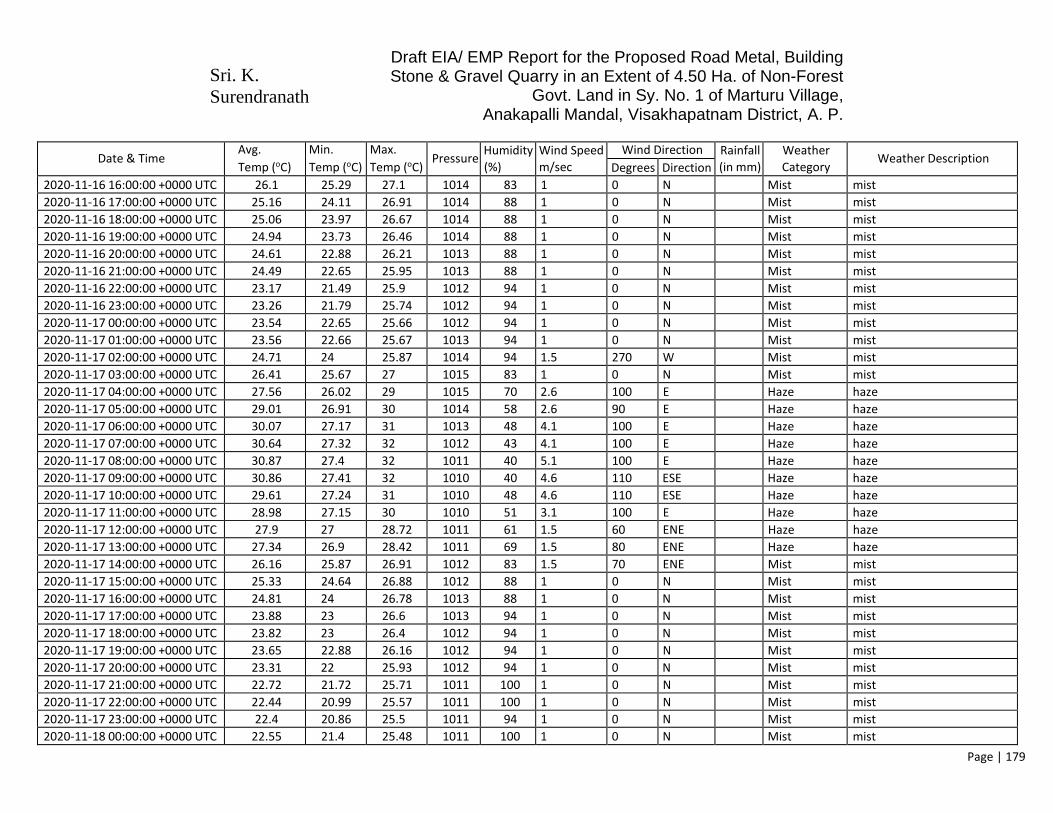
Sri. K. Surendranath
Draft EIA/ EMP Report for the Proposed Road Metal, Building Stone & Gravel Quarry in an Extent of 4.50 Ha. of Non-Forest
Govt. Land in Sy. No. 1 of Marturu Village, Anakapalli Mandal, Visakhapatnam District, A. P.
Page | 179
Date & Time Avg.
Temp (oC)
Min.
Temp (oC)
Max.
Temp (oC) Pressure
Humidity
(%)
Wind Speed
m/sec
Wind Direction Rainfall
(in mm)
Weather
Category Weather Description
Degrees Direction
2020-11-16 16:00:00 +0000 UTC 26.1 25.29 27.1 1014 83 1 0 N Mist mist
2020-11-16 17:00:00 +0000 UTC 25.16 24.11 26.91 1014 88 1 0 N Mist mist
2020-11-16 18:00:00 +0000 UTC 25.06 23.97 26.67 1014 88 1 0 N Mist mist
2020-11-16 19:00:00 +0000 UTC 24.94 23.73 26.46 1014 88 1 0 N Mist mist
2020-11-16 20:00:00 +0000 UTC 24.61 22.88 26.21 1013 88 1 0 N Mist mist
2020-11-16 21:00:00 +0000 UTC 24.49 22.65 25.95 1013 88 1 0 N Mist mist
2020-11-16 22:00:00 +0000 UTC 23.17 21.49 25.9 1012 94 1 0 N Mist mist
2020-11-16 23:00:00 +0000 UTC 23.26 21.79 25.74 1012 94 1 0 N Mist mist
2020-11-17 00:00:00 +0000 UTC 23.54 22.65 25.66 1012 94 1 0 N Mist mist
2020-11-17 01:00:00 +0000 UTC 23.56 22.66 25.67 1013 94 1 0 N Mist mist
2020-11-17 02:00:00 +0000 UTC 24.71 24 25.87 1014 94 1.5 270 W Mist mist
2020-11-17 03:00:00 +0000 UTC 26.41 25.67 27 1015 83 1 0 N Mist mist
2020-11-17 04:00:00 +0000 UTC 27.56 26.02 29 1015 70 2.6 100 E Haze haze
2020-11-17 05:00:00 +0000 UTC 29.01 26.91 30 1014 58 2.6 90 E Haze haze
2020-11-17 06:00:00 +0000 UTC 30.07 27.17 31 1013 48 4.1 100 E Haze haze
2020-11-17 07:00:00 +0000 UTC 30.64 27.32 32 1012 43 4.1 100 E Haze haze
2020-11-17 08:00:00 +0000 UTC 30.87 27.4 32 1011 40 5.1 100 E Haze haze
2020-11-17 09:00:00 +0000 UTC 30.86 27.41 32 1010 40 4.6 110 ESE Haze haze
2020-11-17 10:00:00 +0000 UTC 29.61 27.24 31 1010 48 4.6 110 ESE Haze haze
2020-11-17 11:00:00 +0000 UTC 28.98 27.15 30 1010 51 3.1 100 E Haze haze
2020-11-17 12:00:00 +0000 UTC 27.9 27 28.72 1011 61 1.5 60 ENE Haze haze
2020-11-17 13:00:00 +0000 UTC 27.34 26.9 28.42 1011 69 1.5 80 ENE Haze haze
2020-11-17 14:00:00 +0000 UTC 26.16 25.87 26.91 1012 83 1.5 70 ENE Mist mist
2020-11-17 15:00:00 +0000 UTC 25.33 24.64 26.88 1012 88 1 0 N Mist mist
2020-11-17 16:00:00 +0000 UTC 24.81 24 26.78 1013 88 1 0 N Mist mist
2020-11-17 17:00:00 +0000 UTC 23.88 23 26.6 1013 94 1 0 N Mist mist
2020-11-17 18:00:00 +0000 UTC 23.82 23 26.4 1012 94 1 0 N Mist mist
2020-11-17 19:00:00 +0000 UTC 23.65 22.88 26.16 1012 94 1 0 N Mist mist
2020-11-17 20:00:00 +0000 UTC 23.31 22 25.93 1012 94 1 0 N Mist mist
2020-11-17 21:00:00 +0000 UTC 22.72 21.72 25.71 1011 100 1 0 N Mist mist
2020-11-17 22:00:00 +0000 UTC 22.44 20.99 25.57 1011 100 1 0 N Mist mist
2020-11-17 23:00:00 +0000 UTC 22.4 20.86 25.5 1011 94 1 0 N Mist mist
2020-11-18 00:00:00 +0000 UTC 22.55 21.4 25.48 1011 100 1 0 N Mist mist

Sri. K. Surendranath
Draft EIA/ EMP Report for the Proposed Road Metal, Building Stone & Gravel Quarry in an Extent of 4.50 Ha. of Non-Forest
Govt. Land in Sy. No. 1 of Marturu Village, Anakapalli Mandal, Visakhapatnam District, A. P.
Page | 180
Date & Time Avg.
Temp (oC)
Min.
Temp (oC)
Max.
Temp (oC) Pressure
Humidity
(%)
Wind Speed
m/sec
Wind Direction Rainfall
(in mm)
Weather
Category Weather Description
Degrees Direction
2020-11-18 01:00:00 +0000 UTC 22.58 21.41 25.5 1012 100 1 0 N Mist mist
2020-11-18 02:00:00 +0000 UTC 24.48 24 25.74 1013 94 2.1 240 WSW Mist mist
2020-11-18 03:00:00 +0000 UTC 25.85 25.46 26.2 1014 78 1.5 290 WNW Mist mist
2020-11-18 04:00:00 +0000 UTC 26.95 25.79 28 1014 69 1.5 260 WSW Mist mist
2020-11-18 05:00:00 +0000 UTC 29.03 26.94 30 1014 58 1.5 30 NNE Haze haze
2020-11-18 06:00:00 +0000 UTC 30 27.14 31 1013 55 3.6 120 ESE Haze haze
2020-11-18 07:00:00 +0000 UTC 30.09 27.27 31 1012 55 4.1 140 SE Haze haze
2020-11-18 08:00:00 +0000 UTC 30.24 27.35 31 1011 55 5.1 140 SE Haze haze
2020-11-18 09:00:00 +0000 UTC 29.72 27.34 30.69 1011 58 4.1 140 SE Haze haze
2020-11-18 10:00:00 +0000 UTC 28.93 27.12 30 1011 58 3.6 110 ESE Haze haze
2020-11-18 11:00:00 +0000 UTC 28.33 27.02 29 1011 66 3.6 100 E Haze haze
2020-11-18 12:00:00 +0000 UTC 27.69 26.92 28 1012 69 3.1 100 E Mist mist
2020-11-18 13:00:00 +0000 UTC 27.22 26.88 28.01 1012 78 2.6 90 E Mist mist
2020-11-18 14:00:00 +0000 UTC 26.83 26.4 27 1013 83 2.1 90 E Mist mist
2020-11-18 15:00:00 +0000 UTC 26.45 24.98 27 1013 83 1.5 30 NNE Mist mist
2020-11-18 16:00:00 +0000 UTC 25.87 24.94 26.75 1014 88 1 0 N Mist mist
2020-11-18 17:00:00 +0000 UTC 24.97 23.91 26.48 1014 94 1 0 N Mist mist
2020-11-18 18:00:00 +0000 UTC 24.89 23.86 26.15 1014 94 1 0 N Mist mist
2020-11-18 19:00:00 +0000 UTC 24.73 23.45 25.87 1013 94 1 0 N Mist mist
2020-11-18 20:00:00 +0000 UTC 24.45 22.72 25.62 1012 94 1 0 N Mist mist
2020-11-18 21:00:00 +0000 UTC 23.88 22.51 25.41 1012 100 1 0 N Mist mist
2020-11-18 22:00:00 +0000 UTC 23.62 21.91 25.34 1012 100 1 0 N Mist mist
2020-11-18 23:00:00 +0000 UTC 23.55 21.67 25.21 1012 94 1 0 N Mist mist
2020-11-19 00:00:00 +0000 UTC 23.23 22.05 25.19 1012 100 1 0 N Mist mist
2020-11-19 01:00:00 +0000 UTC 23.24 22 25.16 1013 100 1 0 N Mist mist
2020-11-19 02:00:00 +0000 UTC 24.97 24.31 25.4 1013 94 1 0 N Mist mist
2020-11-19 03:00:00 +0000 UTC 26.65 25.38 28 1014 74 1 0 N Mist mist
2020-11-19 04:00:00 +0000 UTC 26.87 25.54 28 1014 69 1 0 N Haze haze
2020-11-19 05:00:00 +0000 UTC 28.37 26.67 29 1014 66 1.5 240 WSW Haze haze
2020-11-19 06:00:00 +0000 UTC 29.94 26.91 31 1013 58 3.6 110 ESE Haze haze
2020-11-19 07:00:00 +0000 UTC 30.08 27.05 31 1012 58 4.1 120 ESE Haze haze
2020-11-19 08:00:00 +0000 UTC 29.66 27.15 30.73 1011 62 4.6 130 SE Haze haze
2020-11-19 09:00:00 +0000 UTC 29.63 27.08 30.65 1010 66 4.1 120 ESE Haze haze

Sri. K. Surendranath
Draft EIA/ EMP Report for the Proposed Road Metal, Building Stone & Gravel Quarry in an Extent of 4.50 Ha. of Non-Forest
Govt. Land in Sy. No. 1 of Marturu Village, Anakapalli Mandal, Visakhapatnam District, A. P.
Page | 181
Date & Time Avg.
Temp (oC)
Min.
Temp (oC)
Max.
Temp (oC) Pressure
Humidity
(%)
Wind Speed
m/sec
Wind Direction Rainfall
(in mm)
Weather
Category Weather Description
Degrees Direction
2020-11-19 10:00:00 +0000 UTC 28.36 27.06 29 1010 70 4.1 110 ESE Haze haze
2020-11-19 11:00:00 +0000 UTC 27.76 26.94 28 1010 74 3.1 110 ESE Haze haze
2020-11-19 12:00:00 +0000 UTC 27.04 26.8 27.45 1011 83 1 0 N Mist mist
2020-11-19 13:00:00 +0000 UTC 26.54 26 27.61 1011 88 1 0 N Mist mist
2020-11-19 14:00:00 +0000 UTC 26 25 27.56 1012 94 1 0 N Mist mist
2020-11-19 15:00:00 +0000 UTC 25.58 25 27.09 1013 94 1 0 N Mist mist
2020-11-19 16:00:00 +0000 UTC 25.44 24.95 26.99 1013 94 1 0 N Mist mist
2020-11-19 17:00:00 +0000 UTC 25.04 24.03 26.2 1013 94 1 0 N Mist mist
2020-11-19 18:00:00 +0000 UTC 24.44 23.88 25.97 1013 94 1 0 N Mist mist
2020-11-19 19:00:00 +0000 UTC 24.19 23.35 25.6 1012 94 1 0 N Mist mist
2020-11-19 20:00:00 +0000 UTC 23.96 22.75 25.38 1012 94 1 0 N Mist mist
2020-11-19 21:00:00 +0000 UTC 23.41 22.51 25.2 1011 100 1 0 N Mist mist
2020-11-19 22:00:00 +0000 UTC 23.26 22.08 25.28 1011 100 1 0 N Mist mist
2020-11-19 23:00:00 +0000 UTC 23.28 21.94 25.18 1011 100 1 0 N Mist mist
2020-11-20 00:00:00 +0000 UTC 22.72 22 26.85 1012 100 1 0 N Mist mist
2020-11-20 01:00:00 +0000 UTC 22.64 22 26.85 1012 100 1 0 N Mist mist
2020-11-20 02:00:00 +0000 UTC 24.59 24 26.75 1013 100 1 0 N Mist mist
2020-11-20 03:00:00 +0000 UTC 26.06 25.77 26.75 1014 94 2.1 260 WSW Mist mist
2020-11-20 04:00:00 +0000 UTC 27.51 25.77 28 1014 78 1.5 270 W Mist mist
2020-11-20 05:00:00 +0000 UTC 28.69 26.95 29 1014 70 1 0 N Haze haze
2020-11-20 06:00:00 +0000 UTC 28.66 26.95 29 1013 70 2.1 210 SSW Haze haze
2020-11-20 07:00:00 +0000 UTC 29.42 26.95 30 1012 66 1 0 N Haze haze
2020-11-20 08:00:00 +0000 UTC 29.32 27.37 30 1011 70 3.1 110 ESE Smoke smoke
2020-11-20 09:00:00 +0000 UTC 29.26 27.37 30 1010 70 2.6 140 SE Haze haze
2020-11-20 10:00:00 +0000 UTC 28.56 27.37 29 1010 74 2.1 110 ESE Mist mist
2020-11-20 11:00:00 +0000 UTC 27.62 25.85 28 1010 78 1.5 190 S Smoke smoke
2020-11-20 12:00:00 +0000 UTC 27.58 25.85 28 1010 83 2.6 260 WSW Mist mist
2020-11-20 13:00:00 +0000 UTC 26.89 25.85 27.6 1011 83 3.1 250 WSW Smoke smoke
2020-11-20 14:00:00 +0000 UTC 26.04 25.02 27.72 1012 88 1.5 340 NNW Mist mist
2020-11-20 15:00:00 +0000 UTC 25.35 25 27.72 1013 94 1 0 N Mist mist
2020-11-20 16:00:00 +0000 UTC 25.31 25 27.72 1013 94 1 0 N Mist mist
2020-11-20 17:00:00 +0000 UTC 25.21 24.53 27.47 1013 94 1 0 N Mist mist
2020-11-20 18:00:00 +0000 UTC 24.54 24 27.47 1013 100 1 0 N Mist mist

Sri. K. Surendranath
Draft EIA/ EMP Report for the Proposed Road Metal, Building Stone & Gravel Quarry in an Extent of 4.50 Ha. of Non-Forest
Govt. Land in Sy. No. 1 of Marturu Village, Anakapalli Mandal, Visakhapatnam District, A. P.
Page | 182
Date & Time Avg.
Temp (oC)
Min.
Temp (oC)
Max.
Temp (oC) Pressure
Humidity
(%)
Wind Speed
m/sec
Wind Direction Rainfall
(in mm)
Weather
Category Weather Description
Degrees Direction
2020-11-20 19:00:00 +0000 UTC 24.48 24 27.47 1012 94 1 0 N Mist mist
2020-11-20 20:00:00 +0000 UTC 24.28 23.38 27.3 1012 94 1 0 N Mist mist
2020-11-20 21:00:00 +0000 UTC 24.32 23.38 27.3 1011 94 1 0 N Mist mist
2020-11-20 22:00:00 +0000 UTC 23.55 23 27.3 1011 100 1 0 N Mist mist
2020-11-20 23:00:00 +0000 UTC 23.41 22.83 26.81 1011 100 1 0 N Mist mist
2020-11-21 00:00:00 +0000 UTC 22.76 22 26.81 1011 100 2.6 270 W Mist mist
2020-11-21 01:00:00 +0000 UTC 22.68 22 26.81 1012 100 3.1 240 WSW Mist mist
2020-11-21 02:00:00 +0000 UTC 24.02 23 26.95 1013 100 1 0 N Mist mist
2020-11-21 03:00:00 +0000 UTC 26.15 26 26.95 1014 83 1.5 250 WSW Mist mist
2020-11-21 04:00:00 +0000 UTC 28.32 26.15 29 1014 70 1 0 N Mist mist
2020-11-21 05:00:00 +0000 UTC 29.48 27.04 30 1013 66 1 0 N Haze haze
2020-11-21 06:00:00 +0000 UTC 30.12 27.04 31 1012 62 4.1 110 ESE Haze haze
2020-11-21 07:00:00 +0000 UTC 30.21 27.04 31 1012 62 5.1 110 ESE Haze haze
2020-11-21 08:00:00 +0000 UTC 29.41 27.35 30 1010 66 4.6 100 E Haze haze
2020-11-21 09:00:00 +0000 UTC 29.35 27.35 30 1009 66 4.1 110 ESE Haze haze
2020-11-21 10:00:00 +0000 UTC 29.41 27.35 30 1009 66 3.6 90 E Haze haze
2020-11-21 11:00:00 +0000 UTC 28.44 26.14 29 1010 70 3.1 100 E Haze haze
2020-11-21 12:00:00 +0000 UTC 27.69 26.14 28.03 1010 78 1 0 N Haze haze
2020-11-21 13:00:00 +0000 UTC 26.98 26.14 28.03 1011 83 1 0 N Mist mist
2020-11-21 14:00:00 +0000 UTC 26.92 25.7 28.08 1012 83 1 0 N Mist mist
2020-11-21 15:00:00 +0000 UTC 26.92 25.7 28.08 1013 83 1 0 N Mist mist
2020-11-21 16:00:00 +0000 UTC 26.92 25.7 28.08 1014 83 1 0 N Mist mist
2020-11-21 17:00:00 +0000 UTC 26.81 25.01 28.12 1013 83 1 0 N Mist mist
2020-11-21 18:00:00 +0000 UTC 26.1 25.01 28.12 1013 94 1 0 N Mist mist
2020-11-21 19:00:00 +0000 UTC 26.09 25.01 28.12 1012 94 1 0 N Drizzle drizzle
2020-11-21 20:00:00 +0000 UTC 25.2 24.2 27.82 1012 100 1 0 N Mist mist
2020-11-21 21:00:00 +0000 UTC 25.23 24.2 27.82 1011 100 1 0 N Mist mist
2020-11-21 22:00:00 +0000 UTC 25.2 24.2 27.82 1011 94 1 0 N Mist mist
2020-11-21 23:00:00 +0000 UTC 25.14 23.95 27.69 1012 94 1 0 N Mist mist
2020-11-22 00:00:00 +0000 UTC 24.46 23.95 27.69 1013 100 1 0 N Mist mist
2020-11-22 01:00:00 +0000 UTC 24.41 23.95 27.69 1013 100 1 0 N Mist mist
2020-11-22 02:00:00 +0000 UTC 25.56 25 27.29 1014 94 1 0 N Mist mist
2020-11-22 03:00:00 +0000 UTC 27.73 26.92 28 1015 83 1 0 N Mist mist

Sri. K. Surendranath
Draft EIA/ EMP Report for the Proposed Road Metal, Building Stone & Gravel Quarry in an Extent of 4.50 Ha. of Non-Forest
Govt. Land in Sy. No. 1 of Marturu Village, Anakapalli Mandal, Visakhapatnam District, A. P.
Page | 183
Date & Time Avg.
Temp (oC)
Min.
Temp (oC)
Max.
Temp (oC) Pressure
Humidity
(%)
Wind Speed
m/sec
Wind Direction Rainfall
(in mm)
Weather
Category Weather Description
Degrees Direction
2020-11-22 04:00:00 +0000 UTC 28.48 26.92 29 1015 74 2.1 30 NNE Haze haze
2020-11-22 05:00:00 +0000 UTC 30.31 27.31 31 1014 58 3.1 100 E Haze haze
2020-11-22 06:00:00 +0000 UTC 30.23 27.31 31 1013 58 5.1 90 E Haze haze
2020-11-22 07:00:00 +0000 UTC 30.31 27.31 31 1013 58 4.1 110 ESE Haze haze
2020-11-22 08:00:00 +0000 UTC 29.46 27.59 30 1011 66 5.1 100 E Haze haze
2020-11-22 09:00:00 +0000 UTC 29.4 27.59 30 1011 66 4.6 90 E Haze haze
2020-11-22 10:00:00 +0000 UTC 28.73 27.59 29 1011 70 5.1 100 E Haze haze
2020-11-22 11:00:00 +0000 UTC 27.69 26.39 28 1012 74 4.6 100 E Haze haze
2020-11-22 12:00:00 +0000 UTC 27.66 26.39 28 1012 78 4.1 90 E Mist mist
2020-11-22 13:00:00 +0000 UTC 27.69 26.39 28 1013 78 5.1 90 E Mist mist
2020-11-22 14:00:00 +0000 UTC 27.6 25.73 28 1014 78 4.1 90 E Mist mist
2020-11-22 15:00:00 +0000 UTC 27.56 25.73 28 1015 78 4.6 100 E Mist mist
2020-11-22 16:00:00 +0000 UTC 27.6 25.73 28 1015 78 5.1 90 E 1.08 Drizzle light intensity drizzle
2020-11-22 16:00:00 +0000 UTC 27.6 25.73 28 1015 78 5.1 90 E 1.08 Mist mist
2020-11-22 17:00:00 +0000 UTC 27.52 25.24 28 1015 78 4.1 90 E Mist mist
2020-11-22 18:00:00 +0000 UTC 26.77 25.24 27.57 1015 83 3.1 70 ENE 0.33 Drizzle light intensity drizzle
2020-11-22 19:00:00 +0000 UTC 26.79 25.24 27.57 1014 83 1.5 30 NNE 0.33 Drizzle light intensity drizzle
2020-11-22 20:00:00 +0000 UTC 26.57 24.27 27 1014 83 2.6 40 NE Mist mist
2020-11-22 21:00:00 +0000 UTC 25.83 24.27 26.97 1013 83 2.1 40 NE Mist mist
2020-11-22 22:00:00 +0000 UTC 25.84 24.27 26.97 1013 83 2.1 60 ENE Mist mist
2020-11-22 23:00:00 +0000 UTC 25.01 23.68 26.86 1013 88 1 0 N Mist mist
2020-11-23 00:00:00 +0000 UTC 25.02 23.68 26.86 1014 88 1.5 40 NE Mist mist
2020-11-23 01:00:00 +0000 UTC 25.73 23.68 26.86 1014 83 3.6 50 NE Mist mist
2020-11-23 02:00:00 +0000 UTC 25.95 25.25 26.6 1015 78 3.6 40 NE Mist mist
2020-11-23 03:00:00 +0000 UTC 25.95 25.25 26.6 1016 74 3.1 40 NE Haze haze
2020-11-23 04:00:00 +0000 UTC 26.68 25.25 27 1016 74 4.1 50 NE Haze haze
2020-11-23 05:00:00 +0000 UTC 27.72 26.06 28 1016 69 4.6 80 ENE Haze haze
2020-11-23 06:00:00 +0000 UTC 27.68 26.06 28 1015 61 3.6 60 ENE Haze haze
2020-11-23 07:00:00 +0000 UTC 27.72 26.06 28 1013 61 3.6 60 ENE Haze haze
2020-11-23 08:00:00 +0000 UTC 27.63 26.16 28 1012 61 3.1 100 E Haze haze
2020-11-23 09:00:00 +0000 UTC 27.59 26.16 28 1012 65 5.1 90 E Haze haze
2020-11-23 10:00:00 +0000 UTC 27.63 26.16 28 1011 65 5.1 90 E Haze haze
2020-11-23 11:00:00 +0000 UTC 26.7 25.33 27 1011 69 5.1 70 ENE Haze haze

Sri. K. Surendranath
Draft EIA/ EMP Report for the Proposed Road Metal, Building Stone & Gravel Quarry in an Extent of 4.50 Ha. of Non-Forest
Govt. Land in Sy. No. 1 of Marturu Village, Anakapalli Mandal, Visakhapatnam District, A. P.
Page | 184
Date & Time Avg.
Temp (oC)
Min.
Temp (oC)
Max.
Temp (oC) Pressure
Humidity
(%)
Wind Speed
m/sec
Wind Direction Rainfall
(in mm)
Weather
Category Weather Description
Degrees Direction
2020-11-23 12:00:00 +0000 UTC 26.67 25.33 27 1012 69 2.6 90 E Haze haze
2020-11-23 13:00:00 +0000 UTC 26.7 25.33 27 1013 69 2.6 60 ENE Haze haze
2020-11-23 14:00:00 +0000 UTC 25.93 24.86 26.98 1014 74 2.6 80 ENE Haze haze
2020-11-23 15:00:00 +0000 UTC 25.93 24.86 26.98 1015 69 3.1 90 E Haze haze
2020-11-23 16:00:00 +0000 UTC 25.93 24.86 26.98 1015 74 3.1 80 ENE Haze haze
2020-11-23 17:00:00 +0000 UTC 25.82 24.36 26.72 1015 69 4.1 90 E Haze haze
2020-11-23 18:00:00 +0000 UTC 25.81 24.36 26.72 1014 69 3.6 80 ENE Haze haze
2020-11-23 19:00:00 +0000 UTC 25.82 24.36 26.72 1013 69 3.6 70 ENE Haze haze
2020-11-23 20:00:00 +0000 UTC 25.49 22.48 26.4 1013 69 2.6 50 NE Haze haze
2020-11-23 21:00:00 +0000 UTC 25.45 22.48 26.4 1012 69 3.1 40 NE Haze haze
2020-11-23 22:00:00 +0000 UTC 24.76 22.48 26.4 1013 69 4.1 40 NE Haze haze
2020-11-23 23:00:00 +0000 UTC 24.69 22.25 26.04 1013 69 5.1 40 NE Haze haze
2020-11-24 00:00:00 +0000 UTC 23.97 22.25 26.04 1013 69 4.1 40 NE Haze haze
2020-11-24 01:00:00 +0000 UTC 23.96 22.25 26.04 1014 69 3.6 40 NE Haze haze
2020-11-24 02:00:00 +0000 UTC 24.29 24 25.49 1015 64 4.6 50 NE Haze haze
2020-11-24 03:00:00 +0000 UTC 24.32 24 25.49 1015 64 4.1 40 NE Haze haze
2020-11-24 04:00:00 +0000 UTC 25.02 24.76 25.49 1016 61 4.1 60 ENE Haze haze
2020-11-24 05:00:00 +0000 UTC 26.19 25.83 27.36 1015 57 3.6 90 E Haze haze
2020-11-24 06:00:00 +0000 UTC 27.61 25.83 28 1014 48 4.1 60 ENE Haze haze
2020-11-24 07:00:00 +0000 UTC 27.65 25.83 28 1013 48 4.1 60 ENE Haze haze
2020-11-24 08:00:00 +0000 UTC 28.37 25.94 29 1012 42 4.1 90 E Haze haze
2020-11-24 09:00:00 +0000 UTC 27.6 25.94 28 1011 45 4.1 90 E Haze haze
2020-11-24 10:00:00 +0000 UTC 27.64 25.94 28 1011 48 4.1 90 E Haze haze
2020-11-24 11:00:00 +0000 UTC 26.62 25.09 27 1011 51 4.1 90 E Haze haze
2020-11-24 12:00:00 +0000 UTC 25.88 25.09 26.31 1012 57 3.1 70 ENE Haze haze
2020-11-24 13:00:00 +0000 UTC 25.89 25.09 26.31 1013 57 4.1 90 E Haze haze
2020-11-24 14:00:00 +0000 UTC 25.14 24.71 26.6 1013 61 3.6 90 E Haze haze
2020-11-24 15:00:00 +0000 UTC 25.16 24.71 26.6 1014 61 2.1 80 ENE Haze haze
2020-11-24 16:00:00 +0000 UTC 25.14 24.71 26.6 1014 61 2.1 40 NE Haze haze
2020-11-24 17:00:00 +0000 UTC 25.02 23.81 26.84 1014 61 1.5 30 NNE Haze haze
2020-11-24 18:00:00 +0000 UTC 25.03 23.81 26.84 1013 69 2.1 30 NNE Haze haze
2020-11-24 19:00:00 +0000 UTC 25.02 23.81 26.84 1013 69 2.1 40 NE Haze haze
2020-11-24 20:00:00 +0000 UTC 24.73 22.23 26.48 1012 69 2.1 30 NNE Haze haze

Sri. K. Surendranath
Draft EIA/ EMP Report for the Proposed Road Metal, Building Stone & Gravel Quarry in an Extent of 4.50 Ha. of Non-Forest
Govt. Land in Sy. No. 1 of Marturu Village, Anakapalli Mandal, Visakhapatnam District, A. P.
Page | 185
Date & Time Avg.
Temp (oC)
Min.
Temp (oC)
Max.
Temp (oC) Pressure
Humidity
(%)
Wind Speed
m/sec
Wind Direction Rainfall
(in mm)
Weather
Category Weather Description
Degrees Direction
2020-11-24 21:00:00 +0000 UTC 24.02 22.23 26.48 1012 73 3.6 30 NNE Haze haze
2020-11-24 22:00:00 +0000 UTC 24 22.23 26.48 1011 73 3.6 60 ENE Haze haze
2020-11-24 23:00:00 +0000 UTC 24.04 22.63 26.22 1012 73 3.6 50 NE Haze haze
2020-11-25 00:00:00 +0000 UTC 24.05 22.63 26.22 1012 73 4.6 60 ENE Haze haze
2020-11-25 01:00:00 +0000 UTC 24.04 22.63 26.22 1013 73 4.6 60 ENE Haze haze
2020-11-25 02:00:00 +0000 UTC 25.05 24.55 26.11 1014 57 2.1 110 ESE Haze haze
2020-11-25 03:00:00 +0000 UTC 25.06 24.55 26.11 1015 57 3.6 80 ENE Haze haze
2020-11-25 04:00:00 +0000 UTC 25.05 24.55 26.11 1015 50 4.1 60 ENE Haze haze
2020-11-25 05:00:00 +0000 UTC 26.02 25.59 26.41 1014 44 4.1 60 ENE Haze haze
2020-11-25 06:00:00 +0000 UTC 26.72 25.59 27 1013 51 3.6 60 ENE Haze haze
2020-11-25 07:00:00 +0000 UTC 27.47 25.59 28 1012 51 4.1 70 ENE Haze haze
2020-11-25 08:00:00 +0000 UTC 26.69 25.45 27 1012 57 4.1 40 NE Haze haze
2020-11-25 09:00:00 +0000 UTC 26.66 25.45 27 1011 57 3.6 40 NE Haze haze
2020-11-25 10:00:00 +0000 UTC 26.69 25.45 27 1010 61 3.6 80 ENE Haze haze
2020-11-25 11:00:00 +0000 UTC 25.82 25.02 26 1010 61 2.6 70 ENE Haze haze
2020-11-25 12:00:00 +0000 UTC 25.8 25.02 26 1011 61 1.5 60 ENE Haze haze
2020-11-25 13:00:00 +0000 UTC 25.82 25.02 26 1012 61 3.1 80 ENE Haze haze
2020-11-25 14:00:00 +0000 UTC 25.81 24.78 26.03 1013 57 4.1 70 ENE Haze haze
2020-11-25 15:00:00 +0000 UTC 25.79 24.78 26.03 1014 57 4.1 70 ENE Haze haze
2020-11-25 16:00:00 +0000 UTC 25.08 24.78 26.03 1014 61 3.6 50 NE Haze haze
2020-11-25 17:00:00 +0000 UTC 24.94 23.98 25.87 1014 61 4.6 60 ENE 0.33 Drizzle light intensity drizzle
2020-11-25 18:00:00 +0000 UTC 24.94 23.98 25.87 1014 61 3.6 80 ENE 0.33 Drizzle light intensity drizzle
2020-11-25 19:00:00 +0000 UTC 24.94 23.98 25.87 1014 61 4.1 80 ENE 0.33 Drizzle drizzle
2020-11-25 20:00:00 +0000 UTC 23.62 20.29 25.81 1013 69 4.1 80 ENE 0.63 Drizzle drizzle
2020-11-25 21:00:00 +0000 UTC 22.2 20.29 25.81 1012 78 2.6 160 SSE 0.63 Rain light rain
2020-11-25 22:00:00 +0000 UTC 22.18 20.29 25.81 1012 78 2.6 160 SSE 0.63 Rain light rain
2020-11-25 23:00:00 +0000 UTC 21.93 20.04 24.09 1012 78 2.1 50 NE 0.33 Mist mist
2020-11-26 00:00:00 +0000 UTC 21.93 20.04 24.09 1013 73 5.1 110 ESE 0.33 Drizzle light intensity drizzle
2020-11-26 01:00:00 +0000 UTC 21.2 20.04 24.09 1013 77 4.6 50 NE 0.33 Drizzle drizzle
2020-11-26 02:00:00 +0000 UTC 20.44 20 23.23 1014 82 4.6 40 NE 0.5 Rain light rain
2020-11-26 03:00:00 +0000 UTC 21.19 20.45 23.23 1015 68 3.1 60 ENE 0.5 Rain light rain
2020-11-26 04:00:00 +0000 UTC 19.71 19 23.23 1016 88 1 0 N 0.5 Rain moderate rain
2020-11-26 05:00:00 +0000 UTC 21.03 19.65 23.13 1015 88 3.6 120 ESE 0.33 Rain moderate rain

Sri. K. Surendranath
Draft EIA/ EMP Report for the Proposed Road Metal, Building Stone & Gravel Quarry in an Extent of 4.50 Ha. of Non-Forest
Govt. Land in Sy. No. 1 of Marturu Village, Anakapalli Mandal, Visakhapatnam District, A. P.
Page | 186
Date & Time Avg.
Temp (oC)
Min.
Temp (oC)
Max.
Temp (oC) Pressure
Humidity
(%)
Wind Speed
m/sec
Wind Direction Rainfall
(in mm)
Weather
Category Weather Description
Degrees Direction
2020-11-26 06:00:00 +0000 UTC 21.75 19.65 23.13 1014 83 1 0 N 0.33 Rain light rain
2020-11-26 07:00:00 +0000 UTC 21.03 19.65 23.13 1013 88 2.6 330 NNW 0.33 Rain moderate rain
2020-11-26 08:00:00 +0000 UTC 21.17 20.1 23.7 1012 88 3.6 310 NW 1.13 Rain light rain
2020-11-26 09:00:00 +0000 UTC 21.19 20.1 23.7 1012 88 2.6 340 NNW 1.13 Rain light rain
2020-11-26 10:00:00 +0000 UTC 21.17 20.1 23.7 1011 88 2.6 360 N 1.13 Rain light rain
2020-11-26 11:00:00 +0000 UTC 21.3 20.59 24.23 1012 94 2.6 70 ENE 0.33 Rain moderate rain
2020-11-26 12:00:00 +0000 UTC 21.35 20.59 24.23 1012 94 2.1 30 NNE 0.33 Rain light rain
2020-11-26 13:00:00 +0000 UTC 22.03 20.59 24.23 1013 88 4.1 70 ENE 0.33 Rain moderate rain
2020-11-26 14:00:00 +0000 UTC 22.02 21.25 23.24 1014 88 1.5 70 ENE 1.19 Drizzle drizzle
2020-11-26 15:00:00 +0000 UTC 22.03 21.25 23.24 1015 88 1 0 N 1.19 Drizzle drizzle
2020-11-26 16:00:00 +0000 UTC 21.29 21 23.24 1016 94 3.1 250 WSW 1.19 Drizzle drizzle
2020-11-26 17:00:00 +0000 UTC 21.38 21 23.71 1015 100 2.6 270 W 1.5 Rain moderate rain
2020-11-26 18:00:00 +0000 UTC 20.72 20 23.71 1015 100 2.6 280 W 1.5 Rain moderate rain
2020-11-26 19:00:00 +0000 UTC 20.65 20 23.71 1014 100 2.6 340 NNW Drizzle drizzle
2020-11-26 20:00:00 +0000 UTC 20.68 20 23.1 1013 100 2.6 340 NNW 1.25 Drizzle drizzle
2020-11-26 21:00:00 +0000 UTC 20.75 20 23.1 1012 100 1 0 N 1.25 Drizzle drizzle
2020-11-26 22:00:00 +0000 UTC 20.63 20 23.1 1012 100 3.1 50 NE 1.25 Rain light rain
2020-11-26 23:00:00 +0000 UTC 21.47 21 23.83 1012 94 4.1 320 NW 0.33 Drizzle drizzle
2020-11-27 00:00:00 +0000 UTC 22.23 21.95 23.83 1013 88 4.1 60 ENE 0.33 Drizzle drizzle
2020-11-27 01:00:00 +0000 UTC 22.2 21.95 23.83 1014 83 3.6 70 ENE 0.33 Drizzle drizzle
2020-11-27 02:00:00 +0000 UTC 22.36 22 24.79 1014 78 3.1 10 N 0.96 Drizzle light intensity drizzle
2020-11-27 03:00:00 +0000 UTC 23.78 22.11 24.79 1015 69 2.1 230 SW Clouds broken clouds
2020-11-27 04:00:00 +0000 UTC 23.78 22.11 24.79 1015 69 2.1 320 NW Clouds broken clouds
2020-11-27 05:00:00 +0000 UTC 24.76 23.26 25.46 1015 65 1.5 50 NE Clouds broken clouds
2020-11-27 06:00:00 +0000 UTC 25.46 23.26 26 1014 61 4.1 40 NE Clouds broken clouds
2020-11-27 07:00:00 +0000 UTC 25.47 23.26 26 1013 61 3.6 40 NE Clouds overcast clouds
2020-11-27 08:00:00 +0000 UTC 25.49 23.02 26 1012 65 3.6 60 ENE Haze haze
2020-11-27 09:00:00 +0000 UTC 24.74 23.02 25.59 1012 69 4.1 40 NE 1.54 Drizzle drizzle
2020-11-27 10:00:00 +0000 UTC 24.03 23.02 25.59 1012 78 3.6 50 NE 1.54 Drizzle drizzle
2020-11-27 11:00:00 +0000 UTC 23.94 22.54 25.52 1012 78 4.1 30 NNE Drizzle drizzle
2020-11-27 12:00:00 +0000 UTC 23.95 22.54 25.52 1013 78 4.1 30 NNE Drizzle drizzle
2020-11-27 13:00:00 +0000 UTC 23.21 22.54 25.52 1014 78 4.6 30 NNE Drizzle drizzle
2020-11-27 14:00:00 +0000 UTC 21.16 20 25.92 1016 88 3.1 330 NNW 0.06 Rain light rain

Sri. K. Surendranath
Draft EIA/ EMP Report for the Proposed Road Metal, Building Stone & Gravel Quarry in an Extent of 4.50 Ha. of Non-Forest
Govt. Land in Sy. No. 1 of Marturu Village, Anakapalli Mandal, Visakhapatnam District, A. P.
Page | 187
Date & Time Avg.
Temp (oC)
Min.
Temp (oC)
Max.
Temp (oC) Pressure
Humidity
(%)
Wind Speed
m/sec
Wind Direction Rainfall
(in mm)
Weather
Category Weather Description
Degrees Direction
2020-11-27 15:00:00 +0000 UTC 21.28 20 25.92 1016 88 6.2 20 NNE 0.06 Drizzle drizzle
2020-11-27 16:00:00 +0000 UTC 21.16 20 25.92 1017 88 4.1 280 W 0.06 Rain light rain
2020-11-27 17:00:00 +0000 UTC 21.31 20 26.84 1016 88 5.1 270 W 0.33 Drizzle drizzle
2020-11-27 18:00:00 +0000 UTC 21.45 20 26.84 1016 88 3.6 330 NNW Mist mist
2020-11-27 19:00:00 +0000 UTC 21.31 20 26.84 1015 88 2.1 290 WNW Mist mist
2020-11-27 20:00:00 +0000 UTC 21.23 20 26.56 1014 88 2.1 290 WNW Mist mist
2020-11-27 21:00:00 +0000 UTC 22.03 21 26.56 1014 83 2.1 240 WSW 0.06 Drizzle light intensity drizzle
2020-11-27 22:00:00 +0000 UTC 21.93 21 26.56 1014 83 2.1 240 WSW 0.06 Drizzle light intensity drizzle
2020-11-27 23:00:00 +0000 UTC 21.83 21 25.99 1014 83 2.1 250 WSW 0.33 Drizzle drizzle
2020-11-28 00:00:00 +0000 UTC 21.86 21 25.99 1015 83 2.6 260 WSW 0.33 Drizzle light intensity drizzle
2020-11-28 01:00:00 +0000 UTC 21.77 21 25.99 1015 88 1.5 300 WNW 0.33 Drizzle drizzle
2020-11-28 02:00:00 +0000 UTC 23.96 22.72 25.38 1016 60 2.1 70 ENE Haze haze
2020-11-28 03:00:00 +0000 UTC 24.66 22.72 25.38 1017 57 2.6 60 ENE Haze haze
2020-11-28 04:00:00 +0000 UTC 25.41 22.72 26 1017 54 4.1 90 E Haze haze
2020-11-28 05:00:00 +0000 UTC 25.13 25 25.49 1017 57 4.1 70 ENE Haze haze
2020-11-28 06:00:00 +0000 UTC 25.84 25.42 26 1016 57 3.6 100 E Haze haze
2020-11-28 07:00:00 +0000 UTC 25.85 25.42 26 1015 61 4.1 50 NE Haze haze
2020-11-28 08:00:00 +0000 UTC 26.1 25.68 26.87 1014 57 2.1 80 ENE Haze haze
2020-11-28 09:00:00 +0000 UTC 26.11 25.68 26.87 1013 65 1 0 N Haze haze
2020-11-28 10:00:00 +0000 UTC 26.1 25.68 26.87 1013 65 1.5 70 ENE Haze haze
2020-11-28 11:00:00 +0000 UTC 25.18 25 26.19 1014 73 1 0 N Haze haze
2020-11-28 12:00:00 +0000 UTC 25.21 25 26.19 1014 78 1 0 N Mist mist
2020-11-28 13:00:00 +0000 UTC 25.18 25 26.19 1015 73 2.1 120 ESE Haze haze
2020-11-28 14:00:00 +0000 UTC 24.31 24 26.46 1016 78 1 0 N Haze haze
2020-11-28 15:00:00 +0000 UTC 25.05 24.21 26.46 1016 73 3.6 80 ENE Haze haze
2020-11-28 16:00:00 +0000 UTC 25.04 24.21 26.46 1016 73 3.6 50 NE Haze haze
2020-11-28 17:00:00 +0000 UTC 25 23.56 26.97 1016 73 3.1 50 NE Haze haze
2020-11-28 18:00:00 +0000 UTC 25.01 23.56 26.97 1016 69 2.6 40 NE Haze haze
2020-11-28 19:00:00 +0000 UTC 24.27 23.56 26.97 1015 73 1 0 N Haze haze
2020-11-28 20:00:00 +0000 UTC 24.03 22.18 26.81 1015 73 1 0 N Haze haze
2020-11-28 21:00:00 +0000 UTC 24.05 22.18 26.81 1014 73 1 0 N Haze haze
2020-11-28 22:00:00 +0000 UTC 24.03 22.18 26.81 1014 78 1 0 N Mist mist
2020-11-28 23:00:00 +0000 UTC 23.97 22.44 25.89 1014 78 1 0 N Mist mist

Sri. K. Surendranath
Draft EIA/ EMP Report for the Proposed Road Metal, Building Stone & Gravel Quarry in an Extent of 4.50 Ha. of Non-Forest
Govt. Land in Sy. No. 1 of Marturu Village, Anakapalli Mandal, Visakhapatnam District, A. P.
Page | 188
Date & Time Avg.
Temp (oC)
Min.
Temp (oC)
Max.
Temp (oC) Pressure
Humidity
(%)
Wind Speed
m/sec
Wind Direction Rainfall
(in mm)
Weather
Category Weather Description
Degrees Direction
2020-11-29 00:00:00 +0000 UTC 22.58 22 25.89 1014 83 1.5 300 WNW Mist mist
2020-11-29 01:00:00 +0000 UTC 21.78 21 25.89 1015 77 2.1 290 WNW Mist mist
2020-11-29 02:00:00 +0000 UTC 23.69 23 25.94 1016 73 2.1 290 WNW Haze haze
2020-11-29 03:00:00 +0000 UTC 25.87 25.29 26 1017 57 2.6 40 NE Haze haze
2020-11-29 04:00:00 +0000 UTC 26.61 25.29 27 1017 47 3.1 60 ENE Haze haze
2020-11-29 05:00:00 +0000 UTC 27.74 25.89 28 1017 42 4.1 50 NE Haze haze
2020-11-29 06:00:00 +0000 UTC 28.41 25.89 29 1016 39 4.1 50 NE Clear sky is clear
2020-11-29 07:00:00 +0000 UTC 29.2 25.89 30 1015 35 4.1 70 ENE Clear sky is clear
2020-11-29 08:00:00 +0000 UTC 29.23 26.19 30 1013 30 5.1 70 ENE Clear sky is clear
2020-11-29 09:00:00 +0000 UTC 29.15 26.19 30 1013 40 5.1 90 E Clear sky is clear
2020-11-29 10:00:00 +0000 UTC 28.5 26.19 29 1013 39 4.6 70 ENE Clear sky is clear
2020-11-29 11:00:00 +0000 UTC 27.39 25.15 28 1013 39 3.6 60 ENE Haze haze
2020-11-29 12:00:00 +0000 UTC 26.63 25.15 27 1013 51 2.6 40 NE Haze haze
2020-11-29 13:00:00 +0000 UTC 25.93 25.15 26.57 1014 50 3.1 70 ENE Haze haze
2020-11-29 14:00:00 +0000 UTC 25.09 24.43 26.55 1015 57 2.1 70 ENE Haze haze
2020-11-29 15:00:00 +0000 UTC 24.4 24 26.55 1016 73 1 0 N Haze haze
2020-11-29 16:00:00 +0000 UTC 23.63 23 26.55 1016 83 1 0 N Mist mist
2020-11-29 17:00:00 +0000 UTC 22.02 21 26.76 1016 83 2.1 270 W Mist mist
2020-11-29 18:00:00 +0000 UTC 22.22 21 26.76 1016 77 1.5 280 W Mist mist
2020-11-29 19:00:00 +0000 UTC 21.29 20 26.76 1015 82 1 0 N Mist mist
2020-11-29 20:00:00 +0000 UTC 20.96 20 26.46 1015 82 1 0 N Mist mist
2020-11-29 21:00:00 +0000 UTC 21.07 20 26.46 1014 82 1 0 N Mist mist
2020-11-29 22:00:00 +0000 UTC 20.96 20 26.46 1014 82 1 0 N Mist mist
2020-11-29 23:00:00 +0000 UTC 20.22 19 25.59 1014 88 1 0 N Mist mist
2020-11-30 00:00:00 +0000 UTC 20.26 19 25.59 1014 93 1 0 N Mist mist
2020-11-30 01:00:00 +0000 UTC 20.14 19 25.59 1015 88 1 0 N Mist mist
2020-11-30 02:00:00 +0000 UTC 22.02 21 25.12 1016 83 1 0 N Mist mist
2020-11-30 03:00:00 +0000 UTC 24.23 24 25.12 1016 69 3.1 240 WSW Haze haze
2020-11-30 04:00:00 +0000 UTC 26.39 24.51 27 1016 44 2.6 100 E Haze haze
2020-11-30 05:00:00 +0000 UTC 28.47 25.49 29 1016 39 2.6 100 E Haze haze
2020-11-30 06:00:00 +0000 UTC 28.41 25.49 29 1015 39 4.1 70 ENE Haze haze
2020-11-30 07:00:00 +0000 UTC 28.47 25.49 29 1014 39 4.1 60 ENE Haze haze
2020-11-30 08:00:00 +0000 UTC 29.15 26.13 30 1013 37 4.6 110 ESE Haze haze

Sri. K. Surendranath
Draft EIA/ EMP Report for the Proposed Road Metal, Building Stone & Gravel Quarry in an Extent of 4.50 Ha. of Non-Forest
Govt. Land in Sy. No. 1 of Marturu Village, Anakapalli Mandal, Visakhapatnam District, A. P.
Page | 189
Date & Time Avg.
Temp (oC)
Min.
Temp (oC)
Max.
Temp (oC) Pressure
Humidity
(%)
Wind Speed
m/sec
Wind Direction Rainfall
(in mm)
Weather
Category Weather Description
Degrees Direction
2020-11-30 09:00:00 +0000 UTC 28.36 26.13 29 1012 39 5.7 100 E Haze haze
2020-11-30 10:00:00 +0000 UTC 27.69 26.13 28 1012 45 5.1 110 ESE Haze haze
2020-11-30 11:00:00 +0000 UTC 26.56 24.6 27 1013 54 4.6 90 E Haze haze
2020-11-30 12:00:00 +0000 UTC 25.82 24.6 26.47 1013 61 4.1 90 E Haze haze
2020-11-30 13:00:00 +0000 UTC 25.1 24.6 26.47 1014 65 2.6 100 E Haze haze
2020-11-30 14:00:00 +0000 UTC 24.26 23.72 26.62 1015 73 1 0 N Mist mist
2020-11-30 15:00:00 +0000 UTC 24.29 23.72 26.62 1016 73 2.1 310 NW Mist mist
2020-11-30 16:00:00 +0000 UTC 23.53 23 26.62 1016 78 2.1 330 NNW Mist mist
2020-11-30 17:00:00 +0000 UTC 23.25 22.01 26.6 1016 83 1 0 N Mist mist
2020-11-30 18:00:00 +0000 UTC 22.59 22 26.6 1015 88 1 0 N Mist mist
2020-11-30 19:00:00 +0000 UTC 21.8 21 26.6 1015 94 1 0 N Mist mist
2020-11-30 20:00:00 +0000 UTC 21.51 20.95 25.57 1014 88 1 0 N Mist mist
2020-11-30 21:00:00 +0000 UTC 21.58 20.95 25.57 1014 88 1 0 N Mist mist
2020-11-30 22:00:00 +0000 UTC 20.79 20 25.57 1013 100 1 0 N Mist mist
2020-11-30 23:00:00 +0000 UTC 20.73 20 24.91 1014 100 1 0 N Mist mist
2020-12-01 00:00:00 +0000 UTC 20.82 20 24.91 1015 100 1 0 N Mist mist
2020-12-01 01:00:00 +0000 UTC 20.79 20 24.91 1015 100 1 0 N Mist mist
2020-12-01 02:00:00 +0000 UTC 21.9 21 25.03 1016 88 1 0 N Mist mist
2020-12-01 03:00:00 +0000 UTC 24.8 23.83 25.03 1017 78 1 0 N Haze haze
2020-12-01 04:00:00 +0000 UTC 25.55 23.83 26 1017 65 2.6 30 NNE Haze haze
2020-12-01 05:00:00 +0000 UTC 26.84 25.15 27.3 1017 54 3.1 70 ENE Haze haze
2020-12-01 06:00:00 +0000 UTC 28.16 25.15 29 1015 45 3.6 60 ENE Haze haze
2020-12-01 07:00:00 +0000 UTC 28.29 25.15 29 1015 45 4.1 100 E Haze haze
2020-12-01 08:00:00 +0000 UTC 28.4 25.95 29 1014 45 4.1 100 E Haze haze
2020-12-01 09:00:00 +0000 UTC 26.98 25.95 27.69 1012 51 3.1 70 ENE Haze haze
2020-12-01 10:00:00 +0000 UTC 26.99 25.95 27.69 1012 51 3.1 70 ENE Haze haze
2020-12-01 11:00:00 +0000 UTC 26.6 24.86 27 1012 54 4.1 100 E Haze haze
2020-12-01 12:00:00 +0000 UTC 25.86 24.86 26.42 1013 57 2.1 80 ENE Haze haze
2020-12-01 13:00:00 +0000 UTC 25.14 24.86 26.42 1014 65 2.1 90 E Haze haze
2020-12-01 14:00:00 +0000 UTC 25.01 23.88 26.64 1015 65 2.1 80 ENE Haze haze
2020-12-01 15:00:00 +0000 UTC 22.92 22 26.64 1016 78 4.91 57 ENE Haze haze
2020-12-01 16:00:00 +0000 UTC 22.1 21 26.64 1016 83 1 0 N Mist mist
2020-12-01 17:00:00 +0000 UTC 21.91 21 26.58 1016 83 1 0 N Mist mist

Sri. K. Surendranath
Draft EIA/ EMP Report for the Proposed Road Metal, Building Stone & Gravel Quarry in an Extent of 4.50 Ha. of Non-Forest
Govt. Land in Sy. No. 1 of Marturu Village, Anakapalli Mandal, Visakhapatnam District, A. P.
Page | 190
Date & Time Avg.
Temp (oC)
Min.
Temp (oC)
Max.
Temp (oC) Pressure
Humidity
(%)
Wind Speed
m/sec
Wind Direction Rainfall
(in mm)
Weather
Category Weather Description
Degrees Direction
2020-12-01 18:00:00 +0000 UTC 21.41 20 26.58 1015 88 1 0 N Mist mist
2020-12-01 19:00:00 +0000 UTC 21.27 20 26.58 1015 88 1 0 N Mist mist
2020-12-01 20:00:00 +0000 UTC 20.82 20 26.23 1014 88 1 0 N Mist mist
2020-12-01 21:00:00 +0000 UTC 20.92 20 26.23 1013 88 1 0 N Mist mist
2020-12-01 22:00:00 +0000 UTC 20.09 19 26.23 1013 93 1 0 N Mist mist
2020-12-01 23:00:00 +0000 UTC 19.89 19 24.52 1013 93 1 0 N Mist mist
2020-12-02 00:00:00 +0000 UTC 20 19 24.52 1013 93 1 0 N Mist mist
2020-12-02 01:00:00 +0000 UTC 19.89 19 24.52 1014 93 2.1 270 W Mist mist
2020-12-02 02:00:00 +0000 UTC 21.88 21 24.75 1015 83 1 0 N Mist mist
2020-12-02 03:00:00 +0000 UTC 24.07 23.85 24.75 1016 64 1.5 350 NNW Haze haze
2020-12-02 04:00:00 +0000 UTC 26.25 23.85 27 1016 54 1 0 N Haze haze
2020-12-02 05:00:00 +0000 UTC 27.58 25.02 28 1015 48 2.6 80 ENE Haze haze
2020-12-02 06:00:00 +0000 UTC 27.53 25.02 28 1014 51 3.1 50 NE Haze haze
2020-12-02 07:00:00 +0000 UTC 28.31 25.02 29 1013 45 5.7 110 ESE Haze haze
2020-12-02 08:00:00 +0000 UTC 28.39 25.75 29 1012 42 5.7 110 ESE Haze haze
2020-12-02 09:00:00 +0000 UTC 27.63 25.75 28 1011 51 5.1 100 E Haze haze
2020-12-02 10:00:00 +0000 UTC 27.67 25.75 28 1011 65 4.6 100 E Haze haze
2020-12-02 11:00:00 +0000 UTC 26.57 24.8 27 1011 57 5.1 90 E Haze haze
2020-12-02 12:00:00 +0000 UTC 25.82 24.8 26.22 1011 61 3.1 80 ENE Haze haze
2020-12-02 13:00:00 +0000 UTC 25.11 24.8 26.22 1012 69 2.6 90 E Haze haze
2020-12-02 14:00:00 +0000 UTC 25.08 24.28 26.72 1013 69 3.1 100 E Haze haze
2020-12-02 15:00:00 +0000 UTC 24.4 24 26.72 1014 78 1 0 N Mist mist
2020-12-02 16:00:00 +0000 UTC 22.9 22 26.72 1014 94 1 0 N Mist mist
2020-12-02 17:00:00 +0000 UTC 23.44 23 26.54 1014 83 1 0 N Mist mist
2020-12-02 18:00:00 +0000 UTC 22.79 22 26.54 1013 88 1 0 N Mist mist
2020-12-02 19:00:00 +0000 UTC 22.71 22 26.54 1013 88 1 0 N Mist mist
2020-12-02 20:00:00 +0000 UTC 22.44 21.71 26.22 1012 88 1 0 N Mist mist
2020-12-02 21:00:00 +0000 UTC 21.79 21 26.22 1012 94 1 0 N Mist mist
2020-12-02 22:00:00 +0000 UTC 21.76 21 26.22 1012 94 1 0 N Mist mist
2020-12-02 23:00:00 +0000 UTC 20.89 20 25.22 1011 100 1 0 N Mist mist
2020-12-03 00:00:00 +0000 UTC 20.99 20 25.22 1012 94 1 0 N Mist mist
2020-12-03 01:00:00 +0000 UTC 22.35 21.88 25.22 1013 83 1 0 N Mist mist
2020-12-03 02:00:00 +0000 UTC 24.22 24 24.98 1014 78 2.1 50 NE Mist mist

Sri. K. Surendranath
Draft EIA/ EMP Report for the Proposed Road Metal, Building Stone & Gravel Quarry in an Extent of 4.50 Ha. of Non-Forest
Govt. Land in Sy. No. 1 of Marturu Village, Anakapalli Mandal, Visakhapatnam District, A. P.
Page | 191
Date & Time Avg.
Temp (oC)
Min.
Temp (oC)
Max.
Temp (oC) Pressure
Humidity
(%)
Wind Speed
m/sec
Wind Direction Rainfall
(in mm)
Weather
Category Weather Description
Degrees Direction
2020-12-03 03:00:00 +0000 UTC 25.65 24.71 26 1015 65 3.1 70 ENE Haze haze
2020-12-03 04:00:00 +0000 UTC 26.41 24.71 27 1015 57 3.6 40 NE Haze haze
2020-12-03 05:00:00 +0000 UTC 27.68 25.33 28 1015 54 3.1 80 ENE Haze haze
2020-12-03 06:00:00 +0000 UTC 27.64 25.33 28 1014 54 3.1 40 NE Haze haze
2020-12-03 07:00:00 +0000 UTC 28.4 25.33 29 1013 51 4.1 70 ENE Haze haze
2020-12-03 08:00:00 +0000 UTC 29.08 25.69 30 1011 48 4.1 100 E Haze haze
2020-12-03 09:00:00 +0000 UTC 28.28 25.69 29 1011 48 4.1 100 E Haze haze
2020-12-03 10:00:00 +0000 UTC 27.62 25.69 28 1011 54 3.6 100 E Haze haze
2020-12-03 11:00:00 +0000 UTC 26.56 24.87 27 1011 65 3.6 100 E Haze haze
2020-12-03 12:00:00 +0000 UTC 25.82 24.87 26.08 1012 69 3.1 90 E Haze haze
2020-12-03 13:00:00 +0000 UTC 25.1 24.87 26.08 1013 73 2.1 90 E Haze haze
2020-12-03 14:00:00 +0000 UTC 25.07 24.35 26.49 1013 78 1 0 N Mist mist
2020-12-03 15:00:00 +0000 UTC 24.38 24 26.49 1014 83 1 0 N Mist mist
2020-12-03 16:00:00 +0000 UTC 24.34 24 26.49 1014 83 1 0 N Mist mist
2020-12-03 17:00:00 +0000 UTC 24.21 23.64 26.37 1013 83 1 0 N Mist mist
2020-12-03 18:00:00 +0000 UTC 23.54 23 26.37 1012 88 1 0 N Mist mist
2020-12-03 19:00:00 +0000 UTC 23.48 23 26.37 1012 88 1 0 N Mist mist
2020-12-03 20:00:00 +0000 UTC 23.19 21.86 26.19 1011 88 1 0 N Mist mist
2020-12-03 21:00:00 +0000 UTC 23.22 21.86 26.19 1011 88 1 0 N Mist mist
2020-12-03 22:00:00 +0000 UTC 23.19 21.86 26.19 1010 88 1 0 N Mist mist
2020-12-03 23:00:00 +0000 UTC 22.39 21.93 25.54 1010 94 1 0 N Mist mist
2020-12-04 00:00:00 +0000 UTC 22.44 21.93 25.54 1011 88 1 0 N Mist mist
2020-12-04 01:00:00 +0000 UTC 23.12 21.93 25.54 1012 78 2.6 20 NNE Mist mist
2020-12-04 02:00:00 +0000 UTC 25.03 24.63 25.8 1013 61 2.1 80 ENE Haze haze
2020-12-04 03:00:00 +0000 UTC 25.74 24.63 26 1013 57 2.1 40 NE Haze haze
2020-12-04 04:00:00 +0000 UTC 26.49 24.63 27 1014 51 2.6 40 NE Haze haze
2020-12-04 05:00:00 +0000 UTC 27 25.86 27.82 1013 51 2.6 50 NE Haze haze
2020-12-04 06:00:00 +0000 UTC 28.39 25.86 29 1013 42 2.6 70 ENE Haze haze
2020-12-04 07:00:00 +0000 UTC 28.46 25.86 29 1012 48 4.1 80 ENE Haze haze
2020-12-04 08:00:00 +0000 UTC 29.1 25.96 30 1011 48 3.1 90 E Haze haze
2020-12-04 09:00:00 +0000 UTC 28.31 25.96 29 1010 48 5.1 100 E Haze haze
2020-12-04 10:00:00 +0000 UTC 28.37 25.96 29 1010 51 4.1 100 E Haze haze
2020-12-04 11:00:00 +0000 UTC 26.53 24.68 27 1010 65 4.1 100 E Haze haze

Sri. K. Surendranath
Draft EIA/ EMP Report for the Proposed Road Metal, Building Stone & Gravel Quarry in an Extent of 4.50 Ha. of Non-Forest
Govt. Land in Sy. No. 1 of Marturu Village, Anakapalli Mandal, Visakhapatnam District, A. P.
Page | 192
Date & Time Avg.
Temp (oC)
Min.
Temp (oC)
Max.
Temp (oC) Pressure
Humidity
(%)
Wind Speed
m/sec
Wind Direction Rainfall
(in mm)
Weather
Category Weather Description
Degrees Direction
2020-12-04 12:00:00 +0000 UTC 26.48 24.68 27 1011 69 1.5 60 ENE Mist mist
2020-12-04 13:00:00 +0000 UTC 25.07 24.68 26.04 1011 83 1 0 N Mist mist
2020-12-04 14:00:00 +0000 UTC 24.23 23.86 26.21 1012 88 1 0 N Mist mist
2020-12-04 15:00:00 +0000 UTC 23.56 23 26.21 1013 94 1 0 N Mist mist
2020-12-04 16:00:00 +0000 UTC 22.77 22 26.21 1013 94 1 0 N Mist mist
2020-12-04 17:00:00 +0000 UTC 22.57 22 25.92 1013 94 1 0 N Mist mist
2020-12-04 18:00:00 +0000 UTC 22.63 22 25.92 1012 94 3.41 22 NNE Mist mist
2020-12-04 19:00:00 +0000 UTC 22.57 22 25.92 1012 94 1 0 N Mist mist
2020-12-04 20:00:00 +0000 UTC 22.24 21.01 25.47 1011 94 1 0 N Mist mist
2020-12-04 21:00:00 +0000 UTC 22.28 21.01 25.47 1011 88 1 0 N Mist mist
2020-12-04 22:00:00 +0000 UTC 21.55 21 25.47 1011 94 1 0 N Mist mist
2020-12-04 23:00:00 +0000 UTC 21.41 21 24.4 1011 94 1 0 N Mist mist
2020-12-05 00:00:00 +0000 UTC 23.56 21.12 24.4 1011 83 1 0 N Mist mist
2020-12-05 01:00:00 +0000 UTC 22.86 21.12 24.4 1012 88 1 0 N Mist mist
2020-12-05 02:00:00 +0000 UTC 23.42 23 24.75 1013 88 1 0 N Mist mist
2020-12-05 03:00:00 +0000 UTC 25.54 24.23 26 1014 65 1 0 N Haze haze
2020-12-05 04:00:00 +0000 UTC 26.31 24.23 27 1014 61 2.1 70 ENE Haze haze
2020-12-05 05:00:00 +0000 UTC 27.56 25.29 28 1014 58 4.1 70 ENE Haze haze
2020-12-05 06:00:00 +0000 UTC 27.51 25.29 28 1013 54 4.1 50 NE Haze haze
2020-12-05 07:00:00 +0000 UTC 28.29 25.29 29 1012 51 5.1 90 E Haze haze
2020-12-05 08:00:00 +0000 UTC 28.35 25.75 29 1011 51 5.1 100 E Haze haze
2020-12-05 09:00:00 +0000 UTC 28.28 25.75 29 1010 51 5.7 110 ESE Haze haze
2020-12-05 10:00:00 +0000 UTC 28.35 25.75 29 1010 51 5.1 100 E Haze haze
2020-12-05 11:00:00 +0000 UTC 27.21 24.61 28 1011 61 5.1 90 E Haze haze
2020-12-05 12:00:00 +0000 UTC 26.44 24.61 27 1012 65 4.1 80 ENE Haze haze
2020-12-05 13:00:00 +0000 UTC 25.76 24.61 26 1012 74 3.1 70 ENE Haze haze
2020-12-05 14:00:00 +0000 UTC 24.93 23.7 26.15 1013 83 2.1 40 NE Haze haze
2020-12-05 15:00:00 +0000 UTC 24.93 23.7 26.15 1014 78 3.1 70 ENE Mist mist
2020-12-05 16:00:00 +0000 UTC 24.93 23.7 26.15 1014 78 2.6 60 ENE Mist mist
2020-12-05 17:00:00 +0000 UTC 23.98 22.29 26.22 1014 83 1 0 N Mist mist
2020-12-05 18:00:00 +0000 UTC 23.29 22.29 26.22 1014 88 1 0 N Mist mist
2020-12-05 19:00:00 +0000 UTC 23.26 22.29 26.22 1013 88 1 0 N Mist mist
2020-12-05 20:00:00 +0000 UTC 22.99 20.88 25.87 1013 88 3.1 30 NNE Mist mist

Sri. K. Surendranath
Draft EIA/ EMP Report for the Proposed Road Metal, Building Stone & Gravel Quarry in an Extent of 4.50 Ha. of Non-Forest
Govt. Land in Sy. No. 1 of Marturu Village, Anakapalli Mandal, Visakhapatnam District, A. P.
Page | 193
Date & Time Avg.
Temp (oC)
Min.
Temp (oC)
Max.
Temp (oC) Pressure
Humidity
(%)
Wind Speed
m/sec
Wind Direction Rainfall
(in mm)
Weather
Category Weather Description
Degrees Direction
2020-12-05 21:00:00 +0000 UTC 23.01 20.88 25.87 1012 88 2.6 40 NE Mist mist
2020-12-05 22:00:00 +0000 UTC 22.99 20.88 25.87 1012 83 2.1 70 ENE Mist mist
2020-12-05 23:00:00 +0000 UTC 22.85 20.84 24.7 1012 83 2.1 60 ENE Mist mist
2020-12-06 00:00:00 +0000 UTC 22.15 20.84 24.7 1013 83 3.6 50 NE Mist mist
2020-12-06 01:00:00 +0000 UTC 22.13 20.84 24.7 1014 78 1.5 20 NNE Mist mist
2020-12-06 02:00:00 +0000 UTC 24.13 24 24.65 1015 69 2.1 30 NNE Haze haze
2020-12-06 03:00:00 +0000 UTC 25.54 24.34 26 1016 57 1.5 50 NE Haze haze
2020-12-06 04:00:00 +0000 UTC 26.31 24.34 27 1016 54 4.1 40 NE Haze haze
2020-12-06 05:00:00 +0000 UTC 27.61 25.03 28 1016 51 4.1 70 ENE Haze haze
2020-12-06 06:00:00 +0000 UTC 27.56 25.03 28 1015 51 5.1 60 ENE Haze haze
2020-12-06 07:00:00 +0000 UTC 29.07 25.03 30 1014 42 4.1 70 ENE Haze haze
2020-12-06 08:00:00 +0000 UTC 29.13 25.59 30 1013 42 3.6 70 ENE Haze haze
2020-12-06 09:00:00 +0000 UTC 28.33 25.59 29 1012 45 4.1 70 ENE Haze haze
2020-12-06 10:00:00 +0000 UTC 28.4 25.59 29 1013 45 3.6 80 ENE Haze haze
2020-12-06 11:00:00 +0000 UTC 27.26 24.9 28 1013 48 4.1 90 E Haze haze
2020-12-06 12:00:00 +0000 UTC 25.79 24.9 26 1013 61 2.1 50 NE Haze haze
2020-12-06 13:00:00 +0000 UTC 25.08 24.9 25.82 1014 65 1.5 60 ENE Haze haze
2020-12-06 14:00:00 +0000 UTC 24.93 23.79 26.07 1015 65 3.1 60 ENE Haze haze
2020-12-06 15:00:00 +0000 UTC 24.93 23.79 26.07 1015 65 2.1 60 ENE Haze haze
2020-12-06 16:00:00 +0000 UTC 24.93 23.79 26.07 1016 69 2.1 40 NE Mist mist
2020-12-06 17:00:00 +0000 UTC 23.94 22.18 25.97 1016 83 2.1 30 NNE Mist mist
2020-12-06 18:00:00 +0000 UTC 23.94 22.18 25.97 1015 83 1.5 30 NNE Mist mist
2020-12-06 19:00:00 +0000 UTC 23.21 22.18 25.97 1015 94 1 0 N Mist mist
2020-12-06 20:00:00 +0000 UTC 22.89 20.54 25.48 1015 94 1 0 N Mist mist
2020-12-06 21:00:00 +0000 UTC 22.2 20.54 25.48 1014 94 1 0 N Mist mist
2020-12-06 22:00:00 +0000 UTC 22.17 20.54 25.48 1014 94 1 0 N Mist mist
2020-12-06 23:00:00 +0000 UTC 21.38 20.98 24.33 1014 94 1 0 N Mist mist
2020-12-07 00:00:00 +0000 UTC 21.46 20.98 24.33 1014 94 1 0 N Mist mist
2020-12-07 01:00:00 +0000 UTC 21.41 20.98 24.33 1016 94 1 0 N Mist mist
2020-12-07 02:00:00 +0000 UTC 22.63 22 24.61 1016 88 1 0 N Mist mist
2020-12-07 03:00:00 +0000 UTC 25.5 24.13 26 1017 65 1 0 N Haze haze
2020-12-07 04:00:00 +0000 UTC 27 24.13 28 1017 51 2.1 20 NNE Haze haze
2020-12-07 05:00:00 +0000 UTC 28.35 24.86 29 1017 45 2.1 70 ENE Clear sky is clear

Sri. K. Surendranath
Draft EIA/ EMP Report for the Proposed Road Metal, Building Stone & Gravel Quarry in an Extent of 4.50 Ha. of Non-Forest
Govt. Land in Sy. No. 1 of Marturu Village, Anakapalli Mandal, Visakhapatnam District, A. P.
Page | 194
Date & Time Avg.
Temp (oC)
Min.
Temp (oC)
Max.
Temp (oC) Pressure
Humidity
(%)
Wind Speed
m/sec
Wind Direction Rainfall
(in mm)
Weather
Category Weather Description
Degrees Direction
2020-12-07 06:00:00 +0000 UTC 28.98 24.86 30 1016 37 3.6 90 E Clear sky is clear
2020-12-07 07:00:00 +0000 UTC 29.08 24.86 30 1015 35 3.1 80 ENE Clear sky is clear
2020-12-07 08:00:00 +0000 UTC 29.86 25.75 31 1014 35 4.6 90 E Clear sky is clear
2020-12-07 09:00:00 +0000 UTC 29.04 25.75 30 1013 42 4.6 110 ESE Clear sky is clear
2020-12-07 10:00:00 +0000 UTC 28.4 25.75 29 1014 48 4.6 100 E Clear sky is clear
2020-12-07 11:00:00 +0000 UTC 27.26 24.58 28 1014 58 4.6 110 ESE Clear sky is clear
2020-12-07 12:00:00 +0000 UTC 26.49 24.58 27 1015 61 2.6 80 ENE Haze haze
2020-12-07 13:00:00 +0000 UTC 25.81 24.58 26.27 1016 69 3.1 90 E Haze haze
2020-12-07 14:00:00 +0000 UTC 24.92 23.51 26.39 1016 73 2.1 70 ENE Haze haze
2020-12-07 15:00:00 +0000 UTC 23.52 23 26.39 1017 83 1 0 N Haze haze
2020-12-07 16:00:00 +0000 UTC 22.74 22 26.39 1018 83 1 0 N Haze haze
2020-12-07 17:00:00 +0000 UTC 22.57 22 26.29 1018 83 1 0 N Haze haze
2020-12-07 18:00:00 +0000 UTC 21.94 21 26.29 1017 88 1 0 N Haze haze
2020-12-07 19:00:00 +0000 UTC 21.84 21 26.29 1016 94 1 0 N Mist mist
2020-12-07 20:00:00 +0000 UTC 20.74 20 26.11 1016 94 2.96 356 N Mist mist
2020-12-07 21:00:00 +0000 UTC 20.83 20 26.11 1015 94 1 0 N Mist mist
2020-12-07 22:00:00 +0000 UTC 20.74 20 26.11 1015 94 1 0 N Mist mist
2020-12-07 23:00:00 +0000 UTC 19.8 19 24.56 1015 93 1 0 N Mist mist
2020-12-08 00:00:00 +0000 UTC 19.2 18 24.56 1016 93 1 0 N Mist mist
2020-12-08 01:00:00 +0000 UTC 19.07 18 24.56 1016 93 1 0 N Mist mist
2020-12-08 02:00:00 +0000 UTC 19.69 18 24.8 1017 93 1 0 N Mist mist
2020-12-08 03:00:00 +0000 UTC 23.37 23 24.8 1018 83 2.1 260 WSW Mist mist
2020-12-08 04:00:00 +0000 UTC 24.79 23.83 25 1018 73 1.5 10 N Haze haze
2020-12-08 05:00:00 +0000 UTC 27.64 24.97 28 1017 58 1 0 N Haze haze
2020-12-08 06:00:00 +0000 UTC 28.29 24.97 29 1016 48 3.6 60 ENE Smoke smoke
2020-12-08 07:00:00 +0000 UTC 29.09 24.97 30 1015 37 3.1 90 E Haze haze
2020-12-08 08:00:00 +0000 UTC 29 25.44 30 1014 40 5.1 100 E Haze haze
2020-12-08 09:00:00 +0000 UTC 28.89 25.44 30 1013 37 4.6 90 E Haze haze
2020-12-08 10:00:00 +0000 UTC 28.27 25.44 29 1013 42 3.1 100 E Haze haze
2020-12-08 11:00:00 +0000 UTC 27.84 23.87 29 1013 45 4.1 100 E Haze haze
2020-12-08 12:00:00 +0000 UTC 26.33 23.87 27 1014 57 4.1 90 E Haze haze
2020-12-08 13:00:00 +0000 UTC 24.93 23.87 25.92 1014 73 2.6 70 ENE Haze haze
2020-12-08 14:00:00 +0000 UTC 24.08 22.95 26.13 1015 83 1.5 40 NE Mist mist

Sri. K. Surendranath
Draft EIA/ EMP Report for the Proposed Road Metal, Building Stone & Gravel Quarry in an Extent of 4.50 Ha. of Non-Forest
Govt. Land in Sy. No. 1 of Marturu Village, Anakapalli Mandal, Visakhapatnam District, A. P.
Page | 195
Date & Time Avg.
Temp (oC)
Min.
Temp (oC)
Max.
Temp (oC) Pressure
Humidity
(%)
Wind Speed
m/sec
Wind Direction Rainfall
(in mm)
Weather
Category Weather Description
Degrees Direction
2020-12-08 15:00:00 +0000 UTC 23.4 22.95 26.13 1016 88 1 0 N Mist mist
2020-12-08 16:00:00 +0000 UTC 22.62 22 26.13 1016 94 1 0 N Mist mist
2020-12-08 17:00:00 +0000 UTC 21.66 21 26.26 1016 88 1 0 N Mist mist
2020-12-08 18:00:00 +0000 UTC 21.04 20 26.26 1016 94 1 0 N Mist mist
2020-12-08 19:00:00 +0000 UTC 20.93 20 26.26 1015 94 1 0 N Mist mist
2020-12-08 20:00:00 +0000 UTC 20.78 20 25.84 1015 94 1 0 N Mist mist
2020-12-08 21:00:00 +0000 UTC 20.17 19 25.84 1014 93 1 0 N Mist mist
2020-12-08 22:00:00 +0000 UTC 20.05 19 25.84 1014 93 1 0 N Mist mist
2020-12-08 23:00:00 +0000 UTC 19.11 18 24.95 1014 93 1 0 N Mist mist
2020-12-09 00:00:00 +0000 UTC 18.54 17 24.95 1015 100 1 0 N Mist mist
2020-12-09 01:00:00 +0000 UTC 19.11 18 24.95 1015 93 1 0 N Fog fog
2020-12-09 02:00:00 +0000 UTC 20.38 19 24.73 1016 93 1 0 N Fog fog
2020-12-09 03:00:00 +0000 UTC 22.63 22 24.73 1017 78 1 0 N Mist mist
2020-12-09 04:00:00 +0000 UTC 24.75 23.64 25 1016 61 1.5 360 N Haze haze
2020-12-09 05:00:00 +0000 UTC 27.54 24.73 28 1016 45 1.5 340 NNW Haze haze
2020-12-09 06:00:00 +0000 UTC 28.89 24.73 30 1015 37 2.1 330 NNW Haze haze
2020-12-09 07:00:00 +0000 UTC 29 24.73 30 1014 37 3.1 140 SE Haze haze
2020-12-09 08:00:00 +0000 UTC 28.96 25.35 30 1013 37 4.6 120 ESE Haze haze
2020-12-09 09:00:00 +0000 UTC 28.14 25.35 29 1012 45 3.6 13 NNE Haze haze
2020-12-09 10:00:00 +0000 UTC 28.23 25.35 29 1011 45 2.6 100 E Haze haze
2020-12-09 11:00:00 +0000 UTC 26.37 23.67 27 1012 51 3.1 120 ESE Haze haze
2020-12-09 12:00:00 +0000 UTC 24.92 23.67 26.1 1012 61 2.1 100 E Haze haze
2020-12-09 13:00:00 +0000 UTC 24.19 23.67 26.1 1013 64 1.5 60 ENE Haze haze
2020-12-09 14:00:00 +0000 UTC 22.59 22 26.17 1014 83 1 0 N Mist mist
2020-12-09 15:00:00 +0000 UTC 22.66 22 26.17 1014 83 1 0 N Mist mist
2020-12-09 16:00:00 +0000 UTC 21.86 21 26.17 1014 88 1 0 N Mist mist
2020-12-09 17:00:00 +0000 UTC 21.61 21 25.98 1014 88 1 0 N Mist mist
2020-12-09 18:00:00 +0000 UTC 21.68 21 25.98 1013 88 1 0 N Mist mist
2020-12-09 19:00:00 +0000 UTC 20.88 20 25.98 1013 94 1 0 N Mist mist
2020-12-09 20:00:00 +0000 UTC 20.77 20 25.52 1013 94 1 0 N Mist mist
2020-12-09 21:00:00 +0000 UTC 20.18 19 25.52 1012 100 1 0 N Mist mist
2020-12-09 22:00:00 +0000 UTC 19.98 19 25.52 1012 93 1 0 N Mist mist
2020-12-09 23:00:00 +0000 UTC 19.16 18 24.96 1012 100 1 0 N Mist mist

Sri. K. Surendranath
Draft EIA/ EMP Report for the Proposed Road Metal, Building Stone & Gravel Quarry in an Extent of 4.50 Ha. of Non-Forest
Govt. Land in Sy. No. 1 of Marturu Village, Anakapalli Mandal, Visakhapatnam District, A. P.
Page | 196
Date & Time Avg.
Temp (oC)
Min.
Temp (oC)
Max.
Temp (oC) Pressure
Humidity
(%)
Wind Speed
m/sec
Wind Direction Rainfall
(in mm)
Weather
Category Weather Description
Degrees Direction
2020-12-10 00:00:00 +0000 UTC 19.2 18 24.96 1013 93 1 0 N Mist mist
2020-12-10 01:00:00 +0000 UTC 18.34 17 24.96 1014 100 1 0 N Mist mist
2020-12-10 02:00:00 +0000 UTC 20.38 19 24.8 1015 88 1 0 N Mist mist
2020-12-10 03:00:00 +0000 UTC 23.33 23 24.8 1015 83 1 0 N Mist mist
2020-12-10 04:00:00 +0000 UTC 25.48 23.59 26 1016 57 1 0 N Haze haze
2020-12-10 05:00:00 +0000 UTC 27.43 24.65 28 1015 45 2.1 200 SSW Haze haze
2020-12-10 06:00:00 +0000 UTC 28.76 24.65 30 1015 37 1 0 N Haze haze
2020-12-10 07:00:00 +0000 UTC 28.88 24.65 30 1014 37 4.1 130 SE Haze haze
2020-12-10 08:00:00 +0000 UTC 28.12 25.08 29 1013 39 4.6 130 SE Haze haze
2020-12-10 09:00:00 +0000 UTC 28.02 25.08 29 1012 39 5.1 130 SE Haze haze
2020-12-10 10:00:00 +0000 UTC 27.39 25.08 28 1012 45 4.1 140 SE Haze haze
2020-12-10 11:00:00 +0000 UTC 26.32 23.73 27 1012 51 3.1 120 ESE Haze haze
2020-12-10 12:00:00 +0000 UTC 25.56 23.73 26 1013 61 2.1 120 ESE Haze haze
2020-12-10 13:00:00 +0000 UTC 24.14 23.73 25.6 1014 78 1 0 N Mist mist
2020-12-10 14:00:00 +0000 UTC 23.29 22.77 25.87 1015 83 1 0 N Mist mist
2020-12-10 15:00:00 +0000 UTC 22 21 25.87 1015 88 1 0 N Mist mist
2020-12-10 16:00:00 +0000 UTC 21.83 21 25.87 1016 88 1 0 N Mist mist
2020-12-10 17:00:00 +0000 UTC 20.92 20 25.91 1015 94 1 0 N Mist mist
2020-12-10 18:00:00 +0000 UTC 21.03 20 25.91 1015 94 1 0 N Mist mist
2020-12-10 19:00:00 +0000 UTC 20.92 20 25.91 1014 94 1 0 N Mist mist
2020-12-10 20:00:00 +0000 UTC 19.99 19 25.49 1014 93 1 0 N Mist mist
2020-12-10 21:00:00 +0000 UTC 20.1 19 25.49 1013 93 1 0 N Mist mist
2020-12-10 22:00:00 +0000 UTC 20.06 19 25.49 1013 93 1 0 N Mist mist
2020-12-10 23:00:00 +0000 UTC 19.07 18 24.59 1013 93 1 0 N Mist mist
2020-12-11 00:00:00 +0000 UTC 19.2 18 24.59 1014 93 1 0 N Mist mist
2020-12-11 01:00:00 +0000 UTC 19.07 18 24.59 1015 93 1 0 N Mist mist
2020-12-11 02:00:00 +0000 UTC 19.6 18 24.41 1016 93 1 0 N Mist mist
2020-12-11 03:00:00 +0000 UTC 22.57 22 24.41 1016 83 1 0 N Mist mist
2020-12-11 04:00:00 +0000 UTC 25.43 23.53 26 1016 65 1.5 350 NNW Haze haze
2020-12-11 05:00:00 +0000 UTC 26.62 24.31 27 1016 57 2.1 280 W Haze haze
2020-12-11 06:00:00 +0000 UTC 27.28 24.31 28 1014 48 2.1 310 NW Haze haze
2020-12-11 07:00:00 +0000 UTC 28.08 24.31 29 1013 45 3.1 120 ESE Haze haze
2020-12-11 08:00:00 +0000 UTC 28.03 24.67 29 1012 51 5.1 120 ESE Haze haze

Sri. K. Surendranath
Draft EIA/ EMP Report for the Proposed Road Metal, Building Stone & Gravel Quarry in an Extent of 4.50 Ha. of Non-Forest
Govt. Land in Sy. No. 1 of Marturu Village, Anakapalli Mandal, Visakhapatnam District, A. P.
Page | 197
Date & Time Avg.
Temp (oC)
Min.
Temp (oC)
Max.
Temp (oC) Pressure
Humidity
(%)
Wind Speed
m/sec
Wind Direction Rainfall
(in mm)
Weather
Category Weather Description
Degrees Direction
2020-12-11 09:00:00 +0000 UTC 27.23 24.67 28 1011 61 5.1 130 SE Smoke smoke
2020-12-11 10:00:00 +0000 UTC 26.54 24.67 27 1011 69 4.6 130 SE Haze haze
2020-12-11 11:00:00 +0000 UTC 24.82 23.77 25.25 1012 78 2.1 100 E Haze haze
2020-12-11 12:00:00 +0000 UTC 24.82 23.77 25.25 1012 78 2.1 100 E Haze haze
2020-12-11 13:00:00 +0000 UTC 24.11 23.77 25.25 1013 83 1 0 N Mist mist
2020-12-11 14:00:00 +0000 UTC 22.54 22 25.66 1014 88 1 0 N Mist mist
2020-12-11 15:00:00 +0000 UTC 22.6 22 25.66 1015 94 1 0 N Mist mist
2020-12-11 16:00:00 +0000 UTC 21.81 21 25.66 1015 94 1 0 N Mist mist
2020-12-11 17:00:00 +0000 UTC 20.84 20 25.49 1015 100 1 0 N Mist mist
2020-12-11 18:00:00 +0000 UTC 20.94 20 25.49 1015 94 1 0 N Mist mist
2020-12-11 19:00:00 +0000 UTC 20.84 20 25.49 1014 94 1 0 N Mist mist
2020-12-11 20:00:00 +0000 UTC 20.72 20 25.25 1014 94 1 0 N Mist mist
2020-12-11 21:00:00 +0000 UTC 20.11 19 25.25 1013 93 1 0 N Mist mist
2020-12-11 22:00:00 +0000 UTC 20 19 25.25 1013 93 1 0 N Mist mist
2020-12-11 23:00:00 +0000 UTC 19.1 18 24.68 1013 100 1 0 N Mist mist
2020-12-12 00:00:00 +0000 UTC 18.53 17 24.68 1013 100 1 0 N Mist mist
2020-12-12 01:00:00 +0000 UTC 19.1 18 24.68 1014 93 1 0 N Fog fog
2020-12-12 02:00:00 +0000 UTC 20.27 19 24.08 1015 100 1 0 N Mist mist
2020-12-12 03:00:00 +0000 UTC 22.51 22 24.08 1016 83 1 0 N Mist mist
2020-12-12 04:00:00 +0000 UTC 25.37 23.41 26 1016 57 1 0 N Haze haze
2020-12-12 05:00:00 +0000 UTC 27.24 23.89 28 1015 45 2.1 130 SE Haze haze
2020-12-12 06:00:00 +0000 UTC 27.86 23.89 29 1015 39 2.1 190 S Haze haze
2020-12-12 07:00:00 +0000 UTC 28.59 23.89 30 1014 37 2.1 100 E Haze haze
2020-12-12 08:00:00 +0000 UTC 28.54 24.1 30 1013 35 3.1 130 SE Haze haze
2020-12-12 09:00:00 +0000 UTC 27.81 24.1 29 1011 42 3.1 130 SE Haze haze
2020-12-12 10:00:00 +0000 UTC 27.84 24.1 29 1011 42 2.6 130 SE Haze haze
2020-12-12 11:00:00 +0000 UTC 26.96 23.68 28 1011 45 2.6 110 ESE Haze haze
2020-12-12 12:00:00 +0000 UTC 24.75 23.68 25 1012 61 1 0 N Haze haze
2020-12-12 13:00:00 +0000 UTC 23.31 23 24.79 1012 73 1 0 N Haze haze
2020-12-12 14:00:00 +0000 UTC 22.46 22 25.3 1013 78 0.97 349 NNW Haze haze
2020-12-12 15:00:00 +0000 UTC 22.52 22 25.3 1014 78 0.97 349 NNW Mist mist
2020-12-12 16:00:00 +0000 UTC 21.73 21 25.3 1014 88 0.97 349 NNW Mist mist
2020-12-12 17:00:00 +0000 UTC 21.63 21 25.27 1014 88 1.59 322 NW Mist mist

Sri. K. Surendranath
Draft EIA/ EMP Report for the Proposed Road Metal, Building Stone & Gravel Quarry in an Extent of 4.50 Ha. of Non-Forest
Govt. Land in Sy. No. 1 of Marturu Village, Anakapalli Mandal, Visakhapatnam District, A. P.
Page | 198
Date & Time Avg.
Temp (oC)
Min.
Temp (oC)
Max.
Temp (oC) Pressure
Humidity
(%)
Wind Speed
m/sec
Wind Direction Rainfall
(in mm)
Weather
Category Weather Description
Degrees Direction
2020-12-12 18:00:00 +0000 UTC 21.65 21 25.27 1013 88 1.59 322 NW Mist mist
2020-12-12 19:00:00 +0000 UTC 20.85 20 25.27 1013 94 1 0 N Mist mist
2020-12-12 20:00:00 +0000 UTC 20.68 20 25.01 1013 94 1 0 N Mist mist
2020-12-12 21:00:00 +0000 UTC 20.76 20 25.01 1012 94 1 0 N Mist mist
2020-12-12 22:00:00 +0000 UTC 20.03 19 25.01 1011 93 1 0 N Mist mist
2020-12-12 23:00:00 +0000 UTC 18.38 17 24.58 1012 100 1 0 N Mist mist
2020-12-13 00:00:00 +0000 UTC 18.65 17 24.58 1012 100 1 0 N Mist mist
2020-12-13 01:00:00 +0000 UTC 18.38 17 24.58 1013 100 1 0 N Mist mist
2020-12-13 02:00:00 +0000 UTC 20.34 19 24.47 1014 93 1 0 N Mist mist
2020-12-13 03:00:00 +0000 UTC 22.59 22 24.47 1015 78 1 0 N Mist mist
2020-12-13 04:00:00 +0000 UTC 24.71 23.58 25 1015 73 1 0 N Haze haze
2020-12-13 05:00:00 +0000 UTC 27.3 24.33 28 1015 45 1 0 N Haze haze
2020-12-13 06:00:00 +0000 UTC 27.93 24.33 29 1014 42 2.6 130 SE Haze haze
2020-12-13 07:00:00 +0000 UTC 28.03 24.33 29 1012 42 2.6 150 SSE Haze haze
2020-12-13 08:00:00 +0000 UTC 27.97 24.72 29 1011 45 3.1 120 ESE Haze haze
2020-12-13 09:00:00 +0000 UTC 27.17 24.72 28 1011 51 3.1 120 ESE Haze haze
2020-12-13 10:00:00 +0000 UTC 27.25 24.72 28 1010 58 2.6 130 SE Smoke smoke
2020-12-13 11:00:00 +0000 UTC 26.25 23.51 27 1010 65 2.6 130 SE Haze haze
2020-12-13 12:00:00 +0000 UTC 25.48 23.51 26 1011 74 1 0 N Smoke smoke
2020-12-13 13:00:00 +0000 UTC 24.07 23.51 25.27 1011 83 1 0 N Mist mist
2020-12-13 14:00:00 +0000 UTC 22.52 22 25.61 1012 94 1 0 N Mist mist
2020-12-13 15:00:00 +0000 UTC 21.88 21 25.61 1013 94 0.45 243 WSW Mist mist
2020-12-13 16:00:00 +0000 UTC 21.79 21 25.61 1013 94 0.45 243 WSW Mist mist
2020-12-13 17:00:00 +0000 UTC 20.92 20 25.55 1013 100 1 0 N Mist mist
2020-12-13 18:00:00 +0000 UTC 21.03 20 25.55 1012 100 1 0 N Mist mist
2020-12-13 19:00:00 +0000 UTC 20.19 19 25.55 1012 93 1 0 N Mist mist
2020-12-13 20:00:00 +0000 UTC 19.97 19 25.3 1011 93 1 0 N Mist mist
2020-12-13 21:00:00 +0000 UTC 20.08 19 25.3 1011 93 1 0 N Mist mist
2020-12-13 22:00:00 +0000 UTC 19.24 18 25.3 1010 100 1 0 N Mist mist
2020-12-13 23:00:00 +0000 UTC 19.2 18 24.82 1012 100 1.7 1 N Mist mist
2020-12-14 00:00:00 +0000 UTC 19.24 18 24.82 1012 100 1.7 1 N Mist mist
2020-12-14 01:00:00 +0000 UTC 18.39 17 24.82 1013 100 1 0 N Mist mist
2020-12-14 02:00:00 +0000 UTC 20.33 19 24.38 1014 93 1 0 N Mist mist

Sri. K. Surendranath
Draft EIA/ EMP Report for the Proposed Road Metal, Building Stone & Gravel Quarry in an Extent of 4.50 Ha. of Non-Forest
Govt. Land in Sy. No. 1 of Marturu Village, Anakapalli Mandal, Visakhapatnam District, A. P.
Page | 199
Date & Time Avg.
Temp (oC)
Min.
Temp (oC)
Max.
Temp (oC) Pressure
Humidity
(%)
Wind Speed
m/sec
Wind Direction Rainfall
(in mm)
Weather
Category Weather Description
Degrees Direction
2020-12-14 03:00:00 +0000 UTC 21.87 21 24.38 1015 88 1 0 N Mist mist
2020-12-14 04:00:00 +0000 UTC 24.71 23.59 25 1015 73 1 0 N Smoke smoke
2020-12-14 05:00:00 +0000 UTC 27.38 24.18 28 1015 54 2.1 20 NNE Haze haze
2020-12-14 06:00:00 +0000 UTC 28.01 24.18 29 1014 45 2.6 140 SE Haze haze
2020-12-14 07:00:00 +0000 UTC 28.1 24.18 29 1013 42 4.1 140 SE Haze haze
2020-12-14 08:00:00 +0000 UTC 28.06 24.66 29 1012 48 4.1 110 ESE Haze haze
2020-12-14 09:00:00 +0000 UTC 27.96 24.66 29 1012 48 5.1 100 E Haze haze
2020-12-14 10:00:00 +0000 UTC 28.06 24.66 29 1012 48 4.6 100 E Haze haze
2020-12-14 11:00:00 +0000 UTC 26.97 23.59 28 1012 54 3.6 90 E Haze haze
2020-12-14 12:00:00 +0000 UTC 25.47 23.59 26 1012 61 1.5 80 ENE Haze haze
2020-12-14 13:00:00 +0000 UTC 24.06 23.59 25.1 1013 73 1.5 50 NE Haze haze
2020-12-14 14:00:00 +0000 UTC 23.98 23 25.17 1014 73 1.5 60 ENE Mist mist
2020-12-14 15:00:00 +0000 UTC 23.3 23 25.17 1014 78 1 0 N Mist mist
2020-12-14 16:00:00 +0000 UTC 22.52 22 25.17 1015 88 1 0 N Mist mist
2020-12-14 17:00:00 +0000 UTC 22.4 22 25.18 1015 88 1 0 N Mist mist
2020-12-14 18:00:00 +0000 UTC 21.74 21 25.18 1015 88 1 0 N Mist mist
2020-12-14 19:00:00 +0000 UTC 21.67 21 25.18 1014 88 1 0 N Mist mist
2020-12-14 20:00:00 +0000 UTC 21.4 20.74 24.9 1014 88 1 0 N Mist mist
2020-12-14 21:00:00 +0000 UTC 20.76 20 24.9 1013 94 1 0 N Mist mist
2020-12-14 22:00:00 +0000 UTC 20.67 20 24.9 1013 94 1 0 N Mist mist
2020-12-14 23:00:00 +0000 UTC 20.68 20 24.21 1013 100 1 0 N Mist mist
2020-12-15 00:00:00 +0000 UTC 20.76 20 24.21 1013 100 1 0 N Mist mist
2020-12-15 01:00:00 +0000 UTC 22.14 21.28 24.21 1014 94 1 0 N Fog fog
2020-12-15 02:00:00 +0000 UTC 23.36 23 24.41 1015 88 1 0 N Mist mist
2020-12-15 03:00:00 +0000 UTC 24.8 24.21 25 1016 83 2.6 60 ENE Mist mist
2020-12-15 04:00:00 +0000 UTC 25.55 24.21 26 1016 74 4.1 40 NE Haze haze
2020-12-15 05:00:00 +0000 UTC 27.54 24.61 28 1016 65 4.1 50 NE Haze haze
2020-12-15 06:00:00 +0000 UTC 27.48 24.61 28 1015 61 5.1 70 ENE Haze haze
2020-12-15 07:00:00 +0000 UTC 28.27 24.61 29 1014 58 4.1 60 ENE Haze haze
2020-12-15 08:00:00 +0000 UTC 28.24 25.09 29 1013 58 3.6 90 E Haze haze
2020-12-15 09:00:00 +0000 UTC 28.16 25.09 29 1013 58 4.6 100 E Haze haze
2020-12-15 10:00:00 +0000 UTC 27.51 25.09 28 1013 61 4.1 90 E Haze haze
2020-12-15 11:00:00 +0000 UTC 26.39 24.36 27 1013 65 3.6 100 E Haze haze

Sri. K. Surendranath
Draft EIA/ EMP Report for the Proposed Road Metal, Building Stone & Gravel Quarry in an Extent of 4.50 Ha. of Non-Forest
Govt. Land in Sy. No. 1 of Marturu Village, Anakapalli Mandal, Visakhapatnam District, A. P.
Page | 200
Date & Time Avg.
Temp (oC)
Min.
Temp (oC)
Max.
Temp (oC) Pressure
Humidity
(%)
Wind Speed
m/sec
Wind Direction Rainfall
(in mm)
Weather
Category Weather Description
Degrees Direction
2020-12-15 12:00:00 +0000 UTC 25.63 24.36 26 1014 74 3.1 90 E Mist mist
2020-12-15 13:00:00 +0000 UTC 24.93 24.36 25.29 1015 78 2.1 80 ENE Mist mist
2020-12-15 14:00:00 +0000 UTC 24.81 23.45 25.5 1016 83 2.1 70 ENE Mist mist
2020-12-15 15:00:00 +0000 UTC 24.8 23.45 25.5 1016 78 2.1 70 ENE Mist mist
2020-12-15 16:00:00 +0000 UTC 24.81 23.45 25.5 1017 78 1.5 70 ENE Mist mist
2020-12-15 17:00:00 +0000 UTC 24.71 22.56 25.81 1017 83 2.1 70 ENE Mist mist
2020-12-15 18:00:00 +0000 UTC 24.69 22.56 25.81 1016 78 1 0 N Mist mist
2020-12-15 19:00:00 +0000 UTC 23.98 22.56 25.81 1016 88 1 0 N Mist mist
2020-12-15 20:00:00 +0000 UTC 23.77 21.34 25.62 1016 88 1 0 N Mist mist
2020-12-15 21:00:00 +0000 UTC 23.06 21.34 25.62 1015 94 1 0 N Mist mist
2020-12-15 22:00:00 +0000 UTC 23.04 21.34 25.62 1015 94 1 0 N Mist mist
2020-12-15 23:00:00 +0000 UTC 22.97 21.37 25.03 1015 94 1 0 N Mist mist
2020-12-16 00:00:00 +0000 UTC 22.98 21.37 25.03 1015 94 1.5 360 N Mist mist
2020-12-16 01:00:00 +0000 UTC 22.98 21.37 25.03 1016 88 2.1 20 NNE Mist mist
2020-12-16 02:00:00 +0000 UTC 24.08 24 24.63 1016 83 2.1 360 N Mist mist
2020-12-16 03:00:00 +0000 UTC 24.79 24.04 25 1017 78 3.6 50 NE Mist mist
2020-12-16 04:00:00 +0000 UTC 25.53 24.04 26 1017 69 4.6 50 NE Haze haze
2020-12-16 05:00:00 +0000 UTC 26.83 24.69 27.59 1017 65 3.6 70 ENE Haze haze
2020-12-16 06:00:00 +0000 UTC 27.5 24.69 28 1016 61 5.1 70 ENE Haze haze
2020-12-16 07:00:00 +0000 UTC 28.29 24.69 29 1015 54 4.6 70 ENE Haze haze
2020-12-16 08:00:00 +0000 UTC 28.21 25.06 29 1014 54 4.1 90 E Haze haze
2020-12-16 09:00:00 +0000 UTC 28.13 25.06 29 1014 51 4.6 110 ESE Haze haze
2020-12-16 10:00:00 +0000 UTC 28.21 25.06 29 1013 54 4.1 90 E Haze haze
2020-12-16 11:00:00 +0000 UTC 27.12 24.34 28 1014 58 2.6 70 ENE Haze haze
2020-12-16 12:00:00 +0000 UTC 25.63 24.34 26 1014 69 1.5 80 ENE Haze haze
2020-12-16 13:00:00 +0000 UTC 24.93 24.34 25.34 1014 78 2.1 90 E Mist mist
2020-12-16 14:00:00 +0000 UTC 24.09 23.39 25.66 1015 83 2.6 60 ENE Mist mist
2020-12-16 15:00:00 +0000 UTC 24.12 23.39 25.66 1015 83 2.1 60 ENE Mist mist
2020-12-16 16:00:00 +0000 UTC 24.09 23.39 25.66 1016 88 1 0 N Mist mist
2020-12-16 17:00:00 +0000 UTC 23.2 22.35 25.69 1016 88 1 0 N Mist mist
2020-12-16 18:00:00 +0000 UTC 23.24 22.35 25.69 1016 88 1 0 N Mist mist
2020-12-16 19:00:00 +0000 UTC 23.2 22.35 25.69 1016 88 1 0 N Mist mist
2020-12-16 20:00:00 +0000 UTC 22.28 21.48 25.16 1014 94 1 0 N Mist mist

Sri. K. Surendranath
Draft EIA/ EMP Report for the Proposed Road Metal, Building Stone & Gravel Quarry in an Extent of 4.50 Ha. of Non-Forest
Govt. Land in Sy. No. 1 of Marturu Village, Anakapalli Mandal, Visakhapatnam District, A. P.
Page | 201
Date & Time Avg.
Temp (oC)
Min.
Temp (oC)
Max.
Temp (oC) Pressure
Humidity
(%)
Wind Speed
m/sec
Wind Direction Rainfall
(in mm)
Weather
Category Weather Description
Degrees Direction
2020-12-16 21:00:00 +0000 UTC 22.32 21.48 25.16 1013 94 1 0 N Mist mist
2020-12-16 22:00:00 +0000 UTC 22.28 21.48 25.16 1013 94 1 0 N Mist mist
2020-12-16 23:00:00 +0000 UTC 22.27 21.87 24.54 1014 94 1 0 N Mist mist
2020-12-17 00:00:00 +0000 UTC 22.31 21.87 24.54 1014 88 1 0 N Mist mist
2020-12-17 01:00:00 +0000 UTC 22.27 21.87 24.54 1015 88 1 0 N Mist mist
2020-12-17 02:00:00 +0000 UTC 22.66 22 24.61 1016 88 1 0 N Mist mist
2020-12-17 03:00:00 +0000 UTC 24.83 24.32 25 1017 83 1 0 N Mist mist
2020-12-17 04:00:00 +0000 UTC 26.31 24.32 27 1017 69 2.6 40 NE Haze haze
2020-12-17 05:00:00 +0000 UTC 27.66 24.94 28.09 1016 58 3.1 70 ENE Haze haze
2020-12-17 06:00:00 +0000 UTC 28.32 24.94 29 1015 51 4.1 20 NNE Haze haze
2020-12-17 07:00:00 +0000 UTC 29.12 24.94 30 1014 48 4.1 110 ESE Smoke smoke
2020-12-17 08:00:00 +0000 UTC 29.04 25.41 30 1013 48 4.1 90 E Haze haze
2020-12-17 09:00:00 +0000 UTC 28.24 25.41 29 1012 51 5.1 90 E Smoke smoke
2020-12-17 10:00:00 +0000 UTC 27.58 25.41 28 1012 58 4.6 80 ENE Haze haze
2020-12-17 11:00:00 +0000 UTC 26.5 24.71 27 1012 69 5.1 90 E Smoke smoke
2020-12-17 12:00:00 +0000 UTC 25.75 24.71 26 1013 74 3.6 90 E Haze haze
2020-12-17 13:00:00 +0000 UTC 25.04 24.71 25.78 1014 83 2.6 60 ENE Mist mist
2020-12-17 14:00:00 +0000 UTC 24.87 23.39 26.07 1014 83 2.6 80 ENE Mist mist
2020-12-17 15:00:00 +0000 UTC 25.56 23.39 26.07 1015 74 1 0 N Mist mist
2020-12-17 16:00:00 +0000 UTC 24.87 23.39 26.07 1015 83 1 0 N Mist mist
2020-12-17 17:00:00 +0000 UTC 24.73 22.65 25.87 1015 78 1 0 N Mist mist
2020-12-17 18:00:00 +0000 UTC 24.01 22.65 25.87 1015 83 1 0 N Mist mist
2020-12-17 19:00:00 +0000 UTC 24 22.65 25.87 1015 88 1 0 N Mist mist
2020-12-17 20:00:00 +0000 UTC 23.01 21.45 25.21 1014 88 1 0 N Mist mist
2020-12-17 21:00:00 +0000 UTC 23.02 21.45 25.21 1013 88 1 0 N Mist mist
2020-12-17 22:00:00 +0000 UTC 23.01 21.45 25.21 1013 88 1 0 N Mist mist
2020-12-17 23:00:00 +0000 UTC 23.02 21.82 24.84 1013 88 1 0 N Mist mist
2020-12-18 00:00:00 +0000 UTC 23.04 21.82 24.84 1014 88 1 0 N Mist mist
2020-12-18 01:00:00 +0000 UTC 22.3 21.82 24.84 1014 94 2.6 310 NW Mist mist
2020-12-18 02:00:00 +0000 UTC 23.42 23 24.73 1015 88 2.6 300 WNW Mist mist
2020-12-18 03:00:00 +0000 UTC 24.86 24.41 25 1016 78 2.6 290 WNW Mist mist
2020-12-18 04:00:00 +0000 UTC 26.33 24.41 27 1017 69 2.1 360 N Haze haze
2020-12-18 05:00:00 +0000 UTC 27.48 24.69 28 1017 61 4.1 50 NE Haze haze

Sri. K. Surendranath
Draft EIA/ EMP Report for the Proposed Road Metal, Building Stone & Gravel Quarry in an Extent of 4.50 Ha. of Non-Forest
Govt. Land in Sy. No. 1 of Marturu Village, Anakapalli Mandal, Visakhapatnam District, A. P.
Page | 202
Date & Time Avg.
Temp (oC)
Min.
Temp (oC)
Max.
Temp (oC) Pressure
Humidity
(%)
Wind Speed
m/sec
Wind Direction Rainfall
(in mm)
Weather
Category Weather Description
Degrees Direction
2020-12-18 06:00:00 +0000 UTC 28.12 24.69 29 1015 58 4.6 30 NNE Haze haze
2020-12-18 07:00:00 +0000 UTC 28.21 24.69 29 1014 58 4.6 50 NE Haze haze
2020-12-18 08:00:00 +0000 UTC 28.94 25.11 30 1014 55 5.1 90 E Haze haze
2020-12-18 09:00:00 +0000 UTC 28.12 25.11 29 1012 58 4.1 90 E Haze haze
2020-12-18 10:00:00 +0000 UTC 28.14 25.11 29 1012 58 4.1 90 E Haze haze
2020-12-18 11:00:00 +0000 UTC 26.42 24.41 27 1012 65 4.1 90 E Haze haze
2020-12-18 12:00:00 +0000 UTC 25.67 24.41 26 1013 69 3.1 90 E Mist mist
2020-12-18 13:00:00 +0000 UTC 24.97 24.41 25.52 1014 78 1 0 N Mist mist
2020-12-18 14:00:00 +0000 UTC 24.85 23.53 25.68 1015 78 1 0 N Mist mist
2020-12-18 15:00:00 +0000 UTC 24.84 23.53 25.68 1016 83 1 0 N Mist mist
2020-12-18 16:00:00 +0000 UTC 24.85 23.53 25.68 1016 83 1 0 N Mist mist
2020-12-18 17:00:00 +0000 UTC 24.69 22.71 25.42 1016 83 1 0 N Mist mist
2020-12-18 18:00:00 +0000 UTC 24.66 22.71 25.42 1016 83 1 0 N Mist mist
2020-12-18 19:00:00 +0000 UTC 24.66 22.71 25.42 1016 83 2.6 310 NW Mist mist
2020-12-18 20:00:00 +0000 UTC 23.69 21.21 25.38 1015 88 1 0 N Mist mist
2020-12-18 21:00:00 +0000 UTC 23.7 21.21 25.38 1015 88 1 0 N Mist mist
2020-12-18 22:00:00 +0000 UTC 22.99 21.21 25.38 1015 94 1 0 N Mist mist
2020-12-18 23:00:00 +0000 UTC 22.79 20.82 24.12 1014 94 1 0 N Mist mist
2020-12-19 00:00:00 +0000 UTC 22.77 20.82 24.12 1015 88 1 0 N Mist mist
2020-12-19 01:00:00 +0000 UTC 22.06 20.82 24.12 1015 94 1 0 N Mist mist
2020-12-19 02:00:00 +0000 UTC 23.97 23.76 24.09 1016 83 1 0 N Mist mist
2020-12-19 03:00:00 +0000 UTC 24.67 23.76 25 1017 73 1 0 N Mist mist
2020-12-19 04:00:00 +0000 UTC 25.43 23.76 26 1017 65 3.1 80 ENE Haze haze
2020-12-19 05:00:00 +0000 UTC 27.39 24.47 28 1017 61 4.6 60 ENE Haze haze
2020-12-19 06:00:00 +0000 UTC 27.32 24.47 28 1016 51 4.6 60 ENE Haze haze
2020-12-19 07:00:00 +0000 UTC 27.39 24.47 28 1015 51 4.1 60 ENE Haze haze
2020-12-19 08:00:00 +0000 UTC 28.03 24.75 29 1014 54 5.7 90 E Haze haze
2020-12-19 09:00:00 +0000 UTC 27.92 24.75 29 1013 54 5.1 100 E Haze haze
2020-12-19 10:00:00 +0000 UTC 27.3 24.75 28 1013 58 4.6 90 E Haze haze
2020-12-19 11:00:00 +0000 UTC 26.3 23.84 27 1013 57 4.6 90 E Haze haze
2020-12-19 12:00:00 +0000 UTC 25.53 23.84 26 1014 57 3.1 70 ENE Haze haze
2020-12-19 13:00:00 +0000 UTC 24.11 23.84 25.18 1015 64 3.1 80 ENE Haze haze
2020-12-19 14:00:00 +0000 UTC 23.91 22.58 25.18 1016 64 1.5 70 ENE Haze haze

Sri. K. Surendranath
Draft EIA/ EMP Report for the Proposed Road Metal, Building Stone & Gravel Quarry in an Extent of 4.50 Ha. of Non-Forest
Govt. Land in Sy. No. 1 of Marturu Village, Anakapalli Mandal, Visakhapatnam District, A. P.
Page | 203
Date & Time Avg.
Temp (oC)
Min.
Temp (oC)
Max.
Temp (oC) Pressure
Humidity
(%)
Wind Speed
m/sec
Wind Direction Rainfall
(in mm)
Weather
Category Weather Description
Degrees Direction
2020-12-19 15:00:00 +0000 UTC 23.21 22.58 25.18 1016 78 1 0 N Haze haze
2020-12-19 16:00:00 +0000 UTC 23.18 22.58 25.18 1017 78 2.1 40 NE Haze haze
2020-12-19 17:00:00 +0000 UTC 22.28 21.56 25.06 1017 78 1 0 N Mist mist
2020-12-19 18:00:00 +0000 UTC 22.32 21.56 25.06 1016 78 1 0 N Mist mist
2020-12-19 19:00:00 +0000 UTC 22.28 21.56 25.06 1016 78 1 0 N Mist mist
2020-12-19 20:00:00 +0000 UTC 21.16 19.45 24.5 1015 83 1 0 N Mist mist
2020-12-19 21:00:00 +0000 UTC 20.49 19.45 24.5 1014 88 1 0 N Mist mist
2020-12-19 22:00:00 +0000 UTC 20.43 19.45 24.5 1014 88 1 0 N Mist mist
2020-12-19 23:00:00 +0000 UTC 20.27 19.19 23.44 1015 88 1 0 N Mist mist
2020-12-20 00:00:00 +0000 UTC 19.6 19 23.44 1016 93 1 0 N Mist mist
2020-12-20 01:00:00 +0000 UTC 19.54 19 23.44 1016 93 1 0 N Mist mist
2020-12-20 02:00:00 +0000 UTC 21.51 21 23.6 1017 77 2.1 60 ENE Mist mist
2020-12-20 03:00:00 +0000 UTC 23.67 22.34 24 1018 64 4.6 60 ENE Haze haze
2020-12-20 04:00:00 +0000 UTC 24.42 22.34 25 1018 57 3.6 40 NE Haze haze
2020-12-20 05:00:00 +0000 UTC 25.79 23.86 26.18 1018 47 4.1 60 ENE Haze haze
2020-12-20 06:00:00 +0000 UTC 26.46 23.86 27 1017 39 4.6 60 ENE Haze haze
2020-12-20 07:00:00 +0000 UTC 26.51 23.86 27 1016 39 4.1 20 NNE Haze haze
2020-12-20 08:00:00 +0000 UTC 27.24 24.3 28 1015 39 5.1 90 E Haze haze
2020-12-20 09:00:00 +0000 UTC 26.46 24.3 27 1014 42 4.6 90 E Haze haze
2020-12-20 10:00:00 +0000 UTC 26.51 24.3 27 1013 42 4.6 100 E Haze haze
2020-12-20 11:00:00 +0000 UTC 25.34 22.86 26 1013 47 4.6 90 E Haze haze
2020-12-20 12:00:00 +0000 UTC 24.58 22.86 25 1014 53 4.1 70 ENE Haze haze
2020-12-20 13:00:00 +0000 UTC 23.88 22.86 24.56 1015 60 1.5 80 ENE Haze haze
2020-12-20 14:00:00 +0000 UTC 22.98 21.58 24.77 1015 64 1 0 N Haze haze
2020-12-20 15:00:00 +0000 UTC 21.58 21 24.77 1016 77 1 0 N Haze haze
2020-12-20 16:00:00 +0000 UTC 20.79 20 24.77 1017 77 1 0 N Mist mist
2020-12-20 17:00:00 +0000 UTC 19.76 19 25.02 1016 88 1 0 N Mist mist
2020-12-20 18:00:00 +0000 UTC 19.85 19 25.02 1015 82 1 0 N Mist mist
2020-12-20 19:00:00 +0000 UTC 19.03 18 25.02 1015 88 1 0 N Mist mist
2020-12-20 20:00:00 +0000 UTC 18.78 18 24.22 1014 93 1 0 N Mist mist
2020-12-20 21:00:00 +0000 UTC 18.88 18 24.22 1014 93 1 0 N Mist mist
2020-12-20 22:00:00 +0000 UTC 18.78 18 24.22 1014 88 1 0 N Mist mist
2020-12-20 23:00:00 +0000 UTC 17.82 17 23 1014 88 1 0 N Mist mist

Sri. K. Surendranath
Draft EIA/ EMP Report for the Proposed Road Metal, Building Stone & Gravel Quarry in an Extent of 4.50 Ha. of Non-Forest
Govt. Land in Sy. No. 1 of Marturu Village, Anakapalli Mandal, Visakhapatnam District, A. P.
Page | 204
Date & Time Avg.
Temp (oC)
Min.
Temp (oC)
Max.
Temp (oC) Pressure
Humidity
(%)
Wind Speed
m/sec
Wind Direction Rainfall
(in mm)
Weather
Category Weather Description
Degrees Direction
2020-12-21 00:00:00 +0000 UTC 17.22 16 23 1015 87 1 0 N Mist mist
2020-12-21 01:00:00 +0000 UTC 17.09 16 23 1016 87 1 0 N Mist mist
2020-12-21 02:00:00 +0000 UTC 19.12 18 23.12 1016 88 1 0 N Mist mist
2020-12-21 03:00:00 +0000 UTC 22.04 21.38 23.12 1017 68 1 0 N Haze haze
2020-12-21 04:00:00 +0000 UTC 24.22 21.38 25 1017 47 2.6 300 WNW Haze haze
2020-12-21 05:00:00 +0000 UTC 26.37 23.02 27 1016 39 2.6 50 NE Haze haze
2020-12-21 06:00:00 +0000 UTC 26.3 23.02 27 1015 36 3.1 40 NE Haze haze
2020-12-21 07:00:00 +0000 UTC 27.1 23.02 28 1015 30 2.6 50 NE Haze haze
2020-12-21 08:00:00 +0000 UTC 27.11 23.83 28 1013 30 5.1 120 ESE Haze haze
2020-12-21 09:00:00 +0000 UTC 27.02 23.83 28 1012 32 4.1 90 E Haze haze
2020-12-21 10:00:00 +0000 UTC 22.09 21 25.38 1012 52 5.1 120 ESE Haze haze
2020-12-21 11:00:00 +0000 UTC 24.6 22.51 25 1012 47 4.6 120 ESE Haze haze
2020-12-21 12:00:00 +0000 UTC 23.86 22.51 24.9 1012 100 1.5 80 ENE Haze haze
2020-12-21 13:00:00 +0000 UTC 22.41 22 24.9 1013 64 1 0 N Haze haze
2020-12-21 14:00:00 +0000 UTC 21.45 21 24.91 1014 68 1 0 N Haze haze
2020-12-21 15:00:00 +0000 UTC 20.81 20 24.91 1015 72 1 0 N Haze haze
2020-12-21 16:00:00 +0000 UTC 20 19 24.91 1015 77 1 0 N Haze haze
2020-12-21 17:00:00 +0000 UTC 19.03 18 25.02 1015 82 1 0 N Mist mist
2020-12-21 18:00:00 +0000 UTC 18.45 17 25.02 1014 88 1 0 N Mist mist
2020-12-21 19:00:00 +0000 UTC 18.3 17 25.02 1014 88 1 0 N Mist mist
2020-12-21 20:00:00 +0000 UTC 18 17 24.08 1014 88 1 0 N Mist mist
2020-12-21 21:00:00 +0000 UTC 17.41 16 24.08 1013 93 1 0 N Mist mist
2020-12-21 22:00:00 +0000 UTC 16.54 15 24.08 1013 93 1 0 N Mist mist
2020-12-21 23:00:00 +0000 UTC 16.29 15 22.7 1013 93 1 0 N Mist mist
2020-12-22 00:00:00 +0000 UTC 16.44 15 22.7 1014 93 1 0 N Mist mist
2020-12-22 01:00:00 +0000 UTC 16.29 15 22.7 1015 93 1 0 N Mist mist
2020-12-22 02:00:00 +0000 UTC 17.62 16 22.88 1015 87 1 0 N Mist mist
2020-12-22 03:00:00 +0000 UTC 21.29 21 22.88 1016 68 1 0 N Haze haze
2020-12-22 04:00:00 +0000 UTC 23.45 21.29 24 1016 57 1 0 N Haze haze
2020-12-22 05:00:00 +0000 UTC 25.52 22.78 26 1015 50 2.6 320 NW Haze haze
2020-12-22 06:00:00 +0000 UTC 26.17 22.78 27 1015 44 2.1 60 ENE Haze haze
2020-12-22 07:00:00 +0000 UTC 26.98 22.78 28 1014 39 3.1 20 NNE Clear sky is clear
2020-12-22 08:00:00 +0000 UTC 27.01 23.65 28 1012 34 4.1 90 E Clear sky is clear

Sri. K. Surendranath
Draft EIA/ EMP Report for the Proposed Road Metal, Building Stone & Gravel Quarry in an Extent of 4.50 Ha. of Non-Forest
Govt. Land in Sy. No. 1 of Marturu Village, Anakapalli Mandal, Visakhapatnam District, A. P.
Page | 205
Date & Time Avg.
Temp (oC)
Min.
Temp (oC)
Max.
Temp (oC) Pressure
Humidity
(%)
Wind Speed
m/sec
Wind Direction Rainfall
(in mm)
Weather
Category Weather Description
Degrees Direction
2020-12-22 09:00:00 +0000 UTC 26.2 23.65 27 1012 39 5.7 110 ESE Clear sky is clear
2020-12-22 10:00:00 +0000 UTC 26.28 23.65 27 1011 39 4.1 110 ESE Clear sky is clear
2020-12-22 11:00:00 +0000 UTC 25.29 22.36 26 1011 41 4.1 90 E Clear sky is clear
2020-12-22 12:00:00 +0000 UTC 23.82 22.36 24.77 1012 50 1.5 80 ENE Haze haze
2020-12-22 13:00:00 +0000 UTC 22.37 22 24.77 1012 60 1 0 N Haze haze
2020-12-22 14:00:00 +0000 UTC 21.47 21 25.05 1013 64 1 0 N Haze haze
2020-12-22 15:00:00 +0000 UTC 20.13 19 25.05 1014 68 1 0 N Haze haze
2020-12-22 16:00:00 +0000 UTC 19.29 18 25.05 1014 72 1 0 N Haze haze
2020-12-22 17:00:00 +0000 UTC 19.01 18 24.95 1014 77 1 0 N Mist mist
2020-12-22 18:00:00 +0000 UTC 18.54 17 24.95 1014 82 2.33 343 NNW Mist mist
2020-12-22 19:00:00 +0000 UTC 18.29 17 24.95 1013 82 2.33 343 NNW Mist mist
2020-12-22 20:00:00 +0000 UTC 17.28 16 24.19 1013 87 2.71 339 NNW Mist mist
2020-12-22 21:00:00 +0000 UTC 17.43 16 24.19 1012 87 1 0 N Mist mist
2020-12-22 22:00:00 +0000 UTC 17.28 16 24.19 1012 87 1 0 N Mist mist
2020-12-22 23:00:00 +0000 UTC 16.29 15 22.62 1012 93 1 0 N Mist mist
2020-12-23 00:00:00 +0000 UTC 15.74 14 22.62 1012 93 1 0 N Mist mist
2020-12-23 01:00:00 +0000 UTC 16.29 15 22.62 1013 87 1 0 N Mist mist
2020-12-23 02:00:00 +0000 UTC 17.65 16 22.91 1014 87 2.14 359 N Mist mist
2020-12-23 03:00:00 +0000 UTC 21.33 21 22.91 1015 73 1 0 N Haze haze
2020-12-23 04:00:00 +0000 UTC 22.02 21.48 22.91 1016 64 2.6 300 WNW Haze haze
2020-12-23 05:00:00 +0000 UTC 25.55 22.85 26 1015 44 3.1 280 W Haze haze
2020-12-23 06:00:00 +0000 UTC 26.2 22.85 27 1014 39 2.6 120 ESE Haze haze
2020-12-23 07:00:00 +0000 UTC 27 22.85 28 1013 37 3.6 60 ENE Haze haze
2020-12-23 08:00:00 +0000 UTC 27.04 23.67 28 1011 42 5.7 100 E Haze haze
2020-12-23 09:00:00 +0000 UTC 26.24 23.67 27 1011 44 4.6 90 E Haze haze
2020-12-23 10:00:00 +0000 UTC 26.31 23.67 27 1010 42 5.7 90 E Haze haze
2020-12-23 11:00:00 +0000 UTC 24.57 22.51 25 1011 41 3.6 80 ENE Haze haze
2020-12-23 12:00:00 +0000 UTC 23.13 22.51 24.63 1011 53 1.5 80 ENE Haze haze
2020-12-23 13:00:00 +0000 UTC 22.38 22 24.63 1012 56 1 0 N Haze haze
2020-12-23 14:00:00 +0000 UTC 20.77 20 24.92 1013 64 1 0 N Haze haze
2020-12-23 15:00:00 +0000 UTC 20.16 19 24.92 1014 77 1 0 N Haze haze
2020-12-23 16:00:00 +0000 UTC 20.04 19 24.92 1014 77 1 0 N Mist mist
2020-12-23 17:00:00 +0000 UTC 19.8 19 24.91 1014 77 1 0 N Mist mist

Sri. K. Surendranath
Draft EIA/ EMP Report for the Proposed Road Metal, Building Stone & Gravel Quarry in an Extent of 4.50 Ha. of Non-Forest
Govt. Land in Sy. No. 1 of Marturu Village, Anakapalli Mandal, Visakhapatnam District, A. P.
Page | 206
Date & Time Avg.
Temp (oC)
Min.
Temp (oC)
Max.
Temp (oC) Pressure
Humidity
(%)
Wind Speed
m/sec
Wind Direction Rainfall
(in mm)
Weather
Category Weather Description
Degrees Direction
2020-12-23 18:00:00 +0000 UTC 19.19 18 24.91 1014 82 1 0 N Mist mist
2020-12-23 19:00:00 +0000 UTC 18.34 17 24.91 1013 88 1 0 N Mist mist
2020-12-23 20:00:00 +0000 UTC 18.06 17 24.47 1012 88 1 0 N Mist mist
2020-12-23 21:00:00 +0000 UTC 18.19 17 24.47 1012 88 1 0 N Mist mist
2020-12-23 22:00:00 +0000 UTC 17.33 16 24.47 1011 93 1 0 N Mist mist
2020-12-23 23:00:00 +0000 UTC 16.37 15 22.63 1012 93 1 0 N Mist mist
2020-12-24 00:00:00 +0000 UTC 16.53 15 22.63 1012 93 1 0 N Mist mist
2020-12-24 01:00:00 +0000 UTC 16.37 15 22.63 1013 93 1 0 N Mist mist
2020-12-24 02:00:00 +0000 UTC 18.43 17 22.92 1014 88 1 0 N Mist mist
2020-12-24 03:00:00 +0000 UTC 20.68 20 22.92 1014 77 2.6 320 NW Mist mist
2020-12-24 04:00:00 +0000 UTC 22.8 21.81 23 1015 56 2.6 310 NW Haze haze
2020-12-24 05:00:00 +0000 UTC 24.83 23.15 25.28 1015 53 2.6 290 WNW Haze haze
2020-12-24 06:00:00 +0000 UTC 26.21 23.15 27 1014 51 2.6 210 SSW Haze haze
2020-12-24 07:00:00 +0000 UTC 26.29 23.15 27 1013 47 3.6 90 E Haze haze
2020-12-24 08:00:00 +0000 UTC 27.03 23.74 28 1011 42 5.1 100 E Haze haze
2020-12-24 09:00:00 +0000 UTC 26.22 23.74 27 1010 44 5.1 90 E Haze haze
2020-12-24 10:00:00 +0000 UTC 26.3 23.74 27 1010 44 4.1 90 E Haze haze
2020-12-24 11:00:00 +0000 UTC 24.59 22.64 25 1010 53 4.1 100 E Haze haze
2020-12-24 12:00:00 +0000 UTC 23.85 22.64 24.64 1011 64 2.1 80 ENE Haze haze
2020-12-24 13:00:00 +0000 UTC 23.13 22.64 24.64 1011 69 1 0 N Haze haze
2020-12-24 14:00:00 +0000 UTC 22.93 21.32 24.71 1012 69 1 0 N Haze haze
2020-12-24 15:00:00 +0000 UTC 22.23 21.32 24.71 1013 78 1 0 N Haze haze
2020-12-24 16:00:00 +0000 UTC 20.74 20 24.71 1013 82 1 0 N Mist mist
2020-12-24 17:00:00 +0000 UTC 19.86 19 24.66 1013 88 1 0 N Mist mist
2020-12-24 18:00:00 +0000 UTC 19.96 19 24.66 1013 88 1 0 N Mist mist
2020-12-24 19:00:00 +0000 UTC 19.86 19 24.66 1013 88 1 0 N Mist mist
2020-12-24 20:00:00 +0000 UTC 18.81 18 24.29 1012 88 1 0 N Mist mist
2020-12-24 21:00:00 +0000 UTC 18.21 17 24.29 1013 88 1 0 N Mist mist
2020-12-24 22:00:00 +0000 UTC 17.46 16 24.29 1012 93 1 0 N Mist mist
2020-12-24 23:00:00 +0000 UTC 17.32 16 23 1012 93 1 0 N Mist mist
2020-12-25 00:00:00 +0000 UTC 17.37 16 23 1013 93 1 0 N Mist mist
2020-12-25 01:00:00 +0000 UTC 17.96 17 23 1014 93 1.5 230 SW Mist mist
2020-12-25 02:00:00 +0000 UTC 19.22 18 23.19 1015 88 1 0 N Mist mist

Sri. K. Surendranath
Draft EIA/ EMP Report for the Proposed Road Metal, Building Stone & Gravel Quarry in an Extent of 4.50 Ha. of Non-Forest
Govt. Land in Sy. No. 1 of Marturu Village, Anakapalli Mandal, Visakhapatnam District, A. P.
Page | 207
Date & Time Avg.
Temp (oC)
Min.
Temp (oC)
Max.
Temp (oC) Pressure
Humidity
(%)
Wind Speed
m/sec
Wind Direction Rainfall
(in mm)
Weather
Category Weather Description
Degrees Direction
2020-12-25 03:00:00 +0000 UTC 21.45 21 23.19 1015 77 2.1 300 WNW Mist mist
2020-12-25 04:00:00 +0000 UTC 23.59 21.99 24 1016 64 2.1 320 NW Haze haze
2020-12-25 05:00:00 +0000 UTC 25.64 23.1 26 1015 54 3.1 60 ENE Haze haze
2020-12-25 06:00:00 +0000 UTC 26.3 23.1 27 1014 51 3.6 30 NNE Haze haze
2020-12-25 07:00:00 +0000 UTC 26.37 23.1 27 1013 51 1.5 50 NE Haze haze
2020-12-25 08:00:00 +0000 UTC 27.13 23.99 28 1012 48 5.1 120 ESE Haze haze
2020-12-25 09:00:00 +0000 UTC 27.04 23.99 28 1011 48 5.1 90 E Haze haze
2020-12-25 10:00:00 +0000 UTC 26.4 23.99 27 1011 51 5.1 100 E Haze haze
2020-12-25 11:00:00 +0000 UTC 25.35 22.97 26 1011 54 3.1 110 ESE Haze haze
2020-12-25 12:00:00 +0000 UTC 23.89 22.97 24.53 1012 64 2.1 80 ENE Haze haze
2020-12-25 13:00:00 +0000 UTC 23.17 22.97 24.53 1013 69 1 0 N Haze haze
2020-12-25 14:00:00 +0000 UTC 22.3 21.76 24.94 1013 68 1 0 N Haze haze
2020-12-25 15:00:00 +0000 UTC 21.64 21 24.94 1014 73 1 0 N Mist mist
2020-12-25 16:00:00 +0000 UTC 21.57 21 24.94 1014 73 2.71 48 NE Mist mist
2020-12-25 17:00:00 +0000 UTC 20.65 20 25.12 1014 82 1 0 N Mist mist
2020-12-25 18:00:00 +0000 UTC 20.03 19 25.12 1013 88 1 0 N Mist mist
2020-12-25 19:00:00 +0000 UTC 19.92 19 25.12 1013 88 1 0 N Mist mist
2020-12-25 20:00:00 +0000 UTC 19.7 19 24.87 1013 88 1 0 N Mist mist
2020-12-25 21:00:00 +0000 UTC 18.38 17 24.87 1012 93 1 0 N Mist mist
2020-12-25 22:00:00 +0000 UTC 18.34 17 24.87 1012 93 1 0 N Mist mist
2020-12-25 23:00:00 +0000 UTC 17.3 16 23.41 1012 93 1 0 N Mist mist
2020-12-26 00:00:00 +0000 UTC 18.15 17 23.41 1013 88 1 0 N Mist mist
2020-12-26 01:00:00 +0000 UTC 18.03 17 23.41 1014 88 1 0 N Mist mist
2020-12-26 02:00:00 +0000 UTC 19.3 18 23.49 1015 93 1 0 N Mist mist
2020-12-26 03:00:00 +0000 UTC 21.54 21 23.49 1016 83 1.5 250 WSW Mist mist
2020-12-26 04:00:00 +0000 UTC 24.4 22.31 25 1016 61 1 0 N Haze haze
2020-12-26 05:00:00 +0000 UTC 25.77 23.47 26.37 1016 57 3.6 10 N Smoke smoke
2020-12-26 06:00:00 +0000 UTC 26.44 23.47 27 1015 57 3.6 70 ENE Haze haze
2020-12-26 07:00:00 +0000 UTC 27.23 23.47 28 1015 48 4.1 50 NE Smoke smoke
2020-12-26 08:00:00 +0000 UTC 27.23 24.23 28 1013 48 5.1 90 E Haze haze
2020-12-26 09:00:00 +0000 UTC 27.15 24.23 28 1012 48 5.1 100 E Smoke smoke
2020-12-26 10:00:00 +0000 UTC 26.5 24.23 27 1012 51 4.6 90 E Haze haze
2020-12-26 11:00:00 +0000 UTC 26.12 23.22 27 1012 51 4.1 90 E Smoke smoke

Sri. K. Surendranath
Draft EIA/ EMP Report for the Proposed Road Metal, Building Stone & Gravel Quarry in an Extent of 4.50 Ha. of Non-Forest
Govt. Land in Sy. No. 1 of Marturu Village, Anakapalli Mandal, Visakhapatnam District, A. P.
Page | 208
Date & Time Avg.
Temp (oC)
Min.
Temp (oC)
Max.
Temp (oC) Pressure
Humidity
(%)
Wind Speed
m/sec
Wind Direction Rainfall
(in mm)
Weather
Category Weather Description
Degrees Direction
2020-12-26 12:00:00 +0000 UTC 24.64 23.22 25 1012 61 1.5 80 ENE Haze haze
2020-12-26 13:00:00 +0000 UTC 22.48 22 24.54 1013 68 2.1 60 ENE Haze haze
2020-12-26 14:00:00 +0000 UTC 22.32 21.98 24.8 1014 68 1 0 N Haze haze
2020-12-26 15:00:00 +0000 UTC 22.36 21.98 24.8 1015 78 1 0 N Mist mist
2020-12-26 16:00:00 +0000 UTC 21.59 21 24.8 1015 83 1 0 N Mist mist
2020-12-26 17:00:00 +0000 UTC 21.44 20.85 25.08 1015 83 1 0 N Mist mist
2020-12-26 18:00:00 +0000 UTC 20.8 20 25.08 1015 88 1 0 N Mist mist
2020-12-26 19:00:00 +0000 UTC 20.71 20 25.08 1014 88 1 0 N Mist mist
2020-12-26 20:00:00 +0000 UTC 20.38 19.04 24.68 1014 88 1 0 N Mist mist
2020-12-26 21:00:00 +0000 UTC 19.74 19 24.68 1013 93 1 0 N Mist mist
2020-12-26 22:00:00 +0000 UTC 19.65 19 24.68 1013 88 1 0 N Mist mist
2020-12-26 23:00:00 +0000 UTC 18 17 23.34 1013 93 1 0 N Mist mist
2020-12-27 00:00:00 +0000 UTC 18.12 17 23.34 1013 93 1 0 N Mist mist
2020-12-27 01:00:00 +0000 UTC 18 17 23.34 1014 93 1 0 N Fog fog
2020-12-27 02:00:00 +0000 UTC 19.25 18 23.25 1015 88 1 0 N Fog fog
2020-12-27 03:00:00 +0000 UTC 21.48 21 23.25 1016 77 2.1 270 W Fog fog
2020-12-27 04:00:00 +0000 UTC 23.62 22.14 24 1016 69 1 0 N Haze haze
2020-12-27 05:00:00 +0000 UTC 25.67 23.3 26 1016 57 3.6 100 E Haze haze
2020-12-27 06:00:00 +0000 UTC 26.33 23.3 27 1014 51 3.6 110 ESE Haze haze
2020-12-27 07:00:00 +0000 UTC 26.4 23.3 27 1013 51 4.1 110 ESE Haze haze
2020-12-27 08:00:00 +0000 UTC 27.11 24.04 28 1012 45 4.6 100 E Haze haze
2020-12-27 09:00:00 +0000 UTC 26.32 24.04 27 1011 47 5.1 100 E Haze haze
2020-12-27 10:00:00 +0000 UTC 26.38 24.04 27 1010 47 5.1 110 ESE Haze haze
2020-12-27 11:00:00 +0000 UTC 25.34 22.91 26 1010 57 4.1 90 E Haze haze
2020-12-27 12:00:00 +0000 UTC 23.88 22.91 24.48 1011 73 2.1 90 E Haze haze
2020-12-27 13:00:00 +0000 UTC 23.15 22.91 24.48 1011 78 1.5 60 ENE Mist mist
2020-12-27 14:00:00 +0000 UTC 22.27 21.72 24.77 1012 83 1 0 N Mist mist
2020-12-27 15:00:00 +0000 UTC 21.61 21 24.77 1013 88 1 0 N Mist mist
2020-12-27 16:00:00 +0000 UTC 21.54 21 24.77 1014 88 1 0 N Mist mist
2020-12-27 17:00:00 +0000 UTC 21.36 20.58 24.73 1014 88 1 0 N Mist mist
2020-12-27 18:00:00 +0000 UTC 20.71 20 24.73 1013 94 1 0 N Mist mist
2020-12-27 19:00:00 +0000 UTC 19.9 19 24.73 1013 93 1 0 N Mist mist
2020-12-27 20:00:00 +0000 UTC 19.61 19 24.34 1012 93 2.78 355 N Mist mist

Sri. K. Surendranath
Draft EIA/ EMP Report for the Proposed Road Metal, Building Stone & Gravel Quarry in an Extent of 4.50 Ha. of Non-Forest
Govt. Land in Sy. No. 1 of Marturu Village, Anakapalli Mandal, Visakhapatnam District, A. P.
Page | 209
Date & Time Avg.
Temp (oC)
Min.
Temp (oC)
Max.
Temp (oC) Pressure
Humidity
(%)
Wind Speed
m/sec
Wind Direction Rainfall
(in mm)
Weather
Category Weather Description
Degrees Direction
2020-12-27 21:00:00 +0000 UTC 18.99 18 24.34 1011 93 1 0 N Mist mist
2020-12-27 22:00:00 +0000 UTC 18.15 17 24.34 1013 93 1 0 N Mist mist
2020-12-27 23:00:00 +0000 UTC 17.96 17 23.08 1012 93 1 0 N Mist mist
2020-12-28 00:00:00 +0000 UTC 18.77 18 23.08 1013 93 1 0 N Mist mist
2020-12-28 01:00:00 +0000 UTC 19.42 18.69 23.08 1013 88 1 0 N Fog fog
2020-12-28 02:00:00 +0000 UTC 19.91 19 22.93 1014 88 1 0 N Fog fog
2020-12-28 03:00:00 +0000 UTC 22.11 21.94 22.93 1015 83 2.1 320 NW Mist mist
2020-12-28 04:00:00 +0000 UTC 23.55 21.94 24 1015 69 1.5 290 WNW Haze haze
2020-12-28 05:00:00 +0000 UTC 26.31 23.06 27 1015 54 1.5 60 ENE Haze haze
2020-12-28 06:00:00 +0000 UTC 26.17 23.06 27 1015 54 1.5 60 ENE Haze haze
2020-12-28 07:00:00 +0000 UTC 26.96 23.06 28 1013 48 4.1 140 SE Haze haze
2020-12-28 08:00:00 +0000 UTC 27.1 23.76 28 1012 48 4.1 140 SE Haze haze
2020-12-28 09:00:00 +0000 UTC 26.3 23.76 27 1011 51 4.1 140 SE Haze haze
2020-12-28 10:00:00 +0000 UTC 26.37 23.76 27 1011 54 4.6 130 SE Haze haze
2020-12-28 11:00:00 +0000 UTC 25.98 22.92 27 1011 54 4.6 130 SE Haze haze
2020-12-28 12:00:00 +0000 UTC 23.55 22.92 24.39 1011 67 3.6 105 ESE Clear sky is clear
2020-12-28 13:00:00 +0000 UTC 21.78 21 24.39 1012 88 1 0 N Mist mist
2020-12-28 14:00:00 +0000 UTC 21.6 21 24.83 1013 88 1 0 N Mist mist
2020-12-28 15:00:00 +0000 UTC 21.67 21 24.83 1013 88 1 0 N Mist mist
2020-12-28 16:00:00 +0000 UTC 21.63 21 24.83 1013 88 1 0 N Mist mist
2020-12-28 17:00:00 +0000 UTC 22.39 20.67 24.74 1014 77 2.61 18 NNE Clear sky is clear
2020-12-28 18:00:00 +0000 UTC 22.43 20.67 24.74 1014 77 2.61 18 NNE Clear sky is clear
2020-12-28 19:00:00 +0000 UTC 22.39 20.67 24.74 1014 77 2.61 18 NNE Clear sky is clear
2020-12-28 20:00:00 +0000 UTC 21.41 19.21 24.45 1013 83 2.81 7 N Clear sky is clear
2020-12-28 21:00:00 +0000 UTC 21.46 19.21 24.45 1013 83 2.81 7 N Clear sky is clear
2020-12-28 22:00:00 +0000 UTC 21.41 19.21 24.45 1013 83 2.81 7 N Clear sky is clear
2020-12-28 23:00:00 +0000 UTC 18.85 18 23.53 1013 93 1.5 0 N Mist mist
2020-12-29 00:00:00 +0000 UTC 18.9 18 23.53 1013 93 1.5 0 N Mist mist
2020-12-29 01:00:00 +0000 UTC 18.81 18 23.53 1013 93 1.5 0 N Mist mist
2020-12-29 02:00:00 +0000 UTC 19.19 18 22.78 1014 100 1 0 N Fog fog
2020-12-29 03:00:00 +0000 UTC 22.12 22 22.78 1015 83 1 0 N Fog fog
2020-12-29 04:00:00 +0000 UTC 25.02 22.11 26 1015 65 1.5 50 NE Haze haze
2020-12-29 05:00:00 +0000 UTC 26.46 23.35 27 1015 54 2.6 80 ENE Haze haze

Sri. K. Surendranath
Draft EIA/ EMP Report for the Proposed Road Metal, Building Stone & Gravel Quarry in an Extent of 4.50 Ha. of Non-Forest
Govt. Land in Sy. No. 1 of Marturu Village, Anakapalli Mandal, Visakhapatnam District, A. P.
Page | 210
Date & Time Avg.
Temp (oC)
Min.
Temp (oC)
Max.
Temp (oC) Pressure
Humidity
(%)
Wind Speed
m/sec
Wind Direction Rainfall
(in mm)
Weather
Category Weather Description
Degrees Direction
2020-12-29 06:00:00 +0000 UTC 27.1 23.35 28 1014 51 4.1 90 E Smoke smoke
2020-12-29 07:00:00 +0000 UTC 27.19 23.35 28 1013 48 4.1 90 E Smoke smoke
2020-12-29 08:00:00 +0000 UTC 27.23 24.12 28 1012 45 6.2 110 ESE Haze haze
2020-12-29 09:00:00 +0000 UTC 27.15 24.12 28 1011 42 5.7 100 E Smoke smoke
2020-12-29 10:00:00 +0000 UTC 26.5 24.12 27 1011 44 5.1 100 E Haze haze
2020-12-29 11:00:00 +0000 UTC 25.42 23.21 26 1012 47 5.1 90 E Smoke smoke
2020-12-29 12:00:00 +0000 UTC 24.67 23.21 25 1012 50 2.1 70 ENE Haze haze
2020-12-29 13:00:00 +0000 UTC 23.24 23 24.79 1013 60 1 0 N Haze haze
2020-12-29 14:00:00 +0000 UTC 22.36 22 25.08 1014 64 1 0 N Haze haze
2020-12-29 15:00:00 +0000 UTC 21.71 21 25.08 1015 68 1 0 N Haze haze
2020-12-29 16:00:00 +0000 UTC 20.91 20 25.08 1015 77 1 0 N Mist mist
2020-12-29 17:00:00 +0000 UTC 20.01 19 24.77 1015 77 1 0 N Mist mist
2020-12-29 18:00:00 +0000 UTC 20.13 19 24.77 1015 77 1 0 N Mist mist
2020-12-29 19:00:00 +0000 UTC 20.01 19 24.77 1014 82 1 0 N Mist mist
2020-12-29 20:00:00 +0000 UTC 18.97 18 24.58 1014 88 1 0 N Mist mist
2020-12-29 21:00:00 +0000 UTC 19.08 18 24.58 1014 88 1 0 N Mist mist
2020-12-29 22:00:00 +0000 UTC 18.97 18 24.58 1013 88 1 0 N Mist mist
2020-12-29 23:00:00 +0000 UTC 18.86 18 23.79 1013 88 1 0 N Mist mist
2020-12-30 00:00:00 +0000 UTC 18.96 18 23.79 1013 88 1 0 N Mist mist
2020-12-30 01:00:00 +0000 UTC 18.86 18 23.79 1014 88 1 0 N Mist mist
2020-12-30 02:00:00 +0000 UTC 20.12 19 23.23 1015 82 1 0 N Mist mist
2020-12-30 03:00:00 +0000 UTC 22.95 22.53 23.23 1016 64 1 0 N Haze haze
2020-12-30 04:00:00 +0000 UTC 24.41 22.53 25 1016 61 2.1 10 N Haze haze
2020-12-30 05:00:00 +0000 UTC 26.47 23.48 27 1016 54 3.6 60 ENE Haze haze
2020-12-30 06:00:00 +0000 UTC 26.41 23.48 27 1015 51 5.1 100 E Haze haze
2020-12-30 07:00:00 +0000 UTC 27.2 23.48 28 1014 48 5.1 90 E Haze haze
2020-12-30 08:00:00 +0000 UTC 27.24 24.1 28 1013 48 5.1 90 E Haze haze
2020-12-30 09:00:00 +0000 UTC 27.15 24.1 28 1013 48 6.2 90 E Haze haze
2020-12-30 10:00:00 +0000 UTC 26.47 24.1 27 1013 54 4.6 90 E Haze haze
2020-12-30 11:00:00 +0000 UTC 26.08 23.49 27 1012 54 5.1 90 E Haze haze
2020-12-30 12:00:00 +0000 UTC 24.66 23.49 25 1013 65 2.6 80 ENE Haze haze
2020-12-30 13:00:00 +0000 UTC 23.96 23.49 24.38 1013 69 2.1 80 ENE Haze haze
2020-12-30 14:00:00 +0000 UTC 23.76 22.06 24.69 1013 73 2.1 70 ENE Mist mist

Sri. K. Surendranath
Draft EIA/ EMP Report for the Proposed Road Metal, Building Stone & Gravel Quarry in an Extent of 4.50 Ha. of Non-Forest
Govt. Land in Sy. No. 1 of Marturu Village, Anakapalli Mandal, Visakhapatnam District, A. P.
Page | 211
Date & Time Avg.
Temp (oC)
Min.
Temp (oC)
Max.
Temp (oC) Pressure
Humidity
(%)
Wind Speed
m/sec
Wind Direction Rainfall
(in mm)
Weather
Category Weather Description
Degrees Direction
2020-12-30 15:00:00 +0000 UTC 23.76 22.06 24.69 1014 78 1.5 60 ENE Mist mist
2020-12-30 16:00:00 +0000 UTC 23.76 22.06 24.69 1014 78 1.5 70 ENE Mist mist
2020-12-30 17:00:00 +0000 UTC 22.16 21.05 24.67 1015 83 1.5 60 ENE Mist mist
2020-12-30 18:00:00 +0000 UTC 21.48 21 24.67 1015 94 1 0 N Mist mist
2020-12-30 19:00:00 +0000 UTC 21.43 21 24.67 1014 94 10.3 0 N Mist mist
2020-12-30 20:00:00 +0000 UTC 20.46 19.71 24.43 1014 94 10.3 0 N Mist mist
2020-12-30 21:00:00 +0000 UTC 19.82 19 24.43 1014 100 1 0 N Mist mist
2020-12-30 22:00:00 +0000 UTC 19.79 19 24.43 1013 100 1 0 N Mist mist
2020-12-30 23:00:00 +0000 UTC 18.89 18 23.83 1013 93 1 0 N Mist mist
2020-12-31 00:00:00 +0000 UTC 19.69 19 23.83 1014 93 1.5 220 SW Mist mist
2020-12-31 01:00:00 +0000 UTC 20.35 19.43 23.83 1015 94 1.5 220 SW Fog fog
2020-12-31 02:00:00 +0000 UTC 20.8 20 23.46 1016 94 1 0 N Mist mist
2020-12-31 03:00:00 +0000 UTC 22.98 22.55 23.46 1016 73 3.1 20 NNE Haze haze
2020-12-31 04:00:00 +0000 UTC 24.44 22.55 25 1017 65 4.1 30 NNE Haze haze
2020-12-31 05:00:00 +0000 UTC 25.66 23.25 26 1017 54 4.1 40 NE Haze haze
2020-12-31 06:00:00 +0000 UTC 27.02 23.25 28 1016 45 5.1 40 NE Haze haze
2020-12-31 07:00:00 +0000 UTC 27.11 23.25 28 1015 45 3.6 40 NE Haze haze
2020-12-31 08:00:00 +0000 UTC 27.88 23.65 29 1014 37 4.1 50 NE Haze haze
2020-12-31 09:00:00 +0000 UTC 27.76 23.65 29 1013 37 5.1 100 E Haze haze
2020-12-31 10:00:00 +0000 UTC 27.15 23.65 28 1012 39 5.1 90 E Haze haze
2020-12-31 11:00:00 +0000 UTC 26.15 23.43 27 1013 47 3.6 90 E Haze haze
2020-12-31 12:00:00 +0000 UTC 24.66 23.43 25 1013 61 3.6 100 E Haze haze
2020-12-31 13:00:00 +0000 UTC 23.96 23.43 24.45 1013 64 3.6 90 E Haze haze
2020-12-31 14:00:00 +0000 UTC 23.75 21.96 24.63 1014 60 2.6 80 ENE Haze haze
2020-12-31 15:00:00 +0000 UTC 23.03 21.96 24.63 1015 60 2.1 70 ENE Haze haze
2020-12-31 16:00:00 +0000 UTC 22.29 21.96 24.63 1015 64 2.1 300 WNW Haze haze
2020-12-31 17:00:00 +0000 UTC 21.43 21 24.67 1015 68 1 0 N Haze haze
2020-12-31 18:00:00 +0000 UTC 20.78 20 24.67 1015 77 1 0 N Mist mist
2020-12-31 19:00:00 +0000 UTC 20.7 20 24.67 1015 77 1 0 N Mist mist
2020-12-31 20:00:00 +0000 UTC 19.67 19 24.42 1015 77 1 0 N Mist mist
2020-12-31 21:00:00 +0000 UTC 19.81 19 24.42 1015 77 1 0 N Mist mist
2020-12-31 22:00:00 +0000 UTC 18.94 18 24.42 1013 82 1 0 N Mist mist
2020-12-31 23:00:00 +0000 UTC 18.77 18 23.4 1014 82 1 0 N Mist mist
Copyright © 2022 FDOKUMEN