Lourinha stratigraphy Lusitanian Basin GeolJournal_2013 Taylor etal
Upload
independentCategory
view
4download
0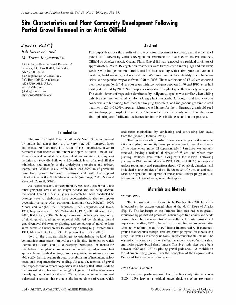
Arctic, Antarctic, and Alpine Research, Vol. 38, No. 3, 2006, pp. 384–393
Site Characteristics and Plant Community Development FollowingPartial Gravel Removal in an Arctic Oilfield
Janet G. Kidd*�Bill Streever� and
M. Torre Jorgenson*§
*ABR, Inc.—Environmental Research &
Services, P.O. Box 80410, Fairbanks,
AK 99708, U.S.A.
�BP Exploration (Alaska), Inc.,
P.O. Box 196612, Anchorage,
AK 99519-6612, U.S.A.
Abstract
This paper describes the results of a revegetation experiment involving partial removal of
gravel fill followed by various revegetation treatments on five sites in the Prudhoe Bay
Oilfield on Alaska’s Arctic Coastal Plain. Gravel fill was removed to a residual thickness of
approximately 25 cm. Revegetation treatments were transplanted tundra plugs and fertilizer;
seeding with indigenous graminoids and fertilizer; seeding with native-grass cultivars and
fertilizer; fertilizer only; and no treatment. We monitored surface stability, soil character-
istics, and vegetation response from 1990 to 2003. Thaw settlement of 17–40 cm occurred
over most areas (with .1 m over areas with ice wedges) between 1990 and 1997; sites had
mostly stabilized by 2003. Soil properties important for plant growth generally were poor.
The establishment of vegetation dominated by indigenous species was similar when adding
only fertilizer as compared to also adding plant materials. Although total live vascular
cover was similar among fertilized, tundra-plug transplant, and indigenous graminoid seed
treatments (26.1–38.3%), species richness was highest for the indigenous graminoid seed
and tundra-plug transplant treatments. The results from this study will drive decisions
about planting and fertilization schemes for future North Slope rehabilitation projects.
Introduction
The Arctic Coastal Plain on Alaska’s North Slope is covered
by tundra that ranges from dry to very wet, with numerous lakes
and ponds. Poor drainage is a result of the impermeable layer of
permafrost that underlies the tundra at depths of about 1 m or less.
Vegetation is dominated by wetland plant communities. Development
facilities are typically built on a 1.5-m-thick layer of gravel fill that
minimizes heat transfer to the underlying permafrost and reduces
thermokarst (Walker et al., 1987). More than 3640 ha of gravel fill
have been placed for roads, runways, and pads that support
infrastructure in the North Slope oilfields (Aeromap, 2002; National
Research Council, 2003).
As the oilfields age, some exploratory well sites, gravel roads, and
other gravel-fill areas are no longer needed and are being decom-
missioned. Over the past 30 years, research has been conducted to
develop ways to rehabilitate these decommissioned sites to support
vegetation or serve other ecosystem functions (e.g., Mitchell, 1979;
Moore and Wright, 1991; Jorgenson, 1997; Jorgenson and Joyce,
1994; Jorgenson et al., 1995; McKendrick, 1997, 2000; Streever et al.,
2003; Kidd et al., 2004). Techniques assessed include planting on top
of thick gravel, total gravel removal followed by planting, partial
gravel removal followed by planting, and contouring of gravel to form
snow berms and wind breaks followed by planting (e.g., McKendrick,
1991; McKendrick et al., 1992; Jorgenson et al., 1993, 2003).
Two of the principal challenges to establishing wetland plant
communities after gravel removal are (1) limiting the extent to which
thermokarst occurs, and (2) developing techniques for facilitating
establishment of plant communities dominated by indigenous plant
species. In undisturbed settings, tundra vegetation maintains a reason-
ably stable thermal regime through a combination of insulation, reflec-
tance, and evapotranspirative cooling. As a result, removal of gravel
that exposes tundra where vegetation has been killed often leads to
thermokarst. Also, because the weight of gravel fill often compresses
underlying tundra soil (Kidd et al., 2004), when the gravel is removed
a depression remains that promotes the impoundment of water, which
accelerates thermokarst by conducting and convecting heat away
from the ground (Hopkins, 1949).
This paper describes surface elevation changes, soil character-
istics, and plant community development on two to five plots at each
of five sites where gravel fill approximately 1.5 m thick was partially
removed, leaving a residual thickness of 25 cm, and where three
planting methods were tested, along with fertilization. Following
planting in 1990, we monitored in 1991, 1997, and 2003 (1) changes in
surface topography and permafrost depth; (2) physical, chemical, and
biological characteristics of the soil; (3) cover of vascular and non-
vascular vegetation and spread of transplanted tundra plugs; and (4)
taxonomic richness of indigenous plant species.
Materials and Methods
STUDY AREA
The five study sites are located in the Prudhoe Bay Oilfield, which
is located on the eastern coastal plain of the North Slope of Alaska
(Fig. 1). The landscape in the Prudhoe Bay area has been greatly
influenced by permafrost processes, eolian deposition of silts and sands
derived from the Sagavanirktok River delta, and coastal erosion and
deposition (Walker, 1985). Permafrost has resulted in numerous lakes
(commonly referred to as ‘‘thaw’’ lakes) interspersed with patterned-
ground features such as high- and low-center polygons, frost boils, and
pingos, as well as relatively uniform, undifferentiated flat plains. The
vegetation is dominated by wet sedge meadows, Arctophila marshes,
and moist sedge–dwarf shrub tundra. The five study sites were built
between 1968 and 1977 by placing gravel pads about 1.5 m thick on
top of tundra using gravel from the floodplain of the Sagavanirktok
River and from two nearby mine sites.
TREATMENT LAYOUT
Gravel was partly removed from the five study sites in winter
(1988–1989), leaving a residual gravel thickness of approximately
384 / ARCTIC, ANTARCTIC, AND ALPINE RESEARCH � 2006 Regents of the University of Colorado1523-0430/06 $7.00

25 cm. To test the effectiveness of plant cultivation in promoting the
establishment of wetland plant communities following partial gravel
removal, three to five plots were established on each of the five sites.
One of the following treatments was applied on each plot (Fig. 1): (1)
fertilization only; (2) tundra plug transplants and fertilizer; (3) seeding
with indigenous graminoids and fertilizer; (4) seeding with commer-
cially available native-grass cultivar seeds and fertilizer; and (5) no
treatment.
All of the plots at the Airport site had comparable dimensions
(;22 3 26 m; 0.06 ha), with slight differences due to the total length of
each road (120–160 m); the five treatment plots were divided equally
within each road. Only two treatment plots (14 3 36 m; 0.05 ha) were
applied to the Prudhoe Bay Operations Center PBOC site (Fig. 1). The
three plots established at the OSP site were 15 3 57 m in size (0.09 ha).
Differences in area of plots and the unbalanced application of treat-
ments reflect differences among sites in the area available and con-
ditions after gravel removal. For example, flooding in the spring
following gravel removal at the OSP site precluded applying the
treatments involving seed mixes. For those plots treated with fertilizer,
a mixture of 8-32-16 (N-P-K) was applied at a rate of 400 kg ha�1 in
mid-June 1990 using a hand spreader.
The tundra plug transplants were collected from wet sedge
meadow tundra adjacent to the sites in mid-June 1990. The plugs
consisted predominantly of the wetland sedges Carex aquatilis and
Eriophorum angustifolium, although the shrubs Salix planifolia and S.
reticulata also were commonly present. The plugs (dimensions approx-
imately 15 3 15 3 30 cm [l 3 w 3 d]) were collected using a post-hole
digger and spade and were planted in plots approximately 1 m apart.
The objective of transplanting the tundra plugs was to provide islands
of tundra vegetation that would expand to fill in adjacent areas and
serve as seed sources for establishing indigenous species.
The indigenous graminoid seed mixture was collected in late
August 1990 from a wet sedge meadow approximately 80 km south
of Prudhoe Bay (next to the Dalton Highway at MP 367), and from
coastal graminoid and wet sedge meadows behind PBOC and along the
Spine Road going toward East Dock in the Prudhoe Bay Oilfield,
respectively (Fig. 1). To enhance seed production prior to harvesting
in August (Chapin and Chapin, 1980), the Dalton Highway and East
Dock seed collection sites were fertilized in June 1990 with a 10:1
mixture of 8-32-16 and 20-20-10 (N-P-K) applied at 200 kg ha�1. We
suspected the PBOC site received nutrients from an adjacent sewage
lagoon, so this area was not fertilized before seed collection. The
dominant species in the seed mixture were Carex aquatilis,
Eriophorum angustifolium, Dupontia fisheri, and Hierochloe pauci-
flora. The seeds were harvested using a portable gas-powered weed
trimmer equipped with an aluminum collecting chamber and cotton
bag (Grin Reaper�, Environmental Survey Consulting, Austin,
Texas). The seed and chaff of each species were combined and air-
dried before they were manually applied to the plots in late August
1990. We did not quantify the percentage of each species; rather, we
broadcast approximately equal volumes of seed and chaff (approxi-
mately 10 kg) in each designated plot.
The native-grass cultivar seed was a mix of species obtained from
commercial growers in Alaska and had the following component
percentages by weight: 28% Festuca rubra (Arctared Fescue–Palmer),
29% Poa glauca (Tundra Bluegrass–Fairbanks), 13% Arctagrostis
latifolia (‘‘Alyeska’’ Polargrass–Trapper Creek), and 11% Beckmannia
syzigachne (‘‘Egan’’ American Sloughgrass–Palmer), and 19% De-
schampsia beringensis (‘‘Norcoast’’ Bering Hairgrass–Fairbanks).
With the exception of D. beringensis, the seed stock came from
collections along the Dalton Highway and Sagwon Bluffs in northern
Alaska, but was cultivated in south-central and interior Alaska to
FIGURE 1. Layout of plant cultivation treatments at five gravel removal sites, Prudhoe Bay Oilfield, Alaska, 2003.
J. G. KIDD ET AL. / 385

maximize seed production. The D. beringensis is a coastal species and
was collected in southwestern Alaska. It is closely related to D.
caespitosa, which occurs in mesic environments in the Arctic but was
not available commercially when this study was initiated.
Seed mix was broadcast in mid-June 1990 at 33 kg ha�1.
Although the long-term goal of this study is to establish plant
communities dominated by indigenous wetland species, there are no
commercial sources for seed of such species. At a minimum, we
expected that the grass cover would improve organic matter content
over time through decomposition, improve soil biological properties,
help trap seed of adjacent tundra wetland species, and provide habitat
for wildlife in the short term. Over the long term, we expected the
grasses to facilitate establishment of vegetation dominated by wetland
tundra species.
MONITORING
Ground Surface Elevations
We monitored the elevation of the ground surface within the
gravel removal areas by surveying along permanent transects oriented
east-west across each pad or road and extending 5 m into the tundra on
either side (Fig. 1). We recorded the elevations at 1-m intervals using
an autolevel and survey rod, and calculated the elevation relative to the
mean elevation of the adjacent undisturbed tundra at each site. The
elevations were recorded in 1990, 1997, and 2003. Thaw depths also
were recorded along the transects in 1997 and 2003 at 2- and 5-m
intervals, respectively, using a metal probe. In 1991, thaw depths were
recorded in the vegetation sampling quadrats. Thaw depths also were
recorded in 1991 in undisturbed wet sedge meadow tundra adjacent to
the Airport sites to compare with the gravel removal areas.
Soil Properties
In 1991, we collected a total of four soil samples (at two of the
three Airport sites and at each of the other sites) to assess the baseline
physical and chemical characteristics of the residual gravel substrate.
We did not collect soil samples from the individual treatments because
there was no reason to expect differences among treatments in this
initial phase of the study. In 1997 and 2003, we collected samples
within each treatment (three to five samples, depending on the number
of treatment blocks). Each sample was a composite of three ‘‘grab’’
samples collected at a depth of 4 to 10 cm below the gravel surface.
Based on personal observation, this was the primary rooting zone. In
addition, one sample was collected for descriptive purposes in 2003
from the upper 2 to 3 cm of the soil column (just below the moss layer)
in the fertilized treatment at the Road 1 Airport Site.
The soil samples were air-dried at room temperature and ground
through a sieve to separate the coarse fraction (.2 mm diameter) from
the fine-earth fraction (,2 mm diameter). Parameters measured in-
cluded total organic matter and carbon, pH, electrical conductivity,
cation exchange capacity, and available nutrients and cations. Labo-
ratory analyses are reported on an oven-dried basis (1058C) using only
the fine-earth fraction (silt, sand, and clay), but final results for most
chemical properties (except pH, electrical conductivity, cation exchange
capacity) are expressed on a whole sample basis including the gravel
fraction, which is assumed to be inert. The analyses were performed
using standard methods (Page et al., 1982; Klute, 1986) by the Soil,
Water, and Plant Testing Laboratory, Colorado State University, Fort
Collins, in 1991, and by the Agricultural & Forestry Experiment Station,
University of Alaska, Palmer Research Station, in 1997 and 2003.
As an indirect measure of soil biological productivity in each
plant cultivation treatment, we collected three soil samples within each
treatment at each location in 1997 and 2003 to assess total fungal and
bacterial biomass. These samples were collected in a manner similar
to that described for the physical and chemical analyses. To minimize
changes to the microbial populations during transit, the samples were
immediately shipped under refrigeration to the laboratory for analysis.
In addition, five samples were collected for comparison from undis-
turbed tundra adjacent to the sites near the Airport. Fungal biomass was
determined by measuring hyphal length and diameter, while bacterial
biomass was measured using plate counts (Schmidt and Paul, 1982).
Soil Foodweb, Inc., Corvallis, Oregon, processed the samples.
Vegetation Response
To monitor vegetation response, we sampled vegetation cover in
five permanent 1-m2 quadrats placed randomly in each treatment plot
at each of the five gravel-removal sites. Vegetation cover was estimated
in the quadrats in 1991, 1997, and 2003 generally using the point-
frame method (Barbour et al., 1980). Plant species were recorded at
20-cm intervals below cross-hairs within a 1-m2 point-frame, for a total
of 50 points per quadrat. Thus, each point within a quadrat represented
a cover value of 2%. If several plant parts of one or more species
overlapped at a given point, each occurrence was recorded, thus gen-
erating a repetitive cover value that could exceed 100%. In 1997, cover
of submerged aquatic forbs at the OSP site had to be recorded using
ocular estimates; the water became too turbid upon approaching the
quadrats to record hits using a point-frame. Species found within the
treatment plots but not recorded as a point also were recorded as trace
cover. Taxonomic identification was primarily for vascular plants and
the nomenclature follows Hulten (1968).
To determine whether the transplanted tundra plugs expanded in
size over time, we measured the total area (length 3 width) of plugs
either inside of, or within 0.5 m of vegetation quadrats in 1997. The
initial mean plug area (1990) was assumed to be 0.02 m2, based on
transplanting plug dimensions of 0.15 3 0.15 m. Meaningful plug-area
measurements could not be collected in 2003 because many plugs had
coalesced at the Airport and PBOC sites.
Results and Discussion
Changes in surface elevation of the gravel removal areas were
highly variable across the five sites, ranging from virtually no change
between 1990 and 2003 at the OSP site to the development of deep
troughs and surface settling typically ranging from 17 to 40 cm at
PBOC and Road 2 of the Airport sites (Fig. 2). Overall mean thaw
settlement was 20 cm, with a maximum of 136 cm (1.4 m). The mean
ground-surface elevation of the Road 2, OSP, and PBOC sites was 3–
9 cm below tundra grade in 2003, but the two remaining sites were
slightly above tundra grade (9–10 cm). Comparing the 1997 and 2003
profiles, it appears that most of the thaw settlement occurred between
1990 and 1997, although a few troughs that were slightly visible in
1997 deepened considerably by 2003, particularly on Road 2 and at
PBOC. The mean depth of the active layer for all sites increased from
87 6 1 cm in 1991 (n¼ 116) to 96 6 7 cm (n¼ 31) in 2003, although
thaw depth was highly variable among sites (Fig. 2). At the OSP site,
the mean active layer depth was thinner in 2003 (66 6 10 cm, n¼ 4)
than in 1997 (84 6 3 cm, n ¼ 7), suggesting the thermal regime has
started to stabilize at this site. Nevertheless, the active layer depth of
all the sites in 2003 was typically more than twice that found in
undisturbed wet sedge meadow tundra (44 6 3 cm, n¼ 14).
The thinner layer of gravel fill and subsequent thaw settlement
and deepening of the active layer in the gravel removal areas has had
at least three hydrological effects that probably influence vegetation
response. First, the settlement of sites below tundra grade has made
them more susceptible to flooding, so that with the exception of Road
3 and PBOC, much of the surface of the remaining sites is inundated.
386 / ARCTIC, ANTARCTIC, AND ALPINE RESEARCH

In some areas, the water is more than 1 m deep. However, the sub-
sidence, in combination with reduced gravel thickness, also has
encouraged establishment of wetland hydrology, which is helping to
promote wetland vegetation.
Second, the deep polygonal troughs that developed in some areas
accelerated thermal erosion and increased the area occupied by deep
ponds. The ponds are deep enough that plant colonization is limited to
their margins, but the polygons are reconnecting with the polygonal
network in the adjacent tundra. The result is visual integration with the
surrounding tundra landscape (Fig. 3). The hydrologic connection with
adjacent tundra plant communities also provides a means of input for
nutrients, dissolved organic matter, and floating seeds.
Third, the persistence of a deep active layer indicates that the sites
have yet to begin developing a thermal equilibrium comparable to that
of undisturbed tundra soils; consequently, the sites may continue to
subside and thermokarst indefinitely. If subsidence continues, the sites
may become permanent deep ponds that keep out most plant species.
However, with the exception of a few isolated locations, the 1997 and
2003 thaw-depth profiles are similar, and we suspect that any addi-
tional thermokarst will be limited. Also, the deeper active layer, which
indicates that soil temperatures are higher at depth than in the adjacent
tundra, provides for a deeper plant rooting zone and a potentially
greater nutrient pool.
SOIL PROPERTIES
Physical and Chemical Characteristics
The soil physical and chemical characteristics of all the treatment
areas in 2003 were largely unchanged from those measured in 1991
and 1997 (Table 1). Overall, soil properties were poor for supporting
plant growth. The soil texture was still primarily gravel and sand, but
the high percentages may reflect the loss of silts and clays during
sampling; most of the surface was inundated in 2003 so it was difficult
to retrieve samples without losing fine particles as the sample passed
through the water column. Organic matter content, available nitrate,
ammonium, and phosphorus were low in all years. An increase in soil
pH from 7.7 in 1991 to 7.9–8.1 in 2003 probably reflects the origin of
the gravel substrate (Put 23 and Put 25 mine sites), where carbonates
associated with soils near the Putuligayuk River tend to drive pH
upward (Walker, 1985). Electrical conductivity was within the range
for non-saline soils (Brady and Weil, 2002). For exchangeable cations,
all values except calcium were low in both 1991 and 2003, and calcium
was lower in 2003 than in 1991. Cation exchange capacity also was
very low. The relatively unchanged condition of soils in all treatments
illustrates the slow development of soils in an arctic environment.
It will likely take many more decades before soil properties begin to
change measurably at any of the sites, given the slow rate of
decomposition and organic matter accumulation in the Arctic (Oechel
and Billings, 1992).
For the soil sample collected from the upper 2 to 3 cm in the
fertilized treatment of Road 1 in 2003, the soil texture was
predominantly sand, with comparable percentages of gravel, silt, and
clay (Table 1). Organic matter content and available nutrients were
low, but were slightly higher than in the subsurface samples described
above. Concentrations of cations in the near-surface soil were several
orders of magnitude higher than in the samples described above. These
results suggest that the surface soil layer is developing characteristics
more conducive to plant community development than the underlying
FIGURE 2. Ground surface and thaw depth profiles across gravel removal areas (mid-point), 1990, 1997, and 2003. Brackets indicateboundaries between adjacent, undisturbed tundra and gravel removal area.
J. G. KIDD ET AL. / 387

soils, where conditions are still similar to those immediately following
partial gravel removal.
Microbial Characteristics
Mean values for soil bacterial and fungal biomass were higher
among all the treatments (and no treatment plots) in 2003 compared to
1997, but the increase also was observed in the adjacent undisturbed
tundra (Fig. 4). The most notable change from 1997 to 2003 was that
mean bacterial biomass in the plant cultivation treatments increased to
levels comparable to those in the adjacent undisturbed tundra. Mean
fungal biomass, however, was substantially lower in the plant
cultivation treatments (and no treatment) than in the adjacent un-
disturbed tundra sampled.
FIGURE 3. View of sites after gravel removal in 1990 and 2002.
388 / ARCTIC, ANTARCTIC, AND ALPINE RESEARCH

Since we have data for only two years and have no data on the
seasonality of microbial populations, we are uncertain whether the
increases in microbial biomass observed in 2003 reflect a positive
trend, but these preliminary results are nonetheless encouraging. Mi-
crobial communities play an important role in nutrient cycling (Tate,
1985), and their presence at this early stage of plant community
development is an indication of soil biological activity. The low fungal
biomass in the plant cultivation treatments (and no treatment) probably
reflects the extremely low organic content in these disturbed soils.
Fungi are primarily responsible for the breakdown of organic com-
pounds (Paul and Clark, 1996), and thus, we expect their numbers
would be high in the more fibric, peaty soils associated with wet
sedge tundra.
VEGETATION RESPONSE
Mean total live cover was highly variable among plots and
treatments, but all had considerably higher mean total live vascular
and non-vascular cover in 2003 than 1991, while cover in the no
treatment plots increased only marginally over the same period
(Fig. 5). The native-grass cultivar seed treatment had less than half
the total live vascular cover (13.1 6 SE 3.6%) of the other
treatments in 2003. Cover of non-vascular species among the
treatments was comparable. The most dominant indigenous
species among all the treatments included Carex aquatilis,
Eriophorum scheuchzeri, E. angustifolium, Utricularia vulgaris, and
Ranunculus gmelini.
FIGURE 4. Comparisons oftotal microbial (bacterial andfungal) biomass (mean, 61 SE,n ¼ 3 unless otherwise noted)among plant cultivation treat-ments, 1997 and 2003. Biomass(lg gds�1) is expressed under alog scale.
TABLE 1
Mean (6 SE) physical and chemical properties of thin gravel fill in four revegetation treatments (and ‘‘No treatment’’ control),Prudhoe Bay Oilfield, Alaska, 1991 and 2003.
1991 2003
All treatments
(n ¼ 5)
No treatment
(n ¼ 4)
Fertilized
(n ¼ 4)
Tundra-plug
transplants (n ¼ 5)
Indigenous-sedge
seed (n ¼ 4)
Native-grass
cultivars (n ¼ 3)
Soil
surfacee
Physicala
Particle size (%)
Gravel 63.7 (5.0) 69.7 (7.3) 71.5 (3.6) 67.6 (3.3) 73.4 (3.9) 64.9 (5.2) 14.5
Sand 30.3 (4.3) 27.0 (5.9) 25.7 (3.0) 29.9 (3.3) 24.0 (3.8) 31.7 (4.3) 61.6
Silt 3.3 (0.3) 2.2 (1.0) 1.5 (0.5) 1.7 (0.4) 1.4 (0.3) 1.6 (0.5) 11.6
Clay 2.7 (0.4) 1.1 (0.8) 1.3 (0.4) 0.8 (0.1) 1.2 (0.4) 1.8 (0.6) 12.3
Chemical
Organic matter (LOI)b 0.5 (0.1) 0.3 (0.1) 0.3 (0.1) 0.2 (,0.1) 0.2 (,0.1) 0.3 (0.1) 5.4
pH 7.7 (,0.1) 8.1 (,0.1) 7.9 (,0.1) 8.0 (,0.1) 8.0 (0.1) 8.0 (,0.1) 7.6
EC (dS/m)c 1.2 (0.2) 0.5 (0.1) 0.6 (,0.1) 0.4 (,0.1) 0.4 (0.1) 0.4 (0.1) 0.7
CEC (meq/100 g)d 2.9 (0.3) 0.5 (0.2) 0.4 (0.1) 0.4 (0.1) 0.4 (0.1) 0.4 (,0.1) 8.2
Exchangeable (mg/kg)
NH4-N 0.4 (0.1) 0.2 (,0.1) 0.2 (,0.1) 0.2 (0.0) 0.1 (,0.1) 0.3 (0.1) 1.7
NO3-N 1.5 (0.1) 0.5 (0.2) 0.4 (0.2) 0.3 (0.1) 0.1 (,0.1) 0.2 (,0.1) 2.6
P 2.9 (1.9) 0.3 (,0.1) 0.7 (0.3) 0.7 (0.1) 1.0 (0.3) 0.8 (0.1) 6.0
K 1.4 (0.2) 4.2 (0.4) 4.4 (0.9) 3.3 (0.4) 3.9 (0.3) 5.4 (1.0) 140.9
Ca 2393.4 (380.1) 1668.6 (230.6) 1620.7 (209.4) 1745.0 (152.1) 1562.4 (272.7) 1953.5 (253.6) 9848.7
Mg 49.2 (7.5) 19.8 (2.4) 15.3 (2.8) 14.1 (1.2) 15.3 (1.8) 19.5 (4.7) 116.8
Na 4.4 (2.1) 9.5 (1.5) 6.3 (0.8) 6.4 (0.9) 5.5 (1.0) 8.9 (3.7) 58.3
a All samples expressed on whole sample basis, which includes the .2 mm gravel fraction.b LOI ¼ loss on ignition.c 1 dS/m ¼ 1 mmhos/cm.d CEC ¼ cation exchange capacity, expressed in millequivalents (meq.)/100 g soil.e Sample was collected from developing moss peat layer (0–2 cm below the surface).
J. G. KIDD ET AL. / 389

Although non-vascular species made up the majority of the total
live cover for all the treatments in 1991 (except the native-grass
cultivar seed treatment), cover of indigenous graminoids was dominant
in most treatments by 2003 (Fig. 6). Notable exceptions were the no
treatment and the native-grass cultivar treatment, where non-vascular
cover made up 53 to 65% of the total cover in 2003. The mean
proportion of cover made up by native-grass cultivars in the native-
grass cultivar seed treatment dropped dramatically between 1991 and
1997, and comprised only 8% of the total cover by 2003. The mean
proportion of forb cover was higher in 2003 than previous years in the
native-grass cultivar plots, but still only accounted for up to 10% of the
total cover. The small amount of cover of native-grass cultivars present
in the other treatments is attributed to incidental deposition during
seed broadcasting in 1990.
In all treatments, taxonomic richness of indigenous species in-
creased between 1991 and 2003 (Table 2), but the highest number of
species (29) occurred in the indigenous graminoid seed treatment,
closely followed by the tundra plug transplant treatment (24). Most of
the species are commonly found in wetland tundra habitats, but some
(e.g., Alopecurus alpinus, Epilobium latifolium, Stellaria crassifolia)
are associated with more disturbed and/or gravelly environments
(Jorgenson, 1997).
The mean area of the vegetation that spread from the original
transplanted tundra plugs among the five sites increased from the initial
0.02 m2 planting size in 1991 to 0.19–1.00 m2 in 1997 (Fig. 7). Our
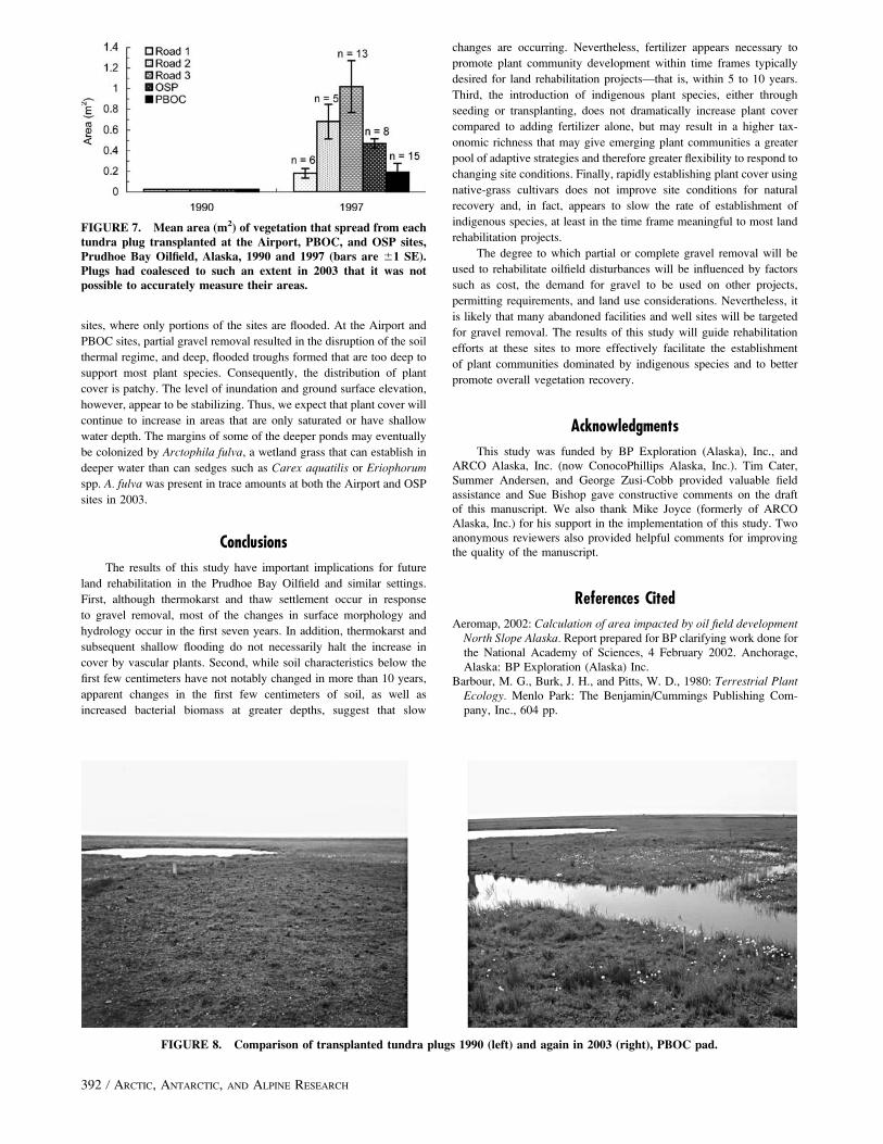
inability to identify many of the plug boundaries in 2003 reflects the
high degree of lateral expansion that has occurred since the initial
planting (Fig. 8). Although we did not evaluate the viability of seed
produced from plants within the tundra plugs, the abundant flowering
observed suggests the plugs may have acted as a seed source, in
addition to producing tillers.
Although mean plant cover was slightly higher in the indigenous
graminoid seed treatment than in other treatments, mean cover was
comparable for all treatments and was higher than areas where no
treatment was applied. The comparable response of all treatments
suggests that the main limitation to vegetation establishment was
nutrients. The lack of a well-developed plant cover in the no treatment
plots after 13 years also supports this assertion. An important benefit
of seeding with indigenous graminoids and transplanting tundra plugs,
however, was the resulting increase in taxonomic richness. The high
numbers of species were due to (1) establishment of targeted species
within the indigenous seed mix and tundra plugs, and (2) seed of
additional species harvested during the indigenous seed collection or
that were present in the soil collected with the tundra plugs.
The relatively poor long-term growth of vascular plants in the
native-grass cultivar treatment was unexpected, although a recent
study conducted at an abandoned exploratory well site in the Prudhoe
Bay Oilfield produced a similar result (Kidd et al., 2004). At both sites,
the level of grass cover was low enough (,20%) to minimize
competition with natural colonizers, a factor that has reduced natural
colonization at sites with denser grass cover (Younkin and Martens,
1987; Densmore, 1992). Perhaps the initial vigorous growth of grass
depleted soil nutrients more rapidly than in the other treatments,
although this was not apparent in soil analyses. We also considered the
possibility that this treatment experienced through random chance
a disproportionately higher degree of thermokarst and flooding than the
other treatments, with resulting poor site conditions for plant
establishment and growth. However, percent cover of water in the
FIGURE 5. Total vascular and non-vascular cover (mean 61 SE, n ¼ 20 except where noted) among the four plant cultivationtreatments and control (no treatment), 1991, 1997, and 2003.
FIGURE 6. Percentages of each life form that make up the total live cover within each plant cultivation treatment, 1991–2003. Shrubswere excluded because they make up ,1% of the total live cover.
390 / ARCTIC, ANTARCTIC, AND ALPINE RESEARCH

native-grass cultivar treatment was comparable to that measured in the
other treatments. Given that the vascular cover in this treatment was
dominated by indigenous sedges and grasses in 2003, we suspect that
over time these species will increase in cover to levels comparable to
the other treatments. Our current results suggest, however, that seeding
with native-grass cultivars does not facilitate natural recovery more
effectively than adding fertilizer or applying other plant cultivation
treatments on sites cover with a residual layer of thin gravel (overlying
tundra). In fact, our results suggest that the seeding effort may delay
establishment of indigenous species, a finding that also has been
observed at upland tundra sites seeded with grasses south of Prudhoe
Bay along the Trans-Alaska Pipeline route (Densmore, 1992;
McKendrick, 2002).
We believe the high variability in plant cover within and among
treatments is at least in part a function of site heterogeneity. For
example, because the OSP site was flooded soon after gravel was
removed (Fig. 3), it was not possible to apply the two treatments
involving broadcasting of seed. At this site, the ground surface has
remained relatively stable, but the gravel removal created a depression
that promoted rapid impoundment of water in the area. Although the
transplanted tundra plugs have survived, there has been some mortality
and they are less well developed than those at the Airport and PBOC
TABLE 2
List of indigenous vascular species within plant cultivation treatments (and ‘‘No treatment’’ control) at the gravel removal sites in thePrudhoe Bay Oilfield, Alaska, 1991, 1997, and 2003.
Species
No treatmenta Fertilization
Indigenous
graminoid seed
Tundra plug
transplants
Native-grass
cultivar seed
1997 2003 1991 1997 2003 1991 1997 2003 1991 1997 2003 1991 1997 2003
Forbs
Artemisia arctica x x x
Braya sp. x x
Caltha palustris x x x x
Cerastium beeringianum x
Draba sp. x x x x
Epilobium latifolium x x x x x x
Equisetum arvense x
Hippuris vulgaris x x x x
Melandrium apetalum x
Parnassia palustris x x x
Pedicularis verticillata x x
Polygonum viviparum x
Potentilla hookeriana x x x
Ranunculus gmelini x x x x x x
R. hyperboreus x x
Sagina intermedia x
Saxifraga cernua x x
S. hieracifolia x
S. hirculus x x x x
Stellaria crassifolia x x x x
Utricularia vulgaris x x x x x
Graminoids
Alopecurus alpinus x x x x x x x x x x
Arctophila fulva x x x x
Carex aquatilis x x x x x x x x x x x x x
Deschampsia caespitosa x x x x x x x x x
Dupontia fisheri x x
Eriophorum angustifolium x x x x x x x x x x
E. scheuchzeri x x x x x x x x x x
Festuca baffinensis x x
F. vivipara x x
Hierochloe pauciflora x x x x x
Juncus arcticus x x x x x x x x x
Poa alpigena x x x x x x
P. arctica x
Puccinellia langeana x x x
Trisetum spicatum x x x x x x
Shrubs
Salix arctica x x x x x x x
S. ovalifolia x x x x x x
S. richardsonii lanata x
S. rotundifolia x x
S. pulchra x x
Total 7 11 2 10 16 4 22 29 7 18 24 1 4 15
a No vascular plants were present in 1991.
J. G. KIDD ET AL. / 391
sites, where only portions of the sites are flooded. At the Airport and
PBOC sites, partial gravel removal resulted in the disruption of the soil
thermal regime, and deep, flooded troughs formed that are too deep to
support most plant species. Consequently, the distribution of plant
cover is patchy. The level of inundation and ground surface elevation,
however, appear to be stabilizing. Thus, we expect that plant cover will
continue to increase in areas that are only saturated or have shallow
water depth. The margins of some of the deeper ponds may eventually
be colonized by Arctophila fulva, a wetland grass that can establish in
deeper water than can sedges such as Carex aquatilis or Eriophorum
spp. A. fulva was present in trace amounts at both the Airport and OSP
sites in 2003.
Conclusions
The results of this study have important implications for future
land rehabilitation in the Prudhoe Bay Oilfield and similar settings.
First, although thermokarst and thaw settlement occur in response
to gravel removal, most of the changes in surface morphology and
hydrology occur in the first seven years. In addition, thermokarst and
subsequent shallow flooding do not necessarily halt the increase in
cover by vascular plants. Second, while soil characteristics below the
first few centimeters have not notably changed in more than 10 years,
apparent changes in the first few centimeters of soil, as well as
increased bacterial biomass at greater depths, suggest that slow
changes are occurring. Nevertheless, fertilizer appears necessary to
promote plant community development within time frames typically
desired for land rehabilitation projects—that is, within 5 to 10 years.
Third, the introduction of indigenous plant species, either through
seeding or transplanting, does not dramatically increase plant cover
compared to adding fertilizer alone, but may result in a higher tax-
onomic richness that may give emerging plant communities a greater
pool of adaptive strategies and therefore greater flexibility to respond to
changing site conditions. Finally, rapidly establishing plant cover using
native-grass cultivars does not improve site conditions for natural
recovery and, in fact, appears to slow the rate of establishment of
indigenous species, at least in the time frame meaningful to most land
rehabilitation projects.
The degree to which partial or complete gravel removal will be
used to rehabilitate oilfield disturbances will be influenced by factors
such as cost, the demand for gravel to be used on other projects,
permitting requirements, and land use considerations. Nevertheless, it
is likely that many abandoned facilities and well sites will be targeted
for gravel removal. The results of this study will guide rehabilitation
efforts at these sites to more effectively facilitate the establishment
of plant communities dominated by indigenous species and to better
promote overall vegetation recovery.
Acknowledgments
This study was funded by BP Exploration (Alaska), Inc., and
ARCO Alaska, Inc. (now ConocoPhillips Alaska, Inc.). Tim Cater,
Summer Andersen, and George Zusi-Cobb provided valuable field
assistance and Sue Bishop gave constructive comments on the draft
of this manuscript. We also thank Mike Joyce (formerly of ARCO
Alaska, Inc.) for his support in the implementation of this study. Two
anonymous reviewers also provided helpful comments for improving
the quality of the manuscript.
References Cited
Aeromap, 2002: Calculation of area impacted by oil field developmentNorth Slope Alaska. Report prepared for BP clarifying work done for
the National Academy of Sciences, 4 February 2002. Anchorage,
Alaska: BP Exploration (Alaska) Inc.
Barbour, M. G., Burk, J. H., and Pitts, W. D., 1980: Terrestrial PlantEcology. Menlo Park: The Benjamin/Cummings Publishing Com-
pany, Inc., 604 pp.
FIGURE 7. Mean area (m2) of vegetation that spread from eachtundra plug transplanted at the Airport, PBOC, and OSP sites,Prudhoe Bay Oilfield, Alaska, 1990 and 1997 (bars are 61 SE).Plugs had coalesced to such an extent in 2003 that it was notpossible to accurately measure their areas.
FIGURE 8. Comparison of transplanted tundra plugs 1990 (left) and again in 2003 (right), PBOC pad.
392 / ARCTIC, ANTARCTIC, AND ALPINE RESEARCH

Brady, N. C., and Weil, R. R., 2002: The Nature and Properties ofSoils, Thirteenth Edition. Upper Saddle River: Prentice Hall, 960 pp.
Chapin, S. C., III, and Chapin, M. C., 1980: Revegetation of an arctic
disturbed site by native tundra species. Journal of Applied Ecology,17: 449–456.
Densmore, R. V., 1992: Succession on an Alaskan tundra disturbance
with and without assisted revegetation with grass. Arctic and AlpineResearch, 24: 238–243.
Hopkins, D. M., 1949: Thaw lakes and thaw sinks in the Imuruk
Lake area, Seward Peninsula, Alaska. Journal of Geology, 57:
119–131.
Hulten, E., 1968: Flora of Alaska and Neighboring Territories.Stanford: Stanford University Press, 1008 p.
Jorgenson, M. T., 1997: Patterns and rates of, and factors affecting
natural recovery on land disturbed by oil development in arctic
Alaska. In Crawford, R. M. M. (ed.), Disturbance and Recovery inArctic Lands: an Ecological Perspective. NATO ASI Series 2
Environment, vol. 25. Dordrecht: Kluwer Academic Publishers,
421–442.
Jorgenson, M. T., and Joyce, M. R., 1994: Six strategies for
rehabilitating land disturbed by oil development in the arctic Alaska.
Arctic, 47: 374–390.
Jorgenson, M. T., Cater, T. C., and Joyce, M. R., 1993: Use of snow
capture for land rehabilitation in Arctic oilfields. In Proceedings
of Sixth International Conference on Permafrost, Beijing, China,
316–321.
Jorgenson, M. T., Cater, T. C., Kidd, J. G., Jacobs, L. L., and Joyce,
M. R., 1995: Techniques for rehabilitating lands disturbed by oil
development in the Arctic. In Proceedings High Altitude Re-
vegetation Workshop No. 11. Ft. Collins: Colorado State University,
Information Series no. 80: 146–169.
Jorgenson, M. T., Kidd, J. G., Cater, T. C., Bishop, S., and Racine,
C. H., 2003: Long-term evaluation of methods for rehabilitation of
lands disturbed by industrial development in the Arctic. InRasmussen, R. O., and Koroleva, N. E. (eds.), Social andEnvironmental Impacts in the North. Dordrecht: Kluwer Academic
Publishers, 173–190.
Kidd, J. G., Streever, B., Joyce, M. R., and Fanter, L. H., 2004:
Wetland restoration of an exploratory well on Alaska’s North Slope:
a learning experience. Ecological Restoration, 22(1): 30–38.
Klute, A., 1986: Methods of Soil Analysis. Part 1. Physical and
mineralogical methods. Madison: American Society of Agronomy
and Soil Science Society of America, Agronomy Series number
9: 1188 pp.
McKendrick, J. D., 1991: Arctic tundra rehabilitation—observations
of progress and benefits to Alaska. Agroborealis, 23(1): 29–40.
McKendrick, J. D., 1997: Long-term tundra recovery in northern
Alaska. In Crawford, R. M. M. (ed.), Disturbance and Recoveryin Arctic Lands, an Ecological Perspective. Dordrecht: Kluwer
Academic Publishers, 503–518.
McKendrick, J. D., 2000: Vegetative responses to disturbance. InTruett, J. C., and Johnson, S. R. (eds.), The Natural History of anArctic Oilfield. New York: Academic Press, 35–56.
McKendrick, J. D., 2002: Soils and Vegetation of the Trans-AlaskaPipeline Route; a 1999 Survey. Fairbanks: University of Alaska
Fairbanks Agricultural and Forestry Experiment Station, Bulletin
109.
McKendrick, J. D., Scorup, P. C., Fiscus, W. E., and Turner, G., 1992:
Gravel vegetation experiments—Alaska North Slope. Agroborealis,24(1): 25–32.
Mitchell, W. W., 1979: Three varieties of native Alaskan grasses forrevegetation purposes. University of Alaska: Alaska Agricultural
Experiment Station Circular 32.
Moore, N., and Wright, S. J., 1991: Revegetation with Arctophila
fulva, 1985–1989. Final report prepared for ARCO Alaska, Inc.,
Anchorage, by Plant Materials Center, Alaska Department of Natural
Resources, Palmer (http://www.dnr.state.ak.us/ag/61Revegetation-
withArctophilafulva.pdf).
National Research Council, 2003: Cumulative Environmental Effectsof Oil and Gas on the North Slope. Washington: The National
Academies Press, 304 pp.
Oechel, W. C., and Billings, W. D., 1992: Effects of global change on
the carbon balance of arctic plants and ecosystems. In Chapin, F. S.,
III, Jefferies, R., Shaver, G., Reynolds, J., and Svoboda, J. (eds.),
Physiological Ecology of Arctic Plants: Implications for ClimateChange. New York: Academic Press, 139–168.
Page, A. L., Miller, R. H., and Keeney, D. R. (eds.), 1982: Methods ofSoil Analysis. Part 2. Chemical and Microbiological Properties.Madison: American Society of Agronomy and Soil Science Society
of America, Agronomy Series number 9: 1159 pp.
Paul, E. A., and Clark, F. E., 1996: Soil Microbiology andBiochemistry. Second edition. San Diego: Academic Press, Inc.,
273 pp.
Schmidt, E. L., and Paul, E. A., 1982: Microscopic methods for soil
microorganisms. In Page, A. L., Miller, R. H., and Keeney, D. R.
(eds.), Methods of Soil Analysis: Part 2. Chemical and Microbio-logical Properties. Madison: American Society of Agronomy and
Soil Science Society of America, 803–813.
Streever, W. J., McKendrick, J., Fanter, L., Anderson, S. C., Kidd, J.,
and Porter, K. M., 2003: Evaluation of percent cover requirements
for revegetation of disturbed sites on Alaska’s North Slope. Arctic,56(3): 234–248.
Tate, R. L., III, 1985: Micro-organisms ecosystem disturbance and soil
formation processes. In Tate, R. L., III, and Klein, D. A. (eds.), SoilReclamation Processes. New York: Marcel Dekker, 1–24.
Walker, D. A., 1985: Vegetation and environmental gradients of thePrudhoe Bay region, Alaska. Hanover, New Hampshire: U.S. Army
Cold Regions Research Engineering Laboratory (CRREL) Report
85-14: 239 pp.
Walker, D. A., Cate, D., Brown, J., and Racine, C., 1987: Disturbanceand recovery of arctic Alaskan tundra terrain: a review of recentinvestigations. Hanover, New Hampshire: U.S. Army Cold Regions
Research Engineering Laboratory (CRREL) Report 87-11: 63 pp.
Younkin, W. E., and Martens, H. E., 1987: Long-term success of
seeded species and their influence on native species invasion at
abandoned rig site A-01 Caribou Hills, N.W.T., Canada. Arctic andAlpine Research, 19: 566–571.
Ms accepted January 2006
J. G. KIDD ET AL. / 393
Copyright © 2022 FDOKUMEN