A stone quarry in the hinterland of Karakorum, Mongolia, with evidence of Chinese stonemasons
41
101 A Stone Quarry in the Hinterland of Karakorum, Mongolia, with Evidence of Chinese Stonemasons J AN BEMMANN, THOMAS O. HÖLLMANN, BIRTE AHRENS, THOMAS KAISER, AND SHING MÜLLER* INTRODUCTION The cities established by rider nomads in the steppe regions of Inner Asia have been a source of fascination ever since their discovery in research at the end of the nineteenth century. This sense of wonder is all the stronger today due to the seemingly immeasurable contrast between urban culture and nomad existence, as envisioned by sedentary people (Weiss 2007). A good example in this regard is Karakorum, the first capital city of the Mongolian world empire, which Ögödei, the third son of and successor to Genghis Khan, expanded in 1235 and enclosed with a wall (Fig. 1) (Barkmann 2002; Bemmann et al. 2010). Ögödei summoned c. 1,500 craftsmen and artisans from China to Karakorum to erect the ruler’s residence in Karakorum (Barkmann 2002, p. 10). His successor Möngke Khan had the palace altered employing 500 additional laborers, and in 1256 could celebrate the completion of the great stupa temple (Cleaves 1952). One enormous logistical challenge at that time was the provision of the city’s inhabitants with basic comestibles, especially urgent due to the rapid increase in population. This was apparently one factor that led to the introduction of field irrigation in the Orkhon valley (Barkmann 2002, p. 14), for which irrefutable archaeological evidence is however still lacking. 1 The external provision of food in the form of cultivated crops and vegetables was, therefore, necessary not only because of climatic conditions of the steppe (Allsen 2009, p. 144), but primarily because of the great number of foreigners living in Karakorum with dietary demands that could not be met by local foods (Barkmann 2002, p. 14). A great variety of foodstuffs could be identified through palaeobotanical analyses of remains in the quarter of Chinese craftsmen (Roesch et al. 2010), a small section of which was excavated in 2000–2005 (Bemmann et al. 2010). The design and construction of a city with palaces, temples, dwellings and workshops required corresponding specialists in these fields, who, as could be imagined were not present in the steppe, and as well as huge amounts of building materials. In addition, a great diversity in crafts in various raw materials, work pieces and components, and semi-finished products had to be supplied. Optimally, the necessary resources should have been found in the surroundings of the city; that is, the city of Karakorum needed a hinterland to provide with these supplies, a hinterland whose range of natural resources has been proposed in varied and different estimations (Moses and Greer 1998; Shiraishi 2004; Tkachev 1986). In order to determine the kind and extent of anthropogenic encroachment in the cultural landscape linked with the procurement of raw materials and to achieve a better understanding of the relationship between city and environment, the project “Geoarchaeology in the Steppe” was established, within whose framework a survey, geophysical prospection and photogrammetic measurements were undertaken in specifically chosen regions of the Orkhon valley. 2 Resources of water, mud, clay and wood are available in the immediate vicinity of the city. And, as to be expected, already at the start of the Mongolian-German project on the investigation of Karakorum, ovens were discovered in the course of geomagnetic prospection inside the city wall, southwest of the Buddhist temple, long held as the palace district (Mommsen, Jansen and Renner 2001). 3 Excavation of a row of four kilns of the mantou (i.e., round)-type showed that these structures had been used to fire roof tiles, architectural ornaments as well as floor and wall tiles (Franken 2005). Another oven located northwest of the temple and investigated in 2002 was connected with the production of typical local grey, wheel made pottery (Franken 2005, p. 148). Furthermore, an extensive area with rows of furnaces, 14 of which were excavated (Hüttel and Dähne 2012, p. 415-19), was discovered in the Orkhon lowlands, ca. 4 km southwest of the city center (Fig. 1). They, too, are of the Chinese mantou-type kiln and served to fire clay figurines, roof tiles and architectural ornaments. These
Transcript of A stone quarry in the hinterland of Karakorum, Mongolia, with evidence of Chinese stonemasons

101
A Stone Quarry in the Hinterland of Karakorum, Mongolia, with Evidence of Chinese Stonemasonsjan beMMann, thoMas o. höllMann, birte ahrens, thoMas Kaiser, and shinG Müller*
inTroducTion
The cities established by rider nomads in the steppe regions of Inner Asia have been a source of fascination ever since their discovery in research at the end of the nineteenth century. This sense of wonder is all the stronger today due to the seemingly immeasurable contrast between urban culture and nomad existence, as envisioned by sedentary people (Weiss 2007). A good example in this regard is Karakorum, the first capital city of the Mongolian world empire, which Ögödei, the third son of and successor to Genghis Khan, expanded in 1235 and enclosed with a wall (Fig. 1) (Barkmann 2002; Bemmann et al. 2010). Ögödei summoned c. 1,500 craftsmen and artisans from China to Karakorum to erect the ruler’s residence in Karakorum (Barkmann 2002, p. 10). His successor Möngke Khan had the palace altered employing 500 additional laborers, and in 1256 could celebrate the completion of the great stupa temple (Cleaves 1952). One enormous logistical challenge at that time was the provision of the city’s inhabitants with basic comestibles, especially urgent due to the rapid increase in population. This was apparently one factor that led to the introduction of field irrigation in the Orkhon valley (Barkmann 2002, p. 14), for which irrefutable archaeological evidence is however still lacking.1 The external provision of food in the form of cultivated crops and vegetables was, therefore, necessary not only because of climatic conditions of the steppe (Allsen 2009, p. 144), but primarily because of the great number of foreigners living in Karakorum with dietary demands that could not be met by local foods (Barkmann 2002, p. 14). A great variety of foodstuffs could be identified through palaeobotanical analyses of remains in the quarter of Chinese craftsmen (Roesch et al. 2010), a small section of which was excavated in 2000–2005 (Bemmann et al. 2010).
The design and construction of a city with palaces, temples, dwellings and workshops required corresponding specialists in these fields, who, as could
be imagined were not present in the steppe, and as well as huge amounts of building materials. In addition, a great diversity in crafts in various raw materials, work pieces and components, and semi-finished products had to be supplied. Optimally, the necessary resources should have been found in the surroundings of the city; that is, the city of Karakorum needed a hinterland to provide with these supplies, a hinterland whose range of natural resources has been proposed in varied and different estimations (Moses and Greer 1998; Shiraishi 2004; Tkachev 1986). In order to determine the kind and extent of anthropogenic encroachment in the cultural landscape linked with the procurement of raw materials and to achieve a better understanding of the relationship between city and environment, the project “Geoarchaeology in the Steppe” was established, within whose framework a survey, geophysical prospection and photogrammetic measurements were undertaken in specifically chosen regions of the Orkhon valley.2
Resources of water, mud, clay and wood are available in the immediate vicinity of the city. And, as to be expected, already at the start of the Mongolian-German project on the investigation of Karakorum, ovens were discovered in the course of geomagnetic prospection inside the city wall, southwest of the Buddhist temple, long held as the palace district (Mommsen, Jansen and Renner 2001).3 Excavation of a row of four kilns of the mantou (i.e., round)-type showed that these structures had been used to fire roof tiles, architectural ornaments as well as floor and wall tiles (Franken 2005). Another oven located northwest of the temple and investigated in 2002 was connected with the production of typical local grey, wheel made pottery (Franken 2005, p. 148).
Furthermore, an extensive area with rows of furnaces, 14 of which were excavated (Hüttel and Dähne 2012, p. 415-19), was discovered in the Orkhon lowlands, ca. 4 km southwest of the city center (Fig. 1). They, too, are of the Chinese mantou-type kiln and served to fire clay figurines, roof tiles and architectural ornaments. These

102
contexts could be greatly augmented by the discovery of a settlement that was contemporary with Karakorum, found during the prospection survey mentioned above. This settlement site is located ca. 6 km southwest of the ancient Mongol capital, on the left bank of the Orkhon river. At the time of the survey structures that indicated the present of kilns could already be recognized. In a geomagnetic prospection permanent buildings, as opposed to gers, and ovens were clearly detected (Bemmann et al. 2011, pp. 79-80, pp. 95-97 figs. 16-19) and were excavated later in a carefully targeted, subsequent project (Pohl et al. 2012). Aside from one oven of the Chinese dragon type, for the first time in Mongolia an oven for smelting iron was discovered in the production settlement. A dendrochronological date of 1237, obtained from a floor plank in a pit house, confirms the site’s contemporaneity – in the archaeological sense – with the founding of Karakorum (Pohl et al. 2012).
For house construction, primarily air-dried mud bricks were used (Pohl 2010), as well as wood, which, as so far identified, is larch. Wooden columns measuring up to 80 cm in diameter were erected in the great Buddhist temple (Franken 2012, p. 86-89). Wood was also used in road construction in Karakorum to delimit individual segments and for drainage gullies.
According to the excavation results so far published, stone served as a building material only to a limited extent. Instead, limestone served as pavement for the north–south main street through Karakorum as well as sometimes for the covering of heating channels (Pohl 2010). Granite was used for the bases of wooden columns, for buildings of the latest attested settlement layer in the Chinese craftsmen quarter (Pohl 2010), and also for the massive column bases in the Buddhist temple (Franken 2012). Indeed, granite occurs often in the Upper Orkhon valley; in earlier research attention had been drawn to a stone quarry on the eastern, right bank of the Orkhon river (Fig. 2), where an abandoned tortoise base had caught the eye and had been noted under the name of “baga-elestei” (Perlee 1972, pp. 321-22; Shiraishi 2004, p. 116). Khödöögiin Perlee reported an inscription consisting of six Chinese characters, which were incised on a worked stone.4 Recorded there is solely a date: day 8, month 7, Zhiyuan-era year 3. This information complies with the third year of Kublai’s reign (1265 CE) and with the third year of Toghan-Temür’s reign (1337 CE). According to Perlee, the site lies on the western, right side of the Orkhon. As in Mongolia the celestial directions are given from the standpoint towards the south, the specifications match with “right” and “western.” Following the
linguistic custom in Europe with the standpoint towards the north, the site must be located on the left bank of the river. This, however, contradicts the localization made by Noriyuki Shiraishi (2004, pp. 115-16, fig. 7), and the position of the tortoise base. Moreover, for a few years now, building material for the neighboring district center, Harhorin, near Karakorum, and presumably other sites has been gained increasingly from a nearby mountaintop. The massive intrusions into the rock there show up very distinctly in aerial photographs. Nevertheless, due to these traces of modern use and thus emerging superimpositions, this area was not investigated in detail during the “Geoarchaeology in the Steppe” project. Repeated pedestrian surveys in this area in 2009 and 2010 could confirm the presence of old traces of exploitation and cut pieces, but no inscriptions were found, nor were the local nomads aware of any such inscriptions in the area. Hence, a renewed documentation has not been successful until now. Shiraishi came to the conclusion that “this must have been where stone was quarried for the construction of Kharakhorum” (Shiraishi 2004, p. 116). Thereafter, the origin of the granite was considered clarified. (J. B.)
a recenTly diScovered STone quarry in The uPPer orKhon valley
The discovery of a second stone quarry during our survey in the spring of 2009 was all the more surprising! The quarry is located on a promontory running from northwest to southeast at a length of ca. 260 m along the western bank of the Orkhon river, c. 13 km south–southwest of ancient Karakorum and c. 2 km northeast of Baga-elestei (Fig. 3). The granite outcrops are situated on the southwest-facing slope of the promontory, while the northeast-facing slope is flatter and covered with grass. The granite rocks are weathered in rounded stacked boulders (“spheroidal weathering”), which can also be noticed at other sites with granite deposits in the surrounding area of the upper Orkhon valley, especially at the riverbanks.5 The findings of the quarry are outstanding: numerous work implements and traces of exploitation on the one hand, and, on the other, a Chinese inscription, next to which is the incised figure of a person clothed in Chinese style with a striking headdress along with the incised side view of a lotus column base. An initial rapid inventory of the site in the spring was followed by a photogrammetric survey in September 2009 by an Unmanned Aerial Vehicle (UAV), conducted by the German Aerospace Center (Deutsches Zentrum für Luft- und Raumfahrt e.V., abbrev. DLR).6

103
From these images an ortho-photograph and a digital model of the surface was created (Fig. 3d, 4). An imprint was made of the inscription and the figural representation by means of a paper squeeze.7 Although the resulting imprint was quite satisfactory, it was nonetheless difficult to read the Chinese characters due to the severe erosion of the granite. Therefore, another procedure in documentation was attempted in autumn 2010. For this, Revultex 359 was used: a pre-vulcanized Full Ammonia natural latex, which, unlike silicon, has the advantage that no residues are left on the stone.8 This liquid is quite economical in price, not at all adverse to the environment, and transportable by air without any restrictions. In making the imprint, the liquid was applied with a brush in as many as ten layers, and, with the eighth layer at the latest, gauze was worked in to increase stability. After the impression had dried, it could be easily removed from the stone. The result: an extremely detailed copy, showing even the smallest cracks in the stone. Furthermore, compared to a paper imprint, this natural latex has the great advantage of being rolled up without damaging the relief structure; hence, is much easier to transport. From the latex imprint plaster copies were then made in the workshops of the Rheinisches Landesmuseum (Bonn), which facilitated the deciphering by Sinologists in Munich (Fig. 14c-d).9 The incised column base with lotus rosette was documented in the same way. In autumn 2010, Birte Ahrens and Jan Bemmann described and measured all traces of exploitation that were visible on the surface in different areas, and also the worked pieces found in the heaps of debris. Nevertheless, no trial trenches were installed, not a single stone was unearthed, and not one worked block was moved. (J. B./B. A.)
The individual exPloiTed areaS, WaSTe heaPS and TraceS of
quarrymen and STonemaSonS
Various techniques employed in the exploitation and processing of the granite could be detected and distinguished at the quarry. As far as we know, pre-industrial stonework and exploitation in Inner and Central Asia have been studied only little or not at all, so that reference has often been made to investigations of ancient and medieval techniques used in Central Europe and the Near East. In this regard, the most comprehensive research is available from the Roman quarries of Mons Claudianus and Mons Porphyrites in Egypt as well as in the Eifel mountains of Germany (Röder 1959; Mangartz
1998). The traces of exploitation visible in the Mongolia quarry are very comparable, allowing deductions about similar techniques and methods of gaining and processing stone.
The predominant method used for quarrying stone in the quarry at the Orkhon was stone splitting with a wedge. This method leaves behind conspicuous and distinctive signs: a number of holes in a row, so-called wedge slots (Keiltaschen) (Fig. 5a) and long lines or wedge grooves (Keilrinnen) (Fig. 5b), both cut into the native rock first. Then iron wedges or “plugs” are driven into the rock, and the resultant pressure causes the stone to split vertically to the desired surface (Mangartz 1998, p. 12, 14-15). Black explosive powder was not employed (although this method was known in China since the eleventh century and attested by drill holes meant to hold the explosive), nor was there evidence of sawing, cutting or hammering the rock nor of setting fire as quarrying techniques.10
In stone splitting, a distinction must be made between splitting the blocks of granite from the native rock (exploitation splitting/Abbauspaltung) (Fig. 5c) and separating or carving already detached blocks (block splitting/Blockspaltung) (Fig. 5a) (Mangartz 1998, p. 14). The traces of working and the artifacts observed in the quarry allow for a three-step process to be distinguished: 1. traces of extraction (wedge slots and wedge grooves), 2. worked pieces, and 3. work debris.11 1. Wedge slots and wedge grooves are the traces of
exploitation that frequently appear on the native rock, but also on smaller blocks that were already detached (Fig. 5a-c).
2. Worked pieces constitute all detached stones, whose intended later purpose is apparent. These usually comprise inaccurate pieces or those that were damaged in the course of further processing and, thus, discarded. The actual detached stones are seldom found as they were usually already hauled away. However, they provide important clues about the prevailing form of the end products, and, through comparison with stones from archaeological contexts, deductions can be made about their chronological position (Fig. 8).
3. The work debris derives from the process of splitting, separating or cutting the blocks. Mostly “negatives” are present, whose form sometimes hints at the appearance of the extracted block or worked piece. Debris is quite abundant (Fig. 5d).
Numerous worked granite blocks and quarrying marks on the native rock are found over a surface area

104
of ca. 1.6 ha. At least five exploitation zones could be distinguished (Fig. 4, 6). These zones appeared sometimes as deep cuts into the native rock or areas that had been cleared out, as well as the quarry face of an exploited area that was sectioned into several parts by the quarries cut at right angle into the native rock spur. Thereby, two different procedures in quarrying can be observed: in one, exploitation followed the natural direction of the rock’s grain, which required less effort and produced slabs; in the other, quarrying went to greater depths into the rock by stone-splitting at right angles to the grain.
Quarry 1 is located on the southeastern narrow side of the promontory orientated to the Orkhon; it runs c. 28 m from the northwest to the southeast, and is 2.5–10.5 m wide. The eastern wall of the quarry is relatively steep, whereas the western one is clearly flatter (Fig. 7). Traces of working are found there in the native rock as well as in the heaps of debris, which are located to the southeast near the quarry and extend into the quarry itself. Seven granite stones (stones 1–7) in quarry 1 were documented in more detail. Two are waste products, that is, “negatives” that remained after splitting the blocks, and five display traces of working. The latter were discovered at the native rock as well as near smaller blocks that had already been detached.
Stone 1 lay in the debris heap and is a waste product, out of which a round, perhaps drum-shaped piece with four wedge slots had been broken (Fig. 7).12
Stone 5, lying in the debris heap, is a trapezoid block with four wedge slots; on another side is an incised rectangle, and running parallel above it another but shorter groove. Presumably the wedge slots should have been hewn inside the rectangle. Also, on the side with the wedge slots is an incised groove, at the southern rim, done perhaps to mark where the block was to be divided (Fig. 10e).13
Located a short way below the top of the hill is stone 6, which due to the slightly projecting rock was difficult to access in ancient times. Therefore, it is not clear as to how the stone should have been transported away from this spot. Yet, here it can be clearly discerned that wedge slots were set into a channel that was deepened beforehand to forestall the rock surface from flaking (Fig. 5b).14
West of quarry 1 and halfway to exploitation zone 4, which runs northwest–southeast, lies a heavy granite boulder, house-shaped in cross-section (Fig. 7a). Its comparatively plane small side is orientated to the river. On this side, appear an inscription and a human figure alongside each other. The small side of the boulder is at
the bottom, 240 cm wide; just before the triangular, roof-shaped upper part it is still 180 cm wide, and the overall height is 110 cm. The greatest extent of the inscribed area is 70 × 45 cm. Inscription and image were to a large extent filled and partly smeared with a black, insoluble substance by unknown persons. Figure 13a shows the state of the stone at our first visit of the site in September 2009.
Quarry 2 is situated northwest of the above-mentioned Chinese inscription, and runs ca. 40 m from the southwest to the northeast (Fig. 6a). The south wall of this quarry, rather narrow with a width of ca. 2.7–8 m, is quite steep. The granite in this wall already splits into natural blocks in a north–south direction. Traces of tools and of quarrying were found mainly in the heap of debris located in front of the quarry, less in the quarry itself or at the walls. Five vestiges of exploitation, one waste stone and two worked pieces were documented in quarry 2. The one worked piece, stone 1, lay in the debris heap. Three of its sides showed chipping; the surface displayed hatching; and one central boss remained (Fig. 9f-g). Presumably this end product was supposed to be a large cube, whose sides measured 133 × 126 × 123 × 143 cm. However, one part, sickle-shaped in cross-section, had broken off, so that the stone could not be used for its intended purpose. A further worked stone found in the heap, stone 2, was intended to be finished as a column basis with a square base (Fig. 10a-b).15 Half of the relatively carefully prepared stone had broken off; the missing broken piece could not be found in the vicinity. Stone 7 and stone 8 are ashlar-shaped blocks from the heap and display two closed and three split wedge slots, respectively, a diagonal wedge groove (Fig. 11a-b).16 Traces of exploitation in quarry 2 include several rows of wedge slots and grooves intended for stone splitting.
Quarry 3 is located some 14 m northwest of quarry 2; with a length of ca. 33 m it was one of the longest areas of granite exploitation; it is about 9 m wide (Fig. 6b). The walls are not steep as they are in quarries 1 and 2, and the granite in this area seems to be smaller sized, that is, in smaller blocks. No traces of exploitation like cut marks, wedge slots or grooves could be observed on the quarry walls: traces of stone working were found only in the heap. Worthy of note about the latter is that only one polygonal disposed stone that displayed halves of wedge slots on two sides (Fig. 5d); the traces of eleven wedge slots were visible over a length of 80 cm (side length of the stone was 110 cm).

105
Quarry 5 runs ca. 20 m from southwest to northeast; with a width of ca. 3.6–4 m it is the most narrow of the five exploitation zones that were cut at right angles into the promontory (Fig. 6c). One remaining, insular-like stone formation gives an idea of the original height of the rock wall. Hardly any stones with traces of working were observed on the quarry walls and in the heap. Only one waste stone was found at the narrow exit of the quarry. This severely weathered ashlar-shaped block displayed six half-wedge slots on one of its long sides.
Quarry 6 is located at the northwestern end of quarry 5. It is c. 32 m long and c. 10.5–29 m wide; its profile resembles a trough form, possibly the result of erosion (Fig. 6d). This quarry seems to have been cleared out: only two traces of exploitation – wedge slots and a worked stone – remained. The worked piece, stone 1, was round or disk-shaped with a diameter of 89–90 × 94 cm and a total height of 20–33 cm; it was found near the top of the rock spur (Fig. 8a). Because one side is cracked, the stone was not used. Shortly above the quarry exit lay an irregularly shaped block, stone 3, with wedge slots. Adjacent to it was a block that had been separated from it; in one spot, roughly opposite the wedge slots, was an area of hatching and 5½ and four wedge slots on one narrow side.17
The lengthy rock wall interrupted by quarries 2, 3, 5 and 6 was designated “exploitation zone 4,” section a is 51 m long, section b 28 m, and section c 23 m (Fig. 6e). There the granite sometimes runs almost vertically in differently sized blocks, as if one was stacked upon the other. Countless traces of stone exploitation are visible on the quarry face as well as in the heaps of debris in front of it. All together, five stones with traces of working, four waste stones, and eight worked stones were documented in this area. In addition, an incised column base was discovered near ground level on the native rock of the quarry wall (Fig. 12).
Stone 1, positioned directly at the foot of the wall, is an almost square block; a circle 94 cm in diameter was incised in the surface.18 Wedge slots on several sides attest the successful detachment of stone blocks (Fig. 8c).
Stone 2 lies directly at the foot of the quarry wall and is a trapezoid block, from which a half circle was extracted by means of wedge slots (Fig. 9b).19
Stone 3, lying in the lower part of the heap, is an ashlar block with one concave side. In this side are four complete wedge slots, while on one long side are five partly eroded half wedge slots, over a length of 92 cm (Fig. 11c).20
Stone 4, found at the foot of the heap, was possibly
meant to be a disk in form. It is severely weathered, eroded, covered with lichen and displays half wedge slots on one side.21 Work on this stone was probably abandoned because of a crack in its center (Fig. 8d).
Stone 5, directly at the quarry wall, is a conspicuously large, detached block, from which a disk should have been broken (Fig. 9c). In an incised circle nine wedge slots are placed in close alignment, beginning with a Y-shaped arrangement with in all five wedge slots and one wedge groove with a V-shaped profile.22
Stone 6, an oblong block that stood upright in the heap, carries five wedge slots with an adjoining V-shaped wedge groove on the side (Fig. 11d).23 Many more stones with half wedge slots, traces of working, and such were registered in the immediate vicinity.
Stone 7, a disk-shaped stone, lay at the foot of the heap (Fig. 8b). Its sides were worked completely around, and its center indicated by a hollow and preparatory markings.24
Stone 8 in the middle of the heap was likely meant to be a kind of drum-shaped disk (Fig. 9d). One half of the stone is well finished, while the other half is still rough.25 Part of this side has broken off, damage that presumably led to abandoning work on the stone. A 5-cm-wide double groove runs diagonally across the middle, probably a preparatory marking for the position of wedge slots.
Stone 9 in the middle of the heap was also meant to be disk, but one of the narrow sides cracked, rendering the stone useless (Fig. 8e). A preparatory mark for a circle is distinct; a groove runs a length of 58 cm, but not across the entire surface.26
Stone 10, a semi-circular stone with incised circle, was largely covered by another block in the middle of the heap (Fig. 9e).27
Stone 11, an almost square block, was located at the foot of the heap and was incised with a single line. It was probably not used, as one side had broken off at a slant (Fig. 10c). Traces of wedge slots are noticeable on several sides.28
Stone 13, a rectangular stone in the heap, near quarry 3, bears an incised circle and traces of working on one side (Fig. 8f).29
Stone 15, a large ashlar lies in the heap with a wedge groove running across the width of one side; about 47–49 cm above it, is an incised preliminary marking for a second groove (Fig. 10d).30
Stone 16 is located above in the quarry wall, still to be exploited. A well-preserved row of wedge slots runs across the surface (Fig. 5a). Two wedge slots, 9.5 cm and 10 cm long, respectively, both incised but not yet deepened, marked each end.31

106
Documented on stone 17 in the quarry wall were a horizontally encircling row of wedge slots and, above, a vertical wedge groove with V-shaped profile and adjoining preliminary markings (Fig. 5c).32
The heap held one waste product, stone 18, from which a half-disk had been worked by means of wedge slots (Fig. 9a). Four in part heavily weathered, half-wedge slots were still recognizable.33
All eight worked pieces from exploitation zone 4 are disk- or drum-shaped stones (Fig. 8-9). This observation underscores that due to the natural existent fissures this quarry wall was especially suited for the production of disk-shaped stones. Some of the waste stones were also intended for making flat cylindrical products, for example, stone 18, in which a semi-circle of wedge slots had been hewn (Fig. 9a). Together with the abundant traces of quarrying, especially on the native rock, this zone yields the greatest number and density of worked pieces, traces of working and waste stones.
The exploitation zones described above are evidence of an intensive use of the quarry. Their chronological sequence, however, cannot be established. On one hand, the techniques employed are scarcely subject to “current trends,” that is, there are hardly any changes over time in the basic techniques of quarrying. On the other hand, variations that appear in the sizes of the wedge slots and grooves can be contingent on the technique used, the quality of the rock or the desired end product. Furthermore, the personal “style” in the way individual stonemasons and quarrymen work can contribute to variations in sizes and spacing. Moreover, it cannot be determined whether the quarries were mined one after the other or at the same time. It is conceivable that some quarries were used to supply specific blocks for work. For example, quarry 3 displays blocks that are somewhat smaller than those from the other quarries. Here one may assume that the naturally occurring smaller granites were used for smaller worked pieces (e.g., grinding stones) in order to “save” the larger blocks for other purposes. Indeed, such specific use would have been more economical, because it was then not necessary to split the rock first into large blocks and then worked further into smaller ones. Quarry 6 differs from the other exploitation zones by its relatively deep cuttings and the scarcity of visible traces of exploitation. In fact, it gives the impression of having been cleared out, so that one can assume that this quarry was exploited most intensively and/or for the longest time.
In order to achieve the economically-profitable exploitation of granite on a large-scale several criteria must be fulfilled:
1. quality of the granite (blocks of a suitable size and quality),
2. quantity (a sufficient number of blocks),3. availability (an easily accessible occurrence),4. transport facilities (ability to transport finished products
in good condition and quickly), and5. finishing work at the site must be possible.
The stone quarry concerned here fulfills all of the above-named criteria: the granite occurs in relatively large blocks and displays hardly any patina or crust formation, such as that observable at other granite occurrences in the Orkhon valley. The quarry is located directly at the Orkhon river, specifically, on an old bend in the river. This allows the rock to be more easily accessed than, for example, granite occurrences in higher locations or on steep slopes. Its setting on a rock promontory, with its relatively flat northern slope, allows the quarry to be accessed from that side and exploited with little difficulty. The bend in the Orkhon river below the quarry with its relatively flat bank offers good loading and transport possibilities to the north.34 Further processing of the detached blocks to worked pieces or finished products is also possible on the exceedingly flat slope below the quarry. This is attested by the countless smaller pieces of granite from between the wedge slots, pieces that were still unfinished, and “negatives” of worked pieces found there. (J. B./B. A.)
WorKed PieceS
Among the incised, partly worked, detached and disposed pieces of granite, rounded stone disks with a diameter of 75 to 110 cm and a thickness of 20 to 52 cm predominated (Fig. 8-9).35 These examples appear as segments of cylindrical columns and were probably made into grinding stones. S. V. Kiselev illustrates one complete example from Karakorum, which has a diameter of ca. 82 cm and a thickness of ca. 13 cm (Kiselev et al. 1965, p. 180, fig. 105,1); it was found during excavations in the center of the city (Fig. 8h). Grinding stones discovered in the course of excavations by the Bonn Institute in the craftsmen quarter in Karakorum exhibit a diameter of c. 30–40 cm—that is, they are only half of that size.36 Perhaps this size is connected with their specific domestic use, whereas the larger grinding stones might have been used in larger, more communal, contexts. Grinding stones from the decaying former capital city of Karakorum were reused as building material for Buddhist temples in Erdene Zuu.37

107
One grinding stone was discovered during our survey in the Bayangol valley in autumn 2008; however, by our subsequent visit, it had disappeared (Fig. 8g). Since all of the previously discovered stone foundations for columns have an almost square base, we can reject the use of stone disks for the bases of wooden columns –at least as for their intended first use.
Only two worked stones – stone 2 in quarry 2 and stone 11 in exploitation zone 4 – can be addressed with certainty as preliminary pieces intended as column bases (Fig. 10a-c).38 Possibly stone 15 in quarry 4 was intended to be cut into several bases (Fig. 10d). This possible use can be seen in its deep wedge groove and the second preparatory incision, marking the place at which the individual disks were to be split. In view of the markings and the row of wedge slots, we can conclude that a rectangular disk-shaped stone was to be produced from stone 5/quarry 1 to serve as a column base (Fig. 10e). In view of its 60 cm height, stone 11 (found in front of the quarried wall designated as exploitation zone 4) could have supplied three almost square bases. Compilation of comparable stones found in the quarter of Chinese craftsmen in Karakorum reveals that the stones were seldom finished into precise squares and that they measure only 8 to 21 cm in thickness (Tab. 1). The length of the edges varies between 20 and 45 cm and, thus, is clearly shorter than the finished pieces from the quarry. Interestingly, all of the bases found in the city excavations stem from the most recent recorded settlement layers of the fourteenth century. This might be explained by the constant recycling of the stones, and that, therefore, only with the abandonment of the settlement were they left behind in their latest use phase.
Dimensions of the column bases from the so-called “East House,” investigated in the northeastern quarter of Karakorum, are lacking (Hüttel and Dähne 2012, p. 414). Column bases found in the Buddhist temple in Karakorum, the excavation results of which have recently appeared (Franken 2012), are definitely larger. Not all of the 64 formerly rectangular to square bases of columns in the temple could be recovered during the excavation. The variance in their measurements is astounding and far from industrial norms. The smallest base (K0050) measures 90 × 100 cm, the largest (K0036) 160 × 160 cm. The base thickness was determined in only one example (K0028): 58 cm. The four largest bases with a side length of 150 to 160 cm are among the total of 16 bases in the center of the temple, and probably bore the greatest weight. Nonetheless, bases with side lengths of 120 cm were also installed there.
Column bases from Karabalgasun, a capital of the Uighur Khaganate, which measure 95 × 95 cm, are also plainly larger than the worked examples from the quarry (Hüttel and Dähne 2012, p. 428-431). Additionally, 14 granite column bases were discovered in the excavated part of a building of unknown function located west of Karabalgasun’s main street; their measurements have not yet been published (Hüttel and Dähne 2012, p. 431). Until now, the two unfinished bases from the quarry have not matched the column bases brought to light in Karakorum and Karabalgasun. This, however, may be due to the small size of the excavation trenches at both sites. In Karakorum, only parts of the craftsmen’s quarter and the temples are represented so far; comparable examples, such as from the palace, are still lacking.
A total of five stones had been shaped as an ashlar, or the holes for splitting were set for a presumably ashlar-shape end product (Fig. 11).39 However, none of the pieces was finished to the extent that its intended purpose or its final measurements could be determined. Upright granite ashlars form the corners of the platform of the large Buddhist temple in Karakorum (Franken 2012, p. 67, p. 270 fig. 64-65). The two preserved columns (K0800 and K0802), both found in situ, have a height of 100 and 110 cm, and side lengths of 25 to 50 cm; their respective visible side was clearly worked more carefully than the other sides. Comparable but more carefully and regularly finished are the upright ashlars that mark the corners of the central platform and the corner of the ascent to the platform at Doityn Balgas, the spring palace built by Ögödei in 1237 CE (Fig. 11f). By contrast, the corners of both small, low platforms are marked only by flat rectangular stones, each with a central hole probably meant to hold the wooden column. Comparable ashlars are also found in the corners of the central platforms in the enclosure of Khar Khul Khan Balgas, east of Erdenemandal; they are adjoined by a veneer of baked bricks. The ashlars could also have been raw, unfinished pieces that functioned as architectural supports, which often end in a dragon’s head. These became known in the Orkhon valley from a Uighur grave monument (Odbaatar and Ankhbayar 2012).40 In this context, mention should be made of a trapezoidal architectural component from Chilen Balgas, which might have been created from comparable blocks (Radlov 1893, pl. 62,4) (Fig. 11e).
One single large cube with side lengths of 133 × 126 × 123 × 143 cm and a height of 104 cm was discovered in the quarry (Fig. 9f-g);41 its form with clearly smaller dimensions recalls the so-called altar stones from Khöshöö Tsaidam. The cylindrically perforated stone

108
from the memorial site of Bilgä Kaghan, next to which the famed hoard was found, measures 240 × 228 cm and 130 cm in height (Amartüvshin and Gerelbadrakh 2009, p. 344 fig. 2; Bayar 2004, p. 78, p. 80 fig. 7). The stone from the Kül Tegin memorial measures 223 × 223 cm and is 115 cm high (Smahelová 2009, p. 335). In sum, as of this writing, grinding stones, column bases and the corner stones of platforms are the firmly attested products from this quarry. (J.B./B.A.)
loTuS-BloSSom column BaSe
An incised or pecked column base displays a stepped upper portion with lotus-blossom decoration and may have been a model for stonemasons. Its position in the quarry—barely above the ground at the foot of a steep wall of several meters’ height—did not allow its exploitation, and thus the stone is in all likelihood a template rather than a preliminary drawing (Fig. 12a-c).42 In view of the six pairs of lotus petals portrayed in perspective, it can be assumed that depicted here is a round base upon a square socle. The down-turned lotus blossoms with double-lobed petals on a round column base is a very characteristic motif in Chinese art. It is noteworthy that until now no column bases with lotus-blossom decoration have been reported in the well-known newly founded cities and residences of the Mongolian empire. Column bases with this decoration have not been found in Karakorum (Kiselev et al. 1965; Bemmann et al. 2010) or in Avraga (Shiraishi and Tsogtbaatar 2009), Doityn Balgas (Shiraishi 2002, pp. 230-236), in Kondui (Kiselev et al. 1965, pp. 325-369) or in Shangdu (Wei 2008). They are absent in the Kitan-period city of Chintolgoi (Kradin 2011), too. The opposite can be stated for Karabalgasun, where an excavation trench was recently opened, that had been dug before by W. Kotwicz in 1912 (Kotvich 1914, p. VI; Tulisow et al. 2012). There, in the investigated area in the so-called citadel, a row of columns forms the eastern limits of the structure interpreted as a Manichaean peripheral temple (Umgangstempel) (Hüttel and Dähne 2012, p. 431). Nine square granite bases, 95 × 95 cm in size, each with a stepped, 6-cm-high, rounded lotus rosette composed of 16 petals, constitute the row of columns (Hüttel and Dähne 2012, pp. 429-430 figs. 73-75). Upon each rosette, each about 74 cm in diameter, stood a wooden column, ca. 55 cm in diameter (Fig. 12d). A similar column base from the walled complex at Chilen Balgas has already been published (Radlov 1893, pl. 62,3) (Fig. 12e).43 In the case of the latter, the clear-cut separation of the double-
lobed petals corresponds even more distinctly to the model in the quarry discussed here. The bases in Karabalgasun possess heart-shaped rather than double petals. Thus, it can be stated that in Mongolia column bases with down-turned lotus blossoms are apparently limited to the time of the Uighur empire, although the state of research so far is admittedly unsatisfactory.
Even though lotus-blossom decoration was introduced into China with the acceptance of Buddhism, and is present in architecture until the Qing dynasty, a review of accessible literature reveals that the form of column bases of interest here is limited to the architecture of the Sui- and Tang dynasties (cp. for example, Ru and Peng 1998, esp. p. 159). The use of down-turned lotus blossoms with double-lobed petals can be clearly recognized in the model of a house of the Sui dynasty (581–618 CE) (Architektur 1990, p. 57). A well-known example from the Tang dynasty can be seen in the Foguang temple near Wutai (Shanxi) (Architektur 1990, p. 68). The exhibition catalogue, China: Dawn of a Golden Age, 200–750 AD, displays a number of outstanding examples of down-turned lotus leaves with double-lobed petals. These can be dated as early as the fifth and sixth centuries and frequently form the base for Buddhist statuary.44
The sandstone sculpture with gilding and pigment of a standing Ashoka-type Buddha, dated by inscription to 551 CE, offers an example of this type of base (Watt 2004, p. 85 fig. 92, pp. 227-229, no. 128). The gilt bronze sculpture of a standing Buddha Shakyamuni has a base with double-lobed petals and is dated by inscription to 475 CE (Watt 2004, pp. 166-167 no. 75), while a gilt bronze statue of Buddha Maitreya, dated to 486 CE by its inscription, has a comparable base (Watt 2004, pp. 168-169 no. 77). A stone sculpture of a standing Buddha and a pair of standing Bodhisattvas, all from Xi’an (Shaanxi), date to the Northern Zhou dynasty (559–581 CE) (Watt 2004, pp. 268-270, nos. 169-170).45 Finally, reference should be made to a lamp of glazed earthenware from the tomb of Lou Rui, dated 570 CE, whose foot is in the form of a down-turned lotus blossom (Watt 2004, pp. 244-246 no. 141); and to a celadon candle holder of the Sui dynasty with an analogous foot (Zhiyan 2010, p. 216 fig. 5.19). Further examples of ceramics and Buddhist sculpture could be given, but note will be made only of Buddhist sculpture of the eighth century, which confirms that this motif remained long in use (Watson 1995, p. 219 fig. 349, p. 225 fig. 359).
Limited to the steppe region during the time of the Uighur empire, this type of column base is attested in China as early as the fifth century CE and apparently

109
experienced its apogee in the architecture of the Sui and Tang dynasties. (J.B.)
chineSe STonemaSonS in The orKhon valley
Roughly 30 Chinese characters were discovered on a 130 cm-wide and 70 cm-high surface of a granite boulder west of quarry 1. Its right side bears an inscription, arranged in three vertical rows, and is adorned with the depiction of a male figure (Fig. 13a). Both inscription and figure were pecked into the rock and were partly smeared over or painted in modern times with a black substance. Only the man’s upper torso is shown (Fig. 13b-c). The length from the top of his hat to the lower edge of his torso measures 59 cm, with a total width of 47 cm; the width of his upper torso is 32 cm. He wears a loose-fitting garment, belted above the waist, that has a round collar. Ribbons flutter up into airy arcs from slightly below the elbows, patterned cuffs or some kind of arm guards adorned the lower ends of the sleeves. With his left hand, he holds the hilt of a sword that points towards his right shoulder. Aside from the area around the left ear, his face appears rather angular in shape; some facial hair can be discerned on the chin.
Even though the perspective was not artfully executed, it is clear that the man is wearing a stepped hat with two “wings” extending from the sides and frills fluttering in the air. Beginning in the Wudai period (907–960 CE), this headdress, generally called futou, became increasingly widespread (Fig. 14a). Reaching its climax roughly during Song times (960–1279 CE), and worn throughout the Song and Yuan (1280–1368 CE) periods, it quickly lost popularity around the beginning of the Ming dynasty (1368–1644 CE). As the Song retreated to the South of the country, the North was ruled by the foreign dynasties of the Liao (916–1125 CE), the Xixia (1032–1227 CE) and the Jin (1115–1234 CE) – only to be unified later as a part of the Mongolian empire under the rule of the Yuan (1280–1368 CE).
According to the Mengxi bitan, written by Shen Gua (Mengxi bitan 1091, chap. 1), wearing a hat of this kind does not allude to any social distinction within a fixed hierarchical classification. The bulky form of the hat suggests that it was probably worn during an engagement in civil affairs, whereas the sword clearly indicates a military function of some sort; the same interpretation may be applied to the arm guards. This apparent contradiction may be resolved by the hypothesis
that there was no longer a clear separation between these two spheres, probably due to the demand for protection sought by those Han46 who were living far away from the Chinese heartland. Then again, guardian figures placed on both sides of the entrances to three Liao tombs47 (twelfth century) in Xiabali (Hebei province) (Fig. 14b) prove that their formidable appearance was neither dependent upon a sword, nor thwarted by a futou. Moreover, martial guardsmen in full armor, but with fluttering frills, were apparently a common sight during this period.48
The male figure in the Orkhon valley strongly resembles that of Min Ziqian’s father (Fig. 13d) on a Jin tomb wall painting from Songcun (Shanxi province).49 Min Ziqian, Confucius’s disciple and a legendary figure, was praised for his selfless filial piety.50 In addition to his story, other fictional scenes of filial piety appear in this tomb. It is noteworthy that persons with high authority are often shown with fluttering frills around them, in contrast to depictions of people carrying out their daily routines. It is quite conceivable that the petroglyph found in Mongolia was not meant to depict the realistic image of a particular individual, but rather to represent a kind of entity that was above and beyond common perception: perhaps it even belonged to the realm of ghosts and demons, against whom people were trying protect themselves. Either way, the martial aspects of the depiction, which render the function of the figure as a guardian deity, do not conflict with the prominent placement of the petroglyph.
As for the inscription (Fig. 14c-d), only the bottom portion with its five vertical lines can be deciphered without any difficulty. It consists of an earlier right part and of a left part that was added later. This is discernible, because the first three lines of the inscription on the right were engraved to align with three vertical lines, while the characters “Fengzhou” 豐州 at the bottom of the third textual line are superimposed on the third vertical line. Thus, it is obvious that the second “Fengzhou” was engraved later on. Judging by the composition of the petroglyph and the actual inscriptions, it is very likely that the first stonemason engraved both the figure and this part of the inscription, while the other characters were engraved by another hand. Indeed, the inscription gives an account of two stonemasons, Hao and Wang, who “arrived at this place from Fengzhou.” The literal translation is: (1) “Hao the elder, a stonemason [of] the district capital, [is coming] from Fengzhou (都付石匠郝大在豐州).” (2) “Junior Wang, a stonemason [from] Fengzhou arrived at this place. Junior Wang engraved [the inscription] (豐州石匠小王在此來。小王作).” The upper part of the inscription, which includes three lines,

110
and was engraved by a third person, is far more difficult to decipher. Since just a few characters can be identified, a reliable reproduction and translation of the text is impossible. Some of the characters could be identified as (from right to left): yan 言 (“to speak”, this could also be a radical), shi 事 (“activity”, quite possibly also part of the title of an inferior administrative office) and hou 候 (“to wait” or “to greet”). The character hou 候 is followed by a character similar to er 兒 (“son”). It almost seems as if someone had left a graffiti-style message for his son. Towards the right side of this segment – above the first line of the bottom text and towards the left side of the dent in the hat – additional carvings can be observed; it is unclear, whether this is Jurchen writing, or some graphic element.
One of the two names in the bottom part of the inscription, namely “Hao, the elder” (Hao Da), complies with the convention in Imperial China of placing an attribution of status within the family after the surname. This custom had a long tradition. “Junior Wang” (Xiao Wang), with the attribution of age preceding the family name, on the other hand, is believed to be a more recent phenomenon. Two court documents and work contracts from the time around the end of the Yuan dynasty refer to the protagonist as either “junior Yan” (Xiao Yan) or “junior Zhang” (Xiao Zhang).51 Thus this name style “Junior Wang” can still be attributed to the Yuan era.
The place name “Fengzhou” is recorded in many Chinese regions and in several dynastic periods. Of course, there is only one homonymic toponym alluding to the northern periphery of this region. It refers to an administrative unit that had already been founded near the great arc of the Yellow river (Ordos) during the Northern Wei (386–534 CE). Its administrative center shifted several times throughout history (Shanxi tongzhi 1734, chap. 34). As archaeological excavations from the year 1980 have shown, the Kitan, who ruled the Liao dynasty, eventually managed to move the center of Fengzhou to a place some 18 km east of the present-day town of Hohhot. At first, this move was primarily to demonstrate military presence, a fact supported by a massive, nearly perpendicular defense wall (east–west 1110 m, north–south 1170 m) (Li 1985, pp. 143-152; 1999, pp. 116, 294). Only later, after the Jurchen had installed the Jin dynasty in 1149, did a more civilian component appear. These activities strove to secure the peaceful coexistence of a multiethnic region, which registered more than 22,000 households (Jinshi 1344, chap. 24). The Mongols continued this style of government, even though some of the juridical authorities were later withdrawn from the
city. In 1359, after violent battles, Fengzhou was finally abandoned. The Chinese majority escaped, and, with time, only the ruins remained as witness of the city’s former importance.52
The term dufu 都付,53 which is rendered here as “district capital,” can be traced back to the Tang dynasty (618–906 CE), denoting an administrative center. It can also take on two other meanings: dufu can imply a densely populated urban settlement, or it can describe the residence of a military governor located near the borders (Rongzhai san bi 1196, chap. 7). As far as Fengzhou is concerned, it is quite possible that all three aspects were applicable simultaneously at certain times.
Fengzhou was cut off towards the north by the Yinshan mountain range, which reaches up to 2,000 m in elevation. It separated cultivatable land from the arid steppe. In order to reach the Orkhon valley from Fengzhou, one would first have to overcome this natural barrier by either travelling around it, or by crossing the range via a mountain pass. Most sources refer to this pass as the “white road,” named after the light colors of the local tuff rocks (Wang 1984). A stele inscription dated to the year 1320 CE demonstrates the importance of this passage, stating that the route had stood under the control of Fengzhou during the Yuan. It was used to secure the supply for those settlements “north of the desert” (Shan you shike congbian 1901, chap. 32). In the Mongol era, it is likely that this short direct route was used by the branch of the imperial post, called “wagon stations (tergen jam),” that was dedicated to the transport of foodstuffs and other bulk goods from North China to Karakorum (Allsen 2010, pp. 257-258).
The inhospitality of the Gobi desert proved to be just as much of an obstacle as the roughness of the mountain ranges. Travelers fared better following the path that the Confucian scholar Zhang Dehui took in 1247 CE, when he left via the Kherlen river. By following its course to the west, he eventually reached the Orkhon, which guided him northwards to Karakorum (Helin) (Lingbei jixing 1248). This was certainly a rather safe route, but also quite a detour. It is to be expected that some caravans might have opted for a shorter, yet in terms of provisions for animals and men, even more dangerous and risky journey.
The question as to how both stonemasons ended up in the Orkhon valley can, of course, no longer be answered. It is also uncertain when they eventually arrived there, even though the iconography and style of the male figure’s headdress as well as the geographical name “Fengzhou” do suggest a time frame between Jin and Yuan times (the twelfth to the fourteenth centuries). However,

111
it seems unlikely that their arrival would have taken place prior to the thirteenth century, when an economic and construction boom began to attract many Chinese craftsmen seeking employment in Karakorum (Hüttel 2005; Erdenebat and Pohl 2005). Pillar bases of granite excavated in the city reveal a possible connection to the quarries found in the Orkhon Valley. Furthermore, during the nineteenth century, a stele that had been signed in the year 1303 by a stonemason with the family name “Wang” was supposedly still located near the former metropolis (Helin Jinshilu after 1895, chap. 1). Keeping in mind that during this period “Wang” had already become one of the most common family names in China, this reference by itself does not offer reasonable grounds for the identification of the stonemasons of the Orkhon valley. It is possible, though, that the profession was passed along from generation to generation within the lineage. Both “Wangs” could have very well emerged from the same “family business.” (Th. O. H./Th. K./Sh. M.)
daTinG
The inscriptions and figural depictions in the stone quarry combined with historical events and comparable finds render it quite likely that the quarry was used intensively foremost during two specific phases. The first phase of the confirmed utilization of granite dates to the time of the Uighur empire and was instigated by the enlargement of Karabalgasun to the capital city and the construction of other Uighur-period cities, residences and fortifications. One example is Chilen Balgas, which, as the other Uighur sites, presumably fell dramatically after the decline of the Uighur empire and violent attacks by the Kyrgyz in 840 CE (Drompp 1999).
Although evidence of the male dressed in Chinese style leads from the tenth to the middle of the fourteenth century, that is, making possible a date in the Liao as well as in the Yuan dynasties, in view of the ever intensified building activities in Karakorum and of the historical background, a date in the thirteenth century is proposed here. During the Liao dynasty there was apparently only occasional later use of already existing places like Karabalgasun (Hüttel and Dähne 2012, p. 423) and Chilen Balgas (Ochir and Enkhtör 2003), but no founding of new cities. No traces of earlier use have been discovered, and earlier exploitation seems unlikely, as grave monuments of the Bronze and Iron Age apparently used random stone material for building. Also, larger stone slabs, known in slab burials, were available as products of natural erosive
processes. Naturally occurring blocks of high quality granite presumably were used for deer stones, nearly all of which were carved out of granite (Turbat et al. 2011, p. 19; Deer Stone Report 2001/2002, p. 48). Likewise, naturally occurring stone slabs were presumably used for constructing graves in the necropolis of the Xiongnu in Gol Mod (Desroches 2005, p. 41-42 fig. 2). Located a mere few hundred meters from this cemetery, which comprises more than 400 grave monuments, are several quarries whose material was utilized for these graves.
The quarries would have been an option for the construction of the Buddhist monastery Erdene Zuu (founded in 1586) (Brandt and Gutschow 2003).54 So, too, could the quarries been used for the construction of the palace city of Khanz Khoto of the eighteenth century, following the Chinese ideal in its basic square plan, and located c. 15 km northeast of Karakorum (Shiraishi 2002, pp. 165-167; Bemmann and Munkhbayar 2010). However, the procurement of building material at this place after the fourteenth century cannot be proven.
During our documentation work in the quarries, 152 stone artifacts were recovered, mostly on the ridge of the promontory; similar to numerous other sites in the middle and upper Orkhon valley, they attest the use of flat hilltops during the late Palaeolithic and the Neolithic periods. Four glazed dark green-brown, thick-walled and six unglazed body sherds were found foremost at the foot of the rock wall and in the debris. The glazed pieces match those in the spectrum known from Karakorum, while the other sherds can be assigned conditionally to the seventh–fourteenth centuries. (J. B./B. A.)
concluSion: The quarry and The SurroundinGS of KaraKorum
The evidence that Chinese stonemasons arrived in the upper Orkhon Valley from distant Fengzhou, some 1,000 km away as the crow flies, and were presumably active in the construction and expansion of the first capital city of the Mongolian empire, Karakorum, is an excellent confirmation of Thomas T. Allsen’s emphasis on the grand scope and precise intentions with which specialists, in particular craftsmen, were dispatched over huge distances (Allsen 2002; 2009). The compelled mobility of craftsmen is a particular characteristic of the Mongolian empire as compared to older established empires in steppe regions of Inner Asia. The Mongols achieved “the shift of attention from products to producers” (Allsen 2009, p. 140). The technology and the transfer of the knowledge associated

112
with this “shift” led to an enormous economical upsurge in the Mongolian empire, also in the violently conquered areas in Central Asia.
As far as the preferred dating applies, the quarry may be part of the catchment area of Karakorum. Karakorum was the urban center of the Mongols outside of China ever since the thirteenth/fourteenth century, and, as such, some of its functions as a central place were correspondingly far-reaching. In addition, based on concentrations of centers of authority and the religious significance of the Khangai mountains, the middle Orkhon valley virtually had a legitimizing power of its own (Allsen 1996).
Until now the expansion of the surroundings of Karakorum has been difficult to define. Thus, the first question would be what kind of area should actually be designated as “surroundings”? What were functions that this area performed, and what were the criteria that delimited its extent?55 Did the surroundings serve to supply the center with food and commodities for daily use as well as with raw materials? Were the surroundings likewise the primary marketing area for Karakorum? Models for the peri-urban zone of Karakorum have been proposed, above all by Valentin N. Tkachev (1986), Larry Moses and Charles Greer (1998) and Noriyuki Shiraishi (2004). Based on written sources and other information, Tkachev’s position is that Karakorum was a multifunctional center (1986, esp. pp. 227-229). According to him, the former Uighur capital Karabalgasun was located in the agricultural area. Metalworking and ceramic production were carried out in Erdene Zuu, and residences stood on the slopes of the west banks of the middle Orkhon valley. In addition, there was sufficient room in the valley for herds to graze and for the necessary sheltered places. In Tkachev’s opinion, cultivated areas were bordered by low wattle walls to keep out the animals. Between these fenced-in areas were the sites of yurts, and there was sufficient space for large military musters as well as for incoming traders and workers. However, the observations upon which Tkachev bases his proposal are unclear; further, he does not describe his model explicitly.56
According to Moses and Greer (1998): In general, these steppe-type urban zones represented very extensive and dispersed symbiotic economic zones in which one or more walled fortresses formed the literal heart of a dispersed interactive region. Each zone included the fortress itself, but also was enfolded within supportive tilled agricultural areas, pastoral nomadic camps and pastures, artisan communities, fixed military
camps, royal palaces and temples, some of which were movable, and market places where both animal and finished products were bartered. To rule over and control each zone, administrative functions were located in the primary fortress at the heart of a zone. In order to “show the flag” and to impress upon the population the image and presence of the ruler, ceremonial centers were also located in the walled fortresses and at temporary sites within the peri-urban zone. (p. 107) The peri-urban zone [of Karakorum] displayed three main features: agricultural support lands, both cultivated and pastured, in more intensive use patterns than was typical of the steppes in general; mineral resource areas in the nearby hills; and a system of sites for the annual cycle of periodic attendance by the Khans. (p. 111)
Some of Moses and Greer’s assertions require some correction; for example, according to our current state of knowledge, Karabalgasun was not inhabited in Mongol times, the palace of Karakorum is located elsewhere; and there is no evidence of ore exploitation in the Khangai Mountains. Nevertheless, these authors have worked with a set of criteria that recalls the discussion on the Central Place Theory in German geography and archaeology, particularly the work of Eike Gringmuth-Dallmer (1996), without dealing with the concept explicitly.
Shiraishi (2004, p. 105) argues differently: “Judging from the location of the Spring and White Palaces, it is clear that the emperors moved over a distance of 450 km each year and a reconstruction of the migration route shows that the emperor had a domain of 14,000 square km. This area can be called the peri-urban area of Kharakhorum, the political, economic, and cultural center of the Mongol empire.” He equates the reconstructed dominion with its residences that the ruler called on during the one-year cycle with the peri-urban area. In this way, he delineates the heartland of the domain under Ögödei and Möngke Khan’s rule, thereby concentrating exclusively on the function of Karakorum as the seat of the ruler. Yet, because he investigates only one aspect of the center and its surroundings, he does not do justice to the multifacetedness and functional interconnectedness of the center and its hinterland.
Moses and Greer, as well as Shiraishi, apparently associate the concept of “peri-urban” with different notions. In particular, a definition or description as well as delimitation of the meaning of “surroundings,” “periphery” and “hinterland” are lacking. The last is often

113
linked (in the German language) to central places on the coast, such as Bremen and Hamburg, cities that, due only to their topography, can possess only a hinterland, but not surroundings. Moreover, the hinterland can extend along a river farther inland.
Aside from the absolute necessity of explaining such terms, in the case of a center with supra-regional importance like Karakorum, a differentiation must be made concerning the extent of its centralistic functions and a frame of reference must be established. Local, regional and long-distance reference points can be created for all aspects. This applies to the supply of foodstuffs, of which – according to written sources – a none-too-small part was supplied by China, just as well as to handcrafted products and raw materials. In addition, the politically and economically active spheres must be studied separately. Also, a hierarchy of the contemporary residences, cities and small centers in the empire should be ascertained, and their involvement in the network analyzed. These are tasks, however, that cannot be achieved in the present state of research and knowledge.
A view of the fate of the city Karakorum shows that along with the interests of the ruler the security of supra-regional trade and traffic routes were of existential importance. Then again this was not a peculiarity of Karakorum; indeed, every city needed to safeguard its supply on foodstuffs and raw materials, in order to ensure that the population was provided for. Yet, one feature of Karakorum, which was surely of great significance for the existence, development and decline of the city, is that its inhabitants were predominantly foreigners, who had specific tasks to fulfill as long as the rulers of Karakorum used this place as a residence and administrative seat.
If the walled district with its different sections and Erdene Zuu – the presumed palatial area – are designated as “core area,” then the activities and shops in front of the city gates described by Wilhelm von Rubruk (1253–1255) as well as the production sites, described above in the Introduction, and nearby burial grounds (Erdenebat
2009) belong to the immediate vicinity, that is, to the urban fringe (Fig. 1). The farther surroundings then would include the presumed production areas in the middle Orkhon Valley as well as the industrial settlement located 4 km southwest of the city’s center on the west bank of the Orkhon river. Hence, we can distinguish aspects of Karakorum as a manufacturing city, as described by al-‘Umarī, the fourteenth-century Arab historian (Sagaster 1999, p. 119).
One task for future research on Karakorum must be to study the city as a complex center within a settlement pattern. The model-creating studies of Dietrich Denecke (1973) and Eike Gringmuth-Dallmer (1996; 1999) on central places, their modification by Axel Posluschny (2010) and Oliver Nakoinz (2009; 2010), as well as modern network analyses (for example, that of Ulrich Müller 2009) could serve as a useful approach. Developed by research associations step-by-step for and tested in the Central European sphere during the past years, these analytical instruments should in future be modified to the special demands of studies on rider-nomads, and the necessary data basis for the Orkhon valley should be established. Fortunately, excavations and surveys in recent years have brought forth new insights about the distribution of production sites and settlement intensity in this landscape. The first capital city of the Mongol empire may no longer be seen as an exotic and isolated solitaire within this landscape, but instead as an urban center, closely and diversely interconnected with surroundings near and far, in which all central functions were united and which played a dominating role over an even larger area.57 In such a centralized political system a hierarchically-differentiated settlement structure should be expected (Gringmuth-Dallmer 1996). The history of Karakorum should be studied all the more thoroughly and described as a complex center with a substantial hinterland, and all written sources on the city’s background evaluated.58 (J. B.)
References
Chinese primary sources (sorted by title)
Helin jinshilu (after 1895)Li Wentian 李文田 comp., Helin jinshilu 和林金石录 [A Collection of Stone and Metal Inscriptions of Helin (=Karakorum)], in Shike shiliao xin bian 石刻史料新编 [A New Collection of Historical Stone Inscriptions] vol.2,
no.15, ed. Luo Zhenyu 羅振玉 (Taipei: Xinwenfeng chuban gongsi, 1979), 11465-67.
Jinshi (1344)Tuotuo 脫脫 (Toktogha) et al. comp., Jinshi 金史 [History of the Jin Dynasty] (Beijing: Zhonghua, 1975).

114
Lingbei jixing (1248)Yao Congwu 姚從吾 ed., Zhang Dehui Lingbei jixing zuben jiaozhu 張德輝嶺北紀行足本校 註 [Unabridged Commentary on Zhang Dehui’s Travelogues North of the Mountains] (Taibei: Minguo, 1962).
Mengxi bitan (1091)Shen Gua 瀋括, Yuan kan Mengxi bitan 元刊夢溪筆談 [Yuan publication of Written Conversations of a Dream Brook] (Beijing: Wenwu, 1975).
Rongzhai san bi (1196)Hong Mai 洪邁, Rongzhai san bi容齋三筆 [Three Essays of the Studio of Forebearance], in Rongzhai suibi 容齋隨筆 [Spontaneous Essays of the Studio of Forebearance] (Beijing: Zhongguo shijieyu, 1995).
Shan you shike congbian (1901)Hu Pinzhi 胡聘之 comp., Shan you shike congbian 山右石刻叢編 (Taiyuan: Shanxi renmin, 1988).
Shanxi tongzhi (1734)Liu Yuyi 劉於義 comp., rev., Shanxi tongzhi 山西通志 [Comprehensive Gazetteer of Shanxi] (Shanghai: Shanghai guji, 1987).
Secondary literature
Allsen 1996Thomas T. Allsen, “Spiritual Geography and Political Legitimacy in the Eastern Steppe,” in Ideology and the Formation of Early States (Studies in Human Society 11), eds. Henri J. M. Claessen and Jarich G. Oosten (Leiden: Brill, 1996), 116-135.
Allsen 2002Thomas T. Allsen, Technician Transfers in the Mongolian Empire (The Central Eurasian Studies Lectures 2), (Bloomington: Indiana University, 2002).
Allsen 2009Thomas T. Allsen, “Mongols as vectors for cultural transmission,” in The Cambridge History of Inner Asia. The Chinggisid Age, eds. Nicola di Cosmo, Allen J. Frank, and Peter B. Golden (Cambridge: Cambridge University Press, 2009), 135-154.
Amartüvshin and Gerelbadrakh 2009Chunag Amartüvshin and Zhamsranzhav Gerelbadrakh,
“Bilgä Khagan’s Treasures,” in Current Archaeological Research in Mongolia. Papers from the First International Conference on “Archaeological Research in Mongolia” held in Ulaanbaatar, August 19th–23rd, 2007 (Bonn Contributions to Asian Archaeology 4), eds. Jan Bemmann, Hermann Parzinger, Ernst Pohl, and Damdinsüren Tseveendorzh (Bonn: vfgarch.press uni-bonn, 2009), 343-347.
Architektur 1990Chinesische Architekturakademie, ed., Klassische chinesische Architektur (Stuttgart: Deutsche Verlags-Anstalt, 1990).
Bayar 2004Dovdoi Bayar, “Recent Archaeological Research at the Bilge-Kagan’s Site,” Archaeology, Ethnology & Anthropology of Eurasia 4,20 (2004): 73-84.
Barkmann 2002Udo Barkmann, “Qara Qorum (Karakorum). Fragmente zur Geschichte einer vergessenen Reichshauptstadt,” in Qara Qorum-City (Mongolia) I. Preliminary Report of the Excavations 2000/2001 (Bonn Contributions to Asian Archaeology 1), eds. Helmut Roth and Ulambayar Erdenebat (Bonn: Institute of Pre- and Early Historical Archaeology Bonn, 2002), 7-20.
Bemmann et al. 2010Jan Bemmann, Ulambayar Erdenebat, and Ernst Pohl, eds., Mongolian-German Karakorum-Expedition Vol. 1: Excavations in the Craftsmen-Quarter at the Main Road (Forschungen zur Archäologie Außereuropäischer Kulturen 8), (Wiesbaden: Reichert Verlag, 2010).
Bemmann et al. 2011Jan Bemmann, Birte Ahrens, Christoph Grützner, Riccardo Klinger, Norbert Klitzsch, Frank Lehmann, Sven Linzen, Lkhvadorj Munkhbayar, G. Nomguunsuren, Martin Oczipka, Henny Piezonka, Brigitta Schütt, and Solongo Saran, “Geoarchaeology in the Steppe. First results of the multidisciplinary Mongolian-German survey project in the Orkhon valley, Central Mongolia,” Studia Archaeologica 30 (2011): 69-97.
Bemmann and Munkhbayar 2010Jan Bemmann and Lkhagvadorj Munkhbayar, “Im Zentrum der Steppenreiche,” Archäologie Deutschland 2010.3: 14-18.

115
Brandt and Gutschow 2003Andreas Brandt and Niels Gutschow, “Erdene Zuu. Zur Baugeschichte der Klosteranlage auf dem Gebiet von Karakorum, Mongolei,” Beiträge zur Allgemeinen und Vergleichenden Archäologie 23 (2003): 21-48.
Cleaves 1952Francis Woodman Cleaves, “The Sino-Mongolian In-scrip tion of 1346,” Harvard Journal of Asiatic Studies 15 (1952): 1-123.
Deer Stone Report 2001/2002Mongolia’s Arctic Connections: The Hovsgol deerstone Project 2001–2002 Field Report (Washington D.C.: Arctic Studies Center. Smithsonian Institution, 2002). http://www.mnh.si.edu/arctic/html/pdf/fieldrep2.pdf
Denecke 1973Dietrich Denecke, “Der geographische Stadtbegriff und die räumlich-funktionale Betrachtungsweise bei Siedlungstypen mit zentraler Bedeutung in Anwendung auf historische Siedlungsepochen,” in Vor- und Früh-formen der europäischen Stadt im Mittelalter. Teil 1. Bericht über ein Symposium in Reinhausen bei Göttingen in der Zeit vom 18. bis 24. April 1972 (Abhandlungen der Akademie der Wissenschaften in Göttingen, Philologisch-Historische Klasse, Folge 3, 83), eds. Herbert Jankuhn, Walter Schlesinger, and Heiko Steuer (Göttingen: Vandenhoeck & Ruprecht, 1973), 33-55.
Desroches 2005Jean-Paul Desroches, “Die Welt der Steppe – das Reich der Xiongnu,” in Dschingis Khan und seine Erben. Das Weltreich der Mongolen (München: Hirmer, 2005), 39-45.
Drompp 1999Michael R. Drompp, “Breaking the Orkhon Tradition: Kirghiz Adherence to the Yenisei Region after A.D. 840,” Journal of the American Oriental Society 119,3 (1999): 390-403.
Erdenebat 2009Ulambayar Erdenebat, Altmongolisches Grabbrauchtum. Archäologisch-historische Untersuchungen zu den mon-golischen Grabfunden des 11. bis 17. Jahrhunderts in der Mongolei (PhD diss., University of Bonn, 2009). urn:nbn:de:hbz:5-19581.
Erdenebat and Pohl 2005Ulambayar Erdenebat and Ernst Pohl, “Aus der Mitte der Hauptstadt – Die Ausgrabungen der Universität Bonn im Zentrum von Karakorum,” in Dschingis Khan und seine Erben. Das Weltreich der Mongolen (München: Hirmer, 2005), 168-175.
Franken 2005Christina Franken, “Die Brennöfen im Palastbezirk von Karakorum,” in Dschingis Khan und seine Erben. Das Weltreich der Mongolen (München: Hirmer, 2005), 147-149.
Franken 2012Christina Franken, Die Befunde der „Großen Halle“ von Karakorum. Die Ausgrabungen im sogenannten Palastbezirk (PhD diss., University of Bonn, 2012). urn:nbn:de:hbz:5-28682.
Gießauf 2003Johannes Gießauf, “Vom Jurtenkarrenparkplatz zur multikulturellen Metropole. Eine kleine Geschichte Karakorums,” in Viatori per urbes castraque. Festschrift für Herwig Ebner zum 75. Geburtstag (Schriftenreihe des Instituts für Geschichte 14), eds. Helmut Bräuer, Gerhard Jaritz, and Käthe Sonnleitner (Graz: Institut für Geschichte der Karl-Franzens-Universität Graz, 2003), 201-214.
Gringmuth-Dallmer 1996Eike Gringmuth-Dallmer, “Kulturlandschaftsmuster und Siedlungssysteme”. Siedlungsforschung, Archäologie-Geschichte-Geographie 14 (1996): 7-31.
Gringmuth-Dallmer 1999Eike Gringmuth-Dallmer, “Methodische Überlegungen zur Erforschung zentraler Orte in ur- und frühgeschichtlicher Zeit,” in Centrum i zaplecze we wczesnośredniowiecznej Europie Środkowej (Spotkania Bytomskie 3), ed. Slawomir Możdzioch (Wrocław: Inst. Archeologii i Etnologii Polskiej Akad. Nauk, Oddz. w Wrocławiu, 1999), 9-20.
Grützner et al. 2012Christoph Grützner, Jan Bemmann, Jonas Berking, Manfred Frechen, Riccardo Klinger, Norbert Klitzsch, Sven Linzen, Sonja Mackens, Martin Oczipka, Henny Piezonka, Susanne Reichert, Michael Schneider, and Brigitta Schütt, “Improving archaeological site analysis: a rampart in the middle Orkhon Valley investigated

116
with combined geosciences techniques,” Journal of Geophysics and Engineering 9 (2012): 1-11.
Gutschow and Brandt 2005Niels Gutschow and Andreas Brandt, “Die Baugeschichte der Klosteranlage von Erdeni Joo (Erdenezuu),” in Dschingis Khan und seine Erben. Das Weltreich der Mongolen (München: Hirmer, 2005), 352-356.
Hebei 2001Hebeisheng wenwu yanjiusuo 河北省文物研究所, Xuanhua Liaomu 宣化遼墓 [Liao Tombs of Xuanhua] (Beijing: Wenwu, 2001).
Hüttel 2005Hans-Georg Hüttel, “Karakorum – Eine historische Skizze,” in Dschingis Khan und seine Erben. Das Weltreich der Mongolen (München: Hirmer, 2005), 133-137.
Hüttel and Dähne 2012Hans-Georg Hüttel and Burkhart Dähne, “Ausgrabungen und Forschungen des DAI und der Mongolischen Akademie der Wissenschaften im Orkhon-Tal, Mongolei, 2009–2010,” Zeitschrift für Archäologie Aussereuropäischer Kulturen 4 (2012): 412-432.
Kiselev et al. 1965Sergej Vladimirovich Kiselev, Lidija A. Evtiukhova, Leonid R. Kyzlasov, Nikolai Ia. Merpert, and Varvara P. Levashova, Drevnie mongolʼskie goroda [Old Mongolian cities] (Moskva: Izdatel’stvo Nauka 1965).
Kotvich 1914Vladyslav L. Kotvich, “Poezdka v dolinu Orkhona letom 1912 goda, [Travels in the Orkhon Valley in summer 1912]” Zapiski Vostochnogo Otdeleniia Russkogo Arkheologicheskogo Obshchestva [Works of the Eastern Branch of the Russian Archaeological Association] 22 (1914): 5-7.
Kradin 2011Nikolaj N. Kradin, Kidanskii gorod Chintolgoi-balgas [The Kidan city Chintolgoi-balgas] (Moskva: Izdat. “Vostochnaia Literatura” RAN, 2011).
Kuhn 1993Dieter Kuhn, ed., Chinas Goldenes Zeitalter. Die Tang-Dynastie (618-907 n. Chr.) und das kulturelle Erbe der Seidenstraße (Heidelberg: Braus, 1993).
Li 1985Li Yiyou 李逸友, “Neimenggu Yuandai chengzhi suo jian chengshi zhidu” 内蒙古元代城址所建城市制度 [The Urban Building System of Yuan Dynasty Cities in Inner Mongolia], in Zhongguo kaogu xuehui di wu ci nianhui lunwenji 中國考古學會第五次年會論文集, ed. Zhongguo kaogu xuehui 中國考古學會 (Beijing: Wenwu, 1985), 143-152.
Li 1999Li Yiyou 李逸友, Beifang kaogu yanjiu 北方考古研究 [Northern Archaeology Research], Vol. 1 (Zhengzhou: Zhongzhou guji, 1999).
Liu 1999Liu Xiaojun 劉曉軍, “Cong Fengzhou chengzhi kan Huhehaote diqu Liao Jin Yuan shiqi de chengshi ji chengshi jingji” 從鳳洲城址看呼和浩特地區遼金元時期的城市及城市經濟 [Looking at Hohhot area Liao-Jin-Yuan period cities and urban economies from Fengzhou city site], Huhehaote wenwu 呼和浩特文物 1999.8: 52-55.
Mangartz 1998Fritz Mangartz, Die Antiken Steinbrüche der Hohen Buche bei Andernach (Andernacher Beiträge 13 = Vulkanpark-Forschungen 1), (Mainz: Römisch-Germanisches Zentralmuseum, 1998).
Mania 1963Dietrich Mania, “Archäologische Studien in der zentralen Mongolei,” Wissenschaftliche Zeitschrift der Martin-Luther-Universität Halle-Wittenberg 12,2 (1963): 847-888.
Mommsen, Jansen and Renner 2001Hans Mommsen, Florian Jansen, and Roger Renner, “Geomagnetische Prospektionsmessungen in Karakorum, Mongolei,” in Archäologisches Zellwerk. Beiträge zur Kulturgeschichte in Europa und Asien. Festschrift für Helmut Roth (Studia Honoraria 16), eds. Ernst Pohl, Udo Recker, and Claudia Theune (Rahden/Westf.: Leidorf, 2001), 71-77.
Moses and Greer 1998Larry Moses and Charles Greer, “Kara Korum and its Peri-Urban Environment: The Imperial District of the Mongol Empire,” Eurasian Studies Yearbook 70 (1998): 105-122.

117
Müller 2009Ulrich Müller, “Netzwerkanalyse und Netzwerktheorie in der Historischen Archäologie,” in Historia archaeologica (Ergänzungsbände zum Reallexikon der germanischen Altertumskunde 70), eds. Sebastian Brather, Christoph Huth, and Dieter Geuenich (Berlin: de Gruyter, 2009), 721-754.
Müller-Wille 1978Wilhelm Müller-Wille, Stadt und Umland im südlichen Sowjet-Mittelasien (Erdkundliches Wissen 49 = Geographische Zeitschrift Beiheft), (Wiesbaden: Franz Steiner Verlag, 1978).
Nakoinz 2009Oliver Nakoinz, “Zentralortforschung und zentralörtliche Theorie,” Archäologisches Korrespondenzblatt 39 (2009): 361-380.
Nakoinz 2010Oliver Nakoinz, “Concepts of central place research in archaeology,” in Landscapes and human development: the contribution of European archaeology. Proceedings of the International Workshop “Socio-Environmental Dynamics over the last 12,000 Years: the Creation of Landscapes (1st–4th April 2009)” (Universitätsforschungen zur prähistorischen Archäologie 191), ed. Hans-Rudolf Bork (Bonn: Habelt, 2010), 251-264.
Ochir and Enkhtör 2003Aiudai Ochir and Altangerel Enkhtör, “Uiguryn khot Chilengiin tukhai, [On the Uighur City Chileng]” Ündesnii Mongol sudlal setgüül [National Mongolian Studies Journal] 2 (2003): 6-13.
Oczipka et al. 2009Martin Oczipka, Jan Bemmann, Lkhagvadorj Munkhbayar, Henny Piezonka, Birte Ahrens, Michael Achtelik, and Frank Lehmann, “Small drones for geo-archaeology in the steppe: locating and documenting the archaeological heritage of the Orkhon Valley in Mongolia,” in Remote Sensing for Environmental Monitoring, GIS Applications, and Geology IX. 31 August–3 September 2009, Berlin, Germany (Proceedings of SPIE 7478), eds. Ulrich Michel and Daniel L. Civco (Bellingham, Wash.: SPIE, 2009), 7478-06.
Оdbaatar and Ankhbayar 2012Tserendorj Оdbaatar and Batsuuri Аnkhbayar, “Övörkhavtsalyn amny 5-r Dörvölzhingiin sudalgaany
zarim ür düngees, [Results from Studies of Square Site No.5 at Övörkhavtsalyn-am]” in Türk Moğol Araştirmalari. Prof. Dr. Tuncer Gülensoy Armağani, ed. Bülent Gül (Ankara: Türk Kültürünü Araştirma Enstitüsü, 2012), 251-262.
Perlee 1972Khödöögiin Perlee, Khan Khentii Min’ [The Khan of my Khentii] (Ulaanbaatar: Ulsyn khevleliin gazar, 1972).
Pizzorusso 1975 Valeria Bertolucci Pizzorusso, ed., Marco Polo: Milione. Versione toscana del Trecento (Milano: Adelphi, 1975).
Pohl 2010Ernst Pohl, “The Excavations in the Craftsmen-Quarter of Karakorum (KAR-2) between 2000 and 2005 – Stratigraphy and Architecture,” in Mongolian-German Karakorum-Expedition Vol. 1: Excavations in the Crafts men-Quarter at the Main Road (Forschungen zur Archäologie Außereuropäischer Kulturen 8), eds. Jan Bemmann, Ulambayar Erdenebat, and Ernst Pohl (Wiesbaden: Reichert Verlag, 2010), 63-136.
Pohl et al. 2012Ernst Pohl, Lkhagvadorj Mönkhbayar, Birte Ahrens, Klaus Frank, Sven Linzen, Alexandra Osinska, Tim Schüler, and Michael Schneider, “Production Sites in Karakorum and Its Environment. A New Archaeological Project in the Orkhon Valley, Mongolia,” The Silk Road 10 (2012): 49-65.
Posluschny 2010Axel Posluschny, “‘Fürstensitze’, Zentralität und Hinterland. Erste Aspekte einer Synthese aus Sicht des Projektes ‘Fürstensitze’ & Umland,” in “Fürstensitze” und Zentralorte der frühen Kelten. Abschlusskolloquium des DFG-Schwerpunktprogramms 1171 in Stuttgart, 12.–15. Oktober 2009 (Forschungen und Berichte zur Vor- und Frühgeschichte in Baden-Württemberg 120), ed. Dirk Krausse (Stuttgart: Theiss, 2010), 359-374.
Posluschny et al. 2012Axel Posluschny, Elske Fischer, Manfred Rösch, Kristine Schatz, Elisabeth Stephan, and Astrid Stobbe, “Modelling the Agricultural Potential of Early Iron Age Settlement Hinterland Areas in Southern Germany,” in Landscape Archaeology between Art and Science. From a Multi- to an Interdisciplinary Approach, eds. Sjoerd Kluiving and Erika B. Guttmann-Bond (Amsterdam: Amsterdam University Press, 2012), 413-428.

118
Radlov 1893Vasilii Vasilievich Radlov, Atlas” drevnostei Mongolii [Atlas of Ancient Mongolia] (Sankt Peterburg: Imperatorskii Akademia Nauk, 1893).
Röder 1959Josef Röder, “Zur Technik der römischen Granitindustrie,” in Der Felsberg im Odenwald. Mit geologischen und archäologischen Beiträgen über die Entstehung der Felsenmeere und die Technik der römischen Granitindustrie (Inventar der Bodendenkmäler 1), ed. Werner Jorns (Kassel: Bärenreiter-Verlag, 1959), 17-38.
Rösch et al. 2010Manfred Rösch, Elske Fischer, Tanja Märkle, Batbold Oyuntuya, “Medieval Plant Remains from Karakorum, Mongolia,” in Mongolian-German Karakorum-Expedition Vol. 1: Excavations in the Craftsmen-Quarter at the Main Road (Forschungen zur Archäologie Außereuropäischer Kulturen 8), eds. Jan Bemmann, Ulambayar Erdenebat, and Ernst Pohl (Wiesbaden: Reichert Verlag, 2010), 219-249.
Ru and Peng 1998Jinghua Ru and Hualiang Peng, Palace architecture. Ancient Chinese architecture (Wien, New York: Springer-Verlag, 1998).
Sagaster 1999Klaus Sagaster, “Die mongolische Hauptstadt Karakorum,” Beiträge zur Allgemeinen und Vergleichenden Archäologie 19 (1999): 113-128.
Schubert 1963Johannes Schubert, Ritt zum Burchan-chaldun. Forschungsreisen in der Mongolischen Volksrepublik (Leipzig: Brockhaus, 1963).
Schwanghart 2008Wolfgang Schwanghart, Climate and landscape evolution of the Ugii Nuur basin, Mongolia (PhD diss., University of Berlin, 2008). urn:nbn:de:kobv:188-fudissthesis000000007237-8.
Shanxi 1999Shanxisheng kaogu yanjiusuo 山西省考古研究所, Pingyang Jinmu zhuandiao 平陽金墓磚雕 [Brick Carvings of Jin Tombs at Pingyang] (Taiyuan: Shanxi renmin, 1999).
Shatzman Steinhardt 1988Nancy Shatzman Steinhardt, “Imperial Architecture along the Mongolian Road to Dadu,” Ars Orientalis 18 (1988): 59-93.
Shiraishi 2002Noriyuki Shiraishi, Mongoru teikokushi no kōkogakuteki kenkyū [The archaeological researches on the history of the Mongol empire] (Tokyo: Doseisha, 2002).
Shiraishi 2004Noriyuki Shiraishi, “Seasonal Migrations of the Mongol Emperors and the Peri-Urban Area of Kharakhorum,” International Journal of Asian Studies 1,1 (2004), 105-119.
Shiraishi and Tsogtbaatar 2009Noriyuki Shiraishi and Batmunkh Tsogtbaatar, “A preliminary Report on the Japanese-Mongolian Joint Archaeological Excavation at Avraga Site: The Great Ordu of Chinggis Khan,” in Current Archaeological Research in Mongolia. Papers from the First International Conference on “Archaeological Research in Mongolia” held in Ulaanbaatar, August 19th–23rd, 2007 (Bonn Contributions to Asian Archaeology 4), eds. Jan Bemmann, Hermann Parzinger, Ernst Pohl, and Damdinsüren Tseveendorzh (Bonn: vfgarch.press uni-bonn, 2009), 549-562.
Sichuan 2004Sichuansheng wenwu kaogu yanjiusuo 四川省文物考古研究所, Luxian Songmu 瀘縣宋墓 [Song Tombs of Lu County] (Beijing: Wenwu, 2004).
Šmahelová 2009Lucie Šmahelová, “Kül Tegin Monument and Heritage of Lumir Jisl. The Expedition of 1958,” in Current Archaeological Research in Mongolia. Papers from the First International Conference on “Archaeological Research in Mongolia” held in Ulaanbaatar, August 19th–23rd, 2007 (Bonn Contributions to Asian Archaeology 4), eds. Jan Bemmann, Hermann Parzinger, Ernst Pohl, and Damdinsüren Tseveendorzh (Bonn: vfgarch.press uni-bonn, 2009), 325-341.
Tkachev 1986Valentin N. Tkachev, “Karakorum v XIII veke, [Karakorum in the 13th century]” in Mongolica. Pamiati akademika Borisa Jakovlevicha Vladimirtsova 1884–1931 [Mongolica. In remembrance of the Academy

119
Member Boris Jakovlevich Vladimirtsov], ed. Andrei Nikolaevich Kononov (Moskva: Nauka, 1986), 219-231.
Tulisow et al. 2012Jerzy Tulisow, Osamu Inoue, Agata Bareja-Starzyńska, and Ewa Dziurzyńska, eds., In the heart of Mongolia – 100th anniversary of W. Kotwicz’s expedition to Mongolia in 1912. Studies and selected source materials (Cracow: Polish Academy of Arts and Sciences, 2012).
Turbat et al. 2011Tsagaan Turbat, Jamsraniav Baiarsaikhan, Dunburee Batsukh, Noost Baiarkhuu, Zhargalantyn amny bugan chöshööd – Deer Stones of the Jargalantyn Am (Ulaanbaatar: Mongolian Tangible Heritage Association NGO, US Embassy in Mongolia, National Museum of Mongolia & Institute of Archaeology MAS, 2011).
Wang 1984Wang Yuping 汪宇平, “Huhehaote shi beibu diqu yu ‘baidao’ youguan de wenwu guji” 呼和浩特市北部地區與“白道” 有關的文物古跡 [Hohhot city northern district and cultural remains related to the “Moon Path”], Neimenggu wenwu kaogu 内蒙古文物考古 1984.3: 61-66, 79.
Watson 1995William Watson, The Arts of China to AD 900 (New Haven, London: Yale University Press, 1995).
Watt 2004James C.Y. Watt, ed., China: dawn of a golden age, 200–750 AD (issued in conjunction with the exhibition “China: Dawn of a Golden Age, 200–750 AD,” held at the Metropolitan Museum of Art, New York, October
12, 2004–January 23, 2005), (New Haven, London: Yale University Press, 2004).
Wei 2008Wei Jian 魏坚, Yuan Shangdu 元上都 [Shangdu Site of the Yuan Dynasty]. (Beijing: Zhongguo dabaike quanshu, 2008).
Weiß 2007Alexander Weiß, ed., Der imaginierte Nomade. Formel und Realitätsbezug bei antiken, mittelalterlichen und arabischen Autoren (Nomaden und Sesshafte 8), (Wiesbaden: Reichert, 2007).
Wu 1997Wu Ch’ing-yü, 24 Stories of Filial Devotion (Singapore: Asiapac, 1997).
Yule and Cordier 1929Henry Yule and Henri Cordier, The Book of Ser Marco Polo, the Venetian concerning the kingdoms and marvels of the East, 3rd edition (London: Murray, 1929).Zhiyan 2010Li Zhiyan, “Ceramics of the Sui, Tang, and Five Dynasties,” in: Chinese Ceramics: From the Paleolithic period through the Qing dynasty, eds. Li Zhiyan, Virginia L. Bower, and He Li (New Haven, London: Yale University Press, 2010), 197-263.
Zhu 2008Zhu Xiaofang 朱曉芳, “Shanxi Tunliu Songcun Jindai bihua mu” 山西屯留宋村金代壁畫墓 [Jin Dynasty Mural Tombs of Song village, Tunliu, Shanxi], Wenwu文物 2008.8: 55-62.
Notes
* Acknowledgements: Translation by Emily Schalk; final revision of the manuscript and bibliography by Susanne Reichert; revision of Chinese titles by Bryan K. Miller; and Octocopter images by Martin Oczipka.
1. Ploughshares are present in the archaeological finds (Kiselev et al. 1965, p. 211, fig. 115,1).
2. Undertaken from July 2008 to June 2011 with funding from the Bundesministerium für Bildung und Forschung (BMBF); project support code: 01UA0801A-E; coordinator: Jan Bemmann. Selected publications about the project: Bemmann et al. 2011; Grützner et al.
2012; Oczipka et al. 2009.
3. See Franken 2012 for details on the erroneous interpretation by Kiselev.
4. Awareness in German research of the quarry arose through reports on a scientific journey in Mongolia, undertaken by Mania (1963) and Schubert (1963), accompanied by Perlee in 1961. According to Mania (1963, p. 857) the site is located 50 km southwest of Karakorum on the right bank of the Orkhon River. Aside from the stone inscription, he mentioned “Chinese inscriptions of unknown contents on the large rock cliffs.” Schubert (1963, p. 154) named

120
two Chinese inscriptions and a distance of 10 km from Karakorum. Barkmann (2002, p. 13) referred to the publication by Perlee, but mentioned a six-line inscription.
5. Schwanghart 2008, pp. 32-3.
6. For methods see Oczipka et al. 2009.
7. This procedure involved 107 × 76 cm large piece of non-glued rotogravure paper, 250g/qm; label: Alt Trier, Zerkall Co.
8. Our sincere thanks are extended to the stone conservator Georg Hartke in the LVR-LandesMuseum in Bonn, who offered us his advice and allowed us to practice handling the materials in the Museum’s workshops.
9. Reinhold Keller kindly made the excellent plaster copies, as is his accustomed manner.
10. For the various methods employed, see details in Mangartz 1998.
11. Mangartz 1998, p. 11. Mangartz differentiated only between traces of quarrying and work pieces. The group of waste/debris stones is added here because of their abundance.
12. Present diameter of the drum is still c. 56 cm; the height is still 20 cm; the length of wedge slot openings is 10–11 cm; their width 7–8 cm.
13. Length of wedge slot openings: 9–10 cm, 9–10 cm, 14 cm, 11 cm; depth of slots: 4 cm, 6 cm; 6–7 cm, 7–8 cm; space between wedge slots: 4 cm, 6–7 cm, 1–2 cm.
14. Length of the already hewn channel was 140 cm, including a V-shaped groove of 72 cm in length, followed by five wedge slots. The depth of the channel worked with slanted notches – 5–5.5 cm; the width of the channel – 15–20 cm; total depth of the channel with groove: 11–14 cm; width of groove: 4–6 cm; length of wedge slots: 8–9 cm, 8–9 cm, 9 cm, 10 cm, 9–10 cm; total depth of wedge slots including the groove: 7–10 cm; the width of the channel in this section – 17–20 cm; space between the slots: 4–5 cm; 5–6 cm; 5–6 cm; 5 cm; 5–6 cm.
15. The diameter of the drum is 63 cm; the base measures 75 cm on the long side and 51 cm on the short side. The height of the stone is 43 cm; that of the square base 10.5 cm, and the height of the drum is 8 cm.
16. Stone 7: length of wedge slots – 16.5 cm, 10 cm, 11.5 cm; depth – 6 cm, 5 cm, 4.5 cm, 5 cm; width – 4–6 cm, 4.5 cm; space between the slots – 13.5 cm, 14.5 cm. – Stone 8: length of groove 44 cm; depth of groove 4.5–6 cm; width of groove 3–3.5 cm.
17. Size of hatched area: 26–27/21 × 31/34 cm; the row of wedge slots at a length of 102 cm; the same measurements for the main stone and the others. Length of wedge slot openings: 16 cm, 14 cm, 15 cm; depth: 9–10 cm, 9 cm, 9 cm; space between the slots: 4 cm, 5 cm, 6.5 cm. Four wedge slots were on the narrow side of the main stone
at a length of 70 cm. Length of wedge slot openings: 10–11 cm, 11–12 cm; space between slots: 9 cm.
18. Diameter of circle: 94 cm; five wedge slots in a length of 96 cm; length of wedge slot openings: 10 cm, 12 cm; depth of wedge slots: 6 cm, 6–7 cm, 8–9 cm; space between slots: 4 cm, 4 cm. On another (second) side three wedge slots in a length of 48 cm; length of wedge slot openings: 10–11 cm; depth of wedge slots: 6 cm; space between slots: 4–5 cm.
19. Four wedge slots; length of wedge slot openings: 10–11 cm, 11 cm, 12 cm, 14? cm; depth of wedge slots: 6 cm, 6 cm, 6–7 cm, 6 cm; space between slots: 7 cm, 6–7 cm, 6–7 cm. One wedge slot is presumably on the surface; length of slot opening: 7–8 cm, depth of slot 2 cm.
20. Length of wedge slot openings: 12 cm, 12 cm,; 11–12 cm; depth of slots: 5–6 cm, 6–7 cm; space between slots 8 cm, 9–10 cm, 10 cm. Length of complete wedge slot openings: 12 cm, 10 cm, 9 cm; depth of complete slots: 5 cm, 5 cm, 3? cm; space between complete slots: 19 cm, 13 cm, 15 cm.
21. Five wedge slots are visible. Height of stone 19–25 cm; diameter 75–76 × 68 cm; length of wedge slot openings: 10 cm, 10 cm, 10 cm, 5 cm, 10–11 cm; depth of wedge slots: 7 cm, 6–7 cm, 6–7 cm, 5–6 cm, 6–7 cm; space between wedge slots: 5 cm, 5–6 cm, 4 cm, 4–5 cm.
22. Diameter of drum: ca. 100 cm; length of wedge slot openings: 10.5 cm, 10 cm, 9.5 cm, 9.5 cm, 9.5 cm, 9.5 cm, 10 cm, 9.5 cm, 9.5 cm; depth of wedge slots: 7.5 cm, 6 cm, 6 cm, 5.5 cm, 6.5 cm, 7 cm, 9 cm, 7.5 cm, 7 cm; space between slots: 3 cm, 2.5 cm, 3 cm, 2.5 cm, 2.5 cm, 2 cm, 3 cm. Length of the appendage of the drum including the last wedge slot: 70 cm. Length of wedge slot opening: 11 cm, 17 cm (double slot), 12.5 cm; depth of slots: 5 cm, 8 cm, 6 cm. Length of wedge groove: 21 cm; depth of groove: 7 cm; maximal thickness of drum: 44 cm.
23. Length of wedge slot openings: 13 cm, 11–12 cm, 15 cm, 12 cm, 12 cm; depth of wedge slots: 4.5 cm, 5 cm, 6 cm, 5.5 cm, 5.5 cm; space between slots: 10 cm, 8–9 cm, 6 cm, 8–9 cm. Length of wedge groove: 27 cm; depth of groove: 6 cm.
24. Diameter ca. 97–100 cm; thickness 29 cm.
25. Diameter 110 cm; thickness 34 cm; length of grooves 94 cm.
26. Diameter of incised circle 89–91 cm; thickness 38 cm.
27. Length of block ca. 110 cm, height 30 cm.
28. Height 60 cm; length of surface edges: 66 cm (a preliminary incised groove was also present there), 69 cm, 72 cm, 82 cm.
29. Diameter of circle 88–89 cm; height 52 cm.
30. Length of groove 74 cm; depth of groove 7–8 cm; width 5 cm; length of marking 65 cm.

121
31. Length of row of slots: 129 cm; length of wedge slot openings, from left to right: 11 cm, 11 cm, 12 cm, 10.5 cm, 10.5 cm, 11.5 cm, 10 cm; depth of slots, from left to right: 9 cm, 11 cm, 10 cm, 10 cm, 10.5 cm, 9.0 cm, 9 cm; space between slots, from left to right: 5 cm, 4 cm, 4.5 cm, 5 cm, 4 cm, 3.5 cm, 3.5 cm; width of the row of slots, left to right: 6 cm, 7 cm, 6 cm.
32. Length of wedge slot openings: 10.5 cm, 12 cm; depth of slots: 9.5 cm, 12 cm; space between slots: 19 cm. Length of groove: 42 cm; width of groove: 5 cm. Length of marking: 17 cm; width of marking: 6 cm.
33. Length of wedge slot openings: 12 cm, 14 cm; depth of slots: 5.5 cm, 5 cm, 6 cm; space between slots: 5 cm, 6 cm; diameter of circle still ca. 70 cm.
34. Despite intensive searching, we did not find any worked pieces or prepared stones directly at the river or in the riverbed.
35. Quarry 1, stone 1, diameter. more than 56 cm, thickness still 20 cm. – Quarry 6, stone 1, diameter 89/90 × 94 cm, thickness 20–33 cm. – Quarry 4, stone 1, diameter 94 cm. – Quarry 4, stone 4, diameter 75/76 × 68 cm, thickness 19–25 cm. – Quarry 4, stone 5, diameter ca. 100 cm. – Quarry 4, stone 7, diameter 97–100 cm, thickness 29 cm. – Quarry 4, stone 8, diameter 110 cm, thickness 34 cm. – Quarry 4, stone 9, diameter 89–91 cm, thickness 38 cm. – Quarry 4, stone 10, diameter ca. 110 cm, thickness 30 cm. – Quarry 4, stone 13, diameter 88–89 cm, thickness 52 cm. – Quarry 4, stone 18, diameter still ca. 70 cm.
36. Details according to the excavation director, Ernst Pohl: feature no. 39, grinding stone, diameter ca. 30 cm; feature no. 1010, grinding stone, diameter 26 cm, thickness 5 cm; feature no. 1032, grinding stone, length – width 30 × 20 cm, thickness 12 cm; feature no. 1128, grinding stone? Diameter 40 cm, thickness 11 cm; feature no. 1659, grinding stone, length – width 30 × 25 cm, thickness unknown.
37. Gutschow and Brandt 2005, p. 352. Elsewhere Gutschow and Brandt noted that spolia from Karakorum were first reused in the twentieth century in building repairs in Erdene Zuu. The majority of spolia allegedly derive from the original foundations of large yurts (Brandt and Gutschow 2003, p. 41). This observation contradicts the distribution of reused stele fragments in the inscription of 1346 (Cleaves 1952).
38. Quarry 2, stone 2, diameter of drum 63 cm, long side of base 75 cm, height of drum 8 cm, height of carved base 10.5 cm. – Quarry 4, stone 11, length of edges 66 cm, 69 cm, 72 cm, 82 cm, height 60 cm.
39. Quarry 1, stone 3. – Quarry 2, stone 7. – Quarry 2, stone 8. – Quarry 6, stone 3. – Quarry 4, stone 3.
40. On the elongated rectangular “dragon- or demon-faced stone architectural members,” cp. Steinhardt (1988, p. 61 and p. 91, fig. 23).
41. Quarry 2, stone 1.
42. Width at upper edge: 49 cm, width at lower edge: 76 cm, height: 30.5 cm, height of base: 21–21.5 cm.
43. We could not find this column base in the course of our survey. Possibly it was reused – as another architectural element – in the ovoo shrine on the corner bastion of the complex.
44. My sincere thanks to James Y. C. Watt, who on the occasion of my lecture at the Institute for the Study of the Ancient World (New York) on October 9, 2012, informed me that this type of base can be dated and drew my attention to several examples in Chinese art.
45. Cp. the bodhisattva of the Sui or Tang Dynasty which was shown at an exhibition in Dortmund (Kuhn 1993, pp. 244-45 fig. 7-11 no. 90, pp. 261-62, fig. 7-28 no. 101). See also Watson (1995, p. 117, fig. 196; p. 145, fig. 237; and p. 150, fig. 246).
46. This is the self-bestowed name for the majority of the Chinese population, based on a strong awareness of cultural unity.
47. These were the tombs of Han Shixun, buried in 1111 CE, and of Zhang Wenyao and Zhang Kuangzheng, both in 1093 CE (Hebei 2001, vol. 1, p. 318).
48. See for example Sichuan 2004, pl. 27, and Shanxi 1999, pl. 114 and 270. This phenomenon may be ultimately traced to Buddhist iconography. Since Tang times the lokapālas (Heavenly Kings) were depicted with fluttering frills.
49. Shanxi 2008. No funerary objects were excavated from the tomb. Its dating to the twelfth or early thirteenth century is based on its construction and the stylistic elements of the murals.
50. His story is part of the “canon” of the 24 paragons of filial piety and was well known since the Han dynasty (Wu and Chʻen 1997).
51. Both documents (dated 1362 and 1368) were unearthed during excavations in Heicheng (Karakoto) in Inner Mongolia (Liu 1999, p. 52-55).
52. Fengzhou was briefly synonymous with Tiande during the Jin dynasty. It is uncertain if there is any connection to “Tenduc,” stated in Marco Polos accounts (Il Milione, chap. 73) (Yule and Cordier 1929, vol. 1, p. 286; Pizzorusso 1975, pp. 105-6).
53. In this case, the second character fu, as carved in the form for “to give” or “to hand out,” renders a homophone variant for “office.”
54. Architectural and ornamental elements in granite are still present in large numbers on the grounds of the monastery (Radlov 1893, pl. 37). The foundation of the enclosure wall is built of granite blocks.
55. Cp. contemplations on the “meaning and defining a hinterland” by Posluschny et al. 2012, pp. 415-19.
56. I am grateful to Ursula Brosseder (Bonn) for her help in interpreting the Russian text. The map included by Tkachev (1986, p. 299, fig. 1) is plainly less precise than the map published by Radlov (1893, pl. 82). The mountains illustrated along the valley are especially erroneous.

122
57. On complex centers, see Gringmuth-Dallmer 1996, p. 8. Modern geographic studies on city and peri-urban area or central places in the steppe zone of Central and Inner Asia have not yet come to my attention. Thirty-five years ago, Wilhelm Müller-Wille (1978) outlined through several case studies the potential that lies in such an analysis.
58. Initial overviews of the city’s history are presented by Sagaster (1999), Barkmann (2002), and Giessauf (2003).
Tab. 1. Compilation of column bases found during the Bonn excavations at the main road in Karakorum. “LH” and following number refers to the local coordination system used during excavations.
Feature-No. Location Context Measures cm Thickness cm48 LH 17/17, level 5 W 5 40 × 44 1056 LH 17/1-11, level 3 W 5 30 × 25 1057 LH 17/3-14, level 3 W 5 35 × 25 15102 LH 26/43, level 3 W 6 35 × ? 15103 LH 26/3, level 3 W 6 40 × 25 8124 LH 26/44, level 7 W 5 35 × 25 121100 LH 28/85-95, level 13 E 2 37 × 25 211105 LH 27/34-34, level 14 W 4 35 × 30 101221 LH 27/5, 17 W 3/4 38 × 30 141319 LH 27/23-22, level 20 W 3 34 × 27 101982 LH 87/21, level 22 ? 60 × 30 102120 LH 88/92, level 16 ? diameter 44 ?
without No. LH 26/74, level 4 W 5/6 45 × 40 10without No. LH 26/79, level 1 W 5/6 40 × 25 13without No. LH 27/45, S-Profile W 6 30 × ? 18without No. LH 27/31, level 13 W 4 35 × 20 ?

123
Fig. 1. Aerial photograph from June 2011, sites in the surroundings of the capital Karakorum are marked. (Aerial photograph: Geosan DLR; graphics: Susanne Reichert) (See Color Plate 1).

124
Fig. 2. Map of the Orkhon Valley with sites mentioned in the text. (Graphics: Susanne Reichert) (See Color Plate 2).

125
Fig. 3. a. Stone quarry in the center of the picture, seen from the mountains in the northwest, in the foreground a grave monument of the Bronze age. Authors’ photograph. – b. Stone quarry seen from the southeast, from the Orkhon River. Authors’ photograph. – c. Stone quarry seen from west-southwest. Authors’ photograph. – d. Stone quarry seen from west-southwest, digital surface model. By courtesy of Martin Oczipka.

126
Fig. 4. Ortho-photograph of the stone quarry, individual quarries and exploitation zone 4a-c are marked in red. ê indicates location of the rock with the Chinese inscription. p indicates location of the incised column base. (Ortho-photography: Martin Oczipka; graphics: Birte Ahrens) (See Color Plate 3).
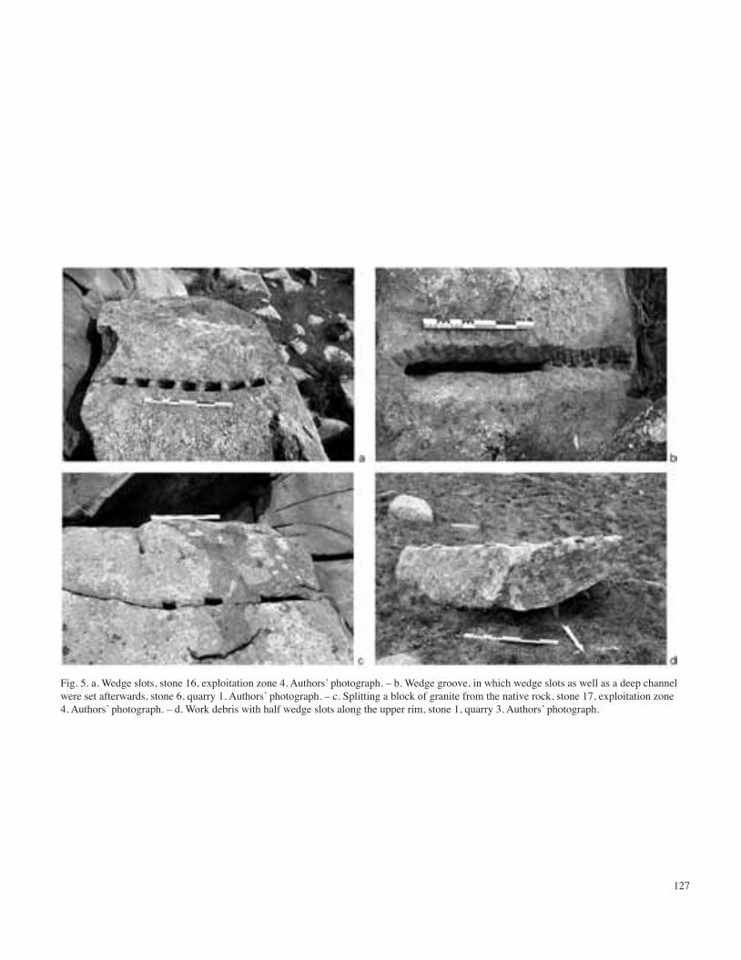
127
Fig. 5. a. Wedge slots, stone 16, exploitation zone 4. Authors’ photograph. – b. Wedge groove, in which wedge slots as well as a deep channel were set afterwards, stone 6, quarry 1. Authors’ photograph. – c. Splitting a block of granite from the native rock, stone 17, exploitation zone 4. Authors’ photograph. – d. Work debris with half wedge slots along the upper rim, stone 1, quarry 3. Authors’ photograph.

128
Fig. 6. a. Quarry 2. Authors’ photograph. – b. Quarry 3. Authors’ photograph. – c. Quarry 5. Authors’ photograph. – d. Quarry 6. Authors’ photograph. – e. Exploitation zone 4a-b. Authors’ photograph.

129
Fig. 7. Quarry 1. – a. To the outer left, stone block with Chinese inscription; in the foreground left, stone 1. Authors’ photograph. – b. Steep east wall with traces of exploitation. Authors’ photograph.

130
Fig. 8. Worked stones in shape of a disk. – a. Stone 1, quarry 6. Authors’ photograph. – b. Stone 7, quarry 4. Authors’ photograph. – c. Stone 1, quarry 4. Authors’ photograph. – d. Stone 4, quarry 4. Authors’ photograph. – e. Stone 9, quarry 4. Authors’ photograph. – f. Stone 13, quarry 4. Authors’ photograph.– g. Grinding stone from a site in Bayangol, Orkhon Valley. Authors’ photograph. – h. Grinding stone from Karakorum. After Kiselev et al. 1965, p. 180, fig. 105,1.

131
Fig. 9. a. Stone 18, quarry 4. Authors’ photograph. – b. Stone 2, quarry 4. Authors’ photograph. – c. Stone 5, quarry 4. Authors’ photograph. – d. Stone 8, quarry 4. Authors’ photograph. – e. Stone 10, quarry 4. Authors’ photograph. – f. Stone 1, quarry 2. Authors’ photograph. – g. Stone 1, quarry 2, detail. Authors’ photograph.

132
Fig. 10. Worked stones in shape of a column base. – a-b. Stone 2, quarry 2. Authors’ photographs. – c. Stone 11, quarry 4. Authors’ photograph.– d. Stone 15, quarry 4. Authors’ photograph. – e. Stone 5, quarry 1. Authors’ photograph.

133
Fig. 11. a. Stone 7, quarry 2. Authors’ photograph. – b. Stone 8, quarry 2. Authors’ photograph. – c. Stone 3, quarry 4. Authors’ photograph. – d. Stone 6, quarry 4. Authors’ photograph. – e. Chilen Balgas. After Radlov 1893, pl. 62,4. – f. Doityn Balgas, corner stone from the central platform. Authors’ photograph.

134
Fig. 12. a-b. Incised template for a column base in exploitation zone 4a. Authors’ photographs. – c. Plaster copy of the upper part of the column bases. Authors’ photograph. – d. Column bases from Karabalgasun, Uighur period. After Hüttel and Dähne 2012, p. 430, fig. 75. – e. Column bases from Chilen Balgas. After Radlov 1893, pl. 62,3.

135
Fig. 13. a-b. Stone with Chinese inscription and figure of a man. Authors’ photograph. – c. Plaster copy of the incision of the man. Authors’ photograph. – d. Father of Min Ziqian; mural in a Jin tomb in Songcun, Shanxi province. After Shanxisheng kaogu yanjiusuo 2008, p. 60, fig. 13 (See Color Plate 4).

136
Fig. 14. a. A Yuan mural (dated 1324) from the Mingyingwang hall (Guangsheng cloister) in the Shanxi province demonstrates different types of the hats (from left to right: persons 1, 3, 4 and 5). After Zhongguo lishi bowuguan 1997, p. 42, fig. 42. – b. Guardians of the rear chamber in the tomb of Zhang Wenzao (interred in 1093), a Han Chinese living under Kitan rule in present-day Xuanhua, Hebei province. After Hebei 2001, pl. 32. – c. Inscription mentioning junior Wang. Plaster cast. Authors’ photograph. – d. Inscription mentioning Hao, the elder. Plaster cast. Authors’ photograph (See Color Plate 5).

227
Plate 1. Aerial photograph from June 2011, sites in the surroundings of the capital Karakorum are marked. (Aerial photograph: Geosan DLR; graphics: Susanne Reichert).
COLOR PLATES JAN BEMMANN ET AL.

228
Plate 2. Map of the Orkhon Valley with sites mentioned in the text. (Graphics: Susanne Reichert).
COLOR PLATES JAN BEMMANN ET AL. COLOR PLATES JAN BEMMANN ET AL.

229
Plate 3. Ortho-photograph of the stone quarry, individual quarries and exploitation zone 4a-c are marked in red. ê indicates location of the rock with the Chinese inscription. p indicates location of the incised column base. (Ortho-photography: Martin Oczipka; graphics: Birte Ahrens).
COLOR PLATES JAN BEMMANN ET AL.

230
Plate 4. a-b. Stone with Chinese inscription and figure of a man. Authors’ photograph. – c. Plaster copy of the incision of the man. Authors’ photograph. – d. Father of Min Ziqian; mural in a Jin tomb in Songcun, Shanxi province. After Shanxisheng kaogu yanjiusuo 2008, p. 60, fig. 13.
COLOR PLATES JAN BEMMANN ET AL. COLOR PLATES JAN BEMMANN ET AL.

231
Plate 5. a. A Yuan mural (dated 1324) from the Mingyingwang hall (Guangsheng cloister) in the Shanxi province demonstrates different types of the hats (from left to right: persons 1, 3, 4 and 5). After Zhongguo lishi bowuguan 1997, p. 42, fig. 42. – b. Guardians of the rear chamber in the tomb of Zhang Wenzao (interred in 1093), a Han Chinese living under Kitan rule in present-day Xuanhua, Hebei province. After Hebei 2001, pl. 32. – c. Inscription mentioning junior Wang. Plaster cast. Authors’ photograph. – d. Inscription mentioning Hao, the elder. Plaster cast. Authors’ photograp.
COLOR PLATES JAN BEMMANN ET AL.