Shiel Dykes Quarry - Northumberland Estates
13
1 Wardell Armstrong LLP Shiel Dykes Quarry Non Technical Summary
-
Upload
khangminh22 -
Category
Documents
-
view
0 -
download
0
Transcript of Shiel Dykes Quarry - Northumberland Estates
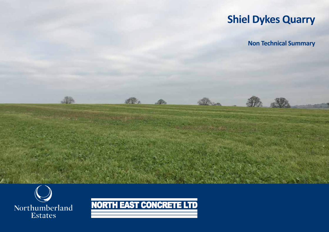
1 Wardell Armstrong LLP Shiel Dykes Quarry
Non Technical Summary
2 Wardell Armstrong LLP
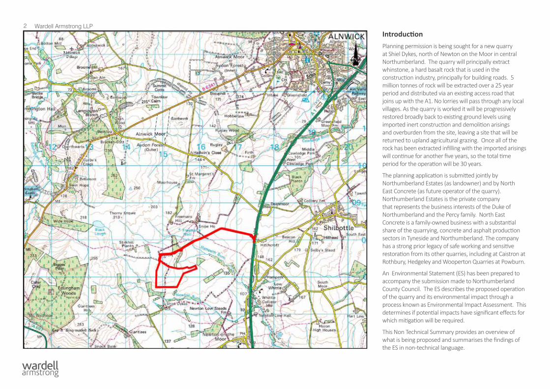
Site LocationIntroductionPlanning permission is being sought for a new quarry at Shiel Dykes, north of Newton on the Moor in central Northumberland. The quarry will principally extract whinstone, a hard basalt rock that is used in the construction industry, principally for building roads. 5 million tonnes of rock will be extracted over a 25 year period and distributed via an existing access road that joins up with the A1. No lorries will pass through any local villages. As the quarry is worked it will be progressively restored broadly back to existing ground levels using imported inert construction and demolition arisings and overburden from the site, leaving a site that will be returned to upland agricultural grazing. Once all of the rock has been extracted infilling with the imported arisings will continue for another five years, so the total time period for the operation will be 30 years.
The planning application is submitted jointly by Northumberland Estates (as landowner) and by North East Concrete (as future operator of the quarry). Northumberland Estates is the private company that represents the business interests of the Duke of Northumberland and the Percy family. North East Concrete is a family-owned business with a substantial share of the quarrying, concrete and asphalt production sectors in Tyneside and Northumberland. The company has a strong prior legacy of safe working and sensitive restoration from its other quarries, including at Caistron at Rothbury, Hedgeley and Wooperton Quarries at Powburn.
An Environmental Statement (ES) has been prepared to accompany the submission made to Northumberland County Council. The ES describes the proposed operation of the quarry and its environmental impact through a process known as Environmental Impact Assessment. This determines if potential impacts have significant effects for which mitigation will be required.
This Non Technical Summary provides an overview of what is being proposed and summarises the findings of the ES in non-technical language.
3 Wardell Armstrong LLP
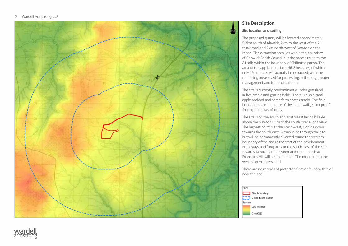
Site DescriptionSite location and setting
The proposed quarry will be located approximately 5.3km south of Alnwick, 2km to the west of the A1 trunk road and 2km north-west of Newton on the Moor. The extraction area lies within the boundary of Denwick Parish Council but the access route to the A1 falls within the boundary of Shilbottle parish. The area of the application site is 46.2 hectares, of which only 19 hectares will actually be extracted, with the remaining areas used for processing, soil storage, water management and traffic circulation.
The site is currently predominantly under grassland, in five arable and grazing fields. There is also a small apple orchard and some farm access tracks. The field boundaries are a mixture of dry stone walls, stock proof fencing and rows of trees.
The site is on the south and south-east facing hillside above the Newton Burn to the south over a long view. The highest point is at the north-west, sloping down towards the south-east. A track runs through the site but will be permanently diverted round the western boundary of the site at the start of the development. Bridleways and footpaths to the south-east of the site towards Newton on the Moor and to the north at Freemans Hill will be unaffected. The moorland to the west is open access land.
There are no records of protected flora or fauna within or near the site.
A1
4 Wardell Armstrong LLP
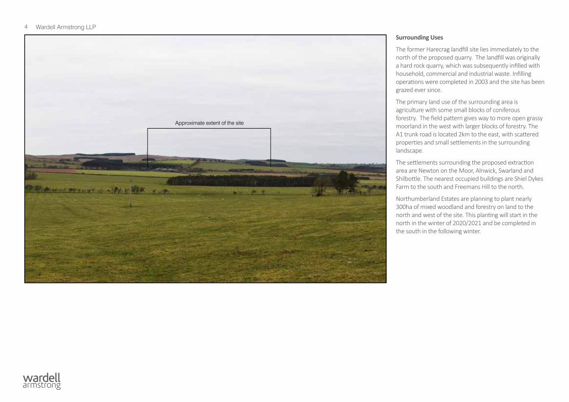
Surrounding Uses
The former Harecrag landfill site lies immediately to the north of the proposed quarry. The landfill was originally a hard rock quarry, which was subsequently infilled with household, commercial and industrial waste. Infilling operations were completed in 2003 and the site has been grazed ever since.
The primary land use of the surrounding area is agriculture with some small blocks of coniferous forestry. The field pattern gives way to more open grassy moorland in the west with larger blocks of forestry. The A1 trunk road is located 2km to the east, with scattered properties and small settlements in the surrounding landscape.
The settlements surrounding the proposed extraction area are Newton on the Moor, Alnwick, Swarland and Shilbottle. The nearest occupied buildings are Shiel Dykes Farm to the south and Freemans Hill to the north.
Northumberland Estates are planning to plant nearly 300ha of mixed woodland and forestry on land to the north and west of the site. This planting will start in the north in the winter of 2020/2021 and be completed in the south in the following winter.
Approximate extent of the site
5 Wardell Armstrong LLP
KEY
Application Boundary
Topsoil storage mound
Subsoil storage mound
Overburden storage mound
Extraction Phasing
Site compound and access tracks
Quarry floor
Existing vegetation
Water treatment area
Existing
Proposed
Trees
Direction of working
Hedgerow
Agricultural land
Water body
Stone wall
Realigned by-way
Fence / gate
0 100 200
metres
Issues
RH
173.1m
Def
Def
RH
RH
ED Bdy
Trough
Swineleas
Pond
RH
ED Bdy
Track
130
135
135
140
140
140
140
145
145
145
145
175
175
175
165
165
165
165
180
170
170
170
170
170
160
160
160
160
160
160
155
155
155
155
155
155
155
150
150
150
150
150
150
150
140
140
140
135
135
145
145
180
180
180
180
140
185
185
185
180
155
155
160
160
165
165
160
165
165
Edge protection bund
Phase 2
Phase 3
Phase 4
Phase 1
Refer to Figure 3.7 fordetail of compound area
Existing by-way
3m
3m
3m
3.5m
2.5m
2.5m
3m
2m
15m
10m
2.5m4.5m
2m
4m
4m
1.5m
3.5m
DRAWN BY CHECKED BY
CLIENT
PROJECT
DRAWING TITLE
A2
NT14060/FIGURE 3.1 -
1:2500 JULY 2020
AB AC NB
SCALE DATE
APPROVED BY
DRG No.
DRG SIZE
REV
WWW.WARDELL-ARMSTRONG.COM
CARDIFF
BIRMINGHAM
EDINBURGH
CARLISLE
BOLTON
CARDIFF
STOKE ON TRENT
BIRMINGHAM
EDINBURGH
LONDON
MANCHESTER
GLASGOW
CARLISLE
BOLTON
NEWCASTLE UPON TYNE | TEL 0191 232 0943
LEEDS
SHIEL DYKES QUARRY
FIGURE 3.1PHASE 1
NORTH EAST CONCRETE LTDAND NORTHUMBERLAND ESTATES
APP'DCHK'DREVISION DETAILS DATE DRAWN
N:\NT\NT14060 - SHIEL DYKES PLANNING AND EIA\03 - DESIGN\AUTOCAD\NT14060 FIGURE 3.1 PHASE 1.DWG
DO NOT SCALE FROM THIS DRAWING
Copyright ReservedcReproduced from Ordnance Survey Maps Crown Copyright All Rights Reserved
Licence No. 0100031673
Rough pasture / grassland
Whin grassland
Proposed trees along fenceline
Phase 1 Restoration
KEY
Application Boundary
Topsoil storage mound
Subsoil storage mound
Overburden storage mound
Extraction Phasing
Site compound and access tracks
Quarry floor
Existing vegetation
Water treatment area
Existing
Proposed
Trees
Direction of working
Hedgerow
Agricultural land
Water body
Stone wall
Proposed woodland
Proposed fence
Realigned by-way
Agricultural land
Fence / gate
Field gate
0 100 200
metres
Issues
RH
Def
RH
ED Bdy
Trough
Swineleas
Pond
RH
ED Bdy
Track
130
135
135
140
140
140
140
145
145
145
145
175
175
175
175
165
165
165
165
165
180
170
170
170
170
160
160
160
160
160
155
155
155
155 155
155
155
150
150
150
150
150
150
140
140
140
135
135
145
145
150
150
150
145140
180
160
180
135130125120115
110
180
180
180
180
185
185
185
155
155
160 165
165
165
126.8
Phase 2
Phase 3
Phase 4
Phase 1
Partial restoration of Phase 1
Advanced woodlandscreen planting
Existing by-way
Refer to Figure 3.7 fordetail of compound area
3m
3m
13m
3.5m
2.5m
2.5m
2m
15m
10m
2.5m4.5m
2m
4m
1.5m
3.5m
5m
4m
3m
DRAWN BY CHECKED BY
CLIENT
PROJECT
DRAWING TITLE
A2
NT14060/FIGURE 3.2 -
1:2500 03/07/2020
AB AC NB
JULY 2020SCALE DATE
APPROVED BY
DRG No.
DRG SIZE
REV
WWW.WARDELL-ARMSTRONG.COM
CARDIFF
BIRMINGHAM
EDINBURGH
CARLISLE
BOLTON
CARDIFF
STOKE ON TRENT
BIRMINGHAM
EDINBURGH
LONDON
MANCHESTER
GLASGOW
CARLISLE
BOLTON
NEWCASTLE UPON TYNE | TEL 0191 232 0943
LEEDS
SHIEL DYKES QUARRY
FIGURE 3.2PHASE 2
NORTH EAST CONCRETE LTDAND NORTHUMBERLAND ESTATES
APP'DCHK'DREVISION DETAILS DATE DRAWN
N:\NT\NT14060 - SHIEL DYKES PLANNING AND EIA\03 - DESIGN\AUTOCAD\NT14060 FIGURE 3.2 PHASE 2.DWG
DO NOT SCALE FROM THIS DRAWING
Copyright ReservedcReproduced from Ordnance Survey Maps Crown Copyright All Rights Reserved
Licence No. 0100031673
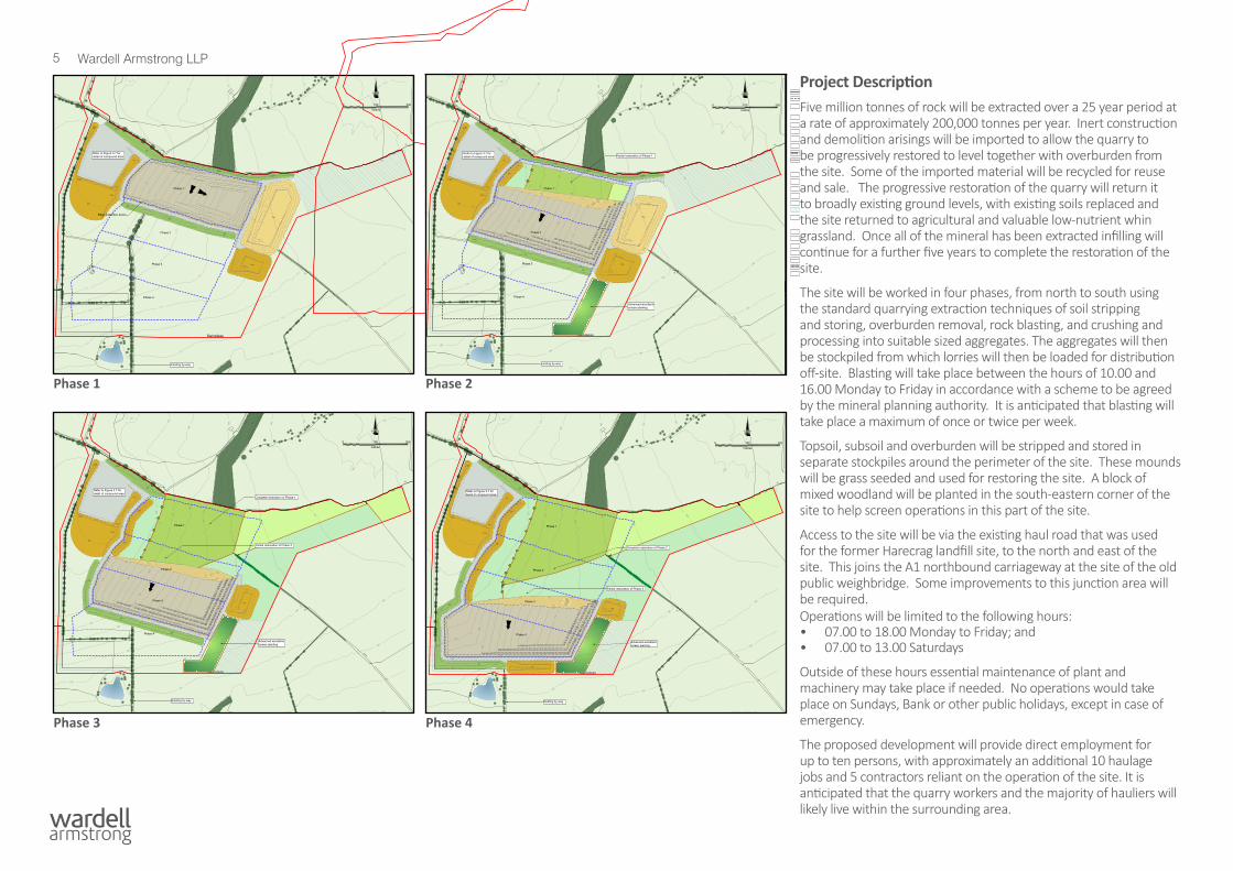
Project DescriptionFive million tonnes of rock will be extracted over a 25 year period at a rate of approximately 200,000 tonnes per year. Inert construction and demolition arisings will be imported to allow the quarry to be progressively restored to level together with overburden from the site. Some of the imported material will be recycled for reuse and sale. The progressive restoration of the quarry will return it to broadly existing ground levels, with existing soils replaced and the site returned to agricultural and valuable low-nutrient whin grassland. Once all of the mineral has been extracted infilling will continue for a further five years to complete the restoration of the site.
The site will be worked in four phases, from north to south using the standard quarrying extraction techniques of soil stripping and storing, overburden removal, rock blasting, and crushing and processing into suitable sized aggregates. The aggregates will then be stockpiled from which lorries will then be loaded for distribution off-site. Blasting will take place between the hours of 10.00 and 16.00 Monday to Friday in accordance with a scheme to be agreed by the mineral planning authority. It is anticipated that blasting will take place a maximum of once or twice per week.
Topsoil, subsoil and overburden will be stripped and stored in separate stockpiles around the perimeter of the site. These mounds will be grass seeded and used for restoring the site. A block of mixed woodland will be planted in the south-eastern corner of the site to help screen operations in this part of the site.
Access to the site will be via the existing haul road that was used for the former Harecrag landfill site, to the north and east of the site. This joins the A1 northbound carriageway at the site of the old public weighbridge. Some improvements to this junction area will be required.Operations will be limited to the following hours:• 07.00 to 18.00 Monday to Friday; and• 07.00 to 13.00 Saturdays
Outside of these hours essential maintenance of plant and machinery may take place if needed. No operations would take place on Sundays, Bank or other public holidays, except in case of emergency.
The proposed development will provide direct employment for up to ten persons, with approximately an additional 10 haulage jobs and 5 contractors reliant on the operation of the site. It is anticipated that the quarry workers and the majority of hauliers will likely live within the surrounding area.
Rough pasture / grassland
Whin grassland
Proposed trees along fenceline
Phase 1-2 Restoration
KEY
Application Boundary
Topsoil storage mound
Subsoil storage mound
Overburden storage mound
Extraction Phasing
Site compound and access tracks
Quarry floor
Existing vegetation
Water treatment area
Existing
Proposed
Trees
Direction of working
Hedgerow
Agricultural land
Water body
Stone wall
Proposed hedgerow
Proposed woodland
Proposed fence
Agricultural field
Proposed gate
Fence / gate
Realigned by-way
0 100 200
metres
Issues
RH
RH
ED Bdy
Trough
Swineleas
Pond
RH
ED Bdy
Track
155
155
155
155
155
130
135
135
140
140
140
140
145
145
145
145
175
175
175
165
165
165
165
180
170
170
170
170
160
160
160
160
160
150
150
150
150
150
140
140
140
135
135
145
145
180
180
180
180
180
155
155
155
160
150
150
150
145
145
145
140
140
140
135
135
130
130
125
125
120
120
115110
185
185
185
165
Phase 2
Phase 3
Phase 4
Phase 1
Complete restoration of Phase 1
Partial restoration of Phase 2
Advanced woodlandscreen planting
Existing by-way
Refer to Figure 3.7 fordetail of compound area
3m
3m
9m
4m
2m
2.5m4.5m
2m
4m
1.5m
3.5m
4m
5m
5m
3m
DRAWN BY CHECKED BY
CLIENT
PROJECT
DRAWING TITLE
A2
NT14060/FIGURE 3.3 -
1:2500 JULY 2020
AB AC NB
SCALE DATE
APPROVED BY
DRG No.
DRG SIZE
REV
WWW.WARDELL-ARMSTRONG.COM
CARDIFF
BIRMINGHAM
EDINBURGH
CARLISLE
BOLTON
CARDIFF
STOKE ON TRENT
BIRMINGHAM
EDINBURGH
LONDON
MANCHESTER
GLASGOW
CARLISLE
BOLTON
NEWCASTLE UPON TYNE | TEL 0191 232 0943
LEEDS
SHIEL DYKES QUARRY
FIGURE 3.3PHASE 3
NORTH EAST CONCRETE LTDAND NORTHUMBERLAND ESTATES
APP'DCHK'DREVISION DETAILS DATE DRAWN
N:\NT\NT14060 - SHIEL DYKES PLANNING AND EIA\03 - DESIGN\AUTOCAD\NT14060 FIGURE 3.3 PHASE 3.DWG
DO NOT SCALE FROM THIS DRAWING
Copyright ReservedcReproduced from Ordnance Survey Maps Crown Copyright All Rights Reserved
Licence No. 0100031673
Rough pasture / grassland
Whin grassland
Proposed trees along fenceline
Phase 1-3 Restoration
KEY
Application Boundary
Topsoil storage mound
Subsoil storage mound
Overburden storage mound
Extraction Phasing
Site compound and access tracks
Quarry floor
Existing vegetation
Water treatment area
Existing
Proposed
Trees
Direction of working
Hedgerow
Agricultural land
Water body
Stone wall
Proposed hedgerow
Proposed woodland
Proposed fence
Agricultural field
Proposed gate
Fence / gate
Realigned by-way
0 100 200
metres
Issues
RH
RH
ED Bdy
Swineleas
Pond
RH
ED Bdy
Track
130
135
135
140
140
140
140
145
145
145
145
155
155
155
155
155
155
155
175
175
175
165
165
165
165
180
170
170
17016
0
160
160
160
150
150
150
150
150
140
140
140
135
135
145
145
180
180
180
180
180
180
180
150
150
150
145140135130125120115
110
185
185
185
175
155
160
Phase 2
Phase 3
Phase 4
Phase 1
Complete restoration of Phase 2
Partial restoration of Phase 3
Advanced woodlandscreen planting
Existing by-way
Refer to Figure 3.7 fordetail of compound area
6m
3m
4m
5m
4m
2.5m4.5m
2m
4m
1.5m
3.5m
4m
5m
5m
4m
3m
DRAWN BY CHECKED BY
CLIENT
PROJECT
DRAWING TITLE
A2
NT14060/FIGURE 3.4 -
1:2500 JULY 2020
AB AC NB
SCALE DATE
APPROVED BY
DRG No.
DRG SIZE
REV
WWW.WARDELL-ARMSTRONG.COM
CARDIFF
BIRMINGHAM
EDINBURGH
CARLISLE
BOLTON
CARDIFF
STOKE ON TRENT
BIRMINGHAM
EDINBURGH
LONDON
MANCHESTER
GLASGOW
CARLISLE
BOLTON
NEWCASTLE UPON TYNE | TEL 0191 232 0943
LEEDS
SHIEL DYKES QUARRY
FIGURE 3.4PHASE 4
NORTH EAST CONCRETE LTDAND NORTHUMBERLAND ESTATES
APP'DCHK'DREVISION DETAILS DATE DRAWN
N:\NT\NT14060 - SHIEL DYKES PLANNING AND EIA\03 - DESIGN\AUTOCAD\NT14060 FIGURE 3.4 PHASE 4.DWG
DO NOT SCALE FROM THIS DRAWING
Copyright ReservedcReproduced from Ordnance Survey Maps Crown Copyright All Rights Reserved
Licence No. 0100031673
Phase 1 Phase 2
Phase 3 Phase 4
6 Wardell Armstrong LLP
KEY
Application Boundary
Existing vegetation
Existing
Proposed restoration
Trees
Hedgerow
Agricultural land
Water body
Fence / gate
Stone wall
Rough pasture grassland
Whin grassland
Trees along fenceline
Hedgerow
Woodland
Fence
Agricultural land
Field gate
Realigned by-way
0 100 200
metres
Issues
RH
RH
ED Bdy
Swineleas
Pond
RH
ED Bdy
Track
130
135
135
140
140
140
140
145
145
145
145
155
155
175
175
165
165
180
170
170
160
160
150
150
150
150
140
140
140
135
135
145
145
180
180
130
135
135
140
140
140
140
145
145
145
165
170
160
160155
155
150
Woodland planting retained
Existing by-way DRAWN BY CHECKED BY
CLIENT
PROJECT
DRAWING TITLE
A2
NT14060/FIGURE 3.5 -
1:2500 JULY 2020
AB AC NB
SCALE DATE
APPROVED BY
DRG No.
DRG SIZE
REV
WWW.WARDELL-ARMSTRONG.COM
CARDIFF
BIRMINGHAM
EDINBURGH
CARLISLE
BOLTON
CARDIFF
STOKE ON TRENT
BIRMINGHAM
EDINBURGH
LONDON
MANCHESTER
GLASGOW
CARLISLE
BOLTON
NEWCASTLE UPON TYNE | TEL 0191 232 0943
LEEDS
SHIEL DYKES QUARRY
FIGURE 3.5RESTORATION
NORTH EAST CONCRETE LTDAND NORTHUMBERLAND ESTATES
APP'DCHK'DREVISION DETAILS DATE DRAWN
N:\NT\NT14060 - SHIEL DYKES PLANNING AND EIA\03 - DESIGN\AUTOCAD\NT14060 FIGURE 3.5 FINAL RESTORATION PLAN.DWG
DO NOT SCALE FROM THIS DRAWING
Copyright ReservedcReproduced from Ordnance Survey Maps Crown Copyright All Rights Reserved
Licence No. 0100031673
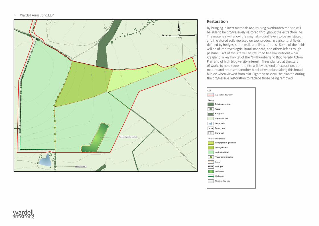
RestorationBy bringing in inert materials and reusing overburden the site will be able to be progressively restored throughout the extraction life. The materials will allow the original ground levels to be reinstated, and the stored soils replaced on top, producing agricultural fields defined by hedges, stone walls and lines of trees. Some of the fields will be of improved agricultural standard, and others left as rough pasture. Part of the site will be returned to a low nutrient whin grassland, a key habitat of the Northumberland Biodiversity Action Plan and of high biodiversity interest. Trees planted at the start of works to help screen the site will, by the end of extraction, be mature and represent another block of woodland along this broad hillside when viewed from afar. Eighteen oaks will be planted during the progressive restoration to replace those being removed.

7 Wardell Armstrong LLP
TrafficThe quarry will use the existing priority access onto the A1 as the sole vehicular access. Local residents will know this as the point where the public weighbridge and the prominent ComVert advertisement is located. Alterations to the junction will be made, including providing space for lorries to decelerate to safely enter the site from the south. The quarry will be gated for security.
On leaving the site all larger lorries will head north. If they need to head south towards Tyneside they will exit the A1 at the next available junction at the Willowburn junction and travel back on the southbound carriageway. Only vehicles under 7.5m in length will be permitted to turn right onto the A1 directly from the quarry, using the existing separator island in the middle of the lanes.
Appropriate signage will be placed to warn drivers of the quarry but overall the quarry will generate very little increase in traffic on the A1 compared to existing numbers of vehicles using the road.
EcologyThere will be no effect on sites designated for nature conservation in the vicinity of the proposed quarry.
Some low value habitats within the site will be lost during the quarry operations but replaced on restoration. The most significant of these losses is the line of mature trees in the centre of the site. This loss will be compensated for in the long term with the planting of 18 oak trees as well as 1ha of new broadleaved woodland. The creation of an area of whin grassland will be a significant biodiversity gain. Whin grassland is a key target habitat of Northumberland County Council’s Biodiversity Action Plan.
Species losses within the site will be mitigated, particularly by precautionary measures for bats and for nesting birds, and will be compensated for by the restoration of habitats similar to those affected.
A1 NorthboundCarriageway
Future DecelerationLane and Taper
Site Access Road

8 Wardell Armstrong LLP
Cultural HeritageThe Environmental Statement assesses the impact of the quarry on historic buildings in the vicinity of the site which are protected by law. Because of their distance from the site, their setting or the lack of visibility between them and the quarry, the ES concludes that the workings will have no impact on them or the way they are appreciated.
Initial archaeological investigations have revealed evidence of medieval ridge and furrow field systems, common in this area. A plan of excavation, recording and preservation of any archaeological features found once the soils have been stripped from the site is being proposed. This will enable the past activity on the site to be thoroughly understood and the results made publicly available. Our knowledge of the local area’s past will increase and because of this benefit the overall effect of the scheme on heritage will be small.
Landscape and Visual ImpactThis will be a new quarry introduced into this rural landscape to the north-west of Newton on the Moor. It will temporarily change the landform, land cover, land use and management of the site for the duration of the operation.
The formation of soil and overburden storage mounds on the perimeter of the site, the grass seeding of these mounds, woodland planting in the south-eastern corner of the site and the backfilling and progressive restoration of the quarry void will minimise impacts. There will be some prominent changes to the landscape character of the site and the area within approximately 2.5km to the south and south-east of the site. There would also be prominent changes to views experienced by residents of this area and people travelling through this area on the road and rights of way network. These are shown and assessed in the Environmental Statement.
The woodland and forestry being planted by Northumberland Estates in 2020 to 2022 to the north and west of the site will greatly limit the perception of the landscape change and views of the development from these areas.
The restoration of the site will return the landform to the existing levels and landcover will be restored similar to how it is now but with added biodiversity benefits resulting from the creation of a species rich whin grassland field.
Shiel DykeNewton-on-the-MoorNorthumberland
archaeological desk-basedassessmentreport 4975
Figure 6: Extract from ChristopherGreenwood's Map of Northumberland,1828
on behalf of
Northumberland Estatesand
North EastConcrete Ltd
approximate site location
not to scale
Extract from Greenwood’s Map of Northumberland, 1828
9 Wardell Armstrong LLP
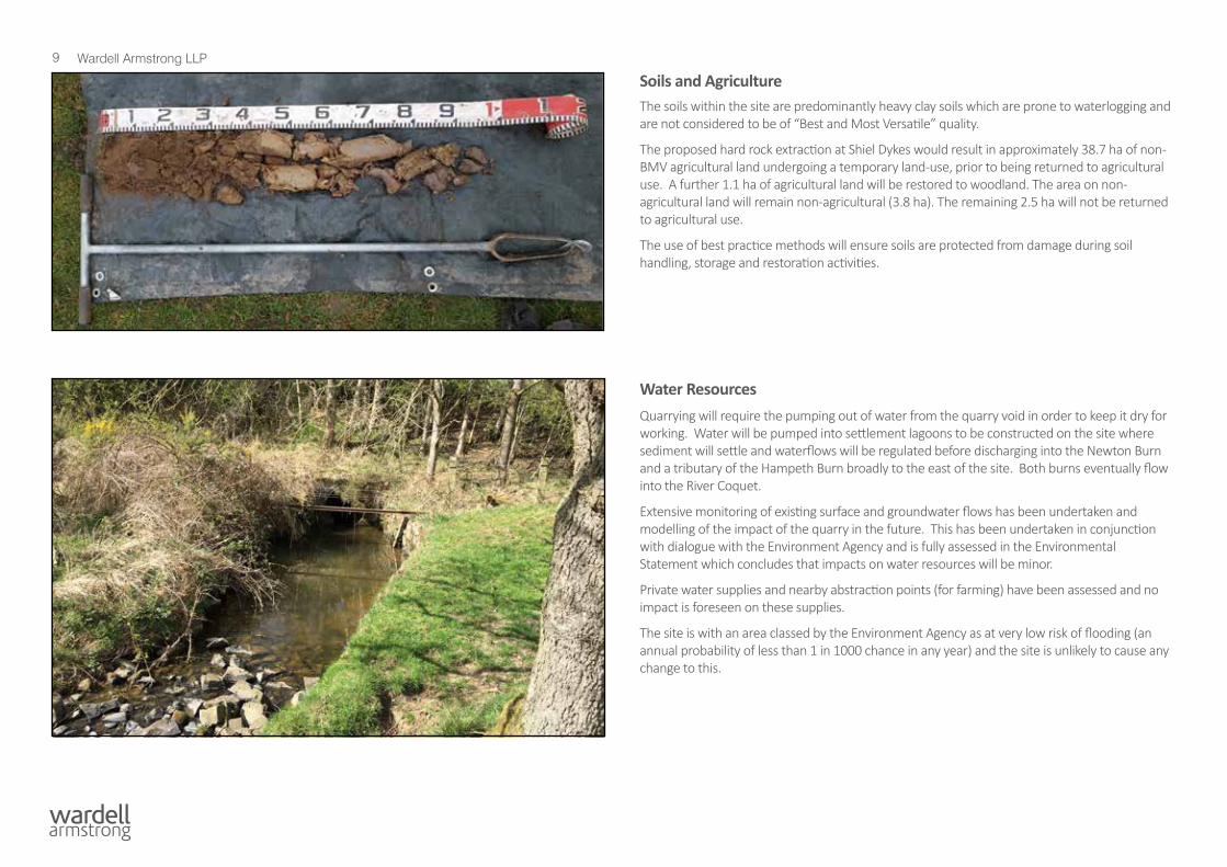
Soils and AgricultureThe soils within the site are predominantly heavy clay soils which are prone to waterlogging and are not considered to be of “Best and Most Versatile” quality.
The proposed hard rock extraction at Shiel Dykes would result in approximately 38.7 ha of non-BMV agricultural land undergoing a temporary land-use, prior to being returned to agricultural use. A further 1.1 ha of agricultural land will be restored to woodland. The area on non-agricultural land will remain non-agricultural (3.8 ha). The remaining 2.5 ha will not be returned to agricultural use.
The use of best practice methods will ensure soils are protected from damage during soil handling, storage and restoration activities.
Water ResourcesQuarrying will require the pumping out of water from the quarry void in order to keep it dry for working. Water will be pumped into settlement lagoons to be constructed on the site where sediment will settle and waterflows will be regulated before discharging into the Newton Burn and a tributary of the Hampeth Burn broadly to the east of the site. Both burns eventually flow into the River Coquet.
Extensive monitoring of existing surface and groundwater flows has been undertaken and modelling of the impact of the quarry in the future. This has been undertaken in conjunction with dialogue with the Environment Agency and is fully assessed in the Environmental Statement which concludes that impacts on water resources will be minor.
Private water supplies and nearby abstraction points (for farming) have been assessed and no impact is foreseen on these supplies.
The site is with an area classed by the Environment Agency as at very low risk of flooding (an annual probability of less than 1 in 1000 chance in any year) and the site is unlikely to cause any change to this.
10 Wardell Armstrong LLP
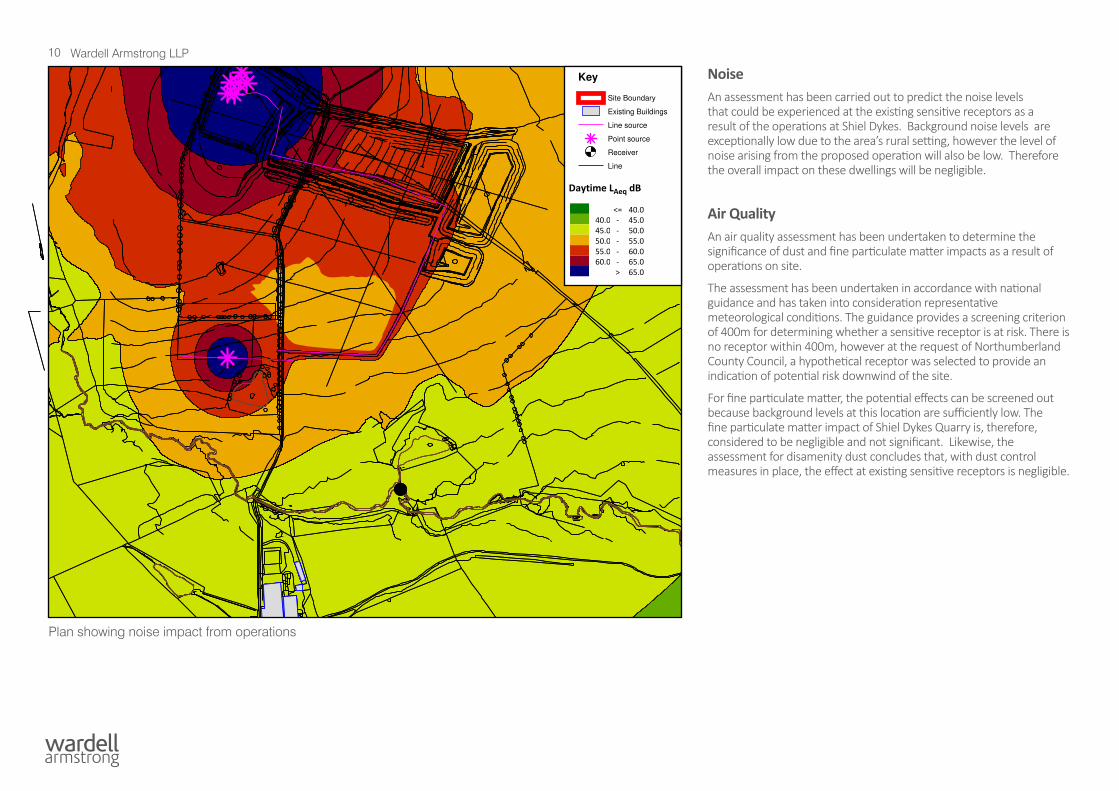
NoiseAn assessment has been carried out to predict the noise levels that could be experienced at the existing sensitive receptors as a result of the operations at Shiel Dykes. Background noise levels are exceptionally low due to the area’s rural setting, however the level of noise arising from the proposed operation will also be low. Therefore the overall impact on these dwellings will be negligible.
Air QualityAn air quality assessment has been undertaken to determine the significance of dust and fine particulate matter impacts as a result of operations on site.
The assessment has been undertaken in accordance with national guidance and has taken into consideration representative meteorological conditions. The guidance provides a screening criterion of 400m for determining whether a sensitive receptor is at risk. There is no receptor within 400m, however at the request of Northumberland County Council, a hypothetical receptor was selected to provide an indication of potential risk downwind of the site.
For fine particulate matter, the potential effects can be screened out because background levels at this location are sufficiently low. The fine particulate matter impact of Shiel Dykes Quarry is, therefore, considered to be negligible and not significant. Likewise, the assessment for disamenity dust concludes that, with dust control measures in place, the effect at existing sensitive receptors is negligible.
Daytime LAeq dB
<= 40.040.0 - 45.045.0 - 50.050.0 - 55.055.0 - 60.060.0 - 65.0
> 65.0
Key
Site Boundary
Existing Buildings
Line source
Point source
Receiver
Line
SCALE: DATE
17/07/20201:19481
DRAWN BY
EFAPPROVED BY
REV:
CLIENT:
North East Concrete Ltd
PROJECT:
Shiel Dykes Quarry
TITLE:
Figure 13.2 - Temporary Operations
DRG NO:
NT14060/002REV:
A
DRG SIZE:
A3SCALE:
1:4500DATE:
17/07/2020
DRAWN BY
LWCHECKED BY APPROVED BY
0 50 100 150 200m
Contains Ordnance Survey data.© Crown Copyright and database
right 2020
Plan showing noise impact from operations
11 Wardell Armstrong LLP
VibrationAll quarry blasting, even the most efficient, must necessarily generate a certain amount of ground and airborne vibration although it is very much in the operator’s interest to always reduce such vibration to the minimum possible in that this substantially increases the efficiency and hence the economy of blasting operations.
This vibration will spread out from the blast in all directions and, although it will decay very rapidly it may still be at a perceptible level once it crosses the site boundary and hence be noticed at adjacent properties and structures. Accordingly, in order to reassure neighbours, all blasts are very strictly controlled in terms of allowable vibration levels at any adjacent vibration sensitive locations. Such control is by means of vibration limits set in line with International and British Standard guidance that forms the basis of HM Government planning advice to local planning authorities.
The vibration assessment concludes that the recommended vibration criterion for adjacent properties, which is in turn in line with planning guidance, can be attained throughout the working area. It is therefore concluded that any adverse comment arising from blast vibrations are expected to be minimal throughout the lifetime of the quarry.
Climate ChangeThe impact of the proposal on climate change has been informed by the developer’s predicted monthly fuel consumption. The proposed development will have a neutral and non-significant impact. This is due to there being no improvements beyond that of the practices that are considered to meet industry standards. It is recognised that the proposed development will emit large amounts of green-house gases, which will contribute to climate change. However, it is assumed that there is a need for the material to be produced and therefore if the proposed quarry were not to take place then another quarry with a similar output will still need to be built elsewhere to meet the demand.
In addition, the quarry is assessed as posing low risk to human health through adverse contributions to climate change. Risks are assessed relating to increased flooding, dust generation and slope failure but mitigation measures are proposed to reduce these risks to acceptable levels.
Alternatives ConsideredAlternatives to the proposal have been considered in this application and have been discounted. These include:
• The option to do nothing;
This would result in the sterilisation of five million tonnes of otherwise workable known whinstone (dolerite) for which there is a clear market in Northumberland and Tyneside. Doing nothing would also not address the geographical imbalance of whinstone in Northumberland, as well as loss of the provision of employment opportunities. By not being transported to the site, inert materials may not be used for recovery and recycling purposes, but rather other outcomes, such as being sent to landfill.
• The option to do find an alternative site;
Finding another site to locate the proposal is largely restricted due to the nature of the geology. A large number of whinstone extraction operations are located in south west Northumberland, whereas there are only a small number of such operations in the north. The site is located to the south west of Alnwick within an area of lesser disturbed igneous rock than other northern sites which are located to the north east of Alnwick. The site is considered to be in a sustainable location where transport and amenity impacts, as well as any cumulative impacts, can be minimised.
• The option to extend at an existing site;
Extensions to other quarries along the whin sill have been granted over recent years and it is unlikely that any other individual site has the potential for further extension over what has been currently been permitted, particularly for the high volumes of mineral that would be generated at Shiel Dykes.
12 Wardell Armstrong LLP
Next stepsThe planning application comprises an application form and land ownership certificates, drawings, an Environmental Impact Assessment report and this Non Technical Summary
Copies of this summary are available free of charge. Copies of the application are available for £50 from:
Nicholas Beale
Wardell Armstrong LLP
City Quadrant
11 Waterloo Square
NEWCASTLE UPON TYNE
NE1 4DP
Tel: 0191 232 0943
Email: [email protected]
The address for consultation responses is:
Specialist Planning Services
Northumberland County Council
County Hall
MORPETH
NE61 2EF
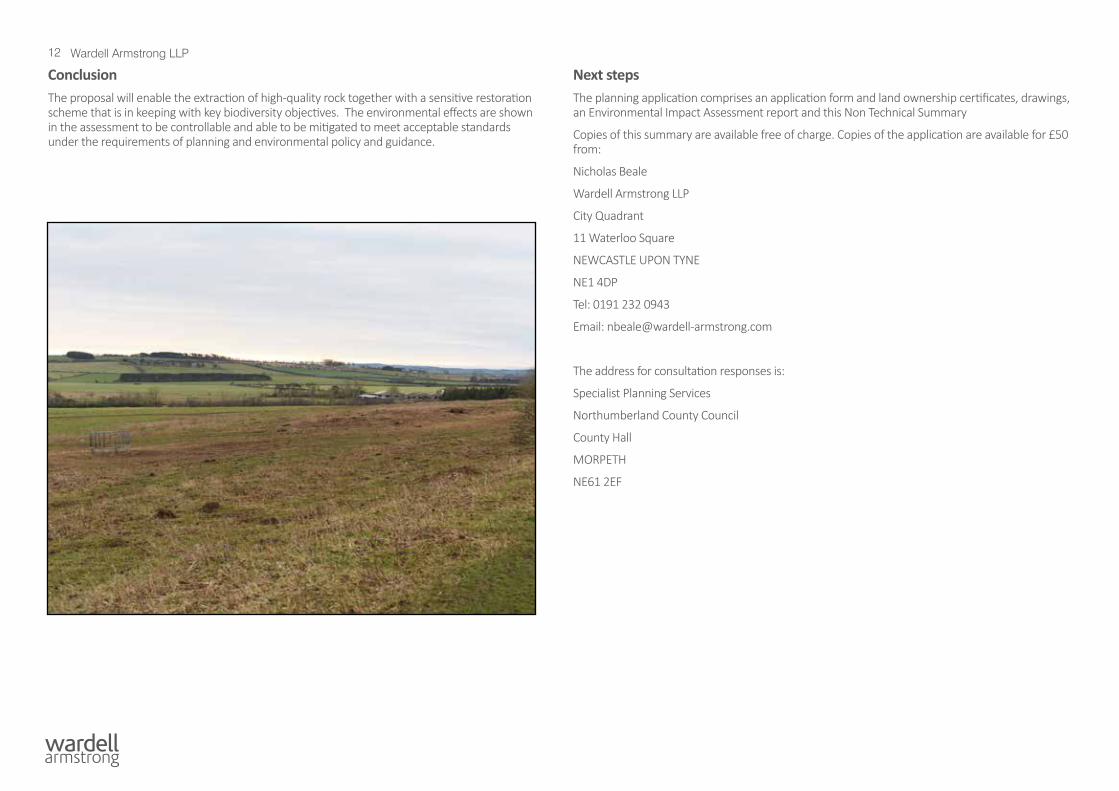
ConclusionThe proposal will enable the extraction of high-quality rock together with a sensitive restoration scheme that is in keeping with key biodiversity objectives. The environmental effects are shown in the assessment to be controllable and able to be mitigated to meet acceptable standards under the requirements of planning and environmental policy and guidance.

W A R D E L L A R M S T R O N G L L PC i t y Q u a d r a n t1 1 W a t e r l o o S q u a r eN e w c a s t l e U p o n T y n eN E 1 4 D P
n b e a l e @ w a r d e l l - a r m s t r o n g . c o m