A GIS-based approach to documenting large canid damage to bones
1/22/2014
TerraGo GeoPDF Report
District 2 GIS Software Evaluation
Idaho Transportation Department
Authored by: Daniel A. Estrada, GIS Analyst District 2
Idaho Transportation Department
Report: GeoPDF, TerraGo TerraGo
Daniel A. Estrada, GIS Analyst District 2
Table of Contents Introduction ....................................................................................................................... 3
TerraGo Publisher for ArcGIS ........................................................................................... 4
TerraGo Demostration ...................................................................................................... 4
ArcGIS Desktop Deployment............................................................................................... 9
Analysis ......................................................................................................................... 12
Preliminary Recommendation .......................................................................................... 12
Appendix A ........................................................................................................................ 14
2
Idaho Transportation Department
Introduction The Idaho Transportation Department (ITD) has a need to be able to deploy
cartographic solutions for field personnel in order to assist with various duties and missions that support ITD be that maintenance, construction, environmental, planning, or other needs as dictated by each District. Asset management, site evaluations and mission specific projects that require in the field editing of cartographic data are of great concern and need to ITD. The advancement of cloud based platforms for cartographic use have great value but are limited to usage within ITD’s districts were the remoteness of the areas prevent real-time access to data services for internet use. Radios, amplifers, repeaters are costly and bulky ways of transmitting information however they are not easily accessible which lowers their efficiency of use. A solution to this challenge is to use the abilities of GeoPDFs. GeoPDFs are not new technology or extension to ArcGIS, they are established and efficient manners to create and export maps that in digital format allow for dynamic usage. This system would allow for a mobile user with a tablet with GPS capability to use spatial data generated in the office in remote areas that not connected to data services. The GeoPDFs are fully editable and efficient for data collection purposes.
In an effort to assist ITD to search for viable and efficient ways to meet our cartographic needs in remote areas, District 2 GIS Analyst assigned to Traffic has evaluated a software package by TerraGo called TerraGo Publisher for ArcGIS. “TerraGo Publisher® for ArcGIS® enables organizations to significantly enhance the value of their existing GIS systems by producing and exploiting portable, interactive and intelligent GeoPDF® maps and imagery that can be easily updated and shared inside and outside the organization with anyone using the free Adobe® Reader®.” (http://www.terragotech.com/products/geospatial-collaboration/terrago-publisher).
This solution would not only meet the needs for the District 2 personnel but it promises great utility for ITD statewide in order to meet the needs of remote data access in all districts within the State of Idaho. The workflow of allowing field personnel to be able to transmit field data back to the GIS Analysts for updating the system of record and being able to keep our data as up to date as possible.
3
Idaho Transportation Department
TerraGo Publisher for ArcGIS TerraGo Publisher is a geospatial collaboration extension for ArcGIS Desktop
that allows for a robust deployment of “static maps” that will allow the sharing of spatial data with field personnel and other end users. It allows users to access, update compact location data in a format that is completely mobile. The publisher augments GeoPDF maps and imagery to fully function on laptops, tablets and other mobile devices without requiring internet connectivity. This allows for the ability to have continuous access to spatial data in remote and bandwith restricted environments. The GeoPDF is not merely a dynamic document reader but a fully integrated document container. It allows the integration of geo-referenced maps, imagery; embed photos, multimedia, hyperlinks, and custom made forms for data collection. It allows for the ability for field personnel to edit, add or create feature classes to the map including assigning attribute values and geo-located annotations.
TerraGo provided a demonstration to the District 2 GIS Analyst and a report on that demonstration will be discussed.
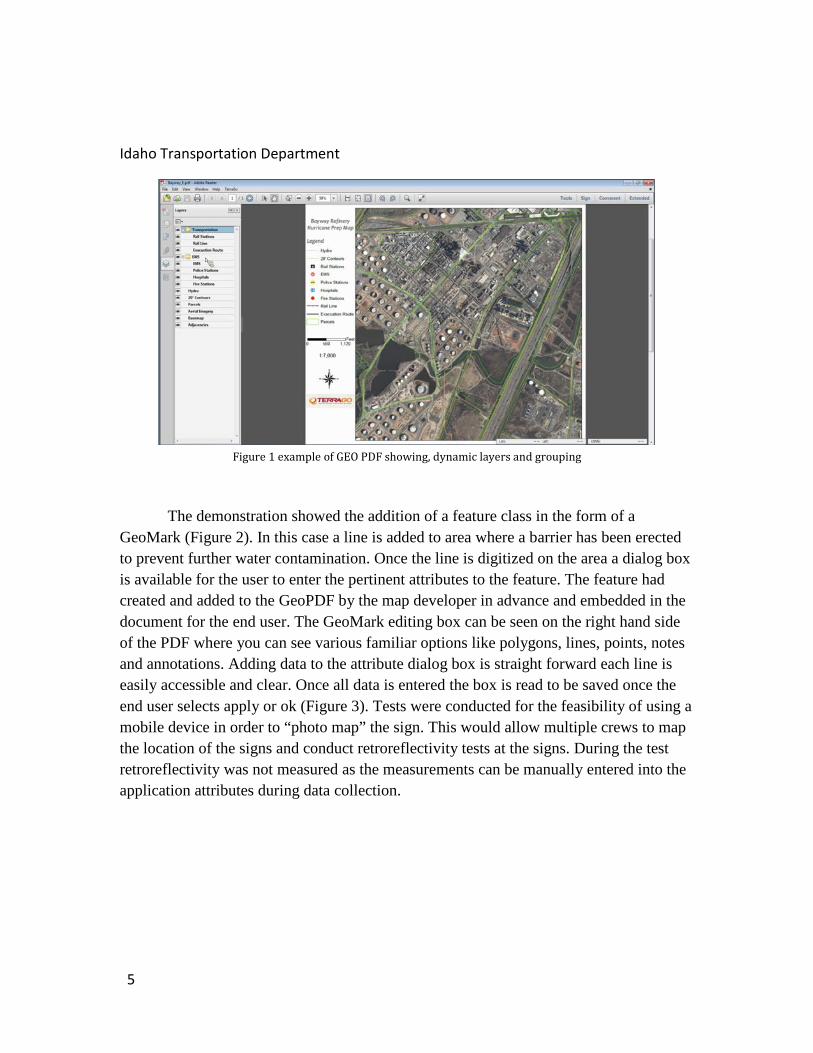
TerraGo Demostration TerraGo began their demonstration with a premade GeoPDF of a refinery that was
being evaluated after a hurricane had passed through the area (Figure 1). The document is clearly formatted containing all map elements. The layers are fully accessible in the document table of contents within Adobe Reader. Each layer is expandable and maintains the ability to be turned off and on as needed by the user. Similar to how a user would turn off or on a layer in ArcGIS Desktop or on a dynamic digitial map on ArcGIS Online. Through Adobe Reader, the user has the ability to magnify areas through the use of the standard PDF controls within the toolbar. The added information can be seen in the lower right hand section of the pdf window where the latitude and longitude can be viewed. This allows the user to see the lat/long at the position of the cursor as the GeoPDF is geo-referenced.
4
Idaho Transportation Department
Figure 1 example of GEO PDF showing, dynamic layers and grouping
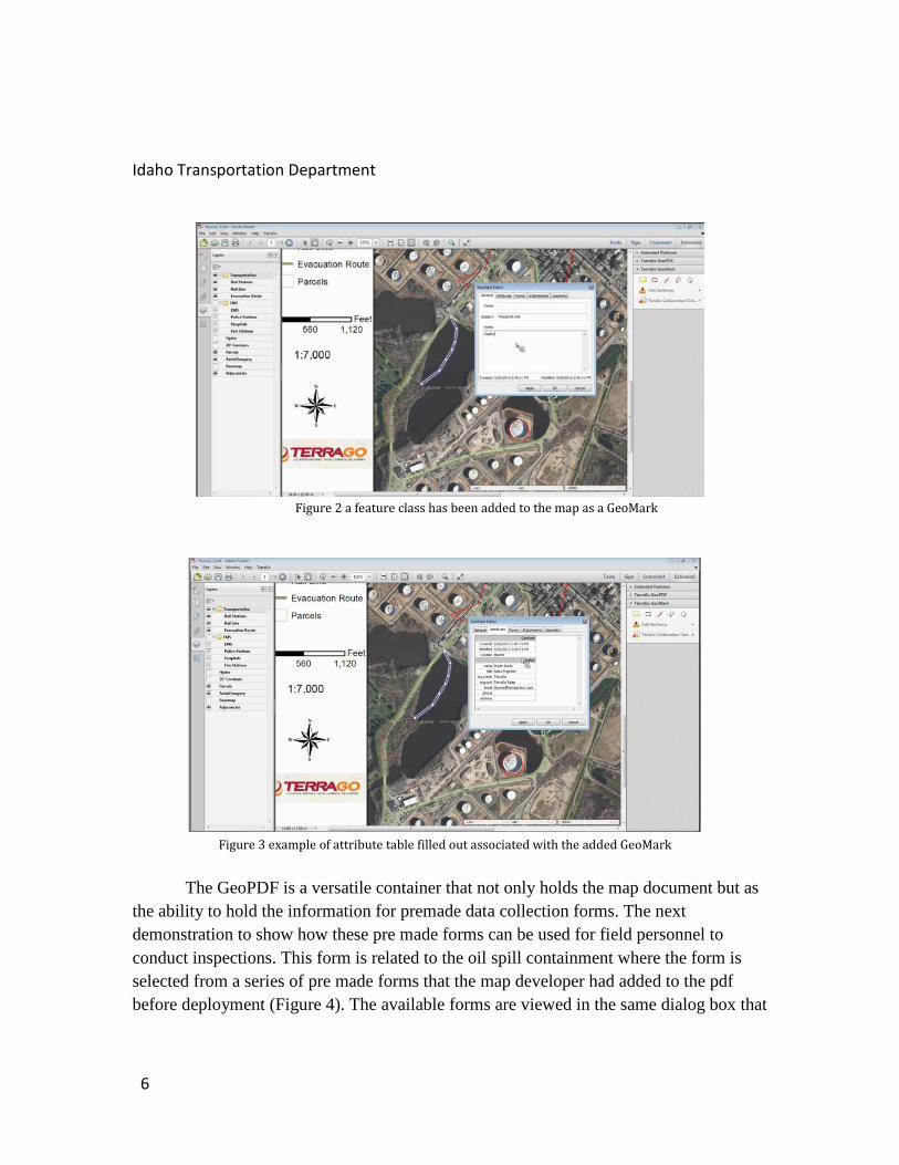
The demonstration showed the addition of a feature class in the form of a GeoMark (Figure 2). In this case a line is added to area where a barrier has been erected to prevent further water contamination. Once the line is digitized on the area a dialog box is available for the user to enter the pertinent attributes to the feature. The feature had created and added to the GeoPDF by the map developer in advance and embedded in the document for the end user. The GeoMark editing box can be seen on the right hand side of the PDF where you can see various familiar options like polygons, lines, points, notes and annotations. Adding data to the attribute dialog box is straight forward each line is easily accessible and clear. Once all data is entered the box is read to be saved once the end user selects apply or ok (Figure 3). Tests were conducted for the feasibility of using a mobile device in order to “photo map” the sign. This would allow multiple crews to map the location of the signs and conduct retroreflectivity tests at the signs. During the test retroreflectivity was not measured as the measurements can be manually entered into the application attributes during data collection.
5
Idaho Transportation Department
Figure 2 a feature class has been added to the map as a GeoMark
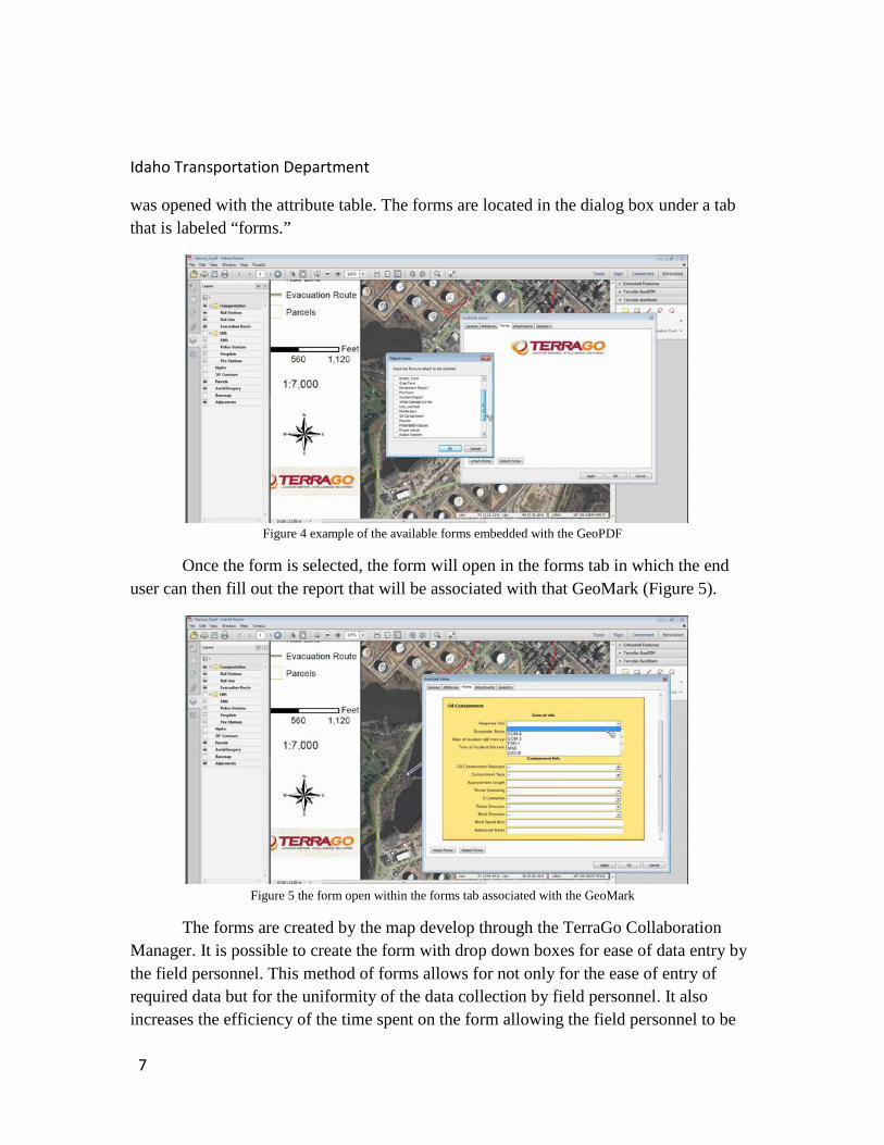
The GeoPDF is a versatile container that not only holds the map document but as the ability to hold the information for premade data collection forms. The next demonstration to show how these pre made forms can be used for field personnel to conduct inspections. This form is related to the oil spill containment where the form is selected from a series of pre made forms that the map developer had added to the pdf before deployment (Figure 4). The available forms are viewed in the same dialog box that
Figure 3 example of attribute table filled out associated with the added GeoMark
6
Idaho Transportation Department
was opened with the attribute table. The forms are located in the dialog box under a tab that is labeled “forms.”
Figure 4 example of the available forms embedded with the GeoPDF
Once the form is selected, the form will open in the forms tab in which the end user can then fill out the report that will be associated with that GeoMark (Figure 5).
Figure 5 the form open within the forms tab associated with the GeoMark
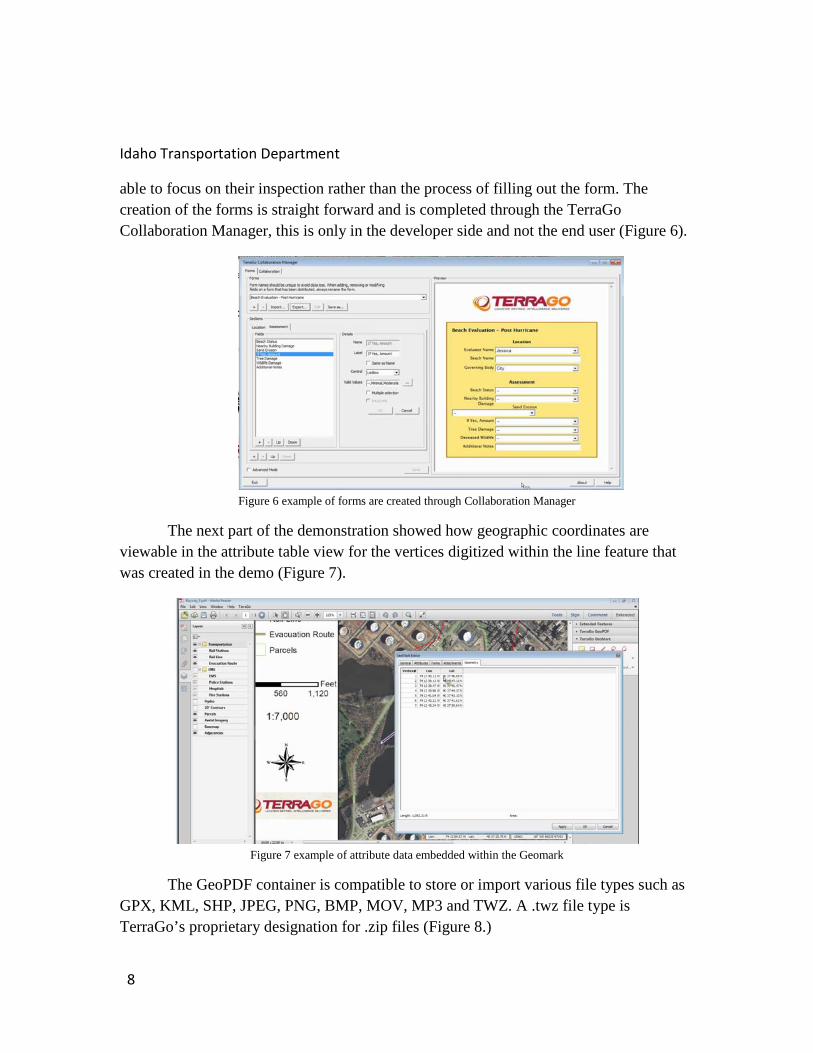
The forms are created by the map develop through the TerraGo Collaboration Manager. It is possible to create the form with drop down boxes for ease of data entry by the field personnel. This method of forms allows for not only for the ease of entry of required data but for the uniformity of the data collection by field personnel. It also increases the efficiency of the time spent on the form allowing the field personnel to be
7
Idaho Transportation Department
able to focus on their inspection rather than the process of filling out the form. The creation of the forms is straight forward and is completed through the TerraGo Collaboration Manager, this is only in the developer side and not the end user (Figure 6).
Figure 6 example of forms are created through Collaboration Manager
The next part of the demonstration showed how geographic coordinates are viewable in the attribute table view for the vertices digitized within the line feature that was created in the demo (Figure 7).
Figure 7 example of attribute data embedded within the Geomark
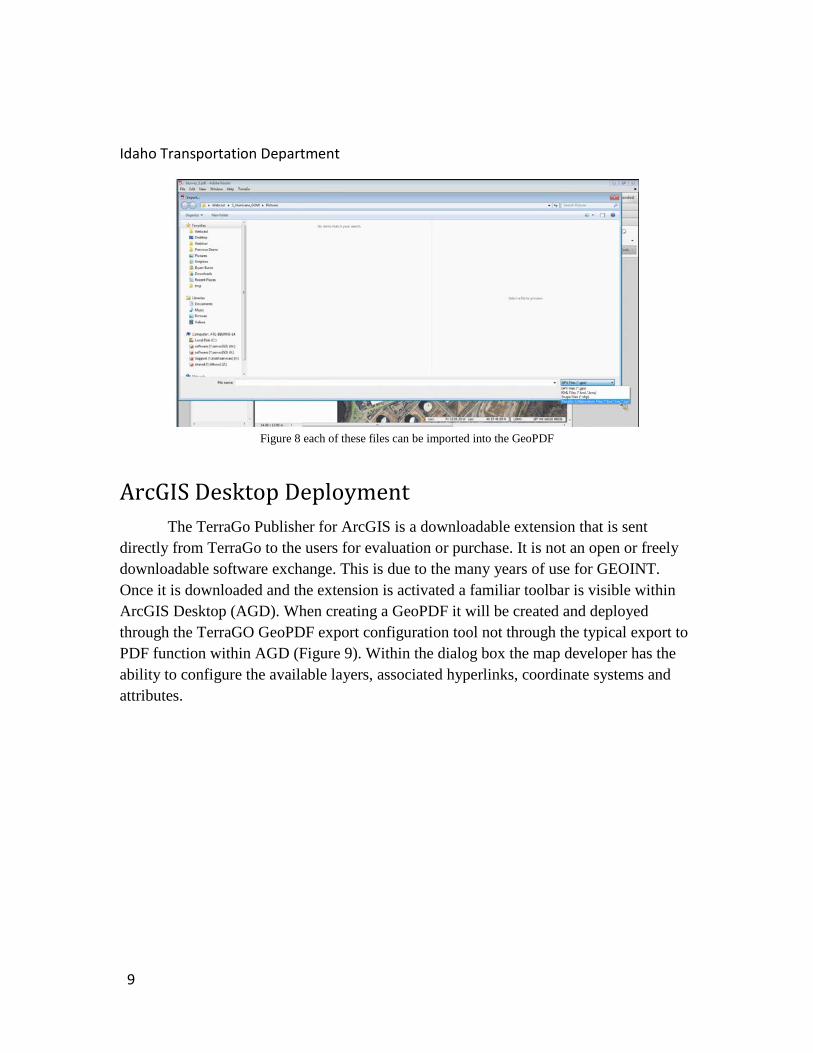
The GeoPDF container is compatible to store or import various file types such as GPX, KML, SHP, JPEG, PNG, BMP, MOV, MP3 and TWZ. A .twz file type is TerraGo’s proprietary designation for .zip files (Figure 8.)
8
Idaho Transportation Department
Figure 8 each of these files can be imported into the GeoPDF
ArcGIS Desktop Deployment The TerraGo Publisher for ArcGIS is a downloadable extension that is sent
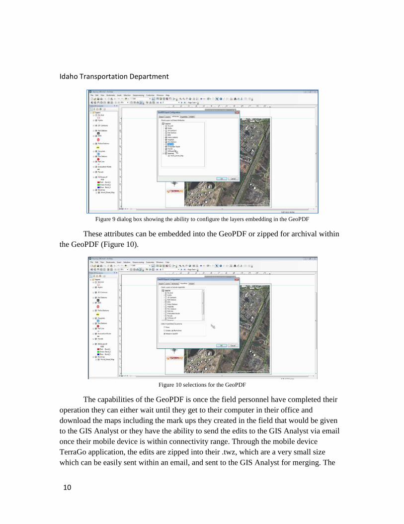
directly from TerraGo to the users for evaluation or purchase. It is not an open or freely downloadable software exchange. This is due to the many years of use for GEOINT. Once it is downloaded and the extension is activated a familiar toolbar is visible within ArcGIS Desktop (AGD). When creating a GeoPDF it will be created and deployed through the TerraGO GeoPDF export configuration tool not through the typical export to PDF function within AGD (Figure 9). Within the dialog box the map developer has the ability to configure the available layers, associated hyperlinks, coordinate systems and attributes.
9
Idaho Transportation Department
Figure 9 dialog box showing the ability to configure the layers embedding in the GeoPDF
These attributes can be embedded into the GeoPDF or zipped for archival within the GeoPDF (Figure 10).
Figure 10 selections for the GeoPDF
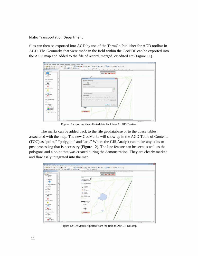
The capabilities of the GeoPDF is once the field personnel have completed their operation they can either wait until they get to their computer in their office and download the maps including the mark ups they created in the field that would be given to the GIS Analyst or they have the ability to send the edits to the GIS Analyst via email once their mobile device is within connectivity range. Through the mobile device TerraGo application, the edits are zipped into their .twz, which are a very small size which can be easily sent within an email, and sent to the GIS Analyst for merging. The
10
Idaho Transportation Department
files can then be exported into AGD by use of the TerraGo Publisher for AGD toolbar in AGD. The Geomarks that were made in the field within the GeoPDF can be exported into the AGD map and added to the file of record, merged, or edited etc (Figure 11).
Figure 11 exporting the collected data back into ArcGIS Desktop
The marks can be added back to the file geodatabase or to the dbase tables associated with the map. The new GeoMarks will show up in the AGD Table of Contents (TOC) as “point,” “polygon,” and “arc.” Where the GIS Analyst can make any edits or post processing that is necessary (Figure 12). The line feature can be seen as well as the polygons and a point that was created during the demonstration. They are clearly marked and flawlessly integrated into the map.
Figure 12 GeoMarks exported from the field to ArcGIS Desktop
11
Idaho Transportation Department
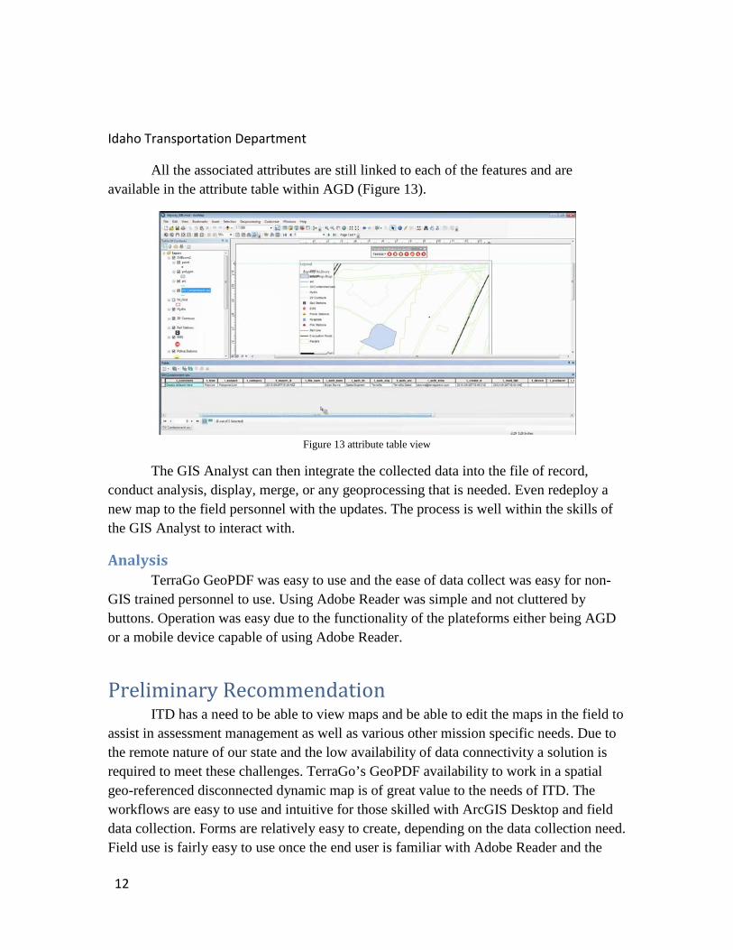
All the associated attributes are still linked to each of the features and are available in the attribute table within AGD (Figure 13).
Figure 13 attribute table view
The GIS Analyst can then integrate the collected data into the file of record, conduct analysis, display, merge, or any geoprocessing that is needed. Even redeploy a new map to the field personnel with the updates. The process is well within the skills of the GIS Analyst to interact with.
Analysis TerraGo GeoPDF was easy to use and the ease of data collect was easy for non-GIS trained personnel to use. Using Adobe Reader was simple and not cluttered by buttons. Operation was easy due to the functionality of the plateforms either being AGD or a mobile device capable of using Adobe Reader.
Preliminary Recommendation ITD has a need to be able to view maps and be able to edit the maps in the field to assist in assessment management as well as various other mission specific needs. Due to the remote nature of our state and the low availability of data connectivity a solution is required to meet these challenges. TerraGo’s GeoPDF availability to work in a spatial geo-referenced disconnected dynamic map is of great value to the needs of ITD. The workflows are easy to use and intuitive for those skilled with ArcGIS Desktop and field data collection. Forms are relatively easy to create, depending on the data collection need. Field use is fairly easy to use once the end user is familiar with Adobe Reader and the
12
Idaho Transportation Department
TerraGo extension to Adobe Reader. Minimal training on the software usage along with the usage of the selected mobile device would be needed but less involved than training on the use of a Trimble device. The mobile platform would be widely useful for all job levels. TerraGo could be used by engineers to show constituents maps of projects, contractors, planners or other needs.
Initially this software was evaluated for use to need these needs within District 2 and met the needs for what the software can offer. The use, however; far exceeds just the needs of District 2. This software can be greatly beneficial for the entire department statewide.
It is my recommendation that ITD HQ purchase the software with a concurrent license that would allow each of the districts to have full use of the software package in the manner that ITD HQ administers the use of ArcGIS Desktop Concurrent Licenses. TerraGo’s software has been in use for many years by the US Government for GEOINT missions and has been reliable in collecting data and displaying data for field operatives in very remote areas with no data connection. ITD can be assured that the investment of the software would be extreme value for the present and future needs of the department to meet its cartographic needs.
Datasheets have been attached to this document to further illustrate the software package as well as price quote for a single use and concurrent use license.
13
Idaho Transportation Department
Appendix A TerraGo Publisher Datasheet
TerraGo Composer
TerraGo Quote
14
Copyright © 2022 FDOKUMEN