Suspended sediment transport in a semiarid watershed, Wadi Abd, Algeria (1973–1995

ELSEVIER
Rehabj
Agriculture Ecosystems & Enmonment
Agriculture, Ecosystems and Environment 65 (1997) 95- 106
itation of a semiarid ecosystem in Senegal *
1. Experiments at the hillside scale
P. Perez '.*, J. Alberge1 ', M. Diatta b, M. Grouzis ', M. Sene CIRAD BP 503.5 34032 Mantpellier Cedex I , France
I S M BP 199 Kaolack, Senegal ORSTOM BP 5045 34032 Montpellier Cedex I. France
Accepted 2 February 1997
Abstract
The groundnut cropping basin of Senegal suffers environmental degradation, with a negative impact on local agriculture, shown by intense soil erosion. Despite the existence of many extensive programmes, there are few results conceming actual effects, at the hillside scale, of rehabilitation practices. The object of the study, carried out from 1983 to 1993, was to give evidence of the actual effects, in terms of hydrology and agronomy, of conservation measures set-up in a small cultivated watershed (60 ha). The measures included, on the basis of ecological features and human xes, live-hedges, stone bunds and improved cropping practices. The hydrological survey, based upon the paired watershed technique, gives evidence of land conservation, rather than land restoration, due to these developments. The efficiency of the hedges is mainly due to the favourable planting conditions. The proposed cropping practices were adopted by farmers to varying degrees, and field monitoring showed no actual effect on average crop production. To improve the cost/benefit ratio, the scientific staff should have emphasized, for the attention of the fapers, the necessary linkage between fertility restoration and runoff control. Despite this limitation, an increasing number of farmers and village communities are asking for technical assistance. O 1997 Elsevier Science B.V.
Keywords: Watershed management; Cropping practices; Paired Watershed technique; Runoff; Senegal
1. Introduction sible for this phenomenon (Le Borgne, 1990; Sir- coulon, 1992; Grouzis and Albergel, 1989; Lericol- lais, 1990).
The agricultural capacity of lands in the Sudano- Sahelian zone is reduced by this ecosystem degrada- tion, with a consequent negative impact on local inhabitants. Ecosystems have to be restored in order to assure sustainable socioeconomic activity in the
In Africa, environmental degradation is now well documented (Pieri, 1989; Richard, 1990; Poulsen and Lawesson, 199 1) and characterized by intense soil erosion, soil fertility loss and marked reductions in plant cover. Natural (mainly climatic) factors and anthropic ._. _. factors-are -- considereg to be jointly respon- I
zone. Extensive programmes have been set up to control land degradation, but they often fail because they are conducted on a strictly technical basis, without addressing the widespread problem I l - Corresponding author. I
- .
0167-8809/97/$17.00 O 1997 Elsevier Science B.V. All rights reserved. P I I SO167-8809(97)00057- I

-I ‘
96 P. Perez et al. /Agriculture, Ecosystems and Brrironment 65 (1997) 9s- 106
(Rochette, 1989; Tybirk, 199 I). Moreover, there are very few results concerning actual effects, at the hillside scale, of land management on crop produc- tion improvement or soil and water conservation (La1 and Stewart, 1990; Vlaar, 1992).
The present study was carried out in the ground- nut cropping basin of Senegal from 1983 to 1993. This region supplies almost half of the groundnut and millet produced in the country. In the light of the diverse activities and interactions that occur in rural areas, our rehabilitation operations were conducted on the basis of ecological features and human uses (Perez and Sene, 1995). The’ objective was to give evidence of the actual effects, in terms of hydrology and agronomy, of rehabilitation practices used in a small cultivated watershed (60 ha).
We first review the features of the zone and techniques used for watershed management and sur- vey. Next, we present results from the hydrological survey, the hedges and field monitoring. Discussion emphasizes the cost/benefit balance of such land management for farmers.
cleared, degrade very quickly after cropping. The terrace has leached, disturbed ferruginous soils on colluvial/alluvial deposits. This is the traditional area of human occupancy. There has been a sharp drop in soil ‘fertility in recent years induced by continuous cropping and fertiliser and manure short- age (Ange, 1991).
In the lowlands, the soils are quite primitive hydromorphic alluvial deposits, colonized by Acacia seyal and Mitragyrza inennis. The main factors lim- iting agricultural development are violent floods and sand buildup due to erosion on the hillslopes (Al- berge1 and Perez, 1993).
The population density was estimated, in 1983, at 6 1 inhabitants/km’; this population (mainly Wolofs) has almost doubled over the past 10 years. The local farming system is chiefly based on groundnut ( Arachis - hypogea) and millet (Penniseticm riplzoi’des), with-a trend towards combining agricul- ture and livestock production. From 1970 to 1990, . cropping areas increased from 40% to 70% of the total surface. They are now characterized by continu- ous cultivation and animal draught (Sene and Perez, 1994).
I
2. Material and methods 2.2. Methods and techiziques
2. I . Area description
The study area (Fig. 1) has a Sudano-Sahelian climate marked by a long dry season (7 to 9 months) and a short summer rainy season (3 to 5 months). The mean annual precipitation for the 1930 to 1990 period was around 820 mm, and dropped to 664 mm over the last two decades (1970 to 1990). Despite this rainfall deficit, violent rainstorms have occurred regularly (Dacosta, 1992).
The region is characterized by a series of vast tablelands (30 to 60 m elevation), interlaced with a network of valleys with gradual slopes. In the central plateau area, the soils are ferruginous without hard- pan. Formerly densely wooded savannas, these lands have been cleared. Only talus is now covered with quite poor brushwood, mainly Combrefaceae species (Bertrand, 1972).
At the base, the hillslope includes an upstream slope and a vast terrace. On the slope, there are quite primitive soils, colluvial deposits, with fine gravel and ferric hardpan. These soils, which were recently
2.2. I . Paired watershed techiiiqire In 1983, two watersheds were delimited in the
Rural Community of Kaymor. Though two cases absolutely alike could not be found, we stressed similarity of geomorphological and land occupancy characteristics. The outlets were five kilometers apart, located close by villages to facilitate hydrological surveys. The two basins were studied under natural conditions over an initial period (1983 to 1987) and- then conservation measures were set up on one of them in 1988. From 1989 to 1993, we studied the hydrological result of these soil conservation prac- tices, in comparison with the traditional land use. This paired watershed technique (Bosch and Hewlett, 1982; Fritsch, 1992) is based on the built-in assump- tion that other factors are nearly constant.
The Ndierguene watershed (ND), of 0.9 km’, presents a shallow relief (relief/length ratio = 5.7 m/km). The tributaries, mainly tracks and ephemeral gullies, feed temporarily the downstream channel during the rainy season (June to October). In 1983,

P. Perez et al. /Agriculture. Ecosystems and Enoironnierit 6.5 (1997) 9.5-106 97
the cropping area represented 42% of the basin area (Fig. 2a). The outlet is equiped with a rain gauge and a water-stage recorder located in a concrete-lined ditch. From 1983 to 1985, suspended sediments were collected with an automatic sampler. Afterwards, due to a weak reliability of results, sediments were man- ually sampled. The ND catchment is considered as a control basin during the whole period.
The Keur Dianko watershed (KD), of 0.6 km’, is situated on the same hillside. It presents a more elongated shape and a more distinct relief (relief/length ratio = 12.4 m/km) than the former one. In 1983, the cropping area represented 34% of the basin area (Fig. 2b). The outlet equipment is identical to the previous one. Unfortunately, sus- pended sediments were not manually sampled until
i
Fig. I . Location of the experimental site in Senegal.

98 P. Perez et al. /Agriculture, Ecosystem and Encironment 65 (19971 95-106
1988. Conservation measures started in 1988, so we can consider a first period of five years (1983 to 1987) for original conditions and a second one (1989 to 1993), for soil and water conservation.
2.2.2. Soil and water conservation practices Land degradation was found in both watersheds.
Intense runoff and sheet erosion characterized up- stream areas, with gully erosion and sand deposits in the downstream areas. As generally accepted, we thought that management that alleviated these con- straints would have an impact on crop yields and
rangeland productivities (La1 and Stewart, 1990; Pierce, 1991). SO, we began, from 1988, to introduce soil and water conservation practices to the farmers working in the Keur Dianko watershed (Fig. 3).
First, we tried to partition hillside area in order to efficiently deal with runoff and concentrated flow and so, to reduce erosion process. In the cropping area 13 live-hedges, covering a total of 4000 linear meters, were set up by villagers between 1988 and 1990. Multiple shrub species were planted to insure the best on-site selection, according to soil condi- tions and farmers remarks: Acacia nilorica. Bauhinia
t::::\ . .
- - - Basin boundaries
O 200
4
1 Areas already cropped in 1983
Rangeland cleared and cropped between 1983 and 1990
Remaining rangeland in 1990
Fig. 2. Land use evolution within the two watersheds, between 1983 and 1990. (A): Control basin; (B): Developed basin.

P. Perez et al. /Agriculture, Ecosystems and Environment 65 (1997) 95-106 99
rufescens, Piliostigma reticulata, Ziziphus maurita- and the absence of suitable formula, was based upon nia, Prosopis juliflora, Acacia seyal, Acacia mellif- the field pattern and the landowners agreement. era, Dichrostachys glomerata (Rautureau et al., Planting techniques were described by Ruelle et al. 1991). The hedge spacing, due to the shallow slope (1990). To decrease runoff energy at the base of the
i
i” N

100 P. Perez et al. / Agriculture, Ecosystems and Encironment 65 (1997) 95-106
talus, a stone line was constructed in a brushwood zone with material available on the site.
Then, inside this network, we tried to increase infiltration and water storage in the soil using the techniques adapted to traditional rangelands or crop- ping areas. Hence, two exclosure plots (0.5 ha) were located in the rangelands to further natural vegeta- tion renovation (Diatta, 1994). On the edge of the talus, some microbasins planted to shrub species ( Acacia nilorica, Bauhinia rufescem, Ziziphus tnau- ririana) permitted the revegetation of degraded areas with outcroping hardpan. In the crop fields, the following cropping practices were proposed to farm- ers:
- Contour cultivation. - Dry season decompacting. This technique corre-
sponds to a 10 cm deep subsoiling done by animal iction with a single excavating pick. Because there no available time during the beginning of the rainy ason (seeding operations), it is the only solution to Ip infiltration of water from the first, and often dent, rainstorms (Le Thiec and Bordet, 1990; Sene d Perez, 1994). - Shallow ridging. before emergence, for ground-
it crop. It is a slight modification of the traditional :eding being practiced just after seeding. Some gs are placed over the heads of the local hoe. This a clever and not expensive way to increase soil
lief on the seeding line (5 cm high). This technique n also be combined with a localized manure appli- tion (Sene, 1995). - Shallow earthing up, for millet crop. When the
op begins to develop suckers a small ridger is used create mounds on the seeding line (10 cm high).
5 above, it can be combined with a localized anure application (Perez et al., 1996). At last, brushwood checkdams and stone pavments
tre used to stabilize the main gully and transform it a permanent waterway and, therefore, secure the
[jacent track. This work was done by villagers.
2.3. Field and hedge monitoring The local impact of individual conservation mea-
res (live-hedge, stone line; cropping practices) and e mechanisms involved were not studied at the llside scale. They were taken into account during rm plot scale experiments, described further in iother paper (Perez et al., 1996).
Beyond the hydrological response to the water- shed management, we were also interested in a long-term survey of the crop yields. For this purpose, an exhaustive field monitoring was realized, since 1987, in the Keur Dianko watershed. Because of time consuming this survey could not be achieved in the second watershed, except for the cadastal survey. ‘* The monitoring comprised for each of the 67 field plots:
Annual cadastral survey. - Recording the dates of farming practices and the types of tools - Observations of weeding levels, crop emergence and flowering. Measurements of yield components from 25 m2 sampling plots. The object of the hedge monitoring was to esti-
mate, according to soil and rain conditions, the aver- age rates of survival and growth for each species. This was important for explaining farmer’s motiva- tion and for planning shrub pruning. Twice a year (June and October) each of the 7000 plants was controlled and measured (Rautureau et al., 1991).
3. Results
3. I . Hydrological suroey
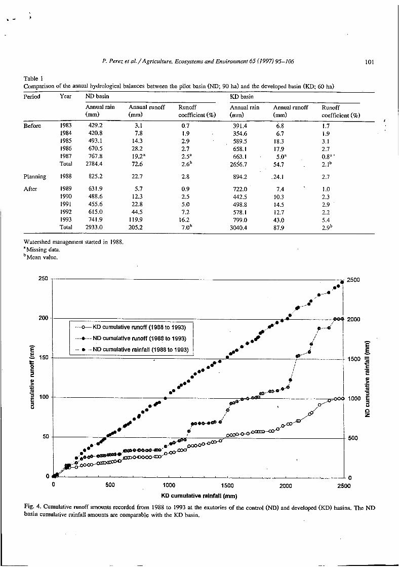
Comparison of the annual hydrological balances of the two watersheds shows similar runoff coeff- cients before applying conservation measures in Keur Dianko (Table 1). During the period from 1983 to 1987, cumulative runoff totalizes 54.7 mm in Keur Dianko and 72.6 mm in Ndierguene watershed. The average runoff coefficients were close: 2.1% (KD) and 2.6% (ND).
After 1988, the annual hydrological balance of the Ndierguene watershed notably evolved, as shown by a marked increase in flooding; this contrasts with the stabilizing trend noted for the Keur Dianko water- shed (Table 1). During the period from 1989 to 1993, cumulative runoff was 87.9 mm in Keur Di- anko and 277.8 mm in Ndierguene watershed. The average runoff coefficients were distinct: 2.9% (KD) and 7.0% (ND).
As shown in the Fig. 4, this difference can’t be attributed to any major variation between the two
P. Perez et al. /Agriculture, Ecosystems and Enuironment 65 (1997) 95-106 101
Table 1 Comparison of the annual hydrological balances between the pilot basin (ND; 90 ha) and the developed basin (KD; 60 ha)
Period Year ND basin KD basin
Annual rain Annual runoff Runoff Annual rain Annual runoff Runoff (mm) (mm) coefficient (%) (mm) (mm) coefficient (%)
I
Before 1983 429.2 3. I 0.7 39 1.4 6.8 I .7 1984 420.8 7.8 I .9 354.6 6.7 1.9 1985 493.1 14.3 2.9 589.5 18.3 3. I 1986 670.5 28.2 2.7 658.1 17.9 2.7 I987 767.8 19.2" 2.5' 663.1 . 5.0" 0.8" * Total 2784.4 72.6 2.6b 265'6.7 54.7 2.1b
Planning 1988 825.2 22.7 2.8 894.2 .24. I 2.7
After 1989 63 1.9 5.7 0.9 722.0 7.4 1 .o 1990 488.6 12.3 2.5 442.5 10.3 2.3 1991 455.6 22.8 5.0 498.8 14.5 2.9 1992 615.0 44.5 7.2 578.1 12.7 2.2 1993 74 1.9 119.9 16.2 799.0 43.0 5.4 Total 2933.0 205.2 7.0b 3040.4 87.9 2.9b
Watershed management started in 1988.
bMean value. Missing data.
250 2500
200
c. E
150 % i
E,
Q > m .- c - = 100
o
50
O O 500 1 O00 1500 2000 2500
KD cumulative rainfall (mm)
Fig. 4. Cumulative runoff amounts recorded from 1988 to 1993 at the exutories of the control (ND) and developed (KD) basins. The ND basin cumulative rainfall amounts are comparable with the KD basin.

102 P. Perez et al. /Agriculture, Ecoqstems and Environment 65 (1997) 95-106
rainfall series. For this representatibn of the cumula- tive runoff values, from 1988 to 1993, we extracted from the data set the events generating no flood in both watershed, the missing or uncertain records and the events for which rainfall amounts differed more then 40% between the two watersheds. One can notice the increase, from 1988, of the variation be- tween the two basins.
In the years with high runoff, the conservation measures had a marked effect on the water balance and the solid transports. For example, in 199 1, levels of solid transports were the same in both basins (about 650 kg/ha), but in * 1992, they represented 488 kg/ha for the Keur Dianko watershed and more than I t/ha for the Ndierguene watershed.
The impact of the watershed management is clearly demonstrated by an event that occurred on 4-5 August 1993 (Fig. 5). Three consecutive rain- storms totaled 179 mm in 24 hours. The floods after the first shower were the same for the two basins,
with a runoff coefficient of 9% for the developed basin (KD) and 11% for the control, one (ND). Floodings caused by the next two showers (very low infiltration conditions) were markedly higher 'and intense in the Ndierguene watershed (KD: 10% and 14%; ND: 50% and 42%). The solid transports were 1.5 t/ha for the developed basin (KD) and 3.5 t/ha for the control basin (ND).
I,
3.2. Field monitoring
The results of the cadastral survey show a com- mon trend, in both watersheds, to increase cropping areas. In 1990, cropping area represented 55% in the developed basin (KD) and 62% in the control one (ND) (Fig. 2). In Keur Dianko, even after 1988, from 6 to 9 new farm plots were slashed from rangeland every year. During the same time, 5 fields, seriously damaged by erosion, are abandonned in the control basin (ND) and no one in the developed basin (JSD).
19:12 0o:oo 04:48 09:36 1424 19:12 0o:oo
. Time (hh:mm)
Fig. 5. Rainfall amounts (mm) and specific discharge (l/s/ha) during the 4th and 5th of August 1993. Comparison between the control (ND) and the developed (KD) basins.

P. Perez et al./Agriculture, Ecosystems and Environnient 65 (I 997) 95-106 1 03
Though some trials were conducted, every year, with farmers of Keur Dianko, the proposed cropping practices were diversly adopted. Contour cultivation increased from 20% to 80% of the fields, between 1987 and 1993, thanks to the establishment of the live-hedges. But dry season decompacting, shallow ridging for groundnut crop or shallow earthing up for millet crop increased only from 0% to 20% during the same time. Localized manure application reached only 16% of the plots. Technical and socio-eco- nomic reasons of such a failure are analysed in a previous paper (Perez et al., 1996).
Due to this weakness of spreading, but also to variable rainfall conditions, grain yields showed no trend during the whole period (Table 2). Considering annual mean yield or its coefficient of variation, it is obvious that production remained at a very low potential (inter-annual mean yield was 687 kg/ha for both crops) and that heterogeneity between the farm plots was high. The surprising results achieved in 1988, despite favorable rainfall amounts, were due to intense leaching and flowers aborting.
3.3. Lice-hedge monitoring
The growth of the seedlings of shrub species was strongly linked with climatic conditions. In 1988, the exceptional precipitation permitted achieving an av- erage survival rate of 9 1 % (from 4700 plants), but in 1989 and moreover in 1990, for the last setting up of hedges, the survival rates dropped to 74% (from 2100 plants) and 36% (from 410 plants), respectively (Table 3). It must be emphasized that neither imga- tion nor protection were given to the young shrubs. The planting conditions were then crucial for the
Table 2
Table 3 Average survival rates and average growing rates of the seedlings
Date of Date of monitoring Planting Rainfall Nb 1988 1989 1990 1991
~~
1988 894.2 4700 - 91 85 84
74 70 1989 722.0 2100 - -
36 1990 442.5 410 - - -
34i-10 79i-35 137f58 145f66
31i-11 61rt28 63 f43
- - 3 1 f 1 0 35 f12
- .
Results are given for each date of planting and each date of monitoring. First line: average survival rate from the planting (%); second line: average cumulative height from the planting (cm). (Rainfall): annual rainfall (mm); (Nb): number of plants. All the species are merged.
future of the live-hedge. Once established the death rate of the plants was much lower. Table 3 shows that the growth rate depended also on the planting conditions. Results given for 1991 must be read with care because pruning activiries began during the previous year.
In fact, these global resuIts hide differences be- tween species (Table 4). For example, Gliricidia sepium gave bad results from the first year (survival rate: 33%) and Prosopis jurifIora remained steady only one more year (survival rate: 43%). On the other hand, Acacia nilotica and Bauhinia rufescens confirmed, in local conditions, their strength and their adaptability, described by other authors (La1 and Stewart, 1990; Vlaar, 1992). Farmers were very sensitive to the survival rate of the plants, considered as a rate of profitability of their work. But they
Groundnut (Arachis hyogea) and millet (Pennisetum fiphdides) annual grain yields
Year Rainfall (mm) Groundnut grain yield Millet grain yield
Nb Mean (kg/ha) cv (%) Nb Mean (ke f ia) cv (%)
1987 663. I 15 1069 45.3 10 82 I 43.0 1988 894.2 18 629 1989 722.0 19 929 1990 442.5 28 483 1991 498.8 26 569 1992 578. I 24 536 1993 799.0 20 595
39.0 7 30.6 1 1 43.7 17 43.3 21 52.6 11 34.3 17
412 682 448 527 757
1163
~~
65.0 44.6 54.5 46.2 27.1 33.6
I
(Rainfall): annual rainfall; (Nb): number of plots; (Mean): average value; (CV): coefficient of variation. Fields monitoring of the KD basin.

104 P. Perez et al. /Agriculture. fiosy.stems and Enuìronment 65 (19971 95-106 I Table 4 Average survival rate from the planting (1988)
Species Nb Date of monitoring
1989 1990 1991
Acacia nilotica 804 98 96 96 Bauhinia rufescens 1557 96 ' 95 95 Dichrostachys glomerata 118 76 65 63 Gliricidia sepium , 60 33 20 18 Acacia mellifera 148 92 81 85 Parkinsonia acufeata 48 98 83 83 Piliostigma reticulatum 641 84 83 17 Prosopis jtilijlora 306 83 43 35 Acacia senegal 76 8 1 83 82 Acacia seyal 177, 97 93 93 Zìzìphus mauritania 365 19 78 77 Total 4300 91 85 84
These are the main species planted in 1988. (Nb): number of plants.
noticed that it was useless to get two meters high thorny shrubs to control runoff and erosion! For this reason, a programme of pruning was started since 1990.
Another aspect oPthe shrubs management was the annual replacing of the ones that died into the exist- ing hedges. From 1989 to 1991, the average rate of substitution was nearly 18%. For most of the species, the survival rates in this case were equivalent to those recorded in the case of a first planting. For example, during the year 1989,43 1 plants of Acucia nilorica were newly planted, with a survival rate of 82%, while 154 plants were planted as substitutes with a survival rate of 84% (Rautureau et al., 1991).
4. Discussion
Since we expected hydrological effects of the project, the first results were quite disappointing. It took four,years to become obvious that we had to analyse them in terms of conservation rather than restoration. The soil and water conservation practices only permitted the slowing down of some mecha- nisms involved in the waterShed degradation process. For that reason, there is no tendency to decrease the global runoff rate of the developed basin (KD). But the increasing difference recorded in comparison with the control basin (ND) showed that the natural trend
had been modified. In this case, the paired watershed technique was the only experimental method that could give evidence of this result.
Even in recent reviews on the subject (Amir, 1996; Unger, 1996) there are very few results of studies realised at this scale (1 km') comparing developed and control basins. At inferior scales (1 ',
ha, 100 m2), many studies gave evidence of positive '
results - in terms of restoration - of developments applied in comparable climatic and human condi- tions (Vlaar, 1992; Roose, 1994).
The farmers took a polite interest in hydrological results but they were more responsive to the main gully and adjacent tracks stabilisation. The relation between rills, track and gullies became so evident that every one tried to control the waterways in his field with the help of stone pavments or wood trunks. On the other hand, despite the predictable consequences, farmers continued to slash the upper parts of the hillside. Between the land degradation and the social pressure on tenure, they chose the lesser of two evils. This can partly explain the limited effect of the conservation measures in the Keur Dianko watershed.
After eleven years of monitoring, it seems incred- ible that we began the planning during the most rainy year of the decade. By a mere chance, the major part of the plantings profited by favourable conditions. What would have been the situation, if we had started two years later? The average survival rate would have dropped to 40% and the farmer's enthusiasm would have disappeared. Today, live- hedges have two main objects for the farmers: to control runoff (and run-on) during the rainy season and to supply fodder during the dry season. For both objects, they get into the habit of creating swaths, at the base of the hedges, with crop and weed residues.
All the labour time requirements were recorded (Ruelle et al., 1990). For the entire project planting hedges required 160 men X day, excluding the nurs- ery activities. Stone line and pavment building re- quired 50 men X day. This theoretically represents 350000 FCFA (1700 FCFA/day in 1988), adding to, approximately, 50000 FCFA for little equip- ments. The nursery yard required 10 men X day for preparation (fencing, digging) and 70 men X day for seeding, that is to say an amount of 140000 FCFA. So, the cost of this collective work, done between
.

P. Perez el al. / Agriculture, Ecosystems and Enuironment 65 (1997) 95-106 105
1988 and 1990, is 540000 FCFA. In fact, this is a theoretical amount because we didn’t pay for any salary; but, on the other hand, we didn’t include the cost of the support from the scientific staff.
At the hillside scale, the collective benefit cannot be derived from an increasing crop production, as we have seen it. The positive results mentioned above are the tracks and the fields stabilization. By compar- ison with the control basin (ND), we can take as an hypothesis that four farm plots were saved from irreversible damage. The average field area is 0.5 ha (KD basin: 67 plots on 33 ha) and the average grain yield is 700 kg/ha (¡.e pod yield is 1000 kg/ha). Using the unit price of groundnut pods (1988: 90 FCFA/kg), we can estimate the benefit as 180000 FCFA/year. The theoretical cost/benefi t balance became steady after 3 years. These results are close to those given by Vlaar (1992) or Rochette (1989).
Beyond this over-simple demonstration, it is a fact that some of the 20 farmers involved in the watershed management felt somehow swindled. Even though they agreed tha i there were actual effects. they said they were not totaly paid back for their contribution to the collective effort. This reaction is, partly, due to the relative failure of our cropping practices proposals. Facing the good results of the trials (Perez et al., 19961, it is clear that the major error has been to neglect the linkage between indi- vidual and collective actions, the farm plot and the hillside scales.
5. Conclusion
Various techniques aimed at controlling runoff and stabilizing water erosion phenomena were ap- plied in a degraded part of the groundnut cropping basin of Senegal. The conservation measures were set up in different landscape units, with their ecologi- cal features and human uses taken into account. Using the paired watershed technique, it has been demonstrated that this land management strategy had actual hydrological effects. After five years, the only agronomic effect was due to the land stabilization. The synergy between runoff control and fertility restoration should have been emphasized to ensure farmer participation and benefits sharing (Roose, 1994). But results are not insignificant: an increasing
number of individual farmers and village communi- ties from the neighborhood are now asking for tech- nical assistance so as to apply conservation measures on their land.
References
Albergel, J., Perez, P., 1993: Fonctionnement hydrologique et aménagement des bas-fonds des formations sédimentaires du continentai terminal: exemple du bassin arachider du Sénégal. In: Raunet, M. (Eh.), Bas-fonds et riziculture. CIRAD Publ., Montpellier France, pp. 155- 164.
Amir, J., 1996: Impact of crop rotation-and land management on soil erosion and rehabilitation. In: Agassi, M. (Ed.), Soil erosion, conservation and rehabilitation. Marcel Decker Inc., New York USA, pp. 375-399.
Ange, A., 1991: Gestion de la fertilité des sols et stratégies de mise en valeur des ressources naturelles. Exemple du mil dans les systèmes de culture du sud du bassin arachidier sénégalais. In: Pieri, C. (Ed.). Terres de savane. terres fertiles?. CIRAD Publ., Montpellier France, pp. 1 10- 12 I .
Bertrand, R., 1972: Morphopédologie et orientations culturales des régions soudaniennes du Sine-Saloum (SCnégal). Agron. Trop., vol XVII nol I. pp. 1 115-1 190.
Bosch, J.M., Hewlett, J.D.. 1982: A review of catchment experi- ments to determine the effect of vegetation changes on water yield and evapotranspiration. J. Hydrol., n”55, pp. 3-23.
Dacosta, H., 1992: Economie de l’eau et DRS sur les bassins versants de Thyssé Kaymor. Synthèse hydrologique 1983- 1988. ORSTOM/WB. Dakar Senegal, 67 p.
Diatta. M.. 1994: Régénération des zones‘marginales et rôle de l’arbre dans les programmes de DRS, application aux bassins versants de Thyssé Kaymor. Doctoral thesis. Un. Louis Pas- teur, Strasbourg France, 183 p.
Fritsch, J.M., 1992: Les effets du défrichement de la forêt ama- zonienne et de la mise en culture sur l‘hydrologie de petits bassins versants. Coll. Etudes and Thèses. ORSTOM Ed., Paris France, 392 p.
Grouzis. M., Albergel, J., 1989: Du risque climatique ’a la con- trainte écologique. Incidence de la sécheresse sur les produc- tions végétales et le miliqu au Burkina Faso. In: Eldin. M., Milleville, P. (Us.), Le risque en agriculture. ORSTOM Publ., Paris France, pp. 243-254.
Lal, R.. Stewart, B.A., 1990: Agroforestry for soil management in tropics. In: Lal. R., Stewart, B.A. (Us.), Soil degradation, A global threat. Springer-Verlag. New York USA, pp. XIII- XVII.
Le Borgne, J., 1990: La dégradation actuelle du climat en Afrique, entre Sahara et Equateur. In: Richard, J.F. (Ed.), La dégrada- tion des paysages en Afrique de l’Ouest. Ministère de la Coopération et du Développement, Paris France. pp. 17-36.
Lericollais. A., 1990: La gestion du paysage? Sahélisation, surex- ploitation et delaissement des terroirs sereer au Sénégal. In: Richard, J.F. (Ed.). La dégradation des paysages en Afrique de l’Ouest. Ministère de la Coopération et du Développement, Paris France, pp. 152-169.
106 P. Perez et al. /Agriculture, Ecosystems and Enrironment 6.5 (1997) 9.5-106
Le Thiec, G., Bordet, D.. 1990 Etude de deux ouills de traction animale visant 2 réduire les contraintes de travail du sol en zones sèches. In: Starkey, P.H., Faye, J. (Eds.), Animal trac- tion for agriculture development (Proc. of WAATN workshop, Saly. july 1988). WAATN F'ubl.. pp. 56-64.
Perez, P., Sene, M., 1995: Evolution des structures agraires et érosion dans le sud Saloum (Senegal). Revxu Emxion 11'15, ORSTOM Montpellier France, pp. 59-68.
Perez, P., Boscher. C., Sene, M., 1996: L'amélioration des tech- niques culturales pour une meilleure gestion de l'eau pluviale (sud Saloum, Senegal). Agriculture and Développement, n"9,
Pierce, F.J., 1991: Erosion productivity impact prediction. In: Lal, R., Pierce, F.J. (Eds.). Soil management for sustainability. Soil and water Conservation Society, Iowa USA, pp. 35-52.
Pieri, C. (Ed.), 1989: Fertilité des terres de savanes. Bilan de trente ans de recherche et de développement agricole au sud du Sahara. CIRAD Publ., Montpellier France, 443 p.
Poulsen. E., Lawesson. J.E. (Eds.), 1991: Dryland degradation. Causes and consequences. Danish Sahel Workshop, Aarhus University Press, Aarhus. I 3 4 p.
Rautureau, J., Perez, P., Diatta, M., 1991: Implantation et gestion de haies-vives. Rapport technique. CIRAD Publ., Montpellier France, 52 p.
Richard, J.F. (Ed.), 1990.L.a dégradation des paysages en Afrique de l'Ouest. Ministère de la Coopération et du Développement, Paris France, 130 p.
Rochette, R.M. (Ed.). 1989: le Sahel en lutte contre la desertifica- tion. Leçons d'expérience. CILSS PAC. GTZ, 592 p.
20-29.
Roose. E., 1994 Introduction 'a la gestion conservatoire de l'eau, de la biomasse et de la fertilité des sols (GCE). Bull. Pedol. de la FAO, n"70, Roma Italia, 420 p.
Ruelle. P.. Sene, M.. Juncker, E., Diatta, M.. Perez, P. (Eds.). 1990: Défense et restauration des sols. Coll. Fiches Tech- niques, vol 1 no], ISRA/UNIVAL, Dakar Senegal. 64 p.
Sene, M., 1995: Influence de I'état hydrique et du comportement mécanique du sol sur l'implantation et la fructification de l'arachide. Doctoral thesis, ENSA Montpellier France, 127 p.
Sene, M., Perez, P., 1994: Contraintes et possibilités de valorisa- tion des ressources naturelles dans le sud du bassin anchidier (Sin6 Saloum, Sénégal). In: Reyniers, F.N.. Netoyo, L. (Eds.), Bilan hydrique agricole et sécheresse en Afrique tropicale. Ed. John Libbey Eurotext, Paris France, pp. 217-233.
Sircoulon. J.. 1992: Evolution des climats et des ressources en eau. In: Pontie, G.. Gaud. M. (Eds.), L'environnement en Afrique. Afrique contemporaine, no 16 I, La Documentation Française, Paris France, pp. 55-76.
Tybirk K.. 1991: Planting trees in Sahel-doomed to failure. In: Poulsen, E., Lawesson, J.E. (Eds.), Dryland degradation. Causés and consequences. Danish Sahel Workshop, Aarhus University Press. Aarhus, pp. 22-28.
Unger, P.W.. 1996 Common soil and water conservation prac- tices. In: Agassi. M. (Ed.), Soil erosion, conservation and rehabilitation. Marcel Decker Inc., New York USA, pp. 375- 399.
Vlaar, J.C.J. (Ed.), 1992: Les techniques de conservation des eaux et des sols dans les pays du sahel. CIEH/UAW, UAW Wageningen Nederlands, 99 p.
Copyright © 2022 FDOKUMEN