Redevelopment of MOD Bicester C Site: Land Quality ...
73
Future Defence Storage and Redistribution Programme, Redevelopment of MOD Bicester C Site: Land Quality Assessments - Phase 1 and Phase 2 BIC/OPA/DOC/22 September 2011
-
Upload
khangminh22 -
Category
Documents
-
view
0 -
download
0
Transcript of Redevelopment of MOD Bicester C Site: Land Quality ...

IMAGE – TBC
Future Defence Storage and Redistribution Programme,
Redevelopment of MOD Bicester
C Site: Land Quality Assessments - Phase 1 and Phase 2
BIC/OPA/DOC/22
September 2011
IMAGE –
westacott road
Defence Estates
A Site and C Site, DSDC Bicester
Land Quality Assessment
Phase One: Desk Study DE Project No.: 13104 Final LQA Report
14 May 2010
Prepared by Entec UK Limited for the Ministry of Defence under commission FTS3/PTSELM/03


Document Revisions
No. Details Date
1 Draft Report 23 March 2010
2 Final Report 14 May 2010

i
h:\mod projects\26999 dsdc bicester lqa review\docs\final reports\a and c sites\rr030i2.doc © Entec UK Limited 14 May 2010
Land Quality Statement for A Site and C Site, DSDC Bicester
Introduction and Terms of Reference Entec UK Ltd (Entec) was commissioned by Defence Estates (DE) to undertake a Phase One Land Quality Assessment of the Ministry of Defence (MOD) sites known as A Site and C Site, DSDC Bicester (‘the site’). This commission was carried out under the interim contracting arrangement DE11/4668 and the FATS/3 contract between Entec and Defence Estates. The purpose of the assessment is to provide information on the site as well as any health and environmental risks that any potential contamination may present to existing site users and in changing the use of the land.
Site Location The site is located approximately 4.5 km south-east of Bicester town centre, Oxfordshire. A Site is located 0.5 km north-west of Piddington village at National Grid Reference (NGR) 463300, 217750 with access (via a secured gated entrance) from the B4011. C Site is located to the immediate north-west of Upper Arncott village at NGR 460700, 217500 and is accessed through a manned security point located on a road junction off Ploughley Road. The location of the site is shown in Figure 1.
Site Description The site consists of two distinct and separate areas of the larger DSDC Bicester with A Site to the east and C Site to the west of Arncott Hill. A Site is roughly triangular (pointing to the east) with a smaller triangle taken out of the base on the western side. A Site covers a total area of approximately 13 ha and its topography is generally level. C Site is rectangular orientated in a northeast to southwest direction. A strip of land connecting C site and DSDC Bicester D Site is also included as part of C Site. C Site covers a total area of approximately 24 ha and slopes downwards from the east side of the site to the west. Both sites lie at an elevation of between 65 and 75 m AOD. Site layout plans are included as Figure 2 and Figure 3.
Site History As of June 1943 A Site and C Site were part of what was called ‘COD (Central Ordnance Depot) Bicester’. Arncott A Site (as it was called) was indicated to be a ‘Signals and Wireless Sub-Depot’ whereas Arncott C Site was an ‘MT Sub-Depot’. The site was used for the processing of return stores from the Second World War and for stores issue in 1949 for the Korean War. The entire DSDC Bicester site was redesignated as a Base Ordnance Depot (BOD) in the 1950. By 1961 the whole site had been reorganised, with technical stores and Motor Transport (MT) units to other depots including BOD Donnington in Shropshire. BOD Bicester was established as the main UK depot for military clothing and general stores. By 1992, the whole site became known as the Defence Storage and Distribution Centre, Bicester.
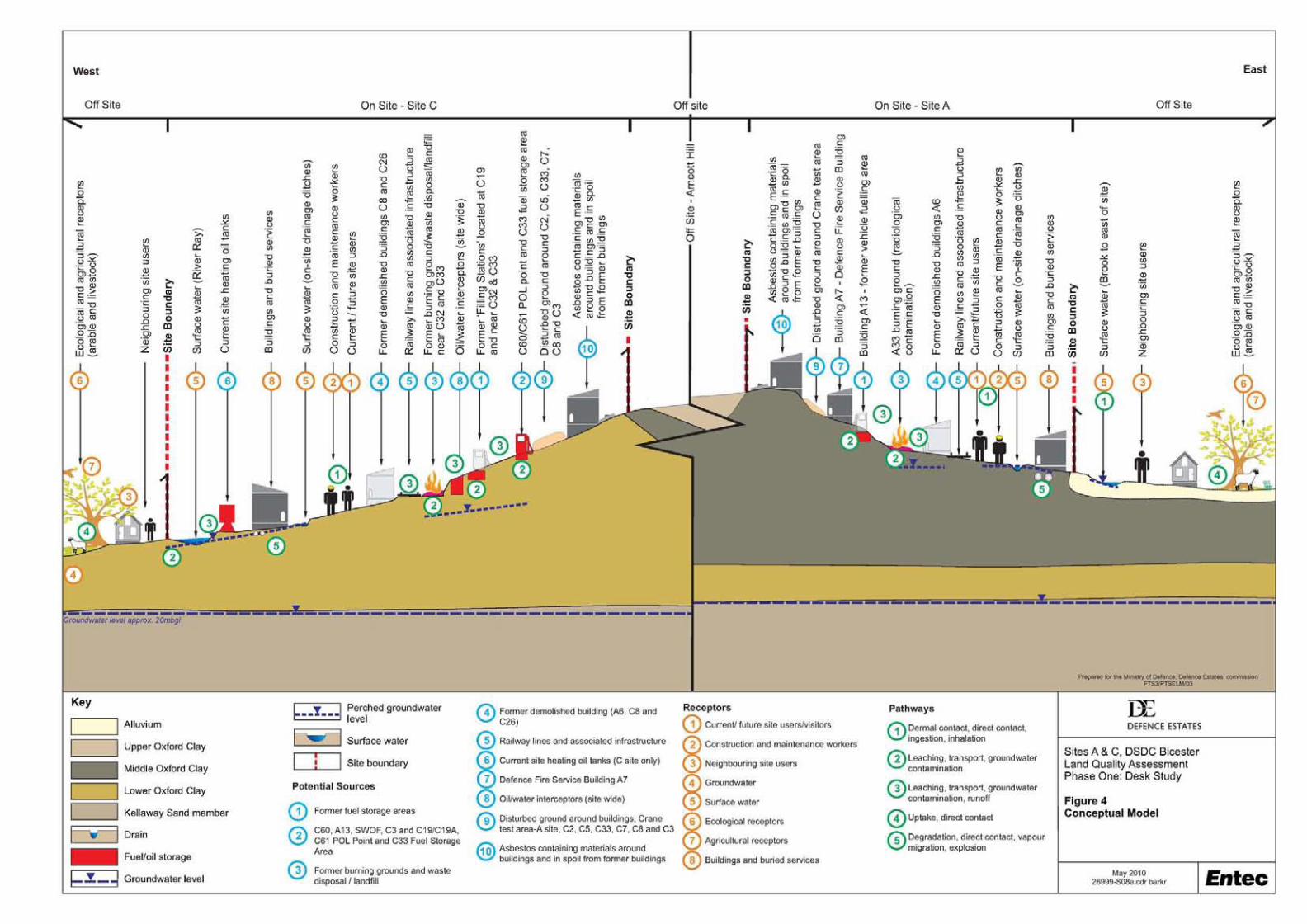
Environmental Setting According to the GeoInsight report, the anticipated geological sequence consists alluvium deposits (clay, silt, sand and gravel) over the northern part of A Site and over the strip of land

ii
connecting C Site and D Site directly overlying solid geology consisting of the Stewartby Member (mudstone) and Peterborough Member (mudstone) of the Oxford Clay Formation. The Kellaways Clay Member and Kellaways Sand Members of the Kellaways Formation outcrop in the north of strip of land connecting C Site and D Site.
A Site Inspection of the Aquifer and Abstraction License Map (provided in the EnviroInsight Report) shows that the northern half of A Site is underlain by a Secondary (Minor) Aquifer (comprising soils of Low Leaching Potential). This is considered to be the Alluvium. The land in the southern half of A Site is underlain by Unproductive Strata (Non-Aquifer - Negligibly Permeable).
C Site According to the Aquifer and Abstraction License Map (provided in the EnviroInsight Report) the majority of the site is underlain by Unproductive Strata (Non-Aquifer - Negligibly Permeable). The strip of land connecting D Site and C Site is also underlain in places by a Secondary (Minor) Aquifer (including soils of both High and Low Leaching Potential).
Site Sensitivity The site is mainly underlain by an Unproductive Strata (Non Aquifer, Oxford Clay Formation) which would be considered to present a low sensitivity with a moderate sensitivity assessed for the Secondary (Minor) Aquifer (Alluvium) situated in the north part of A Site. The site is not within a SPZ.
Groundwater Sensitivity: Moderate / Low
Hydrology River Ray traverses the extreme north of the C Site and is of a generally poor water quality. There is potential for the River Ray to be affected by direct run-off and discharges from the site. However, the site itself is large and as such the sensitivity will decrease with respect to distance for the identified surface water receptors.
Surface Water Sensitivity: Moderate
Ecology A SSSI is located close to the strip of land connecting C Site to other areas of DSDC Bicester.Both A Site and C Site have a record of one ESA being located on-site with a third record being positioned approximately 130 m west of C Site. Both sites are surrounded predominantly by agricultural land which forms the ESA, namely the Upper Thames Tributaries ESA. However, both sites are large and as such the sensitivity will decrease with respect to distance for the identified ecological receptors with C Site being the most sensitive due to the proximity of the SSSI.
Ecological Sensitivity: Moderate
Sources of Information General mapping sources and public body records were consulted for this study, including topographical, geological and groundwater vulnerability maps of the area, the British Geological Survey (BGS), the local authority, emapsite™ GroundSure reports, reference books
h:\mod projects\26999 dsdc bicester lqa review\docs\final reports\a and c sites\rr030i2.doc © Entec UK Limited 14 May 2010

iii
and aerial photographs from the National Monuments Record. Specialist radiological and explosive ordnance desk studies were commissioned. MOD sources of information include plans, previous reports as well as anecdotal information from site personnel. Additionally, a brief review of archaeological and cultural heritage information has been undertaken.
Potential Site Contamination Following the assessment of historical and current activities, there are several potentially contaminative activities which have been identified both on and off site.
On site sources relate to former and current areas of fuel storage and handling, including POL stores and points (fuel tanks and refuelling areas), along with the former burning grounds, landfilling and Made Ground, railway infrastructure and the site-wide railway network, fire service building and contaminants associated with former (demolished buildings) and current building fabric (ACM). The location of and significance (given the nature of the geology) is such that no off site sources have been considered within the risk assessment.
Most of the above identified sources are generally likely to be limited in their extent, with the exception of the site-wide railway network.
Environmental Risks The risks to most human receptors, including current site users/visitors, construction and maintenance workers, future commercial/industrial users and neighbouring site users have been assessed in the range of moderate to low, with the moderate risks generally associated with construction/maintenance works and occasionally for future commercial/industrial users from source areas potentially affected by hydrocarbons (typically current fuel storage areas) and the former burning grounds and landfilled areas around close to buildings C32, C33 and A33 where radiological contamination is potentially present.
Risk for contaminant migration to groundwater are assessed to be in the range moderate/low to negligible with lower risks associated with the unproductive strata beneath the site and moderate/low risks associated hydrocarbon (fuel) sources that may impact the Secondary (Minor) Aquifer. Risks to surface water have been assessed to be in the range moderate to negligible with the highest risks from current fuel storage areas and the former burning grounds and landfilled areas.
Ecologically sensitive sites and receptors have been identified in the search area of the site (generally 500 m) as have agricultural receptors located adjacent to both A Site and C Site. However, given the limited potential contamination identified on site and the mitigating factors presented by the underlying geology and the distance of most of the identified sources to potential receptors (via dilution and attenuation of contaminants), the risk to ecological receptors and agricultural receptors is assessed in the range negligible to low.
The potential presence of fuel contamination at the site presents the greatest risks to buildings and buried services are results in a risk range of moderate/low to negligible.
Overall Land Quality and Suitability for Redevelopment In general, it is considered that the land quality at the majority of the site is likely to be good, with isolated areas of potentially poor land quality associated with the principal areas used for the former and current areas of fuel storage and handling, including POL stores and points (fuel tanks and refuelling areas), along with the former burning grounds, landfilling and Made
h:\mod projects\26999 dsdc bicester lqa review\docs\final reports\a and c sites\rr030i2.doc © Entec UK Limited 14 May 2010

iv
Ground, railway infrastructure and the site-wide railway network, fire service building and contaminants associated with former (demolished buildings) and current building fabric (ACM). In areas associated with these current and former potentially contaminative uses it is likely that land quality will have been impacted and redevelopment proposals will need to be tailored to the potential contamination present in these areas.
Therefore, the site is considered to be suitable for its present commercial/industrial use given the current site configuration, provided that where areas of contamination have been identified during the site investigation (Enviros Aspinwall Phase Two LQA) or are suspected, appropriate further investigation and/or remedial measures are incorporated into the design of any future development. Working practices will need to address the issues of potential contamination.
h:\mod projects\26999 dsdc bicester lqa review\docs\final reports\a and c sites\rr030i2.doc © Entec UK Limited 14 May 2010
v
Contents
1. Introduction 1
1.1 Terms of Reference 1
1.2 Site Location 2
1.3 Site Description 2
1.4 Site-Sourced Information 7
1.5 Site History 9
1.6 Environmental Setting and Sensitivity 10
1.7 Additional Information 14
1.8 Previous Assessments 17
1.9 Historical MOD Practices 20
2. Sources of Information 23
2.1 Source of Information 23
2.2 Presentation of Data within Report 24
2.3 Gaps in Information 24
3. Sources of Contamination 27
3.1 Historical On-Site Issues 27
3.2 Historical Off-Site Issues 30
3.3 Current and Recent On-site Operations 30
3.4 Current and Recent Off-site Operations 38
4. Preliminary Qualitative Risk Assessment 41
4.1 Approach 41
4.2 Summary of Potential Contamination 44
4.3 Receptors and Pathways 45
4.4 Environmental Risk Assessment 45
5. Overall Land Quality and Suitability for Redevelopment 51
h:\mod projects\26999 dsdc bicester lqa review\docs\final reports\a and c sites\rr030i2.doc © Entec UK Limited 14 May 2010

vi
5.1 Potential Site Contamination 51
5.2 Environmental Risks 51
5.3 Overall Land Quality and Suitability for Redevelopment 52 Table 1.1 Site Buildings and Activities 3 Table 1.2 Site Former Structures, Fill Material and/or Disturbed Ground 5 Table 1.3 A Site Boundaries and Adjacent Land Uses 6 Table 1.4 C Site Boundaries and Adjacent Land Uses 6 Table 2.1 Summary Table of Gaps in Information 25 Table 4.1 Tiered Framework 42 Table 4.2 Potential Receptors and Pathways 45 Table 4.3 Risk Assessment Criteria 46 Table 4.4 Potential Significance of Contaminant-Receptor Linkage Matrix 47
Figure 1 Site Location Map Figure 2 Site Layout Plan A Site Figure 3 Site Layout Plan C Site Figure 4 Conceptual Site Model Site A and Site C Figure 5 Potential Contamination Site A Figure 6 Potential Contamination Site C Annex A Site Photographs Annex B Historical Aerial Photographs Annex C emapsite™ GroundSure GeoInsight Report Annex D Explosive Ordnance Threat Assessment Annex E Dstl Radiation Protection Letter eport RAnnex F Local Authority Correspondence Annex G Environmental Risk Assessment Table
h:\mod projects\26999 dsdc bicester lqa review\docs\final reports\a and c sites\rr030i2.doc © Entec UK Limited 14 May 2010

vii
h:\mod projects\26999 dsdc bicester lqa review\docs\final reports\a and c sites\rr030i2.doc © Entec UK Limited 14 May 2010
Glossary of Terms
Site Specific
ARS - Air Raid Shelter
BFI - Bulk Fuel Installation
DE - Defence Estates
DSTL - Defence Science and Technology Laboratory
DSTL RPS - DSTL Radiation Protection Service
MOD - Ministry of Defence
MT - Motor Transport
OWI - Oil Water Interceptor
POL - Petrol, Oil and Lubricants
RPC - Regional Prime Contractor
UXO - Unexploded Ordnance
WWII - Second World War
QM - Quarter Master
Environmental
ACM - Asbestos Containing Material
AOD - Above Ordnance Datum
AONB - Area of Outstanding Natural Beauty
bgl - below ground level
BGS - British Geological Survey
CLEA - Contaminated Land Exposure Assessment
DEFRA - Department for Food and Rural Affairs
EA - Environment Agency
EPA - Environmental Protection Act 1990
GAC - Generic Assessment Criteria
GQA - General Quality Assessment (Surface Water)
GQRA - Generic Quantitative Risk Assessment
HPA - Health Protection Survey
LQA - Land Quality Assessment
ESA - Environmentally Sensitive Areas
NGR - National Grid Reference
NNR - National Nature Reserves
NRPB - National Radiological Protection Board
NGR - National Grid Reference
OS - Ordnance Survey
PAH - Polycyclic Aromatic Hydrocarbons
Part 2A - Part 2A of the Environmental Protection Act (1990)
PCB - Polychlorinated Biphenyls
PPE - Personal Protective Equipment
QRA - Quantitative Risk Assessment
SAC - Special Area of Conservation
SPA - Special Protection Areas
SPZ - Source Protection Zone (groundwater)
SSSI - Site of Special Scientific Interest
TPH - Total Petroleum Hydrocarbons

ii
h:\mod projects\26999 dsdc bicester lqa review\docs\final reports\a and c sites\rr030i2.doc © Entec UK Limited 14 May 2010

1
h:\mod projects\26999 dsdc bicester lqa review\docs\final reports\a and c sites\rr030i2.doc © Entec UK Limited 14 May 2010
1. Introduction
1.1 Terms of Reference
Entec UK Ltd (Entec) was commissioned by Defence Estates (DE) to undertake a Phase One Land Quality Assessment of the Ministry of Defence (MOD) sites known as A Site and C Site, DSDC Bicester (‘the site’). This commission was carried out under the interim contracting arrangement DE11/4668 and the FATS/3 contract between Entec and Defence Estates.
The purpose of the assessment is to provide information on the site as well as any health and environmental risks that any potential contamination may present to existing site users and in changing the use of the land.
1.1.1 Aims and Methodology
The aim and purpose of the Phase One Land Quality Assessment (LQA) report is to collate and review desk study information on the likely ground and contamination conditions at the site to enable a health and environmental risk assessment to be undertaken. The assessment also addresses the potential for ground contamination to arise from the demolition of buildings and structures presently on the site. The objective of the risk assessment is to identify any potential health or environmental risks and liabilities posed by the site which may affect its valuation or future use and to describe the scale of any identified risks.
The following methodology was adopted:
• A site reconnaissance visit was carried out to record potentially contaminative features and operations on site and to gather any evidence of past contaminative uses;
• During the site reconnaissance, potential pathways and environmental receptors were identified, both on the site and within the immediate surrounding area;
• Interviews were carried out with site personnel and staff connected with the site (where present), who possess a knowledge of the present and past operations;
• Historical maps, aerial photographs and site layout plans indicating areas where potentially contaminative activities may have been undertaken were inspected;
• Environmentally pertinent information was gathered regarding the site and the surrounding locality from a variety of sources including the Environment Agency (EA), the Local Authority (LA), British Geological Survey (BGS) and Dstl Radiological Protection Service (DRPS); and
• Present day maps, geological records, and groundwater information were inspected.
The findings of the study are based on the information made available to Entec by the MOD and personnel at the time of the visits, together with information obtained from public domain and other sources.

2
1.1.2 Site Management and Future Use
It is understood from Defence Estates that A Site and C Site of DSDC Bicester (hereafter referred to as ‘the site’) are to be retained by the MOD for redevelopment with a commercial/industrial end use in mind. This report considers the risks applicable to the current and identified potential future use.
1.2 Site Location
The site is located approximately 4.5 km south-east of Bicester town centre, Oxfordshire. A Site is located 0.5 km north-west of Piddington village at National Grid Reference (NGR) 463300, 217750 with access (via a secured gated entrance) from the B4011. C Site is located to the immediate north-west of Upper Arncott village at NGR 460700, 217500 and is accessed through a manned security point located on a road junction off Ploughley Road. The location of the site is shown in Figure 1.
1.3 Site Description
1.3.1 General
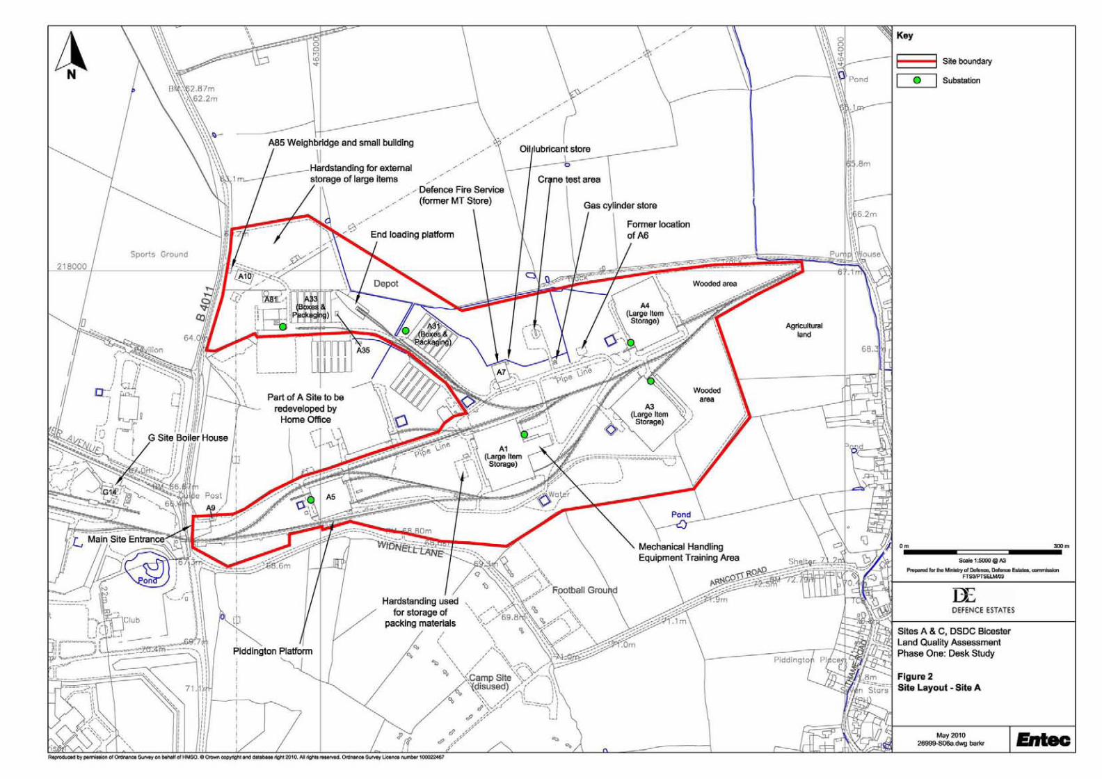
The site consists of two distinct and separate areas of the larger DSDC Bicester with A Site to the east and C Site to the west of Arncott Hill. A Site is roughly triangular (pointing to the east) with a smaller triangle taken out of the base on the western side. A Site covers a total area of approximately 13 ha and its topography is generally level. C Site is rectangular orientated in a northeast to southwest direction. A strip of land connecting C site and DSDC Bicester D Site is also included as part of C Site. C Site covers a total area of approximately 24 ha and slopes downwards from the east side of the site to the west. Both sites lie at an elevation of between 65 and 75 m AOD. Site layout plans are included as Figure 2 and Figure 3.
1.3.2 Site Visit
Entec staff conducted a site walkover on the 20th and 21st January 2010. This included a meeting with the Site Manager, LQA Sponsor and DE Task Officer. Hardcopy and electronic data was obtained from the Site Manager and LQA Sponsor. Entec was able to access the majority of the site areas, with the exception of some buildings which were locked or otherwise inaccessible at the time for health and safety or other reasons. Photographs taken during the site walkover are presented as Annex A to this report.
General Land Use The site is understood to be a storage and distribution hub for a variety of military equipment, including clothes, rations, tents, packaging materials as well as general stores. According to available information (refer to Section 1.4.3 of this report), it is understood that the site has never been used to store explosive ordnance. There is an extensive private railway network across the site which is connected to the national rail network via a spur off the Oxford-Bletchley main line. Rail traffic has to pass through D Site and E Site in order to join the spur that connects to the Oxford-Bletchley main line.
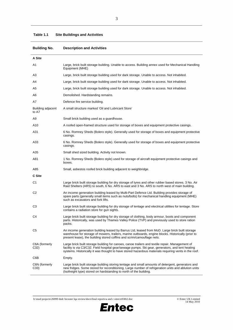
Site Buildings and Activities With reference to Figures 2 and 3, Table 1.1 summarises the buildings and activities at the sites:
h:\mod projects\26999 dsdc bicester lqa review\docs\final reports\a and c sites\rr030i2.doc © Entec UK Limited 14 May 2010
3
Table 1.1 Site Buildings and Activities
Building No. Description and Activities
A Site
A1 Large, brick built storage building. Unable to access. Building annex used for Mechanical Handling Equipment (MHE)
A3 Large, brick built storage building used for dark storage. Unable to access. Not inhabited.
A4 Large, brick built storage building used for dark storage. Unable to access. Not inhabited.
A5 Large, brick built storage building used for dark storage. Unable to access. Not inhabited.
A6 Demolished. Hardstanding remains.
A7 Defence fire service building.
Building adjacent to A7
A small structure marked ‘Oil and Lubricant Store’
A9 Small brick building used as a guardhouse.
A10 A roofed open-framed structure used for storage of boxes and equipment protective casings.
A31 6 No. Romney Sheds (Bolero style). Generally used for storage of boxes and equipment protective casings.
A33 6 No. Romney Sheds (Bolero style). Generally used for storage of boxes and equipment protective casings.
A35 Small shed sized building. Activity not known.
A81 1 No. Romney Sheds (Bolero style) used for storage of aircraft equipment protective casings and boxes.
A85 Small, asbestos roofed brick building adjacent to weighbridge.
C Site
C1 Large brick built storage building for dry storage of tyres and other rubber based stores. 3 No. Air Raid Shelters (ARS) to south, 6 No. ARS to east and 3 No. ARS to north west of main building.
C2 An income generation building leased by Multi-Part Defence Ltd. Building provides storage of spare parts (generally small items such as nuts/bolts) for mechanical handling equipment (MHE) such as excavators and fork lifts.
C3 Large brick built storage building for dry storage of tentage and electrical utilities for tentage. Store contains a radiation store for gun sights.
C4 Large brick built storage building for dry storage of clothing, body armour, boots and component parts. Historically, was used by Thames Valley Police (TVP) and previously used to store ration packs.
C5 An income generation building leased by Barrus Ltd, leased from MoD. Large brick built storage warehouse for storage of mowers, trailers, marine outboards, engine blocks. Historically (prior to present lease), the building stored coffins and scrim/camouflage nets.
C6A (formerly C32)
Large brick built storage building for canoes, canoe trailers and textile repair. Management of facility is via C3/C32. Field hospital gear/sewage pumps. Ski gear, generators, and tent heating systems. Historically it was thought to have stored hazardous materials requiring vents in the roof.
C6B Empty.
C6N (formerly C33)
Large brick built storage building storing tentage and small amounts of detergent, generators and new fridges. Some stored for reconditioning. Large number of refrigeration units and ablution units (Isofreight type) stored on hardstanding to north of the building.
h:\mod projects\26999 dsdc bicester lqa review\docs\final reports\a and c sites\rr030i2.doc © Entec UK Limited 14 May 2010

4
Table 1.1 Site Buildings and Activities
Building No. Description and Activities
C7 A more modern/modernised brick built income generation building leased by Thames Valley Police. Occupant s did not allow access but indicated that building housed mainly clothing and paper.
C8 Modern storage warehouse leased for income generation to KBR. Building used for the storage of tentage and tented accommodation together with the tent utilities (power /refrigeration units. Staff believed the building used to be a former chemical store of some kind.
C8A C8A comprises 3 bays for the handling and storage of chemicals.
C8B A boiler house fed from a 21,000 litre tank. Fuel tanker point accessible with tank located within.
C9 Large brick built storage building for dry storage. Storage contents not known.
C10 Small/medium building used as a stationary store and accounts storage.
C11 Small building, empty and not inhabited.
C12 Small/medium building used as vehicle maintenance workshop by Thames Valley Police (income generation)
C14 Nissen hut indicated as former cleaners store (contractors). No entry allowed due to asbestos within the building.
C16 Large, modernised Head Quarters (HQ) office building comprising open plan office and meeting rooms.
C16A Store building adjacent to C16. Was indicated to also store fuel 3/50 FFO.
C21 Pumphouse and adjacent to Emergency Water Supply (EWS) tank.
C22 A small building adjoined to C23. Wood/Carpenters workshop for construction of coffin frames/pallets. Historically it was a REME training workshop.
C23 A small building adjoined to C22. Printers/graphics workshop.
C24 A medium sized building used as workshops for maintenance of loan pools equipment e.g. climbing gear, cookers, skis, heaters.
C30 Comprises 6 No. Romney Sheds (Bolero style) buildings. Locked and unable to access on the day. Some (if not all) are still used. Some noted to store chemical agents. The remainder (where views into the building were possible) generally held inert items including empty storage cages.
C30A Small building no longer used. Empty.
C31 Comprises 6 No. Romney Sheds (Bolero style) buildings. Locked and unable to access on the day. Some (if not all) are still used.
C32 (formerly C6) Large brick built building for the storage of Loan pool equipment. Stock includes compasses (locked and signed), tables/chairs/tentage/heaters, equipment for watersports /climbing /skiing/camping, ski clothing, fire extinguishers/heaters.
C32A Medium sized annex to C32 used as MoD Police offices.
C33 Test houses for engines, gearbox/transmission systems, antennae and suspension units. Repairs to tracks Challenger & Warrior Hardstanding store to east side. Cooling towers cool water from hydraulic testing of gearboxes located externally to south west.
C33A Large, workshop annex to C33.
C49 Bolero Hut. No entry due to asbestos.
h:\mod projects\26999 dsdc bicester lqa review\docs\final reports\a and c sites\rr030i2.doc © Entec UK Limited 14 May 2010

5
Table 1.1 Site Buildings and Activities
Building No. Description and Activities
C52 Small, income generation building leased to ALC. Building comprises office accommodation only.
C60 Medium to large, former MT section building for site. Used infrequently.
C61 Petrol, Oil, Lubricant dispensers. Current POL point for the site.
C85 Small, brick built former rest room. No longer used due to asbestos.
Evidence of Former Structures, Fill Material and/or Disturbed Ground Evidence of several former structures, fill material and/or disturbed ground was noted during the site walkover, and, with reference to historic aerial photographs (Annex B), historic maps and plans (Annex C) is summarised in Table 1.2:
Table 1.2 Site Former Structures, Fill Material and/or Disturbed Ground
Building No. Description
A Site
Former location of Building A6
10 m x 10 m tiled, concrete floor
Between former buildings of A6 and A7
Roughly circular area of gravel (possibly used by vehicles) with infilled/Made Ground central area.
C Site
North-east of C2 A thin strip of land was observed to have been raised in this area by several metres (2-5 m). Surface cover is smooth comprises mainly of grass.
North of C5 A large, roughly rectangular area of land was observed to have been raised in this area by several metres (3-6 m). Surface cover comprises mainly of grass with a flat plateau.
North-east of C7 The land was observed to have been raised in this area by several metres (3-6 m). Surface cover is smooth comprises mainly of grass.
South-west of C8 A small, roughly rectangular area of land was observed to have been raised in this area by several metres (2-5 m). Surface cover comprises mainly of grass.
Area to north of C32 Burning Ground
A large , roughly rectangular area of land was observed to have been raised in this area by up to 1 m.
Waste Waste materials collected from the site are placed in designated skips and other purpose-built waste containers for collection and disposal to appropriately licensed disposal facilities by Grundons.
Drainage Surface water drainage plans were not known to exist at the site and hence were not available
h:\mod projects\26999 dsdc bicester lqa review\docs\final reports\a and c sites\rr030i2.doc © Entec UK Limited 14 May 2010

6
from site staff according to enquiries made by Entec both during and after the site walkover. However, from the site walkover it would appear that precipitation from roofs and hardstanding areas drains to a network of surface water drainage ditches that drain the low-lying, poorly draining parts of the site. Foul drainage is understood to be sent to the adjacent sewage treatment works. Located around the site, notably around vehicle/container parks and POL facilities are a number of interceptors. Maintenance of these facilities is understood to be undertaken by C Site contractors (via the Regional Prime Contractor – Pride Interserve).
Surface Cover
A Site The predominant surface cover at the site is a mixture of hardstanding/building structures (~45%), soft landscaping (45%) and woodland (~10%).
C Site The predominant surface cover at the site is a mixture of hardstanding/building structures (~60%), soft landscaping (35%) and woodland (~5%).
1.3.3 Site Boundaries
Land uses surrounding the site are summarised in Table 1.3 and Table 1.4 below:
Table 1.3 A Site Boundaries and Adjacent Land Uses
Boundary Adjacent Land Use Nearby Land Use
North Agricultural Agricultural
East Agricultural Predominantly agricultural with some residential
South Widnell Lane (minor road) Predominantly agricultural with Piddington Training Area (military)
West B4011 (minor road) DSDC Bicester G Site and G Site Sports Ground (military)
Table 1.4 C Site Boundaries and Adjacent Land Uses
Boundary Adjacent Land Use Nearby Land Use
North Lower Arncott village and Ploughley Road (minor road)
Predominantly agricultural with some residential
East DSDC Bicester H Site, Upper Arncott village, agricultural land.
Predominantly residential with some military and agricultural
South Agricultural Predominantly agricultural with M40 motorway
West Agricultural Predominantly agricultural with some residential
h:\mod projects\26999 dsdc bicester lqa review\docs\final reports\a and c sites\rr030i2.doc © Entec UK Limited 14 May 2010

7
1.3.4 Tenant, Lodgers and Enclaves
A number of buildings at C Site are leased to businesses and individuals for a variety of uses and is generally referred to as an ‘income generation use’ by DSDC On the basis of the walkover and information collected anecdotally during the walkover, these areas/buildings include Thames Valley Police (Buildings C7 and C12), Multipart (Building C2), Barrus (Building C5), KBR (Building C8) and the Defence Support Group (DSG) (Buildings C33 and C33A).
1.4 Site-Sourced Information
Additional environmentally pertinent information relating to the site was requested from the Site Representative. This information is summarised in the following sections.
1.4.1 COSHH Register and Material Safety Data Sheets
According to site staff, each building has an individual hardcopy COSHH Register. Due to availability and time constraints, it was not possible to review individual COSHH Registers for each and every building. However, it is understood from a conversation with the Site Manager that the COSHH records are generally for minor quantities of substances kept in each building. Dedicated COSHH lockers were also noted adjacent to several of the buildings during the site walkover.
1.4.2 Asbestos Register
Most of the buildings on site date from the 1940s and have asbestos in their fabric. Although many of the buildings were modernised with fire protection systems 15 years ago, some still contain substantial amount of asbestos, which is labelled and managed using individual building asbestos registers. Asbestos survey work and management is understood to be currently in progress.
At the time of reporting, no asbestos registers were available for the site but it was noted that asbestos surveys for the whole of A Site and C Site were being performed and would be completed circa June 2010.
1.4.3 Ordnance
As part of this Phase One LQA, an Explosive Ordnance Threat Assessment (EOTA) was commissioned. The EOTA was undertaken by BACTEC International Ltd (BACTEC), a specialist consultancy. The EOTA concluded as follows:
• DSDC Bicester has been a military depot for over 65 years. No evidence could be found to indicate that the purpose of the depot was ever for the storage of explosive ordnance. Nevertheless, as with all historic military facilities, there is always a residual risk of explosive ordnance contamination. BACTEC concluded that there is a Low-Medium risk from unexploded ordnance at the site of the proposed works;
• During the war years, the facility would have been defended, and weaponry in the form of small arms and land service ammunition would have been stored and available for use. Furthermore, as a result of the military association with the area, it is likely that the land on and around the depot would have been utilised for ground training exercises historically;
h:\mod projects\26999 dsdc bicester lqa review\docs\final reports\a and c sites\rr030i2.doc © Entec UK Limited 14 May 2010

8
• The ‘house-keeping’ of WWII facilities is known to have often been poor with unwanted and unused items of explosive ordnance frequently buried, burnt, lost or otherwise discarded within a facility perimeter. Given the available history of the site, the likelihood of this having occurred within the perimeter of DSDC Bicester is not considered high, but cannot be entirely discounted. It should be noted that several search and clear operations have been undertaken at several locations on the site by 33 Engineer Regiment (EOD) in the post-war period. Although nothing was found, the requirement for and completion of such operations at the cost of the MoD indicates that there was a credible perceived threat/possibility of explosive ordnance contamination being present. It should also be noted that only small sections of DSDC Bicester have been subject to such searches, those searches only providing 12.5% clearance for the whole of DSDC Bicester;
• Research indicates that bombing density over the Bicester area was low. Very few references could be found to raids over the region despite there being a number of high profile RAF targets present. ARP records for COD Bicester could not be located (reports of bombing on military land were generally made by military personnel and kept separate from civilian records). It has therefore not been possible to confirm that the facility was not attacked. However, work on the construction of the depot did not commence until after the main period of bombing in this part of the UK;
• The depot employed thousands of people and for the latter part of WWII at least, would have been manned twenty-four hours a day. It is considered very unlikely that evidence of unexploded ordnance would have been overlooked across the site subsequent to construction work beginning in June 1941. Prior to this date, the C Site comprised open, agricultural land on which it is conceivable that unexploded bombs could have been overlooked had they been dropped. However, given the low bombing density in this part of the county and lack of viable targets within the A Site area in 1940 / early 1941, the likelihood of unexploded bombs having been dropped is considered minimal.
The full EOTA is included as Annex D to this report.
1.4.4 Ionising Radiation Sources
As part of this Phase One LQA, a desk study was commissioned through the Dstl Environmental Services Department (Dstl ESD). As part of this study, Dstl ESD conducted a search of records relating to any radiological contamination issues at the whole DSDA Bicester site.
Dstl ESD records show that a very large number of items of standard military equipment containing radioactive material have been stored at the DSDC Bicester site from at least 1994 to the present day; the site being a major distribution centre for the main storage facility at DSDA Donnington. These include various pieces of instrumentation and check sources containing the following radionuclides: tritium (H-3), nickel-63 (Ni-63), thorium-232 (Th-232), strontium-90 (Sr-90) chlorine-36 (Cl-36) and cobalt-57 (Co-57). In addition, an instrumentation dial from a Canberra (jet aircraft) cockpit containing radium-226 (Ra-226) has been stored on wider DSDC Bicester site since at least 1999.
The full Dstl ESD desk study is included as Annex E to this report.
h:\mod projects\26999 dsdc bicester lqa review\docs\final reports\a and c sites\rr030i2.doc © Entec UK Limited 14 May 2010

9
1.5 Site History
1.5.1 Historical Land Use Summary
Historic mapping and aerial photographs indicate that the entire DSDC Bicester site was built on agricultural land and woodland during the period 1941 - 1943 and was subsequently stocked with tanks, armoured cars, other vehicles and guns in preparation for the invasion of Europe in 1944.
As of June 1943 A Site and C Site were part of what was called ‘COD (Central Ordnance Depot) Bicester’. Arncott A Site (as it was called) was indicated to be a ‘Signals and Wireless Sub-Depot’ whereas Arncott C Site was an ‘MT Sub-Depot’.
There were also seven camps established at COD Bicester at this time, four of which were located adjacent or close to A Site and C Site. Camp 4 was located to the south of A Site (and named Piddington Camp) with Camps 1,2 and 3 located around Arncott Hill close to C Site.
These Camps comprised over 600 Nissen huts used to accommodate troops and depot workers. Following December 1941 a large number of Romney Sheds (also known as ‘boleros’) were erected as part of Operation ‘Bolero’ which was aimed to provide facilities and accommodation for American troops. There were a large number especially those located to the south east of C Site within B- Site.
The 1950 historic mapping shows the site in a very similar layout to that of the present day. The historic aerial photographs from this era also show that the wooded areas of the site were generally planted in the period 1950 - 1975.
The site was used for the processing of return stores from WWII and for stores issue in 1949 for the Korean War. The entire DSDC Bicester site was redesignated as a Base Ordnance Depot (BOD) in the 1950. By 1961 the whole site had been reorganised, with technical stores and Motor Transport (MT) units to other depots including BOD Donnington in Shropshire. BOD Bicester was established as the main UK depot for military clothing and general stores.
By 1983 the processing of ammunition containers was transferred to the site from the depot in Ruddington Ordnance & Supply Depot in Nottinghamshire.
The hazardous storehouse at C8 was opened in 1989, stores being transferred from C6a (flammable and miscellaneous) and C6n (poisons and corrosives). In 1991 the closure of 32 base workshops REME at C32 took place. REME had occupied this area since 1943. Other historical events that could have been of significance with respect to land quality include the spillage of 300 gallons of hydrochloric acid following a rail wagon fire in 1970. The spill location is unknown. Hazardous stores were transferred to C6a and C6n from C7 and the old C8 in 1977.
By 1992, the whole site became known as the Defence Storage and Distribution Centre, Bicester.
Although the site has been used for storage of military hardware and processing of ammunition containers, according to the BACTEC EOTA and a local historian, author of ‘50 years of COD Bicester’, there is ‘no record of explosive ordnance ever being stored, processed or disposed of within the confines of the depot [site] perimeter’.
h:\mod projects\26999 dsdc bicester lqa review\docs\final reports\a and c sites\rr030i2.doc © Entec UK Limited 14 May 2010

10
1.6 Environmental Setting and Sensitivity
1.6.1 Geology
Geological information on the site is provided within the emapsite™ GroundSure GeoInsight Report obtained as part of the site data acquisition exercise, a copy of which is included in Annex C. The geological information provided in the GeoInsight report is derived from the British Geological Survey (BGS) Digital Geological map of Great Britain and 1:50,000 scale, Sheet 219.
According to the GeoInsight report, the anticipated geological sequence consists alluvium deposits (clay, silt, sand and gravel) over the northern part of A Site and over the strip of land connecting C Site and D Site directly overlying solid geology consisting of the Stewartby Member (mudstone) and Peterborough Member (mudstone) of the Oxford Clay Formation. The Kellaways Clay Member and Kellaways Sand Members of the Kellaways Formation outcrop in the north of the strip of land connecting C Site and D Site.
A total of seventeen inferred normal faults are shown within 500 m of the site. Although none of the faults are marked within the site boundary, a total of five faults are marked as crossing the strip of land connecting C Site and D Site approximately 140 m to the North. The closest fault to the site is marked within 60 m of the western boundary of C Site, with a strike trending north-west to south-east.
The natural ground subsidence section of the GeoInsight Report presents the following assessment of risks by the BGS for potential geological hazards that may be present in the general area of the site:
• Potential for shrink-swell clay ground stability hazards: Negligible to Moderate (source: BGS);
• Potential for landslide ground stability hazards: Very Low (source: BGS);
• Potential for ground dissolution of soluble rocks stability hazards: Negligible to Very Low (source: BGS);
• Potential for compressible deposits stability hazards: Negligible to Moderate (source: BGS);
• Potential for collapsible deposits stability hazards: No Hazard to Negligible (source: BGS);
• Potential for running sand stability hazards: Negligible to Low (source: BGS);
• Radon: The site is not within a radon Affected Area, as less than 1% of properties are above the Action Level. No radon protection measures are necessary (sources: Health Protection Agency and Building Research Establishment);
• Mining: There are no historical mining and/or coal mining areas within 1 km of the site boundary. The maximum hazard rating of subsidence relating to shallow mining within the site is Negligible. There are no non-coal mining cavities, natural cavities, brine extraction areas, gypsum extraction areas, tin mining areas or clay mining areas within 1 km of the site boundary (sources: GroundSure, Coal Authority, BGS, Peter Brett Associates mining cavities and natural cavities databases, British Gypsum and relevant tin and clay mining records).
h:\mod projects\26999 dsdc bicester lqa review\docs\final reports\a and c sites\rr030i2.doc © Entec UK Limited 14 May 2010

11
Ground Workings According to the GroundSure GeoInsight Report, included within Annex C of this report, historic surface ground workings have been carried out in the following locations:
• North western boundary of A Site: there are workings related to the sewage works marked within 250 m of this boundary. These workings date from the 1980s and 1990s;
• C Site and area to the east of C Site: there are eight entries for ponds on the northern part of C Site and eleven entries for ponds within 100 m from the eastern boundary of C Site dating from the 1880s to the 1990s. According to the mapping provided in the GeoInsight Report, these entries may all relate to five ponds; and
• Strip of land connecting C Site with Site D: a water body dating from the 1880s is shown on this strip of land, and there are further entries for a pond (1880s-1950s), a cutting (1950s) and an ‘unspecified heap’ (1950s) within 250 m of the northern boundary of this area.
1.6.2 BGS Borehole Records
The GroundSure GeoInsight report provides details of 26 exploratory holes on site or within 250 m of the site boundary. Of these exploratory holes, approximately 14 appear to be trial pits. Of the remaining boreholes, there are only records of eleven boreholes on site; a cluster of five boreholes within the south western part of C Site at the New Engine Test House and six boreholes within centre of C Site at the Hazardous Items Stores. Exploratory logs and borehole records have been requested as part of the annexes from the Enviros Aspinwall Ltd LQA Phase Two, June 2001. These were not received and hence not reviewed.
The geology, as described within previous Phase Two reports for relatively shallow excavations, generally concurs with the BGS geological mapping, indicating Made Ground overlying Oxford Clay.
1.6.3 Groundwater
Hydrogeological information on the site is provided within the emapsite™ GroundSure EnviroInsight Report obtained as part of the site data acquisition exercise, a copy of which is included in Annex C.
It is understood by Entec that the Environment Agency intends to change aquifer designations in line with the updated Groundwater Protection Policy (GP3) and the Water Framework Directive. As part of this change, Minor Aquifers will now be generally referred to as ‘Secondary (A) Aquifers’, with Non-Aquifers referred to as ‘Unproductive Strata’.
A Site Inspection of the Aquifer and Abstraction License Map (provided in the EnviroInsight Report) shows that the northern half of A Site is underlain by a Secondary (Minor) Aquifer (comprising soils of Low Leaching Potential). This is considered to be the Alluvium. The land in the southern half of A Site is underlain by Unproductive Strata (Non-Aquifer - Negligibly Permeable).
C Site According to the Aquifer and Abstraction License Map (provided in the EnviroInsight Report)
h:\mod projects\26999 dsdc bicester lqa review\docs\final reports\a and c sites\rr030i2.doc © Entec UK Limited 14 May 2010

12
the majority of the site is underlain by Unproductive Strata (Non-Aquifer - Negligibly Permeable). The strip of land connecting D Site and C Site is also underlain in places by a Secondary (Minor) Aquifer (including soils of both High and Low Leaching Potential).
Both Sites
Beneath the Oxford Clay and Kellaways formations, the Cornbrash Formation (part of the Great Oolite Group) that outcrops to the north-east and south-west of the site is also classified as a Minor Aquifer of Low Leaching Potential.
According to the site Estate Development Plan (v1.1, 15 August 2008) groundwater levels, although recorded at 70m Above Ordnance Datum (AOD) are within the aquifer of the Great Oolite Group (approximately 30m below ground level), comprising limestone and sands. This confined aquifer is under high pressure conditions, which if penetrated by a borehole will produce artesian conditions with a head of approximately 20 m.
Neither A Site nor C Site overlies a groundwater Source Protection Zones (SPZ) and there are no SPZ marked within 500 m of either site.
Groundwater Abstraction Licenses The EnviroInsight Report states that there are no groundwater abstraction licenses within 2km of the study site.
Potable Water Abstraction Licenses The EnviroInsight Report states that there are no potable water abstraction licenses within 2 km of the study site.
1.6.4 Surface Water
A Site Other than the on-site surface water drainage ditches that cross the site, the closest major surface water feature to A Site is an unnamed brook that is off-site but skirts the eastern most point of the site flowing in a northerly direction. A large lagoon is located to the south west of the entrance to A Site within G Site approximately 75 m away. Other small unnamed ponds (<10No.) are located within 500 m of the site boundary.
C Site Other than the on-site surface water drainage ditches that cross the site and discharge into the River Ray, the major surface water feature is the River Ray, which crosses the strip of land which connects C Site and Site D. There are also two large ponds located to the north of building C9.
The EA record the quality of the River Ray at one reach which crosses the site. The Grendon Underwood STW – Langford Brook reach on the River Ray is rated by the EA as chemical grade ‘E’ (poor) and is not given a biological grade.
Aerial photography also shows that small waterbody (possibly a lagoon) is located to the south of the site. It is likely that this is not in hydraulic continuity with the site.
Surface Water Abstractions There are no records of surface water abstraction license within 1 km of either A Site or C Site.
h:\mod projects\26999 dsdc bicester lqa review\docs\final reports\a and c sites\rr030i2.doc © Entec UK Limited 14 May 2010

13
Discharges There are records of 22 Licensed Discharge Consents within 500 m of the site, 13 of which relate to permits that are now revoked. Details of the permits are as follows:
• Four (two of which have been revoked) relate to the discharge of sewage effluent by the water company to the River Ray at A Site; and
• Eight (five of which have been revoked) relate to the discharge of sewage effluent by the water company to the River Ray at C Site.
During a conversation with a representative of Kelda Water Services, the Aquatrine Contractor for the site, it was indicated that no discharge consents related to the site are still extant. Of the discharge consents that are still extant, all are permitted to the local water company (the name of which is not supplied within the EnviroInsight Report). No discharge consent permits are recorded to be for the site.
Flooding The Surface Water Flood Map provided with the EnviroInsight Report shows that the extreme northwestern corner of the A Site and the strip of land connecting C Site and Site D are within Zone 2 and Zone 3 floodplains. Zone 2 floodplains are those with a greater than one in a thousand (0.1%) annual probability of flooding, but less than one in a hundred (1%). Zone 3 refers to an annual probability of flooding of 1% or greater. There are no flood defences or areas benefiting from flood defences within 250 m of the site.
In addition, there are BGS groundwater flooding susceptibility flood areas within 50 m of the site boundary, and a high groundwater flooding susceptibility is indicated. This means that due to the underlying geology, the area groundwater flooding hazard should be considered in all land use planning decisions. The BGS confidence rating for the groundwater flooding susceptibility areas is moderately high; meaning the groundwater flooding susceptibility areas can be used with confidence.
1.6.5 Ecology
One Site of Special Scientific Interest (SSSI) (Arncott Bridge Meadows) is located approximately 20 m to the east of the strip of land connecting C Site and D Site. The condition of this site is recorded as ‘favourable’.
The EnviroInsight Report provides details of three Environmentally Sensitive Areas (ESA) within 0.5 km of the site.
The Environmentally Sensitive Areas Scheme was introduced to encourage farmers to adopt agricultural practices which would safeguard landscapes, wildlife or countryside of historic value. The scheme has now closed to new applicants and has been superseded by the Environmental Stewardship scheme although some existing agreements will continue until 2014. There are 22 ESAs in England, covering some 10% of agricultural land.
The three recorded areas are all part of the same ESA, the Upper Thames Tributaries. The Upper Thames Tributaries ESA covers approximately 27,200 hectares of the Thames Valley and the lower reaches of five tributaries - the Windrush, the Evenlode, the Glyme, the Cherwell and the Ray. These six valleys radiate from Oxford, to the west, north and north-east, draining parts of the Cotswold dip slope, the upper Thames valley, parts of the Vale of Aylesbury and parts of the Northamptonshire ironstone belt. The majority of the ESA lies within Oxfordshire, with areas extending into Gloucestershire, Northamptonshire and Buckinghamshire. One record
h:\mod projects\26999 dsdc bicester lqa review\docs\final reports\a and c sites\rr030i2.doc © Entec UK Limited 14 May 2010

14
is located on A Site, one record is on C Site and the third record is identified to be approximately 130 m west of C Site.
In addition, the both sites fall within a Nitrate Vulnerable Zone (NVZ).
1.6.6 Site Sensitivity
Groundwater Sensitivity: Moderate / Low The site is mainly underlain by an Unproductive Strata (Non Aquifer, Oxford Clay Formation) which would be considered to present a low sensitivity with a moderate sensitivity assessed for the Secondary (Minor) Aquifer (Alluvium) situated in the north part of A Site. The site is not within a SPZ.
Hydrology
Surface Water Sensitivity: Moderate River Ray traverses the extreme north of the C Site and is of a generally poor water quality. There is potential for the River Ray to be affected by direct run-off and discharges from the site. However, the site itself is large and as such the sensitivity will decrease with respect to distance for the identified surface water receptors.
Ecology
Ecological Sensitivity: Moderate A SSSI is located close to the strip of land connecting C Site to other areas of DSDC Bicester.Both A Site and C Site have a record of one ESA being located on-site with a third record being positioned approximately 130 m west of C Site. Both sites are surrounded predominantly by agricultural land which forms the ESA, namely the Upper Thames Tributaries ESA. However, both sites are large and as such the sensitivity will decrease with respect to distance for the identified ecological receptors with C Site being the most sensitive due to the proximity of the SSSI.
1.7 Additional Information
1.7.1 IPPC Authorisations
According to the EnviroInsight report, there are no records of Integrate Pollution Prevention and Control (IPPC) Authorisations within 500 m of the site.
1.7.2 List 2 Dangerous Substance Inventory Sites
According to the EnviroInsight report, there are no records of a List 2 Dangerous Substance Inventory Site within 500 m of the site.
1.7.3 Environment Agency Recorded Pollution Incidents
According to the EnviroInsight report, there is one record of a recorded pollution incident within 250 m of the site. This relates to a mixed/waste oils spill occurring off-site on 13 March 2002 at a location 120 m NE of C Site. The incident was a Category 3 (Minor) incident with regard to the impacts to land and water.
h:\mod projects\26999 dsdc bicester lqa review\docs\final reports\a and c sites\rr030i2.doc © Entec UK Limited 14 May 2010

15
1.7.4 Waste Sites
According to the EnviroInsight report, there are no records of a historic landfill, landfills or other waste sites within 1.5 km of the sites.
1.7.5 Petrol and Fuel Sites
According to the EnviroInsight report, there are records of an ‘obsolete’ petrol station 476 m north east of the C Site boundary, which is known as Three Corners Garage. There are no further details of this site provided.
1.7.6 Archaeological Issues
• According to the Multi-Agency Geographic Information for the Countryside (MAGIC) website (www.magic.gov.uk , accessed 11 March 2010) there are no records of Scheduled Ancient Monuments (SAMs) within 1 km of the site. Contrary to this the Local Authority response (described below) indicates that Ambrosden Church Cross (located within 500 m) is a scheduled monument;
• Within the Local Authority response (described below) the site (inclusive of the whole of DSDC Bicester is described as an ‘Archaeological Monument Line’ on the basis that it is Britain’s largest military railway system.
1.7.7 Local Authority Environmental Health Department
A response for an information request was received by Entec from Cherwell District Council Environmental Service Department (ESD) on 19 January 2010. The response is extensive, amounting to a 46 page report for A Site and a 52 page report for C Site. The reports include information gathered from the Landmark Group and the BGS, as well as records held within Cherwell ESD.
The response includes detailed information on the site geology (including information on borehole records), hydrogeology and hydrology, naturally occurring arsenic (no naturally occurring arsenic at the site), historical mapping, infilled sites, landfill sites, licensed waste management facilities, environmentally sensitive data, sites of environmental importance and heritage sites.
The data from Landmark and BGS is noted by Cherwell ESD to be current up to 01/04/07. Therefore, it has been assumed that the majority of information provided is superseded by the emapsite™ reports, which was commissioned by Entec in January 2010. However, information on infilled ground, historical land use and pollution incidents (historical and current) from the Cherwell ESD has been included in this section for completeness.
The full Cherwell ESD response is included as Annex F to this report.
A Site One area of ‘Unknown Infilled Ground’ (pond, marsh, river, stream, etc.) is marked on an infilled sites plan (c. 1840-1997) in the northern half of A Site with a second that straddles the boundary within the southern half. Four other locations are highlighted within 500 m of the site. All four of the off-site infilled locations are to the south of the site and given the nature of the geology these potential source areas are not considered further.
No historical or current pollution incidents (1987-2001) have been recorded for the site. Six
h:\mod projects\26999 dsdc bicester lqa review\docs\final reports\a and c sites\rr030i2.doc © Entec UK Limited 14 May 2010
16
historical pollutions incidents are recorded within the 500 m search radius of which one was a ‘major incident’ involving General/Suspended solids (inert). On the basis that any contamination arising from these potential sources are unlikely to impact the site from migration within groundwater they are not considered further.
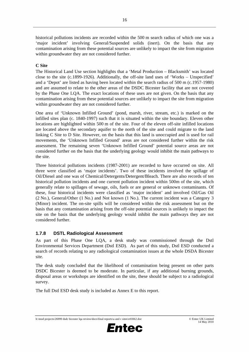
C Site The Historical Land Use section highlights that a ‘Metal Production – Blacksmith’ was located close to the site (c.1899-1926). Additionally, the off-site land uses of ‘Works – Unspecified’ and a ‘Depot’ are listed as having been located within the search radius of 500 m (c.1957-1980) and are assumed to relate to the other areas of the DSDC Bicester facility that are not covered by the Phase One LQA. The exact locations of these uses are not given. On the basis that any contamination arising from these potential sources are unlikely to impact the site from migration within groundwater they are not considered further.
One area of ‘Unknown Infilled Ground’ (pond, marsh, river, stream, etc.) is marked on the infilled sites plan (c. 1840-1997) such that it is situated within the site boundary. Eleven other locations are highlighted within 500 m of the site. Four of the eleven off-site infilled locations are located above the secondary aquifer to the north of the site and could migrate to the land linking C Site to D Site. However, on the basis that this land is unoccupied and is used for rail movements, the ‘Unknown Infilled Ground’ areas are not considered further within the risk assessment. The remaining seven ‘Unknown Infilled Ground’ potential source areas are not considered further on the basis that the underlying geology would inhibit the main pathways to the site.
Three historical pollutions incidents (1987-2001) are recorded to have occurred on site. All three were classified as ‘major incidents’. Two of these incidents involved the spillage of Oil/Diesel and one was of Chemical/Detergents/Detergent/Bleach. There are also records of ten historical pollution incidents and one current pollution incident within 500m of the site, which generally relate to spillages of sewage, oils, fuels or are general or unknown contaminants. Of these, four historical incidents were classified as ‘major incident’ and involved Oil/Gas Oil (2 No.), General/Other (1 No.) and Not known (1 No.). The current incident was a Category 3 (Minor) incident. The on-site spills will be considered within the risk assessment but on the basis that any contamination arising from the off-site potential sources is unlikely to impact the site on the basis that the underlying geology would inhibit the main pathways they are not considered further.
1.7.8 DSTL Radiological Assessment
As part of this Phase One LQA, a desk study was commissioned through the Dstl Environmental Services Department (Dstl ESD). As part of this study, Dstl ESD conducted a search of records relating to any radiological contamination issues at the whole DSDA Bicester site.
The desk study concluded that the likelihood of contamination being present on other parts DSDC Bicester is deemed to be moderate. In particular, if any additional burning grounds, disposal areas or workshops are identified on the site, these should be subject to a radiological survey.
The full Dstl ESD desk study is included as Annex E to this report.
h:\mod projects\26999 dsdc bicester lqa review\docs\final reports\a and c sites\rr030i2.doc © Entec UK Limited 14 May 2010

17
1.8 Previous Assessments
BOD Bicester Land Quality Assessment Phase One: Desk Study. Aspinwall & Company Ltd, August 1998 The desk study, presented in three volumes (Factual Report, Interpretive Report and Land Quality Statement) covered the entire DSDC Bicester site, which is referred to in the reports as the Base Ordnance Depot (BOD) Bicester.
A number of current and historical activities/issues are identified that could give rise to contamination. Those specific to A Site and C Site include the following:
• Leakages from underground fuel tanks or lines north of Building C61 (fuel dispensers C Site). The reports note there were former refuelling facilities at A, D and E sites;
• Leakages from current or former heating oil tanks or supply lines, including the known spill in the vicinity of building C33 (C Site);
• Leakages or spills from the diesel test facility at building C33 (C Site);
• Spill of fuels, oils, degreasants and similar liquids associated with vehicle testing/repair/maintenance at buildings C33 and C60. Tanks were formerly repaired at building C32, which was formerly known as building C6;
• Radiological contamination in and around building C32, the former Royal Electrical and Mechanical Engineers (REME) workshop and at burning grounds;
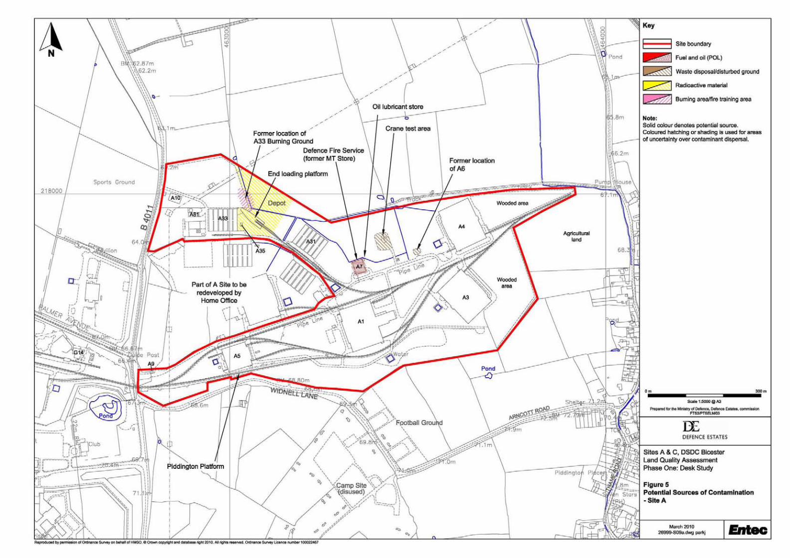
• Former burning grounds in A Site (near building A33) and C Site (near building C32);
• Suspected landfill areas near building C32. The reports also mention earth mounds between buildings to the north of Building C7 (C Site) which are suspected inert fill from site regrading;
• Area of former vehicle storage north of Building A33 where fuels or oils may have leaked or been washed into the ground;
• Railway siding areas (all sites) where stored materials may have leaked. The reports state that a spill of 300 gallons on hydrochloric acid occurred from a rail wagon at an unknown location following a fire in 1970; and
• Any spillages from hazardous stores now kept in a purpose build building at C8, but formerly in buildings C6A, C6N and C7 (all C Site).
The reports also state that asbestos is present in the fabric of a number of the buildings, mainly as cement cladding or roofing. The asbestos register recommended that asbestos in 50% of the locations was replaced, which was taking place as part of an ongoing programme at the time.
It is understood from the reports that large quantities of explosive ordnance have never been stored or used at the site.
In addition, the reports state that the only radioactive sources kept on site are night sights and related equipment at the barracks sites at DSDC Bicester. Historically, building C32 was the REME workshop where luminising using Radium 226 occurred. Detailed investigations were
h:\mod projects\26999 dsdc bicester lqa review\docs\final reports\a and c sites\rr030i2.doc © Entec UK Limited 14 May 2010
18
undertaken by DRPS in 1998 around building C32 and the former vehicle storage area and burning ground near building A33. The results of these surveys proved one location of elevated radioactivity to the rear of building C32, which was associated with a buried luminised object. No elevated levels of radioactivity were recorded within the building or to the north of building A33. DRPS recommended health physics cover be provided for any intrusive works near building C32 in the future, particularly to the rear of the building.
Although a number of generators and transformers were identified on site, the reports state that they have been checked and PCBs are not present.
The environmental risk assessment carried out as part of the reports concludes that the risk to current site users/workers is low, unless ground conditions are disturbed. The greatest risks identified were to surface waters, which provide a preferential route for the migration of any pollutants present in surface run-off. Groundwater pollution risks were not considered significant at the site.
In summary, Aspinwall state that the ‘vast majority’ of the site is unlikely to have been contaminated by historical activities, but that current activities, generally associated with fuel storage, may give rise to localised contamination of soils and surface water. They deemed it unlikely that there would be any major constraints to further developments at the site proposed as part of ongoing operations, although there may be a requirement to remove localised sources of ground contamination prior to building construction. If the site was to be sold for redevelopment for commercial/industrial use, some limited remedial works would likely be necessary. In addition, although ‘large tracts’ of the site would potentially be suitable for housing with gardens, some areas of the site (particularly the depot areas) would not be suitable for housing without some form of remedial work.
ABRO Bicester Land Quality Assessment Phase One: Desk Study. Aspinwall & Company Ltd, February 2001 The desk study, presented in two volumes (LQA Report and Technical Note) covers the Army Base Repair Organisation (ABRO) Site within DSDC Bicester. The ABRO facility occupies three buildings (C33, C33A and C26) in the south west corner of C Site as shown on Figure 3.
A number of potential sources of contamination were identified in the reports, including:
• Oils/fuels stored in underground storage tanks and 205 litre drums at the rear of building C33;
• Oils, degreasers, white spirit and antifreeze stored in metal cages on the floor of building C26;
• Oils stored in above ground tanks in the building C33 storage room;
• Small volumes of paint and thinners stored and used in building C33; and
• Hydrocarbons from the washing area outside building C26.
All risks associated with the site were assessed as low/negligible and Aspinwall anticipated that, based on the information available at the time, the majority of the site was unlikely to have been contaminated by previous or current uses. The potential sources identified above are not thought to have caused widespread contamination but could give rise to localised contamination within the vicinity of the source.
The reports reference an intrusive investigation undertaken at DSDC Bicester in June 2000
h:\mod projects\26999 dsdc bicester lqa review\docs\final reports\a and c sites\rr030i2.doc © Entec UK Limited 14 May 2010

19
following a ruptured fuel line at the rear of building C33 in October 1997. Part of the investigation (reported in June 2001, see below) included the drilling of three window samples to a maximum depth of 2.75 m bgl around the underground tanks to the rear of building C33. During the investigation, no visual or olfactory evidence of contamination was noted. The samples obtained were analysed and revealed no concentrations of toxic or phytotoxic metals (except arsenic) above the relevant Interdepartmental Committee on the Redevelopment of Contaminated Land (ICRCL) screening criteria used. Diesel range organics were not detected at concentrations above the relevant Dutch Intervention Value.
In summary, Aspinwall considered the site to be suitable for use for redevelopment to commercial/industrial use and, subject to investigation and localised remediation, to housing with gardens.
DSDC Bicester Land Quality Assessment Phase Two: Intrusive Survey. Enviros Aspinwall Ltd, June 2001. The report, presented in two volumes (LQA Report and Technical Note) covered the potentially contaminated areas of the site identified within the previous Aspinwall & Company Ltd Phase One LQA reports. These included the following, specific to A Site and C Site:
• A Site former burning ground;
• Burning ground near building C32;
• Building C60 POL point (fuel dispensers and tanks are known as building C61);
• Landfill site near building C33; and
• Underground storage tanks near building C33.
These areas were investigated by a combination of radiological walkover survey and machine excavated trial pits (burning ground and suspected landfills) and shallow window sample holes (underground storage tanks near building C33 and POL points).
Samples of soil and groundwater obtained during the investigation were compared to the relevant ICRCL and Dutch Intervention values used at the time. The results identified the following contamination:
• A Site: slightly elevated metals and hydrocarbons;
• Burning ground near building C32: elevated arsenic and slightly elevated soluble sulphates with five isolated sources of radium contamination;
• Building C60 (C61) POL point: slightly elevated soluble sulphates and elevated hydrocarbons;
• Landfill site near building C33: slightly elevated lead, copper, soluble sulphates, hydrocarbons and one isolated source of radium contamination; and
• Underground storage tanks near building C33: slightly elevated phytotoxic metals.
In summary, the sources of contamination found included metals and soluble sulphate in Made Ground across the site, hydrocarbon (including PAH) contamination in ground and perched groundwater as well as localised radioactive contamination within the burning grounds. The Oxford Clay beneath the Made Ground was found to be free of contamination in the majority of areas investigated and the perched groundwater was not thought to be in continuity with the
h:\mod projects\26999 dsdc bicester lqa review\docs\final reports\a and c sites\rr030i2.doc © Entec UK Limited 14 May 2010

20
regional aquifer beneath the Oxford Clay. Explosive ordnance was not considered a source of contamination based on information obtained during the Phase One LQA and observations made during the Phase Two investigation.
The environmental risk assessment undertaken as part of the reports concluded that the risks to all environmental receptors based on continuing current use was low or negligible. Under a more sensitive end use, such as housing with gardens, the environmental risks were assessed as low to moderate.
In summary, Aspinwall considered that the areas investigated were generally unsuitable for redevelopment to a domestic end use without remediation, although the majority of the site was potentially suitable for redevelopment to sensitive end uses.
DSDC Bicester Explosive Ordnance Clearance. Defence Logistics Organisation Environmental Science Group (ESG), September 2002 The desk study was produced to establish the areas of potential concern (APCs) with respect to explosive ordnance within Sites A, B and G at DSDC Bicester for the purpose of disposal (sale) of these sites.
The desk study work programme included discussions with site personnel, document review (including the previous Aspinwall Phase One and Two LQA Reports) and a site walkover.
A total of three Areas of Potential Concern (APCs) were identified at A Site, as follows:
• APC1: an area between buildings A31 and A4 with large quantities of dumped ammunition containers;
• APC2: an open area adjacent to building A31 with palletised ammunition containers and small arm ammunition containers; and
• APC3: building A2, where ammunition packages were examined to ensure they did not contain explosive items.
N.b The ammunition containers described as APC1, 2 and 3 were observed during the Entec site walkover. On the basis of their clearance they are not considered further).
ESG investigated all of the above APCs and stated that they were satisfied that, as far as reasonably practicable, the areas were clear of explosive ordnance contamination. An explosive ordnance clearance certificate for Site A was issued, a copy of which is included with the report.
1.9 Historical MOD Practices
During the development and function of the site, historical MOD practices and activities may have led to contamination issues. The site has had a generally consistent land use since development in the 1940s. Potential activities that may have led to contamination include the following:
• Unrecorded disposal of waste materials in the ground. The MOD historically tended to opt for local waste disposal practices;
• Burning grounds and disposal of ash/clinker waste, often to ground, as an aggregate material;
• Demolition of former buildings which may have contained Asbestos Containing
h:\mod projects\26999 dsdc bicester lqa review\docs\final reports\a and c sites\rr030i2.doc © Entec UK Limited 14 May 2010

21
Materials (ACMs) and subsequent retention of some demolition rubble as fill or founding aggregate;
• Use and storage of fuels, oils and other chemicals, potentially including the historical unspecified tanks on site;
• Workshops and maintenance facilities, which may have handled fuels, oils and/or other chemicals along with hazardous materials such as asbestos brake pads;
• Use and storage of limited quantities of explosive ordnance probably relating to small arms (for guard / defence personnel);
• Former district heating system including stand-alone boiler houses, solid and liquid fuel storage and associated infrastructure;
• Railway lines, which can be constructed using ash/clinker as a ballast material which could potentially be contaminated from spills of fuels/oils or other chemicals from locomotives and other rolling stock; and
• Electrical distribution substation transformers that are likely to have historically contained polychlorinated biphenyls (PCBs).
1.9.1 Off Site
A Site Historical MOD practices would include those performed within the part of A Site that is not included as part of this study for A Site. The neighbouring area of A Site is contiguous to the site and would have historically not been fenced off. To the west is G Site (and the G Site boilerhouse - Building G14) and both this area, and the part of A Site that is not included as part of this study, would be associated with MOD depot practices. Historical construction (especially of the railway infrastructure) and demolition activities of MOD buildings in the vicinity may have resulted in the presence of some demolition rubble. This could potentially include asbestos containing materials.
The land surrounding A Site to north, east and south has historically always been agricultural land (and still is). The village of Piddington represents the nearest residential land use.
C Site The parts of the DSDA Bicester site that are close to C Site present a number of potential issues associated with MOD depot practices, especially in relation to the Old Locomotive Shed and Workshops located to the north east of site.
Historical construction and demolition activities of MOD buildings in the vicinity may have resulted in the presence of some demolition rubble. This could potentially include asbestos containing materials.
The land surrounding C Site to west and south has historically always been agricultural land (and still is). Residential housing is situated adjacent to the east side of the site with a small number residential houses to the north (off Ploughley Road).
h:\mod projects\26999 dsdc bicester lqa review\docs\final reports\a and c sites\rr030i2.doc © Entec UK Limited 14 May 2010

22
h:\mod projects\26999 dsdc bicester lqa review\docs\final reports\a and c sites\rr030i2.doc © Entec UK Limited 14 May 2010
23
2. Sources of Information
2.1 Source of Information
The following sources of information are drawn from Entec experience of land quality assessments and the requirements contained in the following MOD documents:
• Land Quality Assessment (LQA) Management Guide, Defence Estates, April 2007; and
• Site Specific Detailed Statement of Requirement, Ref. 27/104/3/TBC dated 30/10/2009.
Public Domain and Non-MOD Sourced Information:
• General mapping/plans: recent and historical;
• BGS Digital Geological mapping;
• Hydrogeology mapping and Groundwater Vulnerability mapping;
• emapsite™ GroundSure data search (GeoInsight and EnviroInsight reports);
• Local Authority environmental data search; and
• English Heritage (National Monuments Record) Aerial Photographs.
Archaeology and Cultural Heritage References:
• Multi-Agency Geographic Information for the Countryside (MAGIC) website www.magic.gov.uk
Specialist Data Searches: As part of this Phase One LQA, an Explosive Ordnance Threat Assessment (EOTA) was commissioned. The EOTA was undertaken by BACTEC International Ltd (BACTEC), a specialist consultancy. The full EOTA is included as Annex D to this report.
A search of records relating to any radiological contamination issues was requested from Dstl Environmental Science Department (Dstl ESD). The letter response was received on the 7th January 2010, reference ESD/AS/490158/ENTEC/SH and is included as Annex E.
Site and MOD Sourced Information:
• Plans provided by Defence Estates;
• Anecdotal information from Estates Management Personnel;
• Dstl Radiation Protection Service Report;
• COSHH Registers; and
• OS Tiles provided by DE Geographical Information Unit
h:\mod projects\26999 dsdc bicester lqa review\docs\final reports\a and c sites\rr030i2.doc © Entec UK Limited 14 May 2010

24
Site Visit Information
• Observations, notes and review of on-site documents; and
• Photographs and visual assessment of the site and surrounding area.
Information on site conditions was also provided by staff that appeared to have a good knowledge of the site and its operation.
2.2 Presentation of Data within Report
Information is contained in the following annexes:
• Annex A Site Photographs;
• Annex B Historical Aerial Photographs;
• Annex C emapsite™ GroundSure reports;
• Annex D Explosive Ordnance Threat Assessment;
• Annex E Dstl Radiation Protection Advisory Visit Letter and Report;
• Annex F Local Authority Correspondence; and
• Annex G Environmental Risk Assessment Table.
2.3 Gaps in Information
The following gaps in information were encountered during the preparation of this report. The availability of any of this data may alter the information available to this report, the interpretation of information already held, and may change the overall findings and conclusions of this report.
h:\mod projects\26999 dsdc bicester lqa review\docs\final reports\a and c sites\rr030i2.doc © Entec UK Limited 14 May 2010

25
Table 2.1 Summary Table of Gaps in Information
Information Not known Not found Not examined (reason)
Not relevant
Enviros Phase Two Annexes Information requested but not made available. Awaiting delivery from DE
Asbestos Register Information requested but not currently available until current survey work is completed. Estimated completion is June 2010.
Note on terminology: Not known: no data available. Not found: looked for or requested in this assessment but not located. Not examined: information known to be available but excluded for specific reason (lost, withheld, awaited). Not relevant: where an item of information is not relevant to the property as a matter of fact.
h:\mod projects\26999 dsdc bicester lqa review\docs\final reports\a and c sites\rr030i2.doc © Entec UK Limited 14 May 2010

26
h:\mod projects\26999 dsdc bicester lqa review\docs\final reports\a and c sites\rr030i2.doc © Entec UK Limited 14 May 2010
27
3. Sources of Contamination
3.1 Historical On-Site Issues
The following areas of concern, relating to historical uses of the site from a contaminated land perspective, are described.
3.1.1 Petrol, Oil and Lubricants
A Site A historic plan included in the 1998 Aspinwall Phase One LQA factual report, dated 10 June 1948 indicated that building A13 was identified as vehicle filling area. The facility has been subsequently demolished and the location and nature of the decommissioning is not known. This source area has been considered further within the risk assessment.
C Site Small POL facility located to the south west of building C3 was also identified on the historic plan included in the 1998 Aspinwall Phase One LQA. The facility has been subsequently demolished and the location and nature of the decommissioning is not known. This source area has been considered further within the risk assessment.
Former Building C19 and C19A Examination of the historic plan included in the 1998 Aspinwall Phase One LQA factual report, dated 10 June 1948 shows that C19 and C19A which were located to the south of building C12 were listed as ‘Filling Stations’. During the site walkover it was observed (see Plate 1) that the body of an aircraft, an isofreight container and some spoil that comprised of ballast-like material was stored on the hardstanding area where C19 is thought to have been located. Although only C19 is shown on the plan it is assumed that C19A was located close by. This source area has been considered further within the risk assessment.
Building C22 Building C22 was historically a REME training workshop where tanks and lorries were serviced and repaired for MT training. On the basis that this area was unlikely to have stored bulk volumes of fuel and the condition of the hardstanding in and around the building, this potential source area is not considered further.
3.1.2 Demolished Buildings
A Site Evidence and data referring to several former structures was identified during the site walkover, including the areas where demolished buildings once stood. These demolished buildings include buildings A13 (see previous section) and A6. Based on the data available to Entec, it is not known where A13 was located. A6 was located to the south west of building A4 and its function was originally as an inflammables store (1943) and latterly as a paint store. The nature of the structure and its decommissioning is not known. Building A13 and A6 are considered further
h:\mod projects\26999 dsdc bicester lqa review\docs\final reports\a and c sites\rr030i2.doc © Entec UK Limited 14 May 2010

28
within the risk assessment.
C Site
Former Building to the north east of C4 Inspection of historical aerial photography shows that a former building was present on the hardstanding now used as a car park. The function of this building is not known. No spoil or Made Ground as a result of the demolition was observed and the hardstanding remained in a reasonable condition considering a former building had been demolished. On this basis, this source area is not considered further.
Former Building C8 A historic plan included in the 1998 Aspinwall Phase One LQA factual report, dated 10 June 1948 indicated that building C8 was located just to the north west of the current main entrance to site. The building plan from 1943 indicates that it historically stored tyres and then hazardous stores up until 1977. The DE&S (February 2010) report identifies that this building was destroyed by fire and subsequently demolished to floor slab level. The floor slab was (and still is) used as a hardstanding area for storage purposes. During the site walkover, the hardstanding housed empty storage cages and storage racks. This source area has been considered further within the risk assessment.
Former Building Adjacent to C33 (C26) Building C26 was constructed in the style of a Nissen hut, with metal cladding. According to the 1998 Aspinwall Phase One LQA factual report the date of construction is not known but it was sometime after 1943. The building has since been demolished but was split into two parts, with the larger area used for storage and the remainder used for storage and dispatch of gearboxes and engines. During the site walkover there was evidence that the end of the C6/C33 end loading ramp had been extended using materials that may have arisen from the buildings demolition (see Plate 9). It is likely that this building contained asbestos and so this source area has been considered further within the risk assessment.
A Site and C Site Air Raid Shelters This source is covered within section 3.3.9.
3.1.3 Waste Disposal by Burial
A Site Disposal via burial of waste materials has not been identified from the data sources to have occurred at A Site.
C Site To the rear (south west) of building C33 was a landfill area (approximately 40 m x60 m) that was formerly been used by the workshop located within. The workshop was formerly inhabited by the Army Base Repair Organisation (ABRO). It is currently occupied by the Defence Support Group (DSG) who perform a similar role i.e. the testing of engines and other mechanised equipment parts.
Previous site investigation conducted during the Enviros Aspinwall Phase Two LQA noted that the western part was heavily vegetated and required clearance prior to work. This area is
h:\mod projects\26999 dsdc bicester lqa review\docs\final reports\a and c sites\rr030i2.doc © Entec UK Limited 14 May 2010

29
understood to be a former tipping area, although there is little remaining evidence of this at surface as although there are some areas of bare earth much of the area has re-vegetated with grass and scrub surface cover. In comparison to the surrounding ground, it was observed that the ground level is approximately 0.5 -1.0 metres higher in places indicating either disturbed/filled earth and/or residual tipped materials. The materials found within the Made Ground excavated during the investigation included large quantities of brick, wood, metal and ceramics.
The Land Quality Statement (LQS) summary covering the investigation of the area taken from the Enviros Aspinwall Phase Two LQA was as follows:
‘Elevated arsenic is present in made ground at above the ICRCL threshold for parks and open spaces. Elevated lead and cadmium are locally present at concentrations in excess of the threshold value for domestic gardens. Elevated phytotoxic metals are also present. During the radiological walkover survey one isolated hotspot and two slightly elevated readings were encountered above the local background.’ The scope of the investigation for this area included three machine excavated trial pits and a radiological walkover survey. There is also the potential for small amounts of gas (landfill) to be generated due to the burial of waste.
This source area has been considered further within the risk assessment.
3.1.4 Waste Disposal by Burning and Burning Grounds
A Site A former burning ground area was located to the north east of building A33. It was stated within the 1998 Aspinwalls Phase One LQA that the materials were believed to include ‘timber crates and packing materials although burning of tyres has been reported’. It also identified that an incinerator was located adjacent to building A32/A33 which may have burnt clinical waste. A concrete hardstanding constructed as an open space storage area now covers the former burning area.
Previous investigation of this area during the Enviros Aspinwall Phase Two LQA identified that Made Ground concentrations of cadmium and arsenic were elevated above ICRCL assessment criteria for domestic gardens (but not open space use) and that phytotoxic metals were also elevated in Made Ground and natural ground.
DRPS have previously investigated the area undertaking a radiological walkover survey in May 1998. No radioactive contamination was identified. Review of the DRPS site map, not all of the burning ground was surveyed and it is not clear from the reports whether the current hardstanding that covers the area had been constructed or not.
This source area has been considered further within the risk assessment.
C Site The burning ground located to the rear (north west) of building C32 (see Plates 2, 3 and 11) has been used for burning in recent times and evidence was noted at the surface during the site walkover. The disturbed area which has been recently used is roughly 5 m by 10 m and has two areas of hardstanding to enable vehicles to reverse and facilitate the unloading of waste materials. The waste materials burned in the area are believed to comprise mainly of wood waste.
This area was intrusively investigated and the results summarised in the Enviros Aspinwall
h:\mod projects\26999 dsdc bicester lqa review\docs\final reports\a and c sites\rr030i2.doc © Entec UK Limited 14 May 2010

30
Phase Two LQA conducted in June 2001 indicated that ‘Arsenic concentrations in made ground are locally elevated above the ICRCL threshold value for domestic gardens. Elevated phytotoxic metals (zinc and copper) are locally present in the Made Ground. Hydrocarbon contamination was not detected at elevated concentrations. The radiological survey identified five isolated point sources of radioactive contamination associated with ash and clinker.’
This source area has been considered further within the risk assessment.
3.2 Historical Off-Site Issues
3.2.1 Miscellaneous
The Historical Land Use section within the Local Authority highlights that a ‘Metal Production – Blacksmith’ was located close to the site (c.1899-1926). Additionally, the off-site land uses of ‘Works – Unspecified’ and a ‘Depot’ are listed as having been located within the search radius of 500 m (c.1957-1980) and are assumed to relate to the other areas of the DSDC Bicester facility that are not covered by the Phase One LQA. The exact locations of these uses are not given. On the basis that any contamination arising from these potential sources are unlikely to impact the site from migration within groundwater they are not considered further.
3.3 Current and Recent On-site Operations
3.3.1 Railway Lines and Associated Infrastructure
There is an extensive network of railway lines and associated infrastructure (including platforms, sheds and sidings) across the site that was built in the early 1940s and remains to the present day. Waste materials, including clinker, slag and ash are likely to have been used in the construction of railway tracks and sidings. The Bicester Military Railway book states in Chapter 7 (Maintenance of the Permanent Way) that: ‘Ash, a readily available waste product of the steam age, was used as ballast. During the hasty construction period this was more easily unloaded and packed by hand shovels than stone ballast which, at the time, was difficult to obtain in large quantities’. The chapter goes on to state that the ash was laid onto limestone dust (if available) or directly onto the underlying clay (see Plate 20).
According to the Bicester Military Railway, steam locomotives were used on the site from original construction in the 1940s through to the 1960s when the steam locomotives were replaced by 6 No. diesel hydraulic locomotives in 1965.
The main contaminants arising from railway running lines include polycyclic aromatic hydrocarbons (PAHs), metals and potentially asbestos. Fuel oils, lubricating oils, PCBs, greases, and solvents may also be present in areas where locomotives have stood for longer periods of time, such as sidings which formed the MT Sidings and those adjacent to Building C9.
Due to the low solubility (and therefore mobility) of PAHs, it is likely that PAHs and metals from running lines would only affect the immediate vicinity around the railway infrastructure present on site. This source is considered further within risk assessment.
h:\mod projects\26999 dsdc bicester lqa review\docs\final reports\a and c sites\rr030i2.doc © Entec UK Limited 14 May 2010
31
3.3.2 Petrol, Oil and Lubricants
There are several fuel storage tanks distributed across the site, as follows:
A Site No current POL storage facilities are known to be present at A Site.
C Site
POL Point C60 POL Point (Building C61) – The POL Point is located to the north of the site (see Plates 6 and 7). The facility comprises of eight underground storage tanks, four fuel dispensers, reinforced hardstanding with drainage gullies that empty via oil-water interceptors. A brick building (C61) houses additional facility equipment and instrumentation and supports a roof section that covers the dispensing pumps. Although known as the C60 POL Point, C60 is actually the adjacent MT workshop and the dispensing area and tanks are C61. The tanks details presented on the filling covers are as follows:
• Tank 1 – Plant Diesel – 8,500 litres;
• Tank 2 – MT Diesel – 8,500 litres;
• Tank 3 – MT Diesel – 8,500 litres;
• Tank 4 – MT Diesel – 8,500 litres;
• Tank 5 – MT Diesel – 8,500 litres;
• Tank 6 – MT Diesel – 8,500 litres;
• Tank 7 – Plant Diesel – 4,500 litres; and
• Tank 8 – Empty – 4,500 litres.
Close to the C61 building is a caged store used for the storage of metal fuel containers (Gerry Cans) and historically reports indicate that drums of lubricating oil were also stored. The facility appears to be well maintained with spillage response kits located adjacent to the dispensers. Intrusive investigation as part of the Enviros Aspinwall Phase Two LQA (June 2001) identified Diesel range organics at concentrations within Made Ground that exceeded the Dutch target value but were less than the intervention value. Elevated volatile petroleum range hydrocarbons and PAHs associated with biodegraded diesel were also identified.
C33 Fuel Storage Facility Building C33 and the annex building C33A located to the west are the main workshops currently occupied and used by the Defence Support Group (DSG). The building comprises offices, storage rooms, a boiler house, a main workshop area, two gearbox test cells and six engine test cells. The C33 building was developed for its current use in 1986 and fully commissioned in 1988 with building C33A completed in 1997. The main, large room is used as a workshop with welfare facilities and a maintenance storage room located to front of the building.
Located to the rear of C33 are several tanks for the storage of fuel (for heating and engine testing) and waste oils (see Plates 4, 5, 8 and 10) with associated infrastructure to supply and mitigate the spillage of the hydrocarbon products. These tanks are situated both above and
h:\mod projects\26999 dsdc bicester lqa review\docs\final reports\a and c sites\rr030i2.doc © Entec UK Limited 14 May 2010

32
below ground and include:
• 2 x 10,000 litre double skinned AST containing 3/50 FFO;
• 1 x 5,000 litre double skinned AST for the storage of waste oils;
• 1 x 13,000 litre diesel tank;
• 1 x 7,500 litre heating oil tanks;
• 1 x 3,500 litre waste oil tank; and,
• 1 x 2,000 litre petrol tank.
There are six above ground storage tanks located in a storage room in building C33. Five of the tanks have a capacity of approximately 2,000 litres and store various types of engine and gearbox oils. The tanks are unbunded, and did not appear to be double skinned. A petrol tank is located on a gantry above the other tanks, the capacity of the tank is approximately 1,000 litres, with the fuel gravity fed into the test cells.
The concrete located between the main C33 building and the tanks and the concrete surrounding the tank filling points was in good condition with no evidence of sheen or oil staining in the area. The surface cover in the area of the tanks is gravel.
The three, water based, cooling towers located to the rear of building C33 (adjacent to the underground tank pumphouse) cool and discharge exhaust fumes generated from the engine test rooms.
A former oil spill from a leaking underground fuel line has historically occurred in this area. Intrusive investigation, as part of the Enviros Aspinwall Phase Two LQA (June 2001), was peformed consisting of three window samples completed to a maximum depth of 2.75mbgl. Elevated FID readings were encountered in two locations, the highest being 90ppm.
Made Ground was encountered in all locations to a maximum depth of 1.2mbgl and typically consisted of dark brown gravelly clay. Perched groundwater was encountered associated with a gravel layer between 1.7 and 1.85 m bgl. The summarised contamination was that localised concentrations of total arsenic were present above the ICRCL threshold value for domestic gardens but within the normal background range for UK soils. Diesel range organic concentrations were not elevated above Dutch Intervention Value for mineral oil but were elevated above the Dutch Target Value.
Remainder of C Site There are several other newer fuel storage tanks that have been identified across the site that fuel the individual boilers located close to many of the main C Site depot buildings. These are as follows:
• Building C1 – 20,000 litre double skinned AST containing 3/50 Furnace Fuel Oil (FFO);
• Building C2 – 20,000 litre double skinned AST containing 3/50 FFO;
• Building C3 – 20,000 litre double skinned AST containing 3/50 FFO;
• Building C4/C11 – 25,000 litre double skinned AST containing 3/50 FFO;
h:\mod projects\26999 dsdc bicester lqa review\docs\final reports\a and c sites\rr030i2.doc © Entec UK Limited 14 May 2010

33
• Building C5 – 20,000 litre double skinned AST containing 3/50 FFO;
• Building C6A – 20,000 litre double skinned AST containing 3/50 FFO;
• Building C6N – 20,000 litre double skinned AST containing 3/50 FFO;
• Building C7 – 22,729 litre bunded AST containing 3/50 FFO;
• Building C8 – 2 x 21,000 litre housed and bunded AST containing 3/50 FFO;
• Building C8 – 1,300 litre double skinned AST containing MT diesel to fuel fork lift trucks;
• Building C9 – 20,000 litre double skinned AST containing 3/50 FFO;
• Building C16 – 20,000 litre double skinned AST containing 3/50 FFO;
• Building C16A – Tank containing 3/50 FFO. Unknown volume or configuration;
• Building C32 – 50,000 litre double skinned AST containing 3/50 FFO; and
• Building C33 – 2 No. 10,000 litre (estimated) double skinned AST containing 3/50 FFO and 1 No. 3,500 litre.
All the new double skinned fuels tanks were inspected during the site walkover. No signs of staining were observed around the tanks or interconnecting pipework (above ground where possible). Although they are of recent installation and design, these tanks are considered further within the risk assessment as spillage through refilling or leaking connections could be possible.
POL Stores There was a small, corrugated metal structure POL store located at A Site marked ‘Oil and Lubricant Store’ that contained spent drums of OM-33. The store appears to be disused and is in a poor state of repair. This source is considered further within the risk assessment for building A7 (Defence Fire Service).
Minor amounts of POL stores are held across the site (such as C60 workshop, C5, C8, C12, C33 and C33A – not a comprehensive list) that were observed to be stored in modern ‘COSHH lockers’. Owing to the modern construction and robust nature of these containers, they are not considered further in the risk assessment with respect to POL storage.
3.3.3 Vehicle Storage and Maintenance
Due to the current and historic role of the depot, there are many forklift trucks used at the site in order to load and unload the heavy goods vehicles and trains that transport goods to and from the site. The forklifts used by the MOD occupied buildings are serviced and maintained by Barlow who are based off-site. However, some of the tenants present through the income generation leases operate and maintain their own equipment. Where this was witnessed, fuel and oil products were kept in an environmentally safe manner and no staining was observed. Minor spillages may have occurred but on the basis of the condition of the hardstanding and amounts likely to have been spilt, these sources are not considered further.
A Site Observations from the site walkover noted that building A7 was signed Defence Fire Service but examination of the internal layout suggested that it was used for general storage.
h:\mod projects\26999 dsdc bicester lqa review\docs\final reports\a and c sites\rr030i2.doc © Entec UK Limited 14 May 2010

34
Historically, this is highlighted as an MT Store and due to the potential for fire training involving the use of fuels, this source is considered further.
C Site Vehicle maintenance is known to be currently performed in three buildings at C Site. Building C60 was historically used as a main MT workshop. Currently only small scale, minor maintenance is performed. Potential contaminants were observed to be stored in lockable metal cabinets. The hardstanding was noted to be in good condition. This source is not considered further.
The role of building C33 is described in section 3.3.2. Other minor non-POL substances are used within the facility but only on a small scale. Potential contaminants were observed to be stored in lockable metal cabinets or on bunds and were well managed via a COSHH register. The hardstanding was noted to be in good condition. This source is not considered further.
Building C12 is used as vehicle maintenance workshop by Thames Valley Police [TVP] (income generation). Access was not possible but staff from the facility indicated that only small amounts of fuel, oil and chemicals required to service cars and vans (4 No.) was stored. The lease of this building was due to expire in February 2010 at which point the TVP would leave. This source is not considered further due to the small volumes of potential contaminants used and the condition of hardstanding around the building.
3.3.4 Wash Down Areas
A Site No wash down areas have been identified at A Site.
C Site
C60 Wash Down Areas There are two wash down areas located in and close to (external) building C60. Within C60 there are some vehicle inspection ramps and facilities and equipment to enable the cleaning and wash down of vehicles. The external wash down area has a concrete bund on three sides with gated access. The concrete floor is angled such that liquids drains away from the entrance and sides to the drain located within the centre and across the entrance of the hardstanding. The drain discharges via an oil-water interceptor. A water tank and spray jet are located adjacent to the eastern side. Based upon the condition of the infrastructure, the amounts of contamination expected and the mitigation measures present, these potential source areas are not considered further within the risk assessment.
C26 Wash Down Area There is a wash area located at the front of building C26 that was formerly used for the steam cleaning engines and gearboxes prior to maintenance or repair. The wash area consists of a external area of concrete hardstanding surrounded by a gully which channels surface water run off via an oil-water interceptor that does not discharge to the close by surface water ditch.
During the site walkover it was observed that the area was used mainly to store POL products and chemicals. A dedicated isofreight hazardous substances/COSHH store was located adjacent to the hardstanding. The concrete within the wash area was in a reasonable condition with little staining observed. The interceptor is managed and maintained by the Works Regional Prime Contractor (Pride interserve). This potential source area is not considered further within the risk
h:\mod projects\26999 dsdc bicester lqa review\docs\final reports\a and c sites\rr030i2.doc © Entec UK Limited 14 May 2010

35
assessment.
3.3.5 Storage of Chemicals and Hazardous Goods
Sodium dichloroisocyanurate Sodium dichloroisocyanurate (IUPAC name - sodium 3,5-dichloro-2,4,6-trioxo-1,3,5-triazinan-1-ide) was noted during the site walkover to be stored in several of the depot buildings mainly the Romney Shed / Bolero style buildings of A31 (see Plates 22 and 23), A33, C30 and C31. The chemical is a disinfectant that is used to sterilize drinking water, swimming pool water, tableware and air in order to prevent the spread of infectious diseases. It is used for routine disinfection, preventive disinfection and environmental sterilization in different places. The use of these stocks is expected to be as labelled on the box as a‘Vehicular Borne Decontamination Capability’ (VBDC) (see Plate 23). The chemical is an irritant to eyes and the respiratory tract, noxious if swallowed and can release toxic gases on contact with acid. The boxes were observed to typically be in a good condition and stored on hardstanding under shelter / dry conditions. Due to these observations, this source is not considered further.
Building C33 Other storage within building C33 includes small volumes of solvent thinners, paints, grease and bonding compounds. All are stored on shelves within two lockable steel cabinets. Oxyacetylene and nitrogen cylinders are also stored and used within the unit and are exchanged on a one for one basis. These gases are unlikely to impact land quality and are therefore not considered within the risk assessment.
Building C22/C23 Buidings C22 and C23 adjoin one another and comprise a printing/paint shop facility and carpentry workshop. Building C22 produced coffin frames/pallets and contained small volumes of products required for the maintenance of carpentry equipment and the treatment of wood. The workshop contains a large extraction system for wood dust/shavings. The waste is collected within bags and disposed via an approved waste contractor.
Building C23 contained printing equipment and printing ink (generally in the form of self-contained cartridges). Small scale amounts of detergents, paints, oil and other cleaning products were stored within metal COSHH lockers.
Current operations are on a small scale and given the minor volumes of potential contaminants, these buildings (and potential contaminants) are not considered within the risk assessment.
Building C24 Building C24 contains many different small workshops that are used to maintain damaged equipment that is returned to the loan pools section (Building C32). This equipment includes climbing gear, cookers, skis, heaters. Hardstanding throughout the facility was generally in good condition and painted. Paint, fuels, oils and chemicals were stored within a grey isofreight located on hardstanding to the north of the building. Small amounts of COSHH substances were kept within metal lockers. This potential source area is not considered further within the risk assessment due to the observed storage facilities, management practices and condition of the hardstanding.
h:\mod projects\26999 dsdc bicester lqa review\docs\final reports\a and c sites\rr030i2.doc © Entec UK Limited 14 May 2010

36
3.3.6 Oil Water Interceptors
Several oil water interceptors are located across the site and are situated at zones prone to hydrocarbon spillage, such as the POL Point (Building C61), building C33 wash down area and the vehicle wash (close to Building C60). Where a risk of hydrocarbon spillage is expected, the local site drainage is directed to the nearest interceptor. All infrastructure associated with the interceptors is maintained and managed through the Project Aquatrine Contractors, Kelda Water. The interceptors were all observed as below ground structures, and no anecdotal evidence was provided by the site describing the condition of the interceptors. The oil water interceptors are considered within the risk assessment.
3.3.7 Disturbed Ground
The areas of Made Ground that were observed during the site visit include some of the areas listed with details within Table 1.2. In summary, areas of disturbed ground were located in the following areas:
Site A
• Former Crane Test Area.
Site C
• North-east of Building C2;
• North of Building C5;
• Ground around C33 (formerly C6) end loading platform (see Plate 9);
• North-east of Building C7;
• South-west of Building C8; and
• Area to north of C32 Burning Ground.
These areas are considered further within the risk assessment.
3.3.8 Distribution Substations and Transformers
A Site and C Site There are many distribution substations (DSS) across the site (A and C Sites); each of the large warehouse buildings appears to have at least one DSS (see Plate 19). Visual inspection of equipment and the absence of staining would suggest that the DSS across the sites are in good order.
The ground within the DSS compounds has recently been re-covered with imported, new gravel, making it difficult to check for signs of previous leaks. The equipment and concrete hardstandings showed no evidence of spillage or leakage. Anecdotal information from contractors indicated that transformers within the DSS compounds are typically replaced as soon as there is the slightest indication of any leakage onto their respective concrete plinths.
PCBs are known to have been used historically within electrical equipment and smaller units would have held minor quantities. PCBs have generally been withdrawn from use in external transformers. The 1998 Aspinwalls Phase One LQA factual report states that ‘information supplied by the Works Services Manager (WSM) indicates that the substations and transformers
h:\mod projects\26999 dsdc bicester lqa review\docs\final reports\a and c sites\rr030i2.doc © Entec UK Limited 14 May 2010

37
have all undergone coolant change in the past five years, and that there are therefore no polychlorinated biphenyl (PCB) containing coolants on site. The WSM is not aware of any historic spills or leaks of coolants at substation or transformer sites.’
Owing to the above, the DSS are not considered further within the risk assessment.
3.3.9 Asbestos within Structures
A Site and C Site Buildings constructed pre 1990 are generally expected to have been built with some asbestos containing material prior to the UK Asbestos Regulations (1985) which prohibited the use of all forms of asbestos. Although many of the buildings at the site were modernised with fire protection systems around 15 years ago, some still contain substantial amount of asbestos, which is labelled and managed using individual building asbestos registers. An asbestos survey is understood to be currently in progress and so the results were not available for Entec to review.
The contamination of ground around buildings where ACM from building fabric has fallen to ground and the potential for ACM to reside in spoil from demolished structures is considered further within the risk assessment.
From the inspection of aerial photography and historical plans of A Site and C Site, many more air raid shelters (ARS) than are currently present at the site are shown. There are approximately 40 No. ARSs that have been demolished from C Site and approximately 12 No. from A Site.
The ARS(s) represent a potential source of contamination which is supported by experience from other sites which has showed that many have been backfilled with materials of an unknown or contaminated nature. The roofing on some of the ARSs still present at C Site was observed to potentially contain ACM are therefore these areas are considered further within the risk assessment.
3.3.10 Emergency Water Supplies
A Site and C Site The site has several large volume water tanks used as an emergency source of water in the event of a fire. On the basis that these structures are only used to store water, they are not considered to present significant potential sources of contamination and are therefore not considered further.
3.3.11 Radiation Sources
A Site and C Site The 1998 Aspinwalls Phase One LQA factual report states that ‘no radioactive substances are held on site. The only items utilising small radioactive sources are night sights and related items, small quantities of which at kept at the Barracks sites. These are routinely inspected by an officer from BOD Donnington’. The radioactive items store of C32 is shown in Plate 12.
The Dstl ESD desk study report includes a search of records relating to any radiological contamination issues at the whole DSDA Bicester site. The desk study concluded that the likelihood of contamination being present on parts of DSDC Bicester is deemed to be moderate. In particular, if any additional burning grounds, disposal areas or workshops are identified on
h:\mod projects\26999 dsdc bicester lqa review\docs\final reports\a and c sites\rr030i2.doc © Entec UK Limited 14 May 2010
38
the site, these should be subject to a radiological survey. The risks presented from radiation are considered further within the risk assessment, especially for the areas around C32 burning ground, C33 landfill and A33 burning ground.
3.4 Current and Recent Off-site Operations
3.4.1 Railway Lines and Associated Infrastructure
Railway lines and associated infrastructure have been located both on and off-site. Waste materials are likely to have been used in the construction of railway tracks and sidings and include poly aromatic hydrocarbons (PAHs), metals, herbicides and potentially asbestos. Fuel oils, PCBs, lubricating oils, greases, and solvents may also be present in areas where locomotives have stood for longer periods of time, such as sidings adjacent to the depot buildings, loading platforms or at locomotive sheds.
Due to the low solubility of PAHs, the low mobility of PAHs and metals and the nature of the geology at both Site A and Site C it is likely that PAHs and metals from running lines would only affect the immediate vicinity and it is unlikely that off-site infrastructure would impact either site. On this basis, this source is not considered further within the risk assessment.
3.4.2 Former Boiler House and Associated Infrastructure
A Site Building G14 is one the three former boiler houses (now disused) that provided the steam for the district heating system (DHS) and A Site. According to the Bicester Military Railway book, the boiler houses were originally coal-fired, were subsequently converted to oil and finally new coal-fired equipment was fitted in 1985/1986. The coal was supplied directly to the boiler house from rail wagons. The boiler house and district heating system was replaced with new modular oil-fired boilers at each of the larger warehouse buildings some time after 1998.
G14 is located approximately 100 m to the west of the main entrance to A Site comprising a large (approximately 60 x 30 m) concrete coal storage bunker, boiler house building and two large tanks (volume unknown) formerly used for the storage of fuel oil. Based upon the location of surface water ditches, the distance from A Site and the nature of the geology it is unlikely that A Site would be impacted by this source and it is therefore not considered any further.
A Site and C Site There is an extensive network of (now disused) above ground DHS pipelines over both A and C Sites which distributed steam from the boiler houses to the site buildings. These pipes are lagged with a material that was confirmed anecdotally by the Site Manager to be glass fibre. During an interview during the site visit, the Site Manager indicated that this lagging material had been tested and was not asbestos, although test certificates have not been provided for confirmation.
The source will not be carried forward into the risk assessment, however, if the asbestos register indicates that the lagging is asbestos this will need to be reconsidered.
The pipes carried steam from the boiler houses for distribution to the various buildings across A Site and C Site and it is likely the water used to produce steam contained small amounts of corrosion inhibitors and water conditioners in order to protect the pipework. Due to small
h:\mod projects\26999 dsdc bicester lqa review\docs\final reports\a and c sites\rr030i2.doc © Entec UK Limited 14 May 2010

39
amounts of chemicals used, the unlikely contaminative nature of them and the likelihood that leaks from the pipework were repaired relatively quickly, the steam/steam pipeline will not be carried forward into the risk assessment.
h:\mod projects\26999 dsdc bicester lqa review\docs\final reports\a and c sites\rr030i2.doc © Entec UK Limited 14 May 2010

40
h:\mod projects\26999 dsdc bicester lqa review\docs\final reports\a and c sites\rr030i2.doc © Entec UK Limited 14 May 2010

41
4. Preliminary Qualitative Risk Assessment
4.1 Approach
4.1.1 Legislative Framework
The potential risks and liabilities associated with contaminants identified at the site have been assessed using a risk based framework established to support the implementation of the contaminated land regime in the UK.
The regulatory regime for defining, identifying and remediating contaminated land is Part 2A of the Environmental Protection Act (EPA) 1990. It was introduced in England in April 2000 by the Contaminated Land (England) Regulations 2000, which were later updated in 2006. The regulations are in turn supported by Statutory Guidance issued by the Department for the Environment Food and Rural Affairs (DEFRA) in September 2006, DEFRA Circular 01/2006.
Part 2A provides a statutory definition of ‘Contaminated Land’ and sets out the nature of liabilities that can be incurred by owners of contaminated land and groundwater. According to the Act, ‘contaminated land’ is defined as:
"any land which appears to the local authority in whose area it is situated to be in such a condition, by reason of substance in, on, or under the land that:
• significant harm is being caused, or there is significant possibility of such harm being caused; or
• pollution of controlled waters is being, or is likely to be caused."
Where harm is attributable to radioactivity, the definition of contaminated land has been modified as:
“any land which appears to the local authority in whose area it is situated to be in such a condition, by reason of substances in, on or under the land, that:
• Harm is being caused, or
• There is a significant possibility of such harm being caused.”
The following situations are defined where harm is to be regarded as significant:
i) Death, disease, serious injury, genetic mutation, birth defects or the impairment of reproductive functions of humans;
ii) Irreversible or other substantial adverse change to an ecological system, or harm which affects any special interest and which endangers the long term maintenance of the population of that species;
iii) Structural failure, substantial damage, or interference with the right of occupation of buildings;
h:\mod projects\26999 dsdc bicester lqa review\docs\final reports\a and c sites\rr030i2.doc © Entec UK Limited 14 May 2010

42
iv) Death, serious disease or other physical damage to livestock or crops;
v) The pollution of controlled waters.
Central to the Part 2A regulatory approach is a rigorous procedure of risk assessment which is used to determine whether land meets the definition of ‘contaminated land’ in accordance with the Statutory Guidance. Under the risk assessment procedure for such harm to humans, the environment or pollution of controlled waters to be possible, there must be a ‘pollutant linkage’, as follows:
• A Source of pollution (Hazard);
• A Pathway for the pollutant to move from source to receptor; and
• A Receptor (Target) which is affected by the pollutant. This includes human beings, other living organisms, controlled waters, physical systems and built structures which could be affected by the hazard.
In February 2010, Defra announced its decision to review the Statutory Guidance which underpins the contaminated land regime under Part 2A of the Environmental Protection Act 1990 and consider where it could be amended to reflect experience in delivering the regime and developments in scientific understanding.
It is anticipated that formal consultations on proposals to amend the Statutory Guidance will be undertaken in mid to late 2010. Defra has stated that while this work proceeds, Local Authorities should continue to fulfil their legal duty to identify and deal with contaminated land.
For the purpose of assessment within this report the legislation as it currently stands has been considered. However this appraisal may need to be re-assessed should there be changes in the Statutory Guidance.
4.1.2 Assessment Framework
The tiered approach to assessing risks from land contamination is set out in the DEFRA and Environment Agency publication "Model Procedures for the Management of Land Contamination" CLR11.
Entec’s approach to undertaking risk assessments is based on a tiered framework in accordance with CLR11, as outlined below:
Table 4.1 Tiered Framework
Tier 1: Preliminary Risk Assessment
• Development of a conceptual model.
• Preliminary Risk Assessment examining potential contaminants, pathways and receptors to identify the potential ‘pollutant linkages’.
• Identification of further risk assessment requirements.
Tier 2: Generic Quantitative Risk Assessment (GQRA)
• Screening of analytical results against generic assessment criteria (GAC) for soils and groundwater including Soil Guideline Values, Environmental Quality Standards, etc., to identify issues that require more detailed consideration.
• Identification of further risk assessment or risk management requirements.
h:\mod projects\26999 dsdc bicester lqa review\docs\final reports\a and c sites\rr030i2.doc © Entec UK Limited 14 May 2010

43
Table 4.1 (continued) Tiered Framework
Tier 3: Detailed Quantitative Risk Assessment (DQRA)
• Refinement of site conceptual model which may require the collection of additional data.
• Application of detailed quantitative risk assessment procedures in accordance with CLR Guidance to further assess potential pollutant linkages:
- With respect to human receptors this may involve assessment of site specific exposure scenarios taking into account toxicological properties of substances to derive site specific assessment criteria (SSAC).
- With respect to controlled water receptors this may involve simple analytical calculations of groundwater and/or surface water flow and contaminant attenuation to derive remedial target concentrations.
• To undertake the assessment proprietary software such as RISC4, RBCA or RAM may be used.
• Identification of further risk assessment or risk management requirements.
In general the application of increased tiers of analysis will result in less conservative remediation targets resulting in less costly remedial action. Therefore the cost for increased tiers of assessment is justified where remediation liabilities are potentially high and less costly solutions can be established as acceptable by detailed risk assessment.
This report is based upon a Tier 1 assessment. No quantitative data is available for this site and therefore only the qualitative contaminantpathwayreceptor assessment has been undertaken.
The contaminantpathwayreceptor relationship allows an assessment of potential environmental risk to be determined based on the nature of the source, the degree of exposure of a receptor to a source and the sensitivity of the receptor. On this basis an assessment is made of the environmental liabilities associated with the risk. These can be expressed, for example, in terms of: additional costs associated with site redevelopment or remedial measures; the potential for costs, fines or penalties imposed for breaches of environmental legislation or third party claims; and loss of land value.
The identified potential environmental liabilities have been evaluated with respect to the potential for:
• Impacts on current and future site users;
• Impacts on construction and maintenance workforce;
• Impacts on neighbouring site users;
• Impacts on groundwater;
• Impacts on surface water bodies;
• Impacts on agricultural receptors;
• Impacts on ecological receptors; and
• Impacts on site buildings and buried services.
h:\mod projects\26999 dsdc bicester lqa review\docs\final reports\a and c sites\rr030i2.doc © Entec UK Limited 14 May 2010

44
4.2 Summary of Potential Contamination
4.2.1 On-Site Sources
Following the assessment of historical and current activities, there are several potentially contaminative activities which have been identified on the site, namely:
Historical On-Site Issues
• A13 Vehicle Filling Area;
• POL Facility to south west of building C3;
• C19 and C19A Vehicle Filling Area;
• Former Demolished Buildings A6, C8 and C26 (A13 is a former demolished building but is not included within this source area due to its operation as a filling station);
• Building C33 Landfill;
• A33 Former Burning Ground Area (including former incinerator); and
• C32 Burning Ground.
Current and Recent On-site Operations
• Railway Lines and Associated Infrastructure;
• POL Point (namely C61 - fuel tanks and dispensing pumps);
• C33 Fuel Storage and Engine Test Facility
• C Site Heating Oil Storage Tanks (Buildings C1, C2, C3, C4/C11, C5, C6A, C6N, C7, C8, C9, C16, C16A, C32 and C33);
• A7 Defence Fire Service Building;
• Oil Water Interceptors;
• Disturbed Ground around buildings C2, C5, C33, C7, C8 and C32 Burning Ground;
• ACM around building structures and in spoil from former buildings (including ARSs); and
• Radiation Sources in areas around C32 burning ground, C33 landfill and A33 burning ground.
4.2.2 Off-Site Sources
Following the assessment of historical and current activities, no potentially contaminative activities have been identified off-site, that are considered within the risk assessment.
h:\mod projects\26999 dsdc bicester lqa review\docs\final reports\a and c sites\rr030i2.doc © Entec UK Limited 14 May 2010

45
4.3 Receptors and Pathways
Potential receptors and pathways from identified sources to receptors are as follows:
Table 4.2 Potential Receptors and Pathways
Receptor Pathway
Site Visitors/Users (Commercial/Industrial) Dermal contact, direct contact, ingestion, inhalation
Construction and Maintenance Workers Dermal contact, direct contact, ingestion, inhalation
Future Site Users (Commercial/Industrial) Dermal contact, direct contact, ingestion, inhalation
Neighbouring Site Users Dermal contact, direct contact, ingestion, inhalation
Groundwater (Secondary Aquifer and Unproductive Strata)
Leaching from soils, transport in groundwater, groundwater contamination
Surface Water (site drainage ditches, unnamed on-site ponds, River Ray, brook to east of A Site)
Leaching from soils, transport in groundwater, groundwater contamination, run-off
Ecological Receptors Uptake, direct contact
Agricultural Receptors Uptake, direct contact
Buildings and Buried Services (current and future) Degradation (chemical attack), direct contact, vapour migration, explosion
4.4 Environmental Risk Assessment
The preliminary risk assessment and conceptual model have identified a number of potential pollutant linkages (contaminant-pathway-receptor linkages) on the site. These are tabulated in Annex G. Each pollutant linkage has been qualitatively assessed using the following criteria:
i) Potential consequence of pollutant linkage;
ii) Likelihood of pollutant linkage; and
iii) Risk classification.
The ‘Potential Consequence of Pollutant Linkage’ gives an indication of the sensitivity of a given receptor to a particular source or contaminant of concern under consideration. It is a worst case classification and is based on full exposure via the particular linkage being examined.
‘Likelihood of Pollutant Linkage’ is an assessment of the probability of the selected source and receptor being linked by the identified pathway. This assessment is ranked based on site-specific conditions.
The ‘Risk Classification’ column is an overall assessment of the actual risk, which considers the likely effect on a given receptor, taking account of both of the previous rankings.
The criteria are set-out in Table 4.3.
h:\mod projects\26999 dsdc bicester lqa review\docs\final reports\a and c sites\rr030i2.doc © Entec UK Limited 14 May 2010

46
Table 4.3 Risk Assessment Criteria
Potential Consequence of Contaminant (Source)-Receptor Linkage
Severe Acute risks to human health. Short-term risk of pollution of sensitive water resource (e.g. major spillage into controlled waters). Impact on controlled waters e.g. large scale pollution or very high levels of contamination. Catastrophic damage to buildings or property (e.g. explosion causing building collapse). Ecological system effects – irreversible adverse changes to a protected location. Immediate risks.
Medium Chronic risks to human health. Pollution of sensitive water resources (e.g. leaching of contaminants into controlled waters). Ecological system effects – substantial adverse changes to a protected location. Significant damage to buildings, structures and services (e.g. damage rendering a building unsafe to occupy, such as foundation damage).
Mild Non-permanent health effects to human health. Pollution of non-sensitive water resources (e.g. pollution of non-classified groundwater). Damage to buildings, structures and services (e.g. damage rendering a building unsafe to occupy, such as foundation damage). Substantial damage to non-sensitive environments (unprotected ecosystems e.g. crops).
Minor/ Negligible
Non-permanent health effects to human health (easily prevented by appropriate use of PPE). Minor pollution to non-sensitive water resources. Minor damage to non-sensitive environments (unprotected ecosystems e.g. crops). Easily repairable effects of damage to buildings, structures, services or the environment (e.g. discoloration of concrete, loss of plants in a landscaping scheme).
Likelihood of Contaminant (Source)-Receptor Linkage
High likelihood An event is very likely to occur in the short term, and is almost inevitable over the long term OR there is evidence at the receptor of harm or pollution.
Likely It is probable than an event will occur. It is not inevitable, but possible in the short term and likely over the long term.
Low likelihood Circumstances are possible under which an event could occur. It is by no means certain that even over a longer period such an event would take place, and less likely in the short term.
Unlikely It is improbable that an event would occur even in the very long term.
Potential Significance
Very High Risk Severe harm to a receptor may already be occurring OR a high likelihood that severe harm will arise to a receptor, unless immediate remedial works/mitigation measures are undertaken.
High Risk Harm is likely to arise to a receptor, and is likely to be severe, unless appropriate remedial actions/mitigation measures are undertaken. Remedial works may be required in the short term, but likely to be required over the long term.
Moderate Risk Possible that harm could arise to a receptor, but low likelihood that such harm would be severe. Harm is likely to be medium. Some remedial works may be required in the long term.
Low Risk Possible that harm could arise to a receptor. Such harm would at worse normally be mild.
Very Low Risk Low likelihood that harm could arise to a receptor. Such harm unlikely to be any worse than mild.
h:\mod projects\26999 dsdc bicester lqa review\docs\final reports\a and c sites\rr030i2.doc © Entec UK Limited 14 May 2010

47
The potential significance for each Contaminant-Receptor Linkage is calculated from the following matrix (Table 4.4):
Table 4.4 Potential Significance of Contaminant-Receptor Linkage Matrix
Likelihood
Matrix High Likelihood
Likely Low Likelihood
Unlikely
Severe Very High High Moderate Moderate/Low
Medium High Moderate Moderate/Low Low
Mild Moderate Moderate/Low Low Negligible
Po
ten
tial
co
nse
qu
ence
Negligible Moderate/Low Low Negligible Negligible
Figure 4 shows the accompanying Conceptual Model for the site and Figures 5 and 6 shows the areas of potential contamination.
An environmental risk assessment for the site is included in Annex G, which comprises an analysis of potential pollutant linkages (contaminant-pathway-receptor) on the site.
4.4.1 Current Site Users
Site A and Site C are part of DSDC Bicester which is currently an operational facility which is fenced and guarded. Access to both sites is restricted to MOD staff, cleared income generation employees and visitors. The majority of the site is suitable for use by the current users. Review of previous LQA reports, updated information and site walkover have highlighted the history and the nature of activities undertaken at the site, several potential areas that could act as contaminant sources have been identified. The risks identified for these sources are assessed to be moderate/low.
4.4.2 Construction and Maintenance Workers
A pollutant linkage is created during redevelopment activities as extensive ground disturbance or entry into confined spaces may take place. However, exposures may be controlled by working methods and suitable personal protective equipment (PPE). The exposure pathways include dermal contact, ingestion and inhalation.
It is assumed that ground work would be the subject of a site specific health and safety assessment and appropriate measures would be taken for any redevelopment work at the site. The risks to ground workers during redevelopment are therefore considered to be moderate on the basis of both potential contamination and intrusive investigation results. The incorporation of appropriate Health and Safety protocols can reduce these risks to low.
The risks during demolition or intrusive work could be greater than this, depending on the potential extent and condition of localised radiological contamination, asbestos and work close to fuel leaks.
h:\mod projects\26999 dsdc bicester lqa review\docs\final reports\a and c sites\rr030i2.doc © Entec UK Limited 14 May 2010

48
4.4.3 Future Site Users (Commercial and Industrial)
The risk to future site commercial/ industrial end users considers the probable placement of hard surfaces and the consequential reduced contact with soil, which would reduce/ negate potential pathways for contaminant migration to identified, less sensitive receptors. The exposure frequency and duration to contaminants from outdoor air is also reduced for commercial/ industrial workers. The risks presented to future commercial/ industrial end users have generally been assessed as moderate/low and are covered by the range moderate to moderate/low. Moderate risks are located in the former burning grounds and landfilled areas around close to buildings C32, C33 and A33 where radiological contamination is potentially present and areas of bulk fuel storage.
4.4.4 Neighbouring Site Users
Site A and Site C are bounded in the main by agricultural areas with some residential properties adjacent to the eastern side of C Site. Whilst there is some proven and potential contaminants present on site, a number of factors including the location, localised and limited volume of identified potential contamination, surface cover and underlying geology results means that it is considered less likely to migrate from the site. Consequently, the risks assessed for this receptor are all moderate/low.
4.4.5 Groundwater
The majority of both A Site and C Site overlies unproductive strata with a small strip of land in C Site and approximately 50% of A Site sited upon a Secondary Aquifer, overlain by soil which is assessed to be of classification Low Leaching Potential. Consequently, risks are assessed to be in the range moderate/low to negligible risk for contaminant migration and impact to groundwater.
4.4.6 Surface Water (Drainage Ditches, Unnamed Onsite Ponds, River Ray and Brook to the East of A Site))
Precipitation from roofs and hardstanding areas drains to a network of surface water drainage ditches that drain the low-lying, poorly draining parts of the site. The closest major surface water feature to the site is the River Ray that passes through a thin strip of C Site. Two ponds are located to the north of C Site and brook follows the eastern most boundary of A Site. Based on the nature of the drainage and outfalls present at the site, the risks to surface water have been assessed as generally moderate to negligible risks, with the highest risk associated with the former burning grounds and landfills close to buildings C32, C33 and A33 and the fuel storage facilities adjacent to buildings C61 and C33.
4.4.7 Agriculture (Arable and Livestock)
Site A and Site C are bounded in the main by agricultural land. The land is used for the grazing of livestock and arable (observed generally not to be crops for human consumption). Given the surface cover on the depot sites, the geology and distance of these receptor areas from the potential sources of contamination the assessed risks are consider to be in the range low to negligible.
4.4.8 Ecological Systems
On the basis of the surface cover on the depot sites, the geology and distance to potential
h:\mod projects\26999 dsdc bicester lqa review\docs\final reports\a and c sites\rr030i2.doc © Entec UK Limited 14 May 2010
49
receptor areas from the potential sources of contamination the assessed risks are consider to be in the range low to negligible.
4.4.9 Buildings and Buried Services
Risks to buildings and buried services may occur via direct contact or vapour migration from contaminants in soils. The potential presence of fuel contamination at the site generally gives rise to a moderate/low risk with risks for all sources assessed in the range of moderate/low to negligible.
h:\mod projects\26999 dsdc bicester lqa review\docs\final reports\a and c sites\rr030i2.doc © Entec UK Limited 14 May 2010

50
h:\mod projects\26999 dsdc bicester lqa review\docs\final reports\a and c sites\rr030i2.doc © Entec UK Limited 14 May 2010

51
5. Overall Land Quality and Suitability for Redevelopment
5.1 Potential Site Contamination
Following the assessment of historical and current activities, there are several potentially contaminative activities which have been identified both on and off site.
On site sources relate to former and current areas of fuel storage and handling, including POL stores and points (fuel tanks and refuelling areas), along with the former burning grounds, landfilling and Made Ground, railway infrastructure and the site-wide railway network, fire service building and contaminants associated with former (demolished buildings) and current building fabric (ACM). The location of and significance (given the nature of the geology) is such that no off site sources have been considered within the risk assessment.
Most of the above identified sources are generally likely to be limited in their extent, with the exception of the site-wide railway network.
5.2 Environmental Risks
The risks to most human receptors, including current site users/visitors, construction and maintenance workers, future commercial/industrial users and neighbouring site users have been assessed in the range of moderate to low, with the moderate risks generally associated with construction/maintenance works and occasionally for future commercial/industrial users from source areas potentially affected by hydrocarbons (typically current fuel storage areas) and the former burning grounds and landfilled areas around close to buildings C32, C33 and A33 where radiological contamination is potentially present.
Risk for contaminant migration to groundwater are assessed to be in the range moderate/low to negligible with lower risks associated with the unproductive strata beneath the site and moderate/low risks associated hydrocarbon (fuel) sources that may impact the Secondary (Minor) Aquifer. Risks to surface water have been assessed to be in the range moderate to negligible with the highest risks from current fuel storage areas and the former burning grounds and landfilled areas.
Ecologically sensitive sites and receptors have been identified in the search area of the site (generally 500 m) as have agricultural receptors located adjacent to both A Site and C Site. However, given the limited potential contamination identified on site and the mitigating factors presented by the underlying geology and the distance of most of the identified sources to potential receptors (via dilution and attenuation of contaminants), the risk to ecological receptors and agricultural receptors is assessed in the range negligible to low.
The potential presence of fuel contamination at the site presents the greatest risks to buildings and buried services are results in a risk range of moderate/low to negligible.
h:\mod projects\26999 dsdc bicester lqa review\docs\final reports\a and c sites\rr030i2.doc © Entec UK Limited 14 May 2010

52
5.3 Overall Land Quality and Suitability for Redevelopment
In general, it is considered that the land quality at the majority of the site is likely to be good, with isolated areas of potentially poor land quality associated with the principal areas used for the former and current areas of fuel storage and handling, including POL stores and points (fuel tanks and refuelling areas), along with the former burning grounds, landfilling and Made Ground, railway infrastructure and the site-wide railway network, fire service building and contaminants associated with former (demolished buildings) and current building fabric (ACM). In areas associated with these current and former potentially contaminative uses it is likely that land quality will have been impacted and redevelopment proposals will need to be tailored to the potential contamination present in these areas.
Therefore, the site is considered to be suitable for its present commercial/industrial use given the current site configuration, provided that where areas of contamination have been identified during the site investigation (Enviros Aspinwall Phase Two LQA) or are suspected, appropriate further investigation and/or remedial measures are incorporated into the design of any future development. Working practices will need to address the issues of potential contamination.
It is considered likely that construction / redevelopment workers will come into direct contact with areas of potential contamination (identified by the Enviros Aspinwall Phase Two LQA, and suspected in other areas) and all workers should be made aware of potential risks that exist at the site and take suitable measure to avoid or mitigate potential risk. Appropriate personal protective equipment (PPE) should be used and good working practices adhered to during any future investigation or redevelopment work at the site.
Development may involve the removal of the subsurface infrastructure and obstructions. Remediation may be required if following the removal of infrastructure the soils and waters are found to have been impacted by any contamination. Development may also require the removal or alteration of building foundations, building fabric, underground pipework/services and underground voids.
Development of the land is also likely to involve the removal of buildings present on site, some of which potentially contain asbestos within the building fabric. Disposal of all asbestos containing material would need to be carried out by a specialist contractor.
During any proposed future redevelopment, particularly within the northern areas of both A Site and C Site (noting the flood plains located to the west), a Flood Risk Assessment should be undertaken.
Finally, it should be noted that the high sulphate concentrations present within the Oxford Clay present beneath the site are likely to be detrimental to concrete foundations. Therefore, any new foundations will likely require construction with a Sulphate Resistant Portland Cement.
h:\mod projects\26999 dsdc bicester lqa review\docs\final reports\a and c sites\rr030i2.doc © Entec UK Limited 14 May 2010

h:\mod projects\26999 dsdc bicester lqa review\docs\final reports\a and c sites\rr030i2.doc © Entec UK Limited 14 May 2010
Figures

h:\mod projects\26999 dsdc bicester lqa review\docs\final reports\a and c sites\rr030i2.doc © Entec UK Limited 14 May 2010