WEST OAKLAND REDEVELOPMENT PLAN
351
DRAFT ENVIRONMENTAL IMPACT REPORT WEST OAKLAND REDEVELOPMENT PLAN City of Oakland, Oakland Redevelopment Agency State Clearinghouse # 2002072065 Prepared by Lamphier-Gregory 1944 Embarcadero Oakland, CA 94606 In association with: Dowling Associates, Inc. Orion Environmental Associates Hausrath Economics Group William Self Associates
-
Upload
khangminh22 -
Category
Documents
-
view
0 -
download
0
Transcript of WEST OAKLAND REDEVELOPMENT PLAN

DRAFT ENVIRONMENTAL IMPACT REPORT
WEST OAKLANDREDEVELOPMENT PLAN
City of Oakland,Oakland Redevelopment Agency
State Clearinghouse # 2002072065
Prepared by Lamphier-Gregory1944 Embarcadero
Oakland, CA 94606
In association with:
Dowling Associates, Inc.Orion Environmental Associates
Hausrath Economics GroupWilliam Self Associates

WEST OAKLAND REDEVELOPMENT PLAN DRAFT EIR I
Table of ContentsWest Oakland Redevelopment Plan
Draft EIR
1: Executive Summary1.1 Project Under Review................................................................................................ 1-11.2 Approach to the EIR .................................................................................................. 1-61.3 Summary of Impacts and Alternatives....................................................................... 1-7
2: Introduction2.1 Project Overview ....................................................................................................... 2-12.2 Purpose of the EIR..................................................................................................... 2-22.3 Content and Organization of the EIR......................................................................... 2-9
3: Project Description3.1 Introduction................................................................................................................ 3-13.2 Project Area Location ................................................................................................ 3-63.3 Purpose and Need for the Redevelopment Plan......................................................... 3-93.4 Detailed Project Description .................................................................................... 3-153.5 The Redevelopment Plan as Implementation of the General Plan .......................... 3-20
4: Land Use4.1 Introduction ............................................................................................................... 4-14.2 Environmental Setting ............................................................................................... 4-14.3 Regulatory and Policy Setting ................................................................................... 4-74.4 Impacts and Mitigation Measures............................................................................ 4-14
4.4.1 Division of an Established Community.................................................... 4-154.4.2 Conflict Between Adjacent or Nearby Land Uses.................................... 4-164.4.3 Consistency with Land Use Policy........................................................... 4-214.4.4 Consistency with Habitat or Community Conservation Plans ................. 4-22
5: Transportation5.1 Introduction ............................................................................................................... 5-15.2 Environmental Setting ............................................................................................... 5-15.3 Regulatory Setting ................................................................................................... 5-11
TABLE OF CONTENTS
II WEST OAKLAND REDEVELOPMENT PLAN DRAFT EIR
5.4 Impacts and Mitigation Measures............................................................................ 5-135.4.1 Addition of Traffic to Regional Roadways .............................................. 5-185.4.2 Effects on Study Area Intersections ......................................................... 5-205.4.3 Addition of Traffic to Unsignalized Intersections.................................... 5-275.4.4 Increase in AC Transit Ridership ............................................................. 5-285.4.5 Increase in BART Ridership .................................................................... 5-305.4.6 Traffic and Circulation Safety .................................................................. 5-315.4.7 Potential Parking Shortages...................................................................... 5-35
6: Air Quality6.1 Introduction ............................................................................................................... 6-16.2 Environmental Setting ............................................................................................... 6-16.3 Regulatory and Policy Setting ................................................................................. 6-136.4 Impacts and Mitigation Measures............................................................................ 6-17
6.4.1 Consistency with the Clean Air Plan........................................................ 6-186.4.2 Consistency with Clean Air Plan’s Transportation
Control Measures...................................................................................... 6-226.4.3 Effect of Project Emissions on Regional Air Quality .............................. 6-236.4.4 Effect of Project Emissions on Local Air Quality ................................... 6-246.4.5 Emissions Generated by Construction Activities ..................................... 6-266.4.6 Compatibility of Project-Related Population Increases ........................... 6-296.4.7 Compatibility of Planned West Oakland Transit Village......................... 6-346.4.8 Effects of Cumulative Development on Regional
and Local Air Quality ............................................................................... 6-36
7: Noise7.1 Introduction ............................................................................................................... 7-17.2 Environmental Setting ............................................................................................... 7-17.3 Regulatory and Policy Setting ................................................................................... 7-77.4 Impacts and Mitigation Measures............................................................................ 7-11
7.4.1 Construction Noise Impacts ..................................................................... 7-127.4.2 Project-Related Traffic Noise Impacts .................................................... 7-167.4.3 Noise Compatibility of Future Development .......................................... 7-177.4.4 Noise Compatibility of Mixed Use Developments .................................. 7-217.4.5 Cumulative Traffic Noise Impacts .......................................................... 7-23
8: Hazards and Hazardous Materials8.1 Introduction ............................................................................................................... 8-18.2 Environmental Setting ............................................................................................... 8-28.3 Regulatory and Policy Setting ................................................................................. 8-118.4 Impacts and Mitigation Measures............................................................................ 8-17
8.4.1 Potential Long-Term Impacts .................................................................. 8-188.4.2 Accidental Release of Hazardous Materials or Wastes
during Normal Transport Operations ...................................................... 8-208.4.3 Use of Hazardous Materials within ¼ Mile of a School ......................... 8-228.4.4 Exposure to Hazardous Materials as a Result of
New Land Uses......................................................................................... 8-24

TABLE OF CONTENTS
WEST OAKLAND REDEVELOPMENT PLAN DRAFT EIR III
8.4.5 Exposure to Hazardous Materials in Soil or GroundwaterDuring Construction ................................................................................. 8-26
8.4.6 Exposure to Hazardous Building Materials.............................................. 8-318.4.7 Airport Hazards ........................................................................................ 8-328.4.8 Emergency Response Plan ....................................................................... 8-338.4.9 Wildland Fires .......................................................................................... 8-33
9: Public Infrastructure9.1 Introduction ............................................................................................................... 9-19.2 Environmental Setting ............................................................................................... 9-19.3 Regulatory and Policy Setting ................................................................................... 9-69.4 Impacts and Mitigation Measures.............................................................................. 9-8
9.4.1 Water Supply .............................................................................................. 9-89.4.2 Water Distribution and Wastewater Collection Infrastructure ................. 9-119.4.3 Wastewater Treatment and Disposal ........................................................ 9-149.4.4 Stormwater Runoff/Drainage ................................................................... 9-15
10: Public Services10.1 Introduction ........................................................................................................... 10-110.2 Environmental Setting ........................................................................................... 10-110.3 Regulatory and Policy Setting ............................................................................. 10-1010.4 Impacts and Mitigation Measures........................................................................ 10-13
10.4.1 Park Demand ......................................................................................... 10-1310.4.2 School Facilities .................................................................................... 10-1910.4.3 Police Services....................................................................................... 10-2310.4.4 Fire Protection ....................................................................................... 10-2510.4.5 Solid Waste............................................................................................ 10-26
11: Cultural and Historic Resources11.1 Introduction ........................................................................................................... 11-111.2 Environmental Setting .......................................................................................... 11-111.3 Regulatory and Policy Setting ............................................................................. 11-2111.4 Impacts and Mitigation Measures ....................................................................... 11-27
11.4.1 Impacts to Cultural Resources............................................................... 11-2711.4.2 Possible Discovery of Human Remains................................................ 11-2911.4.3 Potential Removal or Alteration of Historic Resources........................ 11-29
12: Other CEQA Considerations12.1 Introduction............................................................................................................ 12-112.2 Effects Determined to be Less than Significant..................................................... 12-112.3 Potential Impacts Capable of being Mitigated to Less than
Significant Levels ............................................................................................... 12-412.4 Significant Unavoidable Impacts........................................................................... 12-912.5 Cumulative Environmental Effects...................................................................... 12-1012.6 Significant and Irreversible Environmental Changes ......................................... 12-1512.7 Growth-Inducing Effects ..................................................................................... 12-15

TABLE OF CONTENTS
IV WEST OAKLAND REDEVELOPMENT PLAN DRAFT EIR
13: Alternatives13.1 Introduction............................................................................................................ 13-113.2 Alternatives Considered and Rejected .................................................................. 13-513.3 No Project Alternative ........................................................................................... 13-813.4 Project Alternatives.............................................................................................. 13-12
13.4.1 Alternative #1: Private Property Reinvestment andRevitalization ........................................................................................ 13-12
13.4.2 Alternative #2: Public Infrastructure and FacilitiesImprovements ....................................................................................... 13-14
13.4.3 Alternative #3: Environmental Hazard Remediation ............................ 13-1513.5 Environmentally Superior Alternative................................................................. 13-20
14: EIR Preparation14.1 EIR Preparers ......................................................................................................... 14-114.2 Bibliography .......................................................................................................... 14-2
List of Tables
Table 1-1: Summary of Projected Growth and Development withinthe West Oakland Redevelopment Project Area....................................... 1-4
Table 3-1: Subarea Demographic Characteristics within theWest Oakland Redevelopment Area......................................................... 3-9
Table 3-2: Summary of Projected Household, Population andEmployment Growth within the West OaklandRedevelopment Area............................................................................... 3-30
Table 4-1: Existing Land Use in the West Oakland RedevelopmentProject Area .............................................................................................. 4-5
Table 4-2: Existing General Plan Land Use Designations in WestOakland Project Area By Subarea (acres) .............................................. 4-13
Table 5-1: Freeway Operations in 2000 ..................................................................... 5-5Table 5-2: Existing Intersection Operations............................................................... 5-9Table 5-3: Freeway Operations for Cumulative Conditions .................................... 5-19Table 5-4: Intersection Operations, Existing plus Project........................................ 5-21Table 5-5: Intersection Operations for Cumulative Conditions ............................... 5-23Table 5-6: Intersection Operations for Cumulative and
Mitigated Conditions .............................................................................. 5-26Table 6-1: Bay Area Air Emission Inventory Summary and Projections,
1995 to 2010 ............................................................................................. 6-3Table 6-2: Oakland Ambient Air Quality Monitoring Summary, 1996-2001............ 6-4Table 6-3: PM2.5 and PM10 Concentrations, 1997 to 2000 ......................................... 6-7Table 6-4: Asthma Symptom Prevalence in Bay Area Counties In 2001 ................ 6-13Table 6-5: State and Federal Ambient Air Quality Standards
and Attainment Status ............................................................................. 6-14Table 6-6: Estimated Daily Regional Emissions, 2005 and 2020............................ 6-23Table 6-7: Estimated Worst Case Existing and Future CO

TABLE OF CONTENTS
WEST OAKLAND REDEVELOPMENT PLAN DRAFT EIR V
Concentrations at Selected Intersections ................................................ 6-25Table 6-8: Average Daily Construction Activity Air Pollution Emissions.............. 6-27Table 6-9: Estimated Daily Near-Port Cumulative Emissions, 2020....................... 6-37Table 7-1: Existing Noise Levels in Project Area ...................................................... 7-4Table 7-2: State and City Land Use Compatibility Guidelines,
Community Noise ..................................................................................... 7-8Table 7-3: City of Oakland Maximum Allowable Receiving Noise Standards ....... 7-10Table 7-4: Estimated Construction Noise Levels..................................................... 7-13Table 7-5: Future Noise Level Changes along Selected Roadways......................... 7-18Table 8-1: Summary of Permitted Facilities Using Hazardous Materials
in the Project Area .................................................................................... 8-5Table 8-2: Summary of Environmental Cases and Reported Spills ........................... 8-7Table 9-1: Projected Increased Water Demands ........................................................ 9-9Table 10-1: Local Serving Park Acreage per Capita.................................................. 10-3Table 10-2: McClymonds HSAA Capacity and Enrollment...................................... 10-7Table 10-3: Student Generation and Distribution .................................................... 10-20
List of Figures
Figure 3-1: Project Area and Regional Vicinity ......................................................... 3-2Figure 3-2: Redevelopment Project Areas, City of Oakland ....................................... 3-3Figure 3-3: Project Subareas........................................................................................ 3-7Figure 3-4: LUTE Improvement Strategies for the Project Area .............................. 3-22Figure 4-1: Surrounding Land Uses ............................................................................ 4-3Figure 4-2: BCDC, Port Priority Use Designation ...................................................... 4-9Figure 4-3: General Plan Land Use Designations ..................................................... 4-11Figure 4-4: Special Overlay Zones ............................................................................ 4-18Figure 5-1: Regional Roadway Systems...................................................................... 5-2Figure 5-2: Local Roadway Network and Study Area Intersections ........................... 5-7Figure 5-3: Truck Routes and Prohibitions ............................................................... 5-33Figure 6-1 Previous Average Acetaldehyde Air Concentration at Ground
Level in Comparison to Planned Land Use ........................................... 6-35Figure 7-1: Noise Measurement Locations.................................................................. 7-5Figure 9-1: Existing Sanitary Sewer System ............................................................... 9-4Figure 10-1: Existing Parks and Recreation Facilities within the Project Area .......... 10-5Figure 10-2: Existing Schools within the Project Area ............................................... 10-8Figure 10-3: OSCAR Recommended Improvements for Parks and
Recreation Facilities within the Project Area ....................................... 10-15Figure 11-1:Oakland Cultural Heritage Survey, Individual Property Ratings ............ 11-11Figure 11-2:Local Register of Historical Resources and Potential
Designated Historic Resources (PDHPs).............................................. 11-17Figure 11-3: Historic Districts ..................................................................................... 11-19

TABLE OF CONTENTS
VI WEST OAKLAND REDEVELOPMENT PLAN DRAFT EIR
Appendices
Appendix A: Notice of Preparation (NOP) and ResponsesAppendix B: Summary of Land Use and Demographic ProjectionsAppendix C: Intersection Traffic VolumesAppendix D: Summary of Alameda County Congestion Management Plan AnalysisAppendix E: Regulatory Framework for Hazardous MaterialsAppendix F: Review of Environmental DatabasesAppendix G: Table of Permitted Hazardous Materials Use Sites Identified in Area

WEST OAKLAND REDEVELOPMENT PLAN DRAFT EIR PAGE 1-1
11Executive Summary
1.1 Project under ReviewThe City of Oakland has designated a substantial portion of West Oakland as a newRedevelopment Project Area (Project Area), and is now considering adoption of aRedevelopment Plan for this Project Area. The Redevelopment Agency of the City of Oakland(Agency), in consultation with the West Oakland Project Area Committee (WOPAC) hasprepared the Redevelopment Plan for the West Oakland Project Area (Redevelopment Plan).The Redevelopment Project Area is located in western Oakland, in the San Francisco Bay Areaof California.
The City of Oakland is the Lead Agency for this EIR and will be responsible for considering itscertification. The Oakland Redevelopment Agency, as a Responsible Agency, will also use theinformation contained in this EIR when considering adoption of the Redevelopment Plan. Otherresponsible agencies and interested agencies, groups and individuals will also review this DraftEIR.
This EIR will serve as a Program EIR under Section 15168 of CEQA. Subsequent specificredevelopment projects and actions that may be implemented within the Project Area over timemay rely on this EIR, or this EIR may provide a basis for possible subsequent environmentalreview of these projects and actions that is deemed appropriate. As subsequent redevelopmentactivities proceed, they may require additional City permits or approvals, potentially includingsite-specific environmental review or supplements to this EIR.
The Redevelopment Plan is the Project to be evaluated in this Environmental Impact Report(EIR). The Redevelopment Plan itself is not a precise plan. The projects, programs and otheractivities to be undertaken in furtherance of the Redevelopment Plan (see Chapter 3: ProjectDescription) do not contain specific proposals for the redevelopment of individual sites, nor doesthe Redevelopment Plan identify particular actions the Agency will take with regard to specificprojects. Instead, the Redevelopment Plan presents a basic framework and a process withinwhich specific redevelopment projects, programs and other activities will be established andimplemented over time. Redevelopment implementation activities are anticipated to continuethroughout a 30-year redevelopment period. For purposes of this EIR, implementation of theRedevelopment Plan is projected over an approximately 20-year planning horizon, to the year2025.

CHAPTER 1: EXECUTIVE SUMMARY
PAGE 1-2 WEST OAKLAND REDEVELOPMENT PLAN DRAFT EIR
1.1.1 Project Area
The proposed West Oakland Redevelopment Project Area (Project Area) is located on thewestern side of the City of Oakland. The Project Area lies to the northwest of Oakland’s centralbusiness district, immediately southeast of the eastern landing of the Oakland-San Francisco BayBridge, and just inland of the Port of Oakland’s maritime operations along the San Francisco Bayand Oakland Estuary.
The Project Area is approximately 1,546 acres in size, and includes all of the remaining portionsof the West Oakland District not currently within a redevelopment area. The Project Area isbounded on the north by 40th Street and the Oakland/Emeryville city limits; on the east by I-980and Union Street; on the south by 18th Street and Middle Harbor Road; and on the west by Pineand Wood Streets. The recently established Oakland Army Base Area Redevelopment ProjectArea is to the immediate west of the Project Area, the older Acorn and Oak CenterRedevelopment Project Areas are to the east, and the Broadway/MacArthur/San PabloRedevelopment Project Area is to the northeast.
For the purpose of Redevelopment Plan organization and implementation, the Project Area hasbeen divided into three subareas. These subareas are distinct in their land use patterns and mix.They also differ from each other in terms of their blighted conditions and their opportunities forredevelopment and revitalization. These three subareas are:
• Prescott/South Prescott subarea
• Clawson/McClymonds/Bunche subarea
• Hoover/West MacArthur subarea
1.1.2 Project Objectives
The following are the Project goals and objectives of the Redevelopment Plan, as developedthrough public input and deliberations of the WOPAC. These goals and objectives are broadlydrafted and address the blighting influences that hamper renewal. These project objectives arealso intended to attain the purposes of the California Redevelopment Law.
1. Improve the quality of housing by assisting new construction, rehabilitation, andconservation of living units in the Project Area.
2. Maintain and improve the condition of the existing affordable housing in the ProjectArea.
3. Increase opportunities for home ownership in the Project Area.
4. Develop renter stabilization strategies that encourage and assist renters to remain in theProject Area.
5. Mitigate and reduce conflicts between residential and industrial uses in the Project Area.

CHAPTER 1: EXECUTIVE SUMMARY
WEST OAKLAND REDEVELOPMENT PLAN DRAFT EIR PAGE 1-3
6. Provide streetscape improvements, utility undergrounding, open-space and communityfacilities to enhance neighborhood quality and foster economic and neighborhoodvitality.
7. Support recreation, education, healthcare and programs for all members of the ProjectArea community, especially youth, seniors and disabled persons.
8. Improve public safety for people living and working in the Project Area.
9. Restore blighted properties in the Project Area.
10. Assist neighborhood commercial revitalization, and attract more uses that serve the localcommunity including neighborhood-serving retail.
11. Retain existing businesses and attract new businesses to Project Area locationsdesignated for business activity; promote economic development of environmentallysound, light industrial and commercial uses.
12. Increase employment opportunities for Project Area residents.
13. Facilitate economic development by improving and rehabilitating substandard buildingsand targeting infill on vacant lots on commercial corridors in the Project Area.
14. Minimize/eliminate environmental hazards within the Project Area.
15. Improve infrastructure, transportation, and public facilities throughout the Project Area.
16. Incorporate ongoing community participation in the redevelopment process so residentsof all income and wealth levels, geographic areas, language groups and ages haveopportunities to learn about and participate in the redevelopment decision-makingprocess.
17. Promote equitable development that benefits the residents of the Project Area andminimizes the displacement of current residents and businesses.
18. Maintain the mixed-use character of the Project Area in a manner equally beneficial toboth businesses and residents.
19. Preserve and enhance existing residential neighborhoods and core industrial andcommercial areas.
20. Not encourage or support block-busting development, developments that demolishhistorically significant structures that can be rehabilitated, or developments which destroythe positive functioning character of existing areas.
21. Support and recognize the benefit of new residents and incomes that can be encouragedthrough market-rate development and done without displacing existing residents orbusinesses or destroying the existing cultural assets of the area.

CHAPTER 1: EXECUTIVE SUMMARY
PAGE 1-4 WEST OAKLAND REDEVELOPMENT PLAN DRAFT EIR
22. Encourage and assist the rehabilitation of historically significant properties to avoiddemolition or replacement.
23. Relocate displaced residents or businesses, whenever possible and feasible and with theirconsent, within the Project Area.
24. Not concentrate any affordable housing as stand-alone high density projects, but rather asinfill projects on scattered sites and/or mixed-income projects.
25. Improve street configuration on main arterials and their relationship to the surroundingneighborhoods; implement urban design programs for street improvements such as centerdividers, bulb-outs, tree planting, and landscape improvements.
26. Establish an ongoing communication with the Oakland Housing Authority concerning itsrole and responsibility to see that scattered sites undergo design upgrades, reconstruction,and improved general maintenance.
27. Promote sustainable development and “green building” practices.
28. Facilitate through technical assistance the implementation of the goals of theRedevelopment Plan.
29. Not relieve any governmental agency or department of its responsibilities.
1.1.3 Project Description
The Redevelopment Plan is designed to eliminate blight and blighting influences and revitalizesthe community in terms of its housing resources, its employment opportunities, the economicwell-being of its residents, and the condition of its public infrastructure, services, programs andfacilities.
Potential Implementation Programs
The Redevelopment Plan identifies a range of potential redevelopment programs intended toachieve of the foregoing objectives. These programs can generally be grouped into the followingfour major categories:
• affordable housing and general housing improvements,
• public and civic infrastructure, and environmental improvements; and
• improvements to commercial and industrial areas and businesses activities, and increasedopportunities to foster environmentally sound businesses; and
• incentive-based development programs.

CHAPTER 1: EXECUTIVE SUMMARY
WEST OAKLAND REDEVELOPMENT PLAN DRAFT EIR PAGE 1-5
Redevelopment Characteristics
The basis for future redevelopment activity within the Project Area will be to address communityrevitalization and to implement and conform to the City of Oakland General Plan. The GeneralPlan policy direction for the Project Area is principally found in the Land Use andTransportation Element (LUTE, City of Oakland, March 1998); the Open Space, Conservationand Recreation Element (OSCAR, City of Oakland, June 1996); the Historical PreservationElement (City of Oakland, 1994; various sections updated in 1998); and the Housing Element(City of Oakland, 1994; update anticipated 2003).
Redevelopment will facilitate successful implementation of the General Plan by targeting publicinvestments, programs and activities towards certain catalyst projects, infrastructureimprovement projects and infill development projects that are consistent with the General Plan.These targeted specific investments and activities have not been identified at this time.Therefore, as a conservative assumption for use in the analysis required for this EIR, theRedevelopment Plan is anticipated to assist either directly or indirectly in the development andredevelopment of all projected growth within the Project Area that is consistent with the GeneralPlan. Based on the City General Plan, the Redevelopment Plan is projected to assist eitherdirectly or indirectly in the development of:
• approximately 1,850 net new households,
• an increase in population of approximately 4,200 people, and
• approximately 3,185 net new employment opportunities during the 20-year planninghorizon of this EIR.
These projections represent the aggregate of all development anticipated to occur within theProject Area, consistent with the General Plan LUTE, and thus form the basis of subsequentenvironmental analysis. Redevelopment is not expected to provide direct assistance to all suchnew development activity; however, any number of individual projects that comprise this overalldevelopment projection may receive direct or indirect benefits from redevelopment by virtue oftheir location within the Redevelopment Project Area.
A summary of projected growth and development within the Project Area by subarea is shownon Table 1-1.

CHAPTER 1: EXECUTIVE SUMMARY
PAGE 1-6 WEST OAKLAND REDEVELOPMENT PLAN DRAFT EIR
Table 1-1: Summary of Projected Growth and Development within the West OaklandRedevelopment Project Area
Residential Units Population
Prescott/South Prescott 775 1,869
Clawson/McClymonds/Bunche 860 1,863
Hoover/WestMacArthur 210 477
Total 1,830 4,209
Non-Residential Retail Service Mfg. Other
Total
EmploymentPrescott/South Prescott 259 335 20 709 1,323
Clawson/McClymonds/Bunche 387 750 160 386 1,683
Hoover/WestMacArthur 116 115 -55 2 178
Total 762 1,200 125 1,097 3,184
Source: Hausrath Economics Group, 2002
1.2 Approach to the EIRThe California Environmental Quality Act (CEQA) requires that “all public and private activitiesor undertakings in furtherance of a redevelopment plan shall constitute a single project” (CEQAGuidelines Section 15180). CEQA also specifies that an EIR for a redevelopment plan shall betreated as a Program EIR (CEQA Guidelines Section 15180). Therefore this EIR examines, at aprogram level, the potential environmental effects associated with all projected growth anddevelopment within the Project Areas that may benefit from redevelopment actions. This EIRprovides an assessment of all reasonably foreseeable aspects of the establishment of theRedevelopment Plan.
1.2.1 Intended Uses of this EIR
The City of Oakland is the Lead Agency for this EIR and will be responsible for considering itscertification. The Oakland Redevelopment Agency, as a Responsible Agency, will also use theinformation contained in this EIR when considering adoption of the Redevelopment Plan. Otherresponsible agencies and interested agencies, groups and individuals will also review this DraftEIR.
This EIR will serve as a Program EIR under Section 15168 of CEQA. Subsequent specificredevelopment projects and actions that may be implemented within the Project Area over time

CHAPTER 1: EXECUTIVE SUMMARY
WEST OAKLAND REDEVELOPMENT PLAN DRAFT EIR PAGE 1-7
may rely on this EIR, or this EIR may provide a basis for possible subsequent environmentalreview of these projects and actions that is deemed appropriate. As subsequent redevelopmentactivities proceed, they may require additional City permits or approvals, potentially includingsite-specific environmental review or supplements to this EIR.
Areas of Controversy
During the public scoping process for this EIR, several specific areas of controversy wereidentified. These areas of controversy include environmental issues of:
• air quality and impacts on health,
• traffic impacts, illegal truck parking and travel truck travel on non-designated truckroutes through Project Area neighborhoods,
• hazardous substances (i.e., diesel exhaust and acetaldehyde) that are generated within theProject Area, and existing hazardous wastes that are located within the Project Area andtheir effect on existing and future residents, and
• existing and potential land use incompatibilities between residential and industrial uses.
Comments from public agencies as to the scope of this EIR pertained to issues of traffic impacts(addressed in Chapter 5: Traffic), increased demands on transit services (also addressed inChapter 5: Traffic), and toxic and hazardous materials (addressed in Chapter 8: Hazards andHazardous Materials). It must be noted that responses to the NOP will be in the Appendix A.
Issues to be Resolved
The primary issue for consideration by the Oakland Redevelopment Agency is whether or not toadopt the Redevelopment Plan for West Oakland.
1.3 Summary of Impacts and Alternatives
This summary provides an overview of the analysis contained within the following chapters ofthis EIR. The California Environmental Quality Act (CEQA) requires that a summary includethe following topics:
• significant impacts,
• recommended mitigation measures
• significant, unavoidable impacts, and
• alternatives to the proposed project.

CHAPTER 1: EXECUTIVE SUMMARY
PAGE 1-8 WEST OAKLAND REDEVELOPMENT PLAN DRAFT EIR
1.3.1 Significant Impacts and Mitigation Measures
Under CEQA, a significant impact on the environment is defined as “a substantial or potentiallysubstantial adverse change in any of the physical conditions within the area affected by theproject” CEQA Guidelines Section 15382). Implementation of the Redevelopment Plan has thepotential to generate environmental impacts in a number of areas. At the end of this chapter, theSummary Table of Potentially Significant Impacts and Mitigation Measures identifies allenvironmental topics for which potentially significant environmental impacts have beenidentified, and lists those mitigation measures recommended to reduce or avoid suchenvironmental impacts. Information in the Summary Table has been organized to correspond toenvironmental issues and significant impacts that are discussed in the Draft EIR. The table isarranged in three columns:
• description of potential impacts with level of significance prior to mitigation,
• recommended mitigation measures, and
• resulting level of significance after implementation of mitigation measures.
1.3.2 Significant and Unavoidable Impacts
Implementation of the Redevelopment Plan would result in, or would contribute to significantand unavoidable impacts, as summarized below and discussed more thoroughly in subsequentchapters of this EIR.
Compatibility of Project-Related Population Increases in Proximity to Air Emissions
The projected population growth rate within the Project Area is greater than the projectedpopulation growth rate citywide. This increase in population could result in a disproportionateincrease in the number of residential receptors in proximity to existing toxic air contaminants,pollutants and odor emission sources, and would increase the potential for future land useconflicts. Such land use conflicts would be a significant unavoidable impact of the Project(Potential Impact 6.4.6).
Contributions to Significant and Unavoidable Cumulative Impacts
Implementation of the Redevelopment Plan’s projects, programs and other activities in and ofitself may generate insignificant impacts related to the following topics but, in combination withother related past, present and future projects, may contribute to the following cumulativelysignificant and unavoidable impacts:
• cumulative traffic impacts at the intersection of San Pablo Avenue/40th Street in Emeryville(Cumulative Impact 5.4.2),
• cumulatively inadequate supply of parking for trucks serving the Port of Oakland(Cumulative Impact 5.4.7),

CHAPTER 1: EXECUTIVE SUMMARY
WEST OAKLAND REDEVELOPMENT PLAN DRAFT EIR PAGE 1-9
• cumulatively exceeding the BAAQMD significance criteria for NOx and PM10 (CumulativeImpact 6.4.8), and
• cumulative noise increases along local streets affecting sensitive receptors (CumulativeImpact 7.4.5).
1.3.3 Alternatives to the Proposed Project
Several project alternatives to the LUTE have been analyzed in the General Plan LUTE. Thoseanalyses have been incorporated by reference into this EIR. Alternatives to the proposedRedevelopment Plan are analyzed in this Draft EIR, including:
• No Project Alternative, including a no-development scenario and a scenario assumingongoing implementation of the General Plan without assistance from the RedevelopmentPlan; and
• Three other alternatives that are defined as a narrowing-down of the range of financing,staffing and regulatory capabilities of the Redevelopment Agency within the Project Areato achieve greater implementation of one or more goals of the Redevelopment Plan, withpotentially less implementation of other goals. These other alternatives include:
- Alternative #1: Private Property Reinvestment and Revitalization,
- Alternative #2: Public Infrastructure and Facilities Improvements, and
- Alternative #3: Environmental Hazard Remediation.
The proposed Project (implementation of the Redevelopment Plan as proposed) is the onlyalternative that addresses alleviation of the full range of blighted conditions that exist within theProject Area. These blighted conditions include environmental hazards and toxic materials,public infrastructure and service deficiencies, and land use incompatibilities. Therefore, theproposed Project, including all mitigation measures recommended in this EIR, represents theenvironmentally superior alternative.

WEST OAKLAND REDEVELOPMENT PLAN DRAFT EIR PAGE 2-1
22Introduction
2.1 Project Overview
The City of Oakland has designated a substantial portion of West Oakland as a newRedevelopment Project Area (Project Area), and is now considering adoption of aRedevelopment Plan for this Project Area. The Redevelopment Agency of the City of Oakland(Agency), in consultation with the West Oakland Project Area Committee (WOPAC) hasprepared the Redevelopment Plan for the West Oakland Project Area (Redevelopment Plan).The Redevelopment Project Area is located in western Oakland, in the San Francisco Bay Areaof California.
The Redevelopment Plan is the Project to be evaluated in this Environmental Impact Report(EIR). The Redevelopment Plan itself is not a precise plan. The projects, programs and otheractivities to be undertaken in furtherance of the Redevelopment Plan (see Chapter 3: ProjectDescription) do not contain specific proposals for the redevelopment of individual sites, nor doesthe Redevelopment Plan identify particular actions the Agency will take with regard to specificprojects. Instead, the Redevelopment Plan presents a basic framework and a process withinwhich specific redevelopment projects, programs and other activities will be established andimplemented over time. Redevelopment implementation activities are anticipated to continuethroughout a 40-year redevelopment period. For purposes of this EIR, implementation of theRedevelopment Plan is projected over an approximately 20-year planning horizon, to the year2025.
Public Planning Process
The proposed Redevelopment Plan has been drafted during a public process that has included:
• several workshops and meetings with the West Oakland Project Area Committee(WOPAC)1 to discuss the Redevelopment Plan and to scope the EIR;
• interviews with representatives of the local service agencies and the City’s PlanningDepartment to determine the general condition of infrastructure, developmentopportunities and constraints, and other issues;
1 Pursuant to CRL, Section 33385 the Agency called upon residents and existing community organizations toform a Project Area Committee to serve as an advisory body to the Agency concerning policy matters of theRedevelopment Plan.

CHAPTER 2: INTRODUCTION
PAGE 2-2 WEST OAKLAND REDEVELOPMENT PLAN DRAFT EIR
• a review and consideration of all pertinent planning documents including the GeneralPlan Land Use and Transportation Element (LUTE), the Historic Preservation Element(HPE) and the Open Space, Conservation and Recreation Element (OSCAR), withparticular attention to the growth projections, policies and objectives that apply to thegeographical areas contained within the West Oakland Project Area; and
• preparation of a Draft Blight Study for the West Oakland Redevelopment Project Area(Hausrath Economics Group, February 2002)2 documenting the presence and effect ofeconomic and physically blighted conditions in the Project Area and how theseconditions may be corrected through the use of redevelopment.
2.2 Purpose of the EIR
This Draft Environmental Impact Report (DEIR) provides an environmental assessment of thepotential impacts associated with implementation of the Redevelopment Plan’s projects,programs and other activities. It is anticipated that, for the most part, environmental impactsresulting from implementation of the proposed Redevelopment Plan will be beneficial.Implementation of the Redevelopment Plan will reduce or eliminate blight in the Project Area.In addition, implementation of the Redevelopment Plan is anticipated to assist or facilitate in thegradual replacement of existing non-conforming land uses and their inherent land useincompatibilities in order to attain the most cohesive land use pattern as set forth in the City ofOakland General Plan LUTE.
However, the Redevelopment Plan’s implementation projects, programs and other activities arealso intended to promote and facilitate growth and development within the Project Area,provided that such growth and development is consistent with the City of Oakland General Plan.This growth and development will occur over an extended period of time (approximately 20-years) and will depend on market forces, property owner and business participation, and theavailability of funding sources. CEQA Guidelines, Section 15180 provides that, “All public andprivate activities or undertakings pursuant to or in furtherance of a redevelopment plan constitutea single project, which shall be deemed approved at the time of adoption of the redevelopmentplan by the legislative body.” Accordingly, this EIR has been undertaken with the intent that allreasonably foreseeable activities and programs that may be initiated through the RedevelopmentPlan, including those that facilitate or assist new growth and development within the ProjectArea, will be fully described and assessed for potential environmental effects. This assessment isbased on the information known as of the publication of this document. Necessarily, the analysishas been conducted at a programmatic level of detail, as further described and provided for underCEQA Guidelines.
2 The Blight Study prepared pursuant to Section 33344.5 of the California Community Redevelopment Law(CRL, Health and Safety Code, Section 33000) is one of the legally required documents leading to the adoptionof a proposed Redevelopment Plan.

CHAPTER 2: INTRODUCTION
WEST OAKLAND REDEVELOPMENT PLAN DRAFT EIR PAGE 2-3
This program EIR provides citizens and decision-makers with a base of information to evaluatethe potential environmental effects of the projects, programs and other activities that may resultin physical impacts during implementation of the Redevelopment Plan.
2.2.1 Type of EIR
The City of Oakland prepared an Initial Study (July 2002) that identified environmental issuesthat should be addressed in this EIR, and environmental issues that could be excluded fromfurther analysis. On July 17, 2002 the City sent a Notice of Preparation (NOP) together with theInitial Study to governmental agencies, organizations and persons interested in the project. TheInitial Study and NOP are included as Appendix A. The NOP requested those agencies withregulatory authority over any aspect of the project to describe that authority and to identifyrelevant environmental issues that should be addressed in the EIR.
Pursuant to CEQA Guidelines Section 15063, the purposes of this Initial Study included thefollowing:
• to provide the City of Oakland with information to use as a basis for deciding whether toprepare an EIR or a Negative Declaration, and to determine the type of EIR to be prepared;
• to identify whether “tiering” or another appropriate environmental process should be used foranalysis of the project’s environmental effects; and
• to assist in the preparation of the EIR by focusing on effects determined to be significant,identifying effects determined not to be significant, and explaining the reasons fordetermining that potentially significant effects could be reduced to a less than significantlevel through identified mitigation measures.
Program EIR
Based on the findings of the Initial Study, the City of Oakland determined that an EIR wasappropriate and necessary for this project. The California Environmental Quality Act (PublicResources Code 21090 and CEQA Guidelines, Sections 15168 and 15180) provides that an EIRon a Redevelopment Plan (as is the case for this EIR) shall be treated as a “Program EIR”. AProgram EIR is intended addresses a series of actions that may be considered one large project.Typically these actions are related by geography, they form a logical part in a chain of actions inconnection with a plan to be carried out under the same regulatory authority, and/or will havesimilar effects that can be mitigated in similar ways.
This Program EIR is intended to provide the City of Oakland, as Lead Agency, with anopportunity to address the potential environmental consequences associated with a broad rangeof actions pursuant to implementation of the Redevelopment Plan. This Program EIR alsoenables consideration of these cumulative effects as a whole, provides a discussion of broadpolicy alternatives, and enables a reduction in duplication of efforts and paperwork forsubsequent projects (see further discussion below under Subsequent Projects). This ProgramEIR is not as detailed as an EIR on a specific construction project. The degree of specificityrequired in this EIR is more broad and general, and is focused on the secondary effects

CHAPTER 2: INTRODUCTION
PAGE 2-4 WEST OAKLAND REDEVELOPMENT PLAN DRAFT EIR
associated with implementation activities expected to follow from adoption of theRedevelopment Plan. This level of specificity corresponds to the less precise nature of theRedevelopment Plan itself, and is consistent with CEQA Guidelines for preparation of aprogrammatic EIR as provided under Section 15146 of the Guidelines.
Tiering from Previously Prepared EIRs
CEQA Guidelines Section 15152 enables lead agencies to tier from, or use the analysis from abroader EIR (such as one prepared for a General Plan) with later EIRs on more narrowly definedprojects, incorporating by reference the general discussions from the broader EIR. This allowsfor concentrating the analysis of the more narrowly defined project on the issues specific to thatproject. Tiering shall be limited to situations where the project is consistent with the generalplan and zoning. As provided under Section 15152(d) of the Guidelines;
“When an EIR has been prepared and certified for [a large-scale planning approval], the leadagency for a later project pursuant to or consistent with the program, policy, plan or ordinanceshould limit the EIR on the later projects to effects which:
1. were not examined as significant effects on the environment in the prior EIR; or
2. are susceptible to substantial reduction or avoidance by the choice of specific revisions tothe project, by the imposition of conditions or other means.”
Consistent with these CEQA Guidelines, this EIR tiers from, or relies upon several previouslyprepared and certified environmental documents. These previously certified documents haveassisted in the description of general environmental setting information, the identification ofpotentially significant environmental effects and the recommendation of mitigation measuresrelated to significant environmental effects. These previously certified environmental documentsfrom which this EIR has been tiered are hereby incorporated by reference, and include thefollowing:
• Oakland General Plan Open Space, Conservation and Recreation (OSCAR) ElementMitigated Negative Declaration, City of Oakland. October 1995;
• Oakland General Plan Land Use and Transportation Element (LUTE) EIR (SCH#97062089), prepared for the City of Oakland by Environmental Science Associates. June1998; and
• Oakland Army Base Area Redevelopment Plan EIR (SCH #2001082058), prepared for theCity of Oakland by Gail Borchard Associates, et.al. August 2002.
Each of these documents have been cited where applicable in this EIR, and are available forreview at the City of Oakland Planning Department/Community and Economic DevelopmentAgency, 250 Frank Ogawa Plaza, Suite 3330, Oakland, California.
CHAPTER 2: INTRODUCTION
WEST OAKLAND REDEVELOPMENT PLAN DRAFT EIR PAGE 2-5
Scope of the EIR
The CEQA Guidelines for tiering of environmental documents as described above enable theLead Agency to focus the scope of the later EIR on those issues that are specific to the project athand. As provided under Section 15152(f) of the Guidelines:
“A later EIR shall be required when the initial study or other analysis finds that the later projectmay cause significant effects on the environment that were not adequately addressed in the priorEIR.
1. Where a lead agency determines that a cumulative effect has been adequately addressed inthe prior EIR, that effect is not treated as significant for purposes of the later EIR and neednot be discussed in detail.
2. When assessing whether there is a new significant cumulative effect, the lead agency shallconsider whether the incremental effects of the project would be considerable when viewed incontext of past, present and probable future projects. At this point, the question is notwhether there is a significant cumulative impact, but whether the effects of the project arecumulatively considerable.
3. Significant environmental effects have been ‘adequately addressed’ if the lead agencydetermines that:
a) They have been mitigated or avoided as a result of the prior environmental impact reportand findings adopted in connection with that prior environmental report;
b) They have been examined at a sufficient level of detail in the prior environmental impactreport to enable those effects to be mitigated or avoided by site specific revisions, theimposition of conditions, or by other means in connection with the approval of the laterproject; or
c) They cannot be mitigated to avoid or substantially lessen the significant impact despitethe project proponent’s willingness to accept all feasible mitigation measures, and theonly purpose of including analysis of such effects in another environmental impact reportwould be to put the lead agency in position to adopt a statement of overridingconsiderations with respect to the effects.”
As indicated in the Initial Study prepared by the City of Oakland for this EIR (see Appendix A),several potentially significant environmental effects have been adequately analyzed in an earlierdocument prepared pursuant to applicable legal standards. These impacts have been addressedby mitigation measures based on this earlier analysis. These measures are more fully describedin the Initial Study. Therefore, this EIR includes an analysis only of the effects that remain to beaddressed. These remaining effects include:
• Land Use
• Transportation
• Air Quality
• Noise

CHAPTER 2: INTRODUCTION
PAGE 2-6 WEST OAKLAND REDEVELOPMENT PLAN DRAFT EIR
• Hazards and Hazardous Materials
• Public Infrastructure
• Public Services
• Cultural and Historic Resources
• Other CEQA Considerations
• Alternatives
2.2.2 Intended Uses of This EIR
Consideration of the Redevelopment Plan
The City of Oakland and its Redevelopment Agency will consider the information in this EIR aspart of its deliberations on the proposed Redevelopment Plan. This EIR is intended to enableCity of Oakland decision-makers, public agencies and interested citizens to evaluate the broadenvironmental issues associated with implementation of the West Oakland Redevelopment Plan.In accordance with California law, the EIR on the Redevelopment Plan must be certified beforethe City and/or its Redevelopment Agency can take any action on the Redevelopment Plan orbegin implementation of any of its projects, programs or other activities.3
Subsequent Discretionary Actions of the City
Further, this EIR is intended to address any and all subsequent discretionary actions4 of the Cityincluding, but not limited to:
• property acquisition within the Project Area;
• any redevelopment project, program or other implementation activity consistent with theRedevelopment Plan;
• any other development project that falls within the framework of this EIR;
3 Certification of the final EIR is a process prior to the approval of the Redevelopment Plan whereby the City ofOakland shall certify that: 1) the final EIR has been completed in accordance with CEQA; 2) the final EIR waspresented to the decision-making body of the City and that the decision-making body reviewed and consideredthe information contained in the final EIR prior to the approving the project; and 3) the Final EIR reflects theCity’s independent judgement and analysis.
4 “Discretionary action” means an action which requires the exercise of judgement or deliberation when thepublic agency decides to approve or disapprove a particular activity, as distinguished from situation where thepublic agency or body merely has to determine whether there has been conformity with applicable statutes,ordinances, or regulations.

CHAPTER 2: INTRODUCTION
WEST OAKLAND REDEVELOPMENT PLAN DRAFT EIR PAGE 2-7
• any other discretionary actions including subdivisions, disposition and developmentagreements, and owner participation agreements consistent with the Redevelopment Plan;and
• any capital projects such as streetscape, landscape, park, street or other public projectsconsistent with the Redevelopment Plan and the City General Plan.
Permits or Approvals from other Jurisdictional Agencies
In addition, prior to undertaking demolition of structures, site preparation, or construction of anyredevelopment-related improvements identified in the Redevelopment Plan, the City of OaklandRedevelopment Agency and/or private developers may be required to obtain permits orapprovals from other jurisdictional agencies. Some of those potential discretionary regulatoryrequirements, and those agencies that may rely on the contents of this EIR to inform theirdiscretionary decision making process, are identified below. This list may be modified fromtime to time, and the absence of an activity or an agency from the list does not preclude its use ofthis EIR for purposes of considering granting permits or approvals.
• Caltrans, in conducting CEQA review on projects that affect the state transportation system;
• Regional Water Quality Control Board (RWQCB) Region 2, for issuance of NationalPollution Discharge Elimination System permits for individual or collective projects that mayaffect surface water quality from the discharge of site runoff; and General Permits forconstruction sites of 3 or more acres;
• California Department of Toxic Substances Control (DTSC), for approval of toxicremediation programs that may be developed for the area; and
• Bay Area Air Quality Management District (BAAQMD), for the granting of demolitionpermits and stationary source emission permits.
Subsequent Projects
All future projects, programs and other activities that may be used to implement theRedevelopment Plan will use this EIR, once certified, as a base of environmental informationand analysis. No subsequent environmental review for individual implementation activities isrequired unless the City determines that one or more of the following conditions are present, asoutlined in Sections 15162 of the CEQA Guidelines:
1) Substantial changes are proposed in the project which will require major revisions of theprevious EIR or negative declaration due to the involvement of new significantenvironmental effects or a substantial increase in the severity of previously identifiedsignificant effects;
2) Substantial changes occur with respect to the circumstances under which the project isundertaken which will require major revisions of the previous EIR or negative declarationdue to the involvement of new significant environmental effects or a substantial increase inthe severity of previously identified significant effects; or

CHAPTER 2: INTRODUCTION
PAGE 2-8 WEST OAKLAND REDEVELOPMENT PLAN DRAFT EIR
3) New information of substantial importance, which was not known and could not have beenknown with the exercise of reasonable diligence at the time the previous EIR was certified ascomplete or the negative declaration was adopted, shows any of the following:
a) the project will have one or more significant effects not discussed in the previous EIR ornegative declaration,
b) significant effects previously examined will be substantially more severe than shown n theprevious EIR,
c) mitigation measures or alternatives previously found not to be feasible would in fact befeasible, and would substantially reduce one or more significant effects of the project, butthe project proponents decline to adopt the mitigation measures or alternatives, or
d) mitigation measures or alternatives which are considerably different from those analyzedin the previous EIR would substantially reduce one or more significant effects on theenvironment, but the proponents decline to adopt the mitigation measure or alternative.
Similarly, no supplement to this EIR is required unless the City determines that the followingconditions are present, as outlined in Sections 15163 of the CEQA Guidelines:
1) Any of the conditions described in Section 15162 would require the preparation of asubsequent EIR, and
2) Only minor additions or changes would be necessary to make the previous EIR adequatelyapply to the project in the changed circumstances.
Once certified, this West Oakland Redevelopment Plan EIR will be used as a primary source ofinformation upon which to evaluate the potential environmental impacts of future projects,programs and other activities implemented in furtherance of the Redevelopment Plan. Asapplicable, the mitigation measures identified in this EIR to mitigate potentially significantimpacts will be required as part of the implementation of the project, program or other activity.
2.2.3 Public Review
During the public review period for this Draft EIR, interested individuals, organizations andagencies may offer their comments on the document’s evaluation of impacts and alternatives.The comments received during this public review period will be compiled and presented togetherwith responses to these comments. The Draft EIR and the Final EIR (including the response tocomments) together will constitute the EIR for the West Oakland Redevelopment Plan. TheOakland Planning Commission will review the EIR documents and will determine whether ornot the EIR complies with CEQA and provides a full and adequate appraisal of theRedevelopment Plan and its alternatives. The Planning Commission may certify the EIR if itfinds that it complies with CEQA and makes other required findings.

CHAPTER 2: INTRODUCTION
WEST OAKLAND REDEVELOPMENT PLAN DRAFT EIR PAGE 2-9
This Draft EIR will be reviewed for a 45-day public review period. Comments on the Draft EIRshould be submitted in writing during this review period to:
Ms. Elois A. ThorntonCity of Oakland Community and Economic Development Agency250 Frank Ogawa Plaza, Suite 3315Oakland, California, 94550
Please contact Ms. Thornton at (510) 238-6284 if you have any questions.
After reviewing the Draft EIR and the Final EIR, and following City Planning Commissionaction to certify the EIR as adequate and complete, the City of Oakland Redevelopment Agencywill be in a position to determine whether or not to approve the Redevelopment Plan. Thisdetermination will be based, among other considerations, upon information presented on theRedevelopment Plan’s potential environmental impacts and probable consequences, and thepossible alternatives and mitigation measures available.
2.3 Content and Organization of the EIR
Following this Introduction to the West Oakland Redevelopment Plan EIR, the documentincludes the following chapters:
Chapter 3: Project Description
Chapter 4: Land Use
Chapter 5: Transportation
Chapter 6: Air Quality
Chapter 7: Noise
Chapter 8: Hazards and Hazardous Materials
Chapter 9: Public Infrastructure
Chapter 10: Public Services
Chapter 11: Cultural and Historic Resources
Chapter 12: Other CEQA Consideration
Chapter 13: Alternatives
Chapter 14: EIR Preparation
In each of the Chapters 4 through 11, existing conditions are discussed in the EnvironmentalSetting, followed by an evaluation of potentially significant impacts that may be associated withimplementation of the Redevelopment Plan. Where potentially significant impacts are identified,appropriate mitigation measures are recommended.
Chapter 12 of this document presents an overview of the environmental impacts that may beassociated with the Redevelopment Plan, including a discussion of unavoidable/irreversibleeffects, growth-inducing impacts and cumulative impacts. Cumulative effects are addressed in

CHAPTER 2: INTRODUCTION
PAGE 2-10 WEST OAKLAND REDEVELOPMENT PLAN DRAFT EIR
each topic area within Chapters 4 through 10, and then summarized in Chapter 11; althoughsome chapters may not contain a discussion of cumulative effects if they are not relevant.
Chapter 13 presents an evaluation of the environmental effects that may be associated withalternatives to the Redevelopment Plan, including the CEQA-mandated No Project alternativeand other potential strategies for redevelopment within the Project Area.
The final Chapter 14 of this EIR lists the persons who prepared the Draft EIR, identifies personsand organizations contacted during the preparation of the document, and lists the referencematerials used.
The Appendices include the Notice of Preparation (NOP), responses to the NOP that have beenreceived by the City, and other background material.

CHAPTER 2: EXECUTIVE SUMMARY
WEST OAKLAND REDEVELOPMENT PLAN DRAFT EIR PAGE 2-11
Summary Table Of Potentially Significant Impacts And Mitigation Measures
POTENTIALLY SIGNIFICANT IMPACTS MITIGATION MEASURES AND RESULTING LEVEL OF SIGNIFICANCE
Project-Specific Impacts and Mitigation Measures:Land Use
No Potentially Significant Impacts Identified None needed Less than Significant
Transportation
No Potentially Significant Impacts Identified None needed Less than Significant
Air Quality
Potential Impact 6.4.5: Construction Emissions.Construction associated with the Redevelopment Plan’simplementation projects, programs and other activities withinthe Project Area would generate dust (including therespirable fraction known as PM10) and combustionemissions.
Mitigation Measure 6.4.5A: Construction Emission Controls.Contractors for future development projects pursuant to implementationof the Redevelopment Plan shall implement BAAQMD dust controlmeasures as outlined in BAAQMD CEQA Guidelines (1999) or anysubsequent applicable BAAQMD updates.
More details regarding this measure are included in Chapter 6 of the EIR.
Less than Significant
Potential Impact 6.4.6: Compatibility of PopulationGrowth and Air Quality. Projected population growth inthe Project Area would increase at a higher rate thanprojected citywide growth. This disproportionate increasecould result in more residents being located in proximity topollutant emission and odor sources, which could increaseland use compatibility problems.
Mitigation Measure 6.4.6A: BAAQMD TCMs. Major newdevelopment projects pursuant to or in furtherance of the RedevelopmentPlan shall fund on a fair share basis (as appropriate) some or all of thefollowing BAAQMD-recommended feasible Transportation ControlMeasures (TCMs) for reducing vehicle emissions from commercial,institutional, and industrial operations. Alternatively, at theRedevelopment Agency’s sole discretion, redevelopment funds couldpotentially be used to subsidize these fair-share funding contributions orto implements these measures.
More details regarding this measure are included in Chapter 6 of the EIR.
Mitigation Measure 6.4.6B: CAP TCMs. Major new developmentprojects pursuant to or in furtherance of the Redevelopment Plan shallfund on a fair share basis (as appropriate) some or all of the followingClean Air Plan’s transportation control measures. These measures havebeen identified by the BAAQMD as appropriate for local
Significant and Unavoidable

CHAPTER 2: EXECUTIVE SUMMARY
WEST OAKLAND REDEVELOPMENT PLAN DRAFT EIR PAGE 2-12
Summary Table Of Potentially Significant Impacts And Mitigation Measures
POTENTIALLY SIGNIFICANT IMPACTS MITIGATION MEASURES AND RESULTING LEVEL OF SIGNIFICANCE
implementation. Alternatively, at the Redevelopment Agency’s solediscretion, redevelopment funds could potentially be used to subsidizethese fair-share funding contributions or to implements these measures.
More details regarding this measure are included in Chapter 6 of the EIR.
Mitigation Measure 6.4.6C: Upgraded Ventilation Systems.Future residential development within the Project Area shall bedeveloped with upgraded ventilation systems to minimize exposure offuture residents to odors and pollutant emissions. In addition, futuredevelopment should limit outdoor use areas where these uses are locatedin proximity to emission sources.
Noise
Potential Impact 7.4.1: Construction Noise.Implementation of the Redevelopment Plan’s projects,programs and other activities could generate short-termincreases in noise and vibration due to construction. Thiswould be a short-term adverse impact.
Mitigation Measure 7.4.1: Construction Noise Reduction.Compliance with the City Noise Level Standards for TemporaryConstruction or Demolition Activities would mitigate construction noiseimpacts associated with future development projects pursuant toimplementation of the Redevelopment Plan to a less-than-significantlevel.
More details regarding this measure are included in Chapter 7 of the EIR.
Less than Significant
Potential Impact 7.4.3: Exposure to High AmbientNoise. Depending on the precise location of new residentialuses that may be constructed pursuant to or in furtherance ofthe Redevelopment Plan, future noise levels within someportions of the Project Area could be incompatible with suchresidential use.
Mitigation Measure 7.4.3A: Noise Reduction Requirements.The City of Oakland Land Use Compatibility Guidelines for CommunityNoise sets limits on the level of noise that new land uses may besubjected to, and requires analysis and mitigation should these noiselevels be exceeded. In accordance with these guidelines, the followingspecific mitigation measures would apply to new development projectsthat may be in furtherance of implementation of the Redevelopment Plan.
• Future residential development that may be proposed withinapproximately 2,000 feet of the I-580 freeway corridor and 1,400 feetof the I-880 freeway corridor (sections not protected by sound walls),along major arterials identified in the LUTE, adjacent to industrial or
Less than Significant

CHAPTER 2: EXECUTIVE SUMMARY
WEST OAKLAND REDEVELOPMENT PLAN DRAFT EIR PAGE 2-13
Summary Table Of Potentially Significant Impacts And Mitigation Measures
POTENTIALLY SIGNIFICANT IMPACTS MITIGATION MEASURES AND RESULTING LEVEL OF SIGNIFICANCE
business uses that generate noise, or in the vicinity of BART facilitieswhere noise levels exceed 60 dBA CNEL (if a direct line-of-sight isavailable) shall be required to complete a detailed analysis of noisereduction requirements.
• A detailed analysis of noise reduction requirements shall also berequired if any future business commercial uses are proposed withinapproximately 700 feet of the I-580 freeway corridor and 450 feet ofthe I-880 freeway corridor (sections not protected by sound walls),along major arterials identified in the LUTE, or in the vicinity ofBART facilities where noise levels could exceed 67 dBA CNEL (if adirect line-of-sight is available).
• Recommended noise insulation features shall be included in thedesigns of such future development.
Mitigation Measure 7.4.3B: Freeway Sound Walls. The City ofOakland should coordinate with Caltrans to investigate the potential forconstructing new sound walls along those portions of I-880 where nosound walls are currently provided to protect the adjacent neighborhoods.Redevelopment funding could potentially be used to supplement thecosts for such walls.
Mitigation Measure 7.4.3C: BART Train Noise Reduction. TheCity of Oakland should coordinate with BART to investigate potentialtechniques for reducing the noise generated by BART trains, especiallynear the West Oakland BART station. Redevelopment funding couldpotentially be used to supplement the costs associated with theinvestigation of such techniques and potentially to supplement the costsfor implementation.
Hazards and Hazardous Materials
Potential Impact 8.4.1: Long-term Exposure.Currently, businesses within the Project Area handlehazardous materials as part of their operations.Implementation of the Redevelopment Plan’s projects,
Mitigation Measure 8.4.1: Technical Assistance - HazardousMaterials Business Plans and Risk Management andPrevention Plans. Implementation programs pursuant to theRedevelopment Plan should include redevelopment assistance for
Less than Significant

CHAPTER 2: EXECUTIVE SUMMARY
WEST OAKLAND REDEVELOPMENT PLAN DRAFT EIR PAGE 2-14
Summary Table Of Potentially Significant Impacts And Mitigation Measures
POTENTIALLY SIGNIFICANT IMPACTS MITIGATION MEASURES AND RESULTING LEVEL OF SIGNIFICANCE
programs and other activities could result in the introductionof new businesses that handle hazardous materials. Theseexisting and potential new businesses could cause asubstantial hazard to the public or the environment as a resultof an accidental release of hazardous materials or wastes.
existing and potential new businesses within the Project Area that handlehazardous or acutely hazardous materials. Such assistance may be in theform of loans, grants and/or technical assistance from the OES towardthe preparation of required Hazardous Materials Business Plans and/orRisk Management and Prevention Plans.
Potential Impact 8.4.2: Transport of HazardousMaterials. Currently, businesses within the Project Areainclude those which involve transport of hazardous materialsas part of their operations. Implementation of theRedevelopment Plan’s projects, programs and other activitiescould result in the introduction of new businesses thatinvolve transport of hazardous materials. These existing andpotential new businesses could cause a substantial hazard tothe public or the environment as a result of an accidentalrelease of hazardous materials or wastes during normaltransport operations.
Mitigation Measure 8.4.2A: Enforcement of TruckProhibitions. Implementation programs pursuant to the RedevelopmentPlan should include projects, programs or other activities intended toincrease or enhance the enforcement of prohibitions that limit truck travelto designated truck routes.
Mitigation Measure 8.4.2B: Preference for New Industrial Usesalong Truck Routes. Redevelopment assistance for new industrialdevelopment projects should be prioritized to give preference to thosenew or existing businesses located along approved truck travel routes,and whose primary access routes are well away from residential areas.
Less than Significant
Potential Impact 8.4.3: Exposure of Schools andSensitive Uses. Currently, all of the schools within theProject Area are located within ¼ mile of a permittedhazardous materials use or an identified environmental case.Most of these schools are also located within ¼ mile of anarea designated for “Business Mix” or “CommunityCommercial” land uses.
Implementation of the Redevelopment Plan’s projects,programs and other activities could result in the introductionof new businesses that involve hazardous materials withinthe Business Mix or Community Commercial area nearschools and other sensitive uses.
Mitigation Measure 8.4.3A: Preference for Industrial Usesaway from Sensitive Receptors. Redevelopment assistance for newindustrial development projects should be prioritized to give preferenceto those new or existing businesses located further than ¼ mile awayfrom a school sites, hospital, health clinic or residence.
Mitigation Measure 8.4.3B: Hazardous Materials AssessmentReport and Remediation Plan Required. Any project infurtherance of the Redevelopment Plan that proposes a business thathandles hazardous materials within ¼ mile of a school, hospital, orresidence shall be required to submit a Hazardous Materials AssessmentReport and Remediation Plan (HMARRP) for review and approval by theCity.
Mitigation Measure 8.4.3C: Technical Assistance - HazardousMaterials Assessment Report and Remediation Plan.Implementation programs pursuant to the Redevelopment Plan shouldinclude redevelopment assistance for existing businesses within the
Less than Significant

CHAPTER 2: EXECUTIVE SUMMARY
WEST OAKLAND REDEVELOPMENT PLAN DRAFT EIR PAGE 2-15
Summary Table Of Potentially Significant Impacts And Mitigation Measures
POTENTIALLY SIGNIFICANT IMPACTS MITIGATION MEASURES AND RESULTING LEVEL OF SIGNIFICANCE
Project Area that handle hazardous materials within ¼ mile of a school,hospital or residence. Such assistance may be in the form of loans,grants and/or technical assistance from the OES toward the preparationof a required Hazardous Materials Assessment Report and RemediationPlan.
Potential Impact 8.4.4: Exposure from PriorHazardous Materials Users. Implementation of theRedevelopment Plan’s projects, programs and other activitiescould result in the redevelopment of older industrial areaswith new land uses. Without measures to ensure adequatecleanup of closed facilities and cleanup of soil andgroundwater to appropriate cleanup levels, future siteoccupants could be exposed to unacceptable levels ofhazardous materials.
Mitigation Measure 8.4.4A: Technical Assistance - Closure ofPermitted Hazardous Materials Use Sites. Implementationprograms pursuant to the Redevelopment Plan should includeredevelopment assistance for the proper closure of hazardous materialsuse sites in accordance with existing laws and regulations. Suchassistance may be in the form of loans, grants or technical assistance, orthe use of Polanco Act or other Redevelopment Agency authority toensure closure of permitted hazardous materials use sites in accordancewith an approved CUPA program and City of Oakland regulations.Requirements for closure of the facility include preparation of a closureplan.
Mitigation Measure 8.4.4B: Technical Assistance – RiskManagement Plan. Implementation programs pursuant to theRedevelopment Plan should include redevelopment assistance for theappropriate reporting of closures of hazardous materials use sites. Suchassistance may be in the form of loans, grants and/or technical assistancetoward the preparation of a required Risk Management Plan (RMP).
Mitigation Measure 8.4.4C: Permit Tracking Review. Anyproject, program or other implementation activity in furtherance of theRedevelopment Plan proposed on a site that has been closed under therequirements of CUPA shall be reviewed pursuant to the City PermitTracking System. Under this system, any redevelopment-related activitythat might alter conditions of prior site closure would undergo specialreview by the City of Oakland Fire Department to ensure that properactions are taken to prevent unacceptable exposure to hazardousmaterials as a result of changed site conditions.
Less than Significant

CHAPTER 2: EXECUTIVE SUMMARY
WEST OAKLAND REDEVELOPMENT PLAN DRAFT EIR PAGE 2-16
Summary Table Of Potentially Significant Impacts And Mitigation Measures
POTENTIALLY SIGNIFICANT IMPACTS MITIGATION MEASURES AND RESULTING LEVEL OF SIGNIFICANCE
Potential Impact 8.4.5: Contamination of Soil andGroundwater. Future construction activities pursuant toimplementation of the Redevelopment Plan that involveexcavation, grading, and/or de-watering could encounterhazardous materials in the soil and groundwater.
Mitigation Measure 8.4.5A: Identification and Remediation ofHazardous Materials. Implementation programs pursuant to theRedevelopment Plan should include redevelopment assistance in theidentification and remediation of hazardous materials in accordance withexisting laws and regulations. Such assistance may be in the form ofloans, grants or technical assistance, or the use of Polanco Act or otherRedevelopment Agency/City authority (e.g., CLERRA). TheseAgency/City authorities enable the Agency/City to require a site owner toconduct further investigations and, pending the results of a Phase Ienvironmental assessment, to conduct remediation if a release ofhazardous materials is indicated. This mitigation measure wouldimplement state and federal regulations and processes to addresschemical releases and reduce the potential threat to human health and theenvironment.
Mitigation Measure 8.4.5B: Underground Storage Tank (UST)Closure. Implementation programs pursuant to the RedevelopmentPlan should include redevelopment assistance in the removal of permittedor previously unidentified, abandoned or no longer used undergroundstorage tanks in accordance with City of Oakland requirements. Suchassistance may be in the form of loans, grants or technical assistance, orthe use of Polanco Act or other Redevelopment Agency/City authority.This mitigation measure would implement state and federal regulationsand processes to address underground storage tanks.
Mitigation Measure 8.4.5C: Disposal of Contaminated Soil orGroundwater. Implementation programs pursuant to theRedevelopment Plan should include redevelopment assistance in theremoval and disposal of contaminated soil or groundwater in accordancewith City of Oakland requirements. Such assistance may be in the formof loans, grants or technical assistance, or the use of Polanco Act or otherRedevelopment Agency/City authority.
Mitigation Measure 8.4.5D: Dewatering of ContaminatedGroundwater. Implementation programs pursuant to theRedevelopment Plan should include potential redevelopment assistance
Less than Significant

CHAPTER 2: EXECUTIVE SUMMARY
WEST OAKLAND REDEVELOPMENT PLAN DRAFT EIR PAGE 2-17
Summary Table Of Potentially Significant Impacts And Mitigation Measures
POTENTIALLY SIGNIFICANT IMPACTS MITIGATION MEASURES AND RESULTING LEVEL OF SIGNIFICANCE
in the removal or dewatering of contaminated groundwater in accordancewith City of Oakland requirements. Such assistance may be in the formof loans, grants or technical assistance, or the use of Polanco Act or otherRedevelopment Agency/City authority. This mitigation measure wouldimplement state and federal regulations.
Mitigation Measure 8.4.5E: Procedures for Protection ofWorkers. Any project, program or other implementation activity infurtherance of the Redevelopment Plan that may be proposed on a siteinvolving a site investigation, site remediation, underground storage tankremoval, excavation, dewatering, and/or construction of improvementswhere a chemical release has occurred, shall be conducted according tolegally required health and safety precautions.
Mitigation Measure 8.4.5F: Underground Utility ConstructionProcess. Any project, program or other implementation activity infurtherance of the Redevelopment Plan that may include construction ofunderground utilities shall require, through implementing contracts, theconstruction contractor to follow proper health and safety precautionsand to dispose of contaminated soil and groundwater safely and legally.
Potential Impact 8.4.6: Exposure to HazardousBuilding Materials. Demolition and renovation ofexisting structures could result in potential exposure ofworkers or the community to hazardous building materialsduring construction. Without proper abatement procedures,future building occupants could be exposed if hazardousbuilding materials are left in place.
Mitigation Measure 8.4.6A: Hazardous Building MaterialAbatement Process. All projects, programs or other implementationactivities pursuant to the Redevelopment Plan that involve demolition orrenovation to existing structures and facilities shall conduct a hazardousbuilding material survey(s) or audit(s).
Mitigation Measure 8.4.6B: Hazardous Building MaterialsAbatement Assistance. Implementation programs pursuant to theRedevelopment Plan should include potential redevelopment assistancein the removal or abatement of hazardous building materials fromexisting buildings within the Project Area in accordance with City ofOakland requirements. Such assistance may be in the form of loans,grants or technical assistance to individual property owners.
Less than Significant

CHAPTER 2: EXECUTIVE SUMMARY
WEST OAKLAND REDEVELOPMENT PLAN DRAFT EIR PAGE 2-18
Summary Table Of Potentially Significant Impacts And Mitigation Measures
POTENTIALLY SIGNIFICANT IMPACTS MITIGATION MEASURES AND RESULTING LEVEL OF SIGNIFICANCE
Public Infrastructure
Potential Impact 9.4.2: Water Distribution andWastewater Collection Infrastructure. Implementationof the Redevelopment Plan’s projects, programs and otheractivities is expected to facilitate or assist in the constructionof new residential, commercial and/or industrial developmentwithin the Project Area. Such new development may requirelocalized improvements to the water delivery and wastewatercollection systems to provide adequate pipeline capacity.
Mitigation Measure 9.4.2: Infrastructure Improvements. Majornew development projects pursuant to or in furtherance of theRedevelopment Plan shall be reviewed to determine projected water andwastewater loads as compared to available capacity. Where appropriate,determine capital improvement requirements, fiscal impacts and fundingsources prior to project approval.
• These new projects should address the replacement or rehabilitationof the existing sanitary sewer collection system to prevent an increasein I/I in the sanitary sewer system. The main concern is the increasein total wet weather flows, which could have an adverse impact if theflows are greater than the maximum allowable flows from this sub-basin, as defined by the City of Oakland Public Works Department.
• When capital improvement requirements for subsequent projects arebeing assessed, the project sponsor should contact the WastewaterPlanning Section to coordinate with EBMUD for this work.
• At the Redevelopment Agency’s sole discretion, redevelopment fundscould potentially be used to subsidize the costs for suchimprovements.
Less than Significant
Public Services
No Potentially Significant Impacts Identified None needed Less than Significant
Cultural and Historic Resources
Potential Impact 11.4.1: Discovery of CulturalResource. During construction activities pursuant toimplementing the Redevelopment Plan, cultural resourcesmay be uncovered and damaged if not properly recovered orpreserved.
Mitigation Measure 11.1.1: Halt Construction/Evaluate Find. Inaccordance with CEQA Section 15064.5, should previously unidentifiedcultural resources be discovered during construction, the Project sponsor isrequired to cease work in the immediate area and an immediate evaluationof the find should be conducted by a qualified archaeologist or qualifiedpaleontologist. If the find is determined to be an historic or uniquearchaeological resource, contingency funding and a time allotment
Less than Significant

CHAPTER 2: EXECUTIVE SUMMARY
WEST OAKLAND REDEVELOPMENT PLAN DRAFT EIR PAGE 2-19
Summary Table Of Potentially Significant Impacts And Mitigation Measures
POTENTIALLY SIGNIFICANT IMPACTS MITIGATION MEASURES AND RESULTING LEVEL OF SIGNIFICANCE
sufficient to allow for implementation of avoidance measures or appropriatemitigation to protect, preserve, remove or restore the artifacts uncoveredshould be available. Work may continue on part of the building site whilehistoric or unique archaeological resource mitigation takes place.
Potential Impact 11.4.2: Discovery of HumanRemains. During construction activities pursuant toimplementation of the Redevelopment Plan, it is possible thathuman remains may be uncovered.
Mitigation Measure 11.4.2: Halt Construction/EvaluateRemains. In the event that any human remains are uncovered withinthe Project Area during future construction activity associated with theimplementation of the Project, there should be no further excavation ordisturbance of the site or any nearby area until after the Alameda CountyCoroner has been informed and has determined that no investigation ofthe cause of death is required or such investigation has occurred andappropriate actions have been taken. If the remains are determined to beof Native American origin, the descendants from the deceased NativeAmerican(s) shall make a recommendation to the landowner or theperson responsible for the excavation work for means of treating ordisposing of, with appropriate dignity, the human remains and anyassociated grave goods as provided in Public Resources Code Section5097.98.
Less than Significant
Potential Impact 11.4.3: Removal or Alteration ofHistoric Resources: The Redevelopment Plan, as animplementation tool of the General Plan, does not at thispreliminary stage propose any specific removal or alterationof historic structures. However, future redevelopmentactivities may accelerate pressures to alter or replace existingbuildings within the Project Area, likely including historicproperties.
With adherence to the policies and implementation actions included inthe HPE, potential impacts to historic resources in the Project Area maybe avoided or substantially lessened to a level of less than significant. Inorder to provide more specific actions within the context of the WestOakland Redevelopment Plan, the following action items arerecommended to be added to the Redevelopment Plan’s subsequentImplementation Plan(s) to implement HPE provisions:
1. For any project receiving assistance from the RedevelopmentAgency within the West Oakland Redevelopment Project Area, astandard requirement shall be instituted to complete an intensivehistoric survey of the project site and the surrounding area.
2. As part of the first Implementation Plan for the West OaklandRedevelopment Plan, the Agency shall identify potential sites torelocate historic resources that may be displaced by redevelopment
Less than Significant

CHAPTER 2: EXECUTIVE SUMMARY
WEST OAKLAND REDEVELOPMENT PLAN DRAFT EIR PAGE 2-20
Summary Table Of Potentially Significant Impacts And Mitigation Measures
POTENTIALLY SIGNIFICANT IMPACTS MITIGATION MEASURES AND RESULTING LEVEL OF SIGNIFICANCE
projects or activities.
3. If redevelopment projects within the West Oakland RedevelopmentProject Area involve the demolition of multiple historic resources,the Agency will consider acquiring a site for relocation of suchstructures.
4. As part of the first implementation Plan for the West OaklandRedevelopment Plan, the Agency shall fund a Mills Act study for theRedevelopment Project Area.
5. As part of the first Implementation Plan for the West OaklandRedevelopment Plan, a set of design guidelines shall be developedfor the two districts (Oak Center and Oak Point) eligible for theNational Register.
6. Revise, update and republish “Rehab Right”. As part of this effort,incorporate residential design specifications and details that can beused as a template for cost-effective solutions for common repairs,additions and alterations to existing housing in the West OaklandRedevelopment Project Area.
7. As part of the first two 5-year Implementation Plans for the WestOakland Redevelopment Plan, design and implement a set of historicmarkers and other interpretive information demarcating the OakCenter District and Oak Point District, including monument signs onlandmark buildings.
Cumulative Impacts and Mitigation Measures:Transportation
Cumulative Impact 5.4.2: Signalized Intersections.Traffic generated by new growth and development within theProject Area, in combination with traffic from past projects,other current projects, and probable future projects, wouldcause cumulative impacts at the intersection of San PabloAvenue/40th Street in Emeryville.
No feasible mitigation measures have been identified that would reducecumulative impacts at the San Pablo Avenue and 40th Street intersectionto a level that is less than significant.
Considerable andUnavoidable.

CHAPTER 2: EXECUTIVE SUMMARY
WEST OAKLAND REDEVELOPMENT PLAN DRAFT EIR PAGE 2-21
Summary Table Of Potentially Significant Impacts And Mitigation Measures
POTENTIALLY SIGNIFICANT IMPACTS MITIGATION MEASURES AND RESULTING LEVEL OF SIGNIFICANCE
Cumulative Impact 5.4.3: Non-SignalizedIntersections. Traffic generated by new growth anddevelopment within the Project Area, in combination withtraffic from past projects, other current projects, and probablefuture projects, would cause the intersection at 3rd andMarket Streets to operate at unacceptable levels of service.
Mitigation Measure 5.4.3: Convert the two-way-stop-control toall-way-stop-control at the 3rd Street & Market Streetintersection. Individual development projects pursuant toimplementation of the Redevelopment Plan’s programs or other activitieswithin the Project Area shall fund a pro-rata fair share of the cost toconvert the two-way-stop-control intersection to all-way-stop-control atthe 3rd Street & Market Street intersection. Alternatively, at theRedevelopment Agency’s sole discretion, redevelopment funds couldpotentially be used to subsidize these fair-share funding contributions orto implement this improvement.
Less than Considerable
Cumulative Impact 5.4.4: AC Transit Service. Newgrowth and development within the Project Area, incombination with past projects, other current projects, andprobable future projects, would be likely to increase averageridership on AC Transit by more than 3 percent.
Mitigation Measure 5.4.4: Coordination with AC Transit. TheCity of Oakland shall coordinate with AC Transit to ensure that theaverage load factor on any specific AC Transit line does not exceed 125percent over a peak thirty-minute period. At the RedevelopmentAgency’s sole discretion, redevelopment financing capabilities couldpotentially be used to assist AC Transit in meeting this operationalthreshold.
Less than Considerable.
Cumulative Impact 5.4.5: BART Service. New growthand development within the Project Area, in combinationwith other past projects, current projects and probable futureprojects, would likely result in cumulatively significantimpacts on BART service at fare gates.
Mitigation Measure 5.4.5: Coordination with BART. The City ofOakland shall coordinate with BART to ensure that adequate fare gatecapacity is available at the West Oakland and MacArthur BART stationsto accommodate anticipated increases in ridership associated withprojected growth and development within the Project Area. To the extentthat adequate capacity may be reliant on the addition of one or more newfare gates at the station, the Redevelopment Agency, at its solediscretion, may consider utilizing redevelopment financing capabilities toassist in the financing of such station improvements.
Less than Considerable.

CHAPTER 2: EXECUTIVE SUMMARY
WEST OAKLAND REDEVELOPMENT PLAN DRAFT EIR PAGE 2-22
Summary Table Of Potentially Significant Impacts And Mitigation Measures
POTENTIALLY SIGNIFICANT IMPACTS MITIGATION MEASURES AND RESULTING LEVEL OF SIGNIFICANCE
Cumulative Impact 5.4.7: Truck Parking.Redevelopment, in combination with past, other current, andprobable future projects (including the Port of Oakland’sVision 2000 Program and the OARB RedevelopmentProject) could result in a cumulatively inadequate supply ofparking for trucks serving the Port of Oakland.
Any mitigation measures that might be recommended for the ProjectArea that would result in expansion of trucking operations and truck-related activities would be in conflict with the land use compatibilitystrategies embodied in General Plan policy and supporting land useordinances. Therefore, no mitigation measures are recommended.
Considerable andUnavoidable.
Air Quality
Cumulative Impact 6.4.8 Emissions of NOX andPM10: Implementation of the Redevelopment Plan, inconjunction with the Port’s Vision 2000 Program and theadjacent OARB Area Redevelopment Project wouldcumulatively exceed BAAQMD significance criteria forNOx and PM10.
Most of the cumulative emissions in the Project Area are attributed toPort-related projects. The Port of Oakland is implementing the Vision2000 AQMP, a program to mitigate the potential air quality impacts ofthe Port’s Vision 2000 Program.
Significant and Unavoidable
Noise
Cumulative Impact 7.4.5: Traffic Noise. New growthand development within the Project Area, combined withother past projects, other current projects and probable futureprojects would generate cumulative noise increases alonglocal streets.
None identified. Significant and Unavoidable
Public Services
Cumulative Impact 10.4.1: Parks. On a cumulativebasis the growth and development that may be facilitated by,or be in furtherance of the Redevelopment Plan wouldcontribute to a cumulatively considerable deficit in existingparkland.
Mitigation Measure 10.4.1A: Park Sites. The City of OaklandRedevelopment Agency shall coordinate with the Office of Parks andRecreation to develop and initiate a land acquisition program for newparks in underserved areas. The biggest challenge will be to findavailable land in appropriate areas to serve new residents. TheRedevelopment Agency may be able to assist through the use ofredevelopment tools in the identification and acquisition of appropriatenew park sites.
Less than Considerable

CHAPTER 2: EXECUTIVE SUMMARY
WEST OAKLAND REDEVELOPMENT PLAN DRAFT EIR PAGE 2-23
Summary Table Of Potentially Significant Impacts And Mitigation Measures
POTENTIALLY SIGNIFICANT IMPACTS MITIGATION MEASURES AND RESULTING LEVEL OF SIGNIFICANCE
Mitigation Measure 10.4.1B: Joint Use. The City of OaklandRedevelopment Agency shall coordinate with the City Office of Parksand Recreation and the OUSD, local churches, private recreationproviders and local non-profit agencies to promote joint use agreementsand joint use partnerships that maximize the use of non-park recreationalfacilities.
Mitigation Measure 10.4.1C: Funding. The City of Oakland and itsRedevelopment Agency shall identify and pursue local fundingopportunities to augment existing General Fund monies. At theRedevelopment Agency’s sole discretion, redevelopment funds couldpotentially be used for parkland acquisitions and improvements.
Cumulative Impact 10.4.2: Schools. On a cumulativebasis, the growth and development that may be facilitated by,or be in furtherance of the Redevelopment Plan wouldcontribute to a cumulatively considerable deficit in existingschool capacity.
Mitigation Measure 10.4.2A: Joint Use. The City of Oakland, itsRedevelopment Agency, and public and private land developers withinthe Project Area shall work with the OUSD to identify possible joint useopportunities. Examples of joint use may include the lease or sale of airrights above or below existing school grounds or facilities to privatedevelopers, or joint venturing with private developers, public entities orother parties in the development of surplus school property. Other jointuse opportunities include joint ventures with the City parks department inthe development of shared school grounds/public park space. Joint useagreements can result in opportunities for sharing costs for such items asmaintenance and repair, thereby saving funds for other District needs.
Mitigation Measure 10.4.2B: Funding Opportunities. The Cityof Oakland and its Redevelopment Agency shall coordinate with theOUSD to identify and pursue local funding opportunities to matchpotential state grants. At the Redevelopment Agency’s sole discretion,
Less than Considerable

CHAPTER 2: EXECUTIVE SUMMARY
WEST OAKLAND REDEVELOPMENT PLAN DRAFT EIR PAGE 2-24
Summary Table Of Potentially Significant Impacts And Mitigation Measures
POTENTIALLY SIGNIFICANT IMPACTS MITIGATION MEASURES AND RESULTING LEVEL OF SIGNIFICANCE
local funds could potentially include the use of redevelopment funds.1
Mitigation Measure 10.4.2C: Real Estate Asset Management.The City of Oakland and its Redevelopment Agency should coordinatewith the OUSD in the management of the District’s real estate assets. Ona cumulative, District-wide basis the School District will continue to bechallenged in its ability to find available land in appropriate areas toserve new student populations. The District may now own or control realestate outside of the Project Area where new schools may not be neededto serve student demands. Creative use and disposition of these realestate assets could help mitigate the costs of future facility needs. TheCity and Agency may be able to assist through the use of redevelopmenttools in the identification, use and potential disposition of appropriatesites, even if these sites are not located within the Project Area.
1 California Redevelopment Law (Section 33607.5) establishes specific mechanisms and formulas for payments by redevelopment agencies to school districts. Section 33607.5 of the CRL alsospecifically provides that such payments are the exclusive payments required to be made by a redevelopment agency to a school district. A Redevelopment Agency shall not be required, as amitigation measure or as part of any settlement agreement or judgement, to make any other payments to a school district.

WEST OAKLAND REDEVELOPMENT PLAN DRAFT EIR PAGE 3-1
33Project Description
3.1 IntroductionThe City of Oakland has designated a substantial portion of West Oakland as a possible newRedevelopment Project Area, and is now considering adoption of a Redevelopment Plan for thisarea. The Redevelopment Plan for the West Oakland Project Area (Hausrath Economics Group,February 2003), known hereafter as the “Redevelopment Plan,” has been prepared by the City ofOakland Redevelopment Agency in consultation with the West Oakland Project Area Committee(WOPAC), with technical assistance from the Hausrath Economics Group. The RedevelopmentProject Area is located in West Oakland, in the San Francisco Bay Area of California (seeFigure 3.1).
The use of redevelopment as a strategy for implementation of economic improvements andneighborhood revitalization in western Oakland has included establishment of several priorredevelopment districts. These prior districts include the Acorn Redevelopment Projectestablished in 1961; the Oak Center Redevelopment Project established in 1965; theBroadway/MacArthur/San Pablo Redevelopment Project established in 2000; and the OaklandArmy Base Area Redevelopment Project established in 2000 (see Figure 3.2). Consistent withstate law, the Redevelopment Agency is now considering expansion of redevelopment authorityinto the remaining portions of western Oakland not already included in a redevelopment projectarea to facilitate redevelopment activity consistent with the City’s General Plan.
3.1.1 Prior Planning Efforts
Numerous prior planning efforts have been prepared in an effort to influence and stimulatedevelopment and revitalization within West Oakland. These efforts have included:
• CWOR Visions and Strategies, 1995, prepared by the City of Oakland and West Oaklandresidents and business owners;
• San Pablo Avenue Corridor Market Assessment And Implementation Plan, prepared bythe Sedway Group for the Cities of Oakland and Emeryville (Sedway Group, October1997);

CHAPTER 3: PROJECT DESCRIPTION
PAGE 3-2 WEST OAKLAND REDEVELOPMENT PLAN DRAFT EIR
Figure 3.1

CHAPTER 3: PROJECT DESCRIPTION
WEST OAKLAND REDEVELOPMENT PLAN DRAFT EIR PAGE 3-3
Figure 3.2

CHAPTER 3: PROJECT DESCRIPTION
PAGE 3-4 WEST OAKLAND REDEVELOPMENT PLAN DRAFT EIR
• Envision Oakland, the City of Oakland General Plan: Draft Land Use and TransportationElement (LUTE) Volume 2: Supporting Information (City of Oakland, March 1998);
• Mandela Parkway Corridor Plan, prepared by the City of Oakland in April 1998;
• West Oakland 2000, Transportation and Economic Development Study, prepared by theCity of Oakland Community and Economic Development Agency (City of Oakland,August 1998);
• 7th Street/McClymonds Corridor Neighborhood Improvement Initiative Community Plan,dated May 1999; and
• West Oakland Transit Village Action Report, prepared as a collaborative public, privateand agency planning (City of Oakland, February 2001).
These prior planning efforts have pointed to the need for removing and eliminating blightedconditions that affect the area, and for revitalizing neighborhoods. Each of these prior reportshas proposed various strategies to achieve these goals. The actions, strategies and goalsproposed in each of these documents are generally consistent with the actions, strategies andgoals of redevelopment.
Specific efforts to establish the West Oakland Redevelopment Project Area began with theapproval of the West Oakland Redevelopment Survey Area (City of Oakland, July 2000). Thissurvey established the boundaries of those portions of West Oakland not already containedwithin an existing redevelopment project area. The survey provided background information todetermine the feasibility of establishing a West Oakland Redevelopment Project Area in theseneighborhoods.
The next step was preparation of the Preliminary Redevelopment Plan for the Proposed WestOakland Project Area (Preliminary Plan, Hausrath Economics Group, 2001). This PreliminaryPlan is one of the legally required documents leading to the adoption of the Redevelopment Plan.It documents the key issues, goals and preliminary objectives and implementation strategies forredevelopment of the area, as compiled from various community meetings. Pursuant toCalifornia Redevelopment Law (CRL) Section 33385, a citizens Project Area Committee(WOPAC) was established in March 2002 to provide guidance and advice to the RedevelopmentAgency on the Redevelopment Plan and subsequent 5-year implementation plans. The WOPACis a 17-member committee of community-elected representatives from homeowners, residentialtenants, business owners and community organizations that is advisory to the OaklandRedevelopment Agency on policy matters concerning redevelopment of the Project Area.
3.1.2 Overview of the Redevelopment Plan
The West Oakland Redevelopment Plan is the fundamental document that, if adopted, willgovern the Oakland Redevelopment Agency’s actions within the Project Area. It would establishlong-term goals and objectives, policies, procedures and financing tools for the RedevelopmentProject Area. The Redevelopment Plan would also set forth parameters on the Agency’sauthority to conduct activities within the Project Area. The Redevelopment Plan is a general

CHAPTER 3: PROJECT DESCRIPTION
WEST OAKLAND REDEVELOPMENT PLAN DRAFT EIR PAGE 3-5
planning document, thereby providing the Agency with long-term flexibility to address issues,projects, programs and other activities over the 30-year term of the Plan. The programs andprojects included in the Redevelopment Plan are further described in subsequent sections of thisProject Description.
Redevelopment Plan in Relationship to the General Plan
The Redevelopment Plan has been developed to be fully consistent with the City of OaklandGeneral Plan, including the Land Use and Transportation Element (LUTE), the Open Space,Conservation and Recreation Element (OSCAR), the Historic Preservation Element (HPE) andthe Housing Element (HE). As such, the physical development that may occur in furtherance ofthe Redevelopment Plan will be based on, and will be fully consistent with the land usedesignations, development standards and other goals, objectives and policies of the City’sGeneral Plan. This consistency is further described in subsequent sections of this ProjectDescription.
Redevelopment Plan and Environmental Effects
The Redevelopment Plan itself is not a precise plan, nor does it contain specific proposals forredevelopment of individual sites or identify particular actions the Redevelopment Agency willtake with regard to specific projects. Instead,
“The Redevelopment Plan presents a basic policy framework and a process within whichspecific projects and programs will be established and implemented over time. Because ofthe long-term nature of redevelopment, there is the need to retain flexibility to respond tomarket and economic conditions, to community and property owner interests, and toopportunities presented from time to time for redevelopment.” (Hausrath Economics Group2001, page 32)
The Redevelopment Plan, in and of itself, will not result in any physical impact on theenvironment. However, the programs, projects and other implementation activities authorized bythe Redevelopment Plan and as generally described in subsequent sections of this ProjectDescription may result in environmental impacts. These impacts fall within the framework ofgrowth projections, assumptions and physical changes identified and analyzed in the GeneralPlan LUTE EIR (City of Oakland, 1999) as also more fully discussed in subsequent chapters ofthis EIR.
Timeframe for Analysis, 2025
Although the Redevelopment Plan is proposed for a 40-year planning horizon, this Program EIRanalyzes those impacts that would be expected to occur over an approximately 20-year period, orby the year 2025. The year 2025 analysis period has been selected for a number of reasons:
• Citywide and regional growth projections from various sources are available for thisperiod.

CHAPTER 3: PROJECT DESCRIPTION
PAGE 3-6 WEST OAKLAND REDEVELOPMENT PLAN DRAFT EIR
• The traffic, noise and air quality modeling tools used in this EIR have been developed toprovide an approximate 20-year projection of potential impacts. Projections of growthand development, and analysis of potential impacts beyond the 20-year forecasting periodof these analytical tools are too speculative.
• The EIR’s assumption that implementation of the Redevelopment Plan and thecommensurate growth and development within the Project Area would occur by the year2025 ensures that the aggregate effects of the Redevelopment Plan’s implementation arefully and adequately disclosed.
• The 40-year timeframe for the Redevelopment Plan is primarily required under CaliforniaRedevelopment Law for the financing of bonds and other financing indebtedness. Issuesof financing are not directly related to the physical environmental impacts as analyzed inthis EIR. Rather, the financing plan is a facet of the redevelopment plan itself.
3.2 Project Area LocationAs shown on Figure 3.1, the proposed West Oakland Redevelopment Project Area (Project Area)is located on the western side of the City of Oakland. The Project Area lies to the northwest ofOakland’s central business district, immediately southeast of the eastern landing of the Oakland-San Francisco Bay Bridge, and just inland of the Port of Oakland’s maritime operations along theSan Francisco Bay and Oakland Estuary.
The Project Area is approximately 1,546 acres in size, and includes all of the remaining portionsof West Oakland not currently within a redevelopment area. The Project Area is bounded on thenorth by 40th Street and the Oakland/Emeryville city limits; on the east by I-980 and UnionStreet; on the south by 18th Street and Middle Harbor Road; and on the west by Pine and WoodStreets. The recently established Oakland Army Base Area Redevelopment Project Area is tothe immediate west, the older Acorn and Oak Center Redevelopment Project Areas are to theeast, and the Broadway/MacArthur/San Pablo Redevelopment Project Area is to the northeast.
The Project Area’s boundaries are similar to, but not coincidental with the West Oaklandneighborhood planning area as developed for the City’s General Plan Land Use andTransportation Element. These boundaries are shown on Figure 3-3.
3.2.1 Subareas
For the purpose of development and implementation of the Redevelopment Plan, the ProjectArea has been divided into three subareas. Each of these subareas is distinct in its land usedevelopment pattern and mix of land uses. They also differ from each other in terms of theirblight conditions and their opportunities for redevelopment and revitalization. These threesubareas, as shown also on Figure 3-3, are more fully described below.

CHAPTER 3: PROJECT DESCRIPTION
WEST OAKLAND REDEVELOPMENT PLAN DRAFT EIR PAGE 3-7
Figure 3-3

CHAPTER 3: PROJECT DESCRIPTION
PAGE 3-8 WEST OAKLAND REDEVELOPMENT PLAN DRAFT EIR
Prescott/South Prescott Subarea
This subarea is located in the southern portion of the Project Area and is generally bordered byMandela Parkway on the east, Wood Street on the west, and Middle Harbor Road to the south.A large share of the land in this subarea (approximately 60% of the total area and on propertiesgenerally located in the southern portion of this subarea) is owned and used by utilities,government and institutional uses including the Union Pacific Railroad (UPRR) right-of-way.The central portion of this subarea is primarily residential, and the northern portion is primarilyindustrial, connecting to the larger industrial areas further to the north.
Clawson/McClymonds/Bunche Subarea
This subarea is located in the central portion of the Project Area and is generally bordered by SanPablo Avenue on the east, the Oakland Army Base on the west, and the Oakland/Emeryville citylimits on the north. Industrial and residential uses mix throughout this subarea, without a cleartransition from one use to another. Approximately 41% of this subarea is devoted to olderindustrial uses concentrated in the southwest portion along Grand Avenue, Mandela Parkwayand Peralta Street. Approximately 30% of the subarea is devoted to residential uses.Commercial, auto, and trucking-related uses are located throughout this subarea, primarily alongthe major arterial streets.
Hoover/West MacArthur Subarea
This subarea is located in the northern portion of the Project Area, and is generally bordered byI-980 on the east, San Pablo Avenue on the west, and 40th Street on the north. This subarea ispredominately residential in character (nearly 68% of the total), with commercial, institutionaland government uses occupying the remainder.
3.2.2 Existing Population and Employment
Currently the entire Project Area contains approximately 6,820 households with a householdpopulation of approximately 20,305 people. The Project Area also contains employmentopportunities that provide for a total of approximately 13,085 jobs, as show in Table 3.1.

CHAPTER 3: PROJECT DESCRIPTION
WEST OAKLAND REDEVELOPMENT PLAN DRAFT EIR PAGE 3-9
Table 3.1: Subarea Demographic Characteristics within the West Oakland Redevelopment Area
Subarea Households Total Population Employment
Prescott/South Prescott 2,000 (29%) 6,095 (30%) 3,855 (30%)
Clawson/McClymonds/Bunche 2,380 (35%) 7,045 (35%) 7,605 (58%)
Hoover/West MacArthur East 2,440 (36%) 7,165 (35%) 1,625 (12%)
Total Project Area 6,820 20,305 13,085
Source: Hausrath Economics Group (2002), as derived from the U.S. Census for Year 2000.
3.3 Purpose and Need for the Redevelopment Plan
3.3.1 Purpose of Redevelopment
The primary purpose of the Redevelopment Plan is to alleviate the physical and economicburdens caused by blighted conditions in the area. Blight prevents full utilization of the ProjectArea and creates a burden on the local community.
3.3.2 Community Needs and Issues
The following includes a discussion of the purpose and need for establishing a redevelopmentproject area in West Oakland. This discussion is supplemented with key issues and concerns asexpressed by West Oakland residents during a series of community meetings held in January andMarch of 2001, and as supplemented, reorganized and modified by input from the West OaklandProject Area Committee (WOPAC). Key issues pertaining to the need for redevelopmentinclude removal of blight, community revitalization, increased affordable housing and homeownership opportunities, elimination of land use conflicts, increased funding for capitalinvestments and increased public participation and awareness.
Removal of Blight
A number of blight-related conditions affect the vitality of the West Oakland Project Area and itspotential for revitalization. Blighted conditions exist in many sections of the Project Area in theform of deteriorated and dilapidated structures, and obsolete, underutilized and vacant properties.Other issues that need to be addressed include functionally obsolete facilities, seismicallysubstandard structures, industrial facilities that lack on-site parking and storage space, andbrownfield sites with soil and groundwater contamination problems that are costly to remediate.Also, infrastructure deficiencies are found throughout the area.

CHAPTER 3: PROJECT DESCRIPTION
PAGE 3-10 WEST OAKLAND REDEVELOPMENT PLAN DRAFT EIR
Blight-Related Community Objectives:
The following list summarizes key objectives that the West Oakland Project Area Committee hasidentified as crucial in order to eliminate blight:
• Blighted properties should be renovated anddebris that adversely affects neighborhoodconditions should be removed.
• High construction standards for housingdevelopment and rehabilitation programs shouldbe upheld.
• A baseline of public services should beestablished so that services do not diminishfurther.
• Deficiencies in sidewalks, curbs and gutters,utilities and other infrastructure in the areashould be addressed.
• Safety and security should be improved.
Community Revitalization
The western section of the proposed Project Area is located in close proximity to the I-880freeway. This freeway was reconstructed and relocated to the west of the Project Area after the1989 Loma Prieta earthquake, to help reunite and restore parts of West Oakland that had beenbisected by the former Cypress Freeway. Establishment of the proposed Project Area wouldfurther support and facilitate community restoration and revitalization efforts needed to reunitethose portions of West Oakland previously divided by the former Cypress Freeway. Restorationof the properties within the former freeway corridor, much of which are underutilized or vacant,can benefit from redevelopment that will assist in reinvestment and physical improvements.Additionally, redevelopment can assist with the revitalization of currently blighted portions ofthe formerly active commercial corridors along 7th Street, San Pablo Avenue and West GrandAvenue.
Community Revitalization Objectives:
The following list summarizes key community revitalization objectives that need attention inWest Oakland, as derived from input by the West Oakland Project Area Committee and thecommunity at large:
• The number and availability of shops, eating-places and local services should be increased inWest Oakland, and the negative influencesassociated with a preponderance of liquorstores, particularly near sensitive uses such asschools and residences, should be reduced.
• Revitalization of former commercial corridorsalong 7th Street, San Pablo Avenue and alongWest Grand Avenue needs assistance.
• Employment opportunities in West Oaklandshould be increased through business andeconomic development.
• The Mandela Parkway corridor andsurrounding properties should be restored andredeveloped to reunite parts of the communityseparated by the former Cypress Freeway.
• Community facilities for recreation, educationand community uses should be increased andimproved.
CHAPTER 3: PROJECT DESCRIPTION
WEST OAKLAND REDEVELOPMENT PLAN DRAFT EIR PAGE 3-11
Affordable Housing and Home Ownership
Housing in West Oakland includes a mix of older Victorian housing stock built around the turnof the century, and newer subsidized housing built since the 1960s. The area has a highpercentage of subsidized and affordable units, many of which are in poor physical condition.The area also has many older residents and people on fixed-incomes whom are unable to makenecessary home repairs. The following information about general housing conditions in theProject Area has been derived from technical information prepared by Vernazza WolfeAssociates as contained in the Blight Study (Hausrath, 2000). The large majority of housingunits (nearly 74%) is renter occupied. Although housing vacancy rates are low given the overalltight housing market conditions, the poor physical condition of some housing in West Oaklandresults in somewhat higher vacancy than in other parts of the City. Residential sales prices inWest Oakland are below median sales prices for the city overall, but tight market conditions haveresulted in appreciation of housing prices in the last several years. The recent increase inhousing prices and rents has not necessarily led to neighborhood revitalization. Propertyappreciation has not been uniform throughout the area, and problem locations remain. Further,those paying the higher prices do not always have the additional resources necessary improvetheir property. There is concern about increasing housing prices and rents in West Oakland,particularly among long-time residents who are renters with few other housing opportunities.Part of this concern is that redevelopment will result in dislocation of these and other residents.
Housing Objectives:
The following list summarizes key housing objectives for West Oakland, as derived from inputby the West Oakland Project Area Committee:
• Affordable housing opportunities, particularlyattractive, good-quality housing affordable topeople with incomes similar to those of mostWest Oakland residents, should be increased.
• Housing should be made affordable to the mostneedy of West Oakland residents.
• Financial resources necessary to rehabilitate andimprove the quality of housing in WestOakland, particularly older housing, should beenhanced.
• Code deficiencies need to be addressed, andseismic retrofitting and replacement of brickfoundations should be undertaken.
• There is a strong need for renter assistanceprograms and first time homebuyers programsthat are targeted to assist tenants. Theseprograms should also address moneymanagement issues.
• More home ownership should be encouragedand assisted in the area.
• New affordable housing should be in-fill,scattered site, or in mixed-income projects.
Land Use Conflicts
The proposed Project Area includes a mix of older residential, industrial and commercial usesand structures, often in close proximity to each other. Residential uses that are adjacent toindustrial uses have had adverse impacts on nearby properties. Industrial uses, particularly thosethat generate high volumes of truck traffic, are particularly problematic due to noise, traffic,safety and air quality impacts on nearby residences. These impacts have adversely affected

CHAPTER 3: PROJECT DESCRIPTION
PAGE 3-12 WEST OAKLAND REDEVELOPMENT PLAN DRAFT EIR
residential property values and investment in surrounding residential properties. Conversely,residential uses adjacent to or nearby to industrial uses have reduced investment in, and thedevelopment and operation of those industrial uses. The majority of land use conflicts orincompatible land uses exist within the Prescott/South Prescott and the Clawson/McClymonds/Bunche subareas, along 24th, 26th, 28th, Adeline, Poplar and Peralta Streets (Hausrath EconomicsGroup, 2002, page III-17).
Land Use Objectives:
The following list summarizes key land use objectives for West Oakland as derived from inputby the West Oakland Project Area Committee:
• Land use conflicts need to be addressed; inparticular the interface between residential andindustrial uses in the area should be improved.
• Truck traffic in neighborhood areas andassociated environmental hazards and pollutionshould be addressed.
Funding Capabilities
The construction of basic public improvements is necessary to improve the Project Area,enhance property values and ensure proper utilization of existing properties. In additionexpensive site development costs, such as those required for toxic remediation, create barriers toimproving properties and converting and developing space for new uses. Other neededinvestments in the community include improved affordable housing opportunities, streetscapeimprovements, business reinvestments and other types of economic development activity. TheCity’s capital budget does not include funding for all of these types of expenditures, andadditional funding is required above what can be covered by the values of adjacent properties(Hausrath Economics Group, 2001). Redevelopment can provide funding for capital investmentbeyond the capabilities of either Project Area property owners or the City of Oakland GeneralFund through the mechanism known as tax increment financing. California Redevelopment Lawallows redevelopment agencies to capture the increase in property taxes that arise over a 40-yeartime period from properties within a designated redevelopment area, starting from the year theproject is designated, and to use the increase in tax revenues for implementation of theRedevelopment Plan.
Funding Objective:
The following list summarizes key funding objectives for West Oakland as derived from input bythe West Oakland Project Area Committee:
• Streetscape and community beautificationimprovements, including improved lighting,landscaping, cleaner streets, improved parks andopen space, and traffic-calming devices shouldbe funded.
• Financial resources necessary to rehabilitate andimprove commercial and industrial propertiesand for business development and expansionshould be identified.

CHAPTER 3: PROJECT DESCRIPTION
WEST OAKLAND REDEVELOPMENT PLAN DRAFT EIR PAGE 3-13
Public Participation
Local residents have indicated that the Redevelopment Plan should also provide an opportunityfor increased public participation and awareness of community issues. The following listsummarizes key community participation and awareness objectives for West Oakland as derivedfrom input by the West Oakland Project Area Committee:
• All affected property owners within the ProjectArea should be notified regarding land usedecisions.
• Ongoing public participation in, and commenton, the redevelopment process is desired tomonitor how Project is affecting West Oaklandcitizens.
• The potential for redevelopment to result indisplacement of certain types of locally owned,neighborhood-oriented, afro-centric businessesshould be addressed.
• The distribution of the economic and socialbenefits between businesses and residentsshould be equitable to ensure that the currentresidents actually benefit from the Project.
Summary
For all of the above reasons, the Redevelopment Agency desires to develop and implement asingle comprehensive strategy for the overall rehabilitation, revitalization and redevelopment ofthe Project Area.
3.3.3 Project Goals and Objectives
The following are the Project goals and objectives of the Redevelopment Plan, as developedthrough public input and deliberations of the WOPAC. These goals and objectives are broadlydrafted and address the blighting influences that hamper renewal. These project objectives arealso intended to attain the purposes of the California Redevelopment Law.
1. Improve the quality of housing by assisting new construction, rehabilitation, andconservation of living units in the Project Area.
2. Maintain and improve the condition of the existing affordable housing in the ProjectArea.
3. Increase opportunities for home ownership in the Project Area.
4. Develop renter stabilization strategies that encourage and assist renters to remain in theProject Area.
5. Mitigate and reduce conflicts between residential and industrial uses in the Project Area.
6. Provide streetscape improvements, utility undergrounding, open-space and communityfacilities to enhance neighborhood quality and foster economic and neighborhoodvitality.

CHAPTER 3: PROJECT DESCRIPTION
PAGE 3-14 WEST OAKLAND REDEVELOPMENT PLAN DRAFT EIR
7. Support recreation, education, healthcare and programs for all members of the ProjectArea community, especially youth, seniors and disabled persons.
8. Improve public safety for people living and working in the Project Area.
9. Restore blighted properties in the Project Area.
10. Assist neighborhood commercial revitalization, and attract more uses that serve the localcommunity including neighborhood-serving retail.
11. Retain existing businesses and attract new businesses to Project Area locationsdesignated for business activity; promote economic development of environmentallysound, light industrial and commercial uses.
12. Increase employment opportunities for Project Area residents.
13. Facilitate economic development by improving and rehabilitating substandard buildingsand targeting infill on vacant lots on commercial corridors in the Project Area.
14. Minimize/eliminate environmental hazards within the Project Area.
15. Improve infrastructure, transportation, and public facilities throughout the Project Area.
16. Incorporate ongoing community participation in the redevelopment process so residentsof all income and wealth levels, geographic areas, language groups and ages haveopportunities to learn about and participate in the redevelopment decision-makingprocess.
17. Promote equitable development that benefits the residents of the Project Area andminimizes the displacement of current residents and businesses.
18. Maintain the mixed-use character of the Project Area in a manner equally beneficial toboth businesses and residents.
19. Preserve and enhance existing residential neighborhoods and core industrial andcommercial areas.
20. Not encourage or support block-busting development, developments that demolishhistorically significant structures that can be rehabilitated, or developments which destroythe positive functioning character of existing areas.
21. Support and recognize the benefit of new residents and incomes that can be encouragedthrough market-rate development and done without displacing existing residents orbusinesses or destroying the existing cultural assets of the area.
22. Encourage and assist the rehabilitation of historically significant properties to avoiddemolition or replacement.

CHAPTER 3: PROJECT DESCRIPTION
WEST OAKLAND REDEVELOPMENT PLAN DRAFT EIR PAGE 3-15
23. Relocate displaced residents or businesses, whenever possible and feasible and with theirconsent, within the Project Area.
24. Not concentrate any affordable housing as stand-alone high density projects, but rather asinfill projects on scattered sites and/or mixed-income projects.
25. Improve street configuration on main arterials and their relationship to the surroundingneighborhoods; implement urban design programs for street improvements such as centerdividers, bulb-outs, tree planting, and landscape improvements.
26. Establish an ongoing communication with the Oakland Housing Authority concerning itsrole and responsibility to see that scattered sites undergo design upgrades, reconstruction,and improved general maintenance.
27. Promote sustainable development and “green building” practices.
28. Facilitate through technical assistance the implementation of the goals of theRedevelopment Plan.
29. Not relieve any governmental agency or department of its responsibilities.
3.4 Detailed Project DescriptionFor purposes of this EIR, the proposed “Project” is the adoption and implementation of theRedevelopment Plan for the geographical area described as the West Oakland RedevelopmentProject Area. Redevelopment plans are authorized under the California CommunityRedevelopment Law (or CRL).1 Redevelopment Plans are designed to eliminate blight andblighting influences and restore the fabric of a community in terms of its housing resources, itsemployment opportunities, the economic well-being of its residents, and the condition of itspublic infrastructure, services, programs and facilities. The definition of redevelopmentincludes:
“Planning, development, re-planning, redesign, clearance, reconstruction, orrehabilitation (or any combination of these) of all or part of a survey area, andthe provision of residential, commercial, or industrial structures or spaces as maybe appropriate or necessary in the interest of general welfare.” (CRL, 33020)
The Redevelopment Plan does not contain specific development proposals for individual sites,nor does it mandate particular actions the Redevelopment Agency will take with regard tospecific projects. The Redevelopment Plan does include a broadly defined list of potentialprograms and projects intended to reduce blight, and a funding mechanism via tax incrementfinancing. These potential programs and public and private projects are consistent with the
1 California Redevelopment Law is found in the California Health and Safety Code, Division 24, 33000 et.seq

CHAPTER 3: PROJECT DESCRIPTION
PAGE 3-16 WEST OAKLAND REDEVELOPMENT PLAN DRAFT EIR
adopted Oakland General Plan and are intended to enhance the Project Area’s function,appearance, and economic vitality in ways that would not be possible through the normalworkings of government or the private sector alone.
3.4.1 Potential Redevelopment Programs
The Redevelopment Plan identifies a range of potential redevelopment programs intended toachieve the foregoing objectives. These programs can generally be grouped into the followingfour major categories:
• affordable housing and general housing improvements,
• public and civic infrastructure, and environmental improvements; and
• improvements to commercial and industrial areas and businesses activities, and increasedopportunities to foster environmentally sound businesses; and
• incentive-based development programs.
These programs, as more fully described below, are intended to be general and conceptual innature and, due to the lengthy time frame for implementation of the Redevelopment Plan, areintended to be flexible and provide the capacity to change in response to the realities of themarketplace. Additional programs will likely be developed over time as opportunities arise. Thegeneral strategy for each of these programs is to use public investment to attract and stimulateprivate investment. The Agency is authorized to use legal agreements to form public/privatepartnerships leading to development of new uses. These programs are intended to serve as acatalyst to remove blighted conditions, to aid in revitalization efforts, and to spur thepreservation, improvement and creation of affordable housing opportunities.
Affordable Housing and General Housing Improvements
As required by state law and increased under Redevelopment Agency resolution, 25% of thegross tax increment funds received by the Agency must be deposited into a restricted fund for thepurpose of developing housing affordable to low, moderate income households.2 This fund,potentially together with other redevelopment funds, is to be used to assist in the production andpreservation of affordable housing opportunities, and to make home ownership available to morelow- and moderate-income residents in the Project Area. Redevelopment funds may be used tosupport a variety of programs designed to increase the supply of housing, make housing moreaffordable, and improve existing housing stock.
• Housing Improvement Programs. These programs may be used to offer low interest or nointerest loans or grants to assist low- and moderate-income homeowners in making repairs toexisting residences, thereby preserving the current stock of affordable housing. Such repairand improvement programs may include rehabilitation and seismic retrofit programs
2 City of Oakland Resolution, 2000.

CHAPTER 3: PROJECT DESCRIPTION
WEST OAKLAND REDEVELOPMENT PLAN DRAFT EIR PAGE 3-17
especially for older homes and homes owned or occupied by seniors; preservation andrestoration programs for Victorian housing stock and historic homes; support for energyefficiency improvements; and improving and correcting problems at existing public housingsites. These programs may also include residential neighborhood improvements such ascommunity restoration programs that purchase and/or rehabilitate vacant and/or deterioratedresidential properties; removal of blight and debris from residential areas; and acquisition andrelocation of properties contributing to conflicts between residential areas and adjacentindustrial uses.
• Increased Housing Supply Programs. These programs may include Redevelopment Agencyparticipation in land acquisition, land cost write-down, developer recruitment, creditenhancement and other forms of participation resulting in development of additional supplyof affordable housing. This increased housing supply may consist of artist housing especiallyfor low-income artists; construction of additional owner-occupied housing on residentially-zoned vacant sites; replacement of condemned, unsafe properties or properties beyond cost-effective repair; and/or the provision of additional senior housing and housing for disabledpersons.
• Affordable Housing Programs. These programs are intended to provide direct assistance inincreasing the affordability of housing in the Project Area. They may include providingdirect subsidies to developers to lower the cost of producing housing. Additionally, first-time homebuyer programs may assist very low- to moderate-income families with downpayments and closing costs for the purchase of a home; and renter-to-owner assistanceprograms.
Public Infrastructure, Civic, Neighborhood and Environmental Improvements
The Project Area has deficiencies in many basic public infrastructure systems, most noticeablysidewalks, curbs and gutters, and street paving. Additionally, utility poles line nearly all streets,in contrast with the City policy of under-grounding electrical utility supplies. Although theProject Area does have many civic facilities intended to support the quality of life in WestOakland, other facilities are lacking. Many neighborhoods within the Project Area suffer fromblighted conditions that could potentially be removed or reduced through neighborhoodimprovement programs. Identified public infrastructure, civic and neighborhood improvementprograms that may be funded in part or in whole via redevelopment include:
• Infrastructure Improvement Program. Infrastructure improvements may cover a varietyof public works projects including correcting utility and communication systemdeficiencies; under-grounding utilities; improving sidewalks and curbs and gutters; andproviding streetscape amenities and streetscape installations such as lighting, signage,fencing, street furniture and landscaping. This program may also include traffic andtransportation improvements such as improving access to public transit; enhancingbicycle and pedestrian facilities; funding street, roadway, and freeway rampimprovements; increasing and enforcing restrictions on truck traffic withinneighborhoods; and providing new traffic lights, signals and signage where needed. Byimproving the public infrastructure this program is designed to improve the quality of lifefor existing residents and to attract development to the area by eliminating or reducing

CHAPTER 3: PROJECT DESCRIPTION
PAGE 3-18 WEST OAKLAND REDEVELOPMENT PLAN DRAFT EIR
costs that would otherwise have to be borne by the private sector or the public sectoralone.
• Community/Civic Facilities Program. This program would provide Agency funds,potentially together with other city, state and/or federal funding programs to provide newor improved community facilities. Such facilities may include community centers,recreation facilities, libraries, schools, parks, planting strips along roadways, open spacesand public spaces. It may also include new playgrounds, day-care centers andcultural/education/community resource centers. Other potential projects under thisprogram may include providing more small-scale medical facilities and/or better accessto healthcare for West Oakland residents. Community improvements such as these canincrease the quality of life within the Project Area and stimulate private investments andrehabilitation efforts.
• Neighborhood Improvement Program. This program would provide Agency funds,potentially together with other city, state and/or federal funding programs to improve thecondition of Project Area neighborhoods. This program may include such projects as theremoval of abandoned or unused railroad tracks; increasing noise abatement efforts;enhancing neighborhood security and safety through efforts such as community policing;initiating tree planting campaigns; and supporting and encouraging art activities in WestOakland neighborhoods. These types of investments can encourage further investment inthe neighborhoods and make them more desirable places to live and visit.
• Environmental Improvement Program. This program would provide Agency authorityand/or funds, potentially together with other city, state and/or federal funding programs toremediate environmental hazards, hazardous materials and waste. This program mayinclude such projects as identifying and eliminating and expediting the cleanup of“brownfield” sites. A key regulatory program available to the Agency is the PolancoRedevelopment Act, which authorizes a redevelopment agency to take action to requirethe investigation and clean-up of an identified release of hazardous materials, andincludes cost recovery provisions to pursue cost reimbursement for responsible parties.
Improvements To Commercial and Industrial Areas and Businesses Activities, and IncreasedOpportunities to Foster Environmentally Sound Businesses
Generally, business improvement programs are designed to assist and encourage private businessowners to undertake property rehabilitation and redevelopment efforts, potentially includingproviding capital (through loans, grants or other funding mechanisms), and developing publicprograms to assist and support private businesses. The City has also made it a goal to link thecitywide comprehensive economic development strategy to community and economicdevelopment efforts in neighborhoods, transit-oriented districts, and corridors (LUTE, page 175).Thereby targeting certain corridors and activity centers for future investment of limitedresources. Identified business improvement programs include:
• Desirable Business Recruitment/Retention Program. This program may provide low orno-interest loans, grants and technical assistance to business owners trying to improve ormake additions to the types of businesses that meet neighborhood goals. Businessassistance may be in the form of business retention and attraction programs; programs in

CHAPTER 3: PROJECT DESCRIPTION
WEST OAKLAND REDEVELOPMENT PLAN DRAFT EIR PAGE 3-19
support of neighborhood commercial revitalization; providing capital for businessexpansion, equipment replacement or modernization; and marketing and client attractionprograms. The types of businesses that may qualify for such assistance may includeneighborhood serving shops and stores, businesses willing to locate into mixed useprojects with housing above commercial space; businesses that provide neighborhoodjobs and needed services to the community; and neighborhood business incubatorindustries. Assistance may also be provided to those businesses attempting to remain in,or willing to locate to preferred sites. Such sites may include locations that woulddevelop and/or revitalize commercial corridors, that would support the Mandela TransitVillage near the West Oakland BART station, and that would help establish communityconnections west of the freeway to the MacArthur Transit Village near the MacArthurBART station. The primary purposes of this program is to attract businesses to the areato provide a wider range of retail and commercial uses in the Project Area, and to attractnew business tenants to underutilized and vacant buildings.
• Façade and Building Improvement Program. This program would provide matchinggrants to businesses for storefront improvements and façade treatments to enhance theattractiveness and visibility of the area. Improvements may include general buildingrepair/rehabilitation, landscaping, providing handicap access, installing securityimprovements, redevelopment of vacant and/or blighted property, and litter removal andgraffiti eradication programs. By eliminating physical deterioration and improving theappearance of buildings, this program is designed to increase patronage, improve sales,slow business closures and increase property values.
• Employer Incentive Program. Under this program the Agency would give loans, grantsor tax rebates as incentives to employers who would either reuse and rehabilitate existingbuildings within the Project Area, or would reduce neighborhood impacts and/or relocateto a better location those polluting or detrimental businesses and uses. This program mayalso include land acquisition, environmental assessment, site cleanup, site preparationand/or land write-down to facilitate the reuse of obsolete and/or vacant properties. Theseincentives are designed to overcome impaired investment properties that may nototherwise be rehabilitated due to a lack of an adequate rate of return on investments.
Incentive-Based Developer Programs
Redevelopment authority may also be used to augment and enhance current City developmentrequirements on those private, public-private and/or community-owned commercial or businessprojects that may seek redevelopment assistance. Programs within this category might includeAgency-identified developer incentive programs for projects that meet certain community-basedcriteria. A preliminary list of such criteria may include development projects that:
• set-aside funds for neighborhood planning activities and neighborhood studies;
• set-aside a portion or percentage of new construction costs for public art executed byWest Oakland artists, youth, and/or community groups;
• set-aside increased areas for “green” open space,

CHAPTER 3: PROJECT DESCRIPTION
PAGE 3-20 WEST OAKLAND REDEVELOPMENT PLAN DRAFT EIR
• include a West Oakland resident job-training and hiring component, or that
• include West Oakland residents in their design process.
3.4.2 Implementation Plans and Strategies
The Redevelopment Plan’s potential implementation programs and projects described aboveprovide the framework for subsequent and more detailed implementation plans. Theseimplementation plans will lay out the specific projects to be implemented within the Project Areaand will target the financial and other resources necessary for implementation. While the City ofOakland Redevelopment Agency is not required to carry out specific projects as may beidentified in the implementation plans, the implementation plans will identify the manner inwhich the Redevelopment Agency proposes to target its resources in 5-year increments. TheRedevelopment Agency is required to update the implementation plans every five years to allowfor regular evaluation of new and existing opportunities for redevelopment.
Subsequent discretionary actions that may be included within these implementation plans mayinclude:
• Property acquisitions within the Project Area,
• Financial assistance for development projects that are consistent with the RedevelopmentPlan,
• Other types of redevelopment projects that fall within the framework of theRedevelopment Plan,
• Subdivisions, disposition and development agreements, and owner participationagreements, and
• Other capital projects such as streetscape improvements, park facilities, landscaping, orother public projects that are consistent with the Redevelopment Plan and the GeneralPlan.
3.5 The Redevelopment Plan as Implementation of theGeneral Plan
The Redevelopment Plan does not contain specific development proposals for individual sites oridentify particular actions the Redevelopment Agency will take with regard to specificredevelopment projects. Instead, the basis for future redevelopment activity within the ProjectArea will be to implement and conform to the City of Oakland General Plan. The General Plan’spolicy directions regarding development and redevelopment within the Project Area areprimarily included in:

CHAPTER 3: PROJECT DESCRIPTION
WEST OAKLAND REDEVELOPMENT PLAN DRAFT EIR PAGE 3-21
• the Land Use and Transportation Element (LUTE, City of Oakland, 1998);
• the Open Space, Conservation and Recreation Element (OSCAR, City of Oakland,December 1996);
• the Housing Element (City of Oakland, 1994; anticipated update 2003); and
• the Historic Preservation Element (City of Oakland, 1994 as amended in 1998).
Additionally, the Redevelopment Plan is intended to comply with all of the City’s land use plansand programs, including consistency with adopted or established population and employmentprojections.
The policies and objectives of these General Plan elements are then implemented throughexisting or future specific plans, the City’s zoning ordinance, and if adopted, the RedevelopmentPlan.
Redevelopment activities are anticipated to include targeting investments and activities towardscertain catalyst projects, infrastructure improvement projects and infill development projects thatare consistent with, and assist in, implementation of the General Plan. These targetedinvestments and activities have not been specifically identified at this junction, but rather aredescribed in broad, programmatic terms. Therefore, in order to be conservative in this EIR, thisEIR assumes that the Redevelopment Plan would assist either directly or indirectly in thedevelopment and redevelopment of all projected growth within the Project Area, consistent withGeneral Plan land use and population projections. To the extent feasible, all public and privateactivities or undertakings pursuant to or in furtherance of the Redevelopment Plan are evaluatedat a programmatic level in this EIR. All future redevelopment actions will be evaluated againstthis Program EIR to determine consistency and conformance with the growth projections andassumptions contained herein.
3.5.1 Consistency with, and Implementation of the Land Use and TransportationElement (LUTE)
The LUTE outlines several central improvement strategies for the Project Area (see LUTEFigure 5: Improvement Strategies for West Oakland and LUTE Figure 10: Improvementstrategies for North Oakland). These improvement strategies are anticipated to guide futureredevelopment programs, projects and other activities and form the basis for future growth anddevelopment (see Figure 3-4).
Target Areas
An important part of the implementation strategy contained in the LUTE is identification of“target areas” for community and economic development. These target areas are identified forpurposes of focusing public investment and encouraging private investment to follow. In WestOakland, both residential and commercial areas are in need of targeted improvement. Thesetarget areas and strategies, as derived from the LUTE, are more fully described below.

CHAPTER 3: PROJECT DESCRIPTION
PAGE 3-22 WEST OAKLAND REDEVELOPMENT PLAN DRAFT EIR
Figure 3-4

CHAPTER 3: PROJECT DESCRIPTION
WEST OAKLAND REDEVELOPMENT PLAN DRAFT EIR PAGE 3-23
West Oakland BART Station/Mandela Parkway Area (LUTE, pages 190-91)
• Encourage and support beautification of the Mandela Parkway corridor.3
• Offer business support and public improvements toward establishment of a “TransitVillage” near the BART station. Preliminary ideas for this “Transit Village” include thecreation of an afrocentric marketplace and community center that takes advantage of bothBART and the new Mandela Parkway.4
San Pablo Avenue Corridor (LUTE, page 191)
• Implement the San Pablo Avenue Corridor Study recommendations, where possible, thatapply to the Project Area.5
• Improve the appearance of San Pablo Avenue itself, especially as it travels throughEmeryville to Oakland.
• Improve the connection of West MacArthur Boulevard to San Pablo Avenue.
West Grand Avenue from the New Freeway (LUTE, page 191)
• Position West Grand Avenue as the new direct route into West Oakland, and to and fromSan Francisco.
• Take steps to market and promote West Grand Avenue’s commercial and urban housingpotential.
Raimondi Park (LUTE, page 191)
• Make capital improvements to Raimondi Park, including improved security.
3 The Mandela Parkway Corridor Plan (City of Oakland 1997) provides an overall vision and detailed design guidelinesfor establishment of a grand landscaped boulevard along Mandela Parkway from 8th Street to 32nd Street. Anticipatedimprovements include landscaping and sidewalks, trees, bike lanes, street furniture and other amenities.
4 These preliminary ideas are contained in the West Oakland Transit Village Action Report (Action Report), a conceptualplan completed for the Transit Village area near the existing West Oakland BART station (Michael Willis Architects et. al.,2001). This conceptual plan has not been officially adopted as policy by the City, but is used by the City as a guide forspecific public and private projects. There are also other community-based plans for a “Mandela” Transit Villageincorporating and surrounding the West Oakland BART station. For purposes of this EIR, the City’s West Oakland TransitVillage Action Report is used as the basis for assumptions of growth and development at this target area. The emphasis of theAction Report is to establish a compact, visually defined, pedestrian-oriented district centered on the West Oakland BARTstation. The district’s walkable access to the BART station supports a high density of mixed-use development, includingapproximately 600 dwelling units; 8,000 to 12,000 square feet of new retail space; a new parking facility; and a mixed-usecultural entertainment area. The Action Report also provides an optimum sequencing for new development that maximizesthe catalyst-effect of new projects to influence this projected level of growth and investment. Another major goal is tomanage the housing mix to maximize affordability. Other physical improvements include a City-initiated streetscape masterplan for the 7th Street corridor between Peralta and Union Streets.
5 The San Pablo Corridor Market Assessment and Implementation Plan (Cities of Oakland and Emeryville, 1997)includes a variety of revitalization strategies and specific development projects for revitalizing this area and providing neededretail uses to meet the unmet demand of neighborhood residents and businesses. Although the San Pablo Corridor Planstudy area was actually north of the West Oakland Redevelopment Project Area, revitalization along the entire San PabloAvenue corridor, including the southern extension into the Project Area is envisioned.

CHAPTER 3: PROJECT DESCRIPTION
PAGE 3-24 WEST OAKLAND REDEVELOPMENT PLAN DRAFT EIR
Transportation and Planning Links (LUTE, page 191)
• Establish strategically located business centers, target economic development support,and create direct freeway access routes for industry and business.
• Completion of the West Oakland Transportation and Economic Development Study isexpected to establish policies to address these issues.6
Trucking Impacts in Neighborhoods (LUTE, page 192)
• Work with the Port of Oakland to locate new businesses that require trucking servicesaway from residential neighborhoods.7
• Expand and continue educational and enforcement efforts addressing illegal truck parkingand operation that occur in residential areas.
MacArthur BART (LUTE, page 223 and page 54)
These policies pertain primarily to land use immediately adjacent to the Project Area, but alsoinfluence land use and transportation within the Project Area.
• This target area has enormous opportunity for improvement. The MacArthur BART areais an important transit hub with transit village potential. Current efforts are being madeto develop housing and other uses at this location and to apply transit village zoning.
• New development around the MacArthur BART station should capitalize on itsmaximum access potential to create business and residential revitalization, enhance thesafety of the neighborhood, provide secure parking, improve station access, andencourage pedestrian activity and the use of public transportation.
Wood Street, Pine Street, and Frontage Road Improvements (LUTE, page 19)
These policies do not pertain specifically to land use within the Project Area, but do influenceland use and circulation within the Project Area.
• Create a Frontage Road to take heavy haul truck and auto traffic to the new CypressFreeway, thereby avoiding truck impacts to local streets.8
6 The West Oakland 2000, Transportation and Economic Study, (City of Oakland, 1998) was completed by the City inAugust 1998. It identifies and recommends opportunities for economic development created by the changes in circulationpatterns pursuant to the realignment of the Cypress Freeway. The study pinpoints several sites in West Oakland asdevelopment opportunity sites. As such, these sites were targeted with specific transportation and market relatedimprovements to increase economic activity. The sites within the Project Area are clustered, and as such were grouped intonodes which include the area adjacent to the new Cypress Freeway Frontage Road, the area around the West Oakland BARTstation, and the area around the intersection of West Grand Avenue and Mandela Parkway. The study also recommendedseveral transportation and circulation improvements. These recommendations included not connecting the new FreewayFrontage Road to Wood Street via 10th and 14th Streets, and the second recommendation was proposing a preferred truckcirculation pattern prohibiting trucks from many of the residential streets.
7 Pursuant to the Oakland Army Base Area Redevelopment Plan EIR, the City and the Port have agreed to designate atotal of 105-acres of land within that Redevelopment Area for “ancillary maritime support uses”, including businesses thatrequire trucking services.

CHAPTER 3: PROJECT DESCRIPTION
WEST OAKLAND REDEVELOPMENT PLAN DRAFT EIR PAGE 3-25
• Improve Wood and Pine Streets, including installation of curbs, gutters, sidewalks,lighting, and landscape to buffer the New West neighborhood from truck traffic andfreeway noise.
7th Street and Acorn Shopping Center (LUTE, page 191)
• Revitalize 7th Street and the Jack London Gateway shopping center. Take advantage ofnew Cypress Freeway exit at Adeline to attract business into West Oakland.
• Consider a mix of urban housing and commercial uses surrounding the potential “TransitVillage” at the area near Mandela Parkway and 7th Street (page 191).9
Growth and Change Areas
In addition to the target areas for focusing public investment identified above, the LUTE alsoidentifies a number of locations within the Project Area for “growth and change.” These growthand change areas apply to major transportation corridors within the Project Area includingMandela Parkway, 7th Street, West Grand Avenue, San Pablo Avenue, MacArthur Boulevard andMartin Luther King Jr. Way from 40th Street to I-580. Policy direction for certain “grow andchange” areas within the Project Area are as follows:
West Grand Avenue, San Pablo Avenue and 7th Street
Many of the growth and change concepts for these corridors are described above under the“target areas”.
Mandela Parkway
• Landscape and beautify the median.
• Retain general industrial areas toward the core, away from residential areas.
• Work to develop hybrid housing types and to fill vacant commercial areas.
MacArthur Boulevard and Martin Luther King Jr. Way
Both MacArthur Boulevard and Martin Luther King Jr. Way are identified in the LUTE ascorridors with significant opportunities for growth and change. Land uses along these corridorsare designated under the General Plan as “Community Commercial” to provide opportunity andencouragement for additional commercial or urban-density housing development. Law
8 Although not located within the West Oakland Redevelopment Project Area, Frontage Road has since been designateda truck route.
9 A streetscape master plan for the 7th Street corridor between Peralta and Union Streets was prepared pursuant to theWest Oakland Transit Village conceptual plan. The streetscape master plan includes improvements at Adeline and theCypress Freeway exit, along 7th Street south of the Union Street, and within the Acorn Shopping Center. The AcornShopping Center is located within in the Acorn Redevelopment Project Area to south of the proposed West Oakland ProjectArea.

CHAPTER 3: PROJECT DESCRIPTION
PAGE 3-26 WEST OAKLAND REDEVELOPMENT PLAN DRAFT EIR
enforcement issues in the motel district on MacArthur Boulevard are identified as a land useconcern.
City of Emeryville Border (LUTE, page 186)
• Collaborate on planning and implementation of new development.
The City recognizes the influence of how development within the City of Emeryville affectsdevelopment in northern West Oakland and of how working together may produce policiesbeneficial to residents and businesses of both cities. The area located generally south of I-580between Mandela Parkway and San Pablo Avenue, and extending as far south as 28th Avenuefunctions as the gateway to West Oakland from Emeryville. As Emeryville continues to grow asa major high-technology hub and retail destination center, it has increased the local market forhousing, commercial and other land use investments in the area. The LUTE identifies thoseareas along Mandela Parkway, San Pablo Avenue and West Grand Avenue for growth andchange.
Maintain and Enhance Areas
The remaining portions of the Project Area not identified in the LUTE as either “target areas” or“growth and change” areas have been identified as “maintain and enhance” areas. The primaryland use objectives within these areas are to maintain and enhance established neighborhoods,resolve existing land use conflicts, and improve the overall appearance of the community. Key“maintain and enhance” strategies for the Project Area include the following.
South Prescott LUTE, page 188)
• Create performance-based zoning for the South Prescott neighborhood. This zoning willpermit a wide variety of “live-work” and other home based businesses that meet “goodneighbor” criteria.10
• As part of this effort, clearer definitions and standards for live-work development need tobe established, and non-conforming uses addressed.
West Clawson (LUTE, page 187)
West Oakland is a community with a number of persistent land use conflicts between residentialand business uses. The area of the community most affected by these issues has historically beenthe West Clawson neighborhood. In this area, land uses are mixed with no clear dominance ofone use over another. The LUTE seeks to address these longstanding conflicts throughcollaborative efforts between business, community, and city representatives.
10 The City of Oakland adopted an S-15 Transit-Oriented Development Zone for this area in 2000. According to Section17.100.010 of the Oakland Planning Code, the intent of the S-15 Transit-Oriented Development Zoning is to “create,preserve and enhance areas primarily to serve multiple modes of transportation.” This zoning district is intended to “featurehigh-density residential, commercial, and mixed-use developments to encourage a balance of pedestrian-oriented activities,transit opportunities, and concentrated development.”(City of Oakland, 2003).

CHAPTER 3: PROJECT DESCRIPTION
WEST OAKLAND REDEVELOPMENT PLAN DRAFT EIR PAGE 3-27
• The “Housing and Business Mix” (land use) classification becomes the first initiative orbuilding block that can be used in places such as West Clawson.11
• In addition, a number of additional mechanisms are to be provided in these areas whichcan become “good neighbor” criteria.12
Infill Development
Infill development projects can also assist in maintaining and enhancing neighborhoods, asanticipated under the LUTE. Such infill development can provide opportunities to develop orredevelop vacant, underutilized of blighted properties and increase investment opportunities inthe neighborhoods.
3.5.2 Consistency with, and Implementation of the Open Space, Conservationand Recreation Element (OSCAR)
The OSCAR Element is the City of Oakland’s official policy document addressing themanagement of open land, natural resources and parks in Oakland. A major theme of theOSCAR element is the protection of Oakland’s open spaces and natural resources, and bringingthese resources into closer proximity to neighborhoods where they do not currently exist. TheOSCAR Element demonstrates where recreational and open space needs exist in the City andidentifies the types of funding sources that may be used to address these needs. One of theaction items included in the OSCAR Element (Action REC-10.5.1) promotes the use of taxincrement funds for parks, plazas and open space improvements within redevelopment areas. Awide range of parks and open space improvements are eligible for tax increment financingincluding street trees, landscaping, streetlights, and new open spaces and refurbished parkfacilities.
The Redevelopment Plan proposes programs that focus on the need for new or improvedcommunity facilities such as parks, community centers, libraries, open space and culturalfacilities (as noted earlier). Such facilities may be developed using Redevelopment Agencyand/or other funds from the City, state or federal governments. Such projects would encouragefurther investment within Project Area neighborhoods.
11 Land use designations on and adjacent to the corridors within the proposed Project Area focus on increased “BusinessMix” uses. The Business Mix concept allows existing industrial uses to remain towards the core of these areas, although thepredominant land uses are intended to be a mix of commercial businesses and offices. Live/work space is encouraged at theedge of the Business Mix and in Housing and Business Mix areas.
12 These “good neighbor” programs include programs to address dis-investment, mediation of disputes betweenneighbors, organization of neighborhood clean-up, investment and maintenance of infrastructure, establishment andenforcement of development guidelines and City codes, development of new codes specific to the various types of conditionsfound on each block, targeted relocation of specific high impact or heavy industry away from residences, a shift to businesseswith low impacts on surrounding community, encouragement for adaptive reuse of vacant buildings and development ofcompatible infill projects, and residences that abut remaining industry can be better protected against impacts by a range oftreatments that include landscaping, lighting, and fencing.

CHAPTER 3: PROJECT DESCRIPTION
PAGE 3-28 WEST OAKLAND REDEVELOPMENT PLAN DRAFT EIR
New or Improved Parks and Community Facilities
The provisions for new or improved community facilities included in the Redevelopment Planare consistent with, and assist in implementation of the goals, objectives and policies of theOSCAR Element, including the following:
• Accommodate pedestrian and bicycle travel from West Oakland BART to Emeryville viathe Mandela Parkway Median.
• Improve access to the shoreline. This should include construction of the Bay Trail, alongwith spur trails along Maritime and 7th Street/Middle Harbor Road.
• Where feasible, incorporate connections (arcades, landscaped easements, and pathwaysetc.) to parks is West Oakland (DeFremery, Lowell, Raimondi) as old industrial sitesalong Mandela Parkway are redeveloped.
• Pursue schoolyard “greening,” particularly in the northeast part of West Oakland(Hoover/Foster), where there are no neighborhood parks. McClymonds High School islocated in an area with relatively little open space and its field could be a more accessiblecommunity resource.
• Include provisions for a public plaza in any redevelopment plan or urban design plan forthe West Oakland BART station.
• Continue street tree planting efforts and other programs to “green” West Oakland.
• Explore opportunities to restore natural landscape features, including oak trees anddrainage ways.
3.5.3 Consistency with, and Implementation of the Housing Element
A major overall theme of the Oakland General Plan Housing Element is to encourage the growthof new residential development in Oakland. Pursuant to the strategies of the LUTE, newresidential growth is projected to occur along the City’s major corridors, within the downtown, attransit-oriented districts near BART stations, along the waterfront, and infill sites that areconsistent with the neighborhood character of surrounding areas. The City of Oakland HousingElement (City of Oakland 1994; anticipated update 2003) includes an inventory of such sitesthroughout the City suitable for residential development. It identifies that the housing potentialon land suitable for residential development is very large, and that there is more than adequateland available to meet identified housing needs. The inventory of suitable sites for futurehousing includes sites within housing projects recently completed or under construction, siteswith housing projects currently in the review process, and additional housing opportunity sites.The inventory of housing opportunity sites focuses on larger sites suitable for multiple-unithousing development. Many of these opportunity sites envisioned for development are along theCity’s major corridors, in the BART transit village projects and in higher-density and mixed-usedevelopments downtown as part of the City’s 10K Housing Initiative.

CHAPTER 3: PROJECT DESCRIPTION
WEST OAKLAND REDEVELOPMENT PLAN DRAFT EIR PAGE 3-29
All housing sites within the Project Area that are either recently completed or under construction,housing projects currently in the review process, or sites identified as housing opportunitiesunder the Housing Element have been included in the projected growth and development withinthe Project Area.
3.5.4 Consistency with, and Implementation of the Historic Preservation Element
The Oakland General Plan Historic Preservation Element provides a broad, multi-faceted historicpreservation strategy. This strategy includes mechanisms to identify historic properties thatwarrant, or may warrant preservation. It also sets forth a system of preservation incentives andprotective regulations for designated historic properties. The strategy also incorporates historicpreservation into the full range of City programs and activities, and identifies ways to improvepublic and City staff awareness and appreciation of older properties.
The Redevelopment Plan proposes programs, such as the preservation and restoration programfor Victorian housing stock and historic homes (as noted earlier), that are consistent with theHistoric Preservation Element. Portions of the Project Area that include significant historicbuildings can be made into viable retail, commercial or residential properties through Agency-sponsored efforts such as a historic façade improvement program, unreinforced masonry grantprogram and other forms of Agency assistance. Rehabilitation of historic buildings provides forthe reuse of valuable properties that may be vacant or underutilized and helps to preserve thecharacter of neighborhoods. These objectives of the Redevelopment Plan are consistent with,and assist in implementation of the goals, objectives, policies and actions of the HistoricPreservation Element.
3.5.5 Consistency with Population and Employment Projections
Based on the growth projections and land use designations contained in the City General Plan13,the Redevelopment Plan is projected to assist either directly or indirectly in the following amountof population and employment growth by 2020:
• approximately 1,838 net new households,
• an increase in population of approximately 4,209 people, and
• approximately 3,184 net new employment opportunities.
The projected net growth in population and households accounts for anticipated infilldevelopment opportunities as well as construction of new, more dense housing opportunitiesreplacing existing blighted properties. Net growth in employment opportunities represents infillcommercial/industrial development, intensification of uses within existing commercial/industrialspace, and construction of new employee-generating uses to replace existing blighted properties.
13 Including the Land Use and Transportation Element; the Housing Element; the Open Space, Conservation andRecreation Element; and the Historic Preservation Element.

CHAPTER 3: PROJECT DESCRIPTION
PAGE 3-30 WEST OAKLAND REDEVELOPMENT PLAN DRAFT EIR
These projections represent the aggregate of all development anticipated to occur within theProject Area and form the basis of subsequent environmental analysis. Redevelopment is notexpected to provide direct assistance to all such new development activity; however, any numberof individual projects that comprise this overall development projection may receive direct orindirect benefits from redevelopment by virtue of their location within the RedevelopmentProject Area.
A summary of projected households, population and employment growth within the Project Areaby subarea is as shown on Table 3.2. As shown on this table, the number of net new households,population and employment opportunities is expected to increase by approximately one-fifthwithin the Project Area. The greatest growth is predicted for the Prescott/South Prescott subarea.
Table 3.2: Summary of Projected Household, Population and Employment Growth within the WestOakland Redevelopment Area, 2000 to 2020
Subarea 2000 2020 Predicted Change
Households
Prescott/South Prescott 2,000 2,775 +775 (28%)
Clawson/McClymonds/Bunche 2,380 3,240 +860 (26%)
Hoover/West MacArthur 2,440 2,650 +210 (8%)
Total Project Area 6,820 8,650 +1,830 (21%)
Population Growth
Prescott/South Prescott 6,095 7,964 +1,869 (23%)
Clawson/McClymonds/Bunche 7,043 8,906 +1,863 (21%)
Hoover/West MacArthur 7,165 7,642 +477 (6%)
Total Project Area 20,303 24,512 +4,209 (17%)
Employment
Prescott/South Prescott 3,853 5,176 +1,323 (26%)
Clawson/McClymonds/Bunche 7,605 9,288 +1,683 (18%)
Hoover/West MacArthur 1,626 1,804 +178 (10%)
Total Project Area 13,084 16,268 +3,184 (20%)
Source: Hausrath Economics Group (2002b), as derived from Census 2000 and the City of Oakland’s Cumulative GrowthScenario, 12/17/02.
Although the Redevelopment Plan is proposed for a 40-year planning horizon, this Program EIRanalyzes those impacts associated with the growth and development projected to occur over a 20-year period, or by approximately the year 2025. This approach was taken because traffic modelprojections are not calculated beyond the year 2025 and analysis of other environmental effectsbeyond the year 2025 was considered too speculative. Therefore, this EIR assumes that buildout

CHAPTER 3: PROJECT DESCRIPTION
WEST OAKLAND REDEVELOPMENT PLAN DRAFT EIR PAGE 3-31
of the growth projections presented above would occur by year 2025 within the Project Area.This approach assures that the aggregate effects of redevelopment within the Project Area areadequately disclosed for this approximately 20-year period. The 40-year time frame for theRedevelopment Plan is primarily a time frame required by the California CommunityRedevelopment Law, and used for financing bonds and other financial indebtedness.

CHAPTER 3: PROJECT DESCRIPTION
PAGE 3-32 WEST OAKLAND REDEVELOPMENT PLAN DRAFT EIR
This page intentionally left blank
WEST OAKLAND REDEVELOPMENT PLAN DRAFT EIR PAGE 4-1
44Land Use
4.1 IntroductionThis chapter of the EIR describes existing land uses within the West Oakland RedevelopmentProject Area as well as its surrounding areas, and identifies relevant land use planning policiesand regulations applicable within the Project Area. It also provides an analysis of theconsistency of the Redevelopment Plan with adopted plans and policies of the City and otheragencies with jurisdiction within the Project Area. The information contained in this chapter ofthe EIR has been derived from the following primary sources:
• Oakland General Plan Land Use and Transportation Element (LUTE), City of Oakland,March 1998;
• Oakland General Plan Land Use and Transportation Element Draft EIR (LUTE EIR),prepared by ESA for the City of Oakland, October 31, 1997; and
• Preliminary Redevelopment Plan for the Proposed West Oakland Project Area(Preliminary Redevelopment Plan), prepared by Hausrath Economics Group for the Cityof Oakland Redevelopment Agency, June 2001.
4.2 Environmental Setting
4.2.1 Historical Land Use
The land use history of West Oakland is intimately tied to its prominent central waterfrontlocation on the San Francisco Bay. West Oakland’s proximity to the water and San Franciscomade it the focal point for a regional, and later national, rail and maritime transportationnetwork.
When settlement began in the Bay Area, West Oakland was mostly marshland and oak groves.Population growth and demand for convenient access to points around the Bay changed that. In1862, a wharf was built at Oakland Point at the foot of 7th Street for regular ferry service to SanFrancisco. Daily local trains began running down 7th Street to connect downtown Oakland to thenew ferry, leading to the development of 7th Street as a major commercial corridor. In 1869,Oakland Point was chosen as the western terminus of the transcontinental railroad. This turned

CHAPTER 4: LAND USE
PAGE 4-2 WEST OAKLAND REDEVELOPMENT PLAN DRAFT EIR
Oakland into a transportation node of national importance. Later improvements to the wharf atOakland Point led to the proliferation of heavy industrial activities on and near the water due tothe easy access provided by the railroad.
In 1916, the Nabisco Shredded Wheat Plant was built at 14th and Union Streets, away from themain rail line. This was the first of a proliferation of industrial sites throughout West Oakland onland that was previously an unbuildable part of the West Oakland marshes. Development in theouter harbor brought about reclamation and subsequent industrial use of these marshy areas.Since the historic land areas were by that time fully built-up residential neighborhoods, thelocation of industrial sites on former marsh areas began the land use pattern of industrial siteslocated next to residential sites that is still prevalent in the area today.
This land use pattern was exacerbated by the activities brought to West Oakland by both WorldWars. Heavy industrial activities needed for the war efforts were concentrated in West Oaklandbecause of its port and rail facilities. During both wars West Oakland became one of the majorshipbuilding centers for the United States, and during Word War II Army and Navy bases werebuilt along the West Oakland shoreline. The war effort relocated thousands of workers fromacross the country to the area, and the Oakland Housing Authority built major new housingdevelopments to house them near their work.
After World War II an economic decline hit the region and was particularly felt in WestOakland. The City of Oakland targeted the neighborhood for urban renewal. Huge civic projectssuch as the Grove-Shafter Freeway, BART, the Acorn Housing Project, the Cypress Freeway andthe Main Post Office were built in West Oakland during this period. However, these projectsresulted in the displacement of hundreds of families, the destruction of many historic homes, andthe decimation of much of the local commercial activities, especially on 7th Street (OCCUR,1988).
4.2.2 Surrounding Land Uses
West Oakland continues today as the nexus of road, rail, and sea connections for the entire EastBay. Transportation and transportation-related industries generally shape and define the ProjectArea, and in many instances isolate it from the surrounding city. The Port of Oakland, the fourthlargest port in the United States, fronts the Bay and the Oakland Estuary to the west and south ofthe Project Area. Southern and Union Pacific Rail Yards that serve the Port run just inland fromthe Port to the west and south. A regional freeway system including I-880 serves the Port as wellas commuter needs, and surrounds West Oakland to the south and east. Interstates I-980 and I-580 divide the Project Area from downtown Oakland to the east and the City of Emeryville tothe north. The eastern terminus of the Bay Bridge is just to the northeast of the Project Area.
Because the Project Area is at the center of so much transportation and commerce activity, thereare a substantial number of land uses that surround the Project Area and influence adjacent landuse. Starting in the northwestern corner and moving clockwise around the Project Area, themajor surrounding land uses include the following, as also shown on Figure 4-1:

CHAPTER 4: LAND USE
WEST OAKLAND REDEVELOPMENT PLAN DRAFT EIR PAGE 4-3
Figure 4-1

CHAPTER 4: LAND USE
PAGE 4-4 WEST OAKLAND REDEVELOPMENT PLAN DRAFT EIR
• The northern end of the Project Area is bounded by the City of Emeryville. Emeryvillehas recently become, through neighborhood redevelopment, a hub of major commercialdevelopment that contains several large, regionally oriented commercial retailers.
• Interstate 580 runs near the northern boundary of the Project Area.
• The northeastern boundary of the Project Area transitions into the North Oaklandplanning area. The MacArthur BART station is located to the northeast, just outside ofthe Project Area.
• Interstate 980 and State Highway 24 form the eastern boundary of the Project Area.Downtown Oakland is to the east of I-980.
• To the southeast are the older Oak Center and Acorn Redevelopment Project Areas.
• The Union Pacific rail yard and Middle Harbor Road bound the southern end of theProject Area. Immediately south of the rail yard and Middle Harbor Road lies the Port ofOakland. Interstate 880 runs through the Project Area slightly inside the southernboundary.
• The 16th and Wood Streets portion of the Oakland Army Base Area RedevelopmentProject abuts the western boundary of the Project Area. Interstate 880 runs just outsidethis western boundary.
• The northwestern edge of the Project Area abuts the Oakland Army Base (OARB) AreaRedevelopment Project. Three sub-districts within the OARB Redevelopment Area havebeen designated. The City of Oakland Gateway sub-district would include futuredevelopment of approximately 2.3 million square feet of new “flex” uses, including lightindustrial, office, R&D, ancillary and possibly regional retail, and warehouse/distributionuses. The Maritime sub-district anticipates expansion of the Port of Oakland’s maritimefacilities consistent with the Port’s Vision 2000 Program and construction of the Port ofOakland’s New Intermodal Facility (NIF). The 16th/Wood sub-district would includeapproximately 375 units of live/work space and approximately 1.4 million square feet ofcommercial, office, R&D, and retail space.
• East Bay Municipal Utilities District operates its Main Wastewater Treatment Facility tothe northwest of the Project Area, near the I-80/I-580/I-880 interchange.
• The eastern terminus of the San Francisco/Oakland Bay Bridge is just to the north of theArmy Base.
4.2.3 Existing Land Use, Project Area
The Project Area encompasses approximately 1,546 acres of land. The Project Area is boundedon the north by the Oakland/Emeryville city limits and 40th Street, on the east by I-980 andUnion Street, on the south by 18th Street and Middle Harbor Road, and on the west by Pine and

CHAPTER 4: LAND USE
WEST OAKLAND REDEVELOPMENT PLAN DRAFT EIR PAGE 4-5
Wood Streets. These boundaries capture all of the remaining parts of West Oakland notcurrently within a redevelopment project area. The recently established Oakland Army BaseArea Redevelopment Project Area is on the west side, the older Acorn and Oak CenterRedevelopment Project Areas are on the east, and the MacArthur/San Pablo RedevelopmentProject Area is to the north as shown on Figure 3.2.
Excluding streets and public right-of-way, the Project Area encompasses approximately 4,945parcels of land on 966 acres. As indicated in Table 4-1 below, the Project Area currentlycontains many different types of land uses. Among the many land use types, some of the mostprevalent are single and small multifamily residential units (29.5%), and industrial/warehouseuses (21.3%). Utility owned uses, including railroad tracks and adjacent property, along withEast Bay Municipal Utilities District property, also occupy a large share of land (19.7%). Otherprevalent uses include institutional/government owned property (12.4%), which includes thefederally-owned Post Office, BART property, state property, land for public parks andcommunity centers, and land for churches and schools. Also, the Project Area contains a largenumber of vacant lots (6.5%).
Table 4-1: Existing Land Use in the West Oakland Redevelopment Project Area
Land Use Classification Parcels 1 Acres % of Total Land
Residential: 1-4 units 3,146 276.9 29.5%
Residential: 5+ units 163 53.6 5.7%
Commercial 2 256 31.8 3.4%
Auto Service/Repair 62 10.8 1.2%
Parking 17 2.9 0.3%
Industrial/Warehouse 395 199.7 21.3%
Utilities 61 184.5 19.7%
Institutional/Govt. Owned 3 211 116.4 12.4%
Vacant Lots 505 60.4 6.5%
N/A 4 129 29.0 --
Total 4,945 966.0 100.0% Notes: 1 Distribution excludes parcels with incomplete records (N/A).
2 Includes all commercial uses except auto-related commercial.3 Includes churches, schools, parks, Post Office, BART, and state property.4 Records incomplete; use not identified.
Source: Preliminary Redevelopment Plan , page 9

CHAPTER 4: LAND USE
PAGE 4-6 WEST OAKLAND REDEVELOPMENT PLAN DRAFT EIR
Urbanized Land
According to California Redevelopment Law criteria1, the entire Project Area is defined aspredominantly urbanized, with a wide variety of long-established residential, commercial andindustrial land uses.
Vacant Land
According to County Assessor’s data and as shown in Table 4-1, there are a total of 505 vacantlots in the Project Area and 129 additional parcels that do not have any assessed value attributedto buildings or structures. This data can be interpreted as meaning that there are as many asapproximately 634 vacant lots or highly underutilized properties within the Project Area. Theseproperties are scattered throughout the Project Area and are not grouped into any one individualsub-area. The vacant and/or underutilized parcels account for 89.4 acres of property, or about9% of the total Project Area. Together with those parcels in utility and parking uses, the amountof land in very low intensity use or vacant totals 276.8 acres and represents a substantial share(approximately 29%), of the Project Area.
4.2.4 Existing Land Use by Project Subarea
The Project Area has been divided into three subareas, each with its own distinct land usepatterns and land use mix. Generally, existing land uses within each of the three subareas can bedescribed as follows:
Prescott/South Prescott Subarea
A large share of land within this subarea is owned and used by utilities, government, andinstitutional uses (around 60% of the total subarea) with most located primarily to the south ofthis subarea. Prominent land uses included the Main U.S. Post Office, the West Oakland BARTstation and the Union Pacific Rail Road’s tracks. Generally, the central portion of this subarea isresidential, and the northern portion is largely industrial. Often, residential and industrial usesare within close proximity. This subarea currently contains about 2,000 households andemployment opportunities that provide for about 3,853 jobs.
Clawson/McClymonds/Bunche Subarea
The largest share of the land in this subarea is devoted to older industrial uses (about 41%).These industrial uses are concentrated in the southwestern portion of the subarea in the vicinityof West Grand Avenue, Peralta Street, and Mandela Parkway. A large share of the subarea isalso devoted to residential uses (about 31%). However, the residential areas are interspersedthroughout the industrial areas, and there is a general lack of transition to reduce conflictsbetween these uses. Commercial and auto-related uses appear scattered throughout the subarea,with most concentrated along the major arterials. This subarea currently contains about 2,377households and employment opportunities provide for about 7,605 jobs.
1 California Health and Safety Code, Division 24, 33320.1

CHAPTER 4: LAND USE
WEST OAKLAND REDEVELOPMENT PLAN DRAFT EIR PAGE 4-7
Hoover/West MacArthur Subarea
The land use character of this subarea is predominately residential, with residential usesoccupying 68% of the total subarea. Commercial and institutional/government-owned uses alsohave a noticeable presence, occupying about 20% of the subarea. This subarea currentlycontains 2,439 households and employment opportunities provide for about 1,626 jobs.
4.3 Regulatory and Policy Setting
4.3.1 The San Francisco Bay Conservation and Development Commission
San Francisco Bay Plan
The McAteer-Petris Act of 1965 established the San Francisco Bay Conservation DevelopmentCommission (BCDC) to “. . . prepare an enforceable plan to guide the future protection and useof San Francisco Bay and its shoreline.” The outcome of that legislation, The San Francisco BayPlan (Bay Plan), was adopted by BCDC in 1968, and has been amended several times, mostrecently in April 2001 (BCDC 2001). The Bay Plan guides BCDC in its protection of the Bayand in its exercise of permit authority over development adjacent to the Bay.
Seaport Plan
BCDC also recognizes the importance of maritime commerce to the Bay Area, and the necessityof modern facilities to meet current and future maritime commercial needs. As such, the BCDChas prepared the San Francisco Bay Area Seaport Plan to coordinate the planning anddevelopment of port terminals in the Bay. The San Francisco Bay Area Seaport Plan (SeaportPlan) constitutes the maritime element of the Metropolitan Transportation Commission’s (MTC)Regional Transportation Plan, and is incorporated into the Bay Plan, where it forms the basis ofthat Plan’s port policies. The Seaport Plan promotes the following goals related to the ProjectArea:
• Ensure continuation of the San Francisco Bay port system as a major world port andcontributor to the economic vitality of the San Francisco Bay region.
• Provide for efficient use of finite physical and fiscal resources consumed in developingand operating marine terminals through 2020.
• Provide for integrated and improved surface transportation facilities between SanFrancisco Bay ports and terminals and other regional transportation system.
Priority Uses
The Bay Plan defines five special land use designations called “priority uses” that are appropriateto be located at specific limited shoreline sites. The priority use designations are ports, water-related industry, airports, wildlife refuges, and water-related recreation. If properties aredesignated a priority use area in the Bay Plan, then those properties are intended to be reserved

CHAPTER 4: LAND USE
PAGE 4-8 WEST OAKLAND REDEVELOPMENT PLAN DRAFT EIR
for that use. In this manner, BCDC exerts limited land use authority in priority use areas throughthe Bay Plan through its regulatory program.
Existing UPRR railroad tracks and adjacent properties, known as the UP Intermodal Facility, arelocated within the Project Area south of the I-880 Freeway. Consistent with the Seaport Plangoals, these facilities have been designated under the Bay Plan for Port Priority Use (see Figure4-2), and have been identified as necessary for the efficient movement of cargo through the Portof Oakland.
4.3.2 City of Oakland General Plan
The City of Oakland General Plan provides the primary policy direction for land use anddevelopment within the Project Area. The General Plan is comprised of several elements, eachproviding policy direction regarding certain issues. The primary policies regarding developmentand redevelopment within the Project Area are included in the following components of theGeneral Plan:
• Land Use and Transportation Element (LUTE, City of Oakland, March 1998),
• Open Space, Conservation and Recreation Element (City of Oakland, June 1996),
• Housing Element (City of Oakland, 1994, anticipated update 2003); and the
• Historic Preservation Element (City of Oakland, 1994 as amended 1998).
The general policy direction established for the Project Area is more fully described in Chapter3: Project Description of this EIR. The following comprises an overview of the General Planland use designations and their locations within the Project Area, as also shown on Figure 4-3.
Mixed Housing Type Residential
This classification allows for development of a mix of single family homes, townhouses, andsmall multi-unit buildings. It is intended to create, maintain and enhance residential areastypically located along major arterial roads. It applies to the central part of the Prescott/SouthPrescott subarea, as well as the eastern portion of the Clawson/McClymonds/Bunche subarea, inaddition to almost all of the Hoover/West MacArthur subarea.
Urban Residential
This classification allows for multi-unit, mid-rise or high-rise residential structures in locationswith good access to transportation and other services. It is intended to create, maintain andenhance areas of the City appropriate for these types of multi-unit residential structures, andapplies to most of the San Pablo Corridor, MacArthur Boulevard, and around Martin LutherKing Jr. Way in the Hoover/West MacArthur subarea. In addition, there is a small areadesignated Urban Residential in the southeast corner of the Prescott/South Prescott subarea near7th Street and Mandela Parkway.

CHAPTER 4: LAND USE
WEST OAKLAND REDEVELOPMENT PLAN DRAFT EIR PAGE 4-9
Figure 4-2

CHAPTER 4: LAND USE
PAGE 4-10 WEST OAKLAND REDEVELOPMENT PLAN DRAFT EIR
Neighborhood Center Mixed Use
This classification allows for commercial or mixed uses that are pedestrian-oriented and servenearby neighborhoods. It applies in and around the West Oakland BART station in thePrescott/South Prescott subarea.
Community Commercial
This classification is intended to create, maintain and enhance areas suitable for a wide variety oflarger-scaled commercial and institutional operations along major corridors and in shoppingdistricts. This land use classification applies to 7th Street corridor in the Prescott/South PrescottSubarea, to West Grand Avenue corridor east of Chestnut in the Clawson/McClymonds/Bunchesubarea, and to San Pablo Avenue corridor between 27th Street and Brockhurst in theHoover/West MacArthur subarea.
Housing Business Mix
The Housing Business Mix classification allows mixed housing, live-work, low-impact lightindustry, commercial and service business uses. This land use classification applies to portionsof the Clawson/McClymonds/Bunche subarea south of I-580 west of Adeline, east of MandelaParkway, and north of 28th Street.
Business Mix
This classification is a flexible “economic development zone”, which strives to accommodateolder industries and anticipate new technologies, including light industrial, R&D, low-impactmanufacturing, and commercial operations. It is intended to create, preserve and enhance areasof the City that are appropriate for a wide variety of businesses and related commercial andindustrial establishments while buffering nearby residential districts from the heavier industrialuses. This land use classification applies to the southwest portion of the Clawson/McClymonds/Bunche subarea, the northern section of the Prescott/South Prescott subarea, and portions of thePrescott/South Prescott subarea north of I-880 and south of 7th Street.
General Industrial/Transportation
This classification allows for a wide variety of uses including heavy industrial andmanufacturing, transportation, rail yards, maritime terminals, distribution and warehousing, foodprocessing, heavy impact research and development facilities, and other uses of similar orsupporting character. It is intended to recognize, preserve and enhance areas of the City wherebusinesses and related establishments may have the potential for offsite impacts such as noise,light/glare, truck traffic and odor. It applies to the southern end of the Prescott/South Prescottsubarea below I-880.
Regional Commercial
This Classification is intended to maintain, support, and create areas of the City that serve asregion-drawing centers of activity. It allows for a mix of commercial, office, entertainment, arts,recreation, sports, and visitor serving activities, residential, mixed use development and otheruses of similar character or supportive of regional drawing power. It applies to the northwesternend of the Clawson/McClymonds/Bunche subarea between I-580 and the Emeryville city limits.

CHAPTER 4: LAND USE
WEST OAKLAND REDEVELOPMENT PLAN DRAFT EIR PAGE 4-11
Figure 4-3

CHAPTER 4: LAND USE
PAGE 4-12 WEST OAKLAND REDEVELOPMENT PLAN DRAFT EIR
Figure 4-3 back

CHAPTER 4: LAND USE
WEST OAKLAND REDEVELOPMENT PLAN DRAFT EIR PAGE 4-13
Institutional
This land use classification allows for educational, cultural, health, and medical uses in locationswhere they currently exist in the Project Area.
Urban Open Space
This land use classification applies to each of the urban parks and open spaces locatedthroughout the Project Area, including schoolyards.
A summary of General Plan land use designations by Project subarea is shown in the followingTable 4-2:
Table 4-2: Existing General Plan Land Use Designations in West Oakland Project Area by Subarea(acres)
Land Use Classification Prescott/SouthPrescott
Clawson/McCly-monds/Bunche
Hoover/WestMacArthur
Total
Mixed Housing Type Res. 176 175 182 533
Urban Residential 21 14 115 150
Neighborhood Center MixedUse
18 - - 18
Community Commercial 7 33 9 49
Housing/Business Mix - 42 - 42
Regional Commercial - 142 - 142
Business Mix 88 235 - 323
GeneralIndustrial/Transportation
242 - - 242
Institutional 8 13 - 21
Urban Open Space 22 4 - 26
Total 582 658 306 1,546
Source: City of Oakland
4.3.3 City of Oakland Zoning Ordinance
City General Plan policy directions are principally implemented through the City’s zoningordinance. The zoning ordinance translates the General Plan land use classifications and policyframework into a regulatory framework. The current zoning regulations in the Oakland PlanningCode are found in the Oakland Municipal Code, Title 17.
The City of Oakland is in the process of a comprehensive revision of its planning and zoningregulations to make them consistent with the General Plan and to make them more streamlined

CHAPTER 4: LAND USE
PAGE 4-14 WEST OAKLAND REDEVELOPMENT PLAN DRAFT EIR
and tailored to reflect community needs. Changes in zoning and related regulations areanticipated in West Oakland. Existing zoning has been in place since the 1970’s and generallyreflects the historic development pattern.
4.3.4 Port of Oakland
The Port of Oakland is an agency of City government given the responsibility by the OaklandCity Charter2 to own, develop and manage lands within a specified Port jurisdiction. In itsdevelopment role the Port acts as a landlord, offering sites to lease to the private developmentcommunity and taking an active role in project development. The Port has the authority toundertake its own land use planning, project planning and project approval. It reviews andapproves building projects on private property within its jurisdiction and undertakes its ownenvironmental review and certification process. Figure 4-2 shows those portions of the ProjectArea under Port of Oakland jurisdiction (i.e., within the Port Area). Land use within the PortArea is not subject to City of Oakland zoning or development regulations, but the City PlanningDirector reviews new uses for consistency with the City General Plan, and makes a writtendetermination.
4.4 Potential Impacts and Mitigation MeasuresSignificance Criteria
According to the CEQA Guidelines published by the State Office of Planning and Research andthe City of Oakland's environmental review criteria, the Project would have a significantenvironmental impact if it would result in:
• The physical division of an established community
• A fundamental conflict with any applicable land use plan, policy, or regulation of anagency with jurisdiction over the project, including but not limited to the General plan,specific plans, Local Coastal Program or zoning ordinance adopted for the purpose ofavoiding or mitigating an environmental effect
• A conflict with any applicable habitat conservation plan or natural communityconservation plan
• A fundamental conflict between adjacent or nearby land uses.
2 Section 706(3) of the City of Oakland Charter vests in the Board of Port Commissioners “complete and exclusivepower over all the waterfront properties and lands adjacent thereto or under water, structures thereon, and approaches thereto,storage facilities, and other utilities, and all rights and interests belonging thereto, which are now or may hereafter be ownedor possessed by the City, including all salt or marsh or tidelands and structures thereon granted to the City in trust by theState of California for the promotion and accommodation of commerce and navigation.”

CHAPTER 4: LAND USE
WEST OAKLAND REDEVELOPMENT PLAN DRAFT EIR PAGE 4-15
The following discussion provides the information and analysis for concluding that none of theabove thresholds would be met as a result of implementation of any of the programs, projects orother activities included in the Redevelopment Plan.
4.4.1: Division of an Established Community
Future redevelopment programs, projects or other activities within the Project Area would notresult in the division of an established community. For the reasons discussed below, this is notan environmental impact of the Redevelopment Plan.
Discussion
The Redevelopment Plan is implementation programs, projects and other activities are to beconsistent with, and assist in further implementation of specific improvement strategiesidentified in the LUTE. As more fully described in Chapter 3: Project Description, theimprovement strategies as contained in the LUTE are intended to maintain and enhanceestablished neighborhood areas, encourage business expansion, and resolve land use conflictsbetween businesses and residents. Open space strategies include providing additional parks andrecreational space for use by Project Area residents. None of the improvement strategiesidentified in the LUTE, and as may be facilitated through implementation of the RedevelopmentPlan’s programs, projects or other activities would result in the development of new land usesthat would divide established communities within the Project Area.
Benefits of Redevelopment
The Loma Prieta earthquake of 1989 destroyed a section of what was then the I-880 CypressFreeway structure, along with portions of the surrounding West Oakland community. When theCalifornia Department of Transportation (CalTrans) announced that the freeway would berebuilt, the local community voiced strong opposition and proposed that an alternative freewayroute be selected to go around West Oakland neighborhoods. Ultimately, CalTrans developed anew route for I-880 that bypasses most of the residential districts (CalTrans 1997). Whatremains of the former Cypress Freeway right-of-way is now the Mandela Parkway, a boulevardof approximately 1.5 miles in length with a center median containing approximately 480,000square feet of land area.
One of the key land use objectives for West Oakland as contained in the LUTE is therevitalization, beautification and redevelopment of, and along Mandela Parkway. Among theredevelopment strategies contemplated for this parkway is the Mandela Parkway Corridor Plan(WOCA 1999), a community-based plan that recommends use of the median as a multi-usepedestrian/bicycle path with open space areas, landscaping and benches. Implementation of theMandela Parkway Corridor Plan or similar improvements may be facilitated through projects,programs or other implementation activities of the Redevelopment Plan. Such improvementswould assist in re-connecting and re-establishing those neighborhoods that were formerlydivided by the Cypress Freeway structure, and would be a beneficial effect of the Project.

CHAPTER 4: LAND USE
PAGE 4-16 WEST OAKLAND REDEVELOPMENT PLAN DRAFT EIR
4.4.2: Conflict Between Adjacent or Nearby Land Uses
The Redevelopment Plan programs, projects or other implementation activities could facilitatenew development projects. These projects could assist in the transition of those portions of theProject Area designated as “Housing/Business Mix’ and “Business Mix” into a land use patternthat provides for the compatible co-existence of low impact light industrial and other businesses,with residential development. For the reasons discussed below, this is a less than significantenvironmental impact of the Redevelopment Plan.
Discussion
As noted in the LUTE and its associated EIR, “as a result of historic zoning patterns, manyblocks in West Oakland contain a mix of residential, industrial and commercial uses.” Thiscurrent mix of land uses results in portions of the Project Area containing land uses that are inconflict with adjacent or nearby uses. Examples of such existing land use incompatibilitiesinclude:
• housing units that are exposed to noise and air pollution associated with industrial-relatedtraffic on adjacent roadways;
• nuisances such as odors and noise arising from existing commercial businesses operatingin close proximity to residences;
• existing heavy industrial uses that are subject to complaints from neighboring usesregarding noise, dust, odor, visual quality, hours of operation, truck traffic, and variousother industrial processes and operations;
• exposure of residences to on-going industrial activities; and
• manufacturing, wholesale and business uses that are located in close proximity to existingresidential uses, exposing existing residents to incompatible land use.
These existing land use incompatibilities were identified in the LUTE EIR (pages III.A-24through –27). That EIR concluded that such potential land use incompatibilities could beavoided in the future or reduced to less than significant through implementation of General Planpolicies.
City General Plan Policies
The LUTE contains specific policies regarding compatibility of land uses that must beimplemented throughout all of the City’s neighborhoods, including those neighborhoods withinthe Project Area. A list of such applicable policies includes, but is not limited to the following:
Policy I/C4.1: Existing industrial, residential and commercial activities and areas which are consistentwith long-term land use plans of the City should be protected from potentiallyincompatible uses.
Policy I/C4.2: The potential for new or existing industrial or commercial uses, including seaport andairport activities, to create nuisance impacts on surrounding residential areas should beminimized through efficient and appropriate implementation and monitoring ofenvironmental and development controls.

CHAPTER 4: LAND USE
WEST OAKLAND REDEVELOPMENT PLAN DRAFT EIR PAGE 4-17
Policy D10.7: Location and performance criteria should be developed for all live-work developments.
Policy W1.2: Land uses and impacts generated from such activities should be sensitive to one anotherand appropriate buffering should minimize the incompatibility of uses.
Policy W2.2: Appropriate buffering measures for heavy industrial uses and transportation uses onadjacent residential neighborhoods should be developed.
Policy W7.1: Outside the seaport and airport, land should be developed with a variety of uses thatbenefit from the close proximity to the seaport and airport and…which can bufferadjacent neighborhoods from impacts related to such activities.
Policy N1.5: Commercial development should be designed in a manner that is sensitive to surroundinguses.
Policy N2.7: Site Design, architecture, and operating practices of community facilities should becompatible with the area’s desired character.
Policy N3.9: Residential units should be encouraged to orient their units to desirable sunlight andviews, while avoiding unreasonably blocking sunlight and views for neighboringbuildings, respecting the privacy needs of residents of the development and surroundingproperties, providing for sufficient conveniently located on-site open space and avoidingundue noise exposure.
Policy N5.1: Residential areas should be buffered and reinforced from conflicting uses through theestablishment of performance-based regulations, the removal of non-conforming uses,and other tools.
Policy N8.2: The height of development in Urban Residential and other higher density residentialareas should step down as it nears lower density residential areas so that the interferencebetween the two types of development are compatible.
Policy N12.6: Prior to submitting required permit applications, project sponsors of medium and largescale housing developments should be encouraged to meet with established neighborhoodgroups, adjacent neighbors, and other interested local community members, hear theirconcerns regarding the proposed project, and take those concerns into consideration.
General Plan Land Use Designations
In addition to these policies, the City General Plan designates substantial portions of the ProjectArea as either “Housing/Business Mix” or “Business Mix”. These land use designations arespecifically intended to address portions of the City where a complex mix of residences andbusinesses have evolved over time, and may require special attention to address potential landuse incompatibilities. These land use designations which apply to portions of the Project Area asshown on Figure 4.3, are more fully described below.
• Housing/Business Mix. This land use classification recognizes the equal importance ofboth housing and business. This classification is intended to guide a transition fromheavy industry to low impact light industrial and other businesses that can co-existcompatibly with residential development. Respect for environmental quality, coupledwith opportunities for additional housing and neighborhood-friendly business is desired.

CHAPTER 4: LAND USE
PAGE 4-18 WEST OAKLAND REDEVELOPMENT PLAN DRAFT EIR
Also desired is a transition from industry that generated impacts that are detrimental toresidences. Future business development within this classification should be compatiblewith housing, and development should recognize the mixed business nature of the area.Development of site-specific buffers are essential, as are specific conditions under whichbusinesses and housing will co-exits. This classification allows a mix of housingdensities, live-work housing, low-impact light industry, commercial and servicebusinesses, and compatible community facilities.
• Business Mix. The Business Mix classification is a flexible “economic developmentzone” which strives to accommodate older industries and anticipate newer technologies,including both commercial and industrial operations. High impact industrial usesincluding those that have hazardous materials on-site, may be allowed provided that theyare adequately buffered from residential areas.
Special City Zoning Overlay Requirements
In addition to these General Plan policies and land use designations, several special studies werefast-tracked by the City to respond to immediate land use compatibility needs, particularly inWest Oakland. In October 2000 the Oakland City Council adopted interim zoning controls forWest Oakland. This action was in response to ongoing concerns regarding land usecompatibility in West Oakland and the impacts of truck activity in the area. The West Oaklandoverlay zones (S-4, S-15, and S-16) are now applied in combination with the existing underlyingzoning. These overlay zones are shown on Figure 4-4 and described below.
• S-4 Design Review Combining Zone. 3 The S-4 Design Review Combining Zone appliesto areas of special community, historical, or visual significance and covers a substantialportion of the proposed Project Area on either side of Mandela Parkway. The S-4 zone isintended to create, preserve, and enhance the visual harmony and attractiveness of areaswhich require special treatment and the consideration of relationships between facilities,and is typically appropriate to areas of special community, historical, or visualsignificance. In the S-4 zone no building, sign, or other facility shall be constructed orestablished, or altered or painted a new color in such a manner as to affect exteriorappearance, unless plans for such proposal shall have been approved pursuant to designreview procedures.
• S-15 Transit-Oriented Development Zoning District.4 The S-15 Transit-OrientedDevelopment Zoning District overlays the blocks surrounding the West Oakland BARTstation, covering parts of the 7th Street commercial district north of Mandela Parkway, aswell as the light manufacturing district on the south of Mandela Parkway. The S-15District encourages concentrated development with pedestrian amenities near transitstations. The district allows a mix of medium density residential development, civic,commercial, and light industrial activities.
3 Title 17.80.000 et.seq of the Oakland Zoning Code.
4 Title 17.80.000 et.seq of the Oakland Zoning Code.

CHAPTER 4: LAND USE
WEST OAKLAND REDEVELOPMENT PLAN DRAFT EIR PAGE 4-19
Figure 4-4

CHAPTER 4: LAND USE
PAGE 4-20 WEST OAKLAND REDEVELOPMENT PLAN DRAFT EIR
• S-16 Industrial-Residential Transition Combining Zone.5 A new S-16 Industrial-Residential Transition Combining Zone was created to buffer residential uses fromheavier industrial uses allowed under existing zoning. It also is designed to promotelighter industrial and commercial business activities in West Oakland. The districtprohibits new or expanded industrial uses of the following types: transport andwarehousing, scrap operation, general and heavy manufacturing, and small-scale andindustrial transfer/storage of hazardous waste. It specifically prohibits any new orexpanded truck or truck-related uses as well as business operations that have three ormore trucks with a gross weight over 4.5 tons as an accessory use and that are close toresidential areas. Existing non-conforming uses are allowed to remain, but cannot beexpanded.
• Truck Regulation Ordinance.6 This ordinance was passed to establish special regulationsapplying to truck-related activities in West Oakland. Under this ordinance, a conditionaluse permit is required for expansion of any truck or truck-related use. It is likely that thisordinance, in combination with the S-16 Combining District will limit industrial useswith truck-related activity in West Oakland in the future. The limits on the expansion oftruck and truck-related activity refer to both building/facility expansion and expansion oftruck activity from an existing facility (i.e. as increases in the number of truck tripswithout expansion of the building facilities).
City Zoning Ordinance
In addition to the special zoning overlay districts for West Oakland described above, the City ofOakland is undertaking an update to its zoning ordinance. One of the fundamental purposes ofthe updated zoning ordinance will be to provide land use regulations that are consistent with, andassist in implementation of General Plan policy, particularly those policies as contained in theLand Use and Transportation Element (LUTE). As recommended in the LUTE EIR, these newzoning ordinances are anticipated to provide land use regulations that provide for:
• Design requirements for large-scale commercial developments that ensure adequatebuffers for residential uses. The uses of open spaces, recreation spaces, or transitfacilities as buffers are recommended as tools in this effort.
• Distinct definitions for home occupation, live/work and work/live operations; thedefinition of appropriate locations for these activities; and the establishment ofperformance criteria for such uses.
• Guidelines that ensure that new commercial structures and sites are designed in anattractive manner, and that they harmonize with or enhance the visual appearance of thesurrounding neighborhood.
5 Title 17.101.000 of the Oakland Zoning Code
6 Title 17.102.380 et.seq. of the Oakland Zoning Code

CHAPTER 4: LAND USE
WEST OAKLAND REDEVELOPMENT PLAN DRAFT EIR PAGE 4-21
• Guidelines that provide performance-based standards that designate appropriate levels ofnoise, odor, light/glare, traffic volumes and other such characteristics for industrialactivities located near commercial or residential areas.
Potential Benefits of Redevelopment
If adopted, the Redevelopment Plan would become an additional tool available to the Citytoward implementation of General Plan policies and objectives, together with new land useregulations as contained in the zoning update. Implementation of these General Plan policiesand zoning ordinance provisions would avoid the potential for creating new land useincompatibilities within the Project Area.
Additionally, the Redevelopment Agency could assist in the relocation of illegal non-conformingindustrial or commercial businesses from West Oakland residential neighborhoods. Suchassistance may be in the form of financial incentives for such uses to move to more appropriatelocations in the City or the Port area. As part of the Oakland Army Base Redevelopment Project,approximately 105 acres of land have been designated for Ancillary Maritime Support uses. Therelocation of Port-related trucking and truck-dependent businesses from West Oakland to thesesites within the former Oakland Army Base could be part of subsequent future implementationprograms pursuant to the Redevelopment Plan.
Specific discussion regarding land use compatibility of existing and future land uses withprojected noise levels, projected air quality emissions and hazardous substances are included inChapters 6, 7 and 8 of this EIR, respectively.
4.4.3: Consistency with Land Use Policy
Redevelopment programs, projects or other implementation activities would not conflict withany applicable land use plan, policy, or regulation of an agency with jurisdiction over the ProjectArea adopted for the purpose of avoiding or mitigating an environmental effect. For the reasonsdiscussed below, this is not an environmental impact of the Redevelopment Plan.
Discussion
Oakland General Plan
As noted in Chapter 3: Project Description of this EIR, the Redevelopment Plan does not containspecific proposals for redevelopment of individual sites, or identify particular actions theRedevelopment Agency will take with regard to specific redevelopment projects. Instead, thebasis for future redevelopment activity within the Project Area will be to implement and conformto the City of Oakland General Plan. The General Plan’s policy directions regardingdevelopment and redevelopment within the Project Area are included in the Land Use andTransportation Element (LUTE), the Historic Preservation Element, the Open Space,Conservation and Recreation Element and the Housing Element. These General Plan policydirections are then more fully implemented through existing or future specific plans and theCity’s zoning ordinance. Redevelopment implementation programs and projects are anticipatedto include targeting investments and activities towards certain catalyst projects, infrastructure

CHAPTER 4: LAND USE
PAGE 4-22 WEST OAKLAND REDEVELOPMENT PLAN DRAFT EIR
improvement projects and infill development projects that are consistent with, and assist in theimplementation of the General Plan.
Since all of the Redevelopment Plan’s implementation programs, project and other activities arerequired to be consistent with the land use designations and planning policy of the City ofOakland General Plan, the potential for local policy inconsistency this is not considered to be animpact of the Project.
Port of Oakland, BCDC and MTC Bay and Seaport Plans
The Port of Oakland proposes to construct a New Intermodal Facility (NIF) to facilitate moreefficient movement of cargo through the Port. This new facility is an integral part of the adjacentOakland Army Base Area Redevelopment Project.7 A portion of the planned NIF is locatedwithin the boundaries of the West Oakland Redevelopment Project Area, specifically onapproximately 14 acres in the western section of the Prescott/South Prescott subarea (seeprevious Figure 4-2). This portion of the Project Area is designated under the City General Planfor General Industry/Transportation. The Port’s planned use of this property for Port-relatedtransportation use is consistent with the BCDC Port Priority Use designation under the Bay Plan.
Additionally, the existing UP Intermodal Facility located adjacent to the Port’s planned NIF isalso located within the Project Area (as also shown in previous Figure 4-2), and is anticipated toremain in operation, potentially in tandem with the Port’s NIF. The UP Intermodal Facility isalso designated for General Industry/Transportation under the City of Oakland General Plan.Continued use of the UP Intermodal Facility is consistent with the BCDC Port Priority Usedesignation under the Bay Plan, and is consistent with applicable regional planning policy.
4.4.4: Consistency with Habitat or Community Conservation Plans
The Redevelopment Plan’s implementation programs, projects and other activities would notconflict with any applicable habitat conservation plan or natural community conservation plan.For the reasons discussed below, this is not an environmental impact of the Redevelopment Plan.
Discussion
The Redevelopment Plan is required to be consistent with the Oakland General Plan. The EIRfor the General Plan found the General Plan to be consistent with all applicable conservationplans including the Federal and State Endangered Species Acts, wetland policies, CaliforniaDepartment of Fish and Game policies, the San Francisco Bay Basin Plan, the Countywide CleanWater Program, BCDC policies and ABAG regional plans. Therefore, the Redevelopment Planand its implementation programs, projects and other activities would also be consistent withthese plans, policies and programs and not considered an environmental impact.
7 All potential environmental impacts and mitigation measures pertaining to the Port’s NIF have been fully documentedin the City of Oakland-certified Oakland Army Base Area Redevelopment Plan EIR.

WEST OAKLAND REDEVELOPMENT PLAN DRAFT EIR PAGE 5-1
55Transportation
5.1 IntroductionTransportation analysis provided in this chapter of the EIR includes:
• freeways;
• local roadways;
• transit;
• motor vehicle, bicycle, and pedestrian safety; and
• parking.
Significance thresholds for transportation systems would be reached if the Project would result inan increased traffic demand that cannot be met by existing or planned transportationinfrastructure or if the Project conflicts with adopted policies supporting transportationalternatives to the single-occupant automobile.
5.2 Environmental Setting5.2.1 Project Study Area
The Project Study Area includes freeways surrounding or leading to the Project Area. Thefreeways included are I-80, I-580, I-880, I-980, and State Route (SR) 24. Other potentiallyaffected regional state routes include SR 123 (San Pablo Avenue). This regional roadway systemis shown in Figure 5-1. The Study Area was selected to encompass areas within the regionaltransportation network that could be potentially affected by traffic generated by growth anddevelopment as projected for the Project Area. The Study Area also includes local access routesleading to and from the Project Area that are expected to serve as many as fifty peak hour tripsgenerated by growth projected to occur within the Project Area, as more fully discussed below.

CHAPTER 5: TRANSPORTATION
PAGE 5-2 WEST OAKLAND REDEVELOPMENT PLAN DRAFT EIR
Figure 5-1

CHAPTER 5: TRANSPORTATION
WEST OAKLAND REDEVELOPMENT PLAN DRAFT EIR PAGE 5-3
5.2.2 Regional Setting
Regional Highway System
I-80
I-80 is an eight- to ten-lane freeway serving San Francisco and the West Bay as well as East Baydestinations in West Contra Costa County, Sacramento, and points north and east. I-80 isconnected to the redevelopment district by freeway ramps that terminate at the West GrandAvenue/I-880 Frontage Road intersection. I-80 east has recently been widened to provide HighOccupancy Vehicle (HOV) lanes and improved ramp connections to I-580 and the Bay Bridge.
I-880
I-880 is an eight-lane freeway that serves West Alameda County, the South Bay and southernpeninsula, and San Jose. I-880 connects to west I-80 at the Bay Bridge Toll Plaza. Interchangeramps connect I-880 to Maritime, 7th, Union, Adeline, and Market Streets. A connection to I-80east is provided at the north end of a frontage road that extends from 7th Street to West GrandAvenue.
I-580
I-580 is an eight-lane freeway serving Northern Alameda County, Livermore, Stockton, MarinCounty north and I-5 south. Access to the Project Area is provided via interchanges at WestMacArthur Boulevard and Market Street. The City of Oakland has placed a heavy truck (over 4.5tons) restriction on I-580 between Grand Avenue and 106th Avenue.
I-980
I-980 is a six- to eight lane freeway that provides access to the Oakland downtown area. I-980becomes State Route 24 (SR-24) at the northern end, providing access to Contra Costa Countyvia the Caldecott Tunnel, and provides a direct connection between I-580 and I-880.
State Routes
SR 24 is an eight-lane freeway that connects the East Bay area with central and east ContraCosta County. SR 24 extends from I-980 to I-680 through the Caldecott tunnel.
SR 123 (San Pablo Avenue) is a four-lane arterial roadway that extends from West MacArthurBoulevard north to Cutting Boulevard in El Cerrito.
Freeway Conditions
The following discussion of regional freeway conditions was taken from the 2000 Level ofService Monitoring Report prepared by the Alameda County Congestion Management Agency(CMA 2000). The CMA monitors congestion on freeways in the region by measuring theaverage travel speed during the p.m. peak period (4:00 to 6:00 p.m.). Freeway traffic conditionsare then described in terms of level of service (LOS), a standard measure for traffic operations

CHAPTER 5: TRANSPORTATION
PAGE 5-4 WEST OAKLAND REDEVELOPMENT PLAN DRAFT EIR
defined by the average number of seconds of delay per vehicle, with LOS A representing free-flow conditions and LOS F representing gridlocked conditions.
According to the CMA, traffic speeds of 49 miles per hour (mph) or higher on the freewayindicate LOS A through C. At LOS D, traffic operating conditions become unstable and speedscan drop as low as 41 mph. At LOS E, there are virtually no usable gaps in the traffic stream andspeeds can drop as low as 30 mph. Below 30 mph, stop-and-go traffic operations often occurand the LOS is F.
As shown in Table 5-1, in 2000 during the p.m. peak hour, traffic congestion occurred on mostroutes leading away from the major employment centers. I-880 southbound is congested southof I-980. I-580 operates at LOS D or better within the Study Area. Eastbound SR 24 operates atLOS E from I-580 to the Caldecott Tunnel.
During the a.m. peak period (7:00 to 9:00 a.m.), bottlenecks occur on many of the freewaysleading to the major employment centers. SR-24 is congested at its southbound connection to I-580. Congestion regularly occurs on westbound I-80 at the I-580 split and on the approach to theBay Bridge toll plaza. On I-580, slowing occurs regularly in both directions between I-80 and I-980. I-980 is congested southbound from the 12th Street off-ramps to I-880.

CHAPTER 5: TRANSPORTATION
WEST OAKLAND REDEVELOPMENT PLAN DRAFT EIR PAGE 5-5
Table 5-1: Freeway Operations In 2000
A.M. Peak Hour a P.M. Peak Hour
Freeway Segment LOS Speed (mph) LOS Speed (mph)
I-80 at the Bay Bridge
Eastbound - - F 22.1
Westbound F 4.7 F 26.3
I-80 East of I-80/I-580 Split
Eastbound - - E 37.0
Westbound F 24 D 43.4
I-580 East of I-980/SR-24
Eastbound - - C 54.5
Westbound - - C 53.9
I-580 West of I-980/SR-24
Eastbound - - A 64.0
Westbound - - B 58.7
I-880 south of I-980
Northbound D 42.2 C 49.3
Southbound - - E 40.3
I-980
Northbound - - C 52.1
Southbound - - D 47.7
SR-24 East of I-580
Eastbound - - E 33.4
Westbound - - B 57.2
Note: a Missing values (designated with a dash “-”) were not reported in the source document from the AlamedaCounty Congestion Management Agency.
Source: Alameda County Congestion Management Agency 2000 Level of Service Monitoring Report

CHAPTER 5: TRANSPORTATION
PAGE 5-6 WEST OAKLAND REDEVELOPMENT PLAN DRAFT EIR
5.2.3 Local Setting
This section describes the local transportation setting within the transportation Study Area.
The Local Roadway System
The Project Area is well served by an extensive local roadway system as shown on Figure 5-2.The circulation system for West Oakland is characterized by several four-lane arterial streets,many collector and local streets, transit services and rail lines. Most of the arterials provide on-street parking on both sides of the street, with prohibitions that allow for street cleaning. Thefollowing provides a general description of the local street network.
West Grand Avenue is an east/west arterial providing direct access to the downtown and SanFrancisco Bay Bridge. This four to six-lane facility has a median island and left-turn lanes.
14th Street runs east/west from West Oakland to the downtown area. It is a four-lane arterialfrom Mandela Parkway to I-980, with a landscaped median from Kirkham to Brush Street. Westof Mandela Parkway, 14th Street is classified as a collector. Traffic signals and left-turn lanesare provided at major intersections.
7th Street is a four-lane east/west arterial which provides direct access to the West OaklandBART Station, the Port of Oakland, and the former Oakland Army Base. A substantial amountof traffic along 7th Street consists of truck traffic. 7th Street is designated as a local transitarterial.
3rd Street is a two-lane arterial from Mandela Parkway to Brush Street, and a two-lane collectorelsewhere. Currently, 3rd Street is discontinuous at the Cypress Freeway. However, the freewayis being constructed to accommodate a connection at Mandela Parkway.
Mandela Parkway runs north/south from 3rd Street to just south of I-580 primarily as a four-lanearterial road, with a 60 to 100 feet wide median. Mandela Parkway is a two-lane roadway southof 8th Street and east of Horton Street. Parallel parking is provided on both sides of theroadway, and the intersections at major cross streets are signalized. Mandela Parkway isdesignated as a local transit arterial north of 7th Street.
Adeline Street runs north/south from Berkeley to 3rd Street near the Port of Oakland, where itbecomes Middle Harbor Road. The segment within the West Oakland area is a four-lane arterialstreet with signals at major intersections. Between 7th Street and 3rd Street, Adeline serves as amajor access road for the Port of Oakland.
Market Street is an arterial which runs north/south throughout West Oakland, Emeryville andlater becomes Sacramento Street in Berkeley. Market Street is a six-lane road with left-turnlanes at major intersections, and a landscaped median throughout West Oakland.
San Pablo Avenue is a four-lane arterial roadway which begins in downtown Oakland andextends north to the Carquinez Bridge in Contra Costa County. Within West Oakland, San PabloAvenue is designated as State Route 123 north of MacArthur Boulevard.

CHAPTER 5: TRANSPORTATION
WEST OAKLAND REDEVELOPMENT PLAN DRAFT EIR PAGE 5-7
Figure 5.2
CHAPTER 5: TRANSPORTATION
PAGE 5-8 WEST OAKLAND REDEVELOPMENT PLAN DRAFT EIR
Martin Luther King, Jr., Boulevard is a north/south six-lane arterial road which extends fromWest Oakland into Berkeley.
Brush Street is a four to six-lane one-way arterial street which runs southbound west of I-980.Southbound off-ramps from I-980 are provided at 12th and 18th Streets.
Castro Street, a four to six lane one-way/northbound arterial, parallels Brush Street east of I-980.It provides northbound access to I-980 at 14th Street. An on-ramp to both I-980 and I-580 islocated at 22nd Street.
Level of Service (LOS) Analysis
The efficiency of traffic operations at Study Area intersections was evaluated for existing andbaseline conditions. Forty-eight intersections, identified as having the greatest potential fortraffic impacts due to growth and development within the Project Area, were selected for study(also shown on Figure 5-2). LOS at Study Area intersections was analyzed for the a.m. and p.m.peak hours, using methodologies described in the Highway Capacity Manual (TransportationResearch Board 1998).1 The LOS for signalized and unsignalized intersections is defined interms of delay, which is a measure of driver discomfort, frustration, and lost travel time.
Delay is a complex measure and is dependent upon a number of variables, including the numberof vehicles in the traffic stream. For signalized intersections, delay is also dependent on thequality of signal progression, the signal cycle length, and the “green” ratio for each approach orlane group. For intersections with one or two stop signs, delay is dependent on the number ofgaps available in the uncontrolled traffic stream.
All the studied intersections within the Study Area except five are controlled by traffic signals.The Hollis St / Mandela Extension intersection is controlled by stop signs facing the MandelaParkway Extension. The Mandela Pkwy / 32nd Street intersection is controlled by stop signs atall approaches. The Peralta St / 26th Street intersection is controlled by stop signs facing 26thStreet. The 3rd/Adeline Street intersection has a traffic signal that displays flashing red signalindications in all directions and functions as an all-way stop controlled intersection. The3rd/Market Street intersection is controlled by stop signs facing Market Street traffic.
Existing a.m. and p.m. peak-hour traffic turning movement counts were collected at all of theStudy Area intersections within the past three years. The intersection traffic volumes arecontained in Appendix C.
Existing Conditions
The existing levels of service at Study Area intersections were determined for the a.m. and p.m.peak hours and are provided in Table 5-2. Detailed LOS calculation worksheets are available on
1 This version of the Highway Capacity Manual was prepared in 1997 and is commonly referred to as the1997 Highway Capacity Manual.

CHAPTER 5: TRANSPORTATION
WEST OAKLAND REDEVELOPMENT PLAN DRAFT EIR PAGE 5-9
file with the City of Oakland. All intersections operate at or above the City of Oakland’s LOSstandard (LOS D outside of downtown and LOS E within downtown).
Table 5-2: Existing Intersection Operations
A.M. Peak Hour P.M. Peak HourIntersection
LOS Delay LOS Delay
1. Hollis St / 40th St C 29 C 30
2. San Pablo Av / 40th St D 51 C 33
3. Hollis St / Mandela Extension (TWSC) A/B 2/13 A/C 5/18
4. San Pablo Av / Adeline B 18 B 20
5. W. MacArthur Blvd / Market St B 16 B 17
6. Market St / 36th St / I-580 Ramp B 14 B 17
7. Market St / 35th St / I-580 Ramp B 16 B 18
8. Market St / San Pablo Av A 9 A 9
9. Hollis St / Peralta St B 16 B 16
10. Mandela Pkwy / 32nd St (AWSC) A 7 A 7
11. Peralta St / 26th St (TWSC) A/B 1/11 A/B 2/15
12. Market St / 26th St B 12 B 12
13. San Pablo Av / 27th St B 16 B 15
14. 27th / SR 24-580 Off Ramp B 12 B 16
15. 27th / SR 24-580 On Ramp A 10 C 20
16. W Grand Av / Maritime St C 34 C 30
17. W Grand Av / Frontage Rd C 30 D 35
18. W Grand Av / Mandela Pkwy A 10 B 11
19. W Grand Av / Adeline St B 11 B 10
20. W Grand Av / Market St A 10 B 11
21. W Grand Av / San Pablo Av B 11 B 12
22. W. Grand Av / MLK Jr Way a B 14 B 17
23. W. Grand Av / Northgate Av a C 24 C 22
24. Brush St / 18th St a B 12 B 18
25. Castro St / 18th St a A 9 B 17
26. Brush St / 17th St a A 10 B 14
27. Castro St / 17th St a C 26 C 28
28. 14th St / Mandela Pkwy A 9 A 8
29. Adeline St / 14th St B 15 B 16
30. Market St / 14th St B 15 B 15

CHAPTER 5: TRANSPORTATION
PAGE 5-10 WEST OAKLAND REDEVELOPMENT PLAN DRAFT EIR
Table 5-2: Existing Intersection Operations
A.M. Peak Hour P.M. Peak HourIntersection
LOS Delay LOS Delay
31. Brush St / 14th St a B 15 B 15
32. Castro St / 14th St a A 10 B 11
33. Brush St / 12th St a F 82 B 19
34. Castro St / 12th St a B 12 B 15
35. Brush St / 11th St a A 7 A 9
36. Castro St / 11th St a B 18 C 24
37. 7th St / I-880 SB Ramp A 5 A 8
38. 7th St / I-880 North Ramp C 29 C 31
39. 7th St / Peralta St A 9 A 9
40. 7th St / Mandela Pkwy B 15 B 17
41. 7th St / Union St A 9 B 12
42. 7th St / Adeline St B 11 A 10
43. 7th St / Market St B 15 C 21
44. 5th St / Union St / I-880 Ramps C 32 C 27
45. 5th St / Adeline St C 30 C 29
46. I-880 Off Ramp / Market St B 20 C 23
47. 3rd St / Adeline St (AWSC) B 11 B 12
48. 3rd St / Market St (TWSC) A/B 3/14 A/B 3/13Source: Dowling Associates 2003Notes: TWSC = Two-way stop control; AWSC = All-way stop control
For all intersections, the average LOS and average control delay in seconds are provided for all vehicles entering theintersection. For TWSC intersections, these values are followed by the LOS and delay in seconds for the movementwith the highest control delay.a Defined as a downtown intersection.
Pedestrian and Bicycle Facilities
The Project Area is located in a densely populated area where residents depend on walking andtransit. There are numerous schools within the Project Area serving many students whoseprimary means of transportation is on foot. Pedestrian facilities (sidewalks and crosswalks) arecommonplace within the Project Area. Sidewalks exist along most streets, and signalizedcrossings are provided at major intersection. Nevertheless, pedestrian travel in an area wheremotor vehicle traffic volumes are high can be challenging.
Bicycle facilities throughout the Project Area are limited. Class II bike lanes are provided alongWest Street from W. Grand Avenue to MacArthur Boulevard. The City of Oakland BicycleMaster Plan calls for Class II bike lanes along Mandela Parkway and 3rd Street, Peralta Street

CHAPTER 5: TRANSPORTATION
WEST OAKLAND REDEVELOPMENT PLAN DRAFT EIR PAGE 5-11
north of Mandela Parkway, Market Street, W. Grand Avenue, 14th Street, and 7th Street. Fewstreets provide bike lanes or wide curb lanes for bicyclists. Diagonal streets, such as San PabloAvenue and Peralta Street, create many offset and sharply angled intersections. At-grade railroadcrossings create a safety concern for bicyclists.
Public Transit
Transit service in the Study Area is provided primarily by the Alameda-Contra Costa TransitDistrict (AC Transit) and the Bay Area Rapid Transit (BART).
BART
The BART system provides the Project Area with direct links to San Francisco and themetropolitan areas of Contra Costa and Alameda counties. BART operates between 4:00 a.m.and 1:30 a.m. Monday through Friday; 6:00 a.m. to 1:30 a.m. on Saturdays; and 8:00 a.m. to 1:30a.m. on Sundays and major holidays. Two BART stations are located in or near the Project Area.The West Oakland BART is located just south of 7th Street and west of Mandela Parkway. TheMacArthur BART station is located just outside the northeast corner of the Project Area.
AC Transit
AC Transit provides bus service to residents and visitors along the east shore of the SanFrancisco Bay Area with an extensive network of local transit lines and trans-Bay service.Weekday service is provided on most routes about every 15 minutes during peak periods and 30minutes other times from 5:30 a.m. to 7:00 p.m. Evening and weekend service is provided on amore limited schedule. More frequent service is provided along San Pablo Avenue, which isdesignated as a regional transit street. Transbay service for the Project Area is provided along I-880, I-580, W. MacArthur Boulevard, W. Grand Avenue, and Adeline Street.
5.3 Regulatory Setting5.3.1 Federal
The Federal Highway Administration (FHWA) is the agency of the U.S. Department ofTransportation (DOT) responsible for the federally funded roadway system, including theinterstate highway network and portions of the primary state highway network. FHWA fundingis provided through the Transportation Equity Act for the 21st Century (TEA-21). This act’slegislation can be used to fund local transportation improvement projects, such as projects toimprove the efficiency of existing roadways, traffic signal coordination, bikeways, and transitsystem upgrades.
5.3.2 State
The California Department of Transportation (Caltrans) is responsible for planning, design,construction, and maintenance of all state highways. Caltrans jurisdictional interest extends toimprovements to roadways at the interchange ramps serving area freeways. Any federally funded

CHAPTER 5: TRANSPORTATION
PAGE 5-12 WEST OAKLAND REDEVELOPMENT PLAN DRAFT EIR
transportation improvements would be subject to review by Caltrans staff and the CaliforniaTransportation Commission.
5.3.3 Local and Regional
The Metropolitan Transportation Commission
MTC is the regional organization responsible for prioritizing transportation projects in aRegional Transportation Improvement Program (RTIP) for federal and state funding. Theprocess is based on evaluating each project for need, feasibility, and adherence to TEA-21policies and the local Congestion Management Program (CMP). The CMP requires eachjurisdiction to identify existing and future transportation facilities that would operate below anacceptable service level and provide mitigation where future growth would degrade that servicelevel.
The Alameda County Congestion Management Agency
The Alameda County Congestion Management Agency (CMA) is responsible for ensuring localgovernment conformance with the CMP: a seven-year program aimed at reducing trafficcongestion. The CMA has review responsibility for proposed development actions expected togenerate 100 or more p.m. peak-hour trips than otherwise would occur. The CMA reviews theadequacy of California Environmental Quality Act (CEQA) transportation impact analyses andmeasures proposed to mitigate significant impacts. The CMA maintains a CountywideTransportation Model, and has approval authority for the use of any local or subareatransportation models.
The City of Oakland
The City of Oakland has responsibility for constructing and maintaining non-state transportationfacilities within and surrounding the Redevelopment Project Area.

CHAPTER 5: TRANSPORTATION
WEST OAKLAND REDEVELOPMENT PLAN DRAFT EIR PAGE 5-13
5.4 Impacts and Mitigation MeasuresProject Impact Analysis Methodology
The methodology for determining traffic impacts of projected growth and development withinthe Project Area is based on the analytical procedures described in the previous section. Theanalysis of traffic operations at intersections was performed using the 1997 Highway CapacityManual methodologies. For freeways, the analysis was performed using the methodologiesdescribed in the 1984 Highway Capacity Manual, as required by the Alameda County CMA.
Trip Generation
As described in Chapter 3: Project Description, the growth projections for the Project Area ascontained in the City General Plan include the following:2
• approximately 1,280 net new households,
• an increase in population of approximately 2,300 people, and
• approximately 2,310 net new employment opportunities.
Implementation of the Redevelopment Plan’s projects, programs and other activities isanticipated to assist either directly or indirectly in achieving these population and employmentgrowth projections. Although implementation of the Redevelopment Plan is not expected toprovide direct assistance to all such new development activity, any number of individual projectsthat comprise this overall growth projection may receive direct or indirect benefits by virtue oftheir location within the Redevelopment Project Area. Therefore, as a conservative approach foranalysis in this EIR, these projections of the aggregate growth and development projected tooccur within the Project Area form the basis for the following traffic impact analysis.
The methodology for determining the number of trips that would be generated by the aggregateof all growth and development within the Project Area is based on use of the Alameda CountyCongestion Management Agency Countywide Transportation Model. The Countywide Modelwas used to forecast traffic conditions for the year 2025, both with and without the amount ofgrowth and development projected for the Project Area. The difference between these twotraffic forecasts represents traffic generated by growth and development within the Project Area.Based on the traffic model results, future growth and development as projected for the ProjectArea would generate the following motor vehicle traffic:
• 767 vehicles during the a.m. peak hour
• 985 vehicles during the p.m. peak hour
2 Including the Land Use and Transportation Element; the Open Space, Conservation and RecreationElement; and the Housing Element.
CHAPTER 5: TRANSPORTATION
PAGE 5-14 WEST OAKLAND REDEVELOPMENT PLAN DRAFT EIR
These traffic trips were then added to the existing traffic conditions within the Study Areathrough the use of the CMA traffic model to determine project-specific impacts.
This methodology does not identify the additional traffic trips that would be generated locallyand stay local within specific traffic analysis zones (TAZs). These local, internal trips within atraffic zone were deemed to have no significant effect on the surrounding transportation systemas measured in this analysis. However, because the TAZs within the Project Area are relativelysmall, the number of trips internal to any given TAZ would be similarly small and do notrepresent a substantial component of total trips. Therefore, the potential impact resulting fromthese trips is considered less than significant.
The number of trips generated by projected growth and development within the Project Area islower than the traffic that would be anticipated from a comparable amount of growth anddevelopment in a non-urban infill area, such as in “greenfield” developments or in suburbanlocations. Traffic generated by non-urban infill or greenfield sites is typically determined basedon application of Institute of Transportation Engineers (ITE) standard trip generation rates. Ifstandard ITE trip rates were applied to the growth and development projected for the ProjectArea, the resulting trip generation would be about twice as high as identified above. However,this approach is not appropriate for determining traffic generated from within the Project Areafor the following reasons:
• The growth and development projected to occur within the Project Area provides a balanceof residential and commercial uses in an area where there is already dense development.This “smart growth” development pattern promotes opportunities for employment, shoppingand other services in close proximity to housing, thereby reducing the number of vehicle tripsand trip lengths.
• The projected growth in housing represents infill development opportunities and constructionof new, more densely developed housing opportunities replacing existing blighted properties.The replacement of, and addition to the housing stock would occur in areas already served bytransit and in close proximity to commercial services, thereby maximizing opportunities forwalking, bicycle trips and transit.
• The net growth in employment opportunities represents infill commercial/industrialdevelopment, intensification of uses within existing commercial/industrial space, andconstruction of new employee-generating uses to replace existing blighted properties. Theseemployment growth opportunities would not, in many cases, represent new uses so much asexpansion of, or reuse of existing uses. Expansion or reuse of existing employment locationswould not generate as much new traffic as development of new employment sites in locationswhere none exist today.
Trip Distribution
The Alameda Countywide Model determined the distribution of traffic generated by growth anddevelopment within the Project Area. Much of the trip distribution determined by the modelrecognizes the interrelationships between new housing opportunities in close proximity to newemployment locations, and matches these trip generators (housing) with trip attractions

CHAPTER 5: TRANSPORTATION
WEST OAKLAND REDEVELOPMENT PLAN DRAFT EIR PAGE 5-15
(employment). In other words, the traffic model assumes that many of the home-to-work, home-to-shopping, home-to-school and other types of trips generated from the Project Area would alsobe distributed to locations within the local Project Area.
Cumulative Impact Methodology
The same methods of analysis as described above were used for the analysis of transportationimpacts associated with growth and development within the Project Area, in combination withother past projects, other current projects, and probable future projects.
Traffic forecasts were based on the 2001 version of the Alameda Countywide Model. The modelprovides forecasts of travel demand for the years 2005 and 2025 based on ABAG’s Projections2000 socioeconomic forecasts. Two levels of analysis were performed for the analysis ofcumulative traffic impacts using the Alameda Countywide Model. A Congestion ManagementProgram (CMP) analysis was performed using the model with the ABAG land uses for 2005 and2025. A summary of the CMP analysis is provided in Appendix D.
A more detailed analysis was conducted for the purposes of assessing cumulative environmentalimpacts to the transportation system and the extent to which growth and development within theProject Area would contribute to cumulative impacts. In the environmental analysis, acumulative growth approach was developed for the City, using a forecast-based approach. Thisapproach is based on regional forecasts of economic activity and demographic trends. Theupdated cumulative growth scenario for the City considered recent and anticipated futuredevelopment projects in Oakland, as well as other changes in employment and population.Development projects and other changes in Oakland were identified based on input from City ofOakland and Port of Oakland staffs, and analysis of economic and real estate market data andtrends. Future development projects were identified to include approved, proposed, and potentialdevelopment projects that are expected by the year 2020, including all growth and developmentprojected for the Project Area.
The 2020 employment and population data developed by the methods described above werecompared against 2025 employment and population in the ABAG land use data set, and theformer exceeded the latter within the City. The ABAG land use data for the City of Oaklandwere replaced in the ABAG 2025 land use data set and were used as the basis for the analysis ofcumulative conditions for the year 2025.
The Alameda Countywide Model was used with the land use data developed for the City todetermine the traffic volumes that would be present with redevelopment in combination withpast projects, other current projects, and probable future projects. Because the land use intensityassumed for this environmental impact analysis was greater than the ABAG land use data used inthe CMP analysis, the environmental impact analysis yielded more conservative results – anassessment of greater cumulative impacts – than the CMP analysis.

CHAPTER 5: TRANSPORTATION
PAGE 5-16 WEST OAKLAND REDEVELOPMENT PLAN DRAFT EIR
Significance Criteria
Redevelopment would have a significant effect on the environment if it would:
• Cause an increase in traffic which is substantial in relation to the existing or futurebaseline traffic load and capacity of the street system (i.e., result in a substantial increasein either the number of vehicle trips, the volume to capacity ratio on roads, or congestionat intersections), or change the condition of an existing street (i.e., street closures,changing direction of travel) in a manner that would substantially impact access or trafficload and capacity of the street system. Specifically, this potential impact is furtherdefined as being significant if the Project would:
− Cause the existing or future baseline level of service (LOS)3 to degrade to worsethan LOS D (i.e., E) at a signalized intersection which is located outside theDowntown4 area;
− Cause the existing or future baseline LOS to degrade to worse than LOS E (i.e., F)at a signalized intersection which is located within the Downtown area;
− Cause the total intersection average vehicle delay to increase by four (4) or moreseconds, or degrade to worse than LOS E (i.e., F) at a signalized intersectionoutside the Downtown area where the existing or future baseline level of serviceis LOS E;
− Cause an increase in the average delay for any of the critical movements of six (6)seconds or more, or degrade to worse than LOS E (i.e., F) at a signalizedintersection for all areas where the existing or future baseline level of service isLOS E;
− At a signalized intersection for all areas where the existing or future baseline levelof service is LOS F, cause:
(a) the total intersection average vehicle delay to increase by two (2) or moreseconds,
(b) an increase in average delay for any of the critical movements of four (4)seconds or more, or
(c) the volume-to-capacity (“V/C”) ratio exceeds three (3) percent (but only if thedelay values cannot be measured accurately);
3 LOS and delay are based on the “1997” Highway Capacity Manual, Transportation Research Board,National Research Council, 1998.
4 Downtown is defined in the Land Use Transportation Element of the General Plan (page 67) as the areagenerally bounded by West Grand Avenue to the north, Lake Merritt and Channel Park to the east, the OaklandEstuary to the south and I-980/Brush Street to the west.

CHAPTER 5: TRANSPORTATION
WEST OAKLAND REDEVELOPMENT PLAN DRAFT EIR PAGE 5-17
− Add ten (10) or more vehicles and after project completion satisfy the Caltranspeak hour volume warrant at an unsignalized intersection for all areas;
− Make a considerable contribution to cumulative impacts (a project’s contributionto cumulative impacts is considered “considerable” when redevelopmentcontributes five (5) percent or more of the cumulative traffic increase as measuredby the difference between existing and cumulative [with project] conditions).
• Cause a roadway segment on the Metropolitan Transportation System to operate atLOS F or increase the V/C ratio by more than three (3) percent for a roadwaysegment that would operate at LOS F without redevelopment5;
• Result in a change in air traffic patterns, including either an increase in traffic levelsor a change in location that results in substantial safety risks;
• Substantially increase traffic hazards to motor vehicles, bicycles, or pedestrians dueto a design feature (e.g., sharp curves or dangerous intersections) that does notcomply with Caltrans design standards or incompatible uses (e.g., farm equipment);
• Result in less than two emergency access routes for streets exceeding 1,000 feet inlength;
• Result in inadequate parking capacity – specifically, result in a parking demand (bothproject-generated and project-displaced) that would not be met by the project’sproposed parking supply or by the existing parking supply within a reasonablewalking distance of the project site. Project-displaced parking results from theproject's removal of standard on-street parking and legally required off-street parking(non-public parking which is legally required);
• Fundamentally conflict with adopted policies, plans, or programs supportingalternative transportation (e.g., bus turnouts, bicycle racks);
• Generate added transit ridership that would:
− Increase the average ridership on AC Transit lines by three (3) percent where theaverage load factor with the project in place would exceed 125 percent over apeak thirty minute period;
− Increase the peak hour average ridership on BART by three (3) percent where thepassenger volume would exceed the standing capacity of BART trains;
− Increase the peak hour average ridership at a BART station by three (3) percentwhere average waiting time at fare gates would exceed one minute; or
5 LOS and delay are based on the Highway Capacity Manual, Transportation Research Board, NationalResearch Council, 1985, as required by the Alameda County CMA.
CHAPTER 5: TRANSPORTATION
PAGE 5-18 WEST OAKLAND REDEVELOPMENT PLAN DRAFT EIR
• Cause unreasonable delays to commercial vessels plying their trade.
Not all criteria listed above apply to the proposed Project. The Project would not result in achange in air traffic patterns, including either an increase in traffic levels or a change in locationthat results in substantial safety risks; it would not result in the creation of less than twoemergency access routes for streets exceeding 1,000 feet in length; nor would it causeunreasonable delays to commercial vessels plying their trade.
5.4.1: Addition of Traffic to Regional Roadways
Redevelopment would add traffic to roadway segments on the Metropolitan TransportationSystem. However, the amount of traffic added would be small, and is considered to be less thansignificant.
The Project, in combination with past projects, other current projects, and probable futureprojects, would cause some roadway segments on the Metropolitan Transportation System(MTS) to operate at LOS F. This cumulative condition would increase the V/C ratio by morethan three percent on segments that would operate at LOS F without cumulative development.Although this is considered to be a significant cumulative effect, the Project’s contribution to thiseffect is less than cumulatively considerable.
Discussion
Project-Specific Effects on Freeway Segments
New growth and development within the Project Area would add traffic to roadway segments onthe MTS. This traffic would not cause any freeway segments on the MTS to operate at LOS F,or increase the V/C ratio by more than three (3) percent for segments that would operate at LOSF without traffic generated from within the Project Area. Therefore, the impact of the Project onStudy Area freeways is considered to be less than significant.
Cumulative Effects on Freeway Segments
New growth and development within the Project Area, in combination with past projects, othercurrent projects, and probable future projects, would cause some roadway segments on the MTSto operate at LOS F, and would increase the V/C ratio by more than three percent on segmentsthat would operate at LOS F without cumulative development. This would be a significantcumulative impact. A summary of freeway operations for cumulative conditions is provided inTable 5-3.

CHAPTER 5: TRANSPORTATION
WEST OAKLAND REDEVELOPMENT PLAN DRAFT EIR PAGE 5-19
Table 5-3: Freeway Operations for Cumulative Conditions
Existing Conditions Cumulative ConditionsFreeway Segment AM Peak Hour PM Peak Hour AM Peak Hour PM Peak Hour
LOS V/C LOS V/C LOS V/C LOS V/CI-80 at the Bay Bridge
Eastbound B 0.482 F 1.138 D 0.896 F 1.345
Westbound F 1.098 D 0.895 F 1.299 F 1.256
I-80 East of I-80/I-580 Split
Eastbound C 0.720 F 1.008 E 0.933 F 1.107
Westbound E 0.945 D 0.842 F 1.078 E 0.995
I-580 East of I-980/SH-24
Eastbound D 0.802 F 1.116 C 0.599 F 1.300
Westbound E 0.981 D 0.877 F 1.160 D 0.806
I-580 West of I-980/SH-24
Eastbound D 0.847 F 1.178 C 0.743 F 1.064
Westbound F 1.035 D 0.926 F 1.017 D 0.859
I-880 North of Union Street
Northbound D 0.806 C 0.661 D 0.821 D 0.777
Southbound B 0.362 D 0.841 B 0.422 D 0.848
I-880 North of I-980
Northbound C 0.735 C 0.603 E 0.947 D 0.791
Southbound A 0.330 C 0.768 B 0.486 D 0.859
I-880 - south of I-980
Southeast D 0.790 C 0.747 C 0.602 D 0.888
Northwest C 0.730 D 0.809 E 0.949 D 0.795
I-980 North of 14th St.
Eastbound A 0.323 C 0.638 B 0.377 C 0.739
Westbound C 0.627 A 0.334 C 0.727 B 0.387
SR 24 East of I-580
Eastbound B 0.391 F 1.020 C 0.560 F 1.066
Westbound F 1.058 B 0.458 F 1.073 C 0.619Source: Dowling Associates 2003Significant cumulative impacts (i.e., the Project in combination with past projects, other current projects, and probable futureprojects) are shown in Bold Italics.

CHAPTER 5: TRANSPORTATION
PAGE 5-20 WEST OAKLAND REDEVELOPMENT PLAN DRAFT EIR
Significant cumulative impacts would occur on the following freeway sections:
• I-80 at the Bay Bridge
• I-80 East of I-80/I-580 Split
• I-580 East of I-980/SH-24
• SR 24 East of I-580
New growth and development within the Project Area would add traffic to roadway segments onthe MTS. Traffic from the Project Area alone would not cause any freeway segments on theMTS to operate at LOS F, or increase the V/C ratio by more than three (3) percent for segmentsthat would operate at LOS F under the cumulative base case condition. The contribution oftraffic from growth and development within the Project Area to the cumulative traffic levels onall freeway segments would not be cumulatively considerable, and the incremental effect of theProject on cumulative regional roadway congestion is considered less than significant.
5.4.2: Effects on Study Area Intersections
New growth and development within the Project Area would add traffic to Study Areaintersections. However, the amount of traffic added would not result in a significant impact atany signalized intersections within the Study Area. This impact is considered to be less thansignificant.
Cumulative Impact 5.4.2: Traffic generated by new growth and development within the ProjectArea, in combination with traffic from past projects, other current projects, and probable futureprojects, would cause some signalized intersections to operate at unacceptable levels of service.Traffic generated from within the Project Area would contribute to certain intersectionsdescribed below as having a significant cumulative impact, and the contribution of Project Areatraffic would be considered a cumulatively considerable contribution to the cumulative effects atthe intersection of San Pablo Avenue/40th Street in Emeryville.
Discussion
Project-Specific Effects on Local Roadways/Intersections
The impacts of projected growth and development within the Project Area, as may be facilitatedor assisted by implementation of the Redevelopment Plan, on non-freeway roadways of the MTSwere assessed by evaluating traffic operations at intersections where congestion is most likely tooccur. The impact of Project Area traffic on Study Area intersections is summarized in Table5-4.

CHAPTER 5: TRANSPORTATION
WEST OAKLAND REDEVELOPMENT PLAN DRAFT EIR PAGE 5-21
Table 5-4: Intersections Operations, Existing plus Project
Existing Conditions Existing + ProjectA.M. Peak
HourP.M. Peak
HourA.M. Peak
HourP.M. Peak
HourIntersectionLOS Delay LOS Delay LOS Delay LOS Delay
Hollis St / 40th St C 29 C 30 C 29 C 31
San Pablo Av / 40th St D 51 C 33 D 54 C 33
Hollis St / Mandela Extension (TWSC) a A/B 2/13 A/C 5/18 A/B 2/13 A/C 5/19
San Pablo Av / Adeline C 24 C 27 C 23 D 40
W. MacArthur Blvd / Market St B 16 B 17 B 16 B 18
Market St / 36th St / I-580 Ramp B 14 B 17 B 15 B 17
Market St / 35th St / I-580 Ramp B 16 B 18 B 15 B 18
Market St / San Pablo Av A 9 A 9 A 9 A 9
Hollis St / Peralta St B 16 B 16 B 15 B 15
Mandela Pkwy / 32nd St (AWSC) a A 7 A 7 A 8 A 8
Peralta St / 26th St (TWSC) a A/B 1/11 A/B 2/15 A/B 2/13 A/C 3/17
Market St / 26th St B 12 B 12 B 15 B 15
San Pablo Av / 27th St B 16 B 15 B 14 B 18
27th / SR 24-580 Off Ramp B 12 B 16 B 13 B 16
27th / SR 24-580 On Ramp A 10 C 20 A 10 C 21
W Grand Av / Maritime St C 34 C 30 C 34 C 30
W Grand Av / Frontage Rd C 30 D 35 C 32 D 36
W Grand Av / Mandela Pkwy A 10 B 11 B 10 B 11
W Grand Av / Adeline St B 11 B 10 B 11 B 11
W Grand Av / Market St A 10 B 11 A 10 B 11
W Grand Av / San Pablo Av B 11 B 12 B 12 B 12
W. Grand Av / MLK Jr Way b B 14 B 17 B 14 B 17
W. Grand Av / Northgate Av b C 24 C 22 C 24 C 22
Brush St / 18th St b B 12 B 18 B 12 B 18
Castro St / 18th St b A 9 B 17 A 9 B 17
Brush St / 17th St b A 10 B 14 B 10 B 15
Castro St / 17th St b C 26 C 28 C 26 C 29
14th St / Mandela Pkwy A 9 A 8 A 9 A 9
Adeline St / 14th St B 15 B 16 B 15 B 16
Market St / 14th St B 15 B 15 B 15 B 16
Brush St / 14th St b B 15 B 15 B 16 B 15
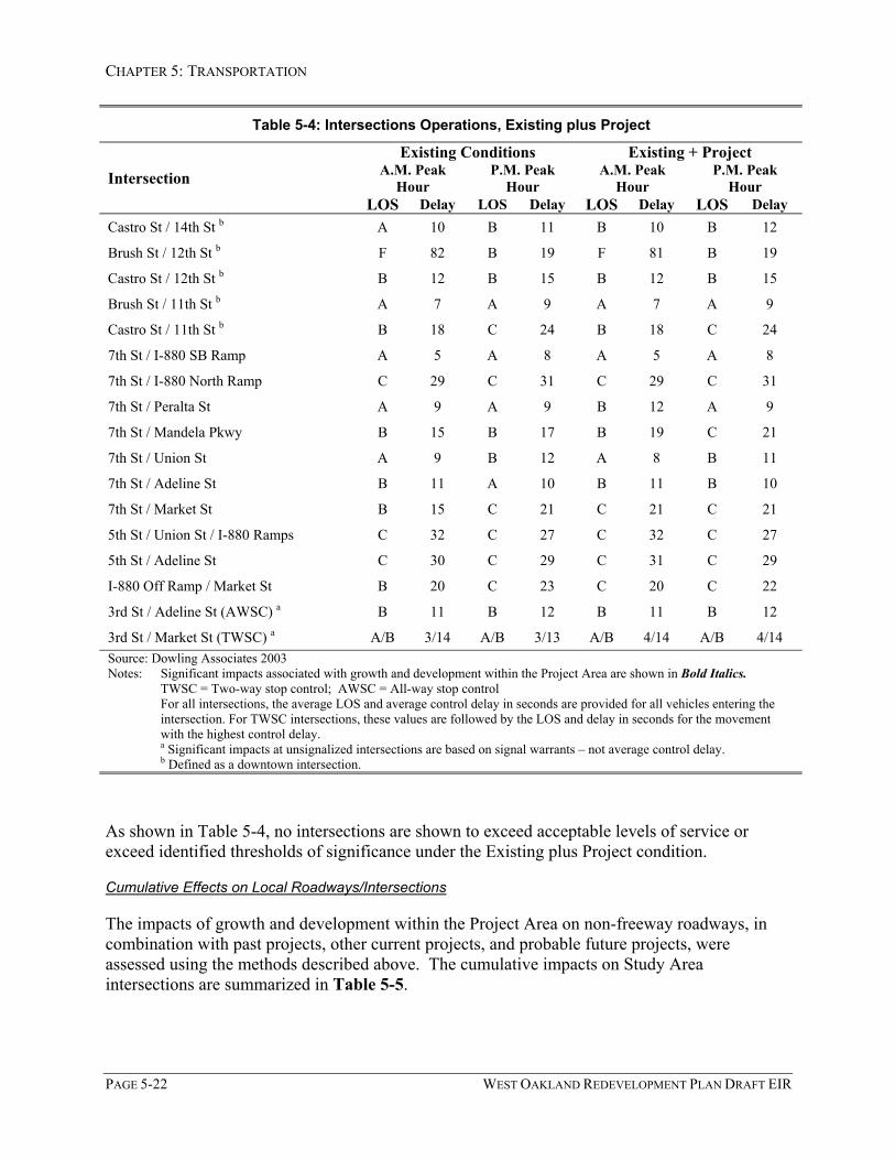
CHAPTER 5: TRANSPORTATION
PAGE 5-22 WEST OAKLAND REDEVELOPMENT PLAN DRAFT EIR
Table 5-4: Intersections Operations, Existing plus Project
Existing Conditions Existing + ProjectA.M. Peak
HourP.M. Peak
HourA.M. Peak
HourP.M. Peak
HourIntersectionLOS Delay LOS Delay LOS Delay LOS Delay
Castro St / 14th St b A 10 B 11 B 10 B 12
Brush St / 12th St b F 82 B 19 F 81 B 19
Castro St / 12th St b B 12 B 15 B 12 B 15
Brush St / 11th St b A 7 A 9 A 7 A 9
Castro St / 11th St b B 18 C 24 B 18 C 24
7th St / I-880 SB Ramp A 5 A 8 A 5 A 8
7th St / I-880 North Ramp C 29 C 31 C 29 C 31
7th St / Peralta St A 9 A 9 B 12 A 9
7th St / Mandela Pkwy B 15 B 17 B 19 C 21
7th St / Union St A 9 B 12 A 8 B 11
7th St / Adeline St B 11 A 10 B 11 B 10
7th St / Market St B 15 C 21 C 21 C 21
5th St / Union St / I-880 Ramps C 32 C 27 C 32 C 27
5th St / Adeline St C 30 C 29 C 31 C 29
I-880 Off Ramp / Market St B 20 C 23 C 20 C 22
3rd St / Adeline St (AWSC) a B 11 B 12 B 11 B 12
3rd St / Market St (TWSC) a A/B 3/14 A/B 3/13 A/B 4/14 A/B 4/14Source: Dowling Associates 2003Notes: Significant impacts associated with growth and development within the Project Area are shown in Bold Italics.
TWSC = Two-way stop control; AWSC = All-way stop controlFor all intersections, the average LOS and average control delay in seconds are provided for all vehicles entering theintersection. For TWSC intersections, these values are followed by the LOS and delay in seconds for the movementwith the highest control delay.a Significant impacts at unsignalized intersections are based on signal warrants – not average control delay.b Defined as a downtown intersection.
As shown in Table 5-4, no intersections are shown to exceed acceptable levels of service orexceed identified thresholds of significance under the Existing plus Project condition.
Cumulative Effects on Local Roadways/Intersections
The impacts of growth and development within the Project Area on non-freeway roadways, incombination with past projects, other current projects, and probable future projects, wereassessed using the methods described above. The cumulative impacts on Study Areaintersections are summarized in Table 5-5.

CHAPTER 5: TRANSPORTATION
WEST OAKLAND REDEVELOPMENT PLAN DRAFT EIR PAGE 5-23
Table 5-5: Intersections Operations for Cumulative Conditions
Cumulative Basecase -Without Project Cumulative, with Project
A.M. PeakHour
P.M. PeakHour
A.M. PeakHour
P.M. PeakHour
Intersection
LOS Delay LOS Delay LOS Delay LOS DelayHollis St / 40th St C 29 C 31 C 29 C 31
San Pablo Av / 40th St F 107 D 52 F 111 E 57
Hollis St / Mandela Extension (TWSC) a A/C 3/15 A/D 6/31 A/C 3/16 A/E 6/36
San Pablo Av / Adeline C 31 D 30 C 31 D 55
W. MacArthur Blvd / Market St B 16 B 19 B 17 C 20
Market St / 36th St / I-580 Ramp B 15 B 17 B 15 B 17
Market St / 35th St / I-580 Ramp B 16 B 18 B 16 B 18
Market St / San Pablo Av A 8 A 9 A 8 A 9
Hollis St / Peralta St B 15 B 17 B 14 B 17
Mandela Pkwy / 32nd St (AWSC) a A/B 8/11 A/C 9/24 A/C 8/15 A/C 9/28
Peralta St / 26th St (TWSC) a B 2 C 3 B 3 D 4
Market St / 26th St B 14 B 15 B 16 B 16
San Pablo Av / 27th St A 8 D 37 C 23 D 51
27th / SR 24-580 Off Ramp B 14 B 16 B 15 B 17
27th / SR 24-580 On Ramp B 11 C 23 B 12 C 27
W Grand Av / Maritime St F 255 F 253 F 253 F 260
W Grand Av / Frontage Rd F 87 F 160 F 91 F 161
W Grand Av / Mandela Pkwy B 15 B 19 C 28 C 30
W Grand Av / Adeline St B 15 B 16 B 16 B 17
W Grand Av / Market St B 11 B 11 B 11 B 11
W Grand Av / San Pablo Av B 13 B 13 B 13 B 14
W. Grand Av / MLK Jr Way b B 15 B 17 B 15 B 17
W. Grand Av / Northgate Av b C 25 C 25 C 25 C 26
Brush St / 18th St b B 13 B 18 B 13 B 18
Castro St / 18th St b B 15 B 19 B 15 B 19
Brush St / 17th St b B 11 B 15 B 12 B 16
Castro St / 17th St b C 26 C 31 C 26 C 32
14th St / Mandela Pkwy A 9 A 8 A 9 A 9
Adeline St / 14th St B 15 B 16 B 16 B 16
Market St / 14th St B 15 B 15 B 15 B 15
Brush St / 14th St b B 17 B 15 B 17 B 15
Castro St / 14th St b B 11 B 12 B 11 B 12

CHAPTER 5: TRANSPORTATION
PAGE 5-24 WEST OAKLAND REDEVELOPMENT PLAN DRAFT EIR
Table 5-5: Intersections Operations for Cumulative Conditions
Cumulative Basecase -Without Project Cumulative, with Project
A.M. PeakHour
P.M. PeakHour
A.M. PeakHour
P.M. PeakHour
Intersection
LOS Delay LOS Delay LOS Delay LOS DelayBrush St / 12th St b F 137 C 22 F 136 C 22
Castro St / 12th St b B 12 B 16 B 13 B 17
Brush St / 11th St b A 8 A 9 A 8 A 10
Castro St / 11th St b B 19 C 26 B 19 C 26
7th St / I-880 SB Ramp A 4 B 11 A 4 B 11
7th St / I-880 North Ramp F 83 D 40 F 83 D 41
7th St / Peralta St A 9 A 8 B 12 A 8
7th St / Mandela Pkwy B 14 B 15 B 18 C 21
7th St / Union St A 8 B 12 A 8 B 12
7th St / Adeline St B 12 B 10 B 12 B 11
7th St / Market St C 23 C 22 C 32 C 23
5th St / Union St / I-880 Ramps C 32 C 30 C 32 C 31
5th St / Adeline St D 54 C 35 D 54 C 35
I-880 Off Ramp / Market St C 22 C 20 C 22 C 20
3rd St / Adeline St (AWSC) a E 42 C 22 E 42 C 22
3rd St / Market St (TWSC) a B/E 13/46 F/F 56/207 B/F 14/51 F/F 63/234Source: Dowling Associates 2003Notes: Significant impacts associated with growth and development within the Project Area are shown in Bold Italics.
TWSC = Two-way stop control; AWSC = All-way stop controlFor all intersections, the average LOS and average control delay in seconds are provided for all vehicles entering theintersection. For TWSC intersections, these values are followed by the LOS and delay in seconds for the movementwith the highest control delay.a Significant impacts at unsignalized intersections are based on signal warrants – not average control delay.b Defined as a downtown intersection.
As indicated in Table 5-5, the Project, in combination with past projects, other current projects,and probable future projects, would:
• cause the level of service to degrade to worse than LOS D at signalized intersectionslocated outside the Downtown area,
• cause an increase in the average delay for a critical movement of six (6) seconds or more,at a signalized intersection where the existing or future baseline level of service is LOS E,
• cause total intersection average vehicle delay to increase by more than two seconds at asignalized intersection where the future baseline level of service would be LOS F, and
CHAPTER 5: TRANSPORTATION
WEST OAKLAND REDEVELOPMENT PLAN DRAFT EIR PAGE 5-25
• cause an increase in average delay for a critical movement of four (4) seconds or more ata signalized intersection where the future baseline level of service would be LOS F.
One non-signalized intersection is shown to exceed identified thresholds of significance underthe cumulative condition. Non-signalized intersections are more fully discussed below underSection 5.4.3.
The contribution of cumulative traffic to the intersections listed above in Table 5-5 would resultin cumulatively significant impacts. The incremental effect associated with implementation ofthe Redevelopment Plan in assisting or facilitating growth and development within the ProjectArea would have a cumulatively considerable contribution to some of the cumulative impacts.The specific impact associated with growth and development within the Project Area atsignalized intersections within the Study Area is at the following location:
• San Pablo Avenue & 40th Street, where the intersection would operate at LOS F under thecumulative basecase condition, and traffic generated from within the Project Area wouldincrease the total intersection average delay by 4 seconds during the a.m. peak hour; andwhere traffic generated from within the Project Area would cause the level of service todegrade from LOS D to LOS E during the p.m. peak hour.
The Project, in combination with past projects, other current projects, and probable futureprojects, would result in cumulatively significant impacts at two other signalized intersections.However, the Project’s contribution of traffic to these intersections is less than cumulativelyconsiderable. The signalized intersections where cumulatively significant impacts would occur,but where the Project’s contribution is less than cumulatively considerable, include:
• W. Grand Avenue & Maritime Street, where the intersection would operate at LOS F underthe cumulative basecase condition, and traffic generated from within the Project Area wouldincrease the total intersection average delay by 7 seconds during the p.m. peak hour. TheProject would contribute less than two (2) percent of the cumulative traffic increase asmeasured by the difference between existing and cumulative (with project) conditions.
• W. Grand Avenue & Frontage Road along I-880, where the intersection would operate atLOS F under the cumulative basecase condition, and traffic generated from within the ProjectArea would cause an increase in average delay of four (4) seconds or more for criticalmovements at the intersection. The Project would contribute less than five (5) percent of thecumulative traffic increase as measured by the difference between existing and cumulative(with Project) conditions.
Mitigation Measures
No feasible mitigation measures are identified for the San Pablo Avenue & 40th Streetintersection. Mitigation measures were investigated that could reduce cumulative impacts to alevel that is less than significant. These measures include:

CHAPTER 5: TRANSPORTATION
PAGE 5-26 WEST OAKLAND REDEVELOPMENT PLAN DRAFT EIR
• Widening of 40th Street on the northerly side, re-designating the bike lane to a Class IIIfacility and re-striping the eastbound lanes to provide a right turn lane onto southbound SanPablo Avenue, and
• modifying the traffic signal to provide split signal phasing for San Pablo Avenue trafficmovements, and increasing the signal cycle length to 110 seconds.
These improvements would mitigate this cumulative impact. However, the widening of 40th
Street would require the acquisition of substantial property along the street, potentially resultingin the need to acquire existing businesses. The secondary impacts of major street widening areconsidered to render that option infeasible. Additionally, because this intersection is locatedwithin the City of Emeryville, the City of Oakland does not have the authority to implementthese mitigation measures.
Resulting Level of Significance
No feasible mitigation measures have been identified that would reduce cumulative impacts atthe San Pablo Avenue and 40th Street intersection to a level that is less than significant.Therefore, residual cumulative impacts at that intersection would be significant and unavoidable,and the Project’s contribution of traffic to this intersection would be cumulative considerableand unavoidable.
The Oakland Army Base Area Redevelopment Plan Draft EIR (City of Oakland 2002) identifiedapplicable mitigation measures for the West Grand Avenue/Maritime Street and West GrandAvenue/Frontage Road intersection along I-880 intersections. The effects of these mitigationmeasures are shown in Table 5-6. Since the incremental effect associated with traffic generatedby growth and development within the Project Area would have a less than cumulativelyconsiderable contribution to these intersections, the mitigation improvements identified in thisprevious EIR would not be applicable to projects within the Redevelopment Plan.
Table 5-6: Intersections Operations for Cumulative and Mitigated Conditions
Without Mitigation With MitigationA.M. Peak
HourP.M. Peak
HourA.M. Peak
HourP.M. Peak
HourIntersection
LOS Delay LOS Delay LOS Delay LOS DelaySan Pablo Av / 40th St F 111 E 57 F 111 E 57
W Grand Av / Maritime St F 253 F 260 D 42 F 89
W Grand Av / Frontage Rd F 91 F 161 D 48 D 53
3rd St / Market St (AWSC mitigated) B/F 14/51 F/F 63/234 B 9 C 18Source: Dowling Associates 2003Notes: Significant impacts associated with growth and development within the Project Area are shown in Bold Italics.
TWSC = Two-way stop control; AWSC = All-way stop controlFor all intersections, the average LOS and average control delay in seconds are provided for all vehicles entering theintersection. For TWSC intersections, these values are followed by the LOS and delay in seconds for the movementwith the highest control delay.

CHAPTER 5: TRANSPORTATION
WEST OAKLAND REDEVELOPMENT PLAN DRAFT EIR PAGE 5-27
5.4.3: Addition of Traffic to Unsignalized Intersections
New growth and development within the Project Area would add traffic to Study Areaintersections. However, the amount of traffic added would be small, and would not result in asignificant impact at any unsignalized intersections within the Study Area. This impact isconsidered to be less than significant.
Cumulative Impact 5.4.3: Traffic generated by new growth and development within the ProjectArea, in combination with traffic from past projects, other current projects, and probable futureprojects, would cause the intersection at 3rd and Market Streets to operate at unacceptable levelsof service. At this intersection, Caltrans’ peak hour volume traffic signal warrants would besatisfied. Growth and development within the Project Area, as may be assisted byimplementation of the Redevelopment Plan, would add more than ten vehicles to thisintersection. This contribution of traffic would be a cumulatively considerable contribution tothis cumulatively significant traffic impact.
Discussion
Cumulative Effects
New growth and development within the Project Area would add more than ten vehicles to the3rd Street & Market Street intersection where the Caltrans peak hour volume traffic signalwarrants would be satisfied. The contribution of traffic from the Project Area to impacts at the3rd Street & Market Street intersection would be cumulatively considerable and the incrementaleffect of the Project is considered significant.
Cumulative traffic conditions at the 3rd Street & Adeline Street intersection would satisfy theCaltrans peak hour volume traffic signal warrant; however, new growth and development withinthe Project Area would add fewer than ten vehicles to the intersection. The contribution of trafficfrom the Project Area to impacts at the 3rd Street & Adeline Street intersection would not becumulatively considerable and the incremental effect of the Project is considered less thansignificant.
Mitigation Measures
The following mitigation measure is recommended to address the contribution of traffic resultingfrom implementation of the Redevelopment Plans’ projects, programs and other activities towardcumulative traffic impacts:
• Mitigation Measure 5.4.2: Convert the two-way-stop-control to all-way-stop-control at the 3rdStreet & Market Street intersection. Individual development projects pursuant toimplementation of the Redevelopment Plan’s programs or other activities within theProject Area shall fund a pro-rata fair share of the cost to convert the two-way-stop-control intersection to all-way-stop-control at the 3rd Street & Market Street intersection.Alternatively, at the Redevelopment Agency’s sole discretion, redevelopment funds

CHAPTER 5: TRANSPORTATION
PAGE 5-28 WEST OAKLAND REDEVELOPMENT PLAN DRAFT EIR
could potentially be used to subsidize these fair-share funding contributions or toimplement this improvement.
Resulting Level of Significance
Converting the two-way-stop-control to all-way-stop-control at the 3rd Street & Market Streetintersection would mitigate the impact to a level of less than significant. The intersection wouldoperate at LOS C or better during the a.m. and p.m. peak hours after converting the two-way-stop-control to all-way-stop-control.
An alternative improvement at this intersection would be the installation of a traffic signal,which would also fully mitigate cumulative traffic impacts at this intersection. However,according to the Caltrans Traffic Manual, a signal should not be installed if lesser measures willprovide acceptable traffic operations.
Coordination of Improvements with the Oakland Army Base Area Redevelopment Project
The Oakland Army Base (OARB) Area Redevelopment Project, an area of approximately 1,800acres in West Oakland, included a required mitigation for the 3rd Street / Market Streetintersection. That improvement included installation of an all-way stop control and revising thewestbound 3rd Street lanes to provide one combined through-left turn lane and one right-turnlane. This mitigation measure from the Oakland Army Base Redevelopment Project EIR is thesame measure as recommended above. Prior to implementation of this mitigation measure, theCity should coordinate mitigation responsibilities for this improvement among all contributingparties.
5.4.4 Increase in AC Transit Ridership
New growth and development within the Project Area would increase average ridership on ACTransit by approximately 0.5 percent, which is considered a less than significant increase.
Cumulative Impact 5.4.4: New growth and development within the Project Area, in combinationwith past projects, other current projects, and probable future projects, would be likely toincrease average ridership on AC Transit by more than 3 percent. This is a significantcumulative effect. It is possible that the contribution of AC Transit riders from within theProject Area to cumulative ridership on AC Transit would be cumulatively considerable.
Discussion
Project Specific Impact
The impacts of the Project on the existing AC transit bus system were assessed based on themodal split assumptions derived from the Countywide Model, and the conservative assumptionthat all Project-related home-based work trips would occur during the peak two-hour period. Inreality, home-based work trips are spread over three to four hours. Based on these conservativeassumptions, the Project has the potential to generate between 389 to 415 new AC transit bustrips in 2005 and 2025 respectively, during the PM peak two-hour period. These trips are for

CHAPTER 5: TRANSPORTATION
WEST OAKLAND REDEVELOPMENT PLAN DRAFT EIR PAGE 5-29
both inbound and outbound directions (See Appendix D, Table 4). These additional passengersrepresent and increase of 0.5 percent that is directly attributable to the Project. Based on recentsurvey conducted by AC Transit, one or two buses on some lines are approaching or currentlyexceed the maximum load factor of 1.25 (this mainly applies in downtown Oakland). However,most existing buses during the peak hour have sufficient capacity to accommodate this increasein bus trips. Therefore, the increase in average ridership on AC Transit lines attributed to newgrowth and development within the Project Area, as may be facilitated by implementation of theRedevelopment Plan, would be less than 3 percent. This impact on AC Transit operations isconsidered to be less than significant.
Cumulative Effects
New growth and development within the Project Area, in combination with past projects, othercurrent projects, and probable future projects, would be likely to increase average ridership onAC Transit by more than 3 percent (see detailed analysis in Appendix D, Table 4). This would bea cumulatively significant impact. The precise location of new growth and development withinthe Project Area is not well defined. Growth and development within the Project Area mayincrease average ridership on AC Transit lines by three percent where the average load factorunder cumulative conditions would exceed 125 percent over a peak thirty-minute period. Thus,it is possible that the contribution of AC Transit riders from within the Project Area would becumulatively considerable.
Mitigation Measures
None required for project-specific effects. The following mitigation measure is intended toaddress the Project’s contribution to cumulative impacts on the AC Transit system.
• Mitigation Measure 5.4.4 Coordination with AC Transit. The City of Oakland shall coordinatewith AC Transit to ensure that the average load factor on any specific AC Transit linedoes not exceed 125 percent over a peak thirty-minute period. At the RedevelopmentAgency’s sole discretion, redevelopment financing capabilities could potentially be usedto assist AC Transit in meeting this operational threshold.
Resulting Level of Significance
AC Transit is currently working on an impact study for bus routes within the Project Area, andwill likely conduct environmental review for any proposed changes along these routes.Redevelopment Agency coordination with AC Transit pursuant to implementation of MitigationMeasure 5.4 above would offset the contribution of AC Transit riders due to implementation ofthe Redevelopment Plan to a level that is less than cumulatively considerable.

CHAPTER 5: TRANSPORTATION
PAGE 5-30 WEST OAKLAND REDEVELOPMENT PLAN DRAFT EIR
5.4.5 Increase in BART Ridership
The impact of the Project on BART operations is considered to be less than significant.
Cumulative Impact 5.4.5: New growth and development within the Project Area, in combinationwith other past projects, current projects and probable future projects, would likely result incumulatively significant impacts on BART service at fare gates. The contribution of peak hourriders on BART trains due to new growth and development within the Project Area would becumulatively considerable.
Discussion
Project-Specific Effects
Based on the modal split assumptions derived from the Countywide Model, new growth anddevelopment within the Project Area would increase peak-hour ridership on BART trains byapproximately 280 riders at the West Oakland BART station and 65 riders at the MacArthurBART station. These increases in peak-hour ridership would be less than 3 percent of the totalridership on BART trains.
New growth and development within the Project Area would increase average daily ridership byapproximately 9 percent at the West Oakland BART station, and approximately 1 percent at theMacArthur BART station. However, the average waiting time at fare gates at the West OaklandBART station is less than one minute, therefore the increase in ridership there, as well as at theMacArthur BART station, is a less than significant impact. The average ridership increases atother BART stations would be less than 3 percent.
All five BART lines serve the West Oakland Redevelopment Project Area station. Each line hasan average of frequency of 15 minutes during the peak hour, except for the Pittsburg/Bay Pointto Colma line, which has 7.5-minute headways. This represents a total of 96 trains at the WestOakland BART station within a two-hour period. Based on this model, estimates for newProject-related transit trips, assuming all Project-related transit trips occur during the peak-twohour period averages to approximately 7 passengers per train. Based on the total seating capacityof a BART train, this equates to an increase of approximately 1.0- percent of the total capacity.Based on this analysis, the increase in passengers due to the Project in both 2005 and 2025 wouldnot cause significant impacts on BART parking, fare gates, platforms or trains, and can beaccommodated with planned BART service.
Cumulative Effects
New growth and development within the Project Area, in combination with past projects, othercurrent projects, and probable future projects, could increase the peak hour average ridership onBART trains. This cumulative increase in ridership is projected to be approximately 3 percentwhere the passenger volume would also exceed the standing capacity of BART trains (seedetailed analysis in Appendix D, Table 5). This would be a significant cumulative effect.However, since the contribution of BART riders from within the Project Area would be less than3 %, this would be a less than cumulatively considerable effect.

CHAPTER 5: TRANSPORTATION
WEST OAKLAND REDEVELOPMENT PLAN DRAFT EIR PAGE 5-31
New growth and development within the Project Area, in combination with past projects, othercurrent projects, and probable future projects, would increase the peak hour average ridership atthe West Oakland station by more than 3 percent. Under these cumulative conditions theaverage waiting time at fare gates could exceed one minute. New growth and developmentwithin the Project Area could contribute a cumulatively considerable amount of new riders atthese stations should these waiting times exceed one minute.
Mitigation Measures
None required for Project-specific effects. The following mitigation measure is recommended toaddress the Project’s potential contribution to cumulative impacts at BART stations.
• Mitigation Measure 5.4.5: Coordination with BART. The City of Oakland shall coordinate withBART to ensure that adequate fare gate capacity is available at the West Oakland andMacArthur BART stations to accommodate anticipated increases in ridership associatedwith projected growth and development within the Project Area. To the extent thatadequate capacity may be reliant on the addition of one or more new fare gates at thestation, the Redevelopment Agency, at its sole discretion, may consider utilizingredevelopment financing capabilities to assist in the financing of such stationimprovements.
Resulting Level of Significance
Redevelopment Agency participation in the implementation of Mitigation Measure 5.4.5 abovewould offset the contribution of BART riders at BART stations due to implementation of theRedevelopment Plan to a level that is less than cumulatively considerable.
5.4.6 Traffic and Circulation Safety
New growth and development within the Project Area could result in traffic hazards to motorvehicles, bicycles, or pedestrians due to inadequate design features or incompatible uses.However, compliance with City standards should prevent the creation of hazards to motorvehicles, bicycles, or pedestrians due to inadequate design features or an incompatible use tolevels of less than significant.
Discussion
Project-Specific Traffic Safety Issues
The Project Area will include a variety of uses and transportation modes ranging from bicyclistsand pedestrians accessing area schools and other public spaces, commuter vehicles traveling toand from employment centers within the Project Area, and commercial vehicles (trucks).Occurrence of safety hazards related to design features or incompatible uses depends on site-specific design not currently defined. However, all new development projects pursuant toimplementation of the Redevelopment Plan will be required to comply with City designstandards. Compliance with City standards would prevent the creation of hazards to motor

CHAPTER 5: TRANSPORTATION
PAGE 5-32 WEST OAKLAND REDEVELOPMENT PLAN DRAFT EIR
vehicles, bicycles, or pedestrians due to inadequate design features or an incompatible use to alevel of less than significant.
Existing Truck Traffic Safety Issues
Traffic in and near the Project Area consists of two primary components: passenger car trafficand heavy trucks primarily associated with Port of Oakland operations. Heavy trucks have asubstantially greater proportional influence on traffic operations than passenger cars, and resultin additional safety and land use compatibility issues.
The OARB EIR indicates that the Port of Oakland operations are projected to result in thegeneration of approximately 24,770 daily truck trips by year 2020. This projection is based onthe Port of Oakland ability to reach the Seaport Plan’s 2020 cargo throughput goals and bymaximizing transport by train rather than by truck. These truck trips include current operationsand approved operations associated with the Port of Oakland’s Vision 2000 Program and theOakland Army Base Area Redevelopment Project. Of this total, over half (or approximately13,000) would be intermodal trips that would not leave the Port area. The remainingapproximately 11,760 trips are considered over-the-road truck trips (City of Oakland 2002,Technical Appendix 4.3b). Based on the distribution of truck traffic derived from a Port ofOakland survey (Port of Oakland 1993), approximately 10% of these over-the-road trips (or1,180 daily trucks) will use West Grand Avenue east of I-880; 3% (or approximately 350 dailytrucks) will use 7th Street; and approximately 2% (or 230 daily trucks) will use MacArthurBoulevard, all within the West Oakland Project Area. (OARB EIR, City of Oakland 2002, Table4.3-7). Port-related truck traffic generally peaks between 11:00 a.m. and 12:00 noon.6
To the extent that implementation of the West Oakland Redevelopment Plan assists in thedevelopment of new land uses along these truck traffic routes, such new development couldcontribute to the exacerbation of existing traffic safety and land use compatibility issues.
Existing Trucking Prohibitions
The City of Oakland has designated certain streets within the Project Area as truck routes andcontainer routes. Fully loaded containers on specialized chassis, with axle weights higher thantypically allowed on other public streets, are allowed to operate with special permits alongcontainer routes. The City of Oakland has also developed a plan for truck prohibitions in WestOakland, as shown on Figure 5-3. Under a 1993 Memorandum of Understanding between theCity of Oakland and the Port of Oakland, the City is responsible for enforcement of traffic lawsin the vicinity of the Port, including truck route compliance and parking restrictions. The Portfunds two police officer positions to enforce these laws in the West Oakland neighborhoods.
6 Vehicle classification counts were conducted at three locations within the OARB in 2000 to determine therelative number of passenger cars and trucks in the Port area. These counts were conducted at Maritime Streetsouth of West Grand Avenue, 7th Street west of I-880; and Middle Harbor Road south of 3rd Street. Theselocations show traffic conditions, respectively, at the northern, central, and southern areas of the Port. Thenumbers of trucks shown in the OARB EIR at these locations (Figure 4.3.4) is substantially higher than the truckvolumes indicated by the distribution numbers. This is because the majority of counted trucks exit off of localstreets and onto the freeway system at the nearest freeway on-ramp.

CHAPTER 5: TRANSPORTATION
WEST OAKLAND REDEVELOPMENT PLAN DRAFT EIR PAGE 5-33
Figure 5-3

CHAPTER 5: TRANSPORTATION
PAGE 5-34 WEST OAKLAND REDEVELOPMENT PLAN DRAFT EIR
Benefits of Redevelopment
The OARB EIR includes the following mitigation measure intended to reduce the effects oftransport trucks on local streets:
Mitigation Measure 4.3-7: The City and the Port shall continue to work together and shall createa truck management plan designed to reduce the effects of transport trucks on local streets. TheCity and Port shall fund on a fair share basis implementation of this plan. Elements that may beincluded in this plan include:
- Further analysis of truck traffic in West Oakland;
- Traffic calming strategies on streets not designated as truck routes to discourage truckthrough travel;
- Truck driver education programs;
- Expanded signage, including truck prohibitions on streets not designated as truck routes;
- Traffic signal timing improvements;
- Exploring the feasibility of truck access to Frontage Road;
- Roadway and terminal gate design elements to prevent truck queues from impeding the flowof traffic on public streets; and
- Continued Port finding of two police officers to enforce prohibitions on local streets. (OARBEIR, City of Oakland, page 4.3-42).
California Redevelopment Law enables redevelopment agencies to allocate funds toward publicinfrastructure improvements that can encourage further investments in neighborhoods and whichmake them more desirable places to live. Such infrastructure improvements may includetransportation and circulation system improvements intended to enhance public safety, such asthose identified in the previously identified mitigation measure. At the RedevelopmentAgency’s discretion, redevelopment funds could be allocated toward implementation of thesecirculation safety improvements.

CHAPTER 5: TRANSPORTATION
WEST OAKLAND REDEVELOPMENT PLAN DRAFT EIR PAGE 5-35
5.4.7 Potential Parking Shortages
New growth and development within the Project Area pursuant to implementation of theRedevelopment Plan could result in an inadequate parking supply within the Project Area.Compliance with City parking code requirements would prevent the creation of new parkingshortages, so this impact is considered less than significant.
Cumulative Impact 5.4.7: Truck Parking. Redevelopment, in combination with past, other current,and probable future projects (including the Port of Oakland’s Vision 2000 Program and theOakland Army Base Area Redevelopment Project) could result in a cumulatively inadequatesupply of parking for trucks serving the Port of Oakland.
Discussion
Project Impacts Related to Parking
Parking demand related to development within the Project Area that may be assisted by, orfacilitated by implementation of the Redevelopment Plan would depend on site-specific designissues not currently defined. However, the Redevelopment Plan is to be consistent with the CityGeneral Plan and the General Plan’s implementing ordinances. Therefore, new development thatmay occur in furtherance of the Redevelopment Plan will be required to comply with City Coderequirements, including parking requirements as found in the City’s parking ordinance.Compliance with these ordinance requirements would ensure that this impact would be less thansignificant.
Existing West Oakland BART Station Parking
The West Oakland BART station currently provides 419 vehicle parking spaces in the surfaceparking lot. Generally, all available BART parking spaces are filled by approximately 6:00 a.m.Caltrans operates a park-and-ride lot on 7th Street between Union, Chestnut and 8th Streets. Thislot is usually fully occupied during the week. Additionally, private off-street parking lotsoperated in the vicinity are similarly fully utilized during the weekdays (City of Oakland, 1998).Because the existing demand for parking at the West Oakland BART station exceeds theavailable supply, parking problems are encountered in the vicinity. In order to discourage non-residential long-term on-street parking, the City has implemented a Residential Permit parkingProgram that limits on-street parking to 2 to 4 hours for vehicles without a permit. This programwas implemented between Mandela Parkway and Peralta Street primarily to discourage overflowparking from the West Oakland BART station.
Potential Benefits of Redevelopment
The Redevelopment Plan is intended as an implementation tool of the City of Oakland GeneralPlan, including the LUTE. The LUTE includes identification of target areas and strategies thatare intended to “offer business support and public improvements toward establishment of aTransit Village near the BART station”. According to the West Oakland Transit Village ActionReport, preliminary ideas for this Transit Village related to physical parking improvementsinclude:

CHAPTER 5: TRANSPORTATION
PAGE 5-36 WEST OAKLAND REDEVELOPMENT PLAN DRAFT EIR
• Construction of a 4 to 5 level public parking structure that could accommodate up to1,400 to 1,600 parking spaces,
• Development of mixed used housing/retail/office projects that also include publicparking as part of the mix,
• Development of satellite parking facilities with shuttle service to the BART station,
• And metered on street parking along 7th Street.
California Redevelopment Law enables redevelopment agencies to allocate funds toward publicinfrastructure improvements, including the provision of additional parking opportunities.Redevelopment funds could be allocated toward implementation of these identified parkingimprovements.
Cumulative Truck Parking Shortages
In an effort to address land use compatibility issues in West Oakland, the City approved a TruckRegulation Ordinance in 2000.7 This ordinance establishes special regulations applying to truck-related activities in West Oakland, and requires a conditional use permit for the expansion of anytruck or truck-related use, including truck parking. The limits on the expansion of truck andtruck-related activity refer to both building/facility expansion, and expansion of truck activityfrom an existing facility (i.e. as increases in the number of truck trips without expansion of thebuilding facilities). The Redevelopment Plan is intended to assist in implementation of theGeneral Plan and its supporting ordinances, including these truck regulations. It is likely thatimplementation of this ordinance, as may be assisted by the Redevelopment Plan’s projects,programs or other activities, will limit the expansion of industrial uses with truck-related activityin West Oakland in the future. This is regarded as a beneficial land use effect of the Project (seediscussion in Chapter 4: Land Use).
However, limitations on the expansion of truck-related activity (including truck-parking supply)will contribute to a cumulative deficit in truck parking and support services projected to benecessary to serve the demand for such uses as generated by the Port of Oakland. This issue hasbeen studied extensively by the Port of Oakland and the City of Oakland, and many of theconclusions from these studies are included in the Oakland Army Base Area RedevelopmentProject EIR (City of Oakland 2002). The conclusions from this EIR, which is herebyincorporated by reference, are summarized below.
The Port of Oakland commissioned a study (Tioga Group 2001) to explore ways toaccommodate truck services that must be located near the Port, while assuring that the adjacentcommunities are relieved of unnecessary truck traffic. The study used forecasts of cargosegment growth, typical facility designs, industry standards, and working assumptions toestimate the usable acres required for efficient, single-purpose, core service facilities. This studyconcluded that a total of approximately 178 acres of core Port-related services will be necessary
7 Title 17.102.380 et.seq. of the Oakland Zoning Code
CHAPTER 5: TRANSPORTATION
WEST OAKLAND REDEVELOPMENT PLAN DRAFT EIR PAGE 5-37
by year 2020, including approximately 46 acres of truck parking/services, approximately 47acres of working reefer depots, and 85 acres of heavy cargo facilities (Tioga Group 2001).
According to the Oakland Army Base Area Reuse Plan (City of Oakland 2002), a total of 105acres within that Redevelopment Project are to be dedicated to “ancillary maritime uses”. Theterm “ancillary maritime use” includes those types of truck-dependent uses that are necessary tosupport maritime Port operations, such as truck parking area. The 105 acres of ancillarymaritime support use within the Oakland Army Base (OARB) Redevelopment Project Area, incombination with other efforts by the Port to provide satellite trucking facilities at strategiclocations, could accommodate much but not all demand for such uses under efficient operatingconditions. Additional interim space within the Port of Oakland’s overall area will likely beavailable during terminal development at the Port. However, starting in about year 2010, therewill be a shortfall or “gap” in available land supply for these uses. Not all Port-related ancillarymaritime support services can be accommodated within the Port’s maritime area and/or theOakland Army Base Redevelopment Project Area, and some of these necessary uses will have tobe located at suitable sites elsewhere (OARB EIR, City of Oakland 2002). The City and the Portof Oakland, the Bay Conservation and Development Commission (BCDC) and trucking industryrepresentatives have agreed to continue to work with the trucking industry and the West Oaklandcommunity to resolve this issue (OARB EIR, City of Oakland 2002, page 5-15). Appropriatesolutions are needed to find the amount of land in locations near but outside the Port that are ableto serve trucking needs while minimizing the impact of Port-related trucking on the WestOakland community. Toward this end, the OARB EIR included the following mitigationmeasure.
Mitigation 5.3-7: The City and Port shall cooperatively develop a program that combines multiplestrategic objectives and implementation tools designed to reduce cumulative truck parking and otherancillary maritime support impacts. This program should consider strategies that may include, butshould not be limited to the following:
a) Pursue truck traffic mitigation steps, information strategies, and rail intermodal strategies.
b) Identify potential land swaps and utilize additional small parcels of land in the vicinity of thePort, especially for truck parking and support services.
c) Prioritize the use of harbor-area land for core services, maximizing the efficient use of harbor-area land and facilities, and reduce the impacts in adjacent neighborhoods.
d) Promote intensive land use (doing more with less) and extended terminal gate hours.
e) Actively encourage relocation of selected services to other Oakland, East Bay, or northernCalifornia (Hinterland Loop) locations.
f) Develop multi-user facilities in Oakland or in corridor locations (e.g., Richmond and SanLeandro) for both core and non-core services.
The OARB EIR found that implementation of this mitigation measure would take many years,and the success of the program cannot be ascertained. Therefore, this cumulative impact wasidentified as significant and unavoidable (OARB EIR, City of Oakland 2002, page 5-17). To theextent that the West Oakland Redevelopment Plan assists in implementation of limits on the

CHAPTER 5: TRANSPORTATION
PAGE 5-38 WEST OAKLAND REDEVELOPMENT PLAN DRAFT EIR
operation and/or expansion of truck and truck-related activity within the Project Area, suchrestrictions will further reduce the supply of land available for such uses, and contribute to thiscumulative effect.
Any mitigation measures that might be recommended for the Project Area that would result inexpansion of trucking operations and truck-related activities would be in conflict with the landuse compatibility strategies embodied in General Plan policy and supporting land use ordinances.These policies and ordinances include limitations on such uses that serve to improve land usecompatibility impacts within the Project Area, particularly where such uses are adjacent to orintermixed within residential neighborhoods. Therefore, no additional mitigation measures arerecommended, and this impact of a shortfall in truck parking and truck-related land use remainscumulatively significant and unavoidable.

WEST OAKLAND REDEVELOPMENT PLAN DRAFT EIR PAGE 6-1
66Air Quality
6.1 IntroductionThis chapter of the EIR describes existing air quality conditions within the West OaklandRedevelopment Project Area and regional vicinity. It also identifies potential impacts associatedwith projected growth and development within the Project Area as may be facilitated byimplementation of the Redevelopment Plan on existing air quality and recommends, wherenecessary and feasible, mitigation measures to reduce and or avoid potentially significant airquality impacts. Air quality issues discussed in this section of the EIR include:
• Consistency of the Project with the Clean Air Plan,
• Emission of regional air pollutants,
• Emission of local air pollutants, and
• Construction-related air quality impacts.
Significance thresholds for impacts on air quality would generally be reached if future growthand development within the Project Area, as may be facilitated by implementation of theRedevelopment Plan were to be inconsistent with the Clean Air Plan, or if air pollutants wouldbe emitted above levels established by the Bay Area Air Quality Management District(BAAQMD).
6.2 Environmental Setting6.2.1 Meteorology
Oakland is located in northern Alameda County, which lies within the San Francisco Bay AreaAir Basin. Temperatures in Oakland average 580F annually, ranging on the average from themid-40s on winter mornings to the mid-70s on summer afternoons. Daily and seasonalfluctuations in temperature are relatively minor because of the moderating effects of the nearbyocean. In contrast to the steady temperature regime, rainfall is highly variable and confinedalmost exclusively to the "rainy" period from early November to mid-April. Oakland averages18 inches of precipitation annually, but because much of the area's rainfall is derived from the

CHAPTER 6: AIR QUALITY
PAGE 6-2 WEST OAKLAND REDEVELOPMENT PLAN DRAFT EIR
fringes of mid-latitude storms, a shift in the annual storm track of a few hundred miles can meanthe difference between a very wet year and near-drought conditions (BAAQMD, 1996; CARB,1984).
In the Oakland area, the flow of marine air traveling through the Golden Gate, across SanFrancisco and through the San Bruno Gap is the dominant weather factor. Winds in the Oaklandarea are typically out of the west, west-northwest, and northwest (about 50% of the time). Allother wind directions occur no more than seven percent of the time, individually, and calmconditions occur during eight percent of annual observations. Annual average wind speeds areapproximately nine miles per hour (BAAQMD, 1996; CARB, 1984).
Air pollution potential in northern Alameda County is lowest close to the Bay, where the ProjectArea is located, due largely to two factors: good ventilation from winds that are frequently brisk,and a relatively low flux of pollutants from upwind areas. The occurrence of light winds in theearly morning and late evening occasionally causes elevated levels of pollutants (BAAQMD,1996).
6.2.2 Emissions and Ambient Air Quality
The BAAQMD estimates emissions of five criteria air pollutants: reactive organic gases (ROG,also known as ozone, O3), carbon monoxide (CO), particulate matter (PM10), nitrogen oxides(NOx), and sulfur dioxide (SO2) from seven use categories: residential, commercial, industrial,infrastructure, construction, transportation, and agricultural sources. Annual average emissionsare compiled for each county in the Bay Area Air Basin. PM2.5 is not included in this inventorybecause the federal PM2.5 standard was only recently upheld, and Bay Area-wide PM2.5emissions and monitoring data are not yet available. Inventory information presented in Table6-1 indicates that within the region, the BAAQMD expects total annual tons of CO, ROG, andNOx to decrease over time, and total annual tons of SO2 and PM10 to increase. As presented inTable 6-1, the District expects the percentage of Alameda County’s contribution to basin-wideemissions would remain approximately the same per pollutant, except the County’s relativecontribution to CO is expected to decrease slightly (BAAQMD, 1996).

CHAPTER 6: AIR QUALITY
WEST OAKLAND REDEVELOPMENT PLAN DRAFT EIR PAGE 6-3
Table 6-1: Bay Area Emission Inventory Summary and Projections, a 1995 To 2010
1995 2000 2010
PollutantBay Area(tons/day)
AlamedaCounty’s
SharebBay Area(tons/day)
AlamedaCounty’s
SharebBay Area(tons/day)
AlamedaCounty’s
Shareb
CO 2,425 22% 1,963 21% 1,600 21%
ROG/Ozone 535 22% 464 22% 406 22%
NOxc 454 20% 441 19% 449 20%
SO2 102 12% 107 11% 115 12%
PM10d 462 19% 501 19% 582 19%
Notes:a Data are estimates for 1995 and were taken from BAAQMD (1996) CEQA Guidelines.b Percent of Bay Area emissions attributable to Alameda County sources.c Average summer day emissions.d Average winter day emissions.SOURCE: BAAQMD (1999)
The BAAQMD operates a regional monitoring network which measures the ambientconcentrations of six criteria air pollutants: ROG (O3), CO, particulate matter (PM10 and PM2.5),nitrogen dioxide (NO2), sulfur dioxide (SO2), and lead (Pb). Existing and probable future levelsof air quality in Oakland can be generally inferred from ambient air quality measurementsconducted by the BAAQMD at its monitoring stations in downtown Oakland and San Leandro.Table 6-2 is a six-year summary of monitoring data (1996-2001) from the BAAQMD's AliceStreet station in Oakland and County Hospital in San Leandro. Data from the San Leandrostation are included because the Alice Street monitoring station does not monitor PM10concentrations. Final data for 2002 are not yet available. Table 6-2 compares measuredpollutant concentrations with state ambient air quality standards, which are more stringent thanthe corresponding federal standards.

CHAPTER 6: AIR QUALITY
PAGE 6-4 WEST OAKLAND REDEVELOPMENT PLAN DRAFT EIR
Table 6-2: Oakland Ambient Air Quality Monitoring Summary, 1996 – 2001
Number of Days Standards were Exceeded andMaximum Concentrations Measured
Monitoring Station & Pollutant Standarda 1996 1997 1998 1999 2000 2001
Downtown Oakland Data:
Ozone (ROG)
1-Hour >0.09 ppm 0 0 0 0 0 0
Max. 1-Hour Conc. (ppm)b 0.09 0.08 0.06 0.08 0.07 0.07
Carbon Monoxide
1-Hour >20. ppm 0 0 0 0 0 0
8-Hour >9. ppm 0 0 0 0 0 0
Max. 1-Hour Conc. (ppm) 7 8 6 6 5 5
Max. 8-Hour Conc. (ppm) 3.9 3.6 4.6 5.2 3.4 4.0
San Leandro Data:
Suspended Particulates (PM10)
Max. 24-hr. Conc. (µg/m3)b >50 µg/m3 59 65 32 - -d - -d - -d
Exceedances/Samplesc 1/61 1/61 0/30 - -d - -d - -d
Annual Geometric Mean(µg/m3)
30 µg/m3 19.1 15.9 - -d - -d - -d - -d
Notes: BAAQMD Monitoring Stations, Alice Street, in Oakland and County Hospital in San Leandro.Bold values are in excess of applicable standard. “NA” indicates that data is not available.
a State standard, not to be exceeded.b conc. = concentration; ppm = parts per million; �g/m3 = micrograms per cubic meterc Indicates the number of exceedances and the number of samples taken in a given year.d Monitoring discontinued in mid-1998 at San Leandro; Annual Geometric mean cannot be determined for 1998.
SOURCE: California Air Resources Board, 1996-2001, Internet Air Quality Data Summaries.
Recognizing that children can sometimes be more at risk than adults from the harmful effects ofair pollution, changes in state law established specific requirements to examine the impacts of airpollution on children’s health. Senate Bill 25 requires the California Air Resources Board(CARB) to expand its existing monitoring program in six communities around the state and toconduct special monitoring. Fruitvale was chosen as one of the six sites for the Children’sEnvironmental Health Protection Program because it is impacted by several categories ofpollutant emissions and because of the large school-age population in the area. In November2001, monitoring began at Lockwood Elementary School, which is located southeast of theProject Area at 6701 International Boulevard. In the initial phase of the study, monitoring isexpected to continue until November 2002. This site is collecting information on approximately70 air pollutants. Analysis of this data is not yet available and is not expected to be availableduring the timeframe for this EIR.

CHAPTER 6: AIR QUALITY
WEST OAKLAND REDEVELOPMENT PLAN DRAFT EIR PAGE 6-5
Ozone (O3)
O3 is a secondary air pollutant produced in the atmosphere through a complex series ofphotochemical reactions involving reactive organic gases (ROG), and nitrogen oxides (NOx).The main sources of NOx and ROG, often referred to as ozone precursors, are combustionprocesses (including motor vehicle engines) and the evaporation of solvents, paints and fuels.Automobiles are the single largest source of ozone precursors in the Bay Area. O3 is a regionalair pollutant because its precursors are transported and diffused by wind concurrently with O3production by the photochemical reaction process. O3 causes eye irritation, airway constriction,shortness of breath, and can aggravate existing respiratory diseases such as asthma, bronchitis,and emphysema (BAAQMD, 1999). Table 6-2 shows that exceedance of the state standard of0.09 parts per million (ppm) and the less stringent federal standard of 0.12 ppm for one hour hasnot been exceeded during the last six years, according to published data.
Carbon Monoxide (CO)
CO is an odorless, colorless gas usually formed as the result of incomplete combustion of fuels.The single largest source of CO is the motor vehicle, and highest during low travel speeds, stop-and-go driving, cold starts, and hard acceleration. Exposure to high concentrations of CO reducesthe oxygen-carrying capacity of the blood and can cause dizziness and fatigue, impair centralnervous system function, and induce angina in persons with serious heart disease (BAAQMD,1999). Table 6-2 also shows that no exceedances of state CO standards were recorded between1996 and 2001. Measurements of carbon monoxide (CO) show low baseline levels, with thehourly maximum averaging less than 40% of the allowable state standard. Similarly, maximumeight-hour CO levels average less than 60% of the allowable eight-hour standard.
Particulate Matter (PM10 and PM2.5)
Particulate matter is a class of air pollutants that consists of solid and liquid airborne particles inan extremely small size range. Particulate matter is measured in two size ranges: PM10 forparticles less than 10 microns in diameter and PM2.5, for even smaller particles which are lessthan 2.5 microns in diameter. Motor vehicles generate about half of Bay Area particulates,through tailpipe emissions as well as brake pad and tire wear. Wood burning in fireplaces andstoves, industrial facilities, and ground-disturbing activities such as construction are othersources of fine particulates. Fine particulates are small enough to be inhaled into the deepestparts of the human lung can cause adverse health effects. Among the criteria pollutants that theBAAQMD regulates, particulates appear to represent the most serious overall health hazard.Studies have shown that elevated particulate levels contribute to the death of approximately 200to 500 people per year in the Bay area. High levels of particulates have also been known toexacerbate chronic respiratory ailments, such as bronchitis and asthma, and have been associatedwith increased emergency room visits and hospital admissions (BAAQMD, 1996).
Table 6-2 also shows that exceedances of the state PM10 standard occur relatively infrequently inSan Leandro. State PM10 standards were exceeded on two measurements out of 152measurement days during 1996 to 1998 (PM10 is not monitored everyday). The BAAQMDdiscontinued monitoring PM10 concentrations in San Leandro in mid-1998. Federal PM10

CHAPTER 6: AIR QUALITY
PAGE 6-6 WEST OAKLAND REDEVELOPMENT PLAN DRAFT EIR
standards were not exceeded at the San Leandro monitoring station. PM10 concentrations inOakland would be expected to be similar to those measured in San Leandro.
In 1997, the U. S. Environmental Protection Agency adopted a new standard for PM2.5, whichrepresents the fine fraction of particulate matter; this standard was subject to legal challenge butwas upheld by the U.S. Supreme Court in February 2001. California has proposed a statestandard for PM2.5 that is more stringent than the new federal standard. The new state standardis an annual average standard of 12 µg/m3, not to be exceeded. This standard will go into effectin 2003, after having gone through California's review process for new regulations. TheBAAQMD began monitoring PM2.5 concentrations in 1999 in Fremont, Livermore, Concord,San Francisco, Redwood City, San Jose, Vallejo and Santa Rosa, with no stations in Oakland orSan Leandro. PM2.5 data are not yet available, although results of PM10 monitoring in SanLeandro, as shown in Table 6-2, indicate that there were no exceedances of the federal PM2.5standard between 1996 and 1998 since the PM10 standard (which includes PM2.5) was notexceeded.
To increase knowledge of particulate exposure at and near the Port of Oakland, the Port ofOakland initiated a monitoring program in April 1997 to measure PM10 and PM2.5 at twolocations. One monitoring station is located on Port property near the intersection of 7th Streetand Middle Harbor Road. The second monitoring station is located near the intersection ofFilbert and 24th streets in a residential area of West Oakland. The monitoring program is beingcoordinated with the BAAQMD.
While the sampling program is ongoing, data have been reported for the years 1997 throughAugust 2001 and are summarized in Table 6-3. During this sampling period, the highest annualaverage PM10 concentration in the project area was 30.7 µg/m3, slightly above the annualaverage state standard of 30 µg/m3 that was in effect until early 2003. The state’s new annualaverage PM10 standard of 20 µg/m3 was exceeded every year since 1997 at both stations. Thepeak 24-hour concentration was 83 µg/m3, above the 24-hour state standard of 50 µg/m3. Themaximum 24-hour PM2.5 concentration was 59 µg/m3, below the 24-hour federal standard of 65µg/m3. The maximum annual average PM2.5 concentration was 12.6 µg/m3; the federal annualaverage PM2.5 standard of 15 µg/m3 was not exceeded. The state annual average PM2.5 standardof 12 µg/m3 would have been slightly exceeded in 1999 at the 7th/Middle Harbor site if the Stateannual average PM2.5 standard had been in effect in prior years.
Monitoring data listed for these two stations in Table 6-3 also indicates that 24-hour and annualaverage concentrations are similar to each other, suggesting that regional sources andmeteorology largely influence ambient concentrations. If ambient concentrations were heavilyinfluenced by Port activities, the monitoring station at the Port (7th Street/Middle Harbor Road)would indicate much higher values than the monitoring station located 1.5 miles to the east inWest Oakland (Filbert/24th Street). A recent study regarding PM10 in the region and Oaklandstates that the ten-year trend in PM10 concentrations is definitely downward, but discontinuouson a year-to-year basis due to the effects of weather during any given year. This studycorroborated the results of the Port’s West Oakland particulate air monitoring study and alsofound that local PM10 concentrations are consistent with overall regional concentrations, andtherefore, are influenced by regional rather than local factors (OARB, 2002).

CHAPTER 6: AIR QUALITY
WEST OAKLAND REDEVELOPMENT PLAN DRAFT EIR PAGE 6-7
Table 6-3: PM2.5 and PM10 Concentrations, a 1997 to 2001
Maximum and Annual AverageConcentrations and Number of Days
Standards were Exceeded
Monitoring Site and PollutantFederal
StandardState
Standard 1997b 1998 1999 2000 2001c
Port of Oakland Site (7TH/Middle Harbor Road)
PM2.5
24-Hour Maximum Conc. (µg/m3)d 65 -- 53 58 53 32 44.6
Annual Average Conc. (µg/m3) 15 -- 10.5 10.6 12.6 11.0 11.6
Days Above Fed./State Standard 0/-- 0/-- 0/-- 0/-- 0/--
PM10
24-Hour Maximum Conc. (µg/m3) d 150 50 83 76 72 60 68.1
Annual Average Conc. (µg/m3) 50 30 25.2 25.7 34.5 30.6 33.4
Days Above Fed./State Standard 0/2 0/6 0/14 0/2 0/7
West Oakland Site (Filbert/24th Street)
PM2.5
24-Hour Maximum Conc. (µg/m3) d 65 -- 51 59 49 35 44.6
Annual Average Conc. (µg/m3) 15 -- 9.5 9.9 11.7 11.2 10.6
Days Above Fed./State Standard 0/-- 0/-- 0/-- 0/-- 0/--
PM10
24-Hour Maximum Conc. (µg/m3) d 150 50 77 65 81 59 83
Annual Average Conc. (µg/m3) 50 30 23.4 22.1 25.4 25.0 26.8
Days Above Fed./State Standard 0/1 0/1 0/4 0/2 0/3NOTES:a All concentrations in µg/m3 (micrograms per cubic meter).b April 1997 – December 1997.c January 2001 – August 2001.d Highest 24-hour concentration in a 12-month period.
-- = Not applicable (no standard).
SOURCE: Orion Environmental Associates (2003); OARB EIR (2002)
Nitrogen Dioxide (NO2)
NO2 is a reddish-brown gas that is a by-product of combustion processes. Automobiles andindustrial operations are the main sources of NO2. The major health effect from exposure tohigh levels of NO2 is the risk of acute and chronic respiratory disease. NO2 is often observedduring the same conditions that produce high levels of O3. NO2 is a precursor to O3. The NO2standard is being met in the Bay Area, and the latest pollutant trends information suggests thatthis standard will not be exceeded in the foreseeable future (BAAQMD, 1996).

CHAPTER 6: AIR QUALITY
PAGE 6-8 WEST OAKLAND REDEVELOPMENT PLAN DRAFT EIR
Sulfur Dioxide (SO2)
SO2 is a colorless acid gas with a strong odor. The main source of SO2 is the combustion offuels containing sulfur, such as fuel oil, coal and diesel. California has very low levels of SO2because most large combustion sources burn natural gas, which contains only trace quantities ofsulfur. California regulations also limit the sulfur content of gasoline and diesel fuel. The majorhealth effect from exposure to SO2 can irritate lung tissue and increase the risk of acute andchronic respiratory disease. The SO2 standard is being met in the Bay Area, and the latestpollutant trends information suggests that this standard will not be exceeded in the foreseeablefuture (BAAQMD, 1996).
Toxic Air Contaminants
Toxic air contaminants (TACs) are air pollutants that may lead to serious illness or increasedmortality, even when present in relatively low concentrations. Potential human health effects ofTACs include birth defects, neurological damage, cancer, and death. There are hundreds ofdifferent types of TACs with varying degrees of toxicity. Individual TACs vary greatly in thehealth risk they present; at a given level of exposure, one TAC may pose a hazard that is manytimes greater than another.
TACs do not have ambient air quality standards, but are regulated by the BAAQMD using a risk-based approach. This approach uses a health risk assessment to determine what sources andpollutants to control as well as the degree of control. A health risk assessment is an analysiswhere human health exposure to toxic substances is estimated, and considered together withinformation regarding the toxic potency of the substances, to provide quantitative estimates ofhealth risks.
In addition to criteria pollutants, both the BAAQMD and the California Air Resources Board(CARB) operate TAC monitoring networks in the San Francisco Bay Area. These stationsmeasure 10 to 15 TACs, depending on the specific station. The TACs selected for monitoringare those that have traditionally been found in the highest concentrations in ambient air, andtherefore tend to produce the most significant risk. The BAAQMD operates an ambient TACmonitoring station at Davie Stadium at 198 Oak Road in Oakland, which is about 2.5 miles to theeast of the Project Area. The estimated average lifetime cancer risk resulting from exposure toTAC concentrations monitored at the Oakland station was approximately 160 in one million in1999, and 150 in one million in year 2000. This risk level is comparable to the Bay Areaaverage for estimated average lifetime cancer risk, which was 186 in one million in year 1999,and 167 in one million in year 2000 for all Bay Area TAC monitoring stations (BAAQMD, 2000and 2001). These levels can be compared to the much higher background cancer incidence ratein the United States from all causes, which is about 1 in 4, or 250,000 in one million (OARB,2002).1
1It is generally believed that a large portion of the total background cancer risk in the United States comes fromsmoking and other personal habits, genetic susceptibilities, diet, natural radiation including radon, and otherlifestyle factors.

CHAPTER 6: AIR QUALITY
WEST OAKLAND REDEVELOPMENT PLAN DRAFT EIR PAGE 6-9
Established under the Emergency Planning and Community Right-to-Know Act of 1986 andexpanded by the Pollution Prevention Act of 1990, the U.S. Environmental Protection Agencymaintains a Toxic Release Inventory (TRI) Program for toxic chemical releases and other wastemanagement activities reported annually by certain covered industry groups as well as federalfacilities (http://www.epa.gov/tri/). The TRI Chemical Report identifies six reported chemicalreleases in 2000 totaling 24,697 pounds for all industries in West Oakland: nitrate compounds(10 pounds or 0.04% of total), nitric acid (10 pounds or 0.04%), zinc compounds (10 pounds or0.04%), chlorine (250 pounds or 1.0%), ammonia (1,217 pounds or 4.9%), and acetaldehyde(23,200 pounds or 94% of total; USEPA, 2002). The TRI Industry Report for 2000 indicates that24,427 pounds (99% of total) are released by food industries, while 270 pounds (1%) are fromfabricated metal industries. Of these six chemicals, acetaldehyde is identified as a known orsuspected carcinogen, while the remaining are identified as non-carcinogenic compounds (butcould have short-term (acute) health risks). The Pacific Institute (2002) identifies Red Star Yeastand Precision Cast Products, Inc. as the primary contributors of TACs emitted in West Oaklandin 1997. Red Star Yeast was the major contributor of carcinogenic air emissions in WestOakland, mainly from its emissions of acetaldehyde and it is discussed below. However,LeSaffre, the owner of the Red Star Yeast plant, has permanently ceased production at thefacility as of April 15th, 2003. Precision Cast ceased operating its West Oakland plant in May2001. The building has been sold and will no longer be operated as an industrial facility (Port ofOakland, 2002).
Acetaldehyde
Acetaldehyde is a colorless liquid with a pungent, fruity odor. When ingested or inhaled,acetaldehyde can irritate eyes, nose, and throat, cause conjunctivitis, coughing, central nervoussystem depression, eye and skin burns, dermatitis, and delayed pulmonary edema (NSC, 2002).Tests involving acute exposure of rats, rabbits, and hamsters have demonstrated acetaldehyde tohave low acute toxicity from inhalation and moderate acute toxicity from oral or dermalexposure. According to the EPA (2002), human data regarding the carcinogenic effects ofacetaldehyde are inadequate. Only one epidemiology study is available that has severallimitations including short duration, small number of subjects, and concurrent exposure to otherchemicals and cigarettes. However, the EPA has classified acetaldehyde as a probable humancarcinogen.
In West Oakland, Red Star Yeast & Products, operated by LeSaffre, was the primary source ofacetaldehyde, which is a byproduct of yeast production. According to the BAAQMD, LeSaffrereported emitting 32,000 pounds of acetaldehyde in 2000.
LeSaffre’s plant operated under a permit issued by the BAAQMD, and was in the process ofrenewing that permit early in the year of 2003 (BAAQMD, 2003). Yeast plants are subject toBAAQMD regulation under what is known as “Regulation 8, Rule 2 - MiscellaneousOperations”. However, when the Red Star Yeast & Products’ permit was issued in 1997, theBAAQMD determined that Red Star Yeast was exempt from the requirements of thoseregulations. In early 2003 the BAAQMD revised that decision, and anticipated that theexemption would have been removed when the permit was renewed. Additionally, theBAAQMD is considering adoption of proposed regulation changes to replace Regulation 8-2.These new regulations, known as proposed Regulation 8-53 are more stringent than therequirements under Regulation 8-2. These new regulations, if adopted, were anticipated to have

CHAPTER 6: AIR QUALITY
PAGE 6-10 WEST OAKLAND REDEVELOPMENT PLAN DRAFT EIR
been applied to Red Star’s permit renewal, and would have greatly reduce the emissions fromthat facility (BAAQMD, 2003). Additionally, the Red Star Yeast facility was under considerableand mounting public pressure to close down. Public protests and opposition was led principallyby the Coalition for West Oakland Revitalization (CWOR), the Chester Street Block Club andother community groups, together with research efforts conducted by the Pacific Institute. Thispublic opposition, combined with anticipated regulatory changes, eventually led to LeSaffre’sdecision to close down this facility in April of 2003 (S.F. Chronicle, 2003).
Particulate Matter
In 1998, the CARB formally identified particulate matter emitted by diesel-fueled engines as aTAC. Diesel engines emit TACs in both gaseous and particulate forms. The particles emitted bydiesel engines are coated with chemicals, many of which have been identified by the EPA ashazardous air pollutants (HAPs) and by the CARB as TACs. The vast majority of diesel exhaustparticles are very small (94% of their combined mass consists of particles less than 2.5 micronsin diameter), both the particles and their coating of TACs can be inhaled into the deepest part ofthe lungs. While the gaseous portion of diesel exhaust also contains TACs, the CARB’s actionwas specific to diesel particulate emissions, which, according to supporting CARB studies,represent 50 to 90% of the mutagenicity of diesel exhaust (OARB, 2002).
The CARB action was taken at the end of a lengthy process that considered dozens of healthstudies, extensive analysis of health effects and exposure data, and public input collected overthe last nine years. CARB’s Scientific Advisory Committee has recommended a unit risk factorof 300 in a million/1 µg/m3 of lifetime exposure for diesel particulate. The CARB action willlead to additional control of diesel engine emissions in coming years by CARB. The EPA hasalso begun an evaluation of both the cancer and non-cancer health effects of diesel exhaust(OARB, 2002).
The 1998 ruling prompted the CARB to begin searching for means to reduce diesel PMemissions. In September 2000, the CARB approved the Risk Reduction Plan to ReduceParticulate Matter Emissions from Diesel-Fueled Engines and Vehicles (Diesel Risk ReductionPlan). The Diesel Risk Reduction Plan outlines a comprehensive and ambitious program thatincludes the development of numerous new control measures over the next several years aimedat substantially reducing emissions from new and existing on-road vehicles (e.g., heavy dutytrucks and buses), off-road equipment (e.g., graders, tractors, forklifts, sweepers, and boats),portable equipment (e.g., pumps), and stationary engines (e.g., stand-by power generators)(OARB, 2002).
There is also growing evidence that exposure to emissions from diesel-fired engines (about 95%of which come from mobile sources) may result in cancer risks that exceed those attributed to themeasured TACs. In 1998, the State of California identified diesel particulate matter (PM) as aTAC and issued a health risk assessment that included estimates of cancer potency of diesel PM.Because diesel PM cannot be monitored directly in the ambient air, cancer risk is estimated usingindirect methods based on measurement of surrogate compounds. The BAAQMD has estimatedthe average cancer risk associated with diesel particulate exposure in the Bay Area, based onCARB estimates of population-weighted average ambient diesel PM concentrations for the BayArea in the year 2000, to be about 450 in one million (OARB, 2002).

CHAPTER 6: AIR QUALITY
WEST OAKLAND REDEVELOPMENT PLAN DRAFT EIR PAGE 6-11
Odors
BAAQMD Regulation 7 places general limitations on odorous substances and specific emissionlimitations on certain odorous compounds. The limitations of this regulation limit the “dischargeof any odorous substance which causes the ambient air at or beyond the property line…to beodorous and to remain odorous after dilution with four parts of odor-free air.” The BAAQMDmust receive odor complaints from ten or more complainants within a 90-day period in order forthe limitations of this regulation to go into effect. If this criterion has been met, an odor violationcan be issued by the BAAQMD if a test panel of people can detect an odor in samples collectedperiodically from the plant.
In West Oakland, Red Star Yeast & Products was a source of odor emissions in its vicinity.Given LeSaffre Yeast Corporations’ recent decision to shutdown this facility, there will nolonger be an odor problem from this facility. The BAAQMD is also currently consideringadoption of proposed new regulations that, if adopted, would have greatly reduced the impact ofodors on the community, making odors from the facility’s stacks undetectable except underextremely unusual conditions (BAAQMD, 2003).
The East Bay Municipal Utility District (EBMUD) Main Wastewater Treatment Plant (WWTP)is located west of the Plan Area, within a triangular area formed by Grand Avenue and the I-80,I-580, and I-880 freeways. There are no odor complaints on file with the BAAQMD for thisfacility over the past three years (BAAQMD, 2002).
6.2.3 Sensitive Receptors
Land uses such as schools, children's day care centers, hospitals, and convalescent homes areconsidered to be more sensitive than the general public to poor air quality because the populationgroups associated with these uses have increased susceptibility to respiratory distress. Personsengaged in strenuous work or exercise also have increased sensitivity to poor air quality.Residential areas are considered more sensitive to air quality conditions than commercial andindustrial areas, because people generally spend longer periods of time at their residences,resulting in greater exposure to ambient air quality conditions. Recreational uses are alsoconsidered sensitive, due to the greater exposure to ambient air quality conditions and becausethe presence of pollution detracts from the recreational experience. There are residential uses,schools, and day care centers located within the Project Area.
While the presence of sensitive receptors is always a concern, all members of the population canbe adversely affected by criteria pollutants, toxic air contaminants, odor, and dust. Therefore,any consideration of potential air quality impacts should include all members of the population.
Public Health Concerns
As described above, increased cancer risk is associated with long-term exposure to certaincriteria pollutants and toxic air contaminants, while short-term exposure can cause or aggravatechronic respiratory disease such as asthma, bronchitis, and emphysema.
Asthma is a serious and growing health problem both in the United States and worldwide. ThePacific Institute (2002) reports that in 1998, West Oakland children were seven times more likely
CHAPTER 6: AIR QUALITY
PAGE 6-12 WEST OAKLAND REDEVELOPMENT PLAN DRAFT EIR
to be hospitalized for asthma than the average child in the state of California. This conclusion isbased on age-adjusted hospitalization rates and actual hospitalization rates for Oakland zipcodes. but may not necessarily reflect the relative rate of asthma occurrence in the area comparedto elsewhere. Rather than examining only asthma-related hospitalization rates, a morecomprehensive study was completed by the University of California at Los Angeles (UCLA)Center for Health Policy Research. This study, known as the 2001 California Health InterviewSurvey (CHIS) is the largest health survey ever conducted in any state and one of the largest inthe nation, covering a broad range of public health concerns, including health status andconditions, health-related behaviors, health insurance coverage, and access to health careservices. This survey reported the number of people, by County, that experience asthmasymptoms at least once a year (called “lifetime asthma prevalence”). The CHIS found thatCalifornia’s lifetime asthma prevalence, at 11.9% of the population, is higher than the nationallifetime asthma prevalence of 10.1%.2
When asthma symptom prevalence in 2001 is sorted by County, the CHIS found that those wholive in rural areas have more frequent asthma symptoms. Asthma symptom prevalence bycounty ranged from 5.7% to 14.1% for all ages. The highest rates occurred in Fresno and Solanocounties with rates of 13.4% and 14.1%, respectively, for all ages and 16% for children (ages 0-17). Alameda County had an asthma symptom prevalence rate for children of 9.9%, and 10.1%for all ages. These rates exceed the statewide average of 9.6% for children and 8.8% for all ages,but are similar to the rates for Contra Costa County and some other Bay Area counties. Table 6-4 lists asthma symptom prevalence in Bay Area counties from the CHIS study. These data aswell as other data in this study indicate that asthma is mainly a regional problem, not only a localproblem, as evidenced by the similar rates for both East Bay counties, Alameda and ContraCosta County. However, these regional statistics may mask the fact that asthma rates are higheramong African-American children than among the rest of the population. There may thus beasthma “hot spots” in West Oakland that are not well characterized by countywide averages.
2 “Lifetime Asthma Prevalence” are those that have been diagnosed with asthma at some point in their lives, while “Asthma Symptom Prevalence” are those that experience
asthma symptoms at least once per year.

CHAPTER 6: AIR QUALITY
WEST OAKLAND REDEVELOPMENT PLAN DRAFT EIR PAGE 6-13
Table 6-4: Asthma Symptom Prevalence In Bay Area Counties In 2001
Bay Area Counties% of Children
(Ages 0-17)% of Adults(Ages 18+) %, All Ages
Santa Clara 9.3 8.0 8.3
Alameda 9.9 10.2 10.1
Contra Costa 9.1 10.4 10.0
San Francisco 10.5 8.3 8.6
San Mateo 9.0 6.1 6.7
Sonoma 11.6 8.7 9.4
Solano 15.9 13.3 14.1
Marin 14.2 8.1 9.4
Napa 8.9 11.9 11.1
SOURCE: UCLA Center for Health Policy Research (2001)
Asthma is a chronic illness, but can be controlled with effective treatment and management.People with asthma have more frequent symptoms if they are exposed to environmental“triggers” such as certain air pollutants, outdoor allergens, tobacco smoke, cockroaches, dustmites, furry pets, mold, and viral respiratory infections. The CHIS also determined that frequentasthma symptoms can be a sign of inadequate medical control and persistent exposure toenvironmental triggers as well as greater severity of the disease. People with asthma will alsohave more symptoms if they do not take appropriate or adequate medication. Approximately14.9% of adults and 18.2% of children in California who experience daily and weekly symptomsare not currently taking any medications to control their asthma.
6.3 Regulatory and Policy Setting6.3.1 Ambient Air Quality Standards
The federal Clean Air Act Amendments of 1970 established national ambient air qualitystandards, and individual states retained the option to adopt more stringent standards and toinclude other pollution sources. California had already established its own air quality standardswhen federal standards were established, and because of the unique meteorological problems inthe state, there is considerable diversity between state and national ambient air quality standards(SAAQS and NAAQS, respectively) currently in effect in California, as shown in Table 6-5.California ambient standards tend to be at least as protective as national ambient standards andare often more stringent.

CHAPTER 6: AIR QUALITY
PAGE 6-14 WEST OAKLAND REDEVELOPMENT PLAN DRAFT EIR
Table 6-5: State and Federal Ambient Air Quality Standards and Attainment Status
(State) SAAQSa (Federal) NAAQSb
Pollutant AveragingTime
Standard AttainmentStatus
Standard AttainmentStatus
Ozone 1-hour 0.09 ppm N 0.12 ppm N8-hour NA NA 0.08 ppm U
Carbon Monoxide 1 hour 20 ppm A 35 ppm A8 hour 9.0 ppm A 9 ppm A
Nitrogen Dioxide 1 hour 0.25 ppm A NA NAAnnual NA NA 0.053 ppm A
Sulfur Dioxide 1 hour 0.25 ppm A NA NA24 hour 0.04 ppm A 0.14 ppm AAnnual NA NA 0.03 ppm A
Particulate Matter (PM10) 24 hour 50 µg/m3 N 150 µg/m3 UAnnualc 20 µg/m3 N 50 µg/m3 A
Fine Particulate Matter (PM2.5) 24 hour NA NA 65 µg/m3 UAnnual 12 µg/m3 d NA 15 µg/m3 U
Sulfates 24 hour 25 µg/m3 A NA NALead 30 day 1.5 µg/m3 A NA NA
Cal. Quarter NA NA 1.5 µg/m3 AHydrogen Sulfide 1 hour 0.03 ppm U NA NAVisibility Reducing Particles 8 hour see note e U NA NANotes: A = Attainment; N = Non-Attainment; U = Unclassified; NA = Not Applicable; ppm = parts per million; µg/m3 =
micrograms per cubic meter.a SAAQS = State Ambient Air Quality Standards (California). SAAQS for ozone, carbon monoxide (except Lake Tahoe),
sulfur dioxide (1-hour and 24-hour), nitrogen dioxide, particulate matter, and visibility reducing particles are values thatare not to be exceeded. All other state standards shown are values not to be equaled or exceeded.
b NAAQS = National Ambient Air Quality Standards. NAAQS, other than ozone and particulates, and those based onannual averages or annual arithmetic means, are not to be exceeded more than once a year. The 1-hour ozone standard isattained if, during the most recent three-year period, the average number of days per year with maximum hourlyconcentrations above the standard is equal to or less than one. The 8-hour ozone standard is attained when the 3-yearaverage of the 4th highest daily concentration is 0.08 ppm or less. The 24-hour PM10 standard is attained when the 3-yearaverage of the 99th percentile of monitored concentrations is less than the standard. The 24-hour PM2.5 standard isattained when the 3-year average of 98th percentiles is less than the standard.
c State Standard = Annual Geometric Mean; National Standard = Annual Arithmetic Mean. d State PM2.5 standard is a new standard that will go into effect in 2003.
e Statewide VRP Standard (except Lake Tahoe Air Basin): Particles in sufficient amount to produce an extinctioncoefficient of 0.23 per kilometer when the relative humidity is less than 70%. This standard is intended to limit thefrequency and severity of visibility impairment due to regional haze and is equivalent to a 10-mile nominal visual range.
SOURCE: Bay Area Air Quality Management District Internet web site. Standards and attainment status as of January 2002.
http://www.baaqmd.gov/planning/resmod/baas.htm
The ambient air quality standards are intended to protect the public health and welfare, and theyspecify the concentration of pollutants (with an adequate margin of safety) to which the publicmay be exposed without adverse health effects. They are designed to protect those segments of

CHAPTER 6: AIR QUALITY
WEST OAKLAND REDEVELOPMENT PLAN DRAFT EIR PAGE 6-15
the public most susceptible to respiratory distress, known as sensitive receptors, includingasthmatics, the very young, the elderly, people weak from other illness or disease, or personsengaged in strenuous work or exercise. Healthy adults can tolerate occasional exposure to airpollution levels somewhat above the ambient air quality standards before adverse health effectsare observed.
6.3.2 Federal Programs and Standards
The 1977 Clean Air Act (last amended in 1990, 42 United States Code [USC] 7401 et seq.)required that regional planning and air pollution control agencies prepare a regional Air QualityPlan to outline the measures by which both stationary and mobile sources of pollutants can becontrolled in order to achieve all standards within the deadlines specified in the Clean Air Act.For the Bay Area Air Basin, the Association of Bay Area Governments (ABAG), theMetropolitan Transportation Commission (MTC), and the BAAQMD jointly prepared a BayArea Air Quality Plan in 1982, which predicted attainment of all federal clean air standardswithin the basin by 1987. This forecast was somewhat optimistic in that attainment of federalclean air standards did not occur throughout the entire air basin until 1991. The plan, which isreferred to as the State Implementation Plan (SIP), must contain control strategies thatdemonstrate attainment with national ambient air quality standards by deadlines established inthe federal CAA.
The Bay Area Air Basin attainment status with respect to federal standards is summarized inTable 6-5. In general, the Bay Area experiences low concentrations of most pollutants whencompared to federal standards, except for O3 and particulate matter, for which standards areexceeded periodically. In 1995, after several years of minimal violations of the federal one-hourozone standard, the U.S. Environmental Protection Agency (EPA) revised the designation of theBay Area Air Basin from “non-attainment” to “attainment” for this standard. However, with lessfavorable meteorology in subsequent years, violations of the one-hour ozone standard were againobserved in the basin. Effective August 1998, the EPA downgraded the Bay Area’sclassification for this standard from a “maintenance” area to an “unclassified non-attainment”area. In 1998, after many years without violations of any carbon monoxide (CO) standards, theattainment status for CO was upgraded to “attainment.”
In response to the EPA’s redesignation of the basin for the one-hour federal ozone standard, theBAAQMD, ABAG, and MTC were required to develop an ozone attainment plan to meet thisstandard. The 1999 Ozone Attainment Plan was prepared and adopted by these agencies in June1999. However, in March 2001, the EPA proposed and took final action to approve portions ofthe 1999 OAP and disapprove other portions, while also making the finding that the Bay Areahad not attained the national 1-hour ozone standard. As a result, a revised OAP was preparedand adopted in October 2001. The 2001 Plan amends and supplements the 1999 Plan, andprovides for attainment by 2006.
The 2001 Plan includes control strategies for stationary and mobile sources. Mobile sourcestrategies encourage the retirement of older, more polluting technologies and the introduction ofnew, less polluting technology; these technological improvements in automobile engines andfuels, which are required by the CARB, have contributed and will continue to contribute the bulkof the quantifiable emission reductions from mobile sources. While CARB-required on-road

CHAPTER 6: AIR QUALITY
PAGE 6-16 WEST OAKLAND REDEVELOPMENT PLAN DRAFT EIR
mobile source emission controls are estimated to decrease VOC and NOx daily emissions byabout 69.6 tons and 81.1 tons, respectively, between 2000 and 2006, the effectiveness oftransportation control measures (TCMs) is measured in tenths or hundredths of a ton per day. Inthe 2001 Plan, TCMs are targeted to reduce VOC and NOx emissions by 0.5 tons and 0.7 tons,respectively. TCMs include provision of programs and funding to help cities and non-profitagencies link transportation projects with community plans as well as provide for low emissionbuses and pedestrian/bicycle facilities. Most notably, the 2001 Plan indicates that the need toencourage compact, infill and transit-oriented development, which places housing, jobs, shopsand services closer together and nearer to public transportation. Only then will walking,bicycling and transit become more attractive options for many daily trips, thereby reducing airpollutant emissions.
6.3.3 State Programs and Standards
California Clean Air Act
In 1988, California passed the California Clean Air Act (CCAA, California Health and SafetyCode § 39600 et seq.) which, like its federal counterpart, called for designations of areas asattainment or non-attainment, based on state Ambient Air Quality Standards rather than federalor national standards. The Bay Area Air Basin attainment status with respect to state standards issummarized in Table 6-5. In general, this table indicates the Bay Area experiences lowconcentrations of most pollutants when compared to state standards, except for O3 andparticulate matter, for which standards are exceeded periodically.
State Ambient Air Quality Standards
The California Air Resources Board (CARB or ARB) is the state agency responsible forregulating air quality. ARB responsibilities include establishing State Ambient Air QualityStandards, emissions standards and regulations for mobile emissions sources (e.g., autos, trucks,etc.), and overseeing the efforts of county-wide and multi-county air pollution control districts,which have primary responsibility over stationary sources. The emission standards most relevantto proposed redevelopment are those related to automobiles, light- and medium-duty trucks, andCalifornia heavy-duty truck engines. The CARB also regulates vehicle fuels, with the intent toreduce emissions, and has set emission reduction performance requirements for gasoline(California reformulated gasoline), and limited the sulfur and aromatic content of diesel fuel tomake it burn cleaner. The CARB also sets the standards used to pass or fail vehicles in smogcheck and heavy-duty truck inspection programs.
Bay Area Air Quality Management District
The Bay Area Air Quality Management District (BAAQMD) is the regional agency responsiblefor air quality regulation within the San Francisco Bay Area Air Basin. The BAAQMD regulatesair quality through its planning and review activities. The BAAQMD has permit authority overmost types of stationary emission sources and can require stationary sources to obtain permits,and can impose emission limits, set fuel or material specifications, or establish operational limitsto reduce air emissions. The BAAQMD regulates new or expanding stationary sources of toxicair contaminants.

CHAPTER 6: AIR QUALITY
WEST OAKLAND REDEVELOPMENT PLAN DRAFT EIR PAGE 6-17
Clean Air Plan
For state air quality planning purposes, the Bay Area is classified by the CCAA as a serious non-attainment area for ozone. The serious classification triggers various plan submittalrequirements and transportation performance standards. One such requirement is that the BayArea update the Clean Air Plan (CAP) every three years to reflect progress in meeting the airquality standards and to incorporate new information regarding the feasibility of controlmeasures and new emission inventory data. The Bay Area's record of progress in implementingprevious measures must also be reviewed. The most recent draft revision to the CAP wascompleted in 2000. The 2000 CAP applies control measures to stationary sources, mobilesources, and transportation control measures (TCMs). Although the 2000 CAP is an ozone plan,it includes PM10 attainment planning as an informational item. The 2000 CAP includes 19TCMs, which were also included in the 1997 CAP, and many of which were partiallyimplemented during 1998 to 2000. The 2000 CAP continues to implement and expand keymobile source programs included in the 1997 CAP.
6.4 Impacts and Mitigation MeasuresSignificance Criteria
The Project would have a significant impact on the environment if it would:
• Conflict with or obstruct implementation of the applicable air quality plan. This criteria isfurther defined as:
- Resulting in a fundamental conflict with the local general plan, when the general planis consistent with the regional air quality plan. When the general plan fundamentallyconflicts with the regional air quality plan, then if the contribution of the proposedproject is cumulatively considerable when analyzed, the impacts to air quality shouldbe considered significant.
- Fundamentally conflict with the Bay Area 2000 Clean Air Plan (CAP), becausepopulation growth for the jurisdiction exceeds values in the CAP, based onpopulation projections in ABAG’s Projections 2000.
- Fundamentally conflict with the CAP because the rate of increase in vehicle milestraveled (VMT) in the jurisdiction is greater than the rate of increase in population.
- Fundamentally conflict with the CAP because the project does not demonstratereasonable efforts to implement transportation control measures (TCMs) in the CAP.
• Violate any air quality standard or contribute substantially to an existing or projected airquality violation;
• Expose sensitive receptors to substantial pollutant concentrations;
• Contribute to CO concentrations exceeding the state ambient air quality standards of 9 ppmaveraged over 8 hours and 20 ppm for 1 hour;

CHAPTER 6: AIR QUALITY
PAGE 6-18 WEST OAKLAND REDEVELOPMENT PLAN DRAFT EIR
• Result in total emissions of ROG, NOx, or PM10 of 15 tons per year or greater, or 80 pounds(36 kilograms) per day or greater (there is currently no quantitative significance threshold forPM2.5);
• Result in a cumulatively considerable net increase in any criteria pollutant for which theproject region is non-attainment under an applicable federal or state ambient air qualitystandard (including releasing emissions which exceed quantitative thresholds for ozoneprecursors).
• Result in a substantial increase in diesel emissions;
• Create objectionable odors affecting a substantial number of people;
• Result in potential to expose persons to substantial levels of toxic air contaminants (TACs),such that the probability of contracting cancer for the Maximally Exposed Individual (MEI)exceeds 10 in one million; or
• Result in ground-level concentrations of non-carcinogenic toxic air contaminants such thatthe Hazard Index would be greater than 1 for the MEI.
6.4.1 Consistency with the Clean Air Plan
The projected population growth within the Project Area is consistent with the populationprojections contained in the City General Plan for the City overall, and may be facilitated byimplementation of the Redevelopment Plan. This population growth and its associated increasein vehicle miles traveled (VMT) would be consistent with the Clean Air Plan (CAP) for the Cityoverall and would not result in a significant environmental effect.
Discussion
According to the BAAQMD CEQA Guidelines (1999) the following criteria, as applied to theProject Area, can be satisfied such that the Redevelopment Plan can be determined to beconsistent with the Clean Air Plan (CAP):
• Population growth in Oakland will not exceed the values included in the current CAP.Citywide population is estimated in ABAG’s Projections 2000 to increase approximately11% for the period between years 2000 and 2020, which averages approximately 0.5% peryear. Under the City General Plan, population growth for the City overall is estimated toaverage approximately 0.4% per year or 9% between 2000 and 2020. Since the 2000 CAP isbased on ABAG’s Projections 2000 population projections, population growth in the Cityoverall would be less, and therefore consistent with, the 2000 CAP.
• Within the Project Area the population is projected to increase by an average ofapproximately 1% per year between 2000 and 2020, with a total population increase over the20-year period of approximately 21%. This growth in population may be facilitated byimplementation of the Redevelopment Plan’s projects, programs and other activities. Thisrate of growth would be more than the citywide population growth rate for the same period.

CHAPTER 6: AIR QUALITY
WEST OAKLAND REDEVELOPMENT PLAN DRAFT EIR PAGE 6-19
However, the higher population increase within the Project Area would be offset by lowergrowth rates in other areas of Oakland, such as the Central City East Redevelopment Area,where the population is estimated to increase by 0.2% per year or 4% over the same 20-yearperiod. Although the growth rate would be higher in West Oakland than in other areas of thecity, population growth within the Project Area would be consistent with the 2000 CAP.Growth in West Oakland is part of the total citywide 20-year growth rate of 9% to 11%,which are both consistent with the 2000 CAP and ABAG’s population projections.
• The rate of increase in VMT (vehicles miles traveled) for Oakland is equal to or lower thanthe rate of increase in population. The increase in VMT attributable to growth anddevelopment within the Project Area is estimated to be 0.3% per year between 2000 and2020. Since this increase in VMT is lower than the projected population growth rate for theProject Area and City overall (all between 0.4% and 1%), the Redevelopment Plan would beconsistent with regional air quality planning. It would support planned attainment of airquality standards by allowing for population growth at a rate consistent with the CAP, butwithout a proportionate increase in vehicle use (as represented in vehicles miles traveled).
City General Plan Policies
Existing policies contained in the Open Space, Conservation, and Recreation (OSCAR) Elementas well as the Land Use and Transportation Element (LUTE) would also help reduce potentialregional and local air quality emissions by encouraging use of transit, alternative transportationmodes, and sustainable development patterns. Future Redevelopment Plan implementationprojects, programs and other activities will be required to be consistent with these General Planpolicies, including the following:
Policy CO-12.1: Promote land use patterns and densities which help improve regional air qualityconditions by: a) minimizing dependence on single passenger autos; (b) promotingprojects which minimize quick auto starts and stops, such as mixed use developments;(c) separating land uses which are sensitive to pollution from the sources of airpollution; and (d) supporting telecommuting, flexible work hours, and behavioralchanges which reduce the percentage of people in Oakland who must drive to work ona daily basis.
Policy CO-12.2: Maintain a coordinated bus, rail, and ferry transit system which provides efficientservice to major destinations and promotes alternatives to the single passenger auto.
Policy CO-12.3: Expand existing transportation systems management and transportation demandmanagement strategies which reduce congestion, vehicle idling, and travel in single-passenger autos.
Policy CO-12.4: Require that development projects be designed in a manner which reduces potentialadverse air quality impacts. This may include: (a) the use of vegetation andlandscaping to absorb carbon monoxide and to buffer sensitive receptors; (b) the use oflow-polluting energy sources and energy conservation measures; and (c) designs whichencourage transit use and facilitate bicycle pedestrian travel.
Policy CO-12.6: Require construction, demolition and grading practices which minimize dust emissions.

CHAPTER 6: AIR QUALITY
PAGE 6-20 WEST OAKLAND REDEVELOPMENT PLAN DRAFT EIR
Policy CO-12.7: Coordinate local air quality planning efforts with other agencies, including adjoiningcities and counties, and the public agencies responsible for monitoring and improvingair quality. Cooperate with regional agencies such as the Bay Area Air QualityManagement District (BAAQMD), the Metropolitan Transportation Commission(MTC), the Association of Bay Area Governments (ABAG), and the Alameda CountyCongestion Management Agency in developing and implementing regional air qualitystrategies. Continue to work with BAAQMD and the California Air Resources Board inenforcing the provisions of the State and Federal Clean Air Acts, including themonitoring of air pollutants on a regular and on-going basis.
Land Use and Transportation Element
Objective T2: Provide mixed use, transit-oriented development that encourages public transit use andincreases pedestrian and bicycle trips at major transportation nodes.
Policy T2.2 Encouraging Transit-Oriented Development: Transit-oriented development should beencouraged at existing and proposed transit nodes, defined by the convergence of two ormore modes of public transit such as BART, bus, shuttle service, light rail or electrictrolley, ferry, and inter-city or commuter rail.
Policy T2.2 Guiding Transit-Oriented Development: Transit-oriented developments should bepedestrian oriented, encourage night and day time use, provide the neighborhood withneeded goods and services, contain a mix of land uses, and be designed to becompatible with the character of surrounding neighborhoods.
Policy T2.3 Promoting Neighborhood Services: Promote neighborhood-serving commercialdevelopment within one-quarter to one-half mile of established transit routes andnodes.
Policy T2.5 Linking Transportation and Activities: Link transportation facilities and infrastructureimprovements to recreational uses, job centers, commercial nodes, and social services(i.e., hospitals, parks, or community centers).
Policy T3.2 Promoting Strategies to Address Congestion: The City should promote and participatein both local and regional strategies to manage traffic supply and demand whereunacceptable levels of service exist or are forecast to exist.
Policy T3.6 Encouraging Transit: The City should encourage and promote use of public transit inOakland by expediting the movement of and access to transit vehicles on designated“transit streets” as shown on the Transportation Plan.
Policy T3.7 Resolving Transportation Conflicts: The City, in constructing and maintaining itstransportation infrastructure, should resolve any conflicts between public transit andsingle occupant vehicles in favor of the transportation mode that has the potential toprovide the greatest mobility and access for people, rather than vehicles, giving dueconsideration to the environmental, public safety, economic development, health, andsocial equity impacts.
Policy T4.1 Incorporating Design Features for Alternative Travel: The City will require newdevelopment, rebuilding, or retrofit to incorporate design features in their projects thatencourage use of alternative modes of transportation such as transit, bicycling, andwalking.

CHAPTER 6: AIR QUALITY
WEST OAKLAND REDEVELOPMENT PLAN DRAFT EIR PAGE 6-21
Policy T4.2 Creating Transportation Incentives: Through cooperation with other agencies, work tocreate incentives to encourage travelers to use alternative transportation options.
Policy T4.3 Reducing Transit Waiting Times: The City should encourage transit operators toreduce waiting times for users by coordinating schedules and maintaining intervals offifteen (15) minutes or less between buses during peak daytime periods.
Policy T4.4 Developing Light Rail or Electric Trolley: The City supports the development of lightrail or trolley bus along Regional Transit streets in high travel demand corridors.
Policy T4.5 Preparing a Bicycle and Pedestrian Master Plan: The City should prepare, adopt, andimplement a Bicycle and Pedestrian Master Plan as a part of the TransportationElement of this General Plan.
Policy T4.6 Making Transportation Accessible for Everyone: Alternative modes of transportationshould be accessible for all of Oakland’s population. Including the elderly, disable, anddisadvantaged.
Policy T6.1 Posting Maximum Speeds: Collector streets shall be posted at the lowest possiblespeed (usually a maximum speed of 25 miles per hour), except where a lower speed isdictated by safety and allowable by law.
Policy T6.2 Improving Streetscapes: The City should make major efforts to improve the visualquality of streetscapes. Design of the streetscape, particularly in neighborhoods andcommercial centers, should be pedestrian-oriented and include lighting, directionalsign, trees, benches, and other support facilities.
Policy D3.1 Promoting Pedestrians: Pedestrian-friendly commercial areas should be promoted.
Policy D3.2 Incorporating Parking Facilities: New parking facilities for cars and bicycles shouldbe incorporated into the design of any project in a manner that encourages andpromotes safe pedestrian activity.
Policy N1.2 Placing Public Transit Stops: The majority of commercial development should beaccessible by public transit. Public transit stops should be placed at strategiclocations in Neighborhood Activity Centers and Transit-oriented Districts to promotebrowsing and shopping by transit users.

CHAPTER 6: AIR QUALITY
PAGE 6-22 WEST OAKLAND REDEVELOPMENT PLAN DRAFT EIR
6.4.2 Consistency with Clean Air Plan’s Transportation Control Measures(TCMs)
The objectives and policies of the Land Use and Transportation Element (LUTE) weredetermined to be consistent with the objectives and Transportation Control Measures (TCMs) asoutlined in the CAP.3 Because the Redevelopment Plan would be consistent with the LUTE, andthe LUTE is consistent with the CAP, the Redevelopment Plan would be consistent with theCAP and this would not be an environmental impact of the Project.
Discussion
The Redevelopment Plan would be consistent with pertinent TCMs outlined in the 2000 CAP.The Redevelopment Plan could facilitate development of the planned West Oakland TransitVillage. This transit village would encourage new growth in proximity to the West OaklandBART station, which is consistent with TCMs 13 and 15 of the 2000 CAP. These TCMsencourage incentives to increase transit use and programs to reduce the number and length ofsingle-occupant automobile trips. The Redevelopment Plan encourages higher densitydevelopment and mixed use development in the vicinity of the West Oakland BART station,which helps promote the use of public transit. The proximity of residential and commercial usesalso helps to reduce shopping-related auto trips. In general, high-density development tends toencourage the use of public transit while increasing the proximity of housing to jobs and otherdestinations can encourage other modes of transportation such as bicycling and walking.
As noted in the Oakland General Plan Land Use and Transportation Element Draft EIR, the“Transit First” resolution (passed by the City Council on October 29,1996) is reflected in theadopted policies of that General Plan Element. The Land Use and Transportation Element isconsistent with the Clean Air Plan objectives and TCMs.
In addition, the Bicycle Master Plan (City of Oakland, July 20, 1999), which is a part of theLUTE, encourages bicycle commuting to help reduce traffic congestion and air pollution. A keyobjective of the Bicycle Master Plan is to increase the bicycle commute mode share to four-percent (6,406 daily bicycle commuters based on 1990 employment levels) by 2010. Thesebicyclists will save an estimated 2.6 million vehicle trips and 9 million vehicle miles per year.According to the Master Plan, the estimated air quality benefit of these future bicycle commutersis a daily reduction of about 425 tons of particulate matter (PM10), 1,225 tons of NOx, and 1,783tons of ROG.
Since the policies of the LUTE, including the Bicycle Master Plan, would be implementedpursuant to any implementation projects, programs and other activities of the RedevelopmentPlan, the proposed redevelopment Plan would be consistent with Clean Air Plan’s TCMs.
3 This determination is discussed in detail on pages III.E-17 through III.E-20 in the Oakland General Plan LandUse and Transportation Element Draft EIR (Environmental Science Associates, 1997).
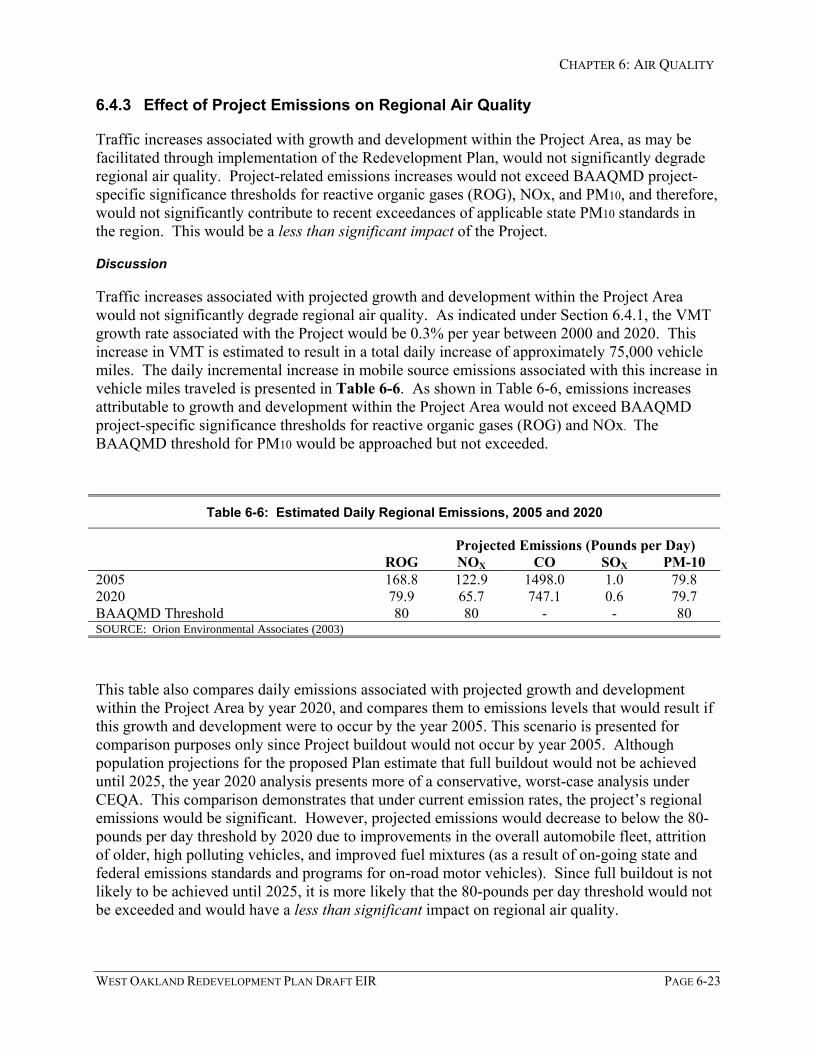
CHAPTER 6: AIR QUALITY
WEST OAKLAND REDEVELOPMENT PLAN DRAFT EIR PAGE 6-23
6.4.3 Effect of Project Emissions on Regional Air Quality
Traffic increases associated with growth and development within the Project Area, as may befacilitated through implementation of the Redevelopment Plan, would not significantly degraderegional air quality. Project-related emissions increases would not exceed BAAQMD project-specific significance thresholds for reactive organic gases (ROG), NOx, and PM10, and therefore,would not significantly contribute to recent exceedances of applicable state PM10 standards inthe region. This would be a less than significant impact of the Project.
Discussion
Traffic increases associated with projected growth and development within the Project Areawould not significantly degrade regional air quality. As indicated under Section 6.4.1, the VMTgrowth rate associated with the Project would be 0.3% per year between 2000 and 2020. Thisincrease in VMT is estimated to result in a total daily increase of approximately 75,000 vehiclemiles. The daily incremental increase in mobile source emissions associated with this increase invehicle miles traveled is presented in Table 6-6. As shown in Table 6-6, emissions increasesattributable to growth and development within the Project Area would not exceed BAAQMDproject-specific significance thresholds for reactive organic gases (ROG) and NOx. TheBAAQMD threshold for PM10 would be approached but not exceeded.
Table 6-6: Estimated Daily Regional Emissions, 2005 and 2020
Projected Emissions (Pounds per Day)ROG NOX CO SOX PM-10
2005 168.8 122.9 1498.0 1.0 79.82020 79.9 65.7 747.1 0.6 79.7BAAQMD Threshold 80 80 - - 80SOURCE: Orion Environmental Associates (2003)
This table also compares daily emissions associated with projected growth and developmentwithin the Project Area by year 2020, and compares them to emissions levels that would result ifthis growth and development were to occur by the year 2005. This scenario is presented forcomparison purposes only since Project buildout would not occur by year 2005. Althoughpopulation projections for the proposed Plan estimate that full buildout would not be achieveduntil 2025, the year 2020 analysis presents more of a conservative, worst-case analysis underCEQA. This comparison demonstrates that under current emission rates, the project’s regionalemissions would be significant. However, projected emissions would decrease to below the 80-pounds per day threshold by 2020 due to improvements in the overall automobile fleet, attritionof older, high polluting vehicles, and improved fuel mixtures (as a result of on-going state andfederal emissions standards and programs for on-road motor vehicles). Since full buildout is notlikely to be achieved until 2025, it is more likely that the 80-pounds per day threshold would notbe exceeded and would have a less than significant impact on regional air quality.

CHAPTER 6: AIR QUALITY
PAGE 6-24 WEST OAKLAND REDEVELOPMENT PLAN DRAFT EIR
It should also be noted that emissions increases from projected growth and development withinthe Project Area might be less than would result if this growth occurred in outlying areas of theair basin (where trip lengths would be longer). Future growth as may be facilitated byimplementation of the Redevelopment Plan would be infill development anticipated to providenew housing near transit corridors, new jobs near existing housing, and new housing nearexisting jobs (i.e., “smart growth”). It is also anticipated that as traffic congestion problemsworsen in the region and travel times get longer, people will need to shorten their commutedistance in order to maintain the same travel time as they have today. These factors, in additionto some increase in transit use, would tend to reduce trip lengths in the future.
6.4.4 Effect of Project Emissions on Local Air Quality
Traffic generated by projected growth and development within the Project Area would notsignificantly increase CO emissions along roadways and at intersections within the Project Areaor its vicinity. This would be a less than significant effect of the Project.
Discussion
A micro-scale CO impact analysis was conducted at 11 study intersections distributed throughoutthe Project Area and its vicinity. These are 11 of the 48 intersections analyzed for traffic impactsin Chapter 5:Traffic and Circulation. Service level operations (used as an indicator of travelspeed) were calculated as part of the transportation analysis. The 11 selected intersections werethose where service levels changed by one service level as a result of Plan-related trafficincreases or those that operated at LOS D, E, or F under existing or future conditions. ACaltrans screening approach, which is based on the CALINE4 model, was used to estimate COconcentrations along these roadway links (Caltrans, 1988). Carbon monoxide concentrationswere calculated at a distance of 25 feet from the edge of each roadway to determine potentialimpacts based on worst-case conditions (peak hour traffic and theoretical minimum atmosphericmixing).
Table 6-7 compares the one-hour and eight-hour CO exposures for existing (2003) and future(2025) conditions without and with the growth and development projected for the Project Area.Significance of localized CO emissions from mobile sources are determined by modeling theambient CO concentration under existing and future conditions, and comparing the resulting one-hour and eight-hour concentrations, both without and with the proposed Project, to the respectivestate and federal CO standards. A detailed impact analysis using the BAAQMD screening modelindicates that the state and federal one-hour ambient standards for CO would not be violated atstudy intersections during worst-case atmospheric conditions (wintertime conditions when COconcentrations are typically greatest). Modeling results indicate that CO concentrations willdecrease in the future due to attrition of older, high polluting vehicles, improvements in theoverall automobile fleet, and improved fuel mixtures (as a result of on-going state and federalemissions standards and programs for on-road motor vehicles).

CHAPTER 6: AIR QUALITY
WEST OAKLAND REDEVELOPMENT PLAN DRAFT EIR PAGE 6-25
Table 6-7: Estimated Worst-Case Existing and Future CO Concentrations at SelectedIntersections
IntersectionAveraging
Period ExistingExisting +
PlanFuture Baseline
(2025) Future + Plan
1 Hour 6.4 6.5 5.2 5.2(1) San Pablo Ave./40th St.
8 Hour 5.1 5.1 3.9 3.9
1 Hour 6.5 6.6 5.2 5.3(2) San Pablo Ave./Adeline St.
8 Hour 5.1 5.2 3.9 4.0
1 Hour 5.8 5.9 4.9 4.9(3) Market St./W. MacArthur Blvd.
8 Hour 4.7 4.8 3.7 3.7
1 Hour 5.1 5.1 4.3 4.4(4) Peralta St./26th St.
8 Hour 4.3 4.3 3.4 3.4
1 Hour 6.0 6.1 4.9 5.0(5) San Pablo Ave./27th St.
8 Hour 4.8 4.9 3.7 3.8
1 Hour 5.8 5.8 5.3 5.3(6) Maritime St./W. Grand Ave.
8 Hour 4.7 4.7 4.0 4.0
1 Hour 6.1 6.2 5.3 5.4(7) I-880 Frontage Rd./W. GrandAve. 8 Hour 4.9 5.0 4.0 4.0
1 Hour 5.7 5.8 5.0 5.0(8) Mandela Pkwy./W. Grande Ave.
8 Hour 4.7 4.7 3.8 3.8
1 Hour 5.4 5.5 4.7 4.8(9) Adeline St./14th St.
8 Hour 4.5 4.5 3.6 3.7
1 Hour 5.4 5.6 4.5 4.6(10) Mandela Pkwy./7th St.
8 Hour 4.5 4.6 3.5 3.6
1 Hour 5.0 5.0 4.4 4.4(11) Market St./3rd St.
8 Hour 4.2 4.2 3.4 3.4
1 Hour 4.6 4.6 4.0 4.0Background Levels (included inabove numbers 8 Hour 3.6 3.6 3.2 3.2
1 Hour 20 ppm 20 ppm 20 ppm 20 ppmState CO Standard
8 Hour 9.0 ppm 9.0 ppm 9.0 ppm 9.0 ppm
Federal CO Standard 1 Hour 35 ppm 35 ppm 35 ppm 35 ppm
8 Hour 9 ppm 9 ppm 9 ppm 9 ppm
NOTE: The “Existing” and “Future” scenarios are based on existing (2003) and future (2025) traffic volumespresented in the Traffic section of this report.
SOURCE: Orion Environmental Associates (2003)
CHAPTER 6: AIR QUALITY
PAGE 6-26 WEST OAKLAND REDEVELOPMENT PLAN DRAFT EIR
6.4.5 Emissions Generated by Construction Activities
Potential Impact 6.4.5: Construction Emissions. Construction associated with the RedevelopmentPlan’s implementation projects, programs and other activities within the Project Area wouldgenerate dust (including the respirable fraction known as PM10) and combustion emissions.These emissions would be a potentially significant effect of the Project.
Discussion
Dust Emissions
Potential dust emissions that may be associated with future implementation of the redevelopmentPlan’s projects, programs and other activities within the Project Area would be specific to eachsite. The BAAQMD does not require quantification of construction emissions (BAAQMD,1999) but considers any project’s construction-related impacts to be adequately mitigated ifrequired dust-control measures are implemented. The extent of dust-control measures requiredby the BAAQMD depends on the size of the project. Since most construction projects wouldcomprise less than one city block (approximately two acres or less), implementation of theBAAQMD’s standard dust control procedures would maintain Project construction-relatedimpacts at acceptable levels.
Combustion Emissions
Combustion emissions from construction equipment and vehicles, such as heavy equipment anddelivery/haul trucks, air compressors, and generators, may result due to implementation of theRedevelopment Plan’s projects, programs and other activities during construction activity.Construction employee vehicles would also result in air pollutant emissions, but the levels wouldbe negligible compared to emissions from on-site heavy equipment and from transport trucks.Equipment exhaust contains both pulmonary irritants and hazardous compounds, which mayaffect sensitive receptors such as young children, senior citizens, or those susceptible torespiratory disease. Where construction occurs in proximity to residential uses, there may be apotential for unhealthful exposure of sensitive receptors to equipment exhaust.
Similar to dust emissions, the equipment activity level would be related to the project size andextent of earthmoving requirements in site preparation. Emission levels for constructionactivities would vary depending on the type of equipment, duration of use, operation schedules,and the number of construction workers. Air pollution emissions from construction activity werecalculated for a prototype project with a two-acre disturbance “footprint” requiring 200workdays to complete major construction. Equipment utilization was estimated based on theCalifornia Air Resources Board (ARB) area source emissions factor of 300,000 Brake-Horsepower-Hours (BHP-HR) per acre of residential/commercial development. Emissions fromaverage daily construction activity are shown in Table 6-8.
This table indicates that although these emissions, in combination with other existing emissionssources, would temporarily contribute to local air quality degradation, the emissions associatedwith most future development projects pursuant to implementation of the Redevelopment Planwithin the Project Area would be less than significant. Short-term construction emissions for a

CHAPTER 6: AIR QUALITY
WEST OAKLAND REDEVELOPMENT PLAN DRAFT EIR PAGE 6-27
single prototype project (two acres or less) within the Project Area would typically not exceedBAAQMD significance thresholds, although these thresholds apply to operational, notconstruction emissions. However, NOx and PM10 thresholds could be exceeded withdevelopment of a project that covers an area larger than two acres, or simultaneous developmentof more than one future project.
Table 6-8: Average Daily Construction Activity Air Pollution Emissions
Daily Emissions (pounds/day)Activity CO ROG NOx Sox PM10
Soil Disturbancea 51.0Equipment Operationsb 5.7 1.8 25.8 1.8 0.9Employee Commutingc 40.6 3.3 5.7 negl. 1.8Truck Haulingd 16.8 2.4 27.1 3.4 57.0
TOTAL 63.1 7.5 58.6 5.3 58.8BAAQMD Threshold n/a 80 80 n/a 80
Emissions FactorsActivity CO ROG NOx SOx PM10 Source
Soil Disturbance (pounds/acre/day) 51.0 BAAQMDEquipment Operations (pounds/1,000 BHP-HR)
1.9 0.6 8.6 0.6 0.3 SCAQMD
Employee Commuting (grams/mile) 9.2 0.7 1.3 negl. 0.4 BAAQMDTruck Hauling (grams/mile) 7.6 1.1 12.3 0.7 0.7 EMFAC7G
Notes: Emissions based on two-acre building footprint and 200 days for construction. Equipment utilization was estimatedbased on the California Air Resources Board (ARB) area source emissions factor of 300,000 Brake-Horsepower-Hours (BHP-HR) per acre of residential/commercial development.a 2 acres x 51 lbs/acre/day x 50% for use of “standard” dust control measures.b 2 acres x 300,000 BHP-HR/acre ÷ 200 days = 3,000 BHP-HR/dayc 50 employees x 40 milesd 20 trucks x 50 milesBAAQMD: Bay Area Air Quality Management District, 1999.SCAQMD: South Coast Air Quality Management District, 1993.EMFAC7G: California Vehicle Emission Computer Model
SOURCE: Orion Environmental Associates, 2003.
Mitigation Measures
The mitigation measures set forth below are intended to address construction-related air qualityimpacts that may be associated with implementation of the Redevelopment Plan’s projects,programs and other activities within the Project Area.

CHAPTER 6: AIR QUALITY
PAGE 6-28 WEST OAKLAND REDEVELOPMENT PLAN DRAFT EIR
• Mitigation Measure 6.4.5: Construction Emission Controls. Contractors for futuredevelopment projects pursuant to implementation of the Redevelopment Plan shallimplement BAAQMD dust control and exhaust emission measures as outlined inBAAQMD CEQA Guidelines (1999) or any subsequent applicable BAAQMD updates.These measures include the following:
Basic Control Measures
The following Basic Control Measures shall be implemented at all construction sites:
• Water all active construction areas at least twice daily.
• Cover all trucks hauling soil, sand, and other loose debris or require all trucks tomaintain at least two feet of freeboard.
• Pave, apply water three times daily, or apply (non-toxic) soil stabilizers on all unpavedaccess roads, parking areas, and staging areas at construction sites.
• Sweep daily (with water sweepers) all paved access roads, parking areas and stagingareas at construction sites.
• Sweep streets daily (with water sweepers) if visible soil material is carried ontoadjacent public streets.
Enhanced Control Measures
In addition to the above, the following Enhanced Control Measures shall be implementedat all construction sites when more than four acres are under construction at any one time:
• Hydroseed or apply (non-toxic) soil stabilizers to inactive construction areas(previously graded areas inactive for ten days or more).
• Enclose, cover, water twice daily or apply (non-toxic) soil binders to exposedstockpiles (dirt, sand, etc.)
• Limit traffic speeds on unpaved roads to 15 mph.
• Install sandbags or other erosion control measures to prevent silt runoff to publicroadways.
• Replant vegetation in disturbed areas as quickly as possible.
Exhaust Emission Control Measures
In addition to the above dust control measures, the following exhaust emission controlmeasures shall be implemented at all construction sites:
• Use alternative fueled construction equipment.
• Minimize idling time (e.g., five-minute maximum).
• Maintain properly tuned equipment.

CHAPTER 6: AIR QUALITY
WEST OAKLAND REDEVELOPMENT PLAN DRAFT EIR PAGE 6-29
• Limit the hours of operation of heavy-duty equipment and/or the amount of equipmentin use.
Resulting Level of Significance:
Implementation of adopted Policy CO-12.6 from the OSCAR Element would help reduce short-term emissions associated with future construction activity pursuant to implementation of theRedevelopment Plan within the Project Area. In addition, the measures recommended abovewould ensure that construction-related dust impacts are minimized to a less than significant level.
6.4.6 Compatibility of Project-Related Population Increases
Potential Impact 6.4.6: Projected population growth in the Project Area would increase more thanprojected citywide growth. This disproportionate increase could result in more residents beinglocated in proximity to pollutant emission and odor sources, which could increase land usecompatibility problems. Such land use conflicts would be an unavoidable, significant impact ofthe Project.
Discussion
As indicated in Impact 6.4.1, population growth in the Project Area is estimated at 21% between2000 and 2020, while citywide growth is estimated at 9% to 11% for the same period. In year2000, the population of the Project Area was 20,300, which was 5.1% of the City’s totalpopulation. By 2020, the population of the Project Area is estimated to reach 24,500, whichcomprises 5.4% to 5.7% of the estimated total citywide population of 433,334 to 442,800. Thisdisproportionate increase could result in slightly more new residents being located in proximityto existing pollutant emission and odor sources such as three freeways (I-880, I-580, and I-980),arterial streets (including San Pablo, West Grand Avenue, Mandela Parkway, and 7th Street),railroad operations, port facilities, industrial facilities (e.g., food and fabricated metal industries),and ancillary maritime support uses (generating truck traffic).
The discussions under Impacts 6.4.3 and 6.4.4 have demonstrated that future residents of theProject Area would not be subject to unhealthful regional and local air quality associated withProject-related traffic since projected traffic emissions increases would not exceed state andfederal standards. Identified toxic air contaminant levels also would not exceed the abovesignificance criteria. However, increasing the number of residential receptors in proximity toexisting toxic air contaminants, pollutant, and odor emission sources would increase the potentialfor future land use conflicts.
The BAAQMD (1999) identifies several types of land use conflicts that should be avoided:location of sensitive receptors in proximity to congested intersections, busy roadways, sources oftoxic air contaminants, or sources of odorous emissions. Often provision of an adequate distance,or buffer zone, between the source of emissions and the receptor(s) is necessary to mitigate theproblem. In addition, the BAAQMD notes that infill or mixed-use projects, while reducing autotrips, could result in localized health or nuisance impacts on sensitive receptors if they arelocated near sources of odors or toxic air contaminants.

CHAPTER 6: AIR QUALITY
PAGE 6-30 WEST OAKLAND REDEVELOPMENT PLAN DRAFT EIR
City Ordinances, Policies and Approved Mitigation Programs
The City of Oakland implements two ordinances that help and will continue to help reduce thesepotential land use conflicts. Sections 10.52.060 and 10.52.120 of the Oakland Traffic Codeprohibit trucks (vehicles over 4.5 tons) from specific street segments and establish truck routeson other roads (see Chapter 5: Traffic and Circulation of this DEIR, Figure 5-3). Most existingprohibitions are within the Prescott neighborhood, which contains a mixture of residential usesand commercial/industrial businesses that generate truck traffic (City of Oakland, 1998). Inaddition, the City of Oakland’s S-16 Industrial-Residential Transition Combining Zone(Ordinance 17.102.380) will eventually reduce ancillary maritime support uses within the ProjectArea, and many of these uses may relocate to the OARB Redevelopment Area (see also furtherdiscussions of this issue in Chapter 4: Land Use and Chapter 5:Traffic and Circulation).
In addition to these ordinances, the Port of Oakland is implementing the Vision 2000 Air QualityMitigation Program (AQMP), a program to mitigate the potential air quality impacts of the Port’sVision 2000 Program. The AQMP projects are intended to reduce emissions from a variety ofmaritime and other local sources. These sources include, for example, construction activities,tugboats, cargo-handling equipment, trucks, public buses, other vehicles, and local stationarysources. Phases I and II were complete as of April 2002. Phase III will be complete by October2003, while Phase IV is scheduled to be completed by April 2005. Program measures includethe following:
Mitigation Measures 3.3-3/M1, M1A, M2, M3, and M4: The Port will subsidize retrofit of dieseltruck engines, diesel cargo-handling equipment (at existing container yards), one diesel tugboat(as a demonstration project), and diesel bus engines (buses operating in the West Oakland,Emeryville, and Alameda areas) with new engines meeting California emission standards for newdiesel engines, or add-on exhaust treatment devices, including soot traps and catalytic converters.
Mitigation Measure 3.3-3/M5: When the new Joint Intermodal Terminal (JIT) is built, the Portwill request the operator of [train] switch engines operating at the terminal to use engines thatmeet the requirements of the recently promulgated federal regulation limiting locomotiveemissions. Implementation of this measure will require that the allocation of switchinglocomotives with new or rebuilt engines take into account the desire of the Port to minimizeemissions related to switching activities.
Mitigation Measures 3.3-3/M6.1 through 6.10: These measures include a suite of ten measures tobe incorporated into the design and operation of new facilities. The measures include, forexample, electric connections so that tugs at Berth 59 can “cold iron” while berthed, subsidized24-hour truck parking facilities in the maritime area, and encouraging employees and tenants touse alternative transportation on “Spare the Air’ days called by the BAAQMD.
Mitigation Measure 3.3-3/M7: The Port will subsidize an engineering study to determine whethercost-effective measures exist to reduce ROG emissions from the Red Star Yeast facility in WestOakland, and if cost-effective, subsidize such measures.
Mitigation Measure 3.3-3/M8: The Port will subsidize an engineering study and control measuresto reduce ROG emissions from the Precision Cast facility in West Oakland.
Mitigation Measure 3.3-3/M9: Work with the CARB to determine the feasibility and potentialbenefits of establishing a heavy-duty diesel truck emissions testing station in the Port area.

CHAPTER 6: AIR QUALITY
WEST OAKLAND REDEVELOPMENT PLAN DRAFT EIR PAGE 6-31
Related Measures and Monitoring Programs. During construction of the Vision 2000 projects,the Port also committed to implement thirteen dust control measures (BAAQMD basic,enhanced, and optional dust control measures); construction-related equipment engine emissionscontrols (including equipment tune up and use of California low-sulfur, low-aromatic diesel fuelin equipment that is not required under state law to use low-sulfur diesel); and encouragecarpooling among construction workers, especially on BAAQMD “Spare the Air” days.
The Port continues to implement an air quality and meteorological monitoring program tomeasure the levels of particulate matter (PM10 and PM2.5) in West Oakland. The objective of theprogram is to characterize the existing particulate air quality conditions in the West Oaklandregion and to provide baseline, as well as ongoing, data on particulate air pollution prior to andduring the construction and operation of the Port’s maritime development projects. A summaryof the monitoring data collected as part of this program is listed in Table 6-3.
In addition to the Vision 2000 AQMP, the Port is required to implement the following CriteriaPollutant Reduction Program as part of implementation of the OARB Reuse Plan. The CriteriaPollutant Reduction Program is aimed at reducing or offsetting Port-related emissions in WestOakland from its maritime and rail operations. The program shall be sufficiently funded toreduce and/or offset OARB Redevelopment-related contributions to local West Oakland airquality to the maximum extent feasible. Program elements are as follows:
This program shall be periodically reviewed and updated every one to three years, correspondingto regular updates of the Clean Air Plan. The review and update shall include a reassessment offunding requirements, technical feasibility, cost benefit assumptions and other factors. Theperiodic updates shall be submitted to the City/Port Liaison Committee or its equivalent.
The pollutant reduction program shall give priority to emission reduction strategies that addressPM10 emissions, but shall also provide for reductions in NOx and ROG emissions. The emissionreduction program shall include a list of potential emission reduction strategies. Strategies thatshall be included in the program and implemented over the buildout period include:
The Port shall expand its existing cargo handling equipment re-powering and retrofittingprogram (part of the Berths 55-58 Project air quality mitigation program) to include marine andrail terminal yard equipment added or relocated as part of redevelopment build-out.
The Port shall extend its grant program (part of the Berths 55-58 Project air quality mitigationprogram) to provide financial incentives to tugboat operators at New Berth 21 and other Portfacilities to implement emission reduction control measures or to replace tugboat engines to lowNOx technology.
The Port shall require rail terminal operators to use switch engines at the New IntermodalFacility that comply with federal air emission regulations for diesel operated locomotives as setforth in federal air regulations. In addition, the rail terminal operator and the Port are toexchange information with the goal of investigating options to accelerate compliance with Tier 0,1 and 2 requirements of the federal regulations.
The Port shall not preclude in its design of the New Intermodal Facility the installation of analternative fueling station and shall to the extent feasible accommodate such a fueling station.

CHAPTER 6: AIR QUALITY
PAGE 6-32 WEST OAKLAND REDEVELOPMENT PLAN DRAFT EIR
The Port shall encourage ships to implement source control technologies when in the port area(such as reduced hoteling).
When technically and economically feasible, include an alternative fueling facility at the NewIntermodal Facility (OARB EIR, City of Oakland 2002).
Mitigation Measures
The mitigation measures set forth below are intended to address potentially significant land useconflicts that could arise with implementation of the Redevelopment Plan’s projects, programsand other activities within the Project Area.
• Mitigation Measure 6.4.6A: Major new development projects pursuant to or in furtherance ofthe Redevelopment Plan shall fund on a fair share basis (as appropriate) some or all of thefollowing BAAQMD-recommended feasible Transportation Control Measures (TCMs)for reducing vehicle emissions from commercial, institutional, and industrial operations.Alternatively, at the Redevelopment Agency’s sole discretion, redevelopment fundscould potentially be used to subsidize these fair-share funding contributions or toimplements these measures.
a) Construct transit facilities such as bus turnouts/bus bulbs, benches, shelters, etc.Improve transit bus service within the Project area.
b) Design and locate buildings to facilitate transit access, e.g., locate building entrancesnear transit stops, eliminate building setbacks, etc.
c) Provide shuttle service between the West Oakland BART station and any future majoremployers or high-density residential developments.
d) Encourage future business uses to use car pools, vanpools, and public transit byproviding incentives.
e) Provide on-site shops or provide convenience services (i.e., cafeteria, bank, drycleaners, convenience market, etc.) nearby for employees.
f) Provide on-site childcare, or contribute to off-site childcare within walking distance.
g) Establish mid-day shuttle service from worksites to food service establishments/commercial areas.
h) Provide preferential parking for carpool and vanpool vehicles.
i) Implement parking fees for single occupancy vehicle commuters.
j) Provide secure, weather-protected bicycle parking for employees.
k) Provide safe, direct access for bicyclists to adjacent bicycle routes.
l) Provide showers and lockers for employees bicycling or walking to work.

CHAPTER 6: AIR QUALITY
WEST OAKLAND REDEVELOPMENT PLAN DRAFT EIR PAGE 6-33
m) Provide direct, safe, attractive pedestrian access between new developments andtransit stops.
n) Provide neighborhood-serving shops and services within or adjacent to residentialareas.
• Mitigation Measure 6.4.6B. Major new development projects pursuant to or in furtherance ofthe Redevelopment Plan shall fund on a fair share basis (as appropriate) some or all of thefollowing Clean Air Plan’s transportation control measures. These measures have beenidentified by the BAAQMD as appropriate for local implementation. Alternatively, at theRedevelopment Agency’s sole discretion, redevelopment funds could potentially be usedto subsidize these fair-share funding contributions or to implements these measures.
a) Support Voluntary Employer-Based Trip Reduction Programs: Promote transit useand support employer-based trip reduction programs through development incentivessuch as density bonuses, reduced parking requirements, incentives for permanentbicycle facilities, etc. Encourage development of transit transfer stations nearemployment concentrations.
b) Improve Bicycle Access and Facilities: Encourage employers and developers toprovide permanent bicycle facilities.
c) Improve Arterial Traffic Management. Improve roadways and intersections to operateat City-standard LOS, to facilitate traffic flow and avoid unnecessary queuing.
d) Local Clean Air Plans, Policies and Programs: Redevelopment projects shouldincorporate measures that reduce the number and length of single-occupantautomobile trips.
e) Conduct Demonstration Projects: Using development incentives, encourageimplementation of demonstration projects for low emission vehicle fleets and LEVrefueling infrastructure.
f) Pedestrian Travel: Promote development patterns that encourage walking andcirculation policies that emphasize pedestrian travel; modify the zoning ordinance toinclude pedestrian-friendly design standards.
g) Promote Traffic Calming Measures: Redevelopment will include traffic calmingmeasures to the extent appropriate, consistent with the General Plan and sound trafficmanagement of the project area.
These transportation control measures shall be coordinated with transportation demandmanagement (TDM) measures listed under Mitigation Measure 6.4.6A as well as similarmeasures to be implemented pursuant to the OARB Reuse Plan.
• Mitigation Measure 6.4.6C: Upgraded Ventilation Systems. Future residential developmentwithin the Project Area shall be developed with upgraded ventilation systems to minimizeexposure of future residents to odors and pollutant emissions. In addition, future

CHAPTER 6: AIR QUALITY
PAGE 6-34 WEST OAKLAND REDEVELOPMENT PLAN DRAFT EIR
development should limit outdoor use areas where these uses are located in proximity toemission sources.
Resulting Level of Significance:
Implementation of adopted city ordinances, the Vision 2000 AQMP, the Port’s Criteria PollutantReduction Program, and the above mitigation measure would help reduce the potential for landuse conflicts arising from air pollutant emission sources. However, since the cumulative near-Port (local) emissions associated with the Vision 2000 Program could not be mitigated to a lessthan significant level, the exposure of new Project-related residents to regional air quality (withthe Vision 2000 Program implemented) would also be significant and unavoidable. However, itshould be noted that the entire air basin, not just the Project Area, would share this significantand unavoidable impact.
6.4.7 Compatibility of Planned West Oakland Transit Village
Implementation of the Redevelopment Plan would facilitate development of the West OaklandTransit Village. Development of residential and commercial uses at the West Oakland BARTstation and its vicinity could have exposed future residents, employees, and customers to odorand acetaldehyde emissions associated with the Red Star Yeast facility, had the owners of thatfacility not permanently ceased production in April of 2003. However, since the plant has beenshut down, the air pollution from the plant will not be produced and the potential exposure toodor and acetaldehyde emissions from the Red Star Yeast plant would not be identified as anenvironmental impact.
Discussion
The BAAQMD (1999) identifies several types of land use conflicts that should be avoided:location of sensitive receptors in proximity to congested intersections, busy roadways, sources oftoxic air contaminants, or sources of odorous emissions. Often provision of an adequatedistance, or buffer zone, between the source of emissions and the receptor(s) is necessary tomitigate the problem. In addition, the BAAQMD notes that infill or mixed-use projects, whilereducing auto trips, could result in localized health or nuisance impacts on sensitive receptors ifthey are located near sources of odors or toxic air contaminants. Planned development of atransit village at the West Oakland BART station would have been inconsistent with theseBAAQMD CEQA guidelines had the Red Star Yeast facility not closed down.
The Concept Plan for the West Oakland Transit Village indicates that Primary Opportunity Sitesthat are designated for apartments with some ground floor retail are located north of now-closedthe Red Star Yeast factory. The existing BART tracks separate these opportunity sites from thatprior facility, as shown in Figure 6-1.

CHAPTER 6: AIR QUALITY
WEST OAKLAND REDEVELOPMENT PLAN DRAFT EIR PAGE 6-35
Figure 6-1

CHAPTER 6: AIR QUALITY
PAGE 6-36 WEST OAKLAND REDEVELOPMENT PLAN DRAFT EIR
Primary Opportunity Site 4, designated for apartments and ground floor retail is located west ofthe prior Red Star Yeast facility. Mandela Parkway separates this opportunity site from thatfacility. As indicated in Figure 6-1, Opportunity Sites O.S.2 and O.S.3 are located in areas thatwould have had predicted concentrations of 2.7 to 12.5 µg/m3 of acetaldehyde emissions, whileOpportunity Site 4 would have been subject to concentrations as high as 8.6 µg/m3. The excesscancer risk4 for a person exposed to 1 µg/m3 of acetaldehyde outdoors for 24 hours per day, 365days per year, for 70 years, is 2.7 per million (CAPCOA, 1993). Future transit village residentswould have been subject to excess cancer risks of 7 to 34 in one million, depending on theirproximity to the Red Star/LaSaffre facility. These residents would have also been subject toobjectionable odors emitted by this facility.
However, the LeSaffre Yeast Corporation decided to close this facility as of April 2003. Thisdecision was likely made in response to mounting public pressure from the Coalition for WestOakland Revitalization (CWOR), the Chester Street Block Club and other community groupssupported by research conducted by the Pacific Institute, as well as anticipated regulatorychanges that would have required substantial emission reductions. Given that this facility is nolonger in operation, the planned development of a transit village at the West Oakland BARTstation is no longer inconsistent with BAAQMD CEQA guidelines regarding land usecompatibility with sources of toxic air contaminants or sources of odorous emissions.
6.4.8 Effects of Cumulative Development on Regional and Local Air Quality
Cumulative Impact 6.4.8: Implementation of the Redevelopment Plan, in conjunction with thePort’s Vision 2000 Program and the adjacent OARB Area Redevelopment Project wouldcumulatively exceed BAAQMD significance criteria for NOx and PM10. These cumulativeemissions would be an unavoidable, significant cumulative impact.
Discussion
NOx and PM10
As indicated in Impact 6.4.3 above, Project-related traffic increases would not significantlydegrade regional air quality. However, when Project-related increases (2020) are consideredwith near-Port emissions associated with the Port’s Vision 2000 Program, cumulative emissionswould exceed BAAQMD project-specific significance thresholds for NOx and PM10. Since near-Port cumulative emissions would be potentially significant, the Project’s contribution tocumulative impacts is also considered significant. Table 6-9 presents local emissions increases
4 For TACs that are known or suspected carcinogens, the CARB has consistently found there are no levels orthresholds below which exposure is risk free. Where data are sufficient to do so, a “unit risk factor” and averagelifetime exposure combine to estimate cancer risk. The unit risk factor expresses assumed risk to a hypotheticalpopulation in terms of the estimated number of individuals in a million who may develop cancer as the result ofcontinuous, lifetime (70-year) exposure to 1 microgram per cubic meter (µg/m3) (equal to one part per million)of the TAC. Unit risk factors provide a standard that can be used to establish regulatory thresholds for permittingpurposes. However, they are not a measure of actual health risk because actual populations do not experience theextent and duration of exposure that the hypothetical population is assumed to experience (OARB, 2002).

CHAPTER 6: AIR QUALITY
WEST OAKLAND REDEVELOPMENT PLAN DRAFT EIR PAGE 6-37
attributable to growth and development within the Project Area as well as probable futureprojects associated with the Port’s Vision 2000 Program that are expected to be completed by2010. Near-port (local) cumulative increases would significantly contribute to recentexceedances of applicable state PM10 standards in the region.
Table 6-9: Estimated Daily Near-Port Cumulative Emissions, 2020
Projected Emissions (Pounds per Day)NOX SOX PM-10
Project Emissions 65.7 0.6 79.7
Probable Port Projects 2,772 1,745 417
Cumulative Total 2,838 1,746 497
BAAQMD Threshold 80 - - 80
NOTES: Probable Port projects are those that the Port anticipates will be completed by 2010 and they include theJoint Intermodal Terminal Project, Berths 55-58, -50 Dredge Projects, Port roadway improvements, and new Berth 21.Since this analysis examines planning year 2020, the 2010 Port-related near-port emissions have been adjusted toreflect 2020 emissions rates. However, any Port projects planned between 2010 and 2020 are not included in theseestimates.
SOURCE (Port Projects): Port of Oakland (1999)
CO
As indicated in Table 6-7, traffic generated by projected growth and development within theProject Area would not significantly increase CO emissions along roadways and at intersectionswithin the Project Area or its vicinity. Combined CO emissions associated with projectemissions in conjunction with cumulative development in the region are presented in Table 6-7under “Future + Plan” for 2025. Estimated cumulative emissions listed in this table indicate thatthe state and federal one-hour ambient standards for CO would not be violated at studyintersections during worst-case atmospheric conditions (wintertime conditions when COconcentrations are typically greatest). In addition, CO concentrations will continue to decreasein the future due to attrition of older, high polluting vehicles, improvements in the overallautomobile fleet, and improved fuel mixtures (as a result of on-going state and federal emissionsstandards and programs for on-road motor vehicles). Since cumulative CO levels would notexceed CO ambient air quality standards, cumulative impacts at local intersections would be lessthan significant.
Mitigation Measures
As indicated in Table 6-9, most of the cumulative emissions in the Project Area can be attributedto Port-related projects. The Port of Oakland is implementing the Vision 2000 AQMP, aprogram to mitigate the potential air quality impacts of the Port’s Vision 2000 Program. Theprimary components of the AQMP are summarized under Impact 6.4.6 above.

CHAPTER 6: AIR QUALITY
PAGE 6-38 WEST OAKLAND REDEVELOPMENT PLAN DRAFT EIR
Potential Benefits of Redevelopment
While the Project-related emissions would be less than significant when considered alone, theywould contribute to significant cumulative emissions in the area. Implementation of theRedevelopment Plan’s projects, programs and other activities within the Project Area wouldinclude the West Oakland Transit Village, which is a project that would increase use of transit,thereby reducing traffic-related emissions. In addition, existing policies contained in the OpenSpace, Conservation, and Recreation Element as well as the Land Use and TransportationElement would also help reduce potential regional and local air quality emissions by encouraginguse of transit, alternative transportation modes, and sustainable development patterns. Thesepolicies are listed under Impact 6.1 above. Future Redevelopment Plan implementation projects,programs and other activities will be required to be consistent with these General Plan policies,which would help to reduce project-related emissions.
Resulting Level of Significance
Implementation of adopted city general plan policies and the Vision 2000 AQMP would helpreduce projected emissions from Port activities as well as the project. However, emissionsreductions resulting from the Vision 2000 AQMP would not be sufficient to reduce cumulativenear-port (local) emissions to a less than significant level. Therefore, the cumulative impact onnear-port (local) air quality would be significant and unavoidable.

WEST OAKLAND REDEVELOPMENT PLAN, DRAFT EIR PAGE 7-1
77Noise
7.1 IntroductionThis chapter of the EIR describes existing noise conditions within the Project Area. It alsoidentifies potential impacts associated with implementation of the Redevelopment Plan’sprojects, programs and other activities within the Project Area on existing noise levels andrecommends, where necessary and feasible, mitigation measures to reduce and or avoidpotentially significant noise impacts. Noise issues discussed in this section of the EIR include:
• Construction noise impacts,
• Noise generated by traffic attributed to growth and development within the Project Area,and
• Compatibility with City Land Use Compatibility Guidelines and ordinances.
Significance thresholds for noise impacts would generally be reached if implementation of theRedevelopment Plan’s projects, programs or other activities were to expose persons to, orgenerate noise levels in excess of guidelines established in the Oakland General Plan orapplicable standards of other agencies. Additionally, thresholds would be reached ifimplementation of the Redevelopment Plan would conflict with city/state land use compatibilityguidelines or violate the City of Oakland Noise Ordinance.
7.2 Environmental Setting7.2.1 Noise Descriptors
Sound is mechanical energy transmitted by pressure waves in a compressible medium such asair. Noise is unwanted sound. Sound is characterized by various parameters that describe therate of oscillation of sound waves, the distance between successive troughs or crests, the speedof propagation, and the pressure level or energy content of a given sound. In particular, thesound pressure level has become the most common descriptor used to characterize the loudnessof an ambient sound level. The decibel (dB) scale is used to quantify sound intensity. Becausesound or noise can vary in intensity by over one million times within the range of humanhearing, a logarithmic loudness scale is used to keep sound intensity numbers at a convenient

CHAPTER 7: NOISE
PAGE 7-2 WEST OAKLAND REDEVELOPMENT PLAN DRAFT EIR
and manageable level. Since the human ear is not equally sensitive to all sound frequencieswithin the entire spectrum, human response is factored into sound descriptions in a processcalled "A-weighting", written as "dBA".
Environmental noise is measured in units of dBA. The dBA, or A-weighted decibel, refers to ascale of noise measurement, which approximates the range of sensitivity of the human ear tosounds of different frequencies. On this scale, the normal range of human hearing extends fromabout zero dBA to about 140 dBA. A ten-dBA increase in the level of a continuous noiserepresents a perceived doubling of loudness; a five-dBA increase is readily noticeable while athree-dBA increase is barely noticeable to most people.
Time variations in noise exposure are typically expressed in terms of a steady-state energy level(called Leq), which represents the acoustical energy of a given measurement. Becausecommunity receptors are more sensitive to unwanted noise intrusion during the evening and atnight, State law requires that for planning purposes, an artificial dB increment be added to quiettime noise levels in a 24-hour noise descriptor called the Community Noise Equivalent Level(CNEL). CNEL adds a 5-dB penalty during the evening hours (7:00 p.m. to 10:00 p.m.) and a10-dB penalty during the night hours (10:00 p.m. to 7:00 a.m.). Another 24-hour noisedescriptor, called the day-night noise level (Ldn), is similar to CNEL. While each adds a 10-dBpenalty to all nighttime noise events between 10:00 p.m. and 7:00 a.m., Ldn does not add theevening 5-dB penalty. In practice, Ldn and CNEL usually differ by less than one dBA at anygiven location for transportation noise sources.
Human response to noise varies from individual to individual and is dependent upon the ambientenvironment in which the noise is perceived. The same noise that would be highly intrusive to asleeping person or in a quiet park might be barely perceptible at an athletic event or in the middleof the freeway at rush hour. Therefore, planning for an acceptable noise exposure must take intoaccount the types of activities and corresponding noise sensitivity of any particular set of landuses. For example, sleep disturbance may occur at less than 50 dB, interference with humanspeech begins at around 60 dB, and hearing damage may result from prolonged exposure tonoise levels in excess of 90 dB.
7.2.2 Existing Noise Sources
The City’s Noise Element identifies the major transportation facilities as the primary noisegenerators within the City (City of Oakland, 1974). Three freeways generally surround theentire Project Area. Interstate 880 (I-880) is one of the major transportation facilities within theCity, and it traverses the southern portion of the Project Area (the Prescott/South PrescottSubarea) and then roughly follows the western boundary of the Project Area (the Prescott/SouthPrescott and the Clawson/McClymonds/Bunche Subareas). Interstate 580 (I-580) traverses thenorthern portion of the Project Area, and it affects the noise environment in the northern portionsof the Clawson/McClymonds/Bunche and Hoover/West MacArthur Subareas. Interstate 980 (I-980) is located east along the eastern boundary of the Project Area, following the easternboundary of the Hoover/West MacArthur Subarea and bounding the southeastern corner of theClawson/McClymonds/Bunche Subarea.

CHAPTER 7: NOISE
WEST OAKLAND REDEVELOPMENT PLAN DRAFT EIR PAGE 7-3
Other transportation facilities that also contribute to the local noise environment include thefollowing arterial streets (as defined by the Oakland Land Use and Transportation Element[LUTE]):
• Mandela Parkway in the Prescott/South Prescott and Clawson/McClymonds/BuncheSubareas,
• San Pablo Avenue and Market Street in the Clawson/McClymonds/Bunche andHoover/West MacArthur Subareas,
• 7th Street in the Prescott/South Prescott Subarea,
• West Grand Avenue, Adeline Street, Peralta Street, and Hollis Street in theClawson/McClymonds/Bunche Subarea,
• 27th Street, Martin Luther King Jr. Way, West MacArthur Boulevard, and 40th Street inthe Hoover/West MacArthur Subarea.
In addition to traffic noise, other major sources of noise in the Project Area include noiseassociated with train operations of Bay Area Rapid Transit (BART) and Union Pacific Railroad.BART facilities traverse the southern portion of the Project Area, generally parallel to and southof 7th Street. BART operations generate noise in the Prescott/South Prescott Subarea wheretracks are elevated. The West Oakland BART Station, also elevated, is located within thePrescott/South Prescott subarea. In addition to BART facilities, the Union Pacific West OaklandRailyard comprises the southern portion of the Project Area located south of the I-880 freeway.
7.2.3 Existing Noise Levels
In order to characterize the current noise environment within the Project Area, seven short-termnoise measurements were collected. Measurement results are presented in Table 7-1.Measurement locations are indicated on Figure 7-1. These measurements, as well as othermeasurements taken previously within the Project Area1, indicate that:
• Noise levels are generally highest along the elevated sections of the I-580 and I-880freeways, with CNEL noise levels estimated at 68 to 71 dBA at 400 feet from bothfreeway centerlines; freeway noise levels are relatively lower in areas protected by soundwalls (less than 60 dBA at 400 feet from the I-880 freeway centerline).
• Noise levels are relatively lower along major arterial streets such as Mandela Parkway,San Pablo Avenue, 7th Street, and West Grand Avenue with daytime levels mostlybetween 66 to 68 dBA (Leq) and CNEL levels mostly between 68 and 72 dBA at 50 feetfrom roadway centerlines.
1 Additional noise measurements within the Project Area were obtained during preparation of the adjacentOakland Army Base Area Redevelopment Project EIR (City of Oakland, 2002)

CHAPTER 7: NOISE
PAGE 7-4 WEST OAKLAND REDEVELOPMENT PLAN DRAFT EIR
• Noise levels in the West Oakland BART station south parking lot reach 67 dBA (Leq)during the day in the southeastern portion of the station parking lot where noise levels areinfluenced by noise generated by the adjacent Red Star Yeast facility. Noise levels at thestation’s northern boundary on 7th Street reach 68 dBA (Leq) during the day.
• In areas away from arterials, freeways, and BART facilities (where there are no adjacentmajor noise sources), noise levels are relatively lower (CNELs of less than 65 dBA).
Table 7-1: Existing Noise Levels in Project Area
Measured Noise Level1
Noise Measurement Locations (see Figure 7-1)
DaytimeLeq
(dBA)CNEL(dBA)2
Distance toCenterline orNoise Source
(feet)1. I-580 Freeway (At Peralta & 34th Streets) 66 71 400
2. San Pablo Avenue (At 32nd Street) 66 69 50
3. West Grand Avenue (At Chestnut Street) 68 71 50
4. Mandela Parkway (At 17th Street) 62 64 50
5. 16th Street (West of Wood Street) 64 66 N/A
6. Peralta Street (At 8th Street) 66 69 50
7. 7th Street (At Mandela Parkway) 68 72 50
8. Mandela Parkway (At 5th Street; BART Parking Lot) 703 74 50
9. I-880 Freeway (Near 3rd and Lewis Streets) 54 59 4001 Noise measurements were taken using a Larson-Davis modified 700b meter.2 CNEL levels were estimated for Locations 1-4 & 6-8 based on 15-minute noise measurements taken
on Tuesday, January 21, 2003 as well as on measured 2-5 dBA differences between the daytime Leqand CNEL at other Oakland locations including Locations 5 & 9. Location 9 is a long-termmeasurement collected on September 23-25, 1997 at the I-880 Freeway near 3rd and Lewis streets andthere is a sound wall along this section of I-880. Location 5 is a long-term measurement collected at16th Street near an elevated section of I-880 on January 13, 1999. It is estimated that CNELs areapproximately 5 dBA higher than the daytime Leq where the freeways or port activities influence thenoise environment, and 2-3 dBA higher in neighborhoods where there is less nighttime activity.
3 At this measurement location, noise generated by Red Star Yeast was the predominant noise source.Other noise sources included buses and cars in BART parking lot, BART trains, and equipmentoperation in other adjacent industrial uses.
SOURCE: Orion Environmental Associates (2003)
Figure 7-1

CHAPTER 7: NOISE
WEST OAKLAND REDEVELOPMENT PLAN DRAFT EIR PAGE 7-5
When measured noise levels are compared to City noise and land use compatibility guidelines,they indicate that the existing noise environments adjacent to or near the elevated sections of theI-580 and I-880 freeways (areas unprotected by sound walls) and within the vicinity of elevatedBART tracks and West Oakland BART station are generally incompatible with residential andother noise-sensitive uses. Noise levels along many major arterials (including those listed aboveunder Existing Noise Sources and those listed in Table 7-1) generally meet the threshold forconditionally acceptable noise levels for residential uses.
7.2.4 Existing Sensitive Receptors
Human response to noise varies considerably from one individual to another. Effects of noise atvarious levels can include interference with sleep, concentration, and communication,physiological and psychological stress, and hearing loss. Given these effects, some land uses areconsidered more sensitive to ambient noise levels than others. In general, residences, schools(which can include childcare centers), hospitals, and nursing homes are considered to be themost sensitive to noise. Neighborhood parks are not considered to be noise-sensitive.
With respect to residential sensitive receptors, the City’s Noise Element identifies nine areas,Areas A through I, which were considered to be “critical noise impact areas” in 1974. The NoiseElement identifies these areas as areas that are “noisier than is desirable,” when compared tonoise compatibility criteria developed by U.S. Department of Housing and Urban Developmentand U.S. Environmental Protection Agency. Although some of the identified area boundaries areoutdated due to the change in location of the Cypress (I-880) Freeway, they can be extrapolatedbased on the text descriptions of these areas.
Two of the identified areas, Areas D and E, include portions of all three subareas. Area D,located in the northern portions of the Clawson/ McClymonds/Bunche and Hoover/WestMacArthur Subareas, includes many older, small-scale homes that are exposed to noise from theelevated, heavily-traveled I-880 and I-580 freeways. These residences are subject to additionalnoise impact from industrial uses interspersed among them, as well as from local truck traffic.Area E is located primarily in the southern portion of the Prescott/South Prescott Subarea, and itidentifies residential uses in this area as being subject to noise from the I-880 Freeway, localtruck traffic, nearby railroad yards and lines, local industries, and BART. It is noted in the NoiseElement that these identified impact areas were areas that were having the “most serious” noiseproblems in 1974, and identification of these areas is not intended to imply a lack of problemselsewhere.
7.3 Regulatory and Policy Setting7.3.1 State Standards and Guidelines
Noise Insulation Standards
Title 24, Part 2 of the California Code of Regulations contains requirements for construction ofnew hotels, motels, apartment houses, and dwellings other than detached single-family dwellings

CHAPTER 7: NOISE
PAGE 7-6 WEST OAKLAND REDEVELOPMENT PLAN DRAFT EIR
intended to limit the extent of noise transmitted into habitable spaces. These requirements arecollectively known as California Noise Insulation Standards. For limiting noise transmittedbetween adjacent dwelling units, the Standards specify the extent to which walls, doors, andfloor ceiling assemblies must block or absorb sound. For limiting noise from exterior sources,the Standards set forth an interior standard of 45 dBA (CNEL or Ldn) in any habitable room withall doors and windows closed, and require an acoustical analysis demonstrating the manner inwhich dwelling units have been designed to meet this interior standard where such units areproposed in areas subject to noise levels greater than 60 dBA (CNEL or Ldn).
California Governor’s Office of Planning and Research Guidelines
Section 65302(f) of the CCR establishes the requirement that local land use planningjurisdictions prepare a General Plan. In 1998, the Office of Planning and Research published themost recent edition of its General Plan Guidelines (GPG). The GPG advises local jurisdictionsin preparing their comprehensive long-term general plans. The Noise Element is a mandatorycomponent of the General Plan and includes general community noise guidelines and specificplanning guidelines for noise/land use compatibility developed by the local jurisdiction. Stateguidelines are presented in Table 7-2.
7.3.2 City of Oakland Planning Guidelines and Noise Standards
Noise exposure standards are implemented at either the receiver or source, and generally fall intotwo categories: (1) receiver-based noise compatibility guidelines for various land uses, and (2)ordinance limits for non-transportation-related noise. Since local jurisdictions are preemptedfrom regulating noise generation from noise sources such as cars, trucks, trains, airplanes, etc.,the City of Oakland implements noise controls through receiver-based noise compatibilityguidelines and its noise ordinance. The adopted noise compatibility guidelines identifyallowable noise exposures for various land uses from such sources, even if the source itselfcannot be regulated. The City’s Noise Ordinance regulates activities that may include suchsources as mechanical equipment, amplified sounds, or hours of heavy equipment operation.Standards in local noise ordinances may be in the form of quantitative noise performance levels(as they are in the Oakland Noise Ordinance), or they may simply be in the form of a qualitativeprohibition against creating a nuisance. Numerical standards are generally preferred becausecompliance is easier to document utilizing objective, rather than subjective (e.g., nuisance),standards.

CHAPTER 7: NOISE
WEST OAKLAND REDEVELOPMENT PLAN DRAFT EIR PAGE 7-7
Table 7-2: State and City Land Use Compatibility Guidelines, Community Noise
Land Use Category Community Noise ExposureLdn or CNEL, dBA55 60 65 70 75 80
Residential - Low Density, SingleFamily, Duplex, Mobile Homes
Residential - Multi-Family
Transient Lodging – Motels, Hotels
Schools, Libraries, Churches,Hospitals, Nursing Homes
Auditoriums, Concert Halls,Amphitheaters
Sports Arena, Outdoor SpectatorSports
Playgrounds, Neighborhood Parks
Golf Courses, Riding Stables, WaterRecreation, Cemeteries
Office Buildings, BusinessCommercial and Professional
Industrial Manufacturing, Utilities,Agriculture
InterpretationNormally Acceptable. Specified land use is satisfactory based upon the assumption that anybuildings involved are of normal conventional construction, without any special noiseinsulation requirements.
Conditionally Acceptable. New construction or development should be undertaken onlyafter a detailed analysis of the noise reduction requirements is made and needed noiseinsulation features included in the design. Conventional construction, but with closedwindows and fresh air supply systems or air conditioning will normally suffice.
Normally Unacceptable. New construction or development should generally bediscouraged. If new construction or development does proceed, a detailed analysis of noisereduction requirements and needed noise insulation features included in the design.Clearly Unacceptable. New construction or development should generally not beundertaken.
Source: California Governor’s Office of Planning and Research (1990)

CHAPTER 7: NOISE
PAGE 7-8 WEST OAKLAND REDEVELOPMENT PLAN DRAFT EIR
City of Oakland Noise Compatibility Guidelines
The City of Oakland noise guidelines recognize the variable sensitivity of certain activities tonoise, and establish noise exposure criteria defining acceptable noise levels. The City uses theland use compatibility noise guidelines developed by the State of California (Table 7-2). Forresidential and transient lodging uses, these guidelines indicate that noise levels up to 60 to 65dBA (Ldn or CNEL) are normally acceptable depending on the type of residential use. Foroffice/commercial uses as well as parks, schools, libraries, churches, hospitals and nursinghomes, guidelines indicate that noise levels up to 70 dBA (Ldn or CNEL) are considerednormally acceptable. For industrial uses, noise levels up to 75 dBA are considered normallyacceptable.
“Normally acceptable” is defined as satisfactory for the specified land use, assuming that normalconventional construction is used in buildings. Under most of these land use categories,overlapping ranges of acceptability and unacceptability are presented, leaving some ambiguity inareas where noise levels fall within the overlapping range. For purposes of this analysis, themost conservative interpretation is followed where noise levels fall within this range (if a noiselevel falls within the overlapping range for normally and conditionally acceptable, it is identifiedas conditionally acceptable).
City of Oakland Noise Ordinance
Section 7710 of the Oakland Planning Code specifies maximum allowable noise levels forvarious land uses (Table 7-3). The first set of standards apply to long-term noise exposure forspecific land uses, while the second set of standards apply to temporary exposure to short- andlong-term construction noise. Standards also indicate that in areas where the measured ambientnoise level exceeds the applicable noise level standard, the ambient noise level becomes theapplicable standard.

CHAPTER 7: NOISE
WEST OAKLAND REDEVELOPMENT PLAN DRAFT EIR PAGE 7-9
Table 7-3: City of Oakland Maximum Allowable Receiving Noise Standards
Operational Noise Standards at Receiving Property Line
Maximum Allowable
Noise Level, dBA
Receiving Land Use
Cumulative Numberof Minutes in One-hour Time Period
Daytime
7 a.m. to 10p.m.
Nighttime
10 p.m. to 7a.m.
20 (L33) 60 4510 (L16.7) 65 50
5 (L8.3) 70 551 (L1.7) 75 60
Residential, School, Child Care,Health Care or Nursing Home, andPublic Open Space
0 (Lmax) 80 65
Commercial 20 (L33) 65 6510 (L16.7) 70 70
5 (L8.3) 75 751 (L1.7) 80 800 (Lmax) 85 85
Manufacturing, Mining, and 20 (L33) 70 70Quarrying 10 (L16.7) 75 75
5 (L8.3) 80 801 (L1.7) 85 850 (Lmax) 90 90
Noise Level Standards for Temporary Construction or Demolition Activities
Operation/Receiving Land Use
Daily
7 a.m. to 7 p.m.
Weekends
9 a.m. to 8 p.m.Short Term Operation (less than 10 days) Residential 80 65 Commercial, Industrial 85 70Long Term Operation (more than 10 days) Residential 65 55 Commercial, Industrial 70 60
NOTE: These standards are reduced 5 dBA for simple tone noise, noise consisting of speech or music, or recurringimpact noise. If the ambient noise level exceeds these standards, the standard shall be adjusted to equal theambient noise level.
Lmax is the maximum noise level; L33 is the noise level exceeded 33 percent of time, etc.
SOURCE: City of Oakland (1996, as revised April 2002)
7.4 Impacts and Mitigation MeasuresSignificance Criteria
The Project would have a significant impact on the environment if it would:

CHAPTER 7: NOISE
PAGE 7-10 WEST OAKLAND REDEVELOPMENT PLAN DRAFT EIR
• Expose persons to or generate noise levels in excess of guidelines established in theOakland General Plan or applicable standards of other agencies (e.g., the OccupationalHealth and Safety Administration);
• Conflict with city/state land use compatibility guidelines for all specified land uses fordetermination of acceptability of noise levels as shown in Table 7-2;
• Violate the City of Oakland Noise Ordinance (Oakland Planning Code § 17.120.050)regarding construction noise, except if an acoustical analysis is performed and all feasiblemitigation measures imposed, including the standard City of Oakland noise measuresadopted by the Oakland City Council on January 16, 2001. These standards include:
- During the hours of 7 p.m. to 7 a.m. on weekdays and 8 p.m. to 9 a.m. on weekendsand federal holidays, noise levels received by any land uses from construction ordemolition shall not exceed the applicable nighttime operational noise levelstandard.2
• Violate the City of Oakland Noise Ordinance (Oakland Planning Code § 8.18.020)regarding nuisance of persistent construction-related noise;
• Create a vibration that is perceptible without instruments by the average person at orbeyond any lot line containing vibration-causing activities not associated with motorvehicles, trains, and temporary construction or demolition work, except activities locatedwithin the (a) M-40 zone or (b) M-30 zone more than 400 feet from any legally occupiedresidential property (Oakland Planning Code § 17.120.060);
• Maintain interior Ldn or CNEL greater than 45 dBA for multi-family dwellings, hotels,motels, dormitories, or long-term care facilities (and if extended by local legislativeaction, single-family dwellings) per California Noise Insulation Standards (CCR Part 2,Title 24);
• Result in a 5-dBA permanent increase in ambient noise levels in the vicinity above levelsexisting without redevelopment;
• Be located within an airport land use plan or, where such a plan has not been adopted,within two miles of a public airport or public use airport, and would expose peopleresiding or working in the project area to excessive noise levels; or
• Be located within the vicinity of a private airstrip, and would expose people residing orworking in the project area to excessive noise levels.
Not all of the above criteria would apply to the proposed Project. Pile-driving activities duringany future construction activities in the Project Area could result in vibration perceptible atresidential receptors, but construction activity is managed through a set of City Council-adopted
2 Table 7-3 applies to construction noise, except if an acoustical analysis is performed and all feasiblemitigation measures imposed, including standard noise measures adopted by the City Council in January 2001.

CHAPTER 7: NOISE
WEST OAKLAND REDEVELOPMENT PLAN DRAFT EIR PAGE 7-11
standard requirements and conditions. It is speculative as to whether any future uses under theProject could generate operational vibration effects. The southern boundary of the Project Areais located more than five miles from the Metropolitan Oakland International Airport and outsideexisting and future (2010) airport noise contours; therefore, excessive airport-related noise is notanticipated in the Project Area.
7.4.1: Construction Noise Impacts
Potential Impact 7.4.1: Construction Noise. Implementation of the Redevelopment Plan’sprojects, programs and other activities could generate short-term increases in noise and vibrationdue to construction. This would be a short-term adverse impact, and would be potentiallysignificant.
Discussion
During construction that may be required in furtherance of the Redevelopment Plan’simplementation projects, programs or other activities, temporary noise increases would resultfrom the operation of heavy equipment. Construction noise levels would fluctuate depending onthe construction phase, equipment type and duration of use, distance between noise source andreceptor, and presence or absence of barriers between noise source and receptor. Typicalconstruction noise sources range from about 76 to 85 dBA at 50 feet for most types ofconstruction equipment, with slightly higher levels of about 88 to 89 dBA for certain types ofearthmoving (e.g., scrapers, pavers). The highest noise levels would be generated by rock drillsand pile drivers, which can generate noise peaks of approximately 98 and 101 dBA at 50 feet,respectively. The rate of attenuation is about 6 dBA for every doubling of distance from a pointsource. Typical noise levels at 50 feet from the noise source for several types of constructionequipment and potential noise attenuation with feasible noise controls are shown in Table 7-4.
Oakland Noise Ordinance Limits
The Oakland Noise Ordinance limits construction noise levels to certain maximum levels duringcertain hours. The Noise Ordinance limits vary depending on the affected land use. Dependingon the size of future projects, either short-term (less than 10 days) or long-term (more than 10days) noise limits would be applied, and they require construction noise levels to be limited to 80dBA (short-term) or 65 dBA (long-term) at the nearest residence during the weekdays (7:00 a.m.to 7:00 p.m.) and 65 dBA (short-term) or 55 dBA (long-term) on weekends (9:00 a.m. to8:00 p.m.). Except for emergencies or in cases where nighttime roadway construction is carriedout to minimize congestion, construction is not allowed during the nighttime hours. In general,construction noise levels (as listed in Table 7-4) would be consistent with the Noise Ordinance’sweekday limits wherever construction occurs more than 50 feet from any receptor andrecommended noise controls are implemented. At distances closer than 50 feet, noise generatedby construction equipment would generally exceed weekday and weekend Noise Ordinancelimits. Therefore, in order to comply with Noise Ordinance limits at distances of less than 50feet, operation of heavy equipment will need to be limited to less than 10 days, or constructionpractices may need to be modified to comply with Noise Ordinance limits.
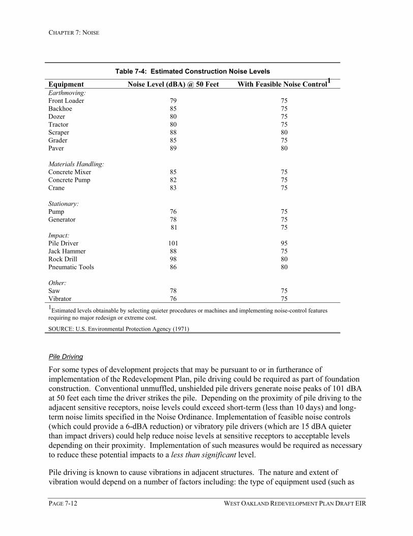
CHAPTER 7: NOISE
PAGE 7-12 WEST OAKLAND REDEVELOPMENT PLAN DRAFT EIR
Table 7-4: Estimated Construction Noise Levels
Equipment Noise Level (dBA) @ 50 Feet With Feasible Noise Control1Earthmoving:Front Loader 79 75Backhoe 85 75Dozer 80 75Tractor 80 75Scraper 88 80Grader 85 75Paver 89 80
Materials Handling:Concrete Mixer 85 75Concrete Pump 82 75Crane 83 75
Stationary:Pump 76 75Generator 78 75
81 75Impact:Pile Driver 101 95Jack Hammer 88 75Rock Drill 98 80Pneumatic Tools 86 80
Other:Saw 78 75Vibrator 76 751Estimated levels obtainable by selecting quieter procedures or machines and implementing noise-control featuresrequiring no major redesign or extreme cost.
SOURCE: U.S. Environmental Protection Agency (1971)
Pile Driving
For some types of development projects that may be pursuant to or in furtherance ofimplementation of the Redevelopment Plan, pile driving could be required as part of foundationconstruction. Conventional unmuffled, unshielded pile drivers generate noise peaks of 101 dBAat 50 feet each time the driver strikes the pile. Depending on the proximity of pile driving to theadjacent sensitive receptors, noise levels could exceed short-term (less than 10 days) and long-term noise limits specified in the Noise Ordinance. Implementation of feasible noise controls(which could provide a 6-dBA reduction) or vibratory pile drivers (which are 15 dBA quieterthan impact drivers) could help reduce noise levels at sensitive receptors to acceptable levelsdepending on their proximity. Implementation of such measures would be required as necessaryto reduce these potential impacts to a less than significant level.
Pile driving is known to cause vibrations in adjacent structures. The nature and extent ofvibration would depend on a number of factors including: the type of equipment used (such as

CHAPTER 7: NOISE
WEST OAKLAND REDEVELOPMENT PLAN DRAFT EIR PAGE 7-13
impact or vibratory tools), the type of activity, the depth of construction and the type andconditions of geologic materials. While the potential for structural damage cannot bespecifically predicted, vibration can be maintained at levels that would not cause structuraldamage if vibratory pile drivers were used. Pre-drilling of pile holes would also reduce thepotential adverse vibration effects of pile driving. With such measures, vibration effects wouldbe noticeable but would not be expected to result in structural damage to buildings if pile drivingoccurs as part of construction of future development projects within the Project Area.
Mitigation Measures
The following mitigation measures are recommended for all construction projects that may beproposed pursuant to, or in furtherance of implementation of the Redevelopment Plan’s projects,programs and other activities:
• Mitigation Measure 7.4.1: Construction Noise. The following measures shall be required asnecessary as part of future development projects pursuant to implementation of theRedevelopment Plan in order to comply with the City Noise Level Standards forTemporary Construction or Demolition Activities, as well as to minimize any potentialpile driving noise and vibration impacts:
1. Equipment and trucks used for construction should utilize the best available noisecontrol techniques (improved mufflers, equipment redesign, use of intake silencers,ducts, engine enclosures and acoustically-attenuating shields or shrouds) in order tominimize construction noise impacts. Construction equipment should not generatenoise levels above the mitigated levels listed in Table 7-4 (75 dBA to 80 dBA at 50feet, depending on equipment type).
2. Equipment used for project construction should be hydraulically or electrical poweredimpact tools (e.g., jack hammers, pavement breakers, and rock drills) whereverpossible to avoid noise associated with compressed air exhaust from pneumatically-powered tools. However, where use of pneumatically powered tools is unavoidable,an exhaust muffler on the compressed air exhaust should be used; this muffler couldlower noise levels from the exhaust by up to about 10 dBA. External jackets on thetools themselves should be used where feasible, and this could achieve a reduction of5 dBA. Quieter procedures should be used such as drilling rather than impactequipment whenever feasible.
3. Stationary noise sources should be located as far from adjacent uses as possible,particularly, any adjacent residences receptors. If they must be located near suchreceptors, they should be adequately muffled and enclosed within temporary sheds.
4. Where existing residences are located within 50 feet of the project constructionactivities, operation of heavy equipment should be limited to 10 or less days at onetime and weekend construction activities should be prohibited.
5. Pile holes should be pre-drilled to reduce potential noise and vibration impacts. Citypile driving noise attenuation requirements should be implemented as necessary.

CHAPTER 7: NOISE
PAGE 7-14 WEST OAKLAND REDEVELOPMENT PLAN DRAFT EIR
Limit pile driving from 8:00 a.m. to 4:00 p.m. Monday through Friday, with no piledriving or other extreme noise generating activity permitted between 12:30 and 1:30p.m., or other mid-day hour as established and noticed. Prohibit pile driving or otherextreme noise generating activity on Sundays and holidays. Pile driving on Saturdayswill be evaluated on a case-by-case basis, with criteria including the proximity ofresidential uses and a survey of business preferences for whether Saturday activity isacceptable if the overall duration of the pile driving is shortened. Avoid times whenthe most disturbance could occur, during business hours (to the extent practicallyfeasible), the noon lunch hour, and evening and nighttime hours (7:00 p.m. to 7:00a.m.). It is recommended that pile driving activities be limited to 1:00 p.m. to 7:00p.m. on weekdays and 9:00 a.m. to 8:00 p.m. on Saturdays. Use sonic or vibratorypile drivers where feasible instead of impact pile drivers (sonic pile drivers are onlyeffective in some soils). Vibratory pile drivers could reduce noise levels by as muchas 16 dBA, but can cause disturbance to adjacent uses. Use engine and pneumaticexhaust controls on pile drivers as feasible to ensure that exhaust noise from piledriver engines is minimized. Such controls could reduce exhaust noise by up to 6dBA.
Resulting Level of Significance
Noise impacts related to construction activities that may be pursuant to or in furtherance ofimplementation of the Redevelopment Plan would be mitigated to a less than significant level byimplementation of recommended mitigation measures.
7.4.2: Project-Related Traffic Noise Impacts
The increase in traffic noise associated with growth and development within the Project Area, asmay be facilitated by implementation of the Redevelopment Plan, would result in future noiselevels that are generally the same as or slightly higher than future noise levels that would occurwithout such growth and development. This impact is considered less than significant.
Discussion
Future (year 2025) increases in traffic as a result of growth and development within the ProjectArea would result in higher noise levels along some streets within the Project Area (see Table 7-5). As indicated in the Significance Criteria listed above, a significant noise impact would occurif traffic noise due to new development within the Project Area were to result in a 5-dBApermanent increase in ambient noise levels in the vicinity. Generally, a doubling in traffic levelstypically results in a 4.5-dBA increase in noise. . For analysis purposes, a conservative “first-cut” criteria was used to identify those roadway segments that could be most affected by trafficgenerated by new development within the Project Area. This conservative criteria was used toidentify all street segment approaches where traffic volumes would increase by 25% when trafficgenerated by new development within the Project Area was added. Of the 48 intersections (or192 intersection approaches or street segments) examined in the traffic analysis (see Chapter 5:Traffic and Circulation), there are fourteen street segments where traffic volumes would increase

CHAPTER 7: NOISE
WEST OAKLAND REDEVELOPMENT PLAN DRAFT EIR PAGE 7-15
by 25% or more when traffic generated by growth and development in the Project Area is added.As indicated in Table 7-5, traffic increases attributable to growth and development within theProject Area would increase existing noise levels by only 1 - 2 dBA along all but three of thesefourteen roadway segments:
• 32nd Street would be subject to noise increases of 3 to 3.6 dBA,
• 26th Street east of Peralta would experience the highest noise increase of 4.6 dBA, and
• Mandela Parkway south of 7th Street would experience a noise increase of approximately2.4 dBA.
Traffic increases due to new growth and development within the Project Are would increasefuture baseline noise levels (2025) by less than 2 dBA on all other segments.
Increases of less than 3 dBA are generally not perceptible to most people. The projected 3 to3.6-dBA increase on 32nd Street west and east of Mandela Parkway would be barely perceptible.These street segments are located in an area designated under the Oakland General Plan for“Business Mix” uses generally west of Mandela Parkway, and “Mixed Housing TypeResidential” and “Business Mix” to the east of Mandela Parkway. The 4.6-dBA noise increaseon 26th Street (east of Peralta) would be noticeable, but this street segment is located in an areadesignated under the Oakland General Plan for “Business Mix” uses. When compared to thesignificance criteria above, noise increases attributable to traffic generated by new growth anddevelopment within the Project Area, which would be less than 5 dBA CNEL, would be lessthan significant.
7.4.3: Noise Compatibility of Future Development
Potential Impact 7.4.3: Noise Compatibility. Depending on the precise location of new residentialuses that may be constructed pursuant to or in furtherance of the Redevelopment Plan, futurenoise levels within some portions of the Project Area could be incompatible with such residentialuse. This impact is considered to be potentially significant.
Discussion
Future growth and development within the Project Area, as may be assisted or facilitated byimplementation of the Redevelopment Plan, would occur in accordance with the OaklandGeneral Plan and more specifically the LUTE and Housing Element. Consistent with the LUTEand as more fully described in Chapter 3: Project Description, it is anticipated that futureresidential, commercial and industrial development pursuant to the Redevelopment Plan wouldoccur primarily along major transit corridors and transit-accessible sites within the Project Area,including the West Oakland Transit Village. As indicated in Table 7-1, noise levels couldapproach or exceed 70 dBA (CNEL) in certain locations within the Project Area, primarily alongarterial streets and in the vicinity of the I-580 and I-880 freeway corridors (sections not protectedby sound walls).

CHAPTER 7: NOISE
PAGE 7-16 WEST OAKLAND REDEVELOPMENT PLAN DRAFT EIR
Land Use Compatibility Guidelines
The City’s Land Use Compatibility Guidelines for Community Noise indicate that noise levelsbetween 55 and 70 dBA (CNEL) are “conditionally acceptable” for residential uses, while noiselevels above 70 dBA (CNEL) are considered “normally unacceptable.” For business commercialuses, the City’s Guidelines indicate that noise levels up to 70 dBA (CNEL) are “normallyacceptable,” while noise levels between 67 and 77 dBA (CNEL) are “conditionally acceptable.”Above 75 dBA (CNEL), noise levels are considered “normally unacceptable” for businesscommercial uses.
Traffic Noise, Major Arterial Streets
When comparing noise levels presented in Tables 7-1 and 7-5, noise levels adjacent to mostmajor arterial streets within the Project Area (including those identified in the LUTE and listedabove under Existing Noise Sources) could reach 60 to 70 dBA (CNEL). Such noise levelswould be conditionally acceptable for residential and business commercial uses. Where noiselevels are “conditionally acceptable,” a detailed noise analysis is required, but conventionalconstruction with closed windows and fresh air supply systems or air conditioning will normallysuffice. Where noise levels exceed 70 dBA (CNEL), which could include Peralta Street, SanPablo Avenue, West Grand Avenue, 7th Street, and Mandela Parkway, noise levels would be“normally unacceptable” for residential uses and “conditionally acceptable” for businesscommercial uses.

CENTRAL CITY EAST REDEVELOPMENT PLAN DRAFT EIR PAGE 7-17
Table 7-5: Future Noise Level Changes Along Selected Roadways
Noise Level (CNEL @ 50 feet from Roadway Centerline)
Street Segment ExistingWith
ProjectdBA
Change
CumulativeBaseline(2025)
CumulativePlus Project
(2025)dBA
Change
CumulativedBA Changefrom Existing
Adeline Street (West of San Pablo) 60.5 61.1 0.6 62.4 62.8 0.4 2.4Hollis Street (North of Peralta) 59.2 60.4 1.2 60.3 61.3 1.0 2.1Mandela Parkway (South of 32nd St.) 60.0 62.1 2.0 62.1 64.0 1.9 3.932nd Street (East of Mandela) 53.9 56.9 3.0 56.6 58.5 1.8 4.632nd Street (West of Mandela) 52.9 56.5 3.6 56.7 58.6 1.8 5.726th Street (East of Peralta) 49.8 54.4 4.6 57.8 58.9 1.1 9.126th Street (East of Market) 55.8 57.9 2.1 58.9 60.1 1.1 4.227th Street (West of San Pablo) 56.6 58.4 1.8 59.5 60.5 1.0 3.9Mandela Parkway (North of West Grand) 64.1 64.9 0.8 66.8 67.3 0.4 3.1Mandela Parkway (South of 7th Street) 60.7 63.1 2.4 62.4 64.1 1.8 3.47th Street (East of Mandela) 66.6 67.4 0.9 67.5 68.2 0.7 1.67th Street (East of Union) 66.0 66.8 0.8 66.7 67.4 0.7 1.4Adeline Street (South of 7th) 59.0 60.5 1.5 60.2 61.4 1.1 2.3I-880 Off-Ramp (East of Market) 60.2 61.2 1.0 61.9 62.6 0.7 2.4
NOTES: Estimates were calculated noise modeling techniques specified by the Federal Highway Administration (FHWA-RD-77-108 with updated California Vehicle NoiseEmission [CALVENO] factors) and traffic volumes in this report. The “Existing” scenario represents 2003 baseline (without project) road link volumes (refer to thetraffic section for more information). Noise levels assume 3% heavy trucks, 2% medium trucks, travel speeds of 30 to 45 miles per hour depending on the street. Noisemeasurements collected within the Plan Area (and Oakland area in general) suggest that noise levels may actually be higher than noise model estimates. Noisemeasurements taken in other areas of Oakland indicate that actual noise levels could be as much as 3 dBA higher than those listed above, depending on location.
SOURCE: Orion Environmental Associates (2003)


CENTRAL CITY EAST REDEVELOPMENT PLAN DRAFT EIR PAGE 7-19
Based on the significance criteria outlined above (which include these guidelines), any futureresidential or business commercial development located adjacent to many of the major arterialsin the Project Area would be “conditionally acceptable” or “normally unacceptable” andtherefore, noise impacts would be potentially significant.
Freeway Noise
Within approximately 500 feet of elevated sections of the I-580 freeway centerline and withinapproximately 300 feet of the I-880 freeway centerline (with a direct line-of-sight to thefreeway), noise levels could exceed 70 dBA (CNEL), which would be considered “normallyunacceptable” for residential uses and “conditionally acceptable” for business commercial uses.Noise levels are relatively lower in areas protected by sound walls (less than 60 dBA at 400 feetfrom the I-880 freeway centerline), and acceptability of noise levels along protected freewaysections would depend on proximity to the freeway. Based on the significance criteria outlinedabove (which include these guidelines), any future residential or commercial developmentlocated near the I-580 and I-880 freeway corridors could be “conditionally acceptable” forbusiness commercial uses or “normally unacceptable” for residential uses and therefore, noiseimpacts would be potentially significant.
BART Train and Station Noise
BART facilities extend through the Prescott/South Prescott subarea, and the West OaklandBART station is located in this subarea. Noise levels exceed 70 dBA (Leq and CNEL) withinthe vicinity of the BART station and elevated sections of the BART tracks, which would be“normally unacceptable” for residential uses and “conditionally acceptable” for businesscommercial uses. In addition, traffic noise generated along 7th Street as well as noise fromindustrial uses located adjacent to the BART station contribute significantly to the ambient noiseenvironment in the BART station vicinity. Based on the significance criteria outlined above(which include these guidelines), any future mixed-use development located near the BARTstation and/or tracks would be “ conditionally acceptable” for business commercial uses or“normally unacceptable” for residential uses and therefore, noise impacts would be potentiallysignificant.
City General Plan Policies
The following General Plan policies would apply to all new development within the ProjectArea, including development pursuant to implementation of the Redevelopment Plan:
Policy I/C4.2: Minimizing Nuisances: The potential for new or existing industrial or commercial uses,including seaport and airport activities, to create nuisance impacts on surroundingresidential land uses should be minimized through efficient and appropriateimplementation and monitoring of environmental and development controls.
Policy N1.5: Designing Commercial Development: Commercial development should be designed in amanner that is sensitive to surrounding uses.
Policy N3.9: Orienting Residential Development: Residential developments should be encouraged toface the street and to orient their units to desirable sunlight and views, while avoidingunreasonably blocking sunlight and views for neighboring buildings, respecting the

CHAPTER 7: NOISE
PAGE 7-20 WEST OAKLAND REDEVELOPMENT PLAN DRAFT EIR
privacy needs of residents of the development and surrounding properties, providing forsufficient conveniently located on-site open space, and avoiding undue noise exposure.
Compliance with the General Plan Policies identified above would address the issues of noiseand land use compatibility, but may not be capable of effectively reducing noise impacts tolevels of less than significant. Therefore the following mitigation measures are recommended:
Mitigation Measures
• Mitigation Measure 7.4.3A: Noise Reduction Requirements. The City of Oakland Land UseCompatibility Guidelines for Community Noise sets limits on the level of noise that newland uses may be subjected to, and requires analysis and mitigation should these noiselevels be exceeded. In accordance with these guidelines, the following specific mitigationmeasures would apply to new development projects that may be in furtherance ofimplementation of the Redevelopment Plan.
• Future residential development that may be proposed within approximately 2,000 feetof the I-580 freeway corridor and 1,400 feet of the I-880 freeway corridor (sectionsnot protected by sound walls), along major arterials identified in the LUTE, adjacentto industrial or business uses that generate noise, or in the vicinity of BART facilitieswhere noise levels exceed 60 dBA CNEL (if a direct line-of-sight is available) shallbe required to complete a detailed analysis of noise reduction requirements.
• A detailed analysis of noise reduction requirements shall also be required if anyfuture business commercial uses are proposed within approximately 700 feet of the I-580 freeway corridor and 450 feet of the I-880 freeway corridor (sections notprotected by sound walls), along major arterials identified in the LUTE, or in thevicinity of BART facilities where noise levels could exceed 67 dBA CNEL (if adirect line-of-sight is available).
• Recommended noise insulation features shall be included in the designs of suchfuture development.
• Mitigation Measure 7.4.3B: Freeway Sound Walls. The City of Oakland should coordinatewith Caltrans to investigate the potential for constructing new sound walls along thoseportions of I-880 where no sound walls are currently provided to protect the adjacentneighborhoods. Redevelopment funding could potentially be used to supplement thecosts for such walls.
• Mitigation Measure 7.4.3C: BART Train Noise Reduction. The City of Oakland shouldcoordinate with BART to investigate potential techniques for reducing the noisegenerated by BART trains, especially near the West Oakland BART station.Redevelopment funding could potentially be used to supplement the costs associated withthe investigation of such techniques and potentially to supplement the costs forimplementation.

CHAPTER 7: NOISE
WEST OAKLAND REDEVELOPMENT PLAN DRAFT EIR PAGE 7-21
Resulting Level of Significance
The impacts of noise on future development projects pursuant to the Redevelopment Plan can bemitigated to a less than significant level by implementation of the above recommendedmitigation measures.
Potential Benefits of Redevelopment
Implementation strategies may be included in the Redevelopment Plan that could help tominimize potential noise conflicts. Such strategies may include Redevelopment Agencyassistance in:
• the acquisition of properties and relocation of problem uses contributing to conflictsbetween adjacent residential and industrial uses,
• the provision of financial assistance through business façade programs that might includescreening of noise generating uses; and
• providing financial resources that might be used to assist in decreasing the noise levelsthat portions of the Project Area are exposed to from I-880 and BART operations.
7.4.4: Noise Compatibility of Mixed Use Developments
Implementation of the Redevelopment Plan would encourage development of mixed-use projectsalong key corridors, transit-oriented districts and neighborhood activity centers where noiselevels may be appropriate for commercial uses but either “conditionally acceptable” or“normally unacceptable” for residential use. However, implementation of City Noise Ordinancelimits and General Plan policies would reduce the potential for noise compatibility problems inmixed-use developments to a less than significant level.
Discussion
The Redevelopment Plan’s projects, programs and other activities, in accordance with theLUTE, would encourage development of mixed-use projects along key corridors, transit-orienteddistricts, and neighborhood activity centers. In particular, the Redevelopment Plan wouldfacilitate development of the West Oakland Transit Village. The potential for noisecompatibility problems associated with the West Oakland Transit Village would relate to theproximity of planned residential uses to noise sources such as planned commercial uses, existingBART facilities, existing industrial uses located adjacent to the BART station, and 7th Street.These sources of noise would contribute to the existing noise environment, where daytime noiselevels are measured at 68 to 70 dBA (Leq) at the BART station’s northern and easternboundaries (adjacent to 7th Street and Mandela Parkway, respectively). Based on thesemeasurements, CNEL noise levels at the station boundaries would exceed 70 dBA, and noiselevels over 70 CNEL are considered to be “normally unacceptable” for residential uses and“conditionally unacceptable” for commercial uses.

CHAPTER 7: NOISE
PAGE 7-22 WEST OAKLAND REDEVELOPMENT PLAN DRAFT EIR
In general, noise compatibility in mixed-use developments, including the Transit Village, wouldbe a concern due to the proximity of residential uses with other commercial and employmentuses. Sources of noise typically associated with commercial uses can include loading/unloadingactivities, delivery trucks, parking cars, garbage trucks, and use of refuse bins. Stationarysources of noise from commercial uses can include refrigeration, air conditioning, and heatingunits. Depending on the type of commercial or employment activities, noise generated duringthe evening or nighttime hours can result in noise conflicts between residential and commercialuses.
As described above under Section 7.4.3, the City of Oakland Land Use Compatibility Guidelinesfor Community Noise sets limits on the level of noise that new land uses may be subjected to,and requires analysis and mitigation should these noise levels be exceeded. Pursuant toMitigation Measure 7.4.3, future mixed-use developments that may be proposed along arterials(such as 7th Street and Mandela Parkway), in the BART station vicinity, within approximately2,000 feet of the I-580 freeway corridor or 1,400 feet of the I-880 freeway corridor (sections notprotected by sound walls), adjacent to industrial or business uses that generate noise where noiselevels exceed 60 dBA CNEL (if a direct line-of-sight is available) shall be required to complete adetailed analysis of noise reduction requirements. Recommended noise insulation features shallbe included in the designs of such future development.
General Plan Policies
The Oakland Noise Ordinance sets limits on the level of noise that any noise source couldgenerate at any adjacent receiving residential uses. Implementation of the City’s Land UseCompatibility Guidelines, Noise Ordinance limits and the following General Plan policies wouldreduce the potential for noise compatibility problems in mixed-use developments to a less thansignificant level.
Policy I/C4.1: Protecting Existing Activities: Existing industrial, residential, and commercial activitiesand areas which are consistent with long-term land use plans for the City should beprotected from the intrusion of potentially incompatible uses.
Policy I/C4.2: Minimizing Nuisances: The potential for new or existing industrial or commercial uses,including seaport and airport activities, to create nuisance impacts on surroundingresidential land uses should be minimized through efficient and appropriateimplementation and monitoring of environmental and development controls.
Policy D11.2: Locating Mixed-Use Development: Mixed-use development should be allowed incommercial areas, where the residential component is compatible with the desiredcommercial function of the area.
Policy N1.5: Designing Commercial Development: Commercial development should be designed in amanner that is sensitive to surrounding uses.
Policy N3.9: Orienting Residential Development: Residential developments should be encouraged toface the street and to orient their units to desirable sunlight and views, while avoidingunreasonably blocking sunlight and views for neighboring buildings, respecting theprivacy needs of residents of the development and surrounding properties, providing forsufficient conveniently located on-site open space, and avoiding undue noise exposure.

CHAPTER 7: NOISE
WEST OAKLAND REDEVELOPMENT PLAN DRAFT EIR PAGE 7-23
7.4.5 Cumulative Traffic Noise Impacts
Cumulative Impact 7.4.5: Cumulative Traffic Noise. New growth and development within theProject Area, combined with other past projects, other current projects and probable futureprojects would generate cumulative noise increases along local streets. This increase in noiselevels is projected to be cumulatively significant, and the Project’s contribution to thiscumulative condition is cumulatively considerable.
Discussion
As indicated in Impact 7.4.2 above, Project-related traffic increases would not result in asignificant noise increase on local roads. However, when future cumulative noise levels(Cumulative plus Project, year 2025 as shown on Table 7-5) are compared to existing noiselevels, noise will increase along local streets in the Project Area due to this cumulativedevelopment. Of the fourteen street segments analyzed, cumulative traffic increases (as reflectedin Cumulative dBA Change from Existing in Table 7-5) would result in noise increases of lessthan 5 dBA along all but two of the fourteen analyzed street segments:
• A 5.7-dBA increase is estimated to occur on 32nd Street west of Mandela Parkway, and
• a 9.1-dBA increase would occur on 26th Street east of Peralta.
When compared to significance criteria above, these cumulative noise increases would besignificant (i.e., greater than 5 dBA) and readily noticeable.
Comparing the noise levels shown on Table 7-5 under the Cumulative Baseline (or year 2025conditions without the Project) to the Cumulative Plus Project conditions, none of thesecumulatively significant increases in noise levels are individually attributable to increased noisedue to the Project. However, on 32nd Street east of Mandela, approximately 1.8 dBA of the 5.7-dBA cumulative increase is attributable to the Project. Similarly on 26th Street east of Peralta,approximately 1.1 dBA of the 9.1-dBA cumulative increase is attributable to the Project. Thus,noise levels due to cumulative traffic conditions are projected to be significant at these locations(i.e., greater than a 5dBA increase), and the Project’s contribution to these cumulative conditionswould be cumulatively considerable.
Existing noise levels along these two road segments are relatively low (less than 60 dBA CNEL)and these street segments are located in areas designated by the Oakland General Plan for“Business Mix” uses. Business commercial uses are not considered noise-sensitive, andprojected future noise levels are considered “normally acceptable” for business commercial uses.It should be noted that, when compared to the City’s Land Use Compatibility Guidelines forCommunity Noise, these cumulative noise increases would not result in land use compatibilityimpacts on existing and future business uses along these street segments (cumulative impactswould be less than significant), but would be considered incompatible with existing residentialuses (i.e. significant and unavoidable).

WEST OAKLAND REDEVELOPMENT PLAN DRAFT EIR PAGE 8-1
88Hazards and Hazardous Materials
8.1 IntroductionThis chapter of the EIR describes the following topics pertaining to hazardous materials relativeto the Redevelopment Plan:
• a definition of hazardous materials and waste;
• an overview of the most relevant regulations and programs pertaining to hazardousmaterials and waste that may apply to the Project Area;
• a description of general soils and groundwater conditions in the Project Area; and
• a general description of hazardous building materials that are present within the ProjectArea.
This discussion addresses hazardous materials that may be encountered during implementationof the Redevelopment Plan’s projects, programs and other activities, and provides a program-level analysis of potential impacts with respect to hazards and hazardous materials together withidentification of program-level mitigation measures.
Information on toxic air contaminants is not included within this chapter, but is addressed inChapter 6: Air Quality.
8.1.1 Definitions
Hazardous materials and hazardous wastes are defined in the California Code of Regulations,Title 22, Sections 66260 through 66261.10. As defined in Title 22, hazardous materials aregrouped into four general categories: toxic (causes human health effects); ignitable (has theability to burn); corrosive (causes severe burns or damages materials); or reactive (causesexplosions or generates toxic gasses). They are generally considered to be substances withcertain chemical or physical properties that may pose a substantial present or future hazard tohuman health or the environment when improperly handled, stored, disposed or otherwisemanaged. In general, discarded, abandoned, or inherently waste-like hazardous materials arereferred to as hazardous wastes. A hazardous material or waste can be present in a liquid, semi-solid, solid, or gaseous form.
CHAPTER 8: HAZARDS AND HAZARDOUS MATERIALS
PAGE 8-2 WEST OAKLAND REDEVELOPMENT PLAN DRAFT EIR
8.2 Environmental SettingThis section describes existing general environmental conditions in terms of potential sources ofhazardous materials in soil or groundwater that may affect future development in theRedevelopment Area. The discussion of environmental conditions is based primarily oninformation from a review of environmental regulatory databases conducted for this EIR(Environmental Data Resources, Inc. [EDR], 2002). Appendix F presents the name and date ofeach database reviewed for this inventory and describes each database. The following potentialsources of hazardous materials are present in the Project Area:
• historic land uses which involved the use of hazardous materials;
• existing permitted uses of hazardous materials including underground storage tanks(USTs) and permitted handling of hazardous wastes;
• sites in the Project Area where soil or groundwater has been affected or is suspected to beaffected by a chemical release(s) from past or present site uses (referred to asenvironmental cases) that have been identified on regulatory databases; and
• soil and/or groundwater quality at land uses adjacent to the Project Area, if contaminationis present and extends off-site to the Project Area.
8.2.1 Historic Land Uses
Historically, the Redevelopment Area was one of the first industrial areas of Oakland. Becauseof its excellent access by rail and sea, the area has been a major transportation node and locationof large industrial plants, many of which involved food processing, since the late 1800s. Duringthe First and Second World Wars, West Oakland also became a center for defense relatedindustries because of its port and rail facilities. Over the years, many industrial operations havemodernized and relocated or closed due to economic decline and a move away from war timeindustries. As a result, many of the industrial properties have been abandoned and left indilapidated and contaminated condition. As this occurred, transportation uses became moreprevalent because of increased activities at the Port of Oakland and because of West Oakland’scentral location and freeway accessibility.
8.2.2 Current Land Uses
The Project Area currently includes a mix of older residential, industrial, and commercial usesand structures. Industrial uses include warehousing, transportation related uses, food processors,various types of smaller manufacturers, building construction and related businesses, metalworks and fabrication uses, various auto dismantling activities and junkyards, and large publicsector facilities such as the Post Office’s mail distribution center. These uses are concentrated inthe vicinity of West Grand Avenue, Mandela Parkway, and Peralta Street. Commercial and auto-related uses are distributed throughout the project area, particularly in the vicinity of San PabloAvenue and West Grand Avenue. Utilities and government agencies use some of the ProjectArea.

CHAPTER 8: HAZARDS AND HAZARDOUS MATERIALS
WEST OAKLAND REDEVELOPMENT PLAN DRAFT EIR PAGE 8-3
Within the Clawson/McClymonds/Bunche and Prescott/South Prescott subareas, industrial usesare often in close proximity to residential uses and other sensitive land uses such as parks andschools to the extent that in some areas sensitive uses are completely surrounded by industrialuses or small industrial uses are completely surrounded by sensitive land uses. These areas lack atransition zone to reduce conflicts between industrial and sensitive land uses.
8.2.3 Permitted Hazardous Materials Uses
To identify land uses that involve the use of hazardous materials, the environmental databasereview identified facilities that use hazardous materials or handle hazardous wastes, inaccordance with current hazardous materials and hazardous waste regulations. Permitted uses ofhazardous materials within the Project Area are tracked by regulatory agencies and includefacilities that:
• have permitted or historic USTs;
• have registered aboveground petroleum storage tanks;
• have reported releases of hazardous materials to the air, water, or land;
• generate, transport, store, or dispose of polychlorinated biphenyls (PCBs);
• manufacture or handle materials regulated under the Toxic Substances Control Act(TSCA);
• are registered pesticide producing facilities;
• conduct dry cleaner-related operations; or
• have historically conducted mining operations.1
Permitted uses associated with handling of hazardous wastes includes generators, transporters,and disposal facilities permitted under the federal Resource Conservation and Recovery Act(RCRA) and facilities that have submitted hazardous waste manifests to the CaliforniaDepartment of Toxic Substances Control (DTSC).
In addition, the City of Oakland maintains an inventory of sites that have filed a HazardousMaterials Business Plan or Risk Management and Prevention Plan, have registered USTs, orhave registered as a hazardous waste generator or hazardous waste treatment facility. These sitesare categorized by approximate risk to the public:
• P1 sites are considered high hazard sites. These sites store acutely hazardous chemicalsor hazardous chemicals in high quantities (including hazardous waste generatorsgenerating greater than 1,000 kg/month of waste or a UST site with more than four
1 Properties that have been involved in mining - including coal mining, quarrying, or sand and gravel operations– are not necessarily permitted for the use of hazardous materials but mining operation have historically involvedthe use of hazardous materials and are included in the summary table.

CHAPTER 8: HAZARDS AND HAZARDOUS MATERIALS
PAGE 8-4 WEST OAKLAND REDEVELOPMENT PLAN DRAFT EIR
tanks), or are sites with an independent operator with on-site contamination or a poorinspection history.
• P2 sites are considered medium hazard sites, such as auto body shops and drycleaners.
• P3 are considered low hazard sites and are any site included in the Office of EmergencyServices database that do not meet the criteria for classification as P1 or P2.
Because the use and handling of hazardous materials at permitted sites are subject to strictregulation, the potential for a release of hazardous materials from these sites is considered lowunless there is a documented chemical release at that same site. In such cases, the site would bealso tracked in the environmental databases as an environmental case (described separatelybelow). Permitted sites without documented releases are nevertheless potential sources ofhazardous materials to the soil and/or groundwater (compared to sites where there are nohazardous materials) because of accidental spills, incidental leakage or spillage that may havegone undetected.
Table 8-1 summarizes the total number of permitted facilities within the Project Area identifiedin the record search for each regulatory database. Many of the facilities are permitted for morethan one hazardous material use and appear in more than one database. After compiling theinformation from each database by address, a total of 475 distinct properties with permittedhazardous materials uses were identified. Appendix F includes a summary of each regulatorydatabase reviewed and the date of the database, and Appendix G includes a compilation ofpermitted uses by address.
As indicated in Table 8-1, the primary permitted uses of hazardous materials identified withinthe Project Area include small quantity generators permitted under RCRA (RCRIS SQG);underground storage tanks which would typically contain petroleum products (UST, CA FIDUST, and HIST UST); facilities that have transported hazardous wastes off-site (HAZNET); andhazardous materials uses tracked by the City of Oakland. Of those facilities tracked by the City15 are classified as P1 sites, 10 are classified as P2 sites, and 125 are classified as P3 sites; theremaining facilities have not been assigned a priority by the City.
The database review also identified four large quantity generators permitted under RCRA(RCRA LQG), seven facilities with an above ground storage tank (AST), three facilities thatreport releases of chemicals to the air, land, or water (TRIS); two facilities that generate,transport, store, broker, or dispose of PCBs (PADs); one facility that manufactures or importschemical substances regulated under the Toxic Substances Control Act (TSCA); 14 sitesundergoing administrative, enforcement, and compliance actions related to the FederalInsecticide, Fungicide, and Rodenticide Act; five identified dry cleaner-related facilities(CLEANERS); and one property that has historically been involved in mining (MINES). TheFacility Index System (FINDS) typically includes pointers to facilities identified in otherregulatory databases.

CHAPTER 8: HAZARDS AND HAZARDOUS MATERIALS
WEST OAKLAND REDEVELOPMENT PLAN DRAFT EIR PAGE 8-5
Table 8-1: Summary of Permitted Facilities Using Hazardous Materials in the Project Area
No. ofFacilities onList* Name and Description of Regulatory Database
4 Resource Conservation and Recovery Act Information System Large Quantity Generators (RCRISLQG) – facilities permitted to generate more than 1,000 kilograms per month of non-acutely hazardouswaste.
78 RCRIS Small Quantity Generators (RCRIS SQG) – facilities permitted to generate more than 100kilograms per month but less than 1,000 kilograms per month of non-acutely hazardous waste.
3 Toxic Chemical Release Inventory System (TRIS) – facilities that report releases of chemicals to the air,water, or land.
2 PCB Activity Database (PADS) – facilities that generate, transport, commercially store, broker, ordispose of PCBs.
1 Toxic Substances Control Act (TSCA) – facilities that manufacture or import chemical substancesincluded on the TSCA Chemical Substances Inventory list.
14 Federal Insecticide, Fungicide, and Rodenticide/TSCA (FTTS) – administrative, enforcement, andcompliance actions related to the Federal Insecticide, Fungicide, and Rodenticide Act.
109 Facility Index System (FINDS) – a database that includes information on facilities included in othermore detailed databases.
294 Hazardous Waste Information System (HAZNET) – facilities that have filed hazardous waste manifestswith the DTSC.
5 Dry cleaner-related facilities (CLEANERS)
169 Oakland HAZMAT Sites (P1, P2, or P3)
158 Underground Storage Tanks (UST) – facilities permitted to maintain underground storage tanks.
98 Facility Inventory Database (CA FID UST) – facilities on a historical listing of active and inactiveUSTs.
90 Hazardous Substances Storage Container Database (HIST UST) – facilities on a historic list of USTsites.
7 Above-ground Petroleum Storage Tank Facilities (AST) – facilities with registered above-groundstorage tanks.
1 Mines Master Index File (MINES) – properties that have been involved in mining including coalmining, quarrying, or sand and gravel operations.
*Some of the sites may appear on more than one list.
Source: Orion Environmental Associates; City of Oakland, 2002; and Environmental Data Resources, 2002.

CHAPTER 8: HAZARDS AND HAZARDOUS MATERIALS
PAGE 8-6 WEST OAKLAND REDEVELOPMENT PLAN DRAFT EIR
8.2.4 Environmental Cases
Environmental cases are those sites suspected of releasing hazardous substances or that have hadcause for hazardous substances investigations and are identified on regulatory agency lists.Identification of hazardous substances at these sites is generally due to site disturbance activitiessuch as removal or repair of an underground storage tank, a spill of hazardous substances, orexcavation for construction. The status of each environmental case varies and can be eitheractive (ongoing investigations or remediation), closed (remediation or clean-up completed andapproved by the regulatory agency), or unknown. However, the status of each case can changewith time, and new cases are periodically added to the databases. Therefore, as discussed belowunder Impacts and Mitigation Measures, it would be necessary to update the status ofenvironmental cases as well as identify any additional cases in the future when site-specificdevelopment occurs.
Table 8-2 summarizes the number of environmental cases within the Project Area identified inthe record search of regulatory databases. Many sites appear in more than one database. Aftercompiling the information from each database by address, a total of 208 distinct properties wereidentified as environmental cases. Appendix F includes a summary of each regulatory databasereviewed and the date of the database, and Appendix G includes a compilation of environmentalcases by address.

CHAPTER 8: HAZARDS AND HAZARDOUS MATERIALS
WEST OAKLAND REDEVELOPMENT PLAN DRAFT EIR PAGE 8-7
Table 8-2: Summary of Environmental Cases and Reported Spills
No. of Cases onList* Name and Description of Regulatory Database
1 List of Deed Restrictions (DEED) – sites which have been issued a deed restriction because of the presenceof hazardous substances
2 Annual Work Plan (AWP) – sites targeted for cleanup by the DTSC.
1 California Bond Expenditure Plan (CA BOND EXP PLAN) – sites with a site-specific expenditure plan forthe appropriation of state funds.
11 Spills, Leaks, Investigation, and Cleanup Cost Recovery Listing (SLIC Reg2) – sites under the jurisdictionof the San Francisco Bay Regional Water Quality Control Board.
161 Leaking Underground Storage Tanks (LUST).
4 Comprehensive Environmental Response, Compensation, and Liability Information System (CERCLIS) ofpotential Superfund sites. These are generally sites with documented releases of hazardous materials.
9 CERCLIS No Further Action Planned (CERCLIS NFRAP) – sites previously identified under CERCLISbut designated for no further action.
47 Cal Sites (CAL-SITES) – potential hazardous waste sites identified by the DTSC.
9 Proposition 65 Records (NOTIFY 65) – facilities that have reported a release that could threaten a drinkingwater source.
1 Toxic Pits Cleanup Act Sites (TOXIC PITS) – sites suspected of containing hazardous materials.
2 Solid Waste Information System (SWF/LF) – active, inactive, or closed solid waste disposal sites.
135 Cortese Hazardous Waste and Substances Site List (CORTESE) – a compilation of sites listed in theLUST, SWF/LF, and CAL-SITES databases.
42 Emergency Response Notification System (ERNS). These cases are usually spills or releases of chemicalsreported to federal authorities
39 California Hazardous Materials Incident Reporting System (CHMIRS) – hazardous materials spills andreleases reported to the California Office of Emergency Services
5 Hazardous Materials Incident Reporting System (HMIRS) – hazardous materials spills and releasesreported to the US Department of Transportation.
* Some of the sites may appear on more than one list.

CHAPTER 8: HAZARDS AND HAZARDOUS MATERIALS
PAGE 8-8 WEST OAKLAND REDEVELOPMENT PLAN DRAFT EIR
As summarized in Table 8-2, the primary environmental cases identified within the Project Areainclude sites with leaking underground storage tanks (LUST) which would generally involve arelease of petroleum products and potential hazardous waste sites identified by the DTSC (CAL-SITES), which would generally include sites with releases of chemicals other than petroleumproducts. The database review also identified:
• 1 site with a deed restriction (DEED),
• 2 sites targeted for cleanup by the DTSC under the Annual Work Plan (AWP),
• 1 site identified under the California Bond Expenditure Plan (CA BOND EXP PLAN),
• 11 sites under the jurisdiction of the RWQCB (SLIC Reg2),
• 4 potential Superfund sites (CERCLIS),
• 9 sites identified under the Comprehensive Environmental Response, Compensation, andLiability Information System but designated for no further action (CERCLIS NFRAP),
• 9 facilities that have reported a release that could threaten a drinking water source(NOTIFY 65),
• 1 site suspected of containing hazardous materials (TOXIC PITS),
• 2 active, inactive or closed solid waste disposal sites (SWF/LF), and
The CORTESE database lists sites that are included in other databases including LUST andCAL-SITES.
Known Groundwater Plume
There is one major groundwater plume2 in the Project Area that is undergoing furthercharacterization. The U.S. EPA is currently in the process of conducting a RemedialInvestigation of this site to collect further information to evaluate the extent vinyl chloride andother chemicals in the soil, groundwater, and soil gas at the AMCO Chemical site. Theinformation obtained will be used to evaluate the site for inclusion on the National Priorities List(NPL). The AMCO Chemical site is located within the City of Oakland’s Transit-OrientedDevelopment Zoning District, adjacent to the proposed West Oakland Transit Village.
The plume of vinyl chloride and other chemicals was first identified in 1996 when samplingperformed in response to complaints from utility workers in 1995 confirmed the presence ofvinyl chloride and chlorinated solvents in soil and groundwater downgradient of the AMCOChemical Corporation site at 1414 Third Street (CH2MHILL, 2002). Subsequent samplingdocumented the presence of vinyl chloride and other chemicals at the AMCO Chemical site.
2 A groundwater plume is an area where chemicals have entered the groundwater. The extent of the plume is theextent of chemicals identified in the groundwater.

CHAPTER 8: HAZARDS AND HAZARDOUS MATERIALS
WEST OAKLAND REDEVELOPMENT PLAN DRAFT EIR PAGE 8-9
To ensure that people living near the site were protected, the U.S. EPA initiated an EmergencyResponse action in 1996, installing a groundwater and soil vapor treatment system whichoperated until July 1998 when the system was shut down in response to community concernsover exposure to contaminants in the exhaust.
Based on sampling activities conducted since shut down of the system, the U.S. EPA hasconcluded that:
• Elevated concentrations of vinyl chloride and other chemicals found in soil at theAMCO property do not extend off-site and the entire site is covered by concretewhich would prevent direct contact with the contaminated soil by the community;
• Elevated levels of vinyl chloride and other chemicals have been identified ingroundwater beneath the site and off-site although the groundwater is not used as adrinking water source and no drinking water wells exist within ¼ mile of the site; and
• Levels of vinyl chloride exceeding action levels were identified in crawl-space air andsoil gas in September 1999 although vinyl chloride was not detected in either crawl-space air or soil gas samples collected in April 2000. The U.S. EPA does not believethat the very low levels of vinyl chloride found in 1999 could affect the health of thepeople living in the homes where samples were collected.
History of Accidental Hazardous Materials Releases
In support of the Defensible Space Assessment, a community emergency preparedness trainingprogram, The Neighborhood Information on Chemical Hazards in the Environment (NICHE)Project conducted a project to analyze accidental releases within West Oakland during the 10year period from 1987 to 1996 including the release location, cause, and hazardous materialreleased (NICHE, 1997).3 The analysis, referred to as the West Oakland Pilot Program,concluded that over 50% of the spills were reported by someone other than the responsible partywhich supports the need for community training in response to hazardous materials incidents.
The analysis also found that during the period reviewed, there were an average of approximately96 reported hazardous substances spills reported each year in Oakland. The most spills reportedin a year was 149, reported in 1992. The number of spills declined each year after this to a low of44 spills reported in 1996. Approximately two events each year resulted in an injury requiring ahospital visit. The most injury related incidents occurred in 1992 when a total of five spillsinjured 24 people. The most people injured during a single year was 36 in 1994. In one 1994incident, 33 individuals were sent to the hospital for decontamination after a firearm wasdischarged into an electrical transformer causing it to explode and spray transformer oil.
Of the reported spills in Oakland, the most commonly spilled substance was a petroleum product,accounting for 41% of all spills. Chemicals and unknown materials accounted for 24% and 16%
3 The analysis included only spills reported to the Emergency Response Notification System, a database of spills
reported to federal agencies. The analysis did not consider releases reported only to state or local agencies.

CHAPTER 8: HAZARDS AND HAZARDOUS MATERIALS
PAGE 8-10 WEST OAKLAND REDEVELOPMENT PLAN DRAFT EIR
of the spills, respectively. Other substances spilled include, waste, paint, gas, asbestos, sewage,and radioactive materials. Of the chemical spills reported, 21 involved the release of transformerand PCB containing materials.4 Other chemicals released include acids and cyanides used by theplating industries, asbestos, drug lab wastes, and chemicals used to make polyurethane foam.One release from a plating shop culminated in a fire that resulted in the evacuation of severalhundred people.
Gases involved in accidental gas releases included liquefied petroleum gas, ammonia, andchlorine; ammonia and chlorine are considered acutely toxic gasses. Four releases of radioactivematerials were reported; one involved a leaking container of radioactive materials, two involvedthe theft of radioactive materials, and one involved the illegal dumping of a cylinder commonlyused by hospitals to hold radioactive materials.
Of the reported spills in Oakland, 17% occurred in West Oakland mixed industrial/residentialland use areas. Illegal dumping is the largest reported cause of spills within Oakland. Othercauses of spills include freight accidents, spills, releases from vessels, public observations,human error and equipment failure, traffic accidents, fires, fumes, and buried utilities. Theenvironmental database review conducted for this EIR confirms that there have been hazardousmaterials spills reported within much of the Project Area (ERNS, CHMIRS, and HMIRSdatabases – see Table 8-2).
Adjacent Land Uses
The Oakland Army Base Redevelopment Area lies directly to the west and south of the WestOakland Redevelopment Area. The Maritime Sub-district borders the redevelopment areadirectly to the south and the 16th/Wood Sub-district borders the redevelopment area to the west.The Oakland Army Base Sub-district is located further to the east of the West OaklandRedevelopment Area (City of Oakland, 2002).
The Maritime Sub-district has been historically and currently used for industrial purposesincluding the Port of Oakland and the Former Fleet and Industrial Supply Center. Numerousleaking underground storage tank sites and other environmental cases have been identified withinthis area. Those cases located nearest to the Redevelopment Area include the Former UnionPacific Roundhouse Property where free product5 has been identified on the groundwater;Schnitzer Steel where concrete pavement has been placed over the exposed soil to eliminateexposure to hazardous substances at the site and a subterranean cutoff wall has been installed toprevent migration of contaminated groundwater to the bay; and the Union Pacific DesertRailyard.
Several environmental cases were identified in the 16th/Wood Sub-district including the FormerAmtrak Station/14th Street Area and the Former Phoenix Ironworks. The primary chemicals
4 Nine of these incidents were caused by the Oakland Hills fire in 1991.
5 Where present in a sufficient quantity, petroleum products will float on the groundwater surface because theyare less dense than water; the presence of petroleum products in this form is referred to as “free product”.

CHAPTER 8: HAZARDS AND HAZARDOUS MATERIALS
WEST OAKLAND REDEVELOPMENT PLAN DRAFT EIR PAGE 8-11
detected in soil and/or groundwater at the Former Amtrak Station/14th Street Area includepetroleum hydrocarbons, lead, and chlorinated hydrocarbons. With few exceptions, thesechemicals were detected at concentrations below Risk-Based Screening Levels (RBSLs) forindustrial/commercial land uses. Chlorinated hydrocarbons identified in soil and groundwater atthis site are suspected to originate from another site. Elevated levels of lead and petroleumhydrocarbons were identified in the soil at the Former Phoenix Ironworks and the groundwatercontained metals and chlorinated hydrocarbons. Soil at both sites would be classified as ahazardous waste on the basis of soluble lead concentrations.
The OARB Sub-district has been used for industrial purposes for some time, with previous landuses including an oil reclaiming plant, a ship manufacturing facility, and metal workingoperations. In the 1940s, the area was filled for the construction of the OARB which wasoperated as a U.S. Army military installation until it was closed in 1995. The Army operated theOARB as a distribution center, and primary operations by the Army involved mostlywarehousing and shipping of cargo overseas. Locomotive engines and trucks involved in thetransport of cargo were serviced at this facility. In addition, hazardous materials may have beenshipped either to or from the OARB during its operation. The DTSC, ORA, and OBRA haveentered into a Consent Agreement for the cleanup of contaminated soil and groundwater at theOARB. Under this agreement, contaminated sites within the OARB will be cleaned up to riskbased cleanup levels suitable for the planned future land use of the site.
8.2.5 Hazardous Building Materials
Hazardous building materials are included in this discussion because future implementationprojects, programs and other activities associated with redevelopment would likely involvedemolition or renovation of existing structures. Some building materials commonly used inolder buildings could present a public health risk if disturbed during demolition or renovation ofan existing building. Hazardous building materials often present in older buildings includeasbestos, electrical equipment such as transformers and fluorescent light ballasts that containPCBs, fluorescent lights containing mercury vapors and lead-based paints. Asbestos and lead-based paint may also present a health risk to existing building occupants if they are in adeteriorated condition. If removed during demolition of a building, these materials would alsorequire special disposal procedures.
8.3 Regulatory and Policy SettingHazardous materials and hazardous wastes are subject to numerous federal, state and local lawsand regulations intended to protect health and safety and the environment. Many of theseregulations would apply to future redevelopment activities within the Project Area. The overallregulatory framework for hazardous materials is discussed in Appendix E.
Of particular relevance to the West Oakland Project area are “Brownfields Initiatives” that havebeen developed to remove barriers to development of properties with real or perceivedcontamination. Abandoned, idled, or underused industrial and commercial facilities are referredto as “brownfields”. Historically, development of these sites has not been favored because of theunknown costs associated with cleanup of existing contamination and because of the potential

CHAPTER 8: HAZARDS AND HAZARDOUS MATERIALS
PAGE 8-12 WEST OAKLAND REDEVELOPMENT PLAN DRAFT EIR
for taking on long-term liability associated with contamination at a property. Faced with theseunknowns, developers have often preferred development of “greenfields”6 in outlying areaswhere there are no contamination concerns but where there is generally a greater overall burdenon the environment.
The sections below focus on those regulatory and policy-based initiatives that have beendeveloped to promote reuse of “brownfields” by facilitating cleanup of abandoned, idled, andunderutilized properties such as those that would be encountered within the Project Area.Regulations that have been enacted to ensure safe handling of hazardous materials, appropriateresponse to releases of hazardous materials, appropriate closure of permitted facilities, and safehandling of hazardous materials near a sensitive receptor are also identified.
8.3.1 Federal Regulations
The U.S. Environmental Protection Agency (U.S. EPA) is the lead agency responsible forenforcing federal regulations that affect public health or the environment. The primary federallaws and regulations include the Resource Conservation and Recovery Act of 1974 (RCRA); theComprehensive Environmental Response, Compensation and Liability Act of 1980 (CERCLA);and the Superfund Act and Reauthorization Act of 1986 (SARA). Federal statutes pertaining tohazardous materials and wastes are contained in the Code of Federal Regulations (40 CFR).
The U.S. Environmental Protection Agency (U.S. EPA) has developed numerous “brownfield”programs to promote and expedite the cleanup of brownfields while reducing the potentialliability to lenders and developers of contaminated properties. These programs are more fullydescribed in Appendix E.
8.3.2 State of California Regulatory/Policy Setting
The California Department of Toxic Substances Control (DTSC) and the Regional Water QualityControl Board (RWQCB) are the primary state agencies regulating hazardous materials inCalifornia. These agencies are part of the California EPA. The RWQCB is authorized by theState Water Resources Control Board to enforce provisions of the Porter - Cologne WaterQuality Control Act of 1969. This act gives the RWQCB authority to require groundwaterinvestigations when the quality of groundwater or surface waters of the state is threatened, and torequire remediation of the site, if necessary. The DTSC is authorized by the U.S. EPA toregulate the management of hazardous substances including the remediation of sitescontaminated by hazardous substances.
The DTSC has also developed “brownfield” programs to promote and expedite the cleanup ofbrownfields. Those state programs developed with or in association with the DTSC mostapplicable to the Project Area are further described below.
6 Greenfields are land where there have been no previous commercial or industrial land uses.

CHAPTER 8: HAZARDS AND HAZARDOUS MATERIALS
WEST OAKLAND REDEVELOPMENT PLAN DRAFT EIR PAGE 8-13
Polanco Redevelopment Act
The Polanco Redevelopment Act, applicable only in redevelopment areas, authorizes aredevelopment agency to take action to require the investigation and clean up of an identifiedrelease of hazardous materials in accordance with applicable state and federal laws. Theredevelopment agency may also perform the cleanup itself with the oversight of the DTSC, theSan Francisco Bay Regional Water Quality Control Board (RWQCB) or local agency if the siteowner or operator refuses to do so. If the clean up is completed in accordance with an approvedclean up plan and is performed to the satisfaction of the responsible agency, redevelopmentagencies, developers, subsequent land owners, and lenders receive immunity from liability forthe contamination under this legislation. This act also includes cost recovery provisions to allowthe redevelopment agency to pursue cost reimbursement from the responsible party for actionstaken by the agency. Senate Bill 1684, passed in September 2002, was enacted to make this actpermanent.
In the San Francisco Bay Area, examples of where redevelopment agencies have used thePolanco Redevelopment Act to expedite the clean up “brownfield” sites include a 12-acreindustrial site in Emeryville, a former 3-acre trucking and fuel distribution facility in SanLeandro, and a former gas station and asphalt manufacturing facility site in Redwood City(California Redevelopment Association, 2002). Advantages of invoking the Polanco Act forthese cleanups include speeding up the cleanup process, immunity from liability to facilitatefinancing for the development projects and shifting the cleanup costs to the responsible parties.
California Land Environmental Restoration and Reuse Act
The California Land Environmental Restoration and Reuse Act (CLERRA) was enacted onOctober 12, 2001, to promote the restoration and reuse of brownfields sites in California. Thisact authorizes local regulatory agencies to require property owners to provide information relatedto potential past or present hazardous material releases at a property and to require a Phase Ienvironmental assessment if a release is indicated. In the event that a potential release isindicated by the Phase I environmental assessment, the act requires the California EPA to assignthe DTSC, RWQCB, or a local agency as the lead oversight regulatory agency for furtherinvestigation and remediation of the site. These actions include a preliminary endangermentassessment, additional site investigations, and implementation of remedial action in accordancewith an approved Remedial Action Plan (RAP). Oakland has not completed the process toauthorize a local agency under the CLERRA.
8.3.3 City of Oakland Regulatory/Policy Setting
In accordance Chapter 6.11 of the Health and Safety Code (Section 25404, et seq.), the City ofOakland assumed authority and responsibility for the administration and enforcement within thecity of the unified hazardous waste and hazardous materials management program. The purposeof this legislation was to simplify environmental reporting by streamlining the number ofregulatory agency contacts a facility must maintain and requiring the use of more standardizedforms and reports. The City of Oakland Fire Services Agency, Office of Emergency Services(OES) is the administering agency for the Certified Uniform Program Agency (CUPA) programin Oakland.

CHAPTER 8: HAZARDS AND HAZARDOUS MATERIALS
PAGE 8-14 WEST OAKLAND REDEVELOPMENT PLAN DRAFT EIR
Oakland Urban Land Redevelopment Program
The Oakland Urban Land Redevelopment Program is a collaborative effort by the City ofOakland and other principal agencies charged with enforcing environmental regulations inOakland7 to streamline the clean up and redevelopment of moderately contaminated sites (Cityof Oakland Public Works Agency, 2000). The program provides a consistent set of guidelinesfor the application of risk-based corrective actions by clarifying environmental investigationrequirements, standardizing the regulatory process, and establishing Oakland-specific, risk basedcorrective action cleanup standards for qualifying sites. Benefits of standardizing this processinclude reduced investigation, remediation, and overall project costs; more accurate costestimating; expedited regulatory approval of the corrective action plans; expedited regulatory siteclosure; and earlier realization of development goals.
The Urban Land Redevelopment Program includes a three-tiered approach to the investigation ofOakland sites and identification of risk-based cleanup standards.
• Tier 1 Risk Based Screening Levels (RBSLs) and Tier 2 Site Specific Target Levels(SSTLs) are specified for the protection of human health at Oakland sites that meetspecific eligibility requirements, where commonly found contaminants are present, andthe contaminants are considered to present a relatively low risk. RBSLs and SSTLs areidentified for residential and commercial/industrial land uses. These levels are typicallylower (more stringent) for residential land uses than for commercial/industrial land uses.
• For more complicated sites that do not meet the eligibility requirements, a Tier 3 analysisusing site-specific information would be required to identify SSTLs for the appropriateland use. RBSLs and SSTLs are based on an acceptable carcinogenic risk of 10-5 andnon-carcinogenic hazard index of 1.0.
A risk management plan would be prepared to specify containment measures8 wherecontaminants would be left at concentrations greater than the most stringent RBSL. Thesemeasures would be used to prevent exposure to any hazardous materials left in place and/orinstitutional controls that would be employed to ensure the future protection of human health.9The site would also be included in the City of Oakland Permit Tracking System, and future
7 Specifically, the program was developed by the Oakland Public Works Agency, Environmental ServicesDivision with assistance from the Alameda County Department of Environmental Health, California Departmentof Toxic Substances Control, San Francisco Regional Water Quality Control Board, US EnvironmentalProtection Agency, a community panel, Spence Environmental Engineering, and volunteer environmentalconsultants.
8 Containment measures are engineering controls that can be used to reduce or eliminate exposure tohazardous materials at a site. Typical containment measures include vapor barriers, asphalt caps, moisturebarriers, and slurry walls. Implementation of these measures can reduce human health risks at a site and aretypically less expensive and easier to implement than techniques used to physically remove contaminants from asite.
9 Institutional controls that are commonly used include deed restrictions, land use restrictions, accesscontrols, recording notices, and contractual obligations.
CHAPTER 8: HAZARDS AND HAZARDOUS MATERIALS
WEST OAKLAND REDEVELOPMENT PLAN DRAFT EIR PAGE 8-15
permit applications for work that might alter the conditions of site closure would undergo specialreview by the City of Oakland Fire Department. Implementation of this program is intended toprovide assurance that human health and environmental resources will be protected withoutneedlessly delaying future construction and development projects.
Throughout most of Oakland, humans are the primary receptor that may be exposed to hazardousmaterials because most of the city is urbanized. Ecological receptors such as wildlife andendangered species are generally not of concern. Based on this, the Urban Land RedevelopmentProgram does not include provisions for development of cleanup levels for sites where there isan existing or potential exposure pathway to ecological receptors or sensitive habitats such aswildlife refuge areas, wetlands, surface water bodies, or other protected areas. For sites whereecological receptors or sensitive habitats may be exposed to hazardous materials, an ecologicalrisk analysis would be required to identify cleanup levels that would be protective of thesereceptors.
Oakland Hazardous Materials Regulation
In accordance Chapter 6.11 of the California Health and Safety Code (Section 25404, et seq.),the City of Oakland assumed authority and responsibility for the administration and enforcementof the unified hazardous waste and hazardous materials management program within the city.The purpose of this legislation was to simplify environmental reporting by streamlining thenumber of regulatory agency contacts a facility must maintain and requiring the use ofstandardized forms and reports. The City of Oakland Fire Services Agency, Office ofEmergency Services (OES) is the administering agency for the Certified Uniform ProgramAgency (CUPA) program in Oakland. The responsibilities of the CUPA are described inAppendix E.
Community Right To Know Laws
In accordance with Community Right to Know laws, businesses that handle specified quantitiesof hazardous materials prepare a Hazardous Materials Business Plan (HMBP) that detailshazardous substance inventories, site layouts, training and monitoring procedures, andemergency response plans. Businesses that handle specified amounts of acutely hazardousmaterials must implement a Risk Management and Prevention Plan (RMPP). The RMPP mustinclude information on the submitting facility, reference to the facility's business plan, processdesignation, identification of acutely hazardous materials handled and their quantity, and ageneral description of processes and principal equipment. Requirements for these programs arefurther discussed in Appendix E.
Spill Reporting at a Permitted Facility
In accordance with CUPA regulations, the City also requires facilities to report any actual orpotential release of hazardous substances by calling 911 and is required to complete all actionsnecessary to remedy the effects of an unauthorized release. If the City suspects a release ofhazardous materials from a facility they may also inspect the facility and abate a property wherecontamination is not being managed in compliance with CUPA regulations. Requirements forspill reporting and authorization for the City to abate a property are further discussed inAppendix E.

CHAPTER 8: HAZARDS AND HAZARDOUS MATERIALS
PAGE 8-16 WEST OAKLAND REDEVELOPMENT PLAN DRAFT EIR
Closure of Facilities Under CUPA Program
As described in more detail in Appendix E, facilities that handle hazardous materials or wastesunder the CUPA program are required to appropriately close, prepare, and implement a closureplan when hazardous materials handling activities are stopped. The closure plan must ensure thatthere is no residual threat to public health and safety or the environment from possible release ofhazardous materials and/or waste from the unit or facility and require no future monitoring of thesite.
Use of Hazardous Substances Within ¼ Mile of a Sensitive Receptor
To protect sensitive receptors from public health effects from a release of hazardous substances,the City of Oakland Municipal Code requires a handler of hazardous materials within 1,000 feetof a residence, school, hospital, or other sensitive receptor to make written disclosure of whetherit will handle, store, or produce any hazardous substances. The City, at its discretion, may requiresuch a facility to prepare a hazardous materials assessment report and remediation plan(HMARRP) and include public participation in the planning process.10 The HMARRP must:
• Identify hazardous materials used and stored at the property and the suitability of thesite;
• Analyze off-site consequences that could occur as a result of a release of hazardoussubstances (including fire);
• Include a health risk assessment; and
• Identify remedial measures to reduce or eliminate on-site and off-site hazards.
Citizens of Oakland Respond to Emergencies
Both the Loma Prieta earthquake of 1989 and the Firestorm of 1991 strained City emergencyresponse resources, and the City recognized that it would be beneficial to have citizens trained inemergency response procedures also. To address this, the OES developed the Citizens ofOakland Respond to Emergencies (CORE) as a citizen emergency response program to help theOakland community become more self sufficient in disaster situations. In 1997 the COREprogram was expanded to include a hazardous materials and awareness educational program.CORE promotes community awareness and training in emergency response to chemicalaccidents, natural disasters, and severe weather incidents. The CORE program includes trainingfor home and family preparedness and forming and linking neighborhood response teams as wellas more advanced training in early response procedures and fire suppression and prevention.
Emergency Response Notification System
The OES has implemented an Emergency Alerting and Notification System which utilizesoutdoor warning sirens to alert the public in the event of an impending emergency including a
10 An industrial facility that changes ownership is also required to disclose whether it will handle, store,produce any substance presenting a threat to public health. If so, then the facility is also required to can also berequired to prepare an HMARRP.

CHAPTER 8: HAZARDS AND HAZARDOUS MATERIALS
WEST OAKLAND REDEVELOPMENT PLAN DRAFT EIR PAGE 8-17
toxic release, threat of flooding or mudslides, major fire, secondary problems caused byearthquakes, or other natural or technological disasters. The public have been alerted to tune intolocal emergency alerting radio station for safety information and instructions if the sirens areactivated. There are sirens installed at three locations in West Oakland including Goss and PineAvenues, the Poplar Recreation Area, and Lafayette Square.
8.4 Impacts and Mitigation MeasuresSignificance Criteria
Under CEQA Guidelines, implementation of the West Oakland Redevelopment Plan would havea significant impact on the environment if it were to:
• Create a substantial hazard to the public or the environment through the routine transport,use, or disposal of hazardous materials;
• Create a substantial hazard to the public or the environment through reasonablyforeseeable upset and accident conditions involving the release of hazardous materialsinto the environment;
• Emit hazardous emissions or handle hazardous or acutely hazardous materials, materials,or waste within ¼ mile of an existing or proposed school;
• Be located on a site that is included on a list of hazardous materials sites compiledpursuant to Government Code Section 65962.5, or be another known or suspectedcontaminated site that would (1) create a significant hazard to the public or theenvironment, (2) exceed the acceptable excess cancer risk range of 1 × 10⁻⁵ forcommercial or industrial land uses as set forth in the City of Oakland Urban LandRedevelopment Program Guidance Document (City of Oakland, 2000), or (3) exceed theacceptable excess cancer risk range set in the National Contingency Plan (1 × 10⁻⁶ to1 × 10-4) for other uses;
• Impair implementation of or physically interfere with an adopted emergency responseplan or emergency evacuation plan; or
• Be located within an airport land use plan or, where such a plan has not been adopted,within two miles of a public airport or public use airport, and would result in safetyhazards for people residing or working in the project area.
Definition, identification and determination of threshold levels of hazardous materials and wastesare provided in Title 40 of the Code of Federal Regulations (40 CFR) and in Title 22 of theCalifornia Code of Regulations. Determination of “substantial” hazard or “insignificant” levelsof hazardous materials is performed by the regulatory agencies on a case-by-case basis,depending on the proposed uses, potential exposure, and degree and type of hazard.
CHAPTER 8: HAZARDS AND HAZARDOUS MATERIALS
PAGE 8-18 WEST OAKLAND REDEVELOPMENT PLAN DRAFT EIR
8.4.1: Potential Long-Term Impacts
Potential Impact 8.4.1: Currently, businesses within the Project Area handle hazardous materialsas part of their operations. Implementation of the Redevelopment Plan’s projects, programs andother activities could result in the introduction of new businesses that handle hazardousmaterials. These existing and potential new businesses could cause a substantial hazard to thepublic or the environment as a result of an accidental release of hazardous materials or wastes.This is a potentially significant effect.
Discussion
Implementation of the Redevelopment Plan would encourage introduction of additionalbusinesses that could involve the handling of hazardous materials in those areas designated underthe General Plan for “Business Mix” uses. While this land use classification requires a mix oflight industrial, commercial business, and office uses along the periphery to attain the requiredbuffering between residential areas and high impact uses, it is likely that some of the newbusinesses could include the use of hazardous materials, require construction and use of on-siteaboveground or underground storage tanks for the storage of hazardous materials or fuelproducts, or result in the production of hazardous wastes. These businesses would be required tocomply with applicable federal, state and local regulations. However, there would remain thepotential for an accidental release of hazardous materials or petroleum products, such as a tankleak, spill or rupture, to occur.
City Municipal Code
To protect residences from exposure to hazardous materials during normal operations, the CityMunicipal Code includes the following measures addressing the compatibility of residential landuses with industrial or commercial land uses involving hazardous materials use:
• Chapter 17.101 of the City Municipal Code, the S-16 Industrial-Residential TransitionCombining Zone regulations, includes requirements to provide a transition betweenresidential and industrial land uses. Limited civic, commercial, and small manufacturingactivities are allowed within this zone. The City, on a case-by-case basis, mayconditionally approve additional uses, including live-work accommodations.
• Chapter 17.114 of the City Municipal Code allows the City to control, improve, orterminate uses that do not conform to the zoning regulations.
General Plan Policies
The Land Use and Transportation Element of the Oakland General Plan contains the followingpolicies to reduce the potential of adverse effects from an accidental release of hazardousmaterials:
Policy I/C4.1: Protecting Existing Activities. Existing industrial, residential, and commercial activitiesand areas which are consistent with long-term land use plans for the City should beprotected from the intrusion of potentially incompatible land uses.
Policy W1.3: Reducing Land Use Conflicts. Land uses and impacts generated from Port orneighborhood activities should be buffered, protecting adjacent residential areas from

CHAPTER 8: HAZARDS AND HAZARDOUS MATERIALS
WEST OAKLAND REDEVELOPMENT PLAN DRAFT EIR PAGE 8-19
the impacts of seaport, airport, or other industrial uses. Appropriate siting of industrialactivities, buffering (e.g., landscaping, fencing, transitional uses, etc.), truck trafficmanagement efforts, and other mitigations should be used to minimize the impact ofincompatible uses.
Policy W2.2: Buffering of Heavy Industrial Uses. Appropriate buffering measures for heavy industrialuses and transportation uses on adjacent residential neighborhoods should be developedand implemented.
Policy N5.1: Environmental Justice. The City is committed to the identification of issues related to theconsequences of development on racial, ethnic, and disadvantaged socio-economicgroups. The City will encourage active participation of all its communities, and will makeefforts to inform and involve groups concerned about environmental justice andrepresentatives of communities most impacted by environmental hazards in the earlystages of the planning and development process through notification and two-waycommunication.
Policy N5.2: Buffering Residential Areas. Residential areas should be buffered and reinforced fromconflicting uses through the establishment of performance-based regulation, the removalof non-conforming uses, and other tools.
Mitigation Measures
Any businesses that handle or store hazardous materials or petroleum products are required tocomply with, among other regulations, the City Municipal Code. Under Code requirements, theCity of Oakland Office of Emergency Services (OES) is designated as the Certified UnifiedProgram Agency (CUPA) responsible for permitting and overseeing activities that involveunderground storage tanks and the handling of hazardous materials in the City of Oakland. TheOakland OES requires facilities that handle hazardous materials greater than threshold quantitiesto prepare a Hazardous Materials Business Plan (HMBP), and facilities that handle acutelyhazardous materials are required to prepare a Risk Management and Prevention Plan (RMPP).
• Mitigation Measure 8.4.1: Technical Assistance - Hazardous Materials Business Plans andRisk Management and Prevention Plans. Implementation programs pursuant to theRedevelopment Plan should include redevelopment assistance for existing and potentialnew businesses within the Project Area that handle hazardous or acutely hazardousmaterials. Such assistance may be in the form of loans, grants and/or technical assistancefrom the OES toward the preparation of required Hazardous Materials Business Plansand/or Risk Management and Prevention Plans.
Resulting Level of Significance
Compliance with OES requirements, as well as with state and federal regulations, wouldminimize potential exposure of site personnel and the public to any accidental releases ofhazardous materials or waste, and would also protect the area from potential environmentalcontamination. Redevelopment assistance pursuant to Mitigation Measure 8.4.1 would ensuremaximum compliance with these regulations and thereby minimize the risk of accidentalreleases, ensure safe handling of hazardous materials at permitted facilities, and increase theprotection of nearby residences from the potential of an accidental release. There remains the

CHAPTER 8: HAZARDS AND HAZARDOUS MATERIALS
PAGE 8-20 WEST OAKLAND REDEVELOPMENT PLAN DRAFT EIR
potential that existing and new businesses could still have an accidental release of hazardousmaterials or wastes. However, required compliance with federal, state and local regulationswould reduce this risk to generally acceptable thresholds. Each of these regulations containsidentifiable quantitative, qualitative or performance-based thresholds. Compliance with thesethresholds would reduce this effect to a level of less than significant.
Potential Benefits of Redevelopment
It is uncertain whether introduction of new businesses would result in an increase or decrease offacilities that handle hazardous materials within the Project Area. However, even if there were aknown increase in the use of hazardous materials, it would not necessarily correspond to anincrease in risk associated with their use or handling, or in generation of hazardous waste. Therisk associated with an increase in hazardous materials use associated with new businesses wouldbe offset with compliance with current hazardous materials regulations, including structuralrequirements of handling, storing, secondary containment and disposing of hazardous materials.In addition, new businesses would likely implement the newer and improved technology forhandling and storage of hazardous materials.
Adoption of the Redevelopment Plan and subsequent implementation of redevelopment projects,programs and other activities is anticipated to assist in implementation of the land use strategyenvisioned under the General Plan LUTE for the Business Mix land use classification. This landuse classification anticipates an eventual transition of land use over time that would result in a“buffer zone” consisting of a mix of light industrial, commercial business, and office uses toseparate residential uses from heavier industrial uses. While this land use transition couldintroduce new businesses which handle hazardous materials, these businesses would be requiredto comply with federal, state and local hazardous materials regulations, including structuralrequirements for handling, storing, secondary containment and disposing of hazardous materials.
An indirect benefit of redevelopment would be the use of newer and improved technology forhandling and storage practices that would likely be implemented by new businesses in the future,and replacement of older businesses that use older technology. This would provide anincremental increase in protection to public health and the environment against future accidentalreleases of hazardous materials.
8.4.2: Accidental Release of Hazardous Materials or Wastes during NormalTransport Operations
Potential Impact 8.4.2: Currently, businesses within the Project Area include those which involvetransport of hazardous materials as part of their operations. Implementation of theRedevelopment Plan’s projects, programs and other activities could result in the introduction ofnew businesses that involve transport of hazardous materials. These existing and potential newbusinesses could cause a substantial hazard to the public or the environment as a result of anaccidental release of hazardous materials or wastes during normal transport operations. This is apotentially significant effect.

CHAPTER 8: HAZARDS AND HAZARDOUS MATERIALS
WEST OAKLAND REDEVELOPMENT PLAN DRAFT EIR PAGE 8-21
Discussion
As described in Impact 8.4.1 above, the Redevelopment Plan’s implementation projects,programs and other activities could result in an increase of use of hazardous materials in theProject Area. This in turn could result in an increased potential for transportation-relatedaccidents in the area. Even though transporters of hazardous materials and wastes are required tocomply with applicable federal, state and local regulations, there would remain the potential foran accidental release of hazardous materials or wastes to occur.
The California Highway Patrol and the California Department of Transportation (Caltrans) arethe primary state agencies with responsibility for enforcing federal and state regulationspertaining to transport of hazardous materials within California. The U.S. Department ofTransportation regulates the transport of chemicals and hazardous materials by truck betweenstates. These agencies regulate container types and packaging requirements as well as licensingand training for truck operations, chemical handling and hazardous waste haulers.
City General Plan Policies
The Land Use and Transportation Element of the Oakland General Plan contains the followingpolicy related to transport of hazardous materials:
Policy T1.6: Designating Truck Routes. An adequate system of roads connecting port terminals,warehouses, freeways and regional arterials, and other important truck destinationsshould be designated. This system should rely upon arterial streets away from residentialneighborhoods.
Mitigation Measures
The potential for an accidental release of hazardous materials to occur within a residential area isreduced by current truck route prohibitions. The prohibitions limit truck travel to designatedtruck routes including the on- and off- ramps at 7th Street, Adeline and Union Streets, and WestGrand Avenue. These truck routes (refer to the Chapter 5: Traffic and Circulation, Section 5.4.3of this EIR for a more complete description of this program) specify approved truck travel routesas well as designated truck prohibition routes, and serve to draw traffic away from residentialareas.
• Mitigation Measure 8.4.2A: Enforcement of Truck Prohibitions. Implementation programspursuant to the Redevelopment Plan should include projects, programs or other activitiesintended to increase or enhance the enforcement of prohibitions that limit truck travel todesignated truck routes.
• Mitigation Measure 8.4.2B: Preference for New Industrial Uses along Truck Routes.Redevelopment assistance for new industrial development projects should be prioritizedto give preference to those new or existing businesses located along approved truck travelroutes, and whose primary access routes are well away from residential areas.

CHAPTER 8: HAZARDS AND HAZARDOUS MATERIALS
PAGE 8-22 WEST OAKLAND REDEVELOPMENT PLAN DRAFT EIR
Resulting Level of Significance
Compliance with federal and state hazardous materials transportation regulations and existingGeneral Plan policies would minimize the risk for accidental releases during normal transportoperations along approved truck routes. Redevelopment programs pursuant to MitigationMeasures 8.4.2A and B would ensure maximum compliance with truck prohibitions and therebyminimize the risks associated with an accidental releases and increase protection of nearbyresidences.
There remains the potential that existing and new businesses could still have an accidentalrelease of hazardous materials or wastes during transport. However, required compliance withfederal, state and local regulations would reduce this risk to generally acceptable thresholds.Each of these regulations contains identifiable quantitative, qualitative or performance-basedthresholds. Compliance with these thresholds would reduce this effect to a level of less thansignificant.
8.4.3: Use of Hazardous Materials within ¼ Mile of a School
Potential Impact 8.4.3: Currently, all of the schools within the Project Area are located within ¼mile of a permitted hazardous materials use or an identified environmental case. Most of theseschools are also located within ¼ mile of an area designated for “Business Mix” or “CommunityCommercial” land uses. Implementation of the Redevelopment Plan’s projects, programs andother activities could result in the introduction of new businesses that involve hazardousmaterials within the Business Mix or Community Commercial area near schools. This is apotentially significant effect.
Discussion
There are seven schools operated by the Oakland Unified School District within the ProjectArea, and an additional four schools located within ¼ mile of the Project Area boundaries. Ofthose schools located within the Project Area, all are currently located within ¼ mile of apermitted hazardous materials use or an identified environmental case. Most are also locatedwithin ¼ mile of an area designated for “Business Mix” or “Community Commercial” land usesunder the 1998 General Plan LUTE. Two of the schools located within ¼ mile of the ProjectArea boundaries are also located within ¼ mile of a permitted hazardous materials use within theProject Area, and one is located within ¼ mile of an area designated for Business Mix uses.
The Redevelopment Plan’s implementation programs, projects and other activities couldfacilitate the addition of new businesses that handle hazardous materials within those areasdesignated as Business Mix and Community Commercial uses. Without proper planning andhandling, the use of hazardous materials within ¼ mile of these schools could result inunacceptable health risks to these sensitive receptors.

CHAPTER 8: HAZARDS AND HAZARDOUS MATERIALS
WEST OAKLAND REDEVELOPMENT PLAN DRAFT EIR PAGE 8-23
Mitigation Measures
The City of Oakland Municipal Code requires any facility that handles hazardous or acutelyhazardous materials in excess of specified quantities to file a disclosure form, commonly referredto as a Hazardous Materials Business Plan (HMBP). This form must contain information neededfor City emergency services to adequately prepare for response to an emergency at that facility.Facilities that handle acutely hazardous materials must also complete a Risk Management andPrevention Plan (RMPP) to assess potential off-site consequences of a release of hazardousmaterials.
In addition, facilities that handle hazardous materials within ¼ mile of a school, hospital, orresidence can be required to complete a Hazardous Materials Assessment Report andRemediation Plan (HMARRP). The HMARRP must identify hazardous materials used at thefacility and the suitability of the site, the potential on-site and off-site risks, and remedialmeasures to be implemented to reduce or eliminate on-site and off-site risks. The HMARRP issubject to review and approval by the City and public review and comment to ensure thatpotential threats to public health are adequately addressed.
• Mitigation Measure 8.4.3A: Preference for Industrial Uses away from Sensitive Receptors.Redevelopment assistance for new industrial development projects should be prioritizedto give preference to those new or existing businesses located further than ¼ mile awayfrom a school sites, hospital, health clinic or residence.
• Mitigation Measure 8.4.3B: Hazardous Materials Assessment Report and Remediation PlanRequired. Any project in furtherance of the Redevelopment Plan that proposes a businessthat handles hazardous materials within ¼ mile of a school, hospital, or residence shall berequired to submit a Hazardous Materials Assessment Report and Remediation Plan(HMARRP) for review and approval by the City.
• Mitigation Measure 8.4.3C: Technical Assistance - Hazardous Materials Assessment Reportand Remediation Plan. Implementation programs pursuant to the Redevelopment Planshould include redevelopment assistance for existing businesses within the Project Areathat handle hazardous materials within ¼ mile of a school, hospital or residence. Suchassistance may be in the form of loans, grants and/or technical assistance from the OEStoward the preparation of a required Hazardous Materials Assessment Report andRemediation Plan.
Resulting Level of Significance
Compliance with City regulations will require hazardous material handlers within 1,000 feet of aschool or other sensitive receptor to disclose the use of hazardous materials, conduct assessmentsof potential off-site risks, and implement remedies to reduce identified risks. These requirementswould reduce the potential for an unacceptable release of hazardous materials within ¼ mile of aschool or other sensitive receptor. Redevelopment priorities, requirements and assistancepursuant to Mitigation Measure 8.4.3A, B and C would ensure maximum compliance with theseregulations and thereby minimize the risk of accidental releases and increase the protection ofnearby sensitive receptors from the potential of an accidental release. However, there remains

CHAPTER 8: HAZARDS AND HAZARDOUS MATERIALS
PAGE 8-24 WEST OAKLAND REDEVELOPMENT PLAN DRAFT EIR
the potential that existing and new businesses could still have an accidental release of hazardousmaterials or wastes.
Required compliance with federal, state and local regulations would reduce this risk to generallyacceptable thresholds. Each of these regulations contains identifiable quantitative, qualitative orperformance-based thresholds. Compliance with these thresholds would reduce this effect to alevel of less than significant.
8.4.4: Exposure to Hazardous Materials as a Result of New Land Uses
Potential Impact 8.4.4: Implementation of the Redevelopment Plan’s projects, programs and otheractivities could result in the redevelopment of older industrial areas with new land uses. Withoutmeasures to ensure adequate cleanup of closed facilities and cleanup of soil and groundwater toappropriate cleanup levels, future site occupants could be exposed to unacceptable levels ofhazardous materials. This is a potentially significant effect.
Discussion
The 1998 General Plan Land Use and Transportation Element anticipates the gradual transitionof properties currently used for industrial purposes, particularly those currently non-conformingindustrial land uses, to other uses. This transition would involve closure and/or relocation ofnon-conforming industrial land uses and introduction of new businesses within a buffer zonealong the periphery of the “Mixed Business” use area. Without measures to ensure adequatecleanup of closed facilities and cleanup of soil and groundwater to appropriate cleanup levels,future site occupants could be exposed to unacceptable levels of hazardous materials.
In addition, known sites where remediation has been completed or in the cases where closure hasbeen granted, regulatory agencies would have approved health-based clean up efforts to levelsthat are based on current land uses. In some cases, closure may have accepted containmentcontrols as adequate to prevent unacceptable exposure to hazardous materials for a given landuse (i.e., industrial uses). Such controls may have allowed the site owner to leave hazardousmaterials in the soil and/or groundwater at concentrations higher than otherwise applicablecleanup levels, such as for residential or more sensitive uses. If land uses change to a moresensitive use as a result of implementation programs, projects or other activities of theRedevelopment Plan, such as changing from existing industrial or commercial use to a newresidential use, then more strict clean up levels would apply. Without additional remediation,new site occupants could be exposed to unacceptable levels of hazardous materials in the soiland/or groundwater.
Mitigation Measures
• Mitigation Measure 8.4.4A: Technical Assistance - Closure of Permitted Hazardous MaterialsUse Sites. Implementation programs pursuant to the Redevelopment Plan should includeredevelopment assistance for the proper closure of hazardous materials use sites inaccordance with existing laws and regulations. Such assistance may be in the form ofloans, grants or technical assistance, or the use of Polanco Act or other Redevelopment

CHAPTER 8: HAZARDS AND HAZARDOUS MATERIALS
WEST OAKLAND REDEVELOPMENT PLAN DRAFT EIR PAGE 8-25
Agency authority to ensure closure of permitted hazardous materials use sites inaccordance with an approved CUPA program and City of Oakland regulations.Requirements for closure of the facility include preparation of a closure plan that:
• Eliminates the need for further monitoring of the closed unit or facility;
• Ensures that there is no residual threat to public health of safety or the environmentfrom possible release of hazardous materials and/or waste from the unit or facility;and
• Ensures that the removal, disposal, and neutralization or reuse of the hazardousmaterials and/or waste handled by or released from the unit or facility, areaccomplished in an appropriate manner.
• Closure of any facility is subject to inspection by the OES before and after closure todemonstrate that the closure will be or was implemented in accordance with theaccepted closure plan.
• Mitigation Measure 8.4.4B: Technical Assistance – Risk Management Plan. Implementationprograms pursuant to the Redevelopment Plan should include redevelopment assistancefor the appropriate reporting of closures of hazardous materials use sites. Such assistancemay be in the form of loans, grants and/or technical assistance toward the preparation of arequired Risk Management Plan (RMP).
• A Risk Management Plan is required in accordance with the Urban LandRedevelopment Program for sites where institutional controls or containment wereused to prevent unacceptable contact with soil or groundwater containing hazardousmaterials.
• The RMP shall specify how remaining contamination would be managed to ensurethe continued protection of human health and the environment.
• A copy of the RMP shall be placed on file with the lead regulatory agency for thecleanup of the site and with the City Fire Department, and the site shall be included inthe City of Oakland Permit Tracking System.
• Mitigation Measure 8.4.4C: Permit Tracking Review. Any project, program or otherimplementation activity in furtherance of the Redevelopment Plan proposed on a site thathas been closed under the requirements of CUPA shall be reviewed pursuant to the CityPermit Tracking System. Under this system, any redevelopment-related activity thatmight alter conditions of prior site closure would undergo special review by the City ofOakland Fire Department to ensure that proper actions are taken to prevent unacceptableexposure to hazardous materials as a result of changed site conditions.

CHAPTER 8: HAZARDS AND HAZARDOUS MATERIALS
PAGE 8-26 WEST OAKLAND REDEVELOPMENT PLAN DRAFT EIR
Resulting Level of Significance
Compliance with City policies and regulations requiring a Risk Management Plan and trackingof sites that have obtained conditional closure in the Oakland Permit Tracking System wouldreduce the risk of unacceptable exposure to hazardous materials. These requirements wouldensure that facilities permitted under the CUPA program are cleaned up to levels appropriate forfuture land uses anticipated at the time of closure, or that the responsible party commits to anacceptable timeline for cleanup.
Required compliance with federal, state and local regulations would reduce this risk to generallyacceptable thresholds. Each of these regulations contains identifiable quantitative, qualitative orperformance-based thresholds. Compliance with these thresholds would reduce this effect to alevel of less than significant.
8.4.5: Exposure to Hazardous Materials in Soil or Groundwater duringConstruction
Potential Impact 8.4.5: Future construction activities pursuant to implementation of theRedevelopment Plan that involve excavation, grading, and/or de-watering could encounterhazardous materials in the soil and groundwater. This impact is considered to be potentiallysignificant.
Discussion
As discussed in the Environmental Setting, there are numerous sites permitted for hazardousmaterials use and many identified environmental cases located within the Project Area.Construction activities associated with excavation, grading, and dewatering at or adjacent tothese sites could encounter hazardous materials in the soil and groundwater. Withoutimplementation of proper precautions, workers and/or the community may be exposed tohazardous materials.
Where remediation would require off-site transport of contaminated soil or groundwater, thesematerials could be classified as a restricted or hazardous waste under state or federal regulationsdepending on the specific characteristics of the materials. There would be the potential foraccidents during transport, which could expose the public and the environment to the chemicalcompounds. Where construction would require de-watering of contaminated groundwater, arelease of hazardous materials could occur, potentially resulting in exposure to the public and theenvironment. Redevelopment may also involve the improvement of underground utilities andcould also include the installation of new utilities by the City. There is the potential to encounterhazardous materials in soil and/or groundwater from adjacent chemical release sites during workon underground utilities which could potentially expose workers, the public, or the environmentto hazardous materials.
General Plan Policies
The Land Use and Transportation Element of the Oakland General Plan contains the followingpolicy related to the cleanup of chemical release sites:

CHAPTER 8: HAZARDS AND HAZARDOUS MATERIALS
WEST OAKLAND REDEVELOPMENT PLAN DRAFT EIR PAGE 8-27
Policy I/C2.1: Pursuing Environmental Cleanup. The environmental clean up of contaminatedindustrial properties should be actively pursued to attract new users in targetedindustrial and commercial areas.
The following OSCAR Element policy and action also apply to the cleanup of chemical releasesites:
Policy CO-1.2: Soil Contamination Hazards. Minimize hazards associated with soil contaminationthrough appropriate storage and disposal of toxic substances, monitoring of dredgingactivities, and cleanup of contaminated sites. In this regard, require soil testing fordevelopment of any site (or dedication of any parkland or community garden) wherecontamination is suspected due to prior activities on the site.
Action CO-1.2.1: Further Study of Soil Contamination. Conduct further study of soil contamination andtoxics during update of the Oakland General Plan Safety Element.
Mitigation Measures
• Mitigation Measure 8.4.5A: Identification and Remediation of Hazardous Materials.Implementation programs pursuant to the Redevelopment Plan should includeredevelopment assistance in the identification and remediation of hazardous materials inaccordance with existing laws and regulations. Such assistance may be in the form ofloans, grants or technical assistance, or the use of Polanco Act or other RedevelopmentAgency/City authority (e.g., CLERRA). These City/Agency authorities enable theAgency/City to require a site owner to conduct further investigations and, pending theresults of a Phase I environmental assessment, to conduct remediation if a release ofhazardous materials is indicated. This mitigation measure would implement state andfederal regulations and would require the following general process to address chemicalreleases and reduce the potential threat to human health and the environment:
• The potential for hazardous materials at a site proposed for development shall beevaluated through completion of a site-specific Phase I environmental site assessmentprior to development. The site assessment includes visual inspection of the property,review of historical documents, and review of environmental databases to assess thepotential for contamination from sources such as underground storage tanks, currentand historical site operations, and migration from off-site sources. Phase Ienvironmental site assessments are commonly conducted to comply with the duediligence requirements of the federal Comprehensive Environmental Response,Compensation, and Liability Act (CERCLA).
• Where a Phase I site assessment indicates evidence of a chemical release, a leadregulatory agency would be assigned (the ACDEH, RWQCB, or DTSC) andadditional data would be gathered during a Phase II investigation. This would includeactual sampling and laboratory analysis of the soil and groundwater for the suspectedchemicals to identify the nature and extent of chemicals in soil and/or groundwater.Appropriate cleanup levels for each chemical, based on current and planned land use,would be determined in accordance with procedures described in the Urban LandRedevelopment Program or accepted procedures adopted by the lead agency

CHAPTER 8: HAZARDS AND HAZARDOUS MATERIALS
PAGE 8-28 WEST OAKLAND REDEVELOPMENT PLAN DRAFT EIR
providing oversight of the investigation and remediation. At sites where there areecological receptors such as sensitive plant or animal species that could be exposed tohazardous materials, clean up levels would be determined according to the acceptedecological risk assessment methodology of the lead agency, and would be protectiveof ecological receptors known to be present at the site.
• If the agreed-upon clean-up levels were exceeded, a remedial action plan would beprepared to describe remedial alternatives considered for the site. This remedialaction plan and the proposed remedial approach would be presented for review andapproval by the lead regulatory agency. The plan would include proposed methods toremove or treat identified chemicals to the approved cleanup levels or containmentmeasures to prevent exposure to chemicals left in place at concentrations greater thanapproved cleanup levels.
• Upon determination that a chemical release has not occurred or that a site remediationhas been successfully completed to the most stringent cleanup levels, the lead agencywould issue a “no further action” letter to the site owner.
• For sites that were cleaned to levels that do not allow unrestricted land use, or wherecontainment measures were used to prevent exposure to hazardous materials, a letterof “conditional site closure” would be issued. Under this scenario, a RiskManagement Plan would be prepared and the site would be tracked in the City’sPermit Tracking System as described in Section 8.4.4.
• Mitigation Measure 8.4.5B: Underground Storage Tank (UST) Closure. Implementationprograms pursuant to the Redevelopment Plan should include redevelopment assistancein the removal of permitted or previously unidentified, abandoned or no longer usedunderground storage tanks in accordance with City of Oakland requirements. Suchassistance may be in the form of loans, grants or technical assistance, or the use ofPolanco Act or other Redevelopment Agency/City authority. This mitigation measurewould implement state and federal regulations and would require the following generalprocess to address underground storage tanks:
• Removing and properly disposing of any remaining hazardous materials in the tank,and having the tank removal supervised by the City.
• Sampling of the soil within the tank excavation. Recycling or disposing of thediscarded tank, and filing a tank removal closure report with the City.
• If a chemical release were indicated on the basis of sampling within the tankexcavation, assessment of soil and groundwater quality and remediation, if required,would be conducted as described above for hazardous materials.
• Alternatively, the tank could be abandoned in place if removal were infeasible.
• Mitigation Measure 8.4.5C: Disposal of Contaminated Soil or Groundwater. Implementationprograms pursuant to the Redevelopment Plan should include redevelopment assistance

CHAPTER 8: HAZARDS AND HAZARDOUS MATERIALS
WEST OAKLAND REDEVELOPMENT PLAN DRAFT EIR PAGE 8-29
in the removal of disposal of contaminated soil or groundwater in accordance with City ofOakland requirements. Such assistance may be in the form of loans, grants or technicalassistance, or the use of Polanco Act or other Redevelopment Agency/City authority.This mitigation measure would implement state and federal regulations and would requirethe following general process:
• The generator of the hazardous wastes would be required to follow state and federalregulations for manifesting the wastes, using licensed waste haulers, and disposing ofthe materials at a permitted disposal or recycling facility.
• The BAAQMD may also impose specific requirements to protect ambient air qualityfrom dust, lead, hydrocarbon vapors or other airborne contaminants during siteremediation activities.
• Mitigation Measure 8.4.5D: Dewatering of Contaminated Groundwater. Implementationprograms pursuant to the Redevelopment Plan should include potential redevelopmentassistance in the removal or dewatering of contaminated groundwater in accordance withCity of Oakland requirements. Such assistance may be in the form of loans, grants ortechnical assistance, or the use of Polanco Act or other Redevelopment Agency/Cityauthority. This mitigation measure would implement state and federal regulations andwould require the following general process:
• The construction contractor would obtain necessary permits from the Regional WaterQuality Control Board, San Francisco Bay Region; East Bay Municipal UtilityDistrict; and/or the City of Oakland Department of Public Works for the discharge ofgroundwater during dewatering to the storm or sanitary sewer.
• During the dewatering, the contractor would comply with any requirements forsampling of the groundwater to identify the concentrations of any chemicals present.Depending on the concentrations, pretreatment of the groundwater may be necessaryprior to discharge.
• If the groundwater does not meet discharge requirements, on-site pretreatment may berequired before discharge to the sewer system.
• If standards could not be met with on-site treatment, off-site disposal by a certifiedwaste hauler would be required.
• Mitigation Measure 8.4.5E: Procedures for Protection of Workers. Any project, program orother implementation activity in furtherance of the Redevelopment Plan that may beproposed on a site involving a site investigation, site remediation, underground storagetank removal, excavation, dewatering, and/or construction of improvements where achemical release has occurred, shall be conducted according to legally required health andsafety precautions.
• For hazardous waste workers, federal and California Occupational Safety and HealthAdministration (Cal/OSHA) regulations mandate an initial training course and

CHAPTER 8: HAZARDS AND HAZARDOUS MATERIALS
PAGE 8-30 WEST OAKLAND REDEVELOPMENT PLAN DRAFT EIR
subsequent annual training. Site-specific training may also be required for someworkers.
• Preparation and implementation of the Site Health and Safety Plan and compliancewith applicable federal, state, regional, and local regulations would minimize impactsto public health and the environment. The Plan would include identification ofchemicals of concern, potential hazards, personal protection clothing and devices, andemergency response procedures as well as required fencing, dust control or other sitecontrol measures needed during excavation.
• Mitigation Measure 8.4.5F: Underground utility Construction Process. Any project, programor other implementation activity in furtherance of the Redevelopment Plan that mayinclude construction of underground utilities shall require, through implementingcontracts, the construction contractor to follow proper health and safety precautions andto dispose of contaminated soil and groundwater safely and legally.
Resulting Level of Significance
Compliance with City policies and regulations as specified above under Mitigation Measures8.4.5A through 8.4.5F would reduce the risk of exposure of workers and the public to hazardousmaterials during redevelopment-related excavation, grading, and/or de-watering activities. Inprotecting the workers who would be closest to potential sources of hazardous materials, thehealth and safety measures would also serve to protect others who live, work, or visit the areaduring the temporary construction period. These measures, along with application of cleanupstandards, would serve to protect human health and the environment during site activities, thusminimizing impacts associated with exposure to hazardous materials.
Required compliance with federal, state and local regulations would reduce this risk to generallyacceptable thresholds. Each of these regulations contains identifiable quantitative, qualitative orperformance-based thresholds. Compliance with these thresholds would reduce this effect to alevel of less than significant.
Potential Benefits of Redevelopment
Much of the Project Area is located in areas with known environmental cases or in areas whereprevious land uses may have resulted in chemical releases to the soil or groundwater. However,the Redevelopment Plan’s implementation projects, programs and other activities wouldencourage and expedite clean up of sites where a chemical release has occurred, which mayotherwise not be remediated. However, there are real and perceived liabilities associated withdevelopment of contaminated properties and the remediation of these properties could be furtherenhanced and encouraged with implementation of a well-coordinated development projectutilizing brownfields (contaminated and underutilized properties) within the Project Area. Suchan approach could be invoked through the Polanco Act or the CLERRA. Advantages of usingthis approach include:
• development of a coordinated and cost-effective approach to investigation and cleanup ofthe brownfields properties;
• coordinated regulatory oversight which simplifies the regulatory process;

CHAPTER 8: HAZARDS AND HAZARDOUS MATERIALS
WEST OAKLAND REDEVELOPMENT PLAN DRAFT EIR PAGE 8-31
• immunity from liability for the Redevelopment Agency as well as the developers andtheir successors; and
• providing the legal ability for the Redevelopment Agency to recuperate costs from theresponsible party(ies).
The U.S. EPA Brownfields Program (described in Appendix E) can also facilitate thiscoordinated approach through providing pilot grants and partnering with state and local agenciesto remove the obstacles to redevelopment.
8.4.6: Exposure to Hazardous Building Materials
Potential Impact 8.4.6: Demolition and renovation of existing structures could result in potentialexposure of workers or the community to hazardous building materials during construction,without proper abatement procedures, and future building occupants could be exposed ifhazardous building materials are left in place. This is a potentially significant impact.
Discussion
Implementation of the Redevelopment Plan’s projects, programs and other activities wouldpromote new construction within the Project Area, which would likely include demolition and/orrenovation of existing structures. Hazardous building materials are likely to be present in olderstructures within the Project Area and could include asbestos-containing material, lead-basedpaint, PCBs, and fluorescent lights containing mercury vapors. Demolition and renovation ofexisting structures could result in potential exposure of workers or the community to hazardousbuilding materials during construction, without proper abatement procedures, and future buildingoccupants could be exposed if hazardous building materials are left in place. Hazardous buildingmaterials could also contaminate soils around structures if these materials were released to theenvironment.
Mitigation Measures
• Mitigation Measure 8.4.6: Hazardous Building Material Abatement Process. All projects,programs or other implementation activities pursuant to the redevelopment Plan thatinvolve demolition or renovation to existing structures and facilities shall conduct ahazardous building material survey(s) or audit(s).
• The survey shall be completed by a Registered Environmental Assessor or aregistered engineer prior to construction or demolition activities.
• If hazardous building materials were identified during the survey, compliance withstate and federal regulations regarding abatement of hazardous building materialswould be required.
• The Project Sponsor shall be required to comply with BAAQMD requirements forthe removal of friable and non-friable asbestos-containing materials as well as otherrequirements of Cal/OSHA, BAAQMD, and the Contractors Licensing Board for

CHAPTER 8: HAZARDS AND HAZARDOUS MATERIALS
PAGE 8-32 WEST OAKLAND REDEVELOPMENT PLAN DRAFT EIR
abatement of asbestos prior to demolition. Any PCB-containing equipment orfluorescent lights containing mercury vapors would also be removed and disposed ofproperly.
• Mitigation Measure 8.4.6B: Hazardous Building Materials Abatement Assistance.Implementation programs pursuant to the Redevelopment Plan should include potentialredevelopment assistance in the removal or abatement of hazardous building materialsfrom existing buildings within the Project Area in accordance with City of Oaklandrequirements. Such assistance may be in the form of loans, grants or technical assistanceto individual property owners.
Resulting Level of Significance
Compliance with City policies and regulations as specified above under Mitigation Measures8.4.6A would reduce the risk of exposure of workers and the public to hazardous buildingmaterials during demolition or renovation. Additionally, the assistance program identified inMitigation Measure 8.4.6B would serve to further protect human health under existingconditions.
Required compliance with federal, state and local regulations would reduce the risk of exposureto hazardous building materials during demolition and renovation to generally acceptablethresholds. Each of these regulations contains identifiable quantitative, qualitative orperformance-based thresholds. Compliance with these thresholds would reduce this effect to alevel of less than significant.
Potential Benefits of Redevelopment
Implementation of the Redevelopment Plan’s projects, programs and other activities wouldpromote new construction within the Project Area, which would likely include demolition and/orrenovation of existing structures. Compliance with required abatement procedures for hazardousbuilding materials during demolition and renovation activities would result in reduced exposureto hazardous building materials and long-term improvement in public health protection withinthe Project Area.
8.4.7: Airport Hazards
The Project Area is not located within an airport land use planning area. Implementation of theRedevelopment Plan would not result in a safety hazard for people residing or working in theProject Area, even though portions of the Project Area are within two miles of the OaklandInternational Airport. The Project Area is not located within the vicinity of a private airstrip.Airport-related safety hazards are not a significant effect associated with implementation of theRedevelopment Plan.

CHAPTER 8: HAZARDS AND HAZARDOUS MATERIALS
WEST OAKLAND REDEVELOPMENT PLAN DRAFT EIR PAGE 8-33
8.4.8: Emergency Response Plan
Implementation of the Redevelopment Plan’s projects, programs or other activities would notimpair implementation of, nor physically interfere with, an adopted emergency response plan oremergency evacuation plan. The Redevelopment Plan is to be consistent with the existingGeneral Plan, and the General Plan incorporates the City of Oakland’s Emergency ResponsePlan. Therefore, implementation of the Redevelopment Plan would not impair or interfere withCity emergency response or evacuation plans.
8.4.9: Wildland Fires
Implementation of the Redevelopment Plan’s projects, programs or other activities would notexpose people or structures to a significant risk of loss, injury or death involving wildland fires,including where wildlands are adjacent to urbanized areas or where residences are intermixedwith wildlands. The Project Area is a fully urbanized area and generally surrounded by urbandevelopment or the Oakland Estuary. No wildlands are located in the vicinity of the ProjectArea. In addition, fire suppression systems would be required under applicable building codeprovisions for all new construction activity, including any construction that may be infurtherance of the Redevelopment Plan. Therefore, implementation of the proposedRedevelopment Plan would not expose people to significant risks associated with wildland fires.

CHAPTER 8: HAZARDS AND HAZARDOUS MATERIALS
PAGE 8-34 WEST OAKLAND REDEVELOPMENT PLAN DRAFT EIR
This page intentionally left blank

WEST OAKLAND REDEVELOPMENT PLAN DRAFT EIR PAGE 9-1
99Public Infrastructure
9.1 IntroductionThis chapter of the EIR describes existing public infrastructure within the West OaklandRedevelopment Project Area. It also identifies the increased demand on existing infrastructurebased on projected growth and development within the Project Area, and recommends wherenecessary and feasible, mitigation measures to reduce and or avoid potentially significantinfrastructure constraints. Public utility infrastructure discussed in this section of the EIRinclude:
• water supply and distribution,
• wastewater collection, treatment and disposal, and
• drainage and stormwater quality.
Significance thresholds for utility systems would generally be reached if future growth anddevelopment, as may be facilitated by or in furtherance of the Redevelopment Plan’s projects,programs or other activities, would result in an increased demand for utility capacities thatcannot be met by existing or planned utility infrastructure. The amount of growth anddevelopment that may be facilitated by implementation of the Redevelopment Plan is consistentwith the growth projections of the City General Plan. Therefore, the impacts of RedevelopmentPlan implementation are no greater than those impacts identified in the Land Use andTransportation Element (LUTE) EIR (City of Oakland, 1998) as incorporated herein byreference.
9.2 Environmental Setting
9.2.1 Water
Water Supply
The East Bay Municipal Utility District (EBMUD) serves all of Oakland including the ProjectArea with potable water, and serves portions of the City including the Project Area with recycledwater. Water consumption by EBMUD customers has remained relatively constant in recent

CHAPTER 9: PUBLIC INFRASTRUCTURE
PAGE 9-2 WEST OAKLAND REDEVELOPMENT PLAN DRAFT EIR
years despite increased growth and development within its service area as a result of increasedconservation and use of recycled water. Between 1987 and 2002, water consumption has rangedfrom a low of 170 million gallons per day (mgd) in 1989, to a high of 220 mgd in 1987.EBMUD’s total service area customer demand in year 2000 was 230 mgd, but when adjusted forconservation and the use of recycled water, net customer demand in year 2000 was estimated at216 mgd. EBMUD projects that by year 2020 the water demands within its service area willreach 277 mgd, but can be reduced to 229 mgd with successful water conservation and recyclingprograms (UWMP, EBMUD 2000, page 4-25).
EBMUD has water rights and facilities to divert up to a maximum of 325 mgd from theMokelumne River, subject to availability of runoff and prior water rights of other users.Conditions that restrict EBMUD’s ability to use its 325-mgd entitlement include:
• Upstream water use by prior rights holders,
• Downstream water use by riparian and senior water appropriators and other downstreamobligations, including protection of public trust resources,
• Drought, or less than normal year rainfall for more than one year, and
• Emergency outages (UWMP, EBMUD 2000, page 2-7).
EBMUD has prepared an Urban Water Management Plan (UWMP, EBMUD 2000) thatindicates that with aggressive conservation and use of recycled water, EBMUD can meet itsobligation to serve its current and future customers in normal rainfall years through the year2020. However, during prolonged drought periods the Mokelumne River cannot meet all ofEBMUD’s customer demands. EBMUD studies indicate that with current water supply and thewater demands expected in 2020, deficiencies in supply of up to 67% could occur duringmultiple year droughts. Therefore, supplemental water supplies are needed. EBMUD hasestablished the objective of obtaining sufficient water supplies necessary to limit customerdeficiency to 25% in a multiple year drought while continuing to meet the requirements of seniordownstream water rights holders and fishery release requirements.
EBMUD’s Water Supply Master Plan (EBMUD 1993) identifies three main options to meetprojected water needs and to increase water reliability. These options include; 1) development ofconveyance facilities necessary to take delivery of the EBMUD-Central Valley Project contractfor delivery of an American River supplemental supply; 2) groundwater conjunctive use; and 3)additional surface water storage. More recently, EBMUD and the County of Sacramento (inassociation with the City of Sacramento and with support from the U.S. Bureau of Reclamation)formed the Freeport Regional Water Authority to develop joint water supply on the SacramentoRiver near Freeport. Such a project would allow for a future groundwater conjunctive usecomponent, and along with planned water recycling and conservation measures, would ensure areliable water supply to meet projected water demands for current and future EMBUDcustomers. Without such a supplemental water supply source, deficiencies in supply duringdrought years are projected.

CHAPTER 9: PUBLIC INFRASTRUCTURE
WEST OAKLAND REDEVELOPMENT PLAN DRAFT EIR PAGE 9-3
Water Distribution System
The Project Area is located within the EBMUD Central Pressure Zone, which provides waterservice to customers within an elevation range of 0 to 100 feet. Water for this pressure zone istreated at the Orinda Treatment Plant in Orinda and the Upper San Leandro Water TreatmentPlant in Oakland. This water is stored in the Central Reservoir and Duinsmuir Reservoir, whereit then flows via gravity throughout the EBMUD water distribution system. Within the ProjectArea, EBMUD owns and maintains the water distribution mains that provide water service tothis area.
Recycled Water
Recycled water has been used by EBMUD since the 1960’s. This water is drawn fromwastewater treatment plants or untreated water reservoirs. The level of treatment variesdepending on the intended use. EBMUD projects that in 2020, customers throughout its servicearea will use approximately 14 mgd of recycled water for landscape irrigation and for someindustrial and commercial uses (LUTE EIR, City of Oakland 1998, page III.D-3). The potentialsupply of EBMUD recycled water from its Main Wastewater Treatment Plan in Oakland farexceeds this demand. Recycled water therefore provides a stable source of non-potable waternot subject to rationing for landscape irrigation and other potential uses.
Currently, the Project Area is within the bounds of the East Bayshore Recycled Water Project.This project will provide up to 2.3 mgd of recycled water, from the Main Wastewater TreatmentPlant, to customers in Alameda, Albany, Berkeley, Emeryville, and parts of Oakland. It isanticipated that recycled water will be available in the Project Area by the year 2005 (EBMUD2002). The recycled water could be used as landscape irrigation water for existing and futuredevelopments within the Project Area, as well as for established and future industrial uses.
9.2.2 Wastewater Collection, Treatment and Disposal
Wastewater Collection
Generally, the City of Oakland maintains and operates a citywide sewage collection service. TheOakland Public Works Department provides sewage collection services for approximately 39square miles within the city, including seven pump stations and approximately 4.5 million linearfeet of pipeline ranging in size from 6 inches to 72 inches in diameter. Many of the lines pre-date 1938 (LUTE EIR, City of Oakland 1998, page III.D-8). Generally, the existing localsanitary sewer system adequately collects wastewater generated within the Project Area.
The City of Oakland sewage collection system discharges into EBMUD’s sewer interceptorsystem. The Project Area’s wastewater system is part of EBMUD’s Special District No. 1 (SD-1), which treats domestic, commercial, and industrial wastewater for several East Bay cities. TheEBMUD sewer interceptor system comprises approximately 29 miles of large-diameter pipeline,ranging in size from 9 to 12 feet in diameter. Wastewater from the Project Area is collected intothe South Interceptor, an EBMUD 42-inch pipe, shown on Figure 9-1. An EBMUD WastewaterPumping Station then pumps the wastewater to the Main Wastewater Treatment Plant via theSouth Interceptor. Wet weather flows are stored and treated in special reservoir tanks at theMain Wastewater Treatment Plant.

CHAPTER 9: PUBLIC INFRASTRUCTURE
PAGE 9-4 WEST OAKLAND REDEVELOPMENT PLAN DRAFT EIR
Figure 9-1

CHAPTER 9: PUBLIC INFRASTRUCTURE
WEST OAKLAND REDEVELOPMENT PLAN DRAFT EIR PAGE 9-5
The Project Area is located within City sewer collection basins 50, 52, 64, which are all withinthe North Oakland Collection System. Each sewer basin is divided into various sub-basins asalso shown on Figure 9.1. Each sub-basin is allocated a certain amount of sewer flow, and flowswithin a sub-basin normally may not exceed that allocation. Should a sub-basin require moreflow than its allocation, allocations may be redirected between adjacent sub-basins. In total,however, flows for the larger sewer basin may not exceed that basin’s allocation. Using sub-basin flow data from the Oakland Public Works Department, EBMUD ensures that the capacityof the wastewater transport and treatment system is adequate to serve development as plannedand proposed.
The City of Oakland has instituted an Inflow and Infiltration Correction Program to reduce wetweather overflows into the sanitary sewer system. This program, when completed, willsubstantially decrease the amount of inflow and infiltration into the sewer pipes. This programwill also increase the capacity of the collection system to allow an approximately 20% increasein wastewater flows for each sub-basin within the City. However, projected flow increases muststay below the base-flow increase allowance for each sub-basin of the system. Inflow andinfiltration projects are planned for the Project Area, and are slated to begin within the next tenyears.
Wastewater Treatment and Disposal
EBMUD provides all sewage treatment and discharge services within the City of Oakland. TheEBMUD interceptor system transports sewage to the Main Wastewater Treatment Facility(WWTF), located in northwest Oakland immediately south of the I-80/I-880/I-580 interchange.The Main WWTF treats domestic, commercial, and industrial wastewater. It currentlyexperiences an annual average flow of approximately 80 million gallons per day (mgd). TheWWTF has a dry weather capacity of 120 mgd, can provide secondary treatment for a maximumflow of 168 mgd, and primary treatment for up to 320 mgd. Storage basins provide plantcapacity for a short-term hydraulic peak of 415 mgd (UWMP, EBMUD 2000, page 5-30).
Treated effluent is discharged from the WWTF to San Francisco Bay south of the Bay Bridgeapproximately one mile from the east Bay shoreline via a 102-inch-diameter deep-water outfallpipeline (EBMUD 2001). EBMUD discharges in compliance with conditions of permits grantedby the RWQCB under the National Pollutant Discharge Elimination System (NPDES) Program.
Wastewater to be recycled for landscape irrigation and other purposes is sent to the ProcessWater Plant, a tertiary treatment facility located at the Main Wastewater Treatment Plant(UWMP, EBMUD 2000, page 5-33).
9.2.3 Stormwater Drainage
The City of Oakland maintains and operates a storm drainage system that is separate from theexisting sanitary sewer system. Citywide, the system contains approximately 302 miles ofstormwater conduit, ranging from 12 inches to 9 feet in diameter constructed primarily ofreinforced concrete. There are about 9,400 stormwater inlets and 5,850 manholes. The City’sstorm drains feed into larger facilities owned and maintained by the Alameda Flood Control andWater Conservation District (ACFCWCD). County facilities in Oakland include drainage

CHAPTER 9: PUBLIC INFRASTRUCTURE
PAGE 9-6 WEST OAKLAND REDEVELOPMENT PLAN DRAFT EIR
channels, pipelines and culverts, flood control dams, erosion control devices, pumping stationsand other facilities such as tide gates.
In Oakland, ACFCWCD’s were planned and constructed in anticipation of the ultimatedevelopment level in each drainage basin. Since the flood control facilities were designed in the1960’s, prior to the acquisition of large parts of the Oakland Hills as parkland, the levels ofanticipated development were probably higher than what actually exists today.
Due to the lack of a regular, reliable funding source, drainage improvements and maintenanceare performed on a case by case basis. The Office of Public Works completes six to twelvedrainage projects in a typical year, usually in response to erosion control or localized floodingproblems. Individual developments are required to mitigate the drainage impacts they createthrough a combination of on-site and off-site improvements. However, the improvements areusually localized and do not address pre-existing basin-wide problems.
9.3 Regulatory and Policy Setting
9.3.1 Federal Regulations
Water Quality
The Safe Drinking Water Act (SDWA, 42 USC §§ 300f et seq.) is the primary federal lawregulating drinking water quality; it establishes standards intended to protect public health,safety, and welfare. The US Environmental Protection Agency (EPA) implements the SDWA,which delegates its authority to the state of California. The Clean Water Act (CWA, 33 UnitedStates Code [USC] §§ 1251 et seq.) is intended to restore and maintain the integrity of thenation’s waters, including requirements for states to establish water quality standards to protectdesignated uses for all waters of the nation. Many aspects of the CWA have been delegated tothe state, including the regulation of discharges from private industry and public facilities such aswastewater treatment plants.
9.3.2 State of California Regulatory/Policy Setting
Water Supply
The California Urban Water Management Planning Act1 requires that an understanding of urbanwater demands and efficient use of water are to be actively pursued by water suppliers, includingthe requirement for every urban water supplier to prepare and adopt an Urban WaterManagement Plan (UWMP). Each UWMP must describe the suppliers’ services area; identifyand quantify existing and planned water sources; describe the reliability of water supplies;describe opportunities for exchanges or transfers of water; quantify past, current, and projected
1 Division 6, Part 2.6 of the California Water Code

CHAPTER 9: PUBLIC INFRASTRUCTURE
WEST OAKLAND REDEVELOPMENT PLAN DRAFT EIR PAGE 9-7
water use; and describe and evaluate the supplier’s water demand management measures. Theseplans are updated every five years (see discussion above regarding EBMUD Urban WaterManagement Plan).
Water Quality
The Department of Health Services (DHS) regulates drinking water, implements the SafeDrinking Water Act and oversees public water systems in California. The state requires thatpublic water systems meet two groups of water quality standards: primary and secondarydrinking water standards. Primary drinking water standards, known as Maximum ContaminantLevels (MCLs), are legally enforceable standards that regulate contaminants which couldthreaten public health. Secondary drinking water standards are used to regulate contaminantsthat affect the taste, odor, and appearance of water, and are enforceable for new potable watersources.
The California RWQCB, San Francisco Bay Region, has established water quality objectives todefine the level of water quality to be maintained for designated beneficial uses. Waterdesignated for uses such as domestic or municipal supply shall not contain concentrations ofconstituents in excess of the limits specified in Title 22 of the California Code of Regulations.
Recycled Water
The Recycled Water in Landscaping Act requires municipalities to adopt ordinances requiringuse of recycled water for landscaping uses where recycled water of appropriate quality is madeavailable.
9.3.3 City of Oakland Regulatory / Policy Setting
The Land Use and Transportation Element (LUTE) of the Oakland General Plan describesOakland services and utilities, identifies providers, and presents an outlook on the long-termprovision of services. The General Plan does not include specific goals or policies regardingservice systems or utilities.
The City of Oakland has adopted the Water Reuse Ordinance, which applies to developmentprojects that are located within a Water Reuse Area and where new water hook-ups from the EastBay Municipal Utility District (EBMUD) are required. Oakland has also adopted a WaterEfficient Landscape Requirement ordinance describing practices designed to achieve water useefficiency.2
2 Article 10, Chapter 7 of the Oakland Municipal Code.

CHAPTER 9: PUBLIC INFRASTRUCTURE
PAGE 9-8 WEST OAKLAND REDEVELOPMENT PLAN DRAFT EIR
9.4 Impacts and Mitigation MeasuresSignificance Criteria
Under CEQA Guidelines, the Project would have a significant environmental impact if it wereto:
Water Supply and Distribution• Exceed water supplies available to serve the project from existing entitlements and
resources, and require or result in construction of water facilities or expansion of existingfacilities, construction of which could cause significant environmental effects.
• Require or result in the construction of new water treatment or distribution facilities orexpansion of existing facilities, the construction of which could cause significantenvironmental effects.
Wastewater Collection, Treatment and Disposal• Exceed wastewater treatment requirements of the applicable Regional Water Quality
Control Board.
• Require or result in the construction of new wastewater treatment facilities of expansionof existing facilities, the construction of which could cause significant environmentaleffects.
• Result in a determination by the wastewater treatment provider which serves or mayserve the project that it has inadequate capacity to serve the project’s projected demand inaddition to the provider’s existing commitments.
Storm Drainage• Require or result in construction of new storm water drainage facilities or expansion of
existing facilities, construction of which could cause significant environmental effects.
9.4.1 Water Supply
Implementation of the Redevelopment Plan’s projects, programs and other activities is intendedto stimulate increased investment and new development within the Project Area. Such newdevelopment would result in an increased demand for water supply. However, for the reasonsdiscussed below, this increased water demand would be a less than significant impact.
Discussion
The increase in water demand associated with growth and development within the Project Area,as may be facilitated by implementation of the Redevelopment Plan’s projects, programs andother activities can be estimated by applying multipliers to the amount of household andemployment growth projected for the Project Area. These growth projections are consistent withthe growth projections as contained in the City of Oakland’s General Plan. Most growth and

CHAPTER 9: PUBLIC INFRASTRUCTURE
WEST OAKLAND REDEVELOPMENT PLAN DRAFT EIR PAGE 9-9
development within the Project Area that may be facilitated by implementation of theRedevelopment Plan will be characterized as an increase in the intensity of existing uses, or thereplacement of currently blighted properties with newer and more modern uses. Multiplierscommonly applied to new development activity (i.e., multipliers applied to the square footage ofnew space or to acres of new development) are not applicable to such redevelopment activity.Therefore, multipliers have been derived based on a per capita water demand for residences andemployment types within the Project Area. Based on this methodology, the increased waterdemand associated with projected growth and development within the Project Area isconservatively estimated to be approximately 0.74 mgd, as shown below in Table 9-1:
Table 9-1: Projected Increased Water Demands, 2025
Land Use Type IncreasedPopulation/
Employment 1
Multiplier 2 Increased WaterDemand
Residential Population 4,209 90 gpd/resident 378,800 gpd
Retail Employment 762 35 gpd/employee 26,700 gpd
Service Employment 1200 115 gpd/employee 138,000 gpd
Manufacturing Employment 125 50 gpd/employee 6,300 gpd
Other Employment 1097 175 gpd/employee 192,000 gpd
Total 741,000 gpd, or
0.74 mgdNotes: 1. Table 3-1, Project Description
2. Source of multipliers: Commercial and Industrial Water Use in California, Dziegielewski et.al., 2000
By way of comparison, increased water demands associated with growth and developmentthroughout the City of Oakland and throughout the regional area served by EBMUD are asfollows:
• According to the LUTE EIR (City of Oakland, 1998), citywide growth and developmentis projected to result in a demand for approximately 6.2 mgd by the year 2015.Therefore, the increase in water demand projected from within the Project Arearepresents approximately twelve percent (12%) of the projected increase in citywidewater demand.3
3 It should be noted that citywide demand estimates are for the year 2015, whereas the Project Area waterdemands are forecasted to the year 2025. Therefore, citywide water demands by the year 2025 would actuallyinclude an additional 10 years of growth not accounted for in this estimate. The Project Area’s proportionalshare of this citywide growth would therefore be substantially less than the 12% described in this comparison.

CHAPTER 9: PUBLIC INFRASTRUCTURE
PAGE 9-10 WEST OAKLAND REDEVELOPMENT PLAN DRAFT EIR
• EBMUD projections indicate that the EBMUD service area’s gross customer demand(not adjusted for conservation or use of recycled water) will increase from a year 2000demand level of approximately 230 mgd, to as much as 277 mgd by the year 2020(EBMUD UWMP 2000). This represents an increase of approximately 47 mgd duringthe next twenty-year period. The increase in water demand projected from within theProject Area represents less than two percent (1.6%) of projected increases in waterdemand throughout the EBMUD service area.
The City of Oakland LUTE EIR concluded that the citywide increase in water demand ofapproximately 6.2 mgd was a less-than-significant environmental impact due to existing GeneralPlan policies that require water conservation and encourage recycled water use. The increasedwater demand attributable to the Project Area is included in this citywide estimate and representsless than 12% of this increase in citywide demand. Therefore, the increased water demandassociated with projected growth and development within the Project Area, as may be facilitatedby implementation of the Redevelopment Plan is similarly a less than significant impact.
Cumulative Water Demand
On a cumulative, regional basis the addition of new urban infill housing and increasedemployment opportunities as projected for the Project Area represents less than 2% (or a lessthan significant) increase in EBMUD’s total customer water demand. It also represents a moreefficient land use pattern for the use of water than a comparable level of growth and developmentin outlying communities where per capita water consumption levels are traditionally muchhigher. Therefore, projected growth and development within the Project Area, as may befacilitated by implementation of the Redevelopment Plan has a less than cumulativelyconsiderable impact on water demands.
Nevertheless, in order to meet all of its cumulative water demands EBMUD will need to achieveambitious water conservation and reclamation programs throughout its service area as set out itsWater Supply Management Program (WSMP).
City General Plan Policies
The City of Oakland General Plan Open Space, Conservation and Recreation Element (OSCAR)includes policies and actions intended to reduce impacts on potable water consumption within allparts of the City, primarily by embarking on aggressive water conservation and reclamationmeasures. These policies and actions include:
Policy CO-4.1: Emphasize water conservation and recycling strategies in efforts to meet future waterdemand.
Action CO-4.1: Implement the water conservation strategies and programs outlined in the 2000 EBMUDUrban Water management Plan at the local level. Develop a strategy to reduce theCity’s water consumption by 20% by year 2005.
Action CO-4.2: Maintain regular contact with EBMUD to promote public education and outreach effortson water conservation.
Policy CO-4.2: Require use of drought-tolerant plants to the greatest extent possible, and encourage theuse of irrigation systems which minimize water consumption.

CHAPTER 9: PUBLIC INFRASTRUCTURE
WEST OAKLAND REDEVELOPMENT PLAN DRAFT EIR PAGE 9-11
Policy CO-4.3: Promote the use of recycled wastewater for irrigating landscape medians, cemeteries,parks, and other areas requiring large volumes of non-potable water.
All new redevelopment projects, programs and activities pursuant to the Redevelopment Planshall be required to be consistent with the planning policy of the City of Oakland General Plan,including the conservation policies identified above. Additionally, such new development shallalso be required to comply with all City regulations pertaining to water use efficiency includingthe Water Efficient Landscape Requirement ordinance. Therefore, the Redevelopment Plan’sprojects, programs and other activities would be required to include implementation of identifiedwater conservation strategies and would result in a less than significant impact on water demand.
Potential Benefits of Redevelopment
Although not specifically needed to address project impacts on water supply, the RedevelopmentPlan’s projects, programs and other implementation activities could assist in furtherance of waterconservation efforts within the Project Area. Such efforts could include:
• Redevelopment Plan funding sources could be used to supplement other funding sourcesfor the extension of recycled water lines to serve the irrigation needs of landscaped areaswithin the Project Area.
• Redevelopment funding and/or other redevelopment assistance for new developmentprojects could be conditioned upon requirements for water conservation measures forboth internal and external use. Such measures may include equipment and methodologythat furthers water conservation and provides for long-term efficient water use, and mayinclude use of drought-resistant plants, use of inert material and minimal use of turf areasin landscaping.
Redevelopment funding and/or other redevelopment assistance for new development projectscould be conditioned upon requirements for sub-metering of landscape irrigation, meters forindividual businesses in multi-unit settings, and separate metering of significant cooling, processor water use in industrial and large commercial settings.
9.4.2 Water Distribution and Wastewater Collection Infrastructure
Potential Impact 9.2: Implementation of the Redevelopment Plan’s projects, programs and otheractivities is expected to facilitate or assist in the construction of new residential, commercialand/or industrial development within the Project Area. Such new development may requirelocalized improvements to the water delivery and wastewater collection systems to provideadequate pipeline capacity. For the reasons discussed below, these potential localizedinfrastructure capacity constraints represent a potentially significant impact.
Discussion
Water Distribution
Many of the water mains serving the Project Area are small in size (8 inches in diameter or less)and quite old. Most of the water delivery lines located within the right-of-way of major
CHAPTER 9: PUBLIC INFRASTRUCTURE
PAGE 9-12 WEST OAKLAND REDEVELOPMENT PLAN DRAFT EIR
transportation corridors within the Project Area were built in the 1920s and 1930s. There has notonly been an increase in system-wide water demand since that time, but new fire flowrequirements have also increased substantially, requiring greater amounts of water at higherpressures to be delivered throughout the system. In order to meet these requirements, localizedpipeline extensions or replacements may be required on a site-specific, project-by-project basis.It should be noted that if pipeline extensions are necessary or replacement/upgrades of existingpipelines are required due to local fire flow, it is City policy that costs are absorbed by projectapplicants.
Wastewater Collection
Increased development in the Project Area as may be facilitated by or in furtherance of theRedevelopment Plan may require localized investment in new or upgraded local City-ownedsanitary sewer infrastructure, or in the larger EBMUD-owned sanitary sewer transmissioninfrastructure. Some of the sub-basins that are within the City of Oakland’s sanitary sewersystem are already at capacity and may require substantial infrastructure upgrades. In addition,many of the City’s sewer collection lines are small in size (6 inches) and very old. In response tosome current deficiencies in the sewer system both the City and EBMUD are currentlyimplementing a long-range plan to minimize sewer system inflow and infiltration problemssystem-wide. Inflow and infiltration projects are planned for the Project Area, and these repairsare slated to begin within ten years. Improvement projects included in these long-range plansmay need to be re-prioritized depending on specific redevelopment objectives or activities withinthe Project Area.
City General Plan Policy
The City of Oakland General Plan Land Use and transportation Element (LUTE) includespolicies intended to reduce impacts on water and wastewater infrastructure pipelines within allparts of the City. These policies focus primarily on requiring that the adequacy of infrastructurebe considered prior to approval of new development projects and by prioritizing City capitalimprovements. These General Plan policies include:
Policy IC 1.9: Adequate public infrastructure should be ensured within existing and proposed industrialand commercial areas to retain viable uses, improve the marketability of existing, vacantor underutilized sites, and encourage future use and development of these areas withactivities consistent with the goals of the General Plan.
Policy T5.1 Funding for infrastructure projects should be long-term and include operating andmaintenance as well as capital development.
Policy N7.2: Infrastructure availability . . . is among the factors that should be taken into accountwhen developing and mapping zoning designations or determining compatibility. Thesefactors should be balanced with the citywide need for housing.
Agenda Item a.1: Establish procedures to link the General Plan to the City’s investments and resourceallocations including the adopted budget, the capital improvement program and bondmeasures.
Based on these policies and established procedures of the City and EBMUD, some of the costsfor localized water and sewer improvements are offset by hook-up or connection fees collected

CHAPTER 9: PUBLIC INFRASTRUCTURE
WEST OAKLAND REDEVELOPMENT PLAN DRAFT EIR PAGE 9-13
from developers as projects are constructed. However, these fees may not fully offset the fullcosts of required improvements.
Mitigation Measures
Implementation of City General Plan policies and payment of hook-up and connection fees maynot fully mitigate site-specific impacts on the capacity of local water and sewer lines. Thisimpact was also identified in the LUTE EIR (ESA for City of Oakland 1999, page IIID-7 and –12). The following mitigation measure, derived from the LUTE EIR is intended to fully addressthis infrastructure capacity impact:
• Mitigation Measure 9.4.2: Major new development projects pursuant to or in furtherance ofthe Redevelopment Plan shall be reviewed to determine projected water and wastewaterloads as compared to available capacity. Where appropriate, determine capitalimprovement requirements, fiscal impacts and funding sources prior to project approval.
• These new projects should address the replacement or rehabilitation of the existingsanitary sewer collection system to prevent an increase in I/I in the sanitary sewer system.The main concern is the increase in total wet weather flows, which could have an adverseimpact if the flows are greater than the maximum allowable flows from this sub-basin, asdefined by the City of Oakland Public Works Department.
• When capital improvement requirements for this project are being assessed, the projectsponsor should contact the Wastewater Planning Section to coordinate with EBMUD forthis work.
• At the Redevelopment Agency’s sole discretion, redevelopment funds could potentiallybe used to subsidize the costs for such improvements.
Potential Benefits of Redevelopment
The Redevelopment Plan includes a number of programs intended to alleviate blight throughoutthe Project Area, including an infrastructure improvement program. Infrastructure improvementsunder this program may cover a wide variety of public works projects, potentially includingcorrecting water and sewer infrastructure deficiencies. The City Redevelopment Agency mayfind, on a site-specific basis, that improvements to the local infrastructure system may attractdevelopment to the area, increase building activity and thereby improve property values. Undersuch a scenario, redevelopment funds may be used as a source of funding for theseimprovements, thereby eliminating costs that would otherwise be born entirely by the privatesector.
Resulting Level of Significance
With implementation of City General Plan policies and the additional Mitigation Measure 9.2above (including the potential use of redevelopment funds to offset infrastructure improvementcosts), site-specific impacts on the capacity of local water and sewer lines can be mitigated to alevel of less than significant.

CHAPTER 9: PUBLIC INFRASTRUCTURE
PAGE 9-14 WEST OAKLAND REDEVELOPMENT PLAN DRAFT EIR
9.4.3 Wastewater Treatment and Disposal
Implementation of the Redevelopment Plan’s projects, programs and other activities is intendedto stimulate increased investment and new development within the Project Area. Such newdevelopment would result in an increased demand for wastewater treatment and disposal.However, for the reasons discussed below, this increased wastewater demand would be a lessthan significant impact.
Discussion
The increase in wastewater generated as a result of future growth and development within theProject Area, as may be facilitated or in furtherance of the Redevelopment Plan, can be estimatedby applying a general factor to the increased water demands estimated for the Project Area, asidentified above. Based on typical wastewater generation figures, approximately eighty percent(80%) of the water used would enter the wastewater system. This represents approximately 0.59mgd of average dry weather flow (ADWF)4. This projected wastewater flow is the amountanticipated from new growth and development within the entire Project Area. On a localizedsite-specific basis, these flows could potentially exceed the allowable sewer collection sub-basinallocations. However, the specific locations and characteristics of any subsequentredevelopment project, program or other implementation activity cannot be know whit anyprecision at this time. Therefore, it is not possible to accurately project, on a sewer sub-basinbasis, whether redevelopment projects would individually exceed the sub-basin allocations.
EBMUD’s projections for future flows and its corresponding design for WWTP capacity arebased on assumptions about the amount of development that will take place within the servicearea. In areas considered fully developed, such as the Project Area, EBMUD has assumed a 20%increase in sanitary sewer flow to account for infill development and intensification. Accordingto the City of Oakland LUTE EIR, wastewater demand within the City is expected to rise toapproximately 5.0 mgd by the year 2015 (City of Oakland 1998). The increase in wastewaterdemand projected from within the Project Area represents approximately 12% of the projectedincrease in citywide demand.5 The City of Oakland LUTE EIR concluded that an increase of 5.0mgd of wastewater demand Citywide was a less than significant impact due to existing GeneralPlan policies that mitigate potential impacts on wastewater treatment facilities as a result ofincreased residential and employment growth. Thus, the increased amount of wastewatergenerated by projected growth and development within the Project Area would not require orresult in the construction of new wastewater treatment facilities or expansion of existingfacilities. Nor would these wastewater flows result in a determination by EBMUD that it has
4 741,000 gallons per day of water demand (from Table 9-1) times 80% equals approximately 593,000gallons per day of wastewater generated (average annual dry weather flow).
5 0.59 million gallons per day of wastewater divided by 5.0 million gallons per day of citywide wastewaterdemand, times 100, equals approximately 12%. Also, it should be noted that citywide demand estimates are forthe year 2015, whereas the Project Area water demands are forecasted to the year 2025. Therefore, citywidewastewater demands by the year 2025 would actually include an additional 10 years of growth not accounted forin this estimate. The Project Area’s proportional share of this citywide growth would therefore be substantiallyless than the 12% described in this comparison.

CHAPTER 9: PUBLIC INFRASTRUCTURE
WEST OAKLAND REDEVELOPMENT PLAN DRAFT EIR PAGE 9-15
inadequate capacity to serve this projected demand in addition to its existing commitments, orexceed wastewater treatment requirements of the applicable Regional Water Quality ControlBoard. Thus, this is not considered to be an impact of the Project.
City General Plan Policy
The City of Oakland General Plan (OSCAR) includes policies and actions intended to reducecumulative impacts on wastewater impacts. These policies include:
Action4.1.1: Implement the water conservation strategies and programs outlined in the 2000 EBMUDUrban Water management Plan at the local level. Develop a strategy to reduce theCity’s water consumption by 20% by year 2005. Reductions in water consumption willreduce the amount of wastewater reaching the WWTP, thereby extending the capacity ofthe plant to accommodate additional development.
Action CO-5.3.11: Reduce water pollution from sanitary sewer collection and treatment systems,including wastewater collection lines and the regional treatment plant. Continue thesystem-wide improvement program to correct inflow and infiltration problems in theEBMUD and City sewer systems.
Conclusion
All projects, programs and other implementation activities pursuant to the Redevelopment Planshall be required to be consistent with the planning policy of the City of Oakland General Plan,including the water conservation and wastewater system improvement policies identified above.Therefore, the Redevelopment Plan’s projects, programs and other activities would be requiredto include implementation of these identified strategies and would result in a less-than-significant impact on wastewater treatment capacity.
9.4.4 Stormwater Runoff/Drainage
All future development pursuant to or in furtherance of implementation of the RedevelopmentPlan will be required to comply with existing policies, ordinances and regulations regardingstormwater runoff. Compliance with these policies, ordinances and regulations would mitigatepotentially significant stormwater discharge impacts to less than significant levels.
Discussion
A major source of contaminants to waters in Oakland is from non-point sources such asconstruction site runoff and polluted stormwater runoff. Implementation of the RedevelopmentPlan’s projects, programs and other activities could contribute to an increase in such non-pointsource pollution and associated surface water quality impacts. Urban land uses such as thosethroughout the Project Area could contribute various pollutants to stormwater runoff, includingfuel leaks, oil and grease, sediments, detergents, cleaning fluids, pesticides, fertilizers andmiscellaneous trash and debris, which could then be carried to the Estuary and eventually theBay.
CHAPTER 9: PUBLIC INFRASTRUCTURE
PAGE 9-16 WEST OAKLAND REDEVELOPMENT PLAN DRAFT EIR
Previously Identified Mitigation Measures
The LUTE EIR includes mitigation measures requiring all projects to be in compliance with theNational Pollutant Discharge Elimination System (NPDES) for the regulation of stormwaterdischarges. Compliance with this program would continue to mitigate potential water qualityimpacts resulting from stormwater runoff. In the San Francisco Bay Region, the San FranciscoBay Regional Water Quality Control Board regulates storm water discharges under the NPDESpermit program. In the Project Area, the stormwater program is administered by the AlamedaCountywide Clean Water Program, which consists of 17 participating agencies, including theCity of Oakland. Any Redevelopment Plan implementation activity would be subject to allNPDES permit requirements for stormwater management and discharges under the Countypermit. The 2002 permit incorporates updated state and federal requirements related to thequantity and quality of stormwater discharges from new development and redevelopmentprojects.
In accordance with these updated requirements, any applicable Redevelopment Planimplementation project, program or other activity will be required to incorporate treatmentmeasures and other appropriate source control and site design features to reduce the pollutantload in stormwater discharges and to manage runoff flows. Projects that involve the creation orreplacement of one or more acre of impervious surfaces are required to comply with theserequirements by April 15, 2004. Projects that involve the creation or replacement of 5,000square feet or more of impervious surfaces are required to comply with these requirements byApril 15, 2005.
Stormwater discharges regulated by the NPDES permit are managed in accordance with theDraft Stormwater Management Plan prepared by the Alameda Countywide Cleanwater Program(Alameda Countywide Cleanwater Program, 2001). In addition, the 2002 NPDES permitrequires the agencies to complete the following:
• Implement an operations and maintenance verification program;
• Modify the development project approval process as needed to address stormwatermanagement requirements;
• Prepare a description of how the proposed standards will be implemented (such as anordinance requiring approval of stormwater management programs, a review andapproval process, and adequate enforcement);
• Prepare a Hydrograph Modification Management Plan describing a process to limitchanges in stormwater flows that could have a harmful affect on downstream beneficialuses by excessive erosion of the bed and bank of downstream water courses;
• Prepare a guidance document specifying design standards related to stormwater qualityand flows;
• Prepare a guidance document for the implementation of source controls;
• Incorporate water quality and watershed protection principles and policies applicable todevelopment projects into the General Plan; and
CHAPTER 9: PUBLIC INFRASTRUCTURE
WEST OAKLAND REDEVELOPMENT PLAN DRAFT EIR PAGE 9-17
• Revise the environmental review processes (CEQA review) to evaluate water qualityimpacts of stormwater runoff from new development and significant redevelopment, asneeded.
Construction projects of greater than 5 acres that are in furtherance of the Redevelopment Plan’simplementation projects, programs or other activities would also be required to comply with theNPDES General Permit for Stormwater Discharges which requires preparation of a Storm WaterPollution Prevention Plan (SWPPP). The SWPPP would specify measures to be used to preventrunoff from entering the storm drain system. Construction projects affecting greater than oneacre will also be required to prepare a SWPPP in accordance with NPDES regulations underanticipated future NPDES requirements.
The City of Oakland also implements the following ordinances that are intended to protect waterquality and water resources:
• the Grading Ordinance (Ordinance No. 10312) requiring grading permits to have, amongother requirements, an erosion and sedimentation control plan;
• the Sedimentation and Erosion Control Ordinance (Ordinance No. 10446) that requiresappropriate preventative measures to control erosion from any grading or clearingoperation; and
• the Stormwater Management and Discharge Control Ordinance (Ordinance No. 12204)that establishes comprehensive guidelines for the regulation of discharge into the City’sstorm drain system.
In addition to these federal, sate and local regulations, the following General Plan policies andmitigation measures (as derived from the OSCAR Element page 3-17) would apply to allRedevelopment Plan implementation activity within the Project Area:
Policy CO-5.3: Employ a broad range of strategies compatible with the Alameda Countywide CleanWater program to reduce water pollution associated with stormwater runoff; reducewater pollution associated with hazardous spills, runoff from hazardous material areas,improper disposal of household hazardous wastes, illicit dumping….
Action CO-5.3.1: In accordance with the Countywide Clean Water Program, study the feasibility ofenacting stormwater retention and pre-treatment requirements for developments meetingcertain criteria.
As determined in these previously prepared EIRs, compliance of future developments in theRedevelopment Area with these policies, ordinances and regulations would effectively mitigatepotentially significant water quality impacts related to stormwater discharges to less thansignificant levels.

CHAPTER 9: PUBLIC INFRASTRUCTURE
PAGE 9-18 WEST OAKLAND REDEVELOPMENT PLAN DRAFT EIR
This page intentionally left blank.

WEST OAKLAND REDEVELOPMENT PLAN DRAFT EIR PAGE 10-1
1100Public Services
10.1 IntroductionThis chapter of the EIR describes existing public services within the West OaklandRedevelopment Project Area. It also identifies the potential impacts of projected future growthand development from within the Project Area on these services and recommends, wherenecessary and feasible, mitigation measures to reduce and/or avoid potentially significantimpacts. Public services discussed in this section of the EIR include:
• parks,
• schools,
• police services,
• fire protection, and
• solid waste.
Significance thresholds for impacts on public services would generally be reached if futuregrowth and development, as may be facilitated by the Redevelopment Plan’s projects, programsor other activities, would result in an increased demand for such services that cannot be met byexisting or planned facilities. The amount of growth and development that may be facilitated byimplementation of the Redevelopment Plan is consistent with the growth projections under theCity General Plan. Therefore, the impacts of Redevelopment Plan implementation are no greaterthan those impacts identified in the Land Use and Transportation Element EIR (City of Oakland,1998) and the Open Space, Conservation and Recreation Element Mitigated NegativeDeclaration (City of Oakland, 1995) as incorporated herein by reference.
10.2 Environmental Setting10.2.1 Parks
Parks and recreation services within the City of Oakland are provided by two separate agencies,the City of Oakland’s Office of Parks and Recreation (OPR) and the East Bay Regional ParkDistrict (EBRPD). The City’s OPR is generally responsible for developing and maintaining

CHAPTER 10: PUBLIC SERVICES
PAGE 10-2 WEST OAKLAND REDEVELOPMENT PLAN DRAFT EIR
local and community parks and recreational facilities within the city boundaries. EBRPD isresponsible for acquisition and development of regional parks, open space areas and regionaltrails.
Within the City of Oakland, there are approximately 2,943 acres of parkland and an additional131 acres of school property playfields, amounting to approximately 8.26 acres of parks perevery 1,000 residents. These parklands are divided among over 130 parks and athletic fieldcomplexes ranging from undeveloped open space lands to intensely developed urban spaces.The City of Oakland’s Open Space, Conservation and Recreation Element of the General Plan(OSCAR) establishes a total park acreage standard of 10 acres per 1,000 resident. The City as awhole, including all parkland in the City regardless of ownership or function, is short of meetingthis standard.
The OSCAR Element also establishes a local-serving parkland standard of 4 acres per 1,000residents for all parks that meet the active recreational needs of the community. Oaklandpresently provides only 1.33 acres of local serving park acreage per 1,000 residents. In order toachieve the 4-acre per 1,000 population standard, the City would need to acquire nearly 1,000acres of relatively flat land for new park and recreation facilities. As noted in the OSCARElement, “while this would be impossible without massive redevelopment, major gains towardthat standard can be made through expansion of existing parks, improvement of creeks andshoreline access, acquisition of vacant parcels, and incorporation of new parks in majorredevelopment projects” (OSCAR, City of Oakland 1996, page 4-9).
Park Classification System and Neighborhood Planning Areas
The OSCAR Element identifies ten (10) neighborhood planning areas for park and recreationplanning within different communities in Oakland. The Project Area is principally located withinthe West Oakland planning area for parks and recreation planning; the Prescott/South Prescottsubarea extends into the Harbor planning area and the Hoover/West MacArthur subarea extendsinto the North Oakland planning area.
The OSCAR Element also identifies ten categories of parks, but emphasizes neighborhood,community and regional parks as the building blocks of the City’s recreation system. TheOSCAR Element states (OSCAR, page 4-4) that each of the City’s neighborhood planning areasshould have a major community park that provides opportunities for active and passiverecreation, social interaction, education and cultural enrichment. A series of neighborhood parksshould serve smaller areas within the City.
The OSCAR Element identifies deficiencies in park service by neighborhood planning area. Theacreage of parkland per capita is one measure used to assess the deficiency. As shown in Table10-1, the West Oakland neighborhood planning area has the highest acreage of parklands percapita in the City. However, several of the larger neighborhood parks that are within the WestOakland neighborhood planning area are outside the Project Area. For example, de FremeryPark with its pool and recreation center, Marston Campbell Park, Wade Johnson Park and LowellPark are all located within the West Oakland neighborhood planning area but not within theWest Oakland Redevelopment Project Area. The parkland acreage per capita within the ProjectArea is considerably lower than the 2.43 acres per 1,000 residents for the entire West Oakland

CHAPTER 10: PUBLIC SERVICES
WEST OAKLAND REDEVELOPMENT PLAN DRAFT EIR PAGE 10-3
neighborhood planning area as a whole, and is well below the City’s adopted local park standardof 4.00 acres per 1,000 residents.
Table 10-1: Local Serving Park Acreage per Capita
Neighborhood Planning Area Acres per 1,000 residents
Neighborhoods included in Project Area
West Oakland 2.43
North Oakland 1.18
Neighborhoods outside of Project Area
Central/Chinatown 1.65
San Antonio 0.78
Fruitvale 0.68
Central East Oakland 0.86
Elmhurst 1.73
North Hills 2.35
South Hills 1.49
Lower Hills 1.20
City-wide Average 1.33
Adopted Standard 4.00
Source: OSCAR Element, page 4-12. City of Oakland 1996
Per capita standards alone are not the only criteria by which to evaluate the City’s park services;social and economic factors also affect recreational needs. The OSCAR Element states thatgenerally the need for City parks and recreational facilities is highest in the denser flatlandneighborhoods as a result of:
• lower household incomes and more limited means to afford private recreation,
• limited mobility due to lower rates of automobile ownership,
• larger numbers of children,
• larger numbers of apartment dwellers living in housing without useable open space,
• denser development patterns without the aesthetic amenities afforded by open space,
• larger numbers of immigrants and persons requiring cultural and social services, and
• larger concentrations of at risk youth.

CHAPTER 10: PUBLIC SERVICES
PAGE 10-4 WEST OAKLAND REDEVELOPMENT PLAN DRAFT EIR
These social and economic factors are important considerations for assessing park services in theWest Oakland neighborhood planning area. Demographic studies show that the recreationalneeds of the West Oakland residents are high. For example, this neighborhood planning area hasthe highest number of children as a percentage of the population in the City of Oakland(OSCAR, page 4-15).
Existing City/Local Parks within the Project Area
There are a total of 11 parks and recreation facilities within the Project Area. These parks andrecreation facilities are shown on Figure 10-1 and are described below by subarea.
Prescott/South Prescott Subarea
Existing parks and recreation facilities in this Redevelopment subarea include the following.
• Raimondi Park is the Project Area’s only community park, and it contains athletic fields.Community concerns exist about the potential for hazardous materials in and adjacent tothis park (see further discussion in Chapter 8: Hazards and Hazardous Materials).
• South Prescott Park is located at Chester and 3rd Streets near the I-880. Thisneighborhood park has benches, green space and a play structure for children.
• Willow Mini-park, Bertha Port Park and the Chester Totlot are small parks with facilitiesfor young children.
Clawson/McClymonds/Bunche Subarea
There are three existing parks and recreation facilities in this Redevelopment subarea.
• Poplar Park includes a recreation center that provides youth and adult recreation servicesthrough a variety of programming including youth sports and exercise programs. Itincludes a kitchen, banquet facilities and gym.
• McClymonds Minipark is small park serving the surrounding neighborhood.
• Fitzgerald Park is a small neighborhood park that includes benches and trees.
Hoover/West MacArthur Subarea
There are three existing parks and recreation facilities in this Redevelopment subarea.
• Grove/Shafter Park, located at the intersection of I-580 and Highway 24,
• the 25th Street Minipark, and
• Durant Minipark.

CHAPTER 10: PUBLIC SERVICES
WEST OAKLAND REDEVELOPMENT PLAN DRAFT EIR PAGE 10-5
(Figure 10-1)
CHAPTER 10: PUBLIC SERVICES
PAGE 10-6 WEST OAKLAND REDEVELOPMENT PLAN DRAFT EIR
East Bay Regional Park District Parks
EBRPD manages over 73,000 acres of parkland in 47 East Bay parks. These parks complementthose provided by the City of Oakland by providing larger park areas, more isolated and wildsettings, and an emphasis on naturalist activities as opposed to active recreation. Four of theirregional parks are located entirely in Oakland and five are located immediately to the east,outside the City limits. There are no East Bay Regional Park District parks within the ProjectArea. However, within the adjacent Oakland Army Base Area Redevelopment Project,approximately 15-acres of land adjacent to the foot of the Bay Bridge are to eventually beconveyed from the City of Oakland to EBRPD for development of a new Gateway Park. Thispark would be primarily used for passive recreational needs such a picnics, fishing and openspace. This Gateway Park would be connected to a segment of the Bay Trail that would link itwith other regional and local parks in the vicinity.
Bay Trail
Portions of the Bay Trail alignment are located within the Project Area, including:
• a segment that follows along 7th Street from the West Oakland BART station to theOakland waterfront,
• a segment that follows from 7th Street to 3rd Street from the West Oakland BART stationto Jack London, and
• an additional segment that is contained within the Mandela Parkway median connectingthe West Oakland BART station to Emeryville, the Shoreline Regional Park and theGateway Park within the former Oakland Army Base.
10.2.2 Schools
Oakland Unified School District, Overview
The Oakland Unified School District (OUSD, or District) provides public schools and educationservices in Oakland. The District serves over 54,000 students in 80 kindergarten to 12th gradeschool facilities, and fourteen alternative and adult schools. It also provides early childhoodeducation services for preschool children with 41 programs throughout Oakland, and housesadministration and support services in 18 buildings at 4 sites. The general condition of theDistricts’ facilities is similar to most urban school districts in California; overcrowded,inadequate and in need of repair (OUSD 2000).
The District’s overall enrollment is projected to be stable or perhaps growing slightly. OUSDprojections indicate that elementary school enrollment peaked during 1998/99 and is expected toremain stable or decline in the near future. However, the peak in 1998/99 elementary schoolenrollment will begin affecting middle school and high school enrollment as these students movethrough grade levels. Middle school enrollment is projected to peak at about 13,500 students byabout 2004, and high school enrollment is projected to peak at about 13,500 students by year2007.

CHAPTER 10: PUBLIC SERVICES
WEST OAKLAND REDEVELOPMENT PLAN DRAFT EIR PAGE 10-7
High School Attendance Areas
The OUSD divides its kindergarten through high school facilities into high school attendanceareas (HSAAs). The Project Area is located within the McClymonds HSAA. There are 10schools within the McClymonds HSAA, including seven elementary schools, two middleschools1, and one high school. Six of the ten schools located in the McClymonds HSAA arelocated within the Project Area, as shown on Figure 10-2 and described below:
Prescott/South Prescott Subarea• Prescott Elementary
Clawson/McClymonds/Bunche Subarea• Bunche Academy School
• McClymonds High School
Hoover/West MacArthur Subarea• Hoover Elementary
• Foster Elementary
• Longfellow Elementary
This high school attendance area is the least crowded HSAA within the OUSD. Within thisenrollment area current school capacity, enrollment and utilization rates as aggregated for allschools (not just those in the Project Area) are as shown in Table 10-2.
Table 10-2: McClymonds HSAA Capacity and Enrollment
Schools Type Capacity Year 2000 Enrollment Space Available
Elementary 3,902 3,277 16%
Middle Schools 1,133 695 39%
High School 1,358 661 51%
Total 6,393 4,633 28%
Source: OUSD 2000
1 Bunche Academy is an alternative school providing education for 8th graders only. Most middle school studentsin the McClymonds HSAA attend Lowell Middle School, which is outside the Project Area.

CHAPTER 10: PUBLIC SERVICES
PAGE 10-8 WEST OAKLAND REDEVELOPMENT PLAN DRAFT EIR
(Figure 10-2)

CHAPTER 10: PUBLIC SERVICES
WEST OAKLAND REDEVELOPMENT PLAN DRAFT EIR PAGE 10-9
This area is projected to experience the most capacity pressure when the current elementaryschool students begin to attend middle and high school. The pressure on the schools from thecurrent cohort of elementary students is expected to be temporary. The number of births toresidents of the McClymonds HSAA fell by 40 percent between 1989 and 1997, the largestpercentage drop of any HSAA. As a result, the number of students living in the area is expectedto decline significantly over the next decade. In addition, the area is also expected to experiencethe smallest amount of housing growth with school age population in the OUSD.
Middle school enrollment from residents within the McClymonds HSAA is expected to peak by2004, with approximately 1,200 to 1,400 students. By 2008, middle school enrollment isexpected to decline to between 800 and 1,100 students, which is within the HSAA’s currentcapacity of 1,133 students. High school enrollment is expected to peak in 2007, withapproximately 1,000 to 1,400 students. By 2011, this number is forecast to drop to between 800and 1,200 high school students, which is also within the HSAA’s current capacity of 1,358students (OUSD 2000).
In contrast to some of the more crowded HSAAs within the City, none of the schools within theMcClymonds HSAA are on a multitrack calendar. Multitrack year-round education (MTYRE)can provide up to 20 percent increase in a school’s capacity and may be an option, along with theaddition of portable classrooms, to accommodate the temporary bulge in the area’s middle andhigh school student populations. As identified by the OUSD, facility age, neighborhoodconditions and utilization are issues to be addressed in the McClymonds HSAA (OUSD 2000).
School Budget
In April of 2003 the State of California Legislature authorized via legislation a loan to theOakland Unified School District in the amount of $100 million. The loan is structured as afloating line of credit to overcome the District’s projected negative general fund balance for theyears 2001/2002 and 2002/2003 budgets. Along with this loan, the legislature authorized theappointment of a State Trustee to oversee the financial matters of the District.
10.2.3 Police Services
In 1997, the City of Oakland maintained a police staff of 697 authorized sworn personnel, orapproximately 1.83 sworn staff per 1,000 residents. This is substantially lower than thecorresponding state and national average rates of 2.0 and 2.8 sworn staff per 1,000 populationrespectively. To maintain service levels, OPD has increased the number of civilian staff itemploys. In 1995, civilians compromised 35 percent of the force, compared to the nationalaverage of 22 percent.
Currently, OPD operates six patrol districts that are divided into 57 patrol beats. The geographicdivisions are used to organize the staffing of the patrol functions. Assignments are organized tomaximize flexibility and rapid response. The beats located within the Project Area are 02Y,02X, 05Y, 05X, 07X, and 06X.

CHAPTER 10: PUBLIC SERVICES
PAGE 10-10 WEST OAKLAND REDEVELOPMENT PLAN DRAFT EIR
10.2.4 Fire Protection and Emergency Services
The Oakland Fire Department employs over 500 sworn and civilian employees. Theseemployees are assigned to six divisions: Operations, Fire Prevention, Support Services,Administration, Education and Training, and Emergency Services. The Operations Division isresponsible for emergency response and fire suppression. There are 29 fire stations, with about480 authorized positions assigned to these stations. This equates to a ratio of about 1.26 swornstaff per 1,000 residents. Currently, within the Project Area there are two fire stations, numbers3 and 5. Both maintain an engine company while Station 3 also maintains a truck company. Inaddition, Stations 1 and 15 are both located just outside the Project Area.
10.2.5 Solid Waste Disposal Services
The City of Oakland generates approximately 650,000 tons of solid waste a year. About two-thirds of this waste is disposed in landfills, while the other third is diverted (recycled, composted,etc.). The City estimates that residences account for 30 percent of this waste, commercial usesaccount for 40 percent, and industrial uses account for 30 percent. Most of the solid waste in theCity is collected by Waste Management of Alameda County and is transported to the DavisStreet Transfer Station in San Leandro via solid waste collection vehicles. Waste is thentransported to the Altamont Landfill in eastern Alameda County for disposal. Construction anddemolition debris are normally hauled by contractors or construction companies to asphalt andconcrete recycling centers in Oakland or to the Vasco Road Landfill north of Livermore.Currently, the City is aggressively pursuing recycling programs, targeting a 50 percent diversionrate, to curb the amount of waste entering the landfills.
10.3 Regulatory and Policy Setting10.3.1 State of California Regulatory/Policy Setting
Parks/Park Funding
A California law known as the Quimby Act2 enables cities and counties to require the dedicationof land, or payment of fees in-lieu of land dedications, for park and recreation purposes. Underthis law the dedication of land or in-lieu fees is not to exceed the proportionate amount necessaryto provide 3 acres of neighborhood and community parkland per 1,000 persons. Dedicationrequirements may be increased if the existing ratio of parkland per 1,000 population at the timeof adoption of a City's local park land dedication ordinance exceeds that ratio, but may notexceed 5 acres per 1,000 population. Local jurisdictions (cities and counties) may requirebuilders of residential subdivisions to dedicate land for parks and recreation areas, or to pay anin-lieu fee.
2 California Subdivision Map Act, California Government Code, Section 66477

CHAPTER 10: PUBLIC SERVICES
WEST OAKLAND REDEVELOPMENT PLAN DRAFT EIR PAGE 10-11
The City of Oakland is one of the only cities in the Bay Area that does not currently have a parkdedication requirement pursuant to the Quimby Act. Before the City could adopt such a fee, itwould need to demonstrate a strong connection between new development, the need for parksand the way in which any fees are spent.
Schools/School Funding
School districts throughout California are regulated by a number of statewide regulations andpolicies affecting such issues as classroom size and operational and facilities funding. In regardsto land use planning and environmental impact issues, Proposition 1A (implemented throughSenate Bill 50 as enacted into law in February 1999) is one of he key state laws relating to schoolfacility funding. First, this law prohibits local agencies such as the City of Oakland fromdenying land use approvals on the basis that school facilities are inadequate. Second, thisregulation established a statewide cap on school funding via developer fees on residential,commercial and industrial development. Under this regulation developer fees may generally beimposed up to an amount equal to 50% of the state's contribution for the cost of schoolconstruction and site acquisition. If state funds for new school facility construction are notavailable, a school district may impose fees up to an amount equal to 100% of the state formulafor determining school construction costs. Additionally, this regulation foreclosed alternativemethods such as "Mira" agreements or Mello-Roos districts for collecting the funds necessary tofully mitigate the impacts of new development on schools, even if those amounts were in excessof the state fee cap.
To provide for the remaining school facilities funding needs, a statewide program for fundingnew school construction and school modernization projects was established, the School FacilitiesProgram (SFP). The state SFP includes a new construction program that provides schooldistricts with a 50% matching grant for the construction of new schools based on a state-established formula of need. It also includes a school modernization program that provides 80%matching grants to school districts for modernizing existing school campuses. Modernization isdetermined on a site-by-site basis, and the grants can be used to extend the useful life of, or toenhance the physical environment of a school.
10.3.2 Local Regulatory / Policy Setting
Parks
The City of Oakland’s Open Space, Conservation and Recreation Element of its General Plan(OSCAR, City of Oakland 1996) sets the City policy framework for parks and recreationservices in the City. The OSCAR Element provides an assessment of existing park andrecreation services, identifies deficiencies in that system, and establishes policies and actions forclosing the gap between needs and capacity. However, the OSCAR is not intended to be aMaster Plan for the City parks and recreation system. In fact, the OSCAR itself calls for the Cityto establish a master plan to specifically address such issues as capital improvements, fundingsources, park administration and program changes. The park and recreation portion of theOSCAR Element is guided by twelve overall principals (OSCAR, page 4-24), three of which areparticularly relevant to land use, development/redevelopment and environmental issues:

CHAPTER 10: PUBLIC SERVICES
PAGE 10-12 WEST OAKLAND REDEVELOPMENT PLAN DRAFT EIR
• A park should be available within walking distance of every Oakland resident. Noperson should have to travel too far from home to gain access to recreational services.
• Oakland’s existing parks should be regarded as a limited and precious resource. Theyshould be carefully managed and conserved in the future. Zoning and master planningshould be used to protect and manage park resources.
• The recreational needs created by new development should be offset by additionalresources to be contributed by that development. In other words, new developmentshould pay its fair share to meet the increased demand for park resulting from thatdevelopment.
The major conclusions and recommendations derived from the OSCAR Element for the CentralCity East Redevelopment Project Area is that the area is highly underserved by park andrecreation facilities, and that opportunities for expanding existing parks or finding new park sitesare needed. Improved security at existing parks is also a high priority.
Schools
OUSD Master Plan
The Oakland Unified School District has prepared a Long-Range Facilities Master Plan (OUSD,January 2000). This Master Plan includes a description of existing classroom facilities, reviewsenrollment trends and projections, considers demographic data that may impact school facilityuse, and identifies funding options for potential solutions to facility needs. The Master Plan isintended to assist the District in providing adequate facilities for its students over the next 20years. Preparation of this Master Plan included seven public hearings throughout Oakland and ageneral town hall televised meeting. Public input received through the hearing process was amain factor in prioritizing issues to ultimately be addressed by the Master Plan.
School Impact Fees
As noted above, the state legislature allows the OUSD to collect school impact fees fromdevelopers of new residential and non-residential building space. The City imposes this feethrough building permits, and the District collects the fees on all permits issued within theDistrict’s boundaries (which are co-terminus with the City boundaries). The developer feerevenue is used together with other District funds (i.e. state grants, general obligation bonds, etc.)to support efforts to complete eligible capital improvements. The amount of the fee isestablished through the District’s Developer Fee Justification Study.

CHAPTER 10: PUBLIC SERVICES
WEST OAKLAND REDEVELOPMENT PLAN DRAFT EIR PAGE 10-13
10.4 Impacts and Mitigation MeasuresSignificance Criteria
Under CEQA Guidelines,3 a project would have a significant environmental impact if it were to:
• Result in the need for new or physically altered parks or recreation facilities, theconstruction of which could cause significant environmental impacts, in order to maintainacceptable service ratios or other performance objectives.
• Result in the need for new or physically altered school facilities, the construction ofwhich could cause significant environmental impacts, in order to maintain acceptableservice ratios or other performance objectives.
• Result in the need for new or physically altered police facilities, the construction ofwhich could cause significant environmental impacts, in order to maintain acceptableservice ratios or other performance objectives.
• Result in the need for new or physically altered fire protection facilities, the constructionof which could cause significant environmental impacts, in order to maintain acceptableservice ratios or other performance objectives.
• Be served by a landfill with insufficient permitted capacity to accommodate the project’swaste disposal needs and require or result in construction of landfill facilities orexpansion of existing facilities, construction of which could cause significantenvironmental effects.
• Violate any applicable federal, state and local statutes and regulations related to solidwaste.
10.4.1: Park Demand
Implementation of the Redevelopment Plan’s projects, programs and other activities is intendedto stimulate increased investment and new development within the Project Area. Such newdevelopment would result in increased population growth consistent with the growth projectionscontained in the City General Plan. This projected growth in population would result in anincreased demand for parks and recreation facilities. For the reasons discussed below, thisincreased parks demand would be a less than significant impact of the Project.
Cumulative Impact 10.4.1: On a cumulative basis, the growth and development that may befacilitated by, or be in furtherance of the Redevelopment Plan would contribute to a cumulativelyconsiderable deficit in existing parkland as more fully discussed below.
3 CEQA required that an EIR focus on substantial adverse changes in the physical environment. While theEIR discusses the need for new physical facilities, such as schools and parks, it does not directly address thefinancial issues related to these improvements.

CHAPTER 10: PUBLIC SERVICES
PAGE 10-14 WEST OAKLAND REDEVELOPMENT PLAN DRAFT EIR
Discussion
Park Demands
Based on the household and population projections contained in the Project Description andderived from the growth projections of the City General Plan, the Project Area is projected togrow by approximately 1,280 new households and approximately 2,347 people. Using the City’sadopted standard of 4 acres of active, local-serving parkland per 1,000 persons, this growth anddevelopment would generate an increased demand for approximately 9 acres of new parkland.4This parkland demand would occur incrementally over the 20-year planning horizon of thisanalysis. There is no site-specific location for any of this projected new growth, and thereforethe distribution of park demand cannot be predicted with any certainty.
Park and Open Space Improvements Pursuant to the OSCAR
The Redevelopment Plan is intended to be consistent with and assist in implementation of theCity of Oakland General Plan, including the OSCAR Element. According to the OSCAR, thereare several improvements recommended for parks within the Project Area. These parkrecommendations from the OSCAR are shown on Figure 10-3 (City of Oakland 1996, pages 5-7– 5-8) and include the following:
• Poplar Park: This neighborhood park has potential for expansion on the unused right-of-way“triangles” along Peralta Street and the lawn behind Clawson School. Any re-use plan for theschool should consider opportunities to enlarge the park in that direction. The existing recreationcenter is small and would benefit from modernization, additional storage space and showers.
• Willow Street Park: This small neighborhood park is not large enough to meet the needs of thePrescott neighborhood. Opportunities for expansion should be pursued.
• Durant Mini-Park: Improved connections to Foster Middle School would be helpful, possiblyintegrating the park with a partially “greened” schoolyard and developing such amenities as acommunity garden or adventure play area. The park currently feels “lost” between the MLK Jr. Waycommercial strip and the school.
• 25th Street Mini-Park: Public safety and landscaping improvements would be helpful.
• McClymonds Mini-Park/ Athletic Field/ Pool: This open space area is located in a part of WestOakland with relatively poor access to open space. The ideal solution would be to relocate the mini-park to a site adjacent to the athletic field so that the entire complex could function as a newneighborhood park, similar to Franklin Park in the San Antonio area. Until this becomes feasible theexisting facilities should be maintained, and their availability for public use should be made moreclear.
4 2,347 new residents times 4 acres per 1,000 residents

CHAPTER 10: PUBLIC SERVICES
WEST OAKLAND REDEVELOPMENT PLAN DRAFT EIR PAGE 10-15
Figure 10-3

CHAPTER 10: PUBLIC SERVICES
PAGE 10-16 WEST OAKLAND REDEVELOPMENT PLAN DRAFT EIR
• Raimondi Field: This park is an important resource for West Oakland and for the entire city.Raimondi Park is the largest and oldest park in the area and is one of the few Oakland parks locatedin a non-residential setting. The site is also one of the few in the city that consists of a large, flat,unobstructed lawn. Raimondi can potentially accommodate more evening/ weekend games andspecial events that it does currently. The field and adjacent properties, including the nearby formerAMTRAK station, would benefit from a master plan which looks at the long-term relationshipbetween uses and the potential for complementary development nearby.
Additionally, the OSCAR includes several additional improvements recommended for openspaces within the Project Area. These open space recommendations from the OSCAR are alsoshown on Figure 10-3 (City of Oakland 1996, pages 5-6 – 5-7) and include the following:
• Accommodate pedestrian and bicycle travel from West Oakland BART to Emeryville via theMandela Parkway Median.
• Improve access to the shoreline. This should include construction of the Bay Trail, along withspur trails along Maritime and 7th Street/Middle Harbor Road.
• Where feasible, incorporate connections such as arcades and landscaped easements to link suchparks in West Oakland as DeFremery, Lowell, and Raimondi. These connections should be madeas old industrial sites along Mandela Parkway are redeveloped.
• Pursue a South Prescott Park near 3rd and Henry Streets adjacent to the new Cypress Freeway.
• Pursue schoolyard “greening,” particularly in the northeast part of West Oakland(Hoover/Foster), where there are no neighborhood parks. McClymonds High School is locatedin an area with relatively little open space and its field could be a more accessible communityresource.
• Include provisions for a public plaza in any redevelopment plan or urban design plan for theWest Oakland BART station.
• Continue street tree planting efforts and other programs to “green” West Oakland.
• Explore opportunities to restore natural landscape features, including oak trees and drainageways.
To the extent that the Redevelopment Plan’s projects, programs and other implementationactivities assist in the implementation of the parks and open space recommendations contained inthe OSCAR as identified above, this would be considered a beneficial effect and not a potentialimpact. Therefore, the demand for new park and recreation facilities is not a direct, significantimpact of Redevelopment Plan implementation.
Cumulative Parks and Recreation Demand
On a cumulative basis the addition of new residents to the area will contribute to the currentdeficit in the availability of parks and recreation facilities. To address this cumulative parkdeficit, the LUTE and OSCAR Elements of the Oakland General Plan contain specific policiesregarding development of new parklands that are to be implemented throughout all of the City’sneighborhoods, including those neighborhoods within the Project Area. These General Planpolicies include:
CHAPTER 10: PUBLIC SERVICES
WEST OAKLAND REDEVELOPMENT PLAN DRAFT EIR PAGE 10-17
Policy REC-10.2: To the extent permitted by law, require recreational needs created by future growthto be offset by resources contributed by that growth. In other words, requiremandatory land dedication for large-scale residential development and establish apark impact fee for smaller-scale residential development projects, includingindividual new dwelling units. Calculate the dedication or fee requirement based n astandard of 4 acres of local-serving parkland per 1,000 residents.
Policy OS-2.5: Increase the amount of urban parkland in the 7 flatland planning areas, placing apriority on land in areas with limited public open space, land adjacent to existingparks, land with the potential to provide creek or shoreline access, land withhistorical or visual significance, and that can be acquired at no cost or reduced cost,land in areas with dense concentrations of people or workers, and land that is highlyvisible from major streets or adjacent to public buildings.
Policy REC-10.1: Continue to provide General Fund support for park and recreational services,acknowledging the importance of these services to the quality of life in Oakland.
Policy REC-3.1: Use level of service standards of 10 acres of total parkland and 4 acres of local-serving parkland as a means of determining where unmet needs exist and prioritizingfuture capital investments.
Policy REC-3.2: Follow a systematic process in allocating park and recreation funds. In generalallocate the greatest expenditures to those areas with the highest unmet needs, andplace a priority on projects that maximize reductions in deficiency for the amount ofmoney spent. However, maintain the flexibility to consider such factors as siteopportunities, the availability of grants or matching funds, and linkages to otherkings of projects.
However, the City of Oakland has not yet adopted a park dedication or in lieu fee, nor can therebe any certainty that new parklands will be developed concurrent with incremental growth anddevelopment. Therefore, the amount of growth and development that may be facilitated byimplementation of the Redevelopment Plan’s projects, programs and other activities would havea cumulatively considerable effect on the current park and recreation deficit within the ProjectArea. Additionally, this cumulative effect is considered potentially significant in that mitigationfor this impact would likely result in physical changes to the environment, such as constructionof new parks and recreational facilities.
Mitigation Measures
The following additional mitigation measures are recommended to address the cumulative effectthat growth and development within the Project Area, as may be facilitated by implementation ofthe Redevelopment Plan, would have on the current park and recreation facility deficits. Thesemitigation measures have been derived from the OSCAR Element, but re-stated to apply to theRedevelopment Agency and redevelopment-related activity.
• Mitigation Measure 10.4.1A: The City of Oakland Redevelopment Agency shall coordinatewith the Office of Parks and Recreation to develop and initiate a land acquisition programfor new parks in underserved areas. The biggest challenge will be to find available land inappropriate areas to serve new residents. The Redevelopment Agency may be able to
CHAPTER 10: PUBLIC SERVICES
PAGE 10-18 WEST OAKLAND REDEVELOPMENT PLAN DRAFT EIR
assist through the use of redevelopment tools in the identification and acquisition ofappropriate new park sites.
• Mitigation Measure 10.4.1B: The City of Oakland Redevelopment Agency shall coordinatewith the City Office of Parks and Recreation and the OUSD, local churches, privaterecreation providers and local non-profit agencies to promote joint use agreements andjoint use partnerships that maximize the use of non-park recreational facilities.
• Mitigation Measure 10.4.1C: The City of Oakland and its Redevelopment Agency shallidentify and pursue local funding opportunities to augment existing General Fundmonies. At the Redevelopment Agency’s sole discretion, redevelopment funds couldpotentially be used for parkland acquisitions and improvements.
Potential Benefits of Redevelopment
California Redevelopment Law enables redevelopment agencies to pay all or part of the value ofland, and for the cost of construction of publicly owned facilities, including parks. However, theAgency must find that the park or park improvements would be of benefit to the Project Area, noother reasonable means of achieving financing for such land acquisition or improvement isavailable, and that the park or park improvement would assist in the elimination of blightingconditions.
Environmental Mitigation of Park Improvements
Environmental review for new park and recreation facility expansion, construction anddevelopment would be conducted on a project-specific basis. The City Office of Parks andRecreation (OPR) will conduct appropriate environmental review for new park facilityconstruction including identifying appropriate site-specific mitigation measures, at such time assuch improvements are proposed. However, the OSCAR Element includes policies that, ifimplemented, would reduce potential environmental consequences associated with new parkfacilities to less than significant levels. These policies include:
Policy REC-2.3: Protect sensitive natural areas within parks including creeks and woodlands, andintegrate them into park design. Require new recreational facilities to respect existingpark character, be compatible with the natural environment and achieve a highstandard of quality design.
Policy REC-2.4: Manage park facilities and activities in a manner which minimizes negative impacts onadjacent residential, commercial or industrial areas.
Policy REC-2.5: Plan and design parks in a way that maximizes their visibility while minimizingconflicts between pedestrians, bicyclists and automobiles.
Policy REC-2-6: Respect historic park features when designing park improvements or programming newpark activities.
Resulting Level of Significance
The growth and development within the Project Area as projected under the General Plan has thepotential to occur with or without implementation of the Redevelopment Plan. However, the

CHAPTER 10: PUBLIC SERVICES
WEST OAKLAND REDEVELOPMENT PLAN DRAFT EIR PAGE 10-19
Redevelopment Plan’s implementation programs, projects and other activities are expected tofacilitate this growth and development, thereby contributing to the cumulative deficit ofparkland. Implementation of Mitigation Measures 10.4.1A through 10.4.1C above wouldmitigate the Redevelopment Plan’s contribution to the existing parks and recreation facilitiesdeficit in the Project Area to a level of less than cumulatively considerable.
Through implementation of the General Plan policies identified above, the potential impacts ofnew park construction or expansion can be mitigated to levels of less than significant.
10.4.2 School Facilities
Implementation of the Redevelopment Plan’s projects, programs and other activities is intendedto stimulate increased investment and new development within the Project Area. Such newdevelopment would result in increased population growth consistent with the growth projectionscontained in the City General Plan. This population growth would result in an increase in thenumber of school-age children projected to attend public schools. For the reasons discussedbelow, this increased school demand would be a less than significant impact of the Project.
Cumulative Impact 10.4.2: On a cumulative basis, the growth and development that may befacilitated by, or be in furtherance of the Redevelopment Plan would contribute to a cumulativelyconsiderable deficit in existing school capacity as more fully discussed below.
Discussion
Student Generation
Based on the household and population projections contained in the Project Description, newgrowth and development within the Project Area is projected to result in the addition ofapproximately 1,280 new households and approximately 2,347 people into the Project Area.Using a statewide average student yield factor of 0.7 students per household, this growth anddevelopment is projected to generate an increase of approximately 896 new students by year2020, as shown below in Table 10-3.

CHAPTER 10: PUBLIC SERVICES
PAGE 10-20 WEST OAKLAND REDEVELOPMENT PLAN DRAFT EIR
Table 10-3: Student Generation and Distribution
Redevelopment Subarea New Households 1 Student Yield 2
Prescott/South Prescott 576 403
Clawson/McClymonds/Bunche 500 350
Hoover/West MacArthur 204 143
Total 1,280 896
Notes: 1. From Table 3-2 of this EIR, Project Description2. Student yield based on statewide average of 0.7 students per household
The addition of these students would occur incrementally over the 20-year planning horizon ofthis analysis, and would not be fully realized within a short-term planning projection period.Additionally, the site-specific location of any of this projected new growth, the distribution ofstudents throughout grade levels at any particular point in time, and changing demographiccharacteristics throughout the school district will all affect the availability of classroom capacityto serve these new students. If classroom capacity within the specific schools serving the ProjectArea were found to be unavailable at the time Project Area students enter into the school system,the District may make other options available to accommodate these students. Such options mayinclude reassigning students among school districts, expanding year-round schooling, addingmore portable classrooms, bussing students to less crowded schools, or finding opportunities tomore efficiently utilize existing or abandoned school facilities.
However, in the long run the OUSD does not project the need for new school construction inorder to accommodate the classroom demands for schools within the McClymonds HSAA. TheOUSD Master Plan recommends reviewing the use of underutilized schools within this HSAA todetermine if space may be temporarily used by students from other overcrowded and growingareas. The major school needs identified by the OUSD for the McClymonds HSAA is themodernization and renovation of existing schools (OUSD 2000, page 9-2). Under current Cityand School District policies, all new development within the Project Area would be required topay school impact fees to offset the costs of new school facilities, and payment of these feeswould effectively mitigate this increased school demand. Therefore, the addition of these newstudents is not considered a direct, significant impact of the Redevelopment Plan.
Cumulative School Capacity and Demand
The OUSD Long-Range Facilities Master Plan (OUSD 2000) has assessed the District’simmediate and projected future facility needs and presents options and recommendations toaddress these needs. Current assumptions indicate that the District does not anticipate providingany new schools within the McClymonds HSAA, but instead will focus on modernization andrenovation of existing school facilities.

CHAPTER 10: PUBLIC SERVICES
WEST OAKLAND REDEVELOPMENT PLAN DRAFT EIR PAGE 10-21
The addition of students who would move into the Project Area as a result of new growth anddevelopment as may be facilitated by implementation of the Redevelopment Plan would increaseenrollment in the McClymonds HSAA. Some of these students may be currently enrolled inother HSAAs within the District. Their move may re-distribute students from overcrowdedHSAAs to the less crowded McClymonds HSAA. Other students who may move to the ProjectArea as a result of new growth and development may be new to the District. In the short-term,the addition of new students may exacerbate the temporary overcrowding in the middle and highschools that is expected to occur within this HSAA. In the long-term, an increase in the numberof students to the McClymonds HSAA would reduce the District’s options to reassign studentsamong HSAAs, bus students to less crowded schools, or find opportunities to more efficientlyutilize existing or abandoned school facilities. This would contribute to the District’scumulatively considerable classroom capacity deficit. Therefore, on a cumulative basis theaddition of new students will contribute to a current District-wide deficit in the availability ofclassrooms to serve student populations.
The costs for new school facility needs throughout the entire District is estimated atapproximately $881 million. The District estimated that it would have approximately $263.5million potentially available if it were able to maximize its pursuit of state grant monies. Thiswould have left an unfunded amount of approximately $617.6 million5. In 1986, with theadoption of AB 2926, the state legislature allowed school districts to collect school impact feesfrom developers of residential and nonresidential (commercial/industrial) building space. TheDistrict will collect these fees from all construction and building permits issued within theProject Area, as well as throughout the District Boundaries. These fees will be utilized inconjunction with other District funds to support efforts to complete eligible capital improvements(i.e., construction and reconstruction)6. However, because all necessary funds for projectedcapital improvements are unavailable, the OUSD predicts continued overcrowding and capacityconstraints in much of the District.
Mitigation Measures
Classroom overcrowding is a cumulatively significant environmental impact because it is likelyto result in physical changes to the environment, such as new school construction (CEQA15064). Environmental review for new school construction is the responsibility of the OUSD.The OUSD will conduct appropriate environmental review for new school facility construction,including identifying appropriate site-specific mitigation measures, at such time as facilityconstruction is proposed.
The following mitigation measures are recommended to address the contribution towardcumulative school capacity deficits that may be exacerbated by implementation of theRedevelopment Plan. These mitigation measures have been derived from the OUSD Long-Range Facility Master Plan, but re-stated in such a way as to apply to the RedevelopmentAgency and redevelopment-related activity.
5 OUSD, Long Range Facilities Master Plan, page FMP-2
6 OUSD LRFMP, page 8-19

CHAPTER 10: PUBLIC SERVICES
PAGE 10-22 WEST OAKLAND REDEVELOPMENT PLAN DRAFT EIR
• Mitigation Measure 10.4.2A: The City of Oakland, its Redevelopment Agency, and public andprivate land developers within the Project Area shall work with the OUSD to identifypossible joint use opportunities. Joint use may take many different forms. Examples ofjoint use may include the lease or sale of air rights above or below existing schoolgrounds or facilities to private developers, or joint venturing with private developers,public entities or other parties in the development of surplus school property. Otherstandard joint use opportunities include joint ventures with the City parks department inthe development of shared school grounds/public park space. Joint use agreements canresult in opportunities for sharing costs for such items as maintenance and repair, therebysaving funds for other District needs.
• Mitigation Measure 10.4.2B: The City of Oakland and its Redevelopment Agency shallcoordinate with the OUSD to identify and pursue local funding opportunities to matchpotential state grants. At the Redevelopment Agency’s sole discretion, local funds couldpotentially include the use of redevelopment funds.7
• Mitigation Measure 10.4.2C: The City of Oakland and its Redevelopment Agency shouldcoordinate with the OUSD in the management of the District’s real estate assets. On acumulative, District-wide basis the School District will continue to be challenged in itsability to find available land in appropriate areas to serve new student populations.However, the District may now own or control real estate in locations outside of theProject Area where new schools may not be needed to serve projected student demands.Creative use and disposition of these real estate assets could help mitigate the costsassociated with future facility needs. The City and Agency may be able to assist throughthe use of redevelopment tools in the identification, use and potential disposition ofappropriate sites, even if these sites are not located within the West Oakland ProjectArea.
Potential Benefits of Redevelopment
California Redevelopment Law (CRL) enables redevelopment plans to include significant capitalimprovement projects to alleviate or eliminate school overcrowding. Additionally, CRLauthorizes or enables redevelopment agencies, should they so choose to build and lease schoolbuildings to a school district with title to vest in the school district upon termination of the lease.
Additionally, the Redevelopment Plan is anticipated to assist or facilitate the development ofnew land uses throughout the Project Area. The School District will collect these fees from allconstruction and building permits issued within the Project Area, as well as throughout theDistrict Boundaries. These fees will be utilized in conjunction with other District funds tosupport efforts to complete eligible capital improvements.
7 It should be noted that California Redevelopment Law (Section 33607.5) establishes specific mechanismsand formulas for payments to be made by redevelopment agencies to school districts to alleviate any financialburden that the district may incur as a result of redevelopment. Section 33607.5 of the CRL also specificallyprovides that such payments are the exclusive payments required to be made by a redevelopment agency to aschool district. A Redevelopment Agency shall not be required, as a mitigation measure or as part of anysettlement agreement or judgement, to make any other payments to a school district.

CHAPTER 10: PUBLIC SERVICES
WEST OAKLAND REDEVELOPMENT PLAN DRAFT EIR PAGE 10-23
Resulting Level of Significance
The growth and development within the Project Area as projected under the General Plan has thepotential to occur with or without implementation of the Redevelopment Plan. However, theRedevelopment Plan’s implementation programs, projects and other activities are expected tofacilitate this growth and development. Implementation of Mitigation Measures 10.2.4A through10.2.4C above would offset the Redevelopment Plan’s contribution to the cumulative effects ofschool overcrowding in the Project Area to a level of less than cumulatively considerable.
10.4.3 Police Services
Implementation of the Redevelopment Plan’s projects, programs and other activity would resultin an increase in population and employment, thereby potentially increasing the demand forpolice service. However, for the reasons discussed below, increased police service demandwould be a less than significant impact.
Discussion
Redevelopment Plan implementation activity is not expected to result in the need for new orphysically altered police stations, the construction of which could cause significantenvironmental impacts. However, new growth and development within the Project Area, as maybe facilitated by implementation of the Redevelopment Plan’s projects, programs and otheractivities would increase the demand for police services. This demand can be estimated byapplying the current police staff-to-resident ratio to the amount of residential growth projectedfor the Project Area for the year 2020. Currently, the Oakland Police Department has a ratio of1.83 sworn staff per 1,000 residents. To keep this service ratio constant, the Oakland PoliceDepartment would have to add approximately 8 new sworn staff members over the next 20 yearsto match the projected residential growth within the Project Area8. Additional sworn staff maybe needed because this calculation does not take into account the daytime population expansiondue to increased employment within the Project Area.
By way of comparison, the Oakland General Plan Land Use and Transportation Elementestimates that, to maintain the current ratio of sworn staff to residents, an additional 47 personnelwould be required citywide. The increased police service demand from the Project Areaaccounts for approximately 17% of the citywide demand. The City of Oakland-certified LUTEEIR concluded that the citywide increase in police service demand was a less than significantenvironmental impact. This conclusion was based on General Plan policies that call forexpanding police services commensurate with growth, and assessing the need for such servicesas individual projects are proposed. The increased police service demand attributable to theProject Area is included in this citywide estimate. The increased police service demandassociated with projected growth and development within the Project Area, as may be facilitatedby implementation of the Redevelopment Plan is similarly a less than significant impact.
8 4,209 new residents times 1.83 officers per 1,000 residents = approximately 8 new officers
CHAPTER 10: PUBLIC SERVICES
PAGE 10-24 WEST OAKLAND REDEVELOPMENT PLAN DRAFT EIR
City of Oakland General Plan
To address potential increased demand for police service, the following General Plan policiesand mitigation measures (as derived from the LUTE EIR, page III.D-23) would apply to allRedevelopment Plan implementation activity within the Project Area.
LUTE Policy N13.1: The development of public facilities and staffing of safety-related services should besequenced and timed to provide a balance between land use and population growth, andpublic services at all times.
LUTE Policy N13.5: In its capital improvement and public service programs, the City should give specialpriority to reducing deficiencies in, and disparities between, existing residential areas.
LUTE Mitigation Measure D.5-1a: In reviewing major land use or policy decisions, consider theavailability of police and fire protection services, . . . in the affected areas, as well as theimpact of the project on current service levels.
LUTE Mitigation Measure D.5-1b: Develop target ratios of police officers and firefighters to populationsfor annual budgeting purposes. These ratios should be used to assess the feasibility andmerits of service fees on new development, which finance additional police officers andfire fighters.
LUTE Mitigation Measure D.5-1c: Increase police foot patrols and cruisers in high visibility downtownareas and locate funding sources to support them.
LUTE Mitigation Measure D.5-1e: Solicit comments from the Oakland Police Service Agency andOakland Fire Department on major new development proposals to ensure that lawenforcement and fire protection impacts are appropriately addressed and mitigated.
As determined in the LUTE EIR (City of Oakland, 1998, page III.D-22), implementation of thesepolicies and mitigation measures would effectively mitigate potentially significant effects onpolice service to less than significant levels.
Potential Benefits of Redevelopment
Implementation of the Redevelopment Plan would create more economic vitality, provide morejobs, and make more efficient use of currently vacant or obsolete structures, all of which couldpotentially beneficially affect crime rates in the Project Area, and thereby curtail a portion of theprojected police services demand.
CHAPTER 10: PUBLIC SERVICES
WEST OAKLAND REDEVELOPMENT PLAN DRAFT EIR PAGE 10-25
10.4.4 Fire Protection
The Redevelopment Plan’s projects, programs and other implementation activity would facilitatean increase in population and employment, thereby increasing the demand for fire protection andemergency services. However, for the reasons discussed below, increased fire protectiondemand would be a less than significant impact.
Discussion
Redevelopment Plan implementation activity is not expected to result in the need for new orphysically altered fire stations, the construction of which could cause significant environmentalimpacts. Existing fire stations and emergency service facilities adequately serve all portions ofthe Project Area. While new growth and development would increase fire and emergencyservice demands, modern construction standards and life safety requirements will ensure thatnew buildings and renovations to existing buildings will be safer. The increase in fire andemergency service demand associated with growth and development within the Project Area canbe estimated by applying the current ratio of fire services staff-to-residents to the amount ofresidential growth projected for the Project Area for the year 2020. Currently, the Oakland FireDepartment has a ratio of 1.26 sworn staff per 1,000 residents. To maintain this service ratio, theOakland Fire Department would have to add approximately 5 new sworn staff members over thenext 20 years to keep pace with the projected growth within the Project Area9. Additional swornstaff may be needed because this calculation does not take into account the daytime populationincrease due to increased employment within the Project Area.
By way of comparison, the Oakland General Plan Land Use and Transportation Elementestimates that to maintain the current ratio of sworn staff-to-residents, an additional 33 personnelwould be required. The increased fire protection and emergency service demand from theProject Area would account for approximately 15% of the citywide demand. The City ofOakland-certified LUTE EIR concluded that the citywide increase in fire protection demand wasa less than significant environmental impact due to implementation of General Plan policies.These policies call for expanding fire protection and emergency services commensurate withgrowth, and assessing the need for such services as individual projects are proposed. Similarly,the increased fire protection and emergency services demand associated with projected growthand development within the Project Area, as may be facilitated by implementation of theRedevelopment Plan is a less than significant impact due to implementation of General Planpolicies.
City General Plan Policies
To address potential increased demand for fire protection and emergency service, the followingGeneral Plan policies and mitigation measures (as derived from the LUTE EIR, page III.D-28)would apply to all Redevelopment Plan implementation activity within the Project Area.
9 4,209 new residents times 1.26 sworn staff per 1,000 residents = approximately 5 sworn staff

CHAPTER 10: PUBLIC SERVICES
PAGE 10-26 WEST OAKLAND REDEVELOPMENT PLAN DRAFT EIR
LUTE EIR, Policy N13.1: The development of public facilities and staffing of safety-related servicesshould be sequenced and timed to provide a balance between land use and populationgrowth, and public services at all times.
LUTE EIR, Policy N13.5: In its capital improvement and public service programs, the City should givespecial priority to reducing deficiencies in, and disparities between, existing residentialareas.
LUTE EIR, Mitigation Measure D.6-1a: In reviewing major land use or policy decisions, consider theavailability of police and fire protection services, . . . in the affected areas, as well as theimpact of the project on current service levels.
LUTE EIR, Mitigation Measure D.6-1b: Develop target ratios of police officers and firefighters topopulations for annual budgeting purposes. These ratios should be used to assess thefeasibility and merits of service fees on new development, which finance additional policeofficers and fire fighters.
LUTE Mitigation Measure D.6-1d: Solicit comments from the Oakland Police Service Agency andOakland Fire Department on major new development proposals to ensure that lawenforcement and fire protection impacts are appropriately addressed and mitigated.
As determined in the LUTE EIR (City of Oakland, 1998, page III.D-28), implementation of thesepolicies and mitigation measures would effectively mitigate potentially significant effects on fireprotection and emergency services to less than significant levels.
Potential Benefits of Redevelopment
Redevelopment Plan implementation activity could reduce certain fire hazards by renovating,reusing or removing existing derelict structures, and replacing older structures with newbuildings that incorporate sprinkler systems, other fire prevention measures and better life safetysystems. These potential benefits would likely reduce a portion of the fire protection andemergency service demand.
10.4.5 Solid Waste
The Redevelopment Plan’s projects, programs and other implementation activity would facilitatean increase in population and employment, thereby increasing the demand for solid wasteservices. However, for the reasons listed below, the increase in solid waste demand for projectspursuant to the Redevelopment Plan would be a less than significant impact.
Discussion
Each new employee and resident within the Project Area would generate approximately 5pounds of solid waste each day.10 The amount of solid waste generated by the incrementalincrease in population projected for the Project Area would be approximately 11 tons of solid
10 Waste generation factor derived from the Coliseum Redevelopment Plan EIR, (City of Oakland 1995)

CHAPTER 10: PUBLIC SERVICES
WEST OAKLAND REDEVELOPMENT PLAN DRAFT EIR PAGE 10-27
waste per day for residential uses and 8 tons per day for non-residential uses11. This representsan additional increase of approximately 6,700 tons of solid waste per year.
By comparison, the City of Oakland-certified LUTE EIR predicts an annual citywide increase insolid waste of 62,000 additional tons. The projected waste generated by the Project Area wouldaccount for approximately 11% of the citywide solid waste generation. This estimate does nottake into account any Redevelopment Plan implementation activity that might result in theremoval of existing structures. Such removal would generate additional construction/demolitionwaste including concrete, asphalt and wood products, as well as certain wastes requiring specialhandling, such as asbestos and lead paint.
The LUTE EIR concluded that landfill capacity at the Altamont and Vasco Road landfills wassufficient to hold the projected citywide estimate of 62,000 annual tons of additional solid waste,which would include the solid waste generated from within the Project Area. This solid wastedemand would be a less than significant impact, provided that the City of Oakland continued toimplement its Source Reduction and Recycling Element and ensured that solid waste collectiondisposal rates were adequate to cover the cost of service delivery. Therefore, the increased solidwaste demand associated with projected growth and development within the Project Area, asmay be facilitated by implementation of the Redevelopment Plan is similarly a less thansignificant impact.
Previously Identified Mitigation Measures
Although landfill capacity is anticipated to be available to meet the needs of projected newdevelopment as may be facilitated by the Redevelopment Plan’s implementation projects,programs and other activities, the following mitigation measures (as derived from the LUTEEIR, page III.D-20) would apply to all Redevelopment Plan implementation activity within theProject Area.
LUTE EIR, Mitigation Measure D.4-1a: Continue to implement programs that reduce the amount of solidwaste generated by the City by encouraging recycling, composting and other activitiesconsistent with the City’s Source Reduction and Recycling Element.
LUTE EIR, Mitigation Measure D.4-1b: Support solid waste collection, recycling and disposal rates thatare sufficient to cover the costs of adequate and efficient service delivery.
LUTE EIR, Mitigation Measure D.4-1c: Establish guidelines and incentives for the recycling ofconstruction and demolition debris and the use of recycled concrete and other recycledproducts in the construction of new buildings, roads and infrastructure.
As determined in the LUTE EIR (City of Oakland, 1998, page III.D-20), implementation of thesemitigation measures would effectively mitigate potentially significant effects on solid wasteservices to a less than significant level.
11 4209 residents times 5 lbs. solid waste per day = approximately 11 tons of solid waste per day. 3184 jobstimes 5 lbs. solid waste per day = approximately 8 tons of solid waste per day

CHAPTER 10: PUBLIC SERVICES
PAGE 10-28 WEST OAKLAND REDEVELOPMENT PLAN DRAFT EIR
This page intentionally left blank

WEST OAKLAND REDEVELOPMENT PLAN DRAFT EIR PAGE 11-1
1111Cultural and Historic Resources
11.1 Introduction
This chapter of the EIR briefly describes existing cultural and historic resources within the WestOakland Redevelopment Project Area and existing regulations regarding those resources. It alsoidentifies potential impacts that implementation of the Redevelopment Plan may have on existinghistoric and cultural resources, and recommends, where necessary and feasible, mitigationmeasures to reduce and or avoid potentially significant impacts. Historic and cultural resourcesdiscussed in this section of the EIR include:
• Properties of cultural or historic significance,
• Prehistoric or historic archaeological sites, and
• Paleontological sites.
Significance thresholds for impacts on cultural and historical resources would generally bereached if redevelopment activity would disrupt or adversely affect the resources, including bothphysical and aesthetic effects. Adverse effects include destruction of a resource as well asalteration that impairs its integrity or significance.
11.2 Environmental Setting
11.2.1 Overview of Oakland’s History and Development
An overview of the history and development of the City of Oakland is contained in the HistoricPreservation Element of the Oakland General Plan (1994, as amended in 1998, pages 1-2through 1-9), and is hereby incorporated by reference. A brief history and description of theProject Area and its resources is provided below. The Oakland City Planning Department’sCultural Heritage Survey project has prepared extensive neighborhood histories, thematiccontext statements, and individual property and district documentation that can be consulted forfurther information. Existing inventory forms for the Oakland Point, South Prescott, andClawson districts, covering over 1,100 properties, are available for review at the City PlanningDepartment.

CHAPTER 11: CULTURAL AND HISTORIC RESOURCES
PAGE 11-2 WEST OAKLAND REDEVELOPMENT PLAN DRAFT EIR
Archaeology/Paleontological Resources
Paleontological resources are the fossilized remains of the area’s early plants and animals.Fossilized beds of oysters, scallops, and clams from the Miocene epoch (10 to 30 million yearsago) have been found in the hills above Oakland and Berkeley. They were deposited when theEast Bay Hills were submerged by the ocean. Fossilized plants from the Pliocene andPleisteocene epochs also occur throughout the Bay Area. While several paleontological finds,including the remains of mammoths, bisons, bears, and others have been discovered in within theCity of Oakland, these finds are clustered in areas where specific excavations have taken place.In fact, fossils may occur in many areas in Oakland and may be encountered wherever there arebroad, deep cuts into bedrock (LUTE DEIR, 1997). Deposits that were caused when upliftingcreated the Oakland/Berkeley Hills between 1.5 and 5 million years ago overlie the bedrock inthe Project Area. Merritt Sand overlies most of the bedrock in the Project Area. In the portion ofthe Hoover/MacArthur subarea that occurs north of the I-580, the bedrock is overlain by olderalluvial fans. Marine and marsh deposits overlay small areas near the southern and westernboundaries of the Project Area (OSCAR Technical Report Volume 1, 1993).
Native American Period
There is a considerable body of ethnographic literature on the Native American inhabitants of theProject region. This section provides a brief overview of the ethnography of the area and isintended to provide a general background only. The Project area lies within the region occupied atthe time of historic contact by the Ohlone or Costanoan group of Native Americans (Kroeber 1970).Although the term Costanoan is derived from the Spanish word Costaños, or "coast people", itsapplication as a means of identifying this population is based in linguistics. The Costanoans spoke alanguage now considered one of the major subdivisions of the Miwok-Costanoan, which belongedto the Utian family within the Penutian language stock (Shipley 1978: 82-84). Costanoan actuallydesignates a family of eight languages spoken by tribal groups occupying the area from the PacificCoast to the Diablo Range, and from San Francisco to Point Sur. Modern descendants of theCostanoan prefer to be known as Ohlone. The name Ohlone is derived from the Oljón tribal groupthat occupied the San Gregorio watershed in San Mateo County (Bocek 1986:8). The two terms(Costanoan and Ohlone) are used interchangeably in much of the ethnographic literature.
On the basis of linguistic evidence, it has been suggested that the ancestors of the Ohlone arrivedin the San Francisco Bay area about 500 A.D., having moved south and west from theSacramento-San Joaquin Delta region. The ancestral Ohlone displaced speakers of a Hokanlanguage, and were probably the producers of the artifact assemblages that constitute theAugustine Pattern described above (Levy 1978). Although linguistically linked as a "family," theeight Costanoan languages actually comprised a continuum in which neighboring groups couldprobably understand each other. However, beyond neighborhood boundaries, each group’slanguage was unrecognizable to the other. Each of the eight language groups was subdivided intosmaller village complexes or tribal groups. The tribal groups were independent political entities,each occupying specific territories defined by physiographic features. Each tribal groupcontrolled access to the natural resources of the territories. Although each tribal group had one ormore permanent villages, their territory contained numerous smaller campsites used as neededduring a seasonal round of resource exploitation.

CHAPTER 11: CULTURAL AND HISTORIC RESOURCES
WEST OAKLAND REDEVELOPMENT PLAN DRAFT EIR PAGE 11-3
The arrival of the Spanish in the San Francisco Bay Area in 1775 led to a rapid and significantreduction in native California populations. Diseases, declining birth rates, and the effects of themission system served to eradicate aboriginal lifeways. Brought into the missions, the survivingOhlone, along with former neighboring groups of Esselen, Yokuts, and Miwok were transformedfrom hunters and gatherers into agricultural laborers (Levy 1978; Shoup and Milliken with Brown1994). With abandonment of the mission system and the Mexican takeover in the 1840s, numerousranchos were established. Generally, the few Indians who remained were then forced, by necessity,to work on the ranchos. Today, descendants of the Ohlone live throughout the Bay Area. Severalof these Ohlone groups (e.g., Muwekma and Amah) have banded together as modern tribelets toseek Federal recognition. Many Ohlone (both individuals and groups) are active in reviving andpreserving elements of their traditional culture such as dance, basketry, and song.
Early Euro-American Settlements
The lands that eventually became Oakland were part of a Spanish land grant given to Luis MariaPeralta in 1820, divided among his four sons in 1842. Most of what is now East Oakland wasgiven to Antonio Peralta, and most of what is now North and West Oakland was given to VicentePeralta. In 1850 a group of Yankee squatters, from the gold fields via San Francisco, landed onthe Estuary west of what became Lake Merritt, hired a surveyor, laid out a town plat with theirlanding at the foot of Broadway, and proceeded to sell lots. The original street grid only ran westas far as Market Street and north to 14th Street, though the town that was incorporated in 1852 asOakland extended west from the future Lake Merritt to the Bay and north to about 22nd Street.
Geographical Setting
The present West Oakland Project area encompasses approximately the west third of the originaltown (from the Estuary to West Grand Avenue), most of the area north from there to theannexation line of 1872 (roughly the MacArthur Freeway), and several blocks north to 40thStreet that were part of the Annex of 1897 and are generally considered part of the NorthOakland neighborhood of Temescal. The buildings in the area still reflect its early history,especially in the residential neighborhoods which retain remarkably intact period character. Inthe Prescott-South Prescott subarea over half the buildings were constructed in the 1880s orearlier, while in the Clawson-McClymonds-Bunche and Hoover-Foster-MacArthur subareas wellover half the buildings are pre-1910.
Early Oakland’s development was shaped by its topography and travel patterns. The OriginalTown occupied a de facto peninsula, surrounded by the Lake Merritt tidal slough, the SanAntonio Estuary and its marshy shores, the Bay west of Pine and Cedar Streets, and a wedge-shaped northern marsh that extended from about 16th Street north to 28th Street and beyond, andat its widest came inland as far as Adeline Street. The west part of town was isolated from theBroadway area by a slough that came north as far as 7th Street in the area around Union andCypress Streets.
The original 1850 settlement at the foot of Broadway was sited at the one point where solidground met the estuary. The estuary in its natural state provided only a shallow, marshy, muddychannel for water transportation to San Francisco (“the Creek Route”). The search for a betterroute soon led Oakland entrepreneurs west to Oakland Point, the future outer end of 7th Street,which was the other place where land met water after a fashion. After at least one false start, in

CHAPTER 11: CULTURAL AND HISTORIC RESOURCES
PAGE 11-4 WEST OAKLAND REDEVELOPMENT PLAN DRAFT EIR
1862-63 a half-mile railroad pier was built out over the shallow bay floor to water navigableenough for passenger transportation and small-scale local shipping. The local railroad connectedWest Oakland to the Broadway area and the early settlement of San Antonio in East Oakland.When the transcontinental railroad arrived in 1869, making West Oakland its land terminus, thewharf was extended out 2 miles to accommodate large ferries continuing on to San Francisco.Beginning in 1874, dredging of the Oakland estuary became a continuing project of the ArmyCorps of Engineers. With dredging of the harbor came use of the dredged material to fill itsshores, progressively changing West Oakland's topography.
From this geographic background follows most of what exists on the land in West Oaklandtoday. On a modern land use map industrial areas mark almost exactly the outline of the oldWest Oakland marsh, while residential areas spread west and north from downtown and from theWest Oakland rail yards on the historic dry land. Industrial development in the area is more orless the inverse of residential: a few pre-1906 plants directly along the water or the tracks, morenumerous and more dispersed plants built in the 1910s and 20s, and the remaining historic marsharea built out in and after the 1940s. It is notable that most of West Oakland, both residential andindustrial, is first-generation development.
The Railroad Era: Prescott & South Prescott
Oakland fought hard and successfully to become the western terminus of the transcontinentalrailroad. The local railroad in 1863 made West Oakland a viable commuter residence district; thetranscontinental railroad in 1869 gave it a powerful economic base. By the early 1870s enormousCentral Pacific yards were located at Oakland Point, west of Peralta and south of the 1st Streettracks (the 1874 Car Paint Shop still survives from this complex). Gradually expanding over themarsh, the yards were headquarters for most of the railroad’s Northern California maintenance,construction, and shipbuilding operations. In the Prescott neighborhoods the railroad employedas many as half the working residents, in a wide range of jobs from car cleaner to engineer topaymaster. Residential development to accommodate these workers in the neighborhoods nearthe yards was so rapid and dense that the area was solidly built up by the end of the 1870s.Memoirs of West Oakland, such as one in the October 1950 West of Market Boys' Journal,regularly claim that “Everyone at the Point, be he laborer, mechanic, business or professionalman were all neighbors. No class lines were drawn. No poverty, no bread lines, and few wealthypeople. Wages were not large, hours of work rather long, but everyone was satisfied and happy.”
The houses at Oakland Point (today’s Prescott and South Prescott) are consistent with thischaracterization of economic diversity, smaller and larger versions of fairly standard Italianate,Stick, and Queen Anne designs, on uniform sized lots, no shacks and no mansions. The Point’sbiggest developer, John Ziegenbein, active from the early 1870s to 1889 building almost 300houses, was hailed as a benefactor of working people because he sold his houses on theinstallment plan and built in a variety of sizes and prices. Oakland Point was an economicallymixed neighborhood; owners of local industries such as Henry Dalton of the foundry at 10th andCedar, Ira Martin Wentworth of the boot and shoe factory near the 16th Street station, and JohnZiegenbein himself lived in the neighborhood side by side with railroad workers and localartisans and entrepreneurs and employees of all levels. South Prescott, “below” the 7th Streettracks, was economically somewhat less mixed, a neighborhood of very modest but neverthelesslargely owner-occupied or neighbor-owned cottages. Both these neighborhoods surviveremarkably intact and are considered potential historic districts.

CHAPTER 11: CULTURAL AND HISTORIC RESOURCES
WEST OAKLAND REDEVELOPMENT PLAN DRAFT EIR PAGE 11-5
West Oakland was also an ethnically mixed neighborhood from the beginning. The railroadyards and local parish church at the Point began with a reputation as an Irish enclave, but therewere strong Scandinavian, German, and African-American presences from the beginning. Fromaround the turn of the century large numbers of Italian, Portuguese, and Eastern Europeanresidents appeared in the neighborhood, many of them recent immigrants or San Franciscoearthquake refugees, at first living together in groups of lodgers while working as laborers. Bythe late 1910s and 1920s many of these new immigrants had become property owners in thedistrict, and increasingly had occupations like factory worker, driver, and a whole range of food-related jobs, reflecting the increasing amount and diversity of industry in West Oakland and inOakland as a whole.
Oakland Point was connected with central Oakland by the local rail line along 7th Street, withstations at Wood, Center, Adeline, and Market Streets. The entire length of west 7th Streetbecame a major commercial, lodging, and entertainment center which survives today only infragments (the Arcadia Hotel, the Lincoln Theater, the Brotherhood of Sleeping CarHeadquarters, Esther’s Orbit Room). Peralta, 8th, and 14th Streets also became significant transitstreets with commercial nodes. The area around 14th, Peralta, and Center exhibits this historywith a former carbarn, the former Peralta Theater, and the flatiron Center Junction Cash Grocery.Corner stores, some still operating, are also scattered through the Prescott neighborhoods.
Along the Northern Railway tracks on the western shore (now the east edge of the Army Base), anarrow industrial strip developed from the earliest years: salt water baths at the end of 7th Street,the 1880s Dalton Foundry and Standard Oil’s 1889 warehouse at 9th and Cedar, Lew Hing’sPacific Coast Cannery north of 11th and Pine from 1905, the 1884 Wentworth Boot and ShoeCo. and California Door Co. on the blocks immediately south of the railroad station at 16th andWood Streets. Opposite the station a small commercial district of saloons and restaurantsprobably served local factory workers as much as railroad people or travelers; when the elaboratenew station was built in 1910-13, a few new hotels and stores were added and still exist toconvey the area’s history.
Garden Suburb: De Fremery/Ralph Bunche/Oak Center
Another very early settler in West Oakland, by 1860 or soon after, was Dutch banker and farmerJames DeFremery, whose house still stands at 16th and Adeline Streets (a city landmark in theOak Center district), backed up against the innermost extension of the marsh. The residentialneighborhood surrounding the DeFremery property developed somewhat later and at a moreleisurely rate than Oakland Point, and generally belonged more to the economic sphere ofdowntown and San Francisco. Houses and lots were generally larger, and were more oftendeveloped individually as suburban custom homes. This neighborhood is divided between thepresent Project Area (Ralph Bunche – historically the Barstow Tract and Curtis & WilliamsTract) and the Oak Center Redevelopment Area to the south.
The DeFremery family sold the house and its immediate surroundings to the city as a park in1906, but much of the marshland to the west remained in their hands until the 1940s when it wassold for industrial development. Southwest of the DeFremerys, on the blocks around 14th andCypress, Contra Costa Laundry was another early purchaser of open land. It became a majoremployer of West Oakland residents in the 19th century, an industry somewhat anomalously

CHAPTER 11: CULTURAL AND HISTORIC RESOURCES
PAGE 11-6 WEST OAKLAND REDEVELOPMENT PLAN DRAFT EIR
bordering what developed as a residential neighborhood. In the 20th century the laundry and itsvicinity became the site of the Shredded Wheat, Carnation, and Coca Cola plants.
Northwest Oakland: Watts Tract/Clawson
For many years an undeveloped, mostly marshy area separated the 16th Street station and itsneighboring businesses from the next stop north, Watts Station. William Watts settled in the1850s on 158 acres between 28th and 38th Streets, from Chestnut Street to the bay, where hefarmed and operated a tannery. When he arrived he was far outside Oakland on the long-distancecountry road of San Pablo Avenue. Almost a generation later the railroad came, and in the 1870she subdivided the land for sale. The area from the Charter Line of 1854 (22nd Street) to theCorporation Line (36th Street and extension) was annexed in 1872, the north end having by thattime partly adopted the Emeryville street grid (Harlan, Haven, the streets west of Peralta totoday’s Ettie Street). Today this northern section west of San Pablo Avenue is known as theClawson neighborhood, historically the Watts Tract and Peralta Homestead Tract.
The northern Watts Tract area developed fairly early, in a semi-rural way, with many housesfrom the 1870s and 1880s. It lay at the junction of radiating long distance roads and within easyreach of Emeryville's early ironworks, stockyards, and racetrack which employed many of theresidents. Judson Manufacturing, later Judson Steel, founded in 1882, was a major employer.There was also, from the 1880s, a community of Scandinavian seafarers in the west part of theneighborhood around Ettie Street. The Watts Tract neighborhoods grew through residential infillin the 1900s and 1910s and early industrial incursions in the 1920s. To at least the 1890s, thisarea was somewhat isolated from central Oakland and the rest of West Oakland by the marsh andminimal transit connections, which reinforced its rural character, its development of self-sufficient neighborhood institutions (e.g., the North Oakland Free Reading Room at 3401Adeline Street), and its relation to the Emeryville economy.
Streetcar Suburbs: Hoover/MacArthur/McClymonds
In the early 1890s, part of a nationwide technological revolution, electric street railways spreadrapidly all over Oakland and its suburbs, joining outlying towns into one large city (there weremajor annexations in 1891, 1897, and 1909) and promoting residential development all along thelines. The 1906 earthquake accelerated development, as many San Francisco refugees decided tostay in Oakland. This history is evident in the concentrations of Queen Anne and Colonialcottages in the Clawson and McClymonds neighborhoods and in the substantial Colonial Revivaland Craftsman houses and flats that line Martin Luther King Way (formerly Grove Street), WestStreet, and their cross streets all the way across North Oakland and into Berkeley, filling inaround the scattered Victorian horsecar-era homes. Occasional commercial nodes and apartmentbuildings mark the transit stops. The Grove Street electric car line in 1889 was the first inOakland, only a year after the world’s first. Clusters of matching houses in these northernneighborhoods reflect the activity of local developers including F.T. Malley, Joseph Simpson,C.M. MacGregor, and the Realty Syndicate. The neighborhood has a distinguished culturalhistory with early residents including labor leader C.L. Dellums, historian Delilah Beasley, andphotographer Anne Brigman.

CHAPTER 11: CULTURAL AND HISTORIC RESOURCES
WEST OAKLAND REDEVELOPMENT PLAN DRAFT EIR PAGE 11-7
Later Industrial Development
The northwest marsh began to be developed in the 1920s in part because of advances in buildingtechnology, in part because truck transportation made it feasible to locate industry andwarehousing away from railroad lines, and in part because of fill resulting from Outer Harbordevelopment. By the mid-1930s some of the prominent industrial landmarks north of 16th andwest of Cypress were already in existence - the brick warehouses at 18th and Campbell, PacificCoast Aggregates and Merco Nordstrom Valve Co. at 24th and Peralta, and the Gantz warehouseat 32nd and Wood - though much of the area was still vacant, grass and mudflats. In 1941 theArmy took over the entire Outer Harbor, and filled the area between Maritime Street and thetracks, finally landlocking the West Oakland marsh. The vacant blocks quickly filled with war-related industry (mostly metals and heavy machinery) and temporary housing for defenseworkers. A postwar building boom completed this northern industrial area’s development withanother dozen plants, still centered on heavy industrial uses (metals, construction materials,motor freight).
Later Evolution of Residential West Oakland
As early as 1915 Werner Hegemann's city plan for Oakland captioned a map of “dwellings builtin Oakland in 1914” with the remark that “West Oakland has become to a considerable degreeindustrial and few homes of any kind are being erected.” The lack of new construction alsosimply meant that as a residential neighborhood West Oakland was fully built up: a look atOakland Point or any of the other West Oakland residential neighborhoods shows that there wasvirtually no room for new construction of houses. But the reputation of the neighborhood waschanging. The construction of the Shredded Wheat plant at 14th and Union in 1915 was said tomark the end of today’s Oak Center-Ralph Bunche as a desirable residence district, and thosewho could afford it and found the changes in the old neighborhoods objectionable werebeginning to move to the new tracts of bungalows and larger houses which developed in thelower hills in the building boom that followed the 1906 earthquake. West Oakland went on toanother notable role as “the Ellis Island of the East Bay” and “a place to start from” that is onlynow beginning to be appreciated by historians.
When the city was zoned for the first time in the early 1930s, West Oakland - everything west ofMarket except a small residential core south and east of DeFremery Park that is today’s OakCenter -looked like a suitable site for industry to the city's planners. Not much industry everactually replaced houses except on the fringes, but maintenance, morale, and property valuessuffered. In 1936-38, city and WPA studies were undertaken toward siting a federal low-renthousing project in Oakland. Two West Oakland sites - Peralta Villa just east of Cypress, andCampbell Village in the heart of Oakland Point - were selected for redevelopment, over theprotests of citizens who insisted that they had a healthy neighborhood of sound, owner-occupiedhouses, strong neighborhood spirit, and a large African-American community whom theauthorities were suspected of targeting for removal. By the time the projects were completed theU.S. was in World War II and both sites were converted to defense worker housing. The Mooreand Bethlehem shipyards along the estuary, which had kept alive since World War I bymanufacturing structural steel, mobilized to far beyond their 1914-18 size. To staff theseindustries, labor recruiters brought large numbers of both white and black workers from theSouth. Oakland’s African-American population more than quintupled during the war years, andmany of the newcomers settled in the established community in West Oakland.

CHAPTER 11: CULTURAL AND HISTORIC RESOURCES
PAGE 11-8 WEST OAKLAND REDEVELOPMENT PLAN DRAFT EIR
In the mid-1950s industrially zoned, largely minority West Oakland was cut in half by a majorpublic works project, the Cypress Freeway. In the following decades, several more housingprojects were built in West Oakland – the Acorn and neighboring projects south of Oak Center,Westwood Gardens in Prescott, Chestnut Court in McClymonds. Between 1969 and 1972 thenew main Post Office and West Oakland BART station destroyed the 7th Street commercial stripand the entire Gibbons Tract west of South Prescott. In 1989 the Loma Prieta earthquakedamaged many of the area's historic buildings, brought down the Cypress Freeway, andprompted a new look at West Oakland. Current issues confronting the neighborhoods includeinflated housing prices, clashes between residential and industrial uses, fear of displacement,unsympathetic building alterations, deferred maintenance, and the perceived difficulty andexpense of rehabilitating old buildings. Redevelopment’s financial and organizational powershave potential to address these problems, affecting historic resources either adversely orbeneficially.
11.2.2 Archaeological Resources
A record search of the Project Area (File No.02-367) was conducted on November 25, 2002 bythe staff at the Northwest Information Center in Rohnert Park, California. Records on all knownarchaeological sites and previous cultural resource surveys within a ¼-mile radius of the ProjectArea boundary were gathered. Based on this research, two archaeological resource sites wereidentified within the vicinity of the Project Area. The Emeryville Shell Mound (California StateHistorical Landmark No. 335) is within ½ mile north of the Project Area. Pre-historic site CA-ALA-17 is reported in the vicinity of the 7th Street/Adeline area, but its exact location isunknown (Oakland Army Base Redevelopment Plan DEIR, 2002).
No paleontological resources have been recorded in the Project Area (OSCAR Technical ReportVolume 1, 1993).
11.2.3 Historic Resources
West Oakland includes Oakland’s oldest and most historic neighborhoods, and as such wasintensively studied by the Planning Department’s Cultural Heritage Survey for five years, from1987 to 1992, with partial funding from the State Office of Historic Preservation. Two otherproject-related surveys were also undertaken in West Oakland by the Cultural Heritage Survey,for the Cypress Freeway replacement and for the City’s Unreinforced Masonry program. Thediscussion in this chapter is based on these surveys.
Each of the 4,000-plus buildings within the Project Area was researched, evaluated, anddocumented in research files that include photographs, construction date, survey rating, andbackground information on early builders, owners, and occupants. Several volumes of StateHistoric Resources Inventory forms were prepared and filed with the State Office of HistoricPreservation for the most significant buildings and districts. About 1,500 properties weredocumented on State Historic Resources Inventory forms, either individually or in districts. Asmall section of the Project Area north of the MacArthur Freeway to 40th Street had beensurveyed only at the reconnaissance level and was researched and documented for this study.

CHAPTER 11: CULTURAL AND HISTORIC RESOURCES
WEST OAKLAND REDEVELOPMENT PLAN DRAFT EIR PAGE 11-9
Area Date surveyed # bldgsClawson & South Prescott 1987-88 310Prescott (Oakland Point, 7th Street, etc.) 1988-89 1083Northwest Oakland (West Clawson, McClymonds) 1989-90 842Northwest Oakland II (Hoover, Bunche) 1990-91 1,506Oak Center Redevelopment Area 1991-92 700I-880 Historic Property Survey Report 1990-91 573Unreinforced Masonry Buildings (W. Oak. section) 1991-94 312MacArthur/40th Street 2002-03 566
Despite the area’s significance and thorough documentation, however, relatively little formaldesignation of properties in the West Oakland Project Area has yet taken place. By contrast, inthe adjoining Oak Center neighborhood, an earlier redevelopment area, a number of residentshave landmarked their homes over the years, and a neighborhood-initiated local historic districtnomination for the whole area has recently been completed. The formally designated propertiesrepresent many of the significant themes and property types in the area – residential, commercial,industrial, institutional, ethnic, and railroad.
Three buildings in the Project Area are now City Landmarks, 8 are on the Oakland PreservationStudy List, two are on the National Register, and 8 individual properties and a district of 800-plus houses have been formally determined eligible for the National Register (a few otherLandmarks and National Register-eligible properties no longer exist). Designations anddeterminations of eligibility have occurred largely through project review and owner interest.Many more properties are clearly eligible for the highest levels of designation (as indicated byNational Register category 3 and Survey ratings A and B), and still more meet the broaddefinition of “historic” under the Historic Preservation Element of the Oakland General Plan(comparable to National Register categories 4 and 5). These various categories are discussedbelow and shown on Figure 1.1.
Formally Listed Properties (Local Listings; National Register Listings and Determinations ofEligibility)
Local designation programs are described under Section 11.3: Regulatory and Policy Setting,below. A National Register status “2” indicates a formal determination of eligibility, usually inthe course of project review. “NR 2S” indicates that a property was found individually eligible;“NR 2D” indicates eligibility as a district contributor. Unless otherwise indicated,determinations of eligibility resulted from environmental review for the I-880 (Cypress) freewayreplacement in 1990. Those properties within the Project Area formally listed include thefollowing.
• 1611-17 5th Street, Davidson Flats, 1887-89, Stick flats (Preservation Study List)
• 1619 5th Street, Davidson Building, 1887-89, Stick store and flat (Preservation StudyList)

CHAPTER 11: CULTURAL AND HISTORIC RESOURCES
PAGE 11-10 WEST OAKLAND REDEVELOPMENT PLAN DRAFT EIR
• 1712 7th Street, Brotherhood of Sleeping Car Porters Headquarters, 1889, Stickcommercial, (pending City Landmark nomination)
• 1485-87 8th Street, Liberty Hall/Western Market/Peace Mission, 1877, Italianatecommercial (National Register and City Landmark)
• 1522 8th Street, Wedgewood-Michel House, 1878-79, Italianate house in Oakland PointDistrict (Preservation Study List; NR 2D)
• 1561 8th Street, Lincoln-Williams House, 1878-79, Italianate house in Oakland PointDistrict (Preservation Study List; NR 2D)
• 1782 8th Street, Shorey House, 1878-79, Italianate house in Oakland Point District(Preservation Study List; NR 2D)
• 1267 14th Street, Nabisco Shredded Wheat Plant, 1915, Gothic revival industrial(Preservation Study List)
• 830 18th Street, Mahoney-Bassett House, 1867-68, 19th century vernacular cottage (NR2S from 980 freeway review, 1977)
• 918 18th Street, Willcutt House, 1889, Queen Anne house (City Landmark)
• 848 19th Street, Kelley-Cianciarulo House, 1888-89 (NR 2S from 980 freeway review,1977)
• 661 27th Street, Union French Bakery, 1911-12, Beaux Arts commercial (PreservationStudy List)
• foot of 26th Street, Interurban Y Bridge, 1937-38, railroad utilitarian (NR 2S; partdemolished)
• 730 29th Street, Oakland Laundry Co.-Calou Laundry, 1931, Chateau revival (CityLandmark)
• 1811-13 Brush Street, Sturrock-Califro Flats, 1887-88 (NR 2S from 980 freeway review,1977)
• 1600-14 Campbell Street, Oakland Mazda Lamp Works, 1916, Arts & Crafts factory(Preservation Study List)
• 1909 Market Street, St. Andrew’s Catholic/St. John’s Baptist Church, 1908-08, MissionRevival church (Preservation Study List)
• 2401 Peralta Street, Merco Nordstrom Valve Co., 1926-26, decorative brick factory (NR2S)
• 714 Pine Street (moved to temporary site), Jackson-Netherland House, 1867-68, 19thcentury vernacular cottage (Preservation Study List)
• 3501 San Pablo Avenue, California Hotel, 1929-30, Beaux Arts hotel (National Register)

CHAPTER 11: CULTURAL AND HISTORIC RESOURCES
WEST OAKLAND REDEVELOPMENT PLAN DRAFT EIR PAGE 11-11
Figure 11-1

CHAPTER 11: CULTURAL AND HISTORIC RESOURCES
PAGE 11-12 WEST OAKLAND REDEVELOPMENT PLAN DRAFT EIR
Figure 11-1 Back

CHAPTER 11: CULTURAL AND HISTORIC RESOURCES
WEST OAKLAND REDEVELOPMENT PLAN DRAFT EIR PAGE 11-13
• 1815 Shorey Street (moved to 1666 11th St), 1889 Queen Anne cottage (PreservationStudy List)
• 935 Union Street, Peralta Villa Housing Project, 1938-42, Moderne apartment complex(NR 2S; totally remodeled since)
• 251 Wood Street, Central Pacific Car Paint Shop, 1874ff, 19th century railroad industrial(Preservation Study List, NR 2D)
• Oakland Point Historic District, the Prescott residential neighborhood, 835 buildings/964parcels, bounded approximately by 7th, 14th, and Pine Streets and Mandela Parkway (NR2S; individual contributors NR 2D)
Other Properties Appearing Eligible for the National Register of Historic Places
The following additional properties appear eligible for the National Register of Historic Places,as evaluated by the Oakland Cultural Heritage Survey and recorded with the State Office ofHistoric Preservation.
• 1109 32nd Street, Summers (James) House, 1899
• 703-05 34th Street, Rouse (Warren)-Beasley (Delilah) House, 1893
• 1804-06 Adeline Street, Miller (John Winthrop) House, 1872
• 3401-07 Adeline Street, Boman Building-North Oakland Free Reading Room, 1891
• 3320 Magnolia Street, Oakland Fire Dept. Engine Co. No. 22, 1922
• 2515-21 San Pablo Avenue, Willowbrook Creamery, 1930
• 2624 West Street, St. Augustine’s Mission-St. Andrew’s Baptist Church, 1920
• Oak Center API (part): 19 properties on the 900 block of 18th Street and 1800-1900blocks of Filbert and Myrtle, part of an Area of Primary Importance that is mostly in theOak Center Redevelopment Area
• South Prescott District, historically Bay View Homestead Tract: This district was notfound eligible for the National Register in the determinations resulting from the Cypressfreeway review in 1990 because of perceived lack of integrity, and was recorded asNational Register category 4 (“might become eligible if restored or reevaluated”). TheSurvey staff believes that in light of increasing awareness of the significance of workers’housing, ethnic history, and the evolution of vernacular buildings, South Prescott mightwell be reevaluated as eligible.
Local Register of Historical Resources
Oakland’s Historic Preservation Element defines a “Local Register of Historical Resources” forenvironmental review purposes that is meant to capture the most significant properties regardlessof preliminary or current designation. It was created by amendment of the Historic Preservation

CHAPTER 11: CULTURAL AND HISTORIC RESOURCES
PAGE 11-14 WEST OAKLAND REDEVELOPMENT PLAN DRAFT EIR
Element in 1998 to address the problem highlighted by the Montgomery Ward case, thatproperties identified as significant by the Survey might nevertheless be without protection inenvironmental review unless they happened to have been designated. The Local Registerincludes all the previously discussed lists of locally designated historic properties, propertieslisted on or determined eligible for the National or California Register, as well as properties ratedA or B by the Survey or in Areas of Primary Importance. (The properties recorded as appearingeligible for the National Register all have A or B Survey ratings.) About 2.6% of propertiescitywide and about 5% in West Oakland are on the Local Register.
The Local Register is designed to be somewhat more inclusive than the National Register,acknowledging the greater importance the Preservation Element and the Survey criteria give toneighborhood context. Thus certain properties in addition to those above are on the LocalRegister by virtue of “B” ratings from the Survey, set slightly above their neighbors by anunusual design or material, a prominent architect, an interesting historical association, orprominence within the neighborhood setting. They might in fact qualify for the NationalRegister, but additional information or interpretation might be needed. It is important to note thatmany of the Survey’s “C” rated properties also approach this level of significance and couldprobably be successfully nominated for Landmark or National Register status by a committedapplicant, and that the Survey ratings are fairly conservative and are open to further information.Special attention is also appropriate for altered properties with “A” or “B” contingency ratings,although they are not within the definition of the Local Register. (See “Potential DesignatedHistoric Properties,” below.) Local Register properties with “B” ratings, not listed in thecategories above, are:
• 1453 5th Street, O’Brien House and Stable, 1875-76
• 950 30th Street, Electrical Products Corp. Neon Factory, 1924-25
• 1136 34th Street, United Brethren Church, 1907
• 2938 Adeline Street, Flack-Liane House, 1905-06
• 1734 Campbell Street, Herrick Iron Works Office, 1936-37
• 3241 Chestnut Street, Joseph House, 1904-05
• 1936 Market Street, Worthington-Velez-Bercovich House, 1900
• 2110 Market Street, Bayles Cottage, 1907
• 2438 Myrtle Street, Lundberg-Dahl House, 1888-89
• 2632 Myrtle Street, Cruz-Wells House, 1896-97
• 1905 West Street, Selby Flats, 1905
Potential Designated Historic Properties
The Historic Preservation Element of the Oakland General Plan defines a broad category of“Potential Designated Historic Properties” – “PDHPs” for short – that are deemed to haveenough historical or architectural interest to deserve some degree of recognition and protection.

CHAPTER 11: CULTURAL AND HISTORIC RESOURCES
WEST OAKLAND REDEVELOPMENT PLAN DRAFT EIR PAGE 11-15
PDHPs include any property that has at least a contingency Survey rating of “C” (“secondaryimportance or superior example”) or contributes or potentially contributes to a primary orsecondary district. They are meant to be “numerous enough to significantly influence the city’scharacter.” Properties with contingency ratings are classified as PDHPs to highlight their valueas restoration opportunities. District contributors and potential contributors are classified asPDHPs to promote preservation of Oakland’s distinctive neighborhoods.
In the West Oakland Project Area, about 2,890 out of a total of about 4,313 rated buildingsqualify as PDHPs, including about 800 that are in the categories above that make up the LocalRegister. The proportion of PDHPs is much higher in West Oakland (67%) than in the city as awhole (an average of 20% to 25%). However, most West Oakland PDHPs are single familyhouses on small lots, so the percentage of land area occupied by PDHPs is far less than theirpercentage of individual buildings. West Oakland’s Local Register properties and PDHPs areshown on Figure 11.2.
Areas of Secondary Importance
In addition to the three districts discussed above – Oakland Point, Oak Center, South Prescott –about 24 potential districts totalling almost 2,000 buildings in the Project Area have beenidentified as Areas of Secondary Importance by the Oakland Cultural Heritage Survey, as shownon Figure 11.3. These are areas and building groups with a coherent and intact period characterthat distinguishes them as districts. They do not appear obviously eligible for the NationalRegister because they are not clearly “first, last, best, or only” but they would be eligible forlocal designation such as the new S-20 zone, and might in some cases qualify for NationalRegister listing with a persuasive application. Many Potential Designated Historic Properties(PDHPs) in West Oakland and elsewhere have that status because of their role as contributors orpotential contributors to districts, reflecting the importance of distinctive neighborhoods inOakland’s overall character.
Name # prop.s Type Subarea
1700 Block 14th Street 9 Residential Prescott
19th & Adeline house group 3 Residential Ralph Bunche
22nd Street house group 5 Residential Ralph Bunche
36th Street Victorian house group 6 Residential Hoover/MacArthur
37th & West Brick group 7 Resid/Comm Hoover/MacArthur
40th & West Streets 29 Residential Hoover/MacArthur
Apgar Street flats group 4 Residential Hoover/MacArthur
Barstow Tract Area 162 Residential Ralph Bunche
Clawson Neighborhood 162 Residential Clawson

CHAPTER 11: CULTURAL AND HISTORIC RESOURCES
PAGE 11-16 WEST OAKLAND REDEVELOPMENT PLAN DRAFT EIR
Curtis & Williams Tract 212 Residential Ralph Bunche
Haven-Harlan-34th Street 26 Residential Clawson
Herbert Hoover Neighborhood 657 Residential Hoover
McClymonds Neighborhood 186 Residential McClymonds
Mead, Market, Milton Streets 137 Residential McClymonds
Minerva Todd Sweeny Resubdivision 66 Residential Clawson
Peralta & 17th Streets 6 Residential Prescott
West Clawson 154 Residential Clawson
West Oakland Marsh (16th/Campbell) 28 Residential Prescott
7th Street Commercial 13 Commercial Prescott
16th Street SP Station Commercial 3 Commercial Prescott
San Pablo Avenue Commercial 40 Commercial Hoover/McC.
18th & Campbell Brick Warehouse 6 Industrial Prescott
Pacific Coast Cannery (12th/Pine) 3 Industrial Prescott
Peralta & 26th Street Industrial 7 Industrial Clawson/McC.
Most residential districts, whether significant for history or architecture or both, are fairly unifiedin age and type and style. In West Oakland they are characterized by 1 and 2-story woodenhouses dating mostly from the 1860s to the 1910s, with consistent massing, siting, rooflines,materials, ornamentation, etc. Often there is one predominant or character defining type and amixture of others - the simple boxy one-story 1870s cottages that distinguish South Prescott, thetwo-story hip-roofed bay-windowed Italianates built by John Ziegenbein in the east part ofOakland Point, the few but distinctive 1-1/2 story minimally Gothic 1860s houses at the PineStreet end of Oakland Point. In the Prescott districts half the houses date from the 1870s; inClawson 1870s settlement and 1900s infill are in a sort of balance; in McClymonds and Bunchehomes of the 1890s and 1900s predominate; and in the streetcar suburbs of Hoover-Foster-MacArthur Colonial houses and flats of the 1900s-1910s establish the neighborhood character.These early tracts were not embellished with the gates, parks, and street improvements createdby later suburban developers; the houses themselves establish the character of each district.
CHAPTER 11: CULTURAL AND HISTORIC RESOURCES
WEST OAKLAND REDEVELOPMENT PLAN DRAFT EIR PAGE 11-17
Figure 11-2
CHAPTER 11: CULTURAL AND HISTORIC RESOURCES
PAGE 11-18 WEST OAKLAND REDEVELOPMENT PLAN DRAFT EIR
Figure 11-2 Back

CHAPTER 11: CULTURAL AND HISTORIC RESOURCES
WEST OAKLAND REDEVELOPMENT PLAN DRAFT EIR PAGE 11-19
Figure 11-3

CHAPTER 11: CULTURAL AND HISTORIC RESOURCES
PAGE 11-20 WEST OAKLAND REDEVELOPMENT PLAN DRAFT EIR
Figure 11-3 Back

CHAPTER 11: CULTURAL AND HISTORIC RESOURCES
WEST OAKLAND REDEVELOPMENT PLAN DRAFT EIR PAGE 11-21
District boundaries are established partly by historic tract boundaries and historic natural ormanmade features that shaped the district's development (the shoreline and marsh, railroad tracksand yards, streetcar lines) and partly by later intrusion or erosion - freeways, housing projects, acertain amount of demolition by neglect and industrial expansion, and recent multi-unitresidential construction especially in the northern Watts Tract area and along West GrandAvenue and other major thoroughfares. In or bordering a residential district there is typically aneighborhood school, often on the site of a historic school. The school often gives theneighborhood its popular name - McClymonds, Prescott, Clawson, Hoover, and Bunche.
11.3 Regulatory and Policy Setting
11.3.1 Federal Regulations
National Register of Historic Places and the National Historic Preservation Act
The National Historic Preservation Act of 1966 as amended (NHPA, 16 USC 470 et seq.)establishes a wide range of federal historic preservation programs and standards, includingprocedures for addressing the effect of federal actions on cultural resources. The NHPA createsthe National Register of Historic Places and sets forth the federal government's policy on historicpreservation. The National Register is the federal government’s official list of historic propertiesformally recognized as significant. Under the NHPA, historic properties include “ . . . anyprehistoric or historic district, site, building, structure, or object included in, or eligible forinclusion in, the National Register of Historic Places.” A district, site, building, structure, orobject is eligible for listing in the National Register when it meets the following criteria:
“The quality of significance in American history, architecture, archaeology, engineering, andculture is present in districts, sites, buildings, structures, and objects that possess integrity,including location, design, setting, materials, workmanship, feeling, and association; and
A. that are associated with events that have made a significant contribution to the broadpatterns of our history; or
B. that are associated with the lives of persons significant in our past; or
C. that embody the distinctive characteristics of a type, period, or method of construction, orthat represent the work of a master, or that possess high artistic values, or that represent asignificant and distinguishable entity whose components may lack individual distinction; orhave yielded, or
D. that may be likely to yield, information important in prehistory or history.”
The National Register criteria and National Register eligibility are used as a standard in otherprograms such as the California Register and many local evaluation and designation systemsincluding Oakland’s. Guidance for determining the eligibility of historic resources andnominating them to the National Register is found in publications of the National Park Service,including National Register Bulletins 15, 16A, 16B, and the Secretary of the Interior’s Standards

CHAPTER 11: CULTURAL AND HISTORIC RESOURCES
PAGE 11-22 WEST OAKLAND REDEVELOPMENT PLAN DRAFT EIR
and Guidelines for Evaluation. Standards for eligibility are in practice fairly restrictive in termsof “significance” and “integrity.” Properties may be listed at the national, state, or local level ofsignificance. Listing is normally initiated by application to the State Historical ResourcesCommission. Determinations of eligibility usually take place as part of federally related projectreviews. Properties officially determined eligible have the same protections and the samestanding in environmental review as those that are listed. Properties listed on the NationalRegister may qualify for a 20% federal investment tax credit.
Section 106 of the NHPA requires federal agencies to provide for review of any federal actions(including federally-assisted grants or loans and federally licensed projects, as well as actualphysical work) that may adversely affect properties listed or eligible for listing on the NationalRegister. Identification of eligible properties is part of the review process. The federal AdvisoryCouncil on Historic Preservation and/or the State Historic Preservation Officer typicallyconducts this review.
Approximately 50 individual properties and three districts in the City of Oakland are listed onthe National Register as of 2002, and several hundred properties have been officially determinedeligible. As many as several thousand may be eligible, individually or – more commonly – ascontributors to districts. In the West Oakland Project Area to date, two individual buildings –Liberty Hall and the California Hotel – are listed on the National Register and half a dozenindividual buildings plus the 964-parcel Oakland Point District have been officially determinedeligible.
11.3.2 State of California Regulatory/Policy Setting
California Environmental Quality Act (CEQA) & California Register of Historical Resources
CEQA requires lead agencies in California to consider the effects of discretionary actions onhistoric resources, to examine alternatives, and to adopt feasible alternatives or mitigations thatminimize adverse effects. The California Register of Historical Resources was created in 1992 as“an authoritative guide” for identifying the state’s historical resources. Historical resources forCEQA are defined as those historical or archaeological resources that are significant under anyof the following criteria for listing on the California Register (CEQA Section 15064.5):
“(a) is associated with events that have made a significant contribution to the broad patternsof California’s history and cultural heritage;
(b) Is associated with lives of persons important in our past;
(c) Embodies the distinctive characteristics of a type, period, region, or method ofconstruction, or represents the work of an important creative individual, or possesses highartistic values; or
(d) Has yielded, or may be likely to yield, information important in prehistory or history.”
The California Register automatically includes properties on or determined eligible for theNational Register and State Historic Landmarks #770 and up. Resources can be added to theCalifornia Register by nomination to the State Historical Resources Commission.

CHAPTER 11: CULTURAL AND HISTORIC RESOURCES
WEST OAKLAND REDEVELOPMENT PLAN DRAFT EIR PAGE 11-23
In addition, the definition of “historical resource” for CEQA includes resources formallydetermined eligible for the California Register, resources on local registers, and any otherresources determined by the lead agency to be significant. Surveys can be nominated as a whole,placing all the resources found to be “significant” on the California Register.
11.3.3 City of Oakland Regulatory/Policy Setting
Local Designations
Oakland has had a Landmarks Board and designation programs for landmarks and districts since1973. The Oakland Planning Code provides for three types of historic designation – Landmarks,S-7 Preservation Combining Zone (historic district), and Preservation Study List – andestablishes a Landmarks Preservation Advisory Board to oversee these properties. A newhistoric district designation, the S-20 Historic Preservation District Combining Zone, designedfor large residential districts, is in process of adoption, with final action by the City Councilexpected in 2003.
Oakland Landmarks
Properties designated as Oakland landmarks are those having “special character or specialhistorical, cultural, educational, architectural, aesthetic or environmental interest or value”(Oakland Planning Code Section 17.07.030P). This definition is interpreted in the LandmarkPreservation Advisory Board’s “Guidelines for Determination of Landmark Eligibility,” a pointsystem based on that used by the Cultural Heritage Survey. Designation is by a three-stageapplication process requiring public hearings and approval by the Landmarks Board, PlanningCommission, and City Council. There are now about 130 designated landmarks, three of them inthe West Oakland Redevelopment Project Area. Landmarks are protected by Landmarks Boardreview of exterior alterations and up to 240 days’ delay of demolition. Design review fees arewaived. The Preservation Element proposes dividing Landmarks into three classes, each with adifferent level of regulations and incentives proportionate to its significance, but currently allOakland Landmarks are subject to a single set of regulations.
S-7 Preservation Combining Zone
The S-7 Preservation Combining zone is the City’s existing historic preservation zoning district.Areas eligible for S-7 designation are those having “special importance due to historicalassociation, basic architectural merit, or the embodiment of a style or special type ofconstruction, or other special character, interest or value” (Oakland Planning Code Chapter17.84). Demolition and design review regulations are similar to those for landmarks. There arenow six small S-7 districts, in the Central District, Adams Point, and San Antonio.
A new preservation district zone, the S-20 Historic Preservation District Combining Zone, is inprocess of adoption for large residential districts. The S-20 will offer a more streamlined designreview process, which should make neighborhood designations more feasible than they havebeen to date. The Preservation Element proposes creation of Class 1 and Class 2 PreservationDistricts, corresponding to the Survey’s Areas of Primary Importance (National Register quality)and Areas of Secondary Importance (of local interest), with regulations proportioned to theirsignificance.

CHAPTER 11: CULTURAL AND HISTORIC RESOURCES
PAGE 11-24 WEST OAKLAND REDEVELOPMENT PLAN DRAFT EIR
Preservation Study List and Heritage Properties
The Preservation Study List is defined as “a list of facilities under serious study for possiblelandmark designation or for other appropriate preservation action” (Oakland Planning CodeSection 17.102.060). The Landmarks Board, the Planning Commission, or the Planning Directorcan add properties to the list. There are about 550 properties on the Study List as of 2002. Mostlistings date from the Board’s early years, up to 1986. The Local Register of Historic Resources,created in 1998, now fulfills much of the function of the Study List by flagging significantproperties whether or not they have been designated, although it does not provide the sameexplicit protection. For new designations, the Study List is being superseded by HeritageProperty status. Heritage Property is a lesser designation created in Policy 2.5 of the PreservationElement, available to properties with an actual or contingency Survey rating of “A”, “B” or “C”from an intensive survey, or “A” or “B” from a reconnaissance survey, or which contribute toany area meeting the Preservation District eligibility guidelines. The Planning Director canpostpone demolition of Study List or Heritage Properties for up to 60 days, during which timelandmark or other preservation district designations may occur or other means to preserve theproperty may be investigated.
Historic Preservation Element of the Oakland General Plan
The City of Oakland General Plan includes a Historic Preservation Element (adopted 1994,amended 1998), which sets forth an extensive framework of goals, objectives, policies, andactions for using “historic preservation to foster economic vitality and quality of life inOakland.” The chapters of the Element address identification, designation, preservation inongoing city activities, and education and information. An important feature of the Element isthat it recognizes a wide range of historic values – not only the National Register and landmarkquality gems but also the secondary-level buildings that establish neighborhood character and thealtered buildings that present restoration opportunities.
Local Register of Historical Resources
The Preservation Element was amended in 1998 to define a Local Register of HistoricalResources (Local Register) for purposes of environmental review under CEQA. The followingproperties constitute the City of Oakland’s Local Register of Historical Resources (Policy 3.8):
• all Designated Historic Properties: currently Oakland Landmarks, S-7 PreservationCombining Zone properties, Preservation Study List properties; future designationcategories would include Heritage Properties and the S-20 Zone; and
• those Potential Designated Historic Properties (PDHPs; see below) that have an existingrating of “A” or “B” under the Oakland Cultural Heritage Survey (OCHS) system (seebelow) or contribute or potentially contribute to an Area of Primary Importance.
Local Register properties are generally those that would clearly be eligible for Landmark,National Register, and California Register status, with the possibility for other properties to beelevated to Local Register status by Heritage Property or other designation. This is the minimumset of historic properties that must be considered during environmental review. HPE Policy 3.8also defines significant adverse effect and gives examples of mitigations.
CHAPTER 11: CULTURAL AND HISTORIC RESOURCES
WEST OAKLAND REDEVELOPMENT PLAN DRAFT EIR PAGE 11-25
Potential Designated Historic Properties (PDHPs)
The Preservation Element establishes a category of Potential Designated Historic Properties(“PDHPs”) that is central to many of its policies and actions. The Element establishes that anyproperty that has at least a contingency Survey rating of “C” (see below) or contributes orpotentially contributes to a primary or secondary district “warrants consideration for possiblepreservation.” If they are not already designated, all properties meeting these minimumsignificance thresholds are called Potential Designated Historic Properties (PDHPs). PDHPs withat least a contingency “C” from the Intensive Survey or an “A” or “B” from the Reconnaissance(preliminary) Survey are automatically eligible for Heritage Property designation. Since all ofWest Oakland has been documented by the Intensive Survey, all PDHPs in West Oakland couldpotentially be designated as Heritage Properties.
PDHPs are a large group - a fifth to a quarter of the buildings in Oakland and two-thirds in WestOakland. They are meant to be “numerous enough to significantly influence the city’s character.”Properties with contingency ratings are classified as PDHPs to highlight their value as restorationopportunities. District contributors and potential contributors are classified as PDHPs to promotepreservation of Oakland’s distinctive neighborhoods. While most PDHPs do not appearobviously eligible for the National or California Register and therefore (in the absence ofHeritage Property designation or some other formal action) do not meet the CEQA definition of“historic resources,” they are recognized and protected under the Historic Preservation Elementof the General Plan for their contribution to the Oakland environment. Policies protecting PDHPsin design review, code compliance, and similar City processes are set out in the Element chapteron “Preservation and Ongoing City Activities.”
Oakland Cultural Heritage Survey
The Oakland City Planning Department has maintained the Oakland Cultural Heritage Survey(Survey) since 1979. The Survey provides an inventory of historic resources throughout the city,which serves as a basis for many of the policies in the Preservation Element. Every property inOakland has at least a preliminary (“windshield”) rating and estimated date from the Survey. Allproperties in the Central District, West Oakland, Adams Point, parts of San Antonio andFruitvale, and on the 1990 Unreinforced Masonry list have been comprehensively researched,evaluated, and documented by the Survey. Survey ratings describe both the individual buildingand its neighborhood context.
For individual properties the Survey uses a letter rating system based on criteria includingexterior design quality, construction, style or type, architect or builder, association with personsor organizations, the age of the building, and the building’s condition and integrity.
A Highest Importance: of exceptional historical or architectural value, outstanding example,clearly eligible for the National Register: about 159 citywide, 4 in the West OaklandProject Area.
B. Major Importance: major historical or architectural value, fine example, probably eligiblefor the National Register: about 624 citywide, 69 in West Oakland Project Area.

CHAPTER 11: CULTURAL AND HISTORIC RESOURCES
PAGE 11-26 WEST OAKLAND REDEVELOPMENT PLAN DRAFT EIR
C. Secondary Importance: superior or visually important example, very early, or otherwisenoteworthy; these properties “warrant limited recognition” but do not appear individuallyeligible for the National Register: about 10,050 citywide, 1221 in the Project Area.
D. Minor Importance: typical or representative example of a type, style, convention, orhistorical pattern: 25,000-plus citywide, 1506 in the Project area. Many D and lower ratedproperties are PDHPs, either because they have higher contingency ratings or becausethey contribute or potentially contribute to districts.
E. Of No Particular Interest: not representative of any important pattern and visuallyundistinguished.
* or F. Not Rated: recent or totally modernized. Some of these also have higher contingencyratings.
Contingency ratings: Dual ratings indicate potential higher ratings under some potentialcircumstance – if restored, when older, or with additional information. The most commoncontingency rating in older neighborhoods is “Dc,” superior buildings with integritysomewhat diminished by reversible alterations. There are about 950 “Dc”s and 370 “Ec”s inthe Project Area, indicating extensive restoration opportunities.
Each property is also given a Multiple Property Rating (1, 2, or 3) based on the nature of the areain which the property is located. Properties in Areas of Primary Importance (API; areas thatappear eligible for the National Register) are indicated by “1”; those in Areas of SecondaryImportance (ASI) are indicated by “2”; and those not in an identified district have “3” in theirratings. A plus (+), minus (-), or asterisk (*) indicates respectively whether the propertycontributes, does not contribute, or potentially contributes to the API or ASI.
API: Areas of Primary Importance are historically or visually cohesive areas or propertygroups that appear eligible for the National Register of Historic Places, either as a district oras a historically-related complex. They typically contain a high proportion of individualproperties with ratings of “C” or higher. At least two-thirds of the properties must becontributors to the API, reflecting the API’s principal historical or architectural themes, andmust not have undergone major alterations.
ASI: Areas of Secondary Importance are similar to APIs but ASIs do not appear eligible forthe National Register, e.g. because they are less intact or less unique. Remodeled buildingsthat are potential contributors to the ASI are counted for purposes of the two-thirds thresholdalong with contributors.
The Survey provides information for National Register and local landmark and districtnominations and for Section 106, CEQA, and local project reviews, as well as to interestedcitizens. Detailed intensive survey documentation has been completed for large portions of theCity, and a preliminary reconnaissance or “windshield” survey covering the entire City wascompleted in two phases in 1985-86 and 1996-97. Inclusion of a property in the Survey has nodirect regulatory effect but the ratings provide guidance to city staff and property owners indesign review, code compliance, and similar ongoing city activities.
CHAPTER 11: CULTURAL AND HISTORIC RESOURCES
WEST OAKLAND REDEVELOPMENT PLAN DRAFT EIR PAGE 11-27
11.4 Impacts and Mitigation MeasuresSignificance Criteria
Under CEQA Guidelines Section 15064.5, a project has a significant environmental impact if itwill:
• Directly or indirectly destroy a unique paleontological resource or site or unique geologicfeature;
• Disturb any human remains, including those interred outside of formal cemeteries; or
• Cause a substantial adverse change in the significance of a historical resource includingunique archaeological resources as defined by CEQA Guidelines Section 15064.5. Asubstantial adverse change includes physical demolition, destruction, relocation, oralteration of the resource or its immediate surroundings such that the significance of thehistorical resource would be materially impaired.
• Section 15064.5 of the CEQA Guidelines further defines that the significance of anhistorical resource is materially impaired when a project demolishes or materially alters,in a adverse manner, those physical characteristics of the resource that:
- convey its historical significance and that justify its inclusion on, or eligibility forinclusion on, the California Register of Historical Resources as determined by theState Historical Resources Commission;
- account for its inclusion on a Local Register of historical resources or itsidentification in an historical resources survey form (DPR Form 523); or
- convey its historical significance and that justify its inclusion on, or eligibility forinclusion on, the California Register of Historical Resources, as determined by thelead agency.
11.4.1: Impacts to Cultural Resources
Potential Impact 11.4.1: During construction that could occur as a result of implementing theRedevelopment Plan, cultural resources may be uncovered and damaged if not properlyrecovered or preserved. This is a potentially significant impact.
Discussion
Although no specific archaeological resources have been identified within the proposed ProjectArea, implementation of the Redevelopment Plan could result in the discovery of potentialhistoric or cultural resources during construction-related excavation required to construct publicand private projects.

CHAPTER 11: CULTURAL AND HISTORIC RESOURCES
PAGE 11-28 WEST OAKLAND REDEVELOPMENT PLAN DRAFT EIR
No unique paleontological resources have been identified within the proposed Project Area. Inaddition, the bedrock in the Project Area is overlain with alluvial, sand, and marine and marshdeposits. Redevelopment may disturb these deposits but is unlikely to disturb the bedrock.However, if any broad, deep cuts in the bedrock are anticipated with a specific developmentproject that occurs as a result of the Redevelopment Plan, fossils may be encountered.
General Plan Policies
Existing Historic Preservation Element policies and the following mitigation apply in thissituation.
Historic Preservation Policy 4.1: To protect significant archaeological resources, the City will takespecial measures for discretionary projects involving ground disturbances located inarchaeologically sensitive areas.
Policy 4.1 seeks to protect both known and undiscovered archaeological sites by requiringarchaeological protection for discretionary ground disturbance activities in archaeologicallysensitive areas. These procedures include: mapping, archival studies, determination of thelikelihood of disturbing archaeological resources, surface and sub-surface reconnaissance by anarchaeologist, and other actions, including further study.
Mitigation Measures
• Mitigation Measure 11.4.1: Halt Construction/Evaluate Find. In accordance with CEQA Section15064.5, should previously unidentified cultural resources be discovered duringconstruction, the Project sponsor is required to cease work in the immediate area and animmediate evaluation of the find should be conducted by a qualified archaeologist orqualified paleontologist. If the find is determined to be an historic or unique archaeologicalresource, contingency funding and a time allotment sufficient to allow for implementation ofavoidance measures or appropriate mitigation to protect, preserve, remove or restore theartifacts uncovered should be available. Work may continue on part of the building sitewhile historic or unique archaeological resource mitigation takes place.
Resulting Level of Significance
This measure is commonly required in public construction contracts and should be required as acondition of approval for private development projects. Historic Preservation Policy 4.1 andMitigation Measure 11.1.1 would reduce the potential impact to a less than significant level.

CHAPTER 11: CULTURAL AND HISTORIC RESOURCES
WEST OAKLAND REDEVELOPMENT PLAN DRAFT EIR PAGE 11-29
11.4.2 Possible Discovery of Human Remains
Potential Impact 11.4.2: During construction that could occur during the implementation of theRedevelopment Plan, it is possible that archaeological human remains may be uncovered.Disturbance of such human remains would be a potentially significant impact.
Discussion
Implementation of the Redevelopment Plan is not likely to result in the disturbance of anyknown human remains. However, it is possible that during construction-related excavationactivity associated with the implementation of the Redevelopment Plan, human remains, mostlikely from the pre-American settlement era, could be uncovered.
Mitigation Measures
• Mitigation Measure 11.4.2: Halt Construction/Evaluate Remains. In the event that any humanremains are uncovered within the Project Area during future construction activityassociated with the implementation of the Project, there should be no further excavationor disturbance of the site or any nearby area until after the Alameda County Coroner hasbeen informed and has determined that no investigation of the cause of death is requiredor such investigation has occurred and appropriate actions have been taken, and (if theremains are determined to be of Native American origin) the descendants from thedeceased Native American(s) have made a recommendation to the landowner or theperson responsible for the excavation work, for means of treating or disposing of, withappropriate dignity, the human remains and any associated grave goods as provided inPublic Resources Code Section 5097.98.
Resulting Level of Significance
This measure would reduce the potential impact to a less than significant level.
11.4.3: Potential Removal or Alteration of Historic Resources
Potential Impact 11.4.3: The Redevelopment Plan, as an implementation tool of the General Plan,does not at this programmatic level of assessment propose any specific removal or alteration ofhistoric structures. However, future redevelopment activities may accelerate pressures to alter orreplace existing buildings within the Project Area, including historic properties. Removal and/orsubstantial adverse alteration of historic properties is deemed a potentially significantenvironmental effect.
Discussion
Potential redevelopment programs are set forth in Chapter 3: Project Description, andsummarized as Project Objectives. The redevelopment plan’s projects, programs and otherimplementation activities are anticipated to assist or facilitate the addition of up to an additional

CHAPTER 11: CULTURAL AND HISTORIC RESOURCES
PAGE 11-30 WEST OAKLAND REDEVELOPMENT PLAN DRAFT EIR
1,838 households, 4,209 residents, and 3,184 jobs. This new growth and development, as maybe assisted by redevelopment Plan implementation, could result in potential effects on historicproperties as described below.
Affordable Housing and Housing Improvements. The Project proposes to increasehousing supply through construction on vacant sites or replacement of condemned, unsafeproperties or properties beyond cost-effective repair. Much damage to PDHPs has previouslyoccurred by not considering the importance of the architectural and historic heritage of manybuildings and neighborhoods within the Project Area. The HPE calls for development ofguidelines for construction in potential historic districts, for defining economic hardship, andcriteria for evaluating potential historic resources. The Project proposes affordable housingprograms that may include assisted subsidies and financing. It is important to implementPreservation Element policies that call for rigorous design and demolition review and highstandards for City-assisted projects. The Project also proposes to implement housingimprovement programs that may include repairs to existing buildings, support for energyefficiency improvements, and property acquisition and relocation to resolve land use conflicts.Previous repairs and improvements to historic properties have seriously impaired the integrity ofhistoric buildings. Consideration of a building’s significant features and use of compatiblebuilding materials and repair methods is an important component of future projects within theProject Area.
Public Infrastructure. The Project includes a proposed program of public infrastructureimprovements, including street, roadway, and freeway ramp improvements; community/civicfacilities, community centers and parks; and neighborhood improvements such as streetscape,under-grounding of utilities, etc. Future public infrastructure and civic work must be carefullydesigned and reviewed to avoid impacts and assure compatibility with historic resources.
Commercial Programs. Commercial improvement programs proposed as part of theProject include business recruitment and retention involving underutilized and vacant buildings,and facade improvements that provide for the redevelopment of vacant and/or blightedproperties. These programs must include special consideration and funding in order to preserve,restore and protect historic buildings. Current City design guidelines for the NCR program,Downtown District, and Small Project Design Review all promote historic preservation instorefront improvements. The Project also proposes employer incentives for rehabilitation,potentially including site preparation and/or land write-down. Traditional cleared-siteredevelopment may be appropriate in certain cases where existing buildings are clearly notcandidates for reuse. However, reuse options need to be given serious consideration early in theplanning process on a project-by-project basis.
General Plan Policies
Policies in the General Plan provide the basis for the preservation, restoration and protection ofhistoric properties and cultural resources.
Each of the potential projects, programs and implementation activities pursuant to theRedevelopment Plan has potential for adverse or beneficial effects on historic properties.Policies and actions in the Historic Preservation Element (HPE) provide guidance towardminimizing adverse effects. Relevant HPE policies and actions are summarized below.

CHAPTER 11: CULTURAL AND HISTORIC RESOURCES
WEST OAKLAND REDEVELOPMENT PLAN DRAFT EIR PAGE 11-31
Adherence to these policies can be expected to substantially lessen the potential for adverseeffects. Redevelopment also has the potential to assist in implementation of beneficial HPEactions.
As an implementation tool of the Oakland General Plan and all its Elements, the RedevelopmentPlan is intended to be fully consistent with General Plan policies. The HPE includes policiesintended to reduce the potential risk of redevelopment and other public or private activities onhistoric structures. These policies are spelled out in 66 action steps, which focus on keystrategies including:
• using historic preservation as a means to foster economic vitality and quality of life,
• identifying historic properties,
• providing regulations and incentives for the protection and enhancement of historicproperties,
• increasing the number of properties that are protected by regulations and incentives,
• incorporating preservation into ongoing City activities such as permit review and codeenforcement, and
• promoting preservation information and education.
Policies and actions in the HPE likely to deserve particular attention in implementation of theRedevelopment Plan include the following:
Objective 1, Identifying Historic Properties
Action 1.1.3, Inventory database, lists, and maps, particularly dissemination of this information throughthe City’s web site
Action 1.1.4, Updating the inventory for changes since the main survey activity in 1987-92
Action 1.2.1, List of PDHPs made more widely available to the public (ideally along with publication ofthe Survey information that underlies the ratings – neighborhood histories, contextstatements, individual building histories, etc.)
Policy 1.3, Using Survey information to support designation of Landmarks, Preservation Districts, andHeritage Properties
Objective 2, Preservation Incentives and Regulations for Designated Historic Properties
Action 2.1.1, Amending zoning regulations to implement new regulations and incentives set forth in theElement
Action 2.2.1, Developing guidelines for Preservation District eligibility
Action 2.4.1, Design guidelines for Landmarks and Preservation Districts
Policy 2.6, Preservation Incentives for Designated Historic Properties

CHAPTER 11: CULTURAL AND HISTORIC RESOURCES
PAGE 11-32 WEST OAKLAND REDEVELOPMENT PLAN DRAFT EIR
Objective 3, Historic Preservation and Ongoing City Activities, “to promote preservation ... as a routinepart of City-sponsored or assisted projects, programs, and regulatory activities”
Policy 3.1, The City will make all reasonable efforts to avoid or minimize adverse effects on theCharacter-Defining Elements of existing or Potential Designated Historic Propertieswhich could result from private or public projects requiring discretionary City actions.Policy 3.1 is a general policy which is expressed more specifically in this Chapter’s otherpolicies and their related actions.
Policy 3.2, “To the extent consistent with other Oakland General Plan objectives, the City will ensurethat all City-owned or controlled properties warranting preservation will, in fact, bepreserved. All City-owned or controlled properties which may be eligible ... will beconsidered for designation.” Related actions set out the steps for designation (3.2.1) andrecommend a formal “historic preservation management procedure for City-ownedproperties” (3.2.2).
Policy 3.3 requires Designated Historic Property status to be obtained for certain eligible properties as acondition of City assistance. This provision is intended “to ensure that historic characteris considered at the earliest stage of the planning and development process” and tospread awareness of preservation by increasing the number of designated historicproperties. The policy states that “Landmark or Preservation District applications willnot be required for projects which are small-scale or do not change exteriorappearance.”
Policy 3.4, Acquisition for historic preservation where necessary, proposes limited acquisition powers,for extremely important properties in dire situations. Action 3.4.2 directs the City todevelop criteria for preservation acquisitions.
Policy 3.5, Historic preservation and discretionary permit approvals, establishes design review findingsfor alterations and demolitions of PDHPs, and directs that design guidelines bedeveloped.
Policy 3.6 recommends that City-sponsored or assisted projects “be selected and designed to avoidadverse effects ... and to promote preservation and enhancement” of DHPs and PDHPs,and recommends development of project selection criteria, use of the Secretary of theInterior’s Standards as one criterion for avoiding adverse effect, and provision of designassistance to help applicants meet preservation and project objectives. This policyextends the protections applied to federally related projects under Section 106 “to non-Federally funded City projects and to City projects that involve existing or PotentialDesignated Historic Properties that are not on or eligible for the National Register.”
Policy 3.7 promotes relocation rather than demolition. When PDHPs are proposed for replacement orremoval, this policy directs that “reasonable efforts be made to relocate the properties toan acceptable site” and directs the City to take steps to facilitate relocation.
Policy 3.8 defines the City’s Local Register of Historical Resources, impacts, and mitigations forpurposes of environmental review under CEQA, as discussed above (“Local Register ofHistorical Resources”). This defines the minimum universe of historic resources thatrequire consideration in environmental review and declares that complete demolition ofa historic resource cannot normally be mitigated to a level of insignificance.

CHAPTER 11: CULTURAL AND HISTORIC RESOURCES
WEST OAKLAND REDEVELOPMENT PLAN DRAFT EIR PAGE 11-33
Policy 3.9 promotes consistency of zoning with existing or potential historic districts and recommendsincluding a historic preservation component in areawide and specific plans.
Policy 3.10 addresses disaster response and Policy 3.11 addresses disaster preparation through seismicretrofit and other building safety programs, directing that retrofit and repair be carriedout in a manner that minimizes adverse effects on character-defining elements.
Policy 3.12 recommends an extensive program for dealing with substandard and public nuisanceproperties, including repair rather than demolition, earlier intervention, repair withliens, property acquisition and transfer, financial assistance, and (Policy 3.13) improvedsecurity of vacant properties.
Policy 3.14 promotes commercial revitalization programs and Main Street projects with a specific focuson preserving and enhancing designated and potential designated historic commercialproperties and districts.
Objective 5, Information and Education, addresses the need to increase awareness and technicalknowledge of preservation among City staff and the public, through a menu of actionsincluding plaques and certificates for designated historic properties, dissemination ofSurvey information, tours and guidebooks, school curricula, and archive management.Actions particularly relevant to the increased construction and rehabilitation anticipatedunder redevelopment are design assistance and referral, preservation trade fairs,rehabilitation training and apprenticeship programs, and updating, translating, andreprinting Rehab Right and Retrofit Right. Possible adverse effects to historic propertiesthrough hasty or low-cost rehab work – or decisions not to rehabilitate – could beprevented by accelerated implementation of the educational programs.
With adherence to the policies and implementation actions included in the HPE, potentialimpacts to historic resources in the Project Area may be avoided or substantially lessened to alevel of less than significant.
Recommended Action Items
In order to provide more specific actions within the context of the West Oakland RedevelopmentPlan, the following action items are recommended to be added to the Redevelopment Plan’ssubsequent Implementation Plan(s) to implement HPE provisions within the West OaklandRedevelopment Project Area:
Implementation Programs and Actions in Furtherance of Historic Preservation
1. For any project receiving assistance from the Redevelopment Agency within the WestOakland Redevelopment Project Area, a standard requirement shall be instituted to completean intensive historic survey of the project site and the surrounding area.
2. As part of the first Implementation Plan for the West Oakland Redevelopment Plan, theAgency shall identify potential sites to relocate historic resources that may be displaced byredevelopment projects or activities.

CHAPTER 11: CULTURAL AND HISTORIC RESOURCES
PAGE 11-34 WEST OAKLAND REDEVELOPMENT PLAN DRAFT EIR
3. If redevelopment projects within the West Oakland Redevelopment Project Area involve thedemolition of multiple historic resources, the Agency will consider acquiring a site forrelocation of such structures.
4. As part of the first implementation Plan for the West Oakland Redevelopment Plan, theAgency shall fund a Mills Act study for the Redevelopment Project Area.
5. As part of the first Implementation Plan for the West Oakland Redevelopment Plan, a set ofdesign guidelines shall be developed for the two districts (Oak Center and Oak Point) eligiblefor the National Register.
6. Revise, update and republish “Rehab Right”. As part of this effort, incorporate residentialdesign specifications and details that can be used as a template for cost-effective solutions forcommon repairs, additions and alterations to existing housing in the West OaklandRedevelopment Project Area.
7. As part of the first two 5-year Implementation Plans for the West Oakland RedevelopmentPlan, design and implement a set of historic markers and other interpretive informationdemarcating the Oak Center District and oak Point District, including monument signs onlandmark buildings.
Resulting Level of Significance
With implementation of existing General Plan policies, adverse effects on historic resourcesthroughout the Project Area could be avoided or substantially lessened to levels of less thansignificant. The additional action items described above are not currently required to reduce oravoid an identified significant environmental effect, but could serve to reduce future impacts orprovide beneficial environmental consequences for historic resources.

WEST OAKLAND REDEVELOPMENT PLAN DRAFT EIR PAGE 12-1
1122CEQA Impact Overview
12.1 IntroductionSections 15126 through 15130 of the California Environmental Quality Act (CEQA) Guidelinesidentify the following subjects that must be addressed in an EIR, in addition to an evaluation ofproject alternatives. These subjects include:
• effects determined to be less than significant;
• significant environmental effects and mitigation measures to avoid or reduce significantimpacts;
• significant environmental effects that cannot be avoided;
• cumulative environmental effects;
• significant irreversible environmental changes; and
• the potential to induce growth and associated secondary impacts.
Each of the previous Chapters 4 through 11 of this document have identified certainenvironmental effects that have been found to be less than significant, significant but mitigable,significant environmental effects that cannot be avoided, and cumulatively significant effects.The remainder of this chapter (Chapter 12) summarizes information from these previouschapters, and from the Initial Study Checklist (see Appendix A), into the categories describedabove.
12.2 Effects Determined to be Less than Significant
12.2.1 Initial Study Conclusions
In July of 2002 the City of Oakland prepared and submitted for public review a Notice ofPreparation (NOP) and Initial Study Checklist (see Appendix A). That Initial Study Checklistidentified environmental topics under which implementation of the Redevelopment Plan’sprojects, programs and other activities could result in environmental impacts. The Initial Studyalso identified certain types of environmental effects for which implementation of the

CHAPTER 12: CEQA IMPACT OVERVIEW
PAGE 12-2 WEST OAKLAND REDEVELOPMENT PLAN DRAFT EIR
Redevelopment Plan would either have no impact, or less than significant impacts due torequired compliance with existing policies of the City of Oakland General Plan or through otherexisting laws, regulations and policies. The Initial Study concluded that implementation of theRedevelopment Plan would either have no impact, or would have a less than significant impacton the following major environmental topics and/or subsets of major topics:
• Aesthetics;
• Agricultural Resources;
• Air Quality issues pertaining to the subset topics of:
- creating objectionable odors affecting a substantial number of people;
• Biological Resources;
• Geology and Soils;
• Hazards and Hazardous Materials issues pertaining to the subset topics of:
- safety hazards due air traffic,
- interference with an adopted emergency response plan, and
- exposure to wildland fires;
• Hydrology issues pertaining to the subset topics of:
- flooding, seiche, tsunami or mudflows;
• Land Use and Planning;
• Mineral Resources;
• Noise issues pertaining to the subset topic of:
- exposure to aircraft noise;
• Population and Housing;
• Public Services;
• Recreation; and
• Utilities and Services.
No information was presented to the City from public agencies or the public in response to theNOP/Initial Study that would contradict these conclusions from the Initial Study. Therefore, theEIR has been focused to analyze only those effects that remain as potentially significant.

CHAPTER 12: CEQA IMPACT OVERVIEW
WEST OAKLAND REDEVELOPMENT PLAN DRAFT EIR PAGE 12-3
12.2.2 DEIR Conclusions
Previous chapters of this Draft EIR have focused on those environmental issues for which theInitial Study concluded that implementation of the Redevelopment Plan may have potentiallysignificant impacts. Further analysis has been conducted in this Draft EIR to more fully addresssome of the issues that the Initial Study had determined that the Project would have no impact orless than significant impacts. Environmental issues for which the analyses contained in thisDraft EIR conclude that Project-specific impacts would be less than significant include:
Land Use
Land use issues pertaining to the following subset of topics would be less-than significant:
• potential division of an established community (Section 4.4.1),
• conflicts between adjacent or nearby land uses (Section 4.4.2)
• consistency with land use policy (Section 4.4.3), and
• consistency with habitat or community conservation plans (Section 4.4.4).
Transportation
Traffic and circulation issues pertaining to the following subset of topics would be less-thansignificant:
• the addition of Project-generated traffic to regional roadways (Section 5.4.1),
• the effects of Project-generated traffic on the Study Area’s signalized intersections(Section 5.4.2),
• the effects of Project-generated traffic on the Study Area’s unsignalized intersections(Section 5.4.3),
• increased ridership on AC Transit (Section 5.4.4),
• increased ridership on BART (Section 5.4.5),
• Project-specific traffic and circulation safety issues (Section 5.4.6), and
• potential parking shortages (Section 5.4.7).
Air Quality
Air quality issues pertaining to the following subset of topics would be less-than significant:
• consistency with the Clean Air Plan (Section 6.4.1),
• consistency with the Clean Air Plan’s transportation control measures (Section 6.4.2),
• effect of Project emissions on regional air quality (Section 6.4.3),
• effect of Project emissions on local air quality (Section 6.4.4), and
• compatibility of planned land uses at the West Oakland Transit Village (Section 6.4.7).

CHAPTER 12: CEQA IMPACT OVERVIEW
PAGE 12-4 WEST OAKLAND REDEVELOPMENT PLAN DRAFT EIR
Noise
Noise issues pertaining to the following subset of topics would be less-than significant:
• Project-related increase in traffic noise (Section 7.4.2),
• compatibility of noise environments in mixed-use developments (Section 7.4.4),
Public Infrastructure
Public infrastructure issues pertaining to the following subset of topics would be less-thansignificant:
• increased demand for water supply (Section 9.4.1),
• increased demand for wastewater treatment and disposal (Section 9.4.3), and
• water quality and increased stormwater discharges - this conclusion is based oncompliance with existing laws, regulations and policies (Section 9.4.4).
Public Services
Public services issues pertaining to the following subset of topics would be less-than significant:
• increased demand for parks and recreation (Section 10.4.1),
• increased demand for school facilities (Section 10.4.2),
• increased demand for police service (Section 10.4.3),
• increased demand for fire protection and prevention services (Section 10.4.4), and
• increased demand for solid waste disposal services and facilities (Section 10.4.5).
12.3 Potential Impacts Capable of Being Mitigated to Lessthan Significant Levels
The following summary indicates those potentially significant Project-specific environmentalimpacts associated with implementation of the Redevelopment Plan’s projects, programs andother activities that are capable of being reduced to levels of less than significant throughimplementation of recommended mitigation measures.
12.3.1 Air Quality
Emissions Generated by Construction Activities
Construction associated with the Redevelopment Plan’s implementation projects, programs andother activities within the Project Area would generate dust (including the respirable fractionknown as PM10) and combustion emissions. These emissions would be a potentially significanteffect of the Project (Potential Impact 6.4.5). Implementation of General Plan policy would help

CHAPTER 12: CEQA IMPACT OVERVIEW
WEST OAKLAND REDEVELOPMENT PLAN DRAFT EIR PAGE 12-5
reduce short-term emissions associated with future construction activity pursuant toimplementation of the Redevelopment Plan within the Project Area. Additional mitigationmeasures are recommended to address construction-related air quality impacts that may beassociated with implementation of the Redevelopment Plan’s projects, programs and otheractivities within the Project Area. These additional measures would ensure that construction-related dust impacts are minimized to a less than significant level.
12.3.2 Noise
Construction Noise Increases
Implementation of the Redevelopment Plan’s projects, programs and other activities couldgenerate short-term increases in noise and vibration due to construction. This would be a short-term adverse impact, and would be potentially significant (Potential Impact 7.4.1). Mitigationmeasures are recommended for all construction projects that may be proposed pursuant to, or infurtherance of implementation of the Redevelopment Plan’s projects, programs and otheractivities. Implementation of recommended mitigation measures could mitigate noise impactsrelated to construction activities pursuant to, or in furtherance of implementation of theRedevelopment Plan to a less than significant level.
Noise Compatibility of Future Development
Depending on the precise location of new residential uses that may be constructed pursuant to orin furtherance of the Redevelopment Plan, future noise levels within some portions of the ProjectArea could be incompatible with such residential use. This impact is considered to be potentiallysignificant (Potential Impact 7.4.3). Compliance with existing General Plan policies wouldaddress the issues of noise and land use compatibility, but may not be capable of effectivelyreducing noise impacts to levels of less than significant. Therefore, mitigation measures arerecommended. The impacts of noise on future development projects pursuant to theRedevelopment Plan can be mitigated to a less than significant level by implementation of theserecommended mitigation measures.
12.3.3 Hazardous Materials
Long Term Exposure
Currently, businesses within the Project Area handle hazardous materials as part of theiroperations. Implementation of the Redevelopment Plan’s projects, programs and other activitiescould result in the introduction of new businesses that handle hazardous materials. Theseexisting and potential new businesses could cause a substantial hazard to the public or theenvironment as a result of an accidental release of hazardous materials or wastes (PotentialImpact 8.4.1). Mitigation measures are recommended to be included as part of implementationprograms pursuant to the Redevelopment Plan. These measures would potentially provideredevelopment assistance in complying with all local, regional, state and federal regulations toexisting and potential new businesses within the Project Area that handle hazardous or acutelyhazardous materials. Compliance with these regulations would minimize potential exposure ofsite personnel and the public to accidental releases of hazardous materials or waste, and would

CHAPTER 12: CEQA IMPACT OVERVIEW
PAGE 12-6 WEST OAKLAND REDEVELOPMENT PLAN DRAFT EIR
also protect the area from potential further environmental contamination. The potential wouldremain that businesses could still have an accidental release of hazardous materials or wastes.However, required compliance with federal, state and local regulations would reduce this risk togenerally acceptable thresholds. Compliance with these thresholds would reduce this effect to alevel of less than significant.
Accidental Release of Hazardous Materials or Wastes during Normal Transport Operations
Currently, businesses within the Project Area include those that involve transport of hazardousmaterials as part of their operations. Implementation of the Redevelopment Plan’s projects,programs and other activities could result in the introduction of new businesses that involvetransport of hazardous materials. These existing and potential new businesses could cause asubstantial hazard to the public or the environment as a result of an accidental release ofhazardous materials or wastes during normal transport operations (Potential Impact 8.4.2).Mitigation measures are recommended to be included as part of implementation programspursuant to the Redevelopment Plan. These measures would ensure maximum compliance withtruck prohibitions, and potentially provide redevelopment assistance in complying with all local,regional, state and federal regulations to businesses within the Project Area that involve thetransport of hazardous materials or waste. Compliance with these regulations would minimizethe risk of accidental releases during normal transport operations along approved truck routes.There remains the potential businesses could still have an accidental release of hazardousmaterials or wastes during transport. However, required compliance with federal, state and localregulations would reduce this risk to generally acceptable thresholds. Compliance with thesethresholds would reduce this effect to a level of less than significant.
Use of Hazardous Materials within ¼ Mile of a School
Currently, all of the schools within the Project Area are located within ¼ mile of a permittedhazardous materials use or an identified environmental case. Most of these schools are alsolocated within ¼ mile of an area designated for “Business Mix” or “Community Commercial”land uses. Implementation of the Redevelopment Plan’s projects, programs and other activitiescould result in the introduction of new businesses that involve hazardous materials within theBusiness Mix or Community Commercial area near schools (Potential Impact 8.4.3). Mitigationmeasures are recommended to be included as part of implementation programs pursuant to theRedevelopment Plan. These measures would include the establishment of redevelopmentpriorities, and would potentially provide technical assistance to ensure maximum compliancewith regulations, thereby minimize the risk of accidental releases and increase the protection ofnearby sensitive receptors from the potential of an accidental release. However, there remainsthe potential that existing and new businesses could still have an accidental release of hazardousmaterials or wastes. Required compliance with regulations would reduce this risk to generallyacceptable thresholds. Compliance with these thresholds would reduce this effect to a level ofless than significant.
Exposure to Hazardous Materials as a Result of New Land Uses
Implementation of the Redevelopment Plan’s projects, programs and other activities could resultin the redevelopment of older industrial areas with new land uses. Without measures to ensureadequate cleanup of closed facilities and cleanup of soil and groundwater to appropriate cleanup

CHAPTER 12: CEQA IMPACT OVERVIEW
WEST OAKLAND REDEVELOPMENT PLAN DRAFT EIR PAGE 12-7
levels, future site occupants could be exposed to unacceptable levels of hazardous materials(Potential Impact 8.4.4). Mitigation measures are recommended to be included as part ofimplementation programs pursuant to the Redevelopment Plan. These measures wouldpotentially provide redevelopment assistance in complying with all local, regional, state andfederal regulations pertaining to the clean-up of prior permitted facilities to levels appropriate forfuture land uses, or would ensure that the responsible party commits to an acceptable timeline forcleanup. Required compliance with these regulations would reduce this risk to generallyacceptable thresholds. Compliance with these thresholds would reduce this effect to a level ofless than significant.
Exposure to Hazardous Materials in Soil or Groundwater during Construction
Future construction activities pursuant to implementation of the Redevelopment Plan thatinvolve excavation, grading, and/or de-watering could encounter hazardous materials in the soiland groundwater (Potential Impact 8.4.5). Mitigation measures are recommended to be includedas part of implementation programs pursuant to the Redevelopment Plan. These measures wouldpotentially provide redevelopment assistance in complying with all local, regional, state andfederal regulations pertaining to the risk of exposure of workers and the public to hazardousmaterials during redevelopment-related excavation, grading, and/or de-watering activities. Thesemeasures, along with application of cleanup standards, would serve to protect human health andthe environment during site activities, thus minimizing impacts associated with exposure tohazardous materials. Required compliance with these regulations would reduce this risk togenerally acceptable thresholds. Compliance with these thresholds would reduce this effect to alevel of less than significant.
Exposure to Hazardous Building Materials
Demolition and renovation of existing structures could result in potential exposure of workers orthe community to hazardous building materials during construction, without proper abatementprocedures, and future building occupants could be exposed if hazardous building materials areleft in place (Potential Impact 8.4.6). Mitigation measures are recommended to be included aspart of implementation programs pursuant to the Redevelopment Plan. These measures wouldpotentially provide redevelopment assistance in complying with all local, regional, state andfederal regulations pertaining to reducing the risk of exposure of workers and the public tohazardous building materials during demolition or renovation. Additionally, assistance programsare recommended to further protect human health under existing conditions. Requiredcompliance with federal, state and local regulations would reduce the risk of exposure tohazardous building materials during demolition and renovation to generally acceptablethresholds. Compliance with these thresholds would reduce this effect to a level of less thansignificant.
12.3.4 Public Infrastructure
Water Distribution and Wastewater Collection Infrastructure
Implementation of the Redevelopment Plan’s projects, programs and other activities is expectedto facilitate or assist in the construction of new residential, commercial and/or industrial

CHAPTER 12: CEQA IMPACT OVERVIEW
PAGE 12-8 WEST OAKLAND REDEVELOPMENT PLAN DRAFT EIR
development that may require localized improvements to the water delivery and wastewatercollection systems to provide adequate pipeline capacity. These potential localized infrastructurecapacity constraints represent a potentially significant impact (Potential Impact 9.4.2). Based onpolicies and established procedures of the City and EBMUD, some of the costs for localizedwater and sewer improvements are offset by hook-up or connection fees collected fromdevelopers as projects are constructed. However, these fees may not fully offset the full costs ofrequired improvements, and may not fully mitigate site-specific impacts on the capacity of localwater and sewer lines. Mitigation measures derived from the LUTE EIR are recommended toaddress this infrastructure capacity impact. With implementation of City General Plan policiesand recommended mitigation measures, site-specific impacts on the capacity of local water andsewer lines can be mitigated to a level of less than significant.
12.3.5 Cultural and Historic Resources
Impacts to Cultural Resources
During construction that could occur as a result of implementing the Redevelopment Plan,cultural resources may be uncovered and damaged if not properly recovered or preserved(Potential Impact 11.4.1). Mitigation measures that are consistent with state law arerecommended to be included in public construction contracts and as a condition of approval forprivate development projects that would reduce this potential impact to a less than significantlevel.
Possible Discovery of Human Remains
During construction that could occur during the implementation of the Redevelopment Plan, it ispossible that archaeological human remains may be uncovered (Potential Impact 11.4.2).Mitigation measures that are consistent with state law are recommended that are capable ofreducing this potential impact to a less than significant level.
Potential Removal or Alteration of Historic Resources
The Redevelopment Plan, as an implementation tool of the General Plan, does not at thisprogrammatic level of assessment propose any specific removal or alteration of historicstructures. However, future redevelopment activities may accelerate pressures to alter or replaceexisting buildings within the Project Area, including historic properties. Removal and/orsubstantial adverse alteration of historic properties is deemed a potentially significantenvironmental effect (Potential Impact 11.4.3). With adherence to the policies andimplementation actions included in the HPE, potential impacts to historic resources in the ProjectArea may be avoided or substantially lessened to a level of less than significant. In order toprovide more specific actions within the context of the West Oakland Redevelopment Plan,additional action items are recommended to be added to the Redevelopment Plan’s subsequentImplementation Plan(s) to implement HPE provisions within the West Oakland RedevelopmentProject Area. These recommended action items would serve to further reduce potential futureimpacts or provide beneficial environmental consequences for historic resources.

CHAPTER 12: CEQA IMPACT OVERVIEW
WEST OAKLAND REDEVELOPMENT PLAN DRAFT EIR PAGE 12-9
12.4 Significant Unavoidable ImpactsAs indicated in Chapter 6: Air Quality of this EIR, one Project-specific significant environmentalimpact associated with implementation of the Redevelopment Plan cannot be mitigated to a levelof less than significant. This impact is more fully discussed below.
12.4.1 Air Quality
Compatibility of Project-Related Population Increases
The projected population growth rate within the Project Area is greater than the projectedpopulation growth rate citywide. This increase in population could result in a disproportionateincrease in the number of residential receptors in proximity to existing toxic air contaminants,pollutants and odor emission sources, and would increase the potential for future land useconflicts. Such land use conflicts would be a significant unavoidable impact of the Project(Potential Impact 6.4.6). Several current programs are in place to address this impact, including:
• City of Oakland policies and ordinances pertaining to prohibitions on through trucktraffic on certain residential streets within the Project Area, and limitations on theexpansion of trucks and truck-related activity;
• The Port of Oakland’s Vision 2000 Air Quality Mitigation Program (AQMP), a programto mitigate the potential air quality impacts of the Port’s Vision 2000 Program. Thisprogram is designed to reduce emissions from a variety of maritime and other localsources including construction activities, tugboats, cargo-handling equipment, trucks,public buses, other vehicles, and local stationary sources;
• The Port of Oakland’s commitment to implement dust control measures, construction-related equipment engine emissions controls, and encourage carpooling amongconstruction workers, and
• The Port of Oakland’s Criteria Pollutant Reduction Program, to be implemented as partof the OARB Reuse Plan. The Criteria Pollutant Reduction Program is aimed at reducingor offsetting Port-related emissions in West Oakland from its maritime and railoperations.
These programs are intended to address significant land use conflicts that currently exist withinthe West Oakland neighborhood. Implementation of the Redevelopment Plan’s projects,programs and other activities within the Project Area is projected to result in new developmentwithin the Project Area that would further add to land use conflicts. This EIR identifiesmitigation measures to be applied to the Redevelopment Plan’s projects, programs and otheractivities intended to reduce vehicle emissions, to implement transportation control measures andto ensure the provision of upgraded ventilation systems in new residential development projects.Implementation of currently adopted programs and mitigation measure recommended in this EIRwould reduce the potential for land use conflicts arising from odor and air pollutant emissionsources.

CHAPTER 12: CEQA IMPACT OVERVIEW
PAGE 12-10 WEST OAKLAND REDEVELOPMENT PLAN DRAFT EIR
However, existing emissions of toxic air contaminants and pollutants can not be mitigated to aless than significant level, and the exposure of new Project Area residents to regional airemissions would be a significant and unavoidable impact of the Project.
12.5 Cumulative Environmental EffectsCumulative effects of the Project have been addressed by topic area in previous chapters of thisdocument. These cumulative effects are summarized and presented together in the followingsection of this chapter.
CEQA defines cumulative impacts as “two or more individual effects which, when takentogether, are considerable, or which can compound or increase other environmental impacts”(CEQA Guidelines, Section 15355). A cumulative analysis is required in EIRs to providedecision-makers and the public with a broader context of the potential environmental effects of aproposed project or program. An individual project, in and of itself, may generate insignificantimpacts; however, in combination with other related projects, these cumulative effects may besignificant (CEQA Guidelines, Section 15130). Evaluation of cumulative effects should reflectthe severity of impacts as well as the likelihood of their occurrence, but the level of detail neednot be as great as for evaluation of project-specific impacts. Section 15130 of the CEQAGuidelines provides direction regarding cumulative impact analysis as follows:
• An EIR should not discuss cumulative impacts that do not result in part from theproposed action.
• A lead agency may determine that an identified cumulative impact is less thansignificant, and shall briefly identify facts and analysis in the EIR supporting itsdetermination.
• A lead agency may determine that an action’s incremental effect is not cumulativelyconsiderable, and therefore is not significant, and shall briefly describe in the EIR thebasis of its determination.
• A lead agency may determine that an action’s cumulatively considerable contribution to asignificant cumulative impact may be rendered less than cumulatively considerable andtherefore residually not significant, if the action implements or funds its fair share of amitigation measure or measures designed to alleviate the cumulative impact, and shallidentify facts and provide analysis supporting its determination.
Cumulative Impact Analysis Methodology
To analyze cumulative impacts for each environmental factor, a lead agency may elect to use alist of other past, current, and probable future projects, including those outside the control of theagency. A lead agency may also elect to use a summary of projections from adopted planningdocuments (CEQA Guidelines, Section 15130). This EIR relies on projections from adoptedplanning documents for conducting the cumulative impact analysis. The planning documentsused in this analysis are identified below. The time horizon for the cumulative analysis is the

CHAPTER 12: CEQA IMPACT OVERVIEW
WEST OAKLAND REDEVELOPMENT PLAN DRAFT EIR PAGE 12-11
year 2025. The physical scope of the analysis generally encompasses the City of Oakland andadjacent jurisdictions.
• City of Oakland General Plan last updated to include Estuary Policy Plan Element in1999. Used for cumulative impact analysis related to land use, traffic, air quality, noiseand public services.
• West Oakland Cumulative Growth Scenario Update, including an update of existing andfuture economic and land use projections (included in Appendix B). Update completedOctober 2002. Used for cumulative impact analysis related to land use, traffic and airquality.
• Projections 2002 prepared by the Association of Bay Area Governments (2001). Thisdemographic projection for the nine Bay Area counties through 2025 was used forcumulative analyses related to traffic, air quality, noise, population/employment/housing,and public services.
• General Plans for the cities of Emeryville and Alameda.
• Recently prepared EIRs for projects within the vicinity, including the OARB Reuse PlanEIR (City of Oakland 2002) and the Port of Oakland’s Vision 2000 EIR (Port of Oakland1999).
12.5.1 Insignificant Contributions to Potentially Significant Cumulative Impacts
According to CEQA Guidelines, a lead agency may determine that a project’s incrementalcontribution to a cumulative impact is not considerable, and therefore is not significant. Asindicated in previous chapters of this EIR, implementation of the Redevelopment Plan’s projects,programs and other activities would not generate considerable contributions to the followingcumulative impacts, and these impacts are therefore less than significant.
Addition of Traffic to Regional Roadways
Cumulative development is projected to cause significant impacts on freeway sections at; I-80 atthe Bay Bridge; I-80 east of I-80/I-580 split; I-580 east of I-980/State Highway 24; and SR 24east of I-580. However, traffic from the Project Area alone would not cause any of thesefreeway segments to operate at LOS F, nor would it increase the V/C ratio on those freewaysegments that would operate at LOS F under the cumulative base case condition by more thanthree (3) percent (Section 5.4.1). Although this is considered to be a significant cumulativeeffect, the Project’s contribution to this effect is less than cumulatively considerable or less thansignificant.
Local Air Quality Emissions
Traffic generated by projected growth and development within the Project Area would notsignificantly increase local CO emissions along roadways and at intersections within the ProjectArea or its vicinity. Furthermore, new growth and development within the Project Area, incombination with past projects, other current projects, and probable future projects, would notviolate that the state and federal one-hour ambient standards for CO (Section 6.4.4). Since

CHAPTER 12: CEQA IMPACT OVERVIEW
PAGE 12-12 WEST OAKLAND REDEVELOPMENT PLAN DRAFT EIR
cumulative CO levels would not exceed CO ambient air quality standards, cumulative impacts atlocal intersections would be less than significant, and the Project’s contribution to this effect issimilarly less than significant.
12.5.2 Considerable but Mitigated Contributions to Cumulative Impacts
As indicated in previous chapters of this EIR, implementation of the Redevelopment Plan’sprojects, programs and other activities in and of itself may generate insignificant impacts relatedto the following topics but, in combination with other related projects, may have a considerablecontribution to significant cumulative impacts. The following section of this EIR identifies thosecumulative impacts to which the Project may have a considerable contribution. It also identifies,where available, the actions that subsequent Redevelopment Plan projects and programs shouldimplement or fund as their share of a mitigation measure or measures designed to alleviate thecumulative impact.
Addition of Traffic to Unsignalized Intersections
New growth and development within the Project Area would add more than ten vehicles to the3rd Street & Market Street intersection, where the Caltrans’ peak hour volume traffic signalwarrants would be satisfied. The contribution of traffic from the Project Area to impacts at thisintersection would be cumulatively considerable, and the incremental effect of the Project isconsidered significant (Cumulative Impact 5.4.3). This EIR recommends a mitigation measure toprovide fair-share funding from redevelopment-sponsored projects to convert the two-way-stop-control to an all-way-stop-control at the 3rd Street & Market Street intersection. This measurewould provide fair-share funding toward an improvement designed to mitigate the cumulativeimpact to a level of less than cumulatively considerable.
Increase in AC Transit Ridership
New growth and development within the Project Area, in combination with past projects, othercurrent projects, and probable future projects, would be likely to increase average ridership onAC Transit by more than 3 percent. Although this increase in ridership would have beneficialeffects in terms of decreasing single-occupant vehicle use and accommodating alternative modesof travel, the impacts on transit operation would be a significant cumulative effect. It is possiblethat the contribution of AC Transit riders from within the Project Area to cumulative ridership onAC Transit would be cumulatively considerable (Cumulative Impact 5.4.4). This EIRrecommends as a mitigation measure that the City of Oakland shall coordination with AC Transitto offset the contribution of AC Transit riders due to implementation of the Redevelopment Plan.This measure would mitigate the Project’s contribution to this cumulative impact to a level ofless than cumulatively considerable.
Increase in BART Ridership
New growth and development within the Project Area, in combination with past projects, othercurrent projects, and probable future projects, would result in a likely cumulative significantimpact on BART service at fare gates. An increase in BART usage would have beneficialeffects in terms of decreasing single-occupant vehicle use and accommodating alternative modesof travel. However, the impacts on transit operation, particularly the contribution of peak hour

CHAPTER 12: CEQA IMPACT OVERVIEW
WEST OAKLAND REDEVELOPMENT PLAN DRAFT EIR PAGE 12-13
riders on BART trains due to new growth and development within the Project Area, would becumulatively considerable (Cumulative Impact 5.4.5). This EIR recommends as a mitigationmeasure that the City of Oakland shall coordination with BART to ensure that adequate fare gatecapacity is available at the West Oakland and MacArthur BART stations to accommodateanticipated increases in ridership associated with projected growth and development within theProject Area. This measure would mitigate the Project’s contribution to this cumulative impactto a level of less than cumulatively considerable.
Park Demand
On a cumulative basis, the growth and development that may be facilitated by, or be infurtherance of the Redevelopment Plan would contribute to a cumulatively considerable deficitin existing parkland (Cumulative Impact 10.4.1). This EIR recommends, as a mitigation measure,that the City of Oakland Redevelopment Agency should coordinate and assist the City Office ofParks and Recreation with implementation of park and open space improvements as identified inthe OSCAR Element of the General Plan. Implementation of these measures would mitigate theRedevelopment Plan’s contribution to the existing parks and recreation facilities deficit in theProject Area to a level of less than cumulatively considerable.
School Facilities
On a cumulative basis, the growth and development that may be facilitated by, or be infurtherance of the Redevelopment Plan would contribute to a cumulatively considerable deficitin existing school capacity (Cumulative Impact 10.4.2). This EIR recommends that, as amitigation measure, the City of Oakland Redevelopment Agency coordinate and assist theOakland Unified School District with implementation of school improvements as identified inthe OUSD Facility Master Plan. Implementation of these measures would mitigate theRedevelopment Plan’s contribution to the potential cumulative deficit in school facilities to alevel of less than cumulatively considerable.
12.5.3 Considerable Contributions to Unavoidable Cumulative Impacts
Effects on Study Area Intersections
Traffic generated by new growth and development within the Project Area, in combination withtraffic from past projects, other current projects, and probable future projects, would cause somesignalized intersections to operate at unacceptable levels of service. Traffic generated fromwithin the Project Area would contribute to a significant cumulative impact at the intersection ofSan Pablo Avenue/40th Street, and the contribution of Project Area traffic would be considered acumulatively considerable contribution (Cumulative Impact 5.4.2). Although mitigation measureswere investigated that could reduce cumulative impacts to a level that is less than significant, nofeasible mitigation measures could be identified. Required improvements would involvewidening of San Pablo Avenue and 40th Street, necessitating acquisition of substantial propertyalong both streets, potentially resulting in the need to acquire existing businesses. The secondaryimpacts of major street widening are considered to render that option infeasible. Therefore,residual cumulative impacts at that intersection would be significant and unavoidable, and the

CHAPTER 12: CEQA IMPACT OVERVIEW
PAGE 12-14 WEST OAKLAND REDEVELOPMENT PLAN DRAFT EIR
Project’s contribution of traffic to this intersection would be cumulative considerable andunavoidable.
Potential Parking Shortages
Redevelopment, in combination with past, other current, and probable future projects (includingthe Port of Oakland’s Vision 2000 Program and the Oakland Army Base Area RedevelopmentProject) could result in a cumulatively inadequate supply of parking for trucks serving the Port ofOakland (Cumulative Impact 5.4.7). The Project is anticipated to assist in implementation oflimits on the operation and/or expansion of trucks and truck-related activities within the ProjectArea consistent with current regulations and ordinances. Such restrictions will further reduce thesupply of land available for such uses, and contribute to this cumulative effect. Any mitigationmeasures that might be recommended for the Project Area that would result in expansion oftrucking operations and truck-related activities would be in conflict with the land usecompatibility strategies embodied in General Plan policy and supporting land use ordinances.These policies and ordinances include limitations on such uses that serve to improve land usecompatibility impacts within the Project Area, particularly where such uses are adjacent to orintermixed within residential neighborhoods. Therefore, no additional mitigation measures arerecommended, and this impact of a shortfall in truck parking and truck-related land use remainscumulatively significant unavoidable, and the Project’s contribution to this impact would becumulative considerable and unavoidable.
Regional Air Quality Emissions
Implementation of the Redevelopment Plan, in conjunction with past, other current, and probablefuture projects (including the Port of Oakland’s Vision 2000 Program and the Oakland ArmyBase Area Redevelopment Project) would cumulatively exceed BAAQMD significance criteriafor NOx and PM10. These cumulative emissions would be a significant and unavoidablecumulative impact (Cumulative Impact 6.4.8). Although Project-related traffic increases alonewould not significantly degrade regional air quality, when Project-related increases areconsidered with other cumulative emissions, these cumulative emissions would exceedBAAQMD significance thresholds for NOx and PM10. The Project’s contribution to thiscumulative impact would be cumulatively considerable. This EIR identifies existing programsthat are intended to address this cumulative impact. It also recommends mitigation measures tobe applied to the Redevelopment Plan’s projects, programs and other activities intended toreduce vehicle emissions, implement transportation control measures and ensure the provision ofupgraded ventilation systems in new residential development projects. Although implementationof currently adopted programs and mitigation measure recommended in this EIR would reducecumulative regional emissions, these emissions cannot be mitigated to a less than significantlevel. Therefore, cumulative regional air emissions would be significant and unavoidable, andthe Project’s contribution to these emissions would be cumulative considerable and unavoidable.
Cumulative Traffic Noise Increases
New growth and development within the Project Area, combined with other past projects, othercurrent projects and probable future projects would generate cumulative noise increases alonglocal streets. This increase in noise levels is projected to be cumulatively significant, and theProject’s contribution to this cumulative condition is cumulatively considerable (Cumulative

CHAPTER 12: CEQA IMPACT OVERVIEW
WEST OAKLAND REDEVELOPMENT PLAN DRAFT EIR PAGE 12-15
Impact 7.4.5). The cumulatively significant increases in noise levels are not individuallyattributable to increased noise due to the Project. However, a considerable portion of these noiseincreases would be attributable to the Project. Thus, noise levels due to cumulative trafficconditions are projected to be significant and unavoidable (i.e., greater than a 5dBA increase),and the Project’s contribution to these cumulative conditions would be cumulativelyconsiderable and unavoidable.
12.6 Significant and Irreversible Environmental ChangesAccording to CEQA Guidelines, Section 15126.2(c), irreversible environmental changes mayinclude the following:
• The use of non-renewable resources may be considered irreversible since a largecommitment of such resources makes their removal or non-use thereafter unlikely.Irretrievable commitments of resources should be evaluated to ensure consumption isjustified.
• Primary impacts and, in particular, secondary impacts (such as a new roadway thatprovides access to a previously inaccessible area) that generally commit futuregenerations to similar uses.
• Irreversible damage resulting from environmental accidents associated with the project.
Commitment of non-renewable energy resources including fossil-based fuels products would bepermanently committed during implementation of certain Redevelopment Plan implementationprojects, programs and other activities. The amount of energy consumed to implement theRedevelopment Plan is not expected to be unusually large or wasteful, and its irreversiblecommitment is not considered significant. Although implementation of the Redevelopment Planwould result in the re-commitment of approximately 1,546 acres of land to a variety of urbanuses, the majority of this land is currently urbanized and/or already developed with urban uses.This irreversible commitment of land to urban uses is a less than significant effect of theRedevelopment Plan’s implementation. Neither the Redevelopment Plan nor any of itsanticipated projects, programs and other implementation activities includes specific actions thatmay result in environmental accidents with irreversible damage.
12.7 Growth-Inducing EffectsAccording to CEQA Guidelines, Section 15126.2(d), an EIR must discuss ways in which theproject may foster economic or population growth or the construction of additional housing,either directly or indirectly, in the surrounding environment. This discussion should includeaspects of the project that would remove obstacles to population growth, or which mayencourage and facilitate other activities that may significantly affect the environment.

CHAPTER 12: CEQA IMPACT OVERVIEW
PAGE 12-16 WEST OAKLAND REDEVELOPMENT PLAN DRAFT EIR
Growth inducement is an inherent impact of redevelopment. One of the basic premises of theRedevelopment Plan is to foster economic growth by improving business, employment andhousing opportunities.
Job Growth
Job generation is a key benefit of implementation of the Redevelopment Plan. Job growthanticipated under the Redevelopment Plan, as may be facilitated by its projects, programs andother implementation activities, would result in increased employment opportunities(approximately 3,184 net new jobs, or an approximate 20% increase over current jobs). Thisamount of job growth falls within the estimates of employment growth projected for Oaklandthrough 2025 by the Association of Bay Area Governments. Persons who already reside in theregion would most likely fill these new employment opportunities. The types of new jobsprojected for the Project Area are not anticipated to induce growth by attracting new employeesfrom outside the area.
Housing Growth
Another key benefit associated with implementation of the Redevelopment Plan is increasedhousing opportunities. The 1,838 net new housing opportunities projected for the Project Area,as may be facilitated by implementation of the Redevelopment Plan, fall within the range ofestimates of housing and population growth projected for Oakland through 2025 by theAssociation of Bay Area Governments. Implementation of the Redevelopment Plan wouldgenerate funds through a 25% tax increment set-aside, to be used in a manner that would fosterincreased opportunities for affordable housing. The amount of new housing units projected forthe Project Area, including any additional units of affordable housing that may be createdthrough implementation of the Redevelopment Plan’s projects, programs or other activities,would serve an unmet demand for housing, and in particular an affordable housing demand,within Oakland. Implementation of the Redevelopment Plan would therefore not inducesignificant new growth in housing or population.
Growth Inducement in Excess of Planned Growth Impacts
The amount of employment and housing growth projected for the Project Area would induce acommensurate increases in demand for infrastructure and public services (see Chapters 9 and 10of this EIR). However, new development projects within the Project Area would be comprisedof “infill” development. New infill employment and housing opportunities, as may be facilitatedby implementation of the Redevelopment Plan, would be located in an area surrounded by urbandevelopment, and already served by existing utilities and public services. While utilities andservice systems may need to be upgraded to serve such growth and development, the upgradingof utilities and service systems would be designed to serve only the amount of growth anddevelopment as projected under the Land Use and Transportation Element of the General Plan.Utilities and/or service improvements necessary to provide service to meet this projected demandwould not be extended into undeveloped areas outside the Project Area. Nor would they includeexcess capacity that could allow additional growth beyond that envisioned under the GeneralPlan. As such, the provision of additional infrastructure capacity to serve the Project Area wouldnot induce growth beyond that already planned, and would not be significant.
CHAPTER 12: CEQA IMPACT OVERVIEW
WEST OAKLAND REDEVELOPMENT PLAN DRAFT EIR PAGE 12-17
Implementation of the Redevelopment Plan would also facilitate the intensification of land uses,resulting in the need to expand or improve upon existing transportation systems, including
improved transit operations and intersection capacities. These transportation improvementswould substantially increase efficiencies within the Project Area, but would also be offset by
increased traffic and transit usage. Therefore, the growth-inducing impact of transportation andtransit improvements which may be part of the Redevelopment Plan’s implementation, or
identified as necessary to mitigate impacts of growth and development within the Project Area, isconsidered less than significant.

CHAPTER 12: CEQA IMPACT OVERVIEW
PAGE 12-18 WEST OAKLAND REDEVELOPMENT PLAN DRAFT EIR
This page intentionally left blank

WEST OAKLAND REDEVELOPMENT PLAN DRAFT EIR PAGE 13-1
1133Alternatives
13.1 IntroductionThe California Environmental Quality Act (CEQA, Section 15126d) requires an EIR to include adiscussion of a reasonable range of alternatives to the proposed project “which could feasiblyattain the basic objectives of the project” and an evaluation of their comparative merits. CEQAalso requires that the EIR explain why specific project alternatives that were considered at onetime in developing the project proposal, were rejected in favor of the project proposal. Theselection of alternatives is to be guided by the provision of reasonable choices, the promotion ofinformed decision-making, and informed public participation. An EIR need not evaluatealternatives that would have effects that cannot be determined, or for which implementationwould be remote and speculative.
Among the alternatives to be addressed, CEQA Sections 15126d(2) and 15126d(5) require thatthe EIR evaluate the “No Project” alternative, and identify an “environmentally superior”alternative based on comparative analysis among project alternatives. The discussion ofalternatives is intended to focus on those alternatives that are capable of avoiding any significantenvironmental impacts or reducing them to a level of less than significant. Such alternativesshould be discussed, even if they may “impede to some degree the attainment of the projectobjectives, or would be more costly” (CEQA, Section 15126d(3)). Additionally, consistencywith the City of Oakland General Plan policies and land use designations was a criterion forselection of the alternatives that have been analyzed.
13.1.1 Project Objectives
The objectives of the Project are re-stated below in order to compare the alternatives to theProject as set forth by the Redevelopment Agency and the Project Area Committee.
1. Improve the quality of housing by assisting new construction, rehabilitation, andconservation of living units in the Project Area.
2. Maintain and improve the condition of the existing affordable housing in the Project Area.
3. Increase opportunities for home ownership in the Project Area.

CHAPTER 13: ALTERNATIVES
PAGE 13-2 WEST OAKLAND REDEVELOPMENT PLAN DRAFT EIR
4. Develop renter stabilization strategies that encourage and assist renters to remain in theProject Area.
5. Mitigate and reduce conflicts between residential and industrial uses in the Project Area.
6. Provide streetscape improvements, utility undergrounding, open-space and communityfacilities to enhance neighborhood quality and foster economic and neighborhood vitality.
7. Support recreation, education, healthcare and programs for all members of the Project Areacommunity, especially youth, seniors and disabled persons.
8. Improve public safety for people living and working in the Project Area.
9. Restore blighted properties in the Project Area.
10. Assist neighborhood commercial revitalization, and attract more uses that serve the localcommunity including neighborhood-serving retail.
11. Retain existing businesses and attract new businesses to Project Area locations designated forbusiness activity; promote economic development of environmentally sound, light industrialand commercial uses.
12. Increase employment opportunities for Project Area residents.
13. Facilitate economic development by improving and rehabilitating substandard buildings andtargeting infill on vacant lots on commercial corridors in the Project Area.
14. Minimize/eliminate environmental hazards within the Project Area.
15. Improve infrastructure, transportation, and public facilities throughout the Project Area.
16. Incorporate ongoing community participation in the redevelopment process so residents of allincome and wealth levels, geographic areas, language groups and ages have opportunities tolearn about and participate in the redevelopment decision-making process.
17. Promote equitable development that benefits the residents of the Project Area and minimizesthe displacement of current residents and businesses.
18. Maintain the mixed-use character of the Project Area in a manner equally beneficial to bothbusinesses and residents.
19. Preserve and enhance existing residential neighborhoods and core industrial and commercialareas.
20. Not encourage or support block-busting development, developments that demolishhistorically significant structures that can be rehabilitated, or developments which destroy thepositive functioning character of existing areas.
CHAPTER 13: ALTERNATIVES
WEST OAKLAND REDEVELOPMENT PLAN DRAFT EIR PAGE 13-3
21. Support and recognize the benefit of new residents and incomes that can be encouragedthrough market-rate development and done without displacing existing residents orbusinesses or destroying the existing cultural assets of the area.
22. Encourage and assist the rehabilitation of historically significant properties to avoiddemolition or replacement.
23. Relocate displaced residents or businesses, whenever possible and feasible and with theirconsent, within the Project Area.
24. Not concentrate any affordable housing as stand-alone high density projects, but rather asinfill projects on scattered sites and/or mixed-income projects.
25. Improve street configuration on main arterials and their relationship to the surroundingneighborhoods; implement urban design programs for street improvements such as centerdividers, bulb-outs, tree planting, and landscape improvements.
26. Establish an ongoing communication with the Oakland Housing Authority concerning its roleand responsibility to see that scattered sites undergo design upgrades, reconstruction, andimproved general maintenance.
27. Promote sustainable development and “green building” practices.
28. Facilitate through technical assistance the implementation of the goals of the RedevelopmentPlan.
29. Not relieve any governmental agency or department of its responsibilities.
Additionally, a key Project Objective for the Redevelopment Plan is the attainment of City ofOakland General Plan goals, policies, objectives, and implementation of General Plan land usedesignations. This Project objective is more fully described and defined in Chapter 3: ProjectDescription, of this EIR.
13.1.2 Factors in Selecting Alternatives
Variables under the Redevelopment Plan (i.e., the Project)
The proposed Redevelopment Plan consists of both additional and alternative means by which toenhance the financing capabilities, personnel resources and regulatory powers of the City ofOakland to assist in elimination of blight and the achievement of economic revitalization of theProject Area.
The additional financing capabilities included in the Redevelopment Plan consist ofestablishment of tax increment financing. Under this financing program, as enabled by stateRedevelopment Law, the increment of growth in property tax assessment from within the ProjectArea is deposited into a fund to be held by the Redevelopment Agency. The Agency may thenuse this fund to pay the principal of and interest on loans, monies advanced to, or indebtedness

CHAPTER 13: ALTERNATIVES
PAGE 13-4 WEST OAKLAND REDEVELOPMENT PLAN DRAFT EIR
incurred by the Redevelopment Agency to finance or refinance, in whole or in part, theRedevelopment Plan.1
The additional personnel and human resources assumed under the Redevelopment Plan includethe City of Oakland Redevelopment Agency and its staff, as well as the Project Area Committeecomprised of residents, businesses and community organizations from the Project Area. TheRedevelopment Plan assumes a commitment of time and effort by the Agency and its staff willbe applied toward those projects and programs identified in the Redevelopment Plan and itssubsequent 5-year implementation plan, together with the input and guidance of the Project AreaCommittee.
The Redevelopment Plan would enable use of additional regulatory capabilities and powers bythe Redevelopment Agency as authorized under California Redevelopment Law. Examples ofsuch capabilities and powers include the ability to purchase, sell and/or develop property;provide for the relocation of displaced residents and/or businesses; and to monitor and causehazardous materials to be removed (e.g., the Polanco Act; see Chapter 9: Hazardous Materials).
Application of Variables under the Project
Under the proposed Redevelopment Plan (the Project), financing, personnel and regulatorypowers of California Redevelopment Law would be used by the Redevelopment Agency toimplement a number of potential projects, programs and other activities as more specificallydescribed in Chapter 3: Project Description of this EIR. These projects, programs and otherimplementation activities potentially include affordable housing and housing improvements;public infrastructure, civic and neighborhood improvements; commercial, industrial andbusinesses improvements; and regulatory policies and controls on new development.Additionally, under California Redevelopment Law and local ordinance, 25% of the taxincrement funds generated from the Project Area must be used by the Agency to increase andimprove the supply of affordable housing for persons of low and moderate income. The locationof this supply of affordable housing may be within the Project Area or elsewhere within the City.
Application of Variables under the Alternatives
The alternatives presented below are defined as a re-focusing of the financing, staffing andregulatory capabilities of the Redevelopment Agency to achieve greater implementation of oneor more goals of the Redevelopment Plan, with potentially less implementation of other goals.These alternatives have been selected to satisfy CEQA requirements for a No Project Alternative,to enable informed decision-making, and to identify and evaluate a reasonable range ofalternatives that would permit a reasoned choice.
1 Pursuant to Article XVI, Section 16 of the California Constitution

CHAPTER 13: ALTERNATIVES
WEST OAKLAND REDEVELOPMENT PLAN DRAFT EIR PAGE 13-5
13.2 Alternatives Considered and Rejected
13.2.1 Alternatives Previously Rejected
In developing alternatives for this analysis, the EIR authors referred to the Oakland GeneralPlan Land Use and Transportation Element (LUTE) EIR (SCH #97062089), prepared for theCity of Oakland by Environmental Science Associates, March 1998. CEQA Guidelines states,
“Where a previous environmental document has sufficiently analyzed a range ofreasonable alternatives and environmental impacts for projects with the same basicpurpose, the lead agency should review the previous documents. The EIR may rely onthe previous documents to help it assess the feasibility of potential project alternatives, tothe extent that the circumstances remain substantially the same as they relate to thealternatives.”2
Consistent with this guideline, the alternatives that were considered in this previous EIR havebeen reviewed, and have not been re-analyzed. The alternative’s analysis from this previous EIRis hereby incorporated by reference. The list of alternatives previously analyzed in the LUTEEIR included the following:3
No Project LUTE Alternative
A No Project - General Plan Land Use and Transportation Element (LUTE) alternative in whichthe 1980 General Plan’s land use designations would have remained in place. This alternativewould have called for “continued separation of land uses into commercial, industrial andmanufacturing areas, despite the fact that much of what exists on the ground today is alreadymixed use.”
When the City of Oakland approved the Land Use and Transportation Element of the GeneralPlan, it rejected this alternative as being infeasible. This alternative lacked recognition ofexisting land use conditions, and was unable to achieve the goals and visions as articulated byOakland residents during the General Plan preparation. This EIR does not identify any newenvironmental impacts as a result of the Project’s implementation of the Oakland General PlanLUTE that have not already been disclosed in the LUTE EIR as certified by the City. Thus, thisEIR presents no new information that would justify the City’s reconsideration of an amendmentto the LUTE Element, and this alternative has been rejected from further consideration.
Alternative LUTE Land Use Designations
An Alternative LUTE Land Use Designation alternative was considered that re-designated landuses for various sites as contemplated during preparation of the LUTE. No specific land usealternatives for the Project Area were identified under this alternative.
2 CEQA Guidelines, Section 15126.6(f)
3 City of Oakland 1998, LUTE EIR, page IV-4

CHAPTER 13: ALTERNATIVES
PAGE 13-6 WEST OAKLAND REDEVELOPMENT PLAN DRAFT EIR
When the City of Oakland approved the Land Use and Transportation Element of the GeneralPlan, it rejected this alternative because of it did not respond to neighborhood goals and visionsas articulated by Oakland residents during the General Plan preparation. It would also not haveincluded the goal of revitalization of specific activity centers along major transportationcorridors. This EIR does not identify any new environmental impacts as a result of the Project’simplementation of the Oakland General Plan LUTE that have not already been disclosed in theLUTE EIR. Thus, this EIR presents no new information that would justify the City’sreconsideration of an amendment to the LUTE Element, and this alternative has been rejectedfrom further consideration.
Environmentally Superior LUTE Alternative
An Environmentally Superior LUTE alternative was considered that would have specified lowerlevels of development in areas with environmental constraints, and would have included“stronger policies regarding impacts on air quality, transportation, fire protection and otheradverse impacts” of the LUTE. No specific land use alternative or policy for the Project Areawas identified under this alternative.
When the City of Oakland approved the Land Use and Transportation Element of the GeneralPlan, it rejected this alternative because of the economic hardships it would impose and becauseit might inadvertently create more adverse impacts than positive impacts. If future developmentin Oakland were constrained or became much more costly to undertake, there is a stronglikelihood that growth would move elsewhere in the region, resulting in continued urban sprawlthroughout the greater Bay Area. This could trigger even greater congestion on Oakland’sfreeways with attendant air quality impacts that would be detrimental to the whole Bay Area.Higher development costs and economic stagnation could ultimately have physical impacts suchas increased blight and abandonment of structures. If the tax base were to decline, local revenueswould decrease and City services could be reduced.
This EIR does not identify any new environmental impacts as a result of the Project’simplementation of the Oakland General Plan LUTE that have not already been disclosed inprevious environmental review documents certified by the City. Thus, this EIR presents no newinformation that would justify the City’s reconsideration of an amendment to the LUTE Element,and this alternative has been rejected from further consideration.
13.2.2 Alternative Location
An alternative location for the Project has not been considered as an alternative for review in thisEIR for the clear reason that no other location would permit achievement of the Projectobjectives of eliminating blight and restoring economic vitality to the West Oakland ProjectArea. Alternative Project boundaries (i.e., a smaller or larger Project Area) have also beenrejected from further consideration. The boundaries of the Project Area have been establishedthrough a process that has included public participation and documented evidence of blightedconditions. The Project Area boundaries also abut other existing redevelopment districts in thevicinity, and this Project Area represents the last portion of West Oakland not already within aRedevelopment District. The Project Area boundaries were formally approved by the City

CHAPTER 13: ALTERNATIVES
WEST OAKLAND REDEVELOPMENT PLAN DRAFT EIR PAGE 13-7
Council via resolution. This EIR presents no new information that would cause this previousdecision of the City to be reconsidered.
13.2.3 No West Oakland Transit Village Alternative
An alternative that was considered early on in the EIR process included a No West OaklandTransit Village alternative. This alternative was considered because the West Oakland TransitVillage represents the largest potential individual development program within the Project Areaand would result in the most substantial potential environmental effects related to trafficgeneration and related air emissions, and demand for public services and infrastructure. It is alsolocated in an area that is subject to significant noise levels from adjacent BART trains, and waspreviously subject to potential toxic air contaminants and odor emissions from the previouslyexisting Red Star Yeast facility.
The West Oakland Transit Village has been retained as part of the Redevelopment Plan (i.e., thisalternative has been rejected) for the following reasons:
• The West Oakland Transit Village has been an integral component of land use planningefforts for West Oakland for many years, and is included in all previously prepared plans.These previously prepared plans that rely on, anticipate or plan for the West Oakland TransitVillage include:
- CWOR Visions and Strategies, 1995,
- Envision Oakland, March 1998,
- Mandela Parkway Corridor Plan, April 1998,
- West Oakland 2000, Transportation and Economic Development Study, August 1998,
- 7th Street/McClymonds Corridor Neighborhood improvement Initiative CommunityPlan, May 1999,
- West Oakland Transit Village Action Report, February 2001, and
- City of Oakland General Plan, Land Use and Transportation Element (LUTE), March1998.
• A key development component of the City of Oakland General Plan (LUTE) is thedesignation and establishment of Transit-Oriented Districts (TODs) intended to takeadvantage of the opportunities presented by Oakland’s eight region-serving BART stations.The area surrounding the West Oakland BART station offers significant opportunities forcompact mixed-use types of development that could include housing, business and otherservices. This strategy supports city and regional goals to foster sustainable developmentlinking transit with higher density housing types.
• The previously existing Red Star Yeast facility may have presented a potential constraint tofull development of the West Oakland Transit Village due to the level of its emissions of

CHAPTER 13: ALTERNATIVES
PAGE 13-8 WEST OAKLAND REDEVELOPMENT PLAN DRAFT EIR
toxic air contaminants in the immediate vicinity. However, since this facility has been closeddown it no longer poses a potential constraint to full implementation of all portions of theTransit Village plan.
13.3 No Project Alternative
13.3.1 Description of No Project Alternative
Under the No Project Alternative, the proposed Redevelopment Plan would not be adopted.Future land use and development within the Project Area would continue to be subject to thepolicies of the City of Oakland General Plan, and to applicable land use regulations as containedin the City zoning code. Without adoption of the Redevelopment Plan, no tax increment wouldbe generated and property taxes would continue to be distributed according to current formulas.The staffing and regulatory capabilities afforded to the Redevelopment Agency under CaliforniaRedevelopment Law would not be made available toward achievement of the objectives theRedevelopment Plan within the Project Area under this alternative.
Full General Plan Implementation
As noted in Chapter 4: Land Use and Planning Policy, the proposed Redevelopment Plan isconsistent with the General Plan, including but not limited to the LUTE, the OSCAR, theHistoric Preservation Element and the Housing Element. Given this consistency, one variant ofthe No Project Alternative is the ongoing implementation of the City of Oakland General Plan ona project-by-project basis. This definition would include generally the same level of growth anddevelopment as projected for the Project (i.e., the development of approximately 1,838 net newhouseholds, an increase in population of approximately 4,209 people and approximately 3,184net new employment opportunities). These projections represent the aggregate of alldevelopment anticipated to occur within the Project Area over the next 20-year period.
Limited General Plan Implementation
A second possible variant of the No Project Alternative is based on the assumption thatenhancement of the Project Area’s function, appearance and economic vitality would not bepossible through the normal workings of government or the private sector alone.4 Under thisdefinition, it would only be through adoption of the Redevelopment Plan and implementation ofits financial, regulatory and other assistance programs that the physical and economic burdenscaused by blighted conditions in the Project Area can be overcome. These blighted conditionsprevent full utilization of the Project Area and thus full implementation of the General Plan.Without the direct or indirect assistance of the Redevelopment Plan, full implementation of theGeneral Plan may not be feasible.
4 This assumption was fundamental to the preparation of the Redevelopment Plan and is not an assumptionmade by the EIR preparers.

CHAPTER 13: ALTERNATIVES
WEST OAKLAND REDEVELOPMENT PLAN DRAFT EIR PAGE 13-9
However, there are a number of development projects within the Project Area that are eitherunder construction, that have been approved by the City but not yet built, that have developmentapplications on file with the City, or for which pre-application meetings have been conductedwith City staff and applicants. The aggregate buildout of these development projects, hereafterreferred to as “likely development projects,” are included in the projections of total growth anddevelopment anticipated to occur within the Project Area by year 2025 under the Project. Giventhese development projects’ current status, it is reasonable to assume that they would moveforward, with or without the benefits of redevelopment. This assumption is not intended toimply that City approval not already granted is forthcoming for any individual project includedin this category. It only indicates that the current market demand appears to support thedevelopment potential represented by these likely development projects. The “likelydevelopment projects” comprise the following development potential:
• approximately 560 net new housing units, including approximately 328 affordablehousing units,5
• approximately 188,000 square feet of net new or reused commercial/industrial space andparking facilities that would generate approximately 370 net new employmentopportunities, and
• based on regional demographic trends as forecasted for the area, an overall net increase inpopulation of approximately 1,560 people.
It is difficult to predict the extent of growth and development that is likely to occur within theProject Area without the benefits of redevelopment. However, based on the informationpresented above, the maximum range of potential development would be consistent with thatprojected for the Project, and the minimum range of development is represented by the aggregateof “likely development projects.” This range of development potential under the No ProjectScenario is therefore represented by between 560 and 1,838 net new residential units, between370 and 3,184 net new employment opportunities, and a net increase in population of between1,560 and 4,209 people.
13.3.2 Ability of No Project Alternative to Reduce or Avoid SignificantEnvironmental Impacts
Full General Plan Implementation
Under the variant of the No Project Alternative that assumes that full implementation of theGeneral Plan is possible without a redevelopment program, growth and development within theProject Area would be the same as projected for the proposed Project. Therefore, the potentialenvironmental consequences associated with this growth and development would be the same asidentified in this EIR.
5 “Affordable” is defined as projects with city and/or other public funds available for subsidies.

CHAPTER 13: ALTERNATIVES
PAGE 13-10 WEST OAKLAND REDEVELOPMENT PLAN DRAFT EIR
Limited Implementation of the General Plan
Under the second variant of the No Project Alternative, it is reasonable to assume that a portionof the growth and development projected for the area would occur. This portion of growth anddevelopment is represented, at a minimum, by the aggregate of “likely development projects”.Under this limited development scenario, approximately 30% of the projected increase in netnew housing units would be anticipated, and approximately 12% of the projected increase in netnew employment opportunities would be anticipated. Under this definition, the environmentalconsequences as compared to those potentially significant impacts of the Project would generallybe as follows:
Land Use Incompatibilities
Reduction and elimination of existing land use incompatibilities within the Project Area isdependent upon a transition of land use over time, consistent with the “Business Mix” and“Housing/Business Mix” land use designations. Without new redevelopment activity, thistransition of land uses would not occur, and existing incompatible land uses would generallyremain.
Emissions Generated by Construction Activities
The total short-term emissions associated with future construction activity would be substantiallyreduced under this alternative, but individual projects would generate significant dust andconstruction emissions, and mitigation measures would be applicable.
Compatibility of Population Increase with Ambient Air Quality
Under this scenario, the limited growth and development as projected for the Project Area wouldnot be disproportionately higher than the projected citywide growth rate. This alternative wouldnot result in a disproportionate increase of residents located in proximity to pollutant emissionsand odor sources.
Construction Noise Increases
The total short-term increase in noise levels associated with future construction activity would besubstantially reduced under this alternative, but individual projects would generate significantconstruction noise, and mitigation measures would be applicable.
Compatibility of Future Land Uses with Noise Environment
Since the extent of new development under this scenario would be much less than under theProject, the number of new uses that might be subject to noise levels considered conditionallyacceptable or normally unacceptable would be reduced. However, individual projects that maybe located along primary transportation corridors would be subject to these projected cumulativenoise levels, and mitigation measures would be applicable.
CHAPTER 13: ALTERNATIVES
WEST OAKLAND REDEVELOPMENT PLAN DRAFT EIR PAGE 13-11
Water and Sewer Infrastructure Capacity
Since the extent of new development under this scenario would be much less than under theProject, the overall demands on water and sewer infrastructure would be reduced. However,individual projects may require localized improvements to water delivery or wastewatercollection systems, and mitigation measures would be applicable.
13.3.3 Environmental Benefits not Realized
Under either variant of a No Project Alternative, the potential benefits of redevelopment inassisting with alleviation of adverse environmental conditions would not be realized. A list ofthose potential environmental benefits of redevelopment that could not be realized under a NoProject alternative includes the following:
• The powers and authorities that are granted by the state to redevelopment agencies underthe Polanco Act to investigate and cause remediation of hazardous materials would not bemade available within the Project Area.
• The Redevelopment Agency’s ability to enter into legal agreements with property ownersthat could facilitate removal and/or relocation of problem uses contributing to land useincompatibilities (particularly incompatibilities related to air emissions or noisegeneration) would not be possible.
• No tax increment funds would be generated. Thus, no affordable housing funds would beset aside for use in production and preservation of affordable housing opportunities, or tomake home ownership available to more low-and moderate-income households withinthe Project Area.
• Potential redevelopment funding and other types of redevelopment assistance would notbe available for improvements such as:
- implementation of the Mandela Parkway Corridor Plan or other programs intended tore-establish previously divided communities;
- funding of traffic safety improvements such as increasing and enforcing restrictionson truck traffic;
- assistance in providing additional parking supply to meet current demands andprojected future needs;
- funding of needed public infrastructure systems or community facilities that areneeded to either correct current deficiencies or to attract new development byreducing cost that would otherwise have to be borne by the private sector alone; and
- assistance in funding programs that are designed to preserve and restore existinghistoric resources.

CHAPTER 13: ALTERNATIVES
PAGE 13-12 WEST OAKLAND REDEVELOPMENT PLAN DRAFT EIR
13.3.4 Conclusions
The No Project Alternative fulfills CEQA requirements for consideration of the effects of notapproving or adopting the proposed Redevelopment Plan (the Project). The No ProjectAlternative would not be capable of accomplishing the basic Project purpose of alleviating thephysical and economic burdens caused by blighted conditions. These conditions prevent fullutilization of the area, and full implementation of the General Plan. The No Project alternativewould not assist in achieving any of the Project objectives identified above.
The No Project Alternative may serve to reduce or avoid certain environmental consequencesassociated with growth and development. However, such growth and development is notprecluded and, in fact, is permitted and encouraged under current policies and regulations. It islikely that under the No Project Alternative, the full extent of growth and development asprojected under the Project would take longer to materialize.
13.4 Project AlternativesUnder the proposed Project, the financing capabilities, personnel resources, and regulatorypowers and authorities under California Redevelopment Law would be used by theRedevelopment Agency to implement a number of potential projects, programs and otheractivities as more specifically described in Chapter 3: Project Description of this EIR. Thesepotential projects, programs and other implementation activities include a wide range ofeconomic development stimulus programs, private property reinvestment and revitalizationstrategies, public services and infrastructure improvements; and environmentalremediation/clean-up activities. The Project Alternatives presented below have been consideredthat would narrow the range of financing, staffing and regulatory capabilities under theRedevelopment Plan to achieve greater implementation of one or more goals of theRedevelopment Plan, with potentially less implementation of other goals. These alternatives aremore fully described below.
13.4.1 Alternative #1: Private Property Reinvestment and Revitalization
Under Alternative #1, a Redevelopment Plan would be approved but it would be amended toeliminate those potential implementation projects, programs and other activities specificallyintended to assist in the growth and development of new housing units or new job opportunitieswithin the Project Area. This alternative would be specifically designed to implement thoseGeneral Plan strategies intended to maintain and enhance established neighborhoods within theProject Area, but would not assist in implementation of those General Plan strategies intended topromote growth and change. Redevelopment would not be used as an implementation tool fortargeted economic development, but could be used to support targeted community developmentefforts that might encourage private investment in existing residences and businesses.

CHAPTER 13: ALTERNATIVES
WEST OAKLAND REDEVELOPMENT PLAN DRAFT EIR PAGE 13-13
Redevelopment Plan Components Retained
Under Alternative #1 several of the Redevelopment Plan’s potential implementation projects,programs and other activities would be retained. These projects and programs would include:
• affordable housing programs such as include first-time homebuyer programs and renter-to-owner assistance programs;
• housing improvement programs designed to assist low- and moderate-incomehomeowners in making repairs to existing residences, community restoration programsthat purchase and/or rehabilitate deteriorated residential properties, removal of blight anddebris from residential areas; and acquisition and relocation of properties contributing toconflicts between residential areas and adjacent industrial uses;
• business retention programs; and
• façade improvements.
Redevelopment Plan Components Not Retained
Under Alternative #1, redevelopment funds and other redevelopment tools would not be used tosupport new public and/or private residential or commercial development projects. The specificimplementation projects, programs and other activities included under the Redevelopment Plan(the Project) that would not be retained include:
• increased housing supply programs (the Affordable Housing Program, as required bystate law and local ordinance, would still provide for 25% of the gross tax incrementfunds received by the Agency to be deposited into a fund used to assist in the productionand preservation of affordable housing opportunities. However, this program would notbe used to create new, additional affordable housing units in the Project Area);6
• affordable housing strategies that would provide subsidies to developers to lower thecosts of producing new housing;
• specific public infrastructure improvements designed to attract development to the areaby eliminating or reducing costs that would otherwise have to be borne by the privatesector;
• the elimination of “brownfield” sites via Polanco Act powers or other redevelopmentactions that would facilitate or assist in the construction of new residential, commercial orindustrial uses;
• desirable business recruitment programs;
6 City redevelopment policies enable affordable housing funds generated from within the Project Area to beused to construct new affordable housing units elsewhere in the City.

CHAPTER 13: ALTERNATIVES
PAGE 13-14 WEST OAKLAND REDEVELOPMENT PLAN DRAFT EIR
• employer incentive programs such as land acquisition, environmental assessment, sitecleanup, site preparation and/or land write-down that would facilitate the redevelopmentof obsolete and/or vacant properties; or
• developer incentive programs intended to reward developers of new residential orcommercial projects for incorporating community goals into their projects.
13.4.2 Alternative #2: Public Infrastructure and Facilities Improvements
Under Alternative #2 a Redevelopment Plan would be approved, but it would be amended toeliminate those potential implementation projects, programs and other activities specificallyintended to directly assist in the reinvestment and redevelopment of private properties. Thisalternative would be specifically designed to alleviate existing deficiencies in many of the basicpublic infrastructure systems, and to improve many of the civic facilities intended to support thequality of life in West Oakland such as parks, civic centers, schools and libraries. Under thisalternative, redevelopment would not be used as an implementation tool for directly targetedeconomic development, but would instead be used to support public improvements that might actas a catalyst to encourage private investment in surrounding properties.
Redevelopment Plan Components Retained
Under Alternative #2, certain Redevelopment Plan implementation projects, programs and otheractivities would be retained. These projects and programs would include’
• Infrastructure improvements such as correcting utility and communication systemdeficiencies,
• Under-grounding utilities,
• Improving sidewalks and curbs and gutters; and providing streetscape amenities andstreetscape installations such as lighting, signage, fencing, street furniture andlandscaping, and traffic and transportation improvements such as improving access topublic transit; enhancing bicycle and pedestrian facilities; funding street, roadway, andfreeway ramp improvements; increasing and enforcing restrictions on truck traffic withinneighborhoods; and providing new traffic lights, signals and signage where needed.
• Providing new or improved community facilities such as community centers, recreationfacilities, libraries, schools, parks, planting strips along roadways, open spaces and publicspaces.
• It may also include new playgrounds, day-care centers and cultural/education/communityresource centers.
Redevelopment Plan Components Not Retained
Under Alternative #2, redevelopment funds and other redevelopment tools would not be used tosupport new public and/or private residential or commercial development projects, reinvestmentin private properties and businesses. The specific implementation projects, programs and other

CHAPTER 13: ALTERNATIVES
WEST OAKLAND REDEVELOPMENT PLAN DRAFT EIR PAGE 13-15
activities included under the Redevelopment Plan (the Project) that would not be retainedinclude:
• The variety of proposed Project programs designed to increase the supply of housing,make housing more affordable, and improve existing housing stock. The AffordableHousing Program as required by state law and local ordinance would still provide for25% of the gross tax increment funds received by the Agency to be deposited into a fundused to assist in the production and preservation of affordable housing opportunities.However, this program would not be used to create new, additional affordable housingunits in the Project Area.
• Environmental improvement program that would provide Agency authority and/or funds,potentially together with other city, state and/or federal funding programs to remediateenvironmental hazards, hazardous materials and waste.
• Business improvement programs designed to assist and encourage private businessowners to undertake property rehabilitation and redevelopment efforts, potentiallyincluding providing capital (through loans, grants or other funding mechanisms), anddeveloping public programs to assist and support private businesses
• Nor would it include use of Redevelopment authority to augment and enhance currentCity development requirements on private commercial or business projects that may seekredevelopment assistance, or assist in private redevelopment projects.
13.4.3 Alternative #3: Environmental Hazard Remediation
Under Alternative #3 a Redevelopment Plan would be approved, but it would be amended toeliminate all potential implementation projects, programs and other activities other than thosespecifically intended to remediate environmental hazards, hazardous materials and waste.Alternative #3 would specifically include such projects as identifying, eliminating and expeditingthe cleanup of “brownfield” sites. Under this alternative, redevelopment would not be used as animplementation tool for directly targeted economic development, nor would it be used to supportpublic improvements that might act as a catalyst to encourage private investment in surroundingproperties. Instead, redevelopment efforts would be focused on remediation and elimination ofthe hazardous conditions that currently exist within the Project Area, thereby making it a morehealthy and attractive location for existing and potential future residents and businesses.
Redevelopment Plan Components Retained
Under Alternative #3, only a focused subset of the Redevelopment Plan’s potentialimplementation projects, programs and other activities would be retained. These projects andprograms would include:
• Implementation of the Polanco Redevelopment Act to the full extent possible. This Act,applicable only in redevelopment areas, authorizes a redevelopment agency to take actionto require the investigation and clean up of an identified release of hazardous materials inaccordance with applicable state and federal laws. The Redevelopment Agency may alsoperform the cleanup itself with the oversight of the DTSC, the San Francisco Bay
CHAPTER 13: ALTERNATIVES
PAGE 13-16 WEST OAKLAND REDEVELOPMENT PLAN DRAFT EIR
Regional Water Quality Control Board (RWQCB) or local agency if the site owner oroperator refuses to do so. If the clean up is completed in accordance with an approvedclean up plan and is performed to the satisfaction of the responsible agency, theRedevelopment Agencies, developers, subsequent land owners, and lenders wouldreceive immunity from liability for the contamination under this legislation. This act alsoincludes cost recovery provisions to allow the Redevelopment Agency to pursue costreimbursement from the responsible party for actions taken by the agency. Senate Bill1684, passed in September 2002, was enacted to make this act permanent.
• Implementation of the Oakland Urban Land Redevelopment Program, a collaborativeeffort by the City of Oakland and other agencies charged with enforcing environmentalregulations in Oakland to streamline the clean up and redevelopment of moderatelycontaminated sites. Redevelopment assistance would be used as part of the program toprovide a consistent set of guidelines for the application of risk-based corrective actions,clarifying environmental investigation requirements, standardizing the regulatoryprocess, and establishing Oakland-specific, risk based corrective action cleanup standardsfor qualifying sites. Benefits of standardizing this process include reduced investigation,remediation, and overall project costs; more accurate cost estimating; expeditedregulatory approval of the corrective action plans; expedited regulatory site closure; andearlier realization of redevelopment goals.
• The Redevelopment Agency would also seek to provide existing and potential newbusinesses within the Project Area that handle hazardous or acutely hazardous materialswith technical assistance, loans or grants intended to ensure compliance will all local,regional, state and federal laws governing such substances. These technical assistanceprograms are more specifically described as mitigation measures in Chapter 8: Hazardsand Hazardous Materials, of this EIR.
• Additionally, the Redevelopment Plan would include programs, projects and otherimplementation activities specifically intended to enforce truck prohibitions in residentialneighborhoods, assist in the abatement of existing hazardous building materials, andsupport efforts to reduce the emission of air pollutants from vehicles and stationarysources.
Redevelopment Plan Components Not Retained
Under Alternative #3, redevelopment funds and other redevelopment tools would not be used tosupport new public and/or private residential or commercial development projects, orreinvestment in private properties or public facilities. The specific implementation projects,programs and other activities included under the Redevelopment Plan (the Project) that wouldnot be retained include:
• The variety of proposed Project programs designed to increase the supply of housing,make housing more affordable, and improve existing housing stock. The AffordableHousing Program as required by state law and local ordinance would still provide for25% of the gross tax increment funds received by the Agency to be deposited into a fundused to assist in the production and preservation of affordable housing opportunities.

CHAPTER 13: ALTERNATIVES
WEST OAKLAND REDEVELOPMENT PLAN DRAFT EIR PAGE 13-17
However, this program would not be used to create new, additional affordable housingunits in the Project Area.
• Business improvement programs designed to assist and encourage private businessowners to undertake property rehabilitation and redevelopment efforts, potentiallyincluding providing capital (through loans, grants or other funding mechanisms), anddeveloping public programs to assist and support private businesses,
• Use of Redevelopment authority to augment and enhance current City developmentrequirements on private commercial or business projects that may seek redevelopmentassistance, or assist in private redevelopment projects,
• Nor would it include those potential implementation projects, programs and otheractivities specifically designed to alleviate existing deficiencies in many of the basicpublic infrastructure systems, and to improve many of the civic facilities intended tosupport the quality of life in West Oakland such as parks, civic centers, schools andlibraries.
13.3.4 Environmental Analysis of the Alternatives
Growth Potential
As discussed above under the No Project Alternative, the proposed Redevelopment Plan isconsistent with the General Plan. Given this consistency, it could be assumed that ongoingimplementation of the City of Oakland General Plan would result in residential and non-residential growth and development even without redevelopment assistance.
However, it is also reasonable to assume that the physical and economic burdens caused byblighted conditions in the Project Area would continue to suppress economic development andresidential property investment, and that only a portion of the growth and development projectedfor the area would occur. This portion of growth and development is represented, at a minimum,by the aggregate of “likely development projects” as described above. Under this “likelydevelopment” scenario, approximately 30% of the projected increase in net new housing unitswould be anticipated, and approximately 12% of the projected increase in net new employmentopportunities would be anticipated under any of the Alternatives that do not provide directredevelopment assistance to foster new growth and development.
Ability of Alternatives to Reduce or Avoid Significant Environmental Impacts
Full General Plan Implementation
Under the definition of any of the Project Alternatives which assumes that full implementation ofthe General Plan is possible without redevelopment assistance being directed toward theassistance of new growth and development, growth and development within the Project Areawould be the same as projected for the proposed Project. Therefore, the potential environmentalconsequences associated with any of the Alternatives would be the same as identified for theProject.

CHAPTER 13: ALTERNATIVES
PAGE 13-18 WEST OAKLAND REDEVELOPMENT PLAN DRAFT EIR
Limited Implementation of the General Plan
The second definition for any of the Alternatives assumes that General Plan implementationwould be limited to the amount of growth and development represented by the aggregate of“likely development projects” without redevelopment assistance being directed toward theassistance of new growth and development. Under this definition, the environmentalconsequences of the Alternatives would generally be comparable to those identified above underthe No Project - limited General Plan implementation alternative, including the following:
• Without new redevelopment activity, the General Plan’s anticipated transition ofcurrently incompatible land uses would not occur and existing incompatible land useswould generally remain.
• Short-term emissions associated with future construction activity would be substantiallyreduced as compared to the Project.
• Growth and development in the Project Area would not result in a disproportionateincrease of residents located in proximity to pollutant emissions and odor sources.
• Short-term increase in noise levels associated with future construction activity would besubstantially reduced as compared to the Project.
• The number of new uses that might be subject to noise levels considered conditionallyacceptable or normally unacceptable would be reduced as compared to the Project.
• The overall demands on water and sewer infrastructure would be reduced as compared tothe Project, but individual projects may require localized improvements to water deliveryor wastewater collection systems.
Environmental Benefits of the Alternatives
Under each of the Project Alternatives a redevelopment plan would be approved, and thepotential environmental benefits of redevelopment in assisting with alleviation of adverseenvironmental conditions (blight) could potentially be utilized, depending on the availability offunding. Such benefits include:
• the powers and authorities under the Polanco Act to investigate and cause remediation ofhazardous materials;
• the ability to enter into legal agreements that could facilitate removal and/or relocation ofincompatible land uses,
• the generation of tax increment funds to be used in the production and preservation ofaffordable housing opportunities; and
• redevelopment funding and other types of redevelopment assistance for needed publicinfrastructure and service improvements.

CHAPTER 13: ALTERNATIVES
WEST OAKLAND REDEVELOPMENT PLAN DRAFT EIR PAGE 13-19
13.4.5 Conclusions Regarding the Project Alternatives
Funding Capabilities
The Redevelopment Agency’s ability to fund any of these potential environmental benefits, orany other potential implementation projects, programs or activities of the Redevelopment Plan isdependent upon the generation of property tax increment. Under state Proposition 13, propertytaxes rates are capped, with limited exceptions, at one percent of full cash value at the time ofacquisition. Property is re-assessed at market value for tax purposes only when it changesownership, and increases in value are limited to an annual inflation factor of no more than twopercent. Therefore, the generation of tax increment, which is used to fund the RedevelopmentPlan’s implementation activities, is only “triggered’ when property changes ownership.Programs such as blight removal, façade improvements, residential property enhancements andother community enhancements would potentially increase the value of property, but this valuewould not translate into tax increment until properties are actually sold. A portion of taxincrement could be expected to accrue as a result of first-time home buyer and renter-to-ownerassistance programs, but the majority of tax increment as projected under the Project would be asa result of property sales intended to enable new growth and development.
Under any of the Project Alternatives whereby redevelopment projects, programs and otherimplementation activities would not be targeted as a catalyst for new growth and development,the generation of tax increment would be substantially limited. With limited tax incrementgeneration, the Redevelopment Agency’s ability to implement the range of potential projects,programs and other activities, including those that result in environmental benefits, would besimilarly limited.
Ability to Achieve Project Objectives
None of the Project Alternatives are capable of accomplishing all of the basic Project objectives.These alternatives would limit the Redevelopment Agency’s participation in such programs asassisting construction of new housing opportunities and expanding affordable housing.Redevelopment would not be used in support of attracting new businesses, promoting economicdevelopment or increasing employment opportunities. Additionally, based on the discussionabove, this alternative may not be capable of generating the tax increment revenues necessary tosupport the full range of projects, programs and other potential implementation activities that areidentified as objectives of the Project.
Although the Project Alternatives may reduce certain significant environmental impactsassociated with residential growth and development as compared to the Project, they would notassist the City in meeting its demand for new housing opportunities, nor would they assist inmeeting the City and the community’s goals for economic development. To the extent thathousing demand and economic development is not met within the City via infill developmentand reuse, it is likely that this demand will then stimulate the need for additional housing andeconomic development elsewhere in the region. To the extent that this ‘displaced’ developmentmay be located in “greenfield” developments elsewhere in the region, its resulting environmentalimpacts on traffic, air quality and public services and infrastructure would be equal to or greaterthan the impacts of the proposed Project.

CHAPTER 13: ALTERNATIVES
PAGE 13-20 WEST OAKLAND REDEVELOPMENT PLAN DRAFT EIR
13.5 Environmentally Superior AlternativeThe alternatives examined in this EIR consist of alternative strategies by which the resources andpowers of the Redevelopment Agency may be used to implement varying degrees ofredevelopment objectives. As indicated under the No Project Alternative, the growth anddevelopment that is projected to occur within the Project Area could be realized over time withor without the Project or any of the alternatives. To the extent that the Project or any alternativeredevelopment plan facilitates or assists in this growth and development, then the resultingenvironmental consequences can be attributed to redevelopment.
The No Project Alternative would not facilitate or provide any assistance to future growth anddevelopment within the Project Area, and thus would result in the least environmental impacts.However, the No Project Alternative would also be incapable of achieving any of the Projectsponsor’s objectives of revitalizing the Project Area’s economy, or alleviating existingenvironmental problems contributing to the blighted conditions within the Project Area.
In the absence of the No Project Alternative, any of the Project Alternatives would direct less ofthe Redevelopment Agency’s resources toward facilitating or assisting in Project Area growthand development as compared to the Project. However, these alternatives would limit theRedevelopment Agency’s efforts toward elimination of all forms of blight that contribute toenvironmental degradation. These alternatives may not be capable of generating sufficient taxincrement revenues necessary to support the full range of projects, programs and other potentialimplementation activities that are identified as objectives of the Project. Because each of theProject Alternatives would limit to some degree the extent to which redevelopment is used toalleviate blighted conditions that exist within the Project Area, each of these Project Alternativewould result in only partial clearing of blighted conditions, and environmental degradationwould remain.
The proposed Project (implementation of the Redevelopment Plan as proposed) is the onlyalternative that addresses alleviation of the full range of blighted conditions that exist within theProject Area. These blighted conditions include environmental hazards and toxic materials,public infrastructure and service deficiencies, and land use incompatibilities. Therefore, theproposed Project, including all mitigation measures recommended in this EIR, represents theenvironmentally superior alternative.

WEST OAKLAND REDEVELOPMENT PLAN DRAFT EIR PAGE 14-1
1144EIR Preparation
14.1 Report PreparersCity of Oakland Redevelopment Agency Staff
250 Frank Ogawa Plaza, 5th FloorOakland, CA 94612
Project Manager: Daniel Vanderpriem, Redevelopment ManagerRedevelopment Staff: Elois A. Thornton and David RalstonCommunity and Economic Development: Claudia Cappio, Manager
Lamphier-GregoryProject Management, Primary EIR Consultant1944 EmbarcaderoOakland, CA 94602Phone: (510) 535-6690
Project Principal: Scott GregoryPlanners: Nat Taylor and Denise Hart
Dowling AssociatesTransportation180 Grand AvenueOakland, CA 94612
Project Principal: Mark BowmanEngineer: Damian Stefanakis
Hausrath Economics GroupEconomic and Demographic Projections1212 Broadway, Suite 1500Oakland, CA 94612
Project Principal: Linda Hausrath
Orion Environmental AssociatesAir Quality, Noise, Hazards and Hazardous Materials436 14th Street, 6th FloorOakland, CA 94612

CHAPTER 14: EIR PREPARATION
PAGE 14-2 WEST OAKLAND REDEVELOPMENT PLAN DRAFT EIR
Principal: Joyce HsiaoPrincipal: Valerie GeierClimatologist: Hans GirouxGeologist: Mary Lucas McDonald
William Self AssociatesHistoric and Cultural Resources61d Avenida de OrindaOrinda, CA 94563
WSA Principal: Bill SelfArchaeo/Historian: Leigh Martin
14.2 BibliographyAlameda County, 2001. Alameda County Clean Water Program. 2001.
- 1976. Archaeology in Alameda County: A handbook for planners, prepared by QuaternaryResearch Group. October
Alameda County Congestion Management Agency, 2000. 2000 Level of Service Monitoring onthe Alameda County Congestion Management Network. September 28
_ 1995. Alameda County Congestion Management Program, – 1999
Association of Bay Area Governments (ABAG), 2001, Projections 2002
Bay Area Air Quality Management District (BAAQMD) Permit Services Division, 2003. DraftStaff Report, Proposed BAAQMD Regulation 8, Rule 53; Yeast Manufacturing. January
- 2002. Toxic Evaluation Section. Dispersion Modeling-Based Odor Assessment, LeSaffreYeast Corporation, Oakland, California, Facility #B2975, Acetaldehyde Emissions fromFermentation Vessels. October 21
- 2002. Toxic Evaluation Section. Health Risk Screening Analysis, Red Star Yeast andProducts, A division of Universal Foods Corporation, Oakland, California, Facility#A3523, Acetaldehyde Emissions from Fermentation Vessels. May 7.
_ 2001. BAAQMD Toxic Air Contaminant Control Program, Annual Report 2000, VolumeOne, December
_ 2000. BAAQMD Toxic Air Contaminant Control Program, Annual Report 1999, VolumeOne, December
_ 1999. BAAQMD CEQA Guidelines, Assessing the Air Quality Impacts of Projects andPlans. Revised December
_ 1996. BAAQMD CEQA Guidelines, Assessing the Air Quality Impacts of Projects andPlans, Appendices A-E. April
CH2MHILL, 2002. AMCO Chemical Site (Formerly DC Metals) Oakland, California: ASummary Report. August

CHAPTER 14: EIR PREPARATION
WEST OAKLAND REDEVELOPMENT PLAN DRAFT EIR PAGE 14-3
California Air Pollution Control Officers Association (CAPCOA), 1993. Air Toxics RiskAssessment Guidelines. October
California Air Resources Board (CARB), 2002. Annual Toxics Summary, Richmond-13th Street,Acetaldehyde. Website accessed in August, 2002http://www.arb.ca.gov/aqd/toxics/sitepages/acchorcmd.html.
_ 1996-2001. Internet Air Quality Data Summaries
_ 1984. California Surface Wind Climatology
California Department of Transportation (Caltrans), 2000. District 4 Highway OperationsBranch, 2000 Traffic Volumes on California State Highways
_ 1993. 1992 Traffic Performance of Bay Area Freeway Systems
_ 1988. Air Quality Technical Analysis
California, Governor’s Office of Planning and Research, 1998. General Plan Guidelines
California Redevelopment Association, 2002. The Polanco Redevelopment Act, http://www.ca-redevelopment.org/. Accessed May 12, 2002.
CWOR, 1995. Visions and Strategies, prepared by the City of Oakland and West Oaklandresidents and business owners
Dziegielewski et.al., 2000. Commercial and Industrial Water Use in California
East Bay Municipal Utility District (EBMUD), 2001. Water Treatment Plants, Water Supply,Wastewater Treatment. Internet site.
_ 2000. Urban Water Management Program. 2000
_ 1999a. EBMUD Reports: “Improving Your Water Supply”, August
_ 1999b. Water Quality & Supply. Spring.
_ 1993. Water Supply Master Plan
Environmental Data Resources, Inc. (EDR), 2002. The EDR Study Area Report, Study Area,West Oakland Redevelopment, Oakland, CA. Inquiry No. 798058.1s. June 18
Environmental Resources Management, Inc. (ERM), 1995. Letter to Alan E. Bahl, P.E. datedJune 19, 1995 from Daniel R. Goldstein, Project Manager
Hausrath Economics Group, 2003. Redevelopment Plan for the West Oakland Project Area.April
_ 2002. West Oakland Redevelopment Project Area, Draft Blight Study. Prepared for the Cityof Oakland Redevelopment Agency. February 27, 2002
_ 2002. Demographic and Land Use Database, prepared for Lamphier-Gregory. December19, 2002
_ 2001. Preliminary Redevelopment Plan for the Proposed West Oakland Project Area.Prepared for the City of Oakland Redevelopment Agency. June
Institute of Transportation Engineers, 1997. Trip Generation, 6th Edition

CHAPTER 14: EIR PREPARATION
PAGE 14-4 WEST OAKLAND REDEVELOPMENT PLAN DRAFT EIR
Michael Willis Architects, JWC Urban Design, The Sedway Group, Pittman & Hames,Dinwiddie and Associates, Davillier-Sloan, and Michael Bernick, February 2001. WestOakland Transit Village Action Report. Prepared for City of Oakland, Community andDevelopment Agency, Oakland Housing Authority, and the San Francisco Bay Area RapidTransit District. February
National Safety Council (NSC), 2002. Acetaldehyde Chemical Backgrounder,[http://www.nsc.org/library/chemical/acetalde.htm]
Neighborhood Information on Chemical Hazards in the Environment (NICHE) Project, 1997.“An Analysis of 1,076 Spills in Oakland, California that were reported to the EmergencyResponse Notification System from 1987 – 1996”,http://home.earthlink.net/~clearh2orev/ernsweb.html, accessed July 3, 2002
Oakland, City of, 2003. Oakland Planning Code, Section 17.100.010.http://bpc.server.net/codes/oakland/_DATA/TITLE17/Chapter.
_ 2002. Oakland Army Base Area Redevelopment Plan EIR (State Clearinghouse Number2001082058), prepared for the City of Oakland by G. Borchard & Associates. August
_ 2000. Oakland Urban Land Redevelopment Program: Guidance Document, prepared bythe City of Oakland Public Works Agency, January 1
_ 1998. West Oakland 2000, Transportation and Economic Development Study. Prepared bythe Oakland Community and Economic Development Agency with funding by theCalifornia Department of Transportation. August
_ 1998. Oakland General Plan Land Use and Transportation Element (LUTE) EIR (SCH#97062089), prepared for the City of Oakland by ESA, Draft – October 1997, Final – June
_ 1998. Mandela Parkway Corridor Plan. April
_ 1998. Land Use and Transportation Element of the General Plan (LUTE). March
_ 1998. Envision Oakland, the City of Oakland General Plan Land Use and TransportationElement (LUTE). March
- 1998. West Oakland 2000, Transportation and Economic Development Study. August
- 1996. Bicycle Master Plan, July
- 1996. Noise Ordinance, as revised 2002. Oakland Municipal Planning Code, Section 7710
_ 1996. Open Space, Conservation and Recreation Element of the General Plan (OSCAR).June
_ 1994. Historic Preservation Element (Adopted1994, amended in July 1998).
_ 1994. Housing Element (anticipated update 2003).
_ 1993. Oakland General Plan, Open Space, Conservation and Recreation (OSCAR)Element. Technical Report Volume 1: Conservation, Open Space. December
_ 1974. Noise: an Element of the Oakland Comprehensive Plan. September
Oakland Unified School District. Long Range Facility Master Plan. February, 2000
CHAPTER 14: EIR PREPARATION
WEST OAKLAND REDEVELOPMENT PLAN DRAFT EIR PAGE 14-5
Pacific Institute, 2002. Neighborhood Knowledge for Change, The West Oakland EnvironmentalIndicators Project. January
Port of Oakland, Environmental Planning Department, 2002. Summary Report #6, Vision 2000Air Quality Mitigation Program. August
_ 1999. Joint Intermodal Terminal Project EIR. SCH No. 98012078. March
San Francisco Bay Conservation and Development Commission (BCDC), 1968. San FranciscoBay and Seaport Plan, as amended through 2001
San Francisco Chronicle, 2002. “West Oakland Factory Emissions Rising Tensions”, by JanineDeFao,[http://sfgate.com/cgibin/article.cgi/file=/chronicle/archive/2002/07/23/BA12760.DTL]
Sedway Group, October 1997. San Pablo Avenue Corridor Market Assessment andImplementation Plan, prepared for the Cities of Oakland and Emeryville
7th Street/McClymonds Corridor Neighborhood Improvement Initiative Community Plan, May1999
South Coast Air Quality Management District (SCAQMD), 1993. CEQA Air Quality Handbook
Transportation Research Board, 1998. Highway Capacity Manual
_ 1985. Highway Capacity Manual
U.S. Environmental Protection Agency (EPA), 2002a. Technology Transfer Network Air ToxicsWebsite. Accessed website on August 19, 2002.[http://www.epa.gov/ttn/atw/hlthef/acetalde.htm]
_ 2002b. Toxic Release Inventory (TRI) Program. Accessed website on August 6, 2002.[http://www.epa.gov/cgi-bin/broker]
Vernazza Wolfe Associates, 2000. Cited in: Hausrath Economics Group, 2002a. West OaklandRedevelopment Project Area Blight Study. February 27, 2002.

CHAPTER 14: EIR PREPARATION
PAGE 14-6 WEST OAKLAND REDEVELOPMENT PLAN DRAFT EIR
This page intentionally left blank