31713 - Schweppes Site Potential Redevelopment
35
SCHWEPPES PAYNEHAM POTENTIAL DEVELOPMENT SITE 382 PAYNEHAM ROAD, PAYNEHAM FINAL - JULY 2017
-
Upload
khangminh22 -
Category
Documents
-
view
1 -
download
0
Transcript of 31713 - Schweppes Site Potential Redevelopment
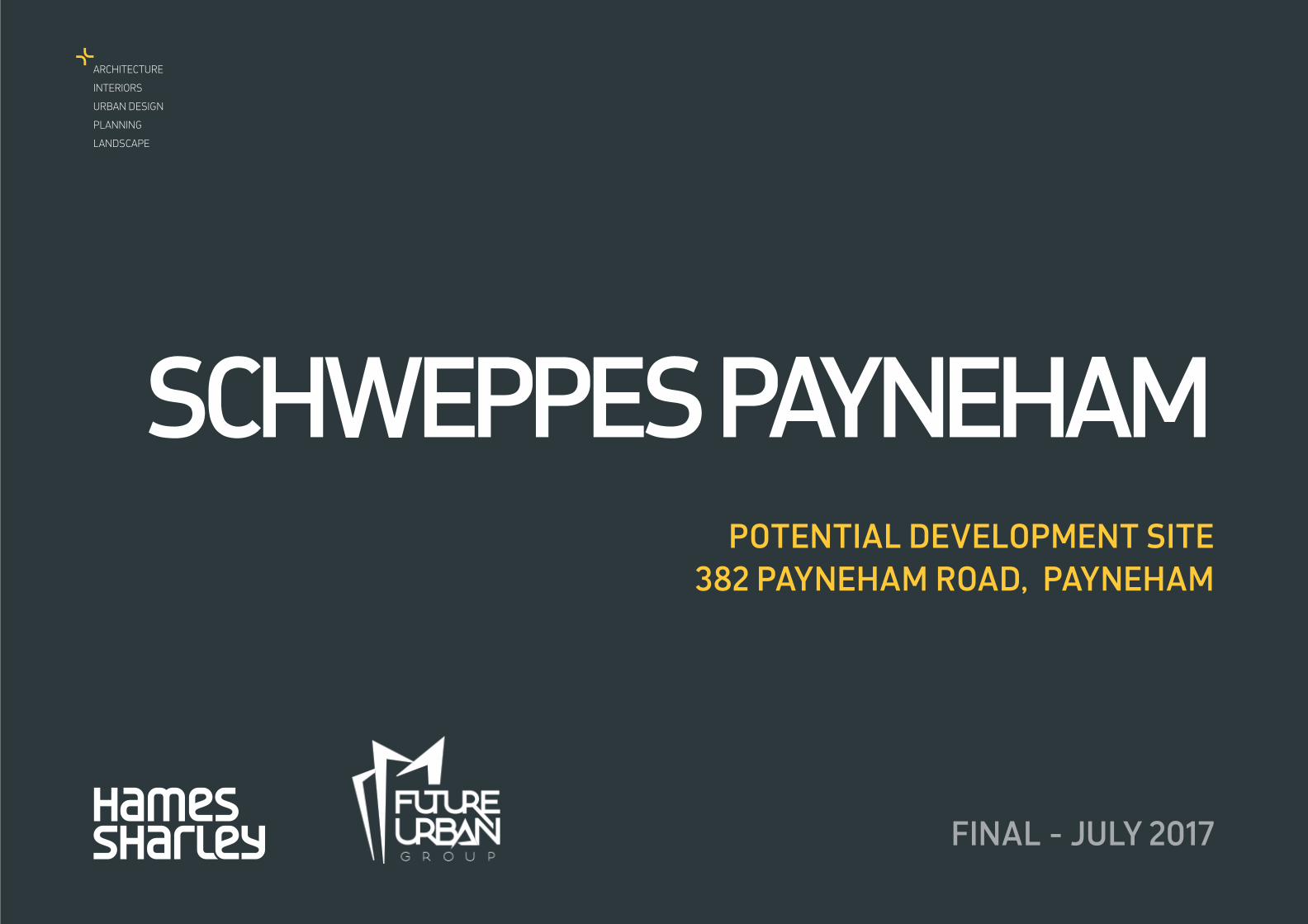
SCHWEPPES PAYNEHAMPOTENTIAL DEVELOPMENT SITE
382 PAYNEHAM ROAD, PAYNEHAM
FINAL - JULY 2017
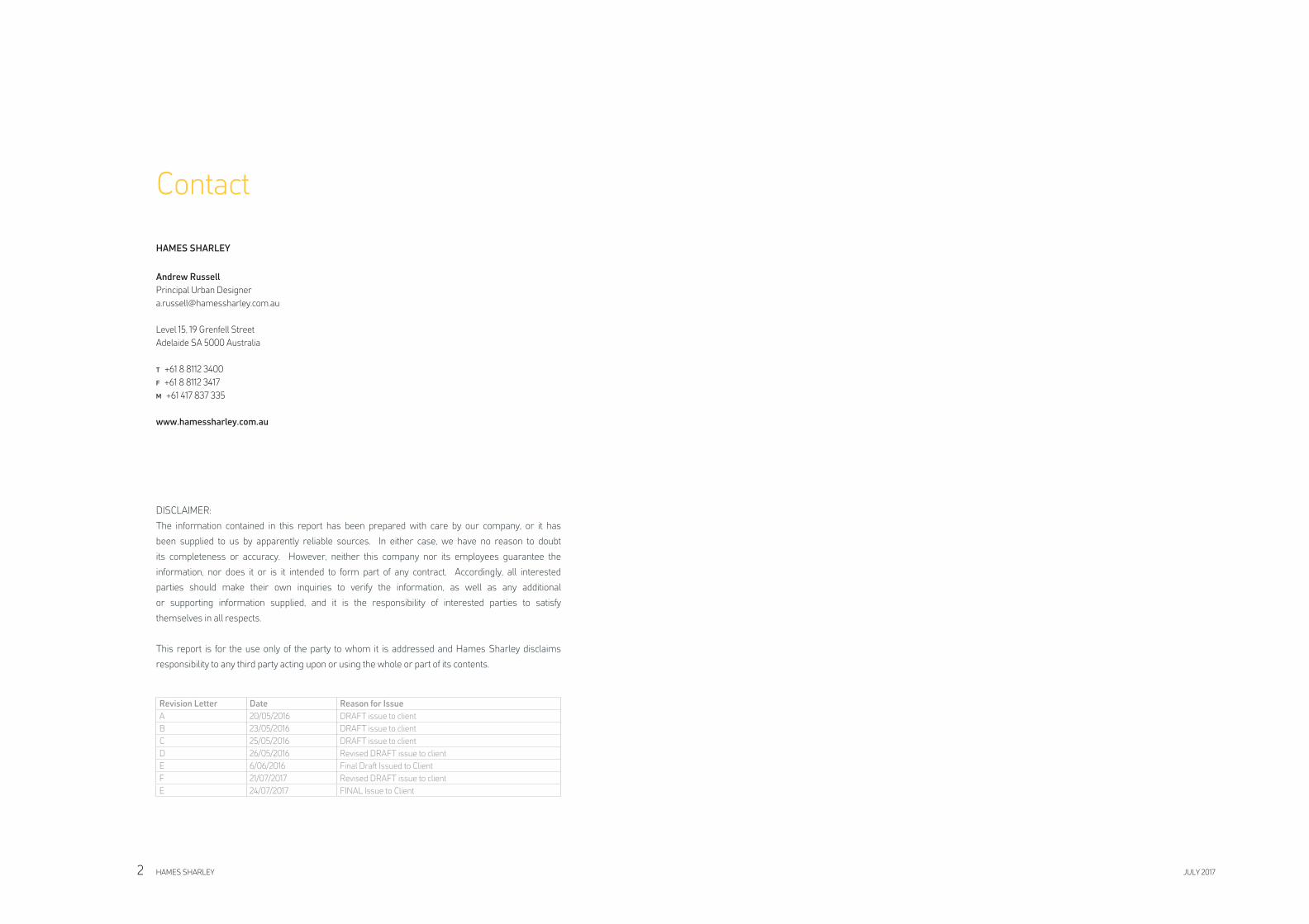
Contact
HAMES SHARLEY
Andrew Russell
Principal Urban Designer
Level 15, 19 Grenfell Street
Adelaide SA 5000 Australia
T +61 8 8112 3400
F +61 8 8112 3417
M +61 417 837 335
www.hamessharley.com.au
DISCLAIMER:
The information contained in this report has been prepared with care by our company, or it has
been supplied to us by apparently reliable sources. In either case, we have no reason to doubt
its completeness or accuracy. However, neither this company nor its employees guarantee the
information, nor does it or is it intended to form part of any contract. Accordingly, all interested
parties should make their own inquiries to verify the information, as well as any additional
or supporting information supplied, and it is the responsibility of interested parties to satisfy
themselves in all respects.
This report is for the use only of the party to whom it is addressed and Hames Sharley disclaims
responsibility to any third party acting upon or using the whole or part of its contents.
Revision Letter Date Reason for Issue
A 20/05/2016 DRAFT issue to client
B 23/05/2016 DRAFT issue to client
C 25/05/2016 DRAFT issue to client
D 26/05/2016 Revised DRAFT issue to client
E 6/06/2016 Final Draft Issued to Client
F 21/07/2017 Revised DRAFT issue to client
E 24/07/2017 FINAL Issue to Client
HAMES SHARLEY JULY 20172
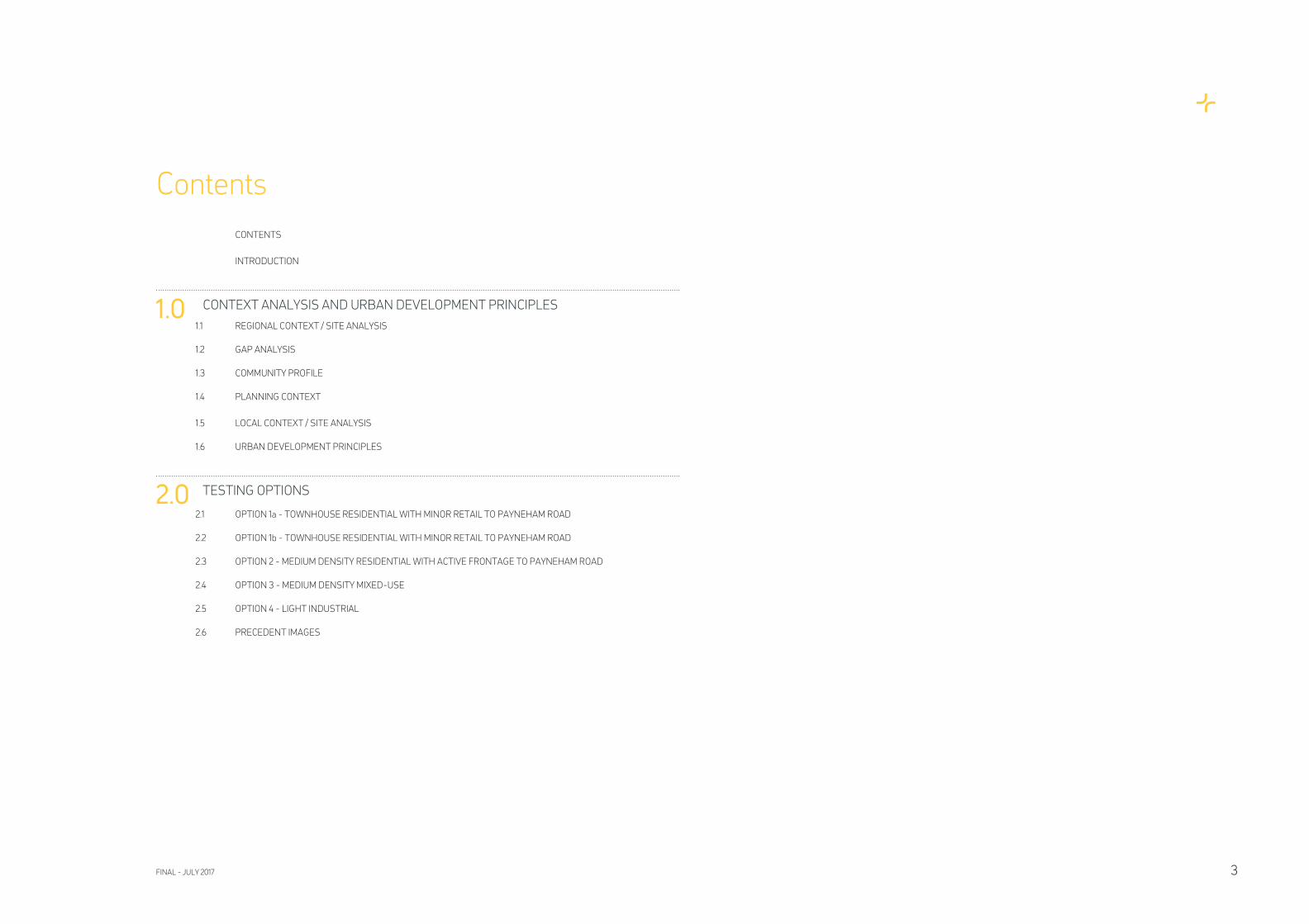
CONTENTS
INTRODUCTION
1.0 CONTEXT ANALYSIS AND URBAN DEVELOPMENT PRINCIPLES
1.1 REGIONAL CONTEXT / SITE ANALYSIS
1.2 GAP ANALYSIS
1.3 COMMUNITY PROFILE
1.4 PLANNING CONTEXT
1.5 LOCAL CONTEXT / SITE ANALYSIS
1.6 URBAN DEVELOPMENT PRINCIPLES
2.0 TESTING OPTIONS
2.1 OPTION 1a - TOWNHOUSE RESIDENTIAL WITH MINOR RETAIL TO PAYNEHAM ROAD
2.2 OPTION 1b - TOWNHOUSE RESIDENTIAL WITH MINOR RETAIL TO PAYNEHAM ROAD
2.3 OPTION 2 - MEDIUM DENSITY RESIDENTIAL WITH ACTIVE FRONTAGE TO PAYNEHAM ROAD
2.4 OPTION 3 - MEDIUM DENSITY MIXED-USE
2.5 OPTION 4 - LIGHT INDUSTRIAL
2.6 PRECEDENT IMAGES
Contents
FINAL - JULY 2017 3
This report has been prepared by Hames
Sharley for The Antunes Group. The purpose
of this report is to outline the present and
future development potential of the site at 382
Payneham Road, Payneham.
The report is designed as a base document
to be used to inform further investigation
of potential development of the site. The
document is divided into two sections. Section
1 outlines the site context through a number
of desktop investigations including existing
regulatory planning framework, engineering
reports, site conditions and its surrounds. It
utilises the knowledge gained to develop a set
of development principles which guide and
inform two different development proposal
options in Section 2.
Introduction
HAMES SHARLEY JULY 20174
FINAL - JULY 2017 5

CONTEXT ANALYIS AND SITE
DEVELOPMENT PRINCIPLES
FINAL - JULY 2017 7
1.0
STUDY AREA AND CONTEXT
2
2
1
2
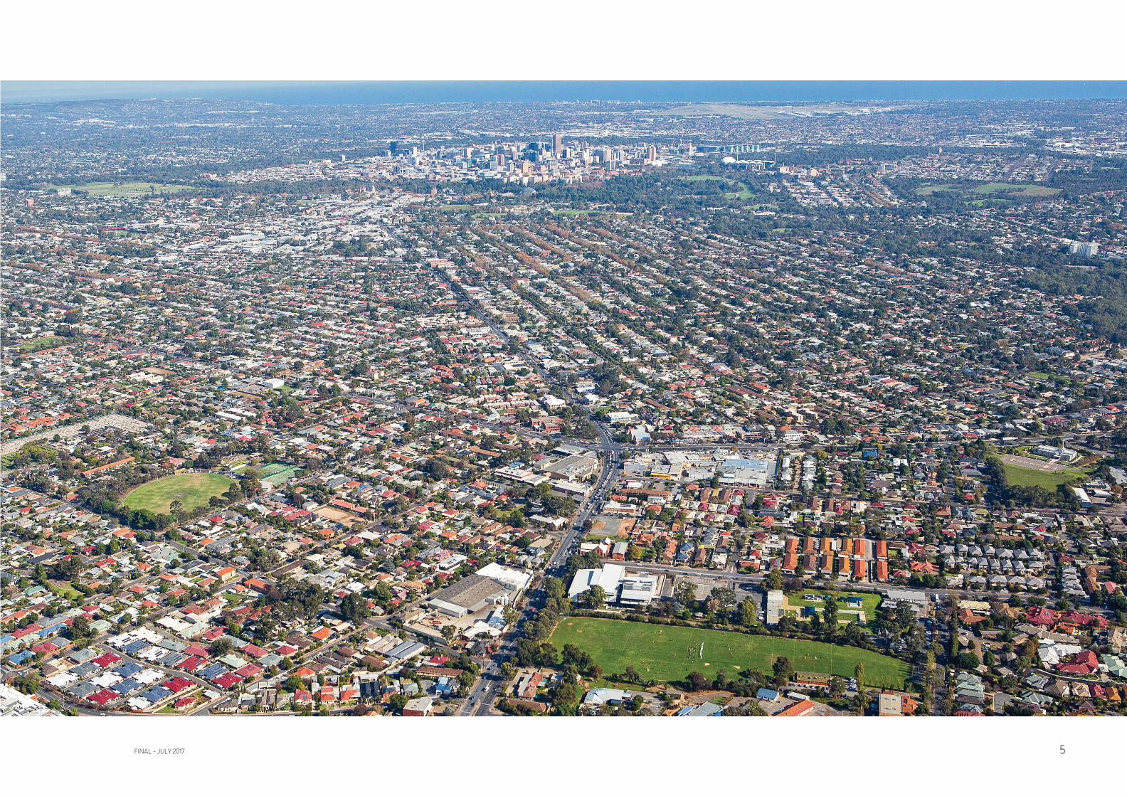
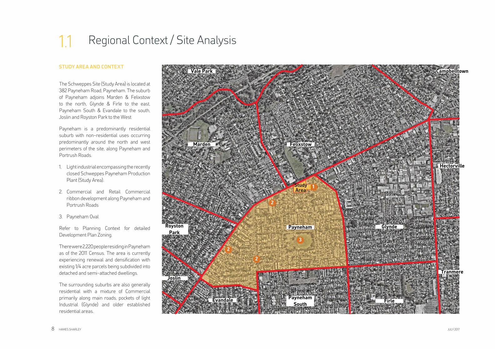
Regional Context / Site Analysis1.1
The Schweppes Site (Study Area) is located at
382 Payneham Road, Payneham. The suburb
of Payneham adjoins Marden & Felixstow
to the north, Glynde & Firle to the east,
Payneham South & Evandale to the south,
Joslin and Royston Park to the West
Payneham is a predominantly residential
suburb with non-residential uses occurring
predominantly around the north and west
perimeters of the site, along Payneham and
Portrush Roads.
1. Light industrial encompassing the recently
closed Schweppes Payneham Production
Plant (Study Area).
2. Commercial and Retail Commercial
ribbon development along Payneham and
Portrush Roads
3. Payneham Oval
Refer to Planning Context for detailed
Development Plan Zoning.
There were 2,220 people residing in Payneham
as of the 2011 Census. The area is currently
experiencing renewal and densifi cation with
existing 1/4 acre parcels being subdivided into
detached and semi-attached dwellings.
The surrounding suburbs are also generally
residential with a mixture of Commercial
primarily along main roads, pockets of light
Industrial (Glynde) and older established
residential areas.
Payneham
Tranmere
Hectorville
Glynde
FirlePayneham
South
Evandale
Joslin
Royston
Park
CampbelltownVale Park
Marden Felixstow
3
HAMES SHARLEY JULY 20178
Study Area
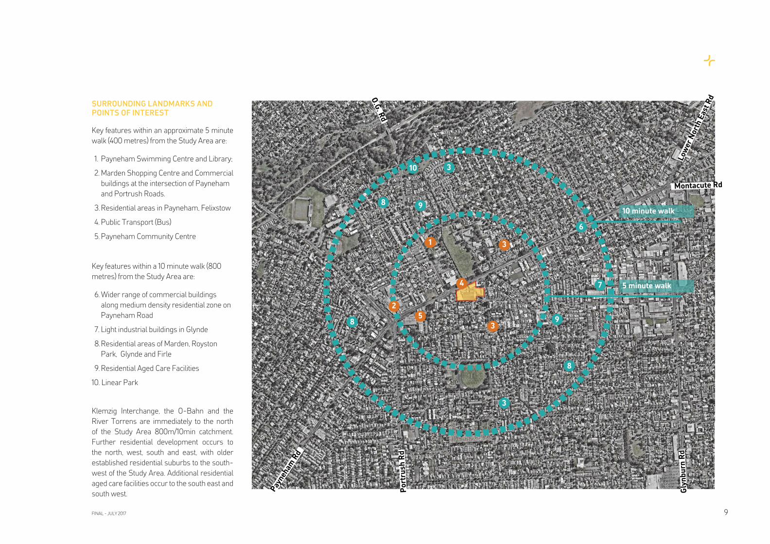
SURROUNDING LANDMARKS AND
POINTS OF INTEREST
Key features within an approximate 5 minute
walk (400 metres) from the Study Area are:
1. Payneham Swimming Centre and Library;
2. Marden Shopping Centre and Commercial
buildings at the intersection of Payneham
and Portrush Roads.
3. Residential areas in Payneham, Felixstow
4. Public Transport (Bus)
5. Payneham Community Centre
Key features within a 10 minute walk (800
metres) from the Study Area are:
6. Wider range of commercial buildings
along medium density residential zone on
Payneham Road
7. Light industrial buildings in Glynde
8. Residential areas of Marden, Royston
Park, Glynde and Firle
9. Residential Aged Care Facilities
10. Linear Park
Klemzig Interchange, the O-Bahn and the
River Torrens are immediately to the north
of the Study Area 800m/10min catchment.
Further residential development occurs to
the north, west, south and east, with older
established residential suburbs to the south-
west of the Study Area. Additional residential
aged care facilities occur to the south east and
south west.
5 minute walk
10 minute walk
1
3
4 7
3
6
3
Pay
neh
am R
d
Montacute Rd
Po
rtru
sh
Rd
Gly
nb
urn
Rd
Lo
we
r N
ort
h E
ast
RdO
.G. R
d
2
8
8
3
8
10
59
9
FINAL - JULY 2017 9
W90
W90W90
281
300
174
176
H21
178
H33
H30
H21
H30
H30H30
H33
300
174
176
178
W90
HAMES SHARLEY JULY 201710
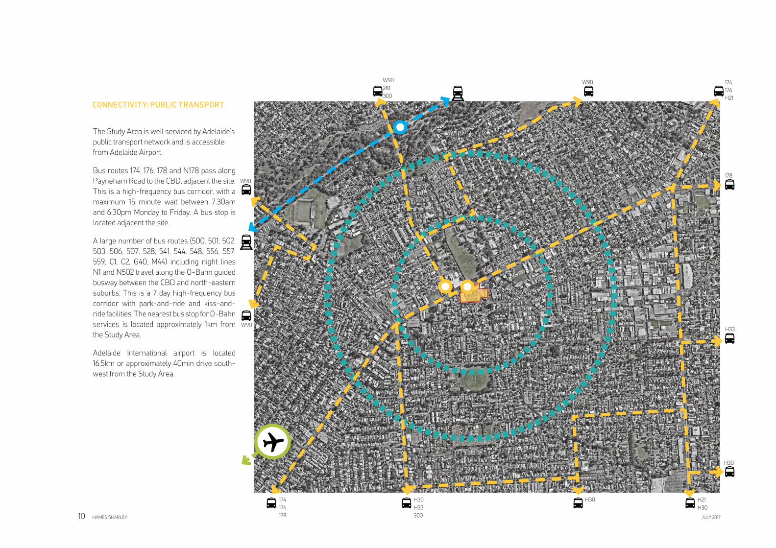
The Study Area is well serviced by Adelaide’s
public transport network and is accessible
from Adelaide Airport.
Bus routes 174, 176, 178 and N178 pass along
Payneham Road to the CBD, adjacent the site.
This is a high-frequency bus corridor, with a
maximum 15 minute wait between 7.30am
and 6.30pm Monday to Friday. A bus stop is
located adjacent the site.
A large number of bus routes (500, 501, 502,
503, 506, 507, 528, 541, 544, 548, 556, 557,
559, C1, C2, G40, M44) including night lines
N1 and N502 travel along the O-Bahn guided
busway between the CBD and north-eastern
suburbs. This is a 7 day high-frequency bus
corridor with park-and-ride and kiss-and-
ride facilities. The nearest bus stop for O-Bahn
services is located approximately 1km from
the Study Area.
Adelaide International airport is located
16.5km or approximately 40min drive south-
west from the Study Area.
CONNECTIVITY: PUBLIC TRANSPORT
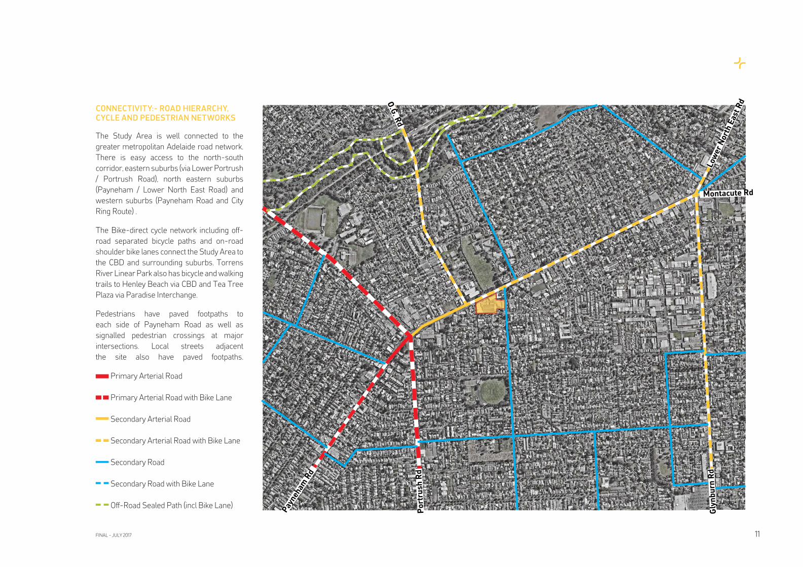
CONNECTIVITY:- ROAD HIERARCHY,
CYCLE AND PEDESTRIAN NETWORKS
The Study Area is well connected to the
greater metropolitan Adelaide road network.
There is easy access to the north-south
corridor, eastern suburbs (via Lower Portrush
/ Portrush Road), north eastern suburbs
(Payneham / Lower North East Road) and
western suburbs (Payneham Road and City
Ring Route) .
The Bike-direct cycle network including off-
road separated bicycle paths and on-road
shoulder bike lanes connect the Study Area to
the CBD and surrounding suburbs. Torrens
River Linear Park also has bicycle and walking
trails to Henley Beach via CBD and Tea Tree
Plaza via Paradise Interchange.
Pedestrians have paved footpaths to
each side of Payneham Road as well as
signalled pedestrian crossings at major
intersections. Local streets adjacent
the site also have paved footpaths.
Pay
neh
am R
d
Montacute Rd
Po
rtru
sh
Rd
Gly
nb
urn
Rd
Lo
we
r N
ort
h E
ast
RdO
.G. R
d
Primary Arterial Road
Primary Arterial Road with Bike Lane
Secondary Arterial Road
Secondary Arterial Road with Bike Lane
Secondary Road
Secondary Road with Bike Lane
Off-Road Sealed Path (incl Bike Lane)
FINAL - JULY 2017 11
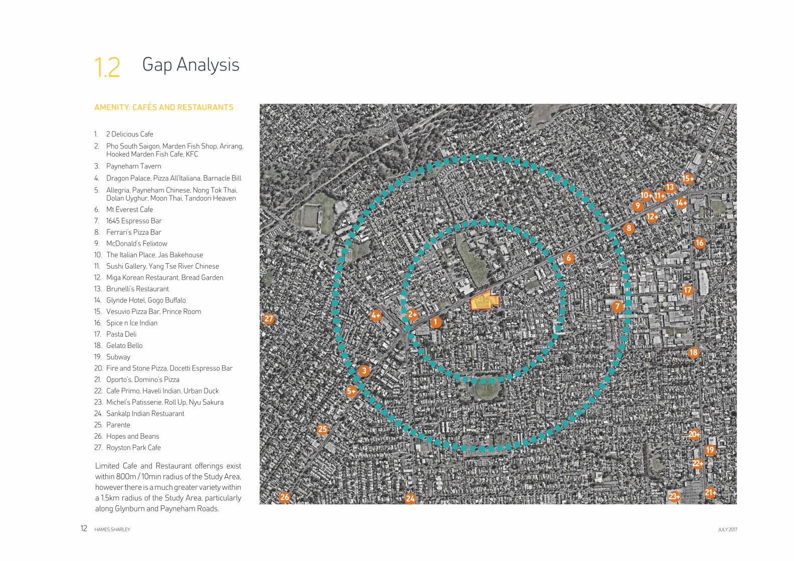
1. 2 Delicious Cafe
2. Pho South Saigon, Marden Fish Shop, Arirang, Hooked Marden Fish Cafe, KFC
3. Payneham Tavern
4. Dragon Palace, Pizza All’Italiana, Barnacle Bill
5. Allegria, Payneham Chinese, Nong Tok Thai, Dolan Uyghur, Moon Thai, Tandoori Heaven
6. Mt Everest Cafe
7. 1645 Espresso Bar
8. Ferrari’s Pizza Bar
9. McDonald’s Felixtow
10. The Italian Place, Jas Bakehouse
11. Sushi Gallery, Yang Tse River Chinese
12. Miga Korean Restaurant, Bread Garden
13. Brunelli’s Restaurant
14. Glynde Hotel, Gogo Buffalo
15. Vesuvio Pizza Bar, Prince Room
16. Spice n Ice Indian
17. Pasta Deli
18. Gelato Bello
19. Subway
20. Fire and Stone Pizza, Docetti Espresso Bar
21. Oporto’s, Domino’s Pizza
22. Cafe Primo, Haveli Indian, Urban Duck
23. Michel’s Patisserie, Roll Up, Nyu Sakura
24. Sankalp Indian Restuarant
25. Parente
26. Hopes and Beans
27. Royston Park Cafe
11+
15+
4+
17
14+9
1
3
6
13
12+
Gap Analysis1.2
10+
2+7
8
16
18
19
20+
22+
21+23+
5+
24
25
26
27
HAMES SHARLEY JULY 201712
Limited Cafe and Restaurant offerings exist
within 800m / 10min radius of the Study Area,
however there is a much greater variety within
a 1.5km radius of the Study Area, particularly
along Glynburn and Payneham Roads.
AMENITY: CAFÉS AND RESTAURANTS
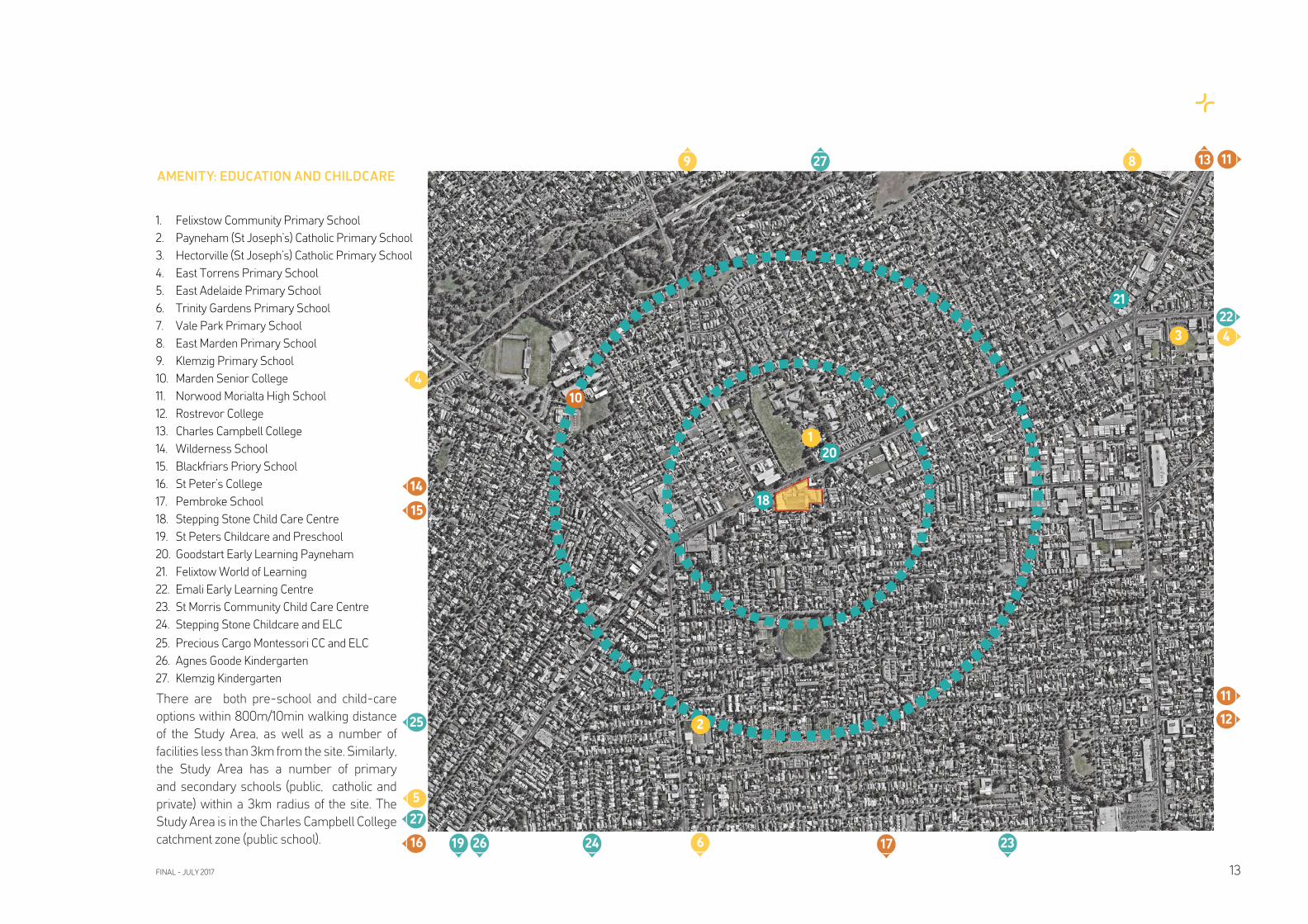
1. Felixstow Community Primary School
2. Payneham (St Joseph’s) Catholic Primary School
3. Hectorville (St Joseph’s) Catholic Primary School
4. East Torrens Primary School
5. East Adelaide Primary School
6. Trinity Gardens Primary School
7. Vale Park Primary School
8. East Marden Primary School
9. Klemzig Primary School
10. Marden Senior College
11. Norwood Morialta High School
12. Rostrevor College
13. Charles Campbell College
14. Wilderness School
15. Blackfriars Priory School
16. St Peter’s College
17. Pembroke School
18. Stepping Stone Child Care Centre
19. St Peters Childcare and Preschool
20. Goodstart Early Learning Payneham
21. Felixtow World of Learning
22. Emali Early Learning Centre
23. St Morris Community Child Care Centre
24. Stepping Stone Childcare and ELC
25. Precious Cargo Montessori CC and ELC
26. Agnes Goode Kindergarten
27. Klemzig Kindergarten
1
8
2324 6
20
2
11
5
4
22
10
3 4
14
9 1113
15
16 17
12
21
19
25
26
27
27
18
FINAL - JULY 2017 13
AMENITY: EDUCATION AND CHILDCARE
There are both pre-school and child-care
options within 800m/10min walking distance
of the Study Area, as well as a number of
facilities less than 3km from the site. Similarly,
the Study Area has a number of primary
and secondary schools (public, catholic and
private) within a 3km radius of the site. The
Study Area is in the Charles Campbell College
catchment zone (public school).
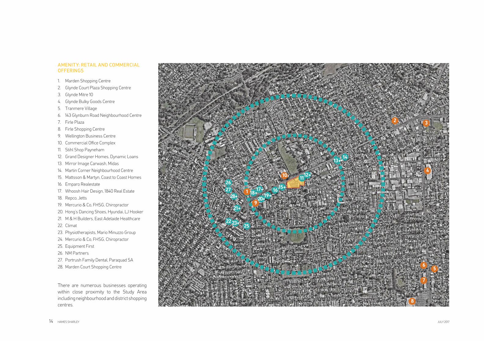
1. Marden Shopping Centre
2. Glynde Court Plaza Shopping Centre
3. Glynde Mitre 10
4. Glynde Bulky Goods Centre
5. Tranmere Village
6. 143 Glynburn Road Neighbourhood Centre
7. Firle Plaza
8. Firle Shopping Centre
9. Wellington Business Centre
10. Commercial Offi ce Complex
11. Stihl Shop Payneham
12. Grand Designer Homes, Dynamic Loans
13. Mirror Image Carwash, Midas
14. Martin Corner Neighbourhood Centre
15. Mattsson & Martyn, Coast to Coast Homes
16. Emparo Realestate
17. Whoosh Hair Design, 1840 Real Estate
18. Repco, Jetts
19. Mercurio & Co, FHSG, Chiropractor
20. Hong’s Dancing Shoes, Hyundai, LJ Hooker
21. M & H Builders, East Adelaide Healthcare
22. Climat
23. Physiotherapists, Mario Minuzzo Group
24. Mercurio & Co, FHSG, Chiropractor
25. Equipment First
26. NM Partners
27. Portrush Family Dental, Paraquad SA
28. Marden Court Shopping Centre
AMENITY: RETAIL AND COMMERCIAL
OFFERINGS
1
23
4
7
5
8
6
9
1011
12+
13+14
15+1617+
18+19+
20+
21+
22 23+25
26
27
28+
HAMES SHARLEY JULY 201714
There are numerous businesses operating
within close proximity to the Study Area
including neighbourhood and district shopping
centres.
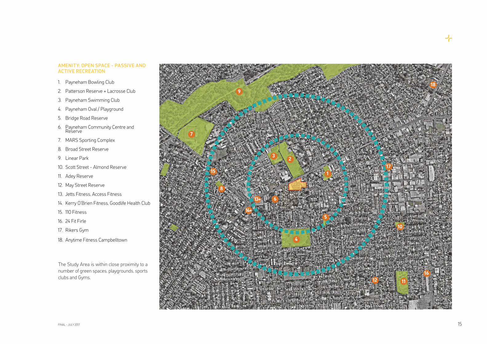
AMENITY: OPEN SPACE - PASSIVE AND
ACTIVE RECREATION
1. Payneham Bowling Club
2. Patterson Reserve + Lacrosse Club
3. Payneham Swimming Club
4. Payneham Oval / Playground
5. Bridge Road Reserve
6. Payneham Community Centre and Reserve
7. MARS Sporting Complex
8. Broad Street Reserve
9. Linear Park
10. Scott Street - Almond Reserve
11. Adey Reserve
12. May Street Reserve
13. Jetts Fitness, Access Fitness
14. Kerry O’Brien Fitness, Goodlife Health Club
15. 110 Fitness
16. 24 Fit Firle
17. Rikers Gym
18. Anytime Fitness Campbelltown
23
4
7
8
1
9
5
6
10
1112
13+
14+
15
16
17
18
FINAL - JULY 2017 15
The Study Area is within close proximity to a
number of green spaces, playgrounds, sports
clubs and Gyms.
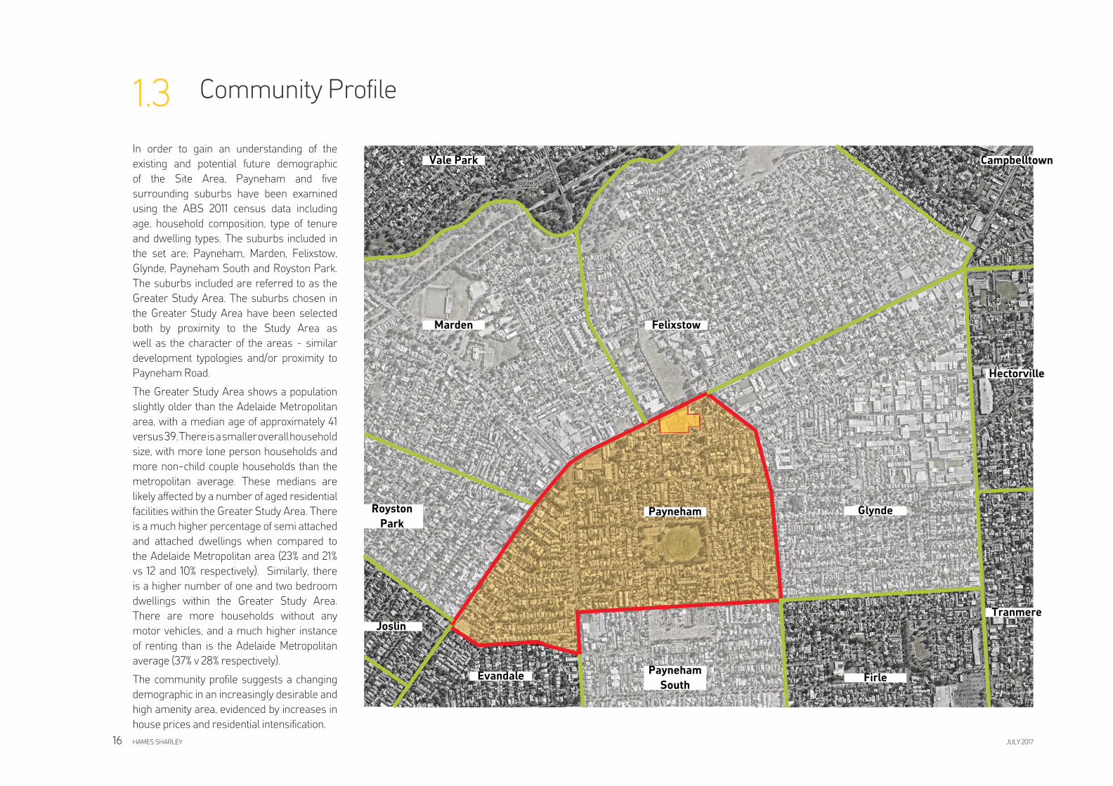
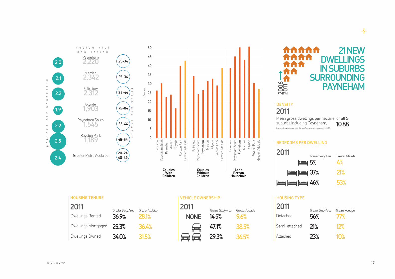
Community Profi le1.3
In order to gain an understanding of the
existing and potential future demographic
of the Site Area, Payneham and fi ve
surrounding suburbs have been examined
using the ABS 2011 census data including
age, household composition, type of tenure
and dwelling types. The suburbs included in
the set are; Payneham, Marden, Felixstow,
Glynde, Payneham South and Royston Park.
The suburbs included are referred to as the
Greater Study Area. The suburbs chosen in
the Greater Study Area have been selected
both by proximity to the Study Area as
well as the character of the areas - similar
development typologies and/or proximity to
Payneham Road.
The Greater Study Area shows a population
slightly older than the Adelaide Metropolitan
area, with a median age of approximately 41
versus 39. There is a smaller overall household
size, with more lone person households and
more non-child couple households than the
metropolitan average. These medians are
likely affected by a number of aged residential
facilities within the Greater Study Area. There
is a much higher percentage of semi attached
and attached dwellings when compared to
the Adelaide Metropolitan area (23% and 21%
vs 12 and 10% respectively). Similarly, there
is a higher number of one and two bedroom
dwellings within the Greater Study Area.
There are more households without any
motor vehicles, and a much higher instance
of renting than is the Adelaide Metropolitan
average (37% v 28% respectively).
The community profi le suggests a changing
demographic in an increasingly desirable and
high amenity area, evidenced by increases in
house prices and residential intensifi cation.
Payneham
Tranmere
Hectorville
Glynde
FirlePayneham
South
Evandale
Joslin
Royston
Park
CampbelltownVale Park
Marden Felixstow
HAMES SHARLEY JULY 201716
HOUSING TYPEVEHICLE OWNERSHIP
2011
14.5%NONE
47.1%
29.3%
HOUSING TENURE
Dwellings Rented
Dwellings Mortgaged
Dwellings Owned
2011
36.9%
25.3%
34.0%
BEDROOMS PER DWELLING
2011
5%
37%
46%
56%
21%
23%
21 NEW DWELLINGS IN SUBURBS
SURROUNDING PAYNEHAM
20
06
2
011
2.0 25-34
2.1 25-34
2.2 35-44
1.9 75-84
2.2 35-44
2.5 45-54
Payneham
Marden
Felixstow
Glynde
Payneham South
Royston Park
Greater Metro Adelaide
pe
rs
on
s
pe
r
ho
us
eh
ol
d
la
rg
es
t
ag
e
gr
ou
p
2,220
2,342
2,312
1,903
1,545
1,189
2.420-24
40-49
r e s i d e n t i a l
p o p u l a t i o n
Detached
Semi-attached
Attached
2011
DENSITY
2011Mean gross dwellings per hectare for all 6 suburbs including Payneham, Royston Park is lowest with 8.4 and Payneham is highest with 14.92.
10.88
0
5
10
15
20
25
30
35
40
45
50
Felix
stow
Payn
eham
Sou
thPayneham
Mar
den
Gly
nde
Roys
ton
Park
Felix
stow
Payn
eham
Sou
thPayneham
Mar
den
Gly
nde
Roys
ton
Park
Felix
stow
Payn
eham
Sou
thPayneham
Mar
den
Gly
nde
Roys
ton
Park
Gre
ater
Ade
laid
e
Gre
ater
Ade
laid
e
Gre
ater
Ade
laid
e
CouplesWithChildren
CouplesWithoutChildren
LonePersonHousehold
Perc
ent
28.1%
36.4%
31.5%
Greater Study Area Greater Adelaide Greater Study Area Greater Adelaide Greater Study Area Greater Adelaide
9.6%
38.5%
36.5%
77%
12%
10%
Greater Adelaide
4%
21%
53%
Greater Study Area
FINAL - JULY 2017 17
The applicable Development Plan for the
Study Area is the Norwood Payneham and St
Peters (City) DP - Consolidated 30 May 2017.
The Study Area is located within the Light
Industry zone, surrounded by Residential and
Medium Density Residential policy zones.
The Study Area has a long standing industrial
use, with certain ‘existing use rights’ enabling
it to continue without requirements for new
approvals. Complying uses in the Light
Industry zone include light industry, petrol
fi lling station, service industry, store, timber
yard and warehouse. Non-complying uses
in the zone include detached dwelling, health
centre, hospital, multiple dwelling, place of
worship, residential fl at building, row dwelling,
semi-detached dwelling and a shop or group
of shops greater than 250m2.
Residential buildings of three or more storeys
are excluded from the list of non-complying
kinds of development. A residential fl at
building is listed as non-compliant.
It is noted that non-complying development
does not preclude the planning authority from
considering these forms of development, but
it does mean that the application process
(as per Regulation 17 of the Development
Regulations 2008) is more onerous and
risky when compared to a consent on-merit
process. There is no right of appeal against a
decision to refuse consent to a non-complying
form of development.
There are very limited opportunities to
redevelop and transform the land into a
feasible outcome without altering the existing
zone provisions and/or the non-complying
list. Due to the scale of the land and its positive
locational attributes, the site supports a
mixed use development outcome. Such an
outcome would also improve the residential
interface and the overall appearance of the
land. Alternatively, ‘freeing-up’ the zone may
also provide an opportunity to reposition the
existing buildings on the site. For example,
the overall form, scale and location of existing
buildings lend themselves to larger format
retailing which is not possible under the
current zone conditions.
Due to the relative proximity of the site in
relation to Adelaide Airport fl ight paths, the
maximum height of all structures above
existing ground level is 45m. Proposals higher
than this will need to be referred to the Federal
Airports Corporation for further assessment.
There are no local or state heritage, or heritage
contributing items within and immediately
surrounding the Study Area.
The Study Area is presently not an affordable
housing designated area.
DEVELOPMENT PLAN SUMMARY AIRPORT BUILDING HEIGHTS HERITAGE AND AFFORDABLE HOUSING
Planning Context1.4
HAMES SHARLEY JULY 201718
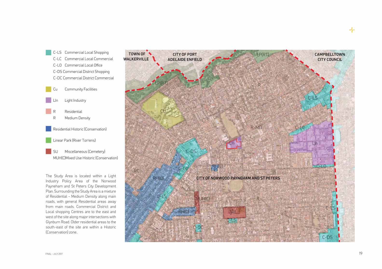
C-LS Commercial Local Shopping
C-LC Commercial Local Commercial
C-LO Commercial Local Offi ce
C-DS Commercial District Shopping
C-DC Commercial District Commercial
Cu Community Facilities
LIn Light Industry
R Residential
R Medium Density
Residential Historic (Conservation)
Linear Park (River Torrens)
SU Miscellaneous (Cemetery)
MUH(C)Mixed Use Historic (Conservation)
The Study Area is located within a Light
Industry Policy Area of the Norwood
Payneham and St Peters City Development
Plan. Surrounding the Study Area is a mixture
of Residential - Medium Density along main
roads, with general Residential areas away
from main roads. Commercial District and
Local shopping Centres are to the east and
west of the site along major intersections with
Glynburn Road. Older residential areas to the
south-east of the site are within a Historic
(Conservation) zone..
FINAL - JULY 2017 19
R-MD
CAMPBELLTOWN
CITY COUNCIL
CITY OF NORWOOD PAYNEHAM AND ST PETERS
CITY OF PORT
ADELAIDE ENFIELD
TOWN OF
WALKERVILLE
R
C-LS
C-LC
LInLIn
C-LO
C-LS
C-DS
SU
C-LS
CU
C-DS
C-LC
LP(RT)
LP(RT)
RH(C)
RH(C)
RC
C-LS
RH(C)
MUH(C)
C-DC
R
CITY SKYLINE VIEWS
HILLS FACE
VIEWS
AFTERNOON SEA BREEZE
MORNING INLAND BREEZE
BURIED THIRD CREEK
N
PAYNEHAM ROAD NOISE, POLLUTION
2 STOREY BLANK BOUNDARY WALL
Local Context / Site Analysis1.5
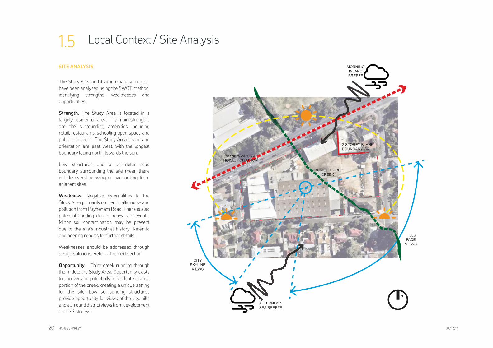
The Study Area and its immediate surrounds
have been analysed using the SWOT method,
identifying strengths, weaknesses and
opportunities.
Strength: The Study Area is located in a
largely residential area. The main strengths
are the surrounding amenities including
retail, restaurants, schooling open space and
public transport. The Study Area shape and
orientation are east-west, with the longest
boundary facing north, towards the sun.
Low structures and a perimeter road
boundary surrounding the site mean there
is little overshadowing or overlooking from
adjacent sites.
Weakness: Negative externalities to the
Study Area primarily concern traffi c noise and
pollution from Payneham Road. There is also
potential fl ooding during heavy rain events.
Minor soil contamination may be present
due to the site’s industrial history. Refer to
engineering reports for further details.
Weaknesses should be addressed through
design solutions. Refer to the next section.
Opportunity: . Third creek running through
the middle the Study Area. Opportunity exists
to uncover and potentially rehabilitate a small
portion of the creek, creating a unique setting
for the site. Low surrounding structures
provide opportunity for views of the city, hills
and all-round district views from development
above 3 storeys.
HAMES SHARLEY JULY 201720
SITE ANALYSIS
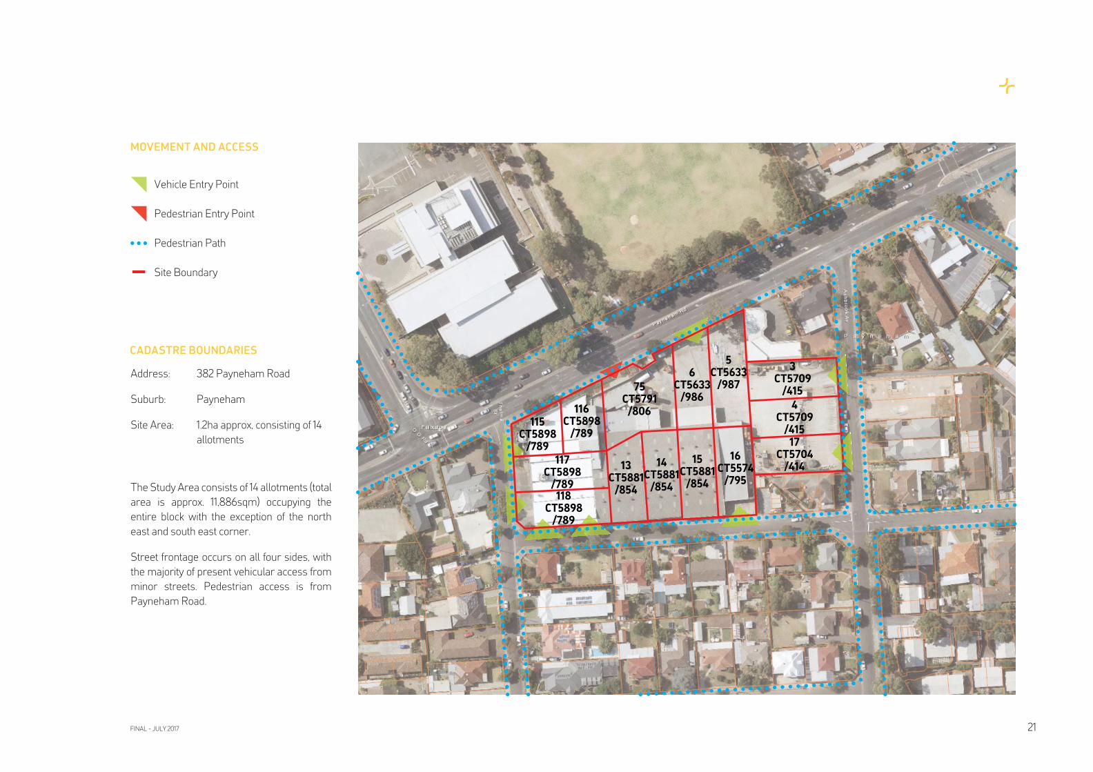
Address: 382 Payneham Road
Suburb: Payneham
Site Area: 1.2ha approx, consisting of 14
allotments
The Study Area consists of 14 allotments (total
area is approx. 11,886sqm) occupying the
entire block with the exception of the north
east and south east corner.
Street frontage occurs on all four sides, with
the majority of present vehicular access from
minor streets. Pedestrian access is from
Payneham Road.
CADASTRE BOUNDARIES
MOVEMENT AND ACCESS
Vehicle Entry Point
Pedestrian Entry Point
Pedestrian Path
Site Boundary
115CT5898
/789
116CT5898
/789
75CT5791
/806
6CT5633
/986
5CT5633
/987
3CT5709
/415
4CT5709
/415
17CT5704
/41416
CT5574/795
15CT5881
/854
14CT5881
/854
13CT5881
/854
117CT5898
/789118
CT5898/789
FINAL - JULY 2017 21
The following summary of the existing Third
Creek drainage culvert and associated fl ood
risk to the Study Area is based on Wallbridge
& Gilbert Engineers Report dated 11 May
2016 (Revision A). Refer to this document
for a detailed investigation report of current
conditions and impact on future development.
Third Creek is a tributary of the River Torrens.
It conveys stormwater runoff from a large
catchment into the River Torrens. The creek
is heavily modifi ed from its natural state
and is now largely comprised of sections
of constructed concrete open channel and
culverts. Due to ever increasing urbanisation
within the catchment, many of the channel
sections and culverts along the creek are
undersized.
There is an existing 1250 H x2500mm W
(approx) box culvert running under the site
that is part of Third Creek. It is estimated that
the capacity of the culvert would be in the order
of 5.5m3/s. As part of drainage upgrades
undertaken in the 1980s, an additional
1650mm diameter reinforced concrete
pipe was constructed to divert some of the
fl ow around a section passing underneath
Payneham Road. The capacity of this pipe is in
the order of 4m3/s.
Based on fl ood maps, it can be concluded that
the combined capacity of the system is well
below a 20 year average recurrence interval
(ARI standard), The site would experience
quite severe fl ooding for a 20 year ARI event,
with peak fl ood depths in the site exceeding
250mm. In a 100 year ARI event, peak fl ood
depths in the site would exceed 500mm.
Considering the severity of the fl ooding shown
at the site for a 20 year ARI event, it is likely that
the site would be inundated in more frequent
storm events, such as a 5 year ARI.
The severity of the fl ooding within the site can
be attributed to;
• the undersized culvert resulting in fl ow
overtopping the obvert
• relatively low lying site compared to
surrounding area
As a result of climate change, peak rainfall
intensities are expected to increase by up to
20% over the next 100 years
The council confi rmed there is an opportunity
to re-align and upgrade the culvert either
through the site or to follow the eastern
boundary of the site, solely at the developer’s
expense. The new culvert would need to be
approximately 4000mm wide. The creek
could also be naturalised and exposed.
It is noted that the upgrading of the culvert
alone will not eliminate fl ood risk for the site.
Consideration should be given to building up
site level as part of any redevelopment works,
as this would help minimise fl ood risk.
The following summary of the environmental
site history, soil sampling and assessment is
based on Mott Macdonald Engineers Report
dated 23 May 2016 (Revision A). Refer to this
document for a detailed investigation report
of current conditions and impact on future
development.
The aim of the work was to address the
potential for gross or widespread soil
contamination to exist as a result of current or
previous land uses at the site.
The site has been a drinks manufacturing
business since 1949 with various private
individuals owning the various relevant
certifi cates of title prior to Schweppes with
the existence of private homes at the site
historically. The site was open land prior to
this.
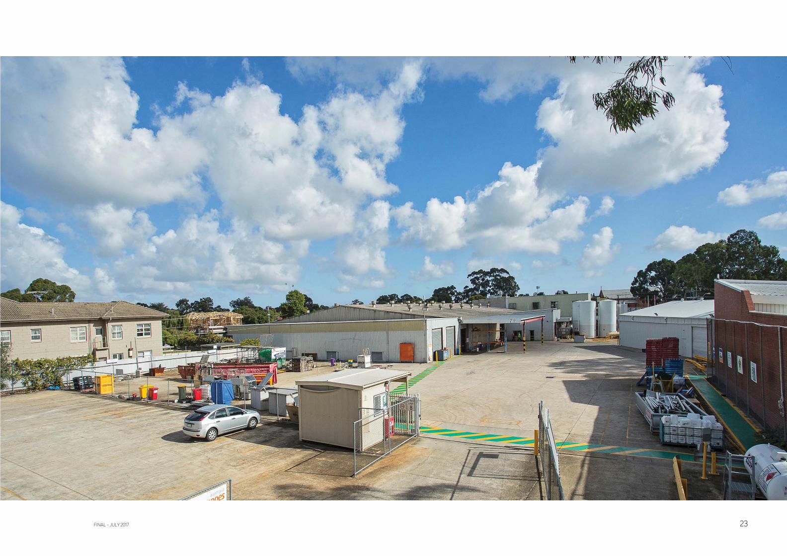
The site is sealed predominantly with
concrete, with the main building occupying the
western portion of the site with an additional
shed on the north-eastern corner. The site
is generally fl at. Third Creek runs beneath
the site approximately through the centre
in a southeast to northwest direction. USTs
were located on the western boundary of the
site and the eastern side of the main storage
warehouse. These were removed and
validated in 2007, reporting limited residual
soil impact. Concentrations did not exceed
NEPM Setting D for commercial / industrial
building land use.
Originally Third Creek fl owed through the
site area as a relatively natural drain and was
concreted over as an enclosed drain through
the site.
Soil is largely natural silty clays and sands. No
odours or staining were noted during the soil
sampling.
PID results from the soil samples retrieved
were measured at 0ppm. This indicates that
the likelihood of volatile gases being present
in the soil at the site is low.
A EPA Section 7 search was made, with
the information indicating that no current
Environmental Performance Agreements,
Environmental Protection Orders or Clean-Up
Orders are registered on the site. No known
wasters are listed or have been produced on
the site.
The SA EPA Public Register Directory - Site
contamination index was searched, with no
listings occuring within 500m of the site.
There was no evidence of the fi eld indicators
used to identify Acid Sulphate Soils. .
HAMES SHARLEY JULY 201722
REVIEW OF EXISTING THIRD CREEK
DRAINAGE CULVERT AND FLOOD RISK
REVIEW OF ENVIRONMENTAL
ASSESSMENT
FINAL - JULY 2017 23
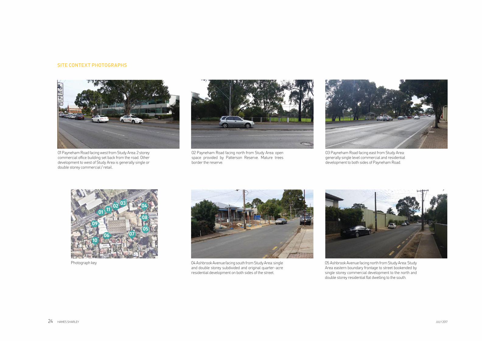
01 Payneham Road facing west from Study Area: 2 storey
commercial offi ce building set back from the road. Other
development to west of Study Area is generally single or
double storey commercial / retail..
02 Payneham Road facing north from Study Area: open
space provided by Patterson Reserve. Mature trees
border the reserve.
03 Payneham Road facing east from Study Area:
generally single level commercial and residential
development to both sides of Payneham Road.
04 Ashbrook Avenue facing south from Study Area: single
and double storey subdivided and original quarter-acre
residential development on both sides of the street.
05 Ashbrook Avenue facing north from Study Area: Study
Area eastern boundary frontage to street bookended by
single storey commercial development to the north and
double storey residential fl at dwelling to the south.
0302
01
04
0509
06
11
10
Photograph key
08
07
HAMES SHARLEY JULY 201724
SITE CONTEXT PHOTOGRAPHS
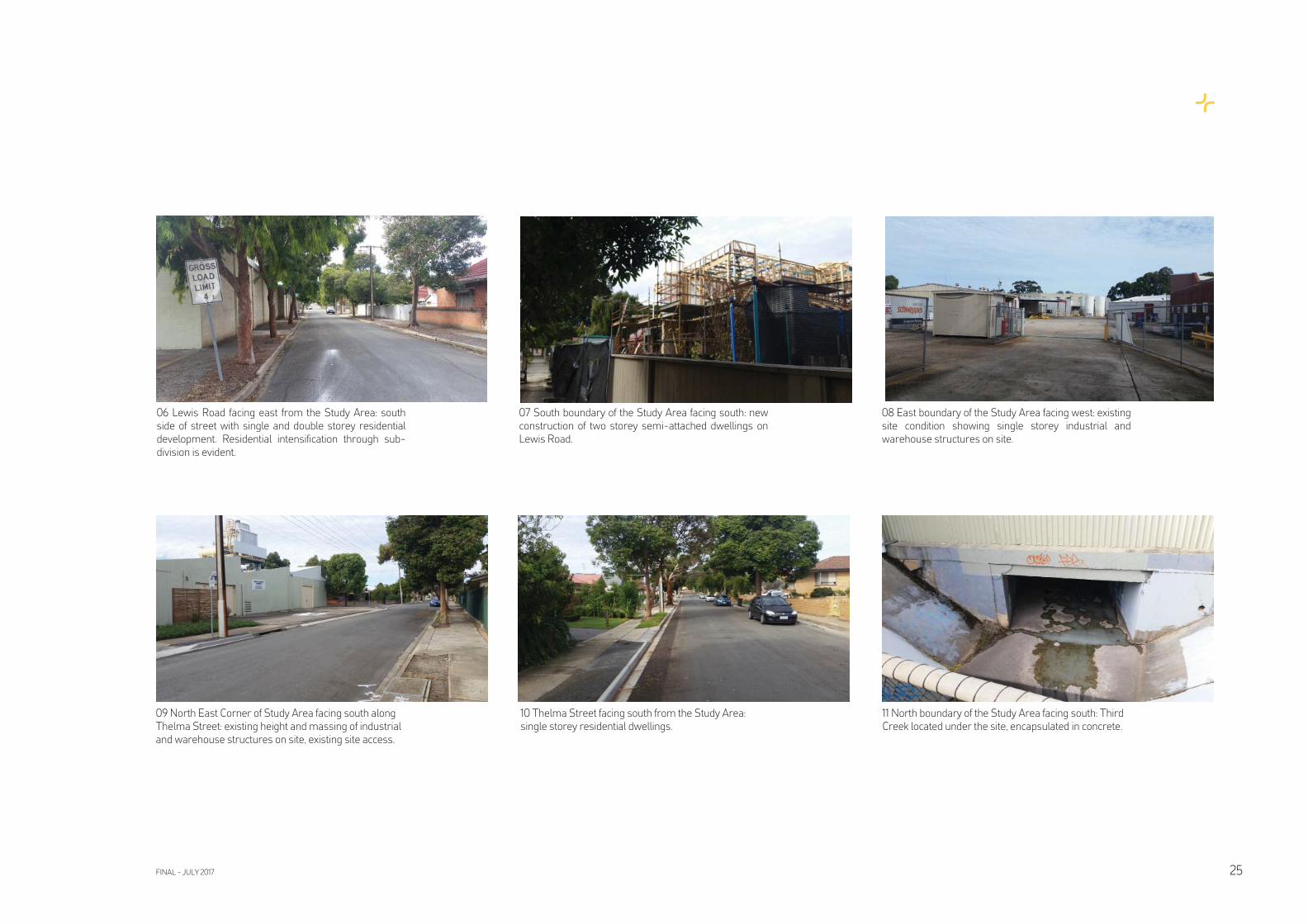
09 North East Corner of Study Area facing south along
Thelma Street: existing height and massing of industrial
and warehouse structures on site, existing site access.
10 Thelma Street facing south from the Study Area:
single storey residential dwellings.
11 North boundary of the Study Area facing south: Third
Creek located under the site, encapsulated in concrete.
06 Lewis Road facing east from the Study Area: south
side of street with single and double storey residential
development. Residential intensifi cation through sub-
division is evident.
07 South boundary of the Study Area facing south: new
construction of two storey semi-attached dwellings on
Lewis Road.
08 East boundary of the Study Area facing west: existing
site condition showing single storey industrial and
warehouse structures on site.
FINAL - JULY 2017 25
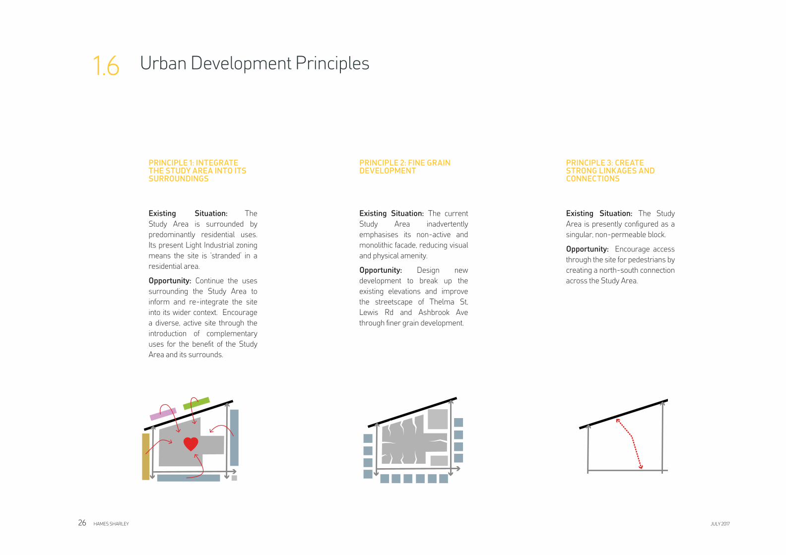
PRINCIPLE 3: CREATE STRONG LINKAGES AND CONNECTIONS
Urban Development Principles1.6
Existing Situation: The Study
Area is presently confi gured as a
singular, non-permeable block.
Opportunity: Encourage access
through the site for pedestrians by
creating a north-south connection
across the Study Area.
PRINCIPLE 1: INTEGRATE THE STUDY AREA INTO ITS SURROUNDINGS
Existing Situation: The
Study Area is surrounded by
predominantly residential uses.
Its present Light Industrial zoning
means the site is ‘stranded’ in a
residential area.
Opportunity: Continue the uses
surrounding the Study Area to
inform and re-integrate the site
into its wider context. Encourage
a diverse, active site through the
introduction of complementary
uses for the benefi t of the Study
Area and its surrounds.
PRINCIPLE 2: FINE GRAIN DEVELOPMENT
Existing Situation: The current
Study Area inadvertently
emphasises its non-active and
monolithic facade, reducing visual
and physical amenity.
Opportunity: Design new
development to break up the
existing elevations and improve
the streetscape of Thelma St,
Lewis Rd and Ashbrook Ave
through fi ner grain development.
HAMES SHARLEY JULY 201726
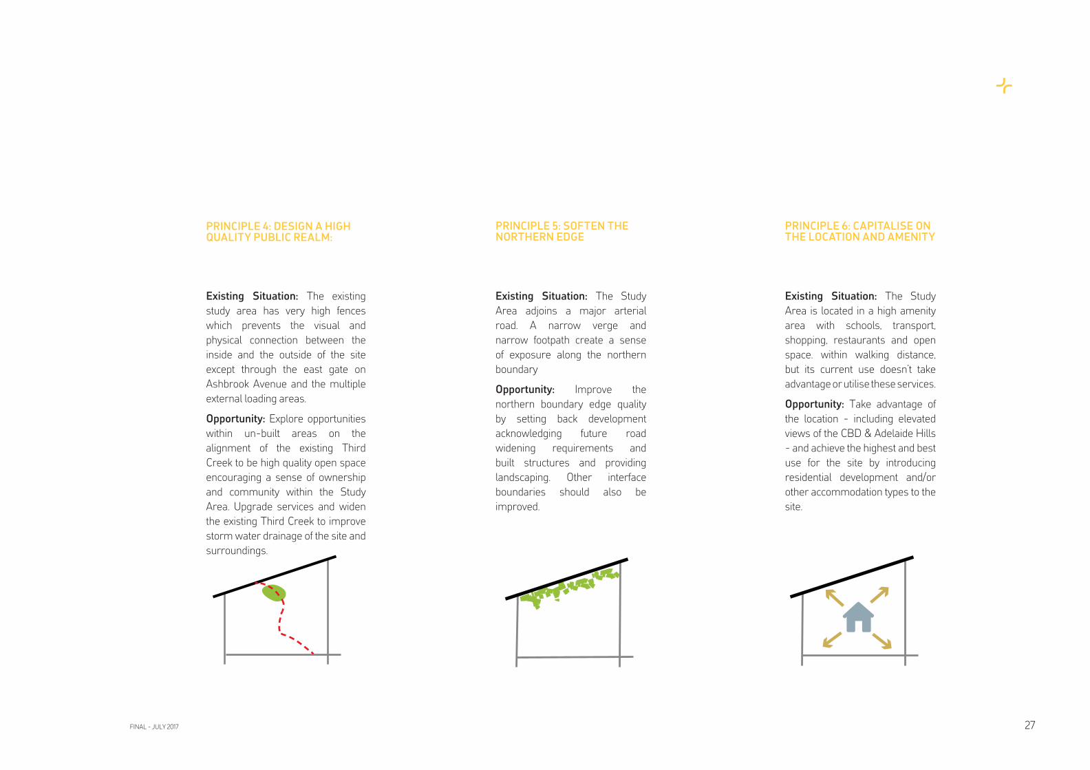
PRINCIPLE 4: DESIGN A HIGH QUALITY PUBLIC REALM:
Existing Situation: The existing
study area has very high fences
which prevents the visual and
physical connection between the
inside and the outside of the site
except through the east gate on
Ashbrook Avenue and the multiple
external loading areas.
Opportunity: Explore opportunities
within un-built areas on the
alignment of the existing Third
Creek to be high quality open space
encouraging a sense of ownership
and community within the Study
Area. Upgrade services and widen
the existing Third Creek to improve
storm water drainage of the site and
surroundings.
PRINCIPLE 5: SOFTEN THE NORTHERN EDGE
Existing Situation: The Study
Area adjoins a major arterial
road. A narrow verge and
narrow footpath create a sense
of exposure along the northern
boundary
Opportunity: Improve the
northern boundary edge quality
by setting back development
acknowledging future road
widening requirements and
built structures and providing
landscaping. Other interface
boundaries should also be
improved.
PRINCIPLE 6: CAPITALISE ON THE LOCATION AND AMENITY
Existing Situation: The Study
Area is located in a high amenity
area with schools, transport,
shopping, restaurants and open
space. within walking distance,
but its current use doesn’t take
advantage or utilise these services.
Opportunity: Take advantage of
the location - including elevated
views of the CBD & Adelaide Hills
- and achieve the highest and best
use for the site by introducing
residential development and/or
other accommodation types to the
site.
FINAL - JULY 2017 27


TESTING OPTIONS
FINAL - JULY 2017 29
2.0
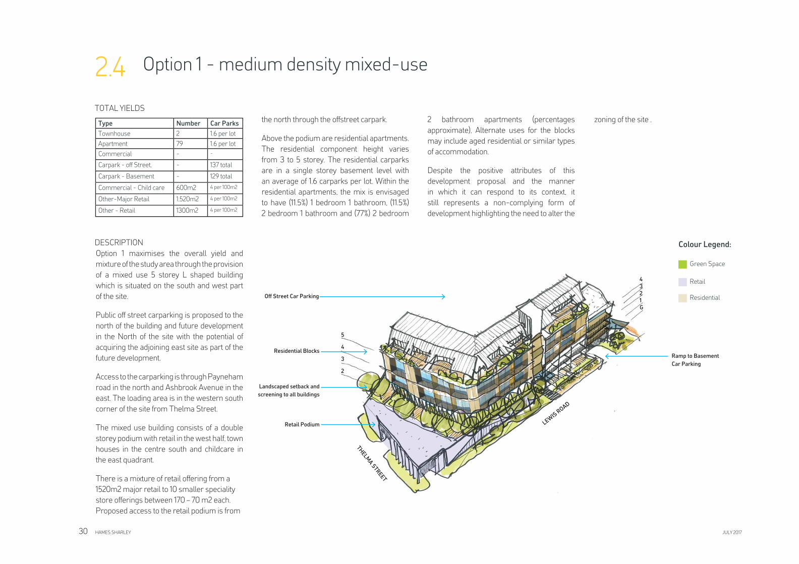
Option 1 - medium density mixed-use2.4
TOTAL YIELDS
DESCRIPTION
Option 1 maximises the overall yield and
mixture of the study area through the provision
of a mixed use 5 storey L shaped building
which is situated on the south and west part
of the site.
Public off street carparking is proposed to the
north of the building and future development
in the North of the site with the potential of
acquiring the adjoining east site as part of the
future development.
Access to the carparking is through Payneham
road in the north and Ashbrook Avenue in the
east. The loading area is in the western south
corner of the site from Thelma Street.
The mixed use building consists of a double
storey podium with retail in the west half, town
houses in the centre south and childcare in
the east quadrant.
There is a mixture of retail offering from a
1520m2 major retail to 10 smaller speciality
store offerings between 170 – 70 m2 each.
Proposed access to the retail podium is from
the north through the offstreet carpark.
Above the podium are residential apartments.
The residential component height varies
from 3 to 5 storey. The residential carparks
are in a single storey basement level with
an average of 1.6 carparks per lot. Within the
residential apartments, the mix is envisaged
to have (11.5%) 1 bedroom 1 bathroom, (11.5%)
2 bedroom 1 bathroom and (77%) 2 bedroom
2 bathroom apartments (percentages
approximate), Alternate uses for the blocks
may include aged residential or similar types
of accommodation.
Despite the positive attributes of this
development proposal and the manner
in which it can respond to its context, it
still represents a non-complying form of
development highlighting the need to alter the
zoning of the site .
Colour Legend:
Green Space
Retail
Residential
Type Number Car Parks
Townhouse 2 1.6 per lot
Apartment 79 1.6 per lot
Commercial - -
Carpark - off Street, - 137 total
Carpark - Basement - 129 total
Commercial - Child care 600m2 4 per 100m2
Other-Major Retail 1,520m2 4 per 100m2
Other - Retail 1300m2 4 per 100m2
LEWIS
ROAD
Landscaped setback and
screening to all buildings
Residential Blocks
Retail Podium
THE
LMA
STR
EE
T
Off Street Car Parking
4
3
2
1
G
5
4
3
2
Ramp to Basement
Car Parking
HAMES SHARLEY JULY 201730
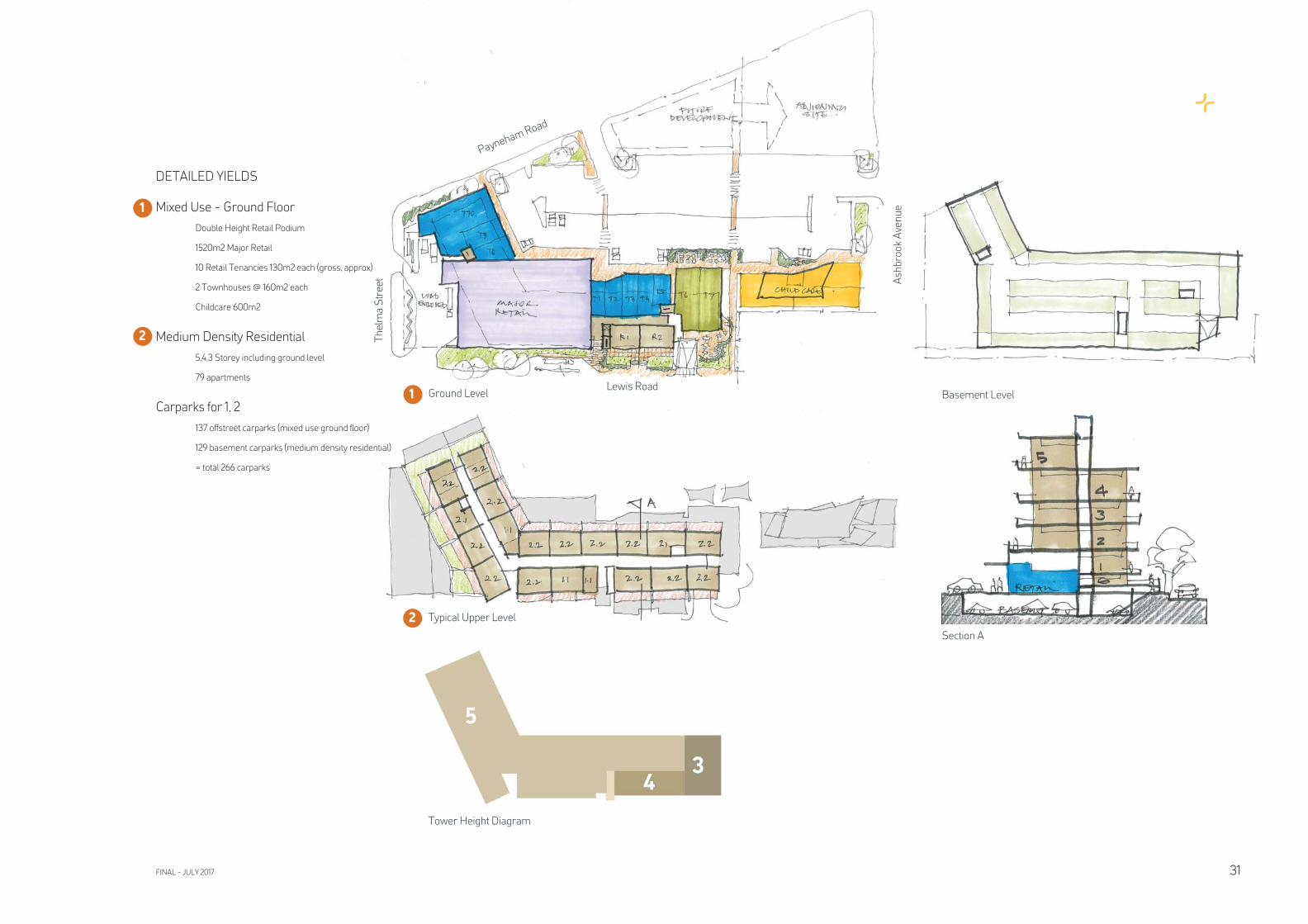
DETAILED YIELDS
Mixed Use - Ground Floor
Double Height Retail Podium
1520m2 Major Retail
10 Retail Tenancies 130m2 each (gross, approx)
2 Townhouses @ 160m2 each
Childcare 600m2
Medium Density Residential
5,4,3 Storey including ground level
79 apartments
Carparks for 1, 2
137 offstreet carparks (mixed use ground fl oor)
129 basement carparks (medium density residential)
= total 266 carparks
1
2
1
2
Ground Level
Typical Upper Level
Basement Level
Section A
5
43
Tower Height Diagram
Payneham Road
Th
elm
a S
tre
et Ash
bro
ok
Ave
nu
e
Lewis Road
FINAL - JULY 2017 31
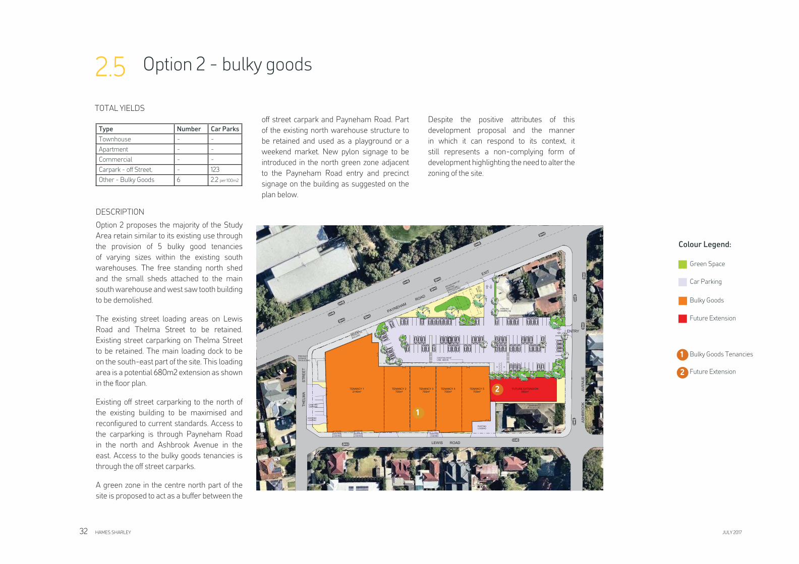
Option 2 - bulky goods2.5
TOTAL YIELDS
DESCRIPTION
Option 2 proposes the majority of the Study
Area retain similar to its existing use through
the provision of 5 bulky good tenancies
of varying sizes within the existing south
warehouses. The free standing north shed
and the small sheds attached to the main
south warehouse and west saw tooth building
to be demolished.
The existing street loading areas on Lewis
Road and Thelma Street to be retained.
Existing street carparking on Thelma Street
to be retained. The main loading dock to be
on the south-east part of the site. This loading
area is a potential 680m2 extension as shown
in the fl oor plan.
Existing off street carparking to the north of
the existing building to be maximised and
reconfi gured to current standards. Access to
the carparking is through Payneham Road
in the north and Ashbrook Avenue in the
east. Access to the bulky goods tenancies is
through the off street carparks.
A green zone in the centre north part of the
site is proposed to act as a buffer between the
off street carpark and Payneham Road. Part
of the existing north warehouse structure to
be retained and used as a playground or a
weekend market. New pylon signage to be
introduced in the north green zone adjacent
to the Payneham Road entry and precinct
signage on the building as suggested on the
plan below.
Despite the positive attributes of this
development proposal and the manner
in which it can respond to its context, it
still represents a non-complying form of
development highlighting the need to alter the
zoning of the site.
1
Colour Legend:
Green Space
Car Parking
Bulky Goods
Future Extension
1
2
Bulky Goods Tenancies
Future Extension
2
Type Number Car Parks
Townhouse - -
Apartment - -
Commercial - -
Carpark - off Street, - 123
Other - Bulky Goods 6 2.2 per 100m2
HAMES SHARLEY JULY 201732
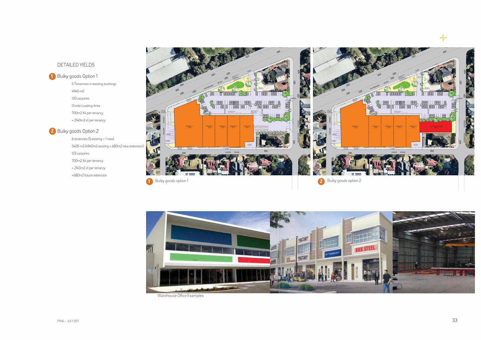
DETAILED YIELDS
Bulky goods Option 1
5 Tenancies in existing buildings
4940 m2
120 carparks
Onsite Loading Area
700m2 X4 per tenancy
+ 2140m2 x1 per tenancy
Bulky goods Option 2
6 tenancies (5 existing + 1 new)
5400 m2 (4940m2 existing + 680m2 new extension)
123 carparks
700m2 X4 per tenancy
+ 2140m2 x1 per tenancy
+680m2 future extension
Bulky goods option 1
Warehouse Offi ce Examples
2
1
21 Bulky goods option 2
FINAL - JULY 2017 33
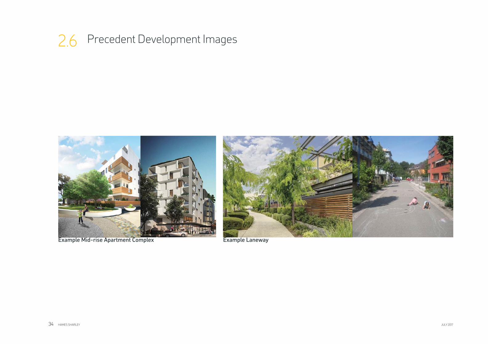
Example Mid-rise Apartment Complex
Precedent Development Images2.6
Example Laneway
HAMES SHARLEY JULY 201734
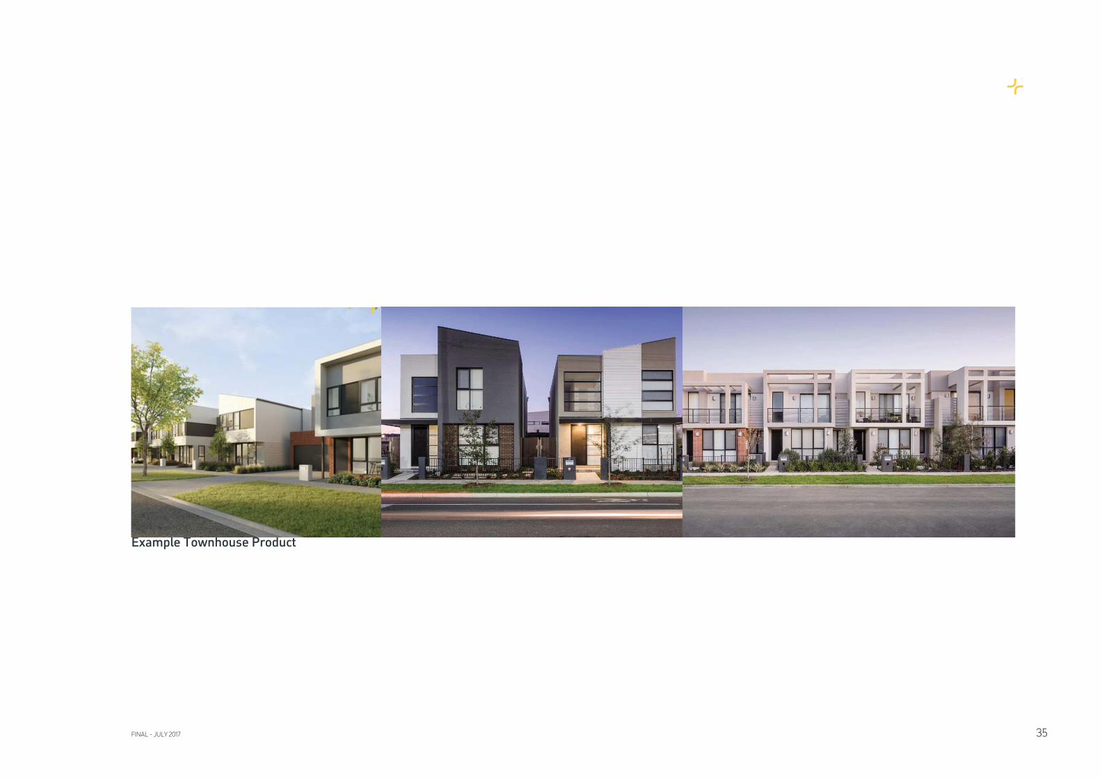
Example Townhouse Product
FINAL - JULY 2017 35