Reconstructing paleoenvironment, eruption mechanism and paleomorphology of the Pliocene Pula maar,...
16
Reconstructing paleoenvironment, eruption mechanism and paleomorphology of the Pliocene Pula maar, (Hungary) K. Németh a, ⁎, K. Goth b , U. Martin c , G. Csillag d , P. Suhr b a Volcanic Risk Solutions, Institute of Natural Resources, College of Sciences, Massey University, PO Box.11 222, Palmerston North, New Zealand b Landesamt für Umwelt und Geologie, Zur Wetterwarte 11, Dresden, D-01109, Germany c KITZ.do, Dortmund, Germany d Department of Geological Research, Geological Institute of Hungary, Stefánia út 14., Budapest, H-1143, Hungary ABSTRACT ARTICLE INFO Article history: Received 17 December 2007 Accepted 12 June 2008 Available online xxxx Keywords: Pliocene maar diatreme tuff-ring basalt pyroclastic rocks maar lake sediments alginate turbidite monogenetic Pula maar is a partially eroded Pliocene maar-diatreme volcano, part of the Mio-Pliocene Bakony-Balaton Highland Volcanic Field. The surficial remnant of the maar-diatreme volcano consists of (1) a distinct depression with a thick post-eruptive lacustrine alginite sediment infill interbedded with coarse-grained volcaniclastic sediments, (2) a narrow marginal zone inside the depression consisting of primary pyroclastic rock units that are interpreted to be partly collapsed and subsided blocks of entire sections from the tephra ring formerly surrounding the maar crater depression, and (3) coarse-grained volcaniclastic debris-flow deposits closely associated with the collapsed primary pyroclastic rock units in the marginal zone. The presence of coherent lava rocks below the crater-fill units, their distribution pattern and their association with scoriaceous beds indicate that, after the maar-diatreme-forming phreatomagmatic explosive activity, small (100 m-scale) scoria and/or spatter cones erupted in the maar crater. These cones are the likely source of the lava flows that partially filled the maar crater basin. The widespread dm-to-m thick basaltic sand and/ or silt units at the base of the post-eruptive crater-filling sedimentary succession are interpreted to be reworked volcaniclastic material from the intra-maar scoria/spatter cones as well as from the tephra ring. Based on comparative analyses of 53 core descriptions, this study reveals that the original maar crater basin was larger than previously suggested. The deep level of the maar crater is reconstructed to be a northeast– southwest elongated depression, currently forming a c. 50-m-deep basin. Geomorphological considerations suggest that most of the phreatomagmatic pyroclastic rocks are composed of base surge and tephra fall deposits around the deep maar depression. These allochthonous rock units form a 50–400 m wide zone of proximal tuff-ring sequences. The formation of this zone is inferred to be a result of a combination of syn- eruptive subsidence due to mass deficit in the rigid Triassic dolomite basement caused by the phreatomagmatic explosions as well as post-eruptive subsidence of the crater- and diatreme-filling successions due to diagenetic compaction. The facies in the centre of the maar lake is a soft laminated “alginite” (mainly Botryococcus colonies, diatom frustles, calcium carbonate crystals, clay minerals). In the section exposed in the Pula open cast mine, a single turbiditic layer is present. This layer originated in a landslide, which possibly could have been caused by either syn-eruptive earthquake and/or a sudden post- eruptive subsidence event of the diatreme fill. © 2008 Elsevier B.V. All rights reserved. 1. Introduction Monogenetic volcanoes are, in general, short-lived (days to years) volcanoes that form scoria cones resulted from mild to violent Strombolian-type of eruptions (Martin and Németh, 2006; Pioli et al., 2008; Valentine and Gregg, in press) and associated lava flows, maar- diatremes, tuff-rings and tuff cones. Maars and tuff-ring s have wide craters surrounded by a circular to oval, rarely crescent-shaped, phreatomagmatic tephra ring (Fisher and Schmincke, 1984; Lorenz, 1986; Cas and Wright, 1987; Vespermann and Schmincke, 2000; Németh and Martin, 2007). The maars are generally characterised by a subsided crater floor, which forms during and after the phreatomag- matic eruptions due to collapse and subsidence of country rocks and pyroclastic deposits in a funnel-shaped volcanic conduit, i.e. in the diatreme (Lorenz, 1986; White, 1991; Lorenz et al., 2003). Crater-floor subsidence continues after the eruption (Suhr et al., 2006) causing collapse of the freshly deposited phreatomagmatic tephra ring, as is commonly recorded in many young and old, eroded maar-diatreme volcanoes (Kienle et al., 1980; Büchel and Lorenz, 1993; Pirrung et al., Journal of Volcanology and Geothermal Research xxx (2008) xxx-xxx ⁎ Corresponding author. E-mail addresses: [email protected] (K. Németh), [email protected] (K. Goth), [email protected] (U. Martin), csillag@mafi.hu (G. Csillag), [email protected] (P. Suhr). VOLGEO-04053; No of Pages 16 0377-0273/$ – see front matter © 2008 Elsevier B.V. All rights reserved. doi:10.1016/j.jvolgeores.2008.06.010 Contents lists available at ScienceDirect Journal of Volcanology and Geothermal Research journal homepage: www.elsevier.com/locate/jvolgeores ARTICLE IN PRESS Please cite this article as: Németh, K., et al., Reconstructing paleoenvironment, eruption mechanism and paleomorphology of the Pliocene Pula maar, (Hungary), J. Volcanol. Geotherm. Res. (2008), doi:10.1016/j.jvolgeores.2008.06.010
Transcript of Reconstructing paleoenvironment, eruption mechanism and paleomorphology of the Pliocene Pula maar,...
Journal of Volcanology and Geothermal Research xxx (2008) xxx-xxx
VOLGEO-04053; No of Pages 16
Contents lists available at ScienceDirect
Journal of Volcanology and Geothermal Research
j ourna l homepage: www.e lsev ie r.com/ locate / jvo lgeores
ARTICLE IN PRESS
Reconstructing paleoenvironment, eruption mechanism and paleomorphology of thePliocene Pula maar, (Hungary)
K. Németh a,⁎, K. Goth b, U. Martin c, G. Csillag d, P. Suhr b
a Volcanic Risk Solutions, Institute of Natural Resources, College of Sciences, Massey University, PO Box. 11 222, Palmerston North, New Zealandb Landesamt für Umwelt und Geologie, Zur Wetterwarte 11, Dresden, D-01109, Germanyc KITZ.do, Dortmund, Germanyd Department of Geological Research, Geological Institute of Hungary, Stefánia út 14., Budapest, H-1143, Hungary
⁎ Corresponding author.E-mail addresses: [email protected] (K. Német
(K. Goth), [email protected] (U. Martin), [email protected]@smul.sachsen.de (P. Suhr).
0377-0273/$ – see front matter © 2008 Elsevier B.V. Aldoi:10.1016/j.jvolgeores.2008.06.010
Please cite this article as: Németh, K., et alPula maar, (Hungary), J. Volcanol. Geotherm
A B S T R A C T
A R T I C L E I N F OArticle history:
Pula maar is a partially ero Received 17 December 2007Accepted 12 June 2008Available online xxxxKeywords:Pliocenemaardiatremetuff-ringbasaltpyroclastic rocksmaar lake sedimentsalginateturbiditemonogenetic
ded Pliocene maar-diatreme volcano, part of the Mio-Pliocene Bakony-BalatonHighland Volcanic Field. The surficial remnant of the maar-diatreme volcano consists of (1) a distinctdepression with a thick post-eruptive lacustrine alginite sediment infill interbedded with coarse-grainedvolcaniclastic sediments, (2) a narrow marginal zone inside the depression consisting of primary pyroclasticrock units that are interpreted to be partly collapsed and subsided blocks of entire sections from the tephraring formerly surrounding the maar crater depression, and (3) coarse-grained volcaniclastic debris-flowdeposits closely associated with the collapsed primary pyroclastic rock units in the marginal zone. Thepresence of coherent lava rocks below the crater-fill units, their distribution pattern and their associationwith scoriaceous beds indicate that, after the maar-diatreme-forming phreatomagmatic explosive activity,small (100 m-scale) scoria and/or spatter cones erupted in the maar crater. These cones are the likely sourceof the lava flows that partially filled the maar crater basin. The widespread dm-to-m thick basaltic sand and/or silt units at the base of the post-eruptive crater-filling sedimentary succession are interpreted to bereworked volcaniclastic material from the intra-maar scoria/spatter cones as well as from the tephra ring.Based on comparative analyses of 53 core descriptions, this study reveals that the original maar crater basinwas larger than previously suggested. The deep level of the maar crater is reconstructed to be a northeast–southwest elongated depression, currently forming a c. 50-m-deep basin. Geomorphological considerationssuggest that most of the phreatomagmatic pyroclastic rocks are composed of base surge and tephra falldeposits around the deep maar depression. These allochthonous rock units form a 50–400 m wide zone ofproximal tuff-ring sequences. The formation of this zone is inferred to be a result of a combination of syn-eruptive subsidence due to mass deficit in the rigid Triassic dolomite basement caused by thephreatomagmatic explosions as well as post-eruptive subsidence of the crater- and diatreme-fillingsuccessions due to diagenetic compaction. The facies in the centre of the maar lake is a soft laminated“alginite” (mainly Botryococcus colonies, diatom frustles, calcium carbonate crystals, clay minerals). In thesection exposed in the Pula open cast mine, a single turbiditic layer is present. This layer originated in alandslide, which possibly could have been caused by either syn-eruptive earthquake and/or a sudden post-eruptive subsidence event of the diatreme fill.
© 2008 Elsevier B.V. All rights reserved.
1. Introduction
Monogenetic volcanoes are, in general, short-lived (days to years)volcanoes that form scoria cones resulted from mild to violentStrombolian-type of eruptions (Martin and Németh, 2006; Pioli et al.,2008; Valentine and Gregg, in press) and associated lava flows, maar-diatremes, tuff-rings and tuff cones. Maars and tuff-ring s have wide
h), [email protected] (G. Csillag),
l rights reserved.
., Reconstructing paleoenviro. Res. (2008), doi:10.1016/j.
craters surrounded by a circular to oval, rarely crescent-shaped,phreatomagmatic tephra ring (Fisher and Schmincke, 1984; Lorenz,1986; Cas and Wright, 1987; Vespermann and Schmincke, 2000;Németh andMartin, 2007). The maars are generally characterised by asubsided crater floor, which forms during and after the phreatomag-matic eruptions due to collapse and subsidence of country rocks andpyroclastic deposits in a funnel-shaped volcanic conduit, i.e. in thediatreme (Lorenz, 1986; White, 1991; Lorenz et al., 2003). Crater-floorsubsidence continues after the eruption (Suhr et al., 2006) causingcollapse of the freshly deposited phreatomagmatic tephra ring, as iscommonly recorded in many young and old, eroded maar-diatremevolcanoes (Kienle et al., 1980; Büchel and Lorenz, 1993; Pirrung et al.,
nment, eruption mechanism and paleomorphology of the Pliocenejvolgeores.2008.06.010

2 K. Németh et al. / Journal of Volcanology and Geothermal Research xxx (2008) xxx-xxx
ARTICLE IN PRESS
2003; Grünewald and Büchel, 2004). It has also been observed inrecent maar crater rims (Wagner et al., 2003; Moreaux et al., 2004). Atephra ring section that becomes unstable may also form lahars(Giordano et al., 2002; Lorenz, 2007), and in rare cases part of thetephra rings could subside, as has been documented for the lowerPermian volcanic pipes of Rödern and Hirschberg in the Rotliegendsoft sediments (Germany) and overlying lava flow (Lorenz, 1971).
Within days to months after the eruption, the craters of maar-diatreme volcanoes are commonly filled by groundwater fromaquifers disrupted by the phreatomagmatic explosive eruption.These crater lakes function as sediment traps into which tephrafrom the surrounding tephra ring is transported (Smith, 1986; White,1992). Due to the steep inner crater wall of these volcanoes, sedimentcould be transported by energetic debris flows, (modified) grain flowsas well as normal turbidity currents (Smith, 1986; Drohmann andNegendank, 1993; Fisher et al., 2000; Pirrung et al., 2001; Pirrunget al., 2003; Pirrung et al., 2008). Eolian sediment is also a very im-portant component in the crater fill of many maars especially in aridclimate such as the SW-USA (White, 1989; White, 1990).
In partially eroded phreatomagmatic volcanic fields such as theMio-Pliocene alkali basaltic volcanic fields in the western Pannonian Basin,these crater-lake sediments preserve a unique sedimentary recorddocumenting the environmental and climatic history of the surround-ings of the maar volcano (Ashton and Schoeman, 1983; Vos et al., 1997;Ramrath et al., 1999; Brauer et al., 2000; Goth and Suhr, 2000; Leroyet al., 2000; Zolitschka et al., 2000a; Zolitschka et al., 2000b; Dimitriadisand Cranston, 2001; Pápay, 2001; Scharf et al., 2001; Hayward et al.,2002; Mingram et al., 2004; Sachse, 2005; Franzen, 2006).
In this paper, we reconstruct the paleoenvironment, eruptive styleand paleomorphology of Pula maar from the central part of theBakony-Balaton Highland Volcanic Field (Martin and Németh, 2004),Hungary (Fig. 1). On the basis of its unique stratigraphic position, Pulabecame one of the key locations for Neogene stratigraphy studies todemonstrate the coeval timing of Pliocene volcanism in the westernPannonian Basin and with ongoing lacustrine sedimentation withinthe Pannonian Lake (Jámbor and Solti, 1975, 1976; Jámbor, 1980;Jámbor et al., 1981; Jámbor, 1989). More recently, independent fielddata demonstrated that extensive lacustrine sedimentation in theextensive Pannonian Lake ceased well before the eruption of the Pulamaar-diatreme volcano (Magyar et al., 1999; Sacchi et al., 1999; Sacchiand Horváth, 2002; Magyar et al., 2006; Magyar et al., 2007) and,therefore, a reinterpretation of the Pula maar-diatreme volcano withits volcano-sedimentary stratigraphy as well as its eruption mechan-ism is necessary. In addition, Pula maar was among the first locationsin Europe where maar lake deposits (alginite) were mined commer-cially for agricultural purposes, having been active since the 1980s(Jámbor and Solti, 1976; Solti, 1986, 1987). The mining operation atPula generated in a large number of drill-cores that were not studiedfrom a volcanological point of view. Unfortunately the original coreswere lost, and therefore the current study relied entirely on thetechnical descriptions of the drill logs filed in the Data Repository ofthe Geological Institute of Hungary. The re-evaluation of the technicalreports on the lithofacies identified in the 53 drill-cores wasaccomplished in a comparative way and supported by extrapolation
Fig. 1. Overview map of the Carpathian–Balkan–Pannonian region shows the western Hunregion (rectangular on inlet map on “A”). A) Late Miocene to Pliocene intracontinentalphreatomagmatic volcanoes (diatremes, dyke and sill swarms, plugs, lava flows). In the terBakony-Balaton Highland Volcanic Field, LHPVF—Little Hungarian Plain Volcanic Field). Pulahas been drilled by shallow exploration wells (numbers s.b.) to define the total volume of theDashed lines: cross section transects of Fig. 3. Violet line: alginate quarry. Red Line: contourwhere drill-cores encountered volcaniclastic units. Blue line: area where drill-cores encountPULA-3; 6—PULA-5; 7—Put-10; 8—PULA-6; 9—Put-19; 10—Put-7; 11—Put-32; 12—O-17; 13—Put-34; 21—Put-27; 22—Put-8; 23—Put-33; 24—Put-30; 25—Put-9;26—Put-31; 27—Put-29; 28—P36—Put-37; 37—Put-12; 38—Put-36; 39—Put-39; 40—PULA-8; 41—PULAK-2;42—Put-22; 43—PuPULA—10; 52-PULA—1; 53-PULA—12; 54-Öcs—14; 55-Öcs—18; 56-Öcs—34; 57—Put-2. (For inteversion of this article.)
Please cite this article as: Németh, K., et al., Reconstructing paleoenviroPula maar, (Hungary), J. Volcanol. Geotherm. Res. (2008), doi:10.1016/j.
of field observations of volcanic lithofacies exposed in the surfacearound the depression of Pula. Field experience and research over thepast ten years on pyroclastic rocks in western Hungary (Martin andNémeth, 2004, 2005, 2007) also helped to identify key texturalcharacteristics in the technical reports. Here we summarize the generalfield observations and the available drill-core data with the aim toproduce a modern model for the eruptive mechanism, paleoenviron-mental reconstruction and the erosion history of the Pliocene Pulamaar.
2. Geological setting
Pula is a Pliocenemaar-diatreme volcano in the eastern part of theBakony-Balaton Highland Volcanic Field (BBHVF) (Martin andNémeth, 2004) (Fig. 1). A succession of Upper Triassic carbonatesmore than 1000 m thick forms the basement of Pula (Budai andVörös, 1992; Budai and Haas, 1997; Budai and Csillag, 1999; Budaiet al., 1999). This unit is topped by a c. 300-m-thick shallowmarine tolacustrine siliciclastic succession (Jámbor, 1980, 1989; Budai andCsillag, 1999; Budai et al., 1999). The volcanic structure of Pula issandwiched between two NE–SW trending strike-slip faults thatwere active during the syn-rift phase of the Pannonian Basin about18–11 million years ago (Budai et al., 1999; Dudkó, 1999; Fodor et al.,2005). The intracontinental alkaline basalt volcanism at the BBHVF,western Hungary (Fig. 1) was active between 7.92 and 2.3 Ma (Baloghet al., 1982,1986; Borsy et al., 1986; Balogh and Pécskay, 2001; Baloghand Németh, 2005; Wijbrans et al., 2007). Age determination onalkaline basaltic lava rocks just south of the Pula volcanic depression(Tálodi-erdő) (Fig. 1) gave a whole rock K–Ar age of 5.02+/−0.39 Ma,from lava rocks in the 3.0 to 7.3 m interval below the surface from thePut-2 core (Fig. 1) (Balogh et al., 1982). Samples collected fromsurface exposures of the same lava flow just south of the Put-2location yielded 5.06±0.22 Ma K–Ar dates (Balogh et al., 1982).Many lava flows from the southern flank of the nearby shield volcanoKab-hegy, just north of the Pula depression (Fig. 1) range in age from4.65+/−0.23 to 4.79+/−0.39 Ma (Balogh et al., 1982). Few K–Ar agedata are available from the coherent lava rocks derived from thevolcanic succession of the Pula maar-diatreme volcano. A rocksample of the lava flow recovered from the 40.0–40.5 m depthinterval from the Put-1 drill-core in the centre of the Pula depression(Fig. 1) gave a K–Ar age of 4.23+/−0.32 Ma (Balogh et al., 1982). Lavasamples from the same drill-core but from a deeper level (144.5–147.0 m) gave a K–Ar age of 3.92+/−0.96 Ma (Balogh et al., 1982).Other K–Ar age data are 4.28+/−0.26 Ma from Put-8 and 4.16+/−0.27 Ma from Put-14 (for their locations see Fig. 1). These age datafrom the surrounding lava fields of Kab-hegy and Tálodi-erdő as wellas from the drill-cores of Pula are of similar age as they lie within theerror of themeasurements, indicating largely coeval volcanism in theregion. Textural similarity of volcanic lithic fragments in thephreatomagmatic pyroclastic succession of Pula to the texture ofthe lava flow of the Kab-hegy–Tálodi-erdő suggests that theexplosive eruptions disrupted lava flows once connected to thenearby Kab-hegy and Tálodi-erdő (Fig. 1), therefore Pula is inferred topost-date these lava flow fields. The accumulated laminated lacus-trine sediments in the Pula maar lake are inferred to be annually
garian Late Miocene–Pliocene intracontinental volcanic fields in the centre part of thevolcanic fields form group of eroded monogenetic volcanic edifices, predominantlyritory of Hungary the volcanic erosion remnants are grouped into two fields (BBHVF—maar is located in the centre part of the BBHVF (red rectangular field). B). The Pula maaraccumulated crater-lake sediments (alginate) that has economic interest in the region.of the maar crater wall on the basis of the drill core. This area represents the locationsered maar lake sediments (alginite). 1—PULA-2; 2—PULA-11; 3—Öcs-12; 4—PULA-7; 5—PULA-4; 14—Put-20; 15—Put-18; 16—Put-17; 17—Put-16; 18—Put-28; 19—Put-35; 20—ut-23; 29—Put-11; 30—PULA-9; 31—Put-38; 32—Put-24; 33—Put-25; 34—Put-3; 35—Put-1;t-6; 44—Put-26; 45—Put21; 46-Put—5; 47-Put—13; 48-Öcs—11; 49-Put—15;50-Put—14; 51-rpretation of the references to colour in this figure legend, the reader is referred to the web
nment, eruption mechanism and paleomorphology of the Pliocenejvolgeores.2008.06.010

3K. Németh et al. / Journal of Volcanology and Geothermal Research xxx (2008) xxx-xxx
ARTICLE IN PRESS
Please cite this article as: Németh, K., et al., Reconstructing paleoenvironment, eruption mechanism and paleomorphology of the PliocenePula maar, (Hungary), J. Volcanol. Geotherm. Res. (2008), doi:10.1016/j.jvolgeores.2008.06.010
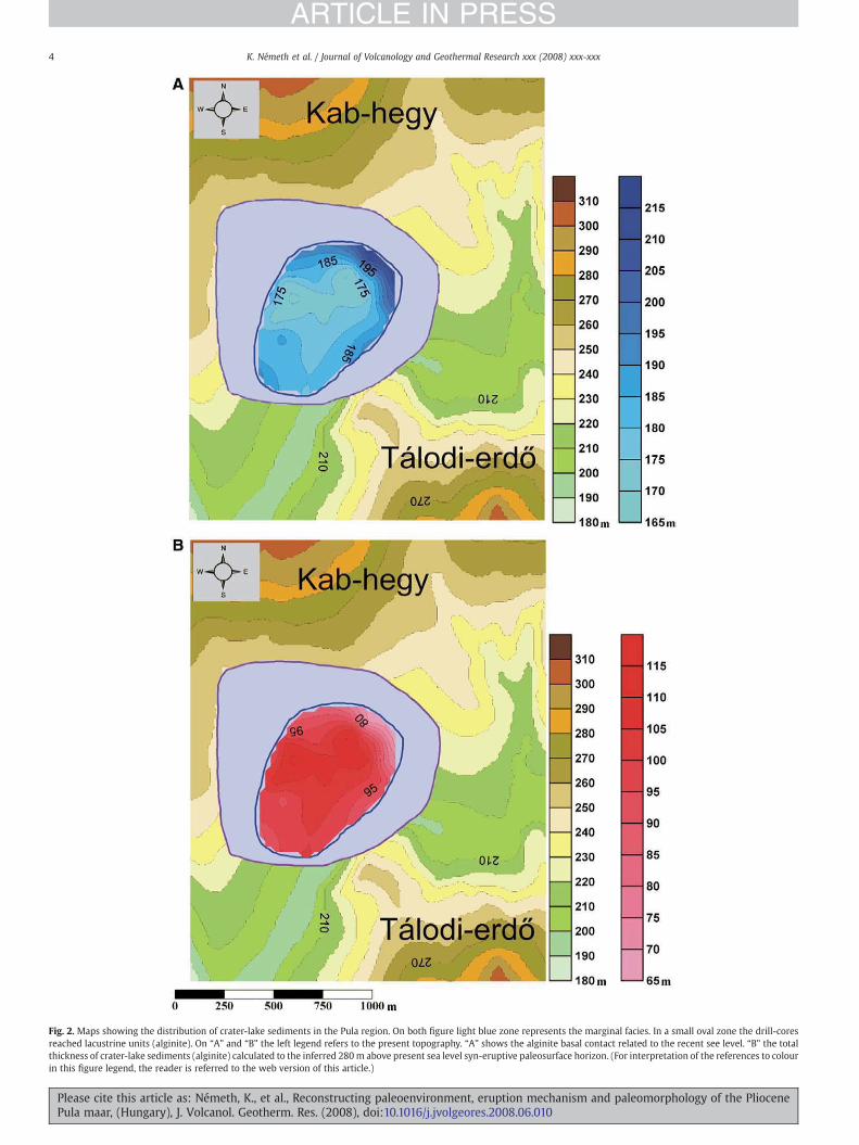
Fig. 2. Maps showing the distribution of crater-lake sediments in the Pula region. On both figure light blue zone represents the marginal facies. In a small oval zone the drill-coresreached lacustrine units (alginite). On “A” and “B” the left legend refers to the present topography. “A” shows the alginite basal contact related to the recent see level. “B” the totalthickness of crater-lake sediments (alginite) calculated to the inferred 280m above present sea level syn-eruptive paleosurface horizon. (For interpretation of the references to colourin this figure legend, the reader is referred to the web version of this article.)
4 K. Németh et al. / Journal of Volcanology and Geothermal Research xxx (2008) xxx-xxx
ARTICLE IN PRESS
Please cite this article as: Németh, K., et al., Reconstructing paleoenvironment, eruption mechanism and paleomorphology of the PliocenePula maar, (Hungary), J. Volcanol. Geotherm. Res. (2008), doi:10.1016/j.jvolgeores.2008.06.010

5K. Németh et al. / Journal of Volcanology and Geothermal Research xxx (2008) xxx-xxx
ARTICLE IN PRESS
laminated sequence of lake sediments, and calculated to representapproximately 320 kyr of accumulation between 3.0 and 2.6 millionyears ago (Willis et al., 1999a,b).
Alginite (oil-shales) studies in the past decades have characterisedlaminated sediments deposited in closed crater lakes such as, in thePula maar lake or at Gérce in the Little Hungarian Plain, just north ofBBHVF (Fig. 1) (Hajós, 1976; Ravasz, 1976; Bence et al., 1978; Solti,1986; Brukner-Wein et al., 2000; Hartyáni et al., 2000; Pápay, 2001).Comparative studies of Pliocene maar crater-lake deposits mainlyfocused on the geochemical characterisation of the sediments (Ravasz,1976; Solti, 1986, 1987; Hetényi, 1992; Hartyáni et al., 2000; Pápay,2001), fossil assemblages (Fischer and Hably, 1991; Kvacek et al., 1994;Hably and Kvacek, 1998) and some basic interpretations of theperiodicity of some of the maar crater lacustrine sediments in respectto climatic change (Willis et al., 1999a,b; Vos et al., 2000). Only alimited number of papers dealt with the geological evolution of thePula maar-diatreme volcano in regard to its volcanic stratigraphy andrelevance to the pre-, syn- and post-volcanic sedimentary records(Jámbor and Solti, 1975, 1976; Németh et al., 2002). In these studiesPulawas reconstructed as a subaqueous volcano that quickly breachedthe water table and formed a closed crater-lake basin separated fromthe surrounding lacustrine environment in which deposition oforganic-rich crater-lake deposits occurred (Jámbor and Solti, 1975,1976). Many of the available descriptions of the volcanic successions ofPula concentrate on the economic potential of the maar crater-hostedalginite deposits and their relevance to other similar sites in theCarpathian realm (Bence et al., 1978; Solti et al., 1988; Vass et al., 1997;Vass, 2000; Viczian, 2000). The importance of these sediments andinterpretation of the sedimentary processes that gave rise to themwere only recently recognized. This has resulted in the realisation thatthe Pula maar-diatreme volcano was an important site at which todescribe the complex volcanic and sedimentary evolution of a maar-diatreme volcano (Németh et al., 2002; Csillag et al., 2004; Goth et al.,2004). In this paper we describe the pyroclastic and maar craterdeposits of Pula maar-diatreme volcano and demonstrate theimportance of distinguishing primary, intra- and extra-crater sedi-mentary processes that operate in association with intracontinentalphreatomagmatic volcanic fields.
3. 3D architecture
In the western Pannonian region, the Neogene shallow marine tolacustrine sedimentation ceased about 8 million years ago andPliocene alkaline phreatomagmatism-dominated volcanism startedshortly afterward in the eastern part of the volcanic field (Magyaret al., 1999; Balogh and Németh, 2005; Wijbrans et al., 2007). TheNeogene sediments have been preserved under basanitic lava nearPula, at the Tálodi-erdő (5.03+/−0.39, 5.06+/−0.22 Ma, Balogh et al.1982). At this location the stratigraphic relation is clearly visible in thePut-2 drill core (Figs. 1 and 3). The Pula maar-diatreme volcanoerupted through this landscape (~4.2 Ma). The maar-diatreme-forming phreatomagmatic eruptions disrupted the surficial countryrocks formed by extensive lava fields from the Kab-hegy shieldvolcano.
A reconstruction of the Pula maar-diatreme geometry is based on1) the reinterpretation of 53 drill-cores evenly distributed mostly inthe central part of the Pula maar-diatreme volcano, 2) GIS-assistedmodelling of the maar geometry and sedimentary infill and 3) thesedimentological study of the exposed surface sections (PULA-1 andPULA-12 on the Fig. 1). All the measured drill-core locations areplotted on Fig. 1. On the basis of the drill-core data, a crater-floormorphology map has been created (Fig. 2). In addition, a detailedstudy of the alginite in the quarry of Pula as well as geologicalmapping of nearby volcanic rocks makes it possible to present a verydetailed reconstruction of the geometry and facies distribution of thePula maar. Cross sections of the maar basin were created by the re-
Please cite this article as: Németh, K., et al., Reconstructing paleoenviroPula maar, (Hungary), J. Volcanol. Geotherm. Res. (2008), doi:10.1016/j.
evaluation of the drill-core descriptions aided by the field observa-tions on available surface outcrops (Fig. 3). The re-interpretations havesome uncertainty because of loss of the majority of the core samples.The lack of access to the samples caused a problem for theinterpretation of several drill-cores located near the maar crater rim,where large volumes of volcaniclastic debris-flow units are a verycharacteristic feature in maar crater deposits (Pirrung et al., 2003).
The drill-core stratigraphic data have been entered into a GIS database to determine the 3D architecture of major sedimentary faciesassociated with the volcanic depression. On the cross sections of Fig. 3only the major geological formations are shown to keep the figure assimple as possible for clarity. The basic summary of the individual rockunits identified in technical reports of the drill-cores provided in anextended figure caption associated with Fig. 3. The interpretations arebased on the cm-scale descriptions that were available from the drill-core technical reports. Identified bedswere grouped into larger units inaccordance to their common facies characteristics such as bedding,grain-size, componentry and their stratigraphic position. A detailedmodel of themaar crater was then created on the basis of the drill-coredata as well as on the location and stratigraphy position of the Tálodi-erdő and Kab-hegy lava field (Fig. 2). The distribution of volcanic rocksassociated with the Pula maar-diatreme volcano (marked by the thickred line on Fig. 1) clearly marks a broad area that is centred on thepresent position of the alginite quarry. A NE to SW elongateddepression forming the Pula basin has been reconstructed on thebasis of the identified region where drill-cores encountered thegreatest thickness of lacustrine successions (Figs. 1, 2 and 3). Thesesuccessions were deposited predominantly by suspension settling offinematerial aswell as inter-bedded thin deposits that originated fromturbidite activity. These finely bedded units are often referred to asalginite successions. The total thickness of the preserved crater-fillingdeposits increases quickly toward the centre of the depression andreaches nearly 50 m in its thickest preserved part (Fig. 2). Along theinferred maar margin, pyroclastic rock units have been documentedfrom the drill-core description that closely resembling pyroclasticunits cropping out in the circum-depression area of the present dayPula basin. The bedding of the pyroclastic units is commonly steep inthe eastern margin of the Pula basin, inferred to be a result of tilting ofsectors of primary pyroclastic rocks close to the crater rim. Thetechnical report descriptions of these pyroclastic units from the drill-cores are not accurate enough for detailed facies analyses, howeverthey contain information such as abundance of angular juvenile clasts,matrix supported texture, thin-to-thick bedding, abundance of sandand limestone clasts which are similar to those pyroclastic unitsexposed and interpreted to be deposited by phreatomagmatic basesurge and fall out events. On the basis of comparative analysis of thedrill-core data base it is inferred that these pyroclastic units are part ofa craterward-dipping inner-crater-filling primary pyroclastic succes-sion that may have been collapsed toward the centre of the volcanicdepression (Figs. 2 and 3). The crater margin zone is defined by thelocation of tilted, inward-dipping primary pyroclastic rocks, subsidedcountry rocks as well as volcaniclastic debris-flow deposits dippingtoward the deep basin of the maar crater (Figs. 2 and 3). The currently250 to 280 m (asl) level is inferred to represent the paleosurface ontowhich the maar erupted. This interpretation is based on the 3Dstratigraphic relation between lava flow units south and north of themaar basin, as well as the stratigraphy relationship within andbetween the drill-cores (Fig. 3). The maximum thickness of preservedmaar crater lacustrine deposits is about 50 m (Figs. 2 and 3). Thepyroclastic beds in the area of the southern margin of the maar craterare currently about 230m asl (Fig. 1). This unit is in top of the crater fillbelow the pre-eruptive land surface, as suggested by the stratigraphicrelationship between other nearby drill-core units (e.g. Put-2, Put-13drill-cores and PULA-10 outcrop) and the Tálodi-erdő lavaflows (Figs.1and 3). This near-crater margin zone is interpreted to be part of a tuff-ring formed on the inner crater wall and it has slid and tilted toward
nment, eruption mechanism and paleomorphology of the Pliocenejvolgeores.2008.06.010

6 K. Németh et al. / Journal of Volcanology and Geothermal Research xxx (2008) xxx-xxx
ARTICLE IN PRESS
Please cite this article as: Németh, K., et al., Reconstructing paleoenvironment, eruption mechanism and paleomorphology of the PliocenePula maar, (Hungary), J. Volcanol. Geotherm. Res. (2008), doi:10.1016/j.jvolgeores.2008.06.010

7K. Németh et al. / Journal of Volcanology and Geothermal Research xxx (2008) xxx-xxx
ARTICLE IN PRESS
the crater. The unconsolidated pre-volcanic sand and silt gave anunstable base for the newly deposited tephra that probably slid andcollapsed gradually into the maar crater after the fracture-controlled,brittle Triassic carbonate basement collapsed in the centre of themaar.The “hard-rock” basement that was covered by an unstable “soft-rock”cap likely provided collapse-prone environment for the maar-diatreme during eruption and also for post-eruptive subsidence(Lorenz and Kurszlaukis, 2007). These processes are likely to havebeen responsible for the preserved facies distribution of mostlyprimary pyroclastic rock units dominantly dipping steeply (about30–40°) in the marginal zone of the preservedmaar structure towardsthe centre of the crater. Entire parts of pre-volcanic and volcanic rockunits have also been identified as large “mega-blocks” collapsed intothe continuously subsiding maar-diatreme volcano. Such blocks havebeen encountered by the drill core of Put-6 (Figs. 1 and 3).Distinguishing between volcaniclastic debris-flow deposits, coarse-grained turbidity deposits and primary coarse-grained pyroclasticunits can be rather problematic, when it is purely based on drill-corereports. Debris-flow deposits however have been identified in surficialdeposits along the southern margin of the inferred maar crater, justabove the drill core of PULA-10 (Figs. 1 and 3). The maar lacustrinedeposits are reported as being underlain by a vesicular lava sheet inmost of the drill-cores (Fig. 3). This vesicular lava sheet is restricted tothe area of the volcanic depression (i.e.. no similar lava has beenreported from other nearby drill-cores) and therefore it must haveemplaced after the volcanic depression formed. An irregular crater-floor morphology (Fig. 2) in the SW part of the maar basin and thehighly vesicular to scoriaceous basaltic rock units (Put-1) describedfromdrill logs in this area suggest the presence of a small (about 100macross) scoria and/or spatter cone that erupted in the maar basin veryshortly after themaar-forming eruptions had ended (Figs. 2 and 3). Thescoriaceous sand units, up to 1.5 m thick that immediately underly thelacustrine alginite noted in the drill-core technical reports, are inferredto have been derived from local intra-maar scoria cone(s) formedimmediately after the maar crater formation before the maar filledwith water (Fig. 3). The small (tens of metres in height) scoria cones inthe maar depression would have represented a substantial source forthe reworkedmaterial occurring in themaar basin. Basaltic rocks reachover 100 m in thickness in the drill-core of Put-1 in the centre of themaar. This enhanced thickness of the coherentmagmatic bodies in thispart of the maar is inferred to be the result of a lava lake ponded in thecentre of the maar. A detailed crater-floor relief map (Fig. 2) suggeststhe existence of avesicularmafic basalt lavaflowmantling theNE–SW-trending crater floor, which developed prior to the accumulation of thelacustrine unit that is preserved in at least a ~50-m thick pile today(Fig. 2).
4. Pyroclastic succession
Pula maar forms a distinct depression with a thick lacustrinesedimentary (alginite) infill. This alginite infill is interbedded withcoarse-grained lapilli tuffs. The present day depression is surroundedby allochthonous primary pyroclastic units as a remnant of the formertuff-ring. Reworked coarse-grained volcaniclastic units are also
Fig. 3. Three cross sections of the Pula maar basin showing the geometrical distribution of idshown on Fig. 1. On each cross section, black thick line represents the present morphology, inabbreviations on the key for the lithostratigraphical units as well as the reconstructed\inferMajor units (left key) 1—Triassic basement, 2—Middle to Upper Miocene rock units, 3a—L(Pannonian) siliciclastic units, 4—undistinguished Pliocene volcaniclastic rocks, 4a—reconbasanitic rocks, 6a—crater-lake suspension deposited (alginate) deposits, 6b—reconstructedsection there is no differentiation between primary pyroclastic, allochton pyroclastic and rewpreserved volcaniclastic successions inferred to be either allochton pyroclastic rock units olithostratigraphical units of Hungary (e.g. rock formation names) as follows: T3—undistinguisTaliándörögd Marl Formation—Upper Miocene, nvM3—Nagyvázsony Limestone Formation—taM3Plbt—Tapolca Basalt Formation /volcaniclastic rocks Upper Miocene–Pliocene, pPl—Pulareferences to colour in this figure legend, the reader is referred to the web version of this a
Please cite this article as: Németh, K., et al., Reconstructing paleoenviroPula maar, (Hungary), J. Volcanol. Geotherm. Res. (2008), doi:10.1016/j.
associated with the marginal zone of the Pula depression. Thepyroclastic succession is best exposed today on the surface at thesouthern and eastern margin of the Pula depression (Fig. 1). Here werefer to a pyroclastic succession as being primary in origin where thesedimentological characteristics of the succession show evidence ofprimary volcanic eruption-related transportation and deposition(Fisher and Schmincke, 1984). In this pure sedimentological distinc-tion, a unit may bear primary characteristics, but this does notnecessary imply that it is preserved in its original position due tosubsequent mass movement.
4.1. Tuff-ring sequences
The marginal area of the Pula depression is formed by a narrowbelt of about 30 m thick phreatomagmatic lapilli tuff and tuff beds.These beds dip (5–15°) toward the centre of the Pula basin or are sub-horizontal. The pyroclastic beds are predominantly accidental lithic-rich (50 vol.% by visual estimate) thinly bedded lapilli tuffsinterbedded with finely bedded tuff beds (Fig. 4A). This lithofaciesconsists of rim-type accretionary lapilli-bearing (Fig. 4B and C),accidental lithic clast-rich (Fig. 4D), cross- and dune bedded lapillituffs and tuffs. The rocks contain angular, blocky, slightly vesicular(40 vol.% by visual estimate) microlite-poor volcanic glass shards.Cauliflower-shaped black lapilli are common with entrapped milli-metre sized carbonate rock fragments (Lorenz et al., 2002) andxenocrysts of olivine and pyroxene are common in the entirepyroclastic succession. Cauliflower lapilli and bombs are common incoarse-grained lapilli tuff beds. Vesicular tuff and few cm thickaccretionary lapilli-bearing beds are common. Accretionary lapilli arerim-type. Lapilli tuff beds contain armoured lapilli and bombs. Thepyroclastic successions around the Pula depression are rich infragments from Triassic formations as well as carbonate-rich matrixand cement (Fig. 4A). The proportion of carbonate rock fragments ishigher in the upper section of the exposed pyroclastic units. The baseof the succession is dominated by plastically deformed sand, mud andsiltstone fragments, as well as large volume of siliciclastic grains in thefine matrix of the lapilli tuff and tuff. The thicker, and coarser-grainedbeds are in general richer in juvenile fragments and coarse ash, finelapilli sized rock pieces from carbonate rocks. The carbonateaccidental lithic fragments are angular and have no thermal alterationmargins. The juvenile fragments are predominantly low in vesicular-ity, and angular, commonly have thin, chilled margins.
4.2. Interpretation
The preserved pyroclastic units in the marginal zone are interpretedto be the near-vent part of inward-dipping pyroclastic units thataccumulated along the inner crater wall, on the basis of their generaldipping toward the depression and texture of thepreserveddeposits. Thepresence of juvenile glass shards, accretionary lapilli, abundance ofaccidental lithic clasts (Fig. 4D), and cross- and dune bedded textureindicate that these beds are primary in origin and formed byphreatomagmatic explosions. The poor sorting, angularity of clasts,bedding characteristics and their 3D architecture also suggest a primary,
entified volcaniclastic lithologies in and around the maar basin. Cross section lines arecontrast to red dashed lines, that stand for the inferred syn-eruptive paleosurface. The
red major rock units associated with the Pula maar are the same on each cross section:ate Miocene (Pannonian) siliciclastic units, 3b—reconstructed (eroded) Late Miocenestructed (eroded) undistinguished Pliocene volcaniclastic rocks, 5—coherent Pliocene(eroded) crater-lake suspension deposited (alginate) deposits. Note that on the cross
orked volcaniclastic (e.g. volcaniclastic debris flow) units assigned to be 4 and 4a.. All ther volcaniclastic debris-flow deposits. The key for the drill-cores based on the acceptedhed Upper Triassic formations, vM2—Vöröstó Clay Formation—Middle Miocene, tdM3—Upper Miocene, taM3Plb—Tapolca Basalt Formation /basalt Upper Miocene–Pliocene,Alginite Formation—Pliocene, Surface—Quaternary deposits. (For interpretation of the
rticle.)
nment, eruption mechanism and paleomorphology of the Pliocenejvolgeores.2008.06.010
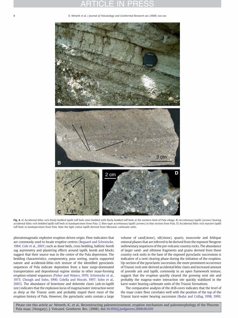
Fig. 4. A) Accidental lithic-rich thinly bedded lapilli tuff beds inter-bedded with finely bedded tuff beds at the western limit of Pula village. B) Accretionary lapilli (arrows) bearingaccidental lithic-rich bedded lapilli tuff beds in handspecimen from Pula. C) Rim-type accretionary lapilli (arrows) in thin section from Pula. D) Accidental lithic-rich massive lapillituff beds in handspecimen from Pula. Note the light colour lapilli derived from Mesozoic carbonate units.
8 K. Németh et al. / Journal of Volcanology and Geothermal Research xxx (2008) xxx-xxx
ARTICLE IN PRESS
phreatomagmatic explosive eruption-driven origin. Flow indicators thatare commonly used to locate eruptive centres (Bogaard and Schmincke,1984; Cole et al., 2001) such as dune beds, cross bedding, ballistic bombsag asymmetry and plastering effects around lapilli, bomb and blockssuggest that their source was in the centre of the Pula depression. Thebedding characteristics, componentry, poor sorting, matrix supportednature and accidental-lithic-rich texture of the identified pyroclasticsequences of Pula indicate deposition from a base surge-dominatedtransportation and depositional regime similar to other maar-formingeruption-related sequences (Fisher and Waters, 1970; Schmincke et al.,1973; Chough and Sohn, 1990; Colella and Hiscott, 1997; Sohn et al.,2003). The abundance of limestone and dolomite clasts (ash-to-lapillisize) indicates that the explosion locus ofmagma/water interactionwentas deep as the Triassic units and probably stayed there most of theeruption history of Pula. However, the pyroclastic units contain a large
Please cite this article as: Németh, K., et al., Reconstructing paleoenviroPula maar, (Hungary), J. Volcanol. Geotherm. Res. (2008), doi:10.1016/j.
volume of sand(stone), silt(stone), quartz, muscovite and feldsparmineral phases that are inferred to be derived from the topmostNeogenesedimentary sequencesof thepre-volcanic country rocks. The abundanceof larger sand- and siltstone fragments and grains derived from thesecountry rock units in the base of the exposed pyroclastic successions isindicative of a vent clearing phase during the initiation of the eruption.Up-section of the pyroclastic succession, themore prominent occurrenceof Triassic rock unit-derived accidental lithic clasts and increased amountof juvenile ash and lapilli, commonly in an open framework texture,suggest that the eruption quickly cleared the growing vent site andprobably the magma–water interaction site quickly stabilized in thekarst-water bearing carbonate units of the Triassic formations.
The comparative analysis of the drill-cores indicates that the level ofthe maar crater floor correlates well with the position of the top of theTriassic karst-water bearing succession (Budai and Csillag, 1998, 1999;
nment, eruption mechanism and paleomorphology of the Pliocenejvolgeores.2008.06.010

9K. Németh et al. / Journal of Volcanology and Geothermal Research xxx (2008) xxx-xxx
ARTICLE IN PRESS
Fodor et al., 2005). The final level of themaar crater floor is, however, theresult of syn- and post-eruptive subsidence. This final level of the crater-floor in Pula is inferred to be lower than itwas just after themaar formed,resulting from 3–4 My of post-volcanic subsidence history at Pula.Therefore, the initial explosion locus is inferred to be above the Triassickarst-water bearing succession in the porous-media aquifer of sand. Thisinterpretation is supported also by the increased abundanceof siliciclasticaccidental lithic and mineral phases derived from the unconsolidatedNeogene sedimentary units in the basal pyroclastic successions exposed.The explosion locus probably rapidly migrated downwards from thecapping ~150 m thick porous-media aquifer (sand and silt) to the karst-water bearing Triassic dolomite units, which predominate in theaccidental lithic assemblage of the upper pyroclastic units.
4.3. Reworked pyroclastic units
Thick (~20 m) volcaniclastic units form a collar-like succession in thesouthern margin of the Pula depression, near the escarpment of the lavaflow-capped Tálodi-erdő (Figs. 1 and 3). This succession flanks theprimary pyroclastic units of the tuff-ring and can be traced aroundthe easternmargin of thepresent dayPuladepression. This unit forms thesteeply inward-dipping (up to 30°) lower part of the marginal primarypyroclastic beds. The deposits are thickly bedded, massive or weaklystratified with fine-grained accidental lithic-fragment-rich cm-to-dmthick matrix supported beds. Large bombs and blocks are hosted in finelapilli to coarse ash matrix with no deformation beneath them. Largeclasts are commonly abraded, or at least their edges are rounded.Sandstone fragments from the Neogene siliciclastic successions showwell-rounded shapes. Juvenile fragments and co-genetic volcanic lithicclasts range from unaltered to strongly altered. The succession containslarge (metre-sized) blocks of lapilli tuff still preserving their originalbedding aswell as boulder sized coherent lavaflow. Theunit is commonlyinterbeddedwith coarser-grained lensoid clast accumulations that can betraced over a distance of a few metres. The larger clasts arecompositionally diverse and represent coherent magmatic fragments aswell as country rock fragments from the entire known pre-volcanic rockunits. The beds have no accretionary lapilli or bedforms associated withhigh energy transportationby lateralmovingpyroclastic density currents.
4.4. Interpretation
The common presence of abraded pyroclastic rock fragments inthese beds shows that diagenetically altered pyroclastic rocks existed
Fig. 5. Volcaniclastic debris-flow deposit in the inner flank of the P
Please cite this article as: Németh, K., et al., Reconstructing paleoenviroPula maar, (Hungary), J. Volcanol. Geotherm. Res. (2008), doi:10.1016/j.
prior to the reworking of volcaniclastic material in the volcanic basinof Pula (Fig. 5). Sedimentary features of these volcaniclastic beds arecharacteristic of reworking by debris flows, which were generated onthe inner wall of the crater mantled by primary pyroclastic deposits.The large number of lava clasts and their diverse shape (Fig. 5)indicates that older lava units were disrupted by the volcanic eruptionof Pula and subsequently reworked by debris flows that developed onthe collapsing inner wall of a phreatomagmatic volcano.
5. Crater-lake sediments
In the Pula maar-diatreme volcano the central facies of maar lakesediments is exposed in an open cast mine (Fig. 6). These sediments, aso-called “alginite”, are exploited for amelioration of soils. In Hungary,four Pliocene maar lakes filled with alginite have been described: Pula,Gérce, Egyházaskesző and Várkesző. The alginite is composed of clayminerals, calcium carbonate and phosphate crystals, diatom frustules,Botryococcus colonies, pollen grains, plant detritus, charcoal fragments,etc. (Ravasz, 1976; Solti, 1987; Vass, 2000; Pápay, 2001) (Fig. 7). Theexposed lacustrine succession in the open pit mine of Pula representsmaar lake deposits are similar to upper sections of lacustrine sedimentsfrom other known maar lakes (Fisher et al., 2000; Pirrung et al., 2003).The lack of a prominent relief suggests that either the tephra ring wallwas stabilized shortly after the eruption ceased, similarly to Ukinrekmaar (Pirrung et al., 2008) or it had beenmore or less eroded before theinfill stage and the sediment is mainly autochthonous in origin. Theamount of sediment deposited per year was probably very low (so-called starving sedimentation), similar to other studied maar lakes(Goth, 1990; Pirrung, 1998; Pirrung et al., 2003). Laterally continuousdetailed lamination without any disturbance is typical for such maarlake sediments, alongwith interlaminated siderite layers (Brunner et al.,1999; Chu et al., 2000; Bullwinkel and Riegel, 2001; Pirrung et al., 2003).These features, however aremissing in the Pula alginite. Along the 30mprofile accessible in the Pula pit, only bedding, with no seasonallamination, is developed. There are thick homogenized layers (up to30 cm) consisting of reworked sediment. Therefore we suggest that thePula maar lake did not develop a meromictic division of the water bodyduring the deposition of the presently exposed alginite. The absence oflaminations means that no clear signal of the sedimentation rate can bedetermined fromthis section, so it is not possible to estimate theamountof time for theaccumulation of the alginite, as has been suggested earlierby Willis et al. (1999a,b). Willis et al. (1999b) described periodicity invegetation change in the Pula alginite. Their use of the sedimentation
ula crater. Note the large basalt block in the middle of the bed.
nment, eruption mechanism and paleomorphology of the Pliocenejvolgeores.2008.06.010

Fig. 6. Open cast mine Pula; view from the south. Arrows indicate the event layer within the alginite. Please note that the layer inclines to the south (distal facies).
10 K. Németh et al. / Journal of Volcanology and Geothermal Research xxx (2008) xxx-xxx
ARTICLE IN PRESS
rate as a basis for time, however, should be reviewed based upon ourresults.
Fragments (1–3 mm in diameter) of mostly juvenile volcanic clasts(e.g. sideromelane glass shards) or volcanic lithics are commonlyscattered within the fine-grained “alginite”. Similar features, such ascoarse single grains in fine-grained lake sediment, are known fromother maar lake sediments; e.g. from the Eocene Messel Lake (Goth,1990), from the Eocene Eckfeld Lake (Zolitschka, 1993) and from theOligocene Maar lakes Kleinsaubernitz and Baruth (Goth, 2000; Gothand Suhr, 2000; Goth et al., 2003). The presence of these clasts cannotbe explained by the normal sedimentation processes in such isolatedlakes. Instead, their presence could be explained by either of thefollowing: (1) transport of the coarse grains clinging to the roots ofplants ripped off the shore, (2) pebbles dropped by birds and (3) in thedwelling tubes of caddis fly larvae.
Analysis of the drill-cores from the central part of the depressionshows the sediments to consist of finely bedded, laminated, normallygraded, fine-grained volcanic silt- and sandstone. These beds containabundant angular quartz and minor non-to-weakly vesicular, non-
Fig. 7. Pula alginite: Botryococcus colonies and diatom frustules.
Please cite this article as: Németh, K., et al., Reconstructing paleoenviroPula maar, (Hungary), J. Volcanol. Geotherm. Res. (2008), doi:10.1016/j.
abraded tephrite to phonotephrite glass shards. The graded texture, finebedding and typical coarse-to-fine bed couplets of these beds areindicativeof sedimentation fromturbiditycurrents crossing the lakefloor.
Coarser-grained and commonly chaotic sediment beds that areassociated with major sedimentary events (e.g. crater wall collapseinduced debris flows and associated turbidity currents) in the earlyevolution of themaar lake (Pirrung et al., 2003, 2008) are missing in theexposed sequence in the quarry (Figs. 8 and 10). Only one prominentunit has been identified in the middle of the alginite section in theexposed quarrywalls that shows textural evidence of disturbance of the
Fig. 8. Outcrop of the event horizonwithin the alginite section at the northern bench ofthe Pula open cast mine.
nment, eruption mechanism and paleomorphology of the Pliocenejvolgeores.2008.06.010

11K. Németh et al. / Journal of Volcanology and Geothermal Research xxx (2008) xxx-xxx
ARTICLE IN PRESS
otherwise typical alginite-dominated sedimentation in the lacustrinebasin. This unit consists of a mixture of quartz and carbonate grains anddark volcanic glass shards, as well as clay minerals. The internal textureof this unit is complex and consists of several thinly bedded layers,suggesting a complex depositional history for this unit. The unit forms ahorizon about 30-cm-thick which is exposed in the central walls of thequarry pit in Pula (Fig. 8). At three points along the quarry wall detailedsedimentary profiles were recorded. This distinctive unit comprises upby up to 18 layers. Every layer is normally graded and capped by a veryfine mud drape. The layer thickness from the base to the top of thehorizon shows a gradual decrease from about 1 cm thickness to about0.1 cm, except the topmost layer which thickens again.
The record starts at the base of the section with about a 10 mmthick layer rich in dark glass shards, quartz and carbonate grains. Thisbasal layer is the coarsest grained of all the layers. The next 4 layers aremainly composed of quartz grains and they are weakly cemented. Thesubsequent layers have an increasing content of carbonate, resultingin stronger cementation. The thickness of the overall unit in theexposed sections is relatively constant. The bedding planes areparallel, however, mm-to-cm-scale undulations over dm-distancesare noted. A characteristic feature of this unit is the great variety of softsediment deformation associated with it (Fig. 9). Truncated internallayers (“convolute lamination” Lowe 1975), cm-size sand/mudvolcanoes and associated “eruption products” around such features,as well as undulating internal layers with twisted, “boudinage-like”lateral features all indicate significant deformation of the freshlydeposited material. The mud volcanoes are water escape structuresproducing a lot of material which settled as the uppermost layer of theevent horizon. These different processes are unique to this unit as itdiffers in thickness compared with the rest of the sedimentary unit.There are no such soft sediment deformation features below andabove this horizon in the alginite succession, suggesting that the softsediment deformation features are syn- or slightly post-depositional.
This prominent horizon in the alginite lacustrine succession (Fig. 10)represents a significant sedimentary event, inferred to be the result of alarge landslide in the inner craterwall. On the basis of the lake's originalsize (min. 1 km across), depth (min. 100 m) and thickness of the unit(about 30 cm), it is estimated that about 100,000m3material plunged tothe crater lake from a landslide. Such a landslide would have caused asignificant turbidity current along the lake floor. When this current hitsthe opposite crater wall it was reflected. This process, commonlyreferred as an internal seiche, could have been repeated several timesuntil the primary energy of the flow was exhausted and all thesuspended particles had settled. Due to the rapid sedimentation from
Fig. 9. Polished slab of the upper part of the event horizon. Please note t
Please cite this article as: Németh, K., et al., Reconstructing paleoenviroPula maar, (Hungary), J. Volcanol. Geotherm. Res. (2008), doi:10.1016/j.
these initials and reflected lake floor-hugging currents, graduallythinning turbidity current deposits accumulated. The fast time-scale ofthis event accompanied by the grain-size variation of the accumulatingsediment resulted in the capture of a significant volume of pore water.Early compaction of the sediments (before accumulation of significantvolume of lacustrine sediment over this bed) the resulted in over-pressure of porewater thatwas inferred to have been released in suddendewatering, causing the prominent soft sediment deformation recordedwithin this unique unit.
Large internal waves resulting from landslides that may triggerturbidity currents and therefore deposit beds representing majorsedimentary events in a lake history have been reported from manynon-volcanic and volcanic lakes. In 1601 an earthquake in the SwissAlps triggered giant landslides in the Lake Lucerne. These slides causedan internal seiche wave in the lake which was described by RenwardCysat (city clerk of Lucerne). Similar events have been investigatedfromdifferent lakes (Siegenthaler et al.,1987; Schnellmann et al., 2002,2003). Wagner et al. (2003) reported an accident with a slide into asmall volcanic lake in Papua New Guinea. The south crater wall of theQuaternary Kasu Tephra Cone in the Highlands of Papua New Guineacollapsed on 20. April 1999 and sent a 150,000-m3 landslide into itslake (Wagner et al., 2003). This collapse displaced 5–10% of the lake'svolume and generating a 15-m-high wave which flattened vegetationthroughout the crater interior, and broke over a low saddle in thecrater's east rimwhere it destroyed two houses and injured 11 people,killing one (Wagner et al., 2003). The Kasu Tephra Cone event is a goodanalogy to what could have caused the turbidity current in Pula,however, the two landformswere different. Kasu Tephra Cone is about100 m high with a 350m diameter. Its crater hosts a slightly elongatedlake with a maximum depth of 20 m surrounded by a 70 m, steeplydipping tephra cone (Wagner et al., 2003). Pula was a much broaderfeature (average 1000 m across), with a much deeper lake. The tephrasuccessions of Pula in contrast are sub-horizontal and dippingoutward, typical of a maar tephra ring. The total thickness of thetephra beds at Pula were probably thinner than the Kasu Tephra Conerim deposits, however, the relative drop from the top of the tephra rimto the lake surface is estimated to be the same range (70+ m) at Pula asin Kasu, therefore the gravitational relief needed to trigger a largeinternal wave was likely to be the same as at Kasu. In spite of thedetailed observations of the landslide event at Kasu no description ofthe resulting deposits and their structures was made. The deposits ofthe Pula unique unit are, however, similar in sedimentologicalcharacteristics to those observed from turbidity currents, e.g. in flyschdeposits and are consistent with an origin from reflected turbidity
he water escape structures. Thickness of the sequence is about 5 cm.
nment, eruption mechanism and paleomorphology of the Pliocenejvolgeores.2008.06.010

Fig. 10. Theoretical sections through the event layer in the Pula open cast pit.
12 K. Németh et al. / Journal of Volcanology and Geothermal Research xxx (2008) xxx-xxx
ARTICLE IN PRESS
currents (Fig. 11). Such reflected turbidity currents have also beengenerated in laboratory experiments as well as in numerical models(Pickering and Hiscott, 1985; Pickering et al., 1986; Pantin and Leeder,1987; Kneller et al., 1991; Kneller and McCaffrey, 1999; Kneller andBuckee, 2000; Pickering and Corregidor, 2005). Pantin and Leeder(1987: 1146ff.) gave a detailed description of the sequence of eventshow turbidity currentsmay reflect based on experimental data. Duringthe initiation of the current, it forms a well-developed head followedby themainbody (Pantin and Leeder,1987). As the density current risesup the sloping ramp (a good model for the opposite crater wall in thecase of Pula), the head decelerates rapidly, reduces in height, andeventually comes to approximate standstill (Pantin and Leeder, 1987).Whilst the head is decelerating and thinning, the body of the flowabove the lower part of the ramp has acquired a backward slope
Fig. 11. Section through a maar lake to show the depositional model of the event layer, especiaand Hiscott 1985).
Please cite this article as: Németh, K., et al., Reconstructing paleoenviroPula maar, (Hungary), J. Volcanol. Geotherm. Res. (2008), doi:10.1016/j.
(Pantin and Leeder, 1987). A ‘bulge’ is soon formed which begins totravel as a reverse flow (Pantin and Leeder, 1987). After a fewdecimetres of travel, the leading edge of the bulge acquires a veryregular wave shape—essentially that of an internal soliton or undulabore (Pantin and Leeder, 1987). The internal solitons are reflected fromthe upstream lock wall, producing standing waves (Pantin and Leeder,1987). Reflection causes little change in amplitude and velocity of thecurrent (Pantin and Leeder, 1987). Pantin and Leeder (1987: 1148) alsopointed out that “The several additional current reversals visible at thetops of some beds are very unlikely to be due to continued reflection ofthe solitons at the ends of the basin. It seams likely that in these casesthe additional reversals are caused by an internal seiche, following theturbidity current itself.” Pantin and Leeder (1987) laboratory experi-ments are inferred to be the plausible models to generate beds such as
lly how the beds are produced by the reflections of the turbidite current (after Pickering
nment, eruption mechanism and paleomorphology of the Pliocenejvolgeores.2008.06.010

Fig. 12. Reconstruction of the evolution of the Pula maar on the basis of detailed drillcore, and facies analysis of volcanic rock units. 1) Phreatomagmatic, magma–waterinteraction driven explosive eruption. The rising magma encountered water-saturatedporous-media aquifer in the Neogene siliciclastic deposits. The eruption excavates a“hole-in-the-ground” leading to an immediate syn-eruptive collapse processes. Theexplosion locus gradually down-migrated and the magma got contact with possiblekarst-water bearing aquifers near the contact between the Triassic and Neogene rockunits. The excavation of the deeper rock units caused a larger scale subsidence of themaar central part. 2) Upon exhausting the water recharge to fuel magma–waterinteraction and/or increasing the magma supply small scale lava effusion and lavaspatter and/or scoria cone building occurred in the new maar crater. 3) Water rechargefrom the disrupted aquifers (mostly the karst-water bearing Triassic units) lead to thegradual fill of the maar. In the maar basin, in the early evolutionary stage, large scalevolcaniclastic debris flows, turbidity currents initiated from the collapsing crater rim. Inthe centre part of themaar, suspension deposition leads to alginite accumulation. Largerscale collapse and subsidence of large blocks from the crater rim are likely to have beenoccurred. 4) Further erosion wiped away the former crater rim base surge and fall outdominated tephra. The centre part of the maar suffered continuous subsidence due todewatering, compaction, diagenesis, and reorganisation of the diatreme debris in thevolcanic pipe. On the figure green pattern represents the Triassic basement, white theNeogene, predominantly siliciclastic rock units, and red the pre-maar Kab-hegy–Tálodi-erdő lava flow field. Yellow to brown tones represent base surge and fall out depositsassociated with the phreatomagmatic eruption of Pula. On “3” dotted brown patternstands for the large scale volcaniclastic debris-flow deposits entered to the maar. Deepblue colour shows the alginite deposited in the crater lake (light blue). Black line on “4”represents the present topography after erosion. (For interpretation of the references tocolour in this figure legend, the reader is referred to the web version of this article.)
13K. Németh et al. / Journal of Volcanology and Geothermal Research xxx (2008) xxx-xxx
ARTICLE IN PRESS
the bed representing an event horizon in the crater-lake succession ofPula.
In summary, the turbidity current generated had a higher densitythan the water and moved down the slope and along the almosthorizontal floor of the Pula crater-lake basin. Reaching the bottom ofthe lake floor, the velocity of the suspension cloud decelerated and anormally graded layer was deposited. However, the velocity of thecurrent was still so high and the lake basin so small that the turbiditycurrent ran up onto the opposite slope and was reflected. The lakewater and the turbidity current sloshed back and forward, losingmoreand more of its momentum. With every passage across the basin agraded layer of sediment settled, a little bit thinner each time (Fig. 9).The suspensions concentrated the light vesicular volcanic glass shardsand lost their heavier quartz and dolomite particles. Only glass shardswere deposited from the last reflected turbidity current. The load ofthis whole layer generated dewatering of the previous sediments andsand volcanoes formed on the sediment surface. The resultingstructures are cm-scale in size in cross section.
6. Discussion
Pula maar today is an erosional remnant of a Pliocene maar-diatreme volcano (Fig. 12). The extensive lava flow fields north andsouth of the maar depression show similar textural characteristics aswell as more or less similar contact elevations between flow and pre-lava rock units. The elevation between 250 to 280 m asl marks apaleosurface through which the maar-diatreme volcano erupted. Thestratigraphic relationship between the Pula maar and Tálodi-erdő lavafield (Fig. 1) and the underlying thick Miocene siliciclastic successionindicates that the Pula depression forms a “hole-in-the-ground”structure. The presence of pyroclastic rock units interpreted to havebeen deposited by base surge and phreatomagmatic tephra fall aretoday located well below the contact between the Tálodi-erdő lavaandMiocene sand and silt units. We therefore argue that, regardless ofprimary origin of the pyroclastic rock units, they are not in theiroriginal position, and consequently they are inferred to be collapsednear-crater rim blocks as has been described from other sites (Lorenz,1970, 1971). The process by which these units reached their presentposition is not yet well understood. The basement at Pula is rigid andfractured Triassic carbonate rocks, a typical “hard-rock” environment(Fig. 12). This basement is covered by a relatively thick (50–100 m)Miocene sand and silt succession, a typical “soft-rock” environment(Fig. 12). This succession was covered by few metres thickness ofextensive lava flows. The general abundance of quartz, muscovite andclay minerals in the matrix of the pyroclastic rocks at Pula suggeststhat, during the phreatomagmatic explosive eruptions, the vents werepartially open and commonly choked by sand and silt chunks that slidinto the active vent from the gradually collapsing siliciclastic cappingrock units (Fig. 12). It is easy to imagine, that the initial phreatomag-matic explosion partially disrupted the topmost “soft-rock” units, andformed a rather large crater of a champagne-glass-type maar-diatreme volcano form, similar to Ellendale lamproite diatremes inWestern Australia (Smith and Lorenz,1989). The abundance of countryrock fragments derived from the Triassic carbonate “hard-rock”environment also suggests that the explosion loci quickly reachedthese rock units which very likely provided abundant karst water tofuel further explosive magma/water interaction (Fig. 12). This processmust have facilitated the excavation of these rigid rock units and easilydestabilized the area around the active vent (Lorenz, 1986). Thisprocess likely initiated an ongoing subsidence of the area of the activevents, leading to the formation of a continuously changing deposi-tional surface for the successive phreatomagmatic base surges as wellas tephra falls (Fig. 12). Because of its size, the eruption of Pula likelylasted weeks to months or even longer (Lorenz, 2003a; Lorenz et al.,2003; Lorenz and Kurszlaukis, 2007) and left behind a “sink-hole-like”crater with unstable tephra ring blocks dipping crater-ward on a
Please cite this article as: Németh, K., et al., Reconstructing paleoenviroPula maar, (Hungary), J. Volcanol. Geotherm. Res. (2008), doi:10.1016/j.
moderately steep (25–35°) surface. Following the eruptions, theprocesses of compaction and diagenetic alteration of the volcaniclasticfill likely caused significant (tens of metres) subsidence in the centreof the young maar-diatreme volcano (Fig. 12), leading to further
nment, eruption mechanism and paleomorphology of the Pliocenejvolgeores.2008.06.010

14 K. Németh et al. / Journal of Volcanology and Geothermal Research xxx (2008) xxx-xxx
ARTICLE IN PRESS
subsidence and collapse and rearrangement of the marginal zones ofthe maar-diatreme volcano depression (Suhr et al., 2006). Coarse-grained volcaniclastic debris-flow deposits likely get preserved in asteeply dipping marginal inner zone of the maar crater commonlyflanking and overlying the tilted and partially subsided blocks oftephra units (Lorenz, 1985; Büchel and Lorenz, 1993). The point-likedistribution of drill-core information as well as the lack of direct studyof the drill-cores makes it hard to constrain this model any better atthis moment. A scientific drilling through the maar succession wouldbe a very important contribution to understand the eruptionmechanism of such a maar-diatreme volcano developed in two verycontrasting types of country rock environment (“hard” versus “soft”rock environment). The relevance of mechanically and thereforehydrogeologically contrasting types of country rocks that were cutthrough by the phreatomagmatic explosive eruptions resulting in theformation of maar/tuff-ring volcanoes has been pointed out insynoptic reviews earlier (Lorenz, 2003a,b). Evidence for extensivecollapse of tephra ring beds due to migration of vent position of aphreatomagmatic volcano developed in a “soft-rock”-covered rigid(lava flow) basement has been demonstrated from Jeju Island, SouthKorea, recently (Sohn and Park, 2005). About 10 km south of Pula, anested maar volcanic complex called Fekete-hegy features evidence ofsimilar collapse processes and dual involvement of contrasting typesof country rocks during the course of magma/water interactionthrough the evolution of the complex (Auer et al., 2007). Pula maartherefore shows very similar architecture and volcano-structuralevolution to volcanoes described from South Korea (Sohn and Park,2005), or the nearby Fekete-hegy (Auer et al., 2007).
It must also be mentioned that the eruption, transport anddeposition mechanisms of the commonly reported basaltic sandbeds that immediately underlie the suspension deposited lacustrinebeds cannot be interpreted fully at this stage. The technical reports arenot detailed enough to accomplish this aim, especially to distinguishbetween an airborne versus water-settled origin of these beds.Similarly the commonly reported scoriaceous, lava spatter-richintra-crater beds below the maar lacustrine rock units indicate thatintra-maar scoria and/or spatter cones partially filled the maar basinprior its filling with water. The reported basaltic sand is inferred tohave been derived from the erosion of these small volcanoes. Thiswould imply some time gap before the maar was filled with water,allowing time to accumulate about a metre thick succession in themaar basin. However, such a thickness of deposits may haveaccumulated only a short time period.
7. Conclusion and outlook
Paleogeographical reconstruction at the Pula Maar focused on theidentified pyroclastic and associated reworked volcaniclastic succes-sion and the crater-lake deposits in order to understand monogeneticvolcanism in the central region of the Bakony-Balaton HighlandVolcanic Field, western Hungary. This study suggests that the originalmaar basin at Pula was larger than previously suggested and showsthe complex interplay of different volcano-tectonism, diagenesisrelated sediment compaction-induced subsidence as well as syn-and post-eruptive collapse and depositional processes involved in theformation of themaar crater-filling. The pyroclastic sequence of Pula isinterpreted to be a typical accidental lithic clast-rich lapilli tuff and ashtuff unit, showing evidence such as abundance of accretionary lapilli,vesicular tuffs as well armoured lapilli that suggest a “damp andsticky” depositional environment. The preserved pyroclastic rockunits record a near-vent depositional environment, presumably closeto the crater depression. These pyroclastic successions are preservedin allochthonous, collapsed blocks. In dissected outcrops, volcaniclas-tic debris-flow deposits have been identified in close relationshipwithsuch primary pyroclastic rock units and interpreted to representenergetic debris flows that transported volcanic detritus into the
Please cite this article as: Németh, K., et al., Reconstructing paleoenviroPula maar, (Hungary), J. Volcanol. Geotherm. Res. (2008), doi:10.1016/j.
crater lake from the tephra ring. These deposits were rich in intactpyroclastic rock fragments inferred to be an evidence of the priorexistence of indurated pyroclastic rocks that were recycled into thecrater lake. The central lacustrine facies consists of bedded deposits(e.g. alginite) inferred to represent quiet, post-eruptional deposition.
Acknowledgements
Various grants such as the DAAD German–Hungarian AcademicExchange Program 2002/2003, the Magyary Zoltán Post-doctoralFellowship, the Hungarian Science Foundation OTKA F 043346, theDFG (German Science Foundation) helped to carry out field work andsynthesis work which led to this paper. The project is also part of KN'sPost-doctoral research on understanding mafic explosive volcanism(Massey University, MAUX0405). The final graphic design of thefigures was done by Astrid Engelhardt-Sobe and Gudrun Baumgart.Suggestions by and discussions with Bob Stewart helped to clarifymany aspects of this research. Formal reviews by Michael Ort andCorado Cimmarelli significantly lifted the quality of the manuscript,many thanks for it.
References
Ashton, P.J., Schoeman, F.R., 1983. Limnological studies on the Pretoria Salt Pan, ahypersaline maar lake 1. Morphometric, physical and chemical-features. Hydro-biologia 99, 61–73.
Auer, A., Martin, U., Németh, K., 2007. The Fekete-hegy (Balaton Highland Hungary)“soft-substrate” and “hard-substrate” maar volcanoes in an aligned volcaniccomplex — implications for vent geometry, subsurface stratigraphy and thepalaeoenvironmental setting. J. Volcanol. Geotherm. Res. 159, 225–245.
Balogh, K., Pécskay, Z., 2001. K/Ar and Ar/Ar geochronological studies in the Pannonian–Carpathians–Dinarides (PANCARDI) region. Acta Geol. Hung. 44, 281–301.
Balogh, K., Németh, K., 2005. Evidence for the neogene small-volume intracontinental.volcanism in western Hungary: K/Ar geochronology of the Tihany Maar volcaniccomplex. Geol. Carp. 56, 91–99.
Balogh, K., Jámbor, A., Partényi, Z., Ravaszné Baranyai, L., Solti, G., 1982. A dunántúlibazaltok K/Ar radiometrikus kora (K/Ar radigenic age of Transdanubian basalts). [inHungarian with English summary]. MÁFI Évi Jel 243–259 1980-ról.
Balogh, K., Árva-Sós, E., Pécskay, Z., Ravasz-Baranyai, L., 1986. K/Ar dating of post-Sarmatian alkali basaltic rocks in Hungary. Acta Mineralogica et Petrographica,Szeged 28, 75–94.
Bence, G., Jámbor, A., Partényi, Z., 1978. A Várkeszõ és Malomsok környéki alginit(olajpala) és bentonitkutatások eredményei.[New results of exploration of alginite(oil-shale) and bentonite around Varkesző and Malomsok]. MÁFI Évi Jel 257–2671977-ről.
Bogaard, P.v.d., Schmincke, H.-U., 1984. The eruptive center of the Late QuaternaryLaacher See Tephra. Geol. Rundsch. 73, 933–980.
Borsy, Z., Balogh, K., Kozák, M., Pécskay, Z., 1986. Újabb adatok a Tapolcai-medencefejlõdéstörténetéhez (Contributions to the evolution of the Tapolca-basin,Hungary)[in Hungarian with English abstract]. Acta Geogr. Debrecina 23, 79–104.
Brauer, A., Endres, C., Zolitschka, B., Negendank, J.F.W., 2000. AMS radiocarbon andvarve chronology from the annually laminated sediment record of Lake MeerfelderMaar, Germany. Radiocarbon 42, 355–368.
Brukner-Wein, A., Sajgó, C., Hetényi, M., 2000. Comparison of Pliocene organic-richlacustrine sediments in twin craters. Organic Geochem. 31, 453–461.
Brunner, I., Friedel, S., Jacobs, F., Danckwardt, E., 1999. Investigation of a Tertiary maarstructure using three-dimensional resistivity imaging. Geophys. J. Int.136, 771–780.
Büchel, G., Lorenz, V., 1993. Syn-and post-eruptive mechanism of the Alaskan Ukinrekmaars in 1977. In: Negendank, J.F.W., Zolitschka, B. (Eds.), Paleolimnology ofEuropean Maar Lakes. Springer-Verlag, Berlin, Heidelberg, pp. 15–60.
Budai, T., Vörös, A., 1992. Middle Triassic history of the Balaton Highland: extensionaltectonics and basin evolution. Acta Geol. Hung. 35, 237–250.
Budai, T., Haas, J., 1997. Triassic sequence stratigraphy of the Balaton Highland, Hungary.Acta Geol. Hung. 40, 307–335.
Budai, T., Csillag, G., 1998. A Balaton-felvidék középső részének földtana. (Geology of themiddle part of the Balaton Highland)[in Hungarian]. A Bakony természettudományikutatásának eredményei (Results of the Scientific Research on the Bakony Mts).118. pp.
Budai, T., Csillag, G. (Eds.), 1999. A Balaton-felvidék földtana: magyarázó a Balaton-felvidék földtani térképéhez, 1:50 000 [Geology of the Balaton Highland:explanatory booklet for the geology map of the Balaton Highland, scale 1:50000]. Occasional Papers of the Geological Institute of Hungary, vol. 197. 257. pp.
Budai, T., Csillag, G., Dudkó, A., Koloszár, L., 1999. A Balaton-felvidék földtani térképe[Geological map of the BalatonHighland]. Magyar Állami Földtani Intézet, Budapest.
Bullwinkel, V., Riegel, W., 2001. The laminated lake sediments of the Eckfeld maar(Middle Eocene, Germany): types of stratification and role of organic matter. Facies45, 165–176.
Cas, R., Wright, J., 1987. Volcanic Successions. Modern and Ancient. Allen and Unwin,London Boston Sydney Wellington. 528 pp.
nment, eruption mechanism and paleomorphology of the Pliocenejvolgeores.2008.06.010

15K. Németh et al. / Journal of Volcanology and Geothermal Research xxx (2008) xxx-xxx
ARTICLE IN PRESS
Chough, S.K., Sohn, Y.K., 1990. Depositional mechanics and sequences of base surges,Songaksan tuff ring, Cheju Island, Korea. Sedimentology 37, 1115–1135.
Chu, G.Q., Liu, J.Q., Liu, D.S., 2000. Discrimination of two kinds of sedimentary laminae inmaar lakes of China. Chinese Sci. Bull. 45, 2292–2295.
Cole, P.D., Guest, J.E., Duncan, A.M., Pacheco, J.M., 2001. Capelinhos 1957–1958, Faial,Azores: deposits formed by an emergent surtseyan eruption. Bull. Volc. 63,204–220.
Colella, A., Hiscott, R.N., 1997. Pyroclastic surges of the Pleistocene Monte Guardiasequence (Lipari Island, Italy): depositional processes. Sedimentology 44, 47–66.
Csillag, G., Németh, K., Martin, U., Goth, K., Suhr, P., 2004. 3D architecture of a Pliocenemaar volcano on the basis of drill core data and its implication for syn-volcanicgeomorphology, Pula Maar, western Pannonian Basin. Abstract Volume of the 2ndInternational Maar Conference. Occasional Papers of the Geological Institute ofHungary 203, 50.
Dimitriadis, S., Cranston, P.S., 2001. An Australian Holocene climate reconstructionusing Chironomidae from a tropical volcanic maar lake. Palaeogeogr. Palaeoclim.Palaeoeco. 176, 109–131.
Drohmann, D., Negendank, J.F.W., 1993. Turbidites in the sediments of lake Meerfeldermaar (Germany) and the explanation of suspension sediments. In: Negendank, J.F.W.,Zolitschka, B. (Eds.), Paleolimnology of European Maar Lakes. Springer-Verlag, Berlin,Heidelberg, pp. 195–208.
Dudkó, A., 1999. A Balaton-felvidék szerkezete (Structural geology of the BalatonHighland) [in Hungarian and English]. In: Budai, T., Csillag, G. (Eds.), A Balaton-felvidék földtana (Geology of the Balaton Highland). Occasional Papers of theGeological Institute of Hungary, vol. 197, pp. 133–145.
Fischer, O., Hably, L., 1991. Pliocene flora from the alginite at Gérce. Ann. Hist.-Nat. Mus.Natl. Hungary 83, 25–47.
Fisher, R.V., Waters, A.C., 1970. Base surge bed forms in maar volcanoes. Am. J. Sci. 268,157–180.
Fisher, R.V., Schmincke, H.-U., 1984. Pyroclastic Rocks. Springer, Heidelberg. 474 pp.Fisher, C., Gaupp, R., Pirrung, M., 2000. Coarse-grained sediments from the EckfeldMaar
(Middle Eocene, Eifel, Germany): development of sedimentary facies. Terra Nostra,2000/6, 118–122.
Fodor, L., Csillag, G., Németh, K., Budai, T., Cserny, T., Martin, U., Brezsnyanszky, K.,Dewey, J., 2005. Tectonic development, morphotectonics and volcanism of theTransdanubian Range: a field guide. Occasional Papers of the Geological Institute ofHungary 204, 59–86.
Franzen, J.L., 2006. A pregnantmarewith preservedplacenta fromtheMiddle Eocenemaarof Eckfeld, Germany. Palaeontograph. Abt. A-Palaozoologie-Stratigraphie, 278, 27–38.
Giordano, G., De Rita, D., Fabbri, M., Rodani, S., 2002. Facies associations of rain-generated versus crater lake-withdrawal lahar deposits fromQuaternary volcanoes,central Italy. J. Volcanol. Geotherm. Res. 118, 145–159.
Goth, K., 1990. Der Messeler Ölschiefer - ein Algenlaminit. Cour. Forsch.-Inst.Senkenberg, Frankfurt/M. 131, 1–143.
Goth, K., 2000. Research drilling Baruth (Bth 98/1): the laminated sediments. TerraNostra 2000/6, 156–159.
Goth, K., Suhr, P., 2000. Ein tertiäres Klimaarchiv in der Lausitz - Erste Ergebnisse derForschungbohrung Baruth. Z. geol. Wiss. (Berlin) 28, 229–236.
Goth, K., Suhr, P., Schulz, R., 2003. Zwei Forschungsbohrungen in das verdeckte Maarvon Baruth (Sachsen). Z. Angew. Geol. 49, 9–17.
Goth, K., Martin, U., Suhr, P., Németh, K., Csillag, G., 2004. Crater lake sediments in thePliocene Pula maar (Western Hungary). Abstract Volume of the 2nd InternationalMaar Conference. Occasional Papers of the Geological Institute of Hungary 203, 60.
Grünewald, U., Büchel, G., 2004. Formation of collapse structures during phreatomag-matic eruptions: a field study from a complex maar volcano in the West Eifelvolcanic field, Germany. Abstract Volume of the 2nd International Maar Conference.Occasional Papers of the Geological Institute of Hungary 203, 61.
Hably, L., Kvacek, Z., 1998. Pliocene mesophytic forests surrounding crater lakes inwestern Hungary. Rev. Palaeobotany Palynol. 101, 257–269.
Hajós, M., 1976. A Pulai PUT-3 Sz. fúrás felsõpannóniai képzõdményeinek diatómaflórája [Diatom flora in Upper Pannonian sediments of borehole PUT-3 at Pulavillage, Transdanubia][in Hungarianwith English abstract]. MAFI Évi Jel. 1974-évről,263–285).
Hartyáni, Z., Pécsi, I., Merényi, L., Szabó, S., Szauer, J., Szilágyi, V., 2000. Mineralogicaland chemical investigation of soil formed on basaltic bentonite at Egyházaskesző,Transdanubia, Hungary. Acta Geol. Hung. 43, 431–445.
Hayward, B.W., Grenfell, H.R., Sandiford, A., Shane, P.R., Morley, M.S., Alloway, B.V., 2002.Foraminiferal and molluscan evidence for the Holocene marine history of twobreached maar lakes, Auckland, New Zealand. NZ J. Geol. Geophys. 45, 467–479.
Hetényi, M., 1992. Organic geochemistry and hydrocarbon potential of Neogenesedimentary-rocks in Hungary. J. Petrol. Geol. 15, 87–96.
Jámbor, Á., 1980. A Dunántúli-középhegység pannóniai képzodményei (Pannonian inthe Transdanubian Central Mountains). Annals Geol. Inst. Hung. 65, 1–259.
Jámbor, Á., 1989. Review of the geology of the s.l. Pannonian Formations of Hungary.Acta Geol. Hung. 32, 269–324.
Jámbor, A., Solti, G., 1975. Geological conditions of the Upper Pannonian oil-shaledeposit recovered in the Balaton Highland and at Kemeneshát. Acta Miner.-Petrogr.Szeged, 22, 9–28.
Jámbor, A., Solti, G., 1976. Geological conditions of the Upper Pannonian oil-shaledeposit recovered in the Balaton Highland and at Kemeneshat [in Hungarian withEnglish abstract]. MÁFI Évi Jel 1974-ről, 193–219.
Jámbor, A., Partényi, Z., Solti, G., 1981. A dunántúli bazaltvulkanitok földtani jellegei.(Geological characteristics of the Transdanubian basaltic volcanic rocks) [inHungarian]. MÁFI Évi Jel. 1979-ről, 225–239.
Kienle, J., Kyle, P.R., Self, S., Motyka, R.J., Lorenz, V., 1980. Uninrek Maars, Alaska, 1. April1977 eruption sequence, petrology, and tectonic settings. J. Geophys. Res. 7, 11–37.
Please cite this article as: Németh, K., et al., Reconstructing paleoenviroPula maar, (Hungary), J. Volcanol. Geotherm. Res. (2008), doi:10.1016/j.
Kneller, B., McCaffrey, W., 1999. Depositional effects of flow nonuniformity andstratification within turbidity currents approaching a bounding slope: deflection,reflection, and facies variation. J. Sed. Res. 69, 980–991.
Kneller, B., Buckee, C.,2000.Thestructure andfluidmechanicsof turbiditycurrents: a reviewof some recent studies and their geological implications. Sedimentology 47, 62–94.
Kneller, B., Edwards, D.P., McCaffrey, W., Moore, R., 1991. Oblique reflection of turbiditycurrents. Geology 14, 250–252.
Kvacek, Z., Hably, L., Szakmány, G., 1994. Additions to the Pliocene flora of Gérce(Western Hungary). Földtani Közlöny, Budapest 124, 69–87.
Leroy, S.A.G., Zolitschka, B., Negendank, J.F.W., Seret, G., 2000. Palynological analyses inthe laminated sediment of Lake Holzmaar (Eifel, Germany): duration of Lateglacialand Preboreal biozones. Boreas 29, 52–71.
Lorenz, V., 1970. Some aspects of the eruption mechanism of the Big Hole Maar, CentralOregon. Geol. Soc. Am. Bull. 81, 1823–1830.
Lorenz, V., 1971. Collapse structures in the Permian of the Saar-Nahe area, SouthwestGermany. Geol. Rundsch. 60, 924–948.
Lorenz, V., 1985. Maars and diatremes of phreatomagmatic origin: a review. Trans. Geol.Soc. South Africa 88, 459–470.
Lorenz, V., 1986. On the growth of maars and diatremes and its relevance to theformation of tuff rings. Bull. Volcanol. 48, 265–274.
Lorenz, V., 2003a. Maar-diatreme volcanoes, their formation, and their setting in hard-rock or soft-rock environments. Geolines 15, 72–83.
Lorenz, V., 2003b. Syn- and post-eruptive processes of maar-diatreme volcanoes andtheir relevance to the accumulation of post-eruptive maar crater sediments. [Maar-diatréma vulkánok szín-és poszt-eruptív folyamatai, azok kapcsolata a poszt-eruptív maar kráter-tavi üledékekkel] [in English with Hungarian abstract].Földtani Kutatás, Budapest XL(2003/2-3), 13–22.
Lorenz, V., 2007. Syn- and posteruptive hazards of maar-diatreme volcanoes. J. Volcanol.Geotherm. Res. 159, 285–312.
Lorenz, V., Goth, K., Suhr, P., 2003. Maar-Diatrem-Vulkanismus - Ursachen und Folgen.Die Guttauer Vulkangruppe in Ostsachsen als Beispiel für die komplexenZusammenhänge. Z. geol. Wiss., Berlin 31, 267–312.
Lorenz, V., Kurszlaukis, S., 2007. Root zone processes in the phreatomagmatic pipeemplacement model and consequences for the evolution of maar-diatremevolcanoes. J. Volcanol. Geotherm. Res. 159, 4–32.
Lorenz, V., Zimanowski, B., Buettner, R., 2002.On the formationof deep-seated subterraneanpeperite-like magma-sediment mixtures. J. Volcanol. Geotherm. Res. 114, 107–118.
Magyar, I., Geary, D.H., Müller, P., 1999. Paleogeographic evolution of the Late MioceneLake Pannon in Central Europe. Palaeogeogr. Palaeoclim. Palaeoeco. 147, 151–167.
Magyar, I., Müller, P.M., Sztanó, O., Babinszki, E., Lantos, M., 2006. Oxygen-related faciesin Lake Pannon deposits (Upper Miocene) at Budapest-Kőbanya. Facies 52,209–220.
Magyar, I., Lantos, M., Ujszászi, K., Kordos, L., 2007. Magnetostratigraphic, seismic andbiostratigraphic correlations of the Upper Miocene sediments in the northwesternPannonian Basin system. Geol. Carp. 58, 277–290.
Martin, U., Németh, K., 2004. Mio/Pliocene phreatomagmatic volcanism in the westernPannonian Basin. Geologica Hungarica, ser. Geol., vol. 204. 1–193 pp.
Martin, U., Németh, K., 2005. Eruptive and depositional history of a Pliocene tuff ringthat developed in a fluvio-lacustrine basin: Kissomlyó volcano (western Hungary).J. Volcanol. Geotherm. Res. 147, 342–356.
Martin, U., Németh, K., 2006. How Strombolian is a "Strombolian" scoria cone? Someirregularities in scoria cone architecture from the Transmexican Volcanic Belt, nearVolcanCeboruco, (Mexico) andAlHaruj (Libya). J. Volcanol. Geotherm.Res.155,104–118.
Martin, U., Németh, K., 2007. Blocky versus fluidal peperite textures developed in volcanicconduits, vents and crater lakes of phreatomagmatic volcanoes in Mio/Pliocenevolcanic fields of Western Hungary. J. Volcanol. Geotherm. Res. 159, 164–178.
Mingram, J., Allen, J.R.M., Bruchmann, C., Liu, J., Luo, X., Negendank, J.F.W., Nowaczyk, N.,Schettler, G., 2004.Maar and crater lakes of the LongGangVolcanic Field (NEChina)—overview, laminated sediments, and vegetation history of the last 900 years. Quater.Int. 123, 135–147.
Moreaux, K., Henriet, J.-P., Ernst, G.G.J., Versteeg, W., Staelens, P., Missianen, T.,Swennen, R., Lavina, P., 2004. Landslide hazard in maar and caldera lakes. AbstractVolume of the 2nd International Maar Conference. Occasional Papers of theGeological Institute of Hungary 203, 78–79.
Németh, K., Martin, U., 2007. Practical volcanology — lectures notes for understandingvolcanic rocks from field based studies. Occasional Papers of the GeologicalInstitute of Hungary 207 221 pp.
Németh, K., Csillag, G., Martin, U., 2002. Pliocene crater lake deposits and soft-sedimentdeformation structures associated with a phreatomagmatic volcano: Pula maar,western Hungary. Geol. Carp. Spec. Iss. 53, 41–43.
Pantin, H.M., Leeder, M.R., 1987. Reverse flow in turbidity currents— the role of internalsolutions. Sedimentology 34, 1143–1155.
Pápay, L., 2001. Comparative analysis of Hungarian maar-type oil shales (alginites) onthe basis of sulfur content. Oil Shale 18, 139–148.
Pickering, K.T., Hiscott, R.N., 1985. Contained (reflected) turbidity currents from theMiddle Ordovician Cloridorme Formation, Quebec, Canada — an alternative to theantidune hypothesis. Sedimentology 32, 373–394.
Pickering, K.T., Corregidor, J., 2005. Mass-transport complexes, (MTCs) and tectoniccontrol on basin-floor submarine fans, middle Eocene, south Spanish Pyrenees.J. Sed. Res. 75, 761–783.
Pickering, K., Stow, D., Watson, M., Hiscott, R., 1986. Deep-water facies, processes andmodels — a review and classification scheme for modern and ancient sediments.Earth-Sci. Rev. 23, 75–174.
Pioli, L., Erlund, E., Johnson, E., Cashman, K., Wallace, P., Rosi, M., Delgado Granados, H.,2008. Explosive dynamics of violent Strombolian eruptions: the eruption ofParícutin Volcano 1943–1952 (Mexico). Earth Planet. Sci. Lett. 271, 359–368.
nment, eruption mechanism and paleomorphology of the Pliocenejvolgeores.2008.06.010

16 K. Németh et al. / Journal of Volcanology and Geothermal Research xxx (2008) xxx-xxx
ARTICLE IN PRESS
Pirrung, M., 1998. Zur Entstehung isolierter alttertiärer Seesedimente in zentraleur-opäischen Vulkanfeldern. Mainzer naturwiss. Arch. Beih. 20, 1–118.
Pirrung, M., Büchel, G., Jacoby, W., 2001. The Tertiary volcanic basins of Eckfeld, Enspeland Messel (Germany). Z. dt. geol. Ges. 152, 27–59.
Pirrung, M., Fischer, C., Buchel, G., Gaupp, R., Lutz, H., Neuffer, F.O., 2003. Lithofaciessuccession of maar crater deposits in the Eifel area (Germany). Terra Nova, 15,125–132.
Pirrung, M., Büchel, G., Lorenz, V., Treutler, H.-C., 2008. Posteruptive development of theUkinrek East Maar since its eruption in 1977 A.D. (Southwest Alaska). Sedimentol-ogy 55, 305–334.
Ramrath, A., Zolitschka, B., Wulf, S., Negendank, J.F.W., 1999. Late Pleistocene climaticvariations as recorded in two Italian maar lakes (Lago di Mezzano, Lago Grande diMonticchio). Quarter. Sci. Rev. 18, 977–992.
Ravasz, C., 1976. A pulai és gércei olajpala közettani vizsgálata. [Petrography of oil shalefrom Pula and Gérce, Dunántúl, Hungary]. MAFI Evi Jel.1974-ről, 221–245.
Sacchi, M., Horváth, F., 2002. Towards a new time scale for the Upper Miocenecontinental series of the Pannonian Basin (Central Paratethys). Stephan MuellerSpecial Publication Series, 3 (Neotectonics and surface processes: the PannonianBasin and Alpine/Carpathian System), pp. 79–94.
Sacchi, M., Horváth, F., Magyari, O., 1999. Role of unconformity-bounded units in thestratigraphy of the continental cord; a case study from the late Miocene of thewestern Pannonian Basin, Hungary. In: Durand, B., Jolivet, L., Horváth, F., Ranne, M.(Eds.), The Mediterranean Basins; Tertiary Extension within the Alpine Orogen.Special Publications, vol. 156. Geological Society, London, pp. 357–390.
Sachse, M., 2005. A remarkable fossiliferous mass flow deposit in the Eocene EckfeldMaar (Germany) — sedimentological, taphonomical, and palaeoecological con-siderations. Facies 51, 183–194.
Scharf, B.W., Pirrung, M., Boehrer, B., Buchel, G., Friese, K., Kusel-Fetzmann, E., Mages,M., Treutler, H.C., Witkowski, A., 2001. Limnogeological studies of maar lake RanuKlindungan, East Java, Indonesia. Amazoniana-Limnol. Oecol. Reg. Syst. FluminisAmazonas 16, 487–516.
Schmincke, H.-U., Fisher, R.V., Waters, A., 1973. Antidune and chute and pool structures inthe base surge deposits of the Laacher See area, Germany. Sedimentology 20, 553–574.
Schnellmann, M., Anselmetti, F., Giardini, D., McKenzie, J.A., Ward, S.N., 2002.Prehistoric earthquake history revealed by lacustrine slump deposits. Geology 30,1131–1134.
Schnellmann, M., Anselmetti, F., Ward, S.N., 2003. Sturm trotz Flaute: Tsunamis auf demVierwaldstätter See. Gaia 12, 265–270.
Siegenthaler, C., Finger, W., Kelts, K., Wang, S., 1987. Earthquake and seiche deposits inLake Lucerne, Switzerland. Ecl. Geol. Helvetiae 80, 241–260.
Smith, R.M.H., 1986. Sedimentation and paleoenvironments of Late Cretaceous crater-lake deposits in Bushmanland, South Africa. Sedimentology 33, 369–386.
Smith, C.B., Lorenz, V., 1989. Volcanology of the Ellendale 872 Lamproite Pipes, WesternAustralia. Vol. 1. Their composition, occurrence, origin and emplacement. Geol. Soc.Australia, Spec. Publ. 875–14, 505–519.
Sohn, Y.K., Park, K.H., 2005. Composite tuff ring/cone complexes in Jeju Island, Korea:possible consequences of substrate collapse and vent migration. J. Volcanol.Geotherm. Res. 141, 157–175.
Sohn, Y.K., Park, J.B., Khim, B.K., Park, K.H., Koh, G.W., 2003. Stratigraphy, petrochemistryand Quaternary depositional record of the Songaksan tuff ring, Jeju Island, Korea.J. Volcanol. Geotherm. Res. 119, 1–20.
Solti, G., 1986. Az egyházaskeszői tufakráterben települő bentonit és alginit telep.[Bentonite and alginite in the Egyházaskeszö tuff crater]. MAFI Evi Jel. 1986-ról,379–397.
Please cite this article as: Németh, K., et al., Reconstructing paleoenviroPula maar, (Hungary), J. Volcanol. Geotherm. Res. (2008), doi:10.1016/j.
Solti, G., 1987. Az alginit [The oil-shale]. MAFI Alkalmi Kiadványa, Budapest, 1–41.Solti, G., Lobitzer, H., Ravasz, C., 1988. Az osztrák maar bazalttufa kráterek alginit célu
vizsgálata. [Monitoring of potential oil shale deposits of basaltic tuff maars inAustria]. MAFI Evi Jel. 1988(1)-ról, 439–450.
Suhr, P., Goth, K., Lorenz, V., Suhr, S., 2006. Long lasting subsidence and deformation inand above maar-diatreme volcanoes — a never ending story. Z. Deutsch. Gesellsch.Geowiss. 157, 491–511.
Valentine, G.A., Gregg, T.K.P., in press. Continental basaltic volcanoes — processes andproblems. J. Volcanol. Geotherm. Res. doi:10.1016/j.volgeores.2008.01.050.
Vass, D., 2000. Alginite: a sedimentary rock rich in organic matter: raw material ofnature protection. Geol. Soc. Greece, Spec. Publ. 9, 235–239.
Vass, D., Elecko, M., Konecny, V., 1997. Alginite; a raw material for environmentalcontrol. Geol. Today 13, 149–153.
Vespermann, D., Schmincke, H.-U., 2000. Scoria cones and tuff rings. In: Sigurdsson, H.,Houghton, B.F., McNutt, S.R., Rymer, H., Stix, J. (Eds.), Encyclopedia of Volcanoes,vol. 683–694. Academic Press, San Diego.
Viczian, I., 2000. History of mineralogical investigations of the Füzérradvány “illite”,near Sárospatak, Hungary. Acta Geol. Hung. 43, 493–500.
Vos, H., Mingram, J., Negendank, J.F.W., 2000. Comparative time series analyses oflaminated sediments from central European maar lakes (Eckfeld + Messel, Eocene;Pula + Gerce, Pliocene). Terra Nostra 2000/6, 485–496.
Vos, H., Sanchez, A., Zolitschka, B., Brauer, A., Negendank, J.F.W., 1997. Solar activityvariations recorded in varved sediments from the crater Lake of Holzmaar— a MaarLake in the Westelfel volcanic field, Germany. Surv. Geophys. 18, 163–182.
Wagner, T.P., McKee, C.O., Kuduon, J., Kombua, R., 2003. Landslide-induced wave in asmall volcanic lake: Kasu Tephra Cone, Papua New Guinea. Int. J. Earth Sci. 92,405–406.
White, J.D.L., 1989. Basic elements of maar-crater deposits in the Hopi Buttes volcanicfield, Northeastern Arizona, USA. J. Geol. 97, 117–125.
White, J.D.L., 1990. Depositional architecture of a maar-pitted playa — sedimentation inthe Hopi Buttes Volcanic Field, Northeastern Arizona, USA. Sed. Geol. 67, 55–84.
White, J.D.L., 1991. Maar-diatreme phreatomagmatism at Hopi Buttes, Navajo Nation(Arizona), USA. Bull. Volcanol. 53, 239–258.
White, J.D.L., 1992. Pliocene subaqueous fans and Gilbert-type deltas in maar craterlakes, Hopi Buttes, Navajo Nation (Arizona), USA. Sedimentology 39, 931–946.
Wijbrans, J., Németh, K., Martin, U., Balogh, K., 2007. Ar-40/Ar-39 geochronology ofNeogene phreatomagmatic volcanism in the western Pannonian Basin, Hungary.J. Volcanol. Geotherm. Res. 164, 193–204.
Willis, K.J., Kleczkowski, A., Briggs, K.M., Gilligan, C.A., 1999a. The role of sub-Milankovitch climatic forcing in the initiation of the Northern Hemisphereglaciation. Science 285, 568–571.
Willis, K.J., Kleczkowski, A., Crowhurst, S.J., 1999b.124,000-year periodicity in terrestrialvegetation change during the late Pliocene epoch. Nature 397, 685–688.
Zolitschka, B., 1993. Paleoecological implications from the sedimentary record of asubtropical maar lake (Eocene Eckfelder Maar; Germany). Lect. Notes Earth Sci. 49,477–484.
Zolitschka, B., Brauer, A., Negendank, J.F.W., 2000a. Eifel maar lake sediments: calendar-year archives of past environments. Terra Nostra 2000/6 545–549.
Zolitschka, B., Brauer, A., Negendank, J.F.W., Stockhausen, H., Lang, A., 2000b. Annuallydated late Weichselian continental paleoclimate record from the Eifel, Germany.Geology 28, 783–786.
nment, eruption mechanism and paleomorphology of the Pliocenejvolgeores.2008.06.010