Reconstructing mid-to-recent Holocene paleoenvironments in the vicinity of ancient Amarynthos...
15
This article was downloaded by: [109.208.89.219] On: 26 September 2013, At: 08:49 Publisher: Taylor & Francis Informa Ltd Registered in England and Wales Registered Number: 1072954 Registered office: Mortimer House, 37-41 Mortimer Street, London W1T 3JH, UK Geodinamica Acta Publication details, including instructions for authors and subscription information: http://www.tandfonline.com/loi/tgda20 Reconstructing mid-to-recent Holocene paleoenvironments in the vicinity of ancient Amarynthos (Euboea, Greece) Matthieu Ghilardi a , Sylvian Fachard b c , Kosmas Pavlopoulos d , David Psomiadis a , Christopher Collana a , Andrew Bicket e , Yannick Crest a , Amandine Bonneau a , Doriane Delanghe-Sabatier a , Alex R. Knodell c & Thierry Theurillat b f a CEREGE, UMR 7330 CNRS, Europôle de l’Arbois , BP 80/13545, Aix-en-Provence CEDEX 04 , France b Swiss School of Archaeology in Greece , Skaramanga 4b, Athens , 10433 , Greece c Joukowsky Institute for Archaeology and the Ancient World, Brown University , Box 1837/60 George Street, Providence , RI , 02912 , USA d Department of Geography , Harokopeio University of Athens , Eleftherios Venizelou Street 70, Kallithea, 176-71, Athens , Greece e Wessex Archaeology, Coastal & Marine , 7/9 North Saint David Street, EH2 1AW, Edinburgh , Scotland f University of Lausanne, Faculté des Lettres, Institut d’archéologie et des sciences de l'Antiquité , Anthropole , CH 1015 , Lausanne , Switzerland Published online: 26 Sep 2013. To cite this article: Matthieu Ghilardi , Sylvian Fachard , Kosmas Pavlopoulos , David Psomiadis , Christopher Collana , Andrew Bicket , Yannick Crest , Amandine Bonneau , Doriane Delanghe-Sabatier , Alex R. Knodell & Thierry Theurillat , Geodinamica Acta (2013): Reconstructing mid-to-recent Holocene paleoenvironments in the vicinity of ancient Amarynthos (Euboea, Greece), Geodinamica Acta, DOI: 10.1080/09853111.2013.838064 To link to this article: http://dx.doi.org/10.1080/09853111.2013.838064 PLEASE SCROLL DOWN FOR ARTICLE Taylor & Francis makes every effort to ensure the accuracy of all the information (the “Content”) contained in the publications on our platform. However, Taylor & Francis, our agents, and our licensors make no representations or warranties whatsoever as to the accuracy, completeness, or suitability for any purpose of the Content. Any opinions and views expressed in this publication are the opinions and views of the authors, and are not the views of or endorsed by Taylor & Francis. The accuracy of the Content should not be relied upon and should be independently verified with primary sources of information. Taylor and Francis shall not be liable for any losses, actions, claims, proceedings, demands, costs, expenses, damages, and other liabilities whatsoever or howsoever caused arising directly or indirectly in connection with, in relation to or arising out of the use of the Content. This article may be used for research, teaching, and private study purposes. Any substantial or systematic reproduction, redistribution, reselling, loan, sub-licensing, systematic supply, or distribution in any form to anyone is expressly forbidden. Terms & Conditions of access and use can be found at http:// www.tandfonline.com/page/terms-and-conditions
-
Upload
imprint-analytics -
Category
Documents
-
view
0 -
download
0
Transcript of Reconstructing mid-to-recent Holocene paleoenvironments in the vicinity of ancient Amarynthos...
This article was downloaded by: [109.208.89.219]On: 26 September 2013, At: 08:49Publisher: Taylor & FrancisInforma Ltd Registered in England and Wales Registered Number: 1072954 Registered office: MortimerHouse, 37-41 Mortimer Street, London W1T 3JH, UK
Geodinamica ActaPublication details, including instructions for authors and subscription information:http://www.tandfonline.com/loi/tgda20
Reconstructing mid-to-recent Holocenepaleoenvironments in the vicinity of ancientAmarynthos (Euboea, Greece)Matthieu Ghilardi a , Sylvian Fachard b c , Kosmas Pavlopoulos d , David Psomiadis a ,Christopher Collana a , Andrew Bicket e , Yannick Crest a , Amandine Bonneau a , DorianeDelanghe-Sabatier a , Alex R. Knodell c & Thierry Theurillat b fa CEREGE, UMR 7330 CNRS, Europôle de l’Arbois , BP 80/13545, Aix-en-Provence CEDEX04 , Franceb Swiss School of Archaeology in Greece , Skaramanga 4b, Athens , 10433 , Greecec Joukowsky Institute for Archaeology and the Ancient World, Brown University , Box1837/60 George Street, Providence , RI , 02912 , USAd Department of Geography , Harokopeio University of Athens , Eleftherios VenizelouStreet 70, Kallithea, 176-71, Athens , Greecee Wessex Archaeology, Coastal & Marine , 7/9 North Saint David Street, EH2 1AW,Edinburgh , Scotlandf University of Lausanne, Faculté des Lettres, Institut d’archéologie et des sciences del'Antiquité , Anthropole , CH 1015 , Lausanne , SwitzerlandPublished online: 26 Sep 2013.
To cite this article: Matthieu Ghilardi , Sylvian Fachard , Kosmas Pavlopoulos , David Psomiadis , Christopher Collana ,Andrew Bicket , Yannick Crest , Amandine Bonneau , Doriane Delanghe-Sabatier , Alex R. Knodell & Thierry Theurillat ,Geodinamica Acta (2013): Reconstructing mid-to-recent Holocene paleoenvironments in the vicinity of ancientAmarynthos (Euboea, Greece), Geodinamica Acta, DOI: 10.1080/09853111.2013.838064
To link to this article: http://dx.doi.org/10.1080/09853111.2013.838064
PLEASE SCROLL DOWN FOR ARTICLE
Taylor & Francis makes every effort to ensure the accuracy of all the information (the “Content”) containedin the publications on our platform. However, Taylor & Francis, our agents, and our licensors make norepresentations or warranties whatsoever as to the accuracy, completeness, or suitability for any purpose ofthe Content. Any opinions and views expressed in this publication are the opinions and views of the authors,and are not the views of or endorsed by Taylor & Francis. The accuracy of the Content should not be reliedupon and should be independently verified with primary sources of information. Taylor and Francis shallnot be liable for any losses, actions, claims, proceedings, demands, costs, expenses, damages, and otherliabilities whatsoever or howsoever caused arising directly or indirectly in connection with, in relation to orarising out of the use of the Content.
This article may be used for research, teaching, and private study purposes. Any substantial or systematicreproduction, redistribution, reselling, loan, sub-licensing, systematic supply, or distribution in anyform to anyone is expressly forbidden. Terms & Conditions of access and use can be found at http://www.tandfonline.com/page/terms-and-conditions
Reconstructing mid-to-recent Holocene paleoenvironments in the vicinity of ancientAmarynthos (Euboea, Greece)
Matthieu Ghilardia*, Sylvian Fachardb,c, Kosmas Pavlopoulosd, David Psomiadisa, Christopher Collanaa, AndrewBickete, Yannick Cresta, Amandine Bonneaua, Doriane Delanghe-Sabatiera, Alex R. Knodellc and Thierry Theurillatb,f
aCEREGE, UMR 7330 CNRS, Europôle de l’Arbois, BP 80/13545, Aix-en-Provence CEDEX 04, France; bSwiss School of Archaeologyin Greece, Skaramanga 4b, Athens 10433, Greece; cJoukowsky Institute for Archaeology and the Ancient World, Brown University,Box 1837/60 George Street, Providence, RI 02912, USA; dDepartment of Geography, Harokopeio University of Athens, EleftheriosVenizelou Street 70, Kallithea, 176-71, Athens, Greece; eWessex Archaeology, Coastal & Marine, 7/9 North Saint David Street, EH2
1AW, Edinburgh, Scotland; fUniversity of Lausanne, Faculté des Lettres, Institut d’archéologie et des sciences de l'Antiquité,Anthropole, CH 1015, Lausanne, Switzerland
(Received 4 April 2013; accepted 15 July 2013)
This article examines the shoreline evolution and human occupation in the vicinity of the important archeological site ofAmarynthos (Euboea Island, Greece) over the last six millennia. Archeological evidence indicates a continuous occupa-tion of the site from the Bronze Age to the Roman period and the site is well-known, thanks to the existence of a sanc-tuary dedicated to the goddess Artemis. Based on the study of four boreholes, a paleogeographic reconstruction of thecoastal landscape is proposed. Facies were determined based on mollusc identification, and sedimentology based ongrain-size measurements (hand sieving for the fraction above 2mm and LASER technique for particles below 2mm) andloss-on-ignition. In addition, a series of 12 AMS radiocarbon dates define a reliable chronostratigraphy. Results suggestthe presence of a fully marine environment from the early Holocene to ca. 2600–2400 cal. BC, which developed into abrackish environment from ca. 2600–2400 cal. BC to ca. 750 cal. BC due to the deltaic progradation of the nearbystream (Sarandapotamos River). From ca. 750 cal. BC onward, coastal swamps prevailed in the study area. Human-envi-ronmental interaction is discussed and particular attention is paid to the paleolandscape configuration of Amarynthos.
Keywords: Euboea; geoarcheology; Holocene; paleoenvironments; shoreline reconstruction
1. Introduction
Over the last 40 years, the geoarcheology of the Greekshoreline has produced a large literature dealing withboth the Aegean (Genre, 1989; Ghilardi, Kunesch, Sty-llas, & Fouache, 2008; Ghilardi et al., 2008, 2010, 2013;Goiran, Pavlopoulos, Fouache, Triantaphyllou, & Eti-enne, 2011; Kraft, Aschenbrenner, & Rapp, 1977; Kraft& Rapp, 1975; Pavlopoulos et al., 2006; Syrides,Albanakis, et al., 2009; Syrides, Vouvalidis, Tsourlos, &Matas, 2009; Triantaphyllou et al., 2010; Vouvalidiset al., 2010) and Ionian coasts (Chabrol, Fouache, LeCoeur, Apostolopoulos, & Pavlopoulos, 2012; Fouacheet al., 2005; Kraft, Rapp, & Aschenbrenner, 1998; Vött,2007). This research has provided multiple reconstruc-tions of coastal landscape changes during the Holocene,highlighting a general phenomenon of deltaic prograda-tion starting from ca. 6000 to 5500 cal. BP (ca. 4000–3500 cal. BC). This topic is also well-studied in theGreek islands (Pavlopoulos et al., 2010), and particularattention has been paid to studying sea-level oscillations(Evelpidou et al., 2010; Evelpidou, Vassilopoulos, &Pirazzoli, 2011; Psomiadis, 2011; Syrides, Vouvalidis,et al., 2009). However, examination of the mid-to-recentHolocene shoreline evolution of the island of Euboea,
the second largest island of Greece (Figure 1) with anarea of ca. 3865 km², in conjunction with the evolutionof human occupation, has been a recent topic of inquiry(Genre, 1989). Only in the area of Eretria have paleoen-vironmental studies been conducted during the mid1980s (Kambouroglou, 1989; Pavlopoulos et al., 1985).The sedimentological results associated with paleontolog-ical identifications (foraminifera, ostracods, and mol-luscs) highlighted a clear shifting in the shoreline duringthe mid-to-recent Holocene, with a gradual transitionfrom fully marine environments during pre-HelladicTimes (before 3000 cal. BC) to lagoon and coastalswamps from early Helladic to recent Times (ca.3000 cal. BC to 1900 cal. AD). Apart from these localinvestigations, no other paleoenvironmental researchfocusing on the relationships between the human occupa-tion and the coastal changes in Euboea has been under-taken, despite the high number of archeological sitessituated close to the modern coastline (Fachard, 2012;Knodell, 2013; Sackett, Hankey, Howell, Jacobsen, &Popham, 1966). The main aim of our research is toreconstruct the shoreline displacements in archeologicallyimportant areas of coastal Euboea. Our goals are: (i) toprovide paleoenvironmental data that could highlight
*Corresponding author. Email: [email protected]
Geodinamica Acta, 2013http://dx.doi.org/10.1080/09853111.2013.838064
� 2013 Taylor & Francis
Dow
nloa
ded
by [
109.
208.
89.2
19]
at 0
8:49
26
Sept
embe
r 20
13
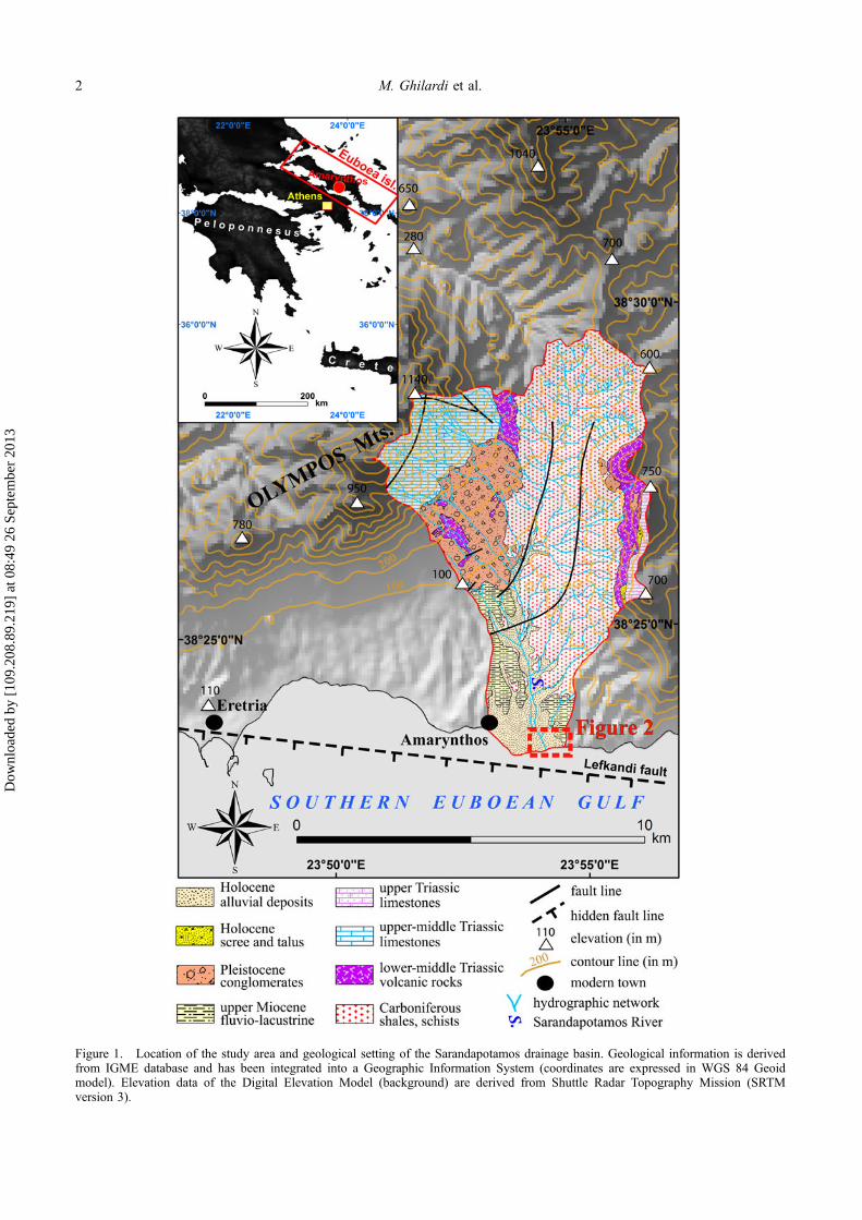
Figure 1. Location of the study area and geological setting of the Sarandapotamos drainage basin. Geological information is derivedfrom IGME database and has been integrated into a Geographic Information System (coordinates are expressed in WGS 84 Geoidmodel). Elevation data of the Digital Elevation Model (background) are derived from Shuttle Radar Topography Mission (SRTMversion 3).
2 M. Ghilardi et al.
Dow
nloa
ded
by [
109.
208.
89.2
19]
at 0
8:49
26
Sept
embe
r 20
13
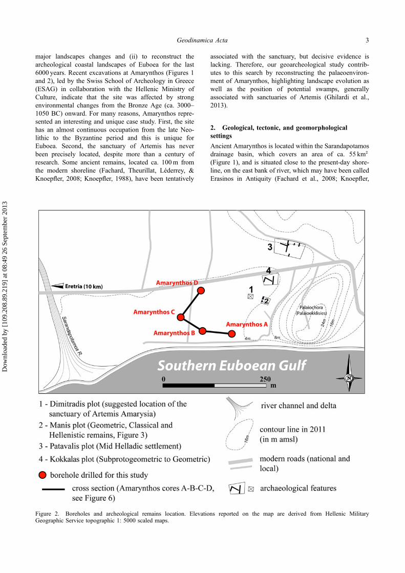
major landscapes changes and (ii) to reconstruct thearcheological coastal landscapes of Euboea for the last6000 years. Recent excavations at Amarynthos (Figures 1and 2), led by the Swiss School of Archeology in Greece(ESAG) in collaboration with the Hellenic Ministry ofCulture, indicate that the site was affected by strongenvironmental changes from the Bronze Age (ca. 3000–1050 BC) onward. For many reasons, Amarynthos repre-sented an interesting and unique case study. First, the sitehas an almost continuous occupation from the late Neo-lithic to the Byzantine period and this is unique forEuboea. Second, the sanctuary of Artemis has neverbeen precisely located, despite more than a century ofresearch. Some ancient remains, located ca. 100m fromthe modern shoreline (Fachard, Theurillat, Léderrey, &Knoepfler, 2008; Knoepfler, 1988), have been tentatively
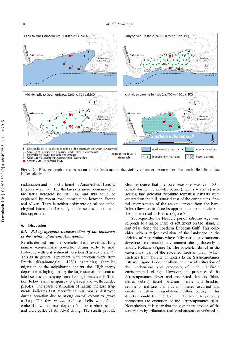
associated with the sanctuary, but decisive evidence islacking. Therefore, our geoarcheological study contrib-utes to this search by reconstructing the palaeoenviron-ment of Amarynthos, highlighting landscape evolution aswell as the position of potential swamps, generallyassociated with sanctuaries of Artemis (Ghilardi et al.,2013).
2. Geological, tectonic, and geomorphologicalsettings
Ancient Amarynthos is located within the Sarandapotamosdrainage basin, which covers an area of ca. 55 km²(Figure 1), and is situated close to the present-day shore-line, on the east bank of river, which may have been calledErasinos in Antiquity (Fachard et al., 2008; Knoepfler,
Figure 2. Boreholes and archeological remains location. Elevations reported on the map are derived from Hellenic MilitaryGeographic Service topographic 1: 5000 scaled maps.
Geodinamica Acta 3
Dow
nloa
ded
by [
109.
208.
89.2
19]
at 0
8:49
26
Sept
embe
r 20
13
1988). Steep slopes characterize the catchment basin withhigh elevations to the northwest, up to 1140m in theOlympos massif (Figure 1), and to the east, up to 750m(Figure 1). The length of the Sarandapotamos River isabout 8.5 km. Violent floods, associated with torrentialactivity during the spring/autumn seasons, are oftenobserved and there is no permanent flow of the Saranda-potamos (meaning the “forty rivers” in Greek) throughoutthe year, with the summer dryness characteristic of Medi-terranean streams. The modern town of Amarynthos, situ-ated on the west bank of the River, is built uponunconsolidated sediments from a deltaic fan created duringthe Quaternary (Figure 1).
From a geological point of view, Amarynthos issituated at the north coastline of the southern EuboeanGulf, which is representative of the early stages of theQuaternary tectonism that formed the marginal Aegeanbasins. The wider region consists of geologicalormations of the Pelagonian zone, mainly Mesozoiclimestones and some clayey psammitic rocks with basiceruptive rock beds (Figure 1). The Paleozoic bedrockoutcrops at the eastern part of the drainage basin as aclastic series (shales, schists, phyllites, and graywackes)with carbonate intercalations (Middle Carboniferous –Permian). The deposits of the margins of the southernEuboean Gulf (that cover the southern extent of theSarandapotamos drainage basin) are belonging to thegreat lacustrine Upper Miocene basin and consist mainlyof conglomerates, breccias, and marls. Pleistocene screeand talus cones form the Mt. Olympos foothills(Figure 1), while the southernmost lowlands towards thecoastline are mainly covered by Holocene alluvial depos-its, loose clayey-sandy materials with cobbles. Theexception is the eastern most part of the drainage basinwhere the cliffs of Palaioekklisies (on which ancientAmarynthos is located; Figure 2) consist of Upper Mio-cene fluvio-lacustrine deposits (Figure 1); which arenowadays affected by strong coastal erosion.
The southern Euboean Gulf is considered as an areaof mild tectonic activity and moderate seismicity(Drakopoulos, Makropoulos, & Stavrakakis, 1984; Pap-azachos & Papazachou, 1997). The main faults thataffect the pre-Neogene and recent geological formationsof the study area are normal, oriented WNW-ESE toNW-SE. Two antithetic normal faults with a WNW-ESEdirection protrude in the southern and northern coastlinesof southern Euboean Gulf (Rondoyanni, Galanakis,Georgiou, & Baskoutas, 2007). The Lefkandi fault, dip-ping to the south, continues offshore, for a total lengthof 25 km, to the south of the villages of Eretria andAmarynthos (Figure 1, Perisoratis & Van Andel, 1991)and forms the northern margin of the graben of southernEuboean Gulf. Neotectonic activity affected this region(Aubouin, 1963), inducing subsidence in coastal areas.These vertical movements seem to have influenced pre-Holocene sediments, primarily the big talus cones of theUpper Pleistocene, while Holocene deposits overlayingthe latter are mostly unaffected (Voreadis, 1952).
However, the very recent tectonism (includingearthquake records during historical times, e.g. in AD365 and AD 511, Ducrey et al., 2004) probably indicatesthe continuation of subsidence at low rates duringHolocene. Recent works (Cundy et al., 2010; Evelpidouet al., 2011; Walker et al., 2010) conclude that thecoastal geomorphology of Northern Euboea wastectonically influenced during the late Holocene withtilting that probably affected part of the island, relyingon previous observations made in the 1990s (Pirazzoli,Stiros, Arnold, Laborel, & Laborel-Deguen, 1999; Stiroset al., 1992). Another possibility is that the uplift isrelated to strike-slip events of magnitude larger than 7.0;these are known to occur offshore, in and around theNorth Aegean Trough (Vacchi et al., 2012), which is notfar from the study area.
Tidal range at the Euripus, the narrowest point in theEuboean Gulf, has been accurately measured for the last50 years and shows a maximum amplitude in NorthChalkis of .56m with an error of ±.05m (Cundy et al.,2000; Tsimplis & Blackman, 1997). Some authorsconsider it to be the largest tide recorded along theGreek Aegean coastline (Tsimplis & Blackman, 1997).However, Tsimplis (1997) distinguishes between NorthChalkis, where the daily tide is around .5m, and SouthChalkis, where values are closer to .2m. Nevertheless,the Holocene “palaeo-tidal ranges” are difficult toestimate since the shoreline position in the Aegean wasstrongly modified during Holocene by different parame-ters, such as general sea-level rise and local tectonics.
3. Archeological context
Various excavations carried out from 1977 to 2007(Knoepfler, 1972) show that the Palaioekklisies hill(Figure 2) and its immediate surroundings werecontinuously occupied from the early Helladic to theByzantine period (though a few earlier [Neolithic] sherdshave been found as well). In the middle Helladic period(2000–1650 BC), it extended to the northwest of the hill,towards the plain, where walls and at least one gravewere found in the Patavalis plot, at an altitude of 5m asl(Figure 2; Krapf, 2011; Theurillat & Fachard, 2007). Theexistence of a late Helladic (1700–1200 BC) settlementon the hill of Palaeoekklissies has been confirmed byexcavations (Figure 2). It was occupied until the lateHelladic IIIC period (ca. 1200–1050 BC). It is clear thatduring the Bronze Age, the site was centered on the hill(Parlama, 1979; Sapouna-Sakellaraki, 1986, 1988). Onthe whole, the collected evidence suggests thatAmarynthos was perhaps the main Mycenaean site ofthe Eretrian plain (Hope Simpson, 1981; Sapouna-Sakellaraki, 1986). Recent excavations have shown thatthe site was also occupied in the Protogeometric andGeometric periods (1050–700 BC) (Fachard et al.,2008). Stratified pottery was found in the Patavalis plot(Figure 2), while excavations carried in the Kokkalasplot (Figure 2) revealed the existence of various remains:
4 M. Ghilardi et al.
Dow
nloa
ded
by [
109.
208.
89.2
19]
at 0
8:49
26
Sept
embe
r 20
13
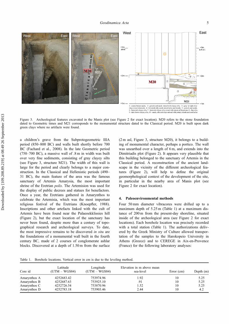
a children’s grave from the Subprotogeometric IIIAperiod (850–800 BC) and walls built shortly before 700BC (Fachard et al., 2008). In the late Geometric period(750–700 BC), a massive wall of .8m in width was builtover very fine sediments, consisting of gray clayey silts(see Figure 3, structure M21). The width of this wall islarge for the period and clearly belongs to a major con-struction. In the Classical and Hellenistic periods (490–31 BC), the main feature of the area was the famoussanctuary of Artemis Amarysia, the most importantshrine of the Eretrian polis. The Artemision was used forthe display of public decrees and statues for benefactors.Once a year, the Eretrians gathered in Amarynthos tocelebrate the Artemisia, which was the most importantreligious festival of the Eretrians (Knoepfler, 1988).Inscriptions and other artefacts linked with the cult ofArtemis have been found near the Palaeoekklissies hill(Figure 2), but the exact location of the sanctuary hasnever been found, despite more than a century of topo-graphical research and archeological surveys. To date,the most impressive remains to be discovered in situ arethe foundations of a monumental wall built in the fourthcentury BC, made of 2 courses of conglomerate ashlarblocks. Discovered at a depth of 1.50m from the surface
(2m asl, Figure 3, structure M20), it belongs to a build-ing of monumental character, perhaps a portico. The wallwas unearthed over a length of 6m, and extends into theDimitriadis plot (Figure 2). It appears very plausible thatthis building belonged to the sanctuary of Artemis in theClassical period. A reconstruction of the ancient land-scape in the vicinity of the different archeological fea-tures (Figure 2), will help to define the originalgeomorphological context of the development of the site,in particular in the nearby area of Manis plot (seeFigure 2 for exact location).
4. Paleoenvironmental methods
Four 50mm diameter vibracores were drilled up to amaximum depth of 5.25m (Table 1) at a maximum dis-tance of 200m from the present-day shoreline, situatedinside of the archeological area (see Figure 2 for exactlocations). Each borehole location was precisely recordedwith a total station (Table 1). The authorizations deliv-ered by the Greek Ministry of Culture allowed transpor-tation of the samples to the Harokopeio University inAthens (Greece) and to CEREGE in Aix-en-Provence(France) for the following laboratory analyses:
Table 1. Borehole locations. Vertical error in cm is due to the leveling method.
Core idLatitude
(UTM – WGS84)Longitude
(UTM – WGS84)Elevation in m above mean
sea-level Error (cm) Depth (m)
Amarynthos A 4252683.42 753974.96 1.92 10 5.25Amarynthos B 4252687.63 753925.10 .91 10 5.25Amarynthos C 4252726.54 753870.96 1.52 10 5.25Amarynthos D 4252783.18 753903.46 2.44 10 4.2
Figure 3. Archeological features excavated in the Manis plot (see Figure 2 for exact location). M20 refers to the stone foundationdated to Geometric times and M21 corresponds to the monumental structure dated to the Classical period. M20 is built upon darkgreen clays where no artifacts were found.
Geodinamica Acta 5
Dow
nloa
ded
by [
109.
208.
89.2
19]
at 0
8:49
26
Sept
embe
r 20
13
4.1. Mollusc identification and AMS dating
All samples were wet-sieved through a .4mm wire meshscreen and air dried at room temperature. The residuewas examined under a binocular microscope and allidentifiable shells and characteristic fragments were col-lected and curated in separate plastic tubes. In general,few macrofauna were encountered across the cores andmicrofauna (ostracods and foraminifera) were very rare.The chronostratigraphy of the cores was determinedusing a series of 12 AMS radiocarbon determinationsderived from in situ shells, plant remains, organic matter,and charcoal (Table 1). These analyses were performedat the Poznan Laboratory for Radiocarbon (Poland) andthe Beta Analytic Radiocarbon Laboratory (USA). Mar-ine samples were corrected for the marine reservoireffect (ΔR = 150, error ΔR = 35) (Reimer & McCormac,2002; Siani et al., 2000), although it must be emphasizedthat the real (paleo) reservoir effect — still unknown —varies widely in different marine environments such aslagoons, coastal swamps, or littoral zones (Siani et al.,2001; Vött, 2007). 14C ages were subsequently calibratedusing the Calib6.0 Software (Reimer et al., 2009).
4.2. Loss-on-ignition and grain-size analyses
The loss-on-ignition measurement was based on Dean’smethod (Dean, 1974) and performed at CEREGE. Sedi-ment samples of approximately 1 g were taken at 10 cmintervals throughout the sequence. After drying at 105 °Cto constant weight, the samples were heated to 550 °Cfor 2 h to estimate organic content. A second heatingphase, to 950 °C for a further 4 h, was undertaken toassess the proportion of carbonates in the sediment. Theformula used to calculate the equivalent CaCO3 contentfollowing LOI of CO2 is:
CaCO3% ¼ 2:27� CO2%
where 2.27 (50/22) is the molecular conversion factor.Grain-size determinations were conducted at CERE-
GE. Samples were taken at 5 cm intervals. Many dis-played coarse particles, with general size above 2mm(except for Amarynthos D where all particles were below2mm), hand-sieving technique under wet conditions wasthen used for obtaining the total fraction of coarse(>2mm) and fine sediments (<2mm). Organic matterwas removed for laser-diffraction particle size study. Pre-treatments for grain-size analysis frequently use oxidativetreatments (Buurman, Pape, & Muggler, 1996; Fullen,Zheng, & Brandsma, 1996; Scott-Jackson & Walkington,2005; Wang, Jin, Bu, Zhou, & Wu, 2006). All of thesamples were mixed with a dispersing agent (.3%sodium hexametaphosphate) in order to disperse the clayparticles. The grain-size distribution was measured usinga Beckman Coulter LS 13 320 laser granulometer with arange of .04–2000 μm, in 132 fractions. The calculationmodel (software version 5.01) uses Fraunhöfer and Mie
theory. For the calculation model, we used water as themedium (RI = 1.33 at 20 °C), a refractive index in therange of that of kaolinite for the solid phase (RI = 1.56),and absorption coefficients of .15 for the 780-nm laserwavelength and .2 for the polarized wavelengths (Buur-man et al., 1996). Samples containing fine particles werediluted, measuring between 8 and 12% of obscurationand between 45 and 70% PIDS (Polarization IntensityDifferential Scattering) obscuration.
5. Results – general stratigraphy
5.1. A basal marine unit
The first unit (M) is found in the lower most part ofcores Amarynthos A, B (Figures 4 and 6), and C(Figures 5 and 6), and is composed of heterogeneoussediments ranging from silts to pebbles (mixture of sharpand well-rounded material). It is found at a depth of ca.2.90m below the surface for Amarynthos B and C(thickness is about ca. 2.35m), and at ca. 3.80m deepfor Amarynthos A (thickness is about 1.50m). The sandyfraction (below the 2mm mesh size) oscillates across theunit lessening in the lower-most part (0 to max. 50%),from 4.30 to 5.25m in depth for cores Amarynthos Band C. Some very small shell fragments were observedbut the size did not allow a precise identification of thespecies. At a depth of ca. 4.50m in Amarynthos A, weobserved a high proportion of the sediment fractionbelow 2mm (from 50 to 80% of the total sample) and inparallel, we have a strong decrease of pebbles. Above,from 4.20 to 4.30m in Amarynthos A, shallow marinespecies such as Loripes lacteus (bivalve) and juvenileBittium reticulatum (gastropod) were identified, well-pre-served, and found embedded within medium to coarsesands (250–600 μm for the mean-size). Similar observa-tions are made in core Amarynthos B where 14C datingperformed on a bivalve Loripes lacteus (found with thetwo valves, meaning that was sampled in situ) at 4.25mdowncore depth gives an age of 3478–3079 cal. BC.Amarynthos C also indicates the presence of rich med-ium to coarse sands where marine Bittium reticulatumshell has been identified at 3.50m depth but due to theirvery small size (less than 2mm) even AMS dating wasnot possible. Based on the mollusc identification and thesedimentology results, unit (M) is indicative of marine toshallow marine environments.
5.2. Beach deposits
The sedimentary unit (F/B) is only found in coresAmarynthos A and B (Figures 4 and 6). Amarynthos Acore records a thin homogeneous layer (.2m thick)composed of coarse homogenous black fine sands (meangrain size is about 100 μm). They record very smallfragments of mollusc fauna and organic matter is rare.These sediments are directly overlying the marinesequence and are probably coming from the upperdrainage basin of the Sarandapotamos River, which is
6 M. Ghilardi et al.
Dow
nloa
ded
by [
109.
208.
89.2
19]
at 0
8:49
26
Sept
embe
r 20
13
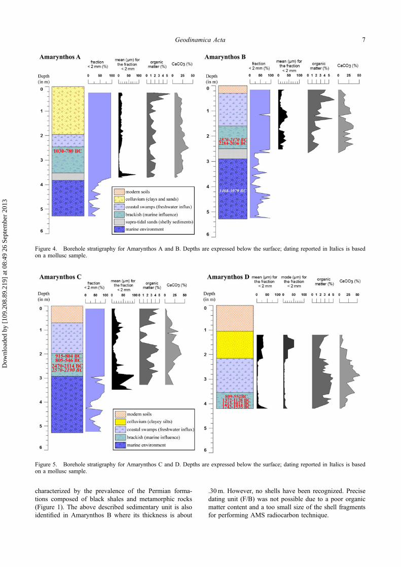
characterized by the prevalence of the Permian forma-tions composed of black shales and metamorphic rocks(Figure 1). The above described sedimentary unit is alsoidentified in Amarynthos B where its thickness is about
.30m. However, no shells have been recognized. Precisedating unit (F/B) was not possible due to a poor organicmatter content and a too small size of the shell fragmentsfor performing AMS radiocarbon technique.
Figure 5. Borehole stratigraphy for Amarynthos C and D. Depths are expressed below the surface; dating reported in Italics is basedon a mollusc sample.
Figure 4. Borehole stratigraphy for Amarynthos A and B. Depths are expressed below the surface; dating reported in Italics is basedon a mollusc sample.
Geodinamica Acta 7
Dow
nloa
ded
by [
109.
208.
89.2
19]
at 0
8:49
26
Sept
embe
r 20
13
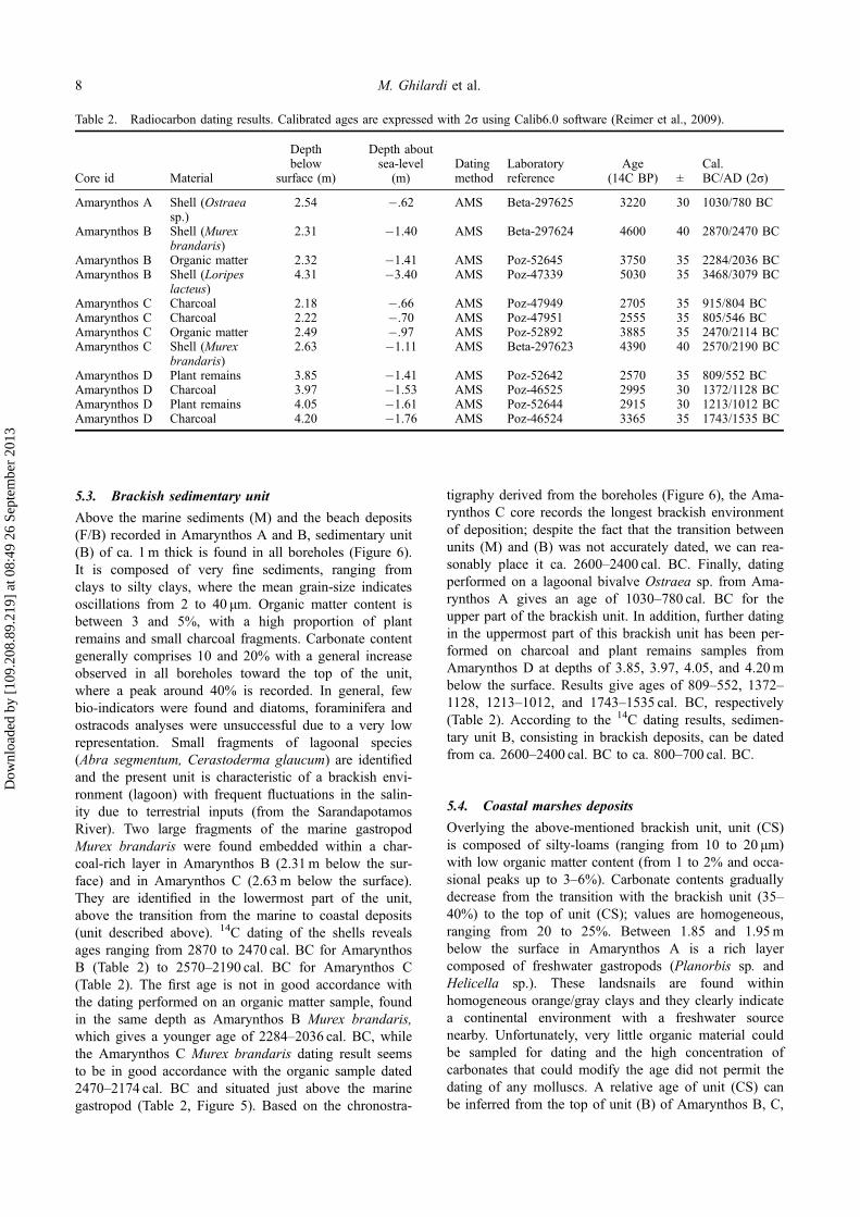
5.3. Brackish sedimentary unit
Above the marine sediments (M) and the beach deposits(F/B) recorded in Amarynthos A and B, sedimentary unit(B) of ca. 1m thick is found in all boreholes (Figure 6).It is composed of very fine sediments, ranging fromclays to silty clays, where the mean grain-size indicatesoscillations from 2 to 40 μm. Organic matter content isbetween 3 and 5%, with a high proportion of plantremains and small charcoal fragments. Carbonate contentgenerally comprises 10 and 20% with a general increaseobserved in all boreholes toward the top of the unit,where a peak around 40% is recorded. In general, fewbio-indicators were found and diatoms, foraminifera andostracods analyses were unsuccessful due to a very lowrepresentation. Small fragments of lagoonal species(Abra segmentum, Cerastoderma glaucum) are identifiedand the present unit is characteristic of a brackish envi-ronment (lagoon) with frequent fluctuations in the salin-ity due to terrestrial inputs (from the SarandapotamosRiver). Two large fragments of the marine gastropodMurex brandaris were found embedded within a char-coal-rich layer in Amarynthos B (2.31m below the sur-face) and in Amarynthos C (2.63m below the surface).They are identified in the lowermost part of the unit,above the transition from the marine to coastal deposits(unit described above). 14C dating of the shells revealsages ranging from 2870 to 2470 cal. BC for AmarynthosB (Table 2) to 2570–2190 cal. BC for Amarynthos C(Table 2). The first age is not in good accordance withthe dating performed on an organic matter sample, foundin the same depth as Amarynthos B Murex brandaris,which gives a younger age of 2284–2036 cal. BC, whilethe Amarynthos C Murex brandaris dating result seemsto be in good accordance with the organic sample dated2470–2174 cal. BC and situated just above the marinegastropod (Table 2, Figure 5). Based on the chronostra-
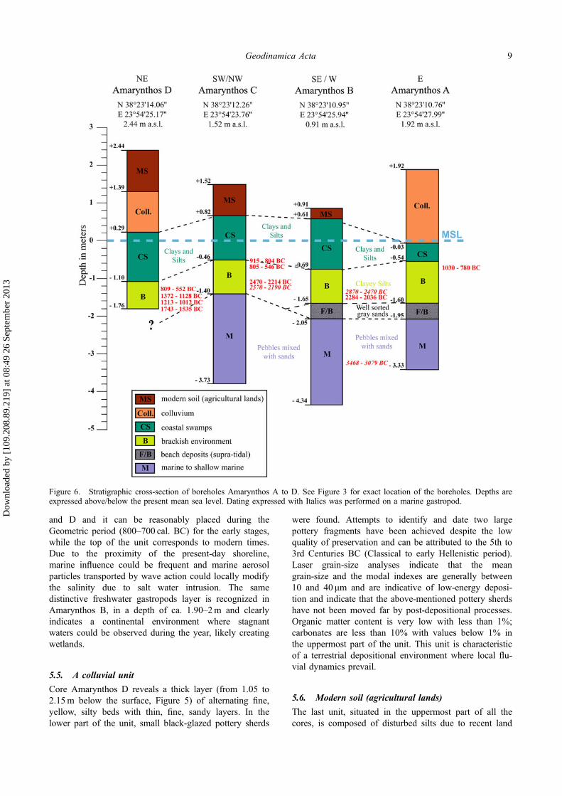
tigraphy derived from the boreholes (Figure 6), the Ama-rynthos C core records the longest brackish environmentof deposition; despite the fact that the transition betweenunits (M) and (B) was not accurately dated, we can rea-sonably place it ca. 2600–2400 cal. BC. Finally, datingperformed on a lagoonal bivalve Ostraea sp. from Ama-rynthos A gives an age of 1030–780 cal. BC for theupper part of the brackish unit. In addition, further datingin the uppermost part of this brackish unit has been per-formed on charcoal and plant remains samples fromAmarynthos D at depths of 3.85, 3.97, 4.05, and 4.20mbelow the surface. Results give ages of 809–552, 1372–1128, 1213–1012, and 1743–1535 cal. BC, respectively(Table 2). According to the 14C dating results, sedimen-tary unit B, consisting in brackish deposits, can be datedfrom ca. 2600–2400 cal. BC to ca. 800–700 cal. BC.
5.4. Coastal marshes deposits
Overlying the above-mentioned brackish unit, unit (CS)is composed of silty-loams (ranging from 10 to 20 μm)with low organic matter content (from 1 to 2% and occa-sional peaks up to 3–6%). Carbonate contents graduallydecrease from the transition with the brackish unit (35–40%) to the top of unit (CS); values are homogeneous,ranging from 20 to 25%. Between 1.85 and 1.95mbelow the surface in Amarynthos A is a rich layercomposed of freshwater gastropods (Planorbis sp. andHelicella sp.). These landsnails are found withinhomogeneous orange/gray clays and they clearly indicatea continental environment with a freshwater sourcenearby. Unfortunately, very little organic material couldbe sampled for dating and the high concentration ofcarbonates that could modify the age did not permit thedating of any molluscs. A relative age of unit (CS) canbe inferred from the top of unit (B) of Amarynthos B, C,
Table 2. Radiocarbon dating results. Calibrated ages are expressed with 2σ using Calib6.0 software (Reimer et al., 2009).
Core id Material
Depthbelow
surface (m)
Depth aboutsea-level
(m)Datingmethod
Laboratoryreference
Age(14C BP) ±
Cal.BC/AD (2σ)
Amarynthos A Shell (Ostraeasp.)
2.54 �.62 AMS Beta-297625 3220 30 1030/780 BC
Amarynthos B Shell (Murexbrandaris)
2.31 �1.40 AMS Beta-297624 4600 40 2870/2470 BC
Amarynthos B Organic matter 2.32 �1.41 AMS Poz-52645 3750 35 2284/2036 BCAmarynthos B Shell (Loripes
lacteus)4.31 �3.40 AMS Poz-47339 5030 35 3468/3079 BC
Amarynthos C Charcoal 2.18 �.66 AMS Poz-47949 2705 35 915/804 BCAmarynthos C Charcoal 2.22 �.70 AMS Poz-47951 2555 35 805/546 BCAmarynthos C Organic matter 2.49 �.97 AMS Poz-52892 3885 35 2470/2114 BCAmarynthos C Shell (Murex
brandaris)2.63 �1.11 AMS Beta-297623 4390 40 2570/2190 BC
Amarynthos D Plant remains 3.85 �1.41 AMS Poz-52642 2570 35 809/552 BCAmarynthos D Charcoal 3.97 �1.53 AMS Poz-46525 2995 30 1372/1128 BCAmarynthos D Plant remains 4.05 �1.61 AMS Poz-52644 2915 30 1213/1012 BCAmarynthos D Charcoal 4.20 �1.76 AMS Poz-46524 3365 35 1743/1535 BC
8 M. Ghilardi et al.
Dow
nloa
ded
by [
109.
208.
89.2
19]
at 0
8:49
26
Sept
embe
r 20
13
and D and it can be reasonably placed during theGeometric period (800–700 cal. BC) for the early stages,while the top of the unit corresponds to modern times.Due to the proximity of the present-day shoreline,marine influence could be frequent and marine aerosolparticles transported by wave action could locally modifythe salinity due to salt water intrusion. The samedistinctive freshwater gastropods layer is recognized inAmarynthos B, in a depth of ca. 1.90–2m and clearlyindicates a continental environment where stagnantwaters could be observed during the year, likely creatingwetlands.
5.5. A colluvial unit
Core Amarynthos D reveals a thick layer (from 1.05 to2.15m below the surface, Figure 5) of alternating fine,yellow, silty beds with thin, fine, sandy layers. In thelower part of the unit, small black-glazed pottery sherds
were found. Attempts to identify and date two largepottery fragments have been achieved despite the lowquality of preservation and can be attributed to the 5th to3rd Centuries BC (Classical to early Hellenistic period).Laser grain-size analyses indicate that the meangrain-size and the modal indexes are generally between10 and 40 μm and are indicative of low-energy deposi-tion and indicate that the above-mentioned pottery sherdshave not been moved far by post-depositional processes.Organic matter content is very low with less than 1%;carbonates are less than 10% with values below 1% inthe uppermost part of the unit. This unit is characteristicof a terrestrial depositional environment where local flu-vial dynamics prevail.
5.6. Modern soil (agricultural lands)
The last unit, situated in the uppermost part of all thecores, is composed of disturbed silts due to recent land
Figure 6. Stratigraphic cross-section of boreholes Amarynthos A to D. See Figure 3 for exact location of the boreholes. Depths areexpressed above/below the present mean sea level. Dating expressed with Italics was performed on a marine gastropod.
Geodinamica Acta 9
Dow
nloa
ded
by [
109.
208.
89.2
19]
at 0
8:49
26
Sept
embe
r 20
13
reclamation and is mostly found in Amarynthos B and D(Figures 4 and 5). The thickness is more pronounced inthe latter borehole (to ca. 1m) and this could beexplained by recent road construction between Eretriaand Aliveri. There is neither sedimentological nor arche-ological interest in the study of the sediment texture inthis upper unit.
6. Discussion
6.1. Paleogeographic reconstruction of the landscapein the vicinity of ancient Amarynthos
Results derived from the boreholes study reveal that fullymarine environments prevailed during early to mid-Holocene with fast sediment accretion (Figures 6 and 7).This is in general agreement with previous work fromEretria (Kambouroglou, 1989) examining shorelinemigration at the neighboring ancient site. High-energydeposition is highlighted by the large size of the accumu-lated sediments, ranging from heterogeneous sands (frac-tion below 2mm is sparse) to gravels and well-roundedpebbles. The sparse distribution of marine mollusc frag-ments indicates that macrofauna was mostly destroyedduring accretion due to strong coastal dynamics (waveaction). The few in situ mollusc shells were foundembedded within finer deposits (fine to medium sands)and were collected for AMS dating. The results provide
clear evidence that the paleo-seashore was ca. 150minland during the mid-Holocene (Figures 6 and 7) sug-gesting that potential Neolithic terrestrial habitats werecentered on the hill, situated east of the coring sites. Spa-tial interpretation of the results derived from the bore-holes allows us to place its approximate position close tothe modern road to Eretria (Figure 7).
Subsequently, the Helladic period (Bronze Age) cor-responds to a major phase of settlement on the island, inparticular along the southern Euboean Gulf. This coin-cides with a major evolution of the landscape in thevicinity of Amarynthos where fully-marine environmentsdeveloped into brackish environments during the early tomiddle Helladic (Figure 7). The boreholes drilled in theeasternmost part of the so-called Eretrian plain (whichstretches from the city of Eretria to the SarandapotamosEstuary, Figure 1) do not allow the clear identification ofthe mechanisms and processes of such significantenvironmental change. However, the presence of theSarandapotamos River and associated deposits (blackshales debris) found between marine and brackishsediments indicate that fluvial influxes occurred andcreated a deltaic progradation. Further, coring in thisdirection could be undertaken in the future to preciselyreconstruct the evolution of the Sarandapotamos delta.Nevertheless, it is clear that the significant erosion of thesubstratum by tributaries and local streams contributed to
Figure 7. Palaeogeographic reconstruction of the landscape in the vicinity of ancient Amarynthos from early Helladic to lateHellenistic times.
10 M. Ghilardi et al.
Dow
nloa
ded
by [
109.
208.
89.2
19]
at 0
8:49
26
Sept
embe
r 20
13
transporting sediment to the coast. In this process of del-taic progradation, the alluvial sediments were transportedaway and formed beaches due to the local wave dynam-ics along the Euboean coast. Related alluviation, due todeep incision of the substratum in the upper reaches,facilitated the formation of a small delta that covers lessthan 1 km². These landforms (coastal spits) could haveisolated lagoons or brackish ponds during middle Hellad-ic period (Figure 7), as we can observe in the investi-gated area. The presence of two marine gastropods(Murex Brandaris) which show older ages than theorganic samples dated within the same layers (Amaryn-thos B, see Figure 4 and Table 2) could indicate thatthey were reworked. Origins of their deposition can bediscussed and anthropogenic parameters must be takeninto consideration. Indeed, the succession of early andmiddle Helladic settlements on the Palaeoekklissies hilland the northern part of the coastal area could indicatethat shellfish were locally consumed and later discardedin the brackish pond. Another possible origin of thisreworked material is natural deposition due to the waveaction (extreme surges) during storm events. But in thislast case, more mollusc and organic remains should havebeen found together with larger particles.
From the end of the late Helladic (ca. 1050 BC) untilthe Geometric period (ca. 750 BC), brackish conditionsstill prevailed but a more confined lagoon developedwith little connection to the sea (Figure 7), according tothe granulometry results. Neither ostracods nor forami-nifera were identified, indicating strong fluctuations insalinity; however, a few shells, including large fragmentsof Murex sp., small fragments of Abra segmentum, Cer-astoderma glaucum, and Ostraea sp., seem to indicatethe close proximity of the seashore. The sediment accre-tion rate reinforces the idea of a disconnected brackishlagoon where we have approximately .80m of homoge-neous silty-clays deposited from ca. 2400 cal. BC to ca.750 cal. BC, a mean rate of ca. .5mKa�1. The creationof the lagoon reflects a shoreline migration towards thesouth due to increased local sediment supply andinduced beach formation due to local coastal dynamics.The progradation of the Sarandapotamos delta duringmid-Holocene has been hypothesized by some authors(Genre, 1989, 1999) but our work confirms it andprecisely dates the early phase of delta development (endof the Early Helladic period).
Finally, according to the stratigraphic cross-section(Figure 6), it is obvious that the transition betweenbrackish and continental environments can be reasonablyplaced in Geometric times, ca. 800–700 cal. BC(Figure 7); within a general context of deltaic prograda-tion (maximum delta development of ca. 200m south-ward from middle Helladic to late Ancient Times) and agradual migration of the shoreline towards the south.The development of coastal marshes with occasionalfluvial/colluvial influxes is recorded. These freshwaterswamps were also subject to frequent periods of aridity(seasonal dryness and climate oscillations) and the
presence of the peaks in the carbonates could beexplained by influxes from local streams running overthe carbonate rocks that form the drainage basin (mainlylimestones and marls, Figure 1). But, another explanationcould also be evaporation (due to a more arid/warmclimate) that would have provoked precipitation of thecarbonates.
The area remained swampy until the mid-twentiethcentury, until drainage works helped to reclaim the area.
6.2. Recent Holocene sea-level deceleration andtectonics vs. anthropogenic factors: what could bethe origins of the deltaic progradation observedalong the southern Euboean Gulf?
Our coring results reveal that the Southern Euboean Gulf(area of Amarynthos) has been affected by a rapid shift-ing in the shoreline over the last 4500 years due to ageneral context of deltaic progradation of the Saranda-potamos River. This observation shows a large differencewith the Eretria site (situated 10 km westward) where thedeltaic formation probably initiated one millennium ear-lier (Kambouroglou, 1989). Since most of the EasternMediterranean deltas (that also includes the Eretria areainitiated ca. 4000–3500 cal. BC (Brückner, Vött, Schri-ever, & Handl, 2005), our work clearly indicates that theSarandapotamos River was affected much later, ca.2600–2500 cal. BC. Questions naturally arise concerningthe origins of the deltaic progradation along the Euboeancoastline where natural parameters (mainly climate con-trol on the sediment budget/transfers and local tectonics)and anthropogenic factors must locally be associated totemporally define the main steps of deltaic progradation/deceleration (Brückner et al., 2005).
First, tectonic influences must be taken into accountsince literature records that North Euboea is affected dur-ing Holocene by a general uplift associated with thepresence of numerous emerged beach rocks and tidalnotches (Cundy et al., 2010; Pirazzoli et al., 1999; Stiroset al., 1992; Walker et al., 2010). The southern EuboeanGulf, and in particular the Amarynthos area, seems notto have been affected much by such pronounced verticalmovement, although the presence of the Lefkandi Fault(Figure 1, Papazachos & Papazachou, 1997) may haveinduced both subsidence and uplift. Until now, there isno study recording uplifted shoreline in this area and fur-ther investigations in this direction should be addressedto clarify the role played by the local tectonics in the socalled Eretrian plain. A possible tectonic control, associ-ated with the deceleration of sea level rise (attested from6000 cal. BP onward in the Aegean) could also explainthe creation of the delta. However, there is no accuratesea level reconstruction for the Southern Euboean Gulfbased on the dating of biologic markers derived fromcoring or potential uplifted notches. Only, general curvescan be used (Lambeck, 2004; Lambeck & Purcell, 2005;Pavlopoulos, Kapsimalis, Theodorakopoulou, & Panagio-topoulos, 2011; Poulos, Chionis, & Maroukian, 2009)
Geodinamica Acta 11
Dow
nloa
ded
by [
109.
208.
89.2
19]
at 0
8:49
26
Sept
embe
r 20
13
and must be refined, taking into account local Holoceneneotectonic movements. Our data-set does not allowreconstructing an accurate sea level curve, since we haverelatively few dates from the marine sequence and brack-ish plants associated with charcoals are not suitable forevaluation of the sea level position.
Apart from the natural parameters, the direct anthro-pogenic impact and its key role in the landscape dynam-ics and processes must be locally considered for Euboeaat a drainage basin scale from the early Helladic periodonward. Previous work undertaken in Euboea revealedimportant alluvial terrace formation during the recentHolocene within most of the fluvial valleys of the island(Genre, 1999). The mid-third millennium BC coincideswith the first important phase of settlement (dating to theHelladic period) along the southern Euboean Gulf.Within this rich archeological context, human impact onthe alluviation since the early Helladic period can be rea-sonably advanced. Similar observations have been madeelsewhere in Greece for the same period (Lespez, 2003).A complete study of the alluvial terraces observed inEuboea could add to previous work (Genre, 1999), byusing both archeological and radiometric techniques; thiscould be envisaged in the near future to estimate themain periods of sediment accumulation/erosion duringhistorical periods as compared with the main steps ofdeltaic progradation. Until now, there are no alluvial ter-races recorded within the Sarandapotamos drainage basin(Genre, 1999). Unfortunately, due to the small area ofthe catchment basin of the Sarandapotamos River (ca.55 km²), the steep slopes and the short length of its mainriver course (ca. 8.5 km), sediment material eroded fromthe upper/middle reaches was probably directly depositedon the shoreline without any long period of storage.Other drainage basins should be elected for study of thehistorical alluviation and the Lilas River could be a suit-able study area.
Finally, a comparative study of multiple archeologicalsites in Euboea (Amarynthos, Eretria, Lefkandi, and theLilas delta) could help to distinguish all parameters andprovide a reference in Greece for studying the interac-tions between human occupation and the natural environ-ment throughout the recent Holocene.
7. Conclusion
For the first time, a paleoenvironmental reconstruction ofthe landscape surrounding the ancient site of Amarynthoshas been developed based on a geoarcheologicalapproach. Through a program of coring and 12 AMS14C dates, the first reliable chronostratigraphic referencesequence for Central West Euboea has been establishedfor the recent Holocene. Our work also provides clearevidence for the long-term migration of the Euboeanshoreline, within an archeological context. It indicates aclear transition from marine environments, dating fromthe mid-Holocene (beginning of the early HelladicPeriod), to a brackish/closed lagoon from the (later) early
Helladic to the Geometric period. Contrasts in patternsof sediment accumulation also characterize both environ-ments where the marine phase is represented by a fastaccretion of coarse material, ranging from sands to peb-bles. By contrast, the brackish sedimentary unit has beendeposited under very low-energy conditions where con-nections with the sea were rare, which could explain thevery slow sediment accumulation of ca. .50–1m over thecourse of approximately 2000 years. Finally, the resultshighlight that the probable site of the sanctuary of Arte-mis was built on the northeastern margin of a coastalmarsh environment at a maximum distance to the sea of80–100m. These results suggest that however large thesanctuary was, its western and southwestern limits couldnot extend beyond the 4 cores Amarynthos A-D, whichdelimit the coastal swamps from the Archaic to the lateHellenistic periods.
AcknowledgmentsThis article is a contribution to the geoarcheological researchprogram (FIR, 2010–2012) conducted and directed by MatthieuGhilardi and Christophe Morhange (University of Aix-Marseille, France) dealing with landscape changes within theEastern Mediterranean Islands (Corsica, Crete, Cyprus andEuboea). It is funded by the University of Provence, Aix-en-Provence (France), and the Swiss School of Archaeology inGreece. Boreholes were drilled under authorization of theHellenic Ministry of Culture (local supervision of the 11thEphorateof Prehistorical and Classical Antiquities) and wewould like to acknowledge all persons who facilitated thefieldwork. The authors wish to thank Dimitris Vandarakis,Stamatis Katsiadramis and Katerina Theodorakopoulou forassistance in fieldwork, their kindness and the fruitfuldiscussions were also well appreciated. Finally, we would liketo express our deep gratitude to George Syrides, StéphaneDesruelles and two anonymous referees for improving thequality of the manuscript.
ReferencesAubouin, J. (1963). Sur la stratigraphie et la tectonique de
l’Eubée moyenne (Grèce) [Stratigraphy and tectonics ofCentral Euboea (Greece)]. Bulletin de la Société géologiquede France, 7, 821–827.
Brückner, H., Vött, A., Schriever, A., & Handl, M. (2005).Holocene delta progradation in the Eastern Mediterranean –Case studies in their historical context. Méditerranée, 104,95–106.
Buurman, P., Pape, T., & Muggler, C. C. (1996). Laser grain-size determination in soil genetic studies: Practical prob-lems. Soil Science, 162, 211–218.
Chabrol, A., Fouache, E., Le Coeur, C., Apostolopoulos, G., &Pavlopoulos, K. (2012). The Holocene evolution of theKalamas delta (Northwestern Greece): Geophysical andsedimentological cross-referenced approach. In M. Ghilardi& Y. Tristant (Eds.), Charting Holocene landscape changesin the Mediterranean: The geoarchaeological approach(pp. 45–58). Géomorphologie, relief, processus et environn-ement, 1.
Cundy, A. B., Kortekaas, S., Dewez, T., Stewart, I. S., Collins,P. E. F., Croudace, I. W., … Dawson, A. (2000). Coastalwetlands as recorders of earthquake subsidence in theAegean: A case study of the 1894 Gulf of Atalanti earth-quakes, central Greece. Marine Geology, 170, 3–26.
12 M. Ghilardi et al.
Dow
nloa
ded
by [
109.
208.
89.2
19]
at 0
8:49
26
Sept
embe
r 20
13
Cundy, A. B., Gaki-Papanastassiou, K., Papanastassiou, D.,Maroukian, H., Frogley, M. R., & Cane, T. (2010). Geolog-ical and geomorphological evidence of recent coastal upliftalong a major Hellenic normal fault system (the Kam-enaVourla fault zone, NW Evoikos Gulf, Greece). MarineGeology, 271, 156–164.
Dean, W. E. (1974). Determination of carbonate and organicmatter in calcareous sediments and sedimentary rocks byloss on ignition: Comparison with other methods. Journalof Sedimentary Petrology, 44, 242–248.
Ducrey, P., Fachard, S., Knoepfler, D., Theurillat, T., Wagner,D., & Zannis, A. (2004). Eretria. Guide of the Ancient city(p. 314). Gollion: Ecole Suisse d’archéologie en Grèce.
Drakopoulos, I., Makropoulos, K., & Stavrakakis, G. (1984).Junction of Evia – Beotia and Chalkida diversion, Seismo-logical study. Report for the Greek Ministry of PublicWorks, p. 58 (in Greek).
Evelpidou, N., Pavlopoulos, K., Vassilopoulos, A., Triantaphyl-lou, M., Vouvalidis, K., & Syrides, G. (2010). Yria (wes-tern Naxos island, Greece): Sea-level changes in upperHolocene and palaegeographic reconstruction. GeodinamicaActa, 23, 233–240.
Evelpidou, N., Vassilopoulos, A., & Pirazzoli, P. (2011). Holo-cene emergence in Euboea island (Greece). Marine Geol-ogy, 295–298, 14–19.
Fachard, S. (2012). Eretria, 21: La défense du territoire d’Erét-rie. Étude de la chôra et de ses fortifications [DefendingEretria territory. Study of the city and its fortifications].Athens: Melissa Publishing House.
Fachard, S., Theurillat, T., Léderrey, C., & Knoepfler, D.(2008). Amarynthos 2007. Antike Kunst, 51, 154–171.
Fouache, E., Dalongeville, R., Kunesch, S., Suc, J. P., Subally,D., Prieur, A., & Lozouet, P. (2005). The environmentalsetting of the harbor of the classical site of Oeniades on theAcheloos delta, Greece. Geoarchaeology, 20, 285–302.
Fullen, M. A., Zheng, Y., & Brandsma, R. T. (1996). Compari-son of soil and sediment properties of a loamy sand soil.Soil Technology, 10, 35–45.
Genre, C. (1989). Variations de la ligne de ravage depuisl’Antiquité en Egée centre-occidentale [Shoreline migrationin East-Central Aegean since Ancient times]. Cahiers ducentre de géomorphologie de Caen, 36, 247–250.
Genre, C. (1999). Néotectonique et développement des terrassesde l’Holocène récent: l’exemple de l’Eubée (Grèce centre-orientale). [Neotectonics and genesis of recent Holocenealluvial terraces: the case study of Euboea (East-CentralGreece)]. Géomorphologie: Relief, Processus et Environne-ment, 2, 143–158.
Ghilardi, M., Kunesch, S., Styllas, M., & Fouache, E. (2008).Reconstruction of Mid-Holocene sedimentary environmentsin the central part of the Thessaloniki Plain (Greece), basedon microfaunal identification, magnetic susceptibility andgrain-size analyses. Geomorphology, 97, 617–630.
Ghilardi, M., Fouache, E., Queyrel, F., Syrides, G., Vouvalidis,K., Kunesch, S., … Stiros, S. (2008). Human occupationand geomorphological evolution of the Thessaloniki Plain(Greece) since Mid Holocene. Journal of ArchaeologicalScience, 35, 111–125.
Ghilardi, M., Genç, A., Syrides, G., Bloemendal, J., Psomiadis,D., Paraschou, T., … Fouache, E. (2010). Reconstructionof the landscape history around the remnant arch of theKlidhi Roman Bridge, Thessaloniki Plain, North CentralGreece. Journal of Archaeological Science, 37, 178–191.
Ghilardi, M., Colleu, M., Pavlopoulos, K., Fachard, S., Psomia-dis, D., Rochette, P., … Fleury, J. (2013). Geoarchaeologyof ancient Aulis (Boeotia, Central Greece): Human occupa-tion and Holocene landscape changes. Journal of Archaeo-logical Science, 40, 2071–2083.
Goiran, J. P., Pavlopoulos, K., Fouache, E., Triantaphyllou, M.,& Etienne, R. (2011). Piraeus, the ancient island of Athens:Evidence from Holocene sediments and historical archives.Geology, 39, 531–534.
Hope Simpson, R. (1981). Mycenaean Greece. Park Ridge, N.J.: William Andrew Publisher.
Kambouroglou, E. (1989). Eretria. Paleo-geographical andgeomorphological evolution during the Holocene (PhD the-sis). Department of Geology, National and KapodistrianUniversity of Athens, p. 234 (in Greek).
Knodell, A. R. (2013). Small-world networks and Mediterra-nean dynamics in the Euboean Gulf: An archaeology ofcomplexity in Late Bronze Age and Early Iron Age Greece(PhD thesis). Joukowsky Institute for Archaeology and theAncient World, Brown University, p. 466.
Knoepfler, D. (1972). Carystos et les Artémisia d’Amarynthos[Carystos and sanctuaries of Goddess Artemis in Amaryn-thos]. Bulletin de Correspondance Hellénique, 96, 283–301.
Knoepfler, D. (1988). Sur les traces de l’Artémision d’Amaryn-thos près d’Erétrie [Trying to find the Sanctuary of Artemisin Amarynthos (East of Eretria)]. Comptes-rendus desséances de l’Académie des Inscriptions et Belles Lettres,132, 382–421.
Kraft, J. C., & Rapp, G. J. (1975). Late Holocene paleogeogra-phy of the coastal plain of the Gulf of Messenia, Greece,and its relationships to archaeological settings and coastalchange. Geological Society of America Bulletin, 86, 1191–1208.
Kraft, J. C., Aschenbrenner, S. E., & Rapp, G. J. (1977). Paleo-geographic reconstructions of coastal Aegean archaeologi-cal sites. Science, 195, 941–947.
Kraft, J. C., Rapp, G. J., & Aschenbrenner, S. E. (1998). LateHolocene paleogeomorphic reconstructions in the area ofthe Bay of Navarino: Sandy Pilos. Journal of Archaeologi-cal Science, 7, 187–210.
Krapf, T. (2011). Amarynthos in der Bronzezeit. Der Wissens-standnach den Schweizer Grabungen 2006 und 2007 [Ama-rynthos during Bronze Age. Main results from Swissexcavations operated in 2006 and 2007]. Antike Kunst, 54,144–159.
Lambeck, K. (2004). Sea-level change through the last glacialcycle: geophysical, glaciological and palaeogeographic con-sequences. Geoscience, 336, 677–689.
Lambeck, K., & Purcell, A. (2005). Sea-level change in theMediterranean Sea since the LGM: Model predictions fortectonically stable areas. Quaternary Science Reviews, 24,1969–1988.
Lespez, L. (2003). Geomorphic responses to long-term land usechanges in Eastern Macedonia (Greece). Catena, 51, 181–208.
Papazachos, B., & Papazachou, C. (1997). The earthquakes ofGreece. Thessaloniki: Ziti editions.
Parlama, L. (1979). Vικρή ανασκαϕική έρɛυνα στoν πρo σ-τoρικό λόϕo της Fμαρύνhoυ (Tύβoια) [Excavations on theprehistoric hill of Amarynthos (Euboea, Greece)]. AAA,12–1, 3–14.
Pavlopoulos, K., Mpompolos, C., Papadopoulos, K., Sympardis,K., Tzormbatzoglou, G., & Charalambakis, A. (1985).Oceanographical researches in the coastal area betweenMalakonta and Eretria, South Euboic Gulf. Athens:Department of Geology, University of Athens, p. 63 (inGreek).
Pavlopoulos, K., Karkanas, P., Triantaphyllou, M., Karymbalis,E., Tsourou, T., & Palyvos, K. (2006). Paleoenvironmentalevolution of the coastal plain of Marathon, Greece, duringthe late Holocene: Depositional environment, climate, andsea level changes. Journal of Coastal Research, 22,424–438.
Geodinamica Acta 13
Dow
nloa
ded
by [
109.
208.
89.2
19]
at 0
8:49
26
Sept
embe
r 20
13
Pavlopoulos, K., Triantaphyllou, M., Karkanas, P., Kouli, K.,Syrides, G., Vouvalidis, K., … Tsourou, T. (2010). Paleoen-vironmental evolution and prehistoric human environment,in the embayment of Palamari (Skyros Island, Greece) dur-ing Middle-Late Holocene. Quaternary International, 216,41–53.
Pavlopoulos, K., Kapsimalis, V., Theodorakopoulou, K., &Panagiotopoulos, I. P. (2011). Vertical displacement trendsin the Aegean coastal zone (NE Mediterranean) during theHolocene assessed by geo-archaeological data. The Holo-cene, 22, 717–728.
Perisoratis, C., & Van Andel, T. H. (1991). Sea-level changesand tectonics in the Quaternary extensional basin of theSouth Evoikos Gulf, Greece. Terra Nova, 3, 294–302.
Pirazzoli, P. A., Stiros, S. C., Arnold, M., Laborel, J., & Labo-rel-Deguen, F. (1999). Late Holocene coseismic verticaldisplacement and tsunami deposits near Kynos, Golf ofEuboea, central Greece. Physics and Chemistry of theEarth, 24, 361–367.
Poulos, S. E., Chionis, G., & Maroukian, H. (2009). Sea-levelrise trends in the Attico–Cycladic region (Aegean Sea) dur-ing the last 5000 years. Geomorphology, 107, 10–17.
Psomiadis, D. (2011). Palaeoenvironmental and sedimentologi-cal formation conditions of beachrocks in North Aegeanregion (PhD thesis). Aristotle University of Thessaloniki(in Greek).
Reimer, P. J., & McCormac, F. G. (2002). Marine radiocarbonreservoir corrections for the Mediterranean and AegeanSeas. Radiocarbon, 44, 159–166.
Reimer, M. J., Baillie, M. G. L., Bard, E., Bayliss, A., Beck, J.W., Blackwell, P. G., … Weyhenmeyer, C. E. (2009). INT-CAL09 and MARINE09 Radiocarbon age calibrationcurves, 0–50,000 years Cal BP. Radiocarbon, 51, 1111–1150.
Rondoyanni, T., Galanakis, D., Georgiou, C., & Baskoutas, I.(2007). Identifying fault activity in the Central EvoikosGulf (Greece). Bulletin of the Geological Society of Greece,40, 439–450.
Sackett, L. H., Hankey, V., Howell, R. J., Jacobsen, T. W., &Popham, M. R. (1966). Prehistoric Euboea: Contributionstoward a survey. Annual of the British School at Athens,61, 33–112.
Sapouna-Sakellaraki, E. (1986). Fμρυνhoς – Παλαιόχωρα και ησχέση της μɛ την Tρέτρια στα Vυκηναϊκ χρόνια [Amaryn-thos. Ancient site and relationships with Eretria duringMycenean times]. AnthrAChron, 1, 67–70.
Sapouna-Sakellaraki, E. (1988). IF’ Tϕoρɛi9α Πρoϊστoρικών καιKλασσικών αρχαιoτήτων (Tύβoια) [11th Ephorate of Pre-historic and Classical Antiquities (Euboea)]. ADelt, 43B,193–204.
Scott-Jackson, J. E., & Walkington, H. (2005). Methodologicalissues raised by laser particle size analysis of depositsmapped as clay-with-flints from the Palaeolithic site ofDickett’s Field, Yarnhams Farm, Hampshire, UK. Journalof Archaeological Science, 32, 969–980.
Siani, G., Paterne, M., Arnold, M., Bard, E., Metivie, B., Tis-nerat, N., & Bassinot, F. (2000). Radiocarbon reservoirages in the Mediterranean Sea and Black Sea. Radiocarbon,42, 271–280.
Siani, G., Paterne, M., Michel, E., Sulpizio, R., Sbrana, A.,Arnold, M., & Haddad, G. (2001). Mediterranean Sea sur-face radiocarbon reservoir age changes since the Last Gla-cial Maximum. Science, 294, 1917–1920.
Stiros, S. C., Arnold, M. A., Pirazzoli, P. A., Laborel, J., Labo-rel, F., & Papageorgiou, S. (1992). Historical coseismicuplift on Euboea Island (Greece). Earth and Planetary Sci-ence Letters, 108, 109–117.
Syrides, G., Albanakis, K., Vouvalidis, K., Pilali, A., Papaste-riou, A., Papaefthimiou-Papanthimiou, A., … Psomiadis,D. (2009). Holocene palaeogeography of the Northern mar-gins of Giannitsa Plain in relation to the Prehistoric Site ofArchontiko (Macedonia-Greece). Zeitschrift für Geomor-phologie, 53, 71–82.
Syrides, G., Vouvalidis, K., Albanakis, K., Tsourlos, P., & Mat-sas, D. (2009). Paleogeographical evolution and sea-levelchanges during Holocene in the Prehistoric settlement ofMikroVouni (Samothrace Island, Greece). Zeitschrift fürGeomorphologie, 53, 39–54.
Theurillat, T., & Fachard, S. (2007). Campagne de fouilles àAmarynthos [Series of excavations in Amarynthos]. AntikeKunst, 50, 135–140.
Triantaphyllou, M., Kouli, K., Tsourou, T., Koukousioura, O.,Pavlopoulos, K., & Dermitzakis, M. D. (2010). Paleoenvi-ronmental changes since 3000 BC in the coastal marsh ofVravron (Attica, SE Greece). Quaternary International,216, 14–22.
Tsimplis, M. N. (1997). Tides and sea-level variability at thestrait of Euripus. Estuarine, Coastal and Shelf Science, 44,91–101.
Tsimplis, M. N., & Blackman, D. (1997). Extreme sea leveldistribution and return periods in the Aegean and IonianSeas. Estuarine Coastal and Shelf Science, 44, 79–89.
Vacchi, M., Rovere, A., Zouros, N., Desruelles, S., Caron, V.,& Firpo, M. (2012). Spatial distribution of sea-level mark-ers on Lesvos Island (NE Aegean Sea): Evidence of differ-ential sea-level changes and the neotectonic implications.Geomorphology, 159–160, 50–62.
Voreadis, G. (1952). The carboniferous Tertiary basin of Mala-kasa-Oropos. Geological and mineralogical study by geo-logical mapping. Geological and Geophysical StudiesIGEY, 141–180 (in Greek).
Vött, A. (2007). Relative sea level changes and regional tec-tonic evolution of seven coastal areas in NW Greece sincethe mid-Holocene. Quaternary Science Reviews, 26, 894–919.
Vouvalidis, K., Syrides, G., Pavlopoulos, K., Pechlivanidou, S.,Tsourlos, P., & Papakonstantinou, M. (2010). Palaeogeo-graphical reconstruction of the battle terrain in AncientThermopylae, Greece. Geodinamica Acta, 23, 241–253.
Walker, R. T., Claisse, S., Telfer, M., Nissen, E., England, P.,Bryant, C., & Bailey, R. (2010). Preliminary estimate ofHolocene slip rate on active normal faults bounding thesouthern coast of the Gulf of Evia, central Greece. Geo-sphere, 6, 583–593.
Wang, S., Jin, X., Bu, Q., Zhou, X., & Wu, F. (2006). Effectsof particle size, organic matter and ionic strength on thephosphate sorption in different trophic lake sediments.Journal of Hazardous Materials, A128, 95–105.
14 M. Ghilardi et al.
Dow
nloa
ded
by [
109.
208.
89.2
19]
at 0
8:49
26
Sept
embe
r 20
13