Way out of Africa: Early Pleistocene paleoenvironments inhabited by Homo erectus in Sangiran, Java
14
Way out of Africa: Early Pleistocene paleoenvironments inhabited by Homo erectus in Sangiran, Java E. Arthur Bettis, III a, * , Adrianne K. Milius a , Scott J. Carpenter a , Roy Larick b , Yahdi Zaim c , Yan Rizal c , Russell L. Ciochon b , Stephanie A. Tassier-Surine a , Daniel Murray a , Suminto d , Sutinko Bronto d a Department of Geoscience, University of Iowa, Iowa City, Iowa 52242, USA b Department of Anthropology, University of Iowa, Iowa City, Iowa 52242, USA c Department of Geology, Institute of Technology, Bandung, Indonesia d Quaternary Geology Laboratory, Geological Research and Development Center, Bandung, Indonesia article info Article history: Received 5 April 2007 Accepted 7 September 2008 Keywords: Carbon isotopes Hominin evolution Indonesia Paleoecology Paleosols Sunda abstract A sequence of paleosols in the Solo Basin, Central Java, Indonesia, documents the local and regional environments present when Homo erectus spread through Southeast Asia during the early Pleistocene. The earliest human immigrants encountered a low-relief lake-margin landscape dominated by moist grasslands with open woodlands in the driest landscape positions. By 1.5 Ma, large streams filled the lake and the landscape became more riverine in nature, with riparian forests, savanna, and open woodland. Paleosol morphology and carbon isotope values of soil organic matter and pedogenic carbonates indicate a long-term shift toward regional drying or increased duration of the annual dry season through the early Pleistocene. This suggests that an annual dry season associated with monsoon conditions was an important aspect of the paleoclimate in which early humans spread from Africa to Southeast Asia. Ó 2008 Elsevier Ltd. All rights reserved. Introduction One of the most significant steps in human evolution was the first human dispersal out of Africa to colonize the rest of the world. Several hominin fossil localities in Java, Indonesia, represent the earliest Asian sign of, and most distant point in, this first human dispersal. Sea-level lowering during Pleistocene glaciations exposed vast parts of the Sunda Shelf creating a large extension of the Malay Peninsula that linked the western islands of today’s Indonesian Archipelago (including the islands of Java and Borneo) with the Southeast Asian mainland known as Sundaland. Modern-day Java is a remnant of this extended Southeast Asian peninsula, preserving a rich fossil record of Homo erectus. In spite of the fact that H. erectus was first discovered here in the late nine- teenth century, and the fact that paleoanthropologists and pale- ontologists have been working there ever since, our understanding of the regional physiography, depositional environments, and habitats present during the occupation of H. erectus is still rudi- mentary (Huffman, 1999, 2001). In recent years, archaeological and paleoanthropological attention has turned to the ecological conditions under which Plio-Pleistocene terrestrial faunas dispersed across Sundaland to inhabit its southernmost reaches (Huffman, 1999; Larick et al., 2000; O’Sullivan et al., 2001). Present efforts focus on applying a newly refined 40 Ar/ 39 Ar geochronology to an emerging history of environmental change recorded in central Java’s rock record, in which the oldest and best preserved strati- graphic sequences bearing on the H. erectus occupation of Sunda- land are found (Larick et al., 2001; Bettis et al., 2004). This paper focuses on paleoecological reconstructions of early Pleistocene (ca. 1.60–1.02 Ma) sediments exposed in the Sangiran Dome, 12–20 km north of the city of Solo, in Indonesia’s Central Java Province (Fig. 1). The Dome offers a stratigraphic window into the Solo Basin, part of a Plio-Pleistocene intra-arc basin along the southern margin of Sundaland. For more than a century, Dome localities have yielded H. erectus and other vertebrate fossils rep- resenting early Sundaland terrestrial faunas. The Dome has a long history of colonial, national, and international research focusing on the stratigraphy and paleontology of deposits that represent the emergence and first human occupation of wet tropical environ- ments. Yet, despite this, our understanding of the early Pleistocene paleogeography of Sundaland is very rudimentary (Watanabe and Kadar, 1985). Facies successions in a few key Central Java localities such as the Sangiran Dome, Trinil, Kendungbrubus, and Perning (Mojokerto) indicate that a range of lowland estuarine, deltaic, paludal, and riverine environments were present when hominins first arrived (Huffman, 1999; 2001; Larick et al., 2001). The occur- rence of laharic breccias in the Sangiran area, and volcaniclastic siltstones and sandstones elsewhere, also point to the presence of * Corresponding author. E-mail address: [email protected] (E.A. Bettis III). Contents lists available at ScienceDirect Journal of Human Evolution journal homepage: www.elsevier.com/locate/jhevol 0047-2484/$ – see front matter Ó 2008 Elsevier Ltd. All rights reserved. doi:10.1016/j.jhevol.2008.09.003 Journal of Human Evolution 56 (2009) 11–24
-
Upload
independent -
Category
Documents
-
view
1 -
download
0
Transcript of Way out of Africa: Early Pleistocene paleoenvironments inhabited by Homo erectus in Sangiran, Java

lable at ScienceDirect
Journal of Human Evolution 56 (2009) 11–24
Contents lists avai
Journal of Human Evolution
journal homepage: www.elsevier .com/locate/ jhevol
Way out of Africa: Early Pleistocene paleoenvironments inhabited by Homoerectus in Sangiran, Java
E. Arthur Bettis, III a,*, Adrianne K. Milius a, Scott J. Carpenter a, Roy Larick b, Yahdi Zaim c, Yan Rizal c,Russell L. Ciochon b, Stephanie A. Tassier-Surine a, Daniel Murray a, Suminto d, Sutinko Bronto d
a Department of Geoscience, University of Iowa, Iowa City, Iowa 52242, USAb Department of Anthropology, University of Iowa, Iowa City, Iowa 52242, USAc Department of Geology, Institute of Technology, Bandung, Indonesiad Quaternary Geology Laboratory, Geological Research and Development Center, Bandung, Indonesia
a r t i c l e i n f o
Article history:Received 5 April 2007Accepted 7 September 2008
Keywords:Carbon isotopesHominin evolutionIndonesiaPaleoecologyPaleosolsSunda
* Corresponding author.E-mail address: [email protected] (E.A. Bettis I
0047-2484/$ – see front matter � 2008 Elsevier Ltd.doi:10.1016/j.jhevol.2008.09.003
a b s t r a c t
A sequence of paleosols in the Solo Basin, Central Java, Indonesia, documents the local and regionalenvironments present when Homo erectus spread through Southeast Asia during the early Pleistocene.The earliest human immigrants encountered a low-relief lake-margin landscape dominated by moistgrasslands with open woodlands in the driest landscape positions. By 1.5 Ma, large streams filled the lakeand the landscape became more riverine in nature, with riparian forests, savanna, and open woodland.Paleosol morphology and carbon isotope values of soil organic matter and pedogenic carbonates indicatea long-term shift toward regional drying or increased duration of the annual dry season through the earlyPleistocene. This suggests that an annual dry season associated with monsoon conditions was animportant aspect of the paleoclimate in which early humans spread from Africa to Southeast Asia.
� 2008 Elsevier Ltd. All rights reserved.
Introduction
One of the most significant steps in human evolution was thefirst human dispersal out of Africa to colonize the rest of the world.Several hominin fossil localities in Java, Indonesia, represent theearliest Asian sign of, and most distant point in, this first humandispersal. Sea-level lowering during Pleistocene glaciationsexposed vast parts of the Sunda Shelf creating a large extension ofthe Malay Peninsula that linked the western islands of today’sIndonesian Archipelago (including the islands of Java and Borneo)with the Southeast Asian mainland known as Sundaland.
Modern-day Java is a remnant of this extended Southeast Asianpeninsula, preserving a rich fossil record of Homo erectus. In spite ofthe fact that H. erectus was first discovered here in the late nine-teenth century, and the fact that paleoanthropologists and pale-ontologists have been working there ever since, our understandingof the regional physiography, depositional environments, andhabitats present during the occupation of H. erectus is still rudi-mentary (Huffman, 1999, 2001). In recent years, archaeological andpaleoanthropological attention has turned to the ecologicalconditions under which Plio-Pleistocene terrestrial faunasdispersed across Sundaland to inhabit its southernmost reaches
II).
All rights reserved.
(Huffman, 1999; Larick et al., 2000; O’Sullivan et al., 2001). Presentefforts focus on applying a newly refined 40Ar/39Ar geochronologyto an emerging history of environmental change recorded in centralJava’s rock record, in which the oldest and best preserved strati-graphic sequences bearing on the H. erectus occupation of Sunda-land are found (Larick et al., 2001; Bettis et al., 2004).
This paper focuses on paleoecological reconstructions of earlyPleistocene (ca. 1.60–1.02 Ma) sediments exposed in the SangiranDome,12–20 km north of the city of Solo, in Indonesia’s Central JavaProvince (Fig. 1). The Dome offers a stratigraphic window into theSolo Basin, part of a Plio-Pleistocene intra-arc basin along thesouthern margin of Sundaland. For more than a century, Domelocalities have yielded H. erectus and other vertebrate fossils rep-resenting early Sundaland terrestrial faunas. The Dome has a longhistory of colonial, national, and international research focusing onthe stratigraphy and paleontology of deposits that represent theemergence and first human occupation of wet tropical environ-ments. Yet, despite this, our understanding of the early Pleistocenepaleogeography of Sundaland is very rudimentary (Watanabe andKadar, 1985). Facies successions in a few key Central Java localitiessuch as the Sangiran Dome, Trinil, Kendungbrubus, and Perning(Mojokerto) indicate that a range of lowland estuarine, deltaic,paludal, and riverine environments were present when homininsfirst arrived (Huffman, 1999; 2001; Larick et al., 2001). The occur-rence of laharic breccias in the Sangiran area, and volcaniclasticsiltstones and sandstones elsewhere, also point to the presence of

Fig. 1. Map showing the location of Central Java, the Sangiran Dome, and the geographical extent of formations with hominin findspots depicted. Numbers inside the hominincranium and mandible symbols refer to the ‘‘Sangiran’’ or S numbers used in the older, colloquial numbering system for Sangiran Dome hominins (see Larick et al., 2000, p. 732–733).
E.A. Bettis III et al. / Journal of Human Evolution 56 (2009) 11–2412
nearby volcanic highlands (Bettis et al., 2004). Such a variedphysiography would have sustained a diverse patchwork of plantand animal communities, presenting H. erectus with a range ofopportunities for making a living. In this paper, we begin to refinethe picture of early Pleistocene Sundaland by presenting new dataon paleosols within the Sangiran Dome succession that shed lighton local environmental conditions during the first half-millionyears of H. erectus occupation of southern Sundaland.
Geology of the Sangiran Dome
Within the Sangiran Dome, H. erectus fossils are found in sedi-ments representing a long succession of depositional environmentsthat range from estuarine-paludal (marshy) in the oldest H. erectus–bearing levels, to riverine in overlying deposits that contain moresignificant numbers of H. erectus remains. During the late middlePleistocene, well after H. erectus disappeared from the basin, risingmethane plumes domed the area presently known as Sangiran anda series of mud volcano eruptions eventually breached the Dome’s
center (Watanabe and Kadar,1985). Subsequently, several tributariesof the Solo River have dissected the Dome, forming hilly topographyand exhuming late Pliocene and Pleistocene deposits relating topre-middle Pleistocene Solo Basin infilling.
The oldest exposed sediments ring four mud volcanoes at theDome’s center (Fig. 1). These are marine limestones, siltstones,mudstones, and muddy sandstones of the Puren Formation. Asso-ciated fauna include an abundance of marine mollusks (Anadarasp.) and rare freshwater forms, such as Corbicula sp. These taxasuggest deposition in a near-shore, shallow-marine environment.
The overlying Sangiran Formation comprises two members: thebasal Lower Lahar Unit and the overlying ‘‘black clay’’ (Watanabeand Kadar, 1985; Bettis et al., 2004). The black clay includes dark-colored siltstones and mudstones that accumulated in shallow-marine, brackish-water, freshwater-lake, and marsh environments.Thin, water-laid tuffs occur throughout the Sangiran Formation(Yoshikawa and Suminto, 1985).
An abrupt change from quiet-water to fluvial environmentsmarks the contact between the Sangiran and overlying Bapang

E.A. Bettis III et al. / Journal of Human Evolution 56 (2009) 11–24 13
formations (Watanabe and Kadar, 1985; Larick et al., 2001). TheBapang Formation consists of three upward-fining cycles of fluvialconglomerates, sands, tuffaceous silts, reworked ash fall, and a fewair-fall tuffs (Fig. 2).
The Pohjajar Formation lies above the Bapang and is also fluvialin origin, but with a higher proportion of fine-grained volcanicsediments. These occur as aerial tuffs, fluvially reworked ash fall,and two lahar-formed diamictons: the Upper and Uppermostlahars. The Dome’s most recent deposits occur as high-level terracefills on the modern landscape. These sediments are a fluvialensemble of alternating tuffaceous sandstone, conglomerate, andfine-grained sediments that unconformably overlie the PohjajarFormation and in many places cut into the underlying Bapang andSangiran formations.
The Sangiran Formation’s black clay contains fossils of terrestrialvertebrate taxa well-adapted to marshy and lake-margin environ-ments (Aimi and Aziz, 1985). H. erectus fossils occur in the upperpart of the black clay as one component in the fully terrestrial andendemic island-type fauna known as Ci Saat (de Vos et al., 1994;Larick et al., 2001). Moving up-section, the lower and middle partsof the Bapang Formation hold the majority of the Dome’s H. erectusfossils, but hominin fossils have not been found in the upperreaches of the Bapang or in any part of the Pohjajar formation.
Chronologic framework
An accurate chronology is essential for examining the arrival ofH. erectus in Sundaland within a context of regional and globalenvironmental change. The initial biostratigraphy of the Dome’ssedimentary sequence placed the Puren and lower Sangiranformations in the late Pliocene, and the Bapang in the Pleistocene(von Koenigswald, 1940a,b). After World War II, Hooijer (1956,1957) and Sartono (1961, 1969, 1970, 1975) reinterpreted theexisting evidence to shift the Sangiran Formation to the earlyPleistocene and the Bapang Formation to the middle Pleistocene.
Lower Tuff
Middle tuff
Upper tuff
UPPERLAHAR
M
White tuff
1.66
40Ar/39Ar
1.02
1.05
1.27
1.30
1.50
Pohjajar Fm.
Pink tuff10
15
20
25
30
35
5
Sangiran Fm.
Plateau Age (Ma)
Fig. 2. Generalized stratigraphic column showing depositional environments and stratigrdepositional environment from low-energy lacustrine and lacustrine margin to high-energ
Thus began the controversy over ‘‘long’’ and ‘‘short’’ chronologiesfor the Dome’s sediments.
In the 1970s and 1980s, a new generation of micropaleontolog-ical analyses emerged in support of the long chronology. Ninkovichand Burckle (1978) used updated ages of published diatom assem-blages in relation to deep-sea cores to suggest an age of 2.1–1.9 Mafor the base of the Sangiran Formation, and Sartono et al. (1981)corroborated that determination in their independent analysis ofnew samples. The biostratigraphy of calcareous nanoplanktonfossils in the upper Puren and lower Sangiran formations is betweennanozones NN 16 and NN 18 (1.65–3.25 Ma), also supporting thelong chronology (Sartono et al., 1981; Seisser et al., 1984).
Fission-track ages from Dome sediments are highly scattered,possibly reflecting problems in standardization, annealing, oroverall counting (Faure, 1986: 343). Magnetostratigraphic studiesconducted on Dome sediments have not reached a consensus onthe number or stratigraphic position of polarity intervals in thesequence (Yokoyama et al., 1980; Semah, 1982; Shimizu et al., 1985;Danisworo, 1992; Hyodo et al., 1993; Anton and Swisher, 2004).Hyodo et al. (2002) cited fission-track ages and the reportedstratigraphic occurrence of tektites in Dome sediments as strongsupport for their magnetostratigraphy, which supports a shortchronology. The age of Australasian strewn-field tektites has beenrefined to 0.803 Ma (Hou et al., 2000), and associated microtektiteshave been found just below the Brunhes-Matuyama boundary inundisturbed Southeast Asian seafloor sediments (Schneider et al.,1992). Controlled excavations in the Sangiran Dome during thejoint Indonesian/Japanese CTA-41 project apparently recoveredtwo tektites in primary context in the middle Bapang Formation(Itihara et al., 1985). Placed low (within the middle BapangFormation), these two tektites continue to be cited as evidencesupporting the short chronological framework (Semah, 1982;Langbroek and Roebroeks, 2000; Hyodo et al., 2002). Detaileddocumentation of these tektite finds was never provided, anddespite several detailed and meticulous excavations in the lower
Cycle 3
Cycle 2
Cycle 1
sand andpebbly sandtuffpaleosol
KEY
organic silty clay
tuffaceous silt
aphy of Homo erectus–bearing sediments in the Sangiran Dome. A major change iny fluvial occurred around 1.5 Ma.

E.A. Bettis III et al. / Journal of Human Evolution 56 (2009) 11–2414
and middle Bapang sequence at several Dome localities over thepast decade, additional tektites have not been recovered (Semahet al., 1992; Widianto et al., 1997; Baba et al., 2000). Until additionaltektites are discovered in primary context in Dome sediments,questions regarding their local stratigraphic occurrence precludetheir use as key stratigraphic markers for H. erectus in Central Java.
Two 40Ar/39Ar step-heating procedures have been used to datevolcaniclastic sediments exposed in the Sangiran Dome. Oneprocedure analyzed single hornblende grains from the sedimentmatrix (Falgueres, 1998; Semah et al., 2000; Falgueres andYokoyama, 2001), while the other procedure, used by our groupand other investigators, isolated small bulk hornblende samplesfrom pumice (Swisher et al., 1994; Swisher, 1997; Swisher andCurtis, 1998; Widiasmoro, 1998; Swisher, 1999; Larick et al., 2001;Bettis et al., 2004). Ironically, the two 40Ar/39Ar chronologiesrecapitulate the divergent microfossil-based chronologies.
The chronology we use places the base of the Bapang Formationat 1.51 Ma and a point in the upper Bapang above the hominin-bearing sequence and below the Upper Lahar at 1.02� 0.06 Ma. Thestratigraphic context of Swisher et al.’s (1994) widely cited age of1.66� 0.04 Ma for the earliest H. erectus fossils in the SangiranFormation black clay is problematic. As such, the age of arrival ofH. erectus in the Sangiran area is most accurately stated as ‘‘prior to1.51 Ma’’ (Larick et al., 2001). In a similar vein, because of uncer-tainties regarding the placement of Australasian strewn-fieldtektites in the Bapang Formation, and inconsistencies in paleo-magnetic determinations, a precise age estimate of the top of theBapang Formation awaits future work.
Methods
Natural and artificial exposures in the southeastern part of theSangiran Dome outcrop belt were described, measured, sampled,and photographed. Paleosol profiles were described using standardprocedures and terminology (Soil Survey Staff, 1993). Bulk samplesof selected horizons and zones were collected for grain-size, claymineral, and soil carbon isotope analysis. Intact blocks werecollected from selected paleosols for micromorphological analysis.Pedogenic carbonate nodules were collected from paleosols inwhich they occurred.
Grain-size analysis was conducted in the University of Iowa’sQuaternary Materials Laboratory using the pipette method anda known standard. Following mechanical and hand grinding, a 10-gsample of the <2-mm sample fraction was treated with hydrogenperoxide and acetic acid to digest organic matter and carbonate,and was then dispersed in a sodium metaphosphate solutionshaken for 12 hours. Aliquots of silts and clays were drawn from theappropriate depth based on particle-size settling velocities, oven-dried, and weighed to the nearest milligram. The sand fraction wasrecovered by wet-sieving.
Clay mineralogy was determined on glycolated and unglyco-lated clay smears using a Siemens 5000 X-ray diffractometer(Moore and Reynolds, 1989).
Carbon isotope analyses of soil organic matter were conducted atthe University of Iowa’s Paul H. Nelson Stable Isotope Laboratory.Ground sample splits were decalcified in 1N HCl, centrifuged, andrinsed a minimum of three times with ultrapure water to removeexcess HCl. After being dried and pulverized with a ruby mortar andpestle to ensure homogenization, the samples were combusted ina Costech CHNS ECS-4010 element analyzer. d13C values weregenerated by a Finnigan MAT 252 isotope ratio mass spectrometercoupled with the element analyzer by a CONFLO interface. Sampleswere run with various internal (bovine liver and citrus leaf) and NISTstandards (LIPS, LSVEC, PEF Foil, and ANU Sucrose), and randomreplicates confirmed a precision typically better than 0.2&. Stable
carbon isotope values are reported in d notation (d13C) relative to theV-PDB standard.
Carbonate nodules from selected paleosols were split witha slow-cut wafering saw, treated with a blue-dyed impregnatingepoxy for stability, and formed into billets. Another cut was made toseparate the impregnated specimen into two portions: the largerportion was sanded and polished, forming a billet from whichsamples would be drilled. The other portion was ground and pol-ished to a standard 30-mm thickness for thin-section analysis andfor use as a guide in collecting drilled samples. Three to four dental-drilled samples were taken from the micrite portion of each nodulein a roughly linear transect from the center to the outer margin ofthe nodule. The powdered carbonate samples were analyzed forstable C and O isotopes at the University of New Mexico. Fourhundred to eight hundred milligrams of powdered carbonate wereplaced in 12-ml vials that were then flushed with He. Two-tenths ofa milliliter of phosphoric acid was added to each vial and theevolved CO2 was measured by continuous flow isotope ratio massspectrometry using a Gasbench Device coupled to a Finnigan MatDelta Plus mass spectrometer. NBS 18, NBS 19, and a laboratorystandard were used in order to determine the corrections for bothd13C and d18O. Reproducibility was better than 0.1& based onduplicate measurements of standards. Values of stable carbon andoxygen isotopes are plotted as per mil units in delta notation (d13Cand d18O) against the V-PDB standard.
Thin sections of intact paleosol blocks were made by SpectrumPetrographics, Vancouver, Washington, USA. The 56� 74 mm thinsections were described and interpreted by two of us (EAB and DM)using the terminology of Bullock et al. (1985).
Stratigraphy
Within the Sangiran Formation, the Lower Lahar Unit and lowerreaches of the ‘‘black clay’’ contain fossils of marine and brackish-water-dwelling organisms. The upper ‘‘black clay’’ has yieldedfossils of terrestrial vertebrates such as Hexaprotodon simplex andvarious cervids that are well adapted to marshy conditions. TheDome’s oldest H. erectus fossils occur in the upper 10 m of theformation above Tuff 10 (Yoshikawa and Suminto, 1985; Laricket al., 2001). The oldest paleosols in the Dome’s sediments occurslightly lower stratigraphically in the marsh and lake-marginsequences of the ‘‘black clay’’ just below Tuff 9 (Fig. 2).
Fluvial deposits of the Bapang Formation unconformably overliethe Sangiran Formation. The contact is generally low-relief and thebasal Bapang Formation contains common clasts ripped up fromSangiran Formation sediments and paleosols. A distinctive, thin,iron-cemented conglomerate, the so-called ‘‘Grenzbank Zone,’’occurs at the base of the Bapang Formation. The Bapang Formationconsists of a series of upward-fining sedimentary cycles. Laricket al. (2001) presented five such cycles. Additional fieldwork hasfound significant lateral variations in lithology and previouslyunrecognized cut-and-fill relationships in the Bapang exposures.The framework has thus been refined to hold three cyclesnumbered in order of decreasing age (Fig. 2).
Each cycle consists of basal trough cross-bedded, tuffaceouspebbly coarse sandstone with lenses of pumiceous conglomeratedeposited as bars and other channel deposits. These grade upward toshallow trough cross-bedded and parallel-bedded, very fine, tuffa-ceous sandstone with intercalated silts, dark-gray silty clay, andreworked tephra deposited in abandoned-channel, natural-levee,and flood-basin environments. Paleosols that mark former stablefloodplain surfaces are present in the upper, fine-grained part of eachcycle as well as in fine-grained sediments in the middle part of Cycle2. Overall, volcaniclastic material in Cycles 1 and 2 has undergonemore transport than that in Cycle 3. Moreover, Cycle 1 and 2 channeldeposits tend to be coarser and have deeper and wider troughs.

E.A. Bettis III et al. / Journal of Human Evolution 56 (2009) 11–24 15
Faunal remains in numerous bone beds are present inthe coarse-grained portion of each cycle. The presence of morecomplete H. erectus cranial fossils in the younger sedimentarycycles corresponds to diminishing energy levels of the fluvialsystem through the Bapang Formation (Larick et al., 2001). Fossilsattributable to the Trinil (Hauptknochenschicht, H.K.; de Vos andSondaar, 1982) fauna are associated with Cycle 1, while the KedungBrubus fauna is associated with Cycles 2 and 3.
Description of pedotypes
Deposits of the upper Sangiran Formation and the overlyingBapang Formation contain numerous paleosols that mark formerstable land surfaces. Sangiran Formation paleosols were formed inmarsh and lake-margin deposits, while Bapang paleosols wereformed in river deposits. These paleosols are grouped into eightdistinct pedotypes: S-1, S-2, SB-1, B-1, B-2, B-3, B-4, and B-5. Eachpedotype is defined by a type profile and distinguished from otherpedotypes by an assemblage of key pedologic features (Table 1).[Uppercase letters in the pedotype name indicate the formation inwhich the pedotype occurs (S¼ Sangiran Formation; B¼ BapangFormation; SB¼ Sangiran and Bapang formations).]
Paleosols in these deposits have been affected by postburialdecomposition of soil organic matter (SOM) and minor cementa-tion. Although the SOM content of the paleosols is much less thanthat encountered in modern surface soils, paleosol surface horizonsstill contain more organic carbon than their subsoils (Table 2).Burial compaction calculations, using the compaction equation ofCaudill et al. (1997) and assuming 50–70% initial solidity anda burial depth of less than 100 m, yield negligible compactionestimates, with the exception of organic soils (histosols) that haveundergone significant compaction. Burial reddening is minimal, asthese soils have not been buried very deeply or exposed to hightemperatures. Minor amounts of fine-grained carbonate cementoccur in some paleosols in the middle and upper parts of theBapang Formation.
Sangiran Formation pedotypes
Paleosols in the upper part of the Sangiran Formation occur asthree pedotypes, all associated with low-relief, poorly drainedlandscape positions along lake or marsh margins. Pedotype S-1paleosols are thin to moderately thick lignites (O soil horizons)resting on rooted, clay- or silt-rich, usually thinly bedded lacustrine
Table 1Distinguishing properties of pedotypes in the Sangiran and Bapang formations
Pedotype Distinguishing characteristics
S-1 Thin to moderately thick lignite (soil O horizon) resting on rooted, thinlybedded lacustrine sediment
S-2 Organic-rich, gleyed, weak to moderate soil structure and network ofdense, shallow root traces
SB-1 Thick, dark-colored surface horizon, angular blocky peds withintersecting arcuate slickensides, gleyed, porostriated and mosaicspeckled b-fabric, pedogenic carbonate nodules
B-1 Well-expressed, well-drained, pedogenic clay accumulation (Bt soilhorizon), medium root traces, large burrows, degraded pedogeniccarbonate nodules
B-2 Weakly expressed, poorly drained, slickensides, porostriated b-fabric, ironand manganese oxide accumulations, mottles, fine-to-medium root tracesand burrows
B-3 Moderately expressed welded sequence of soils, fine root traces, insectburrows; subtype adslickensides in gleyed lower horizons, subtypebdno slickensides
B-4 Similar to B-3 pedotype but has Stage I to Stage III pedogenic carbonateB-5 Well-expressed, well-drained, moderate and fine root traces, insect
burrows, fine pedogenic carbonate nodules beginning 40–60 cm belowpaleosurface
sediments. These may contain intact or broken gastropod shells.Plant macrofossils observed in these paleosols include sedges,Typha, ferns, grasses, and rarely wood of mangrove trees(MyrtaceaedSyzygium?).
The S-2 paleosols are organic-rich, bluish-gray (gleyed) clayloam soils with A/Bg profiles that exhibit weak to moderate soilstructure and root traces (Fig. 3). The size and density of root tracesin these soils suggest that they are related to shrub, shallowlyrooted grass/sedge, and fern vegetation. Spherical and verticallyelongate, discrete micritic carbonate nodules up to 7 cm in diam-eter occur at depths ranging from 70 to 85 cm below the surface ofthese paleosols.
The SB-1 pedotype consists of poorly drained silty clay loam andclay loam paleosols with A/AB/Bg/Bgss profiles that have a thick,dark-colored surface (A) horizon, a network of large, arcuateintersecting slickensides (polished and striated surfaces caused bydifferential movement of soil during shrink-swell cycles), moderateto strong angular blocky and prismatic peds with striated faces, anddiscrete micritic carbonate nodules that occur at depths rangingfrom 30 to 50 cm below the paleosurface. The clay mineralogy ofthese soils is dominated by smectite with lesser amounts of illiteand kaolinite/chlorite (Table 3).
Bapang Formation pedotypes
Three fluvial cycles of Bapang Formation sandy conglomeratesunconformably overlie the Sangiran Formation. The trough cross-bedded and planar-bedded sands and pebbly sands generally lacksurface-exposure indicators. Nevertheless, paleosol developmenthas altered the upper, fine-grained portion of each cycle. The clayfraction of most paleosols in the Bapang Formation has smectiticmineralogy (Table 3).
The SB-1 pedotype also occurs in the oldest sedimentary cycle(Cycle 1) of the Bapang Formation. In the Bapang Formation, the Ahorizon of these paleosols is thinner than in the Sangiran Forma-tion, but other characteristics of the pedotype are similar in the twoformations.
The B-1 paleosols are well-expressed, well-drained, silty clayloam soils with truncated Bt/BC/Ck profiles with pedogenic clayaccumulations (Bt horizon) and degraded nodules of pedogeniccarbonate below the solum (the A and B soil horizons). Largeinfilled mammalian or reptilian burrows and a network of medium-sized root traces are associated with this pedotype.
The B-2 paleosols are weakly-to-moderately expressed, poorlydrained silty clay loam and clay loam soils with A/Bwg/Bgssprofiles, mottles (indicating periods of poor aeration and impededdrainage), and diffuse matrix accumulations of oxidized iron andmanganese oxides. These paleosols contain slickensides, exhibitporostriated b-fabrics (Bullock et al., 1985), and have a densenetwork of fine-to-medium-sized, iron-stained root traces andinfilled insect, small-mammal, and/or reptile burrows (Fig. 3).
The B-3 pedotype consists of moderately expressed, stackedsequences of welded silt loam and silty clay loam A/Bw soil profilesthat lack pedogenic carbonate (Fig. 3). Thin, bioturbated tuff bedsoccur in this pedotype. Fine root traces and insect burrows arecommon in these paleosols. Two subtypes occur: subtype ‘‘a’’ hasslickensides in its gleyed lower part, while subtype ‘‘b’’ is welldrained throughout and lacks slickensides.
The B-4 paleosols consist of a sequence of moderately to well-expressed, stacked, welded silt loam to silty clay loam A/Bk soilprofiles with pedogenic carbonate accumulations (Fig. 3). Pedo-genic carbonate in B-4 paleosols varies from small, discrete micritenodules (Stage III) to filaments (Stage I; Birkeland, 1999). Thin,bioturbated tuff beds occur in this pedotype. This pedotype alsocontains two subtypes differentiated by the presence or absence ofslickensides (b and a, respectively).

Table 2Stable carbon and oxygen isotope data for soil organic matter (SOM) and pedogenic carbonates from the Sangiran and Bapang formations
Pedotype Soil horizon Depth (cm) %C d13Csom d13Ccarb* d18O* Pedotype Soil horizon Depth (cm) %C d13Csom d13Ccarb* d18O*
SB-1 Ak1 0–8 2.17 �12.87 �11.25 �4.74 B-3a (upper Cycle 3) Ak 0–8 0.53 �23.34 �11.77 �6.998–15 3.06 �13.38 �11.11 �4.61 Abk 8–17 �23.15 �10.14 �6.49
Ak2 15–25 2.37 �13.70 �11.31 �4.68 Bwk1 17–27 �22.54 �10.02 �6.8625–35 �13.95 27–35 �22.38 �10.43 �6.6335–43 �14.06 35–43 �22.08
A3 43–52 2.3 �14.44 Bt1 43–53 0.33 �23.78ABg 52–63 2.12 �14.53 53–63 �22.89Bg1 63–69 1.52 �14.80 Bt2 63–74 0.64 �23.65Bgss 69–79 1.18 �14.18 74–89 �23.73
79–89 �15.86 BC1 89–106 �23.9789–102 �15.08 106–116 �23.81
Cg 102–112 �15.37 116–133 �22.94112–123 �12.63 2BC 133–143 �24.04123–133 �12.92 143–151 �23.92
2AC 133–147 2.22 �11.60 2Ab 151–159 �24.072Cg 147–156 1.06 �12.02 159–166 �23.73
2Bw1 166–176 �22.66B-2 ACk1 1–10 0.78 �22.40 �2.62 Nodule 1 �6.05 176–186 �23.07
ACk2 10–22 �22.05 �3.72 Nodule 1 �6.29 186–198 �23.63Ak1 22–27 �21.32 �10.3 Nodule 1 �6.67 2Bw2 198–212 �23.84
27–36 �20.03 212–225 0.41 �24.13Abk 36–48 �20.17 �12.24 Nodule2 �6.99 225–237 �23.94
48–60 �18.53 �13.03 Nodule2 �6.9 2Bss 237–247 �23.89Bgkss1 60–71 0.88 �18.11 �12.76 Nodule2 �6.71 247–257 �23.88
71–82 �18.86 �12.1 Nodule2 �6.72 257–267 �23.51Bgkss2 82–97 0.77 �18.25 �11.86 Nodule2 �6.95 266–277 �23.80Bgkss3 97–107 �19.06
107–117 0.37 �19.68 B-3b C 0–16 1.42 �23.96BCg 117–128 �20.60 CB 16–33 0.7 �23.97
Bw2 33–43 0.27 �24.44B-3a (lower Cycle 3) A 0–6 0.99 �23.74 43–53 0.25 �23.24
Bw1 6–13 �23.66 AB 53–61 0.29 �24.0113–22 �23.53 61–70 0.22 �24.17
Ab 22–28 �22.96 70–75 0.3 �24.25Bw1b 28–35 �23.65 Ab 75–83 0.31 �24.40Bw2b 35–43 �22.9 Bw1b 83–90 0.23 �24.35
42–52 0.84 �22.72 Bw2b 90–100 0.26 �24.19ABb 52–63 �22.33 100–108 0.32 �25.13Bw1b 63–72 �22.71
72–80 �22.36 B-5 ABk 0–9 �23.93 �12.83 �6.35Bw2b 80–90 �22.94 9–17 0.22 �23.64 �12.13 �6.85
90–101 �23.78 Bwk 17–28 �23.36 �13.07 �6.83BCb 101–110 0.61 �24.2 28–38 �24.89
110–118 �23.52 Abb 38–48 �23.57C1 118–128 �24.44 48–57 0.88 �23.92
128–138 �24.34 Bwb 57–65 �24.32C1 138–155 �24.35 65–74 0.41 �23.88Ab 155–163 �23.85 CBb 74–90 �23.56
163–171 �23.11 90–104 0.65 �23.97Bwgb 171–183 �20.94Bgss1 183–193 �21.41
193–203 �21.61Bgss2 203–213 �20.57
213–223 �20.3223–234 �20.28
Bgss3 234–248 �20.16248–260 0.67 �21.23260–280 �20.93
E.A. Bettis III et al. / Journal of Human Evolution 56 (2009) 11–2416
The B-5 paleosols are well-expressed, well-drained silt loam tosilty clay loam soils with A-Bt-BC profiles that contain networks ofmoderate and fine root traces and infilled insect burrows. Fine,discrete nodules of pedogenic carbonate (micrite) occur between40 and 60 cm below the paleosurface of this pedotype.
Interpretation of pedotypes
Classification of pedotypes
Some pedologic features and properties important for classifi-cation are susceptible to alteration in the shallow burial environ-ment (Retallack, 1991; Mack and James, 1992; Sheldon, 2005),
necessitating inferences regarding some original paleosol proper-ties based on proxies or ancillary morphological features preservedin the paleosols. The pedotypes are classified using the scheme ofMack et al. (1993; Table 4), which avoids many of the inferencesused in other paleosol classification schemes. The classificationspresented here are intended only to provide a framework forcomparing these early and middle Pleistocene soils with modernsoils that may represent analogous soil-forming conditions.
Sangiran Formation
Homo erectus first arrived in the Solo Basin before 1.5 Ma duringaccumulation of the upper Sangiran Formation. At that time, the area
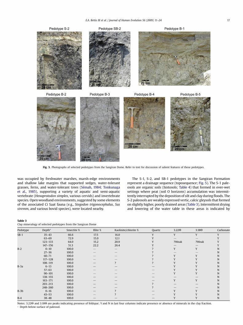
Fig. 3. Photographs of selected pedotypes from the Sangiran Dome. Refer to text for discussion of salient features of these pedotypes.
E.A. Bettis III et al. / Journal of Human Evolution 56 (2009) 11–24 17
was occupied by freshwater marshes, marsh-edge environmentsand shallow lake margins that supported sedges, water-tolerantgrasses, ferns, and water-tolerant trees (Semah, 1984; Tonkunagaet al., 1985), supporting a variety of aquatic and semi-aquaticvertebrate (Hexaprotodon simplex, various cervids) and invertebratespecies. Open woodland environments, suggested by some elementsof the associated Ci Saat fauna (e.g., Stegodon trigonocephalus, Susstremm, and various bovid species), were located nearby.
Table 3Clay mineralogy of selected pedotypes from the Sangiran Dome
Pedotype Depth* Smectite % Illite % Kaolinite/
SB-1 35–43 66.6 17.5 16.063–69 72.9 15.0 12.1
123–133 64.0 15.2 20.9147–156 51.3 22.2 26.4
B-2 0–10 100.0 d d
27–36 100.0 d d
60–71 100.0 d d
117–128 100.0 d d
108–119 100.0 d ?B-3a 6–13 100.0 d d
57–63 100.0 d d
90–101 100.0 d d
138–155 100.0 d d
163–171 100.0 d d
203–213 100.0 d d
248–260 100.0 d d
B-3b 0–16 100.0 d ?43–53 100.0 d ?
B-4 38–48 100.0 d d
Notes: 3.22Q and 3.18Q are peaks indicating presence of feldspar; Y and N in last four c* Depth below surface of paleosol.
The S-1, S-2, and SB-1 pedotypes in the Sangiran Formationrepresent a drainage sequence (toposequence; Fig. 5). The S-1 pale-osols are organic soils (histosols; Table 4) that formed in ever-wetsettings where peat (soil O horizons) accumulation was intermit-tently interrupted by the deposition of silt and clay during floods. TheS-2 paleosols are weakly expressed vertic, calcic gleysols that formedon slightly higher, poorly drained areas (Table 3). Intermittent dryingand lowering of the water table in these areas is indicated by
chlorite % Quartz 3.22Q 3.18Q Carbonate
Y Y Y YY d d YY ?Weak ?Weak YY d d Y? Y Y N? d d N? Y Y N? Y Y N? Y Y Nd Y Y Nd Y Y Nd Y Y Nd d d Nd Y Y N? d d N? d d Nd Y Y Nd Y Y Nd Y Y N
olumns indicate presence or absence of minerals in the clay fraction.

Table 4Classification and interpreted paleoenvironments of pedotypes in the Sangiran Dome (classified according to the system of Mack et al., 1993)
Pedotype Classification Interpreted paleoenvironment
S-1 Histosols Ever-wet lake margin supporting sedges, Typha, ferns, and water-tolerant trees and shrubsS-2 Vertic, calcic gleysol Lake margin supporting fern, water-tolerant grass, and scattered shrub vegetation, seasonally flooded, annual to
semi-annual dry season during which water table drops below surfaceSB-1 Calcic vertisol Relatively stable floodplain or terrace supporting grasses, shrubs and scattered trees, seasonal high water table,
annual dry seasonB-1 Calcic argillisol Well-drained, stable terrace or valley margin supporting open to semiclosed savanna vegetation, annual dry seasonB-2 Vertic gleysol Poorly drained, low-lying landscape positions supporting wet grassland with few trees and shrubs, annual dry seasonB-3a Vertic, andic protosol Well- to moderately well-drained, episodically aggrading landscape positions such as natural levees supporting
mixed grass, shrub, and tree vegetation, annual dry seasonB-3b Andic protosol As aboveB-4a Vertic, calcic, andic protosol Well-drained, episodically aggrading landscape positions such as natural levees supporting mixed grass, shrub, and tree
vegetation, annual dry seasonB-4b Calcic, andic protosol As aboveB-5 Calcic argillisols Well-drained, stable terrace or valley margin supporting open woodland with seasonal grass understory, extended
annual dry season
E.A. Bettis III et al. / Journal of Human Evolution 56 (2009) 11–2418
slickensides on wedge-shaped ped faces, the presence of redox-imorphic features, such as mottles (Vepraskas, 2001), and by thepresence of pedogenic carbonate nodules in the Bg horizon andbelow the solum. Root-trace patterns in S-2 paleosols indicate thatthey supported shallowly rooted vegetation such as water-tolerantgrasses, sedges, and ferns. Soils of the SB-1 pedotype formed on thehighest parts of the local landscape. The network of large, arcuate,intersecting slickensides, vosepic plasmic fabric (Brewer, 1976),smectitic clay mineralogy, and discrete nodules of pedogeniccarbonate indicate that these are calcic vertisols (Patton, 1974;Ahmad, 1983; Blokhius et al., 1990; Caudill et al., 1997; Table 4).Pedologic features similar to those found in the SB-1 pedotype aretypical of modern calciusterts, swelling soils that witness seasonalmoisture deficits and that contain accumulations of pedogeniccarbonate (Soil Survey Staff, 1999). In the tropics, calciusterts arerestricted to areas with seasonal moisture regimes marked bya pronounced dry season of at least four months (Young,1976). Whilenot necessarily indicating a direct comparison with modern seasonalmoisture patterns, the morphology of SB-1 paleosols does suggestsignificant seasonal moisture deficits on higher parts of the earlyPleistocene landscape.
Bapang Formation
The Bapang Formation represents localized erosion and infillingof the lowland by large bedload stream systems draining nearbyvolcanic highlands. Paleosols formed in the upper, fine-grained partof the formation’s three upward-fining cycles (Fig. 2). The SB-1, B-1,B-2, B-3, B-4, and B-5 pedotypes represent different sedimentaryenvironments, water-table conditions, and vegetation associationsacross the paleovalley landscape. The B-1 paleosols formed in well-drained, infrequently flooded parts of the valley landscape underopen woodland vegetation. These are calcic argillisols that formedon relatively stable landscape positions such as terrace treads(Table 4). The B-2 paleosols are vertic gleysols that formed onslowly aggrading, poorly drained landscape positions occupied bywater-tolerant grasses, shrubs, and scattered trees. Water-tablefluctuations and a dry season promoted volumetric changes thatalternately opened and closed deep cracks in these soils. Thestacked sequences of two or more andic protosols represented bythe B-3 and B-4 pedotypes formed on intermittently aggradinglandscape positions such as natural levees under mixed grass, trees,and shrub vegetation. The B-4 paleosols are calcic, andic protosolsthat have diffuse carbonate nodules or filaments in subsoil hori-zons, and may have formed during periods with a longer dry seasonthan occurred during the periods when B-3 paleosols formed.Alternatively, B-3 and B-4 pedotypes may represent slightlydifferent landscape positions where conditions controlling
carbonate accumulation varied. The B-5 pedotype represents calcicargillisols that formed under open woodland on relatively stable,well-drained landscape positions such as terraces. Pedogeniccarbonate nodules in the subsoil of this pedotype suggest thepresence of an extended annual dry season.
Stable isotope record
The feasibility of using d13C values from SOM as a proxy forpaleoenvironmental conditions stems from the fact that theisotopic composition of SOM is controlled by the relative propor-tions of plants with different photosynthetic pathways. In turn, thedominant plant type in a community is strongly correlated withenvironmental parameters such as temperature and moisture. Ifthe composition of the plant community changes through time,these changes will be preserved as the plant material is incorpo-rated into the SOM and retains the stable carbon isotope ratio(13C/12C) of the original vegetation. Many studies have demon-strated that d13C analysis of SOM is a reliable method of recon-structing local vegetation history and, by extension, the ecologicaland environmental history of a region (Cerling et al., 1989; Ehler-inger et al., 1997; Boutton et al., 1998; Kelly et al., 1998; Nordt et al.,2002).
In approximately 85% of plant species, photosynthesis isaccomplished using the Calvin Benson cycle, in which CO2 is initiallyfixed in a three-carbon organic acid. Accordingly, this photosyn-thetic pathway is usually referred to as C3 photosynthesis and theplants that use it are called C3 plants. The C3 pathway is utilized bymost trees, shrubs, herbs, and temperate-climate plant communi-ties. Species that use the C3 pathway are best adapted to environ-ments with abundant moisture. In addition to this basicphotosynthetic mode, some plants are equipped with a metabolicalternative that is more efficient in hot environments with highsolar irradiance and limited water availability. Plants that utilize thispathway have a special leaf anatomy that allows spatial separationof the initial CO2 fixation and standard C3 photosynthesis. BecauseCO2 is initially fixed into four-carbon molecules, this process isreferred to as C4 photosynthesis. The unique physiology of C4 plantsincreases water-use efficiency, resulting in higher productivity inwarm and arid environments (Vogel, 1980; O’Leary, 1981, 1988).Plants that use C4 photosynthesis consist mainly of warm-seasongrasses and forbs. Most tropical, subtropical, and temperate grass-lands are dominated by C4 plants (Boutton, 1996; Nordt et al., 1996;Sage and Monson, 1999). A third group of plants use crassulaceanacid metabolism (CAM) and are denoted by this acronym. Plants inthe CAM group, which includes cacti, euphorbias, agaves, and someferns have carbon isotope values intermediate between those of C3
and C4 plants.

E.A. Bettis III et al. / Journal of Human Evolution 56 (2009) 11–24 19
During photosynthesis, plants discriminate against the 13C isotopein favor of the lighter 12C isotope. However, the extent of 13CO2 frac-tionation in C3 and C4 plants varies due to their ecophysiologicaldifferences, and their d13C values differ significantly (Vogel, 1980;O’Leary,1988; Farquhar et al.,1989; Boutton,1996). Plants that use theC4 pathway have relatively 13C-enriched d13C values, ranging from�17& to �9&, with an average of �13&, while C3 plants are more13C-depleted and have d13C values that range from approximately�32& to �22&, with an average of �27& (Boutton, 1996). Withnonoverlapping ranges and averages that differ by approximately14&, the two plant types contribute distinctive isotopic signatures tothe SOM. This difference in the carbon isotope ratios betweenphotosynthetic pathways can be used to estimate the relativecontributions of C3 and C4 biomass to the SOM pool and, by extension,the composition of the vegetation community on a landscape.
Pedogenic carbonate is formed by the downward leaching ofdissolved carbonate from the upper horizons of a soil, which thenprecipitates in lower soil horizons. The primary mechanism forprecipitation is probably carbonate supersaturation as a result ofsoil drying during evapotranspiration (Cerling, 1984; Quade et al.,1989). In well-drained soils, precipitation of carbonate occurs in thevadose zone, but in areas where seasonal water table fluctuates,pedogenic CaCO3 may also precipitate at the capillary fringe (Slateet al., 1996). Soil carbonate typically forms in dry regions or in areaswith pronounced wet-dry seasons (Ahmad, 1983; Birkeland, 1999).
The source of carbon in pedogenic carbonate is soil CO2. Twoisotopically distinct sources contribute to soil CO2: (1) CO2 fromplant respiration and litter decomposition and (2) atmospheric CO2.Except in sparsely vegetated landscapes, penetration by atmo-spheric CO2 is usually limited to the upper 5–20 cm of the soilprofile because of low diffusivity and porosity, and high flux ofbiogenic CO2 (Cerling, 1984; Quade et al., 1989; Cerling and Quade,1993). Pedogenic carbonate formed in equilibrium with soil-respired CO2 is typically enriched in 13C by 13.5& to 17& over thatof respiring plants, as well as that of decomposing organic carbonand related SOM (Cerling et al., 1989; Cerling and Quade, 1993).
1.66
Plateau Age(Ma)
1.02
1.05
1.27
1.30
1.50
B-
-26 -25 -2
C3 dominan
Sangiran Fm.
Cycle 3
Cycle 2
Cycle 1
δ13
Pohjajar Fm.
Pink tuffWhite tuff
B-3a B-5B-4b
10
B-5
SB-1
-16 -15 -14 -13 -12 -11 -10 -
B-1B-3bB-3b B-3a
B-3b
B-4b
B-1 B-2SB-1 B-2
S-1
SB-1
M
5
15
20
25
30
35
Upper tuff
Middle tuff
Lower Tuff
Tuff 11Tuff 10
Tuff 9
UPPERLAHAR
40Ar/39Ar
Fig. 4. Stratigraphic occurrence and carbon and oxygen isotope ranges of pedotypes in the Saupsection that is reflected in the carbon isotopic values for both the paleosol SOM and carbonthe Sangiran Formation and 18O-depleted river water from volcanic highlands in the Bapan
Soil carbonate d18O values reflect the isotopic composition oflocal meteoric water (Cerling, 1984; Cerling and Quade, 1993). Ingeneral, cool or moist regions have more negative meteoric waterand soil carbonate d18O values than dry or hot regions. The rela-tionship between isotopic composition of pedogenic carbonate andclimatic factors is very complex and involves a number of factorsthat influence d18O values such as evaporation from the soil surface,monsoonal and coastal effects, altitude, and latitude.
Carbon isotope values
The d13C ranges of SOM (d13CSOM) for five paleosols representingfive of the identified pedotypes, and the d13C ranges for pedogeniccarbonate nodules (d13Ccarb) associated with three paleosols repre-senting three pedotypes, are shown in Fig. 4 and Table 2. A significantshift in carbon isotopic composition takes place up-section. The SOMpool of the SB-1 pedotype, formed in sediments just below Tuff 9 inthe Upper Sangiran Formation, has relatively high d13CSOM values,suggesting a 70–80% contribution of C4 and/or CAM vegetation to theSOM (using the mixing model presented by Boutton, 1996). Thesevalues are consistent with the grasslike root patterns associated withpaleosols in the Sangiran Formation and pollen analyses from asso-ciated sediments that suggest that water-tolerant grasslands, somecontaining significant amounts of ferns, were the dominant vege-tation type during accumulation of this part of the sequence (Semah,1984; Tonkunaga et al., 1985). The d13Ccarb values from pedogeniccarbonate associated with the sampled SB-1 pedotype are signifi-cantly 13C-depleted relative to the d13CSOM values. This apparentdiscrepancy between the SOM and pedogenic carbonate d13C valuesmay be a result of incorporation of very 13C-depleted carbon derivedfrom methane into these carbonate nodules. Decomposition oforganic matter under anoxic conditions characteristic of paludalenvironments in the upper Sangiran Formation would have provideda ready source of methane for this process.
The d13CSOM values from the B-2 pedotype, formed in BapangFormation sedimentary Cycle 1, represent a 25–50% contribution of
SB-1
5
4 -23 -22 -21 -20 -19 -18 -17 -16 -15 -14 -13
δ13Csom
t mixed C3/C4 C4 dominant
B-3aB-3b
Ccarb (V-PDB)
-7.0-8.0 -6.0 -5.0δ18O
B-3a
B-2
9 -8 -7 -6 -5 -4 -3 -2 -1
-4.0
ngiran Dome. There is a trend toward more C3 vegetation contribution to the SOM poolates. Oxygen isotope values probably reflect contributions from local meteoric water ing Formation.
E.A. Bettis III et al. / Journal of Human Evolution 56 (2009) 11–2420
C4 plants to SOM. The d13Ccarb values from carbonate nodulesassociated with the sampled profile range from �9.93& to �5.12&
(Table 2). These values overlap with and range to slightly d13C-depleted relative to the values obtained from SOM. The percentageC3/C4 vegetation estimated from the isotope data is consistent withthe open woodland suggested by the associated Trinil H.K. faunaand with the presence of both fine- and medium-sized root traces.The B-3 and B-5 paleosols from the upper part of sedimentary Cycle3 have the most 13C-depleted d13CSOM values. The B-3 paleosols arenoncalcareous and the d13Ccarb values from the B-5 pedotype ared13C-depleted relative to the SOM d13C values. Both SOM andcarbonate d13C indicate a dominance of C3 plants on these paleo-surfaces, which seems inconsistent with faunal evidence, root-tracepatterns, and paleosol morphology indicative of open woodlandenvironments (van den Bergh et al., 2001). We suggest that the13C-depleted d13C values may reflect an open woodland ecosystemwhose SOM input was dominated by C3 leaf fall.
Oxygen isotope values
The d18O values of pedogenic carbonate from the SangiranFormation paleosols are 18O-enriched relative to carbonates fromBapang Formation paleosols (Fig. 4; Table 2). The d18O values fromthe Sangiran Formation are similar to those of modern precipitationover nonmountainous parts of Java today, while the d18O values ofBapang Formation pedogenic carbonates are similar to the values ofprecipitation in mountainous regions of modern Java (Bowen andWilkinson, 2002). This pattern suggests soil water dominated bylocal rainfall during accumulation of the Sangiran Formationpedogenic carbonate, and a strong contribution of 18O-depletedriver water derived from volcanic highlands during formation ofthe soil carbonates in the Bapang Formation.
Paleoenvironmental interpretations
Soils are historical bodies whose properties integrate the effectsof soil-forming factors acting on geological materials through time.Combining environmental interpretations gleaned from SangiranDome paleosols with other paleoenvironmental proxies such asfauna and flora provides robust reconstructions of landscapes andenvironments occupied by H. erectus, as well as insight into early tomiddle Pleistocene environmental change in this tropical setting.This improved understanding of the environment occupied byH. erectus in Central Java provides us with new insights into the kindsof adaptations made by the earliest humans in Southeast Asia.
Local environments
When H. erectus first arrived in southern Sundaland, the Sangiranarea was a low-relief lake-margin and marsh landscape. Streamsdraining nearby volcanic highlands provided intermittent floods ofsilty and clayey sediment, and occasional volcanic eruptionsdeposited blankets of ash. Freshwater marshes and marsh-edgeenvironments supported sedges, ferns, water-tolerant grasses, andtrees (Semah, 1984, Tonkunaga et al., 1985), in addition to a varietyof aquatic and semi-aquatic vertebrate (Hexaprotodon, various cer-vids, crocodiles, turtles, fish) and invertebrate species. Wet grass-lands with scattered shrubs occupied slightly higher parts of thelandscape, where water tables fluctuated from near the land surfaceto about one meter deep on an annual basis (Fig. 5). Still higher,better-drained parts of the landscape supported savanna vegetation,most likely dominated by sedges, grass, and ferns and with scatteredtrees such as Acacia (A. leucophloeaa?), leaf-flower [Phyllanthus (P.emblica?)], and Indian albizia [Albizia (A. lebbekoides?)]. Taxa of theCi Saat fauna, such as Stegodon trigonocephalus and various bovidand cervid species, occupied the savanna and wet grasslands.
Shortly before 1.5 Ma, large bed-load streams draining volcanichighlands to the northwest and southeast began to fill in lakes andmarshes in the Sangiran area. Sedimentary style shifted abruptlyfrom quiet-water-dominated to fluvial as volcaniclastic sands andsilts with minor amounts of epiclastic pumice accumulated on thevalley landscape. Local variations in geomorphic position anddistance from river channels were important factors that influ-enced the nature of soil formation and controlled edaphic condi-tions and vegetation patterns during this time. Paleosolmorphology, root-trace patterns, and d13C values of well-drainedpaleosols indicate that open woodlands occupied well-drainedlandforms such as terraces. Open woodland environments are alsoindicated by several elements of the Trinil H.K. fauna (e.g., Panthera,various cervids, Sus branchygnatus, and primates), which is asso-ciated with Cycle 1 of the Bapang Formation (Larick et al., 2000,2001; van den Bergh et al., 2001). Low-lying, frequently floodedareas supported a moist savanna with scattered trees and shrubs.Riparian forest occupied the active channel belt where shiftingchannels left many sandbars and shallow abandoned channels.
Valley landscape elements similar to those characteristic ofCycle 1 were present during accumulation of Bapang FormationCycles 2 and 3 (Fig. 6). As channel positions became more stable,natural levees formed and began to occupy significant floodplainareas bordering the channel belt. In these areas, episodic depositionof flood sediments produced stacked sequences of moderatelywell-drained soils that supported trees, shrubs, and grasses. Anannual dry season is indicated by wedge-shaped peds andnetworks of intersecting slickensides found in the paleosolsdeveloped on flood basins and natural levees. Pedogenic carbonateaccumulations associated with the B-1, B-4, and B-5 pedotypesprovide further evidence for an annual dry season. The d13C valuesof paleosol SOM indicate higher contributions from C3 vegetation,most likely trees and shrubs, than were characteristic of Cycle 1paleosols. The Kedung Brubus fauna, the composition of whichsuggests that the environment was primarily dry open woodland(Sondaar, 1984; van den Bergh et al., 2001), is associated withsedimentary Cycles 2 and 3. Taken together, the paleosol, stableisotope, and faunal data indicate that the annual dry seasonintensified between about 1.5 and 1.3 Ma.
Regional environment
Vertic properties (e.g., wedge-shaped peds and intersectingslickensides) and pedogenic carbonate accumulations commonlyreflect regional paleoclimatic conditions (Reinhardt and Sigelo,1988; Mack and James, 1992; Birkeland, 1999; Retallack, 2001). Adry season during which clayey soils witnessed shrinking and deepcracking is indicated by the vertic properties of paleosolsthroughout the Sangiran and Bapang formations. Modern tropicalvertisols are common in regions affected by monsoon climates(Young, 1976) and the occurrence of paleovertisols and soils withvertic properties in the Sangiran Dome sequence is strong evidencethat Central Java was affected by monsoon circulation during theearly Pleistocene. This is consistent with oceanographic data thatsuggest the development of the Walker circulation, which drivesthe monsoon, between 1.9 and 1.6 Ma (Ravelo et al., 2004; McCly-mont and Rosell-Mele, 2005). The occurrence of pedogeniccarbonate nodules in many of the Dome’s paleosols also points toan annual dry season and in some instances provides evidence foran annual dry season of several months extent. Rooting patternsand d13C values suggest local vegetation shifts influenced either byan overall long-term drying trend or by increases in the duration ofthe annual dry season through time.
Glacial-interglacial cycles during the last 2.6 Myr have hada profound effect on the distribution of land on the Sunda subcon-tinent (Hall, 2001; de Deckker et al., 2002). During the last glaciation,

Fig. 5. Paleoenvironment of the Sangiran area at the time of the arrival of Homo erectus in southern Sundaland. The low-relief landscape contained a mixture of water-tolerantgrasses, ferns, shrubs, and trees.
E.A. Bettis III et al. / Journal of Human Evolution 56 (2009) 11–24 21
the Intertropical Convergence Zone was north of the Banda Sea,resulting in a perpetual southeastern Monsoon that promoted dryconditions in southern Sundaland (Spooner et al., 2005). If similarcirculation patterns occurred during older glaciations, then southernSundaland witnessed a sequence of relatively dry glacial periods(when low sea levels expanded emergent Sundaland) that wereseparated by less arid interglacial periods (when high sea levelsinundated low-lying portions of Sunda). The most extensive earlyPleistocene glaciations (in terms of sea-level lowering; Shackelton,1997) occurred between about 1.8 and 1.74 Ma [Marine IsotopeStages (MIS) 62, 60, and 58], about 1.56 Ma (MIS 52), between 1.24and 1.1 Ma (MIS 36, 34, and 30), and about 0.9 Ma (MIS 22).
The paleosols reported here represent pieces of former landsurfaces that existed in a small part of southern Sundaland betweenabout 1.66 and 1.0 Ma. Future work should aim at documenting andinterpreting paleosol variations across paleolandscapes, such as isbeing done in eastern Africa (Sikes et al., 1999; Wynn, 2000; Sikesand Ashley, 2007). In Java, vegetation cover, widespread massmovements, and intensive land use challenge our ability to tracelandscapes occupied by the earliest humans.
Implications for the peopling of Java
Homo erectus arrived in southern Sundaland during one or moreearly Pleistocene sea-level low stands. Considering the age of H.erectus fossils in the Sangiran area and the sea-level record, hom-inins most likely made their first crossing into Sundaland between1.8 and 1.74 Ma during glaciations corresponding to MIS 62, 60, or58, when sea level was 50 m or more lower than present (Shack-elton, 1997). Southeast Asian marine and continental records andclimate models indicate that glacial periods were more arid thaninterglacials (de Deckker et al., 2002; Bush and Fairbanks, 2003;Spooner et al., 2005). Therefore, glacial periods offered not onlyland bridges, but also a greater extent of savanna and open forest.These heterogeneous vegetation mosaics may have supporteda more diverse fauna during drier periods, and they provided idealconditions for faunal and human migration (van den Bergh et al.,2001; Yap, 2002; Anton and Swisher, 2004; Wynn, 2004). Most ofthese favorable environments disappeared or became veryrestricted during glacial terminations and subsequent interglacialsas a consequence of sea-level rise and increased atmospheric

Fig. 6. Paleoenvironment of the Sangiran area during accumulation of Cycle 2 deposits of the Bapang Formation. Braided streams brought large loads of sandy sediments fromnearby volcanic highlands, forming a dynamic and diverse riverine landscape characterized by open woodlands/savanna and tree-lined channels. See Fig. 5 for symbol key.
E.A. Bettis III et al. / Journal of Human Evolution 56 (2009) 11–2422
moisture. Sundaland’s H. erectus inhabitants thus became envi-ronmental refugees repeatedly during the Pleistocene as they wereforced into highlands where open vegetation communities werenot as abundant.
Paleosols in the Sangiran and Bapang formations demonstratethat land surfaces habitable by H. erectus existed in the immediatearea prior to and during the period of this species’ occupation. This,in conjunction with the number and condition of hominin fossilscollected from the Sangiran Dome, suggests that living surfacesmay be preserved in the area. The search for these open-air sitesshould focus on paleosols, where time is compressed and habita-tion evidence may be concentrated.
Acknowledgments
The Institute of Technology Bandung and the University of Iowa(UI) collaborated in this research, with assistance from the Indo-nesian Geological Research and Development Centre. The Indone-sian Institute of Sciences issued research permits 7450/V3/KS/1998,3174/V3/KS/1999, 4301/1.3/KS/2001, 4212/SU/KU/2003, and 03799/
SU/KS/2006 for our fieldwork. Funding for fieldwork was providedby the L.S.B. Leakey Foundation. Additional funding came from thefollowing UI sources: Center for Global and Regional EnvironmentalResearch, Central Investment Fund for Research Enhancement,Office of the Vice-President for Research, the Office of the Dean ofthe College of Liberal Arts and Sciences, the Iowa Center forResearch by Undergraduates, and the Human Evolution ResearchFund at the University of Iowa Foundation. Computer graphics andother digital images were created by the authors and refined byJames W. Rogers. K. Lindsay Eaves-Johnson proofread severalversions of the manuscript. The manuscript was significantlyimproved by the comments of three anonymous reviewers.
References
Ahmad, N., 1983. Vertisols. In: Wilding, L.P., Smeck, N.E., Hall, G.F. (Eds.), Pedo-genesis and Soil Taxonomy, Volume II: The Soil Orders. Elsevier, Amsterdam, pp.91–124.
Aimi, M., Aziz, F., 1985. Vertebrate fossils of the Sangiran Dome, Mojokerto, Trinil,and Sambungmachan areas. In: Watanabe, N., Kadar, D. (Eds.), QuaternaryGeology of the Hominid Fossil Bearing Formations in Java. Geological Researchand Development Centre, Bandung, pp. 155–197.
E.A. Bettis III et al. / Journal of Human Evolution 56 (2009) 11–24 23
Anton, S.C., Swisher III, C.C., 2004. Early dispersals of Homo from Africa. Annu. Rev.Anthropol. 33, 271–296.
Baba, H., Aziz, F., Narasaki, S., SudijonoKaifu, Y., Supriojo, A., Hyodo, M., Susanto, E.E.,Jacob, T., 2000. A new hominid incisor from Sangiran, Central Java. J. Hum. Evol.38, 855–862.
Bettis III, E.A., Zaim, Y., Larick, R., Ciochon, R.L., Suminto, Rizal, Y., Reagan, M.,Heizler, M., 2004. Landscape development preceding Homo erectus immigrationinto Central Java, Indonesia: the Sangiran Formation Lower Lahar. Palaeogeogr.Palaeoclimatol. Palaeoecol. 206, 115–131.
Birkeland, P.W., 1999. Soils and Geomorphology. Oxford University Press, New York.Blokhius, W.A., Kooistra, M.J., Wilding, L.P., 1990. Micromorphology of cracking clay
soils (Vertisols). In: Douglas, L.A. (Ed.), Soil Micromorphology: A Basic andApplied Science. Elsevier, Amsterdam, pp. 123–148.
Boutton, T.W., 1996. Stable carbon isotope ratios of soil organic matter and theiruse as indicators of vegetation and climate change. In: Boutton, T.W.,Yamasaki, S. (Eds.), Mass Spectrometry of Soils. Marcel Dekker, Inc., New York,pp. 47–82.
Boutton, T.W., Archer, S.R., Midwood, A.J., Zitzer, S.F., Bol, R., 1998. d13C values of soilorganic matter and their use in documenting vegetation change in a subtropicalsavanna ecosystem. Geoderma 82, 5–42.
Bowen, G.J., Wilkinson, B., 2002. Spatial distribution of d18O in meteoric precipi-tation. Geology 30, 315–318.
Brewer, R., 1976. Fabric and Mineral Analysis of Soils. Krieger, New York.Bullock, P., Fedoroff, N., Jongerius, A., Stoops, G., Turina, T., 1985. Handbook of Soil
Thin Section Description. Waine Research, Albrighton, Texas.Bush, A.B.G., Fairbanks, R.G., 2003. Exposing the Sunda Shelf: tropical responses to
eustatic sea level change. J. Geophys. Res. 108 (D15), 4446–4455.Caudill, M.R., Driese, S.G., Mora, C.I., 1997. Physical compaction of vertic paleosols:
implications for burial diagenesis and paleoprecipitation estimates. Sedimen-tology 44, 673–685.
Cerling, T.E., 1984. The stable isotopic composition of modern soil carbonate and itsrelationship to climate. Earth Planet. Sci. Lett. 71, 229–240.
Cerling, T.E., Quade, J., 1993. Stable carbon and oxygen isotopes in soil carbonates.In: Swart, P.K., Lohmann, K.C., McKenzie, J., Savin, S. (Eds.), Climate Change inContinental Isotopic Records. American Geophysical Union, Washington, DC, pp.217–239.
Cerling, T.E., Quade, J., Wang, Y., Bowman, J.R., 1989. Carbon isotopes in soils asecology and paleoecology indicators. Science 341, 138–139.
Danisworo, C., 1992. Magnetostratigraphy of Plio-Pleistocene deposits in the San-giran area, Central Java. In: Proc. Indonesian Assoc. Geologists XXI AnnualScientific Meeting. Bandung, pp. 477–485.
de Deckker, P., Tapper, N.J., van der Kaars, S., 2002. The status of the Indo-PacificWarm Pool and adjacent land at the Last Glacial Maximum. Global Planet.Change 35, 25–35.
de Vos, J., Sondaar, P.Y., 1982. The importance of the Dubois Collection reconsidered.Mod. Quartern. Res. Southeast Asia 7, 35–63. 97–130.
de Vos, J., Sondaar, P.Y., van den Bergh, G.D., Aziz, F., 1994. The Homo bearingdeposits of Java and its ecological context. Cour. Forshung-Inst. Senckenberg171, 129–140.
Ehleringer, J.R., Cerling, T.E., Helliker, B., 1997. C4 photosynthesis, atmospheric CO2,and climate. Oecologia 112, 285–299.
Falgueres, C., 1998. Dating layers and fossils in Sangiran Dome: methods and results.In: Simanjuntak, H.T. (Ed.), International Colloquium on Sangiran: Man, Cultureand Environment in Pleistocene Solo, Indonesia. Japan Foundation and NationalResearch Centre of Archaeology, Jakarta, pp. 46–47.
Falgueres, C., Yokoyama, Y., 2001. Datation des hominides fossiles en Asie. In:Semah, F., Falgueres, C., Grimaud-Herve, D., Semah, A.M. (Eds.), Origine desPeuplements et Chronologie des Cultures Paleolithiques dans le Sud-Est Asi-atique (Colloque International de la Fondation Singer-Polignac, June 1998).Semenanjung, Paris, pp. 55–64.
Farquhar, G.D., Ehleringer, J.R., Hubick, K.Y., 1989. Carbon isotope discrimination andphotosynthesis. Annu. Rev. Plant Mol. Biol. 40, 503–537.
Faure, G., 1986. Principles of Isotope Geology, second ed. Wiley, New York.Hall, R., 2001. Cenozoic reconstructions of SE Asia and the SW Pacific: changing
patterns of land and sea. In: Metcalfe, I., Smith, J.M.B., Morwood, M.,Davidson, I.D. (Eds.), Faunal and Floral Migrations and Evolution in SE Asia-Australasia. Swets and Zeitlinger Publishers, Lisse, pp. 35–56.
Hooijer, D.A., 1956. The lower boundary of the Pleistocene in Java and the age ofPithecanthropus. Quaternaria 3, 5–50.
Hooijer, D.A., 1957. The correlations of fossil mammalian faunas and the Plio-Pleistocene boundary in Java. Proc. K. Ned. Akad. Wet. Amsterdam 60, 125–128.
Hou, Y., Potts, R., Yaun, B., Guo, Z., Deino, A., Wei, W., Clark, J., Xie, G., Huang, W.,2000. Mid-Pleistocene Acheulean-like stone technology of the Bose Basin,South China. Science 287, 1622–1626.
Huffman, O.F., 1999. Variety in the paleoenvironment of early Homo erectus of Java,Indonesia. J. Hum. Evol. 36, A8–A9.
Huffman, O.F., 2001. Geologic context and age of the Perning/Mojokerto Homoerectus, East Java. J. Hum. Evol. 40, 353–362.
Hyodo, M., Watanabe, N., Sunata, W., Susanto, E.E., Wahyono, H., 1993. Magneto-stratigraphy of hominid fossil-bearing formations in Sangiran and Mojokerto,Java. Anthropol. Sci. 10, 157–186.
Hyodo, M., Nakaya, H., Urabe, A., Saegusa, H., Xue, S., Yin, J., Ji, X., 2002. Paleo-magnetic dates of hominid remains from Yuanmou, China, and other Asiansites. J. Hum. Evol. 43, 27–41.
Itihara, M., Wikarno, Kagemori, Y., 1985. Tektites from the Sangiran area. In:Watanabe, N., Kadar, D. (Eds.), Quaternary Geology of the Hominid Fossil
Bearing Formations in Java. Geological Research and Development Centre,Bandung, pp. 125–128.
Kelly, E.F., Blecker, S.W., Yonker, C.M., Olson, C.G., Wohl, E.E., Todd, L.C., 1998. Stableisotope composition of soil organic matter and phytoliths as paleoenvir-onmental indicators. Geoderma 82, 59–81.
Langbroek, M., Roebroeks, W., 2000. Extraterrestrial evidence on the age of thehominids from Java. J. Hum. Evol. 38, 595–600.
Larick, R., Ciochon, R., Zaim, Y., 2000. Lithostratigraphic context for the Kln-1993.05-SJN, a fossil colobine maxilla from Jokotinkir, Sangiran Dome. Int. J.Primatol. 21, 731–759.
Larick, R., Ciochon, R.L., Zaim, Y., Sudijono, Suminto, Rizal, Y., Aziz, F., Reagan, M.,Heizler, M., 2001. Early Pleistocene 40Ar/39Ar ages for Bapang formation hom-inins, Central Jawa, Indonesia. Proc. Natl. Acad. Sci. U. S. A. 98, 4866–4871.
Mack, G.H., James, W.C., 1992. Paleosols for Sedimentologists. Short Course Manual.Geological Society of America, Boulder.
Mack, G.H., James, W.C., Monger, H.C., 1993. Classification of paleosols. Geol. Soc.Am. Bull. 105, 129–136.
McClymont, E.L., Rosell-Mele, A., 2005. Links between the onset of modern Walkercirculation and the mid-Pleistocene climate transition. Geology 33, 389–392.
Moore, D.M., Reynolds, R.C., 1989. X-Ray Diffraction and the Identification of ClayMinerals. Oxford University Press, Oxford.
Ninkovich, D., Burckle, L.H., 1978. Absolute age of the base of the hominid-bearingbeds in eastern Java. Nature 275, 306–308.
Nordt, L.C., Wilding, L.P., Hallmark, C.T., Jacob, J.S., 1996. Stable carbon isotopecomposition of pedogenic carbonates and their use in studying pedogenesis. In:Boutton, T.W., Yamasaki, S. (Eds.), Mass Spectrometry of Soils. Marcel Dekker,Inc., New York, pp. 133–154.
Nordt, L.C., Boutton, T.W., Jacob, J.S., Mandel, R.D., 2002. C4 plant productivity andclimate-CO2 variations in south-central Texas during the late Quaternary.Quatern. Res. 58, 182–188.
O’Leary, M.H., 1981. Carbon isotope fractionation in plants. Phytochemistry 20, 553–567.
O’Leary, M.H., 1988. Carbon isotopes in photosynthesis. Fractionation techniquesmay reveal new aspects of carbon dynamics in plants. BioScience 38, 328–336.
O’Sullivan, P.B., Morwood, M., Hobbs, D., Aziz, F., Suminto, Situmorang, M., Raza, A.,Maas, R., 2001. Archaeological implications of the geology and chronology ofthe Soa Basin, Flores, Indonesia. 29, 607–610.
Patton, T.R., 1974. Origin and terminology for gilgai in Australia. Geoderma 11,221–242.
Quade, J., Cerling, T.E., Bowman, 1989. Systematic variations in the carbon andoxygen isotope composition of pedogenic carbonate along elevation transectsin the southern Great Basin, United States. Geol. Soc. Am. Bull. 101, 464–475.
Ravelo, C., Andreasen, D., Lyle, M., Lyle, A.O., Wara, M.W., 2004. Regional climate shiftscaused by gradual global cooling in the Pliocene epoch. Nature 429, 263–267.
Reinhardt, J., Sigelo, W.R. (Eds.), 1988. Paleosols and Weathering through GeologicTime. Geological Society of America Special Paper 216, Boulder.
Retallack, G.J., 1991. Untangling the effects to burial alteration and ancient soilformation. Annu. Rev. Earth Planet. Sci. 19, 183–206.
Retallack, G.J., 2001. Soils of the Past: An Introduction to Paleopedology, second ed.Blackwell Science, Oxford.
Sage, R.F., Monson, R.K., 1999. Preface. In: Sage, R.F., Monson, R.K. (Eds.), C4 PlantBiology. Academic Press, New York, pp. xiii–xixv.
Sartono, S., 1961. Notes on a new find of a Pithecanthropus mandible. DepartmenPerindistrian Dasar/Pertambangan Djawatan Geologi. Publ. Tek. - Seri. Paleon-tol. 2, 1–51.
Sartono, S., 1969. On the Plio-Pleistocene boundary of Java. Bull. Nat. Hist. Inst. Geol.Min. Bandung 2, 1–19.
Sartono, S., 1970. On the stratigraphic position of Pithecanthropus mandible C. Proc.- Inst. Teknol. Bandung 4, 91–102.
Sartono, S., 1975. Implication arising from Pithecanthropus VIII. In: Tuttle, R.H. (Ed.),Paleoanthropology: Morphology and Paleoecology. Mouton, The Hague, pp.327–360.
Sartono, S., Orchiston, D.W., Seisser, W.G., Djubiantono, T., 1981. Upper Pliocenesediments in Sangiran, Central Java (Indonesia). Bull. Geol. (Inst. Teknol. Ban-dung) 5, 1–25.
Schneider, D.A., Kent, D.V., Mello, L., 1992. A detailed chronology of the Australasianimpact event, the Brunhes–Matuyama geomagnetic polarity reversal, andglobal climate change. Earth Planet. Sci. Lett. 111, 395–405.
Seisser, W.G., Orchiston, D.W., Djubiantono, T., 1984. Micropaleontological investi-gation of late Pliocene marine sediments at Sangiran, Central Java. Alcheringa 8,87–99.
Semah, F., 1982. Pliocene and Pleistocene geomagnetic reversals recorded in theGemolong and Sangiran domes (Central Java): initial results. Mod. Quatern. Res.Southeast Asia 7, 151–164.
Semah, H., 1984. Palynology and Javanese Pithecanthropus’ palaeoenvironment.Cour. Forsch.-Inst. Senckenberg 69, 237–243.
Semah, F., Semah, A.-M., Djubiantono, T., Simanjuntak, T., 1992. Did they also makestone tools? J. Hum. Evol. 23, 439–445.
Semah, F., Feraud, G., Saleki, H., Falgueres, C., Djubiantono, T., 2000. Did early manreach Java during the late Pliocene? J. Archaeol. Sci. 27, 763–769.
Shackelton, N.J., 1997. The deep-sea sediment record and the Pliocene-Pleistoceneboundary. Quatern. Int. 40, 33–35.
Sheldon, N.D., 2005. Do red beds indicate paleoclimatic conditions?: A Permian casestudy. Palaeogeogr. Palaeoclimatol. Palaeoecol. 228, 305–319.
Shimizu, Y., Mubroto, B., Siaian, H., 1985. A paleomagnetic study in the Sangiranarea. In: Watanabe, N., Kadar, D. (Eds.), Quaternary Geology of the Hominid

E.A. Bettis III et al. / Journal of Human Evolution 56 (2009) 11–2424
Fossil Bearing Formations in Java. Geological Research and Development Centre,Bandung, pp. 275–307.
Sikes, N.E., Ashley, G.M., 2007. Stable isotopes of pedogenic carbonates as indicatorsof paleoecology in the Plio-Pleistocene (upper Bed I), western margin of theOlduvai Basin, Tanzania. J. Hum. Evol. 53, 574–594.
Sikes, N.E., Potts, R., Behrensmeyer, A.K., 1999. Early Pleistocene habitat in Member IOlorgesailie based on paleosol stable isotopes. J. Hum. Evol. 37, 721–746.
Slate, J.L., Smith, G.A., Wang, Y., Cerling, T.E., 1996. Carbonate-paleosol genesis in thePlio-Pleistocene St. David Formation, southeastern Arizona. J. Sediment. Res. 66,85–94.
Spooner, M.I., Barrows, T.T., de Deckker, P., Paterne, M., 2005. Palaeoceanography ofthe Banda Sea, and late Pleistocene initiation of the Northwest Monsoon. GlobalPlanet. Change 49, 28–46.
Soil Survey Staff, 1993. Soil Survey Manual. United States Department of Agricul-ture, Washington, DC.
Soil Survey Staff, 1999. Soil Taxonomy: A Basic System for Making and InterpretingSoil Surveys, second ed. U.S. Government Printing Office, Washington, DC.
Sondaar, P.Y., 1984. Faunal evolution and the mammalian biostratigraphy of Java.Cour. Forsch.-Inst. Senckenberg 69, 219–235.
Swisher III, C.C., 1997. A revised geochronology for the Plio-Pleistocene hominid-bearing strata of Sangiran, Indonesia. J. Hum. Evol. 32, A23.
Swisher III, C.C., 1999. Antiquity of Homo erectus in Java: 40Ar/39Ar dating andpaleomagnetic study of Sangiran and Kedungbrubus areas. In: InternationalSymposium on Palaeoanthropology, 12–16 October 1999, Beijing, China. Insti-tute of Vertebrate Paleontology and Paleoanthropology, Chinese Academy ofSciences, Beijing, China, p. A78.
Swisher III, C.C., Curtis, G.H., 1998. 40Ar/39Ar dating of Plio-Pleistocene hornblendesfrom Java, Indonesia using CO2 laser incremental heating techniques. In: DualCongress, 1998. Joint Meeting of the International Association for the Study ofHuman Palaeontology and the International Association of Human Biologists,Sun City, South Africa, Sun City, Organizing Committee of Dual CongressColloquium, p. 8.
Swisher III, C.C., Curtis, G.H., Jacob, T., Getty, A.G., Suprijo, A., Widiasmoro, 1994. Ageof the earliest known hominids in Java, Indonesia. Science 263, 1118–1121.
Tonkunaga, S., Oshima, H., Polhaupessy, A.A., Ito, Y., 1985. A palynological study ofthe Puchangan and Kabuh formations in the Sangiran area. In: Watanabe, N.,Kadar, D. (Eds.), Quaternary Geology of the Hominid Fossil Bearing Formationsin Java. Geological Research and Development Centre, Bandung, pp. 199–217.
van den Bergh, G.D., de Vos, J., Sondaar, P.Y., 2001. The late Quaternary palae-ogeography of mammal evolution in the Indonesian Archipelago. Palaeogeogr.Palaeoclimatol. Palaeoecol. 171, 385–408.
Vepraskas, M.J., 2001. Morphological features of seasonally reduced soils. In:Richardson, J.L., Vepraskas, M.J. (Eds.), Wetland Soils: Genesis, Hydrology,Landscapes and Classification. Lewis Publishers, Boca Raton, pp. 163–182.
Vogel, J.C., 1980. Fractionation of the Carbon Isotopes during Photosynthesis.Springer, Berlin.
von Koenigswald, G.H.R., 1940a. Preliminary note on new remains of Pithecanthropusfrom Central-Java. In: Proceedings of the Third Congress of Prehistorians of theFar East, 24th January–30th January, 1938. Raffles Museum and GovernmentPrinting Office, Singapore, pp. 91–95.
von Koenigswald, G.H.R., 1940b. Neue Pithecanthropus-Funde 1936–1938. EinBeitrag zur Kenntnis der Praehominiden. Dienst Mijn Ned.-Indie Wet. Med.28, 1–218.
Watanabe, N., Kadar, D. (Eds.), 1985. Quaternary Geology of the Hominid FossilBearing Formations in Java. Geological Research and Development Centre,Bandung.
Widianto, H., Toha, B., Simanjuntak, T., Hidayat, M., 1997. Laporan penelitianSitus Sangiran: Proses sedimentasi, posisi stratigrafi dan kronologi artefakpada endapan purba Seri Kabuh dan Seri Notopuro. Berita PenelitianArkelogi. 1, 1–136.
Widiasmoro, 1998. Late Tertiary–early Quaternary magmatic arc and its relationshipto the sedimentation processes in Sangiran, Central Java. In: Simanjuntak, H.T.(Ed.), International Colloquium on Sangiran: Man, Culture and Environment inthe Pleistocene, Solo, Indonesia. Japan Foundation and National ResearchCenter of Archaeology, Jakarta, pp. 45–46.
Wynn, J.G., 2000. Paleosols, stable carbon isotopes, and paleoenvironmentalinterpretation of Kanapoi, northern Kenya. J. Hum. Evol. 39, 411–432.
Wynn, J.G., 2004. Influence of Plio-Pleistocene aridification on human evolution:evidence from paleosols of the Turkana Basin, Kenya. Am. J. Phys. Anthropol.123, 106–118.
Yap, S.Y., 2002. On the distribution patterns of Southeast-Asia freshwater fish andtheir history. J. Biogeogr. 29, 1187–1199.
Yokoyama, T.S., Hadiwisastra, S., Hayashida, A., Hantoro, W., 1980. Preliminaryreport on the paleomagnetism of the Plio-Pleistocene series in Sangiran andTrinil areas, Central Jawa, Indonesia. In: Nishimura, S. (Ed.), Physical Geology ofIndonesian Island Arcs. Kyoto University, Kyoto, pp. 45–46.
Yoshikawa, S., Suminto, 1985. Tuff layers and pumice tuff beds of the Pliocene andPleistocene sediments in the Sangiran area. In: Watanabe, N., Kadar, D. (Eds.),Quaternary Geology of the Hominid Fossil Bearing Formations in Java.Geological Research and Development Centre, Bandung, pp. 97–104.
Young, A., 1976. Tropical Soils and Soil Survey. Cambridge University Press,Cambridge.