Monitoring of Cytomegalovirus Reactivation in Bone Marrow Transplant Recipients by Real-time PCR

doi:10.1144/0016-76492006-200 2008; v. 165; p. 563-578 Journal of the Geological Society
Zohar Gvirtzman, Ezra Zilberman and Yehoshua Folkman
the Jaffa Basin offshore central IsraelReactivation of the Levant passive margin during the late Tertiary and formation of
Journal of the Geological Society
serviceEmail alerting to receive free email alerts when new articles cite this article click here
requestPermission to seek permission to re-use all or part of this article click here
Subscribe to subscribe to Journal of the Geological Society or the Lyell Collection click here
Notes
Downloaded by on 23 June 2008
© 2008 Geological Society of London
Journal of the Geological Society, London, Vol. 165, 2008, pp. 563–578. Printed in Great Britain.
563
Reactivation of the Levant passive margin during the late Tertiary and formation
of the Jaffa Basin offshore central Israel
ZOHAR GVIRTZMAN, EZRA ZILBERMAN & YEHOSHUA FOLKMAN
Geological Survey of Israel, 30 Malkhei Yisrael Street, Jerusalem, 95501, Israel (e-mail: [email protected])
Abstract: Re-examination of the stratigraphic record in the continental margin of Israel indicates that the
Levant passive margin was reactivated in the late Tertiary. Subsidence and, presumably, sedimentation rates
increased after prolonged gradual decay; the shelf-slope facies transition zone was revived; faulting and
magmatism resumed and the Judea Hills began to rise. Two parallel fault systems with large vertical
displacements were formed (or reactivated) between the Levant Basin and the continent. In the Levant Basin a
new 4 km thick section accumulated and at a middle level between the two faults a local basin was formed
and filled with a 2500 m thick section. That basin, termed here the Jaffa Basin, provides good age control. It
was initiated in the Mid–Late Oligocene, was mainly active in the Miocene and was completely buried by
sediments in the Plio-Pleistocene. We suggest that at the early stage of the Arabia–Africa breakup, in
conjunction with the Suez rifting, the Jaffa Basin was formed between two segments of a left-lateral fault that
allowed Arabia to slip northward relative to the Mediterranean lithosphere. When this fault failed to transform
the motion, both the Suez Rift and the Jaffa Basin were abandoned and the plate motion jumped inland to the
Dead Sea Transform.
The eastern Mediterranean basin and its passive continental
margin (Fig. 1) formed as a result of several faulting and
continental breakup phases in the Permian, Triassic and Early
Jurassic (Freund et al. 1975; Bein & Gvirtzman 1977; Garfun-
kel & Derin 1984; Garfunkel 1988, 1998). The rifting activity
had thinned the continental crust and produced rapid differential
subsidence that was felt up to a distance of 50 km landward
from the present coast (Garfunkel & Derin 1984; Druckman et
al. 1995). The early Mesozoic synrift sediments and their
abrupt thickness variations are well known from seismic data
and from many wells that have penetrated them in central and
southern Israel (Druckman 1974; Goldberg & Friedman 1974;
Druckman et al. 1995). In the continental shelf offshore Israel
the faulted structures are now buried under a very thick
sedimentary column and are recognized only by seismic meth-
ods (Gelberman 1995; Gardosh 2002; Gardosh & Druckman
2006).
Passive margin conditions were established in late Liassic
times over the previously faulted area (Garfunkel & Derin
1984) and persisted for c. 100 Ma. Within that period a phase
of intracontinental tectonism associated with lithospheric heat-
ing, magmatism, and uplift strongly affected the inland area
(Garfunkel 1988; Gvirtzman & Garfunkel 1998; Gvirtzman et
al. 1998), but its influence on the continental margin was
relatively small. Then, at the beginning of the Senonian, when
the African–Arabian plate started to collide with the Euro-
Asian plate, the entire region was affected by a compressional
stress regime that formed the Syrian Arc Fold Belt (Krenkel
1929; Hensen 1951; Freund et al. 1975). This series of folds
and faults extends for 1000 km from the Palmyra Mountains
in Syria, through Lebanon and Israel, to the Sinai Peninsula
(Fig. 1).
In the late Tertiary Israel and nearby areas were strongly
affected by the break of Arabia from Africa that produced the
Red Sea, the Suez Rift, and the Dead Sea Transform (Garfunkel
1988). The influence of these processes on the Levant margin is
the topic of this study.
Stratigraphy
Passive margin sedimentation during the Jurassic and most of the
Cretaceous was characterized by a facies transition zone, which
separated the Arabian plate from the deep Mediterranean basin.
The right-hand side of Figure 2 shows the shallow marine and
continental rock units deposited on the ancient Arabian platform
whereas the left-hand side presents the open marine units
deposited in the ancient Mediterranean basin.
This facies transition, designated as the ‘hinge line’ or ‘hinge
belt’ (Gvirtzman & Klang 1972; Bein & Gvirtzman 1977;
Ginzburg & Gvirtzman 1979), is now buried in the Israeli coastal
plain (the diagonal white lines in Fig. 1) under a thick Tertiary
section. Interestingly, it does not coincide with the present shelf
edge located a few tens of kilometres offshore.
In the mid-Cretaceous the depositional hinge belt disappeared
and open marine conditions extended over the entire Levant
region. Senonian–Eocene sediments of the Mount Scopus and
Avedat groups (Fig. 2) yield no evidence for the earlier shelf
edge and, lithologically, the formations defined in the present-day
shelf are similar to those known on land and the same
nomenclature is used for both regions. Thickness and facies
variations in these units follow the NE–SW-trending, short-
wavelength folds of the Syrian Arc.
Figure 2 describes the chronostratigraphic and lithofacies
framework of seven groups known in the coastal plain, including
formation names and correlations with the inland and offshore
areas. The Jurassic Arad Group is mainly composed of limestone
and dolomite. Marls and sandstones within that group are more
abundant landwards, whereas reduced sections of micritic lime-
stone and shale are more frequent basinwards. The Arad Group
contains four cycles of transgressions and regressions; of these,
only one cycle and a half is included in Figure 2. Older units
that were penetrated in the coastal plain and offshore only by a
few wells are not described.
The Lower Cretaceous Kurnub Group unconformably covers
the eroded Jurassic section. This unconformity reflects Early
Cretaceous uplift of the continental region caused by lithospheric
heating and magmatism (Garfunkel 1988; Gvirtzman & Garfun-
kel 1997, 1998; Gvirtzman et al. 1998). At that time of strong
inland erosion, a deep canyon was incised across the continental
slope and a thick clastic section accumulated in the deep
Mediterranean basin (Cohen 1976). Then, when sedimentation
resumed, the previously uplifted regions were gradually covered
by new sediments composing the Kurnub Group. In central and
southern Israel this group is mainly composed of mature
sandstone and shale (Hatira Formation) derived from the
Arabian–Nubian Shield including some marine intercalations; in
the coastal plain the marine component of the Kurnub Group
prevails; and offshore fine clastic deposits of the Gevaram
Formation deposited in deep waters are dominant. It should be
noted that the Kurnub Group and its western equivalent are
diachronic and that the Jurassic–Cretaceous hiatus narrows
basinward (Fig. 2).
The overlying Judea Group is a rather monotonous sequence
of shallow platformal carbonates. In Albian–Cenomanian times
the edge of this platform was emphasized by well-developed
fringing reefs, and voluminous calci-clastic detritus deriving
from that edge accumulated along the continental slope to form
the Talme Yafe Formation (Bein & Weiler 1976). Chronostrati-
graphically, however, the Talme Yafe Formation is partly equiva-
lent to the Kurnub Group and partly to the Judea Group (Fig. 2).
In the beginning of the Senonian the nature of sedimentation
changed significantly. Instead of limestone and dolostone, chalk
and marl became the dominant sediment, manifesting regional
deepening of the water. The Senonian–Palaeocene Mount Scopus
Group consists mainly of chalk and marl with some chert,
phosphorite, and oil shale (Flexer 1968; Garfunkel 1988). Facies
and thickness variations within the group express synsedimentary
tectonism of Syrian Arc folding. The overlying Avedat Group
was deposited during the widespread Eocene transgression that
reached Egypt and part of Arabia (Garfunkel 1988). In the
coastal plain of Israel deep marine conditions prevailed and
pelagic sediments were deposited almost continuously. In out-
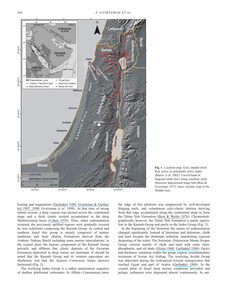
Fig. 1. Location map. Grey, shaded relief.
Red, active or potentially active faults
(Bartov et al. 2002). Curved band of
diagonal white lines along coastline, early
Mesozoic depositional hinge belt (Bein &
Gvirtzman 1977). Inset: tectonic map of the
Middle East.
Z . GVIRTZMAN ET AL.564
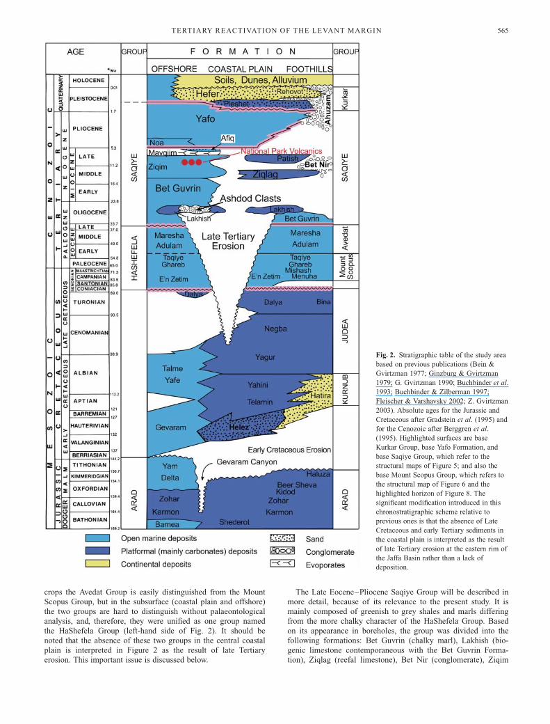
crops the Avedat Group is easily distinguished from the Mount
Scopus Group, but in the subsurface (coastal plain and offshore)
the two groups are hard to distinguish without palaeontological
analysis, and, therefore, they were unified as one group named
the HaShefela Group (left-hand side of Fig. 2). It should be
noted that the absence of these two groups in the central coastal
plain is interpreted in Figure 2 as the result of late Tertiary
erosion. This important issue is discussed below.
The Late Eocene–Pliocene Saqiye Group will be described in
more detail, because of its relevance to the present study. It is
mainly composed of greenish to grey shales and marls differing
from the more chalky character of the HaShefela Group. Based
on its appearance in boreholes, the group was divided into the
following formations: Bet Guvrin (chalky marl), Lakhish (bio-
genic limestone contemporaneous with the Bet Guvrin Forma-
tion), Ziqlag (reefal limestone), Bet Nir (conglomerate), Ziqim
Fig. 2. Stratigraphic table of the study area
based on previous publications (Bein &
Gvirtzman 1977; Ginzburg & Gvirtzman
1979; G. Gvirtzman 1990; Buchbinder et al.
1993; Buchbinder & Zilberman 1997;
Fleischer & Varshavsky 2002; Z. Gvirtzman
2003). Absolute ages for the Jurassic and
Cretaceous after Gradstein et al. (1995) and
for the Cenozoic after Berggren et al.
(1995). Highlighted surfaces are base
Kurkar Group, base Yafo Formation, and
base Saqiye Group, which refer to the
structural maps of Figure 5; and also the
base Mount Scopus Group, which refers to
the structural map of Figure 6 and the
highlighted horizon of Figure 8. The
significant modification introduced in this
chronostratigraphic scheme relative to
previous ones is that the absence of Late
Cretaceous and early Tertiary sediments in
the coastal plain is interpreted as the result
of late Tertiary erosion at the eastern rim of
the Jaffa Basin rather than a lack of
deposition.
TERTIARY REACTIVATION OF THE LEVANT MARGIN 565
(pelagic marl with tuff and basalt flows), Pattish (reefal lime-
stone), Mavqiim (anhydrite formed during the Messinian crisis),
and Yafo Formation (pelagic shales). Among these, the Yafo
Formation is the thickest and most homogeneous unit (Gvirtzman
& Reiss 1965; Buchbinder 1969; Gvirtzman 1970; Gvirtzman &
Buchbinder 1978; Buchbinder et al. 1986, 1993; Buchbinder &
Zilberman 1997; Gvirtzman et al. 1997).
The Saqiye Group represents several sequences of regression
and transgression that had formed a complicated pattern of
deposition. During sea-level falls deep canyons were incised
whereas during sea-level rises the canyons were flooded and
filled with sediments, and coral reefs developed on their
shoulders. At some point during the Pliocene sediment supply
from the Nile River was high enough to fill up all the canyons
and form a relatively flat surface on which the Pleistocene sandy
Kurkar Group was deposited.
The lithological boundary between the Saqiye and Kurkar
groups is clear and sharp. In contrast to the pelagic nature of the
Yafo Formation, the Kurkar Group is mainly clastic, containing a
variety of sediments: calcareous sandstones (some strongly ce-
mented and some loose), shaly to silty red sandstone (locally
named ‘Hamra’), marine and continental clays, conglomerates,
and sand dunes (Gvirtzman et al. 1984).
Motivation for the present study
A quantitative analysis of the sedimentary cover of the Levant
margin, offshore Israel, distinguishing between tectonic-driven
subsidence and sediment loading, shows that the post-rift
subsidence produced by lithospheric cooling continued tens of
millions of years after the early Mesozoic rifting (Garfunkel &
Derin 1984; Ten Brink 1987; Tibor et al. 1992; Gvirtzman &
Garfunkel 1998). This thermal subsidence decayed exponentially
as a function of the time that passed since rifting and became
very weak in the Late Cretaceous and early Tertiary. In the late
Tertiary, however, sedimentation in the Levant margins was
greatly enhanced, by rates faster than those of the early Mesozoic
rifting stage (Tibor et al. 1992). This enhanced sedimentation
was accompanied by renewal of the shelf-slope depositional
transition zone (Buchbinder & Zilberman 1997) after more than
50 Ma in which it had ceased to exist. At that time the Ziqlag
Formation (reefs) was deposited in a shallow marine environment
and the Bet Guvrin and Ziqim formations were deposited in the
open sea (Fig. 2). In addition, during the Miocene some
magmatism occurred in the coastal plain (Gvirtzman 1970;
Livnat 1974; Steinitz et al. 1978) after a very long quiescence;
namely, c. 150 Ma after the Jurassic magmatism that accompa-
nied continental breakup and margin formation, and c. 100 Ma
after the Cretaceous (mainly Early Cretaceous) magmatism that
was associated with intra-continental heating (Garfunkel 1988;
Gvirtzman & Garfunkel 1997, 1998).
The enhanced subsidence and sedimentation in the late
Tertiary produced the Saqiye Group, which thickens from zero c.
15 km east of the present coastline, to c. 2200 m along the
present coastline (e.g. Hof Ashdod-1 well, near the city of
Ashdod, Fig. 1). This pattern of rapid sedimentation continued in
the Quaternary, and the Kurkar Group thickens from zero c.
20 km east of the coastline, to c. 180 m under the coastline.
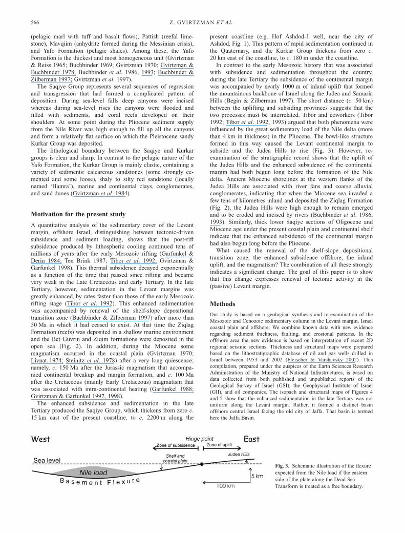
In contrast to the early Mesozoic history that was associated
with subsidence and sedimentation throughout the country,
during the late Tertiary the subsidence of the continental margin
was accompanied by nearly 1000 m of inland uplift that formed
the mountainous backbone of Israel along the Judea and Samaria
Hills (Begin & Zilberman 1997). The short distance (c. 50 km)
between the uplifting and subsiding provinces suggests that the
two processes must be interrelated. Tibor and coworkers (Tibor
1992; Tibor et al. 1992, 1993) argued that both phenomena were
influenced by the great sedimentary load of the Nile delta (more
than 4 km in thickness) in the Pliocene. The bowl-like structure
formed in this way caused the Levant continental margin to
subside and the Judea Hills to rise (Fig. 3). However, re-
examination of the stratigraphic record shows that the uplift of
the Judea Hills and the enhanced subsidence of the continental
margin had both begun long before the formation of the Nile
delta. Ancient Miocene shorelines at the western flanks of the
Judea Hills are associated with river fans and coarse alluvial
conglomerates, indicating that when the Miocene sea invaded a
few tens of kilometres inland and deposited the Ziqlag Formation
(Fig. 2), the Judea Hills were high enough to remain emerged
and to be eroded and incised by rivers (Buchbinder et al. 1986,
1993). Similarly, thick lower Saqiye sections of Oligocene and
Miocene age under the present coastal plain and continental shelf
indicate that the enhanced subsidence of the continental margin
had also begun long before the Pliocene.
What caused the renewal of the shelf-slope depositional
transition zone, the enhanced subsidence offshore, the inland
uplift, and the magmatism? The combination of all these strongly
indicates a significant change. The goal of this paper is to show
that this change expresses renewal of tectonic activity in the
(passive) Levant margin.
Methods
Our study is based on a geological synthesis and re-examination of the
Mesozoic and Cenozoic sedimentary column in the Levant margin, Israel
coastal plain and offshore. We combine known data with new evidence
regarding sediment thickness, faulting, and erosional patterns. In the
offshore area the new evidence is based on interpretation of recent 2D
regional seismic sections. Thickness and structural maps were prepared
based on the lithostratigraphic database of oil and gas wells drilled in
Israel between 1953 and 2002 (Fleischer & Varshavsky 2002). This
compilation, prepared under the auspices of the Earth Sciences Research
Administration of the Ministry of National Infrastructures, is based on
data collected from both published and unpublished reports of the
Geological Survey of Israel (GSI), the Geophysical Institute of Israel
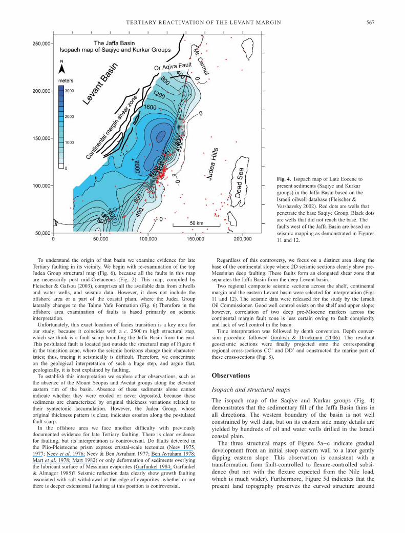
(GII), and oil companies. The isopach and structural maps of Figures 4
and 5 show that the enhanced sedimentation in the late Tertiary was not
uniform along the Levant margin. Rather, it formed a distinct basin
offshore central Israel facing the old city of Jaffa. That basin is termed
here the Jaffa Basin.
Fig. 3. Schematic illustration of the flexure
expected from the Nile load if the eastern
side of the plate along the Dead Sea
Transform is treated as a free boundary.
Z. GVIRTZMAN ET AL.566
To understand the origin of that basin we examine evidence for late
Tertiary faulting in its vicinity. We begin with re-examination of the top
Judea Group structural map (Fig. 6), because all the faults in this map
are necessarily post mid-Cretaceous (Fig. 2). This map, compiled by
Fleischer & Gafsou (2003), comprises all the available data from oilwells
and water wells, and seismic data. However, it does not include the
offshore area or a part of the coastal plain, where the Judea Group
laterally changes to the Talme Yafe Formation (Fig. 6).Therefore in the
offshore area examination of faults is based primarily on seismic
interpretation.
Unfortunately, this exact location of facies transition is a key area for
our study; because it coincides with a c. 2500 m high structural step,
which we think is a fault scarp bounding the Jaffa Basin from the east.
This postulated fault is located just outside the structural map of Figure 6
in the transition zone, where the seismic horizons change their character-
istics; thus, tracing it seismically is difficult. Therefore, we concentrate
on the geological interpretation of such a huge step, and argue that,
geologically, it is best explained by faulting.
To establish this interpretation we explore other observations, such as
the absence of the Mount Scopus and Avedat groups along the elevated
eastern rim of the basin. Absence of these sediments alone cannot
indicate whether they were eroded or never deposited, because these
sediments are characterized by original thickness variations related to
their syntectonic accumulation. However, the Judea Group, whose
original thickness pattern is clear, indicates erosion along the postulated
fault scarp.
In the offshore area we face another difficulty with previously
documented evidence for late Tertiary faulting. There is clear evidence
for faulting, but its interpretation is controversial. Do faults detected in
the Plio-Pleistocene prism express crustal-scale tectonics (Neev 1975,
1977; Neev et al. 1976; Neev & Ben Avraham 1977; Ben Avraham 1978;
Mart et al. 1978; Mart 1982) or only deformation of sediments overlying
the lubricant surface of Messinian evaporites (Garfunkel 1984; Garfunkel
& Almagor 1985)? Seismic reflection data clearly show growth faulting
associated with salt withdrawal at the edge of evaporites; whether or not
there is deeper extensional faulting at this position is controversial.
Regardless of this controversy, we focus on a distinct area along the
base of the continental slope where 2D seismic sections clearly show pre-
Messinian deep faulting. These faults form an elongated shear zone that
separates the Jaffa Basin from the deep Levant basin.
Two regional composite seismic sections across the shelf, continental
margin and the eastern Levant basin were selected for interpretation (Figs
11 and 12). The seismic data were released for the study by the Israeli
Oil Commissioner. Good well control exists on the shelf and upper slope;
however, correlation of two deep pre-Miocene markers across the
continental margin fault zone is less certain owing to fault complexity
and lack of well control in the basin.
Time interpretation was followed by depth conversion. Depth conver-
sion procedure followed Gardosh & Druckman (2006). The resultant
geoseismic sections were finally projected onto the corresponding
regional cross-sections CC9 and DD9 and constructed the marine part of
these cross-sections (Fig. 8).
Observations
Isopach and structural maps
The isopach map of the Saqiye and Kurkar groups (Fig. 4)
demonstrates that the sedimentary fill of the Jaffa Basin thins in
all directions. The western boundary of the basin is not well
constrained by well data, but on its eastern side many details are
yielded by hundreds of oil and water wells drilled in the Israeli
coastal plain.
The three structural maps of Figure 5a–c indicate gradual
development from an initial steep eastern wall to a later gently
dipping eastern slope. This observation is consistent with a
transformation from fault-controlled to flexure-controlled subsi-
dence (but not with the flexure expected from the Nile load,
which is much wider). Furthermore, Figure 5d indicates that the
present land topography preserves the curved structure around
Fig. 4. Isopach map of Late Eocene to
present sediments (Saqiye and Kurkar
groups) in the Jaffa Basin based on the
Israeli oilwell database (Fleischer &
Varshavsky 2002). Red dots are wells that
penetrate the base Saqiye Group. Black dots
are wells that did not reach the base. The
faults west of the Jaffa Basin are based on
seismic mapping as demonstrated in Figures
11 and 12.
TERTIARY REACTIVATION OF THE LEVANT MARGIN 567
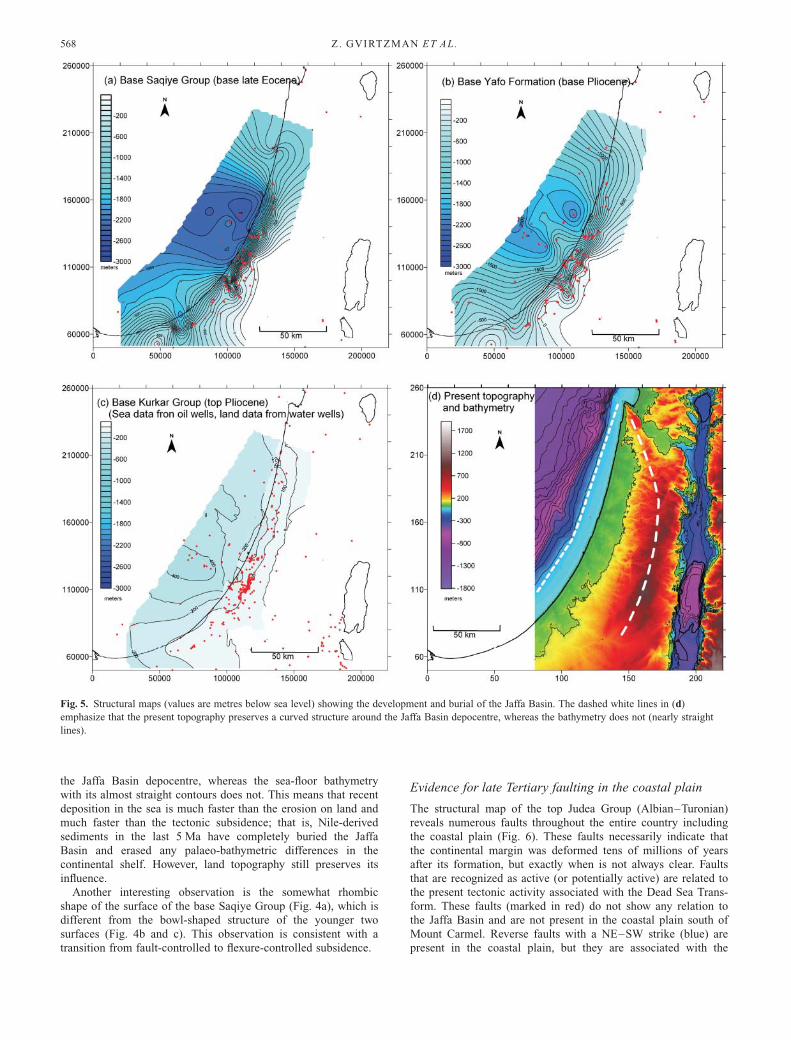
the Jaffa Basin depocentre, whereas the sea-floor bathymetry
with its almost straight contours does not. This means that recent
deposition in the sea is much faster than the erosion on land and
much faster than the tectonic subsidence; that is, Nile-derived
sediments in the last 5 Ma have completely buried the Jaffa
Basin and erased any palaeo-bathymetric differences in the
continental shelf. However, land topography still preserves its
influence.
Another interesting observation is the somewhat rhombic
shape of the surface of the base Saqiye Group (Fig. 4a), which is
different from the bowl-shaped structure of the younger two
surfaces (Fig. 4b and c). This observation is consistent with a
transition from fault-controlled to flexure-controlled subsidence.
Evidence for late Tertiary faulting in the coastal plain
The structural map of the top Judea Group (Albian–Turonian)
reveals numerous faults throughout the entire country including
the coastal plain (Fig. 6). These faults necessarily indicate that
the continental margin was deformed tens of millions of years
after its formation, but exactly when is not always clear. Faults
that are recognized as active (or potentially active) are related to
the present tectonic activity associated with the Dead Sea Trans-
form. These faults (marked in red) do not show any relation to
the Jaffa Basin and are not present in the coastal plain south of
Mount Carmel. Reverse faults with a NE–SW strike (blue) are
present in the coastal plain, but they are associated with the
Fig. 5. Structural maps (values are metres below sea level) showing the development and burial of the Jaffa Basin. The dashed white lines in (d)
emphasize that the present topography preserves a curved structure around the Jaffa Basin depocentre, whereas the bathymetry does not (nearly straight
lines).
Z. GVIRTZMAN ET AL.568

Fig. 6. The top Judea Group structural map (Fleischer & Gafsou 2003). Bold lines represent major faults; fine lines represent minor faults. Red, faults
defined as active or potentially active (Bartov et al. 2002). Blue, reverse faults associated with Syrian Arc folds. Black, normal faults. The grey area at the
eastern rim of the Jaffa Basin represents a truncation band where the top of the Judea Group is truncated by the base Saqiye Group. West of that band the
Saqiye Group unconformably covers the Talme Yafe Formation. 1, Pardes Hanna water well; 2, Netanya 1 oilwell; 3, Hadera 1 oilwell; 4, Caesarea 1
oilwell; 5, Ashdod 3 oilwell; 6, Netanya 2 oilwell; 7, Hof Asdod 1 oilwell. BR is the Bet Rosh outcrop referred to in Figure 10.
TERTIARY REACTIVATION OF THE LEVANT MARGIN 569

Syrian Arc folds formed in the Late Cretaceous and early
Tertiary and not with the Jaffa Basin. However, what about the
rest of the faults in Figure 6, which are recognized as normal?
Are they related to the Syrian Arc stress regime? If not, when
and how did they form?
Miocene faulting in the coastal plain was suggested more than
30 years ago (Gvirtzman 1970) based on well data and on the
very little seismic information available at that time (Fig. 7). It
suggested displacement of Oligocene and Early Miocene forma-
tions and not Middle Miocene and younger units. Twenty-three
years later a set of cross-sections based on a large amount of
seismic material (Fleischer et al. 1993) confirmed the existence
of late Tertiary faulting in the Sharon region (just south of Mount
Carmel; see Fig. 1 for location), but it was not possible to
determine the age of faulting in the central and southern coastal
plain. In those regions faults are clearly detected up to the top
Judea Group, but their continuation into the Mount Scopus,
Avedat, and Lower Saqiye groups is unclear. Other studies, on
the other hand, did trace faults continuing upward and displacing
Oligocene, Miocene and even the base Pliocene Yafo Formation
(Gelberman 1995).
In light of the difficulty in using seismic data for tracing faults
in the facies hinge belt, we now concentrate on the nearly
2000 m high structural step that forms the eastern wall of the
Jaffa Basin in the subsurface of the coastal plain (section DD9 in
Fig. 8). That step is best detected by the base Senonian horizon,
which is 200–300 m below sea level on the eastern side (top
Judea Gr.) and 2000–3000 m below sea level on the western side
(top Talme Yafe Fm.). Between these areas, the Mount Scopus,
Avedat, and part of the Judea Group are missing. We argue that
this structural step was produced by faulting and that the absence
of the Avedat, Mount Scopus, and part of the Judea Group
indicates erosion of the fault scarp and not original non-
deposition (see discussion). In addition, the presence of a thick
lower Saqiye Group with coarse clastic deposits (the ‘Ashdod
Clasts’ in section DD9) at the foothills of the eroded cliff
strongly supports this interpretation.
The coastal plain fault does not continue beyond the immedi-
ate vicinity of the Jaffa Basin. To the north it dies away in the
Sharon region, where it meets the EW Or Aqiva fault, and does
not continue into the Carmel block (Fig. 4). To the south the
high structural step gradually disappears, but whether or not the
fault continues into the Sinai Peninsula without a noticeable
vertical displacement is unclear at this stage.
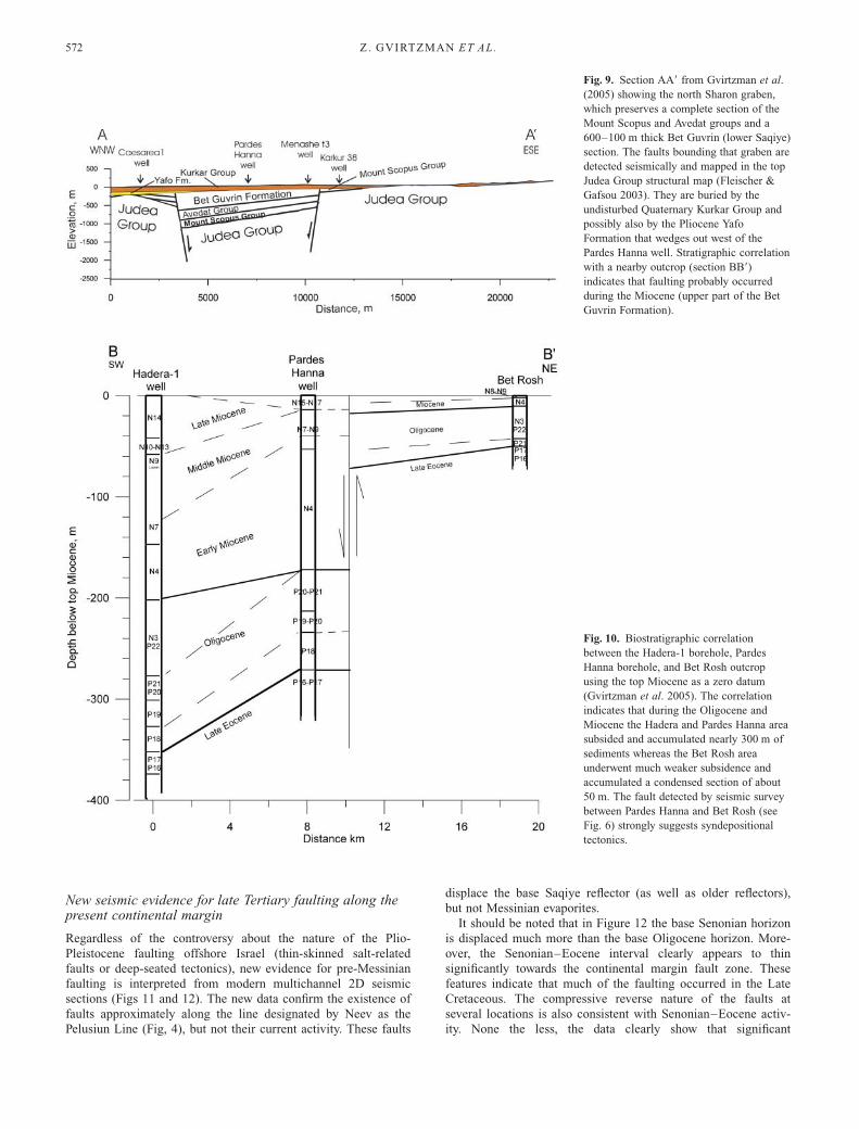
The Sharon graben
In the Sharon region, NE of the Jaffa Basin, a local graben
preserving a unique 200–700 m thick Oligocene–Miocene
section is detected (Fig. 9). This graben is located outside the
Jaffa Basin (Figs 1 and 6) and its vertical throw is not as
large, but it has the potential to provide good age constraints
on faulting. The preservation of the Bet Guvrin Formation in it
and not in its immediate vicinity indicates either post- or syn-
Bet Guvrin faulting, but the Bet Guvrin Formation spans more
than 20 Ma.
To better constrain the age of the faulting, a high-resolution
biostratigraphic study was recently conducted on three water
wells within the Sharon graben (Gvirtzman et al. 2005). Com-
parison of the Sharon graben with the Bet Rosh outcrop, 20 km
to the NE, is shown in Figure 10. The correlation shows that the
c. 300 m thick Oligocene–Miocene section in the Hadera-1 and
Pardes Hanna boreholes is represented by a condensed c. 40 m
thick section in the Bet Rosh outcrop. Whereas the lateral
thickness variations in the Oligocene section may be interpreted
as a gradual change in the subsidence rates, the abrupt thickness
variation of the Miocene section across the eastern fault of the
graben seems to indicate syndepositional faulting during the
Miocene.
Curved band of truncation at the eastern rim of the JaffaBasin
The unconformity at the base of the Saqiye Group is a well-
known phenomenon in the subsurface of the Israeli coastal plain
(Gvirtzman 1970; Gvirtzman & Buchbinder 1978). The amount
of truncation expressed by this unconformity, however, is not
clear. The absence of the Mount Scopus and Avedat groups
(Santonian–Middle Eocene) alone does not necessarily indicate
mid- or late Tertiary erosion, because these groups are char-
acterized by large original thickness variations caused by the
Syrian Arc folding. However, the amount of truncation of the
underlying Judea Group (Albian–Turonian), whose original
thickness can be evaluated more precisely, allows better evalua-
tion of the late Tertiary erosion. The region in which the Judea
Group is truncated and covered by the Saqiye Group is shown
in Figure 6. Not surprisingly, the curved band of truncation
perfectly fits the eastern rim of the Jaffa Basin and not the
Syrian Arc structures.
Based on coincidence between the spatial distribution of the
truncation and the eastern wall of the Jaffa Basin, and on the
observation that the truncated Turonian rocks (Judea Group) are
covered by upper Saqiye Group sediments, we suggest that uplift
and erosion of the basin shoulder occurred at the same time as
deposition of the lower Saqiye sediments in it. The deep canyonsFig. 7. Longitudinal and transverse faults of Miocene age based on a
study of more than 1000 wells (Gvirtzman 1970).
Z. GVIRTZMAN ET AL.570

crossing the elevated eastern shoulder of the basin are well seen
in the top Judea structural map (Fig. 6). Thirty years ago they
were related to the Messinian desiccation crisis of c. 6 Ma
(Gvirtzman & Buchbinder 1978), but later it was suggested that
much of the incision occurred during the Oligocene and Miocene
(Druckman et al. 1995), and a recent revision of the biostrati-
graphic data further constrains the first incision event to Mid–
Late Oligocene and not earlier (Buchbinder et al. 2005).
Fig. 8. DD9 is a regional geological cross-section from the Dead Sea to the Levant basin crossing the Jaffa Basin at its centre. CC9 is a parallel cross-
section from the Jordan Valley to the Levant basin crossing the Jaffa Basin near its northern edge, where the coastal plain fault does not exist (for section
location see Figs 6 and 13). In the offshore area cross-sections CC9 and DD9 are geoseismic. The original interpreted time sections are shown in Figures
11 and 12. The base Senonian horizon (top Judea group laterally changing to top Talme Yafe Formation) is highlighted by a thicker line.
TERTIARY REACTIVATION OF THE LEVANT MARGIN 571
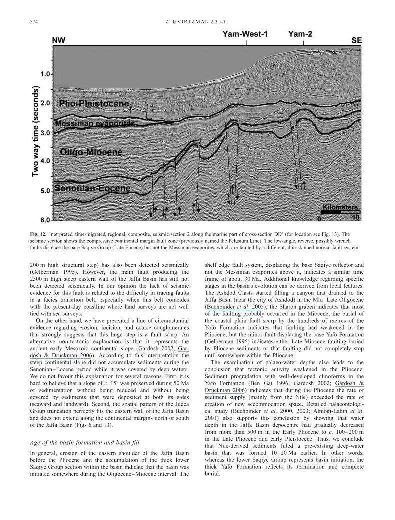
New seismic evidence for late Tertiary faulting along thepresent continental margin
Regardless of the controversy about the nature of the Plio-
Pleistocene faulting offshore Israel (thin-skinned salt-related
faults or deep-seated tectonics), new evidence for pre-Messinian
faulting is interpreted from modern multichannel 2D seismic
sections (Figs 11 and 12). The new data confirm the existence of
faults approximately along the line designated by Neev as the
Pelusiun Line (Fig, 4), but not their current activity. These faults
displace the base Saqiye reflector (as well as older reflectors),
but not Messinian evaporites.
It should be noted that in Figure 12 the base Senonian horizon
is displaced much more than the base Oligocene horizon. More-
over, the Senonian–Eocene interval clearly appears to thin
significantly towards the continental margin fault zone. These
features indicate that much of the faulting occurred in the Late
Cretaceous. The compressive reverse nature of the faults at
several locations is also consistent with Senonian–Eocene activ-
ity. None the less, the data clearly show that significant
Fig. 9. Section AA9 from Gvirtzman et al.
(2005) showing the north Sharon graben,
which preserves a complete section of the
Mount Scopus and Avedat groups and a
600–100 m thick Bet Guvrin (lower Saqiye)
section. The faults bounding that graben are
detected seismically and mapped in the top
Judea Group structural map (Fleischer &
Gafsou 2003). They are buried by the
undisturbed Quaternary Kurkar Group and
possibly also by the Pliocene Yafo
Formation that wedges out west of the
Pardes Hanna well. Stratigraphic correlation
with a nearby outcrop (section BB9)
indicates that faulting probably occurred
during the Miocene (upper part of the Bet
Guvrin Formation).
Fig. 10. Biostratigraphic correlation
between the Hadera-1 borehole, Pardes
Hanna borehole, and Bet Rosh outcrop
using the top Miocene as a zero datum
(Gvirtzman et al. 2005). The correlation
indicates that during the Oligocene and
Miocene the Hadera and Pardes Hanna area
subsided and accumulated nearly 300 m of
sediments whereas the Bet Rosh area
underwent much weaker subsidence and
accumulated a condensed section of about
50 m. The fault detected by seismic survey
between Pardes Hanna and Bet Rosh (see
Fig. 6) strongly suggests syndepositional
tectonics.
Z. GVIRTZMAN ET AL.572
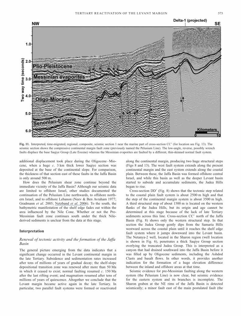
additional displacement took place during the Oligocene–Mio-
cene, when a huge c. 3 km thick lower Saqiye section was
deposited at the base of the continental slope. For comparison,
the thickness of that section east of these faults in the Jaffa Basin
is only around 500 m.
How does the Pelusium shear zone continue beyond the
immediate vicinity of the Jaffa Basin? Although our seismic data
are limited to offshore Israel, other studies documented the
continuation of the Pelusium Line northwards, to offshore north-
ern Israel, and to offshore Lebanon (Neev & Ben Avraham 1977;
Gradmann et al. 2005; Netzband et al. 2006). To the south, the
bathymetric manifestation of the shelf edge fades out within the
area influenced by the Nile Cone. Whether or not the Pre-
Messinian fault zone continues south under the thick Nile-
derived sediments is unclear from the data at this stage.
Interpretation
Renewal of tectonic activity and the formation of the JaffaBasin
The general picture emerging from the data indicates that a
significant change occurred in the Levant continental margin in
the late Tertiary. Subsidence and sedimentation rates increased
after tens of millions of years of gradual decay; the shelf-slope
depositional transition zone was renewed after more than 50 Ma
in which it ceased to exist; normal faulting resumed c. 150 Ma
after the last rifting event; and magmatism resumed after tens of
millions of years of quiescence. Altogether we conclude that the
Levant margin became active again in the late Tertiary. In
particular, two parallel fault systems were formed or reactivated
along the continental margin, producing two huge structural steps
(Figs 8 and 13). The west fault system extends along the present
continental margin and the east system extends along the coastal
plain. Between these, the Jaffa Basin was formed offshore central
Israel, and while this basin as well as the deeper Levant basin
started to subside and accumulate sediments, the Judea Hills
began to rise.
Cross-section DD9 (Fig. 8) shows that the tectonic step related
to the coastal plain fault system is about 2500 m high and that
the step of the continental margin system is about 3500 m high.
A third structural step of about 1500 m is located on the western
flanks of the Judea Hills, but its origin and age cannot be
determined at this stage because of the lack of late Tertiary
sediments across this line. Cross-section CC9 north of the Jaffa
Basin (Fig. 8) shows only the western structural step. In that
section the Judea Group gently dips from the Samaria Hills
westward across the coastal plain until it reaches the shelf edge
fault system where it jumps downward into the Levant basin.
The Netanya-2 well, located in the Sharon region (well location
is shown in Fig. 6), penetrates a thick Saqiye Group section
overlying the truncated Judea Group. This is interpreted as a
canyon that had drained southward into the Jaffa Basin before it
was filled up by Oligocene sediments, including the Ashdod
Clasts and basalt flows. In other words, it provides another
indication for the formation of a huge elevation difference
between the inland and offshore areas at that time.
Seismic evidence for pre-Messinian faulting along the western
system (the Pelusium Line) is now clear, but seismic evidence
for the eastern system and its branches is incomplete. The
Sharon graben at the NE rims of the Jaffa Basin is detected
seismically; a minor fault east of the main postulated fault (the
Fig. 11. Interpreted, time-migrated, regional, composite, seismic section 1 near the marine part of cross-section CC9 (for location see Fig. 13). The
seismic section shows the compressive continental margin fault zone (previously named the Pelusium Line). The low-angle, reverse, possibly wrench
faults displace the base Saqiye Group (Late Eocene) whereas the Messinian evaporites are faulted by a different, thin-skinned normal fault system.
TERTIARY REACTIVATION OF THE LEVANT MARGIN 573
200 m high structural step) has also been detected seismically
(Gelberman 1995). However, the main fault producing the
2500 m high steep eastern wall of the Jaffa Basin has still not
been detected seismically. In our opinion the lack of seismic
evidence for this fault is related to the difficulty in tracing faults
in a facies transition belt, especially when this belt coincides
with the present-day coastline where land surveys are not well
tied with sea surveys.
On the other hand, we have presented a line of circumstantial
evidence regarding erosion, incision, and coarse conglomerates
that strongly suggests that this huge step is a fault scarp. An
alternative non-tectonic explanation is that it represents the
ancient early Mesozoic continental slope (Gardosh 2002; Gar-
dosh & Druckman 2006). According to this interpretation the
steep continental slope did not accumulate sediments during the
Senonian–Eocene period while it was covered by deep waters.
We do not favour this explanation for several reasons. First, it is
hard to believe that a slope of c. 158 was preserved during 50 Ma
of sedimentation without being reduced and without being
covered by sediments that were deposited at both its sides
(seaward and landward). Second, the spatial pattern of the Judea
Group truncation perfectly fits the eastern wall of the Jaffa Basin
and does not extend along the continental margins north or south
of the Jaffa Basin (Figs 6 and 13).
Age of the basin formation and basin fill
In general, erosion of the eastern shoulder of the Jaffa Basin
before the Pliocene and the accumulation of the thick lower
Saqiye Group section within the basin indicate that the basin was
initiated somewhere during the Oligocene–Miocene interval. The
shelf edge fault system, displacing the base Saqiye reflector and
not the Messinian evaporites above it, indicates a similar time
frame of about 30 Ma. Additional knowledge regarding specific
stages in the basin’s evolution can be derived from local features.
The Ashdod Clasts started filling a canyon that drained to the
Jaffa Basin (near the city of Ashdod) in the Mid–Late Oligocene
(Buchbinder et al. 2005); the Sharon graben indicates that most
of the faulting probably occurred in the Miocene; the burial of
the coastal plain fault scarp by the hundreds of metres of the
Yafo Formation indicates that faulting had weakened in the
Pliocene; but the minor fault displacing the base Yafo Formation
(Gelberman 1995) indicates either Late Miocene faulting buried
by Pliocene sediments or that faulting did not completely stop
until somewhere within the Pliocene.
The examination of palaeo-water depths also leads to the
conclusion that tectonic activity weakened in the Pliocene.
Sediment progradation with well-developed clinoforms in the
Yafo Formation (Ben Gai 1996; Gardosh 2002; Gardosh &
Druckman 2006) indicates that during the Pliocene the rate of
sediment supply (mainly from the Nile) exceeded the rate of
creation of new accommodation space. Detailed palaeontologi-
cal study (Buchbinder et al. 2000, 2003; Almogi-Labin et al.
2001) also supports this conclusion by showing that water
depth in the Jaffa Basin depocentre had gradually decreased
from more than 500 m in the Early Pliocene to c. 100–200 m
in the Late Pliocene and early Pleistocene. Thus, we conclude
that Nile-derived sediments filled a pre-existing deep-water
basin that was formed 10–20 Ma earlier. In other words,
whereas the lower Saqiye Group represents basin initiation, the
thick Yafo Formation reflects its termination and complete
burial.
Fig. 12. Interpreted, time-migrated, regional, composite, seismic section 2 along the marine part of cross-section DD9 (for location see Fig. 13). The
seismic section shows the compressive continental margin fault zone (previously named the Pelusium Line). The low-angle, reverse, possibly wrench
faults displace the base Saqiye Group (Late Eocene) but not the Messinian evaporites, which are faulted by a different, thin-skinned normal fault system.
Z. GVIRTZMAN ET AL.574
Tectonic framework
The formation of the Jaffa Basin as well as the uplift of the
Judea Hills predated the main activity on the Dead Sea Trans-
form by c. 15 Ma. The Dead Sea Transform was initiated at
around the Middle Miocene and a third of its strike-slip activity
occurred in the Plio-Pleistocene (Garfunkel & Joffe 1987;
Garfunkel 1988; Bosworth et al. 2005). The Jaffa Basin was
initiated in the Mid- or Late Oligocene; it was mainly active in
the Miocene; and it gradually decayed and was buried by
sediments in the Plio-Pleistocene.
What else happened in the region in the Late Oligocene and
Early Miocene? At that time Africa and Arabia were breaking
apart and the Red Sea was opening. At the northern tip of the
Red Sea rifting was concentrated in the Gulf of Suez, which was
initiated in the latest Oligocene and Early Miocene; it was mostly
active during the Early–Mid-Miocene; and diminished in the
Pliocene (Garfunkel & Bartov 1977; Scott & Govean 1985;
Steckler & ten Brink 1986; Steckler et al. 1988). In other words,
the Jaffa Basin is coeval with the Suez Rift; they were both
formed at the early stage of the Africa–Arabia breakup and
abandoned when most of the plate motion jumped inland to the
Dead Sea Transform (Steckler & ten Brink 1986).
In northern Israel, extensional tectonics predating the Dead
Sea Transform is known from the Yizreel Valley (Schulman
1962; Freund 1970; Shaliv 1991), which is a half-graben that
developed in the Early Miocene along the Carmel Fault (Matmon
et al. 2003). The NW continuation of that half-graben is the
Haifa basin offshore the city of Haifa (Schattner et al. 2006) and,
not surprisingly, its sedimentary fill is similar to that of the Jaffa
Basin; that is, synrift sediments between the Mid-Oligocene and
Early Miocene, and post-rift burial by Pliocene sediments
(Schattner et al. 2006). Furthermore, Schattner et al. suggested
that the Haifa basin is the NW tip of the Qishon–Sirhan rift
system that developed in conjunction with the Red Sea–Suez
graben system. However, in contrast to the Jaffa Basin and the
Suez Rift, which were abandoned when the Dead Sea Transform
took most of the plate motion, the Qishon graben was reactivated
and became an active branch of the Dead Sea Transform
(Schattner et al. 2006).
What is the relationship between the two NW–SE-trending
rifts, the Gulf of Suez and the Yizreel–Qishon–Haifa system
(Carmel Fault), and the reactivation of the Levant margin? Were
they all part of the early Africa–Arabia breakup prior to plate
motion shifting inland? The northward continuation of the Red
Sea extension north of the Gulf of Suez continues to be a
mystery. The Early Miocene opening of the Gulf of Suez
decreases northwards, but is still significant when the rift
disappears beneath the Nile Delta (Steckler et al. 1988). Various
proposals suggest that it continues either to the west (Courtillot
et al. 1987), to the north (Mascle et al. 2000), or to the east
(Steckler & ten Brink 1986). Here we raise the possibility that it
terminates at the point where it meets a left-lateral strike-slip
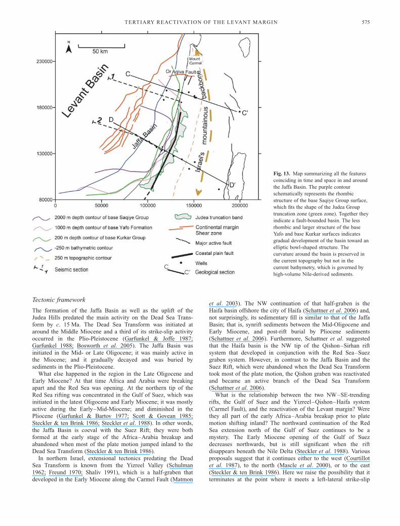
Fig. 13. Map summarizing all the features
coinciding in time and space in and around
the Jaffa Basin. The purple contour
schematically represents the rhombic
structure of the base Saqiye Group surface,
which fits the shape of the Judea Group
truncation zone (green zone). Together they
indicate a fault-bounded basin. The less
rhombic and larger structure of the base
Yafo and base Kurkar surfaces indicates
gradual development of the basin toward an
elliptic bowl-shaped structure. The
curvature around the basin is preserved in
the current topography but not in the
current bathymetry, which is governed by
high-volume Nile-derived sediments.
TERTIARY REACTIVATION OF THE LEVANT MARGIN 575
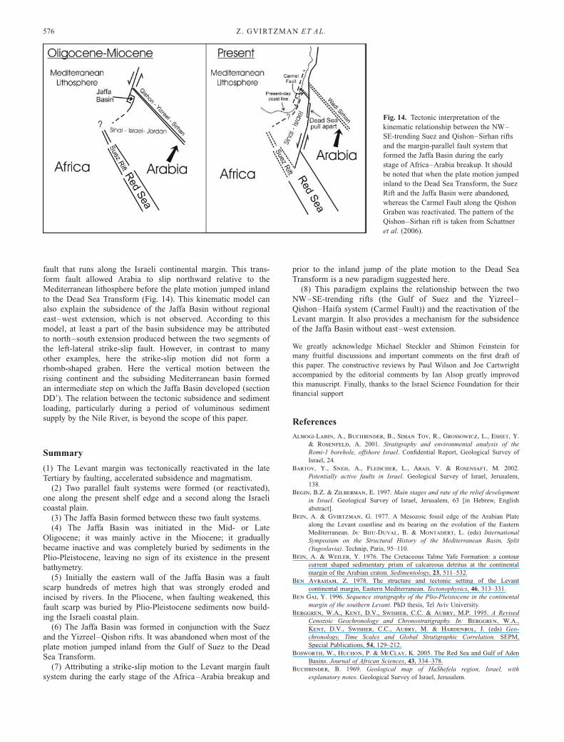
fault that runs along the Israeli continental margin. This trans-
form fault allowed Arabia to slip northward relative to the
Mediterranean lithosphere before the plate motion jumped inland
to the Dead Sea Transform (Fig. 14). This kinematic model can
also explain the subsidence of the Jaffa Basin without regional
east–west extension, which is not observed. According to this
model, at least a part of the basin subsidence may be attributed
to north–south extension produced between the two segments of
the left-lateral strike-slip fault. However, in contrast to many
other examples, here the strike-slip motion did not form a
rhomb-shaped graben. Here the vertical motion between the
rising continent and the subsiding Mediterranean basin formed
an intermediate step on which the Jaffa Basin developed (section
DD9). The relation between the tectonic subsidence and sediment
loading, particularly during a period of voluminous sediment
supply by the Nile River, is beyond the scope of this paper.
Summary
(1) The Levant margin was tectonically reactivated in the late
Tertiary by faulting, accelerated subsidence and magmatism.
(2) Two parallel fault systems were formed (or reactivated),
one along the present shelf edge and a second along the Israeli
coastal plain.
(3) The Jaffa Basin formed between these two fault systems.
(4) The Jaffa Basin was initiated in the Mid- or Late
Oligocene; it was mainly active in the Miocene; it gradually
became inactive and was completely buried by sediments in the
Plio-Pleistocene, leaving no sign of its existence in the present
bathymetry.
(5) Initially the eastern wall of the Jaffa Basin was a fault
scarp hundreds of metres high that was strongly eroded and
incised by rivers. In the Pliocene, when faulting weakened, this
fault scarp was buried by Plio-Pleistocene sediments now build-
ing the Israeli coastal plain.
(6) The Jaffa Basin was formed in conjunction with the Suez
and the Yizreel–Qishon rifts. It was abandoned when most of the
plate motion jumped inland from the Gulf of Suez to the Dead
Sea Transform.
(7) Attributing a strike-slip motion to the Levant margin fault
system during the early stage of the Africa–Arabia breakup and
prior to the inland jump of the plate motion to the Dead Sea
Transform is a new paradigm suggested here.
(8) This paradigm explains the relationship between the two
NW–SE-trending rifts (the Gulf of Suez and the Yizreel–
Qishon–Haifa system (Carmel Fault)) and the reactivation of the
Levant margin. It also provides a mechanism for the subsidence
of the Jaffa Basin without east–west extension.
We greatly acknowledge Michael Steckler and Shimon Feinstein for
many fruitful discussions and important comments on the first draft of
this paper. The constructive reviews by Paul Wilson and Joe Cartwright
accompanied by the editorial comments by Ian Alsop greatly improved
this manuscript. Finally, thanks to the Israel Science Foundation for their
financial support
References
Almogi-Labin, A., Buchbinder, B., Siman Tov, R., Grossowicz, L., Eshet, Y.
& Rosenfeld, A. 2001. Stratigraphy and environmental analysis of the
Romi-1 borehole, offshore Israel. Confidential Report, Geological Survey of
Israel, 24.
Bartov, Y., Sneh, A., Fleischer, L., Arad, V. & Rosensaft, M. 2002.
Potentially active faults in Israel. Geological Survey of Israel, Jerusalem,
138.
Begin, B.Z. & Zilberman, E. 1997. Main stages and rate of the relief development
in Israel. Geological Survey of Israel, Jerusalem, 63 [in Hebrew, English
abstract].
Bein, A. & Gvirtzman, G. 1977. A Mesozoic fossil edge of the Arabian Plate
along the Levant coastline and its bearing on the evolution of the Eastern
Mediterranean. In: Biju-Duval, B. & Montadert, L. (eds) International
Symposium on the Structural History of the Mediterranean Basin, Split
(Yugoslavia). Technip, Paris, 95–110.
Bein, A. & Weiler, Y. 1976. The Cretaceous Talme Yafe Formation: a contour
current shaped sedimentary prism of calcareous detritus at the continental
margin of the Arabian craton. Sedimentology, 23, 511–532.
Ben Avraham, Z. 1978. The structure and tectonic setting of the Levant
continental margin, Eastern Mediterranean. Tectonophysics, 46, 313–331.
Ben Gai, Y. 1996. Sequence stratigraphy of the Plio-Pleistocene in the continental
margin of the southern Levant. PhD thesis, Tel Aviv University.
Berggren, W.A., Kent, D.V., Swisher, C.C. & Aubry, M.P. 1995. A Revised
Cenozoic Geochronology and Chronostratigraphy. In: Berggren, W.A.,
Kent, D.V., Swisher, C.C., Aubry, M. & Hardenbol, J. (eds) Geo-
chronology, Time Scales and Global Stratigraphic Correlation. SEPM,
Special Publications, 54, 129–212.
Bosworth, W., Huchon, P. & McClay, K. 2005. The Red Sea and Gulf of Aden
Basins. Journal of African Sciences, 43, 334–378.
Buchbinder, B. 1969. Geological map of HaShefela region, Israel, with
explanatory notes. Geological Survey of Israel, Jerusalem.
Fig. 14. Tectonic interpretation of the
kinematic relationship between the NW–
SE-trending Suez and Qishon–Sirhan rifts
and the margin-parallel fault system that
formed the Jaffa Basin during the early
stage of Africa–Arabia breakup. It should
be noted that when the plate motion jumped
inland to the Dead Sea Transform, the Suez
Rift and the Jaffa Basin were abandoned,
whereas the Carmel Fault along the Qishon
Graben was reactivated. The pattern of the
Qishon–Sirhan rift is taken from Schattner
et al. (2006).
Z. GVIRTZMAN ET AL.576

Buchbinder, B. & Zilberman, E. 1997. Sequence stratigraphy of Miocene–
Pliocene carbonate–siliciclastic shelf deposits in the eastern Mediterranean
margin (Israel): effects of eustasy and tectonics. Sedimentary Geology, 112,
7–32.
Buchbinder, B., Sneh, A. & Diamant, E. 1986. The Neogene Beit Nir
Conglomerate: a study of alluvial aggradation along the toe of the Judean
monocline. Israel Journal of Earth Sciences, 35, 183–196.
Buchbinder, B., Martinotti, G., Siman Tov, R. & Zilberman, E. 1993.
Temporal and spatial relationships in Miocene reef carbonate in Israel.
Palaeogeography, Palaeoclimatology, Palaeoecology, 101, 97–116.
Buchbinder, B., Siman Tov, R., Eshet, Y., Grossowicz, L. & Almogi-Labin,
A. 2000. Stratigraphic and environmental analysis of the Nir-1 well, offshore
Israel. Confidential Report, Geological Survey of Israel, 21.
Buchbinder, B., Calvo, R., Siman Tov, R., Grossowicz, L. & Almogi-Labin,
A. 2003. Stratigraphy and environmental analysis of the Nir-2 borehole,
offshore Israel. Confidential Report, Geological Survey of Israel, 20.
Buchbinder, B., Calvo, R. & Siman Tov, R. 2005. The Oligocene in Israel: A
marine realm with intermittent denudation accompanied by mass-flow
deposition. Israel Journal of Earth Sciences, 54, 63–85.
Cohen, Z. 1976. Early Cretaceous buried canyon: Influence on accumulation of
hydrocarbons in Helez Oil Fiel Israel. AAPG Bulletin, 60, 106–114.
Courtillot, V., Armijo, R. & Tapponnier, P. 1987. The Sinai triple junction
revisited. Tectonophysics, 141, 181–190.
Druckman, Y. 1974. The stratigraphy of the Triassic sequence in southern Israel.
Geological Survey of Israel Bulletin, 64, 92.
Druckman, Y., Giller, D., Fleischer, L., Gelberman, E. & Wolf, O. 1995.
Subsurface geology and structural evolution of the northwestern Negev,
southern Israel. Israel Journal of Earth Sciences, 44, 115–135.
Fleischer, L. & Gafsou, R. 2003. Top Judea Group digital structural map of
Israel, Scale 1:200 000 (2 sheets). Geophysical Institute of Israel, Jerusalem.
Fleischer, L. & Varshavsky, A. 2002. A lithostratigraphic data base of oil and
gas wells drilled in Israel. Ministry of National Infrastructures, Earth
Sciences Research Administration, Oil and Gas Unit, Jerusalem, 280.
Fleischer, L., Gelberman, E. & Wolf, O. 1993. A geological–geophysical
reassessment of the Judea Group. Institute of Petroleum Research and
Geophysics, Holon.
Flexer, A. 1968. Stratigraphy and facies development of the Mount Scopus Group
(Senonian–Paleocene) in Israel and adjacent countries. Israel Journal of
Earth Sciences, 17, 85–114.
Freund, R. 1970. The geometry of faulting in the Galilee. Israel Journal of Earth
Sciences, 19, 117–140.
Freund, R., Goldberg, M., Weissbrod, T., Druckman, Y. & Derin, B. 1975.
The Triassic–Jurassic structure of Israel and its relation to the origin of the
Eastern Mediterranean. Geological Survey of Israel Bulletin, 65, 1–26.
Gardosh, M. 2002. Sequence stratigraphy and petroleum systems of the Mesozoic,
southeastern Mediterranean continental margin. PhD thesis, Tel Aviv
University.
Gardosh, M. & Druckman, Y. 2006. Stratigraphy and tectonic evolution of the
Levantine Basin, offshore Israel. In: Robertson, A.H.F. & Mountrakis, D.
(eds) Tectonic Development of the Eastern Mediterranean. Geological
Society, London, Special Publications, 260, 201–227.
Garfunkel, Z. 1984. Large-scale submarine rotational slumps and growth faults in
the eastern Mediterranean. Marine Geology, 55, 304–324.
Garfunkel, Z. 1988. The pre-Quaternary geology of Israel. In: Yom Tov, Y. &
Tchernov, E. (eds) The Zoogeography of Israel. W. Junk, Dordrecht, 7–34.
Garfunkel, Z. 1998. Constraints on the origin and history of the eastern
Mediterranean basin. Tectonophysics, 298, 5–35.
Garfunkel, Z. & Almagor, G. 1985. Geology and structure of the continental
margin of northern Israel and the adjacent part of the Levantine Basin.
Marine Geology, 62, 105–131.
Garfunkel, Z. & Bartov, Y. 1977. The tectonics of the Suez Rift. Geological
Survey of Israel Bulletin, 71, 44.
Garfunkel, Z. & Derin, B. 1984. Permian–Early Mesozoic tectonism and
continental margin formation in Israel and its implications for the history of
the eastern Mediterranean. In: Dixon, J.E. & Robertson, A.H.F. (eds) The
Geological Evolution of the Eastern Mediterranean. Geological Society,
London, Special Publications, 17, 187–201.
Garfunkel, Z. & Joffe, S. 1987. Plate kinematics of the circum Red Sea—a re-
evaluation. Tectonophysics, 141, 5–22.
Gelberman, E. 1995. Revised seismic structural and isopach maps—central and
southern Israel. Institute of Petroleum Research and Geophysics, Holon.
Ginzburg, A. & Gvirtzman, G. 1979. Changes in the crust and in the
sedimentary cover across the transition from the Arabian platform to the
Mediterranean Basin: evidence from seismic refraction and sedimentary
studies in Israel and Sinai. Sedimentary Geology, 23, 19–36.
Goldberg, M. & Friedman, G.M. 1974. Paleoenvironments and paleogeographic
evolution of the Jurassic system in Israel. Geological Survey of Israel
Bulletin, 61, 44.
Gradmann, S., Hubscher, C., Ben Avraham, Z., Gajewski, D. & Netzband, G.
2005. Salt tectonics off northern Israel. Marine and Petroleum Geology, 22,
597–611.
Gradstein, F.M., Agterberg, F.P., Ogg, J.G., Hardenbol, J., van Veen, P.,
Thierry, J. & Huang, Z. (eds) 1995. Triassic, Jurassic and Cretaceous
Tmetable. SEPM, Special Publications, 54.
Gvirtzman, G. 1970. The Saqiye Group (Late Eocene to Early Pleistocene) in the
Coastal Plain and the Hashefela regions. Geological Survey of Israel Report,
D/5/67.
Gvirtzman, G. 1990. The geology and geomorphology of the Sharon and its
Mediterranean Shelf. In: Degani, A., Grosman, D. & Shemueli, A. (eds)
The Sharon: Between Yarkon and Carmel. Ministry of Defense, 19–59 [in
Hebrew].
Gvirtzman, G. & Buchbinder, B. 1978. The Late Tertiary of the Coastal Plain
and continental shelf of Israel and its bearing of the history of the Eastern
Mediterranean. In: Ross, D.H. & Neprochnov, Y.P. (eds) Initial Reports of
the Deep Sea Drilling Project. US Government Printing Office, Washington,
DC, 42, 1195–1222.
Gvirtzman, G. & Klang, A. 1972. A structural and depositional hinge-line along
the coastal plain of Israel, evidenced by magneto-tellurics. Geological Survey
of Israel Bulletin, 55, 18.
Gvirtzman, G. & Reiss, Z. 1965. Stratigraphic nomenclature in the coastal plain
and HaShefela region. Geological Survey of Israel, Jerusalem, 14.
Gvirtzman, G., Shachnai, E., Bakler, N. & Ilani, S. 1984. Stratigraphy of the
Kurkar Group (Quaternary) of the coastal plain of Israel. Current Research—
Geological Survey of Israel, 1983-1984, 70–82.
Gvirtzman, G., Martinotti, G.M. & Moshkovitz, S. 1997. Stratigraphy of the
Plio-Pleistocene sequence of the Mediterranean coastal belt of Israel and its
implications for the evolution of the Nile Cone. In: Couvering, V. (ed.) The
Pleistocene Boundary and the Beginning of the Quaternary. Cambridge
University Press, Cambridge, 156–168.
Gvirtzman, Z. 2003. Chronostratigraphic table and subsidence curves of southern
Israel. Israel Journal of Earth Sciences, 53, 47–61.
Gvirtzman, Z. & Garfunkel, Z. 1997. Vertical movements following intraconti-
nental magmatism: an example from southern Israel. Journal of Geophysical
Research, 102, 2645–2658.
Gvirtzman, Z. & Garfunkel, Z. 1998. The transformation of southern Israel
from a swell to a basin: stratigraphic and geodynamic implications for
intracontinental tectonics. Earth and Planetary Science Letters, 163, 275–
290.
Gvirtzman, Z., Garfunkel, Z. & Gvirtzman, G. 1998. Birth and decay of an
intracontinental magmatic swell: Early Cretaceous tectonics of southern
Israel. Tectonics, 17, 441–457.
Gvirtzman, Z., Siman Tov, R., Calvo, R., Grossowicz, L. & Almogi-Labin, A.
2005. Tertiary stratigraphy of the Sharon region in light of new biostrati-
graphic data. Geological Survey of Israel, Jerusalem.
Hensen, F.R.S. 1951. Observations on the geology of the petroleum occurrences of
the Middle East. In: 3rd World Petroleum Congress, 118–140.
Krenkel, E. 1929. Der Syrische Bogen. Centtralblatt fur Mineralogie, 9, 274–281.
Livnat, A. 1974. Geology of the northwestern slopes of the Judean Hills (the Abu-
Qibya–Rantis area). Israel Journal of Earth Sciences, 34, 11–29.
Mart, Y. 1982. Quaternary tectonic pattern along the continental margin of the
northeastern Mediterranean. Marine Geology, 49, 327–344.
Mart, Y., Eisin, B. & Folkman, Y. 1978. The Palmahim Structure—a model of
contineous tectonic activity since the upper Miocene in the southeastern
Mediterranean off Israel. Earth and Planetary Science Letters, 39, 328–334.
Mascle, J.J., Benkhelil, G., Bellaiche, T., Zitter, J. & Woodside, L. 2000.
Marine geologic evidence for a Levantine–Sinai plate, a new piece of the
Mediterranean puzzle. Geology, 28, 779–782.
Matmon, A., Wdowinski, S. & Hall, J.K. 2003. Morphological and structural
relations in the Galilee extensional domain, northern Israel. Tectonophysics,
371, 223–241.
Neev, D. 1975. Tectonic evolution of the Middle East and the Levantine Basin
(easternmost Mediterranean). Geology, 3, 683–686.
Neev, D. 1977. The Pelusium Line—a major transcontinental shear. Tectonophy-
sics, 38, 1–8.
Neev, D. & Ben Avraham, Z. 1977. The Levantine countries: the Israeli coastal
plain. In: Nairn, A.E.M., Kanes, W.H. & Stehli, F.G. (eds) The Ocean
Basins and Margins. Plenum, New York, 355–377.
Neev, D., Almagor, G., Arad, V., Ginzburg, A. & Hall, J.K. 1976. The
geology of the southeastern Mediterranean Sea. Geological Survey of Israel
Bulletin, 68, 1051.
Netzband, G., Hubscher, C. & Gajewski, D. 2006. The structural evolution of
the Messinian evaporites in the Levantine Basin. Marine Geology, 230, 249–
273.
Schattner, U., Ben Avraham, Z., Reshef, M., Bar-Am, G. & Lazar, M. 2006.
Oligocene–Miocene formation of the Haifa basin: Qishon–Sirhan rifting
coeval with the Red Sea–Suez rift system. Tectonophysics, 419, 1–12.
TERTIARY REACTIVATION OF THE LEVANT MARGIN 577

Schulman, N. 1962. The geology of the central Jordan valley. PhD thesis, Hebrew
University, Jerusalem [in Hebrew].
Scott, R.M. & Govean, F.M. 1985. Early depositional history of a rift basin:
Miocene in western Sinai. Paleogeography, Paleoclimatology, Paleoecology,
52, 143–158.
Shaliv, G. 1991. Stages in the tectonic and volcanic history of the Neogene basin in
the Lower Galilee and the valleys. Geological Survey of Israel, Jerusalem, 101.
Steckler, M. & ten Brink, U.S. 1986. Lithospheric strength variations as a
control on new plate boundaries: examples from the northern Red Sea region.
Earth and Planetary Science Letters, 79, 120–132.
Steckler, M., Berthelot, N., Lyberis, N. & Le Pichon, X. 1988. Subsidence of
the Gulf of Suez: implications for rifting and plate kinematics. Tectonophy-
sics, 153, 249–270.
Steinitz, G., Bartov, Y. & Hunziker, J.C. 1978. K–Ar determinations of some
Miocene–Pliocene basalts in Israel: their significance to the tectonics of the
Rift Valley. Geology Magazine, 115, 329–340.
Ten Brink, U.S. 1987. Quantitative basin analysis with implications to the Israeli
continental margin. Oil Exploration Investments Ltd, Tel Aviv.
Tibor, G. 1992. Quantitative basin analysis of the late Tertiary Levant passive
margin, Eastern Mediterranean and its implications to the understanding of
the Messinian event. PhD thesis, Tel Aviv University.
Tibor, G., Ben Avraham, Z., Steckler, M. & Fligelman, H. 1992. Late Tertiary
subsidence history of the southern Levant margin, Eastern Mediterranean
Sea, and its implications to the understandin of the Messinian event. Journal
of Geophysical Research, 97, 17593–17614.
Tibor, G., Lykhovsky, V., Ben Avraham, Z., Fligelman, H. & Achmon, H.
1993. The regional effects of the Nile Delta on the subsidence of the
southern Levant continental margin and the uplift of the Judea
mountains. Earth Sciences Administration, Ministry of Energy and Infrastruc-
ture, Jerusalem.
Received 2 January 2007; revised typescript accepted 11 July 2007.
Scientific editing by Ian Alsop
Z. GVIRTZMAN ET AL.578
Copyright © 2022 FDOKUMEN