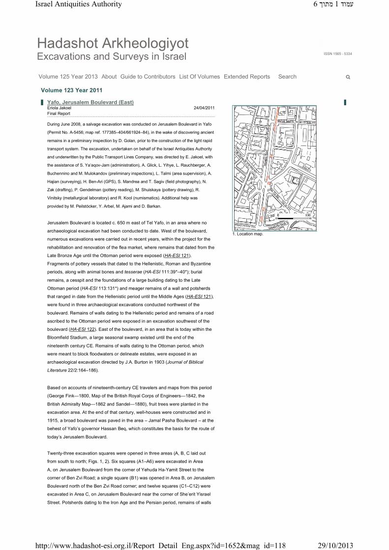
Jaffa, Jerusalem Boulevard (East)
6
Hadashot Arkheologiyot Excavations and Surveys in Israel ISSN 1565 - 5334 Volume 125 Year 2013 About Guide to Contributors List Of Volumes Extended Reports Search Eriola Jakoel 24/04/2011 Final Report During June 2008, a salvage excavation was conducted on Jerusalem Boulevard in Yafo (Permit No. A-5456; map ref. 177385–404/661924–84), in the wake of discovering ancient remains in a preliminary inspection by D. Golan, prior to the construction of the light rapid transport system. The excavation, undertaken on behalf of the Israel Antiquities Authority and underwritten by the Public Transport Lines Company, was directed by E. Jakoel, with the assistance of S. Ya‘aqov-Jam (administration), A. Glick, L. Yihye, L. Rauchberger, A. Buchennino and M. Mulokandov (preliminary inspections), L. Talmi (area supervision), A. Hajian (surveying), H. Ben-Ari (GPS), S. Mandrea and T. Sagiv (field photography), N. Zak (drafting), P. Gendelman (pottery reading), M. Shuiskaya (pottery drawing), R. Vinitsky (metallurgical laboratory) and R. Kool (numismatics). Additional help was provided by M. Peilstöcker, Y. Arbel, M. Ajami and D. Barkan. Jerusalem Boulevard is located c. 650 m east of Tel Yafo, in an area where no archaeological excavation had been conducted to date. West of the boulevard, numerous excavations were carried out in recent years, within the project for the rehabilitation and renovation of the flea market, where remains that dated from the Late Bronze Age until the Ottoman period were exposed (HA-ESI 121). Fragments of pottery vessels that dated to the Hellenistic, Roman and Byzantine periods, along with animal bones and tesserae (HA-ESI 111:39*–40*); burial remains, a cesspit and the foundations of a large building dating to the Late Ottoman period (HA-ESI 113:131*) and meager remains of a wall and potsherds that ranged in date from the Hellenistic period until the Middle Ages (HA-ESI 121), were found in three archaeological excavations conducted northwest of the boulevard. Remains of walls dating to the Hellenistic period and remains of a road ascribed to the Ottoman period were exposed in an excavation southwest of the boulevard (HA-ESI 122). East of the boulevard, in an area that is today within the Bloomfield Stadium, a large seasonal swamp existed until the end of the nineteenth century CE. Remains of walls dating to the Ottoman period, which were meant to block floodwaters or delineate estates, were exposed in an archaeological excavation directed by J.A. Burton in 1903 (Journal of Biblical Literature 22/2:164–186). Based on accounts of nineteenth-century CE travelers and maps from this period (George Fink—1800, Map of the British Royal Corps of Engineers—1842, the British Admiralty Map—1862 and Sandel—1880), fruit trees were planted in the excavation area. At the end of that century, well-houses were constructed and in 1915, a broad boulevard was paved in the area – Jamal Pasha Boulevard – at the behest of Yafo’s governor Hassan Beq, which constitutes the basis for the route of today’s Jerusalem Boulevard. Twenty-three excavation squares were opened in three areas (A, B, C laid out from south to north; Figs. 1, 2). Six squares (A1–A6) were excavated in Area A, on Jerusalem Boulevard from the corner of Yehuda Ha-Yamit Street to the corner of Ben Zvi Road; a single square (B1) was opened in Area B, on Jerusalem Boulevard north of the Ben Zvi Road corner; and twelve squares (C1–C12) were excavated in Area C, on Jerusalem Boulevard near the corner of She’erit Yisrael Street. Potsherds dating to the Iron Age and the Persian period, remains of walls 1. Location map. Volume 123 Year 2011 Yafo, Jerusalem Boulevard (East) ע מ ו ד1 מ ת ו ך6 Israel Antiquities Authority 29/10/2013 http://www.hadashot-esi.org.il/Report_Detail_Eng.aspx?id=1652&mag_id=118
Transcript of Jaffa, Jerusalem Boulevard (East)
Hadashot ArkheologiyotExcavations and Surveys in Israel ISSN 1565 - 5334
Volume 125 Year 2013 About Guide to Contributors List Of Volumes Extended Reports Search
Eriola Jakoel 24/04/2011 Final Report
During June 2008, a salvage excavation was conducted on Jerusalem Boulevard in Yafo
(Permit No. A-5456; map ref. 177385–404/661924–84), in the wake of discovering ancient
remains in a preliminary inspection by D. Golan, prior to the construction of the light rapid
transport system. The excavation, undertaken on behalf of the Israel Antiquities Authority
and underwritten by the Public Transport Lines Company, was directed by E. Jakoel, with
the assistance of S. Ya‘aqov-Jam (administration), A. Glick, L. Yihye, L. Rauchberger, A.
Buchennino and M. Mulokandov (preliminary inspections), L. Talmi (area supervision), A.
Hajian (surveying), H. Ben-Ari (GPS), S. Mandrea and T. Sagiv (field photography), N.
Zak (drafting), P. Gendelman (pottery reading), M. Shuiskaya (pottery drawing), R.
Vinitsky (metallurgical laboratory) and R. Kool (numismatics). Additional help was
provided by M. Peilstöcker, Y. Arbel, M. Ajami and D. Barkan.
Jerusalem Boulevard is located c. 650 m east of Tel Yafo, in an area where no
archaeological excavation had been conducted to date. West of the boulevard,
numerous excavations were carried out in recent years, within the project for the
rehabilitation and renovation of the flea market, where remains that dated from the
Late Bronze Age until the Ottoman period were exposed (HA-ESI 121).
Fragments of pottery vessels that dated to the Hellenistic, Roman and Byzantine
periods, along with animal bones and tesserae (HA-ESI 111:39*–40*); burial
remains, a cesspit and the foundations of a large building dating to the Late
Ottoman period (HA-ESI 113:131*) and meager remains of a wall and potsherds
that ranged in date from the Hellenistic period until the Middle Ages (HA-ESI 121),
were found in three archaeological excavations conducted northwest of the
boulevard. Remains of walls dating to the Hellenistic period and remains of a road
ascribed to the Ottoman period were exposed in an excavation southwest of the
boulevard (HA-ESI 122). East of the boulevard, in an area that is today within the
Bloomfield Stadium, a large seasonal swamp existed until the end of the
nineteenth century CE. Remains of walls dating to the Ottoman period, which
were meant to block floodwaters or delineate estates, were exposed in an
archaeological excavation directed by J.A. Burton in 1903 (Journal of Biblical
Literature 22/2:164–186).
Based on accounts of nineteenth-century CE travelers and maps from this period
(George Fink—1800, Map of the British Royal Corps of Engineers—1842, the
British Admiralty Map—1862 and Sandel—1880), fruit trees were planted in the
excavation area. At the end of that century, well-houses were constructed and in
1915, a broad boulevard was paved in the area – Jamal Pasha Boulevard – at the
behest of Yafo’s governor Hassan Beq, which constitutes the basis for the route of
today’s Jerusalem Boulevard.
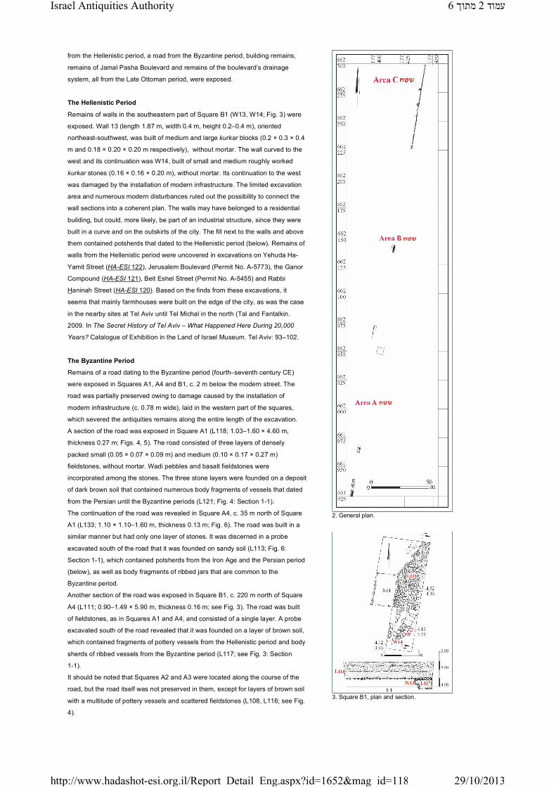
Twenty-three excavation squares were opened in three areas (A, B, C laid out
from south to north; Figs. 1, 2). Six squares (A1–A6) were excavated in Area
A, on Jerusalem Boulevard from the corner of Yehuda Ha-Yamit Street to the
corner of Ben Zvi Road; a single square (B1) was opened in Area B, on Jerusalem
Boulevard north of the Ben Zvi Road corner; and twelve squares (C1–C12) were
excavated in Area C, on Jerusalem Boulevard near the corner of She’erit Yisrael
Street. Potsherds dating to the Iron Age and the Persian period, remains of walls
1. Location map.
Volume 123 Year 2011
Yafo, Jerusalem Boulevard (East)
6Israel Antiquities Authority ךותמ1 דומע
29/10/2013http://www.hadashot-esi.org.il/Report_Detail_Eng.aspx?id=1652&mag_id=118
from the Hellenistic period, a road from the Byzantine period, building remains,
remains of Jamal Pasha Boulevard and remains of the boulevard’s drainage
system, all from the Late Ottoman period, were exposed.
The Hellenistic Period
Remains of walls in the southeastern part of Square B1 (W13, W14; Fig. 3) were
exposed. Wall 13 (length 1.87 m, width 0.4 m, height 0.2–0.4 m), oriented
northeast-southwest, was built of medium and large kurkar blocks (0.2 × 0.3 × 0.4
m and 0.18 × 0.20 × 0.20 m respectively), without mortar. The wall curved to the
west and its continuation was W14, built of small and medium roughly worked
kurkar stones (0.16 × 0.16 × 0.20 m), without mortar. Its continuation to the west
was damaged by the installation of modern infrastructure. The limited excavation
area and numerous modern disturbances ruled out the possibility to connect the
wall sections into a coherent plan. The walls may have belonged to a residential
building, but could, more likely, be part of an industrial structure, since they were
built in a curve and on the outskirts of the city. The fill next to the walls and above
them contained potsherds that dated to the Hellenistic period (below). Remains of
walls from the Hellenistic period were uncovered in excavations on Yehuda Ha-
Yamit Street (HA-ESI 122), Jerusalem Boulevard (Permit No. A-5773), the Ganor
Compound (HA-ESI 121), Beit Eshel Street (Permit No. A-5455) and Rabbi
Haninah Street (HA-ESI 120). Based on the finds from these excavations, it
seems that mainly farmhouses were built on the edge of the city, as was the case
in the nearby sites at Tel Aviv until Tel Michal in the north (Tal and Fantalkin.
2009. In The Secret History of Tel Aviv – What Happened Here During 20,000
Years? Catalogue of Exhibition in the Land of Israel Museum. Tel Aviv: 93–102.
The Byzantine Period
Remains of a road dating to the Byzantine period (fourth–seventh century CE)
were exposed in Squares A1, A4 and B1, c. 2 m below the modern street. The
road was partially preserved owing to damage caused by the installation of
modern infrastructure (c. 0.78 m wide), laid in the western part of the squares,
which severed the antiquities remains along the entire length of the excavation.
A section of the road was exposed in Square A1 (L118; 1.03–1.60 × 4.60 m,
thickness 0.27 m; Figs. 4, 5). The road consisted of three layers of densely
packed small (0.05 × 0.07 × 0.09 m) and medium (0.10 × 0.17 × 0.27 m)
fieldstones, without mortar. Wadi pebbles and basalt fieldstones were
incorporated among the stones. The three stone layers were founded on a deposit
of dark brown soil that contained numerous body fragments of vessels that dated
from the Persian until the Byzantine periods (L121; Fig. 4: Section 1-1).
The continuation of the road was revealed in Square A4, c. 35 m north of Square
A1 (L133; 1.10 × 1.10–1.60 m, thickness 0.13 m; Fig. 6). The road was built in a
similar manner but had only one layer of stones. It was discerned in a probe
excavated south of the road that it was founded on sandy soil (L113; Fig. 6:
Section 1-1), which contained potsherds from the Iron Age and the Persian period
(below), as well as body fragments of ribbed jars that are common to the
Byzantine period.
Another section of the road was exposed in Square B1, c. 220 m north of Square
A4 (L111; 0.90–1.49 × 5.90 m, thickness 0.16 m; see Fig. 3). The road was built
of fieldstones, as in Squares A1 and A4, and consisted of a single layer. A probe
excavated south of the road revealed that it was founded on a layer of brown soil,
which contained fragments of pottery vessels from the Hellenistic period and body
sherds of ribbed vessels from the Byzantine period (L117; see Fig. 3: Section
1-1).
It should be noted that Squares A2 and A3 were located along the course of the
road, but the road itself was not preserved in them, except for layers of brown soil
with a multitude of pottery vessels and scattered fieldstones (L108, L116; see Fig.
4).
2. General plan.
3. Square B1, plan and section.
6Israel Antiquities Authority ךותמ2 דומע
29/10/2013http://www.hadashot-esi.org.il/Report_Detail_Eng.aspx?id=1652&mag_id=118

The construction method and materials used to build the road are completely
identical in all of the squares. Despite the distance between the three sections of
road, their absolute elevations are similar. The road was paved in the eastern part
of the city; based on the ceramic artifacts recovered from the roadbed, it can be
dated to the Byzantine period when Yafo was a prosperous and important city, not
just a port city, but also a destination city for Christian pilgrims. Excavations
conducted in recent years in the vicinity of the flea market, the clock-tower square
and the Ganor Compound, exposed streets, structures, including public buildings,
and a bathhouse, as well as winepresses and numerous industrial installations
(HA-ESI 121). These finds point to an urban complex and extensive activity in the
Byzantine period, not just on the tell and its immediate surroundings, but also at a
considerable distance away. The multitude of winepresses and industrial
installations shows that widespread industry associated with the agricultural
activity existed in the eastern part of the city during the Byzantine period. It is
reasonable to assume that the vineyards for the wine industry were planted east
of the industrial installations.
The Ottoman Period
Remains dating to the Late Ottoman period (nineteenth–twentieth centuries CE)
were uncovered in the center of the excavation and its northern part. Remains of a
building and of Jamal Pasha Boulevard and its drainage system were discovered.
Sections of walls (W10, W11; Fig. 7) were exposed in Square A5, c. 0.5 m below
the modern asphalt street. Wall 10, in the middle of the square and oriented north
–south, was built of small and medium fieldstones (0.08 × 0.12 × 0.14 m and 0.12
× 0.16 × 0.19 m respectively) that were bonded with gray mortar mixed with
crushed shells. The eastern side of the wall was coated with a whitish turquoise-
colored plaster. The middle of the wall was severed by modern infrastructure
(width c. 2.3 m). The section of W10 south of the infrastructure was preserved
three courses high (length 1.9 m, width 0.5 m, height 0.50–0.65 m) and the
section to the north was just a single course high (length 1.5 m, width 0.43 m,
height 0.12 m).
Wall 11 (length 0.76 m, width 0.5 m, height 0.4 m) was c. 2.5 m southeast of W10;
oriented east–west and preserved three courses high, it was built in a similar
manner to W10. Although no direct connection between the two sections of walls
was found, it can be assumed that they dated to the same phase and were built
according to a single plan, because of their building style, elevations and
orientation. The dating of the wall remains is based on their construction style and
not on the ceramic finds that were disturbed when the modern infrastructure was
installed. The sides of the walls coated with whitish turquoise plaster and the gray
mortar mixed with shells are characteristics of the construction in the Late
Ottoman period. Similar buildings were discovered in the northern part of Yafo
(Permit No. A-4675/1) and on Jerusalem Boulevard (Permit No. A-5565).
Cultivation was resumed in the Late Ottoman period east of the city and these wall
sections are probably the remains of a building that was connected to this
agricultural activity.
A row of stones (W12; length 10.5 m, width 0.2 m, height 0.25 m; Fig. 8) was
exposed in the western part of Square A6, close to the trafficmedianin Jerusalem
Boulevard. The row, aligned north–south, was built of dressed kurkar stones (0.2
× 0.3 × 0.4 m), set in place lengthwise on their narrow side and bonded with gray
mortar mixed with shells. The row of stones consisted of a single course and was
abutted on the east by a floor (L126; length 3.3 m, width 0.14 m, thickness 0.15
–0.30 m) of crushed and well-tamped kurkar. The foundation of the floor was
composed of two layers; an upper layer of small and medium fieldstones (0.12 ×
0.14 × 0.90 m) bonded with gray mortar and a lower layer (thickness 0.1 m) of
beach sand. Wall 12 probably bordered one of the flower beds that was installed
in the middle of the boulevard and is clearly visible in historical photographs.
Despite the changes to the boulevard’s appearance over the years, its route has
4. Squares A1-–A3, plan and section.
5.5. Square A1, remains of the Byzantine road, looking north.
6. Square A4, plan and section.
6Israel Antiquities Authority ךותמ3 דומע
29/10/2013http://www.hadashot-esi.org.il/Report_Detail_Eng.aspx?id=1652&mag_id=118

remained the same and the boundaries of the traffic median today are very similar
to those of the flower bed in the Ottoman period. Preliminary inspections in the
northern part of the excavation area exposed a section of a wall (length c. 4 m)
that was identical in its construction to W12. It too probably delimited another
flower bed.
Remains of the Ottoman boulevard’s drainage channel, which was apparently built
of two parallel sides, were exposed in the eastern part of Squares C1–C12 (Fig.
9). The western side was not preserved at all due to damage caused by the
modern sewer line, which was installed along the axis of the channel and exposed
along the entire length of the excavation area. The well-preserved eastern side of
the drainage channel (W15; length 85 m, width 0.26 m, height 0.63 m) was built of
dressed kurkar stones (0.20 × 0.24 × 0.25 m) and bonded with grayish white
mortar. Its outer face consisted of kurkar and small and medium fieldstones (0.08
× 0.10 × 0.15 m), without mortar. Three courses of stones were visible in the side;
the upper course was preserved for almost its entire length and a slight arch was
discerned in it; the middle course was dressed in a straight line and the bottom
course curved inward (Figs. 9, 10). Based on the arch noted in the upper course,
the channel was apparently covered and reached a maximum width of 0.7 m. A
partially preserved kurkar floor (L143; width 0.1–0.5 m) abutted the bottom course.
The side was founded on three foundation courses built of roughly worked kurkar
stones (0.10 × 0.12 × 0.13 m), without mortar. The foundation of the wall was built
into black clayey soil (L134).
The supposition that these are the remains of the drainage channel of Jamal
Pasha Boulevard, which was built in the Late Ottoman period, is based on the
route of the channel, its proximity to the surface and its construction style. The
quality of the construction and its size are indicative of a high degree of planning.
A wave of construction in the Late Ottoman period was encouraged by the
government and paving the boulevard was one of the largest projects.
A channel (L137; length 1.2 m, width 1 m, height 0.34 m; Fig. 9: Section 4:4) and
a pool (L135; 1.2 × 1.3 m, depth 0.9 m; Fig. 9: Section 3:3) that were probably
constructed during the British Mandate era were exposed west of the channel’s
eastern side. The pool was built of kurkar and its sides and floor were coated with
concrete. The channel was built of two parallel rows of dressed kurkar and
medium-sized fieldstones. The beach-rock covering stones of the channel were
preserved in its eastern part. The floor of the channel was paved with dressed
kurkar blocks and an iron water pipe was laid inside it.
Potsherds that ranged in date from the Iron Age until the Ottoman period were
recovered from the excavation. The ceramic finds from undisturbed loci were
mostly body fragments; therefore, the representative diagnostic potsherds were
chosen from layers of fill and accumulations throughout the entire excavation area
(Fig. 11). Body fragments from the Iron Age and the Persian period were found in
a layer of sandy soil below the remains of the Byzantine road. Two other
fragments from these periods included a rim of a large krater (Fig. 11:1) and a
fragment of a jar rim (Fig. 11:2). Body fragments characteristic of the Hellenistic
period were found throughout the excavation area. Fragments of bowls were
recovered from the accumulations above and next to the wall remains in Square
B1. Fragments of cooking pots, a juglet, a bottle (Fig. 11:8), jars and an amphora
base (Fig. 11:13), were retrieved from the accumulations above and below the
road and in the layers of clayey soil. Diagnostic potsherds of these vessel types
were discovered in other loci, including bowls (Fig. 11:3, 4), cooking pots (Fig.
11:5, 6), a juglet (Fig. 11:7) and jars (Fig. 11:9–12).
The rim of a glazed bowl (Fig. 11:14) from the Abbasid period and a jar rim (Fig.
11:15), characteristic of the Mamluk and Ottoman periods, were found in a layer of
clayey soil beneath the Ottoman drainage channel.
7. Square A5, plan.
8. Square A6, plan and section.
6Israel Antiquities Authority ךותמ4 דומע
29/10/2013http://www.hadashot-esi.org.il/Report_Detail_Eng.aspx?id=1652&mag_id=118

Two coins were found in the excavation. They were discovered on the surface and
in a disturbed fill and are therefore of no aid in dating the ancient remains. One
coin (L1003; IAA 119153) is made of copper and dates to the Umayyad period
(697–750 CE). The other (L131; IAA 119154) is a small coin of bronze, minted
under Festus’ tenure as procurator (59 CE) during Nero’s reign as emperor.
Jerusalem Boulevard is located c. 650 m east of Tel Yafo. The location of the
excavation constitutes an important link in understanding the settlement sequence
of Yafo and contributes to our knowledge regarding the layout of the city
throughout its history. The excavation findings point to activity on the outskirts of
the city in the Hellenistic, Byzantine and Late Ottoman periods.
Yafo was a port city of regional importance in the Hellenistic period and it
maintained extensive commercial ties. This is the period when the city expanded
beyond the boundaries of the tell and the areas situated at its foot. The region
around the tell became part of the city’s urban outline and plantations were
established along its more remote outskirts, which served the agricultural
hinterland outside the city. The exposed Hellenistic walls were probably
connected to the agricultural activity in the region.
The city experienced renewed economic prosperity in the Byzantine period. Based
on results of excavations in recent years, the town planning is apparent not just in
the nucleus of the city, but also in its more distant outskirts. The excavation
findings complement this picture and the exposed road was probably also
incorporated in the town planning system of the period.
Apart from several potsherds, no evidence of activity was found between the
Byzantine and the Ottoman periods. At the end of the Ottoman period, activity was
renewed along the outlying areas of the city. New neighborhoods were built north
and south of the tell and the orchards in the east flourished. The wave of
construction swept all over Yafo and included the paving of the boulevard and
other projects that evince the great investment made by the Ottoman government
in the development of the city. The finds exposed in the excavation supplement
the historical evidence about the development of the city in the Late Ottoman
period.
1. Location map.
2. General plan.
3. Square B1, plan and section.
4. Squares A1-–A3, plan and section.
5.5. Square A1, remains of the Byzantine road, looking north.
6. Square A4, plan and section.
7. Square A5, plan.
8. Square A6, plan and section.
9. Squares C1-–C612, plan and sections.
10.10. Area C, Wall 15, looking southeast.
11. Pottery.
תירבעב רמאמל
9. Squares C1-–C612, plan and sections.
6Israel Antiquities Authority ךותמ5 דומע
29/10/2013http://www.hadashot-esi.org.il/Report_Detail_Eng.aspx?id=1652&mag_id=118

10.10. Area C, Wall 15, looking southeast.
11. Pottery.
רתא חותיפ teti-tuCopyright Legalicy to The Israel Antiquities Authority | Credits | תירבע הסרג
6Israel Antiquities Authority ךותמ6 דומע
29/10/2013http://www.hadashot-esi.org.il/Report_Detail_Eng.aspx?id=1652&mag_id=118