Ravensthorpe Gold Project - EPA WA
461
Ravensthorpe Gold Project Environmental Review Document – Response to Submissions Assessment No.2117 April 2020
-
Upload
khangminh22 -
Category
Documents
-
view
0 -
download
0
Transcript of Ravensthorpe Gold Project - EPA WA

Ravensthorpe Gold Project Environmental Review Document – Response to Submissions Assessment No.2117
ACH Minerals Ravensthorpe Gold Project ERD Response to Submissions.1b April 2020 | Page 1
Ravensthorpe Gold Project
Environmental Review Document – Response to Submissions
Assessment No.2117
April 2020
Ravensthorpe Gold Project Environmental Review Document – Response to Submissions Assessment No.2117
ACH Minerals Ravensthorpe Gold Project ERD Response to Submissions.1b April 2020 | Page i
DOCUMENT CONTROL
Version Description Date Author Reviewer
0a Partial draft 31/01/2019 GB/SW GB
0b Second draft 4/02/2020 GB SS/PB
1a Final 5/02/2020 GB EPA Services
1b Revised report following comments from
EPA Services 9/04/2020 GB
Approval for Release
Name Position File Reference
Paul Bennett Managing Director ACH Minerals Ravensthorpe Gold Project ERD Response
to Submissions.1b
Signature
on behalf of P Bennett
Ravensthorpe Gold Project Environmental Review Document – Response to Submissions Assessment No.2117
ACH Minerals Ravensthorpe Gold Project ERD Response to Submissions.1b April 2020 | Page ii
Table of Contents 1 Introduction ...................................................................................................................... 1-1
1.1 The Ravensthorpe Gold Project ........................................................................................... 1-1
1.2 Assessment under the Environmental Protection Act 1986 ................................................ 1-1
1.3 Submissions received ........................................................................................................... 1-1
2 EPA Services ...................................................................................................................... 2-1
3 General ............................................................................................................................. 3-1
4 Flora and vegetation .......................................................................................................... 4-1
5 Landforms ......................................................................................................................... 5-1
6 Terrestrial environmental quality ....................................................................................... 6-1
7 Terrestrial fauna ................................................................................................................ 7-1
8 Subterranean fauna ........................................................................................................... 8-1
9 Inland waters environmental quality .................................................................................. 9-1
10 Air Quality ....................................................................................................................... 10-1
11 Social Surroundings ......................................................................................................... 11-1
12 Stakeholder Consultation ................................................................................................. 12-1
13 Other .............................................................................................................................. 13-1
14 References ...................................................................................................................... 14-1
15 Glossary .......................................................................................................................... 15-1

Ravensthorpe Gold Project Environmental Review Document – Response to Submissions Assessment No.2117
ACH Minerals Ravensthorpe Gold Project ERD Response to Submissions.1b April 2020 | Page iii
Tables Table 1: RGP Project Area – dam water quality samples (2018-2019)
Table 2: RAV8 Nickel Project - pit groundwater quality (May 2018)
Table 3: RGP Project Area and surrounds- indicative surface and groundwater monitoring program
Table 4: RGP Project Area - groundwater quality samples
Table 5: Summary of population counts for five Priority species (December 2019)
Figures Figure 1: Haulage route for water from RAV8 to the Ravensthorpe Gold Project
Figure 2: Surface water and groundwater monitoring locations
Figure 3: Aquifers occurring across the RGP Project Area
Figure 4: Tailings storage facility – proposed seepage controls (from Appendix A).
Figure 5: Remnant vegetation, Shire of Ravensthorpe.
Figure 6: RGP Development Envelope – proposed Exclusion Zone for Calothamnus roseus
Figure 7: Known distribution of the Kundip Quartzite and of Calothamnus roseus
Figure 8: Priority Ecological Community mapped by APM
Figure 9: Known occurrences and cover values of Lepidosperma sp. Elverdton (R. Jasper et al. LCH
16844)
Figure 10: Ecological linkages between coastal vegetation and inland woodlands.
Figure 11: Operational water management measures at the RGP
Figure 12: Exclusion Zone for Bothryembrion (potential SRE)
Figure 13: RGP fauna habitats with disturbance envelope
Figure 14: Alluvial formations within the RGP Project Area
Figure 15: Location of railway heritage trail in relation to the RGP Project Area.

Ravensthorpe Gold Project Environmental Review Document – Response to Submissions Assessment No.2117
ACH Minerals Ravensthorpe Gold Project ERD Response to Submissions.1b April 2020 | Page iv
Appendices : Tailings Storage Facility: Feasibility Study (Resource Engineering Consultants)
: Populations of five Priority Flora species in the Kundip Development Envelope (Dr G.F.
Craig)
: RGP Potential Short Range Endemic Land Snail (Biota Environmental Sciences)

Ravensthorpe Gold Project Environmental Review Document – Response to Submissions Assessment No.2117
ACH Minerals Ravensthorpe Gold Project ERD Response to Submissions.1b April 2020 | Page 1-1
1 Introduction
1.1 The Ravensthorpe Gold Project
The proposed Ravensthorpe Gold Project (the Project or RGP) is located approximately 550 kilometres
(km) southeast of Perth and approximately 17 km southeast of Ravensthorpe in the Great Southern region
of Western Australia (WA). The Project involves mining for gold and copper near the former town of
Kundip.
The proposed Project occurs in an area with significant historical disturbance from previous mining activity
dating back to the early 20th century. The current proposal includes a series of open pit operations,
subsequent underground mining in some open pts, two waste rock landforms, a tailings storage facility
and supporting infrastructure.
1.2 Assessment under the Environmental Protection Act 1986
An Environmental Review Document describing the proposal, the likely environmental impacts and the
proposed management measures was realised released for public review on 1 October 2019. Submissions
closed on 29 October 2019.
The purpose of this document is to assist the Environmental Protection Authority to assess the Project by
providing responses to issues raised in submissions and to also provide the results of any additional
investigations and/or information relevant to the assessment.
1.3 Submissions received
A total of 43 submissions was received. Submissions were received from:
Seven State Government agencies;
The Shire of Ravensthorpe; and
Individuals, NGOs and other organisations based in the Ravensthorpe and Hopetoun areas.

Ravensthorpe Gold Project Environmental Review Document – Response to Submissions Assessment No.2117
ACH Minerals Ravensthorpe Gold Project ERD Response to Submissions.1b April 2020 | Page 2-1
2 EPA Services
Item Issue/Factor Comment Response
1. Proposal The proponent is advised to consider
referring the proposal under the
Environment Protection and Biodiversity
Conservation Act 1999 (EPBC Act) to the
Commonwealth Department of the
Environment and Energy (DoEE) given the
14 year time frame since original referral,
the change in scope and the presence of a
number of threatened and vulnerable
species.
An earlier version of the Project, the Phillips Rivers Project, was referred under
the EPBC Act in 2005 (2005/2000). It was determined that it was “not a
controlled action”.
ACH believes that the current proposal is substantially similar to the original
proposal assessed under the EPBC Act in 2005. It contains key elements (mining
and waste rock storage) within the same tenements which will be permanent
features of the post-mining landscape. The addition of ore treatment and
tailings storage in the current proposal adds to the Project footprint at Kundip.
Conversely, the removal of the 17 km haul road traversing the Ravensthorpe
Range from Kundip to RAV8, the removal of open pit mining and waste storage
at Trilogy and the removal of the services corridor linking Trilogy to Kundip
through the Kundip Nature Reserve collectively are significant reductions in the
Project’s environmental impact when compared to the Project that was
determined to be “not a controlled action” in 2005. It is also noted that closure
of the RAV8 site has been substantially advanced which would otherwise have
not been the case had RAV8 been retained as the preferred ore treatment and
tailings storage location for Kundip and Trilogy ores.
The previous referral was supported by flora and fauna surveys that have been
referenced in the current proposal and recorded substantially similar results to
surveys undertaken on behalf of ACH.

Ravensthorpe Gold Project Environmental Review Document – Response to Submissions Assessment No.2117
ACH Minerals Ravensthorpe Gold Project ERD Response to Submissions.1b April 2020 | Page 2-2
Item Issue/Factor Comment Response
2. One species of Threatened Flora (listed under the WA Wildlife Conservation Act
1950) was recorded previously – this species is still present at the site but has
since been removed from the Threatened species list and is now classified as a
Priority species (P4). No flora listed under the EPBC Act has been recorded,
either in surveys supporting the referral or in subsequent surveys.
Fauna listed under the EPBC Act, including the malleefowl, Carnaby’s black
cockatoo and the western whipbird were recorded in surveys supporting the
referral under the EPBC Act and the impact on these species was assessed at
that time.
3. The haulage route for water transport from
RAV8 should be specified.
The haul route for carting of water from RAV8 to the RGP site will be along
major public roads as shown in Figure 1.
4. Terrestrial
fauna
Please advise if the Heath Mouse
Pseudomys shortridgei is or is not present
at the site. Table 4-22 of the
Environmental Review Document (ERD)
states that it is present at the site yet Table
4-23 states that it is not.
Table 4-22 of the ERD is incorrect. The confusion arises from an incorrect field
identification made in the initial fauna survey. The specimen was not
vouchered. The survey company, APM, with the benefit of subsequent trapping
efforts, determined that the specimen was likely to have been the much more
common bush rat (Rattus fuscipes) and not the Heath Mouse (see p. 84 of
Appendix C to the ERD).
See also the response to item 51.

Ravensthorpe Gold Project Environmental Review Document – Response to Submissions Assessment No.2117
ACH Minerals Ravensthorpe Gold Project ERD Response to Submissions.1b April 2020 | Page 2-3
Item Issue/Factor Comment Response
5. Inland waters Water Balance
The water balance provided in Figure 4-36
does not provide any indicative volumes or
information on water quality. The balance
needs to be updated to include this
information.
With regard to water volumes, feasibility studies are still underway and it is not
possible to provide detailed water balance data (volumes) at this point.
However, the initial water balance showed a potential shortfall in available
water in the initial stages of the Project – thus, the potential requirement to
import water from the RAV8 open pit. As the Project progresses, management
of the site water balance will be undertaken via abstraction from RAV8 when in
shortfall and potentially discharge to RAV8 and storage in the water storage
facility (with discharge via evaporation) (see Figure 2-1 of ERD) when in excess.
With regard to groundwater quality, Table 4-40 from the ERD summarises
groundwater quality within the Project Area. This table has been updated to
include more monitoring data collected since the release of the ERD and is
included here as Table 1. Water quality data for RAV8 is also included here as
Table 2. Water quality from both locations is comparable with a total dissolved
solids content of approximately 20-30,000 mg/L.
6. Background Water Quality Monitoring
There has been insufficient background
water monitoring for both surface and
groundwater. Further sampling needs to
be undertaken pre mining to be able to
ensure adequate knowledge of background
water quality and thus the impact of the
operation. Much of the sampling
undertaken to date is over 10 years old and
may no longer reflect the current condition
of the proposal area and surrounding
environment. For example:
Surface water quality
Local surface waters collected in dams directly over the Project Area provide
background data on surface waters. These locations continue to be monitored
and have most recently been monitored in September 2019. The results of
water monitoring undertaken since the release of the ERD have been
incorporated into Table 1 (an update of ERD Table 4-39).
Historical monitoring of water quality in both the Jerdacuttup and Steere Rivers
has been limited. All available data has been presented in the ERD. Given that
there has been no significant changes in land use in recent years, there is no
reason to conclude that water quality will now be substantially different.
ACH’s ability to collect surface water samples has been hindered by low rainfall
over a number of years. ACH has identified background surface water data
Ravensthorpe Gold Project Environmental Review Document – Response to Submissions Assessment No.2117
ACH Minerals Ravensthorpe Gold Project ERD Response to Submissions.1b April 2020 | Page 2-4
Item Issue/Factor Comment Response
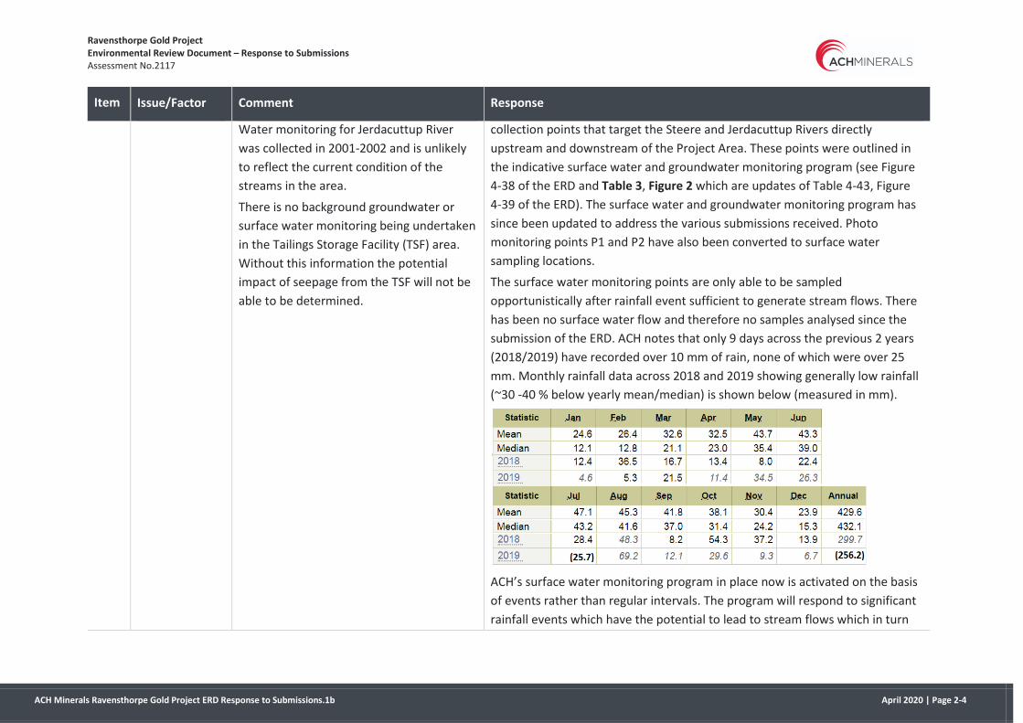
Water monitoring for Jerdacuttup River
was collected in 2001-2002 and is unlikely
to reflect the current condition of the
streams in the area.
There is no background groundwater or
surface water monitoring being undertaken
in the Tailings Storage Facility (TSF) area.
Without this information the potential
impact of seepage from the TSF will not be
able to be determined.
collection points that target the Steere and Jerdacuttup Rivers directly
upstream and downstream of the Project Area. These points were outlined in
the indicative surface water and groundwater monitoring program (see Figure
4-38 of the ERD and Table 3, Figure 2 which are updates of Table 4-43, Figure
4-39 of the ERD). The surface water and groundwater monitoring program has
since been updated to address the various submissions received. Photo
monitoring points P1 and P2 have also been converted to surface water
sampling locations.
The surface water monitoring points are only able to be sampled
opportunistically after rainfall event sufficient to generate stream flows. There
has been no surface water flow and therefore no samples analysed since the
submission of the ERD. ACH notes that only 9 days across the previous 2 years
(2018/2019) have recorded over 10 mm of rain, none of which were over 25
mm. Monthly rainfall data across 2018 and 2019 showing generally low rainfall
(~30 -40 % below yearly mean/median) is shown below (measured in mm).
ACH’s surface water monitoring program in place now is activated on the basis
of events rather than regular intervals. The program will respond to significant
rainfall events which have the potential to lead to stream flows which in turn

Ravensthorpe Gold Project Environmental Review Document – Response to Submissions Assessment No.2117
ACH Minerals Ravensthorpe Gold Project ERD Response to Submissions.1b April 2020 | Page 2-5
Item Issue/Factor Comment Response
provide an opportunity for a representative and guideline compliant sample to
be collected.
Surface and groundwater monitoring at the TSF footprint
There are no potential surface water sampling points (streams, dams) within
the TSF footprint.
While ACH acknowledge there is no groundwater monitoring data over the TSF
footprint, ACH believe there is sufficient groundwater data for a baseline that is
representative of the aquifers present within the TSF footprint. Consider the
two aquifers occurring within the TSF area as shown in Figure 3. ACH has at
least one bore in each of these aquifers and their distribution has been
mapped.
Groundwater monitoring bores are proposed for the TSF so additional data will
be available prior to the commencement of operations.
7. In Section 4.6.5.1 the impact of a breach of
the TSF on surface water quality has been
understated. Given the saline nature of the
tailings, the sediment load and Potential
Acid Forming (PAF) material, a breach of
the TSF would be a significant impact and
should be considered as such with
management options in place to reduce
likelihood of this event. This risk is
increased as there are currently no seepage
controls proposed for the facility.
A failure of the embankment (as it is designed) will only be a result of either the
embankment saturating (as a result of poor operating practices) or as a result
of liquefaction. Liquefaction will be negated by good operational and
deposition practices (i.e. water is not to be stored on the TSF and not allowed
to pond after storm events). This will be achieved in the detailed design
(sufficient stormwater capacity) and also by adhering to the Operating Manual
that will be implemented as part of the construction of the TSF.
The risk is further negated over the life of the facility due to the fact that there
is no proposed upstream raise over the life of the TSF. The starting
embankments will be constructed at full width/capacity from the beginning of
operations. As such it will only be for a very short period that the TSF will near
its maximum operating pond storage capacity (840 mm freeboard), which
would still provide 500 mm freeboard after a 1:100 year 72 hour event. This
Ravensthorpe Gold Project Environmental Review Document – Response to Submissions Assessment No.2117
ACH Minerals Ravensthorpe Gold Project ERD Response to Submissions.1b April 2020 | Page 2-6
Item Issue/Factor Comment Response
minimum 840 mm freeboard will only occur as the mine and tailings production
approaches closure. It is also worth noting that these values were modelled
using very conservative assumptions (i.e. runoff coefficient, C=1.0).
The location of the proposed TSF has been optimised to provide the required
storage capacity whilst minimising the catchment runoff that reports to the
facility i.e. seepage is minimised by minimising TSF inflow.
Specific design elements that relate to seepage have been included in the
updated design report which has been attached in Appendix A. This design
report includes significantly more detail in relation to the design, operation and
closure of the tailings storage than the preliminary documentation provided
with the ERD.
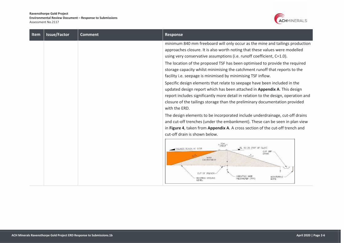
The design elements to be incorporated include underdrainage, cut-off drains
and cut-off trenches (under the embankment). These can be seen in plan view
in Figure 4, taken from Appendix A. A cross section of the cut-off trench and
cut-off drain is shown below.
Ravensthorpe Gold Project Environmental Review Document – Response to Submissions Assessment No.2117
ACH Minerals Ravensthorpe Gold Project ERD Response to Submissions.1b April 2020 | Page 2-7
Item Issue/Factor Comment Response
8. Section 4.6.5.3 refers to seepage
monitoring and a groundwater monitoring
network and reference with baseline data.
There is currently no baseline data for the
TSF area. The proposed seepage monitoring
bores are a considerable way downstream
from the TSF and outside the project area,
making early detection of seepage
impossible. By the time seepage reaches
the proposed locations a significant impact
may have already occurred. The TSF design
should be updated to include seepage
controls and improved seepage monitoring
at the toe of the facility and downstream.
While ACH acknowledges there is no groundwater monitoring data within or
immediately adjacent to the proposed TSF footprint, ACH believe there is
sufficient baseline groundwater data as the same aquifers are present across
the project generally – see also response to item 5.
The updated design report (Appendix A) includes a network of Vibrating Wire
Piezometers and monitoring bores downstream of the TSF (see Appendix A).
Monitoring bores will be installed around the TSF as part of the detailed design
and construction (see Figure 2). The additional monitoring bores have been
proposed closer to the TSF to align with those of the TSF design and to allow
for earlier detection of seepage. Data from these bores and the piezometers
will be used to correlate any rises in water level around the facility with
deposition or increased rainfall.
It is important to note that, given the geology of the TSF site, the monitoring
bores will only intercept seepage through the alluvial soils – of which there are
very little. The TSF site is underlain by siltstone and sandstone at surface. The
seepage controls and the clay lined floor design of the TSF will restrict seepage.
9. Information on the likely chemical
composition of the tailings should be
provided in order to better assess the likely
impacts.
Appendix N of the ERD considered the geochemistry of both oxide and primary
ore (‘fresh rock’) tailings and the information was summarised in section
4.4.3.4 of the ERD. Briefly, oxide tailings are likely to be NAF (not acid-forming)
and tailings derived from fresh rock are likely to be PAF (potentially acid-
forming). Elevated concentrations of some elements, compared with average
crustal abundance, were noted. These included arsenic, selenium and copper.

Ravensthorpe Gold Project Environmental Review Document – Response to Submissions Assessment No.2117
ACH Minerals Ravensthorpe Gold Project ERD Response to Submissions.1b April 2020 | Page 2-8
Item Issue/Factor Comment Response
10. Given Bore KMB3 appears to be the only
source of fresh water in the proposal area,
are any specific controls planned by ACH
Minerals to protect the water quality in this
area?
Figures 4-30 and 4-31 of the ERD show that KMB3 sits on a localised fissured
aquifer described as “fissured aquifer, locally fractured and jointed - moderate
supplies from fracture zones, minor groundwater resource” (see Figure 3). This
geological feature passes through the southern portion of the Project Area and
is likely a location where a greater percentage of rainfall recharges to
groundwater based on salinity and groundwater levels which is not typical of
the remainder of the Project Area.
At closure the water in Flag West pit (near KMB3) is likely to become
moderately acidic because of oxidation of sulphides in the pit walls, causing
copper, iron and aluminium to occur at multi-mg/L levels in the pit lake. Iron
and aluminium concentrations might be reduced by the presence of silicates in
the wall. However, the change in water quality at Flag West Pit / KMB3 will
remain localised to the pit as there will be no movement of water from the pit
into the surrounding rocks due to the pit acting as a groundwater sink at
closure. The impact to groundwater quality will be localised to the Flag West
Pit (refer to Appendix R from the ERD).
It is for this reason that ACH believe that the water source around KMB3 / Flag
West Pit area is adequately protected from significant water quality impacts.
11. A revised monitoring programme (Table 4-
43) is required to include seepage
monitoring at the toe of the TSF. It is
recommended that a comprehensive water
management plan be developed, including
more detailed groundwater monitoring of
TSF and seepage from Waste Rock
Formation (WRF).
See responses to items 6 and 7 in relation to seepage from the TSF.
Seepage from waste rock landforms (WRL) is not anticipated to occur in any
material sense. The design for WRLs describe in the ERD (as shown in Figure 4-
25) includes:
A basal blanket of selected NAF waste rock, 1 m in thickness will be
progressively placed and machine compacted over the footprint of the
WRL;

Ravensthorpe Gold Project Environmental Review Document – Response to Submissions Assessment No.2117
ACH Minerals Ravensthorpe Gold Project ERD Response to Submissions.1b April 2020 | Page 2-9
Item Issue/Factor Comment Response
The outer portion of the initial 10 m layer of waste rock will be
constructed from NAF waste rock;
A low permeability barrier will be constructed from selected NAF waste
rock near the downstream extent of the WRL; and
A clay barrier will be placed over co-mingled NAF-PAFLC-PAF waste
rock.
On the subject of a water management plan, ACH agrees a plan covering
surface and groundwater monitoring and management would be beneficial and
would accept a Ministerial condition in this regard.

Ravensthorpe Gold Project Environmental Review Document – Response to Submissions Assessment No.2117
ACH Minerals Ravensthorpe Gold Project ERD Response to Submissions.1b April 2020 | Page 2-10
Item Issue/Factor Comment Response
12. Section 4.6.5.6 refers to impacts to
sensitive receptors as being only
downstream users of the water. Sensitive
receptors also include aspects of the
environment, for example use of expressed
groundwater to supplement stream flows
and supporting vegetation. These sensitive
receptors should also be considered.
It is implicit in the assessment that water quality in the Steere River is an
important consideration. Impacts on downstream users and the environment
will not occur without some degradation of water quality along the course of
the river.
With regard to groundwater in particular, the assessment does note that:
Groundwater can be recharged from stream flows but there is some
potential for discharge of groundwater into stream sediments when
stream levels are very low (section 4.5.3.4 of the ERD). In other words,
expressed groundwater is not an established feature in the Steere
River and flows are as likely or more likely to move from stream
sediments into local aquifers;
Surveys did not record any obligate phreatophytes (plants dependent
on groundwater) (section 4.2.3.4 of the ERD); and
Groundwater flows are very slow - the effect of any groundwater level
changes would be undetectable at more than 300 m – 500 m down-
gradient of the pits, due to the low permeability of rocks in the area as
assessed by Rockwater (Appendix R of the ERD).
There are potential impacts from the discharge of surface water from the site.
Measures to manage this potential impact are discussed in the response to
item 47.

Ravensthorpe Gold Project Environmental Review Document – Response to Submissions Assessment No.2117
ACH Minerals Ravensthorpe Gold Project ERD Response to Submissions.1b April 2020 | Page 2-11
Item Issue/Factor Comment Response
13. Terrestrial
environmental
quality
Section 4.4.5.1 - The management of PAF
waste rock requires more detailed
explanation. It is advised that a
management plan for PAF and Waste Rock
landform development should be
developed. This should include, as ACH
minerals have stated, ongoing monitoring
of geochemistry as the pit develops to
ensure PAF is identified and handled
appropriately.
The relative proportions of NAF, PAFLC and PAF waste rock are outlined in
section 4.4.3.3 of the ERD (about 75% of all waste rock from the major pit,
Kaolin, is NAF). While kinetic testing has also been proposed and will be
undertaken by ACH, from a risk perspective the various materials can be readily
distinguished by the degree of oxidation (see Table 4-28 of the ERD). In the
unlikely event there is uncertainty about appropriate waste classification,
sulphur content can be determined from blasthole cuttings.
The general approach to placement of waste rock with the waste rock
landforms is shown in Figure 4-25 of the ERD. Further detail will be presented
when seeking approval under the Mining Act 1978 and ACH proposes
development of internal procedures consistent with undertakings in a Mining
Proposal to guide day-to-day management.
14. In Section 4.4.7 the statement that “there is
very limited potential for metalliferous
drainage from waste rock” needs to be
supported with evidence.
This statement is based on:
The incorporation of low permeability barriers within each of the waste
rock landforms to minimise ingress of rainfall (see Figure 4-25); and
Water extracts undertaken as part of the Project’s geochemical testing
recorded values “characterised by minor-element concentrations
either below, or near, the respective detection-limits (0.1-1 µg/L range
typically)” (Appendix L, ERD).
Ravensthorpe Gold Project Environmental Review Document – Response to Submissions Assessment No.2117
ACH Minerals Ravensthorpe Gold Project ERD Response to Submissions.1b April 2020 | Page 2-12
Item Issue/Factor Comment Response
15. A more detailed closure plan will be
required that meets the Guidelines for
Preparing Mine Closure Plans (DMIRS and
EPA 2015).
ACH included a draft Mine Closure Plan (MCP) with the ERD (Appendix F) for
consultation purposes. The MCP is consistent with the guidelines at the time
and provides sufficient information to allow assessment under the EP Act. ACH
also notes that:
New guidelines were released in draft in September 2019 and have not
been finalised; and
The DMIRS review was limited (i.e. did not consider geotechnical
aspects – see item 42).
It is ACH’s expectation that an updated MCP consistent with the guidelines
expected to be released in early 2020 will be provided for assessment of the
Project under the Mining Act 1978. ACH acknowledges that additional
information will be required “in order to meet the requirements of the Mining
guidelines and gain operational approvals under the Mining Act” (DMIRS
comment, Item 42).
16. The closure plan needs to address post
closure water management and in
particular, management of flood events to
prevent erosion/instability of pit walls as
identified in figure 4-35 of the ERD.
ACH acknowledges the findings of the flood modelling and the implications for
surface water management post-closure.
The key areas of inundation as identified in the modelling at closure will be the
targets for additional surface water controls and waterway diversion. Diversion
structures will be designed to re-route run-off from a Probable Maximum Flood
(PMF) rainfall events. Drainage will be routed around the landforms/pits to
meet up with the natural drainage in a controlled way through the use of
diversion structures.
The design measures will be incorporated into the site’s Mine Closure Plan
prior to submission to DMIRS for formal approval.

Ravensthorpe Gold Project Environmental Review Document – Response to Submissions Assessment No.2117
ACH Minerals Ravensthorpe Gold Project ERD Response to Submissions.1b April 2020 | Page 2-13
Item Issue/Factor Comment Response
17. In Section 4.4.5.2 of the ERD – Tailings
management – Capping of the TSF refers to
0.5 to 2m in one paragraph and then 2
meters in another. ACH Minerals should
update Appendix P –Tailings Storage
Facility to reflect the current proposed
method of operation and closure of the
facility.
The documented design at the time of submission of the ERD (Appendix P of
the ERD) was for a capping thickness of 0.5 – 2 m. Section 4.4.5.2 refers to an
update to this design to a minimum 2m thickness, after considering further
information on the characteristics of the tailings. This change is reflected in an
updated revision of the design documentation (Appendix A).
Detailed closure design of the facility will now likely include cut-off drains
upstream of the facility in addition to the 2 m (minimum) thick cover which will
be designed as “store and release”. The thickness of this cover will depend on
the capillary break required and the makeup of the tailings at closure.

Ravensthorpe Gold Project Environmental Review Document – Response to Submissions Assessment No.2117
ACH Minerals Ravensthorpe Gold Project ERD Response to Submissions.1b April 2020 | Page 3-1
3 General
Item Submitter Submission / Issue Response
18. Private submissions
(30 proforma
submissions)
Multiple positive proforma responses to proposal citing
investment in local community, employment opportunities
and mitigation of legacy issues at the site as positive
outcomes were received.
ACH is appreciative of the community’s support and
undertakes to maintain and where possible improve
its levels of community consultation.
19. Shire of Ravensthorpe Council supports the ACH Mineral’s endeavours to expand
their mining enterprise within the Shire of Ravensthorpe.
ACH is appreciative of the Shire’s support and looks
forward to working with the Shire to develop and
implement the Project (subject to all the necessary
approvals being obtained).
20. Livingston Medical The submitter has expressed their support for the project
citing investment in the region, potential job opportunities
and the ability to deal with legacy issues as positive
outcomes.
ACH is appreciative of Livingston Medical’s support
and acknowledges the vital role that organisation
plays in the local community.
21. Private submissions
(Non proforma)
ANON-E5P7-Z8SM-K
ANON-E5P7-Z8SQ-Q
ANON-E5P7-Z8SA-7
ANON-E5P7-Z8S8-X
ANON-E5P7-Z8S1-Q
ANON-E5P7-Z8SP-P
ANON-E5P7-Z8SW-W
ANON-E5P7-Z8SB-8
ANON-E5P7-Z8ST-T
Positive response to proposal. ACH is appreciative of the community’s support.

Ravensthorpe Gold Project Environmental Review Document – Response to Submissions Assessment No.2117
ACH Minerals Ravensthorpe Gold Project ERD Response to Submissions.1b April 2020 | Page 3-2
Item Submitter Submission / Issue Response
ANON-E5P7-Z8SY-Y
ANON-E5P7-Z8S6-V
ANON-E5P7-Z8SF-C
ANON-E5P7-Z8SU-U
ANON-E5P7-Z8VM-P
ANON-E5P7-Z8S5-U
ANON-E5P7-Z8VB-B
21. Hopetoun Men in
Sheds
Positive response to proposal ACH is appreciative of the support from the
Hopetoun Men in Sheds.
22. Ravensthorpe Hotel Positive response to proposal citing investment in the region
and potential economic benefits.
ACH is appreciative of the support from the
Ravensthorpe Hotel and agrees that the Project, if
approved, will bring economic benefits to the
Ravensthorpe area.
23. West Coast Analytical
Services
Positive response to proposal. ACH is appreciative of the support West Coast
Analytical Services and acknowledges the
importance of having a NATA-accredited
Environmental Laboratory located in South West
WA.
24. ANON-E5P7-Z8VC-C Positive response noting the following concerns:
Protection of the water catchment, which is the upper
catchment of the Steere River which flows into the Phillips
River;
Avoid dust pollution - the close by old Copper mine Elverdton
is a local disaster and needs fixing as soon as possible; and
Good Fire mitigation planning.
ACH is appreciative of the submitter’s support and
acknowledges the importance of the issues raised. It
is noted that the presence of a mineral processing
plant and engineered tailings storage facility in close
proximity to the Elverdton site may provide
alternative approaches to remediation of the legacy
issues associated with Elverdton.

Ravensthorpe Gold Project Environmental Review Document – Response to Submissions Assessment No.2117
ACH Minerals Ravensthorpe Gold Project ERD Response to Submissions.1b April 2020 | Page 3-3
Item Submitter Submission / Issue Response
The submitter believes ACH Minerals are fully aware of these
issues and have adequately planned for them.
25. Ravensthorpe
Community Resource
Centre
Positive response to proposal citing ACH Minerals
demonstrated commitment to the community and the
potential positive effect on the local economy.
ACH is appreciative of the support from the
Ravensthorpe Community Resource Centre and
agrees that the Project, if approved, will bring
economic benefits to the Ravensthorpe area.
26. ANON-E5P7-Z8V1-T The submitter believes that the EPA should not allow the
Ravensthorpe Gold Project to proceed for the following
reasons.
The proponent claims that “due to the similarity between
Phillips River Project (PRP) and the Ravensthorpe Gold Project
(RGP) a further referral to the DEE has not been made”. The
previous referral was in 2005, almost 15 years ago. There are
stark differences in the earlier PRP from the current RGP
proposal – for example, clearing of native vegetation would
increase from 80 ha to more than double to 197.8 ha; Offsets
proposed by the PRP as opposed to No offsets with the
current RGP proposal. In the intervening years the Western
Ground Parrot (Critically Endangered) has become locally
extinct.
The RGP proposal is within the Fitzgerald region Biosphere,
and the Ravensthorpe Range, an area of unique and diverse
species of flora and fauna. The EPA should bring to bear the
principle of intergenerational equity and a consideration of a
full accounting of greenhouse gas emissions and the
precautionary principle to its assessment of this proposal. The
With regard to referral under the EPBC Act, refer to
the response to item 1. Offsets were considered
against the current guidelines (Section 6 of the ERD).
These guidelines were not in place at the time of the
previous assessment.
ACH acknowledges the biodiversity values
associated with the Fitzgerald River National Park
and the Ravensthorpe Range. ACH would also draw
attention to the significant disturbance that has
occurred at the site historically. Photos of Kundip in
the early through to the mid-1900s clearly
demonstrate the area had significant tracts of
vegetation removed for the purposes of mine
bracing, fuel and to expose surface expressions of
the mineralised lodes (e.g. see Plate 2-2 , ERD).
Direct comparison of the vegetation of the Project
Area with pristine areas of the Fitzgerald Region
Biosphere and the Ravensthorpe Range are
potentially misleading.

Ravensthorpe Gold Project Environmental Review Document – Response to Submissions Assessment No.2117
ACH Minerals Ravensthorpe Gold Project ERD Response to Submissions.1b April 2020 | Page 3-4
Item Submitter Submission / Issue Response
EPA should consider the primary responsibility to protect the
environment and reject this proposal.
The ERD contains a comprehensive assessment of
the impact of the Project on the biodiversity values
of the Project Area. The assessment concluded that
the threat category of any flora and fauna is unlikely
to be altered by the proposed project –
consequently the EPA’s principles are not
compromised.
The EPA did not consider air quality / greenhouse
gas emissions as a relevant environmental factor for
this assessment. The relevant guideline sates that
the EPA will consider “proposals that have the
potential to significantly increase the State’s
greenhouse gas emissions” (EPA 2016). The RGP
proposal does not fall into this category. For
completeness, ACH undertook an assessment that
was included in the ERD (Appendix T).

Ravensthorpe Gold Project Environmental Review Document – Response to Submissions Assessment No.2117
ACH Minerals Ravensthorpe Gold Project ERD Response to Submissions.1b April 2020 | Page 4-1
4 Flora and vegetation
No. Submitter Submission / Issue Response
27. ANON-E5P7-28SD-A The ERD has failed to adequately recognise the impact
the proposal will have on priority species.
Flora and fauna surveys have been undertaken in accordance
with the EPA’s guidelines. The surveys comprised an initial
desktop survey (what has been found there previously and
what could occur there) followed by multiple field surveys
across different seasons.
ACH was also able to draw on the results from multiple past
flora and vegetation surveys conducted by government and
by consultants on behalf of previous proponents.
Based on all of the above, ACH has identified a total of 18
Priority flora. The potential impact on each of these species
is discussed in Table 4-12 of the ERD. The ERD also discusses
the potential for indirect impacts on flora and vegetation.
Overall, ACH believes the ERD presents a fair assessment of
the impacts on Priority flora.
28. ANON-E5P7-Z8VP-S
Group of 6
individuals.
There is a significant number of priority species present
at the site. ACH Minerals has not adequately addressed
the protection of these species and communities and
that further work is required to better define the spatial
extent of the species on and adjacent to the site and
also the status of certain species for example
Eucalyptus astringens.
In relation to the Threatened and Priority ecological
communities (p 4-26), the submitter suggests that ACH
Minerals has not clearly acknowledged that
“Proteaceae dominated kwongan shrublands of the
Surveys have recorded a total of 18 Priority plant species. No
Threatened species has been recorded. Each of the Priority
species has been considered individually within the ERD
(Table 4-12) in terms of their local occurrence and the likely
impact of the Project.
After the release of the ERD, additional information on
selected species has been collected. This work is discussed in
the response to item 36 (see also report included as
Appendix B).
With respect to Eucalyptus astringens, this species has been
commonly recorded in surveys in the Project Area. This

Ravensthorpe Gold Project Environmental Review Document – Response to Submissions Assessment No.2117
ACH Minerals Ravensthorpe Gold Project ERD Response to Submissions.1b April 2020 | Page 4-2
No. Submitter Submission / Issue Response
southeast coastal floristic province of Western Australia
ecological community” is an endangered community
protected under the EPBC Act. The submitter is of the
view that Figure 4.13 needs to be refined to indicate
the actual occurrence of the Kwongan community.
The occurrence of Dieback (Phytophthora cinnamomi)
has now been recorded in the region, specifically at
Hamersley Drive and on the Desmond Track and the
ERD should reflect this.
species is not listed as Threatened, nor is it listed as a Priority
species.
ACH has mapped the “Proteaceae dominated kwongan
shrublands of the southeast coastal floristic province of
Western Australia ecological community” in Figure 4-13 of
the ERD. Mapping was undertaken by initially mapping each
vegetation community (there were 12 recorded) and then
determining whether the vegetation community met the
requirements (of which two vegetation types did –
community 5 and community 9 (in part)). The exclusion of
communities was largely on the basis of insufficient
proteaceous cover values.
While the Project Area is believed to be free of Phytophthora
cinnamomi, ACH assumes that the introduction of dieback to
the Project Area is a significant risk without the appropriate
management measures. Any instances of local occurrences
of dieback do not change this position.
29. ANON-E5P7-Z8VU-X Cumulative clearing of native habitat in the
Ravensthorpe area needs to be more fully considered.
Further consideration of the protection of threatened
flora should also be made in particular the variant
Eucalyptus astringens which is potentially a distinct
species as well as Calothamnus roseus, Pultenaea
craigiana, Melaleuca sophisma and Melaleuca
stramentosa.
Cumulative clearing
ACH has researched available data on remnant vegetation
within the Shire of Ravensthorpe. Based on aerial
photography undertaken between 2014 and 2018, Figure 5
shows the extent to which land clearing has occurred.
Based on the data extracted from this figure:
62% of native vegetation remains uncleared;
Ravensthorpe Gold Project Environmental Review Document – Response to Submissions Assessment No.2117
ACH Minerals Ravensthorpe Gold Project ERD Response to Submissions.1b April 2020 | Page 4-3
No. Submitter Submission / Issue Response
Consideration of the area as a centre of plant
endemism and its effective conservation is required.
An investigation, including DNA analysis, should be
undertaken into moort (Eucalyptus platypus) variant in
the Kundip area to better understand its taxonomic
rank, and further, if found to be worthy of subspecies
ranking a conservation classification determined
(recommend P1) and a taxonomic treatment prepared
for submission to formalise its recognition.
The restoration of the areas cleared should be diligently
undertaken to ensure continued cover post-disturbance
of the local vegetation, including those taxa mentioned
above.
A restoration or revegetation discussion or plan in the
appendix as mentioned in the referral information
could not be found.
The removal of native vegetation for mining as
proposed would present the opportunity to save and
store topsoil and vegetative material containing
propagules to supply restoration materials for sites
affected. The submitter has recommended that the
involvement of restoration expertise such as that
developed by Kings Park and Botanic Garden scientists
for Rocla and other mining and extractive companies’
restoration achievements.
There remains significant connectivity between
coastal vegetation and woodlands to the north.
See also response to item 41.
Eucalyptus platypus
Florabase (https://florabase.dpaw.wa.gov.au) recognises this
species and two subspecies (Eucalyptus platypus subsp.
congregata and Eucalyptus platypus subsp. platypus), none
of which is Priority listed. E. platypus was recorded in site
surveys.
Florabase also recognises Eucalyptus dielsii × platypus, a P1
taxon. This taxon was not recorded in site surveys and
records indicate it is known from “NW of Munglinup”, about
70 km east of Kundip.
Rehabilitation and existing disturbance
ACH included a draft Mine Closure Plan with the ERD. The
plan was prepared in accordance with guidelines issued by
the Department of Mines, Industry Regulation and Safety
(DMIRS).
ACH has already committed to management of topsoil to
optimise rehabilitation outcomes. ACH will recover and
stockpile topsoil and has identified two opportunities – the
embankment of the tailings storage facility and the batters of
waste rock landforms – where fresh topsoil can be used (i.e.
direct transfer of topsoil onto newly-constructed surfaces.
If the proposal is approved under the Environmental
Protection Act 1986, a more detailed Mine Closure Plan will

Ravensthorpe Gold Project Environmental Review Document – Response to Submissions Assessment No.2117
ACH Minerals Ravensthorpe Gold Project ERD Response to Submissions.1b April 2020 | Page 4-4
No. Submitter Submission / Issue Response
The referral information states that the some of the
area subject to mining is already heavily degraded. The
submitter disputes this characterisation and indicates
that it would be more accurate and honest to say that
some degradation has occurred through past mining
and exploration practices, with the levels of disturbance
and degradation varied from most disturbed and
modified in some small patches and access roads,
through to light disturbance and modification along
exploration lines. Most places of disturbance would
likely respond to quality and locally appropriate
restoration techniques, given the availability and quality
of well managed materials, and the apparent
dominance of obligate-seeding taxa.
The conservation and restoration of this site post-
disturbance could be an opportunity for leadership by
ACH minerals in an area well-known for its conservation
and endemism significance and under the public gaze
being close to a main road. If restoration planning and
implementation is given priority and resources, and
done well, it could provide an important and useful
exemplar.
be submitted to DMIRS for review. Further details about the
rehabilitation processes to be used will be provided at that
time. ACH accepts that the community considers
rehabilitation to be a key aspect of the Project and will be
looking to see progress in this area. There will be an
opportunity through the proposed Community Reference
Group (see item 73) for community input.
ACH stands by the characterisation of some of the areas
subject to mining under the proposal as being heavily
degraded. The presence of multiple open pits, waste dumps,
extensive underground workings which are open to surface,
tailings storage facilities, abandoned heap leach pads and
abandoned processing infrastructure are by definition
heavily disturbed areas.
The mineral leases that are the subject of the proposal were
assessed by the Government of Western Australia under the
Mining Rehabilitation Fund Act 2012 during 2019 and found
to have over 59 ha of disturbance. In accordance with the
requirements of the Act, ACH pays an annual levy on this
disturbance.
Where existing disturbance occurs and does not form part of
the Project footprint, ACH has committed to rehabilitating
those areas.
30. ANON-E5P7-Z8SV-V Flora and fauna studies have been carried out
extensively and threatened species have been noted.
However the submitter could not find reference to
All flora and fauna recorded during field studies are listed in
Appendix C of the ERD. Appendix C includes a full list of flora.
For a list of fauna see Table 5-2 (birds), Table 5-3

Ravensthorpe Gold Project Environmental Review Document – Response to Submissions Assessment No.2117
ACH Minerals Ravensthorpe Gold Project ERD Response to Submissions.1b April 2020 | Page 4-5
No. Submitter Submission / Issue Response
species that do not fall into the threatened category.
For example Eucalyptus erythandra (Eucalyptus sp
Kundip) does not appear to be mentioned.
Existing flora and fauna studies should be deemed
comprehensive by the Department of Biodiversity
Conservation and Attractions (DBCA) or other qualified
bodies.
(amphibians, reptiles and most mammals) and Table 5-4
(bats) of Appendix C.
Regarding Eucalyptus erythandra (Eucalyptus sp. Kundip),
this species was not recorded during surveys. The current
epithet, Eucalyptus x erthyrandra, is widespread, from near
Albany to east of Esperance (see below from Florabase).

Ravensthorpe Gold Project Environmental Review Document – Response to Submissions Assessment No.2117
ACH Minerals Ravensthorpe Gold Project ERD Response to Submissions.1b April 2020 | Page 4-6
No. Submitter Submission / Issue Response
Consultation has been undertaken with DBCA during the
assessment process (see Table 3-2 of the ERD) who also
commented on drafts of the ERD prior to its final release. See
also item 34 in relation to further comment from DBCA.

Ravensthorpe Gold Project Environmental Review Document – Response to Submissions Assessment No.2117
ACH Minerals Ravensthorpe Gold Project ERD Response to Submissions.1b April 2020 | Page 4-7
No. Submitter Submission / Issue Response
31. ANON-E5P7-Z8SN-M The level of clearing required and its impact on native
fauna particularly Carnaby’s Black Cockatoo, Chuditch,
Malleefowl and the Heath Mouse is a concern.
Clearing will be restricted to that which is necessary to
implement the mine plan. ACH accepts that clearing of native
vegetation does reduce the available habitat for fauna but
the impact assessment has determined that the loss of
habitat is not material for any of the species that occur or
could occur in the Project area. ACH also notes that areas
that are already cleared due to historical mining activities will
be rehabilitated during or after the proposed Project is
completed.
32. ANON-E5P7-Z8SE-B The extent of the clearing required should be
minimised, with all possible vegetation being left and
cleared areas kept to an absolute minimum.
ACH agrees that clearing of native vegetation should be
restricted to what is necessary to implement the mine plan.
It is in ACH’s interest to minimise clearing as it will:
Help to demonstrate the Company’s environmental
management credentials;
Minimise the cost associated with clearing native
vegetation and stockpiling topsoil;
Minimise the Company’s Mine Rehabilitation Fund
(MRF) liability; and
Minimise the overall rehabilitation liability and
provide linkages between areas requiring
rehabilitation.
33. Gondwana Link This is sited in an area which, while already impacted by
historic mining activity, supports an exceptionally rich
flora and a significant number of rare and little known
wildlife. There is little recognition in the proponents
While there are examples of historical mine disturbance (e.g.
Kundip, Elverdton), every mine proposal in recent years has
gone through an extensive environmental impact assessment
process. Both the current proposal and the Ravensthorpe

Ravensthorpe Gold Project Environmental Review Document – Response to Submissions Assessment No.2117
ACH Minerals Ravensthorpe Gold Project ERD Response to Submissions.1b April 2020 | Page 4-8
No. Submitter Submission / Issue Response
documentation of cumulative impacts successive
mining developments will have on site or wider, with
information restricted to a few paragraphs of subjective
comment at the end of the Public Environmental
Review (PER) document (pages 76-7). Notwithstanding
this, the document does recognise the extreme
biological richness and importance of the area. The fact
that this is widely recognised, and substantiated by the
significant number of important plant and animal
species on site and nearby, even given the very low
level of survey and documentation that has occurred to
date.
The PER document is correct in noting the very low
level of attention and funding government has given to
understanding the species richness of the area, and of
course implicit in that is the almost total lack of
attention given to key ecological functions, such as
connectivity, and the likely impact of increased regional
mining pressure. But that is no excuse for allowing
further mining in such an important and sensitive area,
even given potential mine funding for a couple of short
term studies (which is of course not a realistic remedy
for the current lack of ecological knowledge and
understanding).
The submitter recommends that the Kundip Mine
proposal not proceed and that the Environmental
Protection Authority (EPA) recommend government
Nickel Project have been or are undergoing assessment
under Part IV of the Environmental Protection Act 1986 and
in both cases flora and vegetation are key environmental
factors. Another significant local project, the Mt Cattlin
Spodumene Project, was not assessed under Part IV of the EP
Act but did seek and was granted clearing permits.
In terms of survey effort, the Kundip area has been the
subject of multiple botanical surveys over a number of years,
as described in the ERD. ACH rejects the statement that the
Project Area has a low level of survey and documentation.
While the level of survey and documentation relevant to the
Project Area does not extend to the broader Ravensthorpe
Range area the results of a regional survey (Craig et al 2007;
Craig et al 2008; Markey et al 2012) are available and were
considered in the impact assessment described in the ERD.
Habitat connectivity was also considered in the ERD and is
again discussed in this document (see item 29).
Other comments in this submission are directed towards
government.
Ravensthorpe Gold Project Environmental Review Document – Response to Submissions Assessment No.2117
ACH Minerals Ravensthorpe Gold Project ERD Response to Submissions.1b April 2020 | Page 4-9
No. Submitter Submission / Issue Response
address its conservation management priorities in this
area by resourcing an intensive study, including the
cumulative impact of further mining, and give full
consideration to the raft of historical and current
proposals for Class A conservation in the area.
34. Department of
Biodiversity
Conservation and
Attractions (DBCA)
Recommendation 1: That further detail is provided on
cumulative impacts of the proposal on conservation
significant flora, threatened ecological communities and
priority ecological communities.
Discussion: The ERD primarily considers direct (clearing
related) impacts within the development footprint and
appears to provide only limited assessment of indirect
impacts (e.g. Table 4-13 page 4-46, and Table 4-14 page
4-48). Despite previous advice and recommendations
provided by DBCA, the document contains no
assessment of the cumulative impacts of relevant
proposals and developments on conservation
significant flora. The Ravensthorpe Range area has
known high conservation significance and cumulative
impacts on local species and their habitat are
potentially an important issue, particularly for endemic
taxa restricted to the Ravensthorpe Range. The
Ravensthorpe Range area is highly prospective for
minerals and areas that support conservation
significant values outside of the Ravensthorpe Gold
project area, including pending Exploration Licence
ACH disagrees that the assessment of indirect impacts
included in the ERD is “limited”. ACH conservatively applied a
20 m buffer to the proposed direct disturbance and included
a discussion of potential indirect impacts (sections 4.2.5.4
through to 4.2.5.10). This is consistent with the appropriate
guideline (EPA 2016) which defines a proposal area as “The
area impacted by clearing for proposal and any adjacent
indirect disturbance or impacts that may result from
operation, including changes to hydrology or introduction of
weeds.”
With regard to cumulative impacts, impacts attributable to
agricultural clearing are unknown. There are two major
mining projects in the area – the Ravensthorpe Nickel Project
(RNP) and the Mt Cattlin Spodumene Project. ACH reviewed
a survey undertaken for the most recent proposal from the
Ravensthorpe Nickel Project (Eco Logical Australia, 2018) and
included the results in Table 4-12 of the ERD. There were
only two Priority species in common with the RGP proposal –
Lepidosperma sp. Maydon (S. Kern, R. Jasper, H. Hughes LCH
17844) and L. Mt Short (S. Kern et al LCH 17510) – both of

Ravensthorpe Gold Project Environmental Review Document – Response to Submissions Assessment No.2117
ACH Minerals Ravensthorpe Gold Project ERD Response to Submissions.1b April 2020 | Page 4-10
No. Submitter Submission / Issue Response
applications held by the proponent (ACH Minerals) in
the nearby Kundip Nature Reserve and Overshot Nature
Reserve, which are the subject of current or future
proposals for mining activities (exploration) submitted
under the Mining Act 1978. DBCA previously
recommended that the final ERD should confirm
whether known occurrences of conservation significant
flora have been impacted by previous exploration or
mining activities and, if so, an attempt to describe and
quantify these impacts should be made. Based on the
information provided it appears that no new
information was collected or compiled and presented in
the ERD.
which were recorded outside of the proposed area of impact
at RNP.
ACH has subsequently reviewed clearing permits 3045 and
8052 granted to Galaxy Resources for the Mt Cattlin project.
Surveys supporting these permits recorded only one species
– Grevillea fulgens (P3) – common to the Priority species
recorded at RGP. The decision report indicated that these
plants would not be impacted.
ACH confirms the Company does hold Exploration Licences
E74/413 and E74/578, portions of which cover the Kundip
Nature Reserve. ACH is not the holder of Exploration
Licences over the Overshot Hill Nature Reserve but has an
interest in minerals other than lithium and tantalum through
a commercial agreement with the tenement holder, Galaxy
Resources. Proposals for non-ground disturbing sampling
(e.g. collection of rock chips and soil sampling) are under
consideration.
35. DBCA Comment: Due to limited available resources, DBCA has
only undertaken a preliminary review of the
management plans provided with the ERD. It is
requested that the opportunity is provided for DBCA to
review further versions of management plans relating
to conservation significant species and communities
prior to their approval but following confirmation by
the DWER on a preliminary basis that they meet the
Management plans
In relation to the Flora and Vegetation Management Plan,
Dieback Management Plan and Terrestrial Fauna
Management Plan, specific comments on the plans are
addressed elsewhere. ACH proposes to produce updated

Ravensthorpe Gold Project Environmental Review Document – Response to Submissions Assessment No.2117
ACH Minerals Ravensthorpe Gold Project ERD Response to Submissions.1b April 2020 | Page 4-11
No. Submitter Submission / Issue Response
basic content requirements of the environmental
approval conditions.
Recommendation 2: Further consideration be given to
the mitigation hierarchy to avoid, minimise, rehabilitate
or offset impacts on conservation significant flora,
fauna and ecological communities.
Discussion: Environmental Scoping Document (ESD)
requirement 9 indicates that the ERD is to demonstrate
that all practicable measures have been applied to
reduce the area of the proposed disturbance footprint
and development envelope. In previous advice DBCA
requested clarification on the extent of flexibility in
relation to the boundaries of the development footprint
and the locations of project elements within the
development envelope. While Table 4-15 (page 4-51 to
4-53, replicated in Table ES3 page xvi) makes a
commitment to review the proposal footprint prior to
commencement of construction, DBCA is of the view
that the project footprint and layout of the
infrastructure, waste rock landforms etc should be
optimised to avoid or minimise direct and indirect
impacts upon conservation significant flora, fauna,
vegetation and threatened and priority ecological
communities, prior to finalisation of the assessment.
Where unavoidable impacts are identified during the
assessment, the application of measures to minimise,
draft Management Plans in response to Ministerial
conditions (should the proposal be approved).
Footprint review
With regard to the footprint and the potential for
modification, ACH confirms that modifications will be made
where possible, although a view of the proposed site layout
(Figure 1-2 of the ERD) shows that the Project elements are
already tightly constrained within the disturbance footprint.
Consequently, it is expected that future footprint changes
will be of a minor or incremental nature. One measure that is
currently proposed, however, is an Exclusion Zone that offers
an increased level of protection to Calothamnus roseus (P1)
(see discussion in next item). This will necessitate the
relocation of some infrastructure.

Ravensthorpe Gold Project Environmental Review Document – Response to Submissions Assessment No.2117
ACH Minerals Ravensthorpe Gold Project ERD Response to Submissions.1b April 2020 | Page 4-12
No. Submitter Submission / Issue Response
rehabilitate and offset may be appropriate, in
accordance with the mitigation hierarchy.
36. DBCA Recommendation 3: That the following information is
considered in the context of assessment of the
significance of impacts on conservation significant flora
from this proposal.
Discussion: DBCA has reviewed the information
presented in the ERD and considers that the assessment
of the significance of impacts on conservation
significant flora and communities, as presented in Table
4-12 and elsewhere in the ERD, appears to be largely
qualitative and requires a more systematic and
quantitative assessment based on empirical data where
possible. In many cases, advice previously provided by
DBCA on deficiencies and limitations in information
presented in the draft ERD remains valid and key
aspects of that advice has been re-iterated below
where applicable:
Description and evaluation of impacts and their
significance
In several cases, assessments of the impacts of the
proposal on conservation significant flora populations
(numbers and percentage) are either not provided or
based on extrapolation of inadequately validated
population estimates rather than population counts
(e.g. Melaleuca sophisma Table 4-12 page 4-38, and
Description and evaluation of impacts and their significance
In the light of the comments from DBCA, ACH undertook a
further targeted survey for:
Calothamnus roseus (P1);
Melaleuca sophisma (P1);
Thomasia sp. Hopetoun (K.R. Newbey 4896) (P2);
Hydrocotyle tuberculata (P2); and
Dampiera sp. Ravensthorpe (G.F. Craig 8277) (P3).
The report on the survey is included here as Appendix B.
The survey aimed to undertake plant counts within the
Development Envelope for each of the five taxa and to
collect additional information via a new DBCA database
survey. The survey also included a review of records that had
not yet been entered into the DBCA database.
The outcome of the survey is summarised in Table 5. One
clear conclusion from the study is that a significant portion of
the overall population of Calothamnus roseus occurs within
the Development Envelope. In light of this, ACH has elected
to add an Exclusion Zone (Figure 6) to the Development
Envelope, within which ACH will not undertake any
disturbance, including exploration. The level of protection
Ravensthorpe Gold Project Environmental Review Document – Response to Submissions Assessment No.2117
ACH Minerals Ravensthorpe Gold Project ERD Response to Submissions.1b April 2020 | Page 4-13
No. Submitter Submission / Issue Response
Calothamnus roseus Table 4-12 page 4-35). This results
in significant uncertainty and difficulties for DBCA in
providing informed and definitive advice on the
significance of impacts. Further information on the
methodology used to assess significance and
quantification of impacts on conservation significant
flora is considered necessary to reduce the level of
uncertainty to an appropriate level, particularly with
respect to C. roseus (Priority 1), M. sophisma (Priority
1), Thomasia sp. Hopetoun (K.R. Newbey 4896) (Priority
2), Hydrocotyle tuberculata (Priority 2), Dampiera sp.
Ravensthorpe (G.F. Craig 8277) (Priority 3), and
Marianthus mollis (Priority 4).
Confirmation of the adequacy of targeted searches for
conservation significant flora by DWER would benefit
the assessment. For example, a review of the survey
track logs by DBCA shows very low intensity of targeted
searches within the area of C. roseus habitat. Appendix
C (Section 6.1 page 109) states “that the number of
individuals was not counted as the population did not
occur within the proposed Project area at the time”. It
was concluded that “the majority of the population will
not be impacted by the Project directly or indirectly”
and as detailed in Table 4-12 of the ERD (page 4-35) the
expected impact was determined as “unlikely to be
significant”. This assessment appears to be on the basis
of estimates on the number of plants likely to occur in
afforded to this taxon by the Exclusion Zone is detailed in
Table 5. The Exclusion Zone includes a 20 m buffer to provide
protection from potential indirect impacts. Should future
surveys identify that C. roseus is more widespread than
current knowledge suggests, ACH may seek to have the
Exclusion Zone removed.
The survey found that less than 1% of almost 60,000 known
plants of Melaleuca sophisma occur within the Development
Envelope. The Project is not expected to have a significant
impact on this species.
Regarding Thomasia sp. Hopetoun (K.R. Newbey 4896), the
survey recorded 44 plants in the Development Envelope,
18% of all known plants. While this is a substantial
proportion, the taxon has several secure populations in
Fitzgerald River National Park.
The survey did not record any individuals of Hydrocotyle
tuberculata or Dampiera sp. Ravensthorpe (G.F. Craig 8277)
in the Development Envelope but the timing of the survey
was sub-optimal for these taxa. H. tuberculata is known
across a range of 250 km and the population within the
Development Envelope is unlikely to be significant. Similarly,
D. sp. Ravensthorpe (G.F. Craig 8277) also appears to be
well-represented outside of the Development Envelope.

Ravensthorpe Gold Project Environmental Review Document – Response to Submissions Assessment No.2117
ACH Minerals Ravensthorpe Gold Project ERD Response to Submissions.1b April 2020 | Page 4-14
No. Submitter Submission / Issue Response
the proposal area and estimates of those impacted
within the development envelope. Clarity should be
sought as to how the population extent and estimated
total number of plants were derived for C. roseus
occurring within and proximate to the development
envelope.
Habitat requirements and restricted distribution of
conservation significant flora
Technical experts within DBCA have indicated that C.
roseus (Priority 1) was rarely encountered during
analysis of plot-based data by Markey (2012)1 for
survey data acquired by Kern et al.2 and Markey et al.
(2012) (2 plots of 266 analysed, or <1% of plots). This
information, when combined with other information
from WA Herbarium records, appears to indicate that
this species is restricted to a small area in the southern
portion of the Ravensthorpe Range. C. roseus also
appears to be more-or-less restricted to Kundip
Quartzite, which is an uncommon geological unit in the
Ravensthorpe Range. The significance of impacts of the
Habitat requirements and restricted distribution of
conservation significant flora
For information, ACH has added a figure (Figure 7) showing
the known distribution of the Kundip Quartzite and of
Calothamnus roseus.
ACH reiterates its commitment to undertake further
subregional surveys of conservation significant Lepidosperma
spp.
1 Markey, A. (2012). "Floristic communities of the Ravensthorpe Range, Western Australia." Conservation Science Western Australia 8(2): 187-239.
2 Kern SR, Jasper R, True D (2008) ‘Floristic survey of the Ravensthorpe Range, 2007’. Unpublished report prepared for the Department of Environment and Conservation by Western
Botanical/Landcare Services.

Ravensthorpe Gold Project Environmental Review Document – Response to Submissions Assessment No.2117
ACH Minerals Ravensthorpe Gold Project ERD Response to Submissions.1b April 2020 | Page 4-15
No. Submitter Submission / Issue Response
proposal on this species should be assessed in the
context of the current understanding of its restricted
distribution and specific habitat requirements.
Lepidosperma sp. Elverdton (R. Jasper et al. LCH 16844)
(Priority 1) is currently known from three collections in
the WA Herbarium, all of which were collected in 2007
during the Ravensthorpe Range survey3. Its current
known distribution is restricted to the Ravensthorpe
Range and the southernmost collection (PERTH
7973195) was from within the development envelope.
The WA Herbarium record for this collection indicates
that “isolated plants” were recorded in this location. L.
sp. Elverdton was not recorded in the APM surveys
(Appendix C) and no quantitative proportional impact
data was provided in the ERD (Table 4-12, page 4-35).
Given the known restricted distribution of this species,
and uncertainties as to the occurrence within the
development envelope, impacts have the potential to
be of high conservation significance at both the local
and regional scale. A similar situation occurs for
Lepidosperma sp. Maydon (S. Kern, R. Jasper, H. Hughes
LCH 17844) (Priority 1) and Lepidosperma. sp. Mt Short
(S.Kern et al. LCH 17510) (Priority 1) as these species
are also known from very few locations, with a
3 Gibson (2009) Ravensthorpe Range Biological Survey: Information Sheet 30/2009. Science Division. Department of Environment and Conservation

Ravensthorpe Gold Project Environmental Review Document – Response to Submissions Assessment No.2117
ACH Minerals Ravensthorpe Gold Project ERD Response to Submissions.1b April 2020 | Page 4-16
No. Submitter Submission / Issue Response
distribution restricted to the Ravensthorpe Range. The
proponent’s commitments in Table 4-15 to undertake
further sub-regional surveys for Lepidosperma species
and to reduce or eliminate direct impacts on
Lepidosperma. sp. Mt Short (S. Kern et al. LCH 17510)
(Priority 1) are supported.
37. DBCA Recommendation 6: That if the proposal is considered
acceptable, a condition of approval is applied that
requires the development and implementation of a
Dieback Management Plan (with review at regular
intervals) in consultation with DBCA.
Discussion:
DBCA has undertaken a basic risk assessment of the
proposal in accordance with relevant guidance4 and
determined that without appropriate management,
Phytophthora dieback5 is ‘almost certain’6 to be
introduced or spread within the development envelope.
Given the high biodiversity values within the
ACH agrees with DBCA’s assessment that, without
appropriate management, there is a high risk of the
introduction and spread of dieback. Therefore, ACH will:
Undertake a further dieback survey of the
Development Envelope prior to the commencement
of operations;
Develop an updated Dieback Management Plan in
consultation with DBCA; and
Implement the Plan throughout the life of the
Project.
4 Department of Biodiversity, Conservation and Attractions (2017). Phytophthora Dieback Management Manual. Prepared by Parks and Wildlife Service, Forest and Ecosystem Management, Department of Biodiversity, Conservation and Attractions, Perth.
5 The term “Phytophthora Dieback (or Dieback) refers to the disease caused by soil borne plant pathogens from the genus Phytophthora. Forty-two Phytophthora species have been
identified in Western Australia (DBCA 2017)
6 Phytophthora Dieback Management Plan guideline FEM079

Ravensthorpe Gold Project Environmental Review Document – Response to Submissions Assessment No.2117
ACH Minerals Ravensthorpe Gold Project ERD Response to Submissions.1b April 2020 | Page 4-17
No. Submitter Submission / Issue Response
development envelope and adjacent areas, the
consequence rating for introduction of dieback to areas
of native vegetation is considered to be ‘significant’ to
‘severe’. Poor dieback hygiene (e.g. inappropriate
procedures for management of vehicle movements, or
contamination of ‘dieback free’ topsoil) will likely
impact on the environmental outcomes of the proposal,
such as the achievement of rehabilitation outcomes,
with potential for direct impacts on conservation
significant values both within and outside of the
development envelope.
DBCA has completed a preliminary review of the
Dieback Management Plan (Appendix G) and
determined that further survey effort and revision is
necessary. Several commitments made in Table 2-1
(page 10 of Appendix G), such as conducting a new
dieback survey, are supported by DBCA and the
proposed management controls are considered
generally consistent with best practice, although
improvements can be made and alternative approaches
adopted to further reduce the likelihood of the
introduction, or spread of dieback to the project area.
It is recommended that if the proposal is considered
acceptable, the advice of a registered and suitably
experienced dieback interpreter is sought to inform the
development and implementation of a Dieback
Management Plan. This plan should be developed on
ACH notes that the granting of Section 40E Permits for
access to Prospect on Crown Land (Prospecting Licences)
within granted mineral licences continues to occur within
the Company’s tenure, both inside and outside of the Project
Area. Prospecting Licences are granted with no conditions
imposed on the holder that in any way address dieback risk,
thereby undermining the Company’s efforts to manage the
risk.

Ravensthorpe Gold Project Environmental Review Document – Response to Submissions Assessment No.2117
ACH Minerals Ravensthorpe Gold Project ERD Response to Submissions.1b April 2020 | Page 4-18
No. Submitter Submission / Issue Response
the basis of current and valid dieback interpretation
and mapping and include specific details on the
intended prevention and management of dieback and
related impacts. DBCA is a lead State agency with
respect to the provision of advice on the management
of dieback and therefore it is appropriate that DBCA be
consulted during the development of a Dieback
Management Plan.
38. Department of
Water and
Environmental
Regulation (DWER)
The flora and vegetation survey has not been revised
since review of the draft ERD. DWER has previously
advised (15 January 2019) that the flora and vegetation
survey was adequate.
It is not obvious therefore how impacts to significant
flora have increased from the draft ERD, and this should
be clarified by the proponent. The increases are:
Figure 4-4 – Significantly more Melaleuca sophisma,
Calothamnus roseus and Lepidosperma sp. Mt Short
shown within or adjacent to the Project Area than
previous versions of the ERD.
Figure 4-6 - Significantly more Pultenaea craigiana
shown within and adjacent to the Project Area.
Figure 4-7 - More Stachystemon vinosus shown within
the Project Area.
Figure 4-8 - Increased area of both Melaleuca sophisma
and Pultenaea craigiana populations.
Subsequent to the initial draft of the ERD, ACH uncovered
some additional sources of information comprising previous
survey work that was not included in DBCA databases. This
work includes surveys by Craig (2004, 2005); Eco Logical
(2018); Hickman (2009); McQuoid (2009); and Rathbone
(2013). All of these contained information that was relevant
to the assessment.
The impacts outlined in Table 4-12 of the ERD reflect this
additional information.
Note that Figure 4-4 shows only two locations for
Lepidosperma sp. Mt Short, as stated in the ERD. This is more
clearly evident in Figure 4-16.
Also note that some taxa have been the subject of additional
survey since the release of the ERD. This is discussed in the
response to item 36.
Regarding the P3 PEC “Proteaceae dominated kwongan
shrublands of the southeast coastal floristic province of
Western Australia ecological community”, we include here a

Ravensthorpe Gold Project Environmental Review Document – Response to Submissions Assessment No.2117
ACH Minerals Ravensthorpe Gold Project ERD Response to Submissions.1b April 2020 | Page 4-19
No. Submitter Submission / Issue Response
Table 4-12 - Comment on Lepidosperma Mt Short states
there are 2 known populations within the Development
Envelope but can be avoided. The new Figure 4-4 shows
8 locations of the species, several of which appear to be
in the disturbance area.
Table 4-12 – As with comment above, other species
require updating in terms of the numbers impacted and
the significance of the impact.
Figures 4-17 to 4-19 – More information provided now
than in previous versions.
modified version of Figure 4-14 from the ERD. This figure
(Figure 8 in this report) shows the distribution of the PEC as
mapped by APM and the project’s disturbance footprint.
ACH also takes the opportunity to add further information in
relation to Lepidosperma sp. Elverdton (R. Jasper et al. LCH
16844). We include an additional figure here (Figure 9) which
shows the existing known populations and the cover values
associated with each.
39. DWER In comparing Table 4-12 in the draft ERD (version f) and
the final ERD (August 2019), there are obvious increases
in number of significant flora recorded. It appears that
much of the increase comes from historical studies
(Craig 2004, 2005) as well as changes to the various
Figures’ scale. Due to these, and other unclarified
factors, it appears that there may be potential increase
in impact to significant flora, however given that all
individuals now counted are not necessarily in the
development area, the proportional impact to
significant flora may have decreased. It is not obvious if
numerical values are also reflected in the quantification
of impact and management actions, as well as
assessment of the proposal’s impact on significant flora.
See response to item 38.

Ravensthorpe Gold Project Environmental Review Document – Response to Submissions Assessment No.2117
ACH Minerals Ravensthorpe Gold Project ERD Response to Submissions.1b April 2020 | Page 4-20
No. Submitter Submission / Issue Response
The proponent should revise its analysis of impacts to
significant flora and appropriate management actions
based on new values presented.
40. DWER Appendix E - Flora and Vegetation Management Plan
has not adequately addressed the impacts associated
with the project.
The Flora and Vegetation Management Plan duplicates
information from the Flora and Vegetation Survey
without applying the information into the Management
Plan.
Additionally, the plan also does not adequately describe
a monitoring program to measure the suitability of
proposed management. Particular attention should be
paid to revising and applying appropriate monitoring
and management to “management actions” in Table 2-1
of the Flora and Vegetation Management Plan for
vegetation clearing, project layout, weeds, closure and
rehabilitation, progressive rehabilitation and vegetation
health as targets and detailed management are
currently inadequate. This advice is in line with DWER’s
previous advice on the draft ERD (15 January 2019), for
example - a management target for closure and
rehabilitation is stated as “successful rehabilitation
(germination of seeds)”. The basic nature of this
management target shows a lack of understanding of
rehabilitation works. As stated in DWER’s previous
ACH generally accepts that the plan would benefit from more
detail. ACH would agree to a Ministerial condition (should
the proposal receive approval) requiring ACH to provide an
updated Flora and Vegetation Management Plan that
addresses the requirements in more detail.

Ravensthorpe Gold Project Environmental Review Document – Response to Submissions Assessment No.2117
ACH Minerals Ravensthorpe Gold Project ERD Response to Submissions.1b April 2020 | Page 4-21
No. Submitter Submission / Issue Response
advice, rehabilitation in a floristically diverse region
should not be committed to without any determination
of feasibility.

Ravensthorpe Gold Project Environmental Review Document – Response to Submissions Assessment No.2117
ACH Minerals Ravensthorpe Gold Project ERD Response to Submissions.1b April 2020 | Page 5-1
5 Landforms
No. Submitter Submission / Issue Response
41. ANON-E5P7-Z8VP-S
Group of 6
individuals.
Submitter commented on the geological significance
of the Ravensthorpe Range and the ecological
linkage that it creates between the Fitzgerald River
National Park and the Great Western Woodland with
concern over the proposals disruption to this link.
The Submitter has also commented that the proposal
will have a significant impact on the landscape
amenity which is currently largely untouched and
that the Steere River has been misrepresented in the
document (s 4.5.3.2) in that it has been identified as
a tributary rather than the river itself.
ACH acknowledges the importance of the ecological linkage
referred to in the submission. The vegetation linking these
areas is shown in Figure 10.
The proposed Project area is not a ‘greenfields’ site as it has a
long history of mining and processing, with numerous mines
known from the area (as shown in Figure 4-22 of the ERD).
Disturbance at the local scale also includes related
infrastructure, including a railway and the township of Kundip.
While the Project will create significantly more substantial
waste rock landforms over those that currently occur, these
structures will not approach the adjoining Ravensthorpe Range
in elevation and will be rehabilitated progressively during
operations.
With regard to the Steere River, there are several branches that
originate at the top of the catchment and meet south of
Kundip. Based on data from the Department of Water (see
Figure 4-28 from the ERD), the branch of the Steere River that
occurs in proximity to the proposed Project is not shown while
two other branches are shown. ACH infers from this
information that it could be considered a tributary. This has no
effect on the impact assessment.
42. Department of
Mines, Industry,
Regulation and
Safety (DMIRS)
DMIRS has not conducted a Geotechnical assessment
of the proposed TSF design and management.
As part of the mining proposal (MP) and mine closure
plan (MCP) review process under the Mining Act
ACH acknowledges that documentation submitted for approval
under the Mining Act 1978 will require a level of detail
consistent with guidelines issued by the Department of Mines,

Ravensthorpe Gold Project Environmental Review Document – Response to Submissions Assessment No.2117
ACH Minerals Ravensthorpe Gold Project ERD Response to Submissions.1b April 2020 | Page 5-2
No. Submitter Submission / Issue Response
1978 (Mining Act), TSF design and other elements
requiring geotechnical assessment will be referred to
DMIRS, Mines Safety Division for assessment.
As previously noted, the ERD and MCP present only
generic TSF closure design principles. There is
insufficient information presented in the documents
to provide comment as to the whether the potential
environmental impacts can be adequately managed
post-closure. This information will need to be
addressed in order to meet the requirements of the
Mining guidelines and gain operational approvals
under the Mining Act.
Industry Regulations and Safety. ACH will consult with DMIRS
when developing the necessary documentation.
43. DMIRS An additional waste characterisation study was
completed by Graeme Campbell and Associates in
July 2019. A conservative approach was taken in the
classification of PAF waste materials. This has
resulted in two categories for PAF material being
identified. Samples with total sulfur content of
greater than 0.3% where classified as PAF and
samples with total sulfur content of between 0.1-
0.3% were classified as low capacity PAF (PAF-LC),
material with the potential to generate acid in
limited amounts. The PAF and PAF-LC material will
make up 27% of the total waste volume from the
Kaolin pit.
ACH acknowledges that some mine waste has the potential, to
varying degrees, to produce acid leachate but that the overall
material balance is favourable. The general approach to
managing PAF-LC and PAF material within waste rock landforms
is shown in Figure 4-25 of the ERD and involves:
A NAF blanket underlying the full extent of the WRL
with a low permeability barrier at the outer edge;
Embankments comprised only of NAF material with a
low permeability barrier underneath;
Capping the final upper surf ace with NAF and a low
permeability barrier.
Ravensthorpe Gold Project Environmental Review Document – Response to Submissions Assessment No.2117
ACH Minerals Ravensthorpe Gold Project ERD Response to Submissions.1b April 2020 | Page 5-3
No. Submitter Submission / Issue Response
The majority of the total of waste volume (62%) is
comprised of oxide material that is chemically benign
but prone to erosion.
It is noted that the solubility of metals and metalloids
in the waste material has not been tested under
range of pH conditions. Based on the waste
characterisation results the material may be subject
to acidic conditions and this may influence the
solubility of Arsenic, Bismuth and Copper found to be
enriched in the some of the waste samples.
The ERD states water extraction testing recorded
very low solubility for Arsenic, Bismuth and Copper
however the potential for metalliferous drainage
may have been underestimated.
To manage PAF material it is proposed the waste
rock classified as PAF and PAF-LC is co-mingled with
non-acid forming (NAF) material in the centre of the
waste rock landform, encapsulated by oxide NAF
material and a one metre layer of NAF competent
fresh rock material. As indicated in the Landform
Evolution Modelling report (Appendix O) the long
term stability of the landforms is highly dependent
on the type of cover material used. The successful
management of PAF is dependent on adequate
volumes of NAF fresh rock material being recovered
from the mining operations. A rehabilitation material
The intent of this design is to prevent conditions under which
mixed NAF- PAF-LC-PAF material can form leachate.
In the event that the proposal receives approval under the EP
Act, ACH will be required to submit a Mining Proposal and an
updated MCP to DMIRS for approval under the Mining Act. ACH
acknowledges the following as requirements for an updated
plan:
Material balance;
Leachate quality under acidic conditions; and
Updated final landform structures.
In regards to the landform/pit post closure surface water
management measures see response to item 15.
With regard to the Landform Evolution Modelling Report
(Appendix O of the ERD), the initial design used was
representative of waste rock landforms used across the state.
The intent of the investigation was to assess the ability of the
abundant oxide materials to provide a stable surface for waste
rock landforms. The findings indicated that a satisfactory result
was not likely to be achieved through the use of oxide materials
alone. The report also identified some basic flaws in the
landform design which ACH would remedy prior to submitting
documents for approval under the Mining Act.

Ravensthorpe Gold Project Environmental Review Document – Response to Submissions Assessment No.2117
ACH Minerals Ravensthorpe Gold Project ERD Response to Submissions.1b April 2020 | Page 5-4
No. Submitter Submission / Issue Response
balance has not been presented to demonstrate that
there will be sufficient quantities of competent NAF
material to adequately complete the waste landform
design at closure.
Post-closure surface water modelling presented in
Figure 4-35 of ERD shows there is potential for water
ponding (greater than 2m depth) to occur in areas
around the landforms and open pit bunds.
Insufficient information has been provided on
waterway diversions to provide confidence that the
management measures proposed for the PAF
material (including landform design) will be adequate
to management the post closure environmental
risks.
As previously noted the Landform Evolution
Modelling report (Appendix O) completed by
Soilwater in 2018 recommended a change to the
landform design for the South Waste Rock Landform
due to unacceptable gully formation, and alludes to
the long term stability challenges presented by a
batter/berm design. Insufficient information is
provided in the ERD to detail how the initial design
was selected and to justify how this design is the
most appropriate to reduce potential environmental
impacts to an acceptable level.

Ravensthorpe Gold Project Environmental Review Document – Response to Submissions Assessment No.2117
ACH Minerals Ravensthorpe Gold Project ERD Response to Submissions.1b April 2020 | Page 6-1
6 Terrestrial environmental quality
No. Submitter Submission / Issue Response
44. Shire of
Ravensthorpe
The closure plan should have set key milestones
relating to rehabilitation of the site instead of
waiting until the end of the project to action the
closure plan.
The potential for progressive rehabilitation has been considered
and construction of the TSF and the WRLs both allow for
progressive rehabilitation.
The TSF embankment will be constructed at its final height and
angle. This means the wall can be rehabilitated immediately
following construction. Similarly, the WRLs will be constructed by
paddock dumping in 10 m high benches. Each bench can be
constructed at its final angle and rehabilitated. This approach will
be included in the next iteration of the Mine Closure Plan.
45. Shire of
Ravensthorpe
If the mine operation is to be placed into care and
maintenance for longer than three years the
closure plan is to be activated.
ACH does not agree that the site should automatically proceed to
full closure after a three year care and maintenance period.
Many gold mining operations are left in a ‘mine-ready’ state for
extended periods of time, provided there is no ongoing
environmental impact (e.g. discharge of contaminated water).
The cyclical nature of the gold mining industry means that a
change in gold price can enable recommencement of profitable
mining at sites where mining had been suspended. It is likely to
be in the community’s interest to allow the future possibility of
further mining.
However, in the event that the site’s resource has been
effectively exhausted, mine closure should proceed immediately
after the cessation of operations.

Ravensthorpe Gold Project Environmental Review Document – Response to Submissions Assessment No.2117
ACH Minerals Ravensthorpe Gold Project ERD Response to Submissions.1b April 2020 | Page 7-1
7 Terrestrial fauna
No. Submitter Submission / Issue Response
46. ANON-E5P7-28SD-A The submitter is concerned about the level of clearing of native
habitat and its impact on vulnerable species such as the
Carnaby’s cockatoo, Malleefowl, Western Whipbird, Western
Ground Parrot and Chuditch which are known to inhabit the
area.
The submitter’s concerns are acknowledged. In
conducting the impact assessment, ACH has formed
the view that the Project Area does not form critical
habitat for any of these species.
47. ANON-E5P7-Z8VP-S
Group of 6
individuals.
The submitter acknowledges that the ERD establishes that the
area is important for a wide range of fauna including many
conservation significant species (Table 4-22 and 4-23). Given
this the submitter has asked if the proposal has been referred
to the Commonwealth Government under the EPBC Act.
The submitter has also expressed concern that the Steere River
will be adversely effected downstream of the proposal through
the use of saline water on site and potential turbid runoff from
cleared areas and that this will in turn impact on the use of the
river by fauna.
With regard to referral under the EPBC Act, the
current proposal has not been referred for the
reasons outlined in the response to item 1.
ACH acknowledge the risk of impacts to the Steere
River through the use of saline water and turbid
runoff and the potential impact to fauna.
In regard to the risks associated with soil erosion
and siltation of rivers from clearing the following
have been proposed in the ERD:
Dust suppression on haul roads will be
undertaken to minimise dust generation and will
utilise small windrows along the edge of roads to
control erosion and sedimentation.
In addition to culverts and drains (ERD Figure 4-
34) sediment traps and detention basins will be
used to slow flow of surface water and give any
mobilised sediments the opportunity to settle (a
modified version of Figure 4-34 is presented
here as Figure 11 to show these features).
Regular maintenance will be required to ensure

Ravensthorpe Gold Project Environmental Review Document – Response to Submissions Assessment No.2117
ACH Minerals Ravensthorpe Gold Project ERD Response to Submissions.1b April 2020 | Page 7-2
No. Submitter Submission / Issue Response
they remain effective and a monitoring program
implemented.
In addition silt and salts removed from sediment
traps that have had dust suppression water
applied or that have been in contact with any
saline waters will be disposed of within the
tailings storage facility or waste rock landform.
Saline water spills are another pathway for potential
impact. The following controls are in place to
prevent saline water spills:
Construct water pipelines with spill protection
and undertake daily inspections; and
Educate workforce on reporting and effective
management of spillages.
48. Cocanarup
Conservation
Alliance Inc. (CCA)
The area proposed for the mining development is
acknowledged to be suitable habitat for the malleefowl, which
is currently listed as “Vulnerable” (facing a high risk of
extinction in the wild in the medium-term future). Members of
CCA who are familiar with the area involved have indicated that
these birds have been regularly seen here over many years – so
much so that warning signs have been erected on the
Ravensthorpe-Hopetoun Road.
The submitter believes that the negative impact of the
proposed mining operation on this species will extend beyond
the already substantial area that is to be cleared, via increased
vehicle movements, noise and dust etc.
During surveys, no active or recently active mounds
were recorded. However, the submission correctly
identifies that sightings have been made in the area
over a number of years and that the Project Area
may be used by malleefowl, even if this only involves
movement through the area.
There is suitable habitat to the north and the south
of the Project Area so the passage of birds through
the area should not be significantly impacted. The
risk of roadkill will increase with an increase in the
amount of traffic. ACH will educate employees and
Ravensthorpe Gold Project Environmental Review Document – Response to Submissions Assessment No.2117
ACH Minerals Ravensthorpe Gold Project ERD Response to Submissions.1b April 2020 | Page 7-3
No. Submitter Submission / Issue Response
contractor about this risk and any incidents will be
reported to DBCA.
49. BirdLife WA (BWA) BWA understand that 197.8 hectares (ha) of native vegetation
will be affected (cleared or disturbed) within a development
envelope of 428 ha. It is understood that the proposed
development includes open cut and underground mining, as
well as on-site processing with tailings and other waste
management.
BWA is concerned about the scale of the impact within an
otherwise extensively disturbed landscape within the Fitzgerald
Biosphere Reserve. We have further concern that the proposed
impact area is habitat suitable for the vulnerable malleefowl
and Western Whipbird. Malleefowl are vulnerable to road-
strike, as currently occurs on the Ravensthorpe-Hopetoun Road.
The mining proposal, if it were to proceed, would significantly
increase the risk of road-strike for this species.
It is also vegetation that provides a food resource for the
endangered Carnaby's Black Cockatoo. This species is known to
breed near the proposed impact area. It is essential that
breeding cockatoos have adequate food resources during the
breeding season within close proximity to support the local
population.
During the period February-March 2019, a flock of
approximately 800 Carnaby's were roosting in trees in an area
just south of the proposed impact site. One reason for them
roosting at this location is the proximity to the available supply
While large areas of the Shire of Ravensthorpe have
been cleared for agriculture, there is a substantial
area of remnant vegetation (see response to item 29
and Figure 5). This remnant vegetation maintains a
linkage from the coastal areas through to inland
woodlands (Figure 10).
Site surveys confirmed the presence of the
malleefowl, western whipbird and Carnaby’s
cockatoo in the area. With regard to the latter, no
breeding trees were recorded although the site does
contain vegetation suitable for roosting and feeding.
With regard to malleefowl, also see response to item
48.
It terms of the overall impact of the Project on the
extent of remnant vegetation, ACH’s position is that
it is unlikely the clearing required to implement the
Project will materially impact available habitat,
particularly considering the Project will rehabilitate
existing disturbance and undertake progressive
rehabilitation of new disturbance during the course
of the Project (see item 29 for an outline of
opportunities to undertake rehabilitation early in the
Project life).

Ravensthorpe Gold Project Environmental Review Document – Response to Submissions Assessment No.2117
ACH Minerals Ravensthorpe Gold Project ERD Response to Submissions.1b April 2020 | Page 7-4
No. Submitter Submission / Issue Response
of suitable water in the Steere River. BWA is concerned about
the potential impact the proposed development may have on
this critical environmental water source now required by
cockatoos.
While assessment of the site is focused on the specified area,
for bird conservation requirements, there is a need to consider
the cumulative impact of disturbance in the broader landscape
with particular consideration of potential immediately adjacent
off-site impacts, as could occur with reduced regions food and
water resources for Carnaby's Black Cockatoo.
With regard to the Steere River and the role it may
play in supporting cockatoo populations, ACH notes
that flows are irregular and it is naturally brackish to
saline, with salinity increasing downstream as
branches of the river originating in agricultural areas
have more influence. ACH disputes the assertion
that standing water was present in the Steere River
or its tributaries during the period February-March
2019 which may have provided a water source for
animals. In efforts to establish baseline ground water
monitoring sites upstream and downstream of the
Project Area, no standing water was observed at any
time including during the wetter months.
Nonetheless, protection of the existing water quality
in the Steere River is a relevant concern for ACH.
This issue is discussed in item 47 where
management actions to maintain water quality are
outlined.
50. ANON-E5P7-Z8V1-T The EPA should not allow the Ravensthorpe Gold Project to
proceed. The proponent claims that “due to the similarity
between Phillips River Project (PRP) and the Ravensthorpe Gold
Project (RGP) a further referral to the DEE has not been made”.
The previous referral was in 2005, almost 15 years ago. There
are stark differences in the earlier PRP from the current RGP
proposal – for example clearing of native vegetation would
increase from 80 ha to more than double to 197.8 ha; Offsets
proposed by the PRP as opposed to No offsets with the current
With regard to referral under the Environment
Protection and Biodiversity Conservation Act 1999,
see response to item 1.
ACH acknowledges the habitat value of the Project
area and this value has been fully described within
the ERD. A draft Fauna Management Plan has been
developed and disturbed areas (including historically
disturbed areas dating back to the early 1900s) will
Ravensthorpe Gold Project Environmental Review Document – Response to Submissions Assessment No.2117
ACH Minerals Ravensthorpe Gold Project ERD Response to Submissions.1b April 2020 | Page 7-5
No. Submitter Submission / Issue Response
RGP proposal. In the intervening years the Western Ground
Parrot (Critically Endangered) has become locally extinct.
However there is suitable foraging habitat for Carnaby Black
Cockatoo (EN), and the Malleefowl (VU) and the Western
Whipbird (VU) have been recorded in surveys of the area.
Although the Kundip minesite has been disturbed in the early
years of the previous century, the local vegetation has come
back. There is a variation of habitat from the dense vegetation
of the creek lines, up the slopes through mallee to eucalyptus.
The Biota 2004 phase 1 survey noted that the “local population
of Western Whipbird will very probably be impacted...the birds
are resident in the area and may be displaced “. The
proponent’s claim that “active Malleefowl mounds will be
avoided” is at best disingenuous.
be rehabilitated, as outlined in the draft Mine
Closure Plan. Both of these plans will be modified in
the light of comments receive – ACH anticipates a
Fauna Management Plan will be a condition of
approval (if project approval is forthcoming) and a
Mine Closure plan will require assessment and
approval under the Mining Act.
The submission notes that the Western Whipbird
was recorded in the Biota survey and it was also
recorded in the 2017 APM survey. ACH notes that
the species has persisted in areas of historical mining
disturbance and that there is abundant undisturbed
habitat nearby. There is no reason why the species
will not continue to use the area as habitat,
particularly after mining has finished and
rehabilitation has been completed.
With regard to malleefowl, ACH’s commitment is
very clear – no clearing within 100 m of active
malleefowl mounds.
51. DBCA Recommendation 4: That if the proposal is considered
acceptable, a condition of approval is applied that requires the
development and implementation (and regular review) of a
conservation significant fauna management plan that specifies
objectives and monitoring protocols to identify and manage
conservation significant fauna and fauna habitat for target
fauna species.
ACH has committed to updating the draft Fauna
Management Plan prior to commencing operations –
see response to item 50.
The revised management plan will consider the
particular species referred to in the submission but
ACH notes that only the malleefowl, chuditch and

Ravensthorpe Gold Project Environmental Review Document – Response to Submissions Assessment No.2117
ACH Minerals Ravensthorpe Gold Project ERD Response to Submissions.1b April 2020 | Page 7-6
No. Submitter Submission / Issue Response
Discussion: Conservation significant fauna (and their habitat)
listed under the Biodiversity Conservation Act 2016 (BC Act) are
known to occur within the development envelope. Information
about key aspects of proposed fauna monitoring presented in
the proposal and supporting appendices, such as survey effort,
methodology, and proposed management procedures (e.g. for
relocation of conservation significant fauna), is insufficient to
confirm suitability and requires further discussion, or
clarification. For example, the Fauna Management Plan
(Appendix J) contains the basic provisions of a generic
environmental management plan, however important detail on
the frequency or timing of monitoring is absent in many
instances.
DBCA has conducted a review of the overarching ERD and its
appendices (Appendices C, H, I and J), and provides the
following comments for consideration in relation to the Fauna
Management Plan:
The plan should be developed to manage and monitor impacts
on conservation significant fauna (and their habitat) within the
Project Area, including but not limited to heath mouse
(Pseudomys shortridgei), Carnaby’s cockatoo (Calyptorhynchus
latirostris), chuditch (Dasyurus geoffroii), malleefowl (Leipoa
ocellata), western bristlebird (Dasyornis longirostris), dibbler
(Parantechinus apicalis), and western ground parrot (Pezoporus
flaviventris).
Carnaby’s cockatoo are known to occur in the
Project Area.
With regard to the heath mouse, the potential for
this species to occur with the Project Area has not
been discounted. However, the species has not been
recorded – this is explained in the ERD (Appendix C
p107), also see response to item 6.

Ravensthorpe Gold Project Environmental Review Document – Response to Submissions Assessment No.2117
ACH Minerals Ravensthorpe Gold Project ERD Response to Submissions.1b April 2020 | Page 7-7
No. Submitter Submission / Issue Response
The plan should include adequate detail in relation to the
proposed management and monitoring of conservation
significant taxa, for example during pre-clearing activities (such
as fauna relocation) to demonstrate that the proposal will be
appropriately managed with respect to protection of these
fauna. This would also assist the proponent by helping to
inform any future applications to ‘take or disturb’ threatened
fauna in accordance with requirements of an application for a
Section 40 Authorisation under the BC Act.
Consideration should be given for the development of
outcomes-based provisions within the plan, particularly where
environmental components can be objectively measured and
reported (e.g. active malleefowl mounds and introduced
predators).
The plan should include trigger and threshold criteria /
management targets that are based on clearly defined SMART
(specific, measurable, attainable, relevant, time-bound)
objectives and outcomes and BACI (before, after, control,
impact) design principles.
It is recommended that the Fauna Management Plan is further
refined in alignment with the relevant EPA guidance, and
outcomes of the assessment. Noting the clear evidence that
threatened fauna are known to use the area, a well-developed
Fauna Management Plan should be required as a condition of
any environmental approval.
Comments:

Ravensthorpe Gold Project Environmental Review Document – Response to Submissions Assessment No.2117
ACH Minerals Ravensthorpe Gold Project ERD Response to Submissions.1b April 2020 | Page 7-8
No. Submitter Submission / Issue Response
Heath mouse (Pseudomys shortridgei)
The ERD contains conflicting information regarding the possible
presence of the heath mouse (Pseudomys shortridgei)
(Vulnerable – BC Act, Endangered – EPBC Act) within the project
area that should be clarified. For example Table 4-22, page 4-
65, indicates that the species has been recorded within the
project area and further in the document, in relation to the
heath mouse the ERD states, “Not recorded in surveys of the
Project Area but suitable habitat (Low Woodland Mallee and
Heath) present” (Table 4-23, page 4-67).
The heath mouse is known to have previously occurred in the
Ravensthorpe Range area and the Project Area contains
suitable habitat, with the heath mouse being reported as a
capture within the project area during a 2016 survey (Appendix
C, page 107). Despite this, it appears that in the supporting
survey documents the species has been discounted as occurring
on the basis that this capture in 2016 was determined as being
a misidentification and stating, “an intensive trapping program
was implemented for the heath mouse on two occasions (winter
and spring) with aluminium box traps set at a high density in
several different habitats across the Project Area. The trapping
effort totalled almost 1000 trap nights. No records of the heath
mouse were made despite abundant captures of the Bush Rat”
(Appendix C, page 107).
A precautionary approach is recommended in the
determination of the presence/absence of the heath mouse
Ravensthorpe Gold Project Environmental Review Document – Response to Submissions Assessment No.2117
ACH Minerals Ravensthorpe Gold Project ERD Response to Submissions.1b April 2020 | Page 7-9
No. Submitter Submission / Issue Response
within the project area. There is suitable habitat within the
project area and without a vouchered specimen from the 2016
survey its presence should not be conclusively discounted. It
appears that current known populations of the heath mouse
are low in abundance and the presence of other more abundant
species such as the bush rat (Rattus fuscipes) may reduce the
detectability or chance of recording heath mouse.
52. DBCA Short Range Endemics
Recommendation 5: That the proponent provides additional
information through survey / assessment of habitat to support
an adequate level of confidence that snail from genus
Bothriembryon will not be directly impacted by the current
proposal.
Discussion: The land snail from the genus Bothriembryon
recorded in the Project Area is a potential short-range endemic
species (SRE). Further survey is proposed to occur after
operations have already commenced (Table ES3, page xviii).
However, determination of the SRE status of the land snail
should occur prior to operations commencing to ensure that
impacts on this taxon are understood and managed accordingly.
Some additional work has been undertaken in regard
to the Bothriembryon specimen. Biota (Appendix C)
undertook a review of the original collection and the
likelihood that the collection represents a SRE. Their
report concluded:
the habitat from which the specimen was
recorded belongs to a group of vegetation
types that occurs more widely, only a small
proportion of which will be impacted by the
project;
other, better resolved, potential SRE taxa
collected from the same location have been
demonstrated to have wider distributions,
consistent with the lack of habitat barriers to
dispersal, suggesting that Bothriembryon sp.
may also be similarly more widely
distributed; and
other members of the same genus in the
region do not show distributions that

Ravensthorpe Gold Project Environmental Review Document – Response to Submissions Assessment No.2117
ACH Minerals Ravensthorpe Gold Project ERD Response to Submissions.1b April 2020 | Page 7-10
No. Submitter Submission / Issue Response
suggest Bothriembryon sp. could possibly be
restricted to an area as small as the project
development envelope.
See also response to item 54 regarding further
survey work.
53. DBCA BC Act Notifications
Comment: The proponent should be made aware of the
following:
Under regulation 124 of the Biodiversity Conservation
Regulations 2018, DBCA is to be notified within 24 hours, of any
threatened and specially protected fauna that is injured or
abandoned. A notification form is available on the
department’s website and the same form can be used to notify
of mortalities (fauna licences, licences for fauna rehabilitation,
https://www.dpaw.wa.gov.au/plants-and-animals/licences-
and-authorities?showall=&start=3 ).
All fauna found deceased, accidentally killed or required to be
humanely killed due to injury, should be offered to the WA
Museum as specimens.
Opportunistic sightings of conservation significant fauna should
be reported to DBCA via the fauna report form available on the
website (https://www.dpaw.wa.gov.au/plants-and-
animals/threatened-species-and-communities/threatened-
animals, and emailed to [email protected]).
ACH notes these requirements under the BC Act and
will incorporate them into the next iteration of the
Terrestrial Fauna Management Plan.
54. DWER The terrestrial fauna surveys have not been revised and no new
surveys have been undertaken since DWER last provided advice
ACH acknowledges that further survey work for SREs
would be beneficial. ACH agrees to undertake a

Ravensthorpe Gold Project Environmental Review Document – Response to Submissions Assessment No.2117
ACH Minerals Ravensthorpe Gold Project ERD Response to Submissions.1b April 2020 | Page 7-11
No. Submitter Submission / Issue Response
on the draft ERD [15 January 2019]. The terrestrial fauna
surveys for vertebrate fauna were appropriate and meet EPA
guidance for Terrestrial Fauna Survey (2016). While the early
short-range endemic invertebrate (SRE) surveys (Appendices H
and I) meet current EPA guidance, it is difficult to evaluate the
adequacy of the survey work for SRE invertebrates, for the
reasons discussed below.
Short-range endemic invertebrates
The project area was last surveyed for SREs in 2004 and the
broader area was surveyed in 2008 (Harvey and Leng, 2008).
The proponent has proposed to undertaken surveys for SREs as
a mitigation measure (Table ES3 and 4-25). Considering the long
time span (15 years) since the last surveys and the increase in
SRE knowledge over the last decade, it is recommended that a
survey for all SREs groups, as listed in EPA guidance (EPA 2016),
is completed prior to the commencement of vegetation clearing
so that any additional mitigation required can be considered, as
discussed below.
The Fauna Management Plan (Appendix J, Table 2-1) includes a
survey for Bothriembryon land snails as a management action
and target as mitigation for SREs, with “survey to be conducted
within first year of operation” (pg. 13) and a “report to be
provided to the WA Museum” (pg.13). Surveys should not be
restricted to Bothriembryon land snails only. To meet EPA
guidance (2016), all of the groups that may contain SREs should
be surveyed (e.g. trapdoor spiders, millipedes and slaters).
further survey for SREs prior to the commencement
of operations. Furthermore, as a precaution ACH has
developed a further Exclusion Zone around the
location of the original Bothriembryon collection
(Figure 12).
See also responses to item 51 regarding the Fauna
Management Plan and item 52 regarding
Bothriembryon.
With regards to fauna habitat generally, Figure 4-21
of the ERD shows fauna habitats across the project
area. This report includes a revised figure (Figure 13)
that also includes the disturbance footprint.

Ravensthorpe Gold Project Environmental Review Document – Response to Submissions Assessment No.2117
ACH Minerals Ravensthorpe Gold Project ERD Response to Submissions.1b April 2020 | Page 7-12
No. Submitter Submission / Issue Response
Additionally, no monitoring or mitigation strategies have been
proposed where SRE invertebrates are recorded. The mitigation
outlined in the ERD includes “Undertake a further SRE survey
during operations. The survey should be conducted in winter to
target land snails” (Table 4-25); and the Fauna Management
Plan includes the management target that surveys should be
“conducted within the first year of operation” (Table 2-1).
Surveys for SREs should be undertaken prior to vegetation
clearing. This mitigation action should be included as a
condition on the proposal.
The maps provided in the ERD are not sufficiently detailed, as
they do not show the development area in relation to the
potential SRE habitat, as requested by DWER [15 January 2019].
In addition, the fauna habitats used for SREs are simplified in
comparison to the vegetation mapping. For example, Figure 4-
21 maps combined habitat types e.g. ‘low dense forest / forest
habitat’ and ‘low woodland mallee and heath habitat’, as
compared with Figure 4-11 vegetation communities mapping,
which appears to be a heterogeneous habitat composed of
many different vegetation types.
Damplands and Drainage Lines habitat, as identified as likely
SRE habitat in EPA Guidance (EPA 2016), make up a relatively
small proportion of the project area (Table 4-19), but are within
a significant portion of the disturbance footprint and
development area. Therefore, impacts within this habitat type
may affect potential SRE taxa.

Ravensthorpe Gold Project Environmental Review Document – Response to Submissions Assessment No.2117
ACH Minerals Ravensthorpe Gold Project ERD Response to Submissions.1b April 2020 | Page 7-13
No. Submitter Submission / Issue Response
Where surveys identify prospective high quality SRE habitat,
clearing of these habitats should be avoided where possible,
and avoidance should be included in the Fauna Management
Plan. Specimens collected during surveys should be submitted
to the WA Museum.
55. DWER Vertebrate fauna
The current Fauna Management Plan (Appendix J) for
Malleefowl and Chuditch is generally appropriate, although the
following points should be considered. The Fauna Management
Plan (Appendix J, pg 13) states that “If active Malleefowl
mounds are located, area will be designated a No-Go Zone, and
a 100 m buffer set around the mound.” The proponent should
justify the use of a 100 m buffer around the mound and state
whether this buffer size is considered appropriate by DBCA.
Larger buffer sizes around Malleefowl mounds have been used
in other fauna management plans. For example, the Mt Gibson
Iron Ore project’s Environmental Plan from 2008 had 250 m
buffers (Mount Gibson Mining & Extension Hill 2008).
It is recommended that pre-clearance surveys for Chuditch and
Malleefowl should be changed from ‘monitoring provisions’ to
‘management actions’ in Table 2-1 (Appendix J) of the Fauna
Management Plan in order to meet objectives for Terrestrial
Fauna.
ACH considers a 100 m buffer size to be appropriate.
The vegetation at Kundip is likely to afford more
protection to malleefowl than less dense vegetation
elsewhere. This issue will be considered again when
the next draft of the Fauna Management Plan is
developed. ACH anticipates this plan will require
formal approval prior to any ground-disturbing
activities.
The requested change in relation to pre-clearance
surveys will be made in the next iteration of the
Fauna Management Plan.

Ravensthorpe Gold Project Environmental Review Document – Response to Submissions Assessment No.2117
ACH Minerals Ravensthorpe Gold Project ERD Response to Submissions.1b April 2020 | Page 8-1
8 Subterranean fauna
No. Submitter Submission / Issue Response
56. DWER The ERD states that “no field surveys for subterranean fauna have
been undertaken within the Project Area (pg. 5-14)”. A
subterranean fauna habitat assessment based on two desktop
investigations (Appendix U; Appendix V) concluded “that
assemblages of subterranean fauna at the Project, if present, are
likely to be low in terms of abundance and species (pg. 5-15)”. This
conclusion was drawn based on the geologies supporting
subterranean fauna habitat being located primarily outside of the
proposed pit areas (Appendix V).
A map showing the potential subterranean fauna habitat overlaid
with the pit outline is required, as per DWER advice [1 January
2018], to support the conclusion that the geologies that contain
potential subterranean fauna habitat are not found within the
mine pit areas (see Appendix V).
Higher quality groundwater is associated with alluvial
formations. This groundwater is recharged directly by
surface water flows from the Steere River.
As the alluvial formations do not intersect the proposed
open pits (see Figure 14) to any great extent, ACH does not
anticipate any impact on stygofauna, in the event that they
do occur in the Project Area.

Ravensthorpe Gold Project Environmental Review Document – Response to Submissions Assessment No.2117
ACH Minerals Ravensthorpe Gold Project ERD Response to Submissions.1b April 2020 | Page 9-1
9 Inland waters environmental quality
No. Submitter Submission / Issue Response
57. ANON-E5P7-Z8VP-S
Group of 6
individuals.
The submitter has identified that the ERD does not address
the characteristics of the water supply at the RAV8 pit.
Concern in relation to the use of this water as it is likely to be
hypersaline and its potential to impact water quality in the
Steere River.
Table 2 shows the water quality in the RAV8 open pit (see
also response to item 4). The water quality at RAV8 is
comparable with groundwater in the Project Area.
See response to item 47 for an outline of how water
quality impacts on the Steere River will be prevented.
58. ANON-E5P7-Z8SV-V The location of the TSF is inappropriate given that it crosses
into two water catchment areas. The submitter proposes that
the TSF be relocated so that it only intersects the Steere River
catchment.
The accuracy of the hydrological model has been questioned
given recent significant flood events in the area and predicted
climate change.
The TSF is located in the Jerdacuttup River catchment only.
The proposed location was selected on the basis of suitable
basement materials and a very small upstream catchment
area. There are no suitable locations within the Project
Area and within the Steere River catchment to situate an
independent paddock style Tailings Storage Facility such as
that described in the ERD.
With regard to the hydrological model, ACH assumes the
submission is referring to above average rainfall events
that occurred in March 2016 and February 2017. These
events are very unlikely to make a material difference to
the calculation of the rainfall associated with extreme
events on which the engineering designs are based.
59. Cocanarup
Conservation
Alliance Inc.
The primary concern with the ACH Ravensthorpe Gold Project
proposal is that they consider that it poses a direct and
immediate threat to the water quality of the Steere River
downstream of the proposed development area.
The Steere River runs through the development area and
crosses the Ravensthorpe – Hopetoun Road immediately
ACH acknowledges the requirement to ensure low quality
water is prevented from entering the Steere River. Saline
water use on site and potential sediment runoff impacting
downstream of the Project are discussed in response to
item 47. ACH reiterates that there is no intention to
discharge Project water to the environment other than

Ravensthorpe Gold Project Environmental Review Document – Response to Submissions Assessment No.2117
ACH Minerals Ravensthorpe Gold Project ERD Response to Submissions.1b April 2020 | Page 9-2
No. Submitter Submission / Issue Response
south of the proposed mine and processing centre. From
there it runs through high quality bush in the proposed
Cocanarup – Kundip Class A Reserve area, through cleared
land and eventually to the Culham Inlet (a wetland of
international importance).
It is of concern that such a substantial development is
proposed at Kundip directly adjacent to the bed of the Steere
River for the following reasons:
Clearing of vegetation must increase the soil erosion risk and
therefore the likelihood of siltation of the river.
We have not been able to find a description of the quality of
the water that is to be used for processing and dust mitigation
but this would seem to be important because of the proximity
to the Steere River. This needs to be clarified, and if the
project is to proceed there should be strict controls over the
quality of water brought in for these purposes.
The Tailings Storage Facility is a major concern because it
introduces a serious risk in this sensitive environment. The
consequences of a spill from the tailings dam could be
catastrophic for the water quality downstream in the Steere
River and Culham Inlet. Apart from operational accidents,
floods do happen in the Ravensthorpe – Hopetoun area,
reference February 2017 when Ravensthorpe recorded 240
mm in early February, and January 2000 when 223mm was
recorded. Both of these events caused serious damage in the
district, including burst dam banks and serious soil erosion.
through evaporation and through dust suppression
activities.
The quality of the water being use from RAV8 Pit is shown
in Table 2. The RAV8 pit water is of similar quality to the
groundwater at Kundip. Water use has been discussed in
response to item 47.
Note that the tailings storage facility is proposed for the
Jerdacuttup River catchment although the need to control
the quality of runoff water from the proposed Project
applies to all affected catchments. A spill from the TSF
itself is a very unlikely scenario for the reasons outlined in
the response to item 6.

Ravensthorpe Gold Project Environmental Review Document – Response to Submissions Assessment No.2117
ACH Minerals Ravensthorpe Gold Project ERD Response to Submissions.1b April 2020 | Page 9-3
No. Submitter Submission / Issue Response
Deterioration of water quality in the Steer River will have a
significant impact on Carnaby’s Cockatoo and the water rat
Rakali (Hydromys chrysogaster) which are known to use the
river.
60. ANON-E5P7-Z8SE-B Due to recent storm events in the area the submitter has
highlighted the need for up to date reports to incorporate
these scenarios.
See response to item 58 – the storm events referred to are
very unlikely to materially affect the basis for engineering
design.
61. DWER It is recommended that a trench drain be installed around the
base of the TSF that will be able to capture any leachate that
may leak from the TSF. Although there are two groundwater
monitoring bores to be installed down gradient of the TSF, the
nature of the fractured rock aquifer means that the local
groundwater is commonly unconnected and spatially
restricted. The location of the groundwater monitoring bores
may not necessarily detect any leakage from the TSF, whereas
a trench drain will capture any leakages from the TSF and
allow for sampling and monitoring of leachate.
As with seepage controls discussed in the response to item
6, there will be a cut-off drain installed with the aim of
intercepting shallow seepage from under the
embankment. See Figure 4 for all proposed seepage
controls. Monitoring of the quality of water intercepted by
the cut-off drain will also be undertaken.
To assist in the early detection of seepage the groundwater
monitoring bores have been amended to be closer to the
TSF and additional bores have been proposed (see Figure
2).
62. DWER Previously queried whether there was the potential for any
groundwater dependent ecosystems (GDE) given shallow
depth to groundwater at KMB5 (~4m). The ERD now states
that no species recorded in the surveys are obligate
phreatophytes, but there may be facultative phreatophytes
(Eucalyptus occidentalis, Melaleuca cuticularis) present. The
proponent should confirm this with a person with botanical
expertise.
The area has been the subject of botanical surveys. E.
occidentalis and M. cuticularis were suggested as examples
of species that are likely facultative phreatophytes. It is
beyond the scope of the assessment to determine all
species that may be facultative phreatophytes. The key
finding is that obligate phreatophytes were not recorded.
KMB5 was damaged some years ago and is not
recoverable. For monitoring purposes, ACH will construct a
new bore that intercepts the alluvial material associated

Ravensthorpe Gold Project Environmental Review Document – Response to Submissions Assessment No.2117
ACH Minerals Ravensthorpe Gold Project ERD Response to Submissions.1b April 2020 | Page 9-4
No. Submitter Submission / Issue Response
The shallow groundwater in bore KMB5 was found on western
part of site adjacent to waterway (tributary to Steere River).
This bore is located in a valley and it is considered that the
shallow groundwater may be representative of a localised
perched groundwater occurrence. KMB5 should be added to
the groundwater monitoring program to determine if there
will be any impact on this perched groundwater which may
have connectivity to the surface water system.
with the Steere River in a similar location (see proposed
location of KMB5a on Figure 2). The updated monitoring
program is detailed in Table 3.
63. DWER Alteration of surface water flows – As the proposed mine site
is at top of the catchment, the surface water systems to be
diverted are minor systems with ephemeral flows. Flows will
be maintained via diversion structures, so limited impact with
maintaining flows to downstream environment during
operational phase, with flows reinstated post closure, albeit
with some modification to protect the waste rock landforms.
The proponents are advised that the disturbance to the
waterways will require a bed and banks permit under section
21 of the Rights in Water and Irrigation Act. Although the
mine site is not in a proclaimed surface water area, as the
works are being undertaken on Crown land, a permit will be
required from DWER.
ACH acknowledge DWER’s comments and will liaise with
DWER in respect of any approvals required under the
Rights in Water and Irrigation Act prior to works being
undertaken.
64. DWER Groundwater abstraction – the proponents are advised that
they will likely require approval from DWER for groundwater
abstraction for the purpose of dewatering the mine pits.
Although the mine site is not in a proclaimed groundwater
area, the aquifer is confined or semi-confined and may require
ACH acknowledge DWER’s comments and commit to
obtaining a licence under the Rights in Water and Irrigation
Act prior to groundwater abstraction if required.

Ravensthorpe Gold Project Environmental Review Document – Response to Submissions Assessment No.2117
ACH Minerals Ravensthorpe Gold Project ERD Response to Submissions.1b April 2020 | Page 9-5
No. Submitter Submission / Issue Response
licencing under the Rights in Water and Irrigation Act. The
proponents are requested to contact the SCR office in Albany
for further advice.
65. DWER ESD Task 72 - Characterise the baseline water quality through
further surface and groundwater monitoring. This hasn’t been
fully completed, though the monitoring plan does include
further monitoring sites upstream and downstream of the
mine site.
It is understood that it is difficult to collect surface water in an
ephemeral environment.
Some upstream information has now been provided. STE01W
could be considered to be representative of mine site surface
water system, whereas Jones Rd surface water quality would
be impacted by farming.
Groundwater monitoring should commence at least 12
months prior to dewatering to ensure that the pre-
development groundwater environment can be determined.
See response to item 5 regarding the current baseline
water quality data available. ACH have increased the
number of surface water and groundwater monitoring
locations as per Figure 2 and Table 3.
The latest surface water and groundwater results have
been incorporated into the analysis that was undertaken in
the ERD (see Table 1 and Table 4).
Groundwater monitoring has been underway for some
time and additional bores will established prior to the
commencement of operations.
66. DWER The ERD discusses risks to the Jerdacuttup system through TSF
failure (as requested by DWER). As the sensitive receptors in
the Jerdacuttup system are a significant distance downstream
~36 kilometres (km), considered to be a low risk. Surface
water and groundwater monitoring will assist with identifying
any leakage from the TSF, and the removal of cyanide in the
TSF further reduces the risk.
ACH acknowledge DWERs comment. The response to item
6 contains further information on how the potential for a
TSF failure has been considered and details the controls in
place in regards to the design and operation of the TSF.

Ravensthorpe Gold Project Environmental Review Document – Response to Submissions Assessment No.2117
ACH Minerals Ravensthorpe Gold Project ERD Response to Submissions.1b April 2020 | Page 9-6
No. Submitter Submission / Issue Response
67. DWER The plan captures upstream and downstream of both Steere
and Jerdacuttup catchments.
J2 should be located further north, perhaps ~ 1km from the
boundary of the tenement
P2 and P3 should also be surface water quality monitoring
sites, not just photo monitoring.
KMB5 should also be added to the groundwater monitoring
program to identify any mining / dewatering impacts on this
area of apparent perched groundwater.
KMB6 should be added to the groundwater monitoring
program. Hydrogeological assessment indicates that the
fractured rock aquifer system that characterises the site
shows an apparent lineation across the central portion of the
tenement. KMB6 is down gradient of that lineation, so would
capture any changes in groundwater quality or movement
along this lineament.
DWER have previously queried the location of groundwater
monitoring bore G5. It is considered that this bore would not
effective at this location to monitor impact of TSF failure. The
bore should be located further south adjacent to wall of TSF.
If a trench drain is constructed around the base of the TSF,
then surface water monitoring in the drain should also be
included.
The post closure water monitoring needs to be included in the
surface and groundwater monitoring plan (Table 4-43)
ACH have updated the surface water and groundwater
monitoring program as well as increased the number of
monitoring locations as per Figure 2 and Table 2.
The position of the surface water monitoring points have
been amended in light of recent on-site reconnaissance in
relation to the motoring point accessibility. It will be
important to be able to reach monitoring points during or
soon after rainfall events and the siting of sampling points
has been undertaken with this in mind. However, a water
monitoring and management plan has been proposed by
ACH (see item 10) and further consideration can be made
in the development of that plan. In the interim period, ACH
agrees to the following:
P2 and P3 have been including in the surface water
monitoring program (see Figure 2).
KMB5 was destroyed but KMB5a has been
proposed in a nearby location. KMB6 will be
destroyed as per the current project, however,
KMB6a has been proposed in a nearby location.
G5 has been removed and an additional four
groundwater monitoring bores have been
proposed closer to the toe of the TSF for earlier
detection of impacts.
Note that when the suggested new location for J2 was
inspected, it was observed that the location was very high
in the catchment and the water course very poorly

Ravensthorpe Gold Project Environmental Review Document – Response to Submissions Assessment No.2117
ACH Minerals Ravensthorpe Gold Project ERD Response to Submissions.1b April 2020 | Page 9-7
No. Submitter Submission / Issue Response
developed such that the collection of flowing water at that
point would be very unlikely at any time. The existing
position for J2 has been retained.
Monitoring of water collected by the cut-off drain at the
TSF will also be undertaken.
Post closure water monitoring has been included.
Groundwater and surface water monitoring will continue
post closure until such a time as the completion criteria are
met as per an approved Mine Closure Plan (MCP) under
the Mining Act.
68. DWER It is essential that groundwater monitoring commence 12
months before dewatering occurs to establish the baseline
groundwater conditions.
ACH currently have sufficient groundwater data to
establish a baseline. While ACH will commence additional
groundwater monitoring prior to dewatering not all bores
will have been monitored 12 months prior to dewatering.
Also see response to items 5 and 65.

Ravensthorpe Gold Project Environmental Review Document – Response to Submissions Assessment No.2117
ACH Minerals Ravensthorpe Gold Project ERD Response to Submissions.1b April 2020 | Page 10-1
10 Air Quality
No. Submitter Submission / Issue Response
69. ANON-E5P7-Z8SV-V The submitter has identified that there may be
an issue with dust lift off from the TSF if there
are significantly higher evaporation rates than
anticipated and if the operation is placed into
care and maintenance. The submitter could not
find any evidence of contingencies for this
possibility.
Tailings will be deposited evenly across the surface of the facility to
allow air drying and consolidation. As much of the surface will be
actively receiving tailings at any one time, dust emissions are very
unlikely during operations, regardless of evaporation rates.
The draft Mine Closure Plan includes provision for a cap of rock and
soil so the tailings surface will not be exposed, thus preventing any
mobilisation of tailings material.
Should operations cease and the company elects to enter a care and
maintenance period, the unrehabilitated tailings surface may dry
and become prone to dust generation. If an extended period of care
and maintenance appears likely, a temporary cover may be required
for the tailings surface. This is likely to comprise waste rock material
but suitable alternatives would be considered. This issue will be
addressed in a revised Mine Closure Plan to be submitted to DMIRS
for approval under the Mining Act.

Ravensthorpe Gold Project Environmental Review Document – Response to Submissions Assessment No.2117
ACH Minerals Ravensthorpe Gold Project ERD Response to Submissions.1b April 2020 | Page 11-1
11 Social Surroundings
No. Submitter Submission / Issue Response
70. Ravensthorpe
Historical Society
The submitter has raised concern over the impact the
proposal will have on the structural integrity of the
former railway alignment and heritage walk trail.
Section 5.1.5.1 of the Plan states “the Railway
Heritage Walk does not fall within the project area
and therefore will not be impacted by the Project”.
However, Figure ES2 shows that some 2.4km of the
walk trail alignment falls within the Project Area and
450m falls within the Development Envelope.
The western toe of waste rock landform (north) is
within 30-40 m of the alignment, any encroachment
by waste rock would structurally compromise it and
having a walk trail so close to a waste rock slope is
certainly a safety issue. The present walk trail is within
70-80 m of the location indicated for Offices.
While the layout of the Project has been placed to the east of
trail, the submission is correct and a section of the trail does
indeed pass through the Development Envelope. Mitigation
measures for the Project’s interaction with the trail were
included in Table 5-1 of the ERD but the statement included in
section 5.1.5.1 was incorrect. The location of the trail in
relation to the proposed Project is shown in Figure 15.
In the ERD ACH committed to:
Warning signs where the trail crosses the main access
road; and
Clearing of vegetation at the intersection to improve
visibility for walkers.
Also, ACH proposes to liaise with the Ravensthorpe Historical
Society in relation to:
Establishment of a rest area with an interpretive
display at the site of the Kundip Battery; and
The salvage any old mine infrastructure believed to be
of value to the Historical Society and delivery of that
infrastructure to a location of their choosing.
ACH notes that it accompanied a representative of the
Historical Society on a tour of the Kundip area on 30 October
2019 during which a large photographic catalogue of legacy
mining infrastructure and artefacts was established.

Ravensthorpe Gold Project Environmental Review Document – Response to Submissions Assessment No.2117
ACH Minerals Ravensthorpe Gold Project ERD Response to Submissions.1b April 2020 | Page 11-2
No. Submitter Submission / Issue Response
In relation to the western toe of the northern waste rock
landform, the footprint shown in the ERD shows the battered
toe and not the ‘as dumped’ placement of waste rock which
would be further to the east. Placement of waste rock at this
location will be by paddock dumping and not through the use
of a tiphead. This significantly reduces the risk of waste rock
inadvertently reaching the trail.
71. ANON-E5P7-Z8VP-S
Group of 6
individuals.
The submitter has identified that the Kundip site is of
heritage significance and that the Railway Heritage
Trail runs through the Development Envelope which is
contrary to the ERD (s 5.1.5.1).
See response to item 70.
72. Department of
Planning Lands and
Heritage
It is considered that Aboriginal heritage matters have
been appropriately dealt with by the proponent under
5.1.3.1 Aboriginal heritage. Heritage surveys have
been reviewed by the proponent with no Aboriginal
heritage sites being identified and ACH Minerals has
since entered into a Noongar Standard Heritage
Agreement with the Wagyl Kaip Traditional Owners.
It should be noted that any potential impacts to
previously unidentified Aboriginal sites or Aboriginal
heritage places from the proposal can be addressed
through the mechanism in the provisions of the
Aboriginal Heritage Act 1972.
A review of historic heritage places identified as
adjacent to the project area has confirmed that none
are entered in the State Register or are on the
Noted. ACH acknowledges its ongoing responsibilities under
the Aboriginal Heritage Act 1972.
With regard to European heritage, ACH will work with DPLH
on these matters and will adhere to the commitments made
in the ERD.

Ravensthorpe Gold Project Environmental Review Document – Response to Submissions Assessment No.2117
ACH Minerals Ravensthorpe Gold Project ERD Response to Submissions.1b April 2020 | Page 11-3
No. Submitter Submission / Issue Response
Heritage Council’s Assessment Program. To that end it
is unlikely that the proposal will impact on places
which are of State cultural heritage significance. It is
noted that, other than P14027 Harbour View, none of
the places will be subject to direct impact. If this were
to change at any point in future, referral under the
provisions of the Government Heritage Property
Disposal Process should be considered.
In relation to P14027 Harbour View it is noted that,
while it will be directly impacted, the Heritage
Council’s Register Committee determined that it did
not warrant full assessment for consideration for
entry in the Register of Heritage Places, and that the
proponent will commission an archive record,
including an archaeological survey, for the place. A
copy of this record and survey should be provided to
the Department of Planning, Lands and Heritage for its
records.
Ravensthorpe Gold Project Environmental Review Document – Response to Submissions Assessment No.2117
ACH Minerals Ravensthorpe Gold Project ERD Response to Submissions.1b April 2020 | Page 12-1
12 Stakeholder Consultation
No. Submitter Submission / Issue Response
73. Shire of
Ravensthorpe
ACH Minerals should develop and implement a community
consultation/liaison group to facilitate views and concerns of the
community to the company.
ACH agrees to form a community reference group,
the Ravensthorpe Gold Project Community
Reference Group (CRG). ACH is considering the
model to be adopted but anticipates the group will
comprise:
an independent chairperson;
3 representatives from the local
community;
3 representatives from the mine; and
standing invitations for representatives
from government agencies, SWALSC, the
Jerdacuttup RNO Working Group and other
groups, such as the Shire, Ravensthorpe
and Hopetoun CRCs and the Fire Brigade.
ACH proposes to develop a mission statement to
which all members would be required to adhere.
Quarterly meetings are proposed. ACH suggest two
meetings at Ravensthorpe (CRC), one at the
minesite and one at Hopetoun (CRC) over the
course of each year but the details can be
determined by the group.

Ravensthorpe Gold Project Environmental Review Document – Response to Submissions Assessment No.2117
ACH Minerals Ravensthorpe Gold Project ERD Response to Submissions.1b April 2020 | Page 12-2
No. Submitter Submission / Issue Response
74. ANON-E5P7-Z8SV-V The submitter has commented that they are a resident within
10km of the proposal and have only received one direct call from
the proponent in the past 10 years. They have also tried to make
direct contact with ACH through the Perth office but have had no
response.
The submitter has suggested the formation of a representative
community group similar to the Jerdacuttup RMO Working Group
which has involved BHP and First Quantum Minerals.
ACH notes that it has only been the legal and
beneficial owner of the Project since August 2016.
The Company maintains a presence at its corporate
office in Perth during business hours where phones
are answered. If a call is missed there is a message
service and the Company responds to all messages
it receives. The Company can be contacted via
email or through the message portal on the
website: www.achminerals.com.au/contact-us/
ACH has consulted extensively with local
stakeholders and would encourage any individuals
who would like further information to again make
contact.
ACH proposes to form a community reference
group (see item 73).
75. Cocanarup
Conservation
Alliance Inc.
The submitter has indicated that they have not been consulted
with during the preparation of the ERD. Given that the group is
involved with the proposed Class A nature reserve adjacent to
the project area it is reasonable to expect consultation to be
undertaken with the group.
ACH met with the Cocanarup Conservation Alliance
during 2019 prior to the public release of the ERD.
At that meeting there was ample opportunity for
the group to put forward any views they had
specific to the proposal which has been in the
public forum since December 2016.
76. ANON-E5P7-Z8SE-B The submitter has requested that all up to date information on
the proposal be made publically available.
For review by the EPA – ACH assumes this refers to
release of this document with the EPA’s report.
Ravensthorpe Gold Project Environmental Review Document – Response to Submissions Assessment No.2117
ACH Minerals Ravensthorpe Gold Project ERD Response to Submissions.1b April 2020 | Page 12-3
No. Submitter Submission / Issue Response
77. Jerdacuttup Working
Group
The Submitter would like it noted that the TSF is now in the
Jerdacuttup River catchment area and hence is covered by the
mining licence of First Quantum Minerals (FQM), to which
Jerdacuttup Working Group is a party. This liaison between the
two parties has been very successful, as a conduit between the
local farming community and the mine. They recommend the
inclusion of the JCA Working Group to be a party to the ACH
mining licence. So that the area is covered in a common liaison
body.
If this liaison can be established they have no grounds against
ACH’s mining Plans.
As the RGP will primarily sit within the Steere River
catchment and there is no direct relationship
between the RGP and the Ravensthorpe Nickel
Operations, ACH foresees the operations would be
best served by a separate group (see item 73).
However, representatives from the Jerdacuttup
Working Group would be able to attend meetings.

Ravensthorpe Gold Project Environmental Review Document – Response to Submissions Assessment No.2117
ACH Minerals Ravensthorpe Gold Project ERD Response to Submissions.1b April 2020 | Page 12-4
No. Submitter Submission / Issue Response
78. South West
Aboriginal Land and
Sea Council
The South West Aboriginal Land and Sea Council (SWALSC)
represents the Wagyl Kaip and Southern Noongar people
(WKSN). On behalf of our clients we have reviewed the public
comment material and taken instructions from our clients.
The WKSN people request that further Aboriginal heritage survey
is undertaken to take into account the proposed mining activities
as opposed to previous exploration activity. The current heritage
surveys are inadequate.
The WKSN recognise that the proposed mining activity is located
within an environmentally sensitive area and request
Ravensthorpe Gold to form a joint management partnership with
WKSN people to manage the mining activity in the mining area.
Active and ongoing consultation is sought to ensure the area is
protected.
ACH acknowledges the comments by SWALSC on
behalf of WKSN and offers the following in
response. ACH refers to the heritage surveys by
Tamora Pty Ltd (December 2003) and Anthropos
Australia Pty Ltd (July 2008). The Tamora survey
and report was specific to M74/51, M74/53,
M74/41, M74/135, P74/153 and M74/176 and
concluded that the informants who undertook the
ethnographic survey understood the extent of the
leases and survey areas and cleared the leases for
mining. The Anthropos survey and report was
specific to L74/35, L74/45 and M74/180 and found
that no ethnographic or archaeological sites were
recorded in the survey area. The Tamora and
Anthropos surveys together cover the entire
proposed development envelope. It is noted that
M74/176, L74/45 and (former) P74/153 do not
form part of the proposed development. On that
basis ACH’s position is that no further Aboriginal
heritage surveys are required and that the existing
surveys are entirely adequate. ACH notes the
Department of Planning Lands and Heritage
considered that Aboriginal heritage matters have
been appropriately dealt with by the proponent in
the Environmental Review Document (see item
72).

Ravensthorpe Gold Project Environmental Review Document – Response to Submissions Assessment No.2117
ACH Minerals Ravensthorpe Gold Project ERD Response to Submissions.1b April 2020 | Page 12-5
No. Submitter Submission / Issue Response
With respect to WKSN’s request that a joint
management partnership be entered into with ACH
to manage mining activity in the proposed
development area, it is ACH’s intention to form a
Ravensthorpe Gold Project Community Reference
Group (CRG). The CRG would meet on a quarterly
basis with the aim of enhancing the relationship
between the operators of the Ravensthorpe Gold
Project and all sectors of the Shire of Ravensthorpe
community. It is proposed that WKSN/SWALSC be
provided with a standing invitation to attend and
participate in CRG meetings.

Ravensthorpe Gold Project Environmental Review Document – Response to Submissions Assessment No.2117
ACH Minerals Ravensthorpe Gold Project ERD Response to Submissions.1b April 2020 | Page 13-1
13 Other
No. Submitter Submission / Issue Response
79. ANON-E5P7-Z8VP-S
Group of 6
individuals.
The submitter has expressed concern over the management of traffic
associated with the proposal. The transport route between RAV8 and
Kundip for water supply is more than the 13 km suggested in the ERD
and that the supply of water at 2 trucks per hour will have a significant
impact on road safety and integrity and needs to be more fully
explained and assessed for impact.
The distance of 13 km referred to in the ERD
is the distance ‘as the crow flies’. The route
by road is indeed much longer – of the order
of 40 km (see Figure 1).
Main Roads WA has reviewed the proposal
and did not raise any concerns about the
impact either on road safety or on the road
integrity. ACH notes that these roads are
routinely used by trucks and other heavy
vehicles and are designed accordingly.
ACH acknowledges, however, that road
modifications at entry and exit points at both
RGP and RAV8 will be necessary to allow for
the safe entry and exit of vehicles from the
road system. This work will be undertaken in
liaison with Main Roads WA (see also rezones
to item 88).
80. ANON-E5P7-Z8VP-S
Group of 6
individuals.
The submitter believes that offsets are required for the proposal. Offsets were considered against the current
guidelines (Section 6 of the ERD). At that
time, ACH concluded that the impacts were
not of an extent that offsets were warranted.
Following further discussions internally and
with government, ACH would not oppose a
requirement to provide offsets and would
accept a Ministerial condition in this regard.

Ravensthorpe Gold Project Environmental Review Document – Response to Submissions Assessment No.2117
ACH Minerals Ravensthorpe Gold Project ERD Response to Submissions.1b April 2020 | Page 13-2
No. Submitter Submission / Issue Response
81. ANON-E5P7-Z8SV-V The submitter considers that ACH should include offsets in their
management plan to mitigate the emissions from diesel power and the
loss of flora and fauna habitat.
See response to previous item regarding
offsets.
The EPA did not consider air quality /
greenhouse gas emissions as a relevant
environmental factor for this assessment. The
relevant guideline sates that the EPA will
consider “proposals that have the potential to
significantly increase the State’s greenhouse
gas emissions” (EPA 2016). The RGP proposal
does not fall into this category.
82. ANON-E5P7-Z8SV-V The submitter has raised several concerns over the amount and nature
of the traffic proposed and questions the suitability of the road
network for the increase in heavy haulage. They have also asked why
Fremantle has been selected as the port when Esperance is closer.
Specifically the submitter is concerned about the proposed route used
for carting of water from RAV8 to the proposal site as this route has not
been specified.
Main Roads WA has reviewed the proposal
and did not raise any concerns about the
impact either on road safety or on the road
integrity. ACH notes that these roads are
routinely used by trucks and other heavy
vehicles and are designed accordingly.
While the Esperance port is closer than the
Fremantle port, the costs associated with
transport and handling overall are lower if
shipped through Fremantle. Fremantle also
has a higher frequency of ships so is the
preferred option.
The route to be used to cart water from RAV8
to the RGP is shown in Figure 1. ACH
proposes to use only public roads.

Ravensthorpe Gold Project Environmental Review Document – Response to Submissions Assessment No.2117
ACH Minerals Ravensthorpe Gold Project ERD Response to Submissions.1b April 2020 | Page 13-3
No. Submitter Submission / Issue Response
83. ANON-E5P7-Z8SV-V The submitter has commended ACH for their commitment to train staff
to fight fires on site and proposes that ACH commits to providing a fire
fighting team to assist in local fire control if called upon by the
Department of Fire and Emergency Response.
The commitment to training and the
provision of local assistance is reiterated.
84. ANON-E5P7-Z8SV-V In regard to Mine Closure the submitter has asked what assurances
ACH can give to ensure the closure plan is put into effect immediately
following the 8 year Life of Mine?
See response to item 45 – depending on
circumstances, immediate implementation of
the MCP may not be in the interests of the all
Project stakeholders. If a resource remains
that has some potential to be economically
extracted, a care and maintenance period
would be warranted.
85. DWER DWER supports the water criteria objectives of the mine closure plan.
The post closure water monitoring needs to be included in the surface
and groundwater monitoring plan (Table 4-43).
The Mine Closure Plan includes provision for
a minimum of two years monitoring after the
cessation of operations.
86. DBCA The location of the project proposal is at the southern extent of the
Ravensthorpe Range and the southern known extent of the known
range for many conservation significant values. The DBCA’s
predecessor, the Department of Environment and Conservation,
undertook a major program of biological investigations over the
majority of the Ravensthorpe Range in 2007 and 2008, and this
significant body of published research has now greatly increased the
level of scientific understanding of the distribution and significance of
the species and floristic communities (including short-range endemic
species and communities) of the range (see attached Parks and Wildlife
Science Division Information Sheet 30/2009).
The botanical values of the broader
Ravensthorpe Range area are discussed in the
ERD and the biological investigations referred
to (Craig et al 2007; Craig et al 2008; Markey
et al 2012) have been consulted and used to
help assess potential impacts within the
Project Area.
It is ACH’s view that the proposal’s location in
the foothills of the Ravensthorpe Range
should not compromise future proposals to
extend the conservation estate.

Ravensthorpe Gold Project Environmental Review Document – Response to Submissions Assessment No.2117
ACH Minerals Ravensthorpe Gold Project ERD Response to Submissions.1b April 2020 | Page 13-4
No. Submitter Submission / Issue Response
The Ravensthorpe Range is located within the greater Fitzgerald
Biosphere area and represents a ‘major biodiversity hotspot’ (Markey
(2012)7: see attached) within the internationally recognised South West
Western Australia Biodiversity Hotspot. The Ravensthorpe Range
supports floristic communities with high levels of floristic diversity and
endemism, many geographically restricted species, species listed as
threatened, and species being considered for listing.
Despite the high conservation values of the range, the area currently
reserved for conservation purposes is limited to two small other than
class A nature reserves (Kundip Nature Reserve and Overshot Hill
Nature Reserve) located off the main range that are not representative
of the full diversity of flora and communities on the range. Several
areas of unallocated Crown land within the Ravensthorpe Range and
surrounding the proposal area are proposed within the department’s
South Coast Region Management Plan8, for inclusion in the Kundip
Nature Reserve to conserve values representative of the range.
Based on available information, impacts in this location have the
potential to be significant at both the local and regional scale for many
of these conservation significant taxa, in particular those restricted to
the Ravensthorpe Range.
Impacts to individual species of conservation
significance were assessed in the ERD and are
summarised in Table 4-12. Subsequent to the
release of the ERD, further work has been
undertaken to better inform the assessment
(see response to item 36).
7 Markey, A. (2012). "Floristic communities of the Ravensthorpe Range, Western Australia." Conservation Science Western Australia 8(2): 187-239.
8 https://www.dpaw.wa.gov.au/images/documents/parks/management-plans/decarchive/south_coast.pdf

Ravensthorpe Gold Project Environmental Review Document – Response to Submissions Assessment No.2117
ACH Minerals Ravensthorpe Gold Project ERD Response to Submissions.1b April 2020 | Page 13-5
No. Submitter Submission / Issue Response
87. DBCA Recommendation 7: That if the EPA is considering a favourable
recommendation toward environmental approval of this proposal,
DBCA is provided with the opportunity to comment on possible
conservation offset measures aimed at mitigating the residual impacts
of the project on conservation values related to the department’s
statutory responsibilities.
Discussion: The proponent’s assessment of the significance of residual
impacts is presented in Table 4-12 (page 4-35) and elsewhere in the
ERD and consideration of environmental offsets is presented in Section
6. The ERD suggests that offsets are not required (Table 6-1 page 6-1),
however in the event that the EPA determines that the residual
impacts of the proposal warrant the provision of environmental offsets
for impacts on biodiversity values, DBCA would appreciate being
consulted on offsets related to matters relevant to the department’s
BC Act related responsibilities.
Following further discussions internally and
with government, ACH would not oppose a
requirement to provide offsets and would
accept a Ministerial condition in this regard.
88. Main Roads Main Roads has no in-principle objection to the proposed truck
movements and transport arrangements associated with the proposal.
To maintain road user safety and levels of serviceability and the road
network however, Main Roads would seek to have the following design
features incorporated in the mine access to the Ravensthorpe-
Hopetoun Road, as a condition of approval:
An acceleration/overtaking lane on the Ravensthorpe-Hopetoun Road
is to be provided for northbound heavy vehicles leaving the mine site
and traveling towards Ravensthorpe.
The crossover is to be sealed and designed to accommodate the
requested type of heavy vehicles. They shall be able to make all turn
Main Roads’ requirements are noted. ACH
will work with Main Roads to ensure required
road upgrades are designed and
implemented.

Ravensthorpe Gold Project Environmental Review Document – Response to Submissions Assessment No.2117
ACH Minerals Ravensthorpe Gold Project ERD Response to Submissions.1b April 2020 | Page 13-6
No. Submitter Submission / Issue Response
movements to and from the Ravensthorpe-Hopetoun Road, whilst
remaining lane-correct and remaining on the sealed surface.
All aspects of the proposed mine entrance shall be designed and
constructed to Main Roads specifications and other relevant standards.
All costs associated with the design and construction of the proposed
mine entrance shall be at the proponents expense.
89. DMIRS As previously stated the completion criteria are preliminary in nature
and do not define quantifiable, measurable outcomes. Completion
criteria will be required to be refined, and it is recommended the
DMIRS endorsed, Western Australian Biodiversity Science Institute
(WABSI) “Framework for development mine site completion criteria in
Western Australia”
https://wabsi.org.au/wpcontent/uploads/2019/09/Completion-riteria-
Project-Report_updated-24.9.2019.pdf is employed in its development.
The closure risk assessment identifies failure of water diversion
infrastructure leading to impacts on the structural integrity of
constructed landforms as an ‘extreme’ risk at closure. The residual risk
is stated as being reduced to ‘moderate’ following the implementation
of water infrastructure designed to withstand a 1 in 100 year rainfall
event and implementation of monitoring and remediation where
required. These management strategies appear insufficient to reduce
the likelihood of the risk. There is insufficient information provided in
the ERD and MCP on the surface water management for closure. It is
DMIRS expectation that long term water diversion structures, that will
be retained post closure, are designed in consideration of a probable
maximum flood event. This information is required in order to
In the event that the Project receives
Ministerial approval under the EP Act, ACH
will be revising the draft Mine Closure Plan
for submission to DMIRS and their review and
approval under the Mining Act.
ACH acknowledges the concerns in relation to
post-closure water management and will
provide additional information for the
document submitted under the Mining Act.
Completion criteria will also be reviewed and
updated in line with the current guidelines.

Ravensthorpe Gold Project Environmental Review Document – Response to Submissions Assessment No.2117
ACH Minerals Ravensthorpe Gold Project ERD Response to Submissions.1b April 2020 | Page 13-7
No. Submitter Submission / Issue Response
determine if potential environmental impacts can be adequately
managed post closure.
Ravensthorpe Gold Project Environmental Review Document – Response to Submissions Assessment No.2117
ACH Minerals Ravensthorpe Gold Project ERD Response to Submissions.1b April 2020 | Page 14-1
14 References
Craig G.F. (2004b), Kundip Mining Leases – Pultenaea and Melaleuca. Unpublished report for Tectonic
Resources NL.
Craig G.F. (2005), Kundip Mining Leases – Waste Dumps and Haul Road – Declared Rare and Priority
Flora Surveys. Unpublished report for Tectonic Resources NL.
Eco Logical Australia (2018). Ravensthorpe Nickel Operations Flora and Vegetation Survey.
Unpublished report prepared for FQM Australia Nickel. Dated 18 December 2018.
Environmental Protection Authority (2016). Environmental Factor Guideline – Air Quality, December
2016.
Environmental Protection Authority (2016). Technical Guidance Flora and Vegetation Surveys for
Environmental Impact Assessment, December 2016.
Hickman, E. (2009), Kundip Mining Leases Additional Monitoring Quadrat Survey. Unpublished report
for Tectonic Resources NL.
McQuoid, N. (2009), Targeted and Regional Survey for Melaleuca sp. Kundip and Melaleuca
stramentosa. Unpublished report for Tectonic Resources NL.
Rathbone, DA. (2013) Flora Survey of the Coastal Catchments and Ranges of the Fitzgerald River
National Park. Unpublished report. Department of Environment and Conservation, Western
Australia.

Ravensthorpe Gold Project Environmental Review Document – Response to Submissions Assessment No.2117
ACH Minerals Ravensthorpe Gold Project ERD Response to Submissions.1b April 2020 | Page 15-1
15 Glossary
Term Meaning
µm Micrometre
µS/cm Micro Siemen per centimetre
ACH ACH Minerals Pty Ltd
Ag Silver
AHD Australian Height Datum
ALA Atlas of Living Australia
ANCOLD Australian National Committee on Large Dams
ANZECC Australian and New Zealand Environment and Conservation Council
APM Animal Plant Mineral Pty Ltd
ARMCANZ Agriculture and Resource Management Council of Australia and New Zealand
Au Gold
Battery An ore crushing facility.
BCM Bank cubic metres
Berm Horizontal shelf or ledge within a wall slope left to enhance the stability of
the slope and intercept run-off.
BGL Below ground level
Biota Biota Environmental Sciences
BoM Bureau of Meteorology
CIL Carbon in leach
Clearing Area Disturbance area that requires native vegetation clearing i.e. does not include
existing cleared areas.
CO Completely oxidised
Concentrate Precious metals concentrate
Cu Copper
DBCA Department of Biodiversity, Conservation and Attractions
DBF Dieback-free
DER Department of Environmental Regulation
Development
Envelope
Envelope within which all ground disturbance and clearing for the Project will
occur. The area is greater than the required disturbance in order to allow for
a degree of flexibility and to ensure that the area captures indirect impacts in
addition to direct impacts.

Ravensthorpe Gold Project Environmental Review Document – Response to Submissions Assessment No.2117
ACH Minerals Ravensthorpe Gold Project ERD Response to Submissions.1b April 2020 | Page 15-2
Term Meaning
Disturbance
Footprint
Defined area of ground disturbance for the Project within the Development
Envelope. Includes new clearing and existing disturbed areas associated with
the Project footprint.
DMA Decision making authority
DMIRS Department of Mines, Industry Resources and Safety
DMP Department of Mines and Petroleum
dmt Dry Metric Tonne
DoEE Department of the Environment and Energy (Cth)
Doré Gold doré, a bar that is a semi-pure allow of gold and silver.
DPaW Department of Parks and Wildlife
DWER Department of Water and Environmental Regulation
EC Electrical conductivity
EIA Environmental impact assessment
EIL Ecological Investigation Level
EMP Environmental Management Plan
EP Act Environmental Protection Act 1986
EPA Environmental Protection Authority
EPBC Act Environment Protection and Biodiversity Conservation Act 1999
ERD Environmental Review Document
ESD Environmental Scoping Document
FIFO Fly in fly out
FoS Factor of safety
FRNP Fitzgerald River National Park
g/m2/mth Grams per square metre per month
g/t Grams per tonne
GCA Graeme Campbell and Associates
GHG Greenhouse Gas
GL Gigalitre
GL/y Gigalitre per year
Gold doré A semi-pure alloy of gold and silver.
Greenbase Greenbase Environmental Accountants
ha Hectare
kg Kilogram
Ravensthorpe Gold Project Environmental Review Document – Response to Submissions Assessment No.2117
ACH Minerals Ravensthorpe Gold Project ERD Response to Submissions.1b April 2020 | Page 15-3
Term Meaning
km Kilometre
km/h Kilometre per hour
kPa kilopascal
LG Low grade
LOM Life of mine
m Metre
m/d Metres per day
m3 Cubic metre
MCP Mine Closure Plan
mg/kg Milligrams per kilogram
mg/l Milligram per litre
mg/m3 Milligram per cubic metre
mm Millimetre
mm/y Millimetres per year
MRWA Main Roads Western Australia
MS Ministerial Statement
Mt Million tonnes
MW Megawatt
NAF Non-acid forming
NEPM National Environmental Protection Measure
PAF Potentially acid-forming
PAFLC Potentially acid forming (low capacity)
NOx Oxides of nitrogen, usually nitric oxide (NO) or nitrogen dioxide (NO2).
PEC Priority Ecological Community
Phreatophyte A plant with a root system that draws its water supply from near the water
table.
PO Partially oxidised (transition zone)
Project Ravensthorpe Gold Project
Project Area
A group of tenements in which the Development Envelope occurs. Most
surveys assessed the whole Project Area and not just the Development
Envelope.
PRP Phillips River Project
RAV8 RAV8 Nickel Project

Ravensthorpe Gold Project Environmental Review Document – Response to Submissions Assessment No.2117
ACH Minerals Ravensthorpe Gold Project ERD Response to Submissions.1b April 2020 | Page 15-4
Term Meaning
Regolith The layer of unconsolidated solid material covering bedrock.
ROM Run-of-mine
RRA Ravensthorpe Range Area
Shire Shire of Ravensthorpe
Silver Lake Silver Lake Resources Ltd
SO Strongly oxidised
Soilwater Soilwater Consultants
SRE Short range endemic
Stope An open space remaining after extraction of ore from an underground mine.
t Tonne
t/mᶾ Tonne per cubic metre
t/y Tonne per year
tCO2-e Tonnes of carbon dioxide equivalent
TDS Total dissolved solids
TEC Threatened Ecological Community
Telemetry An automated communications process that can be used to detect leakage in
pipelines.
TSF Tailings Storage Facility
UO Unoxidized (fresh zone)
Vug Rock cavity
WA Western Australia
WAM Western Australian Museum
wmt Wet Metric Tonne
WRL Waste Rock Landform
WSF Water Storage Facility
w/w “Weight for weight", the proportion of particular substances within a
mixture, e.g. mine tailings and process water.

Ravensthorpe Gold Project Environmental Review Document – Response to Submissions Assessment No.2117
ACH Minerals Ravensthorpe Gold Project ERD Response to Submissions.1b April 2020 | Figures
Figures

XXXXXXX
LEGEND
Figure 01
WATER HAULAGE ROUTERavensthorpe Gold Project ERD
Response to SubmissionsACH Minerals Pty Ltd
¤
Hopetoun-Ravensthorpe Rd South Coast Highway
DESMOND
RAVENSTHORPE
KUNDIP
RAV8Project
RavensthorpeGold Project
790000
790000
800000
800000
6260
000
6260
000
6270
000
6270
000
6280
000
6280
000
Scale @ A3: 1:100,000
ACH Project AreaWater Route (40.5km)ACH TenementMinor RoadMajor Road
Data source: Tenements - DMIRS, 2019. Roads - MRWA, 2019. Imagery: Landgate, 2016.
CoolgardieKalgoorlie
Kambalda
EsperanceRavensthorpe
0 100 200 300km
LOCALITY
Document Path: \\server\Talis\SECTIONS\Environment\Projects\TE2019\TE19017 - Ravensthorpe Gold Project\GIS\Maps\ERD_RtS\TE19017_01_WaterRoute_RevA.mxd
Prepared: F WalkerReviewed: G Barrett
0 1 2 3 4 5km
7/04/2020
TE19017A
Date:Revision:Project No:
Coordinate System: GDA 1994 MGA Zone 50Projection: Transverse Mercator, Datum: GDA 1994
P: PO Box 454, Leederville WA 6903 | A: 604 Newcastle St, Leederville WA 6007 | T: 1300 251 070 | W: www.talisconsultants.com.au

Service Layer Credits:
XX
LEGEND
Figure 2
INDICATIVE SURFACE WATER PHOTO ANDGROUND WATER MONITORING LOCATIONS
Ravensthorpe Gold ProjectWater Monitoring and Management Plan
ACH Minerals Pty Ltd
¤
P1,S6
P2, S5
P3
P4
P5 G1
G2
G3G4
G6
G7
G8
G9 G10
G11
G12VWP1
VWP2
VWP3VWP4
VWP5VWP6
VWP7 VWP8G13
KMB6a
KMB5a
239000
239000
240000
240000
241000
241000
242000
242000
6269
000
6269
000
6270
000
6270
000
6271
000
6271
000
6272
000
6272
000
Scale @ A3: 1:13,000
Ravensthorpe Gold Project AreaProposed Groundwater Monitoring LocationProposed Surface Water Photo Monitoring LocationProposed Surface Water Photo & Surface Water Quality Monitoring LocationVibrating Wire PeizometerMining VoidTailings storage facilityWaste Rock Landform
Data source: Imagery: Landgate, 2016.
CoolgardieKalgoorlie
Kambalda
EsperanceRavensthorpe
0 90 180 270 360km
LOCALITY
Document Path: \\server\talis\SECTIONS\Environment\Projects\TE2019\TE19017 - Ravensthorpe Gold Project\GIS\Maps\WaterMonitoringMgmtPlan\TE19017_2-2_ProposedGroundMonitoringLocs_RevA.mxd
Prepared: F WalkerReviewed: G Barrett
0 200 400 600 800metres
14/04/2020
TE19017A
Date:Revision:Project No:
Coordinate System: GDA 1994 MGA Zone 51Projection: Transverse Mercator, Datum: GDA 1994
P: PO Box 454, Leederville WA 6903 | A: 604 Newcastle St, Leederville WA 6007 | T: 1300 251 070 | W: www.talisconsultants.com.au
AQUIFER CHARACTERISTICSFissured aquifer, locally fractured and jointed - moderate supplies from fracture zones, minor groundwater resourcesFractured and weathered rocks - local aquifer, minor groundwater resourcesFractured and weathered rocks - local aquifer, very minor or no groundwater resources
v v vv v vv v v Fractured and weathered rocks - local aquifers, with large suplies from fracture zones, minor groundwater resources

Service Layer Credits: Landgate / SLIP
XXXXXXX
LEGEND
Figure 03
AQUIFERSRavensthorpe Gold Project ERD
Response to SubmissionsACH Minerals Pty Ltd
¤
239000
239000
240000
240000
241000
241000
242000
242000
6269
000
6269
000
6270
000
6270
000
6271
000
6271
000
6272
000
6272
000
Scale @ A3: 1:13,000
Ravensthorpe Gold ProjectArea
RGP Mine ActivitiesSite Access RoadsAncilliary Support InfrastructureFire Break (DBCA)Mine PitProcessing PlantTailings Storage FacilityWaste Rock Landform
AQUIFER CHARACTERISTICSFissured aquifer, locallyfractured and jointed -moderate supplies fromfracture zones, minorgroundwater resourcesFractured and weathered rocks- local aquifer, minorgroundwater resourcesFractured and weathered rocks- local aquifer, very minor or nogroundwater resources
v v v vv v v vv v v vFractured and weathered rocks
- local aquifers, with largesuplies from fracture zones,minor groundwater resources
Data source: Imagery: Landgate, 2016. Hydrogeology: Water and Rivers Commission, 1998.
CoolgardieKalgoorlie
Kambalda
EsperanceRavensthorpe
0 100 200 300km
LOCALITY
Document Path: \\server\Talis\SECTIONS\Environment\Projects\TE2019\TE19017 - Ravensthorpe Gold Project\GIS\Maps\ERD_RtS\TE19017_03_Aquifers_RevA.mxd
Prepared: F WalkerReviewed: G Barrett
0 200 400 600 800m
7/04/2020
TE19017A
Date:Revision:Project No:
Coordinate System: GDA 1994 MGA Zone 51,Projection: Transverse Mercator, Datum: GDA 1994
P: PO Box 454, Leederville WA 6903 | A: 604 Newcastle St, Leederville WA 6007 | T: 1300 251 070 | W: www.talisconsultants.com.au

Ravensthorpe Gold Project Environmental Review Document – Response to Submissions Assessment No.2117
ACH Minerals Ravensthorpe Gold Project ERD Response to Submissions.1b April 2020 | Figures
Figure 4: Tailings storage facility – proposed seepage controls (from Appendix A).

XXXXXXX
LEGEND
Figure 05
REMNANT VEGETATIONRavensthorpe Gold Project ERD
Response to SubmissionsACH Minerals Pty Ltd
¤
175000
175000
200000
200000
225000
225000
250000
250000
275000
275000
300000
300000
6200
000
6200
000
6225
000
6225
000
6250
000
6250
000
6275
000
6275
000
6300
000
6300
000
6325
000
6325
000
Scale @ A3: 1:500,000
Ravensthorpe LGARavensthorpe Gold Project AreaNative Vegetation ExtentWaterbody
Data source: Imagery: Landgate, 2016. Native Vegetation: DPIRD, 2019.
!
!
!
!
!
Coolgardie Kalgoorlie
Kambalda
EsperanceRavensthorpe
0 100 200 300 400km
LOCALITY
Document Path: \\server\Talis\SECTIONS\Environment\Projects\TE2019\TE19017 - Ravensthorpe Gold Project\GIS\Maps\ERD_RtS\TE19017_05_RavensthorpeClearing_RevA.mxd
Prepared: F WalkerReviewed: G Barrett
0 5 10 15 20 25 30km
4/02/2020
TE19017A
Date:Revision:Project No:
Coordinate System: GDA 1994 MGA Zone 51Projection: Transverse Mercator, Datum: GDA 1994
P: PO Box 454, Leederville WA 6903 | A: 604 Newcastle St, Leederville WA 6007 | T: 1300 251 070 | W: www.talisconsultants.com.au

XXXXXXX
LEGEND
Figure 06
PROPOSED EXCLUSION ZONERavensthorpe Gold Project ERD
Response to SubmissionsACH Minerals Pty Ltd
¤
L 74/34
L74/45
M 74/135
M 74/180
M 74/41
M 74/51
M 74/53
M 74/63
239000
239000
240000
240000
241000
241000
242000
242000
6269
000
6269
000
6270
000
6270
000
6271
000
6271
000
6272
000
6272
000
6273
000
6273
000
Scale @ A3: 1:15,000
Ravensthorpe Gold ProjectAreaRGP Development EnvelopeTenement Boundary
RGP Mine ActivitiesSite Access RoadsAncilliary Support InfrastructureFire Break (DBCA)Mine PitProcessing Plant
Tailings Storage FacilityWaste Rock LandformExclusion Zone (Calothamnusroseus)
Data source: Tenements - DMIRS, 2019. Roads - MRWA, 2019. Imagery: Landgate, 2016.
CoolgardieKalgoorlie
Kambalda
EsperanceRavensthorpe
0 100 200 300km
LOCALITY
Document Path: \\server\Talis\SECTIONS\Environment\Projects\TE2019\TE19017 - Ravensthorpe Gold Project\GIS\Maps\ERD_RtS\TE19017_06_ExclusionZone_RevA.mxd
Prepared: F WalkerReviewed: G Barrett
0 190 380 570 760metres
7/04/2020
TE19017A
Date:Revision:Project No:
Coordinate System: GDA 1994 MGA Zone 51Projection: Transverse Mercator, Datum: GDA 1994
P: PO Box 454, Leederville WA 6903 | A: 604 Newcastle St, Leederville WA 6007 | T: 1300 251 070 | W: www.talisconsultants.com.au
M 74/51
5063025 790
21isolatedplants 1060
1250
1
0 50 100 150 200metres
See Inset
Inset

XXXXXXX
LEGEND
Figure 07
KUNDIP QUARTZITERavensthorpe Gold Project ERD
Response to SubmissionsACH Minerals Pty Ltd
¤
210000
210000
220000
220000
230000
230000
240000
240000
6230
000
6230
000
6240
000
6240
000
6250
000
6250
000
6260
000
6260
000
6270
000
6270
000
Scale @ A3: 1:180,000
Ravensthorpe Gold Project AreaRGP Development EnvelopeKundip Quartzite OutcropCalothamnus roseus known location (WA Herb, TPFL and Current Survey)Calothamnus roseus plant patch
Data source: Imagery: Landgate, 2016. Geology: GSWA 1:100,000 Geological Series, Ravensthorpe and Cocanerup Sheets, 1996.
!
!
!
!
!
CoolgardieKalgoorlie
Kambalda
EsperanceRavensthorpe
0 100 200 300km
LOCALITY
Document Path: \\server\Talis\SECTIONS\Environment\Projects\TE2019\TE19017 - Ravensthorpe Gold Project\GIS\Maps\ERD_RtS\TE19017_07_KundipQuartzite_RevA104.mxd
Prepared: F WalkerReviewed: G Barrett
0 2 4 6 8 10km
4/02/2020
TE19017A
Date:Revision:Project No:
Coordinate System: GDA 1994 MGA Zone 51Projection: Transverse Mercator, Datum: GDA 1994
P: PO Box 454, Leederville WA 6903 | A: 604 Newcastle St, Leederville WA 6007 | T: 1300 251 070 | W: www.talisconsultants.com.au
Inset Map

XX
LEGEND
Figure 8
PRIORITY ECOLOGICAL COMMUNITIES(BASED ON VEGETATION MAPPING)
Ravensthorpe Gold Project ERDResponse to Submissions
ACH Minerals Pty Ltd
¤
239000 240000 241000 24200062
6900
0
6269
000
6270
000
6270
000
6271
000
6271
000
6272
000
6272
000
Scale @ A3: 1:13,000
Ravensthorpe Gold Project AreaDevelopment EnvelopeMelaleuca sophisma dense heath (P1) (Craig, 2004)Kwongkan Shrublands (P3) (APM, 2018)RGP Mine Activities
Data source: Imagery: Landgate, 2016. Ecological Communities: APM, 2018 and Craig, 2004.
CoolgardieKalgoorlie
Kambalda
EsperanceRavensthorpe
0 100 200 300km
LOCALITY
Document Path: \\server\Talis\SECTIONS\Environment\Projects\TE2019\TE19017 - Ravensthorpe Gold Project\GIS\Maps\ERD_RtS\TE19017_10_APM_TECSandPECS_RevA.mxd
Prepared: F WalkerReviewed: G Barrett
0 150 300 450 600metres
7/04/2020
TE19017A
Date:Revision:Project No:
Coordinate System: GDA 1994 MGA Zone 51Projection: Transverse Mercator, Datum: GDA 1994
P: PO Box 454, Leederville WA 6903 | A: 604 Newcastle St, Leederville WA 6007 | T: 1300 251 070 | W: www.talisconsultants.com.au

Service Layer Credits: Landgate / SLIP
XXXXXXX
LEGEND
LEPIDOSPERMA SP. ELVERDTON(R. JASPER ET AL. LCH 16844)Ravensthorpe Gold Project ERD
Response to SubmissionsACH Minerals Pty Ltd
¤
R178isolated plants.
R13510-30% cover.
R073Less than 10% cover.
236000
236000
237000
237000
238000
238000
239000
239000
240000
240000
241000
241000
242000
242000
6269
000
6269
000
6270
000
6270
000
6271
000
6271
000
6272
000
6272
000
6273
000
6273
000
6274
000
6274
000
6275
000
6275
000
Scale @ A3: 1:25,000
Ravensthorpe Gold Project Area
Development Envelope
Lepidosperma sp. Elverdton (R. Jasper et al. LCH 16844)
Annabelle Volcanics
Manyutup Tonalite
Data source: Imagery: Landgate, 2016.
CoolgardieKalgoorlie
Kambalda
EsperanceRavensthorpe
0 100 200 300km
LOCALITY
Document Path: \\server\Talis\SECTIONS\Environment\Projects\TE2019\TE19017 - Ravensthorpe Gold Project\GIS\Maps\ERD_RtS\TE19017_08_LepidospermaElverdton_RevA.mxd
Prepared: F WalkerReviewed: G Barrett
0 300 600 900 1,200 1,500metres
31/03/2020
TE19017A
Date:Revision:Project No:
Coordinate System: GDA 1994 MGA Zone 51Projection: Transverse Mercator, Datum: GDA 1994
P: PO Box 454, Leederville WA 6903 | A: 604 Newcastle St, Leederville WA 6007 | T: 1300 251 070 | W: www.talisconsultants.com.au
R073
R135
R178
Figure 9

Service Layer Credits:
XXXXXXX
LEGEND
Figure 10
ECOLOGICAL LINKAGES BETWEENCOASTAL VEGETATION AND INLAND
WOODLANDSRavensthorpe Gold Project ERD
Response to SubmissionsACH Minerals Pty Ltd
¤
!H
!H
!H
!H
!H
Desmond
Kundip
Hopetoun
Jerdacuttup
Ravensthorpe
Fitzgerald RiverNational Park
Great WesternWoodlands
Newd
egate
Rave
nstho
rpe R
d
South Coast Hwy
Hope
toun-R
aven
sthorp
e Rd
Nindilbillup Rd
Jerdacuttup Rd
Springdale Rd
220000
220000
230000
230000
240000
240000
250000
250000
260000
260000
6240
000
6240
000
6250
000
6250
000
6260
000
6260
000
6270
000
6270
000
6280
000
6280
000
6290
000
6290
000
Scale @ A3: 1:200,000
Ravensthorpe Gold Project AreaGreat Western WoodlandsNative Vegetation ExtentFitzgerald River National Park
Data source: Imagery: National Parks - DBCA, 2019. Native Vegetation Extent - DPIRD, 2019. Great Western Woodlands - Raiter, Keren (2017), Mendeley Data
CoolgardieKalgoorlie
Kambalda
EsperanceRavensthorpe
0 100 200 300km
LOCALITY
Document Path: \\server\Talis\SECTIONS\Environment\Projects\TE2019\TE19017 - Ravensthorpe Gold Project\GIS\Maps\ERD_RtS\TE19017_13_EcologicalLinkage_RevA.mxd
Prepared: F WalkerReviewed: G Barrett
0 2 4 6 8 10km
7/04/2020
TE19017A
Date:Revision:Project No:
Coordinate System: GDA 1994 MGA Zone 51Projection: Transverse Mercator, Datum: GDA 1994
P: PO Box 454, Leederville WA 6903 | A: 604 Newcastle St, Leederville WA 6007 | T: 1300 251 070 | W: www.talisconsultants.com.au

XX
LEGEND
Figure 11
OPERATIONAL WATER MANAGEMENTMEASURES
Ravensthorpe Gold Project ERDResponse to Submissions
ACH Minerals Pty Ltd
¤
CU01
CU02
CU03
CU04
CU06CU05
CU07CU08
CU09
CU10
CU11CU12
CU13CU14
CU15
CU16
CU17
CU18
CU19
CU20OD
05
OD04
OD03
OD12
OD13
OD06
OD09OD
11
OD01
OD10
OD07
OD02
OD08
239000
239000
240000
240000
241000
241000
242000
242000
6269
000
6269
000
6270
000
6270
000
6271
000
6271
000
6272
000
6272
000
Scale @ A3: 1:13,000
Ravensthorpe Gold Project AreaInfrastructureStream FlowsCulvertSediment Settling PondOpen Drains
Operational CatchmentsC02aC03aC04a
C04bC04cC04dC05aC05bC05cC05dC06aC07aC07b
C07cC07dC07eC07fC07gC07hC08aC08bC09aC10a
Data source: Imagery: Landgate, 2016. Flood Modelling: Soilwater Consultants, October 2018.
CoolgardieKalgoorlie
Kambalda
EsperanceRavensthorpe
0 100 200 300km
LOCALITY
Document Path: \\server\Talis\SECTIONS\Environment\Projects\TE2019\TE19017 - Ravensthorpe Gold Project\GIS\Maps\ERD_RtS\TE19017_14_CulvertsDrains_RevA.mxd
Prepared: F WalkerReviewed: G Barrett
0 100 200 300 400 500metres
7/04/2020
TE19017A
Date:Revision:Project No:
Coordinate System: GDA 1994 MGA Zone 51Projection: Transverse Mercator, Datum: GDA 1994
P: PO Box 454, Leederville WA 6903 | A: 604 Newcastle St, Leederville WA 6007 | T: 1300 251 070 | W: www.talisconsultants.com.au

Service Layer Credits: Landgate / SLIP
XXXXXXX
LEGEND
Figure 12
BOTHRIEMBRYON EXCLUSION ZONERavensthorpe Gold Project ERD
Response to SubmissionsACH Minerals Pty Ltd
¤
239000
239000
240000
240000
241000
241000
6269
000
6269
000
6270
000
6270
000
6271
000
6271
000
Scale @ A3: 1:12,000
Ravensthorpe Gold ProjectAreaRGP Development EnvelopeExclusion Zone(Bothriembryon)Bothriembryon
RGP Mine ActivitiesSite Access RoadsAncilliary SupportInfrastructureFire Break (DBCA)Mine Pit
Processing PlantTailings Storage FacilityWaste Rock Landform
Data source: Imagery: Landgate, 2016.
CoolgardieKalgoorlie
Kambalda
EsperanceRavensthorpe
0 100 200 300km
LOCALITY
Document Path: \\server\Talis\SECTIONS\Environment\Projects\TE2019\TE19017 - Ravensthorpe Gold Project\GIS\Maps\ERD_RtS\TE19017_12_SnailBuffer_RevA.mxd
Prepared: F WalkerReviewed: G Barrett
0 200 400 600 800metres
7/04/2020
TE19017A
Date:Revision:Project No:
Coordinate System: GDA 1994 MGA Zone 51Projection: Transverse Mercator, Datum: GDA 1994
P: PO Box 454, Leederville WA 6903 | A: 604 Newcastle St, Leederville WA 6007 | T: 1300 251 070 | W: www.talisconsultants.com.au
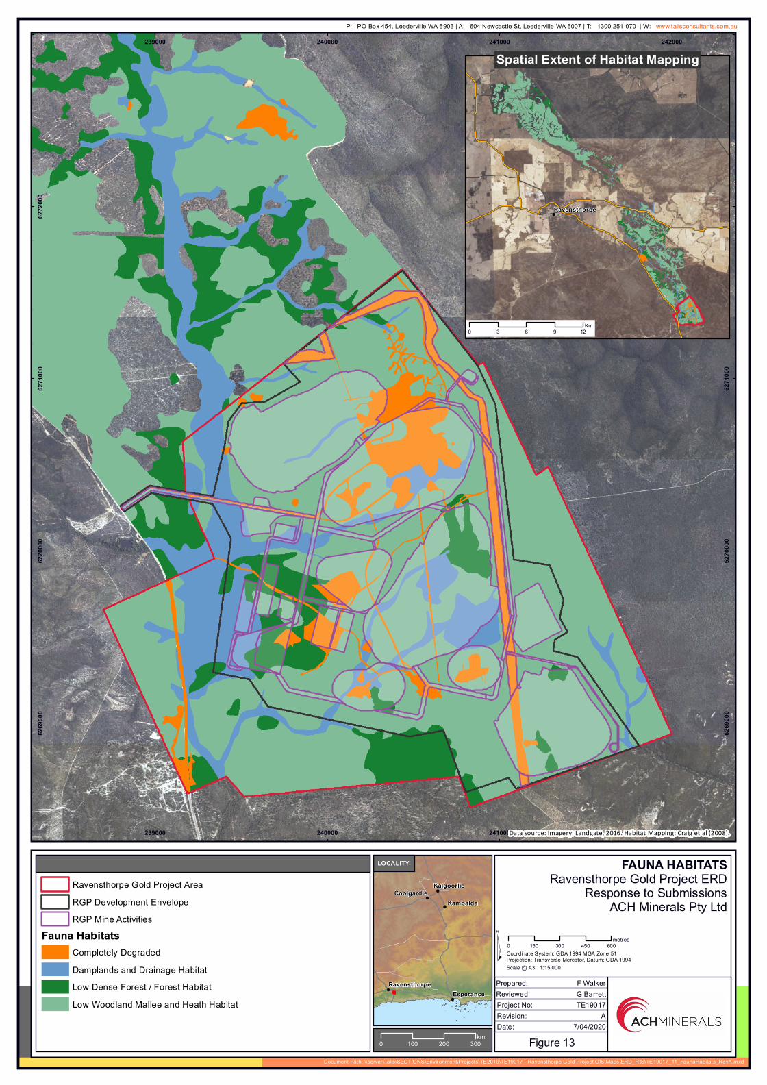
Service Layer Credits: Landgate / SLIP
XX
LEGEND
Figure 13
FAUNA HABITATSRavensthorpe Gold Project ERD
Response to SubmissionsACH Minerals Pty Ltd
¤
239000
239000
240000
240000
241000
241000
242000
242000
6269
000
6269
000
6270
000
6270
000
6271
000
6271
000
6272
000
6272
000
Scale @ A3: 1:15,000
Ravensthorpe Gold Project AreaRGP Development EnvelopeRGP Mine Activities
Fauna HabitatsCompletely DegradedDamplands and Drainage HabitatLow Dense Forest / Forest HabitatLow Woodland Mallee and Heath Habitat
Data source: Imagery: Landgate, 2016. Habitat Mapping: Craig et al (2008).
CoolgardieKalgoorlie
Kambalda
EsperanceRavensthorpe
0 100 200 300km
LOCALITY
Document Path: \\server\Talis\SECTIONS\Environment\Projects\TE2019\TE19017 - Ravensthorpe Gold Project\GIS\Maps\ERD_RtS\TE19017_11_FaunaHabitats_RevA.mxd
Prepared: F WalkerReviewed: G Barrett
0 150 300 450 600metres
7/04/2020
TE19017A
Date:Revision:Project No:
Coordinate System: GDA 1994 MGA Zone 51Projection: Transverse Mercator, Datum: GDA 1994
!Ravensthorpe
Spatial Extent of Habitat Mapping
0 3 6 9 12Km
P: PO Box 454, Leederville WA 6903 | A: 604 Newcastle St, Leederville WA 6007 | T: 1300 251 070 | W: www.talisconsultants.com.au

Service Layer Credits: Landgate / SLIP
XX
LEGEND
Figure 14
ALLUVIAL FORMATIONSRavensthorpe Gold Project ERD
Response to SubmissionsACH Minerals Pty Ltd
¤
240000
240000
6270
000
6270
000
Scale @ A3: 1:13,000
Ravensthorpe Gold Project Area
Potential Stygofauna Habitat
Proposed Open Pit
Data source: Imagery: Landgate, 2016.
CoolgardieKalgoorlie
Kambalda
EsperanceRavensthorpe
0 100 200 300km
LOCALITY
Document Path: \\server\Talis\SECTIONS\Environment\Projects\TE2019\TE19017 - Ravensthorpe Gold Project\GIS\Maps\ERD_RtS\TE19017_15_StygofaunaHabitat_RevA.mxd
Prepared: F WalkerReviewed: G Barrett
0 200 400 600 800m
7/04/2020
TE19017A
Date:Revision:Project No:
Coordinate System: GDA 1994 MGA Zone 51,Projection: Transverse Mercator, Datum: GDA 1994
P: PO Box 454, Leederville WA 6903 | A: 604 Newcastle St, Leederville WA 6007 | T: 1300 251 070 | W: www.talisconsultants.com.au

XX
LEGEND
Figure 15
HOPETOUN - RAVENSTHORPERAILWAY HERITAGE WALK
Ravensthorpe Gold Project ERDResponse to Submissions
ACH Minerals Pty Ltd
¤
Ho peto un
Ra ve n sth or pe
220000
220000
230000
230000
240000
240000
250000
250000
6240
000
6240
000
6250
000
6250
000
6260
000
6260
000
6270
000
6270
000
6280
000
6280
000
Scale @ A3: 1:150,000
Ravensthorpe Gold Project Area
RGP Development Envelope
Proposed Footprint
Hopetoun - Ravensthorpe Railway Heritage WalkRail TrailOther TrailFormer Railway
Kundip Battery
Minor RoadMajor Road
Data source: Roads - MRWA, 2019. Imagery: ESRI, 2016.
CoolgardieKalgoorlie
Kambalda
EsperanceRavensthorpe
0 100 200 300km
LOCALITY
Document Path: \\server\Talis\SECTIONS\Environment\Projects\TE2019\TE19017 - Ravensthorpe Gold Project\GIS\Maps\ERD_RtS\TE19017_16_RailwayHeritageTrail_RevA.mxd
Prepared: F WalkerReviewed: G Barrett
0 2 4 6 8km
7/04/2020
TE19017A
Date:Revision:Project No:
Coordinate System: GDA 1994 MGA Zone 51Projection: Transverse Mercator, Datum: GDA 1994
P: PO Box 454, Leederville WA 6903 | A: 604 Newcastle St, Leederville WA 6007 | T: 1300 251 070 | W: www.talisconsultants.com.au

Ravensthorpe Gold Project Environmental Review Document – Response to Submissions Assessment No.2117
ACH Minerals Ravensthorpe Gold Project ERD Response to Submissions.1b April 2020 | Tables
Tables

Ravensthorpe Gold Project Environmental Review Document – Response to Submissions Assessment No.2117
ACH Minerals Ravensthorpe Gold Project ERD Response to Submissions.1b April 2020 | Tables
Table 1: RGP Project Area – dam water quality samples (2018-2019)
Analyte Units Measured range DER (2014) fresh water
assessment level
EC mS/cm 1.26 – 18.03 -
pH 6.8 – 7.7 6.5-8.5
Total N mg/L 0.04 – 9.11 1 (long term)
2 (Short term)
Hg mg/L 0.00005 – 0.00056 0.00006
Al mg/L 0.07 – 3.3 0.055
Cu mg/L 0.03 – 2.14 0.0014
Mn mg/L 0.03 – 3.95 1.9
Ni mg/L 0.003 – 0.024 0.011
Zn mg/L 0.01 – 0.048 0.008
Bo mg/L 0.2 – 2.1 0.37
Fe mg/L 0.263 – 27.3 0.3
Pb mg/L 0.001 – 1.4 0.0034
Cd mg/L 0.0001 - 0.0047 0.0002
As mg/L 0.001 – 0.027 0.013

Ravensthorpe Gold Project Environmental Review Document – Response to Submissions Assessment No.2117
ACH Minerals Ravensthorpe Gold Project ERD Response to Submissions.1b April 2020 | Tables
Table 2: RAV8 Nickel Project - pit groundwater quality (May 2018)
Parameter Unit Limit of
Reporting Value
pH pH units 0.01 8.14
Total Dissolved Solids mg/L 10 20,200
Major Cations
Calcium mg/L 1 200
Magnesium mg/L 1 864
Sodium mg/L 1 3210
Potassium mg/L 1 103
Total Metals
Aluminium mg/L 0.01 0.02
Arsenic mg/L 0.001 0.001
Beryllium mg/L 0.001 <0.001
Barium mg/L 0.001 0.030
Cadmium mg/L 0.0001 0.0004
Chromium mg/L 0.001 <0.001
Cobalt mg/L 0.001 0.040
Copper mg/L 0.001 0.002
Lead mg/L 0.001 <0.001
Lithium mg/L 0.001 0.138
Manganese mg/L 0.001 0.191
Molybdenum mg/L 0.001 0.002
Nickel mg/L 0.001 3.39
Selenium mg/L 0.01 <0.01
Tin mg/L 0.001 <0.001
Uranium mg/L 0.001 0.001
Vanadium mg/L 0.01 <0.01
Zinc mg/L 0.005 <0.005
Boron mg/L 0.05 1.86
Iron mg/L 0.05 0.14

Ravensthorpe Gold Project Environmental Review Document – Response to Submissions Assessment No.2117
ACH Minerals Ravensthorpe Gold Project ERD Response to Submissions.1b April 2020 | Tables
Table 3: RGP Project Area and surrounds- indicative surface and groundwater monitoring program
Sampling points Timing/frequency Target analytes
Surface water
Steere River monitoring points:
2 upstream
4 downstream
(Figure 4-38, Figure 2)
(Points: S1-4, P1 -2)
Hand sample ephemeral flows
opportunistically during runoff
events, during operation.
Field:
Temperature;
pH;
Dissolved oxygen (DO); and
Electrical conductivity (EC).
Laboratory:
pH;
Total Dissolved Solids (TDS);
Turbidity;
N and P;
Ionic balance;
Metals (total and dissolved); and
Total recoverable hydrocarbons
(TRH).
Jerdacuttup River monitoring points:
1 upstream
2 downstream
(Figure 4-38)
(Points: J1-3)
TSF cut-off drain
Mine void water quality:
All pit lakes
Annually, at cessation of
dewatering when pits fill with
water.
Laboratory:
pH;
TDS;
Ionic balance; and
Metals (total and dissolved).
Photo monitoring points:
5 points along local creeklines
(Figure 2)
(Points: P1-5)
Six monthly. Photo monitoring.
Groundwater
TSF:
An array of 8 monitoring bores
(upstream and downstream)9
(Figure 2)
(Points: G6-12)
During operation quarterly
sampling and monthly
standing water levels.
Laboratory:
pH;
Salinity;
Ionic balance;
Metals (total and dissolved);
Depth to water; and
WAD CN.
Pit voids:
An array of 7 monitoring bores
(upstream and downstream)
(Figure 2)
(Points: G1-4, G8, KMB5a, KMB6a)
During operation annual
sampling and monthly
standing water levels.
9 A mine tenure change will be necessary to establish some groundwater monitoring bores south of the Project Area.

Ravensthorpe Gold Project Environmental Review Document – Response to Submissions Assessment No.2117
ACH Minerals Ravensthorpe Gold Project ERD Response to Submissions.1b April 2020 | Tables
Sampling points Timing/frequency Target analytes
Notes on metals
Metal suite for dissolved and total metals should include the following:
Aluminium (Al), silver (Ag), arsenic (As), boron (B), barium (Ba), beryllium (Be), calcium (Ca), cadmium (Cd),
cobalt (Co), chromium (Cr), copper (Cu), iron (Fe), mercury (Hg) , potassium (K), lithium (Li), magnesium
(Mg), manganese (Mn), molybdenum (Mo), sodium (Na), nickel (Ni), lead (Pb), antimony (Sb), selenium (Se),
tin (Sn), titanium (Ti), uranium (U), vanadium (V) and zinc (Zn).
Notes on post-closure monitoring
Groundwater and surface water monitoring will continue post closure until such a time as the completion
criteria are met as per an approved Mine Closure Plan (MCP) under the Mining Act 1978.
The current completion criteria in the draft MCP in regards to water quality states that water quantity and
quality will be on a trajectory to baseline levels within two years of cessation of mining and processing. This
will likely be subject to change at the time of submission to DMIRS.
Notes on trigger levels
Trigger levels for groundwater and surface water quality will be established once sufficient baseline data has
been collected.
Trigger levels for water quality are proposed to be set to 80th (or 20th) percentile of baseline data and
confirmed in consultation with DMIRS and DWER. Should the trigger levels be exceeded for three consecutive
sampling periods for groundwater (or two for surface water), investigations will take place and management
strategies will be implemented.
Management strategies may include:
Determine whether the changes observed are a results of the Project e.g. undertake a
comparison with any control sites up-gradient or upstream;
Increase monitoring frequency;
Investigate reason for any change including which activities may have caused the change;
Review of management measures and controls; and
Undertaken further studies.

Ravensthorpe Gold Project Environmental Review Document – Response to Submissions Assessment No.2117
ACH Minerals Ravensthorpe Gold Project ERD Response to Submissions.1b April 2020 | Tables
Table 4: RGP Project Area - groundwater quality samples
Analyte Units Measured range DER (2014) non-potable
groundwater use assessment level
EC mS/cm 16.33 – 69.7 -
pH 6.18 – 7.37 -
Sulfate as SO4 mg/L 910 - 3600 1000
Cl mg/L 4634 - 20667 250
Ammonia as N mg/L 0.02 – 7.19 0.5
Al mg/L 0.01 – 0.41 0.2
Fe mg/L 0.001 – 3.633 0.3
Note: The values highlighted denote changes since incorporating the latest monitoring results. The only significant change of note was the presence of elevated ‘ammonia as N’ in one monitoring location (KMB2) as the previous maximum recorded value was 1.24 mg/L. Possibly attributable to historic blasting residue.

Ravensthorpe Gold Project Environmental Review Document – Response to Submissions Assessment No.2117
ACH Minerals Ravensthorpe Gold Project ERD Response to Submissions.1b April 2020 | Tables
Table 5: Summary of population counts for five Priority species (December 2019)
Taxon Conservation
status
Total
known
plants
Abundance in
Development Envelope
and 20 m buffer
% of total known
plants
Abundance in
Development
Envelope less
abundance in
Exclusion Zone
(inc. 20 m buffer)
% of total known
plants (with
Exclusion Zone
applied)
Calothamnus
roseus P1 4,700 3,200 68 220 4.7
Melaleuca
sophisma P1 58,347 347 0.6
Hydrocotyle
tuberculata P2 237 -10 -
Thomasia sp.
Hopetoun (K.R.
Newbey 4896)
P2 243 44 18
Dampiera sp.
Ravensthorpe (G.F.
Craig 8277)
P3 36,893 -11 -
10 Annual plant not found in Dec 2019 survey; c. 60 plants in 2011; previously 110 plants in 2005.
11 Not found in Dec 2019 survey; 1,500 plants in 2009.

Ravensthorpe Gold Project Environmental Review Document – Response to Submissions Assessment No.2117
ACH Minerals Ravensthorpe Gold Project ERD Response to Submissions.1b April 2020 | Appendix
: Tailings Storage Facility: Feasibility Study (Resource Engineering Consultants)
Tailings Storage Facility Feasibility Study
Ravensthorpe Gold Project, Western Australia
ACH Minerals Ltd
Rev. 5 January 2020

Resource Engineering Consultants Pty Ltd ACN: 626 931 753
Trading as REC ABN: 66 626 931 753 Address and Contact Details Suite 2E, 2 Gemstone Blvd
Carine WA 6020
T: +61 (8) 6444 7988
W: www.rec.com.au
Limitations, Uses and Reliance This document, once read in its entirety, may be relied upon for the purposes stated within the limits of:
Geotechnical investigations and assessments are undertaken in accordance with an agreed term of reference and timeframe and may involve intrusive investigations of subsurface conditions, generally at a few selected locations. Although due care, skill and professional judgement are applied in the interpretation and extrapolation of geotechnical conditions and factors to elsewhere, the potential for variances cannot be discounted. Therefore, the results, analyses and interpretations presented herein cannot be considered absolute or conclusive. REC does not accept any responsibility for variances between the interpreted and extrapolated and those that are revealed by any means. Specific warning is given that many factors, natural or artificial, may render conditions different from those that prevailed at the time of investigation and should they be revealed at any time subsequently, they should be brought to our attention so that their significance may be assessed, and appropriate advice may be offered. Users are also cautioned that fundamental assumptions made in this document may change with time and it is the responsibility of any user to ensure that assumptions made, remain valid.
The comments, findings, conclusions and recommendations contained in this document represent professional estimates and opinions and are not to be read as facts unless expressly stated to the contrary. In general, statements of fact are confined to statements as to what was done and/or what was observed; others have been based on professional judgement. The conclusions are based upon information and data, visual observations and the results of field and laboratory investigations and are therefore merely indicative of the environmental and geotechnical conditions at the time, including the presence or otherwise of contaminants or emissions. In addition, presentations in this document are based upon the extent of the terms of reference and/or on information supplied by the client, agents and third parties outside our control. To the extent that the statements, opinions, facts, conclusions and/or recommendations in this document are based in whole or part on this information, those are contingent upon the accuracy and completeness of the information which has not been verified unless stated otherwise. REC does not accept responsibility for omissions and errors due to incorrect information or information not available at the time of preparation of this document and will not be liable in relation to incorrect conclusions should any information be incorrect or have been concealed, withheld, misrepresented or otherwise not fully disclosed. We will not be liable to update or revise the document to take into account any events, emergent circumstances or facts occurring or becoming apparent after the date of this document.
Within the limitations imposed by the terms of reference, the assessment of the study area and preparation of this document have been undertaken and performed in a professional manner, by suitably qualified and experienced personnel, in accordance with generally accepted practices and using a degree of skill and care ordinarily exercised by geotechnical consultants under similar circumstances. No other warranty, expressed or implied, is made.
This document has been prepared for the purposes stated herein. Every care was taken in the interpretation of geotechnical conditions and the nature and extent of impacts, presentation of findings and recommendations which are provided in good faith in the general belief that none of these are misleading. No responsibility or liability for the consequences of use and/or inference by others is accepted.
Intellectual and copyright in the information, data and representations such as drawings, appendices, tabulations and text, included in this document remain the property of REC. This document is for the exclusive use of the authorised recipient(s) and may not be used, copied or reproduced in whole, or in part, for any purpose(s) other than that for which it was prepared for. No responsibility or liability to any other party is accepted for any consequences and/or damages arising out of the use of this document without express and written consent.
The above conditions must be read as part of the document and must be reproduced where permitted. Acceptance of this document indicates acceptance of these terms and conditions.
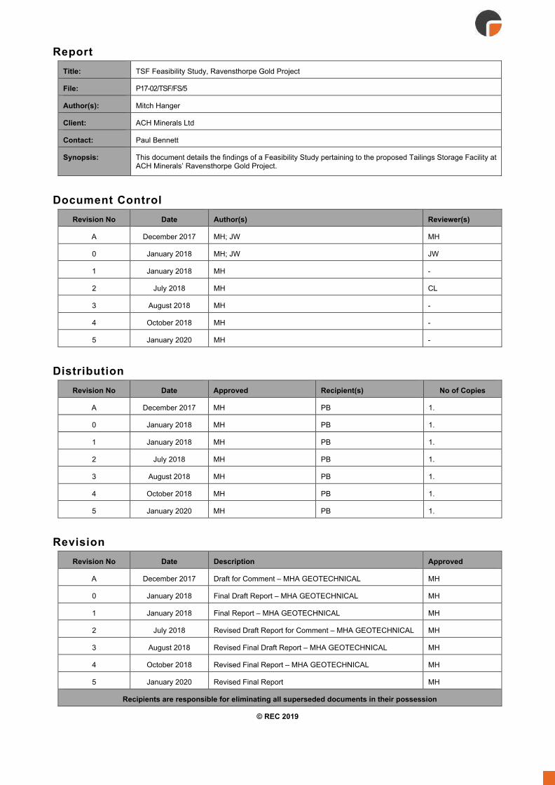
Report Title: TSF Feasibility Study, Ravensthorpe Gold Project
File: P17-02/TSF/FS/5
Author(s): Mitch Hanger
Client: ACH Minerals Ltd
Contact: Paul Bennett
Synopsis: This document details the findings of a Feasibility Study pertaining to the proposed Tailings Storage Facility at ACH Minerals’ Ravensthorpe Gold Project.
Document Control
Revision No Date Author(s) Reviewer(s)
A December 2017 MH; JW MH
0 January 2018 MH; JW JW
1 January 2018 MH -
2 July 2018 MH CL
3 August 2018 MH -
4 October 2018 MH -
5 January 2020 MH - Distribution
Revision No Date Approved Recipient(s) No of Copies
A December 2017 MH PB 1.
0 January 2018 MH PB 1.
1 January 2018 MH PB 1.
2 July 2018 MH PB 1.
3 August 2018 MH PB 1.
4 October 2018 MH PB 1.
5 January 2020 MH PB 1. Revision
Revision No Date Description Approved
A December 2017 Draft for Comment – MHA GEOTECHNICAL MH
0 January 2018 Final Draft Report – MHA GEOTECHNICAL MH
1 January 2018 Final Report – MHA GEOTECHNICAL MH
2 July 2018 Revised Draft Report for Comment – MHA GEOTECHNICAL MH
3 August 2018 Revised Final Draft Report – MHA GEOTECHNICAL MH
4 October 2018 Revised Final Report – MHA GEOTECHNICAL MH
5 January 2020 Revised Final Report MH
Recipients are responsible for eliminating all superseded documents in their possession
© REC 2019

Table of Contents Table of Contents .............................................................................................................. 4
Terminology and Abbreviations ....................................................................................... 8
1. TSF Proposal Summary .............................................................................................. 9
2. TSF Design Considerations ...................................................................................... 10
Introduction ..................................................................................................................... 10
Background ..................................................................................................................... 10
Standards, Guidelines and Regulations ......................................................................... 10
Storage Capacity ............................................................................................................ 10
Tenure and Site Conditions ............................................................................................ 11 2.5.1 Location ............................................................................................................................... 11
2.5.2 Climate ................................................................................................................................ 11
2.5.3 Hydrology ............................................................................................................................ 12
Catchment ...................................................................................................................... 12
Runoff ............................................................................................................................. 13
Design Storm Events ...................................................................................................... 13
2.5.4 Geology ............................................................................................................................... 14
Regional Geology ........................................................................................................... 14
Local Geology ................................................................................................................. 14
Sub-surface Conditions and Foundations ...................................................................... 14
2.5.5 Seismic Risk ........................................................................................................................ 16
2.5.6 Current and After Closure Land Use ................................................................................... 17
Retaining Structure Properties ........................................................................................ 17
Tailings Properties .......................................................................................................... 17 2.7.1 Laboratory Testing............................................................................................................... 17
Oxide Tailings Test Results ............................................................................................ 17
Primary Ore Test Results ............................................................................................... 18
2.7.2 Tailings Design Parameters – Civil Infrastructure and Planning ......................................... 18
2.7.3 Tailings Design Parameters – Civil Infrastructure and Planning ......................................... 18
2.7.4 Geochemical Characterisation of Tailings ........................................................................... 18
3. TSF Design ................................................................................................................. 19
Introduction ..................................................................................................................... 19
DMIRS Classification ...................................................................................................... 20 3.2.1 Hazard Rating ...................................................................................................................... 20
3.2.2 TSF Category ...................................................................................................................... 20
3.2.3 DMP Recommended Freeboard (DMP, 2015a) .................................................................. 20
ANCOLD Consequence Category .................................................................................. 21 3.3.1 General ................................................................................................................................ 21
3.3.2 Dam Failure Severity Level ................................................................................................. 21
3.3.3 Dam Failure Population at Risk ........................................................................................... 22
3.3.4 Dam failure Consequence Category ................................................................................... 22

3.3.5 Environmental Spill Consequence Category ....................................................................... 22
3.3.6 ANCOLD Design Criteria ..................................................................................................... 22
Modelling and Design Studies ........................................................................................ 23 3.4.1 Stability Assessment ........................................................................................................... 23
Embankment Compaction .............................................................................................. 23
Embankment Material Foundation Material Slope Stability Assessment Methodology . 23
Foundation Material ........................................................................................................ 23
Slope Stability Assessment Methodology ...................................................................... 23
Results ............................................................................................................................ 24
3.4.1.5.1 Static Stability .............................................................................................................. 24
3.4.1.5.2 Seismic Stability ........................................................................................................... 24
3.4.2 Erosion Control .................................................................................................................... 24
3.4.3 Seepage .............................................................................................................................. 25
Design Measures ............................................................................................................ 25
3.4.3.1.1 Underdrainage and collection sump ............................................................................ 25
3.4.3.1.2 Cut-off trench and cut-off drain .................................................................................... 25
3.4.3.1.3 TSF Catchment ............................................................................................................ 26
3.4.3.1.4 Decant Pond Location ................................................................................................. 26
3.4.3.1.5 Rate of Rise ................................................................................................................. 26
3.4.3.1.6 Low Permeability Floor ................................................................................................ 26
Operational Controls ....................................................................................................... 26
3.4.3.2.1 Sub-aerial Deposition .................................................................................................. 26
3.4.3.2.2 Decant Pond Management .......................................................................................... 26
3.4.3.2.3 Pore Pressure monitoring ............................................................................................ 26
3.4.3.2.4 Groundwater Monitoring .............................................................................................. 27
Seepage Quality ............................................................................................................. 27
3.4.4 Surface Water Flow and Storage ........................................................................................ 27
Design and Construction Details .................................................................................... 29 3.5.1 General ................................................................................................................................ 29
3.5.2 Bill of Quantities ................................................................................................................... 29
Tailings Discharge and Water Management ................................................................... 29 3.6.1 Tailings Deposition .............................................................................................................. 29
3.6.2 Decant Pond Management .................................................................................................. 31
3.6.3 Seepage Management ........................................................................................................ 33
Covers and Liners ........................................................................................................... 34
Quality Assurance ........................................................................................................... 35
Spillways ......................................................................................................................... 35
4. Operational Requirements ........................................................................................ 36
General ........................................................................................................................... 36
Management of Tailings Deposition and Water .............................................................. 36
Seepage Management ................................................................................................... 36
Erosion Control ............................................................................................................... 36

Embankment Instrumentation ......................................................................................... 36
5. Closure Requirements .............................................................................................. 38
General ........................................................................................................................... 38
Decommissioning ........................................................................................................... 39
Tailings Surface Cover ................................................................................................... 39
Diversion Drains ............................................................................................................. 39
Rehabilitation .................................................................................................................. 39
Performance Monitoring against Closure Criteria ........................................................... 39
6. References ................................................................................................................. 40
7. Limitations ................................................................................................................. 41

Figures Figure 1: RGP Site layout ................................................................................................................................. 11
Figure 2: TSF Catchment. (TSF catchment and upstream catchment areas) ................................................. 12
Figure 3: Proposed TSF location - upstream catchment. ................................................................................. 13
Figure 4: Geotechnical Investigation Setout ..................................................................................................... 15
Figure 5: TSF basin - shallow subsurface conditions ....................................................................................... 16
Figure 6: TSF General arrangement (plan) ...................................................................................................... 19
Figure 7: TSF General arrangement (profile) ................................................................................................... 19
Figure 8: Freeboard definition (DMP, 2015a) ................................................................................................... 21
Figure 9: TSF Freeboard Assessment ............................................................................................................. 28
Figure 10: TSF Freeboard Limits ...................................................................................................................... 28
Figure 11: Tailings surface (beach) development ............................................................................................ 30
Figure 12: Tailings storage capacity curve ....................................................................................................... 31
Figure 13: Tailings Rate of Rise ....................................................................................................................... 31
Figure 14: Decant configuration (initial pump and floating uptake location – Year 1) ...................................... 32
Figure 15: Progressive relocation of decant pump (pump and floating uptake location – Year 10)................. 33
Figure 16: Cut-off trench and cut-off drain ....................................................................................................... 33
Figure 17: Underdrainage and Collection Sump configuration ........................................................................ 34
Figure 18: Embankment instrumentation (Plan) ............................................................................................... 37
Figure 19: Embankment instrumentation.......................................................................................................... 37
Figure 20: RGP TSF closure concept ............................................................................................................... 38
Tables Table 1: Long-term Rainfall & Temperature and Evaporation Data - Ravensthorpe 010633. ......................... 12
Table 2: Rare design rainfall depth (mm) – (BoM 2016 Rainfall IFD data system) .......................................... 14
Table 3: Oxide Ore Tailings test results ........................................................................................................... 17
Table 4: Primary Ore Tailings test results ........................................................................................................ 18
Table 5: Assumed tailings design parameters ................................................................................................. 18
Table 6: Hazard rating system applicable to TSFs in Western Australia ......................................................... 20
Table 7: Embankment Material Geotechnical Parameters ............................................................................... 23
Table 8: Static Stability Results ........................................................................................................................ 24
Table 9: Seismic Stability Results .................................................................................................................... 24
Table 10: Preliminary bill of quantities .............................................................................................................. 29
Appendices Appendix A: Geotechnical Field Investigation Report
Appendix B: Geotechnical Field Investigation Test Pit Logs and Photographs
Appendix C: Geotechnical Field Investigation Field Permeability Test Results
Appendix D: Geotechnical Field Investigation CPT Results
Appendix E: Geotechnical Field Investigation Laboratory Test Results and Certificates
Appendix F: TSF Feasibility Study Drawings

Terminology and Abbreviations The following terminology and abbreviations have been used in this document:
AEP Annual exceedance probability
ANCOLD Australian National Committee on Large Dams
BOM Bureau of Meteorology
DFL Deflector Mining Limited
DMIRS Department of Mines, Industry Regulation and Safety
DWERS Department of Water and Environmental Regulation
LOM Life of mine
IFD Intensity frequency duration
m/a Metres per annum
m3/d Cubic meters per day
Mm3 Million cubic meters
Mt Million tonnes
Mtpa Million tons per annum
NAF Non-acid forming
OD Outside diameter
RL Reduced level
SG Specific gravity
tpa Tonnes per annum
tpd Tonnes per day
t/m³ Tonnes per cubic metre
TSF Tailings Storage Facility
TSM Tailings storage management
Reference: P17-02/TSF/FS/5 Page 9 of 41 Date: January 202 Site: Ravensthorpe Gold Project Title: TSF Feasibility Study Revision No: 5
1. TSF Proposal Summary MHA Geotechnical Pty Ltd (MHA) prepared the original Feasibility Study (FS) level design of the Kundip Mine
Site tailings storage facility (TSF) at the ACH Minerals Pty Ltd (ACH) Ravensthorpe Gold Project (RGP) to
support the overall project Feasibility Study into the technical and commercial viability of RGP. This report was
originally prepared in December 2017 and in July 2019 MHA was rebranded to operate as Resource
Engineering Consultants Pty Ltd (REC).
This revised FS report has been prepared by REC following the format recommended in the Government of
Western Australia Department of Mines and Petroleum’s (DMP) Guide to the Preparation of a Design Report
for Tailings Storage Facilities. This report is not intended to serve as the detailed design report for submission
to the Department on Mines, Industry Regulation and Safety (DMIRS); further design development is required
to advance from a FS level design to detailed design with issued for construction (IFC) documentation.
The Kundip Mine Site is situated approximately 20 km by road south-east of the town of Ravensthorpe and
can be accessed from the Hopetoun-Ravensthorpe Road. The RGP site layout, Kundip mining tenement and
location of the TSF relative the main project features is shown on Figure 1.
The Project schedule envisages total tailings production of 3.1 Mt. At an assumed average dry density of 1.5
t/m3 for the stored tailings, the required tailings storage capacity is 2.0 Mm3.
The proposed RGP TSF is a side-hill paddock-style facility. An engineered embankment will provide
containment on three sides (east, south and west) whilst the natural topography will provide containment on
the north side. The proposed TSF configuration is shown in plan and profile on Figure 6 and Figure 7. In
accordance with the DMP Code of Practice (CoP) (DMP, 2013), the RGP TSF attracts a Medium hazard rating.
Construction of the RGP TSF will be undertaken in accordance with IFC drawings and earthworks specification.
Furthermore, construction and operation will be in general accordance with the design intent of the final detailed
design report.
Tailings are to be deposited from the main embankment in a sub-areal manner in thin lifts and beaching
towards the northwest corner of the facility to form a decant pond away from the main embankment. The
configuration and location of the decant pond provides capacity for the 1:100 annual exceedance probability
(AEP) 72-hour storm event and DMP required freeboard.
It is envisaged that a detailed closure plan will be developed at a later stage in conjunction with an RGP site
wide closure plan. The proposed RGP TSF has been developed with closure in mind, taking into consideration
the DMP’s principal closure objectives for rehabilitated mines and the Environmental Protection Authority’s
(EPA) objective for Rehabilitation and Decommissioning to ensure that premises are decommissioned and
rehabilitated in an ecologically sustainable manner.

Reference: P17-02/TSF/FS/5 Page 10 of 41 Date: January 202 Site: Ravensthorpe Gold Project Title: TSF Feasibility Study Revision No: 5
2. TSF Design Considerations Introduction
MHA was engaged by ACH to provide engineering design services as part of a Feasibility Study (FS) level
design of the Kundip Mine Site tailings storage facility for the Ravensthorpe Gold Project. This work was carried
out between December 2017 and October 2019. MHA was rebranded in July 2019 to operate as REC.
As part of this study, REC have developed a TSF concept through to a FS level. The output of this work will
be incorporated into the overall project Feasibility Study (undertaken by others) assessing the technical and
commercial viability of the RGP.
Background RGP is larger in scale than the previously approved Phillips River Project, which was to be developed at the
same site. Mining of gold and copper bearing ore will be focused on a combination of open-pits and
underground mining at Kundip. Processing and tailings storage will also be contained within the Kundip mining
leases.
The Kundip Mine Site is situated approximately 20 km by road south-east of the town of Ravensthorpe and
can be accessed from the Hopetoun-Ravensthorpe Road. Regional features include the Bandalup Corridor,
the buffer zone for the Fitzgerald Biosphere Reserve and areas of uncleared vacant Crown Land as well as
private property that supports agricultural land uses.
Standards, Guidelines and Regulations The FS level design of the RGP TSF shall follow the recommendations of the following;
• Government of Western Australia Department of Mines and Petroleum (DMP): Guide to Departmental
requirements for the management and closure of tailings storage facilities (TSFs), 2015a;
• Government of Western Australia Department of Mines and Petroleum (DMP) Code of Practice (CoP):
Tailings Storage Facilities in Western Australia, 2013;
• Australian National Committee on Large Dams (ANCOLD): Guidelines on Tailings Dams Planning,
Design, Construction, Operation and Closure, 2012.
Storage Capacity The RGP ore processing route is gravity/flotation/CIL; design slurry density of CIL (Carbon-in-leach) is 50 %
solids w/w (no tailings thickener). After the final adsorption tank the slurry will pass through a detox tank before
being pumped to the TSF at 50 % solids w/w.
Base case tailings production of 3.1 Mt has been adopted for this study. At an assumed average dry density
of 1.5 t/m3 for the stored tailings, the required tailings storage capacity is 2.0 Mm3. Annual production rates
may vary from 0.3 Mtpa to 0.4 Mtpa however the required tailings storage capacity will remain constant.
Should additional storage capacity be required, either from increased production or extending the life of the
project, the TSF could be raised. However, design of a future raise is outside the scope of this document.

Reference: P17-02/TSF/FS/5 Page 11 of 41 Date: January 202 Site: Ravensthorpe Gold Project Title: TSF Feasibility Study Revision No: 5
Tenure and Site Conditions
2.5.1 Location The Kundip Mine Site is situated approximately 20 km by road south-east of the town of Ravensthorpe and
can be accessed from the Hopetoun-Ravensthorpe Road. The RGP site layout, Kundip mining tenements and
location of the TSF relative the main project features is shown on Figure 1.
Figure 1: RGP Site layout
2.5.2 Climate Data from the Bureau of Meteorology (BOM) weather station nearest to the TSF will be used to evaluate the
climate of the project area (BoM, 2017). Presented in Table 1 are the long-term temperature and rainfall data
(1901-2017) for Ravensthorpe (BoM Site 010633).
Mean monthly rainfall at Ravensthorpe ranges from 24.2 mm in December to 47.3 mm in July, with a mean
annual rainfall of 429.5 mm.
Mean daily evaporation at Munglinup Melaleuca (BoM site 012281), approximately 60km from the Kundip mine
site, ranges from 2.5 mm in July to 8.3 mm in January; mean annual daily evaporation of 5.0 mm (1,825 mm
annual).

Reference: P17-02/TSF/FS/5 Page 12 of 41 Date: January 202 Site: Ravensthorpe Gold Project Title: TSF Feasibility Study Revision No: 5
Table 1: Long-term Rainfall & Temperature and Evaporation Data - Ravensthorpe 010633.
Parameter Jan Feb Mar Apr May Jun Jul Aug Sept Oct Nov Dec Annual
Mean Max Temp (oC)*
29.0 28.3 26.6 23.7 20.0 17.3 16.3 17.3 19.5 22.5 25.1 27.2 22.7
Mean Minimum
Temp (oC)* 14.1 14.6 13.6 11.8 9.6 7.9 6.7 6.7 7.4 9.1 11.1 12.8 10.4
Mean Rainfall (mm)**
24.9 26.5 32.8 32.8 44.1 43.6 47.3 45.1 42.3 38.0 30.6 24.2 429.5 (total)
Highest Rainfall (mm)**
223.2 249.2 163.0 144.7 127.0 117.9 129.6 136.6 144.8 121.4 189.4 140.1 734.5 (total)
Mean Daily Evaporation
(mm)*** 8.3 7.7 6.3 4.7 3.2 2.6 2.5 2.9 3.7 4.8 6.0 7.7
1825 (total)
* 1962-2017; **1901-2017; ***1975-2001 Munglinup Melaleuca (BoM site 012281)
2.5.3 Hydrology
Catchment The proposed location of the RGP TSF has been chosen to limit the upstream catchment which would report
to the TSF. The final TSF disturbance footprint is approximately 29.3 ha (main embankment and maximum
tailings extent at year 10). The total tailings surface catchment is 26.1 ha with an upstream catchment of 6.5
ha for a total catchment of 32.6 ha as shown on Figure 2.
Figure 2: TSF Catchment. (TSF catchment and upstream catchment areas)

Reference: P17-02/TSF/FS/5 Page 13 of 41 Date: January 202 Site: Ravensthorpe Gold Project Title: TSF Feasibility Study Revision No: 5
Runoff The catchment upstream of the proposed TSF location is densely vegetated as shown on Figure 3.
Figure 3: Proposed TSF location - upstream catchment.
An appropriate rational method runoff coefficient for heavily vegetated areas with loamy soil such as those
observed for the TSF catchment would be in the range of C = 0.05 to 0.25. Data gathered from the Australian
Rainfall & Runoff Data Hub (accessed 6 November 2017) for the proposed TSF location indicate storm initial
losses and continuing losses at 28.0 mm and 1.5 mm/hr respectively; roughly equating to a rational method
runoff coefficient of C = 0.21 for a 1:100-yr 72-hr event. A conservative runoff coefficient of C = 1.0 and C =
0.25 for the tailings surface (18.9 ha) and upstream catchment (18.6 ha) respectively has been adopted.
A runoff coefficient of C = 1.0 for the upstream catchment was checked for sensitivity in the TSF storm water
storage (freeboard) calculation in Section 3.4.4.
Design Storm Events Design rainfall depths (mm) for the project site obtained from the BoM 2016 Rainfall IFD (Intensity Frequency
Duration) Data System are shown on Table 2. The design storm storage requirement under DMP (2015a) and
ANCOLD (2012) guidelines is for a 1:100 year 72-hour duration rainfall event (highlighted) in Table 2. DMP
and ANCOLD design storm storage requirements are discussed further in Section 3.2.3 & 3.3.6 respectively.
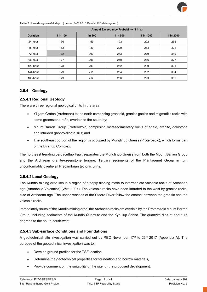
Reference: P17-02/TSF/FS/5 Page 14 of 41 Date: January 202 Site: Ravensthorpe Gold Project Title: TSF Feasibility Study Revision No: 5
Table 2: Rare design rainfall depth (mm) – (BoM 2016 Rainfall IFD data system)
Annual Exceedance Probability (1 in x)
Duration 1 in 100 1 in 200 1 in 500 1 in 1000 1 in 2000
24-hour 136 159 193 222 255
48-hour 162 189 229 263 301
72-hour 172 200 243 279 319
96-hour 177 206 249 286 327
120-hour 178 209 252 290 331
144-hour 179 211 254 292 334
168-hour 179 212 256 293 335
2.5.4 Geology
Regional Geology There are three regional geological units in the area:
• Yilgarn Craton (Archaean) to the north comprising granitoid, granitic gneiss and migmatitic rocks with
some greenstone rafts, overlain to the south by;
• Mount Barren Group (Proterozoic) comprising metasedimentary rocks of shale, arenite, dolostone
and intruded gabbro-diorite sills; and
• The southeast portion of the region is occupied by Munglinup Gneiss (Proterozoic), which forms part
of the Biranup Complex.
The northeast trending Jerdacuttup Fault separates the Munglinup Gneiss from both the Mount Barren Group
and the Archaean granite-greenstone terrane. Tertiary sediments of the Plantagenet Group in turn
unconformably overlie all Precambrian tectonic units.
Local Geology The Kundip mining area lies in a region of steeply dipping mafic to intermediate volcanic rocks of Archaean
age (Annabelle Volcanics) (Witt, 1997). The volcanic rocks have been intruded to the west by granitic rocks,
also of Archaean age. The upper reaches of the Steere River follow the contact between the granitic and the
volcanic rocks.
Immediately south of the Kundip mining area, the Archaean rocks are overlain by the Proterozoic Mount Barren
Group, including sediments of the Kundip Quartzite and the Kybulup Schist. The quartzite dips at about 15
degrees to the south-south-west.
Sub-surface Conditions and Foundations A geotechnical site investigation was carried out by REC November 17th to 23rd 2017 (Appendix A). The
purpose of the geotechnical investigation was to:
• Develop ground profiles for the TSF location,
• Determine the geotechnical properties for foundation and borrow materials,
• Provide comment on the suitability of the site for the proposed development.

Reference: P17-02/TSF/FS/5 Page 15 of 41 Date: January 202 Site: Ravensthorpe Gold Project Title: TSF Feasibility Study Revision No: 5
The typical regolith profile at the TSF site comprises a surficial cover of an unconsolidated sandy silt TOPSOIL
underlain by sandy gravelly SILT, underlain by SILTSTONE (see Appendix B – Geotechnical Field
Investigation Test Pit Logs and Photographs).
The material encountered can be broadly summarised as:
• 0 m – 0.2 m: SILT; sandy, gravelly TOPSOIL with roots and organic matter;
• 0.2 m – 0.6 m: SILT; red brown, sandy with gravel (transitional zone);
• 0.6 m – 1.0 m: SILTSTONE; red brown, conglomeritic;
• 1.0 m – 3.0 m: SILTSTONE, white sandy/gravelly (considered competent bedrock).
Geotechnical test locations relative to the proposed TSF configuration are shown on Figure 4.
Figure 4: Geotechnical Investigation Setout
Additionally, during a site visit undertaken on 19 October 2017, a portion of the TSF basin was accessible from
an existing access track. In an area disturbed by previous prospecting activities a glimpse into the shallow
subsurface conditions was gained by viewing the disturbed areas within the TSF basin. The exposed profile
captured in Figure 5 shows dense vegetation/scrub underlain by 300 to 500 mm of topsoil with a clayey base
below.

Reference: P17-02/TSF/FS/5 Page 16 of 41 Date: January 202 Site: Ravensthorpe Gold Project Title: TSF Feasibility Study Revision No: 5
Figure 5: TSF basin - shallow subsurface conditions
The geotechnical investigation undertaken by REC further confirmed the general shallow subsurface
stratigraphy. The foundation directly beneath the proposed TSF main embankment was not accessible during
the site visit. At this stage it is assumed that the subsurface conditions beneath the main embankment are
similar to the test locations immediately upstream of the embankment. Assumed geotechnical parameters for
the embankment foundation are presented in Section 3.4.1.3.
2.5.5 Seismic Risk The seismic hazard risk assessment contained in GA (2012) is used to quantify the seismic setting for the site.
This is a relatively recent and detailed assessment and provides peak ground accelerations (PGAs) for
earthquakes of return period 500 years and greater (c.f. the project Operating Basis Earthquake (OBE) and
Maximum Design Earthquake (MDE) return periods of 50 years and 100 years respectively). As such its use
is conservative but it directly relates to PGAs of interest to the design of earth structures as opposed to use of
AS1170.4 Structural design actions – Earthquake actions in Australia that is strictly only applicable to steel,
concrete and timber structures.
The PGA is estimated to be 0.06 g for the project. Mining induced ground motion, such as blast induced
shaking, is expected to result in relatively minor PGA and for very short durations (cycles). A blast risk
assessment will be covered as part of the detailed design process if required.

Reference: P17-02/TSF/FS/5 Page 17 of 41 Date: January 202 Site: Ravensthorpe Gold Project Title: TSF Feasibility Study Revision No: 5
2.5.6 Current and After Closure Land Use Post mining land use options and closure objectives have been broadly identified at the project planning phase
and will be further defined during the stakeholder consultation process. The identified post mining land use
aim is to return the land to the pre-mining land use of native vegetation at Kundip.
Retaining Structure Properties The geotechnical investigation undertaken by REC (Appendix A) included collection of samples from stockpiles
located on the Kundip site as well as samples taken from the TSF basin. The results of the laboratory test work
and the geotechnical properties of retaining structure are presented in Appendix E. The geotechnical properties
of the proposed embankment construction material sources are presented in Section 3.4.1.2.
Tailings Properties
2.7.1 Laboratory Testing At the time of writing this report, preliminary representative oxide and primary ore tailings samples were
available for laboratory test work. Assumed engineering design parameters are based on these results and
our experience with similar tailings projects. This is considered acceptable for FS level design, particularly so
because the proposed design does not rely on the geotechnical properties of the tailings for stability or
containment, as would be the case with an upstream raised embankment configuration.
The laboratory test schedule for the tailings samples included:
• Particle Size Distribution with Hydrometer;
• Atterberg limits test;
• Air drying test;
• Settling tests (drained and undrained); and
• Oedometer test.
Oxide Tailings Test Results Preliminary test results indicate that the oxide ore will potentially form a low permeability layer at the base of
the TSF. An in-situ dry density of 1.34 t/m3 is achieved within 24 hours.
Table 3: Oxide Ore Tailings test results
Test/Parameter Value
Percent passing 0.075 mm (SILT) 82 %
Percent passing 0.002 mm (CLAY) 14 %
Liquid Limit 33 %
Plastic Limit 28 %
Plasticity Index 8 %
Linear Shrinkage 2 %
Moisture Content 143.6 %
Particle Density 2.82 t/m3

Reference: P17-02/TSF/FS/5 Page 18 of 41 Date: January 202 Site: Ravensthorpe Gold Project Title: TSF Feasibility Study Revision No: 5
Primary Ore Test Results The results of the primary ore air-drying tests indicate that the evaporation rate form the tailings beach is
expected to be low. The primary ore tailings are non-plastic and settle quickly given the high Specific Gravity
(SG) and lack of plasticity. The settling tests also indicate that water recovering from the TSF is expected to
be high given that an in-situ dry density of 1.46 t/m3 is achieved within 4 hours.
Table 4: Primary Ore Tailings test results
Test/Parameter Value
Percent passing 0.075 mm (SILT) 77 %
Percent passing 0.002 mm (CLAY) 7 %
Liquid Limit NOT OBTAINABLE
Plastic Limit NOT OBTAINABLE
Plasticity Index NON-PLASTIC
Linear Shrinkage NOT OBTAINABLE
Moisture Content 59.6 %
Particle Density 2.91 t/m3
The tailings test results are presented in Appendix E.
2.7.2 Tailings Design Parameters – Civil Infrastructure and Planning The RGP TSF embankment will provide tailings storage capacity for the currently projected life of asset tailings
production, as set out in Section 2.4. The embankment does not rely on the strength of the tailings for stability
and no future raises are currently planned. Assumed parameters for FS level design of the TSF are shown in
Table 5.
Table 5: Assumed tailings design parameters
Parameter Value
In situ dry density 1.5 t/m3
Shear Strength for slope stability assessment zero
Hydraulic permeability 1x10-.3 to 1x10⁻⁷
Slurry density 50 % (w/w)
2.7.3 Tailings Design Parameters – Civil Infrastructure and Planning Tailings samples for rheological test work were not available at the time of preparing this report. Furthermore,
design of mechanical infrastructure is not within the scope of this study.
2.7.4 Geochemical Characterisation of Tailings A preliminary review of the Phillips River Project: Geochemical Characterisation of Tailings-Slurry Samples
(Trilogy Deposit) - Implications for Process-Tailings Management (GCA, 2011) indicates the “Cu/Au-Tailings”
are potentially acid forming (PAF). It is understood that additional geochemical test work and characterisation
will be undertaken prior to or as part of the detailed design process.

Reference: P17-02/TSF/FS/5 Page 19 of 41 Date: January 202 Site: Ravensthorpe Gold Project Title: TSF Feasibility Study Revision No: 5
3. TSF Design Introduction
The proposed RGP TSF is a side-hill paddock-style facility. An engineered embankment will provide
containment on three sides (east, south and west) whilst the natural topography will provide containment to
the north. The proposed TSF configuration is shown in plan and profile on Figure 6 and Figure 7. FS level
design drawings are included in Appendix F.
Figure 6: TSF General arrangement (plan)
Figure 7: TSF General arrangement (profile)

Reference: P17-02/TSF/FS/5 Page 20 of 41 Date: January 202 Site: Ravensthorpe Gold Project Title: TSF Feasibility Study Revision No: 5
DMIRS Classification
3.2.1 Hazard Rating In accordance with the DMP CoP (DMP, 2013), the RGP TSF attracts a Medium hazard rating as demonstrated
in Table 6.
Table 6: Hazard rating system applicable to TSFs in Western Australia
Type of impact or damage Hazard rating Extent or severity of impact or damage
Embankment or Structural Failure Controlled or uncontrolled release of tailings/water, or seepage
Loss of human life or personal injury Low For the proposed location of the TSF the potential population at risk (ANCOLD
terminology) is <1. Adverse human health due to direct physical impact or contamination of the environment
Low
For the proposed location of the TSF there is no potential for human exposure due to direct physical impact. Potential human exposure due to contamination of the environment is low, but the possibility is acknowledged.
Loss of assets due to direct physical impact or contamination of the environment
Low
Livestock will not be present locally, hence there is no potential for loss of livestock from failure. The impact to stock water supply downstream is acknowledged but considered to be minimal; nearest farm is approximately 9km south.
Low There are no infrastructure or other mining, public or pastoral assets immediately downstream of the TSF.
Medium Loss of TSF storage capacity is possible and repair is practicable.
Damage to items of environmental, heritage or historical value due to direct physical impact or contamination of the environment
Medium
The Kundip leases are surrounded by an area of the Ravensthorpe Range recommended by the EPA Red Book (Recommendation 3.8) to become a nature reserve (Proposed Nature Reserve 56). Kundip lies within the eastern sector of the Fitzgerald Biosphere Reserve, in the zone of cooperation. The Biosphere Reserve is a part-tenured management concept recognised by UNESCO as well as State and Commonwealth governments. The concept includes a core area (the Fitzgerald River National Park) a buffer zone (Crown land and some unvested reserves) and a zone of cooperation (private freehold farmland including 557,000ha cleared and 160,000ha uncleared). Mining, subject to sound environmental management practices, is one of many human impacts considered to be acceptable in the zone of cooperation. Kundip is outside of all defined zones. (Tectonic, 2011). The Kundip Mine Site is in close proximity to areas of significant environmental value (nature reserve). Temporary damage to the natural environment is possible.
Medium Temporary adverse effects on flora and fauna are possible
Low Limited or no potential for damage of items of heritage or historical value
3.2.2 TSF Category In accordance with the DMP Code of Practice (DMP, 2013), the RGP TSF would be classified as a Category
1 facility as the TSF attracts a hazard rating of Medium and the embankment will be greater than 15 m in
height.
3.2.3 DMP Recommended Freeboard (DMP, 2015a) Total Freeboard is defined as the vertical height between the lowest point on the crest of the perimeter
embankment of the TSF and the normal operating pond level plus an allowance for an inflow corresponding to
the 1:100 year 72-hour duration rainfall event falling in the catchment of the pond, assuming that no
uncontrolled discharge takes place for the duration of the rainfall event (Total Freeboard also corresponds to
the sum of the “Operational Freeboard” and the “Beach Freeboard” as shown on Figure 8).
Operational Freeboard is defined as the vertical height between the lowest elevation of the perimeter
embankment and the tailings beach immediately inside the embankment.

Reference: P17-02/TSF/FS/5 Page 21 of 41 Date: January 202 Site: Ravensthorpe Gold Project Title: TSF Feasibility Study Revision No: 5
The operational freeboard varies over the course of a deposition cycle as the storage is raised and fills with
tailings. The operational freeboard becomes critically important at the end of a deposition cycle, particularly to
minimise the potential for back flow and overtopping as a result of mounding of tailings at discharge points.
Beach Freeboard is defined as the vertical height between the normal operating pond level plus an allowance
for an inflow corresponding to the 1:100 year 72-hour duration rainfall event falling in the catchment of the
pond, assuming that no uncontrolled discharge takes place for the duration of the rainfall event, and the point
on the beach where the wall freeboard is measured. The Beach Freeboard can vary significantly during the
life of the storage and depends upon beach length, slurry/tailings characteristics, deposition methodology etc.
Beach Freeboard is not applicable where the pond is normally located against a perimeter embankment.
Figure 8: Freeboard definition (DMP, 2015a)
ANCOLD Consequence Category
3.3.1 General There are two Consequence Categories that need to be assessed as part of Tailings Dam design. These are
the Dam Failure Consequence Category and the Environmental Spill Consequence Category. These are used
to determine various design and operational requirements including design of spillways and for flood storage
requirements.
3.3.2 Dam Failure Severity Level In accordance with ANCOLD (2012) Guidelines there are seven (7) damage type categories (infrastructure,
business importance, public health, social dislocation, impact area, impact duration and impact on natural
environment) that need to be assessed in order to determine the severity level/impact (Minor, Medium, Major
and Catastrophic) of a potential facility failure or spill.
The severity levels of impacts associated with failure of the RGP TSF embankment are:
• Infrastructure – Minor: less than $10 M production losses and repair costs;
• Business importance – Medium: significant impacts to operations, including reduced or suspended
operations whilst repairs are made;
• Public health – Minor: no person’s health is affected (see Table 4);
• Social dislocation – Minor: no persons impacted;

Reference: P17-02/TSF/FS/5 Page 22 of 41 Date: January 202 Site: Ravensthorpe Gold Project Title: TSF Feasibility Study Revision No: 5
• Impact area – Medium: potential impact area greater than 1 km2 but less than 5km2;
• Impact duration – Minor: less than 1 year;
• Impact on natural environment – Medium: (see Table 4).
3.3.3 Dam Failure Population at Risk The population at risk (PAR) is defined as all people who would be directly exposed to floodwaters assuming
they took no action to evacuate. No homes, businesses, recreational areas, offices, workshops or laydowns
are located downstream of the embankment, and operational personnel would not be present in low lying areas
downstream of the embankment. Based on this, the PAR for the TSF is considered to be 0 (ANCOLD PAR
category of <1).
3.3.4 Dam failure Consequence Category Based on a dam failure severity level of ‘Medium’ and a PAR <1, the ANCOLD guidelines recommend adoption
of a ‘Low’ Dam Failure Consequence Category rating for purpose of design.
3.3.5 Environmental Spill Consequence Category The Environmental Spill Consequence Category is assessed by considering the effect of spilling dam water to
the downstream environment (typically through the dam spillway during a flood event). The aerial extent of the
spill impact will be significantly smaller than the area which would be affected in the event of dam failure.
The effect of spilling dam water to the environment is primarily driven by the geochemistry of the tailings solids
and supernatant; see Section 2.7.4. Water spilled from the dam under extreme weather events, will be
significantly diluted, and further diluted again given the downstream environment of the dam is also likely to be
flooded.
Therefore, the severity of impact on the natural environmental from environmental spills through a TSF spillway
would be ‘Minor’.
The PAR assigned to a dam spill is <1.
The combined Dam Spill Consequence Category is assessed as ‘Very Low’ at this stage of the design.
3.3.6 ANCOLD Design Criteria ANCOLD recommended design criteria for a ‘Low’ consequence category facility have been adopted,
including;
Minimum freeboard comprising:
• 1:100 annual exceedance probability (AEP), 72-hr flood;
• Contingency freeboard – nil;
• Additional freeboard – nil.
Earthquake loadings:
• Operating Basis Earthquake (OBE) – 1:50 AEP; and
• Maximum Design Earthquake (MDE) – 1:100 AEP.
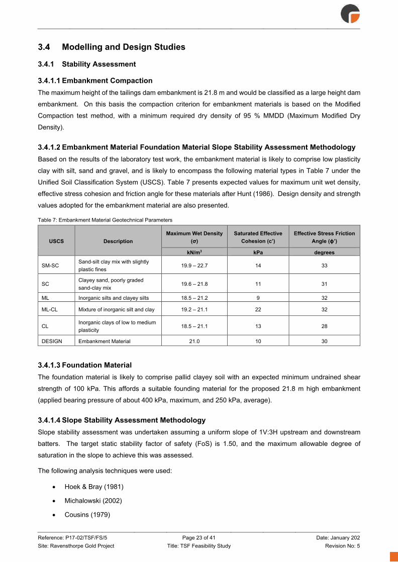
Reference: P17-02/TSF/FS/5 Page 23 of 41 Date: January 202 Site: Ravensthorpe Gold Project Title: TSF Feasibility Study Revision No: 5
Modelling and Design Studies
3.4.1 Stability Assessment
Embankment Compaction The maximum height of the tailings dam embankment is 21.8 m and would be classified as a large height dam
embankment. On this basis the compaction criterion for embankment materials is based on the Modified
Compaction test method, with a minimum required dry density of 95 % MMDD (Maximum Modified Dry
Density).
Embankment Material Foundation Material Slope Stability Assessment Methodology Based on the results of the laboratory test work, the embankment material is likely to comprise low plasticity
clay with silt, sand and gravel, and is likely to encompass the following material types in Table 7 under the
Unified Soil Classification System (USCS). Table 7 presents expected values for maximum unit wet density,
effective stress cohesion and friction angle for these materials after Hunt (1986). Design density and strength
values adopted for the embankment material are also presented.
Table 7: Embankment Material Geotechnical Parameters
USCS Description Maximum Wet Density
(σ) Saturated Effective
Cohesion (c’) Effective Stress Friction
Angle (ɸ’)
kN/m3 kPa degrees
SM-SC Sand-silt clay mix with slightly plastic fines
19.9 – 22.7 14 33
SC Clayey sand, poorly graded sand-clay mix
19.6 – 21.8 11 31
ML Inorganic silts and clayey silts 18.5 – 21.2 9 32
ML-CL Mixture of inorganic silt and clay 19.2 – 21.1 22 32
CL Inorganic clays of low to medium plasticity
18.5 – 21.1 13 28
DESIGN Embankment Material 21.0 10 30
Foundation Material The foundation material is likely to comprise pallid clayey soil with an expected minimum undrained shear
strength of 100 kPa. This affords a suitable founding material for the proposed 21.8 m high embankment
(applied bearing pressure of about 400 kPa, maximum, and 250 kPa, average).
Slope Stability Assessment Methodology Slope stability assessment was undertaken assuming a uniform slope of 1V:3H upstream and downstream
batters. The target static stability factor of safety (FoS) is 1.50, and the maximum allowable degree of
saturation in the slope to achieve this was assessed.
The following analysis techniques were used:
• Hoek & Bray (1981)
• Michalowski (2002)
• Cousins (1979)

Reference: P17-02/TSF/FS/5 Page 24 of 41 Date: January 202 Site: Ravensthorpe Gold Project Title: TSF Feasibility Study Revision No: 5
The embankment material is unlikely to be susceptible to seismic liquefaction, given its high fines content and
well-compacted state. Seismic stability was assessed by considering:
• What percent reduction in soil strength was required in order to achieve a post seismic FoS of unity;
• What coefficients of horizontal (kh) and vertical (kv=+/-0.5kh) acceleration were required to achieve
a FoS of unity.
Results
3.4.1.5.1 Static Stability Results of static stability analyses are presented in Table 8 for target factor of safety (FoS) value of 1.50.
These results indicate adequate stability even for the case of a part-saturated embankment.
Table 8: Static Stability Results
Analysis Method Static FoS Embankment Percentage Saturation
Hoek & Bray (1981) 1.50 50 %
Michalowski (2002) 1.50 90 %
Cousins (1978) 1.50 60 %
3.4.1.5.2 Seismic Stability Results of seismic stability analyses are presented in Table 9 for a target factor of safety (FoS) value of unity.
The strength reduction results point to a robust embankment even if marked strength reduction occurs post
seismic shaking.
Simplistic pseudo-static assessment using kh and kv indicate adequate seismic stability. The peak ground
acceleration (PGA) for the site is <0.06 g for the Operating Basis Earthquake (OBE) and Maximum Design
Earthquake (MDE) events. The kh and kv for FoS of unity are 0.10 g and +/- 0.055 g respectively.
Table 9: Seismic Stability Results
Assessment Method Seismic FoS Result
Strength Reduction 1.0 30 % reduction
in c’ and φ’
1.0 100 % reduction in c’ No reduction in φ’
Lateral Acceleration 1.0 kh = 0.10g kv = +/- 0.5kh
3.4.2 Erosion Control The proposed TSF embankment configuration incorporates 1V:3H upstream and downstream batters to help
manage batter erosion. The shallow downstream batter will serve as both an operational and final closure
slope, envisaged to be vegetated shortly after construction in order to mitigate batter erosion. A shallow
upstream batter has been adopted for the upstream batter due to the length of time the batter will be exposed
prior to being covered with tailings.
The embankment will be constructed of non-dispersive material and includes a protective wood chip/mulch
sheeting layer for further protection of the batter from erosion.
Reference: P17-02/TSF/FS/5 Page 25 of 41 Date: January 202 Site: Ravensthorpe Gold Project Title: TSF Feasibility Study Revision No: 5
3.4.3 Seepage Design measures and operational controls aimed at minimising seepage include;
• Design measures
o Underdrainage and collection sump;
o Cut-off trench and cut-off drain;
o Small TSF catchment;
o Location of the decant pond;
o Low rate of rise;
o Low permeability floor.
• Operational controls
o Sub-areal deposition to promote air-drying (evaporation) whilst continually depositing in thin
lifts to minimise dust generation;
o Maintaining a small decant pond away from the embankment against natural topography;
o Monitoring of pore pressure development within and downstream of the main embankment;
o Monitoring of groundwater levels and groundwater quality downstream of the main
embankment.
These measures are discussed in the following sections.
Design Measures
3.4.3.1.1 Underdrainage and collection sump An underdrainage system and collection sump are proposed to intercept seepage through the tailings stack.
The underdrainage system comprises finger drains within the floor of the TSF (typically wrapped with
geotextile) that are covered with coarse aggregate. The finger drains report to a collection sump at the
downstream toe of the TSF embankment.
Seepage reporting to the collection sump can either be pumped back to the TSF operating pond or to the water
storage dam. The volume of water removed should be correlated against the TSF water balance to determine
whether the underdrainage system is working efficiently and restricting seepage.
3.4.3.1.2 Cut-off trench and cut-off drain A cut-off trench is proposed beneath the TSF embankment. This trench acts to key the embankment into the
natural ground and restrict lateral seepage beneath the embankment wall. A cut-off drain is also proposed on
the downstream toe of the TSF embankment.
The drains act to prevent and collect seepage driven through or under the embankment. The cut-off drain also
acts to manage surface water and prevent ponding on the downstream toe of the embankment. This is
important for TSF monitoring and stability.

Reference: P17-02/TSF/FS/5 Page 26 of 41 Date: January 202 Site: Ravensthorpe Gold Project Title: TSF Feasibility Study Revision No: 5
3.4.3.1.3 TSF Catchment The location of the proposed TSF has been optimised to provide the required storage capacity whilst
minimising the catchment runoff that reports to the facility i.e. seepage is minimised by minimising TSF inflows,
see Section 2.5.3.1.
3.4.3.1.4 Decant Pond Location The TSF is designed such that tailings will be discharged from the embankment and beaching towards the
natural topography. This will facilitate the decant pond being located substantially away from the embankment,
reducing the potential for phreatic conditions (pore pressures) from developing beneath and with the main
embankment. Decant pond development and location are described in Section 3.6.2.
3.4.3.1.5 Rate of Rise The TSF will benefit from a low rate of rise (RoR) of <2 m/yr (year 3 to year 10) which will allow for deposition
of tailings in thin lifts. Sub-areal deposition in thin lifts will promote consolidation through air-drying resulting in
a reduced permeability of the deposited tailings and thus reduced seepage potential (compared to other
deposition strategies such as sub-aqueous deposition or deposition in thick lifts i.e. high RoR). The RoR is
shown graphically on Figure 13.
3.4.3.1.6 Low Permeability Floor The in-situ TSF floor material is assumed to be of low permeability based on preliminary field observations
during the site visit and geotechnical investigation undertaken by REC, see Appendix C and D. Further test
work will be undertaken in the main embankment footprint to confirm this assumption is valid throughout the
TSF. In the event that areas of the TSF floor are found to be more permeable than expected (>1x10⁻⁹), clay
borrow material sourced from the Kundip mine site may be used to construct a compacted clay liner.
Operational Controls
3.4.3.2.1 Sub-aerial Deposition As discussed above, sub-areal deposition in thin lifts will serve to increase evaporative losses (reducing water
available for seepage) and decrease permeability of the deposited tailings. Preliminary tailings test work
indicates that the primary ore tailings settle quickly given the high Specific Gravity (SG) and lack of plasticity.
The settling tests also indicate that water recovering from the TSF is expected to be high given that an in-situ
dry density of 1.46 t/m3 is achieved within 4 hours
3.4.3.2.2 Decant Pond Management Maintaining a small decant pond away from the embankment will reduce (if not eliminate) the potential for
embankment seepage. Furthermore, a small decant pond both in depth and areal extent against natural
topography will minimise hydraulic head driving seepage.
3.4.3.2.3 Pore Pressure monitoring Pore pressure development within and downstream of the main embankment will be monitored via vibrating
wire piezometers (VWPs) as shown in Section 4.5. A total of 16 VWPs are proposed at 4 sections. Each section
comprises 3 nested VWPs within the embankment and 1 VWP near the downstream toe.

Reference: P17-02/TSF/FS/5 Page 27 of 41 Date: January 202 Site: Ravensthorpe Gold Project Title: TSF Feasibility Study Revision No: 5
3.4.3.2.4 Groundwater Monitoring A network of groundwater monitoring bores and VWPs will be installed downstream of the main embankment
to monitor groundwater levels and groundwater quality (against background groundwater quality) downstream
of the main embankment as shown in Section 4.5. A total of 4 monitoring bores are proposed downstream of
the embankment.
Seepage Quality Seepage quality and background groundwater quality in the area of the proposed TSF location has yet to be
quantified. At this stage in the design development process the primary seepage management strategy is to
limit the amount of seepage.
3.4.4 Surface Water Flow and Storage Assessment of freeboard has been conducted taking into consideration the ANCOLD Guidelines on Tailings
Dams – Planning, Design, Construction, Operation and Closure (ANCOLD, 2012) and the Code of Practice
(CoP): Tailings Storage Facilities in Western Australia (DMP, 2013). The TSF catchment is shown on Figure
2.
The freeboard was assessed as shown on Figure 9 (top down approach); the figure shows that based on a
maximum operating pond level of RL 160.61 m, there is sufficient freeboard to contain a 1:100 AEP 72-hour
storm event whilst maintaining 500 mm total freeboard. A very conservative runoff coefficient (C=1.0) was
adopted for the entire catchment to demonstrate the robustness of the TSF storm water storage capacity.
The storm water storage capacity is dependent upon the actual beach slope achieved during operation. The
volume estimate presented in Figure 9 is based on a 0.5 % beach slope. The freeboard limits are presented
graphically in Figure 10.
These freeboard requirements are only applicable at the end of the operation of the facility (i.e. dam full
tailings). During the operational life of the facility the risk of overtopping is significantly reduced as the incidental
rainfall and upstream catchment rainfall is contained within the TSF and should not be allowed to pond on the
tailings surface. Removal of stormwater is managed by designing the decant pumps to extract not only the
volume of water required for the target dry density, but also the volume of water expected from the PMP/PMF.
It should be noted that the maximum operating pond level (RL 160.61 m) could be a combination of small storm
events prior to a 1:100 AEP 72-hour storm event; i.e. the maximum operating pond level at a dam full (tailings)
scenario should not be viewed as a maximum operating level under normal circumstances. The freeboard
assessment should be revisited prior to reaching dam full of tailings to assess if the above assumptions
regarding beach slopes are correct.
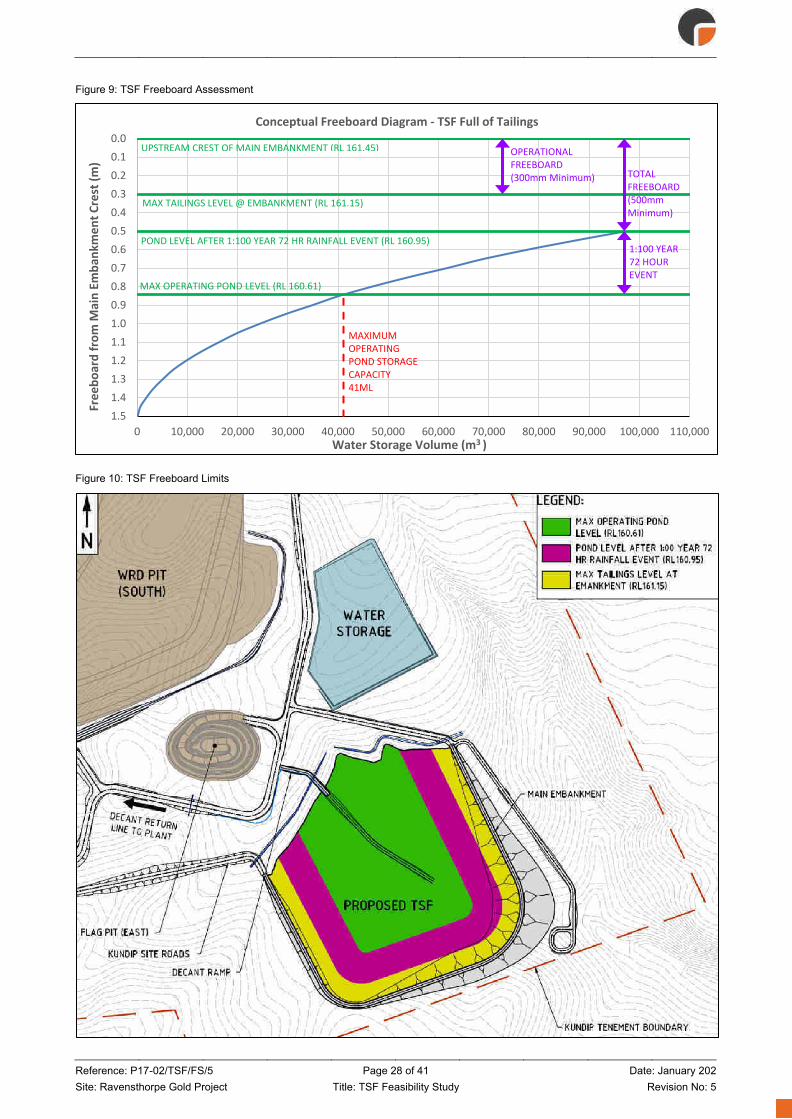
Reference: P17-02/TSF/FS/5 Page 28 of 41 Date: January 202 Site: Ravensthorpe Gold Project Title: TSF Feasibility Study Revision No: 5
Figure 9: TSF Freeboard Assessment
Figure 10: TSF Freeboard Limits
0.00.10.20.30.40.50.60.70.80.91.01.11.21.31.41.5
0 10,000 20,000 30,000 40,000 50,000 60,000 70,000 80,000 90,000 100,000 110,000
Free
boar
d fr
om M
ain
Emba
nkm
ent C
rest
(m)
Water Storage Volume (m3 )
Conceptual Freeboard Diagram - TSF Full of Tailings
UPSTREAM CREST OF MAIN EMBANKMENT (RL 161.45)
MAX TAILINGS LEVEL @ EMBANKMENT (RL 161.15)
POND LEVEL AFTER 1:100 YEAR 72 HR RAINFALL EVENT (RL 160.95)
MAX OPERATING POND LEVEL (RL 160.61)
TOTALFREEBOARD (500mm Minimum)
OPERATIONALFREEBOARD (300mm Minimum)
1:100 YEAR 72 HOUR EVENT
MAXIMUM OPERATINGPOND STORAGE CAPACITY 41ML

Reference: P17-02/TSF/FS/5 Page 29 of 41 Date: January 202 Site: Ravensthorpe Gold Project Title: TSF Feasibility Study Revision No: 5
Design and Construction Details
3.5.1 General Construction of the RGP TSF will be undertaken in accordance with issued for construction (IFC) drawings
and earthworks specification. Furthermore, construction and operation will be in general accordance with the
design intent of the final detailed design report.
This report and the drawings included in Appendix F present a FS level design of the RGP TSF which may
serve as the basis for subsequent development of a detailed design report and IFC drawings.
3.5.2 Bill of Quantities A preliminary earthwork bill of quantities (BOQ) is provided in Table 10. A more detailed BOQ will be developed
during detailed design based on issued for construction (IFC) drawings.
Table 10: Preliminary bill of quantities
Item # Item description Quantity Unit
1
Clear and grub TSF footprint (may be done in stages over the 10-year operational life of the facility to limit the cleared surface area to minimise dust generation and erosion). Trees cleared as part of this item to be chipped/mulched and stockpiled for later use as batter protection (ACH’s dieback management plan will be implemented to ensure that any dieback affected vegetation is not utilised as woodchip cover for the embankment batters).
295,000 m2
2 Prepare main embankment footprint - Immediately prior to construction, trimming of all loose material, ripping to a depth of 200 mm, moisture conditioned and compact as per the Earthworks Specification.
77,500 m2
3
Place clay main embankment - Win, load, haul from within 2km of embankment and place, condition onsite and compact as per the Earthworks Specification and design profile. The construction is to allow for compaction out to the design batters and include removal of excess material to a location directed by ACH.
527,500 m3 (CCM)
4 Install crest roads geofabric - Install geofabric for crest edge detail including supply of steel pins to secure fabric from wind uplift. 1300 m
5 Crest road - Win, load, haul, place and compact crest road gravel 200 mm thick on the embankment; includes windrow construction and supply of gravel from onsite stockpiles.
13,000 m2
6 Guide posts - Prepare location by survey, supply and install Main Roads standard wooden guide posts with delineator (50m intervals on straights and 10m on curves <200m radius).
130 #
7 Woodchip batters - Win, load, haul and place wood chip 100 mm thick on the downstream batter slope. 34,000 m2
8 Supply and install vibrating wire piezometers – Direct push installation with cone penetration test (CPT) rig. Includes supply and installation of cabling, data logger, and lightning protection box.
4 #
9 Install downstream monitoring bore – Depth and specifications to be determined during detailed design. 1 #
10 Prepare decant access ramp – Cut and fill as shown on the drawings. 3,000 m3 (CCM)
11 Decant ramp road - Win, load, haul, place and compact gravel 200 mm thick on the decant access ramp; includes windrow construction and supply of gravel from onsite stockpiles.
4,550 m2
Tailings Discharge and Water Management
3.6.1 Tailings Deposition Tailings are expected to be delivered from the Kundip Plant at a production rate of 300,000 tonnes of solids
per annum (tpa) for 10 years (base case production scenario). At times throughout the mine plan, the rate of
deposition may increase as softer weathered ores are processed. The solids content (% solids) is expected to
be approximately 50 %.

Reference: P17-02/TSF/FS/5 Page 30 of 41 Date: January 202 Site: Ravensthorpe Gold Project Title: TSF Feasibility Study Revision No: 5
A tailings delivery pipeline will be routed to the crest of the embankment and connect to a single ring main with
62 discharge spigots positioned approximately 20 m apart, as shown on Figure 11.
The Kundip TSF has been designed to provide 10 years of tailings storage capacity. The proposed TSF
configuration and tailings deposition methodology results in a tailings surface (beach) area of approximately
7.6 ha after 1 year of tailings deposition.
However, the incremental tailings surface (beach) area for each subsequent year is relatively small as shown
on Figure 11. Initially 23 of the 62 spigots should be installed on the embankment with 4 additional spigots
installed in each subsequent year up to year 6. At this point the remaining spigots should be installed.
Development (filling) of the TSF is shown graphically on Figure 12 and Figure 13 in terms of storage volume,
tailings surface area and rate of rise.
Figure 11: Tailings surface (beach) development

Reference: P17-02/TSF/FS/5 Page 31 of 41 Date: January 202 Site: Ravensthorpe Gold Project Title: TSF Feasibility Study Revision No: 5
Figure 12: Tailings storage capacity curve
Figure 13: Tailings Rate of Rise
3.6.2 Decant Pond Management The RGP TSF has been configured to manage the decant pond away from the embankment. Tailings
discharged from the embankment will beach towards the natural surface where the decant pond will form in
the north-west corner of the facility.

Reference: P17-02/TSF/FS/5 Page 32 of 41 Date: January 202 Site: Ravensthorpe Gold Project Title: TSF Feasibility Study Revision No: 5
Figure 14: Decant configuration (initial pump and floating uptake location – Year 1)
A ramp will be constructed from the north-west corner towards the middle of the TSF basin. A skid-mounted
pump will be located on the ramp with a floating uptake located in the pond.
As the tailings (beach) surface area continues to expand, the skid mounted pump will be relocated up the ramp
to ensure that the pump does not become submerged. Pump specification and sizing are expected to be
undertaken during detailed design.

Reference: P17-02/TSF/FS/5 Page 33 of 41 Date: January 202 Site: Ravensthorpe Gold Project Title: TSF Feasibility Study Revision No: 5
Figure 15: Progressive relocation of decant pump (pump and floating uptake location – Year 10)
3.6.3 Seepage Management A cut-off trench and cut-off drain are proposed as part of the construction of the TSF embankment. Both the
trench and the drain aim to intercept lateral seepage through and beneath the embankment. The configuration
of the trench and drain relative to the embankment is shown in Figure 17.
Figure 16: Cut-off trench and cut-off drain
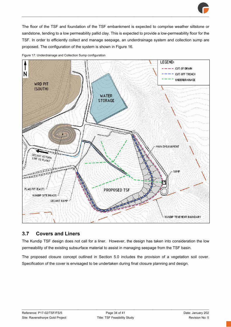
Reference: P17-02/TSF/FS/5 Page 34 of 41 Date: January 202 Site: Ravensthorpe Gold Project Title: TSF Feasibility Study Revision No: 5
The floor of the TSF and foundation of the TSF embankment is expected to comprise weather siltstone or
sandstone, tending to a low permeability pallid clay. This is expected to provide a low-permeability floor for the
TSF. In order to efficiently collect and manage seepage, an underdrainage system and collection sump are
proposed. The configuration of the system is shown in Figure 16.
Figure 17: Underdrainage and Collection Sump configuration
Covers and Liners The Kundip TSF design does not call for a liner. However, the design has taken into consideration the low
permeability of the existing subsurface material to assist in managing seepage from the TSF basin.
The proposed closure concept outlined in Section 5.0 includes the provision of a vegetation soil cover.
Specification of the cover is envisaged to be undertaken during final closure planning and design.
Reference: P17-02/TSF/FS/5 Page 35 of 41 Date: January 202 Site: Ravensthorpe Gold Project Title: TSF Feasibility Study Revision No: 5
Quality Assurance An Earthworks Specification will be developed as part of detailed design development. The specification will
include a construction quality assurance (CQA) plan and requirements for on-site third-party quality assurance
(QA) monitoring. A construction completion report will be prepared by a Competent Person (typically the design
engineer) following substantial completion of TSF construction; in line with the requirements of the CoP:
Tailings Storage Facilities in Western Australia (DMP, 2013) and Guide to Departmental requirements for the
management and closure of tailings storage facilities (TSFs) (DMP, 2015a).
Spillways The CoP: Tailings Storage Facilities in Western Australia (DMP, 2013) states that in Western Australia, the
use of spillways is not encouraged. As such, no spillway has been allowed for as part of the design.

Reference: P17-02/TSF/FS/5 Page 36 of 41 Date: January 202 Site: Ravensthorpe Gold Project Title: TSF Feasibility Study Revision No: 5
4. Operational Requirements General
An operating manual will be developed as part of detailed design in accordance with the DMPs Guide to
Departmental requirements for the managements and closure of tailings storage facilities (TSFs) and Code of
Practice (CoP): Tailings Storage Facilities in Western Australia.
Management of Tailings Deposition and Water Tailings are to be deposited from the main embankment in a sub-areal manner in thin lifts and beaching
towards the northwest corner of the facility to form a decant pond away from the main embankment. The size
of the normal operating pond should be as small as practical to minimise seepage potential whilst providing
sufficient depth for operation of the decant pump. The maximum normal operating pond level for a dam full
(tailings) scenario which still provides capacity for the 1:100 AEP 72-hour storm event and DMP required
freeboard is RL 160.51 m. The maximum normal operating pond level represents the storage of 41 ML,
highlighting the robustness of the proposed TSF design arrangement to prevent overtopping. However, it is
not the intent of the TSF design that such a large amount of water is stored within the facility.
Seepage Management Seepage management is achieved by the presence of a low permeability floor, sub-areal deposition in thin lifts
to promote air-drying (evaporation) and maintaining a small decant pond away from the main embankment as
described in Section 4.2.
Erosion Control Erosion mitigation features are described in Section 3.4.2. The main embankment batter, upstream and
downstream should be inspected on a regular basis and following heavy rainfall events for signs of excessive
erosion and repairs made accordingly. Sub areal tailings deposition on thins lifts across the entire tailings
beach will ensure the tailings surface is kept sufficiently moist to prevent excessive wind erosion and dusting
of the tailings surface.
Embankment Instrumentation Monitoring instrumentation will be installed in the TSF embankment as shown in plan and section on Figure
18 and Figure 19, including;
• Vibrating wire piezometers (VWP) – to monitor the development of pore pressures (phreatic surface)
within the embankment and embankment foundation for assessment of embankment stability (in line
with Section 3.4.1),
• Monitoring bores w/VWP – to monitor groundwater levels immediately downstream of the facility for
comparison with pore pressures (phreatic surface) measured within the embankment VWP’s.

Reference: P17-02/TSF/FS/5 Page 37 of 41 Date: January 202 Site: Ravensthorpe Gold Project Title: TSF Feasibility Study Revision No: 5
Figure 18: Embankment instrumentation (Plan)
Figure 19: Embankment instrumentation
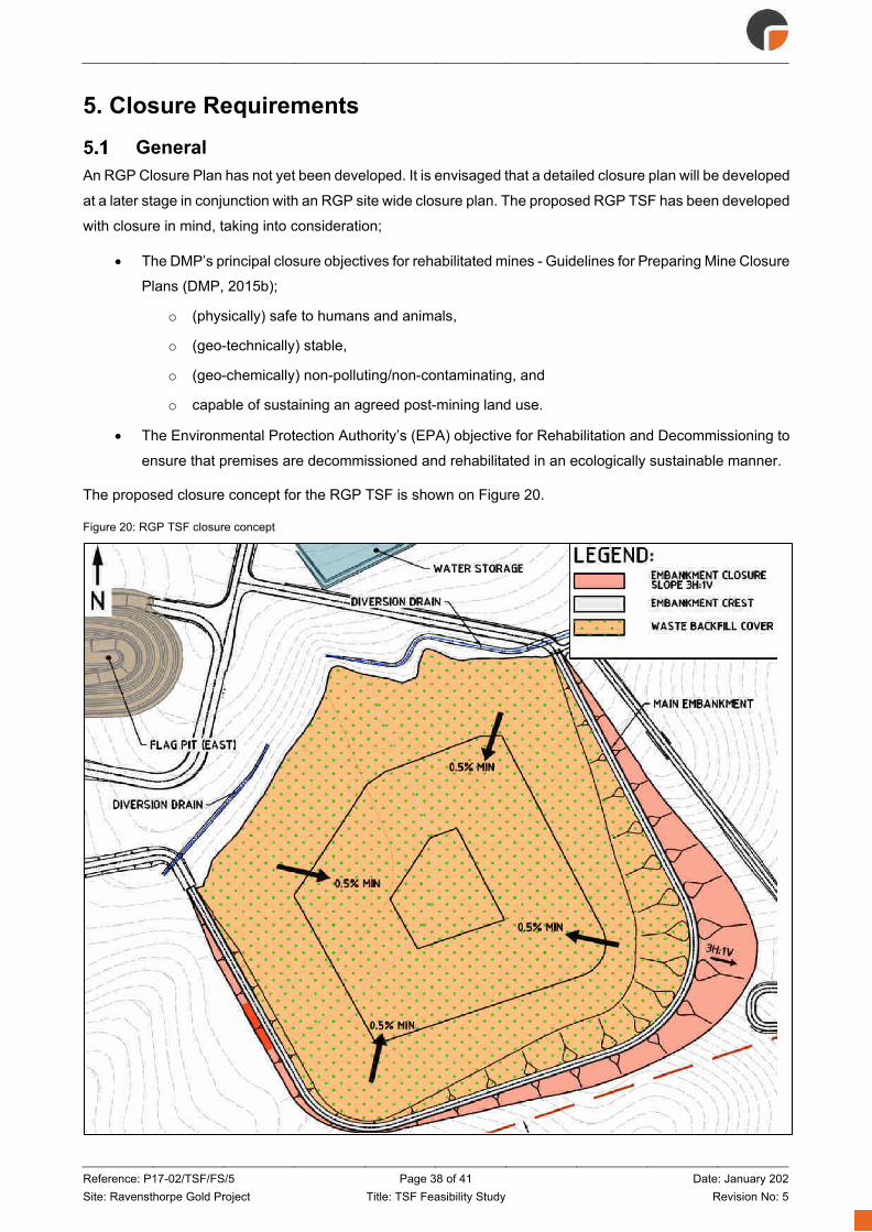
Reference: P17-02/TSF/FS/5 Page 38 of 41 Date: January 202 Site: Ravensthorpe Gold Project Title: TSF Feasibility Study Revision No: 5
5. Closure Requirements General
An RGP Closure Plan has not yet been developed. It is envisaged that a detailed closure plan will be developed
at a later stage in conjunction with an RGP site wide closure plan. The proposed RGP TSF has been developed
with closure in mind, taking into consideration;
• The DMP’s principal closure objectives for rehabilitated mines - Guidelines for Preparing Mine Closure
Plans (DMP, 2015b);
o (physically) safe to humans and animals,
o (geo-technically) stable,
o (geo-chemically) non-polluting/non-contaminating, and
o capable of sustaining an agreed post-mining land use.
• The Environmental Protection Authority’s (EPA) objective for Rehabilitation and Decommissioning to
ensure that premises are decommissioned and rehabilitated in an ecologically sustainable manner.
The proposed closure concept for the RGP TSF is shown on Figure 20.
Figure 20: RGP TSF closure concept

Reference: P17-02/TSF/FS/5 Page 39 of 41 Date: January 202 Site: Ravensthorpe Gold Project Title: TSF Feasibility Study Revision No: 5
The closure concept utilises the tailings beach formed during deposition and the natural topography to divert
surface water away from the highest part of the embankment. Surface water from the upstream catchment will
be diverted away from the TSF by means of diversion drains. The tailings surface will be shaped to direct
incidental rainfall to the centre of the TSF. The downstream embankment batter at 1V:3H will serve as a final
closure surface.
Decommissioning Once the TSF has reached capacity and no further deposition is to occur, the tailings delivery line and
distribution system will be removed from the main embankment. The decant system may remain in place or on
standby until the tailings surface cover has been installed; to provide an interim means of surface water
removal. Further detail around decommissioning of the TSF should be coordinated with the project-wide
decommissioning and closure plan.
Tailings Surface Cover The tailings surface will be covered with waste and topsoil to provide long term containment and erosion
protection of the tailings, as well as providing a suitable medium for re-establishment and sustenance of
vegetation. The cover will be 2.0 m in thickness (minimum) depending on the location of the tailings surface
and estimated surface water flow velocities. The tailings surface cover will make use of the tailings beach slope
and grade towards the centre of the facility.
Diversion Drains Diversion drains will be constructed in the general area shown on Figure 18. The drains will allow for controlled
discharge of surface water collecting within the upstream TSF catchment. The drains will discharge away from
the embankment, providing protection from erosion.
Rehabilitation A rehabilitation plan will be developed at a later stage in conjunction with an RGP site wide closure plan.
Rehabilitation should involve respreading collected topsoil on the downstream slopes of the final embankments
and on top of the capping layer. Topsoil surfaces may require ripping and seeding with native species in order
to promote revegetation, and consequently blend the TSF into the natural landscape and promote
evapotranspiration.
It’s important that batter slopes function as erosion resistant water shedding structures. Rocky mantle scree of
competent oversize material (+10 mm to > 1 tonne) should be spread on the downstream batter surfaces with
a thin layer of topsoil mixed in between the particles to promote revegetation.
The outer slopes should have no berms, banks, moonscapes or rip lines as these pond water which inevitably
result in piping failure or off-contour rip line breakout gullying.
Performance Monitoring against Closure Criteria Closure criteria and a post closure monitoring plan will be developed at a later stage in conjunction with an
RGP site wide closure plan.

Reference: P17-02/TSF/FS/5 Page 40 of 41 Date: January 202 Site: Ravensthorpe Gold Project Title: TSF Feasibility Study Revision No: 5
6. References 1. ANCOLD 2012, Australian National Committee on Large Dams: Guidelines on Planning, Design,
Construction, Operation and Closure of Tailings Dams
2. BoM 2016/17, Bureau of Meteorology Website
3. DMP 2013, Code of Practice (CoP): Tailings Storage Facilities in Western Australia
4. DMP 2015a, Guide to Departmental requirements for the management and closure of tailings storage
facilities (TSFs)
5. DMP 2015b, Guidelines for Preparing Mine Closure Plans
6. DMP 2015c, Guide to the preparation of a design report for tailings storage facilities (TSFs)
7. Geoscience Australia 2012, The 2012 Australian Earthquake Hazard Map
8. Golder 2016, Concept Design for Waste Landform and Tailings Storage Facility Kundip Gold Project
9. Golder 2017, Updated Concept Design for Tailings Storage Facility at ACH Global Ravensthorpe
Gold/Copper Project
10. GCA 2011, Phillips River Project: Geochemical Characterisation of Tailings-Slurry Samples (Trilogy
Deposit) - Implications for Process-Tailings Management (DRAFT)
11. Tectonic 2011, Phillips River Project Definitive Feasibility Study
Reference: P17-02/TSF/FS/5 Page 41 of 41 Date: January 202 Site: Ravensthorpe Gold Project Title: TSF Feasibility Study Revision No: 5
7. Limitations Resource Engineering Consultants Pty Ltd (REC) has prepared this feasibility study (FS) level design of the
Kundip Mine Site tailings storage facility (TSF) at the ACH Mineral’s Ltd (ACH) Ravensthorpe Gold Project
(RGP) to support the overall project Feasibility Study into the technical and commercial viability of RGP. This
report is provided for the exclusive use of ACH Minerals Pty Ltd and their consultants for this project only and
for the purposes as described in the report. Any party so relying upon this report beyond its exclusive use and
purpose as stated above, and without the express written consent of REC, does so entirely at its own risk and
without recourse to REC for any loss or damage. In preparing this report REC has necessarily relied upon
information provided by the client and/or their agents.
The results provided in the report are indicative of the sub-surface conditions on the site only at the specific
sampling and/or testing locations, and then only to the depths investigated and at the time the work was carried
out. Sub-surface conditions can change abruptly due to variable geological processes and also as a result of
human influences. Such changes may occur after REC’s field testing has been completed.
REC’s advice is based upon the conditions encountered during this investigation. The accuracy of the advice
provided by REC in this report may be affected by undetected variations in ground conditions across the site
between and beyond the sampling and/or testing locations. The advice may also be limited by budget
constraints imposed by others or by site accessibility.
This report must be read in conjunction with all of the attached and should be kept in its entirety without
separation of individual pages or sections. REC cannot be held responsible for interpretations or conclusions
made by others unless they are supported by an expressed statement, interpretation, outcome or conclusion
stated in this report.
This report, or sections from this report, should not be used as part of a specification for a project, without
review and agreement by REC. This is because this report has been written as advice and opinion rather than
instructions for construction.
The contents of this report do not constitute formal design components such as are required, by the Health
and Safety Legislation and Regulations, to be included in a Safety Report specifying the hazards likely to be
encountered during construction and the controls required to mitigate risk. This design process requires risk
assessment to be undertaken, with such assessment being dependent upon factors relating to likelihood of
occurrence and consequences of damage to property and to life. This, in turn, requires project data and
analysis presently beyond the knowledge and project role respectively of REC.
REC may be able, however, to assist the client in carrying out a risk assessment of potential hazards contained
in this report, as an extension to the current scope of works, if so requested, and provided that suitable
additional information is made available to REC.
Any such risk assessment would, however, be necessarily restricted to the geotechnical components set out
in this report and to their application by the project designers to project design, construction, maintenance and
demolition.

Appendix A Geotechnical Field Investigation Report (MHA Geotechnical Pty Ltd)

Suite 2, 464 Murray St Perth WA 6000 Australia T: +61 8 9403 6375 W: www.mhageotechnical.com.au E: [email protected] MHA Consulting Group Pty Ltd ACN: 618 738 024 T/A MHA Geotechnical ABN: 66 618 738 024
Geotechnical Site Investigation Tailings Storage Facility
Ravensthorpe Gold Project
ACH Minerals Pty Ltd
January 2018 Rev 1

Reference: P02-17-SI/RF Page 2 of 33 Date: January 2018 Site: Ravensthorpe Gold Project Title: Geotechnical Site Investigation Revision No: 1
MHA Consulting Group Pty Ltd ACN: 618 738 024
Trading as MHA Geotechnical ABN: 66 618 738 024 Address and Contact Details Suite 2, 464 Murray Street
Perth WA 6000
Tel: +61 (8) 6110 4768
e-mail: [email protected] Website: www.mhageotechnical.com.au
Limitations, Uses and Reliance This document, once read in its entirety, may be relied upon for the purposes stated within the limits of:
Geotechnical investigations and assessments are undertaken in accordance with an agreed term of reference and timeframe and may involve intrusive investigations of subsurface conditions, generally at a few selected locations. Although due care, skill and professional judgement are applied in the interpretation and extrapolation of geotechnical conditions and factors to elsewhere, the potential for variances cannot be discounted. Therefore, the results, analyses and interpretations presented herein cannot be considered absolute or conclusive. MHA Geotechnical does not accept any responsibility for variances between the interpreted and extrapolated and those that are revealed by any means. Specific warning is given that many factors, natural or artificial, may render conditions different from those that prevailed at the time of investigation and should they be revealed at any time subsequently, they should be brought to our attention so that their significance may be assessed and appropriate advice may be offered. Users are also cautioned that fundamental assumptions made in this document may change with time and it is the responsibility of any user to ensure that assumptions made, remain valid.
The comments, findings, conclusions and recommendations contained in this document represent professional estimates and opinions and are not to be read as facts unless expressly stated to the contrary. In general, statements of fact are confined to statements as to what was done and/or what was observed; others have been based on professional judgement. The conclusions are based upon information and data, visual observations and the results of field and laboratory investigations and are therefore merely indicative of the environmental and geotechnical conditions at the time, including the presence or otherwise of contaminants or emissions. In addition, presentations in this document are based upon the extent of the terms of reference and/or on information supplied by the client, agents and third parties outside our control. To the extent that the statements, opinions, facts, conclusions and/or recommendations in this document are based in whole or part on this information, those are contingent upon the accuracy and completeness of the information which has not been verified unless stated otherwise. MHA Geotechnical does not accept responsibility for omissions and errors due to incorrect information or information not available at the time of preparation of this document and will not be liable in relation to incorrect conclusions should any information be incorrect or have been concealed, withheld, misrepresented or otherwise not fully disclosed. We will not be liable to update or revise the document to take into account any events, emergent circumstances or facts occurring or becoming apparent after the date of this document.
Within the limitations imposed by the terms of reference, the assessment of the study area and preparation of this document have been undertaken and performed in a professional manner, by suitably qualified and experienced personnel, in accordance with generally accepted practices and using a degree of skill and care ordinarily exercised by geotechnical consultants under similar circumstances. No other warranty, expressed or implied, is made.
This document has been prepared for the purposes stated herein. Every care was taken in the interpretation of geotechnical conditions and the nature and extent of impacts, presentation of findings and recommendations which are provided in good faith in the general belief that none of these are misleading. No responsibility or liability for the consequences of use and/or inference by others is accepted.
Intellectual and copyright in the information, data and representations such as drawings, figures, tabulations and text, included in this document remain the property of MHA Geotechnical. This document is for the exclusive use of the authorised recipient(s) and may not be used, copied or re-produced in whole, or in part, for any purpose(s) other than that for which it was prepared for. No responsibility or liability to any other party is accepted for any consequences and/or damages arising out of the use of this document without express and written consent.
The above conditions must be read as part of the document and must be reproduced where permitted. Acceptance of this document indicates acceptance of these terms and conditions.

Reference: P02-17-SI/RF Page 3 of 33 Date: January 2018 Site: Ravensthorpe Gold Project Title: Geotechnical Site Investigation Revision No: 1
Report Title: Geotechnical Site Investigation
File: P02-17-RF
Author(s): Mitch Hanger
Client: ACH Minerals Pty Ltd
Contact: Paul Bennett
Synopsis: This document details the findings of a geotechnical site investigation pertaining to the proposed Tailings Storage Facility at ACH Minerals’ Ravensthorpe Gold Operation.
Document Control
Revision No Date Author(s) Reviewer(s)
A November 2017 MH; HM MH
0 January 2018 MH
1 January 2018 MH
Distribution
Revision No Date Approved Recipient(s) No of Copies
A December 2017 MH JW 1
0 January 2018 MH PB 1
1 January 2018 MH PB 1
Revision
Revision No Date Description Approved
A December 2017 Draft MH
0 January 2018 Final Report MH
1 January 2018 Final Report MH
Recipients are responsible for eliminating all superseded documents in their possession
© MHA Geotechnical 2018

Reference: P02-17-SI/RF Page 4 of 33 Date: January 2018 Site: Ravensthorpe Gold Project Title: Geotechnical Site Investigation Revision No: 1
Table of Contents Table of Contents ............................................................................................................. 4
Abbreviations ................................................................................................................... 7
Executive Summary ......................................................................................................... 8
1. Introduction ................................................................................................................ 9
2. Site Characteristics .................................................................................................. 11
2.1 Site location ....................................................................................................................... 11
2.2 Regional Geology .............................................................................................................. 11
2.3 Local Geology .................................................................................................................... 11
2.4 Typical TSF Regolith Profile .............................................................................................. 11
2.5 Seismic Assessment ......................................................................................................... 12
3. Geotechnical Investigation ...................................................................................... 13
3.1 Introduction ........................................................................................................................ 13
3.2 Scope of Work ................................................................................................................... 13
3.3 Test Pitting ......................................................................................................................... 13
3.4 Field Permeability Testing ................................................................................................. 14
3.5 Cone Penetrometer Testing .............................................................................................. 14 3.5.1 Electric Friction Cone Penetrometer Testing ...................................................................... 14
3.5.2 CPTU – Dissipation Testing ................................................................................................ 14
3.6 Laboratory Testing ............................................................................................................. 15
4. Sub-surface Ground Conditions ............................................................................. 16
4.1 Introduction ........................................................................................................................ 16
4.2 TSF Footprint ..................................................................................................................... 16
5. Borrow Material Assessment .................................................................................. 17
5.1 Introduction ........................................................................................................................ 17
5.2 Borrow Materials ................................................................................................................ 17
6. TSF Foundation Assessment .................................................................................. 18
6.1 Introduction ........................................................................................................................ 18
6.2 Soil Characterisation ......................................................................................................... 18 6.2.1 CPT Soil Behaviour Type ................................................................................................... 18
6.3 Material Permeabilities ...................................................................................................... 19 6.3.1 Field Permeability Testing .................................................................................................. 19
6.3.2 Laboratory Permeability Testing ......................................................................................... 20
6.3.3 Piezocone Permeability Testing ......................................................................................... 20
6.4 Laboratory Triaxial Test Interpretation .............................................................................. 21 6.4.1 Multistage Unconsolidated Undrained Triaxial Testing ....................................................... 21
6.4.2 Multistage Consolidated Undrained Triaxial Testing ........................................................... 23
6.5 Soil Compressibility ........................................................................................................... 25

Reference: P02-17-SI/RF Page 5 of 33 Date: January 2018 Site: Ravensthorpe Gold Project Title: Geotechnical Site Investigation Revision No: 1
6.6 Settlement Analysis ........................................................................................................... 25 6.6.1 Loadings for Analysis.......................................................................................................... 25
6.6.2 Settlement Analysis Results ............................................................................................... 26
6.7 Slope Stability Assessment Methodology ......................................................................... 26 6.7.1 Static Stability ..................................................................................................................... 26
6.7.2 Seismic Stability ................................................................................................................. 27
7. General Geotechnical Issues .................................................................................. 28
7.1 Retaining Structures .......................................................................................................... 28
7.2 Earthworks ......................................................................................................................... 28
7.3 Excavatability ..................................................................................................................... 29
7.4 Heave Potential ................................................................................................................. 29
7.5 Collapsing Soils ................................................................................................................. 29
7.6 Ant Hills ............................................................................... Error! Bookmark not defined. 9. Conclusions and Recommendations ...................................................................... 30
9.1 General .............................................................................................................................. 30
9.2 Ground Conditions............................................................................................................. 30
9.3 TSF Foundation Design .................................................................................................... 30
11. Limitations ................................................................................................................ 31
13. References ................................................................................................................ 33

Reference: P02-17-SI/RF Page 6 of 33 Date: January 2018 Site: Ravensthorpe Gold Project Title: Geotechnical Site Investigation Revision No: 1
Tables Table 1: Summary of Test Pits ......................................................................................................... 13
Table 2: Summary of Field Permeability Tests ................................................................................. 14
Table 3: Summary of CPTs ............................................................................................................... 14
Table 4: Summary of Piezocone Tests.............................................................................................. 15
Table 5: Summary of Laboratory Test Data for Materials Encountered .......................................... 15
Table 6: Summary of Typical Sub-Surface Profile at TSF Site ........................................................ 16
Table 7: Embankment Material Geotechnical Parameters ............................................................... 17
Table 8: Soil Behaviour Index Summary .......................................................................................... 19
Table 9: Summary of Field Permeability Tests................................................................................. 19
Table 10: Summary of Laboratory Permeability Tests ..................................................................... 20
Table 11: Summary of Piezocone Test Result ................................................................................. 21
Table 12: Sampled 1 UU Triaxial Test Results ................................................................................ 22
Table 13: Sampled 2 UU Triaxial Test Results ................................................................................ 22
Table 14: Sampled 3 UU Triaxial Test Results ................................................................................ 22
Table 15: Sampled 4 CU Triaxial Test Results ................................................................................ 24
Table 16: Sampled 5 CU Triaxial Test Results ................................................................................ 24
Table 17: Sampled 6 CU Triaxial Test Results ................................................................................ 24
Table 18: Summary of Inferred Soil Foundation Elastic Moduli ....................................................... 25
Table 19: Estimated Settlement of TSF Embankment ..................................................................... 26
Table 20: Static Stability Results ....................................................................................................... 26
Table 21: Seismic Stability Results ................................................................................................... 27
Table 22: Summary of Typical Sub-Surface Profile at TSF Site ...................................................... 30
Appendices Appendix B: Geotechnical Field Investigation Test Pit Logs and Photographs
Appendix C: Geotechnical Field Investigation Field Permeability Testing Results
Appendix D: Geotechnical Field Investigation CPT Test Results
Appendix E: Geotechnical Field Investigation Laboratory Test Results and Certificates
Appendix F: TSF Feasibility Study Drawings

Reference: P02-17-SI/RF Page 7 of 33 Date: January 2018 Site: Ravensthorpe Gold Project Title: Geotechnical Site Investigation Revision No: 1
Abbreviations
AHD Australian Height Datum
CBR California Bearing Ratio
DCP Dynamic Cone Penetrometer
HDPE High Density Polyethylene
MDD Maximum Dry Density
OMC Optimum Moisture Content
QA/QC Quality Assurance/Quality Control
PI Plasticity Index
PSD Particle Size Distribution
SP Poorly graded sand (USCS)
UU Undrained Unconsolidated
USCS The Unified Soil Classification System
d day
ha hectare
hr hour
km kilometre
m metre
mm millimetre
min minute
yr year
s second
t ton

Reference: P02-17-SI/RF Page 8 of 33 Date: January 2018 Site: Ravensthorpe Gold Project Title: Geotechnical Site Investigation Revision No: 1
Executive Summary Background MHA Geotechnical (MHA) has prepared this Geotechnical Report as part of a Feasibility Study (FS) level
design of the Kundip Mine Site tailings storage facility (TSF) at ACH’s Ravensthorpe Gold Project (RGP), to
support the overall project Feasibility Study into the technical and commercial viability of RGP. A geotechnical
investigation of the proposed site was carried out by MHA Geotechnical (MHA) between the 17th and 23rd of
November 2017.
The work has been undertaken at the request of Paul Bennett (Managing Director – ACH Minerals).
The purpose of the geotechnical investigation was to:
• Develop ground profiles for the TSF location,
• Determine the geotechnical properties for foundation and borrow materials,
• Provide comment on the suitability of the site for the proposed development.
The general sub-surface profile is consistent across the site, except for variation in the thickness of alluvial
surficial cover and depth to competent bedrock. The sub-surface profile is summarised below:
• The regolith is comprised of a sandy to silty alluvial detrital sediment, with a consistent weathered
profile. The horizon was dominantly alluvial and comprised an unconsolidated grey to brown, silty
SAND with gravel to sandy SILT with gravel, with roots and organic matter;
• Inconsistently, across the TSF site, immediately underlying the top soil horizon, a transition material
comprising a sandy to silty GRAVEL, more consolidated pale brown to white, gravelly horizon. This
horizon was locally cemented and diagenetically altered;
• A red brown soil horizon underlies the transition material and where this transition phase was not
present, the red brown silty clay layer was present immediately below the top soil. This layer was
consistently observed to be indurated and gravelly, with local instances showing a lateritic and
conglomeritic texture. This unit was excavated as rock and had been diagenetically altered;
• The material found at the base of all the test pit locations was described as a white, sometimes grey
to mottled red, sandy SILTSTONE.
TSF Assessment Detailed geotechnical analysis of the TSF footprint and materials identified for construction have been
performed using data obtained from the site investigation and succeeding lab tests. The foundation and
embankment conditions and soil types have been determined from the test pit logs with additional data derived
from laboratory testing and previous investigations.
Borrow Material Assessment An assessment of the borrow material has been undertaken to assess the suitability of both the in-situ and
proposed borrow material for construction of the TSF. This includes an assessment of the subsurface
conditions and the suitability of blended in-situ and borrow material for embankment construction.

Reference: P02-17-SI/RF Page 9 of 33 Date: January 2018 Site: Ravensthorpe Gold Project Title: Geotechnical Site Investigation Revision No: 1
1. Introduction This report presents the findings of a geotechnical site investigation of the proposed Tailings Storage Facility
(TSF) and assessment of proposed construction borrow material. The investigation forms part of a Feasibility
Study (FS) level design of the Kundip Mine Site tailings storage facility (TSF) at ACH’s Ravensthorpe Gold
Project (RGP), to support the overall project Feasibility Study into the technical and commercial viability of
RGP, located approximately 25 km by road south-east of the town of Ravensthorpe, Western Australia.
The investigation was carried out by MHA Geotechnical (MHA) between the 17th and 23rd of November 2017.
The work has been undertaken at the request of Mr. Paul Bennet (Managing Director – ACH Minerals).
The purpose of the geotechnical investigation was to:
• Develop ground profiles for the TSF location,
• Determine the geotechnical properties for foundation and borrow materials,
• Provide comment on the suitability of the site for the proposed development.
The proposed TSF footprint and test locations are shown on Figure 1.
Figure 1 Proposed TSF footprint with associated Test Pit locations.

Reference: P02-17-SI/RF Page 10 of 33 Date: January 2018 Site: Ravensthorpe Gold Project Title: Geotechnical Site Investigation Revision No: 1
This report details the results of the geotechnical investigation (test pits, in situ testing, and laboratory test
results) that have been carried out at the proposed TSF location. Descriptions of in situ ground conditions are
presented, together with interpretation of founding conditions for the TSF and associated structures.
Interpretations, site conditions and design parameters in this report are based on in-situ testing, test pit
excavations and laboratory test results from recovered samples, in addition to information gathered as part of
previous site investigations.

Reference: P02-17-SI/RF Page 11 of 33 Date: January 2018 Site: Ravensthorpe Gold Project Title: Geotechnical Site Investigation Revision No: 1
2. Site Characteristics 2.1 Site location The Ravensthorpe Gold Project (RGP) is hosted within the north-west trending Archaean Ravensthorpe
Greenstone Belt. Nelson (1995) and Savage et al. (1995) have constrained the age of the greenstone belt in
this area to 2950-3000 Ma.
2.2 Regional Geology There are three regional geological units in the area:
• Yilgarn Craton (Archaean) to the north comprising granitoid, granitic gneiss and migmatitic rocks with
some greenstone rafts, overlain to the south by;
• Mount Barren Group (Proterozoic) comprising metasedimentary rocks of shale, arenite, dolostone
and intruded gabbro-diorite sills; and
• The southeast portion of the region is occupied by Munglinup Gneiss (Proterozoic), which forms part
of the Biranup Complex.
The northeast trending Jerdacuttup Fault separates the Munglinup Gneiss from both the Mount Barren Group
and the Archaean granite-greenstone terrane. Tertiary sediments of the Plantagenet Group in turn
unconformably overlie all Precambrian tectonic units.
2.3 Local Geology The Kundip mining area lies in a region of steeply-dipping mafic to intermediate volcanic rocks of Archaean
age (Annabelle Volcanics) (Witt, 1997). The volcanic rocks have been intruded to the west by granitic rocks,
also of Archaean age. The upper reaches of the Steere River follow the contact between the granitic and the
volcanic rocks.
Immediately south of the Kundip mining area, the Archaean rocks are overlain by the Proterozoic Mount Barren
Group, including sediments of the Kundip Quartzite and the Kybulup Schist. The quartzite dips at about 15
degrees to the south-south-west.
2.4 Typical TSF Regolith Profile A geotechnical site investigation was carried out by MHA between the 17th and 23rd of November 2017. The
purpose of the geotechnical investigation was to:
• Develop ground profiles for the TSF location,
• Determine the geotechnical properties for foundation and borrow materials,
• Provide comment on the suitability of the site for the proposed development.
The typical regolith profile at the TSF site comprises a surficial cover of an unconsolidated sandy silt TOPSOIL
underlain by sandy gravelly SILT, underlain by SILTSTONE.
The material encountered can be broadly summarised as:

Reference: P02-17-SI/RF Page 12 of 33 Date: January 2018 Site: Ravensthorpe Gold Project Title: Geotechnical Site Investigation Revision No: 1
• 0 m – 0.2 m: SILT; sandy, gravelly TOPSOIL with roots and organic matter;
• 0.2 m – 0.6 m: SILT; red brown, sandy with gravel (transitional zone);
• 0.6 m – 1.0 m: SILTSTONE; red brown, conglomeritic;
• 1.0 m – 3.0 m: SILTSTONE, white sandy/gravelly (considered competent bedrock)
2.5 Seismic Assessment A seismic hazard assessment of the project site was carried out by MHA to determine design ground
acceleration for the RGO area.
The seismic hazard risk assessment contained in GA (2012) is used to quantify the seismic setting for the site.
This is a relatively recent and detailed assessment and provides peak ground accelerations (PGAs) for
earthquakes of return period 500 years and greater (c.f. the project Operating Basis Earthquake (OBE) and
Maximum Design Earthquake (MDE) return periods of 50 years and 100 years respectively). As such its use
is conservative but it directly relates to PGAs of interest to the design of earth structures as opposed to use of
AS1170.4 Structural design actions – Earthquake actions in Australia that is strictly only applicable to steel,
concrete and timber structures.
The PGA is estimated to be 0.06g for the project.
Mining induced ground motion, such as blast induced shaking, is expected to result in relatively minor PGA
and for very short durations (cycles). A blast risk assessment will be covered as part of the detailed design
process if required.

Reference: P02-17-SI/RF Page 13 of 33 Date: January 2018 Site: Ravensthorpe Gold Project Title: Geotechnical Site Investigation Revision No: 1
3. Geotechnical Investigation 3.1 Introduction A site investigation was undertaken between 17th and 23rd of November 2017. The investigations aimed to
assess the ground conditions and evaluate the suitability of the in-situ and borrow material for construction of
the proposed TSF.
3.2 Scope of Work The field work for the investigation comprised:
• Excavation of 20 test pits broadly tracing the internal embankment of the proposed TSF design
footprint (arranged in a square configuration with 5 test pits on each side);
• Dynamic Cone Penetrometer testing alongside each test pit location to a maximum depth of 3.0 m.
• Cone Penetrometer Testing (CPT) at 7 locations;
• Dissipation Testing at 4 specified locations;
• Falling head permeability tests at 6 locations;
• Recovery of disturbed soil samples for laboratory testing.
Fieldwork was carried out by two experienced senior geotechnical engineers. The test pit locations were set
out using a hand-held Global Positioning (GPS) instrument and were based on the proposed layout of the TSF.
No additional tracks cleared throughout the investigation site due to clearing and access restrictions.
The geotechnical fieldwork was undertaken in accordance with the guidelines presented in AS1726-1993,
Geotechnical Site Investigations (Ref. 3) and samples were collected for laboratory testing.
3.3 Test Pitting A total of twenty (20) test pits were excavated across the proposed TSF investigation area using a backhoe
excavator to depths of up to 3.1 m. All test pits were logged and photographed by the investigating engineers
and samples were collected from selected horizons in each pit for laboratory testing. All the test pits were
backfilled with excavated soil on completion of sampling.
A summary of the test pitting is presented in Table 1.
Table 1: Summary of Test Pits
Site Test Pits No. of Pits Max Depth (m)
TSF North track 16, 17, 18, 19 & 20 5 2.8
TSF East track 11, 12, 13, 14 & 15 5 2.8
TSF South track 6, 7, 8, 9 & 10 5 2.9
TSF West track 1, 2, 3, 4 & 5 5 3.1
Logs, photographs and the locations of the test pits are presented in Appendix B. The proposed test pit
locations are shown in Figure 1.

Reference: P02-17-SI/RF Page 14 of 33 Date: January 2018 Site: Ravensthorpe Gold Project Title: Geotechnical Site Investigation Revision No: 1
3.4 Field Permeability Testing Field permeability tests were conducted in 6 auger boreholes adjacent to selected Test Pits in order to estimate
the permeability of the surficial ground profile across the project site. A summary of these tests and their
locations are presented below in Table 2.
Table 2: Summary of Field Permeability Tests
Test No. Test Depth (m) Target Material Reason for Termination
TP 3 0.6 SILTSTONE Target Depth
TP 7 0.4 SILTSTONE Target Depth
TP 12 0.6 SILTSTONE Target Depth
TP 13 0.7 SILTSTONE Target Depth
TP 16/17 0.8 SILTSTONE Target Depth
TP 19 0.6 SILTSTONE Target Depth
The detailed calculations for the permeability tests are presented in Appendix C
3.5 Cone Penetrometer Testing Both Cone Penetration Tests (CPT) and Piezocone Tests (CPTU) were conducted across the site to
characterise the sub-surface ground profile and estimate in-situ permeability of target materials. A summary of
these tests and their locations are presented below.
3.5.1 Electric Friction Cone Penetrometer Testing A total of seven (7) Electric Friction Cone Penetrometer Tests (CPTs) were conducted at selected Test Pit
locations in order to characterise the sub-surface profile across the site. A summary of the tests conducted is
presented in Table 3.
Table 3: Summary of CPTs
Site EFCPT No. Maximum Termination Depth (m) Reason for Termination
TSF South track CPT6 1.24 Refusal
TSF South track CPT7 2.37 Refusal
TSF East track CPT12 2.28 Refusal
TSF East track CPT12 B 1.68 Refusal
TSF East track CPT13 2.82 Refusal
TSF East track CPT14 2.24 Refusal
TSF North track CPT17 3.04 Refusal
Logs for the CPTs are presented in Appendix D. Test numbers correlate to Test Pit numbers.
3.5.2 CPTU – Dissipation Testing Based on the results of the EFCPT, a total of 4 Piezocone (CPTU) tests were conducted to target specific
material types identified. Stop pause dissipation testing was conducted within each target material to assess
the in-situ permeability of the target materials. The piezocone tests conducted are summarised in Table 4.

Reference: P02-17-SI/RF Page 15 of 33 Date: January 2018 Site: Ravensthorpe Gold Project Title: Geotechnical Site Investigation Revision No: 1
Table 4: Summary of Piezocone Tests
CPTU No. Target Depth (m) Target Material Test Duration (hrs)
CPTU 12 2.3 SILTSTONE 20.6
CPTU 14 4.3 SILTSTONE 14
CPTU 7/8A 2.4 SILTSTONE 0.1
CPTU 7/8B 2.4 SILTSTONE 14.8
Logs for the CPTU and the dissipation test results are presented in Appendix D. Test numbers correlate to
Test Pit numbers.
3.6 Laboratory Testing Laboratory testing was carried out on borrow material and selected disturbed samples recovered from test
pits, in order to characterise the in-situ and borrow materials for design and construction purposes. The testing
was carried out by a NATA accredited laboratory in accordance with Australian Standards and comprised the
following:
• Particle Size Distribution;
• Specific Gravity;
• Atterberg Limits;
• Compaction Testing (Standard and Modified Compactive Effort);
• Multi Stage Unconsolidated Undrained Triaxial Testing;
• Single Stage Consolidated UndrainedTriaxial Testing
• Crumb Test; and
• Pinhole Dispersion test (95% and 98% MMDD).
A summary of the average laboratory test results for each material type is presented below in Table 5. Details
of the samples selected for testing, the laboratory test schedule and results are presented in Appendix E.
Table 5: Summary of Laboratory Test Data for Materials Encountered
Material Location
PSD Physical Parameters
Typi
cal D
epth
to
Bas
e
Fine
s (<
75 µ
m)
Sand
(>75
µm
)
Gra
vel (
>2m
m)
Max
imum
Dry
D
ensi
ty
Opt
imum
Moi
stur
e C
onte
nt
Emm
erso
n C
lass
Plas
ticity
Inde
x
m % % % % % No. %
Alluvial Cover – Sandy SILT 0.6 49.0 32.0 19.0 1.9 13.0 2.3 16.5
Bedrock - SILTSTONE >3.0 43.0 37.0 20.0 1.8 15.0 4.0 9.0
Borrow Material - STOCKPILED NA - - - 1.7 14 6 NP
*NP denotes Not Plastic.

Reference: P02-17-SI/RF Page 16 of 33 Date: January 2018 Site: Ravensthorpe Gold Project Title: Geotechnical Site Investigation Revision No: 1
4. Sub-surface Ground Conditions 4.1 Introduction The sub-surface ground conditions described below are based on the findings of the geotechnical
investigations performed along the 4 access tracks which broadly trace the interior of the proposed TSF
footprint.
4.2 TSF Footprint A total of twenty (20) test pits were excavated within the vicinity of the TSF footprint. These were located along
the interior of the proposed TSF embankments.
The general sub-surface profile is consistent across the site, with only local variation in the degree of
cementation and percentage of sand and gravel contained within the soil layers. The upper most layer is
composed entirely of a sandy, silty, organic soil, which typically comprises the top 0.2m. Beneath the surface
topsoil, is a layer of alluvium which is spatially inconsistent nature; this is likely related to influence of sub-
surface ground waters and the resultant weathering.
Where this horizon is present, it typically extends from 0.2 m – 0.6 m and gradually transitions into the more
diagenetically altered siltstone below. The transitional alluvial cover consists of medium dense to dense sandy
SILT with gravel underlain by a sandy SILT with local cementation and gravel.
The typical sub-surface profile beneath the TSF Site is summarised in Table 6.
Table 6: Summary of Typical Sub-Surface Profile at TSF Site Location Description
GL – 0.2 m Sandy SILT [ML], soft, non-plastic, brown-grey with gravel, dry, contains roots and organics.
0.2 m – 0.6 m Sandy SILT [ML], soft, non-plastic, pale-brown with gravel, dry, transition phase between topsoil and red-brown horizon. Loose and unconsolidated material.
0.6 m – 1.2 m Sandy SILT [ML], stiff, non-plastic, red-brown with gravel, dry, locally very conglomeritic with occasional lateritic texture.
1.2 m – 3. 0m Sandy SILT [ML], stiff, non-plastic, white-grey, mottled red, dry, contains quartz cobbles (excavated as rock - SILTSTONE).

Reference: P02-17-SI/RF Page 17 of 33 Date: January 2018 Site: Ravensthorpe Gold Project Title: Geotechnical Site Investigation Revision No: 1
5. Borrow Material Assessment 5.1 Introduction Borrow material for the construction of the embankments has been identified as material from within the
footprint of the TSF and stockpiled material from adjacent open pits. For the purpose of the assessment and
in order to estimate the shear strength parameters of the borrow material, the following assumptions have
been made;
• The same borrow material will be available from these stockpiles, in sufficient volumes for
construction of the embankments;
• The material selected for borrow retains similar cohesion, permeability and shrink / swell properties
across the pits;
• Prior to being used as a construction material, the material will be worked as needed to conform to
specifications for embankment fill.
5.2 Borrow Materials Based on the results of the laboratory test work, the embankment material is likely to comprise low plasticity
clay with silt, sand and gravel, and is likely to encompass the following material types in Table 7 under the
Unified Soil Classification System (USCS).
Table 7 presents expected values for maximum unit wet density, effective stress cohesion and friction angle
for these materials after Hunt (1986). Design density and strength values adopted for the embankment material
are also presented.
Table 7: Embankment Material Geotechnical Parameters
USCS Description Maximum Wet
Density (σ) Saturated Effective
Cohesion (c’) Effective Stress Friction
Angle (ɸ’)
kN/m3 kPa degrees
SM-SC Sand-silt clay mix with slightly plastic fines 19.9 – 22.7 14 33
SC Clayey sand, poorly graded sand-clay mix 19.6 – 21.8 11 31
ML Inorganic silts and clayey silts 18.5 – 21.2 9 32
ML-CL Mixture of inorganic silt and clay 19.2 – 21.1 22 32
CL Inorganic clays of low to medium plasticity 18.5 – 21.1 13 28
DESIGN Embankment Material 21.0 10 30

Reference: P02-17-SI/RF Page 18 of 33 Date: January 2018 Site: Ravensthorpe Gold Project Title: Geotechnical Site Investigation Revision No: 1
6. TSF Foundation Assessment 6.1 Introduction An analysis of the TSF location has been performed using data obtained from the site investigation. The
foundation conditions and soil types have been determined from the in-situ testing and laboratory testing.
For each soil type, compressibility characteristics were determined according to a combination of the following:
• Soil description;
• Cone Penetrometer Tests;
• Dynamic Cone Penetrometer Tests (DCP’s), and;
• Laboratory data.
Stability analyses were carried out, based on the soil compressibility characteristics within the profile. The
results of these analyses are presented in the following sections.
6.2 Soil Characterisation For the purpose of constructing a model considered representative of the project site, the sub-surface profile
was characterised in terms of composition by means of physical inspection, laboratory test results and CPT
results. Visual inspections combined with the results of specific laboratory tests aided in refining the sub-
surface ground profile according to description, however CPT results were used to further characterise the
sub-surface profile based on mechanical characteristics by accurately measuring in-situ parameters.
The CPT can provide estimates as to the mechanical characteristics (strength, stiffness, compressibility) of the
soil and the soil behaviour type (SBT). CPT data provides a repeatable index of the aggregate behaviour of
the in-situ soil in the immediate area of the probe. Hence, a prediction of soil type based on CPT is referred to
as Soil Behaviour Type (SBT).
6.2.1 CPT Soil Behaviour Type The most commonly used CPT Soil Behaviour Type (SBT) chart was suggested by Robertson et al. (1986).
This chart uses the basic CPT parameters of cone resistance (qt) and friction ratio (Rf). The chart is global in
nature and can provide reasonable predictions of soil behaviour type for CPT soundings to a depth of 20 m
without the need for normalising the parameters. Overlap in some zones should be expected and the zones
can be modified somewhat based on local experience.
The accuracy of the soil behaviour type characterisation can be further improved when pore pressure
measurements are collected, and the data is normalised for the effective overburden stress. In soft soils the
penetration pore pressures can be very large, whereas, in stiff heavily over-consolidated CLAY or dense SILT
and silty SAND the penetration pore pressures (u2) can be small and sometimes negative relative to the
equilibrium pore pressures (u0). The rate of pore pressure dissipation during a pause in penetration can also
guide in the characterisation of soil type and is discussed in detail in Section 6.4. To simplify the
characterisation, the normalized cone parameters Qt and Fr can be combined into one Soil Behaviour Type
index, Ic. The Soil Behaviour Type index can be defined as follows;

Reference: P02-17-SI/RF Page 19 of 33 Date: January 2018 Site: Ravensthorpe Gold Project Title: Geotechnical Site Investigation Revision No: 1
Ic = ((3.47− log Qt)2 + (logFr + 1.22)2)2
where: Qt = (qt – σvo)/ σ'vo (normalized cone penetration resistance).
Fr = (fs/(qt – σvo)) x 100 (normalized friction ratio, in%).
Table 8 below can be used to characterise soil based on the Soil Behaviour Type index, Ic:
Table 8: Soil Behaviour Index Summary Ic Soil Behaviour Type
>3.6 Organic CLAY
2.95 – 3.6 Silty CLAY and CLAY
2.6 – 2.95 Clayey SILT to Silty CLAY
2.05 – 2.6 Silty SAND – Sandy SILT
1.31 – 2.05 SAND to Silty SAND
<1.31 Gravelly SAND – Dense SAND
For the purpose of defining the subsurface ground conditions across the project site, test results were
characterised using normalised SBT charts and the Soil Behaviour Type Index.
6.3 Material Permeabilities In order to further refine the sub-surface ground profile, the in-situ permeability of the ground profile were
estimated from field tests, laboratory tests and CPT tests and CPTU dissipation tests. The details of each of
these is discussed in the following sections.
6.3.1 Field Permeability Testing Field permeability testing conducted as part of the geotechnical investigative works comprised falling head
tests conducted on hand auger boreholes across the project site. A summary of the field permeability testing
is presented in Table 9.
Table 9: Summary of Field Permeability Tests Location Test Depth (m) Average Permeability kh (m/s)
TP 3 0.6 1.0 E-7
TP 7 0.4 3.0 E-7
TP 12 0.6 5.6 E-7
TP 13 0.7 1.5 E-6
TP 16/17 0.8 4.5 E-7
TP 19 0.6 1.2 E-5
The results of the field permeability testing varied slightly and were considered only indicative of the average
permeabilities for the increase in depth below ground and not for each material type encountered within the
sub-surface ground profile.

Reference: P02-17-SI/RF Page 20 of 33 Date: January 2018 Site: Ravensthorpe Gold Project Title: Geotechnical Site Investigation Revision No: 1
6.3.2 Laboratory Permeability Testing In order to further define the permeability of target materials, laboratory permeability testing was conducted as
part of the geotechnical investigative works and comprised falling head tests. These tests were conducted on
selected samples identified as representative of the sub-surface profile across the site.
The results of the laboratory permeability test results are summarised in Table 10.
Table 10: Summary of Laboratory Permeability Tests Sample Location Sample Depth Constant Head Permeability (m/s)
TP02 0.5 m – 1.1 m 6.5 E-9
TP03 0.0 m – 0.7 m 1.6 E-8
TP06 0.6 m – 2.7 m 5.2 E-9
TP13 0.7 m – 2.8 m 4.1 E-9
TP16 1.0 m – 2.8 m 6.2 E-9
Note: “-” denotes that a sample was not tested.
It is important to note that the results of the falling head laboratory permeability tests are considered
“remoulded” permeability tests as a result of being compacted to 95 % of the maximum dry density of the
material at an optimum moisture content of between 21 % and 24 %, as determined by the Maximum Dry
Density testing. As a result, the remoulded permeabilities are considered two orders of magnitude lower than
the expected in-situ permeabilities, depending on the state of the soil.
The results of the laboratory permeability testing identified that a combination of the sandy SILT, mottled silty
CLAY and high plasticity CLAY used as borrow material for the construction of the embankments and cut-off
keys would provide a low permeability composite suitable for construction. The results also provided guidance
as to the materials to be targeted with the use of CPT and Piezocone testing.
6.3.3 Piezocone Permeability Testing An approximate estimate of soil hydraulic conductivity or coefficient of permeability, k, can be made from an
estimate of the Soil Behaviour Type index. The average relationship between soil permeability (k) and SBTn
Ic can be represented by:
k = 10(0.952 – 3.04 Ic) m/s; for 1.0 < Ic ≤ 3.27
k = 10(-4.52 – 1.37 Ic) m/s; for 3.27 < Ic < 4.0
The above relationships can be used to provide an approximate estimate of soil permeability (k) and to show
the likely variation of soil permeability with depth from a CPT sounding. Since the normalized CPT parameters
(Qtn and Fr) respond to the mechanical behaviour of the soil and depend on many soil variables, the suggested
relationship between k and Ic is approximate and should only be used as a guide.
For improved estimates, pore pressure dissipation tests were performed in soil layers defined by the CPT.
These values were interpreted using two separate methods as detailed in Appendix D. The interpretation
methods account for the soil shear strength, soil rigidity, and confining stresses likely to influence the soil
behaviour and as a result the parameter to be interpreted. Numerical analyses have previously demonstrated

Reference: P02-17-SI/RF Page 21 of 33 Date: January 2018 Site: Ravensthorpe Gold Project Title: Geotechnical Site Investigation Revision No: 1
that the rate of dissipation increases as the soil rigidity or the soil confining pressure increases, which is a
consequence of higher excess pore pressure gradient at higher depths or at larger rigidities.
During a pause in penetration, any excess pore pressure generated around the cone will start to dissipate. The
rate of dissipation depends upon the coefficient of consolidation, which in turn, depends on the compressibility
and permeability of the soil. The rate of dissipation also depends on the diameter of the probe. A dissipation
test is performed at any required depth by stopping the penetration and measuring the decay of pore pressure
with time. In order to accurately estimate the in-situ permeabilities of the target materials, the equilibrium pore
pressure was required. As such, each dissipation test was continued until no further dissipation was observed.
This can occur rapidly in SAND, but may take many hours in plastic clays.
A total of four (4) piezocone dissipation tests were conducted within target materials. The results of the
dissipation tests are summarised in Table 11.
Table 11: Summary of Piezocone Test Result CPTU No. Target Depth (m) Target Material Permeability kh (m/s)
CPTU 12 2.3 SILTSTONE 5 E-9
CPTU 14 4.3 SILTSTONE 5.2 E-9
CPTU 7/8A 2.4 SILTSTONE 1.7 E-6
CPTU 7/8B 2.4 SILTSTONE 4.89 E-8
It should be noted that given that the SILTSTONE is inherently dry, the development of negative pore pressure
necessitated that the piezocone be extracted and re-saturated several times at each location. This may affect
the results of the dissipation test. The results of the in-situ permeability testing are considered indicative of the
average permeabilities for the increase in depth below ground
6.4 Laboratory Triaxial Test Interpretation
6.4.1 Multistage Unconsolidated Undrained Triaxial Testing A part of the geotechnical investigation, three (3) samples were collected for Multistage Unconsolidated
Undrained triaxial testing. These samples were considered representative of the following material types:
• Sample 1: White-grey Sandy SILT from Test Pit 02 at 0.5 m below ground level;
• Sample 2: White-grey Clayey SILT from Test Pit 13 at 0.7 m below ground level; and
• Sample 3: Stockpiled borrow material B1 – SILT/CLAY.
Critical to the estimation of shear strength parameters used in the analysis of the settlement and stability of
the embankments is the interpretation of the triaxial data. The results of the multistage consolidated undrained
triaxial tests were reviewed and interpreted in order to estimate the in-situ and composite shear strength and
compressibility parameters.
The multistage unconsolidated undrained triaxial tests were conducted at nominal cell pressures of 75, 150,
300 kPa for each specimen, except for Sample 1, where the test at 300 kPa could not be carried out because
the sample had reached a strain of 20% before the third stage could begin. Each test specimen was compacted
to 95% standard compactive effort at optimum moisture content. A summary of the interpreted test is data for
each sample presented below.

Reference: P02-17-SI/RF Page 22 of 33 Date: January 2018 Site: Ravensthorpe Gold Project Title: Geotechnical Site Investigation Revision No: 1
Table 12: Sampled 1 UU Triaxial Test Results
Parameter Result
Initial Moisture Content (%) 9.4
Wet Density (t/m3) 2.13
Dry Density (t/m3) 1.94
Estimated Voids Ratio 0.37
Estimated Saturation Ratio 71
Cohesion 120
Internal Angle of Friction 20
Strain at Failure (%) 11.5 (Stg 1); 19.28 (Stg 2); -
Deviator Stress at Failure 444 (Stg 1); 522 (Stg 2); -
Modulus of Elasticity Es (Mpa) 22.1 (Stg 1); 63.8 (Stg 2); -
Table 13: Sampled 2 UU Triaxial Test Results
Parameter Result
Initial Moisture Content (%) 16.2
Wet Density (t/m3) 1.88
Dry Density (t/m3) 1.62
Estimated Voids Ratio 0.64
Estimated Saturation Ratio 67
Cohesion 24.1
Internal Angle of Friction 16.5
Strain at Failure (%) 5.4 (Stg 1); 9.78 (Stg 2); 15.09 (Stg 3)
Deviator Stress at Failure 120 (Stg 1); 191 (Stg 2); 301 (Stg 3)
Modulus of Elasticity Es (Mpa) 12.8 (Stg 1); 24.5 (Stg 2); 44.7 (Stg 2)
Table 14: Sampled 3 UU Triaxial Test Results
Parameter Result
Initial Moisture Content (%) 15.6
Wet Density (t/m3) 1.86
Dry Density (t/m3) 1.61
Estimated Voids Ratio .65
Estimated Saturation Ratio 64
Cohesion 46.1
Internal Angle of Friction 21.0
Strain at Failure (%) 5.84 (Stg 1); 10.17 (Stg 2); 15.22 (Stg 3)
Deviator Stress at Failure 208 (Stg 1); 293 (Stg 2); 446 (Stg 3)
Modulus of Elasticity Es (Mpa) 17.1 (Stg 1); 41.9 (Stg 2); 46.2 (Stg 2)
Reference: P02-17-SI/RF Page 23 of 33 Date: January 2018 Site: Ravensthorpe Gold Project Title: Geotechnical Site Investigation Revision No: 1
All three shear strength envelopes were observed as being close to linear. All the samples were partially
saturated, between 63 and 71%, and this will have had the effect of increasing both the angle of friction and
the apparent cohesion. If the soil becomes saturated (this is unlikely if it is to be used in fill and the results are
to be used for design during the construction period) then the shear strength in this condition is likely to be less
than indicated by the shear strength envelopes.
Sample 1 was extremely compact having a low void ratio of 0.37 and a dry density of 1.94 t/m3. As a result,
the apparent cohesion was high at 120 kPa. Presumably this is the effect of the gravel component of the soil.
Only two all-round stress increments were carried out on this specimen because a strain of 20% had been
reached after the second increment. The specimen failed by barrel failure at high strains, indicating that any
shear failure of a structure built with this soil will have experienced excessive settlements well before any shear
failure. Based on a 1% strain as the failure criterion, the equivalent shear strength parameters would equate
to a cohesion of 0 kPa and an internal angle of friction of 35°. The stress strain curves start to become
significantly non-linear beyond 1% strain. The failure criterion used was maximum deviator stress, but it
appears from the stress strain curves that this might not have been completely attained.
Sample 2 and Sample 3 had relatively high void ratios of 0.64 and 0.65 respectively, and showed
correspondingly lower cohesions of 24.1 and 46.1 kPa. Both are low strength materials, presumably owing to
their silt and clay content, and the low dry densities of 1.61 and 1.62 t/m3.
The modulus of elasticity was calculated from the stress strain curves, using the steepest portion of the curves,
and are tabulated above. All the test results appear to be internally consistent and reliable although
consideration will need to be given to the level of saturation expected during operation of the facility.
6.4.2 Multistage Consolidated Undrained Triaxial Testing A part of the geotechnical investigation, three (3) samples were collected for Single Stage Consolidated
Undrained triaxial testing. These samples were considered representative of the following material types:
• Sample 4: White-grey Sandy SILT from Test Pit 02 at 0.5 m – 1.1 m below ground level;
• Sample 5: White-grey Clayey SILT from Test Pit 13 at 0.5 m – 1.1 m below ground level; and
• Sample 6: Stockpiled borrow material B1 – SILT/CLAY.
Critical to the estimation of shear strength parameters used in the analysis of the settlement and stability of
the embankments is the interpretation of the triaxial data. The results of the multistage consolidated undrained
triaxial tests were reviewed and interpreted in order to estimate the in-situ and composite shear strength and
compressibility parameters.
The multistage unconsolidated undrained triaxial tests were conducted at nominal cell pressures of 75, 150,
300 kPa for each specimen, except for Sample 1, where the test at 300 kPa could not be carried out because
the sample had reached a strain of 20% before the third stage could begin. Each test specimen was compacted
to 95% standard compactive effort at optimum moisture content. A summary of the interpreted test is data for
each sample presented below.

Reference: P02-17-SI/RF Page 24 of 33 Date: January 2018 Site: Ravensthorpe Gold Project Title: Geotechnical Site Investigation Revision No: 1
Table 15: Sampled 4 CU Triaxial Test Results
Parameter Result
Initial Moisture Content (%) 9.3
Wet Density (t/m3) 2.14
Dry Density (t/m3) 1.96
Estimated Voids Ratio 0.36
Estimated Saturation Ratio 70
Strain at Failure (%) 7.36
Deviator Stress at Failure 477
Modulus of Elasticity Es (Mpa) 56.7
Table 16: Sampled 5 CU Triaxial Test Results
Parameter Result
Initial Moisture Content (%) 16.2
Wet Density (t/m3) 1.88
Dry Density (t/m3) 1.62
Estimated Voids Ratio 0.64
Estimated Saturation Ratio 67
Cohesion 24.1
Internal Angle of Friction 16.5
Strain at Failure (%) 7.68
Deviator Stress at Failure 484
Modulus of Elasticity Es (Mpa) 23.2
Table 17: Sampled 6 CU Triaxial Test Results
Parameter Result
Initial Moisture Content (%) 15.6
Wet Density (t/m3) 1.86
Dry Density (t/m3) 1.61
Estimated Voids Ratio 0.65
Estimated Saturation Ratio 64
Strain at Failure (%) 10.46
Deviator Stress at Failure 578
Modulus of Elasticity Es (Mpa) 30
The results are consistent with what one might expect from recompacted soils. The Volume Change Curves
indicate that the specimens dilate initially, and the moisture content, density and void ratios are consistent with
the UU results.
Moduli of elasticity were calculated from the test data and the results appear to be internally consistent and
reliable.

Reference: P02-17-SI/RF Page 25 of 33 Date: January 2018 Site: Ravensthorpe Gold Project Title: Geotechnical Site Investigation Revision No: 1
6.5 Soil Compressibility In elastic analysis, settlement is most sensitive to the selection of input parameters for soil compressibility, that
is modulus of elasticity (E) and Poisson’s ratio (μ). The analysis uses values of E and μ which are regarded as
representative of the foundation under consideration. Undrained moduli are used to calculate immediate
settlement and drained moduli are used to calculate long-term settlement, including creep.
Compressibility parameters for the in-situ soils were evaluated from in-situ and laboratory testing as well as
visual and tactile assessments of the materials encountered in test pits and boreholes.
The range of moduli values assigned to each horizon is based on experience with similar soils, and correlations
with field assessments. The recommended drained moduli of elasticity (E) for each interpreted horizon are
summarised in Table 18.
Table 18: Summary of Inferred Soil Foundation Elastic Moduli
Structure Layer Consistency Depth to
base (m)
E (MPa)
Lowest Expected Highest
TSF Embankment
Alluvial Cover – Sandy SILT Soft - Firm 0.2 10 20 30
Conglomerate – Sandy SILT Stiff 1.2 35 50 70
Bedrock - SILTSTONE Stiff – V. Stiff >3 75 85 100
Note: “>” indicates the base of layer was not encountered.
6.6 Settlement Analysis Standard elastic settlement analysis has been used to examine the potential settlements of the embankments.
The method takes into consideration the layered soil profile by using the variation in moduli of elasticity with
depth and allows for pre-consolidation. Standard elastic settlement analysis is based on the equation:
𝑆𝑆 =𝑞𝑞 × 𝐵𝐵 × (1 − 𝜇𝜇2) × 𝑖𝑖
𝐸𝐸
where: S = settlement.
q = increase in effective pressure.
B = width or diameter of footing.
μ = Poisson’s ratio.
i = influence factor.
E = modulus of elasticity.
The influence factor (i) takes into account the shape of the footing or embankment and the thickness of the
various soil horizons. Factors for footings of various dimensions and layer thickness ratios are published by
Harr (Ref. 7) and Lee, White and Ingles (Ref. 8).
6.6.1 Loadings for Analysis Estimated settlements have been calculated for the TSF embankment using interpreted design parameters,
foundation geometries and loadings typically expected during construction and operation. Additional settlement
analyses will need to be carried out as part of the detailed design, if the embankment geometries and layout
change and/or foundation loads, sizes and founding depths vary from those described herein.

Reference: P02-17-SI/RF Page 26 of 33 Date: January 2018 Site: Ravensthorpe Gold Project Title: Geotechnical Site Investigation Revision No: 1
The maximum load applied to the embankment is assumed to be 400 kPa as a result of effective overburden
(embankment to 19.74 m high). For the purpose of the analysis the average load is assumed to be 250 kPa.
6.6.2 Settlement Analysis Results Total and differential settlements were estimated for the embankments assuming a range of moduli of elasticity
as presented in Table 11. Total settlement is the expected maximum settlement of each embankment, and
differential settlement is the potential difference in settlement across the embankment caused by differential
loads and foundation conditions. These settlements are based on the expected bearing pressures and
foundation geometries. The estimated settlements are summarised in Table 19.
Table 19: Estimated Settlement of TSF Embankment
Embankment
Bearing Pressure Most Compressible Expected
Compressibility Least Compressible
Total (kPa)
Total (mm)
Differential (mm)
Total (mm)
Differential (mm)
Total (mm)
Differential (mm)
TSF Embankment 250 40 5 30 5 20 5
6.7 Slope Stability Assessment Methodology Slope stability assessment was undertaken assuming a uniform slope of 1 (V) : 3 (H) upstream and
downstream batters. The target static stability factor of safety (FoS) is 1.50, and the maximum allowable
degree of saturation in the slope to achieve this was assessed.
The following analysis techniques were used:
• Hoek & Bray (1981) – chart solution for circular failure slip with upstream tension crack
• Michalowski (2002) – chart solution for log-spiral failure slip
• Cousins (1978)– chart solution for circular failure slip, presented in Hunt (1986).
The embankment material is unlikely to be susceptible to seismic liquefaction, given its high fines content and
well-compacted state. Seismic stability was assessed by considering
• What percent reduction in soil strength was required in order to achieve a post seismic FoS of unity;
• What coefficients of horizontal (kh) and vertical (kv=+/-0.5kh) acceleration were required to achieve
a FoS of unity.
6.7.1 Static Stability Results of static stability analyses are presented in Table 20 for target factor of safety (FoS) value of 1.50.
These results indicate adequate stability even for the case of a part-saturated embankment.
Table 20: Static Stability Results Analysis Method Static FoS Embankment Percentage Saturation
Hoek & Bray (1981) 1.50 50%
Michalowski (2002) 1.50 90%
Cousins (1978) 1.50 60%

Reference: P02-17-SI/RF Page 27 of 33 Date: January 2018 Site: Ravensthorpe Gold Project Title: Geotechnical Site Investigation Revision No: 1
6.7.2 Seismic Stability Results of seismic stability analyses are presented in Table 21 for a target factor of safety (FoS) value of unity.
The strength reduction results point to a robust embankment even if marked strength reduction occurs post
seismic shaking.
Simplistic pseudo-static assessment using kh and kv indicate adequate seismic stability. The peak ground
acceleration (PGA) for the site is <0.06g for the Operating Basis Earthquake (OBE) and Maximum Design
Earthquake (MDE) events. The kh and kv for FoS of unity are 0.10g and +/- 0.055g respectively.
Table 21: Seismic Stability Results
Assessment Method Seismic FoS Result
Strength Reduction 1.0 30% reduction
in c’ and φ’
1.0 100% reduction in c’ No reduction in φ’
Lateral Acceleration 1.0 kh=0.10g kv=+/- 0.5kh

Reference: P02-17-SI/RF Page 28 of 33 Date: January 2018 Site: Ravensthorpe Gold Project Title: Geotechnical Site Investigation Revision No: 1
7. General Geotechnical Issues 7.1 Retaining Structures Soil loads on retaining structures should be based on Rankine theory and may be calculated in accordance
with the procedure outlined by Duncan and Seed (Ref. 10). Where backfill comprises select sand gravel
with less than 15 % fines, the following parameters are considered applicable:
• Effective angle of friction (ø’) = 36°.
• Cohesion (c’) = 0 kPa.
• Angle of repose (β max.) = 35°.
• Bulk Unit Weight (γ) = 20 kN/m3.
Rankine earth pressure coefficients of Ka (active) = 0.26 and Kp (passive) = 3.85 are recommended
assuming that the retaining wall is vertical and sufficiently flexible, the ground behind the wall is horizontal, and
zero wall friction develops. Ko (at rest) is dependent on the degree of compaction near the retaining structure.
Assuming controlled backfill conditions in which heavy compaction equipment does not traffic adjacent to
the retaining wall and hand compaction is undertaken in these areas, a value of 0.5 may be assumed. A
higher degree of compaction could result in values of Ko of between 2.0 and a maximum value of Kp.
These parameters will vary depending upon the type of backfill material and should be reviewed on a case by
case basis.
In order to provide adequate drainage and minimise lateral earth pressures it is recommended that a granular
backfill material with the following properties be placed within 3m of retaining structures:
• Maximum fines content (% passing 0.075 mm) 15 %.
• Maximum particle size 50 mm.
• Minimum compaction of 92 % of modified maximum dry density (AS1289.5.2) at
• a moisture content of -3 % to +1 % of optimum moisture content.
Adequate drainage must be provided to ensure that water does not collect behind the walls. As an alternative,
a geotextile drainage blanket may be installed down the back face of retaining structures, draining to a toe
drain at the base of the wall. In either case, and regardless of the backfill material, reduced and careful
compaction adjacent to the retaining structures, together with adequate drainage, is required to control
excessive earth and hydrostatic pressures.
7.2 Earthworks In general, subgrade preparation, road base and structural fill should be compacted to 95 % of Maximum
Modified Dry Density (MMDD) at +/- 3 % of Optimum Moisture Content (OMC) in 300 mm layers with a 13-15
Tonne vibrating pad foot roller.
Additionally, depending on the moisture content of the materials, moisture conditioning (i.e. dry or wetting of
the materials) may be required.

Reference: P02-17-SI/RF Page 29 of 33 Date: January 2018 Site: Ravensthorpe Gold Project Title: Geotechnical Site Investigation Revision No: 1
7.3 Excavatability The test pits across the site were excavated with a Backhoe and as such most test pits were refused in the
surficial soil and alluvium at depths of between 1.3 m and 2.8 m below ground level.
It is assumed that the alluvium can be excavated without the need for blasting. We expect that a dozer or
excavator (D9N tracked dozer with single tine, 30 tonne excavator with single tooth ripping tine or similar) may
be used in the excavation of the surficial material.
7.4 Heave Potential There are no indications that the alluvial soils (the particle size distributions of which are clay/silt, sand and
gravel-dominated) have significant heave potential.
7.5 Collapsing Soils The alluvial soils are generally medium dense as a minimum, and often medium dense to dense. In general,
the alluvial soils and duricrust are not expected to be prone to collapse.
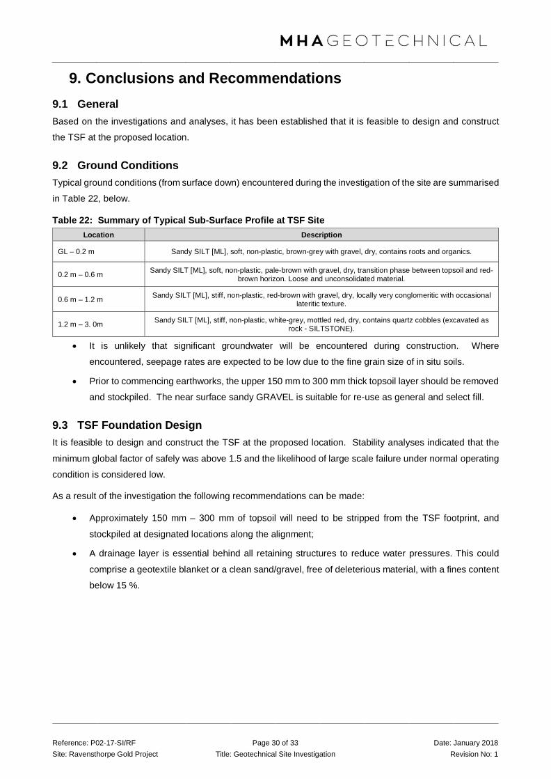
Reference: P02-17-SI/RF Page 30 of 33 Date: January 2018 Site: Ravensthorpe Gold Project Title: Geotechnical Site Investigation Revision No: 1
9. Conclusions and Recommendations 9.1 General Based on the investigations and analyses, it has been established that it is feasible to design and construct
the TSF at the proposed location.
9.2 Ground Conditions Typical ground conditions (from surface down) encountered during the investigation of the site are summarised
in Table 22, below.
Table 22: Summary of Typical Sub-Surface Profile at TSF Site Location Description
GL – 0.2 m Sandy SILT [ML], soft, non-plastic, brown-grey with gravel, dry, contains roots and organics.
0.2 m – 0.6 m Sandy SILT [ML], soft, non-plastic, pale-brown with gravel, dry, transition phase between topsoil and red-brown horizon. Loose and unconsolidated material.
0.6 m – 1.2 m Sandy SILT [ML], stiff, non-plastic, red-brown with gravel, dry, locally very conglomeritic with occasional lateritic texture.
1.2 m – 3. 0m Sandy SILT [ML], stiff, non-plastic, white-grey, mottled red, dry, contains quartz cobbles (excavated as rock - SILTSTONE).
• It is unlikely that significant groundwater will be encountered during construction. Where
encountered, seepage rates are expected to be low due to the fine grain size of in situ soils.
• Prior to commencing earthworks, the upper 150 mm to 300 mm thick topsoil layer should be removed
and stockpiled. The near surface sandy GRAVEL is suitable for re-use as general and select fill.
9.3 TSF Foundation Design It is feasible to design and construct the TSF at the proposed location. Stability analyses indicated that the
minimum global factor of safely was above 1.5 and the likelihood of large scale failure under normal operating
condition is considered low.
As a result of the investigation the following recommendations can be made:
• Approximately 150 mm – 300 mm of topsoil will need to be stripped from the TSF footprint, and
stockpiled at designated locations along the alignment;
• A drainage layer is essential behind all retaining structures to reduce water pressures. This could
comprise a geotextile blanket or a clean sand/gravel, free of deleterious material, with a fines content
below 15 %.

Reference: P02-17-SI/RF Page 31 of 33 Date: January 2018 Site: Ravensthorpe Gold Project Title: Geotechnical Site Investigation Revision No: 1
11. Limitations MHA Geotechnical (MHA) has prepared this report for the development of the Tailings Storage Facility (TSF)
at ACH Minerals’ Ravensthorpe Gold Project in accordance with MHA’s proposal dated the 5th of November
2017. This report is provided for the exclusive use of ACH Minerals Pty Ltd and their consultants for this project
only and for the purposes as described in the report. Any party so relying upon this report beyond its exclusive
use and purpose as stated above, and without the express written consent of MHA, does so entirely at its own
risk and without recourse to MHA for any loss or damage. In preparing this report MHA has necessarily relied
upon information provided by the client and/or their agents.
The results provided in the report are indicative of the sub-surface conditions on the site only at the specific
sampling and/or testing locations, and then only to the depths investigated and at the time the work was carried
out. Sub-surface conditions can change abruptly due to variable geological processes and also as a result of
human influences. Such changes may occur after MHA’s field testing has been completed.
MHA’s advice is based upon the conditions encountered during this investigation. The accuracy of the advice
provided by MHA in this report may be affected by undetected variations in ground conditions across the site
between and beyond the sampling and/or testing locations. The advice may also be limited by budget
constraints imposed by others or by site accessibility.
This report must be read in conjunction with all of the attached and should be kept in its entirety without
separation of individual pages or sections. MHA cannot be held responsible for interpretations or conclusions
made by others unless they are supported by an expressed statement, interpretation, outcome or conclusion
stated in this report.
This report, or sections from this report, should not be used as part of a specification for a project, without
review and agreement by MHA. This is because this report has been written as advice and opinion rather than
instructions for construction.
The contents of this report do not constitute formal design components such as are required, by the Health
and Safety Legislation and Regulations, to be included in a Safety Report specifying the hazards likely to be
encountered during construction and the controls required to mitigate risk. This design process requires risk
assessment to be undertaken, with such assessment being dependent upon factors relating to likelihood of
occurrence and consequences of damage to property and to life. This, in turn, requires project data and
analysis presently beyond the knowledge and project role respectively of MHA.
MHA may be able, however, to assist the client in carrying out a risk assessment of potential hazards contained
in this report, as an extension to the current scope of works, if so requested, and provided that suitable
additional information is made available to MHA.
Any such risk assessment would, however, be necessarily restricted to the geotechnical components set out
in this report and to their application by the project designers to project design, construction, maintenance and
demolition.

Reference: P02-17-SI/RF Page 32 of 33 Date: January 2018 Site: Ravensthorpe Gold Project Title: Geotechnical Site Investigation Revision No: 1
Should you have any questions regarding the content of this report, please do not hesitate to contact us directly.
Sincerely,
For and on behalf of MHA Geotechnical,
Mitch Hanger
Director
Principal Geotechnical Engineer
BEng Civil (Hons) MIEAust

Reference: P02-17-SI/RF Page 33 of 33 Date: January 2018 Site: Ravensthorpe Gold Project Title: Geotechnical Site Investigation Revision No: 1
13. References 1. Giardini, D. Et al, Global Seismic Hazard Assessment Program – Global Seismic Hazard Map, 1999.
2. United States Geology Survey (USGS), World Data Centre for Seismology: Earthquake Data
3. Australian Standards. AS1289.0–1991, Methods of testing soils for engineering purposes.
4. BS 1377: Part 9:1990, Methods of test for soils for civil engineering purposes.
5. Australian Standards. AS1726–1993, Geotechnical Site Investigations.
6. Bowles, J. (1988). Foundation Analysis and Design, 4th Edition. McGraw Hill International Edition.
7. Harr (1966). Foundations of Theoretical Soil Mechanics. McGraw – Hill, New York.
8. Lee, White and Ingles (1983). Geotechnical Engineering. Pitman Publishing, Melbourne.
9. Ahlvin and Ulery (1962). Tabulated Values for Determining the Complete Pattern of Stresses, Strains
and Deflections beneath a Uniform Circular Load on a Homogeneous Half Space. Highway Research
Bulletin No 342.
10. Duncan, James M., and Seed, Raymond B., “Compaction-Induced Earth Pressures under Ko
Conditions”, Journal of Geotechnical Engineering, Volume 112, No. 1, January 1986, pp 1 – 22.
11. Australian Standards. AS1170.4-1993, Minimum Design Loads on Structures. Part 4: Earthquake
Loads.

Appendix B Geotechnical Field Investigation Test Pit Logs and Photographs (MHA Geotechnical Pty Ltd)
Sampling Methods Sampling Sampling is carried out during drilling or test
pitting to allow engineering examination (and
laboratory testing where required) of the soil or
rock.
Disturbed samples taken during drilling provide
information on colour, type, inclusions and,
depending upon the degree of disturbance, some
information on strength and structure.
Undisturbed samples are taken by pushing a thin-
walled sample tube into the soil and withdrawing
it to obtain a sample of the soil in a relatively
undisturbed state. Such samples yield
information on structure and strength, and are
necessary for laboratory determination of shear
strength and compressibility. Undisturbed
sampling is generally effective only in cohesive
soils.
Test Pits Test pits are usually excavated with a backhoe or
an excavator, allowing close examination of the
in- situ soil if it is safe to enter into the pit. The
depth of excavation is limited to about 3 m for a
backhoe and up to 6 m for a large excavator. A
potential disadvantage of this investigation
method is the larger area of disturbance to the
site.
Large Diameter Augers Boreholes can be drilled using a rotating plate or
short spiral auger, generally 300 mm or larger in
diameter commonly mounted on a standard piling
rig. The cuttings are returned to the surface at
intervals (generally not more than 0.5 m) and are
disturbed but usually unchanged in moisture
content. Identification of soil strata is generally
much more reliable than with continuous spiral
flight augers, and is usually supplemented by
occasional undisturbed tube samples.
Continuous Spiral Flight Augers The borehole is advanced using 90-115 mm
diameter continuous spiral flight augers which are
withdrawn at intervals to allow sampling or in-situ
testing. This is a relatively economical means of
drilling in clays and sands above the water table.
Samples are returned to the surface, or may be
collected after withdrawal of the auger flights, but
they are disturbed and may be mixed with soils
from the sides of the hole. Information from the
drilling (as distinct from specific sampling by
SPTs or undisturbed samples) is of relatively
low reliability, due to the remoulding, possible
mixing or softening of samples by groundwater.
Non-core Rotary Drilling The borehole is advanced using a rotary bit, with
water or drilling mud being pumped down the drill
rods and returned up the annulus, carrying the
drill cuttings. Only major changes in stratification
can be determined from the cuttings, together
with some information from the rate of
penetration. Where drilling mud is used this can
mask the cuttings and reliable identification is
only possible from separate sampling such as
SPTs.
Continuous Core Drilling A continuous core sample can be obtained using
a diamond tipped core barrel, usually with a 50
mm internal diameter. Provided full core recovery
is achieved (which is not always possible in weak
rocks and granular soils), this technique provides
a very reliable method of investigation.

Standard Penetration Tests Standard penetration tests (SPT) are used as a
means of estimating the density or strength of
soils and also of obtaining a relatively undisturbed
sample. The test procedure is described in
Australian Standard 1289, Methods of Testing
Soils for Engineering Purposes - Test 6.3.1.
The test is carried out in a borehole by driving a
50 mm diameter split sample tube under the
impact of a 63 kg hammer with a free fall of 760
mm. It is normal for the tube to be driven in three
successive 150 mm increments and the 'N' value
is taken as the number of blows for the last 300
mm. In dense sands, very hard clays or weak
rock, the full 450 mm penetration may not be
practicable and the test is discontinued.
The test results are reported in the following form.
• In the case where full penetration is obtained
with successive blow counts for each 150 mm
of, say, 4, 6 and 7 as: 4,6,7 N=13
• In the case where the test is discontinued
before the full penetration depth, say after 15
blows for the first 150 mm and 30 blows for
the next 40 mm as: 15, 30/40 mm
The results of the SPT tests can be related
empirically to the engineering properties of the
soils.
Dynamic Cone Penetrometer Tests / Perth Sand Penetrometer Tests Dynamic penetrometer tests (DCP or PSP) are
carried out by driving a steel rod into the ground
using a standard weight of hammer falling a
specified distance. As the rod penetrates the soil
the number of blows required to penetrate each
successive 150 mm depth are recorded. Normally
there is a depth limitation of 1.2 m, but this may
be extended in certain conditions by the use of
extension rods. Two types of penetrometer are
commonly used.
• Perth sand penetrometer - a 16 mm diameter
flat ended rod is driven using a 9 kg hammer
dropping 600 mm (AS 1289, Test 6.3.3). This
test was developed for testing the density of
sands and is mainly used in granular soils and
filling.
• Cone penetrometer - a 16 mm diameter rod
with a 20 mm diameter cone end is driven
using a 9 kg hammer dropping 510 mm (AS
1289, Test 6.3.2). This test was developed
initially for pavement subgrade investigations,
and correlations of the test results with
California Bearing Ratio have been published
by various road authorities.

Soil Descriptions Description and Classification Methods The methods of description and classification of
soils and rocks used in this report are based on
Australian Standard AS 1726, Geotechnical Site
Investigations Code. In general, the descriptions
include strength or density, colour, structure, soil
or rock type and inclusions.
Soil Types Soil types are described according to the
predominant particle size, qualified by the grading
of other particles present:
Type Particle size (mm) Boulder >200Cobble 63 - 200 Gravel 2.36 - 63 Sand 0.075 - 2.36 Silt 0.002 - 0.075 Clay <0.002
The sand and gravel sizes can be further
subdivided as follows:
Type Particle size (mm) Coarse gravel 20 - 63 Medium gravel 6 - 20 Fine gravel 2.36 - 6 Coarse sand 0.6 - 2.36 Medium sand 0.2 - 0.6 Fine sand 0.075 - 0.2
The proportions of secondary constituents of soils
are described as:
Term Proportion Example
And Specify Clay (60%) and Sand (40%)
Adjective 20 - 35% Sandy Clay
Slightly 12 - 20% Slightly Sandy Clay
With some 5 - 12% Clay with some sand
With a trace of 0 - 5% Clay with a trace of sand
Definitions of grading terms used are:
• Well graded - a good representation of all
particle sizes;
• Poorly graded - an excess or deficiency of
particular sizes within the specified range;
• Uniformly graded - an excess of a particular
particle size;
• Gap graded - a deficiency of a particular
particle size with the range.
Cohesive Soils Cohesive soils, such as clays, are classified on
the basis of undrained shear strength. The
strength may be measured by laboratory testing,
or estimated by field tests or engineering
examination. The strength terms are defined as
follows:
Description Abbreviation Undrained
shear strength (kPa)
Very soft vs <12 Soft s 12 - 25 Firm f 25 - 50 Stiff st 50 - 100 Very stiff vst 100 - 200 Hard h >200
Cohesionless Soils Cohesionless soils, such as clean sands, are
classified on the basis of relative density,
generally from the results of standard penetration
tests (SPT), cone penetration tests (CPT) or
dynamic penetrometers (PSP). The relative
density terms are given below:

Relative Density Abbreviation SPT N
value
CPT qc value (MPa)
Very loose vl <4 <2 Loose l 4 - 10 2 -5 Medium dense md 10 - 30 5 - 15
Dense d 30 - 50 15 - 25
Very dense vd >50 >25
Soil Origin It is often difficult to accurately determine the
origin of a soil. Soils can generally be classified
as:
• Residual soil - derived from in-situ weathering
of the underlying rock;
• Transported soils - formed somewhere else
and transported by nature to the site; or
• Filling - moved by man.
Transported soils may be further subdivided into:
• Alluvium - river deposits
• Lacustrine - lake deposits
• Aeolian - wind deposits
• Littoral - beach deposits
• Estuarine - tidal river deposits
• Talus - scree or coarse colluvium
• Slopewash or Colluvium - transported
downslope by gravity assisted by water.
Often includes angular rock fragments and
boulders.

TEST PIT LOG
Job No: Date Started: 20/11/2017
Test Pit ID: Date Finished: 20/11/2017
Contractor: Bucket Width: 0.55m
Machine: Easting: -33.685685
Logged By: Northing: 120.206652
Depths (From) Depths (To) Comments DCP Depth
(mm) DCP Blows/100m Laboratory Samples
0 0.2 100 Bulk
200
300
400
500
0.2 0.75 600 Bulk
700
800
900
1000
0.75 1.6 1100 Bulk
1200
1300
1400
1500
1.6 EOH 1600
1700
1800
1900
2000
2100
2200
2300
2400
2500
2600
2700
2800
2900
3000
NOTES AND COMMENTS
Many small (1 - 2 mm) / medium (2 - 10 mm) / large (>10 mm) roots to _____________ m and few small (1 - 2 mm) / medium (2 - 10 mm) / large (>10 mm) roots to _____________ m.
Groundwater recorded at m on the / / .
Co-ordinate System: , Zone: .
Group Consistency Plasticity/Grain size Colour With/Trace Moisture
Pt Fine Grain: Fine grain: red clay dry
OH very soft non-plastic orange silt dry to moist
OL soft low plasticity yellow sand moist
CH firm low - medium brown gravel wet
CL stiff medium plasticity purple cobbles moist to wet
MH very stiff medium to high green OM saturated
ML hard high plasticity white BR
SW Coarse Grain: Coarse Grain: cream Fines:
SP very loose Fine grey <=15% "Trace"
SC loose Medium black 15-30% "With"
SM medium dense Coarse Grain: blue >30% "Secondary"
GW dense Additional: Additional: Coarse:
GP very dense <=5% "Trace"
GC 5-12% "With"
GM >12% "Secondary"
ALLUVIUM
REFUSAL
TOPSOIL
ALLUVIUM
Material DescriptionMain material
SANDY SILT, [ML], soft, non-plastic, brown grey with gravel, dry.
SANDY SILT, [ML], stiff, non-plastic, red brown, with gravel, dry.
P02-17
TP 01
Gary
JCB
Harvey Morcom
Roots and organics
Indurated, excavated as rock.
SANDY SILT, [ML], stiff, non-plastic, white grey motled red orange
Siltstone, excavated as rock.
LATERITECan be modified using pale, dark and motled
Unifor, gap graded, poorly graded. Rounded, sub rounded, sub angular, angular, flaky, platy
bouldery
sandy
gravelly
cobbly
OriginTOPSOIL
CONCRETE
BITUMEN
FILL
BASSENDEAN SAND
SAND FROM TAMALA LST
TAMALA LST
GUILDFORD FORMATION
ALLUVIUM
COLLUVIUM
AEOLIAN
SWAMP DEPOSIT
Soil NamePrimary
PEAT
CLAY
SILT
SAND
GRAVEL
COBBLES
BOULDERS
Scondary:
clayey
silty

Appendix A P 02-17 Page 2 of 21
Test pit TP 01 – 1.6m to refusal, 3 soil horizons in a clockwise rotation starting top right; TOPSOIL, ALLUVIUM (red brown sandy silt) and ALLUVIUM (white mottled sandy silt).

TEST PIT LOG
Job No: Date Started: 20/11/2017
Test Pit ID: Date Finished: 20/11/2017
Contractor: Bucket Width: 0.55m
Machine: Easting: -33.6864494
Logged By: Northing: 120.2067161
Depths (From) Depths (To) Comments DCP Depth
(mm) DCP Blows/100m Laboratory Samples
0 0.1 100 N/S
200
300
400
500
0.1 0.5 600 Bulk
700
800
900
1000
0.5 1.1 1100 Bulk
1200
1300
1400
1500
1.1 2.7 1600 Bulk x2
1700
1800
1900
2000
2.7 EOH 2100
2200
2300
2400
2500
2600
2700
2800
2900
3000
NOTES AND COMMENTS
Many small (1 - 2 mm) / medium (2 - 10 mm) / large (>10 mm) roots to _____________ m and few small (1 - 2 mm) / medium (2 - 10 mm) / large (>10 mm) roots to _____________ m.
Groundwater recorded at m on the / / .
Co-ordinate System: , Zone: .
Group Consistency Plasticity/Grain size Colour With/Trace Moisture
Pt Fine Grain: Fine grain: red clay dry
OH very soft non-plastic orange silt dry to moist
OL soft low plasticity yellow sand moist
CH firm low - medium brown gravel wet
CL stiff medium plasticity purple cobbles moist to wet
MH very stiff medium to high green OM saturated
ML hard high plasticity white BR
SW Coarse Grain: Coarse Grain: cream Fines:
SP very loose Fine grey <=15% "Trace"
SC loose Medium black 15-30% "With"
SM medium dense Coarse Grain: blue >30% "Secondary"
GW dense Additional: Additional: Coarse:
GP very dense <=5% "Trace"
GC 5-12% "With"
GM >12% "Secondary"
Soil NamePrimary
PEAT
CLAY
SILT
SAND
GRAVEL
COBBLES
BOULDERS
Scondary:
clayey
silty
sandy
gravelly
cobbly
OriginTOPSOIL
CONCRETE
BITUMEN
FILL
BASSENDEAN SAND
SAND FROM TAMALA LST
TAMALA LST
GUILDFORD FORMATION
ALLUVIUM
COLLUVIUM
AEOLIAN
SWAMP DEPOSIT
LATERITECan be modified using pale, dark and motled
Unifor, gap graded, poorly graded. Rounded, sub rounded, sub angular, angular, flaky, platy
bouldery
TERMINATION
Roots and organics
Indurated, excavated as rock.
GRAVELLY SILT, [ML], firm, non-plastic, red brown, with gravel, dry.
Siltstone, excavated as rock.
CLAY, [CL], soft, low-medium plasticity, grey white, dry.
P02-17
TP 02
Gary
JCB
Harvey Morcom
Material DescriptionMain material
SANDY SILT, [ML], soft, non-plastic, brown grey with gravel, dry.
GRAVELLY SILT, [ML], firm, non-plastic, red brown, with gravel, dry.
ALLUVIUM
ALLUVIUM
TOPSOIL
ALLUVIUM

Appendix A P 02-17 Page 3 of 21
Test Pit TP 02 – 2.7m to termination, 3 soil horizons in a clockwise rotation starting top right; TOPSOIL, ALLUVIUM (red brown sandy silt) and ALLUVIUM (white mottled sandy silt).

TEST PIT LOG
Job No: Date Started: 20/11/2017
Test Pit ID: Date Finished: 20/11/2017
Contractor: Bucket Width: 0.55m
Machine: Easting: -33.6873212
Logged By: Northing: 120.2068039
Depths (From) Depths (To) Comments DCP Depth
(mm) DCP Blows/100m Laboratory Samples
0 0.1 100 N/S
200
300
400
500
0.1 0.7 600 Bulk
700
800
900
1000
0.7 3 1100 Bulk x2
1200
1300
1400
1500
3 EOH 1600
1700
1800
1900
2000
2100
2200
2300
2400
2500
2600
2700
2800
2900
3000
NOTES AND COMMENTS
Many small (1 - 2 mm) / medium (2 - 10 mm) / large (>10 mm) roots to _____________ m and few small (1 - 2 mm) / medium (2 - 10 mm) / large (>10 mm) roots to _____________ m.
Groundwater recorded at m on the / / .
Co-ordinate System: , Zone: .
Group Consistency Plasticity/Grain size Colour With/Trace Moisture
Pt Fine Grain: Fine grain: red clay dry
OH very soft non-plastic orange silt dry to moist
OL soft low plasticity yellow sand moist
CH firm low - medium brown gravel wet
CL stiff medium plasticity purple cobbles moist to wet
MH very stiff medium to high green OM saturated
ML hard high plasticity white BR
SW Coarse Grain: Coarse Grain: cream Fines:
SP very loose Fine grey <=15% "Trace"
SC loose Medium black 15-30% "With"
SM medium dense Coarse Grain: blue >30% "Secondary"
GW dense Additional: Additional: Coarse:
GP very dense <=5% "Trace"
GC 5-12% "With"
GM >12% "Secondary"
ALLUVIUM
TERMINATION
TOPSOIL
ALLUVIUM
Material DescriptionMain material
SANDY SILT, [ML], soft, non-plastic, brown grey with gravel, dry.
SILT, [ML], soft, non-plastic, grey white, with gravel and sand, dry to moist.
P02-17
TP 03
Gary
JCB
Harvey Morcom
Roots and organics
Indurated, excavated as rock.
clayey SILT, [ML], very stiff, non-plastic, grey white motled red, dry.
Indurated, excavated as rock.
LATERITECan be modified using pale, dark and motled
Unifor, gap graded, poorly graded. Rounded, sub rounded, sub angular, angular, flaky, platy
bouldery
sandy
gravelly
cobbly
OriginTOPSOIL
CONCRETE
BITUMEN
FILL
BASSENDEAN SAND
SAND FROM TAMALA LST
TAMALA LST
GUILDFORD FORMATION
ALLUVIUM
COLLUVIUM
AEOLIAN
SWAMP DEPOSIT
Soil NamePrimary
PEAT
CLAY
SILT
SAND
GRAVEL
COBBLES
BOULDERS
Scondary:
clayey
silty

Appendix A P 02-17 Page 4 of 21
Test pit TP 03 – 3.0m to refusal, 2 soil horizons; TOPSOIL and ALLUVIUM (red brown sandy silt) and ALLUVIUM (white mottled sandy silt).
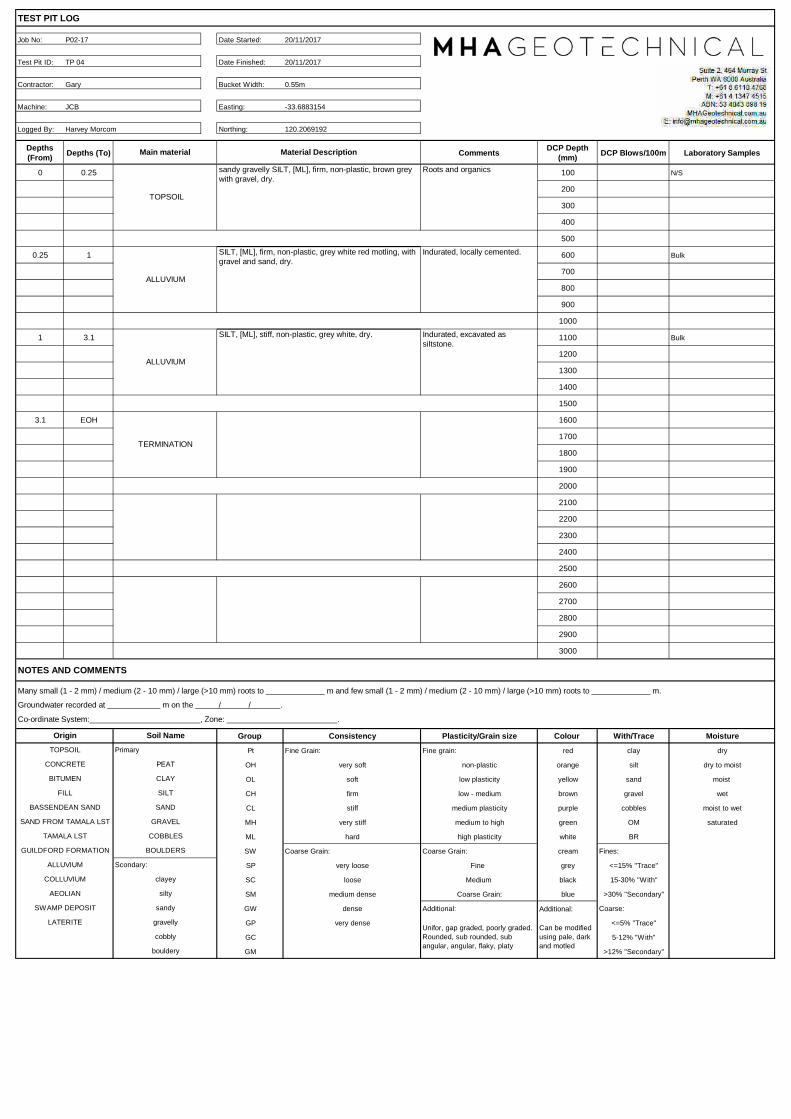
TEST PIT LOG
Job No: Date Started: 20/11/2017
Test Pit ID: Date Finished: 20/11/2017
Contractor: Bucket Width: 0.55m
Machine: Easting: -33.6883154
Logged By: Northing: 120.2069192
Depths (From) Depths (To) Comments DCP Depth
(mm) DCP Blows/100m Laboratory Samples
0 0.25 100 N/S
200
300
400
500
0.25 1 600 Bulk
700
800
900
1000
1 3.1 1100 Bulk
1200
1300
1400
1500
3.1 EOH 1600
1700
1800
1900
2000
2100
2200
2300
2400
2500
2600
2700
2800
2900
3000
NOTES AND COMMENTS
Many small (1 - 2 mm) / medium (2 - 10 mm) / large (>10 mm) roots to _____________ m and few small (1 - 2 mm) / medium (2 - 10 mm) / large (>10 mm) roots to _____________ m.
Groundwater recorded at m on the / / .
Co-ordinate System: , Zone: .
Group Consistency Plasticity/Grain size Colour With/Trace Moisture
Pt Fine Grain: Fine grain: red clay dry
OH very soft non-plastic orange silt dry to moist
OL soft low plasticity yellow sand moist
CH firm low - medium brown gravel wet
CL stiff medium plasticity purple cobbles moist to wet
MH very stiff medium to high green OM saturated
ML hard high plasticity white BR
SW Coarse Grain: Coarse Grain: cream Fines:
SP very loose Fine grey <=15% "Trace"
SC loose Medium black 15-30% "With"
SM medium dense Coarse Grain: blue >30% "Secondary"
GW dense Additional: Additional: Coarse:
GP very dense <=5% "Trace"
GC 5-12% "With"
GM >12% "Secondary"
ALLUVIUM
TERMINATION
TOPSOIL
ALLUVIUM
Material DescriptionMain material
sandy gravelly SILT, [ML], firm, non-plastic, brown grey with gravel, dry.
SILT, [ML], firm, non-plastic, grey white red motling, with gravel and sand, dry.
P02-17
TP 04
Gary
JCB
Harvey Morcom
Roots and organics
Indurated, locally cemented.
SILT, [ML], stiff, non-plastic, grey white, dry. Indurated, excavated as siltstone.
LATERITECan be modified using pale, dark and motled
Unifor, gap graded, poorly graded. Rounded, sub rounded, sub angular, angular, flaky, platy
bouldery
sandy
gravelly
cobbly
OriginTOPSOIL
CONCRETE
BITUMEN
FILL
BASSENDEAN SAND
SAND FROM TAMALA LST
TAMALA LST
GUILDFORD FORMATION
ALLUVIUM
COLLUVIUM
AEOLIAN
SWAMP DEPOSIT
Soil NamePrimary
PEAT
CLAY
SILT
SAND
GRAVEL
COBBLES
BOULDERS
Scondary:
clayey
silty

Appendix A P 02-17 Page 5 of 21
Test pit TP 04 – 3.1m terminated, 2 soil horizons; TOPSOIL and ALLUVIUM (red brown sandy silt) and ALLUVIUM (white mottled sandy silt).
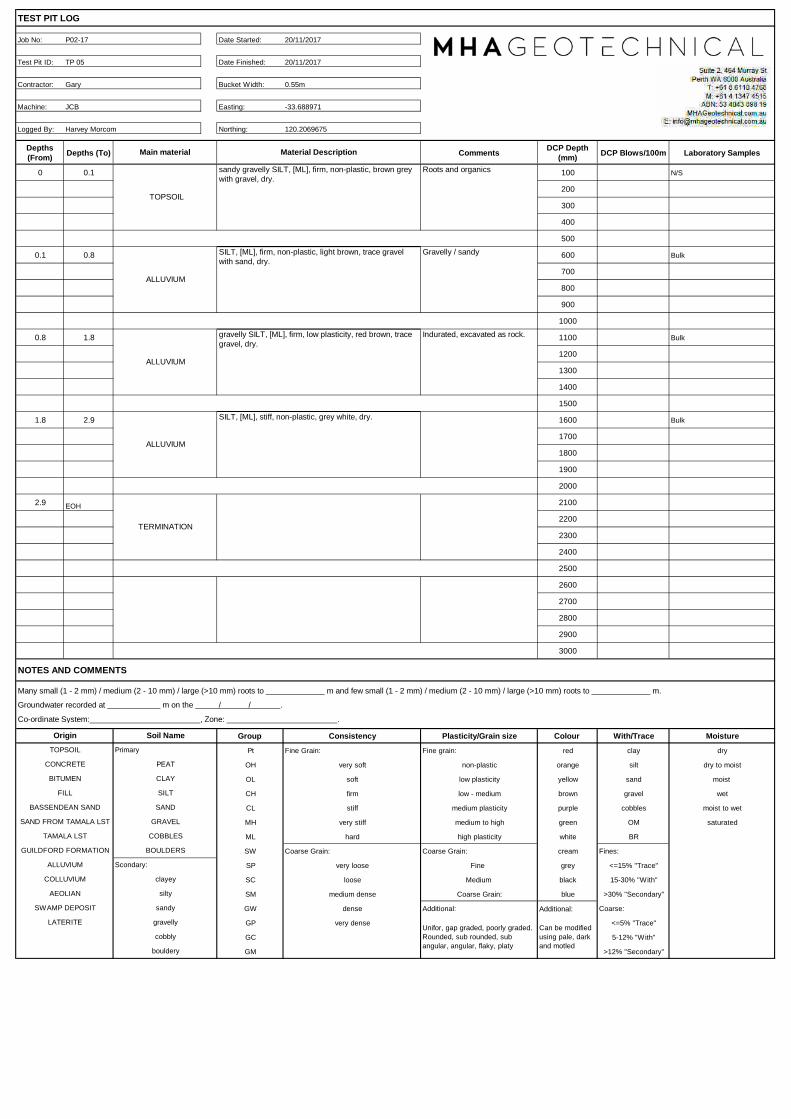
TEST PIT LOG
Job No: Date Started: 20/11/2017
Test Pit ID: Date Finished: 20/11/2017
Contractor: Bucket Width: 0.55m
Machine: Easting: -33.688971
Logged By: Northing: 120.2069675
Depths (From) Depths (To) Comments DCP Depth
(mm) DCP Blows/100m Laboratory Samples
0 0.1 100 N/S
200
300
400
500
0.1 0.8 600 Bulk
700
800
900
1000
0.8 1.8 1100 Bulk
1200
1300
1400
1500
1.8 2.9 1600 Bulk
1700
1800
1900
2000
2.9 EOH 2100
2200
2300
2400
2500
2600
2700
2800
2900
3000
NOTES AND COMMENTS
Many small (1 - 2 mm) / medium (2 - 10 mm) / large (>10 mm) roots to _____________ m and few small (1 - 2 mm) / medium (2 - 10 mm) / large (>10 mm) roots to _____________ m.
Groundwater recorded at m on the / / .
Co-ordinate System: , Zone: .
Group Consistency Plasticity/Grain size Colour With/Trace Moisture
Pt Fine Grain: Fine grain: red clay dry
OH very soft non-plastic orange silt dry to moist
OL soft low plasticity yellow sand moist
CH firm low - medium brown gravel wet
CL stiff medium plasticity purple cobbles moist to wet
MH very stiff medium to high green OM saturated
ML hard high plasticity white BR
SW Coarse Grain: Coarse Grain: cream Fines:
SP very loose Fine grey <=15% "Trace"
SC loose Medium black 15-30% "With"
SM medium dense Coarse Grain: blue >30% "Secondary"
GW dense Additional: Additional: Coarse:
GP very dense <=5% "Trace"
GC 5-12% "With"
GM >12% "Secondary"
ALLUVIUM
ALLUVIUM
TOPSOIL
ALLUVIUM
Material DescriptionMain material
sandy gravelly SILT, [ML], firm, non-plastic, brown grey with gravel, dry.
SILT, [ML], firm, non-plastic, light brown, trace gravel with sand, dry.
P02-17
TP 05
Gary
JCB
Harvey Morcom
TERMINATION
Roots and organics
Gravelly / sandy
gravelly SILT, [ML], firm, low plasticity, red brown, trace gravel, dry.
Indurated, excavated as rock.
SILT, [ML], stiff, non-plastic, grey white, dry.
LATERITECan be modified using pale, dark and motled
Unifor, gap graded, poorly graded. Rounded, sub rounded, sub angular, angular, flaky, platy
bouldery
sandy
gravelly
cobbly
OriginTOPSOIL
CONCRETE
BITUMEN
FILL
BASSENDEAN SAND
SAND FROM TAMALA LST
TAMALA LST
GUILDFORD FORMATION
ALLUVIUM
COLLUVIUM
AEOLIAN
SWAMP DEPOSIT
Soil NamePrimary
PEAT
CLAY
SILT
SAND
GRAVEL
COBBLES
BOULDERS
Scondary:
clayey
silty

Appendix A P 02-17 Page 6 of 21
Test pit TP 05 – 2.9m terminated, 4 soil horizons; TOPSOIL and 3 grades of ALLUVIUM; light brown silt, red brown gravelly silt and grey white sandy silt.

TEST PIT LOG
Job No: Date Started: 20/11/2017
Test Pit ID: Date Finished: 20/11/2017
Contractor: Bucket Width: 0.55m
Machine: Easting: -33.6889939
Logged By: Northing: 120.2084628
Depths (From) Depths (To) Comments DCP Depth
(mm) DCP Blows/100m Laboratory Samples
0 0.1 100 N/S
200
300
400
500
0.1 0.6 600 Bulk
700
800
900
1000
0.6 2.7 1100 Bulk
1200
1300
1400
1500
2.7 EOH 1600
1700
1800
1900
2000
2100
2200
2300
2400
2500
2600
2700
2800
2900
3000
NOTES AND COMMENTS
Many small (1 - 2 mm) / medium (2 - 10 mm) / large (>10 mm) roots to _____________ m and few small (1 - 2 mm) / medium (2 - 10 mm) / large (>10 mm) roots to _____________ m.
Groundwater recorded at m on the / / .
Co-ordinate System: , Zone: .
Group Consistency Plasticity/Grain size Colour With/Trace Moisture
Pt Fine Grain: Fine grain: red clay dry
OH very soft non-plastic orange silt dry to moist
OL soft low plasticity yellow sand moist
CH firm low - medium brown gravel wet
CL stiff medium plasticity purple cobbles moist to wet
MH very stiff medium to high green OM saturated
ML hard high plasticity white BR
SW Coarse Grain: Coarse Grain: cream Fines:
SP very loose Fine grey <=15% "Trace"
SC loose Medium black 15-30% "With"
SM medium dense Coarse Grain: blue >30% "Secondary"
GW dense Additional: Additional: Coarse:
GP very dense <=5% "Trace"
GC 5-12% "With"
GM >12% "Secondary"
ALLUVIUM
TERMINATION
TOPSOIL
ALLUVIUM
Material DescriptionMain material
sandy gravelly SILT, [ML], firm, non-plastic, brown grey with gravel, dry.
SILT, [ML], soft, non-plastic, grey, with gravel and sand, dry.
P02-17
TP 07
Gary
JCB
Harvey Morcom
Roots and organics
roots and organics, gravelly / sandy, loose unconsolidated soil
SILT, [ML], stiff, non-plastic, grey white, dry. Indurated, excavated as siltstone.
LATERITECan be modified using pale, dark and motled
Unifor, gap graded, poorly graded. Rounded, sub rounded, sub angular, angular, flaky, platy
bouldery
sandy
gravelly
cobbly
OriginTOPSOIL
CONCRETE
BITUMEN
FILL
BASSENDEAN SAND
SAND FROM TAMALA LST
TAMALA LST
GUILDFORD FORMATION
ALLUVIUM
COLLUVIUM
AEOLIAN
SWAMP DEPOSIT
Soil NamePrimary
PEAT
CLAY
SILT
SAND
GRAVEL
COBBLES
BOULDERS
Scondary:
clayey
silty

Appendix A P 02-17 Page 7 of 21
Test pit TP 06 – 2.7m terminated, 3 soil horizons; TOPSOIL and 2 grades of ALLUVIUM; predominantly composed of the grey white siltstone, however with darker grey gravelly material.

TEST PIT LOG
Job No: Date Started: 20/11/2017
Test Pit ID: Date Finished: 20/11/2017
Contractor: Bucket Width: 0.55m
Machine: Easting: -33.6889501
Logged By: Northing: 120.2091173
Depths (From) Depths (To) Comments DCP Depth
(mm) DCP Blows/100m Laboratory Samples
0 0.1 100 N/S
200
300
400
500
0.1 0.2 600 Bulk
700
800
900
1000
0.2 2.5 1100 Bulk x2
1200
1300
1400
1500
2.5 EOH 1600
1700
1800
1900
2000
2100
2200
2300
2400
2500
2600
2700
2800
2900
3000
NOTES AND COMMENTS
Many small (1 - 2 mm) / medium (2 - 10 mm) / large (>10 mm) roots to _____________ m and few small (1 - 2 mm) / medium (2 - 10 mm) / large (>10 mm) roots to _____________ m.
Groundwater recorded at m on the / / .
Co-ordinate System: , Zone: .
Group Consistency Plasticity/Grain size Colour With/Trace Moisture
Pt Fine Grain: Fine grain: red clay dry
OH very soft non-plastic orange silt dry to moist
OL soft low plasticity yellow sand moist
CH firm low - medium brown gravel wet
CL stiff medium plasticity purple cobbles moist to wet
MH very stiff medium to high green OM saturated
ML hard high plasticity white BR
SW Coarse Grain: Coarse Grain: cream Fines:
SP very loose Fine grey <=15% "Trace"
SC loose Medium black 15-30% "With"
SM medium dense Coarse Grain: blue >30% "Secondary"
GW dense Additional: Additional: Coarse:
GP very dense <=5% "Trace"
GC 5-12% "With"
GM >12% "Secondary"
ALLUVIUM
TERMINATION
TOPSOIL
ALLUVIUM
Material DescriptionMain material
sandy gravelly SILT, [ML], firm, non-plastic, brown grey with gravel, dry.
SILT, [ML], soft, non-plastic, dark grey, with sand, dry.
P02-17
TP 07
Gary
JCB
Harvey Morcom
Roots and organics.
Gravel clasts, loose, unconsolidated.
SILT, [ML], stiff, non-plastic, white, dry to moist. Indurated, excavated as siltstone.
LATERITECan be modified using pale, dark and motled
Unifor, gap graded, poorly graded. Rounded, sub rounded, sub angular, angular, flaky, platy
bouldery
sandy
gravelly
cobbly
OriginTOPSOIL
CONCRETE
BITUMEN
FILL
BASSENDEAN SAND
SAND FROM TAMALA LST
TAMALA LST
GUILDFORD FORMATION
ALLUVIUM
COLLUVIUM
AEOLIAN
SWAMP DEPOSIT
Soil NamePrimary
PEAT
CLAY
SILT
SAND
GRAVEL
COBBLES
BOULDERS
Scondary:
clayey
silty

Appendix A P 02-17 Page 8 of 21
Test pit TP 07 – 2.5m terminated, 3 soil horizons; TOPSOIL and 2 grades of ALLUVIUM; 0.2m of dark grey surficial top soil blending into the typical white siltstone.

TEST PIT LOG
Job No: Date Started: 20/11/2017
Test Pit ID: Date Finished: 20/11/2017
Contractor: Bucket Width: 0.55m
Machine: Easting: -33.6889116
Logged By: Northing: 120.2096444
Depths (From) Depths (To) Comments DCP Depth
(mm) DCP Blows/100m Laboratory Samples
0 0.1 100 N/S
200
300
400
500
0.1 0.4 600 Bulk
700
800
900
1000
0.4 2.2 1100 Bulk
1200
1300
1400
1500
2.2 EOH 1600
1700
1800
1900
2000
2100
2200
2300
2400
2500
2600
2700
2800
2900
3000
NOTES AND COMMENTS
Many small (1 - 2 mm) / medium (2 - 10 mm) / large (>10 mm) roots to _____________ m and few small (1 - 2 mm) / medium (2 - 10 mm) / large (>10 mm) roots to _____________ m.
Groundwater recorded at m on the / / .
Co-ordinate System: , Zone: .
Group Consistency Plasticity/Grain size Colour With/Trace Moisture
Pt Fine Grain: Fine grain: red clay dry
OH very soft non-plastic orange silt dry to moist
OL soft low plasticity yellow sand moist
CH firm low - medium brown gravel wet
CL stiff medium plasticity purple cobbles moist to wet
MH very stiff medium to high green OM saturated
ML hard high plasticity white BR
SW Coarse Grain: Coarse Grain: cream Fines:
SP very loose Fine grey <=15% "Trace"
SC loose Medium black 15-30% "With"
SM medium dense Coarse Grain: blue >30% "Secondary"
GW dense Additional: Additional: Coarse:
GP very dense <=5% "Trace"
GC 5-12% "With"
GM >12% "Secondary"
ALLUVIUM
TERMINATION
TOPSOIL
ALLUVIUM
Material DescriptionMain material
sandy gravelly SILT, [ML], firm, non-plastic, brown grey with gravel, dry.
sandy SILT, [ML], soft, non-plastic, grey, with sand, dry.
P02-17
TP 08
Gary
JCB
Harvey Morcom
Roots and organics.
Unconsolidated.
SILT, [ML], stiff, non-plastic, white, dry to moist. Indurated, excavated as siltstone.
LATERITECan be modified using pale, dark and motled
Unifor, gap graded, poorly graded. Rounded, sub rounded, sub angular, angular, flaky, platy
bouldery
sandy
gravelly
cobbly
OriginTOPSOIL
CONCRETE
BITUMEN
FILL
BASSENDEAN SAND
SAND FROM TAMALA LST
TAMALA LST
GUILDFORD FORMATION
ALLUVIUM
COLLUVIUM
AEOLIAN
SWAMP DEPOSIT
Soil NamePrimary
PEAT
CLAY
SILT
SAND
GRAVEL
COBBLES
BOULDERS
Scondary:
clayey
silty

Appendix A P 02-17 Page 9 of 21
Test pit TP 08 – 2.2m terminated, 3 soil horizons; TOPSOIL and 2 grades of ALLUVIUM; 0.4m of dark grey surficial top soil blending into the white siltstone.
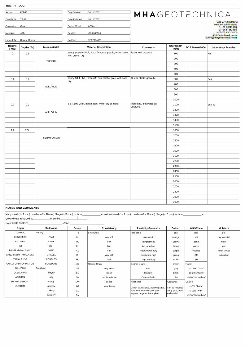
TEST PIT LOG
Job No: Date Started: 20/11/2017
Test Pit ID: Date Finished: 20/11/2017
Contractor: Bucket Width: 0.55m
Machine: Easting: -33.6888324
Logged By: Northing: 120.2104839
Depths (From) Depths (To) Comments DCP Depth
(mm) DCP Blows/100m Laboratory Samples
0 0.1 100 N/S
200
300
400
500
0.1 0.2 600 Bulk
700
800
900
1000
0.2 2.2 1100 Bulk x2
1200
1300
1400
1500
2.2 EOH 1600
1700
1800
1900
2000
2100
2200
2300
2400
2500
2600
2700
2800
2900
3000
NOTES AND COMMENTS
Many small (1 - 2 mm) / medium (2 - 10 mm) / large (>10 mm) roots to _____________ m and few small (1 - 2 mm) / medium (2 - 10 mm) / large (>10 mm) roots to _____________ m.
Groundwater recorded at m on the / / .
Co-ordinate System: , Zone: .
Group Consistency Plasticity/Grain size Colour With/Trace Moisture
Pt Fine Grain: Fine grain: red clay dry
OH very soft non-plastic orange silt dry to moist
OL soft low plasticity yellow sand moist
CH firm low - medium brown gravel wet
CL stiff medium plasticity purple cobbles moist to wet
MH very stiff medium to high green OM saturated
ML hard high plasticity white BR
SW Coarse Grain: Coarse Grain: cream Fines:
SP very loose Fine grey <=15% "Trace"
SC loose Medium black 15-30% "With"
SM medium dense Coarse Grain: blue >30% "Secondary"
GW dense Additional: Additional: Coarse:
GP very dense <=5% "Trace"
GC 5-12% "With"
GM >12% "Secondary"
ALLUVIUM
TERMINATION
TOPSOIL
ALLUVIUM
Material DescriptionMain material
sandy gravelly SILT, [ML], firm, non-plastic, brown grey with gravel, dry.
sandy SILT, [ML], firm-stiff, non-plastic, grey, with sand, dry.
P02-17
TP 09
Gary
JCB
Harvey Morcom
Roots and organics.
Quartz clasts, gravelly.
SILT, [ML], stiff, non-plastic, white, dry to moist. Indurated, excavated as siltstone.
LATERITECan be modified using pale, dark and motled
Unifor, gap graded, poorly graded. Rounded, sub rounded, sub angular, angular, flaky, platy
bouldery
sandy
gravelly
cobbly
OriginTOPSOIL
CONCRETE
BITUMEN
FILL
BASSENDEAN SAND
SAND FROM TAMALA LST
TAMALA LST
GUILDFORD FORMATION
ALLUVIUM
COLLUVIUM
AEOLIAN
SWAMP DEPOSIT
Soil NamePrimary
PEAT
CLAY
SILT
SAND
GRAVEL
COBBLES
BOULDERS
Scondary:
clayey
silty

Appendix A P 02-17 Page 10 of 21
Test pit TP 09 – 2.2m terminated, 3 soil horizons. TOPSOIL and 2 grades of ALLUVIUM; grey surficial top soil blending into the white siltstone.

TEST PIT LOG
Job No: Date Started: 20/11/2017
Test Pit ID: Date Finished: 20/11/2017
Contractor: Bucket Width: 0.55m
Machine: Easting: -33.6888137
Logged By: Northing: 120.2109811
Depths (From) Depths (To) Comments DCP Depth
(mm) DCP Blows/100m Laboratory Samples
0 0.1 100 N/S
200
300
400
500
0.1 2.5 600 Bulk X2
700
800
900
1000
2.5 EOH 1100
1200
1300
1400
1500
1600
1700
1800
1900
2000
2100
2200
2300
2400
2500
2600
2700
2800
2900
3000
NOTES AND COMMENTS
Many small (1 - 2 mm) / medium (2 - 10 mm) / large (>10 mm) roots to _____________ m and few small (1 - 2 mm) / medium (2 - 10 mm) / large (>10 mm) roots to _____________ m.
Groundwater recorded at m on the / / .
Co-ordinate System: , Zone: .
Group Consistency Plasticity/Grain size Colour With/Trace Moisture
Pt Fine Grain: Fine grain: red clay dry
OH very soft non-plastic orange silt dry to moist
OL soft low plasticity yellow sand moist
CH firm low - medium brown gravel wet
CL stiff medium plasticity purple cobbles moist to wet
MH very stiff medium to high green OM saturated
ML hard high plasticity white BR
SW Coarse Grain: Coarse Grain: cream Fines:
SP very loose Fine grey <=15% "Trace"
SC loose Medium black 15-30% "With"
SM medium dense Coarse Grain: blue >30% "Secondary"
GW dense Additional: Additional: Coarse:
GP very dense <=5% "Trace"
GC 5-12% "With"
GM >12% "Secondary"
TERMINATION
TOPSOIL
ALLUVIUM
Material DescriptionMain material
sandy gravelly SILT, [ML], firm, non-plastic, brown grey with gravel, dry.
SILT, [ML], stiff to very stiff, non-plastic, white orange mottling, dry to moist.
P02-17
TP 10
Gary
JCB
Harvey Morcom
Roots and organics.
Clayey silt, less granular, excavated as rock.
LATERITECan be modified using pale, dark and motled
Unifor, gap graded, poorly graded. Rounded, sub rounded, sub angular, angular, flaky, platy
bouldery
sandy
gravelly
cobbly
OriginTOPSOIL
CONCRETE
BITUMEN
FILL
BASSENDEAN SAND
SAND FROM TAMALA LST
TAMALA LST
GUILDFORD FORMATION
ALLUVIUM
COLLUVIUM
AEOLIAN
SWAMP DEPOSIT
Soil NamePrimary
PEAT
CLAY
SILT
SAND
GRAVEL
COBBLES
BOULDERS
Scondary:
clayey
silty

Appendix A P 02-17 Page 11 of 21
Test pit TP 10 – 2.5m terminated, 2 soil horizons. TOPSOIL and ALLUVIUM; brown grey surficial top soil and white siltstone with minor red mottling.

TEST PIT LOG
Job No: Date Started: 20/11/2017
Test Pit ID: Date Finished: 20/11/2017
Contractor: Bucket Width: 0.55m
Machine: Easting: -33.6885004
Logged By: Northing: 120.2113023
Depths (From) Depths (To) Comments DCP Depth
(mm) DCP Blows/100m Laboratory Samples
0 0.2 100 N/S
200
300
400
500
0.2 2.8 600 Bulk X2
700
800
900
1000
2.8 EOH 1100
1200
1300
1400
1500
1600
1700
1800
1900
2000
2100
2200
2300
2400
2500
2600
2700
2800
2900
3000
NOTES AND COMMENTS
Many small (1 - 2 mm) / medium (2 - 10 mm) / large (>10 mm) roots to _____________ m and few small (1 - 2 mm) / medium (2 - 10 mm) / large (>10 mm) roots to _____________ m.
Groundwater recorded at m on the / / .
Co-ordinate System: , Zone: .
Group Consistency Plasticity/Grain size Colour With/Trace Moisture
Pt Fine Grain: Fine grain: red clay dry
OH very soft non-plastic orange silt dry to moist
OL soft low plasticity yellow sand moist
CH firm low - medium brown gravel wet
CL stiff medium plasticity purple cobbles moist to wet
MH very stiff medium to high green OM saturated
ML hard high plasticity white BR
SW Coarse Grain: Coarse Grain: cream Fines:
SP very loose Fine grey <=15% "Trace"
SC loose Medium black 15-30% "With"
SM medium dense Coarse Grain: blue >30% "Secondary"
GW dense Additional: Additional: Coarse:
GP very dense <=5% "Trace"
GC 5-12% "With"
GM >12% "Secondary"
TERMINATION
TOPSOIL
ALLUVIUM
Material DescriptionMain material
sandy gravelly SILT, [ML], firm, non-plastic, brown grey with gravel, dry.
SILT, [ML], stiff to very stiff, non-plastic, white, dry to moist.
P02-17
TP 11
Gary
JCB
Harvey Morcom
Roots and organics.
Clayey silt, less granular, excavated as rock.
LATERITECan be modified using pale, dark and motled
Unifor, gap graded, poorly graded. Rounded, sub rounded, sub angular, angular, flaky, platy
bouldery
sandy
gravelly
cobbly
OriginTOPSOIL
CONCRETE
BITUMEN
FILL
BASSENDEAN SAND
SAND FROM TAMALA LST
TAMALA LST
GUILDFORD FORMATION
ALLUVIUM
COLLUVIUM
AEOLIAN
SWAMP DEPOSIT
Soil NamePrimary
PEAT
CLAY
SILT
SAND
GRAVEL
COBBLES
BOULDERS
Scondary:
clayey
silty

Appendix A P 02-17 Page 12 of 21
Test pit TP 11 – 2.8m terminated, 2 soil horizons. TOPSOIL and ALLUVIUM; brown grey surficial top soil and white siltstone.
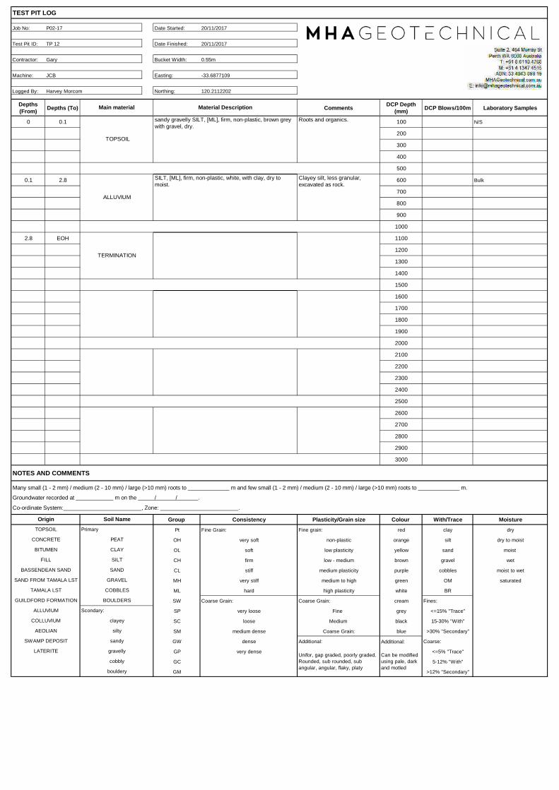
TEST PIT LOG
Job No: Date Started: 20/11/2017
Test Pit ID: Date Finished: 20/11/2017
Contractor: Bucket Width: 0.55m
Machine: Easting: -33.6877109
Logged By: Northing: 120.2112202
Depths (From) Depths (To) Comments DCP Depth
(mm) DCP Blows/100m Laboratory Samples
0 0.1 100 N/S
200
300
400
500
0.1 2.8 600 Bulk
700
800
900
1000
2.8 EOH 1100
1200
1300
1400
1500
1600
1700
1800
1900
2000
2100
2200
2300
2400
2500
2600
2700
2800
2900
3000
NOTES AND COMMENTS
Many small (1 - 2 mm) / medium (2 - 10 mm) / large (>10 mm) roots to _____________ m and few small (1 - 2 mm) / medium (2 - 10 mm) / large (>10 mm) roots to _____________ m.
Groundwater recorded at m on the / / .
Co-ordinate System: , Zone: .
Group Consistency Plasticity/Grain size Colour With/Trace Moisture
Pt Fine Grain: Fine grain: red clay dry
OH very soft non-plastic orange silt dry to moist
OL soft low plasticity yellow sand moist
CH firm low - medium brown gravel wet
CL stiff medium plasticity purple cobbles moist to wet
MH very stiff medium to high green OM saturated
ML hard high plasticity white BR
SW Coarse Grain: Coarse Grain: cream Fines:
SP very loose Fine grey <=15% "Trace"
SC loose Medium black 15-30% "With"
SM medium dense Coarse Grain: blue >30% "Secondary"
GW dense Additional: Additional: Coarse:
GP very dense <=5% "Trace"
GC 5-12% "With"
GM >12% "Secondary"
TERMINATION
TOPSOIL
ALLUVIUM
Material DescriptionMain material
sandy gravelly SILT, [ML], firm, non-plastic, brown grey with gravel, dry.
SILT, [ML], firm, non-plastic, white, with clay, dry to moist.
P02-17
TP 12
Gary
JCB
Harvey Morcom
Roots and organics.
Clayey silt, less granular, excavated as rock.
LATERITECan be modified using pale, dark and motled
Unifor, gap graded, poorly graded. Rounded, sub rounded, sub angular, angular, flaky, platy
bouldery
sandy
gravelly
cobbly
OriginTOPSOIL
CONCRETE
BITUMEN
FILL
BASSENDEAN SAND
SAND FROM TAMALA LST
TAMALA LST
GUILDFORD FORMATION
ALLUVIUM
COLLUVIUM
AEOLIAN
SWAMP DEPOSIT
Soil NamePrimary
PEAT
CLAY
SILT
SAND
GRAVEL
COBBLES
BOULDERS
Scondary:
clayey
silty

Appendix A P 02-17 Page 13 of 21
Test pit TP 12 – 2.8m terminated, 2 soil horizons. TOPSOIL and ALLUVIUM; brown grey surficial top soil and white siltstone.

TEST PIT LOG
Job No: Date Started: 20/11/2017
Test Pit ID: Date Finished: 20/11/2017
Contractor: Bucket Width: 0.55m
Machine: Easting: -33.6867749
Logged By: Northing: 120.2111142
Depths (From) Depths (To) Comments DCP Depth
(mm) DCP Blows/100m Laboratory Samples
0 0.1 100 N/S
200
300
400
500
0.1 0.7 600 Bulk
700
800
900
1000
0.7 2.8 1100 Bulk
1200
1300
1400
1500
2.8 EOH 1600
1700
1800
1900
2000
2100
2200
2300
2400
2500
2600
2700
2800
2900
3000
NOTES AND COMMENTS
Many small (1 - 2 mm) / medium (2 - 10 mm) / large (>10 mm) roots to _____________ m and few small (1 - 2 mm) / medium (2 - 10 mm) / large (>10 mm) roots to _____________ m.
Groundwater recorded at m on the / / .
Co-ordinate System: , Zone: .
Group Consistency Plasticity/Grain size Colour With/Trace Moisture
Pt Fine Grain: Fine grain: red clay dry
OH very soft non-plastic orange silt dry to moist
OL soft low plasticity yellow sand moist
CH firm low - medium brown gravel wet
CL stiff medium plasticity purple cobbles moist to wet
MH very stiff medium to high green OM saturated
ML hard high plasticity white BR
SW Coarse Grain: Coarse Grain: cream Fines:
SP very loose Fine grey <=15% "Trace"
SC loose Medium black 15-30% "With"
SM medium dense Coarse Grain: blue >30% "Secondary"
GW dense Additional: Additional: Coarse:
GP very dense <=5% "Trace"
GC 5-12% "With"
GM >12% "Secondary"
ALLUVIUM
TERMINATION
TOPSOIL
ALLUVIUM
Material DescriptionMain material
sandy gravelly SILT, [ML], firm, non-plastic, brown grey with gravel, dry.
SILT, [ML], firm, non-plastic, grey white red motling, with gravel and sand, dry.
P02-17
TP 13
Gary
JCB
Harvey Morcom
Roots and organics.
Clayey silt, less granular, excavated as rock.
SILT, [ML], firm, non-plastic, white, with clay, dry to moist.
Clayey silt, less granular, excavated as rock.
LATERITECan be modified using pale, dark and motled
Unifor, gap graded, poorly graded. Rounded, sub rounded, sub angular, angular, flaky, platy
bouldery
sandy
gravelly
cobbly
OriginTOPSOIL
CONCRETE
BITUMEN
FILL
BASSENDEAN SAND
SAND FROM TAMALA LST
TAMALA LST
GUILDFORD FORMATION
ALLUVIUM
COLLUVIUM
AEOLIAN
SWAMP DEPOSIT
Soil NamePrimary
PEAT
CLAY
SILT
SAND
GRAVEL
COBBLES
BOULDERS
Scondary:
clayey
silty

Appendix A P 02-17 Page 14 of 21
Test pit TP 13 – 2.9m terminated, 3 soil horizons. TOPSOIL and ALLUVIUM; brown grey surficial top soil and white siltstone with some red mottling.

TEST PIT LOG
Job No: Date Started: 21/11/2017
Test Pit ID: Date Finished: 21/11/2017
Contractor: Bucket Width: 0.55m
Machine: Easting: -33.6861255
Logged By: Northing: 120.2110391
Depths (From) Depths (To) Comments DCP Depth
(mm) DCP Blows/100m Laboratory Samples
0 0.2 100 N/S
200
300
400
500
0.2 1 600 Bulk
700
800
900
1000
1 EOH 1100
1200
1300
1400
1500
1600
1700
1800
1900
2000
2100
2200
2300
2400
2500
2600
2700
2800
2900
3000
NOTES AND COMMENTS
Many small (1 - 2 mm) / medium (2 - 10 mm) / large (>10 mm) roots to _____________ m and few small (1 - 2 mm) / medium (2 - 10 mm) / large (>10 mm) roots to _____________ m.
Groundwater recorded at m on the / / .
Co-ordinate System: , Zone: .
Group Consistency Plasticity/Grain size Colour With/Trace Moisture
Pt Fine Grain: Fine grain: red clay dry
OH very soft non-plastic orange silt dry to moist
OL soft low plasticity yellow sand moist
CH firm low - medium brown gravel wet
CL stiff medium plasticity purple cobbles moist to wet
MH very stiff medium to high green OM saturated
ML hard high plasticity white BR
SW Coarse Grain: Coarse Grain: cream Fines:
SP very loose Fine grey <=15% "Trace"
SC loose Medium black 15-30% "With"
SM medium dense Coarse Grain: blue >30% "Secondary"
GW dense Additional: Additional: Coarse:
GP very dense <=5% "Trace"
GC 5-12% "With"
GM >12% "Secondary"
Soil NamePrimary
PEAT
CLAY
SILT
SAND
GRAVEL
COBBLES
BOULDERS
Scondary:
clayey
silty
sandy
gravelly
cobbly
OriginTOPSOIL
CONCRETE
BITUMEN
FILL
BASSENDEAN SAND
SAND FROM TAMALA LST
TAMALA LST
GUILDFORD FORMATION
ALLUVIUM
COLLUVIUM
AEOLIAN
SWAMP DEPOSIT
LATERITECan be modified using pale, dark and motled
Unifor, gap graded, poorly graded. Rounded, sub rounded, sub angular, angular, flaky, platy
bouldery
Roots and organics.
Cobbly, excavated as rock.
P02-17
TP 14
Gary
JCB
Harvey Morcom
Material DescriptionMain material
sandy gravelly SILT, [ML], firm, non-plastic, brown grey with gravel, dry.
SILT, [ML], very stiff, non-plastic, white red motling, with gravel and sand, dry.
REFUSAL
TOPSOIL
ALLUVIUM

Appendix A P 02-17 Page 15 of 21
Test pit TP 14 – 1.0m refusal. TOPSOIL and gravelly ALLUVIUM; brown grey surficial top soil and white siltstone with some cobbles.

TEST PIT LOG
Job No: Date Started: 21/11/2017
Test Pit ID: Date Finished: 21/11/2017
Contractor: Bucket Width: 0.55m
Machine: Easting: -33.6856138
Logged By: Northing: 120.2109576
Depths (From) Depths (To) Comments DCP Depth
(mm) DCP Blows/100m Laboratory Samples
0 0.2 100 N/S
200
300
400
500
0.2 2.7 600 Bulk x2
700
800
900
1000
2.7 EOH 1100
1200
1300
1400
1500
1600
1700
1800
1900
2000
2100
2200
2300
2400
2500
2600
2700
2800
2900
3000
NOTES AND COMMENTS
Many small (1 - 2 mm) / medium (2 - 10 mm) / large (>10 mm) roots to _____________ m and few small (1 - 2 mm) / medium (2 - 10 mm) / large (>10 mm) roots to _____________ m.
Groundwater recorded at m on the / / .
Co-ordinate System: , Zone: .
Group Consistency Plasticity/Grain size Colour With/Trace Moisture
Pt Fine Grain: Fine grain: red clay dry
OH very soft non-plastic orange silt dry to moist
OL soft low plasticity yellow sand moist
CH firm low - medium brown gravel wet
CL stiff medium plasticity purple cobbles moist to wet
MH very stiff medium to high green OM saturated
ML hard high plasticity white BR
SW Coarse Grain: Coarse Grain: cream Fines:
SP very loose Fine grey <=15% "Trace"
SC loose Medium black 15-30% "With"
SM medium dense Coarse Grain: blue >30% "Secondary"
GW dense Additional: Additional: Coarse:
GP very dense <=5% "Trace"
GC 5-12% "With"
GM >12% "Secondary"
Soil NamePrimary
PEAT
CLAY
SILT
SAND
GRAVEL
COBBLES
BOULDERS
Scondary:
clayey
silty
sandy
gravelly
cobbly
OriginTOPSOIL
CONCRETE
BITUMEN
FILL
BASSENDEAN SAND
SAND FROM TAMALA LST
TAMALA LST
GUILDFORD FORMATION
ALLUVIUM
COLLUVIUM
AEOLIAN
SWAMP DEPOSIT
LATERITECan be modified using pale, dark and motled
Unifor, gap graded, poorly graded. Rounded, sub rounded, sub angular, angular, flaky, platy
bouldery
Roots and organics.
Excavated as rock.
P02-17
TP 15
Gary
JCB
Harvey Morcom
Material DescriptionMain material
sandy gravelly SILT, [ML], firm, non-plastic, brown grey with gravel, dry.
SILT, [ML], very stiff, non-plastic, white, with gravel and sand, dry.
REFUSAL
TOPSOIL
ALLUVIUM

Appendix A P 02-17 Page 16 of 21
Test pit TP 15 – 2.7m refusal. TOPSOIL and gravelly ALLUVIUM; brown grey surficial top soil and white siltstone with some cobbles.

TEST PIT LOG
Job No: Date Started: 21/11/2017
Test Pit ID: Date Finished: 21/11/2017
Contractor: Bucket Width: 0.55m
Machine: Easting: -33.6852333
Logged By: Northing: 120.210323
Depths (From) Depths (To) Comments DCP Depth
(mm) DCP Blows/100m Laboratory Samples
0 0.2 100 N/S
200
300
400
500
0.2 0.6 600 Bulk
700
800
900
1000
0.6 1 1100 Bulk
1200
1300
1400
1500
1 2.8 1600 Bulk
1700
1800
1900
2000
2.8 EOH 2100
2200
2300
2400
2500
2600
2700
2800
2900
3000
NOTES AND COMMENTS
Many small (1 - 2 mm) / medium (2 - 10 mm) / large (>10 mm) roots to _____________ m and few small (1 - 2 mm) / medium (2 - 10 mm) / large (>10 mm) roots to _____________ m.
Groundwater recorded at m on the / / .
Co-ordinate System: , Zone: .
Group Consistency Plasticity/Grain size Colour With/Trace Moisture
Pt Fine Grain: Fine grain: red clay dry
OH very soft non-plastic orange silt dry to moist
OL soft low plasticity yellow sand moist
CH firm low - medium brown gravel wet
CL stiff medium plasticity purple cobbles moist to wet
MH very stiff medium to high green OM saturated
ML hard high plasticity white BR
SW Coarse Grain: Coarse Grain: cream Fines:
SP very loose Fine grey <=15% "Trace"
SC loose Medium black 15-30% "With"
SM medium dense Coarse Grain: blue >30% "Secondary"
GW dense Additional: Additional: Coarse:
GP very dense <=5% "Trace"
GC 5-12% "With"
GM >12% "Secondary"
Soil NamePrimary
PEAT
CLAY
SILT
SAND
GRAVEL
COBBLES
BOULDERS
Scondary:
clayey
silty
sandy
gravelly
cobbly
OriginTOPSOIL
CONCRETE
BITUMEN
FILL
BASSENDEAN SAND
SAND FROM TAMALA LST
TAMALA LST
GUILDFORD FORMATION
ALLUVIUM
COLLUVIUM
AEOLIAN
SWAMP DEPOSIT
LATERITECan be modified using pale, dark and motled
Unifor, gap graded, poorly graded. Rounded, sub rounded, sub angular, angular, flaky, platy
bouldery
TERMINATED
Roots and organics.
Excavated as rock. Lateritic formation.
SILT, [ML], very stiff, low plasticity, red brown white blend, with gravel, dry.
transition phase between soil units above and below.
SILT, [ML], very stiff, non-plastic, white, with gravel and sand, dry.
Excavated as rock.
P02-17
TP 16
Gary
JCB
Harvey Morcom
Material DescriptionMain material
sandy gravelly SILT, [ML], firm, non-plastic, brown grey with gravel, dry.
gravelly SILT, [ML], very stiff, low plasticity, red brown, with gravel, dry.
ALLUVIUM
ALLUVIUM
TOPSOIL
ALLUVIUM

Appendix A P 02-17 Page 17 of 21
Test pit TP 16 – 2.8m termination. TOPSOIL and gravelly ALLUVIUM; red brown surficial top soil and white siltstone with some gravel.

TEST PIT LOG
Job No: Date Started: 21/11/2017
Test Pit ID: Date Finished: 21/11/2017
Contractor: Bucket Width: 0.55m
Machine: Easting: -33.6852913
Logged By: Northing: 120.2093694
Depths (From) Depths (To) Comments DCP Depth
(mm) DCP Blows/100m Laboratory Samples
0 0.2 100 N/S
200
300
400
500
0.2 0.6 600 N/S
700
800
900
1000
0.6 1.2 1100 Bulk
1200
1300
1400
1500
1.2 2.7 1600 Bulk
1700
1800
1900
2000
2.7 EOH 2100
2200
2300
2400
2500
2600
2700
2800
2900
3000
NOTES AND COMMENTS
Many small (1 - 2 mm) / medium (2 - 10 mm) / large (>10 mm) roots to _____________ m and few small (1 - 2 mm) / medium (2 - 10 mm) / large (>10 mm) roots to _____________ m.
Groundwater recorded at m on the / / .
Co-ordinate System: , Zone: .
Group Consistency Plasticity/Grain size Colour With/Trace Moisture
Pt Fine Grain: Fine grain: red clay dry
OH very soft non-plastic orange silt dry to moist
OL soft low plasticity yellow sand moist
CH firm low - medium brown gravel wet
CL stiff medium plasticity purple cobbles moist to wet
MH very stiff medium to high green OM saturated
ML hard high plasticity white BR
SW Coarse Grain: Coarse Grain: cream Fines:
SP very loose Fine grey <=15% "Trace"
SC loose Medium black 15-30% "With"
SM medium dense Coarse Grain: blue >30% "Secondary"
GW dense Additional: Additional: Coarse:
GP very dense <=5% "Trace"
GC 5-12% "With"
GM >12% "Secondary"
Soil NamePrimary
PEAT
CLAY
SILT
SAND
GRAVEL
COBBLES
BOULDERS
Scondary:
clayey
silty
sandy
gravelly
cobbly
OriginTOPSOIL
CONCRETE
BITUMEN
FILL
BASSENDEAN SAND
SAND FROM TAMALA LST
TAMALA LST
GUILDFORD FORMATION
ALLUVIUM
COLLUVIUM
AEOLIAN
SWAMP DEPOSIT
LATERITECan be modified using pale, dark and motled
Unifor, gap graded, poorly graded. Rounded, sub rounded, sub angular, angular, flaky, platy
bouldery
TERMINATED
Roots and organics.
Yellow brown transition between topsoil and red brown silt beneath.
SILT, [ML], very stiff, low plasticity, red brown, with gravel, dry.
Cobbled, conglomertitc, contains large quartz clasts.
SILT, [ML], very stiff, non-plastic, white, with gravel and sand, dry.
Excavated as rock.
P02-17
TP 17
Gary
JCB
Harvey Morcom
Material DescriptionMain material
sandy gravelly SILT, [ML], firm, non-plastic, brown grey with gravel, dry.
sandy SILT, [ML], very stiff, low plasticity, yellow brown, with gravel, dry.
ALLUVIUM
ALLUVIUM
TOPSOIL
ALLUVIUM

Appendix A P 02-17 Page 18 of 21
Test pit TP 17 – 2.7m termination. TOPSOIL (right) grading into ALLUVIUM, white siltstone (left).

TEST PIT LOG
Job No: Date Started: 21/11/2017
Test Pit ID: Date Finished: 21/11/2017
Contractor: Bucket Width: 0.55m
Machine: Easting: -33.6853516
Logged By: Northing: 120.2085011
Depths (From) Depths (To) Comments DCP Depth
(mm) DCP Blows/100m Laboratory Samples
0 0.2 100 N/S
200
300
400
500
0.2 0.6 600 Bulk
700
800
900
1000
0.6 1.2 1100 Bulk
1200
1300
1400
1500
1.2 2.8 1600 Bulk x2
1700
1800
1900
2000
2.8 EOH 2100
2200
2300
2400
2500
2600
2700
2800
2900
3000
NOTES AND COMMENTS
Many small (1 - 2 mm) / medium (2 - 10 mm) / large (>10 mm) roots to _____________ m and few small (1 - 2 mm) / medium (2 - 10 mm) / large (>10 mm) roots to _____________ m.
Groundwater recorded at m on the / / .
Co-ordinate System: , Zone: .
Group Consistency Plasticity/Grain size Colour With/Trace Moisture
Pt Fine Grain: Fine grain: red clay dry
OH very soft non-plastic orange silt dry to moist
OL soft low plasticity yellow sand moist
CH firm low - medium brown gravel wet
CL stiff medium plasticity purple cobbles moist to wet
MH very stiff medium to high green OM saturated
ML hard high plasticity white BR
SW Coarse Grain: Coarse Grain: cream Fines:
SP very loose Fine grey <=15% "Trace"
SC loose Medium black 15-30% "With"
SM medium dense Coarse Grain: blue >30% "Secondary"
GW dense Additional: Additional: Coarse:
GP very dense <=5% "Trace"
GC 5-12% "With"
GM >12% "Secondary"
Soil NamePrimary
PEAT
CLAY
SILT
SAND
GRAVEL
COBBLES
BOULDERS
Scondary:
clayey
silty
sandy
gravelly
cobbly
OriginTOPSOIL
CONCRETE
BITUMEN
FILL
BASSENDEAN SAND
SAND FROM TAMALA LST
TAMALA LST
GUILDFORD FORMATION
ALLUVIUM
COLLUVIUM
AEOLIAN
SWAMP DEPOSIT
LATERITECan be modified using pale, dark and motled
Unifor, gap graded, poorly graded. Rounded, sub rounded, sub angular, angular, flaky, platy
bouldery
TERMINATED
Roots and organics.
Yellow brown transition between topsoil and red brown silt beneath.
SILT, [ML], very stiff, low plasticity, red brown, with gravel, dry.
Cobbled, conglomertitc, contains large quartz clasts.
SILT, [ML], very stiff, non-plastic, yellow white, with gravel and sand, dry.
Excavated as rock.
P02-17
TP 18
Gary
JCB
Harvey Morcom
Material DescriptionMain material
sandy SILT, [ML], firm, non-plastic, brown grey with gravel and sand, dry.
sandy SILT, [ML], very stiff, low plasticity, yellow brown, with gravel, dry.
ALLUVIUM
ALLUVIUM
TOPSOIL
ALLUVIUM

Appendix A P 02-17 Page 19 of 21
Test pit TP 18 – 2.7m termination. TOPSOIL (right) grading into ALLUVIUM, white siltstone (left).

TEST PIT LOG
Job No: Date Started: 21/11/2017
Test Pit ID: Date Finished: 21/11/2017
Contractor: Bucket Width: 0.55m
Machine: Easting: -33.6854116
Logged By: Northing: 120.2077879
Depths (From) Depths (To) Comments DCP Depth
(mm) DCP Blows/100m Laboratory Samples
0 0.2 100 N/S
200
300
400
500
0.2 0.6 600 Bulk
700
800
900
1000
0.6 2.8 1100 Bulk
1200
1300
1400
1500
2.8 EOH 1600
1700
1800
1900
2000
2100
2200
2300
2400
2500
2600
2700
2800
2900
3000
NOTES AND COMMENTS
Many small (1 - 2 mm) / medium (2 - 10 mm) / large (>10 mm) roots to _____________ m and few small (1 - 2 mm) / medium (2 - 10 mm) / large (>10 mm) roots to _____________ m.
Groundwater recorded at m on the / / .
Co-ordinate System: , Zone: .
Group Consistency Plasticity/Grain size Colour With/Trace Moisture
Pt Fine Grain: Fine grain: red clay dry
OH very soft non-plastic orange silt dry to moist
OL soft low plasticity yellow sand moist
CH firm low - medium brown gravel wet
CL stiff medium plasticity purple cobbles moist to wet
MH very stiff medium to high green OM saturated
ML hard high plasticity white BR
SW Coarse Grain: Coarse Grain: cream Fines:
SP very loose Fine grey <=15% "Trace"
SC loose Medium black 15-30% "With"
SM medium dense Coarse Grain: blue >30% "Secondary"
GW dense Additional: Additional: Coarse:
GP very dense <=5% "Trace"
GC 5-12% "With"
GM >12% "Secondary"
Soil NamePrimary
PEAT
CLAY
SILT
SAND
GRAVEL
COBBLES
BOULDERS
Scondary:
clayey
silty
sandy
gravelly
cobbly
OriginTOPSOIL
CONCRETE
BITUMEN
FILL
BASSENDEAN SAND
SAND FROM TAMALA LST
TAMALA LST
GUILDFORD FORMATION
ALLUVIUM
COLLUVIUM
AEOLIAN
SWAMP DEPOSIT
LATERITECan be modified using pale, dark and motled
Unifor, gap graded, poorly graded. Rounded, sub rounded, sub angular, angular, flaky, platy
bouldery
Roots and organics.
White and red brown transition.
SILT, [ML], very stiff, non-plastic, white, with gravel and sand, dry.
Excavated as rock.
P02-17
TP 19
Gary
JCB
Harvey Morcom
Material DescriptionMain material
sandy SILT, [ML], firm, non-plastic, brown grey with gravel and sand, dry.
sandy SILT, [ML], very stiff, low plasticity, white and red brown, with gravel, dry.
ALLUVIUM
TERMINATED
TOPSOIL
ALLUVIUM
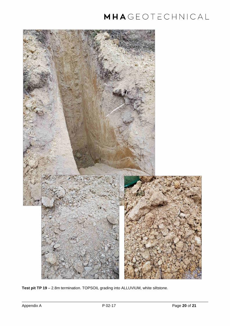
Appendix A P 02-17 Page 20 of 21
Test pit TP 19 – 2.8m termination. TOPSOIL grading into ALLUVIUM, white siltstone.

TEST PIT LOG
Job No: Date Started: 21/11/2017
Test Pit ID: Date Finished: 21/11/2017
Contractor: Bucket Width: 0.55m
Machine: Easting: -33.6854699
Logged By: Northing: 120.206819
Depths (From) Depths (To) Comments DCP Depth
(mm) DCP Blows/100m Laboratory Samples
0 0.2 100 N/S
200
300
400
500
0.2 0.4 600 Bulk
700
800
900
1000
0.4 1.3 1100 Bulk
1200
1300
1400
1500
1.3 EOH 1600
1700
1800
1900
2000
2100
2200
2300
2400
2500
2600
2700
2800
2900
3000
NOTES AND COMMENTS
Many small (1 - 2 mm) / medium (2 - 10 mm) / large (>10 mm) roots to _____________ m and few small (1 - 2 mm) / medium (2 - 10 mm) / large (>10 mm) roots to _____________ m.
Groundwater recorded at m on the / / .
Co-ordinate System: , Zone: .
Group Consistency Plasticity/Grain size Colour With/Trace Moisture
Pt Fine Grain: Fine grain: red clay dry
OH very soft non-plastic orange silt dry to moist
OL soft low plasticity yellow sand moist
CH firm low - medium brown gravel wet
CL stiff medium plasticity purple cobbles moist to wet
MH very stiff medium to high green OM saturated
ML hard high plasticity white BR
SW Coarse Grain: Coarse Grain: cream Fines:
SP very loose Fine grey <=15% "Trace"
SC loose Medium black 15-30% "With"
SM medium dense Coarse Grain: blue >30% "Secondary"
GW dense Additional: Additional: Coarse:
GP very dense <=5% "Trace"
GC 5-12% "With"
GM >12% "Secondary"
Soil NamePrimary
PEAT
CLAY
SILT
SAND
GRAVEL
COBBLES
BOULDERS
Scondary:
clayey
silty
sandy
gravelly
cobbly
OriginTOPSOIL
CONCRETE
BITUMEN
FILL
BASSENDEAN SAND
SAND FROM TAMALA LST
TAMALA LST
GUILDFORD FORMATION
ALLUVIUM
COLLUVIUM
AEOLIAN
SWAMP DEPOSIT
LATERITECan be modified using pale, dark and motled
Unifor, gap graded, poorly graded. Rounded, sub rounded, sub angular, angular, flaky, platy
bouldery
Roots and organics.
Indurated, excavated as rock.
SILT, [ML], very stiff, non-plastic, white yellow, with gravel and sand, dry.
Lateritic conglomerate.
P02-17
TP 20
Gary
JCB
Harvey Morcom
Material DescriptionMain material
sandy SILT, [ML], firm, non-plastic, brown grey with gravel and sand, dry.
sandy SILT, [ML], very stiff, low plasticity, white brown, with gravel, dry.
ALLUVIUM
REFUSAL
TOPSOIL
ALLUVIUM

Appendix A P 02-17 Page 21 of 21
Test pit TP 20 – 1.3m refusal. TOPSOIL into lateritic ALLUVIUM, gravelly and conglomeritic.

Appendix C Geotechnical Field Investigation Field Permeability Test Results (MHA Geotechnical Pty Ltd)

Latitude Longitude(mE) (mS) (min) (mbToC) (m) (m/s)
241073 6269009 Tuesday, 21 November 2017 12:42:00 0 -0.060 -0.060 -Temperature: 36oC 16:28:00 15240 -0.095 -0.0350 7.9E-06
Test Column Depth 0.600Diameter 0.110
Surface Area of base 0.0095Ave 7.94E-06
241073 6269009 Tuesday, 21 November 2017 16:48:00 0 -0.036 -0.036 -Temperature: 36oC 18:22:00 5640 -0.065 -0.0290 2.6E-05
Test Column Depth 0.600 6:52:00 383400 -0.175 -0.1100 1.0E-07Diameter 0.110
Surface Area of base 0.0095Ave 1.30E-05
241073 6269009 Tuesday, 21 November 2017 6:59:00 0 -0.038 -0.038 -Temperature: 36oC 9:10:00 7860 -0.070 -0.0320 1.7E-05
Test Column Depth 0.600 10:27:00 476220 -0.075 -0.0050 1.8E-06Diameter 0.110
Surface Area of base 0.0095Ave 9.32E-06
241292 268835 Tuesday, 21 November 2017 12:45:00 0 -0.100 -0.100 -Temperature: 36oC 16:31:00 12960 -0.425 -0.3250 1.0E-06
Test Column Depth 0.400Diameter 0.110
Surface Area of base 0.0095Ave 1.01E-06
241292 268835 Tuesday, 21 November 2017 16:31:00 0 -0.073 -0.073 -Temperature: 36oC 6:05:00 41640 -0.420 -0.3470 2.9E-07
Test Column Depth 0.400 7:03:00 45120 -0.425 -0.0050 2.4E-04Diameter 0.110
Surface Area of base 0.0095Ave 1.22E-04
241292 268835 Tuesday, 21 November 2017 7:03:00 0 -0.114 -0.114 -Temperature: 36oC 8:55:00 6780 -0.410 -0.2960 2.1E-06
Test Column Depth 0.400 10:11:00 11340 -0.042 0.3685 4.5E-06Diameter 0.110
Surface Area of base 0.0095Ave 3.33E-06
Tuesday, 21 November 2017 13:11:00 0 0.000 0.000 -Temperature: 36oC 13:19:00 480 -0.050 -0.0500 1.8E-04
Test Column Depth 0.600 13:34:00 1380 -0.080 1.6E-04Diameter 0.110 16:36:00 12300 -0.150 5.5E-06
Surface Area of base 0.0095Ave 1.13E-04
Tuesday, 21 November 2017 16:36:00 0 -0.037 -0.037 -Temperature: 36oC 6:15:00 49140 -0.190 -0.1530 5.6E-07
Test Column Depth 0.600 7:22:00 53160 -0.210 -0.0200 5.3E-05Diameter 0.110
Surface Area of base 0.0095Ave 2.66E-05
Tuesday, 21 November 2017 7:22:00 0 -0.075 -0.075 -Temperature: 36oC 8:58:00 5760 -0.175 -0.1000 7.4E-06
Test Column Depth 0.600 10:15:00 10380 -0.195 -0.0200 4.6E-05Diameter 0.110
Surface Area of base 0.0095Ave 2.66E-05
Tuesday, 21 November 2017 13:46:00 0 -0.090 -0.090 -Temperature: 36oC 13:57:00 660 -0.110 -0.0200 3.2E-04
Test Column Depth 0.600 18:18:00 16320 -0.330 1.2E-06Diameter 0.110 7:19:00 55980 -0.045
Surface Area of base 0.0095Ave 1.61E-04
Tuesday, 21 November 2017 0.000 -Temperature: 36oC #REF! #REF!
Test Column Depth 0.600 #REF! #REF!Diameter 0.110
Surface Area of base 0.0095Ave #REF!
Tuesday, 21 November 2017 7:19:00 0 -0.172 #REF! -Temperature: 36oC 9:00:00 6060 -0.220 #REF! 1.5E-05
Test Column Depth 0.600 10:17:00 10680 -0.240 #REF! 4.6E-05Diameter 0.110
TP 12 Unsaturated
Partially Saturated
Saturated
TP 13 Unsaturated
Partially Saturated
Saturated
TP 07 Unsaturated
Partially Saturated
Saturated
TP 03 Unsaturated
Partially Saturated
Saturated
Summary of Field Falling Head TestsSite/Location: ACH Minerals - Ravensthorpe Gold Project - Tailings Storage Facility
Number SaturationLocation (Decimal Degrees) Date Time Time Interval Water Level h k

Surface Area of base 0.0095Ave 3.02E-05
Tuesday, 21 November 2017 12:51:00 0 -0.040 -0.040 -Temperature: 36oC 14:02:00 4260 -0.110 -0.0700 1.4E-05
Test Column Depth 0.600 14:15:00 5040 -0.125 3.6E-04Diameter 0.110 16:40:00 14340 -0.201 6.0E-06
Surface Area of base 0.0095Ave 1.27E-04
Tuesday, 21 November 2017 16:40:00 0 -0.037 -0.037 -Temperature: 36oC 18:18:00 5880 -0.080 -0.0430 1.7E-05
Test Column Depth 0.600 7:15:00 52860 -0.290 -0.2100 4.3E-07Diameter 0.110
Surface Area of base 0.0095Ave 8.59E-06
Tuesday, 21 November 2017 7:15:00 0 -0.070 -0.070 -Temperature: 36oC 9:00:00 6300 -0.100 -0.0300 2.2E-05
Test Column Depth 0.600 10:20:00 11100 -0.130 -0.0300 2.9E-05Diameter 0.110
Surface Area of base 0.0095Ave 2.59E-05
Tuesday, 21 November 2017 14:58:00 0 0.000 0.000 -Temperature: 36oC 15:22:00 1440 -0.065 -0.0650 4.5E-05
Test Column Depth 0.600 16:48:00 6600 -0.100 2.3E-05Diameter 0.110 18:20:00 12120 -0.110 7.7E-05
Surface Area of base 0.0095 7:11:00 58380 -0.182 1.3E-06Ave 3.67E-05
Tuesday, 21 November 2017 7:11:00 0 -0.052 -0.052 -Temperature: 36oC 9:06:00 6900 -0.080 -0.0280 2.2E-05
Test Column Depth 0.600 10:22:00 11460 -0.090 -0.0100 9.3E-05Diameter 0.110
Surface Area of base 0.0095Ave 5.74E-05
Tuesday, 21 November 2017 0.000 -Temperature: 36oC 0.0000 2.2E-05
Test Column Depth 0.600 0.0000 9.3E-05Diameter 0.110
Surface Area of base 0.0095Ave 5.74E-05
TP 16-17 Unsaturated
Partially Saturated
Saturated
TP 19 Unsaturated
Partially Saturated
Saturated

Appendix D Geotechnical Field Investigation CPT Results (MHA Geotechnical Pty Ltd)

Project:
MHA Geotechnical
Suite 2, 464 Murray St PERTH
T: +61 8 6110 4768
www.mhageotechnical.com.au
Total depth: 1.24 m, Date: 4/12/2017
Surface Elevation: 0.00 m
Coords: X:0.00, Y:0.00
Cone Type: Uknown
Cone Operator: Uknown
CPT: CPT 6
Location:
SBT legend
1. Sensitive fine grained
2. Organic material
3. Clay to silty clay
4. Clayey silt to silty clay
5. Silty sand to sandy silt
6. Clean sand to silty sand
7. Gravely sand to sand
8. Very stiff sand to clayey sand
9. Very stiff fine grained
CPeT-IT v.2.0.1.74 - CPTU data presentation & interpretation software - Report created on: 4/12/2017, 11:25:07 AM 1
Project file: C:\Users\mitch\Desktop\RGP CPT Results.cpt

Project:
MHA Geotechnical
Suite 2, 464 Murray St PERTH
T: +61 8 6110 4768
www.mhageotechnical.com.au
Total depth: 1.24 m, Date: 4/12/2017
Surface Elevation: 0.00 m
Coords: X:0.00, Y:0.00
Cone Type: Uknown
Cone Operator: Uknown
CPT: CPT 6
Location:
Calculation parameters
Phi: Based on Kulhawy & Mayne (1990)
User defined estimation data
CPeT-IT v.2.0.1.74 - CPTU data presentation & interpretation software - Report created on: 4/12/2017, 11:25:07 AM 2
Project file: C:\Users\mitch\Desktop\RGP CPT Results.cpt

Project:
MHA Geotechnical
Suite 2, 464 Murray St PERTH
T: +61 8 6110 4768
www.mhageotechnical.com.au
Total depth: 1.24 m, Date: 4/12/2017
Surface Elevation: 0.00 m
Coords: X:0.00, Y:0.00
Cone Type: Uknown
Cone Operator: Uknown
CPT: CPT 6
Location:
Calculation parameters
User defined estimation data
Flat Dilatometer Test data
CPeT-IT v.2.0.1.74 - CPTU data presentation & interpretation software - Report created on: 4/12/2017, 11:25:07 AM 3
Project file: C:\Users\mitch\Desktop\RGP CPT Results.cpt
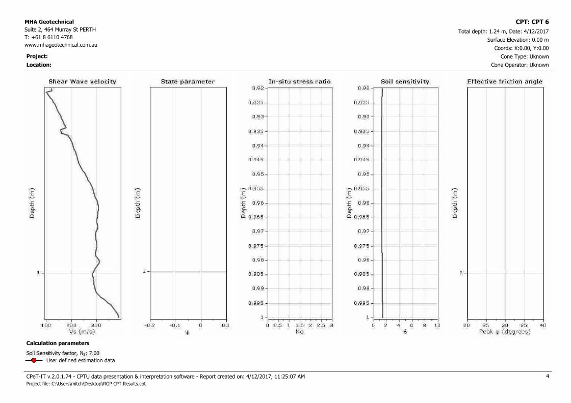
Project:
MHA Geotechnical
Suite 2, 464 Murray St PERTH
T: +61 8 6110 4768
www.mhageotechnical.com.au
Total depth: 1.24 m, Date: 4/12/2017
Surface Elevation: 0.00 m
Coords: X:0.00, Y:0.00
Cone Type: Uknown
Cone Operator: Uknown
CPT: CPT 6
Location:
Calculation parameters
User defined estimation data
CPeT-IT v.2.0.1.74 - CPTU data presentation & interpretation software - Report created on: 4/12/2017, 11:25:07 AM 4
Project file: C:\Users\mitch\Desktop\RGP CPT Results.cpt

Project:
MHA Geotechnical
Suite 2, 464 Murray St PERTH
T: +61 8 6110 4768
www.mhageotechnical.com.au
Total depth: 2.37 m, Date: 4/12/2017
Surface Elevation: 0.00 m
Coords: X:0.00, Y:0.00
Cone Type: Uknown
Cone Operator: Uknown
CPT: CPT 7
Location:
SBT legend
1. Sensitive fine grained
2. Organic material
3. Clay to silty clay
4. Clayey silt to silty clay
5. Silty sand to sandy silt
6. Clean sand to silty sand
7. Gravely sand to sand
8. Very stiff sand to clayey sand
9. Very stiff fine grained
CPeT-IT v.2.0.1.74 - CPTU data presentation & interpretation software - Report created on: 4/12/2017, 11:25:07 AM 5
Project file: C:\Users\mitch\Desktop\RGP CPT Results.cpt

Project:
MHA Geotechnical
Suite 2, 464 Murray St PERTH
T: +61 8 6110 4768
www.mhageotechnical.com.au
Total depth: 2.37 m, Date: 4/12/2017
Surface Elevation: 0.00 m
Coords: X:0.00, Y:0.00
Cone Type: Uknown
Cone Operator: Uknown
CPT: CPT 7
Location:
Calculation parameters
Phi: Based on Kulhawy & Mayne (1990)
User defined estimation data
CPeT-IT v.2.0.1.74 - CPTU data presentation & interpretation software - Report created on: 4/12/2017, 11:25:07 AM 6
Project file: C:\Users\mitch\Desktop\RGP CPT Results.cpt

Project:
MHA Geotechnical
Suite 2, 464 Murray St PERTH
T: +61 8 6110 4768
www.mhageotechnical.com.au
Total depth: 2.37 m, Date: 4/12/2017
Surface Elevation: 0.00 m
Coords: X:0.00, Y:0.00
Cone Type: Uknown
Cone Operator: Uknown
CPT: CPT 7
Location:
Calculation parameters
User defined estimation data
Flat Dilatometer Test data
CPeT-IT v.2.0.1.74 - CPTU data presentation & interpretation software - Report created on: 4/12/2017, 11:25:08 AM 7
Project file: C:\Users\mitch\Desktop\RGP CPT Results.cpt

Project:
MHA Geotechnical
Suite 2, 464 Murray St PERTH
T: +61 8 6110 4768
www.mhageotechnical.com.au
Total depth: 2.37 m, Date: 4/12/2017
Surface Elevation: 0.00 m
Coords: X:0.00, Y:0.00
Cone Type: Uknown
Cone Operator: Uknown
CPT: CPT 7
Location:
Calculation parameters
User defined estimation data
CPeT-IT v.2.0.1.74 - CPTU data presentation & interpretation software - Report created on: 4/12/2017, 11:25:08 AM 8
Project file: C:\Users\mitch\Desktop\RGP CPT Results.cpt

Project:
MHA Geotechnical
Suite 2, 464 Murray St PERTH
T: +61 8 6110 4768
www.mhageotechnical.com.au
Total depth: 2.28 m, Date: 4/12/2017
Surface Elevation: 0.00 m
Coords: X:0.00, Y:0.00
Cone Type: Uknown
Cone Operator: Uknown
CPT: CPT 12
Location:
SBT legend
1. Sensitive fine grained
2. Organic material
3. Clay to silty clay
4. Clayey silt to silty clay
5. Silty sand to sandy silt
6. Clean sand to silty sand
7. Gravely sand to sand
8. Very stiff sand to clayey sand
9. Very stiff fine grained
CPeT-IT v.2.0.1.74 - CPTU data presentation & interpretation software - Report created on: 4/12/2017, 11:25:08 AM 9
Project file: C:\Users\mitch\Desktop\RGP CPT Results.cpt

Project:
MHA Geotechnical
Suite 2, 464 Murray St PERTH
T: +61 8 6110 4768
www.mhageotechnical.com.au
Total depth: 2.28 m, Date: 4/12/2017
Surface Elevation: 0.00 m
Coords: X:0.00, Y:0.00
Cone Type: Uknown
Cone Operator: Uknown
CPT: CPT 12
Location:
Calculation parameters
Phi: Based on Kulhawy & Mayne (1990)
User defined estimation data
CPeT-IT v.2.0.1.74 - CPTU data presentation & interpretation software - Report created on: 4/12/2017, 11:25:08 AM 10
Project file: C:\Users\mitch\Desktop\RGP CPT Results.cpt

Project:
MHA Geotechnical
Suite 2, 464 Murray St PERTH
T: +61 8 6110 4768
www.mhageotechnical.com.au
Total depth: 2.28 m, Date: 4/12/2017
Surface Elevation: 0.00 m
Coords: X:0.00, Y:0.00
Cone Type: Uknown
Cone Operator: Uknown
CPT: CPT 12
Location:
Calculation parameters
User defined estimation data
Flat Dilatometer Test data
CPeT-IT v.2.0.1.74 - CPTU data presentation & interpretation software - Report created on: 4/12/2017, 11:25:08 AM 11
Project file: C:\Users\mitch\Desktop\RGP CPT Results.cpt
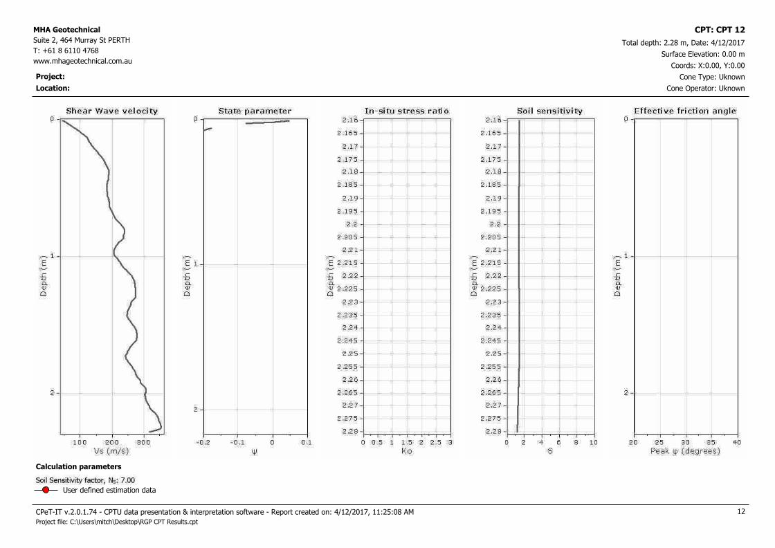
Project:
MHA Geotechnical
Suite 2, 464 Murray St PERTH
T: +61 8 6110 4768
www.mhageotechnical.com.au
Total depth: 2.28 m, Date: 4/12/2017
Surface Elevation: 0.00 m
Coords: X:0.00, Y:0.00
Cone Type: Uknown
Cone Operator: Uknown
CPT: CPT 12
Location:
Calculation parameters
User defined estimation data
CPeT-IT v.2.0.1.74 - CPTU data presentation & interpretation software - Report created on: 4/12/2017, 11:25:08 AM 12
Project file: C:\Users\mitch\Desktop\RGP CPT Results.cpt

Project:
MHA Geotechnical
Suite 2, 464 Murray St PERTH
T: +61 8 6110 4768
www.mhageotechnical.com.au
Total depth: 1.68 m, Date: 4/12/2017
Surface Elevation: 0.00 m
Coords: X:0.00, Y:0.00
Cone Type: Uknown
Cone Operator: Uknown
CPT: CPT 12B
Location:
SBT legend
1. Sensitive fine grained
2. Organic material
3. Clay to silty clay
4. Clayey silt to silty clay
5. Silty sand to sandy silt
6. Clean sand to silty sand
7. Gravely sand to sand
8. Very stiff sand to clayey sand
9. Very stiff fine grained
CPeT-IT v.2.0.1.74 - CPTU data presentation & interpretation software - Report created on: 4/12/2017, 11:25:09 AM 13
Project file: C:\Users\mitch\Desktop\RGP CPT Results.cpt

Project:
MHA Geotechnical
Suite 2, 464 Murray St PERTH
T: +61 8 6110 4768
www.mhageotechnical.com.au
Total depth: 1.68 m, Date: 4/12/2017
Surface Elevation: 0.00 m
Coords: X:0.00, Y:0.00
Cone Type: Uknown
Cone Operator: Uknown
CPT: CPT 12B
Location:
Calculation parameters
Phi: Based on Kulhawy & Mayne (1990)
User defined estimation data
CPeT-IT v.2.0.1.74 - CPTU data presentation & interpretation software - Report created on: 4/12/2017, 11:25:09 AM 14
Project file: C:\Users\mitch\Desktop\RGP CPT Results.cpt

Project:
MHA Geotechnical
Suite 2, 464 Murray St PERTH
T: +61 8 6110 4768
www.mhageotechnical.com.au
Total depth: 1.68 m, Date: 4/12/2017
Surface Elevation: 0.00 m
Coords: X:0.00, Y:0.00
Cone Type: Uknown
Cone Operator: Uknown
CPT: CPT 12B
Location:
Calculation parameters
User defined estimation data
Flat Dilatometer Test data
CPeT-IT v.2.0.1.74 - CPTU data presentation & interpretation software - Report created on: 4/12/2017, 11:25:09 AM 15
Project file: C:\Users\mitch\Desktop\RGP CPT Results.cpt

Project:
MHA Geotechnical
Suite 2, 464 Murray St PERTH
T: +61 8 6110 4768
www.mhageotechnical.com.au
Total depth: 1.68 m, Date: 4/12/2017
Surface Elevation: 0.00 m
Coords: X:0.00, Y:0.00
Cone Type: Uknown
Cone Operator: Uknown
CPT: CPT 12B
Location:
Calculation parameters
User defined estimation data
CPeT-IT v.2.0.1.74 - CPTU data presentation & interpretation software - Report created on: 4/12/2017, 11:25:09 AM 16
Project file: C:\Users\mitch\Desktop\RGP CPT Results.cpt

Project:
MHA Geotechnical
Suite 2, 464 Murray St PERTH
T: +61 8 6110 4768
www.mhageotechnical.com.au
Total depth: 2.82 m, Date: 4/12/2017
Surface Elevation: 0.00 m
Coords: X:0.00, Y:0.00
Cone Type: Uknown
Cone Operator: Uknown
CPT: CPT 13
Location:
SBT legend
1. Sensitive fine grained
2. Organic material
3. Clay to silty clay
4. Clayey silt to silty clay
5. Silty sand to sandy silt
6. Clean sand to silty sand
7. Gravely sand to sand
8. Very stiff sand to clayey sand
9. Very stiff fine grained
CPeT-IT v.2.0.1.74 - CPTU data presentation & interpretation software - Report created on: 4/12/2017, 11:25:10 AM 17
Project file: C:\Users\mitch\Desktop\RGP CPT Results.cpt
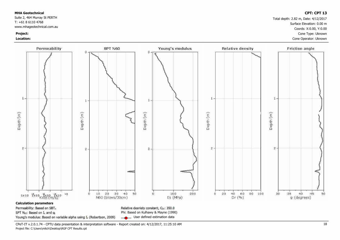
Project:
MHA Geotechnical
Suite 2, 464 Murray St PERTH
T: +61 8 6110 4768
www.mhageotechnical.com.au
Total depth: 2.82 m, Date: 4/12/2017
Surface Elevation: 0.00 m
Coords: X:0.00, Y:0.00
Cone Type: Uknown
Cone Operator: Uknown
CPT: CPT 13
Location:
Calculation parameters
Phi: Based on Kulhawy & Mayne (1990)
User defined estimation data
CPeT-IT v.2.0.1.74 - CPTU data presentation & interpretation software - Report created on: 4/12/2017, 11:25:10 AM 18
Project file: C:\Users\mitch\Desktop\RGP CPT Results.cpt

Project:
MHA Geotechnical
Suite 2, 464 Murray St PERTH
T: +61 8 6110 4768
www.mhageotechnical.com.au
Total depth: 2.82 m, Date: 4/12/2017
Surface Elevation: 0.00 m
Coords: X:0.00, Y:0.00
Cone Type: Uknown
Cone Operator: Uknown
CPT: CPT 13
Location:
Calculation parameters
User defined estimation data
Flat Dilatometer Test data
CPeT-IT v.2.0.1.74 - CPTU data presentation & interpretation software - Report created on: 4/12/2017, 11:25:10 AM 19
Project file: C:\Users\mitch\Desktop\RGP CPT Results.cpt

Project:
MHA Geotechnical
Suite 2, 464 Murray St PERTH
T: +61 8 6110 4768
www.mhageotechnical.com.au
Total depth: 2.82 m, Date: 4/12/2017
Surface Elevation: 0.00 m
Coords: X:0.00, Y:0.00
Cone Type: Uknown
Cone Operator: Uknown
CPT: CPT 13
Location:
Calculation parameters
User defined estimation data
CPeT-IT v.2.0.1.74 - CPTU data presentation & interpretation software - Report created on: 4/12/2017, 11:25:10 AM 20
Project file: C:\Users\mitch\Desktop\RGP CPT Results.cpt

Project:
MHA Geotechnical
Suite 2, 464 Murray St PERTH
T: +61 8 6110 4768
www.mhageotechnical.com.au
Total depth: 2.24 m, Date: 4/12/2017
Surface Elevation: 0.00 m
Coords: X:0.00, Y:0.00
Cone Type: Uknown
Cone Operator: Uknown
CPT: CPT 14
Location:
SBT legend
1. Sensitive fine grained
2. Organic material
3. Clay to silty clay
4. Clayey silt to silty clay
5. Silty sand to sandy silt
6. Clean sand to silty sand
7. Gravely sand to sand
8. Very stiff sand to clayey sand
9. Very stiff fine grained
CPeT-IT v.2.0.1.74 - CPTU data presentation & interpretation software - Report created on: 4/12/2017, 11:25:12 AM 21
Project file: C:\Users\mitch\Desktop\RGP CPT Results.cpt

Project:
MHA Geotechnical
Suite 2, 464 Murray St PERTH
T: +61 8 6110 4768
www.mhageotechnical.com.au
Total depth: 2.24 m, Date: 4/12/2017
Surface Elevation: 0.00 m
Coords: X:0.00, Y:0.00
Cone Type: Uknown
Cone Operator: Uknown
CPT: CPT 14
Location:
Calculation parameters
Phi: Based on Kulhawy & Mayne (1990)
User defined estimation data
CPeT-IT v.2.0.1.74 - CPTU data presentation & interpretation software - Report created on: 4/12/2017, 11:25:12 AM 22
Project file: C:\Users\mitch\Desktop\RGP CPT Results.cpt

Project:
MHA Geotechnical
Suite 2, 464 Murray St PERTH
T: +61 8 6110 4768
www.mhageotechnical.com.au
Total depth: 2.24 m, Date: 4/12/2017
Surface Elevation: 0.00 m
Coords: X:0.00, Y:0.00
Cone Type: Uknown
Cone Operator: Uknown
CPT: CPT 14
Location:
Calculation parameters
User defined estimation data
Flat Dilatometer Test data
CPeT-IT v.2.0.1.74 - CPTU data presentation & interpretation software - Report created on: 4/12/2017, 11:25:12 AM 23
Project file: C:\Users\mitch\Desktop\RGP CPT Results.cpt

Project:
MHA Geotechnical
Suite 2, 464 Murray St PERTH
T: +61 8 6110 4768
www.mhageotechnical.com.au
Total depth: 2.24 m, Date: 4/12/2017
Surface Elevation: 0.00 m
Coords: X:0.00, Y:0.00
Cone Type: Uknown
Cone Operator: Uknown
CPT: CPT 14
Location:
Calculation parameters
User defined estimation data
CPeT-IT v.2.0.1.74 - CPTU data presentation & interpretation software - Report created on: 4/12/2017, 11:25:12 AM 24
Project file: C:\Users\mitch\Desktop\RGP CPT Results.cpt

Project:
MHA Geotechnical
Suite 2, 464 Murray St PERTH
T: +61 8 6110 4768
www.mhageotechnical.com.au
Total depth: 3.04 m, Date: 4/12/2017
Surface Elevation: 0.00 m
Coords: X:0.00, Y:0.00
Cone Type: Uknown
Cone Operator: Uknown
CPT: CPT 17
Location:
SBT legend
1. Sensitive fine grained
2. Organic material
3. Clay to silty clay
4. Clayey silt to silty clay
5. Silty sand to sandy silt
6. Clean sand to silty sand
7. Gravely sand to sand
8. Very stiff sand to clayey sand
9. Very stiff fine grained
CPeT-IT v.2.0.1.74 - CPTU data presentation & interpretation software - Report created on: 4/12/2017, 11:25:14 AM 25
Project file: C:\Users\mitch\Desktop\RGP CPT Results.cpt

Project:
MHA Geotechnical
Suite 2, 464 Murray St PERTH
T: +61 8 6110 4768
www.mhageotechnical.com.au
Total depth: 3.04 m, Date: 4/12/2017
Surface Elevation: 0.00 m
Coords: X:0.00, Y:0.00
Cone Type: Uknown
Cone Operator: Uknown
CPT: CPT 17
Location:
Calculation parameters
Phi: Based on Kulhawy & Mayne (1990)
User defined estimation data
CPeT-IT v.2.0.1.74 - CPTU data presentation & interpretation software - Report created on: 4/12/2017, 11:25:14 AM 26
Project file: C:\Users\mitch\Desktop\RGP CPT Results.cpt

Project:
MHA Geotechnical
Suite 2, 464 Murray St PERTH
T: +61 8 6110 4768
www.mhageotechnical.com.au
Total depth: 3.04 m, Date: 4/12/2017
Surface Elevation: 0.00 m
Coords: X:0.00, Y:0.00
Cone Type: Uknown
Cone Operator: Uknown
CPT: CPT 17
Location:
Calculation parameters
User defined estimation data
Flat Dilatometer Test data
CPeT-IT v.2.0.1.74 - CPTU data presentation & interpretation software - Report created on: 4/12/2017, 11:25:14 AM 27
Project file: C:\Users\mitch\Desktop\RGP CPT Results.cpt

Project:
MHA Geotechnical
Suite 2, 464 Murray St PERTH
T: +61 8 6110 4768
www.mhageotechnical.com.au
Total depth: 3.04 m, Date: 4/12/2017
Surface Elevation: 0.00 m
Coords: X:0.00, Y:0.00
Cone Type: Uknown
Cone Operator: Uknown
CPT: CPT 17
Location:
Calculation parameters
User defined estimation data
CPeT-IT v.2.0.1.74 - CPTU data presentation & interpretation software - Report created on: 4/12/2017, 11:25:14 AM 28
Project file: C:\Users\mitch\Desktop\RGP CPT Results.cpt
Appendix E Geotechnical Field Investigation Laboratory Test Results and Certificates (MHA Geotechnical Pty Ltd)

Analytical Laboratory Certificate Number(s) Analytes
Sample
Number Location Easting Northing Description
Structerre S865847-A-1 Grading TP01_0.0-0.2m TSF West -33.685685 120.206652 TSF West Test Pit Bulk Sample
Structerre S865847-A-2 Grading TP01_0.2-0.75m TSF West -33.685685 120.206652 TSF West Test Pit Bulk Sample
Structerre S865847-A-3 Grading TP01_0.75-1.6m TSF West -33.685685 120.206652 TSF West Test Pit Bulk Sample
Structerre S865847-A-4 Grading and Multistage UU Triaxial TP02_0.1-0.5m TSF West -33.6864494 120.2067161 TSF West Test Pit Bulk Sample
Structerre S865847-A-5 Grading, Permeability, Atterberg Limits, Modified Compaction and Emerson Class Number TP02_0.5-1.1m TSF West -33.6864494 120.2067161 TSF West Test Pit Bulk
Sample
Structerre S865847-A-6 Grading TP02_1.1-2.7m TSF West -33.6864494 120.2067161 TSF West Test Pit Bulk Sample
Structerre S865847-A-7 Grading, Permeability, Atterberg Limits, Modified Compaction and Emerson Class Number TP03_0.0-0.7m TSF West -33.6873212 120.2068039 TSF West Test Pit Bulk
Sample
Structerre S865847-A-8 Grading TP03_0.7-3.0m TSF West -33.6873212 120.2068039 TSF West Test Pit Bulk Sample
Structerre S865847-A-9 Grading TP04_0.0-0.25m TSF West -33.6883154 120.2069192 TSF West Test Pit Bulk Sample
Structerre S865847-A-10 Grading TP04_0.25-1.0m TSF West -33.6883154 120.2069192 TSF West Test Pit Bulk Sample
Structerre S865847-A-11 Grading TP04_1.0-3.1m TSF West -33.6883154 120.2069192 TSF West Test Pit Bulk Sample
Structerre S865847-A-12 Grading TP05_0.1-0.8m TSF West -33.688971 120.2069675 TSF West Test Pit Bulk Sample
Structerre S865847-A-13 Grading TP05_0.8-1.8m TSF West -33.688971 120.2069675 TSF West Test Pit Bulk Sample
Structerre S865847-A-14 Grading TP05_1.8-2.9m TSF West -33.688971 120.2069675 TSF West Test Pit Bulk Sample
Structerre S865847-A-15 Grading TP06_0.0-0.6m TSF South -33.6889939 120.2084628 TSF South Test Pit Bulk Sample
Structerre S865847-A-16 Grading, Permeability, Atterberg Limits, Modified Compaction and Emerson Class Number TP06_0.6-2.7m TSF South -33.6889939 120.2084628 TSF South Test Pit Bulk
Sample
Structerre S865847-A-17 Grading TP07_0.1-0.2m TSF South -33.6889501 120.2091173 TSF South Test Pit Bulk Sample
Structerre S865847-A-18 Grading TP07_0.2-2.5m TSF South -33.6889501 120.2091173 TSF South Test Pit Bulk Sample
Structerre S865847-A-19 Grading TP08_0.1-0.4m TSF South -33.6889116 120.2096444 TSF South Test Pit Bulk Sample
Structerre S865847-A-20 Grading TP08_0.4-2.2m TSF South -33.6889116 120.2096444 TSF South Test Pit Bulk Sample
Structerre S865847-A-21 Grading TP09_0.1-0.2m TSF South -33.6888324 120.2104839 TSF South Test Pit Bulk Sample
Structerre S865847-A-22 Grading TP09_0.2-2.2m TSF South -33.6888324 120.2104839 TSF South Test Pit Bulk Sample
Structerre S865847-A-23 Grading TP10_0.1-2.5m TSF South -33.6888137 120.2109811 TSF South Test Pit Bulk Sample
Structerre S865847-A-24 Grading TP11_0.2-2.8m TSF East -33.6885004 120.2113023 TSF East Test Pit Bulk Sample

Structerre S865847-A-25 Grading TP12_0.1-2.8m TSF East -33.6877109 120.2112202 TSF East Test Pit Bulk Sample
Structerre S865847-A-26 Grading and Multistage UU Triaxial TP13_0.1-0.7m TSF East -33.6867749 120.2111142 TSF East Test Pit Bulk Sample
Structerre S865847-A-27 Grading, Permeability, Atterberg Limits, Modified Compaction and Emerson Class Number TP13_0.7-2.8m TSF East -33.6867749 120.2111142 TSF East Test Pit Bulk Sample
Structerre S865847-A-28 Grading TP14_0.2-1.0m TSF East -33.6861255 120.2110391 TSF East Test Pit Bulk Sample
Structerre S865847-A-29 Grading TP15_0.2-2.7m TSF East -33.6856138 120.2109576 TSF East Test Pit Bulk Sample
Structerre S865847-A-30 Grading TP16_0.2-0.6m TSF North -33.6852333 120.210323 TSF North Test Pit Bulk Sample
Structerre S865847-A-31 Grading TP16_0.6-1.0m TSF North -33.6852333 120.210323 TSF North Test Pit Bulk Sample
Structerre S865847-A-32 Grading, Permeability, Atterberg Limits, Modified Compaction and Emerson Class Number TP16_1.0-2.8m TSF North -33.6852333 120.210323 TSF North Test Pit Bulk
Sample
Structerre S865847-A-33 Grading TP17_0.6-1.2m TSF North -33.6852913 120.2093694 TSF North Test Pit Bulk Sample
Structerre S865847-A-34 Grading TP17_1.2-2.7m TSF North -33.6852913 120.2093694 TSF North Test Pit Bulk Sample
Structerre S865847-A-35 Grading TP18_0.2-0.6m TSF North -33.6853516 120.2085011 TSF North Test Pit Bulk Sample
Structerre S865847-A-36 Grading TP18_0.6-1.2m TSF North -33.6853516 120.2085011 TSF North Test Pit Bulk Sample
Structerre S865847-A-37 Grading TP18_1.2-2.8m TSF North -33.6853516 120.2085011 TSF North Test Pit Bulk Sample
Structerre S865847-A-38 Grading TP19_0.2-0.6m TSF North -33.6854116 120.2077879 TSF North Test Pit Bulk Sample
Structerre S865847-A-39 Grading TP19_0.6-2.8m TSF North -33.6854116 120.2077879 TSF North Test Pit Bulk Sample
Structerre S865847-A-40 Grading TP20_0.2-0.4m TSF North -33.6854699 120.206819 TSF North Test Pit Bulk Sample
Structerre S865847-A-41 Grading TP20_0.4-1.0m TSF North -33.6854699 120.206819 TSF North Test Pit Bulk Sample
Structerre S865847-B-1 Grading, Atterberg Limits, Modified Compaction and Emerson Class Number and Multistage UU Triaxial B1 Stockpile - - Stockpile Bulk Sample
Structerre S865847-B-2 Grading, Atterberg Limits, Modified Compaction and Emerson Class Number B2 Stockpile - - Stockpile Bulk Sample
Structerre S865847-B-3 Grading, Atterberg Limits, Modified Compaction and Emerson Class Number B3 Stockpile - - Stockpile Bulk Sample

Ravensthorpe Gold Particle Size Distributions
Sieve Analysis Soil Classification
+75µ
m
+300
µm
+425
µm
+600
µm
+118
0µm
+2.3
6mm
+4.7
5mm
+9.5
mm
+19.
0mm
+26.
5mm
+37.
5mm
+75.
0mm
Fine
s (<
75 µ
m)
Sand
(>75
µm
)
Gra
vel (
>2m
m)
% Passing Units Sand Gravel Cobble %
LoR
Sample Number Sample Location Sample Description
TP01_0.0-0.2m TSF West TSF West Test Pit Bulk Sample 35 47 56 58 60 64 74 87 95 99 - 100 100 35 39 26
TP01_0.2-0.75m TSF West TSF West Test Pit Bulk Sample 58 66 72 74 76 81 88 93 96 99 - 100 100 58 30 12
TP01_0.75-1.6m TSF West TSF West Test Pit Bulk Sample 34 42 53 57 59 66 76 83 88 89 - 100 97 34 42 24
TP02_0.1-0.5m TSF West TSF West Test Pit Bulk Sample 36 52 62 65 67 70 76 87 97 100 - 100 100 36 40 24
TP02_0.5-1.1m TSF West TSF West Test Pit Bulk Sample 44 49 57 59 61 66 72 81 89 93 97 100 - 44 28 28
TP02_1.1-2.7m TSF West TSF West Test Pit Bulk Sample 56 61 67 71 74 84 94 98 100 100 - 100 100 56 38 6
TP03_0.0-0.7m TSF West TSF West Test Pit Bulk Sample 41 45 51 53 55 61 68 82 92 98 99 100 - 41 27 32
TP03_0.7-3.0m TSF West TSF West Test Pit Bulk Sample 41 45 52 56 61 75 90 97 100 100 - 100 100 41 49 10
TP04_0.0-0.25m TSF West TSF West Test Pit Bulk Sample 63 66 69 71 73 77 82 89 97 100 - 100 100 63 19 18
TP04_0.25-1.0m TSF West TSF West Test Pit Bulk Sample 50 53 58 61 64 72 73 89 95 96 - 100 100 50 23 27
TP04_1.0-3.1m TSF West TSF West Test Pit Bulk Sample 55 59 66 70 73 83 93 97 99 100 - 100 100 55 38 7
TP05_0.1-0.8m TSF West TSF West Test Pit Bulk Sample 57 81 89 90 91 93 94 98 100 100 - 100 100 57 37 6
TP05_0.8-1.8m TSF West TSF West Test Pit Bulk Sample 51 70 75 76 77 82 91 99 100 100 - 100 100 51 40 9
TP05_1.8-2.9m TSF West TSF West Test Pit Bulk Sample 40 50 60 64 67 75 85 93 96 99 - 100 100 40 45 15
TP06_0.0-0.6m TSF South TSF South Test Pit Bulk Sample 52 58 63 66 69 77 87 96 98 99 - 100 100 52 35 13
TP06_0.6-2.7m TSF South TSF South Test Pit Bulk Sample 56 59 63 66 70 80 91 96 100 - - - - 56 35 9
TP07_0.1-0.2m TSF South TSF South Test Pit Bulk Sample 30 40 49 53 56 63 73 84 98 100 - 100 100 30 43 27
TP07_0.2-2.5m TSF South TSF South Test Pit Bulk Sample 53 57 63 68 72 84 98 99 100 100 - 100 100 53 45 2
TP08_0.1-0.4m TSF South TSF South Test Pit Bulk Sample 62 68 74 76 78 84 90 93 96 97 - 100 100 62 28 10
TP08_0.4-2.2m TSF South TSF South Test Pit Bulk Sample 50 54 59 63 66 75 89 93 95 96 - 100 97 50 39 11
TP09_0.1-0.2m TSF South TSF South Test Pit Bulk Sample 56 63 69 72 74 80 84 92 96 99 - 100 100 56 28 16

TP09_0.2-2.2m TSF South TSF South Test Pit Bulk Sample 45 49 56 59 62 70 79 90 98 100 - 100 100 45 34 21
TP10_0.1-2.5m TSF South TSF South Test Pit Bulk Sample 38 40 44 46 49 55 64 75 80 81 - 100 85 38 26 36
TP11_0.2-2.8m TSF East TSF East Test Pit Bulk Sample 45 49 54 57 60 68 85 87 94 98 - 100 100 45 40 15
TP12_0.1-2.8m TSF East TSF East Test Pit Bulk Sample 47 50 54 56 58 64 72 89 95 96 - 100 100 47 25 28
TP13_0.1-0.7m TSF East TSF East Test Pit Bulk Sample 54 57 58 59 60 63 65 83 90 90 - 100 90 54 11 35
TP13_0.7-2.8 TSF East TSF East Test Pit Bulk Sample 64 65 67 68 70 76 81 86 91 97 98 99 100 64 17 19
TP14_0.2-1.0m TSF East TSF East Test Pit Bulk Sample 12 19 36 44 47 53 59 71 84 94 - 100 96 12 47 41
TP15_0.2-2.7m TSF East TSF East Test Pit Bulk Sample 43 46 52 57 61 72 84 95 99 99 - 100 100 43 41 16
TP16_0.2-0.6m TSF North TSF North Test Pit Bulk Sample 54 59 64 66 67 69 73 93 98 98 - 100 100 54 19 27
TP16_0.6-1.0m TSF North TSF North Test Pit Bulk Sample 57 60 66 70 74 82 90 98 100 100 - 100 100 57 33 10
TP16_1.0-2.8m TSF North TSF North Test Pit Bulk Sample 55 57 60 62 64 70 77 84 90 99 100 - - 55 22 23
TP17_0.6-1.2m TSF North TSF North Test Pit Bulk Sample 28 30 36 42 44 49 54 75 91 98 - 100 100 28 26 46
TP17_1.2-2.7m TSF North TSF North Test Pit Bulk Sample 40 44 52 56 62 74 86 97 100 100 - 100 100 40 46 14
TP18_0.2-0.6m TSF North TSF North Test Pit Bulk Sample 56 59 64 66 68 73 80 92 96 100 - 100 100 56 24 20
TP18_0.6-1.2m TSF North TSF North Test Pit Bulk Sample 60 64 70 74 7 85 93 99 100 100 - 100 100 60 33 7
TP18_1.2-2.8m TSF North TSF North Test Pit Bulk Sample 43 44 49 53 56 64 74 81 93 98 - 100 100 43 31 26
TP19_0.2-0.6m TSF North TSF North Test Pit Bulk Sample 55 60 66 68 69 72 76 92 97 100 - 100 100 55 21 24
TP19_0.6-2.8m TSF North TSF North Test Pit Bulk Sample 54 58 63 66 68 73 77 94 99 100 - 100 100 54 23 23
TP20_0.2-0.4m TSF North TSF North Test Pit Bulk Sample 59 67 75 78 80 85 92 96 97 99 - 100 100 59 33 8
TP20_0.4-1.0m TSF North TSF North Test Pit Bulk Sample 32 38 43 45 47 53 64 84 98 100 - 100 100 32 32 36
B1 Stockpile Stockpile Bulk Sample 60 69 76 80 84 88 91 92 94 96 97 98 100 60 31 9
B2 Stockpile Stockpile Bulk Sample 48 57 67 76 87 98 100 - - - - - - 48 52 0
B3 Stockpile Stockpile Bulk Sample 46 56 67 76 87 95 96 96 98 99 100 - - 46 50 4
Minimum 12 19 36 42 7 49 54 71 80 81 97 98 85 12 11 0
Maximum 64 81 89 90 91 98 100 99 100 100 100 100 100 64 52 46

Ravensthorpe Gold Particle Size Distributions
Hydrometer Analysis
+1µm
+2µm
+3µm
+3µm
+4µm
+4µm
+6µm
+8µm
+11µ
m
+16µ
m
+21µ
m
+30µ
m
+42µ
m
+59µ
m
% Passing Units Clay Silt
LoR
Sample Number Sample Location Sample Description
TP02_0.5-1.1m TSF West TSF West Test Pit Bulk Sample 36 36 36 36 36 37 37 38 39 40 41 43 43 44
TP03_0.0-0.7m TSF West TSF West Test Pit Bulk Sample 22 25 26 27 29 31 33 36 37 37 38 39 39 41
TP06_0.6-2.7m TSF South TSF South Test Pit Bulk Sample 8 10 11 16 21 29 40 44 48 50 52 53 54 55
TP13_0.7-2.8 TSF East TSF East Test Pit Bulk Sample 7 8 10 15 23 32 40 48 53 56 60 61 62 63
TP16_1.0-2.8m TSF North TSF North Test Pit Bulk Sample 10 13 14 18 23 28 36 40 44 47 50 51 52 54
B1 Stockpile Stockpile Bulk Sample 9 10 12 14 16 21 28 32 37 42 46 50 55 59
B2 Stockpile Stockpile Bulk Sample 6 7 7 8 11 12 15 19 24 30 32 39 42 47
B3 Stockpile Stockpile Bulk Sample 5 6 7 8 9 11 16 19 24 29 34 37 41 44
Minimum 5 6 7 8 9 11 15 19 24 29 32 37 41 44
Maximum 36 36 36 36 36 37 40 48 53 56 60 61 62 63
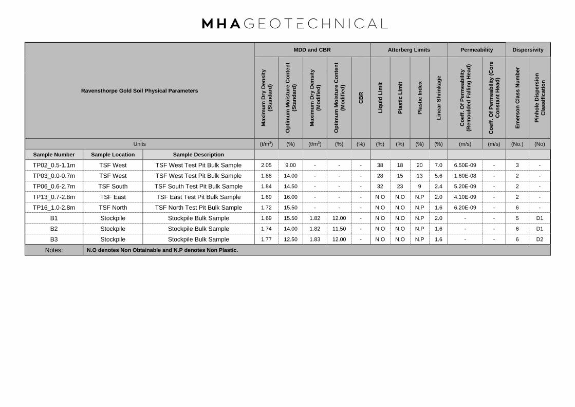
Ravensthorpe Gold Soil Physical Parameters
MDD and CBR Atterberg Limits Permeability Dispersivity
Max
imum
Dry
Den
sity
(S
tand
ard)
Opt
imum
Moi
stur
e C
onte
nt
(Sta
ndar
d)
Max
imum
Dry
Den
sity
(M
odifi
ed)
Opt
imum
Moi
stur
e C
onte
nt
(Mod
ified
)
CB
R
Liqu
id L
imit
Plas
tic L
imit
Plas
tic In
dex
Line
ar S
hrin
kage
Coe
ff. O
f Per
mea
bilit
y (R
emou
lded
Fal
ling
Hea
d)
Coe
ff. O
f Per
mea
bilit
y (C
ore
Con
stan
t Hea
d)
Emer
son
Cla
ss N
umbe
r
Pinh
ole
Dis
pers
ion
Cla
ssifi
catio
n
Units (t/m3) (%) (t/m3) (%) (%) (%) (%) (%) (%) (m/s) (m/s) (No.) (No)
Sample Number Sample Location Sample Description
TP02_0.5-1.1m TSF West TSF West Test Pit Bulk Sample 2.05 9.00 - - - 38 18 20 7.0 6.50E-09 - 3 -
TP03_0.0-0.7m TSF West TSF West Test Pit Bulk Sample 1.88 14.00 - - - 28 15 13 5.6 1.60E-08 - 2 -
TP06_0.6-2.7m TSF South TSF South Test Pit Bulk Sample 1.84 14.50 - - - 32 23 9 2.4 5.20E-09 - 2 -
TP13_0.7-2.8m TSF East TSF East Test Pit Bulk Sample 1.69 16.00 - - - N.O N.O N.P 2.0 4.10E-09 - 2 -
TP16_1.0-2.8m TSF North TSF North Test Pit Bulk Sample 1.72 15.50 - - - N.O N.O N.P 1.6 6.20E-09 - 6 -
B1 Stockpile Stockpile Bulk Sample 1.69 15.50 1.82 12.00 - N.O N.O N.P 2.0 - - 5 D1
B2 Stockpile Stockpile Bulk Sample 1.74 14.00 1.82 11.50 - N.O N.O N.P 1.6 - - 6 D1
B3 Stockpile Stockpile Bulk Sample 1.77 12.50 1.83 12.00 - N.O N.O N.P 1.6 - - 6 D2
Notes: N.O denotes Non Obtainable and N.P denotes Non Plastic.

Ravensthorpe Gold Project Triaxial Testing
Laboratory Measurements
Multi Stage Triaxial Testing
Stage 1 Stage 2 Stage 3 Results
Sigm
a 1
Sigm
a 3
Effe
ctiv
e St
ress
Shea
r Str
ess
Sigm
a 1
Sigm
a 3
Effe
ctiv
e St
ress
Shea
r Str
ess
Sigm
a 1
Sigm
a 3
Effe
ctiv
e St
ress
Shea
r Str
ess
Effe
ctiv
e C
ohes
ion
Effe
ctiv
e A
ngle
of
Fric
tion
Units (kPa) (kPa) (kPa) (kPa) (kPa) (kPa) (kPa) (kPa) (kPa) (kPa) (kPa) (kPa) (kPa) (°)
Sample Location Sample Description
Sample 1 Multistage UU TP02 0.5m 519.0 75.0 444.0 11.5 672.0 150.0 522.0 19.3 - - - - 120.0 20.0
Sample 2 Multistage UU TP13 0.7m 195.0 75.0 120.0 5.4 341.0 150.0 191.0 9.8 601.0 300.0 301.0 15.1 24.1 16.5
Sample 3 Multistage UU Borrow Material 283.0 75.0 208.0 5.8 443.0 150.0 293.0 10.2 746.0 300.0 446.0 15.2 46.1 21.0
Sample 4 Single Stage CU TP02 0.5m 477 7.36
Sample 5 Single Stage CU TP13 0.5m 484 7.68
Sample 6 Single Stage CU Borrow Material 578 10.46
Notes: NO denotes not obtainable

Brisbane
346A Bilsen Road,
Geebung
QLD 4034
Ph: +61 7 3265 5656
Perth
2 Kimmer Place,
Queens Park
WA 6107
Ph: +61 8 9258 8323Soil Rock Calibration
chrisc 1919
Client Report No.
Address
Project Test Date
Report Date
Client ID A5 TP02 Depth (m)
Sieve Size Passing
(mm) %
150.0
75.0
53.0
37.5 100
26.5 97
19.0 93
9.5 89
4.75 81
2.36 72
1.18 66
0.600 61
0.425 59
0.300 57
0.150 49
0.075 44
0.057 44
0.041 43
0.029 43
0.021 41
0.015 40
0.011 39
0.008 38
0.006 37
0.004 37
0.003 36
0.003 36
0.002 36
0.002 36
0.001 36
NOTES/REMARKS:
Moisture Content 8.5% -2.36mm Soil Particle Density(t/m3) 2.63
Sample/s supplied by the client Page 1 of 1 REP33901
Laboratory No. 9926
PO Box 792 BALCATTA WA 6914
Ravensthorpe Gold Project - Geotech Investigation
Foundation & Borrow Samples
0.50-1.10
PARTICLE SIZE DISTRIBUTION TEST REPORTTest Method: AS 1289 3.6.3, 3.5.1
Structerre Consulting Engineers P 17120138-G
2/01/2018
20/12/2017
The results of calibrations and tests performed apply only to the specific instrument or sample at the time of test unless otherwise clearly stated.
Reference should be made to Trilab's “Standard Terms and Conditions of Business” for further details.Trilab Pty Ltd ABN 25 065 630 506
Authorised Signatory
A. Harrap
0
10
20
30
40
50
60
70
80
90
100
0.001 0.01 0.1 1 10 100
Pa
ss
ing
(%
)
Particle Size (mm)
Accredited for compliance with ISO/IEC 17025. The results of the tests, calibrations, and/or measurements included in this
document are traceable to Australian/National Standards.
Tested at Trilab Perth Laboratory
Authorised Signatory
C. Channon
ACCURATE QUALITY RESULTS FOR TOMORROW'S ENGINEERING

Brisbane
346A Bilsen Road,
Geebung
QLD 4034
Ph: +61 7 3265 5656
Perth
2 Kimmer Place,
Queens Park
WA 6107
Ph: +61 8 9258 8323Soil Rock Calibration
chrisc 1919
Client Report No.
Address
Project Test Date
Report Date
Client ID A7 TP03 Depth (m)
Sieve Size Passing
(mm) %
150.0
75.0
53.0
37.5 100
26.5 99
19.0 98
9.5 92
4.75 82
2.36 68
1.18 61
0.600 55
0.425 53
0.300 51
0.150 45
0.075 41
0.059 41
0.042 39
0.03 39
0.021 38
0.016 37
0.011 37
0.008 36
0.006 33
0.004 31
0.003 29
0.003 27
0.003 26
0.002 25
0.001 22
NOTES/REMARKS:
Moisture Content 7.8% -2.36mm Soil Particle Density(t/m3) 2.61
Sample/s supplied by the client Page 1 of 1 REP33901
Laboratory No. 9926
PO Box 792 BALCATTA WA 6914
Ravensthorpe Gold Project - Geotech Investigation
Foundation & Borrow Samples
0.00-0.70
PARTICLE SIZE DISTRIBUTION TEST REPORTTest Method: AS 1289 3.6.3, 3.5.1
Structerre Consulting Engineers P 17120139-G
8/01/2018
21/12/2017
The results of calibrations and tests performed apply only to the specific instrument or sample at the time of test unless otherwise clearly stated.
Reference should be made to Trilab's “Standard Terms and Conditions of Business” for further details.Trilab Pty Ltd ABN 25 065 630 506
Authorised Signatory
A. Harrap
0
10
20
30
40
50
60
70
80
90
100
0.001 0.01 0.1 1 10 100
Pa
ss
ing
(%
)
Particle Size (mm)
Accredited for compliance with ISO/IEC 17025. The results of the tests, calibrations, and/or measurements included in this
document are traceable to Australian/National Standards.
Tested at Trilab Perth Laboratory
Authorised Signatory
C. Channon
ACCURATE QUALITY RESULTS FOR TOMORROW'S ENGINEERING

Brisbane
346A Bilsen Road,
Geebung
QLD 4034
Ph: +61 7 3265 5656
Perth
2 Kimmer Place,
Queens Park
WA 6107
Ph: +61 8 9258 8323Soil Rock Calibration
chrisc 1919
Client Report No.
Address
Project Test Date
Report Date
Client ID A16 TP06 Depth (m)
Sieve Size Passing
(mm) %
150.0
75.0
53.0
37.5
26.5
19.0
9.5 100
4.75 96
2.36 91
1.18 80
0.600 70
0.425 66
0.300 63
0.150 59
0.075 56
0.056 55
0.04 54
0.028 53
0.02 52
0.015 50
0.011 48
0.008 44
0.006 40
0.004 29
0.004 21
0.003 16
0.003 11
0.002 10
0.001 8
NOTES/REMARKS:
Moisture Content 8.9% -2.36mm Soil Particle Density(t/m3) 2.72
Sample/s supplied by the client Page 1 of 1 REP33901
Laboratory No. 9926
The results of calibrations and tests performed apply only to the specific instrument or sample at the time of test unless otherwise clearly stated.
Reference should be made to Trilab's “Standard Terms and Conditions of Business” for further details.Trilab Pty Ltd ABN 25 065 630 506
PARTICLE SIZE DISTRIBUTION TEST REPORTTest Method: AS 1289 3.6.3, 3.5.1
Structerre Consulting Engineers P 17120140-G
8/01/2018
21/12/2017
PO Box 792 BALCATTA WA 6914
Ravensthorpe Gold Project - Geotech Investigation
Foundation & Borrow Samples
0.60-2.70
Authorised Signatory
A. Harrap
0
10
20
30
40
50
60
70
80
90
100
0.001 0.01 0.1 1 10
Pa
ss
ing
(%
)
Particle Size (mm)
Accredited for compliance with ISO/IEC 17025. The results of the tests, calibrations, and/or measurements included in this
document are traceable to Australian/National Standards.
Tested at Trilab Perth Laboratory
Authorised Signatory
C. Channon
ACCURATE QUALITY RESULTS FOR TOMORROW'S ENGINEERING

Brisbane
346A Bilsen Road,
Geebung
QLD 4034
Ph: +61 7 3265 5656
Perth
2 Kimmer Place,
Queens Park
WA 6107
Ph: +61 8 9258 8323Soil Rock Calibration
chrisc 1919
Client Report No.
Address
Project Test Date
Report Date
Client ID A27 TP13 Depth (m)
Sieve Size Passing
(mm) %
150.0
75.0
53.0 100
37.5 99
26.5 98
19.0 97
9.5 91
4.75 86
2.36 81
1.18 76
0.600 70
0.425 68
0.300 67
0.150 65
0.075 64
0.05 63
0.035 62
0.025 61
0.018 60
0.014 56
0.01 53
0.007 48
0.005 40
0.004 32
0.003 23
0.003 15
0.003 10
0.002 8
0.001 7
NOTES/REMARKS:
Moisture Content 11.1% -2.36mm Soil Particle Density(t/m3) 2.75
Sample/s supplied by the client Page 1 of 1 REP33901
Laboratory No. 9926
The results of calibrations and tests performed apply only to the specific instrument or sample at the time of test unless otherwise clearly stated.
Reference should be made to Trilab's “Standard Terms and Conditions of Business” for further details.Trilab Pty Ltd ABN 25 065 630 506
PARTICLE SIZE DISTRIBUTION TEST REPORTTest Method: AS 1289 3.6.3, 3.5.1
Structerre Consulting Engineers P 17120141-G
5/01/2018
20/12/2017
PO Box 792 BALCATTA WA 6914
Ravensthorpe Gold Project - Geotech Investigation
Foundation & Borrow Samples
0.70-2.80
Authorised Signatory
A. Harrap
0
10
20
30
40
50
60
70
80
90
100
0.001 0.01 0.1 1 10 100
Pa
ss
ing
(%
)
Particle Size (mm)
Accredited for compliance with ISO/IEC 17025. The results of the tests, calibrations, and/or measurements included in this
document are traceable to Australian/National Standards.
Tested at Trilab Perth Laboratory
Authorised Signatory
C. Channon
ACCURATE QUALITY RESULTS FOR TOMORROW'S ENGINEERING
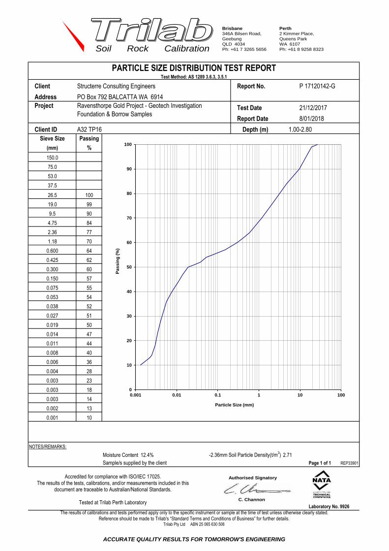
Brisbane
346A Bilsen Road,
Geebung
QLD 4034
Ph: +61 7 3265 5656
Perth
2 Kimmer Place,
Queens Park
WA 6107
Ph: +61 8 9258 8323Soil Rock Calibration
chrisc 1919
Client Report No.
Address
Project Test Date
Report Date
Client ID A32 TP16 Depth (m)
Sieve Size Passing
(mm) %
150.0
75.0
53.0
37.5
26.5 100
19.0 99
9.5 90
4.75 84
2.36 77
1.18 70
0.600 64
0.425 62
0.300 60
0.150 57
0.075 55
0.053 54
0.038 52
0.027 51
0.019 50
0.014 47
0.011 44
0.008 40
0.006 36
0.004 28
0.003 23
0.003 18
0.003 14
0.002 13
0.001 10
NOTES/REMARKS:
Moisture Content 12.4% -2.36mm Soil Particle Density(t/m3) 2.71
Sample/s supplied by the client Page 1 of 1 REP33901
Laboratory No. 9926
PO Box 792 BALCATTA WA 6914
Ravensthorpe Gold Project - Geotech Investigation
Foundation & Borrow Samples
1.00-2.80
PARTICLE SIZE DISTRIBUTION TEST REPORTTest Method: AS 1289 3.6.3, 3.5.1
Structerre Consulting Engineers P 17120142-G
8/01/2018
21/12/2017
The results of calibrations and tests performed apply only to the specific instrument or sample at the time of test unless otherwise clearly stated.
Reference should be made to Trilab's “Standard Terms and Conditions of Business” for further details.Trilab Pty Ltd ABN 25 065 630 506
Authorised Signatory
A. Harrap
0
10
20
30
40
50
60
70
80
90
100
0.001 0.01 0.1 1 10 100
Pa
ss
ing
(%
)
Particle Size (mm)
Accredited for compliance with ISO/IEC 17025. The results of the tests, calibrations, and/or measurements included in this
document are traceable to Australian/National Standards.
Tested at Trilab Perth Laboratory
Authorised Signatory
C. Channon
ACCURATE QUALITY RESULTS FOR TOMORROW'S ENGINEERING

Brisbane
346A Bilsen Road,
Geebung
QLD 4034
Ph: +61 7 3265 5656
Perth
2 Kimmer Place,
Queens Park
WA 6107
Ph: +61 8 9258 8323Soil Rock Calibration
chrisc 1919
Client Report No.
Address
Project Test Date
Report Date
Client ID B1 Depth (m)
Sieve Size Passing
(mm) %
150.0
75.0
53.0 100
37.5 98
26.5 97
19.0 96
9.5 94
4.75 92
2.36 91
1.18 88
0.600 84
0.425 80
0.300 76
0.150 69
0.075 60
0.055 59
0.039 55
0.029 50
0.021 46
0.015 42
0.012 37
0.008 32
0.006 28
0.004 21
0.004 16
0.003 14
0.003 12
0.002 10
0.001 9
NOTES/REMARKS:
Moisture Content 8.2% -2.36mm Soil Particle Density(t/m3) 2.68
Sample/s supplied by the client Page 1 of 1 REP33901
Laboratory No. 9926
PO Box 792 BALCATTA WA 6914
Ravensthorpe Gold Project - Geotech Investigation
Foundation & Borrow Samples
Not Supplied
PARTICLE SIZE DISTRIBUTION TEST REPORTTest Method: AS 1289 3.6.3, 3.5.1
Structerre Consulting Engineers P 17120143-G
5/01/2018
20/12/2017
The results of calibrations and tests performed apply only to the specific instrument or sample at the time of test unless otherwise clearly stated.
Reference should be made to Trilab's “Standard Terms and Conditions of Business” for further details.Trilab Pty Ltd ABN 25 065 630 506
Authorised Signatory
A. Harrap
0
10
20
30
40
50
60
70
80
90
100
0.001 0.01 0.1 1 10 100
Pa
ss
ing
(%
)
Particle Size (mm)
Accredited for compliance with ISO/IEC 17025. The results of the tests, calibrations, and/or measurements included in this
document are traceable to Australian/National Standards.
Tested at Trilab Perth Laboratory
Authorised Signatory
C. Channon
ACCURATE QUALITY RESULTS FOR TOMORROW'S ENGINEERING
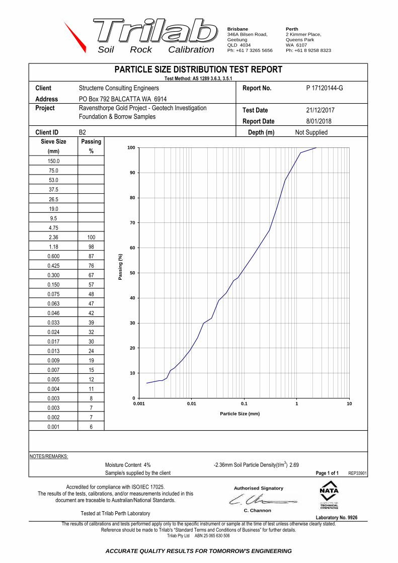
Brisbane
346A Bilsen Road,
Geebung
QLD 4034
Ph: +61 7 3265 5656
Perth
2 Kimmer Place,
Queens Park
WA 6107
Ph: +61 8 9258 8323Soil Rock Calibration
chrisc 1919
Client Report No.
Address
Project Test Date
Report Date
Client ID B2 Depth (m)
Sieve Size Passing
(mm) %
150.0
75.0
53.0
37.5
26.5
19.0
9.5
4.75
2.36 100
1.18 98
0.600 87
0.425 76
0.300 67
0.150 57
0.075 48
0.063 47
0.046 42
0.033 39
0.024 32
0.017 30
0.013 24
0.009 19
0.007 15
0.005 12
0.004 11
0.003 8
0.003 7
0.002 7
0.001 6
NOTES/REMARKS:
Moisture Content 4% -2.36mm Soil Particle Density(t/m3) 2.69
Sample/s supplied by the client Page 1 of 1 REP33901
Laboratory No. 9926
PO Box 792 BALCATTA WA 6914
Ravensthorpe Gold Project - Geotech Investigation
Foundation & Borrow Samples
Not Supplied
PARTICLE SIZE DISTRIBUTION TEST REPORTTest Method: AS 1289 3.6.3, 3.5.1
Structerre Consulting Engineers P 17120144-G
8/01/2018
21/12/2017
The results of calibrations and tests performed apply only to the specific instrument or sample at the time of test unless otherwise clearly stated.
Reference should be made to Trilab's “Standard Terms and Conditions of Business” for further details.Trilab Pty Ltd ABN 25 065 630 506
Authorised Signatory
A. Harrap
0
10
20
30
40
50
60
70
80
90
100
0.001 0.01 0.1 1 10
Pa
ss
ing
(%
)
Particle Size (mm)
Accredited for compliance with ISO/IEC 17025. The results of the tests, calibrations, and/or measurements included in this
document are traceable to Australian/National Standards.
Tested at Trilab Perth Laboratory
Authorised Signatory
C. Channon
ACCURATE QUALITY RESULTS FOR TOMORROW'S ENGINEERING

Brisbane
346A Bilsen Road,
Geebung
QLD 4034
Ph: +61 7 3265 5656
Perth
2 Kimmer Place,
Queens Park
WA 6107
Ph: +61 8 9258 8323Soil Rock Calibration
chrisc 1919
Client Report No.
Address
Project Test Date
Report Date
Client ID B3 Depth (m)
Sieve Size Passing
(mm) %
150.0
75.0
53.0
37.5
26.5 100
19.0 99
9.5 98
4.75 96
2.36 96
1.18 95
0.600 87
0.425 76
0.300 67
0.150 56
0.075 46
0.064 44
0.046 41
0.033 37
0.023 34
0.017 29
0.013 24
0.009 19
0.007 16
0.005 11
0.004 9
0.003 8
0.003 7
0.002 6
0.001 5
NOTES/REMARKS:
Moisture Content 7% -2.36mm Soil Particle Density(t/m3) 2.69
Sample/s supplied by the client Page 1 of 1 REP33901
Laboratory No. 9926
PO Box 792 BALCATTA WA 6914
Ravensthorpe Gold Project - Geotech Investigation
Foundation & Borrow Samples
Not Supplied
PARTICLE SIZE DISTRIBUTION TEST REPORTTest Method: AS 1289 3.6.3, 3.5.1
Structerre Consulting Engineers P 17120145-G
8/01/2018
21/12/2018
The results of calibrations and tests performed apply only to the specific instrument or sample at the time of test unless otherwise clearly stated.
Reference should be made to Trilab's “Standard Terms and Conditions of Business” for further details.Trilab Pty Ltd ABN 25 065 630 506
Authorised Signatory
A. Harrap
0
10
20
30
40
50
60
70
80
90
100
0.001 0.01 0.1 1 10 100
Pa
ss
ing
(%
)
Particle Size (mm)
Accredited for compliance with ISO/IEC 17025. The results of the tests, calibrations, and/or measurements included in this
document are traceable to Australian/National Standards.
Tested at Trilab Perth Laboratory
Authorised Signatory
C. Channon
ACCURATE QUALITY RESULTS FOR TOMORROW'S ENGINEERING

Brisbane
10/104 Newmarket Rd,
Windsor
QLD 4030
Ph: +61 7 3357 5535
Perth
2 Kimmer Place,
Queens Park
WA 6107
Ph: +61 8 9258 8323Soil Rock Calibration
chrisc 1919
Client Report No.
Address
Project Test Date
Report Date
Client ID
Description Sample Type
Compaction Method AS1289.5.1.1 - Standard Compaction
Maximum Dry Density (t/m3) Hydraulic Gradient
Optimum Moisture Content (%) Surcharge (kPa)
Placement Moisture Content (%) Head Pressure Applied (kPa)
Moisture Ratio (%) Water Type
Placement Wet Density (t/m3) Percentage Material Retained/Sieve Size (mm)
Density Ratio (%) Sample Height and Diameter (mm)
Remarks: The above specimen was remoulded to a target of 95% of Standard Dry Density and at Optimum Moisture Content.
Sample/s supplied by client The compaction data was supplied by the client. REP36301
PO Box 792 BALCATTA WA 6914
94.7
The results of calibrations and tests performed apply only to the specific instrument or sample at the time of test unless otherwise clearly stated.
Reference should be made to Trilab's “Standard Terms and Conditions of Business” for further details.
Depth (m) 0.50-1.10
11 / 9.5
Distilled
2.12
GRAVELLY SANDY SILT - pale brown
104.2
Trilab Pty Ltd ABN 25 065 630 506
Laboratory No. 9926
116.6 / 101.1
PERMEABILITY k(20) =
Page: 1 of 1
6.5E-09 (m/sec)
PERMEABILITY BY FALLING HEAD TEST REPORT
Test Method AS 1289 6.7.2, 5.1.1 , KH2 (Based on K H Head (1988) Manual of Laboratory Testing,10.7)
10.1
2.9
11.58
RESULTS OF TESTING
2.05
9.0
9.4
Ravensthorpe Gold Project - Geotech Investigation Foundation & Borrow
Samples
Remoulded Soil Specimen
3/01/2018
9/01/2018
P 17120138-FHPT
A5 TP02
Structerre Consulting Engineers
Accredited for compliance with ISO/IEC 17025. The results of the tests, calibrations, and/or measurements included in
this document are traceable to Australian/National Standards.
Tested at Trilab Perth Laboratory
1.000E-09
3.000E-09
5.000E-09
7.000E-09
9.000E-09
1.100E-08
1.300E-08
1.500E-08
1.700E-08
1.900E-08
0 500 1000 1500 2000 2500 3000 3500 4000 4500 5000
k20
(m
/sec
)
Elapsed Time of Test (mins)
Permeability
Authorised Signatory
C. Channon
ACCURATE QUALITY RESULTS FOR TOMORROW'S ENGINEERING

Brisbane
10/104 Newmarket Rd,
Windsor
QLD 4030
Ph: +61 7 3357 5535
Perth
2 Kimmer Place,
Queens Park
WA 6107
Ph: +61 8 9258 8323Soil Rock Calibration
chrisc 1919
Client Report No.
Address
Project Test Date
Report Date
Client ID
Description Sample Type
Compaction Method AS1289.5.1.1 - Standard Compaction
Maximum Dry Density (t/m3) Hydraulic Gradient
Optimum Moisture Content (%) Surcharge (kPa)
Placement Moisture Content (%) Head Pressure Applied (kPa)
Moisture Ratio (%) Water Type
Placement Wet Density (t/m3) Percentage Material Retained/Sieve Size (mm)
Density Ratio (%) Sample Height and Diameter (mm)
Remarks: The above specimen was remoulded to a target of 95% of Standard Dry Density and at Optimum Moisture Content.
Sample/s supplied by client The compaction data was supplied by the client. REP36301
PO Box 792 BALCATTA WA 6914
94.9
The results of calibrations and tests performed apply only to the specific instrument or sample at the time of test unless otherwise clearly stated.
Reference should be made to Trilab's “Standard Terms and Conditions of Business” for further details.
Depth (m) 0.00-0.70
8 / 9.5
Distilled
2.04
SILTY CLAYEY GRAVEL - grey
100.8
Trilab Pty Ltd ABN 25 065 630 506
Laboratory No. 9926
116.6 / 101
PERMEABILITY k(20) =
Page: 1 of 1
1.6E-08 (m/sec)
PERMEABILITY BY FALLING HEAD TEST REPORT
Test Method AS 1289 6.7.2, 5.1.1 , KH2 (Based on K H Head (1988) Manual of Laboratory Testing,10.7)
10.1
2.9
11.58
RESULTS OF TESTING
1.88
14.0
14.1
Ravensthorpe Gold Project - Geotech Investigation Foundation & Borrow
Samples
Remoulded Soil Specimen
3/01/2018
11/01/2018
P 17120139-FHPT
A7 TP03
Structerre Consulting Engineers
Accredited for compliance with ISO/IEC 17025. The results of the tests, calibrations, and/or measurements included in
this document are traceable to Australian/National Standards.
Tested at Trilab Perth Laboratory
1.000E-08
2.000E-08
3.000E-08
4.000E-08
5.000E-08
6.000E-08
0 500 1000 1500 2000 2500 3000 3500 4000 4500 5000
k20
(m
/sec
)
Elapsed Time of Test (mins)
Permeability
Authorised Signatory
C. Channon
ACCURATE QUALITY RESULTS FOR TOMORROW'S ENGINEERING
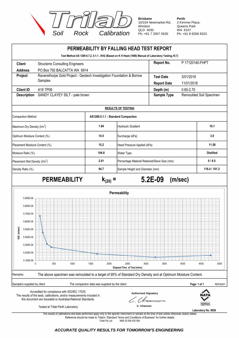
Brisbane
10/104 Newmarket Rd,
Windsor
QLD 4030
Ph: +61 7 3357 5535
Perth
2 Kimmer Place,
Queens Park
WA 6107
Ph: +61 8 9258 8323Soil Rock Calibration
chrisc 1919
Client Report No.
Address
Project Test Date
Report Date
Client ID
Description Sample Type
Compaction Method AS1289.5.1.1 - Standard Compaction
Maximum Dry Density (t/m3) Hydraulic Gradient
Optimum Moisture Content (%) Surcharge (kPa)
Placement Moisture Content (%) Head Pressure Applied (kPa)
Moisture Ratio (%) Water Type
Placement Wet Density (t/m3) Percentage Material Retained/Sieve Size (mm)
Density Ratio (%) Sample Height and Diameter (mm)
Remarks: The above specimen was remoulded to a target of 95% of Standard Dry Density and at Optimum Moisture Content.
Sample/s supplied by client The compaction data was supplied by the client. REP36301
PO Box 792 BALCATTA WA 6914
94.7
The results of calibrations and tests performed apply only to the specific instrument or sample at the time of test unless otherwise clearly stated.
Reference should be made to Trilab's “Standard Terms and Conditions of Business” for further details.
Depth (m) 0.60-2.70
0 / 9.5
Distilled
2.01
SANDY CLAYEY SILT - pale brown
104.8
Trilab Pty Ltd ABN 25 065 630 506
Laboratory No. 9926
116.4 / 101.3
PERMEABILITY k(20) =
Page: 1 of 1
5.2E-09 (m/sec)
PERMEABILITY BY FALLING HEAD TEST REPORT
Test Method AS 1289 6.7.2, 5.1.1 , KH2 (Based on K H Head (1988) Manual of Laboratory Testing,10.7)
10.1
3.0
11.58
RESULTS OF TESTING
1.84
14.5
15.2
Ravensthorpe Gold Project - Geotech Investigation Foundation & Borrow
Samples
Remoulded Soil Specimen
3/01/2018
11/01/2018
P 17120140-FHPT
A16 TP06
Structerre Consulting Engineers
Accredited for compliance with ISO/IEC 17025. The results of the tests, calibrations, and/or measurements included in
this document are traceable to Australian/National Standards.
Tested at Trilab Perth Laboratory
5.100E-09
5.200E-09
5.300E-09
5.400E-09
5.500E-09
5.600E-09
5.700E-09
5.800E-09
5.900E-09
0 500 1000 1500 2000 2500 3000 3500 4000 4500 5000
k20
(m
/sec
)
Elapsed Time of Test (mins)
Permeability
Authorised Signatory
C. Channon
ACCURATE QUALITY RESULTS FOR TOMORROW'S ENGINEERING

Brisbane
10/104 Newmarket Rd,
Windsor
QLD 4030
Ph: +61 7 3357 5535
Perth
2 Kimmer Place,
Queens Park
WA 6107
Ph: +61 8 9258 8323Soil Rock Calibration
chrisc 1919
Client Report No.
Address
Project Test Date
Report Date
Client ID
Description Sample Type
Compaction Method AS1289.5.1.1 - Standard Compaction
Maximum Dry Density (t/m3) Hydraulic Gradient
Optimum Moisture Content (%) Surcharge (kPa)
Placement Moisture Content (%) Head Pressure Applied (kPa)
Moisture Ratio (%) Water Type
Placement Wet Density (t/m3) Percentage Material Retained/Sieve Size (mm)
Density Ratio (%) Sample Height and Diameter (mm)
Remarks: The above specimen was remoulded to a target of 95% of Standard Dry Density and at Optimum Moisture Content.
Sample/s supplied by client The compaction data was supplied by the client. REP36301
PO Box 792 BALCATTA WA 6914
95.1
The results of calibrations and tests performed apply only to the specific instrument or sample at the time of test unless otherwise clearly stated.
Reference should be made to Trilab's “Standard Terms and Conditions of Business” for further details.
Depth (m) 0.70-2.80
9 / 9.5
Distilled
1.87
GRAVELLY SANDY SILT - white
100.8
Trilab Pty Ltd ABN 25 065 630 506
Laboratory No. 9926
116.5 / 101.1
PERMEABILITY k(20) =
Page: 1 of 1
4.1E-09 (m/sec)
PERMEABILITY BY FALLING HEAD TEST REPORT
Test Method AS 1289 6.7.2, 5.1.1 , KH2 (Based on K H Head (1988) Manual of Laboratory Testing,10.7)
10.1
3.0
11.58
RESULTS OF TESTING
1.69
16.0
16.1
Ravensthorpe Gold Project - Geotech Investigation Foundation & Borrow
Samples
Remoulded Soil Specimen
3/01/2018
11/01/2018
P 17120141-FHPT
A27 TP13
Structerre Consulting Engineers
Accredited for compliance with ISO/IEC 17025. The results of the tests, calibrations, and/or measurements included in
this document are traceable to Australian/National Standards.
Tested at Trilab Perth Laboratory
1.000E-09
2.000E-09
3.000E-09
4.000E-09
5.000E-09
6.000E-09
7.000E-09
8.000E-09
9.000E-09
0 500 1000 1500 2000 2500 3000 3500 4000 4500 5000
k20
(m
/sec
)
Elapsed Time of Test (mins)
Permeability
Authorised Signatory
C. Channon
ACCURATE QUALITY RESULTS FOR TOMORROW'S ENGINEERING

Brisbane
10/104 Newmarket Rd,
Windsor
QLD 4030
Ph: +61 7 3357 5535
Perth
2 Kimmer Place,
Queens Park
WA 6107
Ph: +61 8 9258 8323Soil Rock Calibration
chrisc 1919
Client Report No.
Address
Project Test Date
Report Date
Client ID
Description Sample Type
Compaction Method AS1289.5.1.1 - Standard Compaction
Maximum Dry Density (t/m3) Hydraulic Gradient
Optimum Moisture Content (%) Surcharge (kPa)
Placement Moisture Content (%) Head Pressure Applied (kPa)
Moisture Ratio (%) Water Type
Placement Wet Density (t/m3) Percentage Material Retained/Sieve Size (mm)
Density Ratio (%) Sample Height and Diameter (mm)
Remarks: The above specimen was remoulded to a target of 95% of Standard Dry Density and at Optimum Moisture Content.
Sample/s supplied by client The compaction data was supplied by the client. REP36301
PO Box 792 BALCATTA WA 6914
95.2
The results of calibrations and tests performed apply only to the specific instrument or sample at the time of test unless otherwise clearly stated.
Reference should be made to Trilab's “Standard Terms and Conditions of Business” for further details.
Depth (m) 1.00-2.80
0 / 9.5
Distilled
1.89
GRAVELLY SILT - pale brown
100.8
Trilab Pty Ltd ABN 25 065 630 506
Laboratory No. 9926
116.5 / 101.1
PERMEABILITY k(20) =
Page: 1 of 1
6.2E-09 (m/sec)
PERMEABILITY BY FALLING HEAD TEST REPORT
Test Method AS 1289 6.7.2, 5.1.1 , KH2 (Based on K H Head (1988) Manual of Laboratory Testing,10.7)
10.1
3.0
11.58
RESULTS OF TESTING
1.72
15.5
15.6
Ravensthorpe Gold Project - Geotech Investigation Foundation & Borrow
Samples
Remoulded Soil Specimen
3/01/2018
11/01/2018
P 17120142-FHPT
A32 TP16
Structerre Consulting Engineers
Accredited for compliance with ISO/IEC 17025. The results of the tests, calibrations, and/or measurements included in
this document are traceable to Australian/National Standards.
Tested at Trilab Perth Laboratory
1.000E-09
2.000E-09
3.000E-09
4.000E-09
5.000E-09
6.000E-09
7.000E-09
8.000E-09
9.000E-09
0 500 1000 1500 2000 2500 3000 3500 4000 4500 5000
k20
(m
/sec
)
Elapsed Time of Test (mins)
Permeability
Authorised Signatory
C. Channon
ACCURATE QUALITY RESULTS FOR TOMORROW'S ENGINEERING

Brisbane
346A Bilsen Road,
Geebung
QLD 4034
Ph: +61 7 3265 5656
Perth
2 Kimmer Place,
Queens Park
WA 6107
Ph: +61 8 9258 8323Soil Rock Calibration
chrisc 1919
James
Client Report No.
Address PO Box 792 BALCATTA WA 6914
Project Test Date 2/01/2018
Report Date 5/01/2018
Placement Moisture Content (%)
NOTES/REMARKS:
Sample/s supplied by the client Page 1 of 1 REP32002
Laboratory No. 9926
95.7
Nil
2
Structerre Consulting Engineers
D1
Highly dispersive
Yes
Distilled
15.9
DESCRIPTION
Variation from Optimum Moisture Content (%)
Curing Time (Days)
Source of Water
PINHOLE DISPERSION
CLASSIFICATION:DESIGNATION
Trilab Pty Ltd ABN 25 065 630 506
Reference should be made to Trilab's “Standard Terms and Conditions of Business” for further details.
The results of calibrations and tests performed apply only to the specific instrument or sample at the time of test unless otherwise clearly stated.
PINHOLE DISPERSION TEST REPORTTest Method: AS 1289 3.8.3
Ravensthorpe Gold Project - Geotech Investigation
Foundation & Borrow Samples
P 17120143-PHD
8.2
1.922
17120143
B1
Not Supplied
SILTY GRAVEL - white
Optimum Moisture Content
8.2
1.866
17120143
B1
Not Supplied
SILTY GRAVEL - white
Optimum Moisture Content
15.9
98.1
Nil
2
Distilled
Sample No.
Client ID
Depth (m)
Description
Method of Moisture Determination for Remoulding
Initial Moisture Content (%)
Placement Wet Density (t/m³)
Density Ratio (%)
Hole Reformed at 50mm Head Height Yes
D1
Highly dispersive
Accredited for compliance with ISO/IES 17025. The results of the tests, calibrations, and/or measurements included in
this document are traceable to Australian/National Standards.
Tested at Trilab Perth Laboratory.
Authorised Signatory
C. Channon
ACCURATE QUALITY RESULTS FOR TOMORROW'S ENGINEERING
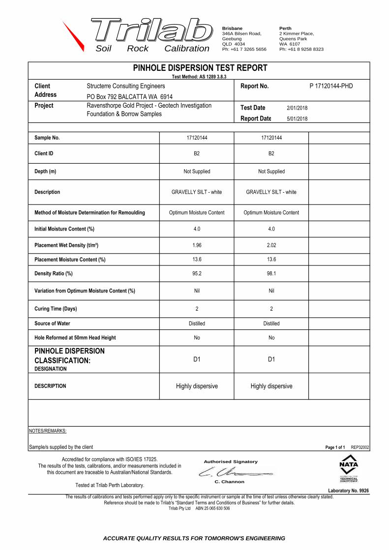
Brisbane
346A Bilsen Road,
Geebung
QLD 4034
Ph: +61 7 3265 5656
Perth
2 Kimmer Place,
Queens Park
WA 6107
Ph: +61 8 9258 8323Soil Rock Calibration
chrisc 1919
James
Client Report No.
Address PO Box 792 BALCATTA WA 6914
Project Test Date 2/01/2018
Report Date 5/01/2018
Placement Moisture Content (%)
NOTES/REMARKS:
Sample/s supplied by the client Page 1 of 1 REP32002
Laboratory No. 9926
95.2
Nil
2
Structerre Consulting Engineers
D1
Highly dispersive
No
Distilled
13.6
DESCRIPTION
Variation from Optimum Moisture Content (%)
Curing Time (Days)
Source of Water
PINHOLE DISPERSION
CLASSIFICATION:DESIGNATION
Trilab Pty Ltd ABN 25 065 630 506
Reference should be made to Trilab's “Standard Terms and Conditions of Business” for further details.
The results of calibrations and tests performed apply only to the specific instrument or sample at the time of test unless otherwise clearly stated.
PINHOLE DISPERSION TEST REPORTTest Method: AS 1289 3.8.3
Ravensthorpe Gold Project - Geotech Investigation
Foundation & Borrow Samples
P 17120144-PHD
4.0
2.02
17120144
B2
Not Supplied
GRAVELLY SILT - white
Optimum Moisture Content
4.0
1.96
17120144
B2
Not Supplied
GRAVELLY SILT - white
Optimum Moisture Content
13.6
98.1
Nil
2
Distilled
Sample No.
Client ID
Depth (m)
Description
Method of Moisture Determination for Remoulding
Initial Moisture Content (%)
Placement Wet Density (t/m³)
Density Ratio (%)
Hole Reformed at 50mm Head Height No
D1
Highly dispersive
Accredited for compliance with ISO/IES 17025. The results of the tests, calibrations, and/or measurements included in
this document are traceable to Australian/National Standards.
Tested at Trilab Perth Laboratory.
Authorised Signatory
C. Channon
ACCURATE QUALITY RESULTS FOR TOMORROW'S ENGINEERING

Brisbane
346A Bilsen Road,
Geebung
QLD 4034
Ph: +61 7 3265 5656
Perth
2 Kimmer Place,
Queens Park
WA 6107
Ph: +61 8 9258 8323Soil Rock Calibration
chrisc 1919
James
Client Report No.
Address PO Box 792 BALCATTA WA 6914
Project Test Date 2/01/2018
Report Date 5/01/2018
Placement Moisture Content (%)
NOTES/REMARKS:
Sample/s supplied by the client Page 1 of 1 REP32002
Laboratory No. 9926
94.9
Nil
2
Structerre Consulting Engineers
D2
Dispersive
No
Distilled
12.7
DESCRIPTION
Variation from Optimum Moisture Content (%)
Curing Time (Days)
Source of Water
PINHOLE DISPERSION
CLASSIFICATION:DESIGNATION
Trilab Pty Ltd ABN 25 065 630 506
Reference should be made to Trilab's “Standard Terms and Conditions of Business” for further details.
The results of calibrations and tests performed apply only to the specific instrument or sample at the time of test unless otherwise clearly stated.
PINHOLE DISPERSION TEST REPORTTest Method: AS 1289 3.8.3
Ravensthorpe Gold Project - Geotech Investigation
Foundation & Borrow Samples
P 17120145-PHD
7.0
1.96
17120145
B3
Not Supplied
SANDY SILT- yellow
Optimum Moisture Content
7.0
1.89
17120145
B3
Not Supplied
SANDY SILT- yellow
Optimum Moisture Content
12.7
98.1
Nil
2
Distilled
Sample No.
Client ID
Depth (m)
Description
Method of Moisture Determination for Remoulding
Initial Moisture Content (%)
Placement Wet Density (t/m³)
Density Ratio (%)
Hole Reformed at 50mm Head Height No
D2
Dispersive
Accredited for compliance with ISO/IES 17025. The results of the tests, calibrations, and/or measurements included in
this document are traceable to Australian/National Standards.
Tested at Trilab Perth Laboratory.
Authorised Signatory
C. Channon
ACCURATE QUALITY RESULTS FOR TOMORROW'S ENGINEERING
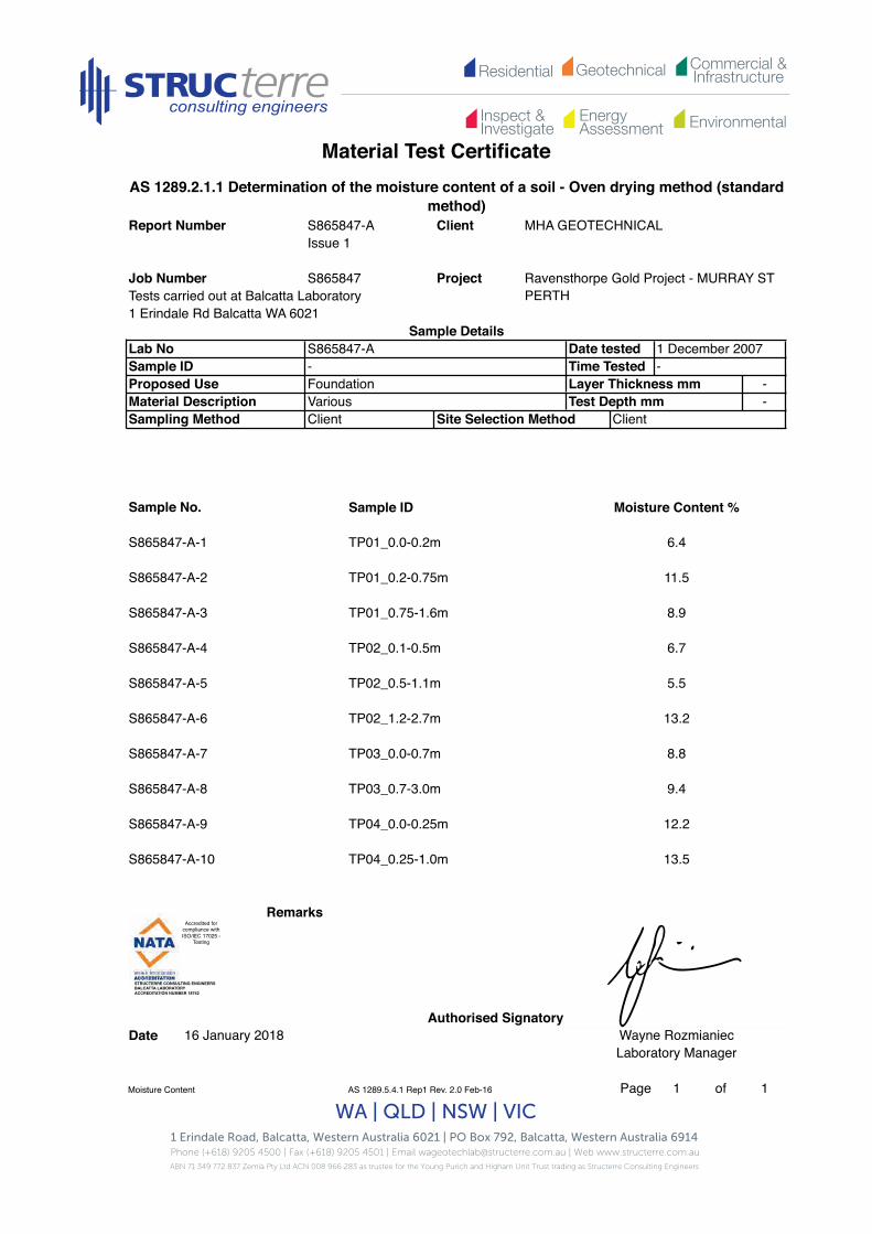
Residential Commercial &InfrastructureGeotechnical
EnergyAssessment
Inspect &Investigate Environmental
Material Test Certificate
1 Erindale Road, Balcatta, Western Australia 6021 | PO Box 792, Balcatta, Western Australia 6914 Phone (+618) 9205 4500 | Fax (+618) 9205 4501 | Email [email protected] | Web www.structerre.com.auABN 71 349 772 837 Zemla Pty Ltd ACN 008 966 283 as trustee for the Young Purich and Higham Unit Trust trading as Structerre Consulting Engineers
WA | QLD | NSW | VIC
Tests carried out at Balcatta Laboratory1 Erindale Rd Balcatta WA 6021
--
Sample ID Moisture Content %
Remarks
Authorised SignatoryDate
Moisture Content AS 1289.5.4.1 Rep1 Rev. 2.0 Feb-16 Page 1 of 1
16 January 2018 Wayne RozmianiecLaboratory Manager
S865847-A-10 TP04_0.25-1.0m 13.5
S865847-A-8 TP03_0.7-3.0m 9.4
S865847-A-9 TP04_0.0-0.25m 12.2
S865847-A-6 TP02_1.2-2.7m 13.2
S865847-A-7 TP03_0.0-0.7m 8.8
S865847-A-4 TP02_0.1-0.5m 6.7
S865847-A-5 TP02_0.5-1.1m 5.5
S865847-A-2 TP01_0.2-0.75m 11.5
S865847-A-3 TP01_0.75-1.6m 8.9
Sample No.
S865847-A-1 TP01_0.0-0.2m 6.4
Material Description Various Test Depth mmSampling Method Client Site Selection Method Client
Sample ID - Time Tested -Proposed Use Foundation Layer Thickness mm
Lab No S865847-A Date tested 1 December 2007
AS 1289.2.1.1 Determination of the moisture content of a soil - Oven drying method (standard method)
Report Number S865847-A Client MHA GEOTECHNICALIssue 1
Job Number S865847 Project Ravensthorpe Gold Project - MURRAY ST PERTH
Sample Details
Accredited for compliance with ISO/IEC 17025 -
Testing!
STRUCTERRE CONSULTING ENGINEERS !BALCATTA LABORATORY!ACCREDITATION NUMBER 18742!

Residential Commercial &InfrastructureGeotechnical
EnergyAssessment
Inspect &Investigate Environmental
MATERIAL TEST CERTIFICATE
1 Erindale Road, Balcatta, Western Australia 6021 | PO Box 792, Balcatta, Western Australia 6914 Phone (+618) 9205 4500 | Fax (+618) 9205 4501 | Email [email protected] | Web www.structerre.com.auABN 71 349 772 837 Zemla Pty Ltd ACN 008 966 283 as trustee for the Young Purich and Higham Unit Trust trading as Structerre Consulting Engineers
WA | QLD | NSW | VIC
Tests carried out at Balcatta Laboratory1 Erindale Rd Balcatta WA 6021
Tested by JWSLayer Thickness -Test Depth -
Remarks
Authorised SignatoryDate Wayne Rozmianiec
Laboratory Manager
PSD Atterberg Report AS 1289.3.6.1/AS 1289.3.1.2 Rep Rev. 2.0 Feb-16 Page 1 of 1
Plastic Limit %Plasticity Index %Linear Shrinkage %Nature Of ShrinkageSample History
16 January 2018
Particle Size Distribution Graph
0.3 mm0.15 mm
3547
75 mm
9.5 mm4.75 mm2.36 mm
100
8774 0.075 mm Dried at 50 °C
0.6 mm0.425 mm99
37.5 mm19 mm
Atterberg Limits (AS 1289.3.1.2,AS 1289.3.2.1,AS 1289.3.3.1,AS 1289.3.4.1)
Liquid Limit %
Foundation
Particle Size Distribution AS 1289.3.6.1Sieve Size % Passing Sieve Size % Passing
1.18 mm
95
Drying Method Dried to constant massParticle Size Distribution & Atterberg Limits of a Soil
64605856
Material DescriptionSampling Method AS 1289.1.4.1
AS 1726 - 2017 Sandy FINES with gravel
Sample DetailsLaboratory Number S865847-A-1 Date tested 05 Dec 2017Sample IDProposed Use
TP01 0.0-0.2m
Particle Size Distribution & Atterberg Limits of a SoilReport Number S865847-A Client MHA GEOTECHNICAL
Issue 1
Project Ravensthorpe Gold Project - MURRAY ST PERTH
Job Number S865847Pe
rcen
t Fin
er T
han
Accredited for compliance with ISO/IEC 17025 -
Testing!
STRUCTERRE CONSULTING ENGINEERS !BALCATTA LABORATORY!ACCREDITATION NUMBER 18742!

Residential Commercial &InfrastructureGeotechnical
EnergyAssessment
Inspect &Investigate Environmental
MATERIAL TEST CERTIFICATE
1 Erindale Road, Balcatta, Western Australia 6021 | PO Box 792, Balcatta, Western Australia 6914 Phone (+618) 9205 4500 | Fax (+618) 9205 4501 | Email [email protected] | Web www.structerre.com.auABN 71 349 772 837 Zemla Pty Ltd ACN 008 966 283 as trustee for the Young Purich and Higham Unit Trust trading as Structerre Consulting Engineers
WA | QLD | NSW | VIC
Tests carried out at Balcatta Laboratory1 Erindale Rd Balcatta WA 6021
Tested by JWS -
Test Depth -
Remarks
Authorised SignatoryDate Wayne Rozmianiec
Laboratory Manager
PSD Atterberg Report AS 1289.3.6.1/AS 1289.3.1.2 Rep Rev. 2.0 Feb-16 Page 1 of 1
16 January 2018
Particle Size Distribution Graph
Liquid Limit %Plastic Limit %
75 mm 1.18 mm
Particle Size Distribution & Atterberg Limits of a SoilReport Number S865847-A Client MHA GEOTECHNICAL
Issue 1
Project Ravensthorpe Gold Project - MURRAY ST PERTH
Job Number S865847
Sampling Method AS 1289.1.4.1 Drying Method
Layer ThicknessFoundationAS 1726 - 2017 FINES trace gravel, with sand
Sieve Size % Passing Sieve Size % Passing
Sample History Dried at 50 °C58
747266
8176
0.075 mm
19 mm 99 0.425 mm9.5 mm 96 0.3 mm
4.75 mm 93 0.15 mm
37.5 mm 100 0.6 mm
2.36 mm 88
Particle Size Distribution & Atterberg Limits of a SoilParticle Size Distribution AS 1289.3.6.1
Nature Of Shrinkage
Plasticity Index %Linear Shrinkage %
Dried to constant mass
Atterberg Limits (AS 1289.3.1.2,AS 1289.3.2.1,AS 1289.3.3.1,AS 1289.3.4.1)
Sample DetailsLaboratory Number S865847-A-2 Date tested 05 Dec 2017Sample ID TP01 0.2-0.75mProposed UseMaterial Description
Perc
ent F
iner
Tha
n
Accredited for compliance with ISO/IEC 17025 -
Testing!
STRUCTERRE CONSULTING ENGINEERS !BALCATTA LABORATORY!ACCREDITATION NUMBER 18742!
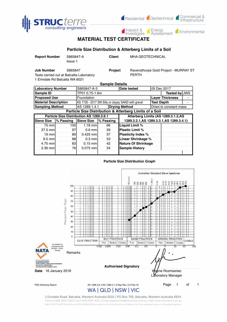
Residential Commercial &InfrastructureGeotechnical
EnergyAssessment
Inspect &Investigate Environmental
MATERIAL TEST CERTIFICATE
1 Erindale Road, Balcatta, Western Australia 6021 | PO Box 792, Balcatta, Western Australia 6914 Phone (+618) 9205 4500 | Fax (+618) 9205 4501 | Email [email protected] | Web www.structerre.com.auABN 71 349 772 837 Zemla Pty Ltd ACN 008 966 283 as trustee for the Young Purich and Higham Unit Trust trading as Structerre Consulting Engineers
WA | QLD | NSW | VIC
Tests carried out at Balcatta Laboratory1 Erindale Rd Balcatta WA 6021
Tested by JWSLayer Thickness -Test Depth -
Remarks
Authorised SignatoryDate Wayne Rozmianiec
Laboratory Manager
PSD Atterberg Report AS 1289.3.6.1/AS 1289.3.1.2 Rep Rev. 2.0 Feb-16 Page 1 of 1
16 January 2018
Particle Size Distribution Graph
Sample History
19 mm 89 0.425 mm 57
Liquid Limit %
Plasticity Index %
4.75 mm 83 0.15 mm 422.36 mm 76 0.075 mm 34
Linear Shrinkage %
FoundationAS 1726 - 2017 SM Silty or clayey SAND with gravel
S865847
100 1.18 mm 6637.5 mm 97 0.6 mm 59 Plastic Limit %
Project Ravensthorpe Gold Project - MURRAY ST PERTH
Sample Details
Material Description
Particle Size Distribution AS 1289.3.6.1Sieve Size
Particle Size Distribution & Atterberg Limits of a SoilReport Number S865847-A Client MHA GEOTECHNICAL
Issue 1
Job Number
Proposed Use
Laboratory Number S865847-A-3 Date tested 05 Dec 2017Sample ID TP01 0.75-1.6m
Nature Of Shrinkage
% Passing Sieve Size % Passing
Sampling Method AS 1289.1.4.1 Drying Method Dried to constant massParticle Size Distribution & Atterberg Limits of a Soil
Atterberg Limits (AS 1289.3.1.2,AS 1289.3.2.1,AS 1289.3.3.1,AS 1289.3.4.1)
9.5 mm 88 0.3 mm 53
75 mm
Perc
ent F
iner
Tha
n
Accredited for compliance with ISO/IEC 17025 -
Testing!
STRUCTERRE CONSULTING ENGINEERS !BALCATTA LABORATORY!ACCREDITATION NUMBER 18742!

Residential Commercial &InfrastructureGeotechnical
EnergyAssessment
Inspect &Investigate Environmental
MATERIAL TEST CERTIFICATE
1 Erindale Road, Balcatta, Western Australia 6021 | PO Box 792, Balcatta, Western Australia 6914 Phone (+618) 9205 4500 | Fax (+618) 9205 4501 | Email [email protected] | Web www.structerre.com.auABN 71 349 772 837 Zemla Pty Ltd ACN 008 966 283 as trustee for the Young Purich and Higham Unit Trust trading as Structerre Consulting Engineers
WA | QLD | NSW | VIC
Tests carried out at Balcatta Laboratory1 Erindale Rd Balcatta WA 6021
Tested by JWS -
Test Depth -
Remarks
Authorised SignatoryDate Wayne Rozmianiec
Laboratory Manager
PSD Atterberg Report AS 1289.3.6.1/AS 1289.3.1.2 Rep Rev. 2.0 Feb-16 Page 1 of 1
16 January 2018
Particle Size Distribution Graph
19 mm 100 0.425 mm 659.5 mm 97 0.3 mm 62
4.75 mm 87 0.15 mm 522.36 mm 76 0.075 mm 36 Sample History
Project
Sample Details
Sampling Method AS 1289.1.4.1 Drying Method Dried to constant mass
Proposed UseMaterial Description AS 1726 - 2017 Sandy FINES with gravel
75 mm 1.18 mm 7037.5 mm
S865847
Particle Size Distribution & Atterberg Limits of a SoilReport Number S865847-A Client MHA GEOTECHNICAL
Issue 1
Ravensthorpe Gold Project - MURRAY ST PERTH
0.6 mm 67
Particle Size Distribution AS 1289.3.6.1Sieve Size % Passing Sieve Size % Passing
Layer Thickness
Job Number
05 Dec 2017Sample ID TP02 0.1-0.5m
Foundation
Laboratory Number S865847-A-4 Date tested
Particle Size Distribution & Atterberg Limits of a SoilAtterberg Limits (AS 1289.3.1.2,AS
1289.3.2.1,AS 1289.3.3.1,AS 1289.3.4.1)Liquid Limit %Plastic Limit %Plasticity Index %Linear Shrinkage %Nature Of Shrinkage
Perc
ent F
iner
Tha
n
Accredited for compliance with ISO/IEC 17025 -
Testing!
STRUCTERRE CONSULTING ENGINEERS !BALCATTA LABORATORY!ACCREDITATION NUMBER 18742!

Residential Commercial &InfrastructureGeotechnical
EnergyAssessment
Inspect &Investigate Environmental
MATERIAL TEST CERTIFICATE
1 Erindale Road, Balcatta, Western Australia 6021 | PO Box 792, Balcatta, Western Australia 6914 Phone (+618) 9205 4500 | Fax (+618) 9205 4501 | Email [email protected] | Web www.structerre.com.auABN 71 349 772 837 Zemla Pty Ltd ACN 008 966 283 as trustee for the Young Purich and Higham Unit Trust trading as Structerre Consulting Engineers
WA | QLD | NSW | VIC
Tests carried out at Balcatta Laboratory1 Erindale Rd Balcatta WA 6021
Tested by CF -
Test Depth 0.5-1.1m
Remarks
Authorised SignatoryDate Wayne Rozmianiec
Laboratory Manager
PSD Atterberg Report AS 1289.3.6.1/AS 1289.3.1.2 Rep Rev. 2.0 Feb-16 Page 1 of 1
Job Number S865847 Project Ravensthorpe Gold Project - MURRAY ST PERTH
Particle Size Distribution Graph
16 January 2018
4.75 mm 0.15 mm2.36 mm 0.075 mm
19 mm 0.425 mm9.5 mm
Particle Size Distribution AS 1289.3.6.1Sieve Size % Passing Sieve Size % Passing
Sampling Method AS 1289.1.4.1 Drying Method Dried to constant massParticle Size Distribution & Atterberg Limits of a Soil
Atterberg Limits (AS 1289.3.1.2,AS 1289.3.2.1,AS 1289.3.3.1,AS 1289.3.4.1)
Proposed UseMaterial Description
Laboratory Number S865847-A-5 Date tested 7 December 2017Sample ID TP02 0.5-1.1m
Layer ThicknessFoundationClay or Silt
Sample Details
Particle Size Distribution & Atterberg Limits of a SoilReport Number S865847-A Client MHA GEOTECHNICAL
Issue 1
7.0Nature Of Shrinkage Normal
0.3 mm
75 mm 1.18 mm37.5 mm 0.6 mm
Sample History Dried at 50 °C
Liquid Limit % 38Plastic Limit % 18Plasticity Index % 20Linear Shrinkage %
Perc
ent F
iner
Tha
n
Accredited for compliance with ISO/IEC 17025 -
Testing!
STRUCTERRE CONSULTING ENGINEERS !BALCATTA LABORATORY!ACCREDITATION NUMBER 18742!

Residential Commercial &InfrastructureGeotechnical
EnergyAssessment
Inspect &Investigate Environmental
MATERIAL TEST CERTIFICATE
1 Erindale Road, Balcatta, Western Australia 6021 | PO Box 792, Balcatta, Western Australia 6914 Phone (+618) 9205 4500 | Fax (+618) 9205 4501 | Email [email protected] | Web www.structerre.com.auABN 71 349 772 837 Zemla Pty Ltd ACN 008 966 283 as trustee for the Young Purich and Higham Unit Trust trading as Structerre Consulting Engineers
WA | QLD | NSW | VIC
Tests carried out at Balcatta Laboratory1 Erindale Rd Balcatta WA 6021
Tested by JWS --
Remarks
Authorised SignatoryDate Wayne Rozmianiec
Laboratory Manager
PSD Atterberg Report AS 1289.3.6.1/AS 1289.3.1.2 Rep Rev. 2.0 Feb-16 Page 1 of 1
Job Number S865847
Particle Size Distribution Graph
16 January 2018
4.75 mm 98 0.15 mm 61
75 mm 1.18 mm 8437.5 mm 0.6 mm 74
Particle Size Distribution AS 1289.3.6.1Sieve Size % Passing Sieve Size % Passing
Sampling Method
2.36 mm 94 0.075 mm 56
19 mm 0.425 mm 719.5 mm 100 0.3 mm 67
AS 1289.1.4.1 Drying Method Dried to constant massParticle Size Distribution & Atterberg Limits of a Soil
Proposed UseMaterial Description
Layer ThicknessTest Depth
FoundationAS 1726 - 2017 Sandy FINES trace gravel
Laboratory Number S865847-A-6 Date tested 07 Dec 2017Sample ID TP02 1.1-2.7m
Project Ravensthorpe Gold Project - MURRAY ST PERTH
Sample Details
Particle Size Distribution & Atterberg Limits of a SoilReport Number S865847-A Client MHA GEOTECHNICAL
Issue 1
Atterberg Limits (AS 1289.3.1.2,AS 1289.3.2.1,AS 1289.3.3.1,AS 1289.3.4.1)
Liquid Limit %Plastic Limit %Plasticity Index %Linear Shrinkage %Nature Of ShrinkageSample History Dried at 50 °C
Perc
ent F
iner
Tha
n
Accredited for compliance with ISO/IEC 17025 -
Testing!
STRUCTERRE CONSULTING ENGINEERS !BALCATTA LABORATORY!ACCREDITATION NUMBER 18742!

Residential Commercial &InfrastructureGeotechnical
EnergyAssessment
Inspect &Investigate Environmental
MATERIAL TEST CERTIFICATE
1 Erindale Road, Balcatta, Western Australia 6021 | PO Box 792, Balcatta, Western Australia 6914 Phone (+618) 9205 4500 | Fax (+618) 9205 4501 | Email [email protected] | Web www.structerre.com.auABN 71 349 772 837 Zemla Pty Ltd ACN 008 966 283 as trustee for the Young Purich and Higham Unit Trust trading as Structerre Consulting Engineers
WA | QLD | NSW | VIC
Tests carried out at Balcatta Laboratory1 Erindale Rd Balcatta WA 6021
Tested by JWS--
Remarks
Authorised SignatoryDate Wayne Rozmianiec
Laboratory Manager
PSD Atterberg Report AS 1289.3.6.1/AS 1289.3.1.2 Rep Rev. 2.0 Feb-16 Page 1 of 1
Job Number S865847
Particle Size Distribution Graph
16 January 2018
4.75 mm 0.15 mm2.36 mm 0.075 mm
19 mm 0.425 mm9.5 mm 0.3 mm
75 mm 1.18 mm37.5 mm 0.6 mm
Particle Size Distribution AS 1289.3.6.1Sieve Size % Passing Sieve Size % Passing
Sampling Method AS 1289.1.4.1 Drying Method Dried to constant massParticle Size Distribution & Atterberg Limits of a Soil
Atterberg Limits (AS 1289.3.1.2,AS 1289.3.2.1,AS 1289.3.3.1,AS 1289.3.4.1)
Proposed UseMaterial Description
Layer ThicknessTest Depth
FoundationAS 1726 - 2017 - -
Laboratory Number S865847-A-7 Date tested 11 December 2017Sample ID TP03_0.0-0.7m
Project Ravensthorpe Gold Project - MURRAY ST PERTH
Sample Details
Particle Size Distribution & Atterberg Limits of a SoilReport Number S865847-A Client MHA GEOTECHNICAL
Issue 1
Nature Of Shrinkage NormalSample History Dried at 50 °C
Liquid Limit % 28Plastic Limit % 15Plasticity Index % 13Linear Shrinkage % 5.5
Perc
ent F
iner
Tha
n
Accredited for compliance with ISO/IEC 17025 -
Testing!
STRUCTERRE CONSULTING ENGINEERS !BALCATTA LABORATORY!ACCREDITATION NUMBER 18742!
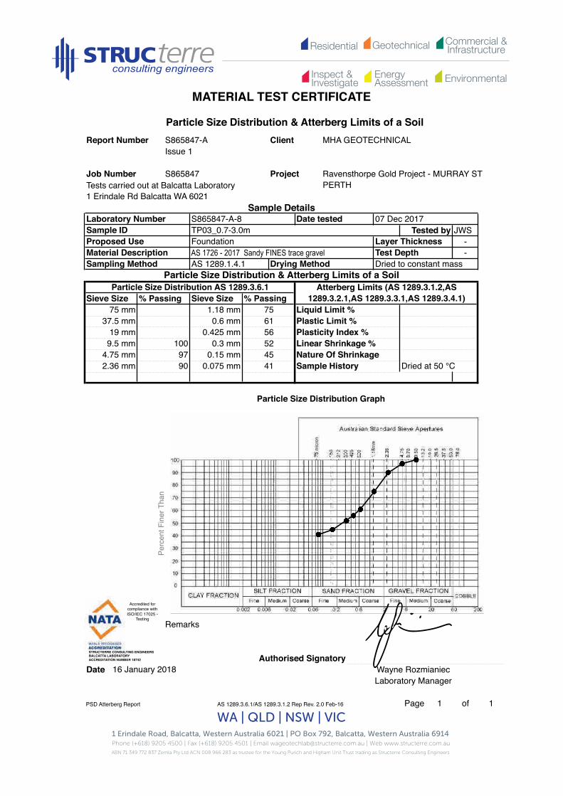
Residential Commercial &InfrastructureGeotechnical
EnergyAssessment
Inspect &Investigate Environmental
MATERIAL TEST CERTIFICATE
1 Erindale Road, Balcatta, Western Australia 6021 | PO Box 792, Balcatta, Western Australia 6914 Phone (+618) 9205 4500 | Fax (+618) 9205 4501 | Email [email protected] | Web www.structerre.com.auABN 71 349 772 837 Zemla Pty Ltd ACN 008 966 283 as trustee for the Young Purich and Higham Unit Trust trading as Structerre Consulting Engineers
WA | QLD | NSW | VIC
Tests carried out at Balcatta Laboratory1 Erindale Rd Balcatta WA 6021
Tested by JWS--
Remarks
Authorised SignatoryDate Wayne Rozmianiec
Laboratory Manager
PSD Atterberg Report AS 1289.3.6.1/AS 1289.3.1.2 Rep Rev. 2.0 Feb-16 Page 1 of 1
Job Number S865847
Particle Size Distribution Graph
16 January 2018
4.75 mm 97 0.15 mm 452.36 mm 90 0.075 mm 41
19 mm 0.425 mm 569.5 mm 100 0.3 mm 52
75 mm 1.18 mm 7537.5 mm 0.6 mm 61
Particle Size Distribution AS 1289.3.6.1Sieve Size % Passing Sieve Size % Passing
Sampling Method AS 1289.1.4.1 Drying Method Dried to constant massParticle Size Distribution & Atterberg Limits of a Soil
Proposed UseMaterial Description
Laboratory Number S865847-A-8 Date tested 07 Dec 2017Sample ID TP03_0.7-3.0m
Layer ThicknessTest Depth
FoundationAS 1726 - 2017 Sandy FINES trace gravel
Project Ravensthorpe Gold Project - MURRAY ST PERTH
Sample Details
Particle Size Distribution & Atterberg Limits of a SoilReport Number S865847-A Client MHA GEOTECHNICAL
Issue 1
Atterberg Limits (AS 1289.3.1.2,AS 1289.3.2.1,AS 1289.3.3.1,AS 1289.3.4.1)
Liquid Limit %Plastic Limit %Plasticity Index %Linear Shrinkage %Nature Of ShrinkageSample History Dried at 50 °C
Perc
ent F
iner
Tha
n
Accredited for compliance with ISO/IEC 17025 -
Testing!
STRUCTERRE CONSULTING ENGINEERS !BALCATTA LABORATORY!ACCREDITATION NUMBER 18742!
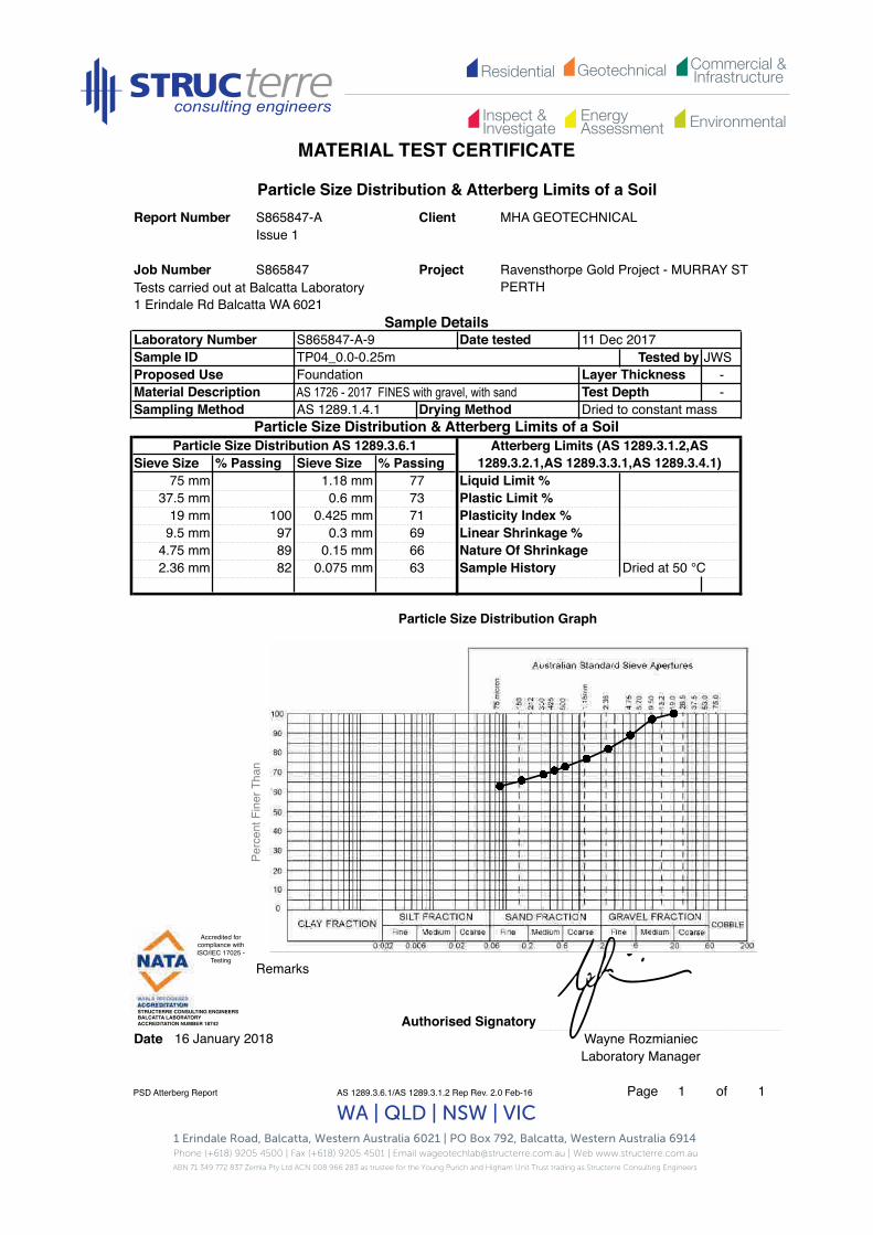
Residential Commercial &InfrastructureGeotechnical
EnergyAssessment
Inspect &Investigate Environmental
MATERIAL TEST CERTIFICATE
1 Erindale Road, Balcatta, Western Australia 6021 | PO Box 792, Balcatta, Western Australia 6914 Phone (+618) 9205 4500 | Fax (+618) 9205 4501 | Email [email protected] | Web www.structerre.com.auABN 71 349 772 837 Zemla Pty Ltd ACN 008 966 283 as trustee for the Young Purich and Higham Unit Trust trading as Structerre Consulting Engineers
WA | QLD | NSW | VIC
Tests carried out at Balcatta Laboratory1 Erindale Rd Balcatta WA 6021
Tested by JWS--
Remarks
Authorised SignatoryDate Wayne Rozmianiec
Laboratory Manager
PSD Atterberg Report AS 1289.3.6.1/AS 1289.3.1.2 Rep Rev. 2.0 Feb-16 Page 1 of 1
Particle Size Distribution Graph
16 January 2018
4.75 mm 89 0.15 mm 662.36 mm 82 0.075 mm 63
19 mm 100 0.425 mm 719.5 mm 97 69
75 mm 1.18 mm 7737.5 mm 0.6 mm 73
0.3 mm
Sieve Size % Passing Sieve Size % Passing
Sampling Method AS 1289.1.4.1 Drying Method Dried to constant massParticle Size Distribution & Atterberg Limits of a Soil
Atterberg Limits (AS 1289.3.1.2,AS 1289.3.2.1,AS 1289.3.3.1,AS 1289.3.4.1)
Particle Size Distribution AS 1289.3.6.1
Proposed UseMaterial Description
Laboratory Number S865847-A-9 Date tested 11 Dec 2017Sample ID TP04_0.0-0.25m
Layer ThicknessTest Depth
FoundationAS 1726 - 2017 FINES with gravel, with sand
Project Ravensthorpe Gold Project - MURRAY ST PERTH
Sample Details
Particle Size Distribution & Atterberg Limits of a SoilReport Number S865847-A Client MHA GEOTECHNICAL
Issue 1
Job Number S865847
Sample History Dried at 50 °C
Liquid Limit %Plastic Limit %Plasticity Index %Linear Shrinkage %Nature Of Shrinkage
Perc
ent F
iner
Tha
n
Accredited for compliance with ISO/IEC 17025 -
Testing!
STRUCTERRE CONSULTING ENGINEERS !BALCATTA LABORATORY!ACCREDITATION NUMBER 18742!

Residential Commercial &InfrastructureGeotechnical
EnergyAssessment
Inspect &Investigate Environmental
MATERIAL TEST CERTIFICATE
1 Erindale Road, Balcatta, Western Australia 6021 | PO Box 792, Balcatta, Western Australia 6914 Phone (+618) 9205 4500 | Fax (+618) 9205 4501 | Email [email protected] | Web www.structerre.com.auABN 71 349 772 837 Zemla Pty Ltd ACN 008 966 283 as trustee for the Young Purich and Higham Unit Trust trading as Structerre Consulting Engineers
WA | QLD | NSW | VIC
Tests carried out at Balcatta Laboratory1 Erindale Rd Balcatta WA 6021
Tested by JWS--
Remarks
Authorised SignatoryDate Wayne Rozmianiec
Laboratory Manager
PSD Atterberg Report AS 1289.3.6.1/AS 1289.3.1.2 Rep Rev. 2.0 Feb-16 Page 1 of 1
Particle Size Distribution Graph
16 January 2018
4.75 mm 89 0.15 mm 532.36 mm 83 0.075 mm 50
19 mm 96 0.425 mm 619.5 mm 95 0.3 mm 58
75 mm 1.18 mm 7237.5 mm 100 0.6 mm 64
Particle Size Distribution AS 1289.3.6.1Sieve Size % Passing Sieve Size % Passing
Sampling Method AS 1289.1.4.1 Drying Method Dried to constant massParticle Size Distribution & Atterberg Limits of a Soil
Proposed UseMaterial Description
Layer ThicknessTest Depth
FoundationAS 1726 - 2017 Sandy FINES with gravel
Laboratory Number S865847-A-10 Date tested 11 Dec 2017Sample ID TP04_0.25-1.0m
Project Ravensthorpe Gold Project - MURRAY ST PERTH
Sample Details
Job Number S865847
Particle Size Distribution & Atterberg Limits of a SoilReport Number S865847-A Client MHA GEOTECHNICAL
Issue 1
Atterberg Limits (AS 1289.3.1.2,AS 1289.3.2.1,AS 1289.3.3.1,AS 1289.3.4.1)
Liquid Limit %Plastic Limit %Plasticity Index %Linear Shrinkage %Nature Of ShrinkageSample History Dried at 50 °C
Perc
ent F
iner
Tha
n
Accredited for compliance with ISO/IEC 17025 -
Testing!
STRUCTERRE CONSULTING ENGINEERS !BALCATTA LABORATORY!ACCREDITATION NUMBER 18742!
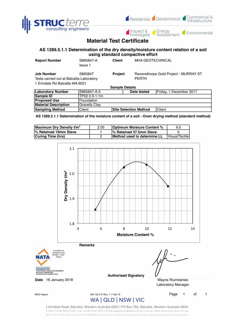
Residential Commercial &InfrastructureGeotechnical
EnergyAssessment
Inspect &Investigate Environmental
Material Test Certificate
1 Erindale Road, Balcatta, Western Australia 6021 | PO Box 792, Balcatta, Western Australia 6914 Phone (+618) 9205 4500 | Fax (+618) 9205 4501 | Email [email protected] | Web www.structerre.com.auABN 71 349 772 837 Zemla Pty Ltd ACN 008 966 283 as trustee for the Young Purich and Higham Unit Trust trading as Structerre Consulting Engineers
WA | QLD | NSW | VIC
Tests carried out at Balcatta Laboratory1 Erindale Rd Balcatta WA 6021
Maximum Dry Density t/m3 Optimum Moisture Content %% Retained 37.5mm Sieve
Remarks
Authorised SignatoryDate Wayne Rozmianiec
Laboratory Manager
MDD Report WA 132.2 R Rev. 1.1 Feb-15 Page 1 of 1
Job Number S865847
AS 1289.5.1.1 Determination of the dry density/moisture content relation of a soil using standard compactive effort
Report Number S865847-A Client MHA GEOTECHNICALIssue 1
Project Ravensthorpe Gold Project - MURRAY ST PERTH
Sample DetailsLaboratory Number S865847-A-5 Date tested Friday, 1 December 2017Sample ID TP02 0.5-1.1mProposed Use FoundationMaterial Description Gravelly ClaySampling Method Client Site Selection Method Client
AS 1289.2.1.1 Determination of the moisture content of a soil - Oven drying method (standard method)
2.051% Retained 19mm Sieve
Curing Time (hrs) 2 Method used to determine LL Visual/Tactile
9.00
16 January 2018
1.8
1.9
2.0
2.1
4 6 8 10 12 14
Dry
Dens
ity t/
m3
Moisture Content %
Accredited for compliance with ISO/IEC 17025 -
Testing!
STRUCTERRE CONSULTING ENGINEERS !BALCATTA LABORATORY!ACCREDITATION NUMBER 18742!

Residential Commercial &InfrastructureGeotechnical
EnergyAssessment
Inspect &Investigate Environmental
Material Test Certificate
1 Erindale Road, Balcatta, Western Australia 6021 | PO Box 792, Balcatta, Western Australia 6914 Phone (+618) 9205 4500 | Fax (+618) 9205 4501 | Email [email protected] | Web www.structerre.com.auABN 71 349 772 837 Zemla Pty Ltd ACN 008 966 283 as trustee for the Young Purich and Higham Unit Trust trading as Structerre Consulting Engineers
WA | QLD | NSW | VIC
Tests carried out at Balcatta Laboratory1 Erindale Rd Balcatta WA 6021
Maximum Dry Density t/m3 Optimum Moisture Content %% Retained 37.5mm Sieve
Remarks
Authorised SignatoryDate Wayne Rozmianiec
Laboratory Manager
MDD Report AS 1289.5.1.1 R Rev. 2.0 Feb-16 Page 1 of 1
S865847Job Number
AS 1289.5.1.1 Determination of the dry density/moisture content relation of a soil using standard compactive effort
Report Number S865847-A Client MHA GEOTECHNICALIssue 1
Project Ravensthorpe Gold Project - MURRAY ST PERTH
Sample DetailsLaboratory Number S865847-A-7 Date tested Monday, 11 December 2017Sample ID TP03 0.0-0.7mProposed Use Foundation Material Description ClaySampling Method
16 January 2018
Client Site Selection Method Client
AS 1289.2.1.1 Determination of the moisture content of a soil - Oven drying method (standard method)
1.8822Curing Time (hrs) Method used to determine LL Visual/Tactile
% Retained 19mm Sieve14.0
0
1.7
1.8
1.9
10 12 14 16
Dry
Dens
ity t/
m3
Moisture Content %
Accredited for compliance with ISO/IEC 17025 -
Testing!
STRUCTERRE CONSULTING ENGINEERS !BALCATTA LABORATORY!ACCREDITATION NUMBER 18742!

Residential Commercial &InfrastructureGeotechnical
EnergyAssessment
Inspect &Investigate Environmental
Material Test Certificate
1 Erindale Road, Balcatta, Western Australia 6021 | PO Box 792, Balcatta, Western Australia 6914 Phone (+618) 9205 4500 | Fax (+618) 9205 4501 | Email [email protected] | Web www.structerre.com.auABN 71 349 772 837 Zemla Pty Ltd ACN 008 966 283 as trustee for the Young Purich and Higham Unit Trust trading as Structerre Consulting Engineers
WA | QLD | NSW | VIC
Tests carried out at Balcatta Laboratory1 Erindale Rd Balcatta WA 6021
--
Sample ID Emerson Class No.
Authorised SignatoryDate Wayne Rozmianiec
Laboratory ManagerEmerson
AS 1289.5.4.3 Rep2 Rev. 2.0 Feb-16 Page 1 of 1
TP02_0.5-1.1m 3
TP03_0.0-0.7m 3
Lab NoSample ID Time Tested -
S865847-A-
Date tested 12 December 2017
Project Ravensthorpe Gold Project - MURRAY ST PERTH
Sample Details
Job Number S865847
Report NumberIssue 1S865847-A
AS 1289.3.8.1 Determination of the Emerson class number of a soil
Client MHA GEOTECHNICAL
Sample No.
Layer Thickness mmTest Depth mm
Sampling Method Client Site Selection Method Client
Proposed Use FoundationVariousMaterial Description
S865847-A-7
S865847-A-5
16 January 2018

Residential Commercial &InfrastructureGeotechnical
EnergyAssessment
Inspect &Investigate Environmental
Material Test Certificate
1 Erindale Road, Balcatta, Western Australia 6021 | PO Box 792, Balcatta, Western Australia 6914 Phone (+618) 9205 4500 | Fax (+618) 9205 4501 | Email [email protected] | Web www.structerre.com.auABN 71 349 772 837 Zemla Pty Ltd ACN 008 966 283 as trustee for the Young Purich and Higham Unit Trust trading as Structerre Consulting Engineers
WA | QLD | NSW | VIC
Tests carried out at Balcatta Laboratory1 Erindale Rd Balcatta WA 6021
--
Sample ID Moisture Content %
Remarks
Authorised SignatoryDate
Moisture Content AS 1289.5.4.1 Rep1 Rev. 2.0 Feb-16 Page 1 of 1
TP07_0.1-0.2m
TP07_0.2-2.5m
TP08_0.1-0.4m
TP08_0.4-2.2m
S865847-A-17
Material Description
Report Number S865847-A
Time TestedSample IDLab No Date tested
S865847Job Number
Layer Thickness mm
Sampling Method
Issue 1
AS 1289.2.1.1 Determination of the moisture content of a soil - Oven drying method (standard method)
Sample Details
Sample No.
MHA GEOTECHNICAL
Ravensthorpe Gold Project - MURRAY ST PERTH
Proposed Use
Client
Project
Foundation
1 December 2007-
S865847-A-
S865847-A-12
S865847-A-13
S865847-A-15
9.5
9.7
9.2
8.6
8.5
TP04_1.0-3.1m
3.3
10.4
9.4
10.2S865847-A-20
Test Depth mmClient Site Selection Method Client
TP05_0.1-0.8m
Various
Laboratory Manager
S865847-A-11
S865847-A-18
S865847-A-14
S865847-A-16 7.4TP06_0.6-2.7m
TP05_0.8-1.8m
TP05_1.8-2.9m
TP06_0.0-0.6m
Wayne Rozmianiec16 January 2018
S865847-A-19
Accredited for compliance with ISO/IEC 17025 -
Testing!
STRUCTERRE CONSULTING ENGINEERS !BALCATTA LABORATORY!ACCREDITATION NUMBER 18742!

Residential Commercial &InfrastructureGeotechnical
EnergyAssessment
Inspect &Investigate Environmental
MATERIAL TEST CERTIFICATE
1 Erindale Road, Balcatta, Western Australia 6021 | PO Box 792, Balcatta, Western Australia 6914 Phone (+618) 9205 4500 | Fax (+618) 9205 4501 | Email [email protected] | Web www.structerre.com.auABN 71 349 772 837 Zemla Pty Ltd ACN 008 966 283 as trustee for the Young Purich and Higham Unit Trust trading as Structerre Consulting Engineers
WA | QLD | NSW | VIC
Tests carried out at Balcatta Laboratory1 Erindale Rd Balcatta WA 6021
Tested by JWSLayer Thickness -Test Depth -
Remarks
Authorised SignatoryDate Wayne Rozmianiec
Laboratory Manager
PSD Atterberg Report AS 1289.3.6.1/AS 1289.3.1.2 Rep Rev. 2.0 Feb-16 Page 1 of 1
Plastic Limit %Plasticity Index %Linear Shrinkage %Nature Of ShrinkageSample History
16 January 2018
Particle Size Distribution Graph
0.3 mm0.15 mm
5559
75 mm
9.5 mm4.75 mm2.36 mm
9793 0.075 mm Dried at 50 °C
0.6 mm0.425 mm100
37.5 mm19 mm
Atterberg Limits (AS 1289.3.1.2,AS 1289.3.2.1,AS 1289.3.3.1,AS 1289.3.4.1)
Liquid Limit %
Foundation
Particle Size Distribution AS 1289.3.6.1Sieve Size % Passing Sieve Size % Passing
1.18 mm
99
Drying Method Dried to constant massParticle Size Distribution & Atterberg Limits of a Soil
83737066
Material DescriptionSampling Method AS 1289.1.4.1
AS 1726 - 2017 Sandy FINES trace gravel
Sample DetailsLaboratory Number S865847-A-11 Date tested 11 Dec 2017Sample IDProposed Use
TP04_1.0-3.1m
Particle Size Distribution & Atterberg Limits of a SoilReport Number S865847-A Client MHA GEOTECHNICAL
Issue 1
Project Ravensthorpe Gold Project - MURRAY ST PERTH
Job Number S865847Pe
rcen
t Fin
er T
han
Accredited for compliance with ISO/IEC 17025 -
Testing!
STRUCTERRE CONSULTING ENGINEERS !BALCATTA LABORATORY!ACCREDITATION NUMBER 18742!

Residential Commercial &InfrastructureGeotechnical
EnergyAssessment
Inspect &Investigate Environmental
MATERIAL TEST CERTIFICATE
1 Erindale Road, Balcatta, Western Australia 6021 | PO Box 792, Balcatta, Western Australia 6914 Phone (+618) 9205 4500 | Fax (+618) 9205 4501 | Email [email protected] | Web www.structerre.com.auABN 71 349 772 837 Zemla Pty Ltd ACN 008 966 283 as trustee for the Young Purich and Higham Unit Trust trading as Structerre Consulting Engineers
WA | QLD | NSW | VIC
Tests carried out at Balcatta Laboratory1 Erindale Rd Balcatta WA 6021
Tested by JWS--
Remarks
Authorised SignatoryDate Wayne Rozmianiec
Laboratory Manager
PSD Atterberg Report AS 1289.3.6.1/AS 1289.3.1.2 Rep Rev. 2.0 Feb-16 Page 1 of 1
16 January 2018
Particle Size Distribution Graph
Liquid Limit %Plastic Limit %
75 mm 1.18 mm
Particle Size Distribution & Atterberg Limits of a SoilReport Number S865847-A Client MHA GEOTECHNICAL
Issue 1
Project Ravensthorpe Gold Project - MURRAY ST PERTH
Job Number S865847
Sampling Method AS 1289.1.4.1 Drying Method
Layer ThicknessTest Depth
FoundationAS 1726 - 2017 Sandy FINES trace gravel
Sieve Size % Passing Sieve Size % Passing
Sample History Dried at 50 °C57
908981
9391
0.075 mm
19 mm 0.425 mm9.5 mm 100 0.3 mm
4.75 mm 98 0.15 mm
37.5 mm 0.6 mm
2.36 mm 94
Particle Size Distribution & Atterberg Limits of a SoilParticle Size Distribution AS 1289.3.6.1
Nature Of Shrinkage
Plasticity Index %Linear Shrinkage %
Dried to constant mass
Atterberg Limits (AS 1289.3.1.2,AS 1289.3.2.1,AS 1289.3.3.1,AS 1289.3.4.1)
Sample DetailsLaboratory Number S865847-A-12 Date tested 11 Dec 2017Sample ID TP05_0.1-0.8mProposed UseMaterial Description
Perc
ent F
iner
Tha
n
Accredited for compliance with ISO/IEC 17025 -
Testing!
STRUCTERRE CONSULTING ENGINEERS !BALCATTA LABORATORY!ACCREDITATION NUMBER 18742!

Residential Commercial &InfrastructureGeotechnical
EnergyAssessment
Inspect &Investigate Environmental
MATERIAL TEST CERTIFICATE
1 Erindale Road, Balcatta, Western Australia 6021 | PO Box 792, Balcatta, Western Australia 6914 Phone (+618) 9205 4500 | Fax (+618) 9205 4501 | Email [email protected] | Web www.structerre.com.auABN 71 349 772 837 Zemla Pty Ltd ACN 008 966 283 as trustee for the Young Purich and Higham Unit Trust trading as Structerre Consulting Engineers
WA | QLD | NSW | VIC
Tests carried out at Balcatta Laboratory1 Erindale Rd Balcatta WA 6021
Tested by JWSLayer Thickness -
-
Remarks
Authorised SignatoryDate Wayne Rozmianiec
Laboratory Manager
PSD Atterberg Report AS 1289.3.6.1/AS 1289.3.1.2 Rep Rev. 2.0 Feb-16 Page 1 of 1
16 January 2018
Particle Size Distribution Graph
Sample History Dried at 50 °C
19 mm 0.425 mm 76
Liquid Limit %
Plasticity Index %
4.75 mm 99 0.15 mm 702.36 mm 91 0.075 mm 51
Linear Shrinkage %
FoundationAS 1726 - 2017 Sandy FINES trace gravel Test Depth
S865847
1.18 mm 8237.5 mm 0.6 mm 77 Plastic Limit %
Project Ravensthorpe Gold Project - MURRAY ST PERTH
Sample Details
Particle Size Distribution & Atterberg Limits of a SoilReport Number S865847-A Client MHA GEOTECHNICAL
Issue 1
Job Number
Proposed Use
Laboratory Number S865847-A-13 Date tested 11 Dec 2017Sample ID TP05_0.8-1.8m
Nature Of Shrinkage
% Passing Sieve Size % Passing
Sampling Method AS 1289.1.4.1 Drying Method Dried to constant massParticle Size Distribution & Atterberg Limits of a Soil
Atterberg Limits (AS 1289.3.1.2,AS 1289.3.2.1,AS 1289.3.3.1,AS 1289.3.4.1)
9.5 mm 100 0.3 mm 75
75 mm
Material Description
Particle Size Distribution AS 1289.3.6.1Sieve Size
Perc
ent F
iner
Tha
n
Accredited for compliance with ISO/IEC 17025 -
Testing!
STRUCTERRE CONSULTING ENGINEERS !BALCATTA LABORATORY!ACCREDITATION NUMBER 18742!
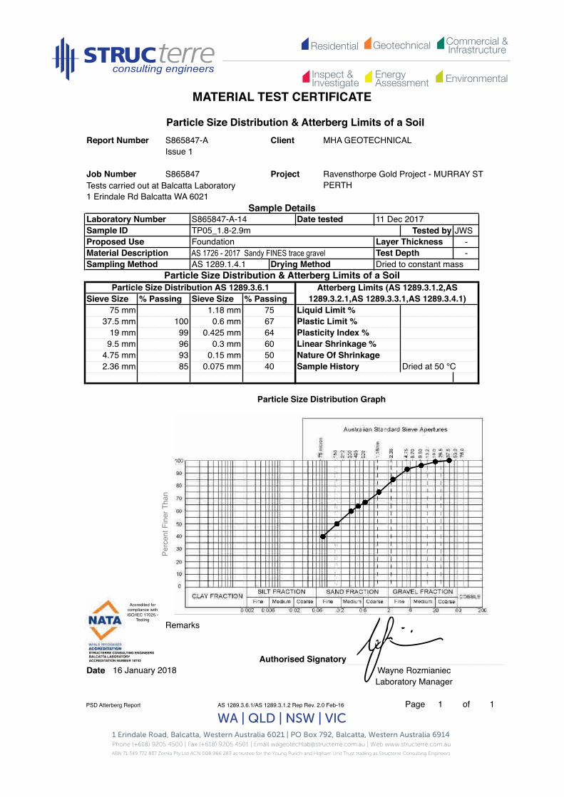
Residential Commercial &InfrastructureGeotechnical
EnergyAssessment
Inspect &Investigate Environmental
MATERIAL TEST CERTIFICATE
1 Erindale Road, Balcatta, Western Australia 6021 | PO Box 792, Balcatta, Western Australia 6914 Phone (+618) 9205 4500 | Fax (+618) 9205 4501 | Email [email protected] | Web www.structerre.com.auABN 71 349 772 837 Zemla Pty Ltd ACN 008 966 283 as trustee for the Young Purich and Higham Unit Trust trading as Structerre Consulting Engineers
WA | QLD | NSW | VIC
Tests carried out at Balcatta Laboratory1 Erindale Rd Balcatta WA 6021
Tested by JWS--
Remarks
Authorised SignatoryDate Wayne Rozmianiec
Laboratory Manager
PSD Atterberg Report AS 1289.3.6.1/AS 1289.3.1.2 Rep Rev. 2.0 Feb-16 Page 1 of 1
S865847
16 January 2018
Particle Size Distribution Graph
Dried at 50 °C
19 mm 99 0.425 mm 649.5 mm 96 0.3 mm 60
4.75 mm 93 0.15 mm 502.36 mm 85 0.075 mm 40 Sample History
Project
Sample Details
Sampling Method AS 1289.1.4.1 Drying Method Dried to constant mass
Proposed UseMaterial Description Test DepthAS 1726 - 2017 Sandy FINES trace gravel
75 mm 1.18 mm 7537.5 mm 100
Particle Size Distribution & Atterberg Limits of a SoilReport Number S865847-A Client MHA GEOTECHNICAL
Issue 1
Ravensthorpe Gold Project - MURRAY ST PERTH
0.6 mm 67
Particle Size Distribution AS 1289.3.6.1Sieve Size % Passing Sieve Size % Passing
Layer Thickness
Job Number
11 Dec 2017Sample ID TP05_1.8-2.9m
Foundation
Laboratory Number S865847-A-14 Date tested
Particle Size Distribution & Atterberg Limits of a SoilAtterberg Limits (AS 1289.3.1.2,AS
1289.3.2.1,AS 1289.3.3.1,AS 1289.3.4.1)Liquid Limit %Plastic Limit %Plasticity Index %Linear Shrinkage %Nature Of Shrinkage
Perc
ent F
iner
Tha
n
Accredited for compliance with ISO/IEC 17025 -
Testing!
STRUCTERRE CONSULTING ENGINEERS !BALCATTA LABORATORY!ACCREDITATION NUMBER 18742!

Residential Commercial &InfrastructureGeotechnical
EnergyAssessment
Inspect &Investigate Environmental
MATERIAL TEST CERTIFICATE
1 Erindale Road, Balcatta, Western Australia 6021 | PO Box 792, Balcatta, Western Australia 6914 Phone (+618) 9205 4500 | Fax (+618) 9205 4501 | Email [email protected] | Web www.structerre.com.auABN 71 349 772 837 Zemla Pty Ltd ACN 008 966 283 as trustee for the Young Purich and Higham Unit Trust trading as Structerre Consulting Engineers
WA | QLD | NSW | VIC
Tests carried out at Balcatta Laboratory1 Erindale Rd Balcatta WA 6021
Tested by JWS--
Remarks
Authorised SignatoryDate Wayne Rozmianiec
Laboratory Manager
PSD Atterberg Report AS 1289.3.6.1/AS 1289.3.1.2 Rep Rev. 2.0 Feb-16 Page 1 of 1
Job Number S865847 Project Ravensthorpe Gold Project - MURRAY ST PERTH
Particle Size Distribution Graph
16 January 2018
4.75 mm 96 0.15 mm 582.36 mm 87 0.075 mm 52
19 mm 99 0.425 mm 669.5 mm 98
Particle Size Distribution AS 1289.3.6.1Sieve Size % Passing Sieve Size % Passing
Sampling Method AS 1289.1.4.1 Drying Method Dried to constant massParticle Size Distribution & Atterberg Limits of a Soil
Atterberg Limits (AS 1289.3.1.2,AS 1289.3.2.1,AS 1289.3.3.1,AS 1289.3.4.1)
Proposed UseMaterial Description
Laboratory Number S865847-A-15 Date tested 12 Dec 2017Sample ID TP06_0.0-0.6m
Layer ThicknessTest Depth
FoundationAS 1726 - 2017 Sandy FINES trace gravel
Sample Details
Particle Size Distribution & Atterberg Limits of a SoilReport Number S865847-A Client MHA GEOTECHNICAL
Issue 1
Nature Of Shrinkage0.3 mm 63
75 mm 1.18 mm 7737.5 mm 100 0.6 mm 69
Sample History Dried at 50 °C
Liquid Limit %Plastic Limit %Plasticity Index %Linear Shrinkage %
Perc
ent F
iner
Tha
n
Accredited for compliance with ISO/IEC 17025 -
Testing!
STRUCTERRE CONSULTING ENGINEERS !BALCATTA LABORATORY!ACCREDITATION NUMBER 18742!

Residential Commercial &InfrastructureGeotechnical
EnergyAssessment
Inspect &Investigate Environmental
MATERIAL TEST CERTIFICATE
1 Erindale Road, Balcatta, Western Australia 6021 | PO Box 792, Balcatta, Western Australia 6914 Phone (+618) 9205 4500 | Fax (+618) 9205 4501 | Email [email protected] | Web www.structerre.com.auABN 71 349 772 837 Zemla Pty Ltd ACN 008 966 283 as trustee for the Young Purich and Higham Unit Trust trading as Structerre Consulting Engineers
WA | QLD | NSW | VIC
Tests carried out at Balcatta Laboratory1 Erindale Rd Balcatta WA 6021
Tested by CF -
Test Depth 0.6-2.7m
Remarks
Authorised SignatoryDate Wayne Rozmianiec
Laboratory Manager
PSD Atterberg Report AS 1289.3.6.1/AS 1289.3.1.2 Rep Rev. 2.0 Feb-16 Page 1 of 1
Job Number S865847
Particle Size Distribution Graph
16 January 2018
4.75 mm 0.15 mm
75 mm 1.18 mm37.5 mm 0.6 mm
Particle Size Distribution AS 1289.3.6.1Sieve Size % Passing Sieve Size % Passing
Sampling Method
2.36 mm 0.075 mm
19 mm 0.425 mm9.5 mm 0.3 mm
AS 1289.1.4.1 Drying Method Dried to constant massParticle Size Distribution & Atterberg Limits of a Soil
Proposed UseMaterial Description
Layer ThicknessFoundationClayey Silt
Laboratory Number S865847-A-16 Date testedSample ID TP06 0.6-2.7m
Project Ravensthorpe Gold Project - MURRAY ST PERTH
Sample Details
Particle Size Distribution & Atterberg Limits of a SoilReport Number S865847-A Client MHA GEOTECHNICAL
Issue 1
Atterberg Limits (AS 1289.3.1.2,AS 1289.3.2.1,AS 1289.3.3.1,AS 1289.3.4.1)
Liquid Limit % 32Plastic Limit % 23Plasticity Index % 9Linear Shrinkage % 2.5Nature Of Shrinkage NormalSample History Dried at 50 °C
Perc
ent F
iner
Tha
n
Accredited for compliance with ISO/IEC 17025 -
Testing!
STRUCTERRE CONSULTING ENGINEERS !BALCATTA LABORATORY!ACCREDITATION NUMBER 18742!

Residential Commercial &InfrastructureGeotechnical
EnergyAssessment
Inspect &Investigate Environmental
MATERIAL TEST CERTIFICATE
1 Erindale Road, Balcatta, Western Australia 6021 | PO Box 792, Balcatta, Western Australia 6914 Phone (+618) 9205 4500 | Fax (+618) 9205 4501 | Email [email protected] | Web www.structerre.com.auABN 71 349 772 837 Zemla Pty Ltd ACN 008 966 283 as trustee for the Young Purich and Higham Unit Trust trading as Structerre Consulting Engineers
WA | QLD | NSW | VIC
Tests carried out at Balcatta Laboratory1 Erindale Rd Balcatta WA 6021
Tested by JSO--
Remarks
Authorised SignatoryDate Wayne Rozmianiec
Laboratory Manager
PSD Atterberg Report AS 1289.3.6.1/AS 1289.3.1.2 Rep Rev. 2.0 Feb-16 Page 1 of 1
Job Number S865847
Particle Size Distribution Graph
16 January 2018
4.75 mm 84 0.15 mm 402.36 mm 73 0.075 mm 30
19 mm 100 0.425 mm 539.5 mm 98 0.3 mm 49
75 mm 1.18 mm 6337.5 mm 0.6 mm 56
Particle Size Distribution AS 1289.3.6.1Sieve Size % Passing Sieve Size % Passing
Sampling Method AS 1289.1.4.1 Drying Method Dried to constant massParticle Size Distribution & Atterberg Limits of a Soil
Atterberg Limits (AS 1289.3.1.2,AS 1289.3.2.1,AS 1289.3.3.1,AS 1289.3.4.1)
Proposed UseMaterial Description
Layer ThicknessTest Depth
FoundationAS 1726 - 2017 SM Silty or clayey SAND with gravel
Laboratory Number S865847-A-17 Date tested 12 Dec 2017Sample ID TP07_0.1-0.2m
Project Ravensthorpe Gold Project - MURRAY ST PERTH
Sample Details
Particle Size Distribution & Atterberg Limits of a SoilReport Number S865847-A Client MHA GEOTECHNICAL
Issue 1
Nature Of ShrinkageSample History
Liquid Limit %Plastic Limit %Plasticity Index %Linear Shrinkage %
Perc
ent F
iner
Tha
n
Accredited for compliance with ISO/IEC 17025 -
Testing!
STRUCTERRE CONSULTING ENGINEERS !BALCATTA LABORATORY!ACCREDITATION NUMBER 18742!

Residential Commercial &InfrastructureGeotechnical
EnergyAssessment
Inspect &Investigate Environmental
MATERIAL TEST CERTIFICATE
1 Erindale Road, Balcatta, Western Australia 6021 | PO Box 792, Balcatta, Western Australia 6914 Phone (+618) 9205 4500 | Fax (+618) 9205 4501 | Email [email protected] | Web www.structerre.com.auABN 71 349 772 837 Zemla Pty Ltd ACN 008 966 283 as trustee for the Young Purich and Higham Unit Trust trading as Structerre Consulting Engineers
WA | QLD | NSW | VIC
Tests carried out at Balcatta Laboratory1 Erindale Rd Balcatta WA 6021
Tested by JWS--
Remarks
Authorised SignatoryDate Wayne Rozmianiec
Laboratory Manager
PSD Atterberg Report AS 1289.3.6.1/AS 1289.3.1.2 Rep Rev. 2.0 Feb-16 Page 1 of 1
Job Number S865847
Particle Size Distribution Graph
16 January 2018
4.75 mm 99 0.15 mm 572.36 mm 98 0.075 mm 53
19 mm 0.425 mm 689.5 mm 100 0.3 mm 63
75 mm 1.18 mm 8437.5 mm 0.6 mm 72
Particle Size Distribution AS 1289.3.6.1Sieve Size % Passing Sieve Size % Passing
Sampling Method AS 1289.1.4.1 Drying Method Dried to constant massParticle Size Distribution & Atterberg Limits of a Soil
Proposed UseMaterial Description
Laboratory Number S865847-A-18 Date tested 12 Dec 2017Sample ID TP07_0.2-2.5m
Layer ThicknessTest Depth
FoundationAS 1726 - 2017 Sandy FINES trace gravel
Project Ravensthorpe Gold Project - MURRAY ST PERTH
Sample Details
Particle Size Distribution & Atterberg Limits of a SoilReport Number S865847-A Client MHA GEOTECHNICAL
Issue 1
Atterberg Limits (AS 1289.3.1.2,AS 1289.3.2.1,AS 1289.3.3.1,AS 1289.3.4.1)
Liquid Limit %Plastic Limit %Plasticity Index %Linear Shrinkage %Nature Of ShrinkageSample History Dried at 50 °C
Perc
ent F
iner
Tha
n
Accredited for compliance with ISO/IEC 17025 -
Testing!
STRUCTERRE CONSULTING ENGINEERS !BALCATTA LABORATORY!ACCREDITATION NUMBER 18742!

Residential Commercial &InfrastructureGeotechnical
EnergyAssessment
Inspect &Investigate Environmental
MATERIAL TEST CERTIFICATE
1 Erindale Road, Balcatta, Western Australia 6021 | PO Box 792, Balcatta, Western Australia 6914 Phone (+618) 9205 4500 | Fax (+618) 9205 4501 | Email [email protected] | Web www.structerre.com.auABN 71 349 772 837 Zemla Pty Ltd ACN 008 966 283 as trustee for the Young Purich and Higham Unit Trust trading as Structerre Consulting Engineers
WA | QLD | NSW | VIC
Tests carried out at Balcatta Laboratory1 Erindale Rd Balcatta WA 6021
Tested by JSO--
Remarks
Authorised SignatoryDate Wayne Rozmianiec
Laboratory Manager
PSD Atterberg Report AS 1289.3.6.1/AS 1289.3.1.2 Rep Rev. 2.0 Feb-16 Page 1 of 1
Particle Size Distribution Graph
16 January 2018
4.75 mm 93 0.15 mm 682.36 mm 90 0.075 mm 62
19 mm 97 0.425 mm 769.5 mm 96 74
75 mm 1.18 mm 8437.5 mm 100 0.6 mm 78
0.3 mm
Sieve Size % Passing Sieve Size % Passing
Sampling Method AS 1289.1.4.1 Drying Method Dried to constant massParticle Size Distribution & Atterberg Limits of a Soil
Atterberg Limits (AS 1289.3.1.2,AS 1289.3.2.1,AS 1289.3.3.1,AS 1289.3.4.1)
Particle Size Distribution AS 1289.3.6.1
Proposed UseMaterial Description
Laboratory Number S865847-A-19 Date tested 13 Dec 2017Sample ID TP08_0.1-0.4m
Layer ThicknessTest Depth
FoundationAS 1726 - 2017 FINES trace gravel, with sand
Project Ravensthorpe Gold Project - MURRAY ST PERTH
Sample Details
Particle Size Distribution & Atterberg Limits of a SoilReport Number S865847-A Client MHA GEOTECHNICAL
Issue 1
Job Number S865847
Sample History Dried at 50 °C
Liquid Limit %Plastic Limit %Plasticity Index %Linear Shrinkage %Nature Of Shrinkage
Perc
ent F
iner
Tha
n
Accredited for compliance with ISO/IEC 17025 -
Testing!
STRUCTERRE CONSULTING ENGINEERS !BALCATTA LABORATORY!ACCREDITATION NUMBER 18742!

Residential Commercial &InfrastructureGeotechnical
EnergyAssessment
Inspect &Investigate Environmental
MATERIAL TEST CERTIFICATE
1 Erindale Road, Balcatta, Western Australia 6021 | PO Box 792, Balcatta, Western Australia 6914 Phone (+618) 9205 4500 | Fax (+618) 9205 4501 | Email [email protected] | Web www.structerre.com.auABN 71 349 772 837 Zemla Pty Ltd ACN 008 966 283 as trustee for the Young Purich and Higham Unit Trust trading as Structerre Consulting Engineers
WA | QLD | NSW | VIC
Tests carried out at Balcatta Laboratory1 Erindale Rd Balcatta WA 6021
Tested by JSO--
Remarks
Authorised SignatoryDate Wayne Rozmianiec
Laboratory Manager
PSD Atterberg Report AS 1289.3.6.1/AS 1289.3.1.2 Rep Rev. 2.0 Feb-16 Page 1 of 1
Particle Size Distribution Graph
16 January 2018
4.75 mm 93 0.15 mm 542.36 mm 89 0.075 mm 50
19 mm 96 0.425 mm 639.5 mm 95 0.3 mm 59
75 mm 100 1.18 mm 7537.5 mm 97 0.6 mm 66
Particle Size Distribution AS 1289.3.6.1Sieve Size % Passing Sieve Size % Passing
Sampling Method AS 1289.1.4.1 Drying Method Dried to constant massParticle Size Distribution & Atterberg Limits of a Soil
Proposed UseMaterial Description
Layer ThicknessTest Depth
FoundationAS 1726 - 2017 Sandy FINES trace gravel
Laboratory Number S865847-A-20 Date tested 13 Dec 2017Sample ID TP08_0.4-2.2m
Project Ravensthorpe Gold Project - MURRAY ST PERTH
Sample Details
Job Number S865847
Particle Size Distribution & Atterberg Limits of a SoilReport Number S865847-A Client MHA GEOTECHNICAL
Issue 1
Atterberg Limits (AS 1289.3.1.2,AS 1289.3.2.1,AS 1289.3.3.1,AS 1289.3.4.1)
Liquid Limit %Plastic Limit %Plasticity Index %Linear Shrinkage %Nature Of ShrinkageSample History Dried at 50 °C
Perc
ent F
iner
Tha
n
Accredited for compliance with ISO/IEC 17025 -
Testing!
STRUCTERRE CONSULTING ENGINEERS !BALCATTA LABORATORY!ACCREDITATION NUMBER 18742!

Residential Commercial &InfrastructureGeotechnical
EnergyAssessment
Inspect &Investigate Environmental
Material Test Certificate
1 Erindale Road, Balcatta, Western Australia 6021 | PO Box 792, Balcatta, Western Australia 6914 Phone (+618) 9205 4500 | Fax (+618) 9205 4501 | Email [email protected] | Web www.structerre.com.auABN 71 349 772 837 Zemla Pty Ltd ACN 008 966 283 as trustee for the Young Purich and Higham Unit Trust trading as Structerre Consulting Engineers
WA | QLD | NSW | VIC
Tests carried out at Balcatta Laboratory1 Erindale Rd Balcatta WA 6021
Maximum Dry Density t/m3 Optimum Moisture Content %% Retained 37.5mm Sieve
Remarks
Authorised SignatoryDate Wayne Rozmianiec
Laboratory Manager
MDD Report AS 1289.5.1.1 R Rev. 2.0 Feb-16 Page 1 of 1
Job Number S865847
AS 1289.5.1.1 Determination of the dry density/moisture content relation of a soil using standard compactive effort
Report Number S865847-A Client MHA GEOTECHNICALIssue 1
Project Ravensthorpe Gold Project - MURRAY ST PERTH
Sample DetailsLaboratory Number S865847-A-16 Date tested Monday, 11 December 2017Sample ID TP06 0.6 - 2.7mProposed Use FoundationMaterial Description ClaySampling Method AS 1289.1.2.1 Site Selection Method AS 1289.1.4.1
AS 1289.2.1.1 Determination of the moisture content of a soil - Oven drying method (standard method)
1.840% Retained 19mm Sieve
Curing Time (hrs) 2 Method used to determine LL Visual/Tactile
14.50
16 January 2018
1.7
1.8
1.9
12 14 16 18
Dry
Dens
ity t/
m3
Moisture Content %
Accredited for compliance with ISO/IEC 17025 -
Testing!
STRUCTERRE CONSULTING ENGINEERS !BALCATTA LABORATORY!ACCREDITATION NUMBER 18742!

Residential Commercial &InfrastructureGeotechnical
EnergyAssessment
Inspect &Investigate Environmental
Material Test Certificate
1 Erindale Road, Balcatta, Western Australia 6021 | PO Box 792, Balcatta, Western Australia 6914 Phone (+618) 9205 4500 | Fax (+618) 9205 4501 | Email [email protected] | Web www.structerre.com.auABN 71 349 772 837 Zemla Pty Ltd ACN 008 966 283 as trustee for the Young Purich and Higham Unit Trust trading as Structerre Consulting Engineers
WA | QLD | NSW | VIC
Tests carried out at Balcatta Laboratory1 Erindale Rd Balcatta WA 6021
--
Sample ID Emerson Class No.
Authorised SignatoryDate Wayne Rozmianiec
Laboratory ManagerEmerson
AS 1289.5.4.3 Rep2 Rev. 2.0 Feb-16 Page 1 of 1
TP06_0.6-2.7m 2
Lab NoSample ID Time Tested -
S865847-A-
Date tested 12 December 2017
Project Ravensthorpe Gold Project - MURRAY ST PERTH
Sample Details
Job Number S865847
Report NumberIssue 1S865847-A
AS 1289.3.8.1 Determination of the Emerson class number of a soil
Client MHA GEOTECHNICAL
Sample No.
Layer Thickness mmTest Depth mm
Sampling Method Client Site Selection Method Client
Proposed Use FoundationVariousMaterial Description
S865847-A-16
16 January 2018
Accredited for compliance with ISO/IEC 17025 -
Testing!
STRUCTERRE CONSULTING ENGINEERS !BALCATTA LABORATORY!ACCREDITATION NUMBER 18742!

Residential Commercial &InfrastructureGeotechnical
EnergyAssessment
Inspect &Investigate Environmental
Material Test Certificate
1 Erindale Road, Balcatta, Western Australia 6021 | PO Box 792, Balcatta, Western Australia 6914 Phone (+618) 9205 4500 | Fax (+618) 9205 4501 | Email [email protected] | Web www.structerre.com.auABN 71 349 772 837 Zemla Pty Ltd ACN 008 966 283 as trustee for the Young Purich and Higham Unit Trust trading as Structerre Consulting Engineers
WA | QLD | NSW | VIC
Tests carried out at Balcatta Laboratory1 Erindale Rd Balcatta WA 6021
--
Sample ID Moisture Content %
Remarks
Authorised SignatoryDate
Moisture Content AS 1289.5.4.1 Rep1 Rev. 2.0 Feb-16 Page 1 of 1
Lab No S865847-A Date tested 1 December 2007
AS 1289.2.1.1 Determination of the moisture content of a soil - Oven drying method (standard method)
Report Number S865847-A Client MHA GEOTECHNICALIssue 1
Job Number S865847 Project Ravensthorpe Gold Project - MURRAY ST PERTH
Sample Details
Sample ID - Time Tested -Proposed Use Foundation Layer Thickness mmMaterial Description Various Test Depth mmSampling Method Client Site Selection Method Client
Sample No.
S865847-A-21 TP09_0.1-0.2m 5.9
S865847-A-22 TP09_0.2-2.2m 6.5
S865847-A-23 TP10_0.1-2.5m 10.6
S865847-A-24 TP11_0.2-2.8m 13.4
S865847-A-25 TP12_0.1-2.8m 15.1
S865847-A-26 TP13_0.1-0.7m 9.9
S865847-A-27 TP13_0.7-2.8m 10.8
S865847-A-28 TP14_0.2-1.0m 6.3
S865847-A-29 TP15_0.2-2.7m 10.0
16 January 2018 Wayne RozmianiecLaboratory Manager
S865847-A-30 TP16_0.2-0.6m 12.9
Accredited for compliance with ISO/IEC 17025 -
Testing!
STRUCTERRE CONSULTING ENGINEERS !BALCATTA LABORATORY!ACCREDITATION NUMBER 18742!

Residential Commercial &InfrastructureGeotechnical
EnergyAssessment
Inspect &Investigate Environmental
MATERIAL TEST CERTIFICATE
1 Erindale Road, Balcatta, Western Australia 6021 | PO Box 792, Balcatta, Western Australia 6914 Phone (+618) 9205 4500 | Fax (+618) 9205 4501 | Email [email protected] | Web www.structerre.com.auABN 71 349 772 837 Zemla Pty Ltd ACN 008 966 283 as trustee for the Young Purich and Higham Unit Trust trading as Structerre Consulting Engineers
WA | QLD | NSW | VIC
Tests carried out at Balcatta Laboratory1 Erindale Rd Balcatta WA 6021
Tested by JWSLayer Thickness -Test Depth -
Remarks
Authorised SignatoryDate Wayne Rozmianiec
Laboratory Manager
PSD Atterberg Report AS 1289.3.6.1/AS 1289.3.1.2 Rep Rev. 2.0 Feb-16 Page 1 of 1
Particle Size Distribution & Atterberg Limits of a SoilReport Number S865847-A Client MHA GEOTECHNICAL
Issue 1
Project Ravensthorpe Gold Project - MURRAY ST PERTH
Job Number S865847
Material DescriptionSampling Method AS 1289.1.4.1
AS 1726 - 2017 FINES with gravel, with sand
Sample DetailsLaboratory Number S865847-A-21 Date tested 13 Dec 2017Sample IDProposed Use
TP09_0.1-0.2m
37.5 mm19 mm
Atterberg Limits (AS 1289.3.1.2,AS 1289.3.2.1,AS 1289.3.3.1,AS 1289.3.4.1)
Liquid Limit %
Foundation
Particle Size Distribution AS 1289.3.6.1Sieve Size % Passing Sieve Size % Passing
1.18 mm
96
Drying Method Dried to constant massParticle Size Distribution & Atterberg Limits of a Soil
80747269
9285 0.075 mm Dried at 50 °C
0.6 mm0.425 mm99
75 mm
9.5 mm4.75 mm2.36 mm
100 Plastic Limit %Plasticity Index %Linear Shrinkage %Nature Of ShrinkageSample History
16 January 2018
Particle Size Distribution Graph
0.3 mm0.15 mm
5663
Perc
ent F
iner
Tha
n
Accredited for compliance with ISO/IEC 17025 -
Testing!
STRUCTERRE CONSULTING ENGINEERS !BALCATTA LABORATORY!ACCREDITATION NUMBER 18742!

Residential Commercial &InfrastructureGeotechnical
EnergyAssessment
Inspect &Investigate Environmental
MATERIAL TEST CERTIFICATE
1 Erindale Road, Balcatta, Western Australia 6021 | PO Box 792, Balcatta, Western Australia 6914 Phone (+618) 9205 4500 | Fax (+618) 9205 4501 | Email [email protected] | Web www.structerre.com.auABN 71 349 772 837 Zemla Pty Ltd ACN 008 966 283 as trustee for the Young Purich and Higham Unit Trust trading as Structerre Consulting Engineers
WA | QLD | NSW | VIC
Tests carried out at Balcatta Laboratory1 Erindale Rd Balcatta WA 6021
Tested by JWS--
Remarks
Authorised SignatoryDate Wayne Rozmianiec
Laboratory Manager
PSD Atterberg Report AS 1289.3.6.1/AS 1289.3.1.2 Rep Rev. 2.0 Feb-16 Page 1 of 1
Sample DetailsLaboratory Number S865847-A-22 Date tested 13 Dec 2017Sample ID TP09_0.2-2.2mProposed UseMaterial Description
Nature Of Shrinkage
Plasticity Index %Linear Shrinkage %
Dried to constant mass
Atterberg Limits (AS 1289.3.1.2,AS 1289.3.2.1,AS 1289.3.3.1,AS 1289.3.4.1)
2.36 mm 79
Particle Size Distribution & Atterberg Limits of a SoilParticle Size Distribution AS 1289.3.6.1
0.075 mm
19 mm 100 0.425 mm9.5 mm 98 0.3 mm
4.75 mm 90 0.15 mm
37.5 mm 0.6 mm
Sample History Dried at 50 °C44
595649
7062
Sampling Method AS 1289.1.4.1 Drying Method
Layer ThicknessTest Depth
FoundationAS 1726 - 2017 Sandy FINES with gravel
Sieve Size % Passing Sieve Size % Passing
Particle Size Distribution & Atterberg Limits of a SoilReport Number S865847-A Client MHA GEOTECHNICAL
Issue 1
Project Ravensthorpe Gold Project - MURRAY ST PERTH
Job Number S865847
16 January 2018
Particle Size Distribution Graph
Liquid Limit %Plastic Limit %
75 mm 1.18 mm
Perc
ent F
iner
Tha
n
Accredited for compliance with ISO/IEC 17025 -
Testing!
STRUCTERRE CONSULTING ENGINEERS !BALCATTA LABORATORY!ACCREDITATION NUMBER 18742!

Residential Commercial &InfrastructureGeotechnical
EnergyAssessment
Inspect &Investigate Environmental
MATERIAL TEST CERTIFICATE
1 Erindale Road, Balcatta, Western Australia 6021 | PO Box 792, Balcatta, Western Australia 6914 Phone (+618) 9205 4500 | Fax (+618) 9205 4501 | Email [email protected] | Web www.structerre.com.auABN 71 349 772 837 Zemla Pty Ltd ACN 008 966 283 as trustee for the Young Purich and Higham Unit Trust trading as Structerre Consulting Engineers
WA | QLD | NSW | VIC
Tests carried out at Balcatta Laboratory1 Erindale Rd Balcatta WA 6021
Tested by JWSLayer Thickness -
-
Remarks
Authorised SignatoryDate Wayne Rozmianiec
Laboratory Manager
PSD Atterberg Report AS 1289.3.6.1/AS 1289.3.1.2 Rep Rev. 2.0 Feb-16 Page 1 of 1
Material Description
Particle Size Distribution AS 1289.3.6.1Sieve Size % Passing Sieve Size % Passing
Sampling Method AS 1289.1.4.1 Drying Method Dried to constant massParticle Size Distribution & Atterberg Limits of a Soil
Atterberg Limits (AS 1289.3.1.2,AS 1289.3.2.1,AS 1289.3.3.1,AS 1289.3.4.1)
9.5 mm 80 0.3 mm 44
75 mm
Proposed Use
Laboratory Number S865847-A-23 Date tested 20 Dec 2017Sample ID TP10_0.1-2.5m
Nature Of Shrinkage
Project Ravensthorpe Gold Project - MURRAY ST PERTH
Sample Details
Particle Size Distribution & Atterberg Limits of a SoilReport Number S865847-A Client MHA GEOTECHNICAL
Issue 1
Job Number
1.18 mm 5537.5 mm 85 0.6 mm 49 Plastic Limit %
Linear Shrinkage %
FoundationAS 1726 - 2017 Gravelly FINES with sand Test Depth
S865847
100
4.75 mm 75 0.15 mm 402.36 mm 64 0.075 mm 38 Dried at 50 °C
19 mm 81 0.425 mm 46
Liquid Limit %
Plasticity Index %
16 January 2018
Particle Size Distribution Graph
Sample History
Perc
ent F
iner
Tha
n
Accredited for compliance with ISO/IEC 17025 -
Testing!
STRUCTERRE CONSULTING ENGINEERS !BALCATTA LABORATORY!ACCREDITATION NUMBER 18742!
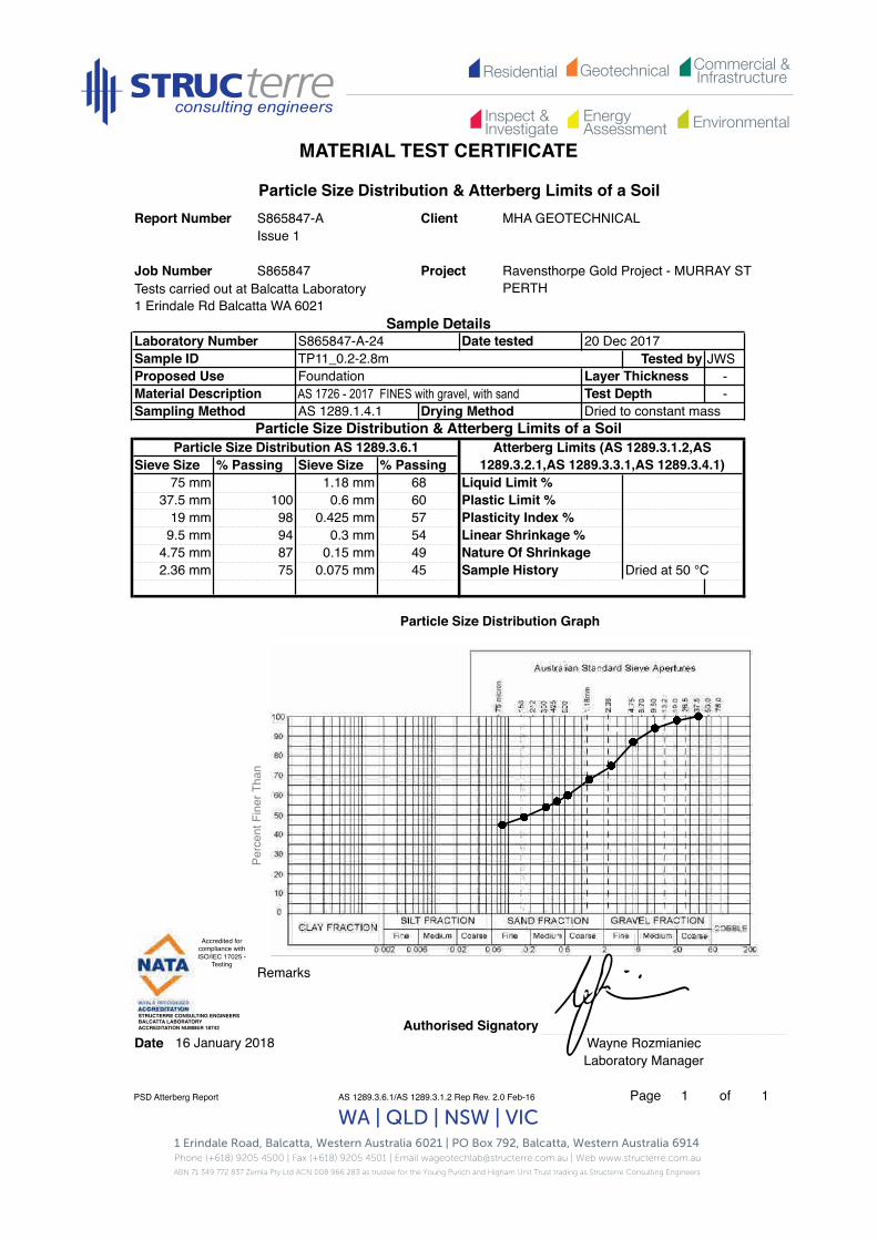
Residential Commercial &InfrastructureGeotechnical
EnergyAssessment
Inspect &Investigate Environmental
MATERIAL TEST CERTIFICATE
1 Erindale Road, Balcatta, Western Australia 6021 | PO Box 792, Balcatta, Western Australia 6914 Phone (+618) 9205 4500 | Fax (+618) 9205 4501 | Email [email protected] | Web www.structerre.com.auABN 71 349 772 837 Zemla Pty Ltd ACN 008 966 283 as trustee for the Young Purich and Higham Unit Trust trading as Structerre Consulting Engineers
WA | QLD | NSW | VIC
Tests carried out at Balcatta Laboratory1 Erindale Rd Balcatta WA 6021
Tested by JWS--
Remarks
Authorised SignatoryDate Wayne Rozmianiec
Laboratory Manager
PSD Atterberg Report AS 1289.3.6.1/AS 1289.3.1.2 Rep Rev. 2.0 Feb-16 Page 1 of 1
Liquid Limit %Plastic Limit %Plasticity Index %Linear Shrinkage %Nature Of Shrinkage
Particle Size Distribution & Atterberg Limits of a SoilAtterberg Limits (AS 1289.3.1.2,AS
1289.3.2.1,AS 1289.3.3.1,AS 1289.3.4.1)
20 Dec 2017Sample ID TP11_0.2-2.8m
Foundation
Laboratory Number S865847-A-24 Date tested
Particle Size Distribution & Atterberg Limits of a SoilReport Number S865847-A Client MHA GEOTECHNICAL
Issue 1
Ravensthorpe Gold Project - MURRAY ST PERTH
0.6 mm 60
Particle Size Distribution AS 1289.3.6.1Sieve Size % Passing Sieve Size % Passing
Layer Thickness
Job Number
Sample History
Project
Sample Details
Sampling Method AS 1289.1.4.1 Drying Method Dried to constant mass
Proposed UseMaterial Description Test DepthAS 1726 - 2017 FINES with gravel, with sand
75 mm 1.18 mm 6837.5 mm 100
Dried at 50 °C
19 mm 98 0.425 mm 579.5 mm 94 0.3 mm 54
4.75 mm 87 0.15 mm 492.36 mm 75 0.075 mm 45
16 January 2018
Particle Size Distribution Graph
S865847Pe
rcen
t Fin
er T
han
Accredited for compliance with ISO/IEC 17025 -
Testing!
STRUCTERRE CONSULTING ENGINEERS !BALCATTA LABORATORY!ACCREDITATION NUMBER 18742!

Residential Commercial &InfrastructureGeotechnical
EnergyAssessment
Inspect &Investigate Environmental
MATERIAL TEST CERTIFICATE
1 Erindale Road, Balcatta, Western Australia 6021 | PO Box 792, Balcatta, Western Australia 6914 Phone (+618) 9205 4500 | Fax (+618) 9205 4501 | Email [email protected] | Web www.structerre.com.auABN 71 349 772 837 Zemla Pty Ltd ACN 008 966 283 as trustee for the Young Purich and Higham Unit Trust trading as Structerre Consulting Engineers
WA | QLD | NSW | VIC
Tests carried out at Balcatta Laboratory1 Erindale Rd Balcatta WA 6021
Tested by JWS--
Remarks
Authorised SignatoryDate Wayne Rozmianiec
Laboratory Manager
PSD Atterberg Report AS 1289.3.6.1/AS 1289.3.1.2 Rep Rev. 2.0 Feb-16 Page 1 of 1
Sample History Dried at 50 °C
Liquid Limit %Plastic Limit %Plasticity Index %Linear Shrinkage %Nature Of Shrinkage
0.3 mm 54
75 mm 1.18 mm 6437.5 mm 100 0.6 mm 58
Sample Details
Particle Size Distribution & Atterberg Limits of a SoilReport Number S865847-A Client MHA GEOTECHNICAL
Issue 1
Proposed UseMaterial Description
Laboratory Number S865847-A-25 Date tested 20 Dec 2017Sample ID TP12_0.1-2.8m
Layer ThicknessTest Depth
FoundationAS 1726 - 2017 FINES with gravel, with sand
Particle Size Distribution AS 1289.3.6.1Sieve Size % Passing Sieve Size % Passing
Sampling Method AS 1289.1.4.1 Drying Method Dried to constant massParticle Size Distribution & Atterberg Limits of a Soil
Atterberg Limits (AS 1289.3.1.2,AS 1289.3.2.1,AS 1289.3.3.1,AS 1289.3.4.1)
4.75 mm 89 0.15 mm 502.36 mm 72 0.075 mm 50
19 mm 96 0.425 mm 569.5 mm 96
16 January 2018
Particle Size Distribution Graph
Job Number S865847 Project Ravensthorpe Gold Project - MURRAY ST PERTH
Perc
ent F
iner
Tha
n
Accredited for compliance with ISO/IEC 17025 -
Testing!
STRUCTERRE CONSULTING ENGINEERS !BALCATTA LABORATORY!ACCREDITATION NUMBER 18742!

Residential Commercial &InfrastructureGeotechnical
EnergyAssessment
Inspect &Investigate Environmental
MATERIAL TEST CERTIFICATE
1 Erindale Road, Balcatta, Western Australia 6021 | PO Box 792, Balcatta, Western Australia 6914 Phone (+618) 9205 4500 | Fax (+618) 9205 4501 | Email [email protected] | Web www.structerre.com.auABN 71 349 772 837 Zemla Pty Ltd ACN 008 966 283 as trustee for the Young Purich and Higham Unit Trust trading as Structerre Consulting Engineers
WA | QLD | NSW | VIC
Tests carried out at Balcatta Laboratory1 Erindale Rd Balcatta WA 6021
Tested by JWS--
Remarks
Authorised SignatoryDate Wayne Rozmianiec
Laboratory Manager
PSD Atterberg Report AS 1289.3.6.1/AS 1289.3.1.2 Rep Rev. 2.0 Feb-16 Page 1 of 1
Atterberg Limits (AS 1289.3.1.2,AS 1289.3.2.1,AS 1289.3.3.1,AS 1289.3.4.1)
Liquid Limit %Plastic Limit %Plasticity Index %Linear Shrinkage %Nature Of ShrinkageSample History Dried at 50 °C
Particle Size Distribution & Atterberg Limits of a SoilReport Number S865847-A Client MHA GEOTECHNICAL
Issue 1
Laboratory Number S865847-A-26 Date tested 20 Dec 2017Sample ID TP13_0.1-0.7m
Project Ravensthorpe Gold Project - MURRAY ST PERTH
Sample Details
AS 1289.1.4.1 Drying Method Dried to constant massParticle Size Distribution & Atterberg Limits of a Soil
Proposed UseMaterial Description
Layer ThicknessTest Depth
FoundationAS 1726 - 2017 Gravelly FINES trace sand
2.36 mm 65 0.075 mm 54
19 mm 90 0.425 mm 599.5 mm 90 0.3 mm 58
4.75 mm 83 0.15 mm 57
75 mm 100 1.18 mm 6337.5 mm 90 0.6 mm 60
Particle Size Distribution AS 1289.3.6.1Sieve Size % Passing Sieve Size % Passing
Sampling Method
16 January 2018
Particle Size Distribution Graph
Job Number S865847
Perc
ent F
iner
Tha
n
Accredited for compliance with ISO/IEC 17025 -
Testing!
STRUCTERRE CONSULTING ENGINEERS !BALCATTA LABORATORY!ACCREDITATION NUMBER 18742!

Residential Commercial &InfrastructureGeotechnical
EnergyAssessment
Inspect &Investigate Environmental
MATERIAL TEST CERTIFICATE
1 Erindale Road, Balcatta, Western Australia 6021 | PO Box 792, Balcatta, Western Australia 6914 Phone (+618) 9205 4500 | Fax (+618) 9205 4501 | Email [email protected] | Web www.structerre.com.auABN 71 349 772 837 Zemla Pty Ltd ACN 008 966 283 as trustee for the Young Purich and Higham Unit Trust trading as Structerre Consulting Engineers
WA | QLD | NSW | VIC
Tests carried out at Balcatta Laboratory1 Erindale Rd Balcatta WA 6021
Tested by CF-
Remarks
Authorised SignatoryDate Wayne Rozmianiec
Laboratory Manager
PSD Atterberg Report AS 1289.3.6.1/AS 1289.3.1.2 Rep Rev. 2.0 Feb-16 Page 1 of 1
Sample History Dried at 50 °C
Liquid Limit % Not obtainedPlastic Limit % Not obtainedPlasticity Index % NPLinear Shrinkage % 2.0Nature Of Shrinkage Normal
Particle Size Distribution & Atterberg Limits of a SoilReport Number S865847-A Client MHA GEOTECHNICAL
Issue 1
Laboratory Number S865847-A-27 Date tested 11 December 2018Sample ID TP13_0.7-2.8m
Project Ravensthorpe Gold Project - MURRAY ST PERTH
Sample Details
Sampling Method AS 1289.1.4.1 Drying Method Dried to constant massParticle Size Distribution & Atterberg Limits of a Soil
Atterberg Limits (AS 1289.3.1.2,AS 1289.3.2.1,AS 1289.3.3.1,AS 1289.3.4.1)
Proposed UseMaterial Description
Layer ThicknessTest Depth
FoundationClayey Silt
75 mm 1.18 mm37.5 mm 0.6 mm
Particle Size Distribution AS 1289.3.6.1Sieve Size % Passing Sieve Size % Passing
2.36 mm 0.075 mm
19 mm 0.425 mm9.5 mm 0.3 mm
16 January 2018
4.75 mm 0.15 mm
Particle Size Distribution Graph
Job Number S865847Pe
rcen
t Fin
er T
han
Accredited for compliance with ISO/IEC 17025 -
Testing!
STRUCTERRE CONSULTING ENGINEERS !BALCATTA LABORATORY!ACCREDITATION NUMBER 18742!

Residential Commercial &InfrastructureGeotechnical
EnergyAssessment
Inspect &Investigate Environmental
MATERIAL TEST CERTIFICATE
1 Erindale Road, Balcatta, Western Australia 6021 | PO Box 792, Balcatta, Western Australia 6914 Phone (+618) 9205 4500 | Fax (+618) 9205 4501 | Email [email protected] | Web www.structerre.com.auABN 71 349 772 837 Zemla Pty Ltd ACN 008 966 283 as trustee for the Young Purich and Higham Unit Trust trading as Structerre Consulting Engineers
WA | QLD | NSW | VIC
Tests carried out at Balcatta Laboratory1 Erindale Rd Balcatta WA 6021
Tested by JWS--
Remarks
Authorised SignatoryDate Wayne Rozmianiec
Laboratory Manager
PSD Atterberg Report AS 1289.3.6.1/AS 1289.3.1.2 Rep Rev. 2.0 Feb-16 Page 1 of 1
Atterberg Limits (AS 1289.3.1.2,AS 1289.3.2.1,AS 1289.3.3.1,AS 1289.3.4.1)
Liquid Limit %Plastic Limit %Plasticity Index %Linear Shrinkage %Nature Of ShrinkageSample History Dried at 50 °C
Project Ravensthorpe Gold Project - MURRAY ST PERTH
Sample Details
Particle Size Distribution & Atterberg Limits of a SoilReport Number S865847-A Client MHA GEOTECHNICAL
Issue 1
Proposed UseMaterial Description
Laboratory Number S865847-A-28 Date tested 20 Dec 2017Sample ID TP14_0.2-1.0m
Layer ThicknessTest Depth
FoundationAS 1726 - 2017 SM Silty or clayey, gravelly SAND
Particle Size Distribution AS 1289.3.6.1Sieve Size % Passing Sieve Size % Passing
Sampling Method AS 1289.1.4.1 Drying Method Dried to constant massParticle Size Distribution & Atterberg Limits of a Soil
19 mm 94 0.425 mm 449.5 mm 84 0.3 mm 36
75 mm 100 1.18 mm 5337.5 mm 96 0.6 mm 47
16 January 2018
4.75 mm 71 0.15 mm 192.36 mm 59 0.075 mm 12
Particle Size Distribution Graph
Job Number S865847Pe
rcen
t Fin
er T
han
Accredited for compliance with ISO/IEC 17025 -
Testing!
STRUCTERRE CONSULTING ENGINEERS !BALCATTA LABORATORY!ACCREDITATION NUMBER 18742!

Residential Commercial &InfrastructureGeotechnical
EnergyAssessment
Inspect &Investigate Environmental
MATERIAL TEST CERTIFICATE
1 Erindale Road, Balcatta, Western Australia 6021 | PO Box 792, Balcatta, Western Australia 6914 Phone (+618) 9205 4500 | Fax (+618) 9205 4501 | Email [email protected] | Web www.structerre.com.auABN 71 349 772 837 Zemla Pty Ltd ACN 008 966 283 as trustee for the Young Purich and Higham Unit Trust trading as Structerre Consulting Engineers
WA | QLD | NSW | VIC
Tests carried out at Balcatta Laboratory1 Erindale Rd Balcatta WA 6021
Tested by JWS--
Remarks
Authorised SignatoryDate Wayne Rozmianiec
Laboratory Manager
PSD Atterberg Report AS 1289.3.6.1/AS 1289.3.1.2 Rep Rev. 2.0 Feb-16 Page 1 of 1
Sample History Dried at 50 °C
Liquid Limit %Plastic Limit %Plasticity Index %Linear Shrinkage %Nature Of Shrinkage
Project Ravensthorpe Gold Project - MURRAY ST PERTH
Sample Details
Particle Size Distribution & Atterberg Limits of a SoilReport Number S865847-A Client MHA GEOTECHNICAL
Issue 1
Job Number S865847
Proposed UseMaterial Description
Laboratory Number S865847-A-29 Date tested 20 Dec 2017Sample ID TP15_0.2-2.7m
Layer ThicknessTest Depth
FoundationAS 1726 - 2017 Sandy FINES with gravel
Sieve Size % Passing Sieve Size % Passing
Sampling Method AS 1289.1.4.1 Drying Method Dried to constant massParticle Size Distribution & Atterberg Limits of a Soil
Atterberg Limits (AS 1289.3.1.2,AS 1289.3.2.1,AS 1289.3.3.1,AS 1289.3.4.1)
Particle Size Distribution AS 1289.3.6.1
52
75 mm 1.18 mm 7237.5 mm 100 0.6 mm 61
0.3 mm4.75 mm 95 0.15 mm 462.36 mm 84 0.075 mm 43
19 mm 99 0.425 mm 579.5 mm 99
16 January 2018
Particle Size Distribution Graph
Perc
ent F
iner
Tha
n
Accredited for compliance with ISO/IEC 17025 -
Testing!
STRUCTERRE CONSULTING ENGINEERS !BALCATTA LABORATORY!ACCREDITATION NUMBER 18742!

Residential Commercial &InfrastructureGeotechnical
EnergyAssessment
Inspect &Investigate Environmental
MATERIAL TEST CERTIFICATE
1 Erindale Road, Balcatta, Western Australia 6021 | PO Box 792, Balcatta, Western Australia 6914 Phone (+618) 9205 4500 | Fax (+618) 9205 4501 | Email [email protected] | Web www.structerre.com.auABN 71 349 772 837 Zemla Pty Ltd ACN 008 966 283 as trustee for the Young Purich and Higham Unit Trust trading as Structerre Consulting Engineers
WA | QLD | NSW | VIC
Tests carried out at Balcatta Laboratory1 Erindale Rd Balcatta WA 6021
Tested by JWS--
Remarks
Authorised SignatoryDate Wayne Rozmianiec
Laboratory Manager
PSD Atterberg Report AS 1289.3.6.1/AS 1289.3.1.2 Rep Rev. 2.0 Feb-16 Page 1 of 1
Atterberg Limits (AS 1289.3.1.2,AS 1289.3.2.1,AS 1289.3.3.1,AS 1289.3.4.1)
Liquid Limit %Plastic Limit %Plasticity Index %Linear Shrinkage %Nature Of ShrinkageSample History Dried at 50 °C
Particle Size Distribution & Atterberg Limits of a SoilReport Number S865847-A Client MHA GEOTECHNICAL
Issue 1
Laboratory Number S865847-A-30 Date tested 20 Dec 2017Sample ID TP16_0.2-0.6m
Project Ravensthorpe Gold Project - MURRAY ST PERTH
Sample Details
Job Number S865847
Sampling Method AS 1289.1.4.1 Drying Method Dried to constant massParticle Size Distribution & Atterberg Limits of a Soil
Proposed UseMaterial Description
Layer ThicknessTest Depth
FoundationAS 1726 - 2017 FINES with gravel, with sand
75 mm 1.18 mm 6937.5 mm 100 0.6 mm 67
Particle Size Distribution AS 1289.3.6.1Sieve Size % Passing Sieve Size % Passing
592.36 mm 73 0.075 mm 54
19 mm 98 0.425 mm 669.5 mm 98 0.3 mm 64
16 January 2018
4.75 mm 93 0.15 mm
Particle Size Distribution Graph
Perc
ent F
iner
Tha
n
Accredited for compliance with ISO/IEC 17025 -
Testing!
STRUCTERRE CONSULTING ENGINEERS !BALCATTA LABORATORY!ACCREDITATION NUMBER 18742!

Residential Commercial &InfrastructureGeotechnical
EnergyAssessment
Inspect &Investigate Environmental
Material Test Certificate
1 Erindale Road, Balcatta, Western Australia 6021 | PO Box 792, Balcatta, Western Australia 6914 Phone (+618) 9205 4500 | Fax (+618) 9205 4501 | Email [email protected] | Web www.structerre.com.auABN 71 349 772 837 Zemla Pty Ltd ACN 008 966 283 as trustee for the Young Purich and Higham Unit Trust trading as Structerre Consulting Engineers
WA | QLD | NSW | VIC
Tests carried out at Balcatta Laboratory1 Erindale Rd Balcatta WA 6021
Maximum Dry Density t/m3 Optimum Moisture Content %% Retained 37.5mm Sieve
Remarks
Authorised SignatoryDate Wayne Rozmianiec
Laboratory Manager
MDD Report AS 1289.5.1.1 R Rev. 2.0 Feb-16 Page 1 of 1
% Retained 19mm Sieve16.0
0Curing Time (hrs) Method used to determine LL Visual/Tactile
AS 1289.1.2.1 Site Selection Method AS 1289.1.4.1
AS 1289.2.1.1 Determination of the moisture content of a soil - Oven drying method (standard method)
1.690
2
16 January 2018
AS 1289.5.1.1 Determination of the dry density/moisture content relation of a soil using standard compactive effort
Report Number S865847-A Client MHA GEOTECHNICALIssue 1
Project Ravensthorpe Gold Project - MURRAY ST PERTH
Sample DetailsLaboratory Number S865847-A-27 Date tested 13 Dec 2017Sample ID TP13_0.7-2.8mProposed Use FoundationMaterial Description SILT with ClaySampling Method
S865847Job Number
1.4
1.5
1.6
1.7
1.8
1.9
2.0
2.1
2.2
2.3
2.4
2.5
0 2 4 6 8 10 12 14 16 18 20 22 24
Dry
Dens
ity t/
m3
Moisture Content %
Accredited for compliance with ISO/IEC 17025 -
Testing!
STRUCTERRE CONSULTING ENGINEERS !BALCATTA LABORATORY!ACCREDITATION NUMBER 18742!

Residential Commercial &InfrastructureGeotechnical
EnergyAssessment
Inspect &Investigate Environmental
Material Test Certificate
1 Erindale Road, Balcatta, Western Australia 6021 | PO Box 792, Balcatta, Western Australia 6914 Phone (+618) 9205 4500 | Fax (+618) 9205 4501 | Email [email protected] | Web www.structerre.com.auABN 71 349 772 837 Zemla Pty Ltd ACN 008 966 283 as trustee for the Young Purich and Higham Unit Trust trading as Structerre Consulting Engineers
WA | QLD | NSW | VIC
Tests carried out at Balcatta Laboratory1 Erindale Rd Balcatta WA 6021
--
Sample ID Emerson Class No.
Authorised SignatoryDate Wayne Rozmianiec
Laboratory ManagerNDM Spec 201 Report
AS 1289.5.4.3 Rep2 Rev. 2.0 Feb-16 Page 1 of 1
TP13_0.7-2.8m 2
16 January 2018
S865847-A-27
Sample No.
Layer Thickness mmTest Depth mm
Sampling Method Client Site Selection Method Client
Proposed Use FoundationVariousMaterial Description
Report NumberIssue 1S865847-A
AS 1289.3.8.1 Determination of the Emerson class number of a soil
Client MHA GEOTECHNICAL
Project Ravensthorpe Gold Project - MURRAY ST PERTH
Sample Details
Job Number S865847
Lab NoSample ID Time Tested -
S865847-A-
Date tested 12 December 2017
Accredited for compliance with ISO/IEC 17025 -
Testing!
STRUCTERRE CONSULTING ENGINEERS !BALCATTA LABORATORY!ACCREDITATION NUMBER 18742!
Accredited for compliance with ISO/IEC 17025 -
Testing!
STRUCTERRE CONSULTING ENGINEERS !BALCATTA LABORATORY!ACCREDITATION NUMBER 18742!

Residential Commercial &InfrastructureGeotechnical
EnergyAssessment
Inspect &Investigate Environmental
Material Test Certificate
1 Erindale Road, Balcatta, Western Australia 6021 | PO Box 792, Balcatta, Western Australia 6914 Phone (+618) 9205 4500 | Fax (+618) 9205 4501 | Email [email protected] | Web www.structerre.com.auABN 71 349 772 837 Zemla Pty Ltd ACN 008 966 283 as trustee for the Young Purich and Higham Unit Trust trading as Structerre Consulting Engineers
WA | QLD | NSW | VIC
Tests carried out at Balcatta Laboratory1 Erindale Rd Balcatta WA 6021
--
Sample ID Moisture Content %
Remarks
Authorised SignatoryDate
Moisture Content AS 1289.5.4.1 Rep1 Rev. 2.0 Feb-16 Page 1 of 1
Lab No S865847-A Date tested 1 December 2007
AS 1289.2.1.1 Determination of the moisture content of a soil - Oven drying method (standard method)
Report Number S865847-A Client MHA GEOTECHNICALIssue 1
Job Number S865847 Project Ravensthorpe Gold Project - MURRAY ST PERTH
Sample Details
Sample ID - Time Tested -Proposed Use Foundation Layer Thickness mmMaterial Description Various Test Depth mmSampling Method Client Site Selection Method Client
Sample No.
S865847-A-21 TP09_0.1-0.2m 5.9
S865847-A-22 TP09_0.2-2.2m 6.5
S865847-A-23 TP10_0.1-2.5m 10.6
S865847-A-24 TP11_0.2-2.8m 13.4
S865847-A-25 TP12_0.1-2.8m 15.1
S865847-A-26 TP13_0.1-0.7m 9.9
S865847-A-27 TP13_0.7-2.8m 10.8
S865847-A-28 TP14_0.2-1.0m 6.3
S865847-A-29 TP15_0.2-2.7m 10.0
16 January 2018 Wayne RozmianiecLaboratory Manager
S865847-A-30 TP16_0.2-0.6m 12.9
Accredited for compliance with ISO/IEC 17025 -
Testing!
STRUCTERRE CONSULTING ENGINEERS !BALCATTA LABORATORY!ACCREDITATION NUMBER 18742!

Residential Commercial &InfrastructureGeotechnical
EnergyAssessment
Inspect &Investigate Environmental
MATERIAL TEST CERTIFICATE
1 Erindale Road, Balcatta, Western Australia 6021 | PO Box 792, Balcatta, Western Australia 6914 Phone (+618) 9205 4500 | Fax (+618) 9205 4501 | Email [email protected] | Web www.structerre.com.auABN 71 349 772 837 Zemla Pty Ltd ACN 008 966 283 as trustee for the Young Purich and Higham Unit Trust trading as Structerre Consulting Engineers
WA | QLD | NSW | VIC
Tests carried out at Balcatta Laboratory1 Erindale Rd Balcatta WA 6021
Tested by JWSLayer Thickness -Test Depth -
Remarks
Authorised SignatoryDate Wayne Rozmianiec
Laboratory Manager
PSD Atterberg Report AS 1289.3.6.1/AS 1289.3.1.2 Rep Rev. 2.0 Feb-16 Page 1 of 1
Particle Size Distribution & Atterberg Limits of a SoilReport Number S865847-A Client MHA GEOTECHNICAL
Issue 1
Project Ravensthorpe Gold Project - MURRAY ST PERTH
Job Number S865847
Material DescriptionSampling Method AS 1289.1.4.1
AS 1726 - 2017 FINES with gravel, with sand
Sample DetailsLaboratory Number S865847-A-21 Date tested 13 Dec 2017Sample IDProposed Use
TP09_0.1-0.2m
37.5 mm19 mm
Atterberg Limits (AS 1289.3.1.2,AS 1289.3.2.1,AS 1289.3.3.1,AS 1289.3.4.1)
Liquid Limit %
Foundation
Particle Size Distribution AS 1289.3.6.1Sieve Size % Passing Sieve Size % Passing
1.18 mm
96
Drying Method Dried to constant massParticle Size Distribution & Atterberg Limits of a Soil
80747269
9285 0.075 mm Dried at 50 °C
0.6 mm0.425 mm99
75 mm
9.5 mm4.75 mm2.36 mm
100 Plastic Limit %Plasticity Index %Linear Shrinkage %Nature Of ShrinkageSample History
16 January 2018
Particle Size Distribution Graph
0.3 mm0.15 mm
5663
Perc
ent F
iner
Tha
n
Accredited for compliance with ISO/IEC 17025 -
Testing!
STRUCTERRE CONSULTING ENGINEERS !BALCATTA LABORATORY!ACCREDITATION NUMBER 18742!

Residential Commercial &InfrastructureGeotechnical
EnergyAssessment
Inspect &Investigate Environmental
MATERIAL TEST CERTIFICATE
1 Erindale Road, Balcatta, Western Australia 6021 | PO Box 792, Balcatta, Western Australia 6914 Phone (+618) 9205 4500 | Fax (+618) 9205 4501 | Email [email protected] | Web www.structerre.com.auABN 71 349 772 837 Zemla Pty Ltd ACN 008 966 283 as trustee for the Young Purich and Higham Unit Trust trading as Structerre Consulting Engineers
WA | QLD | NSW | VIC
Tests carried out at Balcatta Laboratory1 Erindale Rd Balcatta WA 6021
Tested by JWS--
Remarks
Authorised SignatoryDate Wayne Rozmianiec
Laboratory Manager
PSD Atterberg Report AS 1289.3.6.1/AS 1289.3.1.2 Rep Rev. 2.0 Feb-16 Page 1 of 1
Sample DetailsLaboratory Number S865847-A-22 Date tested 13 Dec 2017Sample ID TP09_0.2-2.2mProposed UseMaterial Description
Nature Of Shrinkage
Plasticity Index %Linear Shrinkage %
Dried to constant mass
Atterberg Limits (AS 1289.3.1.2,AS 1289.3.2.1,AS 1289.3.3.1,AS 1289.3.4.1)
2.36 mm 79
Particle Size Distribution & Atterberg Limits of a SoilParticle Size Distribution AS 1289.3.6.1
0.075 mm
19 mm 100 0.425 mm9.5 mm 98 0.3 mm
4.75 mm 90 0.15 mm
37.5 mm 0.6 mm
Sample History Dried at 50 °C44
595649
7062
Sampling Method AS 1289.1.4.1 Drying Method
Layer ThicknessTest Depth
FoundationAS 1726 - 2017 Sandy FINES with gravel
Sieve Size % Passing Sieve Size % Passing
Particle Size Distribution & Atterberg Limits of a SoilReport Number S865847-A Client MHA GEOTECHNICAL
Issue 1
Project Ravensthorpe Gold Project - MURRAY ST PERTH
Job Number S865847
16 January 2018
Particle Size Distribution Graph
Liquid Limit %Plastic Limit %
75 mm 1.18 mm
Perc
ent F
iner
Tha
n
Accredited for compliance with ISO/IEC 17025 -
Testing!
STRUCTERRE CONSULTING ENGINEERS !BALCATTA LABORATORY!ACCREDITATION NUMBER 18742!

Residential Commercial &InfrastructureGeotechnical
EnergyAssessment
Inspect &Investigate Environmental
MATERIAL TEST CERTIFICATE
1 Erindale Road, Balcatta, Western Australia 6021 | PO Box 792, Balcatta, Western Australia 6914 Phone (+618) 9205 4500 | Fax (+618) 9205 4501 | Email [email protected] | Web www.structerre.com.auABN 71 349 772 837 Zemla Pty Ltd ACN 008 966 283 as trustee for the Young Purich and Higham Unit Trust trading as Structerre Consulting Engineers
WA | QLD | NSW | VIC
Tests carried out at Balcatta Laboratory1 Erindale Rd Balcatta WA 6021
Tested by JWSLayer Thickness -
-
Remarks
Authorised SignatoryDate Wayne Rozmianiec
Laboratory Manager
PSD Atterberg Report AS 1289.3.6.1/AS 1289.3.1.2 Rep Rev. 2.0 Feb-16 Page 1 of 1
Material Description
Particle Size Distribution AS 1289.3.6.1Sieve Size % Passing Sieve Size % Passing
Sampling Method AS 1289.1.4.1 Drying Method Dried to constant massParticle Size Distribution & Atterberg Limits of a Soil
Atterberg Limits (AS 1289.3.1.2,AS 1289.3.2.1,AS 1289.3.3.1,AS 1289.3.4.1)
9.5 mm 80 0.3 mm 44
75 mm
Proposed Use
Laboratory Number S865847-A-23 Date tested 20 Dec 2017Sample ID TP10_0.1-2.5m
Nature Of Shrinkage
Project Ravensthorpe Gold Project - MURRAY ST PERTH
Sample Details
Particle Size Distribution & Atterberg Limits of a SoilReport Number S865847-A Client MHA GEOTECHNICAL
Issue 1
Job Number
1.18 mm 5537.5 mm 85 0.6 mm 49 Plastic Limit %
Linear Shrinkage %
FoundationAS 1726 - 2017 Gravelly FINES with sand Test Depth
S865847
100
4.75 mm 75 0.15 mm 402.36 mm 64 0.075 mm 38 Dried at 50 °C
19 mm 81 0.425 mm 46
Liquid Limit %
Plasticity Index %
16 January 2018
Particle Size Distribution Graph
Sample History
Perc
ent F
iner
Tha
n
Accredited for compliance with ISO/IEC 17025 -
Testing!
STRUCTERRE CONSULTING ENGINEERS !BALCATTA LABORATORY!ACCREDITATION NUMBER 18742!

Residential Commercial &InfrastructureGeotechnical
EnergyAssessment
Inspect &Investigate Environmental
MATERIAL TEST CERTIFICATE
1 Erindale Road, Balcatta, Western Australia 6021 | PO Box 792, Balcatta, Western Australia 6914 Phone (+618) 9205 4500 | Fax (+618) 9205 4501 | Email [email protected] | Web www.structerre.com.auABN 71 349 772 837 Zemla Pty Ltd ACN 008 966 283 as trustee for the Young Purich and Higham Unit Trust trading as Structerre Consulting Engineers
WA | QLD | NSW | VIC
Tests carried out at Balcatta Laboratory1 Erindale Rd Balcatta WA 6021
Tested by JWS--
Remarks
Authorised SignatoryDate Wayne Rozmianiec
Laboratory Manager
PSD Atterberg Report AS 1289.3.6.1/AS 1289.3.1.2 Rep Rev. 2.0 Feb-16 Page 1 of 1
Liquid Limit %Plastic Limit %Plasticity Index %Linear Shrinkage %Nature Of Shrinkage
Particle Size Distribution & Atterberg Limits of a SoilAtterberg Limits (AS 1289.3.1.2,AS
1289.3.2.1,AS 1289.3.3.1,AS 1289.3.4.1)
20 Dec 2017Sample ID TP11_0.2-2.8m
Foundation
Laboratory Number S865847-A-24 Date tested
Particle Size Distribution & Atterberg Limits of a SoilReport Number S865847-A Client MHA GEOTECHNICAL
Issue 1
Ravensthorpe Gold Project - MURRAY ST PERTH
0.6 mm 60
Particle Size Distribution AS 1289.3.6.1Sieve Size % Passing Sieve Size % Passing
Layer Thickness
Job Number
Sample History
Project
Sample Details
Sampling Method AS 1289.1.4.1 Drying Method Dried to constant mass
Proposed UseMaterial Description Test DepthAS 1726 - 2017 FINES with gravel, with sand
75 mm 1.18 mm 6837.5 mm 100
Dried at 50 °C
19 mm 98 0.425 mm 579.5 mm 94 0.3 mm 54
4.75 mm 87 0.15 mm 492.36 mm 75 0.075 mm 45
16 January 2018
Particle Size Distribution Graph
S865847Pe
rcen
t Fin
er T
han
Accredited for compliance with ISO/IEC 17025 -
Testing!
STRUCTERRE CONSULTING ENGINEERS !BALCATTA LABORATORY!ACCREDITATION NUMBER 18742!

Residential Commercial &InfrastructureGeotechnical
EnergyAssessment
Inspect &Investigate Environmental
MATERIAL TEST CERTIFICATE
1 Erindale Road, Balcatta, Western Australia 6021 | PO Box 792, Balcatta, Western Australia 6914 Phone (+618) 9205 4500 | Fax (+618) 9205 4501 | Email [email protected] | Web www.structerre.com.auABN 71 349 772 837 Zemla Pty Ltd ACN 008 966 283 as trustee for the Young Purich and Higham Unit Trust trading as Structerre Consulting Engineers
WA | QLD | NSW | VIC
Tests carried out at Balcatta Laboratory1 Erindale Rd Balcatta WA 6021
Tested by JWS--
Remarks
Authorised SignatoryDate Wayne Rozmianiec
Laboratory Manager
PSD Atterberg Report AS 1289.3.6.1/AS 1289.3.1.2 Rep Rev. 2.0 Feb-16 Page 1 of 1
Sample History Dried at 50 °C
Liquid Limit %Plastic Limit %Plasticity Index %Linear Shrinkage %Nature Of Shrinkage
0.3 mm 54
75 mm 1.18 mm 6437.5 mm 100 0.6 mm 58
Sample Details
Particle Size Distribution & Atterberg Limits of a SoilReport Number S865847-A Client MHA GEOTECHNICAL
Issue 1
Proposed UseMaterial Description
Laboratory Number S865847-A-25 Date tested 20 Dec 2017Sample ID TP12_0.1-2.8m
Layer ThicknessTest Depth
FoundationAS 1726 - 2017 FINES with gravel, with sand
Particle Size Distribution AS 1289.3.6.1Sieve Size % Passing Sieve Size % Passing
Sampling Method AS 1289.1.4.1 Drying Method Dried to constant massParticle Size Distribution & Atterberg Limits of a Soil
Atterberg Limits (AS 1289.3.1.2,AS 1289.3.2.1,AS 1289.3.3.1,AS 1289.3.4.1)
4.75 mm 89 0.15 mm 502.36 mm 72 0.075 mm 50
19 mm 96 0.425 mm 569.5 mm 96
16 January 2018
Particle Size Distribution Graph
Job Number S865847 Project Ravensthorpe Gold Project - MURRAY ST PERTH
Perc
ent F
iner
Tha
n
Accredited for compliance with ISO/IEC 17025 -
Testing!
STRUCTERRE CONSULTING ENGINEERS !BALCATTA LABORATORY!ACCREDITATION NUMBER 18742!

Residential Commercial &InfrastructureGeotechnical
EnergyAssessment
Inspect &Investigate Environmental
MATERIAL TEST CERTIFICATE
1 Erindale Road, Balcatta, Western Australia 6021 | PO Box 792, Balcatta, Western Australia 6914 Phone (+618) 9205 4500 | Fax (+618) 9205 4501 | Email [email protected] | Web www.structerre.com.auABN 71 349 772 837 Zemla Pty Ltd ACN 008 966 283 as trustee for the Young Purich and Higham Unit Trust trading as Structerre Consulting Engineers
WA | QLD | NSW | VIC
Tests carried out at Balcatta Laboratory1 Erindale Rd Balcatta WA 6021
Tested by JWS--
Remarks
Authorised SignatoryDate Wayne Rozmianiec
Laboratory Manager
PSD Atterberg Report AS 1289.3.6.1/AS 1289.3.1.2 Rep Rev. 2.0 Feb-16 Page 1 of 1
Atterberg Limits (AS 1289.3.1.2,AS 1289.3.2.1,AS 1289.3.3.1,AS 1289.3.4.1)
Liquid Limit %Plastic Limit %Plasticity Index %Linear Shrinkage %Nature Of ShrinkageSample History Dried at 50 °C
Particle Size Distribution & Atterberg Limits of a SoilReport Number S865847-A Client MHA GEOTECHNICAL
Issue 1
Laboratory Number S865847-A-26 Date tested 20 Dec 2017Sample ID TP13_0.1-0.7m
Project Ravensthorpe Gold Project - MURRAY ST PERTH
Sample Details
AS 1289.1.4.1 Drying Method Dried to constant massParticle Size Distribution & Atterberg Limits of a Soil
Proposed UseMaterial Description
Layer ThicknessTest Depth
FoundationAS 1726 - 2017 Gravelly FINES trace sand
2.36 mm 65 0.075 mm 54
19 mm 90 0.425 mm 599.5 mm 90 0.3 mm 58
4.75 mm 83 0.15 mm 57
75 mm 100 1.18 mm 6337.5 mm 90 0.6 mm 60
Particle Size Distribution AS 1289.3.6.1Sieve Size % Passing Sieve Size % Passing
Sampling Method
16 January 2018
Particle Size Distribution Graph
Job Number S865847
Perc
ent F
iner
Tha
n
Accredited for compliance with ISO/IEC 17025 -
Testing!
STRUCTERRE CONSULTING ENGINEERS !BALCATTA LABORATORY!ACCREDITATION NUMBER 18742!

Residential Commercial &InfrastructureGeotechnical
EnergyAssessment
Inspect &Investigate Environmental
MATERIAL TEST CERTIFICATE
1 Erindale Road, Balcatta, Western Australia 6021 | PO Box 792, Balcatta, Western Australia 6914 Phone (+618) 9205 4500 | Fax (+618) 9205 4501 | Email [email protected] | Web www.structerre.com.auABN 71 349 772 837 Zemla Pty Ltd ACN 008 966 283 as trustee for the Young Purich and Higham Unit Trust trading as Structerre Consulting Engineers
WA | QLD | NSW | VIC
Tests carried out at Balcatta Laboratory1 Erindale Rd Balcatta WA 6021
Tested by CF-
Remarks
Authorised SignatoryDate Wayne Rozmianiec
Laboratory Manager
PSD Atterberg Report AS 1289.3.6.1/AS 1289.3.1.2 Rep Rev. 2.0 Feb-16 Page 1 of 1
Sample History Dried at 50 °C
Liquid Limit % Not obtainedPlastic Limit % Not obtainedPlasticity Index % NPLinear Shrinkage % 2.0Nature Of Shrinkage Normal
Particle Size Distribution & Atterberg Limits of a SoilReport Number S865847-A Client MHA GEOTECHNICAL
Issue 1
Laboratory Number S865847-A-27 Date tested 11 December 2018Sample ID TP13_0.7-2.8m
Project Ravensthorpe Gold Project - MURRAY ST PERTH
Sample Details
Sampling Method AS 1289.1.4.1 Drying Method Dried to constant massParticle Size Distribution & Atterberg Limits of a Soil
Atterberg Limits (AS 1289.3.1.2,AS 1289.3.2.1,AS 1289.3.3.1,AS 1289.3.4.1)
Proposed UseMaterial Description
Layer ThicknessTest Depth
FoundationClayey Silt
75 mm 1.18 mm37.5 mm 0.6 mm
Particle Size Distribution AS 1289.3.6.1Sieve Size % Passing Sieve Size % Passing
2.36 mm 0.075 mm
19 mm 0.425 mm9.5 mm 0.3 mm
16 January 2018
4.75 mm 0.15 mm
Particle Size Distribution Graph
Job Number S865847Pe
rcen
t Fin
er T
han
Accredited for compliance with ISO/IEC 17025 -
Testing!
STRUCTERRE CONSULTING ENGINEERS !BALCATTA LABORATORY!ACCREDITATION NUMBER 18742!

Residential Commercial &InfrastructureGeotechnical
EnergyAssessment
Inspect &Investigate Environmental
MATERIAL TEST CERTIFICATE
1 Erindale Road, Balcatta, Western Australia 6021 | PO Box 792, Balcatta, Western Australia 6914 Phone (+618) 9205 4500 | Fax (+618) 9205 4501 | Email [email protected] | Web www.structerre.com.auABN 71 349 772 837 Zemla Pty Ltd ACN 008 966 283 as trustee for the Young Purich and Higham Unit Trust trading as Structerre Consulting Engineers
WA | QLD | NSW | VIC
Tests carried out at Balcatta Laboratory1 Erindale Rd Balcatta WA 6021
Tested by JWS--
Remarks
Authorised SignatoryDate Wayne Rozmianiec
Laboratory Manager
PSD Atterberg Report AS 1289.3.6.1/AS 1289.3.1.2 Rep Rev. 2.0 Feb-16 Page 1 of 1
Atterberg Limits (AS 1289.3.1.2,AS 1289.3.2.1,AS 1289.3.3.1,AS 1289.3.4.1)
Liquid Limit %Plastic Limit %Plasticity Index %Linear Shrinkage %Nature Of ShrinkageSample History Dried at 50 °C
Project Ravensthorpe Gold Project - MURRAY ST PERTH
Sample Details
Particle Size Distribution & Atterberg Limits of a SoilReport Number S865847-A Client MHA GEOTECHNICAL
Issue 1
Proposed UseMaterial Description
Laboratory Number S865847-A-28 Date tested 20 Dec 2017Sample ID TP14_0.2-1.0m
Layer ThicknessTest Depth
FoundationAS 1726 - 2017 SM Silty or clayey, gravelly SAND
Particle Size Distribution AS 1289.3.6.1Sieve Size % Passing Sieve Size % Passing
Sampling Method AS 1289.1.4.1 Drying Method Dried to constant massParticle Size Distribution & Atterberg Limits of a Soil
19 mm 94 0.425 mm 449.5 mm 84 0.3 mm 36
75 mm 100 1.18 mm 5337.5 mm 96 0.6 mm 47
16 January 2018
4.75 mm 71 0.15 mm 192.36 mm 59 0.075 mm 12
Particle Size Distribution Graph
Job Number S865847Pe
rcen
t Fin
er T
han
Accredited for compliance with ISO/IEC 17025 -
Testing!
STRUCTERRE CONSULTING ENGINEERS !BALCATTA LABORATORY!ACCREDITATION NUMBER 18742!

Residential Commercial &InfrastructureGeotechnical
EnergyAssessment
Inspect &Investigate Environmental
MATERIAL TEST CERTIFICATE
1 Erindale Road, Balcatta, Western Australia 6021 | PO Box 792, Balcatta, Western Australia 6914 Phone (+618) 9205 4500 | Fax (+618) 9205 4501 | Email [email protected] | Web www.structerre.com.auABN 71 349 772 837 Zemla Pty Ltd ACN 008 966 283 as trustee for the Young Purich and Higham Unit Trust trading as Structerre Consulting Engineers
WA | QLD | NSW | VIC
Tests carried out at Balcatta Laboratory1 Erindale Rd Balcatta WA 6021
Tested by JWS--
Remarks
Authorised SignatoryDate Wayne Rozmianiec
Laboratory Manager
PSD Atterberg Report AS 1289.3.6.1/AS 1289.3.1.2 Rep Rev. 2.0 Feb-16 Page 1 of 1
Sample History Dried at 50 °C
Liquid Limit %Plastic Limit %Plasticity Index %Linear Shrinkage %Nature Of Shrinkage
Project Ravensthorpe Gold Project - MURRAY ST PERTH
Sample Details
Particle Size Distribution & Atterberg Limits of a SoilReport Number S865847-A Client MHA GEOTECHNICAL
Issue 1
Job Number S865847
Proposed UseMaterial Description
Laboratory Number S865847-A-29 Date tested 20 Dec 2017Sample ID TP15_0.2-2.7m
Layer ThicknessTest Depth
FoundationAS 1726 - 2017 Sandy FINES with gravel
Sieve Size % Passing Sieve Size % Passing
Sampling Method AS 1289.1.4.1 Drying Method Dried to constant massParticle Size Distribution & Atterberg Limits of a Soil
Atterberg Limits (AS 1289.3.1.2,AS 1289.3.2.1,AS 1289.3.3.1,AS 1289.3.4.1)
Particle Size Distribution AS 1289.3.6.1
52
75 mm 1.18 mm 7237.5 mm 100 0.6 mm 61
0.3 mm4.75 mm 95 0.15 mm 462.36 mm 84 0.075 mm 43
19 mm 99 0.425 mm 579.5 mm 99
16 January 2018
Particle Size Distribution Graph
Perc
ent F
iner
Tha
n
Accredited for compliance with ISO/IEC 17025 -
Testing!
STRUCTERRE CONSULTING ENGINEERS !BALCATTA LABORATORY!ACCREDITATION NUMBER 18742!
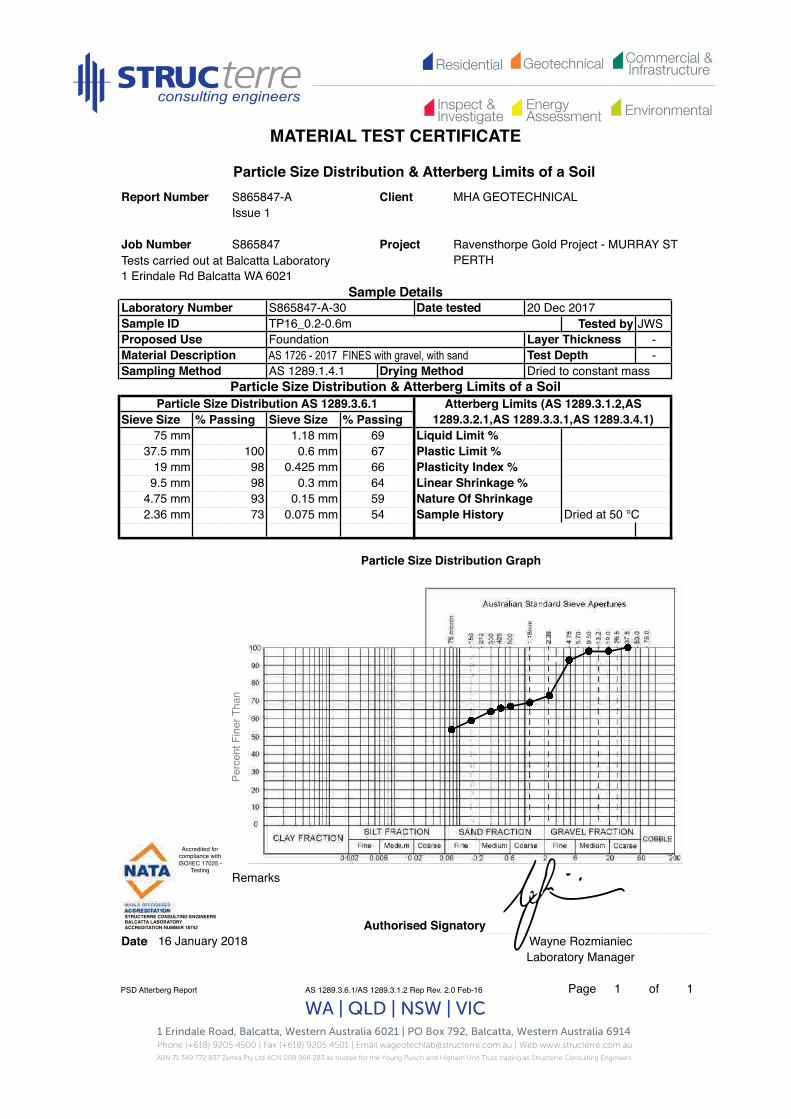
Residential Commercial &InfrastructureGeotechnical
EnergyAssessment
Inspect &Investigate Environmental
MATERIAL TEST CERTIFICATE
1 Erindale Road, Balcatta, Western Australia 6021 | PO Box 792, Balcatta, Western Australia 6914 Phone (+618) 9205 4500 | Fax (+618) 9205 4501 | Email [email protected] | Web www.structerre.com.auABN 71 349 772 837 Zemla Pty Ltd ACN 008 966 283 as trustee for the Young Purich and Higham Unit Trust trading as Structerre Consulting Engineers
WA | QLD | NSW | VIC
Tests carried out at Balcatta Laboratory1 Erindale Rd Balcatta WA 6021
Tested by JWS--
Remarks
Authorised SignatoryDate Wayne Rozmianiec
Laboratory Manager
PSD Atterberg Report AS 1289.3.6.1/AS 1289.3.1.2 Rep Rev. 2.0 Feb-16 Page 1 of 1
Atterberg Limits (AS 1289.3.1.2,AS 1289.3.2.1,AS 1289.3.3.1,AS 1289.3.4.1)
Liquid Limit %Plastic Limit %Plasticity Index %Linear Shrinkage %Nature Of ShrinkageSample History Dried at 50 °C
Particle Size Distribution & Atterberg Limits of a SoilReport Number S865847-A Client MHA GEOTECHNICAL
Issue 1
Laboratory Number S865847-A-30 Date tested 20 Dec 2017Sample ID TP16_0.2-0.6m
Project Ravensthorpe Gold Project - MURRAY ST PERTH
Sample Details
Job Number S865847
Sampling Method AS 1289.1.4.1 Drying Method Dried to constant massParticle Size Distribution & Atterberg Limits of a Soil
Proposed UseMaterial Description
Layer ThicknessTest Depth
FoundationAS 1726 - 2017 FINES with gravel, with sand
75 mm 1.18 mm 6937.5 mm 100 0.6 mm 67
Particle Size Distribution AS 1289.3.6.1Sieve Size % Passing Sieve Size % Passing
592.36 mm 73 0.075 mm 54
19 mm 98 0.425 mm 669.5 mm 98 0.3 mm 64
16 January 2018
4.75 mm 93 0.15 mm
Particle Size Distribution Graph
Perc
ent F
iner
Tha
n
Accredited for compliance with ISO/IEC 17025 -
Testing!
STRUCTERRE CONSULTING ENGINEERS !BALCATTA LABORATORY!ACCREDITATION NUMBER 18742!

Residential Commercial &InfrastructureGeotechnical
EnergyAssessment
Inspect &Investigate Environmental
Material Test Certificate
1 Erindale Road, Balcatta, Western Australia 6021 | PO Box 792, Balcatta, Western Australia 6914 Phone (+618) 9205 4500 | Fax (+618) 9205 4501 | Email [email protected] | Web www.structerre.com.auABN 71 349 772 837 Zemla Pty Ltd ACN 008 966 283 as trustee for the Young Purich and Higham Unit Trust trading as Structerre Consulting Engineers
WA | QLD | NSW | VIC
Tests carried out at Balcatta Laboratory1 Erindale Rd Balcatta WA 6021
Maximum Dry Density t/m3 Optimum Moisture Content %% Retained 37.5mm Sieve
Remarks
Authorised SignatoryDate Wayne Rozmianiec
Laboratory Manager
MDD Report AS 1289.5.1.1 R Rev. 2.0 Feb-16 Page 1 of 1
% Retained 19mm Sieve16.0
0Curing Time (hrs) Method used to determine LL Visual/Tactile
AS 1289.1.2.1 Site Selection Method AS 1289.1.4.1
AS 1289.2.1.1 Determination of the moisture content of a soil - Oven drying method (standard method)
1.690
2
16 January 2018
AS 1289.5.1.1 Determination of the dry density/moisture content relation of a soil using standard compactive effort
Report Number S865847-A Client MHA GEOTECHNICALIssue 1
Project Ravensthorpe Gold Project - MURRAY ST PERTH
Sample DetailsLaboratory Number S865847-A-27 Date tested 13 Dec 2017Sample ID TP13_0.7-2.8mProposed Use FoundationMaterial Description SILT with ClaySampling Method
S865847Job Number
1.4
1.5
1.6
1.7
1.8
1.9
2.0
2.1
2.2
2.3
2.4
2.5
0 2 4 6 8 10 12 14 16 18 20 22 24
Dry
Dens
ity t/
m3
Moisture Content %
Accredited for compliance with ISO/IEC 17025 -
Testing!
STRUCTERRE CONSULTING ENGINEERS !BALCATTA LABORATORY!ACCREDITATION NUMBER 18742!

Residential Commercial &InfrastructureGeotechnical
EnergyAssessment
Inspect &Investigate Environmental
Material Test Certificate
1 Erindale Road, Balcatta, Western Australia 6021 | PO Box 792, Balcatta, Western Australia 6914 Phone (+618) 9205 4500 | Fax (+618) 9205 4501 | Email [email protected] | Web www.structerre.com.auABN 71 349 772 837 Zemla Pty Ltd ACN 008 966 283 as trustee for the Young Purich and Higham Unit Trust trading as Structerre Consulting Engineers
WA | QLD | NSW | VIC
Tests carried out at Balcatta Laboratory1 Erindale Rd Balcatta WA 6021
--
Sample ID Emerson Class No.
Authorised SignatoryDate Wayne Rozmianiec
Laboratory ManagerNDM Spec 201 Report
AS 1289.5.4.3 Rep2 Rev. 2.0 Feb-16 Page 1 of 1
TP13_0.7-2.8m 2
16 January 2018
S865847-A-27
Sample No.
Layer Thickness mmTest Depth mm
Sampling Method Client Site Selection Method Client
Proposed Use FoundationVariousMaterial Description
Report NumberIssue 1S865847-A
AS 1289.3.8.1 Determination of the Emerson class number of a soil
Client MHA GEOTECHNICAL
Project Ravensthorpe Gold Project - MURRAY ST PERTH
Sample Details
Job Number S865847
Lab NoSample ID Time Tested -
S865847-A-
Date tested 12 December 2017
Accredited for compliance with ISO/IEC 17025 -
Testing!
STRUCTERRE CONSULTING ENGINEERS !BALCATTA LABORATORY!ACCREDITATION NUMBER 18742!
Accredited for compliance with ISO/IEC 17025 -
Testing!
STRUCTERRE CONSULTING ENGINEERS !BALCATTA LABORATORY!ACCREDITATION NUMBER 18742!

Residential Commercial &InfrastructureGeotechnical
EnergyAssessment
Inspect &Investigate Environmental
Material Test Certificate
1 Erindale Road, Balcatta, Western Australia 6021 | PO Box 792, Balcatta, Western Australia 6914 Phone (+618) 9205 4500 | Fax (+618) 9205 4501 | Email [email protected] | Web www.structerre.com.auABN 71 349 772 837 Zemla Pty Ltd ACN 008 966 283 as trustee for the Young Purich and Higham Unit Trust trading as Structerre Consulting Engineers
WA | QLD | NSW | VIC
Tests carried out at Balcatta Laboratory1 Erindale Rd Balcatta WA 6021
--
Sample ID Moisture Content %
Remarks
Authorised SignatoryDate
Moisture Content AS 1289.5.4.1 Rep1 Rev. 2.0 Feb-16 Page 1 of 1
16 January 2018 Wayne RozmianiecLaboratory Manager
S865847-A-40 TP20_0.2-0.4m 12.1
S865847-A-38 TP19_0.2-0.6m 12.7
S865847-A-39 TP19_0.6-2.8m 14.6
S865847-A-36 TP18_0.6-1.2m 11.1
S865847-A-37 TP18_1.2-2.8m 9.9
S865847-A-34 TP17_1.2-2.7m 10.8
S865847-A-35 TP18_0.2-0.6m 6.1
S865847-A-32 TP16_1.0-2.8m 8.7
S865847-A-33 TP17_0.6-1.2m 9.1
Sample No.
S865847-A-31 TP16_0.6-1.0m 11.1
Material Description Various Test Depth mmSampling Method Client Site Selection Method Client
Sample ID - Time Tested -Proposed Use Foundation Layer Thickness mm
Lab No S865847-A Date tested 1 December 2007
AS 1289.2.1.1 Determination of the moisture content of a soil - Oven drying method (standard method)
Report Number S865847-A Client MHA GEOTECHNICALIssue 1
Job Number S865847 Project Ravensthorpe Gold Project - MURRAY ST PERTH
Sample Details
Accredited for compliance with ISO/IEC 17025 -
Testing!
STRUCTERRE CONSULTING ENGINEERS !BALCATTA LABORATORY!ACCREDITATION NUMBER 18742!
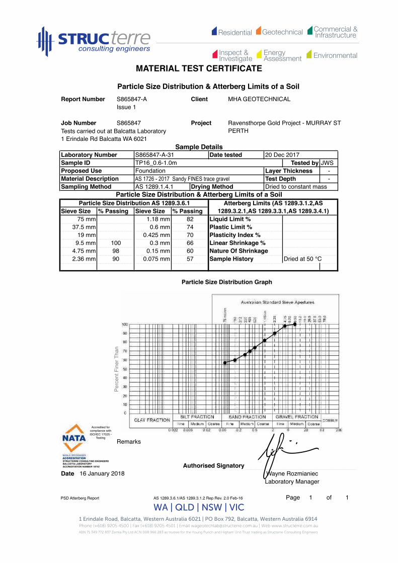
Residential Commercial &InfrastructureGeotechnical
EnergyAssessment
Inspect &Investigate Environmental
MATERIAL TEST CERTIFICATE
1 Erindale Road, Balcatta, Western Australia 6021 | PO Box 792, Balcatta, Western Australia 6914 Phone (+618) 9205 4500 | Fax (+618) 9205 4501 | Email [email protected] | Web www.structerre.com.auABN 71 349 772 837 Zemla Pty Ltd ACN 008 966 283 as trustee for the Young Purich and Higham Unit Trust trading as Structerre Consulting Engineers
WA | QLD | NSW | VIC
Tests carried out at Balcatta Laboratory1 Erindale Rd Balcatta WA 6021
Tested by JWSLayer Thickness -Test Depth -
Remarks
Authorised SignatoryDate Wayne Rozmianiec
Laboratory Manager
PSD Atterberg Report AS 1289.3.6.1/AS 1289.3.1.2 Rep Rev. 2.0 Feb-16 Page 1 of 1
Plastic Limit %Plasticity Index %Linear Shrinkage %Nature Of ShrinkageSample History
16 January 2018
Particle Size Distribution Graph
0.3 mm0.15 mm
5760
75 mm
9.5 mm4.75 mm2.36 mm
9890 0.075 mm Dried at 50 °C
0.6 mm0.425 mm
37.5 mm19 mm
Atterberg Limits (AS 1289.3.1.2,AS 1289.3.2.1,AS 1289.3.3.1,AS 1289.3.4.1)
Liquid Limit %
Foundation
Particle Size Distribution AS 1289.3.6.1Sieve Size % Passing Sieve Size % Passing
1.18 mm
100
Drying Method Dried to constant massParticle Size Distribution & Atterberg Limits of a Soil
82747066
Material DescriptionSampling Method AS 1289.1.4.1
AS 1726 - 2017 Sandy FINES trace gravel
Sample DetailsLaboratory Number S865847-A-31 Date tested 20 Dec 2017Sample IDProposed Use
TP16_0.6-1.0m
Particle Size Distribution & Atterberg Limits of a SoilReport Number S865847-A Client MHA GEOTECHNICAL
Issue 1
Project Ravensthorpe Gold Project - MURRAY ST PERTH
Job Number S865847Pe
rcen
t Fin
er T
han
Accredited for compliance with ISO/IEC 17025 -
Testing!
STRUCTERRE CONSULTING ENGINEERS !BALCATTA LABORATORY!ACCREDITATION NUMBER 18742!

Residential Commercial &InfrastructureGeotechnical
EnergyAssessment
Inspect &Investigate Environmental
MATERIAL TEST CERTIFICATE
1 Erindale Road, Balcatta, Western Australia 6021 | PO Box 792, Balcatta, Western Australia 6914 Phone (+618) 9205 4500 | Fax (+618) 9205 4501 | Email [email protected] | Web www.structerre.com.auABN 71 349 772 837 Zemla Pty Ltd ACN 008 966 283 as trustee for the Young Purich and Higham Unit Trust trading as Structerre Consulting Engineers
WA | QLD | NSW | VIC
Tests carried out at Balcatta Laboratory1 Erindale Rd Balcatta WA 6021
Tested by CF--
Remarks
Authorised SignatoryDate Wayne Rozmianiec
Laboratory Manager
PSD Atterberg Report AS 1289.3.6.1/AS 1289.3.1.2 Rep Rev. 2.0 Feb-16 Page 1 of 1
16 January 2018
Particle Size Distribution Graph
Liquid Limit % Not obtainedPlastic Limit % Not obtained
75 mm 1.18 mm
Particle Size Distribution & Atterberg Limits of a SoilReport Number S865847-A Client MHA GEOTECHNICAL
Issue 1
Project Ravensthorpe Gold Project - MURRAY ST PERTH
Job Number S865847
Sampling Method AS 1289.1.4.1 Drying Method
Layer ThicknessTest Depth
FoundationClayey Silt
Sieve Size % Passing Sieve Size % Passing
Sample History Dried at 50 °C0.075 mm
19 mm 0.425 mm9.5 mm 0.3 mm
4.75 mm 0.15 mm
37.5 mm 0.6 mm
2.36 mm
Particle Size Distribution & Atterberg Limits of a SoilParticle Size Distribution AS 1289.3.6.1
Nature Of Shrinkage Normal
Plasticity Index % NPLinear Shrinkage % 1.5
Dried to constant mass
Atterberg Limits (AS 1289.3.1.2,AS 1289.3.2.1,AS 1289.3.3.1,AS 1289.3.4.1)
Sample DetailsLaboratory Number S865847-A-32 Date tested 11 December 2017Sample ID TP16_1.0-2.8mProposed UseMaterial Description
Perc
ent F
iner
Tha
n
Accredited for compliance with ISO/IEC 17025 -
Testing!
STRUCTERRE CONSULTING ENGINEERS !BALCATTA LABORATORY!ACCREDITATION NUMBER 18742!

Residential Commercial &InfrastructureGeotechnical
EnergyAssessment
Inspect &Investigate Environmental
MATERIAL TEST CERTIFICATE
1 Erindale Road, Balcatta, Western Australia 6021 | PO Box 792, Balcatta, Western Australia 6914 Phone (+618) 9205 4500 | Fax (+618) 9205 4501 | Email [email protected] | Web www.structerre.com.auABN 71 349 772 837 Zemla Pty Ltd ACN 008 966 283 as trustee for the Young Purich and Higham Unit Trust trading as Structerre Consulting Engineers
WA | QLD | NSW | VIC
Tests carried out at Balcatta Laboratory1 Erindale Rd Balcatta WA 6021
Tested by JWSLayer Thickness -
-
Remarks
Authorised SignatoryDate Wayne Rozmianiec
Laboratory Manager
PSD Atterberg Report AS 1289.3.6.1/AS 1289.3.1.2 Rep Rev. 2.0 Feb-16 Page 1 of 1
16 January 2018
Particle Size Distribution Graph
Sample History Dried at 50 °C
19 mm 98 0.425 mm 42
Liquid Limit %
Plasticity Index %
4.75 mm 75 0.15 mm 302.36 mm 54 0.075 mm 28
Linear Shrinkage %
FoundationAS 1726 - 2017 GM Silty or clayey GRAVEL with sand Test Depth
S865847
1.18 mm 4937.5 mm 100 0.6 mm 44 Plastic Limit %
Project Ravensthorpe Gold Project - MURRAY ST PERTH
Sample Details
Particle Size Distribution & Atterberg Limits of a SoilReport Number S865847-A Client MHA GEOTECHNICAL
Issue 1
Job Number
Proposed Use
Laboratory Number S865847-A-33 Date tested 20 Dec 2017Sample ID TP17_0.6-1.2m
Nature Of Shrinkage
% Passing Sieve Size % Passing
Sampling Method AS 1289.1.4.1 Drying Method Dried to constant massParticle Size Distribution & Atterberg Limits of a Soil
Atterberg Limits (AS 1289.3.1.2,AS 1289.3.2.1,AS 1289.3.3.1,AS 1289.3.4.1)
9.5 mm 91 0.3 mm 36
75 mm
Material Description
Particle Size Distribution AS 1289.3.6.1Sieve Size
Perc
ent F
iner
Tha
n
Accredited for compliance with ISO/IEC 17025 -
Testing!
STRUCTERRE CONSULTING ENGINEERS !BALCATTA LABORATORY!ACCREDITATION NUMBER 18742!

Residential Commercial &InfrastructureGeotechnical
EnergyAssessment
Inspect &Investigate Environmental
MATERIAL TEST CERTIFICATE
1 Erindale Road, Balcatta, Western Australia 6021 | PO Box 792, Balcatta, Western Australia 6914 Phone (+618) 9205 4500 | Fax (+618) 9205 4501 | Email [email protected] | Web www.structerre.com.auABN 71 349 772 837 Zemla Pty Ltd ACN 008 966 283 as trustee for the Young Purich and Higham Unit Trust trading as Structerre Consulting Engineers
WA | QLD | NSW | VIC
Tests carried out at Balcatta Laboratory1 Erindale Rd Balcatta WA 6021
Tested by JWS--
Remarks
Authorised SignatoryDate Wayne Rozmianiec
Laboratory Manager
PSD Atterberg Report AS 1289.3.6.1/AS 1289.3.1.2 Rep Rev. 2.0 Feb-16 Page 1 of 1
S865847
16 January 2018
Particle Size Distribution Graph
Dried at 50 °C
19 mm 0.425 mm 569.5 mm 100 0.3 mm 52
4.75 mm 97 0.15 mm 442.36 mm 86 0.075 mm 40 Sample History
Project
Sample Details
Sampling Method AS 1289.1.4.1 Drying Method Dried to constant mass
Proposed UseMaterial Description Test DepthAS 1726 - 2017 Sandy FINES trace gravel
75 mm 1.18 mm 7437.5 mm
Particle Size Distribution & Atterberg Limits of a SoilReport Number S865847-A Client MHA GEOTECHNICAL
Issue 1
Ravensthorpe Gold Project - MURRAY ST PERTH
0.6 mm 62
Particle Size Distribution AS 1289.3.6.1Sieve Size % Passing Sieve Size % Passing
Layer Thickness
Job Number
20 Dec 2017Sample ID TP17_1.2-2.7m
Foundation
Laboratory Number S865847-A-34 Date tested
Particle Size Distribution & Atterberg Limits of a SoilAtterberg Limits (AS 1289.3.1.2,AS
1289.3.2.1,AS 1289.3.3.1,AS 1289.3.4.1)Liquid Limit %Plastic Limit %Plasticity Index %Linear Shrinkage %Nature Of Shrinkage
Perc
ent F
iner
Tha
n
Accredited for compliance with ISO/IEC 17025 -
Testing!
STRUCTERRE CONSULTING ENGINEERS !BALCATTA LABORATORY!ACCREDITATION NUMBER 18742!

Residential Commercial &InfrastructureGeotechnical
EnergyAssessment
Inspect &Investigate Environmental
MATERIAL TEST CERTIFICATE
1 Erindale Road, Balcatta, Western Australia 6021 | PO Box 792, Balcatta, Western Australia 6914 Phone (+618) 9205 4500 | Fax (+618) 9205 4501 | Email [email protected] | Web www.structerre.com.auABN 71 349 772 837 Zemla Pty Ltd ACN 008 966 283 as trustee for the Young Purich and Higham Unit Trust trading as Structerre Consulting Engineers
WA | QLD | NSW | VIC
Tests carried out at Balcatta Laboratory1 Erindale Rd Balcatta WA 6021
Tested by JWS--
Remarks
Authorised SignatoryDate Wayne Rozmianiec
Laboratory Manager
PSD Atterberg Report AS 1289.3.6.1/AS 1289.3.1.2 Rep Rev. 2.0 Feb-16 Page 1 of 1
Job Number S865847 Project Ravensthorpe Gold Project - MURRAY ST PERTH
Particle Size Distribution Graph
16 January 2018
4.75 mm 92 0.15 mm 592.36 mm 80 0.075 mm 56
19 mm 100 0.425 mm 669.5 mm 97
Particle Size Distribution AS 1289.3.6.1Sieve Size % Passing Sieve Size % Passing
Sampling Method AS 1289.1.4.1 Drying Method Dried to constant massParticle Size Distribution & Atterberg Limits of a Soil
Atterberg Limits (AS 1289.3.1.2,AS 1289.3.2.1,AS 1289.3.3.1,AS 1289.3.4.1)
Proposed UseMaterial Description
Laboratory Number S865847-A-35 Date tested 20 Dec 2017Sample ID TP18_0.2-0.6m
Layer ThicknessTest Depth
FoundationAS 1726 - 2017 FINES with gravel, with sand
Sample Details
Particle Size Distribution & Atterberg Limits of a SoilReport Number S865847-A Client MHA GEOTECHNICAL
Issue 1
Nature Of Shrinkage0.3 mm 64
75 mm 1.18 mm 7337.5 mm 0.6 mm 68
Sample History Dried at 50 °C
Liquid Limit %Plastic Limit %Plasticity Index %Linear Shrinkage %
Perc
ent F
iner
Tha
n
Accredited for compliance with ISO/IEC 17025 -
Testing!
STRUCTERRE CONSULTING ENGINEERS !BALCATTA LABORATORY!ACCREDITATION NUMBER 18742!

Residential Commercial &InfrastructureGeotechnical
EnergyAssessment
Inspect &Investigate Environmental
MATERIAL TEST CERTIFICATE
1 Erindale Road, Balcatta, Western Australia 6021 | PO Box 792, Balcatta, Western Australia 6914 Phone (+618) 9205 4500 | Fax (+618) 9205 4501 | Email [email protected] | Web www.structerre.com.auABN 71 349 772 837 Zemla Pty Ltd ACN 008 966 283 as trustee for the Young Purich and Higham Unit Trust trading as Structerre Consulting Engineers
WA | QLD | NSW | VIC
Tests carried out at Balcatta Laboratory1 Erindale Rd Balcatta WA 6021
Tested by JWS--
Remarks
Authorised SignatoryDate Wayne Rozmianiec
Laboratory Manager
PSD Atterberg Report AS 1289.3.6.1/AS 1289.3.1.2 Rep Rev. 2.0 Feb-16 Page 1 of 1
Job Number S865847
Particle Size Distribution Graph
16 January 2018
4.75 mm 99 0.15 mm 64
75 mm 1.18 mm 8537.5 mm 0.6 mm 77
Particle Size Distribution AS 1289.3.6.1Sieve Size % Passing Sieve Size % Passing
Sampling Method
2.36 mm 93 0.075 mm 60
19 mm 0.425 mm 749.5 mm 100 0.3 mm 70
AS 1289.1.4.1 Drying Method Dried to constant massParticle Size Distribution & Atterberg Limits of a Soil
Proposed UseMaterial Description
Layer ThicknessTest Depth
FoundationAS 1726 - 2017 Sandy FINES trace gravel
Laboratory Number S865847-A-36 Date tested 20 Dec 2017Sample ID TP18_0.6-1.2m
Project Ravensthorpe Gold Project - MURRAY ST PERTH
Sample Details
Particle Size Distribution & Atterberg Limits of a SoilReport Number S865847-A Client MHA GEOTECHNICAL
Issue 1
Atterberg Limits (AS 1289.3.1.2,AS 1289.3.2.1,AS 1289.3.3.1,AS 1289.3.4.1)
Liquid Limit %Plastic Limit %Plasticity Index %Linear Shrinkage %Nature Of ShrinkageSample History Dried at 50 °C
Perc
ent F
iner
Tha
n
Accredited for compliance with ISO/IEC 17025 -
Testing!
STRUCTERRE CONSULTING ENGINEERS !BALCATTA LABORATORY!ACCREDITATION NUMBER 18742!
Residential Commercial &InfrastructureGeotechnical
EnergyAssessment
Inspect &Investigate Environmental
MATERIAL TEST CERTIFICATE
1 Erindale Road, Balcatta, Western Australia 6021 | PO Box 792, Balcatta, Western Australia 6914 Phone (+618) 9205 4500 | Fax (+618) 9205 4501 | Email [email protected] | Web www.structerre.com.auABN 71 349 772 837 Zemla Pty Ltd ACN 008 966 283 as trustee for the Young Purich and Higham Unit Trust trading as Structerre Consulting Engineers
WA | QLD | NSW | VIC
Tests carried out at Balcatta Laboratory1 Erindale Rd Balcatta WA 6021
Tested by JWS--
Remarks
Authorised SignatoryDate Wayne Rozmianiec
Laboratory Manager
PSD Atterberg Report AS 1289.3.6.1/AS 1289.3.1.2 Rep Rev. 2.0 Feb-16 Page 1 of 1
Job Number S865847
Particle Size Distribution Graph
16 January 2018
4.75 mm 81 0.15 mm 442.36 mm 74 0.075 mm 43
19 mm 98 0.425 mm 539.5 mm 93 0.3 mm 49
75 mm 1.18 mm 6437.5 mm 100 0.6 mm 56
Particle Size Distribution AS 1289.3.6.1Sieve Size % Passing Sieve Size % Passing
Sampling Method AS 1289.1.4.1 Drying Method Dried to constant massParticle Size Distribution & Atterberg Limits of a Soil
Atterberg Limits (AS 1289.3.1.2,AS 1289.3.2.1,AS 1289.3.3.1,AS 1289.3.4.1)
Proposed UseMaterial Description
Layer ThicknessTest Depth
FoundationAS 1726 - 2017 Sandy FINES with gravel
Laboratory Number S865847-A-37 Date tested 20 Dec 2017Sample ID TP18_1.2-2.8m
Project Ravensthorpe Gold Project - MURRAY ST PERTH
Sample Details
Particle Size Distribution & Atterberg Limits of a SoilReport Number S865847-A Client MHA GEOTECHNICAL
Issue 1
Nature Of ShrinkageSample History Dried at 50 °C
Liquid Limit %Plastic Limit %Plasticity Index %Linear Shrinkage %
Perc
ent F
iner
Tha
n
Accredited for compliance with ISO/IEC 17025 -
Testing!
STRUCTERRE CONSULTING ENGINEERS !BALCATTA LABORATORY!ACCREDITATION NUMBER 18742!

Residential Commercial &InfrastructureGeotechnical
EnergyAssessment
Inspect &Investigate Environmental
MATERIAL TEST CERTIFICATE
1 Erindale Road, Balcatta, Western Australia 6021 | PO Box 792, Balcatta, Western Australia 6914 Phone (+618) 9205 4500 | Fax (+618) 9205 4501 | Email [email protected] | Web www.structerre.com.auABN 71 349 772 837 Zemla Pty Ltd ACN 008 966 283 as trustee for the Young Purich and Higham Unit Trust trading as Structerre Consulting Engineers
WA | QLD | NSW | VIC
Tests carried out at Balcatta Laboratory1 Erindale Rd Balcatta WA 6021
Tested by JWS--
Remarks
Authorised SignatoryDate Wayne Rozmianiec
Laboratory Manager
PSD Atterberg Report AS 1289.3.6.1/AS 1289.3.1.2 Rep Rev. 2.0 Feb-16 Page 1 of 1
Job Number S865847
Particle Size Distribution Graph
16 January 2018
4.75 mm 92 0.15 mm 602.36 mm 76 0.075 mm 55
19 mm 100 0.425 mm 689.5 mm 97 0.3 mm 66
75 mm 1.18 mm 7237.5 mm 0.6 mm 69
Particle Size Distribution AS 1289.3.6.1Sieve Size % Passing Sieve Size % Passing
Sampling Method AS 1289.1.4.1 Drying Method Dried to constant massParticle Size Distribution & Atterberg Limits of a Soil
Proposed UseMaterial Description
Laboratory Number S865847-A-38 Date tested 20 Dec 2017Sample ID TP19_0.2-0.6m
Layer ThicknessTest Depth
FoundationAS 1726 - 2017 FINES with gravel, with sand
Project Ravensthorpe Gold Project - MURRAY ST PERTH
Sample Details
Particle Size Distribution & Atterberg Limits of a SoilReport Number S865847-A Client MHA GEOTECHNICAL
Issue 1
Atterberg Limits (AS 1289.3.1.2,AS 1289.3.2.1,AS 1289.3.3.1,AS 1289.3.4.1)
Liquid Limit %Plastic Limit %Plasticity Index %Linear Shrinkage %Nature Of ShrinkageSample History Dried at 50 °C
Perc
ent F
iner
Tha
n
Accredited for compliance with ISO/IEC 17025 -
Testing!
STRUCTERRE CONSULTING ENGINEERS !BALCATTA LABORATORY!ACCREDITATION NUMBER 18742!

Residential Commercial &InfrastructureGeotechnical
EnergyAssessment
Inspect &Investigate Environmental
MATERIAL TEST CERTIFICATE
1 Erindale Road, Balcatta, Western Australia 6021 | PO Box 792, Balcatta, Western Australia 6914 Phone (+618) 9205 4500 | Fax (+618) 9205 4501 | Email [email protected] | Web www.structerre.com.auABN 71 349 772 837 Zemla Pty Ltd ACN 008 966 283 as trustee for the Young Purich and Higham Unit Trust trading as Structerre Consulting Engineers
WA | QLD | NSW | VIC
Tests carried out at Balcatta Laboratory1 Erindale Rd Balcatta WA 6021
Tested by JWS--
Remarks
Authorised SignatoryDate Wayne Rozmianiec
Laboratory Manager
PSD Atterberg Report AS 1289.3.6.1/AS 1289.3.1.2 Rep Rev. 2.0 Feb-16 Page 1 of 1
Particle Size Distribution Graph
16 January 2018
4.75 mm 94 0.15 mm 582.36 mm 77 0.075 mm 54
19 mm 100 0.425 mm 669.5 mm 99 63
75 mm 1.18 mm 7337.5 mm 0.6 mm 68
0.3 mm
Sieve Size % Passing Sieve Size % Passing
Sampling Method AS 1289.1.4.1 Drying Method Dried to constant massParticle Size Distribution & Atterberg Limits of a Soil
Atterberg Limits (AS 1289.3.1.2,AS 1289.3.2.1,AS 1289.3.3.1,AS 1289.3.4.1)
Particle Size Distribution AS 1289.3.6.1
Proposed UseMaterial Description
Laboratory Number S865847-A-39 Date tested 20 Dec 2017Sample ID TP19_0.6-2.8m
Layer ThicknessTest Depth
FoundationAS 1726 - 2017 FINES with gravel, with sand
Project Ravensthorpe Gold Project - MURRAY ST PERTH
Sample Details
Particle Size Distribution & Atterberg Limits of a SoilReport Number S865847-A Client MHA GEOTECHNICAL
Issue 1
Job Number S865847
Sample History Dried at 50 °C
Liquid Limit %Plastic Limit %Plasticity Index %Linear Shrinkage %Nature Of Shrinkage
Perc
ent F
iner
Tha
n
Accredited for compliance with ISO/IEC 17025 -
Testing!
STRUCTERRE CONSULTING ENGINEERS !BALCATTA LABORATORY!ACCREDITATION NUMBER 18742!

Residential Commercial &InfrastructureGeotechnical
EnergyAssessment
Inspect &Investigate Environmental
MATERIAL TEST CERTIFICATE
1 Erindale Road, Balcatta, Western Australia 6021 | PO Box 792, Balcatta, Western Australia 6914 Phone (+618) 9205 4500 | Fax (+618) 9205 4501 | Email [email protected] | Web www.structerre.com.auABN 71 349 772 837 Zemla Pty Ltd ACN 008 966 283 as trustee for the Young Purich and Higham Unit Trust trading as Structerre Consulting Engineers
WA | QLD | NSW | VIC
Tests carried out at Balcatta Laboratory1 Erindale Rd Balcatta WA 6021
Tested by JWS--
Remarks
Authorised SignatoryDate Wayne Rozmianiec
Laboratory Manager
PSD Atterberg Report AS 1289.3.6.1/AS 1289.3.1.2 Rep Rev. 2.0 Feb-16 Page 1 of 1
Particle Size Distribution Graph
16 January 2018
4.75 mm 96 0.15 mm 672.36 mm 92 0.075 mm 59
19 mm 99 0.425 mm 789.5 mm 97 0.3 mm 75
75 mm 1.18 mm 8537.5 mm 100 0.6 mm 80
Particle Size Distribution AS 1289.3.6.1Sieve Size % Passing Sieve Size % Passing
Sampling Method AS 1289.1.4.1 Drying Method Dried to constant massParticle Size Distribution & Atterberg Limits of a Soil
Proposed UseMaterial Description
Layer ThicknessTest Depth
FoundationAS 1726 - 2017 Sandy FINES trace gravel
Laboratory Number S865847-A-40 Date tested 20 Dec 2017Sample ID TP20_0.2-0.4m
Project Ravensthorpe Gold Project - MURRAY ST PERTH
Sample Details
Job Number S865847
Particle Size Distribution & Atterberg Limits of a SoilReport Number S865847-A Client MHA GEOTECHNICAL
Issue 1
Atterberg Limits (AS 1289.3.1.2,AS 1289.3.2.1,AS 1289.3.3.1,AS 1289.3.4.1)
Liquid Limit %Plastic Limit %Plasticity Index %Linear Shrinkage %Nature Of ShrinkageSample History Dried at 50 °C
Perc
ent F
iner
Tha
n
Accredited for compliance with ISO/IEC 17025 -
Testing!
STRUCTERRE CONSULTING ENGINEERS !BALCATTA LABORATORY!ACCREDITATION NUMBER 18742!

Residential Commercial &InfrastructureGeotechnical
EnergyAssessment
Inspect &Investigate Environmental
Material Test Certificate
1 Erindale Road, Balcatta, Western Australia 6021 | PO Box 792, Balcatta, Western Australia 6914 Phone (+618) 9205 4500 | Fax (+618) 9205 4501 | Email [email protected] | Web www.structerre.com.auABN 71 349 772 837 Zemla Pty Ltd ACN 008 966 283 as trustee for the Young Purich and Higham Unit Trust trading as Structerre Consulting Engineers
WA | QLD | NSW | VIC
Tests carried out at Balcatta Laboratory1 Erindale Rd Balcatta WA 6021
Maximum Dry Density t/m3 Optimum Moisture Content %% Retained 37.5mm Sieve
Remarks
Authorised SignatoryDate Wayne Rozmianiec
Laboratory Manager
MDD Report AS 1289.5.1.1 R Rev. 2.0 Feb-16 Page 1 of 1
1.720
Laboratory Number S865847-A-32
AS 1289.5.1.1 Determination of the dry density/moisture content relation of a soil using standard compactive effort
Report Number S865847-A Client MHA GEOTECHNICALIssue 1
Project Ravensthorpe Gold Project - MURRAY ST PERTH
Job Number S865847
Date tested 13 Dec 2017Sample ID TP16_1.0-2.8m
Sampling Method AS 1289.1.2.1 Site Selection Method AS 1289.1.4.1
AS 1289.2.1.1 Determination of the moisture content of a soil - Oven drying method (standard method)
16 January 2018
% Retained 19mm Sieve 1
FoundationMaterial Description SILTProposed Use
Sample Details
Visual/Tactile
15.5
Curing Time (hrs) 8 Method used to determine LL
1.4
1.5
1.6
1.7
1.8
1.9
2.0
2.1
2.2
2.3
2.4
2.5
0 2 4 6 8 10 12 14 16 18 20 22 24
Dry
Dens
ity t/
m3
Moisture Content %
Accredited for compliance with ISO/IEC 17025 -
Testing!
STRUCTERRE CONSULTING ENGINEERS !BALCATTA LABORATORY!ACCREDITATION NUMBER 18742!

Residential Commercial &InfrastructureGeotechnical
EnergyAssessment
Inspect &Investigate Environmental
Material Test Certificate
1 Erindale Road, Balcatta, Western Australia 6021 | PO Box 792, Balcatta, Western Australia 6914 Phone (+618) 9205 4500 | Fax (+618) 9205 4501 | Email [email protected] | Web www.structerre.com.auABN 71 349 772 837 Zemla Pty Ltd ACN 008 966 283 as trustee for the Young Purich and Higham Unit Trust trading as Structerre Consulting Engineers
WA | QLD | NSW | VIC
Tests carried out at Balcatta Laboratory1 Erindale Rd Balcatta WA 6021
--
Sample ID Emerson Class No.
Authorised SignatoryDate Wayne Rozmianiec
Laboratory ManagerNDM Spec 201 Report
AS 1289.5.4.3 Rep2 Rev. 2.0 Feb-16 Page 1 of 1
TP16_1.0-2.8m 6
Lab NoSample ID Time Tested -
S865847-A-
Date tested 12 December 2017
Project Ravensthorpe Gold Project - MURRAY ST PERTH
Sample Details
Job Number S865847
Report NumberIssue 1S865847-A
AS 1289.3.8.1 Determination of the Emerson class number of a soil
Client MHA GEOTECHNICAL
Sample No.
Layer Thickness mmTest Depth mm
Sampling Method Client Site Selection Method Client
Proposed Use FoundationVariousMaterial Description
S865847-A-32
16 January 2018
Accredited for compliance with ISO/IEC 17025 -
Testing!
STRUCTERRE CONSULTING ENGINEERS !BALCATTA LABORATORY!ACCREDITATION NUMBER 18742!
Residential Commercial &InfrastructureGeotechnical
EnergyAssessment
Inspect &Investigate Environmental
Material Test Certificate
1 Erindale Road, Balcatta, Western Australia 6021 | PO Box 792, Balcatta, Western Australia 6914 Phone (+618) 9205 4500 | Fax (+618) 9205 4501 | Email [email protected] | Web www.structerre.com.auABN 71 349 772 837 Zemla Pty Ltd ACN 008 966 283 as trustee for the Young Purich and Higham Unit Trust trading as Structerre Consulting Engineers
WA | QLD | NSW | VIC
Tests carried out at Balcatta Laboratory1 Erindale Rd Balcatta WA 6021
--
Sample ID Moisture Content %
Remarks
Authorised SignatoryDate
Moisture Content AS 1289.5.4.1 Rep1 Rev. 2.0 Feb-16 Page 1 of 1
16 January 2018 Wayne RozmianiecLaboratory Manager
Sample No.
S865847-A-41 TP20_0.4-1.0m 7
Material Description Various Test Depth mmSampling Method Client Site Selection Method Client
Sample ID - Time Tested -Proposed Use Foundation Layer Thickness mm
Lab No S865847-A Date tested 1 December 2007
AS 1289.2.1.1 Determination of the moisture content of a soil - Oven drying method (standard method)
Report Number S865847-A Client MHA GEOTECHNICALIssue 1
Job Number S865847 Project Ravensthorpe Gold Project - MURRAY ST PERTH
Sample Details
Accredited for compliance with ISO/IEC 17025 -
Testing!
STRUCTERRE CONSULTING ENGINEERS !BALCATTA LABORATORY!ACCREDITATION NUMBER 18742!

Residential Commercial &InfrastructureGeotechnical
EnergyAssessment
Inspect &Investigate Environmental
MATERIAL TEST CERTIFICATE
1 Erindale Road, Balcatta, Western Australia 6021 | PO Box 792, Balcatta, Western Australia 6914 Phone (+618) 9205 4500 | Fax (+618) 9205 4501 | Email [email protected] | Web www.structerre.com.auABN 71 349 772 837 Zemla Pty Ltd ACN 008 966 283 as trustee for the Young Purich and Higham Unit Trust trading as Structerre Consulting Engineers
WA | QLD | NSW | VIC
Tests carried out at Balcatta Laboratory1 Erindale Rd Balcatta WA 6021
Tested by JWSLayer Thickness -Test Depth -
Remarks
Authorised SignatoryDate Wayne Rozmianiec
Laboratory Manager
PSD Atterberg Report AS 1289.3.6.1/AS 1289.3.1.2 Rep Rev. 2.0 Feb-16 Page 1 of 1
Particle Size Distribution & Atterberg Limits of a SoilReport Number S865847-A Client MHA GEOTECHNICAL
Issue 1
Project Ravensthorpe Gold Project - MURRAY ST PERTH
Job Number S865847
Material DescriptionSampling Method AS 1289.1.4.1
AS 1726 - 2017 GM Silty or clayey, sandy GRAVEL
Sample DetailsLaboratory Number S865847-A-41 Date tested 20 Dec 2017Sample IDProposed Use
TP20_0.4-1.3m
37.5 mm19 mm
Atterberg Limits (AS 1289.3.1.2,AS 1289.3.2.1,AS 1289.3.3.1,AS 1289.3.4.1)
Liquid Limit %
Foundation
Particle Size Distribution AS 1289.3.6.1Sieve Size % Passing Sieve Size % Passing
1.18 mm
98
Drying Method Dried to constant massParticle Size Distribution & Atterberg Limits of a Soil
53474543
8464 0.075 mm Dried at 50 °C
0.6 mm0.425 mm100
75 mm
9.5 mm4.75 mm2.36 mm
Plastic Limit %Plasticity Index %Linear Shrinkage %Nature Of ShrinkageSample History
16 January 2018
Particle Size Distribution Graph
0.3 mm0.15 mm
3238
Perc
ent F
iner
Tha
n
Accredited for compliance with ISO/IEC 17025 -
Testing!
STRUCTERRE CONSULTING ENGINEERS !BALCATTA LABORATORY!ACCREDITATION NUMBER 18742!

Residential Commercial &InfrastructureGeotechnical
EnergyAssessment
Inspect &Investigate Environmental
Material Test Certificate
1 Erindale Road, Balcatta, Western Australia 6021 | PO Box 792, Balcatta, Western Australia 6914 Phone (+618) 9205 4500 | Fax (+618) 9205 4501 | Email [email protected] | Web www.structerre.com.auABN 71 349 772 837 Zemla Pty Ltd ACN 008 966 283 as trustee for the Young Purich and Higham Unit Trust trading as Structerre Consulting Engineers
WA | QLD | NSW | VIC
Tests carried out at Balcatta Laboratory1 Erindale Rd Balcatta WA 6021
--
Sample ID Moisture Content %
Remarks
Authorised SignatoryDate
Moisture Content AS 1289.5.4.1 Rep1 Rev. 2.0 Feb-16 Page 1 of 1
Lab No S865847-B Date tested 1 December 2007
AS 1289.2.1.1 Determination of the moisture content of a soil - Oven drying method (standard method)
Report Number S865847-B Client MHA GEOTECHNICALIssue 1
Job Number S865847 Project Ravensthorpe Gold Project - MURRAY ST PERTH
Sample Details
Sample ID - Time Tested -Proposed Use Borrow Layer Thickness mmMaterial Description Various Test Depth mmSampling Method Client Site Selection Method Client
Sample No.
S865847-B-1 Borrow 1 6.3
S865847-B-2 Borrow 2 3.8
S865847-B-3 Borrow 3 7.2
16 January 2018 Wayne RozmianiecLaboratory Manager
Accredited for compliance with ISO/IEC 17025 -
Testing!
STRUCTERRE CONSULTING ENGINEERS !BALCATTA LABORATORY!ACCREDITATION NUMBER 18742!

Residential Commercial &InfrastructureGeotechnical
EnergyAssessment
Inspect &Investigate Environmental
MATERIAL TEST CERTIFICATE
1 Erindale Road, Balcatta, Western Australia 6021 | PO Box 792, Balcatta, Western Australia 6914 Phone (+618) 9205 4500 | Fax (+618) 9205 4501 | Email [email protected] | Web www.structerre.com.auABN 71 349 772 837 Zemla Pty Ltd ACN 008 966 283 as trustee for the Young Purich and Higham Unit Trust trading as Structerre Consulting Engineers
WA | QLD | NSW | VIC
Tests carried out at Balcatta Laboratory1 Erindale Rd Balcatta WA 6021
Tested by CFLayer Thickness -Test Depth -
31.8
Remarks
Authorised SignatoryDate Wayne Rozmianiec
Laboratory Manager
PSD Atterberg Report AS 1289.3.6.1/AS 1289.3.1.2 Rep Rev. 2.0 Feb-16 Page 1 of 1
Particle Size Distribution & Atterberg Limits of a SoilReport Number S865847-B Client MHA GEOTECHNICAL
Issue 1
Project Ravensthorpe Gold Project - MURRAY ST PERTH
Job Number S865847
Material DescriptionSampling Method AS 1289.1.4.1
Clayey Silt
Sample DetailsLaboratory Number S865847-B-1 Date tested 11 December 2017Sample IDProposed Use
Borrow 1
37.5 mm19 mm
Atterberg Limits (AS 1289.3.1.2,AS 1289.3.2.1,AS 1289.3.3.1,AS 1289.3.4.1)
Liquid Limit %
Borrow
Particle Size Distribution AS 1289.3.6.1Sieve Size % Passing Sieve Size % Passing
1.18 mm
Drying Method Dried to constant massParticle Size Distribution & Atterberg Limits of a Soil
0.075 mm
Not obtainedNP2.0NormalDried at 50 °C
0.6 mm0.425 mm
75 mm Not obtained
9.5 mm4.75 mm2.36 mm
Plastic Limit %Plasticity Index %Linear Shrinkage %Nature Of ShrinkageSample History
16 January 2018
Particle Size Distribution Graph
0.3 mm0.15 mm
Moisture Content % of LL specimen
Perc
ent F
iner
Tha
n
Accredited for compliance with ISO/IEC 17025 -
Testing!
STRUCTERRE CONSULTING ENGINEERS !BALCATTA LABORATORY!ACCREDITATION NUMBER 18742!

Residential Commercial &InfrastructureGeotechnical
EnergyAssessment
Inspect &Investigate Environmental
MATERIAL TEST CERTIFICATE
1 Erindale Road, Balcatta, Western Australia 6021 | PO Box 792, Balcatta, Western Australia 6914 Phone (+618) 9205 4500 | Fax (+618) 9205 4501 | Email [email protected] | Web www.structerre.com.auABN 71 349 772 837 Zemla Pty Ltd ACN 008 966 283 as trustee for the Young Purich and Higham Unit Trust trading as Structerre Consulting Engineers
WA | QLD | NSW | VIC
Tests carried out at Balcatta Laboratory1 Erindale Rd Balcatta WA 6021
Tested by CF--
36.7
Remarks
Authorised SignatoryDate Wayne Rozmianiec
Laboratory Manager
PSD Atterberg Report AS 1289.3.6.1/AS 1289.3.1.2 Rep Rev. 2.0 Feb-16 Page 1 of 1
Sample DetailsLaboratory Number S865847-B-2 Date tested 11 December 2017Sample ID Borrow 2Proposed UseMaterial Description
Nature Of Shrinkage Normal
Plasticity Index % NPLinear Shrinkage % 1.5
Dried to constant mass
Atterberg Limits (AS 1289.3.1.2,AS 1289.3.2.1,AS 1289.3.3.1,AS 1289.3.4.1)
2.36 mm
Particle Size Distribution & Atterberg Limits of a SoilParticle Size Distribution AS 1289.3.6.1
0.075 mm
19 mm 0.425 mm9.5 mm 0.3 mm
4.75 mm 0.15 mm
37.5 mm 0.6 mm
Sample History Dried at 50 °C
Sampling Method AS 1289.1.4.1 Drying Method
Layer ThicknessTest Depth
BorrowClayey Silt
Sieve Size % Passing Sieve Size % Passing
Particle Size Distribution & Atterberg Limits of a SoilReport Number S865847-B Client MHA GEOTECHNICAL
Issue 1
Project Ravensthorpe Gold Project - MURRAY ST PERTH
Job Number S865847
16 January 2018
Particle Size Distribution Graph
Moisture Content % of LL specimen
Liquid Limit % Not obtainedPlastic Limit % Not obtained
75 mm 1.18 mm
Perc
ent F
iner
Tha
n
Accredited for compliance with ISO/IEC 17025 -
Testing!
STRUCTERRE CONSULTING ENGINEERS !BALCATTA LABORATORY!ACCREDITATION NUMBER 18742!

Residential Commercial &InfrastructureGeotechnical
EnergyAssessment
Inspect &Investigate Environmental
MATERIAL TEST CERTIFICATE
1 Erindale Road, Balcatta, Western Australia 6021 | PO Box 792, Balcatta, Western Australia 6914 Phone (+618) 9205 4500 | Fax (+618) 9205 4501 | Email [email protected] | Web www.structerre.com.auABN 71 349 772 837 Zemla Pty Ltd ACN 008 966 283 as trustee for the Young Purich and Higham Unit Trust trading as Structerre Consulting Engineers
WA | QLD | NSW | VIC
Tests carried out at Balcatta Laboratory1 Erindale Rd Balcatta WA 6021
Tested by CFLayer Thickness -
-
31.6
Remarks
Authorised SignatoryDate Wayne Rozmianiec
Laboratory Manager
PSD Atterberg Report AS 1289.3.6.1/AS 1289.3.1.2 Rep Rev. 2.0 Feb-16 Page 1 of 1
Material Description
Particle Size Distribution AS 1289.3.6.1Sieve Size % Passing Sieve Size % Passing
Sampling Method AS 1289.1.4.1 Drying Method Dried to constant massParticle Size Distribution & Atterberg Limits of a Soil
Atterberg Limits (AS 1289.3.1.2,AS 1289.3.2.1,AS 1289.3.3.1,AS 1289.3.4.1)
9.5 mm 0.3 mm
75 mm
Proposed Use
Laboratory Number S865847-B-3 Date tested 11 December 2017Sample ID Borrow 3
Nature Of Shrinkage Normal
Project Ravensthorpe Gold Project - MURRAY ST PERTH
Sample Details
Particle Size Distribution & Atterberg Limits of a SoilReport Number S865847-B Client MHA GEOTECHNICAL
Issue 1
Job Number
1.18 mm37.5 mm 0.6 mm
Not obtainedPlastic Limit % Not obtained
NPLinear Shrinkage % 1.5
BorrowClayey Silt Test Depth
S865847
4.75 mm 0.15 mm2.36 mm 0.075 mm Dried at 50 °C
19 mm 0.425 mm
Liquid Limit %
Plasticity Index %
16 January 2018
Particle Size Distribution Graph
Moisture Content % of LL specimenSample History
Perc
ent F
iner
Tha
n
Accredited for compliance with ISO/IEC 17025 -
Testing!
STRUCTERRE CONSULTING ENGINEERS !BALCATTA LABORATORY!ACCREDITATION NUMBER 18742!

Residential Commercial &InfrastructureGeotechnical
EnergyAssessment
Inspect &Investigate Environmental
Material Test Certificate
1 Erindale Road, Balcatta, Western Australia 6021 | PO Box 792, Balcatta, Western Australia 6914 Phone (+618) 9205 4500 | Fax (+618) 9205 4501 | Email [email protected] | Web www.structerre.com.auABN 71 349 772 837 Zemla Pty Ltd ACN 008 966 283 as trustee for the Young Purich and Higham Unit Trust trading as Structerre Consulting Engineers
WA | QLD | NSW | VIC
Tests carried out at Balcatta Laboratory1 Erindale Rd Balcatta WA 6021
Maximum Dry Density t/m3 Optimum Moisture Content %% Retained 37.5mm Sieve
Remarks
Authorised SignatoryDate Wayne Rozmianiec
Laboratory Manager
MDD Report AS 1289.5.1.1 R Rev. 2.0 Feb-16 Page 1 of 1
Curing Time (hrs)
15.50
Method used to determine LL2 Visual/Tactile
AS 1289.5.1.1 Determination of the dry density/moisture content relation of a soil using standard compactive effort
% Retained 19mm Sieve
16 January 2018
21.69
Proposed Use
AS 1289.2.1.1 Determination of the moisture content of a soil - Oven drying method (standard method)
Client
S865847-B-1
Issue 1
Date tested
ClayEmbankment Construction
Monday, 11 December 2017
Report Number S865847-B
Project
MHA GEOTECHNICAL
Ravensthorpe Gold Project - MURRAY ST PERTH
Sample Details
Borrow Pit 1
Job Number S865847
AS 1289.1.4.1
Laboratory NumberSample ID
Material DescriptionSite Selection MethodSampling Method AS 1289.1.2.1
1.6
1.7
12 14 16 18 20
Dry
Dens
ity t/
m3
Moisture Content %
Accredited for compliance with ISO/IEC 17025 -
Testing!
STRUCTERRE CONSULTING ENGINEERS !BALCATTA LABORATORY!ACCREDITATION NUMBER 18742!

Residential Commercial &InfrastructureGeotechnical
EnergyAssessment
Inspect &Investigate Environmental
Material Test Certificate
1 Erindale Road, Balcatta, Western Australia 6021 | PO Box 792, Balcatta, Western Australia 6914 Phone (+618) 9205 4500 | Fax (+618) 9205 4501 | Email [email protected] | Web www.structerre.com.auABN 71 349 772 837 Zemla Pty Ltd ACN 008 966 283 as trustee for the Young Purich and Higham Unit Trust trading as Structerre Consulting Engineers
WA | QLD | NSW | VIC
Tests carried out at Balcatta Laboratory1 Erindale Rd Balcatta WA 6021
Maximum Dry Density t/m3 Optimum Moisture Content %% Retained 37.5mm Sieve
Remarks
Authorised SignatoryDate Wayne Rozmianiec
Laboratory Manager
MDD Report AS 1289.5.1.1 R Rev. 2.0 Feb-16 Page 1 of 1
Curing Time (hrs) 2 Method used to determine LL Visual/Tactile
14.0
16 January 2018
% Retained 19mm Sieve 0
Embankment ConstructionMaterial Description ClayProposed Use
Sample DetailsDate tested Monday, 11 December 2017
Sample ID Borrow Pit 2
Sampling Method AS 1289.1.2.1 Site Selection Method AS 1289.1.4.1
AS 1289.2.1.1 Determination of the moisture content of a soil - Oven drying method (standard method)
AS 1289.5.1.1 Determination of the dry density/moisture content relation of a soil using standard compactive effort
Report Number S865847-B Client MHA GEOTECHNICALIssue 1
Project Ravensthorpe Gold Project - MURRAY ST PERTH
Job Number S865847
1.740
Laboratory Number S865847-B-2
1.78 10 12 14 16
Dry
Dens
ity t/
m3
Moisture Content %
Accredited for compliance with ISO/IEC 17025 -
Testing!
STRUCTERRE CONSULTING ENGINEERS !BALCATTA LABORATORY!ACCREDITATION NUMBER 18742!

Residential Commercial &InfrastructureGeotechnical
EnergyAssessment
Inspect &Investigate Environmental
Material Test Certificate
1 Erindale Road, Balcatta, Western Australia 6021 | PO Box 792, Balcatta, Western Australia 6914 Phone (+618) 9205 4500 | Fax (+618) 9205 4501 | Email [email protected] | Web www.structerre.com.auABN 71 349 772 837 Zemla Pty Ltd ACN 008 966 283 as trustee for the Young Purich and Higham Unit Trust trading as Structerre Consulting Engineers
WA | QLD | NSW | VIC
Tests carried out at Balcatta Laboratory1 Erindale Rd Balcatta WA 6021
Maximum Dry Density t/m3
Remarks
Authorised SignatoryDate Wayne Rozmianiec
Laboratory Manager
MDD Report AS 1289.5.1.1 R Rev. 2.0 Feb-16 Page 1 of 1
% Retained 37.5mm Sieve
Report Number
Curing Time (hrs)
AS 1289.5.1.1 Determination of the dry density/moisture content relation of a soil using standard compactive effort
Borrow Pit 3Proposed Use Embankment ConstructionMaterial Description ClaySampling Method AS 1289.1.2.1 Site Selection Method AS 1289.1.4.1
AS 1289.2.1.1 Determination of the moisture content of a soil - Oven drying method (standard method)
1.770
16 January 2018
2
S865847-B Client MHA GEOTECHNICALIssue 1
Project Ravensthorpe Gold Project - MURRAY ST PERTH
% Retained 19mm Sieve
Sample DetailsLaboratory Number S865847-B-3 Date tested Monday, 11 December 2017Sample ID
0Optimum Moisture Content %
Method used to determine LL Visual/Tactile
12.5
Job Number S865847
1.7
1.8
8 10 12 14 16
Dry
Dens
ity t/
m3
Moisture Content %
Accredited for compliance with ISO/IEC 17025 -
Testing!
STRUCTERRE CONSULTING ENGINEERS !BALCATTA LABORATORY!ACCREDITATION NUMBER 18742!

Residential Commercial &InfrastructureGeotechnical
EnergyAssessment
Inspect &Investigate Environmental
Material Test Certificate
1 Erindale Road, Balcatta, Western Australia 6021 | PO Box 792, Balcatta, Western Australia 6914 Phone (+618) 9205 4500 | Fax (+618) 9205 4501 | Email [email protected] | Web www.structerre.com.auABN 71 349 772 837 Zemla Pty Ltd ACN 008 966 283 as trustee for the Young Purich and Higham Unit Trust trading as Structerre Consulting Engineers
WA | QLD | NSW | VIC
Tests carried out at Balcatta Laboratory1 Erindale Rd Balcatta WA 6021
Maximum Dry Density t/m3 Optimum Moisture Content %% Retained 37.5mm Sieve
Remarks
Authorised SignatoryDate Wayne Rozmianiec
Laboratory Manager
MDD Report AS 1289.5.2.1 R Rev. 2.0 Feb-16 Page 1 of 1
AS 1289.1.4.1
Laboratory NumberSample ID
Material DescriptionSite Selection MethodSampling Method AS 1289.1.2.1
Client
S865847-B-1
Issue 1
Date tested
Clayey SiltBorrow
13 Dec 2017
Report Number S865847-B
Project
MHA GEOTECHNICAL
Ravensthorpe Gold Project - MURRAY ST PERTH
Sample Details
Borrow 1
Job Number S865847
Proposed Use
AS 1289.2.1.1 Determination of the moisture content of a soil - Oven drying method (standard method)
AS 1289.5.2.1 Determination of the dry density/moisture content relation of a soil using modified compactive effort
% Retained 19mm Sieve
16 January 2018
11.82
Curing Time (hrs)
12.04
Method used to determine LL2 Visual/Tactile
1.4
1.5
1.6
1.7
1.8
1.9
2.0
2.1
2.2
2.3
2.4
2.5
0 2 4 6 8 10 12 14 16 18 20 22 24
Dry
Dens
ity t/
m3
Moisture Content %
Accredited for compliance with ISO/IEC 17025 -
Testing!
STRUCTERRE CONSULTING ENGINEERS !BALCATTA LABORATORY!ACCREDITATION NUMBER 18742!

Residential Commercial &InfrastructureGeotechnical
EnergyAssessment
Inspect &Investigate Environmental
Material Test Certificate
1 Erindale Road, Balcatta, Western Australia 6021 | PO Box 792, Balcatta, Western Australia 6914 Phone (+618) 9205 4500 | Fax (+618) 9205 4501 | Email [email protected] | Web www.structerre.com.auABN 71 349 772 837 Zemla Pty Ltd ACN 008 966 283 as trustee for the Young Purich and Higham Unit Trust trading as Structerre Consulting Engineers
WA | QLD | NSW | VIC
Tests carried out at Balcatta Laboratory1 Erindale Rd Balcatta WA 6021
Maximum Dry Density t/m3 Optimum Moisture Content %% Retained 37.5mm Sieve
Remarks
Authorised SignatoryDate Wayne Rozmianiec
Laboratory Manager
MDD Report AS 1289.5.2.1 R Rev. 2.0 Feb-16 Page 1 of 1
1.820
Laboratory Number S865847-B-2
AS 1289.5.2.1 Determination of the dry density/moisture content relation of a soil using modified compactive effort
Report Number S865847-B Client MHA GEOTECHNICALIssue 1
Project Ravensthorpe Gold Project - MURRAY ST PERTH
Job Number S865847
Date tested Monday, 11 December 2017Sample ID Borrow Pit 2
Sampling Method AS 1289.1.2.1 Site Selection Method AS 1289.1.4.1
AS 1289.2.1.1 Determination of the moisture content of a soil - Oven drying method (standard method)
16 January 2018
% Retained 19mm Sieve 0
BorrowMaterial Description Clayey SiltProposed Use
Sample Details
Visual/Tactile
11.5
Curing Time (hrs) 2 Method used to determine LL
1.7
1.8
1.9
6 8 10 12 14
Dry
Dens
ity t/
m3
Moisture Content %
Accredited for compliance with ISO/IEC 17025 -
Testing!
STRUCTERRE CONSULTING ENGINEERS !BALCATTA LABORATORY!ACCREDITATION NUMBER 18742!

Residential Commercial &InfrastructureGeotechnical
EnergyAssessment
Inspect &Investigate Environmental
Material Test Certificate
1 Erindale Road, Balcatta, Western Australia 6021 | PO Box 792, Balcatta, Western Australia 6914 Phone (+618) 9205 4500 | Fax (+618) 9205 4501 | Email [email protected] | Web www.structerre.com.auABN 71 349 772 837 Zemla Pty Ltd ACN 008 966 283 as trustee for the Young Purich and Higham Unit Trust trading as Structerre Consulting Engineers
WA | QLD | NSW | VIC
Tests carried out at Balcatta Laboratory1 Erindale Rd Balcatta WA 6021
Maximum Dry Density t/m3
Remarks
Authorised SignatoryDate Wayne Rozmianiec
Laboratory Manager
MDD Report AS 1289.5.2.1 R Rev. 2.0 Feb-16 Page 1 of 1
Job Number S865847
Method used to determine LL Visual/Tactile
12.0
S865847-B Client MHA GEOTECHNICALIssue 1
Project Ravensthorpe Gold Project - MURRAY ST PERTH
% Retained 19mm Sieve
Sample DetailsLaboratory Number S865847-B-3 Date tested 13 Dec 2017Sample ID
0Optimum Moisture Content %
AS 1289.5.2.1 Determination of the dry density/moisture content relation of a soil using modified compactive effort
Borrow 3Proposed Use BorrowMaterial Description Clayey SiltSampling Method AS 1289.1.2.1 Site Selection Method AS 1289.1.4.1
AS 1289.2.1.1 Determination of the moisture content of a soil - Oven drying method (standard method)
1.830
16 January 2018
2
Report Number
Curing Time (hrs)% Retained 37.5mm Sieve
1.4
1.5
1.6
1.7
1.8
1.9
2.0
2.1
2.2
2.3
2.4
2.5
0 2 4 6 8 10 12 14 16 18 20 22 24
Dry
Dens
ity t/
m3
Moisture Content %
Accredited for compliance with ISO/IEC 17025 -
Testing!
STRUCTERRE CONSULTING ENGINEERS !BALCATTA LABORATORY!ACCREDITATION NUMBER 18742!

Residential Commercial &InfrastructureGeotechnical
EnergyAssessment
Inspect &Investigate Environmental
Material Test Certificate
1 Erindale Road, Balcatta, Western Australia 6021 | PO Box 792, Balcatta, Western Australia 6914 Phone (+618) 9205 4500 | Fax (+618) 9205 4501 | Email [email protected] | Web www.structerre.com.auABN 71 349 772 837 Zemla Pty Ltd ACN 008 966 283 as trustee for the Young Purich and Higham Unit Trust trading as Structerre Consulting Engineers
WA | QLD | NSW | VIC
Tests carried out at Balcatta Laboratory1 Erindale Rd Balcatta WA 6021
--
Sample ID Emerson Class No.
Borrow 3 6
Authorised SignatoryDate Wayne Rozmianiec
Laboratory ManagerNDM Spec 201 Report
AS 1289.5.4.3 Rep2 Rev. 2.0 Feb-16 Page 1 of 1
Borrow 1 5
Borrow 2 6
S865847-B-3
16 January 2018
S865847-B-2
S865847-B-1
Sample No.
Layer Thickness mmTest Depth mm
Sampling Method AS 1289.1.2.1 Site Selection Method AS 1289.1.4.1
Proposed Use BorrowVariousMaterial Description
Report NumberIssue 1S865847-B
AS 1289.3.8.1 Determination of the Emerson class number of a soil
Client MHA GEOTECHNICAL
Project Ravensthorpe Gold Project - MURRAY ST PERTH
Sample Details
Job Number S865847
Lab NoSample ID Time Tested -
S865847-BBorrow
Date tested 20 December 2017

Brisbane
346A Bilsen Road,
Geebung
QLD 4034
Ph: +61 7 3265 5656
Perth
2 Kimmer Place,
Queens Park
WA 6107
Ph: +61 8 9258 8323Soil Rock Calibration
chrisc 1919
Client: Report No.:
Workorder No.
Address Test Date:
Report Date:
Project:
Client Id.: Depth (m):
Description:
Initial Height: 199.8 mm
Initial Diameter: 100.2 mm
L/D Ratio: 2.0 : 1
Initial Moisture Content: 9.4 %
Final Moisture Content: 13.3 %
Wet Density: 2.14 t/m3
Dry Density: 1.96 t/m3
Rate of Strain: 0.002 %/min
B Response: 98 %
Failure Criteria: Maximum Deviator Stress
Strain
s'1 / s'3
292 kPa 800 kPa 508 kPa 508 kPa 507 kPa 2.629 7.36 %
Sample Type: Single Individual Specimen remoulded to a target density of 95% of Standard Maximum Dry Density at Optimum Moisture Content (-19.0mm material tested)
Sample/s supplied by the client Note: Graph not to scale
GRAVELLY SILTY CLAY- red brown
A5 TP02
FAILURE DETAILS
SAMPLE & TEST DETAILS
Sample 1
s'3
477 kPa
TRIAXIAL TEST REPORTTest Method: ASTM D7181-11
18010243 - CD
14/01/2018
22/01/2018
0.50-1.10
Structerre Consulting Engineers
Ravensthorpe Gold Project
PO Box 792 BALCATTA WA 6914
0003674
Trilab Pty Ltd
ABN 25 065 630 506
Initial Pore
Failure
Pore
Confining
Pressure
Back
PressureEffective Pressure
Page 1 of 6
770 kPa 293 kPa
Principal Effective Stresses
s'1
Deviator Stress
REP16401
Laboratory Number
9926
The results of calibrations and tests performed apply only to the specific instrument or sample at the time of test unless otherwise clearly stated.
Reference should be made to Trilab's “Standard Terms and Conditions of Business” for further details.
Authorised Signatory
T. Lockhart
Accredited for compliance with ISO/IEC 17025 - Testing. The results of the tests, calibrations, and/or measurements included in this
document are traceable to Australian/National Standards.
Tested at Trilab Brisbane Laboratory.
Authorised Signatory
C. Channon

Brisbane
346A Bilsen Road,
Geebung
QLD 4034
Ph: +61 7 3265 5656
Perth
2 Kimmer Place,
Queens Park
WA 6107
Ph: +61 8 9258 8323Soil Rock Calibration
Client: Report No.:
Interpretation between stages :
Cohesion C' (kPa) :
Angle of Shear Resistance Ф' (Degrees) :
Sample Type: Single Individual Specimen remoulded to a target density of 95% of Standard Maximum Dry Density at Optimum Moisture Content (-19.0mm material tested)
Sample/s supplied by the client Note: Graph not to scale
Structerre Consulting Engineers
TRIAXIAL TEST REPORTTest Method: ASTM D7181-11
18010243 - CD
Trilab Pty Ltd
The results of calibrations and tests performed apply only to the specific instrument or sample at the time of test unless otherwise clearly stated.
Reference should be made to Trilab's “Standard Terms and Conditions of Business” for further details.
Laboratory Number
9926
ABN 25 065 630 506
Page 2 of 6
REP16401
Authorised Signatory
T. Lockhart
0
100
200
300
400
500
600
700
800
0 100 200 300 400 500 600 700 800
Sh
ear
Str
ess
(k
Pa
)
Principal Stress (kPa)
Mohr Circle Diagram
Accredited for compliance with ISO/IEC 17025 - Testing. The results of the tests, calibrations, and/or measurements included in this
document are traceable to Australian/National Standards.
Tested at Trilab Brisbane Laboratory.
Authorised Signatory
C. Channon

Brisbane
346A Bilsen Road,
Geebung
QLD 4034
Ph: +61 7 3265 5656
Perth
2 Kimmer Place,
Queens Park
WA 6107
Ph: +61 8 9258 8323Soil Rock Calibration
Client: Report No.:
Sample Type: Single Individual Specimen remoulded to a target density of 95% of Standard Maximum Dry Density at Optimum Moisture Content (-19.0mm material tested)
Sample/s supplied by the client Note: Graph not to scale
Reference should be made to Trilab's “Standard Terms and Conditions of Business” for further details.
Trilab Pty Ltd
ABN 25 065 630 506
Laboratory Number
9926
Page 3 of 6
REP16401
TRIAXIAL TEST REPORT
The results of calibrations and tests performed apply only to the specific instrument or sample at the time of test unless otherwise clearly stated.
Test Method: ASTM D7181-11
Structerre Consulting Engineers 18010243 - CD
Authorised Signatory
T. Lockhart
-50
-40
-30
-20
-10
0
10
20
30
40
50
0
100
200
300
400
500
600
0 2 4 6 8 10 12 14 16
Po
re P
ress
ure
kP
a
Dev
iato
r S
tres
s k
Pa
Strain %
Stress/Strain & Pore Pressure/Strain Diagram
_____ Shear Stress
_ _ _ _ Pore Pressure
Accredited for compliance with ISO/IEC 17025 - Testing. The results of the tests, calibrations, and/or measurements included in this
document are traceable to Australian/National Standards.
Tested at Trilab Brisbane Laboratory.
Authorised Signatory
C. Channon

Brisbane
346A Bilsen Road,
Geebung
QLD 4034
Ph: +61 7 3265 5656
Perth
2 Kimmer Place,
Queens Park
WA 6107
Ph: +61 8 9258 8323Soil Rock Calibration
Client: Report No.:
Sample Type: Single Individual Specimen remoulded to a target density of 95% of Standard Maximum Dry Density at Optimum Moisture Content (-19.0mm material tested)
Sample/s supplied by the client Note: Graph not to scale
ABN 25 065 630 506
Reference should be made to Trilab's “Standard Terms and Conditions of Business” for further details.
Trilab Pty Ltd
Page 4 of 6
REP16401
Laboratory Number
9926
TRIAXIAL TEST REPORTTest Method: ASTM D7181-11
Structerre Consulting Engineers 18010243 - CD
The results of calibrations and tests performed apply only to the specific instrument or sample at the time of test unless otherwise clearly stated.
Authorised Signatory
T. Lockhart
0
100
200
300
400
500
600
0 100 200 300 400 500 600
q =
(s
' 1 -
s' 3
)/2
k
Pa
p' = (s'1 + s'3)/2 kPa
p' - q Diagram
Accredited for compliance with ISO/IEC 17025 - Testing. The results of the tests, calibrations, and/or measurements included in this
document are traceable to Australian/National Standards.
Tested at Trilab Brisbane Laboratory.
Authorised Signatory
C. Channon

Brisbane
346A Bilsen Road,
Geebung
QLD 4034
Ph: +61 7 3265 5656
Perth
2 Kimmer Place,
Queens Park
WA 6107
Ph: +61 8 9258 8323Soil Rock Calibration
Client: Report No.:
Sample Type: Single Individual Specimen remoulded to a target density of 95% of Standard Maximum Dry Density at Optimum Moisture Content (-19.0mm material tested)
Sample/s supplied by the client Note: Graph not to scale
Reference should be made to Trilab's “Standard Terms and Conditions of Business” for further details.
The results of calibrations and tests performed apply only to the specific instrument or sample at the time of test unless otherwise clearly stated.
Laboratory Number
9926
Page 5 of 6
REP16401
ABN 25 065 630 506
Trilab Pty Ltd
TRIAXIAL TEST REPORTTest Method: ASTM D7181-11
Structerre Consulting Engineers 18010243 - CD
Authorised Signatory
T. Lockhart
Accredited for compliance with ISO/IEC 17025 - Testing. The results of the tests, calibrations, and/or measurements included in this
document are traceable to Australian/National Standards.
Tested at Trilab Brisbane Laboratory.
Authorised Signatory
C. Channon
Brisbane
346A Bilsen Road,
Geebung
QLD 4034
Ph: +61 7 3265 5656
Perth
2 Kimmer Place,
Queens Park
WA 6107
Ph: +61 8 9258 8323Soil Rock Calibration
Client: Report No.:
t50 = 17.6 mins
Sample Type: Single Individual Specimen remoulded to a target density of 95% of Standard Maximum Dry Density at Optimum Moisture Content (-19.0mm material tested)
Sample/s supplied by the client Note: Graph not to scale
Structerre Consulting Engineers
The results of calibrations and tests performed apply only to the specific instrument or sample at the time of test unless otherwise clearly stated.
Reference should be made to Trilab's “Standard Terms and Conditions of Business” for further details.
Laboratory Number
9926
Trilab Pty Ltd
18010243 - CD
ABN 25 065 630 506
Page 6 of 6
REP16401
TRIAXIAL TEST REPORTTest Method: AS1289.6.4.2
Authorised Signatory
T. Lockhart
t100 t100
t0 t0
t50 t50
1530
1535
1540
1545
1550
1555
1560
1565
1570
1575
1580
0.01 0.1 1 10 100 1000 10000
Vo
lum
e (m
ls)
Time (mins)
Volume v's Time (Log Scale)
Accredited for compliance with ISO/IEC 17025 - Testing. The results of the tests, calibrations, and/or measurements included in this
document are traceable to Australian/National Standards.
Tested at Trilab Brisbane Laboratory.
Authorised Signatory
C. Channon

Brisbane
346A Bilsen Road,
Geebung
QLD 4034
Ph: +61 7 3265 5656
Perth
2 Kimmer Place,
Queens Park
WA 6107
Ph: +61 8 9258 8323Soil Rock Calibration
chrisc 1919
Client: Report No.:
Workorder No.
Address Test Date:
Report Date:
Project:
Client Id.: Depth (m):
Description:
Initial Height: 199.9 mm
Initial Diameter: 100.2 mm
L/D Ratio: 2.0 : 1
Initial Moisture Content: 16.2 %
Final Moisture Content: 22.0 %
Wet Density: 1.88 t/m3
Dry Density: 1.62 t/m3
Rate of Strain: 0.002 %/min
B Response: 98 %
Failure Criteria: Maximum Deviator Stress
Strain
s'1 / s'3
296 kPa 801 kPa 505 kPa 505 kPa 507 kPa 2.646 7.67 %
Sample Type: Single Individual Specimen remoulded to a target density of 95% of Standard Maximum Dry Density at Optimum Moisture Content (-19.0mm material tested)
Sample/s supplied by the client Note: Graph not to scale
CLAYEY SILT- pale brown
A27 TP13
FAILURE DETAILS
SAMPLE & TEST DETAILS
Sample 1
s'3
484 kPa
TRIAXIAL TEST REPORTTest Method: ASTM D7181-11
18010244 - CD
11/01/2018
22/01/2018
0.70-2.80
Structerre Consulting Engineers
Ravensthorpe Gold Project
PO Box 792 BALCATTA WA 6914
0003674
Trilab Pty Ltd
ABN 25 065 630 506
Initial Pore
Failure
Pore
Confining
Pressure
Back
PressureEffective Pressure
Page 1 of 6
779 kPa 294 kPa
Principal Effective Stresses
s'1
Deviator Stress
REP16401
Laboratory Number
9926
The results of calibrations and tests performed apply only to the specific instrument or sample at the time of test unless otherwise clearly stated.
Reference should be made to Trilab's “Standard Terms and Conditions of Business” for further details.
Authorised Signatory
T. Lockhart
Accredited for compliance with ISO/IEC 17025 - Testing. The results of the tests, calibrations, and/or measurements included in this
document are traceable to Australian/National Standards.
Tested at Trilab Brisbane Laboratory.
Authorised Signatory
C. Channon

Brisbane
346A Bilsen Road,
Geebung
QLD 4034
Ph: +61 7 3265 5656
Perth
2 Kimmer Place,
Queens Park
WA 6107
Ph: +61 8 9258 8323Soil Rock Calibration
Client: Report No.:
Interpretation between stages :
Cohesion C' (kPa) :
Angle of Shear Resistance Ф' (Degrees) :
Sample Type: Single Individual Specimen remoulded to a target density of 95% of Standard Maximum Dry Density at Optimum Moisture Content (-19.0mm material tested)
Sample/s supplied by the client Note: Graph not to scale
Structerre Consulting Engineers
TRIAXIAL TEST REPORTTest Method: ASTM D7181-11
18010244 - CD
Trilab Pty Ltd
The results of calibrations and tests performed apply only to the specific instrument or sample at the time of test unless otherwise clearly stated.
Reference should be made to Trilab's “Standard Terms and Conditions of Business” for further details.
Laboratory Number
9926
ABN 25 065 630 506
Page 2 of 6
REP16401
Authorised Signatory
T. Lockhart
0
100
200
300
400
500
600
700
800
0 100 200 300 400 500 600 700 800
Sh
ear
Str
ess
(k
Pa
)
Principal Stress (kPa)
Mohr Circle Diagram
Accredited for compliance with ISO/IEC 17025 - Testing. The results of the tests, calibrations, and/or measurements included in this
document are traceable to Australian/National Standards.
Tested at Trilab Brisbane Laboratory.
Authorised Signatory
C. Channon

Brisbane
346A Bilsen Road,
Geebung
QLD 4034
Ph: +61 7 3265 5656
Perth
2 Kimmer Place,
Queens Park
WA 6107
Ph: +61 8 9258 8323Soil Rock Calibration
Client: Report No.:
Sample Type: Single Individual Specimen remoulded to a target density of 95% of Standard Maximum Dry Density at Optimum Moisture Content (-19.0mm material tested)
Sample/s supplied by the client Note: Graph not to scale
Reference should be made to Trilab's “Standard Terms and Conditions of Business” for further details.
Trilab Pty Ltd
ABN 25 065 630 506
Laboratory Number
9926
Page 3 of 6
REP16401
TRIAXIAL TEST REPORT
The results of calibrations and tests performed apply only to the specific instrument or sample at the time of test unless otherwise clearly stated.
Test Method: ASTM D7181-11
Structerre Consulting Engineers 18010244 - CD
Authorised Signatory
T. Lockhart
-50
-40
-30
-20
-10
0
10
20
30
40
50
0
100
200
300
400
500
600
0 2 4 6 8 10 12 14 16
Po
re P
ress
ure
kP
a
Dev
iato
r S
tres
s k
Pa
Strain %
Stress/Strain & Pore Pressure/Strain Diagram
_____ Shear Stress
_ _ _ _ Pore Pressure
Accredited for compliance with ISO/IEC 17025 - Testing. The results of the tests, calibrations, and/or measurements included in this
document are traceable to Australian/National Standards.
Tested at Trilab Brisbane Laboratory.
Authorised Signatory
C. Channon
Brisbane
346A Bilsen Road,
Geebung
QLD 4034
Ph: +61 7 3265 5656
Perth
2 Kimmer Place,
Queens Park
WA 6107
Ph: +61 8 9258 8323Soil Rock Calibration
Client: Report No.:
Sample Type: Single Individual Specimen remoulded to a target density of 95% of Standard Maximum Dry Density at Optimum Moisture Content (-19.0mm material tested)
Sample/s supplied by the client Note: Graph not to scale
ABN 25 065 630 506
Reference should be made to Trilab's “Standard Terms and Conditions of Business” for further details.
Trilab Pty Ltd
Page 4 of 6
REP16401
Laboratory Number
9926
TRIAXIAL TEST REPORTTest Method: ASTM D7181-11
Structerre Consulting Engineers 18010244 - CD
The results of calibrations and tests performed apply only to the specific instrument or sample at the time of test unless otherwise clearly stated.
Authorised Signatory
T. Lockhart
0
100
200
300
400
500
600
0 100 200 300 400 500 600
q =
(s
' 1 -
s' 3
)/2
k
Pa
p' = (s'1 + s'3)/2 kPa
p' - q Diagram
Accredited for compliance with ISO/IEC 17025 - Testing. The results of the tests, calibrations, and/or measurements included in this
document are traceable to Australian/National Standards.
Tested at Trilab Brisbane Laboratory.
Authorised Signatory
C. Channon

Brisbane
346A Bilsen Road,
Geebung
QLD 4034
Ph: +61 7 3265 5656
Perth
2 Kimmer Place,
Queens Park
WA 6107
Ph: +61 8 9258 8323Soil Rock Calibration
Client: Report No.:
Sample Type: Single Individual Specimen remoulded to a target density of 95% of Standard Maximum Dry Density at Optimum Moisture Content (-19.0mm material tested)
Sample/s supplied by the client Note: Graph not to scale
Reference should be made to Trilab's “Standard Terms and Conditions of Business” for further details.
The results of calibrations and tests performed apply only to the specific instrument or sample at the time of test unless otherwise clearly stated.
Laboratory Number
9926
Page 5 of 6
REP16401
ABN 25 065 630 506
Trilab Pty Ltd
TRIAXIAL TEST REPORTTest Method: ASTM D7181-11
Structerre Consulting Engineers 18010244 - CD
Authorised Signatory
T. Lockhart
Accredited for compliance with ISO/IEC 17025 - Testing. The results of the tests, calibrations, and/or measurements included in this
document are traceable to Australian/National Standards.
Tested at Trilab Brisbane Laboratory.
Authorised Signatory
C. Channon

Brisbane
346A Bilsen Road,
Geebung
QLD 4034
Ph: +61 7 3265 5656
Perth
2 Kimmer Place,
Queens Park
WA 6107
Ph: +61 8 9258 8323Soil Rock Calibration
Client: Report No.:
t50 = 5.1 mins
Sample Type: Single Individual Specimen remoulded to a target density of 95% of Standard Maximum Dry Density at Optimum Moisture Content (-19.0mm material tested)
Sample/s supplied by the client Note: Graph not to scale
Structerre Consulting Engineers
The results of calibrations and tests performed apply only to the specific instrument or sample at the time of test unless otherwise clearly stated.
Reference should be made to Trilab's “Standard Terms and Conditions of Business” for further details.
Laboratory Number
9926
Trilab Pty Ltd
18010244 - CD
ABN 25 065 630 506
Page 6 of 6
REP16401
TRIAXIAL TEST REPORTTest Method: AS1289.6.4.2
Authorised Signatory
T. Lockhart
t100 t100
t50 t50
1500
1510
1520
1530
1540
1550
1560
1570
1580
0.01 0.1 1 10 100 1000 10000
Vo
lum
e (m
ls)
Time (mins)
Volume v's Time (Log Scale)
Accredited for compliance with ISO/IEC 17025 - Testing. The results of the tests, calibrations, and/or measurements included in this
document are traceable to Australian/National Standards.
Tested at Trilab Brisbane Laboratory.
Authorised Signatory
C. Channon

Brisbane
346A Bilsen Road,
Geebung
QLD 4034
Ph: +61 7 3265 5656
Perth
2 Kimmer Place,
Queens Park
WA 6107
Ph: +61 8 9258 8323Soil Rock Calibration
chrisc 1919
Client: Report No.:
Workorder No.
Address Test Date:
Report Date:
Project:
Client Id.: Depth (m):
Description:
Initial Height: 199.8 mm
Initial Diameter: 100.2 mm
L/D Ratio: 2.0 : 1
Initial Moisture Content: 15.6 %
Final Moisture Content: 20.8 %
Wet Density: 1.86 t/m3
Dry Density: 1.61 t/m3
Rate of Strain: 0.002 %/min
B Response: 98 %
Failure Criteria: Maximum Deviator Stress
Strain
s'1 / s'3
304 kPa 800 kPa 496 kPa 496 kPa 499 kPa 2.916 10.46 %
Sample Type: Single Individual Specimen remoulded to a target density of 98% of Standard Maximum Dry Density at Optimum Moisture Content (-19.0mm material tested)
Sample/s supplied by the client Note: Graph not to scale
0003674
Laboratory Number
9926
The results of calibrations and tests performed apply only to the specific instrument or sample at the time of test unless otherwise clearly stated.
Reference should be made to Trilab's “Standard Terms and Conditions of Business” for further details.
Page 1 of 6
REP04001
Trilab Pty Ltd
Principal Effective Stresses
s'1
Deviator Stress
ABN 25 065 630 506
Initial Pore
Failure
Pore
Confining
Pressure
Back
PressureEffective Pressure
SANDY CLAYEY SILT- pale brown
FAILURE DETAILS
SAMPLE & TEST DETAILS
Sample 1
s'3
578 kPa880 kPa 302 kPa
TRIAXIAL TEST REPORTTest Method: ASTM D4767-04
18010245 - CU
11/01/2018
22/01/2018
Not Supplied
Ravensthorpe Gold Project
Structerre Consulting Engineers
PO Box 792 BALCATTA WA 6914
B1
Authorised Signatory
T. Lockhart
Accredited for compliance with ISO/IEC 17025 - Testing. The results of the tests, calibrations, and/or measurements included in this
document are traceable to Australian/National Standards.
Tested at Trilab Brisbane Laboratory.
Authorised Signatory
C. Channon

Brisbane
346A Bilsen Road,
Geebung
QLD 4034
Ph: +61 7 3265 5656
Perth
2 Kimmer Place,
Queens Park
WA 6107
Ph: +61 8 9258 8323Soil Rock Calibration
Client: Report No.:
Interpretation between stages :
Cohesion C' (kPa) :
Angle of Shear Resistance Ф' (Degrees) :
Sample Type: Single Individual Specimen remoulded to a target density of 98% of Standard Maximum Dry Density at Optimum Moisture Content (-19.0mm material tested)
Sample/s supplied by the client Note: Graph not to scale
ABN 25 065 630 506
Trilab Pty Ltd
The results of calibrations and tests performed apply only to the specific instrument or sample at the time of test unless otherwise clearly stated.
Reference should be made to Trilab's “Standard Terms and Conditions of Business” for further details.
Page 2 of 6
REP04001
Laboratory Number
9926
Structerre Consulting Engineers
TRIAXIAL TEST REPORTTest Method: ASTM D4767-04
18010245 - CU
Authorised Signatory
T. Lockhart
0
100
200
300
400
500
600
700
800
900
0 100 200 300 400 500 600 700 800 900
Sh
ear
Str
ess
(k
Pa
)
Principal Stress (kPa)
Mohr Circle Diagram
Accredited for compliance with ISO/IEC 17025 - Testing. The results of the tests, calibrations, and/or measurements included in this
document are traceable to Australian/National Standards.
Tested at Trilab Brisbane Laboratory.
Authorised Signatory
C. Channon

Brisbane
346A Bilsen Road,
Geebung
QLD 4034
Ph: +61 7 3265 5656
Perth
2 Kimmer Place,
Queens Park
WA 6107
Ph: +61 8 9258 8323Soil Rock Calibration
Client: Report No.:
Sample Type: Single Individual Specimen remoulded to a target density of 98% of Standard Maximum Dry Density at Optimum Moisture Content (-19.0mm material tested)
Sample/s supplied by the client Note: Graph not to scale
Test Method: ASTM D4767-04
Structerre Consulting Engineers 18010245 - CU
Laboratory Number
9926
TRIAXIAL TEST REPORT
Reference should be made to Trilab's “Standard Terms and Conditions of Business” for further details.
Trilab Pty Ltd
ABN 25 065 630 506
The results of calibrations and tests performed apply only to the specific instrument or sample at the time of test unless otherwise clearly stated.
Page 3 of 6
REP04001
Authorised Signatory
T. Lockhart
-50
-40
-30
-20
-10
0
10
20
30
40
50
0
100
200
300
400
500
600
700
0 2 4 6 8 10 12 14 16
Po
re P
ress
ure
kP
a
Dev
iato
r S
tres
s k
Pa
Strain %
Stress/Strain & Pore Pressure/Strain Diagram
_____ Shear Stress
_ _ _ _ Pore Pressure
Accredited for compliance with ISO/IEC 17025 - Testing. The results of the tests, calibrations, and/or measurements included in this
document are traceable to Australian/National Standards.
Tested at Trilab Brisbane Laboratory.
Authorised Signatory
C. Channon
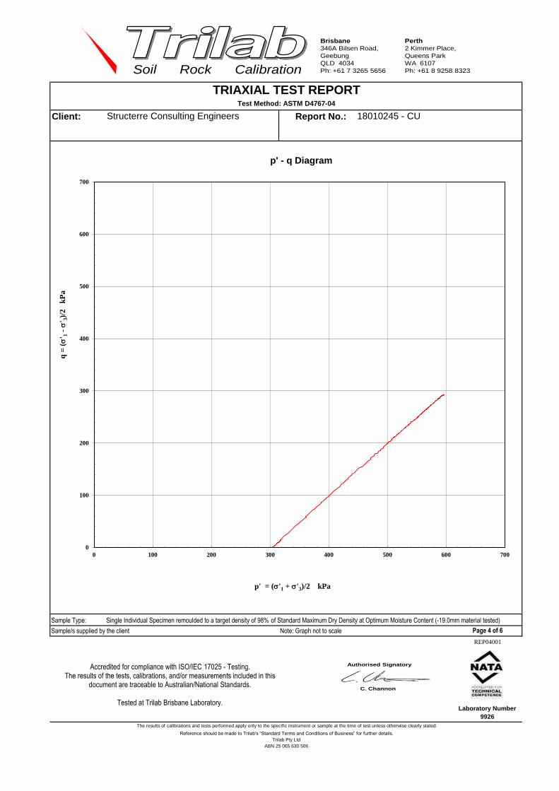
Brisbane
346A Bilsen Road,
Geebung
QLD 4034
Ph: +61 7 3265 5656
Perth
2 Kimmer Place,
Queens Park
WA 6107
Ph: +61 8 9258 8323Soil Rock Calibration
Client: Report No.:
Sample Type: Single Individual Specimen remoulded to a target density of 98% of Standard Maximum Dry Density at Optimum Moisture Content (-19.0mm material tested)
Sample/s supplied by the client Note: Graph not to scale
Reference should be made to Trilab's “Standard Terms and Conditions of Business” for further details.
Trilab Pty Ltd
TRIAXIAL TEST REPORTTest Method: ASTM D4767-04
Structerre Consulting Engineers 18010245 - CU
The results of calibrations and tests performed apply only to the specific instrument or sample at the time of test unless otherwise clearly stated.
Page 4 of 6
REP04001
Laboratory Number
9926
ABN 25 065 630 506
Authorised Signatory
T. Lockhart
0
100
200
300
400
500
600
700
0 100 200 300 400 500 600 700
q =
(s
' 1 -
s' 3
)/2
k
Pa
p' = (s'1 + s'3)/2 kPa
p' - q Diagram
Accredited for compliance with ISO/IEC 17025 - Testing. The results of the tests, calibrations, and/or measurements included in this
document are traceable to Australian/National Standards.
Tested at Trilab Brisbane Laboratory.
Authorised Signatory
C. Channon

Brisbane
346A Bilsen Road,
Geebung
QLD 4034
Ph: +61 7 3265 5656
Perth
2 Kimmer Place,
Queens Park
WA 6107
Ph: +61 8 9258 8323Soil Rock Calibration
Client: Report No.:
Sample Type: Single Individual Specimen remoulded to a target density of 98% of Standard Maximum Dry Density at Optimum Moisture Content (-19.0mm material tested)
Sample/s supplied by the client Note: Graph not to scale
TRIAXIAL TEST REPORTTest Method: ASTM D4767-04
Structerre Consulting Engineers 18010245 - CU
ABN 25 065 630 506
Reference should be made to Trilab's “Standard Terms and Conditions of Business” for further details.
The results of calibrations and tests performed apply only to the specific instrument or sample at the time of test unless otherwise clearly stated.
Page 5 of 6
REP04001
Laboratory Number
9926
Trilab Pty Ltd
Authorised Signatory
T. Lockhart
Accredited for compliance with ISO/IEC 17025 - Testing. The results of the tests, calibrations, and/or measurements included in this
document are traceable to Australian/National Standards.
Tested at Trilab Brisbane Laboratory.
Authorised Signatory
C. Channon
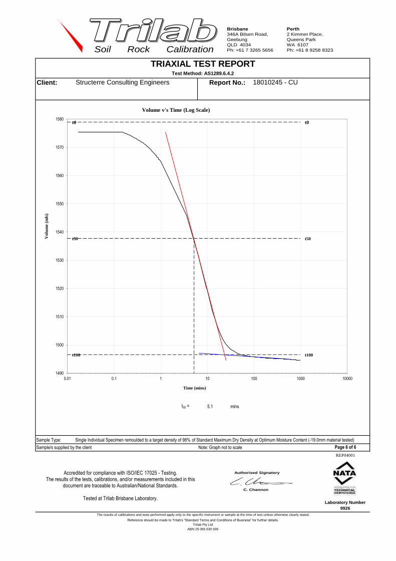
Brisbane
346A Bilsen Road,
Geebung
QLD 4034
Ph: +61 7 3265 5656
Perth
2 Kimmer Place,
Queens Park
WA 6107
Ph: +61 8 9258 8323Soil Rock Calibration
Client: Report No.:
t50 = 5.1 mins
Sample Type: Single Individual Specimen remoulded to a target density of 98% of Standard Maximum Dry Density at Optimum Moisture Content (-19.0mm material tested)
Sample/s supplied by the client Note: Graph not to scale
TRIAXIAL TEST REPORTTest Method: AS1289.6.4.2
18010245 - CUStructerre Consulting Engineers
ABN 25 065 630 506
The results of calibrations and tests performed apply only to the specific instrument or sample at the time of test unless otherwise clearly stated.
Reference should be made to Trilab's “Standard Terms and Conditions of Business” for further details.
Laboratory Number
9926
Trilab Pty Ltd
Page 6 of 6
REP04001
Authorised Signatory
T. Lockhart
t100 t100
t0 t0
t50 t50
1490
1500
1510
1520
1530
1540
1550
1560
1570
1580
0.01 0.1 1 10 100 1000 10000
Vo
lum
e (m
ls)
Time (mins)
Volume v's Time (Log Scale)
Accredited for compliance with ISO/IEC 17025 - Testing. The results of the tests, calibrations, and/or measurements included in this
document are traceable to Australian/National Standards.
Tested at Trilab Brisbane Laboratory.
Authorised Signatory
C. Channon

Brisbane
346A Bilsen Road,
Geebung
QLD 4034
Ph: +61 7 3265 5656
Perth
2 Kimmer Place,
Queens Park
WA 6107
Ph: +61 8 9258 8323Soil Rock Calibrationchrisc 1919
Client Report No.
Address Test Date
Report Date
Project
Client ID Depth (m)
Description
Interpretation between stages 1 to 2
Cohesion C (kPa) 128.2
Angle of Shear Resistance Ф (0) 20.0
MOISTURE CONTENTS Initial 9.4 % Final 9.4 % Failure Criteria Maimum Deviator Stress
Strain
Initial Height 200.2 mm
Initial Diameter 100.4 mm 444 kPa 11.51 %
Wet Density 2.13 t/m3 522 kPa 19.28 %
Dry Density 1.94 t/m3
Rate of Strain 0.500 % / min
Notes/Remarks: Test completed on Stage 2 as 20% strain has been reached as per AS1289 6.4.1.
Graph not to scale Page 1 of 3 REP2601
Laboratory No. 9926
TRIAXIAL TEST REPORTTest Method: AS1289.6.4.1
0.50-1.10
18010243- UU
16/01/2018
10/01/2018
Structerre Consulting Engineers
PO Box 792 BALCATTA WA 6914
A5 TP02
Ravensthorpe Gold Project
0003674Workorder No.
Trilab Pty Ltd ABN 25 065 630 506
The results of calibrations and tests performed apply only to the specific instrument or sample at the time of test unless otherwise clearly stated.
Reference should be made to Trilab's “Standard Terms and Conditions of Business” for further details.
672 kPa
FAILURE DETAILSPrincipal Stresses
SAMPLE & TEST DETAILS
GRAVELLY SILTY CLAY- red
brown
Sample Type Single Individual Specimen remoulded to a target density of
95% of Standard Maximum Dry Density at Optimum
Moisture Content (-19.0mm material tested)
75 kPa
Deviator
Stresss1
75 kPa 519 kPa
Confining PressureSample Details
s3
150 kPa150 kPa
Authorised Signatory
T. Lockhart
0
100
200
300
400
0 100 200 300 400 500 600 700
Sh
ear
Str
ess kP
a
Normal Stress kPa
Mohr Circle Diagram
Accredited for compliance with ISO/IEC 17025 - Testing. The results of the tests, calibrations, and/or measurements included in this
document are traceable to Australian/National Standards.
Tested at Trilab Brisbane Laboratory.
Authorised Signatory
C. Channon
ACCURATE QUALITY RESULTS FOR TOMORROW'S ENGINEERING

Brisbane
346A Bilsen Road,
Geebung
QLD 4034
Ph: +61 7 3265 5656
Perth
2 Kimmer Place,
Queens Park
WA 6107
Ph: +61 8 9258 8323Soil Rock Calibration
Client Report No.
Notes/Remarks: Test completed on Stage 2 as 20% strain has been reached as per AS1289 6.4.1.
Graph not to scale Page 2 of 3 REP2601
Laboratory No. 9926
TRIAXIAL TEST REPORTTest Method: AS1289.6.4.1
18010243- UUStructerre Consulting Engineers
The results of calibrations and tests performed apply only to the specific instrument or sample at the time of test unless otherwise clearly stated.
Reference should be made to Trilab's “Standard Terms and Conditions of Business” for further details.Trilab Pty Ltd ABN 25 065 630 506
Authorised Signatory
T. Lockhart
0
100
200
300
400
500
600
0 5 10 15 20 25
De
via
tor
Str
es
s
kP
a
Strain %
Stress/Strain Diagram
Accredited for compliance with ISO/IEC 17025 - Testing. The results of the tests, calibrations, and/or measurements included in this
document are traceable to Australian/National Standards.
Tested at Trilab Brisbane Laboratory.
Authorised Signatory
C. Channon
ACCURATE QUALITY RESULTS FOR TOMORROW'S ENGINEERING

Brisbane
346A Bilsen Road,
Geebung
QLD 4034
Ph: +61 7 3265 5656
Perth
2 Kimmer Place,
Queens Park
WA 6107
Ph: +61 8 9258 8323Soil Rock Calibration
Client Report No.
Notes/Remarks: Photo not to scale
Graph not to scale Page 3 of 3 REP2601
Laboratory No. 9926
TRIAXIAL TEST REPORTTest Method: AS1289.6.4.1
Structerre Consulting Engineers 18010243- UU
The results of calibrations and tests performed apply only to the specific instrument or sample at the time of test unless otherwise clearly stated.
Reference should be made to Trilab's “Standard Terms and Conditions of Business” for further details.Trilab Pty Ltd ABN 25 065 630 506
Authorised Signatory
T. Lockhart
Accredited for compliance with ISO/IEC 17025 - Testing. The results of the tests, calibrations, and/or measurements included in this
document are traceable to Australian/National Standards.
Tested at Trilab Brisbane Laboratory.
Authorised Signatory
C. Channon
ACCURATE QUALITY RESULTS FOR TOMORROW'S ENGINEERING

Brisbane
346A Bilsen Road,
Geebung
QLD 4034
Ph: +61 7 3265 5656
Perth
2 Kimmer Place,
Queens Park
WA 6107
Ph: +61 8 9258 8323Soil Rock Calibrationchrisc 1919
Client Report No.
Address Test Date
Report Date
Project
Client ID Depth (m)
Description
Interpretation between stages 1 to 2 2 to 3 1 to 3
Cohesion C (kPa) 18.1 30.6 24.4
Angle of Shear Resistance Ф (0) 18.6 15.6 16.5
MOISTURE CONTENTS Initial 16.2 % Final 16.2 % Failure Criteria Maximum Deviator Stress
Strain
Initial Height 200.0 mm
Initial Diameter 100.1 mm 120 kPa 5.41 %
Wet Density 1.88 t/m3 191 kPa 9.78 %
Dry Density 1.62 t/m3 301 kPa 15.09 %
Rate of Strain 0.250 % / min
Notes/Remarks:
Graph not to scale Page 1 of 3 REP2601
Laboratory No. 9926
TRIAXIAL TEST REPORTTest Method: AS1289.6.4.1
0.70-2.80
18010244- UU
16/01/2018
12/01/2018
Structerre Consulting Engineers
PO Box 792 BALCATTA WA 6914
A27 TP13
Ravensthorpe Gold Project
0003674Workorder No.
Trilab Pty Ltd ABN 25 065 630 506
The results of calibrations and tests performed apply only to the specific instrument or sample at the time of test unless otherwise clearly stated.
Reference should be made to Trilab's “Standard Terms and Conditions of Business” for further details.
341 kPa
601 kPa
75 kPa
Deviator
Stresss1
75 kPa 195 kPa
Confining Pressure
FAILURE DETAILSPrincipal Stresses
SAMPLE & TEST DETAILS
CLAYEY SILT- yellow/brown Sample Type Single Individual Specimen remoulded to a target density of
95% of Standard Maximum Dry Density at Optimum
Moisture Content (-19.0mm material tested)
Sample Detailss3
150 kPa
300 kPa
150 kPa
300 kPa
Authorised Signatory
T. Lockhart
0
100
200
300
400
0 100 200 300 400 500 600 700
Sh
ear
Str
ess kP
a
Normal Stress kPa
Mohr Circle Diagram
Accredited for compliance with ISO/IEC 17025 - Testing. The results of the tests, calibrations, and/or measurements included in this
document are traceable to Australian/National Standards.
Tested at Trilab Brisbane Laboratory.
Authorised Signatory
C. Channon
ACCURATE QUALITY RESULTS FOR TOMORROW'S ENGINEERING

Brisbane
346A Bilsen Road,
Geebung
QLD 4034
Ph: +61 7 3265 5656
Perth
2 Kimmer Place,
Queens Park
WA 6107
Ph: +61 8 9258 8323Soil Rock Calibration
Client Report No.
Notes/Remarks:
Graph not to scale Page 2 of 3 REP2601
Laboratory No. 9926
TRIAXIAL TEST REPORTTest Method: AS1289.6.4.1
18010244- UUStructerre Consulting Engineers
The results of calibrations and tests performed apply only to the specific instrument or sample at the time of test unless otherwise clearly stated.
Reference should be made to Trilab's “Standard Terms and Conditions of Business” for further details.Trilab Pty Ltd ABN 25 065 630 506
Authorised Signatory
T. Lockhart
0
50
100
150
200
250
300
350
0 2 4 6 8 10 12 14 16 18
De
via
tor
Str
es
s
kP
a
Strain %
Stress/Strain Diagram
Accredited for compliance with ISO/IEC 17025 - Testing. The results of the tests, calibrations, and/or measurements included in this
document are traceable to Australian/National Standards.
Tested at Trilab Brisbane Laboratory.
Authorised Signatory
C. Channon
ACCURATE QUALITY RESULTS FOR TOMORROW'S ENGINEERING

Brisbane
346A Bilsen Road,
Geebung
QLD 4034
Ph: +61 7 3265 5656
Perth
2 Kimmer Place,
Queens Park
WA 6107
Ph: +61 8 9258 8323Soil Rock Calibration
Client Report No.
Notes/Remarks: Photo not to scale
Graph not to scale Page 3 of 3 REP2601
Laboratory No. 9926
TRIAXIAL TEST REPORTTest Method: AS1289.6.4.1
Structerre Consulting Engineers 18010244- UU
The results of calibrations and tests performed apply only to the specific instrument or sample at the time of test unless otherwise clearly stated.
Reference should be made to Trilab's “Standard Terms and Conditions of Business” for further details.Trilab Pty Ltd ABN 25 065 630 506
Authorised Signatory
T. Lockhart
Accredited for compliance with ISO/IEC 17025 - Testing. The results of the tests, calibrations, and/or measurements included in this
document are traceable to Australian/National Standards.
Tested at Trilab Brisbane Laboratory.
Authorised Signatory
C. Channon
ACCURATE QUALITY RESULTS FOR TOMORROW'S ENGINEERING
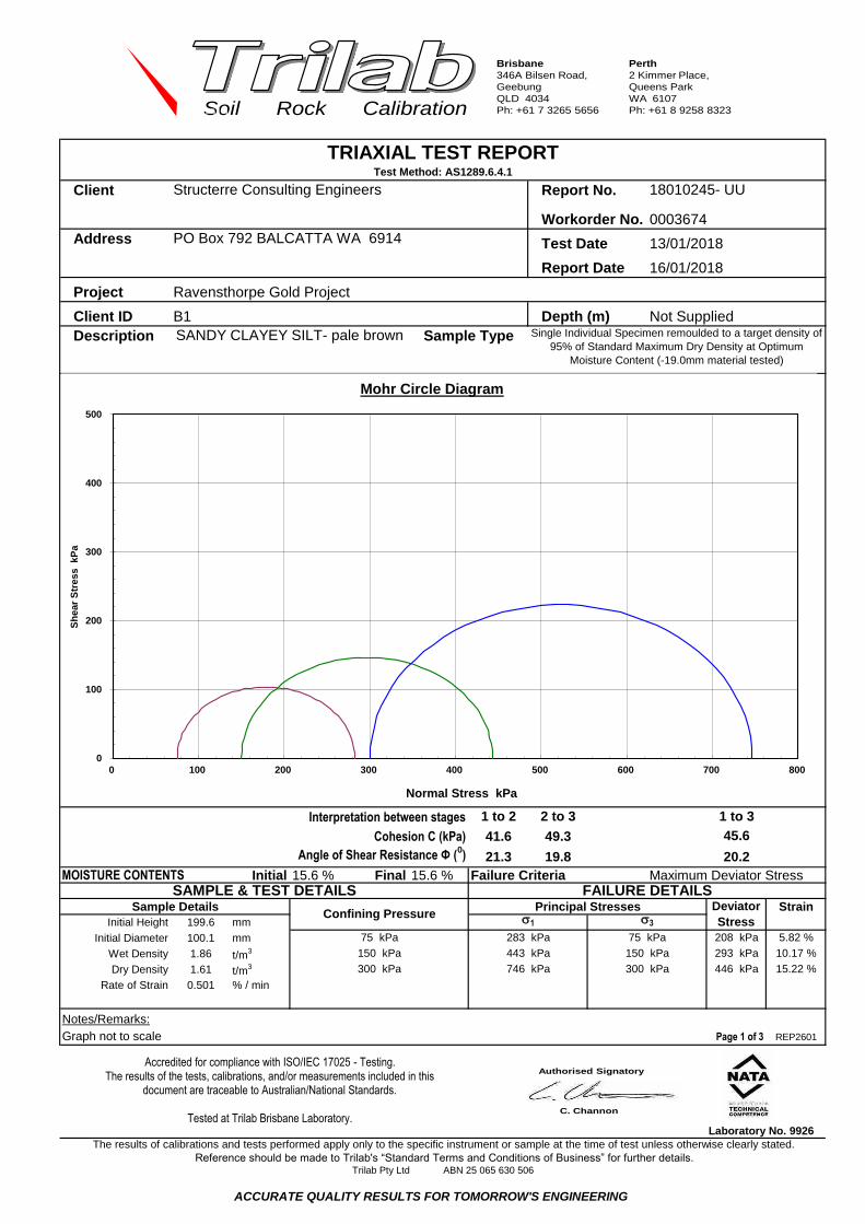
Brisbane
346A Bilsen Road,
Geebung
QLD 4034
Ph: +61 7 3265 5656
Perth
2 Kimmer Place,
Queens Park
WA 6107
Ph: +61 8 9258 8323Soil Rock Calibrationchrisc 1919
Client Report No.
Address Test Date
Report Date
Project
Client ID Depth (m)
Description
Interpretation between stages 1 to 2 2 to 3 1 to 3
Cohesion C (kPa) 41.6 49.3 45.6
Angle of Shear Resistance Ф (0) 21.3 19.8 20.2
MOISTURE CONTENTS Initial 15.6 % Final 15.6 % Failure Criteria Maximum Deviator Stress
Strain
Initial Height 199.6 mm
Initial Diameter 100.1 mm 208 kPa 5.82 %
Wet Density 1.86 t/m3 293 kPa 10.17 %
Dry Density 1.61 t/m3 446 kPa 15.22 %
Rate of Strain 0.501 % / min
Notes/Remarks:
Graph not to scale Page 1 of 3 REP2601
Laboratory No. 9926
TRIAXIAL TEST REPORTTest Method: AS1289.6.4.1
Not Supplied
18010245- UU
16/01/2018
13/01/2018
Structerre Consulting Engineers
PO Box 792 BALCATTA WA 6914
B1
Ravensthorpe Gold Project
0003674Workorder No.
Trilab Pty Ltd ABN 25 065 630 506
The results of calibrations and tests performed apply only to the specific instrument or sample at the time of test unless otherwise clearly stated.
Reference should be made to Trilab's “Standard Terms and Conditions of Business” for further details.
443 kPa
746 kPa
75 kPa
Deviator
Stresss1
75 kPa 283 kPa
Confining Pressure
FAILURE DETAILSPrincipal Stresses
SAMPLE & TEST DETAILS
Sample Type Single Individual Specimen remoulded to a target density of
95% of Standard Maximum Dry Density at Optimum
Moisture Content (-19.0mm material tested)
SANDY CLAYEY SILT- pale brown
Sample Detailss3
150 kPa
300 kPa
150 kPa
300 kPa
Authorised Signatory
T. Lockhart
0
100
200
300
400
500
0 100 200 300 400 500 600 700 800
Sh
ear
Str
ess kP
a
Normal Stress kPa
Mohr Circle Diagram
Accredited for compliance with ISO/IEC 17025 - Testing. The results of the tests, calibrations, and/or measurements included in this
document are traceable to Australian/National Standards.
Tested at Trilab Brisbane Laboratory.
Authorised Signatory
C. Channon
ACCURATE QUALITY RESULTS FOR TOMORROW'S ENGINEERING

Brisbane
346A Bilsen Road,
Geebung
QLD 4034
Ph: +61 7 3265 5656
Perth
2 Kimmer Place,
Queens Park
WA 6107
Ph: +61 8 9258 8323Soil Rock Calibration
Client Report No.
Notes/Remarks:
Graph not to scale Page 2 of 3 REP2601
Laboratory No. 9926
TRIAXIAL TEST REPORTTest Method: AS1289.6.4.1
18010245- UUStructerre Consulting Engineers
The results of calibrations and tests performed apply only to the specific instrument or sample at the time of test unless otherwise clearly stated.
Reference should be made to Trilab's “Standard Terms and Conditions of Business” for further details.Trilab Pty Ltd ABN 25 065 630 506
Authorised Signatory
T. Lockhart
0
50
100
150
200
250
300
350
400
450
500
0 2 4 6 8 10 12 14 16 18 20
De
via
tor
Str
es
s
kP
a
Strain %
Stress/Strain Diagram
Accredited for compliance with ISO/IEC 17025 - Testing. The results of the tests, calibrations, and/or measurements included in this
document are traceable to Australian/National Standards.
Tested at Trilab Brisbane Laboratory.
Authorised Signatory
C. Channon
ACCURATE QUALITY RESULTS FOR TOMORROW'S ENGINEERING

Brisbane
346A Bilsen Road,
Geebung
QLD 4034
Ph: +61 7 3265 5656
Perth
2 Kimmer Place,
Queens Park
WA 6107
Ph: +61 8 9258 8323Soil Rock Calibration
Client Report No.
Notes/Remarks: Photo not to scale
Graph not to scale Page 3 of 3 REP2601
Laboratory No. 9926
TRIAXIAL TEST REPORTTest Method: AS1289.6.4.1
Structerre Consulting Engineers 18010245- UU
The results of calibrations and tests performed apply only to the specific instrument or sample at the time of test unless otherwise clearly stated.
Reference should be made to Trilab's “Standard Terms and Conditions of Business” for further details.Trilab Pty Ltd ABN 25 065 630 506
Authorised Signatory
T. Lockhart
Accredited for compliance with ISO/IEC 17025 - Testing. The results of the tests, calibrations, and/or measurements included in this
document are traceable to Australian/National Standards.
Tested at Trilab Brisbane Laboratory.
Authorised Signatory
C. Channon
ACCURATE QUALITY RESULTS FOR TOMORROW'S ENGINEERING

Brisbane
346A Bilsen Road,
Geebung
QLD 4034
Ph: +61 7 3265 5656
Perth
2 Kimmer Place,
Queens Park
WA 6107
Ph: +61 8 9258 8323Soil Rock Calibration
chrisc 1919
Client: Report No.:
Workorder No.
Address Test Date:
Report Date:
Project:
Client Id.: Depth (m):
Description:
0.8
1.6
0
20
Wet Density (t/m3): 2.91 Initial Moisture (%): 163.2
Particle Density (t/m3): 2.68 Initial Voids Ratio: 1.425 Initial Degree of Saturation (%): 100.0
Slurry sample supplied by client Remarks: Mixed to a target of 40% Solids Page 1 of 2
OEDOMETER TEST REPORTTest Method: AS1289.6.6.1, 3.5.1
18090289-CHP
21/09/2018
15/10/2018
Not Supplied
SILT - pale brown, Tailings
Structerre Consulting Engineers
PO Box 792 BALCATTA WA 6914
S893890-A - Oxide Tailing Sample
4845
S893890 - Ravensthorpe Gold Project
Trilab Pty Ltd
REP03102
The results of calibrations and tests performed apply only to the specific instrument or sample at the time of test unless otherwise clearly stated.
Reference should be made to Trilab's “Standard Terms and Conditions of Business” for further details.
0.0
2.0
4.0
6.0
8.0
10.0
12.0
14.0
16.0
18.0
20.0
0.90
1.00
1.10
1.20
1.30
1.40
1.50
0.1 1 10 100 1000
% C
on
solid
atio
n
Vo
id R
atio
Applied Pressure (kPa)
Void Ratio
% Consolidation
Authorised Signatory
C. Channon

Brisbane
346A Bilsen Road,
Geebung
QLD 4034
Ph: +61 7 3265 5656
Perth
2 Kimmer Place,
Queens Park
WA 6107
Ph: +61 8 9258 8323Soil Rock Calibration
Client: Report No.:
Workorder No.
Address Test Date:
Report Date:
Project:
Client Id.: Depth (m):
Description:
Stage
t50 t90
1 74.39 61.35
2 53.62 59.46
3 113.89 85.89
4 264.59 228.43
5 376.48 346.75
6 599.35 453.37
7 1294.13 1202.88
Remarks: Mixed to a target of 40% Solids Page 2 of 2
(kPa)
TEST RESULTS
OEDOMETER TEST REPORTTest Method: AS1289.6.6.1, 3.5.1
Structerre Consulting Engineers 18090289-CHP
4845
PO Box 792 BALCATTA WA 6914 21/09/2018
15/10/2018
0.232
0.228
9.095
3.228
0.326
20-40
40-81
81-161
5-11
0.045
0.164
0.132
0.5-2
2-5
1.1
3.8
5.7
7.80.19711-20
7.473 0.00
2.02
2.87
2.95
SILT - pale brown, Tailings
Load
S893890-A - Oxide Tailing Sample
Cv (m2/yr) % ConsolidationCa x 10
-3Mv (kPa-1
x10-3
)Cc
Not Supplied
S893890 - Ravensthorpe Gold Project
17.6
10.7
13.5
1.561
0.786
2.240.581
2.66
2.23
Trilab Pty Ltd
REP03102
The results of calibrations and tests performed apply only to the specific instrument or sample at the time of test unless otherwise clearly stated.
Reference should be made to Trilab's “Standard Terms and Conditions of Business” for further details.
2.486
Authorised Signatory
C. Channon

Brisbane
346A Bilsen Road,
Geebung
QLD 4034
Ph: +61 7 3265 5656
Perth
2 Kimmer Place,
Queens Park
WA 6107
Ph: +61 8 9258 8323Soil Rock Calibration
ABN 25 065 630 506

Brisbane
346A Bilsen Road,
Geebung
QLD 4034
Ph: +61 7 3265 5656
Perth
2 Kimmer Place,
Queens Park
WA 6107
Ph: +61 8 9258 8323Soil Rock Calibration
ABN 25 065 630 506

Brisbane
346A Bilsen Road,
Geebung
QLD 4034
Ph: +61 7 3265 5656
Perth
2 Kimmer Place,
Queens Park
WA 6107
Ph: +61 8 9258 8323Soil Rock Calibration
Gerard boma
Client Report No.
Address Test Date
Report Date
Project
Client ID
Description Sample Type
(min) (cm) (g/cm3)
0.5 36.54 0.552
1 34.91 0.578
2 34.10 0.592
4 33.70 0.599
8 33.29 0.606
15 32.07 0.629
30 30.45 0.663
60 28.42 0.710
120 24.97 0.808
180 21.52 0.938
240 20.30 0.994
300 17.46 1.156
1260 15.02 1.344
1320 15.02 1.344
1380 15.02 1.344
1440 15.02 1.344
Remarks:
Sample/s supplied by client REP36701
Settling Test Type:
Initial Mass of Slurry (g): Volume of water in Cylinder (ml)
Mass of dry waste material (g)Drained
2434.3 Elapsed
Time
Solids
Height
Dry
Density
2000.0
994.2
SETTLING TEST REPORT
Settling Test Procedure - as Supplied by Client
RESULTS OF TESTING
Structerre Consulting Engineers
PO Box 792 BALCATTA WA 6914
Drained
3/09/2018
18080058-SETL
Oxide Tailing Sample (S893890-A) Depth (m) Not Supplied
SILT - brown
S893890 - Ravensthorpe Gold Project
28/08/2018
The results of calibrations and tests performed apply only to the specific instrument or sample at the time of test unless otherwise clearly stated.
Reference should be made to Trilab's “Standard Terms and Conditions of Business” for further details.Trilab Pty Ltd ABN 25 065 630 506
Page: 1 of 1
Authorised Signatory
C. Channon
0
5
10
15
20
25
30
35
40
0
0.2
0.4
0.6
0.8
1
1.2
1.4
1.6
0 200 400 600 800 1000 1200 1400 1600
So
lids
Hei
gh
t (c
m)
Dry
Den
sity
(g/c
m3 )
Elapsed Time of Test (mins) Dry Density Solids Height
ACCURATE QUALITY RESULTS FOR TOMORROW'S ENGINEERING
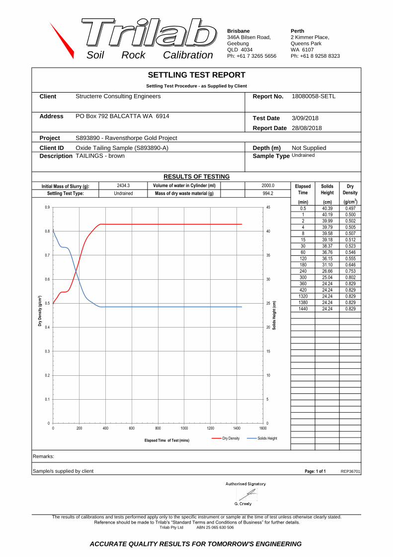
Brisbane
346A Bilsen Road,
Geebung
QLD 4034
Ph: +61 7 3265 5656
Perth
2 Kimmer Place,
Queens Park
WA 6107
Ph: +61 8 9258 8323Soil Rock Calibration
chrisc 1919
Client Report No.
Address Test Date
Report Date
Project
Client ID
Description Sample Type
(min) (cm) (g/cm3)
0.5 40.39 0.497
1 40.19 0.500
2 39.99 0.502
4 39.79 0.505
8 39.58 0.507
15 39.18 0.512
30 38.37 0.523
60 36.76 0.546
120 36.15 0.555
180 31.10 0.646
240 26.66 0.753
300 25.04 0.802
360 24.24 0.829
420 24.24 0.829
1320 24.24 0.829
1380 24.24 0.829
1440 24.24 0.829
Remarks:
Sample/s supplied by client REP36701
The results of calibrations and tests performed apply only to the specific instrument or sample at the time of test unless otherwise clearly stated.
Reference should be made to Trilab's “Standard Terms and Conditions of Business” for further details.Trilab Pty Ltd ABN 25 065 630 506
Page: 1 of 1
SETTLING TEST REPORT
Settling Test Procedure - as Supplied by Client
RESULTS OF TESTING
Structerre Consulting Engineers
PO Box 792 BALCATTA WA 6914
Undrained
28/08/2018
18080058-SETL
Oxide Tailing Sample (S893890-A) Depth (m) Not Supplied
TAILINGS - brown
S893890 - Ravensthorpe Gold Project
3/09/2018
Elapsed
Time
Solids
Height
Dry
Density
2000.0
994.2Settling Test Type:
Initial Mass of Slurry (g): Volume of water in Cylinder (ml)
Mass of dry waste material (g)Undrained
2434.3
Authorised Signatory
C. Channon
0
5
10
15
20
25
30
35
40
45
0
0.1
0.2
0.3
0.4
0.5
0.6
0.7
0.8
0.9
0 200 400 600 800 1000 1200 1400 1600
So
lids
Hei
gh
t (c
m)
Dry
Den
sity
(g/c
m3 )
Elapsed Time of Test (mins) Dry Density Solids Height
ACCURATE QUALITY RESULTS FOR TOMORROW'S ENGINEERING

Brisbane
346A Bilsen Road,
Geebung
QLD 4034
Ph: +61 7 3265 5656
Perth
2 Kimmer Place,
Queens Park
WA 6107
Ph: +61 8 9258 8323Soil Rock Calibration
Client Report No.
Address Test Date
Report Date
Project
Client ID
29/08/2018
Start Date
30/08/2018
31/08/2018
1/09/2018
3/09/2018
4/09/2018
5/09/2018
6/09/2018
7/09/2018
10/09/2018
12/09/2018
13/09/2018
14/09/2018
18/09/2018
21/09/2018
25/09/2018
28/09/2018
1/10/2018
2/10/2018
Remarks:
Sample/s supplied by client REP41101
Control Beaker
Evaporation (g)
-
20.2
53.727.8 1068.4 1206.7 63.5 0.0 1206.7
18.6 1101.9 1246.1 24.1 0.0 1246.1
Test Sample Decant
21.9 264.9 684.3 585.9 0.0 684.3857.2
22.3 266.9 684.3 585.9 0.0 684.3855.2
19.3 293.5 685.3 584.9 0.0 685.3828.6
21.7 367.6 689.0 581.2 0.0 689.0754.5
20.4 470.9 698.2 572.0 0.0 698.2651.2
29.0 559.4 710.8 559.4 0.0 710.8562.7
28.1 664.4 771.4 498.8 0.0 771.4457.7
27.9 693.3 797.3 472.9 0.0 797.3428.8
29.3 725.8 826.7 443.5 0.0 826.7396.3
22.6 790.3 890.2 380.0 0.0 890.2331.8
30.9 863.9 970.2 300.0 0.0 970.2258.2
29.2 902.7 1013.1 257.1 0.0 1013.1219.4
135.8
21.3 1036.0 1168.3 101.9 0.0 1168.386.1
29.0 938.2 1052.3 217.9 0.0 1052.3183.9
21.2 967.3 1085.7 184.5 0.0 1085.7154.8
Reference should be made to Trilab's “Standard Terms and Conditions of Business” for further details.
Trilab Pty Ltd ABN 25 065 630 506
DateTemperature (° C) Mass (g) Mass (g)
Page: 1 of 1
-
Evaporation (g) Mass (g) Decantation (g)
19.1 1122.1 1270.2 - 0.0
The results of calibrations and tests performed apply only to the specific instrument or sample at the time of test unless otherwise clearly stated.
22.0 986.3 1109.0 161.2 0.0 1109.0
Tailings at 40% solids
RESULTS OF TESTING
PO Box 792 BALCATTA WA 6914 29/08/2018-2/10/2018
2/10/2018
S893890 - Ravensthorpe Gold Project
Depth (m) Not Supplied
AIR DRYING TEST REPORT
Air Drying Test Procedure - as Supplied by Client
Structerre Consulting Engineers P18080058-AD
Oxide Tailing Sample (S893890-A)
Sample Type
0
200
400
600
800
1000
1200
1400
0 5 10 15 20 25 30 35 40
Mas
s (g
)
Elapsed Time of Test (days)
Mass v's Elapsed Time Test Sample Control Beaker
ACCURATE QUALITY RESULTS FOR TOMORROW'S ENGINEERING

Brisbane
346A Bilsen Road,
Geebung
QLD 4034
Ph: +61 7 3265 5656
Perth
2 Kimmer Place,
Queens Park
WA 6107
Ph: +61 8 9258 8323Soil Rock Calibration
James
Client Report No.
Address PO Box 792 BALCATTA WA 6914
Project Test Date
Report Date
18080058 - - - - -
Oxide Tailing
Sample
(S893890-A)
- - - - -
Not Supplied - - - - -
33 - - - - -
28 - - - - -
5 - - - - -
Linear Shrinkage (%) 2.0 - - - - -
Moisture Content (%) 143.6 - - - - -
- - - - - -
- - - - - -
- - - - - -
- - - - - -
- - - - - -
- - - - - -
Linear Shrinkage (%) - - - - - -
Moisture Content (%) - - - - - -
NOTES/REMARKS: The samples were tested oven dried, dry sieved and in a 125-250mm mould.
Sample/s supplied by the client * Cracking occurred + Curling occurred Page 1 of 1 REP30101
Laboratory No. 9926
Depth (m)
Trilab Pty Ltd ABN 25 065 630 506
Reference should be made to Trilab's “Standard Terms and Conditions of Business” for further details.
The results of calibrations and tests performed apply only to the specific instrument or sample at the time of test unless otherwise clearly stated.
Liquid Limit (%)
Plastic Limit (%)
Plasticity Index (%)
ATTERBERG LIMITS TEST REPORTTest Method: AS 1289 2.1.1, 3.1.1, 3.1.2, 3.2.1, 3.3.1, 3.4.1
S893890 - Ravensthorpe Gold Project
P 18080058-AL
04/09/2018
03/09/2018
Structerre Consulting Engineers
Sample No.
Client ID
Depth (m)
Client ID
Sample No.
Plastic Limit (%)
Liquid Limit (%)
Plasticity Index (%)
Authorised Signatory
A. Harrap
Authorised Signatory
C. Channon
Accredited for compliance with ISO/IEC 17025 - Testing. The results of the tests, calibrations, and/or measurements included in
this document are traceable to Australian/National Standards.
Tested at Trilab Perth Laboratory.
ACCURATE QUALITY RESULTS FOR TOMORROW'S ENGINEERING

Brisbane
346A Bilsen Road,
Geebung
QLD 4034
Ph: +61 7 3265 5656
Perth
2 Kimmer Place,
Queens Park
WA 6107
Ph: +61 8 9258 8323Soil Rock Calibration
chrisc 1919
Client Report No.
Address
Project Test Date
Report Date
Client ID Oxide Tailing Sample (S893890-A) Depth (m)
Sieve Size Passing
(mm) %
150.0
75.0
53.0
37.5
26.5
19.0
9.5
4.75
2.36
1.18
0.600
0.425
0.300 100
0.150 98
0.075 82
0.059 78
0.043 68
0.031 60
0.023 55
0.017 47
0.013 43
0.009 36
0.007 30
0.005 24
0.004 21
0.003 19
0.003 16
0.002 14
0.001 11
NOTES/REMARKS:
Moisture Content 143.6% -2.36mm Soil Particle Density(t/m3) 2.82
Sample/s supplied by the client Page 1 of 1 REP33901
Laboratory No. 9926
The results of calibrations and tests performed apply only to the specific instrument or sample at the time of test unless otherwise clearly stated.
Reference should be made to Trilab's “Standard Terms and Conditions of Business” for further details.Trilab Pty Ltd ABN 25 065 630 506
PARTICLE SIZE DISTRIBUTION TEST REPORTTest Method: AS 1289 3.6.3, 3.5.1
Structerre Consulting Engineers P 18080058-G
4/09/2018
28/08/2018-4/09/2018
PO Box 792 BALCATTA WA 6914
S893890 - Ravensthorpe Gold Project
Not Supplied
Authorised Signatory
A. Harrap
Authorised Signatory
C. Channon
0
10
20
30
40
50
60
70
80
90
100
0.001 0.01 0.1 1
Passin
g (
%)
Particle Size (mm)
Accredited for compliance with ISO/IEC 17025 - Testing. The results of the tests, calibrations, and/or measurements included in this
document are traceable to Australian/National Standards.
Tested at Trilab Perth Laboratory
ACCURATE QUALITY RESULTS FOR TOMORROW'S ENGINEERING
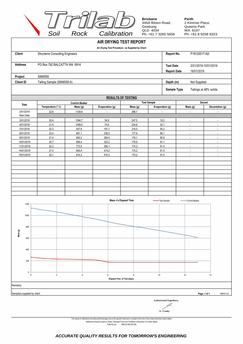
Brisbane
346A Bilsen Road,
Geebung
QLD 4034
Ph: +61 7 3265 5656
Perth
2 Kimmer Place,
Queens Park
WA 6107
Ph: +61 8 9258 8323Soil Rock Calibration
Gerard 1919
Client Report No.
Address Test Date
Report Date
Project
Client ID
2/01/2019
Start Date
3/01/2019
4/01/2019
7/01/2019
8/01/2019
9/01/2019
10/01/2019
11/01/2019
14/01/2019
15/01/2019
Remarks:
Sample/s supplied by client REP41101
Control Beaker
Evaporation (g)
-
34.9
70.621.4 1059.0 234.6 32.1 - -
20.4 1094.7 247.5 19.2 - -
Test Sample Decant
22.1 614.3 175.2 91.5 - -515.3
21.0 655.4 175.2 91.5 - -474.2
22.2 773.5 175.3 91.4 - -356.1
238.5
20.3 937.9 216.5 50.2 - -191.7
20.7 806.4 175.6 91.1 - -323.2
21.4 845.2 176.1 90.6 - -284.4
Reference should be made to Trilab's “Standard Terms and Conditions of Business” for further details.
Trilab Pty Ltd ABN 25 065 630 506
DateTemperature (° C) Mass (g) Mass (g)
Page: 1 of 1
-
Evaporation (g) Mass (g) Decantation (g)
22.6 1129.6 266.7 - -
The results of calibrations and tests performed apply only to the specific instrument or sample at the time of test unless otherwise clearly stated.
23.4 891.1 177.6 89.1 - -
Tailings at 48% solids
RESULTS OF TESTING
PO Box 792 BALCATTA WA 6914 2/01/2019-15/01/2019
16/01/2019
S906559
Depth (m) Not Supplied
AIR DRYING TEST REPORT
Air Drying Test Procedure - as Supplied by Client
Structerre Consulting Engineers P18120017-AD
Tailing Sample (S906559-A)
Sample Type
0
200
400
600
800
1000
1200
0 2 4 6 8 10 12 14
Mas
s (g
)
Elapsed Time of Test (days)
Mass v's Elapsed Time Test Sample Control Beaker
ACCURATE QUALITY RESULTS FOR TOMORROW'S ENGINEERING

Brisbane
346A Bilsen Road,
Geebung
QLD 4034
Ph: +61 7 3265 5656
Perth
2 Kimmer Place,
Queens Park
WA 6107
Ph: +61 8 9258 8323Soil Rock Calibration
James
Client Report No.
Address PO Box 792 BALCATTA WA 6914
Project Test Date
Report Date
18120017 - - - - -
Tailing Sample
(S906559-A)- - - - -
Not Supplied - - - - -
Not Obtainable - - - - -
Not Obtainable - - - - -
Non-plastic - - - - -
Linear Shrinkage (%) Not Obtainable - - - - -
Moisture Content (%) 59.6 - - - - -
- - - - - -
- - - - - -
- - - - - -
- - - - - -
- - - - - -
- - - - - -
Linear Shrinkage (%) - - - - - -
Moisture Content (%) - - - - - -
NOTES/REMARKS: The samples were tested oven dried, dry sieved and in a 125-250mm mould.
Sample/s supplied by the client * Cracking occurred + Curling occurred Page 1 of 1 REP30101
Laboratory No. 9926
Depth (m)
Trilab Pty Ltd ABN 25 065 630 506
Reference should be made to Trilab's “Standard Terms and Conditions of Business” for further details.
The results of calibrations and tests performed apply only to the specific instrument or sample at the time of test unless otherwise clearly stated.
Liquid Limit (%)
Plastic Limit (%)
Plasticity Index (%)
ATTERBERG LIMITS TEST REPORTTest Method: AS 1289 2.1.1, 3.1.1, 3.1.2, 3.2.1, 3.3.1, 3.4.1
S906559
P 18120017-AL
20/12/2018
18/12/2018-19/12/2018
Structerre Consulting Engineers
Sample No.
Client ID
Depth (m)
Client ID
Sample No.
Plastic Limit (%)
Liquid Limit (%)
Plasticity Index (%)
Authorised Signatory
A. Harrap
Authorised Signatory
C. Channon
Accredited for compliance with ISO/IEC 17025 - Testing. The results of the tests, calibrations, and/or measurements included in
this document are traceable to Australian/National Standards.
Tested at Trilab Perth Laboratory.
ACCURATE QUALITY RESULTS FOR TOMORROW'S ENGINEERING

Brisbane
346A Bilsen Road,
Geebung
QLD 4034
Ph: +61 7 3265 5656
Perth
2 Kimmer Place,
Queens Park
WA 6107
Ph: +61 8 9258 8323Soil Rock Calibration
Client Report No.
Address
Project Test Date
Report Date
Client ID Tailing Sample (S906559-A) Depth (m)
Sieve Size Passing
(mm) %
150.0
75.0
53.0
37.5
26.5
19.0
9.5
4.75
2.36
1.18
0.600
0.425
0.300 100
0.150 97
0.075 77
0.052 60
0.038 55
0.028 45
0.02 40
0.015 35
0.011 30
0.0081 25
0.0058 20
0.0042 15
0.0034 11
0.0030 10
0.0024 9
0.0021 7
0.0012 5
NOTES/REMARKS:
Moisture Content 59.6% -2.36mm Soil Particle Density(t/m3) 2.91
Sample/s supplied by the client Page 1 of 1 REP33901
Laboratory No. 9926
PO Box 792 BALCATTA WA 6914
S906559
Not Supplied
PARTICLE SIZE DISTRIBUTION TEST REPORTTest Method: AS 1289 3.6.3, 3.5.1
Structerre Consulting Engineers P 18120017-G
21/12/2018
18/12/2018-21/12/2018
The results of calibrations and tests performed apply only to the specific instrument or sample at the time of test unless otherwise clearly stated.
Reference should be made to Trilab's “Standard Terms and Conditions of Business” for further details.Trilab Pty Ltd ABN 25 065 630 506
Authorised Signatory
A. Harrap
Authorised Signatory
C. Channon
0
10
20
30
40
50
60
70
80
90
100
0.001 0.01 0.1 1
Passin
g (
%)
Particle Size (mm)
Accredited for compliance with ISO/IEC 17025 - Testing. The results of the tests, calibrations, and/or measurements included in this
document are traceable to Australian/National Standards.
Tested at Trilab Perth Laboratory
ACCURATE QUALITY RESULTS FOR TOMORROW'S ENGINEERING

Brisbane
346A Bilsen Road,
Geebung
QLD 4034
Ph: +61 7 3265 5656
Perth
2 Kimmer Place,
Queens Park
WA 6107
Ph: +61 8 9258 8323Soil Rock Calibration
Gerard boma
Client Report No.
Address Test Date 14/12/2018-18/12/2018
Report Date
Project
Client ID
Description Sample Type
(min) (cm) (g/cm3)
0.5 40.60 0.686
1 40.60 0.686
2 40.60 0.686
4 40.60 0.686
8 39.78 0.700
15 38.97 0.715
30 36.54 0.763
60 32.48 0.858
120 24.76 1.125
180 19.49 1.430
240 19.08 1.460
300 19.08 1.460
360 19.08 1.460
420 19.08 1.460
4263 18.67 1.492
5733 18.67 1.492
Remarks:
Sample/s supplied by client REP36701
Settling Test Type:
Initial Mass of Slurry (g): Volume of water in Cylinder (ml)
Mass of dry waste material (g)Drained
2870.9 Elapsed
Time
Solids
Height
Dry
Density
2000.0
1372.5
SETTLING TEST REPORT
Settling Test Procedure - as Supplied by Client
RESULTS OF TESTING
Golder Associates Pty Ltd
PO Box 1914 WEST PERTH WA 6872
Drained
20/12/2018
181120017-SETL
TCL-TP014 - Sample ID 6 Depth (m) 0.50-1.00
SILT - grey
18104178 - Metronet TCL Thornlie to Cockburn Link
The results of calibrations and tests performed apply only to the specific instrument or sample at the time of test unless otherwise clearly stated.
Reference should be made to Trilab's “Standard Terms and Conditions of Business” for further details.Trilab Pty Ltd ABN 25 065 630 506
Page: 1 of 1
Authorised Signatory
C. Channon
0
5
10
15
20
25
30
35
40
45
0
0.2
0.4
0.6
0.8
1
1.2
1.4
1.6
0 1000 2000 3000 4000 5000 6000 7000
So
lids
Hei
gh
t (c
m)
Dry
Den
sity
(g/c
m3 )
Elapsed Time of Test (mins) Dry Density Solids Height
ACCURATE QUALITY RESULTS FOR TOMORROW'S ENGINEERING

Brisbane
346A Bilsen Road,
Geebung
QLD 4034
Ph: +61 7 3265 5656
Perth
2 Kimmer Place,
Queens Park
WA 6107
Ph: +61 8 9258 8323Soil Rock Calibration
Gerard boma
Client Report No.
Address Test Date 14/12/2018-18/12/2018
Report Date
Project
Client ID
Description Sample Type
(min) (cm) (g/cm3)
0.5 40.39 0.735
1 40.39 0.735
2 40.39 0.735
4 39.99 0.743
8 39.58 0.750
15 38.78 0.766
30 37.56 0.791
60 34.33 0.865
120 28.27 1.050
180 23.63 1.257
240 23.43 1.268
300 23.43 1.268
360 23.43 1.268
420 23.43 1.268
4252 23.02 1.290
5722 23.02 1.290
Remarks:
Sample/s supplied by client REP36701
The results of calibrations and tests performed apply only to the specific instrument or sample at the time of test unless otherwise clearly stated.
Reference should be made to Trilab's “Standard Terms and Conditions of Business” for further details.Trilab Pty Ltd ABN 25 065 630 506
Page: 1 of 1
SETTLING TEST REPORT
Settling Test Procedure - as Supplied by Client
RESULTS OF TESTING
Structerre Consulting Engineers
PO Box 792 BALCATTA WA 6914
Undrained
20/12/2018
18120017-SETL
Tailing Sample (S906559-A) Depth (m) Not Supplied
SILT - grey
S906559
Elapsed
Time
Solids
Height
Dry
Density
2000.0
1470.5Settling Test Type:
Initial Mass of Slurry (g): Volume of water in Cylinder (ml)
Mass of dry waste material (g)Undrained
2877.3
Authorised Signatory
C. Channon
0
5
10
15
20
25
30
35
40
45
0
0.2
0.4
0.6
0.8
1
1.2
1.4
0 1000 2000 3000 4000 5000 6000 7000
So
lids
Hei
gh
t (c
m)
Dry
Den
sity
(g/c
m3 )
Elapsed Time of Test (mins) Dry Density Solids Height
ACCURATE QUALITY RESULTS FOR TOMORROW'S ENGINEERING

Appendix F TSF Feasibility Study Drawings

160 165
165
165
170
170
175
175
180
180
180
185185
190
195
200
200
205
205
210
210
215
220
225
230
130
130
130130
135
135
140
140
140
145
145
145
145 15
0
150
155
155
160
160
TO A
IRPORT
RAVEN
STHORPE
DRAWING INDEXCIVIL:
DE-001 - SITE LAYOUT PLAN AND DRAWING INDEX
DE-002 - MAIN EMBANKMENT GENERAL ARRANGEMENT
DE-003 - MAIN EMBANKMENT CROSS SECTIONS - SHEET 1 OF 5
DE-004 - MAIN EMBANKMENT CROSS SECTIONS - SHEET 2 OF 5
DE-005 - MAIN EMBANKMENT CROSS SECTIONS - SHEET 3 OF 5
DE-006 - MAIN EMBANKMENT CROSS SECTIONS - SHEET 4 OF 5
DE-007 - MAIN EMBANKMENT CROSS SECTIONS - SHEET 5 OF 5
DE-008 - MAIN EMBANKMENT SECTIONS
DE-009 - MAIN EMBANKMENT SECTIONS AND DETAILS
DE-010 - DECANT - ARRANGEMENT AND DETAILS
DE-011 - TAILINGS DISTRIBUTION NETWORK GENERAL ARRANGEMENT
DE-012 - TAILINGS DISTRIBUTION NETWORK SECTIONS AND DETAILS
DE-013 - CONCEPTUAL CLOSURE PLAN
NOTES:1. HORIZONTAL DATUM: MGA94 ZONE 51
VERTICAL DATUM: AUSTRALIAN HEIGHT DATUM (AHD)m
2. SURVEY SUPPLIED BY:
- ACH MINERALS (OCT' 2017)
3. DESIGN LEVELS SHOWN ARE TO TOP OF CLAY AND TOP OF TAILINGS UNLESS
NOTED OTHERWISE.
4. THESE DRAWINGS ARE PROVIDED FOR INFORMATION ONLY AS PART OF THE
RAVENSTHORPE GOLD PROJECT FEASIBILITY STUDY. NOT FOR CONSTRUCTION.
5. DIMENSIONS SHOWN IN METRES U.N.O.
6. USE FIGURED DIMENSIONS, DO NOT SCALE OFF DRAWING.
7. EXISTING UNDERGROUND SERVICES ARE NOT SHOWN ON THIS DRAWING U.N.O.
THE CONTRACTOR SHALL CONTACT THE RELEVANT AUTHORITIES TO
DETERMINE THE PRESENCE OF UNDERGROUND SERVICES PRIOR TO
COMMENCEMENT OF ANY WORKS.
8. ALL RELEVANT WORKING PERMITS SHALL BE ACQUIRED PRIOR TO
COMMENCEMENT OF ANY WORKS.
ACH MINERALS PTY LTD
GOLDEN EAGLE PROJECT PRELIMINARY DESIGN
SITE LAYOUT AND DRAWINGS INDEXDE-001 C
1:10,000 @ A1
Cad File: C:\Users\MHA Geotechnical\REC Group\MHA Geotechnical - 1. MHA Project Folders\3 - Projects 2017\P17-02 ACH Minerals Ltd\2. Project Information\Drawings\Working\DE-001.dwg 8-Aug-18 - 03:08:42 PM
NOTE:
This document carries MHA Geotechnical
Pty Ltd copyright and is reproduced
here for information only. The information shown
must be verified for accuracy and completeness
by necessary investigation and site inspection
and measurement. Users of this information
hereby agree and indemnify the company against
any claim from the use of the information
contained herein and associated discussions.
DRAWING No. REV
DRAWN :
DESIGNED :
ORIGINATOR :
APPROVED :
COMPANY :
SCALE
AMENDMENTS
A1 Border v1.4
CLIENT TITLE
CHECKED :
DATEREV
MATERIAL DISCLOSED IN THIS DOCUMENT IS CONFIDENTIAL PROPRIETARY INFORMATION
AND SHOULD NOT BE COPIED OR REPRODUCED IN ANY FORM OR GIVEN
TO ANY OTHER PERSON OR COMPANY WITHOUT WRITTEN PERMISSION
BY DATE
DRG. NO. REFERENCE DRAWING
AS PART OF
INITIAL
PLAN1:10000
242000 N
241000 N
240000 N
239000 N
241500 N
240500 N
239500 N
238500 N
6271000 E
6270000 E
6269000 E
6268500 E
6269500 E
6270500 E
6271500 E
6268000 E
242500 N
238000 N
KUNDIP TENEMENT OUTLINE
KAOLIN PIT
PROPOSED MAIN EMBANKEMENT
PROPOSED
TSF
HILLSBOROUGH PIT
KUNDIP PLANT
WATER TRANSFER
FLAG PIT
WASTE ROCK DUMP PIT
HARBORVIEW PIT
UPSTREAM CATCHMENT
AREA: 12.7ha
KUNDIP TENEMENT BOUNDARY
TAILINGS SURFACE CATCHMENT
AREA: 26.1ha
WATER STORAGE
WASTE ROCK DUMP PIT
ACCOMMODATION VILLAGE
DECANT RAMP
HARBORVIEW PIT
BROOME
PT HEDLAND
KARRATHA
CARNARVON
TOM PRICE
NEWMAN
MEEKATHARRA
GERALDTON
PERTH
NORTHAM
BUNBURY
BUSSELTON
ALBANY
KALGOORLIE
ESPERENCE
WYNDHAM
LEONORALAVERTON
DERBY
HALLS CREEK
KUNUNARRA
GEOGRAPHICAL LOCATIONNOT TO SCALE
RAVENSTHORPE GOLDEN
EAGLE PROJECT
RAVENSTHORPE
0 400200 200
SCALE 1 : 10,000
600 Metres
NOT FOR CONSTRUCTION
FOR INFORMATION ONLY
A 05/07/18 ISSUED FOR INTERNAL REVIEW
B 09/07/18 ISSUED FOR CLIENT REVIEW
C 08/08/18 ISSUED FOR CLIENT REVIEW
D.SIBANIC
M.HANGER
30/06/18
30/06/18
M.HANGER 06/07/18

140
145
150
155
160
165
170
170 170 170 170
158
160
CH 0
CH 100
CH 200
CH 295.335CH 300
CH 4
00
CH 4
25.881
CH 5
00
CH 6
00
CH 6
98.771
CH 7
00
CH 800
CH 900
CH 948
.591
CH 100
0
CH 110
0
CH 120
0
CH 130
0CH 130
0.134
NOTES:
PROPOSED TSF
MAIN EMBANKMENT SETOUT
CHAINAGE EASTING (m) NORTHING (m) RL (m) RADIUS
0.000 240972.025 6269013.989
161.350
-
295.335 241105.543 6268750.55990
425.881 241216.582 6268706.668
698.771 241473.038 6268799.939150
948.591 241557.258 6269005.270
1300.134 241406.412 6269322.804 -
KUNDIP TENEMENT BOUNDARY
EXISTING GROUND LEVEL: RL 139.15
TOP OF CLAY: RL 161.45
TOP OF CAPPING: RL 161.65
008-DEC
008-DEB
008-DEA
KUNDIP SITE ROADS TYP.
(BY OTHERS)
LEGEND:
PROPOSED MAIN EMBANKMENT
PROPOSED FINAL TAILINGS
SURFACE
EXISTING CONTOUR AND HEIGHT140
PROPOSED DECANT RAMP
PROPOSED VIBRATING
WIRE PIEZOMETER
PROPOSED MONITORING BORE
1. REFER TO DRG. DE-001 FOR NOTES.
ACH MINERALS PTY LTD
GOLDEN EAGLE PROJECT PRELIMINARY DESIGN
MAIN EMBANKMENTDE-002 C
1:2,000 @ A1
Cad File: C:\Users\MHA Geotechnical\REC Group\MHA Geotechnical - 1. MHA Project Folders\3 - Projects 2017\P17-02 ACH Minerals Ltd\2. Project Information\Drawings\Working\DE-002.dwg 8-Aug-18 - 03:52:29 PM
NOTE:
This document carries MHA Geotechnical
Pty Ltd copyright and is reproduced
here for information only. The information shown
must be verified for accuracy and completeness
by necessary investigation and site inspection
and measurement. Users of this information
hereby agree and indemnify the company against
any claim from the use of the information
contained herein and associated discussions.
DRAWING No. REV
DRAWN :
DESIGNED :
ORIGINATOR :
APPROVED :
COMPANY :
SCALE
AMENDMENTS
A1 Border v1.4
CLIENT TITLE
CHECKED :
DATEREV
MATERIAL DISCLOSED IN THIS DOCUMENT IS CONFIDENTIAL PROPRIETARY INFORMATION
AND SHOULD NOT BE COPIED OR REPRODUCED IN ANY FORM OR GIVEN
TO ANY OTHER PERSON OR COMPANY WITHOUT WRITTEN PERMISSION
BY DATE
DRG. NO. REFERENCE DRAWING
AS PART OF
INITIAL
0 8040 40
SCALE 1 : 2,000
120 Metres
NOT FOR CONSTRUCTION
FOR INFORMATION ONLY
WRD PIT
WATER STORAGE
DECANT RETURN LINETO PLANT
POND LEVEL AFTER 1:100 YEAR 72HR RAINFALL
EVENT (RL 160.95)
MAX OPERATING POND LEVEL (RL 160.51)
160.7
160.9
161.1
160.3
160.5
160.1
160.0
160.4
160.6
160.2
160.8
161.0
POND EXTENTS
PROPOSED CONTOUR AND HEIGHT160.6
GENERAL ARRANGEMENT
MAIN EMBANKMENT UPSTREAM TOE
14.7
A 05/07/18 ISSUED FOR INTERNAL REVIEW
B 09/07/18 ISSUED FOR CLIENT REVIEW
C 08/08/18 ISSUED FOR CLIENT REVIEW
D.SIBANIC
M.HANGER
30/06/18
30/06/18
M.HANGER 06/07/18
CH 865

ACH MINERALS PTY LTD
GOLDEN EAGLE PROJECT PRELIMINARY DESIGN
MAIN EMBANKMENTDE-003 C
1:250 @ A1
Cad File: C:\Users\MHA Geotechnical\REC Group\MHA Geotechnical - 1. MHA Project Folders\3 - Projects 2017\P17-02 ACH Minerals Ltd\2. Project Information\Drawings\Working\DE-003.dwg 8-Aug-18 - 03:35:32 PM
NOTE:
This document carries MHA Geotechnical
Pty Ltd copyright and is reproduced
here for information only. The information shown
must be verified for accuracy and completeness
by necessary investigation and site inspection
and measurement. Users of this information
hereby agree and indemnify the company against
any claim from the use of the information
contained herein and associated discussions.
DRAWING No. REV
DRAWN :
DESIGNED :
ORIGINATOR :
APPROVED :
COMPANY :
SCALE
AMENDMENTS
A1 Border v1.4
CLIENT TITLE
CHECKED :
DATEREV
MATERIAL DISCLOSED IN THIS DOCUMENT IS CONFIDENTIAL PROPRIETARY INFORMATION
AND SHOULD NOT BE COPIED OR REPRODUCED IN ANY FORM OR GIVEN
TO ANY OTHER PERSON OR COMPANY WITHOUT WRITTEN PERMISSION
BY DATE
DRG. NO. REFERENCE DRAWING
AS PART OF
INITIAL
0 105 5
SCALE 1 : 250
15 Metres
NOT FOR CONSTRUCTION
FOR INFORMATION ONLY
CROSS SECTIONS - SHEET 1 OF 5
NOTES:1. REFER TO DRG. DE-001 FOR NOTES.
2. REFER TO DRG. DE-009 FOR TYPICAL SECTION.
A 05/07/18 ISSUED FOR INTERNAL REVIEW
B 09/07/18 ISSUED FOR CLIENT REVIEW
C 08/08/18 ISSUED FOR CLIENT REVIEW
D.SIBANIC
M.HANGER
30/06/18
30/06/18
M.HANGER 06/07/18
CH 100
1 in 3
2% 2%
1 in 3
-14
.750
158.000
0.000
158.000
-5.000
158.000
3.250
161.250
0.000
158.000
3.350
161.350
5.000
158.000
3.450
161.450
15.350
158.000
0.000
158.000
OFFSETFROM REF. LINE
SURVEY
DEPTHCUT - / FILL +
DESIGN SURFACE(TOP OF CLAY)
DATUM R.L. 155.000
CH 200
1 in 3
2% 2%
1 in 3
-14
.750
158.000
0.000
158.000
-5.000
158.000
3.250
161.250
0.000
158.000
3.350
161.350
5.000
158.000
3.450
161.450
15.350
158.000
0.000
158.000
OFFSETFROM REF. LINE
SURVEY
DEPTHCUT - / FILL +
DESIGN SURFACE(TOP OF CLAY)
DATUM R.L. 155.000
CH 295.335
1 in 3
2% 2%
1 in 3
-14
.750
158.000
0.000
158.000
-5.000
158.000
3.250
161.250
0.000
158.000
3.350
161.350
5.000
158.000
3.450
161.450
15.350
158.000
0.000
158.000
OFFSETFROM REF. LINE
SURVEY
DEPTHCUT - / FILL +
DESIGN SURFACE(TOP OF CLAY)
DATUM R.L. 155.000
CH 300
1 in 3
2% 2%
1 in 3
-14
.388
158.121
0.000
158.121
-5.000
158.117
3.133
161.250
0.000
158.115
3.235
161.350
5.000
158.113
3.337
161.450
15.024
158.109
0.000
158.109
OFFSETFROM REF. LINE
SURVEY
DEPTHCUT - / FILL +
DESIGN SURFACE(TOP OF CLAY)
DATUM R.L. 155.000
CH 400
1 in 3
2% 2% 1 in 3
-8.661
160.030
0.000
160.030
-5.000
160.148
1.102
161.250
0.000
160.309
1.041
161.350
5.000
160.470
0.980
161.450
7.680
160.557
0.000
160.557
OFFSETFROM REF. LINE
SURVEY
DEPTHCUT - / FILL +
DESIGN SURFACE(TOP OF CLAY)
DATUM R.L. 157.000
CH 425.881
1 in 3
2% 2% 1 in 3
-10.858
159.297
0.000
159.297
-5.000
159.577
1.673
161.250
0.000
159.816
1.534
161.350
5.000
160.023
1.427
161.450
8.977
160.124
0.000
160.124
OFFSETFROM REF. LINE
SURVEY
DEPTHCUT - / FILL +
DESIGN SURFACE(TOP OF CLAY)
DATUM R.L. 156.000
CH 500
1 in 3
2% 2%
1 in 3
-23.136
155.205
0.000
155.205
-5.000
156.211
5.039
161.250
0.000
156.487
4.863
161.350
5.000
156.764
4.686
161.450
17.036
157.438
0.000
157.438
OFFSETFROM REF. LINE
SURVEY
DEPTHCUT - / FILL +
DESIGN SURFACE(TOP OF CLAY)
DATUM R.L. 152.000
DESIGN SURFACE
(TOP OF CLAY)
EXISTING GROUND LEVEL
(SURVEY RECEIVED FROM ACH MINERALS OCT' 2017)
CH 0
2% 2%
-5.305
161.352
0.000
161.352
-5.000
161.352
-0.102
161.250
0.000
161.351
-0.001
161.350
5.000
161.370
0.080
161.450
5.236
161.371
0.000
161.371
OFFSETFROM REF. LINE
SURVEY
DEPTHCUT - / FILL +
DESIGN SURFACE(TOP OF CLAY)
DATUM R.L. 158.000

ACH MINERALS PTY LTD
GOLDEN EAGLE PROJECT PRELIMINARY DESIGN
MAIN EMBANKMENTDE-004 C
1:250 @ A1
Cad File: C:\Users\MHA Geotechnical\REC Group\MHA Geotechnical - 1. MHA Project Folders\3 - Projects 2017\P17-02 ACH Minerals Ltd\2. Project Information\Drawings\Working\DE-004.dwg 8-Aug-18 - 03:41:24 PM
NOTE:
This document carries MHA Geotechnical
Pty Ltd copyright and is reproduced
here for information only. The information shown
must be verified for accuracy and completeness
by necessary investigation and site inspection
and measurement. Users of this information
hereby agree and indemnify the company against
any claim from the use of the information
contained herein and associated discussions.
DRAWING No. REV
DRAWN :
DESIGNED :
ORIGINATOR :
APPROVED :
COMPANY :
SCALE
AMENDMENTS
A1 Border v1.4
CLIENT TITLE
CHECKED :
DATEREV
MATERIAL DISCLOSED IN THIS DOCUMENT IS CONFIDENTIAL PROPRIETARY INFORMATION
AND SHOULD NOT BE COPIED OR REPRODUCED IN ANY FORM OR GIVEN
TO ANY OTHER PERSON OR COMPANY WITHOUT WRITTEN PERMISSION
BY DATE
DRG. NO. REFERENCE DRAWING
AS PART OF
INITIAL
0 105 5
SCALE 1 : 250
15 Metres
NOT FOR CONSTRUCTION
FOR INFORMATION ONLY
CROSS SECTIONS - SHEET 2 OF 5
NOTES:1. REFER TO DRG. DE-001 FOR NOTES.
2. REFER TO DRG. DE-009 FOR TYPICAL SECTION.
A 05/07/18 ISSUED FOR INTERNAL REVIEW
B 09/07/18 ISSUED FOR CLIENT REVIEW
C 08/08/18 ISSUED FOR CLIENT REVIEW
D.SIBANIC
M.HANGER
30/06/18
30/06/18
M.HANGER 06/07/18
CH 600
1 in 3
2% 2%
1 in 3
-40.657
149.364
0.000
149.364
-5.000
151.712
9.538
161.250
0.000
152.053
9.297
161.350
5.000
152.389
9.061
161.450
27.869
153.827
0.000
153.827
OFFSETFROM REF. LINE
SURVEY
DEPTHCUT - / FILL +
DESIGN SURFACE(TOP OF CLAY)
DATUM R.L. 146.000
CH 698.771
1 in 3
2% 2%
1 in 3
-50.238
146.170
0.000
146.170
-5.000
149.178
12.072
161.250
0.000
149.504
11.846
161.350
5.000
149.830
11.620
161.450
34.589
151.587
0.000
151.587
OFFSETFROM REF. LINE
SURVEY
DEPTHCUT - / FILL +
DESIGN SURFACE(TOP OF CLAY)
DATUM R.L. 143.000
CH 700
1 in 3
2% 2%
1 in 3-50.240
146.170
0.000
146.170
-5.000
149.189
12.061
161.250
0.000
149.515
11.835
161.350
5.000
149.841
11.608
161.450
34.536
151.604
0.000
151.604
OFFSETFROM REF. LINE
SURVEY
DEPTHCUT - / FILL +
DESIGN SURFACE(TOP OF CLAY)
DATUM R.L. 143.000
DESIGN SURFACE
(TOP OF CLAY)
EXISTING GROUND LEVEL
(SURVEY RECEIVED FROM ACH MINERALS OCT' 2017)

ACH MINERALS PTY LTD
GOLDEN EAGLE PROJECT PRELIMINARY DESIGN
MAIN EMBANKMENTDE-005 C
1:250 @ A1
Cad File: C:\Users\MHA Geotechnical\REC Group\MHA Geotechnical - 1. MHA Project Folders\3 - Projects 2017\P17-02 ACH Minerals Ltd\2. Project Information\Drawings\Working\DE-005.dwg 8-Aug-18 - 03:44:47 PM
NOTE:
This document carries MHA Geotechnical
Pty Ltd copyright and is reproduced
here for information only. The information shown
must be verified for accuracy and completeness
by necessary investigation and site inspection
and measurement. Users of this information
hereby agree and indemnify the company against
any claim from the use of the information
contained herein and associated discussions.
DRAWING No. REV
DRAWN :
DESIGNED :
ORIGINATOR :
APPROVED :
COMPANY :
SCALE
AMENDMENTS
A1 Border v1.4
CLIENT TITLE
CHECKED :
DATEREV
MATERIAL DISCLOSED IN THIS DOCUMENT IS CONFIDENTIAL PROPRIETARY INFORMATION
AND SHOULD NOT BE COPIED OR REPRODUCED IN ANY FORM OR GIVEN
TO ANY OTHER PERSON OR COMPANY WITHOUT WRITTEN PERMISSION
BY DATE
DRG. NO. REFERENCE DRAWING
AS PART OF
INITIAL
0 105 5
SCALE 1 : 250
15 Metres
NOT FOR CONSTRUCTION
FOR INFORMATION ONLY
CROSS SECTIONS - SHEET 3 OF 5
NOTES:1. REFER TO DRG. DE-001 FOR NOTES.
2. REFER TO DRG. DE-009 FOR TYPICAL SECTION.
A 05/07/18 ISSUED FOR INTERNAL REVIEW
B 09/07/18 ISSUED FOR CLIENT REVIEW
C 08/08/18 ISSUED FOR CLIENT REVIEW
D.SIBANIC
M.HANGER
30/06/18
30/06/18
M.HANGER 06/07/18
DESIGN SURFACE
(TOP OF CLAY)
EXISTING GROUND LEVEL
(SURVEY RECEIVED FROM ACH MINERALS OCT' 2017)
CH 800
1 in 3
2% 2%
1 in 3
-60.286
142.821
0.000
142.821
-5.000
144.249
17.001
161.250
0.000
144.355
16.995
161.350
5.000
144.460
16.990
161.450
54.291
145.020
0.000
145.020
OFFSETFROM REF. LINE
SURVEY
DEPTHCUT - / FILL +
DESIGN SURFACE(TOP OF CLAY)
DATUM R.L. 140.000
CH 865
1 in 3
2% 2%
1 in 3
-68.750
140.000
0.000
140.000
-5.000
139.719
21.531
161.250
0.000
139.456
21.894
161.350
5.000
139.194
22.256
161.450
75.350
138.000
0.000
138.000
OFFSETFROM REF. LINE
SURVEY
DEPTHCUT - / FILL +
DESIGN SURFACE(TOP OF CLAY)
DATUM R.L. 131.000
LEGEND:
PROPOSED VIBRATING WIRE PIEZOMETER
(RELATIVE EXISTING GROUND LEVEL
DEPTH IN METRES)(5m)
(0m)
(-5m)
(5m)
MONITORING BORE.
REFER DRG. DE-002
(-5m)

ACH MINERALS PTY LTD
GOLDEN EAGLE PROJECT PRELIMINARY DESIGN
MAIN EMBANKMENTDE-006 C
1:250 @ A1
Cad File: C:\Users\MHA Geotechnical\REC Group\MHA Geotechnical - 1. MHA Project Folders\3 - Projects 2017\P17-02 ACH Minerals Ltd\2. Project Information\Drawings\Working\DE-006.dwg 8-Aug-18 - 03:11:59 PM
NOTE:
This document carries MHA Geotechnical
Pty Ltd copyright and is reproduced
here for information only. The information shown
must be verified for accuracy and completeness
by necessary investigation and site inspection
and measurement. Users of this information
hereby agree and indemnify the company against
any claim from the use of the information
contained herein and associated discussions.
DRAWING No. REV
DRAWN :
DESIGNED :
ORIGINATOR :
APPROVED :
COMPANY :
SCALE
AMENDMENTS
A1 Border v1.4
CLIENT TITLE
CHECKED :
DATEREV
MATERIAL DISCLOSED IN THIS DOCUMENT IS CONFIDENTIAL PROPRIETARY INFORMATION
AND SHOULD NOT BE COPIED OR REPRODUCED IN ANY FORM OR GIVEN
TO ANY OTHER PERSON OR COMPANY WITHOUT WRITTEN PERMISSION
BY DATE
DRG. NO. REFERENCE DRAWING
AS PART OF
INITIAL
0 105 5
SCALE 1 : 250
15 Metres
NOT FOR CONSTRUCTION
FOR INFORMATION ONLY
CROSS SECTIONS - SHEET 4 OF 5
NOTES:1. REFER TO DRG. DE-001 FOR NOTES.
2. REFER TO DRG. DE-009 FOR TYPICAL SECTION.
A 05/07/18 ISSUED FOR INTERNAL REVIEW
B 09/07/18 ISSUED FOR CLIENT REVIEW
C 08/08/18 ISSUED FOR CLIENT REVIEW
D.SIBANIC
M.HANGER
30/06/18
30/06/18
M.HANGER 06/07/18
CH 900
1 in 3
2% 2%
1 in 3
-68.187
140.188
0.000
140.188
-5.000
140.000
21.250
161.250
0.000
140.000
21.350
161.350
5.000
140.000
21.450
161.450
71.208
139.381
0.000
139.381
OFFSETFROM REF. LINE
SURVEY
DEPTHCUT - / FILL +
DESIGN SURFACE(TOP OF CLAY)
DATUM R.L. 136.000
CH 948.591
1 in 3
2% 2%
1 in 3
-62.879
141.957
0.000
141.957
-5.000
142.686
18.564
161.250
0.000
142.795
18.554
161.350
5.000
142.889
18.561
161.450
59.448
143.301
0.000
143.301
OFFSETFROM REF. LINE
SURVEY
DEPTHCUT - / FILL +
DESIGN SURFACE(TOP OF CLAY)
DATUM R.L. 139.000
DESIGN SURFACE
(TOP OF CLAY)
EXISTING GROUND LEVEL
(SURVEY RECEIVED FROM ACH MINERALS OCT' 2017)
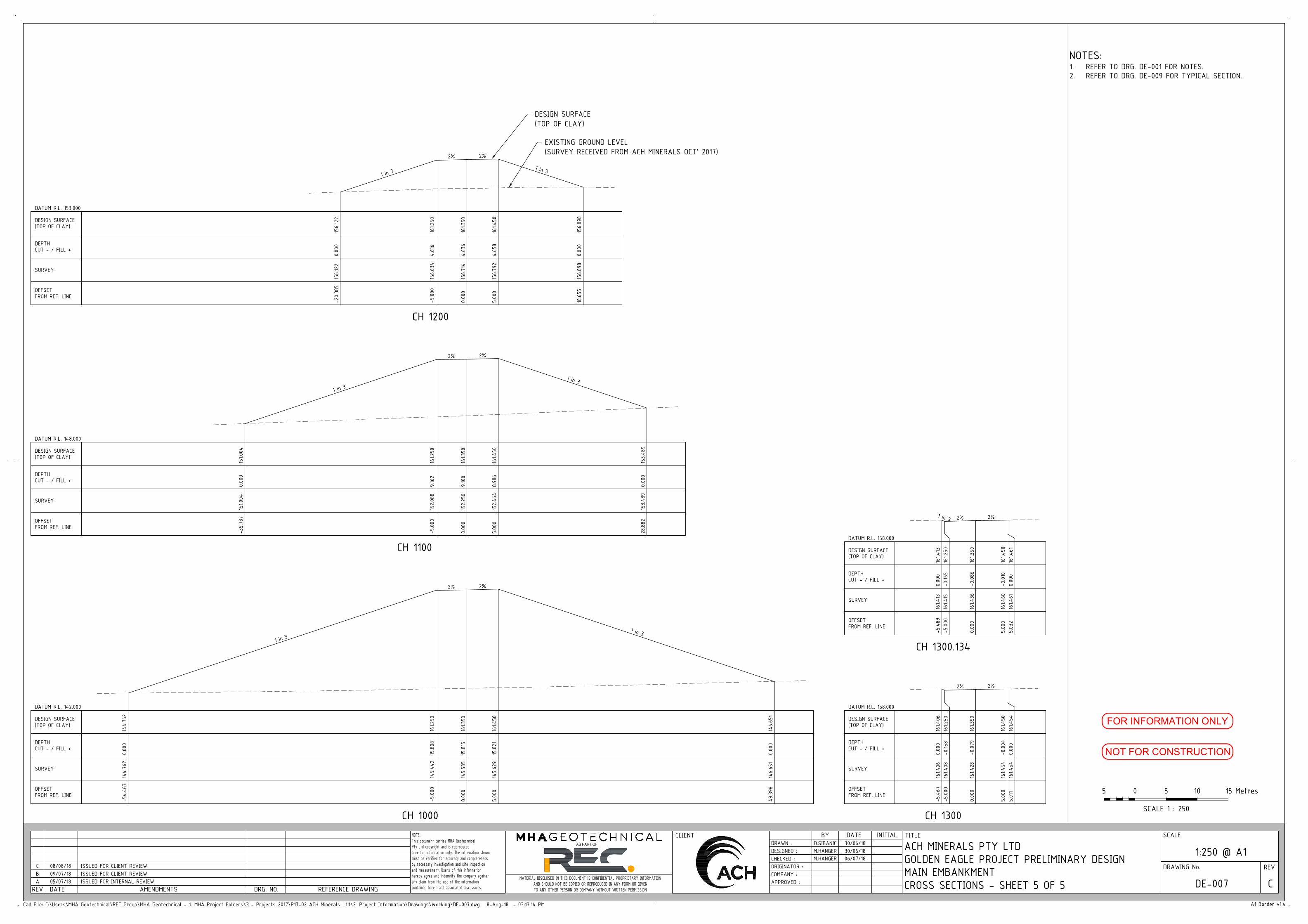
ACH MINERALS PTY LTD
GOLDEN EAGLE PROJECT PRELIMINARY DESIGN
MAIN EMBANKMENTDE-007 C
1:250 @ A1
Cad File: C:\Users\MHA Geotechnical\REC Group\MHA Geotechnical - 1. MHA Project Folders\3 - Projects 2017\P17-02 ACH Minerals Ltd\2. Project Information\Drawings\Working\DE-007.dwg 8-Aug-18 - 03:13:14 PM
NOTE:
This document carries MHA Geotechnical
Pty Ltd copyright and is reproduced
here for information only. The information shown
must be verified for accuracy and completeness
by necessary investigation and site inspection
and measurement. Users of this information
hereby agree and indemnify the company against
any claim from the use of the information
contained herein and associated discussions.
DRAWING No. REV
DRAWN :
DESIGNED :
ORIGINATOR :
APPROVED :
COMPANY :
SCALE
AMENDMENTS
A1 Border v1.4
CLIENT TITLE
CHECKED :
DATEREV
MATERIAL DISCLOSED IN THIS DOCUMENT IS CONFIDENTIAL PROPRIETARY INFORMATION
AND SHOULD NOT BE COPIED OR REPRODUCED IN ANY FORM OR GIVEN
TO ANY OTHER PERSON OR COMPANY WITHOUT WRITTEN PERMISSION
BY DATE
DRG. NO. REFERENCE DRAWING
AS PART OF
INITIAL
0 105 5
SCALE 1 : 250
15 Metres
NOT FOR CONSTRUCTION
FOR INFORMATION ONLY
CROSS SECTIONS - SHEET 5 OF 5
NOTES:1. REFER TO DRG. DE-001 FOR NOTES.
2. REFER TO DRG. DE-009 FOR TYPICAL SECTION.
A 05/07/18 ISSUED FOR INTERNAL REVIEW
B 09/07/18 ISSUED FOR CLIENT REVIEW
C 08/08/18 ISSUED FOR CLIENT REVIEW
D.SIBANIC
M.HANGER
30/06/18
30/06/18
M.HANGER 06/07/18
CH 1000
1 in 3
2% 2%
1 in 3
-54.463
144.762
0.000
144.762
-5.000
145.442
15.808
161.250
0.000
145.535
15.815
161.350
5.000
145.629
15.821
161.450
49.398
146.651
0.000
146.651
OFFSETFROM REF. LINE
SURVEY
DEPTHCUT - / FILL +
DESIGN SURFACE(TOP OF CLAY)
DATUM R.L. 142.000
CH 1100
1 in 3
2% 2%
1 in 3
-35.737
151.004
0.000
151.004
-5.000
152.088
9.162
161.250
0.000
152.250
9.100
161.350
5.000
152.464
8.986
161.450
28.882
153.489
0.000
153.489
OFFSETFROM REF. LINE
SURVEY
DEPTHCUT - / FILL +
DESIGN SURFACE(TOP OF CLAY)
DATUM R.L. 148.000
CH 1200
1 in 3
2% 2%
1 in 3
-20.385
156.122
0.000
156.122
-5.000
156.634
4.616
161.250
0.000
156.714
4.636
161.350
5.000
156.792
4.658
161.450
18.655
156.898
0.000
156.898
OFFSETFROM REF. LINE
SURVEY
DEPTHCUT - / FILL +
DESIGN SURFACE(TOP OF CLAY)
DATUM R.L. 153.000
CH 1300
2% 2%
-5.467
161.406
0.000
161.406
-5.000
161.408
-0.158
161.250
0.000
161.428
-0.079
161.350
5.000
161.454
-0.004
161.450
5.011
161.454
0.000
161.454
OFFSETFROM REF. LINE
SURVEY
DEPTHCUT - / FILL +
DESIGN SURFACE(TOP OF CLAY)
DATUM R.L. 158.000
CH 1300.134
1 in 3 2% 2%
-5.489
161.413
0.000
161.413
-5.000
161.415
-0.165
161.250
0.000
161.436
-0.086
161.350
5.000
161.460
-0.010
161.450
5.032
161.461
0.000
161.461
OFFSETFROM REF. LINE
SURVEY
DEPTHCUT - / FILL +
DESIGN SURFACE(TOP OF CLAY)
DATUM R.L. 158.000
DESIGN SURFACE
(TOP OF CLAY)
EXISTING GROUND LEVEL
(SURVEY RECEIVED FROM ACH MINERALS OCT' 2017)

0 50
100
150
200
250
300
350
400
450
500
550
600
750
100
120
140
160
180
HORIZONTAL DISTANCE (m)
ELEVATION (m)
100
120
140
160
180
650
700
RL 161.150 (MAXIMUM TAILINGS LEVEL AT EMBANKMENT)
CL RL 161.350 (CLAY)CL RL 161.550 (CAPPING)
0 50
100
150
200
250
300
350
400
450
500
550
600
750
100
120
140
160
180
HORIZONTAL DISTANCE (m)
ELEVATION (m)
100
120
140
160
180
650
700
RL 161.150 (MAXIMUM TAILINGS LEVEL AT EMBANKMENT)
CL RL 161.350 (CLAY)CL RL 161.550 (CAPPING)
0 50
100
150
200
250
140
300
350
400
450
600
100
120
160
180
HORIZONTAL DISTANCE (m)
ELEVATION (m)
100
120
140
160
180RL 161.150 (MAXIMUM TAILINGS LEVEL AT EMBANKMENT)
500
550
CL RL 161.350 (CLAY)CL RL 161.550 (CAPPING)
ACH MINERALS PTY LTD
GOLDEN EAGLE PROJECT PRELIMINARY DESIGN
MAIN EMBANKMENTDE-008 C
1:1000 @ A1
Cad File: C:\Users\MHA Geotechnical\REC Group\MHA Geotechnical - 1. MHA Project Folders\3 - Projects 2017\P17-02 ACH Minerals Ltd\2. Project Information\Drawings\Working\DE-008.dwg 8-Aug-18 - 03:14:23 PM
NOTE:
This document carries MHA Geotechnical
Pty Ltd copyright and is reproduced
here for information only. The information shown
must be verified for accuracy and completeness
by necessary investigation and site inspection
and measurement. Users of this information
hereby agree and indemnify the company against
any claim from the use of the information
contained herein and associated discussions.
DRAWING No. REV
DRAWN :
DESIGNED :
ORIGINATOR :
APPROVED :
COMPANY :
SCALE
AMENDMENTS
A1 Border v1.4
CLIENT TITLE
CHECKED :
DATEREV
MATERIAL DISCLOSED IN THIS DOCUMENT IS CONFIDENTIAL PROPRIETARY INFORMATION
AND SHOULD NOT BE COPIED OR REPRODUCED IN ANY FORM OR GIVEN
TO ANY OTHER PERSON OR COMPANY WITHOUT WRITTEN PERMISSION
BY DATE
DRG. NO. REFERENCE DRAWING
AS PART OF
INITIAL
0 4020 20
SCALE 1 : 1000
60 Metres
NOT FOR CONSTRUCTION
FOR INFORMATION ONLY
SECTIONS
NOTES:1. REFER TO DRG. DE-001 FOR NOTES.
2. REFER TO DRG. DE-009 FOR TYPICAL SECTION.
A 05/07/18 ISSUED FOR INTERNAL REVIEW
B 09/07/18 ISSUED FOR CLIENT REVIEW
C 08/08/18 ISSUED FOR CLIENT REVIEW
D.SIBANIC
M.HANGER
30/06/18
30/06/18
M.HANGER 06/07/18
0.5%
0.5%
EMBANKMENT CONSTRUCTED FROM
LOCALLY AVAILABLE MATERIAL
EMBANKMENT CONSTRUCTED FROM
LOCALLY AVAILABLE MATERIAL
EMBANKMENT CONSTRUCTED FROM
LOCALLY AVAILABLE MATERIAL
PROPOSED TSF
PROPOSED TSF
PROPOSED TSF
23.32
4.78
23.11
0.5%
SECTION ADE - 0021:1000
SECTION BDE - 0021:1000
SECTION CDE - 0021:1000
POND LEVEL AFTER 1:100 YEAR 72HR RAINFALL EVENT (RL 160.95)
POND LEVEL AFTER 1:100 YEAR 72HR RAINFALL EVENT (RL 160.95)
POND LEVEL AFTER 1:100 YEAR 72HR RAINFALL EVENT (RL 160.95)
MAX OPERATING POND LEVEL (RL 160.51)
MAX OPERATING POND LEVEL (RL 160.51)
MAX OPERATING POND LEVEL (RL 160.51)
0.5%
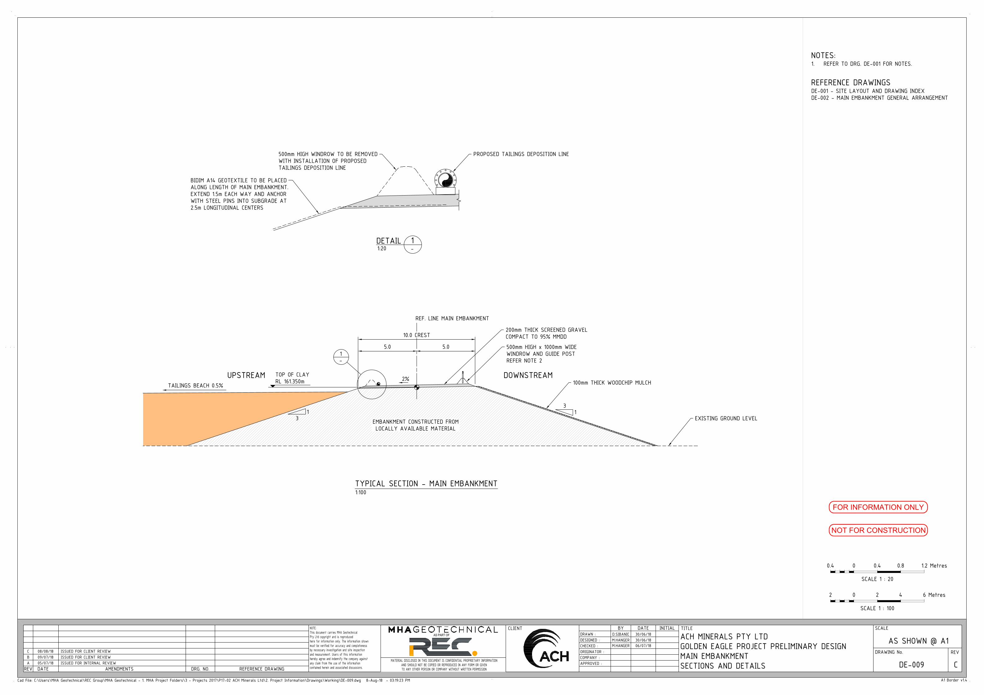
ACH MINERALS PTY LTD
GOLDEN EAGLE PROJECT PRELIMINARY DESIGN
MAIN EMBANKMENTDE-009 C
AS SHOWN @ A1
Cad File: C:\Users\MHA Geotechnical\REC Group\MHA Geotechnical - 1. MHA Project Folders\3 - Projects 2017\P17-02 ACH Minerals Ltd\2. Project Information\Drawings\Working\DE-009.dwg 8-Aug-18 - 03:19:23 PM
NOTE:
This document carries MHA Geotechnical
Pty Ltd copyright and is reproduced
here for information only. The information shown
must be verified for accuracy and completeness
by necessary investigation and site inspection
and measurement. Users of this information
hereby agree and indemnify the company against
any claim from the use of the information
contained herein and associated discussions.
DRAWING No. REV
DRAWN :
DESIGNED :
ORIGINATOR :
APPROVED :
COMPANY :
SCALE
AMENDMENTS
A1 Border v1.4
CLIENT TITLE
CHECKED :
DATEREV
MATERIAL DISCLOSED IN THIS DOCUMENT IS CONFIDENTIAL PROPRIETARY INFORMATION
AND SHOULD NOT BE COPIED OR REPRODUCED IN ANY FORM OR GIVEN
TO ANY OTHER PERSON OR COMPANY WITHOUT WRITTEN PERMISSION
BY DATE
DRG. NO. REFERENCE DRAWING
AS PART OF
INITIAL
0 42 2
SCALE 1 : 100
6 Metres
NOT FOR CONSTRUCTION
FOR INFORMATION ONLY
SECTIONS AND DETAILSA 05/07/18 ISSUED FOR INTERNAL REVIEW
B 09/07/18 ISSUED FOR CLIENT REVIEW
C 08/08/18 ISSUED FOR CLIENT REVIEW
D.SIBANIC
M.HANGER
30/06/18
30/06/18
M.HANGER 06/07/18
REFERENCE DRAWINGSDE-001 - SITE LAYOUT AND DRAWING INDEX
DE-002 - MAIN EMBANKMENT GENERAL ARRANGEMENT
NOTES:
500mm HIGH WINDROW TO BE REMOVED
WITH INSTALLATION OF PROPOSED
TAILINGS DEPOSITION LINE
DETAIL 1 - 1:20
BIDIM A14 GEOTEXTILE TO BE PLACED
ALONG LENGTH OF MAIN EMBANKMENT.
EXTEND 1.5m EACH WAY AND ANCHOR
WITH STEEL PINS INTO SUBGRADE AT
2.5m LONGITUDINAL CENTERS
PROPOSED TAILINGS DEPOSITION LINE
13
1-
200mm THICK SCREENED GRAVEL
COMPACT TO 95% MMDD
500mm HIGH x 1000mm WIDE
WINDROW AND GUIDE POST
REFER NOTE 2
2%
10.0 CREST
5.0 5.0
REF. LINE MAIN EMBANKMENT
TYPICAL SECTION - MAIN EMBANKMENT1:100
TOP OF CLAY
RL 161.350m
EXISTING GROUND LEVELEMBANKMENT CONSTRUCTED FROM
LOCALLY AVAILABLE MATERIAL
13
TAILINGS BEACH 0.5%
1. REFER TO DRG. DE-001 FOR NOTES.
0 0.80.4 0.4
SCALE 1 : 20
1.2 Metres
100mm THICK WOODCHIP MULCHDOWNSTREAMUPSTREAM

140
145
150
155
160
165
170
170 170 170 170
158
160
PROPOSED TSF
KUNDIP TENEMENT BOUNDARY
KUNDIP SITE ROADS TYP.
(BY OTHERS)
PROPOSED DECANT RAMP
ACH MINERALS PTY LTD
GOLDEN EAGLE PROJECT PRELIMINARY DESIGN
DECANTDE-010 C
1:2,000 @ A1
Cad File: C:\Users\MHA Geotechnical\REC Group\MHA Geotechnical - 1. MHA Project Folders\3 - Projects 2017\P17-02 ACH Minerals Ltd\2. Project Information\Drawings\Working\DE-010.dwg 8-Aug-18 - 03:47:46 PM
NOTE:
This document carries MHA Geotechnical
Pty Ltd copyright and is reproduced
here for information only. The information shown
must be verified for accuracy and completeness
by necessary investigation and site inspection
and measurement. Users of this information
hereby agree and indemnify the company against
any claim from the use of the information
contained herein and associated discussions.
DRAWING No. REV
DRAWN :
DESIGNED :
ORIGINATOR :
APPROVED :
COMPANY :
SCALE
AMENDMENTS
A1 Border v1.4
CLIENT TITLE
CHECKED :
DATEREV
MATERIAL DISCLOSED IN THIS DOCUMENT IS CONFIDENTIAL PROPRIETARY INFORMATION
AND SHOULD NOT BE COPIED OR REPRODUCED IN ANY FORM OR GIVEN
TO ANY OTHER PERSON OR COMPANY WITHOUT WRITTEN PERMISSION
BY DATE
DRG. NO. REFERENCE DRAWING
AS PART OF
INITIAL
0 8040 40
SCALE 1 : 2,000
120 Metres
NOT FOR CONSTRUCTION
FOR INFORMATION ONLY
WRD PIT
WATER STORAGE
DECANT RETURN LINETO PLANT
ARRANGEMENT AND DETAILSA 05/07/18 ISSUED FOR INTERNAL REVIEW
B 09/07/18 ISSUED FOR CLIENT REVIEW
C 08/08/18 ISSUED FOR CLIENT REVIEW
D.SIBANIC
M.HANGER
30/06/18
30/06/18
M.HANGER 06/07/18
NOTES:
LEGEND:
MAXIMUM TAILINGS DEPOSITION
EXTENTS (RL 161.15 AT EMBANKMENT)
MAXIMUM NORMAL OPERATING
POND EXTENT (RL 160.510)
RETURN WATER LINE AND SKID
MOUNTED DECANT PUMP
1. REFER TO DRG. DE-001 FOR NOTES.
FLOATING DECANT UPTAKE TO BE PROGRESSIVELY
RELOCATED DURING TAILINGS DEPOSITION. REFER DRG.
DE-011 FOR ANNUAL TAILINGS DEPOSITION EXTENTS
SKID MOUNTED DECANT PUMP TO BE PROGRESSIVELY RELOCATED DURING TAILINGS
DEPOSITION. REFER DRG. DE-011 FOR ANNUAL TAILINGS DEPOSITION EXTENTS
MAIN EMBANKMENT

140
145
150
155
160
165
170
170 170 170 170
158
160
PROPOSED TSF
KUNDIP TENEMENT BOUNDARY
KUNDIP SITE ROADS TYP.
(BY OTHERS)
PROPOSED DECANT RAMP
ACH MINERALS PTY LTD
GOLDEN EAGLE PROJECT PRELIMINARY DESIGN
TAILINGS DISTRIBUTION NETWORKDE-011 C
1:2,000 @ A1
Cad File: C:\Users\MHA Geotechnical\REC Group\MHA Geotechnical - 1. MHA Project Folders\3 - Projects 2017\P17-02 ACH Minerals Ltd\2. Project Information\Drawings\Working\DE-011.dwg 8-Aug-18 - 03:21:11 PM
NOTE:
This document carries MHA Geotechnical
Pty Ltd copyright and is reproduced
here for information only. The information shown
must be verified for accuracy and completeness
by necessary investigation and site inspection
and measurement. Users of this information
hereby agree and indemnify the company against
any claim from the use of the information
contained herein and associated discussions.
DRAWING No. REV
DRAWN :
DESIGNED :
ORIGINATOR :
APPROVED :
COMPANY :
SCALE
AMENDMENTS
A1 Border v1.4
CLIENT TITLE
CHECKED :
DATEREV
MATERIAL DISCLOSED IN THIS DOCUMENT IS CONFIDENTIAL PROPRIETARY INFORMATION
AND SHOULD NOT BE COPIED OR REPRODUCED IN ANY FORM OR GIVEN
TO ANY OTHER PERSON OR COMPANY WITHOUT WRITTEN PERMISSION
BY DATE
DRG. NO. REFERENCE DRAWING
AS PART OF
INITIAL
0 8040 40
SCALE 1 : 2,000
120 Metres
NOT FOR CONSTRUCTION
FOR INFORMATION ONLY
WRD PIT
WATER STORAGE
DECANT RETURN LINETO PLANT
GENERAL ARRANGEMENTA 05/07/18 ISSUED FOR INTERNAL REVIEW
B 09/07/18 ISSUED FOR CLIENT REVIEW
C 08/08/18 ISSUED FOR CLIENT REVIEW
D.SIBANIC
M.HANGER
30/06/18
30/06/18
M.HANGER 06/07/18
NOTES:1. REFER TO DRG. DE-001 FOR NOTES.
ANNUAL TAILINGS DEPOSITION
YEAR RL (m) AREA (m) VOLUME (m3)
1 150.000 86,281 276,902
2 152.200 114,862 476,002
3 154.000 139,720 687,479
4 155.400 160,143 884,117
5 156.600 178,597 1,076,217
6 157.800 197,442 1,291,566
7 158.800 222,387 1,495,082
8 159.600 233,107 1,672,648
9 160.600 244,099 1,906,593
10 161.000 246,811 2,003,623
0.5% B
EACH S
LOPE
0.5% BE
ACH S
LOPE
LEGEND:
TAILINGS DISTRIBUTION LINE AND
SPIGOTS AT 20m SPACINGS
MAIN EMBANKMENT
0.5% BE
ACH SL
OPE
TAILINGS D
ELIVERY
LINE FROM
PLANT

HARDWOOD SLEEPERS
(UNDERNEATH TEE)
RADIUS OF MAIN RING PIPE
TO MANUFACTURER'S
SPECIFICATION
SAFETY WINDROW
500.00
BETWEEN BUNDS
SAFETY WINDROW
HARDWOOD SLEEPERS
EXTEND SPIGOT
AS REQUIRED
TYPICAL CONDUCTOR PIPE OUTLET SLOT
SETOUT FOR LENGTH OF PIPE
ACH MINERALS PTY LTD
GOLDEN EAGLE PROJECT PRELIMINARY DESIGN
TAILINGS DISTRIBUTION NETWORKDE-012 C
AS SHOWN @ A1
Cad File: C:\Users\MHA Geotechnical\REC Group\MHA Geotechnical - 1. MHA Project Folders\3 - Projects 2017\P17-02 ACH Minerals Ltd\2. Project Information\Drawings\Working\DE-012.dwg 8-Aug-18 - 03:21:28 PM
NOTE:
This document carries MHA Geotechnical
Pty Ltd copyright and is reproduced
here for information only. The information shown
must be verified for accuracy and completeness
by necessary investigation and site inspection
and measurement. Users of this information
hereby agree and indemnify the company against
any claim from the use of the information
contained herein and associated discussions.
DRAWING No. REV
DRAWN :
DESIGNED :
ORIGINATOR :
APPROVED :
COMPANY :
SCALE
AMENDMENTS
A1 Border v1.4
CLIENT TITLE
CHECKED :
DATEREV
MATERIAL DISCLOSED IN THIS DOCUMENT IS CONFIDENTIAL PROPRIETARY INFORMATION
AND SHOULD NOT BE COPIED OR REPRODUCED IN ANY FORM OR GIVEN
TO ANY OTHER PERSON OR COMPANY WITHOUT WRITTEN PERMISSION
BY DATE
DRG. NO. REFERENCE DRAWING
AS PART OF
INITIAL
0 42 2
SCALE 1 : 100
6 Metres
NOT FOR CONSTRUCTION
FOR INFORMATION ONLY
SECTIONS AND DETAILSA 05/07/18 ISSUED FOR INTERNAL REVIEW
B 09/07/18 ISSUED FOR CLIENT REVIEW
C 08/08/18 ISSUED FOR CLIENT REVIEW
D.SIBANIC
M.HANGER
30/06/18
30/06/18
M.HANGER 06/07/18
NOTES:1. REFER TO DRG. DE-001 FOR NOTES.
0 0.80.4 0.4
SCALE 1 : 20
1.2 Metres
SECTION A-1:20
-A
SPIGOT ARRANGEMENT PLAN1:20
TYPICAL SECTION - MAIN EMBANKMENT TAILINGS
EXISTING GROUND LEVEL
TAILINGS DELIVERY SPIGOT
SAFETY
WINDROW
1:100
℄ MAIN EMBANKMENT
1
31
3
DOWNSTREAM UPSTREAM
0.5%

145
150
160
165
170
170 170 170 170
1
KUNDIP TENEMENT BOUNDARY
KUNDIP SITE ROADS TYP.
(BY OTHERS)
ACH MINERALS PTY LTD
GOLDEN EAGLE PROJECT PRELIMINARY DESIGN
CONCEPTUAL CLOSURE PLANDE-013 C
1:2,000 @ A1
Cad File: C:\Users\MHA Geotechnical\REC Group\MHA Geotechnical - 1. MHA Project Folders\3 - Projects 2017\P17-02 ACH Minerals Ltd\2. Project Information\Drawings\Working\DE-013.dwg 8-Aug-18 - 03:21:52 PM
NOTE:
This document carries MHA Geotechnical
Pty Ltd copyright and is reproduced
here for information only. The information shown
must be verified for accuracy and completeness
by necessary investigation and site inspection
and measurement. Users of this information
hereby agree and indemnify the company against
any claim from the use of the information
contained herein and associated discussions.
DRAWING No. REV
DRAWN :
DESIGNED :
ORIGINATOR :
APPROVED :
COMPANY :
SCALE
AMENDMENTS
A1 Border v1.4
CLIENT TITLE
CHECKED :
DATEREV
MATERIAL DISCLOSED IN THIS DOCUMENT IS CONFIDENTIAL PROPRIETARY INFORMATION
AND SHOULD NOT BE COPIED OR REPRODUCED IN ANY FORM OR GIVEN
TO ANY OTHER PERSON OR COMPANY WITHOUT WRITTEN PERMISSION
BY DATE
DRG. NO. REFERENCE DRAWING
AS PART OF
INITIAL
0 8040 40
SCALE 1 : 2,000
120 Metres
NOT FOR CONSTRUCTION
FOR INFORMATION ONLY
A 05/07/18 ISSUED FOR INTERNAL REVIEW
B 09/07/18 ISSUED FOR CLIENT REVIEW
C 08/08/18 ISSUED FOR CLIENT REVIEW
D.SIBANIC
M.HANGER
30/06/18
30/06/18
M.HANGER 06/07/18
NOTES:1. REFER TO DRG. DE-001 FOR NOTES.
0.5% MIN
0.5% MIN
0.5% MIN
ACTIVE CHANNEL
PILOT CHANNEL
1-
3H:1V
CLOS
URE S
PILLW
AY
LEGEND:
EMBANKMENT CLOSURE SLOPE 3H:1V
WASTE BACKFILL COVER
ACTIVE CHANNEL
EMBANKMENT CREST
INITIAL VEGETATION PLANTING
GRAVEL ARMOUR
LATERAL RESTRAINT
CONTOURING
FLOW
PILOT CHANNEL
PILOT CHANNEL
ACTIVE CHANNEL
PLAN1:2000
WATER STORAGE
SECTION A-N.T.S.
A
DETAIL 1-N.T.S.
ACTIVE CHANNEL
WIDTH SCALED FROM PRE-MINING TOPOGRAPHY
PHOTOGRAPHY QW > 100 YEARS ARI

Ravensthorpe Gold Project Environmental Review Document – Response to Submissions Assessment No.2117
ACH Minerals Ravensthorpe Gold Project ERD Response to Submissions.1b April 2020 | Appendix
: Populations of five Priority Flora species in the Kundip Development Envelope (Dr G.F. Craig)

ACH Minerals Pty Ltd
Ravensthorpe Gold Project ERD
Populations of five Priority Flora species in the Kundip Development Envelope
A report prepared for
ACH Minerals Pty Ltd Lot 1968 Hopetoun-Ravensthorpe Rd, Ravensthorpe WA 6346
January 2020
Dr G F Craig
Environmental Consultant ABN: 96 108 756 719
PO Box 130, Ravensthorpe 6346
P 08 9838 1071

ACH Minerals – Ravensthorpe Gold Project: Priority Flora GF Craig – January 2020
DISCLAIMER In undertaking this work, the author has made every effort to ensure the accuracy of the information used. Any conclusions drawn or recommendations made in the report and maps are done in good faith and the consultant takes no responsibility for how this information is used subsequently by others. © GF Craig, 2020. This report is to be treated as confidential, and may not be reproduced in part or whole by electronic, mechanical or other means, including photocopying, recording or any information storage system, without the express approval of Dr GF Craig and/or ACH Minerals. Cover photo:
Melaleuca sophisma at Ravensthorpe Gold Project area, Kundip

ACH Minerals – Ravensthorpe Gold Project: Priority Flora GF Craig – January 2020
i
TABLE OF CONTENTS
EXECUTIVE SUMMARY .................................................................................. III
INTRODUCTION ................................................................................................ 4
METHODS ......................................................................................................... 7
RESULTS .......................................................................................................... 7
DISCUSSION ................................................................................................... 21
Acknowledgements 22
References 22
APPENDIX 1 – THREATENED AND PRIORITY FLORA REPORT FORMS ................. 23
LIST OF TABLES Table 1 – Five Priority species targeted for survey ....................................................................... 4 Table 2 – Population summary of Calothamnus roseus ............................................................... 8 Table 3 – Population summary of Melaleuca sophisma ............................................................... 9 Table 4 - Population summary of Hydrocotyle tuberculata ......................................................... 10 Table 5 - Population summary of Thomasia sp. Hopetoun ......................................................... 10 Table 6 – Population summary of Dampiera sp. Ravensthorpe ................................................. 11 Table 7 – Summary of desktop analysis and field survey of Priority Flora species in the RGP
Development Envelope and 20 m buffer. .................................................................... 21
LIST OF FIGURES Figure 1 – Location of the ACH Minerals’ Ravensthorpe Gold Project and ‘Ard Patrick’. ............. 5
Figure 2 – Location of five Priority species in the Kundip mining area. ......................................... 6
Figure 3 – Known Calothamnus roseus populations ...................................................................12
Figure 4 - Patches of Calothamnus roseus surveyed in the Development Envelope, plus 20 m buffer, in December 2019 ..........................................................................13
Figure 5 - Known sub-populations of Melaleuca sophisma .........................................................14
Figure 6 – Known populations of Hydrocotyle tuberculata ..........................................................15
Figure 7 – Known sub-populations of Hydrocotyle tuberculata in the Development Envelope in 2011 ........................................................................................................16
Figure 8 – Known populations of Thomasia sp. Hopetoun (KR Newbey 4896) ..........................17
Figure 9 – Sub-population of Thomasia sp. Hopetoun (KR Newbey 4896) surveyed in the Development Envelope in December 2019 .........................................................18
Figure 10 – Known populations of Dampiera sp. Ravensthorpe (GF Craig 8277) ......................19
Figure 11 – Known population of Dampiera sp. Ravensthorpe (GF Craig 8277) in the Development Envelope in 2009 ...............................................................................20

ACH Minerals – Ravensthorpe Gold Project: Priority Flora GF Craig – January 2020
ii

ACH Minerals – Ravensthorpe Gold Project: Priority Flora GF Craig – January 2020
iii
Executive Summary The Ravensthorpe Gold Project (RGP) is a proposal by ACH Minerals Pty Ltd to mine for gold and copper on the Kundip mining leases (tenements M74/41, 51, 53 & 135 and P74/153) located approximately 17 km south-east of Ravensthorpe and 31 km north of the coastal town of Hopetoun. Five Priority flora species occur within the RGP Development Envelope.The Department of Biodiversity, Conservation and Attactions (DBCA) requested further information on the known populations of these species, especially abundance data. Searches were made of the WA Herbarium specimen database (WAHerb) and the Threatened and Priority Flora database (TPFL). It was found that DBCA had not updated their TPFL databases for 10 years for these species. Subsequently, copies were obtained of Threatened and Priority Flora report forms that had not been databased. Data from DBCA, previous surveys in the Kundip area and targeted surveys in December 2019 of the known locations within the RGP Development Envelope and a 20 m buffer were collated into a single database. The results are summarized in the following table:
TaxonName WAConStat
TOTAL known plants
Abundance in Development Envelope &
buffer
Percentage of known
populations (%)
Calothamnus roseus P1 4,700 3,200 68
Melaleuca sophisma P1 60,247 347 0.6
Hydrocotyle tuberculata P2 237 -1 -
Thomasia sp. Hopetoun (K.R. Newbey 4896) P2 243 44 18
Dampiera sp. Ravensthorpe (G.F. Craig 8277) P3 36,893 -2 -
1 annual plant not found in Dec 2019 survey; c. 60 plants in 2011; previously 110 plants in 2005 2 not found in Dec 2019 survey; 1500 plants in 2009 The December 2019 survey failed to find either the annual Hydrocotyle tuberculata due to the dry conditions or Dampiera sp. Ravensthorpe (G.F. Craig 8277). It is not known whether the latter species is a short-lived perennial and has disappeared from the site until another fire or disturbance occurs, or the author was unable to find this cryptic species because it was not flowering. Seed banks of both species would still remain at their known sites. Surveys in winter-spring for Dampiera sp. Ravensthorpe and in October for Hydrocotyle tuberculata are recommended.
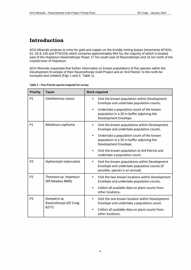
ACH Minerals – Ravensthorpe Gold Project: Priority Flora GF Craig – January 2020
4
Introduction ACH Minerals propose to mine for gold and copper on the Kundip mining leases (tenements M74/41, 51, 53 & 135 and P74/153) which comprise approximately 664 ha, the majority of which is located east of the Hopetoun-Ravensthorpe Road, 17 km south east of Ravensthorpe and 31 km north of the coastal town of Hopetoun. ACH Minerals requested that further information on known populations of five species within the Development Envelope of their Ravensthorpe Gold Project and at ‘Ard Patrick’ to the north be surveyed and collated (Figs 1 and 2, Table 1).
Table 1 – Five Priority species targeted for survey
Priority Taxon Work required
P1 Calothamnus roseus • Visit the known population within Development
Envelope and undertake population counts.
• Undertake a population count of the known
population in a 20 m buffer adjoining the
Development Envelope.
P1 Melaleuca sophisma • Visit the known populations within Development
Envelope and undertake population counts.
• Undertake a population count of the known
population in a 20 m buffer adjoining the
Development Envelope.
• Visit the known population at Ard Patrick and
undertake a population count.
P2 Hydrocotyle tuberculata • Visit the known populations within Development
Envelope and undertake population counts (if
possible, species is an annual).
P2 Thomasia sp. Hopetoun
(KR Newbey 4896)
• Visit the two known locations within Development
Envelope and undertake population counts.
• Collect all available data on plant counts from
other locations.
P3 Dampiera sp.
Ravensthorpe (GF Craig
8277)
• Visit the one known location within Development
Envelope and undertake a population count.
• Collect all available data on plant counts from
other locations.

ACH Minerals – Ravensthorpe Gold Project: Priority Flora GF Craig – January 2020
5
Figure 1 – Location of the ACH Minerals’ Ravensthorpe Gold Project and ‘Ard Patrick’.
Kundip
Elverdton Elverdton
Hopetoun-Ravensthorpe Rd
Ravensthorpe
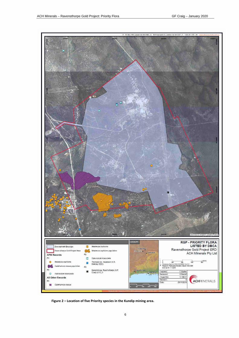
ACH Minerals – Ravensthorpe Gold Project: Priority Flora GF Craig – January 2020
6
Figure 2 – Location of five Priority species in the Kundip mining area.

ACH Minerals – Ravensthorpe Gold Project: Priority Flora GF Craig – January 2020
7
Methods Desktop Priority flora population data of the five species which had been collated by Talis Consultants (Fig 1) which included data from APM (2017), McQuoid (2009), Hickman (2007, 2009) and database searches from the Department of Biodiversity, Conservation and Attractions (DBCA). The latter was recorded as ‘DBCA Record’ rather than whether the source was the WA Herbarium specimen database (WAHerb) or the Threatened and Priority Flora database (TPFL). A request was made for DBCA database searches of WAHerb and TPFL for the five Priority flora species on 10 December 2019. Also, Sarah Barrett, Threatened Flora Officer, DBCA Albany District was asked for any additional information on these species. All data was collated into an Excel file, including survey data from Craig (2004, 2011) which included information on Melaleuca sophisma (previously known as Melaleuca sp. Kundip) and Hydrocotyle tuberculata (previously known as H. decipiens ms). The Excel table was imported into a QGIS mapping program to obtain an overview of the distribution of the five species. The polygon for Calothamnus roseus (Fig 2) was deleted from the database as it could not be ascertained whether this was a surveyed boundary by APM or extrapolated from known point locations. Data was then packaged for the Index of Biodiversity Surveys for Assessments (IBSA). The Environmental Protection Authority (EPA), Department of Water and Environmental Regulation and Department of Mines, Industry Regulation and Safety require IBSA Data Packages to support assessment and compliance under the Environmental Protection Act 1986. Field survey The known populations of the five species, Calothamnus roseus (P1), Melaleuca sophisma (P1), Hydrocotyle tuberculata (P2), Thomasia sp. Hopetoun (KR Newbey 4896) (P2) and Dampiera sp. Ravensthorpe (GF Craig 8277) (P3) were surveyed within the Development Envelope and an adjoining 20 m buffer on 9 December 2019. Weather conditions were warm (max 26oC) and dry. Each patch was GPSed and actual counts of plants made, except for the three large patches of Calothamnus roseus. The boundary of each patch of >100 plants was tracked. On 17 December 2019, an estimate of population size of the three large patches of Calothamnus roseus was made using the Wandering Quarter method (Catana, 1963) assisted by Vern Jones, Project Manager, ACH Minerals. Also, the ‘Ard Patrick’ site was surveyed for Melaleuca sophisma.
Results Desktop DBCA provided WAHerb and TPFL database information on 17/12/2019 (Ref: 20-1219FL), although their Flora Technical Officer noted that “not all Priority flora populations have been entered into the database. Therefore there were no results of a search of this database for the following species as these species are yet to be databased on TPFL:
• Calothamnus roseus • Thomasia sp. Hopetoun (KR Newbey 4896) • Dampiera sp. Ravensthorpe (GF Craig 8277).

ACH Minerals – Ravensthorpe Gold Project: Priority Flora GF Craig – January 2020
8
There is also additional information on our [DBCA] files that has not yet been entered into TPFL for the following species (including the date of the last time the information on the file was entered into TPFL):
• Calothamnus roseus • Melaleuca sophisma (February 2009) • Thomasia sp. Hopetoun (KR Newbey 4896) • Dampiera sp. Ravensthorpe (GF Craig 8277).”
Sarah Barrett (Threatened Flora Officer, DBCA Albany) provided additional Threatened Flora Report Forms for:
• Calothamnus roseus (2012) • Thomasia sp. Hopetoun (KR Newbey 4896) (2011,2013, 2015) • Dampiera sp. Ravensthorpe (GF Craig 8277) (2010 – which equated to WAHerb specimen
data) Tim Hammer, a botanist with Spectrum Ecology, accessed Threatened and Priority Flora (TPF) report forms on DBCA’s files on 9/1/2020. These were sent to the author for inclusion in the collated database. APM (2019), McQuoid (2009), Hickman (2007), Craig (2004 & 2011) provided information on all five species. It should be noted that there are five TPF reports by McQuoid (dated 17/3/2009) which duplicate the information given in McQuoid (2009). The latter were not added to the database. All desktop and new field data was collated into shapefiles:
• ACH_2B_Flora_ALL_pt.shp (includes point data on all five species) • ACH_2B_Flora_Calothamnus roseus_py.shp • ACH_2B_Flora_Melaleuca sophisma_py. shp
Field survey Calothamnus roseus (P1)
The known range of Calothamnus roseus is 11 km with three main populations, i.e. Kundip Nature Reserve, Road Eleven and the Kundip area (which includes a number of sub-populations). Interrogation of the WAHerb data found two specimens that had incorrect lat/longs compared to the location description. Survey of the sub-population that occurs within the Development Envelope plus 20 m buffer found 8 discrete patches, varying in size from 6 to an estimated 1250 plants (Figs 3 & 4). This represents 68% of the known plants of C. roseus (Table 2).
Plate 1 – Calothamnus roseus fruits
Table 2 – Population summary of Calothamnus roseus
SiteName Abundance
Percentage of known populations (%)
Eastern end of Kundip Plateau, Kundip Nature Reserve* 100 2 Road Eleven, WSW of Kundip 800 17 Small hill, W side of the Ravensthorpe - Hopetoun Road, 1.4 km N of Kundip 200 4 Kundip, Hopetoun-Ravensthorpe Rd 500 11 Ravensthorpe Gold Project - Development Envelope (D E) 1700 36 Ravensthorpe Gold Project - 20 m buffer adjoining D E 1500 32
TOTAL 4700
*abundance = "common on summit only" so nominated 100 plants

ACH Minerals – Ravensthorpe Gold Project: Priority Flora GF Craig – January 2020
9
Melaleuca sophisma (P1)
Melaleuca sophisma (previously known as Melaleuca sp. Kundip (GF Craig 6020)) is an erect, robust shrub, 1-2 m tall with recurved leaves and white flowers. It is an obligate seeder that grows in dense stands, with individual plants often only a few centimetres apart. It is very vulnerable to disturbance, being killed by fire and maintenance activities such as firebreaks.
Plate 2 – Melaleuca sophisma flowers
McQuoid (2009) found that although M. sophisma is locally common in the immediate Kundip vicinity, it has a very restricted distribution within a 2.5 km x 1.5 km area (Fig 5). He considered there to be one population with an estimated 60,000 plants, which included five relatively indistinct sub-populations. One of these occurs in the Development Envelope and comprises less than 1% of the known plants (Table 3). A search for the two locations at ‘Ard Patrick’, previously recorded by APM (2017) failed to find M. sophisma. The very similar looking Melaleuca undulata was common and could have been mistaken for the former species.
Table 3 – Population summary of Melaleuca sophisma
SiteName Abundance
Percentage of known populations (%)
South of Kundip Mining leases, east of Hopetoun-Ravensthorpe Rd 1500 2.5 Kundip Mining Leases, east of Hopetoun-Ravensthorpe Rd (excl. DE) 26200 43.5 Kundip townsite and west of Hopetoun-Ravensthorpe Rd 14600 24.2 Road Eleven area, west of Hopetoun-Ravensthorpe Rd 17600 29.2 Ravensthorpe Gold Project - Development Envelope (D E) 347 0.6 TOTAL 60247
Hydrocotyle tuberculata (P2)
Hydrocotyle tuberculata is a winter annual herb, with flowering and fruiting occurring from September to November (Perkins, 2018). It grows in winter-moist drainage areas in damp sandy loams. It is known from six other locations besides the Development Envelope at Kundip, extending from near Middle Mt Barren in the Fitzgerald River National Park to north-east of Esperance, a range of 250 km (Fig 6).
Plate 3 – Hydrocotyle tuberculata growing with moss in 2011.
The survey on 9 December 2019 failed to find any H. tuberculata (previously known as H. decipiens ms). The Kundip area has experienced below average rainfall for the past two years, with only 230 mm recorded at Ravensthorpe in 2019 compared with an annual average of 430 mm. It is therefore unlikely that this species successfully germinated this year. In 2011, only two of the three sub-populations of H. tuberculata were relocated at the known location in the Development Envelope (Craig, 2011). At these two sites, the numbers of plants had considerably diminished since the 2005 survey by Craig (2005) (Fig 7).

ACH Minerals – Ravensthorpe Gold Project: Priority Flora GF Craig – January 2020
10
Table 4 - Population summary of Hydrocotyle tuberculata
SiteName Abundance
Fitzgerald River National Park, ca 6 km W of Middle Mount Barren -
20 m north of Desmond Track (between Moir Rd and Hopetoun-Ravensthorpe Rd) 2
‘Ard Patrick’, 3 km N of Kundip 35
28.5 km E of Ravensthorpe along South Coast Highway -
Salt lake, S side of Scaddan Road, 5.2 km E of Coolgardie-Esperance Highway 100
Mount Ridley, ca 80 miles NE of Esperance 100
Ravensthorpe Gold Project - Development Envelope (DE) N/A*
TOTAL 237
*Not found in Dec 2019; c. 60 plants in 2011; previously 110 plants in 2005
Thomasia sp. Hopetoun (K.R. Newbey 4896) (P2)
This is a soft, rounded shrub that grows to about 70 cm tall, has pale green leaves and white flowers in spring. It is known from five locations in the Fitzgerald River National Park as well as in the Elverdton – Kundip area, with a range of about 100 km (Fig 8).
Plate 4 - Thomasia sp. Hopetoun fruiting in 2019.
Population counts at each site are low (< 80 plants recorded per site) with a total of 243 plants overall. In the Kundip Development Envelope there were two patches 90 m apart in a creekline, totaling 44 plants in 2019 (Fig 9). This population represents about 18% of known plants (Table 5).
Table 5 - Population summary of Thomasia sp. Hopetoun
SiteName Abundance
Percentage of known populations (%)
Quaalup - Fitzgerald River National Park, Mount Bland area 30 12 Fitzgerald River National Park, Thumb Peak area 80 33 Fitzgerald River National Park, west of Quoin Head 9 4 Fitzgerald River National Park, Whoogarup Range 20 8 Elverton Rd area, east of Hopetoun-Ravensthorpe Rd 10 4 Adjacent Hopetoun-Ravensthorpe Road at Kundip 50 21 Ravensthorpe Gold Project - Development Envelope (D E) 44 18 TOTAL 243

ACH Minerals – Ravensthorpe Gold Project: Priority Flora GF Craig – January 2020
11
Dampiera sp. Ravensthorpe (G.F. Craig 8277) (P3)
This is a low, herbaceous shrub with multiple stems from the base and blue flowers It is known from a number of scattered populations through the Ravensthorpe System – on the Ravensthorpe Range and east to near Bandalup Hill, with a range of about 30 km, plus a disjunct population near Munglinip (over 100 km to the east) (Fig 10).
Plate 5 - Dampiera sp. Ravensthorpe growing in the Ravensthorpe Range in
2005.
The current survey failed to find any plants of this taxon in the Development Envelope, although 1500 plants had been recorded 10 years ago on the Kundip firebreak in open shrubland regenerating after fire (Fig 11). Recently, the firebreak has been scrub-rolled again.
There were three possible scenarios as to why there were no plants; (i) the original collection by D.Rathbone DAR 255 had been wrongly identified, or (ii) the species has disappeared from the site due to it being a short-lived plant, or (iii) I just didn’t find it because it wasn’t flowering and it was disguised by the common Chorizema trigonum which has superficially similar stems.
Plate 6 – Scrub-rolled firebreak at Kundip, Dec 2019.
Subsequently, Michael Hislop (DBCA WA Herbarium) confirmed the identification of DAR 255 is Dampiera sp. Ravensthorpe (G.F. Craig 8277). Therefore another survey is recommended between July and October, i.e. when this taxon should be flowering, to ascertain whether it is a short-lived disturbance opportunist or is so inconspicuous that it cannot be readily seen unless flowering.
Table 6 – Population summary of Dampiera sp. Ravensthorpe
SiteName Abundance
Percentage of known populations (%)
Ravensthorpe Range, Mt McMahon-Mt Benson 44 0.1 Ravensthorpe Range, Cordingup Creek area 230 0.6 UCL north of the South Coast Highway, W of Nindabillup Road 35000 94.9 W of Hatfield Road 3 0.0 W side of Bandalup Hill 8 0.0 Shoemaker Levy, E of Bandalup Track 6 0.0 Rocky outcrop to side of Maydon link, E end of Ravensthorpe Range 2 0.0 Munglinup Mining Reserve 100 0.3 Ravensthorpe Gold Project - Development Envelope (D E) 15001 4.1 TOTAL 36893
1 not found in Dec 2019 survey; 1500 plants in 2009

ACH Minerals – Ravensthorpe Gold Project: Priority Flora GF Craig – January 2020
12
Figure 3 – Known Calothamnus roseus populations

ACH Minerals – Ravensthorpe Gold Project: Priority Flora GF Craig – January 2020
13
Figure 4 - Patches of Calothamnus roseus surveyed in the Development Envelope, plus 20 m buffer, in December 2019
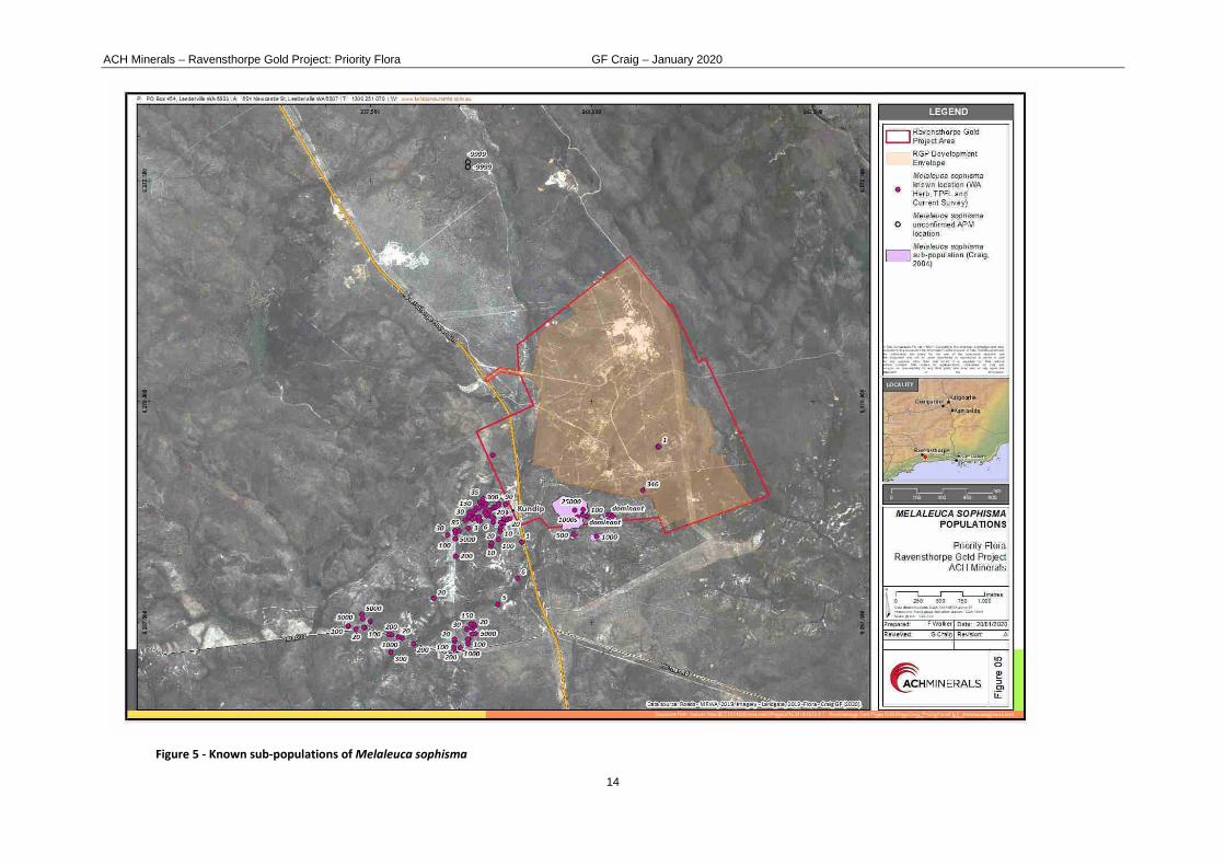
ACH Minerals – Ravensthorpe Gold Project: Priority Flora GF Craig – January 2020
14
Figure 5 - Known sub-populations of Melaleuca sophisma

ACH Minerals – Ravensthorpe Gold Project: Priority Flora GF Craig – January 2020
15
Figure 6 – Known populations of Hydrocotyle tuberculata
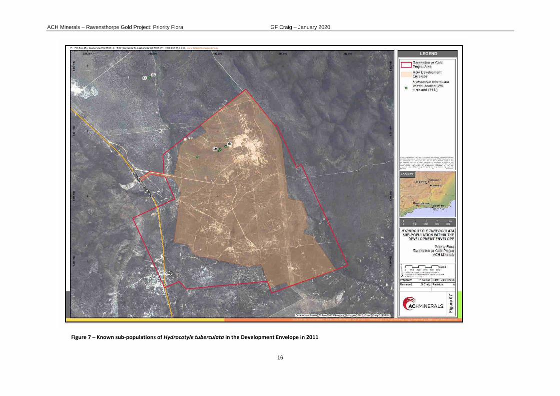
ACH Minerals – Ravensthorpe Gold Project: Priority Flora GF Craig – January 2020
16
Figure 7 – Known sub-populations of Hydrocotyle tuberculata in the Development Envelope in 2011

ACH Minerals – Ravensthorpe Gold Project: Priority Flora GF Craig – January 2020
17
Figure 8 – Known populations of Thomasia sp. Hopetoun (KR Newbey 4896)

ACH Minerals – Ravensthorpe Gold Project: Priority Flora GF Craig – January 2020
18
Figure 9 – Sub-population of Thomasia sp. Hopetoun (KR Newbey 4896) surveyed in the Development Envelope in December 2019

ACH Minerals – Ravensthorpe Gold Project: Priority Flora GF Craig – January 2020
19
Figure 10 – Known populations of Dampiera sp. Ravensthorpe (GF Craig 8277)

ACH Minerals – Ravensthorpe Gold Project: Priority Flora GF Craig – January 2020
20
` Figure 11 – Known population of Dampiera sp. Ravensthorpe (GF Craig 8277) in the Development Envelope in 2009

ACH Minerals – Ravensthorpe Gold Project: Priority Flora GF Craig – January 2020
21
Discussion Desktop There are major flaws with the DBCA databases when one is attempting to interrogate species population data. Some of these are recognized by DBCA, e.g. old specimen records without GPS locations which have been manually given geographic coordinates that don’t tally with the location description. However, by today’s standards their TPFL system is archaic because:
• species’ population data is based on hard copy Threatened Flora Report Forms. Therefore, it is no surprise that DBCA have not updated the data for the five priority species here, for at least 10 years. In contrast, data provided digitally could be uploaded within days.
• TPFL information is based a single point within a population – it is not possible to provide polygon or multiple-point population data to DBCA. Therefore DBCA has (i) no method for determining loss or increase to a particular population’s area, or (ii) whether two separate points represent a continuum of a single population or are disparate groups of plants.
• TPFL and WAHerb data does not provide the collector’s name, although it is possible to cross-reference using DBCA’s Florabase (the author has Level 4 access) which is a tedious process. It would help if this data was included, so that it could be cross-referenced with published and unpublished reports that may be available.
• It was also found that some populations were repeated in both the WAHerb and TPFL databases, so care was needed not to simply sum all the abundance data, otherwise one would double the population size. It would be preferable that if a specimen is lodged in PERTH and therefore appears on the WAHerb database, that a Threatened Flora Report Form does not need to be filled out too.
Formating the spreadsheet to be compliant with IBSA standards was time consuming:
• data was in a number of different geographic coordinate systems and needed to be transformed (in this case) to decimal degrees;
• column headings were inconsistent between WAHerb, TPFL and IBSA. It would be a great benefit if these government datasets were integrated.
Field survey The field survey in December 2019 found three of the five Priority Flora species. The information from the desktop analysis and the survey are summarized in Table 7.
Table 7 – Summary of desktop analysis and field survey of Priority Flora species in the RGP Development Envelope
and 20 m buffer.
TaxonName WAConStat
TOTAL known plants
Abundance in Development Envelope &
buffer
Percentage of known
populations (%)
Calothamnus roseus P1 4,700 3,200 68
Melaleuca sophisma P1 60,247 347 0.6
Hydrocotyle tuberculata P2 237 -1 -
Thomasia sp. Hopetoun (K.R. Newbey 4896) P2 243 44 18
Dampiera sp. Ravensthorpe (G.F. Craig 8277) P3 36,893 -2 -
1 annual plant not found in Dec 2019 survey; c. 60 plants in 2011; previously 110 plants in 2005 2 not found in Dec 2019 survey; 1500 plants in 2009

ACH Minerals – Ravensthorpe Gold Project: Priority Flora GF Craig – January 2020
22
The December 2019 survey failed to find either the annual Hydrocotyle tuberculata due to the dry conditions or Dampiera sp. Ravensthorpe (G.F. Craig 8277). It is not known whether the latter species is a short-lived perennial and has disappeared from the site until another fire or disturbance occurs, or the author was unable to find this cryptic species because it was not flowering. Seed banks of both species would still remain at their known sites. Surveys in winter-spring for Dampiera sp. Ravensthorpe and in October for Hydrocotyle tuberculata are recommended.
Acknowledgements The assistance of the following people in preparing this report is gratefully acknowledged:
Greg Barrett – Talis Consultants Sarah Barrett – DBCA Albany David Groombridge – ACH Minerals Tim Hammer – Spectrum Ecology Michael Hislop – DBCA WA Herbarium Vern Jones – ACH Minerals Felicity Walker – Talis Consultants
References APM (2017) Targeted survey for declared conservation significant flora and ecological communities
to support exploration drilling within the Ravensthorpe Copper / Gold Project area. Report prepared for ACH Minerals by Animal Plant Mineral Pty Ltd.
Catana AJ Jr (1963) The Wandering Quarter Method of Estimating Population Density. Ecology 44 (2): 349-360.
Craig GF (2004) Kundip Mining Leases: Pultenaea and Melaleuca. Report prepared for Tectonic Resources NL, Subiaco. November 2004.
Craig GF (2011) Hydrocotyle decipiens survey. Report prepared for Phillips River Mining NL, Victoria Park. November 2011.
Hickman E (2007) Kundip Mining Leases Monitoring Quadrat Survey. Unpublished report for Tectonic Resources NL.
Hickman E (2009) Kundip Mining Leases Additional Monitoring Quadrat Survey. Unpublished
report for Tectonic Resources NL. McQuoid N (2009) Targeted and Regional Survey for Melaleuca sp. Kundip and Melaleuca
stramentosa. Unpublished report for Tectonic Resources NL.
Perkins AJ (2018) Hydrocotyle eichleri, H. papilionella and H. tuberculata (Araliaceae), three new annual species from Western Australia. Nuytsia 29: 240-243.

ACH Minerals – Ravensthorpe Gold Project: Priority Flora GF Craig – January 2020
23
Appendix 1 – Threatened and Priority Flora report forms Please complete as much of the form as possible, with emphasis on those sections bordered in black. For information on how to complete the form please refer to the Threatened & Priority Flora Report Form (TPRF) manual on the DBCA website at http://dpaw.wa.gov.au/ under Standard Report Forms
TAXON: Calothamnus roseus TPFL Pop. No:
OBSERVATION DATE: 17/12/2019 CONSERVATION STATUS: P1 New population
OBSERVER/S: Gillian Craig PHONE: 98381071
ROLE: Botanist ORGANISATION:
DESCRIPTION OF LOCATION (Provide at least nearest town/named locality, and the distance and direction to that place):
17 km SE of Ravensthorpe. Located ca 250 m E of Ravensthorphe - Hopetoun Road in Kundip Mining leases
Reserve No:
DBCA DISTRICT: Albany LGA: Ravensthorpe Land manager present:
DATUM:
GDA94 / MGA94
AGD84 / AMG84
WGS84
Unknown
COORDINATES: (If UTM coords provided, Zone is also required) DecDegrees DegMinSec UTMs
METHOD USED:
GPS Differential GPS Map
Lat / Northing: 33.684654 No. satellites: Map used:
Long / Easting: 120.190196 Boundary polygon captured: Map scale:
ZONE:
LAND TENURE:
Nature reserve
National park
Conservation park
Timber reserve
State forest
Water reserve
Private property
Pastoral lease
UCL
Rail reserve
MRWA road reserve
SLK/Pole to
Shire road reserve
Other Crown reserve
Specify other: mining lease
AREA ASSESSMENT: Edge survey Partial survey Full survey Area observed (m²): 100,000
EFFORT: Time spent surveying (minutes): 8 hrs No. of minutes spent / 100 m2:
POP’N COUNT ACCURACY: Actual Extrapolation Estimate Count method: (Refer to field manual for list)
Wandering quarter
WHAT COUNTED: Plants Clumps Clonal stems
TOTAL POP’N STRUCTURE: Mature: Juveniles: Seedlings: Totals:
Alive 3000 200 3200 Area of pop (m²): 30,000
Dead Note: Pls record count as numbers (not percentages) for database.
QUADRATS PRESENT: No. Size Data attached Total area of quadrats (m²):
Summary Quad. Totals: Alive
REPRODUCTIVE STATE: Clonal Vegetative Flowerbud Flower
Immature fruit Fruit Dehisced fruit Percentage in flower: 0%
CONDITION OF PLANTS: Healthy Moderate Poor Senescent
COMMENT:
THREATS - type, agent and supporting information: Current impact
(N-E)
Potential Impact
(L-E)
Potential Threat Onset
(S-L)
Eg clearing, too frequent fire, weed, disease. Refer to field manual for list of threats & agents. Specify agent where relevant.
Rate current and potential threat impact: N=Nil, L=Low, M=Medium, H=High, E=Extreme
Estimate time to potential impact: S=Short (<12mths), M=Medium (<5yrs), L=Long (5yrs+)
• Development Envelope for ACH Minerals' Ravensthorpe Gold Project N

ACH Minerals – Ravensthorpe Gold Project: Priority Flora GF Craig – January 2020
24
HABITAT INFORMATION:
LANDFORM:
Crest
Hill
Ridge
Outcrop
Slope
Flat
Open depression
Drainage line
Closed depression
Wetland
ROCK TYPE:
Granite
Dolerite
Laterite
Ironstone
Limestone
Quartz
Specify other:
LOOSE ROCK:
(on soil surface; eg gravel, quartz fields)
0-10%
10-30%
30-50%
50-100%
SOIL TYPE:
Sand
Sandy loam
Loam
Clay loam
Light clay
Peat
Specify other:
SOIL COLOUR:
Red
Brown
Yellow
White
Grey
Black
Specify other:
DRAINAGE:
Well drained
Seasonally inundated
Permanently inundated
Tidal
Specific Landform Element: (Refer to field manual for additional values)
CONDITION OF SOIL: Dry Moist Waterlogged Inundated
VEGETATION CLASSIFICATION *: Eg: 1. Banksia woodland (B. attenuata, B. ilicifolia); 2. Open shrubland (Hibbertia sp., Acacia spp.) ; 3. Isolated clumps of sedges (Mesomelaena tetragona)
1. Very open mallee (Eucalyptus ecostata, E. pleurocarpa)
2. Thicket (Calothamnus pinifolia, C. roseus, C. quadrifidus, Taxandria spathulata)
3.
4.
ASSOCIATED SPECIES: Other (non-dominant) spp
* Please record up to four of the most representative vegetation layers (with up to three dominant species in each layer). Structural Formations should follow 2009 Australian Soil and Land Survey Field Handbook guidelines – refer to field manual for further information and structural formation table.
CONDITION OF HABITAT: Pristine Excellent Very good Good Degraded Completely degraded
COMMENT: Old tracks which have regrown intersect the area. FIRE HISTORY: Last Fire: Season/Month: Year: Fire Intensity: High Medium Low No signs of fire
FENCING: Not required Present Replace / repair Required Length req’d:
ROADSIDE MARKERS: Not required Present Replace / reposition Required Quantity req’d:
OTHER COMMENTS: (Please include recommended management actions and/or implemented actions - include date. Also include details of additional data available, and how to locate it.)
Eight distinct patches of plants were located within the Development Envelope and 20 m buffer survey area.
Full details of the survey and maps are available in report:
Craig GF (2020) Populations of five Priority Flora species in the Kundip Development Envelope. A report prepared for ACH Minerals Pty Ltd, Ravensthorpe Gold Project. January 2020.
DRF PERMIT/ LICENCE No: FB62000115 Note if only observing plants (i.e. no specimens or plant matieral is taken) then no permit/licence is required. For further information on permit and licening requirements see the Threatened Flora and Wildlife Licensing pages on DBCA’s website. Any actions carried out under licence/permit should be recorded above in the OTHER COMMENTS section. SPECIMEN: Collectors No: ___________ WA Herb. Regional Herb. District Herb. Other: __________________
ATTACHED: Map
Mudmap
Photo
GIS data
Field notes
Other:
______________________
COPY SENT TO: Regional Office District Office Other:
Submitter of Record: Gillian Craig Role: Botanist Signed: Date: 6/1/2020

ACH Minerals – Ravensthorpe Gold Project: Priority Flora GF Craig – January 2020
25
Please complete as much of the form as possible, with emphasis on those sections bordered in black. For information on how to complete the form please refer to the Threatened & Priority Flora Report Form (TPRF) manual on the DBCA website at http://dpaw.wa.gov.au/ under Standard Report Forms
TAXON: Melaleuca sophisma TPFL Pop. No:
OBSERVATION DATE: 9/12/2019 CONSERVATION STATUS: P1 New population
OBSERVER/S: Gillian Craig PHONE: 98381071
ROLE: Botanist ORGANISATION:
DESCRIPTION OF LOCATION (Provide at least nearest town/named locality, and the distance and direction to that place):
1.6 km E of old Kundip townsite. [= original sub-population Mx-4 of Craig (2004); collection GFC 6020]
Reserve No:
DBCA DISTRICT: Albany LGA: Ravensthorpe Land manager present:
DATUM:
GDA94 / MGA94
AGD84 / AMG84
WGS84
Unknown
COORDINATES: (If UTM coords provided, Zone is also required) DecDegrees DegMinSec UTMs
METHOD USED:
GPS Differential GPS Map
Lat / Northing: -33.687357 No. satellites: Map used:
Long / Easting: 120.2015 Boundary polygon captured: Map scale:
ZONE:
LAND TENURE:
Nature reserve
National park
Conservation park
Timber reserve
State forest
Water reserve
Private property
Pastoral lease
UCL
Rail reserve
MRWA road reserve
SLK/Pole to
Shire road reserve
Other Crown reserve
Specify other: mining lease
AREA ASSESSMENT: Edge survey Partial survey Full survey Area observed (m²): 700
EFFORT: Time spent surveying (minutes): 90 No. of minutes spent / 100 m2:
POP’N COUNT ACCURACY: Actual Extrapolation Estimate Count method: (Refer to field manual for list)
WHAT COUNTED: Plants Clumps Clonal stems
TOTAL POP’N STRUCTURE: Mature: Juveniles: Seedlings: Totals:
Alive 346 346 Area of pop (m²): 700
Dead Note: Pls record count as numbers (not percentages) for database.
QUADRATS PRESENT: No. Size Data attached Total area of quadrats (m²):
Summary Quad. Totals: Alive
REPRODUCTIVE STATE: Clonal Vegetative Flowerbud Flower
Immature fruit Fruit Dehisced fruit Percentage in flower: 10%
CONDITION OF PLANTS: Healthy Moderate Poor Senescent
COMMENT:
THREATS - type, agent and supporting information: Current impact
(N-E)
Potential Impact
(L-E)
Potential Threat Onset
(S-L)
Eg clearing, too frequent fire, weed, disease. Refer to field manual for list of threats & agents. Specify agent where relevant.
Rate current and potential threat impact: N=Nil, L=Low, M=Medium, H=High, E=Extreme
Estimate time to potential impact: S=Short (<12mths), M=Medium (<5yrs), L=Long (5yrs+)
• Development Envelope for ACH Minerals' Ravensthorpe Gold Project N

ACH Minerals – Ravensthorpe Gold Project: Priority Flora GF Craig – January 2020
26
HABITAT INFORMATION:
LANDFORM:
Crest
Hill
Ridge
Outcrop
Slope
Flat
Open depression
Drainage line
Closed depression
Wetland
ROCK TYPE:
Granite
Dolerite
Laterite
Ironstone
Limestone
Quartz
Specify other:
LOOSE ROCK:
(on soil surface; eg gravel, quartz fields)
0-10%
10-30%
30-50%
50-100%
SOIL TYPE:
Sand
Sandy loam
Loam
Clay loam
Light clay
Peat
Specify other:
SOIL COLOUR:
Red
Brown
Yellow
White
Grey
Black
Specify other:
DRAINAGE:
Well drained
Seasonally inundated
Permanently inundated
Tidal
Specific Landform Element: (Refer to field manual for additional values)
CONDITION OF SOIL: Dry Moist Waterlogged Inundated
VEGETATION CLASSIFICATION *: Eg: 1. Banksia woodland (B. attenuata, B. ilicifolia); 2. Open shrubland (Hibbertia sp., Acacia spp.) ; 3. Isolated clumps of sedges (Mesomelaena tetragona)
1. Open Woodland (Eucalyptus aff. astringens)
2. Open to mid-dense shrubs (Melaleuca sophisma, M. glaberrrima)
3.
4.
ASSOCIATED SPECIES: Other (non-dominant) spp
* Please record up to four of the most representative vegetation layers (with up to three dominant species in each layer). Structural Formations should follow 2009 Australian Soil and Land Survey Field Handbook guidelines – refer to field manual for further information and structural formation table.
CONDITION OF HABITAT: Pristine Excellent Very good Good Degraded Completely degraded
COMMENT:
FIRE HISTORY: Last Fire: Season/Month: Year: Fire Intensity: High Medium Low No signs of fire
FENCING: Not required Present Replace / repair Required Length req’d:
ROADSIDE MARKERS: Not required Present Replace / reposition Required Quantity req’d:
OTHER COMMENTS: (Please include recommended management actions and/or implemented actions - include date. Also include details of additional data available, and how to locate it.)
Recently a narrow vehicle has driven through sub-population knocking over 5 plants.
Full details of the survey and maps are available in report:
Craig GF (2020) Populations of five Priority Flora species in the Kundip Development Envelope. A report prepared for ACH Minerals Pty Ltd, Ravensthorpe Gold Project. January 2020.
Note: 1 outlier shrub found 530 m NNE of this sub-population, previously noted by Hickman (2007)
DRF PERMIT/ LICENCE No: FB62000115 Note if only observing plants (i.e. no specimens or plant matieral is taken) then no permit/licence is required. For further information on permit and licening requirements see the Threatened Flora and Wildlife Licensing pages on DBCA’s website. Any actions carried out under licence/permit should be recorded above in the OTHER COMMENTS section. SPECIMEN: Collectors No: ___________ WA Herb. Regional Herb. District Herb. Other: __________________
ATTACHED: Map
Mudmap
Photo
GIS data
Field notes
Other:
______________________
COPY SENT TO: Regional Office District Office Other:
Submitter of Record: Gillian Craig Role: Botanist Signed: Date: 7/1/2020

ACH Minerals – Ravensthorpe Gold Project: Priority Flora GF Craig – January 2020
27
Please complete as much of the form as possible, with emphasis on those sections bordered in black. For information on how to complete the form please refer to the Threatened & Priority Flora Report Form (TPRF) manual on the DBCA website at http://dpaw.wa.gov.au/ under Standard Report Forms
TAXON: Thomasia sp. Hopetoun (KR Newbey 4896) TPFL Pop. No:
OBSERVATION DATE: 9/12/2019 CONSERVATION STATUS: P2 New population
OBSERVER/S: Gillian Craig PHONE: 98381071
ROLE: Botanist ORGANISATION:
DESCRIPTION OF LOCATION (Provide at least nearest town/named locality, and the distance and direction to that place):
Kundip Mining Leases, 2.5 km NE of old Kundip townsite
Reserve No:
DBCA DISTRICT: Albany LGA: Ravensthorpe Land manager present:
DATUM:
GDA94 / MGA94
AGD84 / AMG84
WGS84
Unknown
COORDINATES: (If UTM coords provided, Zone is also required) DecDegrees DegMinSec UTMs
METHOD USED:
GPS Differential GPS Map
Lat / Northing: -33.671583 No. satellites: Map used:
Long / Easting: 120.19619 Boundary polygon captured: Map scale:
ZONE:
LAND TENURE:
Nature reserve
National park
Conservation park
Timber reserve
State forest
Water reserve
Private property
Pastoral lease
UCL
Rail reserve
MRWA road reserve
SLK/Pole to
Shire road reserve
Other Crown reserve
Specify other: mining lease
AREA ASSESSMENT: Edge survey Partial survey Full survey Area observed (m²): 5000
EFFORT: Time spent surveying (minutes): 90 No. of minutes spent / 100 m2:
POP’N COUNT ACCURACY: Actual Extrapolation Estimate Count method: (Refer to field manual for list)
WHAT COUNTED: Plants Clumps Clonal stems
TOTAL POP’N STRUCTURE: Mature: Juveniles: Seedlings: Totals:
Alive 44 44 Area of pop (m²): 1,000
Dead Note: Pls record count as numbers (not percentages) for database.
QUADRATS PRESENT: No. Size Data attached Total area of quadrats (m²):
Summary Quad. Totals: Alive
REPRODUCTIVE STATE: Clonal Vegetative Flowerbud Flower
Immature fruit Fruit Dehisced fruit Percentage in flower: 0%
CONDITION OF PLANTS: Healthy Moderate Poor Senescent
COMMENT:
THREATS - type, agent and supporting information: Current impact
(N-E)
Potential Impact
(L-E)
Potential Threat Onset
(S-L)
Eg clearing, too frequent fire, weed, disease. Refer to field manual for list of threats & agents. Specify agent where relevant.
Rate current and potential threat impact: N=Nil, L=Low, M=Medium, H=High, E=Extreme
Estimate time to potential impact: S=Short (<12mths), M=Medium (<5yrs), L=Long (5yrs+)
• Development Envelope for ACH Minerals' Ravensthorpe Gold Project N
•

ACH Minerals – Ravensthorpe Gold Project: Priority Flora GF Craig – January 2020
28
HABITAT INFORMATION:
LANDFORM:
Crest
Hill
Ridge
Outcrop
Slope
Flat
Open depression
Drainage line
Closed depression
Wetland
ROCK TYPE:
Granite
Dolerite
Laterite
Ironstone
Limestone
Quartz
Specify other:
LOOSE ROCK:
(on soil surface; eg gravel, quartz fields)
0-10%
10-30%
30-50%
50-100%
SOIL TYPE:
Sand
Sandy loam
Loam
Clay loam
Light clay
Peat
Specify other:
SOIL COLOUR:
Red
Brown
Yellow
White
Grey
Black
Specify other:
DRAINAGE:
Well drained
Seasonally inundated
Permanently inundated
Tidal
Specific Landform Element: (Refer to field manual for additional values)
CONDITION OF SOIL: Dry Moist Waterlogged Inundated
VEGETATION CLASSIFICATION *: Eg: 1. Banksia woodland (B. attenuata, B. ilicifolia); 2. Open shrubland (Hibbertia sp., Acacia spp.) ; 3. Isolated clumps of sedges (Mesomelaena tetragona)
1. Woodland (Eucalyptus sporadica, E. flocktoniae)
2. Open scrub (Gastrolobium parviflorum, Dodonaea pinifolia, Acacia cyclops, A.disticha)
3.
4.
ASSOCIATED SPECIES: Other (non-dominant) spp
* Please record up to four of the most representative vegetation layers (with up to three dominant species in each layer). Structural Formations should follow 2009 Australian Soil and Land Survey Field Handbook guidelines – refer to field manual for further information and structural formation table.
CONDITION OF HABITAT: Pristine Excellent Very good Good Degraded Completely degraded
COMMENT:
FIRE HISTORY: Last Fire: Season/Month: Year: Fire Intensity: High Medium Low No signs of fire
FENCING: Not required Present Replace / repair Required Length req’d:
ROADSIDE MARKERS: Not required Present Replace / reposition Required Quantity req’d:
OTHER COMMENTS: (Please include recommended management actions and/or implemented actions - include date. Also include details of additional data available, and how to locate it.)
Two distinct patches of plants were located 90 m apart in the creekline.
Full details of the survey and maps are available in report:
Craig GF (2020) Populations of five Priority Flora species in the Kundip Development Envelope. A report prepared for ACH Minerals Pty Ltd, Ravensthorpe Gold Project. January 2020.
DRF PERMIT/ LICENCE No: FB62000115 Note if only observing plants (i.e. no specimens or plant matieral is taken) then no permit/licence is required. For further information on permit and licening requirements see the Threatened Flora and Wildlife Licensing pages on DBCA’s website. Any actions carried out under licence/permit should be recorded above in the OTHER COMMENTS section. SPECIMEN: Collectors No: ___________ WA Herb. Regional Herb. District Herb. Other: __________________
ATTACHED: Map
Mudmap
Photo
GIS data
Field notes
Other:
______________________
COPY SENT TO: Regional Office District Office Other:
Submitter of Record: Gillian Craig Role: Botanist Signed: Date: 7/1/2020

Ravensthorpe Gold Project Environmental Review Document – Response to Submissions Assessment No.2117
ACH Minerals Ravensthorpe Gold Project ERD Response to Submissions.1b April 2020 | Appendix
: RGP Potential Short Range Endemic Land Snail (Biota Environmental Sciences)

/Volumes/Cube/Current/1504 (Ravensthorpe Gold Project Fauna Support)/Documents/Talis Ravensthorpe Gold SRE Advice Rev 0.docx
Biota (n): The living creatures of an area; the flora and fauna together 20 January 2020
Greg Barrett Senior Environmental Consultant Talis Consultants (via Email) Dear Greg
Ravensthorpe Gold Project Potential Short Range Endemic Land Snail Further to our recent discussions, we provide here an assessment of the short range endemic (SRE) status of a land snail species recorded from of the Ravensthorpe Gold Project, and the risk that it could be restricted in distribution to the project development envelope. 1. Background As we understand it, ACH Minerals proposes to develop the Kundip Mine Site located approximately 17 km southeast of Ravensthorpe (hereafter ‘the project’). The project involves the development and operation of a gold and copper mine including open cut and underground mining, and associated infrastructure, and will result in the clearing of 197.8 ha of fauna habitat within a 428.4 ha development envelope (ACH Minerals 2019). Several fauna surveys have been completed within the development envelope, during one of which a land snail specimen was collected belonging to the genus Bothriembryon (Biota 2004). Diagnosis of the specimen at the time by the Western Australian Museum indicated that it was not the relatively commonly collected Bothriembryon dux, which was also collected during the survey, but appeared to be an undescribed species (Biota 2004). Submissions received during the public comment period on the project’s Environmental Review Document (ACH Minerals 2019), requested further determination of the putative species’ SRE status and to place it into better context in respect of potential impacts and management. 2. Statutory and Policy Context Some SRE fauna species within Western Australia are formally listed as being of conservation significance under the Biodiversity Conservation Act 2016, but there are no listed species belonging to the genus Bothriembryon in the South Coast region of the state1. Two species of Bothriembryon, B. brazieri and B. glauerti, occur in the South Coast region, but these are currently only known from within and adjacent to Stirling Range National Park, north of Albany, and approximately 200 km to the southwest of the project area2. As both species were already described at the time of the Western Australian Museum’s 2004 consideration of the project area specimen (see Section 1 above), the project area specimen does not represent either Priority 2 species.
1 https://www.dpaw.wa.gov.au/images/documents/plants-animals/threatened-species/Listings/fauna_notice.pdf
2 https://naturemap.dbca.wa.gov.au

Ravensthorpe Gold Project Potential Short Range Endemic Land Snail
/Volumes/Cube/Current/1504 (Ravensthorpe Gold Project Fauna Support)/Documents/Talis Ravensthorpe Gold SRE Advice Rev 0.docx 2
Listing as Threatened or Priority fauna aside, all SRE fauna species are identified in Environmental Protection Authority (EPA) technical guidance as requiring specific consideration in environmental impact assessment (EPA 2016). This also sets out the lines of evidence that should be considered to assess the degree of short-range endemism and assessing potential impacts, as addressed in Section 3 below. 3. Assessment In assessing potential short-range endemism and risk of restricted distributions, the following can be considered:
A. the habitat from which the specimen was collected (in particular, whether it occurs in isolation of as part of a geographically isolated landform feature);
B. distributions of other potential SRE taxa recorded from the same habitat; and
C. minimum distributions and patterns of endemism in other members of the same genus in the region.
A. Habitat The habitats of the development envelope can be spatially considered through vegetation mapping. A vegetation survey of the development envelope was carried out by Craig (2004), who identified 18 vegetation types. Since that survey, other vegetation types have been mapped over the Ravensthorpe Range, with 10,200 ha of vegetation being mapped between Mt Short and Kundip (Craig et al. 2008). The land snail specimen in question, hereafter Bothriembryon sp., was collected from site KU8 of the Biota (2004) survey, in vegetation mapped as the ‘Eflo/Mcuc’ vegetation unit of Craig et al. (2008). This unit is dominated by Melaleuca cucullata with an overstorey of open Eucalyptus flocktoniae subsp. flocktoniae and occurs on topographically flat landforms on firm brown clay loam sandy substrates (e.g. Plate 1).
Plate 1: Habitat from which Bothriembryon sp. was collected (photo: Site KNDSRE01 of Biota (2014)).
This vegetation unit forms part of the Colluvium and weathered clays over granite soil-landscape grouping of Craig et al. (2004), where it shows affinities to five other units of similar substrates and habitat structure, all of which include E. flocktoniae and/or M. cucullata, and it is likely that this a consolidation of these six vegetation units is the appropriate level to consider for the purposes of fauna habitats. While Eflo/Mcuc has a mapped extent of 108.6 ha within the Ravensthorpe Range, the combined extent of Colluvium and weathered clays over granite units mapped by Craig et al. (2004) was 325.4 ha. The habitat is generally dominated by clay plains with minor drainages and would appear to not present any geomorphological discontinuities that might act to promote short-range endemism. The ERD for the project (ACH Minerals 2019), indicates that 17.6 ha in total of the vegetation units that belong to this soil-landscape habitat will be directly impacted by the project footprint, or 5.4% of the mapped extent (Craig et al. 2008).

Ravensthorpe Gold Project Potential Short Range Endemic Land Snail
/Volumes/Cube/Current/1504 (Ravensthorpe Gold Project Fauna Support)/Documents/Talis Ravensthorpe Gold SRE Advice Rev 0.docx 3
B. Records of other Potential SRE Taxa SRE targeted survey work completed by Biota (2014), also recorded two potential SRE mygalomorph spiders from the same vegetation unit at sites very close to the collection location of Bothriembryon sp. (site KNDSRE01 of Biota (2014)). While different taxa may not necessarily share distribution patterns, the level of localised restriction across groups prone to short-range endemism can be informative to assessments of less well-collected taxa such as Bothriembryon sp. here. The two mygalomorph spider species recorded from the same habitat and effective location were Idiopidae sp. I78 and Nemesiidae sp. N80 Biota (2014). Molecular analysis conducted by Biota (2014) demonstrated that both species, while remaining as potential SREs, have distributions that extend outside of the development envelope, and are not locally restricted in distribution to the habitat patch from which Bothriembryon sp. was recorded as might have been the case if significant barriers to dispersal were present. C. Distributions of other Bothriembryon in the South Coast region Lastly then, inferences may be drawn from the size of the documented distributions of other related Bothriembryon occurring in the South Coast region. The three species of most relevance in this context comprise: B. dux – a South Coast distribution exceeding 900,000 ha3; B. brazieri – a distribution in the Stirling Ranges of at least 36,000 ha4; and B. glauerti - a distribution in the Stirling Ranges of at least 3,000 ha4. None of these Bothriembryon species have a minimum area of occupancy as small as the 428.4 ha development envelope for the project, and most are significantly larger. 4. Conclusions The best method of further determining the SRE status of Bothriembryon sp. would have been to sequence tissue from the collected specimen, but consultation we completed with the Western Australian Museum indicated that the specimen cannot now be located within the collection. The SRE status of Bothriembryon sp. has, however, still be further informed by the review completed here, which found in summary that: • the habitat from which the specimen was recorded belongs to a group of vegetation
types that occurs more widely, only a small proportion of which will be impacted by the project (5.4%; see Section 3A above);
• other, better resolved, potential SRE taxa collected from the same location have been demonstrated to have wider distributions, consistent with the lack of habitat barriers to dispersal; suggesting that Bothriembryon sp. may also be similar more widely distributed (Section 3B above); and
• Other members of the same genus in the region do not show distributions that suggest Bothriembryon sp. could possibly be restricted to an area as small as the project development envelope (Section 3C).
Please contact me should you have any queries relating to the above. Yours sincerely,
Biota Environmental Sciences Pty Ltd
Garth Humphreys Principal Ecologist / Director
3 http://ala.org.au 4 https://naturemap.dbca.wa.gov.au

Ravensthorpe Gold Project Potential Short Range Endemic Land Snail
/Volumes/Cube/Current/1504 (Ravensthorpe Gold Project Fauna Support)/Documents/Talis Ravensthorpe Gold SRE Advice Rev 0.docx 4
References ACH Minerals (2019). Ravensthorpe Gold Project. Environmental Review Document, ACH Minerals, Perth, Western Australia.
Biota (2004). Fauna and Fauna Assemblages of the Kundip and Trilogy Study Sites. Unpublished report prepared for Tectonic Resources NL, May 2004, Biota Environmental Sciences, Western Australia.
Biota (2014). Kundip Mining Cenre and Proposed Haul Road SRE Fauna Survey. Unpublished draft report prepared for Silver Lake Resources, February 2014, Biota Environmental Sciences, Western Australia.
Craig, G. F. (2004). Vegetation and flora survey Tectonic Resources NL, Kundip Mining Leases M74/41, 51, 53 and 135 and P74/153. Unpublished report prepared for Tectonic Resources NL, .
Craig, G. F., E. J. Hickman, J. Newell, N. McQuoid, A. M. Rick, and E. M. Sandiford (2008). Vegetation of the Ravensthorpe Range, Western Australia: Mt Short to Kundip 1:10000 scale. Department of Environment and Conservation, Albany, Western Australia.
EPA (2016). Technical Guidance: Sampling of Short Range Endemic Invertebrate Fauna. Environmental Protection Authority, Western Australia.