NOTICE OF INTENT - NT EPA
158
NOTICE OF INTENT FOUNTAIN HEAD GOLD PROJECT DECEMBER 2019 Report No. 01238C_1_v1
-
Upload
khangminh22 -
Category
Documents
-
view
0 -
download
0
Transcript of NOTICE OF INTENT - NT EPA

NOTICE OF INTENT
FOUNTAIN HEAD GOLD PROJECTDECEMBER 2019Report No. 01238C_1_v1

ERIAS Group Pty LtdACN 155 087 362

December 2019
(Report No. 01238C_1_v1)
Prepared by ERIAS Group Pty Ltd
(ACN: 155 087 362)
22B Beulah Road
Norwood, South Australia, 5067
Australia
P +61 419 012 698
W eriasgroup.com
PNX Metals
Fountain Head Gold Project
Notice of Intent

Client Contact: James Fox
ERIAS Group Contact: David Browne
ERIAS Group Alternative Contact: Kate Sinai

NOTICE OF INTENT FOUNTAIN HEAD GOLD PROJECT
01238C_1_NOI_V1.DOCX I
Table of Contents Chapters
1. Proponent and Consultant Details .................................................................................... 1–1
1.1 Proponent Details .......................................................................................................... 1–1
1.2 Consultant Details ......................................................................................................... 1–1
2. Project Location ................................................................................................................. 2–1
3. Legislative Framework ....................................................................................................... 3–1
3.1 Northern Territory Environmental Approvals Process ................................................... 3–1
3.2 National Environmental Approvals Process .................................................................. 3–1
3.3 Other Relevant Legislation ............................................................................................ 3–2
4. Project Description ............................................................................................................. 4–1
4.1 Overview of Project ....................................................................................................... 4–1
4.1.1 Dewatering ............................................................................................................. 4–1
4.1.2 Evaporation Dam .................................................................................................... 4–3
4.1.3 Mining ..................................................................................................................... 4–3
4.1.4 Pit Design ............................................................................................................... 4–3
4.1.5 Mine Schedule ........................................................................................................ 4–6
4.1.6 Mining Equipment ................................................................................................... 4–8
4.1.7 Blasting ................................................................................................................... 4–8
4.1.8 Waste Rock Stockpile ............................................................................................ 4–9
4.2 Ore Processing ............................................................................................................ 4–10
4.2.1 Crushing and Screening ....................................................................................... 4–11
4.2.2 Agglomeration ...................................................................................................... 4–14
4.2.3 Stacking ................................................................................................................ 4–14
4.2.4 Heap Leach Pad ................................................................................................... 4–15
4.2.5 Leaching and Gold Recovery Process ................................................................. 4–15
4.2.6 Reagents and Consumables ................................................................................ 4–17
NOTICE OF INTENT FOUNTAIN HEAD GOLD PROJECT
01238C_1_NOI_V1.DOCX II
4.2.7 Heap Leach Facility Environmental Management ................................................ 4–18
4.3 Infrastructure ............................................................................................................... 4–19
4.3.1 Electricity .............................................................................................................. 4–19
4.3.2 Water .................................................................................................................... 4–19
4.3.3 Diesel ................................................................................................................... 4–20
4.4 Emissions .................................................................................................................... 4–20
4.4.1 Fugitives and Respirable Dust ............................................................................. 4–20
4.4.2 Noise .................................................................................................................... 4–20
4.5 Hazardous Substances ............................................................................................... 4–21
4.5.1 Storage ................................................................................................................. 4–21
4.5.2 Transport .............................................................................................................. 4–21
4.6 Waste .......................................................................................................................... 4–21
4.7 Mine Infrastructure ....................................................................................................... 4–21
4.8 Social and Economics ................................................................................................. 4–22
4.8.1 Economic Benefits ................................................................................................ 4–22
4.8.2 Workforce and Accommodation ........................................................................... 4–22
4.9 Decommissioning and Rehabilitation .......................................................................... 4–24
4.10 Project Schedule/Timeline ....................................................................................... 4–24
5. Land Use History ................................................................................................................ 5–1
5.1 Previous Activity ............................................................................................................ 5–1
5.2 Recent Exploration ........................................................................................................ 5–1
6. Existing Environment ......................................................................................................... 6–1
6.1 Natural Environment ...................................................................................................... 6–1
6.1.1 Climate ................................................................................................................... 6–1
6.1.2 Geology .................................................................................................................. 6–1
6.1.3 Topography, Geomorphology and Soils ................................................................. 6–3
6.1.4 Surface and Groundwater Hydrology ..................................................................... 6–3
6.1.5 Aquatic Ecology .................................................................................................... 6–10

NOTICE OF INTENT FOUNTAIN HEAD GOLD PROJECT
01238C_1_NOI_V1.DOCX III
6.1.6 Flora and Fauna ................................................................................................... 6–13
6.2 Cultural Heritage Environment .................................................................................... 6–24
6.2.1 History .................................................................................................................. 6–24
6.2.2 Cultural Heritage .................................................................................................. 6–24
6.3 Social and Economic Environment .............................................................................. 6–27
7. Potential Impacts and Measures to Avoid or Mitigate .................................................... 7–1
7.1 Approach to Identifying Potential Environmental Impacts ............................................. 7–1
7.1.1 Introduction ............................................................................................................. 7–1
7.1.2 Environmental Values ............................................................................................ 7–2
7.1.3 Risk Assessment Method ....................................................................................... 7–2
7.1.4 Potential Impacts .................................................................................................... 7–4
7.2 Natural Environment ...................................................................................................... 7–7
7.2.1 Surface Water and Aquatic Ecology ....................................................................... 7–7
7.2.1.1 Avoidance, Mitigation and Management Measures ............................................ 7–9
7.2.1.2 Residual Risk Assessment ............................................................................... 7–11
7.2.1.3 Assumptions ..................................................................................................... 7–12
7.2.1.4 Relevant Policy and Guidance .......................................................................... 7–12
7.2.2 Groundwater ......................................................................................................... 7–13
7.2.2.1 Potential Impacts .............................................................................................. 7–13
7.2.2.2 Avoidance, Mitigation and Management Measures .......................................... 7–14
7.2.2.3 Residual Risk Assessment ............................................................................... 7–15
7.2.2.4 Assumptions ..................................................................................................... 7–16
7.2.2.5 Relevant Policy and Guidance .......................................................................... 7–16
7.2.3 Flora ..................................................................................................................... 7–17
7.2.3.1 Potential Impacts .............................................................................................. 7–17
7.2.3.2 Avoidance, Mitigation and Management Measures .......................................... 7–19
7.2.4.3 Residual Risk Assessment ............................................................................... 7–20
7.2.3.4 Assumptions ..................................................................................................... 7–21

NOTICE OF INTENT FOUNTAIN HEAD GOLD PROJECT
01238C_1_NOI_V1.DOCX IV
7.2.3.5 Relevant Policy and Guidance .......................................................................... 7–21
7.2.4 Fauna ................................................................................................................... 7–22
7.2.4.1 Potential Impacts .............................................................................................. 7–22
7.2.4.2 Avoidance, Mitigation and Management Measures .......................................... 7–24
7.2.4.3 Residual Risk Assessment ............................................................................... 7–25
7.2.4.4 Assumptions ..................................................................................................... 7–26
7.2.4.5 Relevant Policy and Guidance .......................................................................... 7–26
7.2.5 Air Quality ............................................................................................................. 7–26
7.2.5.1 Potential Impacts .............................................................................................. 7–26
7.2.5.2 Avoidance, Mitigation and Management Measures .......................................... 7–28
7.2.5.3 Residual Risk Assessment ............................................................................... 7–29
7.2.5.4 Assumptions ..................................................................................................... 7–29
7.2.5.5 Relevant Policy and Guidance .......................................................................... 7–29
7.2.6 Noise and Vibration .............................................................................................. 7–30
7.2.6.1 Potential Impacts .............................................................................................. 7–30
7.2.6.2 Avoidance, Mitigation and Management Measures .......................................... 7–31
7.2.6.3 Residual Risk Assessment ............................................................................... 7–31
7.2.6.4 Assumptions ..................................................................................................... 7–32
7.2.6.5 Relevant Policy and Guidance .......................................................................... 7–32
7.2.7 Greenhouse Gas Emissions ................................................................................. 7–32
7.2.7.1 Potential Impacts .............................................................................................. 7–32
7.2.7.2 Avoidance, Mitigation and Management Measures .......................................... 7–32
7.2.7.3 Residual Risk Assessment ............................................................................... 7–33
7.2.7.4 Assumptions ..................................................................................................... 7–33
7.2.7.5 Relevant Policy and Guidance .......................................................................... 7–33
7.3 Cultural Heritage Environment .................................................................................... 7–34
7.3.1 Cultural Heritage .................................................................................................. 7–34
7.3.1.1 Potential Impacts .............................................................................................. 7–34
NOTICE OF INTENT FOUNTAIN HEAD GOLD PROJECT
01238C_1_NOI_V1.DOCX V
7.3.1.2 Avoidance, Mitigation and Management Measures .......................................... 7–35
7.3.1.3 Residual Risk Assessment ............................................................................... 7–35
7.3.1.4 Assumptions ..................................................................................................... 7–36
7.3.1.5 Relevant Policy and Guidance .......................................................................... 7–36
7.4 Social and Economic Environment .............................................................................. 7–36
7.4.1 Land Use .............................................................................................................. 7–36
7.4.1.1 Potential Impacts .............................................................................................. 7–36
7.4.1.2 Avoidance, Mitigation and Management Measures .......................................... 7–37
7.4.1.3 Residual Risk Assessment ............................................................................... 7–37
7.4.1.4 Assumptions ..................................................................................................... 7–38
7.4.1.5 Relevant Policy and Guidance .......................................................................... 7–38
7.4.2 Traffic and Transport ............................................................................................ 7–38
7.5 Cumulative Impacts ..................................................................................................... 7–39
8. Matters of National Environmental Significance ............................................................. 8–1
8.1 Overview ........................................................................................................................ 8–1
8.2 Threatened Species ...................................................................................................... 8–2
8.2.1 Flora ....................................................................................................................... 8–2
8.2.2 Fauna ..................................................................................................................... 8–2
8.3 Migratory Species .......................................................................................................... 8–6
9. Proponent Statement of Whether Significant Impacts are Likely .................................. 9–1
10. References ........................................................................................................................ 10–1
Appendix 1. Environmental Protection Biodiversity Conservation – Protected Search Matters Tool .............................................................................................................................. 10–1

NOTICE OF INTENT FOUNTAIN HEAD GOLD PROJECT
01238C_1_NOI_V1.DOCX VI
Tables
Table 1.1 – Proponent Contact Details ........................................................................................ 1–1
Table 1.2 – Consultant Contact Details ....................................................................................... 1–2
Table 2.1 – Project Coordinates .................................................................................................. 2–1
Table 4.1 – Pit and Haul Road Design Preliminary Parameters .................................................. 4–6
Table 4.2 – Mining and Processing Equipment with Ancillaries ................................................... 4–8
Table 4.3 – Waste Rock Dump Landform Parameters .............................................................. 4–10
Table 4.4 – Workforce Requirements ........................................................................................ 4–23
Table 6.1 – Land Systems within the Project Area ...................................................................... 6–3
Table 6.2 – Methodology Used at Each Survey Site for 2017 and 2019 ................................... 6–13
Table 6.3 – Type of Survey Undertaken to Target Threatened Species Under the EPBC Act and TPWC Act Potentially Occurring within the Survey Area ........................................................... 6–16
Table 6.4 – Description of Vegetation Types within the Project Area ........................................ 6–17
Table 6.5 – Habitat Types Identified During the On ground Survey .......................................... 6–18
Table 6.6 – Flora Species .......................................................................................................... 6–19
Table 6.7 – Declared Weed Species Recorded in the Survey Area during the May 2017 and August 2019 surveys, Including Classification under the NT Weeds Act, EPBC Act and Inclusion on the WoNS list ........................................................................................................................ 6–20
Table 6.8 – Number of Fauna recorded in the Project Area ...................................................... 6–20
Table 6.8 – Number of Fauna recorded in the Project Area (cont’d) ......................................... 6–21
Table 6.9 – Near Threatened and Data Deficient Fauna Species Recorded in the Project Area .. 6–23
Table 6.10 – Summary of Survey Results ................................................................................. 6–24
Table 6.11 – Demographics of Adjacent Townships .................................................................. 6–27
Table 6.12 – Unemployment and Income .................................................................................. 6–28
Table 7.1 – Identified Project Environmental Factors and Objectives ......................................... 7–2
Table 7.2 – Descriptor Used to Classify Consequence ............................................................... 7–3
Table 7.3 – Descriptors Used to Classify Likelihood .................................................................... 7–3
Table 7.4 – Significance Assessment Matrix ............................................................................... 7–4

NOTICE OF INTENT FOUNTAIN HEAD GOLD PROJECT
01238C_1_NOI_V1.DOCX VII
Table 7.5 – Environmental Factors and Corresponding Project Aspects .................................... 7–5
Table 7.5 – Environmental Factors and Corresponding Project Aspects (cont’d) ....................... 7–6
Table 7.6 – Identification of Potential Risks and Significance Rating .......................................... 7–8
Table 7.7 – Summary of Impacts on Surface Waters and Aquatic Ecology .............................. 7–11
Table 7.8 – Identification of Potential Risks and Significance Rating ........................................ 7–14
Table 7.9 – Summary of Impacts on Groundwater .................................................................... 7–15
Table 7.10 – Identification of Potential Risks and Significance Rating ...................................... 7–18
Table 7.11 – Summary of Impacts on Flora ............................................................................... 7–20
Table 7.12 – Identification of Potential Risks and Significance Rating ...................................... 7–23
Table 7.13 – Summary of Impacts on Fauna ............................................................................. 7–25
Table 7.14 – Identification of Potential Risks and Significance Rating ...................................... 7–28
Table 7.15 – Summary of Impacts on Air Quality ...................................................................... 7–29
Table 7.16 – Identification of Potential Risks and Significance Rating ...................................... 7–31
Table 7.17 – Summary of impacts on Noise and Vibration ........................................................ 7–31
Table 7.18 – Identification of Potential Risks and Significance Rating ...................................... 7–32
Table 7.19 – Summary of Impacts on Greenhouse Gas Emissions .......................................... 7–33
Table 7.20 – Identification of Potential Risks and Significance Rating ...................................... 7–34
Table 7.21 – Summary of Impacts on Cultural Heritage ............................................................ 7–35
Table 7.22 – Identification of Potential Risks and Significance Rating ...................................... 7–36
Table 7.23 – Summary of Impacts on Land Use ........................................................................ 7–37
Table 7.24 – Identification of Potential Risks and Significance Rating ...................................... 7–38
Table 7.25 – Summary of Impacts on Traffic and Transport ...................................................... 7–39
Table 7.26 – Potential Impacting Processes and Factors Potentially Impacted ........................ 7–40
Table 8.1 – Vegetation Types Within the Project Area ................................................................ 8–3
Table 8.2 – EPBC Act Listed Migratory Species That Potentially Occur Within the Project Area8–6
Table 8.3 – Areas of Important Habitat Likely to Result in a Significant Impact if Affected ....... 8–12
Table 8.4 – EPBC-Defined Ecologically Significant Proportions of Migratory Species Population 8–13

NOTICE OF INTENT FOUNTAIN HEAD GOLD PROJECT
01238C_1_NOI_V1.DOCX VIII
Figures
Figure 2.1 –Project Location ....................................................................................................... 2–2
Figure 2.2 – Fountain Head Lease Boundaries and Project Area ............................................... 2–3
Figure 4.1 – Fountain Head Project Layout ................................................................................. 4–4
Figure 4.2 – Proposed Fountain Head Pit and WRD in Comparison to Existing Pit and WRD ... 4–5
Figure 4.3 – Stages of Fountain Head Pit Development .............................................................. 4–7
Figure 4.4 – Fountain Head Heap Leach Process Flowsheet ................................................... 4–12
Figure 4.5 – Typical Mobile Two Stage Crushing and Screening Circuit ................................... 4–13
Figure 4.6 – Fountain Head Heap Leach Facility Layout ........................................................... 4–16
Figure 6.1 – Project Site Climate Data ......................................................................................... 6–2
Figure 6.2 – Fountain Head Pit Water Level Recovery Including Groundwater, Rainfall and Runoff Inputs ........................................................................................................................................... 6–5
Figure 6.3 – Fountain Head Groundwater Bores ......................................................................... 6–6
Figure 6.4 – Surface Water Quality and Aquatic Ecology Survey Study Area and Sampling Locations ...................................................................................................................................... 6–9
Figure 6.5 – Survey Sites of 2017 and 2019 Flora and Fauna Surveys .................................... 6–14
Figure 6.6 – Fountain Head Area of Disturbance ...................................................................... 6–25
Figure 6.7 – Cultural Heritage Survey Results ........................................................................... 6–26
Figure 8.1 – Vegetation Types within the Project Area ................................................................ 8–4
Plates
Plate 4.1 – Typical Evaporator System ........................................................................................ 4–2
Plate 4.2 – Evaporators in use at Mt Morgan, QLD ..................................................................... 4–2
Plate 4.3 – Existing Fountain Head Waste Rock Stockpile ........................................................ 4–10
Plate 4.4 – A Typical Agglomeration Circuit and Drum .............................................................. 4–14
Plate 4.5 – A Typical Radial Stacker on Heap Leach Pad ......................................................... 4–15
Plate 4.6 – Typical Gold Recovery Plant ................................................................................... 4–17
Plate 4.7 – Typical Self Bunded Fuel Storage Tank .................................................................. 4–20
Plate 6.1 – Water Quality Site S5 ................................................................................................ 6–8
Plate 6.2 – Water Quality Site S6 ................................................................................................ 6–8

NOTICE OF INTENT FOUNTAIN HEAD GOLD PROJECT
01238C_1_NOI_V1.DOCX IX
Plate 6.3 – Water Quality Site S7 ................................................................................................ 6–8
Plate 6.4 – Water Quality Site S8 ................................................................................................ 6–8
Plate 6.5 – Open Forest on Alluvial Floodplain – FH2 ............................................................... 6–19
Plate 6.6 – Pastoral and Mining Impacted Habitat – Fountain Head Survey Area .................... 6–19
Appendices
Appendix 1. Environmental Protection Biodiversity Conservation – Protected Search Matters Tool

NOTICE OF INTENT FOUNTAIN HEAD GOLD PROJECT
01238C_1_NOI_V1.DOCX X

NOTICE OF INTENT FOUNTAIN HEAD GOLD PROJECT
01238C_1_NOI_V1.DOCX XI
Abbreviations AACAI Association of Australian Consulting Archaeologists Inc.
AAPA Aboriginal Areas Protection Authority
ABS Australian Bureau of Statistics
AMD Acid Metalliferous Drainage
ANFO Ammonium Nitrate and Fuel Oil
ANZECC Australian and New Zealand Environment and Conservation Council
ANZG Australian and New Zealand Guidelines
APA Australian Pipeline Group
ARMCANZ Agriculture and Resource Management Council of Australia and New Zealand
AS Australian Standards
ASX Australian Stock Exchange
BCM Bank Cubic Metre
BGP Bonaparte Gas Pipeline
BIBO Bus in Bus out
BOM Bureau of Meteorology
CHMP Cultural Heritage Management Plan
CIS Carbon in Solution
CN Cyanide
DENR Department of Environment and Natural Resources
DHWQO Darwin Harbour Water Quality Objectives
DNRETAS Department of Natural Resources Environment the Arts and Sport
DPIR Department of Primary Industries
DO Dissolved Oxygen
EC Electrical Conductivity

NOTICE OF INTENT FOUNTAIN HEAD GOLD PROJECT
01238C_1_NOI_V1.DOCX XII
EIS Environmental Impact Statement
ELs Exploration Licenses
EPBC Environment Protection and Biodiversity Conservation Act 2015
GBS GBS Gold Australia Pty Ltd
GC Grade control
ha Hectare
HDPE High Density Polyethylene
LES Low Ecological Services
mAHD Metres Australian Height Datum
MLs Mineral Leases
MMP Mining Management Plan
MMU Mobile Man Unit
mRL Metres Relative Level
Mtpa Million Tonne per Annum
NEPM National Environment Protection Measures
NOI Notice of Intent
NT Northern Territory
NT EPA Northern Territory Environment Protection Agency
PAF Potentially Acid Forming
PER Public Environmental Report
PER Public Environmental Report
PNX PNX Metals Limited
PWC Power & Water Corporation
ROM Run of Mine
ToR Terms of Reference
tpa Tonne per Annum

NOTICE OF INTENT FOUNTAIN HEAD GOLD PROJECT
01238C_1_NOI_V1.DOCX XIII
TPWC Territory Parks and Wildlife Conservation
WoNS Weeds of National Significance

NOTICE OF INTENT FOUNTAIN HEAD GOLD PROJECT
01238C_1_NOI_V1.DOCX XIV

NOTICE OF INTENT FOUNTAIN HEAD GOLD PROJECT
01238C_1_NOI_V1.DOCX 1–1
1. Proponent and Consultant Details
1.1 Proponent Details PNX Metals Limited (‘PNX’ or ‘Company’) is a publicly listed Company (ASX: PNX). The Company’s main focus is the development of two projects:
¨ Fountain Head Gold Project (the ‘Project’ or ‘Fountain Head’), containing the Fountain Head gold deposit, which is located in the Pine Creek region of the Northern Territory.
¨ Hayes Creek Project, a zinc, gold and silver project containing the Iron Blow and Mt Bonnie polymetallic deposits located within close proximity to the Fountain Head Gold Project.
In 2014, the Company acquired 13 Mineral Leases (MLs) in the region and entered into a separate farm-in agreement with Newmarket Gold NT Holdings Pty Ltd, a subsidiary of Kirkland Lake Gold Ltd. Through this farm-in agreement the Company has earned an initial 51% and has elected to continue to a 90% ownership of 19 Exploration Licenses (ELs) and 4 MLs over a total area of approximately 1,550 square kilometres.
In 2018, PNX Metals acquired 4 MLs at Fountain Head (MLN4, MLN1020, MLN1034 and ML31124), securing the preferred site for the Hayes Creek Project’s proposed processing plant and tailings facility. During the 2018 field season, exploration drilling was undertaken to determine additional gold resources at the Fountain Head site. The Company recently published a new Mineral Resource Estimate for the Project containing 2.58 Mt at 1.7 g/t Au for 138,000 oz Au (reported in accordance with the JORC Code, 2012, see ASX release 11 July 2019 for full details including JORC tables). Recent exploration drilling intersected new gold mineralisation adjacent and along strike of the historic open-pit, which is currently being assessed.
Contact details for PNX Metals are provided below in Table 1.1.
Table 1.1 – Proponent Contact Details Contact Phone Email Address
James Fox Managing Director and Chief Executive Officer
08 8364 3188 [email protected] Level 1, 135 Fullarton Road, Rose Park, South Australia 5067
1.2 Consultant Details PNX Metals have engaged ERIAS Group to assist in coordinating the environmental approvals process. Contact details for ERIAS Group are provided below in Table 1.2.

NOTICE OF INTENT FOUNTAIN HEAD GOLD PROJECT
01238C_1_NOI_V1.DOCX 1–2
Table 1.2 – Consultant Contact Details Contact Phone Email Address
David Browne Approvals Manager
0419 012 698 [email protected] 22B Beulah Rd, Norwood, South Australia 5067

NOTICE OF INTENT FOUNTAIN HEAD GOLD PROJECT
01238C_1_NOI_V1.DOCX 2–1
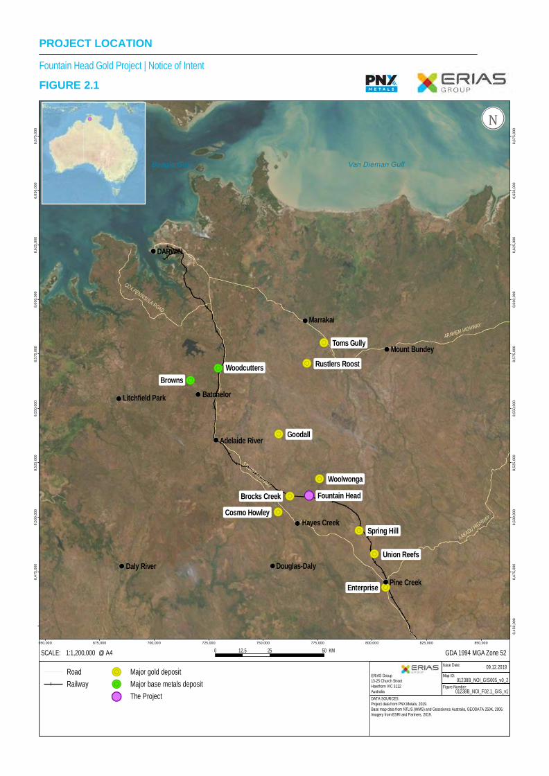
2. Project Location Fountain Head is located on Ban Ban Springs Station, approximately 170 km south of Darwin in the Northern Territory, approximately 6 km east of the Stuart Highway (Figure 2.1). Ban Ban Springs Station is an operating cattle station on pastoral lease (PL 1111). The station covers an area of 1,873 square kilometres, with a carrying capacity of approximately 12,000 head of beef cattle for domestic and international markets. The land system consists of hilly and gently undulating terrain and vast plains interspersed with creek beds bordered by flood out country.
Coordinates of the site are provided below in Table 2.1 below.
Table 2.1 – Project Coordinates Site Latitude Longitude
Fountain Head 13°27'58"S 131°30'15"E Coordinates are in Latitude and longitude – Degrees, minutes, seconds.
Fountain Head is located on 4 MLs (MLN4, 1020, 1034, and ML31124) which form the Project area for the Fountain Head Gold Project, shown in Figure 2.2.
The area surrounding the Project contains a number of historic predominantly gold mines, some of which are being assessed by various companies. Cosmo Gold Mine owned by Kirkland Lake Gold, located approximately 15 km to the west of the Project is the only operating mine. Ore from Cosmo is processed approximately 70 km south at Kirkland Lake Gold’s Union Reefs processing facility which recommenced operations in November 2019 after an approximate two year period under care and maintenance.
Police (Territory) and Fire and Emergency (volunteer) services are located in the closest townships of Adelaide River and Pine Creek, both located approximately 50 km from the Project area. Mines rescue and medical personnel are also located at Cosmo and Union Reefs.
G D A 1 9 9 4 M G A Z o ne 5 20 2 5 5 01 2 . 5 K M@ A 4S C A L E : 1 :1 ,2 0 0 ,0 0 0
!(
!(
!(
!(
!(
!(
!H!
Litchfie ld P ark
M ount B undey
M arrakai
H ayes C reek
D ouglas-D a ly
Fountain H ead
B atch elor
D A R W IN
A de la ide R iver
D aly R ive rPine C reek
Spring H ill
R us tlers R oo st
C osm o H ow ley
Tom s Gu lly
B row ns
U nion R ee fs
Enterp rise
B rocks C reek
Go oda ll
W oolw onga
W oodcutters
A R N H E M H IG H W A Y
S T U A R T H IG H W AY
C O X P E N IN S U L A R O A D
K A K A D U H IG H W AY
6 5 0 ,0 0 0 6 7 5 ,0 0 0 7 0 0 ,0 0 0 7 2 5 ,0 0 0 7 5 0 ,0 0 0 7 7 5 ,0 0 0 8 0 0 ,0 0 0 8 2 5 ,0 0 0 8 5 0 ,0 0 0
8,450
,000
8,475
,000
8,475
,000
8,500
,000
8,500
,000
8,525
,000
8,525
,000
8,550
,000
8,550
,000
8,575
,000
8,575
,000
8,600
,000
8,600
,000
8,625
,000
8,625
,000
8,650
,000
8,650
,000
8,675
,000
8,675
,000
R o a dR a i lw a y
!R M a jo r g o ld d e p o s i t!R M a jo r b a s e m e ta ls d e p o s it!H! T h e P ro je c t D A T A S O U R C E S :
P ro je c t da ta f ro m P N X M e ta ls, 2 01 9 .B a se m a p d a ta fr om N T L IS (W M S ) a n d G e os c ie n c e A u st ra lia , G E O D A T A 2 50 K , 2 00 6 .Im a ge ry f ro m E S R I an d P ar tn ers , 2 01 9 .
Is su e D at e:M ap I D :
F igu re N u m b e r:0 1 2 3 8 B _ N O I_ F 0 2 .1 _ G I S _ v 1
0 9 . 1 2 . 2 0 1 9
ÄÄÄN⟨P ro je c t N a m e | R e p o r tF IG U R E 2 .1
E R I A S G ro u p13 -2 5 C h u rc h S tr ee tH aw th o rn V I C 3 1 22A u st ra lia
0 1 2 3 8 B _ N O I_ G IS 0 0 5 _ v 0 _ 2
P R O J E C T L O C A T IO NF o u n ta in H e a d G o ld P ro je c t | N o tic e o f In te n t
!(
V a n D ie m a n G u lfB e a g le G u lf
!(
!(
!(
!(

@ A 4S C A L E : 1 :2 8 ,0 0 0
Is s ue D at e:M ap I D :
F igu re N um b e r:
2 0 . 1 2 .2 0 1 9
F o u n ta in H e ad G o ld P ro je c t | N o tice o f In te n tFIGURE 2.2
E R IA S G ro up13-2 5 C hu rch S tre etHa w th orn V IC 3 12 2A us tra l ia
ÄÄÄN⟨
0 1 2 3 8 B _ N O I_ F 0 2 .2 _ G IS _ v 10 1 2 3 8 B _ N O I_ G I S 0 0 6 _ v 0 _ 3
0 1 20 .5 K M
ML31124
A L IC E S P R IN G S D A R W IN R A ILW AYA L IC E S P R IN G S D A R W IN R A ILW AY
ML31124
MLN1020
MLN1034
MLN4
FOUNTAIN HEAD LEASE BOUNDARIES AND PROJECT AREA
D A T A S O U R C E S :P ro je c t da ta fro m P N X M e ta ls , 20 1 9 .B a s e da ta f ro m G e o s c ie nc e A u st ra lia , G E O D A T A 2 5 0K , 2 0 0 6.Im a ge ry © E S R I, D ig i ta lG lo be a n d P a rt ne rs , 2 01 9 .
R a ilw a yR o a dW a te r c o u r s eL e a s e b o u n d a r yP r o je c t A r e a
G D A 1 9 9 4 M G A Z o n e 5 2
M o u n t W e l ls R o a d

NOTICE OF INTENT FOUNTAIN HEAD GOLD PROJECT
01238C_1_NOI_V1.DOCX 2–4

NOTICE OF INTENT FOUNTAIN HEAD GOLD PROJECT
01238C_1_NOI_V1.DOCX 3–1
3. Legislative Framework 3.1 Northern Territory Environmental Approvals Process In the Northern Territory, environmental permitting of mining activities is regulated under the Environmental Assessment Act (as in force 1 January 2013) and the Mining Management Act (as in force 1 July 2015). The Environmental Assessment Act (and associated administrative procedures) is administered by the Department of Environment and Natural Resources (DENR) and provides a framework for the assessment of the environmental effects of development proposals and for the protection of the environment. The Mining Management Act is administered by the Department of Primary Industry and Resources (DPIR) and provides the framework for the authorisation of mining activities, the management of mining sites, the protection of the environment on mining sites, the provision of economic and social benefits to communities affected by mining activities, and for related purposes.
A Notice of Intent (NOI) (i.e. this document) is submitted to the DPIR for consideration of the proposed action. The NOI will be referred to the Northern Territory Environment Protection Agency (NT EPA) by the Minister for Primary Industry and Resources to determine the level of assessment required under the Environmental Assessment Act, which may require the submission of a Public Environmental Report (PER) or an Environmental Impact Statement (EIS). In some cases where environmental risks are considered to be minor and they can be adequately managed, no further formal assessment is required under the NT Environmental Assessment Act. The proposal is then referred back to the DPIR to be managed under the Mining Management Act through the Mining Management Plan process.
An environmental assessment (either a PER or an EIS) is prepared in accordance with the Environmental Assessment Act and the established Terms of Reference (ToR) and submitted to the NT EPA. The NT EPA reviews all comments received and prepares an assessment report, which is provided to the Minister for Primary Industry and Resources. The Minister, taking into consideration the assessment report, will then determine if the Project is approved or not, and the conditions that may be applied. Following approval from the Minister, authorisation for the proposed activity is obtained under the Mining Management Act and Mining Act via the preparation and subsequent approval of a Mining Management Plan (MMP) by the Minister for Primary Industry and Resources.
3.2 National Environmental Approvals Process The Commonwealth Environment Protection and Biodiversity Conservation (EPBC) Act 1999 requires that actions likely to have a significant impact on a matter of national environmental significance (NES) be assessed. Matters considered of NES include:
· World Heritage properties.
· National Heritage places.
· Wetlands of international importance (Ramsar Convention).
· Listed threatened species and ecological communities.

NOTICE OF INTENT FOUNTAIN HEAD GOLD PROJECT
01238C_1_NOI_V1.DOCX 3–2
· Listed migratory species.
· Nuclear actions.
· Commonwealth marine areas (including the Great Barrier Reef Marine Park).
· A water resource, in relation to coal seam gas development and large coal mining development.
· Additional matters of national environmental significance (‘prescribed actions’).
In February 2019, PNX submitted a referral under the EPBC Act for the development of the Hayes Creek Project which included processing of ore at Fountain Head and use of the Fountain Head open pit to place tailings. The Department of Environment and Energy after a period of public consultation determined that the proposed activity was not a controlled action and would not require approval under the EPBC Act. PNX have decided not to submit a referral for the Project on the basis that a controlled action is not expected as there are no additional matters to be considered that were not addressed in the Hayes Creek Project referral. Matters of National Significance are discussed in Chapter 8.
3.3 Other Relevant Legislation Territory and Commonwealth legislation of most relevance to the proposed Project include the following acts and associated regulations:
· Aboriginal Land Rights (Northern Territory) Act 1976.
· Aboriginal Land Act (as in force 28 August 2013).
· Bushfires Management Act (as in force 2 November 2016).
· Dangerous Goods Act (as in force 1 January 2012).
· Environmental Assessment Act and Environmental Assessment Administrative Procedures (as in force 1 January 2013).
· Environment Protection and Biodiversity Conservation Act 1999.
· Heritage Act (as in force 1 May 2016).
· Mineral Royalty Act (as in force 1 July 1982).
· Mineral Titles Act (as in force 7 November 2016).
· Mining Management Act (as in force 1 July 2015).
· Native Title Act 1993 (Federal Legislation).
· Northern Territory Aboriginal Sacred Sites Act (as in force 28 August 2013).
· Northern Territory Control of Roads Act (as in force 1 January 2015).
· Northern Territory Environment Protection Authority Act (as in force 1 January 2013).

NOTICE OF INTENT FOUNTAIN HEAD GOLD PROJECT
01238C_1_NOI_V1.DOCX 3–3
· Northern Territory Traffic Act (as in force 1 July 2007).
· Northern Territory Water Act and Water Regulations 2002.
· Pastoral Land Act 2016.
· Planning Act (as in force 28 July 2016).
· Public and Environmental Health Act (as in force 1 May 2016).
· Soil Conservation and Land Utilisation Act (as in force 1 May 2016).
· Territory Parks and Wildlife Conservation Act (as in force 13 November 2014).
· Traffic Act (as in force 1 May 2016).
· Transport of Dangerous Goods by Road and Rail (National Uniform Legislation) Act (as in force 1 May 2016).
· Waste Management and Pollution Control Act (as in force at 1 May 2016).
· Weeds Management Act (as in force 28 August 2013).
· Work Health and Safety (National Uniform Legislation) Act 2011.

NOTICE OF INTENT FOUNTAIN HEAD GOLD PROJECT
01238C_1_NOI_V1.DOCX 3–4

NOTICE OF INTENT FOUNTAIN HEAD GOLD PROJECT
01238C_1_NOI_V1.DOCX 4–1
4. Project Description 4.1 Overview of Project PNX proposes to recommence mining at Fountain Head and extract gold from the ore using heap leaching to a produce gold dore. Mining at Fountain Head was most recently undertaken from 2007 to 2009 by GBS Gold however the site has a long history of gold mining and exploration dating back to the 1800’s. The Project will involve the following activities:
· Dewatering of existing open pit.
· Expansion of existing open pit.
· Expansion of existing waste rock stockpile.
· Construction of processing related leach pads, solution ponds, crushing facilities and gold processing plant.
· Construction of supporting infrastructure i.e. workshops, power station, roads, offices etc.
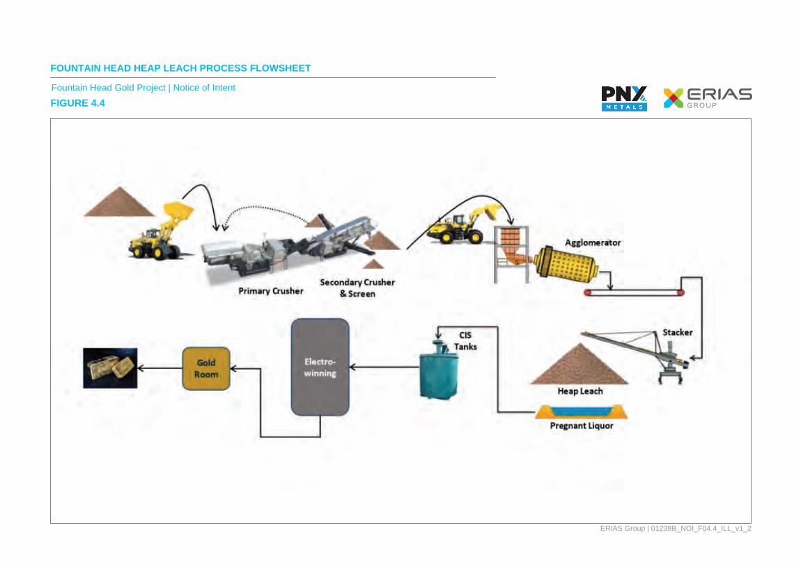
4.1.1 Dewatering The current Fountain Head void has filled with ground water inflows, surface water runoff and rainfall since mining ceased in 2009. There is currently approximately 1.9 Mm3 of water contained in the pit (PNX Metals, 2019). The dewatering of the pit will be covered in a separate dewatering Mining Management Plan (MMP) which will be submitted to the DPIR for approval. An overview of the dewatering activities is outlined below for completeness.
Dewatering of the Fountain Head void is required to enable mining to recommence. Not all water is required to be removed before mining can recommence and subsequently a staged approach to dewatering is proposed. Discharge of water from the mining lease is not proposed. In parallel with using mine water evaporators the remaining water is to be pumped and stored in an existing surface dam located to the north of the historic pits for natural evaporation and retention.
Subject to regulatory approval and subsequent to mining, the enlarged Fountain Head void is proposed to be used a tailings storage for the Hayes Creek Project. The Fountain Head site was initially selected as a site to process the Hayes Creek ore as the pit provided a storage facility for placing potentially acid forming tailings from the Hayes Creek Project sub-aqueously.
It is anticipated that on the completion of mining at Fountain Head, pit water would be returned to the enlarged void to allow for tailings from the Hayes Creek Project to be place sub-aqueously. This is an important component of the Hayes Creek Project.
Dewatering of the current pit will need to be strictly scheduled and managed so that dewatering occurs sufficiently in advance of mining so that no production delays result.
It is proposed that four, approximately 90 kW electrical evaporators will be installed on the edge of the pit with a separation of approximately 50 m to increase evaporation rates. Seasonal evaporation rates have been taken into consideration to determining the number and size of units required. Current estimates are that approximately 50% of the water pumped (37.5l/s per unit)

NOTICE OF INTENT FOUNTAIN HEAD GOLD PROJECT
01238C_1_NOI_V1.DOCX 4–2
through the evaporators will be evaporated, this is the average annualised rate. The evaporators are expected to be only used in daylight hours when the maximum evaporation conditions exist, and will be positioned to direct the plume of spray over and into the pit. Any precipitates that may result as the water evaporates would be self-contained within the pit. A typical setup of these evaporators is shown in Plate 4.1 and Plate 4.2. The operation of the evaporators will be linked via telemetry to a weather station which will shut down the evaporators when wind direction and/or wind speeds result in the spay plume drifting outside of the pit.
Plate 4.1 – Typical Evaporator System
Plate 4.2 – Evaporators in use at Mt Morgan, QLD
NOTICE OF INTENT FOUNTAIN HEAD GOLD PROJECT
01238C_1_NOI_V1.DOCX 4–3
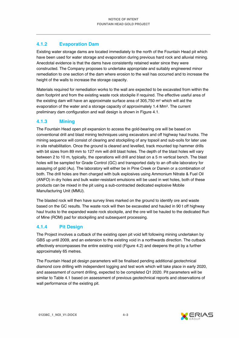
4.1.2 Evaporation Dam Existing water storage dams are located immediately to the north of the Fountain Head pit which have been used for water storage and evaporation during previous hard rock and alluvial mining. Anecdotal evidence is that the dams have consistently retained water since they were constructed. The Company proposes to undertake appropriate and suitably engineered minor remediation to one section of the dam where erosion to the wall has occurred and to increase the height of the walls to increase the storage capacity.
Materials required for remediation works to the wall are expected to be excavated from within the dam footprint and from the existing waste rock stockpile if required. The effective useful area of the existing dam will have an approximate surface area of 305,750 m2 which will aid the evaporation of the water and a storage capacity of approximately 1.4 Mm3. The current preliminary dam configuration and wall design is shown in Figure 4.1.
4.1.3 Mining The Fountain Head open pit expansion to access the gold-bearing ore will be based on conventional drill and blast mining techniques using excavators and off highway haul trucks. The mining sequence will consist of clearing and stockpiling of any topsoil and sub-soils for later use in site rehabilitation. Once the ground is cleared and levelled, track mounted top hammer drills with bit sizes from 89 mm to 127 mm will drill blast holes. The depth of the blast holes will vary between 2 to 10 m, typically, the operations will drill and blast on a 5 m vertical bench. The blast holes will be sampled for Grade Control (GC) and transported daily to an off-site laboratory for assaying of gold (Au). The laboratory will either be in Pine Creek or Darwin or a combination of both. The drill holes are then charged with bulk explosives using Ammonium Nitrate & Fuel Oil (ANFO) in dry holes and bulk water-resistant emulsions will be used in wet holes, both of these products can be mixed in the pit using a sub-contracted dedicated explosive Mobile Manufacturing Unit (MMU).
The blasted rock will then have survey lines marked on the ground to identify ore and waste based on the GC results. The waste rock will then be excavated and hauled in 90 t off highway haul trucks to the expanded waste rock stockpile, and the ore will be hauled to the dedicated Run of Mine (ROM) pad for stockpiling and subsequent processing.
4.1.4 Pit Design The Project involves a cutback of the existing open pit void left following mining undertaken by GBS up until 2009, and an extension to the existing void in a northwards direction. The cutback effectively encompasses the entire existing void (Figure 4.2) and deepens the pit by a further approximately 65 metres.
The Fountain Head pit design parameters will be finalised pending additional geotechnical diamond core drilling with independent logging and test work which will take place in early 2020, and assessment of current drilling, expected to be completed Q1 2020. Pit parameters will be similar to Table 4.1 based on assessment of previous geotechnical reports and observations of wall performance of the existing pit.

Waste Rock Dump
Topsoil Stockpile1
Topsoil Stockpile 2
Third Party ROM
Truck Turn
Mine Haulroads
HL ROM/Crusher
Power station
Process Station
Fuel Farm
Mining Contractor Yard
PNX Core Shed
Heap Leach Facility
Dam Wall
Dam Water
ALICE SPRINGS DARWIN RAILWAY
ALICE SPRINGS DARWIN RAILWAY
Mount Wells Road
Ban B
an Spring
s Road
Magazine
ANE Facility
8,512,000
8,511,500
8,511,000
8,510,500
8,510,000
8,509,500
8,509,000
8,508,500
8,512,000
8,511,500
8,511,000
8,510,500
8,510,000
8,509,500
8,509,000
8,508,500
773,500773,000772,500772,000771,500771,000770,500770,000769,500769,000768,500
ERIAS Group13-25 Church StreetHawthorn VIC 3122Australia
Figure Number:
Map ID:
Issue Date:
01238B_NOI_F04.1_GIS_v1
01238B_NOI_GIS004_v0_5
2019.12.20
ÄÄN⟨ Railroad
Road
Gas Pipeline
Watercourse
Survey Area
Infrastructure
COORDINATE REFERENCE: GDA 1994 MGA Zone 52@ A41:24,000SCALE: 0 1 20.5 KM
DATA SOURCES:Project data from CLIENT NAME, 2019.Base data from CLIENT NAME & GEODATA 250K, 2006.Imagery © ESRI, DigitalGlobe and Partners, 2019.
FIGURE 4.1Fountain Head Gold Project | Notice of Intent
FOUNTAIN HEAD GOLD PROJECT LAYOUT

@ A 4S C A L E : 1 :1 5 ,0 0 0
Is s ue D at e:M ap I D :
F igu re N um b e r:
0 9 . 1 2 . 2 0 1 9
F o u n ta in H e a d G o ld P ro je c t | N o tic e o f In te n tFIGURE 4.2
E R IA S G ro up13-2 5 C hurc h S tre etHa w th orn V IC 3 12 2A us tra l ia
ÄÄÄN⟨
0 1 2 3 8 B _ N O I_ F 0 4 .2 _ G IS _ v 10 1 2 3 8 B _ N O I_ G IS 0 1 0 _ v 0 _ 1
0 0 .5 10 .2 5 K M
Pit(proposed)
Waste rock dump(proposed)
A L IC E S P R IN G S D A R W IN R A ILW AYA L IC E S P R IN G S D A R W IN R A ILW AY
Wasterock dump(existing) Pit
(existing)
PROPOSED FOUNTAIN HEAD PIT AND WASTE ROCK DUMP IN COMPARISON TO EXISTING PIT AND WASTE ROCK DUMP
D A T A S O U R C E S :P ro je c t da ta f ro m P N X M et a ls , 2 0 19 .B a se da ta f ro m G e o sc ien c e A u s tr a l ia , G E O D A T A 2 5 0 K , 20 0 6 .Im a ge ry © E S R I , D ig it a lG lob e a n d P a rtn e rs , 2 0 1 9.
R a ilw a yW a te r c o u rs eH a u l r o a dP r o p o s e d P it a n d W R DE x is t in g P it a n d W R D
G D A 1 9 9 4 M G A Z o n e 5 2
M o u n t W e l ls R o ad
Ban B a n S
p ring s R
o a d

NOTICE OF INTENT FOUNTAIN HEAD GOLD PROJECT
01238C_1_NOI_V1.DOCX 4–6
Table 4.1 – Pit and Haul Road Design Preliminary Parameters Feature Unit
Surface RL (Mine grid) mRL 1105 Final Pit Floor (Mine Grid) mRL 965 Total Pit Depth m 140 Pit Length m 700 Pit Width m 400 Road Width – Dual Lane m 30 Road Width – Single Lane m 17 Ramp Gradient V:H 1:8 Batter Height m 15 Berm Width m 5 Upper Batter Angle ° 55 Lower Batter Angles ° 60 to 70 Overall Pit Slope ° ~45
4.1.5 Mine Schedule A draft mining schedule has been designed to supply approximately 1 Mtpa of ore for heap leaching. To achieve this production rate the pit will be mined in stages (shown in Figure 4.3) to ensure consistent ore supply whilst pre-stripping of other areas of the pit. Further refinement of the schedule is expected after completion of further geotechnical assessment and drilling.

@ A 4S C A L E : 1 :3 0 ,0 0 0
Is s ue D at e:M ap I D :
F igu re N um b e r:
0 9 . 1 2 . 2 0 1 9
F o u n ta in H e a d G o ld P ro je c t | N o tic e o f In te n tFIGURE 4.3
E R IA S G ro up13-2 5 C hurc h S tre etHa w th orn V IC 3 12 2A us tra l ia
0 1 2 3 8 B _ N O I_ F 0 4 .3 _ G IS _ v 10 1 2 3 8 B _ N O I_ G IS 0 11 _ v 0 _ 1
0 0 .5 10 .2 5 K M
STAGES OF FOUNTAIN HEAD PIT DEVELOPMENT
D A T A S O U R C E S :P ro je c t im a ge fro m P N X M et a ls , 20 1 9.
G D A 1 9 9 4 M G A Z o n e 5 2
ÄÄÄN⟨

NOTICE OF INTENT FOUNTAIN HEAD GOLD PROJECT
01238C_1_NOI_V1.DOCX 4–8
4.1.6 Mining Equipment The mining equipment will not be finalised until the further technical studies are completed and contracts are awarded for the mining, crushing & screening operations. Due to the size of the operation an experienced earthmoving contractor will likely be engaged to undertake mining and haulage of waste rock and ore. It is expected that the mining equipment will be a combination of readily available new and used fit for purpose equipment (outlined in Table 4.2)
Table 4.2 – Mining and Processing Equipment with Ancillaries Type Brand Model No. Units
Excavator Liebherr R9150 1 Excavator Komatsu PC300LC 1 Trucks Caterpillar 777G 6 Dozer Caterpillar D9T 2 Grader Caterpillar 14M 1 Water cart Caterpillar 777F 1 Drill Atlas Copco ROC F9 2 MMU Hino TBD 1 Stemming Loader Komatsu WA300 1 Crusher Loader Komatsu WA500 1 Fire Tender Kenworth TBD 1 Workshop Truck Isuzu TBD with Hiab 1 Service Truck Hino TBD 1 Boiler Makers Truck Isuzu TBD 1 Light Vehicles Toyota Various 12 Lighting Plants Greenlite 5 Head LED 10 Bus Isuzu TBD 26 seat coach 1 Crane Franna 25T 1 Forklift Komatsu FH50 1 Tyre Handler Komatsu WA500 1 Telehandler Manitou TBD 1 Skid Steer Loaders TBA TBD 2
4.1.7 Blasting The majority of the material to be mined from the pit will require blasting. On the surface there will be limited volumes of free digging oxide materials, below this will be semi weathered transitional rock which will require a powder factor of around 0.4 kg/BCM of explosives with the fresh rock requiring around 0.7 kg/BCM of explosive. It is expected that due to the relatively highwater table in the region, the majority of the blast holes will be wet requiring water resistant emulsion explosives.
Fragmentation will be important to ensure productive throughput in the mobile crusher circuit. It is more productive and cost efficient to correctly blast the rock in the pit than to perform additional crushing.

NOTICE OF INTENT FOUNTAIN HEAD GOLD PROJECT
01238C_1_NOI_V1.DOCX 4–9
Blast holes will be drilled using conventional track mounted top hammer mobile drill rigs that are capable of drilling holes with a diameter 89 mm to 127 mm. The rigs will be able to drill blast holes from 2 m to over 10 m as required. The drills have the added safety advantage of being able to be positioned back from the exposed edges of the Fountain Head pit cutback.
Important considerations during blasting will be the proximity of sensitive receptors. Within close proximity to the pit crest is the buried high-pressure Bonaparte Gas pipeline (BGP). At the closest point the pipeline is 370 m from the pit crest to the east and 480 m in the south. The Company has been consulting with Australian Pipeline Group (APA), the owners of the pipeline, and before mining and the use of explosives can take place a joint Safety Management Study (SMS) will be conducted to determine allowable ground vibration limits that will be enforced on the blasting operation to ensure that no disruption is caused to the flow of gas through the BGP.
Approximately 540 m to the south of the operation is the Adelaide to Darwin railway line, this rail line has intermittent passenger and freight services which can pass through at any time day or night. Therefore, the blasting operation will have a zero-ejection policy for fly rock leaving the pit area to avoid any incidents with trains or other site infrastructure.
The restrictions on ground vibration and rock ejection are all achievable via professional drill and blast design. Blasting will take place in daylight hours only and preferably during meal or shift breaks.
4.1.8 Waste Rock Stockpile To the west of the pit there is an existing waste rock stockpile which was constructed during the last phase of mining by GBS Gold from 2007 to 2009 (Figure 4.2). No rehabilitation of the stockpile has occurred and whilst batters are at the angle of repose (Plate 4.3) the stockpile is generally stable and revegetation particular of the oxide waste has occurred. Visual evidence and surface water quality monitoring results indicate that the waste rock is non-acid forming and is not generating metalliferous drainage. The existing waste rock stockpile encroaches into the proposed cutback of the pit and therefore a section of the waste rock stockpile will need to be relocated prior to cutting back the pit in this region (refer Figure 4.2). The waste rock will be used for the construction of haul roads, workshops, laydown areas etc. Some of this rock may also be crushed and screened during site establishment for blast hole stemming and aggregate for concrete. Following removal of a section of the existing waste rock stockpile there will be a minimum of 40 m from the pit crest to the waste rock stockpile.
The waste rock stockpile landform design parameters are outlined in Table 4.3. The current pit design estimates that approximately 15 Mt of waste rock will be moved to access the ore. The design of the landform has assumed that additional exploration will identify new ore reserves. Subsequently the current design has an excess capacity of approximately 7.7 Mt for any future expansion of the waste rock stockpile.

NOTICE OF INTENT FOUNTAIN HEAD GOLD PROJECT
01238C_1_NOI_V1.DOCX 4–10
Plate 4.3 – Existing Fountain Head Waste Rock Stockpile
Table 4.3 – Waste Rock Dump Landform Parameters Feature Unit
Waste Rock Capacity Mt 22.82 Waste Rock Capacity Mm3 8.55 Batter Angle, Final Rehab ° 20 Berm Width m 10 Berm Interval m 10 Ramp Gradient V:H 1:10 Ramp Width m 30
The waste rock stockpile will be progressively rehabilitated with sections that are dumped to final limits shaped and topsoiled. All faces of the existing waste rock stockpile that will not be buried by the extension will be rehabilitated in the same manner as the new waste rock stockpile, thus forming a single rehabilitated stockpile at mine closure.
4.2 Ore Processing The construction of the heap leach pads and gold processing plant will take between 6 to 9 months. The gold bearing ore from mining will be stockpiled on the ROM until required where it will then be crushed and screened and stacked onto the heap leach pads. The crushing and screening circuits will be designed with excess production capacity to ensure that ore processing can be achieved whilst allowing for potential delays due to weather or mechanical breakdown.
NOTICE OF INTENT FOUNTAIN HEAD GOLD PROJECT
01238C_1_NOI_V1.DOCX 4–11
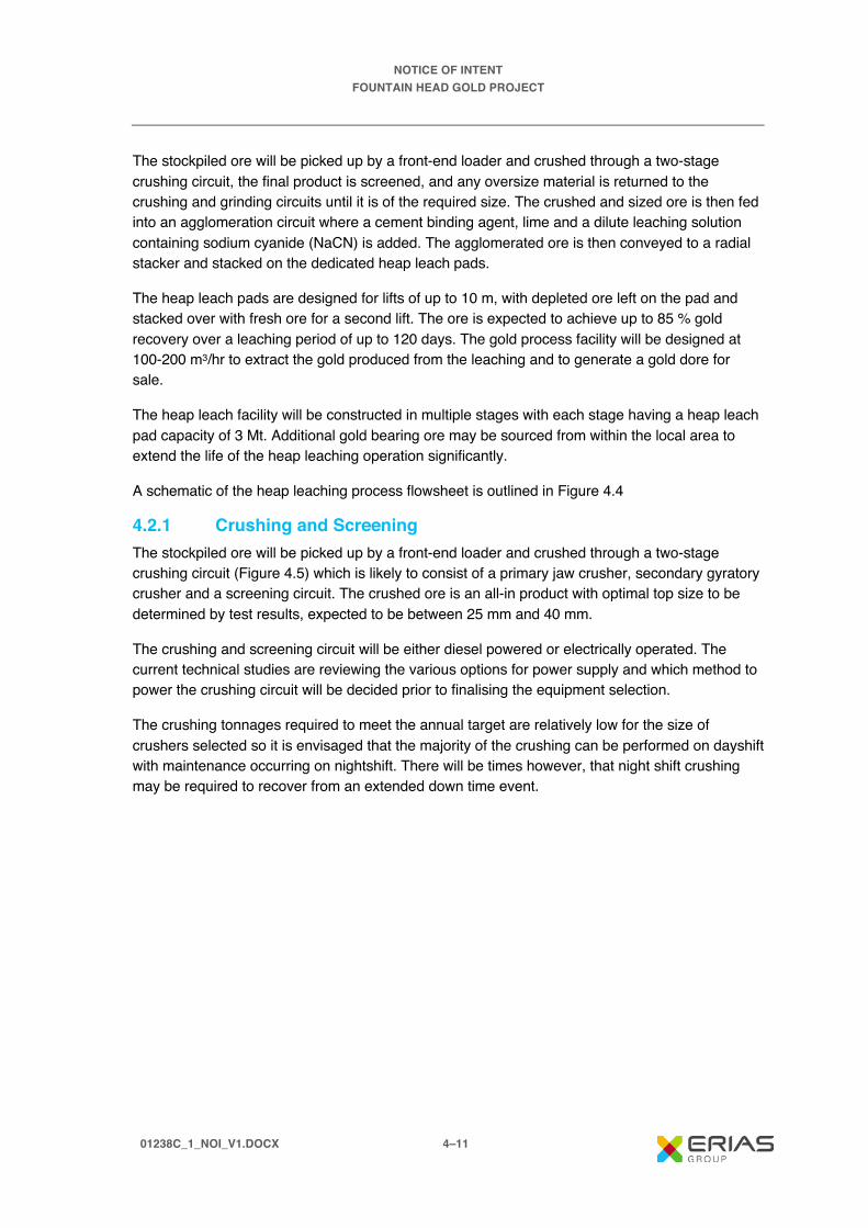
The stockpiled ore will be picked up by a front-end loader and crushed through a two-stage crushing circuit, the final product is screened, and any oversize material is returned to the crushing and grinding circuits until it is of the required size. The crushed and sized ore is then fed into an agglomeration circuit where a cement binding agent, lime and a dilute leaching solution containing sodium cyanide (NaCN) is added. The agglomerated ore is then conveyed to a radial stacker and stacked on the dedicated heap leach pads.
The heap leach pads are designed for lifts of up to 10 m, with depleted ore left on the pad and stacked over with fresh ore for a second lift. The ore is expected to achieve up to 85 % gold recovery over a leaching period of up to 120 days. The gold process facility will be designed at 100-200 m3/hr to extract the gold produced from the leaching and to generate a gold dore for sale.
The heap leach facility will be constructed in multiple stages with each stage having a heap leach pad capacity of 3 Mt. Additional gold bearing ore may be sourced from within the local area to extend the life of the heap leaching operation significantly.
A schematic of the heap leaching process flowsheet is outlined in Figure 4.4
4.2.1 Crushing and Screening The stockpiled ore will be picked up by a front-end loader and crushed through a two-stage crushing circuit (Figure 4.5) which is likely to consist of a primary jaw crusher, secondary gyratory crusher and a screening circuit. The crushed ore is an all-in product with optimal top size to be determined by test results, expected to be between 25 mm and 40 mm.
The crushing and screening circuit will be either diesel powered or electrically operated. The current technical studies are reviewing the various options for power supply and which method to power the crushing circuit will be decided prior to finalising the equipment selection.
The crushing tonnages required to meet the annual target are relatively low for the size of crushers selected so it is envisaged that the majority of the crushing can be performed on dayshift with maintenance occurring on nightshift. There will be times however, that night shift crushing may be required to recover from an extended down time event.
FOUNTAIN HEAD HEAP LEACH PROCESS FLOWSHEET
Fountain Head Gold Project | Notice of Intent
ERIAS Group | 01238B_NOI_F04.4_ILL_v1_2
FIGURE 4.4

TYPICAL MOBILE TWO STAGE CRUSHING AND SCREENING UNIT
Fountain Head Gold Project | Notice of Intent
ERIAS Group | 01238B_NOI_F04.5_ILL_v1_1
FIGURE 4.5

NOTICE OF INTENT FOUNTAIN HEAD GOLD PROJECT
01238C_1_NOI_V1.DOCX 4–14
4.2.2� Agglomeration The agglomeration circuit consists of a feed hopper, rotating agglomeration drum, and conveyors (Plate 4.4). The agglomeration process adds cement binding agent, lime and a dilute leaching solution (NaCN) to leach the contained NaCN soluble gold.
When ore is crushed it can produce significant quantities of fines and some near surface ores are high in clay. These finer particles can impede the flow of the leach solution by reducing the porosity of the stockpile. The use of binding agents during agglomeration greatly improves the heap permeability by reducing the fines and transforming them into uniform pellets. Not only is heap permeability improved, but the ore is effectively cured providing an early start to the leaching. Particle strength of the ore is also greatly improved for pad stability and integrity.
Plate 4.4 – A Typical Agglomeration Circuit and Drum
4.2.3� Stacking Once the ore has had the binding agents and leaching solution added in the agglomeration circuit the now pelletised ore will travel across overland conveyors to a radial stacking unit positioned on the heap leach pad (Plate 4.5). The height of stacking will be determined from column leaching tests in a laboratory however, it is expected that the heaps will be up to 10 m high.

NOTICE OF INTENT FOUNTAIN HEAD GOLD PROJECT
01238C_1_NOI_V1.DOCX 4–15
Plate 4.5 – A Typical Radial Stacker on Heap Leach Pad
4.2.4� Heap Leach Pad The radial stacker places the agglomerated ore onto geotechnically engineered impermeable pads for heap leaching to take place. The dual lined pads consist of a compacted clay liner, a geo-fabric protection layer and then a high density polyethylene HDPE liner. On top of the lining system a cushion layer is provided to protect the liner from trafficable damage and to provide drainage levels. The pads are designed with a slope so that the leaching solution gravitates towards a collection system and is diverted into a clay/geo-fabric/HDPE lined & covered collection pond system (Figure 4.6).
On top of the cushion layer and immediately below the heap there is a herring bone network of 100 mm slotted drainage pipes spaced at 4 m centres. This drainage network collects the leaching solution which then gravitates towards the collection system at the low point of each pad.
The pads incorporate a series of dual lined ponds for collection and storage of the various leaching solutions. The ponds are designed with sufficient capacity to contain a 1:100 year 72 hour event and incorporate storm water ponds for retaining the leaching solution in the lined ponds in any large event.
4.2.5� Leaching and Gold Recovery Process Once the agglomerated ore is stacked on the heap leach pads an irrigation system is placed on the surface of the heaps to efficiently distribute the leach solution. The irrigation system consists of (HDPE) piping and then a specifically designed dripper irrigation system. The CN containing leach solution is pumped through the irrigation system where it then contacts the ore as it travels through the heap via gravity. The leaching solution will typically operate at approximately 500 to 1000ppm sodium cyanide (NaCN) equivalent to 260 to 520ppm CN. The solution will be dosed with lime to maintain a pH = 10. As the NaCN contacts any gold it is dissolved leaving the host rock behind. Leaching solution will be pumped at a rate of 100-200 m3/hr onto the heaps and similar quantity (minus evaporation @ 5%) is collected in the process ponds. The now gold bearing leach solution (called pregnant leach solution or PLS) is collected at the base of the heap in the herring bone drainage network and is then directed via the drainage system to drainage pipes and the covered process ponds.

@ A 4S C A L E : 1 :6 ,0 0 0
Is s ue D at e:M ap I D :
F igu re N um b e r:
0 9 . 1 2 . 2 0 1 9
F o u n ta in H e a d G o ld P ro je c t | N o tic e o f In te n tFIGURE 4.6
E R IA S G ro up13-2 5 C hurc h S tre etHa w th orn V IC 3 12 2A us tra l ia
0 1 2 3 8 B _ N O I_ F 0 4 .6 _ G IS _ v 10 1 2 3 8 B _ N O I_ G IS 0 1 2 _ v 0 _ 1
0 2 5 0 5 0 01 2 5 M
FOUNTAIN HEAD HEAP LEACH FACILITY LAYOUT
D A T A S O U R C E S :P ro je c t im a ge fro m P N X M et a ls , 20 1 9.
E x is t in g t ra n s m is s io nlin eE x is t in g g a s p ip e l in e
G D A 1 9 9 4 M G A Z o n e 5 2
ÄÄÄN⟨

NOTICE OF INTENT FOUNTAIN HEAD GOLD PROJECT
01238C_1_NOI_V1.DOCX 4–17
The PLS from the process pond is pumped to a conventional gold recovery plant (Plate 4.6), where the gold is loaded onto activated carbon in sealed carbon in solution (CIS) tanks/columns. The gold is absorbed by the carbon and the leachate solution now depleted in gold is discharged to a process pond where additional NaCN is added and then this solution is pumped back onto the heaps to recover more gold. The leach circuit is a closed loop system with no discharge to the environment.
Plate 4.6 – Typical Gold Recovery Plant
The gold loaded carbon is removed from the contact columns and placed in a sealed elution column where under temperature and pressure the gold is eluted back off the activated carbon. The elution solution is pumped to an electrowinning cell where the gold (and any silver) is plated as metal. The resultant metal is placed in a small furnace for melting and conversion into a bullion bar (or dore) ready for sale.
The eluted (stripped) activated carbon is recycled back to the contact columns to extract further gold.
4.2.6� Reagents and Consumables Based on current testwork leaching of gold from the ore will consume approximately 0.2 kg/t of NaCN. Based on approximately 1 Mtpa of ore the operation will require 200 tpa of NaCN, the NaCN will be delivered in solid prill form in sealed 1 t bags and stored in a secure dedicated reagent storage area.
When required the NaCN will be dissolved in heavily neutralised water (pH=10) in a purpose built dedicated reagent mixing and dosing system.
Other major consumables will be lime and cement (if required for addition into the agglomeration drum). Lime consumption (at 3k g/t) for pH control will be in the order of 3,000 tpa and will be

NOTICE OF INTENT FOUNTAIN HEAD GOLD PROJECT
01238C_1_NOI_V1.DOCX 4–18
delivered in trucks where it will be transferred into a storage silo. From the silo an auger system will be used to deliver lime to a mixing plant where it will be mixed with process water. There may be a need to add some lime directly to the agglomeration system.
Cement, if required would also be delivered via truck and transferred into a silo and then added as a powder into the agglomerating drum. At 5 kg/t this would require 5,000 tpa of cement.
Approximately 10 to 20 tpa of activated carbon will be required each year to replace the activated carbon consumed in the gold recovery process.
The process will also require water, as this will be lost as evaporation and retained moisture in the leach residue on the pads. The water loss will be in the order of 10 to 25 m3/hr. The initial water requirement and make up water will be drawn from the evaporation ponds on site.
A preliminary water balance has been established for site, including site rainfall data, and this has indicated that the facility will be a net water consumer. The facility will however have surface water storage ponds for any interim water excess during the wet season. Additionally, if required any excess water could be diverted back to the Fountain Head pit.
4.2.7 Heap Leach Facility Environmental Management The heap leach and process area will be fenced with a suitable fence to exclude access of both native and introduced animals. The process ponds will be either covered in netting or polypropylene balls to exclude access to wildlife, in particular birds and bats. All process solutions will be transported via closed pipes.
Leach Pads are designed with clay liners/geomembrane/HDPE/Cushion layer to ensure no leach solution can escape to the environment. Construction activities have stringent liner integrity QA/QC procedures that need to be met prior to acceptance for commercial use. Several monitoring bores will be drilled around and downstream of the facility to monitor ground water to ensure integrity of the system.
All pipes containing leach solution will be placed on lined HDPE corridors which will drain back to process ponds or the process plant. Any potential leakage will be collected and returned to the process.
The process ponds are designed with clay liners/geomembrane/double HDPE liner. In between the clay and the HDPE liner an intercept collection drain and sump with collection pumping bore will be installed for leak detection. Standard International Cyanide management codes will be adopted for the site inclusive of all necessary statutory OHS&E requirements.

NOTICE OF INTENT FOUNTAIN HEAD GOLD PROJECT
01238C_1_NOI_V1.DOCX 4–19
4.3 Infrastructure 4.3.1 Electricity Three options are being considered to provide power for the Project taking into account location, cost and availability of renewable energy sources:
Option 1: Power & Water Corporation (PWC) 66 kVa powerline servicing Ban Ban Springs Station passes in close proximity to the site infrastructure and would require a short spur line and associated transformer.
Option 2: Containerised and silenced 800 kVa diesel generators could offer the Project some flexibility by providing continuous uninterrupted power effectively eliminating any power shortages caused by lightning and inclement weather which currently impacts on the PWC 66 kVa powerline.
Option 3: Gas fired reciprocal engines as the Bonaparte Gas Pipeline (BGP) runs in close proximity to the operation. Negotiations are ongoing with Australian Pipeline Group (APA) the owner of the pipeline and with PWC the owner of the gas.
The use of renewable energy in the form of solar and wind have been investigated and will not be considered further as the life of the Project will not justify the significant capital expenditure of a solar system and the region does not have consistent winds for wind turbine power generation
4.3.2 Water Non-potable water is available in large quantities on site from the Fountain Head pit. The water is suitable as process water, dust suppression and for heap leaching operations. In total approximately 40,000 kl will be required per month, with instantaneous requirements of approximately 60 m3/hr.
The non-potable water users on site will be:
· Office ablutions.
· Pit and road dust suppression.
· Vehicle washdown.
· Core cutting and core shed ablutions.
· Crusher dust suppression.
· Heap Leach start and make-up water.
· Plant wash water.
Potable water will initially be trucked to site and stored in sealed water tanks with a skid mounted filtration system to process the water prior to use. Longer term bores may be required for potable water and treated through a UV and filtration system. The potable water requirements on site are limited to drinking water, washup and explosive manufacture.

NOTICE OF INTENT FOUNTAIN HEAD GOLD PROJECT
01238C_1_NOI_V1.DOCX 4–20
4.3.3 Diesel Diesel will be the primary source of fuel for the mobile fleet and between 1 to 2 weeks supply will be stored on site to protect from any disruption caused to transport logistics by weather etc.
It is proposed that diesel will be stored on site in standard self-bunded 55 kl storage tanks (example shown in Plate 4.7) in a dedicated fuel farm facility that will service both light and heavy vehicles. The refuelling facility will be located to aid efficient unloading of deliveries and will have good all-weather road access and will be secured at all times.
The operation will use approximately 250 kl of diesel per month.
Plate 4.7 – Typical Self Bunded Fuel Storage Tank
4.4 Emissions 4.4.1 Fugitives and Respirable Dust The primary emissions generated on site will be diesel emissions and fugitive dust which will be generated by the roads, waste rock stockpile, blasting, excavation and crushing. Dust emissions will be managed by the use of large off highway style water carts with a capacity of 80 kl. The water cart will also be fitted with a water cannon which can be utilised for watering stockpiles. All crusher hoppers, transfer and drop points will have water sprays fitted.
Regular dust monitoring will take place at least twice per year to measure the silica levels in the respirable dust range to ensure that no worker is exposed to respirable silica.
4.4.2 Noise The operation will operate 24 hours per day 365 days per year. Noise will be generated from the mining fleet, blasting and crushing. The greatest noise generation is likely to be from reversing horns on mobile plant and crushing of rocks in the primary jaw crusher. The hours of construction are expected to be 12 hour day shift only.

NOTICE OF INTENT FOUNTAIN HEAD GOLD PROJECT
01238C_1_NOI_V1.DOCX 4–21
Prior to construction, noise loggers will be deployed to collect background noise data as part of the noise assessment to commence early 2019. Noise and vibration sources associated with the Project will be determined using the sound power level emitted by each noise source. Noise predictions will be made including the effect of meteorological conditions and topography and will be compared with the NT Noise Management Framework Guideline to ensure noise levels are not being exceeded.
The workforce will be required to wear appropriate noise PPE when undertaking or in the vicinity of high noise level activity.
4.5 Hazardous Substances 4.5.1 Storage All hazardous substances including explosives and cyanide will be stored in accordance with Northern Territory standards, or Australian standards where Northern Territory standards do not exist. A register will be maintained on site, of all hazardous substances including chemicals for the life of the mine.
4.5.2 Transport All hazardous substances including explosives and cyanide will be transported to the site via road. All substances will be transported using the Australian Dangerous Good Code (Edition 7.4).
4.6 Waste Management of waste rock is outlined in Section 4.1.8. For all other general wastes PNX will adopt the waste hierarchy of:
· Avoid.
· Reuse.
· Recycle.
· Reprocess.
· Energy recovery.
· Dispose.
Where wastes are to be disposed, they will be trucked offsite by a licenced operator for disposal.
4.7 Mine Infrastructure The infrastructure on site at Fountain Head will primarily be demountable buildings and may consist of the following:
· Main administration office, ablutions and carpark.
· Crib room for mine workers.
· Heap Leach Facility complete with pads, plant and conveyance systems.

NOTICE OF INTENT FOUNTAIN HEAD GOLD PROJECT
01238C_1_NOI_V1.DOCX 4–22
· Heap Leach chemical storage.
· Heap Leach Facility office, ablutions and carpark.
· Workshop, stores, service bay and stockyard.
· Heavy vehicle washdown pad with oil separators.
· Diesel fuel and oil storage and dispensing facilities.
· Power generation facility.
· Exploration core shed with office and ablutions.
· Perimeter and internal fencing with signage.
· Explosive magazines.
· ANE Storage sheds/facility.
· Water storage/evaporation dam.
· Mine access roads.
· UHF Radio repeater communications tower.
4.8 Social and Economics 4.8.1 Economic Benefits The Project will provide economic benefits to the Federal and Northern Territory governments in the form of company taxes and royalties. Positive economic benefits will also be generated for the Project workforce and for suppliers, services providers and contractors of the Project.
4.8.2 Workforce and Accommodation The personnel required for the mining and heap leach operations (Table 4.4) will be in the first instance sourced from the local areas of Pine Creek and Darwin. PNX are an equal opportunity employer and encourage the employment of indigenous locals and persons of any gender.
There will be no camp facilities constructed on site and numerous options are being investigated including utilising and expanding existing accommodation facilities in close proximity to Fountain Head. The workforce will be transported in daily, by bus from the selected camp with the daily commute to and from work to be less than 1 hour per journey. There will be approximately 70 persons housed at the camp at any one time (day and night shift).
The site will be a bus-in bus-out (BIBO) site from Darwin with any FIFO workforce required to make their own way to Darwin, in this way the local communities will have greater accessibility to employment on site. Only local personnel not on the bus route will be able to drive to the camp to commence their swing on shift change days.
The mining and heap leaching process will operate 24 hours per day 365 days per annum. It is expected most employees will be engaged on 12 hour shifts and rosters approximating 2 weeks

NOTICE OF INTENT FOUNTAIN HEAD GOLD PROJECT
01238C_1_NOI_V1.DOCX 4–23
on and 1 week off. It is envisaged that management staff and administrative positions will be on a one week on and one week off roster.
The workforce required for the early construction phases for the heap leach and processing plant will peak at around 50 persons at any one time.
Table 4.4 – Workforce Requirements Area Position No. Required
Mining – Staff Project Manager 1 Maintenance Superintendent 1 Senior Mining Engineer 2 Mine Geologist 2 Mining Operations Supervisor 3 Maintenance Supervisor 3 Surveyor 2 Site Admin 2 Safety Coordinator 2 HSET – Paramedic / ERT 2 Mining – Wages Excavator Operators 3 Loader Operators 3 Dump Truck Operators 18 Dozer Operators 6 Grader Operators 3 Watercart Operators 3 Dewatering Crew 2 Drill & Blast Shotfirer 2 Brill & Blast Crew 8 Drillers 6 Workshop Trades 16 Heap Leach Metallurgical Manager 1 Plant Supt/OHS Compliance 2 Shift Team Leader 3 Lime, cement and CN Operators\Stores 3 Heap Leach Operators 4 Au Plant Operators 3 Agglomeration and Stacking Operators 3 Fitters 2 Electrical Supervisor/Technician 2 Laboratory 2 Total Workforce 113

NOTICE OF INTENT FOUNTAIN HEAD GOLD PROJECT
01238C_1_NOI_V1.DOCX 4–24
4.9 Decommissioning and Rehabilitation Historical mining activities have resulted in significant disturbance at the Fountain Head site. In selecting the location for project infrastructure the Company’s preference has been to locate infrastructure on land that has already been disturbed, so far as reasonably practicable, thereby avoiding clearing areas of undisturbed native vegetation.
Geochemical assessment of the ore and waste rock is underway with existing data relating to the quality of water directly adjacent to the historic waste rock stockpiles suggesting that the existing waste rock is non-acid forming. Confirmation of the geochemical properties will be important in the development of the site closure plan.
The Project presents opportunities to plan for the closure of the site through the following:
· Development of a landform design which can be progressively implemented to ensure that the site is rehabilitated during operations and not left unrehabilitated as is currently the situation.
· Development of the evaporation dam is an opportunity to clean up an area that is highly disturbed due to historical alluvial mining.
· The site is heavily infested with weeds and there is an opportunity with the recommencement of mining to implement a weed management program.
· Consultation with stakeholders regarding potential land use opportunities post closure and in particular whether any of the infrastructure could be used for other land uses.
4.10 Project Schedule/Timeline A project schedule has been developed with the following key milestones:
· Dewatering of the existing pit Q2 2020.
· Regulatory approvals before end of 2020.
· Commence construction of heap leach pads and process plant H2 2020.
· Commencement of mining Q1 2021.
· Commissioning of process plant and heap leach pads H1 2021.

NOTICE OF INTENT FOUNTAIN HEAD GOLD PROJECT
01238C_1_NOI_V1.DOCX 5–1
5. Land Use History 5.1 Previous Activity The Project is located on Ban Ban Springs Station, an operating cattle station on pastoral lease (PL 1111). The station covers an area of 1,873 square kilometres, with a carrying capacity of 12,000 head of beef cattle for domestic and international markets. The land system consists of hilly and gently undulating terrain and vast plains interspersed with creek beds bordered by flood out country.
The Fountain Head area is part of the Northern Territory Goldfields where extensive mining and exploration activity dates back to the 1870’s. Mining in the area was undertaken intermittently between 1883 and 1951 and a small open cut pit was excavated at the site by Dominion Mining in the 1990’s. Northern Gold acquired the leases in 2001 and then in 2005, GBS Gold Australia announced that it intended to make an off-market takeover offer for Northern Gold. GBS Gold mined the Fountain Head and Tally Ho deposits between 2007 to 2009. GBS were mining at Fountain Head when they went into receivership in August 2008, which saw the site placed in care and maintenance. No rehabilitation of the waste rock stockpile has been undertaken and the Fountain Head and Tally Ho pits (separate pits but joined) have become flooded. Kirkland Lake Gold, formerly Newmarket Gold NT Holdings Pty Ltd (and Crocodile Gold Australia Pty Ltd before that) purchased the GBS Gold leases in November 2009. The site has remained under care and maintenance since 2009 with past activities leaving the site highly disturbed. The site has not been regulated as a contaminated site under the Waste Management and Pollution Control Act 1998.
The North Australia Railway easements passes directly to the south and the Bonaparte Gas Pipeline easement is adjacent to the mine lease boundary on the south and passes through the mining lease on the east.
5.2 Recent Exploration PNX have continued to undertake exploration around the existing open pit with drilling currently underway.

NOTICE OF INTENT FOUNTAIN HEAD GOLD PROJECT
01238C_1_NOI_V1.DOCX 5–2

NOTICE OF INTENT FOUNTAIN HEAD GOLD PROJECT
01238C_1_NOI_V1.DOCX 6–1
6. Existing Environment 6.1 Natural Environment 6.1.1 Climate The Project area has a tropical savannah climate (Bureau of Meteorology (BOM), 2016a). The closest BOM records are from the Pine Creek Station, 54 km south-east of the Project site. Pine Creek has a mean annual rainfall (2000 to 2016) of 1,423 mm, with a wet season from about December to March, and a dry season from May to September (BOM, 2016a). Mean daily maximum temperature (2000 to 2011) is 33.4ºC, with the warmest months being September to December, and coolest temperatures in the driest months of June and July (BOM, 2016b). Figure 6.1 presents climate data for Pine Creek. During the dry season, winds are predominately south-easterly while during the wet season, winds are predominately north-westerly.
6.1.2 Geology The Foundation Head and Tally Ho deposits are located within the Pine Creek Inlier or “Pine Creek Geosyncline”, a basin formed by crustal extension of c. 2500 Ma granitic basement, where about 10 km of Proterozoic (~1900 Ma) shallow marine to continental supracrustal rocks (sediments and volcanics) accumulated in <20 million years (Needham et al., 1988).
The mineralisation at Fountain Head and Tally Ho occurs within the upper units of the Mount Bonnie Formation, the uppermost division of the South Alligator Group, a tight to isoclinally folded sequence of mainly pelitic and psammitic Lower Proterozoic sediments with interlayered tuff units. These cyclic siltstone, mudstone and greywacke packages have been metamorphosed to greenschist facies. In the area, stratigraphy is folded along northwest-southeast axes that plunge shallowly to the southeast.
Mineralisation at Fountain Head is intimately associated with the Fountain Head Anticline. The Tally Ho deposit is located just to the southwest of Fountain Head deposit and sits on the western limb of the Fountain Head anticline.
Mineralisation occurs in veins as either conformable anticlinal lodes (with flanking mineralisation) or subvertical “ladder vein” styled mineralisation associated with brittle failure sub-parallel to the fold axis, and is found within mudstones, greywackes and phyllite units. Sheeted quartz vein stock-works occur mainly in the axial zone with veins predominantly dipping northeast, and some saddle reefs occur in the axial zone. Increased grades encountered at Fountain Head are thought to result from secondary deformation of the Fountain Head anticline. Gold is associated with quartz veining containing a pyrite-arsenopyrite sulphide assemblage and coarse gold is also not uncommon.

PROJECT SITE CLIMATE DATAFountain Head Gold Project | Notice of Intent
ERIAS Group | 01238B_NOI_F06.1_ILL_v1_1
FIGURE 6.1

NOTICE OF INTENT FOUNTAIN HEAD GOLD PROJECT
01238C_1_NOI_V1.DOCX 6–3
6.1.3 Topography, Geomorphology and Soils The location of the Project is within the head waters of the Adelaide River catchment, where topography is hilly to rugged and is drained by ephemeral water courses that flow northwards towards Adelaide River. The terrain around the Project area is characterised by low ridges with elevations between 90 to 100 mAHD and undulating with scattered hills and alluvial flats.
The Project area falls within the Bend Land System characterised by dissected uplands and isolated strike ridges with skeletal soils and variable tropical woodland (Storey et al 1969). The geomorphology of the Bend Land System is described (Storey et al 1969) as hill slopes with summits of low strike hills, and erosion remnants of siltstone and quartz on slightly weathered metasediments. In between the hills lie a network of alluvial flats and channels incised into deep alluvial sands and loams, and in places clays exist. The remainder consists of colluvial wash slopes with veneer of siltstone flakes and/or sub-angular stony quartz in a loamy mix (Storey et al., 1969).
The Department of Environment and Natural Resources online mapping database (NR Maps) was accessed to identify the land systems within which the Project is located (Table 6.1). The Project is located predominantly within the Rumwaggon land system with a small area in the McKinlay land system.
Table 6.1 – Land Systems within the Project Area Land system Class Class Description Landform Soils Rumwaggon Sandstone
plains and rises Plains, rises and plateaux on mostly sandstone, siltstone, claystone, shale and some limestone; commonly shallow soils with surface stone and rock outcrops
Low rounded hills and low gravelly ridges with intervening alluvial flats
Lithosols on rises, yellow podzolics on alluvial areas
McKinlay Alluvial floodplains
Alluvial floodplains, swamps, drainage depressions and alluvial fans; sandy, silty and clay soils on Quaternary alluvium
Alluvial floodplains and channels
Siliceous sands, silty brown and yellow earths, yellow podzolics
Source: NR Maps (2017)
6.1.4 Surface and Groundwater Hydrology
6.1.4.1 Groundwater Groundwater occurs within fractured and weathered basement rocks. McGowan (1989) described the major hydro-stratigraphic units present within the Project area as:
· Fractured rocks – Local Aquifers:
– The Mount Bonnie formation is characterised by intensely fractured aquifers, which can be enhanced in zones of dolomite. High yields may or may not be sustained under long-term pumping regimes.
– The Geowie Tuff forms fractured aquifers that are prospective for reliable yields. Higher yields are generally associated with faults and shear zones.

NOTICE OF INTENT FOUNTAIN HEAD GOLD PROJECT
01238C_1_NOI_V1.DOCX 6–4
· Fractured and weathered rocks with minor groundwater resources:
– Rocks of very low permeability. Higher permeability tends to be associated with fault lines where significant fracturing occurs or near to alteration zones associated with intrusives.
– The Burrell Creek formation reports variable permeability, with higher estimates associated with alternation arising from intrusive emplacement and fault shear zones.
Groundwater Levels and Flow Recent groundwater level monitoring and sampling was conducted by CDM Smith from the 15 to 19 of July 2019. The results of this field work are detailed in the following sections.
The Fountain Head pit has filled with inflow from groundwater and to a lesser extent rainfall and surface runoff since mining ceased in 2009. Time series data collected by DPIR and water balance modelling undertaken by CDM Smith (2019) demonstrates that the water level in the pit is expected to continue to increase for some years albeit at a slower rate (Figure 6.2). The groundwater level recovery of Fountain Head pit is slowing and it is likely that this will, if left undisturbed, become a throughflow feature. Regional groundwater flow is in a north-northwesterly direction.
Ground Water Quality The Fountain Head site has a number of bores (shown in Figure 6.3) in various condition from which water quality data was collected between 2013 to 2016 by New Market Gold, and more recently by CDM Smith in 2019. The relevant water quality guideline applicable to the assessment of the groundwater water quality results is the Australia and New Zealand Guidelines for Livestock Drinking Water (ANZECC/ARMCANZ, 2000), as the major use for groundwater in the region is for irrigation and livestock.
Results of groundwater monitoring indicated that metal concentrations of Cd, Cu, Cr, Co, Pb, Ni and Zn were either below or close to the limit of reporting. The Al concentrations were for the most part close to the limit of reporting, with the exception of one incident of exceeding the ANZECC/ARMCANZ (2000) guideline value. Elevated As concentrations in groundwater were detected at all sites and in particular at a bore north-west of the Fountain Head pit. Although elevated Arsenic (As) concentrations were recorded (up to 450 µg L-1), the concentrations do not exceed the ANZECC/ARMCANZ (2000) guideline value of 500 µg L-1.
The Fountain Head site is approximately 50 km from Pine Creek, which has been previously described as naturally having irregularly high As concentrations occurring in the groundwater and surface waters (Tickell, 2008). The regionally elevated As in groundwater is associated mainly with structure-controlled deposits, which are predominantly of the vein type. These quartz veins host deposits of gold and base metal and are controlled by major lineaments and faults (Karp, 2008). Surface water across the site also found elevated As concentrations, with the highest concentrations in the Fountain Head pit. The majority of surface water samples at the pit were in exceedance of ANZECC/ARMCANZ (2000) guideline limit for As, see Section 6.1.4.2.
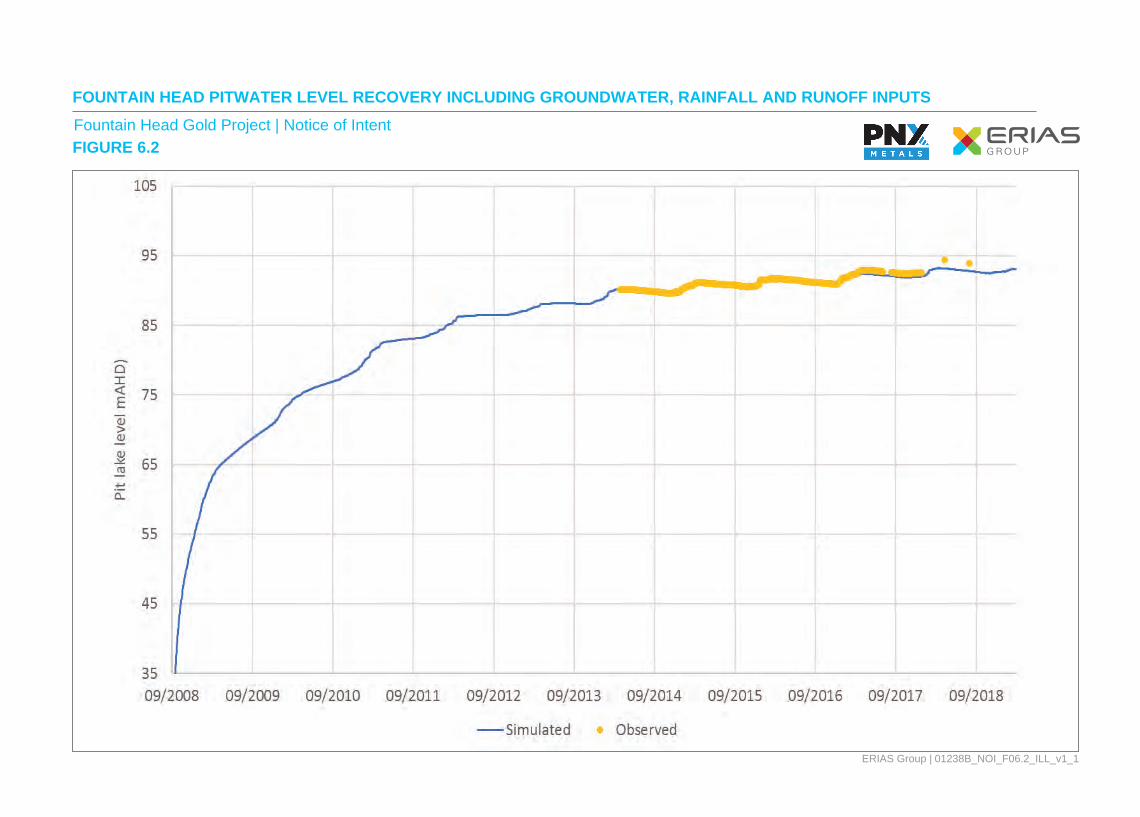
FOUNTAIN HEAD PITWATER LEVEL RECOVERY INCLUDING GROUNDWATER, RAINFALL AND RUNOFF INPUTSFountain Head Gold Project | Notice of Intent
ERIAS Group | 01238B_NOI_F06.2_ILL_v1_1
FIGURE 6.2

!.
!.
!.
!.!.
!.
8,511,400
8,511,200
8,511,000
8,510,800
8,510,600
8,510,400
8,510,200
8,510,000
8,509,800
8,509,600
8,509,400
8,509,200
8,509,000
8,511,400
8,511,200
8,511,000
8,510,800
8,510,600
8,510,400
8,510,200
8,510,000
8,509,800
8,509,600
8,509,400
8,509,200
8,509,000
772,000771,800771,600771,400771,200771,000770,800770,600770,400770,200770,000
ERIAS Group13-25 Church StreetHawthorn VIC 3122Australia
Figure Number:
Map ID:
Issue Date:
01238B_NOI_F06.3_GIS_v1
01238B_NOI_GIS008_v0_3
13.12.2019
ÄÄN⟨
RailroadRailroad
RoadRoad
Gas PipelineGas Pipeline
WatercourseWatercourse
!. Groundwater boreGroundwater bore
PitPit
COORDINATE REFERENCE: GDA 1994 MGA Zone 52@ A41:12,500SCALE: 0 0.25 0.50.13 KM
DATA SOURCE:Project data from CLIENT NAME, 2019.Base data from CLIENT NAME & GEODATA 250K, 2006.Imagery © ESRI, DigitalGlobe and Partners, 2019.
FIGURE 6.3
Fountain Head Gold Project | Notice of Intent
FOUNTAIN HEAD GROUNDWATER BORES

NOTICE OF INTENT FOUNTAIN HEAD GOLD PROJECT
01238C_1_NOI_V1.DOCX 6–7
6.1.4.2 Surface Water The Project site is located in the upper region of the Adelaide River catchment, with the Daly River catchment to the south and the Bridge Creek sub-catchment to the west. The site is locally within the Howley Creek catchment and is fed by a number of smaller ephemeral creeks that drain from the site, primarily to the east, north and northwest. Howley Creek flows into the Margaret River, which passes approximately 4 km to the northwest and then joins the Adelaide River approximately 65 km north-west of the site (GBS Gold Australia, 2007).
In northern Australia, many streams only flow in the wet season, where first flows are generally characterised by high levels of soluble matter, elevated turbidity, and suspended particulates as a result of the flushing effect of the first rains in the wet season. Water quality generally improves after the initial flows for the season, with peak water quality usually encountered around the peak flows later in the wet season (GBS Gold Australia, 2007).
There are four bodies of water found in the Project area: the Fountain Head pit, the Fountain Head lake, a dam and a wetland (shown in Figure 4.2).
The Project area is surrounded by land having the following beneficial use categories, which will need to be protected:
· Environment.
· Riparian.
· Agriculture.
· Potable (drinking) water.
· Industrial.
Surface Water Quality of the Fountain Head Pit Water quality data for the Fountain Head pit was collected between 2007 to 2013 by New Market Gold, and in 2019 by CDM Smith. The water in the Fountain Head pit was generally good, the main exception being dissolved As. Several samples exceeded the ANZECC (2000) 80% trigger values for freshwater aquatic systems for As, and all samples exceeded ANZECC (2000) trigger values for stock drinking water. The elevated As is likely attributed to potential mixing with groundwater which has been characterised by elevated concentrations of As (CDM Smith, 2019), see Section 6.1.5.1. Metals such as copper and zinc vary, but also at times exceeded the ANZECC (2000) 80% trigger values for freshwater aquatic ecosystems.
Surface Water Quality of Waterways Water quality surveys were commissioned for the Hayes Creek Project in April 2019, and included surveying the creeks surrounding the Fountain Head site. Water quality sites (S5, S6, S7 and S8) are shown in Plate 6.1, 6.2, 6.3 and 6.4 respectively, and the location of the sites are shown in Figure 6.4. In this section the study area refers to all sites surveyed (S5, S6, S7 and S8). The water quality data relevant to the Fountain Head site is summarised below.
Physicochemical water quality parameters were generally typical of ephemeral inland freshwater systems of northern Australia. Dissolved oxygen levels were low at some sites, which is not uncommon in such systems, particularly when there is intermittent, low or no flow. Electrical
NOTICE OF INTENT FOUNTAIN HEAD GOLD PROJECT
01238C_1_NOI_V1.DOCX 6–8
conductivity was within the range for default trigger values for upland and lowland rivers in tropical Australia of 20 to 250 μS/cm (ANZECC/ARMCANZ, 2000). pH was within applicable guideline limits at all sites. Turbidity was elevated in the tributary creek north of Fountain Head (S6) and at the most downstream sampling location in the Margaret River (S8).
Nutrients were generally below applicable guidelines, with the exception of total nitrogen which exceed the ANZG (2018) guidelines and DHWQO at some sampling locations in the downstream part of the study area and NOx which exceeded the DHWQO at one sampling location, east of the study area in the Margaret River (S5).
Dissolved metal concentrations were below ANZG (2018) trigger values for slightly to moderately disturbed freshwater systems, with the exception of chromium, which was slightly elevated at S6 in the tributary creek downstream of Fountain Head.
There was evidence of microbial contamination across samples with faecal coliforms, E. coli detected at all sites and above the DHWQO at some sampling locations. This is likely due to the presence of cattle.
There was no evidence of existing hydrocarbon contamination in the study area with all parameters below the laboratory limit of reporting.
Plate 6.1 – Water Quality Site S5 Plate 6.2 – Water Quality Site S6
Plate 6.3 – Water Quality Site S7 Plate 6.4 – Water Quality Site S8

G D A 1 9 9 4 M G A Z o n e 5 20 1 2 30 .5 K M@ A 4S C A L E : 1 :6 0 ,0 0 0
!(
!(
!(
!(
M A R G A R E T
R IV E R
F o u n ta inH e a d
A L IC E S P R IN G S D A R W IN R A ILW A YA L IC E S P R IN G S D A R W IN R A ILW A Y
S 5
S 6
S 7
S 8
7 7 0 ,0 0 0 7 7 2 ,5 0 0 7 7 5 ,0 0 0 7 7 7 ,5 0 0
8,507
,500
8,507
,500
8,510
,000
8,510
,000
8,512
,500
8,512
,500
8,515
,000
8,515
,000
8,517
,500
8,517
,500
R a ilw a yR o a dW a te r c o u r s eM in e s ite
A q u a t ic s u r v e y s a m p le lo c a t io n a n d ty p e!( W a te r q u a lity!( W a te r q u a lity, m a c ro in v e r te b ra te s , f is h a n d m a c ro c r u s ta c e a n s D A T A S O U R C E S :
A q ua tic s u rv e y s am p le lo c at io n d at a fro m E R I A S G ro u p , 2 0 1 9.
Is s ue D at e:M ap I D :
F igu re N um b e r:0 1 2 3 8 B _ N O I_ F 0 6 .4 _ G IS _ v 1
11 .1 2 .2 0 1 9
ÄÄÄN⟨P ro je c t N a m e | R e p o r tFIGURE 6.4
E R I A S G ro u p13 -2 5 C h u rc h S t re etH a w th o rn V I C 3 1 2 2A u s tra lia
0 1 2 3 8 B _ N O I_ G I S 0 0 2 _ v 0 _ 4
SURFACE WATER QUALITY AND AQUATIC ECOLOGY SURVEY STUDY AREA ANDSAMPLING LOCATIONSF o u n ta in H e ad G o ld P ro je c t | N o tice o f In te n t

NOTICE OF INTENT FOUNTAIN HEAD GOLD PROJECT
01238C_1_NOI_V1.DOCX 6–10
6.1.5 Aquatic Ecology ERIAS Group conducted an aquatic ecology field survey from 2 to 4 April 2019. A total of three sampling locations (S5, S6 and S8) were investigated during the survey (shown in Figure 6.4). Aquatic survey sites were selected within the Margaret River and small tributary creeks located close to the Project area to investigate a variety of aquatic habitats both upstream and downstream of potential Project activities. At all sampling locations, water quality samples were collected and in situ measurements of water quality parameters were taken. Refer to Section 6.1.4.5 for surface water quality results.
Aquatic biodiversity surveys were undertaken and included the following three components:
· Fish and macrocrustacean assessment.
· Macroinvertebrate assessment (at some sites).
· Stream assessment.
Due to the different conditions (e.g., stream width and depth) encountered at each sampling location, aquatic biodiversity sampling methods were not the same for each sampling location. The overall objective for the aquatic biodiversity survey was to conduct a rapid assessment within the study area, by employing a variety of available sampling methods. The objective of the survey was not to necessarily be able to quantitatively compare the aquatic biodiversity between sampling locations, rather to understand the occurrence, distribution and abundance of aquatic biodiversity in the study area. Survey methods were however standardised, to allow some comparison between sites where the same methods were employed.
6.1.5.1 Aquatic Habitats A variety of aquatic habitats were encountered in the study area and within sampling locations. Observed aquatic habitats included:
· Low gradient sections of the main Margaret River channel and its tributaries, characterised by slow moving or stagnant, slightly turbid water with cobbles, boulders and sandy substrate and typically shallow.
· Moderate gradient sections of the main Margaret River channel characterised by moderate clear water, flowing water over boulders and cobbles.
· Deeper pools, characterised by slow moving or stagnant, slightly turbid water with a predominantly sandy substrate with depths typically 0.5 to 1 m deep.
· Low gradient tributary creeks, characterised by slow to moderate velocities, moderate to high turbidity and a narrow channel.
Creeklines and riparian zones are common throughout the Project area and surrounding region, dominated by Nauclea orientalis, Ficus racemosa and Melaleuca leucadendra over a dense midstorey characterised by Lophostemon lactifluus, Pandanus aquatic and Bambusa arnhemica. The understorey is made up of mostly weed species such as snakeweed (Stachytarpheta sp.), hyptis (Hyptis suaveolens) and grader grass (Themeda quadrivalvis), interspersed with Heteropogon contortus and Themeda triandra.

NOTICE OF INTENT FOUNTAIN HEAD GOLD PROJECT
01238C_1_NOI_V1.DOCX 6–11
6.1.5.2 Aquatic Fauna
Macrocrustaceans
Freshwater prawns were common to all sites surveyed for aquatic biodiversity. Species recorded included Macrobrachium bullatum (northwest Australian river prawn), Macrobrachium spinipes (cherabin) as well as large numbers of small individuals that were either observed during the survey but not captured or captured but not identified due to their sheer numbers. Freshwater prawns were collected from all sampling methods which included electrofishing, fyke nets, bait traps and from the macroinvertebrate sampling.
Macrobrachium bullatum has a widespread distribution in northwester Australia and occur in a wide range of freshwater habitats including permanent creeks and streams as well as billabongs, seasonal water courses, man-made reservoirs and lakes (De Grave et al., 2013a). Macrobrachium spinipes has a widespread distribution throughout northern Australia and the Indo-west Pacific in Indonesia, Papua New Guinea and the Philippines and is found in lowland rivers and streams that have connectivity to the sea (De Grave et al., 2013b).
One freshwater crab species was recorded at S5, Veruna litterata (river swimming crab) with 20 individuals recorded. Veruna litterata is a euryhaline species, i.e., able to survive in a range of salinities. It’s found throughout the tropical Indo-west Pacific, including South Africa, India, Vietnam, Taiwan, Indonesia, Papua New Guinea, New Caledonia and Australian (Davie, 2002; Waltham et al., 2014). In Australia they're found from the north of the Northern Territory and along the Queensland coast, down into northern New South Wales (Mos et al., 2017).
Macroinvertebrates A total of just over 200 individuals from at least 10 orders were identified. Macroinvertebrate assemblages were numerically dominated by:
· Ephemeroptera (mayflies) (4 taxa).
· Hemiptera (true bugs) (5 taxa).
· Diptera (true flies) (4 taxa).
These three orders accounted for approximately 85% of total abundance across the surveyed sites. Caenidae (small square-gill mayflies) was the most numerically dominant family, followed by Baetidae (mayflies). Other relatively abundant families included Coenagrionidae (narrow-winged damselflies) and Corixidae (water boatmen).
Immature Corixidae (water boatmen), Chironomidae (non-biting midges) and Caenidae (small square-gill mayflies) were common across all sites, while Baetidae (mayflies) were common to all sites except S5.
Diptera (true flies), Hemiptera (true bugs) and Coleoptera (beetles and weevils), Ephemeroptera (mayflies) and Odonata (dragonflies and damselflies) were the most taxonomically rich Orders. There was only one taxa recorded for each of the remaining taxonomic groups.
Total abundance varied considerably between sites, with similar abundance recorded at S6 and S8 and notably lower abundance recorded at S5, with only 18 individuals recorded. Odonata were

NOTICE OF INTENT FOUNTAIN HEAD GOLD PROJECT
01238C_1_NOI_V1.DOCX 6–12
only recorded at S6 with four individuals. Hemiptera (true bugs) were notably more abundant at S6 compared to the other sites.
The number of taxa ranged from 9 at S5 to 15 at S8. While there were notable differences in total abundance of macroinvertebrates between sites, the number of taxa showed less variability at the site level. The general makeup of macroinvertebrate taxa was different between sites.
Fish A total of 896 individuals represented by 7 species were recorded across the three sites surveyed for aquatic biodiversity (based on pooling the data from all survey techniques). Fish assemblages were composed of:
· Northwest glassfish (Ambassis sp).
· Eastern rainbowfish (Melanotaenia splendida).
· Northern trout gudgeon (Mogurnda mogurnda).
· Hyrtl's catfish (Neosilurus hyrtlii).
· Spangled perch (Leiopotherapon unicolor).
· Black catfish (Neosilurus ater).
· Sleepy cod (Oxyeleotris lineolata).
The northwest glassfish was the most abundant fish species in the study area but was only observed at one of the three sites (S5). While less abundant, the eastern rainbowfish was common across all sites and the northern trout gudgeon was found at all sites except one (S8). The sleepy cod was only recorded at S6, with a single individual recorded.
Overall fish abundance and richness was highest at S5, with fish from this site accounting for 97% of all fish recorded (869 individuals), represented by six of the seven recorded species in the study area. In comparison, the number of individuals recorded at S6 and S8 were 18 and 9 respectively.
Survey Results Summary
All the species recorded during the April 2019 survey are known to occur throughout northern Australia, with the most abundant species, northwest glassfish (Ambassis sp.), eastern rainbowfish (Melanotaenia splendida), and northern trout gudgeon (Mogurnda mogurnda), consistent with findings of a recent study into the distribution of 111 freshwater fishes throughout northern Australia (Pusey et al., 2017).
Species richness is considered low, with only seven species recorded. The study area appears to provide suitable habitat for species such as catfish (Ariidae), gobies (Glossagobius sp.), sooty grunter (Hephaestus fuliginosus), tarpons (Megalops sp.) and barramundi (Lates calcarifer), with their absence likely indicative of the time of year and/or low water levels observed during the survey period.
No sensitive species, ecosystems or habitat features occur within the study area. The Margaret River does however report to the downstream Adelaide River coastal floodplain, which is a

NOTICE OF INTENT FOUNTAIN HEAD GOLD PROJECT
01238C_1_NOI_V1.DOCX 6–13
designated conservation site in the Northern Territory. While no threatened species were recorded during the survey, three species of elasmobranchs have potential to occur in the study area and have been previously recorded further downstream in the Adelaide River catchment.
No introduced or invasive aquatic species were recorded during the survey nor are they expected to occur in the study area.
6.1.6 Flora and Fauna
6.1.6.1 Field Survey Overview Low Ecological Services (LES) conducted two flora and fauna surveys of the Project area (Figure 6.5) from 15 to 18 of May 2017 (post wet-season) and 20 to 24 August 2019 (late-dry season). These two surveys were commissioned for the Hayes Creek Project, and included surveying the Fountain Head site. This section describes the survey information relevant to the Fountain Head site only. References to the survey area in this section, are the lease boundary/Project area of the Fountain Head Gold Project.
Prior to the commencement of the surveys, a desktop assessment was undertaken to provide information of the existing environment within the Project area and the likelihood that threatened species may occur. The surveys were designed to gain a detailed understanding of the environment of the Project area, as well as to target threatened species that may be present. Survey sites were chosen to incorporate the main habitat types in each area (Figure 6.5) and various methods were used to survey all taxa (shown in Table 6.2).
Table 6.2 – Methodology Used at Each Survey Site for 2017 and 2019 Site Site
Description Vegetation Transect
Live-trapping
Bat Detector
Bird Survey
Secondary Sign
Survey
Area Search
Camera Trap
FH1 X X FH2 X X X X X X X FH3 X FH4 X FH5 X FH6 X FH7 X FH8 X FH9 X FH10 X FH11 X X X
6.1.6.2 Landscape, Vegetation and Flora Surveys Characterisation of vegetation communities across the Project area was undertaken using a combination of vegetation quadrats, transects, driving transects or walking meanders across survey sites according to standard survey requirements.

@ A 4S C A L E : 1 :2 4 ,0 0 0
Is s ue D at e:M ap I D :
F igu re N um b e r:
11 .1 2 .2 0 1 9
F o u n ta in H e ad G o ld P ro je c t | N o tice o f In te n tFIGURE 6.5
E R IA S G ro up13-2 5 C hu rch S tre etHa w th orn V IC 3 12 2A us tra l ia
ÄÄÄN⟨
0 1 2 3 8 B _ N O I_ F 0 6 .5 _ G IS _ v 10 1 2 3 8 B _ N O I_ G I S 0 0 3 _ v 0 _ 5
0 0 .5 10 .2 5 K M
!?!?
!?!?
!?!?!?
!?!?
!?
!?
!?
!?
F H 2F H 2
F H 3F H 3
F H 4F H 4 F H 5F H 5F H 6F H 6
F H 1F H 1F H 7F H 7
F H 8F H 8F H 9F H 9
F H 1 0F H 1 0
F H 11F H 11
A L IC E S P R IN G S D A R W IN R A ILW AYA L IC E S P R IN G S D A R W IN R A ILW AY
FLORA AND FAUNA SURVEY SITES - 2017 AND 2019
D A T A S O U R C E S :P ro je c t da ta fro m P N X M e ta ls , 20 1 9 .B a s e da ta f ro m G e o s c ie nc e A u st ra lia , G E O D A T A 2 5 0K , 2 0 0 6.Im a ge ry © E S R I, D ig i ta lG lo be a n d P a rt ne rs , 2 01 9 .S u rv ey S i te s fro m Lo w E c o lo g y, 2 0 19 .
!? S u rv e y S ite sR a ilw a yR o a dW a te r c o u r s eS u rv e y A r e a
G D A 1 9 9 4 M G A Z o n e 5 2
M o u n t W e l ls R o a d

NOTICE OF INTENT FOUNTAIN HEAD GOLD PROJECT
01238C_1_NOI_V1.DOCX 6–15
A site description was carried out within a 50 m x 50 m quadrat. Site descriptions provided an overall snapshot of the landscape, geology, soil, dominant flora species and vegetation structure and density at each site. The presence of termite mounds and woody debris, impact from disturbance, weeds and current vegetation condition were also noted.
A complete list of all flora species present within each quadrat was collated by doing a walkover of the quadrat during May 2017. Comprehensive flora lists were not collected during August 2019 as this survey targeted threatened species and their habitat. Voucher specimens were taken where plants could not be identified in the field. Botanists at the Northern Territory Herbarium, Darwin, identified voucher specimens.
The flora survey in August 2019 aimed to identify important habitat for threatened species within the Project area. The focus of the survey in particular was to identify habitat suitable for the Gouldian finch (Erythrura gouldiae). Although several conservation significant species were identified (EPBC PMST) to have a high chance of occurring within the study area, the Gouldian finch has been previously recorded within 5 km of the Project area,
Previous studies have described habitat use by the Gouldian finch to incorporate areas of stony hill woodlands dominated by E. tintinnans and E. brevifolia. These species are hollow-bearing, providing critical nesting sites for the Gouldian finch (Tidemann, et al., 1992). In the post-breeding season (late-dry season and early-wet season) the birds disperse locally to surrounding lowlands to feed on a variety of grass species and available standing water bodies (Tidemann, et al., 1992; Tidemann, et al., 1999; Collins & McNee, 1992; Dostine, et al., 2001; Lewis, 2007; Liedloff, et al., 2009).
Additional habitat assessments were undertaken during the August 2019 survey to better describe the distribution of Gouldian finch habitat within the Project area. Data collected included landscape type, distance to closest water, disturbance variables (climate, fire, weeds, introduced herbivores), vegetation community structure, dominant flora species and hollow attributes, including quantity, size class (1-4 cm, 4-8 cm, 8-10 cm and >10 cm) and average hollow height (placement within the tree), within a 1 ha quadrat.
6.1.6.3 Fauna Surveys The general survey methodology follows the NT EPA Guidelines for Assessment of Impacts on Terrestrial Biodiversity (NT Environment Protection Authority, 2013).
Survey methods used to determine the presence of threatened species follow those suggested in the Survey Guidelines for Australia’s Threatened Mammals (Department of Sustainability, Environment, Water, Population and Communities, 2011) Survey Guidelines for Australia’s Threatened Bats (Department of the Environment, Water, Heritage and the Arts, 2010), Survey Guidelines for Australia’s threatened reptiles (Department of Sustainability, Environment, Water, Population and Communities, 2011) and Survey Guidelines for Australia’s Threatened Birds (Department of the Environment, Water, Heritage and the Arts, 2010).
Targeted searches were conducted during May 2017 and August 2019 for threatened species identified by the EPBC PMST or NT Flora and Fauna Atlases as occurring or potentially occurring within the Project area, that were assessed as having a moderate or high likelihood of occurring within the Project area (Table 6.3).

NOTICE OF INTENT FOUNTAIN HEAD GOLD PROJECT
01238C_1_NOI_V1.DOCX 6–16
Table 6.3 – Type of Survey Undertaken to Target Threatened Species Under the EPBC Act and TPWC Act Potentially Occurring within the Survey Area
Site Site Description Habitat Search
Live-trapping
Bat Detector
Secondary Sign
Area Search
Camera Trap
Spotlighting
Call Playback
Erythrotriorchis radiatus
Red goshawk X – – – X – – –
Erythrura gouldiae Gouldian finch X – – – X X – – Geohaps smithii Partridge pigeon X – – – X X – – Rostratula australis Australian painted snipe X – – – X – – Tyto novaehollandiae kimberli
Masked owl X – – – – – X X
Antechinus bellus Fawn antechinus X X – – – X X – Dasyurus hallucatus Northern quoll X X X – X X – Macroderma gigas Ghost bat X – X – – – Mesembriomys gouldii gouldii
Black-footed tree-rat X X – X – X X –
Phascogale pirata Northern brush-tailed phascogale
X X – – – X X –
Rattus tunneyi Pale field-rat X X – – – X X – Saccolaimus saccolaimus nudicluniatus
Bare-rumped sheath-tailed bat
X – X – – – – –
Varanus mertensi Merten’s water monitor X X – – X – – – Varanus mitchelli Mitchell’s water monitor X X – – X – – – Varanus panoptes Floodplain monitor X X – – X – – –

NOTICE OF INTENT FOUNTAIN HEAD GOLD PROJECT
01238C_1_NOI_V1.DOCX 6–17
6.1.6.4 Introduced Flora and Weed Surveys Weeds of National Significance (WoNS) are declared based on invasiveness, potential for spread and environmental, social and economic impacts. Strategic plans for WoNS are developed as a result of their declaration, which define responsibilities and identifies strategies and actions to control the species. Landholders and managers are ultimately responsible for managing WoNS, and the state/territory government is responsible for overall legislation and administration (Department of Sustainability, Environment, Water, Population and Communities, 2012).
In the NT, a plant is declared a weed if it has been identified for control, eradication or prevention of entry into the NT. All landholders, land managers and land users must comply with the declaration classification. Based on the risk of harm they could cause and how difficult they are to control; weeds are placed into the following classes:
· Class A – to be eradicated.
· Class B – growth and spread to be controlled.
· Class C – not to be introduced into the NT.
All Class A and Class B weeds are also considered Class C.
6.1.6.5 Survey Results
Sites of Conservation Significance There are 67 Sites of Conservation significance (SoCS) in the Northern Territory identified as the most important for biodiversity, and that require further protection (Department of Land Resource Management, 2019). Sites of Botanical Significance (SoBS) are defined as areas that have botanical features distinguishing them from the surrounding landscape, and that are important for general plant conservation and for specifically mentioned species (White, et al., 2000a). There are no SoCS or SoBS within 20 km of the survey area. The nearest SoCS are the Daly River middle reaches, Western Arnhem Plateau and Yinberrie Hills; located approximately 40 km south-west, 40 km west and 60 km south-east of the survey area, respectively. No further descriptions are provided as these areas are considered outside of the potential impacts of the Project.
Vegetation Types in the Survey Area Vegetation in the Project area has been mapped at a scale of 1: 100 000 in the Vegetation Survey of the Northern Territory (Wilson, et al., 1990). The Project area is within vegetation units 316, 572 and 1064, shown in Table 6.4.
Table 6.4 – Description of Vegetation Types within the Project Area Vegetation
Unit Broad Vegetation
Classification Structural Formation
Fine Vegetation Description
316 Melaleuca woodland Woodland Melaleuca viridiflora/leucadendra +/- Melaleuca argentea, Barringtonia acutangula, Pandanus aquaticus, Chysopogon fallax, Heteropoon contortus, Pseudoraphis spinescens

NOTICE OF INTENT FOUNTAIN HEAD GOLD PROJECT
01238C_1_NOI_V1.DOCX 6–18
Table 6.4 – Description of Vegetation Types within the Project Area (cont’d) Vegetation
Unit Broad Vegetation
Classification Structural Formation
Fine Vegetation Description
572 Eucalyptus woodland Woodland Eucalyptus tectifica, E. bigalerita, Erythrophleum chlorostachys, Corymbia latifolia, Terminalia ferdinandiana, Petalostigma pubescens, Sorghum spp., Heteropogon triticeus, Chrysopogon fallax
1064 Pastoral/ Horticultural /Roads
– Acacia holesericea, Calytrix sp, Gamba grass (Andropogon gayanus) hyptis (Hyptis suaveolens), mission grass (Cenchrus pedicellatus)
Habitat Types in the Survey Area Two habitats were identified during the on-ground survey. These habitat types are described in detail in Table 6.5. Habitat areas identified during the on-ground survey correlated with existing land classifications by Lynch et al. (2012) and the vegetation classes described by Wilson, et al., 1990) for the survey area. The two land system classifications and one vegetation class were ground truthed resulting in a total of three key habitats within the survey area. Examples of these habitats in the Project area are shown in Plate 6.5 and 6.6.
Table 6.5 – Habitat Types Identified During the On ground Survey Northern
Land Systems
(Lynch, et al., 2012)
Vegetation Class
(Wilson et al. 1990)
Habitat and Land Classification
Survey Area
Primary Vegetation Recorded
McKinley – Open forest on alluvial floodplain
FH2 C. polycaroa, E. apodophylla, Acacia auriculiformis, Melaleuca viridiflora, A. auriculiformis, Themedia triandra, Cynodon sp., Eriachne burkittii
Rumwaggen 572 Open woodland on sandstone plain
FH11, FH10, FH8
E. tectifica, E. bigalerita, Erythrophleum chlorostachys, E. miniata and E. foelshiana, Buchanania obovata, Terminalia ferdinandiana, Corymbia latifolia and Erythrophleum chlorostachys Themedia triandra, Heteropogon sp., Chrysopogon fallax, Stylidium sp., Goodenia sp., Spermococe sp.
– – Areas disturbed by pastoralism, mining, existing haul roads and tracks
Fountain Head Survey Area
Acacia holesericea, Calytrix sp., Andropogon gayanus, Hyptis suaveolens, Cenchrus pedicellatus

NOTICE OF INTENT FOUNTAIN HEAD GOLD PROJECT
01238C_1_NOI_V1.DOCX 6–19
Plate 6.5 – Open Forest on Alluvial
Floodplain – FH2
Plate 6.6 – Pastoral and Mining Impacted
Habitat – Fountain Head Survey Area
Flora Species of Conservation Significance The NT Flora Atlas found 4281 records of 661 species within a 20 km buffer of the survey area. Two species of conservation significance were identified by the EPBC PMST or TWPC Flora Atlas as occurring or potentially occurring within a 20 km radius of the Project area (Table 6.6), one endangered flora species, Stylidium ensatum, and one vulnerable flora species, Acacia praetermissa. Review of the NT Flora Atlas identified 222 records of A. praetermissa within the same search area. Four species listed as near threatened and eight species listed as data deficient under the TPWC Act were also previously recorded within 20 km of the Project area shown in Table 6.6.
Table 6.6 – Flora Species Family Scientific Name Status PMST NT Flora
Atlas Likelihood of Occurrence TPWC EPBC
Fabaceae Acacia praetermissa VU VU X X High Fabaceae Alysicarpus
suffruticosus DD – – X Moderate
Centrolepidaceae Centrolepis curta NT – – X Moderate Malvaceae Decaschistia byrnesii
subsp. byrnesii NT – – X High
Cyperaceae Eleocharis acutangula DD – – X Moderate Amaranthaceae Gomphrena involucrata DD – – X High Goodeniaceae Goodenia glandulosa NT – – X Moderate Pittosporaceae Pittosporum
moluccanum NT – – X Moderate
Cyperaceae Scleria pergracilis DD – – X Moderate Cyperaceae Scleria psilorrhiza DD – – X High Fabaceae Senna procumbens DD – – X Moderate Stylidiaceae Stylidium ensatum EN EN X X High Santalaceae Viscum whitei subsp.
flexicaule DD – – X Moderate
Poaceae Whiteochloa multiciliata DD – – X Moderate VU = Vulnerable, DD = Data Deficient, NT = Near Threatened.

NOTICE OF INTENT FOUNTAIN HEAD GOLD PROJECT
01238C_1_NOI_V1.DOCX 6–20
No flora species of conservation significance were identified in the Project area during the May 2017 and August 2019 surveys, despite targeted survey effort for A. praetermissa and S. ensatum. Specimens collected from FH1 and FH2 during the May 2017 survey were sent to the NT Herbarium and identified as Stylidium sp. but could not be identified to species level due to a lack of flowers or fruits. No specimens of Stylidium were recorded during the August 2019 survey. Several other flora species could not be identified to species level. However, all were determined not to be threatened species due to their identified genus, description and/or location.
Threatened Ecological Communities No threatened ecological communities were identified within 20 km of the Project Area.
Introduced and Weed Species
During the 2017 and 2019 field surveys, three weed species were identified, including Gamba grass (Andropogon gayanus), Rubber bush (Calotropis procera), and Grader Grass (Themeda quadrivalvis) – classifications provided in Table 6.7. Gamba grass was prevalent around most of the edge of the existing pit, along the fence running parallel with the train line and scattered throughout the disturbed areas. These species have all been declared as weeds under the NT Weeds Management Act.
Table 6.7 – Declared Weed Species Recorded in the Survey Area during the May 2017 and August 2019 surveys, Including Classification under the NT Weeds Act, EPBC Act and
Inclusion on the WoNS list Scientific
Name Common Name Survey Status PMST NT
Flora Atlas NT EPBC WoNS
Andropogon gayanus
Gamba grass May-17, Aug-19
B Invasive X X X
Calotropis procera
Rubber Bush May-17, Aug-19
B (zoned*)
– – – X
Themeda quadrivalvis
Grader Grass May-17, Aug-19
B – – – X
NT– NT weed legislation listed species. EPBC – EPBC listed as an invasive species. WoNS – Federally listed Weeds of National significance. * South of 16°30’ S latitude (growth and spread to be controlled).
Native Fauna Species A total of five native amphibian, 77 native birds, 19 native mammals and two native reptile individuals were recorded across the survey area during the May 2017 and August 2019 surveys (Table 6.8).
Table 6.8 – Number of Fauna recorded in the Project Area Survey Fauna Group Number of Species
May-17 Amphibian 5 Bird 26 (1) Mammal 4 (2) Reptile 2
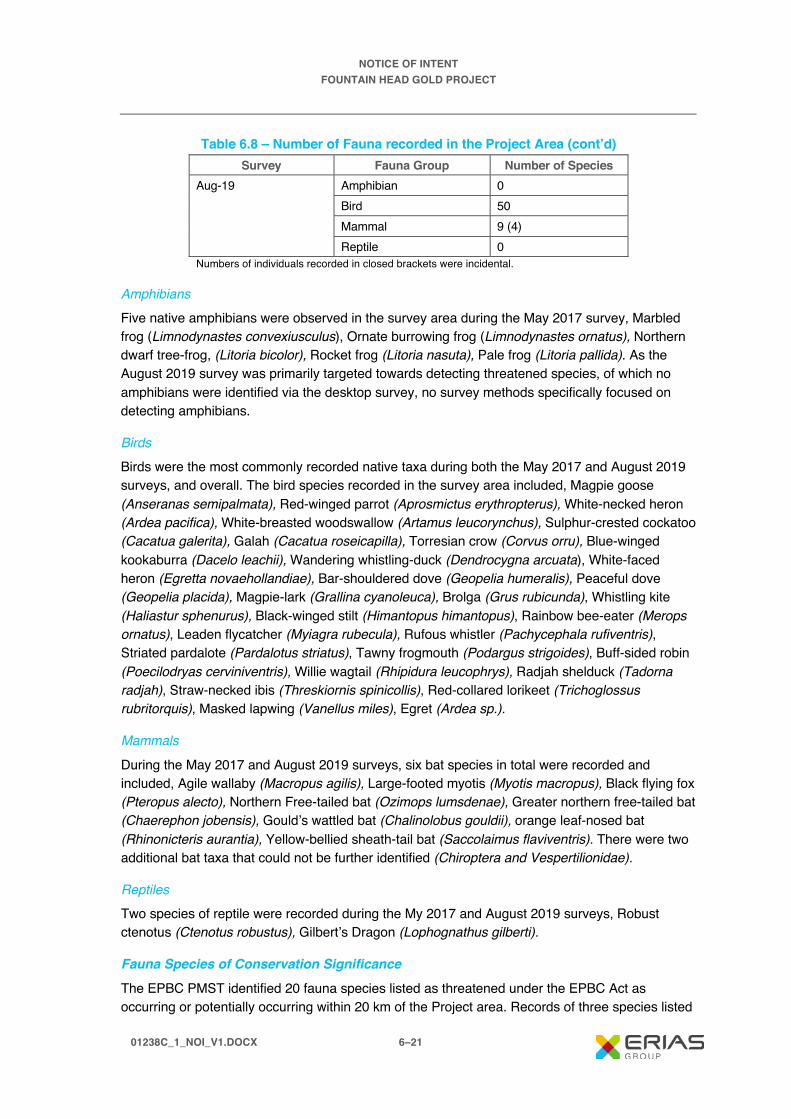
NOTICE OF INTENT FOUNTAIN HEAD GOLD PROJECT
01238C_1_NOI_V1.DOCX 6–21
Table 6.8 – Number of Fauna recorded in the Project Area (cont’d) Survey Fauna Group Number of Species
Aug-19 Amphibian 0 Bird 50 Mammal 9 (4) Reptile 0
Numbers of individuals recorded in closed brackets were incidental.
Amphibians Five native amphibians were observed in the survey area during the May 2017 survey, Marbled frog (Limnodynastes convexiusculus), Ornate burrowing frog (Limnodynastes ornatus), Northern dwarf tree-frog, (Litoria bicolor), Rocket frog (Litoria nasuta), Pale frog (Litoria pallida). As the August 2019 survey was primarily targeted towards detecting threatened species, of which no amphibians were identified via the desktop survey, no survey methods specifically focused on detecting amphibians.
Birds Birds were the most commonly recorded native taxa during both the May 2017 and August 2019 surveys, and overall. The bird species recorded in the survey area included, Magpie goose (Anseranas semipalmata), Red-winged parrot (Aprosmictus erythropterus), White-necked heron (Ardea pacifica), White-breasted woodswallow (Artamus leucorynchus), Sulphur-crested cockatoo (Cacatua galerita), Galah (Cacatua roseicapilla), Torresian crow (Corvus orru), Blue-winged kookaburra (Dacelo leachii), Wandering whistling-duck (Dendrocygna arcuata), White-faced heron (Egretta novaehollandiae), Bar-shouldered dove (Geopelia humeralis), Peaceful dove (Geopelia placida), Magpie-lark (Grallina cyanoleuca), Brolga (Grus rubicunda), Whistling kite (Haliastur sphenurus), Black-winged stilt (Himantopus himantopus), Rainbow bee-eater (Merops ornatus), Leaden flycatcher (Myiagra rubecula), Rufous whistler (Pachycephala rufiventris), Striated pardalote (Pardalotus striatus), Tawny frogmouth (Podargus strigoides), Buff-sided robin (Poecilodryas cerviniventris), Willie wagtail (Rhipidura leucophrys), Radjah shelduck (Tadorna radjah), Straw-necked ibis (Threskiornis spinicollis), Red-collared lorikeet (Trichoglossus rubritorquis), Masked lapwing (Vanellus miles), Egret (Ardea sp.).
Mammals During the May 2017 and August 2019 surveys, six bat species in total were recorded and included, Agile wallaby (Macropus agilis), Large-footed myotis (Myotis macropus), Black flying fox (Pteropus alecto), Northern Free-tailed bat (Ozimops lumsdenae), Greater northern free-tailed bat (Chaerephon jobensis), Gould’s wattled bat (Chalinolobus gouldii), orange leaf-nosed bat (Rhinonicteris aurantia), Yellow-bellied sheath-tail bat (Saccolaimus flaviventris). There were two additional bat taxa that could not be further identified (Chiroptera and Vespertilionidae).
Reptiles Two species of reptile were recorded during the My 2017 and August 2019 surveys, Robust ctenotus (Ctenotus robustus), Gilbert’s Dragon (Lophognathus gilberti).
Fauna Species of Conservation Significance
The EPBC PMST identified 20 fauna species listed as threatened under the EPBC Act as occurring or potentially occurring within 20 km of the Project area. Records of three species listed

NOTICE OF INTENT FOUNTAIN HEAD GOLD PROJECT
01238C_1_NOI_V1.DOCX 6–22
as endangered and three species listed as vulnerable under the EPBC Act were identified by the NT Fauna Atlas within a 20 km radius of the survey area. The NT Fauna Atlas also identified records of four species listed as vulnerable under the TPWC Act, but not listed under the EPBC Act. Records of an additional 15 species listed as near threatened and seven listed as data deficient under the TPWC Act, were identified in the NT Flora Atlas.
Of the threatened species identified by the desktop study classified as moderately or highly likely to occur within the Project area, two were recorded during the surveys. The Gouldian finch, listed as endangered under the EPBC Act and vulnerable under the TPWC Act, was recorded during both the May 2017 and August 2019 surveys for the Hayes Creek Project. Merten’s water monitor (Varanus mertensi), listed as vulnerable under the TPWC Act, was anecdotally recorded prior to the May 2017 survey. Neither of these species were recorded within the Project area, they were identified at other survey locations ranging approximately 5 to 8 km from the Fountain Head site. Potential Impacts of the Project on threatened species, with focus on the Gouldian finch is discussed in Section 8.2.
Threatened species identified in the desktop study that were moderately or highly likely to occur within the survey area but not recorded during the May 2017 or August 2019 surveys despite targeted survey effort included:
· Curlew sandpiper.
· Red goshawk.
· Partridge pigeon.
· Eastern curlew.
· Australian painted snipe.
· Masked owl.
· Fawn antechinus.
· Northern quoll.
· Ghost bat.
· Black-footed tree-rat.
· Northern brush-tailed phascogale.
· Pale field rat.
· Bare-rumped sheath-tailed bat.
· Mitchell’s water monitor.
· Floodplain monitor.

NOTICE OF INTENT FOUNTAIN HEAD GOLD PROJECT
01238C_1_NOI_V1.DOCX 6–23
Near Threatened and Data Deficient Fauna Species
Fauna species listed as near threatened (NT), data deficient (DD), marine (Ma) or migratory (Mi) under the EPBC Act or TPWC Act recorded during the May 2017 and August 2019 Hayes Creek Project surveys are shown in Table 6.9. Co-ordinates are provided in GDA94.
Table 6.9 – Near Threatened and Data Deficient Fauna Species Recorded in the Project Area
Species Status Date Co-ordinates Location Number of Individuals
Australian bustard (Ardeotis australis)
NT (TPWC)
Not recorded
– Fountain Head lease area
1
Bush stone-curlew (Burhinus grallarius)
NT (TPWC)
22/08/2019 -13.47096, 131.50987
Fountain Head lease area
1
Hooded parrot (Psephotus dissimlis)
NT (TPWC)
23/08/2019 – Fountain Head lease area
5
Orange leaf-nosed bat (Rhinonicteris aurantia)
NT (TPWC)
17/05/2017 – 19/05/2017
-13.459068, 131.506359
FH2 – disturbed woodland in Fountain Head lease area
NA
NA indicates that the number of individuals of a bat species cannot be discerned from echolocation call recordings.
Marine and Migratory Fauna Species
A total of 18 listed migratory species, three of which are classified as threatened species, were identified using the PMST as having the potential to occur within the vicinity of the Project area and 20 km buffer area. The curlew sandpiper (Calidris ferruginea) and the eastern curlew or far eastern curlew (Numenius madagascariensis) are listed as critically endangered, and the freshwater sawfish (Pristis pristis) is listed as vulnerable. None of these species were observed during the May 2017 or August 2019 flora and fauna surveys or2019 aquatic ecology survey. See Section 8.3 for further detail on the listed migratory species.
Introduced Fauna Species
Twelve introduced fauna species were identified by the EPBC PMST as occurring or potentially occurring within 20 km of the survey area. Eight introduced fauna species were identified by the NT Fauna Atlas within 20 km of the survey area. Two of these species were recorded in the May 2017 and August 2019 survey (cane toads and cattle) in and around the survey area. Although not recorded during either of the site surveys, house mice, Asian house geckos, feral dogs, flowerpot blind snakes, and rock doves could be present or have the potential to occur in the survey area.

NOTICE OF INTENT FOUNTAIN HEAD GOLD PROJECT
01238C_1_NOI_V1.DOCX 6–24
6.2 Cultural Heritage Environment 6.2.1 History Alluvial mining at Fountain Head was undertaken intermittently between 1883 and 1951 (GBS Gold Australia, 2007). From 1985, extensive alluvial mining was undertaken, which was followed by Dominion Mining establishing a small open pit in the 1990’s. Further exploration continued which culminated in GBS Gold recommencing mining at Fountain Head in 2007 which ceased in 2009. Historical disturbance at the Fountain Head site is illustrated in Figure 6.6.
6.2.2 Cultural Heritage
6.2.2.1 Tangible Heritage An archaeological assessment of the Project area was conducted over six days from 18 to 23 October 2019 by Indepth Archaeology. Traditional Owners from the Warai and Wagiman aboriginal peoples accompanied the archaeologist for the duration of the field survey. The survey recorded six archaeological places and five archaeological objects, as defined under the Heritage Act 2011.
The survey results are summarised in Table 6.10, below, and the locations of archaeological places or objects recorded during the survey are mapped in Figure 6.7.
Table 6.10 – Summary of Survey Results Site Name Site Type Contents
201910220900 Aboriginal place Open site – camp / occupation site 201910220945 Aboriginal place Open site – high density occupation site with knapping
floors 201910221500 Aboriginal place Open site – stone artefact scatter plus historical
material: glass, metal artefacts 201910221510 Aboriginal place Open site – low density artefact scatter 201910221515 Aboriginal place Open site – artefact scatter 201910221545 Aboriginal place Open site – medium density artefact scatter with
knapping floors 201910220850 Aboriginal object Isolated artefact x 3 201910221030 Aboriginal object Isolated artefact 201910221040 Aboriginal object Isolated artefact 201910221045 Aboriginal object Isolated artefact 201910221220 Aboriginal object Isolated artefact
Figure 6.7 shows that the archaeological sites are concentrated in the eastern portion of the Project area. This is primarily due to the nature of the landscape in this area, comprising low hills with preferred stone resources, in close proximity to watercourses. One isolated artefact was found in the western portion of the Project area. Due to the nature of the land system in the western area, there is a low probability of finding more archaeological places and objects in this area. The archaeological significance of these finds is currently being assessed.

@ A 4S C A L E : 1 :1 5 ,0 0 0
Is s ue D at e:M ap I D :
F igu re N um b e r:
11 .1 2 .2 0 1 9
F o u n ta in H e ad G o ld P ro je c t | N o tice o f In te n tFIGURE 6.6
E R IA S G ro up13-2 5 C hu rch S tre etHa w th orn V IC 3 12 2A us tra l ia
0 1 2 3 8 B _ N O I_ F 0 6 .6 _ G IS _ v 10 1 2 3 8 B _ N O I_ G I S 0 0 9 _ v 0 _ 2
0 0 .5 10 .2 5 K M
R O M
W a s te r o c k d u m p
F o u n ta in H e a d p it
D a mL a k e
L a k e
L a k eD a m
A L IC E S P R IN G S D A R W IN R A ILW AYA L IC E S P R IN G S D A R W IN R A ILW AY
FOUNTAIN HEAD AREA OF DISTURBANCE
D A T A S O U R C E S :P ro je c t da ta fro m P N X M e ta ls , 20 1 9 .B a s e da ta f ro m G e o s c ie nc e A u st ra lia , G E O D A T A 2 5 0K , 2 0 0 6.Im a ge ry © E S R I, D ig i ta lG lo be a n d P a rt ne rs , 2 01 9 .
R a ilw a yW a te r c o u r s eH a u l r o a dG a s P ip e lin eP ip e lin e e a s e m e n tA r e a o f d is tu rb a n c e
G D A 1 9 9 4 M G A Z o n e 5 2
M o u n t W e l ls R o a d
Ban B a n S
p r ing s R
o ad ÄÄÄN⟨

201910220850201910220850
201910220900201910220900
201910221545201910221545
201910221220201910221220
201910221045201910221045
201910221040201910221040
201910221030201910221030
201910221515201910221515
201910221510201910221510201910221500201910221500
201910220850201910220850
HAS4HAS4
HAS6HAS6
HAS5HAS5
EBPFH1EBPFH1EBBPFH BSArch & His2EBBPFH BSArch & His2EBPFH BSArch8EBPFH BSArch8
BGPRNE3BGPRNE3
-1,512,000
-1,513,000
-1,514,000
-1,515,000
-1,512,000
-1,513,000
-1,514,000
-1,515,000
14,641,00014,640,00014,639,00014,638,00014,637,00014,636,000
ERIAS Group13-25 Church StreetHawthorn VIC 3122Australia
Figure Number:
Map ID:
Issue Date:
01238B_NOI_F06.7_GIS_v1
01238B_NOI_GIS007_v0_1
2019.12.13
ÄÄN⟨ CH Points
Aboriginal Object
Aboriginal Place
Fountain Head TallyHo Archelogical Site
AAPA Survey Area
Restricted Work Area
Area to be Surveyed
Fountain HeadApproximate DisturbedArea
Low Probability Area
COORDINATE REFERENCE: GDA 1994 MGA Zone 52@ A41:25,000SCALE: 0 0.5 10.25 KM
DATA SOURCES:Project data from CLIENT NAME, 2019.Base data from CLIENT NAME & GEODATA 250K, 2006.Imagery © ESRI, DigitalGlobe and Partners, 2019.
FIGURE 6.7Fountain Head Gold Project | Notice of Intent
CULTURAL HERITAGE SURVEY RESULTS

NOTICE OF INTENT FOUNTAIN HEAD GOLD PROJECT
01238C_1_NOI_V1.DOCX 6–27
The central northern part of the Project area (Figure 6.7) was unable to be surveyed due to time constraints and extreme heat conditions. PNX are not planning to undertake any ground disturbing activities in this area.
An archaeological assessment was also completed in 2006 (Bengaze, 2006) prior to the expansion of the Fountain Head open pit (results also shown in Figure 6.7). The assessment identified the following in the vicinity of the Project (directly north of the waste rock stockpile):
· One Aboriginal site (a quartz stone artefact scatter).
· Two background scatters, which included stone artefacts and one glass fragment.
The Aboriginal site found north of the waste rock stockpile had a high density of artefacts and a diversity of artefact types and as such was deemed to have moderate archaeological significance. The background scatters were deemed to possess low archaeological significance.
6.2.2.2 Intangible Heritage There are currently no recorded sacred sites within the Project area, however PNX will pursue investigating whether it will be required to obtain an Authority Certificate to protect intangible cultural heritage in accordance with the Northern Territory Aboriginal Sacred Sites Act.
6.3 Social and Economic Environment The Project is located within the Pine Creek Community Government Council with land use in the surrounding area including pastoral leases, freehold blocks, mining, the North Australian Railway easement (Darwin to Adelaide line), the Bonaparte Gas Pipeline easement which passes through the mining lease on the east, and the Darwin to Katherine transmission line, which passes to the south of Fountain Head.
The Project is located within the Northern Territory goldfields, where extensive mining and exploration activities have occurred for a period of over 100 years. There are a number of historic and operational mines within the vicinity of the Project area.
The main nearby town centres are Pine Creek, located approximately 50 km southeast and Adelaide River, located approximately 50 km to the northwest of the Project. Demographic data from the Australian Bureau of Statistics for Pine Creek (ABS, 2016a) and Adelaide River (ABS, 2016b) are presented in Table 6.11.
Table 6.11 – Demographics of Adjacent Townships Area Population
(Males and Females) % of Population of
Aboriginal and Torres Straight Islanders
Median Age
Adelaide River 353 25.1 47 Pine Creek 328 46 39 Northern Territory 228,833 25.5 32 Australia 23,401,892 2.8 38

NOTICE OF INTENT FOUNTAIN HEAD GOLD PROJECT
01238C_1_NOI_V1.DOCX 6–28
Both Adelaide River and Pine Creek recorded high proportions of Aboriginal and Torres Strait Islander residents compared to the remainder of Australia. The median age for Adelaide River was significantly older than the median ages for Northern Territory and Australia.
Unemployment and employment statistics for Pine Creek (ABS, 2016a) and Adelaide River (ABS, 2016b) are provided below in Table 6.12.
Table 6.12 – Unemployment and Income Area Unemployment Rate % Median Weekly Household
Income Adelaide River 10.9% $1017 Pine Creek 20.4% $945 Northern Territory 7.0% $1,983 Australia 6.9% $1,438
Unemployment rates for the townships are well above Northern Territory and Australian rates.
The largest industry (i.e. number of employed people) in Pine Creek (Urban Centres and Localities) is Accommodation 14.4%. Other major industries include Beef Cattle Farming (Specialised) 11.1%, Local Government Administration 7.8%, Iron Ore Mining 5.6% and Gold Ore Mining 5.6% (ABS, 2016a).
Major industries of employment in Adelaide River include Technical and Vocational Training 14.3%, Accommodation 13.2%, Primary Education 8.8%, Road Freight Transport 7.7% and Beef Cattle Farming (Specialised) 6.6%.

NOTICE OF INTENT FOUNTAIN HEAD GOLD PROJECT
01238C_1_NOI_V1.DOCX 7–1
7. Potential Impacts and Measures to Avoid or Mitigate
7.1 Approach to Identifying Potential Environmental Impacts
7.1.1 Introduction This section describes the approach used to assess potential impacts of the proposed Project activities on the physical, cultural and social environment. These activities include clearing of vegetation, road construction and maintenance, mining and stockpiling of waste rock, transport of materials (and people) to and from the site, crushing and grinding of ore, construction and operation of the heap leach facility, process plant and associated infrastructure i.e. power and water. Components of these activities, that may have an impact on the environment or present potential hazards, have been systematically considered via a risk assessment process (e.g. land clearing, groundwater, surface water and management of wastes i.e. rock).
The risk assessment involves:
· Describing the existing physical environment within and around the Project area, including relevant 'receptors' and beneficial values (see Chapter 6).
· Describing the Project and associated activities, particularly within the context of potential interactions with the existing environment (see Chapter 4).
· Taking into account the existing environment and the nature of the Project activities, identifying:
– Potential impacts that reflect credible scenarios (i.e. their occurrence is a real possibility) and encompass all phases of the Project, with a conservative approach being adopted when defining these scenarios.
– Avoidance and management measures that address these potential impacts and are both technically and economically feasible within the Project context and are assumed to be implemented in a timely manner during Project development.
– Residual impacts, which are those impacts that remain after the successful implementation of management or mitigation measures.
Assessment of the above is based primarily on assessing the likelihood and consequence of the impacts.
Potential cumulative impacts (Section 7.5) (successive, incremental and combined impacts of past, present and foreseeable actions) have also been considered.

NOTICE OF INTENT FOUNTAIN HEAD GOLD PROJECT
01238C_1_NOI_V1.DOCX 7–2
7.1.2 Environmental Values The NT EPA has developed environmental factors and objectives categorised under five themes of: Land, Water, Sea, Air and People and Communities. These factors are broad components of the environment (e.g., flora, fauna, water or air quality) that may be impacted by an aspect of a proposal, such as land clearing or crushing of ore. The environmental objectives are the desired outcome for each environmental factor.
Factors that may be impacted by the Project will be addressed by the risk assessment and are outlined in Table 7.1.
Table 7.1 – Identified Project Environmental Factors and Objectives Theme Key Environmental Factors Objectives
Land Terrestrial environmental quality
Maintain the quality of land and soils so that environmental values are protected
Terrestrial flora and fauna Protect the NT’s flora and fauna so that biological diversity and ecological integrity are maintained
Water Hydrological processes Maintain the hydrological regimes of groundwater and surface water so that environmental values are protected
Inland water environmental quality
Maintain the quality of groundwater and surface water so that environmental values including ecological health, land uses, and the welfare and amenity of people are protected
Aquatic ecosystems Protect aquatic ecosystems to maintain the biological diversity of flora and fauna and the ecological functions they perform
Air Air Quality and Greenhouse Gases
Maintain air quality and minimise emissions and their impact so that environmental values are protected
People and communities Social, economic and cultural surroundings
Protect the rich social, economic, cultural and heritage values of the Northern Territory
7.1.3 Risk Assessment Method Residual impacts have been assessed by considering both the consequence of the impact (initially before any mitigation measures and after the successful application of mitigation or management measures) and the likelihood of the event occurring.
This approach has allowed determination of the risk via a matrix, as discussed further below. While the definitions of the various consequence and likelihood categories are, to some degree, subjective, (particularly given that the Project is in the early stages of its development) the process does identify the potential significant impacts as a result of Project activities.

NOTICE OF INTENT FOUNTAIN HEAD GOLD PROJECT
01238C_1_NOI_V1.DOCX 7–3
7.1.3.1 Consequence of Impact The consequence of an impact reflects the size and nature of change based on its severity, geographical extent, and duration. For the purposes of this risk assessment, these elements have been defined as follows:
· Severity: the scale or degree of change from the existing condition as a result of the impact.
· Geographical extent: the spatial extent of the impact where this is defined as site, local or regional.
· Duration: the timescale of the effect, such as short, medium or long term (i.e. effectively permanent), and takes into account reversibility.
Based on these elements, the consequence of potential impact has been ranked as catastrophic, major, moderate, minor and negligible, as described in Table 7.2.
Table 7.2 – Descriptor Used to Classify Consequence Consequence Description Catastrophic A major event that could cause severe or long-term damage to a key environmental
factor. Examples include spill that causes major downstream impact that requires at least 12 months to remediate or total destruction of cultural heritage site
Major Substantial and significant changes to a key environmental factor that will attract public concern, only partially able to be rehabilitated or uncertain if impact can be successfully rehabilitated. Examples include spill that results in major downstream impact that requires remediation over a 12-month period or major destruction to a cultural heritage site
Moderate Significant temporary or minor permanent impact to a key environmental factor. Examples include seepage from a dam that requires rectification works over several months to repair or permanent damage to a cultural heritage site
Minor Some limited temporary consequence but no significant long-term impact to any key environmental factors. Examples include a spill which is easily remediated or minor damage to a cultural heritage site which can be repaired
Negligible Possible impacts but without noticeable consequence
7.1.3.2 Likelihood of Impact The likelihood of the Project impacting key environmental factors has been assessed based on desktop research, site-specific studies (i.e. flora and fauna), experience and accepted practice. The likelihood of an event occurring has been ranked as virtually certain, likely, possible, unlikely or virtually impossible, as described in Table 7.3.
Table 7.3 – Descriptors Used to Classify Likelihood Likelihood Description
Virtually certain Will occur, or is of a continuous nature, or the likelihood is unknown Likely Likely to occur during the mine’s lifetime Possible May occur in some mines Unlikely May occur in some mines but not expected Virtually impossible
Has almost never occurred in similar mines but conceivably could

NOTICE OF INTENT FOUNTAIN HEAD GOLD PROJECT
01238C_1_NOI_V1.DOCX 7–4
7.1.3.3 Impact Significance The level of risk for each potential impact is determined by combining the likelihood of the impact and the consequence via a matrix based on the above criteria. This approach is shown in Table 7.4.
Table 7.4 – Significance Assessment Matrix Likelihood Virtually
Certain Likely Possible Unlikely Virtually
Impossible
Cons
eque
nce
Catastrophic Extreme Major High
Moderate Moderate Minor Low
Very Low Very Low
7.1.4 Potential Impacts The remainder of this chapter identifies and assesses the key environmental factors associated with the Fountain Head Gold Project. Measures have been identified to mitigate and manage impacts, and the residual impact assessment assumes that these measures have been implemented successfully.
An environmental aspect, according to the definition provided by ISO 14001 is an ‘element of an organisations activities, products or services that can interact with the environment’. An environmental impact is the change that takes place from occurrence of any given aspect.
The environmental factors and planned Project aspects have been identified and are shown in Table 7.5.

NOTICE OF INTENT FOUNTAIN HEAD GOLD PROJECT
01238C_1_NOI_V1.DOCX 7–5
Table 7.5 – Environmental Factors and Corresponding Project Aspects Environmental Factors Project Aspect
Air Quality and Greenhouse Gas
· Site preparation works i.e. topsoil removal · Drilling and blasting of waste rock and ore · Loading and hauling waste rock to the WRS · Loading and hauling ore to the ore stockpile · Unloading of ore at the ROM stockpile or crusher · Crushing of ore · Placement of ore on the heap leach pad · General vehicle movements within the Project area · Wind erosion from exposed surfaces i.e. WRS, topsoil stockpiles, haul roads, laydown areas · Transport of supplies and personnel · Electricity generation from diesel generators
Terrestrial Environmental Quality
Land and Soils · Clearing of vegetation · Topsoil removal and stockpiling
Terrestrial Flora and Fauna Flora · Clearing of vegetation · Use of machinery and equipment
Fauna · Clearing of vegetation · Use of machinery and equipment · Operation of the HLF
Inland Water Environmental Quality
Surface Water · Discharge of sediment-laden water to the environment via WRD, haul roads and other areas · Operation of the HLF · Retention of surface water on site · Storage of fuels, lubricants, explosives and process reagents on site · WRS AMD and saline drainage
Groundwater · Operation of the HLF · Extraction of groundwater · WRS and ore leaching of metals and salts · Seepage of process chemicals and fuels from storage tanks, spills or ponds

NOTICE OF INTENT FOUNTAIN HEAD GOLD PROJECT
01238C_1_NOI_V1.DOCX 7–6
Table 7.5 – Environmental Factors and Corresponding Project Aspects (cont’d) Environmental Factors Project Aspect
Inland Water Environmental Quality (cont’d)
Aquatic Ecosystems · Discharge of sediment-laden water to the environment via WRD, haul roads and other areas · Operation of the HLF · Storage of fuels, lubricants, explosives and process reagents on site · WRD AMD and saline drainage · Diversions causing altered flow regimes · Reduced flows due to retention of surface runoff on site
Hydrological Processes · Diversions causing altered flow regimes · Reduced flows due to retention of surface water on site
Cultural Heritage · Earthworks and clearance activities Socio-economic Noise Operation of the following:
· Vehicles (including reversing alarms) · Machinery (e.g. drills, loaders, haul trucks, excavators) · Blasting · Process plant
Traffic and Transport · Increased traffic as a result of Project vehicles Land Use · Storage of fuels, lubricants, explosives and process reagents on site
· Inadequate fencing of Project area · Operation of the HLF · Vehicles (including reversing alarms)

NOTICE OF INTENT FOUNTAIN HEAD GOLD PROJECT
01238C_1_NOI_V1.DOCX 7–7
7.2 Natural Environment 7.2.1 Surface Water and Aquatic Ecology
7.2.1.1 Potential Impacts Potential Project related surface water and aquatic ecology impacts are described below. These potential impacts do not take into consideration the proposed avoidance, mitigation and management measures that PNX will implement during construction, operation and closure of the Project.
Fugitive Sediment The proposed Project development has the potential to cause soil erosion, resulting in delivery of increased sediment loads to nearby creeks which are part of the Margaret River system. The WRS, pit expansion and construction of infrastructure including roads and other areas disturbed as part of the Project have the potential to discharge sediment-laden water to the environment. Aquatic fauna and habitats could be potentially impacted due to:
· Changes in water quality (due to increased concentrations of total suspended solids and associated contaminants) and physical effects, e.g. blocking of gills, or direct toxicity.
· Physical alteration of stream habitat (in-stream deposition).
Altered Flow Regimes It is likely that as part of the Project development diversion of some runoff will be required to minimise contact with areas disturbed by the Projects activities while runoff from areas disturbed by the mine will be retained. Depending on the relative changes in the flow regimes as a result of these diversions and retention of runoff, riparian vegetation and aquatic fauna associated with creeks in the Project area could be impacted.
Miscellaneous Fuels and Chemicals Fuels, lubricants, explosives and process reagents will be stored and used on site and the potential exists for spillages to report to Margaret River and creeks that feed into Margaret River, thereby adversely affecting aquatic biota and local users of the river way immediately downstream of the Project.
Acid Metalliferous Drainage (AMD) Anecdotal evidence from the existing waste rock stockpile and surface water monitoring indicates that there is a low potential for waste rock to produce AMD. Geochemical investigations are currently underway to determine the potential of waste rock and/or ore to produce AMD. Until the investigations are complete, and based on visual observations of the existing waste rock stockpile and surface water monitoring results, it has been assumed that there is a possibility for small volumes of waste rock and/or ore to produce AMD in the absence of appropriate control measures. The potential therefore may exist for small volumes of AMD from waste rock stored in the WRS to report to Margaret River and associated tributaries, with related effects on aquatic biota and riparian vegetation.

NOTICE OF INTENT FOUNTAIN HEAD GOLD PROJECT
01238C_1_NOI_V1.DOCX 7–8
Heap Leach Facility The leaching and gold recovery process will involve the use of NaCN bearing waters, including heap leach pads, pipes, open drains, and process ponds. Accidental release of these contaminated waters to the receiving environment could potentially affect water quality with subsequent impacts on aquatic ecology should the contaminants enter nearby waterways.
Cyanide acts rapidly in aquatic environments, and aquatic biota are highly susceptible. Catastrophic impacts on downstream aquatic ecosystems have resulted where cyanide-contaminated waters have escaped as a result of accidental release of contaminants e.g., a flooding event.
Table 7.6 outlines the potential risks that without controls have been assessed as high.
Table 7.6 – Identification of Potential Risks and Significance Rating Aspect/ Activity
Risk Potential Impact Significance Without Controls
Likelihood Consequence Significance Discharge of sediment-laden water to the environment via WRS, haul roads and other areas
Suspended solids and sedimentation (due to turbid stormwater and erosion and/or runoff from disturbed areas and changes in catchment sediment yield resulting from altered land use)
Adverse effects on aquatic biota due to toxicants (e.g. metals and/or salt). Toxicants can directly affect aquatic biota over short (acute) or long (chronic) periods, with potential consequences with respect to conservation values and resource use for local people
Virtually Certain Moderate High
Retention of surface water on site
Reduced volume of water in local creeks/drainage
Reduced surface water flow with potential riparian vegetation and aquatic fauna associated with creeks in the Project area being impacted
Virtually Certain Minor High
Storage of fuels, lubricants, explosives and process reagents on site
Spill of greater than 200 l of fuels, explosives or reagents
Adverse effects on aquatic biota due to toxicants (e.g. fuels, explosives or reagents). Toxicants can directly affect aquatic biota over short (acute) or long (chronic) periods, with potential consequences with respect to conservation values and resource use for local people
Possible Major High

NOTICE OF INTENT FOUNTAIN HEAD GOLD PROJECT
01238C_1_NOI_V1.DOCX 7–9
Table 7.6 – Identification of Potential Risks and Significance Rating (cont’d) Aspect/ Activity
Risk Potential Impact Significance Without Controls
Likelihood Consequence Significance WRS AMD and saline drainage
Leaching of metals and salts from waste rock and ore (due to oxidation of potentially acid forming and metalliferous waste rock and ore)
Adverse effects on surface water quality with potential consequences with respect to adverse effects on aquatic biota due to toxicants (e.g. metals and/or salt), conservation values and resource use
Possible Major High
Operation of HLF
Loss of process solution from heap leach pad and/or process water pond(s)
Toxicants in process solution affect water quality of surface water in the receiving environment with potential adverse effects on aquatic biota
Possible Catastrophic High
7.2.1.1 Avoidance, Mitigation and Management Measures
Surface Water Management A detailed surface water management plan (including site water balance) will be developed as part of the Project technical studies. Proposed management practices which are likely to be included in this plan are summarised below.
Waste Rock Stockpile Runoff from the WRS is likely to generate sediment-laden stormwater. Cut-off drains will be established around the WRS to separate clean (non-mine impacted water) from dirty (mine-impacted water). Mine-impacted water will be collected in diversion channels and directed through sediment traps prior to discharging to the natural environment.
Monitoring of water quality in sediment dams will be undertaken to determine that water is suitable for discharge to the environment. Where water is considered unsuitable for discharge it will be used as road watering, within the process plant or stored on site (evaporation dam). Sediment accumulated in sedimentation traps will be removed periodically and stockpiled at the WRS. The sediment will be tested prior, and if found to be contaminated will be stockpiled on the WRS before being placed back into the pit post mining completion.
Diversions A bund will be placed around the Fountain Head pit for personnel safety and where required diversion channels will be constructed to divert surface water away from operational areas around the pit to sediment ponds. Diversions will also be established around other project infrastructure such as the Heap Leach Facility.

NOTICE OF INTENT FOUNTAIN HEAD GOLD PROJECT
01238C_1_NOI_V1.DOCX 7–10
Other Infrastructure The specific location of infrastructure facilities will be considered with preference for infrastructure to be located within areas disturbed by the Project. All fuels, lubricants and process reagents will be stored within covered areas or in bunded areas and lined.
The vehicle maintenance workshop will contain a wash bay, with an oil trap and water underflow reporting to a soakage or storage pit for reuse. All waste oil will be collected and stored in drums within a bunded and lined area for removal off site by a licensed contractor.
Water Balance A water balance will be developed for the site and will include the following:
· Dewatering rate and volume.
· Volume of water used in operations i.e. dust suppression, process plant.
· Area of footprint for each site.
· Volume of runoff from design storm events.
· Size of water storages.
· Pump and pipeline capacity.
· Evaporation.
· Consideration of any diversions in place to separate non-mine impacted water.
A water balance model will be developed to enable various scenarios to run to evaluate the effect that above average wet seasons have on the water balance and whether sufficient storage is available etc.
AMD Management (Waste Rock) AMD waste rock, should it be determined to occur is expected to be in very small quantities. PNX strategy for the management of any AMD waste rock, is to temporarily store it at the WRS and following the completion of open pit mining back fill the AMD rock back into the pit. During operations, AMD rock would be selectively handled to ensure that rock with any AMD potential is appropriately located in the WRS for rehandling and return to the pit at completion under permanent water coverage.
Heap Leach Facility The heap leach facility has been designed to avoid the release of contaminated water to the environment, this includes the following features:
· All process solutions to be transported via pipes in a closed loop system with no discharge to the environment.
· Leach pads and process ponds will be double lined to ensure no leach solution can escape.
· All pipes containing process solution to be placed on lined HDPE corridors which will drain back to the process ponds or plant.

NOTICE OF INTENT FOUNTAIN HEAD GOLD PROJECT
01238C_1_NOI_V1.DOCX 7–11
· Heap Leach pond designed with the capacity to contain a 1:100 year, 72 hour event and large storm water ponds for retaining the leaching solution in any large event.
7.2.1.2 Residual Risk Assessment The residual risk after consideration of the successful implementation of the proposed avoidance, mitigation and management measures of the Project on surface waters is outlined in Table 7.7.
Table 7.7 – Summary of Impacts on Surface Waters and Aquatic Ecology Risk Potential Impact Avoidance,
Mitigation and Management
Measures
Significance with Controls
Likelihood Consequence Significance
Discharge of sediment-laden water to the environment via WRS, haul roads and other areas
Suspended solids and sedimentation (due to turbid stormwater and erosion and/or runoff from disturbed areas and changes in catchment sediment yield resulting from altered land use)
· Separation of clean water from mine impacted water
· Construction of sediment ponds
· Implementation of surface water management plan
· Establishment of site water balance
Possible Moderate Moderate
Retention of surface water on site
Reduced volume of water in local creeks/drainage
· Diverted water to remain in same catchment
· Minimise area impacted by mining activities and therefore water retained on site
Virtually Certain
Very Low Moderate
Storage of fuels, lubricants, explosives and process reagents on site
Spill of greater than 200 l of fuels, explosives or reagents
· Storage of fuels and chemicals in bunded areas in accordance with Australian Standards
· Process plant designed with concrete bunds and sumps to collect and return any spills internally
· Oil separator at wash down bays to remove oil from waste water
Unlikely Major Moderate
WRS AMD and saline drainage
Leaching of metals and salts from waste rock and ore (due to oxidation of potentially acid forming and metalliferous waste rock and ore)
· Temporary stockpiling of PAF waste rock in WRS prior to relocation back to Fountain Head pit and placement under a permanent water cover
Virtually Impossible
Moderate Low

NOTICE OF INTENT FOUNTAIN HEAD GOLD PROJECT
01238C_1_NOI_V1.DOCX 7–12
Table 7.7 – Summary of Impacts on Surface Waters and Aquatic Ecology (cont’d) Risk Potential Impact Avoidance,
Mitigation and Management
Measures
Significance with Controls
Likelihood Consequence Significance
Loss of process solution from heap leach pad and/or process water pond(s)
Toxicants in process solution affect water quality of surface water in the receiving environment with potential adverse effects on aquatic biota
· All process solutions to be transported via pipes in a closed loop system with no discharge to the environment
· Leach pads and process ponds will be double lined
· All pipes with process solution to be placed on lined HDPE corridors which will drain back to the process ponds or plant
· Heap Leach pond designed with the capacity to contain a 1:100 year, 72 hour event and large storm water ponds for retaining the leaching solution in any large event
Unlikely Moderate Moderate
7.2.1.3 Assumptions Construction of heap leach pad and process water ponds is undertaken to the highest standard and all QA/QC requirements are achieved.
Geochemical investigations are currently underway to determine the potential of waste rock and ore to generate AMD. Until the investigations are complete, it is assumed that there is a possibility for some small quantities of waste rock and/or ore to produce AMD, however existing anecdotal evidence and surface water monitoring results indicates that the likelihood is low.
7.2.1.4 Relevant Policy and Guidance The following guidelines were compared for the surface water quality and aquatic ecology assessment:
· Australian and New Zealand Guidelines for Fresh and Marine Water Quality (ANZG, 2018).
· Australian and New Zealand water quality guidelines (ANZECC/ARMCANZ, 2000)1.
1 While the ANZG (2018) replace the previous ANZECC/ARMCANZ (2000) guidelines, default guideline values for the Timor Sea drainage division where the Project is located have not yet been published, therefore the regional default guidelines values from ANZECC/ARMCANZ (2000) have been used.

NOTICE OF INTENT FOUNTAIN HEAD GOLD PROJECT
01238C_1_NOI_V1.DOCX 7–13
· Darwin Harbour Water Quality Objectives (DHWQO) for freshwater rivers and streams provided in DNRETAS (2010).
Further guidelines relating to this section include:
· Northern Territory Environment Protection Authority, 2013. Environmental Assessment Guidelines, Acid and metalliferous drainage. Version 2.0, November 2013.
· Global Acid Rock Drainage Guide (GARD Guide), 2014. International Network for Acid Prevention. Version 1.0, November 2014.
7.2.2 Groundwater
7.2.2.1 Potential Impacts Potential Project related groundwater impacts are described below. Beneficial use categories have been established for the land surrounding the Project and these include:
· Environment.
· Riparian.
· Agriculture.
· Potable (drinking) water.
· Industrial.
These potential impacts do not take into consideration the proposed avoidance, mitigation and management measures that PNX will implement during construction, operation and closure of the Project, and which will result in the residual impacts discussed in Section 7.2.2.3.
Potential Project-related impacts with respect to groundwater include:
· Groundwater Extraction – groundwater will be extracted from the Fountain Head pit and dewatering bores to ensure that the mining of the pit can be undertaken safely. Water from the dewatering of the pit will be sufficient to meet the Project needs with any excess water being pumped to the evaporation dam. The extraction of groundwater to meet project requirements has the potential to impact groundwater availability for other users i.e., cattle station, as a result of a reduction in groundwater level and/or groundwater yield.
· Groundwater Contamination – Geochemical investigations are currently underway to determine the potential of waste rock and ore to produce AMD. Until the investigations are complete, it is assumed that there is a possibility for some small quantities of waste rock and ore to produce AMD in the absence of appropriate control measures. The potential therefore exists for AMD to be produced from waste rock stored in the WRS resulting in contamination of the groundwater, potentially impacting other groundwater users and aquatic biota due to toxicants (e.g. metals and/or salt) from groundwater discharge into creeks and rivers.
· Groundwater Contamination – seepage of process water containing CN from the heap leach pad and/or process water pond(s) results in process water contaminating groundwater impacting other groundwater users and aquatic biota due to toxicants (e.g. CN) from groundwater discharge into creeks and rivers.
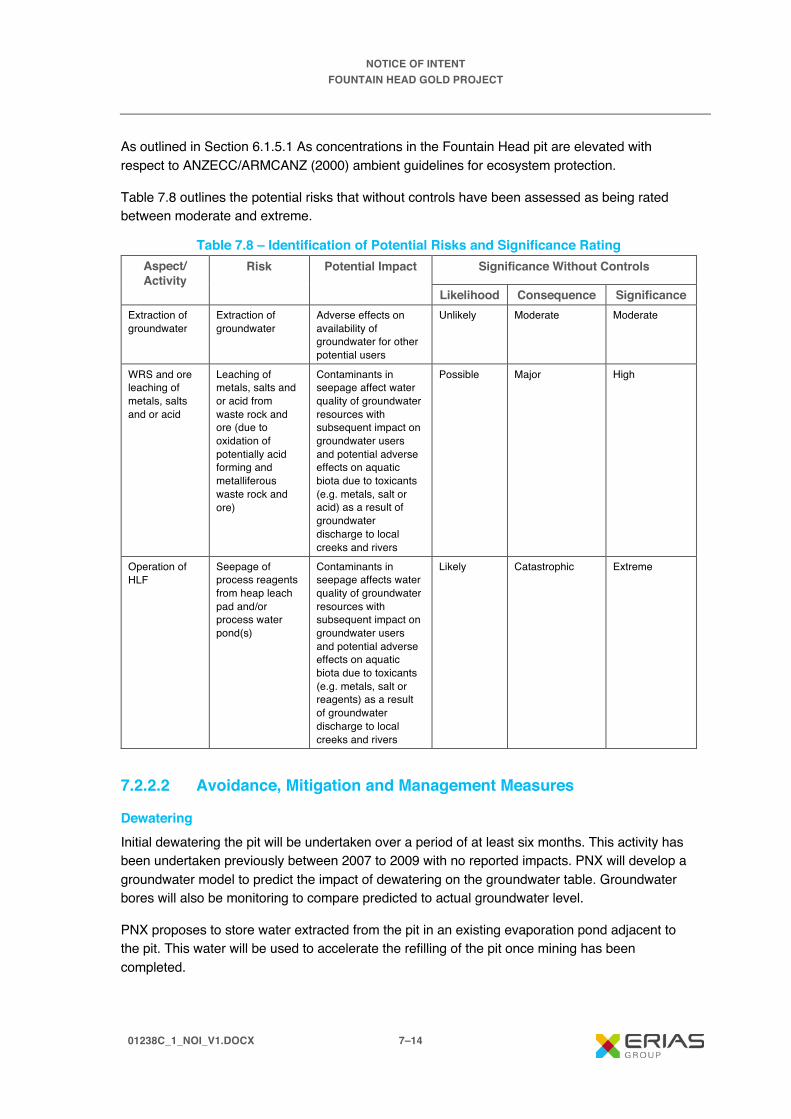
NOTICE OF INTENT FOUNTAIN HEAD GOLD PROJECT
01238C_1_NOI_V1.DOCX 7–14
As outlined in Section 6.1.5.1 As concentrations in the Fountain Head pit are elevated with respect to ANZECC/ARMCANZ (2000) ambient guidelines for ecosystem protection.
Table 7.8 outlines the potential risks that without controls have been assessed as being rated between moderate and extreme.
Table 7.8 – Identification of Potential Risks and Significance Rating Aspect/ Activity
Risk Potential Impact Significance Without Controls
Likelihood Consequence Significance Extraction of groundwater
Extraction of groundwater
Adverse effects on availability of groundwater for other potential users
Unlikely Moderate Moderate
WRS and ore leaching of metals, salts and or acid
Leaching of metals, salts and or acid from waste rock and ore (due to oxidation of potentially acid forming and metalliferous waste rock and ore)
Contaminants in seepage affect water quality of groundwater resources with subsequent impact on groundwater users and potential adverse effects on aquatic biota due to toxicants (e.g. metals, salt or acid) as a result of groundwater discharge to local creeks and rivers
Possible Major High
Operation of HLF
Seepage of process reagents from heap leach pad and/or process water pond(s)
Contaminants in seepage affects water quality of groundwater resources with subsequent impact on groundwater users and potential adverse effects on aquatic biota due to toxicants (e.g. metals, salt or reagents) as a result of groundwater discharge to local creeks and rivers
Likely Catastrophic Extreme
7.2.2.2 Avoidance, Mitigation and Management Measures
Dewatering Initial dewatering the pit will be undertaken over a period of at least six months. This activity has been undertaken previously between 2007 to 2009 with no reported impacts. PNX will develop a groundwater model to predict the impact of dewatering on the groundwater table. Groundwater bores will also be monitoring to compare predicted to actual groundwater level.
PNX proposes to store water extracted from the pit in an existing evaporation pond adjacent to the pit. This water will be used to accelerate the refilling of the pit once mining has been completed.

NOTICE OF INTENT FOUNTAIN HEAD GOLD PROJECT
01238C_1_NOI_V1.DOCX 7–15
Acid and Metalliferous Drainage A geochemical assessment of waste rock and ore is currently underway. Anecdotal evidence from the existing waste rock stockpile indicates that the potential for AMD material is low. Should the geochemical assessment identify rock units with the potential to generate AMD the following mitigation and management measures would be implemented:
· Development of a geochemical block model to identify AMD material.
· Implementation of a geochemical monitoring program with the objective of confirming and/or continuing to refine the block model.
· Separation of AMD material and placement on the WRS.
· At the completion of mining relocated AMD material stockpiled on the WRS back into the pit and cover with a water cover.
Heap Leach Facility Leach Pads and process water ponds are designed with clay liners/geomembrane/HDPE and a cushion layer to ensure no leach solution can escape to the environment. Strict QA/QC procedures are implemented by an independent testing company to ensure that the design specifications are achieved prior to acceptance for commercial use.
The process ponds are designed with clay liners, geomembrane and HDPE liner. In between the clay and the HDPE liner an intercept collection drain and sump with collection pumping bore will be installed for leak detection.
Monitoring bores will be drilled around and downstream of the facility to monitor groundwater to ensure integrity of the system.
All pipes with leach solution will be placed in lined HDPE corridors which will drain back to process ponds or the process plant. Any potential leakage will be collected and returned to the process.
7.2.2.3 Residual Risk Assessment The residual risk after consideration of the successful implementation of the proposed avoidance, mitigation and management measures of the Project on groundwater is outlined in Table 7.9.
Table 7.9 – Summary of Impacts on Groundwater Risk Potential
Impact Avoidance,
Mitigation and Management
Measures
Significance with Controls
Likelihood Consequence Significance
Extraction of groundwater
Extraction of groundwater impacts surrounding groundwater users
· Develop groundwater dewatering model
· Monitor groundwater levels and compare against model
Unlikely Major Moderate

NOTICE OF INTENT FOUNTAIN HEAD GOLD PROJECT
01238C_1_NOI_V1.DOCX 7–16
Table 7.9 – Summary of Impacts on Groundwater (cont’d) Risk Potential
Impact Avoidance,
Mitigation and Management
Measures
Significance with Controls
Likelihood Consequence Significance
WRS and ore leaching of metals, salts and or acid
Leaching of metals, salts and or acid from waste rock and ore (due to oxidation of potentially acid forming and metalliferous waste rock and ore)
· Complete geochemical assessment
· Prepare geochemical block model
· Undertake geochemical monitoring and compare to block model
· If AMD material identified, stockpile on WRS and backfill to pit following completion of mining
Unlikely Minor Low
Seepage of process reagents from heap leach pad and/or process water pond(s)
Contaminants in seepage affects water quality of groundwater resources with subsequent impact on groundwater users and potential adverse effects on aquatic biota due to toxicants (e.g. metals, salt or reagents) as a result of groundwater discharge to local creeks and rivers
· Design of heap leach pad including clay compaction, geotextile liner and HDPE liner and cushion layer
· Leak detection and above management measures for process water ponds
· Monitoring bores around and downstream of heap leach pad and process water ponds
· Pipes containing process fluids to be placed within HDPE lined drains which flow to process water pond or plant
Unlikely Moderate Moderate
7.2.2.4 Assumptions Construction of heap leach pad and process water ponds is undertaken to the highest standard and all QA/QC requirements are achieved.
Geochemical investigations are currently underway to determine the potential of waste rock and ore to generate AMD. Until the investigations are complete, it is assumed that there is a possibility for some waste rock and the ore to produce AMD, however the likelihood is low.
7.2.2.5 Relevant Policy and Guidance International Cyanide Management Code for the Manufacture, Transport and Use of Cyanide in the Production of Gold. International Cyanide Management Institute. 2006.

NOTICE OF INTENT FOUNTAIN HEAD GOLD PROJECT
01238C_1_NOI_V1.DOCX 7–17
7.2.3 Flora
7.2.3.1 Potential Impacts Potential project related flora risks are described below. These potential impacts do not take into consideration the proposed avoidance, mitigation and management measures that PNX will implement during construction, operation and closure of the Project, and which will result in the residual impacts discussed in Section 7.2.3.3.
Vegetation will be cleared to accommodate project components such as the expanded Fountain Head Pit, expanded WRS, construction of HLF, process plant, power station, laydown areas, access roads and other infrastructure (i.e. electricity lines, water pipelines). Project associated potential impacts to flora that may occur in the absence of avoidance, mitigation and management measures are discussed below.
Reduced Species Abundance (Density and Diversity of Species) Species abundance can be measured by the density and diversity of species present (i.e. the number of individual plants and the total number of species present in a specified area). Vegetation clearing will remove individual plants from the broader population of plants in and around areas affected by the Project.
Threatened Species Two species of conservation significance were identified by the EPBC PMST and TWPC Flora Atlas as occurring or potentially occurring within a 20 km radius of the survey area, one endangered flora species, Triggerplant (Stylidium ensatum), and one vulnerable flora species, a shrub (Acacia praetermissa). Neither species were recorded during the 2017 or 2019 flora and fauna surveys despite targeted survey effort. Vegetation clearing may reduce the abundance of these species if they are found to be present within the Project area.
Reduced Conditions Favourable for Plant Growth The Project has the potential to cause increased erosion and generate dust. Vegetation clearing during construction will result in soil previously covered by vegetation being no longer bound by roots and protected by vegetative matter, and therefore prone to an increase in wind (and water) erosion. Disturbance of areas that are not naturally vegetated may also lead to increased erosion as the protective surface crust (or rock) is removed. Vehicle movements and day-to-day operational activities will also generate dust. These conditions have the potential to reduce conditions favourable for plant growth, with subsequent reduced plant health. Compaction of disturbed ground, minor contamination of soil and physical damage to vegetation in the Project area may reduce the ability of plants to become established and limit the potential for regeneration and revegetation of disturbed areas.
Increased Weed Density and Distribution Vegetation clearing and movement of project-related vehicles, machinery and equipment (especially earth-moving equipment) has the potential to increase weed density and distribution by spreading weeds that are already present on-site and by creating conditions favourable for the establishment of weed species and exclusion of native species. Three weed species were identified on-site during the 2017 and 2019 vegetation surveys, including Gamba grass (Andropogon gayanus), Rubber bush (Calotropis procera), and Grader Grass (Themeda
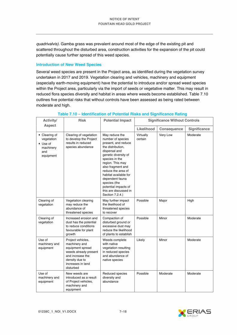
NOTICE OF INTENT FOUNTAIN HEAD GOLD PROJECT
01238C_1_NOI_V1.DOCX 7–18
quadrivalvis). Gamba grass was prevalent around most of the edge of the existing pit and scattered throughout the disturbed area, construction activities for the expansion of the pit could potentially cause further spread of this weed species.
Introduction of New Weed Species Several weed species are present in the Project area, as identified during the vegetation survey undertaken in 2017 and 2019. Vegetation clearing and vehicles, machinery and equipment (especially earth-moving equipment) have the potential to introduce and/or spread weed species within the Project area, particularly via the import of seeds or vegetative matter. This may result in reduced flora species diversity and habitat in areas where weeds become established. Table 7.10 outlines five potential risks that without controls have been assessed as being rated between moderate and high.
Table 7.10 – Identification of Potential Risks and Significance Rating Activity/ Aspect
Risk Potential Impact Significance Without Controls
Likelihood Consequence Significance · Clearing of
vegetation · Use of
machinery and equipment
Clearing of vegetation to develop the Project results in reduced species abundance
May reduce the number of species present, and reduce the distribution, dispersal and genetic diversity of species in the region. This may also fragment and reduce the area of habitat available for dependent fauna species (the potential impacts of this are discussed in Section 7.2.4.)
Virtually certain
Very Low Moderate
Clearing of vegetation
Vegetation clearing may reduce the abundance of threatened species
May further impact the likelihood of threatened species to recover
Possible Major High
Clearing of vegetation
Increased erosion and dust has the potential to reduce conditions favourable for plant growth
Compaction of disturbed ground or excessive dust may reduce the likelihood of plants to establish
Possible Minor Moderate
Use of machinery and equipment
Project vehicles, machinery and equipment spread weeds already present and increase the density due to increases in land disturbed
Weeds complete with native vegetation resulting in reduced species and abundance of native species
Likely Minor Moderate
Use of machinery and equipment
New weeds are introduced as a result of Project vehicles, machinery and equipment
Reduced species diversity and abundance
Possible Moderate Moderate

NOTICE OF INTENT FOUNTAIN HEAD GOLD PROJECT
01238C_1_NOI_V1.DOCX 7–19
7.2.3.2 Avoidance, Mitigation and Management Measures Avoidance, management and mitigation measures that will be implemented as part of the Project’s development are outlined below.
Vegetation Clearing During the development of the Project, a key consideration has been for the Project to utilise areas that have already been disturbed. The placement of infrastructure has considered areas of the site which are currently highly disturbed from previous activities. Other measures to avoid, mitigate and manage the risks associated with the clearing of vegetation include:
· Minimising the area of direct land clearing in areas sensitive to disturbance, such as near waterways.
· Complete flora and fauna survey of Project area to identify if any threatened species exist (survey has been completed).
· Retaining areas of vegetation that have high species diversity.
· Implementation of systems for the approval of vegetation clearing.
· Clearly identifying areas of vegetation that are to be protected and therefore avoided.
· Progressively rehabilitating disturbed areas.
· Stockpiling of vegetation debris collected during clearing for later use in rehabilitation.
Weeds Measures to minimise the spread of existing weed species and introducing any new weed species into the project area include:
· Inspection of all earth moving equipment that enters the Project area to ensure that it is free of soil and any vegetative matter.
· Reduce the area of vegetation to be cleared.
· Minimise the timeframe between vegetation being cleared and the area being used for Project requirements to reduce the likelihood of weeds becoming established.
· Implementation of weed control measures, e.g., cleaning of vehicles and machinery travelling through seeding weed species and ensure all seeds and mud are removed.
· Regular monitoring and weed control where weed density is noted as increasing.
· Control of weed populations on any topsoil stockpiles.
· Dispose of weed species removed during clearing appropriately, e.g. Gamba grass.
· Rehabilitation of disturbed areas as soon as possible to minimise the likelihood of weed establishment.

NOTICE OF INTENT FOUNTAIN HEAD GOLD PROJECT
01238C_1_NOI_V1.DOCX 7–20
7.2.4.3 Residual Risk Assessment The residual risk after consideration of the successful implementation of the proposed avoidance, mitigation and management measures of the Project on flora is outlined in Table 7.11.
Table 7.11 – Summary of Impacts on Flora Risk Potential Impact Avoidance,
Mitigation and Management
Measures
Significance with Controls
Likelihood Consequence Significance
Clearing of vegetation to develop the Project results in reduced species abundance
May reduce the number of species present, and reduce the distribution, dispersal and genetic diversity of species in the region. This may also fragment and reduce the area of habitat available for dependent fauna species (the potential impacts of this are discussed in Section 7.2.4.)
· Locate Project infrastructure in areas previously disturbed
· Implement system for approval of clearing of vegetation
· Minimising the area of direct land clearing in areas sensitive to disturbance, such as along Margaret River
Unlikely Minor Low
Vegetation clearing may reduce the abundance of threatened species
May further impact the likelihood of threatened species to recover
· Complete flora and fauna survey of Project area to identify if any threatened species exist (completed)
Unlikely Major Moderate
Increased erosion and dust has the potential to reduce conditions favourable for plant growth
Compaction of disturbed ground or excessive dust may reduce the likelihood of plants to establish
· Progressively rehabilitating disturbed areas
Unlikely Minor Low
Project vehicles, machinery and equipment spread weeds already present and increase the density due to increases in land disturbed
Weeds complete with native vegetation resulting in reduced species and abundance of native species
· Inspection of all earth moving equipment that enters the Project area to ensure that it is free of soil and any vegetative matter
· Reduce the area of vegetation to be cleared
· Minimise timeframe between vegetation being cleared and the area being used for Project requirements to reduce the likelihood of weeds becoming established
Possible Minor Moderate

NOTICE OF INTENT FOUNTAIN HEAD GOLD PROJECT
01238C_1_NOI_V1.DOCX 7–21
Table 7.11 – Summary of Impacts on Flora (cont’d) Risk Potential
Impact Avoidance,
Mitigation and Management
Measures
Significance with Controls
Likelihood Consequence Significance
Project vehicles, machinery and equipment spread weeds already present and increase the density due to increases in land disturbed (cont’d)
Weeds complete with native vegetation resulting in reduced species and abundance of native species
· Implementation of weed control measures where weeds have established in areas previously identified as being weed free.
· Regular monitoring and undertaking weed control where the density of weeds is increasing.
· Control of weed populations on any topsoil stockpiles.
· Rehabilitation of disturbed areas as soon as possible to minimise the likelihood of weeds becoming established.
· Implementation of weed control measures e.g., cleaning of vehicles and machinery travelling through seeding weed species and ensure all seeds and mud are removed.
· Dispose of weed species removed during clearing appropriately, e.g. Gamba grass.
Possible Minor Moderate
New weeds are introduced as a result of Project vehicles, machinery and equipment
Reduced species diversity and abundance
See mitigation measures outlined above
Possible Minor Moderate
7.2.3.4 Assumptions The vegetation surveys undertaken in 2017 and 2019 identified three species of weed in the Project area. No assumptions on the types of weeds that may be encountered and appropriate control measures are required.
7.2.3.5 Relevant Policy and Guidance PNX will be required to control the growth and spread of Class B weeds under the Weed Management Act.

NOTICE OF INTENT FOUNTAIN HEAD GOLD PROJECT
01238C_1_NOI_V1.DOCX 7–22
Northern Territory Environment Protection Authority, 2013. Guidelines for Assessment of Impacts on Terrestrial Biodiversity. November 2013, Version 2.0
7.2.4 Fauna
7.2.4.1 Potential Impacts Potential Project related fauna impacts are described below. These potential impacts do not take into consideration the proposed avoidance, mitigation and management measures that PNX will implement during construction, operation and closure of the Project, and which will result in the residual impacts discussed in Section 7.2.4.3.
Vegetation clearing and ground disturbance during construction have the potential to reduce areas of habitat and resources within the Project area. The potential impacts to fauna are discussed below.
Reduced Species Abundance (Density and Diversity of Species) Vegetation clearing will remove some native fauna habitat, reduce (possibly) resources for native fauna species and increase competition for food and habitat, with potential changes in the density and distribution of these species. Project construction and operations have the potential to create noise and vibration emissions, resulting in some species avoiding the Project area. Traffic levels along the access road may result in increased fauna deaths. The operation of the HLF may result in fauna deaths if they are exposed to the process ponds containing cyanide. PNX will ensure that the heap leach and process area are fenced to exclude access to native and introduced fauna. The process ponds will be either covered in netting or polypropylene balls to exclude bird access.
Threatened Species No threatened species were recorded in the Project area during the 2017 and 2019 flora and fauna surveys. One threatened species was physically identified during both surveys approximately 5 to 8 km from the Project area – the Gouldian finch (Erythrura gouldiae). The Gouldian Finch is listed as endangered under the EPBC Act.
The Project area is predominantly Eucalyptus woodland on sandstone plains which is suitable habitat for the Gouldian finch, however the site is greatly disturbed and the vegetation is not intact. Disturbance does not necessarily mean that the Gouldian finch will not be present, as it is known to forage in disturbed areas and several grass species that the Gouldian finch feeds upon have been identified within the Project area.
Based on the level of disturbance at the Fountain Head site in comparison to potential habitat adjacent to the Project area and the lack of trees suitable for nesting, it is unlikely the Project area is a significant site for Gouldian finches. While development of the project without the implementation of effective mitigation measures has potential to impact individuals within the group observed near the Project area, it is unlikely the development would lead to disruptions in the breeding cycle or lead to a long-term decrease in the size of an important population of Gouldian finches.
Construction activities and associated additional noise, light and vibration and vehicles may discourage finches from accessing the area, the construction and operation activities will not create a barrier to movement of the Gouldian finch group between remnant habitat areas. It is
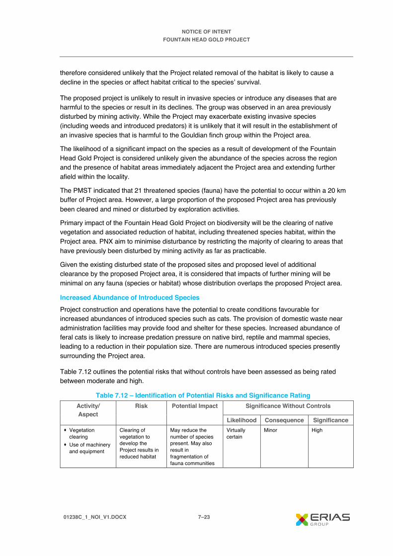
NOTICE OF INTENT FOUNTAIN HEAD GOLD PROJECT
01238C_1_NOI_V1.DOCX 7–23
therefore considered unlikely that the Project related removal of the habitat is likely to cause a decline in the species or affect habitat critical to the species’ survival.
The proposed project is unlikely to result in invasive species or introduce any diseases that are harmful to the species or result in its declines. The group was observed in an area previously disturbed by mining activity. While the Project may exacerbate existing invasive species (including weeds and introduced predators) it is unlikely that it will result in the establishment of an invasive species that is harmful to the Gouldian finch group within the Project area.
The likelihood of a significant impact on the species as a result of development of the Fountain Head Gold Project is considered unlikely given the abundance of the species across the region and the presence of habitat areas immediately adjacent the Project area and extending further afield within the locality.
The PMST indicated that 21 threatened species (fauna) have the potential to occur within a 20 km buffer of Project area. However, a large proportion of the proposed Project area has previously been cleared and mined or disturbed by exploration activities.
Primary impact of the Fountain Head Gold Project on biodiversity will be the clearing of native vegetation and associated reduction of habitat, including threatened species habitat, within the Project area. PNX aim to minimise disturbance by restricting the majority of clearing to areas that have previously been disturbed by mining activity as far as practicable.
Given the existing disturbed state of the proposed sites and proposed level of additional clearance by the proposed Project area, it is considered that impacts of further mining will be minimal on any fauna (species or habitat) whose distribution overlaps the proposed Project area.
Increased Abundance of Introduced Species Project construction and operations have the potential to create conditions favourable for increased abundances of introduced species such as cats. The provision of domestic waste near administration facilities may provide food and shelter for these species. Increased abundance of feral cats is likely to increase predation pressure on native bird, reptile and mammal species, leading to a reduction in their population size. There are numerous introduced species presently surrounding the Project area.
Table 7.12 outlines the potential risks that without controls have been assessed as being rated between moderate and high.
Table 7.12 – Identification of Potential Risks and Significance Rating Activity/ Aspect
Risk Potential Impact Significance Without Controls
Likelihood Consequence Significance · Vegetation
clearing · Use of machinery
and equipment
Clearing of vegetation to develop the Project results in reduced habitat
May reduce the number of species present. May also result in fragmentation of fauna communities
Virtually certain
Minor High

NOTICE OF INTENT FOUNTAIN HEAD GOLD PROJECT
01238C_1_NOI_V1.DOCX 7–24
Table 7.12 – Identification of Potential Risks and Significance Rating (cont’d) Activity/ Aspect
Risk Potential Impact Significance Without Controls
Likelihood Consequence Significance · Vegetation
clearing · Use of machinery
and equipment
Vegetation clearing may reduce the habitat for threatened species
May further impact the likelihood of threatened species to recover
Possible Major High
· Vegetation clearing
· Use of machinery and equipment
Vegetation clearing may reduce the habitat for migratory species
May impact the presence of migratory species in the area and disrupt migration patterns
Unlikely Major Moderate
· Vegetation clearing
· Use of machinery and equipment
Project construction and operations have the potential to create conditions favourable for increases in introduced species
Increased predation pressure on native bird, reptile and mammal species, leading to a reduction in population size
Possible Moderate Moderate
· Operation of the HLF
Fauna exposed to process ponds
May result in fauna deaths due to exposure
Possible Moderate Moderate
7.2.4.2 Avoidance, Mitigation and Management Measures Avoidance, management and mitigation measures that will be implemented as part of the Project development are outlined below.
Removal of Habitat as a Result Vegetation Clearing A key consideration for the Project has been to utilise areas that have already been disturbed, thereby minimising the requirement to clear native vegetation. Other measures to avoid, mitigate and manage the risks associated with habitat removal include:
· Minimising the area of direct land clearing in areas sensitive to disturbance, such as nearby waterways.
· Complete a seasonal flora and fauna survey of Project area to obtain a greater understanding of the presence of threatened species (completed).
· Retaining areas of vegetation that are have high species diversity.
· Implementation of systems for the approval of vegetation clearing.
· Clearly identifying areas of vegetation that are to be protected and therefore avoided.
· Progressively rehabilitating disturbed areas.
· Stockpiling of vegetation debris collected during clearing for later use in rehabilitation.
Introduced Species Measures designed to manage and mitigate the risks associated with an increased abundance of introduced species include:

NOTICE OF INTENT FOUNTAIN HEAD GOLD PROJECT
01238C_1_NOI_V1.DOCX 7–25
· Controlling new and existing feral animal populations.
· Implementation of a waste management plan to reduce potential sources of food for feral animals.
· Regularly monitoring areas with a high potential for, or susceptibility to, increases in abundance of introduced species.
Heap Leach Facility Cyanide containing water bodies within the HLF are hazardous to fauna. Exclusion from cyanide solutions or reductions of cyanide concentrations to non-toxic levels are the only certain methods of protecting terrestrial vertebrate fauna from cyanide poisoning. There are a variety of exclusion/cyanide reduction techniques available. PNX will fence the heap leach and process area with a suitable fence to exclude access of both native and introduced animals. The process ponds will also be covered in either netting or polypropylene balls to exclude access to birds. All process solutions containing cyanide will be transported via pipes. With the implementation of these control measures, fauna deaths are not expected to occur as a result of cyanide poisoning and the likelihood of a significant impact on fauna is considered unlikely.
7.2.4.3 Residual Risk Assessment The residual risk after consideration of the successful implementation of the proposed avoidance, mitigation and management measures of the Project on fauna is outlined in Table 7.13.
Table 7.13 – Summary of Impacts on Fauna Risk Potential
Impact Avoidance,
Mitigation and Management
Measures
Significance with Controls
Likelihood Consequence Significance
Clearing of vegetation to develop the Project results in reduced habitat
May reduce the number of species present. May also result in fragmentation of fauna communities
· Locate Project infrastructure in areas previously disturbed
· Implement system for approval of clearing of vegetation
· Minimising the area of direct land clearing in areas sensitive to disturbance, such as along Margaret River
Unlikely Minor Low
Vegetation clearing may reduce the habitat for threatened species
May further impact the likelihood of threatened species to recover
· Complete second seasonal flora and fauna survey of Project area to greater understand the presence of threatened species (completed)
Unlikely Major Moderate

NOTICE OF INTENT FOUNTAIN HEAD GOLD PROJECT
01238C_1_NOI_V1.DOCX 7–26
Table 7.13 – Summary of Impacts on Fauna (cont’d) Risk Potential
Impact Avoidance,
Mitigation and Management
Measures
Significance with Controls
Likelihood Consequence Significance
Vegetation clearing may reduce the habitat for migratory species
May impact the presence of migratory species in the area and disrupt migration patterns
· Complete second flora and fauna survey of Project area to greater understand if migratory species exist in the area (completed)
Unlikely Major Moderate
Project construction and operations have the potential to create conditions favourable for increases in introduced species
Increased predation pressure on native bird, reptile and mammal species, leading to a reduction in population size
· Control existing and new feral animal populations
· Implement waste management plan to reduce potential food sources for feral animals
Unlikely Minor Low
Fauna exposed to process ponds
May result in fauna deaths due to exposure
· Fence the heap leach and process area to exclude access to fauna
· The use of netting or polypropylene balls over process ponds to exclude access to birds
Unlikely Minor Low
7.2.4.4 Assumptions The flora and fauna surveys undertaken in 2017 and 2019 have informed this risk assessment, including input from LES for measures to mitigate potential project impacts. No assumptions have been made.
7.2.4.5 Relevant Policy and Guidance International Cyanide Management Code for the Manufacture, Transport and Use of Cyanide in the Production of Gold. International Cyanide Management Institute. 2006.
Northern Territory Environment Protection Authority, 2013. Guidelines for Assessment of Impacts on Terrestrial Biodiversity. November 2013, Version 2.0
7.2.5 Air Quality
7.2.5.1 Potential Impacts Potential Project related air quality impacts are described below. These potential impacts do not take into consideration the proposed avoidance, mitigation and management measures that PNX will implement during construction, operation and closure of the Project, and which will result in the residual impacts discussed in Section 7.2.5.3.
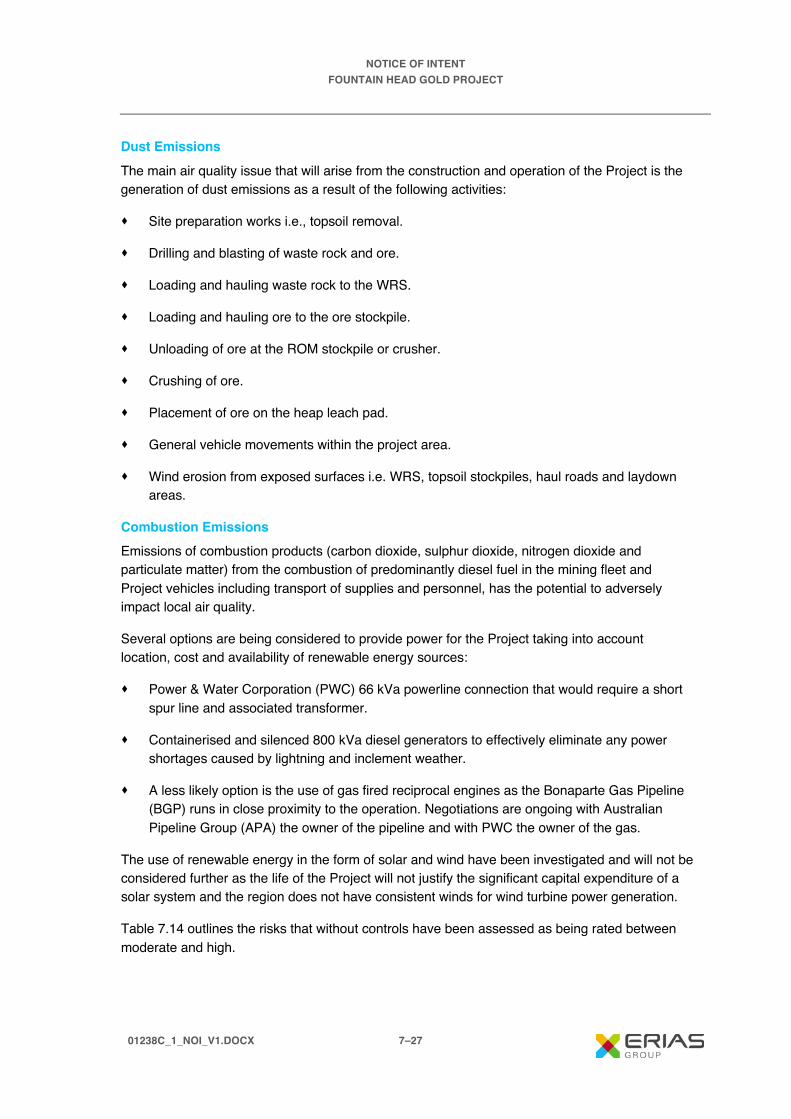
NOTICE OF INTENT FOUNTAIN HEAD GOLD PROJECT
01238C_1_NOI_V1.DOCX 7–27
Dust Emissions The main air quality issue that will arise from the construction and operation of the Project is the generation of dust emissions as a result of the following activities:
· Site preparation works i.e., topsoil removal.
· Drilling and blasting of waste rock and ore.
· Loading and hauling waste rock to the WRS.
· Loading and hauling ore to the ore stockpile.
· Unloading of ore at the ROM stockpile or crusher.
· Crushing of ore.
· Placement of ore on the heap leach pad.
· General vehicle movements within the project area.
· Wind erosion from exposed surfaces i.e. WRS, topsoil stockpiles, haul roads and laydown areas.
Combustion Emissions Emissions of combustion products (carbon dioxide, sulphur dioxide, nitrogen dioxide and particulate matter) from the combustion of predominantly diesel fuel in the mining fleet and Project vehicles including transport of supplies and personnel, has the potential to adversely impact local air quality.
Several options are being considered to provide power for the Project taking into account location, cost and availability of renewable energy sources:
· Power & Water Corporation (PWC) 66 kVa powerline connection that would require a short spur line and associated transformer.
· Containerised and silenced 800 kVa diesel generators to effectively eliminate any power shortages caused by lightning and inclement weather.
· A less likely option is the use of gas fired reciprocal engines as the Bonaparte Gas Pipeline (BGP) runs in close proximity to the operation. Negotiations are ongoing with Australian Pipeline Group (APA) the owner of the pipeline and with PWC the owner of the gas.
The use of renewable energy in the form of solar and wind have been investigated and will not be considered further as the life of the Project will not justify the significant capital expenditure of a solar system and the region does not have consistent winds for wind turbine power generation.
Table 7.14 outlines the risks that without controls have been assessed as being rated between moderate and high.
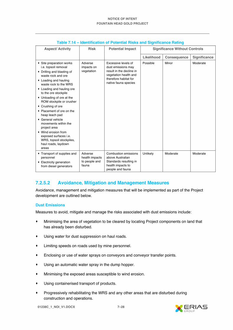
NOTICE OF INTENT FOUNTAIN HEAD GOLD PROJECT
01238C_1_NOI_V1.DOCX 7–28
Table 7.14 – Identification of Potential Risks and Significance Rating Aspect/ Activity Risk Potential Impact Significance Without Controls
Likelihood Consequence Significance · Site preparation works
i.e. topsoil removal · Drilling and blasting of
waste rock and ore · Loading and hauling
waste rock to the WRS · Loading and hauling ore
to the ore stockpile · Unloading of ore at the
ROM stockpile or crusher · Crushing of ore · Placement of ore on the
heap leach pad · General vehicle
movements within the project area
· Wind erosion from exposed surfaces i.e. WRS, topsoil stockpiles, haul roads, laydown areas
Adverse impacts on vegetation
Excessive levels of dust emissions may result in the decline in vegetation health and therefore habitat for native fauna species
Possible Minor Moderate
· Transport of supplies and personnel
· Electricity generation from diesel generators
Adverse health impacts to people and fauna
Combustion emissions above Australian Standards resulting in health impacts to people and fauna
Unlikely Moderate Moderate
7.2.5.2 Avoidance, Mitigation and Management Measures Avoidance, management and mitigation measures that will be implemented as part of the Project development are outlined below.
Dust Emissions Measures to avoid, mitigate and manage the risks associated with dust emissions include:
· Minimising the area of vegetation to be cleared by locating Project components on land that has already been disturbed.
· Using water for dust suppression on haul roads.
· Limiting speeds on roads used by mine personnel.
· Enclosing or use of water sprays on conveyors and conveyor transfer points.
· Using an automatic water spray in the dump hopper.
· Minimising the exposed areas susceptible to wind erosion.
· Using containerised transport of products.
· Progressively rehabilitating the WRS and any other areas that are disturbed during construction and operations.

NOTICE OF INTENT FOUNTAIN HEAD GOLD PROJECT
01238C_1_NOI_V1.DOCX 7–29
Combustion Emissions All plant equipment will meet exhaust air quality standards. Vehicles and machinery will be fitted with the appropriate emission control equipment and will be maintained and serviced frequently.
7.2.5.3 Residual Risk Assessment The residual risk after consideration of the successful implementation of the proposed avoidance, mitigation and management measures of the Project on air quality is outlined in Table 7.15.
Table 7.15 – Summary of Impacts on Air Quality Risk Potential
Impact Avoidance,
Mitigation and Management
Measures
Significance with Controls
Likelihood Consequence Significance
Adverse impacts on vegetation
Excessive levels of dust emissions may result in the decline in vegetation health and therefore habitat for native fauna species
· Locate Project infrastructure in areas previously disturbed
· Use of water to control dust emissions from haul roads
· Speed limits on roads used by mine personnel
· Enclosing or use of water sprays on conveyors and conveyor transfer points
· Automatic water spray at the dump hopper
· Containerised transport of products
· Progressively rehabilitating the WRS
Possible Minor Moderate
Adverse health impacts to people and fauna
Combustion emissions above Australian Standards resulting in health impacts to people and fauna
· Vehicles and equipment fitted with emission control devices and regularly serviced and maintained
Unlikely Moderate Moderate
7.2.5.4 Assumptions Given the short duration and size of the Project, emissions are not expected to exceed Australian Standards. A qualitative air quality assessment will be undertaken in early 2020 to estimate the likely emissions of air pollutants from the Project and provide air quality control measures with the aim of further minimising air emissions.
7.2.5.5 Relevant Policy and Guidance The air quality assessment planned for 2020 will be undertaken in accordance with appropriate legislation and guidance. Commonwealth and Northern Territory legislation that may be relevant to the assessment include:
· Environmental Assessment Act 1994 (Northern Territory).
NOTICE OF INTENT FOUNTAIN HEAD GOLD PROJECT
01238C_1_NOI_V1.DOCX 7–30
· Environmental Protection Act 2012 (Northern Territory).
· Waste Management and Pollution Control Act 2015 (Northern Territory).
· National Environment Protection Measure for Ambient Air Quality (NEPM Air).
· Noise Guidelines for Development Sites in the Northern Territory (May 2014).
7.2.6 Noise and Vibration
7.2.6.1 Potential Impacts Potential Project related noise and vibration impacts and potential disturbance to residents/ neighbours are described below. These potential impacts do not take into consideration the proposed avoidance, mitigation and management measures that PNX will implement during construction, operation and closure of the Project, and which will result in the residual impacts discussed in Section 7.2.6.3.
Disturbance to Residents from Noise and Vibration In general terms, it is the increment above background that determines the noise nuisance and, with attenuation by distance travelled over land, this increment does not usually extend more than 1 to 2 km from a noise source.
The mine operations will produce noise and vibration from both fixed and mobile sources, with the major sources being:
· Vehicles (including reversing alarms).
· Machinery (e.g. drills, loaders, haul trucks, excavators).
· Blasting.
· Process plant.
Noise generated during the construction period may be higher than during operations.
A noise and vibration assessment will be undertaken in early 2020 to predict project noise levels including the effect of meteorological conditions and topography. Noise contours will be generated for the worst case expected period of the mine construction and operation. The potential impacts of vibration will be determined by predicting the level of vibration from blasting and comparing the level with relevant vibration criteria.
Table 7.16 outlines two potential risks that without controls have been assessed as being rated moderate.

NOTICE OF INTENT FOUNTAIN HEAD GOLD PROJECT
01238C_1_NOI_V1.DOCX 7–31
Table 7.16 – Identification of Potential Risks and Significance Rating Aspect/ Activity Risk Potential
Impact Significance Without Controls
Likelihood Consequence Significance Operation of the following: · Vehicles (including
reversing alarms) · Machinery (e.g. drills,
loaders, haul trucks, excavators)
· Process plant
Noise emissions Adverse noise impacts on neighbours
Possible Moderate Moderate
· Blasting Vibration emissions
Adverse vibration impacts on neighbours
Possible Moderate Moderate
7.2.6.2 Avoidance, Mitigation and Management Measures
Noise and Vibration Emissions Locating project infrastructure away from sensitive receptors is the most effective measure to avoid noise and vibration impacts. Other measures include, limiting work hours and the installation of acoustic noise barriers. The Project infrastructure is approximately 5.0 km from the nearest neighbours located to the east of the Project area on Mount Wells Road.
7.2.6.3 Residual Risk Assessment The residual risk after consideration of the successful implementation of the proposed avoidance, mitigation and management measures of the Project on noise and vibration is outlined in Table 7.17.
Table 7.17 – Summary of impacts on Noise and Vibration Risk Potential Impact Avoidance,
Mitigation and Management
Measures
Significance with Controls
Likelihood Consequence Significance
Adverse noise impacts on neighbours
Excessive levels of noise may result in impacts to adjacent neighbours
· Locate Project infrastructure away from sensitive receptors
· Maintain equipment in good working order and meet noise emission standards
Unlikely Minor Low
Adverse vibration impacts on neighbours
Excessive levels of vibration as a result of blasting may result in impacts to adjacent neighbours
· Locate Project infrastructure away from sensitive receptors
Unlikely Minor Low

NOTICE OF INTENT FOUNTAIN HEAD GOLD PROJECT
01238C_1_NOI_V1.DOCX 7–32
7.2.6.4 Assumptions Controls for potential noise and vibration impacts have been derived from industry best practice. The noise and vibration assessment planned for 2020 will further inform the controls to mitigate project noise after background data has been collected and levels of predicted project noise has been determined.
7.2.6.5 Relevant Policy and Guidance The noise and vibration assessment will be undertaken in accordance with the Northern Territory Noise Management Framework Guideline. Northern Territory Environment Protection Authority. 2018.
7.2.7 Greenhouse Gas Emissions
7.2.7.1 Potential Impacts The Project will emit greenhouse gas emissions during the construction, operation and closure phases. The main greenhouse gases that are influenced by human activities include carbon dioxide (CO2), methane (CH4), nitrous oxide (N2O), ozone (O3) and synthetic gases (i.e. chlorofluorocarbons and hydrofluorocarbons) (CSIRO, 2011). The main greenhouse gas emission as a result of the Project will be CO2 as a result of the combustion of diesel used in the mining fleet and project vehicles.
A greenhouse gas assessment will be undertaken in early 2020 to estimate project emissions on an annual basis for the life of the mine. Annual Scope 1 (direct) and Scope 2 (indirect, electricity) GHG emissions will be estimated as carbon dioxide equivalents (CO2-e).
Table 7.18 outlines one potential risks that without controls have been assessed as being rated moderate.
Table 7.18 – Identification of Potential Risks and Significance Rating Aspect/ Activity
Risk Potential Impact Significance Without Controls
Likelihood Consequence Significance · Transport of
supplies and personnel
· Electricity generation from diesel generators
Greenhouse gas emissions
Emissions of greenhouse gases as a result of the Project contributes to Australia’s overall greenhouse gas emissions
Virtually Certain
Very Low Moderate
7.2.7.2 Avoidance, Mitigation and Management Measures Avoidance, management and mitigation measures that will be implemented as part of the Project development are outlined below.
Opportunities to minimise the Project greenhouse gas emissions are greatest during the design phase. Minimising the distance that material needs to be transported is a key opportunity that PNX has implemented. The construction of the HLF and processing plant on-site reduces the distance for transportation of the ore to be processed and has subsequently reduced the Project diesel consumption.
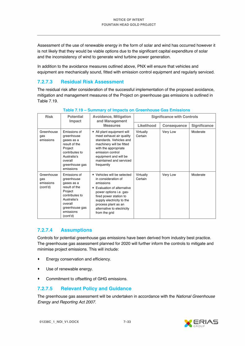
NOTICE OF INTENT FOUNTAIN HEAD GOLD PROJECT
01238C_1_NOI_V1.DOCX 7–33
Assessment of the use of renewable energy in the form of solar and wind has occurred however it is not likely that they would be viable options due to the significant capital expenditure of solar and the inconsistency of wind to generate wind turbine power generation.
In addition to the avoidance measures outlined above, PNX will ensure that vehicles and equipment are mechanically sound, fitted with emission control equipment and regularly serviced.
7.2.7.3 Residual Risk Assessment The residual risk after consideration of the successful implementation of the proposed avoidance, mitigation and management measures of the Project on greenhouse gas emissions is outlined in Table 7.19.
Table 7.19 – Summary of Impacts on Greenhouse Gas Emissions Risk Potential
Impact Avoidance, Mitigation
and Management Measures
Significance with Controls
Likelihood Consequence Significance Greenhouse gas emissions
Emissions of greenhouse gases as a result of the Project contributes to Australia’s overall greenhouse gas emissions
· All plant equipment will meet exhaust air quality standards. Vehicles and machinery will be fitted with the appropriate emission control equipment and will be maintained and serviced frequently
Virtually Certain
Very Low Moderate
Greenhouse gas emissions (cont’d)
Emissions of greenhouse gases as a result of the Project contributes to Australia’s overall greenhouse gas emissions (cont’d)
· Vehicles will be selected in consideration of emissions
· Evaluation of alternative power options i.e. gas-fired power station to supply electricity to the process plant as an alternative to electricity from the grid
Virtually Certain
Very Low Moderate
7.2.7.4 Assumptions Controls for potential greenhouse gas emissions have been derived from industry best practice. The greenhouse gas assessment planned for 2020 will further inform the controls to mitigate and minimise project emissions. This will include:
· Energy conservation and efficiency.
· Use of renewable energy.
· Commitment to offsetting of GHG emissions.
7.2.7.5 Relevant Policy and Guidance The greenhouse gas assessment will be undertaken in accordance with the National Greenhouse Energy and Reporting Act 2007.

NOTICE OF INTENT FOUNTAIN HEAD GOLD PROJECT
01238C_1_NOI_V1.DOCX 7–34
Emissions estimates will be calculated based on methodology consistent with the following standards and guidance documents, in order of preference:
· National Greenhouse and Energy Reporting (Measurement) Determination. Department of Environmental and Energy. 2019.
· National Greenhouse Accounts Factors. Department of Environment and Energy. 2019.
· Greenhouse Gas Protocol: A Corporate Accounting and Reporting Standard. World Resources Institute and World Business Council for Sustainable Development. 2001.
7.3 Cultural Heritage Environment 7.3.1 Cultural Heritage
7.3.1.1 Potential Impacts Potential project related impacts on indigenous and non-indigenous cultural heritage are described below. These potential impacts do not take into consideration the proposed avoidance, mitigation and management measures that PNX will implement during construction, operation and closure of the Project, and which will result in the residual impacts discussed in Section 7.3.1.3.
Impacts on indigenous and non-indigenous cultural heritage as a result of the Project development are possible through the ground disturbance but also the inappropriate siting of project infrastructure. An archaeological survey undertaken by InDepth Archaeology in October 2019 identified the following:
· Six Aboriginal Places.
· Five Aboriginal Objects.
No non-indigenous cultural heritage places or objects were identified.
There are currently no recorded sacred sites within the Project area, however PNX will consult with the Aboriginal Areas Protection Authority whether it will be required to obtain an Authority Certificate to protect intangible cultural heritage in accordance with the Northern Territory Aboriginal Sacred Sites Act.
Table 7.20 outlines two potential impacts that without controls have been assessed as being rated high.
Table 7.20 – Identification of Potential Risks and Significance Rating Aspect/ Activity
Risk Potential Impact
Significance Without Controls
Likelihood Consequence Significance Earthworks and clearance activities
Disturbance to known indigenous and non-indigenous sites
Project activities result in disturbance to known sites
Possible Major High
Earthworks and clearance activities
Disturbance to unknown indigenous and non-indigenous sites
Project activities result in disturbance to unknown sites
Possible Major High
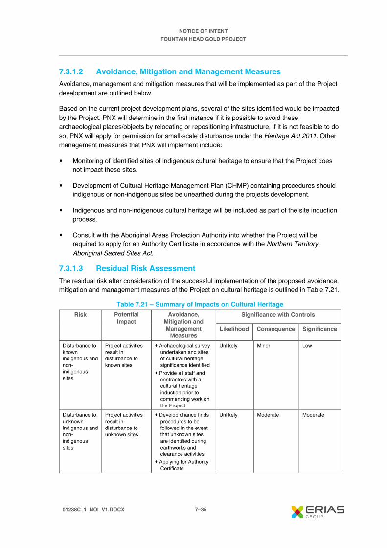
NOTICE OF INTENT FOUNTAIN HEAD GOLD PROJECT
01238C_1_NOI_V1.DOCX 7–35
7.3.1.2 Avoidance, Mitigation and Management Measures Avoidance, management and mitigation measures that will be implemented as part of the Project development are outlined below.
Based on the current project development plans, several of the sites identified would be impacted by the Project. PNX will determine in the first instance if it is possible to avoid these archaeological places/objects by relocating or repositioning infrastructure, if it is not feasible to do so, PNX will apply for permission for small-scale disturbance under the Heritage Act 2011. Other management measures that PNX will implement include:
· Monitoring of identified sites of indigenous cultural heritage to ensure that the Project does not impact these sites.
· Development of Cultural Heritage Management Plan (CHMP) containing procedures should indigenous or non-indigenous sites be unearthed during the projects development.
· Indigenous and non-indigenous cultural heritage will be included as part of the site induction process.
· Consult with the Aboriginal Areas Protection Authority into whether the Project will be required to apply for an Authority Certificate in accordance with the Northern Territory Aboriginal Sacred Sites Act.
7.3.1.3 Residual Risk Assessment The residual risk after consideration of the successful implementation of the proposed avoidance, mitigation and management measures of the Project on cultural heritage is outlined in Table 7.21.
Table 7.21 – Summary of Impacts on Cultural Heritage Risk Potential
Impact Avoidance,
Mitigation and Management
Measures
Significance with Controls
Likelihood Consequence Significance
Disturbance to known indigenous and non-indigenous sites
Project activities result in disturbance to known sites
· Archaeological survey undertaken and sites of cultural heritage significance identified
· Provide all staff and contractors with a cultural heritage induction prior to commencing work on the Project
Unlikely Minor Low
Disturbance to unknown indigenous and non-indigenous sites
Project activities result in disturbance to unknown sites
· Develop chance finds procedures to be followed in the event that unknown sites are identified during earthworks and clearance activities
· Applying for Authority Certificate
Unlikely Moderate Moderate
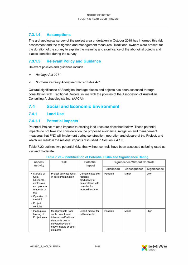
NOTICE OF INTENT FOUNTAIN HEAD GOLD PROJECT
01238C_1_NOI_V1.DOCX 7–36
7.3.1.4 Assumptions The archaeological survey of the project area undertaken in October 2019 has informed this risk assessment and the mitigation and management measures. Traditional owners were present for the duration of the survey to explain the meaning and significance of the aboriginal objects and places identified during the survey.
7.3.1.5 Relevant Policy and Guidance Relevant policies and guidance include:
· Heritage Act 2011.
· Northern Territory Aboriginal Sacred Sites Act.
Cultural significance of Aboriginal heritage places and objects has been assessed through consultation with Traditional Owners, in line with the policies of the Association of Australian Consulting Archaeologists Inc. (AACAI).
7.4 Social and Economic Environment 7.4.1 Land Use
7.4.1.1 Potential Impacts Potential Project related impacts to existing land uses are described below. These potential impacts do not take into consideration the proposed avoidance, mitigation and management measures that PNX will implement during construction, operation and closure of the Project, and which will result in the residual impacts discussed in Section 7.4.1.3.
Table 7.22 outlines two potential risks that without controls have been assessed as being rated as low and moderate.
Table 7.22 – Identification of Potential Risks and Significance Rating Aspect/ Activity
Risk Potential Impact
Significance Without Controls
Likelihood Consequence Significance · Storage of
fuels, lubricants, explosives and process reagents on site
· Operation of the HLF
· Project vehicles
Project activities result in soil contamination
Contaminated soil reduces productivity of pastoral land with potential for reduced income
Possible Minor Low
· Inadequate fencing of Project area
Meat products from cattle do not meet international/national standards due to elevated levels of heavy metals or other elements
Export market for cattle affected
Possible Major High

NOTICE OF INTENT FOUNTAIN HEAD GOLD PROJECT
01238C_1_NOI_V1.DOCX 7–37
7.4.1.2 Avoidance, Mitigation and Management Measures Avoidance, management and mitigation measures that will be implemented as part of the Project development are outlined below.
PNX will have agreements in place with pastoral owners who are impacted adversely by the Project.
A number of measures will be implemented to prevent soil contamination including:
· Fuels to be stored in double lined tanks.
· Where fuels and oils are dispensed, drip trays will collect any spillage.
· Spill clean-up materials to be available for any spills.
· Heap Leach pads and ponds to be lined.
· All exposed pipes with leach solution will be placed on lined HDPE corridors.
· Process plant will have concrete floor with any spills directed to sumps for collection.
· Fencing to exclude cattle from operational areas.
· Fencing of potential contaminated areas to restrict access to grazing cattle.
· At the conclusion of the Project, an assessment will be undertaken to detect any contamination and this material will be removed or rehabilitated.
7.4.1.3 Residual Risk Assessment The residual risk after consideration of the successful implementation of the proposed avoidance, mitigation and management measures of the Project on land use is outlined in Table 23.
Table 7.23 – Summary of Impacts on Land Use Risk Potential
Impact Avoidance, Mitigation
and Management Measures
Significance with Controls
Likelihood Consequence Significance Project activities result in soil contamination
Contaminated soil reduces productivity of pastoral land with potential for reduced income
· Storage of fuels and chemicals in accordance with Australian standards
· Placement of tailings sub-aqueously
· Contamination assessment and clean up at the end of the Project
Possible Minor Low
Cattle contamination
Meat products from cattle do not meet international/national standards due to elevated levels of heavy metals or other elements
· Fencing to exclude cattle from operational areas
· Contamination assessment and clean up at the end of the Project
Unlikely Major Moderate

NOTICE OF INTENT FOUNTAIN HEAD GOLD PROJECT
01238C_1_NOI_V1.DOCX 7–38
7.4.1.4 Assumptions None.
7.4.1.5 Relevant Policy and Guidance A landholder agreement between PNX and the landholder will outline obligations that PNX will adhere to.
7.4.2 Traffic and Transport
7.4.2.1 Potential Impacts Table 7.24 outlines two potential risks that without controls have been assessed as being rated moderate and high.
Table 7.24 – Identification of Potential Risks and Significance Rating Aspect/ Activity
Risk Potential Impact Significance Without Controls
Likelihood Consequence Significance · Increased
traffic as a result of Project vehicles
Disruption of traffic during construction
Movement of earthmoving equipment and infrastructure for construction has the potential to impact traffic due to wide loads and/or slow vehicles
Virtually Certain
Very Low Moderate
· Increased traffic as a result of Project vehicles
Disruption of traffic during operations
Increased traffic as a result of transport of supplies and personnel
Virtually Certain
Minor High
7.4.2.2 Avoidance, Mitigation and Management Measures Avoidance, management and mitigation measures that will be implemented as part of the Project development are outlined below.
Traffic and transport studies will be undertaken in early 2020. This will include a transport impact assessment that will review potential traffic generation during construction and operations and potential impacts and development of a traffic management plan.
All Project vehicles will comply with the Northern Territory requirements regarding maximum dimensional limits and maximum standard mass limits, and where required an exemption will be obtained from the Department of Transport.
In addition, PNX will restrict non-essential access by Project personnel to Project specific roads, in particular the Stuart Highway, Ban Ban Springs Road, and Fountain Head Road.
7.4.2.3 Residual Risk Assessment The residual risk after consideration of the successful implementation of the proposed avoidance, mitigation and management measures of the Project on traffic and transport is outlined in Table 7.25.

NOTICE OF INTENT FOUNTAIN HEAD GOLD PROJECT
01238C_1_NOI_V1.DOCX 7–39
Table 7.25 – Summary of Impacts on Traffic and Transport Risk Potential Impact Avoidance,
Mitigation and Management
Measures
Significance with Controls
Likelihood Consequence Significance
Disruption of traffic during construction
Movement of earthmoving equipment and infrastructure for construction has the potential to impact traffic due to wide loads and/or slow vehicles
· Permits in place for loads that are oversize etc.
· Traffic Management Plan
Possible Very Low Low
Disruption of traffic during operations
Increased traffic as a result of transport of supplies and personnel
· Project vehicles restricted to identified roads
· Traffic Management Plan
Likely Minor Moderate
7.4.2.4 Assumptions None.
7.4.2.5 Relevant Policy and Guidance The traffic and transport studies planned for early 2020 will further inform the mitigation and management measures.
7.5 Cumulative Impacts Cumulative impacts are defined as the total impact arising from the Project in conjunction with other current or future activities (e.g. by that of developers, local communities, government). The project’s impact is therefore one part of the total cumulative impact on the environment.
The identification process for selecting existing and future credible activities for the cumulative impact assessment has not yet been completed at this stage of the project development. The area surrounding the Fountain Head Gold Project contains a number of abandoned mine sites and one current mining operation. The Cosmo Gold Mine, located approximately 15 km to the west of the Project area, is the only operating mine in the immediate area. The mine is owned by Kirkland Lake Gold who have recently commenced mining of underground ore. The Kirkland Lake Gold Union Reefs processing facility 70 km south is processing the ore. The Woolwonga Project is located approximately 7 km north-east of the Project area. The mine is owned by Bacchus Resources who have been undertaking exploration activity at the site since 2017. Bacchus Resources are not moving toward mining operation at this point in time.
Table 7.26 identifies the Project impacts that could potentially cumulatively contribute to adverse impacts on environmental, social and cultural key environmental factors.

NOTICE OF INTENT FOUNTAIN HEAD GOLD PROJECT
01238C_1_NOI_V1.DOCX 7–40
Table 7.26 – Potential Impacting Processes and Factors Potentially Impacted Environmental
Factors Aspect/ Activity Potential Impacts
Inland water environmental quality
· Discharge of sediment-laden water to the environment via WRS, haul roads and other areas
· Retention of surface water on site. · Storage of fuels, lubricants,
explosives and process reagents on site
· WRS AMD and saline drainage
Effects on surface water quality with potential consequences with respect to adverse effects on aquatic biota due to toxicants (e.g. metals and/or salt), conservation values and resource use by leaching of metals and salts from waste rock and ore.
Inland water environmental quality
See above Contamination of groundwater by leaching of metals and salts from waste rock and ore (due to oxidation of potentially acid forming and metalliferous waste rock and ore).
Terrestrial flora and fauna
· Clearing of vegetation · Topsoil removal and stockpiling
Clearing of vegetation to develop the project results in reduced species abundance.
Terrestrial flora and fauna
See above Clearing of vegetation may reduce the habitat for threatened species.
Terrestrial flora and fauna
See above Clearing of vegetation may further impact the likelihood of threatened species to recover
Terrestrial flora and fauna
See above Clearing of vegetation may reduce the habitat for migratory species.
Social, economic and cultural surroundings
· Increased traffic as a result of Project vehicles
Movement of earthmoving equipment and infrastructure for construction has the potential to impact traffic due to wide loads and/or slow vehicles Increased traffic as a result of transport of supplies and personnel
Air Quality and Greenhouse Gases
· Site preparation works i.e. topsoil removal
· Drilling and blasting of waste rock and ore
· Loading and hauling waste rock to the WRS
· Loading and hauling ore to the ore stockpile
· Unloading of ore at the ROM stockpile or crusher
· Crushing of ore
Air Quality and Greenhouse Gases (cont’d)
· Placement of ore on the heap leach pad
· General vehicle movements within the project area
· Wind erosion from exposed surfaces i.e. WRS, topsoil stockpiles, haul roads, laydown areas
· Transport of supplies and personnel · Electricity generation from diesel
generators
Emissions of greenhouse gases as a result of the Project.

NOTICE OF INTENT FOUNTAIN HEAD GOLD PROJECT
01238C_1_NOI_V1.DOCX 7–41
The Fountain Head Gold Project is small in scale, with mining and processing to occur on the same site. The majority of projects that are in close proximity to the Fountain Head Gold Project are currently undertaking exploration activity and there is no available information to ascertain that these projects will move into operations in the near future. Cumulative impacts are not expected to occur given it is unlikely these nearby projects would operate in parallel with the Fountain Head Gold Project within the expected Project life of three years.
The potential cumulative impacts associated with the operation of the Cosmo Gold mine will be assessed due to its close proximity to the Fountain Head Gold Project.

NOTICE OF INTENT FOUNTAIN HEAD GOLD PROJECT
01238C_1_NOI_V1.DOCX 7–42

NOTICE OF INTENT FOUNTAIN HEAD GOLD PROJECT
01238C_1_NOI_V1.DOCX 8–1
8. Matters of National Environmental Significance
8.1 Overview A search for matters of national environmental significance was completed in November 2019 (Appendix 1) using the EPBC Act Protected Matters Search Tool (PMST). In addition, flora and fauna surveys were completed in the area in May 2017 (early-dry season) and August 2019 (late-dry season) by Low Ecological Services Pty Ltd.
The PMST confirmed the following:
· World Heritage properties – There are no World Heritage properties in the vicinity of the proposed Project. The closest site is the Kakadu National Park located approximately 49 km east of the Project.
· World Heritage places – There are no World Heritage places in the vicinity of the proposed Project. The closest site is the Kakadu National Park located approximately 49 km east of the Project.
· Wetland of international importance (declared Ramsar wetlands) - There are no wetlands of international importance (Ramsar-listed wetlands) in close proximity to the proposed Project. The closest site is the Kakadu National Park, located approximately 49 km east of the Project.
· Commonwealth marine area or the Great Barrier Reef Marine Park – the Project is not located within or near the Great Barrier Reef Marine Park, and no Commonwealth marine areas are present within or close to the proposed Project.
· Commonwealth land – the proposed Project will not be taken on, or adjacent to, Commonwealth land.
· Listed threatened species and ecological communities (discussed further in Section 8.2) – There are 21 threatened species and ecological communities that have the potential to occur within a 20 km buffer of the Project. One of these species, the Gouldian finch, was identified during the flora and fauna surveys in May 2017 and August 2019 for the Hayes Creek Project. The sightings were in several locations, ranging approximately 5 to 8 km from the Fountain Head site, but no sightings were made on the site itself. No threatened ecological communities were identified in the EPBC, PMST or during the surveys completed in May 2017 and August 2019.
· Migratory species (discussed further in Section 8.3) – A total of 18 listed migratory species (three of which are classified as threatened species) were identified as having the potential to occur within the vicinity of the Project using a 20 km buffer area. None of these were recorded during the 2017 or 2019 flora and fauna surveys.

NOTICE OF INTENT FOUNTAIN HEAD GOLD PROJECT
01238C_1_NOI_V1.DOCX 8–2
8.2 Threatened Species 8.2.1 Flora A search using the EPBC Act PMST identified two flora species of conservation significance to potentially occur within the 20 km buffer of the Project. A triggerplant (Stylidium ensatum) (listed as endangered) and a shrub (Acacia praetermissa) (listed as vulnerable) were identified as known to and likely to occur within the area, respectively. There is potential habitat for Stylidium ensatum to the north of the Fountain Head site within the lease area, however no species were recorded during the May 2017 or August 2019 surveys. Suitable undisturbed habitat for Acacia praetermissa was identified in the survey area however no evidence of the species was recorded during the on-ground surveys despite targeted area searches.
LES concluded that neither species were determined likely to be significantly impacted by development of the Project and due to the highly disturbed nature of the site from previous clearing and mining there is no real chance or possibility of significant impact on flora by the Project.
8.2.2 Fauna The EPBC Act PMST identified 19 threatened fauna species that potentially occur within 20 km of the Project. The 19 threatened fauna species included:
· Eight birds.
· Nine mammals.
· One reptile.
· One freshwater shark.
Of these threatened species, only the Gouldian finch (Status Endangered (EPBC) and Vulnerable (TPWC)) was recorded during the flora and fauna surveys in May 2017 and August 2019. The sightings were in several locations, ranging approximately 5 to 8 km from the Fountain Head site
8.2.2.1 Potential Impacts from Clearing of Native Vegetation The extent of clearing of native vegetation in the Project area will predominantly occur in areas that are highly disturbed as a result of previous mining and exploration. The area to the west of the site contains vegetation which although not intact due to previous disturbance activities, such as cattle grazing, could still be utilised as habitat, this will be the location of the heap leach facility and associated infrastructure. PNX plan to minimise impacts on biodiversity resulting from clearing of native vegetation and habitat, by utilising areas previously disturbed by mining activities as much as possible i.e., bare soils with no vegetation.
Vegetation in the project area was mapped at a scale of 1: 100 000 using the Vegetation Survey of the Northern Territory (Wilson, et al., 1990). The broad vegetation classification and total Project area are shown in Table 8.1 and Figure 8.1.
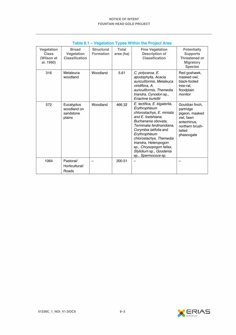
NOTICE OF INTENT FOUNTAIN HEAD GOLD PROJECT
01238C_1_NOI_V1.DOCX 8–3
Table 8.1 – Vegetation Types Within the Project Area Vegetation
Class (Wilson et al. 1990)
Broad Vegetation
Classification
Structural Formation
Total area (ha)
Fine Vegetation Description of Classification
Potentially Supports
Threatened or Migratory Species
316 Melaleuca woodland
Woodland 5.61 C. polycaroa, E. apodophylla, Acacia auriculiformis, Melaleuca viridiflora, A. auriculiformis, Themedia triandra, Cynodon sp., Eriachne burkittii
Red goshawk, masked owl, black-footed tree-rat, floodplain monitor
572 Eucalyptus woodland on sandstone plains
Woodland 466.32 E. tectifica, E. bigalerita, Erythrophleum chlorostachys, E. miniata and E. foelshiana, Buchanania obovata, Terminalia ferdinandiana, Corymbia latifolia and Erythrophleum chlorostachys, Themedia triandra, Heteropogon sp., Chrysopogon fallax, Stylidium sp., Goodenia sp., Spermococe sp.
Gouldian finch, partridge pigeon, masked owl, fawn antechinus, northern brush-tailed phascogale
1064 Pastoral/ Horticultural/ Roads
– 200.51 – –

@ A 4S C A L E : 1 :3 0 ,0 0 0
Is s ue D at e:M ap I D :
F igu re N um b e r:
0 9 . 1 2 . 2 0 1 9
F o u n ta in H e a d G o ld P ro je c t | N o tic e o f In te n tFIGURE 8.1
E R IA S G ro up13-2 5 C hurc h S tre etHa w th orn V IC 3 12 2A us tra l ia
ÄÄÄN⟨
0 1 2 3 8 B _ N O I_ F 0 8 .1 _ G IS _ v 10 1 2 3 8 B _ N O I_ G IS 0 0 1 _ v 0 _ 4
0 0 .5 10 .2 5 K M
A L IC E S P R IN G S D A R W IN R A ILW A Y
A L IC E S P R IN G S D A R W IN R A ILW A Y
VEGETATION TYPES WITHIN THE PROJECT AREA
D A T A S O U R C E S :P ro je c t da ta f ro m P N X M et a ls , 2 0 19 .B a se da ta f ro m G e o sc ien c e A u s tr a l ia , G E O D A T A 2 5 0 K , 20 0 6 .Im a ge ry © E S R I , D ig it a lG lob e a n d P a rtn e rs , 2 0 1 9.V e ge ta tio n da ta f ro m L o w E co log y , 20 1 9.
R a ilw a yR o a dW a te r c o u rs eS u rv e y A r e a
V e g e ta t io nE u c a ly p tu s w o o d la n dM e la le u c a w o o d la n dP a s to ra l/ H o rt ic u ltu r e /R o a d s
G D A 1 9 9 4 M G A Z o n e 5 2
M o u n t W e lls R o a d

NOTICE OF INTENT FOUNTAIN HEAD GOLD PROJECT
01238C_1_NOI_V1.DOCX 8–5
As shown in Figure 8.1 and described in Table 8.1, over 70% of the Project area has been identified as Eucalyptus woodland on sandstone plains, suitable habitat for the Gouldian finch. However, both flora and fauna surveys (2017 and 2019) have confirmed that the Project area can be characterised as highly disturbed and is not characteristic of the typical woodland habitats, when intact. This is due to mining and exploration activities and cattle grazing which has resulted in many areas of the identified habitat being sparsely vegetated with bare soils and a high density of weed species, in particular Gamba grass.
Typical Gouldian finch habitat is characterised by a combination of rocky hills in proximity to flatter country with a predominance of annual spear grasses or perennial sorghum in the understorey during the dry season (O'Malley, 2006). Their preferred breeding habitat within this habitat consists of E. tintinnans and E. Brevifolia, nesting in tree hollows. An assessment of potential breeding sites for the Gouldian finch in the Project area found there just seven hollow bearing trees within a 1 ha search area. Whereas in other locations surveyed (for the Hayes Creek Project) where E. tintinnans were recorded there were up to 70 hollows within 1 ha. No E. tintinnans were recorded in the survey area, and this is likely due to the fact that they are present in woodland on low sandstone hills and not open woodland on sandstone plains. These findings suggest that the Gouldian finch is less likely to utilise the Fountain Head site for nesting over other areas nearby. Seven sites within the Northern Territory are recognised as breeding areas supporting important populations, including Yinberrie Hills, Newry Station, Timber Creek, Eva Valley (in Kakadu NP), Mt Thymann (in Bradshaw Field Training Area), Kidman Springs and Manbulloo as well as several locations in the Kimberley. None of these sites of important populations fall within 40 km of the project area (O’Malley, 2006).
The Project area has several preferred grass species of the Gouldian finch (Heteropogon spp., and Themeda triandra), which determines there is a possibility that the Gouldian finch may utilise the site for ground foraging. These grasses are important for the Gouldian finch and other finch species when food supply is low between the end of the dry season, going into the wet season. However, there is availability of potential habitat including grass species for foraging, adjacent to the site. The Gouldian finch is also known to travel far, up to 10 km to find seed. The habitat available in the Project area is not considered critical habitat for the Gouldian finch and therefore it is unlikely to lead to impacts in relation to loss of habitat and important resources.
Individuals within the groups observed may be at risk from the project development without the implementation of effective mitigation measures but it is unlikely the development would lead to disruptions in the breeding cycle or lead to a long-term decrease in the size of an important population of Gouldian finches.
8.2.2.2 Potential Impacts from the Spread of Weeds Other potential threats to fauna biodiversity associated with the Project include the introduction of weeds or the further spread of weeds that already exist in the Project area. During the 2017 and 2019 field surveys, two species were identified, including Gamba grass (Andropogon gayanus), and Rubber bush (Calotropis procera). Gamba grass was prevalent around most of the edge of the existing pit and scattered throughout the disturbed area. These species have both been declared as weeds under the NT Weeds Management Act and require land holders, managers and users to comply with the declaration classification. Gamba grass is declared Class A, B and C and rubber bush Class C. Gamba grass is also listed as a weed of national significance (WoNS). Details on the weed classifications are in Section 6.1.6.4.
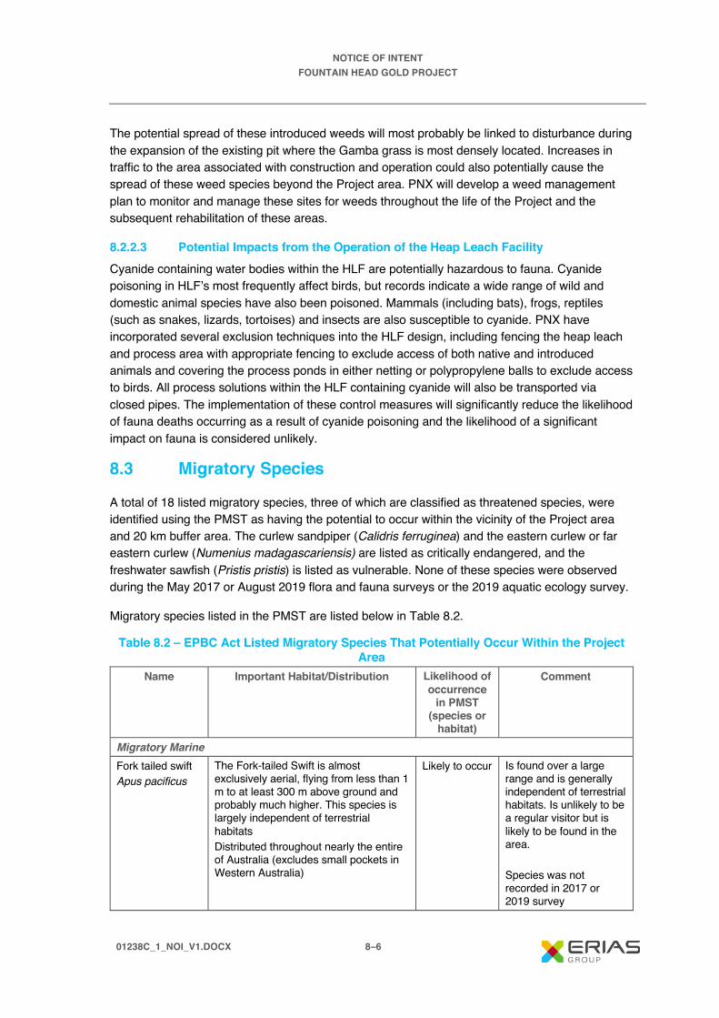
NOTICE OF INTENT FOUNTAIN HEAD GOLD PROJECT
01238C_1_NOI_V1.DOCX 8–6
The potential spread of these introduced weeds will most probably be linked to disturbance during the expansion of the existing pit where the Gamba grass is most densely located. Increases in traffic to the area associated with construction and operation could also potentially cause the spread of these weed species beyond the Project area. PNX will develop a weed management plan to monitor and manage these sites for weeds throughout the life of the Project and the subsequent rehabilitation of these areas.
8.2.2.3 Potential Impacts from the Operation of the Heap Leach Facility Cyanide containing water bodies within the HLF are potentially hazardous to fauna. Cyanide poisoning in HLF’s most frequently affect birds, but records indicate a wide range of wild and domestic animal species have also been poisoned. Mammals (including bats), frogs, reptiles (such as snakes, lizards, tortoises) and insects are also susceptible to cyanide. PNX have incorporated several exclusion techniques into the HLF design, including fencing the heap leach and process area with appropriate fencing to exclude access of both native and introduced animals and covering the process ponds in either netting or polypropylene balls to exclude access to birds. All process solutions within the HLF containing cyanide will also be transported via closed pipes. The implementation of these control measures will significantly reduce the likelihood of fauna deaths occurring as a result of cyanide poisoning and the likelihood of a significant impact on fauna is considered unlikely.
8.3 Migratory Species
A total of 18 listed migratory species, three of which are classified as threatened species, were identified using the PMST as having the potential to occur within the vicinity of the Project area and 20 km buffer area. The curlew sandpiper (Calidris ferruginea) and the eastern curlew or far eastern curlew (Numenius madagascariensis) are listed as critically endangered, and the freshwater sawfish (Pristis pristis) is listed as vulnerable. None of these species were observed during the May 2017 or August 2019 flora and fauna surveys or the 2019 aquatic ecology survey.
Migratory species listed in the PMST are listed below in Table 8.2.
Table 8.2 – EPBC Act Listed Migratory Species That Potentially Occur Within the Project Area
Name Important Habitat/Distribution Likelihood of occurrence
in PMST (species or
habitat)
Comment
Migratory Marine Fork tailed swift Apus pacificus
The Fork-tailed Swift is almost exclusively aerial, flying from less than 1 m to at least 300 m above ground and probably much higher. This species is largely independent of terrestrial habitats Distributed throughout nearly the entire of Australia (excludes small pockets in Western Australia)
Likely to occur Is found over a large range and is generally independent of terrestrial habitats. Is unlikely to be a regular visitor but is likely to be found in the area. Species was not recorded in 2017 or 2019 survey

NOTICE OF INTENT FOUNTAIN HEAD GOLD PROJECT
01238C_1_NOI_V1.DOCX 8–7
Table 8.2 – EPBC Act Listed Migratory Species That Potentially Occur Within the Project Area (cont’d)
Name Important Habitat/Distribution Likelihood of occurrence
in PMST (species or
habitat)
Comment
Salt-water crocodile, Estuarine crocodile Crocodylus porosus
Salt-water Crocodile mostly occurs in tidal rivers, coastal floodplains and channels, billabongs and swamps (Webb et al. 1987) up to 150 km inland from the coast Found in the northern section of Queensland, Northern Territory and Western Australia. In the Northern Territory, the Salt-water Crocodile has been found in the following rivers: Mary, Adelaide, Daly, Moyle, Victoria/Baines, Finniss, Wildman, West Alligator, East Alligator, South Alligator, Liverpool, Blyth, Glyde, Habgood, Baralminar/Gobalpa, Goromuru, Cato and Peter John Rivers
Likely to occur Is found over a large range and unlikely to be present in the Project area, due to absence of marine and river environments Species was not recorded in 2017 or 2019 survey
Freshwater sawfish, Largetooth sawfish, River sawfish, Leichhardt's sawfish, Northern sawfish Pristis pristis
Juveniles and sub-adult Freshwater Sawfish predominantly occur in rivers and estuaries, while large mature animals tend to occur more often in coastal and offshore waters up to 25 m depth northern Australia, this species appears to be confined to freshwater drainages and the upper reaches of estuaries, occasionally being found as far as 400 km from the sea. Found in the northern section of Queensland, Northern Territory and Western Australia. Occurs in all large rivers of northern Australia
Likely to occur Is found over a large range and unlikely to be present in the Project area, due to absence of marine and large river environments in close proximity to the Project Species was not recorded in 2017 or 2019 survey or 2019 aquatic ecology survey
Migratory Terrestrial Red-rumped swallow Cecropis daurica
Records in Australia are of non- breeding migrants (December - February) and confined to the north of the country, particularly around Cairns, Gulf of Carpentaria, Darwin and Broome. Predominantly forages over wetlands: e.g. swamps, rivers, dams etc. or open areas such as golf course or cane fields, where insects are taken on the wing. They have been recorded feeding in mixed flocks with other aerial insectivores. As with most swallows and martins, Red-rumped Swallows often perch on bare branches or wires
May occur Is found over a large range and is unlikely to be a regular visitor due to lack of suitable habitat but there is a moderate chance that it could be found in the area. Species was not recorded in 2017 or 2019 survey.

NOTICE OF INTENT FOUNTAIN HEAD GOLD PROJECT
01238C_1_NOI_V1.DOCX 8–8
Table 8.2 – EPBC Act Listed Migratory Species That Potentially Occur Within the Project Area (cont’d)
Name Important Habitat/Distribution Likelihood of occurrence
in PMST (species or
habitat)
Comment
Migratory Terrestrial (cont’d) Oriental cuckoo, Horsfield's cuckoo Cuculus optatus
Non-breeding habitat only: monsoonal rainforest, vine thickets, wet sclerophyll forest or open Casuarina, Acacia or Eucalyptus woodlands. Frequently at edges or ecotones between habitat types. Riparian forest is favoured habitat in the Kimberley region
May occur There is a moderate chance that it could be found in the area. Species was not recorded in 2017 or 2019 survey
Barn swallow Hirundo rustica
Habitat in the air above open vegetated areas including farmland, sports grounds, native grasslands and airstrips as well as over open water such as billabongs, lagoons, creeks and sewage treatment plants
May occur Unlikely to be regularly present in the Project area, due to absence of suitable habitat. There is a moderate chance that it could be found in the area. Species was not recorded in 2017 or 2019 survey.
Grey wagtail Motacilla cinerea
Is a scarce but regular visitor to northern Australia, generally arriving during the last 10 days of October and departing around March. The species has a strong association with water. In their normal breeding range, Grey Wagtails are found across a variety of wetlands, especially water courses, but also on the banks of lakes and marshes, as well as artificial wetlands such as sewage farms, reservoirs and fishponds. Non-breeding habitat only: has a strong association with water, particularly rocky substrates along water courses but also lakes and marshes
May occur Unlikely to be present in the Project area, due to absence of suitable habitat. There is a moderate chance that it could be found in the area. Species was not recorded in 2017 or 2019 survey
Yellow wagtail Motacilla flava
Habitat requirements for the Yellow Wagtail are highly variable, but typically include open grassy flats near water. Habitats include open areas with low vegetation such as grasslands, airstrips, pastures, sports fields; damp open areas such as muddy or grassy edges of wetlands, rivers, irrigated farmland, dams, waterholes; sewage farms, sometimes utilise tidal mudflats and edges of mangroves
May occur Unlikely to be regularly present in the Project area, due to disturbed nature of the project sites. There is a moderate chance that it could be found in the area. Species was not recorded in 2017 or 2019 survey

NOTICE OF INTENT FOUNTAIN HEAD GOLD PROJECT
01238C_1_NOI_V1.DOCX 8–9
Table 8.2 – EPBC Act Listed Migratory Species That Potentially Occur Within the Project Area (cont’d)
Name Important Habitat/Distribution Likelihood of occurrence
in PMST (species or
habitat)
Comment
Migratory Terrestrial (cont’d) Rufous Fantail Rhipidura rufifrons
Occurs in coastal and near coastal districts of northern and eastern Australia In north and north-east Australia, they often occur in tropical rainforest and monsoon rainforests, including semi-evergreen mesophyll vine forests, semi-deciduous vine thickets or thickets of Paperbarks (Melaleuca spp.). The Rufous Fantail forages mainly in the low to middle strata of forests, sometimes in or below the canopy or on the ground; in northern Australia they also forage in mangroves
May occur Unlikely to be present in the Project area, due to absence of suitable habitat Species was not recorded in 2017 or 2019 survey
Migratory Wetland Oriental reed-warbler Acrocephalus orientalis
A small insectivore, found in aquatic vegetation along waterways and water bodies. It has been recorded using Typha sp., in sugar cane plantations, and in mangroves. These habitats are similar to those utilised through the breeding season in eastern Asia, where it is mainly encountered in reed and sedge beds, paddy field, cane grass, grasslands and mangroves. On migration, it may occur briefly in any vegetated habitat. The species is a wet-season (October – March) migrant to northern Australia, and while rare, it is probably a regular visitor. Abundance may be under-estimated because of confusion with Australian Reed-Warbler A. australis which it closely resembles
May occur Unlikely to be present in the Project area, due to absence of suitable habitat Species was not recorded in 2017 or 2019 survey
Common sandpiper Actitis hypoleucos
Found along all coastlines of Australia and in many areas inland, the Common Sandpiper is widespread in small numbers. The population when in Australia is concentrated in northern and western Australia. Areas of national importance include Kakadu National Park and Darwin.
May occur Unlikely to be found in the area. Species was not recorded in 2017 or 2019 survey.

NOTICE OF INTENT FOUNTAIN HEAD GOLD PROJECT
01238C_1_NOI_V1.DOCX 8–10
Table 8.2 – EPBC Act Listed Migratory Species That Potentially Occur Within the Project Area (cont’d)
Name Important Habitat/Distribution Likelihood of occurrence in
PMST (species or
habitat)
Comment
Migratory Wetland (cont’d) Sharp-tailed sandpiper Calidris ferruginea
In the NT they mostly occur in the north coastal regions, generally east to Groote Eylandt and Gove Peninsula, but also around McArthur River and east of Borroloola. Widely but sparsely scattered inland records occur south to northern Tanami Desert, and in south Northern Territory, from Alice Springs, north to Napabie Lakes and south to Uluru National Park. Also found in South, West and Eastern Australia.
May occur Moderate likelihood of being found in the area due to wide distribution of the species. Species was not recorded in 2017 or 2019 survey
Curlew sandpiper Calidris ferruginea
In the Northern Territory (NT), Curlew Sandpipers have been recorded from most coastal areas and these are important non- breeding and stop-over areas. Chatto (2003) considered the Fog Bay and Chambers Bay areas and the Port McArthur area as the main areas for the species in the NT. They have also been reported at Alice Springs and Newhaven Station (presumed to be migrants passing through)
May Is found over a large range and unlikely to be present in the Project area, due to absence of coastal environment. The closest record of this species to the survey areas is approximately 117 km west of the Project area. Species was not recorded in 2017 or 2019 survey
Pectoral sandpiper Calidris melanotos
In Australasia, the Pectoral Sandpiper prefers shallow fresh to saline wetlands. The species is found at coastal lagoons, estuaries, bays, swamps, lakes, inundated grasslands, saltmarshes, river pools, creeks, floodplains and artificial wetlands. In the Northern Territory (NT), the Pectoral Sandpiper is found at Darwin and Alice Springs (Higgins & Davies 1996).
May Is unlikely of being found in the area. Species was not recorded in 2017 or 2019 survey

NOTICE OF INTENT FOUNTAIN HEAD GOLD PROJECT
01238C_1_NOI_V1.DOCX 8–11
Table 8.2 – EPBC Act Listed Migratory Species That Potentially Occur Within the Project Area (cont’d)
Name Important Habitat/Distribution Likelihood of
occurrence in PMST
(species or habitat)
Comment
Migratory Wetland (cont’d) Oriental plover, Oriental dotterel Charadrius veredus
Feeding habitat: Oriental Plovers usually forage among short grass or on hard stony bare ground (McCrie 1984), but also on mudflats or among beach-cast seaweed on beaches. Roosting habitat: Oriental Plovers sometimes roost on soft wet mud or in shallow water of beaches and tidal mudflats and also occasionally in dry, open habitats, such as saltmarsh or paddocks. The species does not breed in Australia
May Is found over a large area. There is a moderate chance for it to be present in the Project area. Species was not recorded in 2017 or 2019 survey
Oriental pratincole Glareola maldivarum
The species does not breed in Australia. It usually inhabits open plains, floodplains or short grassland (including farmland or airstrips), often with extensive bare areas. They often occur near terrestrial wetlands, such as billabongs, lakes or creeks, and artificial wetlands such as reservoirs, salt works and sewage farms, especially around the margins. The species also occurs along the coast, inhabiting beaches, mudflats and islands, or around coastal lagoons
May While the water storages in the Project area could be used by the species, the species is found over a large area so would not be expected to be a regular visitor. There is a moderate likelihood of it being found in the area. Species was not recorded in 2017 or 2019 survey
Eastern curlew, Far eastern curlew Numenius madagascariensis
In the Northern Territory (NT), Eastern Curlews have been recorded all along the coast and on many offshore islands. Chatto (2003) considered the more important areas for the species to be along the coast either side of Darwin, the Millingimbi to Buckingham Bay area, the Roper and Limmen Bight River mouths and the Port McArthur area
May The closest record of this species to the survey areas is 113 km north-east of Iron Blow. Given that this species inhabits coastal areas there is unlikely that it occurs within the survey areas. Species was not recorded in 2017 or 2019 survey

NOTICE OF INTENT FOUNTAIN HEAD GOLD PROJECT
01238C_1_NOI_V1.DOCX 8–12
Table 8.2 – EPBC Act Listed Migratory Species That Potentially Occur Within the Project Area (cont’d)
Name Important Habitat/Distribution Likelihood of
occurrence in PMST
(species or habitat)
Comment
Migratory Wetland (cont’d) Osprey Pandion haliaetus
Bays, estuaries, along tidal stretches of large coastal rivers, mangrove swamps, coral and rock reefs, terrestrial wetlands and coastal lands of tropical and temperate Australia and off shore islands. They feed primarily in the sea or nearby estuarine waters and nest in trees (often dead or with dead tops), rocky coastlines and on artificial structures such as telecommunication towers. Ospreys are generally found on or near the coast but also range inland along large rivers, mainly in northern Australia
May Is found over a large range and unlikely to be present in the Project area, due to absence of coastal environment. Species was not recorded in 2017 or 2019 survey
The project will not significantly impact (based on criteria outlined in the Draft Referral guideline for 14 birds listed as migratory species under the EPBC Act (Department of Environment 2015) and provided below in Tables 8.3 and 8.4) migratory species detailed in the PMST in any of the below manners:
· Substantially modify (including by fragmenting, altering fire regimes, altering nutrient cycles or altering hydrological cycles), destroy or isolate an area of important habitat for a migratory species
· Seriously disrupt the life cycle (breeding, feeding, migration or resting) of an ecologically significant proportion of each species population.
Table 8.3 – Areas of Important Habitat Likely to Result in a Significant Impact if Affected Species Area thresholds (ha unless otherwise stated)*
1% 0.1% Osprey 840 km coastline 84 km coastline White-throated needletail * * Fork-tailed swift * * Oriental cuckoo 250,000 25,000 Black-faced monarch 2,600 260 Black-winged monarch 865 87 Satin flycatcher 4,400 440 Spectacled monarch 2,100 210 Southern spectacled monarch 1,300 130 Wet Tropics spectacled monarch 1,100 110

NOTICE OF INTENT FOUNTAIN HEAD GOLD PROJECT
01238C_1_NOI_V1.DOCX 8–13
Table 8.3 – Areas of Important Habitat Likely to Result in a Significant Impact if Affected Species Area thresholds (ha unless otherwise stated)*
1% 0.1% Cape York spectacled monarch 1,300 130 Rufous fantail 7,500 750 Southern rufous fantail 2,600 260 North-eastern rufous fantail 3,400 340 Arafura rufous fantail 4,500 450 Oriental reed-warbler * * Barn swallow * * Red-rumped swallow * * Grey wagtail * * Yellow wagtail * *
Source: Draft Referral guideline for 14 birds listed as migratory species under the EPBC Act (Department of Environment 2015). * For areas of important habitat, thresholds of 1% are considered of international significance, while area thresholds of 0.1% are of national significance.
Table 8.4 – EPBC-Defined Ecologically Significant Proportions of Migratory Species
Population Species Ecologically significant proportion of a
population (individuals)* 1% 0.1%
Osprey 240 24 White-throated needletail 100 10 Fork-tailed swift 1,000 100 Oriental cuckoo 10,000 1,000 Black-faced monarch 4,600 460 Black-winged monarch 1,500 150 Satin flycatcher 17,000 1,700 Spectacled monarch 6,500 650 Southern spectacled monarch 4,100 410 Wet Tropics spectacled monarch 3,300 330 Cape York spectacled monarch 3,900 390 Rufous fantail 48,000 4,800 Southern rufous fantail 11,000 1,100 North-eastern rufous fantail 15,000 1,500 Arafura rufous fantail 22,000 2,200 Oriental reed-warbler 10,000 1,000 Barn swallow 10,000 1,000 Red-rumped swallow 10,000 1,000 Grey wagtail 10,000 1,000 Yellow wagtail 10,000 1,000 Source: Draft Referral guideline for 14 birds listed as migratory species under the EPBC Act (Department of Environment 2015). * For species that aggregate in flocks, 1% of the population is considered internationally important, 0.1% of the population is considered nationally important.

NOTICE OF INTENT FOUNTAIN HEAD GOLD PROJECT
01238C_1_NOI_V1.DOCX 8–14

NOTICE OF INTENT FOUNTAIN HEAD GOLD PROJECT
01238C_1_NOI_V1.DOCX 9–1
9. Proponent Statement of Whether Significant Impacts are Likely
This section will focus on the key potential impacts associated with the Project, discussed below.
The operation of any mining and processing facility has risks associated with its operation and closure if not appropriately managed. There is potential for impacts on the environment as a result of the operation of the facility and unplanned events, such as spills. These potential impacts include fauna fatalities as a result of poisoning and the loss of process solutions to the receiving environment with potential adverse impacts on aquatic biota. The technology to extract gold using heap leach pads is a methodology that is used safely around the world and has been used at mine sites in the Northern Territory. The HLF has been designed incorporating the experience at other sites to prevent these risks from occurring. This includes using a close-circuit system, HDPE lined ponds and bunded storage to ensure NaCN does not enter the environment. The construction of heap leach pads, ponds and pipeline corridors to the plant will involve preparation of detailed construction specifications and QA/QC procedures and independent testing prior to acceptance for commercial use. PNX use the International Cyanide Management Code (2006) in the development of specifications for the construction and operation of the facility.
The waste rock and ore mined from the pit could potentially leach metals and salts (AMD) with adverse effects on surface water quality and groundwater. Based on historical data and visual observations, the waste rock and ore is unlikely to generate AMD. A program of geochemical assessment of the existing WRS, waste rock and ore to be mined as part of the Project is currently being undertaken to determine the potential for generation of AMD. The NOI has taken a conservative approach and has assumed there is potential for AMD to be generated and included risks associated with AMD in the risk assessment. Understanding the geochemical properties of the waste rock in the existing WRS and waste rock and ore which is mined as part of the Project is important to manage these risks and also for closure.
Management of water onsite is a key aspect for the Project, in particular the management of surface water, in a location which exhibits distinct wet and dry seasons. Hydrology studies have been commissioned and a site water management plan will be developed. A site water balance will also be developed to include the pit expansion and larger waste rock stockpile. Another important aspect will be the diversion of non-mine impacted water away from the mining operation to minimise the area and therefore volume of water captured within the mine water management system. Flood assessments will also be completed in relation to flood risk.
There are 21 threatened species and ecological communities and 18 migratory species (three of which are threatened species) that have the potential to occur within the Project area (based on 20 km buffer). One of these species was recorded within 5 to 8 km of the Project area, the Gouldian finch (Erythrura gouldiae). As a result of these records from the 2017 survey, a habitat survey was conducted in 2019 to investigate potential habitat for the finch within the Project area. The Fountain Head site was determined to have suitable habitat; however, the habitat is disturbed, with areas of bare soils, dense weed infestation and vegetation disturbance from cattle grazing. It was determined that while proposed Project construction will reduce the potential area

NOTICE OF INTENT FOUNTAIN HEAD GOLD PROJECT
01238C_1_NOI_V1.DOCX 9–2
of occupancy due to vegetation clearing, suitable habitat does occur adjacent to the Project site and therefore Fountain Head is not critical habitat for the Gouldian finch. The likelihood of a significant impact on the species as a result of the Project was considered unlikely.
The residual risk assessment did not produce any significant risks, as a result of Project activities, above the rating of moderate once control measures have been successfully implemented. As a result of the risk assessment, PNX Metals considers that the remaining impacts associated with the Project can be managed effectively utilising established industry practices.

NOTICE OF INTENT FOUNTAIN HEAD GOLD PROJECT
01238C_1_NOI_V1.DOCX 10–1
10. References Australian and New Zealand Environment and Conservation Council (ANZECC). 2000. Australian
and New Zealand Guidelines for Fresh and Marine Water Quality. National Water Quality Management Strategy. October 2000.
ABS 2016a. Pine Creek (Urban Centres and Localities), 2011 Census Data A WWW database accessed in March 2017 at http://www.censusdata.abs.gov.au/census_services/getproduct/census/2011/quickstat/UCL722025?opendocument&navpos=220. Australian Bureau of Statistics, Canberra, Australia.
ABS 2016b. Adelaide River (Urban Centres and Localities), 2011 Census Data. A WWW database accessed in March 2017 at http://www.censusdata.abs.gov.au/census_services/getproduct/census/2011/quickstat/UCL722001?opendocument&navpos=220. Australian Bureau of Statistics, Canberra, Australia.
ANZG. 2018. Australian and New Zealand guidelines for fresh and marine water quality. Australian and New Zealand Governments and Australian state and territory governments, Canberra, ACT.
Barlow, B.A. 1985. A revised natural regions map for Australia. Brunonia 8: 387-392.
Bengaze. 2006. Archaeological Survey for the Proposed Fountain Head Open Cut, East Burnside Project, NT. A report for URS on behalf of Burnside Operations Pty Ltd, May 2006.
BOM, 2016a Climate Zones – subdivisions within the key climate groups. A WWW publication accessed on 28 Dec 2016: http://www.bom.gov.au/iwk/climate_zones/map_2.shtml. Bureau of Meteorology. Melbourne, Vic.
BOM, 2016b. Climate Data Online – Pine Creek monthly rainfall. A WWW publication accessed on 28 December 2016 at http://www.bom.gov.au/climate/averages/tables/cw_014960.shtml. Bureau of Meteorology. Pine Creek, NT.
Braithwaite, R.W., and Griffiths, A.D. 1994. Demographic variation and range contraction in the Northern Quoll, Dasyurus Hallucatus (Marsupialia: Dasyuridae). Wildlife Research 21, 203-217.
CDM Smith 2017. Hayes Creek Project preliminary water management issue assessment. Report prepared for ERIAS Group, February 2017.
CDM Smith. 2019. Hayes Creek Project: Groundwater baseline report (DRAFT). Draft report compiled by CDM Smith Australia Pty Ltd for PNX Metals Ltd, Adelaide, Australia.
Chatto, R. 2003. The distribution and status of shorebirds around the coast and coastal wetlands of the Northern Territory. (Technical Report 73, Parks and Wildlife Commission of the Northern Territory, Darwin. http://www.nt.gov.au/nreta/publications/wildlife/science/pdf/2003_shorebirds_rpt76.pdf.
Collins, B. G. & McNee, S. A., 1992. Impact of the proposed Mt Todd gold mine and other environmental factors on the Gouldian finch in northern Australia. In: Mt Todd Gold Project Environmental Impact Statement Appendix II. Hawthorn, Australia: NSR Environmental Consultants P/L for Zapopan NL.CSIRO. 2011. Science and Solutions for Australia Climate Change. Editors Helen Cleugh, Mark Stafford Smith, Michael Battaglia and Paul Graham. Published by CSIRO Publishing.

NOTICE OF INTENT FOUNTAIN HEAD GOLD PROJECT
01238C_1_NOI_V1.DOCX 10–2
Davie, P. J. F. 2002. Crustacea: Malacostraca: Eucarida (Part 2: Anomura, Brachyura) in Zoological Catalogue of Australia eds. A. Wells and W.W.K Houston) pp. 1-656, Vol. 19.3b. CSIRO Publishing, Melbourne, VIC.
De Grave, S., Ayhong, S. and Page, T. 2013a. Macrobrachium bullatum. A WWW publication accessed on 24 October 2019 at https://www.iucnredlist.org/species/197598/2492381#bibliography. The IUCN Red List of Threatened Species 2013.
De Grave, S., Wowor, D. and Page, T. 2013b. Macrobrachium spinioes. A WWW publication accessed on 24 October 2019 at https://www.iucnredlist.org/species/197715/2497083#text-fields. The IUCN Red List of Threatened Species 2013.
Department of Environment and Natural Resources. 2011. NR Maps. A WWW data base accessed on 13 February 2011 at Http://www.nrmaps.nt.gov.au.
Department of Environment 2015. Draft referral guideline for 14 birds listed migratory under the EPBC Act. Department of Environment, Canberra.
DEWHA. 2010. Survey guidelines for Australia’s threatened bats. Department of Environment, Water, Heritage and the Arts. Canberra, Australia. A WWW publication accessed in November 2019 https://www.environment.gov.au/resource/survey-guidelines-australias-threatened-bats-guidelines-detecting-bats-listed-threatened
DEWHA. 2010. Survey guidelines for Australia’s threatened birds. Department of Environment, Water, Heritage and the Arts. Canberra, Australia. A WWW publication accessed in November 2019 https://www.environment.gov.au/epbc/publications/survey-guidelines-australias-threatened-birds-guidelines-detecting-birds-listed-threatened
DEE. 2019. National Greenhouse and Energy Reporting (Measurement) Determination. Department of Environment and Energy. Canberra, Australia. A WWW publication accessed in November 2019 https://www.environment.gov.au/climate-change/climate-science-data/greenhouse-gas-measurement/nger/determination.
DEE. 2019. National Greenhouse Accounts Factors. Department of Environment and Energy. Canberra, Australia. A WWW publication accessed in November 2019 https://www.environment.gov.au/climate-change/climate-science-data/greenhouse-gas-measurement/publications/national-greenhouse-accounts-factors-august-2019
Department of Environment and Energy. 2017. EPBC Protected Matters Report. A WWW database accessed on 25 November 2019. Accessed at http://www.environment.gov.au/webgis-framework/apps/pmst/pmst.jsf. Department of Environment and Energy, Canberra.
Dostine, P. et al., 2001. Seasonal use of savanna landscapes by the Gouldian finch, Erythrura gouldiae, in the Yinberrie Hills area, Northern Territory. Wildlife Research, Volume 28, pp. 445-458.Firth, R., Smith, J., Brady, C. 2006. Fauna and flora surveys of proposed mine sites and intersections for GBS Gold Australia Pty Ltd. Report prepared by Indicus Biological Consultants.
DSEWPC. 2011. Survey guidelines for Australia’s threatened mammals. Department of Sustainability, Environment, Water, Population and Communities. Canberra, Australia. A WWW publication accessed in November 2019 at https://www.environment.gov.au/resource/survey-guidelines-australias-threatened-mammals-guidelines-detecting-mammals-listed

NOTICE OF INTENT FOUNTAIN HEAD GOLD PROJECT
01238C_1_NOI_V1.DOCX 10–3
DSEWPC. 2011. Survey guidelines for Australia’s threatened reptiles. Department of Sustainability, Environment, Water, Population and Communities. Canberra, Australia. A WWW publication accessed in November 2019 at https://www.environment.gov.au/resource/survey-guidelines-australias-threatened-reptiles-guidelines-detecting-reptiles-listed
DSEWPC. 2012. Weeds of National Significance. Department of Sustainability, Environment, Water, Population and Communities. Canberra, Australia. A WWW publication accessed in November 2019 at https://www.environment.gov.au/biodiversity/invasive/weeds/weeds/lists/wons.html
GBS Gold Australia. 2007. Mining Management Plan for Fountain Head Open Cut Project. Report compiled by GBS Gold Australia for Burnside Operations Pty Ltd, Brocks Creek, Northern Territory. November 2007.
Higgins, P.J. & S.J.J.F. Davies, eds (1996). Handbook of Australian, New Zealand and Antarctic Birds. Volume Three - Snipe to Pigeons. Melbourne, Victoria: Oxford University Press.
IBC (Indicus Biological Consultants) 2006. Fauna and flora surveys of proposed mine sites and intersections for GBS Gold Australia Pty Ltd. Report prepared by Firth, R., Smith, J., Brady, C. of Indicus Biological Consultants for GBS Gold Australia Pty. Ltd, West Perth, Australia.
International Cyanide Management Code for the Manufacture, Transport and Use of Cyanide in the Production of Gold. 2006. International Cyanide Management Institute. Washington, D.C, USA. A WWW publication accessed in November 2019 at https://www.cyanidecode.org/
LES. 2017. Hayes Creek Flora and Fauna Report for PNX Metals Ltd. Report prepared by J. Cuneo, N. Hanrahan, K. Degnian, N. Liddle and B. Lowe of Low Ecological Services, Alice Springs, Australia.
Lewis, M., 2007. Foraging responses of the endangered Gouldian finch to temporal differences in seed availability in Northern Australian savanna grasslands. In: J. Bisonnette & I. Storch, eds. Temporal dimensions of landscape ecology: wildlife responses to variable resources. New York: Springer Science + Business Media, p. 218.
Liedloff, A., Milne, D. & Woinarski, J., 2009. A decision-support system for the conservation management of the Gouldian finch, Darwin, Australia: CSIRO for Natural Heritage Trust project 2005/061.Karp, D. 2008. Groundwater arsenic concentrations in the Darwin Region. Department of Natural Resources, Environment, the Arts and Sport, Darwin, NT.
Lynch, B., Cuff, N., & Green, C. (2012). Summary of the origin and derivation of the 1:250,000 land system descriptions for the northern part of the Northern Territory. Palmerston, NT: Land Resource Assessment Unit, Department of Land Resource Management.
McGowan 1989. Hydrogeology of the Pine Creek Mining Region. Explanatory Notes for 1:250,000 scale map. Report 10/1989. Power and Water Authority, Northern Territory.
Mos, B., Ahyong, S., Burnes, C., Davie, P. J. F and McCormack, R. B. 2017. Range extension of a euryhaline crab, Varuna litterata (Fabricus, 1798) (Brachyura: Varunidae), in a climate change hot-spot. Journal of Crustacean Biology , 37(3): 258-262.
Needham, R.S. and Stuart-Smith, P.G. 1984. Geology of the Pine Creek Geosyncline, Northern Territory. Bureau of Mineral Resources, Geology and Geophysics, Darwin, Northern Territory.
Northern Territory Environment Protection Authority. 2013. NT EPA Guidelines for Assessment of Impacts on Terrestrial Biodiversity. Northern Territory.

NOTICE OF INTENT FOUNTAIN HEAD GOLD PROJECT
01238C_1_NOI_V1.DOCX 10–4
Northern Territory Environment Protection Authority. 2018. Northern Territory Noise Management Framework Guideline. Northern Territory Environment Protection Authority. Darwin, Australia. A WWW publication accessed in November 2019 at https://ntepa.nt.gov.au/news/2018/nt-noise-management-framework-guideline.
Northern Territory Government. 2019. Sites of Conservation Significance. Darwin, Australia. A WWW publication accessed in November 2019 at https://nt.gov.au/environment/environment-data-maps/important-biodiversity-conservation-sites/conservation-significance-list
Oakwood, M. 2002. Spatial and social organisation of a carnivorous marsupial Dasyurus hallucatus (Marsupialia: Dasyuridae). Journal of Zoology 257, 237-248.
O'Malley, C. (2006). National Recovery Plan for the Gouldian Finch (Erythrura gouldiae). Palmerston: WWF-Australia, Sydney and Parks and Wildlife NT, DENR.
Bennet. 2017. Mining Management Plan for Exploration Activities for Hayes Creek Project. Internal report prepared by Andy Bennett of PNX Metals Ltd, Rose Park, South Australia.
PNX Metals. 2019. Draft Project Description – Mining and Heap Leach. Internal report prepared by Craig Wilson of PNX Metals Ltd, Rose Park, South Australia.
Pusey, B.J. et al. 2017. Freshwater fishes of northern Australia. Zootaxa, Volume 4253. Townsville, Australia.
Story et al. 1969. Land systems of the Douglas Daly area. CSIRO Melbourne.
Tidemann, S. et al., 1992. Comparison of the breeding sites and habitat of two hole-nesting estrildid finches, one endangered, in northern Australia. Journal of Tropical Ecology, Volume 8, pp. 373-388.
Tidemann, S. C. et al., 1999. Breeding biology of the Gouldian finch Erythrura gouldiae, an endangered finch in northern Australia. Emu, Volume 99, pp. 191-199.
Waltham, N. J., Hughes, J. M. and Davie, P. J. F. 2014. Freshwater crabs occupying tropical north Queensland coastal creeks. Australian Zoologist 37: 256-262.
White, M. et al., 2000a. Plant species and sites of botanical significance. Volume 2: Significant sites. Part 1: Sites of significance, Alice Springs: Arid Lands Environment Centre.
Wilson, B. A., Brocklehurst, P. S., Clark, M. J. & Dickinson, K. J. M., 1990. Vegetation Survey of the Northern Territory, Australia.. Darwin: Conservation Commission of the Northern Territory.
WRI and WBCSD. 2001. Greenhouse Gas Protocol: A Corporate Accounting and Reporting Standard. World Resources Institute in Washington, D.C., USA and World Business Council for Sustainable Development in Geneva, Switzerland. A WWW publication accessed in November 2019 http://ghgprotocol.org/

Appendix 1. Environmental
Protection Biodiversity Conservation – Protected
Search Matters Tool


EPBC Act Protected Matters Report
This report provides general guidance on matters of national environmental significance and other mattersprotected by the EPBC Act in the area you have selected.
Information on the coverage of this report and qualifications on data supporting this report are contained in thecaveat at the end of the report.
Information is available about Environment Assessments and the EPBC Act including significance guidelines,forms and application process details.
Other Matters Protected by the EPBC Act
Acknowledgements
Buffer: 20.0Km
Matters of NES
Report created: 25/11/19 14:02:55
Coordinates
This map may contain data which are©Commonwealth of Australia(Geoscience Australia), ©PSMA 2010
CaveatExtra Information
DetailsSummary

Summary
This part of the report summarises the matters of national environmental significance that may occur in, or mayrelate to, the area you nominated. Further information is available in the detail part of the report, which can beaccessed by scrolling or following the links below. If you are proposing to undertake an activity that may have asignificant impact on one or more matters of national environmental significance then you should consider theAdministrative Guidelines on Significance.
Matters of National Environmental Significance
Listed Threatened Ecological Communities:
Listed Migratory Species:
None
Great Barrier Reef Marine Park:
Wetlands of International Importance:
Listed Threatened Species:
None
21
None
None
National Heritage Places:
Commonwealth Marine Area:
World Heritage Properties:
None
None
18
The EPBC Act protects the environment on Commonwealth land, the environment from the actions taken onCommonwealth land, and the environment from actions taken by Commonwealth agencies. As heritage values of aplace are part of the 'environment', these aspects of the EPBC Act protect the Commonwealth Heritage values of aCommonwealth Heritage place. Information on the new heritage laws can be found athttp://www.environment.gov.au/heritage
This part of the report summarises other matters protected under the Act that may relate to the area you nominated.Approval may be required for a proposed activity that significantly affects the environment on Commonwealth land,when the action is outside the Commonwealth land, or the environment anywhere when the action is taken onCommonwealth land. Approval may also be required for the Commonwealth or Commonwealth agencies proposing totake an action that is likely to have a significant impact on the environment anywhere.
A permit may be required for activities in or on a Commonwealth area that may affect a member of a listed threatenedspecies or ecological community, a member of a listed migratory species, whales and other cetaceans, or a member ofa listed marine species.
Other Matters Protected by the EPBC Act
None
None
None
Listed Marine Species:
Whales and Other Cetaceans:
24
Commonwealth Heritage Places:
None
None
Critical Habitats:
Commonwealth Land:
Commonwealth Reserves Terrestrial:
NoneAustralian Marine Parks:
Extra Information
This part of the report provides information that may also be relevant to the area you have nominated.
None
NoneState and Territory Reserves:
Nationally Important Wetlands:
NoneRegional Forest Agreements:
Invasive Species: 23
NoneKey Ecological Features (Marine)

Details
Listed Threatened Species [ Resource Information ]Name Status Type of PresenceBirds
Curlew Sandpiper [856] Critically Endangered Species or species habitatmay occur within area
Calidris ferruginea
Red Goshawk [942] Vulnerable Species or species habitatlikely to occur within area
Erythrotriorchis radiatus
Gouldian Finch [413] Endangered Species or species habitatknown to occur within area
Erythrura gouldiae
Crested Shrike-tit (northern), Northern Shrike-tit[26013]
Vulnerable Species or species habitatlikely to occur within area
Falcunculus frontatus whitei
Partridge Pigeon (eastern) [64441] Vulnerable Species or species habitatknown to occur within area
Geophaps smithii smithii
Eastern Curlew, Far Eastern Curlew [847] Critically Endangered Species or species habitatmay occur within area
Numenius madagascariensis
Australian Painted Snipe [77037] Endangered Species or species habitatmay occur within area
Rostratula australis
Masked Owl (northern) [26048] Vulnerable Species or species habitatlikely to occur within area
Tyto novaehollandiae kimberli
Mammals
Fawn Antechinus [344] Vulnerable Species or species habitatlikely to occur within area
Antechinus bellus
Brush-tailed Rabbit-rat, Brush-tailed Tree-rat,Pakooma [132]
Vulnerable Species or species habitatmay occur within area
Conilurus penicillatus
Northern Quoll, Digul [Gogo-Yimidir], Wijingadda[Dambimangari], Wiminji [Martu] [331]
Endangered Species or species habitatknown to occur within area
Dasyurus hallucatus
Arnhem Leaf-nosed Bat [86675] Endangered Species or species habitatlikely to occur within area
Hipposideros inornatus
Matters of National Environmental Significance

Name Status Type of Presence
Ghost Bat [174] Vulnerable Species or species habitatlikely to occur within area
Macroderma gigas
Black-footed Tree-rat (Kimberley and mainlandNorthern Territory), Djintamoonga, Manbul [87618]
Endangered Species or species habitatknown to occur within area
Mesembriomys gouldii gouldii
Nabarlek (Top End) [87606] Endangered Species or species habitatlikely to occur within area
Petrogale concinna canescens
Northern Brush-tailed Phascogale [82954] Vulnerable Species or species habitatknown to occur within area
Phascogale pirata
Bare-rumped Sheath-tailed Bat, Bare-rumpedSheathtail Bat [66889]
Vulnerable Species or species habitatmay occur within area
Saccolaimus saccolaimus nudicluniatus
Plants
a shrub [14840] Vulnerable Species or species habitatlikely to occur within area
Acacia praetermissa
a triggerplant [86366] Endangered Species or species habitatknown to occur within area
Stylidium ensatum
Reptiles
Plains Death Adder [83821] Vulnerable Species or species habitatlikely to occur within area
Acanthophis hawkei
Sharks
Freshwater Sawfish, Largetooth Sawfish, RiverSawfish, Leichhardt's Sawfish, Northern Sawfish[60756]
Vulnerable Species or species habitatlikely to occur within area
Pristis pristis
Listed Migratory Species [ Resource Information ]* Species is listed under a different scientific name on the EPBC Act - Threatened Species list.Name Threatened Type of PresenceMigratory Marine Birds
Fork-tailed Swift [678] Species or species habitatlikely to occur within area
Apus pacificus
Migratory Marine Species
Salt-water Crocodile, Estuarine Crocodile [1774] Species or species habitatlikely to occur within area
Crocodylus porosus
Freshwater Sawfish, Largetooth Sawfish, RiverSawfish, Leichhardt's Sawfish, Northern Sawfish[60756]
Vulnerable Species or species habitatlikely to occur within area
Pristis pristis
Migratory Terrestrial Species
Red-rumped Swallow [80610] Species or species habitatmay occur within area
Cecropis daurica
Oriental Cuckoo, Horsfield's Cuckoo [86651] Species or species habitatmay occur within area
Cuculus optatus
Barn Swallow [662] Species or species habitatmay occur within area
Hirundo rustica
Grey Wagtail [642] Species or speciesMotacilla cinerea

Name Threatened Type of Presencehabitat may occur withinarea
Yellow Wagtail [644] Species or species habitatmay occur within area
Motacilla flava
Rufous Fantail [592] Species or species habitatmay occur within area
Rhipidura rufifrons
Migratory Wetlands Species
Oriental Reed-Warbler [59570] Species or species habitatmay occur within area
Acrocephalus orientalis
Common Sandpiper [59309] Species or species habitatmay occur within area
Actitis hypoleucos
Sharp-tailed Sandpiper [874] Species or species habitatmay occur within area
Calidris acuminata
Curlew Sandpiper [856] Critically Endangered Species or species habitatmay occur within area
Calidris ferruginea
Pectoral Sandpiper [858] Species or species habitatmay occur within area
Calidris melanotos
Oriental Plover, Oriental Dotterel [882] Species or species habitatmay occur within area
Charadrius veredus
Oriental Pratincole [840] Species or species habitatmay occur within area
Glareola maldivarum
Eastern Curlew, Far Eastern Curlew [847] Critically Endangered Species or species habitatmay occur within area
Numenius madagascariensis
Osprey [952] Species or species habitatlikely to occur within area
Pandion haliaetus
Listed Marine Species [ Resource Information ]* Species is listed under a different scientific name on the EPBC Act - Threatened Species list.Name Threatened Type of PresenceBirds
Oriental Reed-Warbler [59570] Species or species habitatmay occur within area
Acrocephalus orientalis
Common Sandpiper [59309] Species or species habitatmay occur within area
Actitis hypoleucos
Magpie Goose [978] Species or species habitatmay occur within area
Anseranas semipalmata
Fork-tailed Swift [678] Species or speciesApus pacificus
Other Matters Protected by the EPBC Act

Name Threatened Type of Presencehabitat likely to occur withinarea
Great Egret, White Egret [59541] Species or species habitatknown to occur within area
Ardea alba
Cattle Egret [59542] Species or species habitatmay occur within area
Ardea ibis
Sharp-tailed Sandpiper [874] Species or species habitatmay occur within area
Calidris acuminata
Curlew Sandpiper [856] Critically Endangered Species or species habitatmay occur within area
Calidris ferruginea
Pectoral Sandpiper [858] Species or species habitatmay occur within area
Calidris melanotos
Oriental Plover, Oriental Dotterel [882] Species or species habitatmay occur within area
Charadrius veredus
Black-eared Cuckoo [705] Species or species habitatlikely to occur within area
Chrysococcyx osculans
Oriental Pratincole [840] Species or species habitatmay occur within area
Glareola maldivarum
White-bellied Sea-Eagle [943] Species or species habitatlikely to occur within area
Haliaeetus leucogaster
Red-rumped Swallow [59480] Species or species habitatmay occur within area
Hirundo daurica
Barn Swallow [662] Species or species habitatmay occur within area
Hirundo rustica
Rainbow Bee-eater [670] Species or species habitatmay occur within area
Merops ornatus
Grey Wagtail [642] Species or species habitatmay occur within area
Motacilla cinerea
Yellow Wagtail [644] Species or species habitatmay occur within area
Motacilla flava
Eastern Curlew, Far Eastern Curlew [847] Critically Endangered Species or species habitatmay occur within area
Numenius madagascariensis
Osprey [952] Species or species habitatlikely to occur within area
Pandion haliaetus
Rufous Fantail [592] Species or species habitatmay occur within area
Rhipidura rufifrons
Painted Snipe [889] Endangered* Species or species habitatmay occur within
Rostratula benghalensis (sensu lato)

Name Threatened Type of Presencearea
Reptiles
Freshwater Crocodile, Johnston's Crocodile,Johnston's River Crocodile [1773]
Species or species habitatmay occur within area
Crocodylus johnstoni
Salt-water Crocodile, Estuarine Crocodile [1774] Species or species habitatlikely to occur within area
Crocodylus porosus
Extra Information
Invasive Species [ Resource Information ]Weeds reported here are the 20 species of national significance (WoNS), along with other introduced plantsthat are considered by the States and Territories to pose a particularly significant threat to biodiversity. Thefollowing feral animals are reported: Goat, Red Fox, Cat, Rabbit, Pig, Water Buffalo and Cane Toad. Maps fromLandscape Health Project, National Land and Water Resouces Audit, 2001.
Name Status Type of PresenceBirds
Rock Pigeon, Rock Dove, Domestic Pigeon [803] Species or species habitatlikely to occur within area
Columba livia
Frogs
Cane Toad [83218] Species or species habitatknown to occur within area
Rhinella marina
Mammals
Domestic Cattle [16] Species or species habitatlikely to occur within area
Bos taurus
Water Buffalo, Swamp Buffalo [1] Species or species habitatlikely to occur within area
Bubalus bubalis
Domestic Dog [82654] Species or species habitatlikely to occur within area
Canis lupus familiaris
Donkey, Ass [4] Species or species habitatlikely to occur within area
Equus asinus
Horse [5] Species or species habitatlikely to occur within area
Equus caballus
Cat, House Cat, Domestic Cat [19] Species or species habitatlikely to occur within area
Felis catus
House Mouse [120] Species or species habitatlikely to occur within area
Mus musculus
Black Rat, Ship Rat [84] Species or species habitatlikely to occur
Rattus rattus

Name Status Type of Presencewithin area
Pig [6] Species or species habitatlikely to occur within area
Sus scrofa
Plants
Gamba Grass [66895] Species or species habitatlikely to occur within area
Andropogon gayanus
Para Grass [5879] Species or species habitatmay occur within area
Brachiaria mutica
Cabomba, Fanwort, Carolina Watershield, Fish Grass,Washington Grass, Watershield, Carolina Fanwort,Common Cabomba [5171]
Species or species habitatmay occur within area
Cabomba caroliniana
Hymenachne, Olive Hymenachne, Water Stargrass,West Indian Grass, West Indian Marsh Grass [31754]
Species or species habitatlikely to occur within area
Hymenachne amplexicaulis
Cotton-leaved Physic-Nut, Bellyache Bush, Cotton-leafPhysic Nut, Cotton-leaf Jatropha, Black Physic Nut[7507]
Species or species habitatlikely to occur within area
Jatropha gossypifolia
Lantana, Common Lantana, Kamara Lantana, Large-leaf Lantana, Pink Flowered Lantana, Red FloweredLantana, Red-Flowered Sage, White Sage, Wild Sage[10892]
Species or species habitatlikely to occur within area
Lantana camara
Mimosa, Giant Mimosa, Giant Sensitive Plant,ThornySensitive Plant, Black Mimosa, CatclawMimosa, Bashful Plant [11223]
Species or species habitatlikely to occur within area
Mimosa pigra
Mission Grass, Perennial Mission Grass,Missiongrass, Feathery Pennisetum, FeatherPennisetum, Thin Napier Grass, West IndianPennisetum, Blue Buffel Grass [21194]
Species or species habitatlikely to occur within area
Pennisetum polystachyon
Salvinia, Giant Salvinia, Aquarium Watermoss, KaribaWeed [13665]
Species or species habitatlikely to occur within area
Salvinia molesta
Prickly Acacia, Blackthorn, Prickly Mimosa, BlackPiquant, Babul [84351]
Species or species habitatmay occur within area
Vachellia nilotica
Reptiles
Asian House Gecko [1708] Species or species habitatlikely to occur within area
Hemidactylus frenatus
Flowerpot Blind Snake, Brahminy Blind Snake, CacingBesi [1258]
Species or species habitatlikely to occur within area
Ramphotyphlops braminus
- non-threatened seabirds which have only been mapped for recorded breeding sites
- migratory species that are very widespread, vagrant, or only occur in small numbers
- some species and ecological communities that have only recently been listed
Not all species listed under the EPBC Act have been mapped (see below) and therefore a report is a general guide only. Where available datasupports mapping, the type of presence that can be determined from the data is indicated in general terms. People using this information in makinga referral may need to consider the qualifications below and may need to seek and consider other information sources.
For threatened ecological communities where the distribution is well known, maps are derived from recovery plans, State vegetation maps, remotesensing imagery and other sources. Where threatened ecological community distributions are less well known, existing vegetation maps and pointlocation data are used to produce indicative distribution maps.
- seals which have only been mapped for breeding sites near the Australian continent
Such breeding sites may be important for the protection of the Commonwealth Marine environment.
Threatened, migratory and marine species distributions have been derived through a variety of methods. Where distributions are well known and iftime permits, maps are derived using either thematic spatial data (i.e. vegetation, soils, geology, elevation, aspect, terrain, etc) together with pointlocations and described habitat; or environmental modelling (MAXENT or BIOCLIM habitat modelling) using point locations and environmental datalayers.
The information presented in this report has been provided by a range of data sources as acknowledged at the end of the report.Caveat
- migratory and
The following species and ecological communities have not been mapped and do not appear in reports produced from this database:
- marine
This report is designed to assist in identifying the locations of places which may be relevant in determining obligations under the EnvironmentProtection and Biodiversity Conservation Act 1999. It holds mapped locations of World and National Heritage properties, Wetlands of Internationaland National Importance, Commonwealth and State/Territory reserves, listed threatened, migratory and marine species and listed threatenedecological communities. Mapping of Commonwealth land is not complete at this stage. Maps have been collated from a range of sources at variousresolutions.
- threatened species listed as extinct or considered as vagrants
- some terrestrial species that overfly the Commonwealth marine area
The following groups have been mapped, but may not cover the complete distribution of the species:
Only selected species covered by the following provisions of the EPBC Act have been mapped:
Where very little information is available for species or large number of maps are required in a short time-frame, maps are derived either from 0.04or 0.02 decimal degree cells; by an automated process using polygon capture techniques (static two kilometre grid cells, alpha-hull and convex hull);or captured manually or by using topographic features (national park boundaries, islands, etc). In the early stages of the distribution mappingprocess (1999-early 2000s) distributions were defined by degree blocks, 100K or 250K map sheets to rapidly create distribution maps. More reliabledistribution mapping methods are used to update these distributions as time permits.
-13.47095 131.478082,-13.46686 131.483661,-13.466443 131.48512,-13.460433 131.488896,-13.457845 131.489411,-13.452753 131.494905,-13.452169 131.499969,-13.452419 131.501599,-13.45484 131.501685,-13.455758 131.519538,-13.460683 131.519281,-13.473037 131.525203,-13.474539 131.523057,-13.473204 131.509496,-13.471534 131.492501,-13.471033 131.478768,-13.47095 131.478082
Coordinates

-Environment and Planning Directorate, ACT-Birdlife Australia-Australian Bird and Bat Banding Scheme
-Department of Parks and Wildlife, Western Australia
Acknowledgements
-Office of Environment and Heritage, New South Wales
-Department of Primary Industries, Parks, Water and Environment, Tasmania
-Department of Land and Resource Management, Northern Territory-Department of Environmental and Heritage Protection, Queensland
-Department of Environment and Primary Industries, Victoria
-Australian National Wildlife Collection
-Department of Environment, Water and Natural Resources, South Australia
This database has been compiled from a range of data sources. The department acknowledges the followingcustodians who have contributed valuable data and advice:
-Australian Museum
-National Herbarium of NSW
Forestry Corporation, NSW-Australian Government, Department of Defence
-State Herbarium of South Australia
The Department is extremely grateful to the many organisations and individuals who provided expert adviceand information on numerous draft distributions.
-Natural history museums of Australia
-Queensland Museum
-Australian National Herbarium, Canberra
-Royal Botanic Gardens and National Herbarium of Victoria
-Geoscience Australia
-Ocean Biogeographic Information System
-Online Zoological Collections of Australian Museums-Queensland Herbarium
-Western Australian Herbarium
-Tasmanian Herbarium
-Northern Territory Herbarium
-South Australian Museum
-Museum Victoria
-University of New England
-CSIRO
-Other groups and individuals-Tasmanian Museum and Art Gallery, Hobart, Tasmania
-Museum and Art Gallery of the Northern Territory
-Reef Life Survey Australia-Australian Institute of Marine Science-Australian Government National Environmental Science Program
-Australian Tropical Herbarium, Cairns
-Australian Government – Australian Antarctic Data Centre
-Queen Victoria Museum and Art Gallery, Inveresk, Tasmania
-eBird Australia
-American Museum of Natural History
© Commonwealth of Australia
+61 2 6274 1111
Canberra ACT 2601 Australia
GPO Box 787
Department of the Environment
Please feel free to provide feedback via the Contact Us page.


www.eriasgroup.com
Melbourne, AustraliaSuite 9, 13-25 Church StreetHawthorn, Victoria, 3122Phone: +61 3 9208 6700
Adelaide, Australia
Brisbane, AustraliaLevel 4, 46 Edward StreetBrisbane, Queensland, 4000Phone: +61 417 564 702
Papua New GuineaERIAS Group PNG Limitedc/o KTK, PO Box 111Waterfront, KonedobuPort Moresby, National Capital DistrictPhone: +675 7035 1772
22B Beulah RoadNorwood, South Australia, 5067Phone: +61 419 012 698