RAINFALL VARIABILITY IN SOUTHERN AFRICA, ITS ...
231
RAINFALL VARIABILITY IN SOUTHERN AFRICA, ITS INFLUENCES ON STREAMFLOW VARIATIONS AND ITS RELATIONSHIPS WITH CLIMATIC VAR1ATIONS A thesis submitted in fulfilment of the requirements for the degree of DOCTOR OF PHILOSOPHY of RHODES UNIVERSITY by PATRICK V ALIMBA October 2004
-
Upload
khangminh22 -
Category
Documents
-
view
1 -
download
0
Transcript of RAINFALL VARIABILITY IN SOUTHERN AFRICA, ITS ...

RAINFALL VARIABILITY IN SOUTHERN AFRICA, ITS
INFLUENCES ON STREAMFLOW VARIATIONS AND
ITS RELATIONSHIPS WITH CLIMATIC V AR1ATIONS
A thesis submitted in fulfilment of the requirements for the degree of
DOCTOR OF PHILOSOPHY
of
RHODES UNIVERSITY
by
PATRICK V ALIMBA
October 2004

ABSTRACT
Hydrological variability involving rainfall and streamflows in southern Africa have
been often studied separately or have used cumulative rainfall and streamflow indices. The
main objective of this study was to investigate spatio-temporal variations of rainfall, their
influences on streamflows and their relationships with climatic variations with emphasis on
indices that characterise the hydrological extremes, floods and droughts.
It was found that 60-70% of the time when it rains, daily rainfalls are below their
long-term averages and daily amounts below 10 mm are the most frequent in southern
Africa. Spatially, climatologies of rainfall sub-divided the southern African subcontinent
into the dry western/southwestern part and the “humid” eastern and northern part. The daily
amounts below 20 mm contribute significantly to annual rainfall amounts in the dry part
while all types of daily rainfall exceeding 1 mm have comparable contributions in the
humid part. The climatologies indicated the highest likelihood of experiencing intense daily
events during the core of the wet seasons with the highest frequencies in central
Mozambique and the southern highlands of Tanzania. Interannual variations of rainfall
indicated that significant changes had occurred between the late-1940s and early-1980s,
particularly in the 1970s. The changes in rainfall were more evident in the number of daily
rainfall events than in rainfall amounts, led generally to increasing early summer and
decreased late summer rainfall.
It was also found that intra-seasonal dry day sequences were an important parameter
in the definition of a rainy season’s onset and end in southern Africa apart from rainfall
amounts. Interannual variations of the rainy season characteristics (onset, end, duration)
followed the variations of rainfall amounts and number of events. The duration of the rainy
season was affected by the onset (Tanzania), onset or end (tropical southern Africa -
southwestern highlands of Tanzania, Zambia, northern Zimbabwe and central
Mozambique) and end (the remaing part of southern Africa).
Flow duration curves (FDCs) identified three types of rivers (ephemeral, seasonal
and perennial) in southern Africa with ephemeral rivers found mainly in the dry western
part of the region. Seasonal streamflow patterns followed those of rainfall while interannual
streamflow variations indicated significant changes of mean flows with little evidences of
_________________________________________________________________________ii

high and low flow regime changes except in Namibia and some parts of northern
Zimbabwe. It was, however, not possible to provide strong links between the identified
changes in streamflows and those in rainfall.
Regarding the influences of climate variability on hydrological variability in
southern Africa, rainfall variations in southern Africa were found to be influenced strongly
by ENSO and SST in the tropical Indian ocean and moderately by SST in the south
Madagascar basin. The influence of ENSO was consistent for all types of daily rainfall and
peaks for the light and moderate (< 20 mm) events in the southern part and for the intense
events in the northern part. SST in the tropical Indian ocean influence the light and
moderate events while SST close to the region influence the heavy events. However, the
relationships experienced significant changes in the mid-1950s and in the 1970s. The
former changes led to improved associations while the latter deteriorated or reversed the
relationships. The influences of climatic variables on streamflows and rainy season
characteristics were inferred from the rainfall-streamflow and rainfall-climatic variables
relationships.
_________________________________________________________________________iii

TABLE OF CONTENTS ABSTRACT ............................................................................................................................................. ii LIST OF TABLES ................................................................................................................................ viii LIST OF FIGURES ................................................................................................................................ ix ACKNOWLEDGEMENTS .................................................................................................................. xii DECLARATION AND COPYRIGHT................................................................................................ xiv CHAPTER 1 ............................................................................................................................................ 1
INTRODUCTION .................................................................................................................................................1 1.1. Introduction ...................................................................................................................... 1 1.2. Thesis organisation ............................................................................................................. 4
CHAPTER 2 ............................................................................................................................................ 6
THE STUDY OBJECTIVES................................................................................................................................6 2.1 Introduction ....................................................................................................................... 6 2.2 The importance of the study ............................................................................................... 6 2.2.1 Rainfall ........................................................................................................................... 7 2.2.1.1 Rainfall amounts and number of daily rainfall events ...................................................... 7 2.2.1.2 Rainy and dry seasons..................................................................................................... 7 2.2.1.3 Types of daily rainfall events........................................................................................... 8 2.2.2 River flows ..................................................................................................................... 8 2.2.3 Linking interannual variations of rainfall and streamflows to climatic variations ............. 9 2.3 Study objectives ................................................................................................................ 10 2.3.1 Sub-objective 1: Variability analysis of rainfall indices ................................................... 10 2.3.2 Sub-objective 2: Variability analysis of flow indices....................................................... 11 2.3.3 Sub-objective 3: Linking interannual rainfall and flow variations to climatic variations.. 12 2.4 The study hypotheses........................................................................................................ 12
CHAPTER 3 .......................................................................................................................................... 14
THE SOUTHERN AFRICA SUBCONTINENT..........................................................................................14 3.1 Introduction ..................................................................................................................... 14 3.2 Climate of southern Africa................................................................................................ 14 3.3 Geology, topography and soils .......................................................................................... 16 3.3.1 Geology and geological background ............................................................................. 16 3.3.2 Topography.................................................................................................................. 18 3.3.3 Soils.............................................................................................................................. 20 3.4 Vegetation ........................................................................................................................ 23 3.5 Wetlands of southern Africa ............................................................................................. 23 3.5.1 Wetland systems ........................................................................................................... 23 3.5.2 Rivers and the river networks ....................................................................................... 25 3.6 Factors affecting spatio-temporal variations of rainfall and streamflows............................ 28 3.6.1 Factors affecting rainfall variations ............................................................................... 28 3.6.1.1 SST distribution and the role of the ocean currents ...................................................... 28 3.6.1.2 SLP distribution and the role of atmospheric circulations ............................................. 33 3.6.1.3 Topography.................................................................................................................. 35 3.6.1.4 Proximity to tropical (equatorial) rainy forests .............................................................. 36 3.6.2 Factors affecting streamflow variations......................................................................... 37
CHAPTER 4 .......................................................................................................................................... 39
LITERATURE REVIEW AND THEORETICAL BACKGROUND ......................................................39 4.1 Introduction ..................................................................................................................... 39 4.2 Interannual variations of rainfall and streamflows ............................................................. 39
_________________________________________________________________________ iv

4.3 The influences of the atmosphere and SST on southern African rainfall ........................... 40 4.3.1 The influences of the atmosphere................................................................................. 40 4.3.2 The influences of the SST............................................................................................. 43 4.3.2.1 SST in the Atlantic Ocean ............................................................................................ 43 4.3.2.2 SST in the Indian Ocean............................................................................................... 43 4.3.2.3 SST in the Pacific Ocean .............................................................................................. 45 4.4 Theoretical background .................................................................................................... 46 4.4.1 Methods of interannual variability analysis .................................................................... 46 4.4.1.1 General ........................................................................................................................ 46 4.4.1.2 Subjective segmentation and comparison...................................................................... 46 4.4.1.3 Shifts ............................................................................................................................ 48 4.4.1.4 Trends .......................................................................................................................... 48 4.4.2 Classification of daily rainfalls and streamflows ............................................................ 50 4.4.3 Coherent rainfall regions and regional indices ............................................................... 52 4.4.3.1 Regionalisation of rainfall indices.................................................................................. 52 4.4.3.2 Regional indices............................................................................................................ 54 4.4.4 Correlation analysis....................................................................................................... 55
CHAPTER 5 .......................................................................................................................................... 56
THE DATA SETS.................................................................................................................................................56 5.1 Introduction ..................................................................................................................... 56 5.2 Rainfall data ...................................................................................................................... 56 5.2.1 Description of data sets ................................................................................................ 56 5.2.2 Data selection and time series reconstruction ............................................................... 58 5.2.2.1 Data selection............................................................................................................... 58 5.2.2.2 Time series reconstruction............................................................................................ 60 5.3 River flow data.................................................................................................................. 61 5.3.1 Description of data sets ................................................................................................ 61 5.3.2 Data selection and time series reconstruction ............................................................... 62 5.3.2.1 Data selection............................................................................................................... 63 5.3.2.2 Time series reconstruction............................................................................................ 64 5.4 Climatic data ..................................................................................................................... 65 5.4.1 Sea surface temperatures (SST) and indices of El Niño................................................. 65 5.4.2 Sea level pressure (SLP) and southern oscillation index (SOI)....................................... 65 5.4.3 Atmospheric data ......................................................................................................... 66
CHAPTER 6 .......................................................................................................................................... 67
DAILY RAINFALL CHARACTERISTICS AND SPATIAL VARIATIONS OF RAINFALL AMOUNTS AND NUMBER OF EVENTS...................................................................................................67
6.1 Introduction ..................................................................................................................... 67 6.2 Average daily intensities .................................................................................................... 68 6.3 Overall rainfall amounts (totals) ........................................................................................ 70 6.4 Overall number of rainfall events ...................................................................................... 78 6.5 Annual daily intensity maxima........................................................................................... 81 6.5.1 Spatial variation of average intensity maxima ................................................................ 81 6.5.2 Months of annual intensity maxima .............................................................................. 82 6.6 Classifying daily rainfall intensities .................................................................................... 84 6.6.1 Exceedence daily rainfall intensities .............................................................................. 84 6.6.2 Classes of daily rainfall intensities ................................................................................. 84 6.7 Seasonality of rainfall in southern Africa ........................................................................... 94 6.8 Major rainfall sub-regions according to average rainfall indices ......................................... 94 6.8.1 Sub-region 1 ................................................................................................................. 95 6.8.2 Sub-region 2 ................................................................................................................. 96
_________________________________________________________________________ v

6.8.3 Sub-region 3 ................................................................................................................. 97 6.9 Conclusions ...................................................................................................................... 99
CHAPTER 7 ........................................................................................................................................ 100
INTERANNUAL VARIATIONS OF RAINFALL AMOUNTS AND NUMBER OF DAILY RAINFALL EVENTS ....................................................................................................................................... 100
7.1 Introduction ................................................................................................................... 100 7.2 Results ............................................................................................................................ 101 7.2.1 Patterns of anomalies ................................................................................................. 101 7.2.2 Abrupt changes .......................................................................................................... 107 7.3 Discussion ...................................................................................................................... 115 7.3.1 Patterns of anomalies ................................................................................................. 115 7.3.2 Abrupt changes .......................................................................................................... 117 7.4 Conclusions .................................................................................................................... 120
CHAPTER 8 ........................................................................................................................................ 122
THE RAINY SEASONS IN SOUTHERN AFRICA................................................................................. 122 8.1 Introduction ................................................................................................................... 122 8.2 The review of the definitions of the rainy seasons ........................................................... 122 8.3 Defining the rainy seasons .............................................................................................. 124 8.3.1 Plots of daily rainfall intensities and the sequences of dry days.................................... 124 8.3.2 The definition of the onset and end of the rainy seasons ............................................ 128 8.4 Sensitivity of parameters defining the rainy seasons ........................................................ 130 8.5 Spatial variation of averages of the rainy seasons............................................................. 132 8.5.1 Onset, end and duration in the bimodal northern Tanzania ........................................ 132 8.5.2 Onset, end and duration in the unimodal southern Africa........................................... 136 8.5.3 Rainfall amounts during the rainy seasons................................................................... 137 8.6 Interannual variations ..................................................................................................... 138 8.6.1 Interannual variability ................................................................................................. 138 8.6.2 Interrelationships between the rainy season characteristics ......................................... 141 8.7 Discussion ...................................................................................................................... 145 8.7.1 Spatial variation of average rainy season characteristics............................................... 145 8.7.2 Interannual variations ................................................................................................. 147 8.8 Conclusions .................................................................................................................... 147
CHAPTER 9 ........................................................................................................................................ 149
SEASONAL AND INTERANNUAL VARIATIONS OF RIVER FLOWS IN SOUTHERN AFRICA................................................................................................................................................................ 149
9.1 Introduction ................................................................................................................... 149 9.2 Streamflow seasonality .................................................................................................... 149 9.2.1 River flow regimes...................................................................................................... 150 9.2.2 Flow seasonality ......................................................................................................... 151 9.3 Flow persistency ............................................................................................................. 154 9.4 Indices of high and low flows ......................................................................................... 155 9.4.1 Low flow thresholds................................................................................................... 156 9.4.2 High flow thresholds .................................................................................................. 156 9.4.3 Time series of deficit and excess flow volumes and frequencies .................................. 157 9.5 Interannual variability of seasonal streamflow indices ..................................................... 158 9.5.1 Summary of identified shifts in streamflow indices ..................................................... 158 9.5.2 Spatial patterns of identified shifts .............................................................................. 158 9.6 Discussion ...................................................................................................................... 161 9.6.1 Mean flows................................................................................................................. 161 9.6.2 High and low flows .................................................................................................... 163
_________________________________________________________________________ vi

9.7 Conclusions .................................................................................................................... 165 CHAPTER 10 ...................................................................................................................................... 166
RESPONSE OF RAINFALL AND STREAM FLOWS TO CLIMATIC VARIATIONS ................. 166 10.1 Introduction ................................................................................................................... 166 10.2 Key oceanic basins in the Atlantic and Indian oceans...................................................... 167 10.3 Spatially coherent rainfall regions .................................................................................... 169 10.3.1 Results of the principal components analysis .............................................................. 169 10.3.2 Spatially coherent rainfall regions................................................................................ 169 10.4 The ENSO-southern African rainfall associations ........................................................... 174 10.4.1 ENSO-southern African rainfall relationships ............................................................ 174 10.4.2 SST-southern African rainfall relationships ................................................................. 177 10.5 Stability of the ENSO/SST-southern African rainfall relationships ................................. 180 10.5.1 Stability of the ENSO-southern African rainfall relationships ..................................... 180 10.5.2 Stability of SST-southern African rainfall relationships ............................................... 183 10.6 SST-atmospheric circulations associations and interannual variability of southern African
rainfall ............................................................................................................................ 184 10.6.1 Atmospheric circulations related to TWIO SST.......................................................... 186 10.6.2 Atmospheric circulations related to MADA and SWIO SST ....................................... 188 10.7 Discussion ...................................................................................................................... 189 10.8 Conclusions .................................................................................................................... 192
CHAPTER 11 ...................................................................................................................................... 194
GENERAL SUMMARY, CONCLUSIONS AND RECOMMENDATIONS...................................... 194 11.1 Summary and conclusions ....................................................................................................... 194 11.1.1 Spatial-temporal variations of rainfall .................................................................................. 194 11.1.1.1 Spatial variations ............................................................................................................ 194 11.1.1.2 Temporal variations ....................................................................................................... 195 11.1.2 Spatial-temporal variations of the rainy seasons ................................................................... 195 11.1.3 Seasonal and interannual streamflow variations ................................................................... 196 11.1.4 Relationships between rainfall variations and ENSO/SST................................................... 196 11.2 General conclusions ................................................................................................................ 197 11.3 Recommendations ................................................................................................................... 198 11.3.1 Revision of operational and forecasting hydroclimatological models ................................... 198 11.3.2 Detailed hydrological studies at finer spatial scales .......................................................... 199 11.3.3 Studies of characteristics of short-duration rainfall events ................................................ 199 11.3.4 Studies of the relationships between climatic factors and types of rainfall ....................... 199 11.3.5 Data availability and reliability ............................................................................................. 200 REFERENCES.................................................................................................................................... 201
_________________________________________________________________________ vii
LIST OF TABLES
Table 3.1: Country areas within the shared river basins in southern Africa 27
Table 5.1: Summary of available daily rainfall data in southern Africa 59
Table 5.2: Summary of available daily river flow data in southern Africa 63
Table 7.1: Summary of number of stations in southern Africa in which
discontinuities in rainfall indices were identified 108
Table 7.2: Percentages of stations in which shifts in rainfall amounts were
identified in different periods in southern Africa 109
Table 7.3: Summary of shifts in annual class VI events 116
Table 9.1: Correlation coefficients for monthly flows in selected rivers 154
Table 9.2: Summary of shifts in seasonal flow indices 158
Table 10.1: Correlations between seasonal rainfall and SOI 175
Table 10.2: Correlations between seasonal rainfall and SST 178
Table 10.3: Correlations between seasonal rainfall and SOI for sub-periods
of the 1950-1994 period 183
_________________________________________________________________________ viii
LIST OF FIGURES
Fig.3.1: Southern Africa subcontinent 14
Fig.3.2: Climatic zones of southern Africa 15
Fig.3.3: Major aquifer systems of southern Africa 18
Fig.3.4: Major topographical features and lakes in southern Africa 19
Fig.3.5: Major soils of southern Africa 21
Fig.3.6: Wetlands and main rivers in southern Africa 24
Fig.3.7: Shared river basins in southern Africa 26
Fig.3.8: January and July global SST climatologies 28
Fig.3.9: Major surface and subsurface ocean currents of the world 30
Fig.3.10: Global mean sea level pressures during southern summer and winter 32
Fig.3.11: Generalised representation of tropospheric circulations 34
Fig.3.12: Global distribution of original and remaining forests 37
Fig.5.1: Spatial distribution of acquired rainfall stations 57
Fig.5.2: Spatial distribution of selected rainfall stations 60
Fig.5.3: Spatial distribution of acquired and selected flow gauging stations 62
Fig.6.1: Spatial variation of all-record average daily intensities (AADI) 69
Fig.6.2: Monthly average daily intensities (ADI) 71
Fig.6.3: Spatial variation of mean and coefficients of variation of annual
amounts, number of daily events and intensity maxima 73
Fig.6.4: Spatial variation of mean monthly rainfall amounts 76
Fig.6.5:Spatial variation of mean monthly number of daily rainfall events 79
Fig.6.6: An example of the interannual variation of the months of annual
intensity maxima 81
Fig.6.7: Spatial variation of the months of annual intensity maxima in
southern Africa 82
Fig.6.8: Spatial variation of the threshold intensities in southern Africa 85
Fig.6.9: Spatial variation of mean annual number of daily rainfall events in
different classes of daily rainfall intensities 86
Fig.6.10: Spatial variation of mean annual amounts in different classes
of daily rainfall intensities 87
Fig.6.11: Spatial variation of mean monthly number of daily rainfall events
in different classes of daily rainfall intensities 90
Fig.6.12: Sub-regions in southern Africa as distinguished by characteristics of
_________________________________________________________________________ ix

average rainfall indices 94
Fig.7.1: Spatial variation of 5-year average standardized anomalies of
different indices of annual rainfall in southern Africa 103
Fig.7.2: Spatial variation of 5-year average standardized anomalies
of seasonal amounts in southern Africa 105
Fig.7.3: Dates of identified unidirectional shifts in different indices
of annual rainfall 110
Fig.7.4: Dates and direction of shifts in seasonal rainfall amounts 113
Fig.8.1: Typical plots of daily rainfall in various parts of southern Africa 125
Fig.8.2: Time series of daily rainfall at Moshi Airport in northeast Tanzania 127
Fig.8.3: Examples of temporal variations of the short rains in northeast Tanzania 128
Fig.8.4: Defining the bimodal and unimodal regions in Tanzania 130
Fig.8.5: Sensitivity analysis of the parameters defining the onset and end of
the rainy seasons 131
Fig.8.6: Average onset and end dates of the short and long rains in the
bimodal northern Tanzania 133
Fig.8.7: Average onset, end and duration of the rainy season in the unimodal
southern Africa 135
Fig.8.8: Spatial variation of averages and coefficients of variation of rainfall
amounts received during the rainy seasons 138
Fig.8.9: Coefficients of variation of the onset, end and duration of the
rainy season in the unimodal southern Africa 139
Fig.8.10: Temporal evolution of the number of stations with a completely
failed rainy season 140
Fig.8.11: Duration of the rainy seasons in various years in the unimodal
southern Africa 141
Fig.8.12: Correlations between rainy season characteristics in the bimodal
northern Tanzania for the long rains 143
Fig.8.13: Correlations between the duration of the rainy season and the
onset and end in the unimodal southern Africa 145
Fig.8.14: Near-surface wind climatologies in October over southern Africa 146
Fig.9.1: FDCs for selected rivers in southern Africa 151
Fig.9.2: Typical seasonal flow variations in different southern African rivers 153
Fig.9.3: Dates of shifts in seasonal flow indices in southern African rivers 160
_________________________________________________________________________ x

Fig.9.4: Time series of anomaly seasonal rainfall and flows in Groot-Visrivier 164
Fig.10.1: Selected key oceanic regions in the Atlantic and Indian oceans 168
Fig.10.2: PC loadings for seasonal amounts in different classes of daily
rainfall in southern Africa 170
Fig.10.3: General coherent clusters as depicted by PCA and correlation analysis 172
Fig.10.4: Generalisation of the ENSO-southern African rainfall relationships 176
Fig.10.5: Correlations between early summer seasonal amounts for different
classes of daily rainfall in the Zambezi (sud6) region and SST 179
Fig.10.6: Temporal evolution of correlations between seasonal number of
events and SOI 181
Fig.10.7: Temporal evolution of correlations between seasonal number of
events and SST 185
Fig.10.8: Correlations between NCEP/NCAR reanalyses and OND SST 187
Fig.10.9: Correlations between NCEP/NCAR reanalyses and FMA SST 189
_________________________________________________________________________ xi
ACKNOWLEDGEMENTS
I would like to express my sincere gratitude to my supervisors, Prof. Denis HUGHES
of the Institute for Water Research (IWR) of the Rhodes University (South Africa), Dr Eric
SERVAT of the Institut de Recherche pour le Developpement (IRD, France) and Dr Simon
MKHANDI of the Department of Water Resources Engineering (WRE) of the University of
Dar Es Salaam. They provided ideas and data from the beginning throughout to the end and
whose encouragement, contributions through constructive criticisms and their patience of
reading through the whole document were the key to this thesis.
I would like to express also my sincere gratitude to Prof. Felix W. Mtalo of the
Department of Water Resources Engineering of the University of Dar Es Salaam who offered
this chance to pursue my PhD studies and to IRD (France) who funded the study.
I would also like to express my sincere appreciation to Dr Pierre CAMBERLIN of the
Centre de Recherches de Climatologie (CRC) of the Université de Bourgogne (Dijon) whose
collaboration from the beginning and working together on the rainy season characteristics
developed my interest to the use of indices of rainfall and streamflow derived from short-
duration data such as daily. I would also like to express my sincere gratitude to Dr. Yves
RICHARD of the CRC of the Université de Bourgogne (Dijon) with whom I had discussions
about the southern African climate and who provided his own findings and findings of others.
I would also like to express my sincere appreciations to all members of the
Department of Water Resources Engineering of the University of Dar Es Salaam (Tanzania),
VAHYNE of the IRD, Maison de Sciences de l’Eau (MSE) (Montpellier, France) and CRC
(Dijon) with whom we have worked together and who kindly assisted in my academic as well
as social matters: Prof. Damas MASHAURI, Prof. Aloyse MAYO, Ms Triza META, Dr
Semu, Mzee Saidi, Mr P. NDOMA, Mr J. NOBERT (WRE, Dar Es Salaam); Jean-François
BOYER, Mme Claudine DIEULIN, Mme Muriel TAPIAU, Mme Nathalie ROUCHER, Dr
Alain DEZETTER, Mme Helen LUBES-NIEL, Sandra ARDOIN, Dr Guillaume FAVREAU,
Dr Christian LEDUC (IRD/MSE, Montpellier); Dr Benard FONTAINE, Dr Pascal
ROUCOU, Nicholas FAUCHEREAU, Pascal OETTLI (CRC, Dijon).
My sincere thanks are due to Dr Silvain BIGOT of the Université des Sciences et
Techniques de Lille (France), Dr Raphael OKOOLA of the University of Nairobi (Kenya)
with whom I had very useful discussions regarding the climate of central and eastern Africa;
Prof Sharon E. Nicholson of the Florida State University (USA) who provided some of her
_________________________________________________________________________ xii

own articles on climatic variations and to Peter Hans Freeman of the Development Ecology
Information System (DEVECOL, USA) who created the soil map for southern Africa for me.
I would like also to thank my dear colleagues Gaëlle GAULTIER, Telesphore Y.
BROU, Kamagaté BAMORY, Koffi KOUDIO, Dr Abdou GUERO, Maryline GOULEAU,
Jean-Marc LEBLANC and Daniel SIGHOMNOU with whom and in different periods we
shared the same office and had constructive discussions while I was in Montpellier.
Lastly, my sincere gratitude are due to my family: my mother, my sisters, my brothers;
to my close relatives and friends who gave me their support during all the time of this study
and who bear the load of being away from me.
_________________________________________________________________________ xiii

DECLARATION AND COPYRIGHT
I, Patrick VALIMBA, declare that this thesis is my original work and that it has not
been presented and will not be presented to any other university for a similar or any other
degree award.
____________________________________
Signature
This thesis is a copyright material protected under the Berne Convention, the Copyright Act
1966 and other international and national enactments, in that behalf, on intellectual property.
It may not be reproduced by any means, in full or in part, except for short extracts in fair
dealing, for research or private study, critical scholarly review or discorse with an
acknowledgement, without written permission of both the author and the Rhodes University.
_________________________________________________________________________ xiv
___________________________________________________________________________ CHAPTER 1
INTRODUCTION ___________________________________________________________________________
1.1. Introduction
Surface water resources in southern Africa are declining leading to growing conflicts
between different competing users such as agriculturalists, hydropower plants and water
suppliers. Declining river flows and dam levels are the evidences of declining surface water
resources in the region. Dam levels have been reported to decline since the mid 1970s in
Namibia (Jury and Engert, 1999), in South Africa since the early 1980s as a reflection of
prolonged rainfall deficit in the 1980s and early 1990s (Mason, 1996). Berhanu (1999) and
Berhanu et al. (2001) found a recent decrease in mean annual runoff in southern African
catchments that occurred since 1975, particularly marked in Zambia, Angola, Mozambique
and the South African High Veld. The decline is attributed mainly to declining and unreliable
rainfall, population increase and changing landuse and water use patterns.
It is plausible to hypothesize that identified changes in southern African surface water
resources are reflected from changes in rainfall as observed in West Africa (Mahé and Olivry,
1991; Olivry, 1993; Olivry et al., 1993; Servat et al., 1997b) and their severity is increased by
human-related influences. Past studies had identified a mixture of increasing and decreasing
annual and seasonal rainfall amounts in some parts of southern Africa (Tyson, 1986;
Smakhtina, 1998; Mason et al., 1999; Mkhandi and Ngana, 1999; Mutua, 1999) while studies
which used regional indices concluded that there is no strong evidence of declining or
increasing trends in southern Africa rainfall amounts.
There is evidence, however, of increasing frequency of high rainfall events in some
parts of southern Africa. A modeling study of Mason and Joubert (1997) under a doubled-
CO2 scenario and the studies of Smakhtina (1998) and Mason et al. (1999) which used
observed records had further identified increased frequency and magnitude of high rainfall
and rain rates in southern Africa. Such changes in rainfall alone could have serious negative
consequences to water resources, the population and properties. The possibilities of collapse
of small dams and reservoirs are likely to increase which means flood risks to the population
and properties in the flood plains are similarly increased. Consequently, frequent floods have
been reported in recent decades in the humid as well as in the dry parts of the region (e.g. the
1984 floods in the dry Namibian coast; the February 2000 severe floods which hit
_________________________________________________________________________ 1

Mozambique, Zimbabwe and northeast South Africa; the November-December 1997 floods in
east Africa).
The risks of flooding are further increased by human-related activities. The southern
African population is mostly rural and agriculture, predominantly traditional rainfed type, is
its main economic activity. The population is dynamic and has been growing rapidly in recent
decades with the highest population densities and growth rates characterising the humid
eastern part and the fertile land. Owing to its rapid growth and limited fertile land, the
southern African population is constantly displaced into marginal, low-productivity areas
looking for areas for settlement and cultivation. Increasing exploitation of these marginal
areas have been observed in different parts of the region (e.g. Yanda, 2002). Limited land and
increased water demand from the growing population have led to changes in the landuse and
water use patterns in the region. Traditional farming and pastoralism have changed into
irrigation and plantation agriculture mixed with modern animal husbandry. More land
therefore is cleared to accommodate these activities, leading to reduced land cover and
modified soil surface properties. Consequently large land areas become exposed to actions of
the weather. The changes at the soil surface may result in increased frequency and/or volumes
of flash floods due to poor infiltration. Insufficient groundwater recharge due to poor
infiltration during the wet season may further lead to declining dry season flow and hence the
danger of severe streamflow droughts. Identified declining annual flows, therefore, may be
caused by prolonged periods of low flows.
Floods and drought events in southern Africa have been further linked to extreme
oceanic and atmospheric conditions in the surrounding Atlantic and Indian oceans as well as
to the remote influence of the Pacific ocean. The 1997 floods in east Africa (including
Tanzania) were differently linked to Indo-Pacific El Niño/Southern Oscillation (ENSO) and to
sustained high sea surface temperatures (SST) in the Southwest Indian Ocean. The 1984
floods along the Namibian coast were associated with extremely warm SST in the
Angola/Benguela Front region typical of the Benguela Niño while the 2000 floods which hit
Mozambique, eastern Zimbabwe and northeast South Africa could have been influenced by
the tropical-temperate troughs (TTTs) which have been previously linked to high rainfall
intensities in these parts. Moreover, severe storm and flooding rainfall events along the
southern coast of South Africa have also been linked to warmer than normal SST in the
Agulhas Current which flows off the South African southeast coast. Droughts in most of the
southern part of southern Africa, on the other hand, have been linked to SST variations in
tropical Indian ocean (TIO) and to ENSO. Warmer conditions in TIO and/or in the Pacific or
_________________________________________________________________________ 2

low phase of the southern oscillation (SO), typical of the warm ENSO, correspond to reduced
rainfall in the southern part of the region and rainfall increase in the northern part, particularly
in northern Equatorial Tanzania.
However, the relationships between southern African rainfall and climatic variables
are dynamical, seasonally variable and have undergone significant changes in the 1970s
reflecting changes that occurred in the background climatic variables in that decade.
Significant changes in SST have been identified in the 1970s, warming in the tropical Indian
and Pacific Ocean basins in the late-1970s and in Southwest Indian Ocean basins in early-
1970. According to Stephens (1990) and Zhang (1993), an increase in SST causes a non-
linear increase in the amount of water precipitated from an oceanic vertical column of air.
Since the Indian Ocean is the main source of moisture, which is advected into southern
Africa, the warming in this Ocean may have enhanced convection and consequently rainfall in
southern Africa becomes more convective leading to reduced frequency of light rainfall
events while enhancing heavy rainfall events. The results of Mason and Joubert (1997),
Smakhtina (1998), Mason et al. (1999) and Richard et al. (2000) agree with enhanced SST
although the annual timescale used in the latter three studies usually masks the patterns at
lower timescales (seasonal, monthly). Recent floods in southern Africa are more severe while
recent droughts are both severe and widespread.
The changes towards increased frequency and magnitude of high rainfall identified at
the annual timescale, while suggesting increased flood risks during the wet season, are not
very useful in the management of floods as the dates when the risks are highest are still not
provided. Intense rainfall events are often observed during the core of the rainy seasons at the
time when soil moisture is high due to early season rains. Flood flows are usually short-lived
and correspond to such similarly short-lived intense rainfall events on moist soils. Better
management of floods and their associated risks, therefore, requires knowledge of the period
when high rainfall events are more likely to occur during the wet season, their frequency,
intensity and duration of the individual events and the soil moisture conditions before the time
of these high rainfalls. This therefore requires analyses of short-duration (e.g. daily) records
of rainfall and streamflows at intra-annual timescales to better understand hydrological
variability at lower timescales (monthly, seasonal), which are most appropriate in water
resources planning and management.
It is therefore the time scale that is important in the management of water resources,
which includes management of floods and droughts. Short-duration records are more
informative and indices derived from these short-duration records are therefore useful. Since
_________________________________________________________________________ 3

southern African rainfall is variable between the seasons of the year and across the region, it
is necessary to perform analyses at monthly or seasonal timescales rather than at the annual
timescale. For example, the identification of periods in which floods are most likely involves
studying characteristics of daily rainfall and streamflows within the year and for different
years of the records across the region. No studies have yet characterised spatio-temporal
patterns of daily rainfalls, the relationships between different types of daily rainfall and
climatic variables and their links to streamflow variations in southern Africa. Such studies are
expected to improve our understanding of hydrological variability in the southern African
region.
Our better understanding of spatio-temporal variations of rainfall in southern Africa is
highly dependent on how well we understand the variations of the dynamic background
climatic variables with respect to their influences on different types of rainfall events in the
region. The use of total amounts, for example, may hamper advancement of our
understanding of relationships between southern African rainfall and climatic variables. It
would be appropriate then to classify daily rainfall events into classes and thereafter seek to
understand how rainfall amounts and number of rainfall events in each of the classes are
related to climatic variables. Emphasis should, therefore, be given to links between indices
derived from short-duration observations and climatic variables. Better understanding of the
relationships between types of daily rainfall and climatic variables is expected to be useful in
improving the prediction skills of the operational general circulation models (GCMs) on one
hand and on the other, it will be possible to predict different types of daily rainfall given that
climatic variables are successfully predicted well in advance. Consequently, the impacts of
floods and droughts can be significantly reduced.
Despite past efforts at studying different characteristics of rainfall, most of the
previous studies analysed rainfall and streamflows separately and those which used observed
records were mainly concentrated in different parts of the region, notably South Africa. It was
not possible, therefore, to obtain a regional interpretation of the results. More often, studies of
rainfall and those of streamflows were concentrated in different areas making it difficult to
relate variations of the two variables.
1.2. Thesis organisation
This thesis is broadly intended to investigate spatio-temporal variations of rainfall in
southern Africa, their relationships with climatic variables and their influences on the rainy
seasons characteristics and streamflow variations. The main interest is on the identification of
_________________________________________________________________________ 4
drought and flood prone areas in the region on one hand and on the other, the identification of
periods during the wet season when risks of flooding are high. Using indices that
appropriately characterise flood and deficit streamflows, interannual variability of
corresponding rainfall indices are related to interannual variability of these indices of
streamflows. They are both then linked to interannual variations of climatic variables.
The entire study is therefore divided into five main parts, specifically designed to
achieve the three main objectives of the study. Part I, which comprises five chapters,
introduces the study in general (chapter 1), presents the objectives of the study (chapter 2),
introduces the study region (chapter 3) and reviews the literature (chapter 4) and describes the
data sets that were used (Chapter 5). Chapters 6, 7 and 8 form Part II, which investigates
rainfall variations in the region. Chapters 6 and 7 describe respectively the spatial variations
and interannual variability of southern African rainfall while chapter 8 investigates spatial and
interannual variations of the rainy season characteristics in southern Africa. Seasonal and
interannual streamflow variations are presented in chapter 9, the only chapter in the Part III,
while Part IV investigates relationships between interannual variations of rainfall and
interannual variations of climatic variables (chapter 10). The general conclusions are given in
chapter 11 (Part V).
_________________________________________________________________________ 5

___________________________________________________________________________
CHAPTER 2
THE STUDY OBJECTIVES ___________________________________________________________________________
2.1 Introduction
From the introductory chapter, it is clear that there are potential problems with the
management of surface water resources in southern Africa, which are partly caused by
climate-related rainfall variations and partly by human activities. Despite various past studies
aimed at understanding the hydrological variability in the region, efforts are still needed to
improve our understanding of the hydrological variability particularly in relation to flow
extremes, droughts and floods. The availability of good quality and long daily records of
rainfall and streamflows makes studies of hydrological variability using indices derived from
these short-duration observational records more appropriate now than before.
This chapter presents, using a list of questions, key issues that, when better understood
and resolved, are considered to improve our ability to manage the surface water resources in
the southern African sub-continent. The objectives are then stated in the form of responses to
formulated questions.
2.2 The importance of the study
In this section, a set of questions, which form the basis of the present study, is
presented. Questions regarding rainfall variability, flow variability, inter-relationships
between interannual variations of rainfall and flow indices and their relationships to climatic
variables are formulated. With respect to rainfall variability in southern Africa, a number of
important key issues have been grouped into 5 categories: rainy season, rainfall amounts and
number of daily rainfall events, extreme rainfall, other derived rainfall indices and links
between rainfall variations and climatic variables at both regional and global scales. Since
rainfall is the main forcing factor for streamflow and several characteristics of the rainfall
affect the resulting patterns of streamflow, therefore different characteristics of rainfall are
addressed while only a few of streamflow are studied.
_________________________________________________________________________ 6
2.2.1 Rainfall
2.2.1.1 Rainfall amounts and number of daily rainfall events
Rainfall amounts have been and are being extensively investigated although a few
recent studies have analysed the number of rainfall events as well. The annual timescale has
been preferred by most researches although some have used seasonal and monthly timescales.
Despite such efforts devoted to studying the variability of rainfall amounts, there are still a lot
of unanswered questions.
• What temporal patterns of variability do time series of annual rainfall amounts and
number of rainfall events display? Are they uniform in space?
• Are spatio-temporal patterns of rainfall variability at the annual timescale identical to
those at seasonal and monthly timescales? Do certain seasons dominate variations
observed in annual rainfall amounts and number of rainfall events?
• How does this dominance vary both in time and in space? Do rainfall amounts co-
vary with number of rainfall events at both annual and seasonal timescales?
2.2.1.2 Rainy and dry seasons
It is well known that there exists no global definition of the rainy season. This fact
may be caused by the lack of a precise way of defining important characteristics of the rainy
season: onset and cessation, hence the duration of the season. A high degree of spatial and
temporal variability of rainfall may be contributing to this problem. This study will not
provide precise definitions of rainy seasons. It will rather tackle the problem through analysis
of daily as well as monthly rainfall amounts and number of rainfall events in separating wet
(rainy) seasons from dry season. The following questions are relevant:
• Is it possible to characterise wet and dry seasons in southern Africa with regard to
sequences of wet and dry days? What can be said about dry days and their sequences
during the wet seasons in the region?
• Can existing definitions of rainy seasons adequately define the rainy seasons in
southern Africa? If not, then how can the start and the end of the rainy seasons in
different parts of southern Africa be defined?
• What spatial patterns of variations are shown by the rainy season characteristics
(onset, end and duration) in southern Africa? Are there any significant changes of
_________________________________________________________________________ 7

these rainy season characteristics over time? Are there any interrelationships between
interannual variations of the rainy season characteristics?
• On average, what proportions of annual rainfall amounts and number of rainfall
events are observed during the rainy seasons? Are rainfall amounts received during
the rainy season dependent on onset, end, duration or both?
2.2.1.3 Types of daily rainfall events
Apart from rainfall amounts and number of rainfall events, indices defining rainfall
extremes are of great importance in water resources management and in hydrological risk
assessment. Unfortunately, they and their spatio-temporal patterns of variability have not yet
been fully explored. Problems posed by extremely high, as well as low, rainfall intensities are
well known. Apart from maximum intensities, which have been often studied, interannual
variability of other rainfall intensities is worth investigating. Then,
• How effectively can daily rainfall intensities be classified (It is the problem of
defining objectively the limits that appropriately distinguish between different
classes of daily rainfall intensities)?
• Once classes of daily rainfall intensities are established, which classes contribute the
most to the seasonal and annual amounts and number of rainfall events? What are the
spatio-temporal patterns of variability of rainfall amounts and number of rainfall
events in each of the defined classes? Are the patterns of interannual variability
similar between the classes and between classes and overall amounts and number of
rainfall events?
2.2.2 River flows
In most cases, seasonal streamflow variations respond to rainfall variations. Long term
flow variations, on the other hand, are affected by a combination of rainfall variations and
human-related changes such as changing water use and landuse patterns. Changes in these
background factors have different effects on various streamflow characteristics. For example,
depleted land cover can significantly affect both low and high flows in such a way as to cause
substantial flood volumes during the wet period and reduced flows during the dry period. The
following questions can be asked:
_________________________________________________________________________ 8

• What seasonal patterns do flow records display across southern Africa? Are the
patterns uniform across the region irrespective of basin (catchment) size,
geographical location in the region and physiographical differences?
• Do flow peaks lag behind rainfall peaks substantially? If yes, do these lags remain
practically unchanged over the years? If changes were observed, then when and do
they manifest as trends or discontinuities?
• Are mean monthly and seasonal flows displaying discontinuities or significant
trends? Are patterns of interannual variability of mean monthly and seasonal flows
comparable to those of mean annual flows?
• Can flood and deficit (drought) flows adequately be separated using existing
techniques such as the flow duration curves (FDCs) or statistical frequency
distributions? Once successfully separated, have flood flows and deficit flows
become more severe and/or more frequent in recent decades than before? If trends
and/or discontinuities were identified in mean flows, are they caused by similar
trends and/or discontinuities in low flows, high flows or both?
• In relation to rainfall variability, are seasonal and interannual patterns of streamflow
variability resembling those of rainfall? If not, do common periods exist in which
both streamflow and rainfall indices show similar interannual patterns of variability?
Are there any links between various rainfall and streamflow indices? What may be
the probable causes of deviations observed in the other periods?
2.2.3 Linking interannual variations of rainfall and streamflows to climatic variations
Past efforts have been devoted to understanding the nature of the relationship between
interannual variations of climatic variables and variations of overall rainfall amounts and to
some extent variations of mean streamflow. Some contradictory results have been reported in
the case of rainfall (see e.g. Lanzante, 1996; Janicot et al., 1996, 1999). These contradictions
may be arising from the fact that background climatic variables are dynamic and their
influences on rainfall are similarly changing over time. The following questions can be asked:
• Are SST changes in the key oceanic basins, that have been identified to influence
southern African overall rainfall amounts, influencing rainfall amounts and number
of rainfall events in each class of daily rainfall similarly?
_________________________________________________________________________ 9
• Which ocean basins have dominant influences and on which classes and where in
southern Africa? What is the nature of the relationships between SST variations in
the different ocean basins and rainfall amounts and number of rainfall events in each
class?
• What relationships exist between ENSO and rainfall amounts and number of rainfall
events in each class of daily rainfall? Are the relationships stronger for certain
classes and in certain parts of southern Africa than in others?
• Are the relationships between classified rainfall amounts and number of rainfall
events and ENSO indices/SST seasonally variable? Are they dynamic over time?
• What are the possible responses of streamflow to varying climatic background? Are
low flows, mean flows and high flows responding similarly? Do high and low flow
indices undergo any significant temporal modifications as a result of changes in the
climatic variables?
2.3 Study objectives
The fundamental objective of this study is to explore spatio-temporal variability of
various rainfall and flow indices in the southern African subcontinent, investigating their
interrelationships and how they are influenced by climatic variations. More specifically, this
general objective has been divided into four sub-objectives, which correspond to the
anticipated outputs:
2.3.1 Sub-objective 1: Variability analysis of rainfall indices
Fundamentally, this objective investigates spatio-temporal variability of various
rainfall indices in southern Africa. The analysis of spatial rainfall variations in the region aims
at delineating the southern African region into dry and humid sub-regions using different
rainfall indices derived from daily rainfall. Characteristic daily rainfall intensities of the two
sub-regions are then related to overall seasonal and annual rainfall amounts and number of
rainfall events. Interannual variability analysis is used to investigate the temporal evolution of
indices of rainfall amounts and number of rainfall events. Hence this broad sub-objective
specifically involves
_________________________________________________________________________ 10

• Defining appropriate seasons for the entire southern African region and establishing
time series of overall rainfall amounts and number of rainfall events at monthly,
seasonal and annual timescales at each rainfall station.
• Establishing limits that appropriately define classes of daily rainfall intensities. Time
series of monthly, seasonal and annual rainfall amounts and number of rainfall events
in each of the defined classes are then established at each rainfall station.
• Spatial investigation of rainfall seasonality in southern Africa using monthly rainfall
amounts and number of rainfall events in each of the established classes as well as
using overall rainfall amounts and number of rainfall events.
• Establishing appropriate definition(s) of the start and end of the rainy seasons in
southern Africa. Using the established definition(s), time series of the onset, end and
duration of the rainy seasons and of the amounts of rainfall received during the rainy
seasons are established at each station.
• Investigating temporal evolution of the established rainfall indices at annual and
seasonal timescales. This is done using both standardized rainfall anomalies and
statistical change-point and linear trend analyses.
2.3.2 Sub-objective 2: Variability analysis of flow indices
This objective fundamentally aims at investigating seasonal and interannual
streamflow variations in southern Africa and their relationships to rainfall variations. This
involves:
• Investigation of seasonal characteristics of river flows in southern Africa. The
emphasis is on mean monthly flows, maximum flows and minimum flows and on the
identification of months of high and low flows.
• Establishment of time series of mean, maximum and minimum flows at monthly,
seasonal and annual timescales.
• Defining threshold flows that approximately distinguish flood and drought flows
from normal flows. Using the defined thresholds, time series of monthly, seasonal
and annual excess and deficit flow volumes and frequencies are established.
• Investigating the temporal evolution of the established flow indices at monthly and
seasonal timescales. This is done statistically using change-point and linear trend
analyses.
_________________________________________________________________________ 11

• Investigating interrelationships between monthly and seasonal flow indices and
catchment areal average rainfall indices. This is performed only for selected
catchments.
2.3.3 Sub-objective 3: Linking interannual rainfall and flow variations to climatic
variations
This sub-objective intends to broadly investigate the influences of interannual
variations of climatic variables on interannual variations of rainfall amounts and number of
rainfall events and of river flows. The influences of climatic variables on river flows are
inferred from rainfall-flow relationships. The relationships between climatic variables
(southern oscillation index (SOI), sea surface temperatures (SST) and atmospheric fields
(winds and geopotential heights)) and southern African seasonal rainfall as well as classified
seasonal amounts and number of rainfall events are statistically explored and no numerical
model experiments are performed. More specifically, this sub-objective concerns:
• Identification of key oceanic basins in the Atlantic and Indian oceans in which
interannual variability of their SST affects significantly interannual variability of
rainfall in southern Africa.
• Investigation of the relationships between interannual variability of areal average
SST indices in these key oceanic regions and interannual variability of rainfall
amounts and number of rainfall events in southern Africa. Overall and classified
seasonal rainfall indices are used while both seasonal and monthly SST indices are
used.
• Investigation of the relationships between interannual variability of ENSO indices
(SOI is used) and seasonal rainfall amounts and number of rainfall events in southern
Africa.
• Assessing the dynamic nature of the relationships between overall and classified
rainfall amounts and number of rainfall events in southern Africa and climatic
variables.
2.4 The study hypotheses
In southern Africa not much has been done with regard to hydrological variability,
although devastating floods and prolonged droughts have been observed in the region. Hence
the present study hypothesizes that
_________________________________________________________________________ 12

• There have been significant rainfall decreases in some parts of southern Africa and
increases in other parts at all timescales. The rainfall changes are shown by changing
characteristics of the rainy seasons, changing number of rainfall events and
intensities of daily rainfall as well as changing frequencies and lengths of dry
episodes within the rainy seasons.
• Rainfall changes in recent decades are caused by observed changes in climatic
variables including warming in the tropical Indian and Pacific Oceans, warming in
the Southwest Indian Ocean and changing ENSO characteristics.
• Recent changes in rainfall patterns induce similar changes in the streamflows.
_________________________________________________________________________ 13

___________________________________________________________________________
CHAPTER 3
THE SOUTHERN AFRICA SUBCONTINENT ___________________________________________________________________________
3.1 Introduction
The southern African region lies in the tropics in the southern hemisphere, between
latitudes 0° and 35°S and longitudes 13°E and 41°E. The region is surrounded by the Atlantic
Ocean (west), Indian Ocean (east), the southern Oceans (south) and continental central and
eastern Africa to the north (Fig.3.1). The region comprises the 11 countries; Angola,
Botswana, Lesotho, Malawi, Mozambique, Namibia, South Africa, Swaziland, Tanzania,
Zambia and Zimbabwe.
Fig.3.1: Southern Africa subcontinent (shaded region).
The introduction includes a general overview of the wetland systems and the climate
of the region with emphasis given to rivers, the river network and rainfall. Factors that affect
spatio-temporal variations of rainfall and streamflows and consequently the surface water
resources in southern Africa are briefly discussed. They include, among others, topography,
soils and aquifer characteristics, vegetation and the influences of the oceans and atmosphere.
3.2 Climate of southern Africa
The equatorial-tropical extent of the southern Africa region and the range of different
landforms, including high mountains and large inland lakes, make the regional climate highly
variable. The climate of southern Africa varies from arid (tropical dry) to humid tropical and
_________________________________________________________________________ 14

subtropical (Fig.3.2) and can be broadly divided into 7 zones. In a broad sense, the region is
dry as indicated by the dominance of tropical dry/wet-dry climates, with characteristic annual
rainfall amounts below 1 000 mm. The driest conditions with annual rainfall amounts
typically below 500 mm are observed in the deserts of Namib and Kalahari, which occupy
most of Botswana and some parts of Angola, Namibia and South Africa.
Different climatic zones are mainly observed in Angola and South Africa. Northern
Angola lies on the boundaries of the tropical (Congo) rainforest climate while the southern
coast experiences arid conditions. Rainfall is abundant in the north (1 500 mm annual
average) and lowest on the southern coast (340 mm), and typically about 50 mm in the Namib
Desert.
Fig.3.2: Climatic zones of southern Africa (Source: Natural History Museum of Los
Angeles County Foundation, 1997).
South Africa experiences 5 different types of climates. Its southern/southwestern part
experiences a Mediterranean climate, the northwest part lies within the tropical dry climate,
while the east coast has a humid subtropical climate. Areas inland of the east coast (in the
Drakensburg Mountains) experience both midlatitude and mountainous climates. A
midlatitude climate is considered to be a transition between the humid subtropical climate in
the lowveld and the mountainous climate in the higher Drakensburg.
_________________________________________________________________________ 15

Despite such diverse climatic zones, rainfall in southern Africa is mainly observed
during the austral summer between October and May. Rainfall in May is observed in northern
Tanzania. Southwest South Africa (Western Cape Province) receives most of its annual
rainfall during the austral winter (May – September). There are areas such as western Lake
Victoria and the Usambara Mountains in Tanzania and the southern coast of South Africa
which receive rainfall throughout the year, although the rainfall amounts and characteristics
during the main wet seasons and the intermediate season are significantly different.
3.3 Geology, topography and soils
3.3.1 Geology and geological background
The continent of Africa is made up of a very old and vast stable crystalline rock
basement, mainly of Precambrian age. Superimposed on this basement are later, largely flat-
lying cover successions; along the east, north and west coasts there are sediments of Mesozoic
and Tertiary age, deposited in marginal marine basins.
The Precambrian basement can be divided into three large masses (cratons), the
Kalahari, Congo, and West African cratons. They are separated from each other by a number
of mobile belts active in late Precambrian and early Palaeozoic times.
A number of well-defined mobile belts became established in the continent in late
Precambrian times. They are the two well-defined Mozambique and Katanga belts and two
other less well-defined belts running through the Cape Province and along the west Zaire
(Democratic Republic of Congo, DRC) coast. The Mozambique belt stretches north-south
along the eastern side of the continent from Egypt to Mozambique whereas the Katanga belt
runs east-west between the Congo and Kalahari cratons. At this late Precambrian-early
Palaeozoic time Africa was joined to the other southern continents as part of the super-
continent of Gondwanaland. Evidence of these late Precambrian belts is found in the other
continents.
Towards the end of the glaciation time (Upper Palaeozoic), new basins of deposition
were initiated within the continent and on its margins. This phase began with a widespread
glaciation in Permo-Carboniferous times. Huge thicknesses of glacial deposits (tillites, varved
clays, and sandstones) were laid down. The Dykwa glacial sequence of the Karroo basin is
800-900 m thick, suggesting a lengthy glaciation. The Cape fold belt in the southwest of
Africa was another feature of Palaeozoic times.
Sedimentation in the continental Karroo basin continued without interruption through
Permian, Triassic, and Jurassic times. The Permian glacial deposits were closely followed by
_________________________________________________________________________ 16

the deposition of coal measures, followed in turn by shales, sandstones, and finally the Karroo
basalts. Large volumes of plateau basalts, up to 1 000 m thick, poured out in late Triassic and
Jurassic times, marking the beginning of the splitting up of the Gondwanaland continent.
During the initial phases of continental disruption in late Jurassic and early Cretaceous
times, narrow marine troughs developed at the sites of the future continental margins, and
faulting and flexing in the basement brought about the formation of the east African rift
system. This system came into existence in its southern part in the late Mesozoic, and was
associated with voluminous igneous activity. It is part of a 5 000 km fracture zone extending
from the Limpopo valley in the south to the Jordan valley in the north. At the same time, basic
and alkaline igneous activity was widespread with further extensive igneous activities in the
Tertiary to recent volcanics of the northern part of the rift. Fault movement forming the rift
valley took place mainly in Miocene and Pleistocene times, and the area is still marked by
seismic activity, volcanism, and high heat flow through the crust. Since mid-Cretaceous
times, the continents began to move apart. This movement is believed to have displaced
Africa by about 15-18oN north to its present position.
In general, the topograhy, aquifer systems and soils in southern Africa correspond to
these past geological activities. There are 6 major aquifer systems in the region (Fig.3.3),
namely Fold system, Precambrian crystalline ridges system, Central African/Sahara
Sedimentary system, Coastal Sedimentary system, Infra-Cambrian and Paleozoic cover and
Volcanic effusions.
The Precambrian crystalline ridges system is the largest, extending from Tanzania to
northeast South Africa. It covers most of Tanzania and Zimbabwe, the whole of Malawi,
northern central Mozambique and northern South Africa. Precambrian crystalline ridges also
occupy most of Angola and northwest and southeast parts of Namibia.
The Central Africa/Sahara Sedimentary system occupies almost the whole of
Botswana, the eastern half of Angola, northeast Namibia, southwest Zambia and central South
Africa (highveld). The Coastal Sedimentary system covers much of Mozambique while the
fold system extends along the whole South African coastline. The Infra-Cambrian/Paleozoic
cover is observed usually between the Precambrian and Sedimentary systems.
_________________________________________________________________________ 17

Fig.3.3: Major aquifer systems of southern Africa (Source: Chenje and Johnson, 1996).
3.3.2 Topography
There are three basic landforms in southern Africa, the low-altitude coastal plain; the
mountain systems and the elevated interior (or central) plateau. The low-altitude coastal plain
is wider in central and southern Mozambique than elsewhere (Fig.3.4). The mountain systems
in southern Africa can be divided, according to their location in the region, into eastern and
western mountain systems. The eastern mountains of southern Africa are part of the east coast
mountain system of Africa, extending between Ethiopia in the north and South Africa in the
south (Fig.3.4). The southern part of the east coast system is divided into
• The southern section, containing the Drakensberg with its highest peak Thabana
Ntlenyana (3482 m), the Randberg with Stritzkop (2286 m) and the Neuveld with
_________________________________________________________________________ 18

Compass Berg (2440 m). Also there are the Manicaland (Eastern) Mountains in
Zimbabwe with their highest peak Inyangani (2593 m) and the Sapitwa peak (3002
m) in southern Malawi in the Mulanje Mountains.
Fig.3.4: Major topographical features and lakes in southern Africa.
• The section between the Zambezi and Ethiopia, containing the highest peaks in
Africa. Kilimanjaro (5895 m) and Mount Kenya (5199 m) are extinct volcanic peaks
while Mount Meru (4556 m), west of Mount Kilimanjaro, is a non-volcanic peak.
The highest peak of the Usambara Mountains located southeast of Mount
Kilimanjaro and near the Indian Ocean coast is 2280 m.
Central Tanzania is characterized by hilly ground of which the Sekenke hills are a
part. To the south, there are the southern highlands of Tanzania with their highest
peak Poroto (2961 m) and the Muchinga chain occupying most of northeast Zambia.
The Mitumba chain, situated on the western border of Tanzania, extends from
northwest Zambia to northwest Uganda (Fig.3.4). Its highest peaks are Kirisimbi
(4507 m) in Rwanda, the Ruwenzori Range or 'Mountains of the Moon' (4880 m)
situated between Lake Mobutu and Lake Edward and Mount Mfumbiro (3355 m)
situated between Lake Mobutu and Lake Victoria.
_________________________________________________________________________ 19

Two main mountain ranges are found on the western mountain system of the southern
Africa sub-continent. They are the Namib Desert chain in central Namibia with its highest
peak the Brandberg (2606 m) and the central Mountains occupying most of central and
southern Angola, with Môco (2620 m) the highest peak.
The interior plateau of southern Africa, situated to the west of the eastern mountains,
is part of the elevated central and southern African plateau. It lies, on average, between 900 m
and 1500 m above mean sea level. It is said to have resulted from uplift of the central plateau
in the late Miocene (10 million years BP).
3.3.3 Soils
Soils originate from weathered rocks. They derive most of their characteristics from
their parent rock materials. According to FAO’s soil descriptions and the soil map of Africa1,
the southern African region is dominated by 4 types of soils, sandy soils, soils with clay
increasing at depth (Luvisols, Nitisols, Planosols), soils with low nutrient holding capacity
(Ferralsols and Acrisols) and shallow stony soils (Lithosols, Leptosols, Xerosols, Yermosols)
(Fig.3.5). Further, Cambisols and Gleysols/Histosols cover considerable areas of Tanzania
and Angola respectively.
Sandy soils occupy much of the interior western part of southern Africa. They are a
characteristic of deserts and tropical dry climates. They cover about two thirds of Angola and
Botswana and are found in northeast Namibia as well, the southern half of Mozambique,
northwest South Africa and some parts of western Zambia and Zimbabwe. They are
wind/water deposits in deserts or residues of weathering of quartz-rich rocks in tropical and
subtropical regions. Sandy soils are very permeable with low water holding capacity within
the root zone and low fertility.
1 FAO soil map of Africa. Available online in September, 2003 at http://www.devecol.org/DevHelp/Soil%20Group%20Descriptions.htm
_________________________________________________________________________ 20

Fig.3.5: Major soils of southern Africa. (Data Source: FAO; Prepared by Development
Ecology Information Services, DEVECOL (USA)).
_________________________________________________________________________ 21

Soils with clay increasing at depth occupy considerable areas of the eastern part of
southern Africa. Of their three types, Luvisols and Nitisols are most suitable for agriculture
since they have generally better chemical properties, relatively high nutrient content,
moderate to high water storage capacity and are well drained. Planosols found mainly in
South Africa, however, are constrained by several deficiencies such as the low structural
stability of the surface horizon, compactness of the subsoils and seasonal waterlogging
properties, that make them difficult to improve.
The third dominant type, soils with low nutrient holding capacity, is mainly found in
northern Zambia and the central plateau of Tanzania and in some parts of southern Tanzania
and northern Mozambique. The soils are strongly weathered, dominated by Kaolinite clays
and a certain residual accumulation of iron and aluminium oxide and hydroxide. They are
poor soils chemically, with a low ion exchange capacity, and nutrient reserves that are easily
disrupted by agricultural practices, while inactivation of phosphorus is a major problem. The
content of available aluminium may reach toxic levels, as may manganese. On the other hand,
the physical characteristics of these soils are quite favourable; because of their great depth,
high permeability and stable microstructure they are less prone to erosion. Acrisols, which are
part of these soils, however, are highly erodible which limits their agricultural potential.
Shallow stony soils are characteristic of high and middle mountain areas with unstable
rocky slopes and outcrops of bedrock. The soils occupy much of Lesotho and are found in
some parts of the Muchinga Mountains in eastern Zambia and in northwest Namibia as well.
Constant soil erosion by wind and water and unfavourable climatic conditions limit their
formation and usually layers of less than 300 mm of these soils are found above hard rocks.
The limited soil volume makes them subject to drought, waterlogging and rapid run-off and
consequently most of Lesotho rivers experience long periods of very low flows or no flows
after the rainy season (Sene et al., 1998). Hence, the soils are less suitable for agricultural
activities.
Cambisols (moderately developed loamy to clayey soils) are found mainly in the
southern highlands of Tanzania and in the eastern lake Victoria are but also in limited areas of
lower Zambezi and Limpopo (Fig.3.5). They are characterized by slight or moderate
weathering of the parent material and by an absence of appreciable quantities of accumulated
clay, organic matter, aluminium or iron compounds. Cambisols develop on medium and fine
textured materials derived from a wide range of rocks. The soils have widely varying
properties but they generally have good structural stability, high porosity, good water holding
_________________________________________________________________________ 22

capacity, good internal drainage, moderate to high natural fertility and an active soil fauna
making them suitable for agricultural activities.
3.4 Vegetation
The natural vegetation of a region is determined primarily by the climate and type of
soils. Soil characteristics (Fig.3.5) and the varying climate in southern Africa (Fig.3.2) result
in 6 major types of vegetation in the region (Chenje and Johnson, 1996). Except in South
Africa, the rest of the region is dominated by Savanna and Desert scrub vegetation with
mountainous vegetation found in western and a limited part of central Tanzania. In South
Africa, the Mediterranean type, the desert scrubs and the mid-latitude broadleaf vegetation
cover the majority of the country.
Dense tropical rainforests are situated west of Tanzania, in central and part of West
African Gulf of Guinea countries. The forests are composed principally of closely growing,
broadleaved tall and straight trees, typically exceeding 30 m height though a few shorter trees
(about 7.5-15 m) are still found in these forests (Butler, unpublished manuscript). They are
shallow rooted trees reflecting the abundance of water in the forest areas.
Savanna is an area of tropical wooded grassland characteristic of the drier regions of
tropical wet and dry climates. The widely scattered short, flat-topped trees are mixed with tall
grasses to make Savanna a transition between forests and open grasslands. On the other hand,
tropical deciduous trees and scrub are found in the wet regions of the tropical wet and dry
climate. Trees are tall (~ 26 m) and usually do not grow close together. In areas where rainfall
is not that abundant, scrubs, which adapt to dry climates, replace the deciduous forests.
Spacing of trees allows light penetration onto the floor encouraging bushes to grow. Short
plants that grow sufficiently far apart characterize desert scrub vegetation, typically observed
in the desert climates in western part of southern Africa.
3.5 Wetlands of southern Africa
3.5.1 Wetland systems
Wetlands are broadly defined as areas that are inundated or saturated by surface or
ground water at a frequency and duration sufficient to support a prevalence of vegetation
typically adapted for life in saturated soil conditions2. Or in simple terms, wetlands are areas
containing much soil water due to the presence of water at or near the soil surface. The natural
2 Definition of wetlands as used by the U.S. Army Corps of Engineers (Corps) and the U.S. Environmental Protection Agency (EPA).
_________________________________________________________________________ 23
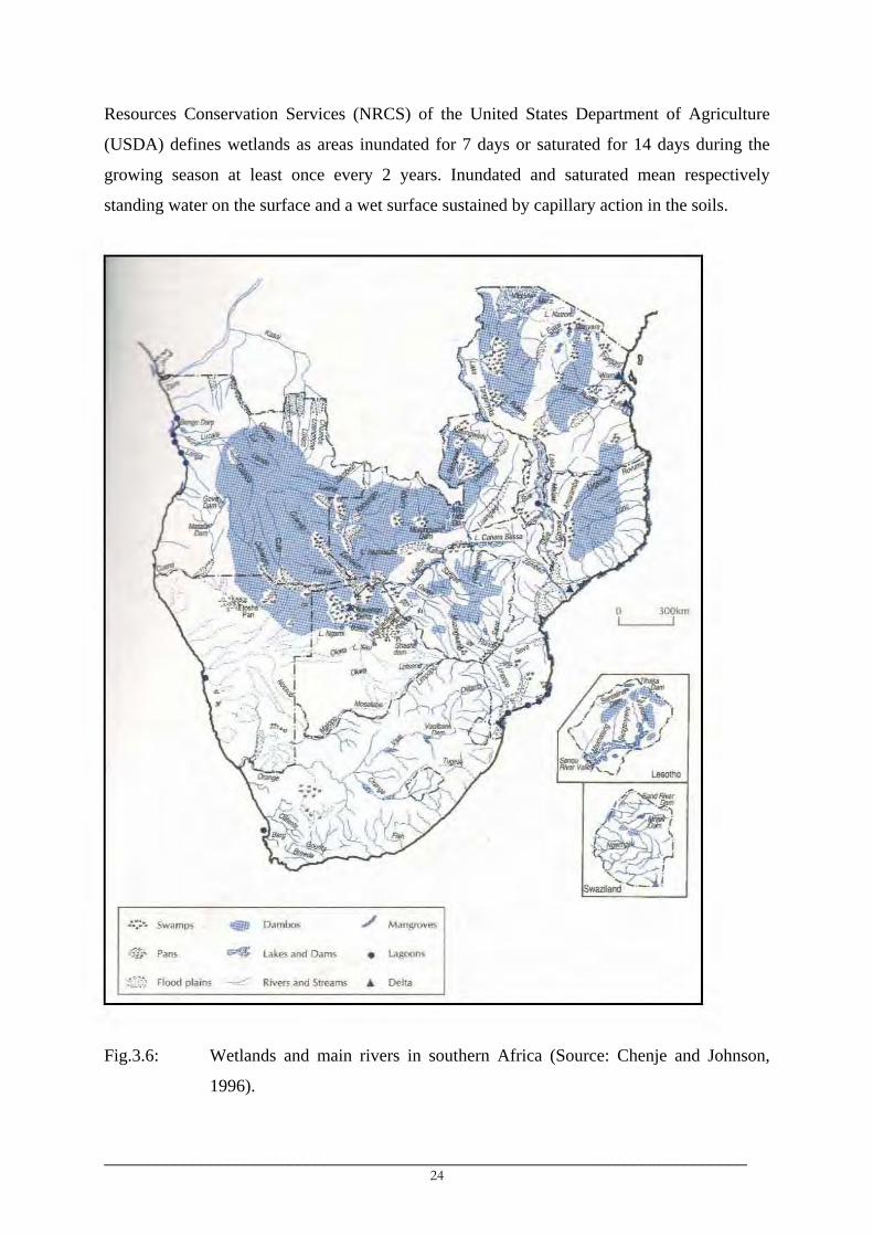
Resources Conservation Services (NRCS) of the United States Department of Agriculture
(USDA) defines wetlands as areas inundated for 7 days or saturated for 14 days during the
growing season at least once every 2 years. Inundated and saturated mean respectively
standing water on the surface and a wet surface sustained by capillary action in the soils.
Fig.3.6: Wetlands and main rivers in southern Africa (Source: Chenje and Johnson,
1996).
_________________________________________________________________________ 24
o 300km 1 1
.-.;. .. Sw~mps -D",,,,", ./ M~"groves
~,...
P""$ ""'" Lakf'$ .. nd DAms """'" " ir • :,"'.~, Flood plain. -~- Riven .. nd Str" .. "" • 0.10
o ""km ! I
"
: .-;. .. Sw~mp> ... Dambos ./ Man@'uves
:;tl' Pans

Wetlands are often characterized by hydric soils and hydrophytes. Hydric soils have
characteristics that are unsuitable for the growth of most plants except hydrophytes such as
marsh grasses. It should be noted however that the presence of water by flooding, ponding or
soil saturation does not necessarily constitute a wetland. Further, wetlands fluctuate
seasonally due to their determining variables such as rainfall, groundwater, etc.
From the definition of wetlands and their characteristics, 5 different wetland systems
are distinguished in southern Africa (Chenje and Johnson, 1996). These are palustrine,
riverine, lacustrine, estuarine and marine systems.
Palustrine include generally all vegetated wetlands from marshes to springs. Other
forms of vegetated wetlands are lagoons, ponds, pans, swamps and dambos. A dambo is a
spongy-like land area that stores substantial amounts of water during wet seasons and releases
it gradually during the dry season. Dambos occupy large parts of Angola, western Zambia,
western Tanzania, the eastern mountains of Tanzania and northern Mozambique (Fig.3.6).
Estuarine wetlands are found near river mouths and are characterized by mixed-origin
volumes of water. This type of wetland system is found along the coastline of southern
Africa. The Rufiji (Tanzania) and Zambezi (Mozambique) are estuarine wetlands, found at
the mouths of the Rufiji and Zambezi rivers along the Indian Ocean, and the Orange (western
South Africa) and Cuanza (Angola) estuarine wetlands along the Atlantic Ocean are the major
estuarine systems in southern Africa.
Lacustrine wetlands are lakes found in depressions or dammed river channels. They
are either natural (e.g. Lakes Victoria, Tanganyika, Malawi, Rukwa, Liambezi, Mweru, etc)
or manmade lakes (e.g. Kariba, Cabora Bassa, Nyumba ya Mungu). Most of these lakes are
perennial although lakes like Liambezi and Ngami (Botswana) are seasonal.
Riverine systems are the largest wetland systems in southern Africa occupying about
110 000 km2 (Chenje and Johnson, 1996). They comprise mainly rivers, floodplains and
riverine swamps. Large rivers are often perennial while small rivers may either be perennial
or ephemeral depending on their sources. Flood plains exist in areas surrounding lakes and
areas alongside rivers while riverine swamps develop in still water around the lakes.
3.5.2 Rivers and the river networks
Most of the rivers in southern Africa forming the riverine system originate from the
mountains and highlands and either drain directly into the oceans or into inland depressions.
Most of southern African rivers join into large networks within the large river basins before
discharging their waters. There are 20 major river networks (basins) in southern Africa and
_________________________________________________________________________ 25

their main channels drain either into the Indian Ocean, Atlantic Ocean or inland depressions
such as the Etosha pan (Namibia) and the Okavango delta (Botswana). Among these 20 river
basins, 15 are shared by two or more southern African states (Table 3.1, Fig.3.7). A number
of rivers in Angola, Namibia, South Africa and Mozambique drain directly into the Atlantic
or Indian oceans.
The Congo River basin is the largest in southern Africa. Its largest portion (62%) falls
within the Democratic Republic of Congo (DRC) and other southern Africa states share 17%
of the total basin area. The basin has been recently included into southern Africa and is not
considered in the present study as sufficient data are not available for DRC.
Apart from the largest Nile River, which has only 5% of its total area within southern
Africa, the Zambezi River with its headwaters in northwest Angola and Zambia is the longest
in southern Africa draining 8 countries (Table 3.1) before discharging its water into the Indian
Ocean in Mozambique.
Fig.3.7: Shared (international) river basins in southern Africa. The Pangani and Rufiji
non-shared basins are included due to their importance in Tanzania.
_________________________________________________________________________ 26
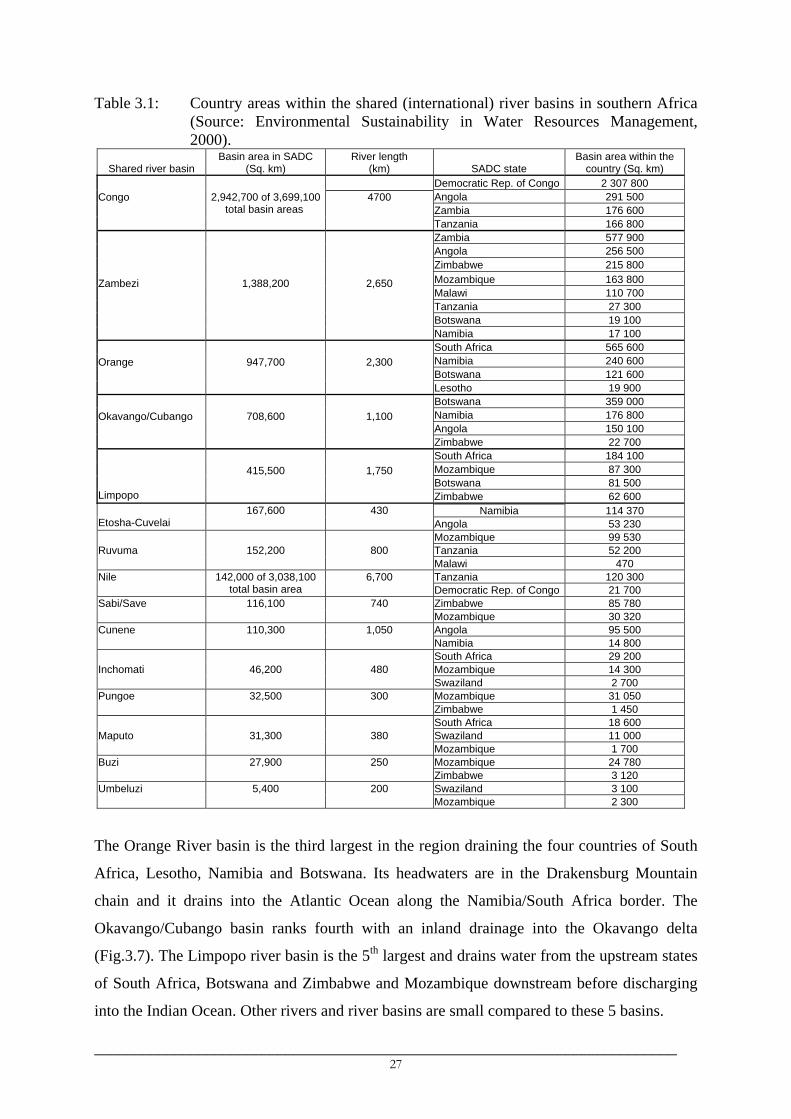
Table 3.1: Country areas within the shared (international) river basins in southern Africa (Source: Environmental Sustainability in Water Resources Management, 2000).
Shared river basin Basin area in SADC
(Sq. km) River length
(km) SADC state Basin area within the
country (Sq. km) Democratic Rep. of Congo 2 307 800 Angola 291 500 Zambia 176 600
Congo
2,942,700 of 3,699,100 total basin areas
4700 Tanzania 166 800
Zambia 577 900 Angola 256 500 Zimbabwe 215 800 Mozambique 163 800 Malawi 110 700 Tanzania 27 300 Botswana 19 100
Zambezi
1,388,200
2,650 Namibia 17 100
South Africa 565 600 Namibia 240 600 Botswana 121 600
Orange
947,700
2,300 Lesotho 19 900
Botswana 359 000 Namibia 176 800 Angola 150 100
Okavango/Cubango
708,600
1,100 Zimbabwe 22 700
South Africa 184 100 Mozambique 87 300 Botswana 81 500
Limpopo
415,500
1,750 Zimbabwe 62 600
Namibia 114 370 Etosha-Cuvelai
167,600
430 Angola 53 230
Mozambique 99 530 Tanzania 52 200 Ruvuma
152,200
800
Malawi 470 Tanzania 120 300 Nile
142,000 of 3,038,100
total basin area 6,700
Democratic Rep. of Congo 21 700 Zimbabwe 85 780 Sabi/Save
116,100
740
Mozambique 30 320 Angola 95 500 Cunene
110,300
1,050
Namibia 14 800 South Africa 29 200 Mozambique 14 300 Inchomati
46,200
480
Swaziland 2 700 Mozambique 31 050 Pungoe
32,500
300
Zimbabwe 1 450 South Africa 18 600 Swaziland 11 000 Maputo
31,300
380
Mozambique 1 700 Mozambique 24 780 Buzi
27,900
250
Zimbabwe 3 120 Swaziland 3 100 Umbeluzi
5,400
200
Mozambique 2 300
The Orange River basin is the third largest in the region draining the four countries of South
Africa, Lesotho, Namibia and Botswana. Its headwaters are in the Drakensburg Mountain
chain and it drains into the Atlantic Ocean along the Namibia/South Africa border. The
Okavango/Cubango basin ranks fourth with an inland drainage into the Okavango delta
(Fig.3.7). The Limpopo river basin is the 5th largest and drains water from the upstream states
of South Africa, Botswana and Zimbabwe and Mozambique downstream before discharging
into the Indian Ocean. Other rivers and river basins are small compared to these 5 basins.
_________________________________________________________________________ 27
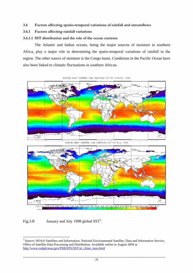
3.6 Factors affecting spatio-temporal variations of rainfall and streamflows
3.6.1 Factors affecting rainfall variations
3.6.1.1 SST distribution and the role of the ocean currents
The Atlantic and Indian oceans, being the major sources of moisture in southern
Africa, play a major role in determining the spatio-temporal variations of rainfall in the
region. The other source of moisture is the Congo basin. Conditions in the Pacific Ocean have
also been linked to climatic fluctuations in southern African.
Fig.3.8: January and July 1998 global SST3.
3 Source: NOAA Satellites and Information, National Environmental Satellite, Data and Information Service, Office of Satellite Data Processing and Distribution. Available online in August 2004 at http://www.osdpd.noaa.gov/PSB/EPS/SST/al_climo_mon.html
_________________________________________________________________________ 28
Southern Africa and the surrounding oceanic basins are characterized by equator-
extratropical temperature gradients due to differential solar heating between the equator and
the midlatitudes. The highest solar energy is received along the equator throughout the year.
Periodic movement of the sun between the equator and the tropics means each of the tropics
experiences a period of highest temperatures only once each year.
Constantly high SST in the equatorial Atlantic and tropical Indian Oceans (Fig.3.8) are
an important factor for evaporation of seawater, the process that adds moisture into the
atmosphere. The SST gradients between the tropical and midlatitude ocean basins drive the
ocean currents, which then act to distribute heat energies within and between the different
oceans. The ocean currents are either wind-driven surface currents or density-driven deep
currents (thermohaline/thermocline currents, Fig.3.9b).
Thermocline currents are made of near-surface warm currents and deeper cold
currents. A thermocline’s near-surface seawater begins its descent into the ocean in the North
Atlantic. High levels of evaporation, which cools and increases the salinity of the seawater,
cause the downwelling. This seawater then moves south along the coast of North and South
America until it reaches Antarctica. At Antarctica, the cold and dense seawater then travels
eastward. During this part of its voyage the flow splits off into two currents that move
northward. In the North Pacific (off the coast of Asia) and in the Indian Ocean (off the coast
of Africa), these two currents move from the ocean floor to its surface creating upwelling. The
flow then becomes near-surface moving back to the starting point in the North Atlantic. These
currents are equivalently referred to as thermohaline currents and their one complete circuit is
estimated to take about 1 000 years.
The pattern of surface ocean currents (Fig.3.9a) is a reflection of a combination of
surface wind patterns and Ekman transport4. Usually wind-driven motion ceases at ocean
layers below 100 m. The major surface ocean currents systems influencing southern Africa
climate are the cold Benguela/warm Angola system in the South Atlantic Ocean along the
western coast and the Agulhas system in the Indian Ocean along the eastern coast.
The Warm Angola Current forms the eastern section of a large, cyclonic gyre. It flows
southward along the Angolan coast until it joins the northward flowing cold Benguela
Current. In the upper layer (0-100 m), it is formed mainly by the southeast branch of the
South Equatorial Countercurrent (SEC) and the southward-turning waters from the north
branch of the Benguela Current; the influx of waters originating north of the Equator is only
4 Ekman transport is the net transport of ocean water in all layers of the water column due to winds and is theoretically 90° to the right (left) of the wind direction in the northern (southern) hemisphere.
_________________________________________________________________________ 29

moderate. However, in deeper layers (> 100 m), northern waters become more important in
feeding the Angola Current (Moroshkin et al. 1970). The surface water of the current usually
has a temperature greater than 24°C with the highest temperatures (27-30°C) observed during
the austral summer and in which the surface temperature decreases as it flows southwards.
(a) (b) Fig.3.9: Major a) surface5 and b) subsurface (thermocline) ocean currents of the world6.
Red and blue arrows indicate respectively warm and cold Ocean currents. In b) warm thermocline currents are near-surface currents while cold currents are deep currents.
The Benguela Current is the eastern boundary current of the South Atlantic subtropical
gyre (Peterson and Stramma, 1991; Wedepohl et al., 2000). It begins as a northward flow off
the Cape of Good Hope, where it skirts the western coast of Africa equatorward until around
24°S-30°S. Here most of it separates from the coast as it bends toward the northwest.
However, two branches of the current do continue along the coast, and one of them joins the
Angola Current at the Angola-Benguela Front near 14-16°S (Meeuwis and Lutjeharms, 1990;
Wedepohl et al., 2000). The location of this northwest-southeast oriented Front has been
5 Source: Matthias Tomczak 6 Source: Michael J. Pidwirny, Department of Geography, Okanagan University College, 2001. Available online in September 2003 at http://www.geog.ouc.bc.ca/physgeog/contents/8q.html
_________________________________________________________________________ 30

associated with rainfall variations in parts of Angola and Namibia. Its southward displacement
corresponds to periodic intrusion of warm tropical surface waters into the northern Benguela
enhancing rainfall in Angola and Namibia.
The southwestern part of the Indian Ocean on the eastern coast of southern Africa is
dominated largely by the warm Agulhas system. This is the western boundary current of the
South Indian Ocean. It flows down the east coast of Africa from 27°S to 40°S (Gordon,
1985). The source water at its northern end is derived from the Mozambique and East
Madagascar Currents, but the greatest source of water is recirculation in the southwest Indian
Ocean sub-gyre (Gordon, 1985; Stramma and Lutjeharms, 1997). The current extends
throughout the water column in March and is only limited to the upper 2300 m in June
(Donohue et al., 2000). At the southern tip of Africa, the Agulhas Current flows toward the
southwest and it retroflects on reaching the Southern Ocean and flows eastward as the
Agulhas Return Current (Quartly and Srokosz, 1993). The Agulhas retroflection region
situated around 15°E (the turning point southwest of South Africa in Fig.3.9a) has an average
loop diameter of 340 km.
The important features of the ocean currents in relation to climatic variations are i) the
large ocean currents gyres in south Atlantic and Indian oceans, ii) the inter-linkage between
the surface and thermocline currents and iii) the inter-connection between the South Atlantic
and South Indian Ocean basins.
The ocean currents gyres in the South Atlantic and Indian Oceans indicate that, if any
part of the South Atlantic or Indian Ocean influences climatic conditions, then the remaining
part may or may not have similar influences. Moreover, they provide links between variations
in different regions such as between South America and Africa, for example, apart from the
influences of factors local to the continents.
The importance of the Agulhas retroflection region is that it is in this region where
inter-ocean exchange between the Indian and Atlantic Oceans and the inter-linkage between
the surface and thermocline currents take place. An average of 5-6 energetic and saline
anticyclonic rings (~ 320 km in diameter), which enclose pools of Indian Ocean water whose
temperature is more than 5°C warmer than the temperature of the South Atlantic sea surface
at similar latitudes (Gordon, 1985), escape from the unstable Agulhas Current into the South
Atlantic Ocean. These rings keep their distinctive thermal characteristics as far west as 5°E
and as far south as 46°S. The volume transport into the South Atlantic Ocean per ring is
estimated at 0.5-1.5Sv (1Sv is 106 m3/s) constituting about 7Sv of the 15-25Sv equatorward
flow of the main Benguela Current. The properties of the rings (such as their salt content),
_________________________________________________________________________ 31

therefore, mix into the surroundings of the Benguela Current system and they feed into the
global upper warm thermohaline (Gordon, 1985) and into the broad SEC thermohaline (Lazar
et al., 2001) that provides the largest part of the shallow water of the tropical and equatorial
regions (Stramma and England, 1999).
The Inter-ocean exchange of heat and salt, taking place at the Agulhas Retroflection, is
thought to be a key link in the maintenance of the global overturning circulation of the ocean.
Modeling studies suggest that this Indian-Atlantic inter-ocean exchange is related to wind
field structure in the South Indian Ocean basins. The in-phase co-variability of SST between
the southwest parts of the Indian and Atlantic Oceans (Fauchereau et al., 2003a) is suggestive
of such interconnections between the South Atlantic and South Indian cyclonic ocean currents
gyres.
Therefore, while SST and surface ocean currents can significantly influence seasonal
to interannual climate variability, SST and climate variability at decadal to centennial time
scales is coupled to variations in the ocean's circulation at the global scale, associated
thermohaline transport and interactions between surface and subsurface ocean currents.
(a)
(b) Fig.3.10: Global mean sea level pressures during southern a) summer and b) winter7.
7 Source: John Brandon 2000: Aviation meteorology guide. Available online in September 2003 at http://www.auf.asn.au/meteorology/section4.html
_________________________________________________________________________ 32
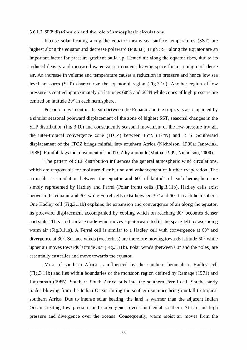
3.6.1.2 SLP distribution and the role of atmospheric circulations
Intense solar heating along the equator means sea surface temperatures (SST) are
highest along the equator and decrease poleward (Fig.3.8). High SST along the Equator are an
important factor for pressure gradient build-up. Heated air along the equator rises, due to its
reduced density and increased water vapour content, leaving space for incoming cool dense
air. An increase in volume and temperature causes a reduction in pressure and hence low sea
level pressures (SLP) characterize the equatorial region (Fig.3.10). Another region of low
pressure is centred approximately on latitudes 60°S and 60°N while zones of high pressure are
centred on latitude 30° in each hemisphere.
Periodic movement of the sun between the Equator and the tropics is accompanied by
a similar seasonal poleward displacement of the zone of highest SST, seasonal changes in the
SLP distribution (Fig.3.10) and consequently seasonal movement of the low-pressure trough,
the inter-tropical convergence zone (ITCZ) between 15°N (17°N) and 15°S. Southward
displacement of the ITCZ brings rainfall into southern Africa (Nicholson, 1986a; Janowiak,
1988). Rainfall lags the movement of the ITCZ by a month (Mutua, 1999; Nicholson, 2000).
The pattern of SLP distribution influences the general atmospheric wind circulations,
which are responsible for moisture distribution and enhancement of further evaporation. The
atmospheric circulation between the equator and 60° of latitude of each hemisphere are
simply represented by Hadley and Ferrel (Polar front) cells (Fig.3.11b). Hadley cells exist
between the equator and 30° while Ferrel cells exist between 30° and 60° in each hemisphere.
One Hadley cell (Fig.3.11b) explains the expansion and convergence of air along the equator,
its poleward displacement accompanied by cooling which on reaching 30° becomes denser
and sinks. This cold surface trade wind moves equatorward to fill the space left by ascending
warm air (Fig.3.11a). A Ferrel cell is similar to a Hadley cell with convergence at 60° and
divergence at 30°. Surface winds (westerlies) are therefore moving towards latitude 60° while
upper air moves towards latitude 30° (Fig.3.11b). Polar winds (between 60° and the poles) are
essentially easterlies and move towards the equator.
Most of southern Africa is influenced by the southern hemisphere Hadley cell
(Fig.3.11b) and lies within boundaries of the monsoon region defined by Ramage (1971) and
Hastenrath (1985). Southern South Africa falls into the southern Ferrel cell. Southeasterly
trades blowing from the Indian Ocean during the southern summer bring rainfall to tropical
southern Africa. Due to intense solar heating, the land is warmer than the adjacent Indian
Ocean creating low pressure and convergence over continental southern Africa and high
pressure and divergence over the oceans. Consequently, warm moist air moves from the
_________________________________________________________________________ 33

Southwest Indian Ocean into southern Africa. The opposite occurs during the southern winter.
The Indian Ocean, being warmer than the land, experiences lower pressure and hence warm
air convergence in the ocean and cold air sinks in continental southern Africa creating dry
conditions. Two exceptions are noted with respect to this general atmospheric circulation-
rainfall relationship over southern Africa. The case of southern South Africa and the northern
Mozambique/Tanzania region.
(a) (b)
Fig.3.11: Genaralised representation of a) planetary scale tropospheric systems and b)
cross-section of tropospheric circulation8.
The ITCZ is located about 12°-15°S in the December-January period implying that
areas north of it are under the influence of cold dry cross-equatorial northeasterlies
(harmattan). These winds become northwesterlies on crossing the equator. Hence, rainfall in
Tanzania during the southern summer is mainly due to convergence brought about by
colliding warm moist southeasterlies and cold dry cross-equatorial northeasterlies. One
significant feature is the flow pattern in the Mozambique Channel. The southeasterly trades in
this region are met by cross-equatorial northerlies creating a convergence zone in the channel.
Tropical cyclones (TCs) often form within the Mozambique Channel during December,
January and February. In fact, all oceanic regions with SST above 26°C or air temperatures
above 27.5°C (Palmen, 1948) are regions of tropical cyclone generation. These regions are
8 Source: John Brandon 2000: Aviation meteorology guide. Available online in September 2003 at http://www.auf.asn.au/meteorology/section4.html
_________________________________________________________________________ 34

normally located between 5°S and 20°S and the cyclones occur during the November-April
period.
Winter rainfall in southern and southwestern South Africa is influenced by weather
disturbances associated with the belt of westerly winds in the southern ocean, particularly the
cold fronts and sometimes by cut-off lows and by disturbances in the easterlies over the
tropical regions lying to the northwest (Reason et al., 2002). Cold fronts are northward
propagating cold air of an extra-tropical cyclone (equivalently known as a low, a storm
depression or a cold-core cyclone). Primary depressions are isolated from westerly wind belts
when moving northward into high-pressure belts, thus forming cut-off lows. Cut-off lows tend
to be large, deep and slow moving and they may bring heavy rainfall for several days. Lows
usually tend to travel in families of 3 or 4. In doing so they create large eddies in the westerly
wind belt. Secondary lows normally trail the primary lows and are intense, rapidly developing
and short-lived storms.
3.6.1.3 Topography
Mountainous topography in southern Africa influences regional climates positively
through orography and negatively by blocking inland penetration of humid southeasterlies
from the Indian Ocean. Orography usually affects rainfall amounts, rates, frequency and
distribution around the mountains and their surroundings (Schulze, 1997). Elevated areas
usually receive higher rainfall than surrounding areas. Rainfall is highest on the windward
side of the mountain while leeward side receives little rainfall. Rainfall increases with altitude
up to the base of trade wind inversion. Thereafter significant reduction of rainfall with altitude
occurs (Riehl, 1979). The highest precipitation usually occurs between 1000 m and 1400 m
altitude. This situation prevails in most tropical high mountains like Kilimanjaro (Tanzania).
For slightly elevated mountains with heights less than the height of the base of inversion,
normally precipitation increases with altitude. Schulze (1997) indicated increased
thunderstorm activities and high lightning incidences for high altitudes which were associated
with a steep altitude gradients.
Mountain barriers may affect a wider region in the lee of the mountains, the effect
depending mainly on the height and lateral length of the mountain/mountain chain and on the
characteristics (direction, tropospheric level) of rain-influencing winds. Moisture from the
Indian Ocean is mainly responsible for rainfall in southern Africa (Chenje and Johnson,
1996), particularly along the eastern part of the subcontinent. Accordingly, the eastern
mountains extending from southern South Africa to Kenya act in a way to prevent penetration
_________________________________________________________________________ 35

of humid southeasterlies into interior southern Africa. As a result, dry conditions with little
rainfall prevail in the western part of the region and humid conditions in the eastern part,
particularly south of about 15°S.
3.6.1.4 Proximity to tropical (equatorial) rainy forests
Tropical rainforests (described under vegetation below) are mostly found around the
equator where intense solar heating takes place. Mean annual rainfall usually exceeds 2 000
mm and can reach up to 11 000 mm in certain parts within the rainforests region (Butler,
unpublished manuscript). Such high annual amounts of rainfall are contributed by all months
of the year.
The canopy layer of rainforests is important with respect to the forests life and climate
variations. The canopy of rainforests is formed by billions of leaves (Butler, unpublished
manuscript), which act as a solar panel providing energy for the forest through
photosynthesis. Through evapo-transpiration, about 75% of rainwater returns to the
surrounding atmosphere in the form of water vapour. Dense rain clouds and high humidity are
thus year round features of the tropical rainforests. It is estimated that each canopy tree
transpires about 760 litres of water each year and hence an acre of rainforest (approximately
about 100 trees) adds about 76,000 litres of water to the atmosphere each year (Butler,
unpublished manuscript).
The ever-present dense clouds over the Congo rainforests periodically affect the
southern African countries of Zambia, Angola and Tanzania, parts of which are situated near
these equatorial rainforests. Moisture-rich westerlies from the Congo basin are associated
with rainfall in most of western, southwestern and southern Tanzania (Nyenzi et al., 1999).
However, the spatial extent of the influence depends on the atmospheric circulations and
proximity to the forests. Atmospheric conditions that favour eastward displacement of these
cloud bands bring rains to most of western Tanzania and northeast Zambia.
Through time, human activities, such as cultivation, have caused considerable changes
to the vegetation cover that existed naturally. Human activities have caused a worldwide
disappearance of about half of the forest that existed during the post-Pleistocene times
(Fig.3.12). The rate of disappearance, however, varies in various parts of the world. Southern
Africa has observed a significant disappearance of its forests. The forests that had initially
covered most of the region are now present as scattered forests.
_________________________________________________________________________ 36

3.6.2 Factors affecting streamflow variations
Between their sources and discharge points, some of southern African rivers traverse
lands with different climatic and physiographic characteristics as well as socio-economic
activities. They therefore undergo changing flow patterns along their lengths. Rainfall, soil
and aquifer characteristics, vegetation, population densities and growth and human socio-
economic activities in a given region are among the most important factors that influence
river flows regimes. Rainfall, soil and aquifer characteristics are the primary (major) factors
which are essentially the driving force for other factors (secondary) such as population
distribution and growth, changing socio-economic activities and distribution of the vegetation.
The favourable soil and aquifer characteristics (Sections 3.3) are associated with soil
fertility, nutrient availability to plants, water holding capacity and high groundwater storage
capacity, which ensures river flow throughout the year. These characteristics together with
high and well-distributed rainfall are favourable for agricultural activities and water
availability in the humid eastern and northern parts of southern Africa. Population densities
and growth rates are, therefore, highest in these eastern and northern parts compared to the
western and southwestern parts of southern Africa where soil properties and low rainfall are
unfavourable for agriculture.
Fig.3.12: Global distribution of original and remaining forests9.
9 Source: United Nations Environmental Programme’s World Conservation Monitoring Center (2000). Available online in September, 2003 at http://www.unep-wcmc.org/index.html?http://www.unep-wcmc.org/forest/original.htm~main
_________________________________________________________________________ 37

The ever-growing population is exerting high pressure on limited land and water
resources. In order to cope with such population pressures, there have been constant changes
in landuse and water use patterns in the southern African region, particularly in recent
decades. Changing landuse patterns involve modifications of natural vegetal cover as well as
soil conditions that usually lead to modified runoff production and consequently to changing
flow regimes. Increased agricultural activities in the region, which include opening of large
plantations, are related to decreasing natural vegetation, which are being replaced by crops.
Irrigation canals, constructed along river channels, extract water for irrigation schemes and
modify flow patterns along the river length. Steadily increasing demands for food imply
similar increasing water abstractions to sustain expanding agricultural activities and therefore
suggest constantly changing river flow regimes. Urbanisation, apart from removing vegetal
cover, involves the creation of impervious surfaces. The landuse changes and increased
demand for water further lead to changes in the water use pattern. Constantly increasing water
demands of the growing populations particularly during the dry season has led to the necessity
of conserving flows generated during the wet season for use during the dry season. The region
has therefore witnessed construction and commission of dams since the 1960s in which the
single busiest decade in terms of dam commissioning was 1985-1995. The largest number of
these dams is in South Africa (550 dams) and Zimbabwe (213) and most of them are single
purpose dams mainly built for irrigation and water supply purposes. Apart from being
associated with flow regulation, dams enhance water loss through increased evaporation from
open water.
The rainfall distribution within the large southern African river basins is not uniform
nor are the rates of modification of natural land surface and vegetal cover. Consequently flow
regime changes are likewise not uniform across the basins. The Orange River basin (Fig.3.7)
illustrates this. The Orange River has its headwaters in the Drakensburg where mean annual
rainfall is around 2000 mm. Its longest path lies within a region where mean annual rainfall is
below 600 mm in central South Africa, while mean annual rainfall is less than 200 mm at its
mouth. Much of its water, therefore, comes from the eastern upper catchments and socio-
economic activities in the low-rainfall middle and lower catchments are dependent on the
amount of water that is reaching the areas from the upper catchments. The river basin has
been extensively developed through the construction of dams since the 1970s.
_________________________________________________________________________ 38

_________________________________________________________________________________________ CHAPTER 4
LITERATURE REVIEW AND THEORETICAL BACKGROUND
4.1 Introduction
The main aim of this chapter is to review the past studies of hydrological variability in
the southern African region with a focus on rainfall and streamflows. The past studies of the
interannual variability of these hydrological variables in southern Africa as well as in other
parts of the world are reviewed. Oceanic and atmospheric conditions and features that
significantly affect spatio-temporal rainfall variations in the region are described. The
theoretical background of the study is given in which different statistical methods relevant for
the study are briefly described. They include methods of interannual variability analysis such
as change-point and linear trend analyses as well as methods of relational analysis such as
correlation analysis and multivariate analyses.
4.2 Interannual variations of rainfall and streamflows
Alternating years of above and below average seasonal and annual rainfall amounts
have been observed in southern Africa (Nicholson, 1986a; Jury, 1995; Nicholson, 2000;
Richard et al., 2001). The occurrence of the two hydrological extremes, floods and droughts,
in the region (Harsch, 1992; Chenje and Johnson, 1996; Dyson and van Heerden, 2001; Jury
and Mwafulirwa, 2002) as well as changes in the mean streamflows have been often observed
in years in which above and below average rainfalls were recorded.
Dam levels have been reported to be in decline since the mid-1970s in Namibia (Jury
and Engert, 1999), in South Africa since early 1980s as a reflection of a prolonged rainfall
deficit in the 1980s and early 1990s (Mason, 1996). Berhanu (1999), Berhanu et al. (2001)
and Alemaw and Chaoka (2002) found decreases in mean annual runoff in southern African
catchments since 1975 which were particularly marked in Zambia, Angola, Mozambique and
the South African highveld. Magadza (1995) found a change in the flow regime of the Gwaai
River in which the river has been progressively transformed from perennial to seasonal with a
lengthening period of no flow. The observed changes in the flow regime have been linked to,
among many factors, changes in rainfall, landuse and water use patterns.
The study of Hulme (1992) concluded that there is an absence of significant trends in
southern African regional time series of rainfall amounts. However, significant changes in
_________________________________________________________________________ 39

different indices of rainfall have been identified in different parts of the region. Most parts of
northeast Tanzania were characterized by decreasing annual rainfall amounts (Mkhandi and
Ngana, 1999). The results of Mkhandi and Ngana (1999) were consistent with those of Mutua
(1999) who also identified decreasing October-November-December (OND) and March-
April-May (MAM) seasonal rainfall amounts in most of Tanzania, with exceptions in the
Kipengule-Udzungwa mountains of southeast Tanzania and along the northwestern shore of
Lake Victoria. Annual rainfall amounts in western and southern Zambia were reported to
decrease since 1975 (Sichingabula, 1998). A similar decrease was identified in the late 1970s
in the South African lowveld in summer rainfall amounts (Mason, 1996) and the extreme
rainfall events (Mason et al., 1999). Richard et al. (2002) identified shifts in the number of
rainy days and in rain rates in the former Transkei and northern Transvaal while Smakhtina
(1998) reported a progressive decrease of the number of rainy days, an increase in the rain
rate and frequency of high rainfall intensities in the Eastern Cape.
Some studies have linked these changes in rainfall amounts to quasi-oscillations in the
time series of rainfall amounts which hypothesize alternating periods of above and below
average rainfall. The quasi-oscillatory periodicities mainly in the bands of 2-5, 7-9, 11-13, 17-
19 year have been identified in southern Africa rainfall patterns (Tyson, 1986; Nyenzi et al.,
1999). However, Mason (1996) observed that some of the cycles in rainfall amounts are not
robust features of the climate of southern Africa.
4.3 The influences of the atmosphere and SST on southern African rainfall
4.3.1 The influences of the atmosphere
Surface or near-surface circulation patterns usually provide important links between
rainfall and SST. The major synoptic-scale features of the surface or near-surface circulations
over the southern African subcontinent are the three wind systems which meet and converge
over the region during the southern summer (Tyson, 1986) to produce the inter-tropical
convergence zone – ITCZ (Nicholson, 1996; Okoola and Ambenje, 2003) which is the major
rainfall-bearing system in southern Africa. Consequently, the peak summer rainfall is
associated with the ITCZ and occurs over central southern Africa and the Indian ocean (Todd
and Washington, 1999a). The other system is the tropical-temperate troughs (TTTs, Todd and
Washington, 1999ab), which are associated with northwest-southeast bands of clouds
extending from tropical southern Africa to the southwest Indian ocean and which have been
linked to the occurrence of intense rainfall intensities in December through February in
southern Africa.
_________________________________________________________________________ 40

Within southern Africa, the ITCZ has two branches, the meridional branch and zonal
branches. The meridional branch of ITCZ located over the Congo basin and adjacent southern
African countries during the austral summer, is the zone of convergence of the westerlies and
easterlies (Jury and Gwezantini, 2002). The northeasterlies and/or southeasterlies in the Indian
Ocean become easterlies on reaching southern Africa while the inland Angolan heat low is
associated with the re-curving southeast Atlantic’s southeasterlies into the moist unstable
westerlies (Nicholson, 1996). This meridional branch remains within the Congo basin
between September and April (Okoola and Ambenje, 2003). The zonal branch of ITCZ is
essentially the convergence zone between the cold dry cross-equatorial northwesterlies and
warm moist southeasterlies. The northwesterlies are the northeasterlies which become
northwesterlies on crossing the equator. This branch fluctuates between 10°S and 15°S during
the austral summer and is located about 12-15°S between December and February.
The passage of the ITCZ influences rainfall farther north in Tanzania. Thus, northeast
monsoon flow, southeast trade winds and topography act to promote early summer (short)
rains in northern Tanzania (Nyenzi, 1992; Mutai and Ward, 2000; Philippon et al., 2002). The
abundance or deficiency of short rains depends on the northeast monsoon in which positive
rainfall anomalies during the short rains are linked to weak monsoon wind stress (Phillipon et
al., 2002). Moreover, these positive rainfall anomalies during the short rains were associated
with the lower level dynamics associated with anomalous ascent in the western Indian Ocean
and the upper level dynamics associated with anomalous subsidence in the eastern Indian
Ocean in September (Phillipon et al., 2002) and October (Hastenrath, 2000). The dynamics
represent a Walker cell in the tropical Indian Ocean. Mutai and Ward (2000) further related
the low-level dynamics in equatorial Atlantic, Indian and Pacific Oceans and upper-level
cyclonic flow over Arabia to the occurrence of a rainfall event in East Africa during the short
rains.
Apart from the ITCZ, there are localised cyclonic flows within the Mozambican
Channel which are mainly observed between December and February. A cyclonic flow within
the channel enhances the southeasterlies on its southern part and the flow itself is more
evident in the mean low level circulation in January and February, the period when intense
daily events and floods have been observed in Mozambique. The Angolan heat low is
associated with cyclonic flow within the Angola/Congo basin boundaries which brings
moisture from the tropical Atlantic Ocean and the Congo basin into parts of Angola, northern
Botswana (van Regenmortel, 1995), eastern and northern Namibia (Jury and Engert, 1999),
Malawi, (Jury and Mwafulirwa, 2002), southwest Tanzania, Zambia and Zimbabwe.
_________________________________________________________________________ 41

There are other occasional localised circulation features that are affecting rainfall in
southern Africa. Short-lived tropical cyclones in eastern Madagascar are related to enhanced
or reduced rainfall in eastern and southern Africa (Obasi, 1977; Ogallo, 1988; Jury and
Mwafulirwa, 2002) to as far north as Ethiopia (Camberlin and Shanko, 1998). They are
observed usually between November and April and have been linked to weakened
easterlies/southeasterlies, a southward displacement of ITCZ which becomes less defined and
with a restrained convection over east Africa (Macodras et al., 1989; Camberlin and Shanko,
1998). Depending on their strength and location, these tropical cyclones may be associated
with significant enhancement of the westerly/northwesterly flow from the Congo basin in the
southwestern Indian Ocean (Camberlin and Shanko, 1998) enhancing moisture influx from
the equatorial Atlantic Ocean and the Congo basin into western and southern Tanzania,
Malawi, Zambia, Zimbabwe and Mozambique.
Anticyclonic circulation anomalies over warmer SST in the Angola/Benguela Front
region, usually observed during the Benguela Niños, favour the mean westward inflow of
moisture from the Indian Ocean while weakening the mean southeasterly moisture flow out of
southern Africa. These conditions have often resulted in above average summer rainfall along
the adjacent coast and sometimes in the interior of southern Africa (Hirst and Hastenrath,
1983; Nicholson and Entekhabi, 1987; Rouault et al., 2003).
After March-April, there is a progressive weakening of most of the features of
atmospheric circulations associated with rainfall in southern Africa. This weakening
corresponds to rainfall withdrawal from the region. The Angolan low is absent in April while
the near-surface cyclonic flow within the Mozambique Channel is significantly reduced in
March and is absent in April. However, strong southerlies/southeasterlies penetrate from the
western/southwestern Indian Ocean into northern Mozambique and Tanzania in April which
is the climatological peak of the principal rainy season in Tanzania, the long rains.
Interannual rainfall variations in southern Africa are associated with changes in the
characteristics of these features that influence seasonal rainfall variations. A latitudinal shift
associated with a failure of the ITCZ to move further south into southern Africa or its
weakening, for example, have been linked to dry summers in southern Africa (Shinoda, 1990;
Rocha and Simmonds, 1997b). Upper tropospheric westerlies over much of southern Africa
which are observed during warm ENSO (Arkin, 1982) were similarly linked to below average
rainfall in southern Africa (Lindesay, 1988; Rocha and Simmonds, 1997b; Tyson et al.,
1997), while low-level easterlies over Angola/Namibia are unfavourable for the formation of
_________________________________________________________________________ 42

a strong heat low there (Reason, 1998) and consequently an increased likelihood of below
average rainfall.
4.3.2 The influences of the SST
A number of past studies have related rainfall variations in southern Africa to SST
variations in the different oceanic basins in the Indian, Atlantic and Pacific Oceans. In
general, SST in the equatorial, tropical and South Atlantic Ocean basins, in the tropical and
Southwest Indian Ocean basins and in the Niño regions (Niño1 through Niño4) in the Pacific
Ocean have been identified as influencing rainfall variations in southern Africa.
4.3.2.1 SST in the Atlantic Ocean
The most important influences of the SST in the southeast Atlantic basin is related to
the Benguela Niño, a condition when there are anomalous warm waters within the
Angola/Benguela Front. The anomalous warm waters, apart from being attributed to an
intrusion of warm equatorial waters, also correspond to outcropping subsurface temperature
anomalies originating from the central equatorial Atlantic (Florenchie et al., 2003). These
conditions have been linked to increased rainfall along the adjacent coast (Rouault et al.,
2003).
In general, SST in different basins in the south Atlantic have been linked to rainfall
variations in southern Africa. Richard et al. (2000) found significant correlations between late
summer southern African rainfall and SST in the equatorial Atlantic in which pre-1970 cold
SST in the equatorial and southwest Atlantic were associated with below average rainfall in
southern Africa (Richard et al., 2001). Jury (1996) found significant correlations between
summer rainfall in Zimbabwe, Namibia and South Africa and SST in different basins in
tropical and south Atlantic in which significant correlations were observed as early as
November in the central equatorial Atlantic basin and January across the eastern equatorial
and tropical south Atlantic basins. Mutai et al. (1998) and Phillipon et al. (2002) found
positive influences of SST in the tropical and southeast Atlantic on rainfall in the northern
part of southern Africa (northern Tanzania as part of east Africa).
4.3.2.2 SST in the Indian Ocean
The Indian Ocean is considered to be the principal source of moisture for southern
Africa. Consequently, a number of studies had found significant relationships between rainfall
variations in southern Africa and SST variations in different basins of the Indian Ocean,
_________________________________________________________________________ 43

particularly those in the Southwest Indian Ocean and the whole of the tropical basin north of
about 15°S and the tropical central Indian Ocean basin. There are also local influences of the
Agulhas Current System on the adjacent southern coast of South Africa (Reason, 1998, 2001).
More generally, summer rainfall in much of southern Africa is negatively influenced by SST
in the tropical western Indian Ocean basin (Jury, 1995, 1996; Rocha and Simmonds, 1997a;
Richard et al., 2000) and positively by SST in the Southwest Indian Ocean basins comprising
the Mozambique Channel and the Agulhas System (Walker, 1990; Jury, 1995; Reason and
Mulenga, 1999; Richard et al., 2000).
Decadal rainfall variations in eastern and central South Africa show dipole
associations with SST in the southern Indian ocean basins in which the SST influence of the
southwest basin is positive and that of the southeast negative (Reason and Mulenga, 1999)
indicating that cooling to the west of Australia and warming to the south of Madagascar
correspond to enhanced rainfall in southern Africa. The dipole association reflects the existing
SST dipole in the southern hemisphere Indian Ocean basins (Behera and Yamagata, 2001;
Fauchereau et al., 2003a). Reason (2002) further demonstrated the high sensitivity of southern
African rainfall to the presence of the two parts of the dipole. Walker (1989) and Mason
(1992) noted, however, that the influence of SST in the southwest Indian Ocean on southern
African rainfall is enhanced during weak ENSO.
Rainfall in equatorial east Africa, of which northern Tanzania is part, is positively
influenced by SST in the equatorial, tropical and southwest Indian Ocean (Ogallo et al., 1988;
Mutai et al., 1998; Mutai and Ward, 2000). The associations between the Indian Ocean SST
and East Africa rainfall are stronger mainly for rainfall in the October-February period than
during the long rains, suggesting that warmer SST in these Indian Ocean basins enhances
October-February rainfall in equatorial East Africa.
An increase in SST causes a non-linear increase in the amount of water precipitated
from an oceanic vertical column of air (Stephens, 1990; Zhang, 1993) and therefore the
warming of the Indian Ocean might have enhanced convection and consequently rainfall
becomes more convective leading to reduced frequency of light rainfall events while
enhancing the frequency of intense events. Mason et al. (1999) identified an increase in the
intensity of high rainfall events in much of South Africa while Mason and Joubert (1997)
noted similar increases over much of southern Africa under a doubled CO2 concentration.
Severe floods have been reported in the recent years such as that in February 2000 which hit
Mozambique, Zimbabwe and northeast South Africa and the November-December 1997 event
in East Africa.
_________________________________________________________________________ 44

4.3.2.3 SST in the Pacific Ocean
The main interannual modes of SST and atmospheric variability in the Pacific Ocean
are associated with the El-Niño/Southern Oscillation (ENSO) which corresponds to both SST
conditions and the southern oscillation. Teleconnection patterns associated with ENSO have
been linked to the modulation of climate in various parts of the world including southern
Africa.
ENSO-rainfall associations in southern Africa region are both spatially and
temporarily variable but generally the association with warm (cold) ENSO-rainfall is positive
(negative) in northern Tanzania and negative (positive) in the rest of the region (Ropelewski
and Halpert, 1987; Janowiak, 1988; Nicholson and Kim, 1997; Rocha and Simmonds,
1997ab; Mutai et al., 1998; Landman and Mason, 1999; Latif et al., 1999; Indeje et al., 2000;
Mutai and Ward, 2000; Richard et al, 2000, 2001). These ENSO-rainfall associations,
therefore, indicate that below average rainfall is experienced during warm ENSO (El Niño)
events in the southern part while northern Tanzania experiences above average rainfall and
vice versa during cold ENSO (La Niña) events, although this is not always the case.
It has been observed that the ENSO signal in southern African rainfall is strongest
when it is communicated in rainfall in southern Africa through the Atlantic and Indian Oceans
waters (Nicholson and Kim, 1997). According to Wang and Ropelewski (1995), the warming
of the tropical (Trenberth, 1990; Kerr, 1992; Wang, 1995; Trenberth and Hoar, 1996) and
Southwest (Trzaska et al., 1996) Indian Ocean in the 1970s provided a warmer low-frequency
climatic base state which is favourable for frequent and amplified ENSO-scale variability
which has consequently lead to more warm (El Niño) events than cold (La Niña) events. This
suggests that the southern African region will experience more frequent and severe droughts
than before. Consequently, drought characteristics in southern Africa have been reported to
change with post-1970 droughts being more intense and widespread (Richard et al., 2001).
However, the ENSO signals in SST in the Indian Ocean have weakened since the late-1970s
(Landman and Mason, 1999). As a consequence, the influences of the Indo-Pacific ENSO
signal on rainfall in southern Africa have weakened and in certain areas changed and positive
associations between SST in the tropical Indian Ocean and rainfall in various parts of the
region have been reported (Landman and Mason, 1999).
_________________________________________________________________________ 45

4.4 Theoretical background
4.4.1 Methods of interannual variability analysis
4.4.1.1 General
The basis of interannual variability analysis is time series analysis. Time series
analysis involves the identification or detection and consequently description of the basic
components of a time series (Salas et al., 1980). According to Kendall and Stuart (1968), a
typical time series consists of a) a trend, b) an oscillation, c) a seasonal effect and d) a random
component. Further, changes in the statistical properties of a time series are either evolutive or
sudden which need to be detected and justified.
The identification and description of a change in a hydrologic time series involves
testing for randomness (homogeneity and consistency) and whenever inconsistencies exist,
identification of their cause through a) detection of shifts, b) identification of a trend and
when the first two are non-existent then c) identification of oscillations. Testing for
randomness commonly uses distribution-free tests such as the Mann-Kendall’s rank
correlation test and serial correlation test (Kendall and Stuart, 1968). The details of these tests
are not included here. Once a time series has been identified to be non-random, the study
proceeds with the identification of the cause of such inconsistencies, whether it is due to a) a
sudden change (shift) or b) an evolutive change (trend). Oscillations are not considered in the
present study.
4.4.1.2 Subjective segmentation and comparison
The main objective of this procedure of interannual variability analysis has been
comparison of statistical moments (mean, standard deviation, skewness, etc), correlations, etc
of different sub-series (segments) of a time series to check whether significant differences in
the statistical characteristics of different segments exist.
A time series is divided into overlapping or non-overlapping segments and statistical
characteristics are determined for each segment. The characteristics of one segment are
compared to those of the other segments using either statistical tests such as the Student’s t-
test or simply using differences or fractions with respect to statistical characteristics of a
reference segment.
The procedure that uses non-overlapping segments of time series of hydrological
variables requires a priori knowledge of the change-points which are usually linked to known
hydroclimatological events. This procedure has been used in studying interannual rainfall
variations in different parts of the world (e.g. Brunetti et al., 2002). To facilitate the choice of
_________________________________________________________________________ 46

the cut-points, standardised rainfall indices have been used. They are computed as the
standardised departures from the long-term average in which standardisation is either by the
standard deviation or by the long-term average. Visual observations of standardised time
series can help in the identification of the change-points as in the case of Sahel rainfall. The
standardised elements xi,j of a time series are computed as
i
ndata
jiji
ji
XXx
σ
∑=
−= 1
,
, (4.1a)
or
i
ndata
jiji
ji X
XXx
∑=
−= 1
,
, (4.1b)
where Xi,j are the original time series elements at station or grid point i, iX and iσ are
respectively the long-term average and the standard deviation at that particular station or grid
point and ndata is the sample size.
The procedure that uses overlapping segments, on the other hand, does not require
such a priori knowledge of change-points as the points can be indicated by the evolutive or
abrupt changing statistical properties. However, this procedure is dependent on the selected
segment length (window size) and the overlap interval. To capture the probable change-
points, medium-sized windows and short overlap intervals like serial overlap (in which the
first element of the segment is left out whenever the next element after the segment is picked
up) are more appropriate than long windows and overlap intervals. Small window sizes are
less appropriate for computations of statistical characteristics. However, this procedure is time
consuming as it involves a number of segments and consequently requires the determination
of statistical characteristics for each segment and comparison between different segments.
In most cases, the a priori knowledge is missing and there is always a need for
exhaustive computations. Therefore, statistical objective methods of change-point and trend
analyses are preferred to the subjective segmentation methods. They are described below.
_________________________________________________________________________ 47

4.4.1.3 Shifts
According to Laraque et al. (2001), a discontinuity at a given time represents a change
in the probability law of a time series. Under normal circumstances, a time series free of
trends and shifts in the first two moments (mean and standard deviation) is free of such
changes in other higher moments (Salas et al., 1980).
There exist numerous parametric and non-parametric methods for detection of
differences in sub-series average. No parametric probability distribution fits exactly between-
the-years monthly flow variations. Consequently, parametric change-point methods such as
the Bayesian method of Lee and Heghinian (1977) and the Buishand U test (Buishand, 1982,
1984) were avoided in the analysis. The mathematical details and robustness of these and
other tests for hydroclimatic applications can be found, for example, in Lubès-Niel et al.
(1998).
The non-parametric test of Pettitt (1979) and the autosegmentation procedure of
Hubert (Hubert and Carbonnel, 1987; Hubert et al., 1989) were used. The former test is
referred to here as the non-parametric data referring method and the latter as the non-
parametric data dependent method. The difference is that Pettitt’s test assigns values (-1, 0
and 1) for differences between the time series elements involved, whereas Hubert’s procedure
uses exact values of the difference in the analysis. Hence, Hubert’s procedure is affected by
the presence of outliers.
Using Pettitt’s test, repeated series segmentation was performed until no further
segmentation was possible (Assani, 1999). This procedure provides multiple segments,
whenever they exist, and reduces the Pettitt’s test weakness of providing a single change point
(jump) even if more than one exists. The results of this improved procedure, together with
those of Hubert’s autosegmentation procedure were used in determining series segmentation.
Owing to the weakness of Hubert’s procedure, segments which were at least 5 years
long were accepted, while segments of less than 5 years were treated as grouped outliers and
segments comprising single years as isolated outliers.
4.4.1.4 Trends
A tth element yt of a time series known to possess a trend can be approximated by an
nth order polynomial in t (Kendall and Stuart, 1968; Salas et al., 1980) as
tn
nn
nt tatatatataay ++++++= −−
11
33
22
110 ... (4.2)
_________________________________________________________________________ 48

in which a0 is a constant or zero and any of the ai, i = 1,2,3,…,n are statistically significantly
different from zero.
This is a general trend model. When two or more ai, i = 1,2,3,…,n are non zero, the
model is a non-linear trend model and when they are all equal to zero except a1, the model
becomes a linear trend model. The time series can be reasonably well approximated by model
(4.2) when higher orders are used. However being based on higher-order moments, higher
order coefficients of (4.2) are unstable (Kendall and Stuart, 1968). For such reasons, the linear
trend model is widely used. It uses the first two terms of the model (4.2) and a random
variable (Wigley and Jones, 1981) and is given as
tt btay ξ++= (4.3)
where yt is an element of a time series y at time t; a and b are linear trend parameters
(intercept and slope respectively) and tξ is the random part with zero mean and unit standard
deviation.
The trend model of eq.(4.3) has a consequence of overestimating effective sample size
(Trenberth, 1984) and hence the significance of a trend is likewise overestimated (von Storch,
1995). This model is not very appropriate for modeling hydroclimatic variables, which
normally show temporal dependence between their elements (e.g. Berhanu, 1999). The
performance of model (4.3) has been observed to improve when autoregressive terms are
included (e.g. Hirsch et al., 1993; Zhang et al., 2000). Despite this weakness, no attempts
were made to incorporate autoregressive terms into the trend model (4.3) due to a lack of
detailed studies on the applicability of autoregressive models in modeling rainfall in southern
Africa. Thus, model (4.3) was retained and used in this study.
The slope (b) of a linear trend linear model (4.3) is commonly estimated by a least
square method. However, least square estimates are affected by the presence of abnormally
low or high elements of a time series (Hirsch et al., 1993). The use of Mann-Kendall’s
procedure (Kendall and Stuart, 1968) in estimating the trend slope b reduces the effects of
unusual low or high values. In this method, the trend slope b is indirectly estimated by the
standard normal variate, Z (Hirsch et al., 1993; Yu and Zuo, 1993) as
_________________________________________________________________________ 49

<+
=
>−
=
0)var(
100
0)var(
1
SifS
SSif
SifS
S
Z (4.4)
where S is calculated as
∑∑+=
−
=
−=n
ijij
n
iyyS
1
1
1)sgn( (4.5)
in which yi to yn are elements of a time series and the sign function sgn(yj – yi) is
• 1 when yj – yi > 0
• 0 when yj – yi = 0
• -1 when yj – yi < 0
The mean and variance of S are given by
E(S) = 0
and
18
)52)(1()52)(1()var(
+−−+−
=∑
kkkknnn
S (4.6)
where n is the length of record used and k is the length of any given tie. A tie is a subset of
the ordered data that comprises a sequence of the same value. Var(S) as given in eq.(4.6)
includes an overall correction for tied data (Hirsch et al., 1993). In this study, no correction
for tied data was applied (i.e. k = 0). The value of Z refers indirectly to the magnitude of a
trend (slope b in eq.(4.3)) while its sign indicates the direction of the trend.
4.4.2 Classification of daily rainfalls and streamflows
The review in the preceding sections and chapters show that rainfall in southern Africa
is highly variable both in time and space. There are parts in which intense daily rainfall
intensities are more frequent than in others while the amounts and intensities received at the
_________________________________________________________________________ 50
start and end of the rainy seasons are less than those received during the core of the rainy
seasons. In order to better understand the characteristics of the spatial variation of rainfall in
the region, it is important to characterise the rainfall in southern Africa by the characteristic
daily intensities, that is, the daily rainfall intensities that are commonly observed in different
parts in the region.
In order to account for the observed spatial variation of rainfall in southern Africa, a
station-dependent approach (see e.g. Stone et al., 2000) is used in establishing the class limits
at each rainfall station in the region. The approach involves assigning class extremities
according to what prevails at each station. An exceedence index Pf is defined as the value (of
a daily rainfall intensity or an average daily river flow) that has been equalled or exceeded for
f percent of the available record.
The f are essentially the probabilities of having a certain P magnitude being equaled or
exceeded and can be associated to a return period (T) used in statistical probability
distributions. Therefore, the exceedence indices Pf have been variously determined for the
time series of hydrological variables using probability theory. Some studies used the
probability distributions in which the most suitable probability distribution is fitted to the data
and the Pf determined for different values of f (Mason and Joubert, 1997; Egozcue and Ramis,
2001). However, none of the probability distributions fits exactly the statistical distribution of
the data and in order to reduce this stochastic uncertainty inherent in the probabilistic models,
the plotting position formulae for an unspecified probability distribution are used. The
plotting position formula method involves re-arranging the time series elements in the
ascending or descending order of magnitude and assigning ranks to the new series and the
required plotting positions f , the exceedence probabilities for the descending ordered series,
are determined.
The exceedence frequency f is, therefore, determined from the plotting position
formula for unspecified probability distribution (Mutreja, 1995) as
N
if 5.0−= (4.7)
where i denotes rank in the descending series and N the total number of elements of the
sample, while the index Pf corresponds to the ith value of the descending sequence that gives
the required f.
_________________________________________________________________________ 51

The description of the procedure can be found in, for example, Mutreja (1995). This
method has been commonly used in studies of low flows (Quimpo et al., 1983; Mimikou and
Kaemaki, 1985; Pearson, 1995; Smakhtin et al., 1995) and the overall procedure of the
determination of the flows (Pf) that have been equaled or exceeded for the specified
percentages of time (f) constitute the flow duration curves (FDCs). The method has also been
used in studying other hydroclimatic variables such as rainfall and air temperature (e.g.
Salinger and Griffiths, 2001).
The non-zero daily rainfall intensities are used and the Pf values are interpreted as
daily rainfall intensities that have been equaled or exceeded for f% of the time when it rains.
A similar interpretation is adopted for flows. The values of Pf are also computed for the cases
that include zero flows aiming at distinguishing seasonal and perennial rivers and they are
interpreted as flows that have been equaled or exceeded for f% of the time. Since the Pf are
computed for the period of the available record, whether it is 10 or 50 years, the approach,
therefore, provides period(or length)-of-the-record exceedence intensities or flows, which are
therefore sensitive to record lengths (Smakhtin et al., 1995).
4.4.3 Coherent rainfall regions and regional indices
4.4.3.1 Regionalisation of rainfall indices
Rainfall data from various stations are frequently correlated with each other. One
implication of these correlations is that there will be some redundancy in the information
provided by station data. For two perfectly correlated data sets, one of them is redundant since
knowledge of one data set removes the degree of freedom of the other data set. Multivariate
methods such as Principal Components Analysis (PCA) exploits the redundancy in such
multivariate data enabling a) identification of patterns (relationships) in the variables and b)
reducing the dimensionality of the data set without a significant loss of information.
PCA attempts to explain the variance-covariance structure of high dimensional
random vector through a few linear combinations of the original correlated component
variables.
The first principal component can be expressed as follows
Y1 = a11X1 + a21X2 + ... + ap1Xp (4.8a)
or in matrix form
_________________________________________________________________________ 52

Y1 = a'x (4.8b)
The aj1 are scaled such that a1'a1 = 1. Y1 accounts for the maximum variability of the p
variables of any linear combination. The variance of Y1 is λ1. The next, principal component
Y2 is formed such that its variance, λ2 is the maximum amount of the remaining variance and
that it is orthogonal to the first principal component. That is, a1'a2 = 0. One continues to
extract components until some termination criterion is encountered or until p components are
formed. Practically, the number of components or a required explained variance are used as
termination criteria.
Principal components (PCs) are usually computed from either the covariance matrix
(without division by standard deviation) or the correlation matrix (through division by
standard deviation) of the p variables.
The weights used to create the principal components are the eigenvectors of the
characteristic equation,
(S - λiI)a = 0 (4.9a)
or
(R - λiI)a = 0 (4.9b)
where S is the covariance matrix, R is the correlation matrix and the λi are the eigenvalues
(the variances of the components) which are obtained by solving
|S - λiI| = 0 for λi. (4.10)
PCA therefore represents the originally correlated variables by a set of a few
uncorrelated empirical orthogonal functions (EOFs) that explains the largest part of the
variance inherent in the original correlated variables. When performed on hydrological
variables in the spatial (S-) mode, the EOFs represent homogeneous regions while their time
series (the PCs) represent common temporal modes of variability for time series within the
regions. The analysis in the temporal (T-) mode correlates a series of temporal elements in
which a group of spatially referenced observed values characterise each element.
_________________________________________________________________________ 53

There are several criteria which assess the significance of the extracted PCs. The
include the North et al. (1982) sampling errors of the PCs, the Kraiser (1959, as referred to in
Indeje et al., 2000) criterion of eigenvalue greater than 1 and the Scree test (Cattell, 1966) for
the break of the slope of the Scree plot. Adherence to these tests may result in a large number
of significant PCs being retained and the final selection of the PCs to be retained depends on
the main purpose of the study. This may be the case with rainfall in southern Africa which is
affected by the diverse influences of local-scale (topography, lakes), regional-scale
(surrounding Atlantic and Indian Oceans) and global-scale (ENSO phenomenon) variables, all
of which vary spatially and seasonally. Such heterogeneity may necessitate a number of EOFs
to explain a substantial part of variance in regional rainfall.
Sometimes, the retained significant unrotated PCs are difficult to interpret and in such
cases, their rotation may remove the ambiguities by distributing the variance within the
eigenvectors while conserving the total variance. The orthogonal (Varimax) rotation is the
common. However, this orthogonal rotation, as noted by Richman (1991, and referred to in
Peñarrocha et al., 2002), sometimes produces spatial patterns that do not reflect the reality and
in such cases an oblique (Oblimin) rotation served to resolve the difficulties.
4.4.3.2 Regional indices
Area average indices are calculated simply as spatial average of indices from each
station or grid that falls within the given region. The general equation is given as
2,1,1,
ndatandatajN
xx
N
iji
j ==∑
= (4.11)
where xj is an area average for the jth element of the time series, xi,j are jth elements of
time series at each station or grid point i. N is the number of stations or grids within the given
region while ndata1 and ndata2 are respectively initial and end elements of the selected
section of the time series.
It is, however, necessary to eliminate the influences of local environments of different
stations or grids before using their xi,j indices in equation (4.11). This is done by
standardization of the series through division of the departures from the long-term average by
the standard deviation as given in eqns.4.1.
_________________________________________________________________________ 54

The elements xi,j in (4.11) are in fact the standardized elements. Areal average regional
indices are not always appropriate unless they are derived for homogeneous regions, that is,
for regions in which patterns of interannual variability are similar irrespective of what is
observed at a site. Therefore, areal average rainfall indices in this study are derived for
coherent rainfall regions.
4.4.4 Correlation analysis
The correlation coefficient expresses the degree of the association between two
variables. There are several types of correlation coefficient to choose from, the choice being
based on the nature of the variables being correlated.
For example, if two variables are to be correlated in which one is measured on a
continuous scale while the other is measured on a dichotomous scale, then the Point-Biserial
correlation will be appropriate. Since most hydrological data are measured on a continuous
scale, the Pearson’s product moment is appropriate and has been commonly used. The other
types are either poor estimators of the population correlation coefficients (e.g. tetrachoric
correlation coefficient) or not a significant improvement on the Pearson’s correlation
coefficient except for extremely non-normality in data when Kendall Tau holds up better.
The Pearson’s correlation coefficient is estimated, for two samples X and Y with N
elements in the common period, as
−
−
−
−
−
−=
∑∑
∑∑
∑∑∑
=
=
=
=
==
=
11
12
1
1
2
2
1
1
2
11
1,
N
YY
N
XX
N
YXYX
rN
iiN
ii
N
iiN
ii
N
ii
N
iiN
iii
YX (4.12)
and ranges between ±1. This correlation coefficient is used in this study.
_________________________________________________________________________ 55

___________________________________________________________________________ CHAPTER 5
THE DATA SETS
5.1 Introduction
The bibliographic analysis indicated the importance of studying the variability of
hydrological variables (rainfall and streamflows) using the short-duration records such as
daily and monthly records in order to account for hydrological phenomena like droughts and
floods which have significant impacts on the management of water resources. Therefore this
section describes the data sets that were considered necessary for the present study and were
eventually acquired from various sources worldwide. They include
• Time series of daily and monthly rainfall.
• Time series of mean daily and monthly river flows.
• Sea surface temperature and its derived indices.
• Sea level pressure and its derived indices.
• Atmospheric fields (wind speeds, geopotential heights, relative humidity, air
temperatures).
The selection and reconstruction procedures are described for rainfall and streamflow
data.
5.2 Rainfall data
5.2.1 Description of data sets
Time series of daily and monthly rainfall for 8 countries were acquired from the
southern African FRIEND database at the Department of Water Resources Engineering
(WRE) of the University of Dar Es Salaam. The data sets were originally supplied by the
meteorological departments or the departments of water affairs of individual southern African
countries. No rainfall data were available for Angola. This database comprised daily rainfall
data from the countries of Botswana, Lesotho, Malawi, Mozambique, Swaziland, Tanzania,
Zambia and Zimbabwe. Monthly data were available for Tanzania (1691 stations) and Malawi
(23 stations) (Fig.5.1b).
_________________________________________________________________________ 56

Daily data for Namibia and for the Republic of South Africa (RSA) were kindly
provided by the Department of Water Affairs (Namibia) and the Computing Centre for Water
Research (CCWR, RSA). Daily rainfall data for Tanzania were only available in the three
basins of Lake Victoria (north), Pangani (northeast) and Rufiji (southwest). Updates of daily
rainfall data for 25 stations in northeast Tanzania were provided by the Tanzania
Meteorological Agency (TMA) and cover the 1990s decade.
Record lengths of the acquired data vary from 1 year to 140 years in which the longest
daily records are mostly found in Namibia, RSA and Swaziland. Moreover, Botswana,
Namibian, RSA and Tanzanian daily data span the mid- to late-1990s and some stations have
data for the year 2000. The Zambian and Zimbabwean records of daily rainfall are about 28-
43 years long (Table 5.1) and span the early-1950s to early-1990s (not later than 1993). Daily
data sets for Malawi are only 8-12 years spanning mainly the period 1979 to 1989.
Fig.5.1: Spatial distribution of rainfall stations in southern Africa whose a) daily and b)
monthly data were available for the study.
Most of available daily records for Mozambique are more than 20 years (Table 5.1)
but terminate in the late-1970s or early-1980s (not later than 1984) and are characterised by
frequent missing observations in the 1970s and 1980s. The distribution of rainfall stations is
denser in South Africa (daily data, Fig.5.1a) and Tanzania (Monthly data, Fig.5.1b). Except in
Botswana and Mozambique, most of the acquired data are from stations located in hilly
terrain.
_________________________________________________________________________ 57

5.2.2 Data selection and time series reconstruction
5.2.2.1 Data selection
The acquired data from different sources were of variable quality and record length.
The selection criteria were therefore necessarily different and more stringent criteria were
used in the areas such as Tanzania (monthly data) and South Africa (daily data) where the
largest number of good or reasonable quality records were available.
The main objectives of the selection process are therefore a) to obtain a spatially
representative data set for the southern African region for the determination of climatological
rainfall indices and b) to have the longest and most continuous time series of rainfall indices
for interannual variability analysis. The selection criteria were formulated to achieve the two
objectives and were based mainly on a) record length, b) continuity of the records and c)
spatial evenness of the distribution of rainfall stations.
• Selection for climatological indices
The study is interested in interannual variability of rainfall during the 20th century and
perhaps the period before. However, the study is restricted by the length of the available
records in which most of them span the period 1950-1990 and are less than 45 years,
except for the Namibia and South African records (Table 5.1). Therefore, all stations
which had more than 30 years of most continuous records in the 1960-1990 period were
initially retained. The continuity of the record was defined by the presence of 15% or less
missing monthly, seasonal or annual values. The requirement of at least 30 years was
relaxed to 20 years of data in Mozambique due to the poor data situation in the post-1970
period. The retained stations at this stage (Fig.5.2a) were used in the determination of
climatological indices of rainfall. The aim of retaining as many stations as possible
particularly in the mountainous areas was to facilitate in the spatial interpolation of the
climatological rainfall indices as altitude affects significantly rainfall variations in the
region. However, there are a number of areas where no daily data were available
(Fig.5.1a, Fig.5.2a) and these areas were not considering during the interpolation.
_________________________________________________________________________ 58

Table 5.1: Summary of available daily rainfall data in southern Africa by record length.
Number of rainfall stations with record length (nyrs): Country nyrs <20 20 ≤ nyrs < 30 30 ≤ nyrs < 45 45 ≤ nyrs < 60 nyrs ≥ 60 Total
Angola 0 Botswana 1 2 24 2 13 42 Lesotho 3 2 1 6 Malawi 41 41 Mozambique 56 32 8 1 97 Namibia 4 21 63 88 South Africa* 515 515 Swaziland 5 3 12 3 12 35 Tanzania 23 67 72 43 31 236 Zambia 9 3 19 4 3 38 Zimbabwe 5 19 14 1 39 Total 84 153 179 83 638 1137
* Only for selected stations as described in the text.
• Selection for interannual variability
Interannual rainfall variations are affected by variations in the background climatic
variables in which the influences are usually coherent over a number of stations. The
distribution in Fig.5.2a may not be necessarily advantageous over that of selected
representative stations which retain the spatial even distribution. Therefore, additional
criteria of most continuous daily records exceeding 45 years in the 1950-2000 period
and the even distribution of stations within the 1°x1° grids were imposed on the South
African records in areas where the distribution was dense. Only 149 South African
rainfall stations were retained for interannual variability analysis (Fig.5.2b). However,
not all stations satisfying the record length and missing data criteria were suitable for
interannual variability analysis. An additional criterion of less than 4 consecutive
missing values was imposed. This was important in avoiding erroneous results. For
example, an 80-year record of annual rainfall amounts with 9 consecutive missing
annual values satisfies the first two criteria but not the third. The distribution of missing
monthly, seasonal and annual values within the time series with less than 15% missing
was investigated. Those stations with 4 or more consecutive values missing were
further investigated. If the reduction of the record length caused the removal of missing
period(s) resulted in a record length of less than 30 years or the record not including the
1961-1990 period, the station was then rejected. The spatial distribution of the retained
stations for interannual variability analysis is shown in Fig.5.2b.
_________________________________________________________________________ 59

• Monthly, seasonal and annual indices
Monthly rainfall indices for the retained stations were computed from daily
observations only for complete months. Wherever daily observations were unavailable
for calculation of monthly rainfall amounts, acquired monthly rainfall amounts
(Fig.5.1b) were used. Seasonal rainfall indices were determined only for seasons in
which all contributing months were non-missing. An annual index value was
determined in the following ways. For stations with only monthly indices, annual index
values were calculated for years with non-missing monthly indices. For stations where
daily observations were available, annual index values were computed for years with
less than 6 missing daily observations. Missing data during the dry season were not
ignored. Further, a 6-day missing period would not result in missing a significant
number of daily rainfall events.
Fig.5.2: Spatial distribution of rainfall stations a) with at least 30 complete years of
daily data and b) selected for trend and change-point analyses in southern Africa.
5.2.2.2 Time series reconstruction
The reconstruction of missing monthly, seasonal and annual values was done through
their replacement by long-term averages. This way of series reconstruction may introduce an
artificial drop (rise) in such periods of high (low) index values. The effect is considered low
due to short length of consecutive missing values allowed in the present study and whenever
_________________________________________________________________________ 60

the replacement by the long-term average was considered inappropriate, the missing value
was replaced by a moving average value which approximately represented the trend pattern.
Rainfall in the region is spatially highly variable in which two close stations have been found
to exhibit different interannual variability patterns as indicated by their existence into
different homogeneous regions. Therefore, the methods that use cross-stations correlations or
regional averages in replacing the missing values at a station requires the use of stations
within the coherent regions and so they were not used.
5.3 River flow data
5.3.1 Description of data sets
Average daily flow data in rivers in the 11 southern African countries have been
acquired from the southern African FRIEND HYDATA database at the Department of Water
Resources Engineering (WRE) of the University of Dar Es Salaam. The database was
compiled by the Centre for Ecology and Hydrology (formerly the Institute of Hydrology,
Wallingford) for the Southern African FRIEND. It comprises time series of average daily
river flows for 676 gauging stations (Fig.5.3a) which have been used in previously studies
(Berhanu, 1999; Berhanu et al., 2001; Alemaw and Chaoka, 2002). Additional 23 records of
average daily flows and updates of the 79 records in the FRIEND database for gauging
stations in the Pangani and Rufiji basins in Tanzania were originally obtained from the
Hydrology Section of the Department of Water Resources in the Ministry of Water and
Livestock Development (Tanzania) and processed at the Department of Water Resources
Engineering (WRE) of the University of Dar Es Salaam. Their quality is described in the
Water Resources Engineering Programme report (WREP, 1999). Mean monthly discharges
for the Shire River at Chiromo were obtained from a UNESCO (1995) report on selected
rivers of Africa.
The spatial distribution of the river flow gauging stations is dense in the eastern,
northeastern and southern South Africa, in the eastern and southwestern Zimbabwe, in
central-western Namibia and in the two Pangani (northeast) and Rufiji (southwest) basins in
Tanzania (Fig.5.3a). Table 5.2 indicates that the three countries South Africa, Tanzania and
Zimbabwe together accounts for 68.7% of the available data and separately account for
39.9%, 17.0% and 11.8% of the available river flow data respectively. The flow data in
Namibia, Malawi and Swaziland account separately for 5.0-6.6% of the available data while
data in the remaining 5 countries account individually for 2.3-3.6%.
_________________________________________________________________________ 61

Fig.5.3: Spatial distribution of a) all stations with average daily flow data and b)
selected flow gauging stations used in the interannual variability analysis in southern Africa. The coloured background indicates some of the shared river basins in the region (Fig.3.7 in section 3.5.2).
The available records were of variable quality, lengths as well as the periods of data.
The available records varies from 1 year to over 50 years and span mainly the period 1940-
1995. The longest records of 52 years are found in 3 South African gauging stations while
62.9% of the available records 20 years or more longer, about half of which (representing
31.6% of the available data) are at least 30 years. The flow records in Angola and Lesotho are
less than 20 years in which only two Angolan flow records are 10 years long while the rest are
less than 10 years and span mainly the 1963-1974 period. 32.1%, 19.3% and 11.5% of the
available records in the database start respectively before 1961, 1956 and 1951 while 78.0%
and 66.2% extend after 1985 and into the 1990s respectively. However, only 15.4% and
21.6% of the available records spanning the 1955-1985 and 1960-1990 periods respectively,
most of which are found in South Africa.
5.3.2 Data selection and time series reconstruction
The preceding discussion indicates that the southern African region is characterised by
short stream flow records indicating that they are not very appropriate for interannual
variability analysis. This study is focused on a) interannual flow variations with respect to
_________________________________________________________________________ 62

changing rainfall and landuse patterns and b) investigating whether or not changes in flow
regimes are uniform across river basins.
Table 5.2: Summary of available mean daily river flow data in southern Africa by record length.
Number of river flow gauging stations with record length (nyrs): Country
<5 5 ≤ nyrs < 10 10 ≤ nyrs < 20 20 ≤ nyrs < 30 nyrs ≥ 30 Total by country
% of overall total
Angola 3 14 2 19 2.6 Botswana 1 5 6 12 24 3.3 Lesotho 6 17 23 3.2 Malawi 1 7 9 5 15 37 5.1 Mozambique 1 4 8 3 16 2.2 Namibia 3 29 8 6 46 6.4 South Africa 2 52 113 120 287 39.9 Swaziland 2 3 16 6 8 35 4.9 Tanzania 8 15 27 29 43 122 17.0 Zambia 7 13 5 25 3.5 Zimbabwe 3 24 31 27 85 11.8 Total by record length
15 59 193 225 227 719 100
Percentage of overall total
2.1 8.2 26.8 31.3 31.6 100
5.3.2.1 Data selection
The selection criteria of record length, missing data and period of interest as used in
the selection of rainfall stations for interannual variability analysis were similarly applied to
the flow records in addition to some other criteria. In order to study interannual flow
variations with respect to interannual variations in rainfall, basins were selected according to
the results of interannual rainfall variability analysis (Chapter 7). Analyses of rainfall indices
show that areas such as the southern highlands of Tanzania, northern half of Mozambique and
the South Africa lowveld where high rainfalls are observed are characterized by intense daily
rainfall events and are prone to flooding. The western part of southern Africa is dry and rivers
here experience frequent and prolonged dry conditions. Basins whose rivers drain these areas
are of particular interest in studying relationships between rainfall and flow variations.
The selection process further excluded all gauging stations that were known to be
located downstream of any artificial regulation point which regulates the flow measured at
those particular stations. Gauging stations within the selected basins were further selected in
such a way to avoid closely located gauges while retaining as many gauges as possible along
the river lengths. This aimed at investigating the spatial variations of the changes of the river
_________________________________________________________________________ 63

flows regimes, if any present, within the basins. The overall requirements of analysing long
continuous records from unregulated catchments within the selected basins, therefore,
retained 38 river flow record as shown in Fig.5.3b.
5.3.2.2 Time series reconstruction
Mean monthly flows were computed at each of the retained gauging station and only
for months in which 90% of average daily flows were available. Using cross-correlations
between different months, missing monthly flows were replaced by values computed from
(Haan, 1977)
kjkXjXjkj
jj Xr
SS
X ±±±
××= (5.1)
only for months with a cross-correlation of at least 0.7. Xj and X j±k are monthly flows
in month j and j±k. k is the time lead/lag between the two months that are highly correlated.
rxj,xj±k is the coefficient of cross-correlation between Xj and X j±k, Sxj and Sxj±k are their
respective standard deviations. The cross-correlations were computed for months at the same
site and whenever low correlations prevailed, the correlations were computed between the
gauging station under consideration and the nearby gauging stations either upstream,
downstream or in the nearby river which is considered to be under almost the similar climatic,
landuse and water use conditions. If filling was not possible, the monthly flow was considered
missing.
The filling of missing monthly frequencies of excess (high) and deficit (low) flows
was made first through investigation of the behaviour of the time series of average daily
flows. The behaviour of the time series (increasing, decreasing or fluctuating flows) was
investigated and flow magnitudes before and after the missing observations were compared to
the threshold values. For the short gaps of less than 4 days a month, the missing daily
observations were considered to be relatively not very different from those before and after
the gap if the flows were significant higher (lower) than the threshold defining the high (low)
flows before and after the gap and number of missing flows observations was added to the
frequencies. Whenever the filling by this procedure was not possible particularly for the cases
of fluctuating series or when the flows before and after the gap are on the opposite sides of the
threshold such as, for example, flows before the gap are above (below) the threshold flow and
those after the gap are below (above) the threshold. In such cases, the cross-correlation
_________________________________________________________________________ 64

procedure described for monthly flows was used. The filling of monthly flow volumes was
done in a similar way as for monthly flows.
Mean seasonal and annual flow indices were calculated for years with non-missing
monthly indices and the missing values replaced by values computed from filled monthly
indices.
5.4 Climatic data
5.4.1 Sea surface temperatures (SST) and indices of El Niño
Time series of 5° × 5° gridded monthly mean SST were obtained from the United
Kingdom Meteorological Office (UKMO) Global Sea-Ice and SST (GISST 2.3b) data set
(Rayner et al., 1996). The data span the period January 1856 to December 1999. Indices of El
Niño were acquired from the Climate Analysis Section (CAS) of the National Center for
Atmospheric Research (NCAR) and include area average SST in the 4 Niño regions (Niño1 -
Niño4; Niño1.2 and Niño3.4. regions) and the Trans-Niño Index (TNI). The TNI and Niño3.4
data span the period January 1871 to September 2000 while Niño1.2, niño3 and niño4 data
span the period January 1950 to November 2001.
The quality of pre-1950 SST analyses is not as good as in the recent years and data are
frequently missing in the Atlantic and Indian ocean basins. Data are very often sparse and
their quality is restricted by the method of spatial analysis used (Trenberth, 2001). Therefore,
only the period 1950 to present is used in the analyses in this study.
5.4.2 Sea level pressure (SLP) and southern oscillation index (SOI)
Time series of monthly SLP were obtained from various sources. Monthly mean SLP
data at both Darwin and Tahiti have been acquired from the Climate Research Unit (CRU)10
of the University of East Anglia (UEA), Norwich, UK. These data span the period January
1866 (Darwin)/June 1855 to June 1998. Similar time series of monthly SLP at Darwin and
Tahiti were obtained from CAS11 of NCAR. They span the period January 1951 to December
2000. Time series of monthly SOI values were obtained from CSIRO12 division of
Atmospheric Research of the CSIRO Environment and Natural Resources Alliance
(Australia), CRU (UK) and CAS (USA). The CAS data set spans the period January 1882 to
December 2000, that of CSIRO January 1886 to October 2000 while that of CRU January
10 http://www.cru.uea.ac.uk/cru 11 www.cgd.ucar.edu/cas/indices 12 http://www.dar.csiro.au/
_________________________________________________________________________ 65

1866 to December 2002. The CSIRO data set has been computed relative to the 1933-1992
base period used by the National Climate Centre of the Australian Bureau of Meteorology.
5.4.3 Atmospheric data
Atmospheric National Center for Environmental Predictions(NCEP)/NCAR monthly
re-analyses (Kalnay et al., 1996) were acquired from NCEP/NCAR and include the
atmospheric wind speeds, geopotential height and air temperature. The reanalyses span the
preiod January 1948 to December 2001. Despite being extending back into the late-1940s, the
upper air reanalyses prior to 1968 are not fully reliable for the African continent (Camberlin et
al., 2001) and therefore only the period after 1968 is used in this study.
_________________________________________________________________________ 66

___________________________________________________________________________
CHAPTER 6 DAILY RAINFALL CHARACTERISTICS AND
SPATIAL VARIATIONS OF RAINFALL AMOUNTS AND NUMBER OF EVENTS
___________________________________________________________________________
6.1 Introduction
The spatio-temporal variability of accumulated (overall) rainfall amounts at monthly,
seasonal and annual timescales have been investigated in a number of studies. Some studies
have investigated the spatio-temporal variability of the number of rainfall events while others
have included variability of intensity maxima. However, monthly, seasonal and annual
rainfall amounts and number of rainfall events are a result of accumulation of different types
of daily rainfall events. It is therefore necessary to go beyond the analysis of spatio-temporal
variability of these overall rainfall amounts and number of rainfall events by investigating
spatio-temporal characteristics of daily rainfall. The daily timescale is the shortest duration in
which data were available for this study.
This chapter explores spatial variations of indices established from daily rainfall
intensities at monthly and annual timescales in southern Africa. They include monthly and
annual rainfall amounts, number of rainfall events and maximum daily intensities. A peak-
over-threshold (POT) method is used to establish daily rainfall intensities that correspond to
different relative frequencies (probabilities), the exceedence intensities, which are then used
in grouping daily intensities in southern Africa into different classes. Rainfall amounts and
number of rainfall events are computed for each class of daily intensities and for each month,
season and year and their spatial variations are investigated.
It should be noted that spatial interpolation technique of Kriging was used to derive
contours in this study. This method was found to provide better spatial patterns in northeast
Tanzania (Abass, 1999). However, this method cannot provide better estimate through the
southern Africa region as found by Lynch and Schulze (1995) and Lynch (1998) compared to
several other methods like the Schafer method, inverse square distance method (Lynch, 1998),
multiple regression methods (Dent et al., 1989), etc. Moreover, the spatial interpolation in
complex physiography requires a dense and representative distribution of raingauges to
provide more accurate estimates. Despite efforts made, this could not be ensured due to data
problems and therefore the contours in the figures might have been affected by this fact.
_________________________________________________________________________ 67

To simplify the presentation and discussion, the following terms are used in this
chapter and hold for the rest of the document, unless stated otherwise:
• A rain day is any day of a year in which an amount of rainfall has been measured and
recorded as non-zero intensity. This definition is not applicable in chapter 8 on rainy
seasons.
• Overall monthly or annual rainfall amounts refer to the amounts of rainfall
accumulated over a given month or single year for all types of daily rainfall events.
For simplicity, monthly and annual amounts refer to these quantities.
• Overall monthly or annual number of daily rainfall events are simply referred to as
monthly or annual rainfall events and indicate the total number of all types of daily
rainfall events within the given month or year.
• Monthly or annual class X rainfall amounts refer to the amounts of rainfall
accumulated over a given month or year for all daily rainfall events which belong to
the class X of daily rainfall intensities. For simplicity, monthly or annual class X
amounts refer to these quantities.
• Monthly or annual number of daily rainfall events which belong to the class X of
daily rainfall intensities are simply referred to as monthly or annual class X rainfall
events.
• A monthly or an annual daily intensity maximum is the highest daily intensity that
have been recorded in that particular month or year.
6.2 Average daily intensities
Rainy seasons are characterised by varying amounts of rainfall received each day,
between which sequences of completely dry days are typical. It is useful to represent the time-
varying daily rainfall intensities by a few statistics that appropriately describe the inherent
temporal variations. Average daily rainfall intensities (ADI) and the standard deviation of
intensities are often used. However, these two statistics can be derived using all available
records (all-record statistics) or derived for a particular month or season (monthly or seasonal
statistics).
All-record average daily rainfall intensity (AADI) is defined as the average daily
intensity computed from all daily rainfall intensities. This quantity refers, roughly, to the
expected daily amount of rainfall at a particular place within the rainy season. However, it
does not indicate the seasonality of rainfall within the year. Monthly and seasonal ADI are
_________________________________________________________________________ 68

determined likewise using daily rainfall in particular months or seasons. Rainfall seasonality
is addressed through comparison of monthly ADI and the AADI.
Southern Africa is characterised by an west-east/north-south increase of AADI
(Fig.6.1) in which the lowest AADI are found in the Namib desert along the southern coast of
Namibia and northwest South Africa while the highest characterise central Mozambique and
the southwest highlands of Tanzania
10 15 20 25 30 35 40Longitude
-35
-30
-25
-20
-15
-10
-5
0
Latit
ude
Fig.6.1: Spatial variation of AADI (in mm) in southern Africa.
Standardised percentage deviations of mean monthly ADI (computed as percentage
departures from their respective AADI) (Fig.6.2) show a substantial change between October
and November across much of southern Africa marking the start of the wet season. The high
negative percentage deviations in October are significantly reduced and changed to positive
percentage deviations in November, except in the southwestern part of the region (western
Namibia and western South Africa). The November ADI equals or exceeds AADI in the
northern and eastern parts of southern Africa including eastern South Africa, southern
Mozambique, Zimbabwe and Tanzania. Monthly ADI values for December through February
persist above AADI as indicated by positive percentage departures, the period when the
highest monthly ADI are observed in central Mozambique. After March, there is a progressive
_________________________________________________________________________ 69

decrease of monthly ADI, which remain above AADI only in Tanzania in April and in
northeast Tanzania in May.
Despite a gradual increase in monthly ADI in Namibia after October, only January
ADI values exceed AADI in northern Namibia and persist above AADI until March with a
peak in February. In southwest South Africa, monthly ADI values decrease progressively
between September and February and thereafter increase and exceed AADI in the May to
September period with a peak in June-July.
AADI and ADI are derived only from amounts and number of days with measurable
rainfall. Repetitive occurrences of one or two isolated intense rainfall events during the dry
months cause non-zero monthly ADI even during the known June-September dry period in
southern Africa. The study of ADI has simply highlighted spatial variation of expected daily
intensities across southern Africa. Subsequent sections are devoted to analysing spatial
variations of rainfall amounts and number of rainfall events, the two quantities which were
used to derive ADI’s.
6.3 Overall rainfall amounts (totals)
Mean annual rainfall (MAP) varies from as high as 2708.4 mm to below 100 mm with
a general decrease from the north/east coast to south/southwest and its spatial pattern of
variation distinguishes the dry southwestern part from the “humid” eastern and northern parts
(Fig.6.3a). Low MAP and high interannual variations of annual rainfall characterise the dry
areas of central Tanzania, Botswana, Namibia and most of the western half of South Africa
(Fig.6.3a, 6.3d). The relatively dry part of Tanzania, extending from central areas to the
northeast in the lee of the mountains, receives between 500 mm and 750 mm of rainfall
annually (Fig.6.3a). The eastern Zimbabwe Manicaland mountains and the Drakensberg chain
prevent moist air from the Indian Ocean from reaching the interior and western part of
southern Africa and consequently, areas in the lee of these mountains are mostly dry receiving
less than 500 mm of rainfall annually, mainly from less than 100 mm in the Namib desert
along the Namibian coast to about 400-500 mm in Botswana.
_________________________________________________________________________ 70

10 15 20 25 30 35 40
Longitude
-35
-30
-25
-20
-15
-10
-5
0La
titud
eOctober
November
10 15 20 25 30 35 40
Longitude
-35
-30
-25
-20
-15
-10
-5
0
Latit
ude
December
10 15 20 25 30 35 40
Longitude
-35
-30
-25
-20
-15
-10
-5
0
Latit
ude
January
10 15 20 25 30 35 40
Longitude
-35
-30
-25
-20
-15
-10
-5
0La
titud
e
February
10 15 20 25 30 35 40
Longitude
-35
-30
-25
-20
-15
-10
-5
0
Latit
ude
March
10 15 20 25 30 35 40
Longitude
-35
-30
-25
-20
-15
-10
-5
0
Latit
ude
Fig.6.2: Monthly ADI (% departures from AADI) in southern Africa.
_________________________________________________________________________ 71

April
10 15 20 25 30 35 40
Longitude
-35
-30
-25
-20
-15
-10
-5
0La
titud
e
May
10 15 20 25 30 35 40
Longitude
-35
-30
-25
-20
-15
-10
-5
0
Latit
ude
June
10 15 20 25 30 35 40
Longitude
-35
-30
-25
-20
-15
-10
-5
0
Latit
ude
July
10 15 20 25 30 35 40
Longitude
-35
-30
-25
-20
-15
-10
-5
0La
titud
e
August
10 15 20 25 30 35 40
Longitude
-35
-30
-25
-20
-15
-10
-5
0
Latit
ude
September
10 15 20 25 30 35 40
Longitude
-35
-30
-25
-20
-15
-10
-5
0
Latit
ude
Fig.6.2: Monthly ADI (% departures from AADI) in southern Africa (Continued).
_________________________________________________________________________ 72

10 15 20 25 30 35 40Longitude
-35
-30
-25
-20
-15
-10
-5
0
Latit
ude
(a)
30 32 34 36 38 40-12
-10
-8
-6
-4
-2 TanzTanzania
10 15 20 25 30 35 40Longitude
-35
-30
-25
-20
-15
-10
-5
0
Latit
ude
(b)
Fig.6.3: Spatial variations of mean a) annual totals, b) annual number of rainfall events,
c) mean annual maximum intensity (mm) and corresponding spatial variations of cv of d) annual totals, e) annual frequencies and f) annual intensity maxima in southern Africa.
_________________________________________________________________________ 73
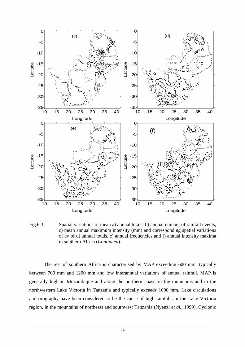
10 15 20 25 30 35 40Longitude
-35
-30
-25
-20
-15
-10
-5
0La
titud
e(c)
10 15 20 25 30 35 40
Longitude
-35
-30
-25
-20
-15
-10
-5
0
Latit
ude
(d)
10 15 20 25 30 35 40Longitude
-35
-30
-25
-20
-15
-10
-5
0
Latit
ude
(e)
(f)
10 15 20 25 30 35 40Longitude
-35
-30
-25
-20
-15
-10
-5
0La
titud
e
Fig.6.3: Spatial variations of mean a) annual totals, b) annual number of rainfall events, c) mean annual maximum intensity (mm) and corresponding spatial variations of cv of d) annual totals, e) annual frequencies and f) annual intensity maxima in southern Africa (Continued).
The rest of southern Africa is characterised by MAP exceeding 600 mm, typically
between 700 mm and 1200 mm and low interannual variations of annual rainfall. MAP is
generally high in Mozambique and along the northern coast, in the mountains and in the
northwestern Lake Victoria in Tanzania and typically exceeds 1000 mm. Lake circulations
and orography have been considered to be the cause of high rainfalls in the Lake Victoria
region, in the mountains of northeast and southwest Tanzania (Nyenzi et al., 1999). Cyclonic
_________________________________________________________________________ 74

flows within the Mozambique channel and the TTTs have been linked to high rainfall in the
adjacent low-lying areas of the central Mozambique.
Spatially, MAP variations reflect the orientation of the ITCZ and in general the low-
level circulation features associated with moisture distribution in the region (see Nicholson,
1996; Okoola and Ambenje, 2003). The main features of the spatial pattern of monthly
rainfall are briefly discussed below.
Mean monthly amounts indicate a i) relatively dry period of June through September
(JJAS) in most of southern Africa except in the coastal and mountainous northeast Tanzania
and in the Western Cape and b) a wet period of October-May (Fig.6.4).
• The beginning of the wet season is characterised by significant increases in rainfall
amounts between October and November which are linked to the southward
displacement of the ITCZ into southern Africa. The early summer months of October
and November are characterised by the meridional rainfall distribution.
• The ITCZ is well developed and remains in the 12°S-15°S latitudes between
December and February, the highest monthly amounts, exceeding 200 mm, occur in
the December-March period and characterise the northwest-southwest (zonally)
oriented region extending from western Zambia/western Tanzania through Malawi
and northern Zimbabwe to northern and central Mozambique. Spatially, the variation
is more or less zonally in the equatorial and tropical southern Africa and
meridionally in the southwestern part.
• The end of the wet season in the southern part of the region is marked by a
progressive decrease of rainfall amounts and northward/ eastward displacement of
the zones of high rainfall. The southwest-northeast-oriented contours in Tanzania
(see April, Fig.6.4) and meridionally-orientated contours in Mozambique and the east
coast of South Africa correspond to the southeasterlies and easterlies which bring
moisture from the southwest and tropical Indian ocean into these parts.
• The period June through September is relatively dry except in the Western Cape
which receives most of its annual amount during this period, mean monthly amounts
vary between 25 mm and 190 mm while in northeast Tanzania, they exceed 60 mm.
_________________________________________________________________________ 75

10 15 20 25 30 35 40Longitude
-35
-30
-25
-20
-15
-10
-5
0La
titud
eOctober
10 15 20 25 30 35 40
Longitude
-35
-30
-25
-20
-15
-10
-5
0
Latit
ude
November
10 15 20 25 30 35 40Longitude
-35
-30
-25
-20
-15
-10
-5
0
Latit
ude
December
10 15 20 25 30 35 40
Longitude
-35
-30
-25
-20
-15
-10
-5
0La
titud
e
January
10 15 20 25 30 35 40Longitude
-35
-30
-25
-20
-15
-10
-5
0
Latit
ude
February
10 15 20 25 30 35 40
Longitude
-35
-30
-25
-20
-15
-10
-5
0
Latit
ude
March
Fig.6.4: Spatial variation of mean monthly rainfall in southern Africa.
_________________________________________________________________________ 76

10 15 20 25 30 35 40Longitude
-35
-30
-25
-20
-15
-10
-5
0La
titud
eApril
10 15 20 25 30 35 40
Longitude
-35
-30
-25
-20
-15
-10
-5
0
Latit
ude
May
10 15 20 25 30 35 40Longitude
-35
-30
-25
-20
-15
-10
-5
0
Latit
ude
June
10 15 20 25 30 35 40
Longitude
-35
-30
-25
-20
-15
-10
-5
0La
titud
e
July
10 15 20 25 30 35 40Longitude
-35
-30
-25
-20
-15
-10
-5
0
Latit
ude
August
10 15 20 25 30 35 40
Longitude
-35
-30
-25
-20
-15
-10
-5
0
Latit
ude
September
Fig.6.4: Spatial variation of mean monthly rainfall in southern Africa (Continued).
_________________________________________________________________________ 77
• Despite the highest mean amounts being observed in the northern Lake Malawi
region of the southern highlands (Tanzania), stations in the northwest record about
twice the rainfall compared to those in the northeast. MAP in the northwest varies
between 2040 mm and 2708 mm with the highest MAP observed at the lake, while it
is between 1030 mm and 1150 mm in the northeast. Except for the spatial locations,
the other station details like altitude are similar suggesting the possible role of lake-
land thermal contrast. However, no detailed studies have yet quantified the influence
of Lake Malawi on rainfall in the surrounding areas.
6.4 Overall number of rainfall events
The spatial patterns of variation of annual and monthly number of rainfall events are
shown in Fig.6.3b and Fig.6.5, respectively and are very similar to those of rainfall amounts
and therefore are not discussed in detail. Only those features that differ from the rainfall
amounts or which were not very apparent, are discussed.
• Despite having lower MAP than the neighbouring southern highlands and central
Mozambique, much of Zambia receives the highest number of daily rainfall events in
southern Africa, significantly exceeding those in the two high rainfall areas.
• Central Mozambique receives a lower number of rainfall events than the southern
highlands of Tanzania. Despite experiencing the highest MAP, low AADI in areas in
the southern highlands of Tanzania compared to AADI in central Mozambique are
caused by a significant difference in the number of daily rainfall events which
contribute to MAP.
• The interannual variations of annual number of rainfall events is low to moderate
even in the dry southwestern part of southern Africa (Fig.6.3e) which are
characterised by high interannual variations in annual amounts (Fig.6.3d).
• The zonally-oriented contours along the southern part of South Africa correspond to
moisture advection from the Agulhas Current.
• The areas in coastal northeast Tanzania and southern South Africa which experience
rainfall throughout the year are characterised by 2-7 daily rainfall events a month.
Moreover, the eastern coast of the region receives rainfall, on average, at least 2 days
throughout the year.
_________________________________________________________________________ 78

10 15 20 25 30 35 40Longitude
-35
-30
-25
-20
-15
-10
-5
0La
titud
eOctober
10 15 20 25 30 35 40
Longitude
-35
-30
-25
-20
-15
-10
-5
0
Latit
ude
November
10 15 20 25 30 35 40Longitude
-35
-30
-25
-20
-15
-10
-5
0
Latit
ude
December
10 15 20 25 30 35 40
Longitude
-35
-30
-25
-20
-15
-10
-5
0La
titud
e
January
10 15 20 25 30 35 40Longitude
-35
-30
-25
-20
-15
-10
-5
0
Latit
ude
February
10 15 20 25 30 35 40
Longitude
-35
-30
-25
-20
-15
-10
-5
0
Latit
ude
March
Fig.6.5: Spatial variations of mean monthly number of rainfall events in southern
Africa.
_________________________________________________________________________ 79

10 15 20 25 30 35 40Longitude
-35
-30
-25
-20
-15
-10
-5
0La
titud
eApril
10 15 20 25 30 35 40
Longitude
-35
-30
-25
-20
-15
-10
-5
0
Latit
ude
May
10 15 20 25 30 35 40Longitude
-35
-30
-25
-20
-15
-10
-5
0
Latit
ude
June
10 15 20 25 30 35 40
Longitude
-35
-30
-25
-20
-15
-10
-5
0La
titud
e
July
10 15 20 25 30 35 40Longitude
-35
-30
-25
-20
-15
-10
-5
0
Latit
ude
August
10 15 20 25 30 35 40
Longitude
-35
-30
-25
-20
-15
-10
-5
0
Latit
ude
September
Fig.6.5: Spatial variations of mean monthly number of rainfall events in southern
Africa (Continued).
_________________________________________________________________________ 80

6.5 Annual daily intensity maxima
6.5.1 Spatial variation of average intensity maxima
Maximum daily intensities are variable both in time and in space. The average annual
daily intensity maxima (Fig.6.3c) are computed as averages of annual daily intensity maxima.
Spatially, the highest daily intensity maxima characterise the high rainfall areas of southwest
Tanzania (the southern highlands) and central Mozambique while the lowest are found in the
dry southern and southwestern parts of southern Africa. The interannual variation of annual
intensity maxima (Fig.6.3f) is identical to that of annual amounts as indicated by a similar
spatial pattern of variation and almost the same magnitudes of coefficients of variations
(compare Fig.6.3d and 6.3f).
(a)
0123456789
101112
1900 1910 1920 1930 1940 1950 1960 1970 1980 1990 2000
Mon
th
(b)
0123456789
101112
1900 1910 1920 1930 1940 1950 1960 1970 1980 1990 2000
Mon
th
Fig.6.6: Variation of the month of annual daily intensity maxima at a) Goudveld (BOS)
and b) Keilands in the southern part of South Africa.
_________________________________________________________________________ 81

6.5.2 Months of annual intensity maxima
Investigations of time series of daily rainfall and of monthly daily maxima further
indicated temporal variations associated with the month in which the annual daily intensity
maxima are observed. Along the southern coast of South Africa, for example, annual daily
rainfall maximum can occur in any month of the year (Fig.6.6a) while in the Eastern Cape, it
mainly occurs during the December-March period (Fig.6.6b), although it can occur in other
months as well.
Where the annual intensity maxima are relatively high (Fig.6.3c), a precise knowledge
of the period (months) in which they are most likely to be experienced is of utmost important
in relation to the reduction of their impacts. The following procedure was used to establish
these months in the region. At each station, one standard deviation of the annual daily
intensity maxima was added to the average annual daily intensity maxima and the resulting
intensities (mean + 1 standard deviation) was subtracted from the average monthly daily
intensity maxima. The months showing positive departures were considered as the months of
high rainfall intensities and which are most likely to experience the annual daily intensity
maxima and are shown in Fig.6.7.
10 15 20 25 30 35 40
Longitude
-35
-30
-25
-20
-15
-10
-5
0
Latit
ude
Jul-Sep
Dec
- Feb
Feb
Any monthNov - Mar
Feb - Mar
Mar - Apr
AprNov - Dec
MayMar - Apr
Fig.6.7: Spatial variation of months of annual intensity maxima in southern Africa.
_________________________________________________________________________ 82

It is observed that most of Tanzania experiences its highest daily rainfall in the March-
April period while northeast Tanzania has two other periods of maximum intensities. Areas
between the northern mountains (Kilimanjaro and Meru) and southern Usambara Mountains
have their highest daily rainfall amounts during the short rains, in November or December.
Areas lying north of the Usambara and Pare Mountains experience their highest daily rainfall
in May. Most of Namibia experiences intense daily events in February while they are
experienced in the western coast of South Africa in July-September and mainly in September.
In the southern coast of South Africa, annual daily intensity maxima can be experienced in
any month of the year. This is exemplified by the daily intensity maxima at Goudveld (BOS)
(Fig.6.6a). Intense midlatitude cut-off lows (described in section 3.6.1.2) have been linked to
heavy rainfall events in the Western Cape (Reason et al., 2002) and southern coast of South
Africa (Tyson, 1986; Jury et al., 1993) in which the warm Agulhas current acts as the main
source of moisture for these systems. The areas between 32°S and the northern boundary of
the southern coastal region experience annual daily intensity maxima between November and
March (e.g. Fig.6.6b). Elsewhere in southern Africa, intensity maxima are experienced in
December, January or February.
Records of daily rainfall in southern Africa show further that wet years are
characterised by multiple intense daily events that are well above average annual daily
intensity maxima. In relatively dry years, low daily intensities are a characteristic. An all-
record average annual daily intensity maximum of 150.3 mm at Kwiro Mission in the
southern highlands in Tanzania, for example, was exceeded 3 times in 1978/79 (260.0 mm in
November 1978, 226.1 mm in March 1979 and 165.0 mm in April 1979) while the period
October 1966 to December 1971 recorded only 2 daily events whose rainfall amounts
exceeded 100 mm (123.7 mm in November 1969 and 120.0 mm in February 1970). The
extraction of a single maximum intensity for each year, therefore, would fail to account for
the multiplicity of intense daily events. The Peak-over-threshold method, which selects all
intensities exceeding a predefined intensity limit (threshold), would better address the impacts
of multiple extreme events during dry and wet years. This method is used in grouping daily
intensities into different classes. Threshold (exceedence) intensities, Pf, are objectively
established and used in defining classes of daily intensities in southern Africa.
_________________________________________________________________________ 83

6.6 Classifying daily rainfall intensities
6.6.1 Exceedence daily rainfall intensities
Results show that the lowest Pf occur in the drier southwestern part of southern Africa
while the highest Pf values characterise the humid northern and eastern parts, east of about
30°E and north of about 30°S (see e.g. Fig.6.8). The non-zero intensities that have been
equalled or exceeded for 40-95% of the time when it rains (P40-P95), spatially, have a small
range of values in southern Africa. This is illustrated in Fig.6.8 in which P90 are mainly
below 2 mm across the region and all stations in Namibia, Zambia and Zimbabwe having
values below 1.5 mm. It was further observed that the intensities which have been equalled or
exceeded for 30-40% of the time when it rains (P30-P40) approximately equalled the AADI
indicating that 60-70% of the daily rainfall events at most locations in southern Africa are less
than the expected daily rainfall intensities.
The daily intensities which have been equalled or exceeded for 5-25% of the time
when it rains (P5-P25) represent, on average, between 124.4% and 391.2% of the AADI and
are spatially highly variable across southern Africa (P5 and P10 in Fig. 6.8). The highest P5,
for example, exceeds 55 mm in southwest Tanzania and central Mozambique, while it is
below 26 mm in Namibia. The spatial differences, however, reduce from P5 towards P25.
6.6.2 Classes of daily rainfall intensities
About 60-70% of the daily rainfall events in southern Africa are less than the all-
record average daily rainfall intensities (AADI) which vary typically in the range 8-12mm
(Fig.6.1). Therefore, a daily intensity of approximately 10 mm can be used to separate the
most frequent daily events in the region from other events. However, daily intensities below 1
mm, which approximately represent the P90-P95, are highly susceptible to errors (Mekis and
Hogg, 1999) and hence are separated from the rest of the most frequent (below 10 mm) daily
intensities. The first two classes (I and II), therefore, comprise the intensity ranges 0.1-0.9 mm
and 1.0-9.9 mm. Daily intensities exceeding 10 mm, approximately represented by high Pf
(P25-P5), exhibit high spatial variations and despite the low Pf in the southwestern part of
southern Africa, daily events with intensities equalling or exceeding 40 mm have been
recorded. Equal intervals were then used to group daily intensities exceeding 10 mm into
broad classes which include the class III, class IV, class V and class VI representing
respectively 10-19.9 mm, 20-29.9 mm, 30-39.9 mm and intensities equalling or exceeding 40
mm.
_________________________________________________________________________ 84
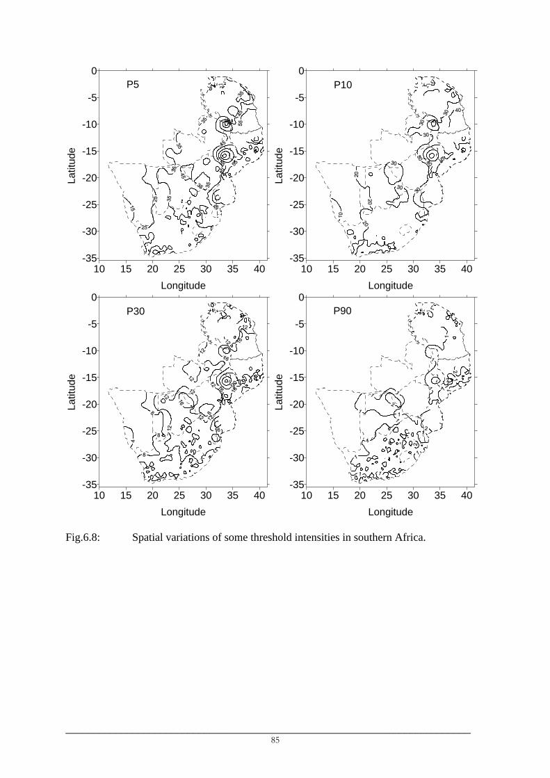
10 15 20 25 30 35 40Longitude
-35
-30
-25
-20
-15
-10
-5
0La
titud
eP5
10 15 20 25 30 35 40Longitude
-35
-30
-25
-20
-15
-10
-5
0
Latit
ude
P10
10 15 20 25 30 35 40Longitude
-35
-30
-25
-20
-15
-10
-5
0
Latit
ude
P30
10 15 20 25 30 35 40Longitude
-35
-30
-25
-20
-15
-10
-5
0
Latit
ude
P90
Fig.6.8: Spatial variations of some threshold intensities in southern Africa.
_________________________________________________________________________ 85

10 15 20 25 30 35 40Longitude
-35
-30
-25
-20
-15
-10
-5
0La
titud
e(a)
10 15 20 25 30 35 40
Longitude
-35
-30
-25
-20
-15
-10
-5
0
Latit
ude
(b)
10 15 20 25 30 35 40Longitude
-35
-30
-25
-20
-15
-10
-5
0
Latit
ude
(c)
10 15 20 25 30 35 40
Longitude
-35
-30
-25
-20
-15
-10
-5
0La
titud
e
(d)
10 15 20 25 30 35 40Longitude
-35
-30
-25
-20
-15
-10
-5
0
Latit
ude
(e)
10 15 20 25 30 35 40
Longitude
-35
-30
-25
-20
-15
-10
-5
0
Latit
ude
(f)
Fig.6.9: Spatial variation of annual number of a) class I, b) class II, c) class III, d) class
IV, e) class V and f) class VI daily rainfall events in southern Africa, expressed as percentages of annual daily rainfall events.
_________________________________________________________________________ 86

10 15 20 25 30 35 40Longitude
-35
-30
-25
-20
-15
-10
-5
0La
titud
eClass I
10 15 20 25 30 35 40
Longitude
-35
-30
-25
-20
-15
-10
-5
0
Latit
ude
Class II
10 15 20 25 30 35 40Longitude
-35
-30
-25
-20
-15
-10
-5
0
Latit
ude
Class III
10 15 20 25 30 35 40
Longitude
-35
-30
-25
-20
-15
-10
-5
0La
titud
e
Class IV
10 15 20 25 30 35 40Longitude
-35
-30
-25
-20
-15
-10
-5
0
Latit
ude
Class V
10 15 20 25 30 35 40
Longitude
-35
-30
-25
-20
-15
-10
-5
0
Latit
ude
Class VI
Fig.6.10: Spatial variation of mean annual rainfall amounts in each intensity class
expressed as percentage of annual total rainfall.
_________________________________________________________________________ 87

The spatial patterns of variation are shown in Fig.6.9 for annual rainfall events, in
Fig.6.10 for annual amounts and in Fig.6.11 only for monthly rainfall events in the classes II
and IV. They indicate mainly increasing percentages for the four lower classes (Class I to
class IV) and decreasing for the higher two classes (Class V and VI) from the eastern coast
and northern areas of the region towards the west and southwest (Figs.6.9 and 6.10). That is,
the low intensity daily events are the most frequent rainfall events in the western/southwestern
part of the region. The patterns are more meridional than zonal, particularly for the class II, III
and VI and are more evident in rainfall amounts (Fig.6.10) than in the number of rainfall
events (Fig.6.9).
• The decreasing contribution of high rainfall from the east to the west suggests the
importance of the moisture from the Indian Ocean and its redistribution in southern
African by atmospheric winds and the combined influences of the dry air from the
south Atlantic and eastern mountain chains (Drakensberg chain in eastern South
Africa and the Manicaland Mountains in eastern Zimbabwe) on rainfall in the
interior and southwestern areas of the region. These areas are found in the lee of
these eastern mountain chains which block the penetration of the moist southwest
Indian Ocean winds into the western parts while the southwesterly flow from the
coastal zone brings dry air into the adjacent interior (Jury and Engert, 1999).
Therefore, Namibia, being located farthest from the moist Indian or Congo sources
and closest to the dry south Atlantic source, has its highest percentages of annual
rainfall events (59-86%) and amounts (67-85%) contributed by daily intensities less
than 20 mm. The lowest percentages of low intensity daily events in Namibia,
however, characterise the northeastern part, in which, part of its rainfall is caused by
the moisture advected from the Congo basin and the equatorial and tropical Atlantic
(van Regenmortel, 1995; Jury and Engert, 1999).
• The lowest contributions of the lower two classes (classes I and II) and highest
percentages of the higher two classes (class V and VI) to annual amounts are found
in central Mozambique. A multiplicity of factors favourable for their occurrence in
the two areas of Mozambique are observed during the wet season. The zonal branch
of the ITCZ is located over parts of central Mozambique during the December-
February period which is also the main season of the tropical cyclones in the western
tropical Indian Ocean (Camberlin and Shanko, 1998 and references therein) and the
period when the TTTs are most likely to occur (Todd and Washington, 1999ab). The
_________________________________________________________________________ 88

result is enormous convergence of moist air from the Congo basin, south Madagascar
and tropical and equatorial Indian Ocean over central Mozambique favouring the
occurrence of heavy rainfall events over light events. Floods have been mostly
observed during the same period in Mozambique, such as that which occurred in
February-March 2000.
• Similarly, these intense daily rainfall events are also observed in the northern Lake
Malawi region in the southern highlands of Tanzania in April. Unlike the
Mozambique case, the influences of the cyclonic activities over the Mozambique
Channel and eastern Madagascar and those of the TTTs are low or absent and it is
the northward displaced ITCZ into the country that brings the zone of convergence
into the areas favouring the occurrence of heavy events in the southern highlands of
Tanzania. Flooding almost every year during the March-April period of the Kiwila
River, with headwaters in the southwestern part of the southern highlands and
draining into northern Lake Malawi, (Kachroo et al., 1999) can be related to these
intense events which usually occur late in the season when soils are wet due to early
season rainfall.
• Results further show that these intense daily events can be observed in November
and March in the southern part of Southern Africa, except in southwest Namibia and
the Western Cape.
• The dry June-September rainfall in northeast Tanzania, the northern Lake Victoria
and in the areas along the coast of South Africa mainly experience class II daily
events (Fig.6.11a) and occasionally class I and class III daily rainfall events (not
shown). It is unlikely that other types of daily rainfall events will occur during this
period.
_________________________________________________________________________ 89

10 15 20 25 30 35 40Longitude
-35
-30
-25
-20
-15
-10
-5
0La
titud
eOctober
10 15 20 25 30 35 40
Longitude
-35
-30
-25
-20
-15
-10
-5
0
Latit
ude
November
10 15 20 25 30 35 40Longitude
-35
-30
-25
-20
-15
-10
-5
0
Latit
ude
December
10 15 20 25 30 35 40
Longitude
-35
-30
-25
-20
-15
-10
-5
0La
titud
e
January
10 15 20 25 30 35 40Longitude
-35
-30
-25
-20
-15
-10
-5
0
Latit
ude
February
10 15 20 25 30 35 40
Longitude
-35
-30
-25
-20
-15
-10
-5
0
Latit
ude
March
Fig.6.11(a): Spatial variation of mean monthly number of class II events in southern Africa.
_________________________________________________________________________ 90

10 15 20 25 30 35 40Longitude
-35
-30
-25
-20
-15
-10
-5
0La
titud
eApril
10 15 20 25 30 35 40
Longitude
-35
-30
-25
-20
-15
-10
-5
0
Latit
ude
May
10 15 20 25 30 35 40Longitude
-35
-30
-25
-20
-15
-10
-5
0
Latit
ude
June
10 15 20 25 30 35 40
Longitude
-35
-30
-25
-20
-15
-10
-5
0La
titud
e
July
10 15 20 25 30 35 40Longitude
-35
-30
-25
-20
-15
-10
-5
0
Latit
ude
August
10 15 20 25 30 35 40
Longitude
-35
-30
-25
-20
-15
-10
-5
0
Latit
ude
September
Fig.6.11(a): Spatial variation of mean monthly number of class II events in southern Africa
(Continued).
_________________________________________________________________________ 91

10 15 20 25 30 35 40Longitude
-35
-30
-25
-20
-15
-10
-5
0La
titud
eOctober
10 15 20 25 30 35 40
Longitude
-35
-30
-25
-20
-15
-10
-5
0
Latit
ude
November
10 15 20 25 30 35 40Longitude
-35
-30
-25
-20
-15
-10
-5
0
Latit
ude
December
10 15 20 25 30 35 40
Longitude
-35
-30
-25
-20
-15
-10
-5
0La
titud
e
January
10 15 20 25 30 35 40Longitude
-35
-30
-25
-20
-15
-10
-5
0
Latit
ude
February
10 15 20 25 30 35 40
Longitude
-35
-30
-25
-20
-15
-10
-5
0
Latit
ude
March
Fig.6.11(b): Spatial variation of mean monthly class VI frequencies in southern Africa.
_________________________________________________________________________ 92

10 15 20 25 30 35 40Longitude
-35
-30
-25
-20
-15
-10
-5
0La
titud
eApril
10 15 20 25 30 35 40
Longitude
-35
-30
-25
-20
-15
-10
-5
0
Latit
ude
May
10 15 20 25 30 35 40Longitude
-35
-30
-25
-20
-15
-10
-5
0
Latit
ude
June
10 15 20 25 30 35 40
Longitude
-35
-30
-25
-20
-15
-10
-5
0La
titud
e
July
10 15 20 25 30 35 40Longitude
-35
-30
-25
-20
-15
-10
-5
0
Latit
ude
August
10 15 20 25 30 35 40
Longitude
-35
-30
-25
-20
-15
-10
-5
0
Latit
ude
September
Fig.6.11(b): Spatial variation of mean monthly class VI frequencies in southern Africa
(Continued).
_________________________________________________________________________ 93

6.7 Seasonality of rainfall in southern Africa
All indices of rainfall amounts and frequencies (Figs.6.4, 6.5, 6.11) indicate
seasonality of rainfall in southern Africa and spatially distinguish between the dry and humid
zones. Most of the region receives rainfall between October and May except in the Western
Cape in southwest South Africa that experiences rainfall during the austral winter. The wet
season October-May/June is mainly a continuous single season, between May and September
(Western Cape) and between November and April (the rest of the region), except in Tanzania
(northern Tanzania in particular) where it is characterised by a break in January-February
which separates the short rains (October-November-December) from the long rains (March-
April-May). In general, a high number and intensity of daily rainfall events characterise the
December-February (DJF) period in unimodal southern Africa and this period is regarded as
the core of the wet season. The period June through September (JJAS) is relatively dry in
southern Africa and August is generally the driest month.
10 15 20 25 30 35 40Longitude
-35
-30
-25
-20
-15
-10
-5
0
Latit
ude
Sub-region 1
Sub-region 2Sub-region 3
Fig.6.12: Sub-regions in southern Africa as distinguished by spatial rainfall
characteristics.
6.8 Major rainfall sub-regions according to average rainfall indices
The results have been used to divide southern Africa into three major sub-regions with
regard to rainfall amounts and number of rainfall events: the sub-region north of about 17°S
comprising Tanzania, Zambia, Malawi, the northern Zimbabwe and the northern half of
_________________________________________________________________________ 94

Mozambique (sub-region 1), the sub-region south of 17°S and east of about 27°E comprising
eastern Zimbabwe, the southern half of Mozambique and eastern South Africa (sub-region 2)
and the sub-region south of 17°S and west of 27°E comprising Namibia, Botswana, western
Zimbabwe and western South Africa (sub-region 3) (Fig.6.12).
Using probabilities of exceedence, as computed from distribution-free plotting
position formula, daily intensities were classified into 6 groups: class I (0.1-0.9 mm), class II
(1-9.9 mm), class III (10-19.9 mm), class IV (20-29.9 mm), class V (30-39.9 mm) and class
VI (≥ 40 mm). Class I intensities represent about 5.5-22.5% of the annual number of rainfall
events but only about 0.4-2.3% of annual rainfall amounts rendering them less important in
water resources. They are, therefore, not included in the summary of the main spatial
characteristics of rainfall in the three sub-regions given below.
6.8.1 Sub-region 1
This sub-region borders the Congo rainforests on the west and it is within the
Mozambique Channel where summer tropical cyclones are frequently observed. The northern
part (0-5°S) lies within the equatorial region.
• Most of the region receives more than 800 mm of rainfall annually except the central
plateau of Tanzania were MAP ranges between 500 mm and 800 mm. MAP exceeds
1500 mm in central Mozambique, in northwest lake Victoria, the Indian Ocean
islands of Zanzibar (Unguja and Pemba) and Mafia, in areas around Kilimanjaro, the
Meru and Usambara Mountains in northeast Tanzania and in the southern highlands
of Tanzania.. Annual rainfall amounts show low interannual variations as indicated
by low interannual coefficients of variation (cv) which are lowest in Zambia.
• Mean annual number of daily rainfall events varies between 70 and 130, typically
between 70 and 90 in which the highest annual number of events (90-135)
characterize the mountains of northeast and southwest Tanzania and western and
northern Zambia. The annual number of rainfall events show low interannual
variations in this region.
• Mean annual maximum daily rainfall intensities in this region vary typically between
70 mm and 150 mm and the highest daily intensity maxima in southern Africa are
found in the Usambaras and in the southern highlands of Tanzania near northern lake
Malawi and in central Mozambique. Daily intensities exceeding 350 mm have been
_________________________________________________________________________ 95

observed in certain years in this region, mainly in December-February
(Mozambique) and March-May (Tanzania).
• Long-term average daily rainfall intensity ranges between 12 mm and 24 mm. Daily
intensities that are equaled or exceeded 5% of the time range between 40 mm and 80
mm, while those equaled or exceeded 10% of the time range between 30 mm and 50
mm. Daily intensities equaled or exceeded 90% of the time are less than 1.5mm
while intensities equaled or exceeded 95% of the time are typically less than 1mm.
• Light (Class II) daily events represent about 30-64% of annual events contributing
10-34% of annual rainfall amounts in which their lowest contribution is found in
central Mozambique and the highest contributions in western Zambia and in
Tanzania. Class III intensities represent between 9 and 28% of annual events and
about 7-35% of annual amounts. Class IV intensities are about 5-15% of annual
events but contribute between 10 and 24% of annual amounts with spatial patterns
resembling that shown by class II amounts. Class V and class VI intensities are the
most infrequent representing about 2-11% (class V) and 2-20% (class VI) of annual
event. Despite their infrequency, they contribute typically about 11-13% (class V)
and 20-35% (class VI) of annual rainfall amounts.
6.8.2 Sub-region 2
This sub-region is influenced by the warm Agulhas current system, which includes the
Mozambique current, east Madagascar current and the Agulhas current itself.
• MAP ranges typically between 600 mm and 800 mm, though areas in the
Drakensberg and the east coast of South Africa receive more than 1000 mm
(sometimes up to 2000 mm) a year. MAP decreases from the east towards the interior
and the central parts of South Africa are characterized by MAP around 600-800 mm.
Interannual variations of annual amounts in this region are identical to those in
region 1.
• Mean annual number of rainfall events varies between 50 and 110 with the highest
(about 90 or more) found in Mozambique and along the east coast of South Africa,
decreasing westward.
• Mean annual maximum daily rainfall intensities range typically between 50 mm and
90 mm a day. The highest annual daily intensity maxima are found in Mozambique
_________________________________________________________________________ 96

and they decrease from east to west and their interannual variations resemble those of
annual intensity maxima in region 1.
• Average daily intensities vary from 8 mm in southern Zimbabwe to 12 mm in the rest
of the region. Daily intensities equaled or exceeded 5% of the time range between 40
mm and 60 mm, while those equaled or exceeded 10% of the time range between 30
mm and 40 mm. Intensities equaled or exceeded 90% of the time are less than 1.5
mm except in eastern South Africa where they are high. Intensities equaled or
exceeded 95% of the time are typically less than 1 mm.
• Class II intensities represent about 40-60% of annual events in this region and
contribute about 15-30% of annual rainfall amounts in which their lowest
percentages are found in Mozambique. Class III intensities represent between 24 and
36% of annual events and about 16-35% of annual amounts. Class IV represent about
6-15% of annual events but contribute between 16 and 24% of annual amounts with
a spatial pattern resembling that shown by class II amounts. Class V and class VI
intensities are the most infrequent representing about 4-10% (class V) and 4-16%
(class VI) of annual events. They contribute typically about 9-13% (class V) and 10-
35% (class VI) of annual amounts. Their highest contributions to annual amounts and
number of daily rainfall events are observed in eastern South Africa.
6.8.3 Sub-region 3
Its unfavourable geographical location corresponds to its arid condition. It is located in
the lee of the eastern mountains (Drakensberg chain in the eastern South Africa and the
Manicaland Mountains in the eastern Zimbabwe) which block the penetration of near-surface
moisture-rich winds from southwest Indian Ocean. Moreover, cold dry winds associated with
the cold Benguela Current along the western coast of the region further reduce rainfall. The
two deserts of Kalahari and Namib are found in this region.
• The region generally receives less than 600 mm of rainfall annually, typically below
500 mm and generally increases from the western coast to the interior. MAP
decreases toward the west coast in which it is less than 100 mm in the Namib desert
along the Atlantic coast of Namibia. The highest MAP (about 400 mm) characterizes
most of Botswana and northeast Namibia while it is less than 300 mm in southern
Namibia and western South Africa. Annual rainfall amounts show the highest
interannual variations in southern Africa, particularly Namibia. Exception to this
pattern are the areas along the winter rainfall region along the southern coast of
_________________________________________________________________________ 97

South Africa where MAP of up to 900-1300 mm is observed which exceeds 2000mm
in certain years at certain locations. This abundant rainfall is brought by the
interactions between the cold fronts and the Agulhas which acts as the source of
moisture that is advected to the adjacent coastal areas of southern South Africa.
• Mean annual number of rainfall events varies between 30 and 70, but is typically less
than 50. The lowest annual number of rainfall events (30 or less) characterize the
Namibian Atlantic coast and western South Africa, except at the Cape’s tip and along
the southern coast where mean annual number of rainfall events of about 50-90 are
observed.
• Mean annual maximum daily rainfall intensities in the region are the lowest, ranging
typically between 30 mm and 60 mm, and highly variable between years. The lowest
intensity maxima are found in the southern and coastal Namibia.
• Average daily intensities in this region are the lowest in southern Africa and vary
between 4 mm and 12 mm with Namibia and the western South Africa observing less
than 8 mm while Botswana observes an average daily intensity of about 12 mm.
Daily intensities that are equaled or exceeded for 5% of the time range between 6
mm and 47 mm, while those equaled or exceeded for 10% of the time range between
4 mm and 40 mm. Intensities equaled or exceeded for 90% of the time are less than
1.5 mm while intensities equaled or exceeded for 95% of the time are less than 1mm.
• Class II intensities represent 35-70% of annual events and contribute 12-64% of
annual amounts. Their highest contributions are found in the southern and coastal
areas of Namibia where they contribute between 50 and 70% of annual amounts.
Class III intensities represent about 2-18% (Namibia) and 12-30% (Botswana and
western South Africa) of annual events and about 21-34% of annual rainfall amounts.
Class II and class III intensities together contribute between 67% and 85% (Namibia)
and 36% and 62% (Botswana) of annual rainfall amounts. Daily events whose
intensities are below 20mm are, therefore, the most important particularly in
Namibia, and their variations have significant impacts on the surface water resources
in these countries. Daily intensities exceeding 20mm are infrequent in Namibia and
represent the remaining 15-33% of annual amounts. Class IV represent, on average,
0.1-5.2% of annual events in Namibia while class V and class VI intensities
respectively represent 0-2.5% and 0-1% of annual events in Namibia.
_________________________________________________________________________ 98
6.9 Conclusions
The results of the spatial analysis of different indices of rainfall have identified three
sub-regions in southern Africa. The rainfall characteristics in each of these sub-regions were
summarized in the preceding section. They reflect a combination of various factors which
influence rainfall variations in the region such as the location with respect to the sources of
moisture (equatorial and tropical Atlantic and Indian ocean basins, southwest Indian ocean
and the Congo basin), the general atmospheric circulations and synoptic-scale circulation
features such as tropical cyclones and the mountains and lakes. The interannual variations of
rainfall indices whose spatial distributions have been discussed in this chapter are investigated
in the next chapter to complete the spatio-temporal variability analysis of rainfall in southern
Africa.
_________________________________________________________________________ 99

___________________________________________________________________________ CHAPTER 7
INTERANNUAL VARIATIONS OF RAINFALL AMOUNTS
AND NUMBER OF DAILY RAINFALL EVENTS
___________________________________________________________________________
7.1 Introduction
This chapter investigates interannual variability of seasonal and annual rainfall
amounts and number of daily rainfall events in southern Africa. Different months have been
pooled to form different 2-month to 5-month seasons in the region (Nicholson, 1986b; Latif et
al., 1999; Indeje et al., 2000; Mutai and Ward, 2000; Richard et al., 2000; Reason et al.,
2002) depending on different factors such as atmospheric circulation (D’abreton and
Lindesay, 1993). However, Richard et al. (2002) indicated that rainfall in November through
May in South Africa show similar patterns of interannual variability and seasons can be
formed from pooling of any of these months. The year was, therefore, divided into three (3) 4-
month seasons, October-November-December-January (ONDJ or early summer), February-
March-April-May (FMAM or late summer) and June-July-august-September (JJAS or austral
winter). The first two seasons form the dry season in the Western Cape and the wet season in
the rest of the region and vice versa.
The interannual variability analysis involves i) an investigation of temporal patterns
displayed by anomaly indices and ii) identification of discontinuities and trends. Anomaly
indices are used to provide rapid characterisation of patterns of interannual variability and are
defined as departures from the 1950-1989 averages standardised by 1950-1989 standard
deviations. The period 1950-1989 consists of the most continuous records which provides the
best spatial distribution of rainfall stations in the region. Eight 5-year segment averages were
computed for the period 1950-1989. The 5-year window was selected based on the presence
of quasi-periodicities within the 2-7 year band in southern African rainfall (Tyson, 1986;
Nyenzi et al., 1999; Nicholson, 2000) reflecting the ENSO signals. Therefore, time windows
of 10 years or more may incorporate more than one alternating wetter and drier period and
consequently, averaging over the wet and dry periods will lead to anomalies close to zero. The
anomalies at each station were spatially interpolated to obtain region patterns.
Time series of seasonal and annual rainfall indices were tested for randomness and
change-point and linear trend analyses were then performed on non-random time series. The
_________________________________________________________________________ 100

whole time series were used in the change-point analyses while the linear trend analysis used
the periods 1960-1990 and 1940-1990 respectively for the whole of southern Africa and for
some long stations in Tanzania, Namibia, Botswana and South Africa to assess the influence
of the record length and period on the nature (direction and magnitude) of a trend.
Results of change-point analysis allow the identification of the dates when changes
had occurred and are presented, while those of trend analysis are included in the discussion.
Owing to the resemblance of patterns of variability between different indices studied and in
order to avoid repetition, only the main representative recurrent features are presented and
discussed.
In order to simplify the discussion, the following terms have been used:
• Rainfall events refer to the number of daily rainfall events e.g. annual events implies
annual number of daily rainfall events.
• Annual or seasonal amounts refer to the annual or seasonal amounts of rainfall due to
all rainfall events.
• Annual or seasonal events refer to the annual or seasonal number of all daily rainfall
events.
• Annual or seasonal class X amounts refer to the annual or seasonal amounts that are
contributed only by daily rainfall intensities within that particular class X.
• Annual or seasonal class X events refer to the annual or seasonal number of daily
rainfall events due to daily rainfall intensities within that particular class X.
• Season identifications such as ONDJ, FMAM, JJAS, late summer, early summer are
sometimes used in place of the word seasonal.
• Class E20mm groups all daily rainfall intensities exceeding 20 mm.
7.2 Results
7.2.1 Patterns of anomalies
Fig.7.1 and Fig.7.2 show the most recurrent patterns of anomalies of rainfall amounts
and events which indicate the wet 1975-1979 and dry 1980-1984 periods in southern Africa.
They further show:
• A dipole between the northern and southern part with a node in the 10°S-15°S
latitudes. The dipole pattern, which is apparent in the 1970-1974 period and to a
lesser extent in the 1950-1954 and 1965-1969 periods, is analogous to the type 4
pattern in Nicholson and Kim (1997) and is more evident in the annual amount
_________________________________________________________________________ 101

(Fig.7.1a) than in either the annual events (Fig.7.1b) or seasonal amounts (Fig.7.2). It
reflects a response of the southern Africa rainfall to an ENSO signal (Nicholson and
Kim, 1997).
• A tendency for the occurrence of anomalies of the same sign across the whole of
southern Africa. This is evident in the wet 1975-1979 and dry 1980-1984 periods in
annual amounts and events (Fig.7.1) and late summer amounts (Fig.7.2b) but not in
early summer amounts (Fig.7.2a).
• The persistency of negative anomalies over a decade or more. This have been
observed in the anomalies of annual events (Fig.7.1b) and annual class II events (not
shown) in Botswana.
• Influences of the dominant classes on the patterns of interannual variability of total
indices. The patterns of anomalies of annual events resemble those of the most
frequent class II events while the patterns of anomalies of annual amounts were
rather a combination of anomaly patterns of daily intensities exceeding 10 mm (Class
III-class VI) which contribute about 75% of annual amounts in southern Africa,
except Namibia.
• Changes in the spatial patterns of anomalies of rainfall in certain classes between the
different 5-year periods. While the anomalies of class VI annual amounts (not
shown) display opposing patterns of interannual variability between eastern
(including the Lake Victoria region) and western Tanzania, except in the 1960-1964
and 1980-1984 periods when positive anomalies of class VI annual amounts were
found only in the Lake Victoria region. Anomalies of class III annual amounts (not
shown) show a change in their spatial pattern of interannual variability across
Tanzania since the 1970-1974 period in which the 1950-1969 period was
characterised by anomalies of the same sign across the country while the period
1970-1989 experienced opposite anomaly signs between eastern Tanzania and the
rest of the country.
• Different patterns of anomalies of rainfall in the early (ONDJ, Fig.7.2a) and late
(FMAM, Fig.7.2b) summers during the same 5-year period. The differences, for
example, are apparent in the 1960-1964, 1965-1969 and 1980-1984 periods.
_________________________________________________________________________ 102

Fig.7.1a: Variation of 5-year average standardized anomalies of annual rainfall amounts
in southern Africa for the period 1950-1989. Positive anomalies are cross hatched.
_________________________________________________________________________ 103

Fig.7.1b: Variation of 5-year average standardized anomalies of annual rainfall events in
southern Africa for the period 1950-1989. Positive anomalies are cross hatched.
_________________________________________________________________________ 104

Fig.7.2a: Variation of 5-year average standardized anomalies of early summer (ONDJ)
rainfall amounts in southern Africa for the period 1950-1989. Positive anomalies are cross hatched.
_________________________________________________________________________ 105

Fig.7.2b: Variation of 5-year average standardized anomalies of late summer (FMAM)
rainfall amounts in southern Africa for the period 1950-1989. Positive anomalies are cross hatched.
_________________________________________________________________________ 106

7.2.2 Abrupt changes
The final results of the change-point analysis after comparison of those provided by
the Hubert’s autosegmentation (Hubert and Carbonel, 1987; Hubert et al., 1989) and Pettitt’s
test (Pettitt, 1979) are summarised in Table 7.1 through Table 7.3 and in Fig.7.3 and Fig.7.4.
They confirm some features present in the patterns of rainfall anomalies and further indicate
the following:
• Discontinuities characterise annual events (Table 7.1b) more than annual amounts
(Table 7.1a) indicated in these tables by “total”. This is illustrated, for example, by
high percentages of stations with shifted annual events (61.5%) and low percentages
for annual amounts (15.3%) and suggests a lack of any real evidence of trends in
annual rainfall amounts in the region as a whole and a strong evidence of spatially
localised trends in annual amounts like in Namibia.
• Changes characterise mainly the light daily rainfall events. This is indicated by the
highest percentages of stations in which discontinuities in class II events were
identified compared to percentages in the other classes (Table 7.1b).
• The domination of downward over upward changes in southern Africa (Table 7.1)
and mainly characterise the light and moderate daily rainfalls (< 20 mm).
• Influences of the dominant classes on the patterns of interannual variability of total
indices. The dominance of class II events on annual events in southern Africa
(Chapter 6) is reflected by almost the same number of stations with discontinuities
(Table 7.1b) while their low contributions to annual amounts in the region (except
Namibia) correspond to unequal numbers (Table 7.1a).
• Opposing patterns of interannual variability of rainfall in the early and late summers.
This is shown by predominantly abrupt increases in early summer amounts against
predominantly abrupt decreases in late summer amounts (Table 7.1a, Figs.7.4a,
7.4b). The magnitude of increases and decreases were similar, ranging from 34 mm
to 228 mm in early summer amounts and from 37 mm to 228 mm in late summer
amounts, in which the highest amount changes (> 90 mm) were found in the late
summer. The effects of this tendency of opposing changes were related to a lack of
abrupt changes in annual amounts in the eastern part of Tanzania (Fig.7.3a).
• The influences of the changes at the seasonal timescale on the changes at the annual
timescale. The predominant decreases in late summer amounts in Namibia, for
example, caused decreases in annual amounts in this country (Table 7.1a) since the
_________________________________________________________________________ 107
decreases occurred at almost similar times (compare Fig.7.3a and Fig.7.4b) while
shifts were almost absent in early summer amounts (Table 7.1a, Fig.7.4a).
Table 7.1: Summary of number of stations in southern Africa in which discontinuities in rainfall indices were identified.
a) Rainfall amounts
Annual Seasonal Number Direction of shift Country Total Class II Class III E20mm E40mm ONDJ FMAM JJAS
Botswana 3 12 1 2 0 1 0 25 Namibia 15 10 9 8 6 1 65 South Africa 12 41 6 8 6 4 142 Tanzania 5 25 2 3 3 0 16 a
Zambia 2 7 0 3 0 0 1 Zimbabwe 0 2 0 0 0 1 0 0
No. of stations 37 97 18 24 15 8 53 10
Botswana 1 1 1 1 1 2 25 Namibia 0 0 0 0 0 0 65 South Africa 5 24 5 13 4 18 3 Tanzania 13 10 3 3 7 11 3 3 Zambia 1 0 0 1 2 1 0 0 22 Zimbabwe 0 1 0 1 0 0 1 0 21
Upward No. of stations 20 36 9 7 6 No. of stations observed shifts c 57 116 30 45 39 60 16 No. as % of all stations analysed 15.3 34.6 9.0 13.4 8.4 10.5 335 b
b) Rainfall events
Annual Direction of shift Country Total Class II Class III E20mm E40mm
Number of stations
Botswana 14 13 1 0 0 25 Namibia 32 7 4 65 South Africa 68 66 3 3 8 Tanzania 29 32 2 3 3 59 Zambia 3 1 2 1 22 Zimbabwe 0 2 0 0
Downward
of stations
0 3 17
Downward 21 5 2 59 2 22
21
1 0 0 0
1 142 59*
19 14 31 28
16.1 4.3
13 10 142
6 1 21
No. of stations 149 129 17 15 17 Botswana 5 2 2 0 0 25 Namibia 6 2 2 0 0 65 South Africa 59 46 15 19 6 142 Tanzania 15 14 3 2 7 59 Zambia 0 1 0 2 22 Zimbabwe 1 0 0 0 1 21
Upward No. of stations 86 64 23 21 16 No. of stations observed shiftsc 206 177 39 36 32 No. as % of all stations analysed 61.5 52.8 11.6 11.0 9.6 335
0
a: 96 stations were used for annual total amounts. b: 372 stations were used for annual total amounts. c: Stations with both upward and downward shifts are counted once.
• The temporal heterogeneity of the changes. This is indicated by a range of dates in
which discontinuities were identified (Table 7.2). Both the longest and moderately
long records indicate that most of the abrupt decreases in rainfall amounts and events
_________________________________________________________________________ 108

had occurred between the late-1960s and early-1980s, particularly in the 1970-1981
period while abrupt increases were identified throughout the period late-1940s to
late-1970s. The changes in the 1940s were identified in the longest records some of
which extend back to the late-1890s and early-1900s.
• The spatial heterogeneity of the changes. This is indicated by the differences in dates
in which shifts were identified across the region although some sort of spatial
clustering, which is defined by the similar direction and almost similar dates of a
change, is also apparent (Fig.7.3, Fig.7.4, Table 7.3). The stations in Namibia, for
example, experienced abrupt decreases in annual amounts (Fig.7.3a), annual events
(not shown) and annual class II amounts (Fig.7.3c) and events (not shown) in mainly
the 1974-1980 period; stations in Zambia experienced abrupt decreases in annual
class II amounts (Table 7.1a) and events (Table 7.1b) in the 1973-1983 period
(Fig.7.3c); stations in southeast Botswana in the 1968-1977 period; stations in areas
along the southern half of Tanzania abruptly increased in early summer amounts in
the 1976-1980 period while those in the northern Tanzania underwent such abrupt
increases in early summer rainfall amounts in 1960/61 (Fig.7.4a). Furthermore,
abrupt increases in early summer amounts were concentrated along the eastern part
of southern Africa (Fig.7.4a).
Table 7.2: Percentages of stations in which shifts in rainfall amounts were identified in
different periods in southern Africa.
Index of annual amounts
Total Class II Class III Class E20mm Class VI Period Down* Up* Down Up Down Up Down Up Down Up
Before 1941 0.0 0.0 0.0 2.8 0.0 0.0 0.0 5.3 0.0 7.1
1941-1945 11.1 0.0 2.1 2.8 0.0 0.0 4.3 0.0 0.0 0.0
1946-1950 2.8 10.0 0.0 16.7 0.0 22.2 8.7 5.3 6.7 0.0
1951-1955 2.8 5.0 6.3 2.8 0.0 11.1 0.0 15.8 0.0 7.1
1956-1960 5.6 5.0 7.4 13.9 11.1 0.0 13.0 5.3 13.3 7.1
1961-1965 13.9 30.0 12.6 8.3 11.1 33.3 17.4 0.0 13.3 35.7
1966-1970 0.0 5.0 10.5 16.7 0.0 11.1 8.7 5.3 6.7 0.0
1971-1975 8.3 30.0 14.7 5.6 11.1 0.0 4.3 52.6 20.0 14.3
1976-1980 44.4 10.0 26.3 30.6 55.6 11.1 34.8 10.5 40.0 28.6
1981-1985 11.1 5.0 15.8 0.0 5.6 11.1 8.7 0.0 0.0 0.0
After 1985 0.0 0.0 4.2 0.0 5.6 0.0 0.0 0.0 0.0 0.0
* Down and up imply respectively downward and upward shifts.
_________________________________________________________________________ 109

1980/81
1980/811975/76 1977/78
1976/771978/79
1974/751977/78
1978/79
1954/551980/811972/73
1972/731962/63
1947/48 1948/49 1943/44
1960/61
1976/771960/61
1959/60
1954/55
1945/461942/43
1942/43
1954/55
1977/78
1960/61
1960/61
1976/77
1964/65
1960/61
1958/59
10 15 20 25 30 35 40Longitude
-35
-30
-25
-20
-15
-10
-5
0La
titud
e
1974/751978/79
1978/79
1978/79
1972/73
1973/74
1943/44
1977/78
1960/611963/64
1948/49
1974/75
1976/77
1977/78
1960/61
1978/791976/77
1967/68(a)
Fig.7.3a: Dates of identified unidirectional shifts in annual amounts in southern Africa.
_________________________________________________________________________ 110

1975/76
1975/76
1978/79
1971/72
1961/62
1971/72
1975/76
1977/781957/58
1968/69
1977/78
1954/55
1976/77
1959/60
1963/64
1961/62
1976/771977/78
1967/68
1960/61
1975/76
10 15 20 25 30 35 40Longitude
-35
-30
-25
-20
-15
-10
-5
0La
titud
e
1973/74
1949/501970/71
1961/62
1963/64
1977/78
(b)
Fig.7.3b: Dates of identified unidirectional shifts in annual class VI amounts in southern
Africa.
_________________________________________________________________________ 111
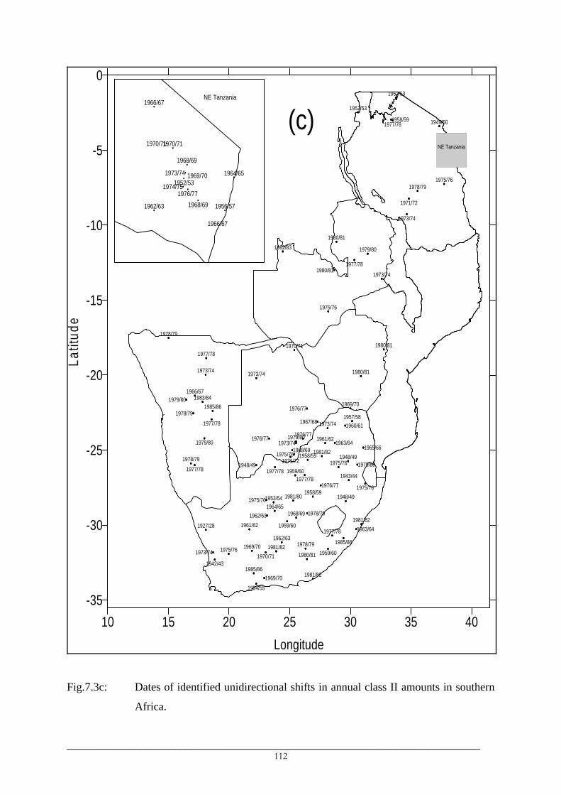
1979/801976/77
1970/71
1973/74
1978/79
1985/861983/84
1966/67
1973/74
1977/78
1978/79
1981/821985/86
1980/811975/76 1969/70 1981/82 1978/79
1962/631977/78
1927/28 1961/621981/82
1964/651968/69
1953/54 1981/801958/59
1948/49
1959/601943/44
1975/761958/59 1948/49
1981/82
1961/62
1973/741957/58
1952/53
1952/53
1949/50
1978/791975/76
1973/74
1975/76
1980/81
1979/801982/83
1980/81
1980/81
1969/70
10 15 20 25 30 35 40Longitude
-35
-30
-25
-20
-15
-10
-5
0La
titud
e
1968/69
1969/70
1963/64
1978/79
1976/77
1979/80
1963/641965/66
1960/61
1958/59
1967/68
1976/77
1975/76
1973/74
1976/77
1948/49
1978/79
1979/80
1973/74
1962/63
1975/76
1980/81
1971/721977/78
1979/80
1977/78
1954/55
1942/431970/71 1959/60
1985/86
1959/60
1975/761977/78
1977/78
1977/78
1971/72
1973/74
1977/78
NE Tanzania
1968/69
1966/67
1970/71
1956/571962/63
1966/67
1964/651952/53
1968/691976/77
1970/71
1973/74
1974/751969/70
NE Tanzania
(c)
Fig.7.3c: Dates of identified unidirectional shifts in annual class II amounts in southern
Africa.
_________________________________________________________________________ 112
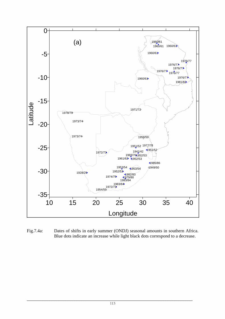
10 15 20 25 30 35 40Longitude
-35
-30
-25
-20
-15
-10
-5
0La
titud
e
1972/73
1973/74
1973/74
1978/79
1954/551972/73
1983/84
1974/751928/29 1952/53
1961/62
1960/61
1960/61
1976/77
1976/771976/77
1981/821976/771960/61
1971/72
1979/801982/83
1953/54 1949/501985/86
1952/531952/53
1951/52
1983/84
1960/61
1976/77
1953/54
1969/701941/42
1951/52 1977/78
1958/59
1960/61
1976/77
(a)
Fig.7.4a: Dates of shifts in early summer (ONDJ) seasonal amounts in southern Africa. Blue dots indicate an increase while light black dots correspond to a decrease.
_________________________________________________________________________ 113

10 15 20 25 30 35 40Longitude
-35
-30
-25
-20
-15
-10
-5
0La
titud
e
1976/77
1977/78 1976/77
1976/771977/78 1979/80
1975/761981/82
1979/80
1973/74
1973/74 1966/671981/82
1978/791962/63
1932/331976/77 1961/62
1947/48
1975/76
1977/78 1975/76
1977/781977/78
1956/57
1943/44
1980/81
1971/72
1965/66
1967/68
1945/46
1961/62
1962/63
1972/73
1979/80
1977/78
1979/80
1961/62
1946/47
1956/571956/57
1979/80
1978/79
1976/77
1976/77
1955/56
1942/43
1954/55
1938/39
1960/61
1966/67
1947/48
1958/591972/73
1979/801979/801979/80
1946/47
1943/44
(b)
Fig.7.4b: Dates of shifts in late summer (FMAM) seasonal amounts in southern Africa.
Blue dots indicate an increase while light black dots correspond to a decrease.
_________________________________________________________________________ 114

• The varying degree of the severity of the changes (Table 7.3). The changes in the
frequency of intense (> 40 mm) daily events in Namibia, for example, are of the
order of fractions of a day but represent a decrease of more than 66%. The changes
have caused these events to become even rare in some stations in which only 1 or 2
events have been observed in the 19-25 years after the change while in other they
have disappeared (Table 7.3). The largest change of 6 events at Kyela Boma (ID
09933010, Table 7.3), on the other hand, represent only 26% of the average before
the change. In stations which observed shifts in both annual amounts and annual
class II amounts, the changes in the frequency of intense events in the dry parts
contributed about 21-35% of the changes in annual amounts. The light daily events
represented a significant portion (up to 75%) of changes in annual amounts in dry
parts compared to humid parts (Table 7.3a).
7.3 Discussion
7.3.1 Patterns of anomalies
The wet early-1950s and late-1970s in most of the southern part of southern Africa
(Chenje and Johnson, 1996; Mason, 1996), as well as the drought conditions in the mid-1970s
in Tanzania and East Africa in general (Nyenzi et al., 1999; Ogallo and Nasib, 1984) and the
widespread drought in the early-1980s across much of southern Africa and other parts of
Africa (Chenje and Johnson, 1996) are apparent in the patterns of anomalies (Fig.7.1, 7.2).
Furthermore, the patterns of anomalies show alternating wet and dry periods at the regional
spatial scale consistent with reported absence of any real long term trends in southern Africa
rainfall amounts (Hulme, 1992).
However, the anomalies show some features which contradict what has been reported
in the past studies. The dry 1967-1973 period in most southern parts of the region (Chenje and
Johnson, 1996) is evidenced by negative anomalies in the time series of annual rainfall
amounts and events (e.g. Fig.7.5) and anomalies of annual amounts (Fig.7.1a) and events
(Fig.7.1b) in the 1965-1969 period but those in the 1970-1974 period indicate the opposite.
The strong and extended June 1973-April 1976 La Niña event (Trenberth, 1997) was
responsible for the heavy 1974 rainfall in the southern part of southern Africa in which
anomalies of up to 4 standard deviations were observed in certain areas. Similarly, Nyenzi et
al. (1999) linked the 1973-1976 rainfall deficits and drought conditions in Tanzania to this La
Niña event. Therefore, the high rainfalls of 1974 were essentially the cause of positive
anomalies in the 1970-1974 period given the slightly below or above average rainfalls in the
_________________________________________________________________________ 115
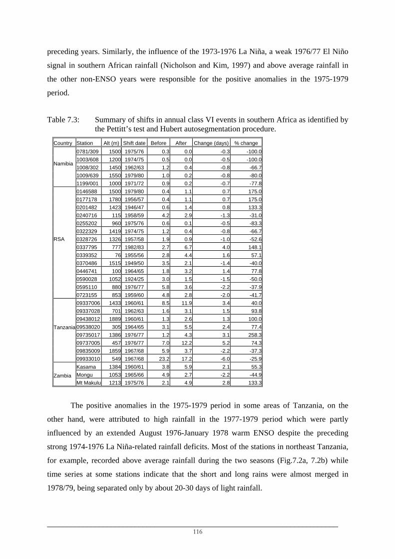
preceding years. Similarly, the influence of the 1973-1976 La Niña, a weak 1976/77 El Niño
signal in southern African rainfall (Nicholson and Kim, 1997) and above average rainfall in
the other non-ENSO years were responsible for the positive anomalies in the 1975-1979
period.
Table 7.3: Summary of shifts in annual class VI events in southern Africa as identified by the Pettitt’s test and Hubert autosegmentation procedure.
Country Station Alt (m) Shift date Before After Change (days) % change 0781/309 1500 1975/76 0.3 0.0 -0.3 -100.01003/608 1200 1974/75 0.5 0.0 -0.5 -100.01008/302 1450 1962/63 1.2 0.4 -0.8 -66.71009/639 1550 1979/80 1.0 0.2 -0.8 -80.0
Namibia 1199/001 1000 1971/72 0.9 0.2 -0.7 -77.8
0146588 1500 1979/80 0.4 1.1 0.7 175.00177178 1780 1956/57 0.4 1.1 0.7 175.00201482 1423 1946/47 0.6 1.4 0.8 133.30240716 115 1958/59 4.2 2.9 -1.3 -31.00255202 960 1975/76 0.6 0.1 -0.5 -83.30322329 1419 1974/75 1.2 0.4 -0.8 -66.70328726 1326 1957/58 1.9 0.9 -1.0 -52.60337795 777 1982/83 2.7 6.7 4.0 148.10339352 76 1955/56 2.8 4.4 1.6 57.10370486 1515 1949/50 3.5 2.1 -1.4 -40.00446741 100 1964/65 1.8 3.2 1.4 77.80590028 1052 1924/25 3.0 1.5 -1.5 -50.00595110 880 1976/77 5.8 3.6 -2.2 -37.9
RSA 0723155 853 1959/60 4.8 2.8 -2.0 -41.7
09337006 1433 1960/61 8.5 11.9 3.4 40.009337028 701 1962/63 1.6 3.1 1.5 93.809438012 1889 1960/61 1.3 2.6 1.3 100.009538020 305 1964/65 3.1 5.5 2.4 77.409735017 1386 1976/77 1.2 4.3 3.1 258.309737005 457 1976/77 7.0 12.2 5.2 74.309835009 1859 1967/68 5.9 3.7 -2.2 -37.3
Tanzania 09933010 549 1967/68 23.2 17.2 -6.0 -25.9
Kasama 1384 1960/61 3.8 5.9 2.1 55.3Mongu 1053 1965/66 4.9 2.7 -2.2 -44.9Zambia
Mt Makulu 1213 1975/76 2.1 4.9 2.8 133.3
The positive anomalies in the 1975-1979 period in some areas of Tanzania, on the
other hand, were attributed to high rainfall in the 1977-1979 period which were partly
influenced by an extended August 1976-January 1978 warm ENSO despite the preceding
strong 1974-1976 La Niña-related rainfall deficits. Most of the stations in northeast Tanzania,
for example, recorded above average rainfall during the two seasons (Fig.7.2a, 7.2b) while
time series at some stations indicate that the short and long rains were almost merged in
1978/79, being separated only by about 20-30 days of light rainfall.
_________________________________________________________________________ 116

The other important pattern that is displayed by the anomalies is the seasonality. The
anomalies of ONDJ amounts in the 1980-1984 reported dry period in southern Africa are
positive over much of Tanzania consistent with the expected positive response of early
summer rainfall to a strong warm 1982/83 ENSO. The drought conditions at the annual
timescale are, however, reflected from similar deficit rainfalls during the FMAM.
Consequently, the FMAM rainfall deficits correspond to the longest 4-year drought during the
long rains which lasted between 1982 and 1985 in northeast Tanzania (Nyenzi et al., 1999). In
general, the rainfall deficit in the early-1980s were linked to ENSO (Chenje and Johnson,
1996) or ENSO-SST mode and its changed relationship since the 1970s (Folland et al.,1986;
Janicot et al., 1996; Richard et al., 2000; Janicot et al., 2001).
The reported dry 1967-1973 period in the southern part of southern Africa are
apparent in the anomalies of annual indices (Fig.7.1) and late summer (ONDJ, Fig.7.2a)
amounts in the 1965-1969 period but not in the anomalies of late summer amounts (FMAM,
Fig.7.2b). Moreover, the 1973-1976 drought in Tanzania tends to characterize rainfall
amounts at both seasonal and annual timescales. However, the drought was severe in the
equatorial northern Tanzania and during the short rains (October-December) (Nyenzi et al.,
1999), the part and season that are significantly influenced by ENSO (Ropelewski and
Halpert, 1987; Latif et al., 1999; Indeje et al., 2000; Mutai and Ward, 2000). The drought was
influenced mainly by the strong and extended 1973-1976 La Niña (Nyenzi et al., 1999) and is
indicated by the dates and duration of the drought which coincide with those of the La Niña
event.
7.3.2 Abrupt changes
It is important to assess the reality of the identified abrupt changes as they may have
resulted from inhomogeneities introduced by changes in the station location or units of
measurement, for example, which may have a significant impact on the intensities of daily
rainfall. The spatial patterns and dates of abrupt changes, however, indicate that it is unlikely
that the changes can be attributed to such inhomogeneities although the probability of such
influences are not ruled out completely.
The small number of stations in which discontinuities were identified in annual
amounts of rainfall support the claim that there is no real evidence of any trends in rainfall
amounts in most parts of southern Africa (Hulme, 1992; Smakhtina, 1998) except in certain
areas such as the South African Lowveld (Mason, 1996), Botswana and Zimbabwe (Hulme,
1992), southern Zambia (Sichingabula, 1998), etc. However, results indicate strong evidence
_________________________________________________________________________ 117

of decreasing annual amounts in Namibia since the mid-1970s, in some northeast South
Africa stations since the early-1960s and in others since the late-1970s. Mason (1996) and
Mason et al. (1999) reported decreases in annual amounts in the Lowveld in northeast South
Africa since the late-1970s while Jury and Engert (1999) reported decreases in dam levels in
Namibia since the mid-1970s.
The changes in early and late summer amounts reflect mainly the influences of ENSO
and SST in the surrounding Indian Ocean basins. The ENSO influences on rainfall in the
region is communicated mainly through the Indian and Atlantic Ocean waters (Nicholson and
Kim, 1997). Its influences on rainfall in Tanzania peak in the October-December period (Latif
et al., 1999; Mutai and Ward, 2000; Trenberth and Caron, 2000). Abrupt increases in early
summer amounts in eastern and southern Tanzania occurred mainly in 1976/77, consistent
with the period when warming in the tropical Indian and Pacific Oceans occurred (Trenberth,
1990; Kerr, 1992; Wang, 1995; Trenberth and Hoar, 1996). The increase in the northern
Tanzania, on the other hand, occurred earlier in 1960/61, the changes which could be
probably reflecting a reoccurrence of an active phase of ENSO in the late-1950 to early-1960s
(Wang and Wang, 1996; Kestin et al., 1998; Torrence and Compo, 1998) and in which ENSO
signals were probably communicated through the atmosphere.
The abrupt increases in early summer amounts in South Africa occurred mainly in the
early-1950s in the northern part of the central interior and early-1970s in the southern part of
the central interior. The influences of the great Agulhas Current system on the rainfall in
central southern South Africa (Reason, 1998; Reason and Mulenga, 1999; Reason, 2001), the
warming of the southwest Indian Ocean since the early-1970s (Trzaska et al., 1996) and an
enhanced influence of the Agulhas during weak ENSO (Walker, 1989; Mason, 1992) and a
low ENSO signal in rainfall during the months of early-summer are possibly responsible for
the increase in the early-1970s in the central southern Africa. The negative influences of the
Indo-Pacific ENSO signal on rainfall in the southern part of southern Africa (Jury, 1995;
Landman and Mason, 1999; Richard et al., 2000) peaks after December and therefore
significantly affects the late summer rainfall. Consequently, the warming in the tropical
Indian and Pacific Oceans since the mid-1970s is consistent with late summer rainfall
decreases since the late-1970s in Namibia and in some areas of southeast and northeast South
Africa.
There is also strong evidence of decreases of light (< 10 mm) daily rainfall events in
the region. The results indicated that daily rainfall events whose intensities are below 10 mm
have significantly decreased in the most parts of the region and consistently since the second
_________________________________________________________________________ 118

half of the 1970s possibly related to warming in the tropical Indian and Pacific Oceans. The
decrease is indicated by a significant reduction of the number as well as the amounts
contributed by these light daily events. Owing to their low contribution to annual amounts in
the region, the decreases in the light daily events could not affect significantly annual amounts
except in areas such as Namibia where their contributions are high. The decreases in the
number of these most frequent light daily rainfall with relatively unchanged or increasing
frequency of occurrences of intense events are reflected by the decreasing annual events (not
shown) as well as rain rates in the Eastern Cape (Smakhtina, 1998) and in the former Transkei
and the northern Transvaal (Richard et al., 2002).
On the other hand, abrupt decreases in number of class II events along the northeast
coast of Tanzania have occurred in the late-1960s and early-1970s, while increases in the
areas around Mount Kilimanjaro occurred in the early-1960s. The changes in Mount
Kilimanjaro could be linked to signals embedded in the atmosphere as discussed above, while
decreases around 1970 could be due to warming in the southwest Indian Ocean since rainfall
in equatorial East Africa, in which the coast northeast is part, correlates significantly with
SST (Latif et al., 1999) and atmospheric winds (Mutai and Ward, 2000) in the southwest
Indian Ocean.
Simulation experiments of an enhanced greenhouse state indicated increases of
convective activity (Mitchell and Ingram, 1992; Whetton et al., 1993) due to enhanced
greenhouse effects leading to increasing frequency of high rainfall events and a decrease in
the number of rain-days. Consequently, Smakhtina (1998) found an increase in the frequency
of high rainfall in the Eastern Cape while Mason and Joubert (1997) simulated an increase of
the frequency and intensity of these high rainfalls in much of southern Africa. Similarly,
abrupt increases in both the frequency (Table 7.3) and amount (Fig.7.3b) of intense (> 40
mm) daily events have occurred in northeast Tanzania during 1961-1964. However, these
intense daily events in Namibia have become very rare or disappeared since the mid-1970s
while they have generally decreased in northern central (since mid-1970) and northeast South
Africa (between early-1960s and late-1970s), the result for northeast South Africa being
consistent with the decreases identified in Mason et al. (1999).
The changes in the characteristics of daily rainfall intensities identified in the 1970s in
the southern African region seem to have occurred in other parts of the world which have
different climatic regimes to those in southern Africa. Brunetti et al. (2001) found increasing
trends in the number and intensity of high rainfall events and decreasing trends in the lightest
events in Italy since the 1970s leading to decreases in the number of rainfall events. Salinger
_________________________________________________________________________ 119

and Griffiths (2001) found an abrupt increase in the frequency of high rainfall in 1977 in the
southwest of the South Island of New Zealand and around mid-1950s in the north of the North
Island. They further found significant increases in the minimum temperatures around 1970 in
the northern and central areas of the North Island. Several other studies have found a mixture
of increases and decreases in extremes of rainfall and other climatic variables in different
parts of the world (Karl et al., 1995).
It was also tempting to associate the abrupt decreases and increases with the 11-19
years decadal/multidecadal cycles in southern African rainfall (Tyson, 1986; Nicholson and
Entekhabi, 1987; Nyenzi et al., 1999; Nicholson, 2000). Interannual variability of Namibian
rainfall is, however, dominated by 2-5 year cycles (Nicholson and Entekhabi, 1987;
Nicholson, 2000) suggesting that there is little possibility that an abrupt decrease could be
attributed to the decadal/multidecadal cycles of 11-19 years. The presence of the 11-19 year
cycles in rainfall in northeast South Africa and Tanzania indicates that for decreases occurring
in the 1970s, a return to normal rainfall condition was expected around the early- to mid-
1990s while for the decreases that occurred in the early-1960s, the cycle is irrelevant.
Therefore, the changes since the 1970s could be part of the long periodicity oscillations but
the records since the early-1990s are too short to draw firm conclusions. Nonetheless, Mason
(1996) cautioned of the robustness of the 18-year cycle particularly when recent records are
used.
7.4 Conclusions
Changes have been identified in southern Africa rainfall which significantly affect the
number and amounts of the light (< 10mm) daily rainfall events and consequently the annual
number of daily rainfall events. The changes were predominantly decreasing and have
occurred mainly in the 1970s characterising mostly rainfall in the late (FMAM) season.
Changes that have been identified in rainfall in the early (ONDJ) summer season, on the other
hand, were predominantly towards increasing rainfall. These changes were not attributable to
the decadal/multidecadal cycles in rainfall but rather to the changes in the background oceanic
and atmospheric conditions which have been identified in the 1940s through late-1970s,
although the influence of the long periodicity cycles were not ruled out.
It was further observed that the patterns of anomalies averaged over 5-year periods
were significantly affected by the extreme years. Therefore, since the dominant modes of
interannual rainfall variability in the region are related to ENSO which has a preferred range
of 3-8 years periodicity and whose influences are seasonally varying, averaging over time
_________________________________________________________________________ 120

windows sometimes results in unrealistic patterns while combining the opposing early and
late summer rainfalls may dampen the annual pattern.
Shorter and few records in Zambia and Zimbabwe hindered an appropriate
characterisation of time series behaviour in that part of southern Africa. Shifts were identified
as early as in the late-1940s, in the 1950s and in early-1960s but most of the records used for
the two countries cover only the early-1950s and early 1990s. It was not possible to
characterise pre-1950s rainfall behaviour and it was difficult to distinguish between shifts and
grouped outliers pre-1965, as only a few years of records are available. Similarly,
unavailability of daily data in most of western and southern Tanzania hindered the verification
of patterns of variability displayed by annual amounts. The unavailability of data in northeast
and southern Mozambique and excessive missing observations in the 1970s and 1980s
prevented a satisfactory regional characterisation of rainfall variability in southern Africa.
Changing frequencies of rainfall in the region indicate modification of rainfall
occurrence in the region and consequently modifications in rainy season patterns are
anticipated. The modifications may involve lengthening dry episodes during the rainy seasons
or shortening of the seasons. Moreover, changes in rainy season behaviour may cause regime
changes in river flows. Therefore, interannual variations of rainy season characteristics and
streamflow regimes in southern Africa are investigated respectively in chapter 8 and chapter
9.
_________________________________________________________________________ 121

___________________________________________________________________________
CHAPTER 8
THE RAINY SEASONS IN SOUTHERN AFRICA
___________________________________________________________________________
8.1 Introduction
Amounts of rainfall during the rainy season to some extent depend on its onset and/or
cessation (Camberlin et al., 2002). It is obvious that the short rainy season is normally dry,
but the interrelationship between dryness of a season and duration of the season in southern
Africa is little understood. What may be causing shortened (prolonged) rains, whether it is
their early (late) end, late (early) onset or both is not well understood. The knowledge of the
onset of the rainy season as well as of its cessation is therefore of utmost importance
especially to rain-fed agriculture, which is widely practised in southern Africa. Perfect timing
of the start of the rainy season has substantial economical benefits to southern African
farmers. A false start of a rainy season (indicated by a few isolated pre-season rainy events),
for example, always has negative impacts on agricultural activities. In most cases, it leads to
resowing of crops. A combination of a late start and early termination of the rainy season
usually corresponds to insufficient soil moisture for crops like rice, which results into either
crop failure or low agricultural productivity.
Therefore, the main objective of this chapter is to investigate any relationships
between interannual variations of the rainy season characteristics (onset, end and duration)
and interannual variations of rainfall amounts and number of daily events in southern Africa.
The rainy season characteristics are defined and their spatial variations across southern Africa
are studied. The interannual variability of the rainy season characteristics is mainly discussed
in relation to the interannual variations of rainfall amounts and number of events presented in
the preceding chapter.
8.2 The review of the definitions of the rainy seasons
Previous studies of rainy seasons attempted, in one way or the other, to produce
definitions of a rainy season that are capable of capturing spatio-temporal variations of daily
rainfall intensities and sequences of dry days. A variety of methods that define rainy season
characteristics (onset and cessation) exists. The methods are generally grouped (Camberlin et
_________________________________________________________________________ 122
al., 2002) into 1) agroclimatic-based methods, 2) methods based on climatic variables such as
winds, convections and 3) purely precipitation-based methods.
The first group comprises methods whose definitions of onset and cessation of rainy
seasons are based both on rainfall characteristics (such as daily rainfall intensities) and on
availability of sufficient soil moisture for crop sowing. The methods in this group have been
used in studies of rainy seasons in West Africa (Diop, 1996; Houndenou and Hernandez,
1998).
Methods in the second group relate changes in climatic variables to onset and
cessation of rainy seasons. They have been used in the studies of Holland (1986), Omotosho
(1990, 1992) and Omotosho et al. (2000). Omotosho (1992) related sudden changes in 400
hPa wind direction, from westerly to easterly, to the onset of a rainy season in the West
African Sahel. Kousky (1988) defined the onset and end of rainy seasons in the Amazoni
basin based on out-going longwave radiation (OLR). Others used a combination of OLR and
rainfall in defining rainy season’s onset and end. Hendon and Liebmann (1990) combined
wind and rainfall in their definition of a rainy season.
Methods in the third group use only rainfall characteristics in determining the onset
and cessation of a rainy season. They were used as early as in the 1970s and early-1980s
(Ilesanmi, 1972; Nicholls et al., 1982) and in the more recent studies of Liebmann and
Marengo (2001), Marengo et al. (2001), Camberlin and Diop (2002), Camberlin et al. (2002),
and Valimba et al. (2004d). The methods in this group usually use data either from individual
stations or grids (Liebmann and Marengo, 2001; Valimba et al., 2004d) or regional indices
(Camberlin and Diop, 2002; Camberlin et al., 2002) derived as regional averages (Marengo et
al., 2001) or as empirical orthogonal function (EOF) principal components (PC) (Camberlin
et al., 2002). Depending on the method, different timescales have been used, from daily
observations to pentad or decadal averages.
The first two methods were considered inappropriate for the study since
• The methods in the first group are dependent on the agronomic requirements which
are, in turn, dependent on several other non-climatic variables.
• The methods in the second group, despite being robust, suffer from the inadequate
availability of climatic data over Africa (Camberlin et al., 2002) or where available,
the network is sparse (Omotosho et al., 2000). Consequently, studies of rainy seasons
at finer spatial scales become difficult to conduct and hence these methods are not
very suitable for southern Africa.
_________________________________________________________________________ 123

• The use of all-record averages hampers studies of the temporal evolution of rainy
season characteristics since only a single climatological onset and a single cessation
date are determined.
• The use of spatial averages hinders the studies of spatial variation of the rainy season
characteristics since only single onset and end dates of the rainy seasons are
computed for an area and given the varying degree of the influences of the
topography and other climatic variables in southern Africa, the dates may not be
spatially representative in the region.
The present study is interested in spatio-temporal variations of rainy seasons
characteristics. Hence methods that allow for spatial as well as temporal investigation of rainy
seasons characteristics such as those of Marengo et al. (2001), Camberlin et al. (2002) and
Valimba et al. (2004d) are considered appropriate. However, there is a need to consider the
diverse climatic conditions in the region in which accounting for a sequence of dry days in the
dry parts of southern Africa is considered important in order to avoid the false onset and end
(Benoit, 1977) of the rainy seasons.
In this chapter, a method that defines rainy season onset and cessation on the basis of
daily rainfall intensities and length of sequences of dry days is proposed. Plots of daily
rainfall intensities for different years at various locations in southern Africa and daily rainfall
characteristics in Chapter 6 are used in establishing the definitions.
8.3 Defining the rainy seasons
8.3.1 Plots of daily rainfall intensities and the sequences of dry days
Plots of daily rainfall for different years (e.g. Fig.8.1), at various locations in the
region and the sequences of the dry days before, during and after the rainy seasons show
various characteristics of daily rainfall in relation to the start and end of the rainy seasons in
the region. In the plots, the year was defined as a hydrological (water) year between 1st
October and 30th September and they confirm a dominance of unimodal rainfall regimes in
southern Africa. The main features that were considered useful in relation to the definitions of
the rainy season characteristics are presented below.
_________________________________________________________________________ 124

Fig.8.1: Typical plot of daily rainfall in various parts of southern Africa to highlight
different rainfall regimes. Plots are for a year defined from 1st October to 30th September, the dates being represented respectively by leftmost and rightmost sides of the plots.
_________________________________________________________________________ 125

a) The rainfall regimes
• The unimodal and bimodal regimes
Most of southern Africa is characterised by a unimodal rainfall regime, except in
northern Tanzania where a bimodal regime exists. Rainfall seasons start in unimodal
southern Africa between the first two weeks of October (in southeast South Africa
and in north-northwest Zambia) and the first two weeks of January (in Namibia). The
end of the rainy season is observed between mid March in the deserts in southeast
Namibia and southern Botswana and mid April in northern Zambia and
Mozambique. In the Western Cape, the rainy season extends, on average, from late
April to early September.
• Distinguishing the short and long rains in the northern Tanzania
In northern Tanzania, the bimodality of the rainy season is more evident in the
Arusha and Kilimanjaro regions around mounts Kilimanjaro and Meru in northeast
Tanzania. A relatively dry January-February period separates the short rains from the
long rains in the lowlands in the lee of the mountains and amid the northern
(Kilimanjaro and Meru) and southern (the Usambaras) mountains (Fig.8.1). In the
mountainous and coastal areas of the northeast as well as in northern Lake Victoria,
the two seasons are still distinct but are separated by a January-February period of
reduced rainfall intensities. The bimodality is not well marked in areas between the
Usambaras and the Indian Ocean coast in northeast Tanzania where the long rains
appear to be a continuation of the short rains (Fig.8.1).
Further, three types of years are distinguished with respect to rainfall bimodality.
There are years (e.g. 1978/79) when the two seasons are almost combined into a
single continuous season between October and May. In such years, the two seasons
are typically separated by less than 30 dry days. Daily intensities during the January-
February period remain above 5mm and frequently exceed 10mm. Other years
correspond to separated short and long rains whereby short rains are either well
developed (e.g. in 1982/83, Fig.8.3) or practically absent (e.g. 1975/76, Fig.8.2b).
The plots of daily rainfall further show that the short rains, commonly regarded to
occur between October and December, are actually observed between early October
and early February. The peak of the short rains shifts between the three months of
November, December and January (Fig.8.3). Moreover, daily rainfall events during
the short rains are usually less intense compared to those during the long rains
_________________________________________________________________________ 126

(Fig.8.2 and 8.3). However, in strong warm ENSO years such as 1982/83 (Fig.8.3b),
intense daily events are observed during the short rains.
(a)
020406080
100
O N D J F M A M J J A SMonth
Rai
nfal
l (m
m)
(b)
020406080
100
O N D J F M A M J J A S
Month
Rai
nfal
l (m
m)
Fig.8.2: Time series of daily rainfall at Moshi airport (ID 09337004) in northeast
Tanzania for the year a) 1978/79 and b) 1975/76.
b) The importance of the definition of a dry day and the length of dry sequences
• Further investigation shows that pre-season and post-season rains are characterised
by 1-3 daily events with intensities around 5-20 mm separated by long (> 15 days)
sequences of days with intensities below 1 mm. Thus, in order to avoid false onset or
cessation, a dry day was redefined as a day whose intensity is below 1 mm (1.1 mm
in the Western Cape).
• The occurrence of daily rainfall during the pre-season/early season and late
season/post-season periods October-November and April-May (unimodal areas) and
October-November, December-January, February-March and May-June (bimodal
areas) shows that i) during the month (30 days) preceding the onset of the rainy
season, the sequence of dry days is usually longer than 10-15 days and reduces to
below 10-15 days in the month following the onset, ii) in bimodal areas in northeast
Tanzania, the use of a 30-day period following the onset does not completely
eliminate the likelihood of a false onset of short rains as well as long rains in certain
years while the use of a 45-day period does, iii) coastal areas and the Usambara
Mountains in northeast Tanzania and areas in northwest Lake Victoria in Kagera
_________________________________________________________________________ 127

region (Tanzania) receive rainfall throughout the year (Fig.8.1) and a length of 20
dry days was appropriate to discriminate the long rains from dry season rains while
shorter lengths (e.g. 15 days) and longer lengths (e.g. 30 days) would result into early
and sometimes false cessation.
(a)
020406080
100
O N D J F M A M J J A S
Month
Rai
nfal
l (m
m)
(b)
020406080
100
O N D J F M A M J J A S
Month
Rai
nfal
l (m
m)
(c)
020406080
100
O N D J F M A M J J A S
Month
Rai
nfal
l (m
m)
Fig.8.3: Examples of temporal variations of the short rains in northeast Tanzania:a)
1988/89, b) 1982/83 and c) 1964/65 at Moshi Airport.
8.3.2 The definition of the onset and end of the rainy seasons
From the preceding observations and the comparison of the daily intensities during the
rainy seasons and the all-record average daily rainfall intensities (AADI), the onset of the
rainy seasons in southern Africa was, therefore, defined as the second day when the average
rainfall intensity of two consecutive days exceeds AADI and after which, during the next 45
days there is no sequence of days with intensities less than 1 mm that exceeds 15 (10 in
bimodal areas) days. The end of the rainy season was likewise defined as the last day after
which the daily intensity falls below AADI and is followed by a sequence of at least 28 (18 in
_________________________________________________________________________ 128

the bimodal areas) out of 30 (20 in bimodal areas) days whose intensities are below to 1 mm.
The length of the rainy season was defined as the difference between the end and onset dates.
These definitions were used to provide results discussed in the subsequent sections of this
chapter.
The applications of the definitions involved a spatial delineation of the southern
African region according to the prevailing rainfall regimes: the bimodal northern Tanzania,
the unimodal summer and winter regions. The following procedure was used to separate the
bimodal northern Tanzania and unimodal Western Cape from the unimodal summer areas in
the region:
• Three time periods were analysed in Tanzania, a whole year (1st October to 30th
September), the period 1st September - 28th February for short rains and 1st February
- 31st July for long rains and two in the southern and western South Africa, 1st March
– 28th/29th February and 1st October – 30th September. In Tanzania, September and
February are included so as not to exclude the possibility of early onsets of the short
and long rains respectively, while January-February and June-July are included in
order not to exclude late cessations of the two seasons. It should be noted that
February is used in both sub-periods. February was purposely included in the two
sub-periods so as to enable appropriate identification of unimodal and bimodal areas.
• Using the definitions of the onset and end of the rainy season, the onset and end were
calculated at each station in the corresponding regions and are shown in Fig.8.4 for
Tanzania.
• A presumption of a period of at least one and a half to two months separating the two
seasons indicates that the bimodal region of Tanzania extends from western Lake
Victoria region sweeping across northern and northeast Tanzania to the northeast
coast along the Indian Ocean, north of about 7.5°S (Fig.8.4). Nevertheless, the whole
region above the 40-days contour show bimodal characters and is considered as the
bimodal region in this study. The region immediately south of the bimodal region
experiences characteristics of both bimodal and unimodal rainfall regimes. It is
referred to as transition region between the unimodal and bimodal regions (Nyenzi et
al., 1999). The Western Cape was similarly separated from the rest of South Africa.
_________________________________________________________________________ 129

28 30 32 34 36 38 40Longitude
-12
-10
-8
-6
-4
-2
0
Latit
ude
Fig.8.4: Differences (in days) between onset of long rains and end of short rains in Tanzania when the sub-periods for short and long rains were used. The region north of the bold dashed line roughly represents the bimodal areas of northern Tanzania.
8.4 Sensitivity of parameters defining the rainy seasons
Sensitivity tests were performed on intensities and lengths of dry day sequences which
define the onset and cessation of rainy seasons. Sensitivity of onset dates was performed i) by
comparing onset dates given by AADI as a limiting intensity to those resulting from the use of
5 mm and 10 mm fixed daily intensities for a 15-day long dry day sequence and ii) by
comparing onset dates given by a 15-day long sequence of dry days to those resulting from
the use of 7-day and 10-day long sequences with AADI as a limiting intensity.
Likewise, sensitivity of cessation dates was assessed i) by comparing cessation dates
given by AADI as a limiting intensity to those resulting from the use of 0.5AADI and 1 mm
fixed daily intensities for a 30-day long dry day sequence and ii) by comparing cessation dates
given by 30-day long sequence of dry day to those resulting from the use of 20-day and 40-
day long sequences with AADI as a limiting intensity.
Results show generally that onset and cessation of rainy seasons determined by the
proposed method are more sensitive to varying length of sequence of dry days than to
variation of the limiting intensities. Moreover, onset of the rainy season is more sensitive to
changing limiting intensities than the end. The main features are
_________________________________________________________________________ 130

10 15 20 25 30 35 40Longitude
-35
-30
-25
-20
-15
-10
-5
0La
titud
e
(a)
10 15 20 25 30 35 40Longitude
-35
-30
-25
-20
-15
-10
-5
0
Latit
ude
(b)
10 15 20 25 30 35 40Longitude
-35
-30
-25
-20
-15
-10
-5
0
Latit
ude
(c)
10 15 20 25 30 35 40Longitude
-35
-30
-25
-20
-15
-10
-5
0
Latit
ude
(d)
Fig.8.5: Differences between onset dates given by a) 5mm against AADI intensities, b)
15 days long and 10 days long dry day sequences and between cessation given by c) 1mm against AADI intensities and d) 20 days long against 30 days long dry day sequences in the unimodal rainfall southern Africa. Negative differences are shaded.
• Changes of onset-defining intensities from AADI to 5 mm or 10 mm fixed intensities
lead to an early onset in the Western Cape and a delayed onset in the rest of
unimodal southern Africa (Fig.8.5a). The significant delays of up to a month are
found in Botswana while in the remaining part the changes are moderate. The
_________________________________________________________________________ 131

decrease of the length of the sequence of dry days from 15 to 10 days result in a
delayed onset across the whole of unimodal southern Africa (Fig.8.5b) which is
longer in the southern and eastern parts than in the northern (Zambia) and western
(western Namibia) parts.
• At a constant month (30 days) long sequence of dry day, there are practically no
changes in the dates of the end of the rainy season across southern Africa whether
AADI, its half or 1 mm intensities are used as limiting intensities (Fig.8.5c).
However, a change from 30-day long sequence of dry days to 20-day long sequence
for a fixed limiting intensity (AADI, 0.5AADI or 1 mm) results in an early end of the
season across the whole of the unimodal southern Africa, affecting significantly the
eastern part of the region particularly in southern Mozambique, eastern South Africa
and southwest Botswana (Fig.8.5d). The isolated nature of daily rainfall events in the
dry southwestern part of southern Africa and high frequencies of rainfall events in
Zambia make the end of the season less sensitive to changes in the length of the
sequence of dry days as indicated by the lowest changes in these parts. The earliest
ends around early January in Botswana or around late January in central South
Africa, for example, were not consistent with what is shown by time series
suggesting the inappropriateness of this length.
8.5 Spatial variation of averages of the rainy seasons
8.5.1 Onset, end and duration in the bimodal northern Tanzania
The results of the average onset and end dates of the short and long rains in the
bimodal northern Tanzania are summarised in Fig.8.6. They show generally characteristics
which are related to the start, advances and retreat of the two seasons in the bimodal northern
Tanzania:
• The average dates and durations
The short rains in bimodal Tanzania last, on average, about 55-60 days between 1st
week of October and 2nd week of January (around 13th January) (Fig.8.6a, 8.6b)
while the long rains start in late-February (around 27th February) in southern Lake
Victoria and between 12th and 22nd March in northeast and they retreat from the
bimodal region between 12th and 27th May and have average durations not
significantly different from that of the short rains (Fig.8.6c, 8.6d).
_________________________________________________________________________ 132
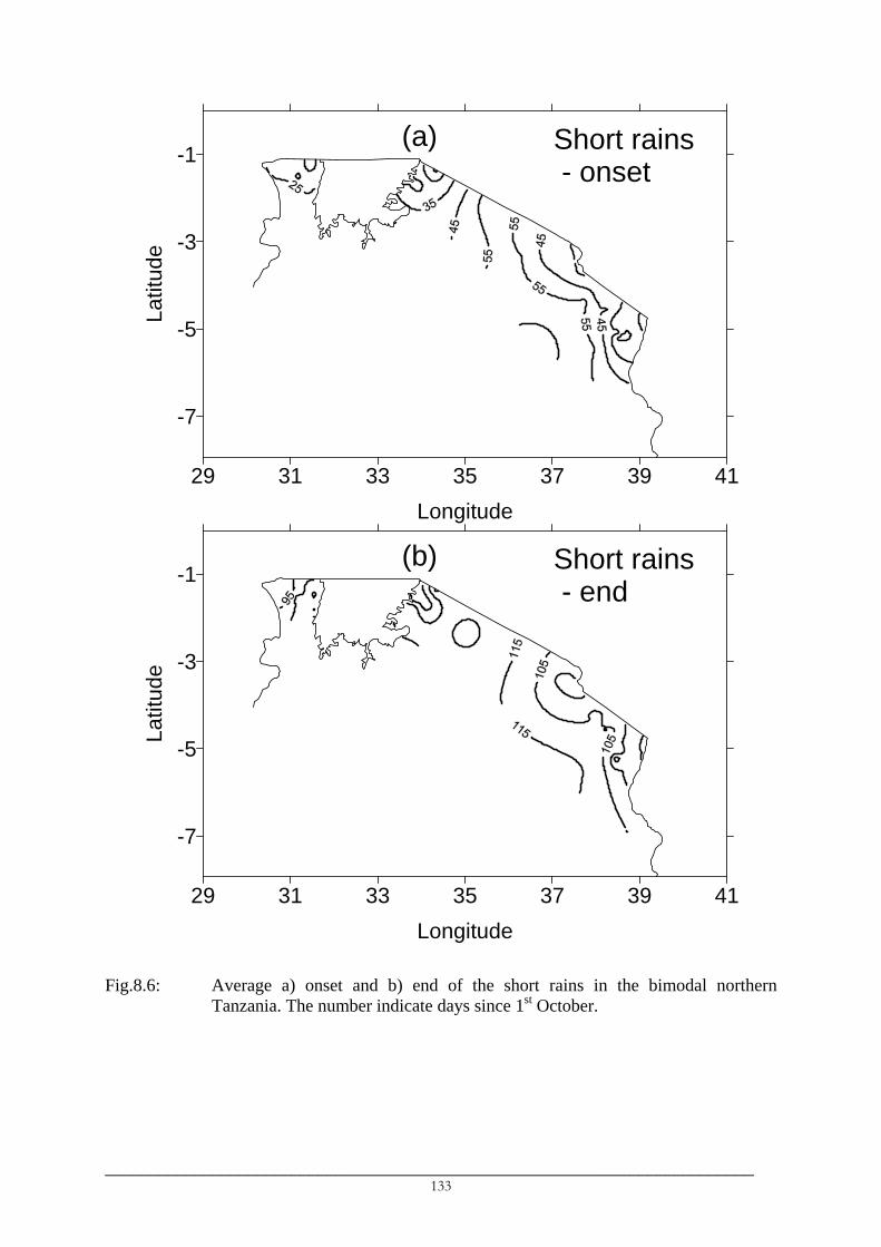
(a) Short rains - onset
29 31 33 35 37 39 41Longitude
-7
-5
-3
-1La
titud
e
(b) Short rains - end
29 31 33 35 37 39 41Longitude
-7
-5
-3
-1
Latit
ude
Fig.8.6: Average a) onset and b) end of the short rains in the bimodal northern
Tanzania. The number indicate days since 1st October.
_________________________________________________________________________ 133

29 31 33 35 37 39 41Longitude
-7
-5
-3
-1La
titud
e(c) Long rains
- onset
(d) Long rains - end
29 31 33 35 37 39 41Longitude
-7
-5
-3
-1
Latit
ude
Fig.8.6: Average c) onset and d) end of the long rains in the bimodal northern
Tanzania. The number indicate days since 1st October (Continued).
_________________________________________________________________________ 134

10 15 20 25 30 35 40Longitude
-35
-30
-25
-20
-15
-10
-5
0La
titud
e
(a) Onset
10 15 20 25 30 35 40
Longitude
-35
-30
-25
-20
-15
-10
-5
0
Latit
ude
(b) End
10 15 20 25 30 35 40Longitude
-35
-30
-25
-20
-15
-10
-5
0
Latit
ude
(c) Duration
15 17 19 21 23 25
Longitude
-35
-33
-31
-29
-27
-25La
titud
e
AtlanticOcean
SOUTH AFRICA
(d) Onset
15 17 19 21 23 25Longitude
-35
-33
-31
-29
-27
-25
Latit
ude
AtlanticOcean
SOUTH AFRICA
(e) End
15 17 19 21 23 25
Longitude
-35
-33
-31
-29
-27
-25
Latit
ude
AtlanticOcean
SOUTH AFRICA
(f) Duration
Fig.8.7: Average onset, end and duration of the rainy season in unimodal areas of
southern Africa: a)-c) summer rainfall areas and d)-f) Western Cape. Onset and cessation dates are days since 1st October.
_________________________________________________________________________ 135

• The spatial patterns of advances and retreat
The short rains spread into northern Tanzania from i) northwest Lake Victoria and ii)
the northernmost coast of Tanzania (Fig.8.6a) while their pattern of retreat follows
that of its start (Fig.8.6b). The spatial pattern of long rains onset is almost the reverse
of that of the short rains in which the long rains start in southern Lake Victoria and
the southwest part of northeast Tanzania (Fig.8.6c) while they cease earliest in the
southern part of the bimodal areas and latest in the coastal areas of the northeast
(Fig.8.6d).
• The evidence of the differences between the short and long rains
Seasonal amounts and number of daily rainfall events indicate that these two
quantities are lower during the short rains than during the long rains. The long rains
receive about 4-27 extra daily rainfall events compared to the short rains. The Lake
Victoria region experiences comparable seasons with typical differences of below 10
days. However, the greatest differences (typically between 10-20 days) are observed
in the mountainous areas in northeast Tanzania. Moreover, amounts of rain falling
during the long rains are about 1.1-1.5 of those during the short rains. These results
suggest that the names (short and long rains) are derived from the expected number
of daily rainfall events and rainfall amounts rather than their lengths.
8.5.2 Onset, end and duration in the unimodal southern Africa
The spatial variation of the average dates of onset and end and the average durations
of the rainy seasons in the unimodal summer and winter (Western Cape) areas of southern
Africa are shown in Fig.8.7. The main features are summarised as follow:
• The average dates and durations
The rainy season in the summer areas of the unimodal southern Africa is observed
between the 1st week of October and 4th week of April (8.7a, 8.7b) while in the
Western Cape it extends between 4th week of April and mid-October (8.7d,8.7e).
• The spatial patterns of advances and retreat
The rainy season in the summer unimodal areas spreads from the southeastern coast
of South Africa (1st two weeks of October) in the south and from northern and
western Zambia (20th-30th October) in the north into the interior part of southern
Africa (1st three weeks of November) and occurs latest in western and southern
Namibia (between the 4th week of November and 3rd week of January; Fig.8.7a). The
cessation begins in Botswana (around mid- to late-February) and progresses radially
_________________________________________________________________________ 136

into other parts of the region (Fig.8.7b) in which the latest cessation in April is
experienced in areas approximately north of 17°S.
In the Western Cape, the rains begin first in the southwestern tip of South Africa
between the 4th week of April and 2nd week of May and progress northwestward
(Fig.8.7d). The retreat is almost the reverse of the pattern of advance in which it
starts in the 1st week of August from the inland areas towards the coast where the
latest cessation is observed at the Cape’s tip in mid-October. The zones of retreat
approximately parallel the coastline (Fig.8.7e).
8.5.3 Rainfall amounts during the rainy seasons
Southern Africa receives about 80% of its annual rainfall amounts during the rainy
seasons proper (Fig.8.8a), although the percentage amounts vary across the region. Most of
Zambia, for example, receives over 90% of its annual amounts during the rainy season
whereas much of South Africa receives 70% or less. The fraction of annual amounts falling
within the established rainy seasons show high interannual variation in two regions (Fig.8.8b)
i) the region comprising southwest Zimbabwe and the eastern and central Botswana and ii)
the region comprising much of Namibia (except northeast Namibia) and the western half of
South Africa which is hereafter referred to as the southwest region.
In general, fractions of annual amounts received during the rainy seasons decreases
from the west to the east coast and from north to south. Two main factors attribute to this
general pattern:
• Pre- and post-season rainfall
According to the definitions of the onset and end of the rainy season used and the
nature of the occurrence of daily rainfall events in the region, a few rainfall events
are observed at the beginning and end of the season and which are either less intense
or significantly isolated in such a way that they could not satisfy the criteria. In the
dry areas, a few moderate or heavy daily events, which contribute significantly to
seasonal amounts, were often separated by a long sequence of dry days and
consequently fell out of the onset or end dates.
• Dry season rainfall
Rainfall events are observed along the eastern coast of southern Africa during the dry
season which correspond to significant rainfall amounts in the coastal northeast
Tanzania, northern Lake Victoria region and central southern South Africa.
_________________________________________________________________________ 137

8.6 Interannual variations
Since the main aim of this section was to investigate the impacts of the changes
identified in rainfall amounts and number of events on the rainy season characteristics, the
main features of interannual variability of the rainy season characteristics are presented. They
are discussed under a) interannual variability and b) inter-relationships between the rainy
season characteristics.
10 15 20 25 30 35 40Longitude
-35
-30
-25
-20
-15
-10
-5
0
Latit
ude
(a)
10 15 20 25 30 35 40Longitude
-35
-30
-25
-20
-15
-10
-5
0
Latit
ude
(b)
Fig.8.8: Spatial variation of a) average and b) coefficients of variations of rainfall
amounts during the rainy seasons in southern Africa. Averages in a) are expressed as percentage of annual rainfall amounts. Amounts in northern Tanzania are accumulations of the two seasons.
8.6.1 Interannual variability
Change-point and linear trend analyses were not performed and results of interanual
coefficient of variation (Fig.8.9) and maps of the rainy season characteristics for the wet and
dry periods are used to highlight the possible interrelationships between interannual variations
of rainfall amounts and number of daily events on one hand and interannual variations of the
onset, end and duration of the rainy seasons in southern Africa. The interannual coefficients
of variation (CVs) show that:
_________________________________________________________________________ 138

10 15 20 25 30 35 40Longitude
-35
-30
-25
-20
-15
-10
-5
0La
titud
e(a)
10 15 20 25 30 35 40Longitude
-35
-30
-25
-20
-15
-10
-5
0
Latit
ude
(b)
10 15 20 25 30 35 40Longitude
-35
-30
-25
-20
-15
-10
-5
0
Latit
ude
(c)
Fig.8.9: Coefficients of variation for the rainy season characteristics in the unimodal
southern Africa. Mozambique is excluded.
• The spatial patterns of CVs of the duration and end of the rainy season are very
similar and they differ from the pattern of CVs of the onset. The duration and end of
the rainy season in summer areas of the unimodal southern Africa are less variable
between the years in the eastern and northern parts of the region (sub-region2 in
Fig.6.12) as indicated by the lowest CVs in the northern and western Zambia. The
_________________________________________________________________________ 139
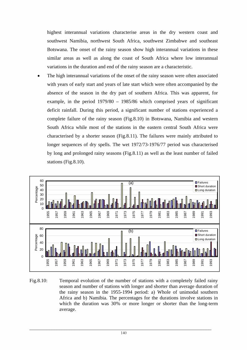
highest interannual variations characterise areas in the dry western coast and
southwest Namibia, northwest South Africa, southwest Zimbabwe and southeast
Botswana. The onset of the rainy season show high interannual variations in these
similar areas as well as along the coast of South Africa where low interannual
variations in the duration and end of the rainy season are a characteristic.
• The high interannual variations of the onset of the rainy season were often associated
with years of early start and years of late start which were often accompanied by the
absence of the season in the dry part of southern Africa. This was apparent, for
example, in the period 1979/80 – 1985/86 which comprised years of significant
deficit rainfall. During this period, a significant number of stations experienced a
complete failure of the rainy season (Fig.8.10) in Botswana, Namibia and western
South Africa while most of the stations in the eastern central South Africa were
characterised by a shorter season (Fig.8.11). The failures were mainly attributed to
longer sequences of dry spells. The wet 1972/73-1976/77 period was characterised
by long and prolonged rainy seasons (Fig.8.11) as well as the least number of failed
stations (Fig.8.10).
(a)
0102030405060
1955
1957
1959
1961
1963
1965
1967
1969
1971
1973
1975
1977
1979
1981
1983
1985
1987
1989
1991
1993
Perc
enta
ge
FailuresShort durationLong duration
(b)
0
20
40
60
80
1955
1957
1959
1961
1963
1965
1967
1969
1971
1973
1975
1977
1979
1981
1983
1985
1987
1989
1991
1993
Perc
enta
ge
FailuresShort durationLong duration
Fig.8.10: Temporal evolution of the number of stations with a completely failed rainy
season and number of stations with longer and shorter than average duration of the rainy season in the 1955-1994 period: a) Whole of unimodal southern Africa and b) Namibia. The percentages for the durations involve stations in which the duration was 30% or more longer or shorter than the long-term average.
_________________________________________________________________________ 140

8.6.2 Interrelationships between the rainy season characteristics
The relationships between the duration of the rainy season and the onset and end of the
rainy season on one hand and between the duration and the amounts and number of daily
rainfall events during the rainy season on the other were investigated using correlation
analysis. The results are presented in Fig.8.12 and Fig.8.13 and the main observations are
summarised below.
10 15 20 25 30 35 40Longitude
-35
-30
-25
-20
-15
-10
-5
0
Latit
ude
Duration1965/66
10 15 20 25 30 35 40
Longitude
-35
-30
-25
-20
-15
-10
-5
0La
titud
eDuration1972/73
10 15 20 25 30 35 40
Longitude
-35
-30
-25
-20
-15
-10
-5
0
Latit
ude
Duration1974/75
10 15 20 25 30 35 40Longitude
-35
-30
-25
-20
-15
-10
-5
0
Latit
ude
Duration1976/77
10 15 20 25 30 35 40
Longitude
-35
-30
-25
-20
-15
-10
-5
0
Latit
ude
Duration1981/82
10 15 20 25 30 35 40
Longitude
-35
-30
-25
-20
-15
-10
-5
0
Latit
ude
Duration1985/86
Fig.8.11: Duration of the rainy season for different years in unimodal southern Africa.
Blue (red) triangles indicate >30% longer (shorter) duration with respect to long-term average. Black dots indicate stations which experienced a complete failure of the rainy season.
a) Time shift of the rainy seasons
This is indicated by significant positive relationships between the onset and end dates
and characterise the lowlands of bimodal northeast Tanzania during both the short and
long rains and the southwest region defined above. Accordingly, early onsets of the
rainy season correspond to early ends and vice versa. This was observed, for example,
_________________________________________________________________________ 141

in 1972/73 and 1974/75 in Namibia and western South Africa in which both the onset
and end were late. Neither onset nor end of the rainy season show any significant
relationships with the duration of the rainy season in these areas.
b) The relationships between the duration of the season and the onset and end
• Both the onset and end influence the duration of the rainy season in the tropical
region of southern Africa comprising the southwestern highlands of Tanzania,
Zambia, northern Zimbabwe and central Mozambique (Fig.8.13). However,
relationships between the onset and end of the rainy season are almost non-existent
in these areas suggesting that longer seasons may result from either an early onset or
a late end but not simultaneously from both.
• The onset significantly affects the duration of both the short and long rains in the
bimodal northern Tanzania as indicated by high negative correlations (long rains,
Fig.8.12) suggesting that earlier than normal onsets correspond to long seasons and
vice versa. This was exemplified by the early and prolonged 1978 and the late and
short 1984 long rains (Camberlin et al., 2002; Valimba et al., 2004d). The end of the
season significantly affect the duration of the long rains in northern Lake Victoria but
not in northeast Tanzania (Fig.8.12) while it does show low correlations in early
summer.
• In the remaining part of southern Africa, the duration of the rainy season is positively
and significantly affected by the end of the season as indicated by high positive
correlations (Fig.8.13) while no significant relationships exist between the duration
and onset. This fact suggests that longer seasons correspond to late ends rather than
to early starts as was observed in the long rainy seasons in 1972/73 and 1974/75
(Fig.8.11) which corresponded to late ends of the season rather than early onsets.
c) The relationships between the duration of the season and the amounts and number of
daily rainfall events
The duration of the rainy season is significantly related to both rainfall amounts and
the number of daily rainfall events received during the rainy season. This is shown by
i) high cross-correlations between the three (see e.g. Fig.8.12) and ii) their similar
spatial patterns of variations and magnitude of the interannual coefficients of variation
(compare Fig.8.8b and Fig.8.9a). Hence, longer seasons are usually characterised by
abundant and more frequent rains in most parts of the region.
_________________________________________________________________________ 142

29 31 33 35 37 39 41Longitude
-7
-5
-3
-1
Latit
ude
KENYA
TANZANIA
LakeVictoria
(a) Onset against End
29 31 33 35 37 39 41Longitude
-7
-5
-3
-1
Latit
ude
(b) Onset against Duration
Fig.8.12: Correlations between rainy season characteristics in the bimodal northern
Tanzania for the long rains.
_________________________________________________________________________ 143

29 31 33 35 37 39 41Longitude
-7
-5
-3
-1
Latit
ude
(c) End against Duration
29 31 33 35 37 39 41Longitude
-7
-5
-3
-1
Latit
ude
(d) Duration against Amount
Fig.8.12: Correlations between rainy season characteristics in the bimodal northern
Tanzania for the long rains (Continued).
_________________________________________________________________________ 144

10 15 20 25 30 35 40Longitude
-35
-30
-25
-20
-15
-10
-5
0La
titud
e
(a) Onset against duration
10 15 20 25 30 35 40
Longitude
-35
-30
-25
-20
-15
-10
-5
0
Long
itude
(b) End against duration
Fig.8.13: Correlations between duration of the rainy season and the onset and end in the
unimodal southern Africa.
8.7 Discussion
8.7.1 Spatial variation of average rainy season characteristics
The two rainfall regimes (unimodal and bimodal) and the spatial pattern of the
beginning of the rainy seasons, their advances and retreat from the southern Africa correspond
to the seasonal displacement of the inter-tropical converge zone (ITCZ) into and from the
region and the winds associated with it. The low-level climatological wind patterns in
September and October (Fig.8.14) indicate prevailing westerlies extending from the Congo
basin into the western Lake Victoria bringing moisture from the Congo source into the
northwestern Victoria region while recurved westerlies around the Angolan heat low bring
this into the western and northern Zambia. Easterlies from the tropical Indian Ocean bring
moisture into northeast Tanzania while the cyclonic flow southeast of Madagascar advects
moisture into the eastern part of South Africa. Subsequent changes in the low-level circulation
winds between October and December which include, for example, southward displacement
of the ITCZ and replacement of southeasterlies by northeasterlies, are associated with the
advances of the season into the interior southern Africa. The northernward displacement of
the ITCZ in late summer marks the retreat of the rainy season in the southern part and the start
of the long rains in the northern Tanzania. Therefore, the bimodality in the northern Tanzania
is caused by bi-passage of the ITCZ when it goes into and out of the southern African region.
_________________________________________________________________________ 145

Mean 850 hPa circulation (1968−1990), Month 10
5
5
5
5
5
5
5
5
5
10
−20 0 20 40 60 80 100
−40
−30
−20
−10
0
10
20
30
40
Fig.8.14: Near-surface wind climatologies in October over southern Africa.
Despite a limited number of studies which were devoted to rainy season characteristics
in the region, the dates of onset and ends of the long rains, for example, were consistent with
those found in the literature. Camberlin et al. (2002) found that the longs rains start in
northeast Tanzania, on average, around 25th March, Asnani (1993) around 22nd – 26th March,
Alusa and Mushi (1974) placed the average onset around 12-17th March in Kenya bordering
northeast Tanzania while this study found the earliest and latest starts to be around 12th and
22nd March respectively. Further, the average end of the long rains on 21st May (Camberlin et
al., 2002) lies within the earliest and latest ends around 12th and 27th May, respectively, found
in this study. The range of dates found in this study corresponds to the spatial nature of
variations in which the southern part of the northeast experiences both the earliest onset and
end of the long rains while the mountainous and coastal areas experience the latest end.
_________________________________________________________________________ 146
8.7.2 Interannual variations
As expected, interannual variations of the rainy season characteristics are observed to
follow those in the amount and number of daily events since the two quantities are used in the
definitions of the onset and end of the rainy season. The wet years (e.g. 1972/73, 1974/75) in
the unimodal summer areas of southern Africa correspond to longer than average seasons
while the dry years (e.g. 1981/82) were characterised by shorter than average seasons.
There is evidence of shortening of the rainy seasons, delayed onset and increased
interannual variability since the late-1960s to the 1970s while no significant changes were
associated with the end of the rainy season . The long rains in northeast Tanzania, for
example, were often later than average in the 1970s except in 1978 and 1979, while since the
early-1980s, they show high interannual variability and are delayed. These results are
consistent with those of Valimba et al. (2004d). There is little evidence that these results
could be attributed to the definition of the rainy season characteristics used in this study and
that of Valimba et al. (2004d) which were based on the daily intensities and the length of the
sequences of dry spells. Camberlin et al. (2002), who used a different approach to the one
used in the present study, found a trend towards late onsets influenced significantly by late
onsets since the early-1970s (see their Fig.4).
The fact that the number of stations experiencing failure of the rainy season and that of
stations observing shorter than average durations in Namibia has not significantly changed,
while there is a significant reduction in the number of stations in which longer than average
durations of the rainy season were identified in Namibia since around 1978/79 suggests a
shortening of the rainy season in the stations which were initially characterised by long rainy
seasons. The durations were more often below their long-term averages since around 1978/79,
the period consistent with that in which abrupt decreases in the amounts and number events
were identified in Namibia.
8.8 Conclusions
A method that defines the rainy season in terms of daily rainfall intensities and length
of dry spells has been established. The general definitions of onset and end of rainy seasons
established in this chapter are more sensitive to the length of sequences of dry days than to
intensities defining them. Sequences of dry days have not been widely used but high
sensitivity of the onset and end dates of the rainy season to the length of these sequences
indicates that they are an important parameter of the rainy season.
_________________________________________________________________________ 147

The onset, advances and retreat of the rainy season in southern Africa have been
related to the seasonal movement of the ITCZ and the associated atmospheric wind patterns.
The early starts were observed in the northwestern part (northwest and northern Zambia),
southeastern part (southeast South Africa) and northeastern part (northeast Tanzania) of the
region while the retreat starts in the central part (Botswana) and progresses radially. On the
other hand, interannual variability of the rainy seasons were observed to resemble those in
rainfall amounts and number of events suggesting factors that influence interannual variations
of the amounts and number of daily events are likewise affecting the rainy season
characteristics since more than 70-90% of the amounts and events are observed during the
established seasons.
The method proposed in this chapter was able to identify probable dates of the onset
and end of rainy seasons in southern Africa including seasons in the dry southwestern part of
southern Africa and the highly variable short rains in northern Tanzania. Changing frequency
of occurrence of daily events was observed to cause failure to identify the rainy season,
particularly in the dry southern Africa. However, frequent absence of the season may be
attributed to a failure of the proposed scheme to account appropriately for daily rainfall
characteristics in these dry areas. Further studies of daily rainfall variations in dry southwest
southern Africa are therefore recommended.
_________________________________________________________________________ 148

___________________________________________________________________________ CHAPTER 9
SEASONAL AND INTERANNUAL VARIATIONS OF RIVER FLOWS IN SOUTHERN AFRICA
___________________________________________________________________________
9.1 Introduction
It is hypothesized that identified changes in southern African rainfall are similarly
reflected in streamflows as observed in West Africa (Olivry and Mahé, 1991; Olivry, 1993;
Olivry et al., 1993; Servat et al., 1997a) and their severity is increased by anthropogenic
human influences. Dam levels have been reported to decline since the mid-1970s in Namibia
(Jury and Engert, 1999), in South Africa since the early 1980s as a reflection of a prolonged
rainfall deficit in the 1980s and early 1990s (Mason, 1996). Berhanu (1999) and Berhanu et
al. (2001) found a recent decrease in mean annual runoff in southern African catchments to
have occurred since 1975, particularly marked in Zambia, Angola, Mozambique and the
South African Highveld. The changes in annual runoff in southern African catchments are
occurring at shorter timescales such as monthly and seasonal. Moreover, identified increasing
frequencies and/or intensity of high rainfall, in some parts of the region, may cause an
increase of frequencies and/or volumes of high flow and a decline of dry season flows due to
poor infiltration and consequently insufficient groundwater recharge.
The intention of this chapter is, therefore, to investigate changes in mean flows and
extreme streamflow characteristics (flood and drought flows) at monthly and seasonal
timescales and their relationships with changes in rainfall. Change-point and linear trend
analyses are used to check the existence of any discontinuities in the average values of flow
time series indices. It should be noted, however, that the interest is related to the hypothesis
that high and low flows are more frequent and severe in recent decades than in the past and
therefore the peak-over-threshold method (POT) is used and annual maxima and minima are
not investigated.
9.2 Streamflow seasonality
Flow seasonality is studied using mean monthly and mean annual flows to define
months of high and low flows in southern African catchments. Behaviour of average daily
flows is studied using flow duration curves (FDCs) and these are used to distinguish
catchments with different response characteristics. A catchment is considered flashy when its
groundwater storage capacity is low and consequently most of the falling rain is immediately
_________________________________________________________________________ 149

transformed into runoff and flow ceases soon after the end of the rains. Rivers in flashy
catchments are usually seasonal, flowing only during the rainy season, or ephemeral, flowing
intermittently.
9.2.1 River flow regimes
The FDCs calculated with zero flows included (e.g. Fig.9.1) distinguished i) seasonal
rivers from perennial rivers and ii) highly seasonal (or ephemeral) rivers from moderately
seasonal rivers. in the southern Africa region.
• Highly seasonal or ephemeral rivers, flow when there is rainfall and cease almost
immediately afterwards. There are frequent periods of no flow within a wet period.
This type of river characterises rivers in Botswana, Namibia, western Zimbabwe and
South Africa (Mngodo, 2002). All three Namibian rivers, for example, flow for less
than 10%-30% of the time (Fig.9.1) regardless of catchment size. Time series of
average daily (not shown) and monthly (e.g. in the Swakop River at Westfalenhof in
Fig.9.2) flows indicate that flows in these rivers are observed between January and
April for rivers in western Namibia which drain directly into the Atlantic and
between December and May for the Fish River which joins the Orange River.
• Moderately seasonal rivers, flow continuously during the rainy season and cease
sometime after the end of the rains and dry up completely during the dry period.
These are the characteristics of small catchments in the Limpopo and in the Western
Cape in South Africa. In these catchments, rivers flow continuously mainly between
May and December for catchments in the Western Cape and between November and
April-July for catchments in the other parts of unimodal southern African, the exact
end month of the flow between April and July being dependent on catchment
characteristics.
• Perennial rivers flow throughout the year and are a characteristic of most rivers in
southern Africa, particularly the main rivers in the large river basins or their main
tributaries in the large river sub-basins. These rivers are characterised by non-zero
FDCs (e.g. Upper Zambezi in Fig.9.1) indicating residual flows during the dry
period, which are dependent on catchment characteristics. Further, these rivers are
characterised by periods of high and low flow as opposed to seasonal rivers, which
experience periods of flow and no flow.
_________________________________________________________________________ 150

Western Namibia
02468
101214161820
0 10 20 30 40 50 60 70 80 90 1
Percentage of time discharge is exceeded
Qp(
1) a
s %
AD
F
00
647310016473200364734001
Southeast South Africa
050
100150
200250300
0 10 20 30 40 50 60 70 80 90 1
Percentage of time discharge is exceeded
Qp(
1) a
s %
AD
F
00
276632012767390127672205
Upper Zambezi in Western Zambia
050
100150200250300350
0 10 20 30 40 50 60 70 80 90 1
Percentage of time the discharge is exceeded
Qp(
1) a
s %
AD
F
00
603700306037000164370001
Fig.9.1: FDCs for selected rivers in southern Africa. Exceedence flows were
determined including the zero flows to highlight seasonality of river flow regimes.
9.2.2 Flow seasonality
Seasonal flow variations in the perennial rivers in southern African are characterised
by double flow peaks in northern Tanzania, as well as parts of the southern and Eastern Cape
and a single flow peak in the rest of the southern African subcontinent (Fig.9.2). The peaks
correspond to seasonal rainfall variations in the region, double peaks in northern Tanzania
corresponding to the bimodal rainfall regime reflecting the short (October-December) and the
long (March-May) rains while in the southern and Eastern Cape, the flow peaks are observed
in April and December corresponding to early and late summer rainfalls. A single peak in the
_________________________________________________________________________ 151

remaining area corresponds to the unimodal rainfall regime. It was further noted that the peak
in the bimodal northern Tanzania is well defined and more apparent during the long rains than
during the short rains (e.g. Pangani at Hale in Fig.9.2).
To define months of high and low flows, mean monthly flows (µmon) were compared
to mean annual flows (µan). However, high flows during the long rains in northeast Tanzania
caused mean annual flows above mean monthly flows during the short rains (Pangani in
Fig.9.2) and consequently a peak during the short rains could not be established. Subtraction
of half a standard deviation of annual flow (½σan) from the mean annual flow, however, was
able to isolate the weak peak during the short rains. Results show that:
• Months of high and low monthly flows vary between catchments. Generally, the
periods June-September and January/February-April/May are characterised as high
flow periods in the Western Cape and in the rest of the unimodal southern Africa
respectively (Fig.9.2) and April-June in northern Tanzania. Rivers that drain the
catchments in southeast Angola and western Zambia have their high flow period
extending into May. The highest monthly flows are observed in January-February in
most parts of unimodal southern Africa, in August in the Western Cape, in March-
April in Zambia and Malawi and in May-June in northeast Tanzania (Fig.9.2).
Similarly, low flows are observed during the dry periods, between July and
November in most parts of unimodal southern Africa, between December and March
in the Western Cape and in both August-October and February-March in bimodal
northeast Tanzania.
• Despite similar seasonal flow patterns, mean monthly flows vary greatly between
southern African catchments depending, among other factors, on the catchment size,
catchment slope, rainfall amounts and soil and aquifer properties related to water
holding capacity and groundwater storage. Mean monthly flows are high along the
length of the main rivers in the large basins or their main tributaries (e.g. the
Zambezi basin or its Luangwa sub-basin; the Okavango basin, etc, Fig.9.1) which
drain the humid part of southern Africa.
_________________________________________________________________________ 152

010203040506070
Sep Oct Nov Dec Jan Feb Mar Apr May Jun Jul Aug
Month
Ave
rage
flow
(m3/
s) Pangani at Hale Tanga(Northeast Tanzania)M l fl
0
1000
2000
3000
4000
5000
Sep Oct Nov Dec Jan Feb Mar Apr May Jun Jul Aug
Month
Mea
n flo
w (m
3/s) Zambezi at Tete Matundo
Cais (Mozambique)Mean annual flow
0.00.51.01.52.02.53.03.54.0
Sep Oct Nov Dec Jan Feb Mar Apr May Jun Jul Aug
Month
Mea
n flo
w (m
3/s) Swakop at Westfalenhof
(W. Central Namibia)M l fl
05
1015202530
Jan Feb Mar Apr May Jun Jul Aug Sep Oct Nov Dec
Month
Mea
n flo
w (m
3/s) Doringrivier at E2H002
(W. Cape, RSA)M l fl
Fig.9.2: Typical seasonal flow variations in different southern African rivers. The
dashed line represents the mean flow.
_________________________________________________________________________ 153

9.3 Flow persistency
Coefficients of correlation of monthly flows are shown in Table 9.1 for some southern
African rivers. These were computed for time series of monthly flows constructed as single
time series comprising of the all months during the period studied (e.g. for a 30 years record,
the series comprises of 12 × 30 = 360 monthly data points). The residual flow characteristic of
the perennial rivers is an important factor of the within-the-year and between-years flow
persistency. Time series of mean monthly flows show high Lag 1 serial correlations in all the
selected gauges except those in the Orange basin and western Namibia (Table 9.1). The
highest lag 1 serial correlations were found for rivers in the Upper Zambezi sub-basin, the
Shire sub-basin and the Okavango basin. The correlations for other intra-annual lags,
particularly for lags 3 to 10, were low and sometimes negative.
Table 9.1: Correlation coefficients for time series of mean monthly flows in selected rivers in southern Africa constructed for the 1960-1989 period.
Gauge Details Series correlations at lag (months): Sub-basin Gauge Area (Sq. km) MAF (m3/s) 1 2 3 12 24 36 60 120 Upper Zambezi 60370030 212450 239.6 0.81 0.40 -0.03 0.89 0.80 0.75 0.78 0.80 60370001 290572 296.3 0.84 0.48 0.05 0.91 0.84 0.78 0.80 0.85 64370001 339521 352.1 0.77 0.35 -0.03 0.80 0.70 0.63 0.62 0.79 Kafue 60334005 433 0.8 0.61 0.19 -0.07 0.66 0.48 0.32 0.25 0.58 60334050 5163 16.0 0.78 0.37 0.00 0.73 0.60 0.50 0.54 0.66 60334620 1125 2.1 0.64 0.20 0.05 0.43 0.43 0.30 0.12 0.55 60334280 23218 53.1 0.80 0.40 0.01 0.76 0.69 0.61 0.58 0.70 Luangwa 60773275 1008 6.5 0.80 0.49 0.20 0.02 0.01 -0.01 0.07 0.26 60332040 142760 169.8 0.68 0.24 -0.10 0.75 0.68 0.69 0.69 0.66 Western Namibian 64731001 6567 0.3 0.12 0.02 -0.03 0.10 0.27 0.22 0.17 0.05 64732003 8986 0.3 0.18 0.16 0.02 0.01 0.14 0.14 0.05 0.00 64734001 7729 0.1 0.17 -0.03 -0.02 0.05 0.25 0.26 0.15 0.00 Western Cape 27712202 6895 4.0 0.59 0.33 0.02 0.25 0.20 0.32 0.14 0.25 27711403 46 0.4 0.62 0.38 0.06 0.45 0.44 0.49 0.34 0.43
At the interannual timescale, most rivers show low flow persistency except those
rivers which drain the large catchments or sub-basins in the Zambezi and Okavango. Except
for rivers in the Shire sub-basin, rivers in the other Zambezi sub-basins and the Okavango
basin are found within the central African/Sahara Sedimentary aquifer system (Fig.3.5 in
Chapter 3) in which the sedimentary layers form important groundwater reservoirs. The soils
in these basins are predominantly sandy soils (Fig.3.4) with low water holding capacity within
the root zone, a factor favourable for infiltration that eventually leads to aquifer recharge.
Therefore, as suggested by Jury and Gwazantini (2002), this high persistence can be attributed
partly to the large sizes of the catchments and partly to the Atlantic decadal variability
through rainfall variability.
_________________________________________________________________________ 154

Correlations were also computed for annual series of each month. The series for each
month (e.g. January) comprises monthly mean flows for that particular month over the record
period (e.g. for a 30-year period, a series for January comprises 30 mean January monthly
flows, etc). They show that:
• Flows in perennial rivers are more variable during the high flow period than during
the low flow period. The lowest interannual variations characterise rivers in the
upper Zambezi sub-basin and the Okavango basin. Flows during the high flow period
are contributed to by both groundwater storage and rainfall in which the latter
displays considerable interannual variations in southern Africa (cf Chapter 7)
compared to the former. The low interannual variations during the low flow period
are not unexpected as flows during the dry period are contributed mainly by
groundwater storage.
• Flows in seasonal rivers and in the perennial rivers which drain the small catchments
in the humid parts show high interannual variations during the dry period and low
interannual variability during the high flow period. This is attributed mainly to low
mean flows and high interannual variance during the low flow months since flows
are either very low in perennial rivers or observed only in certain years in seasonal
rivers while the rivers usually flow during the wet flow period.
The interannual flow persistency in some of these southern African rivers, therefore,
may lead to delayed responses of streamflows to the long-term changes in rainfall while
damping the impacts of the short-term rainfall changes depending on the magnitude of the
change and on the groundwater contribution to streamflows.
9.4 Indices of high and low flows
The selection of high and low flow thresholds involves reaching a compromise
between having a significant number of daily flows above or below a threshold appropriate
for interannual variability analysis and the flow magnitudes that are representative of the two
flow extremes. This necessitates taking care of the frequent zero-drought/flooding years
which are apparent when high thresholds are used (Tallaksen and Hisdal, 1998). Fixed-
magnitude FDC flows are used to define the appropriate thresholds in favour of the seasonally
varying indices defined using average and standard deviation flows or annual maximum or
minimum flows (see e.g. Valimba et al., 2004c). Often, the choice of a low flow threshold is
linked to the flows that define hydrological droughts and is usually dependent on the overall
_________________________________________________________________________ 155

water requirements of the society including demands from hydropower plants, recreational
uses, maintenance of the ecosystems, irrigation, industries, etc. The low flow thresholds are
usually associated with flows in perennial rivers in which fractions of the all-record average
daily flows (ADF), particularly the 50% ADF, have been frequently used.
9.4.1 Low flow thresholds
The low flow thresholds have been mostly defined in relation to hydrological drought.
Previously used thresholds have been different but mainly percentiles of the annual flow
duration curve (Tallaksen et al., 1997; Demuth and Heinrich, 1998; Tallaksen and Hisdal,
1998; Hisdal et al., 2001). Owing to the use of different percentiles in different studies and a
lack of identifiable thresholds over the whole of southern Africa it was necessary to define
new thresholds for this specific region.
The FDCs show that daily flows in perennial rivers in southern Africa exceed ADF
for only 25-35% of the time, suggesting that flow is below the ADF most of the time. Q70,
the flow that has been equalled or exceeded for 70% of the time, and Q50 correspond
respectively to 40-60% ADF and 51-82% ADF in perennial flow regimes in the Upper
Zambezi sub-basin and Okavango basin. In the other perennial rivers, Q50 corresponds to 33-
70% ADF while Q70 represents 14-51% ADF (typically 20-40% ADF). Q70 was finally
adopted as the threshold defining drought conditions in perennial rivers. A similar index has
been used as a low flow threshold in the studies of Tallaksen et al. (1997), Tallaksen and
Hisdal (1998) and Hisdal et al. (2001).
In seasonal (including ephemeral) rivers, however, there are usually prolonged periods
of no flows after the end of the rainy seasons and hydrological droughts in seasonal rivers can
be studied with respect to the number of days with no flow in which the severity of droughts
can be related to lengthened periods of no flows. Therefore, Q = 0.0 m3/s is considered as the
threshold defining the drought conditions in seasonal rivers and the number of days with no
flows are analysed.
9.4.2 High flow thresholds
Despite prolonged periods of no flows in seasonal rivers, flows during the rainy season
can sometimes be very high. The FDC computed with zero flows included gave very low
exceedence flows particularly for ephemeral rivers in which, for example, the Q5 flow in the
Kuiseb River at Schlesien Weir was 1.0 m3/s, the discharge that was exceeded by 55% of the
_________________________________________________________________________ 156

non-zero flows in the record. Therefore, to avoid such low exceedence flows, the indices of
high flows were defined from FDCs calculated using non-zero flows.
Q10 and above (Q5, Q3, Q1) exceeded twice ADF. Time series of daily flows show
that the Q5 and above were mainly exceeded in wet years and the time series of seasonal
excess flow volumes and frequencies consisted of frequent spells of values. Therefore, the
series were considered unsuitable for interannual variability analysis. The use of Q10 reduced
significantly the problem of frequent zeros in the time series of seasonal excess volumes and
frequencies while the Q10 exceeded ADF significantly. Therefore, Q10 was retained as the
threshold defining high flows in southern Africa rivers.
9.4.3 Time series of deficit and excess flow volumes and frequencies
Persistence of low (high) flows was defined as the number of days in which flows are
below (above) a predetermined flow threshold and is referred to hereafter as deficit (excess)
flow frequency. Deficit and excess volumes are respectively the cumulative flows below or
above the correspond thresholds.
Monthly excess and deficit flow volumes and frequencies were computed only for
complete months. Otherwise a monthly value was considered missing. The reconstruction of
the missing monthly values was done as described in section 5.3.2.2 in Chapter 5. Seasonal
values were computed from non-missing monthly values (after reconstruction of monthly
series), otherwise the seasonal values were considered missing.
The seasons used for the river flow indices were essentially those used in the analyses
of rainfall with slight changes to account for the observed flow regimes. The month of
October was omitted from the early summer season (ONDJ), used in the rainfall analyses, in
order to separate the low flow October from the other months. The season April-May-June
(AMJ), June-July-August (JJA) and FMA were used for high flow indices in rivers in
northeast Tanzania, the Western Cape and in the rest of southern Africa respectively. The JJA
season was considered in the low flows against the August-September-October (ASO) season
as most of the time flows during the latter season are usually below Q70 and the resulting
time series are not very useful for interannual variability analysis. It should be noted that time
series of JJA seasonal indices for seasonal rivers consist of zeros and were therefore not
useful for analysis.
_________________________________________________________________________ 157
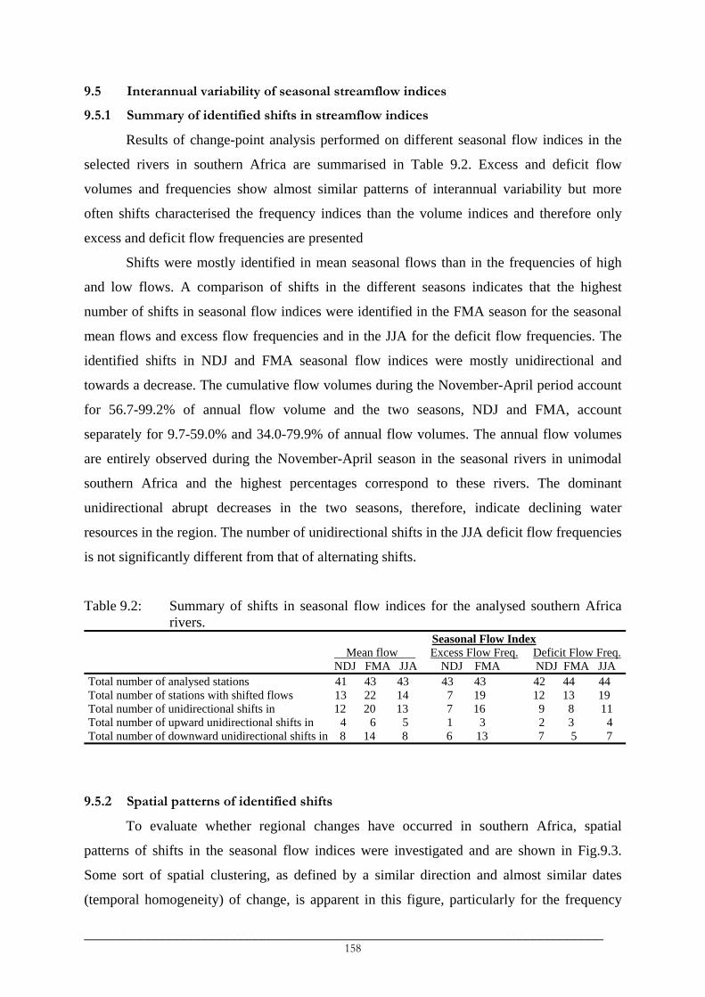
9.5 Interannual variability of seasonal streamflow indices
9.5.1 Summary of identified shifts in streamflow indices
Results of change-point analysis performed on different seasonal flow indices in the
selected rivers in southern Africa are summarised in Table 9.2. Excess and deficit flow
volumes and frequencies show almost similar patterns of interannual variability but more
often shifts characterised the frequency indices than the volume indices and therefore only
excess and deficit flow frequencies are presented
Shifts were mostly identified in mean seasonal flows than in the frequencies of high
and low flows. A comparison of shifts in the different seasons indicates that the highest
number of shifts in seasonal flow indices were identified in the FMA season for the seasonal
mean flows and excess flow frequencies and in the JJA for the deficit flow frequencies. The
identified shifts in NDJ and FMA seasonal flow indices were mostly unidirectional and
towards a decrease. The cumulative flow volumes during the November-April period account
for 56.7-99.2% of annual flow volume and the two seasons, NDJ and FMA, account
separately for 9.7-59.0% and 34.0-79.9% of annual flow volumes. The annual flow volumes
are entirely observed during the November-April season in the seasonal rivers in unimodal
southern Africa and the highest percentages correspond to these rivers. The dominant
unidirectional abrupt decreases in the two seasons, therefore, indicate declining water
resources in the region. The number of unidirectional shifts in the JJA deficit flow frequencies
is not significantly different from that of alternating shifts.
Table 9.2: Summary of shifts in seasonal flow indices for the analysed southern Africa rivers.
Seasonal Flow Index Mean flow Excess Flow Freq. Deficit Flow Freq. NDJ FMA JJA NDJ FMA NDJ FMA JJA Total number of analysed stations 41 43 43 43 43 42 44 44 Total number of stations with shifted flows 13 22 14 7 19 12 13 19 Total number of unidirectional shifts in 12 20 13 7 16 9 8 11 Total number of upward unidirectional shifts in 4 6 5 1 3 2 3 4 Total number of downward unidirectional shifts in 8 14 8 6 13 7 5 7
9.5.2 Spatial patterns of identified shifts
To evaluate whether regional changes have occurred in southern Africa, spatial
patterns of shifts in the seasonal flow indices were investigated and are shown in Fig.9.3.
Some sort of spatial clustering, as defined by a similar direction and almost similar dates
(temporal homogeneity) of change, is apparent in this figure, particularly for the frequency
_________________________________________________________________________ 158

indices. These clusters are observed in northeast Tanzania, in the southern
Zimbabwe/northeast South Africa, in Namibia and in the western/northern Zambia (Fig.9.3).
The changes in the seasonal river flow characteristics were mainly identified in the 1970s and
early-1980s although changes were identified as early as in the late-1950s and early-1960s.
The identified changes in the river flows corresponded to increasing flows in the rivers
in northeast Tanzania which corresponded mainly to increasing mean flows and decreasing
deficit flow volumes and frequencies (Fig.9.3; Valimba et al., 2004c), except in rivers which
drain the eastern Kilimanjaro areas where decreases were identified. The abrupt increases in
low flow characteristics in rivers in northeast Tanzania resulted into dry seasonal flows
remaining above the low flow threshold in the post-change period.
Changes in river flow characteristics in other parts of southern Africa were associated
with decreasing river flows particularly during the FMA season. The decreases which were
related to changes of up to 50% or higher, characterised the mean flows, high flows as well as
low flows. This is illustrated by complete declines in the Namibian rivers and abrupt
decreases in FMA and JJA mean seasonal flows and deficit flow frequencies in the upper
Zambezi in western Zambia (Fig.9.3). The start of the declining flow indices in Namibia is
consistent with the start of declining dam levels in Namibia around the mid-1970s (Jury and
Engert, 1999). Berhanu (1999), Berhanu et al. (2001) and Alemaw and Chaoka (2002),
reported declining annual runoff in parts of Zambia and Angola. Furthermore, frequent and
lengthening periods of no flows were observed in some of the perennial rivers since the early-
1980s indicating that these rivers are being progressively transformed into seasonal rivers,
results which were similarly observed in Zimbabwe (Magadza, 1995).
_________________________________________________________________________ 159

1977u1976d
10 15 20 25 30 35 40-35
-30
-25
-20
-15
-10
-5
0
1961u1985d1960u
Missing1982d
1974u
1980d
1980d
1980d
1974d
1974d1974d
MissingZero flows
Missing1974u
(a)
1961u1977u1961u
1980d1979d
1980d1977d
1980d
1973u1980d
1980d
1981d1979d
1975d
1975d1975d
Missing1974u
1977d
1979d
1975u
10 15 20 25 30 35 40-35
-30
-25
-20
-15
-10
-5
0
1979u1975d
1973u1980d
(b)
1979u1961u
1979d1980d
1975u
1980d1983d
1971u1980d
1961d
Missing
1975d
Zero flowsZero flows
Zero flows
1957d 1975u
10 15 20 25 30 35 40-35
-30
-25
-20
-15
-10
-5
0
1977u1975d
(c)
1976u1962u1979d
1980d1981d
1981d
1980d1981d
1973d
1981d
1979d1967d1978d
1976d
1976d1976d
1957d1958d1966u
1987u
10 15 20 25 30 35 40-35
-30
-25
-20
-15
-10
-5
0
1979u1986d
(d)
1979d1976d
1976u
1970d1980u
1973d1981u1973d1981u
1973d
1979u
1975d
10 15 20 25 30 35 40-35
-30
-25
-20
-15
-10
-5
0
1977d1988u1961d1976d
1973d1981u
1977u(e)
1976u
10 15 20 25 30 35 40-35
-30
-25
-20
-15
-10
-5
0
1977d1977d1983d
1973d1981u
1977d1961d1970d
1960d1982u1971u1980u
1964d1981u
1976d1988u
1961d1977u1976d
1970d1980u
1973d1981u
1972d
1959d
1979u
1964u
1975d
(f)
Fig.9.3: Dates of shifts in a) NDJ, b) FMA and c) JJA mean seasonal river flows; in the
frequencies of d) excess flows (see text for the high flow seasons), e) FMA deficit and f) JJA deficit flows in the southern African rivers. The year indicates the date of shift while the letters indicate the direction of shifts, u for the upward and d for the downward shift.
_________________________________________________________________________ 160

9.6 Discussion
9.6.1 Mean flows
Changes in river flow regimes may result from a variety of factors such as changes in
the climatic parameters (precipitation, temperature) and artificial influences in the catchment,
including changing landuse and water use patterns (Hisdal et al., 2001). The selection
procedure of the gauging stations for use in this interannual analysis (see section 5.3.3.2 in
Chapter 5) tried to minimise the influences of flow regulation but not of other artificial
influences such as flow abstraction points and changing landuse patterns. However, it was not
possible to obtain details about the changing landuse and water use patterns and a comparison
of the interannual patterns of variability of flows and rainfall may help in the identification of
artificial influences on the flow regimes. This is illustrated for the Groot-Vis (Fish) River in
South Africa which has experienced a regime transformation since the mid-1970s from
seasonal to perennial.
The following discussion will be limited mainly to the influences of rainfall variations
on the identified changes in river flow regimes. The influences of rainfall on streamflow
changes may be plausible with regard to consistent dates of shifts in certain indices of river
flows. It should, however, be remembered that most of the changes related to artificial
influences in the catchments such as dam construction and commissioning, accelerated
landuse changes, etc have occurred since the 1960s and they are discussed whenever
differences exist between patterns of variations of rainfall and flow. Similarly, changes in the
extreme flow characteristics (flood and low flows) are influenced partly by changing rainfall
characteristics and partly by the changing vegetation cover and soil properties (e.g.
permeability). In such cases of extreme flows, therefore, it might be difficult to obtain strong
links between the changes in streamflows and rainfall. The following discussion focuses
mainly on the spatial clustering and interannual patterns of flow variability that differ
appreciably from those of rainfall indices.
In general, NDJ mean flows in southern African rivers have remained unsegmented or
showed abrupt increase, except for the rivers in Namibia, northeast South Africa and southern
Zimbabwe (Fig.9.3a). This pattern during the early summer is identical to changes in early
summer seasonal rainfall amounts, which had either remained unsegmented or abruptly
increased in the region except in Namibia and northeast South Africa (Fig.7.6a in Chapter 7).
Similarly, predominantly decreasing FMA mean flows in unimodal southern Africa
correspond to declining overall rainfall amounts in late summer (Fig.7.6b). The abrupt
decreases in late summer overall amounts in Namibia were identified mainly in the 1977-1980
_________________________________________________________________________ 161

period lagging flow decreases. Owing to their seasonal nature, the slight changes in rainfall
since the mid-1970s might be a cause of the early decreases in river flows. The flow decreases
in northeast South Africa were consistent with decreases in the late summer overall rainfall in
that area but lagged the rainfall decreases by about 2-3 years.
The lack of abrupt decreases in seasonal as well as annual amounts in western Zambia
(Fig.7.5, 7.6) could be hardly linked to the abrupt decreases in mean seasonal flows in the
upper Zambezi (western Zambian) catchments. However, the results of linear trends for the
1961-1991 period (not shown) showed decreasing trends in seasonal amounts in these parts of
Zambia. Sichingabula (1998) found decreasing annual rainfall in southern and eastern Zambia
since 1975, while Bigot (1997) and Bigot et al. (1998) identified declining annual rainfall in
the central Africa and the Congo basin since the late-1960s, a decline which was similarly
identified by Laraque et al. (2001) in the catchments within the Congo basin and which was
reflected in the decrease of annual flows in the Congo River basin since the 1970s and which
amplified and became widespread since the early-1980s (Laraque et al., 1998, 2001). The
changes in the western Zambian catchments could be partly related to the changes in rainfall
mostly identified in the Congo basin.
The increasing FMA mean seasonal flows identified in the 1960s and 1970s in rivers
draining areas of the Usambara Mountains in northeast Tanzania (Fig.9.3b) contradict the
decreases in late summer seasonal amounts which were identified mainly in the late-1940s to
late-1950s (Fig.6.6c, 6.6d). In fact, monthly flows in September through March have
increased in these rivers while those in April-August have remained unsegmented. This could
not be attributed to the length of the flow records but rather to increases in OND and January-
February amounts. Linear trends calculated for 3 different periods, 1961-1990, 1941-1990 and
1931-1990 were consistently increasing for OND and January-February (JF) seasonal
amounts for the latter two periods (Valimba et al., 2004a). The long records of annual and
early summer seasonal amounts for stations in the Usambara Mountains and coastal northeast
Tanzania show fluctuating dry and wet periods in which the 1940s and 1950s were
characterised mainly by below average rainfall while the decades 1960s and 1970s observed
above average rainfall.
Long rainfall records further indicate shifts towards persistent wetter conditions in the
areas around Mount Kilimanjaro (Valimba et al., 2004ab). Despite a number of existing flow
abstractions upstream, mean flows in all months at the most downstream gauge in the
Kikuletwa River, which drains the western part of the Kilimanjaro, have increased since
1960/61 (Valimba et al., 2004c), consistent with the reported increases in rainfall amounts. A
_________________________________________________________________________ 162
number of past studies have identified similar increases in rainfall in the early-1960s in east
Africa (including Tanzania) and other hydrological variables such as lake levels (Bergonzini,
1998; Nicholson, 1998, 1999, 2000; Bergonzini et al., 2001, 2002; Nicholson and Yin, 2001).
However, the rivers which drain the eastern part of Mount Kilimanjaro were characterised by
decreasing flows in all months, contradicting the rainfall increases. A number of studies have
linked decreasing river flows from the slopes of Mount Kilimanjaro to the population increase
and degrading landuse and water use practices (Mujwahuzi, 1999; Mwamfupe, 1999;
Shechambo, 1999; Yanda and Shishira, 1999; Mwamfupe, 2002; Ngana, 2002; Shishira,
2002; Yanda, 2002) This linkage has been discussed in Valimba et al. (2004c).
The striking feature was the regime transformation of the Groot-Vis River located in
the central southern part of South Africa that did not correspond to the interannual pattern of
rainfall variability. The river has become perennial since around 1974/75 while the abrupt
increases in early summer overall amounts in a few stations in this part of South Africa were
identified mainly in the early-1980s (Fig.7.6a). Time series of NDJ seasonal flows are
persistently below average before the mid-1970s even during the period of above average
rainfall in the 1950s (Fig.9.4a). The FMA rainfall series is predominantly below average after
the mid-1970s while the corresponding flows are mostly above average (Fig.9.4b). The cause
of the observed regime change in this river was the inter-basin transfers from the Orange
River basin for irrigation water along the Fish and Sundays Rivers (Hughes, personal
communication; Department of Water Affairs and Forestry (RSA)13) through the Orange Fish
Tunnel. Consequently, all the flow in the Fish (Groot-Vis) River is, since 1975, managed
releases from the Gariep (formerly Hendrik Verwoerd) Dam (completed in 1972) on the
Orange River.
9.6.2 High and low flows
Changing extreme flows (excess and drought flows volumes and frequencies) are
partly affected by changes in the amounts of rainfall due to intense daily rainfall events and
partly by changes in the catchment characteristics that affect runoff generation mechanisms.
The results (Fig.9.3d) show consistent and persistent decreases in the frequency (duration) of
excess flows in the rivers in western and northern Zambia (early-1980) and in Namibia (mid-
1970s). In other southern African rivers, the changes were heterogeneous and not very
persistent since they did not characterise a number of rivers and only segments of high or low
13 Available online in January 2004 at http://www.dwaf.gov.za/orange/gariep.htm
_________________________________________________________________________ 163

frequencies were observed, after which, the time series returned mostly to the pre-change
states. This fact is also observed in the frequencies of deficit flows, except in northeast
Tanzania where low flows had increased since the mid-1970s.
The pattern of the changes in the frequencies of excess and deficit flows seem to
reflect the wet and dry periods in southern Africa (compare Figs.7.7e, 7.7f and Figs.7.2a, 7.3).
Abundant rainfall observed in the early-1970s to late-1970s in southern Africa (Chenje and
Johnson, 1996) could have caused considerable groundwater recharge which lead to increased
flows during both the rainy season and the following dry season and therefore corresponded
to decreased frequencies of deficit flow volumes. The rainfall deficits since the early-1980s
and low between-the-years flow carry-over in most of the catchments caused a return of the
low flows almost to the values before the changes and this corresponds to an increase in the
deficit flow frequencies since the early-1980s (Fig.9.3e, 9.3f).
(a)
-2.0-1.5-1.0-0.50.00.51.01.52.02.53.0
1940 1945 1950 1955 1960 1965 1970 1975 1980 1985 1990Rai
nfal
l Ano
mal
y
-1.0
-0.5
0.0
0.5
1.0
1.5
2.0
2.5
Flow
Ano
mal
y
RainfallFlow
(b)
-1.5-1.0-0.50.00.51.01.52.02.53.03.5
1940 1945 1950 1955 1960 1965 1970 1975 1980 1985 1990
Rai
nfal
l Ano
mal
y
-1.0-0.50.00.51.01.52.02.53.03.5
Flow
Ano
mal
y
RainfallFlow
Fig.9.4: Time series of anomaly a) NDJ and b) FMA seasonal flows and catchment
overall rainfall amounts for the catchment of the gauge 27673901 in the Groot-Vis (Fish) River.
_________________________________________________________________________ 164

9.7 Conclusions
Significant changes in the river flows regimes in the southern African rivers were
identified in the 1970s through early-1980s. These changes led to decreases in river flows in
western Zambia, Namibia and northeast South Africa considerably affecting the flows during
the high flow months in which 34-80% of the annual flow volumes are observed. Flows in the
Zambezi, upstream of Victoria Falls, have decreased to about a half of the flows before the
change, while periods of no flow are observed in recent decades (Magadza, 1995) in some
perennial rivers and are extending in seasonal rivers. In the other parts of southern Africa,
alternating increases and decreases in river flow indices were observed which corresponded
mainly to interannual patterns of rainfall variation. However, in certain rivers such as the Mue
River, which drains areas of eastern Mount Kilimanjaro, the influences of degrading landuse
practices have led to declining flows despite observed increasing rainfall.
It was not possible, however, to provide strong links between the identified changes in
streamflows and those in rainfall due to a) short available flow records, b) lack of the detailed
information on the landuse, water use and other socio-economic activities within the
catchments and c) unavailability of the stations details such as the rating curves and their
quality, gauge history (e.g. on the relocation of the gauging sites).
Therefore, despite a certain degree of consistency of changes in rainfall and flows,
detailed studies at the catchment level are necessary in order to verify these broad regional
observations and to more fully investigate the links between the identified changes in
streamflow and rainfall indices and other factors affecting streamflows. The progressive
transformation of perennial rivers into seasonal rivers, for example, can be partly influenced
by deficit rainfall but changes at the soil surface relating to soil permeability and removal of
vegetation cover can result in insufficient groundwater recharge which eventually may lead to
reduced dry season flows or to flow cessation in the perennial rivers. This transformation can
also be related to a number of factors such as reservoir construction, increasing water
abstractions, etc. Therefore detailed information of developments within the catchments is
required.
_________________________________________________________________________ 165

___________________________________________________________________________ CHAPTER 10
RESPONSE OF RAINFALL AND STREAM FLOWS TO CLIMATIC VARIATIONS
___________________________________________________________________________
10.1 Introduction
In this chapter, relationships between southern African rainfall and climatic variables
are investigated using seasonal rainfall amounts and number of events in each class of daily
intensities as well as overall unclassified seasonal amounts and number of events. The main
questions that are investigated are:
• In which classes of daily rainfall intensities do ENSO and SST have stronger
influences?
• In which parts of southern Africa and in which seasons do ENSO and SST have
stronger influences?
• Is there any possibility of forecasting the impacts of ENSO and SST variations? It is
the question of lead-lag relationships and their stability over time.
In order to avoid noisy stations series, regional time series of seasonal rainfall amounts
are used. Principal components analysis (PCA) and correlation analysis are used to establish
coherent rainfall regions. Moreover, the areal average indices of SST anomalies in the key
oceanic basins in the Atlantic and Indian oceans (see next section) are used.
Pearson’s correlation coefficients, computed between regional seasonal rainfall indices
and monthly/seasonal SOI and SST anomalies for the 1955-1985 common period, are used to
assess the ENSO/SST-rainfall lead-lag relationships. Absolute correlations exceeding 0.39
and 0.49 are significant at the 95% and 99% levels, respectively.
The stability of ENSO/SST-southern African rainfall associations is investigated for
the common period 1950-1994 using long Namibian and South African data. Since major
changes in oceanic and atmospheric variables had occurred in the late-1970s and only 18
years are available for analysis in the post-1977 period, a 15-year window is used to compute
sliding correlations between SOI/SST indices and seasonal rainfall indices. Absolute
correlations exceeding 0.5 and 0.43 are significant at the 95% and 90%, levels respectively.
In order to investigate possible changes in atmospheric circulations due to an SST
anomaly forcing, correlations are computed between SST anomalies in each of the 5 key
_________________________________________________________________________ 166

basins and gridded NCEP/NCAR reanalysis fields (winds, moisture flux and geopotential
heights) in the Atlantic and Indian oceans. This enables the study of interannual variability of
SST and associated atmospheric dynamics. However, the pattern associated with the post-
1970 warmer SST, which is a decadal signal, is likely to be different as the spatial signature of
this decadal signal is different from that associated with interannual variability. The resulting
correlation atmospheric patterns are compared to mean fields and are related to circulation
features that have been linked to dry and wet conditions in southern Africa.
Correlations are, therefore, computed for the period 1968-1990 between areal average
SST anomalies in each key of the 5 key basins and gridded reanalysis fields (winds and
geopotential heights). Lower (850 hPa) and upper (200 hPa) tropospheric levels are
considered. Results of correlations for the 1968-1985 period are relatively similar to those of
the 1968-1990 period while the latter offer longer records than the former.
ONDJ and FMA seasons are used to define early and late summer seasonal rainfall.
May is omitted from the original FMAM late summer season (cf chapter 6) as atmospheric
circulations responsible for rainfall in northern Tanzania at this time resemble those in early
summer and differ from March-April (Mutai and Ward, 2000; Camberlin and Okoola, 2003)
while May rainfall in the southwestern and southern part of South Africa is predominantly
frontal. ENSO seasons (SON, DJF, MAM and JJA; Trenberth and Caron, 2000) are used to
compute seasonal SOI values while seasonal SST anomalies are computed for rainfall seasons
(OND, FMA) and for the JJA ENSO season.
10.2 Key oceanic basins in the Atlantic and Indian oceans
Past studies indicate 5 major oceanic basins in the Atlantic and Indian Oceans that are
influencing rainfall variations in southern African. The Tropical Indian Ocean (TIO) basin
north of about 15°S extends from the western Indian Ocean along the eastern coast of Africa
to the eastern Indian Ocean in the maritime continent. Its central basin, which extends
between 10°N-10°S and 50°-75°E (Fig.10.1), has the highest influences upon rainfall
variability in southern Africa during both ENSO and non-ENSO years (Jury, 1996; Rocha and
Simmonds, 1997a; Landman and Mason, 1999; Richard et al., 2000). This region has been
equivalently referred to as the Tropical Western Indian Ocean (TWIO) and this terminology is
used in this chapter.
The second region is the Southwest Indian Ocean (SWIO) basin, which forms a dipole
with southeast Indian Ocean basin (Fauchereau et al., 2003). The SWIO basin is defined by
30°S-40°S latitudes and 55°E-75°E longitudes (Fig.10.1) and is weakly associated with
_________________________________________________________________________ 167

ENSO (Latif et al., 1999; Mutai and Ward, 2000; Fauchereau et al., 2003). The third region is
the Mozambique/Agulhas Currents (MADA) basin region which is located south/southwest of
Madagascar within the 25°S-40°S latitudes and 35°E-45°E longitudes (Mason, 1995). This
basin has also been referred to as SWIO in some past studies (e.g. Reason and Mulenga,
1999) but the term MADA is used in this study to distinguish it from the southwest Indian
Ocean basin defined above.
-20 0 20 40 60 80Longitude
-40
-20
0
20
Latit
ude EAO BENG
TIO
MADASWIO
Fig.10.1: Selected key oceanic regions in the Atlantic and Indian Oceans which
influences southern African rainfall.
The fourth region is the Atlantic northeast-southwest dipole (Fauchereau et al., 2003),
between the Southwest Atlantic Ocean (SWAO) basin centred around 36°E, 25°W and the
large northeast Atlantic Ocean’s Benguela system (Mason, 1995). The Benguela system
includes the Angola/Benguela Front region off the Angola/Namibia coast extending
northwestward from the Front region to equatorial Atlantic. Owing to local Benguela Niños
within the Angola/Benguela Front region, the large northeast Atlantic basin is sub-divided
further into the equatorial Atlantic Ocean (EAO) and the Angola/Benguela Front region
(BENG) (Fig.10.1). The EAO is defined by latitudes 5°N-15°S and longitude 15°W to the
coastline (Phillipon et al., 2002) while the BENG basin lies within latitudes 8°S-20°S and
longitudes 12°E-15°E approximately defining the core of extreme warmer SST anomalies
during the Benguela Niños (see e.g. Rouault et al., 2003).
_________________________________________________________________________ 168

10.3 Spatially coherent rainfall regions
10.3.1 Results of the principal components analysis
Unrotated and orthogonally (Varimax) rotated S-mode PCA performed on the
correlation matrix of seasonal rainfall amounts for each of the 5 classes of daily intensities
produced large spatial clusters mainly for the three lower classes. The Kaiser criterion of
eigenvalues exceeding 1 resulted in 30 significant principal components (PCs). Scree test
(Cattell, 1966) plots show sharp drops between the first 5 PCs and thereafter slopes are gentle
but the curves do not flatten. The first 20-23 unrotated and rotated PCs have explained
variances exceeding 2% in both early and late summers. Scree plots of varimax rotated PCs
yielded almost flat curves after the 15th PCs although discontinuities were less marked after
the 7-8th PC. However, the first 5-8 PCs explain individually more than 4% while the rest
explain less than 4%, typically below 3.5%.
This chapter is interested, apart from relating rainfall variations to climatic variations,
in investigating relationships between widespread droughts in southern Africa and SST
variations and variations in atmospheric fields. Therefore large spatial clusters are of interest.
Considering areas within the 0.4 isopleth of every PC, only 4-5 PCs of class II through class
IV showed large spatial regions. This 0.4 isopleth represents a correlation contour that is
significant at 95% for the 31-year period used and provides minimal overlapping between
spatial clusters. The first 7 and 9 PCs were retained for class V and class VI respectively.
10.3.2 Spatially coherent rainfall regions
Spatial patterns of loadings of the retained first 4-9 PCs in each class of rainfall show
some similarities and differences with respect to the regions of significant loadings. For the
same season, the spatial patterns of loadings for the three lower classes (class II – IV) defined
spatial clusters, which were mostly identical with a few differences corresponding to the sub-
division or fusion of the clusters. This can be observed, for example, in Fig.10.2. The
significant PC1 loadings during the early summer (ONDJ) season are concentrated mainly in
Namibia and northern Botswana for class III (Fig.10.2a) while for class IV, they are
insignificant and negative in northern Botswana differing from the significant positive
loadings in northwestern Namibia and southwest Botswana (Fig.10.2d). Significant positive
PC1 loadings of class II rainfall in early summer are found in the whole of central South
Africa while those of class III during the late summer (not shown) divide this central part of
South Africa into the western and eastern part around a 25°E longitude.
_________________________________________________________________________ 169
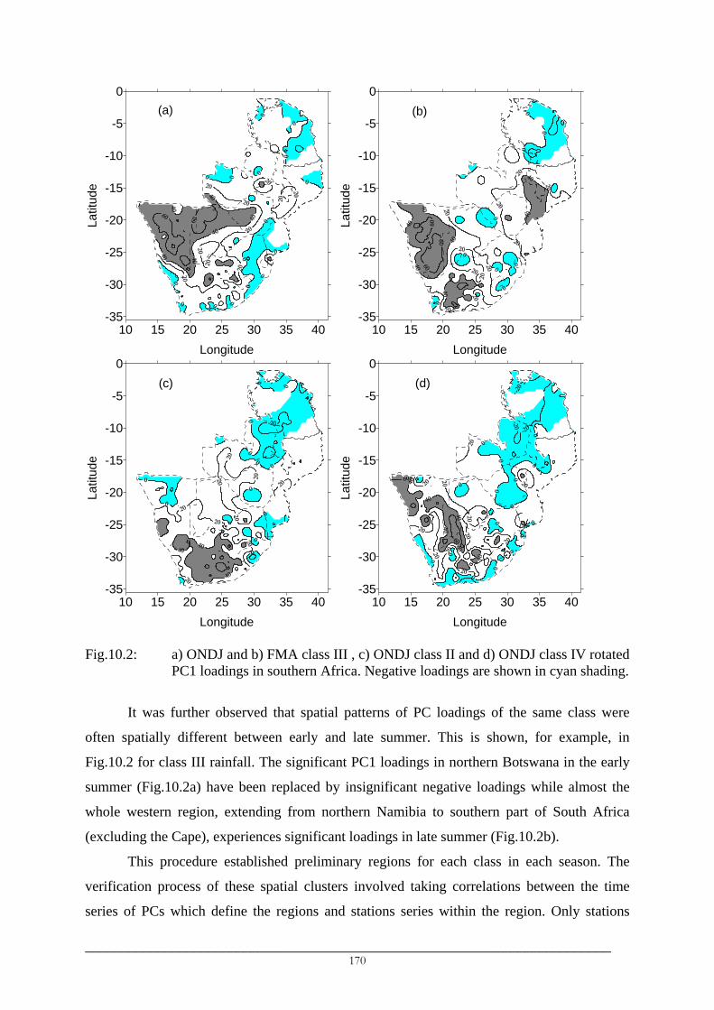
10 15 20 25 30 35 40Longitude
-35
-30
-25
-20
-15
-10
-5
0La
titud
e(a)
10 15 20 25 30 35 40
Longitude
-35
-30
-25
-20
-15
-10
-5
0
Latit
ude
(b)
10 15 20 25 30 35 40Longitude
-35
-30
-25
-20
-15
-10
-5
0
Latit
ude
(c)
10 15 20 25 30 35 40
Longitude
-35
-30
-25
-20
-15
-10
-5
0La
titud
e
(d)
Fig.10.2: a) ONDJ and b) FMA class III , c) ONDJ class II and d) ONDJ class IV rotated
PC1 loadings in southern Africa. Negative loadings are shown in cyan shading.
It was further observed that spatial patterns of PC loadings of the same class were
often spatially different between early and late summer. This is shown, for example, in
Fig.10.2 for class III rainfall. The significant PC1 loadings in northern Botswana in the early
summer (Fig.10.2a) have been replaced by insignificant negative loadings while almost the
whole western region, extending from northern Namibia to southern part of South Africa
(excluding the Cape), experiences significant loadings in late summer (Fig.10.2b).
This procedure established preliminary regions for each class in each season. The
verification process of these spatial clusters involved taking correlations between the time
series of PCs which define the regions and stations series within the region. Only stations
_________________________________________________________________________ 170

which correlated at 0.5 or higher (significant at 99%) with the PCs were retained in that
particular region. This was done for all regions.
In order to facilitate interpretation of the results of the analysis between the different
classes of daily rainfall and between seasons, it was necessary to define a few regions which
are the most representative for the various classes and seasons. The most recurrent spatial
patterns of the PC loadings, therefore, described basically about 10 regions across southern
Africa (Fig.10.3). These regions were mostly depicted by the first 3-5 PCs of the three lower
classes (class II to class IV). PCs of the higher two classes (class V and VI) tend to divide
these large regions into much smaller regions (see e.g. a small insert in Fig.10.3) creating
geographical outliers (van Regenmortel, 1995) in which as few as one or two stations tend to
form their own regions. The finer regions therefore suggest modulation of the large-scale
signal by mesoscale influences such as topography, which mostly impact on heavy rainfall
events (upper classes).
The regions are briefly described except for the two regions, S7 and N3 due to the
presence of a few, poorly distributed stations.
• Region S1:
PC loadings that were associated with this region parallel the coastline
in the northwest-southeast orientation with the highest loadings in the central
and southeast mountains of Namibia. Such orientation corresponds to the mean
circulation pattern along the southwest coast of Africa during the austral
summer. Near-surface southwesterly flow over the cold Benguela water brings
dry air to the immediate interior of Namibia and western South Africa (Jury
and Engert, 1999). Orographic influences of the western escarpment enhances
rainfall in the mountains. Weak recurving northeasterlies around the Angolan
low brings moisture into eastern Namibia.
Occasional intensification of the surface low over Namibia (Bhalotra,
1984) increases rainfall in northern Namibia, western and northwest Botswana
(van Regenmortel, 1995). This is shown, for example, by PC1 for ONDJ class
III (Fig.10.3a) in which the highest loadings extend from Namibia to western
and northern Botswana. Moreover, anomalously warm waters off the
Angola/Namibia coast during the Benguela Niños (Shannon et al., 1986)
accompanied by local cyclonic and anticyclonic flows (Rouault et al., 2003)
are related to enhanced rainfall along the adjacent coast of Namibia favouring
_________________________________________________________________________ 171
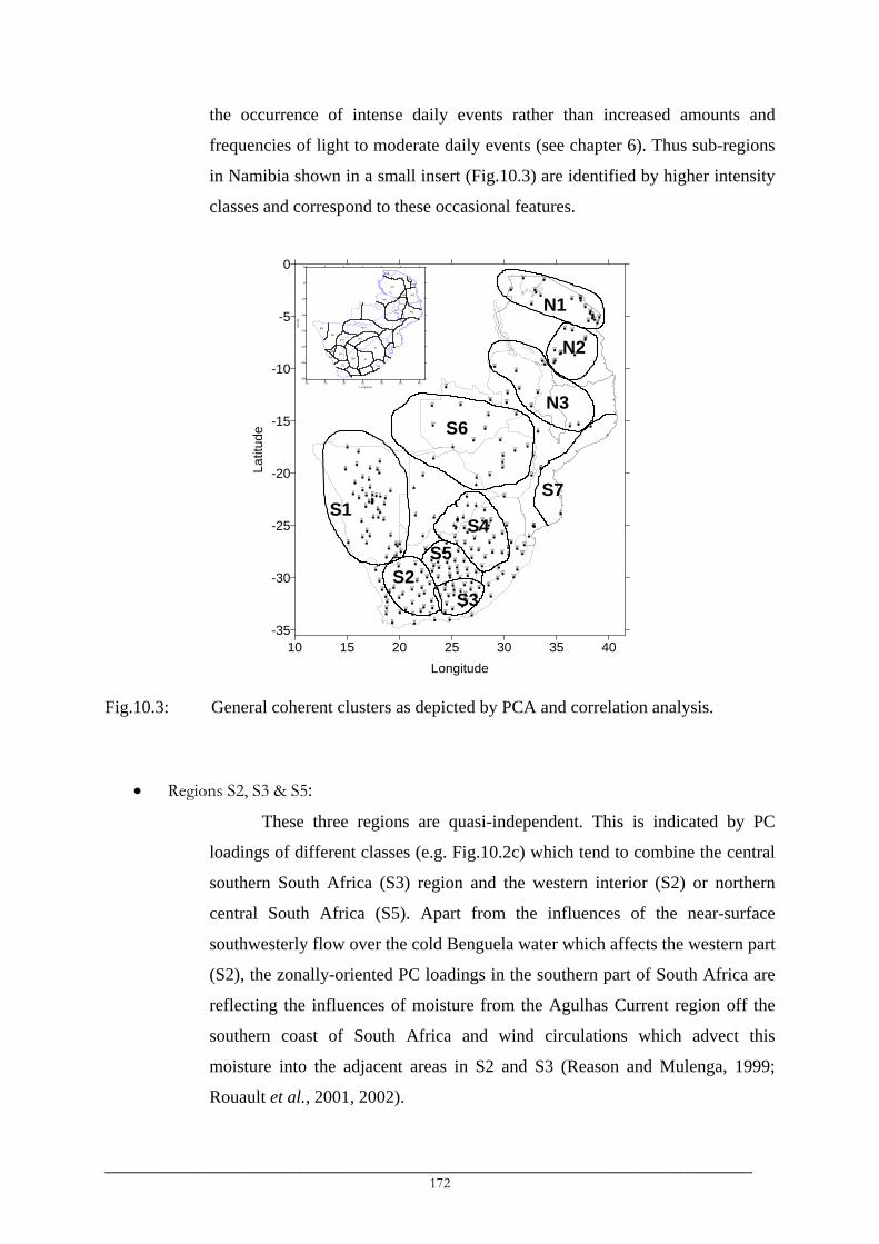
the occurrence of intense daily events rather than increased amounts and
frequencies of light to moderate daily events (see chapter 6). Thus sub-regions
in Namibia shown in a small insert (Fig.10.3) are identified by higher intensity
classes and correspond to these occasional features.
1
2
3
4
5
6
7
89
10
1112
13
14
15
16
17
18
19
20
222324
25
2627
28
29
3031
32 3334
35
36 37 3839
40 41
43
44
4546 47
49
51
5253
56 58596061
6365
67
68 70 7173
7475 76
79
8082
83
84 85 8687
8891
92
94
95 9697 98
99 100101 102103
104105 106
107 108 109110
111112
113 114115 116
117 118119
120 121 122 123 124 125 126 127
128129
130131
132 133 134 135136
137 138
139 140 141 142143
144145 146
147
148149150 151
152153
154155
156
157158 159
160 161162
163164
165166
167168
169
170 171 172
173 174 175 176177 178
179 180 181182 183
184185
186187 188
189 190
191 192 193 194 195196
197 198 199200
201
202 203
204205
206
207
208
209
210
211212
213 214215
216
217219 222223
224
226
229231232
234235
236238239242
243244
245246
247248249
250
251252
253254
255
256
257
258
259
260
261
262 263
264
265266
267
268
269270
271
272
273
274
275
276 277
278 279
280
10 15 20 25 30 35 40Longitude
-35
-30
-25
-20
-15
-10
-5
0La
titud
e
N1
N2
N3
S1
S2S3
S4
S6
S5
S7
10 15 20 25 30 35 40Longitude
-35
-30
-25
-20
-15
-10
-5
0
Latitu
de
A1a
A3
A4 A5
A6
A7 A8
B1
B2
B3
B4 B5
B6B7
B8C1
C2
C3
C4
A1c
A1b A2
D
E
F
G
Fig.10.3: General coherent clusters as depicted by PCA and correlation analysis.
• Regions S2, S3 & S5:
These three regions are quasi-independent. This is indicated by PC
loadings of different classes (e.g. Fig.10.2c) which tend to combine the central
southern South Africa (S3) region and the western interior (S2) or northern
central South Africa (S5). Apart from the influences of the near-surface
southwesterly flow over the cold Benguela water which affects the western part
(S2), the zonally-oriented PC loadings in the southern part of South Africa are
reflecting the influences of moisture from the Agulhas Current region off the
southern coast of South Africa and wind circulations which advect this
moisture into the adjacent areas in S2 and S3 (Reason and Mulenga, 1999;
Rouault et al., 2001, 2002).
_________________________________________________________________________ 172

• Region S4:
PCA results further distinguished region S4 from other South African
regions. This region does not combine with any of the three (S2, S3 and S5)
regions for all classes in both early and late summers. Rainfall variations in
region S4, comprising northeast South Africa and southeast Botswana, has
been linked to tropical-temperate troughs (Todd and Washington, 1999ab), the
northwest-southeast cloud bands that are considered to have little influence on
rainfall variations in the rest of South Africa.
• Region S6:
Significant zonally-oriented PC loadings are observed in the broad
region of tropical southern Africa, comprising Zimbabwe, northern Botswana
and Zambia (excluding its northern edge). The pattern is apparent mainly in
late summer and particularly for class II and class III seasonal amounts. The
zonally-oriented loadings are similar to van Regenmortel (1995) PC4 loadings
representing northern Botswana. They indicate the tropical influences in
relation to a zonal branch of the ITCZ in which the Congo air boundary in the
north fails to link up with a westerly flow to the south (van Regenmortel,
1995).
• Regions N1 & N2:
Northern regions (N1 and N2) usually show opposite spatial loadings to
the rest of the region especially in early summer. Despite possession of a
similar sign, PCA distinguished Tanzania into these two major regions for
lower classes (class II-IV), while for higher classes, the regions are further sub-
divided (see a small insert in Fig.9.2). Finer sub-regions of N1, for example,
distinguish the Usambaras and coastal northeast Tanzania from areas around
Mounts Kilimanjaro and Meru. Similarly, different sub-regions of N1 exist in
the Lake Victoria region. The broad regions (N1 and N2) resemble the
generally coherent regions of Ogallo (1989) while finer sub-divisions indicate
the influence of mesoscale features on large-scale climatic signals and those in
northern Tanzania resemble those identified by Indeje et al. (2000).
_________________________________________________________________________ 173

The general South Africa regions (S2-S5) resemble those of Landman and Mason
(1999). Their western interior region is essentially a combination of the regions S2, S3 and
south-southwest Namibia is the region which is distinguished by PC2 of class III late summer
amounts (not shown), while their northeastern highveld resembles S4.
Six southern regions (S1-S6) and two northern regions (N1 and N2) were therefore
retained and used in studying relationships between classified rainfall amounts and SST and
SOI as an index of ENSO. Results in which SOI and SST lead rainfall are presented as they
are appropriate for forecasting purposes.
10.4 The ENSO-southern African rainfall associations
10.4.1 ENSO-southern African rainfall relationships
Results show that SOI affects rainfall amounts and number of rainfall events similarly,
as indicated by almost similar correlations both in magnitude and sign. Therefore, only
correlations shown by seasonal amounts are presented and discussed. This facilitates
comparison with findings of past studies, which used seasonal amounts. Furthermore,
correlations between seasonal amounts in the S regions and ENSO seasons (SON/MAM) are
slightly less than those obtained when rainfall seasons (OND/FMA) are used while in the N
regions the opposite is observed. Only correlations computed between seasonal rainfall
amounts and SOI in which ENSO seasons are used for SOI, are presented.
In general, the results of correlation analysis between SOI and seasonal rainfall
amounts (Table 10.1) indicate the seasonality of rainfall responses to an ENSO signal and the
spatial variation of the responses which can be summarised, spatially, according to the
strength of the response (Fig.10.4a) and the nature and seasonality of the relationships
(Fig.10.4b).
a) The consistent influences of ENSO on all classes of daily rainfall.
The correlations between SOI and rainfall amounts (Table 10.1) indicate that the
responses of rainfall in the different classes to an ENSO signal are generally identical.
However, it is worth noting that the highest influences of ENSO are often found in
class III and class II and that the ENSO signals in southern African seasonal rainfall
reduce with increasing daily intensities.
_________________________________________________________________________ 174

Table 10.1: Correlations between ONDJ and FMA seasonal amounts in southern Africa and seasonal SOI values. Significant correlations at 95% are in bold italics.
ONDJ seasonal amounts against FMA seasonal amounts against Region Class SOI_MAM SOI_JJA SOI_SON SOI_DJF SOI_MAM SOI_JJA SOI_SON SOI_DJF
II 0.12 0.22 0.25 0.04 0.38 0.50 0.67 0.54 III 0.12 0.27 0.33 0.03 0.38 0.45 0.68 0.65 IV 0.11 0.27 0.39 0.00 0.35 0.43 0.62 0.61 V 0.16 0.28 0.40 -0.02 0.31 0.36 0.54 0.54 VI 0.13 0.27 0.35 0.03 0.14 0.29 0.48 0.43
S1 Overall 0.13 0.27 0.35 0.02 0.36 0.45 0.66 0.61 II 0.29 0.26 0.31 0.09 0.33 0.47 0.58 0.47 III 0.40 0.30 0.40 0.21 0.28 0.34 0.49 0.47 IV 0.36 0.23 0.30 0.18 0.09 0.28 0.36 0.31 V 0.37 0.21 0.27 0.28 0.20 0.44 0.46 0.43 VI 0.18 0.14 0.32 0.04 0.23 0.48 0.47 0.46
S2 Overall 0.36 0.25 0.36 0.18 0.25 0.45 0.53 0.49 II 0.32 0.23 0.34 -0.06 0.43 0.40 0.58 0.66 III 0.17 0.16 0.24 -0.11 0.38 0.42 0.47 0.51 IV 0.24 0.31 0.31 0.14 0.40 0.49 0.57 0.56 V 0.23 0.23 0.29 0.15 0.30 0.52 0.56 0.52 VI -0.12 0.01 0.10 -0.05 0.36 0.35 0.48 0.45
S3 Overall 0.20 0.21 0.29 0.00 0.43 0.49 0.60 0.60 II 0.14 0.39 0.47 -0.09 0.30 0.27 0.23 0.35 III 0.31 0.44 0.55 -0.02 0.32 0.23 0.25 0.35 IV 0.30 0.44 0.46 0.11 0.28 0.29 0.32 0.39 V 0.30 0.35 0.31 0.17 0.26 0.31 0.27 0.37 VI 0.19 0.09 0.15 0.25 0.11 0.30 0.38 0.46
S4 Overall 0.30 0.37 0.43 0.13 0.26 0.31 0.34 0.44 II 0.07 0.31 0.34 -0.08 0.41 0.29 0.54 0.57 III 0.30 0.51 0.58 -0.05 0.50 0.36 0.57 0.61 IV 0.20 0.42 0.47 -0.06 0.43 0.42 0.46 0.53 V 0.39 0.29 0.41 0.14 0.40 0.52 0.58 0.55 VI 0.20 0.22 0.43 -0.04 0.42 0.58 0.56 0.54
S5 Overall 0.29 0.43 0.55 -0.03 0.49 0.50 0.60 0.63 II 0.17 0.25 0.29 0.15 0.06 0.28 0.36 0.41 III 0.19 0.31 0.32 0.14 -0.03 0.18 0.21 0.26 IV 0.11 0.20 0.31 0.18 0.12 0.24 0.34 0.31 V 0.24 0.25 0.32 0.24 0.14 0.18 0.26 0.29 VI 0.26 0.22 0.24 0.12 -0.20 0.04 0.05 0.13
S6 Overall 0.23 0.27 0.31 0.18 -0.01 0.18 0.22 0.27 II -0.18 -0.40 -0.41 0.11 0.09 -0.07 -0.12 0.08 III -0.33 -0.48 -0.53 0.12 0.18 -0.15 -0.14 -0.08 IV -0.34 -0.33 -0.38 -0.09 0.17 -0.17 -0.13 -0.10 V -0.27 -0.37 -0.46 0.07 0.02 -0.29 -0.19 -0.15 VI -0.32 -0.42 -0.52 0.07 -0.06 -0.38 -0.31 -0.25
N1 Overall -0.32 -0.42 -0.49 0.06 0.06 -0.31 -0.24 -0.16 II -0.26 -0.34 -0.36 -0.14 0.44 0.29 0.34 0.32 III -0.33 -0.38 -0.41 -0.01 0.56 0.16 0.19 0.24 IV -0.08 -0.20 -0.27 0.15 0.39 0.08 0.26 0.32 V -0.04 -0.30 -0.26 0.10 0.00 -0.03 -0.01 -0.10 VI -0.20 -0.34 -0.36 0.09 0.00 0.01 -0.01 0.03
N2 Overall -0.21 -0.35 -0.37 0.06 0.26 0.10 0.15 0.17
The two higher classes (class V and VI) in S4 and S6 show generally poor
correlations with SOI in early summer. The two regions are located within the
influence of tropical-temperate troughs (TTTs, Todd and Washington, 1999ab) which
are observed mainly during November-March period and which have been associated
with infrequent but intense rainfall events. These TTTs may partly be responsible for
_________________________________________________________________________ 175

the low correlations between rainfall and SOI in S6 although links between TTTs and
ENSO are not yet known.
b) The spatial variation of rainfall responses to an ENSO signal.
The magnitude and significance of the correlations (Table 10.1) indicate that
the strongest ENSO signals in southern African rainfall are found in the western parts
of southern Africa (Fig.10.4a) while moderate to weak signals are found in the
northern and eastern parts of the region. These results are consistent with those in the
past studies (Ropelewski and Halpert, 1987; Janowiak, 1988; Nicholson and Kim,
1997; Rocha and Simmonds, 1997a; Landman and Mason, 1999; Latif et al., 1999;
Indeje et al., 2000; Trenberth and Caron, 2000).
10 15 20 25 30 35 40Longitude
-35
-30
-25
-20
-15
-10
-5
0
Latit
ude
(a)Moderate
Weak
Strong
10 15 20 25 30 35 40
Longitude
-35
-30
-25
-20
-15
-10
-5
0
Latit
ude
Negative(Early Summer)
Positive(Early Summer)
Positive(All Summer)
Positive(Late Summer)
(b)
Fig.10.4: Generalisation of the ENSO-southern African rainfall relationships according
to a) strength and b) seasonality and sign of the association with SOI.
c) The seasonality of the influences of ENSO.
ENSO signals in early summer rainfall are strong in the eastern regions (northeast
South Africa/southeast Botswana or S4 and northern Tanzania or N1), while the
strongest signals in late summer are observed in the western and southern regions -
Namibia (S1), western interior South Africa (S2) and central southern South Africa
_________________________________________________________________________ 176

(S3). An exception is the central interior of South Africa (S5) where the influences of
ENSO on rainfall in both early and late summer is significant.
Generally, correlations between SOI and late summer seasonal amounts are low in
the northern (N) regions. Moreover, the weak response of late summer rainfall in the
northern (N1) region is consistently negative while it is positive in the southwest (N2)
(Table 10.1). These correlations suggest that post-ENSO long rains are not always
below average in northern Tanzania, results which are consistent with the findings of
Indeje et al. (2000), but which differ from those of Nicholson (1996).
The correlations are consistently positive in the southern (S) regions in both early
and late summers and consistently negative in early summer in the northern (N)
regions.
d) The lead-lag influences of ENSO
As noted by Jury (1996), it is observed that the southern spring (September-
December) SOI values show the highest influences on southern African rainfall in
both early and late summer. Correlations are progressively increasing with reducing
SOI lead and usually peak in SON (Table 10.1) and decay thereafter. Correlations with
monthly SOI indicate a steadily increasing correlation from June to peak in October
(for early summer rainfall), November (late summer class IV-VI), January (late
summer, S regions) or April (late summer, N2) for the lower classes. Monthly SOI
values during the April-May ENSO transition period (Trenberth and Caron, 2000)
gave generally poor correlations with both early and late summer rainfall. Therefore,
significant correlations obtained with FMA or MAM seasonal SOI were mainly
attributed to February and March SOI.
10.4.2 SST-southern African rainfall relationships
Results of correlation analysis between classed seasonal amounts and SST in the
Atlantic and Indian Ocean basins are given in Table 10.3 and indicate mainly the dominant
influence of SST in the tropical western Indian Ocean (TWIO) and also the influence of SST
in the south Madagascar (MADA) basin on heavy rainfall events. The influence of TWIO
SST are positive in the northern N regions and negative in the southern S regions while that of
MADA is generally the opposite. SST in other oceanic basins show low correlations with
southern African rainfall.
_________________________________________________________________________ 177

Table 10.2: Correlation coefficients between seasonal rainfall amounts in southern Africa and seasonal SST anomalies. Significant correlations at 95% (r > 0.39) are shown in bold italics. MA = MADA, SW = SWIO, TW = TWIO, EA = EAO and BE = BENG.
ONDJ Seasonal amounts against FMA Seasonal amounts against Region Class MA_OND SW_OND TW_OND EA_OND BE_OND MA_FMA SW_FMA TW_FMA EA_FMA BE_FMA
II 0.21 0.10 -0.18 0.01 0.04 0.34 0.11 -0.59 0.05 0.18 III 0.11 0.05 -0.19 0.00 0.06 0.39 0.20 -0.57 -0.04 0.11 IV 0.09 0.08 -0.22 -0.04 0.04 0.36 0.19 -0.52 -0.10 0.04 V 0.04 0.09 -0.20 -0.03 0.00 0.28 0.18 -0.40 -0.29 -0.15
S1 VI 0.04 0.10 -0.23 -0.03 0.05 0.28 0.04 -0.36 -0.47 -0.27 II 0.18 0.12 -0.41 0.14 0.12 0.30 0.20 -0.52 0.20 0.18 III 0.09 0.24 -0.59 -0.07 -0.15 0.21 0.16 -0.47 0.27 0.26 IV 0.09 0.22 -0.27 -0.05 -0.09 0.33 0.31 -0.23 0.29 0.19 V 0.22 0.33 -0.22 0.13 -0.14 0.09 0.19 -0.25 0.06 0.20
S2 VI 0.06 0.26 -0.18 0.08 -0.13 0.41 0.37 -0.26 -0.09 -0.03 II 0.28 0.11 -0.52 -0.16 -0.03 0.23 0.10 -0.45 0.00 -0.04 III 0.37 0.17 -0.45 -0.03 0.08 0.37 0.38 -0.28 0.05 -0.04 IV 0.22 0.27 -0.39 0.17 0.06 0.43 0.39 -0.33 0.00 -0.05 V 0.17 0.21 -0.35 -0.01 -0.09 0.35 0.34 -0.37 0.00 0.09
S3 VI 0.42 0.29 -0.06 0.15 0.15 0.51 0.33 -0.30 0.09 0.01 II 0.16 -0.01 -0.23 -0.15 0.06 0.06 -0.01 -0.20 -0.09 -0.08 III 0.14 -0.08 -0.41 -0.23 -0.07 0.08 0.05 -0.39 -0.10 -0.10 IV 0.12 0.12 -0.35 -0.24 -0.23 0.13 0.04 -0.36 -0.18 -0.22 V 0.10 0.23 -0.31 -0.08 -0.22 0.15 0.03 -0.38 -0.13 -0.21
S4 VI -0.04 -0.06 -0.25 -0.33 -0.30 0.23 0.12 -0.43 -0.28 -0.21 II 0.28 0.04 -0.36 -0.02 0.20 0.14 0.13 -0.36 -0.18 -0.06 III 0.15 0.14 -0.53 -0.20 0.12 0.26 0.22 -0.38 -0.02 -0.03 IV 0.01 0.04 -0.52 -0.05 0.11 0.18 0.30 -0.29 0.02 0.00 V 0.11 0.22 -0.44 0.04 -0.05 0.29 0.37 -0.31 -0.24 -0.12
S5 VI 0.14 0.10 -0.32 -0.19 -0.05 0.24 0.19 -0.34 -0.19 -0.08 II 0.13 -0.01 -0.17 -0.01 -0.01 0.51 0.28 -0.29 -0.22 -0.17 III 0.18 0.22 -0.21 0.05 -0.09 0.39 0.16 -0.23 -0.31 -0.22 IV 0.24 0.22 -0.12 0.15 -0.01 0.39 0.16 -0.33 -0.34 -0.23 V 0.41 0.35 -0.14 -0.16 -0.08 0.36 0.30 -0.25 -0.36 -0.33
S6 VI 0.24 0.16 -0.08 -0.15 -0.09 0.44 0.16 -0.11 -0.32 -0.38 II -0.24 -0.05 0.35 0.10 -0.04 -0.27 -0.11 0.23 -0.15 -0.08 III -0.09 0.02 0.57 0.23 0.05 -0.38 -0.29 0.14 -0.21 -0.02 IV -0.03 0.06 0.47 0.19 0.11 -0.07 -0.08 0.14 -0.24 -0.18 V -0.09 0.04 0.47 0.16 0.08 -0.06 -0.12 0.25 -0.35 -0.29
N1 VI -0.02 -0.04 0.60 0.20 0.10 -0.14 -0.24 0.32 -0.13 -0.14 II 0.15 0.19 0.49 0.37 0.19 -0.25 0.00 -0.18 0.05 0.25 III 0.15 0.20 0.48 0.20 -0.07 -0.61 -0.25 -0.20 -0.19 0.07 IV 0.09 0.11 0.30 0.21 0.09 -0.39 -0.14 -0.27 -0.13 0.04 V 0.19 0.24 0.39 0.16 0.04 -0.15 -0.23 -0.06 -0.39 -0.14
N2 VI 0.04 0.21 0.50 0.19 -0.01 -0.39 -0.24 0.03 -0.01 0.11
_________________________________________________________________________ 178
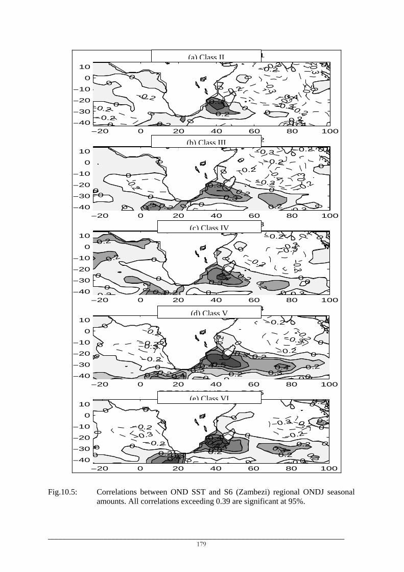
−20 0 20−40
−30
−20
−10
0
10
REGIO 6 − PC 1
−0.2
−0.2
−0.2
0
0
0
0
0
0.2
−20 0 20−40
−30
−20
−10
0
10
REGIO
−0.2
0
0
0
0
00
0.2 00.3
−20 0 20−40
−30
−20
−10
0
10
REGIO
0
00
0
0.2
0 2
0.2 0.2
0.2
0.3
−20 0 20−40
−30
−20
−10
0
10
REGIO
−0.3
−0.2−0.2
−0.2
0
0
0
0
0
0.20.3 0.4
−20 0 20−40
−30
−20
−10
0
10
REGIO
−0.3−0.2
−0.2
0 0
0
0
00
0
0.20.30.4
Fig.10.5: Correlations between ONDamounts. All correlations ex
__________________________________
N SUD(a) Class II
40 60 80 100
−0.5
−0.4
−0.4
−0.3
−0.3
−0.3
−0.3
−0.3
−0.2
−0.2
−0.2−0.2
−0.20
0
0
0
0
0
0
0.2
0.3
40 60 80 100
− PC 2
−0.4
−0.3
−0.3 −0.3
−0.2
−0.2
−0.2
−0 2
−0.2
0
0
00
0
00
0.2
.2 0.2
0.3
0.3
40 60 80 100
− PC 3
−0.3
−0.2
−0 2
−0.2
−0.2
−0.2
−0.2
0
0
0 0
00
0
0
0.2 0.20.3
0.4
40 60 80 100
6 − PC 4
−0.3
−0.2
−0 2
−0.2
−0.20
0
0 0 0
0 0
00.2
0.2
0.20.2
0.3 0.3
0.3
0.4 0.40.5
− PC 50.2
_
N SUD6(e) Class VI
N SUD(d) Class V
N SUD6(c) Class IV
N SUD6(b) Class III
40 60 80 100
−0.3
−0 2
−0.2
−0.20
00
0 0 0
0 0
0
0.2
0.2
0.20.2
0.20.3 0.30.4
0.40.5
SST and S6 (Zambezi) regional ONDJ seasonal ceeding 0.39 are significant at 95%.
______________________________________ 179

In the N regions, the influence of SST is almost consistent for all classes but peaks for
the higher classes. In the S regions, the lower classes of daily intensities are predominantly
influenced by the SST in the tropical Indian Ocean (e.g. Table 10.3, Fig.10.5a, 10.5b), which
are known to modulate regional scale atmospheric dynamics notably the Walker and Hadley
cells. However, the influence generally decreases with increasing intensities suggesting the
increasing role of local or regional scale influences on heavy rainfall events. This is indicated,
for example, by the SST signals which are confined mainly around southern Africa,
particularly in the southern Madagascar (MADA) basin (Fig.10.5c-10.5e). The regional SST
can be playing an important role in modulating the moisture of the air which is advected
towards the continent. The studies of Reason (1998), Crimp and Mason (1999), Reason and
Mulenga (1999), Reason (2001) and Rouault et al. (2002) found the influences of the SST and
moisture from the southwest Indian Ocean basins on rainfall and extreme rainfall events in
different parts of South Africa.
10.5 Stability of the ENSO/SST-southern African rainfall relationships
10.5.1 Stability of the ENSO-southern African rainfall relationships
The stability of the ENSO-southern African rainfall was assessed in the five southern
regions (S1-S5) which have long records. Due to a large number of rainfall and SOI indices
used, the complete results are not presented but only the main results are discussed. Results of
sliding correlation analysis indicate significant changes in the relationships in all regions
while the changes differ between the different ENSO seasons involved.
a) Dates and direction of changes
Significant changes were observed mainly in the mid-1950s and mid-1970s in
which significant correlations between SOI and early and late summer rainfall
characterise all the 15-year segments starting between 1956/57 and 1975/76 while
weak correlations or correlations of opposite sign were found for segments starting
before 1956/57 or after 1975/76 (Fig.10.6b). The two extreme dates correspond to a
period of re-occurrence of an active ENSO phase in the late-1950s/early-1960s after
its calm phase in the1930s-1950s (Torrence and Compo, 1998; Kestin et al., 1998) and
of warming in the tropical Pacific basins in about 1976/77 (Wang, 1995; Trenberth
and Hoar, 1996). The earlier changes in the mid-1950s improved the ENSO-rainfall
associations while the latest changes in the 1970s deteriorated or even changed the
associations.
_________________________________________________________________________ 180

(a)
0.0
0.1
0.2
0.3
0.4
0.5
0.6
0.7
0.8
0.9
1950 1955 1960 1965 1970 1975 1980
Cor
rel.
Coe
ff.
Upper (95%)1-10mm10-20mm20-30mm30-40mmE40mmOverall
(b)
-0.7
-0.5
-0.3
-0.1
0.1
0.3
0.5
0.7
1950 1955 1960 1965 1970 1975 1980
Cor
rel.
Coe
ff.
Upper (95%)1-10mm10-20mm20-30mm30-40mmE40mmOverallLower (95%)
(c)
-0.3-0.2-0.10.00.10.20.30.40.50.60.70.8
1950 1955 1960 1965 1970 1975 1980
Cor
rel.
Coe
ff.
Upper (95%)1-10mm10-20mm20-30mm30-40mmE40mmOverall
Fig.10.6: Typical temporal evolution of correlations between seasonal rainfall and SOI: a) FMA seasonal number of events and DJF SOI in S5, b) ONDJ seasonal number of events and JJA SOI in S1 and c) FMA seasonal number of events and MAM SOI in S2. Absolute correlations exceeding 0.50 (0.43) are significant at 95% (90%). The year shown correspond to starting year of the 15-year segment such as 1970 implies the 1970-1984 period.
b) The changing influences of ENSO
The typical temporal patterns of evolution of SOI-rainfall correlations are
illustrated in Fig 10.6. They indicates a reducing influence of the austral spring
(September-December) SOI on early summer rainfall in southern Africa affecting
_________________________________________________________________________ 181

significantly the three higher classes (class IV-VI) (e.g. Fig.10.6a). In fact, most of the
relationships during early summer have changed from positive to negative for
segments starting after 1975/76, the changes which were more evident in the western
(S1 and S2) regions and to some extent in S4. The influences of the spring SOI on late
summer rainfall have reduced as in S5 or remained relatively unchanged besides
correlation depressions caused by low correlations in the periods 1975-1989, 1976-
1990 and 1977-1991.
A steadily increasing influence of the austral winter (JJA) and summer
(January-March) SOI values on southern Africa rainfall in late summers was observed
(e.g. Fig.10.5c, Table 10.2) while in early summer, the influence remained relatively
unchanged despite correlation depressions. The changes affect mainly the southern
(S2, S3) and southeast (S4) regions in which correlations has become significant for
segments starting in 1971 or later. Richard et al. (2000) found similar significant post-
1970 association between JFM overall rainfall amounts in southern Africa and JFM
SOI.
c) The possible impacts of the changes on the relationships over the 1955-1985 period
Significant reductions or the change in the nature of the SOI-rainfall
associations in the southern (S) regions generally resulted in weak associations. This is
exemplified in Table 10.2. The changes have been observed mostly around 1976 and
the 1950-1994 period was therefore divided into the 1950-1976 and 1977-1994 sub-
periods (see e.g. Landman and Mason, 1999) and correlations calculated for each sub-
period. The correlations are stronger in the first sub-period than in the second. Since
71% of the 1955-1985 period falls within the first period, it is obvious that high
correlations in the 1950-1976 period influenced significantly the correlations
computed in the 1955-1985 period (Table 10.1).
d) Possible implications of the changes
The results showed the change of the nature of the SOI-early summer rainfall
relationships in certain regions since mid-1970s from positive to negative. The
relationships in late summer are persistently positive but have significantly reduced for
spring SOI and increased for summer SOI. The negative SOI-early summer rainfall
association suggest that post-1975/76 decaying SOI (warm ENSO) correspond to
_________________________________________________________________________ 182

enhanced early summer rainfall and reduced late summer rainfall as indicated by
persistent positive SOI-late summer rainfall.
Table 10.3: Correlations between seasonal SOI and early and late summer regional seasonal number of events in southern Africa. Significant correlations at 95% are shown in bold italics: ׀r0.39 < ׀ for 1950-1976 period and ׀r0.46 < ׀ for 1977-1994 period.
1950-1976 ONDJ seasonal frequencies against 1977-1994 ONDJ seasonal frequencies against Region Class SOI_MAM SOI_JJA SOI_SON SOI_DJF SOI_OND SOI_MAM SOI_JJA SOI_SON SOI_DJF SOI_FMA
II -0.08 0.29 0.25 -0.08 0.20 0.08 -0.10 0.08 -0.09 0.11 III 0.04 0.39 0.42 -0.04 0.41 0.06 -0.26 0.06 -0.20 0.12 IV 0.09 0.45 0.53 -0.06 0.52 -0.14 -0.46 -0.07 -0.25 0.02 V 0.17 0.39 0.50 -0.04 0.49 -0.13 -0.34 0.00 -0.32 0.06 VI 0.06 0.29 0.39 0.00 0.37 -0.07 -0.34 -0.02 -0.21 0.08
S1 Overall -0.02 0.35 0.35 -0.07 0.31 0.06 -0.17 0.07 -0.13 0.11 II 0.27 0.29 0.35 -0.01 0.33 0.21 0.17 0.20 0.13 0.24 III 0.38 0.37 0.51 0.01 0.54 0.34 0.17 0.16 0.31 0.22 IV 0.38 0.43 0.54 0.11 0.52 0.27 -0.14 -0.21 0.25 -0.19 V 0.58 0.64 0.61 0.28 0.63 0.05 -0.31 -0.30 0.21 -0.23 VI 0.25 0.42 0.57 -0.09 0.61 0.11 -0.27 -0.27 0.35 -0.26
S2 Overall 0.36 0.40 0.50 0.02 0.49 0.26 0.11 0.12 0.22 0.17 1950-1976 FMA seasonal frequencies against 1977-1994 FMA seasonal frequencies against
Region Class SOI_MAM SOI_JJA SOI_SON SOI_DJF SOI_OND SOI_MAM SOI_JJA SOI_SON SOI_DJF SOI_FMAII 0.24 -0.19 0.67 0.49 0.42 0.14 -0.12 0.21 0.03 0.05 III 0.18 -0.15 0.55 0.52 0.37 0.28 0.03 0.36 0.31 0.30 IV 0.26 0.00 0.48 0.50 0.43 0.33 0.17 0.48 0.44 0.44 V 0.24 -0.11 0.43 0.43 0.39 0.41 0.27 0.29 0.37 0.42 VI 0.10 -0.15 0.40 0.38 0.27 0.10 0.19 0.15 0.19 0.12
S1 Overall 0.24 -0.16 0.64 0.54 0.44 0.22 -0.04 0.29 0.16 0.17 II 0.21 -0.10 0.38 0.27 0.30 0.44 -0.05 0.33 0.39 0.50 III 0.18 0.01 0.27 0.22 0.27 0.57 0.08 0.60 0.45 0.53 IV 0.06 -0.14 0.25 0.20 0.15 0.40 0.03 0.26 0.06 0.23 V 0.08 -0.11 0.17 0.12 0.12 0.26 -0.19 0.60 0.45 0.30 VI 0.18 -0.08 0.38 0.33 0.27 0.35 0.24 0.40 0.33 0.24
S2 Overall -0.09 0.36 0.27 0.29 0.51 -0.02 0.45 0.41 0.52 0.19
10.5.2 Stability of SST-southern African rainfall relationships
Results of sliding correlation analysis are almost identical to those obtained with SOI
which indicate changes in the SST-rainfall associations in the 1956-1966 and 1970-1978
periods. A few representative examples are shown in Fig.10.7.
a) In general, the changes which involve SST in the three Indian Ocean basins had
occurred mainly in the 1970s. The changes in the early-1970s were evident in the
correlations involving JJA SST in the TWIO basin and OND SST in the MADA basin.
b) In early summer, correlations for segments starting after 1970-1975 were
predominantly positive with the highest (and sometimes significant) correlations
characterising the three higher classes.
_________________________________________________________________________ 183

c) In late summer, the changes involving TWIO SST led to positive associations after
mid-1970s (Fig.10.7a) while those involving SST in the two southwest Indian Ocean
basins (MADA and SWIO) led generally to negative associations for FMA SST
(Fig.10.7b). The influence of SST in the two Atlantic Ocean basins (BENG and EAO)
has remained generally insignificant and relatively unaltered.
d) Increasing influences of the austral winter (JAS) SST and decreasing influences of the
austral spring (OND) SST in these three Indian Ocean basins on summer rainfall in
southern Africa were observed. This is suggesting a probable shift of the influence
from the austral spring to austral winter, increasing the SST lead favourable for
forecasting purposes.
10.6 SST-atmospheric circulations associations and interannual variability of southern
African rainfall
Both observational and experimental studies have shown responses of the atmosphere
and southern African rainfall to changes in SST in the Atlantic and Indian Oceans south of the
Equator. The main influences of SST changes on southern African rainfall are through
changes in atmospheric circulation patterns due to SST forcing. These atmospheric changes
involve generally strengthening or weakening of Walker and Hadley circulations as well as
weakening/strengthening of the inland Angolan/Namibia heat low and/or its eastward
displacement into Mozambique or the Mozambique Channel (Reason, 1998). Tropical-
temperate troughs (TTTs, Todd and Washington, 1999ab) are usually linked to an inland heat
low and the eastward shift of this heat low offshore into eastern Madagascar and is associated
with a similar eastward shift of TTTs (Reason, 1998).
Correlations between TWIO SST and lower (850 hPa) and upper (200 hPa) zonal and
meridional winds show i) wind patterns that are less consistent at 850 hPa than patterns at 200
hPa (Figs.10.8, 10.9) particularly over the southern African subcontinent, ii) less consistent
correlation with wind patterns in early summer than those in late summer and iii) some
similarities for the two southwest Indian Ocean basins (MADA and SWIO) and also for the
two Atlantic Ocean basins (EAO and BENG). Patterns involving the Atlantic basins are not
discussed since no significant correlations between SST in the Atlantic and southern Africa
rainfall were found while patterns for the two southwest Indian Ocean basins are discussed
together.
_________________________________________________________________________ 184

(a)
-0.7-0.6-0.5-0.4-0.3-0.2-0.10.00.10.20.30.40.50.60.7
1950 1955 1960 1965 1970 1975 1980
Cor
rel.
Coe
ff.1-10mm10-20mm20-30mm30-40mmE40mmOverall
(b)
-0.3-0.2-0.10.00.10.20.30.40.50.60.70.8
1950 1955 1960 1965 1970 1975 1980
Cor
rel.
Coe
ff.
1-10mm10-20mm20-30mm30-40mmE40mmOverall
(c)
-0.8-0.7-0.6-0.5-0.4-0.3-0.2-0.10.00.10.20.30.40.50.60.7
1950 1955 1960 1965 1970 1975 1980
Cor
rel.
Coe
ff.
1-10mm10-20mm20-30mm30-40mmE40mmOverall
(d)
-0.7-0.6-0.5-0.4-0.3-0.2-0.10.00.10.20.30.40.5
1950 1955 1960 1965 1970 1975 1980
Cor
rel.
Coe
ff.
1-10mm10-20mm20-30mm30-40mmE40mmOverall
Fig.10.7: Temporal evolution of correlations between FMA seasonal number of events
a) in S5 and FMA TWIO SST, b) in S2 and FMA MADA SST, c) in S3 and OND MADA SST and d) in S4 and FMA BENG SST. Absolute correlations exceeding 0.50 (0.43) are significant at 95% (90%). The year shown correspond to starting year of the 15-year segment such as 1970 implies the 1970-1984 period.
_________________________________________________________________________ 185

10.6.1 Atmospheric circulations related to TWIO SST
The TWIO SST correlation map shows an indication of three weak low-level
cyclonic/anti-cyclonic correlation gyres at approximately 30° centres south of Africa in early
summer (Fig.10.8a). Two cyclonic flows, one in the southeast Atlantic centred around 40°S,
5°E and the other in the southwest Indian Ocean centred at 40°S, 70°E. Anti-cyclonic
anomalous flow is found over the Agulhas between the two cyclonic flows. Cyclonic flow
southeast of Madagascar introduces a northerly component into the southeast trades and divert
moisture into the central Indian Ocean (Rocha and Simmonds, 1997b). Some of these trades
penetrate into Mozambique and reach as far north as Tanzania bringing moisture into the
eastern coast (Mozambique) and the northern (Tanzania) part of southern Africa. They meet
northwesterlies in northern Tanzania and converge, enhancing early summer rainfall there. An
anti-cyclonic anomalous flow southeast of South Africa advects dry air from the midlatitudes
into the eastern and southern parts of South Africa reducing the likelihood of abundant
rainfall. This effect is indicated by negative correlations between TWIO SST and rainfall in
the South African S regions (Table 10.2).
Low-level correlation circulations features that prevail in early summer are not
similarly observed in late summer. Correlations between FMA TWIO SST and FMA 850 hPa
winds show recurving southwesterlies from the southeast Atlantic over cold Benguela waters
into western southern Africa (Namibia, western South Africa; Fig.10.9a). These recurved
southwesterlies then combine with recurving northeasterlies around the Angola heat low
forming northwesterlies which overly S4 and extend into the Agulhas, preventing moisture
influx from southwest Madagascar. Northerly flow in the Mozambique Channel further takes
moisture away from southern Africa into Tanzania. This may result in an enhancement of late
summer rainfall in northern Tanzania and reduction in the rest of southern Africa, consistent
with the correlation results in Table 10.4 (TWIO SST) and Table 10.1 (SOI) indicating
probably the response to ENSO forcing.
At 200 hPa, two features that are associated with wet short rains (early summer) are
present in Fig.10.8d. Mutai and Ward (2000) observed the presence of twin anti-cyclonic
flows centred around 20° on both sides of the equator, 30-50°E during the wettest short rains.
An anti-cyclone centred around 20°S, 35°E-60°E is observed in correlation map of TWIO
SST (Fig.10.8d). Upper tropospheric easterlies which are linked to enhanced convection over
East Africa and the western Indian Ocean (Mutai and Ward, 2000) leading to positive rainfall
anomalies are also present in Fig.10.8d. These two features further suggest that SST
_________________________________________________________________________ 186
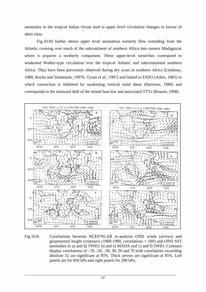
anomalies in the tropical Indian Ocean lead to upper level circulation changes in favour of
short rains.
Fig.10.9d further shows upper level anomalous westerly flow extending from the
Atlantic crossing over much of the subcontinent of southern Africa into eastern Madagascar
where it acquires a northerly component. These upper-level westerlies correspond to
weakened Walker-type circulation over the tropical Atlantic and subcontinental southern
Africa. They have been previously observed during dry years in southern Africa (Lindesay,
1988; Rocha and Simmonds, 1997b; Tyson et al., 1997) and linked to ENSO (Arkin, 1982) in
which convection is inhibited by weakening vertical wind shear (Harrison, 1986) and
corresponds to the eastward shift of the inland heat low and associated TTTs (Reason, 1998).
Fig.10.8: Correlations between NCEP/NCAR re-analysis OND winds (arrow
geopotential height (contours) (1968-1990, correlations × 100) and ONanomalies in a) and d) TWIO; b) and e) MADA and c) and f) SWIO. Cdisplay correlations of –70, -50, -30, 30, 50 and 70 with correlations exabsolute 52 are significant at 95%. Thick arrows are significant at 95panels are for 850 hPa and right panels for 200 hPa.
______________________________________________________________________187
f
e
d
s) and D SST ontours ceeding %. Left
___

10.6.2 Atmospheric circulations related to MADA and SWIO SST
An anomalous low-level cyclonic flow is observed over much of southern Africa in
the correlation map for OND MADA SST (Fig.10.8b) in which northerlies/northwesterlies on
its equatorward side bring moisture from the Congo basin into southern Tanzania, Zambia,
eastern Zimbabwe, Botswana and central/southern Mozambique. These northerlies extend
into the eastern and southern parts of South Africa and might be advecting moisture into these
parts of South Africa. A weak anti-cyclonic correlation gyre is found off the Tanzania coast
with its northerlies paralleling the northern coast and penetrate the southern coast. These
winds may correspond to negative and positive correlations between OND MADA SST and
early summer rainfall in N1 and N2 respectively (Table 10.2). Apart from an anti-cyclonic
correlation gyre within the Mozambique Channel and southwest directed vectors over
southeast/south-central South Africa, there are no other specific features in the correlation
map of SWIO SST (Fig.10.8c) which are associated with enhanced or reduced influx of
moisture into southern Africa.
Anti-cyclonic anomalous flows in the central south Atlantic, to the southeast of Africa
and in the Mozambique Channel are observed in a map of correlations between FMA MADA
SST and FMA low-level winds (Fig.10.9b). Weak northerlies/northeasterlies and
southerlies/westerlies meet and converge over Zambia. Furthermore, northerly flow over the
Mozambique Channel recurves and penetrates into southeast South Africa bringing moist air
into S3. These low-level circulation features favour an increase in late summer rainfall in
Zambia, Malawi, central and southern Mozambique and southeast South Africa and this is
indicated by positive correlations between FMA MADA SST and late summer rainfall in the
S3 and S6 regions (Table 10.2). Northerlies/northwesterlies along the Tanzanian coast hinder
Indian Ocean moisture influx into the country leading to a negative association between late
summer rainfall in Tanzania and FMA SST in southwest Madagascar (Table 10.2).
At 200 hPa, an anomalous easterly flow is observed over much of southern part of
southern Africa in late summer in the maps of both MADA SST (Fig.10.9e) and SWIO SST
(Fig.10.9f). The anomalous easterly flow may suggest wet conditions in the southern part as
they oppose the westerly flow which is related to dry conditions in the region.
_________________________________________________________________________ 188

Fig.10.9: Correlations between NCEP/NCAR re-analysis FMA winds (arrow
geopotential height (contours) (1968-1990, correlations × 100) and FManomalies in a) and d) TWIO, b) and e) MADA and c) and f) SWIO. Cdisplay correlations of –70, -50, -30, 30, 50 and 70 with correlations exabsolute 52 are significant at 95%. Thick arrows are significant at 95panels are for 850 hPa and right panels for 200 hPa.
10.7 Discussion The results presented above show the dominance of influences of ENSO and
the tropical Indian Ocean on interannual variability of southern Africa rainfall. Al
variations in south/southwest Madagascar were observed to influence interannual
variations in the Zambezi basin (S6) and central southern South Africa.
The TWIO basin is influenced by ENSO and simultaneous associations b
southern African early and late summer rainfall and SOI (Table 10.1) and TWIO SST
10.2) suggest modulation of regional rainfall by ENSO. The Indo-Pacific influenc
between regions and slightly among classes of daily rainfall. While early summer rai
the N regions is predominantly responding to the Indo-Pacific ENSO signal, the respo
______________________________________________________________________189
f
e
d
s) and A SST ontours ceeding %. Left
SST in
so SST
rainfall
etween
(Table
es vary
nfall in
nses in
___

the S regions are different. Significant (at 90% and 95%) correlations between early summer
amounts in all classes in southwest Tanzania (N2) and SOI and TWIO SST and MADA SST
indicate mixed influences of the remote ENSO/TWIO SST signal and regional SST in
south/southwest Madagascar.
ENSO became active again in the late-1950s-early-1960s (Kestin et al., 1998;
Torrence and Compo, 1998). Negative SOI-early summer rainfall association in the N regions
suggests enhanced early summer rainfall (short rains) in a low phase of SOI. Identified shifts
in early summer seasonal amounts (Fig.7.4, Chapter 7) as well as class VI amounts (Fig.7.3b)
in the southern Lake Victoria region and northeast Tanzania were likely to be caused by these
ENSO changes. The mechanisms that lead to such changes in some parts of northern Tanzania
and not all over the northern part are not yet well understood.
Responses of early summer rainfall in S4 and S5 and late summer rainfall in S5 to the
Indo-Pacific ENSO signal resemble those in the N regions although the relationships are
inverted, towards reduced rainfall during El Niño years. Early summer rainfall increases and
late summer rainfall decreases in late the 1970s in these regions (Fig.6.6) could have been
induced by warming in the tropical Pacific and Indian Oceans in the late 1970s (Trenberth,
1990; Kerr, 1992; Wang, 1995; Trenberth and Hoar, 1996) which drove changes in
atmospheric circulations. Using AGCM forced with positive SST anomalies typical of ENSO
anomalies, Rocha and Simmonds (1997b) observed an upper-level westerly flow over much
of southern Africa that is associated with reduced DJF rainfall in the region.
Early summer rainfall increases in eastern South Africa (Fig.6.6) could not be linked
to warming in the tropical Indian Ocean or Pacific Ocean, whose SST are negatively
correlated with rainfall in this region (Table 10.2). However, positive association between
rainfall in this part of South Africa and MADA SST and positive associations with TWIO
since 1972 (Not shown) could be responsible for such rainfall increases. A warm SST
anomaly in MADA produces a low-level cyclonic anomaly over the warmer southwest Indian
waters (Fig.10.8b) and its southeasterly vectors advect moisture into southeast South Africa
leading to enhanced early and late summer rainfall. Furthermore, low-level anomalous
northwesterlies extend from the Congo basin to the eastern coast of southern Africa bringing
moisture into the region from the Congo basin. It is noted that dates of upward shifts (Fig.7.4)
are spatially variable with only shifts in early summer overall seasonal amounts in S3
identified in the late-1970s-early-1980s. Abrupt increases in S5 were identified in the early-
1950s (1952/53), in S4 they occurred between 1951/52 and 1969/70, while decreases in the
seasonal number of rainfall events were identified in the early-1950s and early-1970s in
_________________________________________________________________________ 190

northeast Tanzania (Valimba et al., 2003b). Earlier changes in rainfall in South Africa have
been identified in a number of previous studies (Tyson, 1986; Smakhtina, 1998).
Shifts in southern African rainfall that were identified before the late-1960s do not
correspond to changes in SST in the Indian and tropical Pacific Ocean basins in the 1970s.
They may be linked to changes that involve the atmosphere or land-atmosphere interactions
and in general to global warming. Warming in both southern and northern hemispheric annual
mean surface air temperatures after 1960 has been reported (IPCC, 2001). Global surface air
temperature trends, show abrupt rises in the early 1940s and early 1960s. According to Flohn
and Kapala (1989), warming of the tropical troposphere has a consequence of accelerating a
delayed oceanic warming in low latitudes. Hence oceanic warming in the 1970s could be an
oceanic response to tropospheric warming in the 1960s which in turn feedbacks into the
atmosphere modifying further atmospheric circulations. It is then possible that atmospheric-
related changes in southern African rainfall were the cause of observed changes in SST-
southern African rainfall associations before the 1970s.
An increase in SST causes a non-linear increase in the amount of water precipitated
from an oceanic vertical column of air (Stephens, 1990; Zhang, 1993). Warming of the
southwest Indian (including MADA and SWIO) and tropical Indian and Pacific Ocean waters
in the 1970s may have enhanced convection in these oceans and consequently rainfall
becomes more convective leading to reduced frequency of light rainfall events. Decreases in
class II amounts and number of events were identified mainly in the 1970s in coastal northeast
Tanzania, Namibia and the southeast coast of South Africa (e.g. Fig.7.3c). Positive and
significant correlations between class VI (≥ 40 mm) in S3 and MADA SST in both early and
late summer and insignificant correlations with both TWIO SST (Table 10.2) and SOI (Table
10.1) may be indicating a contribution of enhanced convection over local warmer southwest
Madagascar waters to the increase of higher rainfall in the southeast South Africa (Smakhtina,
1998). Mason et al. (1999) found a decreasing intensity of high rainfall in northeast South
Africa (S4) since the late 1970s, decreases which have been similarly identified in annual
amounts (Fig.7.3a) and number of events (Table 7.3) of class VI rainfall. However, the
decreases were identified in the present study between early 1960s and late 1970s. In contrast,
these intense daily events had increased in eastern and northeast Tanzania in the early-1960s.
Tables 10.1 and Table 10.2 link changes in southern African rainfall mainly to SOI
and TWIO SST changes and their induced atmospheric circulation changes discussed above.
Correlations between class VI rainfall in S4 and SOI (TWIO SST) are significant and
persistently positive (negative) for late summer rainfall while in early summer, they are
_________________________________________________________________________ 191

insignificant and have shifted to negative for SOI in post-1975/76. In an almost similar
period, correlations between early summer class VI rainfall events in S4 and SST in TWIO,
MADA and SWIO have shifted from negative to positive. These correlations suggest that a
decaying phase of SOI (warm ENSO) and/or warming of TWIO, SWIO and MADA waters
correspond, therefore, to reduced intense daily events in late summer in northeast South
Africa and their increase in early summer in the post-1975/76 period. Low-level easterlies,
northeasterlies or southeasterlies over the Congo basin and Angola/northern Namibia
(Fig.10.7a, 10.8a) due to warmer TWIO SST are unfavourable for the development of an
inland heat low (Reason, 1998; Reason and Mulenga, 1999) indicating reduced likelihood for
TTTs formation which in turn implies reduced frequency and/or intensity of heavy rainfall in
northeast South Africa.
Further, SST in the Atlantic Ocean basins (BENG and EAO) are significantly and
persistently negatively correlated with early summer rainfall in S4 since 1968-1970 at both
lag-0 and lag-1 season but correlations reduced to insignificant negative after 1978. These
negative correlations suggest that warming in these Atlantic Ocean basins, as is observed
during Benguela Niños, corresponds to reduced intense rainfall in S4. The mechanism may
involve weakening of the temperature gradient between the tropical/subtropical Atlantic and
southwest Indian Ocean, conditions unfavourable for strengthening of strong southeasterlies,
which advect moisture into eastern South Africa including S4.
10.8 Conclusions Results show that interannual variability of rainfall in southern Africa is mostly
influenced by ENSO and SST in the tropical Indian Ocean and south/southwest Madagascar
basins. SST in southwest Indian Ocean and in the Benguela Current system, including the
Angola/Benguela Front region and the equatorial Atlantic, have selective influences upon
southern African rainfall. The study has mainly found the following
o Influences of ENSO:
• ENSO influences are consistent in all classes and highest in the light (< 20 mm) daily
events.
• There is a dipole-like response of rainfall in the northern and southern part of
southern Africa to an ENSO signal in which the ENSO influence is strong and
positive in early summer in the north and strong and negative in late summer in the
south.
_________________________________________________________________________ 192

• There has been a significant change in the ENSO-southern African rainfall
relationship since the mid-1970s, which led to an increasing influence of austral
winter SOI and decreased or changed associations for austral spring SOI.
o Influences of SST in the Indian and Atlantic Oceans
• SST in the tropical Indian ocean have a dominant influence on the interannual
variability of rainfall in the region.
• The interannual variability of the light/moderate (< 20 mm) daily events is being
modulated by large-scale influences of the Indo-Pacific signals while regional SST in
the south/southwest Madagascar were found to have a considerable influence on
heavy daily events.
• SST in the tropical Indian ocean show an inverse relationship with rainfall in the
southern part and a direct relationship with rainfall in the north, while SST in the
south Madagascar basin show the opposite influence to that of the tropical Indian
ocean.
It was not possible, however, to reach firm conclusions based on the observed results
as it was not possible to link pre-1950s rainfall changes to climatic changes since pre-1950s
SST in the southern Atlantic and Indian Oceans and pre-1968 upper air data over Africa are
doubtful and frequently missing.
Changes were identified in the mid-1970s but the records were too short to provide
any strong conclusions in the post-1975 period. Moreover, it was not possible to study similar
temporal evolutions of SOI/SST-rainfall associations in other parts of southern Africa due to
short available records.
Nevertheless, evolving long lead SOI/SST-summer rainfall associations in Namibia
and South Africa offer the possibility of using SOI and SST as predictors of summer rainfall
in these countries. But one should also be cautious when constructing summer seasons as it
was observed that the two parts (early and late summers) of the single rainy season in the
summer region of southern Africa displayed opposing interannual patterns of variability.
_________________________________________________________________________ 193

___________________________________________________________________________ CHAPTER 11
GENERAL SUMMARY, CONCLUSIONS AND RECOMMENDATIONS
___________________________________________________________________________
11.1 Summary and conclusions
The main objective of the study was to investigate hydrological variability in southern
Africa at a regional spatial scale and its relationship to climatic variations. Additional interest
was in studying hydrological variability in relation to hydrological extremes, floods and
droughts, which have been reported to be more frequent, severe and widespread in recent
decades than in the past. This necessitated the use of indices of rainfall and streamflow that
define the hydrological extremes, which in turn required data of short-duration such as daily
data. The fact that these hydrological extremes do not characterise the whole of southern
Africa at the same time and that floods and droughts of different levels of severity and
duration have been reported in different areas of the region at the same time, indicates the
spatial non-uniformity of the variations. The main findings of this study are summarised
below.
11.1.1 Spatial-temporal variations of rainfall
11.1.1.1 Spatial variations
Climatologies of daily rainfall indicated that about 60-70% of the time when it rains,
daily rainfall intensities are below the long-term average daily rainfall intensities (AADI) and
light (< 10 mm) daily intensities are generally the most frequent in the region (Section 6.6.2).
The dry western/southwestern part of southern Africa is dominated by light (< 10mm)
daily rainfall intensities, has low annual amounts and number of daily events and the highest
interannual variability while the “humid” eastern and northern part has generally high annual
amounts and number of daily events, almost similar contributions of different types of daily
events to annual amounts and low interannual variability.
The high daily rainfalls exceeding 30 mm were experienced mainly during the core of
the principal wet seasons: March-April in most of Tanzania, June-August in the Western Cape
and December-February in the rest of southern Africa (Fig 6.11). Further, the areas in central
Mozambique and the southern highlands of Tanzania receive the highest number of these
intense daily events and are therefore the most prone to flooding.
_________________________________________________________________________ 194

11.1.1.2 Temporal variations
Change-point and linear trend analyses of seasonal and annual rainfall amounts and
number of daily rainfall events resulted in a number of conclusions. It should be noted that
linear trends were investigated for the common periods 1941-1990 and 1961-1990 to provide
comparison of trending behaviour (strictly increasing/decreasing or alternating) in the two
sub-periods.
• There is an opposing pattern of interannual variability of rainfall in the early and late
summer which leads to a tendency towards decreasing late summer rainfall in
various parts of southern Africa since the 1970s and increasing early summer rainfall
in the eastern part since early-1960s (Table 7.1a, Figs 7.4a, 7.4b). The recent
decreases in late summer rainfall affected significantly rainfall in Namibia.
• There is a lack of any real evidence of trends in annual rainfall amounts in the region
as a whole and there is strong evidence of spatially localised trends in annual
amounts like in Namibia (Table 7.1a).
• There is strong evidence of trends towards declining annual number of daily rainfall
events as well as the number of light (< 10 mm) daily rainfall events in the region
(Table 7.1b).
• The opposing patterns of interannual variability of rainfall in the early and late
summer affect the patterns of overall rainfall indices at the annual timescale. Abrupt
decreases in annual rainfall in some southern parts of southern Africa were similarly
identified in late summer rainfall but were lacking in early summer rainfall. In
eastern Tanzania, increases in early summer rainfall were countered by similar
decreases in late summer rainfall resulting in the lack of abrupt changes in annual
rainfall (Fig 7.3a).
11.1.2 Spatial-temporal variations of the rainy seasons
The rainy seasons characteristics (onset, end and duration) were objectively defined
(Section 8.3) and their spatio-temporal variations in the southern African were investigated
(Sections 8.5 & 8.6). Spatially, the start and end of the rainy seasons in the region (Figs 8.6,
8.7) were related to the pattern of low-level atmospheric circulation features including the
ITCZ, the southeast trades and the inland Angola heat low. Temporally, interannual
variability of the rainy season characteristics were similar to interannual variability of rainfall
amounts and number of daily events. Wet years, for example, corresponded to prolonged
_________________________________________________________________________ 195

rainy seasons (Fig 8.11) which recorded significant amounts and number of events while in
dry years the opposite was observed.
11.1.3 Seasonal and interannual streamflow variations
Seasonal and interannual variations of streamflows (Sections 9.2 & 9.5) were almost
similar to seasonal and interannual variations of rainfall. Seasonally, flow peaks correspond to
rainfall peaks and occur mainly during the core of the rainy seasons. Interannually, significant
unidirectional abrupt changes in mean flows have occurred mainly in the mid-1970s to early-
1980 which
• significantly affected streamflows during the late summer rather than during the early
summer (Table 9.2);
• led to significant reduction of streamflows in the upper Zambezi basin, Namibia and
northeast South Africa (Fig 9.3);
• were observed in other areas like the upper Zambezi in which evolutive rather than
abrupt changes of rainfall were identified, suggesting that slight changes in rainfall
could translate into significant changes in streamflows;
• indicated little evidence of changes in the flow extremes (high and low flows) except
in the upper Zambezi and Namibia (Figs 9.3d, 9.3e, 9.3f).
11.1.4 Relationships between rainfall variations and ENSO/SST
Relationships were investigated between the different types of daily rainfall events and
ENSO and SST in the Atlantic and Indian Oceans. The results concluded that
• Interannual variability of southern Africa rainfall is mainly influenced by ENSO,
SST in the tropical Indian Ocean and in southern Madagascar with weaker influences
of other oceanic basins in the Indian and Atlantic oceans.
• ENSO influences are relatively consistent for all types of daily rainfall events;
highest for light intensities, highest in early summer in the northern part of southern
Africa (Tanzania) and in late summer in the western part (Table 10.1). Furthermore,
the responses of southern Africa rainfall to an ENSO signal show a dipole-like effect
between the northern and southern parts (Fig10.4).
_________________________________________________________________________ 196

• Interannual variability of light and moderate (< 20 mm) daily rainfall events is
modulated by SST in the tropical Indian Ocean, while regional SST were found to
show significant influences on heavy rainfall events (Table 10.2, Fig 10.5).
• The ENSO/SST-southern African rainfall associations are dynamic and underwent
significant changes in the mid-1950s and in the 1970s (Figs 10.6, 10.7). The latter
changes led to weaker or reversed associations, while the former generally led to
strengthened associations. The reversed associations characterised mainly the early
summer rainfall. Consistent positive associations between SOI and late summer
rainfall in the southern part of southern Africa and decreases in SOI around the mid-
1970s due to warming in the Pacific could be linked to predominantly decreasing late
summer rainfall in various parts of the region.
• There is an increasing influence of the austral winter (JJA) ENSO and SST on
summer rainfall in southern Africa
11.2 General conclusions
The findings on rainfall variations lead to the following general conclusions with
respect to the widespread droughts and devastating floods in southern Africa and their
changing characteristics:
Daily rainfall intensities below 20 mm are dominant in the region, dominating annual
amounts in the western and southern parts comprising of Namibia, Botswana,
southwestern Zimbabwe and western South Africa. Warmer than average SST in the
tropical Indian Ocean basin since the mid-1970s, frequent warm ENSO events since
the mid-1970s and strong inverse relationships between amounts/frequencies of daily
rainfall intensities below 20 mm and ENSO and SST in the tropical Indian Ocean
basin point towards decreasing these type of daily rainfall events in the region. Since
they account for a significant portion of annual rainfall amounts in the large part of
the west and south southern Africa, they are partly responsible for the widespread
droughts in these areas.
•
• Positive and sometimes significant relationships between daily rainfalls and SST in
the surrounding oceanic basins, particularly between high rainfalls and SST in the
south Madagascar basin, suggested that the unexpected observed above average
_________________________________________________________________________ 197

rainfall amounts in certain warm ENSO years could be attributed to the influence of
SST in the surrounding basins.
The high positive association between the high daily rainfalls and SST in the
surrounding oceanic basins particularly the south Madagascar basin and the low
associations between these daily rainfalls and SST in the tropical Indian Ocean
suggest an important role of SST in the surrounding oceans in relation to floods. As
identified in some recent studies, these basins are other sources of moisture into the
region and the regional SST can be playing an important role in modulating the
moisture of the air, which is advected towards the continent.
•
11.3 Recommendations
11.3.1 Revision of operational and forecasting hydroclimatological models
The results in this study showed significant changes in the rainfall, streamflows and
rainfall-ENSO/SST relationships particularly in the 1970s. It has been a common practice to
calibrate and verify parameters of the hydroclimatological models using long records.
However, in southern Africa, most of the rainfall and streamflow records span the period
1950s-1990s. Therefore, the significant changes that have been identified in the 1960s
through the 1970s suggest
• a revision of the operational and forecasting hydrological models that use rainfall and
streamflows. Models that have been calibrated using data spanning the period of
significant changes (e.g. 1960s, 1970s) should be revised by considering the pre- and
post-change periods separately. The suitability of the model can be assessed by
considering, for example, the pre-change period for calibration and the post-change
period for verification and vice versa.
• a revision of the regional general circulation models (GCMs) that are used for
operational and forecasting purposes in southern Africa. The revision may consider,
for example, the separate influences of the SST in the tropical central Indian Ocean
and those in the south Madagascar basin. The stability of model parameters should
be investigated separately with consideration of the pre- and post-1970s periods.
• that climatological models should also take advantage of the temporal shifting of the
influences of ENSO and SST.
_________________________________________________________________________ 198

11.3.2 Detailed hydrological studies at finer spatial scales
Results have highlighted consistent changes in both rainfall and streamflows in certain
catchments like those in Namibia and western Zambia while in others it was not possible or
very difficult to associate changes in streamflows with identified changes in rainfall. An
example was given for Groot-Vis (Fish) River where the flow supplement from the Orange
River modified this seasonal river into a perennial river. However, to accurately quantify the
magnitude of the influence of rainfall changes on changes of streamflows, studies at finer
spatial scales like catchment scales are recommended. The use of water balance models can
assist in quantifying the influence of climate and rainfall changes on streamflows once other
model components have been quantified and accounted for.
11.3.3 Studies of characteristics of short-duration rainfall events
The study has indicated the spatially and temporally varying compositions of different
types of daily events in southern Africa. Light daily rainfall events dominate annual rainfall
amounts in the western and southern parts while moderate and heavy daily events dominate
the eastern and northern parts. This spatial variation has been linked to droughts and floods in
the region. The frequent heavy daily events in central Mozambique, Malawi and northern
Shire basin in the southwest highlands of Tanzania marked the respective areas as flood prone
while the dominant light daily events in the western part like in Namibia indicate that the
western part is the most drought prone in the region.
However, details of how the different types of daily events are related to observed
hydrological droughts and floods were not investigated in detail in this study while they are
necessary. Studies which will investigate different indices of flood-producing rainfall events
(e.g. persistent daily events of more than 30 mm, isolated intense daily events, etc) and their
relationships to different flood magnitudes, for example, are therefore encouraged.
11.3.4 Studies of the relationships between climatic factors and types of rainfall
Apart from the known influences of ENSO and SST in the tropical Indian Ocean, SST
in the other oceanic basins such as the equatorial Atlantic Ocean (EAO) and the south
Madagascar (MADA) basins were influencing rainfall variations in different parts of southern
Africa. SST in the surrounding oceanic basins were influencing mainly the high rainfalls, the
fact which needs further investigation.
_________________________________________________________________________ 199
11.3.5 Data availability and reliability
However, caution should be exercised in applying the results of this study. The results
were hindered by the data unavailability and quality:
• The spatially uneven distribution of rainfall and flow gauging stations caused mainly
by unavailability of records and excessive missing observations. No rainfall data
were available for Angola, available data in most of the countries studied ended
between mid-1980s and early-1990s while Mozambican data were characterised by
long periods of missing observations.
• The short records used in some regions in which alternating periods of high and low
rainfall or streamflows could be interpreted in relation to abrupt unidirectional
changes.
• The quality of the records is not always known, as detailed information concerning
the rainfall and flow gauging stations were mostly missing or only partially available.
Therefore efforts are required to improve the spatial distribution of rainfall and
streamflow stations and availability of quality data. For streamflows, the emphasis will be on
gauging all rivers at different points and at the most downstream points before they discharge
into the oceans, lakes or wetlands. The efforts may involve i) improving collection and
processing of historical data with emphasis on their quality, ii) installation of new rainfall and
streamflow gauges across the region with priority given to accounting for factors like
topography and iii) documenting detailed inventory of the gauges (e.g. as gauge relocation,
changing techniques of measurements and for streamflows) and details of changes involving
any factors that add or abstract water upstream of the gauges.
_________________________________________________________________________ 200

___________________________________________________________________________
REFERENCES
___________________________________________________________________________
Alemaw, B. F. and Chaoka, T. R., 2002: Trends in the flow regime of the southern African
rivers as visualised from rescaled partial sums (RAPS), Afr. J. Sc. Technol., 3, 69 – 78.
Alusa, A.L., Mushi, M., 1974: A study of the onset , duration and cessation of the rains in
East Africa. Preprints, International Tropical Meteorology Meeting, Nairobi, 21 Jan-7
Feb 1974. AMS, Boston, 133 – 140.
Arkin, P. A., 1982: The relationship between interannual variability in the 200 mb tropical
wind field and the Southern Oscillation, Mon. Wea. Rev., 110, 1393 – 1404.
Asnani, G. C., 1993: Tropical meteorology, Poona, India, 2 vol., 1202pp.
Assani, A. A., 1999: Variabilité temporelle et persistance des épisodes secs en saison des
pluies à Lubumbashi (Congo-Kinshasa), Cahiers Sécheresse, 10, 45 – 53.
Behera, S. K. and Yamagata, T., 2001: Subtropical SST dipole events in the southern Indian
Ocean, Geophys. Res. Lett., 28, 327 – 330.
Benoit, P., 1977: The start of the growing season in northern Nigeria, Agric. Meteorol., 18,
91.
Bergonzini, L., 1998: Bilans hydriques de lacs (Kivu, Tanganyika, Rukwa et Nyassa) du rift
est-Africain, Annales – Sciences Geologiques, Publ. No. 103, Mus. Roy. Afr. Centr.,
Tervuren, Belgique, 183pp.
Bergonzini, L., Camberlin, P. and Richard, Y., 2002: Variation interannuelle du billan
hydrique du lac Tanganyika (1932-1995): Changement dans la relation precipitation-
excedent lacustre, Hydrol. Sc. J., 47, 781 – 796.
Bergonzini, L., Camberlin, P. and Richard, Y., 2001: Variations interannuelles du billan
hydrologique du lac Tanganyika: Les précipitations dans l’Afrique des Hautes-Terres
sont-elles seules en cause?, Espaces Tropicaux, 16, 145 – 159.
Berhanu, F. A., 1999: Development and application of a GIS - based regional hydrological
variability and environmental assessment system (RHVEAS) for the southern Africa
region, PhD Thesis, University of Dar Es Salaam.
Berhanu, F. A., Zaake, B. T. and Kachroo, R. K., 2001: A study of variability of annual
river flow of the southern African region, Hydrol. Sci. J., 46(4), 513 - 524.
Bhalotra, Y. P. R., 1984: Climate of Botswana, Part1, Climatic Controls, Department of
_________________________________________________________________________ 201

Meteorological Services, Republic of Botswana.
Bigot, S., 1997: Les precipitations et la convection profonde en Afrique Centrale: Cycle
saisonièr, variabilité interannuelle et impact sur la végétation, Thèse de Doctorat,
Université de Bourgogne, 283pp.
Bigot, S., Moron, V., Melice, J.-L., Servat, E. and Paturel, J.-E., 1998: Fluctuations
pluviométriques et analyse fréquentielle de la pluviosité en Afrique centrale. In Servat,
E., Hughes, D, Fritsch, J.-M. and Hulme, M. (Eds): Water Resources Variability in
Africa during the XXth century, IAHS Pub. No 252, pp 71 – 78.
Brandon, J., 2000: Aviation meteorology guide. Available online in September 2003 at
http://www.auf.asn.au/meteorology/section4.html
Brunetti, M., Maugeri, M., Nanni, T. and Navarra, A., 2002: Droughts and extreme events
in regional daily Italian precipitation series, Int. J. Climatol., 22, 543 – 558.
Buishand, T. A., 1984: Tests for detecting a shift in the mean of hydrological time series, J.
Hydrol., 73, 51 – 69.
Buishand, T. A., 1982: Some methods for testing the homogeneity of rainfall records, J.
Hydrol., 58, 11 – 27.
Butler, R. A., 2001: A place out of time: tropical rainforests and the perils they face,
Unpublished.
Camberlin, P. and Okoola, R. E., 2003: The onset and cessation of the long rains in eastern
Africa and their interannual variability, Theor. Appl. Climatol., 75, 43 – 54.
Camberlin, P. and Diop, 2002: Application of daily rainfall PCA to the assessment of the
rainy season characteristics in Senegal, Accepted Climate Research.
Camberlin, P., Okoola, R., Diop, M. and Valimba, P., 2002: Identification des dates de
démarrage et de fin de saison des pluies: Application a l’Afrique de l’Est et au
Sénégal, Conference on Climatology, Besançon, September 2002.
Camberlin, P., Janicot, S. and Poccard, I., 2001: Seasonality and atmospheric dynamics of
the teleconnections between African rainfall and tropical ocean surface temperatures:
Atlantic vs. ENSO, Int. J. Climatol., 21, 973 – 1005.
Camberlin, P. and Shanko, D., 1998: The effects of the southwest Indian Ocean tropical
cyclones on Ethiopian drought, Int. J. Climatol., 18, 1373 – 1388.
Cattell, R. B., 1966: The scree test for the number of factors, Mult. Behav. Res., 1, 245 – 276.
Chenje, M. and Johnson, P., 1996: Water in southern Africa, Print Holdings (Harare),
238pp.
Crimp, S. J. and Mason, S. J., 1999: The extreme precipitation event of 11 to 16 February
_________________________________________________________________________ 202
1996 over South Africa, Meteorol. Atmos. Phys., 70, 29 – 42.
D’abreton, P. C. and Lindesay, J. A., 1993: Water vapour transport over southern Africa
during wet and dry early and late summer months, Int. J. Climatol., 12, 151 – 170.
Demuth, S. and Heinrich, B., 1998: Temporal and spatial behaviour of drought in south
Germany, In Gustard, A., Blazkova, S., Brilly, M., Demuth, S., Dixon, J., van Lanen,
H., Llasat, C., Mkhandi, S. and Servat, E. (Eds): Regional Hydrology: Concepts and
Models for Sustainable Water Resources Management, IAHS Pub. No 246, pp 151 –
157.
Dent, M. C., Lynch, S. D. and Schulze, R. E., 1989: Mapping mean annual and other
rainfall statistics over Southern Africa. Univ. of Natal, Dept. Agric. Eng., ACRU
Report 27, Water Research Commission, Pretoria, South Africa. Report No 109/1/89.
Diop, M., 1996: A Propos de la durée de la saison des pluies au Sénégal, Cahiers Sécheresse,
7, 7 – 15.
Donohue, E.A., Firing, E. and Beal, L., 2000: Comparison of the three velocity sections of
the Agulhas current and the Agulhas undercurrent. J. Geophys. Res., 105, C12, 28585
– 28593.
Dyson, L. L. and van Heerden, J., 2001: The heavy rainfall and floods over the northeastern
interior of South Africa during February 2000, South African J. Sc., 97, 80 – 86.
Egozcue, J. J. and Ramis, C., 2001: Bayesian hazard analysis of heavy precipitation in
eastern Spain, Int. J. Climatol., 21, 1263 – 1279.
Fauchereau, N., Trzaska, S., Richard, Y., Roucou, P. and Camberlin, P., 2003: Sea-
surface temperature co-variability in the southern Atlantic and Indian Oceans and its
connections with the atmospheric circulation in the southern hemisphere, Int. J.
Climatol., 23, 663 – 677.
Fauchereau, N., Trzaska, S., Rouault, M. and Richard, Y., 2003: Rainfall variability and
changes in southern africa during the 20th century in the global warming, Natural
Hazards, 29, 139 – 154.
Flohn, H. and Kapala, A., 1989: Changes of tropical sea-air interaction processes over 30-
year period, Nature, 338, 244 – 246.
Folland, C. K., Palmer, T. N. and Parker, D. E., 1986: Sahel rainfall and worldwide sea
surface temperature 1901-1985, Nature, 320, 602 – 607.
Florenchie, P., Lutjeharms, J. R. E., Reason, C. J. C., Mason, S. and Rouault, M., 2003:
The sources of Benguela Ninos in the south Atlantic Ocean, Geophys. Res. Lett., 30,
DOI: 10.1029/2003GL017172, 2003.
_________________________________________________________________________ 203
Gordon, A.L., 1985: Indian-Atlantic transfer of thermocline water at the Aghulhas
Retroflection, Science, 227, 1030 – 1033.
Gu, D. and Philander, S. G. H., 1995: Secular changes of annual and interannual variability
in the tropics during the past century, J. Climate, 8, 864 – 876.
Haan, C. T., 1977: Statistical methods in hydrology, The Iowa State University Press/ Ames,
378pp.
Harsh, E., 1992: Droughts devastates Southern Africa, Drought Network News, 2, 17 – 19.
Harrison, S. J., 1986: A synoptic climatology of South Africa rainfall variations, PhD
Thesis, University of Witwatersrand, 341pp.
Hastenrath, S., 2000: Zonal circulations over the equatorial Indian Ocean, J. Climate,13,
2746 – 2756.
Hastenrath, S., 1985: Climate and circulation of the tropics, Reidel, 455pp.
Hendon, H. and Liebmann, B., 1990: A composite study of onset of the Australian summer
monsoon, J. Atmos. Sci., 47, 2227 – 2240.
Hirsch, R. M., Helsel, D. R., Cohn, T. A. and Gilroy, E. J., 1993: Statistical analysis of
hydrologic data, Handbook of Hydrology, Maidment, D. R. (Ed)., McGraw-Hill Inc,
17.1 – 17.55.
Hirst, A. C. and Hastenrath, S., 1983: Atmosphere-ocean mechanisms of climate anomalies
in the Angola-tropical Atlantic sector, J. Phys. Oceanog., 13, 1146 – 1157.
Hisdal, H., Stahl, K., Tallaksen, L. M. and Demuth, S., 2001: Have streamflow droughts in
Europe become more severe or frequent, Int. J. Climatol., 21, 317 – 333.
Holland, G. J., 1986: Interannual variability of the Australian monsoon at Darwin, Mon.
Wea. Rev., 114, 594 – 604.
Houndenou, C. and Hernandez, K., 1998: Modification de la saison pluvieuse dans
l'Atakora (1961-1990): Un exemple de sécheresse au nord-ouest du Bénin (Afrique
occidentale), Cahiers Sécheresse, 9, 23 – 34.
Hubert, P., Carbonnel, J. P. and Chaouche, A., 1989: Segmentation des séries
hydrométéorologiques – Application à des séries de précipitations et de débits de
l’Afrique de l’Ouest, J. Hydrol., 110, 349 – 367.
Hubert, P. and Carbonnel, J. P., 1987: Approche statistique de l’aridification de l’Afrique
de l’Ouest, J. Hydrol., 95, 165 – 183.
Hulme, M. , 1992: Rainfall changes in Africa: 1931-1960 to 1961-1990, Int. J. Climatol., 12,
685 – 699.
Ilesanmi, O. O., 1972: An imperical formulation of an ITD rainfall model for the tropics: a
_________________________________________________________________________ 204

case study of Nigeria, J. Appl. Meteorol., 10, 882 – 889.
Indeje, M., Semazzi, F. H. M. and Ogallo, L. J., 2000: ENSO signals in east African
rainfall seasons, Int. J. Climatol., 20, 19 – 46.
IPCC, 2001: Climate change: The Scientific basis, Cambridge University Press, 881pp.
Janicot, S., Trzaska, S. and Poccard, I, 2001: Summer Sahel-ENSO teleconnections and
decadal timescale SST variations, Clim. Dyn., 18, 303 – 320.
Janicot, S., Polcher, J, Trzaska, S. and Poccard, I., 1999: Decadal scale variability of
summer Sahel-ENSO teleconnection, submitted to Climate Dyn.
Janicot, S., Moron, V. and Fontaine, B., 1996: Sahel droughts and ENSO dynamics,
Geophys. Res. Lett., 23, 515 – 518.
Janowiak, J. E., 1988: An investigation of interannual rainfall variability in Africa, J.
Climate, 1, 240 – 255.
Jury, M. R., 1996: Regional teleconnection patterns associated with summer rainfall over
South Africa, Namibia and Zimbabwe, Int. J. Climatol., 16, 135 – 153.
Jury, M. R., 1995: A review of research on ocean-atmosphere interactions and South African
climate variability, S. Afr. J. Sc., 91, 289 – 294.
Jury, M. R. and Gwezantini, M. E., 2002: Climate variability in Malawi, Part 2: Sensitivity
and prediction of lake levels, Int. J. Climatol., 22, 1303 – 1312.
Jury, M. R. and Mwafulirwa, N. D., 2002: Climate variability in Malawi, Part 1: Dry
summers, statistical associations and predictability, Int. J. Climatol., 22, 1289 – 1302.
Jury, M. R. and Engert, S., 1999: Teleconnections modulating inter-annual climate
variability over northern Namibia, Int. J. Climatol., 19, 1459 – 1475.
Jury, M. R., Lindesay, J. A. and Wittmeyer, I., 1993: Flood episodes in central South
Africa from satellite and ECMWF data, S. Afr. J. Sc.,89, 263 – 269.
Kachroo, R. K., Badaza, M. and Gadain, H. M., 1999: Simulation of backwater in Kiwira
River in the lake Nyasa basin, East African J. Eng., 2, 102 – 110.
Kalnay, E., Kanamitsu, M., Kistler, R., Collins, W., Deaven, M. I., Gandin, L., Iredell,
M., Saha, S., White, G. Wollen, J., Zhu, Y., Chelliah, M., Ebisuzaki, W., Higgins,
W., Janowiak, J., Mo, K. C., Ropelewski, C., Leetma, A., Reynolds, R., Jenne, R.,
Joseph, D., 1996: The NCEP/NCAR 40-year reanalysis project, Bull. Amer. Meteorol.
Soc., 77, 437 – 471.
Karl, T. R., Knight, R. W. And Plummer, N., 1995: Trends in high-frequency climate
variability in the twentieth Century, Nature, 377, 217 – 220.
Kendall, M. G. and Stuart, A., 1968: The advanced theory of statistics. Design and analysis,
_________________________________________________________________________ 205

and time series, Vol. 2 (2nd Edition.), Charles Griffin and Co. Ltd (London), 690pp.
Kerr, R. A., 1992: Unmasking a shifty climate system, Science, 255, 1508 – 1510.
Kestin, T. S., Karoly, D. J., Yano, J-I and Rayner, N. A., 1998: Time-frequency variability
of ENSO and stochastic simulation, J. Climate, 11, 2258 – 2272.
Kousky, V. E., 1988: Pentad outgoing longwave radiation climatology for the South
American sector, Rev. Bras. Meteor., 3, 217 – 231.
Landman, W. A. and Mason, S. J., 1999: Change in the association between Indian Ocean
sea-surface temperatures and summer rainfall over South Africa and Namibia, Int. J.
Climatol., 19, 1477 – 1492.
Lanzante, J. R., 1996: Lag relationships involving tropical sea surface temperatures, J.
Climate, 9, 2568 – 2578.
Laraque, A., Mahé, G., Orange, D. and Marieu, B., 2001: Spatio-temporal variations in
hydrological regimes within central Africa during the XXth century, J. Hydrol., 245,
104 – 117.
Laraque, A., Orange, D., Maziezoula, B. and Olivry, J.-C., 1998: Origine des variations de
debits du Congo à Brazzaville durant le Xxème siècle. In Servat, E., Hughes, D,
Fritsch, J.-M. and Hulme, M. (Eds): Water Resources Variability in Africa during the
XXth century, IAHS Pub. No 252, pp 171 - 179.
Latif, M., Dommenget, D., Dima, M., and Grötzner, A., 1999: The role of Indian Ocean
sea surface temperature in forcing east African rainfall anomalies during December-
January 1997/98, J. Climate, 12, 3497 – 3504.
Lazar, A., Murtugudde, R. and Busalacchi, A. J., 2001: A model study of temperature
anomaly propagation from the subtropics to tropics within the South Atlantic
thermocline, Geophys. Res. Lett., 28, 1271 – 1274.
Lee, A. F. S. and Heghinian, S. M., 1977: A shift of the mean level in a sequence of
independent normal random variables: A Bayesian approach, Technometrics, 19, 503
– 506.
Liebmann, B. and Marengo, J. A., 2001: Interannual variability of the rainy season and
rainfall in the Brazilian Amazon basin, J. Climate, 14, 4308 – 4318.
Lindesay, J. A., 1988: The Southern Oscillation and atmospheric circulation changes over
souther Africa, PhD Thesis, University of Witwatersrand, 284pp.
Lindesay, J. A. and Jury, M. R., 1991: Atmospheric circulation controls and characteristics
of a flood event in central South Africa, Int. J. Climatol., 11, 609 – 627.
Lubès-Niel, H., Masson, J. M., Paturel, J. E. and Servat, E., 1998: Variabilité climatique
_________________________________________________________________________ 206

et statistiques. Etude par simulation de la puissance et de la robustesse de quelques
tests utilisés pour vérifier l’homogénéité de chroniques, Revue des Sciences de l’Eau,
3, 383 – 408.
Lutjeharms, J. R. E. and van Ballegooyen, R.C., 1988: The retroflection of the Agulhas
Current, J. Phys. Oceanogr., 18, 11, 1570-1583.
Lynch, S. D., 1998: Converting point estimate of daily rainfall onto a rectangular grid,
Available online in 2004 at http://amanzi.beeh.unp.ac.za/ageng/users/lynch/dpub0.html
Lynch, S. D. and Schulze, R. E., 1995: Techniques for Estimating Areal Daily Rainfall.
Proc. 1995 ESRI User Conference, Palm Springs, CA, USA.
Macodras, M. W., Nthusi, P. N. and Mwikya, J., 1989: Synoptic features associated with
the failure of 1984 long rains in Kenya. In: Coping with drough in Kenya, Downing,
T. E., Gitu, K., W. and Kamau, C. M. (Eds.), Lynne Rienner Publishers, Boulder, CO.
Magadza, C. H. D., 1995: Special problems in lakes/reservoir management in tropical
southern Africa, A paper presented in the 6th International Conference on the
Conservation and Management of Lakes, 23rd – 27th October, 1995, Kamisugaura,
Ibaraki, Japan.
Marengo, J. A., Kousky, V. E., Filizola, N. P., Wainer, I. C., 2001: Onset and end of the
rainy season in the Brazilian Amazon basin, J. Climate, 14, 833 – 852.
Mason, S. J., 1996: Climate change over the lowveld of South Africa, Climate Change, 32,
35 – 54.
Mason, S. J., 1995: Sea surface temperatures-South African rainfall associations, 1910 –
1989, Int. J. climatol., 15, 119 – 135.
Mason, S. J., 1992: Sea surface temperatures and South African rainfall variability, PhD
Thesis, University of Witwatersrand, 235pp.
Mason, S. J., Waylen, P. R., Mimmack, G. M., Rajaratnam, B. and Harrison, J. M.,
1999: Changes in extreme rainfall events in South Africa, Climate Change, 41, 249 –
257.
Mason, S. J. and Joubert, A. M., 1997: Simulated changes in extreme rainfall over southern
Africa, Int. J. climatol., 17, 291 – 301
Meeuwis, J.M. and Lutjeharms, J.R.E., 1990: Surface thermal characteristics of the
Angola-Benguela front. S. Afr. J. Mar. Sc., 9, 261 – 279.
Mekis, E and Hogg, W. D., 1999: Rehabilitation and analysis of daily precipitation time
series, Atmosphere-Ocean, 37, 53 - 85.
Mimikou, M. and Kaemaki, S., 1985: Regionalisation of Flow Duration Characteristics, J.
_________________________________________________________________________ 207

Hydrol., 82, 77 - 91.
Mitchell, J. F. B. and Ingram, W. J., 1992: Carbon dioxide and climate: mechanisms of
changes in cloud, J. Climate, 5, 5 – 21.
Mkhandi, S. H. and Ngana, J. O. 1999: Trend analysis and spatial variability of annual
rainfall in Pangani river basin. In Ngana (Ed.) (1999): Water management in Pangani
river basin, Challenges and opportunities, Dar Es Salaam University Press, pp 11 –
20.
Mngodo, R. J., 2002: Development of low flow prediction models for southern Africa, PhD
Thesis, University of Dar Es Salaam, 189pp.
Moroshkin, K.V., Bunov, V.A. and Bulatov, R.P., 1970: Water circulation in the eastern
South Atlantic Ocean, Oceanology, 10, 27 – 34.
Mujwahuzi, M., 1999: Water use conflicts in Pangani basin. In Ngana (Ed.) (1999): Water
management in Pangani river basin, Challenges and opportunities, Dar Es Salaam
University Press, pp 128 – 137.
Mutai, C. C. and ward, N. M., 2000: East African rainfall and the tropical
circulation/convection on intraseasonal to interannual timescales, J. Climate, 13, 3915
– 3939.
Mutai, C. C., Ward, N. M. and Colman, A. W., 1998: Towards the prediction of the east
Africa short rains based on sea-surface temperature-atmosphere coupling, Int. J.
Climatol., 18, 975 – 997.
Mutreja, K. N., 1995: Applied Hydrology, Tata McGraw-Hill Publishing Co. Ltd, 959pp.
Mutua, F. M., 1999: Comparison of trend and general circulation model based projections of
seasonal and annual rainfall in east African region, Proc. of an Interdisciplinary
International Conference on Integrated Drought Management, Sep 20-22, Pretoria
1999
Mwamfupe, D. G., 2002: The role of non-farm activities in household economies: A case
study of Pangani basin, Tanzania. In Ngana (Ed.) (2002): Water resources
management. The case of Pangani river basin, Issues and approaches, Dar Es Salaam
University Press, pp 39 – 47.
Mwamfupe, D. G., 1999: Shotage of water for irrigation and farmers’ response. In Ngana
(Ed.) (1999): Water management in Pangani river basin, Challenges and
opportunities, Dar Es Salaam University Press, pp 73 – 82.
Ngana, J. O. 2002: Diminishing water resources and increasing water demands. In Ngana
_________________________________________________________________________ 208

(Ed.) (2002): Water resources management. The case of Pangani river basin, Issues
and approaches, Dar Es Salaam University Press, pp 90 – 100.
Nicholls, N., McBride, J. L. And Ormerod, R. J., 1982: On predicting the onset of the
Australian wet season at Darwin, Mon. We. Rev., 110, 14 – 17.
Nicholson, S. E., 2000: The nature of rainfall variability over Africa on time scales of
decades to millenia, Global and Planetary Change, 26, 137 – 158.
Nicholson, S. E., 1999: Historical and modern fluctuations of Lakes Tanganyika and Rukwa
and their relationship to rainfall variability, Climate Change, 41, 53 – 71.
Nicholson, S. E., 1998: Interannual and interdecadal variability of rainfall over the African
continent during the last two centuries, In Servat, E., Hughes, D, Fritsch, J.-M. and
Hulme, M. (Eds): Water Resources Variability in Africa during the XXth century,
IAHS Pub. No 252, pp 107 – 116.
Nicholson, S. E., 1996: A review of climate dynamics and climate variability in eastern
Africa. In: the limnology, climatology and paleoclimatology of the east African lakes,
Johnson, T. C. and Odada, E. (Eds.), Gordon and Breach, pp 25 – 56.
Nicholson, S. E., 1986a: The nature of rainfall variability in Africa south of the Equator, J.
Climatol., 6, 515 – 530.
Nicholson, S. E., 1986b: The spatial coherence of African rainfall anomalies-
interhemispheric teleconnections, J. Clim. Apll. Meteorol., 25, 1365 – 1381.
Nicholson, S. E. and Yin, X., 2001: Rainfall conditions in equatorial East Africa during the
nineteenth century as inferred from the record of Lake Victoria, Climate Change, 48,
387 – 398.
Nicholson, S. E. and Kim, J., 1997: The relationship of the El Niño-southern oscillation to
African rainfall, Int. J. Climatol., 17, 117 – 135.
Nicholson, S. E. and Enthekhabi, D., 1987: The nature of rainfall variability in equatorial
and southern Africa: Relationships with SST along the south-western coast of Africa,
J. Clim. Appl. Meteorol., 26, 561 – 578.
North, G. R., Bell, T. L. and Cahalan, R. F., 1982: Sampling errors in estimation of
empirical orthogonal functions, A. Meteorol. Soc., 110, 699 – 706.
Nyenzi, B. S., 1992: El Nino/Southern Oscillation (ENSO) fluctuations and its influences to
Southern Africa climate, Proc. of the first SADCC conference on climate change,
Windhoek, Namibia, 2nd – 6th March 1992.
Nyenzi, B. S., Kavishe, M. M., Nassib, I. R. and Tilya, F. F., 1999: Analysis of
_________________________________________________________________________ 209

meteorological droughts in Tanzania, Proc. of an Interdisciplinary international
Conference on Integrated Drought Management, Pretoria 1999.
Obasi, G. O. P., 1977: Forecasting techniques in east Africa, WMO, Technical Publications
no. 492, pp 126 – 150.
Ogallo, L. J., 1989: The spatial and temporal patterns of the east African seasonal rainfall
derived from principal components analysis, J. Climatol., 9, 145 – 167.
Ogallo, L. J., 1988: Relationships between seasonal rainfall in east Africa and the southern
oscillation, J. Climatol., 8, 31 – 43.
Ogallo, L. J. and Nasib, I. R., 1984: Drought patterns and famine in East Africa during
1982-83. TMP No. 15.
Ogallo, L. J., Janowiak, J. E. and Halpert, M. S., 1988: Teleconnections between seasonal
rainfall over east Africa and global sea-surface temperature anomalies, J. Meteor. Soc.
Jpn, 66, 807 – 822.
Okoola, R. E. and Ambenje, P. G., 2003: Transition from the southern to the northern
hemisphere summer of zones of active convection over the Congo basin, Meteorol.
Atmos. Phys., DOI 10.1007/s00700703-003-0002-6.
Olivry, J.-C., 1993: Evolution récente des regimes hydrologiques en Afrique intertropicale,
Proc. of Int. Symposium on Hydrology of Warm Humid Regions, Yokohama (Japan),
IAHS Publ. no. 216, pp 181 – 190.
Olivry, J.-C., Bricquet, J. P. and Mahé, G., 1993: Vers un appauvrissement durable des
resources en eau de l’Afrique humide, Proc. of Int. Symposium on Hydrology of Warm
Humid Regions, Yokohama (Japan), IAHS Publ. no. 216, pp 67 – 78.
Olivry, J.-C. and Mahé, G., 1991: Changements climatiques et variations des écoulements
en Afrique occidentale et centrale, du mensuel à l’interannuel, Proc. of Int. Symposium
on Hydrology for the Water Management of Large River Basins, Vienna (Austria),
IAHS Publ. no. 201, pp 163 – 171.
Omotosho, J.’Bayo, 1992: Long-range prediction of the onset and end of the rainy season in
the west African Sahel., Int. J. Climatol., 12, 369 – 382.
Omotosho, J.’Bayo, 1990: Onset of thunderstorms and precipitation over northern Nigeria,
Int. J. Climatol., 10, 849 – 860.
Omotosho, J.’Bayo, Balogun, A. A. and Ogunjobi, K., 2000: Predicting monthly and
seasonal rainfall, onset and cessation of the rainy season in west Africa using only
surface data, Int. J. Climatol., 20, 865 – 880.
Palmen, E., 1948: On the formation and structure of tropical hurricanes, Geophysics, 3, 26 –
_________________________________________________________________________ 210

38.
Pearson, C. P., 1995: Regional Frequency Analysis of Low Flows in New Zealand, J.
Hydrol. (NZ), 33 (2), 94 – 122.
Peñarrocha, D., Estrela, M. J. and Millán, M., 2002: Classification of daily rainfall patterns
in a Mediterranean area with extreme intensity levels: The Valencia region, Int. J.
Climatol., 22, 677 – 695.
Peterson, R.G. and L. Stramma, 1991: Upper-level circulation in the South Atlantic Ocean.
Progress in Oceanography, 26, 1 – 73.
Pettitt, A. N., 1979: A non-parametric approach to the change-point problem, Appl. Statist.,
28, 126 – 135.
Phillipon, N., Camberlin, P. and Fauchereau, N., 2002: Empirical predictability study of
October-December east African rainfall, Q.J.R. Meteorol. Soc., 128, 2239 – 2256.
Quimpo, R. G., M. ASCE, Alejandrino, A. A. and McNally, T. A., 1983: Regionalised
flow duration curves for Philippines, J. Water Resour. Plan. & Mgt, 109, 320 - 330.
Quartly, G.D. and M.A. Srokosz, 1993: Seasonal variations in the region of the Agulhas
Retroflection: Studies with Geosat and FRAM, J. Phys. Oceanogr., 23, 2107 – 2124.
Ramage, C. S., 1971: Monsoon Meteorology, Academic Press New York NY, 296 pp.
Rayner, N. A., Hortton, E. B., Parker, D. E., Folland, C. K. and Hackett, R. B., 1996:
Climate research technical note. UKMO, Bracknell.
Reason, C. J. C., 2002: Sensitivity of the southern African circulation to dipole sea surface
temperature patterns in the south Indian Ocean, Int. J. Climatol., 22, 377 – 393.
Reason, C. J. C., 2001: Evidence of the influence of the Agulhas current on regional
atmospheric circulation patterns, J. Climate, 14, 2769 – 2778.
Reason, C. J. C., 1998: Warm and cold events in the southeast Atlantic/southwest Indian
Ocean region and potential impacts on circulation and rainfall over southern Africa,
Meteorol. Atmos. Phys., 69, 49 - 65.
Reason, C. J. C. and Rouault, M., 2002: ENSO-like decadal variability and South African
rainfall, Geophys. Res. Lett., 29, DOI 10.1029/2002GL014663.
Reason, C. J. C., Rouault, M., Melice, J.-L. and Jagadheesha, D., 2002: Interannual winter
rainfall variability in SW South Africa and large scale ocean-atmosphere interactions,
Meteorol. Atmos. Phys., 80, 19 – 29.
Reason, C. J. C. and Mulenga, H., 1999: Relationships between South African rainfall and
SST anomalies in the southwest Indian Ocean, Int. J. Climatol., 19, 1651 – 1673.
Richard, Y., Camberlin, P, Fauchereau, N. and Mulenga, H., 2002: El niño-La niña:
_________________________________________________________________________ 211

coherence intrasaisonnière de la variabilité pluviométrique interannuelle en Afrique du
Sud, l’Espace Géographique, 1, 63 – 72.
Richard, Y., Fauchereau, N., Poccard, I., Rouault, M. and Trzaska, S., 2001: 20th century
droughts in southern Africa: Spatial and temporal variability, teleconnections with
oceanic and atmospheric conditions, Int. J. Climatol., 21, 873 – 885.
Richard, Y., Trzaska, S., Roucou, P. and Rouault, M., 2000: Modification of the southern
Africa rainfall variability/ENSO relationship since the late 1960s, Clim. Dyn., 16, 883
– 895.
Riehl, H., 1979: Climate and weather in the tropics, Academic Press, 611pp.
Rocha, A. and Simmonds, I., 1997a: Interannual variability of southeastern African summer
rainfall. Part I: Relationships with air-sea interaction processes, Int. J. Climatol., 17,
235 – 265.
Rocha, A. and Simmonds, I., 1997b: Interannual variability of southeastern African summer
rainfall. Part II: Modelling the impact of sea surface temperatures on rainfall and
circulation, Int. J. Climatol., 17, 267 – 290.
Ropelewski, C. F. and Halpert, M. S., 1987: Global and regional scale precipitation patterns
associated with the El Nino/Southern Oscillation, Mon. Wea. Rev., 115, 1606 – 1626.
Rouault, M., Florenchie, P., Fauchereau, N. and Reason, C. J. C., 2003: Southeast tropical
Atlantic warm events and southern African rainfall, Geophys. Res. Lett., 30, (5),
8009,doi: 10.1029/2002GL014840.
Rouault, M., White, S. A., Reason, C. J. C., Lutjeharms, J. R. E. and Jobard, I., 2002:
Ocean-atmosphere interaction in the Agulhas current region and a South African
extreme weather event, J. Climate, 17, 655 – 669.
Rouault, M., Jobard, I., White, S. A. and Lutjeharms, J. R. E., 2001: Studying rainfall
events over South Africa and adjacent oceans using the TRMM satellite, S. Afr. J. Sc.,
97, 455 – 460.
Salas, J. D., Delleur, J. W., Yevjevich, V. and Lane, W. L., 1980: Applied modelling of
hydrological time series, Water Resources Publications, BookCrafters Inc., 484pp.
Salinger, M. J. and Griffiths, G. M., 2001: Trends in New Zealand daily temperature and
rainfall extremes, Int. J. Climatol., 21, 1437 – 1452.
Schulze, R. E., 1997: South African atlas of agrohydrology and -climatology. Water
Research Commission, Pretoria, South Africa. Report No TT82/96
Sechambo, F. C. 1999: Application of environmental economics in resolving conflicts on
_________________________________________________________________________ 212

natural resources utilisation. In Ngana (Ed.) (1999): Water management in Pangani
river basin, Challenges and opportunities, Dar Es Salaam University Press, pp 121 –
127.
Sene, K. J., Jones, D. A., Meigh, J. R. and Farquharson, F. A. K., 1998: Rainfall and flow
variations in the Lesotho highlands, Int. J. Climatol., 18, 329 – 345.
Servat, E., Paturel, J.-E., Lubès-Niel, H., Kouame, B., Travaglio, M. and Marieu, B.,
1997a: De la diminution des écoulements en Afrique de l’ouest et centrale, C. R.
Acad. Sci. Paris, Sciences de la terre et des planètes, 325, 679 – 682.
Servat, E., Paturel, J.-E., Lubès-Niel, H., Kouame, B., Ouedraogo, M. and Masson, J.
M., 1997b: Climatic variability in humid Africa along the Gulf of Guinea. Part I:
Detailed analysis of the phenomenon in Côte d’Ivoire, J. Hydrol., 191, 1 – 15.
Shannon, L. V., Boyd, A. J., Brundrit, G. B. and Taunton-Clark, J., 1986: On the
existence of an El Niño-type phenomenon in the Benguela system, J. Mar. Res., 44,
495 – 520.
Shinoda, M., 1990: Long-term variability of the tropical African rainbelt and its relation to
rainfall in the Sahel and northern Kalahari, J. Meteor. Soc. Jpn., 68, 19 – 35.
Shishira, E. K. 2002: Landuse changes and sustainability of water resources utilisation in the
Pangani river basin downstream of the Nyumba ya Mungu dam. In Ngana (Ed.)
(2002): Water resources management. The case of Pangani river basin, Issues and
approaches, Dar Es Salaam University Press, pp 83 – 89.
Sichingabula, H., M., 1998: Rainfall variability, drought and implications of its impacts on
Zambia, 1886 – 1996. In Servat, E., Hughes, D, Fritsch, J.-M. and Hulme, M. (Eds):
Water Resources Variability in Africa during the XXth century, IAHS Pub. No 252, pp
125 – 134.
Smakhtin, V. U., 2001: Low Flow Hydrology: A Review, J. Hydrol., 240, 147 - 186.
Smakhtin, V. U., Watkins, D. A. and Hughes, D. A., 1995: Preliminary analysis of low
flow characteristics of South Africa, Water SA, 21, 201 – 210.
Smakhtina, O., 1998: Historical changes in rainfall pattern in the eastern Cape Province,
South Africa, In Servat, E., Hughes, D, Fritsch, J.-M. and Hulme, M. (Eds): Water
Resources Variability in Africa during the XXth century, IAHS Pub. No 252, pp 135 –
142.
Stephens, G. L., 1990: On the relationship between water vapour over the oceans and sea
surface temperature, J. Climate, 3, 634 – 645.
Stern, R.D., Dennett, M. D. and Dale, C. I.., 1982: Analysing daily rainfall measurements to
_________________________________________________________________________ 213

give agronomically useful results, I. direct methods, Exp. Agriculture, 18, 223 – 236.
Stone, D., Weaver, A. J. and Zwiers, F. W., 2000: Trends in Canadian precipitation
intensity, Atmosphere-Ocean, 38, 321 - 347.
Stramma, L. and England, M., 1999: In the water masses and mean circulation of the South
Atlantic ocean, J. Geophys. Res., 104, 20863 – 20883.
Stramma, L. and Lutjeharms, J.R.E., 1997: The flow field of the subtropical gyre in the
South Indian Ocean into the Southeast Atlantic Ocean: a case study. J. Geophys. Res.,
99, 14053 – 14070.
Tallaksen, L. and Hisdal, H., 1998: Regional analysis of extreme streamflow drought
duration and deficit volume, In Gustard, A., Blazkova, S., Brilly, M., Demuth, S.,
Dixon, J., van Lanen, H., Llasat, C., Mkhandi, S. and Servat, E. (Eds): Regional
Hydrology: Concepts and Models for Sustainable Water Resources Management,
IAHS Pub. No 246, pp 141 – 150.
Tallaksen, L., Madsen, H. and Clausen, B., 1997: On the definition and modelling of
streamflow drought duration and deficit volume, Hydrol. Sci., J., 42, 15 – 33.
Todd, M. and Washington, R., 1999a: Circulation anomalies associated with tropical-
temperate troughs in southern Africa and the southwest Indian Ocean, Clim. Dyn., 15,
937 – 951.
Todd, M. and Washington, R., 1999b: Tropical-temperate links in southern African and
southwest Indian Ocean satelite-derived daily rainfall, Int. J. Climatol., 19, 1601 –
1616.
Torrence, C. and Compo, G. P., 1998: A practical guide to wavelet analysis, Bull. Amer.
Meteor. Soc., 79, 61 – 78.
Trenberth, K. E., 2001: Indices of El Niño evolution, J. Climate, 14, 1697 – 1701.
Trenberth, K. E., 1997: Definition of El Niño, Bull. Amer. Meteorol. Soc., 78, 2771 – 2777.
Trenberth, K. E., 1990: Recent observed interdecadal climate changes in the northern
Hemisphere, Bull. Amer. Meteorol. Soc., 71, 988 – 993.
Trenberth, K. E., 1984: Some effects of finite sample size and persistence on meteorological
statistics. Part I: Autocorrelations, Mon. Wea. Rev., 112, 2359 – 2368.
Trenberth, K. E. and Caron, J. M., 2000: The Southern Oscillation revisited: sea level
pressure, surface temperatures and precipitation, J. Climate, 13, 4358 - 4365.
Trenberth, K. E. and Hoar, T. J., 1996: The 1990-1995 El Nino-Southern Oscillation event:
longest on record, Geophys. Res. Lett., 23, 57 - 60.
Trzaska, S., Moron, V. and Fontaine, B., 1996: Global atmospheric response to specific
_________________________________________________________________________ 214
linear combination of the main SST modes. Part I: Numerical experiments and
preliminary results, Ann. Geophys., 14, 1066 – 1077.
Tyson, P. D., 1986: Climate change and variability over southern Africa, Oxford Univ. Press,
Cape Town, 220pp.
Tyson, P. D., Sturman, A. P., Fitzharris, B. B., Mason, S. J. and Owens, I. F., 1997:
Circulation changes and teleconnections between glacial advances on the west coast of
New Zealand and extended spells of drought years in South Africa, Int. J. Climatol.,
17, 1499 – 1512.
UNEP-WCMC, 2000: Global distribution of original and remaining forests. Available online
in September at http://www.unep-wcmc.org/index.html?http://www.unep-
wcmc.org/forest/original.htm~main
UNESCO, 1995: Discharge of selected rivers of Africa, Studies and Reports in Hydrology,
UNESCO Publishing, 166pp.
VVaalliimmbbaa,, PP..,, SSeerrvvaatt,, EE..,, MMkkhhaannddii,, SS.. HH.. aanndd CCaammbbeerrlliinn,, PP..,, 22000044aa:: SSppaattiioo--tteemmppoorraall
vvaarriiaattiioonnss ooff sseeaassoonnaall aanndd aannnnuuaall rraaiinnffaallll ttoottaallss iinn TTaannzzaanniiaa,, SSuubbmmiitttteedd ttoo JJoouurrnnaall ooff
HHyyddrroollooggyy..
VVaalliimmbbaa,, PP..,, MMkkhhaannddii,, SS.. HH.. aanndd SSeerrvvaatt,, EE..,, 22000044bb:: IInntteerraannnnuuaall vvaarriiaabbiilliittyy ooff rraaiinnffaallll
iinntteennssiittiieess iinn NNoorrtthheeaasstt TTaannzzaanniiaa,, SSuubbmmiitttteedd ttoo IInntt.. JJ.. CClliimmaattooll....
VVaalliimmbbaa,, PP..,, MMkkhhaannddii,, SS.. HH.. aanndd SSeerrvvaatt,, EE..,, aanndd HHuugghheess,, DD.. AA.. 22000044cc:: IInntteerraannnnuuaall ffllooww
vvaarriiaattiioonnss iinn tthhee PPaannggaannii BBaassiinn iinn NNoorrtthheeaasstt TTaannzzaanniiaa,, SSuubbmmiitttteedd ttoo HHyyddrrooll.. SScc.. JJ....
VVaalliimmbbaa,, PP..,, MMkkhhaannddii,, SS.. HH..,, SSeerrvvaatt,, EE..,, HHuugghheess,, DD.. AA.. aanndd CCaammbbeerrlliinn,, PP.. 22000044dd::
TThhee rraaiinnyy sseeaassoonnss iinn nnoorrtthheerrnn TTaannzzaanniiaa aanndd tthheeiirr ssppaattiioo--tteemmppoorraall vvaarriiaattiioonnss,, SSuubbmmiitttteedd
ttoo IInntt.. JJ.. CClliimmaattooll..
VVaalliimmbbaa,, PP..,, MMkkhhaannddii,, SS.. HH..,, SSeerrvvaatt,, EE..,, HHuugghheess,, DD.. AA.. aanndd CCaammbbeerrlliinn,, PP.. 22000044ee::
IInnfflluueenncceess ooff EENNSSOO aanndd SSSSTT vvaarriiaattiioonnss oonn tthhee iinntteerraannnnuuaall vvaarriiaabbiilliittyy ooff rraaiinnffaallll
iinntteennssiittiieess iinn NNoorrtthheeaasstt TTaannzzaanniiaa,, SSuubbmmiitttteedd ttoo IInntt.. JJ.. CClliimmaattooll..
van Ballegooyen, R.C., Grundlingh, M.L and Lutjeharms, J.R.E., 1994: Eddy fluxes of
heat and salt from the southwest Indian Ocean into the southeast Atlantic Ocean: A
case study. J. Geophys. Res., 99, 14053 – 14070.
van Regenmortel, G., 1995: Regionalisation of Botswana during the 1980s using principal
components analysis, Int. J. Climatol., 15, 313 – 323.
von Storch, H., 1995: Misuses of statistical analysis in climate research. In: Analysis of
Climate Variability: Applications of Statistical Techniques. Von Storch, H. and
Navarra, A. (Eds), Springer-Verlag Berlin, pp 11 – 26.
_________________________________________________________________________ 215

Walker, N. D., 1990: Links between South African summer rainfall and temperature
variability of the Agulhas and Benguela Current systems, J. Geophys. Res., 95, 3297 –
3319.
Walker, N. D., 1989: Sea surface temperature-rainfall relationships and associated ocean-
atmosphere coupling mechanisms in the southern African region, PhD thesis,
University of Cape Town, 171pp.
Wang, B., 1995: Interdecadal changes in El Nino onset in the last four decades, J. Climate, 8,
267 – 285.
Wang, B. and Wang, Y., 1996: Temporal structure of the Southern Oscillation as revealed
by waveform and wavelet analysis, J. Climate, 9, 1586 – 1598.
Wang, X. L. and Ropelewski, C. F., 1995: An assessment of ENSO-scale secular variability,
J. Climate, 8, 1584 – 1599.
Wedepohl, P.M., Lutjeharms J.R.E., and Meeuwis J.M., 2000: Surface drift in the south-
east Atlantic Ocean. South African Journal of Marine Science, 22, 71 – 79.
Whetton, P. H., Fowler, A. M., Haylock, M. R. and Pittock, A. B., 1993: Implications of
climate change due to the enhanced greenhouse effect on floods and droughts in
Australia, Climate Change, 25, 289 – 318.
Wigley, T. M. L. and Jones, P. D., 1981: Detecting CO2-induced climate change, Nature,
292, 205 – 208.
WREP, 1999: A study of hydrological phenomenon and floods and drought studies in the
Pangani and Rufiji basins, The United Republic of Tanzania, Ministry of Water, River
Basin Management and Small Holder Irrigation Improvement Project, 190 pp.
Yanda, P. Z., 2002: Landuse pressure on the upper slopes of mount Kilimanjaro and
progressive colonosation of marginal areas on footslopes. In Ngana (Ed.) (2002):
Water resources management. The case of Pangani river basin, Issues and
approaches, Dar Es Salaam University Press, pp 74 – 82.
Yanda, P. Z. and Shishira, E. K., 1999: Forestry conservation and resource utilisation on
southern slopes of mount Kilimanjaro: trends, conflicts and resolutions. In Ngana
(Ed.) (1999): Water management in Pangani river basin, Challenges and
opportunities, Dar Es Salaam University Press, pp 104 – 117.
Yu, Y. S. and Zuo, S., 1993: Relating trends in water quality of principal components to
trends of water quality constituents, Water Resour. Bull., 29, 797 – 806.
Zhang, C., 1993: Large-scale variability of atmospheric deep convection in relation to sea
surface temperature in the tropics, J. Climate, 10, 1898 – 1913.
_________________________________________________________________________ 216

Zhang, X., Vincent, L. A., Hogg, W. D. and Niitsoo, A., 2000: Temperature and
precipitation trends in Canada during the 20th century, Atmosphere-ocean, 38, 395 -
429.
_________________________________________________________________________ 217