Putslaagte 1 (PL 1), the Doring River, and the later Middle Stone Age in southern Africa's Winter...
16
Putslaagte 1 (PL1), the Doring River, and the later Middle Stone Age in southern Africa's Winter Rainfall Zone Alex Mackay a, b, * , Alex Sumner b , Zenobia Jacobs a , Ben Marwick c , Kyla Bluff b , Matthew Shaw b a Centre for Archaeological Science, School of Earth and Environmental Sciences, Northfields Avenue, Building 41, University of Wollongong, NSW 2522, Australia b Department of Archaeology, University of Cape Town, South Africa c Department of Anthropology, University of Washington, United States article info Article history: Available online xxx Keywords: Middle Stone Age Lithics OSL Southern Africa MIS 3 abstract Existing data suggest weak human occupation of southern Africa's Winter Rainfall Zone (WRZ) during later Marine Isotope Stage (MIS) 3, the causes of which are unknown. Here we report briefly on the results of recent surveys of alluvial terrace sites of the Doring River in the WRZ, which document occupation over a broad expanse of the later Middle Stone Age (MSA) and Pleistocene Later Stone Age. We then report on test excavations at one terrace site, denoted Putslaagte site 1 (PL1), describe in detail the assemblage of flaked stone artefacts produced from that excavation, and present two OSL ages ob- tained from 0.8 m to 1.5 m below surface. The results suggest that a) artefact accumulations at PL1 are dense, b) the technological systems documented are characteristically MSA but differ in form from the range of systems known from other excavated sites in the region, and c) that the assemblages accu- mulated in MIS 3. Taken together with the survey data the results introduce new variation into the later MSA in southern Africa, and imply reorganisation of land use in the WRZ in late MIS 3 rather than abandonment. We suggest that a research emphasis on rock shelter deposits may have produced misleading depictions of regional occupation. © 2014 Elsevier Ltd and INQUA. All rights reserved. 1. Introduction The archaeology of Marine Isotope Stage (MIS) 3 in southern Africa is important, witnessing the end of the Middle Stone Age (MSA) and the beginnings of the Later Stone Age (LSA) (D'Errico et al., 2012), but it is also somewhat perplexing (Mitchell, 2008). Whereas MIS 4 and MIS 2 are characterised by dense artefact as- semblages in well-defined industries distributed across numerous sites (e.g., Volman, 1980; Deacon, 1984; Mitchell, 1988; Wadley, 1993, 2007; Soriano et al., 2007; Jacobs et al., 2008a,b; Villa et al., 2009, 2010; Brown et al., 2012; Porraz et al., 2013a), the archae- ology of MIS 3, particularly after 50 ka appears comparatively quiet and less well resolved (Ambrose, 2002; Klein et al., 2004; Mitchell, 2008). This is most clearly the case in the south western part of South Africa, in the Winter and Year-Round Rainfall regions (WRZ/ YRZ) which both receive significant winter rainfall input from the seasonal north-ward migration of westerly winds (Chase and Meadows, 2007)(Fig. 1). Many of the most imposing archives in this area e including Klasies River, Nelson Bay Cave, Pinnacle Point, Blombos Cave, Diepkloof and Elands Bay Cave e appear to have been largely unused in the period 50e25 ka (Deacon and Thackeray, 1984; Deacon, 1995; Mitchell, 2008; Jacobs, 2010; Mackay, 2010; Brown et al., 2012; Faith, 2013), despite rich earlier periods of occupation and in some cases, reoccupation after 25 ka (Deacon, 1978; Parkington, 1980; Orton, 2006). This has led some researchers to suggest that southern Africa was largely depopu- lated in the period leading up to the MSA/LSA transition (Klein et al., 2004). One of the issues with occupational models built on the late Pleistocene archaeological record of southern Africa is that the re- cord as we discuss it is dominated by data recovered from rock shelters. This is partly a consequence of the fact that much of southern Africa is erosional. Although Pleistocene open sites are abundant, they invariably occur in deflated contexts, often as cumulative palimpsests (Bailey, 2007 : 204), in which multiple phases of occupation are conflated on a single surface. Such sites * Corresponding author. E-mail address: [email protected] (A. Mackay). Contents lists available at ScienceDirect Quaternary International journal homepage: www.elsevier.com/locate/quaint http://dx.doi.org/10.1016/j.quaint.2014.05.007 1040-6182/© 2014 Elsevier Ltd and INQUA. All rights reserved. Quaternary International xxx (2014) 1e16 Please cite this article inpress as: Mackay, A., et al., Putslaagte 1 (PL1), the Doring River, and the later Middle Stone Age in southern Africa's Winter Rainfall Zone, Quaternary International (2014), http://dx.doi.org/10.1016/j.quaint.2014.05.007
Transcript of Putslaagte 1 (PL 1), the Doring River, and the later Middle Stone Age in southern Africa's Winter...
Putslaagte 1 (PL1), the Doring River, and the later Middle Stone Age in
southern Africa's Winter Rainfall Zone
Alex Mackay a, b, *, Alex Sumner b, Zenobia Jacobs a, Ben Marwick c, Kyla Bluff b,Matthew Shaw b
a Centre for Archaeological Science, School of Earth and Environmental Sciences, Northfields Avenue, Building 41, University of Wollongong,
NSW 2522, Australiab Department of Archaeology, University of Cape Town, South Africac Department of Anthropology, University of Washington, United States
a r t i c l e i n f o
Article history:
Available online xxx
Keywords:
Middle Stone Age
Lithics
OSL
Southern Africa
MIS 3
a b s t r a c t
Existing data suggest weak human occupation of southern Africa's Winter Rainfall Zone (WRZ) during
later Marine Isotope Stage (MIS) 3, the causes of which are unknown. Here we report briefly on the
results of recent surveys of alluvial terrace sites of the Doring River in the WRZ, which document
occupation over a broad expanse of the later Middle Stone Age (MSA) and Pleistocene Later Stone Age.
We then report on test excavations at one terrace site, denoted Putslaagte site 1 (PL1), describe in detail
the assemblage of flaked stone artefacts produced from that excavation, and present two OSL ages ob-
tained from 0.8 m to 1.5 m below surface. The results suggest that a) artefact accumulations at PL1 are
dense, b) the technological systems documented are characteristically MSA but differ in form from the
range of systems known from other excavated sites in the region, and c) that the assemblages accu-
mulated in MIS 3. Taken together with the survey data the results introduce new variation into the later
MSA in southern Africa, and imply reorganisation of land use in the WRZ in late MIS 3 rather than
abandonment. We suggest that a research emphasis on rock shelter deposits may have produced
misleading depictions of regional occupation.
© 2014 Elsevier Ltd and INQUA. All rights reserved.
1. Introduction
The archaeology of Marine Isotope Stage (MIS) 3 in southern
Africa is important, witnessing the end of the Middle Stone Age
(MSA) and the beginnings of the Later Stone Age (LSA) (D'Errico
et al., 2012), but it is also somewhat perplexing (Mitchell, 2008).
Whereas MIS 4 and MIS 2 are characterised by dense artefact as-
semblages in well-defined industries distributed across numerous
sites (e.g., Volman, 1980; Deacon, 1984; Mitchell, 1988; Wadley,
1993, 2007; Soriano et al., 2007; Jacobs et al., 2008a,b; Villa et al.,
2009, 2010; Brown et al., 2012; Porraz et al., 2013a), the archae-
ology of MIS 3, particularly after 50 ka appears comparatively quiet
and less well resolved (Ambrose, 2002; Klein et al., 2004; Mitchell,
2008). This is most clearly the case in the south western part of
South Africa, in the Winter and Year-Round Rainfall regions (WRZ/
YRZ) which both receive significant winter rainfall input from the
seasonal north-ward migration of westerly winds (Chase and
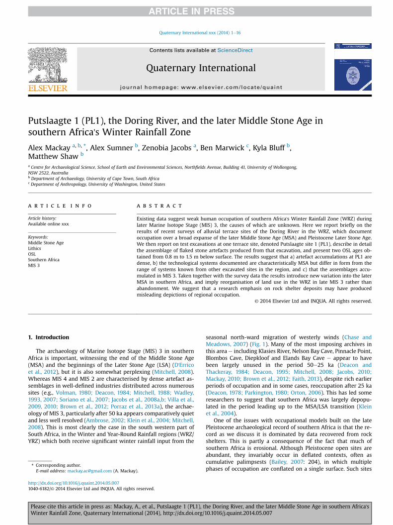
Meadows, 2007) (Fig. 1). Many of the most imposing archives in
this area e including Klasies River, Nelson Bay Cave, Pinnacle Point,
Blombos Cave, Diepkloof and Elands Bay Cave e appear to have
been largely unused in the period 50e25 ka (Deacon and
Thackeray, 1984; Deacon, 1995; Mitchell, 2008; Jacobs, 2010;
Mackay, 2010; Brown et al., 2012; Faith, 2013), despite rich earlier
periods of occupation and in some cases, reoccupation after 25 ka
(Deacon, 1978; Parkington, 1980; Orton, 2006). This has led some
researchers to suggest that southern Africa was largely depopu-
lated in the period leading up to the MSA/LSA transition (Klein
et al., 2004).
One of the issues with occupational models built on the late
Pleistocene archaeological record of southern Africa is that the re-
cord as we discuss it is dominated by data recovered from rock
shelters. This is partly a consequence of the fact that much of
southern Africa is erosional. Although Pleistocene open sites are
abundant, they invariably occur in deflated contexts, often as
cumulative palimpsests (Bailey, 2007: 204), in which multiple
phases of occupation are conflated on a single surface. Such sites* Corresponding author.
E-mail address: [email protected] (A. Mackay).
Contents lists available at ScienceDirect
Quaternary International
journal homepage: www.elsevier .com/locate/quaint
http://dx.doi.org/10.1016/j.quaint.2014.05.007
1040-6182/© 2014 Elsevier Ltd and INQUA. All rights reserved.
Quaternary International xxx (2014) 1e16
Please cite this article in press as: Mackay, A., et al., Putslaagte 1 (PL1), the Doring River, and the later Middle Stone Age in southern Africa'sWinter Rainfall Zone, Quaternary International (2014), http://dx.doi.org/10.1016/j.quaint.2014.05.007
are presently difficult if not impossible to date by other than rela-
tive means. This has in turn led to a strong research emphasis on
rock shelters to the exclusion of open sites (although see Sampson,
1968; Henderson et al., 2006; Mackay et al., 2010; Fisher et al.,
2013). The focus on rock shelters has important weaknesses,
however. First, throughout the past most activities including the
acquisition of food, water, tool-making and other manufacturing
materials, and perhaps also social activities, were likely undertaken
in open landscape settings. Thus, rock shelters represent only a
limited and potentially biased portion of past behaviours. Second,
the conditions governing rock shelter use may not have been
consistent through time. In some periods rock shelters appear to
have been used proportionally more often, leading to their over-
representation in shelters and their near absence on the land sur-
face (Hallinan, 2013).
As part of a broader archaeological research program in the
Western Cape of South Africa we undertook surveys along the
Doring River, situated in the rain shadow of the Cape Fold Belt
mountains in the WRZ. During those surveys we identified
numerous relict alluvial terraces with an abundance of MSA arte-
facts on their surface. We provide a brief report on the results of
those surveys here and then describe in detail the results of test
excavations undertaken on one terrace e denoted Putslaagte site 1
(PL1). The results suggest intensive occupation of the Doring River
corridor during the later Pleistocene, including the production of
large numbers of MSA artefacts during MIS 3, using a general but
distinct set of core reduction systems. From this we infer that the
absence of occupation noted in rock shelter sites in theWRZ during
MIS 3 may reflect a reorganisation of landscape use rather than
depopulation. This calls into question not only existing occupa-
tional models but also the utility of rock shelters, when viewed in
isolation, for understanding past occupational dynamics.
2. Late Pleistocene archaeological sequence in the modern
Winter and Year-round rainfall zones
Though the dating remains somewhat contested, the later Pleis-
tocene technological sequence of the WRZ/YRZ appears reasonably
well understood (Lombard et al., 2012; Mackay et al., in press;Wurz,
2013). Earlier MSA assemblages are heterogeneous, dominated by a
diverse range of rock types but often quartzite, with knapping sys-
tems featuring the productionofflakes, blades and convergentflakes
(including levallois points and pseudo-points) (Volman, 1980;
Thackeray, 2000; Henshilwood et al., 2001; Wurz, 2002, 2012;
Mackay, 2009; Thompson et al., 2010; Steele et al., 2012; Will et al.,
2013; Porraz et al., 2013a). Linking these lithic assemblages is a
paucity of retouched flakes, with denticulates perhaps being the
most common form (Volman, 1980; Thompson and Marean, 2008;
Wurz, 2012; Will et al., 2013). Earlier MSA assemblages are
currently known frommany sites in theWRZ/YRZ, including Cape St
Blaize, Nelson Bay Cave, Klasies River, Blombos Cave, Pinnacle Point,
Die Kelders, Peers Cave, Ysterfontein, Hoedjiespunt, Elands Bay Cave,
Diepkloof, Hollow Rock Shelter and Klipfonteinrand (Volman, 1980;
Singer and Wymer, 1982; Avery et al., 1997; Henshilwood et al.,
2001; Marean et al., 2007; Avery et al., 2008; Thompson and
Marean, 2008; Mackay, 2009; Marean, 2010; H€ogberg and Larsson,
2011; Will et al., 2013; Porraz et al., 2013a).
From approximately 75 ka, lithic technologies in the WRZ/YRZ
shift to the production of bifacial points and an increased preva-
lence of fine-grained rock types is noted at some sites (Evans, 1994;
Henshilwood et al., 2001; H€ogberg and Larsson, 2011; Porraz et al.,
2013a). Evidence for the use of pressure flaking has also been
presented (Mourre et al., 2010). This period is known as the Still Bay
industry. Still Bay assemblages have been identified at Blombos
Cave, Peers Cave, Diepkloof, Hollow Rock Shelter (Volman, 1980;
Henshilwood et al., 2001; H€ogberg and Larsson, 2011; Porraz
et al., 2013a) and probably also open sites such as Soutfontein
and Cape Hangklip (Minichillo, 2005; Mackay et al., 2010). The ages
for the start for the Still Bay at Diepkloof are contested. Tribolo et al.
(2013) argue that the Still Bay begins ~100 ka while Jacobs et al.
(2008a,b) provide an earliest age of ~73 ka. At this stage, the Ja-
cobs ages for the Still Bay have been reproduced at several sites
across southern Africa; the Tribolo ages remain an outlier (see
Mackay et al., in press; Porraz et al., 2013b for alternative in-
terpretations based on these chronologies).
The Still Bay appears to end around 70 ka at many sites, and the
nature of subsequent developments was for a long time unclear. The
stratigraphically subsequent industry, known as the Howiesons
Poort, was believed to begin ~65 ka, implying a ~5 ky hiatus after the
Still Bay (Jacobs et al., 2008a). Recent work at Diepkloof and Pinnacle
Point, however, and most notably Diepkloof, suggests that the
HowiesonsPoort is complexandmayhave initiated in the later stages
of the Still Bay (Porraz et al., 2013a). The backed artefacts and small
blades produced from unipolar prepared cores which best charac-
terise the Howiesons Poort appear in the last few bifacial point-
bearing layers at Diepkloof, with dates extending to around 70 ka
at both Diepkloof (in the Jacobs chronology) and Pinnacle Point 5/6
(Jacobs et al., 2008a; Brown et al., 2012). In addition to backed arte-
facts, the earliest Howiesons Poort at Diepkloof contains numerous
pi�eces esquill�ees, while a later phase contains both backed artefacts
and large numbers of notched flakes. The final or classic Howiesons
Poort contains more backed artefacts than notched flakes or pi�eces
esquill�ees, a pattern replicated at nearby Klein Kliphuis (Mackay,
2011), and on the south coast at Klipdrift (Henshilwood et al.,
2014). The fine-grained rock silcrete is more common during the
Howiesons Poort than most other periods of the MSA but its preva-
lence fluctuates within the Howiesons Poort at manyWRZ/YRZ sites
(Volman,1980; Singer andWymer, 1982;Mackay, 2011; Porraz et al.,
2013a,b). Heat treatment of silcrete has been noted at Diepkloof,
Pinnacle Point andpossibly alsoKleinKliphuis (Mackay, 2009; Brown
et al., 2012; Schmidt et al., 2013). The Howiesons Poort is a particu-
larly common industry, having been noted at Klasies River, Nelson
Bay Cave, Pinnacle Point 5/6, Boomplaas, Peers Cave, Diepkloof, Klein
Kliphuis, Klipdrift and Klipfonteinrand (Deacon,1979; Volman,1980;
Singer and Wymer, 1982; Mackay, 2006; Brown et al., 2012; Porraz
et al., 2013a; Henshilwood et al., 2014). Open site expressions of the
Howiesons Poort in the region are, however, scarce (Hallinan, 2013;
though see; Carrion et al., 2000; Kandel and Conard, 2012).
Fig. 1. Modern rainfall zones of southern African showing major Middle Stone Age
sites. Dark grey shading: Winter Rainfall Zone. Light grey shading: Year-round Rainfall
Zone. No shading: Summer Rainfall Zone. Site abbreviations: Apollo 11 (AXI), Blombos
Cave (BBC), Boomplaas (BMP), Border Cave (BC), Diepkloof (DRS), Hollow Rock Shelter
(HRS), Klasies River (KRM), Nelson Bay Cave (NBC), Peers Cave (PC), Pinnacle Point (PP),
Sehonghong (SHH), Sibudu Cave (SC), Ysterfontein (YFT).
A. Mackay et al. / Quaternary International xxx (2014) 1e162
Please cite this article in press as: Mackay, A., et al., Putslaagte 1 (PL1), the Doring River, and the later Middle Stone Age in southern Africa'sWinter Rainfall Zone, Quaternary International (2014), http://dx.doi.org/10.1016/j.quaint.2014.05.007
After ~58 ka the Howiesons Poort gives way to the post-
Howiesons Poort industry characterised by the replacement of
backed artefacts by unifacial points and scraper forms (Volman,
1980; Mackay, 2011; Porraz et al., 2013a). At Diepkloof, Klasies
River and Klein Kliphuis, core reduction remains oriented towards
the production of blades in the early post-Howiesons Poort before
later giving way to the production of flakes (Wurz, 2002; Mackay,
2009; Porraz et al., 2013a). At sites where it was common during
the Howiesons Poort the prevalence of silcrete drops following the
transition, though there is a lag between the cessation of backed
artefact production and a decrease in silcrete in some cases
(Mackay, 2011; Porraz et al., 2013a). The Howiesons Poort to post-
Howiesons Poort transition is gradual at most sites where it has
been examined (Soriano et al., 2007; Villa et al., 2010; Mackay,
2011; Porraz et al., 2013a). Consistent with this, the distribution
of post-Howiesons Poort sites can be viewed as an attenuated
subset of Howiesons Poort sites in the WRZ/YRZ. Occupation con-
tinues from one into the other at Klasies River, Pinnacle Point 5/6,
Peers Cave, Diepkloof and Klein Kliphuis, but ceases at Nelson Bay
Cave, Boomplaas and Klipfonteinrand.
After ~50 ka, occupation of almost all sites in the modern WRZ/
YRZ appears to cease (Mackay, 2010; Mackay et al., in press). Klein
Kliphuis and Boomplaas have limited occupation in this period,
with low rates of discard at the former site (Mackay, 2010), but
none of the other previously occupied MSA sites have clear signals
of use from 50 to 25 ka. The technological characteristics of this
period have consequently been very hard to define. This contrasts
with occupational and technological patterns outside the WRZ/
YRZ, and particularly in the summer rainfall areas to the north and
east (Mackay, 2010). At sites in those areas, a broad variety of MSA
assemblages featuring blades, backed artefacts, unifacial points,
bifacial points and scrapers are known to occur in pulses
throughout later MIS 3 (Wendt, 1976; Carter, 1978; Kaplan, 1990;
Clark, 1997; Wadley, 2005; Wadley and Jacobs, 2006; Vogelsang
et al., 2010). An early occurrence of LSA technology has also been
claimed for Border Cave in Swaziland (D'Errico et al., 2012).
Occupation (in many cases re-occupation) of sites is evident
throughout the WRZ/YRZ from the start of MIS 2. Boomplaas,
Byneskranskop, Elands Bay Cave, Kangkara, Nelson Bay Cave, Far-
aoskop and Klein Kliphuis have stone artefact assemblages dating
between 25 ka and 12 ka (Deacon, 1978, 1982; Schweitzer and
Wilson, 1983; Manhire, 1993; Orton, 2006; Mackay, 2010). In all
cases these sites lack characteristically MSA flakes and cores, with
discoid and Levallois reduction effectively absent. These MIS 2 LSA
assemblages often have an abundance of small blades and platform
cores, and are ascribed to the Robberg industry (Deacon, 1984).
3. The Doring River corridor surveys
The Doring River is a large water-course situated in the middle
of the modern WRZ, and draining approximately 24 000 km2 of
largely semi-arid and arid lands in the rain shadow east of the Cape
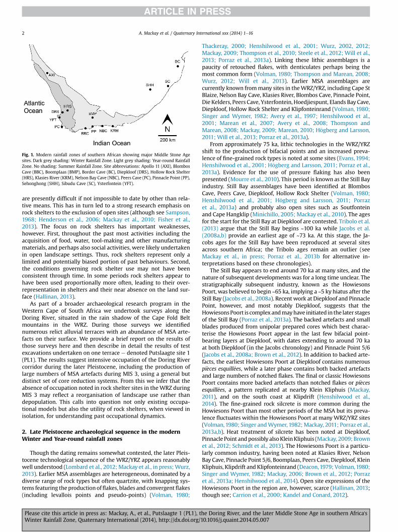
Fig. 2. Study area, showing open sites along the Doring River (triangles) and nearby excavated rock shelters (circles). Inset panel (a): location of study area relative to modern
rainfall zones, with important archaeological sites as per Fig. 1. Inset panel (b): location of Putslaagte valley near Doring River confluence. Site abbreviations: Hollow Rock Shelter
(HRS), Klipfonteinrand (KFR), Putslaagte 1 (PL1), Putslaagte 8 (PL8).
A. Mackay et al. / Quaternary International xxx (2014) 1e16 3
Please cite this article in press as: Mackay, A., et al., Putslaagte 1 (PL1), the Doring River, and the later Middle Stone Age in southern Africa'sWinter Rainfall Zone, Quaternary International (2014), http://dx.doi.org/10.1016/j.quaint.2014.05.007

Fold Belt mountains (Fig. 2). Though seasonal, the annual outflowof
the Doring is roughly equivalent to that of the Olifants River which
lies to thewest of themountains and flows permanently. These two
rivers run in parallel for approximately 70 km before converging
and flowing to the sea together as the Olifants River. Although the
Olifants River has large dams at multiple points and its terraces
have been extensively cultivated, the annual flows and terrace
characteristics of the Doring have seen considerably less manipu-
lation by modern farming practices.
Due to its extensive catchment, the Doring contains a diverse
range of flakeable rock types, with sandstone and quartzite domi-
nant. Cobbles of the fine grained black metamorphic rock hornfels
are also common, with cobbles of silcrete less frequent and pebbles
of micro-/crypto-crystalline silicates and quartz occasionally
observed. Additionally, sandstone, quartzite and quartz are com-
mon on the land surface through much of the catchment.
One of us (AM) spent an extended period camped on the Doring
River during excavation of rock shelter sites in the Putslaagte valley,
a small tributary of the Doring (Fig. 2). During that time a remnant
area of alluvial terrace was noted at the Putslaagte/Doring conflu-
ence (Fig. 3). Our interest in the terrace was piqued by a) the
abundance of MSA artefacts, b) the presence of small flakes sug-
gesting minimal fluvial reworking, and c) the apparent absence of
typical MIS 4 and early MIS 3 markers such as backed artefacts,
bifacial points or unifacial points. The site had been designated
Putslaagte site 1 (PL1) during previous surveys (Halkett, 1982).
Further surveys in the Doring River corridor led to the identifi-
cation of numerous additional terrace sites with a broadly similar
pattern (Fig. 4): relict terraces located either in back-flooding
contexts at the confluence of the Doring and minor tributaries or
on point bars at major river bends. In most cases, the terraces are
covered in MSA and sometimes early LSA artefacts. The later LSA
industries (Deacon, 1984) are generally poorly represented on the
terraces so far surveyed; this stands in contrast to patterns iden-
tified towards the coast (Kandel and Conard, 2013). Some of these
terraces have a significant colluvial drape, meaning that potentially
ancient and young artefacts may have migrated across the sedi-
ment surface from adjacent slopes since the cessation of terrace
formation. In many cases, however, there was little or no subse-
quent colluviation. Thus, though they may have been palimpsests,
the assemblages on these non-colluviated terraces necessarily
post-date the cessation of sediment accumulation. In such cases it
would be theoretically possible to provide a maximum age for the
assemblages using OSL, and thus an age bracket using the presence
of MSA artefacts as a terminus ad quem of >25 ka.
In addition, in both colluviated and non-colluviated terrace
contexts it was often possible to isolate spatially-discrete assem-
blages of clear industrial affinity within otherwise temporally-
mixed assemblages. These included a Robberg assemblage con-
sisting of ~50 small blade cores on heated silcrete (Appelboskraal),
a bifacial point manufacturing site with >140 points and associated
thinning flakes eroding out from the base of a terrace (Klein Hoek 1)
and an early post-Howiesons Poort site with laminar flakes, heated
silcrete and at least nine unifacial points (Uitspankraal 7) (Fig. 4).
In total, we have so far identified bifacial point bearing assem-
blages at eight localities (including two instances of isolated points,
two instances of two points together, and four instances of multiple
points); unifacial points at seven localities of which five also have
bifacial points; potentially early (pre-MIS 4) MSA assemblages at 11
localities; potentially late (post-MIS 4) MSA assemblages at four
localities; Pleistocene/early Holocene assemblages at two localities;
and ESA assemblages, as identified through handaxes, at two lo-
calities, both of which have a heavy colluvial drape. Interestingly,
but concordant with the findings of Hallinan (2013) in the Olifants
River corridor, no Howiesons Poort assemblages have as yet been
located in the surveyed areas.
Our initial interest, however, was in PL1. The site appeared to
include >10 000 flaked stone artefacts on the surface with a clear
MSA signal and no obvious LSA input, yet lacked the characteristic
markers of Still Bay, Howiesons Poort or post-Howiesons Poort. If
the assemblage had been deposited since the cessation of sedi-
mentation then several possibilities arose. First, the assemblage
entirely ante-dated MIS 4, with no subsequent occupation. Second,
the assemblage had components of MIS 5 and later MIS 3 but no
significant MIS 4/early MIS 3 input. Third, the assemblage largely or
entirely post-dated early MIS 3. In this final case the assemblage
would conceivably belong in the documented sequence gap in the
WRZ/YRZ sequence noted above. Our excavation and analysis
aimed to test these possibilities.
4. Excavations at Putslaagte site 1 (PL1)
The terrace site PL1 measures ~70 m eastewest and ~50 m
northesouth, and covers ~2720 m2. Artefacts are unevenly
distributed across its surface, with an average density of 20 arte-
facts >5 mm per m2 (Shaw, 2013). At its highest point the sediment
Fig. 3. Images of PL1. Panel (a): PL1 terrace with Putslaagte valley to the left and Doring River on the right of panel. Panel (b): surface artefacts on PL1. Panel (c): Excavation pit.
A. Mackay et al. / Quaternary International xxx (2014) 1e164
Please cite this article in press as: Mackay, A., et al., Putslaagte 1 (PL1), the Doring River, and the later Middle Stone Age in southern Africa'sWinter Rainfall Zone, Quaternary International (2014), http://dx.doi.org/10.1016/j.quaint.2014.05.007

body is ~6 m above the modern floodplain. There have been recent
modifications to the terrace including arrangements of large stones
probably forming the base of two small animal pens or ‘kraals’.
There are thus some large rocks on the sediment surface that were
likely moved there in the relatively recent past. Otherwise, the
surface lacks colluvium.
Excavations at PL1 were undertaken in January 2011. The ob-
jectives were to provide a small, controlled assemblage sufficient to
characterise the site, to understand the distribution of artefacts
through the sediment body, and to provide a profile to clarify site
formation and for OSL dating. A single 2 m � 1 m test excavation e
constituting <0.1% of the terrace surface e was opened at the
highest point of the terrace. The two square meters were each
subdivided into 0.5m� 0.5m quadrants, and excavation proceeded
in horizontal 50 mm spits with no stratigraphic changes noted in
the upper ~1 m. The only significant sedimentary change occurred
~1.0e1.2 m below surface when consolidated and pedal sediments
and several large rocks were encountered, potentially indicating a
palaeosol (Fig. 5). We noted no other distinct depositional units or
laminations; the sediments were largely undifferentiated. This may
imply that roots and other bioturbative agents have erased past
depositional planes, or that the sediments reflect rapid, relatively
large depositional events.
Excavation ceased at ~1.3 m below surface in one square and
continued to ~1.8 m below surface in the other. In spite of the small
excavation area, we recovered 6674 stone artefacts, as well as 15
pieces of ochre, one of which was ground.We also recovered ~8 g of
bone, most of it poorly preserved but some fresh and likelymodern.
The modern fragments most likely derive from burrowing animals.
We also identified two pieces of marine shell in contexts from
immediately below surface. These fragments are not necessarily
ancient, but do imply contact with the coastline a minimum dis-
tance of 80 kmwest over the mountains. Finally, we identified only
9 fragments of charcoal, two of which we dated by AMS. These
derived from ~0.1 m to ~0.8 m below surface; both returned rela-
tively recent ages of 139 ± 21 (DAMS-003795) and 227 ± 36 (DAMS-
003796) radiocarbon years respectively. We interpret these results
to reflect either downward migration of small particles in the
sediment body though bioturbation or the remains of burned roots.
The alternative e that the sediments accumulated recently e is
incompatible with the geomorphic setting, archaeological remains
and luminescence evidence (discussed below).
Artefacts were concentrated in the uppermost spits but rapidly
decreased in number with depth (Fig. 6). The exception is a brief
and muted spike in artefact numbers roughly concordant with the
proposed palaeosol. These layers also have cores, which were ab-
sent in the immediately overlying spits. The depth/decay signal in
the artefact numbers is inferred to reflect some downward migra-
tion probably through the root zone in the period since discard. The
potential palaeosol may either be an independent accumulation, or
a density barrier accumulating downward migrating artefacts.
5. Particle size and site formation at PL1
To investigate the environmental history of site formation at
PL1, small amounts (<5 g) of loose bulk sediment from each spit in
one square metre were separated with a 2 mm sieve and the
<2 mm fraction was analysed with a Horiba LA-950 Laser Diffrac-
tion Particle Size Distribution Analyzer (15 replicates per spit). Data
were analysed using R version 3.0.2 (R Core Team, 2014) with Folk
and Ward (1957) summary statistics computed following Blott and
Pye (2001) using the G2Sd package (Gallon and Fournier, 2013).
Stratigraphically constrained clustering of spits was used for
quantitative definition of depositional units. We used the con-
strained sum-of-squares clustering method (CONISS) implemented
in the rioja package (Juggins, 2012) to ensure that only
Fig. 4. Images from selected terrace sites along the Doring River.
A. Mackay et al. / Quaternary International xxx (2014) 1e16 5
Please cite this article in press as: Mackay, A., et al., Putslaagte 1 (PL1), the Doring River, and the later Middle Stone Age in southern Africa'sWinter Rainfall Zone, Quaternary International (2014), http://dx.doi.org/10.1016/j.quaint.2014.05.007
stratigraphically adjacent spits are considered for membership of
the same cluster (Grimm, 1987).
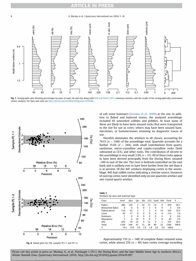
Consistent with the field observations, particle size analysis
indicates three major depositional units with diffuse boundaries
around 0.8 m and 1.2 m below the surface (Fig. 7). The lower unit
consists of fine sand that is moderately sorted, fine skewed, and
mesokurtic. Themiddle unit is distinctive by a reduction in the sand
fraction and decrease in sorting. Further work is currently under-
way to determine if this is a palaeosol. The upper unit is also
dominated by fine skewed fine sand but is distinctive by being even
less well sorted and platykurtic.
The dominance of fine sand suggests that the site is a slackwater
deposit, which are usually fine-grained (fine sand and coarse silt)
flood sediments deposited in areas of the floodplain that are shel-
tered from high-velocity flood flows (Heine and Heine, 2002).
Slackwater deposits often represent floods of high magnitude,
indicating extreme precipitation events in the upper reaches of the
river catchments (Benito et al., 2003; Baker et al., 2009).
From about 1.0 m below the surface there is a uniform fining
upwards sequence. In a floodplain landscape this is frequently
interpreted as a point-bar deposit. Upward-fining is typical in
meandering channel point bar deposits because the energy of the
flow at the top of the point bar is less than at the base where lag
material is deposited in the thalweg (Smith, 1987). Alternative
models for this architecture are ephemeral rivers that flow for
limited periods of time, or flash floods of limited duration (Reading,
2001). Given the slackwater characteristics of this deposit, further
work is required to be certain if the fining up sequence indicates an
increasing frequency of flood events at the site over time or an
unrelated gradual shift in the river architecture.
6. OSL dating
Two OSL samples were collected at 0.8 m and 1.5 m below
surface, bracketing the possible palaeosol (Fig. 5). The upper parts
of the deposit were not dated because of concerns over possible
downward migration of material. To test whether this may also
have been a problem in the deeper deposits, we used single grain
OSL dating of individual grains of quartz to obtain an age for the
two samples. Details about sampling, sample preparation and OSL
and dose rate measurement procedures are provided in Supporting
Online Information.
Fig. 5. West section of excavation pit at completion of excavations. Locations of OSL samples are shown, as is the approximate location of the proposed palaeosol.
A. Mackay et al. / Quaternary International xxx (2014) 1e166
Please cite this article in press as: Mackay, A., et al., Putslaagte 1 (PL1), the Doring River, and the later Middle Stone Age in southern Africa'sWinter Rainfall Zone, Quaternary International (2014), http://dx.doi.org/10.1016/j.quaint.2014.05.007

Two thousand individual grains were measured of which only
178 grains (~9% of the total number measured) were used for final
De determination. Reasons for rejecting individual grains are pro-
vided in Table S1. The De values for all the accepted grains are
displayed as radial plots in Fig. 8 (Galbraith 1988, 1990) and show
De distributions that are largely consistent with a central value. We
consequently used the central age model (CAM) of Galbraith et al.
(1999) to provide an estimate of De overdispersion (Table 1), and
a weighted mean De estimate for both samples, and believe that
this is meaningful with regards to the true burial dose received by
all the grains. The final ages for the two samples are listed in Table 1,
together with the supporting De and dose rate estimates. Uncer-
tainty on the age is given at 1s (standard error of the mean) and
was derived by combining, in quadrature, all known and estimated
sources of random and systematic error. The two ages of 61 ± 5
(PL1-1) and 59 ± 5 (PL1-2) ka are statistically consistent with each
other and suggest that the bracketed sediment was deposited fairly
rapidly during late MIS 4/early MIS 3. At a minimum, these results
confirm that the artefacts on the surface at PL1 were deposited
during or afterMIS 3, effectively precluding inputs from any periods
earlier than the post-Howiesons Poort. We now describe in detail
the flaked stone artefacts from the site.
7. Flaked stone artefacts from PL1
The total number of recovered artefacts is, as noted above,
6674, comprising 2876 artefacts >15 mm in maximum dimension
and a further 3798 artefacts <15 mm which we class here as
small flaking debris (SFD). These numbers are based on pre-
liminary examination of 98.3% of quadrants; artefacts from four
quadrants remain to be included. Of these ~6700 artefacts, a
sample of 1566 (23% of the total) has so far been analysed in
detail e analysis of the remaining material is on-going. The
breakdown of artefacts by class and material type in the analysed
is given in Table 2. In addition to the data from the analysed
quadrants detailed in Table 2, we also analysed all remaining
complete cores in the assemblage, giving a core total of 225.
These cores form the focus of our discussion. We treat the entire
sample as a single assemblage at this stage, as the number of
analysed artefacts from the lower spits is currently too small to
allow comparison. The decay signal in artefact numbers gives us
reason to believe that most of the upper artefacts were initially
deposited on or near the surface.
A large proportion of the artefacts in the analysed sample
were classed as SFD (50.5%, n ¼ 791). Flakes, both complete and
broken, are the next most common class (28.0%, n ¼ 439), fol-
lowed by cores (7.4%, n ¼ 115). Flaked pieces, defined here as
broken flaked artefacts containing neither positive percussion
features nor a single complete scar (Hiscock, 2007), account for a
further 10.5% (n ¼ 135) of the assemblage. Retouched flakes,
excluding flakes used as cores, were extremely uncommon (0.4%,
n ¼ 5). Six hammerstones were also identified, with sandstone
the most common rock type used e this implies at least some use
Fig. 6. Distribution of artefacts through the excavated deposit. Panel (a): density of artefacts per spit. Panel (b): numbers of artefacts >15 mm (light shading) and small flaking debris
(dark shading). Panel (c): numbers of cores.
Table 1
Dose rate data, equivalent dose and OSL ages for the sediment samples from PL1.
Sample
code
Moisture
content (%)
Dose rates (Gy/ka) Total dose rate
(Gy/ka)
De (Gy) Age
model
Number of
grains
Over-dispersion
(%)
Optical
age (ka)Beta Gamma Cosmic
PL1-1 5 (3.5) 1.44 ± 0.08 1.17 ± 0.13 0.21 2.84 ± 0.21 172.6 ± 6.6 CAM 96/1000 23 ± 4 60.8 ± 5.2
PL1-2 5 (0.3) 1.18 ± 0.07 1.01 ± 0.10 0.20 2.40 ± 0.17 141.1 ± 7.7 CAM 82/1000 40 ± 5 58.8 ± 5.3
A. Mackay et al. / Quaternary International xxx (2014) 1e16 7
Please cite this article in press as: Mackay, A., et al., Putslaagte 1 (PL1), the Doring River, and the later Middle Stone Age in southern Africa'sWinter Rainfall Zone, Quaternary International (2014), http://dx.doi.org/10.1016/j.quaint.2014.05.007
of soft stone hammers (Soriano et al., 2009) at the site. In addi-
tion to flaked and battered stones, the analysed assemblage
included 45 unworked cobbles and pebbles. At least some of
these are likely to have been unused rocks that were transported
to the site for use as cores; others may have been unused ham-
merstones, or hammerstones retaining no diagnostic traces of
use.
Hornfels dominates the artefacts in all classes, accounting for
74.1% (n ¼ 1160) of the assemblage total. Quartzite accounts for a
further 15.6% (n ¼ 244), with small contributions from quartz,
sandstone, micro-crystalline and crypto-crystalline rocks (both
subsumed as CCS), and other rocks. The contribution of silcrete to
the assemblage is very small (1.0%, n¼ 15). All of these rocks appear
to have been derived principally from the Doring River, situated
~100 m east of the site. The river is bedrock-controlled on the east
bank and is unlikely ever to have been further from the site than it
is at present. Of the 447 artefacts displaying cortex in the assem-
blage, 445 had cobble cortex indicating a riverine source. Instances
of outcrop cortex were identified only on one quartzite artefact and
one crystal quartz artefact.
Approximately 73% (n ¼ 148) of complete flakes retained some
cortex, while almost 25% (n ¼ 49) have cortex coverage exceeding
Fig. 7. Stratigraphic plot showing percentages by mass of sand, silt and clay along with Folk and Ward (1957) summary statistics and the results of the stratigraphically constrained
cluster analysis. For data and code see http://dx.doi.org/10.6084/m9.figshare.1035786.
Fig. 8. Radial plots for OSL samples PL1-1 and PL1-2.
Table 2
Artefacts by class and material type.
Class Hrnf Qtzt Qtz Silc CCS Sand Oth Total %
Flakes 280 120 2 10 13 14 0 439 28.1
Retouched flakes 4 0 0 0 1 0 0 5 0.4
Flaked pieces 116 25 3 1 2 4 14 165 10.5
Cores 92 17 0 0 0 6 0 115 7.4
Hammers 1 0 0 0 0 0 5 6 0.4
Manuports 7 4 19 0 0 7 8 45 2.9
SFD 659 79 23 4 12 9 5 791 50.5
Total 1160 244 47 15 28 40 32 1566 100.0
% 74.1 15.6 3.0 1.0 1.8 2.6 2.0 100.0
A. Mackay et al. / Quaternary International xxx (2014) 1e168
Please cite this article in press as: Mackay, A., et al., Putslaagte 1 (PL1), the Doring River, and the later Middle Stone Age in southern Africa'sWinter Rainfall Zone, Quaternary International (2014), http://dx.doi.org/10.1016/j.quaint.2014.05.007
50% of their dorsal and platform surfaces. Differences in the
prevalence of cortex between the two main material types
(hornfels and quartzite) are minor. Similarly, 50% (n ¼ 85) of
complete hornfels cores and 46% (n ¼ 23) of complete quartzite
cores had cortex exceeding 50% of their surface. Almost 90%
(n ¼ 152) of hornfels cores and 72% (n ¼ 52) of quartzite cores had
cortical coverage exceeding 25% of their surface. These data tend to
confirm the predominantly local origin of the stone used in flaking
at the site and suggest that PL1 may effectively have functioned as
a quarry.
Flaking techniques as identified from the discarded flakes
largely reflect early stage reduction and the subsequent use of
centripetal, unidirectional and prepared core technology (PCT)
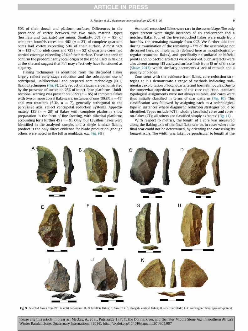
flaking techniques (Fig. 9). Early reduction stages are demonstrated
by the presence of cortex on 25% of intact flake platforms. Unidi-
rectional scarring was present on 63.9% (n ¼ 85) of complete flakes
with two ormore dorsal flake scars; instances of one (30.8%, n¼ 41)
and two rotations (5.3%, n ¼ 7), generally orthogonal to the
percussive axis, reflect centripetal reduction systems. Approxi-
mately 12% (n ¼ 28) of flakes with complete platforms show
preparation in the form of fine faceting, with dihedral platforms
accounting for a further 4% (n ¼ 9). Only four Levallois flakes were
identified in the analysed sample, and a single laminar flaking
product is the only direct evidence for blade production (though
others were noted in the full assemblage, e.g., Fig. 9H).
As noted, retouched flakes were rare in the assemblage. The only
types present were single instances of an end-scraper and a
notched flake. Four of the five retouched flakes were made from
hornfels, the remaining example from CCS. We further add that
during examination of the remaining ~77% of the assemblage not
discussed here, no implements (defined here as morphologically-
regular retouched flakes), and specifically no unifacial or bifacial
points and no backed artefacts were observed. Such artefacts were
also absent among 413 analysed surface finds from 18m2 of the site
(Shaw, 2013), which similarly documents a lack of retouch and a
paucity of blades.
Consistent with the evidence from flakes, core reduction stra-
tegies at PL1 demonstrate a range of methods indicating rudi-
mentary exploitation of local quartzite and hornfels nodules. Due to
the somewhat expedient nature of the core reduction, standard
typological assignments were not always suitable, and cores were
thus initially classified in terms of scar patterns (Fig. 10). This
classification was followed by assigning each to a technological
type in instances where diagnostic reduction strategies could be
identified. Types include PCT (including Levallois) cores and cores-
on-flakes (CF); all others are classified simply as ‘cores’ (Fig. 11).
With respect to metrics, the length of a core was measured
along the flaking axis of the final flake scar or, in cases where the
final scar could not be determined, by orienting the core using its
longest scars. The width was taken perpendicular to length at the
Fig. 9. Selected flakes from PL1. A, eclat debordant; BeD, levallois flakes; E, flake; F & G, elongate cortical flakes; H, recurrent blade; IeK, convergent flakes (pseudo-points).
A. Mackay et al. / Quaternary International xxx (2014) 1e16 9
Please cite this article in press as: Mackay, A., et al., Putslaagte 1 (PL1), the Doring River, and the later Middle Stone Age in southern Africa'sWinter Rainfall Zone, Quaternary International (2014), http://dx.doi.org/10.1016/j.quaint.2014.05.007
widest margin and thickness, at a midpoint at right angles to
width.
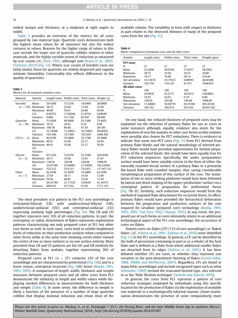
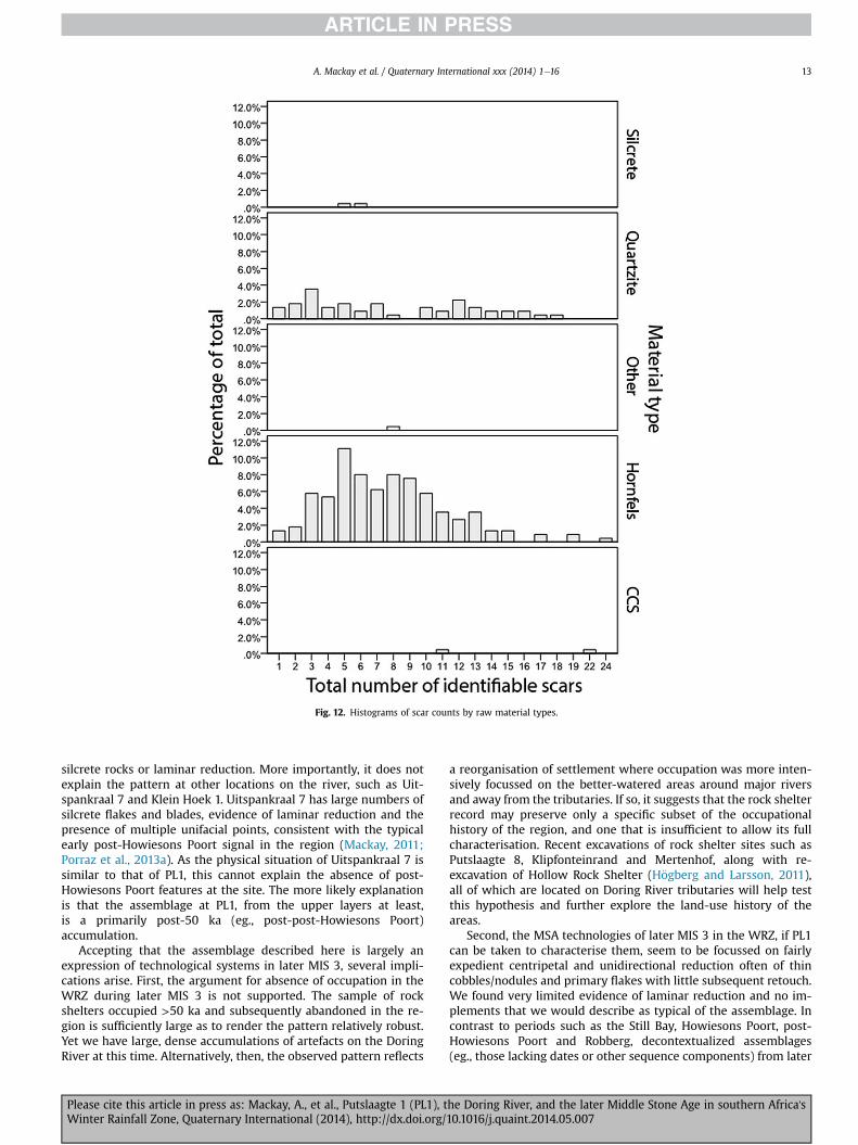
Table 3 provides an overview of the metrics for all cores
grouped by raw material type. Quartzite cores demonstrate both
the highest mean values for all measures but also the widest
variance in values. Reasons for the higher range of values in this
case include the larger size of quartzite cobbles relative to other
materials, and the highly variable extent of reduction as measured
by scar counts (cf., Potts, 1991; although note Braun et al., 2005;
Clarkson, 2013) (Fig. 12). Where scar counts of hornfels cores are
fairly modal, those for quartzite are widely dispersed and vaguely
intimate bimodality. Conceivably this reflects differences in the
quality of quartzites.
The most prevalent scar pattern in the PL1 core assemblage is
centripetal-bifacial (CB) with unidirectional-bifacial (UB),
unidirectional-unifacial (UU) and centripetal-unifacial (CU)
expressing similarly high percentages (Fig. 10). The CB and CU
together represent over 35% of all reduction patterns. In part, the
centripetal, or radial, detachment of flakes represents exploitation
patterns characterizing not only prepared cores at PL1 but other
core forms as well. In such cases, cores tend to exhibit heightened
levels of reduction on their production surfaces when compared to
other forms while at the same time retaining cortex either toward
the centre of one or more surfaces or on one surface entirely. More
prevalent than CB and CU patterns are the UU and UB methods for
detaching flakes from nodules, together representing 36% of
reduction patterns.
Prepared cores at PL1 (n ¼ 27) comprise 12% of the core
assemblage and are characterized by preferential (Fig. 11G) and to a
lesser extent, centripetal recurrent (Fig. 10H) forms (Bo€eda, 1991,
1993, 1995). A comparison of length, width, thickness and weight
measures between prepared cores and all other cores from PL1
demonstrate the similarity in length and width values while dis-
playing marked differences in measurements for both thickness
and weight (Table 4). In some sense, the difference in weight is
likely a function of the presence of a number of large quartzite
cobbles that display minimal reduction and retain most of the
available volume. The variability in form with respect to thickness
in part relates to the observed thinness of many of the prepared
cores from the site (Fig. 11).
On one hand, the reduced thickness of prepared cores may be
explained via the selection of primary flakes for use as cores in
some instances although, equally, evidence also exists for the
exploitation of very flat nodules in other core forms so thin nodules
were possibly also chosen for PCT reductions. There is evidence to
indicate that some non-PCT cores (Fig. 11) from PL1 derived from
primary flake blanks and the natural morphology of selected pri-
mary flakes would have provided opportunities for limited prepa-
ration of the selected blank; this would have been equally true for
PCT reduction sequences. Specifically, the under (preparation)
surface would have been suitably convex in the form of either the
naturally rounded dorsal surface of a primary flake or a primarily
flat-based flake with rounded margins, thus saving considerable
morphological preparation of this surface of the core. The instal-
lation of one or more striking platforms would have been followed
by lateral and distal shaping of the upper (production) surface via a
centripetal pattern of preparation for preferential forms
(Fig. 9BeD). Similarly, such reduction sequences would form the
method of repeated flake detachment for recurrent forms. In effect,
primary flakes would have provided the hierarchical delineation
between the preparation and production surfaces of the core
required for Levallois (prepared core) technology (Bo€eda, 1991,
1993, 1995; Van Peer, 1992; Chazan, 1997). In any event, the pro-
posed use of such forms as cores intimately relates to an additional
technological aspect of the PL1 core assemblage, the occurrence of
cores-on-flakes.
Sixteen cores-on-flakes (CF) (7.1% of core assemblage), or ‘flaked
flakes’ (cf., Ashton et al., 1991; Zaidner et al., 2010) were identified
(Fig. 11) in the PL1 assemblage. In general, a CF can be identified by
the bulb of percussion (remaining in part or as a whole) of the host
flake and is defined as a flake fromwhich additional smaller flakes
are detached from its edges (Ashton et al., 1991). It has been
debated whether CFs are cores, or whether they represent one
variation in the post-detachment thinning of flakes (Goren-Inbar,
1988; Dibble and McPherron, 2007). Regardless, CFs are found in
many lithic assemblages and include recognized types such as what
Schro€eder (1969) termed the truncated faceted type, also referred
to as the ‘Nahr Ibrahim technique’ (Solecki and Solecki, 1970).
In general, the cores from PL1 represent a pattern of core
reduction strategies employed by individuals using this specific
location for the production of flakes via the exploitation of available
raw materials in a technologically informal manner. Closer exami-
nation demonstrates the presence of some comparatively more
Table 3
Metrics for all analysed complete cores.
Material Statistic Length (mm) Width (mm) Thick (mm) Weight (g)
Hornfels
(n ¼ 170)
Mean 39.4200 37.5250 18.0400 38.0000
Minimum 38.75 25.04 11.60 31.00
Maximum 40.09 50.01 24.48 45.00
S.D. 0.94752 17.65646 9.10754 9.89949
Variance 0.898 311.750 82.947 98.000
Quartzite
(n ¼ 50)
Mean 51.0309 49.4968 23.1306 75.4925
Minimum 19.55 24.52 9.10 8.00
Maximum 100.78 89.46 67.39 291.00
S.D 12.74306 11.29021 10.15893 49.68281
Variance 162.386 127.469 103.204 2468.382
CCS (n ¼ 2) Mean 40.4700 55.6800 23.1700 59.5000
Minimum 40.47 55.68 23.17 59.50
Maximum 40.47 55.68 23.17 59.50
S.D . . . .
Variance . . . .
Silcrete
(n ¼ 2)
Mean 65.7226 72.6576 51.5340 320.5650
Minimum 20.71 35.98 15.05 27.47
Maximum 138.56 165.08 149.68 1908.09
S.D 23.07189 23.96483 27.43083 342.32694
Variance 532.312 574.313 752.451 117187.732
Other
(n ¼ 1)
Mean 42.2500 53.4650 16.4400 42.2500
Minimum 27.94 38.11 14.30 13.00
Maximum 56.56 68.82 18.58 71.50
S.D 20.23740 21.71525 3.02642 41.36575
Variance 409.552 471.552 9.159 1711.125
Table 4
Metric comparison of prepared cores and all other cores.
Statistic Length (mm) Width (mm) Thick (mm) Weight (gms)
PCT cores
N 27 27 27 27
Mean 51.0300 50.0744 17.6537 58.5893
Minimum 38.75 25.04 10.25 20.00
Maximum 74.77 74.40 39.14 216.69
Std. deviation 10.13674 10.77615 6.88993 44.66380
Variance 102.754 116.125 47.471 1994.855
All other cores
N 198 198 198 198
Mean 54.4818 55.2171 30.9312 138.8892
Minimum 19.55 24.52 9.10 8.00
Maximum 138.56 165.08 149.68 1908.09
Std. deviation 17.48605 18.59770 20.25100 205.43501
Variance 305.762 345.874 410.103 42203.542
A. Mackay et al. / Quaternary International xxx (2014) 1e1610
Please cite this article in press as: Mackay, A., et al., Putslaagte 1 (PL1), the Doring River, and the later Middle Stone Age in southern Africa'sWinter Rainfall Zone, Quaternary International (2014), http://dx.doi.org/10.1016/j.quaint.2014.05.007

elaborate tasks involving the likely production of (some) prepared
cores on flakes and, otherwise, the use of flakes as cores to produce
other flakes. Additional fine-grained observations include the
identification e by characteristic pecking on one end e of at least
one core that was derived from its original use as a hammerstone
(Fig. 10D), thus indicating a measure of opportunistic recycling at
PL1, and the presence of single instances of blades and bladelet
cores (Fig. 11C). The latter are both made from hornfels and do not
resemble equivalent cores from the Howiesons Poort or post-
Howiesons Poort.
8. Discussion
Many aspects of the PL1 assemblage suggest that the site
functioned as a primary flaking location in MIS 3, with a principal
focus on reduction of hornfels and quartzite nodules/cobbles
extracted from cobble beds of the adjacent Doring River. The
quarry-like characteristics of the site explain the high proportions
of cortex on flakes and cores and the fairly limited extent of core
volume exploitation. This in turn may in part account for the
relatively expedient nature of much of the documented core
reduction.
That primary core reduction occurred at PL1 may be taken as
partial explanation of the density of finds at the site, but this re-
quires some further discussion. We excavated a high point on an
otherwise undifferentiated terrace surface at PL1, and our excava-
tion encompassed <0.1% of the surface area available for excavation
(and a much lower proportion of the available volume). However,
we recovered ~6700 artefacts, or roughly 3350 artefacts/m2.
Conservatively, we estimate that the presently-remaining terrace
area contains >350 000 artefacts (allowing that densities in the
excavated area are 10 times higher than average and that no sig-
nificant assemblages exist below the tested sediment depths). Even
given that the assemblagemay have formed over 30e35 ky, the fact
that a) there is no obvious focal agent for occupation at PL1 and b)
other terraces we visited had similar densities of artefacts, suggests
to us thatMSA archaeology is particularly dense through the Doring
River corridor. The marked discrepancy between the density of
surface finds (~20/m2) and excavated finds (~3350/m2) further
suggests that the observable surface density will in some cases
under-represent actual density by more than two orders of
magnitude. The MSA archaeology of the Doring River corridor ap-
pears dense, but is likely far denser than it appears.
With respect to the 30e35 ky over which the assemblage may
have formed, our PL1 assemblagemust necessarily be characterised
as a potential cumulative palimpsest. Other than the small pulse
associated with the possible palaeosol we found no evidence for
discrete horizons of artefact accumulations within the excavation
area, and this is consistent with our observations at other terrace
sites with large exposed sections. This, coupled with the site setting
in a back-flooding tributary mouth, the composition of the sedi-
ments through the excavated sequence, and the statistically similar
OSL ages taken 700mm apart in thewest section imply that PL1 is a
slackwater deposit, most likely reflecting three or more large flood
events in the Doring River around the start of MIS 3. Dated slack-
water deposits are known from the Holocene and the Last Glacial
Maximum in the Orange River and further north in Namibia (Heine
and Heine, 2002; Herbert and Compton, 2007; Heine and Volkel,
2011), but have previously not been documented from MIS 3.
Further OSL work along the river may allow the temporal range,
magnitude, and periodicity of these events to be identified.
That PL1 is effectively a quarry and potentially a palimpsest does
not explain the absence of typical late MIS 4/early MIS 3 retouched
flakes, material selection or reduction systems. It is possible that
retouched artefacts were not produced in large numbers at sources
of primary stone extraction, but this does not explain the lack of
Fig. 10. Scar pattern classification system applied to PL1 cores and percentage of cores in each class.
A. Mackay et al. / Quaternary International xxx (2014) 1e16 11
Please cite this article in press as: Mackay, A., et al., Putslaagte 1 (PL1), the Doring River, and the later Middle Stone Age in southern Africa'sWinter Rainfall Zone, Quaternary International (2014), http://dx.doi.org/10.1016/j.quaint.2014.05.007

Fig. 11. A, unidirectional-unifacial core; B, unidirectional-bifacial core; C, unidirectional-unifacial core (bladelet); D, large quartzite core with refitted flake; E, core-on-flake (arrow
indicates origin of strike and bulb); F, core-on-flake (arrows indicate flake scars); GeH, prepared cores (preferential and centripetal recurrent, respectively); I, discoid; J, example of
core on flat hornfels nodule, a common type of raw material form at PL1.
A. Mackay et al. / Quaternary International xxx (2014) 1e1612
Please cite this article in press as: Mackay, A., et al., Putslaagte 1 (PL1), the Doring River, and the later Middle Stone Age in southern Africa'sWinter Rainfall Zone, Quaternary International (2014), http://dx.doi.org/10.1016/j.quaint.2014.05.007
silcrete rocks or laminar reduction. More importantly, it does not
explain the pattern at other locations on the river, such as Uit-
spankraal 7 and Klein Hoek 1. Uitspankraal 7 has large numbers of
silcrete flakes and blades, evidence of laminar reduction and the
presence of multiple unifacial points, consistent with the typical
early post-Howiesons Poort signal in the region (Mackay, 2011;
Porraz et al., 2013a). As the physical situation of Uitspankraal 7 is
similar to that of PL1, this cannot explain the absence of post-
Howiesons Poort features at the site. The more likely explanation
is that the assemblage at PL1, from the upper layers at least,
is a primarily post-50 ka (eg., post-post-Howiesons Poort)
accumulation.
Accepting that the assemblage described here is largely an
expression of technological systems in later MIS 3, several impli-
cations arise. First, the argument for absence of occupation in the
WRZ during later MIS 3 is not supported. The sample of rock
shelters occupied >50 ka and subsequently abandoned in the re-
gion is sufficiently large as to render the pattern relatively robust.
Yet we have large, dense accumulations of artefacts on the Doring
River at this time. Alternatively, then, the observed pattern reflects
a reorganisation of settlement where occupation was more inten-
sively focussed on the better-watered areas around major rivers
and away from the tributaries. If so, it suggests that the rock shelter
record may preserve only a specific subset of the occupational
history of the region, and one that is insufficient to allow its full
characterisation. Recent excavations of rock shelter sites such as
Putslaagte 8, Klipfonteinrand and Mertenhof, along with re-
excavation of Hollow Rock Shelter (H€ogberg and Larsson, 2011),
all of which are located on Doring River tributaries will help test
this hypothesis and further explore the land-use history of the
areas.
Second, the MSA technologies of later MIS 3 in the WRZ, if PL1
can be taken to characterise them, seem to be focussed on fairly
expedient centripetal and unidirectional reduction often of thin
cobbles/nodules and primary flakes with little subsequent retouch.
We found very limited evidence of laminar reduction and no im-
plements that we would describe as typical of the assemblage. In
contrast to periods such as the Still Bay, Howiesons Poort, post-
Howiesons Poort and Robberg, decontextualized assemblages
(eg., those lacking dates or other sequence components) from later
Fig. 12. Histograms of scar counts by raw material types.
A. Mackay et al. / Quaternary International xxx (2014) 1e16 13
Please cite this article in press as: Mackay, A., et al., Putslaagte 1 (PL1), the Doring River, and the later Middle Stone Age in southern Africa'sWinter Rainfall Zone, Quaternary International (2014), http://dx.doi.org/10.1016/j.quaint.2014.05.007

MIS 3 will be difficult to identify as such. This may explain past
problems in identifying a characteristic late MSA industry in the
region.
Third, there is no obvious consistency between the assemblage
from PL1 and MIS 3 MSA industries known from southern Africa's
Summer Rainfall Zone to the north and east. Those industries
commonly have blades, backed artefacts, large side-scrapers, uni-
facial points and bifacial points, the last sometimes with distinct
hollow-based morphologies (Carter, 1978; Kaplan, 1990;
Opperman, 1996; Clark, 1999; Wadley, 2005; Jacobs et al., 2008a;
Stewart et al., 2012; Mohapi, 2013). None of these artefacts are
present in our excavated sample and none were noted on the sur-
face of the site. This difference supports suggestions of technolog-
ical fragmentation between regions in later MIS 3 (Jacobs and
Roberts, 2009; Mackay et al., in press).
9. Conclusions
The Doring River has a rich late Pleistocene archaeological
landscape, with open sites relating to the earlier MSA, Still Bay,
post-Howiesons Poort, and Robberg industries. At PL1, however, we
have identified occupation during later MIS 3 and with it a tech-
nological variant of the MSA not previously described in the region.
This variant seems to comprise few morphologically-regular
retouched flakes and fairly expedient flaking systems centred on
centripetal and unidirectional reduction techniques. Though we
cannot presently refine the dating, the existence of such variation
in this time period challenges existing depictions of the occupa-
tional history of the region. We suggest that future research might
profitably focus on the articulation of rock shelter and open site
deposits, not only to better resolve regional occupational histories,
but also to better understand patterns of land use through the late
Pleistocene.
Acknowledgments
We thank Huw Groucutt and Eleanor Scerri for their invitation
to participate in this volume and their patience in awaiting our
submission. The paper was significantly improved by comments
from three attentive and diligent reviewers. Remaining errors are
our own.
Appendix A. Supplementary data
Supplementary data related to this article can be found at http://
dx.doi.org/10.1016/j.quaint.2014.05.007.
References
Ambrose, S.H., 2002. Small things remembered: origins of early Microlithic in-
dustries in Sub-Saharan Africa. In: . Elston, R.G., Kuhn, S.L. (Eds.), ThinkingSmall: Global Perspectives on Microlithization, vol. 12. American Anthropo-
logical Association, pp. 9e30.Ashton, N., Dean, P., McNabb, J., 1991. Flaked flakes: what, where, when and why?
Lithic Technology 12, 1e11.Avery, G., Cruz-Uribe, K., Goldberg, P., Grine, F.E., Klein, R.G., Lenardi, F.J.,
Marean, C.W., Rink, W.J., Schwarcz, H.P., Thackeray, A.I., Wilson, M.L., 1997. The
1992e1993 excavations at Die Kelders Middle and Later Stone Age cave site,South Africa. Journal of Field Archaeology 24, 263e291.
Avery, G.D., Halkett, D., Orton, J., Steele, T.E., Klein, R.G., 2008. The Ysterfontein 1Middle Stone Age Rockshelter and the evolution of coastal foraging. South Af-
rican Archaeological Society Goodwin Series 10, 66e89.
Bailey, G., 2007. Time perspectives, palimpsests and the archaeology of time. Journalof Anthropological Archaeology 26, 198e223.
Baker, V.R., Kochel, R.C., Patton, P.C., Pickup, G., 2009. Palaeohydrologic analysis ofHolocene flood slack-water sediments. In: Collinson, J.D., Lewin, J. (Eds.),
Modern and Ancient Fluvial Systems. Blackwell Publishing Ltd, pp. 229e239.Blott, S., Pye, K., 2001. Gradistat: grain size distribution and statistics package for the
analysis of unconsolidated sediment. Earth Surface Processes and Landforms
26, 1237e1248.
Benito, G., Sope~na, A., S�anchez-Moya, Y., Machado, MaJ., P�erez-Gonz�alez, A., 2003.
Palaeoflood record of the Tagus River (Central Spain) during the Late Pleisto-cene and Holocene. Quaternary Science Reviews 22, 1737e1756.
Bo€eda, E., 1991. Approche de la variabilit�e des systems de production Lithique desindustries du Pal�eolithique inf�erieur et moyen: chronique d'une variabilit�e
attendee. Techniques et Cultures 17 (18), 37e79.
Bo€eda, E., 1993. Le d�ebitage discoïde et le d�ebitage Levallois r�ecurrent centrip�ete.Bulletin de la Soci�et�e Pr�ehistorique Française 90 (6), 392e404.
Bo€eda, E., 1995. Levallois: a volumetric construction, methods, a technique. In:Dibble, H.L., Bar-Yosef, O. (Eds.), The Definition and Interpretation of Levallois
Technology. Prehistory Press, Madison, WI, pp. 41e68.Braun, D.R., Tactikos, J.C., Ferraro, J.V., Harris, J.W., 2005. Flake recovery rates and
inferences of Oldowan hominin behavior: a response to Kimura 1999, 2002.
Journal of Human Evolution 48 (5), 525e531.Brown, K.S., Marean, C.W., Jacobs, Z., Schoville, B.J., Oestmo, S., Fisher, E.C.,
Bernatchez, J., Karkanas, P., Matthews, T., 2012. An early and enduring advancedtechnology originating 71,000 years ago in South Africa. Nature 491, 590e593.
Carrion, J.S., Brink, J.S., Scott, L., Binneman, J.N.F., 2000. Palynology and palae-
oenvironment of Pleistocene hyaena coprolites from an open-air site at OysterBay. South African Journal of Science 96, 449e453.
Carter, P.L., 1978. The Prehistory of Eastern Lesotho. University of Cambridge,Cambridge.
Chase, B.M., Meadows, M.E., 2007. Late Quaternary dynamics of southern Africa's
winter rainfall zone. Earth-science Reviews 84 (3e4), 103e138.Chazan, M., 1997. Redefining Levallois. Journal of Human Evolution 33, 719e736.
Clark, A.M.B., 1997. The final Middle Stone Age at Rose Cottage Cave: a distinctindustry in the Basutolian ecozone. South African Journal of Science 93,
449e458.Clark, A.M.B., 1999. Late Pleistocene technology at Rose Cottage cave: a search for
modern behavior in an MSA Context. African Archaeological Review 16 (2),
93e119.Clarkson, C., 2013. Measuring core reduction using 3D flake scar density: a test case
of changing core reduction at Klasies River Mouth, South Africa. Journal ofArchaeological Science 40 (12), 4348e4357.
d'Errico, F., Backwell, L., Villa, P., Deganog, I., Lucejkog, J.J., Bamford, M.K.,
Higham, T.F.G., Colombinig, M.P., Beaumont, P.B., 2012. Early evidence of Sanmaterial culture represented by organic artifacts from Border Cave, South Af-
rica. Proceedings of the National Academy of Sciences of the U. S. A. 109 (33),13214e13219.
Deacon, H.J., 1979. Excavations at Boomplaas Cave e a sequence through the UpperPleistocene and Holocene in South Africa. World Archaeology 10 (3), 241e257.
Deacon, H.J., 1995. Two Late Pleistocene-Holocene Archaeological depositories from
the Southern Cape, South Africa. South African Archaeological Bulletin 50 (162),121e131.
Deacon, H.J., Thackeray, J.F., 1984. Late Pleistocene environmental changes andimplications for the archaeological record in southern Africa. In: Vogel, J.C. (Ed.),
Late Cainozoic Palaeoclimates of the Southern Hemisphere. Balkema, Rotter-
dam, pp. 375e390.Deacon, J., 1978. Changing patterns in late Pleistocene/Early Holocene prehistory in
southern Africa as seen from the Nelson Bay Cave stone artifact sequence.Quaternary Research 10, 84e111.
Deacon, J., 1982. The Later Stone Age in the southern Cape, South Africa. PhD.University of Stellenbosch.
Deacon, J., 1984. The Later Stone Age in southernmost Africa. Archaeopress, Oxford.
Dibble, H.L., McPherron, S.P., 2007. Truncated-faceted pieces: Hafting modification,retouch, or cores? In: McPherron, S.P. (Ed.), Cores vs Tools: Alternative Ap-
proaches to Stone Tool Analysis. Cambridge Scholars Publishing, Cambridge,pp. 75e90.
Evans, U., 1994. Hollow Rock Shelter, a Middle Stone Age site in the Cederberg.
Southern African Field Archaeology 3, 63e73.Faith, J.T., 2013. Taphonomic and paleoecological change in the large mammal
sequence from Boomplaas Cave, western Cape, South Africa. Journal of HumanEvolution 65 (6), 715e730.
Fisher, E., Albert, R.-M., Botha, G.A., Cawthra, H., Esteban, I., Harris, J.W., Jacobs, Z.,Jerardino, A., Marean, C.W., Neumann, F.H., Pargeter, J., Poupart, M., Venter, J.,
2013. Archaeological reconnaissance for Middle Stone Age sites along the
Pondoland Coast, South Africa. PaleoAnthropology 2013, 104e137.Folk, R.L., Ward, W.C., 1957. Brazos River bar: a study in the significance of grain size
parameters. Journal of Sedimentary Petrology 27, 3e26.Galbraith, R.F., 1988. Graphical display of estimates having differing standard errors.
Technometrics 30, 271e281.
Galbraith, R.F., 1990. The radial plot: graphical assessment of spread in ages. NuclearTracks and Radiation Measurements 17, 207e214.
Galbraith, R.F., Roberts, R.G., Laslett, G.M., Yoshida, H., Olley, J.M., 1999. Opticaldating of single and multiple grains of quartz from Jinmium rock shelter,
northern Australia: Part I, experimental design and statistical models.
Archaeometry 41, 339e364.Gallon, Regis K., Fournier, J., 2013. G2Sd: Grain-size Statistics and Description of
Sediment, R Package Version 2.1. http://cran.r-project.org/web/packages/G2Sd/index.html.
Goren-Inbar, N., 1988. Too small to be true? Reevaluation of cores on flakes inLevantine Mousterian assemblages. Lithic Technology 17 (1), 37e44.
Grimm, E.C., 1987. CONISS: a FORTRAN 77 program for stratigraphically constrained
cluster analysis by the method of incremental sum of squares. Computers &
Geosciences 13, 13e35.
A. Mackay et al. / Quaternary International xxx (2014) 1e1614
Please cite this article in press as: Mackay, A., et al., Putslaagte 1 (PL1), the Doring River, and the later Middle Stone Age in southern Africa'sWinter Rainfall Zone, Quaternary International (2014), http://dx.doi.org/10.1016/j.quaint.2014.05.007
Halkett, D., 1982. From Doorn to Dusk: Spatial Patterning of Archaeological Sites in a
Kloof (Unpublished MA thesis). Department of Archaeology, University of CapeTown.
Hallinan, E., 2013. Stone Age Landscape Use in the Olifants River Valley. WesternCape Department of Archaeology, MPhil. University of Cape Town.
Heine, K., Heine, J.T., 2002. A paleohydrologic reinterpretation of the Homeb Silts,
Kuiseb River, central Namib Desert (Namibia) and paleoclimatic implications.Catena 48, 107e130.
Heine, K., Volkel, J., 2011. Extreme floods around 1700 AD in the northern NamibDesert, Namibia, and in the Orange River Catchment, South Africa e were they
forced by a decrease of solar irradiance during the Little Ice Age? GeographiaPolonica 84 (1), 61e80.
Henderson, Z., Scott, L., Rossouw, L., Jacobs, Z., 2006. Dating, palaeoenvironments
and archaeology: a progress report on the Sunnyside 1 site, Clarens. SouthAfrica Archaeological Papers of the American Anthropological Association 16,
139e149.Henshilwood, C.S., Sealy, J.C., Yates, R., Cruz-Uribe, K., Goldberg, P., Grine, F.E.,
Klein, R.G., Poggenpoel, C., van Niekerk, K., Watts, I., 2001. Blombos Cave,
Southern Cape, South Africa: preliminary report on the 1992e1999 excavationsof the Middle Stone Age levels. Journal of Archaeological Science 28, 421e448.
Henshilwood, C.S., van Niekerk, K.L., Wurz, S., Delagnes, A., Armitage, S.J., Rifkin, R.F.,Douze, K., Keene, P., Haaland, M.M., Reynard, J., Discamps, E., Mienies, S.S., 2014.
Klipdrift Shelter, southern Cape, South Africa: preliminary Report on the
Howiesons Poort layers. Journal of Archaeological Science 45, 284e303.Herbert, C.T., Compton, J.S., 2007. Geochronology of Holocene sediments on the
western margin of South Africa. South African Journal of Geology 110, 327e338.Hiscock, P., 2007. Looking the other way. A materialist/technological approach to
classifying tools and implements, cores and retouched flakes. In:McPherron, S.P. (Ed.), Tools versus Cores? Alternative Approaches to Stone Tool
Analysis. Cambridge Scholars Publishing, Cambridge, pp. 198e222.
H€ogberg, A., Larsson, L., 2011. Lithic technology and behavioural modernity: newresults from the still Bay site, hollow rock shelter, Western Cape Province, South
Africa. Journal of Human Evolution 61 (2), 133e155.Jacobs, Z., 2010. An OSL chronology for the sedimentary deposits from Pinnacle
Point Cave 13Bea punctuated presence. Journal of Human Evolution 59 (3e4),
289e305.Jacobs, Z., Roberts, R.G., 2009. Catalysts for Stone Age innovations. Communicative
and Integrative Biology 2 (2), 191e193.Jacobs, Z., Roberts, R.G., Galbraith, R.F., Deacon, H.J., Grun, R., Mackay, A., Mitchell, P.,
Vogelsang, R., Wadley, L., 2008a. Ages for the Middle Stone Age of southernAfrica: implications for human behavior and dispersal. Science 322, 733e735.
Jacobs, Z., Wintle, A.G., Duller, G.A.T., Roberts, R.G., Wadley, L., 2008b. New ages for
the post-Howiesons Poort, late and final Middle Stone Age at Sibudu, SouthAfrica. Journal of Archaeological Science 35 (7), 1790e1807.
Juggins, S., 2012. Rioja: Analysis of Quaternary Science Data, R package version 0.8-5. http://cran.r-project.org/package¼rioja.
Kandel, A.W., Conard, N.J., 2012. Settlement patterns during the Earlier and Middle
Stone Age around Langebaan Lagoon, Western Cape (South Africa). QuaternaryInternational 270, 15e29.
Kandel, A.W., Conard, N.J., 2013. Stone Age economics and land use in the GeelbekDunes. In: Jerardino, A., Malan, A., Braun, D.R. (Eds.), The Archaeology of the
West Coast of South Africa. Archaeopress, Oxford.Kaplan, J., 1990. The Umhlatuzana rock shelter sequence: 100 000 years of Stone
Age history. Natal Museum Journal of Humanities 2, 1e94.
Klein, R.G., Avery, G., Cruz-Uribe, K., Halkett, D., Parkington, J.E., Steele, T.,Volman, T.P., Yates, R., 2004. The Ysterfontein 1 Middle Stone Age site, South
Africa, and early human exploitation of coastal resources. Proceedings, NationalAcademy of Science, U. S. A. 101 (16), 5708e5715.
Lombard, M., Wadley, L., Deacon, J., Wurz, S., Parsons, I., Mohapi, M., Swart, J.,
Mitchell, P., 2012. South African and Lesotho Stone Age sequence updated.South African Archaeological Bulletin 67 (195), 120e144.
Mackay, A., 2006. A characterisation of the MSA stone artefact assemblage from the1984 excavation at Klein Kliphuis, Western Cape. South African Archaeological
Bulletin 61 (184), 181e189.Mackay, A., 2009. History and Selection in the Late Pleistocene Archaeology of the
Western Cape, South Africa. PhD. School of Archaeology and Anrthopology,
Australian National University.Mackay, A., 2010. The Late Pleistocene archaeology of Klein Kliphuis rockshelter,
Western Cape, South Africa: 2006 excavations. South African ArchaeologicalBulletin 65 (192), 132e147.
Mackay, A., 2011. Nature and significance of the Howiesons Poort to post-
Howiesons Poort transition at Klein Kliphuis rockshelter, South Africa. Journalof Archaeological Science 38 (7), 1430e1440.
Mackay, A., Orton, J., Schwortz, S., Steele, T.E., 2010. Soutfontein (SFT)-001: pre-liminary report on an open-air bifacial point-rich site in southern Namaqua-
land, South Africa. South African Archaeological Bulletin 65, 84e95.
Mackay, A., Stewart, B.A., Chase, B.M., 2014. Coalescence and fragmentation in thelate Pleistocene archaeology of southernmost Africa. Journal of Human Evolu-
tion (in press).Manhire, A., 1993. A report on the excavations at Faraoskop Rock Shelter in the
Graafwater District of the South-Western Cape. Southern African FieldArchaeology 2, 3e23.
Marean, C.W., 2010. Introduction to the special issueethe Middle Stone Age at
Pinnacle Point site 13B, a coastal cave near Mossel Bay (Western Cape Province,South Africa). Journal of Human Evolution 59, 231e233.
Marean, C.W., Bar-Matthews, M., Bernatchez, J., Fisher, E., Goldberg, P.,
Herries, A.I., Jacobs, Z., Jerardino, A., Karkanas, P., Minichillo, T., Nilssen, P.J.,Thompson, E., Watts, I., Williams, H.M., 2007. Early human use of marine
resources and pigment in South Africa during the Middle Pleistocene. Nature449, 905e908.
Minichillo, T., 2005. Middle Stone Age Lithic Study, South Africa: An Examination of
Modern Human Origins. PhD. Department of Anthropology, University ofWashington.
Mitchell, P.J., 1988. The Early Microlithic Assemblages of Southern Africa. BritishArchaeological Reports. Oxford.
Mitchell, P.J., 2008. Developing the archaeology of Marine Isotope Stage 3. SouthAfrican Archaeological Society Goodwin Series 10, 52e65.
Mohapi, M., 2013. The Middle Stone Age point assemblage from Umhlatuzana: a
morphometric study. Southern African Humanities 25, 25e51.Mourre, V., Villa, P., Henshilwood, C.S., 2010. Early use of pressure flaking on lithic
artifacts at Blombos Cave, South Africa. Science 330, 659e662.Opperman, H., 1996. Strathalan Cave B, north-eastern Cape Province, South Africa:
evidence for human behaviour 29,000e26,000 years ago. Quaternary Interna-
tional 33, 45e53.Orton, J., 2006. The Later Stone Age lithic sequence at Elands Bay, Western Cape,
South Africa: raw materials, artefacts and sporadic change. Southern AfricanHumanities 18 (2), 1e28.
Parkington, J.E., 1980. The Elands Bay cave sequence: cultural stratigraphy and
subsistence strategies. In: Leakey, R.A., Ogot, B.A. (Eds.), Proceedings of theEighth Pan-African Congress of Prehistory and Quaternary Studies. Tillmiap,
Nairobi, pp. 315e320.Porraz, G., Texier, P.-J., Archer, W., Piboule, M., Rigaud, J.-P., Tribolo, C., 2013a.
Technological successions in the Middle Stone Age sequence of Diepkloof RockShelter, Western Cape, South Africa. Journal of Archaeological Science 40,
3376e3400.
Porraz, G., Parkington, J.E., Rigaud, J.-P., Miller, C.E., Poggenpoel, C., Tribolo, C.,Archer, W., Cartwright, C.R., Charri�e-Duhaut, A., Dayet, L., Igreja, M., Mercier, N.,
Schmidt, P., Verna, C., Texier, P.-J., 2013b. The MSA sequence of Diepkloof andthe history of southern African Late Pleistocene populations. Journal of
Archaeological Science 40, 3542e3552.
Potts, R.B., 1991. Why the Oldowan?: Plio-Pleistocene tool-making and the trans-port of resources. Journal of Anthropological Research 47, 153e176.
R Core Team, 2014. R: a Language and Environment for Statistical Computing.Austria, R Foundation for Statistical Computing, Vienna. http://www.R-project.
org/.Reading, H.G., 2001. Clastic facies models, a personal perspective. Bulletin,
Geological Society of Denmark 48, 101e115.
Sampson, C.G., 1968. The Middle Stone Age Industries of the Orange River SchemeArea. National Museum, Bloemfontein.
Schmidt, P., Porraz, G., Slodczyk, A., Bellot-gurlet, L., Archer, W., Miller, C.E., 2013.Heat treatment in the South African Middle Stone Age: temperature induced
transformations of silcrete and their technological implications. Journal of
Archaeological Science 40 (9), 3519e3531.Schro€eder, B., 1969. The Lithic Industries from Jerf Ajla and Their Bearing on the
Problem of a Middle to Upper Paleolithic Transition. PhD. Columbia University.Schweitzer, F.R., Wilson, M.L., 1983. Byneskranskop 1: a Late Quaternary living site
in the southern Cape province, South Africa. The Rustica Press, Cape Town.Shaw, M., 2013. A Lithic Analysis of the Open-Air Site of Putslaagte 1: Variation in
the Late Middle Stone Age Artefacts in an Open Site. Department of Archae-
ology, BA Hons. University of Cape Town.Singer, R., Wymer, J., 1982. The Middle Stone Age at Klasies River Mouth in South
Africa. University of Chicago Press, Chicago.Smith, D.G., 1987. Meandering river point bar lithofacies models: modern and
ancient examples compared. In: Ethridge, F.G., Flores, R.M., Harvey, M.D. (Eds.),
Recent Developments in Fluvial Sedimentology. SEPM Special Publication 39,pp. 83e91.
Solecki, R.L., Solecki, R.R., 1970. A new secondary flaking technique at the NahrIbrahim cave site. Bulletin du Mus�ee de Beyrouth 23, 137e142.
Soriano, S., Villa, P., Wadley, L., 2007. Blade technology and tool forms in the MiddleStone Age of South Africa: the Howiesons Poort and post-Howiesons Poort at
Rose Cottage Cave. Journal of Archaeological Science 34 (5), 681e703.
Soriano, S., Villa, P., Wadley, L., 2009. Ochre for the toolmaker: shaping the Still Baypoints at Sibudu (KwaZulu-Natal, South Africa). Journal of African Archaeology
7 (1), 45e54.Steele, T.E., Mackay, A., Orton, J., Schwortz, S., 2012. Varsche Rivier 003, a new
Middle Stone Age site in southern Namaqualand, South Africa. South African
Archaeological Bulletin 67 (195), 108e119.Stewart, B.A., Dewar, G.I., Morley, M.W., Inglis, R.H., Wheeler, M., Jacobs, Z.,
Roberts, R.G., 2012. Afromontane foragers of the Late Pleistocene: site forma-tion, chronology and occupational pulsing at Melikane Rockshelter, Lesotho.
Quaternary International 270, 40e60.
Thackeray, A.I., 2000. Middle Stone Age artefacts from the 1993 and 1995 excava-tions of Die Kelders Cave 1, South Africa. Journal of Human Evolution 38,
147e168.Thompson, E., Marean, C.W., 2008. The Mossel Bay lithic variant: 120 years of
Middle Stone Age research from Cape St Blaize to Pinnacle Point. South AfricanArchaeological Society Goodwin Series 10, 90e104.
Thompson, E.,Williams, H.M.,Minichillo, T., 2010.Middle and late PleistoceneMiddle
Stone Age lithic technology from Pinnacle Point 13B (Mossel Bay, Western CapeProvince, South Africa). Journal of Human Evolution 59 (3e4), 358e377.
A. Mackay et al. / Quaternary International xxx (2014) 1e16 15
Please cite this article in press as: Mackay, A., et al., Putslaagte 1 (PL1), the Doring River, and the later Middle Stone Age in southern Africa'sWinter Rainfall Zone, Quaternary International (2014), http://dx.doi.org/10.1016/j.quaint.2014.05.007
Tribolo, C., Mercier, N., Douville, E., Joron, J.L., Reyss, J.L., Rufer, D., Cantin, N.,
Lefrais, Y., Miller, C.E., Porraz, G., Parkington, J., Rigaud, J.P., Texier, P.J., 2013. OSLand TL dating of the Middle Stone Age sequence at Diepkloof Rock Shelter
(South Africa): a clarification. Journal of Archaeological Science 40 (9),3401e3411.
Van Peer, P., 1992. The Levallois Reduction Strategy. Prehistory Press, Madison, WI.
Villa, P., Soressi, M., Henshilwood, C.S., Mourre, V., 2009. The Still Bay points ofBlombos Cave (South Africa). Journal of Archaeological Science 36, 441e460.
Villa, P., Soriano, S., Teyssandier, N., Wurz, S., 2010. The Howiesons Poort and MSA IIIat Klasies River main site, Cave 1A. Journal of Archaeological Science 37,
630e655.Vogelsang, R., Richter, J., Jacobs, Z., Eichhorn, B., Linseele, V., Roberts, R.G., 2010.
New Excavations of Middle Stone Age Deposits at Apollo 11 Rockshelter,
Namibia: Stratigraphy, Archaeology, Chronology and Past Environments. Jour-nal of African Archaeology 8 (2), 185e218.
Volman, T.P., 1980. The Middle Stone Age in the Southern Cape. PhD. University ofChicago.
Wadley, L., 1993. The Pleistocene Later Stone Age south of the Limpopo. Journal of
World Prehistory 7, 243e296.Wadley, L., 2005. A typological study of the Final Middle Stone Age Stone Tools from
Sibudu Cave, Kwazulu-Natal. South African Archaeological Bulletin 60 (182),51e63.
Wadley, L., 2007. Announcing a Still Bay industry at Sibudu Cave, South Africa.
Journal of Human Evolution 52 (6), 681e689.Wadley, L., Jacobs, Z., 2006. Sibudu Cave: background to the excavations, stratig-
raphy and dating. Southern African Humanities 18, 1e26.Wendt, W.E., 1976. ‘Art Mobilier’ from the Apollo 11 Cave, South West Africa:
Africa's Oldest Dated Works of Art. South African Archaeological Bulletin 31
(121/122), 5e11.Will, M., Parkington, J.E., Kandel, A.W., Conard, N.J., 2013. Coastal adaptations and
the Middle Stone Age lithic assemblages from Hoedjiespunt 1 in the WesternCape, South Africa. Journal of Human Evolution 64 (6), 518e537.
Wurz, S., 2002. Variability in the Middle Stone Age Lithic Sequence, 115,000e60,000Years Ago at Klasies River, South Africa. Journal of Archaeological Science 29,
1001e1015.
Wurz, S., 2012. The significance of MIS 5 shell middens on the Cape coast: a lithicperspective from Klasies River and Ysterfontein 1. Quaternary International 270,
61e69.Wurz, S., 2013. Technological trends in the Middle Stone Age of South Africa be-
tween MIS 7 and MIS 3. Current Anthropology, S000.
Zaidner, Y., Yeshurun, R., Mallol, C., 2010. Early Pleistocene hominins outside ofAfrica: recent excavations at Bizat Ruhama, Israel. PaleoAnthropology 2010,
162e195.
A. Mackay et al. / Quaternary International xxx (2014) 1e1616
Please cite this article in press as: Mackay, A., et al., Putslaagte 1 (PL1), the Doring River, and the later Middle Stone Age in southern Africa'sWinter Rainfall Zone, Quaternary International (2014), http://dx.doi.org/10.1016/j.quaint.2014.05.007