Regional perspective on rainfall change and variability in the central highlands of Ethiopia,...
10
Regional perspective on rainfall change and variability in the central highlands of Ethiopia, 1978e2007 Staffan Rosell * University of Gothenburg, Department of Earth Sciences, P.O. Box 460, S-405 30 Gothenburg, Sweden Keywords: Belg Rainfall change Ethiopia Cereal production Start of rainy seasons abstract Rain-fed agriculture is the most common farming strategy in rural Ethiopia. A short rainy period called Belg (FebruaryeMay) is caused by easterly winds from the Indian Ocean and a longer rainy season (Kiremt) which occurs between July and October is the result when the inter-tropical convergence zone (ITCZ) is located over the horn of Africa. The staple food is Injera preferably made from Tef (Eragrostis tef) but it is common to mix it with other cereals like Sorghum or Barley. The aim of this study is to analyse regional differences in yearly precipitation, seasonal, variability, intensity and the start of the short and the long rainy in the central highlands during the period 1987e2007. The analysis is done by comparing the three decades between 1978 and 2007. Analyses of total rainfall, seasonal changes, rainfall variability and rainy days were conducted from daily rainfall data from seven stations. Daily temperature data from two stations were used to calculate potential evaporation. Rainfall results show an increase in the annual rainfall and also in Kiremt season. The Belg rainfall has, on the other hand, declined during the 30 year period that has been analysed. High rainfall variability, more extreme rainfall during the start of the Kiremt season and more rainy days during the Kiremt season were found. The Belg season shows an increase in temperature and potential evaporation as well. The possibility to grow cereal during Kiremt season is considered to be more or less the same during the past 30 years but in the last decade it has become impossible in the southern part of the study area due to a shortening of the Belg season. Cereal production is considered to be a bigger problem in the last decade around some rainfall stations espe- cially in South Wollo where population numbers are high and land is under greater pressure than the southern areas of the study region. Ó 2010 Elsevier Ltd. All rights reserved. Introduction Most of the Ethiopian population lives in rural areas and depends on rain-fed agriculture. Cultivation of five different cereals comprises the staple crops for the farming population in the region. Socio-economic problems caused by seasonal and inter-annual variations of the precipitation are common due to the fact that livelihood is based on income from agriculture (CSA, 2007; Omiti, Parton, Sinden & Ehui, 1999; Shanko and Camberlain, 1998; UNDP, 2000). The administrative zones of North Shewa and South Wollo are located in the central highlands of Ethiopia. In the region there are similarities in rainfall pattern and physical setting. However, there are some dissimilarities that are taken into account to better understand regional differences in the study area (Europa Publications, 2003, pp. 381e407; Unwin, 1992). The three seasons based on rainfall are called Belg, the short rainy period, Kiremt, the long rainy period and Bega, the dry season which is found in the central highlands. Belg rainfall is caused by moist easterly and south-easterly winds from the Indian Ocean which leads to rainfall in February, March, April and May. The cessation of Belg precipitation gives a short dry spell before the long rainy season, Kiremt, which starts in July and lasts for three months. Kiremt rainfall is a result of convergence in low-pressure systems, and the ITCZ, and covers most of the country. North-easterly wind systems give Ethiopia a dry period that lasts between October and February which is called Bega. Movement of the low-pressure system over the Mediterranean area moves eastward and the interaction with equatorial/tropical systems leads to rainfall over parts of horn of Africa in March (Seleshi & Zanke, 2004). Analysis done on precipitation and temperature change for the time period 1901e 1995 indicates that the African continent is now warmer than it was 100 years ago. Regarding Ethiopia, temperature was below mean for the time period 1950e1990. During this period there was also lower rainfall, the total mean rainfall over Ethiopia * Tel.: þ46 31 786 2925. E-mail address: [email protected]. Contents lists available at ScienceDirect Applied Geography journal homepage: www.elsevier.com/locate/apgeog 0143-6228/$ e see front matter Ó 2010 Elsevier Ltd. All rights reserved. doi:10.1016/j.apgeog.2010.07.005 Applied Geography 31 (2011) 329e338
Transcript of Regional perspective on rainfall change and variability in the central highlands of Ethiopia,...

lable at ScienceDirect
Applied Geography 31 (2011) 329e338
Contents lists avai
Applied Geography
journal homepage: www.elsevier .com/locate/apgeog
Regional perspective on rainfall change and variability in the central highlands ofEthiopia, 1978e2007
Staffan Rosell*
University of Gothenburg, Department of Earth Sciences, P.O. Box 460, S-405 30 Gothenburg, Sweden
Keywords:BelgRainfall changeEthiopiaCereal productionStart of rainy seasons
* Tel.: þ46 31 786 2925.E-mail address: [email protected].
0143-6228/$ e see front matter � 2010 Elsevier Ltd.doi:10.1016/j.apgeog.2010.07.005
a b s t r a c t
Rain-fed agriculture is the most common farming strategy in rural Ethiopia. A short rainy period calledBelg (FebruaryeMay) is caused by easterly winds from the Indian Ocean and a longer rainy season(Kiremt) which occurs between July and October is the result when the inter-tropical convergence zone(ITCZ) is located over the horn of Africa. The staple food is Injera preferably made from Tef (Eragrostis tef)but it is common to mix it with other cereals like Sorghum or Barley. The aim of this study is to analyseregional differences in yearly precipitation, seasonal, variability, intensity and the start of the short andthe long rainy in the central highlands during the period 1987e2007. The analysis is done by comparingthe three decades between 1978 and 2007. Analyses of total rainfall, seasonal changes, rainfall variabilityand rainy days were conducted from daily rainfall data from seven stations. Daily temperature data fromtwo stations were used to calculate potential evaporation. Rainfall results show an increase in the annualrainfall and also in Kiremt season. The Belg rainfall has, on the other hand, declined during the 30 yearperiod that has been analysed. High rainfall variability, more extreme rainfall during the start of theKiremt season and more rainy days during the Kiremt season were found. The Belg season shows anincrease in temperature and potential evaporation as well. The possibility to grow cereal during Kiremtseason is considered to be more or less the same during the past 30 years but in the last decade it hasbecome impossible in the southern part of the study area due to a shortening of the Belg season. Cerealproduction is considered to be a bigger problem in the last decade around some rainfall stations espe-cially in South Wollo where population numbers are high and land is under greater pressure than thesouthern areas of the study region.
� 2010 Elsevier Ltd. All rights reserved.
Introduction
Most of the Ethiopian population lives in rural areas anddepends on rain-fed agriculture. Cultivation of five different cerealscomprises the staple crops for the farming population in the region.Socio-economic problems caused by seasonal and inter-annualvariations of the precipitation are common due to the fact thatlivelihood is based on income from agriculture (CSA, 2007; Omiti,Parton, Sinden & Ehui, 1999; Shanko and Camberlain, 1998;UNDP, 2000). The administrative zones of North Shewa and SouthWollo are located in the central highlands of Ethiopia. In the regionthere are similarities in rainfall pattern and physical setting.However, there are some dissimilarities that are taken into accountto better understand regional differences in the study area (EuropaPublications, 2003, pp. 381e407; Unwin, 1992).
All rights reserved.
The three seasons based on rainfall are called Belg, the shortrainy period, Kiremt, the long rainy period and Bega, the dry seasonwhich is found in the central highlands. Belg rainfall is caused bymoist easterly and south-easterly winds from the Indian Oceanwhich leads to rainfall in February, March, April and May. Thecessation of Belg precipitation gives a short dry spell before the longrainy season, Kiremt, which starts in July and lasts for three months.Kiremt rainfall is a result of convergence in low-pressure systems,and the ITCZ, and covers most of the country. North-easterly windsystems give Ethiopia a dry period that lasts between October andFebruary which is called Bega. Movement of the low-pressuresystem over the Mediterranean area moves eastward and theinteraction with equatorial/tropical systems leads to rainfall overparts of horn of Africa in March (Seleshi & Zanke, 2004).
Analysis done on precipitation and temperature change for thetime period 1901e1995 indicates that the African continent is nowwarmer than it was 100 years ago. Regarding Ethiopia, temperaturewas belowmean for the time period 1950e1990. During this periodthere was also lower rainfall, the total mean rainfall over Ethiopia

Table 1List of stations from south to north Aleltu, North Shewa, Oromia up to Hayk, South Wollo, Amhara.
Name of station Latitude Longitude Woreda Altitude m.a.s.l Years % Missing of data
Aleltu AVA 9� 120N 39� 090N Aleltu Bereh 2600 1978e2007 2.5Debre Berhan 9� 380N 39� 300N Debre Berhan Zuriya 2700 1978e2007 2Debre Sina 9� 520N 39� 450N Mafud Mezezo/Mojana 2000 1978e2007 2Majete 10� 300N 39� 510N Antsokiyana 1900 1978e2007 0.6Combolcha 11� 070N 39� 440N Combolcha 1900 1978e2007 0.8Dessie 11� 080N 39� 380N Dessie Zuriya 2550 1978e2007 2.3Hayk 11� 190N 39� 400N Tehuledere 1900 1978e2007 1.1
S. Rosell / Applied Geography 31 (2011) 329e338330
was between 0 and 20% lower (Hulme, Doherty, Ngara, New& Lister,2001). Nicholson’s study on climate change in Africa (2001) indi-cates that rainfall in the 1950s was above average in Ethiopia, whilein the 1960s it was below average. During the 1970s variationswithin the country are shown but during the 1980s it was drier thanaverage. One cannot say that a concordance can be found regardingclimate change in the different studies conducted. Different timeperiods and scale makes it hard to compare the studies.
The last century is only covered by recordings at stations fromthe mid 1950s. The 1970s and 1980s stand out as dry decadeswhereas the 1990s return to wetter conditions (Conway, 2000).Spatial disparity and time period differences when comparingprevious research results to this study makes it difficult to drawconclusions that are easily compared.
USDA (2009) has highlighted the importance of Belg seasonproductivity for the food security situation in the country. Thecentral highlands are densely populated and this area is consideredamarginal area for people to sustain their livelihoods. It is known tobe highly vulnerable to rainfall failure (Europa Publications, 2003;UNDP, 2000). The increased variability of rainfall puts farmers ina delicate situation, with higher demand for flexibility in theirfarming strategies. One of the key conclusions found in Rosell andHolmer (2007) was the importance of the short rainy season.
This conclusion opened up further research but on a differentscale. The stations used in this study are all located in one of severalknown marginal areas for food production. The aims of this studyare to analyse regional differences in the variability and intensity ofprecipitation both annual and seasonal, and also to analyse the startof the short and long rainy seasons in the central highlands duringthe period 1987e2007. The analyses are done by comparing thethree decades between 1978 and 2007. The analyses will help tounderstand the constraints that rural people face in order to makea living in this specific part of rural Ethiopia.
Fig. 1. A: North Shewa, Oromia, B. North Shewa Amhara, and C. South Wollo. The rainfall stBerhan, Debre Sina, Majete, Combolcha, Dessie and Hayk.
Methods and meteorological data
Seven rainfall stations were selected at the National Meteoro-logical Service Agency office in Addis Ababa. The stations werechosen to get a mix of stations at different altitudes anda geographical distribution covering the study area between Aleltuto Hayk (See Table 1). Daily precipitation data from seven stationsand diurnal temperature data from two stations were obtained. Therainfall data from seven stations cover the period 1978e2007. Oneof the two stations that temperature data were obtained covers theperiod 1978e2007 (Debre Berhan) and the other station covers theperiod 1989e2007 (Majete). The quality of the data must beconsidered good and the missing percentage of the data can befound in Table 1. Change of location of the measurement equipmentat the stations has only been found at Hayk and Combolcha but inboth cases less than 100 m.
The rainfall data was grouped into three decades, 1978e1987,1988e1997 and 1998e2007. The reason for this was to reducerandomness in the data set. Mean values, standard deviation andcoefficient of variance (CV) were calculated (Sokal & Rohlf, 2000,887 pp.). Counting rainy days (0.1 mm) and dry spells during theBelg season was conducted as part of the analysis to find out thestart of the rainy seasons. The start of the rainy seasons wascalculated by finding three days in a row of total 15 mm of rainfallor more followed by no consecutive dry spells of more than eightdays within 30 days from the starting day (Segele & Lamb, 2005).
Geographical setting
Physical setting
There are two main highlands areas in Ethiopia divided by theRift valley that runs from the Red Sea coast through Afar and further
ations are found in the small figure. The stations from south to north are Aleltu, Debre

Fig. 2. Population density. Source: CSA (1995, 2007).
S. Rosell / Applied Geography 31 (2011) 329e338 331
south in a north-east to south-west diagonal. The highlands are thearea above 1500 m.a.s.l. which is the most densely populated areain Ethiopia. The study area is approximately 250 km from south tonorth (Fig. 1).
Altitudevaries between1500 andup to 2650m.a.s.l.whichmeansthe agro ecological zones are locally calledWeynaDega andDega. Thelandscape is undulating in North Shewa, Oromia state compared tothe steep topography found in SouthWollo (EthiopiaMap,1995). Soilcover is less thick in the north of the study area and high degree ofstones is common. The most typical soil types are Leptosols in thenorth. Vertisols and Leptosols are found aroundMajete, Efeson,DebreSina and Debre Berhan in the central and southern part of the region.Cambisols are also common in the south. Soils are generally richer inclay down south than up north (FAO, 1998).
Administrative boundaries and population
The study area is located in two different regions and withinthree different administrative zones. Oromia and Amhara are theregions and the zones are, (1) North Shewa, Oromia, (2) NorthShewa, Amhara and (3) South Wollo, Amhara (Fig. 3). Within thesethree zones the seven rainfall stations are located within seven
Fig. 3. Photo of a valley south-west of Dessie in South Wollo.
different woredas (Table 1). Ethiopia is divided into nine regionskililoch, sixty-eight zones which are divided into 550, woredas(Atlas of the Ethiopian Rural Economy, 2006).
Population pressure and number of habitants per square km,varies within the study area and population pressure is generallyhigher in the northernworedas compared to the southern woredas(See Fig. 2). Between the two population censuses that have takenplace in Ethiopia, in 1994 and 2007, the population in the countryincreased from app. 59 million people up to 79 million people,which means an annual growth of 2.3%. This annual growth is inline with the average population growth found south of the Sahara(http://www.unfpa.org, 2010). This increase can be identified in allthe Woredas surrounding the meteorological stations that thisstudy is based upon. In general the pressure is higher in the norththan in the south (CSA, 2007). Since the land reform in the 1970s allland in the country is owned by the state. Farmers have access toa piece of land inherited within the family. This means that movingbetween villages or nearby areas is not an option (Alemu, 1999;Rahmato, 1985).
Agriculture and land use in the study area
Rain-fed agriculture is most common in this study area (Shankoand Camberlain,1998). Farmers’ choice of staple crops varies withinthe AleltueHayk area. Staple crops of importance are tef, sorghum,maize, barley and wheat. All the five cereals are found within thestudy region but tef and sorghum are more frequent in the north.Wheat and barley are more common in the south of the study areaandmaize is the least grown crop. The growing period for tef is app.90 days, wheat, barley maize around 110e120 days and the longestperiod of growth among the cereals is Sorghum which needs 180
Table 2Bega, Belg, and Kiremt mean mm of rainfall at all seven stations 1978e2007.
Aleltu DebreBerhan
DebreSina
Majete Combolcha Dessie Hayk
Belg 200 164.2 475.1 296.9 266.1 266.0 346.8Kiremt 708.6 645.3 1170.6 710.5 665.3 789.5 711.2Bega 40.1 43.7 275.7 140.3 95.5 104.1 132.5Totalamount
948.7 853.2 1921.4 1147.7 1026.9 1159.6 1190.5

Fig. 4. Precipitation three decades during Belg season.
S. Rosell / Applied Geography 31 (2011) 329e338332
days to mature (Ketema, 1993, 102 pp.; Norman, Pearson, Searle,1995; Wikipedia.com, Wikipedia 2009a,b). The staple foodpreferred by Ethiopians is Injera bread which is made by all theabove-mentioned cereals but Injera breadmadewith tef is themostpopular.
According to CSA (2002) in Addis Ababa the average tef yieldswere approximately 9 quintal/hectare, which means 900 kg/ha.Average yield in Amhara region is in line with the national averageand in the case of Oromia it is 5% higher than national average. Tefyields are in general lower than staple crops like, maize, sorghum,wheat and barley. Sorghum andWheat have up to 50% higher yieldper hectare than tef (Tefera, Belay, & Sorrells, 2001). Tef, on theother hand, yields higher prices (CSA, 2009a, 2009b).
Land use
Farmers’ access to land varies between 0.8 ha and 1.3 ha inthis region of Ethiopia. Farmers typically have a smaller land
Fig. 5. Precipitation during Kir
area to farm in the north compared to the south (CSA, 2002).Farmers in the north use a greater proportion of the total landfor crops compared to farmers in the south. Exactly what theother part of the land is used for is not stated in the statisticsfrom CSA. The average percentage of crop land share of the totalland use areas in rural Ethiopia is 82%. The percentage landcultivated during the Belg season varies from year to year andalso within the region. Up north farmers cultivate between 20and 30% of the total area and at the other stations 5e15% (CSA,2002).
Results
Precipitation during the three rainy seasons
Mean precipitation data for the three seasons at the sevenstations are presented in Table 2. Debre Sina has a much higherrainfall compared to the other stations.
emt season three decades.

Fig. 6. Precipitation during Bega season three decades.
S. Rosell / Applied Geography 31 (2011) 329e338 333
Belg seasonFig. 4 shows the general decline of Belg rainfall in the central
highlands during the last 30 years. Stations up north show a biggerdecline in Belg rainfall compared to the south. However, the north,except for Debre Sina, has a higher Belg rainfall compared to thesouth.
Kiremt seasonKiremt season shows an increase in rainfall during the last
decade 1998e2007 at all stations compared to the first decade1978e1987. All stations but Debre Sina have rainfall amounts closeto 800 mm. Debre Sina had an average of over 1300 mm ofprecipitation during the last decade (Fig. 5).
Bega seasonThe dry Bega season shows little variation in rainfall when
comparing the three decades at all but Debre Sina where one canfind a high peak during the middle decade and a low peak duringthe first decade. The amount of Bega rainfall is slightly lower in thesouth. At the four most northern stations the total Bega rainfall isapp. 100 mm for the four dry months that make up Bega season(Fig. 6).
Table 4CV three seasons at seven stations.
Rainfall intensity, rainy days and rainfall variability
At all stations there is an increase in number of rainy days duringthe Kiremt season. The Belg season indicates no change in vari-ability. When studying number of days with more than 20 mm ofrainfall it is clear that there has been an increase during the monthsof July and August during the latest decade. During the othermonths of the year no difference is obvious.
Table 3CV of rainfall three seasons three decades at all seven stations.
1978e1987 1988e1997 1998e2007
Bega 49 75 63Belg 37 36 36Kiremt 22 20 23
In Table 3 the rainfall variability is calculated by coefficient ofvariance (CV). Both the Belg and the Kiremt seasons variability hasbeen stable when comparing the three decades. During the Begaseason it has increased. The decade 1988e1997 had the highestvariability (Table 3).
Table 4 shows rainfall variability comparing the seven rainfallstations and also the three seasons. Highest variability during theBelg season is in the very south at Aleltu station. Debre Sina is alsoslightly higher compared to the other stations, ranging from 33 to38 CV during Belg. Also during Kiremt season Debre Sina had highvalues of variability as did Majete. The Bega season shows thehighest variability compared to the other two seasons and Aleltuand Debre Sina once again are found to have the highest variability.
Start of rainfall seasons
Fig. 7 shows a later start of the Belg season during the latestdecade. Start in this case means start of rainfall for cerealproduction. The rainy seasons does arrive but in most cases startbut the start must be considered too low for cereal productionpurposes. At Aleltu the Belg had an average starting day of mid-March during the period 1978e1987 and of mid-April during1998e2007. At the other stations there has also been a later start.The station with the most constant starting date is Dessie.
The starting date for the Kiremt season is the opposite of Belgseason. Kiremt rainfall has tended to start earlier during the latestdecade. Aleltu, Debre Sina, Majete and Combolcha show an earlierstart during the 1998e2007 of more than ten days compared with1978e1987 period (Fig. 8).
Belg Kitemt Bega
Aleltu 52 21 127Debre Berhan 35 22 76Debre Sina 41 33 94Majete 34 28 61Combolcha 38 23 62Dessie 39 25 70Hayk 33 24 64

Fig. 7. Starting date Belg season.
S. Rosell / Applied Geography 31 (2011) 329e338334
Number of years for cereal production
The number of years that the Belg seasons starts for cerealproduction varies between the three decades (Table 5). At fourstations the Belg season rainfall was sufficient for cereal cropproduction more than two out of three years during the time period1978e2007.Acomparisonof the threedecades shows that themiddledecade was a good decade for cultivation. Three of the stations hadnine out of tenwet years during that decade. During the first and lastdecade only every second yearwas potential cereal production years.
The number of days between the start of the Belg season and thestart of Kiremt season were counted (see Fig. 9). The time span isshorter at all the stations. The station with the biggest differencebetween the decades is Aleltu showing a decline of more than40 days. Also at Debre Sina and Combolcha it is worth taking note ofthe shortening between the rainy seasons (Fig. 9).
Temperature and evaporation at two stations
Temperature data from the two stations Debre Berhan at2650 m.a.s.l. and Majete at 1900 m.a.s.l. were used when calcu-lating the potential evaporation (Thornthwaite, 1948). The reasonfor this is to analyse one station at a higher altitude and one stationat a lower altitude within the range of the rainfall stations.
Minimum temperature ranges between 2 �C in November atDebre Berhan station up to 17 �C at Majete in June and July.Maximum temperatures at the two stations both vary between21 and almost 33 �C in the month of June.
Fig. 8. Starting date
When using the Thornthwaite model for potential evaporation,Debre Berhan station shows a deficit of water for all but the threemonths of July to September when there is a clear surplus of water.Majete station also shows a surplus of water during the Kiremtseason. At Debre Berhan there is a small surplus of water duringBelg but at Majete it is close to zero during Belg (Fig. 10).
The mean maximum temperatures seen in Fig. 11 show that itwas warmer during eight out of twelve months the last decade.However, during Kiremt season July and August show slightly lowertemperatures. The Belg season is warmer.
The minimum temperatures in Fig. 12 show a minor increaseduring the long rainy Kiremt season and slightly cooler in Februaryand March. Similar to the maximum temperatures, eight out oftwelve months showed an increase in temperature.
The Thornthwaite evaporation model used for comparing threedecades of available water indicates that there was an increase ofavailable water from rainfall during 1998e2007. For the month ofJuly the increase is approximately 50%. During 1978e1987 periodthere was surplus of water also during the month of March whichwas not the case during the two later decades (Fig. 13).
The bars in the graph are potential evaporation (PET) and theline in the graph is mean rainfall.
Discussion
Changes in precipitation and temperature
This study shows an increase of precipitation during Kiremtseason and drier conditions during Belg season at all stations
Kiremt season.

Table 5Number of years Belg rainfall started when using onset criteria.
Aleltu DebreBerhan
DebreSina
Majete Combolcha Dessie Hayk %
1978e1987 3 6 5 4 7 8 7 571988e1997 4 6 9 7 9 7 9 731998e2007 1 3 7 6 6 5 7 50
Total 8 15 21 17 22 20 23
S. Rosell / Applied Geography 31 (2011) 329e338 335
surveyed during the last decade. The first of the three decadesexamined (1978e1988) was a dry period in Ethiopia, especially theyear 1984 which caused famine in Ethiopia (Bewket & Conway,2007, Shanko & Camberlin, 1998). Nicholson (2001) has foundevidence that the 19700s showed variation within the country andthat the 19800s were dry and the 19900s rainfall increased which isline with what this regional study has concluded as well. This studyalso found that an increase in rainfall took place after the turn of thecentury and thesewetter conditions have increased. Rainfall is at itshighest since the turn of the century for the active farming pop-ulation. It is important to remember the complex situation of theEthiopian topography that causes big climatic differences withina short distance. Large-scale studies like Nicholson (2001), Dinku,Chidzambwa, Ceccato, Connor, Ropelewski, (2008). Hulme et al.(2000) and Conway (2000) show lower temperatures for theprevious century and this study has found an increase in temper-ature during the past 30 years which is in line with WMO (2009)report that global temperature is increasing. The maximumtemperature at Debre Berhan showed an increase during eight outof twelve months. The minimum temperature has become higherduring the Kiremt season but lower during the Belg season. This canbe correlated to cloudiness. More rainy days which mean morecloudy days during Kiremt resulted in less radiation which mademaximum temperatures slightly lower and minimum tempera-tures higher. Calculating evaporation (Thornthwaite (1948)) showsthat the available water is greater during the Kiremt season butduring the Belg season where the surplus of water is smaller theincrease in temperature could play a vital role in the amount ofwater available for farming activities. Conway (2000) claims that interms of temperature themost recent decade of the past 3000 yearshas been the warmest, due to the fact that forest now grows above3600m.a.s.l. which is a new phenomenon. The increase in potentialevaporation during Belg season is of importance for farming
Fig. 9. Number of days betw
activities but further analysis of soil water balance could furtherhelp to analysis effects of increase in temperature. Setegn (2008)found that 60% of water was lost through evaporation which indi-cates that temperature increase is of importance.
Results from this study indicate fewer rainy days during theyears from 1978e1987 compared to the later two decades and thisis most obvious during the Kiremt season. This is line with theconclusions that Bewket and Conway (2007), and Conway (2000)made that the 19800s was a dry decade. Few rainy days togetherwith low total rainfall during Kiremt season 1978e1987 is affectingthe farming situation due to the dependency of rain-fed agriculture.However the lowest amount of rainfall on average for a decade wasstill as high as 600mm during the long rainy seasonwhich must beseen as adequate for cultivation. Rainfall intensity shows anincrease in July (mm of rainfall/rainy day) during the last decade atall stations except for the most southern station of Aleltu. A similarresult was found by Seleshi and Camberlin (2006) that the intensityof the precipitation had increased, and they also found big spatialdifferences between the rainfall stations. It was a minor increasebut the fact that in July the fields are bare means an increasedthreat of soil erosion, which can affect the size of harvests in thelong run (Morgan,1995). Intensity of rainfall is slightly lower duringthe Belg season at all stations. The increase at Debre Sina andMajetein the month of January must, however, be highlighted. The monthof January, as in July, is also a time of the year when there isvegetation cover. It is clear that the number of rainy days hasincreased during the Kiremt season at all the stations. Rainfallintensity, as previously mentioned, is slightly higher but it is thenumber of days with precipitationwhich seems to be the key to theincrease of rainfall.
Start of the rainy seasons & cereal production possibilities
One of themost important changes for the farmers is the fact thatthere has been a delay in the start of the Belg season and also theearlier start of the Kiremt, which makes the Belg growing seasonshorter. This has occurred during the last decadewhich puts farmersin a difficult situation. At some places, like the most southern stationof Aleltu, the limited number of days between the seasons makes itimpossible to grow staple crops that must be harvested before theKiremt season starts. Even though the Aleltu area is less Belg depen-dent than e.g. Hayk, which is themost northern station, the option ofgrowing tef has not been present during past decade which must be
een the rainy seasons.
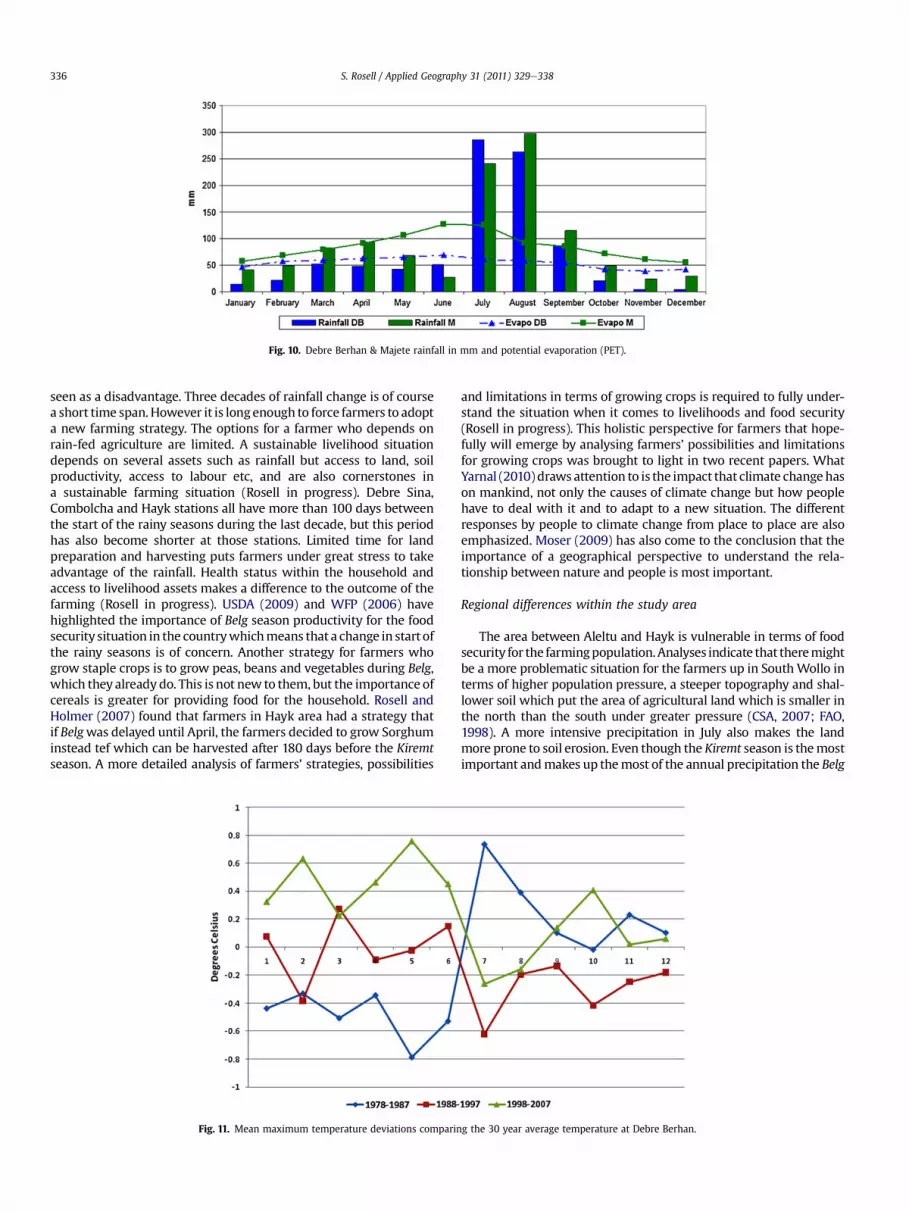
Fig. 10. Debre Berhan & Majete rainfall in mm and potential evaporation (PET).
S. Rosell / Applied Geography 31 (2011) 329e338336
seen as a disadvantage. Three decades of rainfall change is of coursea short time span. However it is longenough to force farmers to adopta new farming strategy. The options for a farmer who depends onrain-fed agriculture are limited. A sustainable livelihood situationdepends on several assets such as rainfall but access to land, soilproductivity, access to labour etc, and are also cornerstones ina sustainable farming situation (Rosell in progress). Debre Sina,Combolcha and Hayk stations all have more than 100 days betweenthe start of the rainy seasons during the last decade, but this periodhas also become shorter at those stations. Limited time for landpreparation and harvesting puts farmers under great stress to takeadvantage of the rainfall. Health status within the household andaccess to livelihood assets makes a difference to the outcome of thefarming (Rosell in progress). USDA (2009) and WFP (2006) havehighlighted the importance of Belg season productivity for the foodsecurity situation in the countrywhichmeans that a change in start ofthe rainy seasons is of concern. Another strategy for farmers whogrow staple crops is to grow peas, beans and vegetables during Belg,which they already do. This is not new to them, but the importance ofcereals is greater for providing food for the household. Rosell andHolmer (2007) found that farmers in Hayk area had a strategy thatif Belgwas delayed until April, the farmers decided to grow Sorghuminstead tef which can be harvested after 180 days before the Kiremtseason. A more detailed analysis of farmers’ strategies, possibilities
Fig. 11. Mean maximum temperature deviations comparin
and limitations in terms of growing crops is required to fully under-stand the situation when it comes to livelihoods and food security(Rosell in progress). This holistic perspective for farmers that hope-fully will emerge by analysing farmers’ possibilities and limitationsfor growing crops was brought to light in two recent papers. WhatYarnal (2010)draws attention to is the impact that climate changehason mankind, not only the causes of climate change but how peoplehave to deal with it and to adapt to a new situation. The differentresponses by people to climate change from place to place are alsoemphasized. Moser (2009) has also come to the conclusion that theimportance of a geographical perspective to understand the rela-tionship between nature and people is most important.
Regional differences within the study area
The area between Aleltu and Hayk is vulnerable in terms of foodsecurity for the farmingpopulation.Analyses indicate that theremightbe a more problematic situation for the farmers up in SouthWollo interms of higher population pressure, a steeper topography and shal-lower soil which put the area of agricultural land which is smaller inthe north than the south under greater pressure (CSA, 2007; FAO,1998). A more intensive precipitation in July also makes the landmore prone to soil erosion. Even though the Kiremt season is themostimportant andmakes up themost of the annual precipitation the Belg
g the 30 year average temperature at Debre Berhan.
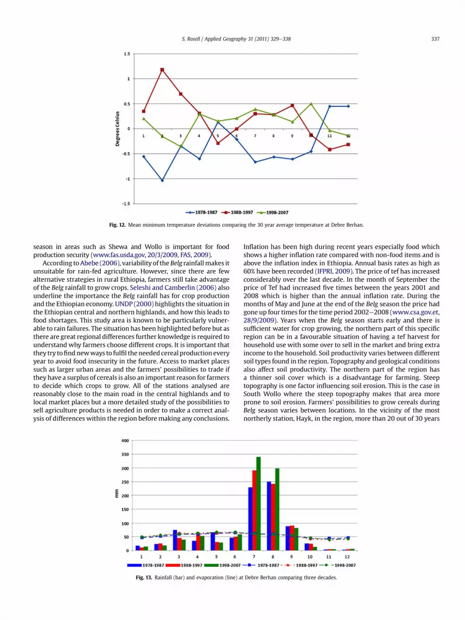
Fig. 12. Mean minimum temperature deviations comparing the 30 year average temperature at Debre Berhan.
S. Rosell / Applied Geography 31 (2011) 329e338 337
season in areas such as Shewa and Wollo is important for foodproduction security (www.fas.usda.gov, 20/3/2009, FAS, 2009).
According toAbebe (2006), variability of theBelg rainfallmakes itunsuitable for rain-fed agriculture. However, since there are fewalternative strategies in rural Ethiopia, farmers still take advantageof the Belg rainfall to grow crops. Seleshi and Camberlin (2006) alsounderline the importance the Belg rainfall has for crop productionand the Ethiopian economy. UNDP (2000) highlights the situation inthe Ethiopian central and northern highlands, and how this leads tofood shortages. This study area is known to be particularly vulner-able to rain failures. The situation has been highlighted before but asthere are great regional differences further knowledge is required tounderstand why farmers choose different crops. It is important thatthey try tofindnewways to fulfil theneededcereal productioneveryyear to avoid food insecurity in the future. Access to market placessuch as larger urban areas and the farmers’ possibilities to trade iftheyhave a surplus of cereals is also an important reason for farmersto decide which crops to grow. All of the stations analysed arereasonably close to the main road in the central highlands and tolocal market places but a more detailed study of the possibilities tosell agriculture products is needed in order to make a correct anal-ysis of differences within the region beforemaking any conclusions.
Fig. 13. Rainfall (bar) and evaporation (line) at
Inflation has been high during recent years especially food whichshows a higher inflation rate compared with non-food items and isabove the inflation index in Ethiopia. Annual basis rates as high as60% have been recorded (IFPRI, 2009). The price of tef has increasedconsiderably over the last decade. In the month of September theprice of Tef had increased five times between the years 2001 and2008 which is higher than the annual inflation rate. During themonths of May and June at the end of the Belg season the price hadgone up four times for the timeperiod 2002e2008 (www.csa.gov.et,28/9/2009). Years when the Belg season starts early and there issufficient water for crop growing, the northern part of this specificregion can be in a favourable situation of having a tef harvest forhousehold use with some over to sell in the market and bring extraincome to the household. Soil productivity varies between differentsoil types found in the region. Topography and geological conditionsalso affect soil productivity. The northern part of the region hasa thinner soil cover which is a disadvantage for farming. Steeptopography is one factor influencing soil erosion. This is the case inSouth Wollo where the steep topography makes that area moreprone to soil erosion. Farmers’ possibilities to grow cereals duringBelg season varies between locations. In the vicinity of the mostnortherly station, Hayk, in the region, more than 20 out of 30 years
Debre Berhan comparing three decades.

S. Rosell / Applied Geography 31 (2011) 329e338338
Belg rainfall started according to the onset criteria. It does not tell usif farmers grow staple crops or not, but it gives an indication thatrainfall is sufficient for staple cropcultivation. So thenorthernpartofthis study area does have a more stable Belg but higher populationpressure, smaller land areas for cultivation and is more prone to soilerosion. Pros and cons make the south more favourable forsustainable farming when comparing those factors.
Conclusions
This is a homogenous region at a glance in amarginal agriculturalarea of the Ethiopianhighlands. A closer look indicates that there arelarge differences within the region in the production of cereals forthe staple food Injera. The most obvious finding regarding rainfallchange in this paper is the increase of annual and Kiremt rainfall andalso the decline of Belg rainfall between 1978 and 2007at all stationsbut Aleltu. At Aleltu the annual rainfall is more or less the same butthe Kiremt has increased and the Belg decreased. There has beena shortening of the Belg rainfall season, it starts later and it tends tocease earlier. Thedecline ofBelg rainfall is bigger in the southernpartof the study area. The north of the study area is generally moredependent on rainfall during the Belg season for food productioncompared to the southern part of the study region. The farming areais smaller in thenorth andpopulationpressure is higher in thenorth.The increase in potential evaporation made the most obviousdifference during Belg season where there was a minor surplus ofwater during the first decade in this study and it turned into a smalldeficit due to increase in temperature and decrease of precipitation.The north is also more exposed to soil erosion due to steeper slopes,which has resulted in a thinner soil cover and stones exposed at theground. One can draw the conclusion that the shorter growingperiod in the southern regionshasmade it impossible during the lastdecade to grow cereals when the season lasts less than 90 days. Inthe north where crop growing is more essential the possibilities arestill there but the Belg season started on average on six occasionsduring the last decade upnorth and as little as one to threeBelg rainyseasons in the most southerly stations of the study area. The lateronset of the Belg and the earlier start of the Kiremtmight influencethe cropping strategies in the regionwhich is of importance for thefood security situation in the region.
Acknowledgement
The author would like to thank the National MeteorologicalAgency in Addis Ababa, Ethiopia for providing the climate data. AtAddis Ababa University, Department of Geography Dr MulunehWoldetsadik played a vital role in obtaining the data. Manysupportive and valuable comments and discussions during thewriting procedure of the manuscript, thanks to associate ProfessorBjörn Holmer, associate Professor Sofia Thorsson both at EarthScience Centre, University of Gothenburg. Thanks to Dr ElisabethSimelton at Leeds University for her support and valuablecomments on this manuscript. My supervisor associate ProfessorMats Olvmo has also contributed to finalise this manuscript. Twoanonymous reviewers made contributions to improve the manu-script as well. During fieldwork in Ethiopia Linda and Emma Zoëhelped me to obtain my goals.
References
Abebe, M. (2006). The onset, cessation and dry spells of the small rainy season (Belg) ofEthiopia. Addis Ababa, Ethiopia: Meteorological Research and Studies Depart-ment National Meteorological Agency.
Alemu, T. (1999). Land tenure and soil conservation evidence from Ethiopia. 92.Göteborg: Ekonomiska Studier utgivna av Nationalekonomsika InstitutionenHandelshögskolan vid Göteborgs Universitet.
Atlas of the Rural Ethiopian Economy. (2006). Washington, DC, USA/Addis Ababa,Ethiopia: International food policy research institute/Central StatisticalAgency.
Bewket, W., & Conway, D. (2007). A note on the temporal and spatial variability ofrainfall in the drought-prone Amhara region of Ethiopia. International Journal ofClimatology, 27(11), 1467e1477.
Conway, D. (2000). The climate and hydrology of the upper Blue Nile River. TheGeographical Journal, 166(1), 49e62.
CSA. (1995). The 1994 population and housing census for Ethiopia.CSA. (2002). Ethiopia agricultural sample enumeration farm implement 2001/2002.CSA. (2007). http://www.csa.gov.et/pdf/Cen2007_firstdraft.pdf19/10/2009.CSA. (2009a). (www.csa.gov.et) Accessed 28.09.09.CSA. (19/10/2009b) www.csa.gov.et.Dinku, T., Chidzambwa, S., Ceccato, P., Connor, S. J., & Ropelewski, C. F. (20 July
2008). Validation of high-resolution satellite rainfall products overcomplex terrain. International Journal of Remote Sensing, 29(14),4097e4110.
Ethiopia Map. (1995). Map of Ethiopia, 1: 1 000 000, Agroecological Belts. SoilConservation Research Programme, Addis Ababa, 1995.
Europa Publications. (2003). Ethiopia, Africa south of the Sahara e Regional surveys ofthe world (33rd ed.). London.
FAS. (1998). The soil and terrain database for north-eastern Africa. In Land and waterdigital media series. FAO.
FAO. (2009) (www.fas.usda.gov, 20/3/2009).Hulme, M., Doherty, R., Ngara T., New, M., & Lister, D. (2001). African climate
change: 1900e2100. Climate Research, 17, 145e168.IFPRI. (February, 2009). IFPRI Discussion paper 00846Ketema, S. (1993). Tef, breeding, genetic resources agronomy, utilization and role in
Ethiopia agriculture. Addis Ababa: Institute of Agricultural Research.Morgan, R. P. C. (1995). Soil erosion & conservation (2nd ed.) Harlow: Longman
Group Limited, 198 pp.Moser, C. S. (2009). Now more than ever: the need for more societally relevant
research on vulnerability and adaptation to climate change. Applied Geography,doi:10.1016/j.apgeog.2009.09.003.
Nicholson, S. E. (2001). Climatic and environmental change in Africa during the lasttwo centuries. Climate Research, 17, 123e144.
Norman, M. J. T., Pearson, C. J., & Searle, P. G. E. (1995). Tropical food crops intheir environment (2nd ed.) Melbourne, Australia: Cambridge UniversityPress.
Omiti, J. M., Parton, K. A., Sinden, J. A., & Ehui, S. K. (1999). Agriculture. Ecosystemsand Environment, 72, 111e118.
Rahmato, D. (1985). Agrarian reform in Ethiopia. Trenton, New Jersey: The Red SeaPress, 105 pp.
Rosell, S., & Holmer, B. (2007). Rainfall change and its implications for Belg harvestin South Wollo, Ethiopia. Geografiska Annaler, 89A(4), 287e299.
Segele, Z. T., & Lamb, P. J. (2005). Characterization and variability of Kiremt rainyseason over Ethiopia. Meteorology and Atmospheric Physics, 89, 153e180.
Seleshi, Y., & Camberlin, P. (2006). Recent changes in dry spell and extreme rainfallevents in Ethiopia. Theoretical and Applied Climatology, 83, 181e191.
Seleshi, Y., & Zanke, U. (2004). Recent changes in rainfall and rainy days in Ethiopia.International Journal of Climatology, 24, 973e983.
Shanko, D., & Camberlin, P. (1998). The effects of the southwest Indian Oceantropical cyclones on Ethiopian drought. International Journal of Climatology, 18,1373e1388.
Setegn, S. G. (June 2008). Hydrological and sediment yield modelling in Lake Tanabasin, Blue Nile Ethiopia. Licentiate Thesis. KTH-Hydraulic Engineering ResearchGroup Department of Land and Water Resources Engineering, Royal Institute ofTechnology (KTH), ISBN 978-91-7415-026-1.
Sokal, R. R., & Rohlf, F. J. (2000). Biometry, the principles and practice of statistics inbiological research. New York: W.H. Freeman and Company.
Tefera, H., Belay, G., & Sorrells, M. (2001). Narrowing the rift, tef research anddevelopment. Addis Ababa, Ethiopia: Ethiopian Agricultural ResearchOrganization.
Thornthwaite, C. W. (1948). An approach toward a rational classification of climate.Geographical Review, 38, 55e94.
UNDP. (14e24 March 2000). Belg rains arrive late, the northern highlands once againface a difficult year. Report of a field mission to Welo.
UNFPA, 12/2e2010 (http://www.unfpa.org/worldwide/africa.html).Unwin, T. (1992). The place of geography. Longman Group UK Limited.USDA. (20/3-2009). United States Department of Agriculture, www.fas.usda.gov.WFP. (24 March 2006). Map titled: Belg growing woredas and their contribution,
Graphics by WFP/VAM Ethiopia. Source: Emergency Needs Assessment Reports.Wikipedia. (10/12/2009a), www.wikipedia.org/wiki/barley.Wikipedia. (10/12/2009b), www.wikipedia.org/wiki/wheat.WMO. (2009), http://www.wmo.int/pages/mediacentre/press_releases/pr_869_en.
html.Yarnal, B. (2010). Climate change and applied geography e place, policy, and
practice: a foreword to the special issue. Applied Geography.