Proterozoic - Early Palaeozoic rocks and the Tyennan Orogeny in central Victoria: The Selwyn Block...
30
Australian Journal of Earth Sciences (2002) 49, 225–254 INTRODUCTION Recently, the composition and age of the rocks that form Victoria’s basement have been a source of speculation. Both are crucial in analysing the plate-tectonic setting, but have been difficult to resolve because of problems in identifying what the basement is. The Delamerian and Lachlan Fold Belts both have a thin-skinned geometry so that the nature of the lower 20–25 km of crust remains open to speculation. In the Victorian part of the Lachlan Fold Belt, there is evidence for a mixed basement composition, with wide areas of oceanic crust separated by one or more older continental blocks. Cambrian metavolcanics from mid- crustal levels are exposed along the largest faults, such as the Moyston, Avoca, Mt William and Governor Faults. These represent the oldest and deepest levels exposed in most of the fold belt and their composition suggests an intra-oceanic crustal setting (Crawford et al. 1984; Crawford & Keays 1987) so that there is no need to postulate an older continental basement for most of the fold belt. However, granite composition, palaeogeographical reconstructions, deep seismic profiles, lower crustal seismic velocities and isotope studies have long implied older continental base- ment is present under parts of the Lachlan Fold Belt, including in Victoria (Packham 1973; Gibson et al. 1981; Glen & VandenBerg 1987; White & Chappell 1988; Gray 1990; Scheibner & Basden 1996). Scheibner (1985) called this the Victorian Microcontinent. Proterozoic – Early Palaeozoic rocks and the Tyennan Orogeny in central Victoria: the Selwyn Block and its tectonic implications R. A. CAYLEY,* D. H. TAYLOR, A. H. M. VANDENBERG AND D. H. MOORE Geological Survey of Victoria, PO Box 500, East Melbourne, Vic. 3002, Australia. Aeromagnetic and field data suggest that meta-igneous rocks exposed on the south coast of central Victoria at Waratah Bay, Phillip Island, Barrabool Hills and inland near Licola, are continuous—beneath Bass Strait—with Proterozoic/Cambrian igneous rocks in King Island and Tasmania. This correlation is supported by a pre-Early Ordovician unconformity above gabbro protomylonite at Waratah Bay, age equivalent to the Tasmanian Tyennan unconformity. Cambrian volcanics at Licola and unusual features of the Melbourne Zone sequence indicate that Tyennan continental crust extends north as basement to the central Victorian portion of the Lachlan Fold Belt. In contrast, adjacent parts of the Lachlan Fold Belt in Victoria contain conformable sea-floor sequences that span the Early Cambrian to Late Ordovician, with no evidence of either Cambrian deformation or underlying continental basement. The block of Tyennan continental crust beneath central Victoria—the Selwyn Block—is fundamentally different, and has influenced temporal and spatial patterns of sedimentation, deformation, metamorphism and plutonism. Palaeogeographical reconstructions suggest that the block was a submarine plateau that lay outboard of the Australian craton, upon which a condensed Ordovician sequence was deposited. The sequence above the Selwyn Block unconformity at Waratah Bay is similar to widespread post-Tyennan sediments in western Tasmania. During Late Ordovician and Early Silurian deformation, the Selwyn Block protected much of the overlying sedimentary sequence. Instead, shortening was focused into the Stawell and Bendigo Zones to the west. These zones were sandwiched between the Selwyn Block and the Australian craton in a ‘vice’ scenario reminiscent of some Appalachian orogenic events. The region above the Selwyn Block was downwarped adjacent to the overthrust Bendigo Zone as a foreland deep, into which a conformable clastic wedge of sediment was deposited in Late Ordovician to Devonian time, prior to final Middle Devonian deformation. The Selwyn Block includes the Cambrian calc-alkaline Licola and Jamieson Volcanics that are correlated with the Tasmanian Mt Read Volcanics. In Victoria, these form a basement high controlling the unusual down-cutting thrusts in the overlying Melbourne Zone and explaining the major structural vergence reversal between the Melbourne and Tabberabbera Zones. The Selwyn Block has exerted some control on the timing, chemistry and distribution of post-orogenic granites, and on central Victorian gold mineralisation. Reactivated faults in the block influenced deposition, and continue to control the deformation of the portions of the Otway and Gippsland Basins that lie above it. KEY WORDS: aeromagnetic surveys, Bass Strait, King Island, Lachlan Fold Belt, mineralisation, Proterozoic, Tasmania, tectonics, Tyennan Orogeny,Victoria. *Corresponding author: [email protected]
Transcript of Proterozoic - Early Palaeozoic rocks and the Tyennan Orogeny in central Victoria: The Selwyn Block...

Australian Journal of Earth Sciences (2002) 49, 225–254
INTRODUCTION
Recently, the composition and age of the rocks that formVictoria’s basement have been a source of speculation. Bothare crucial in analysing the plate-tectonic setting, but havebeen difficult to resolve because of problems in identifyingwhat the basement is. The Delamerian and Lachlan FoldBelts both have a thin-skinned geometry so that the natureof the lower 20–25 km of crust remains open to speculation.
In the Victorian part of the Lachlan Fold Belt, there isevidence for a mixed basement composition, with wideareas of oceanic crust separated by one or more oldercontinental blocks. Cambrian metavolcanics from mid-crustal levels are exposed along the largest faults, such as the Moyston, Avoca, Mt William and Governor Faults.These represent the oldest and deepest levels exposed inmost of the fold belt and their composition suggests an
intra-oceanic crustal setting (Crawford et al. 1984; Crawford& Keays 1987) so that there is no need to postulate an oldercontinental basement for most of the fold belt. However,granite composition, palaeogeographical reconstructions,deep seismic profiles, lower crustal seismic velocities andisotope studies have long implied older continental base-ment is present under parts of the Lachlan Fold Belt,including in Victoria (Packham 1973; Gibson et al. 1981;Glen & VandenBerg 1987; White & Chappell 1988; Gray 1990;Scheibner & Basden 1996). Scheibner (1985) called this theVictorian Microcontinent.
Proterozoic – Early Palaeozoic rocks and the Tyennan Orogeny in central Victoria: the Selwyn Block and its tectonic implicationsR. A. CAYLEY,* D. H. TAYLOR, A. H. M. VANDENBERG AND D. H. MOORE
Geological Survey of Victoria, PO Box 500, East Melbourne, Vic. 3002, Australia.
Aeromagnetic and field data suggest that meta-igneous rocks exposed on the south coast of central Victoria at Waratah Bay, Phillip Island, Barrabool Hills and inland near Licola, are continuous—beneath Bass Strait—with Proterozoic/Cambrian igneous rocks in King Island andTasmania. This correlation is supported by a pre-Early Ordovician unconformity above gabbro protomylonite at Waratah Bay, age equivalent to the Tasmanian Tyennan unconformity. Cambrianvolcanics at Licola and unusual features of the Melbourne Zone sequence indicate that Tyennancontinental crust extends north as basement to the central Victorian portion of the Lachlan Fold Belt.In contrast, adjacent parts of the Lachlan Fold Belt in Victoria contain conformable sea-floorsequences that span the Early Cambrian to Late Ordovician, with no evidence of either Cambriandeformation or underlying continental basement. The block of Tyennan continental crust beneathcentral Victoria—the Selwyn Block—is fundamentally different, and has influenced temporal and spatial patterns of sedimentation, deformation, metamorphism and plutonism. Palaeogeographicalreconstructions suggest that the block was a submarine plateau that lay outboard of the Australiancraton, upon which a condensed Ordovician sequence was deposited. The sequence above the Selwyn Block unconformity at Waratah Bay is similar to widespread post-Tyennan sediments inwestern Tasmania. During Late Ordovician and Early Silurian deformation, the Selwyn Block protectedmuch of the overlying sedimentary sequence. Instead, shortening was focused into the Stawell andBendigo Zones to the west. These zones were sandwiched between the Selwyn Block and theAustralian craton in a ‘vice’ scenario reminiscent of some Appalachian orogenic events. The regionabove the Selwyn Block was downwarped adjacent to the overthrust Bendigo Zone as a forelanddeep, into which a conformable clastic wedge of sediment was deposited in Late Ordovician toDevonian time, prior to final Middle Devonian deformation. The Selwyn Block includes the Cambriancalc-alkaline Licola and Jamieson Volcanics that are correlated with the Tasmanian Mt ReadVolcanics. In Victoria, these form a basement high controlling the unusual down-cutting thrusts inthe overlying Melbourne Zone and explaining the major structural vergence reversal between the Melbourne and Tabberabbera Zones. The Selwyn Block has exerted some control on the timing,chemistry and distribution of post-orogenic granites, and on central Victorian gold mineralisation.Reactivated faults in the block influenced deposition, and continue to control the deformation ofthe portions of the Otway and Gippsland Basins that lie above it.
KEY WORDS: aeromagnetic surveys, Bass Strait, King Island, Lachlan Fold Belt, mineralisation, Proterozoic,Tasmania, tectonics, Tyennan Orogeny, Victoria.
*Corresponding author: [email protected]
Underlying old continental crust has been invoked toexplain many features such as: the presence of a submarineplateau inferred from palaeogeographical reconstructions(Cas 1983; Powell 1983); the unbroken sedimentary succes-sion of the Melbourne Zone, interpreted to be protectedfrom Silurian overthrusting of the Bendigo Zone by a rigidbasement (Scheibner 1985); the composition of S-type gran-ites (Clemens 1988); localised eastward vergence of struc-tures in central Victoria (Fergusson et al. 1986); the presenceand geometry of deep reflectors in a seismic traverse acrossthe western margin of the Melbourne Zone (Gray et al.1991); and Proterozoic ages of the subcrustal lithosphericmantle of parts of Victoria determined by Re–Os isotopicgeochronology of mantle xenoliths in Cainozoic volcanics(McBride et al. 1996). The value of granite chemistry andthe mantle xenoliths remain questionable as proof ofolder crust (Collins 1996; Gray et al. 1998), but the otherregional-scale and fundamental observations remain.
All these scenarios lack a regional context for the proposed older continental crust. Before aeromagneticdata were available, it was difficult to take into accountadjacent regions separated by non-outcropping areas; theTasmanian connection is typical. In Tasmania, Proterozoiccontinental crust is exposed. The similarity between theconformable Ordovician to Middle Devonian marinesequences of the Melbourne Zone and the Mathinna Groupof northeast Tasmania has long been known (Baillie &Powell 1991; Powell et al. 1993) and has formed the mainbasis for comparison between the mainland and Tasmanianportions of the Lachlan Fold Belt (Glen et al. 1992). Recentdeep seismic investigations in eastern Tasmania suggestthat Proterozoic crust lies unconformably beneath theMathinna Group (Drummond et al. 1998, 2000), but theimplications of this interpretation for central Victoria havenot been considered.
Authors such as Foster et al. (1996), Gray (1997), Gray andFoster (1997, 1998), Anderson et al. (1998) and O’Halloranand Rey (1999) have proposed an entirely oceanic setting for the Lachlan Fold Belt, with an extensive, uniform base-ment of oceanic crust and no deep, old continental crust.The absence of outcropping older basement on mainlandAustralia provided some support for this. However, thisentirely oceanic setting needs to be reassessed in view ofthe recognition of pre-Lachlan continental basementdescribed in this paper.
Key outcrops, together with geophysical, sedimento-logical, structural, palaeontological and geochemical data,support the presence of a Proterozoic–Cambrian contin-ental crustal block beneath the Melbourne Zone. This oldcrustal block is clearly continuous with the Proterozoic–Cambrian crust of western Tasmania and its Victorian partis referred to as the Selwyn Block (VandenBerg et al. 2000).The block is almost completely buried beneath Ordovicianto Devonian rocks. Its composition is inferred from a few key exposures, from geophysical data, from granitechemistry and from comparison with Tasmania. These suggest that it consists mostly of Neoproterozoic meta-sedimentary and metavolcanic rocks; some Cambrianmeta-igneous rocks are also considered to be part of theSelwyn Block.
Outcrops of the Selwyn Block are rare. We regard occur-rences of tholeiitic metabasalt and metagabbro (‘green-stone’) on the Victorian coast at Waratah Bay (Lindner 1953;
Singleton 1968; Crawford et al. 1988) and Phillip Island(Henry & Birch 1992) and somewhat farther inland in theBarrabool Hills (Coulson 1930; Spencer-Jones 1967; Morand1995) as exposed parts of the Selwyn Block. Farther inland,in the vicinity of Licola–Jamieson, calc-alkaline meta-volcanics are exposed in erosion windows cut through overthrust Melbourne Zone rocks and may also be part of the Selwyn Block.
The outcrops at Licola, Waratah Bay and Phillip Islandlie well within the Lachlan Fold Belt, hundreds of kilo-metres east of its western margin, yet they do not fit wellinto the previously known Victorian structural framework:they do not lie along strike from the known major LachlanFold Belt fault zones (e.g. Heathcote Fault Zone, GovernorFault: VandenBerg et al. 2000) in which other Cambrianigneous rocks (greenstones) are exposed (Figure 1). Theyalso have a different structural history. At Waratah Bay anunconformity exists between deformed igneous rocks andLower Ordovician (and Upper Cambrian?) sedimentaryrocks.
The greenstone belts flanking the Melbourne Zone(Heathcote and Dookie–Howqua–Dolodrook belts) consistof tholeiitic and boninitic rocks and, in common with manyother Lachlan Fold Belt rocks, were not deformed beforeLate Ordovician time (Figure 2). On the basis of lithologicaland chemical similarities the coastal greenstone occur-rences have previously been assumed to share a commonorigin and structural history with these other greenstonebelts. However, aeromagnetic data and the presence of aCambrian unconformity above deformed greenstones atWaratah Bay indicate that these coastal occurrences havea history similar to, and are physically connected with,Neoproterozoic and Cambrian greenstones in Tasmaniaand King Island, all of which were deformed during theCambrian Tyennan Orogeny.
In Tasmania and on King Island, Neoproterozoic green-stones lie unconformably on Proterozoic continental crustthat was strongly deformed in the Neoproterozoic Penguin/Wickham Orogeny. More greenstones of Cambrian agewere emplaced during the Cambrian Delamerian/TyennanOrogeny (Berry & Crawford 1988) that affected allProterozoic–Cambrian rocks of Tasmania (Seymour &Calver 1998). In Tasmania, all these rocks lie beneath awidespread Late Cambrian unconformity (Figure 2).
The calc-alkaline Licola Volcanics of the easternMelbourne Zone have a similar age and composition to theMt Read Volcanics of western Tasmania and the Mt StavelyVolcanic Complex of western Victoria (Crawford et al. 1996;Turner 1996). Both were deformed in the Cambrian. Trace-element composition in all these rocks is typical of a contin-ental component in the melt generation, with possibleeruption in a post-collisional, continental-rift setting(Crawford et al. 1996; VandenBerg et al. 2000).
GEOPHYSICAL DATA SUPPORT A LINKAGEBETWEEN TASMANIA AND VICTORIA
Modern geophysical datasets allow correlation across BassStrait where direct information of the basement rocks islimited to a few drill holes. The basement of Tasmania andKing Island is Proterozoic–Cambrian continental crust(Seymour & Calver 1998), and the continuity of geophysical
226 R. A. Cayley et al.

character across Bass Strait is strong evidence for theextension of that crust to the south coast of Victoria.
Aeromagnetic data in Bass Strait show continuity in the magnetic character between Tasmania and southernVictoria (Figures 1, 3). The Togari Group, Rocky Cape Blockand the Arthur Lineament in northwestern Tasmania arethree belts of Proterozoic–Cambrian rocks with contrast-ing magnetic character that produce a distinctive triplet of linear magnetic features. The triplet consists of a broad
belt of low magnetic character (the Rocky Cape Group)flanked on the east by the magnetic Arthur Lineament andon the west by the magnetic Togari Group. This triplet canbe traced beneath Bass Strait to the south coast of Victoria(Figures 1, 3). The ‘Togari’ trend corresponds with outcrop-ping Cambrian greenstones at Waratah Bay, but the othertwo trends are buried under younger rocks. Greenstone outcropping on Phillip Island lies at the end of a belt of highly magnetic rock that extends to Neoproterozoic
Central Victoria and the Selwyn Block 227
Figure 1 Regional geological subdivisions and deformation ages for Victoria and Tasmania, with simplified Bass Strait aeromagnetic data (after Milligan & Tarlowski 1999) (see also Figure 3). The map shows the interpreted margins of the Selwyn Blockand key features and locations referred to in the text. The location of Figures 11 and 12, and the position of the Bass 2 petroleum exploration well are also shown.

metavolcanics (Currie Group: Figure 2) on the east coast of King Island (Figure 3). The rocks adjacent to the belt are less magnetic and, on King Island, include rocks thatare intruded by 760–750 Ma granites (Black et al. 1997).The Barrabool Hills occurrence (Ceres Gabbro: Vanden-Berg et al. 2000) does not show in the magnetic data, but issituated north of another highly magnetic belt that extendsfrom King Island north to Cape Otway (Lammens 1997).
Gravity data covering the region are more difficult tointerpret. They lack the resolution of the aeromagneticdata and are also strongly influenced by thick post-Palaeozoic rift sediments. Significant gravity effects arealso caused by the edge of the Australian continent, whichborders most of Tasmania and parts of Victoria. Despitethese limitations, the gravity data suggest a basement connection between Tasmania and Victoria (Bureau ofMineral Resources 1992). A broad gravity high connects the Rocky Cape Block with King Island and the Victorian
south coast. The high extends northeast to Phillip Islandand Waratah Bay along the King Island – Mornington High (Figure 1), and northwest from King Island to CapeOtway and inland towards the Barrabool Hills. Regions oflow gravity beneath Bass Strait coincide in part with themagnetic and non-magnetic granitic intrusions visible inthe aeromagnetic data, and with basin-fill sediments(Williamson et al. 1987) (Figures 1, 3).
CENTRAL VICTORIAN GREENSTONES HAVE TASMANIAN AFFINITY
Waratah Bay
Waratah Bay has the best exposure and best demonstratesthe tectonic setting of the coastal greenstones (Figures 1, 4).Cambrian greenstones crop out in a narrow belt between
228 R. A. Cayley et al.
Figure 2 Comparative time–space stratigraphic table for central Victoria, King Island and northern Tasmania (see Seymour & Calver1998; VandenBerg et al. 2000). Intervals in which no rock is preserved are shaded. Age constraints on named deformation events areprovided by the ages of unconformably overlying sediments and post-tectonic intrusions as shown, and by isotopic dating of micagrown during deformation (Foster et al. 1998). S.R.V, Snowy River Volcanics.

Central Victoria and the Selwyn Block 229
Figure 3 Regional aeromagnetic data map of Victoria, Tasmania and Bass Strait (residual data: purple, least magnetic; red, most magnetic). Note the positions of exposed coastal Victorian Selwyn Block rocks. 1, Waratah Bay; 2, Phillip Island; 3, Barrabool Hills.See Figures 1 and 7 for other geological data (data sources: Geological Survey of Victoria, Geoscience Australia, company data, MineralResources Tasmania).

230 R. A. Cayley et al.
Figure 4 Geological map of the Waratah Bay coastline.
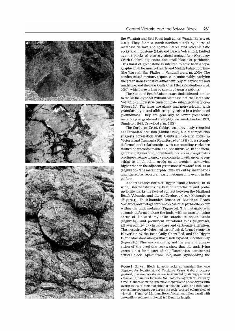
the Waratah and Bell Point fault zones (VandenBerg et al.2000). They form a north-northeast-striking horst ofmetabasaltic lava and sparse intercalated volcaniclasticrocks and mudstone (Maitland Beach Volcanics), faultedagainst blocks of coarse-grained metagabbro (CorduroyCreek Gabbro: Figure 5a), and small blocks of peridotite.This horst of greenstone is inferred to have been a topo-graphic high for much of Early and Middle Palaeozoic time(the Waratah Bay Platform: VandenBerg et al. 2000). Thecondensed sedimentary sequence unconformably overlyingthe greenstones consists almost entirely of carbonate andmudstone, and the Bear Gully Chert Bed (VandenBerg et al.2000), which is overlain by scattered quartz pebbles.
The Maitland Beach Volcanics are tholeiitic and similarto the MORB-type Mt William Metabasalt of the HeathcoteVolcanics. Pillow structures indicate subaqueous eruption(Figure 5c). The lavas are glassy and non-vesicular, withgranular augite and albitised plagioclase in a chloritisedgroundmass. They are generally of lower greenschistmetamorphic grade and are highly fractured (Lindner 1953;Singleton 1968; Crawford et al. 1988).
The Corduroy Creek Gabbro was previously regardedas a Devonian intrusion (Lindner 1953), but its compositionsuggests correlation with Cambrian volcanic rocks inVictoria and Tasmania (Crawford et al. 1988). It is stronglydeformed and relationships with surrounding rocks arefaulted or unconformable and not intrusive. In the meta-gabbro, metamorphic hornblende occurs as overgrowths on clinopyroxene phenocrysts, consistent with upper green-schist to amphibolite grade metamorphism, somewhathigher than in the adjacent greenstone (Crawford et al. 1988)(Figure 5b). The metamorphic rims are cut by shear bandsand, therefore, record an early metamorphic event in thegabbro.
A short distance north of Digger Island, a broad (~100 mwide), northeast-striking belt of cataclasite and proto-mylonite marks the faulted contact between the MaitlandBeach Volcanics and altered Corduroy Creek Metagabbro(Figure 4). Fault-bounded lenses of Maitland BeachVolcanics and metagabbro, and occasional peridotite, occurwithin the fault mélange (Figure 6e). The metagabbro isstrongly deformed along the fault, with an anastomosingarray of lineated mylonite–cataclasite shear bands (Figure 6g), and prominent intrafolial folds (Figure 6f),all overprinted by chrysoprase and carbonate alteration.The most strongly deformed part of this deformed sequenceis overlain by the Bear Gully Chert Bed, and the DiggerIsland Marlstone along a sharp, well exposed unconformity(Figure 6c). This unconformity, and the age and compo-sition of the overlying rocks, show that the underlyinggreenstones form part of the Tasmanian continentalcrustal block. Apart from ubiquitous stylobedding the
Central Victoria and the Selwyn Block 231
Figure 5 Selwyn Block igneous rocks at Waratah Bay (see Figure 4 for locations). (a) Corduroy Creek Gabbro: coarse-grained, massive corestones are surrounded by strongly alteredcataclasite; hammer for scale. (b) Photomicrograph of CorduroyCreek Gabbro showing igneous clinopyroxene phenocrysts withovergrowths of metamorphic hornblende (visible as thin palerrims). Late fractures cut across the rock (crossed polars, field ofview 25 � 17 mm) (c) Maitland Beach Volcanics: pillow basalt withinterpillow sediments. Pencil is 140 mm in length.

232 R. A. Cayley et al.

overlying sedimentary rocks are very weakly deformed and of very low metamorphic grade, indicating that the regionhas remained at very shallow crustal levels since theCambrian.
The Bear Gully Chert Bed shows fine lamination dis-rupted by burrowing and may be an algal deposit. It con-tains terrigenous detritus, including lithic fragments, thatappear to have been derived from a previously tectonisedsource (Merry 1987). The chert is approximately 10 cm thickand includes sparsely scattered pebbles of well-roundedquartz and other rock types (Figure 6d). The basal part ofthe conformably overlying Digger Island Marlstone com-prises thick-bedded dolomite and dolomitic breccia, butmost of the formation consists of thinly bedded biotur-bated, and in part stylobedded, calcareous mudstone(Lindner 1953; Singleton 1968; Jell 1985). This upper partcontains a rich trilobite and brachiopod fauna of Tremadoc(probable early Lancefieldian) age (Jell 1985; Laurie 1987).
The Bear Gully Chert Bed and the Digger IslandMarlstone are weakly metamorphosed and uncleaved, andfolded into gentle dome-and-basin folds and cut by small,late extensional faults (Figure 6b, c), probably related to thenearby younger (Tabberabberan) Waratah and Bell Pointfaults, of Middle Devonian age.
The Lancefieldian (basal Ordovician) age of the DiggerIsland Marlstone means that the metamorphism and deformation of the underlying Corduroy Creek Gabbro and Maitland Beach Volcanics and their exhumation must have occurred in the Cambrian or earlier. The DiggerIsland Marlstone and the presence of vein quartz pebblesand lithic fragments in the Bear Gully Chert Bed shows thatcontinentally derived sediments were reaching the areaprobably no later than latest Cambrian time, and imply that
the deformed mafic igneous rocks must have been in a shallow marine continental setting by this time. Theabsolute age of deformation of the Waratah Bay maficrocks is not known, although their compositional similaritywith Cambrian mafic–ultramafic igneous rocks inTasmania suggests that they are Cambrian or earlier (A. J. Crawford pers. comm. 1998)
The Digger Island Marlstone is the only Ordoviciandetrital carbonate known in Victoria (Cas & VandenBerg1988), and contrasts strongly with the deep-marine blackshale–chert–turbidite lithofacies that characterises theLachlan Fold Belt sedimentary succession elsewhere in the State (Figure 2). It has a unique faunal assemblage and sedimentary features that suggest deposition in a shallow-marine to supratidal environment (Lindner 1953; Sandiford 1978; Cas & VandenBerg 1988; A. H. M.VandenBerg unpubl. data).
Thus, the deformation of the greenstones at WaratahBay occurred much earlier than deformation of the green-stones at Heathcote and Howqua–Dolodrook, whichremained undeformed in a deep marine setting until atleast Late Ordovician time (VandenBerg et al. 2000). Theyoungest recognised deformation event in southeastAustralia that can account for the observed deformationfeatures at Waratah Bay is the Tyennan Orogeny inTasmania, which is coeval with the Delamerian Orogenyon the mainland. An even older, Proterozoic, age cannot be ruled out at present, but would necessarily imply acorrespondingly older age of the igneous rocks themselves(Crawford et al. 1988). This is possible as they lie on thesame magnetic belt as the Togari Group, which containssubstantial amounts of tholeiitic basalt of probable pre-Penguin/Wickham Orogeny (700 Ma) age (Figures 1, 2)(Turner 1989; Seymour & Calver 1998). A K/Ar age of589 � 2.6 Ma from tuffaceous mudstone and mafic volcanicsat the base of Bass 2 well (Figure 1) in the middle of BassStrait shows that Tasmanian Proterozoic crust extends atleast this far north (Williamson et al. 1987; Hall 1998).
Although the Maitland Beach Volcanics have a similarcomposition to most other Cambrian igneous rocks inVictoria (Heathcote and Lickhole Volcanics, Dookie andThiele igneous complexes: VandenBerg et al. 2000), they are also comparable to tholeiites in the ProterozoicCrimson Creek Formation and to younger Cambrianmafic–ultramafic complex rocks in Tasmania. Indeed, theWaratah Bay association of such tholeiites with faultedslices of gabbros and peridotites is characteristic ofwestern Tasmania, where boninitic low-Ti tholeiites andunrelated gabbros and orthopyroxene-rich cumulates wereemplaced as an ophiolite allochthon onto a passive-marginsequence dominated by Crimson Creek Formation(Crawford & Berry 1992).
The overlying Cambro-Ordovician sedimentary rocksalso show that the greenstones of Waratah Bay haveTasmanian character. The sedimentary rocks correlatewith the siliciclastic Owen Conglomerate and overlyingcarbonates of the Denison and Gordon Groups. TheDenison and Gordon Groups overlie Proterozoic toCambrian rocks with an unconformity marked by extensiveconglomerate, such as the Owen and Roland Conglomerates(Brown et al. 1982; Seymour & Calver 1998). Although theirdepositional setting is not clear, the pebbles in the Bear
Central Victoria and the Selwyn Block 233
Figure 6 The Late Cambrian (Tyennan) unconformity andrelated rocks at Waratah Bay (see Figure 4 for locations). (a)Outcrop of the unconformity near Digger Island, looking south.Rocks below are chrysoprase-altered and sheared CorduroyCreek Gabbro with an anastomosing schistosity that truncatesagainst the unconformity. The overlying Bear Gully Chert Bed(pale unit) and the Lancefieldian Digger Island Marlstone areclearly visible as the moderately east-dipping beds draped overthe unconformity. (b, c) Detail of the outcrop showing the pale,undeformed Bear Gully Chert Bed overlying the unconformity.The angular relationship between the shears in the underlyinggabbro and the unconformity is very clear. Late, small, brittle normal faults of probable Middle Devonian (Tabberabberan) age dip steeply east and cut the unconformity and bedding in theoverlying rocks. (d) Bear Gully Chert Bed just above the uncon-formity. Slabbed section of entire, virtually undeformed, bedshowing fine lamination disrupted by soft-sediment deformation.The large rounded quartz pebble was impressed into the top of the unit prior to deposition of the overlying Digger IslandMarlstone. Coin is 30 mm in diameter. (e) Cambrian mylonite withsinistral shear sense just below the unconformity. Mainlydeformed Maitland Beach Volcanics in this outcrop. Note augenof ultramafic rock (e.g. just to the right of the pencil tip). Pencilis 140 mm in length. (f) Cambrian recumbent isoclinal fold (justleft of hammer) refolding a platy mylonite fabric in CorduroyCreek Gabbro just below the unconformity. (g) Photomicrographof deformed Corduroy Creek Gabbro just below the unconformity.Note abraded and microfaulted clinopyroxene phenocryst fragments in a fine, mylonitised groundmass (crossed polars,field of view 1.6 � 1.1 mm).

Gully Chert Bed may correlate with the Owen and RolandConglomerates. It seems most likely that the unconformityat the base of the Bear Gully Chert Bed correlates with theTyennan unconformity in Tasmania (Figure 2).
The presence of several Lower Devonian carbonate formations at Waratah Bay (Lochkovian Waratah Lime-stone and Pragian–Emsian Bell Point Limestone) impliesa long-lasting topographic high existed—the Waratah BayPlatform—in this region (Figure 2) (VandenBerg et al. 2000).These carbonates are in strong contrast to the deep-marine
turbidite-dominated sandstone–mudstone sequence farthernorth and west of the Waratah Fault. Debris shed from the platform makes up much of the Lower Devonian Boola Formation and Coopers Creek Limestone (Figure 2)(VandenBerg 1975, 1988; Rehfisch & Webb 1993) and shows that the Waratah Bay Platform extended at least as far north as Morwell (Figure 7) (VandenBerg 1988;VandenBerg et al. 2000). The magnetic data support thisnorthern extension of the greenstone of Waratah Bay(Figures 3, 8).
234 R. A. Cayley et al.
Figure 7 Geological map of central Victoria showing the main stratigraphic and structural provinces and zones, and the positions offaults and locations discussed in the text.

Phillip Island
At Phillip Island, tholeiitic basalt and dolerite of green-schist metamorphic grade occur in a small window throughCenozoic Older Volcanics, with no exposure of the contactswith any pre-Cenozoic rocks (Henry & Birch 1992). Thebasalt contains a northeast-striking penetrative cleavage.It lies on a major south-southwest-trending magnetic belt that includes outcrops of tholeiitic and picritic basalt (Currie Group) on the east coast of King Island(Figures 1–3) (Jago 1974; Brown 1989; Roach 1997). TheCurrie Group overlies a sequence of glacial rocks and conglomerate of probable Neoproterozoic (Marinoan) age (Seymour & Calver 1998).
Henry and Birch (1992) compared the Phillip Islandrocks with the tholeiites in the Heathcote and LickholeVolcanics. However, four of their eight samples aredolerites particularly low in Ti (av. 0.28%), closer in compo-sition to the picritic rocks of the Currie Group and to similar rocks from several locations in western Tasmania(e.g. Double Cove on Macquarie Harbour: Crawford & Berry1992). The association of very low-Ti dolerite with morenormal tholeiitic lava is unknown in the Heathcote andLickhole Volcanics. The Phillip Island rocks seem to havemuch greater affinity with the Neoproterozoic Currie
Group and Crimson Creek Formation (A. J. Crawford pers.comm. 1998), again supporting the physical link visible inthe aeromagentic data.
Barrabool Hills
The Ceres Gabbro outcrops as small patches in theBarrabool Hills, intruded by Devonian granite and surrounded by younger sedimentary rocks (Figure 7). It is a fine- to coarse-grained, weakly foliated to myloniticmetagabbro. Amphibolite-facies metamorphism appears tohave accompanied the formation of the foliation (Morand1995; VandenBerg et al. 2000). The mylonitic fabric trendseast–west, and shear bands form a conjugate set indicatingnorth–south compression during regional deformation,which is at odds with the structural grain in Bendigo Zonerocks farther north (Morand 1995). The composition andmetamorphic grade differ from those of the HeathcoteVolcanics to the north.
The Ceres Gabbro is only slightly magnetic and cannotbe traced in the aeromagnetic data (Figure 3). However, theoutcrops lie at the northern end of a gravity high thatextends southwest beneath the Otway Ranges and south toKing Island. Beneath the Otway Ranges, a layered belt ofmagnetic rocks continues southwards to the west coast
Central Victoria and the Selwyn Block 235
Figure 8 Aeromagnetic greyscale image (residual data: black, least magnetic; white, most magnetic) of the central Victorian coast,with topographic data superimposed in colour. The position of the Otway and Strzelecki Ranges and of many structures that havetopographic expression are also shown. #, the buried Selwyn Block structure, which truncates the western margin of the Cape Otwaymagnetic belt and coincides with a strike change in the overlying Otway Range. *, a buried magnetic feature interpreted to be a northern extension of the Waratah Bay greenstones. See Figure 7 for comparison with named structures and Figure 9 for earthquakedata that indicate currently active structures.

of King Island, where the Neoproterozoic Currie Group lieson it. We refer to this belt as the Cape Otway magnetic belt.
Relationships of the Ceres Gabbro with pre-Devonianrocks are not exposed. However, outcrops of CretaceousOtway Group near the gabbro contain clasts of the gabbro,as well as abundant angular cobbles of high grade, foliatedmetaquartzite and schist. The angularity and size of theseclasts suggests a very close source, yet no such rocks are known from any of the nearby Palaeozoic outcrops.The nearest exposed similar high grade rocks are theMesoproterozoic Wickham metamorphics that underlie theCurrie Group on King Island. In western Tasmania, high-grade Precambrian metaquartzites are also widespread.Possibly such unmagnetic rocks occur near the CeresGabbro outcrops, buried beneath younger rocks.
Jamieson and Licola Volcanics
Volcanics exposed in erosional windows at the eastern margin of the Mt Useful Fault Zone of the easternMelbourne Zone occur 150 km from the coast, approxi-mately along strike from the exposures at Waratah Bay(Figure 7). These are the Jamieson and Licola Volcanics,and volcanics at Glen Creek. These volcanics include vesiculated pyroclastics and are therefore shallow marinein part. A megaclast of pure limestone in the LicolaVolcanics contains crinoid ossicles and a brachiopod,proving a Phanerozoic age. Overlying shale contains very Early Ordovician (Lancefieldian, La2) graptolites,suggesting that the volcanics are Cambrian.
The volcanics are calc-alkaline, with andesite lavas and breccias, overlain by rhyolite lavas and volcaniclasticsedimentary rocks (VandenBerg et al. 1995). They are onlyslightly magnetic. Their composition and structural settingare also quite different from the tholeiitic–boniniticCambrian igneous rocks that occur elsewhere (Heathcoteand Lickhole Volcanics; Dookie and Thiele igneous com-plexes: VandenBerg et al. 2000).
The Licola and Jamieson Volcanics are predominantlyhigh- and medium-K hornblende andesite, stronglyenriched in Sr and Ba. They compare closely with the MtRead Volcanics, having a similar age, petrography, compo-sition, and Cu–Au volcanic-hosted massive sulfide mineral-isation style (Crawford et al. 1988, 1996; Turner 1996). TheLicola Volcanics also have a similar composition to the MtStavely Volcanic Complex, with nearly identical averageZr/TiO2 ratios (Crawford et al. 1996).
The calc-alkaline composition of the Licola Volcanicssuggests that, like the Mt Read Volcanics, they wereextruded through continental crust, although none of thisolder crust is exposed. However, the presence of clasts ‘ofgranitic origin’ in breccia overlying Cambrian volcanics at Glen Creek (Sandl 1989) suggests that continental crustwas exposed in the region in Cambrian time. Perhaps thebreccia is analogous to the Bear Gully Chert Bed atWaratah Bay.
The timing of deformation of the Licola Volcanics is not well constrained, but appears to be earlier than defor-mation of the overlying sedimentary rocks as the volcanicsformed a structural high against, and over, which thesewere emplaced during the Tabberabberan Orogeny. Thelack of Ordovician turbidites in the eastern part of the
Melbourne Zone perhaps implies that the structural highwas present by the end of the Cambrian (VandenBerg et al. 1995, 2000). Therefore, the deformation of the LicolaVolcanics may pre-date that of the adjacent LickholeVolcanics, which, together with other rocks in theTabberabbera Zone, were not deformed before EarlySilurian time (Figure 2).
The Licola Volcanics underlie, but are apparently notincorporated in, a Tabberabberan (Middle Devonian) foldand thrust belt in the Mt Useful region (VandenBerg et al.1995; contra Gray 1995). Bedding, an early foliation and several faults in the volcanics all trend west-northwest to nearly east–west (D. Cherry & G. Turner pers. comm.1999). Dips in all these structures are to the south at moderate angles (35–40°). We infer that the foliation is aCambrian fabric. The Cambrian rocks are separated fromoverlying Ordovician–Silurian sedimentary rocks by anear-horizontal thrust that has been observed in all out-crops of this contact. Overlying rocks are strongly dis-cordant, with a north–south structural grain, suggestingthat they were deformed in a different strain regime. Wepropose that these volcanics were deformed during theCambrian Tyennan Orogeny, like the Mt Read Volcanics(Crawford & Berry 1992).
MELBOURNE ZONE GEOLOGY SUPPORTS ATASMANIAN CONNECTION
Although the Melbourne Zone has some features in common with the adjacent structural zones in Victoria,many major features are notably different. There are alsosimilarities between the Melbourne Zone and the MathinnaTerrane of northeastern Tasmania, and these have formedpart of the basis of models that proposed large-scale lateraltectonics in the Lachlan Fold Belt (Glen et al. 1992).
The Melbourne Zone sequence shows at least 13 unusualfeatures, listed below. Many compare well with Tasmania,but are in marked contrast to adjacent regions on the main-land. Some of these features point to the existence of oldbasement beneath the Melbourne Zone since the end of theCambrian.
(1) Relationships of Ordovician rocks with underlyingrocks in the east of the Melbourne Zone are unconformable(Waratah Bay) or thrust-faulted (Mt Useful region), indi-cating an older deformed substrate. This contrasts stronglywith the adjacent Victorian zones, where conformable succession from Cambrian volcanics to deep-marine chert,shale and thick Ordovician turbiditic sediments occurs(Cas & VandenBerg 1988; Fergusson 1998; VandenBerg et al. 2000): in these adjacent regions the available evidencesuggests that an oceanic setting spanned the Cambrian and Ordovician, with no need for an older substrate. Anunconformable relationship between Ordovician rocksand their basement is also seen in northwest Tasmania(Seymour & Calver 1998).
(2) A complete, conformable sedimentary sequence is present, ranging from Lower Ordovician to very highLower Devonian in the western part and from upper MiddleOrdovician to Middle Devonian in the east. The missingOrdovician rocks can be explained by non-deposition, withno record of deformation during this period. This is
236 R. A. Cayley et al.

unique in the mainland portion of the Lachlan Fold Belt,but also occurs in the Mathinna Terrane of northeasternTasmania (see Seymour & Calver 1998). Elsewhere in themainland Lachlan Fold Belt, strong deformation, beginningat the end of the Ordovician, terminated conformable deposition (see point 9).
(3) The post-Lancefieldian portion of the Lower Ordovician sequence is much thinner than in the flankingzones, largely because there is a much lower turbidite com-ponent; most of the Lower and middle Ordovician sequenceis missing in the eastern part of the zone. Comparisonbetween outcrops in the western part of the zone and thoseof the Bendigo Zone indicate strong eastward thinning: onewell-dated 10 m-thick interval at Mornington Peninsula,approximately 30 km east of the easternmost BendigoZone outcrop, correlates with 550 m of sedimentary rocksat Bendigo and approximately 450 m at Castlemaine(VandenBerg et al. 2000 figure 2.109). Unlike the BendigoZone, chert predominates in the hemipelagic intervals. TheWaratah Bay Platform contains no record of sedimentationbetween earliest Ordovician and mid-Early Devonian time[although curiously Mawson and Talent (1994) foundSilurian conodonts in a redeposited limestone derived fromthe platform, suggesting that Silurian limestone wasdeposited upon now-unexposed parts of the platform].
The pattern of eastward thinning of the CastlemaineGroup between the Bendigo Zone and the MorningtonPeninsula cannot be explained by simple proximal-to-distal changes in a turbidite fan because bedding thick-nesses in the turbidites themselves do not show markedchanges. Instead, the difference is due to a much lower pro-portion of sandstone to mudstone farther east, a patternthat is consistent with it having been deposited on a sub-marine plateau.
In the eastern Melbourne Zone (Mt Easton Province),Lower and Middle Ordovician rocks are absent or repre-sented by a few metres of shale. The available evidence indicates that the sequence is truly condensed, i.e. that verylittle sediment was deposited here during the Early andMiddle Ordovician. This may have been because most turbidite flows were exhausted before they arrived in theregion. Alternatively, the province may have been a palaeo-high like the Mornington Peninsula. The Digger IslandMarlstone fits the latter interpretation.
(4) The Silurian to Devonian sedimentary sequencealso shows marked lateral variation, with rapid eastwardthinning. The contrast is sufficient to recognise twoprovinces. The Darraweit Guim Province in the west hasa 9–10 km-thick sequence, and the Mt Easton Province inthe east with a much thinner, but still complete, sequence(4 km) below the uppermost Lower Devonian WalhallaGroup (Figures 2, 7) (Ramsay & VandenBerg 1986). The twoprovinces also have very different structural character (see point 6).
(5) Sedimentology, provenance and detrital-micageochronology show that parts of the Bendigo Zone pro-vided sediment into the Melbourne Zone from the EarlySilurian onwards. Palaeocurrent measurements indicatethat sediment was carried into the Melbourne Zone fromthe west, southwest and south before the Emsian. In con-trast, no sediment was provided from the east until theEmsian (Glen et al. 1992; Bucher et al. 1996; Powell et al. 1998;
VandenBerg et al. 2000 figure 2.108). This suggests that therewas either a major barrier between the Tabberabbera andMelbourne Zones, or that the Tabberabbera Zone was notin its present position with respect to the Melbourne Zoneuntil the Emsian.
(6) Overall shortening of the sedimentary sequence inthe Melbourne Zone (~50%) is less than in the adjacentBendigo and Tabberabbera zones (~70%), and the structuralstyle is quite different. The deformation style of the sedi-mentary sequence in the Melbourne Zone (including theOrdovician rocks) also changes markedly from west to east.In the thick sequence of the Darraweit Guim Provinceshortening is much less intense (35–55%) than in the thinsequence in the Mt Easton Province (shortened by morethan 80%: VandenBerg et al. 2000). The structural stylechanges accordingly. The folds in the Darraweit GuimProvince are generally 3–6 km apart, are domes-and-basins,and show very little cleavage. These gradually change eastward to closely spaced tight to isoclinal folds in an east-directed fold-and-thrust slate belt in the Mt UsefulFault Zone (Gray 1995; VandenBerg et al. 1995).
The Mt Useful Fault Zone has a shallow, thin-skinnedstyle, developed above, but not involving, the Cambrian volcanics that form the structural basement (VandenBerget al. 1995). The major faults in the Mt Useful Fault Zonehave cut down through the stratigraphy so that youngersedimentary rocks have been thrust over older. There is no evidence that extensional tectonics controlled thisprocess—east-directed compression is consistently indi-cated by small-scale and mesoscopic structures. Vanden-Berg et al. (1995) suggested that the down-cutting thrustswere partly controlled by a basement high of LicolaVolcanics. We regard these volcanics as part of the SelwynBlock. Structures near the base of the Mt Useful Fault Zone have comparable style to those in parts of north-eastern Tasmania (Mathinna Terrane), where west-vergingrecumbent folds and low-angle cleavage formed in the lower parts of the Mathinna Group (A. Reed pers. comm.1999).
The correspondence between sedimentary rock thick-ness and structural style across the Melbourne Zone suggests that the thickness of the sedimentary sequenceupon the basement (9–10 km in the west versus 4 km in the east) may have been a major control on deformationstyle. From west to east, there is an increase in the inten-sity of cleavage, a decrease in fold wavelength, tighteningof folds and an increase in the importance of thrust faulting. The Darraweit Guim Province rocks also show avertical change in structural style. Around DarraweitGuim, folds in the Upper Ordovician Sunbury Group are tighter and more closely spaced than folds in the over-lying Murrindindi Supergroup. The difference appears due to strain partitioning along the Darraweit GuimMudstone, which forms an important décollement surface(VandenBerg 1992).
(7) The Melbourne Zone has the lowest metamorphicgrade in the Lachlan Fold Belt in Victoria. Metamorphicgrade varies from diagenetic in the west (Offler et al.1998a) to low greenschist in the easternmost outcrops. Theincrease accompanies the increasing deformation intensity,ranging from uncleaved or weakly cleaved in the west andnorth (VandenBerg 1988, 1992; Gray & Mortimer 1996) to
Central Victoria and the Selwyn Block 237

strongly cleaved in the east in the Mt Useful Fault Zone,where slate and phyllite are the dominant rocks (Ramsay& VandenBerg 1986; VandenBerg et al. 1995).
(8) The Cambrian igneous rocks in the Heathcote FaultZone and the Governor Fault that flank the Melbourne Zonecontain substantial pods of transitional blueschist faciesrocks unlike any other Victorian greenstone belts and suggest an anomalously low geotherm (Spaggiari et al.1998, 1999, 2000) during their deformation.
(9) The Ordovician to Devonian sequence in theMelbourne Zone remained undeformed until the MiddleDevonian Tabberabberan Orogeny. Deformation in theflanking Bendigo and Tabberabbera Zones began in theLate Ordovician with the first major deformation,the Benambran Orogeny, completed by mid-Silurian time (VandenBerg 1976, 1978; Scheibner 1985; Edwards et al. 1998; VandenBerg et al. 2000) (Figures 1, 2). The lackof early deformation in the Melbourne Zone sets it apartfrom the rest of the Lachlan Fold Belt on the mainland,but it is similar to the Mathinna Terrane in Tasmania(Seymour & Calver 1998)
(10) Where present, the thrust-faulted margins of theBendigo and Tabberabbera Zones are directed towardsthe Melbourne Zone (Figures 1, 7), which is, therefore, aregion of major vergence reversal in the Lachlan Fold Belt (Scheibner 1985; VandenBerg et al. 1995).
At the western margin the Heathcote Fault Zone [by which we mean the Late Ordovician to Silurian duplexfault system in the greenstone sequence (VandenBerg et al. 2000)] dips west, and structures in the fault zone suggest a dip-slip, west-over-east movement history (Gray& Willman 1991). Reactivation during the Middle DevonianTabberabberan Orogeny, when the Melbourne Zonesequence was deformed, occurred mainly along the MtWilliam Fault, which forms the Bendigo Zone/MelbourneZone boundary (Edwards et al. 1998). Near Heathcote thisfault truncates Tabberabberan structures in its footwall, inparticular the Mt Ida Syncline (Edwards et al. 1998). In itshangingwall it truncates the older Heathcote Fault Zone, aBendigo Zone structure. A deep-seismic traverse in thisarea suggests that the whole fault system is listric, with a moderate westerly dip flattening at depth into a mid-crustal detachment (Gray et al. 1991). The Bendigo Zone has,therefore, overthrust the Melbourne Zone, a process thatbegan in the Late Ordovician and was completed in theMiddle Devonian.
Along the northern and eastern margins of theMelbourne Zone, south- and west-directed movementsappear to have occurred along the northeast- to east-dippingGovernor Fault. The Tabberabbera Zone has, therefore,overthrust the Melbourne Zone from the east, the oppositemovement sense to the Bendigo Zone. The gentle north dipof the Governor Fault is visible in a short seismic surveynorth of Dookie in the extreme north; this parallels dipsof faults in the hangingwall of the Dookie Fault (Gray &Mortimer 1996; VandenBerg et al. 2000). The same geometryoccurs farther south along the Governor Fault at Tatongand indicates north-over-south movement in this northernsegment. Farther southeast, a gentle eastward dip is impliedby the geometry of outcrops of the Lickhole Volcanics in the hangingwall near the Howqua River, and by west-verging folds in the adjacent Tabberabbera Zone meta-
sediments (Fergusson 1998). Dextral transpression hasbeen noted in the western part of the Tabberabbera Zonefarther southeast (Fergusson 1998). Such fault movementsare consistent with the transpressional character of theTabberabberan dome-and-basin folds in the MelbourneZone adjacent to the Governor Fault in the north.
(11) Granites of the Central Victorian MagmaticProvince extend across the Melbourne Zone and much of the Bendigo Zone. They are dominated by cordierite-bearing S-types (Figure 7), which may imply greateramounts of silicic source rocks in the middle to lower crustin this region than is typical for the southwestern LachlanFold Belt (Clemens 1988). The Rb–Sr isotopic ratios of thegranites are different from those of any exposed Palaeozoicbasement, which suggests a different crustal source(Chappell et al. 1988; Gray 1990). The granites are differentfrom those in the flanking zones, but similar to those of theBassian Granite Province, which is continuous fromWilsons Promontory into northeastern Tasmania (Chappell& White 1985; Stump et al. 1986).
In general, the granites of the Central Victorian andBassian Magmatic Provinces have fewer inherited zircons,less evolved Nd and Sr and higher abundances of Ba rela-tive to other Lachlan Fold Belt granites (Elburg 1996;Anderson 1997). Their sources are therefore different;the sparse, Cambrian-dominated zircon inheritance and relatively primitive Nd and Sr isotopic signatures suggest possible derivation from Cambrian volcanogenicmaterial containing some recycled Proterozoic components(Anderson 1997 p. 141). Gray’s (1990 pp. 341, 343) Sr data showno apparent distinction between these granites and thosein Tasmania and the inferred source for the granites is anisotopically distinctive and juvenile ?500–450 Ma crustincorporating andesitic volcanics and ‘Murray Bridge-type’granites.
Although similar to S-types of the Central VictorianProvince, granites of the Bassian Province show differ-ences in trace-element abundances. In Victoria, the BassianProvince includes granites that appear to have intruded the Cambrian continental crust beneath the MelbourneZone, such as the Wilsons Promontory Batholith, and perhaps also the Mt Martha and Dromana granites.The Wilsons Promontory Batholith, dated as 395 � 4 Ma(U/Pb: Elburg 1996), appears to pre-date the TabberabberanOrogeny, unlike granites in the Central Victorian MagmaticProvince. The Blue Tier Batholith of northeasternTasmania may also be pre-Tabberabberan, although theK/Ar and Rb/Sr ages of most granites in northeasternTasmania range from 380 Ma to 350 Ma and are consideredto post-date the Tabberabberan Orogeny (McClenaghan et al. 1989). The cause of this apparently pre-Tabberabberanepisode of mid-crustal melting and granite intrusion in theSelwyn Block and in Tasmania is not known.
(12) The many Devonian goldfields in the MelbourneZone and in the eastern part of the Bendigo Zone east ofthe Whitelaw Fault (e.g. Costerfield, Maldon, Fosterville,Toolleen) show a distinctive association of antimony (stibnite) and gold, and a generally more disseminated style that is quite different from older, Ordovician toSilurian, goldfields of the Bendigo Zone, such as Bendigoand Ballarat (Phillips & Hughes 1996). Mineralisationshows a strong relationship with the late stages of the
238 R. A. Cayley et al.

Tabberabberan Orogeny. In the west of the MelbourneZone, mineralisation is associated with thrust faults formedduring north–south compression and post-dates the maineast–west Tabberabberan convergence. Controls on mineral-isation in the Bendigo Zone are less well understood,although reactivation of faults appears to have been impor-tant. In both areas, deposits formed at shallow crustal levels (200 � 50°C: Gao & Kwak 1995; Changkakoti et al.1996), hence the characteristic stibnite assemblages.
(13) Like Tasmania (Richardson et al. 1989 figure 13.11),the Melbourne Zone is seismically active with frequent low-energy earthquakes (Figure 9) (Gibson et al. 1981). Incontrast, the adjacent parts of Victoria have far fewerrecorded tremors.
SELWYN BLOCK: CONTINENTAL BASEMENT OF WESTERN TASMANIAN AFFINITY BENEATH CENTRAL VICTORIA
Any tectonic model for the southern Lachlan Fold Beltneeds to account for the differences between the MelbourneZone and adjacent zones, and the similarities to Tasmania,summarised above. It needs to explain the differences indepositional, structural, intrusive and mineralisation his-tory for the Melbourne Zone that began in the Cambrianat the latest. Such long-lasting differences point to a sub-strate that has behaved fundamentally differently to theoceanic substrate of the adjacent parts of the Lachlan FoldBelt. The evidence above indicates that a rigid substrate ofcontinental crust of Cambrian or older age (the Victorianmicrocontinent of Scheibner 1985) underlies the LachlanFold Belt in central Victoria and is responsible for these differences.
The new mapping and recent geophyscial data show thatthis crustal block is the northern extension of Tasmaniancrust across Bass Strait. The emergent setting of theWaratah Bay greenstones during the Early Palaeozoic is an important key to the tectonic model. A simplistic
scenario might interpret this setting as a preserved part of a (deformed) Cambrian greenstone seamount in anoceanic setting. However, this could not explain the pres-ence of continentally derived clastics in the Bear GullyChert Bed. The juxtaposition of the Maitland BeachVolcanics, metagabbro and peridotite across faults alsoindicates significant deformation of the greenstones priorto the Early Ordovician, by which time they had beenuplifted into a shallow-water setting receiving continentallyderived detritus. The tectonised detritus incorporated in the Bear Gully Chert Bed records a continental defor-mation event that is older than any recognised elsewherein central Victoria (Cas & VandenBerg 1988).
The Waratah Bay outcrops, the unusual features of theMelbourne Zone and the physical link with Tasmania seenin the aeromagnetic data can be explained by the presenceof a northward extension of thick Proterozoic crust ofTasmanian affinity—the Selwyn Block—beneath centralVictoria since Cambrian times. This interpretation is supported by palaeomagnetic data (Li et al. 1997), whichdemonstrate that western Tasmania was in its present location with respect to Gondwanaland by the EarlyOrdovician.
The magnetic data show no evidence for large-scale lateral offsets on east–west faults in the vicinity of BassStrait to separate the mainland Lachlan Fold Belt rocksfrom a northern extension of Tasmania (Etheridge 1988).Specifically, there is no evidence for lateral displacementsparallel to the east–west ‘Gabo–Gambier Lineament’ or‘Gippsland Line’ as proposed by many authors (Davidson1980; Baillie 1985; Carey 1986; Stump et al. 1986; Elliot & Gray1992).
From aeromagnetic and gravity data over the OtwayBasin, the Moyston Fault and Delamerian structures farther west can be traced south with no lateral offsettowards the present-day continental margin (Simons &Moore 2000). Where the Moyston Fault (Cayley & Taylor1996, 1998a, b) passes beneath the Otway Basin, it isexpressed in the overlying rocks as the Sorell–Purrumbete
Central Victoria and the Selwyn Block 239
Figure 9 Distribution of epicentresof Victorian earthquakes recordedin the period 1960–1985. Increasingcircle size corresponds to decreas-ing accuracy of epicentre location(adapted from Gibson & Wesson1985). The position of the SelwynBlock beneath central Victoria isalso shown.
Trend (Cooper 1995), a major thermochronological andstructural break in the Otway Basin that also approximatesthe trend of the offshore Sorell Fault Zone with no lateraloffset (Figure 1). Outcrops of Melbourne Zone rocks on theMornington Peninsula, near Wonthaggi, and at WaratahBay also demonstrate conclusively that there is no signifi-cant lateral offset of these regions with respect to otherMelbourne Zone rocks that occur further inland.
Extent of the Selwyn Block
The fault-bounded margins of the Melbourne Zone—theHeathcote and Dookie–Howqua–Dolodrook greenstonebelts—crudely mirror the approximate shape of the under-lying Selwyn Block. These belts converge northwards tomeet at the Victoria – New South Wales border beneath theMurray Basin and outline a triangular shape (Figures 1, 7).The overthrust geometry of these margins suggests thatthis older block of crust probably has a much larger extentat depth, a point further implied by the approximately 50%thin-skinned shortening of the Melbourne Zone sedi-mentary rocks, which presumably detached from a morerigid and, therefore less shortened, underlying SelwynBlock during Middle Devonian deformation.
Inland from the coastal exposures, the Selwyn Block is covered by the post-Palaeozoic Otway and GippslandBasins and, farther north, almost entirely by the PalaeozoicMelbourne Zone rocks. The exceptions are the small windows of Jamieson and Licola Volcanics along the eastern margin of the Melbourne Zone (Figure 7). Theincreasing thickness of Palaeozoic cover rocks towards the north may be reflected in the very low-frequency mag-netic character and the low gravity of this part of theMelbourne Zone. The low-frequency magnetic highs here(Figure 3) suggest that the magnetic rocks responsible mustlie at a depth of more than 10 km. These are interpretedhere to be part of the Selwyn Block basement.
Because of the extensive and often very thick cover,much of the Selwyn Block—away from the key coastal exposures at Waratah Bay and Phillip Island, and inlandexposures at Barrabool Hills and Licola—can only be per-ceived indirectly, by the effects it has had on overlyingrocks. The purpose of this section is to list these effects andto explain how and why they help define the at-depth limitsof the Selwyn Block.
WESTERN MARGIN
Magnetic units in the Cape Otway magnetic belt, whichoccur south of the Otway coastline, are truncated on theirnorthwestern side by a buried, northeast-trending struc-ture (Figures 1, 8) that may lie close to the buried marginof the Selwyn Block. Farther north in the Otway Ranges,this margin coincides with a marked change in the struc-tural trend of the Otway Group and in the strike of theOtway Ranges, suggesting that there has been reactivationalong this structure (Figure 8). The Johanna and CastleCove Faults and the Wicham, Barramunda and DevilsElbow monoclines all converge into the Bambra Fault(Edwards et al. 1996) (Figure 7).
Farther north, the Rowsley Fault scarp (Figure 7) sepa-rates a plateau over 500 m high of Palaeozoic rocks with
scattered thin Cenozoic cover to the west from the PortPhillip Sunkland that lies close to sea-level and contains amuch thicker, partly marine, Cenozoic sequence. In thisregion a poorly understood transition occurs between the Bendigo and Melbourne Zones. Here, faults along theHeathcote Fault Zone, strongly developed farther north,appear to lose displacement rapidly along several splayfaults (VandenBerg 1992). The strong Late Ordovician –Silurian deformation of the Bendigo Zone appears to dieout approaching the Melbourne Zone. Some displacementmay have been taken up along parallel faults, such as theDjerriwarrh and Rowsley Faults, and unnamed faults nearClarkefield and Sunbury. The Rowsley Fault appears to havebeen active in the Palaeozoic, suggested by the presence ofcrenulation cleavage along its western side (Beavis &Beavis 1968). Seismic studies show that the fault probablydips steeply west and it is currently undergoing west-over-east thrust displacement, consistent with its interpretationas a reactivated west-dipping Palaeozoic thrust fault(Gibson et al. 1981).
This region represents a poorly understood transitionbetween the Bendigo Zone and the Melbourne Zone (whichwas not deformed until the Tabberabberan Orogeny, begin-ning at 385 Ma). The transitional nature of the region isillustrated by the Kerrie Conglomerate on the easternslopes of Mt Macedon (Figures 2, 7). It occupies an open syncline and, while undated, its composition and structureindicate that the Kerrie Conglomerate correlates with theMurrindindi Supergroup and is most probably LowerDevonian. It was sourced from Bendigo Zone rocks, and its homogeneity and the general lack of bedding indicatedeposition in a braided stream. The Kerrie Conglomerateoverlies the Upper Ordovician Riddell Sandstone with ahigh-angle unconformity (Thomas 1932), but its gentle folding pre-dated intrusion of the Late Devonian BarringoGranodiorite, which is consistent with deformation duringthe Middle Devonian Tabberabberan Orogeny. Thus, theKerrie Conglomerate has the same source rocks as the Melbourne Zone and was probably deformed at thesame time as the Melbourne Zone.
The Hanover Fault, and the Spring Creek Fault farthernorth, appear to provide a link between the Rowsley Fault and the Muckleford/Meredith and Campbelltown/Williamson Creek Faults of the Bendigo Zone farther west(VandenBerg et al. 2000). The Hanover Fault (Figure 7) inparticular is unusual in that it is curved and the fault planestrikes obliquely to the regional structural grain (Ferguson1940; Bolger 1977). In its northeast-trending portion alongthe margin of the Steiglitz goldfield, it is a northwest-dipping reverse fault with brittle features (Beavis & Beavis 1968). The major, east-verging Muckleford/Meredithand Campbelltown/Williamson Creek Faults of the BendigoZone are thrusts that appear to converge with the RowsleyFault north of the Ceres Gabbro outcrop. All this complexitybroadly coincides with the buried western margin of theSelwyn Block as indicated by the magnetic data.
North of the Cobaw Granite, the deformation timingand east-verging geometry of the Heathcote Fault Zone isconsistent with the presence of an old basement ramp, ontowhich a wedge of Bendigo Zone rocks was emplaced in theEarly Silurian. Late Ordovician – Silurian deformation inthe fault zone consists of a duplex fault system in Cambrian
240 R. A. Cayley et al.

volcanics, which grades west into tight folding of the over-lying turbidite sequence. The duplex system is truncatedalong its eastern side by the Mt William Fault.
Faulting in the Heathcote Fault Zone, dated at 457, 440and 426 Ma by 40Ar/39Ar (Foster et al. 1996, 1998, 1999), tookplace while the conformable Ordovician to Devoniansequence of the Melbourne Zone was being deposited(Figure 2) (VandenBerg 1999). The incorporation of UpperOrdovician (Gisbornian) sediment as fault slices in theHeathcote Fault Zone duplex system (Edwards et al. 1998)shows that it had ramped high into the turbidite pile priorto the mid-Silurian. The Melbourne Zone rocks alone cannot have initiated or supported this ramping at thistime—they remained submarine and were not deformeduntil the Middle Devonian. The eastern margin of theBendigo Zone must have been underlain by older, rigidcrust to provide the ramp (Scheibner 1985).
The Middle Devonian reactivated margin of the faultzone, the Mt William Fault, truncates the earlier duplex system (Edwards et al. 1998). Both the fault and the duplexsystem are clearly seen in a deep seismic profile (Gray et al. 1991). Gray et al. (1991) interpreted the fault zone as a west-dipping listric structure, with Melbourne Zonebasement extending west beneath the Bendigo Zone beyondthe limit of the profile. The seismic data indicate the pres-ence of highly reflective crust deep beneath both the
Melbourne and Bendigo Zones. Gray et al. (1991) interpretedthis as a possible slab of thinned Proterozoic crust riftedoff the Gondwana margin in late Precambrian time, or evenas exotic continental fragments that were originallyoceanic plateaus. We interpret the seismic data as imagingthe Selwyn Block beneath the Melbourne Zone and beneaththe eastern part of the Bendigo Zone.
The western limit of the Selwyn Block may coincidewith the western limit of S-type granites in the CentralVictorian Magmatic Province (= the ‘Melbourne graniteterrane’ of White & Chappell 1988). These non-magneticgranites contrast with the older, magnetic I-type granitesfarther west. The inferred western limit of the SelwynBlock parallels the eastern limit of magnetic granites ofthe Early Devonian Mt Cole Suite (Figure 3), and coincideswith an abrupt change in the magnetic character of theBendigo Zone, with slightly higher overall magnetic inten-sity to the east. It also coincides with a change in theamount of uplift of the Bendigo Zone, with significantuplift and denudation to the west (Foster & Gleadow 1992;Offler et al. 1998a). We suggest that uplift on its eastern sideis minimal because of the presence of the Selwyn Block,in a similar fashion to far western Victoria where theDevonian Rocklands Volcanics are preserved upon the old(pre-Lachlan) crust of the Delamerian Fold Belt (Foster &Gleadow 1992).
Central Victoria and the Selwyn Block 241
Figure 10 Map of the onshore portion of the Gippsland Basin, southeastern Victoria, showing the transition from northeast-trending faults in the west to east-trending folds to the east. Marked facies changes within the basin sequence coincide with this transition. These changes are attributed to the underlying eastern margin of the Selwyn Block, shown as the heavy dashed line. Modifiedfrom Abele et al. (1988).

Thus, we conclude that the deep western limit of theSelwyn Block lies west of the surficial boundary of theBendigo and Melbourne Zones. It may coincide approxi-mately with the position of the Campbelltown/WilliamsonCreek Fault (Figure 7). East of this fault, a significant por-tion of the Bendigo Zone appears to have been thrust overthe block, during both Late Ordovician – Silurian regionaldeformation and again during the Middle DevonianTabberabberan Orogeny. Where the Campbelltown/Williamson Creek Fault loses displacement to the south and converges with the Muckleford/Meredith and RowsleyFaults north of the Barrabool Hills, the amount of over-thrusting of the Bendigo Zone appears to be much less,as no clear structural break is recognised. Instead theBendigo Zone rocks may have been squashed against amuch thicker and more substantial Selwyn Block, whichlies at much shallower levels in the south and outcrops inthe Barrabool Hills, where it is presumably of full contin-ental crustal thickness. Continued movement along someof the Palaeozoic faults is seen in the present topographyand in earthquake data. The inferred western margin ofthe Selwyn Block corresponds with the sharp westwarddrop in seismic activity in central Victoria (Figure 9), withmuch of the present-day earthquake activity apparentlygenerated along reactivated faults in the underlying crustalblock.
EASTERN MARGIN
Close to the coast, the eastern margin of the Selwyn Blockprobably coincides with a transition zone just east of theStrzelecki Ranges, where northeast-striking basement-controlled faults change to east–west-trending folds in theGippsland Basin farther east (Figure 10). This north–south-orientated transition zone projects into the position of theGovernor Fault farther north and coincides with the east-ern margin of the Bassian Rise in Bass Strait (Figure 1).It is currently a region of intense earthquake activity(Figure 9). This margin also coincides with significantfacies changes in the Gippsland Basin. These include theapproximate western limit of deposition of the Cretaceousto Eocene Latrobe Group, with an eastward Oligo-Miocenefacies change from the Morwell and Yallourn Formationsto the Seaspray Group (Figure 10), and the western edge ofsignificant Quaternary deposition in the region. They suggest that the Selwyn Block was, and is, a strong influ-ence in the development and depositional history of theGippsland Basin.
Inland, this eastern margin probably extends to the eastof the Governor Fault at depth. The Governor Fault is anortheast-dipping fault that thrust Cambrian to Silurianrocks of the Tabberabbera Zone over younger rocks of theMelbourne Zone. It has a strike length in excess of 300 km.At Howqua River it forms a 100 m-wide steeply dipping zoneof intense deformation at the western boundary of thetholeiitic Lickhole Volcanics, with some evidence of strike-slip fault displacements (Fergusson 1998). In the DolodrookRiver area a large fault separates ?Silurian rocks from a beltof Cambrian and Ordovician rocks that includes the ThieleIgneous Complex (Andrews 1988). The Governor Fault liesat the base of this belt as a subvertical fault zone 1–1.5 kmwide (Andrews 1988; Gray & Foster 1998).
The Selwyn Block probably does not extend very far eastof the Governor Fault, especially when the greater degreeof oblique convergence during deformation (Fergusson1998) is taken into account. The eastern limit of the CentralVictorian Magmatic Province, whose isotopic character isdiscussed above, lies close to the Governor Fault with iso-topic signatures of granites farther east being generallycompatible with melt generated from the exposed rocks(Gray 1990).
NORTHERN LIMIT
In the north, the Governor Fault strikes roughly east–westand exposure is limited to Dookie, where it dips gently north(e.g. the Dookie Fault: Tickell 1989). A single seismic profilenearby supports this (VandenBerg et al. 2000 figure 3.58).Magnetic units beneath cover to the north are interpretedas Cambrian volcanics, suggesting the presence of anotherthrust sequence. At a seismically active region near Echuca(Figure 9), the Governor Fault converges with the MtWilliam Fault (VandenBerg et al. 2000 figure 3.39B).Magnetic images show that the Governor Fault truncatesthe Mt William Fault and then continues to the west(Simons & Moore 2000), but the relationship between the twois not proven conclusively. The north-dipping geometry ofthe Governor Fault here suggests some overthrusting andimplies that the buried Selwyn Block extends north at depth.
Reactivated faults in the Selwyn Block
The positions of many younger geological structures inoverlying rocks, often affecting topography, appear to have been controlled by the underlying Selwyn Block(Figures 7, 8). Young faults with topographic expression arecommon above the Selwyn Block, but are less common inadjacent coastal regions in western and eastern Victoria.Many of these faults coincide with changes in the magneticcharacter of the basement, suggesting that many faults inthe Otway and Gippsland Basins link into older structuresin the underlying Selwyn Block. Another striking featureis the relatively low relief of parts of the southern andwestern Melbourne Zone underlain by the Selwyn Block,such as the Port Phillip and Western Port Sunklands(Figures 7, 8). These regions are separated by fault-boundedbelts of more uplifted rocks, which include the Waratah Bayand Phillip Island greenstone belts. The uplift of these beltsis probably due to relatively recent and ongoing reacti-vation of the bounding faults, as indicated by earthquakedata.
Northward extensions of the coastal greenstone occurrences can be clearly seen on the magnetic data(Figures 3, 8). At Waratah Bay, the Waratah Fault (Lindner1953; Gray et al. 1999), and the newly recognised Bell PointFault (Figure 4) are sinistral strike-slip faults that wereactive during the Tabberabberan Orogeny. Both also cutinto the underlying Delamerian crust that is well exposedhere, and may therefore also have an earlier Cambrianmovement history. In particular, the Waratah Fault separates Lower Devonian sedimentary rocks that weredeposited in fundamentally different environments,suggesting that it was an influential structure prior to the Tarrerabberan Orogeny.
242 R. A. Cayley et al.

North of Waratah Bay, the strike extensions of theWaratah Fault are continuous with the complex fault zone of the Doomburrim, Fish Creek and Budgeree Faults (Figure 7). Their extensions farther northeast can be interpreted beneath Cenozoic cover, where LowerPalaeozoic rocks are juxtaposed against thick Mesozoic sediments. They reappear as the Morwell Monocline andthe Yallourn Monocline/Fault—the latter shows severalhundred metres of Cenozoic displacement along theMacalister River valley. The eastern flank of the WaratahBay greenstone may extend northeast to the YarramMonocline, which forms the southeastern margin of theStrzelecki Ranges.
Small horsts of Silurian sedimentary rocks occur atWonthaggi and approximately 15 km northeast at Kongwak.These rocks are interpreted to lie along a northeast-striking fault, the Wonthaggi Fault (Figure 7). Like thoseat Waratah Bay, this fault is likely to extend down into theSelwyn Block with Cenozoic rejuvenation having emplacedthe Palaeozoic rocks into the overlying Mesozoic GippslandBasin rocks.
Farther west, the western margin of the magnetic feature on which the Phillip Island greenstone lies coin-cides with the Selwyn Fault, an east-side-up fault that formsthe southeastern margin of Port Phillip Bay and runsnortheast into the Dandenong Ranges Cauldron. Like the Rowsley Fault, and perhaps many other faults in theOtway and Gippsland Basins, the Selwyn Fault is nowknown to be an active contractional structure (Willcox et al. 1992). It has an easterly dip.
The Selwyn Fault parallels the Palaeozoic structuraltrend of the Lower Ordovician rocks exposed on theMornington Peninsula and forms their western margin.It lies a short distance west of a large Palaeozoic fault in the Ordovician rocks (VandenBerg 1998) and may have had a long history of movement, perhaps beginningin the Tyennan Orogeny when rocks of different magnetic character were juxtaposed across it as seen in the magnetic data, and continuing to the present day.The Selwyn Fault can be traced south to King Island as the western margin of the King Island – MorningtonHigh, a possible pop-up structure in the hangingwall of the Selwyn Fault (Figure 1). The eastern margin ofthis postulated pop-up coincides with the northeast-trending Tyabb Fault. This west-side-up fault also forms the western margin of the Western Port Sunkland (Figures 7, 8).
The faults that bound the Otway Ranges—the northeast-trending (and southeast-dipping?) Barrabool/BambraFaults and the reverse, northwest-dipping Torquay Fault—may be similar to the Selwyn Fault, linking down into olderfaults in the Selwyn Block (Figures 7, 8). This whole regionappears to be underlain, at relatively shallow depth, by theSelwyn Block. The Otway Ranges may, therefore, lie in apop-up structure above the Bambra and Torquay Faultsformed during Cretaceous and Cenozoic convergent reacti-vation of underlying Palaeozoic structures. The Barrabool/Bambra and Torquay Faults link along strike into a net-work of similar faults just east of Geelong (Spencer-Jones1962, 1963). These control the margins of the BellarinePeninsula and may represent a series of similar pop-upstructures.
INFLUENCES OF THE SELWYN BLOCK ON THEEVOLUTION OF CENTRAL VICTORIA
The Selwyn Block has had a profound influence on thedevelopment of the western Lachlan Fold Belt. The modelfor the evolution of central Victoria presented hereassumes the presence of the Selwyn Block beneath centralVictoria from the Early Ordovician onwards and accountsfor the temporal and spatial patterns of sedimentation,deformation, plutonism, metamorphism and the observedcrustal architecture of the region. It also provides a clear,simple link with Tasmania. This model builds on the funda-mental observations made some time ago by Scheibner(1985), who suggested that the Melbourne Zone was a fore-land basin initially protected from deformation by a rigidbasement that later became the source of the distinctivegranites of the Central Victorian Magmatic Province.
We propose that this rigid basement block (the SelwynBlock) is the northward extension of the TasmanianProterozoic – Early Palaeozoic crust, and that the Ordo-vician to Devonian sedimentary rocks of the MelbourneZone—like those of the Mathinna Terrane of northeastTasmania—were deposited on its low-lying surface (Figure 11a). In Victoria adjacent regions (proto-Stawelland Bendigo Zones) probably consisted of Early Cambrianthin oceanic crust. The Selwyn Block appears to have actedas a relatively rigid basement during subsequent episodesof crustal shortening. It protected most of the overlyingsedimentary rocks from the strong regional deformationthat affected the adjacent oceanic regions in the LateOrdovician to Early Silurian, while its edges providedcrustal ramps onto which parts of the Bendigo Zonesequence (Figure 11b), and perhaps subsequently theTabberabbera Zone rocks were emplaced (Figure 11c, d).
Following the orogenic model through time
CAMBRIAN TO ORDOVICIAN: DEPOSITION ON THE SELWYNBLOCK
By the end of the Cambrian (Figure 11a), Tasmania—andthe Selwyn Block—may have lain some distance off the east coast of the then-Australian continent, perhaps as partof a continental fragment in a Palaeozoic ocean basin(Coney 1992), or as a small continental plateau protrudingbeyond the Cambrian continental margin (Meffre et al.2000).
The Ordovician turbidite sequences of the Lachlan FoldBelt represent part of the voluminous turbidite fan shedfrom the Delamerian highlands in the west. The BendigoZone sequence was probably deposited in a marginal seaon oceanic crust that lay between the eastern margin ofthe Australian continent and the Selwyn Block (Cayley &Taylor 1999), all of which probably lay in a backarc settingalong the western palaeo-Pacific margin (Glen et al.1998). Even with the limited outcrop, it is clear that the Ordovician sequence in the Melbourne Zone thins drastically to the east and is condensed relative to the adjacent zones. Apart from Waratah Bay, the sedimentaryfeatures of this sequence (Cas & VandenBerg 1988) indicatea deep-marine setting. The turbidites were largely depo-sited west of the Selwyn Block, but also upon it, where
Central Victoria and the Selwyn Block 243

244 R. A. Cayley et al.

the presence of cherts deposited in long time intervals without turbidites suggests deposition on a submarineplateau. Changes in the proportion of turbidites andpelagic sediments with time, as seen at MorningtonPeninsula (VandenBerg 1998), may reflect changes of theelevation of the block with respect to the deeper ocean tothe west over time, perhaps in response to poorly knownfar-field orogenic processes.
Farther south and east, the Selwyn Block appears tohave reached shallower marine conditions, as shown by theOrdovician carbonates at Waratah Bay.
Lower and Middle Ordovician turbidites are almostcompletely absent in the east of the Melbourne Zone,whereas they comprise a substantial portion of the adja-cent Tabberabbera Zone. This implies some separation ofthe depositional systems of the Melbourne Zone and theTabberabbera Zone at this time (Glen et al. 1992; Vanden-Berg & Stewart 1992). The relative positions of these tworegions are unknown prior to the Emsian, when thedeformed rocks of eastern Victoria began to contribute sediment to the Melbourne Zone.
SILURIAN: THE MELBOURNE ZONE AS A FORELAND BASIN
Regional deformation of the Bendigo Zone commenced in the Late Ordovician – Early Silurian (Figure 11b).Sedimentation ceased as it underwent intense east–west shortening and was uplifted above sea-level to becomethe source of sediments deposited in the Melbourne Zone.
The tholeiitic–boninitic Heathcote, Lickhole and PitfieldVolcanics are exposures of the Cambrian oceanic crust ofthe Lachlan Fold Belt that was not deformed until this time.During Lachlan orogenesis this entire oceanic crust mayhave been structurally thickened to the crustal thicknessnow observed in the Stawell, Bendigo and TabberabberaZones, without need for any older underlying basement inthese regions (Gray & Willman 1991; Gray & Foster 1998).However, central Victoria was already underlain bydeformed continental crust of the Selwyn Block at thistime.
Strong Late Ordovician – Early Silurian deformationwas part of the initial development of the Lachlan FoldBelt, and was perhaps linked to subduction processes welleast of the Selwyn Block (Fergusson & Coney 1992; Miller& Gray 1997; VandenBerg et al. 2000). The turbidites in themarginal sea between Australia and the Selwyn Block weredeformed and uplifted to form the Stawell and BendigoZones. The inverted marginal setting of central Victoriaduring the Early Palaeozoic implied by this geometry isconsistent with palaeogeographical reconstructions of theregion (Cas 1983; Powell 1983). Gray and Foster (1998) pro-posed subduction beneath the Bendigo and Stawell Zones,and this could explain how the relatively strong oceaniccrust beneath these regions was strongly deformed at thistime, while the relatively weaker continental crust of theSelwyn Block remained undeformed. Such a scheme is also compatible with the geometry of the region, but many features diagnostic of subduction are absent in the Ordovician–Silurian geological record of the westernLachlan (Taylor & Cayley 2000).
In the Melbourne Zone, marine sedimentation contin-ued uninterrupted with Upper Ordovician rocks followedby the very thick Silurian to Devonian MurrindindiSupergroup that shows gradual upward shoaling (Figures2, 11c). Palaeocurrent and provenance studies show that theBendigo Zone rocks were an important source for these sediments (Bucher et al. 1996; VandenBerg et al. 2000) and even briefly contributed material from an upliftedmetabasalt (VandenBerg 1992).
In strong contrast, there is no evidence of sedimentarymaterial being shed into the Melbourne Zone from east ofthe Selwyn Block. This is despite the fact that the rocks of eastern Victoria are known to have undergone strongdeformation and uplift at this time. We infer that theSelwyn Block lay near the eastern edge of the developingLachlan orogen at this time. This may explain why theMelbourne Zone escaped regional deformation.
The presence of the Selwyn Block also helps explain thebreak in the timing of deformation that occurs across the Heathcote Fault Zone. The Selwyn Block provided arigid backstop onto which the Bendigo Zone rocks were partially overthrust during the Late Ordovician – Siluriandeformation. It buttressed the overlying sediments, pro-tecting them from deformation.
Central Victoria and the Selwyn Block 245
Figure 11 Orogenic model for Palaeozoic central Victoria, pre-sented as schematic time-slice cross-sections looking north,located at approx. 37°S (see Figure 1 for section location).(a) Cambrian to Late Ordovician. The Selwyn Block consists of Proterozoic and Cambrian crust that includes Cambrian rockssuch as the Licola Volcanics. Sea-floor sediments, includingpelagic sediments and turbidites of continental origin accumu-lated in a deep-marine setting. The thick sequence deposited in the marginal sea of the proto-Bendigo Zone contrasts with amuch thinner sequence deposited on the Selwyn Block in theMelbourne Trough (proto-Melbourne Zone). (b) Late Ordovicianto Early Devonian. (b1) Late Ordovician to Early Silurian. Strongdeformation of the Bendigo (and Tabberabbera) zones. TheSelwyn Block and Bendigo and Stawell Zones are accreted ontothe Delamerian Australian continental margin to the west (seeFigure 12). West-directed underthrusting of the Selwyn Blockbeneath the eastern Bendigo Zone extends perhaps as far west asthe Whitelaw Fault. (b2) Early Silurian to end Early Devonian.Uplift of the Bendigo Zone is followed by erosion. A sedimentwedge is deposited to form the Darraweit Guim Province, a foreland-type marine basin adjacent to the Bendigo Zone. A thinsequence accumulates in the Mt Easton Province farther east.Onset of mid-crustal anatexis in the Bendigo and TabberabberaZones leads to intrusion of post-tectonic I-type granites in theEarly Devonian. (c) End Early Devonian. The first sedimentsderived from eastern Victoria arrive in the Melbourne Troughin the form of the Walhalla Group. These signal the approach ofeastern Victoria, by dextral transcurrent movement along theBaragwanath Transform (proto-Governor Fault). In the shoalingDarraweit Guim Province a shoreline facies has gradually movedeast since Late Silurian time and includes the Pragian LilydaleLimestone. (d) Middle and Late Devonian. (d1) Middle Devonian.Docking of eastern Victoria leads to west-directed convergenceand overthrusting along the Governor Fault. Reactivation of theHeathcote Fault Zone (the Mt William Fault), with reactivatedunderthrusting of the Selwyn Block perhaps as far west as theCampelltown Fault, results in detachment and shortening of sandwiched Melbourne Trough Palaeozoic cover rocks to form the Melbourne Zone. (d2) Late Devonian. Crustal thicken-ing and mid-crustal heating leads to anatexis beneath theMelbourne Zone and the eastern portion of the Bendigo Zone,including in the Selwyn Block, resulting in the intrusion of post-Tabberabberan S- and I-type granites.

Loading and downwarping of the western margin of theblock by substantial overthrusting of the Bendigo Zoneexplains why the Melbourne Zone remained below sea-levelto act as a depocentre for the newly uplifted Bendigo Zone.The thick clastic wedge in the west of the Melbourne Zone(Darraweit Guim Province: Figures 2, 7) is upward-shoaling and can be interpreted as a prograding submarineforeland basin succession. It thins markedly to the east (Mt Easton Province) which, while it lay at the distal endof this foreland basin sequence, may not have been verydeep.
Although thinner, the depositional pattern in the MtEaston Province is quite similar to that in the DarraweitGuim Province, with sandstones flooding in at similar levels (VandenBerg et al. 2000). At the resolution providedby fossil control there is no evidence of progradation fromwest to east, or from south to north. This suggests that thecondensed sedimentation in the Mt Easton Provincereflects the space being made available for deposition com-pared to the adjacent Darraweit Guim Province. The rateof subsidence must have been considerably greater in thewest than in the east—probably twice as much—to keep the locus of sedimentation in that part of the MelbourneZone. Such a scenario supports the interpretation of theMurrindindi Supergroup as a wedge deposited into a sub-marine foreland basin being downwarped in the west. Thiswedge-shaped sedimentary pile is interpreted to reflect the similar, but opposite, wedge shape of the underlyingSelwyn Block, which is thick in the east where it outcropssporadically, but must be much thinner in the west whereit is deeply buried. In response to depositional loading, thethin western portion was able to sink at roughly the samerate as the sedimentary pile was being built on top of theblock.
A lesser degree of Bendigo Zone overthrusting in the south is suggested by loss of displacement along theHeathcote Fault Zone southward, and by the convergenceof several Bendigo Zone faults nearby. The Campbelltown,Muckleford and Mt William Faults appear to have the greatest offsets and the widest spacing in the region northof the Cobaw Granite, where the distance of overthrustingis the greatest. This coincides with the area where theHeathcote Fault Zone is most complex. This fault includesminor pods of transitional blueschist with intermediatepressure sodic amphiboles indicative of a low geotherm at15–20 km depth (Nicholls 1965; Crawford 1982; Spaggiari et al. 1998). This is the level of the mid-crustal detachmentof the Heathcote Fault Zone (Gray & Willman 1991) and theprobable depth of the leading edge of the Selwyn Block.
The formation of the transitional blueschists can beexplained by wholesale crustal thickening (Sandiford &Dymoke 1991), which began in the Bendigo Zone in the LateOrdovician – Early Silurian. Where mid-crustal levelswere rapidly thrust to shallow levels over the older cratonicSelwyn Block, relicts of this early transitional blueschistmetamorphism could have been preserved—presumablyuplifted before they could be completely overprinted by theBarrovian greenschist metamorphism that ensued duringthermal re-equilibration of the crust.
Igneous activity in the Lachlan Fold Belt largely followed regional deformation, with widespread graniteintrusion lagging up to 20 million years behind regional
deformation. In the Bendigo Zone, post-tectonic granitesintruded at approximately 400 Ma (Early Devonian). Thewidespread nature and tight timing constraint of this magmatic event suggests that large-scale post-orogenicprocesses in the mid–lower crust were responsible.Houseman et al. (1981) suggest convective removal of thethickened mantle lithosphere can lead to heating from theupwelling asthenosphere and cause widespread lowercrustal melting. Such processes have been invoked inintraplate settings (Type 2 deformation paths: Sandiford & Powell 1990) and could be envisaged for the westernLachlan Fold Belt at this time. Curiously, no post-orogenicgranites of Early Devonian age intrude the eastern part of the Bendigo Zone, even though this region was strongly deformed during the Late Ordovician – Silurian.Perhaps the underlying Selwyn Block hindered lowercrustal processes that elsewhere resulted in widespreadmelting.
In the Melbourne Zone (Castlemaine Group, Murrin-dindi Supergroup) and Tasmania (Gordon, Eldon, TigerRange and Mathinna Groups), deposition spanned theEarly Ordovician to Middle Devonian (Seymour & Calver1998). No evidence exists in either the Melbourne Zone orTasmania of deformation in the interval 455–420 Ma. Thepresence of a relatively rigid Proterozoic crust as basementin both these regions may account for the absence of defor-mation in the overlying sequences at this time, in contrastto the rest of the Lachlan Fold Belt, which was stronglydeformed.
DEVONIAN: DEFORMATION OF THE MELBOURNE ZONE ANDTHE AMALGAMATION OF EASTERN VICTORIA
Eastern Victoria (the Benambra Terrane of VandenBerg et al. 2000) was deformed in three well-defined episodes ofstrong deformation, uplift, regional metamorphism andigneous activity that began in the earliest Silurian andended in the Middle Devonian (Figure 11c, d) (VandenBerget al. 1998, 2000). Two episodes of crustal extension withassociated volcanism and marine sedimentation separatethe deformations. Whereas deformation of the BendigoZone provided a large influx of sediment to the MelbourneZone, no sediment was contributed from the east during thetwo earlier deformations. This suggests that this region waselsewhere at this time (Glen et al. 1992; VandenBerg 1998;VandenBerg et al. 2000), or that a significant barrier to sedimentation existed. Sediment input from the east first occurred in the Emsian Walhalla Group, very late inthe depositional history of the Melbourne Zone. This contribution of sediment from the east is interpreted toreflect the approach of eastern Victoria along the dextralBaragwanath Transform, shortly before its emplacementagainst the Melbourne Zone during the Middle DevonianTabberabberan Orogeny (Figure 11c) (Willman et al. 2000).
The geometry of the Governor Fault suggests only limited westward overthrusting of the Selwyn Block by the Tabberabbera Zone during the emplacement of easternVictoria. The deformation style of the Melbourne Zone sedimentary rocks, with early bedding-parallel faulting followed by folding and east-directed thrusting(VandenBerg et al. 2000), is consistent with thin-skinneddeformation above the rigid Selwyn Block, driven by
246 R. A. Cayley et al.

overthrusting of the adjacent zones during oblique con-vergence. This buttressing helps to explain the relativelylimited deformation and general absence of cleavage in the Melbourne Zone and accounts for the present crustalthickness of this region, which is much greater thanexpected given the limited overall shortening. The buttres-sing may explain the very limited post-orogenic uplift of theMelbourne Zone, which is indicated both by the low meta-morphic grade and by the preservation of very young pre-Tabberabberan sedimentary rocks in many of the largesynclines.
The top of the Selwyn Block, originally an uncon-formity, became the décollement that controlled the thin-skinned style of Melbourne Zone deformation in theTabberabberan Orogeny (Figure 11d). This décollement isdeeply buried in the Darraweit Guim Province, but isexposed in erosion windows eroded through the Mt UsefulFault Zone belt in the east, forming the contacts betweenCambrian volcanics and overlying Ordovician and Siluriansedimentary rocks (VandenBerg et al. 1995). The windowslie along a structural high of the Selwyn Block that mayhave existed before the overlying rocks were deposited. Thestructural high forced the décollement towards the surfaceas it propagated eastwards during regional deformation of the Melbourne Zone. This may explain some of the structural complexity, especially the presence of thrustfaults that have emplaced younger rocks over older ones(Willman et al. 1995). The opposite vergence of the Mt Usefulfold and thrust belt and the Governor Fault along the eastern Melbourne Zone margin can also be explained bythe presence of the Selwyn Block structural high, whoseflanks acted as relatively rigid ramps of opposite dip.
Early bedding-parallel faults mostly formed in the blackshales near the base of the sequence (Upper Ordovician MtEaston Shale and Darraweit Guim Mudstone) or at a muchhigher level (Lower Devonian Wilson Creek Shale). In thebasal part of the thrust sheet, exposed in the Mt UsefulFault Zone, the Mt Easton Shale has been structurally thick-ened and imbricated. This suggests that folds, whichdominate the structural style at higher levels in the thrustsheet, give way at depth to a duplex fault zone above the décollement at the top of the Selwyn Block. The large-wavelength folds in the Darraweit Guim Province mayrepresent the high-level expression of deep-seated blindthrusts that were able to propagate from the basal décolle-ment zone to higher stratigraphic levels.
The easterly vergence of the Mt Useful Fault Zone isalmost opposite to the inferred movement along theGovernor Fault farther east at this time. It suggests that the basal detachment must link westward beneath the sedimentary rocks into the Mt William Fault (Edwards et al. 1998). In this scenario movement on the detachmentwas in response to overthrusting of the Bendigo Zone ontothe Melbourne Zone during the Tabberabberan Orogeny,in response to the arrival of eastern Victoria along theGovernor Fault.
Obvious overprinting of early structures above this proposed reactivated region in the eastern part of theBendigo Zone is largely lacking, possibly because theTabberabberan Orogeny in this area was coaxial with the earlier deformation. However, rare instances of over-printing are found in some places. Around Lancefield,
where the regional folds are not meridional, they are over-printed by a prominent meridional cleavage (A. H. M.VandenBerg unpubl. data). North of Gisborne, the LowerDevonian(?) Kerrie Conglomerate has been folded into anopen meridional syncline that has overturned the beddingin unconformably underlying Upper Ordovician rocks (A. H. M. VandenBerg unpubl. data). Brittle conjugate cross-faults, which post-date Early Devonian granite intrusion,are widespread across the entire Bendigo Zone (Willman1995; Taylor et al. 1996) and point to an east–west compres-sion direction consistent with Tabberabberan structuresfarther east.
The composition and 40Ar/39Ar geochronology ofquartz–gold mineralisation in structures in the easternpart of the Bendigo Zone may provide the strongest evi-dence for overprinting deformation and for the presence ofthe underlying Selwyn Block here. Many of the largermeridional Late Ordovician – Silurian thrust faults werereactivated and mineralised during the Middle DevonianTabberabberan Orogeny, such as at Fosterville, Toolleenand Maldon (Foster et al. 1998). They have the same age and distinctive gold–antimony (stibnite) association asmineralisation in the Melbourne Zone (Phillips & Hughes1996).
In central Victoria, orogenesis was followed by the intru-sion of widespread Late Devonian post-tectonic granites.These granites also extend over much of the Bendigo Zone,implying mid-crustal melting following the TabberabberanOrogeny in this region that had been deformed much earlier. This may be further evidence of widespreadTabberabberan reactivation of Bendigo Zone structures atmid-crustal levels. Presumably, the source of these granitesis similar to that of the earlier post-tectonic intrusions,although the role of the underlying Selwyn Block crust in granite generation is not known. There is little arealoverlap between Early and Late Devonian granites in thisregion.
The central Victorian granites cannot be distinguishedin strontium isotope data from those in Tasmania (Gray1990 p. 341) and the inferred source for all of them is an isotopically distinctive and juvenile ?500–450 Ma crust that includes andesitic volcanics and ‘Murray Bridge-type’granites (Gray 1990 p. 343). This indicates that melting of the Selwyn Block crust, rather than just Melbourne Zone sedimentary rocks, was involved in the generation of central Victorian granite magmas. The source rocks,by comparison with western Tasmania, are likely to be Mt Read-type volcanic rocks (such as the Jamieson andLicola Volcanics), associated Dundas Trough-type sedi-mentary rocks, and post-tectonic Cambrian granites, ratherthan the older Precambrian metasedimentary gneisses that may also be present. These isotope data suggest that volcanics like the Jamieson and Licola Volcanics arewidespread in the Selwyn Block.
DISCUSSION
The Selwyn Block has had a profound influence on thedevelopment of the Lachlan Fold Belt and provides a crucial link between the geology of the Australian mainland and Tasmania—a long debated problem. The
Central Victoria and the Selwyn Block 247

numerous important differences between the MelbourneZone and the flanking structural zones, in particular thetiming, both of deposition and deformation, and in theintrusive history, are reconciled by its presence in the oro-genic model presented above. The restricted sedimentinput into the Melbourne Zone from the east prior to theDevonian complicates the story as it implies that easternVictoria, although deformed in the Silurian, was not translated into its present position until the MiddleDevonian (Glen et al. 1992; VandenBerg & Stewart 1992;VandenBerg et al. 2000).
Tracing the magnetic greenstone belts from Tasmaniaand King Island into Victoria makes it clear that the posi-tion of Tasmania with respect to the Melbourne Zone hasremained essentially unchanged since the Palaeozoic.Mesozoic rifting probably separated the two by less than afew tens of kilometres, most of which would have to havebeen northeasterly, parallel to the magnetic belts. The aeromagnetic data suggest that the ‘Tamar Fault Zone’ or‘Tiers Lineament’ of northeast Tasmania (Figure 1) has not had a great influence along strike in Victoria. It mayterminate or merge with other faults in the eastern part ofthe Selwyn Block beneath Bass Strait (contra Glen et al.1992).
The expressions of reactivated Selwyn Block faults inthe cover sequences along the Victorian coast coincide withseismically active regions and provide an improved frame-work for understanding both the regional seismicity andthe structural development of the Otway and GippslandBasins. The presence of the Selwyn Block beneath the Bass Basin and the flanking portions of the Otway andGippsland Basins may explain why these regions: (i)remained as relative structural highs during basin develop-ment; and (ii) have markedly different rock sequences and less hydrocarbon potential than the adjacent deeperparts of the same basins, with oil and gas discoveries sofar only occurring beyond the margins of the Selwyn Block.The regions beyond the Selwyn Block margins are truecontinental margin rifts with thick fill sequences. By con-trast the Bass Basin, Torquay Embayment and the westernonshore part of the Gippsland Basin are probably intra-cratonic rift basins developed on the Selwyn Block withgenerally thinner sequences and a markedly differentstructural evolution dominated by the inherited structuralgrain of the underlying crust.
In recent reviews of the Tasman Fold Belt System(Coney et al. 1990; Gray et al. 1991; Coney 1992; Fergusson &Coney 1992; Gray 1997) the differences between the LachlanFold Belt and other circum-Pacific orogenic systems,particularly the classic foreland fold-and-thrust belts ofNorth America, have been listed. Differences cited include:the presence of (i) an anomalously large monotonousPalaeozoic turbidite succession; (ii) an extraordinary volume of granite; (iii) an apparently complex pattern ofthe timing of deformation and igneous activity: and theabsence of (iv) an obvious ‘transitional’ or ‘platform’ suc-cession between the Lachlan Fold Belt and the older craton to the west; (v) fragments of older crystalline base-ment within the Lachlan Fold Belt; and (vi) craton-vergentthrust belts.
Most of these authors (e.g. Coney et al. 1990) concludedthat the Lachlan turbidite pile must have been deposited
on some kind of attenuated quasi-continental substrate ina backarc setting with the complex orogenies reflecting pro-gressive intraplate collapse with a major convergent bound-ary lying somewhere to the east. The deep crustal structurewas noted as an enigma that posed problems for the plate-tectonic setting suggested by the palaeogeography. Coneyet al. (1990 pp. 528, 529) noted that almost every possibleplate-tectonic setting had been proposed, but that resolutionhad been hampered by the absence of universally recog-nised convergent, transform or divergent plate-margin signatures. Although many of the proposed settings were quite reasonable and well thought out, they have been difficult to test. Coney et al. also recognised that understanding Tasmania—which possesses lithotectoniccharacteristics of southeastern Australia, northernVictoria Land in Antarctica and New Zealand—might provide a key to understanding the Early Palaeozoic tectonic evolution of the Tasman orogenic system.
To explain the plate-tectonic setting in the apparentabsence of classic foreland fold-and-thrust belt features, anoceanic subduction–accretion model has recently been proposed (Foster et al. 1996; Gray 1997). A major appeal ofthis model is that it does not require any of the ‘missingelements’ to be present. It explains the apparently complexpattern of deformation timing by proposing the existenceof at least three subduction zones, all operating at the same time, in the Lachlan Fold Belt—one initiating at theposition of the Moyston Fault and dipping west, anotherat the position of the Governor Fault and dipping east, anda third lying just east of the Narooma AccretionaryComplex.
The Narooma Accretionary Complex has features that support the existence of a subduction zone nearby.One is the accretionary complex itself and another is theMacquarie (= Molong) Volcanic Arc (Miller & Gray 1997).The Molong Volcanic Arc (Scheibner & Basden 1998), nowmainly in New South Wales, appears to have formed as anintra-oceanic arc above a west-dipping subduction zonefrom Early Ordovician to earliest Silurian time (Glen et al.1998). The accretionary complex (Powell 1983; Miller & Gray 1997) formed in the Ordovician (Offler et al. 1998b).The existence of the other two proposed subduction zonesis more speculative, with little evidence having been foundfor subduction–accretion processes (Taylor & Cayley 2000).
Pods of transitional blueschist documented in mudmatrix mélanges within the Heathcote and Governor FaultZones (Nicholls 1965; Crawford 1982; Spaggiari et al. 1998)have been interpreted as important evidence of subductionin the Lachlan Fold Belt (Spaggiari et al. 1999, 2000; Gray &Foster 1998), based on comparison with modern examples.However, similar blueschist metamorphism is also wide-spread in western Tasmania, presumably related to theCambrian Tyennan Orogeny. In Victoria, the mud matrixmélanges occur at the top of the Lower Cambrian volcanicsequences. This is reminiscent of modern examples (Fryeret al. 1999) and suggests a Cambrian age for the blueschistmetamorphism in Victoria. Therefore, some Victoriantransitional blueschists may have been formed above theintra-oceanic subduction zone active in the Cambrian(VandenBerg et al. 2000), and may have nothing to do withLachlan orogenesis, which did not begin until the end ofthe Ordovician.
248 R. A. Cayley et al.

Alternatively, the transitional nature of the Victorianblueschists means that their formation could also beexplained in terms of intraplate tectonic processes duringthe Lachlan deformation in the Ordovician–Silurian. Theinitial development of transitional blueschist meta-morphism is an inevitable and immediate consequence of wholesale crustal thickening, particularly of a crust rich in unradiogenic mafic rocks (Sandiford & Dymoke1991). Where mid-crustal levels were rapidly thrust to shallow levels over the older cratonic Selwyn Block, relicsof this early transitional blueschist metamorphism could have been preserved—presumably uplifted beforethey could be completely overprinted by the Barroviangreenschist metamorphism that ensued during thermal re-equilibration of the crust.
Recent mapping and the extensive collection of semi-detailed gravity and airborne magnetic datasets have clari-fied many of the ‘anomalous elements’ [points (i) to (vi)above] that made the Lachlan Fold Belt appear atypical toConey et al. (1990) and others. These new data, and especi-ally the recognition of the Selwyn Block, make it possibleto identify supposedly missing features of the Lachlan FoldBelt, namely ‘transitional’ or ‘platform’ successions, frag-ments of older crystalline basement, and craton-vergentthrust belts. The new data also provide a context in whichthe multiple subduction model can be evaluated against analternative model, proposed here, that involves intraplatedeformation. Armed with these new data, we can revisiteach of the six points in turn.
(1) The enormous lateral extent of the turbidite pile. Wesee this as an apparent feature caused by partial duplicationof the same system by large-scale lateral displacement onthe Baragwanath Transform (Governor Fault) (Vanden-Berg et al. 2000). In addition, large parts of the MelbourneZone sequence were deposited upon the Selwyn Block as aforeland basin-type succession, recycled from the adjacentBendigo and Stawell Zones, further accounting for the largewidth.
(2) The granite problem. The volume, chemistry, wide-spread distribution and post-deformational character ofthe granites also fits an intraplate model, but not anisland-arc model (Chappell 1998). In an intraplate setting,convective removal of the thickened lithosphere towardsthe end of deformation can allow heat from the upwellingasthenosphere to cause widespread lower- to mid-crustalmelting (Houseman et al. 1981; Sandiford & Powell 1990).This effect is enhanced by the injection of upwelled mantle-derived magmas and from shear-heating from faults active during the deformation (Gray & Cull 1992).
(3) Apparently complex deformation timing. Relativelyrigid Selwyn Block beneath part of the Lachlan Fold Belt means that Ordovician–Silurian shortening from theactive plate boundary in the eastern Lachlan Fold Belt(including the Narooma Accretionary Complex) could havebeen transferred west, beneath the intervening MelbourneZone, into the Bendigo and Stawell Zones, which were also strongly deformed at this time. In this scenario,Ordovician–Silurian deformation across the whole widthof the Lachlan Fold Belt can simply be attributed to a single subduction system active in the eastern Lachlan Fold Belt, despite the lack of deformation of this age in the Melbourne Zone. Amalgamation of the two major
Lachlan Fold Belt terranes (the Whitelaw and Benambraterranes: VandenBerg et al. 2000) in the Devonian explainsthe final deformation of the Melbourne Zone and parts ofTasmania during the Tabberabberan Orogeny.
(4) Missing platform sequence. Much of the ‘trans-itional’ or ‘platform’ sequence that bordered the Ordoviciandeep-marine turbidites has been removed by subsequenterosion, most of it probably redeposited farther east duringthe Silurian. The marginal facies to the Melbourne Zone isin part buried under the Mt William Fault. In the west, theGrampians Group is a platform sequence (Cayley & Taylor1997), while in central Victoria, the Kerrie Conglomerateis a tiny remnant of the platform depositional system thatfed into the Melbourne Zone.
(5) Crystalline basement within the Lachlan Fold Belt.The Selwyn Block—Tasmanian crust deformed in theTyennan Orogeny—beneath the Melbourne Zone is oneexample of such a microcontinental block.
A key attribute of the Selwyn Block, which allows forits recognition, is its apparently rigid behaviour duringsubsequent Palaeozoic deformation, with resulting controlson sedimentation. There are numerous examples wherecontinental crust has behaved as relatively rigid blocks during regional deformation in both ancient and modernrock records. The Aegean Microplate (also known as theAegean–Anatolian Block) in the eastern Mediterranean isone modern example. This large region of continental crustis behaving as a rigid block—in part submarine—whileexperiencing thrust from the east and also transform androtational motions resulting from Eurasia–Africa collision(Le Pichon et al. 1995). The block is also exerting funda-mental control on the distribution, facies and thickness of modern marine sediments accumulating both upon it in the Aegean Sea and in the adjacent Mediterranean Sea (Chaumillon & Mascle 1997)
(6) Craton-directed tectonic transport. The Moyston(Cayley & Taylor 1996, 1998a, b, 1999, 2001), Heathcote (and Mt William) Faults (Edwards et al. 1998; VandenBerget al. 2000), and the Governor Fault (VandenBerg et al. 1995,2000) are the largest Lachlan Fold Belt faults known inVictoria, and all verge towards cratonic blocks. TheMoyston Fault verges towards the Delamerian Fold Belt(Australian craton), and the Mt William and GovernorFaults both verge towards the Selwyn Block (Figure 12).
Thus, we do not view the western Lachlan Fold Belt as an atypical fold belt deformed in an uncertain plate-tectonic setting. The available evidence supports the inter-pretation that the western Lachlan was a passive marginalbasin shortened and thickened during strong outboard convergence in the Silurian to form a craton-directed fold-and-thrust belt. This model is consistent with the passive-margin/backarc basin setting proposed for thisregion prior to Silurian deformation on the basis of palaeo-geographical and sedimentologic considerations (Cas et al.1980; Cas 1983; Powell 1983; VandenBerg & Stewart 1992).
In summary, we attribute the Ordovician–Silurian defor-mation in the western Lachlan Fold Belt to convergencebetween the Selwyn Block and the Australian craton(Figure 12). With these bordering cratonic blocks, theregional crustal architecture is that of a doubly vergentorogen (Willet et al. 1993) involving the convergence ofcontinental blocks with an intervening weaker zone (the
Central Victoria and the Selwyn Block 249

Stawell and Bendigo zones) in a ‘vice’ scenario (Ellis et al.1998). Although some deformation can be expected at themargins of such a system, most of the deformation will initiate where the intervening zone is weakest and propa-gate from that point. In Victoria, this was in the west, inthe vicinity of the Moyston Fault (Cayley & Taylor 2001).Shortening was achieved by folding and faulting in the sedimentary pile and by duplexing in the underlyingoceanic crustal rocks. It was not until the final amalga-mation of the Lachlan Fold Belt, during the MiddleDevonian Tabberabberan Orogeny, that the Selwyn Blockwas incorporated into the middle of the fold belt, finallyforcing the deformation of the overlying Melbourne Zonesequence.
Thus, the western Lachlan Fold Belt has an overallgeometry that is very similar to fold belts in other parts ofthe world, for example the Appalachians (Ellis et al. 1998),with convergence between continental blocks, exoticcrustal fragments, craton-directed thrusts and forelandbasin and fold-and-thrust systems.
CONCLUSIONS
The northward extension of Proterozoic crust of Tasmanianaffinity—the Selwyn Block—as basement unconformablybeneath sedimentary rocks of the Melbourne Zone isdemonstrated by regional geophysical data and by therecognition of Tyennan age structures at Waratah Bay.Recognising the Selwyn Block beneath central Victoriaallows the reconciliation of a great variety of geologicalfeatures. The block has fundamentally influenced the sedimentation, deformation, magmatic and mineralisationhistory of central Victoria.
All the main elements of Tasmanian Proterozoic toEarly Palaeozoic geology exist in central Victoria, althoughmost are buried beneath Lower Palaeozoic sedimentaryrocks that are equivalents of the Mathinna Group ofnortheast Tasmania. The greenstones exposed along thesouth coast and in windows in the eastern part of theMelbourne Zone are the only exposures of the SelwynBlock. The magnetic data and several coastal outcrops show
no evidence of lateral displacement between Tasmania andthe Australian mainland, even during Mesozoic–Cenozoicrifting.
The depth to the Selwyn Block varies greatly. Along the Victorian coast, and for a considerable distance inland(to approximately 37°S latitude), it lies at shallow depths.Many of the younger faults in this region, including thosein the Cenozoic basins, may be the surface expression ofolder (possibly Cambrian) reactivated faults in the under-lying Selwyn Block. In the north and west of the MelbourneZone, the thick, deformed Ordovician to Devonian sequenceindicates that the top of the block descends to mid-crustallevels (~ 15 km or more) over a relatively short distance. Thedeeply buried western margin of the Selwyn Block extendsunder part of the Bendigo Zone, where it has influencedmetamorphism, gold mineralisation and post-tectonicigneous activity. The eastern margin may extend a shortdistance beneath the Tabberabbera Zone.
The structural history of the Melbourne Zone sedi-mentary sequence has been controlled by the presence ofthe Selwyn Block, which appears to have acted as a rela-tively rigid basement since the Late Cambrian. Its presencehas given the Melbourne Zone a geological history quite different from adjacent parts of the mainland Lachlan Fold Belt, although very similar to Tasmania.
Recognition of the Selwyn Block has important eco-nomic consequences. The Licola Volcanics of this blockshare similar composition, setting and are along strikefrom the Mt Read Volcanics, which makes them highlyprospective. The block also appears to have influenced theformation of late antimony–gold deposits (known as theCosterfield Domain) in the overlying rocks. The marginsof the block beneath the Otway and Gippsland Basins are inferred to coincide with changes in the depositionalhistory and structural development of these basins that are of importance to hydrocarbon potential. The SelwynBlock continues to influence central Victoria, with reacti-vated basement faults being the loci of much present seismic activity.
The recognition of a continental crustal block in centralVictoria raises an alternate tectonic synthesis to theentirely oceanic setting of the subduction–accretion model
250 R. A. Cayley et al.
Figure 12 Diagrammatic cross-section across the entire western Lachlan Fold Belt at approximately 37°S, noting many of the important features of the fold belt discussed in the text and incorporating the Selwyn Block concept. The section extends from just east of the Victorian/South Australian Border (the eastern Delamerian Fold Belt) into the Tabberabbera Zone (see Figure 1).

recently proposed for this region (Gray 1997; Gray & Foster1998). We hope that the detailed field observations, interpre-tation of regional geophysical datasets and integration ofnumerous previous datasets into a coherent model that ties Tasmania into the crustal evolution of Victoria willspark further debate and investigation into the complexPhanerozoic history of this region.
ACKNOWLEDGEMENTS
This paper is based on the acquisition and integration ofboth geological mapping and geophysical data by theGeological Survey of Victoria, Department of NaturalResources and Environment. Important were the encour-agement of general managers, both former (Tom Dickson)and current (Philip Roberts), and managers of mapping(Peter O’Shea) and geophysics (Allan Willocks). Thisresearch was funded in part by the Victorian Initiative for Minerals and Petroleum (VIMP). We thank the staffof the Department of Geology, University of Tasmania,for discussion and the opportunity to visit numerous sites in western Tasmania, and Clive Willman and TonyCrawford for assistance in remapping exposures at WaratahBay. Bob Dalgarno contributed discussion during a visit to sites on King Island, and Alastair Reid showed R. A. Cayley some important sites in northeast Tasmania.We would like to thank the reviewers, Dick Glen and ChrisFergusson, from whose criticism this paper has benefitedgreatly, and Clive Willman, Tony Crawford, Vince Morandand Chris Gray for discussions. Jane Edwards, TonyCrawford and Bruce Simons reviewed an early draft.Figures were draughted by Michelle Parenzan. Publicationis with permission of the General Manager of theGeological Survey of Victoria.
REFERENCES
ABELE C., GLOE C. S., HOCKING J. B., HOLDGATE G., KENLEY P. R.,LAWRENCE C. R., RIPPER D., THRELFALL W. F. & BOLGER P. F. 1988.Tertiary. In: Douglas J. G. & Ferguson J. A. eds. Geology of Victoria,2nd edition, pp. 251–350. Geological Society of Australia, VictorianDivision, Melbourne.
ANDERSON J. A. C. 1997. A structural, metamorphic and isotopic geo-chemical study of metasedimentary enclaves from the southernLachlan Fold Belt. PhD thesis, La Trobe University, Melbourne(unpubl.).
ANDERSON J. A. C., PRICE R. C. & FLEMING P. D. 1998. Structural analysisof metasedimentary enclaves: implications for the evolution andgranite petrogenesis in the southern Lachlan Fold Belt, Australia.Geology 26, 119–122.
ANDREWS S. 1988. The Dolodrook River Lower Palaeozoic inlier:structural geology and implications for the tectonic developmentof the Mount Wellington Fault zone. BSc (Hons) thesis, MonashUniversity, Melbourne (unpubl.).
BAILLIE P. W. 1985. A Palaeozoic suture in eastern Gondwanaland.Tectonics 4, 653–660.
BAILLIE P. W. & POWELL C. MCA. 1991. Tectonic affinity of the LachlanFold Belt in Tasmania. Geological Society of Australia Abstracts29, 2.
BEAVIS F. C. & BEAVIS J. H. 1968. Structural geology and graptolites ofthe Ordovician rocks at Steiglitz, Victoria, Australia. Proceedingsof the Royal Society of Victoria 81, 97–118.
BERRY R. F. & CRAWFORD A. R. 1988. The tectonic significance of Cambrian allochthonous mafic–ultramafic complexes inTasmania. Australian Journal of Earth Sciences 35, 523–533.
BLACK L. P., SEYMOUR D. B., CORBETT K. D., COX S. E., STREIT J. E., BOTTRIL
R. S., CALVER C. R., EVERARD J. L., GREEN G. R., MCCLENAGHAN
M. P., PEMBERTON J., TAHERI J. & TURNER N. J. 1997. DatingTasmania’s oldest events. Australian Geological SurveyOrganisation Record 1997/15.
BOLGER P. 1977. Explanatory notes on the Meredith and You Yangs 1:50 000 Geological Maps. Geological Survey of Victoria Report1977/14.
BROWN A. V. 1989. Eo-Cambrian–Cambrian. In: Burrett C. F. & Martin E. L. eds. Geology and Mineral Resources of Tasmania,pp. 47–83. Geological Society of Australia Special Publication 15.
BROWN A. V., COOPER R. A., CORBETT K. D., DAILY B., GREEN G. R.,GRINDLEY G. W., JAGO J., LAIRD M. G., VANDENBERG A. H. M.,VIDAL G., WEBBY B. D. & WILKINSON H. E. 1982. Late Proterozoic to Devonian sequences of southeastern Australia, Antarctica and New Zealand and their correlation. In: Cooper R. A. &Grindley G. W. eds. Geological Society of Australia SpecialPublication 9.
BUCHER M., FOSTER D. A. & GRAY D. R. 1996. Timing of cleavage develop-ment in the western Lachlan Fold Belt: new constraints from40Ar/39Ar geochronology. Geological Society of Australia Abstracts41, 66.
BUREAU OF MINERAL RESOURCES. 1992. Gravity Anomaly Map ofAustralia, Scale: 1:5 000 000. Bureau of Mineral Resources,Canberra.
CAREY S. W. 1986. Geotectonic setting of Australasia. In: Glenie R. C.ed. 2nd Southeastern Australian Oil Exploration Symposium,pp. 3–25. Petroleum Exploration Society of Australia, Melbourne.
CAS R. A. F. 1983. A review of the palaeogeographic and tectonic development of the Palaeozoic Lachlan Fold Belt ofsoutheastern Australia. Geological Society of Australia SpecialPublication 10.
CAS R. A. F., POWELL C. MCA. & CROOK K. A. W. 1980. Ordovician palaeo-geography of the Lachlan Fold Belt: a modern analogue and tectonic constraints. Journal of the Geological Society of Australia27, 19–32.
CAS R. A. F & VANDENBERG A. H. M. 1988. Ordovician. In: Douglas J. G. & Ferguson J. A. eds. Geology of Victoria, 2nd edition,pp. 63–102. Geological Society of Australia, Victorian Division,Melbourne.
CAYLEY R. A. & TAYLOR D. H. 1996. Geological evolution and economicpotential of the Grampians area, Victoria. In: Hughes M. J., Ho S. E. & Hughes C. E. eds. Recent Developments in VictorianGeology and Mineralisation, pp. 11–18. Australian Institute ofGeoscientists Bulletin 20.
CAYLEY R. A. & TAYLOR D. H. 1997. Grampians special map area geological report. Geological Survey of Victoria Report 107.
CAYLEY R. A. & TAYLOR D. H. 1998a. The structural framework and tectonic evolution of the Western Lachlan Fold Belt,Victoria. In: Finlayson D. M. & Jones L. E. A. eds. Mineral Systems and the Crust – Upper Mantle of Southeastern Australia,pp. 29–33. Australian Geological Survey Organisation Record1998/2.
CAYLEY R. A. & TAYLOR D. H. 1998b. The Lachlan margin Victoria: theMoyston Fault, a newly recognized terrane boundary. GeologicalSociety of Australia Abstracts 49, 73.
CAYLEY R. A. & TAYLOR D. H. 1999. The Grampians and western Lachlanmargin excursion, Halls Gap, Victoria: recent mapping support-ing an intra-plate tectonic setting for the western Lachlan FoldBelt. Geological Society of Australia, Specialist Group in Tectonicsand Structural Geology Field Guide 8.
CAYLEY R. A. & TAYLOR D. H. 2001. Ararat 1:100 000 geological mapreport. Geological Survey of Victoria Report 115.
CHANGKAKOTI A., GAO Z., GREEN N., KWAK T. A. P., GRAY J. & KROUSE
H. R. 1996. Contrasting origins of Au- and Sb- bearing fluids,Central Victoria, Australia. Neues Jahrbuch für Mineralogie 6,271–285.
CHAPPELL B. W. & WHITE A. J. R. 1985. Granites and the Victorian litho-sphere. In: Vandenberg A. H. M. eds. Abstracts of the VictorianLithosphere Symposium, Melbourne, pp. 10–11. LithosphereTransect Studies of the Australian Continent, Victorian WorkingGroup.
CHAPPELL B. W. 1998. Tectonic evolution of eastern Australia viewedfrom a granite-based perspective. The Australian Geologist 109,24–30.
Central Victoria and the Selwyn Block 251

CHAPPELL B. W., WHITE A. J. R. & HINE R. 1988. Granite provinces andbasement terranes in the Lachlan Fold Belt, southeasternAustralia. Australian Journal of Earth Sciences 35, 505–521.
CHAUMILLON E. & MASCLE J. 1997. From foreland to forearc domains:new multichannel seismic reflection survey of the Mediterraneanridge accretionary complex (Eastern Mediterranean). MarineGeology 138, 237–259.
CLEMENS J. D. 1988. Volume and composition relationships betweengranites and their lower crustal source regions: an example fromcentral Victoria, Australia. Australian Journal of Earth Sciences35, 445–449.
COLLINS W. J. 1996. Lachlan Fold Belt granitoids: products of three-component mixing. Transactions of the Royal Society ofEdinburgh: Earth Sciences 87, 171–181.
CONEY P. J. 1992. The Lachlan belt of eastern Australia and Circum-Pacific tectonic evolution. In: Fergusson C. L. & Glen R. A. eds.The Palaeozoic Eastern Margin of Gondwanaland: Tectonics of theLachlan Fold Belt, Southeastern Australia and Related Orogens,pp. 1–25. Tectonophysics 214.
CONEY P. J., EDWARDS A., HINE R., MORRISON F. & WINDRIM D. 1990. Theregional tectonics of the Tasman orogenic system, easternAustralia. Journal of Structural Geology 12, 519–543.
COOPER G. T. 1995. Seismic structure and extensional development of the Eastern Otway Basin – Torquay embayment. The APEAJournal 35, 436–450.
COULSON A. 1930. On the relationship of the epidiorite and the graniteat Barrabool Hills and Dog Rocks, near Geelong, Victoria. Pro-ceedings of the Royal Society of Victoria 42, 99–109.
CRAWFORD A. J. 1982. The geology, petrology and geochemistry of theVictorian Cambrian greenstones, and their implications for thetectonic evolution of the Lachlan Fold Belt. PhD thesis, Universityof Melbourne, Melbourne (unpubl.).
CRAWFORD A. J. & BERRY R. F. 1992. Tectonic implications of LateProterozoic – Early Palaeozoic igneous rock associations in western Tasmania. Tectonophysics 214, 37–56.
CRAWFORD A. J., BUCKLAND G. L. & VANDENBERG A. H. M. 1988.Cambrian. In: Douglas J. G. & Ferguson J. A. eds. Geology ofVictoria, 2nd edition, pp. 37–62. Geological Society of Australia,Victorian Division, Melbourne.
CRAWFORD A. J., CAMERON W. E. & KEAYS R. R. 1984. The association boninite–low-Ti andesite–tholeiite in the Heathcote GreenstoneBelt, Victoria: ensimatic setting for the Early Lachlan Fold belt.Australian Journal of Earth Sciences 31, 161–177.
CRAWFORD A. J., DONAGHY A. G., BLACK L. P. & STUART-SMITH P. G. 1996.Mount Read Volcanics correlatives in western Victoria: a newexploration opportunity. Australian Institute of Geoscience Bulletin20, 97–102.
CRAWFORD A. J. & KEAYS R. R. 1987. Petrogenesis of Victorian Cambriantholeiites and implications for the origin of associated boninites.Journal of Petrology 28, 1075–1109.
DAVIDSON J. K. 1980. Rotational displacements in southern Australiaand their influences on hydrocarbon occurrence. Tectonophysics63, 139–153.
DRUMMOND B. J., BARTON T. J., KORSCH R. J., RAWLINSON N., YEATES
A. N., COLLINGS C. D. N. & BROWN A. V. 2000. Evidence for crustalextension and inversion in eastern Tasmania, Australia, duringthe Neoproterozoic and Early Palaeozoic. Tectonophysics 329,1–21.
DRUMMOND B. J., KORSCH R. J., BROWN A. V. & BARTON T. J. 1998. Crustalstructure in eastern Tasmania—an example of an inverted passive margin? Geological Society of Australia Abstracts 49, 126.
EDWARDS J., LEONARD J. G., PETTIFER G. R. & MCDONALD P. A. 1996. Colac1:250 000 map geological report. Geological Survey of VictoriaReport 98.
EDWARDS J., WOHLT K. E., SLATER K. R., OLSHINA A. & HUTCHINSON D. F.1998. Heathcote and parts of Woodend and Echuca. 1:100 000 maparea geological report. Geological Survey of Victoria Report 108.
ELBURG M. A. 1996. U–Pb ages and morphologies of zircon in micro-granitoid enclaves and host granite: evidence for magma ming-ling. Contributions to Mineralogy and Petrology 123, 177–189.
ELLIOT C. G. & GRAY D. R. 1992. Correlations between Tasmania and the Tasman–Transantarctic orogen: evidence for easterly derivation of Tasmania relative to mainland Australia. Geology20, 621–624.
ELLIS S., BEAUMONT C., JAMIESON R. & QUINLAN G. 1998. Continental collision including a weak zone—the vise model and its appli-
cation to the Newfoundland Appalachians. Canadian Journal of Earth Science 35, 1323–1346.
ETHERIDGE M. A. 1988. Bassian Zone. In: Douglas J. G. & Ferguson J. A. eds. Geology of Victoria, 2nd edition, pp. 26–29. GeologicalSociety of Australia, Victorian Division, Melbourne.
FERGUSON W. H. 1940. Geological Map of the Steiglitz Goldfield.Geological Survey of Victoria, Melbourne.
FERGUSSON C. L. 1998. Cambrian–Silurian oceanic rocks, upper HowquaRiver, eastern Victoria: tectonic implications. Australian Journalof Earth Sciences 45, 633–644.
FERGUSSON C. L. & CONEY P. J. 1992. Convergence and intraplate defor-mation in the Lachlan Fold Belt of southeastern Australia.Tectonophysics 214, 417–439.
FERGUSSON C. L., GRAY D. R. & CAS R. A. F. 1986. Overthrust terranesin the Lachlan Fold Belt, southeastern Australia. Geology 14,519–522.
FOSTER D. A. & GLEADOW J. W. 1992. Reactivated tectonic boundariesand implications for the reconstruction of southeastern Australiaand northern Victoria Land, Antarctica. Geology 20, 267–270.
FOSTER D. A., GRAY D. R. & BUCHER M. 1999. Chronology of deformationwithin the turbidite-dominated Lachlan orogen: implications forthe tectonic evolution of eastern Australia and Gondwana.Tectonics 18, 452–485.
FOSTER D. A., GRAY D. R., KWAK T. A. P. & BUCHER M. 1998. Chronologyand tectonic framework of turbidite hosted gold deposits in theWestern Lachlan Fold Belt, Victoria: 40Ar–39Ar results. Ore GeologyReviews 13, 229–250.
FOSTER D. A., GRAY D. R. & OFFLER R. 1996. The western subprovinceof the Lachlan Fold Belt: structural style, geochronology, meta-morphism and tectonics. Geological Society of Australia, SpecialistGroup in Geochemistry, Mineralogy and Petrology Field Guide 1.
FRYER P., WHEAT C. G. & MOTTL M. J. 1999. Mariana blueschist mud volcanism: implications for conditions within the subductionzone. Geology 27, 103–106.
GAO Z. L. & KWAK T. A. P. 1995. Turbidite-hosted gold deposits in theBendigo–Ballarat and Melbourne Zones, Australia. InternationalGeology Review 37, 910–944.
GIBSON G. & WESSON V. 1985. A tectonic model of Victoria based on earthquake data. In: VandenBerg A. H. M. ed. Abstracts ofthe Victorian Lithosphere Symposium, Melbourne, pp. 16–18.Lithosphere Transect Studies of the Australian Continent,Victorian Working Group.
GIBSON G., WESSON V. & CUTHBERTSON R. 1981. Seismicity of Victoria to 1980. Journal of the Geological Society of Australia 28,341–356.
GLEN R. A., SCHEIBNER E. & VANDENBERG A. H. M. 1992. Palaeozoicintraplate escape tectonics on Gondwanaland and major strike-slip duplication in the Lachlan Orogen of southeastern Australia.Geology 20, 795–798.
GLEN R. A. & VANDENBERG A. H. M. 1987. Thin-skinned tectonics in partof the Lachlan Fold Belt near Delegate, southeastern Australia.Geology 15, 1070–1073.
GLEN R. A., WALSHE J. L., BARRON L. M. & WATKINS J. J. 1998. Ordovicianconvergent-margin volcanism and tectonism in the Lachlan sector of east Gondwana. Geology 26, 751–754.
GRAY C. M. 1990. A strontium isotopic traverse across the granitic rocksof southeastern Australia: petrogenetic and tectonic implications.Australian Journal of Earth Sciences 37, 331–350.
GRAY D. R. 1995. Thrust kinematics and transposition fabrics from abasal detachment zone, eastern Australia. Journal of StructuralGeology 17, 1637–1654.
GRAY D. R. 1997. Tectonics of southeastern Australian Lachlan FoldBelt: structural and thermal aspects. In: Burg J-P. & Ford M. eds.Orogeny through Time, pp. 149–177. Geological Society of LondonSpecial Publication 121.
GRAY D. R. & CULL J. P. 1992. Thermal regimes, anatexis, and orogenesis:relations in the western Lachlan Fold Belt, southeasternAustralia. In: Fergusson C. L. & Glen R. A. eds. The PalaeozoicEastern Margin of Gondwanaland: Tectonics of the Lachlan FoldBelt, Southeastern Australia and Related Orogens, pp. 441–461.Tectonophysics 214.
GRAY D. R. & FOSTER D. A. 1997. Orogenic concepts—application anddefinition: Lachlan fold belt, eastern Australia. American Journalof Science 297, 859–891.
GRAY D. R. & FOSTER D. A. 1998. Character and kinematics of faultswithin the turbidite-dominated Lachlan Orogen: implications for
252 R. A. Cayley et al.

tectonic evolution of eastern Australia. Journal of StructuralGeology 20, 1691–1720.
GRAY D. R., FOSTER D. A., GRAY C., CULL J. & GIBSON G. 1998. Lithosphericstructure of the southeast Australian Lachlan Orogen along the Victorian Global Geoscience Transect. International GeologyReview 40, 1088–1117.
GRAY D. R., JANSSEN C. & VAPNIK Y. 1999. Deformation character andpalaeo-fluid flow across a wrench fault within a Palaeozoic sub-duction–accretion system: Waratah Fault Zone, southeasternAustralia. Journal of Structural Geology 21, 191–214.
GRAY D. R. & MORTIMER L. 1996. Implications of overprinting defor-mations and fold interference patterns in the Melbourne Zone,Lachlan Fold Belt. Australian Journal of Earth Sciences 43,103–114.
GRAY D. R. & WILLMAN C. E. 1991. Deformation in the Ballarat Slate Belt,central Victoria and implications for the crustal structure acrosssoutheast Australia. Australian Journal of Earth Sciences 38,171–201.
GRAY D. R., WILSON C. J. L. & BARTON T. J. 1991. Intracrustal detachmentsand implications for crustal evolution within the Lachlan FoldBelt, southeastern Australia. Geology 19, 574–577.
HALL M. 1998. The structural history of northern Tasmania and theBass Strait connection. In: Finlayson D. M. & Jones L. E. A. eds.Mineral Systems and the Crust – Upper Mantle of SoutheasternAustralia, pp. 93–97. Australian Geological Survey OrganisationRecord 1998/2.
HENRY D. A. & BIRCH W. D. 1992. Cambrian greenstone on Phillip Island, Victoria. Australian Journal of Earth Sciences 39,567–575.
HOUSEMAN G. A., MCKENZIE D. P. & MOLNAR P. 1981. Convective instability of a thickened boundary layer and its relevance for the thermal evolution of continental convergent belts. Journal of Geophysical Research 86, 6115–6132.
JAGO J. B. 1974. The origin of Cottons Breccia, King Island, Tasmania.Transactions of the Royal Society of South Australia 98, 13–28.
JELL P. A. 1985. Tremadoc trilobites of the Digger Island Formation,Waratah Bay, Victoria. Museum of Victoria Memoir 46, 53–88.
LAMMENS N. 1997. Geophysical modelling of aeromagnetic anomaliesin the Cape Otway region. BSc (Hons) thesis, Monash University,Melbourne (unpubl.).
LAURIE J. R. 1987. Early Ordovician orthide brachiopods from theDigger Island Formation, Waratah Bay, Victoria. Museum ofVictoria Memoir 48, 101–106.
LE PICHON X., CHAMOT-ROOKE N. & LALLEMANT S. 1995. Geodeticdetermination of the kinematics of central Greece with respectto Europe: implications for eastern Mediterranean tectonics.Journal of Geophysical Research 100, 12 675–12 690.
LI Z. X., BAILLIE P. W. & POWELL C. MCA. 1997. Relationship betweennorthwest Tasmania and East Gondwanaland in the LateCambrian/Early Ordovician: paleomagnetic evidence. Tectonics16, 161–171.
LINDNER A. W. 1953. The geology of the coastline of Waratah Baybetween Walkerville and Cape Liptrap. Proceedings of the RoyalSociety of Victoria 64, 77–92.
MCBRIDE J. S., LAMBERT D. D., GREIG A. & NICHOLLS I. A. 1996. Multistageevolution of Australian subcontinental mantle: Re–Os isotopicconstraints from Victorian mantle xenoliths. Geology 24,631–634.
MCCLENAGHAN M. P., CAMACHO A., HIGGINS N. C. & REID E. J. 1989.Mid-Palaeozoic granitoids. In: Burrett C. F. & Martin E. L. eds.Geology and Mineral Resources of Tasmania, pp. 253–270.Geological Society of Australia Special Publication 15.
MAWSON R. & TALENT J. A. 1994. Age of an Early Devonian carbonatefan and isolated limestone clasts and megaclasts, East-CentralVictoria. Proceedings of the Royal Society of Victoria 106, 31–70.
MEFFRE S., BERRY R. F. & HALL M. 2000. Cambrian metamorphic complexes in Tasmania: tectonic implications. Australian Journalof Earth Sciences 47, 971–985.
MERRY N. J. 1987. Lower to Middle Palaeozoic sedimentation and tectonics at the eastern margin of the Melbourne Terrane,Cape Liptrap, Victoria. BSc (Hons) thesis, Monash University,Melbourne (unpubl.).
MILLER J. MCL. & GRAY D. R. 1997. Subduction related deformation andthe Narooma anticlinorium, eastern Lachlan fold belt. AustralianJournal of Earth Sciences 44, 237–251.
MILLIGAN P. R. & TARLOWSKI C. 1999. Magnetic Anomaly Map ofAustralia, 1:5 000 000 (3rd edition). Australian Geological SurveyOrganisation, Canberra.
MORAND V. J. 1995. The Barrabool Hills metagabbro: a curious piece ofthe Cambrian jigsaw puzzle in Victoria. Geological Society ofAustralia Abstracts 40, 111.
NICHOLLS I. A. 1965. Studies on the mineralogy, petrology and chemistryof the greenstones of the Heathcote district, Victoria. MSc thesis, University of Melbourne, Melbourne (unpubl.).
O’HALLORAN G. J. & REY P. 1999. Isostatic constraints on the centralVictorian lower crust: implications for the tectonic evolution ofthe Lachlan Fold Belt. Australian Journal of Earth Sciences 46,633–639.
OFFLER R., MCKNIGHT S. & MORAND V. 1998a. Tectonothermal historyof the western Lachlan Fold Belt, Australia—insights from white mica studies. Journal of Metamorphic Geology 16,531–540.
OFFLER R., MILLER J. MCL., GRAY D. R., FOSTER D. A. & BALE R. 1998b.Crystallinity and b0 spacing of K-white micas in a Paleozoic accretionary complex, eastern Australia: metamorphism, paleo-geotherms, and structural style of an underplated sequence.Journal of Geology 106, 495–509.
PACKHAM G. H. 1973. A speculative Phanerozoic history of the south-West Pacific. In: Coleman P. J. ed. The Western Pacific: Island Arcs,Marginal Seas, Geochemistry, pp. 369–388. University of WesternAustralia Press, Nedlands.
PHILLIPS G. N. & HUGHES M. J. 1996. The geology and gold deposits ofthe Victorian gold province. Ore Geology Reviews 11, 255–302.
POWELL C. MCA. 1983. Tectonic relationship between the LateOrdovician and Late Silurian palaeogeographies of southeasternAustralia. Journal of the Geological Society of Australia 30,353–373.
POWELL C. McA., BAILLIE P. W. & VANDENBERG A. H. M. 1998. Silurianto Mid Devonian basin development of the Melbourne Zone,Lachlan Fold Belt, Southeastern Australia. Geological Survey ofVictoria Report 1998/5 (unpubl.).
POWELL C. MCA., BAILLIE P. W., CONAGHAN P. J. & TURNER N. J. 1993. Themid-Palaeozoic turbiditic Mathinna Group, northeast Tasmania.Australian Journal of Earth Sciences 40, 169–196.
RAMSAY W. R. H. & VANDENBERG A. H. M. 1986. Metallogeny and tec-tonic development of the Tasman Fold Belt System in Victoria.Ore Geology Reviews 1, 213–257.
REHFISCH M. W. & WEBB J. A. 1993. The Early Devonian Coopers CreekLimestone, a redeposited deep-water limestone within theMelbourne Trough, southeastern Australia. Australian Journalof Earth Sciences 40, 575–589.
RICHARDSON R. G. 1989. Geophysics. In: Burrett C. F. & Martin E. L.eds. Geology and Mineral Resources of Tasmania, pp. 450–467.Geological Society of Australia Special Publication 15.
ROACH M. J. 1997. Regional geophysics and geology of King Island.Australian Society of Exploration Geophysicists 12th GeophysicalConference and Exhibition Abstracts, p. 90.
SANDIFORD M. 1978. Geology of the Waratah Bay axis—late diagenetic–tectonic structures in the Devonian limestones of Waratah Bay. BSc (Hons) thesis, University of Melbourne, Melbourne(unpubl.).
SANDIFORD M. & DYMOKE P. 1991. Some remarks on the stability of blueschists and related high P–low T assemblages in continental orogens. Earth and Planetary Science Letters 102,14–23.
SANDIFORD M. & POWELL C. MCA. 1990. Some isostatic and thermal consequences of the vertical strain geometry in convergent orogens. Earth and Planetary Science Letters 98, 154–165.
SANDL I. 1989. Structural evolution, contact metamorphism and goldmineralisation in the Strathbogie aureole, northeast of BonnieDoon, Victoria. BSc (Hons) thesis, Monash University, Melbourne(unpubl.).
SCHEIBNER E. 1985. Suspect terranes in the Tasman Fold Belt System,eastern Australia. In: Howell D. G. ed. TectonostratigraphicTerranes of the Curcum-Pacific Region, pp. 493–514. Circum-PacificCouncil for Energy and Mineral Resources Earth Science Series1. Houston, Texas.
SCHEIBNER E. & BASDEN H. (Editors) 1996. Geology of New South Wales—Synthesis. Volume 1, Structural Framework. Geological Survey ofNew South Wales Memoir Geology 13(1).
Central Victoria and the Selwyn Block 253
SCHEIBNER E. & BASDEN H. (Editors) 1998. Geology of New South Wales—Synthesis. Volume 2, Geological Evolution. Geological Survey ofNew South Wales Memoir Geology 13(2).
SEYMOUR D. B. & CALVER C. R. 1998. Time–space diagram for Tasmania,version 2 (31-03-1998). NGMA TASGP project: Sub-project 1,Geological Synthesis. Australian Geological Survey Organisation,Canberra.
SIMONS B. A. & MOORE D. H. 2000. Victoria 1:1 000 000 Pre-PermianGeology. Geological Survey of Victoria, Melbourne.
SINGLETON O. P. 1968. Geology of South Gippsland. In: McAndrew J. &Marsden M. A. H. eds. Regional Guide to Victorian Geology,pp. 129–138. Geology Department, University of Melbourne,Melbourne.
SOESOO A., BOND P. D., GRAY D. R. & FOSTER D. A. 1997. Divergent double subduction: tectonic and petrological consequences.Geology 25, 755–758.
SPAGGIARI C. V., GRAY D. R. & FOSTER D. A. 1998. Tectonic significanceof oceanic crustal slices and intermediate P metamorphism in thewestern Lachlan Fold Belt. Victoria Geological Society of AustraliaAbstracts 49, 420.
SPAGGIARI C. V., GRAY D. R. & FOSTER D. A. 1999. Occurrences and significance of Franciscan-like melange and blueschist meta-morphism in Lachlan Orogen fault zones. Geological Society of Australia Abstracts 53, 248–249.
SPAGGIARI C. V., GRAY D. R., FOSTER D. A. & FANNING M. 2000. Oceanicsetting and subduction-related tectonics for the central Lachlanorogen, southeastern Australia. Geological Society of AustraliaAbstracts 59, 468.
SPENCER-JONES D. 1962. Geelong 1:63 360 Geological Map. GeologicalSurvey of Victoria, Melbourne.
SPENCER-JONES D. 1963. Portarlington 1:63 360 Geological Map.Geological Survey of Victoria, Melbourne.
SPENCER-JONES D. 1967. Geelong District. In: Excursions Handbook, 39thCongress of the Australian and New. Zealand Association for theAdvancement of Science, Sect. C, pp. 159–164.
STUMP E., WHITE A. J. R. & BORG S. G. 1986. Reconstruction of Australiaand Antarctica: evidence from granites and recent mapping. Earthand Planetary Science Letters 70, 348–360.
TAYLOR D. H. & CAYLEY R. A. 2000. Character and kinematics of faultswithin the turbidite-dominated Lachlan Orogen: implications fortectonic evolution of eastern Australia. Discussion. Journal ofStructural Geology 22, 523–528.
TAYLOR D. H., WHITEHEAD M. L., OLSHINA A. & LEONARD J. G. 1996.Ballarat 1:100 000 map geological report. Geological Survey ofVictoria Report 101.
THOMAS D. E. 1932. The Kerrie Series and associated rocks. Proceedingsof the Royal Society of Victoria 49, 257–287.
TICKELL S. J. 1989. Dookie 1:100 000 map geological report. GeologicalSurvey of Victoria Report 87.
TURNER N. J. 1989. Precambrian. In: Burrett C. F. & Martin E. L. eds.Geology and Mineral Resources of Tasmania, pp. 5–46. GeologicalSociety of Australia Special Publication 15.
TURNER G. 1996. The Barkly River Greenstone—a new mineral province in eastern Victoria? In: Hughes M. J., Ho S. E. & HughesC. E. eds. Recent Developments in Victorian Geology andMineralisation, pp. 71–89. Australian Institute of GeoscientistsBulletin 20.
TURNER N. J., BLACK L. P. & KAMPERMAN M. 1998. Dating of Neopro-terozoic and Cambrian orogenies in Tasmania. Australian Journalof Earth Sciences 45, 789–806.
VANDENBERG A. H. M. 1975. Definitions and descriptions of MiddleOrdovician to Middle Devonian rock units of the Warburton
District, East Central Victoria. Geological Survey of VictoriaReport 1975/6.
VANDENBERG A. H. M. 1976. The Tasman Fold Belt in Victoria.Geological Survey of Victoria Report 1976/3.
VANDENBERG A. H. M. 1978. The Tasman Fold Belt system in Victoria.Tectonophysics 48, 267–297.
VANDENBERG A. H. M. 1988. Silurian–Middle Devonian. In: Douglas J. G. & Ferguson J. A. eds. Geology of Victoria, 2nd edition,pp. 103–146. Geological Society of Australia, Victorian Division,Melbourne.
VANDENBERG A. H. M. 1992. Kilmore 1:50 000 map geological report.Geological Survey Report 91.
VANDENBERG A. H. M. 1998. Ordovician of the Mornington Peninsula.Geological Survey of Victoria Report 1998/12 (unpubl.).
VANDENBERG A. H. M. 1999. Timing of orogenic events in the LachlanOrogen. Australian Journal of Earth Sciences 46, 691–701.
VANDENBERG A. H. M., HENDRICKX M. A., WILLMAN C. E., MAGART
A. P. M., SIMONS B. A. & RYAN S. M. 1998. Benambra 1:100 000 maparea geological report. Geological Survey Report 114.
VANDENBERG A. H. M. & STEWART I. R. 1992. Ordovician terranes ofthe southeastern Lachlan Fold Belt: Stratigraphy, structure and palaeogeographic reconstruction. In: Fergusson C. L. & Glen R. A. eds. The Palaeozoic Eastern Margin of Gondwanaland:Tectonics of the Lachlan Fold Belt, Southeastern Australia andRelated Orogens, pp. 159–176. Tectonophysics 214.
VANDENBERG A. H. M., WILLMAN C. E., HENDRICKX M. A., BUSH M. D. &SANDS B. 1995. The geology and prospectivity of the 1993 MountWellington Airborne Survey area. Geological Survey of VictoriaVIMP Report 2.
VANDENBERG A. H. M., WILLMAN C. E., MAHER S., SIMONS B. A., CAYLEY
R. A., TAYLOR D. H., MORAND V. J., MOORE D. H. & RADOJKOVIC A.2000. The Tasman Fold Belt System in Victoria. Geological Surveyof Victoria Special Publication.
WHITE A. J. R. & CHAPPELL B. W. 1988. Granites. In: Douglas J. G. &Ferguson J. A. eds. Geology of Victoria (2nd edition). pp. 427–439.Geological Society of Australia, Victorian Division, Melbourne.
WILLCOX J. B., COLWELL J. B. & CONSTANTINE A. E. 1992. New Ideas onGippsland Basin Regional Tectonics. In: Energy and Economicsand Environment, Gippsland Basin Symposium Proceedings.Volume 3/92. pp. 93–110. Australasian Institute of Mining andMetallurgy, Melbourne.
WILLET S., BEAUMONT C. & FULLSACK P. 1993. Mechanical model for thetectonics of doubly vergent compressional orogens. Geology 21,371–374.
WILLIAMSON P. E., PIGRAM C. J., COLWELL J. B., SCHERL A. S., LOCKWOOD
K. L. & BRANSON J. C. 1987. Review of stratigraphy, structure, andhydrocarbon potential of Bass Basin, Australia. AmericanAssociation of Petroleum Geologists Bulletin 71, 253–280.
WILLMAN C. E. 1995. Castlemaine Goldfield—Castlemaine–Chewton,Fryers Creek 1:10 000 Maps Geological Report. Geological Surveyof Victoria Report 106.
WILLMAN C. E., HENDRICKX M., VANDENBERG A. H. M., CAYLEY R. A. &TAYLOR D. H. 1995. A down-cutting thrust in the Mount Useful SlateBelt of eastern Victoria. Geological Society of Australia Abstracts40, 174–175.
WILLMAN C. E., VANDENBERG A. H. M., MORAND V. J., HENDRICKX M. A.,SIMONS B. A. & CAYLEY R. A. 2000. Evolution of the Eastern LachlanFold Belt in Victoria—implication for oblique convergence.Geological Society of Australia Abstracts 59, 543.
Received 19 February 1999; accepted 5 May 2001
254 R. A. Cayley et al.