A study of the micro-machining process on quartz crystals ...
Upload
khangminh22Category
view
0download
0
IAEA-TECDOC-427
URANIUM DEPOSITSIN PROTEROZOIC
QUARTZ-PEBBLE CONGLOMERATES
REPORT OF THE WORKING GROUP ON URANIUM GEOLOGYORGANIZED BY THE
INTERNATIONAL ATOMIC ENERGY AGENCY
A TECHNICAL DOCUMENT ISSUED BY THEINTERNATIONAL ATOMIC ENERGY AGENCY, VIENNA, 1987

URANIUM DEPOSITS IN PROTEROZOIC QUARTZ-PEBBLE CONGLOMERATESIAEA, VIENNA, 1987IAEA-TECDOC-427
Printed by the IAEA in AustriaSeptember 1987
PLEASE BE AWARE THATALL OF THE MISSING PAGES IN THIS DOCUMENT
WERE ORIGINALLY BLANK

The IAEA does not normally maintain stocks of reports in this series.However, microfiche copies of these reports can be obtained from
IN IS ClearinghouseInternational Atomic Energy AgencyWagramerstrasse 5P.O. Box 100A-1400 Vienna, Austria
Orders should be accompanied by prepayment of Austrian Schillings 100,-in the form of a cheque or in the form of IAEA microfiche service couponswhich may be ordered separately from the INIS Clearinghouse.
FOREWORD
The surge activity in exploration and research regarding uraniumdeposits which ended in the early 1980's added significantly to ourknowledge of uranium geology and the nature of uranium deposits. Much ofthe information that has been developed by government and industryprogrammes has not been widely available and in many cases has not hadthe benefit of systematic gathering, organization and publication. Withthe reduced uranium exploration and research efforts there is a dangerthat much of the knowledge will be lost. In an effort to gather togetherthe most important information on the types of uranium deposits, a seriesof reports has been prepared each covering a specific type of deposit.These reports are a product of the Agency's Working Group on UraniumGeology. This group gathered and exchanged information on key questionsof uranium geology and co-ordinated investigations on importantgeological questions.
The reports have been developed and through a series of projects.The topics and the project leaders are listed below. This volume is thelast to be prepared in this series of Tec Docs.
Proterozoic Unconformity and Stratabound IAEA-TEC-DOC-315 1984Uranium Deposits- John Ferguson -
Surficial Uranium Deposits IAEA-TEC-DOC-322 1984- Dennis Toens -Sedimentary Basins and Sandstone- IAEA-TEC-DOC-328 1985type Deposits- Warren Finch -Vein-type Uranium Deposits IAEA-TEC-DOC-361 1985- Helmut Fuchs -
Uranium Deposits in Proterozoic (This volume)Quartz-Pebble Conglomerates- Desmond Pretorius -
The success of the projects is due to the dedication and effortsof the project leaders and their organizations, and the activeparticipation and contribution of world experts on the types of depositsinvolved. The Agency wishes to extend its thanks to all involved in theproject for their efforts. The reports constitute an important additionto the literature on uranium geology. They have had an enthusiasticreception by the member states of the Agency and the uranium communityworldwide.
Special thanks are extended to Desmond Pretorius of the EconomicGeology Research Unit of the University of the Witwatersrand, whoorganized and guided this project on Uranium Deposits in ProterozoicQuartz Pebble-Conglomerates, and to his colleagues and theirorganizations, for their efforts and support in the preparation of thisvolume.
EDITORIAL NOTE
In preparing this material for the press, staff of the International Atomic Energy Agencyhave mounted and paginated the original manuscripts as submitted by the authors and givensome attention to the presentation.
The views expressed in the papers, the statements made and the general style adopted arethe responsibility of the named authors. The views do not necessarily reflect those of the govern-ments of the Member States or organizations under whose auspices the manuscripts were produced.
The use in this book of particular designations of countries or territories does not imply anyjudgement by the publisher, the IAEA, as to the legal status of such countries or territories, oftheir authorities and institutions or of the delimitation of their boundaries.
The mention of specific companies or of their products or brand names does not imply anyendorsement or recommendation on the part of the IAEA.
Authors are themselves responsible for obtaining the necessary permission to reproducecopyright material from other sources.
CONTENTS
UNITED STATES OF AMERICA
Favorability of Precambrian quartz-pebble conglomerates inthe United States as uranium hosts ..................................................................... 7J.R. Anderson, C.S. Goodknight, J.M. Sewell, J.K. Riley
Tectonic environment of Precambrian quartz-pebble conglomerate uranium depositsformed along the southern margin of the Archean Shield in North America .................. 41F.A. Hills
The search for Elliot Lake type, uraniferous quartz-pebble conglomerates,Southern Lake Superior Region, USA ................................................................. 59R. W. Ojakangas
Uraniferous early Proterozoic conglomerates of the Black Hills, South Dakota, USA .......... 75J.A. Redden
Application of the time and strata bound model for the origin of uranium bearingquartz-pebble conglomerate in southeastern Wyoming, USA ..................................... 99R.S. Houston, K.E. Karlstrom
CANADA
Glacial outwash uranium placers? Evidence from the Lower Huronian Supergroup,Ontario, Canada ............................................................................................ 133P.W. Fralick, A.D. Miall
Sedimentary framework of uranium deposits in the Southern Cobalt Embayment,Ontario, Canada ............................................................................................ 155D.G.F. Long
FINLAND
Uranium in Lower Proterozoic conglomerates of the Koli Area, Eastern Finland ............... 189O. Äikäs, R. Sarikkola
GHANA
The mineralized quartz-pebble conglomerates of Ghana ............................................... 235W. Vogel
SOUTH AFRICA
Uranium distribution and redistribution in a suite of fresh and weatheredPre-Witwatersrand and Witwatersrand conglomerates from South Africa ...................... 255M. Meyer, R. Saager, V. Koppel
Mineralogical changes in Witwatersrand placer uranium during Proterozoicweathering, Welkom Goldfield, South Africa ... . . . . . . . . . . . . . . . . . . . . . . . . . . . . . . . . . . . . . . . . . . . . . . . . . . . . . 275W.E.L. Minier, C.E. Feather, C.W. Glatthaar
Interpretation of alpha- and gamma-spectrometric data from Precambrian conglomerates:a case study from the Denny Dalton uranium prospect, Northern Zululand,South Africa ................................................................................................ 293R. Saager, H.D. Stupp, R. Vorwerk, K. Thiel, G.J. Hennig
Heavy mineral distribution and geochemistry related to sedimentary faciès variationwithin the uraniferous intermediate reefs placers, Witwatersrand Supergroup,South Africa ................................................................................................. 313M. Frey, R. Saager, S.G. Buck
Paleocurrent and lithological faciès control of uranium and gold mineralisationin the Witwatersrand Carbon Leader Placer, Carletonville Goldfield,South Africa ................................................................................................. 335S.G. Buck, W.E.L. Minier
A review of uranium-bearing minerals in the Dominion and Witwatersrand placers ............ 355C.E. Feather, C.W. Glatthaar
AUSTRALIA
Geology and exploration history of Precambrian quartz-pebble conglomeratesin Western Australia ....................................................................................... 387J.D. Carter, R.D. Gee
Sedimentology, origin and gold potential of the Late Archean Lalla Rookh Basin,East Pilbara Block, Western Australia ................................................................. 427B. Krapez, R.G. Furnell
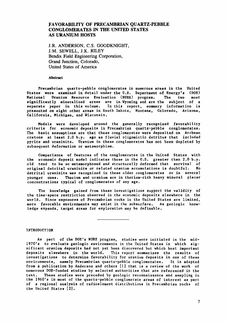
FAVORABILITY OF PRECAMBRIAN QUARTZ-PEBBLECONGLOMERATES IN THE UNITED STATESAS URANIUM HOSTS
J.R. ANDERSON, C.S. GOODKNIGHT,J.M. SEWELL, J.K. RILEYBendix Field Engineering Corporation,Grand Junction, Colorado,United States of America
Abstract
Precambrian quartz-pebble conglomerates in numerous areas in the UnitedStates were examined in detail under the U.S. Department of Energy's (DOE)National Uranium Resource Evaluation (NURE) program. The two mostsignificantly mineralized areas are in Wyoming and are the subject of aseparate paper in this volume. In this report, summary information ispresented on eight other areas in South Dakota, Montana, Colorado, Arizona,California, Michigan, and Wisconsin.
Models were developed around the generally recognized favorabilitycriteria for economic deposits in Precambrian quartz-pebble conglomerates.The basic assumptions are that these conglomerates were deposited on Archeancratons at least 2.0 b.y. ago as fluvial oligomictic detritus that includedpyrite and uraninite. Uranium in these conglomerates has not been depleted bysubsequent deformation or metamorphism.
Comparisons of features of the conglomerates in the United States withthe economic deposit model indicates those in the U.S. greater than 2.0 b.y.old tend to be so metamorphosed and structurally deformed that survival oforiginal detrital uraninite or related uranium accumulations is doubtful. Nodetrital uraninite was recognized in these older conglomerates or in severalyounger ones. Thorium and uranium are in thorium-rich heavy mineral placerconcentrations typical of conglomerates of any age.
The knowledge gained from these investigations support the validity ofthe time-space restriction observed in the economic deposits elsewhere in theworld. Since exposures of Precambrian rocks in the United States are limited,more favorable environments may exist in the subsurface. As geologic know-ledge expands, target areas for exploration may be definable.
INTRODUCTION
As part of the DOE's NURE program, studies were initiated in the mid-1970's to evaluate geologic environments in the United States in which sig-nificant uranium deposits had not yet been discovered but which host importantdeposits elsewhere in the world. This report summarizes the results ofinvestigations to determine favorability for uranium deposits in one of theseenvironments, namely Precambrian quartz-pebble conglomerates. It is adaptedfrom a publication by Anderson and others [1] that is a review of the work ofnumerous DOE-funded studies by selected authorities that are referenced in thetext. These studies were preceded by geologic reconnaissance and sampling inthe 1960's in most of the quartz-pebble conglomerate areas of interest as partof a regional analysis of radioélément distributions in Precambrian rocks ofthe United States [2].
The methods used in the studies for this report included geologic map-ping, radiometric surveying, examining and describing outcrops, sampling forgeochemical and pétrographie analyses, and interpreting results in terms offavorability for uranium. Drilling was conducted in two areas to provideinformation on the subsurface extent and uranium content of conglomerate hostrocks.
Precambrian uraniferous quartz-pebble conglomerate is a specific type ofplacer uranium deposit with geologic characteristics whose presence defines afavorable environment. For instance, establishing the presence or clearindication of the former presence of uraninite as the chief uranium mineral iscritical in evaluating the favorability of the environment of deposition. Aclear distinction must be made between oligomictic, uraniferous quartz-pebbleconglomerates that contain economic uraninite paleoplacer deposits, and theuneconomic monazite- and zircon-rich placers [3] that also, and far morecommonly, occur in conglomeratic rocks.
Time terminology used in this report is as follows:
middle Proterozoic 1.8 to 1.0 b.y.early Proterozoic 2.5 to 1.8 b.y.Archean older than 2.5 b.y.
CRITERIA AND MODELS
For economic concentrations of uranium to accumulate in quartz-pebbleconglomerates, proper time, source-rock, depositional-environment, andpreservation conditions must be met. These conditions have been incorporatedin genetic models by Houston and Karlstrom [4] and Button and Adams [5], andare used in a report by Karlstrom and others [6, 7]. Houston and Karlstrom[4] researched the Precambrian conglomerate deposits of the world and the morepromising Precambrian terranes in the United States, and developed a geneticmodel to use for comparitive purposes. Button and Adams [5] synthesized thedata available for uraniferous quartz-pebble conglomerates and establishedrecognition criteria useful in predicting the presence or absence of deposits.They emphasized the weighting of criteria to provide a basis for comparisons,rankings, and decision making and ranked the two most promising U.S. areas,the Medicine Bow Mountains in Wyoming and the Black Hills in South Dakota,relative to the Elliot Lake uranium district. Karlstrom and others [6, 7]provided a summarized comparison of southeastern Wyoming conglomerates withthe Houston-Karlstrom genetic model.
The simplified listing of general criteria in Table 1 was applied forbasic screening of all Precambrian quartz-pebble conglomerates now recognizedin the United States. Information generally is not yet adequate for detailedscreening. Comments regarding the selected recognition criteria in Table 1follow.
Economically significant uraniferous conglomerates have formed throughmechanical concentration in basins between 2.0 and 3.2 b.y. old on anArchean craton. This time-spece criterion is essential, but othercriteria must be met [4, 5].It is not essential that the presence of uraniferous granitic sourcerocks be confirmed, however, geologic inference of their existence as asource of detritus for conglomerates is essential.
The presence of truly oligomictic, fluvial conglomerates is crucial asit indicates reworking of the sediments and associated detritaluraninite essential for placer uranium concentration has occurred.
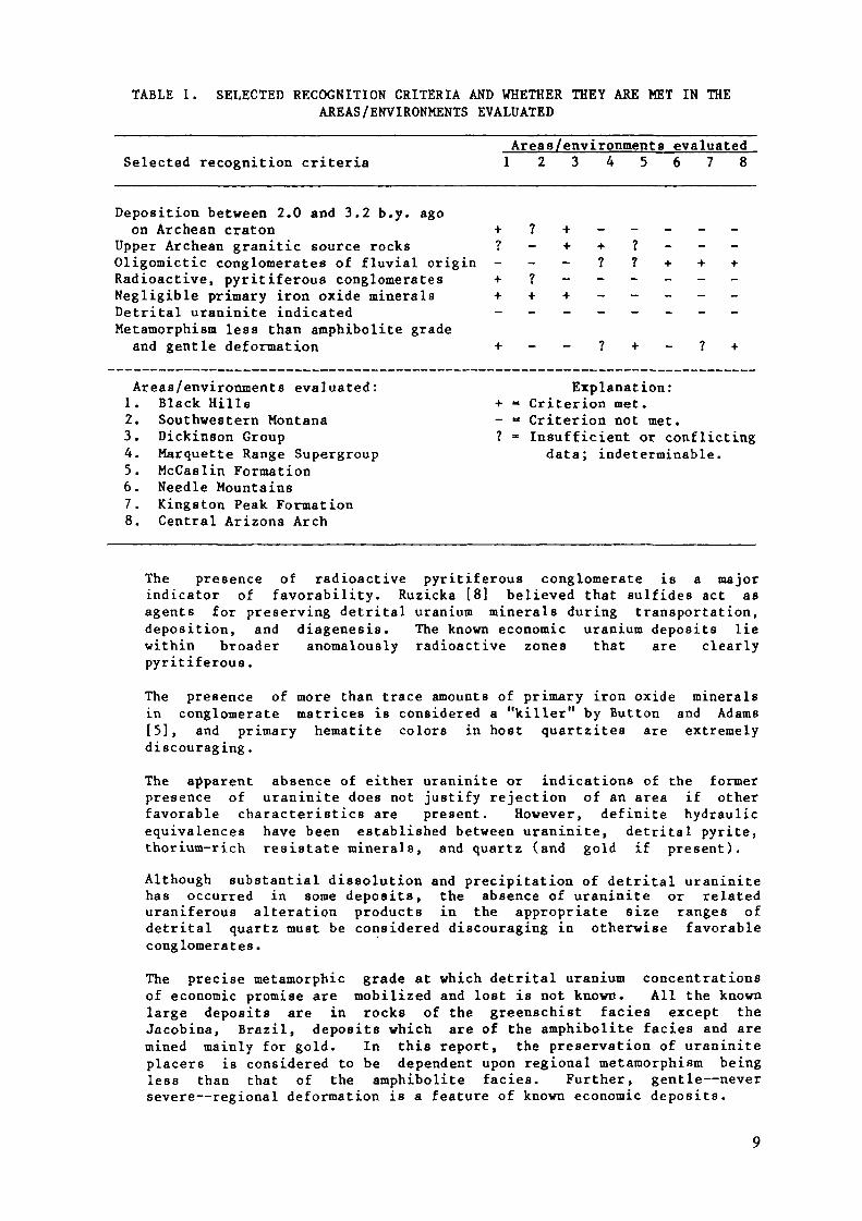
TABLE 1. SELECTED RECOGNITION CRITERIA AND WHETHER THEY ARE MET IN THEAREAS/ENVIRONMENTS EVALUATED
Selected recognition criteriaAreas/environments evaluated1 2 3 4 5 6 7 8
Deposition between 2.0 and 3.2 b.y. agoon Archean craton + ? + - -
Upper Archean granitic source rocks ? - + + ?Oligomictic conglomerates of fluvial origin - - - ? ?Radioactive, pyritiferous conglomerates + ? -Negligible primary iron oxide minerals + + +Detrital uraninite indicated - - - - -Metamorphism less than amphibolite grade
and gentle deformation + - - ? +
Areas/environments evaluated:1. Black Hills2. Southwestern Montana3. Dickinson Group4. Marquette Range Supergroup5. McCaslin Formation6. Needle Mountains7. Kingston Peak Formation8. Central Arizona Arch
Explanation:+ » Criterion met.- = Criterion not met.? = Insufficient or conflicting
data; indeterminable.
The presence of radioactive pyritiferous conglomerate is a majorindicator of favorability. Ruzicka [8] believed that sulfides act asagents for preserving detrital uranium minerals during transportation,deposition, and diagenesis. The known economic uranium deposits liewithin broader anomalously radioactive zones that are clearlypyritiferous.
The presence of more than trace amounts of primary iron oxide mineralsin conglomerate matrices is considered a "killer" by Button and Adams[5], and primary hematite colors in host quartzites are extremelydiscouraging.The apparent absence of either uraninite or indications of the formerpresence of uraninite does not justify rejection of an area if otherfavorable characteristics are present. However, definite hydraulicequivalences have been established between uraninite, detrital pyrite,thorium-rich resistate minerals, and quartz (and gold if present).Although substantial dissolution and precipitation of detrital uraninitehas occurred in some deposits, the absence of uraninite or relateduraniferous alteration products in the appropriate size ranges ofdetrital quartz must be considered discouraging in otherwise favorableconglomerates.The precise metamorphic grade at which detrital uranium concentrationsof economic promise are mobilized and lost is not known. All the knownlarge deposits are in rocks of the greenschist faciès except theJacobina, Brazil, deposits which are of the amphibolite faciès and aremined mainly for gold. In this report, the preservation of uraniniteplacers is considered to be dependent upon regional metamorphism beingless than that of the amphibolite faciès. Further, gentle—neversevere—regional deformation is a feature of known economic deposits.
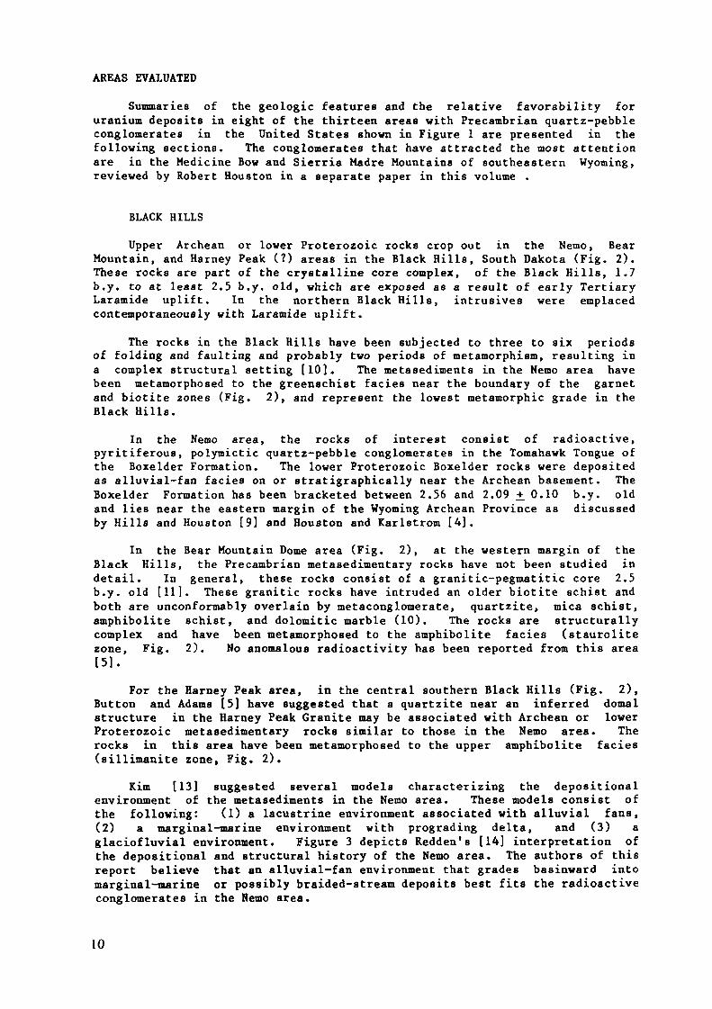
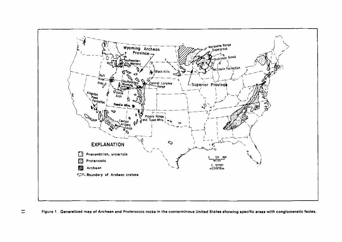
AREAS EVALUATED
Summaries of the geologic features and the relative favorability foruranium deposits in eight of the thirteen areas with Precambrian quartz-pebbleconglomerates in the United States shown in Figure 1 are presented in thefollowing sections. The conglomerates that have attracted the most attentionare in the Medicine Bow and Sierria Madre Mountains of southeastern Wyoming,reviewed by Robert Houston in a separate paper in this volume .
BLACK HILLS
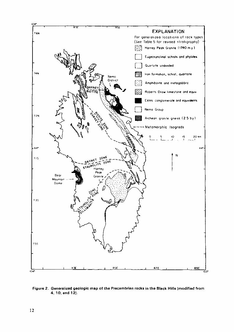
Upper Archean or lower Proterozoic rocks crop out in the Nemo, BearMountain, and Harney Peak (?) areas in the Black Hills, South Dakota (Fig. 2).These rocks are part of the crystalline core complex, of the Black Hills, 1.7b.y. to at least 2.5 b.y. old, which are exposed as a result of early TertiaryLaramide uplift. In the northern Black Hills, intrusives were emplacedcontemporaneously with Laramide uplift.
The rocks in the Black Rills have been subjected to three to six periodsof folding and faulting and probably two periods of metamorphism, resulting ina complex structural setting [10]. The metasediments in the Nemo area havebeen metamorphosed to the greenschist faciès near the boundary of the garnetand biotite zones (Fig. 2), and represent the lowest metamorphic grade in theBlack Hills.
In the Nemo area, the rocks of interest consist of radioactive,pyritiferous, polymictic quartz-pebble conglomerates in the Tomahawk Tongue ofthe Boxelder Formation. The lower Proterozoic Boxelder rocks were depositedas alluvial-fan faciès on or stratigraphically near the Archean basement. TheBoxelder Formation has been bracketed between 2.56 and 2.09 +_ 0.10 b.y. oldand lies near the eastern margin of the Wyoming Archean Province as discussedby Hills and Houston [9] and Houston and Karlstrom [4].
In the Bear Mountain Dome area (Fig. 2), at the western margin of theBlack Hills, the Precambrian metasedimentary rocks have not been studied indetail. In general, these rocks consist of a granitic-pegmatitic core 2.5b.y. old [11]. These granitic rocks have intruded an older biotite schist andboth are unconformably overlain by metaconglomerate, quartzite, mica schist,amphibolite schist, and dolomitic marble (10). The rocks are structurallycomplex and have been metamorphosed to the amphibolite faciès (staurolitezone, Fig. 2). No anomalous radioactivity has been reported from this area[5].
For the Harney Peak area, in the central southern Black Hills (Fig. 2),Button and Adams [5] have suggested that a quartzite near an inferred domalstructure in the Harney Peak Granite may be associated with Archean or lowerProterozoic metasedimentary rocks similar to those in the Nemo area. Therocks in this area have been metamorphosed to the upper amphibolite faciès(sillimanite zone, Fig. 2).
Kirn [13] suggested several models characterizing the depositionalenvironment of the metasediments in the Nemo area. These models consist ofthe following: (1) a lacustrine environment associated with alluvial fans,(2) a marginal-marine environment with prograding delta, and (3) aglaciofluvial environment. Figure 3 depicts Redden*s [14] interpretation ofthe depositional and structural history of the Nemo area. The authors of thisreport believe that an alluvial-fan environment that grades basinward intomarginal-marine or possibly braided-stream deposits best fits the radioactiveconglomerates in the Nemo area.
10
Wyoming Archeanf Province
Central Lorami«
EXPLANATION
Precambrian, uncertain
3 Pfoterozoic
Archean
T-^- Boundary of Archtan craton«
Figure 1. Generalized map of Archean and Proterozoic rocks in the conterminous United States showing specific areas with conglomeratic faciès.
104*«JE
T6KI
T4N
T Z N
1 IS
TiS
EXPLANATIONFor generalized locat ions of rock types(See Table 5 for revised stratigraphy) •[v'i;] Homey Peak Granite ( i 7 4 0 m y )
I__I Eugeosynclmal schists and phyllites
I__j Quortzite undivided
Iron formation, schist, quortzite
'.;.;',j Amprtibolite and metogobbro
Roberts Draw limestone and equiv
Estes conglomerate and equivalents
Nemo Group
Archean granite gneiss (2 5 by)
— — —Metamorphic Isograds
0 5 10 15 20 krr
1 N
BearMounfoin —
Dôme
R9E103-
Figure 2. Generalized geologic map of the Précambrien rocks in the Black Hills (modified from4. 10, and 12).
12

.-V SRE ENWOOp TON6UULTRA-MAFIC
TACONITE
OLDER METAMORPHIC ROCKS
TOMAHAWK TONGUE
BBENCHMARK IRON FORMATION^
30XELDERO U A R T Z I T E
E A S T
Figure 3. Diagrammatic sedimentation and structural sequence. Nemo area (from Redden, 14).
The presence of quartzite pebbles containing rounded detrital quartzgrains and blue quartz, probably vein quartz, indicates a sedimentary and anigneous source for the conglomerates. Therefore, the Nemo conglomerates arenot truly oligomictic. The quartz-pebble conglomerates of the Elliot Lake andWitwatersrand deposits have been described as oligomictic by many workers [4].Because detrital uraninite is associated with an igneous provenance, it isimportant that the conglomerates in question be dominated by clasts from anigneous source. This is not the case in the Nemo area, where, according toRedden1s [14] core descriptions, the quartzite pebbles constitute the majorityof clasts in the drilled sections.
As mentioned before, the sediments in the Nemo area have beenmetamorphosed to the upper greenschist faciès, the lowest metamorphic grade inthe Black Hills. Alteration products, such as fuchsite after detritalchromite and TiC>2 pseudomorphs after ilmenite(T), have been described byRedden [14]. However, the most important alteration mineral probably isuranothorite, tentatively identified petrographically by Kim [13] in aconglomerate matrix. The euhedral character of the uranothorite within thematrix of rounded detrital grains clearly indicates a postdepositional origin,possibly during metamorphism, for the uranothorite. Ortlepp [15] hasdescribed the in-situ alteration of uraninite to uranothorite in thePrecambrian metasediments of the Dominion Reef area. This alteration processinvolves the replacement of thorium-rich uraninite by siliceous solutions andmay involve the loss of some uranium. This process may have taken place inthe Nemo area conglomerates. The combination of a poor sorting mechanism forconcentrating detrital uraninite and postdepositional alteration of anydetrial uraninite that was present in the Nemo quartz-pebble conglomeratescould account for the low uranium content in Redden's core samples (Table 2).This may also account for the difficulty that Kim and Redden had inidentifying any uranium minerals.
TABLE 2. ANALYSES OF DRILL CORE FROM THE TOMAHAWK TONGUE CONGLOMERATEIN THE NEMO AREA, BLACK HILLS (FROM REDDEN, 13)
Hole number
22233333444
Interval
397-400404-415421-430248-254255-259336-353435-442543-548235-246320-335339-343
Core length(ft)
3119641775
11154
Weighted Ücontent (ppm)
555559122404054655076100
Weighted Thcontent (ppm)
611264516699671059210010729
The Precambrian rocks of the Black Hills exhibit several general char-acteristics considered by Houston and Karlstrom [4] and Button and Adams [5]to be favorable for uraniferous quartz-pebble conglomerates. These char-acteristics include: (1) an Archean craton tectonic setting, (2) an agebetween 2.1 and 2.5 b.y., and (3) a radioactive, pyritiferous clastic hostrock. The results of field investigations in the Nemo area by Kim [13] and
14
Redden [14] revealed several negative factors: (1) a proposed deposi.ti.onalenvironment that did not include the hydrologie regime necessary toconcentrate placer uranium, (2) the existence of more than one provenance, (3)unfavorably high metamorphic grade, and (4) the general absence of uraniumconcentrations above 100 pptn. In the Bear Mountain and Harney Peak areas, themetamorphic grade is unfavorably high, reaching that of the amphibolite faciès[10].
An unfavorable ranking of the Black Hills environments applies only tothose rocks in the Nemo, Bear Mountain, and Harney Peak areas. Button andAdams [5] have suggested that other conglomerates may exist at a lowerstratigraphie level or to the northeast under Paleozoic cover.
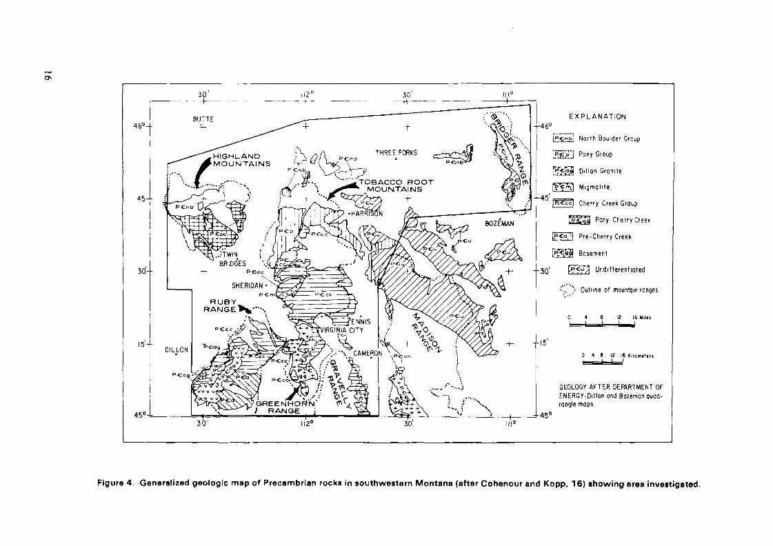
SOUTHWESTERN MONTANA
Archean and Proterozoic supracrustal metasedimentary rocks crop out insouthwestern Montana in the tobacco Root Mountains, southern HighlandMountains, Ruby Range, Greenhorn Range, northern part of the Gravelly Range,northern edge of the Madison Range, and several fault blocks along theJefferson River (Fig. 4). These rocks were deposited near the northwesternmargin of the Wyoming Archean Province craton (Fig. 1).
A generalized Precambrian stratigraphie and age sequence for south-western Montana is given in Table 3. Quartz-pebble conglomerates, oreven quartzites, are not abundant in these Archean and Proterozoic rocks. TheLaHood Formation of the North Boulder Group, exposed in tectonic blocks alongthe Jefferson River, is part of the Belt Supergroup and contains coarsearkoses and conglomerates interpreted as having been deposited in a deltaic orbraided-stream environment [16]. Rocks of the Cherry Creek Group consistmainly of quartzofeldspathic gneiss, but siliceous and dolomitic marbles, ironformations, calc-silicates, and quartzites also characterize the group.Conglomeratic zones occur in the quartzites; however, they are poorlydeveloped and, at best, may be classified as fine-pebble arkosic paraconglom-erates.
The deltaic or braided-stream sediments of the LaHood Formation, a partof the Belt Supergroup of middle Proterozic age, were deposited in anoxidizing environment [17]. Conglomerates of the LaHood Formation are assumedto be too young to host placer uranium deposits.
Archean or lower Proterozoic conglomeratic rocks in southwestern Montanaare known only in quartzites in the Cherry Creek Group. Some clast-bearingconglomeratic zones are present in the Cherry Creek Group but no clast-supported rocks have been identified. The Archean Cherry Creek Group rockswere deposited on the margin of the Wyoming Archean Province craton in acontinental shelf or miogeosynclinal environment. The shallow-marine environ-ment was characterized by widespread deltas that had frequent influxes ofclastic sediments, shales, siltstones, and feldspathic sandstones, alternatingwith carbonate deposition [18]. Cohenour and Kopp [16] found no evidence thatthe radioactive quartzites in the Cherry £reek Group were deposited inchannels or other fluvial environments. They concluded that the most likelydepositional environment for these middle Archean rocks was barrier bar.
James and Hedge [18] dated the formation of the Cherry Creek rocks atabout 3.1 b.y. ago, based on regression of strontium-87-to-strontium-86 ratiosto typical mantle values. Mineralogie and element studies of the quartzitesof the Cherry Creek by Cohenour and Kopp [16] suggest that they had two sourceareas: a granitic terrane that included pegmatites containing uranium andthorium and a gabbro-pyroxenite terrane containing titanomagnetite bodies.
15
0\
46°-
HIGHLANDMOUNTAINS
TOBACCO ROOTMOUNTAINS
E X P L A N A T I O N
Nor th Boulder Group
Pony Group
Dillon Grani te
Migmot i te
Cherry Creek Groi^p
P o n y - C h e r r y C r e e K
P r e - C h e r r y Creek
Basement
Undifferentiated
"... '': Outline of mountain ranges
0 4 8 1 2 1 6 M M »i ]_____i__i
0 4 e 12 16 Ki iomtlm
GEOLOGY AFTER DEPARTMENT OFENERGY-Dillon and Bo2emon quad-rangle mops
30 30 III0
Figure 4. Generalized geologic map of Precambrian rocks in southwestern Montana (after Cohenour and Kopp, 16) showing area investigated.
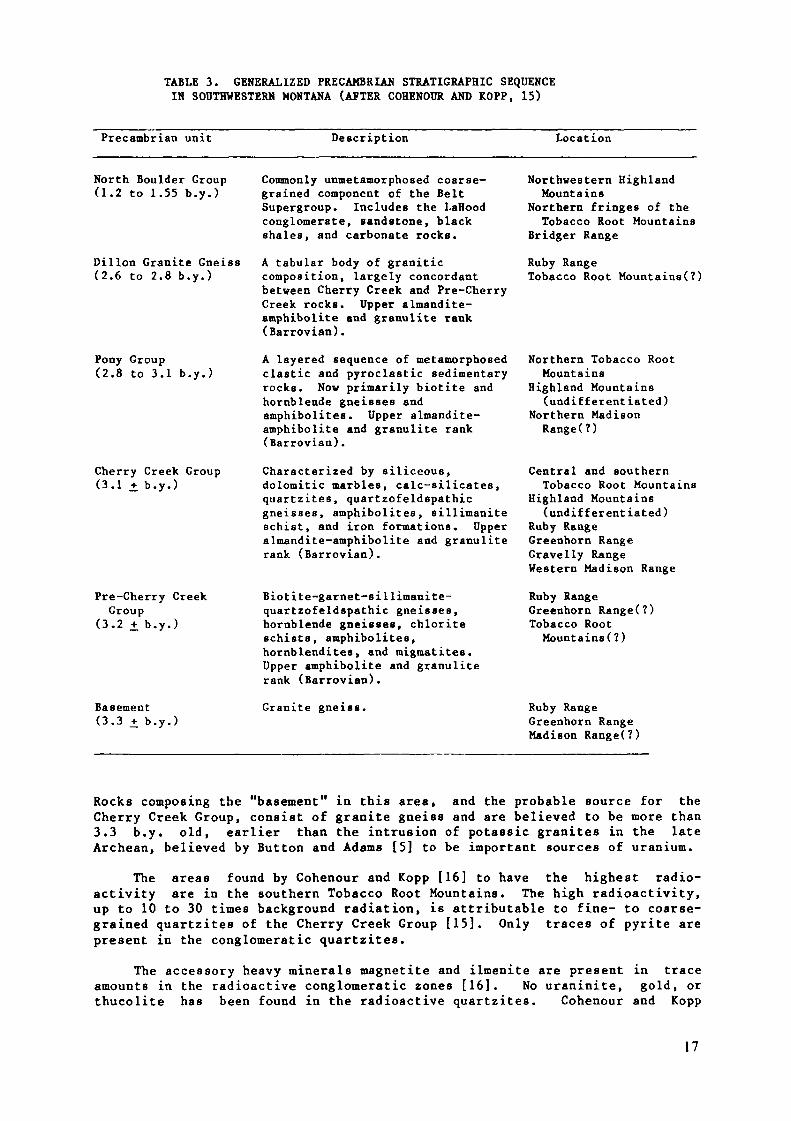
TABLE 3. GENERALIZED PRECAMBRIAN STRATIGRAPHIC SEQUENCEIN SOUTHWESTERN MONTANA (AFTER COHENOUR AND KOPP, 15)
Precambrian unit Description Location
North Boulder Group(1.2 to 1.55 b.y.)
Dillon Granité Gneiss(2.6 to 2.8 b.y.)
Pony Group(2.8 to 3.1 b.y.)
Cherry Creek Group(3.1 ± b.y.)
Pré-Cherry CreekGroup
(3.2 jf b.y.)
Basement(3.3 ± b.y.)
Commonly unmetamorphosed coarse-grained component of the BeltSupergroup. Includes the LaHoodconglomerate, sandstone, blackshales, and carbonate rocks.A tabular body of graniticcomposition, largely concordantbetween Cherry Creek and Pre-CherryCreek rocks, upper almandite-amphibolite and granulite rank(Harrovian).A layered sequence of metamorphosedclastic and pyroclastic sedimentaryrocks. Now primarily biotite andhornblende gneisses andamphibolites. Upper almandite-amphibolite and granulite rank(Harrovian).
Characterized by siliceous,dolomitic marbles, calc-silicates,quartzites, quartzofeldspathicgneisses, amphibolites, sillimaniteschist, and iron formations. Upperalmandite-amphibolite and granuliterank (Barrovian).
Biotite-garnet-sillimanite-quartzofeldspathic gneisses,hornblende gneisses, chloriteschists, amphibolites,hornblendites, and migmatites.Upper amphibolite and granuliterank (Barrovian).
Granite gneiss.
Northwestern HighlandMountains
Northern fringes of theTobacco Root Mountains
Bridger Range
Ruby RangeTobacco Root Mountains(î)
Northern Tobacco RootMountains
Highland Mountains(undifferentiated)
Northern MadisonRange(?)
Central and southernTobacco Root Mountains
Highland Mountains(undifferentiated)
Ruby RangeGreenhorn RangeGravelly RangeWestern Madison Range
Ruby RangeGreenhorn Range(?)Tobacco RootMountains (?)
Ruby RangeGreenhorn RangeMadison RangeO)
Rocks composing the "basement" in this area, and the probable source for theCherry Creek Group, consist of granite gneiss and are believed to be more than3.3 b.y. old, earlier than the intrusion of potaesic granites in the lateArchean, believed by Button and Adams [5] to be important sources of uranium.
The areas found by Cohenour and Kopp [16] to have the highest radio-activity are in the southern Tobacco Root Mountains. The high radioactivity,up to 10 to 30 times background radiation, is attributable to fine- to coarse-grained quartzites of the Cherry Creek Group [15]. Only traces of pyrite arepresent in the conglomeratic quartzites.
The accessory heavy minerals magnetite and ilmenite are present in traceamounts in the radioactive conglomeratic zones [16], No uraninite, gold, orthucolite has been found in the radioactive quartzitea. Cohenour and Ropp
17

[16] believed that the anomalous radioactivity was attributable to cheralite,a variety of monazite. Cheralite is in rounded to subrounded, detrital grainsthat are stratabound and commonly associated with graded bedding or cross-bedded strata; the greatest concentration of this mineral, much less than 1Zof the rock is where the quartzites contain a few pebbles of quartz and inzones where iron oxide minerals occur.
The high degree of metamorphism and several periods of intense deform-ation have obscured the relationship of the radioactive quartzites tounconformitites within the Cherry Creek Group. The rocks underwentdynamothennal metamorphism, dominantly upper amphibolite grade, about 2.75b.y. ago [19].
The Archean and Proterozoic metasedimentary rocks in southwestern Montanaare considered unfavorable for uranium deposits in Precambrian quartz-pebbleconglomerate. The braided-stream depositional environment of the LaHoodFormation [16] was formed in an unfavorable oxidizing environment during themiddle Proterozoic. Although the conglomeratic rocks of the Cherry CreekGroup were deposited on an Archean craton margin and the rocks are old enoughto have been deposited in an oxygen-poor environment, no clast-supported"true" conglomerates are known, the rocks were deposited prior to intrusion ofupper Archean potassic granites (sources of uranium), and they underwent upperamphibolite-grade metamorphism. The radioactive quartzites show no evidenceof being deposited in a fluvial environment and their radioactivity isattributable to weak placer accumulations of cheralite, a member of thethorium-rich monazite group.
DICKINSON GROUP
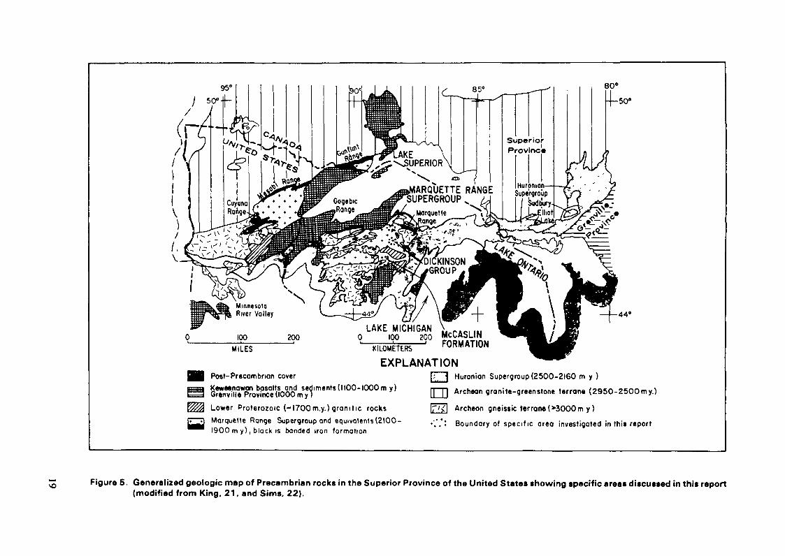
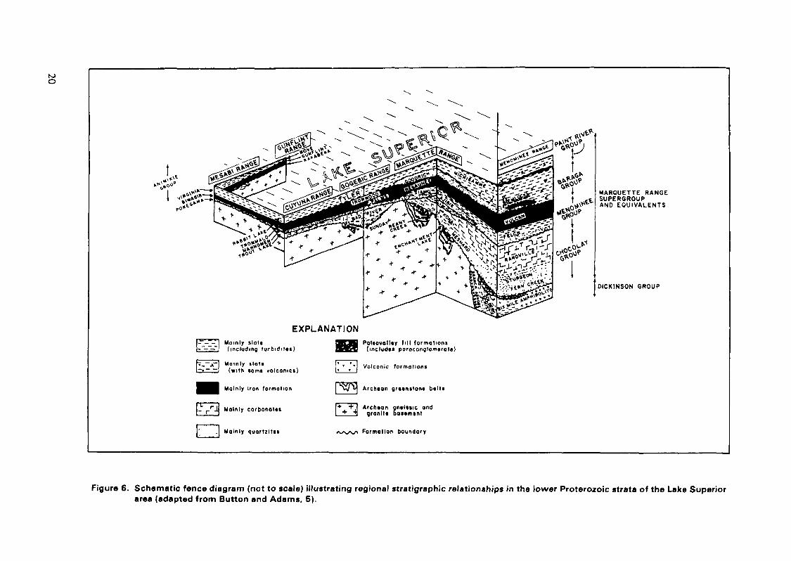
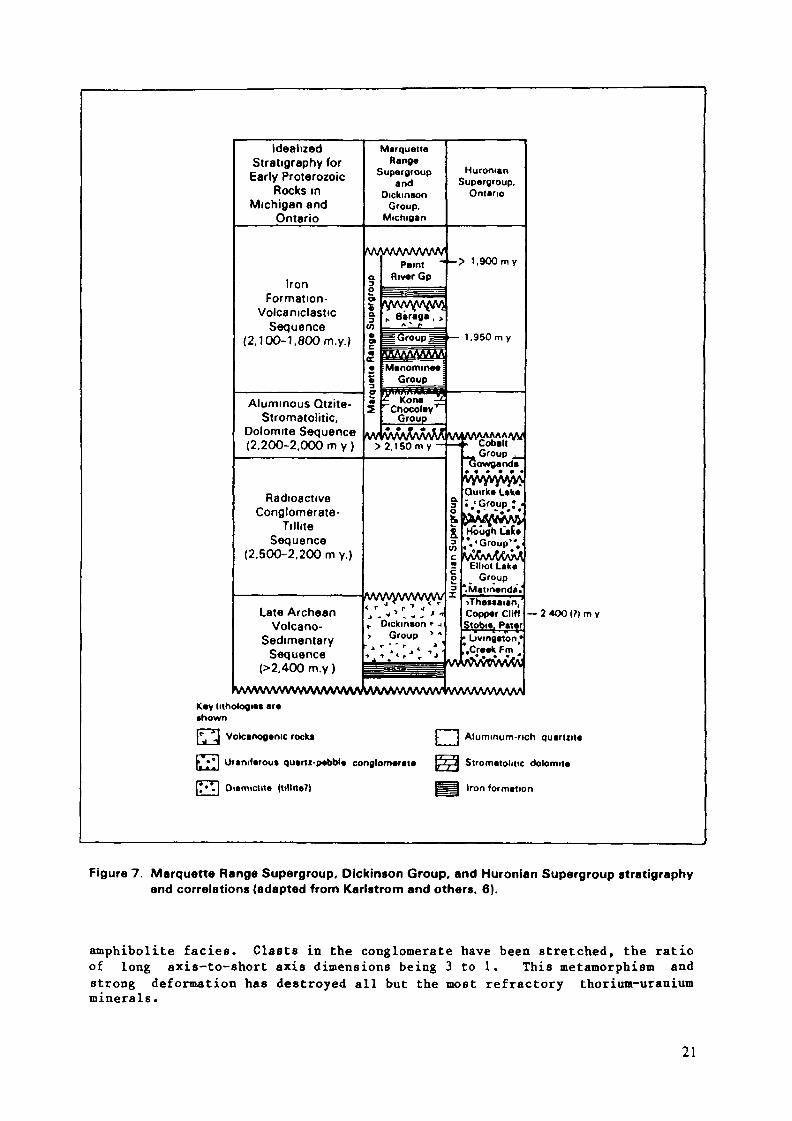
Most of the Proterozoic Marquette Range Supergroup between Lake Superiorand Lake Michigan is underlain by Archean gneiss, granite, and greenstone;however, in Iron and Dickinson Counties, Michigan, the supergroup is underlainby a poorly exposed sedimentary-volcanic sequence, the Dickinson Group (Fig.5)[20]. The group, about 3 to 4 km thick, overlies basement gneisses and isdivided into three units which are, from oldest to youngest, the East BranchArkose, the Solberg Schist, and the Six Mile Amphibolite. The Dickinson Groupis probably late Archean because it unconformably underlies the MarquetteRange Supergroup, and radiometric dates of associated rocks suggest an Archeanage. Regional stratigraphie relationships are illustrated in Figures 6 and 7.
The East Branch Arkose is mainly arkose interbedded with conglomerate andvolcanic flows and tuffs. The Solberg Schist is probably sedimentary andvolcanic and includes biotite, hornblende, and quartz-mica schists with a thiniron-formation member. The youngest unit, a hornblende-plagioclase basalticrock, is the Six Mile Amphibolite. Other nearby rocks considered to be in theDickinson Group are quartz-sericite-magnetite schists, felsites, and green-schists that were originally intermediate and silicic lavas and pyroclastics.
The Dickinson Group sediments probably are late Archean and overlie anuncon formity above Archean cratonic rocks. Possible source rocks fordetrital uranium minerals are present in the area [23, 24]. The East BranchArkose may be a fluvial deposit and contains beds of conglomerate 3 to 10 mthick. These favorable factors are considered to be outweighed by thenegative factors that follow. The conglomerates are polymictic and containclasts of quartzite, granite gneiss, slate, schist, and vein quartz. Thenature of the rocks indicates the conglomerates were deposited in a localbasin, and little or no reworking and reconcentration of placer minerals tookplace. Pyritiferous radioactive conglomerates have not been reported. Therocks have been metamorphosed to various degrees but are commonly of the
18
SuperiorProvinceKE
^SUPERIOR
HurpmonSupergroup
SudtJury.Iliot
r ARQUETTE RANGESUPERGROUP _
MinnesotaRiver Valley
50»
44°
100MILES
Post-Precambnan coverEXPLANATION
fc j Huronion Supergroup (2500-2160 m y )
O Archeon granite-greenstone (erroné (2950-2500my.)
E%%! Lower Proterozoic (~l700m.y.) granit ic rocks |p<| Archean gneissic terror«(»3000m y )f^l Marquette Range Supergroup and equivalents(2IOO- .•;;. Boundary of specif,c area investigated in this report
1900 m y), black is banded iron formation
~ Figure 5. Generalized geologic map of Précambrien rocks in the Superior Province of the United States showing specific areas discussed in this report(modified from King, 21, and Sims, 22).
K»O
EXPLANATION(----- I Momly Holtl-~-~-~l (including, turbidit»i)
7_~jCH Mainly lloti•~»~ ~' (with »omt volcanici)
Mainly Iron formation
Mainly carbonaKt
. Mainly quartzltti
Pol«ovall«y fill formation»(include* paraconglomerote)
Volcanic formations
Archian grttniton« b*ltt
Arehean gncliiic andgranit« DOMmint
Formation boundary
MARQUETTE RANGESUPERGROUPAND EQUIVALENTS
OICKINSON GROUP
Figure 6. Schematic fence diagram (not to scale) illustrating regional stratigraphie relationships in the lower Proterozoic strata of the Lake Superiorarea (adapted from Button and Adams, 5).
IdealizedStratigraphy forEarly Proterozoic
Rocks inMichigan and
Ontario
IronFormation-
VolcaniclasticSequence
(2, 100-1, 800 m.y.)
Aluminous Qtzite-Stromatolitic,
Dolomite Sequence(2,200-2,000 m y )
RadioactiveConglomerate-
TilliteSequence
(2,500-2,200 m y.)
Late ArcheanVolcano-
SedimentarySequence
(>2,400 m.y )
MarquetteRange
Supergroupand
DickinsonGroup,
Michigan
fW/WWWVWPaint -
a River Gp0 =at ~
% „ Birag« , >to A- f ——
• Menommee• Group ;3 ^^^- , - \ 'v 'y'tivirtAAAamÄ5 C. Kona^E2 '"Chocolay' "
Group
w vvwWv\W> 2,1 50 m y -
wwywvwvy
r Dickinson <• j> Group * *
HuronianSupergroup.
Ontario
-> 1,900my
— 1.950 m y
VAAAAAAAAAAA/:-i -Cobal t
Group .Gowganda
vyvryvyvyjAQuirk« Lake
o ijjjiv:?^r£ Hough Let«
*c yvCvA/OOvî^| Elliot Lakeo Group^ *<Matmenda.
>TheMaian, 'Copper CliffStobie, Pater• Livingalon«".Creek F m e
VVVVVWVVVVVVVVVVVVVVVVVVVVVWVVirvVW\/\rVWvV\l
Key lithologie* are
— 2 4OO (?) m y
•hown
|*^ ' Volcanogenic rock* [; ) Aluminum-rich quartut«
jj ^J Uranrterou* quartz-pebble conglomerate ^'j\ Stromatolitic dolomite
[*»*.] Oiamiclit« (ttlltte?) Iron formation
Figure 7. Marquette Range Supergroup, Dickinson Group, and Huronian Supergroup stratigraphyand correlations (adapted from Karlstrom and others. 6).
amphibolite faciès. Clasts in the conglomerate have been stretched, the ratioof long axis-to-ahort axis dimensions being 3 to 1. This metamorphism andstrong deformation has destroyed all but the most refractory thorium-uraniumminerals.
21
The Dickinson Group metasedimentary rocks indicate that the Lake Superiorregion is not totally devoid of such rocks within favorable Precambrianquartz-pebble conglomerate age constraints. Also, the source of the conglom-erate is an Archean craton that includes uraniferous granitic rocks.
As for negative factors, the known conglomerates of the Dickinson Groupare polymictic and were deposited in a local basin. Oligomictic, well-worked,fluvial conglomerates in a continental-shallow marine setting are not nowindicated. Also, any original placer uranium oxide minerals may not havesurvived the severe metamorphism and deformation.
More favorable quartz-pebble conglomerate environments may be presentelsewhere in Michigan under Paleozoic or other cover.
MARQUETTE RANGE SUPERGROUP
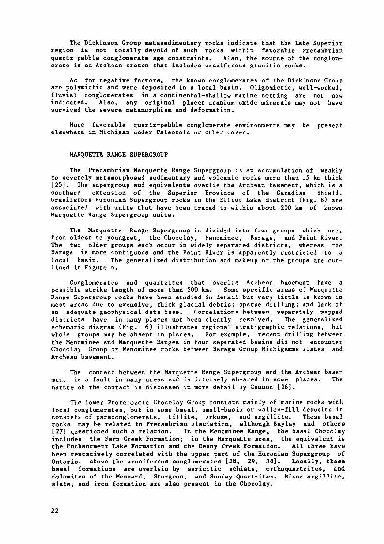
The Precambrian Marquette Range Supergroup is an accumulation of weaklyto severely metamorphosed sedimentary and volcanic rocks more than 15 km thick[25]. The supergroup and equivalents overlie the Archean basement, which is asouthern extension of the Superior Province of the Canadian Shield.Uraniferous Euronian Supergroup rocks in the Elliot Lake district (Fig. 8) areassociated with units that have been traced to within about 200 km of knownMarquette Range Supergroup units.
The Marquette Range Supergroup is divided into four groups which are,from oldest to youngest, the Chocolay, Menominee, Baraga, and Paint River.The two older groups each occur in widely separated districts, whereas theBaraga is more contiguous and the Paint River ie apparently restricted to alocal basin. The generalized distribution and makeup of the groups are out-lined in Figure 6.
Conglomerates and quartzites that overlie Archean basement have apossible strike length of more than 500 km. Some specific areas of MarquetteRange Supergroup rocks have been studied in detail but very little is known inmost areas due to exensive, thick glacial debris; sparse drilling; and lack ofan adequate geophysical data base. Correlations between separately mappeddistricts have in many places not been clearly resolved. The generalizedschematic diagram (Fig. 6) illustrates regional stratigraphie relations, butwhole groups may be absent in places. For example, recent drilling betweenthe Menominee and Marquette Ranges in four separated basins did not encounterChocolay Group or Menominee rocks between Baraga Group Michigamme slates andArchean basement.
The contact between the Marquette Range Supergroup and the Archean base-ment is a fault in many areas and is intensely sheared in some places. Thenature of the contact is discussed in more detail by Cannon [26].
The lower Proterozoic Chocolay Group consists mainly of marine rocks withlocal conglomerates, but in some basal, small-basin or valley-fill deposits itconsists of paraconglomerate, tillite, arkose, and argillite. These basalrocks may be related to Precambrian glaciation, although Bayley and others[27] questioned such a relation. In the Menominee Range, the basal Chocolayincludes the Fern Creek Formation; in the Marquette area, the equivalent isthe Enchantment Lake Formation and the Reany Creek Formation. All three havebeen tentatively correlated with the upper part of the Huronian Supergroup ofOntario, above the uraniferous conglomerates [28, 29, 30]. Locally, thesebasal formations are overlain by sericitic schists, orthoquartzites, anddolomites of the Mesnard, Sturgeon, and Sunday Quartzites. Minor argillite,slate, and iron formation are also present in the Chocolay.
22
\
EXPLANATIONMarquette Range Supergroup
Huronion Supergroup
Other Précambrien rock»
° °J Paleozoic rocks
toOJ
Figure 8 Geologic map of Précambrien rocks showing generalized limits of the Elliot Lake district and the Marquette Range Supergroup andHuroman Supergroup (adapted from King, 21).
The marine Menominee Group unconformably overlies the Chocolay or theArchean basement. The youngest rocks of the Menominee Group include the majoriron formations of Michigan.
The Baraga Group is a thick eugeosynclinal assemblage of graywacke,shale, iron formation, and volcanic rocks. In the Marquette area, the Good-rich Quartzite of the Baraga overlies Menominee Group iron formation. Thisquartzite has interlayered conglomerate beds that, grouped together, make upthe most extensive basal conglomerate in the Marquette Range Supergroup. Theyoungest units of the Baraga are the thick slates and grayvackes of theMichigamme and Tyler Formations which cover large areas in northern Michigan.
The youngest member of the supergroup, the Paint River Group, is mostlygraywacke and slate and some iron formation. The member is restricted to arelatively small basin south of the bulk of the metasedimentary rocks.
In general, the northern area of the supergroup is only weakly meta-morphosed to the greenschist faciès. Much higher grade metamorphism,including that of the amphibolite faciès, has been described farther south orassociated with metamorphic "nodes" [22, 31]. Deformation also increases tothe south.
The Marquette Range Supergroup lies on an Archean craton, and Archeangranitic and volcanic rocks that could have been a source for uranium in latersediments are described in numerous reports, including Vickers [23], Malan andSterling [24], and Trow [32].
The youngest elements of the basal Archean rocks have been dated at 2.7b.y. [22], and the maximum intensity of the Penokean orogeny has been dated atabout 1.8 to 1.9 b.y. ago [33]. These ages bracket the supergroup. There areimportant questions regarding the maximum age of the supergroup that are notanswered by available data, but it is indicated that the supergroup isprimarily younger than about 2 b.y. Most geologists who have worked in theregion believe that the rocks are largely younger than the Uuronian Supergroupin Ontario which hosts the Elliot Lake uranium deposits [34].
Exposures of unconformities are rare, and even rarer are exposuresshowing effects of weathering at the base of the Chocolay. Deeply weatheredregoliths in Archean rocks that may have supplied detrital uraninite to basalrocks of the supergroup have not been reported. If the earliest Chocolaydeposits are the result of continental glaciation, regoliths, weathered zones,and possible uraninite and thorium-uranium resistate minerals may have beenremoved by glaciation.
The subbasins below Chocolay marine units include polymictic conglom-erates and graywacke conglomerates (the tillites). Clasts are mostlygranitic, but clasts of other Archean rocks, including gneiss, greenstone,mafic schists, vein quartz, and iron formation, are also reported. The matrixhas been described as commonly chloritic, and the rocks are typically poorlysorted. In general, it appears that all the lower supergroup conglomerates,including these younger than glacially related ones and below the major ironformations, are typically polymictic with granitic and feldspar clasts. Someconglomerates containing pebbles of vein quartz and chert also include clastsof carbonate rocks and granite in an arkosic matrix. No oligomictic pyrite-bearing conglomerates or widespread continental clastic units that mightcontain them have been reported.
The only conglomerates other than those in the Chocolay Group consideredto have any possible uranium potential are those of the Baraga Group. Theconglomerates in the Goodrich Quartzite of the Baraga Group contain monazite-
24
rich placers within quartz-pebble conglomerate in the Palmer area [23], How-ever, the placers are not pyritiferous and no uranium minerals are reported.There is abundant evidence that Baraga Group sediments formed after theatmosphere of Earth was strongly oxidizing.
The basal quartzite formations of supergroup equivalents in Wisconsin andMinnesota were also reviewed for indications of deposition before the adventof significant free atmospheric oxygen. Pink and red colors due todisseminated hematite are fairly common and indicate all associated conglom-erates are unfavorably young. Also, possibly favorable fluvial environmentsare not reported for these quartzites, and nothing known indicates theirpresence.
The matrix of the conglomerates in the local subbasins of the ChocolayGroup is commonly chloritic but varies from quartzitic to arkosic to high ingraywacke. The main minerals include chlorite, sericite, carbonates, quartz,and feldspar. Some basal beds are high in accessory magnetite and other ironoxides. Basal quartzites associated with the conglomerates contain accessorymagnetite, rutile, zircon, and epidote [27]. The magnetite content in thebasal conglomerates is discouraging with regard to the possible presence ofdetrial uraninite because typical uraniferous quartz-pebble conglomerates lackmagnetite.
Déformâtional and metamorphic effects on supergroup rocks are extremelyvariable and, in many areas, probably include destruction of any placeruraninites that might have been present. Button and Adams [5] concluded thatthe northern, less deformed and metamorphosed half of the supergroup basinappears to be more favorable than the southern half for economic deposits inuraniferous conglomerates.
No significantly favorable environments in the Marquette Range Supergroupare indicated. The presence of Archean basement that could have provideduranium for later placer or nonplacer concentration justify continued interestin the Lake Superior region as geologic knowledge increases. In regard toPrecambrian quartz-pebble conglomerates, the ages of deposition of the knownrocks are considered too young, based on radiometric dating and substantiatedby the presence of primary iron oxides. Also, the bulk of the rocks of thesupergroup are marine, and depositional environments having favorable fluvialconglomerates and associated placer concentrations are not known in basalsediments. Extensive exploration programs will be required to fully evaluatethe Marquette Range Supergroup.
MCCASLIN FORMATION
The McCaslin Formation in northeastern Wisconsin (Fig. 1) is included ina ridge 40 km long and 3 to 8 km wide. The formation consists of quartzitesand basal quartz-pebble conglomerates. The metasediments are older than 1.5b.y., which is the age of intruded granitic rocks of the Wolf River batholith.Van Schmus [34] believed the formation to be 1.9 b.y. old.
The dominant structure in the area is the McCaslin syncline, the axis ofwhich plunges 5° W. The younger granitic rocks crop out within and along thesyncline. Rocks that are mapped as older than the metasediments includevolcanics, granite, quartz diorite, and gneiss. The McCaslin Formation andother geologic units in the area are near the southern limit of the SuperiorProvince, and possibly Archean rocks are exposed about 80 km northwest of thesyncline. Details regarding the geology are included in theses by Mancuso[35, 36] and Motten [37].
25
The McCaslin sediments consist mainly of massive and red-gray quartzitesand quartz-pebble conglomerates. A basal quartz-pebble conglomerate isoverlain by a sequence of quartzites that in many places display cross-beddingand ripple marks. The quartzites are reddish in places due to disseminatedhematite, which is the major accessory mineral in the conglomerate.
The McCaslin Formation may have been deposited on Archean cratonic rocksbefore intrusion of the granitic rocks of the Wolf River batholith. Theunfavorably young age of 1.9 b.y. for deposition is strengthed by the presenceof hematite in associated quartzites and as a major accessory in bedrockconglomerates. Deposition was probably marine and not fluvial [36], and thereis no accessory pyrite.
It is possible that rocks of the "right" age, geologic setting, andcharacteristics may be present but have not been reported. As in the otherProterozoic quartzite-conglomerate occurrences in the Lake Superior region, nounits are now recognized as older than 2 b.y.
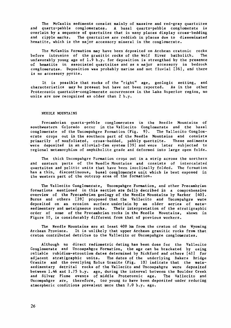
NEEDLE MOUNTAINS
Precambrian quartz-pebble conglomerates in the Needle Mountains ofsouthwestern Colorado occur in the Vallecito Conglomerate and the basalconglomerate of the Uncompahgre Formation (Fig. 9). The Vallecito Conglom-erate crops out in the southern part of the Needle Mountains and consistsprimarily of nonfoliated, cross-bedded, pebbly quartzite. These sedimentswere deposited in an alluvial-fan system [39] and were later subjected toregional metamorphism of amphibolite grade and deformed into large open folds.
The thick Uncompahgre Formation crops out in a strip across the northernand eastern parts of the Needle Mountains and consists of intercalatedquartzites and pelitic units that have been isoclinally folded. The formationhas a thin, discontinuous, basal conglomerate unit which is best exposed inthe western part of the outcrop area of the formation.
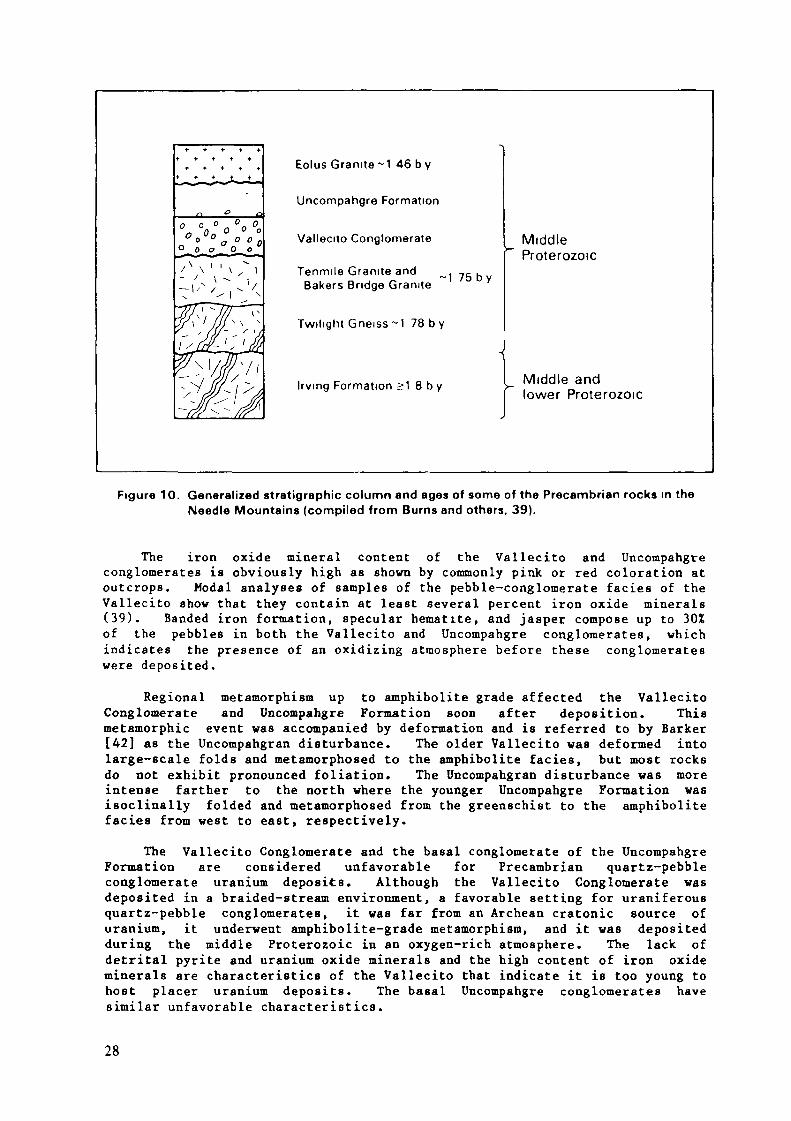
The Vallecito Conglomerate, Uncompahgre Formation, and other Precambrianformations mentioned in this section are fully decribed in a comprehensiveoverview of the Precambrian geology of the Needle Mountains by Barker [40].Burns and others [39] proposed that the Vallecito and Uncompahgre weredeposited on an erosion surface underlain by an older series of meta-sedimentary and metaigneous rocks. Their interpretation of the stratigraphieorder of some of the Precambrian rocks in the Needle Mountains, shown inFigure 10, is considerably different from that of previous workers.
The Needle Mountains are at least 400 km from the craton of the WyomingArchean Province. It is unlikely that upper Archean granitic rocks from thatcraton contributed detritus to the Vallecito or Uncompahgre conglomerates.
Although no direct radiometric dating has been done for the VallecitoConglomerate and Uncompahgre Formation, the age can be bracketed by usingreliable rubidium-strontium dates determined by Bickford and others [41] foradjacent stratigraphie units. The dates of the underlying Bakers BridgeGranite and the overlying Eolus Granite (Fig. 10) indicate that the meta-sedimentary detrital rocks of the Vallecito and Uncompahgre were depositedbetween 1.46 and 1.75 b.y. ago, during the interval between the Boulder Creekand Silver Plume events of middle Proterozoic age. The Vallecito andUncompahgre are, therefore, too young to have been deposited under reducingatmospheric conditions prevalent more than 2.0 b.y. ago.
26
I0r°43' EXPLANATION
37«45'
37« 3O
c 0 L 0 R A 0 0
N««dl. Mounloln«
_ HIUSOOLC COARCMULET» CO
Younger intrutive rock*Includt Trlmttt Cranitt,
EltCtra Lotone Eotui
Older intrusive rockstnclud* Ttnmilt and
and Twilight
Vollecilo Conglomerate ^
KOZ4OUlora.
12 Miltt
20 Kllom«t*rt
Contact
FoultHeavy-lined areas studiedby Burns and o t h« r» (39)
Figure 9. Generalized geologic map of Précambrien rocks in the Needle Mountains (after Barker, 40).
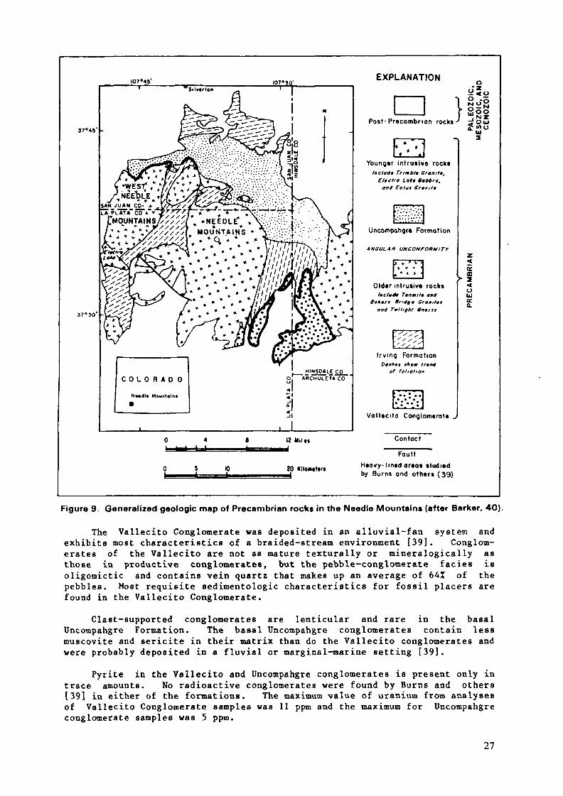
The Vallecito Conglomerate was deposited in an alluvial-fan system andexhibits most characteristics of a braided-stream environment [39]. Conglom-erates of the Vallecito are not as mature texturally or mineralogically asthose in productive conglomerates, but the pebble-conglomerate faciès isoligomictic and contains vein quartz that makes up an average of 64% of thepebbles. Most requisite sedimentologic characteristics for fossil placers arefound in the Vallecito Conglomerate.
Clast-supported conglomerates are lenticular and rare in the basalUncompahgre Formation. The basal Uncompahgre conglomerates contain lessmuscovite and sericite in their matrix than do the Vallecito conglomerates andwere probably deposited in a fluvial or marginal-marine setting [39].
Pyrite in the Vallecito and Uncompahgre conglomerates is present only intrace amounts. No radioactive conglomerates were found by Burns and others[39] in either of the formations. The maximum value of uranium from analysesof Vallecito Conglomerate samples was 11 ppm and the maximum for Uncompahgreconglomerate samples was 5 ppm.
27
Eolus Granite ~1 46 b y
Uncompahgre Formation
Vallecito Conglomerate
Tenmile Granite andBakers Bridge Granite -1 75 by
Twilight Gneiss ~1 78 b y
Irvmg Formation >1 8 b y
MiddleProterozoic
Middle andlower Proterozoic
Figure 10. Generalized stratigraphie column and ages of some of the Précambrien rocks in theNeedle Mountains (compiled from Burns and others. 39).
The iron oxide mineral content of the Vallecito and Uncompahgreconglomerates is obviously high as shown by commonly pink or red coloration atoutcrops. Modal analyses of samples of the pebble-conglomerate faciès of theVallecito show that they contain at least several percent iron oxide minerals(39). Banded iron formation, specular hematite, and jasper compose up to 30%of the pebbles in both the Vallecito and Uncompahgre conglomerates, whichindicates the presence of an oxidizing atmosphere before these conglomerateswere deposited.
Regional metamorphism up to amphibolite grade affected the VallecitoConglomerate and Uncompahgre Formation soon after deposition. Thismetamorphic event was accompanied by deformation and is referred to by Barker[42] as the Uncompahgran disturbance. The older Vallecito was deformed intolarge-scale folds and metamorphosed to the amphibolite faciès, but most rocksdo not exhibit pronounced foliation. The Uncompahgran disturbance was moreintense farther to the north where the younger Uncompahgre Formation wasisoclinally folded and metamorphosed from the greenschist to the amphibolitefaciès from west to east, respectively.
The Vallecito Conglomerate and the basal conglomerate of the UncompahgreFormation are considered unfavorable for Precambrian quartz-pebbleconglomerate uranium deposits. Although the Vallecito Conglomerate wasdeposited in a braided-stream environment, a favorable setting for uraniferousquartz-pebble conglomerates, it was far from an Archean cratonic source ofuranium, it underwent amphibolite-grade metamorphism, and it was depositedduring the middle Proterozoic in an oxygen-rich atmosphere. The lack ofdetrital pyrite and uranium oxide minerals and the high content of iron oxideminerals are characteristics of the Vallecito that indicate it is too young tohost placer uranium deposits. The basal Uncompahgre conglomerates havesimilar unfavorable characteristics.
28
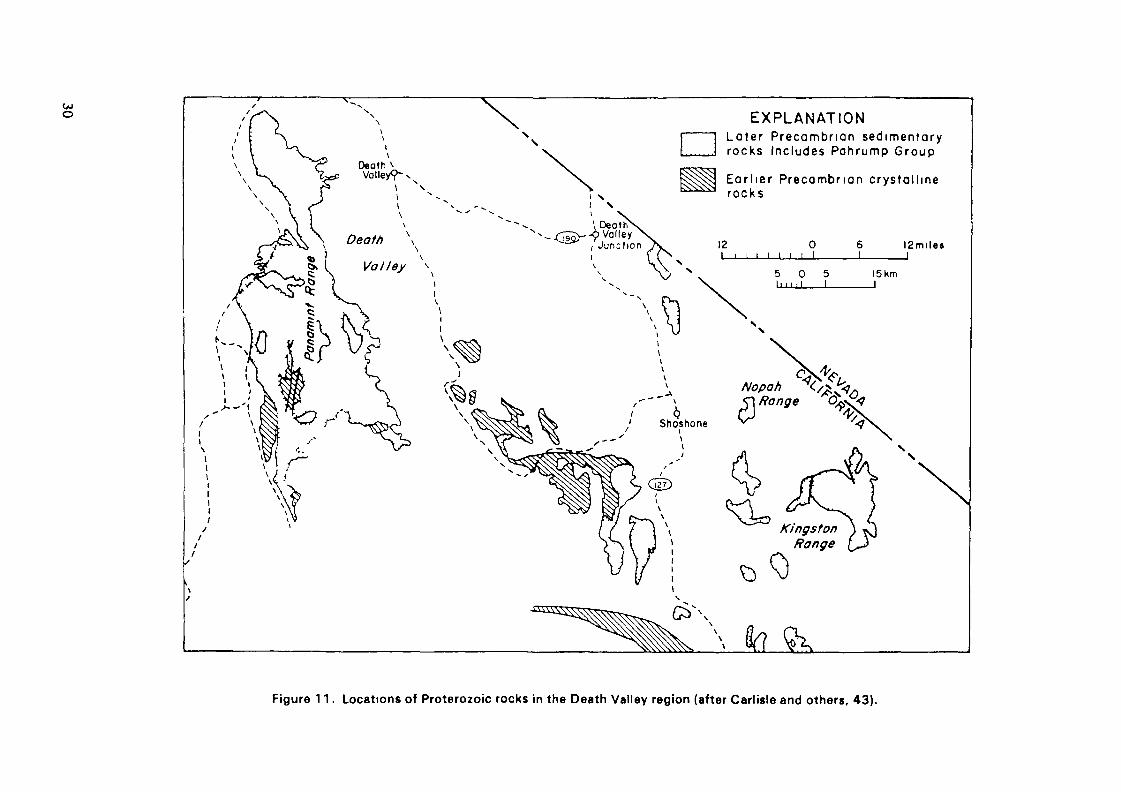
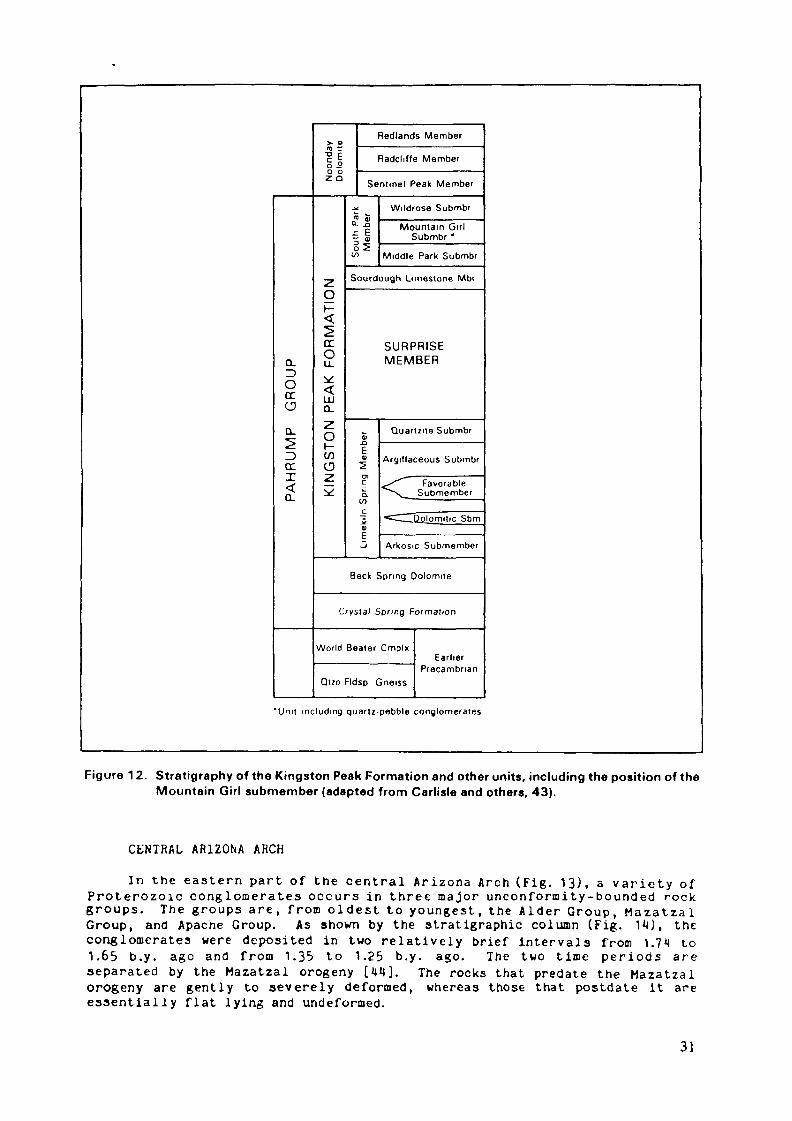
KINGSTON PEAK FORMATION
Quartz-pebble conglomerates occur in the Mountain Girl submember withinthe Kingston Peak Formation of the Pahrump Group of upper Proterozoic sedi-ments along the western flank of the southern Panamint Range in southeasternCalifornia (Figs. 11 and 12). The Pahrump Group unconformably overlies olderProterozoic metamorphic and igneous rocks which include a complex of augengneiss, the World Beater Complex, that has anomalously high uranium andthorium content and is 1.8 b.y. old. The Kingston Peak Formation radioactiveconglomerates are younger than 1.35 b.y. and may be less than 1.1 b.y. old.Rocks in the Kingston Peak Formation between the unconformity below thePahrump Group and the radioactive conglomerates of the Mountain Girl submemberinclude a high proportion of dolomites and other marine rocks. Thestratigraphy is summarized in Figure 12. The rocks stratigraphically betweenthe conglomerate and the World Beater Complex are between 2 and 4 km thick.Included in these rocks is the "favorable submember" which is basically aquartz-mica schist that hosts nondetr i tal uranium occurrences. Metamorphicgrade is variable from place to place, amphibolite grade being the highestreported.
The Archean and lower Précambrien rocks of early workers have now beenestablished as Proterozoic. Basement rocks beneath the Pahrump Group wereoriginally mainly volcanic and sedimentary units and are now orthogneisses andparagneisses with granitic intrusions. The uraniferous World Beater Complexis not considered by Carlisle and others [43] to have been a possible sourceof uranium to the conglomerates.
The environment of the Mountain Girl conglomerates is mainly fluvial-deltaic and braided stream. Anomalously high radioactivity occurs in broadlylenticular oligomictic quartz-pebble conglomerate layers from severalcentimeters to l m thick. The highest uranium value reported is only 40 ppm.
According to Carl is le and others l*»3] cerium contents are u n u s u a l l y high andare d i r e c t l y r e l a t e d to u r a n i u m and t h o r i u m , w h i c h suggests to them tha tm o n a z i t e hosts al l three e l e m e n t s and is the source of r a d i o a c t i v i t y ,typical ly 5 to 10 times background.
Matrix minerals in the radioactive conglomerates consist of quartz (5551),microcline (20J), biotite (10%-30J), and opaques (51; mainly magnetite). Itis no tewor thy t h a t v a r i a b l e amounts of plagioclase have been repor ted ,magnetite is present in more than trace amounts, and pyrite is absent.
The uranium occurrences in schists older than the conglomerates includebranner i te . U r a n i u m e n r i c h m e n t p robab ly is due to u ran ium t ranspor ted insolution; nothing suggests the presence of de t r i ta l u r a n i u m oxides in anysediments of the K ings ton Peak Formation. M e t a m o r p h i s m up to a m p h i b o l i t egrade is not cons idered by Ca r l i s l e and others [43] to have mob i l i z ed orotherwise affected the uranium or thorium present in the Precambrian rocks.
Factors that greatly reduce the probability of occurrence of uraniferousq u a r t z - p e b b l e conglomerates are the absence of an Archean basement h a v i n gfavorable source rocks and the young age of the known conglomerates and otherPrecambrian rocks. Other strongly negative factors include indications thatconglomerate uranium contents and relat ively high radioactivity are due solelyto m o n a z i t e , that pyri te is absent in conglomerate ma t r i ce s , and thatmagnet i te is the main h e a v y m i n e r a l . The o n l y f a v o r a b l e fac tor is thepresence of f luv ia l conglomerates having characteristics of deposition in abraided-stream environment.
29
Oeoth v.Volley?- XN
\ N
Death \ \Valley
I XI N
EXPLANATIONLa te r Précambrien sedimentaryrocks Includes Pahrump Group
Ear l ier Precambnan crys ta l l inerocks
\ DeafÎNv)Val l€yJunction
\ ^^12 0
l i i i i i i i II 2 m i l e »
,' Shoshone
£>\
5 0 511 l M I I
15 Km
i_SiFigure 11. Locations of Proterozoic rocks in the Death Valley region (after Carlisle and others, 43).
PA
HR
UM
P
GR
OU
P
Noo
nday
Dol
omite
KIN
GS
TON
PE
AK
FO
RM
AT
ION
Redlands Member
Radcliffe Member
Sentinel Peak Member
Sou
th P
ark
Mem
ber
Wildrose Submbr
Mountain GirlSubmbr '
Middle Park Submbr
Sourdough Limestone Mbr
SURPRISEMEMBER
V-Û
E0)5CT)C
o.l/>
_5aE_*
Quartzue Submbr
Argillaceous Submbr
< FavorableSubmember
<=^__Qolomitic Sbm
Arkosic Submember
Beck Spring Dolomite
Crystal Spring Formation
World Beater CmplxEarlier
PrecambrianQuo Fldsp Gneiss
"Unit including quartz-pebble conglomerates
Figure 12. Stratigraphy of the Kingston Peak Formation and other units, including the position of theMountain Girl submember (adapted from Carlisle and others, 43).
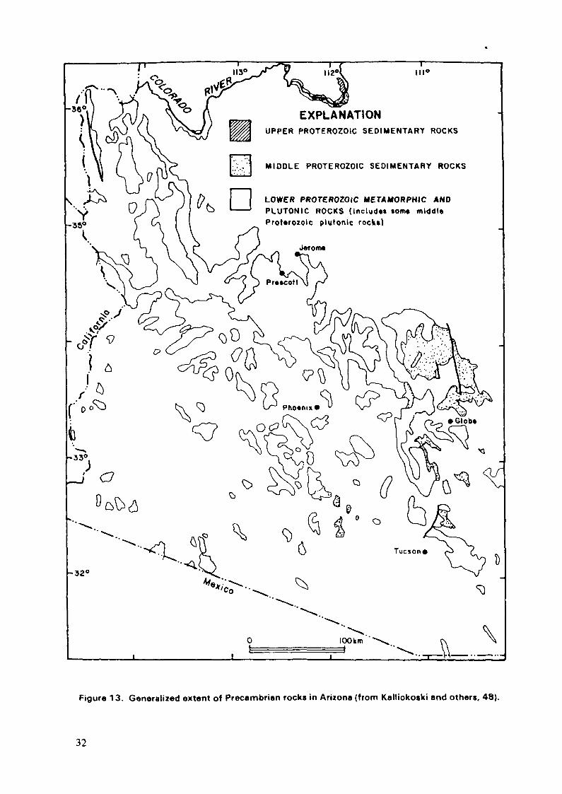
C E N T R A L A R I Z O N A ARCH
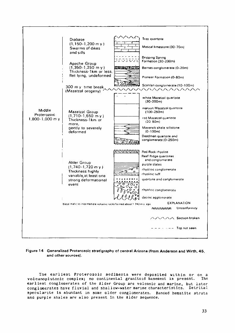
In the eas te rn part of the cen t ra l A r i z o n a A r c h (Fig. 13), a v a r i e t y ofProterozoic conglomera tes occurs in three major u n c o n f o r m i t y - b o u n d e d rockgroups . The groups a re , f rom o ldes t to y o u n g e s t , the A l d e r G r o u p , M a z a t z a lGroup, and Apache Group. As shown by the stratigraphie column (Fig. HO, theconglomerates were deposited in two r e l a t i ve ly brief intervals from 1.711 to1.65 b.y. ago and f rom 1.35 to 1.25 b.y. ago. The two t ime per iods areseparated by the Mazatzal orogeny [W]. The rocks that predate the Mazatzalorogeny are gently to severely deformed, whereas those that postdate it areessentially f la t lying and undeformed.
31
EXPLANATIONUPPER PROTEROZOIC SEDIMENTARY ROCKS
MIDDLE PROTEROZOIC SEDIMENTARY ROCKS
LOWER PROTEROZOIC METAMORPHIC ANDPLUTONIC ROCKS (Includ«» torn» middl«ProUrozolc plutonlc rock»)
Figure 13. Generalized extent of Précambrien rocks in Arizona (from Katliokoski and others, 48).
32
MiddleProterozoic
1.800-1.000 m y
Diabase(1.150-1, 200m y)Swarms of dikesand sills
Apache Group(1,350-1,250 my)Thickness-lkm or less,flat lying, undeformed
300 m y time break,(Mazatzal orogeny)
Mazatzal Group(1,710-1,650 myThickness-1km ormore,gently to severelydeformed
i r
Alder Group(1,740-1,720 m y )Thickness highlyvanable.at least onestrong deformationalevent
rhyolitic conglomerate
dacitic agglomerate
Basal mafic 10 intermediate volcanic rocks formed about 1 740 m v ago
Troy quartzite
Mescal limestone (30-70m)
Dripping SpringFormation (30-200m)
Barnes conglomerate (0-20m)
Pioneer Formation (0-80m)
Scanlan conglomerate (10-100m)
white Mazatzal quartzite(30-200m)
maroon Mazatzal quartzite(100-250m)
red Mazatzal quaMzite(20 80m)
Maverick shale siltstone(0-100m)
Deadman quartzite andconglomerate (0-250m)
Red Rock rhyoliteReef Ridge quartzites
and conglomeratepurple slatesrhyolitic conglomeraterhyolittc tuff
quartzite and conglomerate
EXPLANATION
A/VWWWVWt Unconformity
/\/\/\/\/-\ Section broken
- - - - - - - Top not seen
Figure 14 Generalized Proterozoic stratigraphy of central Arizona (from Anderson and Wirth, 45,and other sources).
Tne ea r l i e s t Proterozoic sediments were deposi ted w i t h i n or on avolcanoplutonic complex; no continental granitoid basement is present. Theearliest conglomerates of the A l d e r Group are volcanic and marine, but laterconglomerates have f l u v i a l and shal low-water marine characteristics. Detr i ta lspéculante is abundant in some older conglomerates. Banded hematite strataand purple shales are also present in the Alde r sequence.
33
After deformation of the Alder Group, the Mazatzal sediments weredeposited; included in them is an assemblage of rhyolitic rocks. Hematiticrhyolite volcanics below sediments contain abundant vesicles filled withspecularite which Anderson and Wirth [45] considered the obvious source forthe abundant rounded detrital specularite in the Mazatzal Group. Olderlocalized fluvial environments containing conglomerates were superseded bymarine sediments that were deposited over a large part of Arizona. The upperquartzite of the group is white, has a specularite-rich zone at the base, andis considered to be eolian. The rocks have been metamorphosed to theamphibolite faciès only near granites.
The undeformed Apache Group, deposited after the Mazatzal orogeny, hasbeen intruded by swarms of diabase dikes and sills. A basal conglomerate,partially fluvial, is locally rich in hematitic debris and an overlying shaleis red and hematitic. Up section is the Dripping Spring Formation, whichincludes a lower siltstone and conglomerate and an upper siltstone member.Small uranium mines and occurrences in the upper siltstone are considered tobe genetically tied to pyritic siltstone. Uranium enrichment is due toremobilization caused by diabase intrusions [45, 46, 47]. Within the Mescallimestone, above the Dripping Spring Formation, are local radiometricanomalies in chert, limestone breccia, and conglomerate [45, 46].
All sediments have been determined by radiometric dating to be youngerthan 1.74 b.y., and there is abundant evidence of a strongly oxidizingatmosphere during deposition. In the conglomerates most highly enriched inuranium (33 ppm uranium) [44], uranium and iron in specularite correlatepositively. There is a lack of correspondingly high thorium content. Mostconglomerates that have the slightly elevated uranium geochemical values areonly weakly radioactive (2 or 3 times background), and none are pyritiferous.
The Precambrian conglomerates in the central Arizona Arch are consideredunfavorable for uraniferous quartz-pebble conglomerates due to the absence ofArchean rocks and favorable source rocks for detrital uraninite and to theyoung ages of the Precambrian sediments.
CONCLUSIONS
Comparisons of the geologic characteristics of selected exposedPrecambrian terranes in the conterminous United States with those of knownuraniferous quartz-pebble conglomerates elsewhere indicate that the U.S.terranes as presently known have low potential for paleoplacer uraniumdeposits. Field investigations conducted as part of the NURE program, whichincluded extensive geochemical sampling in all areas and drilling in two,focused on selected potentially favorable Precambrian rocks. Theseinvestigations failed to identify a significantly favorable geologicenvironment for uranium deposits in uraniferous quartz-pebble conglomerates.
Quartz-pebble conglomerates that have some characteristics in common withthose of the Witwatersrand or Elliot Lake districts have been identified, butthey lack significant concentrations of uranium or other metals. Conglomeratedeposition between 2.0 and 3.2 b.y. ago on an Archean craton plus source-rock,depositional-environment, and preservation factors must all be met forfavorable concentrations of uranium to be probable. For the known U.S.conglomerates that meet time and depositional-site criteria, other crucialrequirements either are not met or are indeterminable (Table 1).
The presence of uraniferous quartz-pebble conglomerates in the UnitedStates that do not meet the time and depositional-site criteria establishedfor the economic deposits cannot be precluded, but the authors consider the
34
probability of their existence to be low. The information generated tends tosupport the time-space restriction as observed in the known uraniferousconglomerate deposits. Additional dating may reveal that lower Proterozoicrocks are more widespread than presently known. For example, the first lowerProterozoic rock in Alaska has recently been reported—an augen gneiss datedas 2.3 b.y. [49]. However, available information suggests that Arehean cratonlimits will remain approximately as currently known.
The most promising known U.S. areas that meet the age-of-depositioncriterion are southeastern Wyoming, the Nemo area of the Black Hills, andsouthwestern Montana. However, in these areas the thorium and uranium are inthorium-rich heavy-mineral placer concentrations that have characteristicstypical of conglomerates of any age. No detrital uraninite concentrationswere found or indicated to have been present in appropriate hydraulic-equiva-lency depositional regimes. In addition, no fluvial oligomictic conglomeratesin geologic settings favorable .for mechanical concentration and preservationof uraninite were found or indicated. In general, the rocks are metamorphosedand/or deformed to such a degree that the preservation of any placer uraniumoxides that might have existed is doubtful.
Within the known archean cratons, in the Lake Superior and Wyomingregions, the presence of favorable conglomerates cannot be ruled out becauseinvestigations largely did not include the subsurface, and very littledetailed geophysical and drilling information is available. Additionalinvestigations proposed for both regions [4, 5, 6] deserve seriousconsideration.
The quartz-pebble conglomerate target having the most uranium potentialin the United States may be the possible extension of members of the HuronianSupergroup beneath Paleozoic rocks in the Upper Peninsula of Michigan, asproposed by Button and Adams [5]. On the other hand, Karlstrom and others [5,7] presented sedimentation studies that led them to suspect most quartz-pebbleconglomerates were deposited south of present outcrops in Minnesota andWisconsin. However, drilling in buried Precambrian rocks outside thegeneralized boundaries of the Archean craton is not known to have cutfavorable metasedimentary strata. Indications based on available informationare that the Proterozoic rocks examined are all too young to host deposits andthat any older quartz-pebble conglomerates, if present, will be below youngercover on the craton.
There are many unanswered questions, especially in regard to age,concerning many, in most places poorly exposed, metasedimentary Precambrianrocks in the United States. Although favorable geologic environments have notbeen outlined to date, placer quartz-pebble conglomerate uranium deposits maybe discovered in the Precambrian of the United States as geologic informationbecomes available and subsurface exploration targets are identified andevaluated.
REFERENCES
1. ANDERSON, J. R. , GOODKNIGHT, C. S., SEWELL, J. M., and RILEY, J. K.,Uranium potential of Precambrian Quartz-Pebble conglomerates in theUnited States: A Summary: U.S. Department of Energy, Grand JunctionOffice, Open-File Report GJBX-35(82) (1982) 84 p.
2. MALAN, R. C., Summary Report-Distribution of uranium and thorium inthe Precambrian of the western United States: U.S. Atomic EnergyCommission Grand Junction Office, Open-File Report AEC-RD-12 (1972)59 p.
35

3. JONES, C. A., Uranium occurrences in sedimentary rocks exclusive ofsandstone, in Mickle, D. G., and Mathews, G.W., eds., Geologiccharacteristics of environments favorable for uranium deposits: U.S.Department of Energy, Grand Junction Office, Open-File Report GJBX-67(78) (1978), p. 1-86.
4. HOUSTON, R. S., and KARLSTROM, K. E., Precambrian uranium-bearingquartz-pebble conglomerates: Exploration model and United Statesresource potential: U.S. Department of Energy, Grand Junction Office,Open-File Report GJBX-l(SO) (1979) 510 p.
5. BUTTON, Andrew, and ADAMS, S. S., Geology and recognition criteria foruranium deposits of the quartz-pebble conglomerate type: U.S.Department of Energy, Grand Junction Office, Open-File Report GJBX-3(81) (1981) 390 p.
6. KARLSTROM, K. E., HOUSTON, R. S., FLURKEY, A. J., COOLIDGE, C. M.,KRATOCHVIL, A. L., and SEVER, C. K., A summary of the geology anduranium potential of Precambrian conglomerates in southeasternWyoming: U.S. Department of Energy, Grand Junction Office, Open-FileReport GJBX-139(81), v. l (1981) 541 p.
7. KARLSTROM, K. E., HOUSTON, R. S., SCHMIDT, T. G., INLOW, David,FLURKEY, A. J., KRATOCHVIL, A. L., COOLIDGE, C. M., SEVER, C. K.,and QUIMBY, W. F., Drill-hole data, drill-siter geology, andgeochemical data from the study of Precambrian uraniferousconglomerates of the Medicine Bow Mountains and the Sierra Madre ofsoutheastern Wyoming: U.S. Department of Energy, Grand JunctionOffice, Open-File Report GJBX-139(81) v. 2 (1981) 682 p.
8. RUZICKA, Vladimir, Some metallogenic features of the Huronian andpost-Huronian uraniferous conglomerates in genesis of uranium- andgold-bearing Precambrian quartz-pebble conglomerates: Proceedings ofa workshop, October 13-15, 1975, Golden, Colorado: U.S. GeologicalSurvey Professional Paper 1161-V (1981)) 8 p.
9. HILLS, F. A., and Houston, R. S., Early Proterozoic tectonics of thecentral Rocky Mountains, North America: Contributions to Geology,University of Wyoming, v. 17 (1979) p. 89-109.
10. REDDEN, J. A., and Norton, J. J., Precambrian geology of the BlackHills, in Mineral and water resources of South Dakota: U.S. SenateCommittee on Interior and Insular Affairs, Henry M. Jackson, Chairman,(1975) p. 21-28.
11. RATTE, J. C., and Zartman, R. S., Bear Mountain gneiss dome, BlackHills, South Dakota—Age and structure [abs.]: Geological Society ofAmerica Abstracts with Programs, v. 2 no. 5 (1970) p. 345.
36
12. HILLS, F. A., uranium and thorium in the middle Precambrian EstesConglomerate, Nemo district, Lawrence County, South Dakota—Apreliminary report: U.S. Geological Survey Open-File Report 77-55,(1977) 27 p.
13. KIM, J. D., Mineralogy and trace elements of the uraniferousconglomerates, Nemo district, Black Hills, South Dakota: Rapid City,South Dakota School of Mines and Technology, Ph.D. dissertation,(1979) 125 p.
14. REDDEN, J. A., Geology and uranium resources in Precambrianconglomerates of the Nemo area, Black Hills, South Dakota: U.S.Department of Energy, Grand Junction Office, Open-File Report GJBX-127(80), (1980) 147 p.
15. ORTLEPP, R. J., On the occurrence of uranothorite in the DominionReef: Transactions of the Geological Society of South Africa, v. 65pt. 1 (1962) p. 197-202.
16. COHENOUR, R. E., and Kopp, R. S., Regional investigation foroccurrences of radioactive quartz-pebble conglomerates in thePrecambrian of southwestern Montana: U.S. Department of Energy, GrandJunction Office Open-File Report GJBX-252(80) (1980) 582 p.
17. BOYCE, R. L., Depositional systems in the LaHood Formation, BeltSupergroup, Precambrian, southwestern Montana: Austin, University ofTexas, Ph.D. dissertation (1975) 247 p.
18. HANLEY, T. B., Structure and petrology of the northwestern TobaccoRoot Mountains, Madison County, Montana: Bloomington, IndianaUniversity, Ph.D. dissertation (1975) 206 p.
19. JAMES, H. L., and Hedge, C. E., Age of the basement rocks of southwestMontana: Geological Society of America Bulletin, v. 91, pt. 1, (1980)p. 11-15.
20. JAMES, H. L. Clark, L. D., Lamey, C. A., and Pettijohn, F. J., Geologyof central Dickinson County, Michigan: U.S. Geological SurveyProfessional Paper 310 (1961) 87 p.
21. KING, P. B., compiler, Tectonic map of North America: U.S. GeologicalSurvey, scale 1:5,000,000 (1979).
22. SIMS, P. K., Precambrian tectonics and mineral deposits, Lake Superiorregion: Economic Geology, v. 71, (1976) p. 1092-1127.
23. VICKERS, R. C., Geology and monazite content of the GoodrichC^iartzite, Palmer area, Marquette County, Wisconsin: U.S. GeologicalSurvey Bulletin 1030-F, (1956) p. 171-185.
37
24. MALAN, R. C., and Sterling, D. A., A geologic study of uraniumresources in Precambrian rocks of the western United States:Distribution of uranium and thorium in Precambrian rocks in thewestern Great lakes region: U.S. Atomic Energy Commission, GrandJunction Office, Open-File Report AEC-RD-10, (1969) 25 p.
25. KING, P. B., Precambrian geology of the United States; an explanatorytext to accompany the geologic map of the United States: U.S.Geological Survey Professional Paper 902, (1976) 85 p.
26. CANNON, W. F., The Penokean orogeny in northern Michigan, in Young, G.M., ed., Huronian stratigraphy and sedimentation: GeologicalAssociation of Canada Special Paper 12, (1973) p. 251-271.
27. BAYLEY, R. W., Dutton, C. E., and Lamey, C. A., Geology of theMenominee iron-bearing district, Michigan and Wisconsin: U.S.Geological Survey Professional Paper 513, (1966) 96 p.
28. JAMES, H. L., Stratigraphy of the pre-Keweenawan rocks in parts ofnorthern Michigan: U.S. Geological Survey Professional Paper 314-C,(1958) p. 27-44.
29. YOUNG, G. M., Huronian stratigraphy of the MacGregor Bay area,Ontario: Relevance to the paleogeography of the Lake Superior region:Canadian Journal of Earth Sciences, v. 3, (1966) p. 203-210.
30. YOUNG, G. M., An extensive Early Proterozoic glaciation in NorthAmerica?: Paleogeography, Paleoclimatology, Paleoecology, v. 7,(1970) p. 85-101.
31. JAMES, H. L., Zones of regional metamorphism in the Precambrian ofnorthern Michigan: Geological Society of American Bulletin, v. 66,(1955) p. 1455-1488.
32. SIMS, P. K., Precambrian tectonics and mineral deposits, Lake Superiorregion: Economic Geology, v. 71, (1976) p. 1092-1127.
33. BANKS, P. 0., and Van Schmus, W. R., Chronology of Precambrian rocksof Iron and Dickinson Counties, Michigan [abs.]: Institute on LakeSuperior Geology, 17th Annual Abstracts and Field Guides, (1971)p. 9-10.
34. VAN SCHMUS, W. R., Early and Middle Proterozoic history of the GreatLakes area, North America: Philosophical Transactions of the RoyalSociety of London, v. 280-A, (1976) p. 605-628.
35. MANCUSO, J. J., Geology and mineralization of the Mountain area,Wisconsin: Madison, University of Wisconsin, M.S. thesis, (1957)32 p.
38
36. MANCÜSO, J. J., Stratigraphy and structures of the McCaslin district,Wisconsin: East Lansing, Michigan State University, Ph.D.dissertation, (1960) 101 p.
37. MOTTEN, R. H., III, The bedrock geology of Thunder Mountain area,Wisconsin: Bowling Green, Ohio, Bowling Green State University, M.S.thesis, (1972) 59 p.
38. BARRETT, L. P., Uranium occurrences, Michigan, Wisconsin, andMinnesota: U.S. Department of Energy, Grand Junction Office, Open-File Report RME-3161, (1979) 13 p.
39. BURNS, L. K., Ethridge, F. G., Tyler, Noel, Gross, A. S., and Campo,A. M., Geology and uranium evaluation of the PreCambrian quartz-pebbleconglomerates of the Needle Mountains, southwest Colorado: U.S.Department of Energy, Grand Junction Office, Open-File Report GJBX-118, (1980) 161 p.
40. BARKER, Fred, Gold investigations in Precambrian clastic and peliticrocks, southwestern Colorado and northern New Mexico: U.S. GeologicalSurvey Bulletin 1272-F, (1969) 22 p.
41. BICKFORD, M. E., Wetherill, G. W., Barker, Fred, and Lee-Hu, C. N.,Precambrian Rb-Sr chronology in the Needle Mountains, southwesternColorado: Journal of Geophysical Research, v. 74, (1969) p. 1660-1676.
42. BARKER, Fred, Precambrian geology of the Needle Mountains, south-western Colorado: U.S. Geological Survey Professional Paper 644-A,(1969) 35 p.
43. CARLISLE, Donald, Kettler, R. M., and Swanson, S. C., Geological studyof uranium potential of the Kingston Peak Formation, Death Valleyregion, California: U.S. Department of Energy, Grand Junction Office,Open-File Report GJBX-37(80), (1980) 109 p.
44. WILSON, E. D., Pre-cambrian Mazatzal revolution in central Arizona:Geological Society of America Bulletin, v. 50, no. 7, (1939) p. 1113-1164.
45. ANDERSON, Phillip, and Wirth, K. R., Uranium potential in Precambrianconglomerates of the central Arizona Arch: U.S. Department of Energy,Grand Junction Office, Open-File Report GJBX-33(81), (1981) 122 p.
46. LUNING, R. H., Thiede, D. S., O'Neill, A. J., Nystrom, R. J., andWhite, D. L., Uranium resource evaluation, Mesa Quadrangle, Arizona:U.S. Department of Energy, Grand Junction Office, Open-File ReportPGJ-006(80), (1980) 269 p.
39

47. NUTT, C. J., A model of uranium mineralization in the Dripping Springquartzite, Gila County, Arizona: U.S. Geological Survey Open-FileReport 81-524, (1981) 49 p.
48. KALLIOKOSKI, Jorma, Langford, F. F., and Ojakangas, R. W., Criteriafor uranium occurrences in Saskatchewan and Australia as guides tofavorability for similar deposits in the United States: U.S. Depart-ment of Energy, Grand Junction Office, Open-File Report GJBX-114(78),(1978) 480 p.
49. U.S. Geological Survey, Geological Survey research, 1980: U.S.Geological Survey Professional Paper 1175, p. 108.
40
TECTONIC ENVIRONMENT OF PRECAMBRIANQUARTZ-PEBBLE CONGLOMERATE URANIUMDEPOSITS FORMED ALONG THE SOUTHERN MARGINOF THE ARCHEAN SHIELD IN NORTH AMERICA
F.A. HILLSGeological Survey,Denver, Colorado,United States of America
Abstract
TECTONIC ENVIRONMENT OF PRECAMBRIAN QUARTZ-PEBBLE-CONGLOMERATE URANIUMDEPOSITS FORMED ALONG THE SOUTHERN MARGIN OF THE ARCHEAN SHIELD IN NORTHAMERICA
Uraniferous Early Proterozoic conglomerates have been discovered atseveral localities in Canada and the United States near the southeastern edgeof the Archean Superior and Wyoming Provinces. Sedimentary successions thatcontain the uraniferous conglomerates apparently were deposited in fault-bounded troughs or basins and on faulted coastal plains that formed on or nearthe margin of an Archean craton or cratons. The Early Proterozoic history ofthis cratonal margin, called the Proterozoic-Archean boundary zone, ischaracterized by approximately synchronous periods of (1) extensionaltectonics with rifting, volcanism, and subsidence; (2) intrusion of maficdikes and s i l l s ; (3) carbonate shelf development; (4) eugeoclinalsedimentation and volcanism; and (5) orogeny.
1. PROTEROZOIC-ARCHEAN BOUNDARY ZONELate Archean to Early Proterozoic ensialic sedimentary rocks in the
United States and southern Canada are found in a series of structural basinsor troughs that lie along the southern edge of the Archean shield fromLabrador through Ontario, Michigan, Wisconsin, Minnesota, South Dakota,Wyoming, and Utah (Fig. 1). Strata in these basins and troughs, which includethe great Proterozoic iron-formations of North America as well as most of theknown occurrences of uraniferous quartz-pebble conglomerate, are diverse incomposition and differ by as much as several hundred m i l l i o n years in age.Nevertheless, they share many sedimentologic and structural characteristics.Generally these strata record several cycles of advance of the sea onto theArchean craton. Each advance resulted in deposition of fl uvial-to-marine orglacial-to-marine conglomerates and sandstones, followed by shallow-marineclastic or carbonate rocks. Generally the final cycle of sedimentation endswith deep-water-marine dark shales, graywacke and volcanic rocks. Episodes ofextension, compression, granite intrusion, gabbro intrusion, and metamorphismoccurred during the same approximate periods of time throughout this regionfrom southeastern Canada to the western United States.
The structural basins or troughs that contain uraniferous conglomerateand iron-formation formed within the Archean continental crust, but apparentlynear its edge. Early Proterozoic volcanic rocks, gneisses, and granitegenerally are found southeast of the basins, but in Wisconsin and Minnesota,Archean gneiss and granite crop out as much as 200 km to the southeast. Thesouthern l i m i t of the Archean has not been precisely located because Paleozoicand younger sedimentary rocks cover most of the area south of the EarlyProterozoic basins. However, except for those previously mentioned inWisconsin and Minnesota, no Archean rocks have been recognized in the region
41
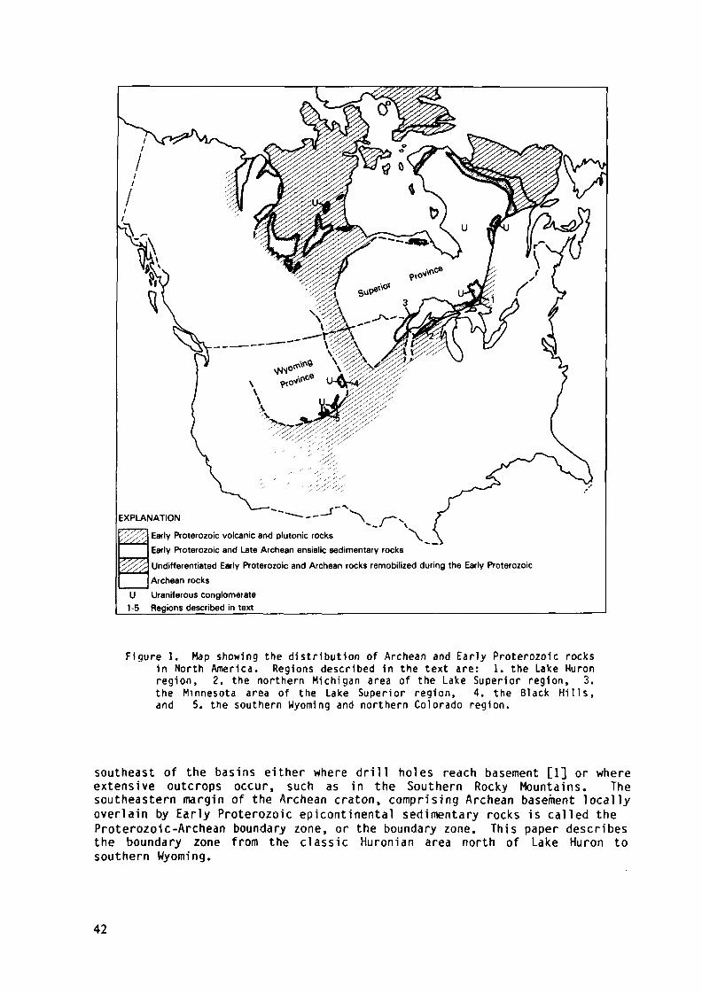
EXPLANATION"-'' VEarly Proterozoic volcanic and plutonic rocks \
Early Proterozoic and Late Archean ensialic sedimentary rocks
Undifferentiated Early Proterozoic and Archean rocks remobilized during the Early ProterozoicArchean rocks
U Uraniferous conglomerate1-5 Regions described in text __ ____________________________
Figure 1. Map showing the distribution of Archean and Early Proterozoic rocksin North America. Regions described in the text are: 1. the Lake Huronregion, 2. the northern Michigan area of the Lake Superior region, 3.the Minnesota area of the Lake Superior region, 4. the Black Hills,and 5. the southern Wyoming and northern Colorado region.
southeast of the basins either where drill holes reach basement [1] or whereextensive outcrops occur, such as in the Southern Rocky Mountains. Thesoutheastern margin of the Archean craton, comprising Archean basement locallyoverlain by Early Proterozoic epicontinental sedimentary rocks is called theProterozoic-Archean boundary zone, or the boundary zone. This paper describesthe boundary zone from the c lassic Huronian area north of Lake Huron tosouthern Wyoming.
42
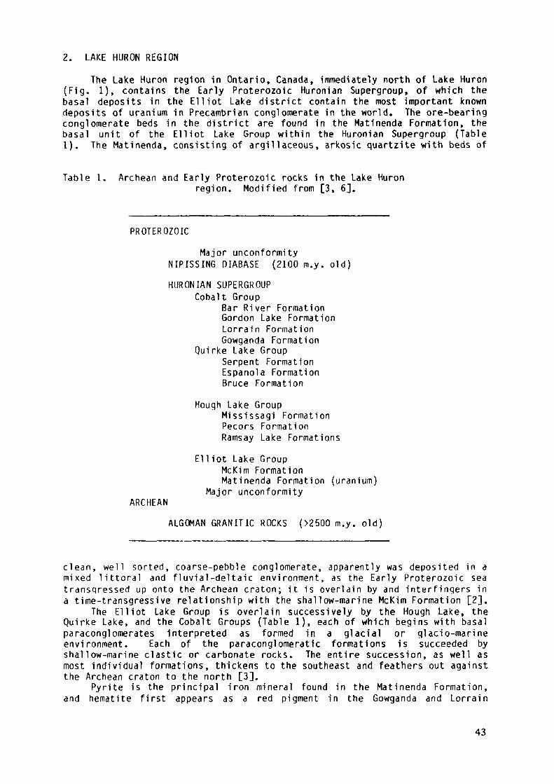
2. LAKE HURON REGIONThe Lake Huron region In Ontario, Canada, immediately north of Lake Huron
(Fig. 1), contains the Early Proterozoic Huronian Supergroup, of which thebasal deposits in the Elliot Lake district contain the most important knowndeposits of uranium in Precambrian conglomerate in the world. The ore-bearingconglomerate beds in the district are found in the Matinenda Formation, thebasal unit of the Elliot Lake Group within the Huronian Supergroup (Table1). The Matinenda, consisting of argillaceous, arkosic quartzite with beds of
Table 1. Archean and Early Proterozoic rocks in the Lake Huronregion. Modified from [3, 6].
PROTEROZOICMajor unconformity
NIPISSING DIABASE (2100 m.y. old)HURONIAN SUPERGROUP
Cobalt GroupBar River FormationGordon Lake FormationLorrain FormationGowganda Formation
Quirke Lake GroupSerpent FormationEspanola FormationBruce Formation
Hough Lake GroupMississagi FormationPecors FormationRamsay Lake Formations
El Hot Lake GroupMcKim FormationMatinenda Formation (uranium)
Major unconformityARCHEAN
ALGOMAN GRANITIC ROCKS (>2500 m.y. old)
clean, well sorted, coarse-pebble conglomerate, apparently was deposited in amixed littoral and fluvial-deltaic environment, as the Early Proterozoic seatransgressed up onto the Archean craton; it is overlain by and interfingers ina time-transgressive relationship with the shallow-marine McKim Formation [2],
The Elliot Lake Group is overlain successively by the Hough Lake, theQuirke Lake, and the Cobalt Groups (Table 1), each of which begins with basalparaconglomerates Interpreted as formed in a glacial or glacio-marineenvironment. Each of the paraconglomeratic formations is succeeded byshallow-marine clastic or carbonate rocks. The entire succession, as well asmost individual formations, thickens to the southeast and feathers out againstthe Archean craton to the north [3].
Pyrite is the principal iron mineral found in the Matinenda Formation,and hematite first appears as a red pigment in the Gowganda and Lorrain
43
Formations of the Cobalt Group. Also, the Th-U ratio in radioactive placerdeposits first increases to greater than ten in the Lorrain Formation [3].Thus, the hypothesized change in the Earth's atmosphere from non-oxidizing tooxidizing [4] apparently occurred during the interval of time in which theHuronian Supergroup was deposited.
Mafic volcanic rocks underlying or interbedded with the lowest beds ofthe Matinenda, and thought to be approximately contemporaneous with it, aremost abundant in the vicinity of two east-trending fault zones (the Murray andFlack faults), which also mark zones of abrupt change in style ofsedimentation and thickness of stratigraphie units [3]. The faults apparentlyacted as hinge lines that were zones of crustal bending, faulting, and minorvolcanism during deposition of the Huronian strata.
The Huronian Supergroup lies unconformably upon Algoman granitic rocks,which have been dated at about 2500 m.y. old [5], and is intruded by a seriesof post-Huronian rocks, the oldest of which is the Nipissing Diabase, dated atabout 2100 m.y. old [6].
3. LAKE SUPERIOR REGION
Early Proterozoic sedimentary or metasedimentary rocks crop outextensively in the region south and west of Lake Superior. No significanturanium mineralization has been reported in Proterozoic conglomerate in theLake Superior region, possibly because the exposed rocks are younger than mostof the Huronian section.
Two thick successions of ensialic Early Proterozoic sedimentary rocks arefound in the Lake Superior region. These comprise the Marquette RangeSupergroup of northern Michigan and part of northern Wisconsin and the M i l l eLacs and An i m i k i e Groups of northeastern and central Minnesota (Fig. 2 andTable 2). The area underlain by these ensialic rocks, as well as the Archeanrocks on which they rest, is referred to below as the northern Lake Superiorregion. Areas southeast of the northern Lake Superior region are underlain bythick successions of metamorphosed and deformed Early Proterozoic volcanic andsedimentary rocks and by Archean gneisses as much as 3500 m.y. old [6, 7].This area is referred to below as the southern Lake Superior region.
Rocks of the southern Lake Superior region are poorly exposed, theirboundary with the northern Lake Superior region is poorly defined, and theirrelationship to the Marquette Range Supergroup and to the M i l l e Lacs andAnimikie Groups is poorly understood. Sims and others [7] recognize a mobilezone characterized by recurrent shearing and faulting and by Early Proterozoicmetamorphism, which they call the Great Lakes tectonic zone. This zone lieswithin the northern Lake Superior region and its southeastern margin locallymay form the boundary with the southern region. However, strata of theMarquette Range Supergroup are found southeast of the Great Lakes tectoniczone in northern Michigan and Wisconsin, and the M i l l e Lacs Group appears toextend into the area southeast of the Great Lakes tectonic zone in Minnesota[8]. The Niagara fault in northern Wisconsin (Fig. 2) appears to truncate theMarquette Range Supergroup, and separates it from primarily volcanic andPlutonic Early Proterozoic rocks to the south [8, 9]. Archean gneisses arefound some distance south of the Niagara fault in central Wisconsin. Neitherthe Niagara fault nor comparable faults have been recognized in Minnesota, buta zone occupied by Early Proterozoic plutonic rocks is found approximately 30to 50 km south of the Great Lakes tectonic zone. The contact between theseplutonic rocks and Archean gneisses is assumed here to be the boundary betweenthe northern and southern Great Lakes regions in Minnesota (Fig. 2).
44
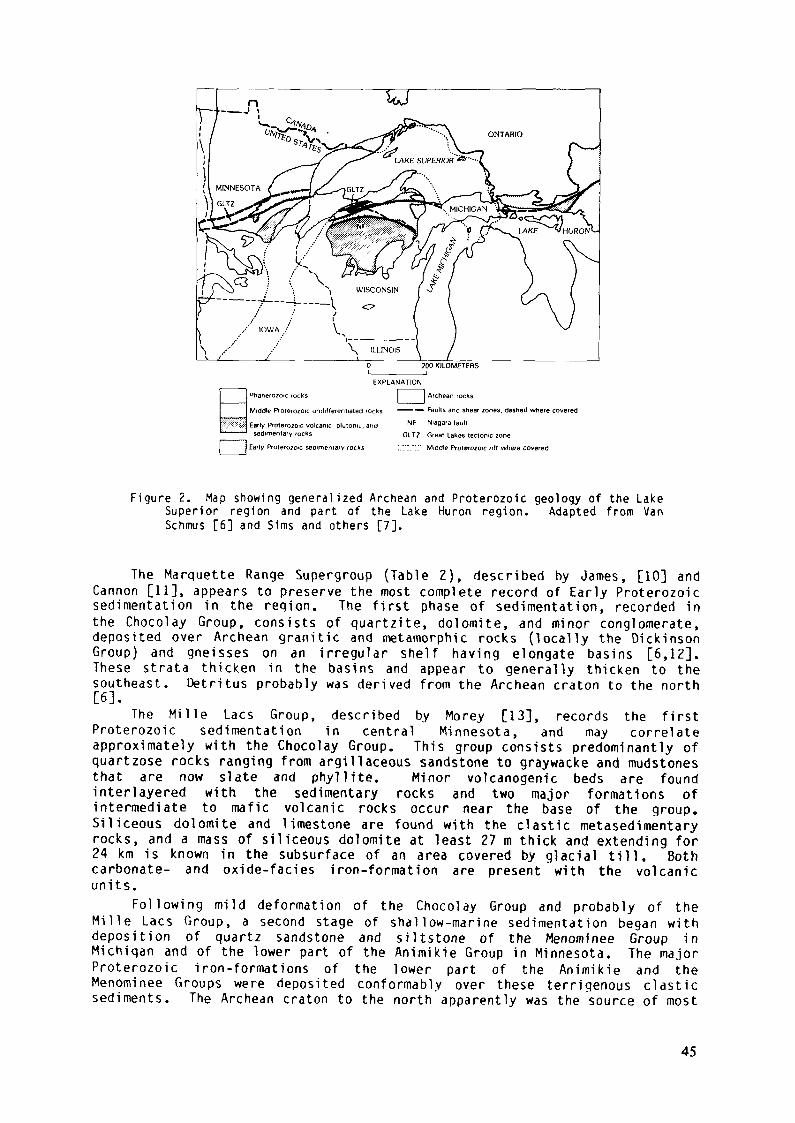
^anerozoic rocks
Middle Proterozûic undilferennated rock
Early Proterozotc volcanic plutomi,, andsedimentary rocks
| Early Prolerozoic sedimentary rocks
EXPLANATION
j Archean rocks
—— — Faults and shear zones, dashed where covered
NF Niagara tault
GLT2 Great Lakes tectonic zone
".".".I" Middle Proterozoic nil where covered
Figure 2. Map showing generalized Archean and Proterozoic geology of the LakeSuperior region and part of the Lake Huron region. Adapted from VanSchmus [6] and Sims and others [7],
The Marquette Range Supergroup (Table 2), described by James, [10] andCannon [11], appears to preserve the most complete record of Early Proterozoicsedimentation in the region. The first phase of sedimentation, recorded inthe Chocolay Group, consists of quartzite, dolomite, and minor conglomerate,deposited over Archean granitic and metamorphic rocks (locally the DickinsonGroup) and gneisses on an irregular shelf having elongate basins [6,12].These strata thicken in the basins and appear to generally thicken to thesoutheast. Detritus probably was derived from the Archean craton to the north[6].
The M i l l e Lacs Group, described by Morey [13], records the firstProterozoic sedimentation in central Minnesota, and may correlateapproximately with the Chocolay Group. This group consists predominantly ofquartzose rocks ranging from argillaceous sandstone to graywacke and mudstonesthat are now slate and phyllite. Minor volcanogenic beds are foundinterlayered with the sedimentary rocks and two major formations ofintermediate to mafic volcanic rocks occur near the base of the group.Siliceous dolomite and limestone are found with the clastic metasedimentaryrocks, and a mass of siliceous dolomite at least 27 m thick and extending for24 km is known in the subsurface of an area covered by glacial till. Bothcarbonate- and oxide-facies iron-formation are present with the volcanicunits.
Following mild deformation of the Chocolay Group and probably of theM i l l e Lacs Group, a second stage of shallow-marine sedimentation began withdeposition of quartz sandstone and siltstone of the Menominee Group inMichigan and of the lower part of the Animikie Group in Minnesota. The majorProterozoic iron-formations of the lower part of the Animikie and theMenominee Groups were deposited conformably over these terrigenous clasticsediments. The Archean craton to the north apparently was the source of most
45
Table 2. Archean and Early Proterozoic in the northern Lake Superiorregion. Modified after [6, 22],
Minnesota Michigan and Wisconsin
PROTEROZOICMajor unconformity
Animikie Group Marquette Range SupergroupUpper part Paint River GroupBaraga Group
UnconformityLower part Menonrinee GroupUnconformity Unconformity
Kenora-Kabetogama Dike SwarmM i l l e Lacs Group Chocolay Group
Major unconformityARCHEAN
Dickinson GroupUnconformity
Basement Complex Basement Complex
of the terrigenous detritus, but mild deformation accompanied sedimentationlocally, and there is some evidence, particularly in Michigan, that uplift wasoccurring to the south [10, 11], and some detritus may have come from thatsource. Uplift and some erosion of the iron-formation followed deposition ofthe Menominee Group in Michigan but not in Minnesota, where sediments of thenext phase apparently were deposited conformably over the iron-formation [14].
The final phase of sedimentation, recorded in the upper part of theAnimikie Group in Minnesota and in the Baraga and Paint River Groups inMichigan, indicates an abrupt increase in depth of water and the accumulationof several thousand meters of graywacke, siltstone, and, in Michigan, ofsubmarine, mostly basaltic, volcanic rocks [6].
The minimum age for rocks of the Marquette Range Supergroup, and bycorrelation the Animikie Group, is between 1850 and 1900 m.y. Deformation andintrusion of granitic rocks ascribed to the Penokean orogeny occurred duringthis interval [15, 16, 17]. In addition, Banks and Van Schmus [17] have datedzircon from rhyolite in the Baraga Group as 1900 m.y. old.
A maximum age for the Animikie Group, and by correlation the MenomineeGroup, has been established by Southwick and Day [18], who demonstrated thatthe Kenora-Kabetogama dike swarm, a swarm of mafic dikes intrusive intoArchean basement, is overlain unconformably by the basal formation of theAnimikie Group. Beck and Murthy [19] reported an age of about 2120 m.y. for adike of this swarm. The age of the Mille Lacs Group relative to the dikeswarm has not been established, but Southwick and Day [18] suggest that thedikes may be contemporaneous with or younger than volcanic rocks in the M i l l eLacs Group.
Van Schmus [6] reported an age of about 2100 m.y. for metamorphism andintrusion of igneous rocks into the basement on which the Marquette RangeSupergroup was deposited. However, an unconformable relationship with thedated igneous rocks has not been established, and Sims [20] suggested thatbasement remobilization and igneous intrusion may have followed deposition of
46
the Marquette Range Supergroup. At least the Chocolay Group may be older than2100 m.y. if correlation of the Menominee Group with the lower part of theAnimikie Group is sound.
Extensional tectonics played an important role during Early Proterozoicsedimentation in the Lake Superior region. Larue and Sloss [12] show thatsedimentary formations of the Chocolay Group are thicker in northeast- toeast-trending, elongate, probably fault-bounded basins that became structuraltroughs during the Penokean orogeny. Basal conglomérâtes of the Chocolay arerestricted to these troughs.
According to Sims and others [7], the Great Lakes tectonic zone is a zoneof recurrent faulting that was extensional during deposition of the Mille Lacsand Animikie Groups. They speculate that faults along the northern boundaryof the Great Lakes tectonic zone coincide with faults of the Murray system inthe Lake Huron region and extend northeastward to the Grenville Province (Fig.1). Thus, the Great Lakes tectonic zone may also have been extensional duringHuronian times.
The tectonic environment in which Early Proterozoic rocks of the LakeSuperior region were deposited remains controversial. Van Schmus [6], Cambray[21], Morey [22], Larue and Sloss [12], and Sims and others [7] all appear toagree that early stages of deposition took place on a southward facingmiogeocline that foundered and became eugeoclinal during later stages of'deposition. However, Van Schmus [6], Cambray [21] and Larue and Sloss [12]regard the area as a passive continental margin, perhaps with extensional riftzones although Morey [22] and Sims and others [7] regard the sedimentarybasins as intracratonic.
Compressional deformation in the Lake Superior region began during thelate stages of deposition of the Animikie Group and Marquette Range Supergroupand culminated with the Penokean orogeny around 1850 to 1900 m.y. ago [6,7]. This orogeny was accompanied by-intrusion of dioritic to granitic plutonsin the southern Lake Superior region [6, 23, 24]. A younger suite of deformedand mildly metamorphosed granitic rocks and associated rhyolitic ignimbrites,which intruded the southern Lake Superior«region in southern Wisconsin 1750 to1800 m.y. ago [6], represents a younger cycle of post-Penokean deposition,plutonism, and metamorphism.
4. THE BLACK HILLSThe Black H i l l s uplift of South Dakota (Fig. 1) is an elongate dome or
anticline, cored by Precambrian rocks, that was uplifted during the Laramideorogeny approximately at the end of the Cretaceous Period. The Precambriancore consists mostly of Early Proterozoic metasedimentary and igneous rocks,but Archean granitic rocks crop out in two structural domes that appear to bemantled gneiss domes. Uraniferous metaconglomerate is exposed on the flank ofone of the domes in the eastern Black Hills, near Rapid City. The geology ofthe Black Hills region, summarized below, is based on the work of Redden [25,26] and Redden and Norton [27].
Four -cycles of Early Proterozoic metasedimentary rocks, three of whichare known to be separated by unconformities, are recognized in the Black Hills(Table 3). The first cycle consists of phyllite and iron-formation, which arepoorly exposed and little known. Their age relative to the Archean granite isnot known.
The second cycle consists of the Proterozoic (?) Boxelder Creek Formationand the Benchmark Iron-formation. The Boxelder Creek Formation is a thicksuccession of mainly clastic sedimentary rocks that includes quartzite,phyllite, conglomerate, and minor carbonate rocks. Both well-sortedoligomictic and poorly-sorted polymictic conglomerates are found in theBoxelder Creek. The well-sorted beds contain pyrite and anomalousconcentrations of uranium, thorium, and gold, but all apparently in presently-subeconomic quantities.
47
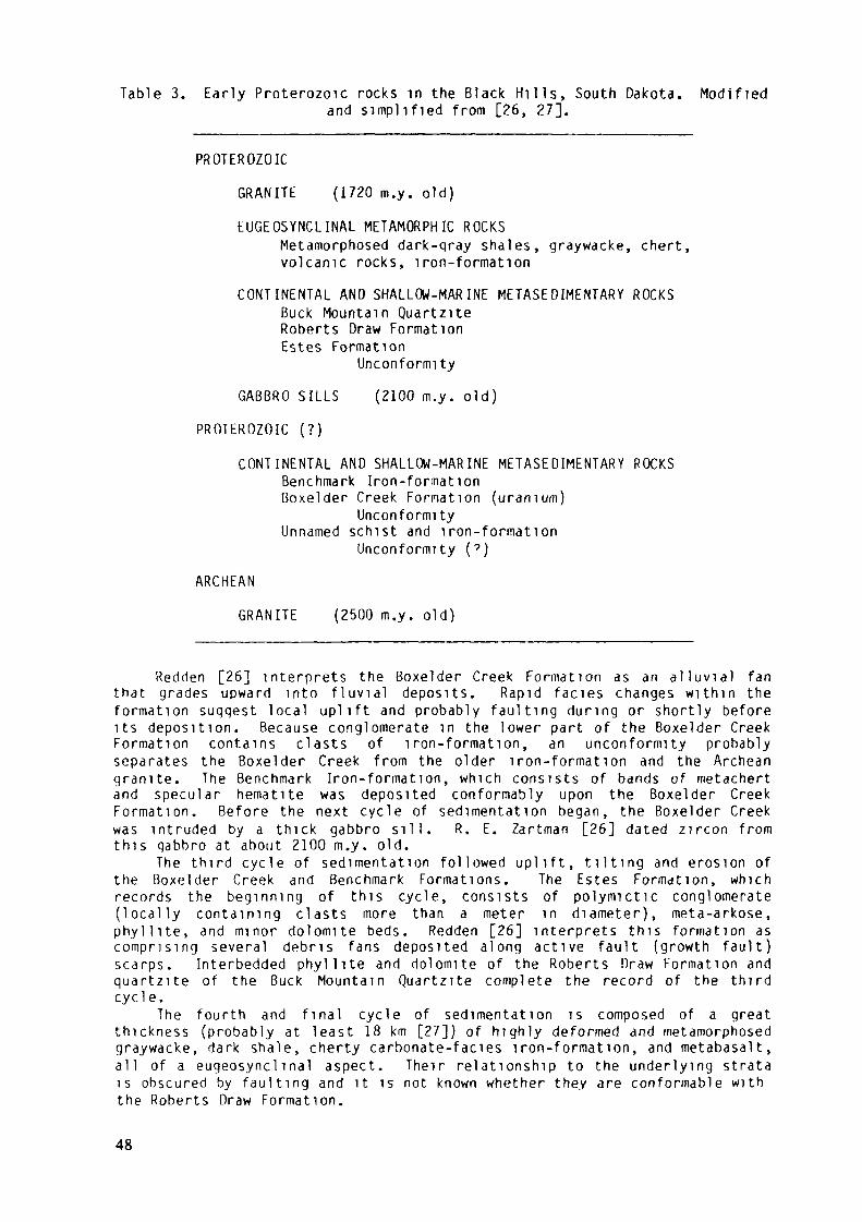
Table 3. Early Proterozoïc rocks in thé Black Hills, South Dakota. Modifiedand simpli f ied from [26, 27].
PROTEROZOIC
GRANITE (1720 m.y. old)
EUGEOSYNCLINAL METAMORPHIC ROCKSMetamorphosed dark-qray shales, graywacke, chert,volcanic rocks, iron-formation
CONTINENTAL AND SHALLOW-MARINE METASEDIMENTARY ROCKSBuck Mountain Quartz i teRoberts Draw FormationEstes Formation
Unconformity
GABBRO SILLS (2100 m.y. old)
PROTEROZOIC (? )
CONTINENTAL AND SHALLOW-MARINE METASEDIMENTARY ROCKSBenchmark Iron-formationßoxelder Creek Formation (uranium)
UnconformityUnnamed schist and iron-formation
Unconformity (? )
ARCHEAN
GRANITE (2500 m.y. old)
Redden [26] interprets the ßoxelder Creek Formation as an a l l u v i a l fanthat grades upward into f l u v i a l deposits. Rapid faciès changes within theformation suggest local uplift and probably faulting during or shortly beforeits deposition. Because conglomerate in the lower part of the Boxelder CreekFormation contains clasts of iron-formation, an unconformity probablyseparates the Boxelder Creek from the older iron-formation and the Archeangranite. The Benchmark Iron-formation, which consists of bands of metachertand specular hematite was deposited conformably upon the Boxelder CreekFormation. Before the next cycle of sedimentation began, the Boxelder Creekwas intruded by a thick gabbro s i l l . R. E. Zartman [26] dated zircon fromthis gabbro at about 2100 m.y. old.
The third cycle of sedimentation followed uplift, t i l t i n g and erosion ofthe Boxelder Creek and Benchmark Formations. The Estes Formation, whichrecords the beginning of this cycle, consists of polymictic conglomerate(locally containing clasts more than a meter in diameter), meta-arkose,phyllite, and minor dolomite beds. Redden [26] interprets this formation ascomprising several debris fans deposited along active fault (growth fault)scarps. Interbedded phyllite and dolomite of the Roberts Draw Formation andquartzite of the Buck Mountain Quartzite complete the record of the thirdcycle.
The fourth and final cycle of sedimentation is composed of a greatthickness (probably at least 18 km [27]) of highly deformed and metamorphosedgraywacke, dark shale, cherty carbonate-faciès iron-formation, and metabasalt,all of a eugeosynclmal aspect. Their relationship to the underlying stratais obscured by faulting and it is not known whether they are conformable withthe Roberts Draw Formation.
48
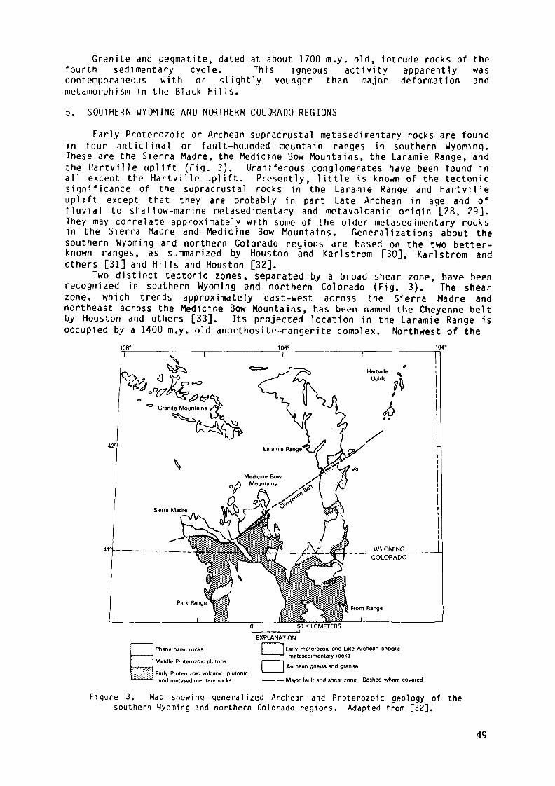
Granite and peqmatite, dated at about 1700 m.y. old, intrude rocks of thefourth sedimentary cycle. This igneous activity apparently wascontemporaneous with or sliqhtly younger than major deformation andmetamorphism in the Black Hills.5. SOUTHERN WYOMING AND NORTHERN COLORADO REGIONS
Early Proterozoic or Archean supracrustal metasedimentary rocks are foundin four anticlinal or fault-bounded mountain ranges in southern Wyoming.These are the Sierra Madre, the Medicine Bow Mountains, the Laramie Range, andthe Hartville uplift (Fig. 3). Uraniferous conglomerates have been found inall except the Hartville uplift. Presently, little is known of the tectonicsignificance of the supracrustal rocks in the Laramie Range and Hartvilleuplift except that they are probably in part Late Archean in age and offluvial to shallow-marine metasedimentary and metavolcanic origin [28, 29].They may correlate approximately with some of the older metasedimentary rocksin the Sierra Madre and Medicine Bow Mountains. Generalizations about thesouthern Wyoming and northern Colorado regions are based on the two better-known ranges, as summarized by Houston and Karl ström [30],others [31] and Hills and Houston [32].
Two distinct tectonic zones, separated by a broad shearrecognized in southern Wyoming and northern Colorado (Fig.zone, which trends approximately east-west across the Sierra Madre andnortheast across the Medicine Bow Mountains, has been named the Cheyenne beltby Houston and others [33]. Its projected location in the Laramie Range isoccupied by a 1400 m.y. old anorthosite-mangerite complex. Northwest of the
Karlstrom andzone,3).
have beenThe shear
108° 106° 104°
HartvilleUplift
« •
XX
\
__ WYOMING __ ___LCOLORADO
Front Range
50 KILOMETERS
EXPLANATION
Phanerozoic rocks
Middle Proterozoic plutons
Early Proterozoic volcanic, plutonic,and metasedimentary rocks
[ 1 Early Proterozoic and Late Archean ensialict————' metasedimentary rocks
I Archean gneiss and granite
—— — Major fault and shear zone Dashed where covered
Figure 3. Map showing generalized Archean and Proterozoic geology of thesouthern Wyoming and northern Colorado regions. Adapted from [32].
49
Cheyenne belt, ensialic Late Archean and Early Proterozoic rocks overly abasement of Archean granite and gneiss, whereas, southeast of the belt, onlyEarly Proterozoic metasedimentary, metavolcanic, and plutomc rocks areknown. No evidence has been found for rocks more ancient than 1800 to 1900m.y. old south of the belt. The region northwest of the Cheyenne belt will becalled the southern Wyoming region, and the region southeast of the Cheyennebelt, although partly in southern Wyoming, will be called the northernColorado region.
Six cycles of sedimentation have been recognized in the Late Archean andEarly Proterozoic rocks north of the Cheyenne belt [30, 31], butunconformities within some of these cycles could justify their subdivisioninto additional cycles. The first cycle of sedimentation is recorded by thePhantom Lake Metamorphic Suite (Table 4), a succession of metaconqlomerate,quartzite, and metavolcanic rocks having an aggregate thickness of more than 3km [31]. Quartz-pebble conglomerates contain pyrite and anomalousconcentrations of uranium. Contact relations between the Phantom LakeMetamorphic Suite and Archean gneisses are obscured by intrusion of largesills and dikes of mafic rocks, by tight isoclinal folding, and by amphibolitefaciès metamorphism, but Houston and Karl ström [30] and Karl ström and others[31] suggest that the Phantom Lake Suite lies unconformably on Archean gneissdated as approximately 2600 m.y. old. Sills and dikes of granitic rocks thatyield Rb-Sr whole-rock dates ranging from about 2350 to 2500 m.y. (all withlarge uncertainties) intrude the Phantom Lake, indicating that the PhantomLake is probably latest Archean or Early Proterozoic in age.
The Snowy Pass Supergroup of Early Proterozoic age includes the Deep LakeGroup and the Libby Creek Group. The Deep Lake Group, which appears to lieunconformably over the Phantom Lake Suite, comprises three cycles ofsedimentation [30], each bounded by an unconformity, and each consisting ofbasal conglomerate beds overlain by quartzites, pebbly quartzites, and pebblyarkoses, but the uppermost cycle contains marble as well. The record of thesethree cycles aggregates over 2000 m thick.
The basal conglomerate of the first cycle in the Deep Lake Group is theuraniferous, pyrite-bearing Magnolia Formation, a fluvial deposit that passesupward into fluvial deltaic quartzite. Succeeding cycles consist of rocksinterpreted as of glacio-marine, fluv i a l , and shallow-marine origin. Thicks i l l s and dikes of gabbroic igneous rocks intrude the Deep Lake and PhantomLake strata, but not the Libby Creek Group.
The Libby Creek Group is in thrust-fault contact with strata of the DeepLake Group, and its age relative to those rocks is speculative. Nevertheless,based on the following three lines of evidence, Houston and Karlstrom [30] andKarl ström and others [31], infer that the Libby Creek Group is younger thanthe Deep Lake Group: (1) Conglomerates of the Libby Creek Group are notenriched in uranium, as they are in the Deep Lake; (2) The main iron mineralsare iron oxides rather than pyrite; and (3) Speculative 11 thostratigraphiccorrelations suggest that the lower part of the Libby Creek Group maycorrelate with the upper part of the Huronian Supergroup, whereas the DeepLake Group may correlate with lower parts of the Huronian Supergroup.
The fifth sedimentary cycle, recorded by the approximately 4000 m thicklower part of the Libby Creek Group consists of mainly siliceous, clasticunits deposited in a shallow-marine deltaic environment [31]. Quartzitepredominates over other lithologies in the lower part of the Libby Creek, andin general, these quartzites are more mineralogical ly mature than those of theDeep Lake Group or Phantom Lake Suite. A small plug of granitic rock, datedat about 2000 m.y. old, intrudes strata of the lower part of the Libby CreekGroup.
The sixth and last cycle of Early Proterozoic sedimentation in the areais recorded in the upper part of the Libby Creek Group. These strata are inthrust-fault contact with the lower part of the Libby Creek Group, and theirage relative to the lower part of the Libby Creek is in some doubt [31].
50
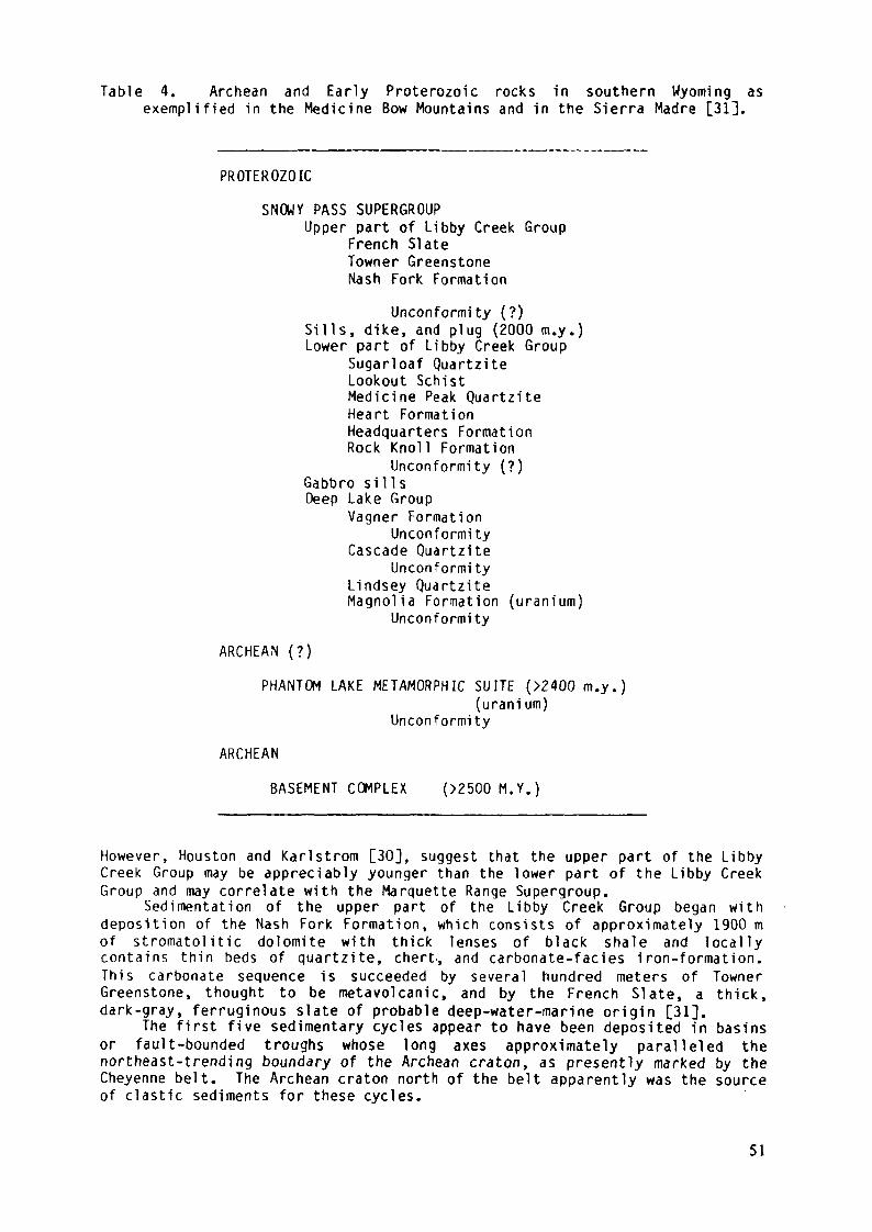
Table 4. Archean and Early Proterozoic rocks in southern Wyoming asexemplified in the Medicine Bow Mountains and in the Sierra Madre [31],
PROTEROZOICSNOWY PASS SUPERGROUP
Upper part of Libby Creek GroupFrench SlateTowner GreenstoneNash Fork Formation
Unconformity (?)Sills, dike, and plug (2000 m.y.)Lower part of Libby Creek Group
Sugarloaf QuartziteLookout SchistMedicine Peak QuartziteHeart FormationHeadquarters FormationRock Knoll Formation
Unconformity (?)Gabbro s i l l sDeep Lake Group
Vagner FormationUnconformity
Cascade QuartziteUnconformi ty
Lindsey QuartziteMagnolia Formation (uranium)Unconformity
ARCHEAN (?)PHANTOM LAKE METAMORPHIC SUITE (>2400 m.y.)
(uranium)Unconformity
ARCHEANBASEMENT COMPLEX (>2500M.Y.)
However, Houston and Karl ström [30], suggest that the upper part of the LibbyCreek Group may be appreciably younger than the lower part of the Libby CreekGroup and may correlate with the Marquette Range Supergroup.Sedimentation of the upper part of the Libby Creek Group began withdeposition of the Nash Fork Formation, which consists of approximately 1900 mof stromatolitic dolomite with thick lenses of black shale and locallycontains thin beds of quartzite, chert., and carbonate-faciès iron-formation.This carbonate sequence is succeeded by several hundred meters of TownerGreenstone, thought to be metavolcanic, and by the French Slate, a thick,dark-gray, ferruginous slate of probable deep-water-marine origin [31].
The first five sedimentary cycles appear to have been deposited in basinsor fault-bounded troughs whose long axes approximately paralleled thenortheast-trending boundary of the Archean craton, as presently marked by theCheyenne belt. The Archean craton north of the belt apparently was the sourceof clastic sediments for these cycles.
51
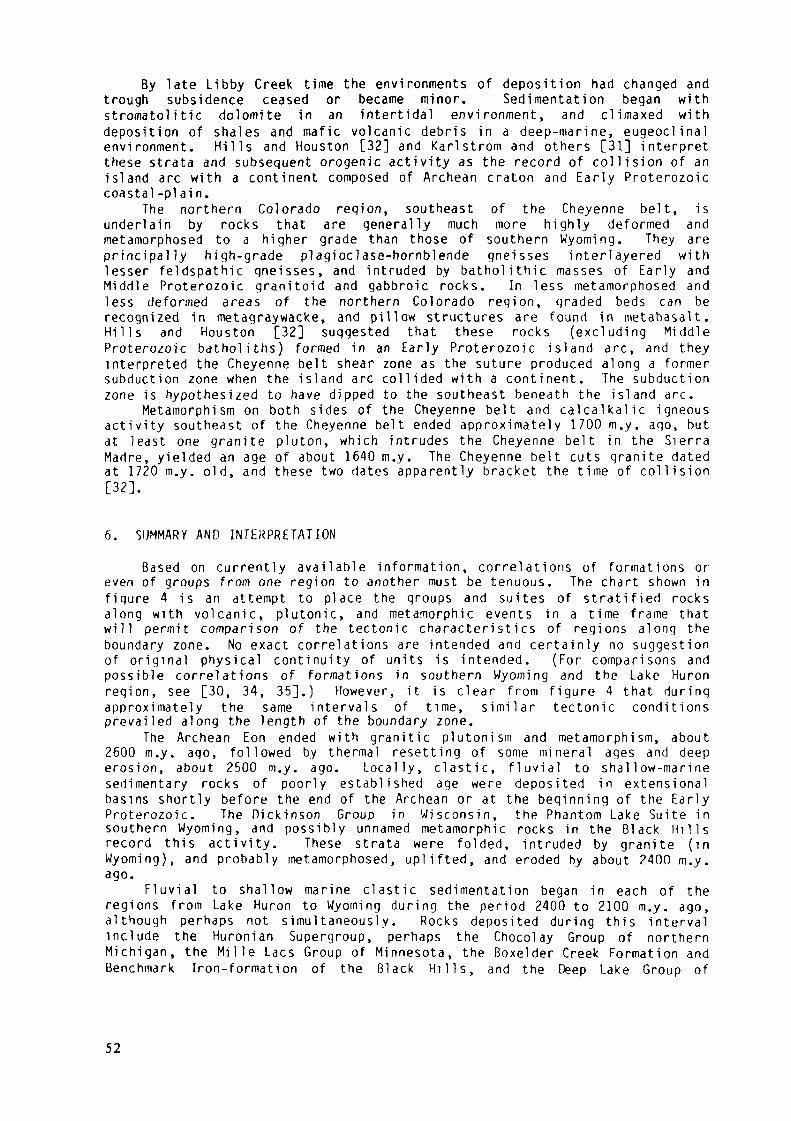
By late Libby Creek time the environments of deposition had changed andtrough subsidence ceased or became minor. Sedimentation began withstromatolitic dolomite in an intertidal environment, and climaxed withdeposition of shales and mafic volcanic debris in a deep-marine, eugeoclinalenvironment. H i l l s and Houston [32] and Karlstrom and others [31] interpretthese strata and subsequent orogenic activity as the record of collision of anisland arc with a continent composed of Archean craton and Early Proterozoiccoastal-pi ai n.
The northern Colorado region, southeast of the Cheyenne belt, isunderlain by rocks that are generally much more highly deformed andmetamorphosed to a higher grade than those of southern Wyoming. They areprincipally high-grade plagioclase-hornblende gneisses interlayered withlesser feldspathic gneisses, and intruded by batholithic masses of Early andMiddle Proterozoic granitoid and gabbroic rocks. In less metamorphosed andless deformed areas of the northern Colorado region, graded beds can berecognized in metagraywacke, and pillow structures are found in metabasalt.H i l l s and Houston [32] suggested that these rocks (excluding MiddleProterozoic batholiths) formed in an Early Proterozoic island arc, and theyinterpreted the Cheyenne belt shear zone as the suture produced along a formersubduction zone when the island arc collided with a continent. The subductionzone is hypothesized to have dipped to the southeast beneath the island arc.
Metamorphism on both sides of the Cheyenne belt and c a l c a l k a l i c igneousactivity southeast of the Cheyenne belt ended approximately 1700 m.y. ago, butat least one granite pluton, which intrudes the Cheyenne belt in the SierraMadre, yielded an age of about 1640 m.y. The Cheyenne belt cuts granite datedat 1720 m.y. old, and these two dates apparently bracket the time of collision[32].
6. SUMMARY AND INTERPRETATION
Based on currently available information, correlations of formations oreven of groups from one region to another must be tenuous. The chart shown infigure 4 is an attempt to place the groups and suites of stratified rocksalong with volcanic, plutonic, and metamorphic events in a time frame thatw i l l permit comparison of the tectonic characteristics of regions along theboundary zone. No exact correlations are intended and certainly no suggestionof original physical continuity of units is intended. (For comparisons andpossible correlations of formations in southern Wyoming and the Lake Huronregion, see [30, 34, 35].) However, it is clear from figure 4 that duringapproximately the same intervals of time, s i m i l a r tectonic conditionsprevailed along the length of the boundary zone.
The Archean Eon ended with granitic plutonism and metamorphism, about2600 m.y. ago, followed by thermal resetting of some mineral ages and deeperosion, about 2500 m.y. ago. Locally, clastic, f l u v i a l to shallow-marinesedimentary rocks of poorly established age were deposited in extensionalbasins shortly before the end of the Archean or at the beginning of the EarlyProterozoic. The Dickinson Group in Wisconsin, the Phantom Lake Suite insouthern Wyoming, and possibly unnamed metamorphic rocks in the Black H i l l srecord this activity. These strata were folded, intruded by granite (inWyoming), and probably metamorphosed, uplifted, and eroded by about 2400 m.y.ago.
F l u v i a l to shallow marine clastic sedimentation began in each of theregions from Lake Huron to Wyoming during the period 2400 to 2100 m.y. ago,although perhaps not simultaneously. Rocks deposited during this intervalinclude the Huronian Supergroup, perhaps the Chocolay Group of northernMichigan, the M i l l e Lacs Group of Minnesota, the Boxelder Creek Formation andBenchmark Iron-formation of the Black H i l l s , and the Deep Lake Group of
52
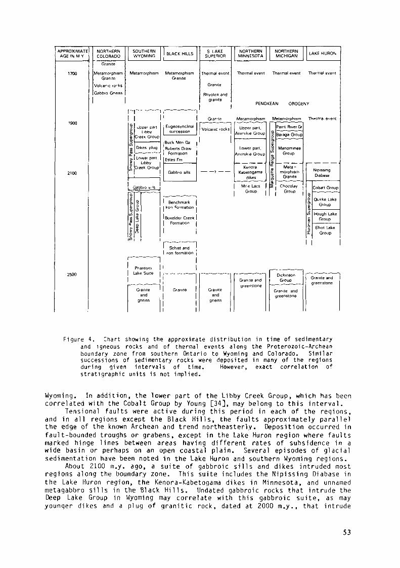
APPROXIMATEAGE IN M Y
1700
1900
2100
2500
NORTHERNCOLORADO
Granite
MetamorphismGranite
Volcanic rorks
Gabbro Gneiss
SOUTHERNWYOMING BLACK HILLS
Metamorphism Metamorphism
rr~1
Granite
S LAKESUPERIOR
Thermal event
Granite
Rhyohte andgranite
NORTHERNMINNESOTA
NORTHERNMICHIGAN LAKE HURON
Thermal event Thermal event Thermal event
PENOKEAN OROGENY———^ ,- -~~^—
3 Upper part| LibbyS"" Creek Group
(O« Dtkes plug<£ ~"~~
r Lower parto 1 Llbt>Vfj Creek Group
Gabbro sills— -, - —Q
1 Q.Dl DS £Q. fO3
if Qi. 0)Ï AI °c
C/Î
i — — "
_ ___ _ _
Eugeosynchnalsuccession 1
Buck Mm Qz |
Granite Metamorphism Metamorphism Thprmal e^ent1 —— ———— 1Volcanic rocks
Roberts Draw 'Formation |
Estes Fm
Gabbro sills — —,— —
-_ —— — — • — — ™- »Benchmark
Iron Formation
Boxelder CreekFormation
Upper part,Animikie Group
Lower part,Animikie Group
KenoraKabetogama
dikes
Mille LacsGroup
Paint River Gr
g Baraga Group5)SD Menominee» Group
1 — — — -œ Meta -c morphism3 GraniteCT
5 ChocolayGroup
1
NipissingDiabase
Cobalt Groupa ' ~" "~~ 'D° Ouirke Lakej Gioup
(/} Hough LakeS Group
2 Elliot LakeX Group
' Schist and !
- —————1
PhantomLake Suite
— ~ — . — . —Granite
andgneiss
iron formation
—————
Granite
1
- — -— ~ — ~ — ——
Graniteand
gneiss
Granite andgreenstone
| DickmsonGroup
_ ————— - — —
Granite andgreenstone
Granite andgreenstone
Figure 4. Char t showing the approximate d is t r ibut ion in t ime of sedimentaryand igneous rocks and of thermal events along the Proterozoic-Archeanboundary zone from southern Ontar io to Wyoming and Colorado. Similarsuccess ions of sedimentary rocks were deposi ted in many of the regionsduring given in tervals of t ime. However, exact correlat ion ofs t ra t ig raph ie units is not implied.
Wyoming. In addition, the lower part of the Libby Creek Group, which has beencorrelated wi th the Cobalt Group by Young [34], may belong to this interval .
Tensional fau l ts were ac t i ve during this period in each of the regions,and in all regions except the Black Hills, the faults approximately paral le lthe edge of the known Archean and trend northeasterly. Deposition occurred infault-bounded troughs or grabens, except in the Lake Huron region where fau l tsmarked hinge lines between areas having different rates of subsidence in awide basin or perhaps on an open coastal plain. Several episodes of g lac ia lsedimentation have been noted in the Lake Huron and southern Wyoming regions.
About 2100 m.y. ago, a suite of gabbroic si l ls and dikes intruded mostregions along the boundary zone. This suite includes the Nipissing Diabase inthe Lake Huron region, the Kenora-Kabetogama dikes in Minnesota, and unnamedmetagabbro sil ls in the Black Hil ls. Undated gabbroic rocks that intrude theDeep Lake Group in Wyoming may corre late w i th this gabbroic suite, as mayyounqer dikes and a plug of grani t ic rock, dated at 2000 m.y., that intrude
53
the lower part of the Libby Creek Group. In northern Michigan, metamorphismand intrusion of a small amount of granitic rock has been dated atapproximately 2100 m.y. ago.
Between 2100 and 2000 m.y. ago, clastic sedimentation began in northernMichigan and northern Minnesota and was followed by deposition of the greatProterozoic carbonate-faciès iron-formations. Deposition apparently occurredin a wide, shallow basin or perhaps on a miogeoclinal continental shelf.Farther west, in the Black Hills, the oldest sedimentary rocks depositedduring this interval were coarse conglomerates deposited in fault-boundedbasins, but these were followed by dolomite. If the lower part of the LibbyCreek Group is assigned to this time interval, sedimentation in southernWyoming began in a deltaic environment along a coast on which there was somefaulting. However, if the lower part of the Libby Creek Group is older andcorrelates approximately with the Cobalt Group, sedimentation began withdeposition of stromatoli tic dolomite containing lenses of black shale andminor carbonate iron-formation of the upper part of the Libby Creek Group.Karlstrom and others [31] interpreted the depositional environment as tidalflats with a shoreline to the northwest and an open marine basin or ocean tothe southeast.
Following deposition of the iron-formations and carbonate banks, thewhole boundary zone (possibly excepting the Lake Huron region, where there isno record of post-Nipissing sedimentation) apparently foundered and greatthicknesses of dark shales, graywackes, cherts, and volcanic rocks weredeposited in a eugeosynclinal environment. Strata of this association includethe Baraga and Paint River Groups in northern Michigan, the upper part of theAnimikie Group of Minnesota, the greater part of the Proterozoic sectionexposed in the Black H i l l s , and the uppermost upper part of the Libby CreekGroup in Wyoming.
The eugeoclinal stage apparently climaxed with the Penokean orogeny about1900 m.y. ago in the east and central regions and possibly in the west,although no compelling geochronologic evidence for this orogeny has beenrecognized in the Black H i l l s or in southern Wyoming and Colorado. In thesouthern Lake Superior region, 1800 to 1900 m.y. old granitic plutons intrudeapproximately contemporaneous volcanic rocks and earlier Archean rocks. Southof the Cheyenne belt, in northern Colorado, a well-dated gabbroic plutonintruded metavolcanic rocks about 1780 m.y. ago [36]. Dates between 1800 and1900 m.y. [37] have been reported for several other metamorphosed plutons, butthese dates are considered tentative because they are either based on too fewdata or because they have large probable errors.
The last event to affect the boundary zone during the Early Proterozoicwas widespread orogenesis that apparently began between 1800 and 1750 m.y. agoand lasted until about 1700 m.y. ago, although locally it may have ended aslate as about 1640 m.y. ago. Granitic plutons associated with this event arefound south of the Cheyenne belt in southern Wyoming and Colorado, in theBlack Hills, in the southern Lake Superior region, and in eastern Ontario[38]. Low- to medium-grade metamorphism overprinted both the EarlyProterozoic and Archean rocks along most of the boundary zone from Ontario toWyoming.
Major Early Proterozoic structures trend approximately parallel to theboundary zone along most of its length. These structures include the majorfaults and shear zones, such as the Murray, Flack, and Niagara faults, theGreat Lakes tectonic zone, and the Cheyenne belt, and the major foldstructures in the Lake Huron region, the troughs and basins in the northernLake Superior region, and the troughs and fold structures in southernWyoming. Similar orientations of structures are found in the more complexvolcanic and plutonic terranes of northern Colorado and of the southern LakeSuperior region. The Black Hills region, however, may be exceptional. Majorstructures trend approximately to the northwest and at a high angle to thelin e formed by the boundary zone elsewhere. Geophysical studies [39] as wellas geochronologic and pétrographie studies [40] of basement samples from wells
54
that pierce the cover of Paleozoic sedimentary rocks north of the Black H i l l sindicate that a zone of Early Proterozoic rocks runs northward between theArchean Wyoming Province and the Archean Superior Province (Fig. 1) from theBlack Hills, perhaps as far as northern Saskatchewan.
The tectonic environment or environments in which the boundary zoneformed during the Early Proterozoic is still controversial, and may remain sobecause the boundary zone is so incompletely exposed. Paleozoic sedimentaryrocks lap up onto the southeastern side of the boundary zone in the Lake Huronand Lake Superior regions, and the western exposures are mostly surrounded byyounger rocks. Only in Wyoming and Colorado is a continuous, if narrow, stripexposed across the boundary zone.
Archean basement is found in both the northern and southern Lake Superiorregion, and it is not known whether the Early Proterozoic depositional troughsformed between Archean cratons or near the edge of an Archean craton.However, as no Archean rocks are known from the subsurface south of exposuresin Wisconsin or Minnesota, and none are known from south of the Cheyenne beltor its projected location in Wyoming or Colorado, it is probable that thesouthernmost present exposures of Archean rocks in the Lake Superior regionare near the southern li m i t of the craton during the Early Proterozoic.Perhaps the boundary was a marginal mobile belt [6] analogous to more recentmobile belts such as the Appalachian Mountains.
Numerous authors [41, 32, 6, 37, 21, 12, 31,9] have proposed plate-tectonic models for portions of the boundary zone. A hypothetical plate-tectonic history of the boundary zone may be outlined as follows:1. Rifting of the Archean craton occurred at the end of the Archean or
during earliest Proterozoic time. Faults of the Great Lakes tectoniczone and similar extensional faults in the Black Hills and southernWyoming formed at this time and were reactivated repeatedly during theEarly Proterozoic. Fluvial and glacial sediments accumulated in riftvalleys or on faulted coastlines and were succeeded by shallow-marinedeposits. Volcanism was associated with rifting locally, and mafic dikesand sills were emplaced along most of the boundary zone about 2100 m.y.ago.
2. As rifting became less pronounced, sedimentation continued on a passive,Atlantic-type coastal plain. Fine sands and silt were succeeded bycarbonate-bank deposits, which include the extensive carbonate-facièsiron-formations in eastern regions.
3. The boundary zone foundered and great thicknesses of eugeoclinal rocksaccumulated as volcanic arcs developed offshore or as the EarlyProterozoic ocean closed and collision with a volcanic arc approached.
4. Congressional and volcano-plutonic stages of the orogenic cycle, (thePenokean orogeny in eastern areas and perhaps the approximately 1700 m.y.event in the west) occurred when either back-arc areas collapsed or whenthe boundary zone collided with a volcanic arc as the Early Proterozoicocean closed. Lack of calcalkalic igneous activity northwest of theCheyenne belt or north of the southern Great Lakes region suggests thelatter possibility. If this speculation is correct, then apparently someof the Archean gneisses south of the Niagara fault and its hypotheticalextension in Minnesota may have been on the volcanic arc, either asexotic terrane or as basement in an Andean-type volcanic arc. As noArchean rocks are known south of the Cheyenne belt, an ensimatic islandarc is suggested as the progenitor of that region.Uraniferous conglomerates at Elliot Lake and in the Witwatersrand are
found in fluvial-fan deposits [42, 43], as apparently are those in the BlackH i l l s and in southern Wyoming. Whereas the Witwatersrand conglomerates wereapparently deposited in an interior basin surrounded by Archean craton, [44],uraniferous conglomerates of the Proterozoic-Archean boundary zone insoutheastern Canada and the northern United States apparently formed in rift
55
valleys or on a passive continental margin, perhaps during the early,spreading phase of continental dispersion and ocean growth. The deposits inthe boundary zone were preserved because the zone foundered, was deeplyburied, and later was compressed to form deep, synclinal basins durinq thePenokean or other Early Proterozoic orogenies.
The structural basins containing Early Proterozoic ensialic sedimentaryrocks are scattered discontinuously in a narrow belt along the Proterozoic-Archean boundary zone, and the areal extent of outcrops of uraniferousconglomerates and their associated f l u v i a l sandstones is almost vanishinglysmall. Except for the early, chance discovery in the Matinenda Formation nearE l l i o t Lake and subsequent discoveries in the basal Huronian beds of nearbyareas, the uraniferous conglomerates were not found un t i l a genetic theory hadbeen developed [45, 46, 47] that led geologists to examine areas likely tohave rocks of the appropriate age and faciès. Following this, however,genetically s i m i l a r (although economically inferior) uraniferous conglomerateswere discovered in each of the basins or troughs along the boundary zone whererocks of sufficient age are found. Similar boundary zones between Archeancraton and Proterozoic mobile belts, found in the Canadian Shield and inPrecambrian shields of other continents, also may preserve fluvial sedimentaryrocks deposited during early, extensional phases of their tectonicdevelopment, and these boundary zones should be given a high priority asexploration targets for uraniferous Precambrian conglomerates.
REFERENCES[I] GOLDICH, S.S., LIDIAK, E.G., HEDGE, C.E., WALTHALL, F.G..Geochronology of
the midcontinent region, United States, pt. 2, Northern area.Journal of Geophysical Research _n_ (1966) 5389-5408.
[2] ROSCOE, S.M., Huronian rocks and uraniferous conglomerates in the CanadianShield. Geological Survey of Canada Paper 68-40 (1969) 205 p.
[3] ROBERTSON, J.A., The Blind River uranium deposits: the ores and theirsetting. Ontario Division of Mines Miscellaneous Paper 65_ (1976) 45P.[4] CLOUD, P.E., Atmospheric and hydrospheric evolution of the primitiveEarth. Science 160 (1968) 729-736.
[5] VAN SCHMUS, W.R., The geochronology of the Blind River-Bruce Mines area,Ontario, Canada. Journal of Geology _7_3 (1965) 755-780.
[6] VAN SCHMUS, W.R., Early and middle Proterozoic history of the Great Lakesarea, North America. Royal Society of London PhilosophicalTransactions, Series A, 280 (1976) 605-628.
[7] SIMS P.K., CARD, K.D., MOREY, G.B., PETERMAN, Z.E.Jhe Great Lakestectonic zone--A major crustal structure in central North America.Geological Society of America Bulletin _9J_ (1980) 690-698.
[8] MOREY, G.B., SIMS, P.K., CANNON, W.F., MUDREY, M.G., JR., SOUTHWICK, D.L.,Geologic map of the Lake Superior region, Minnesota, Wisconsin, andnorthern Michigan. Minnesota Geological Survey Map Series S-13(1982) 1:1,000,000.
[9] GREENBERG, J.K., BROWN, B.A., Lower Proterozoic volcanic rocks and theirsetting in southern Lake Superior district. In Early Proterozoicgeology of the Great Lakes region (ed. L.G. Medaris, Jr.).Geological Society of America Memoir 160 (1982) 67-84.
[10] JAMES H.L., Sedimentary faciès of i ron-formation. Economic Geology 49(1954) 235-293.
[II] CANNON, W.F., The Penokean orogeny in northern Michigan. In Huronianstratigraphy and sedimentation (ed. G.M. Young). GeologicalAssociation of Canada Special Paper _1_2 (1973) 251-271.
[12] LARUE, O.K., SLOSS, L.L., Early Proterozoic sedimentary basins of theLake Superior region: Summary. Geological Society of AmericaBulletin _91_ (1980) 450-452.
56
[13] MOREY, G.B., Lower and middle Precarnbrian stratigraphie nomenclature foreast-central Minnesota. Minnesota Geological Survey Report ofInvestigations 2l_ (1978) 52 p.
[14] MOREY, G.B., Stratigraphie framework of middle Precarnbrian rocks inMinnesota. In Huronian stratigraphy and sedimentation (ed. G.M.Young). Geological Association of Canada Special Paper J_2_ (1973) 211-249.
[15] ALDRICH, L.T., DAVIS, G.L., JAMES, J.L., Ages of minerals frommetamorphic and igneous rocks near Iron Mountain, Michigan. Journalof Petrology _6 (1965) 445-472.
[16] BANKS, P.O., VAN SCHMUS, W.R., Chronology of Precambrian rocks of Ironand Dickinson Counties, Michigan (abs.). Institute on Lake SuperiorGeology Proceedings, Abstracts and Field Guides 17 (1971) 9-10.
[17] BANKS, P.O., VAN SCHMUS, W.R., Chronology of Precambrian rocks of Ironand Dickinson Counties, Michigan, Part II (abs.). Institute on LakeSuperior Geology Proceedings, Abstracts and Field Guides _1_8 (1972)Paper 23.
[18] SOUTHWICK, D.L., DAY, U.C., Geology and petrology of Proterozoic maficdikes, north-central Minnesota and western Ontario. Canadian Journalof Earth Sciences j?0_ (1983), 622-638.
[19] BECK, W., MURTHY, V.R., Rb-Sr and Sm-Nd isotopic studies of Proterozoicmafic dikes in northeastern Minnesota (Abs.). Institute of LakeSuperior Geology Proceedings, Abstracts and Field Guide 28 (1982)
[20] SIMS, P.K., Precambrian tectonics and mineral deposits, Lake Superiorregion. Economic Geology J71_ (1976) 1092-1118.
[21] CAMBRAY, F.W., Plate tectonics as a model for the environment ofdeposition and deformation of the Early Proterozoic (Precambrain X)of northern Michigan (Abs). Geological Society of America Abstractswith Programs JJ3 (1978) 376.
[22] MOREY, G.B., Stratigraphy and tectonic history of east-centralMinnesota. In Field trip guidebook for stratigraphy, structure andmineral resources of east-central Minnesota (ed. N.H. Balaban).Minnesota Geological Survey Guidebook Series 9 (1979)
[23] KEIGHIN, C.W., MOREY, G.B., GOLDICH, S.S., F.ast~central Minnesota. InGeology of Minnesota: A centennial volume (ed. P.K. Sims and G.B.Morey). Minnesota Geological Survey (1972) 240-255.
[24] GOLDICH, S.S., HEDGE, C.E., STERN, T.W., Age of the Morton and Montevideogneisses and related rocks, southwestern Minnesota. GeologicalSociety of America Bulletin 8l_ (1970) 3671-3696.
[25] REDDEN, J.A., Geology and uranium resources in Precambrian conglomeratesof the Nemo area, Black H i l l s , South Dakota: Final report. U.S.Department of Energy Report GJBX-127 '80 (1980) 147 p.
[26] REDDEN, J.A., Summary of the geology of the Nemo area. In Geology of theBlack H i l l s , South Dakota and Wyoming (ed. F.J. Rich). GeologicalSociety of America, Rocky Mountain Section, Field Trip Guidebook(1981) 193-209.
[27] REDDEN, J.A., NORTON, J.J., Precambrian geology of the Black H i l l s .South Dakota Geological Survey Bulletin J.6_ (1975) 21-28.
[28] GRAFF, P.J., SEARS, J.W., HOLDEN, fi.S., Investigation of uranium potentialof Precambrian metasedimentary rocks, central Larainie Range, Wyoming--Final report. U.S. Department of Energy Report GJBX-22 '81 (1981)99 p.
[29] SNYDER, G.L., PETERMAN, Z.E., Precambrian geology and geochronology ofthe Hartville Uplift, Wyoming. In Archean geochemistry fieldconference, August 15-19, 1982, Seminoe Mountains and HartvilleUplift, Wyoming; Part I, Guide to field trips (ed. S. S. Goldich).(1982) 64-93.
[30] HOUSTON, R.S., KARLSTROM,K.E., Uranium-bearing quartz-pebbleconglomerates: Exploration model and United States potential. U. S.Department of Energy Report GJBX-1 '80 (1980) 510 p.
57
[31] KARLSTROM, K.E., FLURKEY, A.J., HOUSTON, R.S..Stratigraphy anddepositional setting of the Proterozoic Snowy Pass Supergroup,southeastern Wyoming: Record of an Early Proterozoic Atlantic-typecratonic margin. Geological Society of America Bulletin 94 (1983)1257-1274.
[32] HILLS, F.A., HOUSTON, R.S., Early Proterozoic tectonics of the centralRocky Mountains, North America. University of Wyoming Contributionsto Geology J_7_ (1979) 89-109.
[33] HOUSTON, R.S., KARLSTROM, K.E., HILLS, F.A., SMITHSON, S. B., TheCheyenne Belt: a major Precambrian crustal boundary in the westernUnited States. Geological Society of America Abstracts with ProgramsJJ_ (1979) 446.
[34] YOUNG, G.M., Tillites and aluminous quartzites as possible time markersfor middle Precambrian (Aphebian) rocks of North America. In Huronianstratigraphy and sedimentation (ed. G. M. Young). GeologicalAssociation of Canada Special Paper \2_ (1973) 97-127.
[35] GRAFF, P.J., Geology of the lower part of the Early Proterozoic SnowyRange Supergroup, Sierra Madre, Wyoming. Ph. D. Thesis, Universityof Wyoming, Laramie, Wyoming (1978) 85 p.
[36] SNYDER.G.L., Geologic map of the northernmost Park Range and southernmostSierra Madre, Jackson and Routt Counties, Colorado. U.S. GeologicalSurvey Miscellaneous Investigations Map 1-1113, scale 1:48:000 (1979)
[37] DIVIS, A.F., Isotopic studies on a Precambrian geochronologic boundary,Sierra Madre Mountains, Wyoming. Geological Society of AmericaBulletin 88 (1977) 96-100.
[38] CARD, K.D., Geology of the Sudbury-Manitoul in area, Districts of Sudburyand Manitoulin. Ontario Geological Survey Report 166 (1978) 238 p.
[39] CAMFIELD, P.A., GOUGH, D.I., A possible Proterozoic plate boundary inNorth America. Canadian Journal of Earth Sciences _14_ (1977) 1229-1238.
[40] PETERMAN, Z.E., HEDGE, C.E., Aqe of basement rocks from the Willistonbasin of North Dakota and adjacent areas. U.S. Geological SurveyProfessional Paper 475-C (1964) D100-D104.
[41] HILLS, F.A., HOUSTON, R.S., SU8BARAYUDU, G.V., Possible Proterozoic plateboundary in southern Wyoming. Geological Society of AmericaAbstracts with Programs ]_ (1975) 614.
[42] THE IS, N.J., Uranium-bearing and associated minerals in their geochemicaland sedimentological context, E l l i o t Lake, Ontario. GeologicalSurvey of Canada Bulletin 304 (1979) 50 p.
[43] PRETORIUS, O.A., Gold in the Proterozoic sediments of South Africa:Systems, paradigms, and models. In Handbook of strata-bound andstratiform ore deposits, Pt. II, Regional studies and specificdeposits (ed. K. H. Wolf). Eisevier Scientific Publishing Co. (1976)1-27.
[44] PRETORIUS, O.A., The nature of the Witwatersrand gold-uranium deposits.In Handbook of strata-bound and stratiform ore deposits, Pt. II,Regional studies and specific deposits (ed. K.H. Wolf). ElsevierScientific Publishing Co. (1976) 29-88.
[45] ROBERTSON, D.S., DOUGLAS, R.F., Sedimentary uranium deposits. CanadianInstitute of Mining and Metallurgy Transactions^ (1970) 109-118.[46] ROSCOE, S.M., The Huronian Supergroup, a Paleoaphebian succession showingevidence of atmospheric evolution. Geological Association of CanadaSpecial Paper \2_ (1973) 31-47.
[47] ROBERTSON, D.S., Basal Proterozoic units as fossil time markers and theiruse in uranium prospection. In Formation of uranium ore deposits.International Atomic Energy Agency Proceedings, Vionna (1974) 495-511.
58
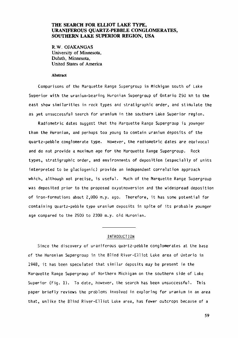
THE SEARCH FOR ELLIOT LAKE TYPE,URANIFEROUS QUARTZ-PEBBLE CONGLOMERATES,SOUTHERN LAKE SUPERIOR REGION, USA
R.W. OJAKANGASUniversity of Minnesota,Duluth, Minnesota,United States of America
Abstract
Comparisons of the Marquette Range Supergroup in Michigan south of LakeSuperior with the uranium-bearing Huronian Supergroup of Ontario 25Ü km to theeast show similarities in rock types and stratigraphie order, and stimulate theas yet unsuccessful search for uranium in the southern Lake Superior region.
Radiometrie dates suggest that the Marquette Range Supergroup is youngerthan the Huronian, and perhaps too young to contain uranium deposits of thequartz-pebble conglomerate type. However, the radiometric dates are equivocaland do not provide a maximum age for the Marquette Range Supergroup. Rocktypes, stratigraphie order, and environments of deposition (especially of unitsinterpreted to be glaciogenic) provide an independent correlation approachwhich, although not precise, is useful. Much of the Marquette Range Supergroupwas deposited prior to the proposed oxyatmoversion and the widespread depositionof iron-formations about 2,000 m.y. ago. Therefore, it has some potential forcontaining quartz-pebble type uranium deposits in spite of its probable youngerage compared to the 2500 to 2300 m.y. old Huronian.
INTRODUCTIONSince the discovery of uraniferous quartz-pebble conglomerates at the base
of the Huronian Supergroup in the Blind River-Elliot Lake area of Ontario in1948, it has been speculated that similar deposits may be present in theMarquette Range Supergroup of Northern Michigan on the southern side of LakeSuperior (Fig. 1). To date, however, the search has been unsuccessful. Thispaper briefly reviews the problems involved in exploring for uranium in an areathat, unlike the Blind River-Elliot Lake area, has fewer outcrops because of a
59
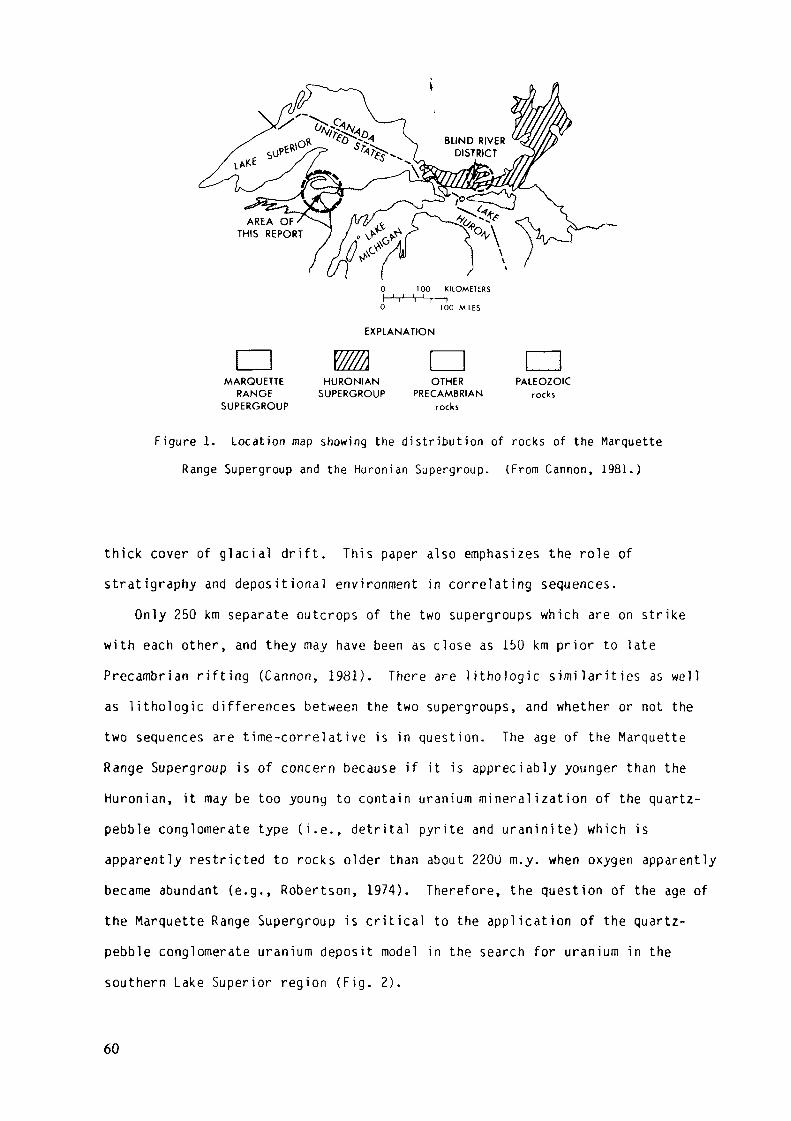
100 KILOMEIERS
0 100 MILES
EXPLANATION
v/mMARQUETTE
RANGESUPERGROUP
HURONIAN OTHERSUPERGROUP PRECAMBRIAN
rocks
PALEOZOICrocks
Figure 1. Location map showing the distribution of rocks of the MarquetteRange Supergroup and the Huronian Supergroup. (From Cannon, 1981.)
thick cover of glacial drift. This paper also emphasizes the role ofstratigraphy and depositional environment in correlating sequences.
Only 250 km separate outcrops of the two supergroups which are on strikewith each other, and they may have been as close as 150 km prior to latePrecambrian rifting (Cannon, 1981). There are lithologie similarities as wellas lithologie differences between the two supergroups, and whether or not thetwo sequences are time-correlative is in question. The age of the MarquetteRange Supergroup is of concern because if it is appreciably younger than theHuronian, it may be too young to contain uranium mineralization of the quartz-pebble conglomerate type (i.e., detrital pyrite and uraninite) which isapparently restricted to rocks older than about 2200 m.y. when oxygen apparentlybecame abundant (e.g., Robertson, 1974). Therefore, the question of the age ofthe Marquette Range Supergroup is critical to the application of the quartz-pebble conglomerate uranium deposit model in the search for uranium in thesouthern Lake Superior region (Fig. 2).
60
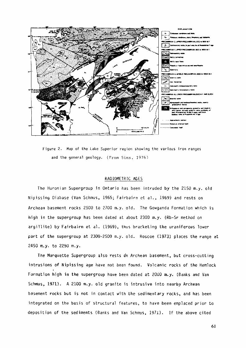
EXPLANATION
PKCMMMIAN Zi l*PW MCCAMMlAN, 570 (• »OO HY
In »«ft m», H tt BilliiHit» Y •»
PMCCAMMIAN V, UPPCR ntCCAMMIAM. «00 M MOO H V
PMCAMMIAN X, I«DOLE PMCCAMM1AN, MOO to MOO M.Y.
Grwiltk rocfci
M V4 POfOffWIHl «TMwlfttOltl» toClM IACIW4M framtk rKt».
* «H Xrockt «f ProCMlkriM X «f«
Figure 2. Map of the Lake Superior region showing the various iron rangesand the general geology. (From Sims, 1976)
RADIOMETRIC AGESThe Huronian Supergroup in Ontario has been intruded by the 2150 m.y. old
Nipissing Diabase (Van Schmus, 1965; Fairbairn et al., 1969) and rests onArchean basement rocks 2500 to 2700 m.y. old. The Gowganda Formation which ishigh in the supergroup has been dated at about 2300 m.y. (Rb-Sr method onargillite) by Fairbairn et al. (1969), thus bracketing the uraniferous lowerpart of the supergroup at 2300-2500 m.y. old. Roscoe (1973) places the range at2450 m.y. to 2250 m.y.
The Marquette Supergroup also rests ar\ Archean basement, but cross-cuttingintrusions of Nipissing age have not been found. Volcanic rocks of the HemlockFormation high in the supergroup have been dated at 20ÜO m.y. (Banks and VanSchmus, 1971). A 2100 m.y. old granite is intrusive into nearby Archeanbasement rocks but is not in contact with the sedimentary rocks, and has beenintegrated on the basis of structural features, to have been emplaced prior todeposition of the sediments (Banks and Van Schmus, 197i). If the above cited
61
ages in the two sequences are correct, then the Marquette Range Supergroup is
younger than the Huronian. However, additional radiometric data are necessary
before the relative ages can be well established. The maximum age of the
Marquette Supergroup is not yet known (Cannon, 1981).
Lithologie comparisons of rock units, their stratigraphie relationships, and
their environments of deposition within each of the two sequences provide an
independent approach to the correlation and age problems. This approach will be
elaborated upon below.
GENERAL STRATIGRAPHY AND LITHOLQGY
The stratigraphie succession of the Huronian Supergroup is shown in Table I.
The four groups are separated by unconformities. The younger three groups each
have a basal conglomerate unit containing diamict i te at the base, overlain by
finer-grained sedimentary rock units. The Matinenda Formation at or near the
base of the supergroup contains the wel l -known uranium deposits. This formation
Table I. Summary of Huronian stratigraphy in the Blind River-Ell iot Lake area.
(From Robertson, 1973.)
Summary of Huronian Stratigraphy in the Blind River-Elliot Lake area
Croup
Cobalt
Quirke Lake
Hough Lake
Elliot Lake
Formation
Bar River
GordonLake
Lorram
Gowganda
SerpentEspanola
Bru ceMissibsagi
Pccors
RamsayLake
McKim
Matmi nda
\ ok jmcroi k s
LHkotofy
Quaruite
Silistone,sandstone
Quartale,conglomerate, arkose
Conglomerate,greywacke,quanzile, siltstone
QuantitéLimestonedolostone, siltstone
Conglomc rate
Quarlzue
Argillite
Conglomerate
Argilhte-grc>wacke
Quanziie, arkose,conglomerate
Andvsne-basall(filmic volcanic*»)
Thickness(I« feet)
At least 1 .000 feet-Flack Lake, at least4,000 feei-Willisville
1,000 feet Flack Lake;1,000 feet WilliiVilte
2,000-6,000
500-4,200
0-1. 10«
0-1.500
0- 200I)-'. OOO-i-
40-1 000 -
5- 200
0-2,500 +
l>- 71X1 +
Local
Deposition«!Environnent
Shallow waler
Shallow waler
Shallow water
Glacial innorth, glacial-marine in south
Shallow water
Shallow water
Glacial-shallow water
Shallow water
Shallow water
Glacial shallow watir
Shallot* wan r(lurhidilc)
Shjllow wjicr
•>
Source
Source north butcurrent* variable
Source north butcurrents variable
North-northwest
North-northwest
Nonhwesi
Northwe.,!
North0
West-northwestin »est. northin southeast
North northwest
Nortliwt..,!'»
Norlhwcst
Northwest
Mlnerali/alion
Th-U in northCu->
U (race m Victoria Tp,Cu in limestoneagainst diabase
U near basement highs
Trjccs U nearbasement highs
Traces U whereunionformablc onMjltnenda Formation
Traces LI m.nrbjsemcnt highs
U-Th— Rare Earthsin conglomi rail inb.iscmcm ki»**
U-Th in ipniJiiiiKr.iliinierhcus C u tn Mows
• All U-deposiis of commercial importance in the Blind River-Elliot Lake ari.a arc in ihc Manncnda Formanon
62
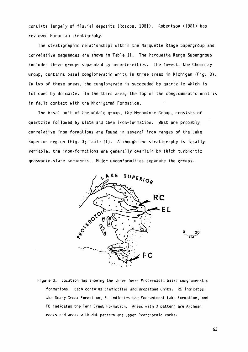
consists largely of fluvial deposits (Roscoe, 1981). Robertson (1981) hasreviewed Huronian stratigraphy.
The stratigraphie relationships within the Marquette Range Supergroup andcorrelative sequences are shown in Table II. The Marquette Range Supergroupincludes three groups separated by unconformities. The lowest, the ChocolayGroup, contains basal conglomeratic units in three areas in Michigan (Fig. 3).In two of these areas, the conglomerate is succeeded by quartzite which isfollowed by dolomite. In the third area, the top of the conglomeratic unit isin fault contact with the Michigammi Formation.
The basal unit of the middle group, the Menominee Group, consists ofquartzite followed by slate and then iron-formation. What are probablycorrelative iron-formations are found in several iron ranges of the LakeSuperior region (Fig. 3; Table II). Although the stratigraphy is locallyvariable, the iron-formations are generally overlain by thick turbiditicgraywacke-slate sequences. Major unconformities separate the groups.
0___20KM""1
FC
Figure 3. Location map showing the three lower Proterozoic basal conglomeraticformations. Each contains diamictites and dropstone units. RC indicatesthe Reany Creek Formation, EL indicates the Enchantment Lake Formation, andFC indicates the Fern Creek Formation. Areas with X pattern are Archeanrocks and areas with dot pattern are upper Proterozoic rocks.
63
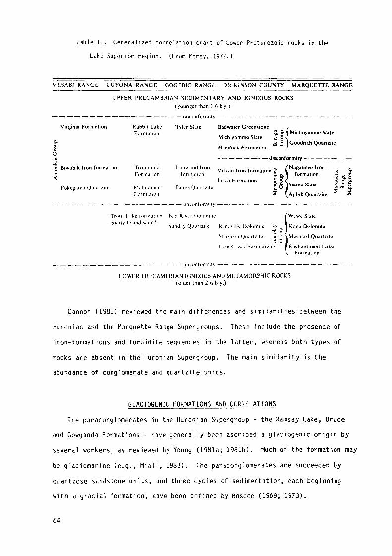
Table II. General ized correlation chart of Lower Proterozoic rocks in the
Lake Superior region. (From Morey, 1972.)
MESABI RANOL CUYUNA RANGE GOGEBtC RANGfc DICklNSON COUNTY MARQUETTE RANGE
UPPER PRECAMBRIAN SEDIMENTARY AND IGNEOUS ROCKS(younger than 1 6 b y )
— — — — — — — — — —— — — — — — — — unconformity — — — — — — — — —— — — — — — — — — —
Virginia Formation
§•oO
"F Biwabik Iron-formation5c
Pokcgama Quartzilc
Rabbit LakeFormation
TrommalilFormation
MahnomcnFormation
Tylcr Slate Badwaler Greenstone ,„ . , 3> §• ( Mkhigamnic SUeMicnigammc Slate 2 g \
a '3 I Goodnih QuartaleHemlock Formation v
- — — — — —— — Jisconformity — - — — — — —
Iron wood Iron-,formaiion
Palms Qiiart/ilcell h F-orm.ilion
Nagauncc Iron-,
£ ex 1 formation ~ 0
... ,. - -,Vuli.in Iron-formation u l , u 9-
| o ,5 s3 '
§. ? »d c.
Ajihik Qtiartzilc
urn.onU>rmily -
Trout 1 ake formation Had RIH.T Dolomite.nul si.île'
Sund iy Qki.irlzitc Rand\illi: Dolomite
SuiruLon Ouartzile
l 1.1 n C ic>.k Formation"-= O
Wcwc Slate
Kona Dolomite
Mcsnanl Quarlzile
Enchantment LikeFormation
• utKonlormit)
LOWER PRECAMBRIAN IGNEOUS AND METAMORPHIC ROCKS(older than 2 6 b y.)
Cannon (1981) reviewed the main differences and similarities between theHuronian and the Marquette Range Supergroups. These include the presence ofiron-formations and turbidite sequences in the latter, whereas both types ofrocks are absent in the Huronian Supergroup. The main similarity is theabundance of conglomerate and quartzite units.
GLACIQGENIC FORMATIONS AND CORRELATIONSThe paraconglomerates in the Huronian Supergroup - the Ramsay Lake, Bruce
and Gowganda Formations - have generally been ascribed a glaciogenic origin byseveral workers, as reviewed by Young (1981a; 1981b). Much of the formation maybe glaciomarine (e.g., M i a l l , 1983). The paraconglomerates are succeeded byquartzose sandstone units, and three cycles of sedimentation, each beginningwith a glacial formation, have been defined by Roscoe (1969; 1973).
64
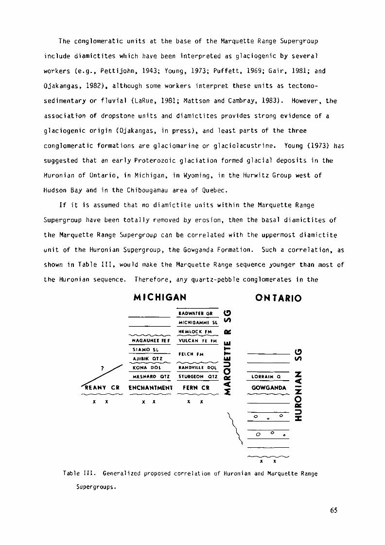
The conglomeratic units at the base of the Marquette Range Supergroupinclude diamictites which have been interpreted as glaciogenic by severalworkers (e.g., Pettijohn, 1943; Young, 1973; Puffett, 1969; Gair, 1981; andOjakangas, 1982), although some workers interpret these units as tectono-sedimentary or fluvial (LaRue, 1981; Mattson and Cambray, 1983). However, theassociation of dropstone units and diamictites provides strong evidence of aglaciogenic origin (Ojakangas, in press), and least parts of the threeconglomeratic formations are glaciomarine or glaciolacustrine. Young (1973) hassuggested that an early Proterozoic glaciation formed glacial deposits in theHuronian of Ontario, in Michigan, in Wyoming, in the Hurwitz Group west ofHudson Bay and in the Chibougamau area of Quebec.
If it is assumed that no diamictite units within the Marquette RangeSupergroup have been totally removed by erosion, then the basal diamictites ofthe Marquette Range Supergroup can be correlated with the uppermost diamictiteunit of the Huronian Supergroup, the Gowganda Formation. Such a correlation, asshown in Table III, would make the Marquette Range sequence younger than most ofthe Huronian sequence. Therefore, any quartz-pebble conglomerates in the
MICHIGAN ONTARIOBADWATER GR
MICHIGAMMI SL
HEMLOCK FM
NAGAUNEEFEF VULCAN FE FM
SIAMO SL
AJIBIK OTZ*iMn"ii -ni "ni_ i»~ii
KONA DOL
FELCH FM
RANDVILLE DOL
MESNARD OTZ STURGEON OTZ
REANY CR ENCHANTMENT FERN CR
X X
SGM
ARQ
UETT
E
LORRAIN Q
o
GOWGANDA ~Q
X X
Table III. Generalized proposed correlation of Huronian and Marquette RangeSupergroups.
65
Marquette Range Supergroup, and in the correlative units on the Mesabi, Cuyunaand Gogebic ranges as well (see Table II), would be younger than those in theMatinenda Formation. Even if the Michigan diamictites are correlated witheither the older Ramsey Lake or the Bruce diamictites, and the dolomites of theLake Superior region with carbonates of the Espanola Formation (see Table II),any quartz-pebble conglomerates in the Marquette Range Supergroup would still beyounger than the Matinenda uraniferous quartz-pebble conglomerates. However,the age difference could be small, and even if as large as 200 m.y., may notrule out the possible presence of uranium deposits of the quartz-pebbleconglomerate type in the Marquette Range Supergroup, as reasoned below.
DISCUSSION OF URANIUM POTENTIALThe extensive Lake Superior iron-formations with an early Proterozoic age of
about 2000 m.y. have commonly been interpreted as the result of the extensiveprecipitation of iron-formations when oxygen levels in the atmosphere reachedcritical levels (e.g., Roscoe, 1973; 1981; Cannon, 1981), although this has beendisputed (e.g., Dimroth and Kimberley, 1976). It appears that some oxygen waspresent long before this time (e.g., Grandstaff, 1981), but its influence on theability of pyrite and uraninite silt- and sand-sized grains to survive chemicalweathering and transportation is not well known. With the present state ofknowledge, it seems that thèse minerals could have been transported as detritalgrains at least until the time of deposition of abundant iron-formation.Therefore, from the age point of view, pyrite- and uraninite-bearing quartz-pebble conglomerates may exist in the Chocolay and Menominee groups of theMarquette Range Supergroup and in the correlative pre-iron-formation rock units(Table II) of the Lake Superior region.
Such reasoning would make the Sturgeon, Mesnard and Sunday quartzites of theChocolay Group and the Ajibik, Palms, Mahnomen and Pokegama quartzites (TableII) potential units in which to explore for horizons of quartz-pebbleconglomerates. Presumably, by analogy with the Huronian Matinenda Formation andwith parts of the Witwatersrand Supergroup, any uraniferous conglomerate
66
horizons would be fluviatile in origin. However, the Palms and the PokegamaFormations have been interpreted as having been deposited in a marine tidalenvironment (Ojakangas, 1983), and hence may be largely ruled out as havinguranium potential on the basis of environment of deposition. The Mahnomen,which is a subsurface formation, was presumably deposited in the same basin asthe Palms and Pokegama and under the same sedimentational regime, and can alsobe eliminated from further consideration. The environment of deposition of thecorrelative Ajibik Quartzite is less well known, although it is probably marine.The Goodrich Quartzite is probably younger than the aforementioned units, but isof interest because it contains monazite-rich placers in quartz-pebbleconglomerate (Vickers, 1956). Nevertheless, thin units of fluvial origin couldtheoretically exist in paleotopographic lows at the base of each of theseformations, deposited before the marine transgression. The older SundayQuartzite also has attributes of tidal deposits, including a bipolar-bimodalcross-bedding pattern, and has a low potential.
This reasoning leaves two formations, the Sturgeon and Mesnard quartzites,as the most likely units to explore for uranium deposits of the quartz-pebbleconglomerate type. Button and Adams (1981, p. 319) have down-graded the Mesnardas well as the aforementioned formations, on the bases of the presence ofdisseminated hematite, polymictic conglomeratic horizons, and the presumed longduration of the erosional intervals that produced these quartzose formations.The only exposed formation that they did not eliminate from consideration is theSturgeon Quartzite. Most of the Marquette Range Supergroup rocks shown inFigure 1 lie in the Iron River 1° by 2° quadrangle, and the quadrangle has beenjudged an unfavorable environment for quartz-pebble conglomerate type uraniumdeposits by Frishman (1982).
The amount of rock exposure in the Lake Superior region is small, andnumerous paleoval leys may be preserved in the subsurface south of Lake Superiorin Michigan and Wisconsin as well as west of Lake Superior in Minnesota (Fig. 3).Button and Adams (1981, p. 319-321) have emphasized the necessity of bothgeologic and geophysical studies to locate sites with the best potential which
67
can then be tested by drilling. Cannon (1981) has suggested that blind diamonddrilling may be worthwhile as an exploration technique.
The possibility of subsurface quartz-pebble conglomerate units existing ineast-central Minnesota just west of Lake Superior has been discussed byOjakangas (1976, p. 108-120 and 153-157) and by Morey (1981). The ThomsonFormation, which is probably more than 1500 m thick and is equivalent to theVirginia, Rabbit Lake and Tyler Formations of Table II, unconformably overliesthe thick Mille Lacs Group. Quartzose sedimentary rocks which comprise thelower part of the group are exposed in only one small area (Morey, 1978).Anomalous concentrations of uranium and radon in that vicinity (Lively andMorey, 1982) may be related to the M i l l e Lacs Group or to the underlying Archeangneiss. The basin in which the Thomson and Virginia formations were depositedin east-central Minnesota occupies more than 10,000 km"?. The area underlain bythe Mille Lacs Group is much smaller, but is of unknown dimensions.
Comparisons of rock types and stratigraphie sequences in the Huronian andMarquette Range Supergroups and in the Sierra Madre and Medicine Bow Mountainsof Wyoming, 1300 km west of Lake Superior, show many similarities (Karlstrom andHouston, 1979). Oiamictites, laminated dropstone units, quartzose sandstones,and carbonates all occur in these areas, and in similar stratigraphie order.Karlstrom and Houston (1979) have interpreted the existence of three glacial tofluvial or glacial to marine cycles in Wyoming, as did Roscoe (1969) in theHuronian. Radioactive quartz-pebble conglomerates are present at two horizons,stratigraphically lower than the glacial cycles. Radioactive quartz-pebbleconglomerates are also present in the Black H i l l s of South Dakota, northeast ofthe Medicine Bows (Hills, 1979; Rodden, 1980).
The presence of uranium in quartz-pebble conglomerates in the Wyoming andSouth Dakota sequences, which are apparently about the same age as the Huronian,strengthens the case for the possible presence of such uraniferous conglomeratesin the Lake Superior region which is situated between these western regions andthe region of Huronian exposures.
68
SUMMARYThe rock types, stratigraphie relationships, and ages of the lower
Proterozoic rocks in the southern Lake Superior region are similar to theHuronian Supergroup. A likely correlation is the upper part of the HuronianSupergroup with the lower part of the Marquette Range Supergroup. In spite ofits apparent younger age, there is nevertheless potential for uraniferousquartz-pebble conglomerates in the Marquette Range Supergroup. Poor exposuredue to a cover of glacial drift and the likelihood that such deposits would haveformed in paleoval leys which would have been covered by younger rocks of thesame sequences (Button and Adams, 1981, p. 320), make their location verydifficult. Quartz-pebble conglomerates are not abundant in outcrops, and wherepresent they are thin, non-pyritiferous, and non-radioactive. However, thereare many anomalously radioactive Archean "granitic" basement rocks which couldhave been sources for the uranium.
ACKNOWLEDGEMENTSMuch of this work was accomplished while on WAE status with the United
States Geological Survey.
REFERENCESBanks, P.O., and Van Schmus, W.R., 1971, Chronology of Precaoibrian rocks of
Iron and Dickinson Counties, Michigan (Abs.): Institute on Lake SuperiorGeology, 17th, Duluth, Minnesota, p. 9.
Button, Andrew, and Adams, S.S., 1981, Geology and recognition criteria foruranium deposits of the quartz-pebble conglomerate type: U.S. Oept. ofEnergy Report GJBX-3(81), 390 p.
Cannon, W.F., 1981, Basal conglomerates and weathered zones in the MarquetteRange Supergroup, Northern Peninsula of Michigan - Age, indications ofatmospheric oxygen, and uranium potential: jji Armstrong, F.C., ed., Genesisof Uranium- and Gold-bearing Precambrian Quartz-pebble Conglomerates, U.S.Geological Survey Professional Paper 1161A-BB, p. Z-l - Z-16.
69
Dimroth, Erich, and Kimberley, M.M., 1976, Precambrian atmospheric oxygen:evidence in the sedimentary distributions of carbon, sulfur, uranium andiron: Canadian Journal of Earth Sciences, v. 13, p. 1161-1185.
Fairbairn, H.W., Hurley, P.M., Card, K.O., and Knight, C.J., 1969, Corrrelationof radiometric ages of Nipissing diabase and Huronian metasediments withProterozoic orogenic events in Ontario: Canadian Journal of EarthSciences, v. 6, p. 489-497.
Frishman, David, 1982, National uranium resource evaluation, Iron RiverQuadrangle, Michigan and Wisconsin: U.S. Department of Energy ReportPGJ/F-120(82), 47 p.
Gair, J.E., 1981, Lower Proterozoic glacial deposits of northern Michigan,U.S.A.: jni Hambrey, M.J. and Harland, W.B., eds., Earth's Pre-PleistoceneGlacial Record, Cambridge University Press, p. 803-806.
Grandstaff, D.E., 1981, Uraninite oxidation and the Precambrian atmosphere:jji Armstrong, F.C., ed., Genesis of Uranium- and Gold-bearing PrecambrianQuartz-pebble Conglomerates, U.S. Geological Survey Professional Paper1161A-BB, p. C-l - C-16.
Hills, F.A., 1979, Uranium, thorium and gold in the Lower Proterozoic (?) EstesConglomerate, Nemo district, Lawrence County, South Dakota: University ofWyoming Contributions to Geology, v. 17, p. 159-172.
Karlstrom, K.E., and Houston, R.S., 1979, Stratigraphy and uranium potential ofearly Proterozoic metasedimentary rocks in the Medicine Bow Mountains,Wyoming: Geological Survey of Wyoming Report of Investigations 13, 45 p.
LaRue, O.K., 1981, The Chocolay Group, Lake Superior region, U.S.A.:Sedimentologic evidence for deposition in basinal and platform settings onan early Proterozoic craton: Geological Society of America Bulletin,Part I, v. 92, p. 417-435.
Lively, R.S., and Morey, A.B., 1982, Hydro-geochemical distribution of uraniumand radon in east-central Minnesota: j_n_ Perry, E.C., Jr., and Montgomery,C.W., eds., Isotope studies of hydrologie processes: Dekalb, NorthernIllinois University Press, p. 91-107.
70
Mattson, S.R., and Cambray, F .W. , 1983, The Reany Creek Formation: a mass-flow
deposit of possible post-Menominee age: 29th Institute on Lake Superior
Geology, Houghton, Michigan, p. 27.
Miall, A.D., 1983, Glaciomarine sedimentation in the Gowganda Formation
(Huronian), Northern Ontario: Journal of Sedimentary Petrology, v. 53,
p. 477-491.
Morey, G.B., 1972, Middle Precambrian, general geologic setting: jm Sims, P.K.
and Morey, G.B., eds., Geology of Minnesota: A Centennial Volume,
p. 199-203.
________, 1978, Lower and Middle Precambrian stratigraphie nomenclature for
east-central Minnesota: Minnesota Geological Survey Report of Investiga-
tions 21, 52 p.
___________, 1981, Geologic terranes of Minnesota and their uranium potential:
Minnesota Geological Survey Information Circular 19, 40 p.
ûjakangas, R .W. , 1976, Uranium potential in Precambrian rocks of Minnesota:
U.S. Dept. of Energy, Rept. GJBX-62(76), 259 p.
_______, 1982, Lower Proterozoic glaciogenic formations, Marquette Super-
group, Upper Peninsula, Michigan, U.S.A. (Abs.): International Association
of Sedimentologists Abstracts of Papers, llth International Congress on
Sedimentology, McMaster University, Ontario, Canada, p. 76.
______, 1983, Tidal deposits in the early Proterozoic basin of the Lake
Superior region - the Palms and Pokegama Formations: Evidence for subtidal-
shelf deposition of Superior-type banded iron-formation: jji Medaris, L.G.,
Jr., Early Proterozoic Geology of the Great Lakes Region, Geological
Society of America Memoir 160, p. 49-66.
____, in press, Evidence for early Proterozoic glaciation: the dropstone
unit - diamictite association: Geological Survey of Finland Bulletin.
Petti John, F.J., 1943, Basal Huronian conglomerates of Menominee and Calumet
distr icts, Michigan: Journal of Geology, v. 51, p. 387-397.
Puffett , W.P . , 1969, The Reany Creek Formation, Marquette County, Michigan:
U.S. Geological Survey Bullet in 1274-F, p. F-l - F-25.
71
Redden, J.A., 198Ü, Geology and uranium resources in Precambrian conglomeratesof the Nemo area, Black Hills, South Dakota: U.S. Department of Energy,Bendix Field Engineering Corporation, Subcontract No. 79-311-E, 147 p.
Robertson, O.A., 1973, A review of recently acquired geological data, BlindRiver-Elliot Lake area: j_n_ Young, G.M., ed., Huronian stratigraphy andsedimentation, Geological Association of Canada Special Paper 12,p. 169-198.
______, 1974, Basal Proterozoic units as fossil time markers and their usein uranium prospection: j_n Formation of Uranium Ore Deposits, InternationalAtomic Energy Agency, p. 495-512.
_______, 1981, The Blind River uranium deposits: the ores and their setting:jji Armstrong, F.C., ed., Genesis of Uranium- and Gold-bearing PrecambrianQuartz-pebble Conglomerates, U.S. Geological Survey Professional Paper1161A-BB, p. U-l - U-23.
Roscoe, S.M., 1969, Huronian rocks and uraniferous conglomerates in the CanadianShield: Geological Survey of Canada Paper 68-40, 205 p.
______, 1973, The Huronian Supergroup, a Paleoaphebian succession showingevidence of atmospheric evolution: _i_n Young, G.M., ed., Huronianstratigraphy and sedimentation, Geological Association of Canada SpecialPaper 12, p. 21-37.
______, 1981, Temporal and other factors affecting deposition of uraniferousconglomerates: j_n_ Armstrong, F.C., ed., Genesis of Uranium- and Gold-bearing Precambrian Quartz-pebble Conglomerates, U.S. Geological SurveyProfessional paper 1161A-BB, p. W-l - W-17.
Sims, P.K., 1976, Precambrian tectonics and mineral deposits, Lake Superiorregion: Economic Geology, v. 71, p. 1092-1118.
Van Schmus, W.R., 1965, The geochronology of the Blind River-Bruce Mines area,Ontario, Canada: Journal of Geology, v. 73, p. 755-780.
Vickers, R.C., 1956, Geology and monazite content of the Goodrich quartzite,Palmer area, Marquette County, Michigan: U.S. Geological Survey Bulletin1030-F, p. 171-185.
72

Young, G.M., 1973, "Milites and aluminous quartzites as possible time markersfor Middle Precambrian (Aphebian) rocks of North America: j_n Young, G.M.,ed., Huronian Stratigraphy and Sedimentation, Geological Association ofCanada Special Paper 12, p. 97-128.
_______, 1981a, The early Proterozoic Gowganda Formation, Ontario, Canada:_in_ Hambrey, M.J., and Harland, W.B., eds., Earths' Pre-Pleistocene GlacialRecord, Cambridge University Press, p. 807-812.
______, 1981b, Diamictites of the early Proterozoic Ramsay Lake and BruceFormations, north shore of Lake Huron, Ontario, Canada: j_n Hambrey, M.J.,and Harland, W.B., eds., Earths' Pre-Pleistocene Glacial Record, CambridgeUniversity Press, p. 813-816.
73

URANIFEROUS EARLY PROTEROZOICCONGLOMERATES OF THE BLACK HILLS,SOUTH DAKOTA, USA
J.A. REDDENGeological Survey,Denver, Colorado,United States of America
Abstract
Metamorphosed uraniferous conglomerates are a part of a complexly
folded and faulted sequence of Early Proterozoic rocks exposed over an
area of about 25 km^ near the v i l lage of Nemo in the northeastern part
of the Black Hil ls dome, South Dakota. The uraniferous conglomerates
lie between an older unit of fanglomerates and a 3,300-meter-thick
younger section of f luvial and marine quartzites capped by taconitic
banded iron-formation. This sequence is probably younger than the
2.5-b.y. age of the nearby Litt le Elk Granite but older than the
2.1-b.y. age of a 1,000-meter-thick gravity-dif ferentiated gabbroic
sill emplaced in the quartzites. Folding of the sedimentary rocks
and of the sill was fol lowed by erosion and by deposition of marine
fanglomerates along growth faults. All of these coarse c las t ic rocks
were overturned to the southeast during a poorly known deformational
episode and were subsequently folded along northwest-trending vertical
folds that developed during low-grade regional metamorphism 1.7 b.y.
ago.
The uraniferous unit consis ts of a 100-meter-thick section predomi-
nantly of quartzi te but also containing pyrit iferous pebble conglomer-
ates. Individual conglomerate units are generally a few meters thick
and intertongue with granule quartzi te having smal l -scale trough cross-
bedding and isolated clasts. Sedimentary structures indicate a f luvial
origin and unidirectional current transport. C lasts are mostly recrys-
ta l l ized chert, c last ic quartzite, and vein quartz. The matrix consists
75

largely of quartz, muscovite, and chlorite. Accessory minerals includepyrite, chromite, fuchsite, zircon, rutile, tourmaline, apatite, xeno-time, monazite, gold, uraninite, and uranothorite(?). Much of thepyrite is secondary and formed by sulfidization of iron-titaniumminerals, which also resulted in sieve aggregates of rutile or anataseand quartz. Zircon grains and blue quartz granules in the conglomerateresemble those from the Little Elk Granite; the conglomerate section mayunconformably overlie the granite in areas to the east that are con-cealed by Paleozoic rocks. The uranium and gold contents of theconglomerate are submarginal. Richer concentrations correlate in ageneral way with better pebble sorting, higher pyrite content, and ahigher percentage of vein quartz clasts. The heavy minerals indicatemultiple source terranes, which combined with poor sorting and can-nibal ization, may explain why the known concentrations are submarginal.Richer concentrations might occur in concealed areas where the conglo-merates are inferred to unconformably overlie granite rocks.
INTRODUCTIONAnomalous concentrations of uranium were detected in oxidized sur-
face exposures of Precambrian pyritiferous conglomerates in the NemoDistrict of the northeastern Black Hills (Fig. 1) in 1976 by F. AllanH i l l s of the U. S. Geological Survey (Hills, 1977). This led to exten-sive claim staking in the area by many companies and private individualsfollowed by surface exploration and diamond drilling. In 1979 anexploration d r i l l i n g program was carried out by Bendix Field EngineeringCorporation on behalf of the U. S. Department of Energy in order toevaluate the uranium resources of the district. Study of the dril lcore and detailed evaluation of the geology of the district and explora-tion results was carried out by the author in 1978-79 (Redden, 1980).
76
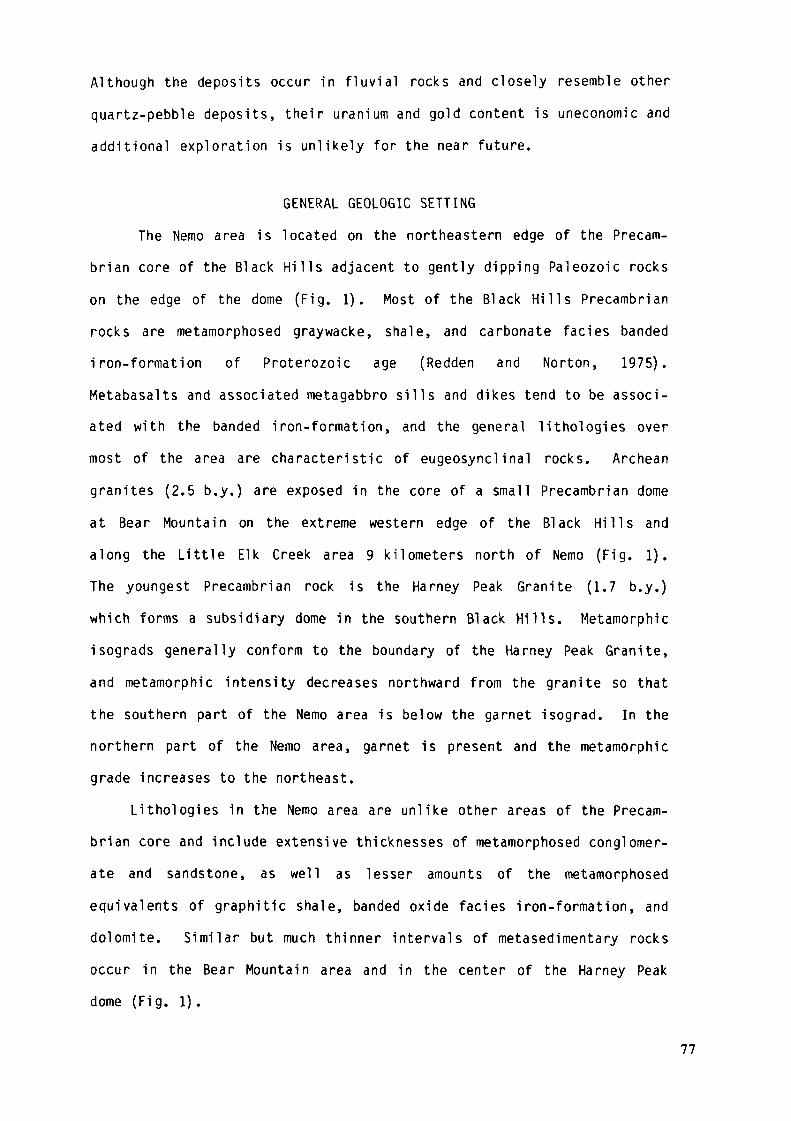
Although the deposits occur in f luvial rocks and closely resemble other
quartz-pebble deposits, their uranium and gold content is uneconomic and
additional exploration is unlikely for the near future.
GENERAL GEOLOGIC SETTINGThe Nemo area is located on the northeastern edge of the Precam-
brian core of the Black Hi l l s adjacent to gently dipping Paleozoic rockson the edge of the dome (Fig. 1). Most of the Black Hills Precambrianrocks are metamorphosed graywacke, shale, and carbonate faciès bandediron-formation of Proterozoic age (Redden and Norton, 1975).Metabasalts and associated metagabbro sills and dikes tend to be associ-ated with the banded iron-formation, and the general lithologies overmost of the area are characteristic of eugeosynclinal rocks. Archeangranites (2.5 b.y.) are exposed in the core of a small Precambrian domeat Bear Mountain on the extreme western edge of the Black H i l l s andalong the Little Elk Creek area 9 kilometers north of Nemo (Fig. 1).The youngest Precambrian rock is the Harney Peak Granite (1.7 b.y.)which forms a subsidiary dome in the southern Black Hills. Metamorphicisograds generally conform to the boundary of the Harney Peak Granite,and metamorphic intensity decreases northward from the granite so thatthe southern part of the Nemo area is below the garnet isograd. In thenorthern part of the Nemo area, garnet is present and the metamorphicgrade increases to the northeast.
Lithologies in the Nemo area are unlike other areas of the Precam-brian core and include extensive thicknesses of metamorphosed conglomer-ate and sandstone, as well as lesser amounts of the metamorphosedequivalents of graphitic shale, banded oxide faciès iron-formation, anddolomite. Similar but much thinner intervals of metasedimentary rocksoccur in the Bear Mountain area and in the center of the Harney Peakdome (Fig. 1).
77

4V SO'
T6N EXPLANATION
T5N
PrecambrianMetamorphic Rocks j
Granite(Includes Linie
Elk Granite)
Nemo Area
GeographicNarr.esN - NemoBM - Bear MountainL - LeadHR - Harney PeakMR - Mount Rushmore
S o u t h D a k o t a
FIGURE 1 - LOCATION OF NEMO A R E A AND GENERALIZED GEOLOGIC MAP OF BLACK HILLS
78

Virtually all of the Precambrian metamorphic rocks are steeplydipping, tightly folded, and have had several different periods ofdeformation. The last major deformation approximately coincided withthe Proterozoic emplacement of the Harney Peak Granite and the develop-ment of a north-northwesterly trending foliation.
Ore deposits in the Black Hills Precambrian rocks include the wellknown pegmatite deposits associated with the Harney Peak Granite (Pagej^t ai, 1953) and the large Homestake gold mine located at Lead, SouthDakota (Fig. 1).
STRATIGRAPHY OF THE NEMO DISTRICT
IntroductionThe stratigraphie relationships of the rocks associated with the
uraniferous section are relatively complex due to faulting and rapidfaciès changes associated with some of the tectonic activity (Fig. 2).The general rock sequence is shown on Table 1, and Figure 3 shows dia-grammatical ly the depositional and tectonic events associated with theseunits. The stratigraphie units shown in Table 1 represent considerablemodification of the earlier units of Bayley (1972). The evolution ofthe stratigraphie and structural concepts in the area has been summa-rized by Redden (1981). Only the rocks related to the deposition ofthe uraniferous section and subsequent structural events as shown onthe geologic map (Fig. 2) are discussed in the following section. Thegeologic map (Fig. 2) has more similarity to a geologic cross sectionthan to a conventional plan view because of the steep dips (greater than70 degrees) and fold plunges. Bedding dips to the west, northwest, ornorth but the beds are overturned throughout the area.
79
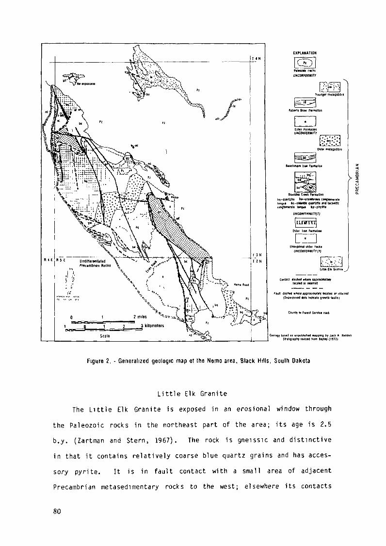
EXPLANATION
long» bc-tMMtfc quirUdf lit bconffic
FtttK disfttd wftflrt «ppraitnutttr located or tnlttrtdiSupirpotld dolt IndfCfti growrtt liullil
Clunty M Fw«l Slrvtcl lud
bi"il en unpubtiin«] nuppmg by Jich A RiddenSlfitignphy rinsed liom Biyliy (1972)
Figure 2. - Generalized geologic map of the Nemo area. Black Hills, South Dakota
Little Elk GraniteThe Little Elk Granite is exposed in an erosional window through
the Paleozoic rocks in the northeast part of the area; its age is 2.5b.y. (Zartman and Stern, 1967). The rock is gneissic and distinctivein that it contains relatively coarse blue quartz grains and has acces-sory pyrite. It is in fault contact with a small area of adjacentPrecambrian metasedimentary rocks to the west; elsewhere its contacts
80
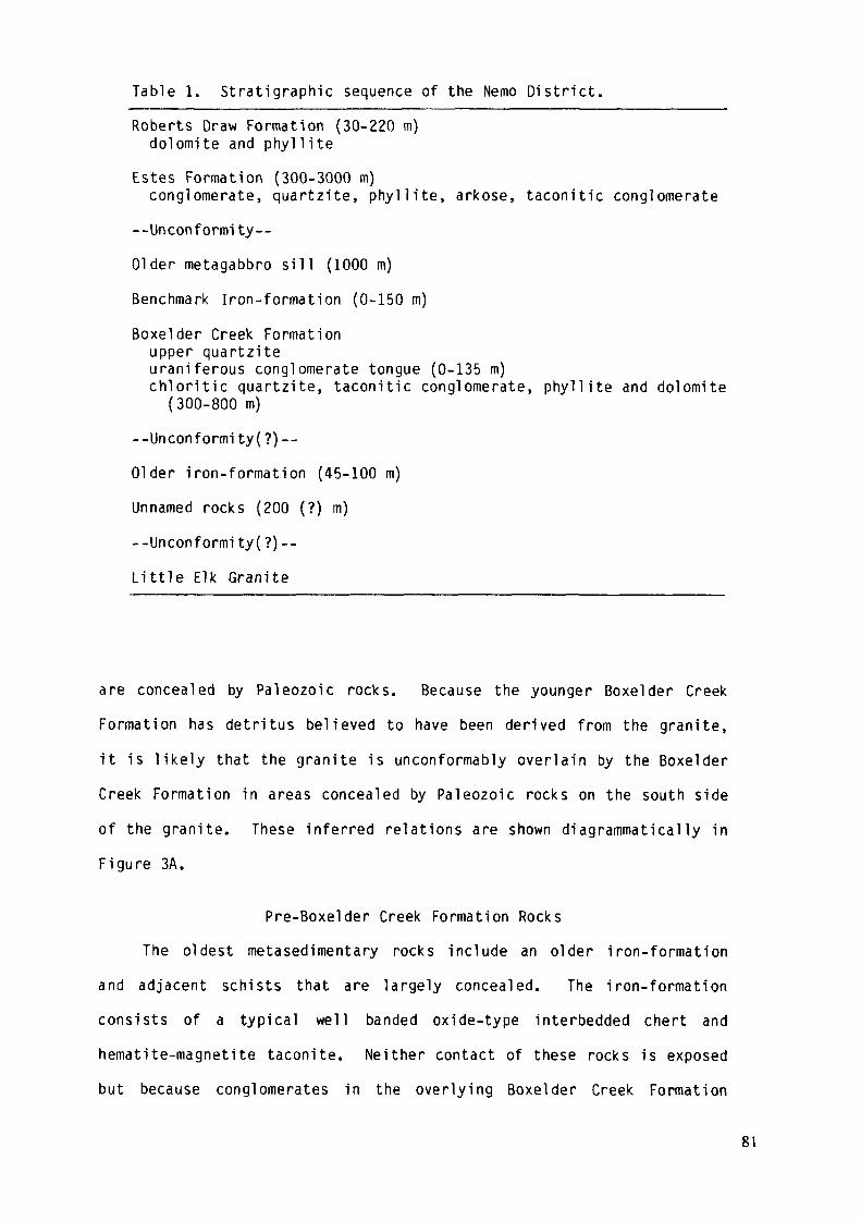
Table 1. Stratigraphie sequence of the Nemo District.Roberts Draw Formation (30-220 m)
dolomite and phylliteEstes Formation (300-3000 m)
conglomerate, quartzite, phyllite, arkose, taconitic conglomerate--Unconformity--01 der metagabbro sill (1000 m)
Benchmark Iron-formation (0-150 m)
Boxelder Creek Formationupper quartziteuraniferous conglomerate tongue (0-135 m)chlorit ic quartzite, taconitic conglomerate, phyllite and dolomite
(300-800 m)
--Unconformity(?)--
01 der iron-formation (45-100 m)
Unnamed rocks (200 (?) m)
--Unconformi ty(?)--
Little Elk Granite
are concealed by Paleozoic rocks. Because the younger Boxelder Creek
Formation has detritus believed to have been derived from the granite,
it is likely that the granite is unconformably overlain by the Boxelder
Creek Formation in areas concealed by Paleozoic rocks on the south side
of the granite. These inferred relations are shown diagrammatically in
Figure 3A.
Pre-Boxelder Creek Formation Rocks
The oldest metasedimentary rocks include an older iron-formation
and adjacent schists that are largely concealed. The iron-formation
consists of a typical well banded oxide-type interbedded chert and
hematite-magnetite taconite. Neither contact of these rocks is exposed
but because conglomerates in the overlying Boxelder Creek Formation
81
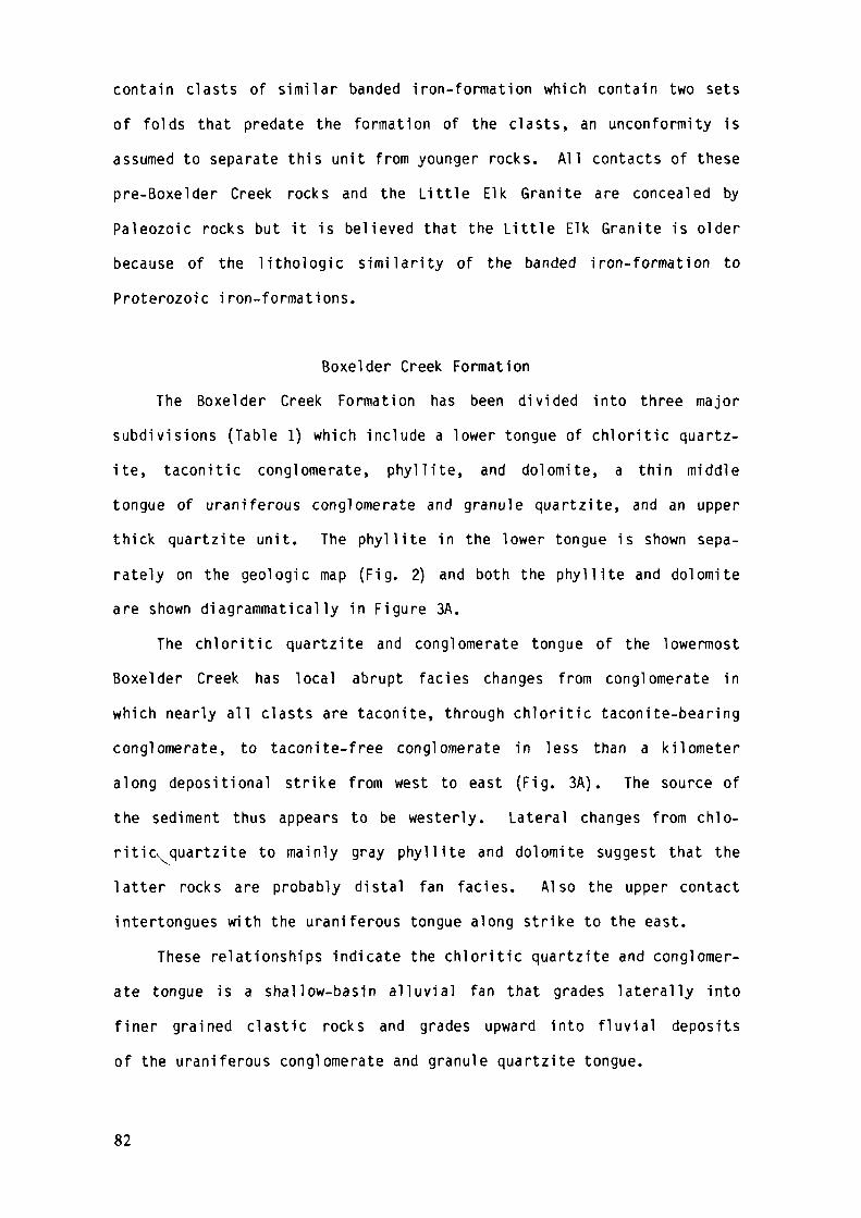
contain clasts of similar banded iron-formation which contain two sets
of folds that predate the formation of the clasts, an unconformity is
assumed to separate this unit from younger rocks. All contacts of these
pre-Boxelder Creek rocks and the Little Elk Granite are concealed by
Paleozoic rocks but it is believed that the Little Elk Granite is older
because of the lithologie similarity of the banded iron-formation to
Proterozoic iron-formations.
Boxelder Creek FormationThe Boxelder Creek Formation has been divided into three major
subdivisions (Table 1) which include a lower tongue of chloritic quartz-ite, taconitic conglomerate, phyllite, and dolomite, a thin middletongue of uraniferous conglomerate and granule quartzite, and an upperthick quartzite unit. The phyllite in the lower tongue is shown sepa-rately on the geologic map (Fig. 2) and both the phyllite and dolomiteare shown diagrammatically in Figure 3A.
The chloritic quartzite and conglomerate tongue of the lowermostBoxelder Creek has local abrupt faciès changes from conglomerate inwhich nearly all clasts are taconite, through chloritic taconite-bearingconglomerate, to taconite-free conglomerate in less than a kilometeralong depositional strike from west to east (Fig. 3A). The source ofthe sediment thus appears to be westerly. Lateral changes from chlo-ritio. quartzite to mainly gray phyllite and dolomite suggest that thelatter rocks are probably distal fan faciès. Also the upper contactintertongues with the uraniferous tongue along strike to the east.
These relationships indicate the chloritic quartzite and conglomer-ate tongue is a shallow-basin alluvial fan that grades laterally intofiner grained clastic rocks and grades upward into fluvial depositsof the uraniferous conglomerate and granule quartzite tongue.
82
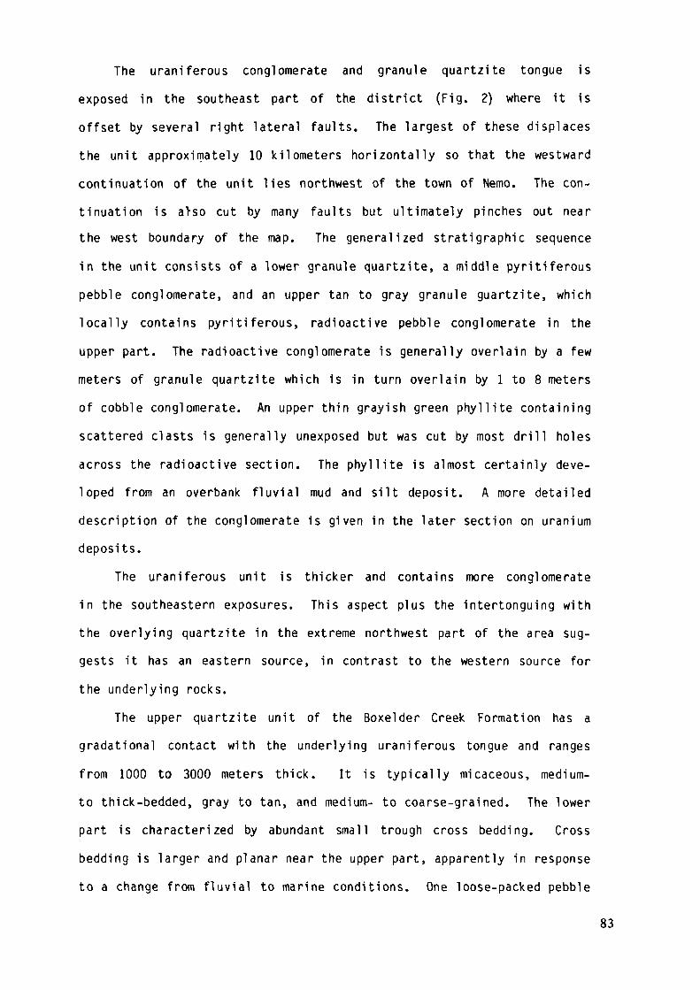
The uraniferous conglomerate and granule quartzite tongue isexposed in the southeast part of the district (Fig. 2) where it isoffset by several right lateral faults. The largest of these displacesthe unit approximately 10 kilometers horizontally so that the westwardcontinuation of the unit lies northwest of the town of Nemo. The con-tinuation is a>so cut by many faults but ultimately pinches out nearthe west boundary of the map. The generalized stratigraphie sequencein the unit consists of a lower granule quartzite, a middle pyritiferouspebble conglomerate, and an upper tan to gray granule guartzite, whichlocally contains pyritiferous, radioactive pebble conglomerate in theupper part. The radioactive conglomerate is generally overlain by a fewmeters of granule quartzite which is in turn overlain by 1 to 8 metersof cobble conglomerate. An upper thin grayish green phyllite containingscattered clasts is generally unexposed but was cut by most drill holesacross the radioactive section. The phyllite is almost certainly deve-loped from an overbank fluvial mud and silt deposit. A more detaileddescription of the conglomerate is given in the later section on uraniumdeposits.
The uraniferous unit is thicker and contains more conglomeratein the southeastern exposures. This aspect plus the intertonguing withthe overlying quartzite in the extreme northwest part of the area sug-gests it has an eastern source, in contrast to the western source forthe underlying rocks.
The upper quartzite unit of the Boxelder Creek Formation has agradational contact with the underlying uraniferous tongue and rangesfrom 1000 to 3000 meters thick. It is typically micaceous, medium-to thick-bedded, gray to tan, and medium- to coarse-grained. The lowerpart is characterized by abundant small trough cross bedding. Crossbedding is larger and planar near the upper part, apparently in responseto a change from fluvial to marine conditions. One loose-packed pebble
83
conglomerate occurs about 1000 meters above the base but it is onlyslightly radioactive. Accessory pyrite is locally common.
The faciès changes and sedimentary structures indicate that thedepositional environment of the Boxelder Creek varies from proximal todistal a l l u v i a l fans in its lowest part, through fluvial deposits inthe uraniferous tongue, and finally to marine sandstone in the uppermostpart of the quartzite member (Fig. 3A-C).
Benchmark Iron-FormationThe Benchmark Iron-Formation was deposited apparently conformably
above the Boxelder Creek (Fig. 3C) but is now preserved only locallyalong a major angular unconformity below the Estes Formation, or inlocal small fault-bound slices as in the northern part of the area.The thicknesses preserved below the Estes unconformity range from 0to as much as 150 meters and because the thickest part is exposed justbelow the unconformity, the original thickness is unknown. The rockis mostly steel gray banded recrystal1ized chert and hematite althoughlocally it is magnetite-rich. Exposures differ from the older iron-formation only in having a higher proportion of hematite.
Older MetagabbroAn older metagabbro forms a layered easterly-trending, folded s i l l
about 1000 meters thick that is emplaced near the middle of the BoxelderCreek (Fig. 3D). The sill is offset by a major right lateral fault thatcauses it to be exposed in both the central and southeast parts of thearea. The layers—from bottom to top--are serpentinite, hornblendite,hornblende-pi agioclase gabbro (locally transitional to diorite), and abiotite granodiorite. The uppermost unit locally has granitic phasesand is discontinuous. The layers are interpreted to be the result ofgravity differentiation. Relict megascopic textures of cumulate olivine
84
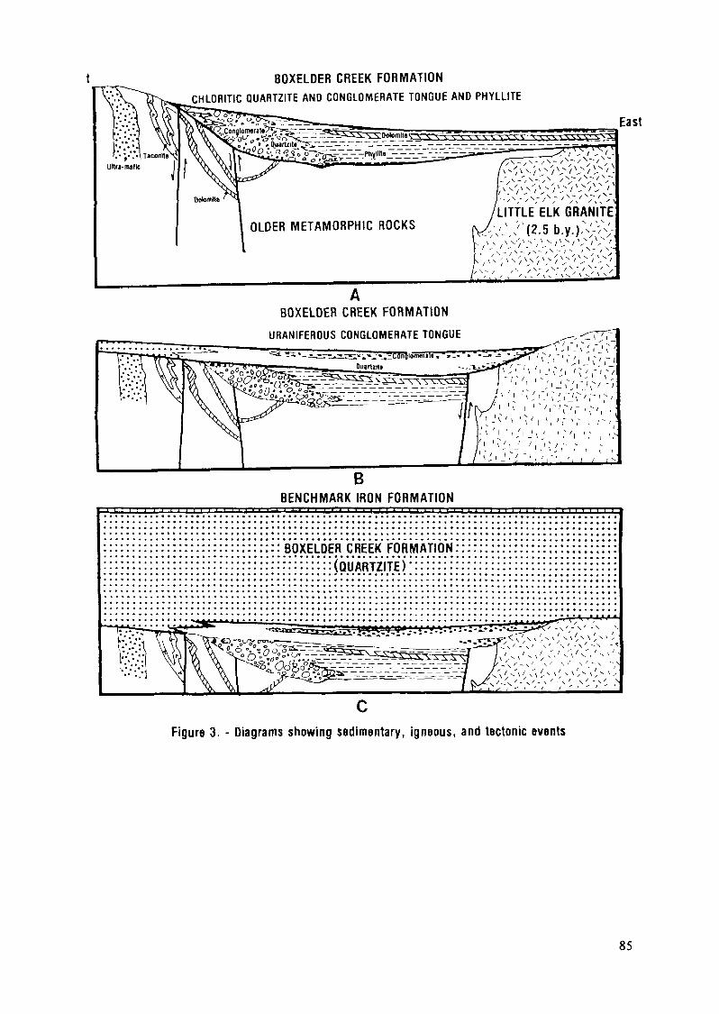
BOXELDER CREEK FORMATIONCHLORITIC QUARTZITE AND CONGLOMERATE TONGUE AND PHYLLITE
OLDER METAMORPHIC ROCKS
East
BOXELDER CREEK FORMATION
URANIFEROUS CONGLOMERATE TONGUE
BENCHMARK IRON FORMATION
BOXELDER CREEK FORMATION:: (QUARTZITE)
Figure 3. - Diagrams showing sedimentary, igneous, and tectonic events
85
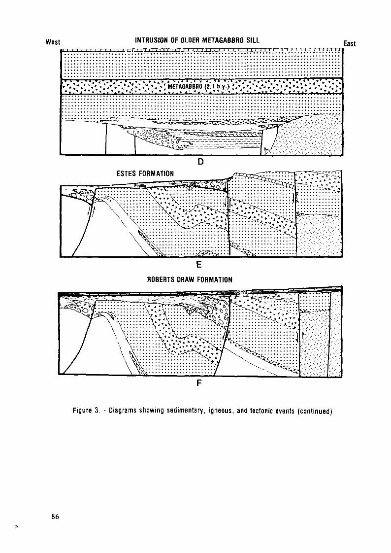
West INTRUSION OF OLDER METAGABBRO SILL11 i i i i i i i i i i j i j r i i i i ] i i i i i i i i i i i i i i i i ii iii i~n~
East
« « * * « T « • » - - - J * * . « Tr-Z*.*•«•.-.VT"/^.:»V* <;METAGABBRO (2.1 b.y.)..\- ,•/*/- A;^«.-:-:'l.v-;»:* r r*Al^* « * » * ^ < ^ *«*•» • « » . > ! . - . > . < • • i , . ^ J . " " ^ ' < . ' < ^ ^ . > - - < » ' - - v < > r - ' y A * , - * * * * * ,
DESTES FORMATION
ROBERTS DRAW FORMATION
Figure 3. - Diagrams showing sedimentary, igneous, and tectonic events (continued)
86
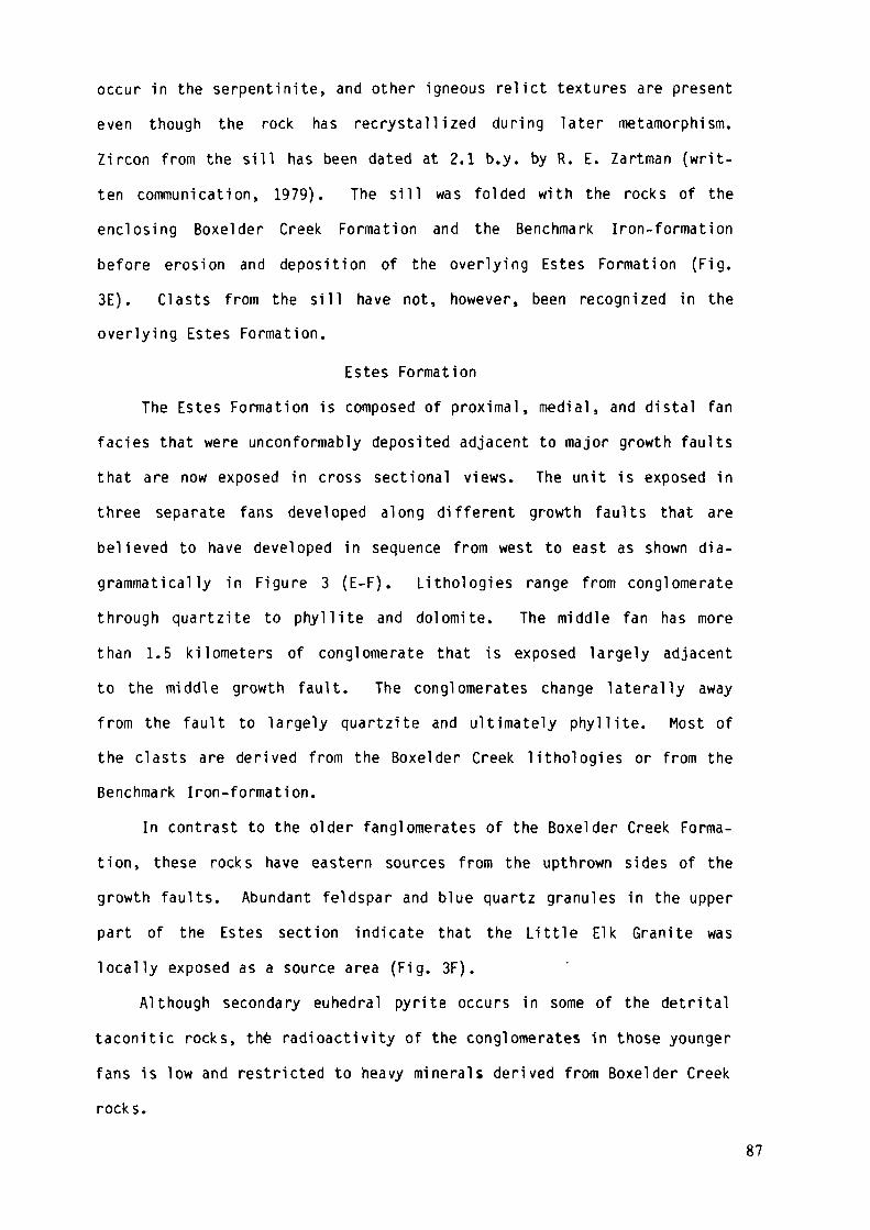
occur in the serpentinite, and other igneous relict textures are presenteven though the rock has recrystallized during later metamorphism.Zircon from the sill has been dated at 2.1 b.y. by R. E. Zartman (writ-ten communication, 1979). The sill was folded with the rocks of theenclosing Boxelder Creek Formation and the Benchmark Iron-formationbefore erosion and deposition of the overlying Estes Formation (Fig.3E). Clasts from the sill have not, however, been recognized in theoverlying Estes Formation.
Estes FormationThe Estes Formation is composed of proximal, medial, and distal fan
faciès that were unconformably deposited adjacent to major growth faultsthat are now exposed in cross sectional views. The unit is exposed inthree separate fans developed along different growth faults that arebelieved to have developed in sequence from west to east as shown dia-grammatical ly in Figure 3 (E-F). Lithologies range from conglomeratethrough quartzite to phyllite and dolomite. The middle fan has morethan 1.5 kilometers of conglomerate that is exposed largely adjacentto the middle growth fault. The conglomerates change laterally awayfrom the fault to largely quartzite and ultimately phyllite. Most ofthe clasts are derived from the Boxelder Creek lithologies or from theBenchmark Iron-formation.
In contrast to the older fanglomerates of the Boxelder Creek Forma-tion, these rocks have eastern sources from the upthrown sides of thegrowth faults. Abundant feldspar and blue quartz granules in the upperpart of the Estes section indicate that the Little Elk Granite waslocally exposed as a source area (Fig. 3F).
Although secondary euhedral pyrite occurs in some of the detritaltaconitic rocks, the radioactivity of the conglomerates in those youngerfans is low and restricted to heavy minerals derived from Boxelder Creekrocks.
87
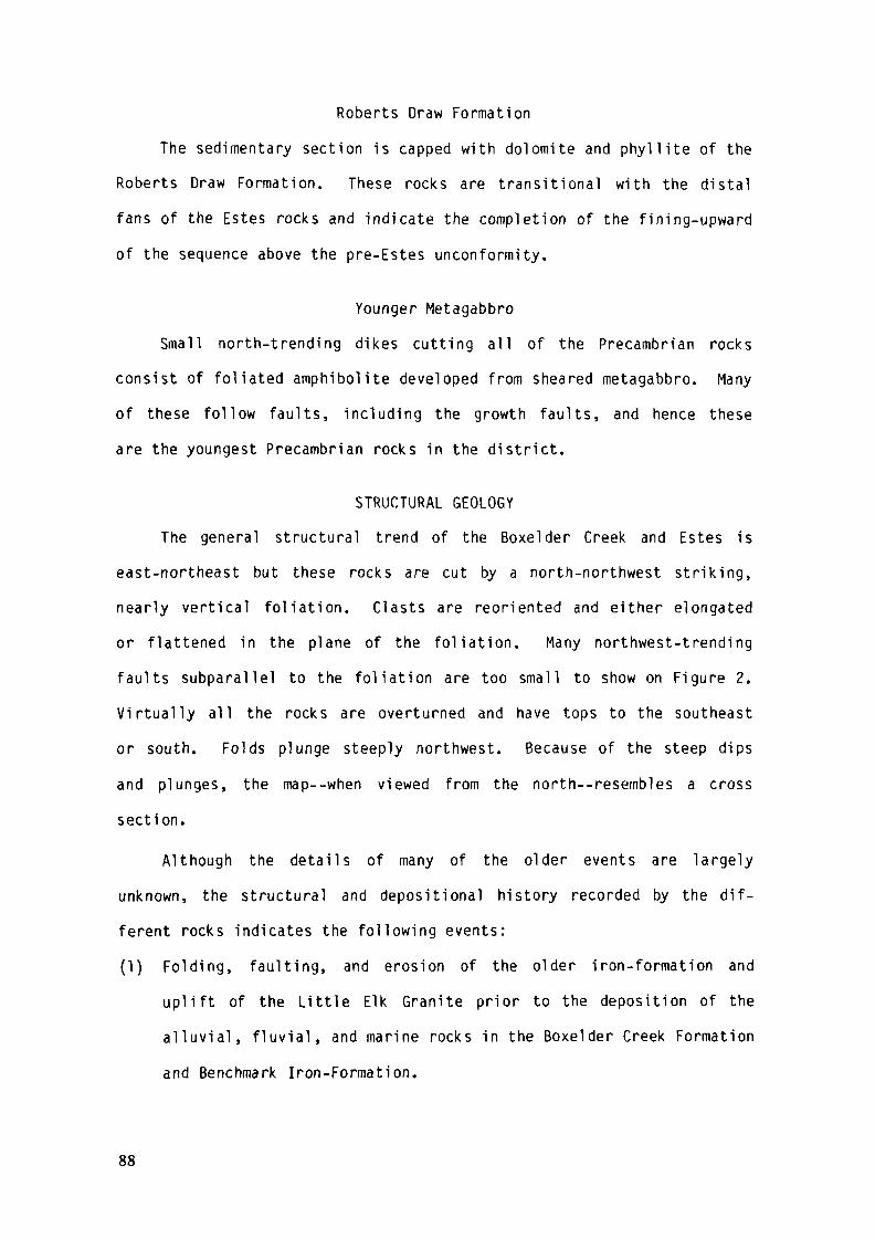
Roberts Draw Formation
The sedimentary section is capped with dolomite and phyll ite of the
Roberts Draw Formation. These rocks are transit ional with the distal
fans of the Estes rocks and indicate the completion of the fining-upward
of the sequence above the pre-Estes unconformity.
Younger MetagabbroSmall north-trending dikes cutting all of the Precambrian rocks
consist of foliated amphibolite developed from sheared metagabbro. Manyof these follow faults, including the growth faults, and hence theseare the youngest Precambrian rocks in the district.
STRUCTURAL GEOLOGYThe general structural trend of the Boxelder Creek and Estes is
east-northeast but these rocks are cut by a north-northwest striking,
nearly vertical foliation. Clasts are reoriented and either elongated
or flattened in the plane of the foliation. Many northwest-trending
faul ts subparallel to the fol iat ion are too small to show on Figure 2.
Virtually all the rocks are overturned and have tops to the southeast
or south. Folds plunge steeply northwest. Because of the steep dips
and plunges, the map—when viewed from the north—resembles a cross
section.
Although the details of many of the older events are largely
unknown, the structural and depositional history recorded by the dif-
ferent rocks indicates the fol lowing events:
(1) Folding, faulting, and erosion of the older iron-formation and
uplift of the Little Elk Granite prior to the deposition of the
al luvial , f luvial , and marine rocks in the Boxelder Creek Formation
and Benchmark Iron-Formation.
88
(2) Emplacement of the older metagabbro sill in a subhorizontal posi-
tion fol lowed by folding of the pre-Estes rocks.
(3) Uplift and block (?) rotation along growth faults fol lowed by depo-
sition of marine fans in the Estes and shal low marine rocks in the
Roberts Draw Formation.
(4) Overturning to the north-northwest of both pre- and post-Estes
rocks.
(5) Deformation, folding, and development of the north-northwest,
nearly vert ical fol iat ion, presumably by northeast-southwest com-
pression. This last event was associated with north-northwest
folding and regional metamorphism in the rest of the Black Hil ls
which culminated with the emplacement of the 1.7 b.y. Harney Peak
Granite.
(6) Post metamorphic faulting.
(7) Laramide uplift of the Black Hills dome and subsequent erosion.
URANIUM DEPOSITS
Di stribution
Anomalous radioactivity is virtually restricted to the uraniferous
conglomerate and granule quartzite tongue in the lower part of the
Boxelder Creek Formation. Slightly anomalous radioactivity in conglo-
merate in the lower chlorit ic quartzite tongue confirms the gradational
contact between the two units. The most uraniferous rocks are the pyri-
tic pebble conglomerates, although adjacent granule quartzites are
local ly anomalous, especially where they are coarser grained and pyri-
tic.
In general the proportion of pebble conglomerate to quartzi te
decreases along strike to the west. For example, there is about 12
meters of conglomerate where the host unit disappears beneath the Paleo-
zoic rocks to the southeast, but the conglomerate faciès is absent in
89
the northwest part of the district. Most of the conglomerate occurs
at two distinct levels; one is near the middle of the unit and the other
is near the upper contact. However the conglomerate is lensoid and
a single 1.3 meter thick bed can thicken to 6 meters in less than 50
meters along strike. Also a thick, homogeneous, close packed conglomer-
ate bed can also change laterally in a few tens of meters to several
thin, loose packed beds separated by quartzite. The shape and rapid
lithologie changes indicate the conglomerate was largely confined to
channel deposits. Isolated clasts in quartzite along the lateral exten-
sions of the conglomerates are typical of gravels in a fluvial system.
The uppermost conglomerate is generally cobble-bearing and forms
a relatively continuous subunit adjacent to a 20 meter thick unit
of phyllite which marks the top of the uraniferous tongue. Although
pyritiferous, this upper cobble conglomerate is generally not as radio-
active as some of the underlying conglomerates. Locally there are
lenses of cobble conglomerate within the pebble conglomerate subunits
near the middle of the tongue.
Petrography and Mineralogy
The conglomerate and granule quartzite are typically poorly foli-
ated and gray, tan, or greenish gray in unoxidized drill core but
largely tan or iron-stained in surface exposures. The iron staining
is due to oxidation of pyrite, which generally makes up a few percent
to as much as 10 percent of the conglomerate. Local thin cross beds
can contain as much as 30 percent pyrite. Greenish colors are due to
a more chlorit ic matrix or in a few exposures, to higher concentrations
of fuchsite.
Clast compositions in the pebble conglomerates consist of--in
decreasing order of abundance--quartzite, chert, vein quartz, and phyl-
lite. Phyllite clasts are very sparse. The conglomerate a lso has
90
single crystal blue quartz clasts,largely of granule size and not
exceeding 0.8 centimeter in maximum dimension. The single crystal
blue quartz clasts are typically subrounded and undeformed whereas
the clasts of chert and quartzite tend to be more rounded and are typi-
cally flattened or oriented with their shortest ax is perpendicular to
the foliation. Clas ts of vein quartz retain their original subrounded
shapes. Packing varies from close to loose and some beds grade into
quartzite containing only a few widely scattered pebbles.
The matrix of the conglomerate is largely finer grained quartz,
muscovite, and chlorite. Accessory heavy minerals--in decreasing
order of abundance—include pyrite, chromite, rutile, zircon, apatite,
tourmaline, uranothorite(?), pyrrhotite, monazite, xenotime, uraninite
and gold. Fuchsite commonly develops from the chromite grains, and in
the area of higher metamorphic grade in the northeast part of the
district, virtually all of the chromite is converted to fuchsite. The
detn'tal grains of chromite vary from euhedral octahedra to well rounded
grains and most are broken as a result of the deformation that accom-
panied the metamorphism of the host rocks. Pyrite occurs as either
euhedral grains that obviously formed late, or as subrounded grains that
are probably detrital. In general the grain size of both types of
pyrite increases with increase in pebble size. Zircon, apatite,
uranothorite(?), monazite, and gold have typical detrital shapes.
Rutile, however, occurs largely as composite small euhedral crystals
that constitute 30 to 70 percent of subrounded to rounded skeletal
quartz-rich aggregates. Sparse anatase has a similar habit. The tex-
tures indicate that an early detrital titaniferous mineral (ilmenite or
magnetite?) has been replaced either during diagenesis or subsequent
metamorphism. Similar textures have been described by Ramdohr (1958),
Ferris and Rudd (1971), and Saager (1970) in other Precambrian uranifer-
ous conglomerates and are the basis for Ramdohr's "Pronto" reaction
91
wherein sulfidization of iron-titanium minerals produces rutile pluspyrite. Such a reaction explains the absence of ilmenite and magnetitein the uraniferous conglomerates as well as the obviously late, euhedralpyrite.
The uranothorite (?) is the most abundant radioactive mineral.The- grains are generally well rounded but show various stages ofrecrystal1ization. A thin rind of pyrite is common around some of thegrains and is additional evidence for sulfur addition during diagenesisor metamorphism.
Uraninite is very sparse and generally limited to minute grains,most of which are within small quartz clasts. None was recognized withshapes of obviously detrital origin. Uraninite has been found in asingle thin veinlet but the sample came from an area of intense faultingand also higher metamorphic grade.
Geochemi stry
Neutron activation analyses for 25 elements in approximately 125samples have been reported by Redden (1980). The samples were largelyfrom drill core and most are conglomerate but also include samplesof granule quartzite and pebble-bearing quartzite. Average sampleintervals were approximately 1.5 meters. A summary of the statisticaldata for drill core samples is given in Table 2. The uranium and tho-rium contents ranged from 4 to 290 and 2 to 500 ppm, respectively. Sur-face leaching of uranium is evident in that the U/Th ratio of surfaceor near-surface oxidized samples averaged 1:7 whereas unoxidized samplesaveraged 1:3. The more uraniferous unoxidized samples tend to have U/Thratios near or greater than one.
A comparison of the lithologie characteristics of the more uranif-erous conglomerate samples indicates that in general higher uraniumcontent is favored by: close packing, better sorting, higher pyrite
92
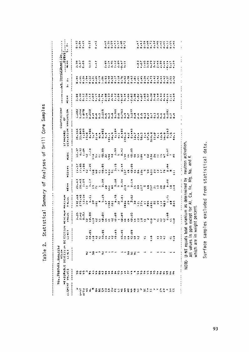
I/leu"o.Ero
(S>
Z
8
0
o
O)</>
<TJC
ITJ
E
ITJO
J-J(TJ
CM
dl
ITJ
S_<».ijou.
Z
2ZIJ
zIU
CG
fcF
MC
01
NI •
J J<1 tlzi r•flrv»•Jai•nt*i01a
t«3ao0.
U.O
a
;
/
3
i
<Z
1i
ä2
M^u
L.C2~-
Uu>-ucuc«vus
, n*» rv, *, o 0 o o K o n ^ r m o n n , * « « . ^ « ,
• iVt 1
l
1
1 1 11
1 O O O - ' O O O O — O O O O O O O Q O — O O O O O O O O O O O O• 1
in l1
1 1 I I I 111
Z t N V Q (V i/> O n N r>O 1 O * h- N -* «O «O •*• t>
«• ,34>
^ .0 » a> o in a > o « «
-, nn« o coo y- — *M in <A — — — n ^t> -. - mUJD 1
I K - O ^ Ö ^ > o ^ M i n c -i n - ^ o « o i n * o t o
Oi - \ / — i n v v t v p « n v v v - ^ o o o ^ — — o *ox i v / i - . — A *
K lO "O yt «p «n 4 in D7 * n > o o o o — * o m
oi — — v > * a v v - * N v n t n v v v i n o j i n w — — f^ —z
i n « ) O K to «o * * ol * * < v - * n r\i *i — oz t . - . . . . . .
1 o o * -^ in o — M •.J O 4 1 - ' 1 - « * V ^ O O » ^
> i w w -• — '•J * -• n *rt o —w ***1 -* -« ->jt
uj i in o i w 'n in m »n <oo » n * v > o o o o o oJ 1 • • . . • . . .
v v v
t- in tn in v> in— 1 O O O O OT | • » • • *
I V V V
1>• 1
» » i o »n m m in o-. »_j i
•^ l
* -i i* l> li» iZ 1
J I » Sj r ^ ^
•
i
i
i
i o K3i ~ -M
i .> -Sj O ^
l ^ - o "^i ls z, "5 . -^
: >, er. <°: -°s tî1 T3
; c iï Ei .— Lu Ot_ rö i4_tt> C— *
1 QJ "U: "° < a>, f> . "O: ro o "H 3
i IU 5! t: a> "t± i/i; e o> <"i 5 o-'l 'o-; s. °- s E] ^2 — — toi U OJ «- dlt O" 13 TO (J
! *" "rô jr "O>— > o •<-
i Z _ ~ l.
; =•« * Jo• LJJ
! O
93

content, higher heavy mineral content, and a larger percentage of veinquartz clasts. Also in individual conglomerate beds, either the bottomor top of the beds may have higher radioactivity than the middle of thebed. Kirn (1979), however, believed that the tops of individual beds hadhigher radioactivity only when truncated by overlying quartzite beds.
Correlation coefficients between the different elements in thedrill core samples were not exceptionally high. Thorium correlatesmoderately well with uranium but shows little correlation with Cr,Zr, and Ti which are the major elements in the dominant heavy mineralswithin the conglomerates. The lack of correlation of the latter isprobably because chromium and titanium did not originate from the samesource rocks as the uranium and thorium. Zirconium correlated rela-tively well with Ce and Y as might be expected. Yttrium, however,showed very poor correlation with phosphorous and thus confirms therelative scarcity of monazite and xenotime in the conglomerates.Potassium and aluminum have high correlation coefficients because musco-vite is the chief matrix mineral.
All d r i l l core samples were below the detection limit (0.2 ppm) forgold. However, smaller surface samples contain as much as 3.9 ppm gold.
In general, the geochemical data confirms the known mineralogy ofthe conglomerates and indicates the likelihood of different source areasfor some of the heavy minerals. The relatively poor correlation of ele-ments characteristic of the different heavy minerals also tends to sup-port the pétrographie evidence that the conglomerates and associatedquartzites have not undergone extensive winnowing and reworking beforedeposition.
Origin and SourceThe lenticular bedding, lateral variation in both thickness and
clast packing over short distances, and small-scale trough cross-bedding
94
of the associated granule quartzite and pebble-bearing quartzite indi-
cate the uraniferous rocks were deposited in a f luvial environment.
Although absolute current directions generally could not be determined,
the nearly constant relationship—wherein cross bedding truncations
are visible on surfaces perpendicular to bedding/cleavage intersection
and subplanar bedding is visible on surfaces parallel to foliation--
indicates a strongly unidirectional current f low characteristic of flu-
vial systems.
The associated minor minerals are typical heavy minerals of f luvial
systems except that iron-titanium minerals are absent. However, rutile
aggregates clearly indicate that sulfidization of iron-titanium heavy
minerals occurred during diagenesis or subsequent low grade metamor-
phism. Most of the pyrite formed during this alteration although some
is apparently detrital.
The relative abundance of the heavy minerals zircon and chromite
and the abundance of chert and quartzite clasts indicate that there were
probably several different source areas for the uraniferous rocks.
Detrital uraninite grains have not been identified but uranotho-
r i te(?) grains are clearly detrital and are probably the host for most
of the uranium. Uranium also occurs in small amounts in zircon, mona-
zite, and secondary carbonate minerals.
All of these characterist ics suggest strongly that the uranium
has originated in heavy minerals which were subsequently modified by
diagenesis/metamorphism into their present mineralogy.
The original source of the uranium is not known but may have been
the Archean Little Elk Granite. Reasons for this conclusion include (1)
the occurrence of blue quartz grains in the granite which are also abun-
dant in the uraniferous rocks, (2) the physical similarity of zircons in
the granite and in the conglomerates, and (3) the occurrence of pyrite
95
in the granite. In addition, analyses of surface samples of the granitefor uranium and thorium, when corrected for probable leaching, indicatethat the fresh granite probably contains about 8 to 10 ppm uranium andis thus somewhat enriched in that element. Also the distribution of theuraniferous conglomerates suggests that they may have had an easterlysource toward the Little Elk Granite.
Economic PotentialThe present exposures of the uraniferous conglomerates do not
encourage exploitation because of their low uranium and gold contents.However, it cannot be assumed that the district has no potential becausethe structure is such that only a single cross section of the uranifer-ous rocks is exposed. The thicknesses of the uraniferous rocks areadequate and the environment of deposition seems to be virtually iden-tical with economic Precambrian pebble conglomerates elsewhere. If eco-nomic deposits exist, they almost certainly are to the east beneath thecovering of Phanerozoic rocks.
On the negative side, however, the conglomerates have originatedfrom several different types of source rocks and have not been subjectedto enough winnowing and cannibalization to have developed economic min-eralization. An additional hindrance to possible economic developmentis the extreme structural complexity but covered areas to the east couldbe structurally more simple.
REFERENCES
Bayley, R. W., 1972, Preliminary geologic map of the Nemo district,Black Hills, South Dakota: U. S. Geological Survey MiscellaneousGeologic Investigations Map 1-712.
Ferris, C. S., and Rudd, C. 0., 1971, Brannerite: Its occurrenceand recognition by microprobe: Colorado School of Mines Quarterly,v. 66, 35 p.
96
Hills, F. A. 1977, Uranium and thorium in the Middle Precambrian EstesConglomerate, Nemo District, Lawrence County, South Dakota—a prelimi-nary report: U. S. Geological Survey Open-File Report 77-55, 27 p.
Kim, Jong Dae, 1979, Mineralogy and trace elements of the uraniferousconglomerates, Nemo Distr ic t , Black Hi l ls, South Dakota: South DakotaSchool of Mines and Technology unpub. Ph. D. thesis, 125 p.
Page, L. R., and others, 1953, Pegmatite investigations 1942-45 BlackHil ls, South Dakota: U. S. Geological Survey Professional Paper 247,228 p.
Ramdohr, P., 1958, Über das vorkommen von uranin alten konglomeraten:Geologie (Berl in), Jahrgang 7, p. 965-968.
Redden, J. A., and Norton, J. J. 1975, Precambrian geology of the BlackHi l ls, in Mineral and water resources of South Dakota: South DakotaGeological Survey Bull. 16, 2nd ed., p. 21-28.
Redden, J. A., 1980, Geology and uranium resources in Precambrian con-glomerates of the Nemo area, Black Hills, South Dakota: U.S. Departmentof Energy National Uranium Resource Evaluation Report GJBX 127(80),147 p.
______, 1981, Summary of the geology of the Nemo area, _i_n Geology ofthe Black Hills, South Dakota and Wyoming: F. J. Rich, ed., publishedby American Geological Institute, Washington, D. C., p. 193-209.
Saager, R., 1970, Structures in pyrite from the Basal Reef in the OrangeFree State gold field: Geological Society of South Afr ica Transactions,v. 73, pt. 1, p. 29-46.
Zartman, R. E., and Stern, T. W., 1967, Isotopic age and geologic rela-tionships of the Little Elk Granite, northern Black Hills, South Dakota,rn_ Geological Survey Research 1967: U. S. Geological Survey Profes-sional Paper 575-D, p. D157-D163.
97
APPLICATION OF THE TIME AND STRATA BOUNDMODEL FOR THE ORIGIN OF URANIUM BEARINGQUARTZ-PEBBLE CONGLOMERATE INSOUTHEASTERN WYOMING, USA
R.S. HOUSTONDepartment of Geology and Geophysics,University of Wyoming,Laramie, WyomingK.E. KARLSTROMDepartment of Marine, Earth and
Atmospheric Sciences,North Carolina State University,Raleigh, North CarolinaUnited States of America
Abstract
Application of the "time and stratabound model" for the origin ofquartz-pebble conglomerates led to the discovery in 1975 of uranium,thorium and gold bearing conglomerates in the Late Archean and EarlyProterozoic Rocks of southern Wyoming, U. S. A. The principal hostrocks, in the Medicine Bow and Sierra Madre mountains, west of Laramie,are in early Proterozoic miogeoclinal metasediments. The rocks weredeposited in a rifted passive margin and preserved where thick deltaicsuccessions were buried by overriding thrusts. The most promisingdeposits are in the Early Proterozoic Magnolia formation. The principaluranium minerals are uranothorite and coffinite. The conglomerates areat the base of a sedimentary sequence lying unconformably on older rocksand have well rounded, moderatedly sorted and tightly packed pebbles,dominantly of quartz. The matrix is composed of quartz, feldspars andphyllosilicates (muscovite, chlorite and biotite) formed frommetamorphism of an argilliceous matrix. The mineralogy present supportsthe concept that uranium rich rocks did not develop until late in theArchean.
The potential area underlain by quartz-pebble conglomerates is verylarge. The uranium grades in the Medicine Bow area increase from SW toNE, which is promising, but the conglomerate becomes deeply buried.Resources in the Medicine Bow mountains are estimated from geologicconsiderations at more than 10,000 tonnes of uranium.
INTRODUCTIONSince 1975 a cooperative effort between the United States Geological Survey,
United States Department of Energy, Geological Survey of Wyoming, the Geology Depart-ment, University of Wyoming, and various industry groups has resulted in the discoveryof a series of uranium-thorium- and gold-bearing conglomerates in Late Archeanand Early Proterozoic metasedimentary rocks of southern Wyoming. The mineral de-
99
posits were found by applying the time and strata bound model for the origin ofuranium-bearing quartz-pebble conglomerates to favorable rock types within a geologicterrane known from prior regional mapping (Houston and others, 1977).
No mineral deposits have been discovered that are of current (1983) economic
interest, but preliminary resource estimates determined by the Kriging method of
ore reserve estimation and an ore-grade cutoff of 100 ppm indicate that over 3A18
tons of uranium and over 1996 tons of thorium are present in the Medicine Bow Moun-
tains and that over 440 tons of uranium and 6350 tons of thorium are present inthe Sierra Madre (Borgman and others, 1981). Geologic reasoning suggests much
larger reserves of uranium in the Medicine Bow Mountains perhaps more than 10,000
tons (Borgman and others, 1981).
Sampling has been inadequate to determine gold resources. High grade uranium
deposits (deposits over 2 meters thick and averaging over 1000 ppm uranium) have
not been detected by work to date but local beds of uranium-bearing conglomeratecontain as much as 1380 ppm uranium over a thickness of 0.65 meters. These projects
involved geologic mapping at scales from 1/6000 to 1/50,000, detailed sampling,
and the evaluation of 48 diamond drill holes, but the area is too large to fully
establish the economic potential with present information.
LOCATION AND GENERAL GEOLOGYThere are three main uplifts exposed in southeastern Wyoming which have rocks
of Precambrian age in their core (fig. 1). The two westernmost ranges, the MedicineBow Mountains and Sierra Madre contain Early Proterozoic metasedimentary rockswhich are raiogeoclinal and are the hosts of radioactive quartz-pebble conglomerate.
The boundary between the Archean Wyoming Province and Proterozoic rocks ofColorado is exposed in southeastern Wyoming (fig. 1) and is a zone of sheared rocksthat strikes generally northeast. This boundary has been referred to as the CheyenneBelt (Houston and others, 1979) and may be part of a suture where island arcs thatdeveloped in what is now Colorado were attached to the Arche^n continent that con-stituted The Wyoming Province (Hills and Houston, 1979). North of the Cheyenne
Belt Archean basement gneiss and granite is overlain unconformably or is in faultcontact with metasedimentary and metavolcanic rocks that range in age from LateArchean to Early Proterozoic. Early Proterozoic metasedimentary rocks are found
within 30 kilometers of this boundary, but have not been identified in the central
100

EXPLANATION3 SHERMAN GRANITE (1400 m y)
I LARAMIE ANORTHOSITE
| SYENITE (1435my)
-j SYNTECTONIC GRANITOID (1700 m y)• QUARTZ DIORITE (1780my)a VOLCANOGENIC GNEISS* * = MIGMATITE
| MAFIC INTRUSIONS
UPPER LIBBY CREEK GROUPLOWER LIBBY CREEK GROUPDEEP LAKE GROUP
ARCHEAN SUPRACRUSTAL ROCKS
ARCHEAN GNEISS AND GRANITE
'THRUST FAULT
"SHEAR ZONE
SIERRA MADRE
106'
UJ
o
LARAMIEMTS.
HARTVILLEUPLIFT :
MEDICINE BOWMTS.
WYOMINGPROVINCE
INDEXM MAP
NORTHPARK
RANGE
STEAMBOATSPRINGS
FRONTRANGE
0 10 20 30 40 50
Figure 1 - Index map showing generalized Precambrian geology of southeastern Wyomingand northern Colorado. Colorado geology modified from Tweto (1979).
101
part of the Wyoming Province. This Early Proterozoic miogeoclinal succession is
interpreted as having been deposited along a rifted, passive (Atlantic-type) margin
and is preserved near the margin where thick deltaic successions were buried byoverriding thrusts during collision (Karlstrom, Flurkey, and Houston, 1984).
South of the Cheyenne Belt there are no rocks of Archean age. Proterozoicrocks are about 1800 m.y. old (Premo and Van Schmus, 1982) and consist of metavolcanicand metasedimentary rocks of island arc affinity (Hills and Houston, 1979; Houston,
Schmidt and Lane, 1984).The Archean basement of central and southeastern Wyoming consists of a granite-
gneiss terrane and greenstone belts cut by Late Archean granite. The gneiss terraneand greenstone belts are approximately 3000 m.y. old (Peterman and Hildreth, 1978)
and there are, at least, two Late Archean episodes of granite formation, one about2700 m.y. and another about 2500 m.y. (Peterman and Hildreth, 1978). The 2500
m.y. granites are especially significant from the viewpoint of uranium mineralizationsince they contain anomalous thorium and uranium and have been considered by somegeologists and geochemists as the prime source of uranium in younger rocks of Wyoming(Houston, 1979; Stuckless, 1979). The Archean basement of the Medicine Bow Mountainsand Sierra Madre is largely quartzofeldspathic gneiss, but small areas underlainby amphibolite and hornblende gneiss in the northern Sierra Madre and northeastern-most Medicine Bow Mountains may be parts of more extensive greenstone belts buriedby Phanerozoic sedimentary rocks. Small Late Archean granites representative ofboth the 2700 m.y. suite and the 2500 ra.y. suite are exposed in the Sierra Madre,but only the 2500 m.y. granite is found in the Archean basement of the MedicineBow Mountains.
Three metasedimentary and metavolcanic rock successions are exposed in theSierra Madre and Medicine Bow Mountains that are approximately 15000 meters thick(table 1). These rock successions are the Late Archean Phantom Lake Metamorphic
Suite, and the Early Proterozoic Deep Lake and Libby Creek Groups. The Late Archean
Phantom Lake Metamorphic Suite is a rock succession having characteristics inter-
mediate between a greenstone belt and typical Early Proterozoic miogeoclinal succes-
sions, and is a mixture of volcanic rocks, volcanoclastic metasedimentary rocks,quartzite, phyllite, slate, and conglomerate. The stratigraphy of the PhantomLake succession is not well-established because of poor preservation of primarystructure and multideformation hence the designation Suite (Henderson, Caldwell,
102
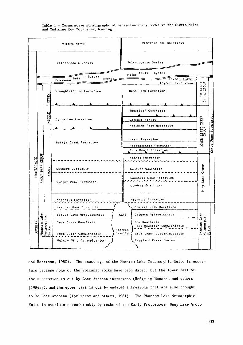
Table 1 - Comparative stratigraphy of metasedimentary rocks in the Sierra Madreand Medicine Bow Mountains, Wyoming.
MEDICINE BOIjJ MOUNTAINSSIERRA MftDRE
l/olcanogenic GneissVolcanogenic Gneiss
fault SystemFrpnrh Slate
Towner Greenstone
Nash Fork FormationSlaughterhouse Formation
Suqarloaf QuartziteA A
Copperton Formation Lookout Schistfledicine Peak Quartzite
Heart FormationBottle Creek Formation
Headquarters FormationRock Knoll Formation
Uaqner Formation
Cascade Quactzite Cascade Quartzite
Campbell Lake Formationt H?**» l* *~*S**~f *r ~ t
Lindsey Quar t z i teSinger Peak F o r m a t i o n
flagnolia F o r m a t i o nus ~**s~ r~ r* ~*s~**r ,? -
Conical Peak Quartzite
Nagnolia Formation
Bridger Peak Q u a r t z i t e
CoLberq MetavolcaoicsSilver Lake Metavolcanics
Sou QuartziteRock Mountain Conglomerate
ArcheanGranite ) 5tud Creek Volcanic 1 as 11 es
Jack Creek Quartzite
Deep Gulcn Conglomerate—^——'••^-^-^^^^•N^^^^^^'^^X^^X'N^
Uulcan Cltn. Hetawolcanics Querland Creek Gneiss
and Harnson, 1980). The exact age of the Phantom Lake Metamorphic Suite is uncer-tain because none of the volcanic rocks have been dated, but the lower part ofthe succession is cut by Late Archean intrusions (Hedge in Houston and others[ 1984a]), and the upper part is cut by undated intrusions that are also thoughtto be Late Archean (Karlstrom and others, 1981). The Phantom Lake Metamorphic
Suite is overlain unconformably by rocks of the Early Proterozoic Deep Lake Group
103
which consists of six formations from oldest, the Magnolia Formation, Lindsey Quart-zite, Campbell Lake Formation, Cascade Quartzite, Vagner Formation, and Rock KttollFormation. The lower Deep Lake Group is interpreted as fluvial whereas the CampbellLake Formation and younger formations are considered marine and glaciomarine (Karl-strom and others, 1981; Houston and others, 1981). The rocks of the Deep LakeGroup are in fault contact with metasedimentary rocks of the Libby Creek Group,which is divided into a lower and upper part. The lower Libby Creek Group consistsof five formations, from oldest, The Headquarter Schist, The Heart Formation, TheMedicine Peak Quartzite, the Lookout Schist and The Sugarloaf Quartzite (Houstonand others, 1968). This lower part of the Libby Creek Group is interpreted asmarine; the Headquarters Sehn st as glaciomarine and the overlying formations as
part of a deltaic succession (Karlstrom, Flurkey, and Houston, 1981). The upper
Libby Creek Group which is in fault contact with the lower Libby Creek Group con-sists of three formations from oldest, the Nash Fork Formation, the Towner Green-
stone, and the French Slate. The upper Libby Creek Group is also viewed as marinebut these beds are thought to have been deposited farther offshore than rocks of
the lower Libby Creek Group.
There is no direct dating of rocks of the Libby Creek Group, but the lower
Libby Creek Group succession is cut by a felsic intrusion (the Gaps Intrusion)that has been dated at approximately 2000 m.y. (Hedge in Houston and others, 1984a).
Metamorphic dates for units of both lower and upper Libby Creek Group are approximately
1700 m.y. (Hills and Houston, 1979). On geologic grounds the lower Libby CreekGroup has been correlated with the Huronian Supergroup of Canada (2400-2100 m.y.)
and the upper Libby Creek Group with the Marquette Range Supergroup (2100-1900
m.y.) of the Lake Superior region (Houston and others, 1977).The rocks of the Phantom Lake Metamorphic Suite are the most highly deformed
and metamorphosed of the metasedimentary successions. In the Sierra Madre PhantomLake rocks are in a series of overturned folds with axial planes dipping southand these folds are refolded about a new axis in the northwestern Sierra Madre.Phantom Lake rocks are also intensely folded in the Medicine Bow Mountains wherefolds strike east northeast and are refolded about new axes in the northeasternMedicine Bow Mountains. Strike faults are common in the Phantom Lake in both theSierra Madre and Medicine Bow; some fold-fault systems of the Sierra Madre areprobably nappes although the amount of displacement in individual faults has not
104
been established. Phantom Lake rocks are amphibolite facies reaching upper amphi-
bolite facies locally.Rocks of the Deep Lake and Libby Creek groups are less deformed than the
Phantom Lake. Deep Lake Group metasedimentary rocks are in broad open folds in
the central Medicine Bow Mountains that become tighter and more closely appressedto the northeast. In the Sierra Madre the Deep Lake Group is more deformed than
in the Medicine Bow and parts of the section are removed by strike faults. Libby
Creek Group rocks of the Medicine Bow Mountains are in a northeast striking synclinewhich has its southeast limb largely removed by a major fault, the Müllen Creek-Nash Fork shear zone (Houston and McCallum, 1961). In the Sierra Madre much ofthe Libby Creek Group is removed by thrust or high angle reverse faults, but partialsections are preserved at the southern margin.
The metamorphic rank of rocks of the Deep Lake and Libby Creek Groups varies from
green schist in the central Medicine Bow Mountains to amphibolite facies in other areas.
RADIOACTIVE QUARTZ PEBBLE CONGLOMERATEUranium-thorium-gold bearing quartz-pebble conglomerate is present in the
Deep Gulch Conglomerate of the Jack Creek Quartzite, the lower division of the
Late Archean Phantom Lake MetamorphicSuite, and the Conglomerate Member of theMagnolia Formation, the basal formation of the Early Proterozoic Deep Lake Group,in the Sierra Madre and Medicine Bow Mountains respectively. The best developedand most continuous beds of quartz-pebble conglomerate are in the basal Jack CreekQuartzite of the Carrico Ranch area of the northwest Sierra Madre, where radioactiveconglomerate crops out in the overturned limb of a major fold for a distance of13 kilometers (fig. 2). Unfortunately, the well-developed quartz-pebble conglomeratesof the Late Archean. Jack Creek Quartzite are a thorium rather than a uranium resourcewith thorium to uranium ratios averaging 6.99. The chemical composition of primarythorium-uranium minerals in the Jack Creek Quartzite indicate that these mineralsare mixtures of a thorium-bearing monazite and the thorium silicate huttonite.
These minerals along with monazite, zircon, and pyrite are the principal heavy
minerals in the Jack Creek Quartzite. The thorium-uranium minerals of the JackCreek Quartzite are believed to have been derived from 2800 m.y. or older Archean
gneiss and granite of the Wyoming Province. Paleocurrent determinations in the
Jack Creek Quartzite suggest a northerly source.
105
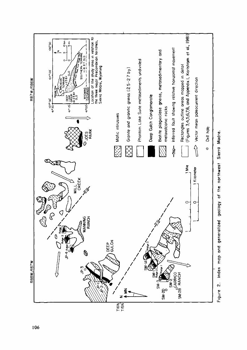
(DCOC
ooce
00(r
O
O
•oo
o\_W
M
oc
o>o
•o<uN
O)Cv
CO
O.DEXO)•o
CVJ
3g»u.
106
In contrast to the Jack Creek Quartzite, the Early Proterozoic quartz-pebbleconglomerate of the Magnolia Formation of the Deep Lake Group of the Medicine Bow
Mountains contains minerals richer in uranium and has an average thorium to uranium
ratio of 2. 9. The most promising deposits in the Magnolia Formation are in athree square mile area along Onemile Creek near the village of Arlington in thenortheastern Medicine Bow Mountains. Here uranium-bearing quartz-pebble conglomerateis in the southwest plunging nose and in the complexly folded and overturned north-west limb of a major syncline (fig. 3). The principal uranium minerals in theArlington locality are uranothorite and coffinite and uranium is also present inlesser amounts in monazite, zircon, and monazite-huttonite mixtures similar tothe principal uranium-thorium-bearing minerals of the Sierra Madre. The heavymineral suite is much more complex in the Magnolia Formation than in the Jack CreekQuartzite and contains minerals such as ilmenorutile and columbite that are almostcertainly from a granitic source (Desborough and Sharp in Houston, Karlstrom, andGraff, 1979). Pyrite is the most abundant heavy mineral in both the Medicine Bowand Sierra Madre occurrences. No reliable paleocurrent measurements have beenobtained in the quartz-pebble conglomerate beds of the Magnolia Formation but paleo-current determinations in overlying quartzites suggest a northeast to north source.
Inasmuch as the Magnolia Formation is believed to have been deposited after intrusionof uranium-rich Late Archean granites (2500-2600 b.y.) of the Wyoming Province,these granites of central and eastern Wyoming are considered to be the source of
uranium-bearing minerals of the quartz-pebble conglomerate. The different sourcerocks of the Late Archean quartz-pebble conglomerate and Early Proterozoic quartz-
pebble conglomerate are critical in that they determine the economic potential
of the conglomerate.In both the Sierra Madre and Medicine Bow Mountains radioactive quartz-pebble
conglomerate is either at, or near, the base of a sedimentary succession that lies
unconformably on older rocks. The quartz-pebble conglomerate is believed to havebeen deposited in braided streams and rivers that developed in the vicinity oftectonic (fault-controlled) highlands. Radioactive quartz-pebble conglomerate
layers are individual beds or compound beds in coarse-grained quarlzite and theyoccur at different levels in quartzite units that are up to 800 meters thick (fig.4).
107
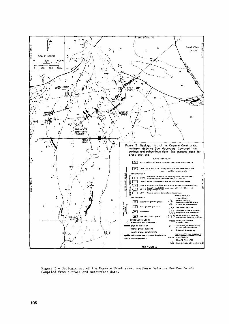
SCALE I 6000
0 5OO lOOOft
Figure 3 Geologic mop of the Onemile Creek area,northern Medicine Bow Mountains Compiled fromsurface and subsurface data See opposite page forcross sections
EXPLANATIONMAFIC INTRUSIVE ROCK Amphibol zed gabbro and pyro*emt
CASCADE QUARTZITE Pebbly quorti . te and non-radioactive
UNCONFORMIT r
I ——— . MuicovHk luborkos« ond quartz-pebble conglomérat«LAJ UNIT 5 principal radioactive ion«* labeled 5o ond 5b[ 4 | UNIT4 SiaflfB chlonf« »cftr«f with paraconqloenerate lentet
l — - — i . Trough crossb«dd«d tu bo r k ose with ihmI 2 I ^N(T2 conglomerate b«di
[ 1 J UNIT 1 Ar he« ic pa ro conglomerate and »uborkos*MAP SYMBOLS
UNCONFORMIT V
] qÇ [ Granite ana gran me g
Fine qramed quorliir«
Mttabatall
Inferred faults,showing relatived i »place men I, dotted whereinvaded by igneous rocks
- Overturned Synclme
Y \ V Stretched pebble mineral a•;,-5s7s mtnof fold am» lineohoni
'5*2*5 Sinkt and dip ol bedding,i & ' overturned bedding, follatiOver
LITHOLOCIC UNITSeheared and brecciateo rock
phyllite ond ichittcoor»e-groi«ed quarlxite
quartz-granule conglomeraterodwacfiv« quor'i-p«b»4» tonq
porocongtomtrate
Drillhole« showing, bearing,plunge and tota l lengthCrotibed, ihowmg top
CROSS SECTION SYMBOLSunconformitybedding form lines
T. A to word/aura y strike slip foul
Figure 3 - Geologic map of the Onemile Creek area, northern Medicine Bow Mountains.Compiled from surface and subsurface data.
108
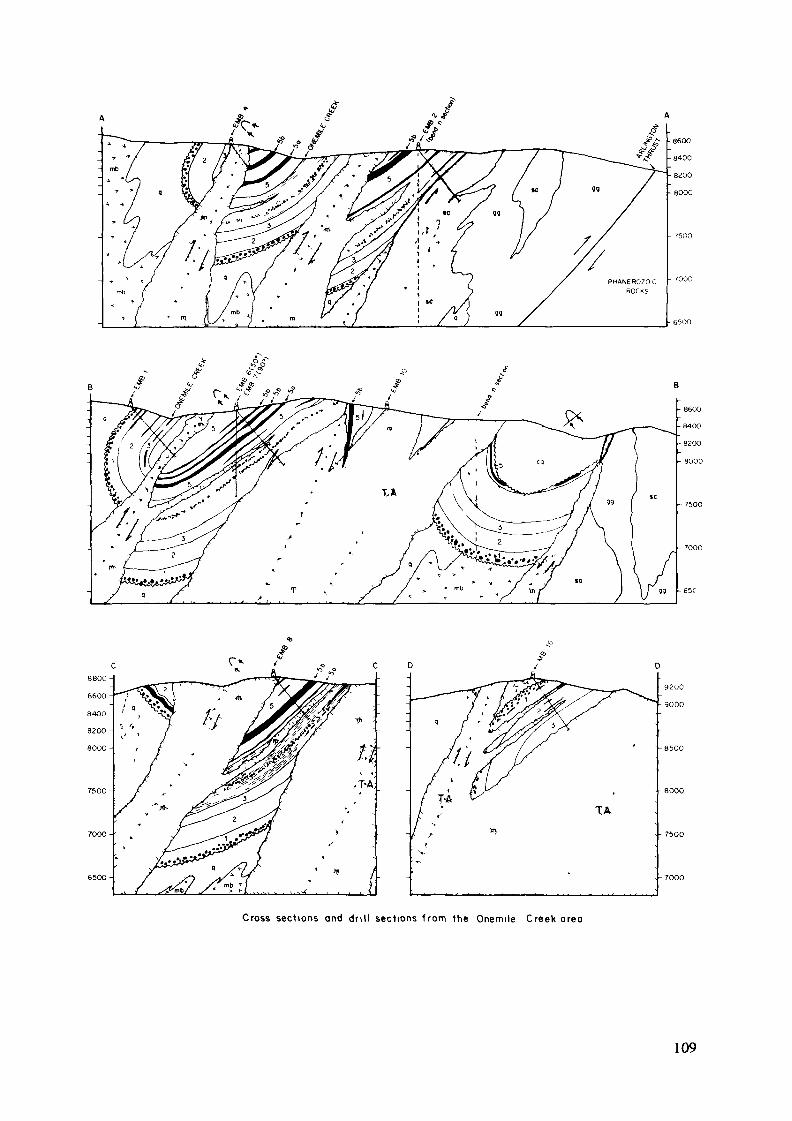
650O-
Cross sections and drill sections f rom the Onemile Creek area
109
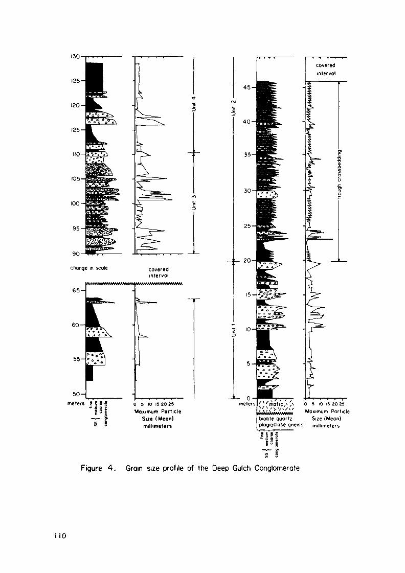
130 i. ...
50meters | f • s 0 5 10 IS 2025
Maximum ParticleSize (Mean)millimeters
biotite quartzplagioclose gneiss
° 5 10 is 20 25Maximum Port.cle
Size (Mean)millimeters
t e s s-
Figure 4. Grain size profile of the Deep Gulch Conglomerate
110

None of the formations of the Libby Creek Group contain significant uranium,
and inasmuch as local beds of hematitic quartzite are in the French Slate and otherformations of the Libby Creek Group, it seems probable that uraninite could nothave been transported as a detrital mineral when beds of the Libby Creek Groupwere deposited.
PETROGRAPHY OF RADIOACTIVE BEDSThe most radioactive rocks in the Sierra Madre are subarkosic moscovitic
quartz-pebble conglomerates of Unit 3 of the Deep Gulch Conglomerate (fig. 5) andthe most radioactive rocks in the Medicine Bow Mountains are subarkosic, muscoviticsmall-pebble (quartz, granite, and quartzite) conglomerates of Unit 5 of the MagnoliaFormation (fig. 3). Although these beds differ in age, the major constituentsare basically the same (except granite fragments are rare in the Sierra Madre).These constituents include quartz, rock fragments of granite and quartzite, K-feldspar,
plagioclase, muscovite, chlorite, biotite, pyrite and a heavy mineral suite. Arkosicand subarkosic quartzites were originally bimodal, argillaceous sandstones andquartz-pebble conglomerates were originally trimodal, argillaceous conglomerates.
Tables 2 and 3 show modal analyses of the sand and granule size fractions fromthe main radioactive units in the Medicine Bow Mountains and Sierra Madre.
Pebbles in the conglomerates are well rounded, generally moderately sorted,
and tightly packed. The most radioactive conglomerates appear to be pebble-supportedin both ranges, although stretching of pebbles in the Onemile Creek area of theMedicine Bow Mountains makes it difficult to decipher original packing densities.
Clasts in the Deep Gulch Conglomerate are entirely quartz and quartzite, with an
average size range of 0.7 to 3.7 and maximum size of 5 cm. Clasts in the MagnoliaFormation conglomerates are quartz, quartzite, and granite. They range in size
from granules to boulders 7.5 cm in diameter but are most commonly 1-3 cm in diameter.Many of the conglomerates contain 100 percent quartz pebbles; others contain upto 20 percent quartzite and granite pebbles.
The matrix of the conglomerates is composed of quartz, feldspar, andphyllosilicates. The phyllosolicates, muscovite, chlorite, and biotite are consid-ered to be raetamorphic minerals formed by recrystallization of an argillaceousmatrix. Micas make up about 25 percent of the matrix of most conglomerates andsome samples contain as much as 50 percent. The most radioactive conglomeratestend to be rich in muscovite and sericite, but poor in biotite and chlorite.
I l l
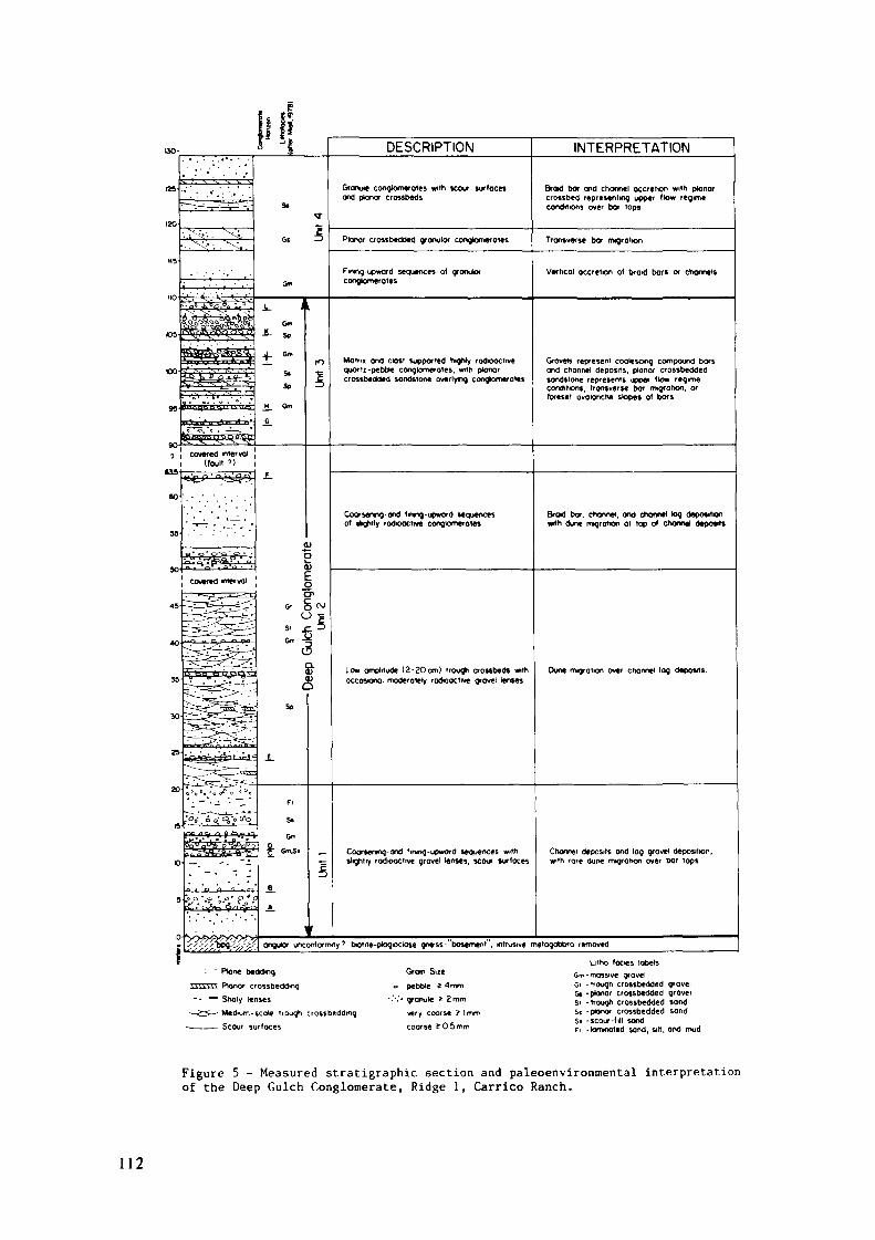
DESCRIPTION INTERPRETATION
Granute congkxnerQies with scour surfacesand ptonor crossbeds
Braid bar and channel accretion with planarcrossbed representing upper flow regimeconditions over bar tops
Planar crossbedded gronutar congtomerotes Transverse bar migration
Fmrtg-upward sequences of granularconglomérâtes
Vertical accretion of brad bars or channels
MotTii and clast supported higniy rodoactivequortz-pebble conglomérâtes, with planarcrossbedded sandstone overlying conglomerates
Grovets represent coalescing compound barsand channel deposits, planar crossbeddedsandstone represents upper flow regimecondiNons. transverse bor migration, orforeset avalanche slopes of bars
Coorsenrg-and fnng-upword sequencesof shghtly radioactive congtomerates
Braid bar, channel, and channel log depositionwith dune migration at top of Channel deposits
Low amplitude (2-2Ocm) trough crossbeds withoccoscnai moderoiety radioactive gravel lenses
Dune rrvgraiton over channel lag deposits.
Coarsening- and fmtnq-jpword sequences wiThslightly radioactive grovel lenses, scour surfaces
Channel deposits and log gravel deposition,wrth rare dune migration over bar tops
angular unconformity ' biotiie-piogiociase gneiss-"basemefit", intrusive metagobbro rernoved
— - Plan« (»öd««,^ ^ ^ ^ ^ ^ ^ Ptanor crossbeddmq-• — Sholy lenses
—2^^ Medium -scale trouah crossbeddmg,———— Scour surfaces
Gram Su«o Mbcle z 4mm. . „-.-.. granule t 2mm
very coarse îlmm„,coarse 505mm
Lilho (aces labelssa>- massive gravelGi -itouah crossbedded «ravelG» -ptaoor crossb«kled grovels, .)rough crossbe(k)ed ,ond
St -plonor crossbedded sandSi -scour-lill sandFl .,0™,,,,,,) Mn(Ji „|t| Ond mud
Figure 5 - Measured stratigraphie section and paleoenvironmental interprétationof the Deep Gulch Conglomerate, Ridge 1, Carrico Ranch.
112
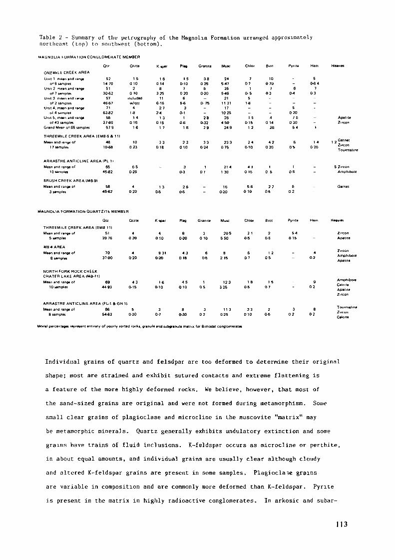
Table 2 - Summary of the petrography of the Magnolia Formation arranged approximatelynortheast (top) to southwest (bottom).
MAGNOLIA FORMATION CONGLOMERATE MEMBER
K .par PI.O Chlor Pyrite
ONEMILE CHEEK AREAUnit 1 mean and range
of 9 samplesUnit 2 mean and range
of 7 samplesUnit 3 mean and range
of 2 samplesUnit 4, mean and range
of 4 samplesUnit 5. mean and range
of 43 samplesGrand Mean of 65 samples
521470
5130-62
5746-67
7163-82
5827-80
579
1 50 10
20 10
includedw/qtz
41-8
1 40 16
1 6
1 6014
B325
116-16
2 72-4
1 3015
1 7
1 50-10
7020
65-6
30-1
10-6
1 8
38025
50-20-
0-75--28
0-3229
245-47
255-45
2111 31
171025
26450
249
70-7
10-5
51-8--1 5
0-161 2
10070
703----4
01426
50-64
6 70-4 03--5
0207 6
03054 1
ApatiteZircon
THREEMILE CREEK AREA IEMB-5 & tilMean and range of
1 7 samples48
10-6810
0233 3
0 182 3
01033
0-24233
0752 4
O-104 2
0206 1 4
05 020
t 2 GarnetZirconTourmaline
ARRASTRE ANTICLINE AREA |PL 11
Mean and range of10 samples
BRUSH CREEK AREA IMB-91
Mean and range of3 samples
6545-82
5846-62
650-25
4020
_
-
1 30-5
30-3
260-5
10 1
_-
21 41 30
160-20
4 10 15
560 10
10 5
220-5
105
602
5 ZirconAmphibole
Garnet
MAGNOLIA FORMATION QUARTZITE MEMBER
Qtzte «-•par Plag Granite Muse Pyrite Hem
THREEMILE CREEK AREA IEMB 11)Mean and range ot 5)
5 samplet 20 76
MB-4 AREAMean and range of 70
8 samples 37-90
NORTH FORK ROCK CREEKCRATER LAKE AREA IMB-11)
Mean and range of 6910 samples 4493
ARHASTRE ANTICLINE AREA (PL-1 & GH 11
Mean and range of 668 samples 54-62
4020
4020
4 30-15
50-20
4010
9310-20
1 60-10
30-7
80-20
430 18
4 5010
80-30
30 10
60-5
105
302
205550
82 15
123325
11 30-25
2 10-5
607
1 80-5
3 30 10
20-5
1 205
1 507
20-6
540 15
40-2
902
3 802 02
ZirconApatite
ZirconAmphiboleApatite
AmphiboleCalciteApatiteZircon
TourmalineZirconC»tc«e
Modal percentages represent entirety of poorly sorted rocks, granule and subgranule matrix for Bimodal conglomerates
Individual grains of quartz and felsdpar are too deformed to determine their originalshape; most are strained and exhibit sutured contacts and extreme flattening isa feature of the more highly deformed rocks. We believe, however, that most ofthe sand-sized grains are original and were not formed during metamorphism. Somesmall clear grains of plagioclase and microcline in i.he muscovite "matrix" maybe metamorphic minerals. Quartz generally exhibits undulatory extinction and somegrains have trains of fluid inclusions. X-feldspar occurs as microcline or perthite,in about equal amounts, and individual grains are usually clear although cloudyand altered K-feldspar grains are present in some samples. Plagioclase grains
are variable in composition and are commonly more deformed than K-feldspar. Pyriteis present in the matrix in highly radioactive conglomerates. In arkosic and subar-
113
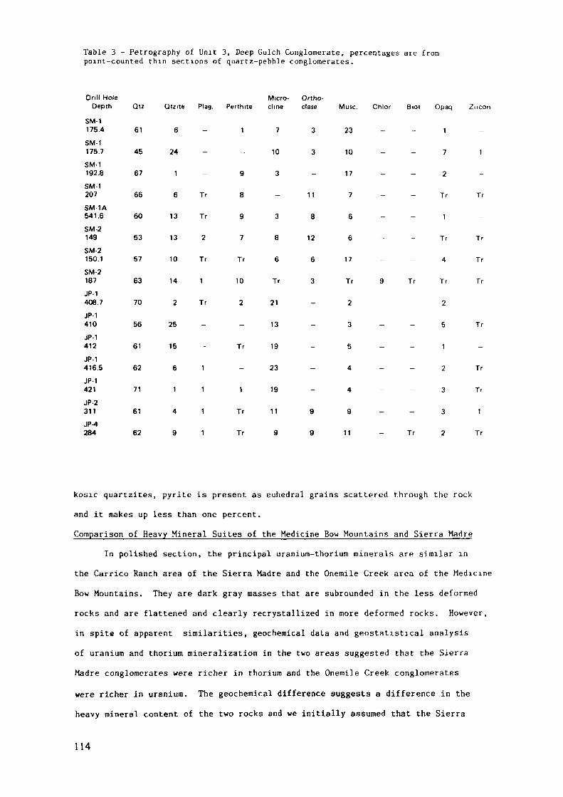
Table 3 - Petrography of Unit 3, Deep Gulch Conglomerate, percentages are frompoint-counted thin sections of quartz-pebble conglomerates.
Drill HoleDepth
SM-1175.4
SM-1175.7
SM-1192.8
SM-1207
SM-1A541.6
SM-2149
SM-2150.1
SM-2187
JP-1408.7
JP-1410
JP-1412
JP-1416.5
JP-1421
JP-2311
JP-4284
Qtz
61
45
67
66
60
53
57
63
70
56
61
62
71
61
62
Qtzite Plag.
6
24
1
6 Tr
13 Tr
13 2
10 Tr
14 1
2 Tr
25
15
6 1
1 1
4 1
9 1
Perthite
1
-
9
8
9
7
Tr
10
2
-
Tr
-
1
Tr
Tr
Micro- Ortho-clme clase
7 3
10 3
3
11
3 8
8 12
6 6
Tr 3
21
13
19
23
19
11 9
9 9
Muse.
23
10
17
7
6
6
17
Tr
2
3
5
4
4
9
11
Chlor Biot Opaq
_ _ j
7
2
Tr
1
Tr
— — 4
9 Tr Tr
- - 2
5
1
- - 2
- - 3
— — 3
- Tr 2
Zircon
-
1
-
Tr
-
Tr
Tr
Tr
-
Tr
-
Tr
Tr
1
Tr
kosic quartzites, pyrite is present as euhedral grains scattered through the rock
and it makes up less than one percent.
Comparison of Heavy Mineral Suites of the Medicine Bow Mountains and Sierra MadreIn polished section, the principal uranium-thorium minerals are similar in
the Carrico Ranch area of the Sierra Madre and the Onemile Creek area of the MedicineBow Mountains. They are dark gray masses that are subrounded in the less deformedrocks and are flattened and clearly recrystallized in more deformed rocks. However,
in spite of apparent similarities, geochemical data and geostatistical analysisof uranium and thorium mineralization in the two areas suggested that the SierraMadre conglomerates were richer in thorium and the Onemile Creek conglomerates
were richer in uranium. The geochemical difference suggests a difference in theheavy mineral content of the two rocks and we initially assumed that the Sierra
114
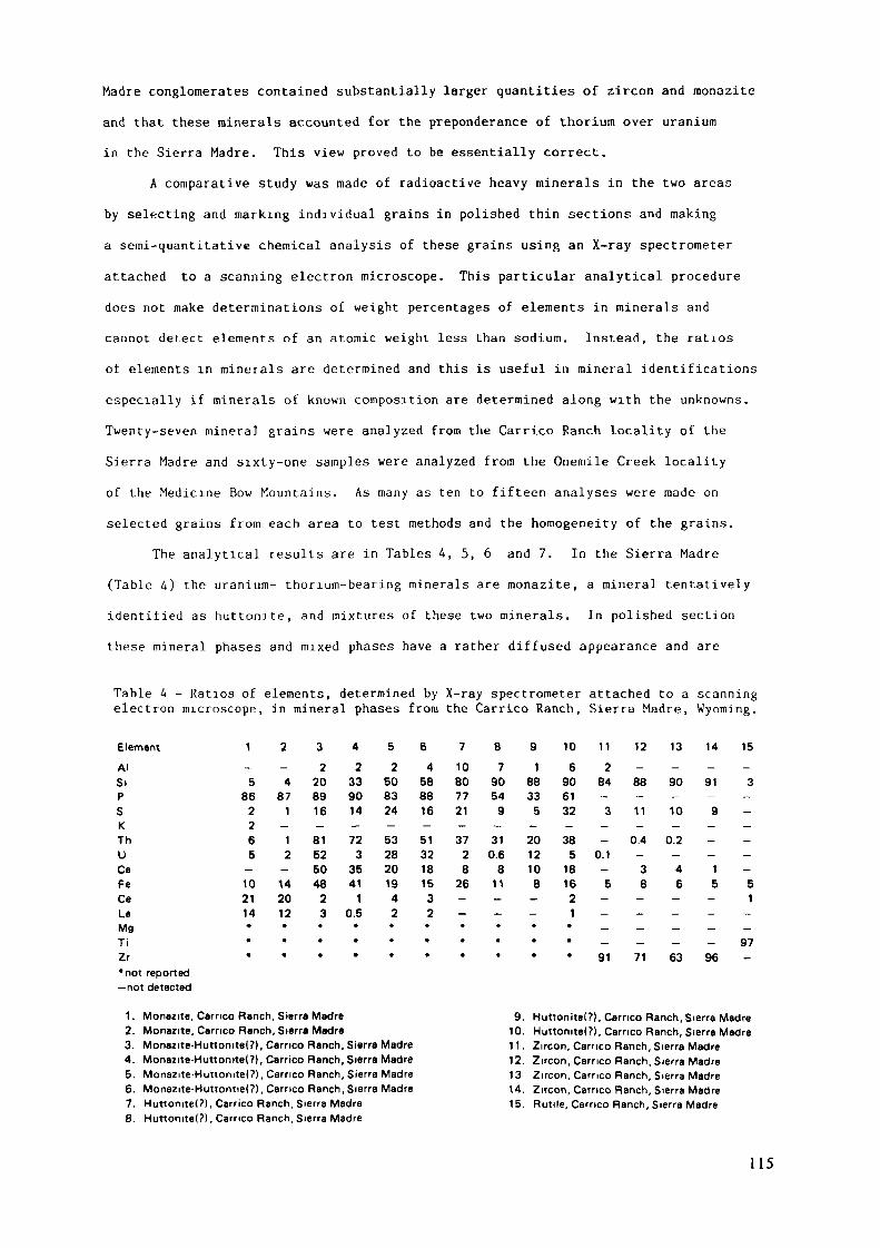
Madré conglomerates contained substantially larger quantities of zircon and monazite
and that these rainerais accounted for the preponderance of thorium over uranium
in the Sierra Madre. This view proved to be essentially correct.
A comparative study was made of radioactive heavy minerals in the two areas
by selecting and marking individual grains in polished thin sections and making
a semi-quantitative chemical analysis of these grains using an X-ray spectrometer
attached to a scanning electron microscope. This particular analytical procedure
does not make determinations of weight percentages of elements in minerals and
cannot detect elements of an atomic weight less than sodium. Instead, the ratios
of elements in minerals are determined and this is useful in mineral ident if icat ions
especially if minerals of known composition are determined along with the unknowns.
Twenty-seven minera] grains were analyzed from the Carrico Ranch locality of the
Sierra Madre and sixty-one samples were analyzed f rom the Onemile Creek locality
of the Medicine Bow Mountains . As many as ten to f i f t een analyses were made on
selected grains f rom each area to test methods and the homogeneity of the grains.
The analytical results are in Tables 4, 5, 6 and 7. In the Sierra Madre
(Table 4) the uran ium- thorium-bearing minerals are monazite, a mineral tenta t ively
ident i f ied as h u t t o n i t e , and mix tu res of these two minerals . In polished section
these mineral phases and mixed phases have a rather d i f fused appearance and are
Table U - Ratios of elements, determined by X-ray spectrometer attached to a scanningelectron microscope, in mineral phases from the Carrico Ranch, Sierra Madre, Wyoming.
Element 10 11 12 13 14 15
AISiPSKThUÇaFeCeLaMgTiZr*not reported— not detected
-5
862265
—102114*
•
•
-4
871-12
—142012•
«
*
2208916-81525048
23*
•
ft
2339014-72
33541
10.5•
*
«
2508324-5328201942•
•
*
4588816-5132181532*
*
*
10807721-37
28
26—-•*•
79054
9-310.6
811—-••»
188335-2012108
——•*•
6906132-385
181621**«
284-3--
0.1—5
——--91
-88-11-
0.4-38
—---71
-90-10-
0.2_46-—--63
-91-9-—_15
——--96
-3-—--——51--97-
1. Monazite, Carrico Ranch, Sierra Madre2. Monazite, Carrico Ranch, Sierra Madre3. Monazite-Huttomtel?), Carrico Ranch, Sierra Madre4. Monazite-Huttonite(?(, Carrico Ranch, Sierra Madre5. Monazite-Huttomtel?), Carrico Ranch, Sierra Madre6. Monazite-Huttontiel?), Carrico Ranch, Sierra Madre7. Hu«onite(?), Carrico Ranch, Sierra Madre8. Huttomtel?), Carrico Ranch, Sierra Madre
9. Huttonite(?l. Carrico Ranch, Sierra Madre10. Huttomtel?), Carrico Ranch, Sierra Madre11. Zircon, Carrico Ranch, Sierra Madre12. Zircon, Carrico Ranch, Sierra Madre13 Zircon, Carrico Ranch, Sierra Madre14. Zircon, Carrico Ranch, Sierra Madre15. Rutile, Carrico Ranch, Sierra Madre
115
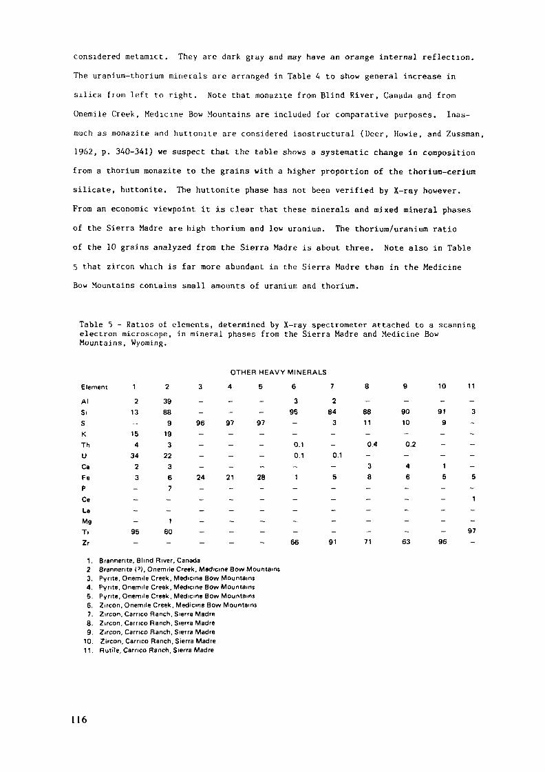
considered metamict. They are dark gray and may have an orange internal reflection.The uranium-thorium minerals are arranged in Table 4 to show general increase in
silica from left to right. Note that monazite from Blind River, Canada and from
Onemile Creek, Medicine Bow Mountains are included for comparative purposes. Inas-much as monazite and huttonite are considered isostructural (Deer, Howie, and Zussman,1962, p. 340-341) we suspect that the table shows a systematic change in compositionfrom a thorium monazite to the grains with a higher proportion of the thorium-ceriumsilicate, huttonite. The huttonite phase has not been verified by X-ray however.From an economic viewpoint it is clear that these minerals and mixed mineral phasesof the Sierra Madre are high thorium and low uranium. The thorium/uranium ratioof the 10 grains analyzed from the Sierra Madre is about three. Note also in Table5 that zircon which is far more abundant in the Sierra Madre than in the MedicineBow Mountains contains small amounts of uranium and thorium.
Table 5 - Ratios of elements, determined by X-ray spectrometer attached to a scanningelectron microscope, in mineral phases from the Sierra Madre and Medicine BowMountains, Wyoming.
Element
OTHER HEAVY MINERALS
4 5 6 7 10 11
AISiSKThUÇaFePCeLaMgTiZr
213-1543423----95_
3988919322367--160_
96 97 97
24 21 28
395-
0.10.1-1
284
3
_
0.1-5
-8811
0.4-38
-9010
0.2-4
6
-919
_
-15
-3-
_
--5
1
9766 91 71 63 96
1. Brannente, Blind River, Canada2 Brannente ('), Onemile Creek, Medicine Bow Mountains3. Pyrite, Onemile Creek, Medicine Bow Mountains4. Pynte, Onemile Creek, Medicine Bow Mountains5. Pyrite, Onemile Creek, Medicine Bow Mountains6. Zircon, Onemile Creek, Medicine Bow Mountains7. Zircon, Carrico Ranch, Sierra Madre8. Zircon, Carrico Ranch, Sierra Madre9. Zircon. Carrico Ranch, Sierra Madre
10. Zircon, Carrico Ranch, Sierra Madre11. Rutile, Carrico Ranch, Sierra Madre
1 1 6
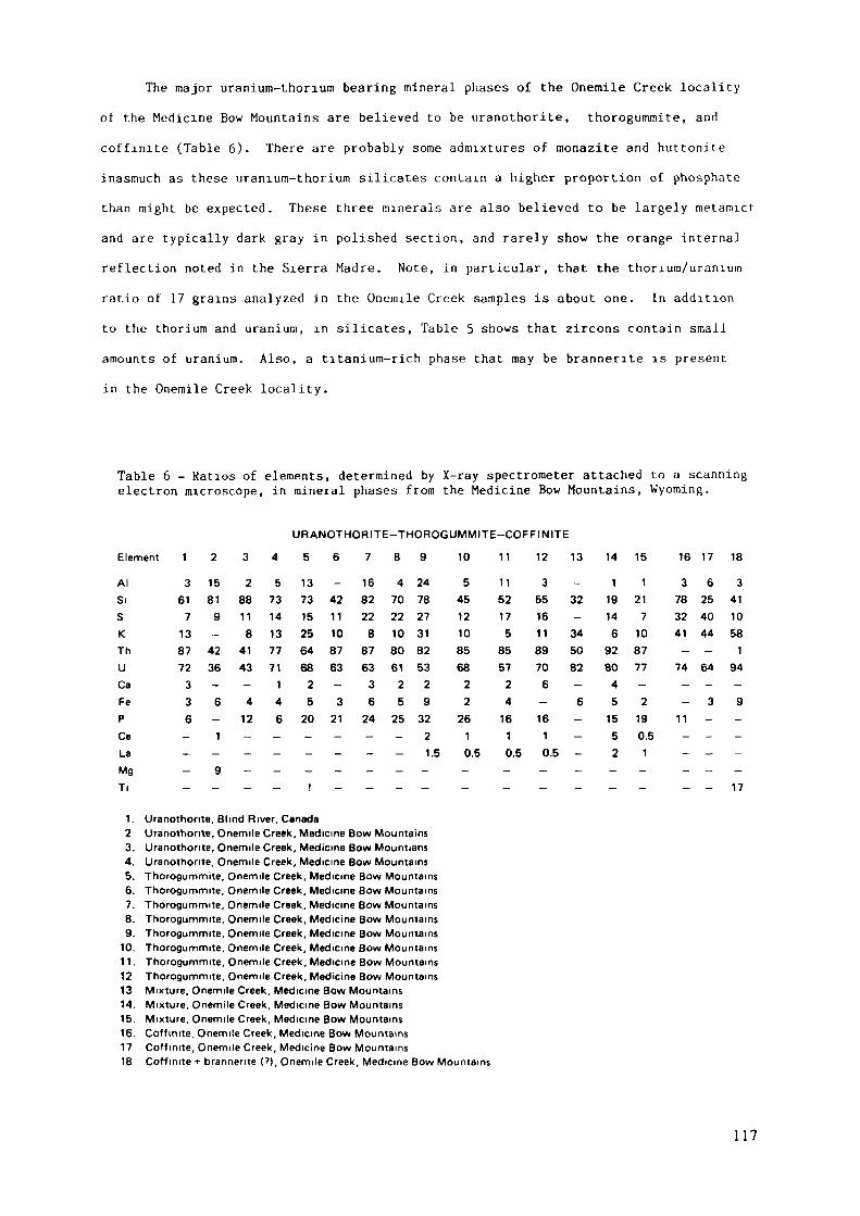
The major uranium-thorium bearing mineral phases of the Onemile Creek localityof the Medicine Bow Mountains are believed to be uranothorite, thorogummite, and
coffinite (Table 6)- There are probably some admixtures of monazite and huttonite
inasmuch as these uranium-thorium silicates contain a higher proportion of phosphate
than might be expected. These three minerals are also believed to be largely metamict
and are typically dark gray in polished section, and rarely show the orange internal
reflection noted in the Sierra Madre. Note, in particular, that the thorium/uranium
ratio of 17 grains analyzed in the Onenule Creek samples is about one. In addition
to the thorium and uranium, in silicates, Table 5 shows that zircons contain small
amounts of uranium. Also, a titanium-rich phase that may be brannerite is present
in the Onemile Creek locality.
Table 6 - Ratios of elements, determined by X-ray spectrometer attached to a scanningelectron microscope, in mineral phases from the Medicine Bow Mountains, Wyoming.
Element
URANOTHORITE-THOROGUMMITE-COFFINITE
4 5 6 7 8 9 1 0 1 1 1 2 1 3 14 15 16 17 18
AISiSKThUÇaFePCeLaMgTi
3617138772336---—
15819-4236-6-1-9_
288118
4143-412----
57314137771146---_
1373152564682520---!
-4211108763-321---—
168222887633624---—
470221080612525---—
247827318253293221.5-_
54512108568222610.5-—
11521758557241610.5-_
355161189706-1610.5-—
-32-345082-6----_
1191469280451552-_
1217108777-2190.51-_
3783241-74--
11---_
6254044-64-3-----
3411058194-9----17
1. Uranothorite, Blind River, Canada2 Uranothorite, Onemile Creek, Medicine Bow Mountains3. Uranothorite, Onemile Creek, Medicine Bow Mountians4. Uranothorite, Onemile Creek, Medicine Bow Mountains5. Thorogummite, Onemile Creek, Medicine Bow Mountains6. Thorogummite, Onemile Creek, Medicine Bow Mountains7. Thorogummite, Onemile Creek, Medicine Bow Mountains8. Thorogummite, Onemile Creek, Medicine Bow Mountains9. Thorogummite, Onemile Creek, Medicine Bow Mountains
10. Thorogummite, Onemile Creek, Medicine Bow Mountains11. Thorogummite, Onemile Creek, Medicine Bow Mountains12 Thorogummite, Onemile Creek, Medicine Bow Mountains13 Mixture, Onemile Creek, Medicine Bow Mountains14. Mixture, Onemile Creek, Medicine Bow Mountains15. Mixture, Onemile Creek, Medicine Bow Mountains16. Coffmite, Onemile Creek, Medicine Bow Mountains17 Coffmite, Onemile Creek, Medicine Bow Mountains18 Coffmite + brannerite (?), Onemile Creek, Medicine Bow Mountains
117
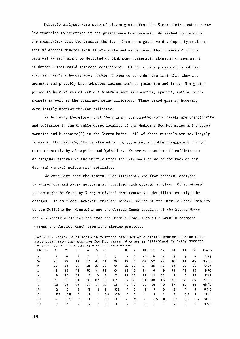
Multiple analyses were made of eleven grains from the Sierra Madre and Medicine
Bow Mountains to determine if the grains were homogeneous. We wished to consider
the possibility that the uranium-thorium silicates might have developed by replace-
ment of another mineral such as uranunte and we believed that a remnant of the
original mineral might be detected or that some systematic chemical change might
be detected that would indicate replacement. Of the eleven grains analyzed five
were surprisingly homogeneous (Table 7) when we consider the fact that they are
metamict and probably have adsorbed cations such as potassium and iron. Six grains
proved to be mixtures of various minerals such as monazite, apatite, rutile, iron-
spinels as well as the uranium-thorium silicates. These mixed grains, however,were largely uranium-thorium silicates.
We believe, therefore, that the primary uranium-thorium minerals are uranothorite
and coffinite in the Onemile Creek locality of the Medicine Bow Mountains and thorium
raonazite and huttonite(?) in the Sierra Madre. All of these minerals are now largelymetamict, the uranothorite is altered to thorogummite, and other grains are changed
compositionally by adsorption and hydration. We are not certain if coffinite is
an original mineral in the Onemile Creek locality because we do not know of any
detrital mineral suites with coffinite.
We emphasize that the mineral identifications are from chemical analyses
by microprobe and X-ray sepctrograph combined with optical studies. Other mineral
phases might be found by X-ray study and some tentative identifications might be
changed. It is clear, however, that the mineral suites of the Onemile Creek locality
of the Medicine Bow Mountains and the Cameo Ranch locality of the Sierra Madre
are distinctly different and that the Onemile Creek area is a uranium prospect
whereas the Carrico Ranch area is a thorium prospect.
Table 7 - Ratios of elements in fourteen analyses of a single uranium-thorium sili-cate grain from the Medicine Bow Mountains, Wyoming as determined by X-ray spectro-meter attached to a scanning electron microscope.
13 14 X Ranqp
2 2 5 1-1846 44 45 366634 29 26 12-34
11 12 12 9164 9 10 221
86 85 85 77*864 66 68 58 78
2 4 2 0552 0 5 1 n d 3
05 05 05 05 05 nri12 3 2 053
118
£ lemeni
AISiPSKThUFrOLaCa
1443291687758305-2
24392412108671205051
3347261312817131052
4
2372810386622312
52
412313582673112
61
38251688263
1050505
7
23619122
8773050511
8342281211877511-2
9356291016877S320 51
1012663t1 11484693--3
1 118522014118868
11053
121442129
2186705101
Metamorphism and Source of Radioactive MineralsRadioactive conglomerates from both the Onemile Creek area of the Medicine
Bow Mountains and the Carrico Ranch area of the Sierra Madre have been affected
by amphibolite facies regional metamorphism and by contact metamorphism adjacentto gabbroic intrusions. Inasmuch as we have found no weakly metamorphosed counter-
parts of these conglomerates in southern Wyoming, we are unable to demonstratethat any of the principal uranium-thorium minerals are definitely detrital. At
present, there is not enough information on heavy minerals in potential source
rocks such as Late Archean granites of the Wyoming Province to predict mineralsuites that might be present in conglomerates derived from them. We do know thaturaninite is present in some vein deposits and in contact metamorphic depositsassociated with the Late Archean granites so that uraninite may have been an originalmineral of the conglomerates. If so, it has been reconstituted during amphibolite
faciès metamorphism. It is also possible that coffinite and thorite were the primarydetrital minerals, but these minerals have not been identified so far in the poten-tial source rocks.
Where radioactive conglomerate is in contact with gabbroic intrusives, asin some localities of the Onemile Creek area, the uranium has been mobilized and
precipitated in veinlets. We have noted veinlets of uranophane in samples from
the Onemile Creek area, but only in close proximity to gabbroic intrusions.
SEDIMENTOLOGY OF URANIUM-BEARING UNITSUranium-bearing beds in the Sierra Madre and Medicine Bow Mountains are of
two types: lenticular beds of quartz-pebble conglomerate interlayered with various
types of paraconglomerates and basal successions containing interbedded quartz-pebble conglomerates, coarse-grained quartzites and arkosic paraconglomerates which
unconformably overlie older "basement." The first type is of little economic signi-
ficance because of lack of continuity of the radioactive zones. The second type
shows the greatest continuity and may, in the long run, constitute mineable deposits.The second type of radioactive quartz-pebble conglomerates, those that occur
in basal conglomerate-quartzite successions above unconformities, are present inboth the Sierra Madre and Medicine Bow Mountains. In the Sierra Madre, stronglyradioactive rocks of the Deep Gulch Conglomerate occur locally at the base of the
Phantom Lake Metamorphic Suite and unconformably overlie older Archean gneisses.
119
In the Medicine Bow Mountains, strongly radioactive rocks occur at the base ofthe Early Proterozoic Magnolia Formation which unconformably overlies the PhantomLake Suite and Archean granitic rocks.
The basal 200 meters of the Jack Creek Quartzite of the Sierra Madre hasbeen divided into five units that can be recognized in most outcrops of the Carrico
Ranch area (fig. 5). The lower unit (Unit 1 of fig. 5) is an arkose which is medium-to coarse-grained, poorly sorted, and is interbedded with muscovite-rich arkose,
thin quartz-pebble conglomerate layers, and thin arkosic conglomerate layers.The arkose conglomerate layers of Unit 1 contain abundant granite clasts and angular
K-feldspar pebbles. Both the arkosic conglomerate and quartz-pebble conglomeratelayers are slightly radioactive (2-3X background). Unit 1 is overlain by an arkose
and subarkose (Unit 2 of fig. 5) which is coarse-grained and rich in muscovite.
The arkose and subarkose contain well-developed small-scale trough crossbeds and
lenticular beds of quartz-granule conglomerate quartz-pebble conglomerate, and
arkosic conglomerate. These conglomerates are also slightly radioactive (2-5Xbackground). Unit 3 (fig. 5) contains pyritic and radioactive quartz-pebble conglom-
erates (up to 60X background) interbedded with granular to pebbly subarkosic quart-
zites. These conglomerates occur at the base of the fining-upward stratification
sequences and pass up-section into coarse-grained subarkose with well developedtrough and planar crossbeds. Beds of quartz-pebble conglomerate are from 17 to
75 cm thick (fig. 6) and individual beds can be traced for a distance of two kilo-
meters in the Carrico Ranch area and one bed may extend through the entire outcrop
area of Unit 3, a distance of 7 kilometers (fig. 2). Units 1, 2, and 3, together,
form the Deep Gulch Conglomerate of the Jack Creek Quartzite.
Above the Deep Gulch Conglomerate in the northwestern Sierra Madre is a
succession of fine- to medium-grained, planar crossbedded quartzites. Near Carrico
Ranch, the lower parts of this quartzite succession were mapped as Unit 4, a medium-grained, planar crossbedded, well sorted subarkose, and Unit 5, a black phyllite
with lenses of arkose. In other areas, the quartzite succession of the Jack CreekQuartzite was not subdivided, but includes lenses of highly deformed metalimestone,metagraywacke, phyllite, and paraconglomerate. Paraconglomerate is not presentinterbedded with units of the Deep Gulch Conglomerate at the Carrico Ranch locality,but lenses of paraconglomerate have been identified in Unit 4 at the Deep Gulchlocality (fig. 2) -and as discontinuous lenses higher in the Jack Creek Quartzite
120
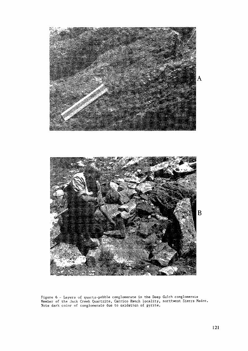
Figure 6 - Layers of quartz-pebble conglomerate in the Deep Gulch conglomerateMember of the Jack Creek Quartzite, Carrico Ranch locality, northwest Sierra Madre.Note dark color of conglomerate due to oxidation of pyrite.
121
succession. Highly deformed paraconglomerates are also present in the "basement"rocks below the Deep Gulch Conglomerate at Deep Gulch.
The Deep Gulch Conglomerate (Unit 1 to Unit 3) is interpreted to be a fluvial
succession deposited in a braided river system. Unit 1 is a fining-upward sequence
which represents a reworked grus which was deposited in channels and braid bars
unconformably on gneissic basement. Unit 2 generally coarsens-upwards and contains
abundant trough crossbeds and fining-upward stratification sequences. Unit 2 isinterpreted to represent aggrading channels in a braided river system. Unit 3contains the major radioactive conglomerate zones in the Deep Gulch Conglomerate.
These are interpreted to represent deposition of gravels on longitudinal bars inbraided rivers, which developed on prograding wet alluvial fans. The coarsening-upwards succession represented by Units 2 and 3 may have been caused by faulting
and uplift along the basin margins. The most radioactive conglomerate layers of
Unit 3 are interpreted to represent compound longitudinal gravel bars which wererelatively long-lived. Reworking of sediment in these bars, in response to prograda-
tion of the fan system, caused heavy minerals to be concentrated in these bars.
Alternate interpretations of the depositional environment of units of theDeep Gulch Conglomerate are feasible and include a glacial connection. It is possible
that the braided river system developed because of the excess of clastic materialpresent in a glaciated source area. We have no evidence of glaciation at the timeof deposition of the Deep Gulch Conglomerate but it is quite possible that a glaciatedarea existed north of the present outcrop area.
Units of the Jack Creek Quartzite above the Deep Gulch Conglomerate are inter-preted as a marine transgressional succession. In the Carrico Ranch locality,fluvial rocks pass up-section into marine quartzites, phyllites, and thin metalime-stone. In other areas, the basal, fluvial rocks of the Deep Gulch Conglomerate
may be entirely absent and fine-grained, marine quartzites appear to rest directlyon basement rocks. The transgressional character of the Jack Creek Quartzite isunfortunate from an economic viewpoint. It suggests that fluvial deposition was
not long-lived enough to produce really thick or extensive alluvial systems and
it suggests that the basal Phantom Lake Suite unconformity is not necessarily a
favorable exploration target.
In the Medicine Bow Mountains, the most radioactive conglomerates occur at
the base of the Magnolia Formation. This unit contains anomalously radioactive
122
zones throughout the Medicine Bow Mountains but the thickest and most radioactive
conglomerates found so far crop out in the Onemile Creek area of the northern Medicine
Bow Mountains (figs. 3, 7). The Onemile Creek area (Sees. 5, 6, and 7, T. 15 N.,
R. 78 W.) has many characteristics in common with the Deep Gulch area of the Sierra
Madre. At Onemile Creek, however, the units of interest are in the lower Conglomerate
Member of the Magnolia Formation of the Deep Lake Group and are Early Proterozoic
instead of Late Archean. Paraconglomerate is also more prevalent than in the beds
of the Lower Jack Creek Formation. Before discussing the depositional environmentof radioactive beds at Onemile Creek it is desirable to review the general strati-graphy and regional distribution of beds of the Magnolia Formation. In the MedicineBow Mountains it has been possible to subdivxde the Magnolia Formation into two
mappable units which are referred to as the Conglomerate Member and Quartzite Memberof the Magnolia Formation (Karlstrom and Houston, 1979a, 1979b). The ConglomerateMember ranges in thickness from 0 to 330 meters and is composed of paraconglomerate,quartz-pebble conglomerate, and interlayered pebbly and granular quartzite. Thequartzite member ranges from 400 to 600 meters in thickness and is coarse-grainedquartzite composed of rounded granules of quartz (Karlstrom, 1977).
The Conglomerate Member of the Magnolia Formation is of particular interest
in this study because it is the host of all significant uranium-thorium depositsin the Medicine Bow Mountains. In general, the Conglomerate Member has paraconglom-
erate at the base which grades upward into conglomeratic quartzite. The paraconglom-
erate at the base of the Conglomerate Member is variable in thickness and containsbeds that range from true paraconglomerate (open-framework) to beds of orthoconglom-
erate (closed or largely closed framework). Clasts range in size up to tens of
centimeters in diameter, and are granite, granite gneiss, phyllite, quartzite,amphibolite, hornblende gneiss, sericite schist and garnet biotite schist in a
matrix of arkose. Thick beds of paraconglomerate are present at the base of the
Conglomerate Member at localities west of the confluence of Brush Creek and LittleBrush Creek (Sec. 22, T. 16 N., R. 81 W.) and in outcrops on the east limb of theArrastre Anticline (Sec. 10, T. 16 N., R. 80 W.) (fig. 7). Paraconglomerate beds
have not been recognized in the limited exposures of the Conglomerate Member atthe North Fork Rock Creek (although an outcrop of paraconglomerate in Sec. 19,T. 18 N., R. 78 W. may be part of the basal Magnolia Formation) or on the MedicineBow River (fig. 7). Thick beds of paraconglomerate are again present in the Conglom-
123
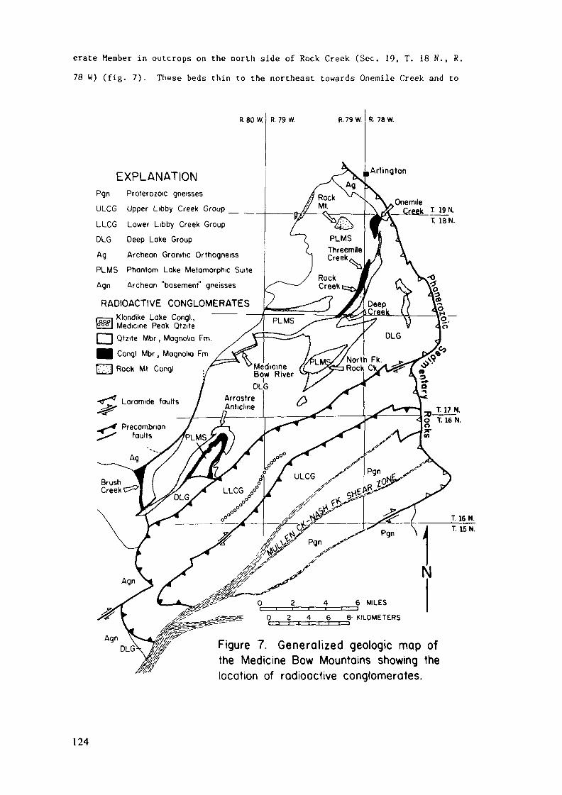
erate Member in outcrops on the north side of Rock Creek (Sec. 19, T. 18 N., R.78 W) (fig. 7). These beds thin to the northeast towards Onemile Creek and to
R. 80 W, R. 79 W.
EXPLANATIONPgn Proterozoic gneisses
ULCG Upper Libby Creek Group ____
LLCG Lower Libby Creek Group
DLG Deep Lake Group
Ag Archean Granitic Orthogneiss
PLMS Phantom Lake Metomorphic Suite
Agn Archean "basement" gneisses
RADIOACTIVE CONGLOMERATESr---. Klondike Lake Congl.,P°°l Medicine Peak Qtzite[ ] Qtzite Mbr, Magnolia Fm.
m Congl Mbr, Magnolia Fm
fc'.yj Rock Mt Congl
R. 79 W. R. 78 W.
OnemileCreek T. 19 H
T. 18 N.
Figure 7. Generalized geologic map ofthe Medicine Bow Mountains showing thelocation of radioactive conglomerates.
124
the southwest, towards Deep Creek (fig. 7). In general, the paraconglomeratesare best developed on the northwest limbs of synclines and are believed to thinto the southeast. We believe that the paraconglomerates represent alluvial fansthat had a source (perhaps a fault scarp) some distance northwest of their principaloutcrop areas. The paraconglomerates grade up-section and along strike into theQuartzite Member which is interpreted as braided stream or river deposits. TheConglomerate Member succession is therefore transgressive or it may represent adecrease in tectonic activity in the source area through time.
The Magnolia Formation paraconglomerate is radioactive and, in contrast to
paraconglomerates of the Phantom Lake Metamorphic Suite, it has radioactivity abovebackground in virtually every outcrop examined. The uranium and thorium contentof the paraconglomerate is generally low, however, averaging 10-20 ppm uranium
and 20-30 ppm throium. In local areas, beds of quartz-pebble conglomerate areinterlayered with paraconglomerate and some beds of paraconglomerate are quartz-rich and better sorted than typical paraconglomerate — these beds normally containa higher percentage of uranium and thorium, up to 545 ppm uranium and 1143 ppmthorium in the Brush Creek area and 100 ppm U and 190 ppm Th near Rock Creek.Also, a zone of uranium- and thorium-rich paraconglomerate north of Rock Creek,(fig. 7), which has local layers of quartz-pebble conglomerate and zones of quartz-rich paraconglomerate, is nearly 200 feet thick and averages over 100 ppm uranium,and as such constitutes a low-grade uranium resource.
The paraconglomerate of the basal Magnolia Formation obviously had a different
source than paraconglomerates of the Phantom Lake Metamorphic Suite. Magnoliaparaconglomerates have fewer clasts of volcanic rocks, more quartz, and an arkosicrather than a phyllitic or amphibolitic matrix. The paraconglomerates were derived
from a mixed source consisting of Archean granite, gneiss, metasedimentary and
metavolcanic rocks. The proportions of these various rocks in the local sourcearea, within about 10-15 miles of the alluvial fan system, we assume, is reflectedin clasts of the paraconglomerate. In the area west of the confluence of BrushCreek and Little Brush Creek and at Arrastre Anticline, typical clasts in theparaconglomerate are phyllite, quartzites, mafic volcanics, and vein quartz.Granite clasts are uncommon in these localities (although they are present in twoof eight localities studies). In contrast, granite is a common constituent ofparaconglomerates of the basal Magnolia Formation in outcrops extending from the
125

south side of Deep Creek to Onemile Creek (fig. 7), and it is in these localities
where the most uranium-rich paraconglomerates (and quartz-pebble conglomerates)
are tound.
The Conglomerate Member of the Magnolia Formation gets progressively more
radioactive as one goes north from Rock Creek and this change is accompanied by
a change in lithology, from dominantly paraconglomerate in the south to dominantly
quartz-pebble conglomerate in the north. The best developed quartz-pebble conglom-
erates are in the vicinity of Onemile Creek (Sees. 5, 6, and 7, 1. 18 N., R. 79
W , fig. 7) where the Magnolia Formation is exposed in the nose of an overturned
syncline (fig. 3). Only the Conglomerate member of the Magnolia Formation is exposed
in the Onemile Creek area and here, it has been subdivided into five units (fig.
3) Unit 1 is an arkosic paraconglomerate with abundant large granite clasts inter-
layered with subarkose. Unit 1 grades up-section into a trough cross-bedded sub-
arkose with thin lenticular beds of radioactive quartz-pebble conglomerate referred
to as Unit 2 Unit 2 grades upward into a granular subarkose (Unit 3) with thin
lenticular beds of radioactive quarto-pebble conglomerate. Unit 3 is overlain
b> biotite chlorite schist with paraconglomerate lenses (Unit A), and Unit A is
o\erlain b> muscovite-rich subarkose with thick and continuous beds of radioactivequartz-pebble conglomerate. The radioactive quartz-pebble conglomerate beds ofUnit 5 are the most radioactive and most persistent of any in the Medicine Bow
Mountains. As illustrated in figure 3, there are two main zones (5a and 5b) inUnit 5 that contain radioactive quartz-pebble conglomerate. Individual zones ofradioactive quartz-pebble conglomerate are up to 20 m thick. However, these radio-
active zones are not single beds of conglomerate but are intervals of coarse-grained
quartzite with numerous quartz-pebble conglomerate layers. The individual layers
of quartz-pebble conglomerate range in thickness from that of a single pebble to
composite zones tens of feet thick. Unfortunately these quartr-pebble conglomerate
beds are not uniformly mineralized and may range from as little as 10 ppm to over
1000 ppm uranium. The variation in uranium values is believed to be related to
the location within a channel, with generally higher values at the base of individual
channels.
We interpret the basal Conglomerate Member of the Magnolia Formation as deposits
of an alluvial fan system with the paraconglomerate representing more proximal,
mudflow deposits, the mixed paraconglomerate-quartz-pebble conglomerate representing
126
mid-fan deposits; and the coarse-grained quartzite with beds of quartz-pebble
conglomerate representing parts of the distal fan. Overall, the Conglomerate Member
of the Magnolia Formation is transgressional but there are obvious local episodes
of progradation superimposed on the transgressional event. The presence of the
most uranium- and thorium-rich quartz-pebble conglomerate at Onemile Creek is thought
to be related to proximity to a source underlain by Late Archean granites as suggested
above, but we must emphasize that this is also the only area of outcrop of the
Conglomerate Member which contains thick quartz-pebble conglomerates so that the
uranium and thorium mineralization might also be related to favorable depositional
conditions We cannot rule out the possibility of finding other thick and persistent
beds of quartz-pebble conglomerate in unexplored subcrops of the Conglomerate Memberelsewhere in the Medicine Bow Mountains, even in areas at some distance from known
granitic source areas.
DISCUSSIONFrom the viewpoint of the mineral explorationist the discovery of uranium-
thorium- and gold-bearing quartz pebble conglomerate as late as 1975 in surface
outcrops in the United States, where many geologists seem to have the impression
that the entire country is well-mapped, may be surprising. In the first place
there are large areas in the United States that are inadequately mapped and a sur-
prising number of areas that have yet to be mapped even in reconnaissance. The
first geologic map of the Medicine Bow Mountains ot this report was not publisheduntil 1968 (Houston and others, 1968), and reasonable detailed geologic maps of
the northern Sierra Madre were not published until 1981 (Karlstrom and others,
1981). The use of genetic models is generally recognized as the best prospectingtool where the geology is well enough known to apply the model (Bailly, 1978, p.362). New and revised models can be successfully applied whether or not an areahas been thoroughly explored in the past. The southeast Wyoming discoveries are
another good example of the successful use of a revised genetic model (revised,
at least, in the minds of many geologists outside of South Africa) where geologic
information is adequate for its application.The southeast Wyoming deposits are identified-subeconomic resources using
the terminology of the U.S. Bureau of Mines and U.S. Geological Survey (1980).
Such deposits might be of eventual economic interest if the price of uranium and
127
thorium were to change significantly or if gold in the deposits proved to be present
in amounts of current economic interest. Inasmuch as a change in price of uranium
seems unlikely in the near future what are possibilities for discovery of highergrade deposits in this area9 The Sierra Madre quartz pebble conglomerate bedsof Archean age are thicker, coarse-grained, and more continuous than those of the
Medicine Bow Mountains, but they are less well-sorted than typical South Africandeposits and more critical from an economic viewpoint contain thorium-rich ratherthan uranium-rich heavy minerals. The Early Proterozoic quartz pebble conglomerate
beds of the Medicine Bow Mountains contain heavy minerals with higher uranium contentthan the Sierra Madre but are finer-grained, appear to have less continuity thanbeds of the Sierra Madre, and suffer from the same relatively poor sorting as com-
pared with South African deposits as do the deposits of the Sierra Madre. Aninteresting feature of the Medicine Bow deposits is the systematic increase in
grade from southwest to northeast. Unfortunately the Precambrian northeast of
Onemile Creek in the Medicine Bow Mountains is buried beneath a thick Phanerozoic
cover and exploration would be difficult. The potential area underlain by quartz
pebble conglomerate in the Medicine Bow Mountains is large and drilling is inadequate
to test most of this area especially in the central Medicine Bow Mountains where
metamorphic rank is greenschist. Certainly these unexplored areas should not beruled out in future exploration. Finally, a potential may exist for remobilized
uranium deposits in both the Sierra Madre and Medicine Bow Mountains and the presence
of numerous unexplained radon anomalies in the central Medicine Bow Mountains may
be significant in this respect (Houston and others, 1984b).
One of the benefits of well-financed studies on mineral resources such as
those supported by the U.S. Department of Energy and the U.S. Geological Survey
in the 1970's is new geologic information that can be used to gain a better under-
standing of geologic evolution and hence develop better geologic models useful
in future exploration. The southeastern Wyoming study demonstrated that metasedi-
mentary and metavolcanic successions transitional in character between Archeangreenstone belts of Early Proterozoic Miogeoclinal sedimentary successions existedin the southern part of the Wyoming Province. These Late Archean rocks are somewhatsimilar to rocks of the Pangola Supergroup of southern Africa (Tonkard and others,
1982) where the transition from Archean-style geologic processes to Early Proterozoicprocesses took place at an earlier date than was believed to be the case in North
128
America. If our geochronologic and geologic results in southeastern Wyoming stand
the test of time, this may be added evidence that the transition from Archean-stylegeologic processes to Early Proterozoic processes took place earlier than generallyaccepted and was more transitional in nature than generally proposed.
The contrast in mineralogy between Late Archean quartz pebble conglomerateand Early Proterozoic quartz pebble conglomerate may also be significant. Theresults of the southeastern Wyoming study could be interpreted to be a function
of province rather than of time as suggested here, but added support for the timeconcept comes from another U.S. Department of Energy study in the Wyoming Provincein southwestern Montana. The southwestern Montana study (Cohenour and Kopp, 1980)
recognized radioactive placers of possible beach origin that are of Late Archeanage. These Montana placers also had a thorium-rich heavy mineral suite much likethat of the Late Archean of southeastern Wyoming. These results seem to indicate
that uranium-rich source rocks did not develop until late in the Archean. If this
is a general case world-wide, and there is some evidence to support a general case(Houston and Karlstrom, 1979b), it may have significance with regard to the evolution
of plate tectonic processes.
REFERENCESBailly, P.A., 1978, Exploration and future demand for minerals: Geological Society
of America Abstract with Programs, v. 10, no. 7, p. 362.Borgman, L.E., Sever, C.K., Quimby, W.F., Andrew, M.E., Houston, R.S., and Karlstrom,
K.E., 1981, Uranium Assessment for the Precambrian pebble conglomerates insoutheastern Wyoming: U.S. Dept. of Energy Report No. DJBX-139-81, v. 3,157 p., available from U.S. Dept. of Energy, Grand Junction Office, GrandJunction, Co., U.S.A.
Cohenour, R.E., and Kopp, R.S., 1980, Regional investigation for occurrences ofradioactive quartz-pebble conglomerates in the Precambrian of southwesternMontana: U.S. Dept. of Energy Report No. GJBX-252-80, 582 p., availablefrom U.S. Dept. of Energy, Grand Junction Office, Grand Junction, Co., U.S.A.
Deer, W.A., Howie, R.A. and Zussman, J., 1962, Rock forming minerals: New York,John Wiley and Sons, Inc., v. 3, 270 p.
Henderson, J.B., Caldwell, W.G., and Harrison, J.E., 1980, North American Commissionon Stratigraphie Nomenclature, report 8 - amendment of code concerning termino-logy for igneous and high-grade metamorphic rocks: Geological Society ofAmerica Bulletin, v. 91, p. 374-376.
Hills, F.A., and Houston, R.S., 1979, Early Proterozoic tectonics of the centralRocky Mountains, North America: Contributions to Geology, v. 17, p. 89-109.
Houston, R.S., and McCallum, M.E., 1961, Müllen Creek-Nash Fork shear zone. MedicineBow Mountains, southeastern Wyoming (abstract): Geological Society of AmericaSpecial Paper 68, p. 91.
129
Houston, R.S., and others, 1968, A regional study of rocks of Precambnan age inthat part of the Medicine Bow Mountains lying in southeastern Wyoming, witha chapter on The relationship between Precambnan and Laramide structure:Wyoming Geological Survey Memoir no. 1, 167 p.
Houston, R.S., Graff, P.J., Karlstrom, K.E., and Root, F.K., 1977, Preliminaryreport on radioactive conglomerate of Middle Precambnan age in the SierraMadre and Medicine Bow Mountains of southeastern Wyoming: United States,Geological Survey Open-File Report, 77-584, 31 p.
Houston, R.S., Karlstrom, K.E., and Graff, P.K., 1979, Progress report on the studyof radioactive quartz-pebble conglomerate of the Medicine Bow and SierraMadre, southeastern Wyoming: United States Geological Survey, Open-FileReport 79-1131, 41 p.
Houston, R.S., and Karlstrom, K.E., 1979, Uranium-bearing quartz-pebble conglom-erates: exploration model and United States resource potential: UnitedStates Dept. of Energy Open-File Report GJBX-1(80), 510 p., available fromU.S. Dept. of Energy, Grand Junction Office, Grand Junction, Co., U.S.A.
Houston, R.S., 1979, Introduction to the second uranium issue and some suggestionsfor prospecting: Contributions to Geology, v. 17, no. 2, p. 85-88
Houston, R.S., Lanthier, L.R., Karlstrora, K.E., and Sylvestor, George, 1981, EarlyProterozoic diamictite of southern Wyoming: ]M_ Earth's pre-Pleistocene glacialrecord, eds. Hambrey, M.J. and Harland, W.B., p. 795-799.
Houston, R.S., Karlstrom, K.E., Flurkey, A.J., and Graff, P.J., 1984a, Stratigraphyof Late Archean supracrustal rocks in the Sierra Madre and Medicine BowMountains, Wyoming: U.S. Geological Survey Bulletin.
Houston, R.S., Karlstrom, K.E., Lanthier, L.R., and Miller, W.R., 1984b, Mineralresource potential of the Snowy Range Wilderness study area, Albany and CarbonCounties, Wyoming: U.S. Geological Survey Map MF.
Houston, R.S., Schmidt, T.G., and Lane, M.E., 1984, Mineral resource potentialof the Huston Park RARE II further planning study area, Carbon County, Wyoming:U.S. Geological Survey Map MF.
Karlstrom, K.E., 1977, Geology of the Prot^rozoic Deep Lake Group, central MedicineBow Mountains, Wyoming [M.S. thesis]: Laramie, Wyoming, University of Wyoming,116 p.
Karlstrom, K.E., and Houston, R.S., 1979a, Stratigraphy and uranium potential ofthe Phantom Lake Metamorphic Suite and Deep Lake Group, Medicine Bow Mountains,Wyoming: Wyoming Geological Survey Report of Investigations, RI-13, 45 p.
Karlstrom, K.E., und Houston, R.S., 1979b, Stratigraphy of the Phantom Lake Meta-morphic Suite and Deep Lake Group and a review of the Precambnan tectonichistory of the Medicine Bow Mountains: Contributions to Geology, v. 17,no. 2, p. 111-133.
Karlstrom, K.E., Houston, R.S., Flurkey, A.J., Coolidge, C.M., Kratochvil, A.L.,And Sever, C.K., 1981, A summary of the geology and uranium potential ofPrecambnan conglomerates in southeastern Wyoming: U.S. Dept. of EnergyReport no. GJBX-139-81, v. 1, 541 p., available from U.S. Dept. of Energy,Grand Junction Office, Grand Junction, Co., U.S.A.
Karlstrom, K.E., Flurkey, A.J., and Houston, R.S., 1984, Stratigraphy and deposi-tional setting of the Proterozoic Snowy Pass Supergroup, southeastern Wyoming:Record of an early Proterozoic Atlantic-type cratonic margin: GeologicalSociety of America Bulletin, v. 95.
Peterman, Z.E., and Hildreth, R.A., 1978, Reconnaissance geology and geochronologyof the Precambnan of the Granite Mountains, Wyoming: United States Geolo-gical Survey Professional Paper 1055, 22 p.
130
Premo, W.R., and Van Schmus, W.R., 1982, U-Pb zircon geochronology of the SierraMadré Range, Wyoming: Geological Society of America Abstracts with Programs,v. 14, no. 6, p. 346
Stuckless, J.S., 1979, Uranium and thorium concentrations in Precambrian granitesas indicators of a uranium province in central Wyoming: Contributions toGeology, v. 17, p. 173-178.
Tankard, A.J., Jackson, M.P.A., Eriksson, K.A., Hobday, O.K., Hunter, D.R., andHinter, W.E.L., 1982, Crustal evolution of southern Africa, 3.8 billion yearsof earth history: Springer-Verlag, Berlin, 523 p.
Tweto, Odgen, 1979, Geologic map of Colorado: U.S. Geological Survey, Reston,Va., U.S.A.
U.S. Bureau of Mines and U.S. Geological Survey, 1980, Principles of a resource/reserve classification for minerals: U.S. Geological Survey Circular 831,5 p.
131

GLACIAL OUTWASH URANIUM PLACERS?EVIDENCE FROM THE LOWER HURONIANSUPERGROUP, ONTARIO, CANADA
P.W. FRALICKDepartment of Geology,Lakehead University,Thunder Bay, OntarioA.D. MIALLDepartment of Geology,University of Toronto,Toronto, OntarioCanada
Abstract
Uraniferous conglomerates present in the E l l i o t Lakemining area are contained within the middle and lower portions ofthe Matinenda Formation—the basal unit of the early ProterozoicHuronian Supergroup. The Supergroup forms a southward thickeningwedge composed of three sedimentary megacycles. Each cycle con-sists of a basal fluvial unit overlain by glacial-marine/lacustrinestrata and capped by a t u r b i d i t i c to lenticular bedded assemblage.The juxtaposition of these depositional environments suggests:1) glaciofluvial outwash accumulated in front of an ice mass tothe north; 2) the outwash was overridden and isostatic depressioninitiated glacial-marine/lacustrine deposition; 3) after meltbackof the ice openwater elastics accumulated. The MatinendaFormation represents the basal braided fluvial unit of the lower-most glacial megacycle. Glacial units of the Ramsay Lake Formationand marine/lacustrine strata of the McKim and Pecors Formationscomplete the assemblage.
Evidence of a glacial outwash origin for the MatinendaFormation consists of: 1) glacial override features in the upperMatinenda; 2) glacial erosion and resedimentation of unconsolidatedMatinenda material; 3) intimate association between small Matinendadeltas and subaqueous glacial outwash; If) interbedding of glacialmixtite and fluvial quartzite; 5) Zr/Hf ratios indicating Matinendasediments from differing source areas were well mixed prior todeposition. However, all criteria except numbers 2 and 5 applyonly to the uppermost Matinenda and related, overlying deltaicunits. In the absence of pronounced regional breaks in Matinendasedimentation it is difficult to ascertain whether the lower andmiddle portions of the Formation, i.e. strata containing uran-iferous ore conglomerates, are related to deposition on a glacialoutwash fan. If the ore conglomerates were formed as the resultof glacial outwash activity analogies may exist between flood-event reworking of proximally stored sediment on the Huronianoutwash fans and tectonically induced sediment reworking on Pre-cambrian, South African a l l u v i a l fans.
133
INTRODUCTION
The basal Huronian Matinenda Formation contains morethan half of Canada's reasonably assured reserves of uranium.Uraninite and brannerite are concentrated in quartz-pebble con-glomerate blankets in the lower portion of the Formation withcoarse-grained sandstones forming lenses interlayered with theconglomerates and more extensive units separating i n d i v i d u a lconglomerate sheets. The genesis of the uranium deposits hasbeen debated extensively in the literature (see Roscoe, 1969,
p. 159-166 for a summary). However, recent studies conducted byTheis (1979), Robinson (1982) and Robinson and Spooner 1982)strongly indicate a placer mode of origin for the Matinendauranium deposits.
Most models concerning the formation of paleoplacers ingravel deposits are based on the gold-uranium occurrences of SouthAfrica (Pretorius, 1976, 1981; Minter, 1976, 1978; Smith and Minter
1979, 1980). In some of these models the paleoplacers overlieslig h t angular unconformities (Pretorius, 1981). The unconformitiesusually reflect: tectonic uplift of the source area; rejuvenationof the stream system on an a l l u v i a l fan; stream incision in thefan-head area with resulting reworking of sediments; and depositionof heavy mineral rich units directly overlying the unconformity.In contrast to the above model no intraformational unconformities
are present in the Matinenda Formation. The lack of intervals oftectonically induced reworking in the E l l i o t Lake succession wouldappear to be in direct opposition to Pretorius1 belief thatextensive reworking in a high energy environment is needed to
produce paleoplacers (Pretorius, 1981, p. 137). However, large-
134
scale flood events are capable of causing extensive reworkingand developing conditions favourable to paleoplacer formationwithout the necessity of tectonic motion. Flood events may beproduced by excessive rainfall or sudden drainage of a largebody of water. The presence of g l a c i a l l y derived mixtitesassociated with Matinenda sediments leads to speculation thatcatastrophic ice-margin lake drainage flowing down an outwash fandeposited the uraniferous conglomeratic units present in thelower Matinenda Formation. Church (1972) has described floods in
the arctic caused by catastrophic drainage of water ponded at
ice margins. These flows were capable of depositing conglomerate fardownstream. As a step toward understanding the depositional environ-ment of the E l l i o t Lake paleoplacers their association with glacial
units was investigated.
GENERAL GEOLOGY
The Huronian Supergroup -a southward thickening, earlyProterozoic, mainly clastic succession - outcrops north of LakeHuron (Figure 1). It forms as east-west trending belt overlyingthe southern portion of the Superior Province of the CanadianShield. The rock succession \s d i v i s i b l e into three megacycles.Each is composed of coarse-grained f l u v i a l sandstones overlainby glaciomarine/lacustrine mixtites and marine/lacustrinesiltstone plus shale with a capping deltaic succession b u i l d i n gup into another coarse-grained fluvial sandstone (Figure 2). Deltalobe progradation and abandonment combined with non-synchronoussoutheast to northwest flooding adds a large diachronous element
to lithofacies boundaries, however, the division of the successioninto three thick megacycles is apparently valid nonetheless.
135
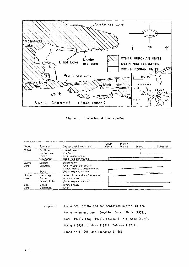
Quirke ore zone
km 20
OTHER HURONIAN UNITS
MATINENDA FORMATION
PRE-HURONIAN
N o r t h C h a n n e l (Lake Huron)U S A
Figure 1. Location of area studied
GroupCobal
Qui'keLake
HoughLake
ElliotLafce
Format onBar RiverGordon LakeLorrainGowgandaSerpentEspanola
BruceMiss ssagiPecorsRamsay LakeMcKimMatmenda
Deep ShallowOepositional Environment Marine Marine Strand Subaenalcoastal beachtidal fiai , ...„, .... .., „ ...lluvialto near shoreglacial to glacio mannedistal streamfluvial through deltaic and ___ Jshallow marine to deeper manne - — ——— —— —— ——glacial to glacio manne (deltaic fluvial and shallow marine - ——— • —— - — ——turbidite basing'aciai to glacio marineturDidite basinfluvial
Figure 2. Lithostratigraphy and sedimentation h i s t o r y of the
Huroman Supergroup. Compiled from Theis (1979),
Card (1978), Long (1976), Roscoe (1973), Wood (1973),Young (1973), Lindsey (1970, Palonen (1970,Chandler (1969), and Casshyap (1966).
136
The tripartite subdivisions of each megacycle seem toreflect: development of a glacial outwash plain; isostatic
depression and flooding as the ice sheet advanced into the area;
an interval of glacio-marine deposition; development of a fine-
grained marine/lacustrine succession as glacial meltback raisedthe water level; and finally delta progradation as isostatic reboundbegan to outstrip the rising water. An investigation of thecontact relationships of the units forming the basal megacyclewas conducted in order to ascertain if the hypothesis put forwardabove is val id.
The Matinenda Formation represents the coarse-grained,sandstone blanket at the base of the lowest megacycle. It onlapped
to the north over an irregular, Archean topography (Roscoe, 19&9).first f i l l i n g the paleoval leys then burying the intervening h i l l s .Uraniferous, quartz-pebble conglomerates interbedded with the coarse-grained sandstones form laterally extensive deposits with NW-SEtrending long axes. The NW end of the conglomerates generallyeither abuts abainst basement or is cut off by an erosive scour atthe base of the overlying Ramsay Lake Formation. The conglomeratesdie out to the southeast by an increase in the proportion of inter-bedded sandstone wedges and a general reduction in grainsize(Roscoe, 1969; Robertson, 1976).
Most conglomerates are massive, however, some showhorizontal stratification. Trough cross-stratification ispresent in the pebble conglomerates in areas where numerous sand-stone lenses occur. Occasionally the cross-sets can be tracedfrom the conglomerate into sandstone lenses. Sandstones inter-layered with the conglomerate and forming units separating con-glomerate packages are generally trough cross-stratified with cross-
137
set amplitude averaging approximately 12 cm. One example of large-scale (1 meter amplitude) planar cross-stratification was observed.Likewise the majority of Matinenda sandstones which are not associatedwith conglomeratic blankets are trough cross-stratified with large-scale planar cross-stratification only dominating in deltaic dis-tributary channels (Fralick, in prep.). The l i t h i c succession
probably represents gravelly longitudinal bars (massive and parallelstratified conglomerate) which were reworked during intervals ofreduced discharge creating sand f i l l e d chuts channels and sandshadows behind topographic highs down-bar (sandstone lenses). Inone location a longitudinal bar was traced laterally over 80 m and
found to be gradational with a major sand f i l l e d side channel.
General s i m i l a r i t i e s with the mixed gravel/sand sediments of partsof the modern Donjek River (Williams and Rust, 1969; M i a l l , 1977) are
suggested. More d i s t a l , crossbedded sandstones of the m i d d l e partof the Matinenda Formation can be compared to deposits forming inshallow braided rivers of Platte type (Smith, 1970; M i a l l , 1977).
The uraninite concentrates in more massive portions of thelongitudinal bars and as lags along horizontal reactivation surfacesin stacked bars (Fralick, in prep.). The bars themselves representrare, discrete high energy events in a succession that is dominatedby braid-channel deposits (trough cross-stratified sandstones). The
gravel bars are localized in the lower portion of the formation,
usually being confined to paleoval leys (Roscoe, 1969).During deposition of the lower portions of the formation
flow was from north to south. As time passed the regional paleo-flow direction gradually changed to NW-SE and eventually to WNW-ESE (Fralick, in prep.). The swing in paleocurrent direction is
thought to reflect crustal subsidence to the east of the area inwhich the Matinenda Formation was studied.
138
EVIDENCE OF A GLACIAL ASSOCIATION
The contact relationships between fluvial MatinendaFormation sandstones and glacial Ramsay Lake Formation mixtiteswas investigated in an attempt to gain insight into the possibilitythat the Matinenda Formation was deposited on a glacial outwashplain. Five pieces of evidence were found indicating a glacialo r i g i n for at least the upper Matinenda sandstones: 1) glacialerosion and resedimentation of unconsolidated Matinenda material;2) g l a c i a l override features present in the upper Matinenda Formation;3) interbedding of glacial mixtite and fluvial quartzite; A) intimateassociation between small Matinenda deltas and subaqueous glacial out-wash; 5) Zr/Hf ratios indicating Matinenda sediments from differingsource areas were well mixed prior to deposition.
Resedimented Matinenda Debris
In the northern portion of the outcrop area g l a c i a l l y
derived mixtites of the Ramsay Lake formation overlie both Matinenda
f l u v i a l sandstones and McKim marine/lacustrine s i ltstone-shalesuccessions. Of these only the contact between glacial mixtitesand fluvial sandstones was studied. The contact is generallygradational with the sandstone becoming massive instead of cross-stratified and then the sorting of the rocks deteriorating. Thedecrease in sorting is caused by an increase in the matrix content,the addition of sand grains of various sizes other than the usualcoarse sand, and occasional quartz pebbles floating in the rock.The amount of both matrix and quartz pebbles increases upward.
The contact with the Ramsay Lake Formation is extremely gradationaland is simply defined as where the first granitic clast appearsin the succession. The transition zone ranges from 5 to 23 metersin thickness.
139
The massive nature of most of the transition zoneindicates that sorting processes did not play an important rolein its sedimentation. Further evidence concerning the depositionalenvironment is provided by siltstone layers containing dropstoneswhich are sometimes present near the base of the transition. Thisunit attests to the previous development of frigid conditions andflooding of the area. The above combined with the gradationalcontact the transition zone rocks exhibit with overlying glacialrainout mixtites (Fralick, in prep.) strongly indicates that thetransition zone itself was deposited as a glacial rainout unit.Debris in the ice mass acquired a stacked zonation reflecting the
lateral lithofacies distribution the ice passed over. Thus debrisat the base of the ice was composed of the most proximal lithologieunit the ice passed over before it became a floating sheet, namely
Matinenda Formation sandstones and conglomerates. Thus sedimentsfrom this source were the first to be liberated from the glacierduring melting. As melting continued Archean debris incorporatedfurther up paleoslope was deposited creating the transition toRamsay Lake mixtites. Boulton (1972) has observed a s i m i l a r l i t h i csuccession in the glacial debris of Antarctica and inferred the same
process.Microscopic examination of the Matinenda resedimented
material indicates that the formation was not l i t h i f i e d prior toglacial erosion. There is also no evidence of any interstitialgrowth of cement, or of any overgrowths having formed on sand grains
prior to scouring by ice advance.The pattern of glacial advance described here contrasts with
that of other Huronian units. The M ississagi-Bruce transition ischaracterized by 150 m of interbedded crossbedded sandstone and mixtite(Long, 1976, 1977). By contrast the Serpent-Gowganda transition is
140
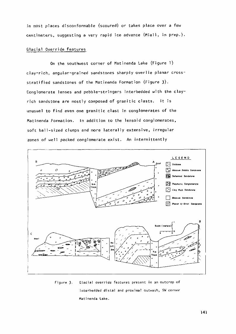
in most places disconformable (scoured) or takes place over a fewcentimeters, suggesting a very rapid ice advance (Miall, in prep.)
Glacial Override Features
On the southwest corner of Matinenda Lake (Figure 1)clay-rich, angular-grained sandstones sharply overlie planar cross-
stratified sandstones of the Matinenda Formation (Figure 3).Conglomerate lenses and pebble-stringers interbedded with the clay-rich sandstone are mostly composed of granitic clasts. It isunusual to find even one granitic clast in conglomerates of theMatinenda Formation. In addition to the lensoid conglomerates,soft ball-sized clumps and more laterally extensive, irregularzones of well packed conglomerate exist. An intermittently
L E G E N D
|* •*•] Diobos«
\°Q\ Massivt P«bbly Sondsrofi«
pffijj Dtformtd Sanditont
[<j | Polymictic ConglorrMratt
\J-\ Clay Rich Sandstont
[ | Massiv« Sandtront[ j *jKN Planar X-Stral Sandtton«
Figure 3- Glacial override features present in an outcrop ofinterbedded distal and proximal outwash, SW corner
Matinenda Lake.
141
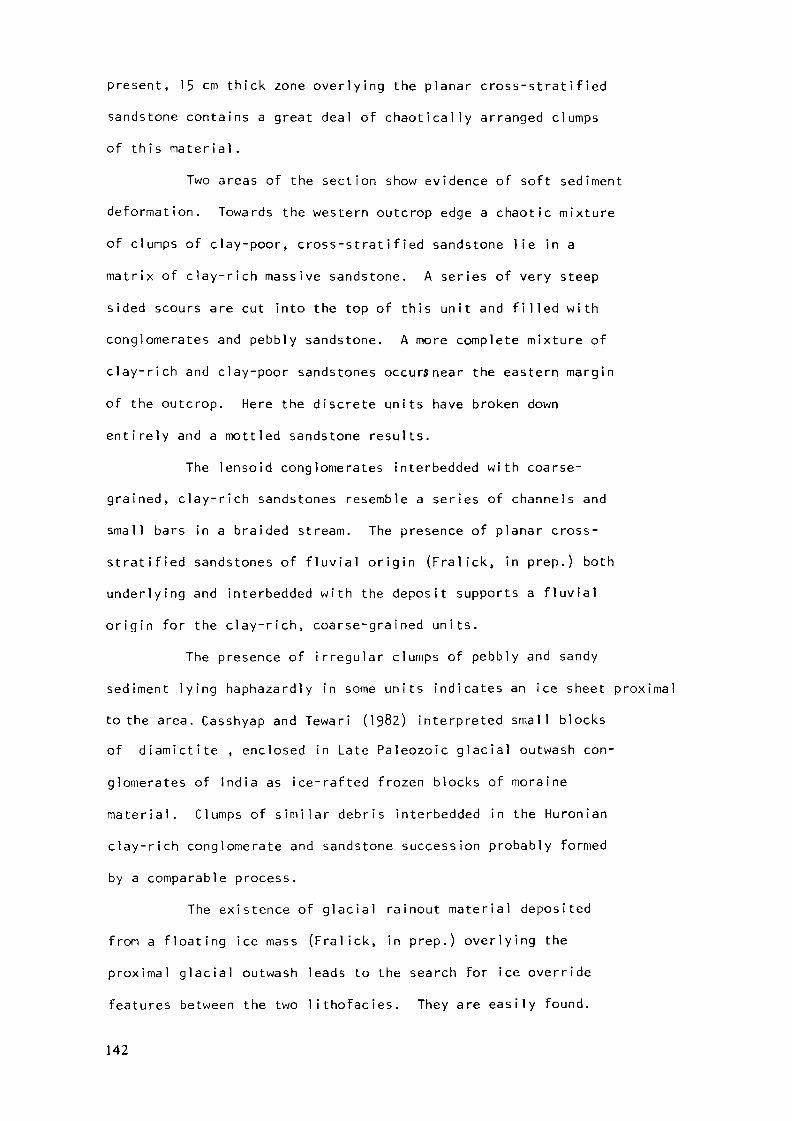
present, 15 cm thick zone overlying the planar cross-stratifiedsandstone contains a great deal of chaotically arranged clumpsof this material.
Two areas of the section show evidence of soft sedimentdeformation. Towards the western outcrop edge a chaotic mixtureof clumps of clay-poor, cross-stratified sandstone lie in amatrix of clay-rich massive sandstone. A series of very steep
sided scours are cut into the top of this unit and f i l l e d withconglomerates and pebbly sandstone. A more complete mixture of
clay-rich and clay-poor sandstones occursnear the eastern marginof the outcrop. Here the discrete units have broken downentirely and a mottled sandstone results.
The lensoid conglomerates interbedded with coarse-grained, clay-rich sandstones resemble a series of channels andsmall bars in a braided stream. The presence of planar cross-stratified sandstones of f l u v i a l origin (Fralick, in prep.) bothunderlying and interbedded with the deposit supports a fluvialo r i g i n for the clay-rich, coarse-grained units.
The presence of irregular clumps of pebbly and sandysediment lying haphazardly in some units indicates an ice sheet proximalto the area. Casshyap and Tewari (1982) interpreted small blocksof diamictite , enclosed in Late Paleozoic glacial outwash con-
glomerates of India as ice-rafted frozen blocks of morainematerial. Clumps of s i m i l a r debris interbedded in the Huronianclay-rich conglomerate and sandstone succession probably formedby a comparable process.
The existence of g l a c i a l rainout material depositedfrom a floating ice mass (Fralick, in prep.) overlying theproximal g l a c i a l outwash leads to the search for ice overridefeatures between the two lithofacies. They are easily found.
142
The chaotic mixture of clay-rich and clay-poor sandstones isboth in the stratigraphically correct position and exhibitsthe proper texture to classify as a g l a c i a l l y disrupted zone.The presence of cross-stratified, Ma tinenda-l ike sandstones asclasts in the disrupted zone signified that sedimentation of the
Mat inenda-1 ike sandstone occurred after a layer of proximaloutwash deposits had accumulated. The easiest way to accomodatethis is through minor ice-front retreat or a reduction in runoffcausing more distal outwash (Matinenda-1ike sandstone) to bedeposited in the area. As the major readvance occurred proximaloutwash again advanced over d i s t a l outwash and the two weredeformed by ice override.
Subaqueous Outwash Deposits
A coarsening upward succession is overlain by thick-bedded massive sandstones in the southeastern portion of the out-crop area examined (see Mink Lake, Figure 1). Thinly beddedturbidites underlie these units and grade upward throughlenticular bedded sandstones and shales, mica-rich ripple anddune cross-laminated sandstones with occasional discontinuousshales to trough and planar cross-stratified, coarse-grainedsandstones (Figure V\). The rock sequence exhibits s i m i l a rsedimentary structures and textures to those described byColeman and Prior (1982) from the much larger M i s s i s s i p p i Delta. They inter-preted the portions of the M i s s i s s i p p i succession as changingvertically from distal bar, through distributary mouth bar, tofluvial channel environments. A s i m i l a r interpretation, based onsedimentary structures and grainsize ^may be advanced for thecoarsening upward sequence present at Mink Lake.
143
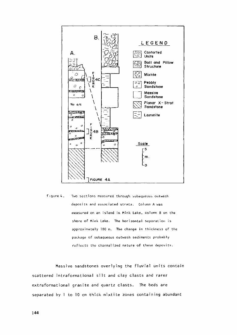
B.
No o/c
\F \|
RE
~o&£
oT ö
L E G E N D
ContortedUnitsBall and PillowStructure
Mixtite
PebblySandstoneMassiveSandstonePlanar X-StratSandstone
Scale
m.L0
"l FIGURE 4A
Figured. Two sections measured through subaqueous outwash
deposi ts and assoc ia ted strata. Column A was
measured on an island in Mink Lake, column B on the
shore of Mink Lake. The horizontal separation is
approximately 100 m. The change in thickness of the
package of subaqueous outwash sediments probably
re f lec ts the channalized nature of these deposi ts.
Massive sandstones overlying the f luvial units contain
scattered intraformational s i l t and clay c las ts and rarer
extraformational granite and quartz c las ts . The beds are
separated by 1 to 10 cm thick mix t i te zones containing abundant
144
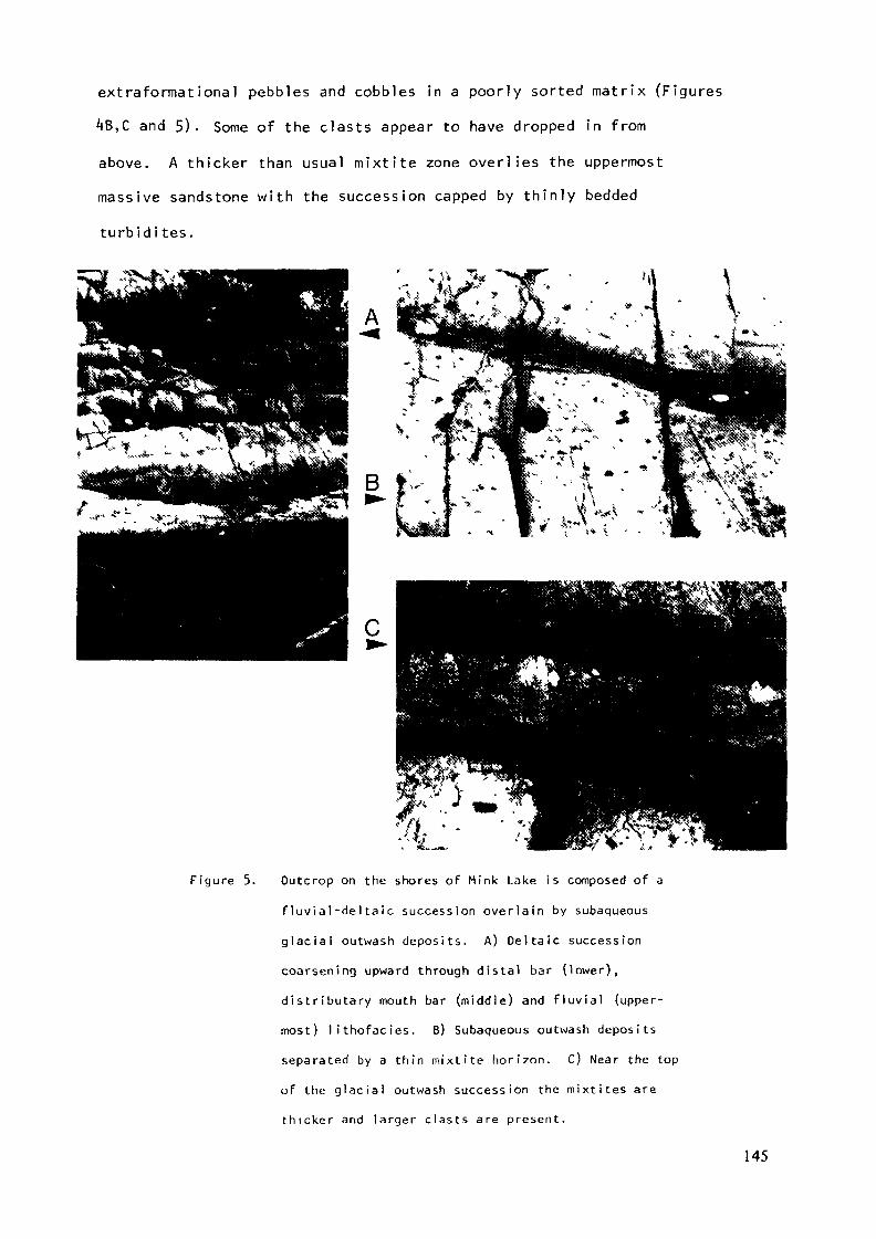
extraformational pebbles and cobbles in a poorly sorted matrix (Figures
4B,C and 5). Some of the clasts appear to have dropped in fromabove. A thicker than usual mixtite zone overlies the uppermostmassive sandstone with the succession capped by thinly beddedturbid i tes.
B
Figure 5. Outcrop on the shores of Mink Lake is composed of a
flu v i a l - d e l t a i c succession overlain by subaqueous
glacial outwash deposits. A) Deltaic successioncoarsening upward through distal bar (lower),distributary mouth bar (middle) and f l u v i a l (upper-most) lithofacies. B) Subaqueous outwash depositsseparated by a thin mixtite horizon. C) Near the topof the glacial outwash succession the mixtites arethicker and larger clasts are present.
145
Dropstones in the mixtite layers indicate that rainoutfrom floating ice was occurring during deposition of the massivesandstones. The sandstones themselves probably formed as a resultof grain or fluidized-flow processes. Their massive nature andrandomly distributed clasts strongly indicate transportation by asediment-gravity flow process in which l i t t l e sorting occurred.S i m i l a r massive sands have been described from the Pleistocene
near Ottawa (Rust and Romanelli, 1975; Rust, 1977). The Pleistocenesandstones are interpreted as mass-flow deposits f i l l i n g channelsin a subaqueous, glacial outwash fan. This interpretation mayalso be applied to the massive, coarse-grained sandstones presenton Mink Lake.
Comparison of the glacial incursion at Mink Lake withthe thicker deposits to the north highlights the diachronousnature of most l i t h i c contacts. In most of the northern portionof the study area fluvial Matinenda sandstones form the entireHuronian succession underlying the Ramsay Lake glacial event.However, at Mink Lake a marine incursion occurred previous toRamsay Lake sedimentation, drowning the Matinenda fluvial sandstonesand depositing the McKim Formation. Immediately prior to RamsayLake ice advance into the area a small delta b u i l d i n g southeastfrom the main fluvial sandstones caused the land at Mink Lake tobecome emergent. This was followed by another transgression anddeposition of subaqueous, glacial outwash. Whether the advance
of the small delta is related to proximal ice with its periods ofvoluminous meltwater and sediment generation is not known.However, the juxtaposition of the small delta and sedimentsbearing evidence of glacial advance indicates the two events may
be 1 inked.
146
Interbedded Glacial and Fluvial Units
An outcrop on Lauzon Lake (see Figure 1) displays anunusual contact relationship between gla c i a l mixtite and fluvialsandstones. Here a succession of planar and trough cross-stratified sandstones (fluvial and river mouth bar deposits, Fralickin prep.) contain a 1.5 m thick, sand-dominated mixtite horizon.
The mixtite is l i t h i c a l l y s i m i l a r to other glacial mixtites foundoverlying the Matinenda Formation in the study area. It isinternally massive and contains pebble sized clasts of granitics,volcanics, quartz, siltstone, and shale, the usual clastassemblage found in Ramsay Lake Mixtites. It is not known whetherthe massive mixtite horizon was deposited by mass-flow processesor as a result of subaqueous rainout of material from a floatingice shelf or icebergs. No structures produced by glacial override
are present in this section, indicating the mixtitewas deposited south of the ice-margin. Fluvially deposited rocksdominate the outcrops both below and above the mixtite horizon.
Zr/Hf Ratios
A study of the Zr/Hf ratios of whole rock samples fromthe Matinenda Formation was conducted with the hope of isolatingdistinct source areas. It was believed that the Huronian placerdeposits may have formed through erosion of a localized sourcerich in uraninite (possibly a pegmatitic, alaskitic graniteterrain, Robinson and Spooner, 1982). If this was the case thezircons associated with the uranium deposits should have lower
Zr/Hf ratios than zircons from Matinenda sandstones not in closespacial association with ore zones. The expected change in
147
ratios is caused by zircons from pegmatites usually having lower
Zr/Hf ratios (average 25) than zircons from granites (average *tO)
(Deer et al, 196*0. The expected variation was not observed.
The Zr/Hr ratios for whole rock samples are all s i m i l a r to
one another. The average ratios for various rock types are:uraniferous conglomerates 28; sandstones associated with uran-
iferous conglomerates 25; sandstones collected from outcrops not
spacially associated with ore zones 27; Ramsay Lake Formationmixtites 28. Zr/Hf ratios in possible source rocks are considerably
more variable. Huronian volcanics averaged ^3 while four samplesfrom the Archean granitic terrain gave values from 16 to 5^-
It is obvious that sediment derived from rock units
possessing differing Zr/Hf ratios must have been well mixed prior
to deposition, thus homogenizing the Zr/Hf ratios. The sediment
may have been mixed in a single trunk stream. However, field
observations indicate that the lower Matinenda sandstones were
deposited in a number of different paleoval leys. This would imply
that the provenance should have changed across the basin and thus
their Zr/Hf ratios should vary.
One way to produce the mixing necessary to homogenize
the sediment is by way of glacial processes. Sub and englacial
streams carrying sediment out of the ice mass should contain a
homogenous mixture of the lithologies the ice passed over. Thus,
sediments deposited in front of the ice mass by a series of these
streams should yield fairly consistent Zr/Hf ratios.
CONCLUSIONS
Pi scussion
The previous section clearly demonstrates that thesouthernmost, upper Matinenda Formation was deposited under
148
conditions specially and probably genetically linked to glaciation
of the area. It is extremely difficult to ascertain whether this
relationship holds for the entire Matinenda Formation. The lowerunits of the Matinenda had not undergone cementation or indeedappreciable precipitation of the interstitial material prior to
glacial advance into the area. This could be interpreted asevidence in support of a short time span separating commencementof Matinenda deposition and glacial advance. Zr/Hf ratiosfurther suggest a glacial source for sediment deposited duringthe entire episode of Matinenda accretion. However, it must beemphasized that only the southern, upper units of the MatinendaFormation can be proven glaciof1uvial in origin. A glacial out-wash origin may be speculated for the rest of the Formation butmore evidence is needed before speculation is transformed to fact.
Implicat ions
If the entire Matinenda Formation is found to be glacio-fluvial in origin this would have serious implications for boththe process which formed the uraniferous placers and use of theuraninite in these rocks as evidence for a reducing atmosphere.
As stated earlier the uraninite is concentrated incoarse gravel tongues which b u i l t southward from the edge of thebasin (Rosco, 1969). Flows with velocities much higher thannormal (flood events) caused the southward progradation of theseconglomeratic longitudinal bar systems into an otherwise monot-onous, coarse-grained sandstone succession. Catastrophic drainageof water ponded at the ice margin is one possible mechanism forsudden release of a large surge of sediment and water. It also
149
provides a mechanism whereby sediment stored up-paleoslope may bereworked and washed down-paleoslope, s i m i l a r to the reworkingcaused by tectonic uplif t which formed the South African paleo-placers. Of course it must be born in mind that large-scaleflood events can be produced simply by torrential rains with no
need for sudden drainage of a glacial lake.Erosion and deposition of the sediment in a cold
environment has an Important bearing on the use ofuraninite as evidence for a reducing atmosphere. Obviously therate at which uraninite grains would suffer from dissolution
would be greatly reduced in an environment with a temperature nearzero. The E l l i o t Lake uraninite also contains a high percentageof thorium which acts to retard dissolution (Robinson, 1982).It is therefore understandable that the grains stood up well tochemical weathering during f l u v i a l transport and storage in thesedimentary p i l e even if the atmosphere was oxidizing.
ACKNOWLEDGEMENTS
Grateful appreciation is expressed to T.J. Barrett,C.H. Eyles, and N. Eyles for the many discussions which took place
right on the outcrops. Thanks are also extended to Wendy Bonswho typed the manuscript and Sam Spivak who drafted the diagrams.This project was supported by grants 8k and 136 from the OntarioGeological Survey of the Ministry of Natural Resources and an
N.S.E.R.C. grant to A.D.M.
150
REFERENCES
Boulton, G.S., 1972. Modem arctic glaciers as depositions! models
for former ice sheets. J. Geol. Soc. of London, vol. 128,
p. 361-393.Card, K.D., 1978. Geology of the Sudbury-Manitoulin area, Districts
of Sudbury and Manitoulin. O.G.S., Report 166, 238 p.
Casshyap, S.M., 1966. Sedimentary Petrology and Stratigraphy of theHuronian rocks south of Espanola, Ontario. Unpubl. Ph.D.
thesis, Un. of Western Ont., London, 232 p.Casshyap, S.M., and Tewari, R.G., 1982. Facies analysis and paleo-
geographic implications of a Late Paleozoic glacial outwashdeposit, Bihar India. J. Sed. Pet., vol. 52, p. 12^3-1256.
Chandler, F.W., 1969- Geology of the Huronian Rocks, Harrow
Township area, Ontario. Ph.D. thesis, University of
Western Ontario, Canada, 327 P-
Church, M. , 1972. Baffin Island sandurs; a study of Arctic fluvial
process. B u l l . Geol. Sur. of Can., vol. 216, p. 1-208.Coleman, J.M., and Prior, D.B., 1982. Deltaic Sand Bodies. A.A.P.G.,
1980 Short Course, Education Course Note Series #15, 171 p.Deer, W.A., Howie, R.A., and Zussman, J., 196^. Rock Forming
Minerals, Volumes 1 to 5- Longmans, London.Fralick, P.W., in prep. Deposition on an Early Proterozoic
continental margin: the Lower Huronian Supergroup of
central Ontario. Unpub. Ph.D. thesis, University of Toronto,
Toronto, Ontario, Canada.Lindsey, 1971- Glacial Marine Sediments in the Precambrian
Gowganda Formation at Whitefish Falls, Ontario. Pal. Pal.
Pal., vol. 9, p. 7-25.
151
Long, D.G.F., 1976. The stratigraphy and sedimentology of the
Huronian (Lower Aphebian) Mississagi and Serpent Formations.Unpubl. Ph.D. thesis, Un. of Western Ont., London, 291 p.
Long, D.G.F., 1977- Resedimented conglomerates of Huronian (lowerAphebian age, from the north shore of Lake Huron, Ontario,Canada. Can. Jour, of Earth Science, vol. 14, p. 2^95-2509.
M i a l l , A.D., 1977- A review of the braided river depositional
environment. Earth Sei. Revs., Vol. )3> p. 1-62.M i a l l , A.D., in prep. Sedimentation on an Early Proterozoic
continental margin under glacial influence: the GowgandaFormation (Huronian), E l l i o t Lake area, Ontario, Canada.
Hinter, W.E.L., 1976. Detrital gold, uranium, and pyriteconcentrations related to sedimentology in the PrecambrianVaal Reef placer, Witwatersrand, S. Afr. Econ. Geol., vol.
71, p. 157-176.Hinter, W.E.L., 1978. A sedimentological synthesis of placer gold,
uranium, and pyrite concentrations in Proterozoic Witwaters-rand sediments. In H i a l l , A.D., ed., F l u v i a l Sedimentology,
C.S.P.G. mem. 5, p. 801-829-
Palonen, P.A., 1971. Stratigraphy and depositional environment
of the Hississagi Formation, Ontario. M.Sc. thesis,
University of Calgary, Alberta, Canada, 103 P-Pretorius, O.A., 1976. The nature of the Witwatersrand gold-
uranium deposits. In, ed. K.H. Wolf, Handbook of strata-
bound and stratiform ore deposits, vol. 7, Elsevier,Amsterdam, p. 29-88.
Pretorius, D.A., 1981. Gold and uranium in quartz-pebble con-
glomerates. Econ. GeoJ., vol. 75i P- 117-138.
152
Robertson, J.A., 1976. The B l i n d River uranium deposits: the oresand their setting. Ontario Ministry of Natural Resources,
Miscellaneous Paper 65, 45 p.Robinson, A.G., 1982. The origin and modification of a uraninite-
bearing placer, E l l i o t Lake, Ontario, unpub. M.Sc. thesis,
University of Toronto, Toronto, Ontario, Canada, 208 p.Robinson, A.G., and Spooner, E.T.G., 1982. Source of the detrital
components of uraniferous conglomerates, Quirke ore zone,E l l i o t Lake, Ontario, Canada. Nature, vol. 299, p. 622-624.
Roscoe, S.M., 1969- Huronian rocks and uraniferous conglomeratesin the Canadian Shield. Geologic Survey of Canada, Paper
68-40, 205 p.Roscoe, S.M., 1973- Thr Huronian Supergroup, a Paleophebian
succession showing evidence of atmospheric evolution. In.,
ed., G.M. Young, Huronian Stratigraphy and Sedimentation.
Geol. Ass. of Can., Spec. Paper No. 12, p. 31-48.Rust, B.R., 1977- Mass flow deposits in a Quaternary succession
near Ottawa, Canada: diagnostic criteria for subaqueous
outwash. Can. J. of Earth Sc., vol. 14, p. 175-184.Rust, B.R., and Romanelli, R., 1975- Late Quaternary subaqueous
outwash deposits near Ottawa, Canada. In, ed. Jopling andMcDonald, Glaciof1uvia1 and Glaciolacustine Sedimentation,Soc. Econ. Pal. and Min., Spec. Pub. 23, p. 177~192.
Smith, N.D., 1970. The braided stream depositional environment:comparison of the Platte River with some S i l u r i a n clasticrocks, north-central Appalachians. Geol. Soc. Am. Bul l . ,Vol. 81, p. 2993-3014.
153
Smith, N.D., and Minter, W.E.L., 1979- Sedimentological controlsof gold and uranium in local developments of the Leader Reef,Welkom Goldfield, and Elsbury No. 5 Reef, Klerksdorp Gold-Field, Witwatersrand Basin. Econ. Geol. Res. Unit, Un. of
the Witwatersrand, Info. Cir. No. 137, 21 p.Smith, N.D., and Minter, W.E.L., 1900. Sedimentological controls
of gold and uranium in two Witwatersrand paleoplacers.
Econ. Geol., vol. 75, p. 1-14.Theis, N.J., 1979- Uranium-bearing and associated minerals in
their geochemical and sedimentological context, E l l i o t Lake,
Ontario. G.S.C. B u l l . 304, 50 p.W i l l i a m s , P.P., and Rust, B.R., 1969. The Sedimentology of a
braided river. J. Sediment. Petrol., vol. 39, p. 6^9-679.Wood, J., 1973- Stratigraphy and depositional environments of
Upper Huronian rocks of the Rawhide Lake-Flack Lake Area,
Ontario. In, ed, G.M., Young, Huronian Stratigraphy andSedimentation, Geol. Ass. of Can., Spec. Paper No. 12,
p. 73-96.Young, G.M., 1973- Origin of Carbonate-Rich Early Proterozoic
Espanola Formation, Ontario, Canada. G.S.A. Byll., vol.81», p. 135-160.
154

SEDIMENTARY FRAMEWORK OF URANIUM DEPOSITSIN THE SOUTHERN COBALT ENBAYMENT,ONTARIO, CANADA
D.G.F. LONGDepartment of Geology,Laurentian University,Sudbury, Ontario,Canada
Abstract
Uranium concentrations in the basal Huronian (lower Aphebian) strataof the Cobalt Bnbayment are associated with, but not always confined to,pyritic resistate pebble conglomerates. Placer concentrations of ilmaniteand magnetite formed in mid fan and valley bottom fluvial systems resemblingScott and Donjeck type braided stream models; uranium was introduced intothe system, along with sane gold, during diagenetic alteration of ilmanite-magnetite placers to pyrite by acid-oxidizing groundwaters : in places uraniumwas remobilized during upper greenschist faciès metamorphism and migrated toadjacent mudstone units.
INTRODUCTION
The uranium potential of pyritic quartz pebble conglomerates at or nearthe base of the Huronian Supergroup in the Blind River - Elliot Lake area ofnorthern Ontario has been exploited since the mid 1950's (Pienaar 1963;Roscoe 1969; Robertson 1971, 1976, 1981; Theis 1979). In this area (Fig. 1)economic concentrations of uranium are associated with laterally extensivesheets of massive to plane bedded pyritic quartz pebble conglomerates inthe Matinenda Formation of the Elliot Lake Group (Table 1) . In the southernCobalt Bnbayment (Fig. 1, 2) concentrations of uranium are similarly confinedto the basal strata of the Huronian Supergroup, but are not confined to quartzpebble conglomerates. They are found in mudstones, fine sandstones and dis-continuous resistate pebble conglomerates.
155
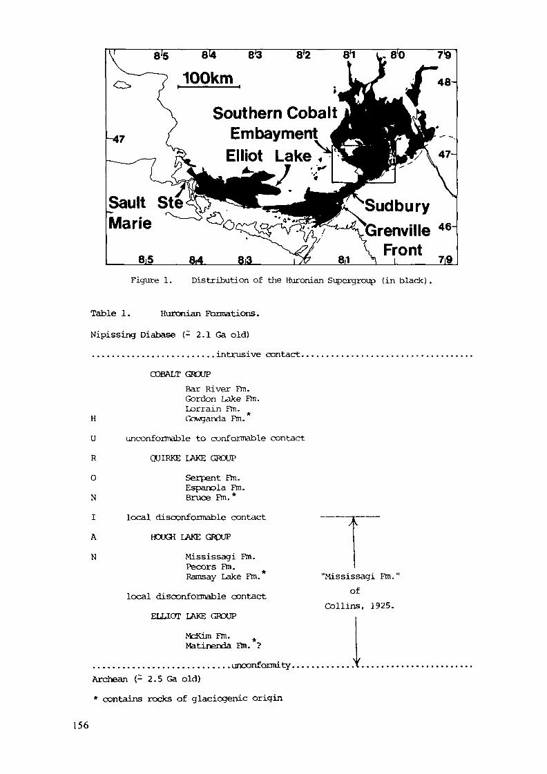
Southern CobaltEmbayment
Sault SteMarie
8iS 8,4 8i3
SudburyÖrenville 46
FrontI /T 7i9Figure 1. Distribution of the Huronian Supergroup (in black) .
Table 1. Huronian Formations.Nipissing Diabase (- 2.1 Ga old)......................... intrusive contact...........................
COBALT GROUPBar River Fm.Gordon Lake Fm.Lorrain Fm.
H Gowganda Fm.U unoonformable to conformable contactR QUIRKE LAKE GROUPO Serpent Fm.
Espanola Fm.N Bruce Fm.*I local disconformable contactA HOUGH LAKE GROUP
N Mississagi Fm.Pecors Fm.Ramsay Lake Fm.
local disconformable contactELLIOT LAKE GROUP
McKim Fm. AMatinenda Fm. ?
"Mississagi Fm."of
Collins, 1925.
. unconformity .Archean (- 2.5 Ga old)* contains rocks of glaciogenic origin
156
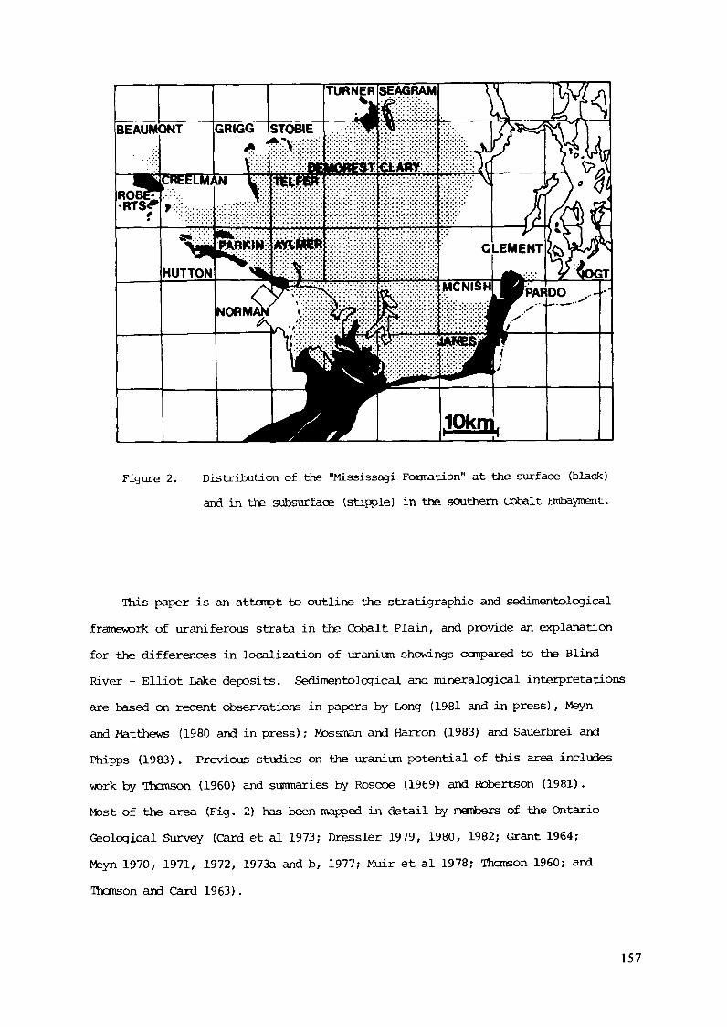
Figure 2. Distribution of the "Mississagi Formation" at the surface (black)and in the subsurface (stipple) in the southern Cobalt Bnbayment.
This paper is an attempt to outline the stratigraphie and sedimentologicalframework of uraniferous strata in the Cobalt Plain, and provide an explanationfor the differences in localization of uranium showings compared to the BlindRiver - Elliot Lake deposits. Sedimentological and mineralogical interpretationsare based on recent observations in papers by Long (1981 and in press), Meynand Matthews (1980 and in press) ; Mossman and Harron (1983) and Sauerbrei andPhipps (1983). Previous studies on the uranium potential of this area includeswork by Thomson (1960) and summaries by Roscoe (1969) and Robertson (1981).Most of the area (Fig. 2) has been mapped in detail by members of the OntarioGeological Survey (Card et al 1973; Dressler 1979, 1980, 1982; Grant 1964;Meyn 1970, 1971, 1972, 1973a and b, 1977; Muir et al 1978; Thomson 1960; andThomson and Card 1963).
157

GEOLOGICAL SETTING
Rocks of the Huronian Supergroup crop out in a broad belt betweenSault Ste. Marie and Noranda (Fig. 1) occupying a structural positionwhich straddles the Superior and Southern tectonic provinces (Card et al1972) and is terminated to the southeast against rocks of the Grenvillestructural province. Metamorphic grade ranges from low or subgreenschistfaciès in the north and northwest to almandine-anphibolite grade in thevicinity of the Grenville Front (Card et al 1972) . In the southern partof the Cobalt embayment most of the supergroup has been regionally meta-morphosed under lower greenschist faciès conditions (Meyn 1973a) with mostsamples containing muscovite and biotite of metemorphic origin, and a fewcontaining chlorite (Long, in press). Observations by Mossman and Harron(1983) suggest that in some localities metamorphism may have reached loweranphibolite faciès conditions.
The Huronian Supergroup consists of an apparently cyclical associationof conglomerates, siltstones and sandstones (Roscoe 1969; Fraray & Roscoe 1970)
and 2.2deposited between 2.5/Ga ago (Van Schmus 1965). The conglomeratic parts ofthis sequence (Ramsay Lake, Bruce and Gowganda Formations) appear to havebeen deposited in a glacial to paraglacial environment (Young 1966, 1970, 1981;Parviainen 1973) in middle to high latitudes (Morris 1977; Syroons 1975, Nesbittand Young 1982). Sandstones are predominantly fluvial (Long 1976) and mudstoneswere deposited in lacustrine and possibly restricted marine conditions. Detailsof individual formations and prior history of investigation of the area aresummarized in papers by Collins (1925), Roscoe (1969) and Robertson (1973).Further details of the tectonic, structural, stratigraphie and metamorphicsetting can be found in papers by Card et al (1972), Sims et al (1981),Young (1982, 1983), Long and Lloyd (1983) and Long (1984).
The regional geology of the southern part of the Cobalt Fjnbayment has beenoutlined by Meyn (1973a) who indicates that the Huronian Supergroup in the areais over 6.5 km thick. The basal Huronian strata in this area (Fig. 2) are
158
predominantly arkosic and subarkosic sandstones with lesser amounts of conglo-merate and modstone. Sandstones dominate the upper part of the sequence, withconglomerates confined to the lower 100 m. The basal sequence is traditionallyascribed to the "Mississagi Formation" in the sense originally used by Collins(1925) . They may be correlative with parts of the Hough and Elliot Lake Groups(Table 1) although clear cut stratigraphie subdivisions, apparent in the BlindRiver - Elliot Lake area, and in the area south of Wanapitei Lake, cannot betraced with certainty into the Cobalt Embayment (Meyn 1973a; Meyn and Matthews,in press; Long, in press) . Most of the monotonous sequences of planar andtrough cross-stratified sandstones in the upper part of the "Mississagi Formation"of the Cobalt Embayment are probably correlative with the Mississagi Formation(Hough Lake Group) in the more restrictive useage (Table 1). Conglomeratesnear the base of the sequence may be in part equivalent to the MatinendaFormation, or may represent faciès equivalents of stratigraphically higherunits.
STRATIGRAPHY
The "Mississagi Formation" in the southern part of the Cobalt Embaymentunconformably to disconformably overlies Archean metasediments, metavolcanicsand granites. In places the contact is fresh, while in others Archean rocksshow signs of paleosoil development related to Proterozoic weathering phenomena.Thickness of the basal sequence (0-55Qm) is highly irregular due to depositionof the sequence on an irregular topographic surface, and erosional truncationof the top of the sequence. The latter is related to glacial scouring whichpreceded deposition of both the Bruce and Gowganda Formations. Contacts withthe Bruce Formation are cainmonly conformable, while those with the GowgandaFormation may be locally disconformable, indicating a period of subduedtectonic activity between these two major glacial advances.
On a regional basis the "Mississagi Formation" can be subdivided intotwo menbers: a lower member consisting of conglomerates, sandstones and mud-stones; and an upper mejnber dominated by planar and trough cross stratified
159
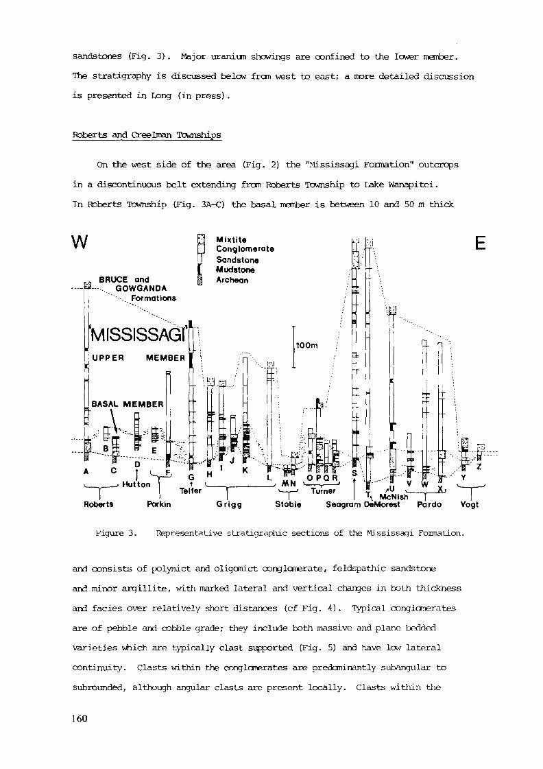
sandstones (Fig. 3) . Major uranium showings are confined to the lower member.The stratigraphy is discussed below fron west to east; a more detailed discussionis presented in Long (in press) .
Roberts and Creelman Townships
On the west side of the area (Fig. 2) the "Mississagi Formation" outcropsin a discontinuous belt extending from Roberts Township to Lake Wanapitei.In Roberts Township (Fig. 3A-C) the basal member is between 10 and 50 m thick
\A/ 3 Mixtite* " J Conglomerate
T SandstoneI Mudstooe
r., BRUCE and | Archean----- :a— .... GOWGANDA
• .. Formations
'MISSISSAM;1 u" ':UPPER MEMBER 1 ;
5 1 ;
. BASAL MEMBER
1 \
!i. B i ^ E
;
K:"""i ""b"'— --r--^ ;--
¥"¥••• »
3 .ak"/'!/l T •
» c I si S » 'v ____ > Hutton 1 v
=|
' • . _
Ni >i f -•-:•:
K1 MN ,- -
J, J
'""S
100m
i*:V !J
^•:'"nL>„LL
Î1
19
O Pj A\N ' ——— f
/
;
;'
TfiJM .--
tl?r "•
E l
fc"3 R, ? \
(\;.f.
rj
1J. .c.._
55 n •B---3 1
r-
B »
" " • ;
\
\
T-'' >r r. v w " ^.Roberts Parkin Grigg Stobie Seagram DeMorest Pardo Vogt
Figure 3. Representative stratigraphie sections of the Mississagi Formation.
and consists of polymict and oligcmict conglomerate, feldspathic sandstoneand minor argillite, with marked lateral and vertical changes in both thicknessand faciès over relatively short distances (cf Fig. 4). Typical conglomeratesare of pebble and cobble grade; they include both massive and plane beddedvarieties which are typically clast supported (Fig. 5) and have low lateralcontinuity. Clasts within the conglcnerates are predominantly subangular tosubrounded, although angular clasts are present locally. Clasts within the
160
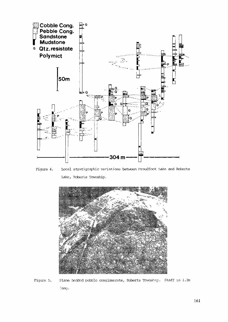
H Cobble CongPebble CongSandstoneMudstone
Q Qtz.resistatePolymict
50m
Figure 4. Local stratigraphie variations between Proudfoot Lake and RobertsLake, Roberts Township.
Figure 5. Plane bedded pebble conglomerate, Roberts Township. Staff is 1.5mlong.
161
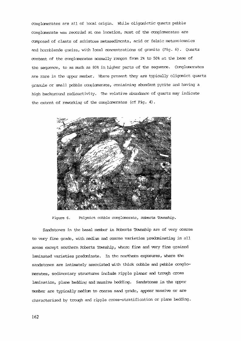
conglomerates are all of local origin. While oligomictic quartz pebbleconglomerate was recorded at one location, most of the conglomerates arecomposed of clasts of schistose metasediments, acid or felsic metavolcanicsand hornblende gneiss, with local concentrations of granite (Fig. 6) . Quartzcontent of the conglomerates normally ranges from 2% to 50% at the base ofthe sequence, to as much as 80% in higher parts of the sequence. Conglomeratesare rare in the upper member. Ifriere present they are typically oligomict quartzgranule or small pebble conglomerate, containing abundant pyrite and having ahigh background radioactivity. The relative abundance of quartz may indicatethe extent of reworking of the conglomerates (cf Fig. 4) .
Figure 6. Polymict cobble conglomerate, Roberts Township.
Sandstones in the basal member in Roberts Township are of very coarseto very fine grade, with medium and coarse varieties predominating in allareas except southern Roberts rlbwnship/ where fine and very fine grainedlaminated varieties predominate. In the northern exposures, where thesandstones are intimately associated with thick cobble and pebble conglo-merates, sedimentary structures include ripple planar and trough crosslamination, plane bedding and massive bedding. Sandstones in the uppermember are typically medium to coarse sand grade, appear massive or arecharacterized by trough and ripple cross-stratification or plane bedding.
162
Argillites are locally important in the basal member, they aretypically plane bedded to laminated and have a high background radio-activity.
Hutton, Parkin, Aylmer and Rathburn Townships
South of Roberts Township the "Mississagi Formation" is poorly exposed;the sequence in this area (Fig. 3D-F) is dominated by planar and troughcross stratified mediun and coarse feldspathic and lithic feldspathicsandstones (Long 1976) . This sequence appears to have been depositedon an irregular topographic surface, as indicated by inferred positionof the contact in Norman and Tathburn townships mapped by Dressier (1982)and central Hutton Township as mapped by Meyn (1970) . Long (1976) suggestsdevelopment of local relief in excess of 131m in the latter area.
The lower conglomeratic member of the formation is poorly exposed.Scattered quartz pebbles were observed in coarse sandstones in the "paleo-valley" in central Hutton Township. Thomson (1960) indicates that mostof the conglomerates encountered in the subsurface in this area are dominatedby subangular pebbles of quartz and chert. Minor boulders of granite,argillite and rhyolite are also recorded, but are not as predominant asin Roberts Township. Discontinuous quartz pebble conglomerates are exposedalong the east bank of the Vermilion River in Hutton Township (Fig. 3D) andnear Fletcher Lake in Parkin Township (Fig. 3E, F) . Conglomerates at theselocalities are predominantly massive with well rounded to subroundedquartz pebbles. Minor chert, rhyolite and granite are present inconglomerates in the Hutton Township locality, while only quartz clastswere seen in the pyritiferous pebble and cobble conglomerates in the ParkinTownship locality.
Sandstones in the basal member are of very fine to coarse sand gradeand include massive, plane bedded and planar cross stratified varieties.Argillites and argillaceous sandstones are exposed in association with
163
conglomerates along the Vermilion River (Fig. 3D) . As in Roberts Townshipthese are plane laminated or massive, with high background radioactivity.
The upper member is doninated by planar and trough cross stratifiedsandstones, but includes 80 to 120 m of argillaceous fine and very finesandstone in Parkin and Rathburn townships. This unit is typically planelaminated with only minor ripple cross lamination, and resanbles the PecorsFormation in the Sudbury and Elliot Lake areas. It may be correlative witha 35 m thick mudstone unit in the subsurface in Telfer Township (Fig. 3G) .
Telfer, Fraleck and Grigg Townships
The "Mississagi Formation" is exposed in a belt, parallel to theWanapitei River which extends from central Fraleck Township to centralGrigg Township, and is present in the subsurface to the east. The basalmamber is best developed in central Grigg Township (Fig. 3K) . It consistsof up to 75 m of interbedded cong loner ate, sandstone and mudstone withsome high uranium values concentrated in the more argillaceous parts ofthe sequence. The unit thins rapidly to the south (Fig. 31, H) and isapparently absent in Fraleck Township. Less than two metres of conglomerateis recorded at the base of the sequence in Telfer Township (Fig. 3G).Local thickness variations of the manber reflect development of paleo-valley systans in the Archean surface. In Grigg Township, on the flanksof the paleovalley system (3J), conglomérâtes include both weakly stratified,clast supported small pebble conglomerates, and structureless matrix supportedconglomeratic sandstones with local inverse coarse tail grading at the base.Clasts in these conglomerates are angular to subangular, and consist pre-dominantly of vein quartz with some rare granitic rock fragments and nogreenstones. Conglomerates in the core of the paleovalley system (Fig. 3K)are coarser than those on the flanks. Maximum recorded grain size at thebase of the sequence is very large pebble grade. Conglomerates exposednear the top of the sequence in the paleovalley have a more cyclic appearance(Fig. 7) and show a marked lateral variation in grain size and thickness.
164
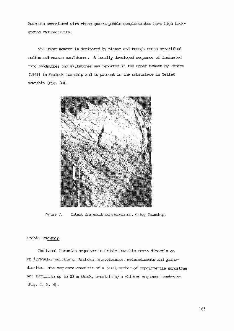
Mudrocks associated with these quartz-pebble conglomerates have high back-ground radioactivity.
The upper member is dominated by planar and trough cross stratifiedmedium and coarse sandstones. A locally developed sequence of laminatedfine sandstones and siltstones was reported in the upper member by Peters(1969) in Fraleck Township and is present in the subsurface in Te If erTownship (Fig. 3G) .
Figure 7. Intact framework conglomérâtes, Grigg Township.
Stobie Township
The basal Huronian sequence in Stobie Township rests directly onan irregular surface of Archean metavolcanics, metasediments and grano-diorite. The sequence consists of a basal member of conglomerate sandstoneand argillite up to 23 m thick, overlain by a thicker sequence sandstone(Fig. 3, M, N).
165
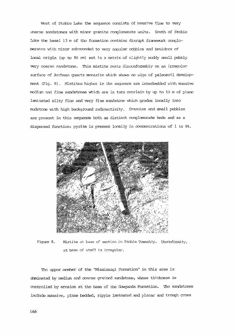
West of Stobie Lake the sequence consists of massive fine to very-coarse sandstones with minor granite conglomerate units. South of StobieLake the basal 13 m of the formation contains disrupt framework conglo-merates with minor subrounded to very angular cobbles and boulders oflocal origin (up to 80 cm) set in a matrix of slightly muddy small pebblyvery coarse sandstone. This mixtite rests dis conformably on an irregularsurface of Archean quartz monazite which shows no sign of paleosoil develop-ment (Fig. 8) . Mixtites higher in the sequence are interbedded with massivemedium and fine sandstones which are in turn overlain by up to 10 m of planelaminated silty fine and very fine sandstone which grades locally intomudstone with high background radioactivity. Granules and small pebblesare present in this sequence both as distinct conglomerate beds and as adispersed function: pyrite is present locally in concentrations of 1 to 8%.
Figure 8. Mixtite at base of section in Stobie Township. Unconformity,at base of staff is irregular.
The upper member of the "Mississagi Formation" in this area isdominated by medium and coarse grained sandstone, whose thickness iscontrolled by erosion at the base of the Gcwganda Formation. The sandstonesinclude massive, plane bedded, ripple laminated and planar and trough cross
166
stratified varieties, and are affected locally by Sudbury type brecciation(cf Speers 1957) involving abrasion of breccia fragments by gas streamingprocesses.
Turner, Seagram, Danorest and Clary
The basal member of the Mississagi Formation in this area consistsof a 6 to 68 m thick package of sandstone conglomerate and argillite(Fig. 3). Intact framework conglomerates in the area of granule tocobble grade, are commonly polymict. Thin beds of oligomict quartz pebbleconglomerate intimately associated with medium grained sandstones withhigh background radioactivity were found in the vicinity of "Discovery Pond"in Turner Township. Average thickness of polymict conglomerates ranges froma few centimetres to 20 m.
Where exposed the conglomerates appear massive to weakly planarstratified. Examples in the northwest of Turner Township fined upwardsfrom cobbly very large pebble conglomerate at the base, to large pebbleconglomerate at the bop in one instance and small pebble conglomerate inanother. Both conglomerates were overlain by massive and plane beddedmedium, coarse and very coarse sandstone, and pebbly granule conglomerate,and had a matrix and medium to coarse sand to granule grade, with abundantpyrite. Clasts in these conglomerates are predominantly rounded to sub-rounded and consist of up to 40% quartz, 10-15% locally derived meta-sandstone and 45-50% felsic metavolcanics.
Mixtite was recorded in the subsurface, and at one locality withintwo metres of the base of the sequence in Turner Township.
Most sandstones in the basal member are massive-plane bedding, ripplelamination and trough cross stratification is present locally. Thin bedsof mudstone are found interbedded with very fine and very coarse sandstonein outcrops of the basal member. These units are ccmnonly lenticular; oneexample contained dessication cracks. Thicker mudstone units were recordedin the subsurface.
167

Janes, fteNish Pardo and Clement Townships
Rocks of the "Mississagi Formation" crop out in a broad belt extendingfrom the Grenville Front, in Janes Township to Clement Township. The basalHuronian sequence in this area consists of a conglomeratic sequence 40 to80 m thick, overlain by about 270 m of sandstone (Fig. 3 U to X) .
The basal member of the formation is best exposed in Pardo and ClementTownships where it has a relatively uniform stratigraphy with two majorconglomeratic horizons separated by 10 to 40 m of massive and trough cross-stratified medium grained sandstones. At the outlet of Tee Lake, in PardoTownship the lower conglomerate consists of 9 to 20 m of massive to weaklystratified cobbly large and very large pebble conglomerates, with interbedsof pebbly medium to coarse sandstone. Clasts in the conglomerate arepredominantly subangular to moderately well rounded metasiltstone withlesser amounts of metavolcanic material. Clasts include only 10 to 15%quartz résistâtes including vein quartz, and white and black chert. Grano-diorite pebbles are present above the 4 m level in trace amounts. Thelower conglomerates at this location are separated from an upper conglomerateunit by 24 m of lithic-arkosic sandstone. The upper conglomerate consistsof 15 bo 20 m of large pebble, very large pebble and small cobble conglomerate,containing clasts up to 33 cms. The conglomerate is predominantly clastssupported, though disrupt framework (matrix supported) conglomerates arepresent locally. Clasts in the conglomerate are typically rounded to sub-rounded, and include meta-argillite, metavolcanics, metaplutonics and minorgranodiorite, garnetiferous schist, black chert and siliceous iron formation.Vein quartz accounts for only one or two percent of the clasts present.
The upper member of the formation in this area consists predominantlyof thick bedded planar and trough cross-stratified medium sandstones, withminor quartz pebble conglomerates.
168
Vogt Township
An isolated patch of the Mississagi Formation is preserved beneath theGowganda Formation in south-central Vogt Ttwnship. In this area it consistsof up to 36 m of medium to thickly bedded massive and planar cross stratifiedmedium and coarse arkosic sandstone, with minor well sorted medium and largepebble quartz resistate conglomerates, and pebble cobble and boulder gradepolymict conglomerates. Polymict conglomerates are confined to the base ofsequence, and are thickest (up to 7 m) in the base of depressions interpretedas paleovalleys (Fig. 3 Y,Z ). Clasts in these basal conglomerates aretypically angular to subangular and consist predominantly of locally derivediron formation, siliceous metavolcanics and metagreywacke. "Quartzite"and vein quartz typically constitute less than 50% of the gravel fraction.
Resistate pebble conglomerate in the overlying sandstone sequenceare medium to thickly bedded (20-55 cms) have low lateral continuity,and are usually devoid of internal structure. Planar bedding is visiblein some units. Clasts in the conglomerates are predominantly subangularto rounded and consist of strain-recrystallized vein quartz ( > 50%) withlesser amounts of siliceous and sericitic metasediments and metavolcanics.The matrix of these conglomerates is a moderately poorly sorted pyriticarkose in which all feldspar grains have been altered to sericite. Heavyminerals such as zircon and monazite are cormon.
SEDIMENTTOIOGY
Most of the "Mississagi Formation" in southern Cobalt Plain is ofbraided fluvial origin. Lake and pond deposits are recognized in severallocalities, in places forming sequences tens of metres thick. Long (1976,1978) suggested that most of the Mississagi Formation was deposited inPlatt type braided rivers (cf Miall 1978) with high width to depth ratiosand highly unstable banks. More recent observations (Long, in press) indicatethat while sandy Platte type river deposits predominate, especially in theupper manber, more proximal (conglomeratic) Platte, Donjeck and Scott typedeposits (cf Miall 1978) are present in the lower member (Long 1981 and inpress).
169
Conglomerates and sandstones in the basal menber in Roberts Townshipinterpreted as products of deposition in braided streams with characteristicsof both Scott, and proximal Donjeck type rivers. Their irregular thicknessand apparent low lateral continuity suggests that these conglomerates accumulatedon an irregular topographic surface in both valley fill and alluvial fan settings.Thin mudstone units associated with the conglomerates are interpreted as depositsof small flcodplain lakes or cut-off channels. Thicker sequences of fines mayrepresent more extensive lakes. The upper member if interpreted as the productof deposition in proximal Platte type braided streams. Sane of the more massiveand plane laminated sands near the base of the menber could represent distalsheet flood deposits of alluvial fans (cf Hooke 1967) .
Laterally discontinuous conglomerates and associated strata in thebasal member of the "Mississagi Formation" south of Roberts Township representproducts of deposition fron Donjeck or proximal Platte type braided streamslocally in valley fill setting. Alluvial deposits are not important suggestinga more subdued topographic setting than in Roberts Township. Thicker argillaceousunits may represent deposits of small floodplain lakes or ponds. The thickpackage of argillaceous sandstones in the upper member is interpreted as theproduct of deposition in a more extensive (?) fresh water lake.
Distribution of conglomerates in the basal member in Grigg Townshipsuggests that they are of valley fill origin. Conglomerates exposed on thepresent western margin of the paleovalley represent Scott type braided streams,with pebbly sandstones representing debris flow deposits. Conglomerates exposedin the core of the paleovalley system represent a variant of the Donjeck typebraided stream deposit with associated laminated silty sandstones andmudstones representing pond deposits, which formed on the margins of thechannel systems, or in channel cut-offs. Decrease in abundance and gradeof conglomerates to the south, in Telfer and Fraleck Townships indicatesa decrease in topographic relief in this direction.
Much of the basal member in Stobie Township formed in a valley-fillsetting, with pronounced local relief. Mixtites which occur locally atthe base of the sequence are interpreted as local debris flow deposits,
170
with the overlying laminated sequence, with scattered pebble horizonsrepresenting sheetflood deposits (cf Hook 1967) in a Bijou Creek (cf Miall1978) type braided stream environment. Overlying strata are interpretedas the products of deposition in proximal Platte type braided streams.
Thick polymict conglomerates in the basal member of the "MississagiFormation" in Turner, Seagram Dgnorest and Clery townships, may representchannel deposits of streams with characteristics intermediate in typebetween the Scott and Donjeck models of Miall (1978) . Conglomerates in thebasal member contain clasts predominantly of local origin, are laterallydiscontinuous, and are not developed uniformally throughout the area. Theirregular thickness of, and distribution of conglomerates within, the basalmember may reflect deposition in valley fill environments. Mixtite in thebasal member in Turner Township may represent debris flow events relatedto floods within the valleys, rather than floods confined to specific fansystems. This is reflected by absence of locally derived iron formationpebbles in this occurrence. Massive sandstones in the basal member may
represent sheet flood deposits which accumulated in an overbank-floodplainenvironment. Intermittent exposure is indicated by the presence of dessicationcracks in one example. As in other areas, the upper member is dominated byPlatte type river deposits.
Conglomerates in the basal member in Janes, McNish Pardo and Clementtownships form a relatively uniform sheet, 40 to 80 metres thick: thereis no evidence of pronounced topography at the base of the sequence, precludinga narrow valley fill origin. The conglomerates are interpreted as depositsof proximal Scott type braided streams with matrix supported conglomérâtessuch as those at the base of the upper conglomerate representing in-channeldebris flows. Most of the framework supported conglomerates are lenticularand represent channel filling by longitudinal bars. Thin sandstones mayrepresent bar-edge sand wedges. Sandstones separating the two main conglomeratezones in the basal member represent deposits of proximal Platte type rivers.Thin conglomerate layers in the upper member may represent lag deposits, orminor longitudinal bars.
171
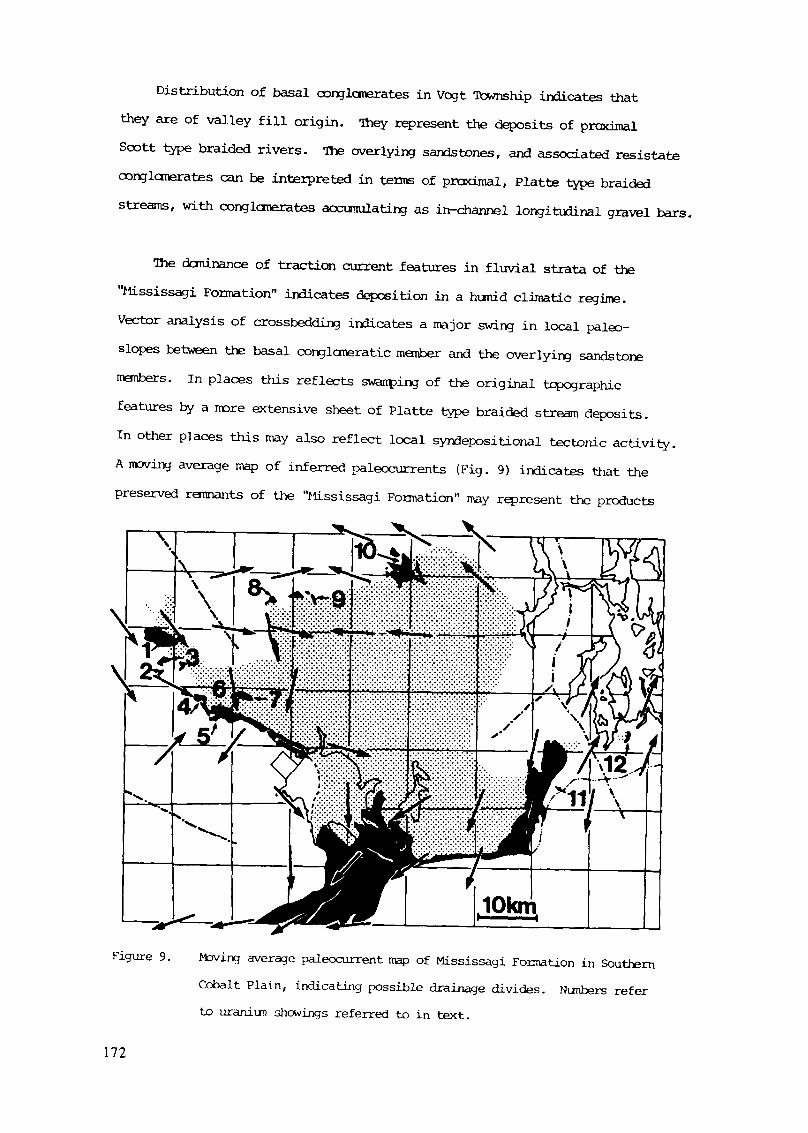
Distribution of basal conglomerates in Vogt Township indicates thatthey are of valley fill origin. They represent the deposits of proximalScott type braided rivers. The overlying sandstones, and associated resistateconglomerates can be interpreted in terms of proximal, Platte type braidedstreams, with conglomerates accunulating as in-channel longitudinal gravel bars.
The dominance of traction current features in fluvial strata of the"Jlississagi Formation" indicates deposition in a hunid climatic regime.Vector analysis of crossbedding indicates a major swing in local paleo-slopes between the basal conglomeratic member and the overlying sandstonemembers. In places this reflects swamping of the original topographicfeatures by a more extensive sheet of Platte type braided stream deposits.In other places this may also reflect local syndepositional tectonic activity.A moving average map of inferred paleccurrents (Fig. 9) indicates that thepreserved remnants of the "Mississagi Formation" may represent the products
>— tyy.-FWFTvT-.-.1*.- .v.T.-T'TWr..... .
Figure 9. Moving average paleocurrent map of Mississagi Formation in SouthernCobalt Plain, indicating possible drainage divides. Nunbers referto uraniun showings referred to in text.
112
of accumulation in more than one distinct drainage basin. A possible drainagedivide is inferred between Pardo and Vogt Townships; between Clement and Clarytownships, and at least locally between Grigg and Roberts Township.
URANIUM SHOWINGS
Major uranium showings in the southern Cobalt Embayment are confinedto the basal member of the "Mississagi Formation". They are not confinedto pyritic quartz pebble conglomerates as are the major deposits in theBlind River - Elliot Lake area, but are more frequently associated withargillaceous sandstones and mudstones. Details of individual showings havebeen discussed, in a regional context by Thomson (1960) , Meyn (1979), Meynand Matthews (1980 and in press) , and in a local context by Grant (1964) ,Meyn (1970, 1971, 1972) and Dressier (1979). Pétrographie details of theuranium mineralization are included in the work by Meyn and Matthews (inpress): names for showings are taken from this report where applicable.
Roberts and Creelman Townships
Uranium mineralization occurs in three main areas within Robertsand Creelman Townships. These are: 1, the Roberts Lake area; 2, theCentral Roberts area; and 3, the Leslie showing (Fig. 9, locations 1, 2, 3) .
In the Roberts Lake area (Fig. 9, locality 1) polymict congloneratesat the base of the sequence in exposures adjacent to the Vermilion Riverhave high background radioactivity. Upon analysis (Long, in press) thoseat the base of the sequence contain only 3 to 8 ppm uranium. Pyriticoligomict quartz pebble conglomerate, higher in the sequence (Fig. 3, A)contain only 7 ppm uranium despite its resemblance to the Elliot Lake ores.Further south near the boundary of Roberts and Creelman Townships uraniumconcentrations of 29 and 38 ppn were encountered in large and very largepebble conglomerates containing 80 to 90% quartz pebbles (Long, in press).Meyn and Matthews (in press) indicate that the richest uranium mineralizationin this area (581 ppm) is in a pyritic fine sandstone. Higher concentrations
173
of uranium are present in laminated mudrccks near the base of the sequencebetween the Vermilion River and Roberts Lake (Meyn 1971) . Meyn and Matthews(in press) indicate concentrations of up to 1516 ppm in the lowermost mudstonein this area (cf Fig. 4) with other high values recorded in interbedded silt-stone-sandstone units.
Uraniun concentrations in the Central Roberts area (Fig. 9, loc. 2)are confined to a thick sequence of plane laminated silty very fine sandstoneswith uranium concentrations up to 8200 ppm (Meyn and Matthews, in press) .Goodwin (1980) showed that radioactive horizons are not laterally extensiveand are coincident with thin (pyritic) laminations containing concentrationsof zircon, ilmenite, rutile and mica (with minor tourmaline) which he considersto have been in hydraulic equilibrium.
The Leslie showing (Fig. 9, location 3) in central western RobertsTownship has been described by Thomson (I960) and Meyn (1971). Meyn andMatthews (in press) indicate that uraniun mineralization is found in irregularlybedded, slurped siltstones and mudstones similar to the host rocks in theCentral Roberts area. Associated conglomerates are only mildly radioactive.
Button, Parkin, Aylmer and Rathbun Ttwnships
Uranium mineralization has been noted in three main areas in HuttonTtawnship (Northern Hutton, Central Hutton, and Bannagan Lake areas) and inone location (Flesher Lake) in Parkin Township (cf. Fig. 9, localities 4 to 7) .
In the northern Hutton area (Fig. 9, loc. 4) uranium mineralizationoccurs in massive black mudrccks near the base of the sequence (Thomson 1960;Meyn 1970). Meyn and Matthews (in press) indicate maximum concentrations ofup to 340 ppm uranium in the mudrocks, with pyritiferous conglomerates higherin the same sequence containing only 4 ppm uranium.
In the central Hutton, Bannagan Lake and Flesher Lake areas (Fig. 9,loc. 5, 6, 7) uranium mineralization is found in pyritic resistate pebble
174
conglomerates (Meyn 1970). îteyn and Ilatthews (in press) indicate that thehighest concentrations (1300 ppm) in the central Hutton locality are inquartzose polymict conglomerate lenses of granule to pebble grade associatedwith pebbly sandstones. Uranium mineralization in the Bannagan Lake area(Fig. 3 D) is concentrated in pyritic quartz pebble conglomerates whichclosely resemble the ore zones in the Elliot Lake area. In outcrops alongthe Vermilion River, uranium concentrations of up to 1500 ppm are intimatelylinked to the distribution of pyrite in the matrix of these conglomerates(Meyn and Matthews in press) Mildly radioactive pebble and cobble conglomeratesof similar composition are present in the Flesher Lake area (Fig. 3, E, F:Fig. 9, locality 7).
Telfer, Fraleck and Grigg "Townships
Minor uraniun mineralization (up to 730 ppm) has been recorded alongthe flanks of, and in the core of, the paleovalley (Fig. 3, J, K; Fig. 9,locality 8) in Grigg Township (Meyn 1972; Meyn and Matthews, in press) .Uranium is present in low levels in conglomeratic strata, but high valuesare confined to laminated pyritic mudrccks.
Stobie Township
Uranium mineralization has been recorded by Meyn (1972) and Meyn andMatthews (in press) in sheared pyritiferous argillites in the basal memberof the "Mississagi Formation" south of Stobie Lake (Fig. 3 N; Fig. 9,locality 9) . Maximum uranium concentrations recorded by Meyn (1972) areabout 770 ppm. Long (in press) found minor concentrations (up to 140 ppm)in thin muddy pebbly medium sandstones (mixtites) containing 20% quartz pebblesnear the base of the sequence.
Turner, Seagram, Deforest and Clary
Uranium mineralization has been recorded in the Pilgrim Creek area(Fig. 9, locality 10) by Thomson (1960), Card et al (1973) and Meyn and
175
Matthews (in press). Meyn and Matthews (in press) found concentrations ofup to 120 ppm uranium in pyritiferous siltstone laminae between fine tomedian grained sandstone in the vicinity of "discovery pond" in TurnerTownship. Maximum concentrations (280 ppm) recorded by Long (in press) atthis locality were in plane bedded medium to fine sandstones which underliea thin bedded sequence of lenticular quartz granule conglomerates. Accordingto Card et al (1973, p.113) these pyritic conglomerates contain local concen-trations of up to 2584 ppm uraniu, but grade is not consistent along strike.
Janes, McNish, Pardo and Clement Townships
Minor uranium showings are present in the basal Huronian sequence inMcNish, Pardo and Clement Townships (Thomson 1960; Dressier, 1979). Drillingin the vicinity of Tee and Silver lakes (Fig. 9, loc. 11) in Pardo Townshiprecorded by Thomson (1960) indicates that uranium concentrations of between 19and 86 ppm in the basal conglomerates. A scintilloneter survey of exposuresat the south end of Tee Lake indicates that the highest uranium concentrationsoccur in the basal few centimetres of the conglomerate sequence, and in theunderlying regolith.
Vogt Township
Minor uranium mineralization has been recorded in Vogt Township (Thomson1960; Grant 1964) in pyritic resistate pebble conglonerates near the base ofthe sequence. Maximun recorded values range from 364 to 498 ppm uranium (Thomson)The highest uranium (250 ppm) values encountered by Long (in press) werein lenticular, massive to weakly stratified pyritic medium and large pebbleconglomerates which contained minor gold concentrations.
SEDIMENTARY FRAMEWORK OF URANIUM SHOWINGS
Uranium is found in resistate pebble conglomerates in the Central Hutton,Banagan Lake, Flesher Lake and Vogt Township locations (Fig. 9, locatins 5, 6,7 and 12) . In all of these areas the uraniferous conglomerates are interpreted
176
as products of deposition on longitudinal in-channel bars which formed inDonjeck or proximal Platte type braided rivers. The first two locationsmay reflect the deposits of a single fluvial system which emanated from theHutton paleovalley into a broad alluvial.plain. Lateral continuity ofindividual conglomerate beds is much lower than in the Elliot Lake area.Conglomerates in the Flesher Lake area accumulated in a broad paleovalley,and like those at Banagan Lake have low lateral continuity. Low paleoslopesat both these locations are indicated by their association with laminatedmudrocks.
The coarsest conglomerates in the Vogt Township area are interpretedas Scott type braided stream deposits which were confined to the floor ofa sinuous valley (Long in press). Uraniun and gold concentrations occur inthe more siliceous upner part of this basal unit. Distribution of goldvalues suggests that they are related to reworking of the channel fillmaterial, and may follow the tract of ancient stream thalwegs (cf Minter 1978).Uranium and gold are also present in medium to large pebble conglomerateshigher in the sequence. These are interpreted as products of depositionon longitudinal in-channel bars in a proximal Platte type braided river.
Pyrite is cannon in all the above conglomerates as are heavy mineralssuch as zircon. The association of uranium with heavy mineral concentrations
tois indicative of a genetic link placer formation. While the higher uraniumconcentrations usually occur in rocks with high pyrite content, the abundanceof pyrite in a conglomerate does not guarantee high uranium content (cf.Meyn and Matthews in press).
Minor uranium concentrations in the Tee Lake area (Fig. 9, loc. 11)occur in the basal few centimetres of the conglomerate sequence and in theupper few centimetres of the underlying metasiltstone. Conglomerates atthis location are interpreted as Scott type river deposits with a sheet likedistribution. Placer minerals could have concentrated in traps alongthe unconformity. Uranium in the underlying regolith appears to be concentratedin black veins (? thucolite).
177
Uranium in the Stobie Lake and Pilgrim Creek areas (Fig. 9, loc. 9 and 10)is associated with pebbly sandstones, mudstones and quartzose mixtites whichaccumulated on an irregular unconformity. Their association with polymicticmixtites of debris flow origin in the Stobie occurrence indicates that theymay have formed as sheetflcod deposits on small alluvial fans.
Uranium concentrations at the Roberts Lake, Central Roberts, Leslie,North Hutton and Grigg locations (Fig. 9, locations 1, 2, 3, 4, 8) occurin laminated mudrocks and pyritic fine sandstones. The sequence of siltyvery fine and fine sandstones which hosts uranium showings in southernRoberts Township is interpreted as the deposit of a small lake which wasprogressively filled by prodeltaic silts and sands (Long in press). Thisis indicated by the flat laminated character of most of the beds, the presenceof minor graded sandstone beds and lenticular conglomerates of probable grainflow origin (cf. Middleton & Hampton 1973). Laterally discontinuous (uraniferous)heavy mineral layers in the finer grained strata (Goodwin 1980) may be the productsof winnowing by bottom currents. Fine grained sequences associated withuranium showings in the Roberts Lake, Leslie, N. Hutton and areas may haveaccumulated in small lakes or floodplain ponds. They occur in pyritiferousstrata but are not specifically related to concentrations of zircons, hencea placer origin is unlikely.
DiscussionCurrent models of uranium deposits in the Elliot Lake - Blind River area,
summarized by Pobertson (1981) indicate that they represent modified placerdeposits. Lateral continuity of pyritic quartz pebble conglomerate beds inthe Elliot Lake area indicate that they formed in a (humid) mid-fan settingpossibly as sheetflood deposits. While sheetflood deposits do host minoruranium concentrations in the Cobalt Embayment, these lack the coarse grainsize and lateral continuity of the Elliot Lake areas. Uraniferous conglomeratesin the Cobalt Embayment have low lateral continuity, and formed in valleyfill and velley bottom settings, rather than mid-fan settings.
178
Uranini te in the Elliot Lake ores may be detrital (Roscoe 1969; Theis 1979;Clenrney and Badham 1982) although brannerite is predominantly of diageneticorigin, fornved by adsorption of uranium onto titania collectors (Theis, 1979) .Theis (1979) noted a strong correlation between grain size of coarse pyriteand pebble size in the Elliot Lake ores, and used this to support a detrital(placer) origin for the pyrite. Other authors have suggested that the pyriteis polygenetic (Roscoe 1969; Pinaar 1963) or entirely diagenetic in origin(Clenmey and Badham 1982) .
major barrier to acceptance of a simple placer model for accumulationof the ore horizons at Elliot Lake, and uraniferous conglomerates of the CobaltEmbayment, is that the heavy mineral assemblages appear to be dominated bypyrite, and do not contain abundant magnetite or illmanite. Both magnetiteand illmanite are carmon constituents of the Archean bedrock in the Elliot Lakearea and in the Cobalt Embayment and are very common in modem placers (cf.Boyle 1979) , yet they are not conspicuous in uraniferous horizons. Clamey(1981) and Clertmey and Badham (1982) suggested that pyrite, along with uraniumand gold were introduced into conglomeratic zones during diagenesis. Clenmey(1981) suggests that the pyrite is a product of extensive sulphidization ofmagnetite and illmanite, by acid oxidized groundwater. This would explainthe absence of well rounded magnetite and illmanite grains in uraniferousconglomerates at Elliot Lake and in the Cobalt Embayment, and the concentrationof uranium in minerals such as branerite. Most pyrite in uranierous stratain the Cobalt Embayment is euhedral to subrounded (Meyn and Matthews in press) .This, along with the presence of leuooxene cores in some pyrite grains fromthe Elliot Lake ores (Arnold 1954) supports a diagenetic origin. Furtherevidence for extensive early diagenetic activity is the low calcium contentof the host conglomerates (and sandstones) and the highly altered nature ofmany of the feldspar grains. Rounded, or "buckshot" pyrite grains wereobserved in conglomerates from Roberts and Vogt Township (Mossman and Harron1983) but could represent pseudcmorphs after detrital magnetite or illmanitegrains.
179
Uranivm concentrations in mudrocks and fine sandstones in CentralRoberts Township are spatially related to heavy mineral bands (Goodwin 1980)with high pyrite content. These could have been formed diagenetically as thelake deposits were overwhelmed by fluvial strata and incorporated into a sub-fluvial aquifer. Bladed ilmenite grains in this occurrence are probably oflater metanorphic origin.
Uraniun concentrations in thinner mudrock sequences, especially thoseassociated with pyritic conglomerates may reflect remobilization, and re-concentration of uraniun during metamorphism. Absence of this type of depositin the Elliot Lake camp may be a function of the slightly lower metamorphicgrade.
Field work for this paper was supported by the Ontario Geological Survey,and by a Natural Sciences and Engineering Research Council of Canada grant(A8456) to the author. I wish to thank A.C. Colvine, J. Wood and P.E. Giblinfor discussion on the location and genesis of Huronian uranium-gold occurrences.R.O. Onyejekwe provided able assistance in the field and S.R. Cunningham typedthe manuscript.
REFERENCES
Arnold, R.G., 1954.A preliminary account of the mineralogy and genesis of the uranif erousconglomerates of Blind River, Ontario; M.A.Sc. thesis (unpublished)University of Toronto, Ontario, Canada, 58p.
Boyle, R.W. , 1979.The geochemistry of gold and its deposits (together with a chapter ongeochenical prospecting for the element) ; Geological Survey of Canada ,Bulletin 280, 584p.
180
Card, K.D., Church, W.R., Franklin, J.M., Frarey, J.A., Robertson, J.A.,West, G.F., and Young, G.M., 1972.
The Southern Province; In: R.A. Price and R.J.V7. Douglas (editors)Variations in tectonic styles in Canada; Geological Association of Canada,Special Paper No. 11, p. 335-380.
Card, K.D., Mcllwaine, W.A., and Meyn, H.D., 1973.Geology of the Maple Mountain Area, Operation Maple Mountain, Districts ofTimiskaming, Nipissing and Sudbury; Ontario Division of Mines, GeologicalReport 106, 160p. Acccrpanied by Maps 2256, 2257, 2258, 2259, Scale1 inch to 1 mile, and Map 2260, Scale 1 inch to mile.
Clermey, H., 1981.Some aspects of the genesis of heavy mineral assemblages in Lower Proterozoicuranium-gold conglomerates; Mineralogical Magazine, v44, p. 399-408.
Clemmey, H., and Badham, N., 1982.Oxygen in the Precambrian atmosphere: an evaluation of the geologicalevidence; Geology, v. 10, p. 141-146.
Collins, W.H., 1925.North shore of Lake Huron; Canada, Department of Mines, GeologicalSurvey, Merroir 143, 160p.
Dressler, B.O., 1979.Geology of McHish and Janes townships, District of Sudbury; OntarioGeological Survey, Report 191, 91p. Accompanied by Map 2425, Scale 1:31,680or 1 inch to h mile.
Dressler, B.O., 1980.Geology of the Wanapitei Lake Area, District of Sudbury; Ontario GeologicalSurvey, Open File Report 5287, 150p. Accompanied by 19 talbes, 29 figures,25 Dhotos (xerox copies) and 3 maps.
181
Dressler, B.O., 1982.Geology of the Wanapitei Lake Area, District of Sudbury; Ontario GeologicalSurvey, Report 213, 131p. Accompanied by Maps 2450, 2451, Scale 1:31,680(1 inch to % mile).
Goodwin, J.R., 1980.Depositional and diagenetic aspects of sane uraniferous feldsarenites in theHuronian (Mississagi Formation), Roberts township, Ontario, Canada: M.Sc.
thesis (unpublished), Laurentian University, Sudbury, Ontario, 66p.
Grant, J.A., 1964.Vogt-Hobbs area; Ontario Department of Mines, Geological Report 22,24p. Accompanied bv Map 2048, Scale 1 inch to % mile.
ttooke, R. LeB., 1967.Processes on arid region alluvial fans; Journal of Geology, v. 75,p. 438-460.
Long, D.G.F., 1976.The stratigraphy and sedimentology of the Huronian (lower Aphebian)Mississagi and Serpent Formations; Ph.D. thesis, University of WesternOntario, London, Ontario, Canada, 291p.
Long, D.G.F., 1978.Depositional enviorrments of a thick Proterozoic sandstone: the MississagiFormation of Ontario, Canada; Canadian Journal of Earth Sciences, v.15,p. 190-206.
Long, D.G.F., 1981.The sedimentary framework of placer gold concentrations in basal Huronianstrata of the Cobalt Bnbayment; in, J. Wood, O.L. White, R.B. Barlow andA.C. Colvine (editors), Summary of Field Work, 1981 by the Ontario GeologicalSurvey, Ontario Geological Survey Miscellaneous Paper 100, p. 218-223.
182
Long, D.G.F., 1984.Tectonic setting of early Aphebian strata in the Southern Province;sedimentation in an elongate pull-apart basin related to oblique sub-duction: Geological Association of Canada, Mineralogical Associationof Canada, Program with Abstracts (London, May 1984), v.9.
Long, D.G.F., in press.Stratigraphie and depositional setting of placer gold concentrationsin basal Huronian strata of the Cobalt Plain; Ontario Geological Survey.
Long, D.G.F., and Lloyd, T.R., 1983. Placer gold potential of basal Huronianstrata of the Elliot Lake Group in the. Sudbury Area, Ontario; in J. Wood,O.L. White, R.B. Barlow, and A.C. Colvine (editors) , Suntnary of Field Work,1983 by the Ontario Geological Survey; Ontario Geological Survey MiscellaneousPaper 116, p. 256-258.
Meyn, H.D., 1970.Hutton and Parkin Townships; Ontario Department of Mines, Geological Report80, 78p. Acccnpanied by Map 2180, Scale 1 inch to h mile.
Meyn, H.D., 1971.Roberts, Creelman and Fraleck 'Townships, District of Sudbury; OntarioDepartment of Mines and Northern Affairs, Geological Report 91, 48p.Acccnpanied by Map 2212, Scale 1 inch to 1 mile.
Meyn, H.D., 1972.Geology of Grigg and Stobie Townships, Districts of Sudbury; OntarioDepartment of Mines, Geological Report 100, 39p. Acccnpanied by Map2238, Scale 1:31,680 or 1 inch to % mile.
Meyn, H.D., 1973a.The Proterozoic sedimentary rocks north and northeast of Sudbury, Ontario;in G.M. Young (editor) Huronian Stratigraphy and Sedimentation, GeologicalAssociation of Canada, Special Paper 12, p. 129-146.
183
Meyn, H .D . , 1973b.
Geolcxgy of Sweeney, Beainvont and Beres/ord Townships, District of Sudbury;
Ontario Division of Mines, Geological Report 108, 50p. Accompanied by
Map 2261, Scale 1 inch to h mile.
Meyn, H.D., 1977.
Geology of Afton, Scholes, Macbeth and Clement townships, District ofSudbury and Nipissing: Ontario Geological Survey, Report 170, 77p.Accompanied by Maps 2385 and 2386.
Meyn, H.D., 1979.Uranium deposits of the Cobalt Btibayment ; in V.G, Milne, O.L. White,R.B. Barlow and C.R. Kustra (editors) Sutmary of Field Work, 1979 by theOntario Geological Survey, Miscellaneous Paper 90, p. 218-221.
Meyn, H.D., and Matthews, M.K., 1980.Uraniun deposits of the Cobalt Embayment; in V.G. Milne, O.L. White,R.B. Barlow, J.A. Robertson and A.C. Colvine (editors) Summary of FieldWork 1980 by the Ontario Geological Survey, Ontario Geological SurveyMiscellaneous Paper 96, p. 195-199.
Meyn, H.D. and Matthews, M.K., in press.A study of some uranium occurrences at the base of the Huronian Supergroupin an area north of Lake Wanapitei, District of Sudbury, Ontario: OntarioGeological Survey.
Miall, A.D., 1978.Lithofacies types and vertical profile models in braided river deposits,
a sunmary; in A.D. Mall (editor) Fluvial Sedimentology, Canadian Society
of Petroleun Geologists, Memoir 5, p. 597-604.
184
Middleton, G.V., and Hanpton, M.A., 1973.
Sediment gravity flows: mechanics of flow and deposition: ill
Turbidites and deep-water sedimentation, Society of Economic Paleontologists
and Mineralogists, Pacific Section short course, Anaheim 1973, p. 1-38.
Minter, W.E.L., 1978.
A sedimentological synthesis of placer gold, uraniun and pyrite concentrationsin Proterozoic Vlitwatoersrand sediments; in A.D. Miall (editor) Fluvial Sedi-mentology, Canadian Society of Petroleun Geologists, Memoir 5, p. 801-829.
Morris, W.A., 1977.Paleanagnetism of the Gowganda and Chibougamau Formations, evidence for2,200 m.y.-old folding and remagnetization event of the Southern Province;Geology, v.5, p. 137-140.
Mossman, D.J., and Harron, G.A., 1983.Origin and distribution of gold in the Huronian Supergroup, Canada - thecase for Witwatersrand-type paleoplacers; Precambrian Research, v.20,p. 543-583.
Muir, T.L., Rebic, Z., and Dressler, B.O., 1978.Capreol Area, eastern part, District of Sudbury, Ontario Geological Survey,Preliminary Map 2378, Geological Series, Scale 1:15,840.
Nesbitt, H.W., and Young, G.M., 1982.Early Proterozoic climates and plate motions inferred from major elementchemistry of lutites: Nature, v.299, p. 715-717.
Parviainen, E.A.U., 1973.The sedimentology of the Huronian Ramsay Lake and Bruce Formations,north shore of Lake Huron, Ontario; Ph.D. thesis, University of WesternOntario, London, Ontario, Canada, 426p.
185
Peters, T.J., 1969.The geology of the Huronian sequence in parts of Fraleck, Grigg, Stobie andHeifer Townships, Ontario; M.Sc. thesis, Bowling Green State University,Bowling Green, Ohio, U.S.A., 59p.
Pienaar, P.J., 1963.Stratigraphy, petrology and genesis of the Elliot Lake Group, Blind River,Ontario, Including the uraniferous conglomerate: Geological Survey of CanadaBulletin 83.
Robertson, J.A., 1971.A review of recently acquired geological data, Blind River - Elliot Lakearea; Ontario Department of Mines, Miscellaneous Paper 45, 35p.
Robertson, J.A., 1973.A review of recently acquired geologic data, Blind River - Elliot Lakearea; in G.M. Young (editor) Huronian stratigraphy and sedimentation,Geological Association of Canada, Special Paper 12, p. 169-198.
Robertson, J.A., 1976.The Blind River uranium deposits; the ores and their setting; OntarioDivision of Mines, Miscellaneous Paper 65, 45p.
Robertson, J.A., 1981.lîie uranium deposits of Ontario - their distribution and classification;Ontario Geological Survey, Miscellaneous Paper 86, 37p.
Roscoe, S.M., 1969. Huronian rocks and uraniferous conglomérâtes in theCanadian Shield; Geological Survey of Canada, Paper 68-40, 205p.
186
Sauerbrei, J.A., and Phipps, D., 1903.Deep exploration for gold and uranium in the Cobalt Embayment northeastof Sudbury: Paper presented at Sudbury Prospectors and Developers AssociationMeeting, Septen\ber 1983.
Sims, P.K., Card, K.D., and Lumbers, S.D., 1981.Evolution of early Proterozoic basins of the Great Lakes region; inF.H.A. Campbell (editor) Proterozoic basins of Canada, Geological Surveyof Canada, Paper 81-10, p. 379-397.
Speers, B.C., 1957.The age relation and origin of conrmon Sudbury Breccia; Journal of Geology,v.65, p. 497-514.
Symons, D.T.A., 1975.Huronian glaciation and polar wander from the Gowganda Formation, Ontario;Geology, v.3, p. 303-306.
Iheis, N.J., 1979.Uranium bearing and associated minerals in their geochemical and sedi-mentological context, Elliot Lake, Ontario; Geological Survey of Canada,Bulletin 304, 50p.
Thomson, J.E., 1960.Uranium and thorium deposits at the base of the Huronian System in theDistrict of Sudbury; Ontario Department of Mines, Geological Report 1,40p. Accompanied by 10 charts.
Thomson, J.E., and Card, K.D., 1963.Geology of Kelley and Davis Townships, District of Sudbury; OntarioDepartment of Mines, Geological Report 15, 20p. Accompanied by Map 2037,Scale 1:31,680 or 1 inch to % mile.
187

Van Schmus, W.R., 1965.The geochronology of the Blind River - Bruce Mines area, Ontario, Canada;Journal of Geology, v.73, p. 755-780.
Young, G.M., 1966.Huronian stratigraphy of the McGregor Bay area, Ontario: relevance to thepaleogeography of the Lake Superior region; Canadian Journal of Earth Sciences,v.3, p. 203-210.
Young, G.M., 1970.An extensive early Proterozoic glaciation in North America?; Palaeogeography,Palaeoclimatology and Palaeoecology, v.7, p. 85-101.
Young, G.M., 1981.The early Proterozoic Gowcjanda Formation; in M.J. Hambrey and W.B. Harland(editors) Pre-Pleistocene glacial record on Earth. Canbridge University Press,p. 807-812.
Young, G.M., 1982.Depositional environments and tectonic setting of the early ProterozoicHuronian Supergroup: International Association of Sedimentologists, EleventhInternational Congress on Sedimentology, blaster University, Hamilton,Ontario, Canada, August 22-21, 1982, Field Excursion Guide Book 13B, 79p.
Young, G.M., 1983.Tectono-sedimentary history of early Proterozoic rocks of the northernGreat Lakes region; Geological Society of America, Memoir 160, p. 15-32.
188
URANIUM IN LOWER PROTEROZOICCONGLOMERATES OF THE KOLI AREA,EASTERN FINLAND
O. ÄIKÄSGeological Survey of Finland,Kuopio
R. SARIKKOLAExploration Department,Outokumpu Oy,OutokumpuFinland
Abstract
Jatulian meta-arenites form an extensive part of the KarelianSupergroup (middle to lower Proterozoic) in the Baltic Shield. In North
Karelia, eastern Finland, the middle and lower Karelian supracrustal rocks(Jatulian and Sariolian; 2,000-2,500 Ma) trend northwesterly for 150 kmalong the margin of the Archean basement in the east. The thickness of
this sequence varies from less than 500 m to 2,000 m.
Already in the late 1950's, near Koli in North Karelia small uranium
deposits were discovered. Uranium and, in places, thorium occur in the
lower Jatulian Quartzite Member as lenses along a horizon that bears
spotty pigmentation of hematite. Interbeds of quartz-pebble conglomerateare typical of this horizon. Uranium is also enriched at the contacts ofJatulian diabases where they cut across the uraniferous horizon. Smalluranium bodies also lie in the middle Jatulian Arkosite Member. Southeast
of Koli, pitchblende veins occur in Prejatulian weathering crust; the host
material is derived mainly from Archean schists and gneisses.Ipatti, a well-exposed occurrence of uranium at Koli (71,000 tons of
mineralized rock averaging 0.083 % U) is situated in the Arkosite Member
200-300 m above the hematite-stained horizon. The Ipatti arenites are
predominantly pebbly and clayey subarkoses indicating poor sorting and,hence, rapid burial; the sedimentary structures suggest a fluvial-dominated
189
deltaic environment. Mineralization is restricted to beds of quartzose
grit and small-pebbled conglomerate on top of a 5-20 m thick unit of
sericite quartzite. The maximum dimensions of the uraniferous body are
6 x 50 x 300 m.
Colloform low-thorium pitchblende forms part of the cement material
between the quartz clasts in the mineralized grit. Secondary uranium
minerals envelop the pitchblende mineralization as a network of fracture
fillings. Magnetite occurs both as dissemination of subhedral grains and
as rare rock pebbles of magnetite - quartz. Systematic lithogeochemical
study across the Ipatti deposit and the lower Jatulian Quartzite Member
at Koli did not reveal anomalous contents of gold.
The uranium mineralization at Ipatti is suggested to have originated
from pore fluids in at least three stages of epigenetic precipitation.
Sedimentary control for the migration of the mineralizing fluids is
displayed by the host unit that is interpreted as a channel-fill structure
with relatively better permeability than the wall rocks. The antecedent
concentration of magnetite in the host acted as precipitant in deposition
of pitchblende. The Prejatulian weathering crust and Archean granitoids
are considered to be the most probable sources of uranium.
Sedimentological, mineralogical, and geochemical evidence for
syngenetic conglomerate-type mineralization of uranium in the Koli area
is negative; on the whole, the uranium occurrences of the area reflect
more than one superimposed stages of epigenetic mineralization.
Introduction
Purpose of the study
Uranium occurrences in lower Proterozoic (Karelian) quartzites and
conglomerates southeast of Koli, eastern Finland, were discovered and
explored by Atomienergia Oy and Outokumpu Oy in 1957-63. Outokumpu Oy
190
continued the work in 1967-72 by further drillings and by extending the
exploration to the north and northwest. All occurrences found by the
companies proved too small to be economic. The Geological Survey of
Finland is presently investigating one of the first discoveries at Riutta
in Eno, about 30 SE of Koli.
Piirainen (1963, 1968) attributed the primary occurrence of uranium
in the Koli area to a modified sandstone-type deposition: uranium was
syndiagenetically absorbed from groundwaters by a laterally extensive
horizon of previous iron hydroxide gel in the host sandstone and conglom-
erate. Emplacement of diabasic magma into the sediments caused crystalli-
zation of the absorbed uranium to pitchblende and the iron gel to hematite,
partly even to magnetite. Subsequent circulation of oxidizing fluids
remobilized part of the uranium and, where reductive agents were available
to precipitate pitchblende, produced transverse occurrences along the
contacts of cross-cutting diabases, in fracture zones, and in underlying
Archean sulphide deposits. Thorium showings discovered in 1970 northwest
of Koli and coinciding with the uraniferous hematitic horizon in the
quartzite have been interpreted to be of placer origin (Piirainen, 1979).
Uranium in Karelian metasediments at Koli and elsewhere in Finland
has been ascribed to the deposits of quartz-pebble conglomerate type
(Bowie, 1970; Pretorius, 1981), largely because of the apparent similarityof the conglomeratic host rocks to, e.g., those in the Elliot Lake - BlindRiver area. On application of the conglomerate model, however, the evi-
dently epigenetic mode of uranium mineralization in the Koli area has been
found to be exceptional (IAEA, 1970, p. 368; Boyle, 1982, p. 76).
Ipatti, a well-exposed occurrence of uranium at Koli, was chosen for
detailed study in connection with Project III of the IAEA Working Group on
Uranium Geology. The purposes of this study were 1) to determine the
controls of uranium mineralization at Ipatti and 2) to discuss the Koli
area with regard to the scope of Project III: uranium deposits in
Proterozoic quartz-pebble conglomerates.191

Karelian formations
Karelian formations include rocks of early Proterozoic age (1,600-2,500 Ma; Laajoki, 1983) deposited or extruded on the Archean basement in
eastern and northern Finland. With corresponding rocks in Soviet Karelia
(U.S.S.R.), they form the Karelian Supergroup in the eastern part of theBaltic Shield (Salop, 1983). In Finland their nomenclature and subdivision
are under discussion and their sedimentology is being studied (Laajoki,
1983; and, e.g., Marmo and Ojakangas, 1984).
The rocks of the Archean basement in eastern Finland are schists,
paragneisses, and orthogneisses, which date back to 2,600-3,000 Ma (Simo-
nen, 1980). The orthogneisses are quartz dioritic to granitic in composi-
tion while the schists consist mainly of mafic volcanogenic rocks with
minor arenitic and pelitic metasediments.
The Karelian formations have been divided into lower, middle, and
upper groups called Sariolian, Jatulian, and Kalevian, respectively (Fig. 1;
Meriläinen, 1980). In his recent review, however, Laajoki (1983) avoidspresenting a single stratigraphie scheme for the Karelian formations.
The Sariolian Group (2,300-2,500 Ma) consists of discontinuoussedimentary and volcanogenic sequences of different compositions. The
arenites and rudites have been interpreted as fluvial sediments (Pekkari-
nen, 1979). Glacigenic deposits have recently been described south of
Koli (Marmo and Ojakangas, 1984). The Sariolian Group may reach a thick-
ness of 400 m; in North Karelia it usually is 100-150 m thick (Pekkarinen,
1979).
Deposition of the Jatulian Group (2,000-2,300 Ma) was preceded by a
period of intensive chemical weathering (Meriläinen and Sokolov, 1981).
In eastern Finland this group comprises sequences of fluvial to shallow-
water and marine sediments and volcanics, which are up to 1,500 m in thick-
ness. The lower Jatulian sandstones may have covered an area of 400,000
km on the basement (Ojakangas, 1965).
192
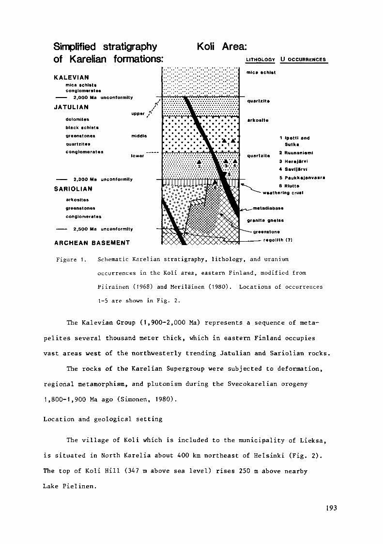
Simplified stratigraphyof Karelian formations:KALEVIAN
mica schistsconglomerates
——— 2,000 Ma unconformity
JATULIAN
Koli Area:LITHOLOGY U OCCURRENCES
dolomitesblack schists
greenstonesquartzltesconglomerates
upper
middle
lower
——— 2,300 Ma unconformity
SARIOLIANarkosltes
greenstones
conglomerates
—— 2,500 Ma unconformity
ARCHEAN BASEMENT
• •; • v • >• •< 'W »• •>"< • v •*••< ' v
1 Ipattl andSutka
2 Ruunanleml3 Herajarvi4 SavlJarvl
5 Paukkajanvaara6 Rlutta
weathering crust
metadlabase
granite gneiss
greenstone
- regollth (?)
Figure 1. Schematic Karelian stratigraphy, lithology, and uranium
occurrences in the Koli area, eastern Finland, modified from
Piirainen (1968) and Meriläinen (1980). Locations of occurrences
1-5 are shown in Fig. 2.
The Kalevian Group (1,900-2,000 Ma) represents a sequence of meta-
pelites several thousand meter thick, which in eastern Finland occupies
vast areas west of the northwesterly trending Jatulian and Sariolian rocks.The rocks of the Karelian Supergroup were subjected to deformation,
regional metamorphism, and plutonism during the Svecokarelian orogeny1,800-1,900 Ma ago (Simonen, 1980).
Location and geological setting
The village of Koli which is included to the municipality of Lieksa,
is situated in North Karelia about 400 km northeast of Helsinki (Fig. 2).The top of Koli Hill (347 m above sea level) rises 250 m above nearbyLake Pielinen.
193
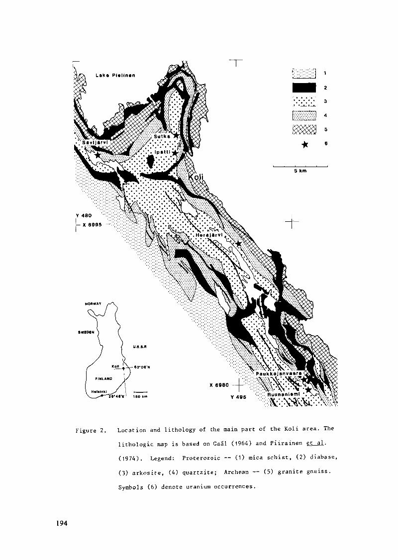
Figure 2. Location and lithology of the main part of the Koli area. The
lithologie map is based on Gaäl (1964) and Piirainen et al.
(1974). Legend: Proterozoic — (1) mica schist, (2) diabase,
(3) arkosite, (4) quartzite; Archean — (5) granite gneiss.
Symbols (6) denote uranium occurrences.
194
The geology of the Koli area has been described by Väyrynen (1933),
Aurola (1959), Piirainen (1963, 1968), Gaäl (1964), and Piirainen et al.(1974). Hietanen (1938) and Ojakangas (1965) have studied the Karelian
quartzites. The zone of Karelian quartzites extending some 120 km south-
east of Koli has been described by Pekkarinen (1979).
The rocks of the Archean basement between the quartzite ridges and
Lake Pielinen (Fig. 2) are mainly granite, granodiorite, and trondhjeraite
gneisses. Greenstones occur north of Koli (Fig. 3 A) where they are com-
posed of metavolcanics and pelitic metasediments and are called "the Ipatti
Formation" (Piirainen et al.. 1974; Rossi, 1975).
The Karelian metasediments at Koli begin with discontinuous thin
units of sericite schists and conglomerates that show high contents of Al-
minerals (Aurola, 1959) and can be interpreted to represent the Prejatulian
weathering crust. These are followed by a thick (more than 1,000 m)
sequence of Jatulian rudites and arenites, which generally dip 30-45 to
the west and southwest. Piirainen (1968) divided the Jatulian arenites at
Koli into three members: orthoquartzite I, arkose quartzite, and ortho-
quartzite II. This division should be revised with respect to ortho-
quartzite II (Piirainen, pers. comm., 1984). In this study the arenites
are referred as the lower Quartzite Member and the middle Arkosite Member
of the Jatulian Group (Fig. 1). Tholeitic and spilitic sills and dykes
occur within the sedimentary sequence and the basement. To the west, the
overlying Kalevian pelites and graywackes form a wide synclinal basin with
flat topography. Basal Kalevian conglomerates in the Koli area and further
to the southeast show the Kalevian Group to be unconformable against the
Jatulian; to the northwest, Kalevian conglomerates rest directly on the
Archean basement. In the Koli area, however, the margin between the
Kalevian and Jatulian Groups is mostly tectonic as a result of thrust
faulting.
195

n 199contour« 1-10-25-50%mean 275* / 69'
10.11
X 7001, KW.....
VI.89300
^ 5
/ 6
1 km
OPA 83 15
X 7000 900Yl.891.50
OPA 83 3
en»10O m
fn 92
vector mean 360*
D
n 45vector mean 2*
Figure 3. A. Geology of the Ipatti area at Koli, after Pixrainen et al .
(197A) and Rossi (1975). Legend: Proterozoic — (l) diabase,
(2) arkosite, (3) quartzite; Archean — (4) granite gneiss and
greenstone (darker shading), (5) fault, (6) uranium occurrence.
B. Geology of the Ipatti deposit. Legend: Lower Jatulian —
(1) quartzite; Middle Jatulian — (2) arkosite and subarkosite,
(3) sericite quartzite, (A) mudstone, (5) uraniferous horizon,
solid where exposed. (6) fault, teeth to the downthrown side;
(7) diamond drill holes.
C. Equal area projection (lower hemisphere) of plane beds
measured at Ipatti.
D. and E. Original dip directions for foresets of planar (D)
and trough (E) cross-bedding measured at Ipatti.
196

Cross-bedding data from quartzites at Koli and Paukkajanvaara suggest317 as the dominant direction of transport for the lower Jatulian sedimen-tation (Ojakangas, 1965). With reference to the study of Pasek (1971),
Piirainen et al. (1974) concluded that the provenance areas for the Jatulian
sediments in the Koli area were in the east, northeast, and even in the
northwest.
The Koli area belongs to one of the major depressions along thenorthwesterly trending zone of Karelian metasediments in eastern Finland.
High angle faults that strike subparallel to the bedding of the areniteshave increased the apparent thickness of the sedimentary series and pro-
vided zones of weakness for emplacement of the diabase dykes (Vaasjoki,
1966; Piirainen et al.. 1974). The degree of deformation increases mark-edly to the west where polyphase folding is dominant in the Kalevian
rocks (Koistinen, 1981).
Uranium and thorium in the Koli area
Piirainen (1963, 1968) provided the basic data on occurrence ofuranium in the Koli area; later reviews (Sarikkola, 1974; Piirainen, 1979)
together with brief descriptions by the lUREP-mission (OECD, 1981) summar-
ize the present knowledge.On the regional scale uranium is strata-bound: the host unit is a
horizon of reddish quartzite in the lower Jatulian Quartzite Member (Fig.
1). This 20-30 m thick horizon can be followed from Ruunaniemi in the
southeast for 40 km to the northwest past Savijärvi (Fig. 2). Discontinuous
thin interbeds of quartz-pebble conglomerate occur in this horizon.
Hematite pigmentation in the quartzite causes the red colour, which is seenas irregular spots on the exposed surfaces. At Ruunaniemi and Paukkajan-
vaara the marker horizon lies 50-100 m above the basement; as the arenites
thicken northwards the distance from the basement increases to 300-350 m
197
at Herajärvi and to 400, even 600 m (Pasek, 1971), between Koli and Savi-
järvi. The quartzite below the marker horizon often shows cross-bedding,
whereas the overlying beds are horizontal with prominent ripple marks
locally.
The deposits at Herajärvi and Ruunaniemi represent the stratiform
mode of occurrence of uranium in the Quartzite Member; modifications are
provided at Savijärvi by thorium minerals, at Paukkajanvaara where the
mined-out orebody was transverse to the marker horizon, and at Ipatti and
Sutka where uranium was found in the overlying Arkosite Member (Figs. 1
and 2). The Riutta occurrence represents the unconformity type of miner-
alization in Archean rocks scavenged by the Prejatulian weathering.
Herajärvi. Atomienergia Oy located about 2,000 boulders of uranium
ore (0.05-10 % U) in glacial drift between Lakes Herajärvi and Pielinen.
Several exposures of similar rocks were subsequently reported for 7 km
along the upper part of the Quartzite Member at Herajärvi, where the
Member is about 400 m thick and dips 25-45 SW. The mineralized horizon
was found to contain separate uraniferous lenses with their long axes
parallel to the strike of the bedding. Thin interbeds of quartz-pebble
conglomerate are typical of the mineralized horizon. "Martti" and "Herman",
the two largest bodies found, are each about 100 m long; "Martti" was
estimated to contain 20,000 tons of uraniferous rock averaging 0.1 % U.
The ore-grade rock occurs as plates parallel to the bedding in the
middle of the uraniferous lenses. The mineralized rock changes gradually
to barren quartzite; the colour of the rock grades from red brown to reddish
and to white, the hematite pigmentation extending beyond the uranium miner-
alization. Although fully recrystallized, the quartzite displays clastic
texture with rounded, medium- to coarse-grained quartz clasts and a sparse
matrix of fine-grained sericite and quartz. Hematite pseudomorphs aftermagnetite occur in the matrix and as inclusions in the quartz clasts. In
the ore the clasts are surrounded by a mass of goethite and pitchblende.
198
Zircon is the most common accessory mineral, sulphides are rare. Secondary
uranium minerals occur as fracture fillings.
Ruunaniemi. A ground scintillation survey by Atomienergia Oy re-
vealed some 1,000 boulders of uranium ore, which originate from separate
uraniferous bodies in the Quartzite Member under and near Lake Ylä-Paukka-
janjärvi. The largest of these bodies crops out at Ruunaniemi (Fig. 2) on
the SW shore of the lake. Diamond drillings by Outokumpu Oy verified
112,000 tons of ore with a mean uranium content of 0.14 %.
Uranium occurs as stratiform lenses 50-80 m above the basement within
the same hematitic and conglomeratic horizon as at Herajärvi; the bedding
dips 20-25 SW. Pitchblende is the main ore mineral; but compared to Hera-
järvi, the amount of secondary minerals, mainly uranophane, is greater.
Vanadium contents up to 0.6 % have been reported in the ore specimens;
vanadium is included in mica (roscoelite) and in magnetite (Piirainen, 1968)
Paukkajanvaara. The Mirtensson orebody at Paukkajanvaara was the
target of test mining and milling by Atomienergia Oy in 1958-61: surface
and underground operations produced 31,000 tons of ore grading 0.122 % U
(Räisänen, 1961). The orebody, which was 1-5 m wide, 10-25 m high, and125 m long, followed the hanging-wall contact of a subvertical diabase dyke
that in E-W direction cuts the gently dipping Quartzite Member (Tyni, 1962).The best ore was at the intersection of the dyke and basal quartz-pebble
conglomerate, which at Paukkajanvaara is exceptionally thick, averaging15 m. The pebbles in the conglomerate are also large, up to 10 cm indiameter. Sericite and quartz, and in the upper parts, biotite, chlorite,
and magnetite form the matrix. Below the orebody, the mineralized zonecontinues along the contact of the dyke down through the Prejatulian
sericite-quartz schist (weathering crust) into the basement gneiss. In thesame horizon as at Herajärvi and Ruunaniemi, additional uranium showingsoccur, some 100 m above the basement.
199
The ore consisted of massive uranophane at the contact and in the
fractures of the adjacent conglomerate and quartzite beds. Remnants ofpitchblende were reported in the thickest parts of the ore; gummite, meta-
torbernite, autunite, and thucolite have also been reported (Tyni, 1962;Piirainen, 1968). A reddish brown zone, 3-5 cm wide in the quartzite and
conglomerate next to the dyke, displays hematitization along the contact.
Savijärvi. Outokumpu Oy traced the mineralized horizon of the
Quartzite Member from Koli to the N and NW. In the showings discovered,
the portion of quartz-pebble conglomerate was found to increase to the NWwith decreasing uranium content; thorium was found to explain the observedradioactivity. The thorium contents are generally less than 200 ppm.At Savijärvi (Fig. 2) where the quartzite dips 30 S the mineralizedconglomerate beds vary in thickness but are never more than 30 cm thick.The pebbles, which are mostly quartz, rarely exceed 3 cm in diameter.
Brockite, zircon and rutile with goethite and hematite reportedly occur
in the matrix (Piirainen, 1979).Riutta. Hundreds of boulders of high-grade uranium ore were found by
Atomienergia Oy at Riutta in Eno, about 30 km SE of Koli. Boulder tracing
led to uraniferous bedrock exposures that now are interpreted to represent
the Prejatulian weathering crust derived mainly from the Archean basement
and partly from Sariolian sediments. The occurrence is considered to be
a good example of the unconformity-type uranium deposits (OECD, 1981);
pyrite in the host rocks possibly acted as the reductant for uranium.
Pitchblende veins and impregnations occur in sericite-quartz schist,epidote-chlorite schist, magnetitic iron ore (BIF), quartzite, and diabase.
The Th contents of the mineralized rocks are low, but anomalous contents
of Cu, Mo, Co, and Au are common.
Ipatti and Sutka. Systematic ground scintillation survey by Outo-
kumpu Oy in 1969 revealed magnetite-bearing uranium ore boulders on the
slopes of Ipatti and Sutka hills at Koli (Fig. 3 A). The boulders were
200
traced back to their bedrock exposures, which turned out to belong to the
Arkosite Member. Ground geophysics, trenching, percussion drilling, and
diamond drilling proved that the uraniferous rock at Ipatti forms a
down-dip curved body conformable with the host arenites. The showing at
Sutka was found to have no significant dimensions. The Ipatti deposit was
evaluated to contain 71,000 tons of mineralized rock averaging 0.083 % U.
Ipatti uranium deposit
Materials and methods
The materials for the study were collected in 1969 during evaluation
of the Ipatti deposit by Outokumpu Oy and in 1983 during field work by the
Geological Survey. The Ipatti metasediments crop out in an area of 450 by
500 m (Fig. 3 B) ; about 100 outcrops were uncovered for mapping and sampling.
The exposures and the diamond drill cores provide an almost continuous
section across the deposit, totalling 120 m upwards (west) and 150 m down-
wards (east) from the uraniferous horizon.
Diamond drill cores 1-5, 8-11, and 13 (Figs. 3 and 6) were reinvestigated.An isopach map of the orebody was compiled on the basis of both the drilling
and surface data; corrections for the plunge of possible large-scale folding
were omitted in this projection. Observations on directional sedimentarystructures measured in outcrops were rotated to a horizontal position withstereographic projection (Schmidt net).
During the field work the total gamma radiation was measured using
Scintrex BGS-3 scintillation counters. Samples for pétrographie and minér-
alogie studies were collected from bedrock exposures, ore boulders, and
drill cores. Alpharadiography with Kodak CA-80 cellulose nitrate film
(Basham and Easterbrook, 1977) was used to study the distribution of radio-
active minerals in rock slabs and polished thin sections. Selected ore
minerals were scanned and analyzed at the Geological Survey using a Jeol
Superprobe 733 equipped with energy-dispersive instrumentation (EDS).
201
Assays of the drill cores are based on radiometric determinations by
the laboratory of the Exploration Department at Outokumpu Oy. Using port-
able percussion drills, lithogeocheraical samples were taken across theIpatti deposit at sample intervals of 3-30 cm. The sampling was extended
across the Quartzite Member east of the deposit, and a series of samples
was taken across the exposure of "Herman's orebody" at Herajärvi.
Altogether 580 samples were collected and analyzed for gold according to
the procedure used in Härkönen (1984); 180 samples from radioactive beds
and lithological type sections were analyzed for U, Th, Fe, Au, and a
number of other elements, using instrumental epithermal neutron activation
analysis (INAA) at the Reactor Laboratory, Technical Research Centre of
Finland (Rosenberg et al., 1982). The limits of detection (in ppm) given
for the INAA analyses are, e.g., 250 for Na, 40 for Cr, 2,500 for Fe, 1.5
for Mo, 1.5 for La, 0.003 for Au, 0.4 for Th, and 0.3 for U. Except for
U, Th, and (partly) Fe, a great part of the results obtained did not
exceed the limits of detection, and, therefore no detailed geochemical
examination was made.
Rock descriptions
The metasedimentary sequence at Ipatti includes arkosites, sub-
arkosites, quartzites, and sericite schists, originally arkoses, subarkoses,sandstones, and mudstones in the basal parts of the middle Jatulian Arkosite
Member. Conglomerates occur as pockets and thin interbeds. In places,
fine-grained material indicating clayey matrix is so abundant in the
arenites that they could be called wackes. Clastic texture is well pre-
served in the rocks.
The thickness of the Jatulian at Koli may reach 1,000 m; 600 m of
this is the Arkosite Member (Pasek, 1971; Rossi, 1975). At Ipatti its
base against the Quartzite Member is not exposed but can be inferred (Fig.
3 B) from scattered outcrops and from the distribution of quartzite
202
boulders in the glacial drift. Pasek (1971) described the lower contact
as gradational with possible minor erosion.
In the following discussion the Ipatti succession is divided into
the footwall rocks in the east, the uraniferous horizon, and the hanging
wall rocks in the west; stratigraphically, the footwall and hanging wall
represent the sediments deposited under and over the uraniferous horizon,
respectively.
Arkosite and subarkosite. The most common arenites at Ipatti are
arkosic to subarkosic in composition, ranging in grain size from medium
sand to gravel. Their colour is light to greenish yellow depending on the
sericite content. The rocks are poorly sorted and characteristically
pebbly, the pebbles being composed of subrounded to rounded quartz, sub-
angular feldspar, and minor rock fragments of granitic (aplitic) composi-
tion. Pebbles of tourmaline-quartz rock and fine-grained quartzite have
also been observed. Intraformational mud clasts are common in the
coarsest beds. The feldspar is predominantly microcline varying from less
than 10 % to about 30 % of the rock. Unaltered feldspar clasts may occur
together with strongly sericitized and even partly disintegrated clasts androck fragments.
An abundant matrix of fine-grained sericite and quartz fills the
interstices. In the upper part of the hanging wall series, calcite cement
constitutes nearly half of the interstitial material. Quartz may also occur
as partial cement. Zircon and apatite represent the detrital heavy minerals,
both displaying zoned overgrowths. Tourmaline is common in the matrix but
appears to be authigenic, possibly metamorphic in origin. In arkosic grit-
stones near the top of the footwall series, carbonate was observed to
replace quartz and microcline in the matrix; in addition, growth of epidote
porphyroblasts has occurred in mud clasts and in interstitial sericite.
Sericite quartzite. Interbeds of quartzite among the footwall
arkosites manifest the gradual change from the Quartzite Member to the
203
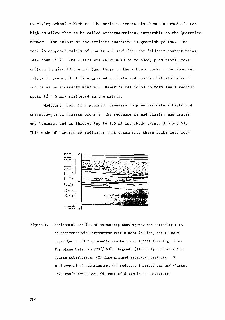
overlying Arkosite Member. The sericite content in these interbeds is too
high to allow them to be called orthoquartzites, comparable to the Quartzite
Member. The colour of the sericite quartzite is greenish yellow. The
rock is composed mainly of quartz and sericite, the feldspar content being
less than 10 %. The clasts are subrounded to rounded, prominently more
uniform in size (0.5-4 mm) than those in the arkosic rocks. The abundant
matrix is composed of fine-grained sericite and quartz. Detrital zircon
occurs as an accessory mineral. Hematite was found to form small reddish
spots (^ < 5 mm) scattered in the matrix.
Mudstone. Very fine-grained, greenish to grey sericite schists and
sericite-quartz schists occur in the sequence as mud clasts, mud drapes
and laminae, and as thicker (up to 1.5 m) interbeds (Figs. 3 B and 4).
This mode of occurrence indicates that originally these rocks were mud-
IPATTI Woutcrop
OP&-83-3
i'.'.-" 5
X 7DOO 805Y 489 300 E
Figure 4. Horizontal section of an outcrop showing upward-coarsening sets
of sediments with transverse weak mineralization, about 100 m
above (west of) the uraniferous horizon, Ipatti (see Fig. 3 B).
The plane beds dip 270 / 63 . Legend: (1) pebbly and sericitic,
coarse subarkosite, (2) fine-grained sericite quartzite, (3)medium-grained subarkosite, (4) mudstone interbed and mud clasts,
(5) uraniferous zone, (6) zone of disseminated magnetite.
204
stones and siltstones. They are commonly in transition to and alternation
with fine-grained sericite quartzites. In addition to clay- and silt-sized
sericite and quartz, the rocks may contain apatite and, rarely, zircon.The thicker mudstone beds bear numerous quartz veins and display shearing
between the more competent arenitic beds; hence, they often have a mylonitic
appearance. The quartz veins occur as discontinuous lenticular bodies sub-
parallel to and strictly within the mudstone beds. In places, vein quartz
may constitute half of the mudstone bed.
Conglomerate and grit. Quartz-pebble conglomerate occurs at Ipatti
as rare interbeds and lenses less than 20 cm thick. The rock is small-
pebbled and matrix-supported; the pebbles consist of both unit and poly-
crystalline quartz, with minor quartzite, tourmaline-quartz rock, and rare
feldspar. The matrix is composed of fine- to medium-grained sericite and
quartz. The most common conglomerates, however, are beds one to two clasts
thick on top of pebbly arkosic sets, displaying armoured surfaces as a
result of winnowing. The pebbles are variably quartz and feldspar, re-
flecting the composition of the pebbles in the washed arkose. On the bottom
of sets displaying trough cross-bedding on a larger scale, random deposits
of channel lag contain locally derived mud clasts and flakes. Discounting
the mud clasts, the pebbles at Ipatti are usually 0.5-3 cm in diameter;
those of 3-5 cm are rare, and no pebbles exceeding 5 cm have been observed.
At the top of the unit of sericite quartzite that terminates the
footwall series (Figs. 3 B and 6), lenses of coarse-grained or gritty,
light to dark grey quartzite form a continuous horizon hosting the uranium
minerals. The rock is composed of medium- to coarse-grained quartz clasts,
a few grains of feldspar and aplite, and local disseminations of fine- to
medium-grained magnetite (Fig. 5). Quartz and, rarely, magnetite - quartz
rock occur as scattered pebbles. The interstices are partly filled by
sericite and quartz, partly cemented by uranium minerals or carbonate.
205
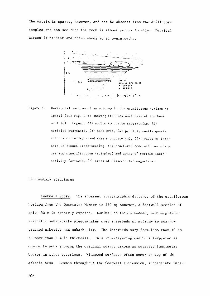
The matrix is sparse, however, and can be absent: from the drill coresamples one can see that the rock is almost porous locally. Detritalzircon is present and often shows zoned overgrowths.
IPATTIoutcrop OPA-83-15X 7000.985V 488.420
Figure 5. Horizontal section of an outcrop in the uraniferous horizon at
Ipatti (see Fig. 3 B) showing the erosional base of the host
unit (c). Legend: (!) medium to coarse subarkosite, (2)
sericite quartzite, (3) host grit, (4) pebbles, mostly quartz
with minor feldspar and rare magnetite (m), (5) traces of fore-
sets of trough cross-bedding, (6) fractured zone with secondary
uranium mineralization (stippled) and zones of maximum radio-
activity (arrows), (7) areas of disseminated magnetite.
Sedimentary structures
Footwall rocks. The apparent stratigraphie distance of the uraniferous
horizon from the Quartzite Member is 250 m; however, a footwall section ofonly 150 m is properly exposed. Laminar to thinly bedded, medium-grained
sericitic subarkosite predominates over interbeds of medium- to coarse-
grained arkosite and subarkosite. The interbeds vary from less than 10 cm
to more than 2 m in thickness. This interlayering can be interpreted ascomposite sets showing the original coarse arkose as separate lenticular
bodies in silty subarkose. Winnowed surfaces often occur on top of the
arkosic beds. Common throughout the footwall succession, subordinate inter-
206
beds of sericite quartzite display planar cross-bedding. In associated
fine-grained laminae ripple marks have been developed, ranging from small
current ripples to reworked megaripples.
Some 50 m below the uraniferous horizon, mudstone interbeds appear
and the arkosic beds become coarser, containing frequent mud clasts. About
20 m below the top, arkosic grit forms cosets 1-1.5 m thick, which show
large-scale trough cross-bedding.
Several outcrops represent sequences that coarsen upwards, starting
with simple sets of laminar sericite quartzite overlaid by composite sets
of sericite quartzite and arkosite and ending with massive or thickly bedded
subarkosite or arkosite. The thickness of these sequences varies from less
than 2 ra to about 10 m. A laterally extensive unit of sericite quartzite
terminates the footwall series. This unit is composed of sets 0.5-1.5 mthick totalling 5-20 m in thickness. Bedding is predominantly even andparallel, mostly laminar; the horizontally bedded sets are separated by
subunits with planar cross-bedding or by quartz-pebble seams that have
resulted from winnowing. Symmetrical ripple marks are common in the basal
part of the unit where an interbed of mudstone 0.5-1 m in thickness also
occurs.
Uraniferous horizon. In the upper part of the sericite quartzite
unit that terminates the footwall series, 0.5 m thick lenses of arkosic to
quartzitic conglomerates appear, showing prominent trough cross-bedding
with scoured bases and winnowed tops. These interbeds develop upwards to
a more uniform 0.5-1.5 m thick horizon of quartzose grit, which hosts
uranium minerals. In its upper parts the host unit is usually cross-bedded,
and its base is erosional (Fig. 5). The orebody depicted in Fig. 6 includes
this horizon and a number of adjacent smaller lenses of conglomerate and
grit.
207
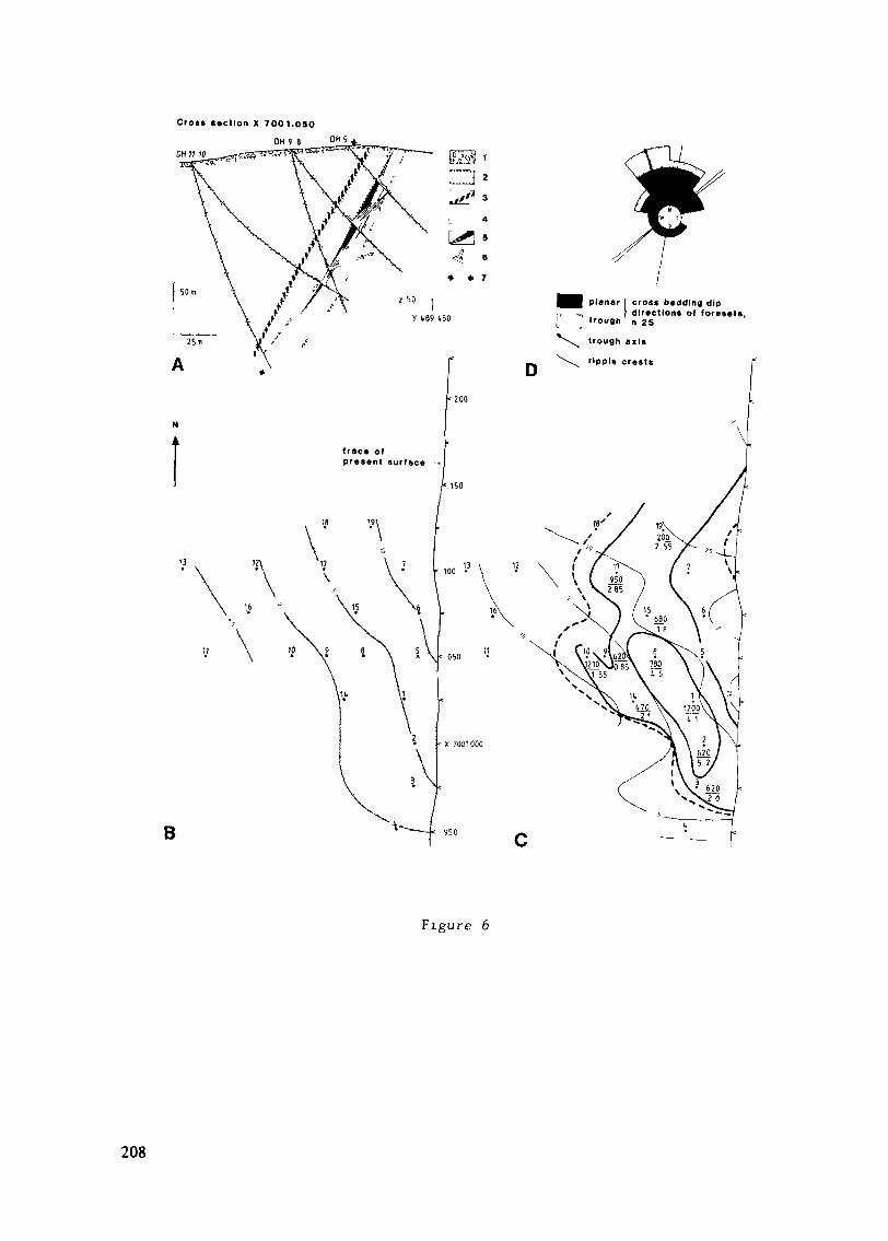
Crost »action X 7001.050
DH9 6DU 11 10
B
planar ] croas bedding dipdirections of foresets
Irouflh' n 25
Figure 6
208
Figure 6. A. Simplified cross section of the Ipatti deposit based on
diamond drillings by Outokumpu Oy. Legend: (1) drift, (2)
arkosite and subarkosite, (3) mudstone, (4) sericite quartzite,
(5) uranium ore, (6) total gamma log, (7)trace of the average
plane-bedding used for projection in B and C.
B. Upper surface of the mudstone interbed in A as projected on
the plane of the average plane-bedding: the contours give the
relative slope in meters. Numbers 1-19 denote the projected
intersections of the drill holes.
C. Projection and apparent slope (as in B) of the orebody and
the top of the sericite quartzite unit. The dashed line limits
the uranium mineralization; the solid heavy lines represent the
thickness of the orebody (contours 1 and 3 m). The 1-m contour
also limits the distribution of magnetite. The drill core
assays are given under the respective hole numbers asU (ppm)
core length (m)
D. Original directions of sedimentary structures measured in
outcrops of the uraniferous horizon and sericite quartzite unit
depicted in Fig. 3 B.
Hanging wall rocks. Upwards from the uraniferous horizon there is aprominent increase in the numbers of mudstone interbeds, cosets of sub-
arkosite showing trough cross-bedding, and arkosic sets with winnowed
surfaces. Accordingly, beds of original sand and gravel alternating with
those of mud are frequent. Current ripples and small-scale climbing ripples
with mud drapes are associated with the mudstone interbeds that are most
extensive laterally. In the arkosic sets, scour and fill structures arecommon. A typical succession in the upper part shows upward-coarseningsets ranging from mudstone to coarse-grained pebbly subarkose (Fig. 4).
209
Paleocurrents and the geometry of the orebody. A paleocurrent study
of cross-beds (Figs. 3 and 6) indicates northerly transport for the material
of the Ipatti arenites. The erosional lower surface of the host grit unitindicates that at least 20 m of section were eroded by the channels that
are now filled with grit. The drill core data projected on to the plane
of average horizontal bedding suggest a northeasterly apparent paleoslope
for the marker horizons in the drill core sections (Fig. 6). The isopach
map and the shape of the orebody on this slope agree well with the measured
directions of the sediment transportation, indicating that the host unit
represents a primary channel fill or superimposed channel fills where
transportation of the material occurred from (the present) south to the
north and northwest.
The orebody can be drawn as a boomerang-shaped arc, generally 1-3 m
thick, with its greatest dimensions being 6 x 50 x 300 m; in detail, however,
it is composed of two or more separate and overlapping radioactive beds
(Fig. 5; gamma logs in Fig. 6 A). The basal beds are most uniform laterally
and contain most of the magnetite disseminations.
Tectonics
Differing from the trend of bedding in the main part of the Koli area,
the Jatulian arenites between Koli and Savijärvi have been folded to a
syncline opening to the SW (Fig. 2; see also Fig. 8 in Koistinen, 1981,p. 130). As the limbs of the syncline steepen towards the hinge, they
display vertical bedding. However, faulting is the principal mode of
deformation in the Koli area (Piirainen et al.. 1974). The Ipatti depositis situated on the eastern limb of the syncline where the arenites start
diverging from the SW-dipping trend; this is shown by the moderate dip ofthe average plane-bedding at Ipatti, 275 / 69 (Fig. 3 C). The uniformityof the observations indicates that there is no marked folding with vertical
or subvertical axis. Transverse schistosity, probably related to the NNE
210

trending zone of S. schistosity west of Ipatti (Koistinen, 1981, p. 130)
and following the apparent axial plane of the syncline, was observed in afew outcrops of arkosites rich in sericite. Tectonic repetition by high-
angle faulting present at Ipatti probably increased the apparent thicknessof the sediments; hence, the thicknesses (up to 1,000 m) given in Pasek
(1971) for several traverses across the Jatulian succession may be over-
estimated.
Ore mineralogy
Uranium minerals. Alpharadiographs show that the radioactive minerals
in the Ipatti ore are limited to the matrix and, to a lesser extent, to thefractures penetrating the host rock. The principal uranium mineral is pitch-blende: "type 1" pitchblende occurs with sericite in the matrix, displaying
finely disseminated grains (Figs. 7 C,D). Submicroscopic zoned particles
of this type were found to occur as inclusions in clay-like material con-
sisting of a silicate of Al, K, Ca, and Fe (Fig. 8). Botryoidal, colloform"type 2" pitchblende, either fills interstices of the rock and shows rhythmic
deposition (Fig. 7 A) or replaces the matrix, often as coatings on the
quartz clasts (Fig. 7 B). The "type 2" pitchblende contains about 1 % Th
(Table 1). According to ED spectra the compositions of both types of pitch-
blende are reasonably similar.Secondary uranium minerals occur mostly in fractures as yellow to
brownish masses. In the matrix, however, secondary minerals may encloseand intrude aggregates composed variably of carbonate, chlorite, andepidote. The most common of the secondary phases is a yellow U, Casilicate (uranophane? ; Table 1).
Magnetite. The uranium ore boulders and the drill core samples show
that pitchblende occurs mainly in beds containing magnetite. Grains of
magnetite up to 3 mm in diameter may form medium to heavy disseminations
211
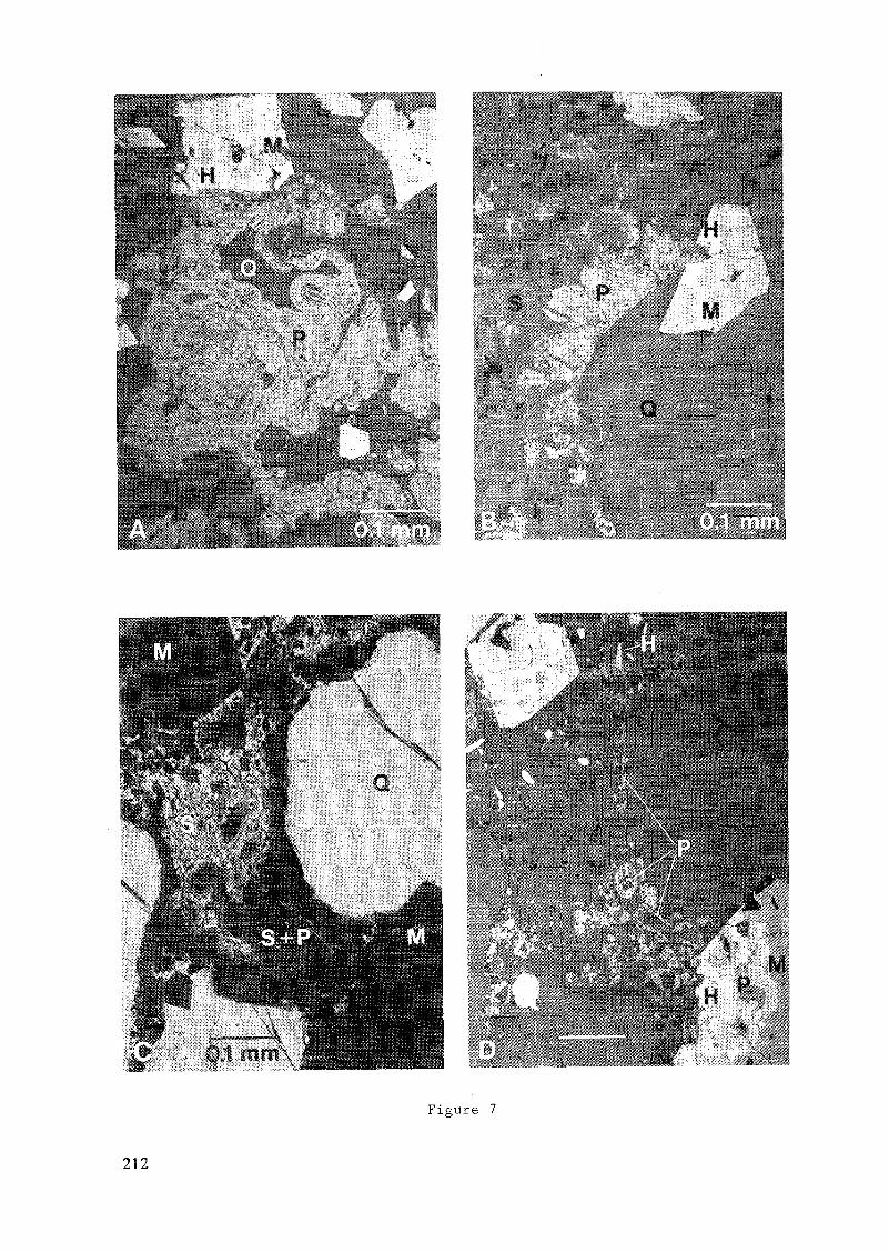
Figure 7
212
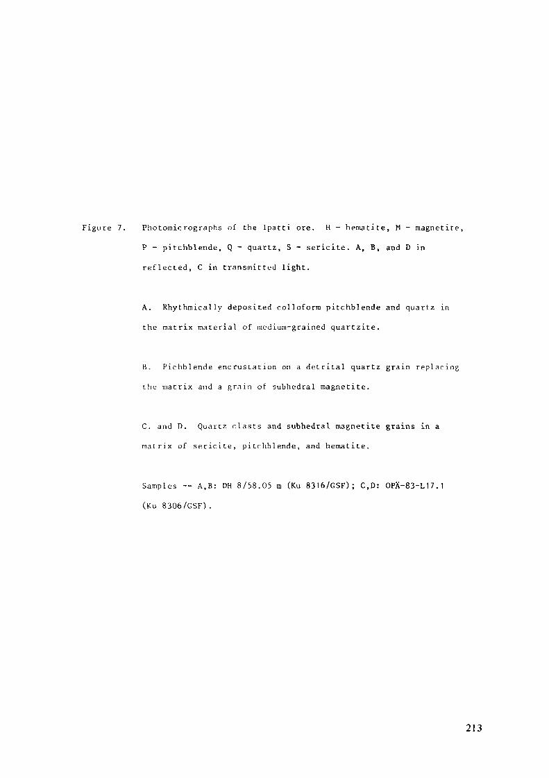
Figure 7. Photomicrographs of the Ipatti ore. H - hematite, M - magnetite,
P - pitchblende, Q - quartz, S - sericite. A, B, and D in
reflected, C in transmitted light.
A. Rhythmically deposited colloform pitchblende and quartz in
the matrix material of medium-grained quartzite.
B. Pichblende encrustation on a detrital quartz grain replacing
the matrix and a grain of subhedral magnetite.
C. and D. Quartz clasts and subhedral magnetite grains in a
malrix of sericite, pitchblende, and hematite.
Samples — A,B: DH 8/58.05 m (Ku 8316/GSF); C,D: OPÄ-83-L17.1
(Ku 8306/GSF) .
213
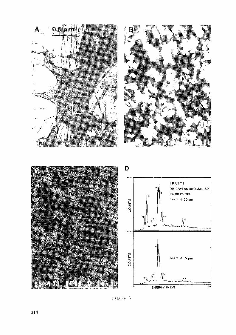
D
W
Ou
cozoo
l P A T T l
DH 2/24 85 m/OKME-69
Ku 8312/GSF
beam 0 50 pm
beam 0 5 prn
ENERGY (KEV)
Tigure 8
214
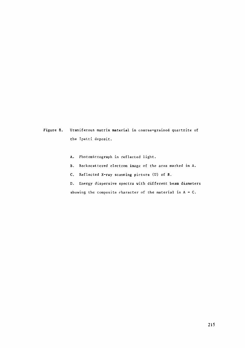
Figure 8. Uraniferous matrix material in coarse-grained quartzite of
the Ipatti deposit.
A. Photomicrograph in reflected light.
B. Backscattered electron image of the area marked in A.
C. Reflected X-ray scanning picture (U) of B.D. Energy dispersive spectra with different beam diameters
showing the composite character of the material in A - C.
215
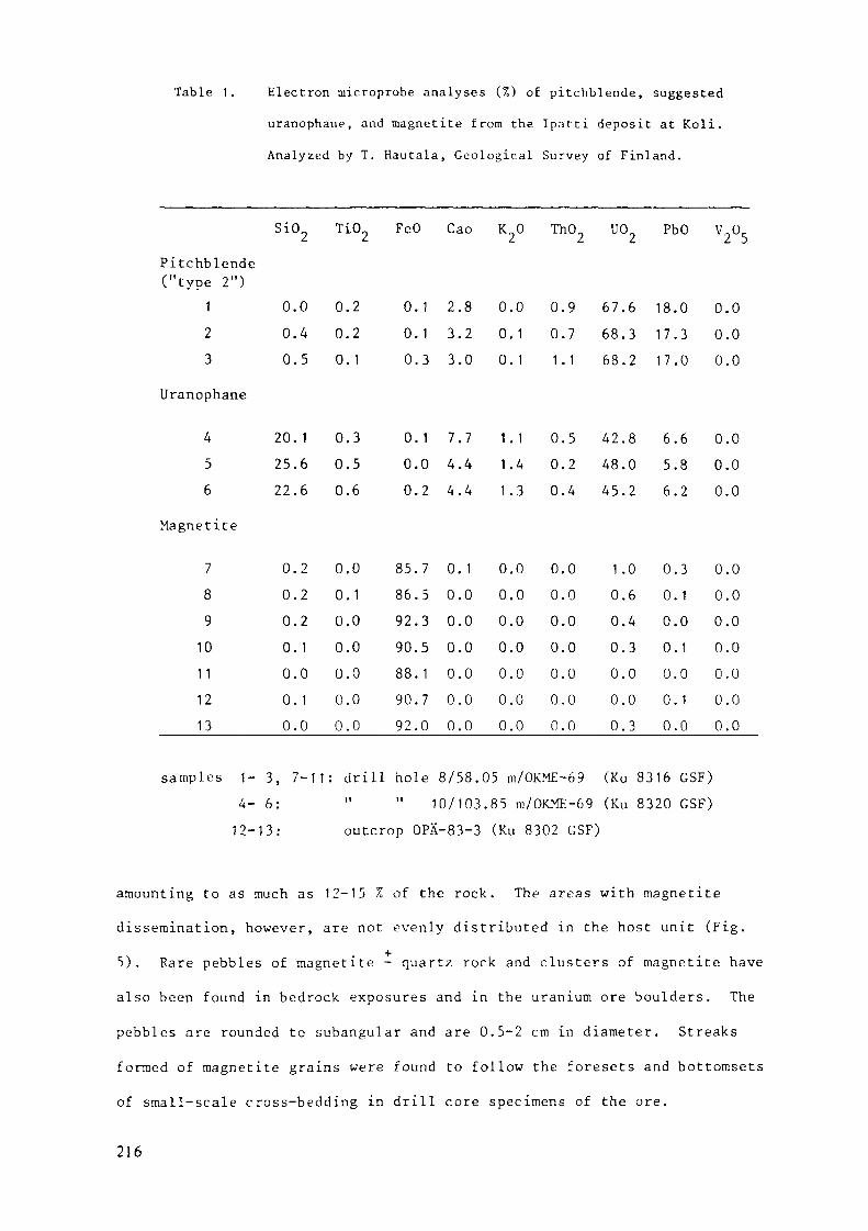
Table 1. Electron microprobe analyses (%) of pitchblende, suggested
uranophane, and magnetite from the Ipatti deposit at Koli.
Analyzed by T. Hautala, Geological Survey of Finland.
SiO„ TiO„ FeO
Pitchblende("type 2")
123
Uranophane
456
Magnetite
789101 11213
000
202522
0000000
.0
.4
.5
. 1
.6
.6
.2
.2
.2
. 1
.0
. 1
.0
0.20.20.1
0.30.50.6
0.00.10.00.00.00.00.0
000
000
85869290889092
.1
.1
.3
. 1
.0
.2
.7
.5
.3
.5
.1
.7
.0
Cao
2.83.23.0
7.74.44.4
0. 10.00.00.00.00.00.0
K20
0.00.10.1
1.11.41.3
0.00.00.00.00.00.00.0
Th02
0.90.71.1
0.50.20.4
0.00.00.00.00.00.00.0
uo2
67.668.368.2
42.848.045.2
1.00.60.40.30.00.00.3
PbO
18.017.317.0
6.65.86.2
0.30.10.00.10.00.10.0
V2°5
0.00.00.0
0.00.00.0
0.00.00.00.00.00.00.0
samples 1- 3, 7-11: drill hole 8/58.05 m/OKME-69 (Ku 8316 GSF)4- 6: " " 10/103.85 m/OKME-69 (Ku 8320 GSF)12-13: outcrop OPÄ-83-3 (Ku 8302 GSF)
amounting to as much as 12-15 % of the rock. The areas with magnetite
dissemination, however, are not evenly distributed in the host unit (Fig.
5). Rare pebbles of magnetite - quartz rock and clusters of magnetite have
also been found in bedrock exposures and in the uranium ore boulders. The
pebbles are rounded to subangular and are 0.5-2 cm in diameter. Streaks
formed of magnetite grains were found to follow the foresets and bottomsets
of small-scale cross-bedding in drill core specimens of the ore.
216
Under the microscope disseminated magnetite appears subhedral in
form; the magnetite in the pebbles is also subhedral but has smaller grain
size. Very fine-grained, chert-like quartz occurs in the pebbles with the
magnetite. ED spectra of several magnetites from the pitchblende ore
showed their compositions to be uniform and similar to that of grains 7-11
in Table 1. The magnetites from Ipatti have especially low contents of
Ti and V. Anomalous uranium contents suggest a close genetic relationship
between magnetite and pitchblende, as indicated by Fig. 7.
Sulphides. Opaque minerals other than pitchblende and magnetite are
scarce in the Ipatti rocks; finely disseminated galena follows pitchblende,
the lead most probably being radiogenic. Fine-grained dissemination of
chalcopyrite occurs sporadically with the uranium minerals.
Alteration and replacement; metamorphism
According to pétrographie criteria, the rocks in the Koli area have
undergone regional metamorphism under conditions of amphibolite faciès(Piirainen, 1968). An extensive retrograde greenschist faciès metamorphism
obscures the amphibolite faciès mineralogy. Relic textures from the higher
grade metamorphisra are especially prominent in the Jatulian diabases.
Clastic textures are well preserved in the Ipatti meta-arenites.
Prominent recrystallization, however, is manifested by overgrowths onquartz, apatite, and zircon and by the subhedral magnetite. During meta-
morphism the original clayey matrix became sericite. Calcite was observed
to replace quartz in the matrix of the host grit and in the footwall
arkosites; chloritization and growth of incomplete epidote porphyroblastshave occurred in the fractured zones within and close to the uraniferous
horizon, probably as a result of metasomatism in a late stage. Secondary
uranium mineralization is closely related to these zones. Scattered
aggregates of carbonate + chlorite + epidote, encrusted and penetrated
by secondary uranium minerals have the appearance of rounded, disintegrated
clastic grains.217
Quartz veins in the mudstone interbeds reveal the most conspicuous
metasomatic reactions at Ipatti. At their contacts the veins commonly dis-
play a reaction zone where the wall rock has been altered to massive sericite
rock; these zones may be 5 cm wide. The quartz veins may be compared to
those that bear kyanite in the lowermost Jatulian and in the Sariolian:
Aurola (1959) proposed that these quartz veins could be associated with the
radioactive mineralizations in the Koli area. On the other hand, the veins
resemble those that occur in Kalevian mica schists west of Koli and which
are said to be sweated out from their host rocks (Koistinen, 1981).
The subhedral magnetite replaces both the matrix and the quartz clasts
(Fig. 7). The relationship of pitchblende and magnetite is variable: "type
1" pitchblende may occur as inclusions in magnetite (Fig. 7 D), whereas
"type 2" pitchblende regularly follows the margins of the magnetites or isintruded into the magnetites along fractures (Fig. 7 A,B). In both cases,
zones of hematite occur between pitchblende and the unaltered magnetite.In addition, finely disseminated, lath-shaped hematite was observed in thematrix (Fig. 7 D). Compared with the prominent martitization in the uranium
occurrences of the Quartzite Member (Piirainen, 1968), alteration of
magnetite to hematite at Ipatti is negligible.
To the west of the uraniferous horizon, a bed of sericite quartzite
was found to show radioactivity associated with magnetite dissemination
(Fig. 4). When studied in detail, this weak mineralization turned out to
be diagonal to the bedding. The rocks contain 30 ppm U; Th is not present,
and no uranium minerals could be found. These rocks, however, contain
abundant zircon and tourmaline. Under the microscope, magnetite shows
euhedral porphyroblasts accompanied by quartz and calcite, which have grown
in the pressure shadows of magnetites. Replacement of magnetite by chlorite
and by an unidentified brown iron silicate is prominent, together with
carbonatization and chloritization of the rock. To a lesser extent, similar
alteration of magnetite was found in the uraniferous horizon, especially
in the fractured zones.218
Lithogeochemistry
Uranium and thorium. The mean uranium contents of the drill core
intersections of the Ipatti orebody varied from 0.02 to 0.121 % U (Fig. 6 C).
The best single core length assayed (0.75 m, DH 17) contained 0.242 % U.
The superposition of beds containing pitchblende together with the halo of
secondary mineralization have produced elevated background contents of
uranium in the intervening beds of sericite quartzite and subarkosite.
In 35 surface samples from the ore and the host rocks at Ipatti, uranium
was found to range from 2 to 1,220 ppm and thorium from 1 to 18 ppm (INAA).
In their mean uranium contents, typical host rocks (units a-d in Fig. 5;
Table 2) show an enrichment of 10-50 times compared to the wall rocks.
Of the wall rocks, mudstones show slightly elevated average contents of
uranium, high enough to allow them to be followed with scintillation coun-
ters where the overburden is thin.
The reference samples from the Quartzite Member at Herajärvi display
uranium enrichment similar to the host rocks at Ipatti (Table 2), but their
thorium contents are lower. Samples from radioactive beds found
in the upper part of the Quartzite Member at Koli showed Th contents up to
147 ppm, averaging 3 ppm U and 37 ppm Th (Table 2). With their sporadic
occurrence of quartz-pebble conglomerate, these beds are comparable to
the Th showings at Savijärvi.
Iron. Enrichment of iron is evident in the host rocks at Ipatti
(Table 2). In relation to the high amount of magnetite in the pitchblende
ore proper, however, the iron contents obtained for the host rocks are low.
This may be explained by the uneven distribution of areas with magnetite
dissemination within the host (Fig. 5). The characteristic hematite pig-
mentation in the uraniferous horizon of the Quartzite Member does not
necessarily show up as increased contents in the host rocks at Herajärvi
(Table 2). In this horizon, high contents of iron (1-23 % Fe) have been
reported only in association with high contents of uranium (0.5-6.6 % U;
Piirainen, 1968).219
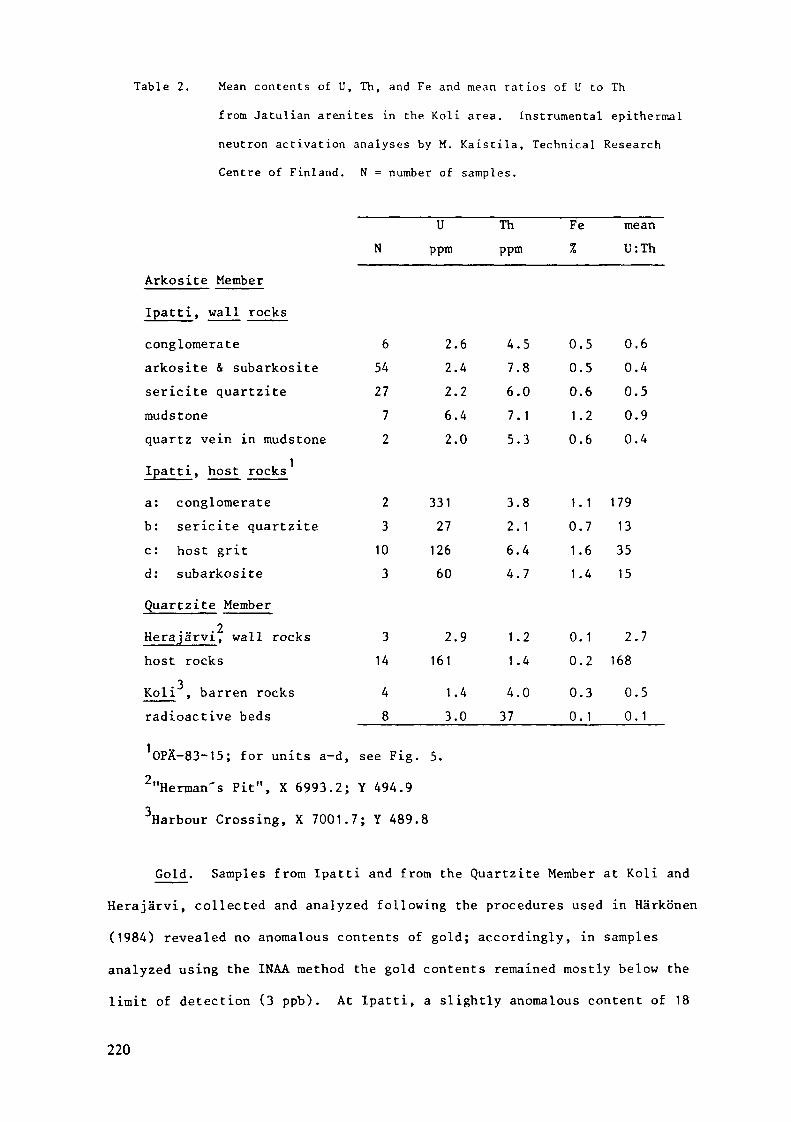
Table 2. Mean contents of U, Th, and Fe and mean ratios of U to Th
from Jatulian arenites in the Koli area. Instrumental epithermal
neutron activation analyses by M. Kaistila, Technical Research
Centre of Finland. N = number of samples.
U Th Fe meanN ppm ppm % U:Th
Arkosite Member
Ipatti, wall rocksconglomerate 6 2.6 4.5 0.5 0.6arkosite & subarkosite 54 2.4 7.8 0.5 0.4sericite quartzite 27 2.2 6.0 0.6 0.5mudstone 7 6.4 7.1 1.2 0.9quartz vein in mudstone 2 2.0 5.3 0.6 0.4Ipatti, host rocksa: conglomerate 2 331 3.8 1.1 179b: sericite quartzite 3 27 2.1 0.7 13c: host grit 10 126 6.4 1.6 35d: subarkosite 3 60 4.7 1.4 15Quartzite Member
2Herajarvi, wall rocks 3 2.9 1.2 0.1 2.7host rocks 14 161 1.4 0.2 168Koli3, barren rocks 4 1.4 4.0 0.3 0.5radioactive beds 8 3.0 37 0.1 0.1
OPÄ-83-15; for units a-d, see Fig. 5.2"Herman's Pit", X 6993.2; Y 494.93Harbour Crossing, X 7001.7; Y 489.8
Gold. Samples from Ipatti and from the Quartzite Member at Koli and
Herajarvi, collected and analyzed following the procedures used in Härkönen
(1984) revealed no anomalous contents of gold; accordingly, in samples
analyzed using the INAA method the gold contents remained mostly below the
limit of detection (3 ppb). At Ipatti, a slightly anomalous content of 18
220
ppb Au was found (unit c in Fig. 5). Further sampling proved that the
anomaly was random, and that there is no systematic increase in the goldcontent of the uraniferous horizon at Ipatti.
Discussion
Origin and controls of uranium mineralization at Ipatti
Host rocks. The pure quartzites in the upper part of the QuartziteMember in the Koli area resulted from maturation by transportation, deposi-tion, and reworking of the material from the extensive and deep weatheringcrust of the Prejatulian basement. Sedimentation occurred in transgressive
conditions comparable to those in clastic shore-zone systems (cf. Gallowayand Hobday, 1983) and may also have been affected by wind (Ojakangas, 1965;Piirainen et al.. 1974). The overlying Arkosite Member reflects a markedchange in tectonic conditions; uplifting on the continent with possiblesubsidence of the depositional basin might have caused a great influx ofmixed detrital material including arkosic sand from the freshly exposedgranitic terrain, clay from the weathering crust, and quartzose sand fromthe previous Jatuiian deposits. This is shown as the coexistence ofangular clasts of fresh feldspar, abundant sericite, and rounded clasts of
quartz and quartzite in the poorly sorted arkosites and subarkosites at
Ipatti. Conspicuous alternation of upward-coarsening cosets of arkosicsands with mudstones and cleaner quartzites displays cyclicity in thedeposition. In addition, poor sorting, scour and fill structures, small
size of pebbles in the coarsest sediments, and general lack of tidal andwave-generated structures indicate a fluvial-dominated deltaic environment
(Galloway and Hobday, 1983) for the deposition of the arkosic successionat Ipatti, probably marginal to a marine basin. The composition and
structures of the host unit suggest a primary channel fill or a number of
221
superimposed channel fills, differing from the wall rocks by larger grain
size and better porosity. Numerous interbeds of mudstone above the ura-
niferous horizon provided vertical impermeability, thus emphasizing the
significance of the host unit as the relatively most permeable channelway
for pore fluids in the succession.
The magnetite in the host unit may result from the recrystallization
of antecedent grains of detrital magnetite, a suggestion supported by the
apparently detrital pebbles of magnetite - quartz rocks. In addition,
detrital zircon is most common where magnetite is abundant. "Magnetite
as placers from original shore-deposits is not rare in the sedimentogeneous
rocks of Finland" (Hietanen, 1938, p. 106); detrital magnetite in Jatulian
sediments has been described by Aurola (1959) in basal conglomerates of the
Koli area, Pekkarinen (1979) in quartzites SE of Koli, Heino (1983) in
magnetite-pebble conglomerate from Paltamo, NW of Koli, and by Härkönen
(1984) in conglomerate from Lapland. Weathering of Archean iron formations
is considered to be one source of the detrital magnetite in the Koli area;
examples of this process are visible, e.g., in outcrops at the Riutta ura-
nium occurrence and at Särkilampi, SE of Koli (Pekkarinen, 1979). On the
other hand, the uniform composition of the Ipatti magnetites reveals that
a syndiagenetic origin for magnetite is not excluded: this would mean a
primary precipitation of iron hydroxide that later crystallized as hematite
and further, as magnetite in the regional metamorphism.Uranium mineralization. The lack of indisputable evidence for detri-
tal uranium minerals and occurrence of low-thorium pitchblende at Ipattisuggest that uranium was deposited epigenetically from meteoric ground water
migrating in the buried arenites (cf. Galloway and Hobday, 1983). The
"plumbing" was provided by the relatively porous channel fills of the host
unit. The magnetite and other possible placer minerals (e.g., sulphides)
acted as précipitants in the deposition of pitchblende. By the reduction
of uranium, magnetite was partly altered to hematite, and any pre-existing
222

sulphides were totally replaced by hematite and pitchblende. The different
generations of pitchblende and the evidently metasomatic chloritization
indicate that mineralization occurred repeatedly. The mineralizing fluid
may have been capable of dissolving part of the carbonate cement in the
host grit, as is suggested by the occurrence of colloform "type 2" pitch-
blende and by the interstices present in the ore. The heat generated by
the emplacement of the Jatulian diabases and, finally, the compaction of
the sediments in the regional metamorphism may have caused rejuvenation
of the mineralizing fluid. Incomplete alteration of magnetite to hematite,
the grey colour of the ore, and the generally low uranium contents in
separate drill core sections indicate that optimum conditions for deposition
of uranium ore by the oxidation-reduction mechanism either were not reached
at Ipatti or there was not enough uranium available in the mineralizing
fluid.
At least three stages of epigenetic uranium mineralization are sug-
gested to have occurred at Ipatti; these can be tied up with the history
of the magnetite. The dust-like dissemination of "tyoe 1" pitchblende
resulted from syndiagenetic to early epigenetic deposition of uranium
from meteoric ground water by reductive or adsorptive action of magnetite,
possible sulphides, and clay in the matrix. This stage preceded the
recrystallization of magnetite as shown by the grains and clusters of
"type 1" pitchblende occurring as inclusions in magnetite.
The second stage produced irregular pods and lenses of colloform
"type 2" pitchblende in interstices, partly replacing the matrix. This
pitchblende borders the recrystallized magnetite or replaces it along
fractures. Rhythmic precipitation of pitchblende and silica indicates
that enrichment of uranium was probably related to the overall silicification
of the rocks, best visible as quartz veins in the mudstone interbeds.
The third stage probably occurred as late fracture fillings after
generation of the assemblage carbonate-chlorite-epidote, producing a
223
secondary uranium halo over the pitchblende mineralization. Replacement
of magnetite by chlorite can be assigned to this remobilization of uranium.
Uranium mineralization in the Koli area
In the Koli area uranium concentrations occur through the sedimentary
sequence from the middle Jatulian down to the Archean basement (Fig. 1).
Laterally the most extensive unit hosting radioactive minerals is the lower
Jatulian Quartzite Member. The occurrences can be divided into stratiform
and transverse types.
Stratiform occurrences. Two occurrences, Ipatti and Sutka (Fig. 3 A)
are known in the Arkosite Member. The Sutka showing lacks a vertical
dimension; but due to its magnetite content and stratigraphie position, it
is considered to be identical to the Ipatti deposit.
The Quartzite Member displays a marker horizon, which extends lat-
erally for more than 40 km and is recognizable by its reddish colour due
to hematite pigmentation. This horizon with its associated lenses of quartz-
pebble conglomerate and small radioactive bodies is confined to the upper
part of the Member. The host quartzite reflects a change in depositional
conditions; the underlying cross-bedded part changes upwards to a horizon-
tally laminated quartzite bearing prominent ripple horizons (Piirainen,
1968). This change may have produced a laterally extensive surface of
winnowing, resulting in pockets of conglomerate and placer enrichment of
magnetite and possibly other ferrous minerals, which may be a factor in
the origin of the hematitic horizon. This is supported by the coincidenceof the placer concentrations of thorium minerals with the hematitic horizon(Piirainen, 1979; OECD, 1981). Similar occurrences of brockite and det-
rital thorite have been described by Pekkarinen (1979) in quartz-pebble
conglomerates from Kiihtelysvaara and Värtsilä, SE of Koli; here the miner-alization occurs in both the basal and upper parts of Jatulian quartzites.
224
Detrital uranium minerals have not been reported from the occurrences
of the hematitic horizon in the Koli area; instead, colloform pitchblende
and uranophane constitute the ore minerals, always cementing the quartz
clasts. At Ruunaniemi, uranium mineralization is closely associated with
anomalous contents of vanadium. Similarly, as suggested for the Ipatti
deposit, the mineralization of uranium was most probably epigenetic, poss-ibly volume-for-volume replacement of antecedent ferrous minerals (OECD,
1981). The small size of the known bodies indicates that this type ofoccurrence has no potential for uranium ore deposits.
Transverse occurrences. The uranium bodies at Paukkajanvaara occurin the Quartzite Member, showing enrichment in a structural and geochemicaltrap along the wall of a cross-cutting diabase dyke (Tyni, 1962; Piirainen,1968; OECD, 1981). Hematitization of the host rocks provides evidence for
epigenetic mineralization that extended from the Quartzite Member down to
the weathering crust and terminated in the basement gneiss. Ferrous iron
contained in the diabase is suggested as the reductant for uranium (Tyni,
1962). Coincidence of the best ore with the local bed of quartz-pebble
conglomerate indicates that the coarsest sediments provided the most
permeable site for hosting the uranium.
The difference between the Riutta occurrence and the other miner-
alizations in the Koli area was not understood during the active explo-
ration stage some 25 years ago. Later, the mineralization has been inter-preted as representing the unconformity type of deposition, localized
along and across the Prejatulian paleosurface (Piirainen, 1979; OECD, 1981).Application of conglomerate model. In the Koli area, quartz-pebble
conglomerate occurs in the Jatulian arenites as discontinuous basal pockets
and as minor interbeds higher in the sequence. The thickest conglomerateunit with the coarsest pebbles occurs at the Paukkajanvaara uranium deposit;generally, where radioactive minerals are present, conglomerate is common.
The uranium occurrences in the Koli area, however, are different from the
225

major uranium ore deposits of the conglomerate type, the Witwatersrand and
Elliot Lake areas (cf. Pretorius, 1981; Toens, 1981): (i) detrital
uraninite has not been reported; (ii) pyrite and gold seem to be almost
totally lacking; (iii) the host rocks tend to be distal fluvial to shore-
zone elastics instead of alluvial-fan deposits; (iv) the age of the Jatulian
sedimentation coincides with the transitional period in the development of
the atmosphere towards oxygenous conditions. Therefore, the uranium could
probably have been transported from the provenance area in solution.Excluding the Th-bearing placers in the NW part of the hematitic
horizon, the role of conglomerates in the evolution of the uranium miner-
alization was in forming a relatively porous plumbing system for mineralizing
fluids at the syndiagenetic and epigenetic stages. The zone of chemical
weathering underlying the Jatulian arenites and rudites may limit the
occurrence of Proterozoic placer concentrations of uranium minerals. Where
preserved from weathering, the underlying Sariolian Group seems most
suitable for exploration of conglomerate-type uranium deposits. Unfortu-
nately, in Finland the lateral extent of the Sariolian Group is limited.
Application of epigenetic model. Piirainen (1979) interpreted the
stratiform mineralizations of the Quartzite Member as sandstone-type U-(V)
deposits; based on the geometry of the uraniferous body, he also referredto the Ipatti deposit as a roll-front mineralization. In addition, he
considered the Paukkajanvaara orebodies to be products of remobilization
of the previous stratiform mineralization in the quartzite and was the
first to recognize the resemblance between the Riutta occurrence and the
major unconformity-related deposits of uranium ore. In his model for
Riutta uraniferous fluids migrating from the overlying Jatulian sediments
were driven by progressive metamorphism, and pitchblende was precipitated
by the Archean sulphide deposit at the unconformity.
Kalliokoski and McKillen (OECD, 1981, pp. 42-46) applied the uncon-
formity model to most of the uranium occurrences in the Jatulian of Finland.
226
In their model epigenetic mineralizations may occur both in the sedimentary
cover and basement, close to the unconformity.
Epigenetic enrichment of uranium in North Karelia also occurred
earlier, in the Sariolian time as is shown by the uraninite mineralization
from Kiihtelysvaara, dated at 2,340 Ma (Pekkarinen, 1979). The complex
mode of occurrence of uranium in the Koli area indicates that a composite
epigenetic model can be applied, largely following that of Kalliokoski
and McKillen (OECD, 1981): uranium mineralization from ground water
commenced in the cover sediments, probably during the syndiagenetic stage
when extensive areas of the quartzite were oxidized. More than one super-
imposed period of epigenetic mineralization produced successive generations
of pitchblende mineralization in suitable hosts provided by the most porous
sedimentary units and by cross-cutting structures with enhanced permeability,
Source of uranium. In the epigenetic model, uranium is carried in
solution to the deposition site. The most obvious source of uranium in the
Koli area was the Prejatulian residual cover resulting from deep chemical
weathering, especially where it scavenged the Archean basement. In eastern
Finland, concentrations of uraniferous minerals are known to occur inArchean granitoids and migmatites (OECD, 1981). According to Button and
Tyler (1979), there is some evidence that pre-2,200 Ma paleogroundwaterleached uranium from granitic rocks. In the Prejatulian weathering crust
(Sariolian sediments) west of the Riutta occurrence, uranium contents aregenerally 5-10 ppm, and thorium 10-15 ppm (INAA). These results indicatethat 50-70 % of the uranium probably was leached, as compared with thebulk of the unweathered pile of Sariolian sediments (J. Marmo, pers. comm.,
1984). The change in tectonic conditions during the lower to middleJatulian produced the thick Arkosite Member from the vast exposed areas
of Archean granitoids; concurrently, weathering would have dissolved the
trace uranium contained in the eroded granitoids.
227
Excluding remobilization of uranium from possible concentrations
of detrital uraninite, no other sources of uranium can be considered
realistic: extensive felsic volcanics are lacking in North Karelia, and
uranium probably has not dissolved from the arenites because the radio-
active elements tend to occur in refractory minerals. Uraniferous albite-
carbonate veins in albite diabases are known in northern Finland; Piirainen
(1979) suggested assimilation from the wall rocks as the mineralizing
mechanism for the diabases. Because in the Koli area only traces of
this type of mineralization have been found, the diabases can be excluded
as a possible source.
Conclusions
Based on this study, we have drawn the following conclusions concerning
the origin and controls of uranium mineralization at Ipatti and in theProterozoic conglomerates of the Koli area:1. The arkosic and subarkosic succession hosting the Ipatti depositreflects sedimentation in a fluvial-dominated deltaic environment.
2. The host unit at Ipatti is composed of quartzose grit and small-pebbleconglomerate representing a channel fill or a number of superimposed channel
fills in which the transportation of clastic material was from the southtowards the north and northwest.3. Uranium mineralization at Ipatti occurred from pore fluids in at least
three stages of epigenetic mineralization. The host channel fill displayssedimentary control for the mineralization by its apparent permeability
and by antecedent ferrous minerals acting as the reductive agents forpitchblende deposition.
4. Comparison of the uraniferous conglomeratic occurrences in the Koli
area with major deposits of the conglomerate type shows negative correlation.
228
5. More than one superimposed period of epigenetic mineralization is
suggested as the process of uranium mineralization in the Koli area, after
the unconformity-related model of Kalliokoski and McKillen (OECD, 1981).
The epigenetic mineralizations produced a number of stratiform and trans-
verse occurrences both in the cover sediments and in the Prejatulian basement.
6. The Prejatulian weathering crust and Archean granitoids in the prov-
enance areas of Jatulian arenites are considered to be the sources of uranium.
7. Thorough explorations by Atomienergia Oy and Outokumpu Oy revealed
numerous small occurrences of uranium in the Koli area. In this sense, the
area is well known, and we consider its potential for economic deposits
of uranium ore to be low.
8. Where preserved from Prejatulian weathering, the alluvial and fluvial
metasediments of the Sariolian Group (2,300-2,500 Ma) are the most suitabletarget for exploration of conglomerate-type uranium deposits in the
Proterozoic of Finland.
Acknowledgmen t s
The authors wish to thank Prof. R. W. Ojakangas of the University ofMinnesota, Duluth, for his valuable advice in selection of the study areaand for many fruitful discussions and field visits in the Koli area.
Dr. K. A. Kinnunen of the Geological Survey of Finland is warmly acknowl-
edged for his generous advice and discussions. In addition to Dr. Kinnunen,
Dr. K. Taipale of the Geological Survey of Finland read the manuscriptcritically. Dr. J. von Weissenberg of the University of Kuopio corrected
the English of the manuscript.
229
Re f e renc e s
Aurola, E., 1959: Kyaniitti- ja pyrofylliittiesiintymät Pohjois-Karjalassa(Summary: The kyanite and pyrophyllite occurrences in North Karelia).
Geological Survey of Finland. Geotekn. Julk. 63, 36 £.
Basham I.R. & Easterbrook, G.D., 1977: Alpha-particle autoradiography of
geological specimens by use of cellulose nitrate detectors. Inst.Mining Metallurgy Trans. 86 B, 96-98.
Sowie, S.H.U., 1970: World uranium deposits. Pp. 23-33 in IAEA (1970).
Boyle, R.W., 1982: Geochemical prospecting for thorium and uranium deposits.
Elsevier, Amsderdam, 498 p.
Button, A., & Tyler, N., 1979: Precambrian paleoweathering and erosionsurfaces in southern Africa: review of their character and economic
significance. Univ. Witwatersrand, Econ. Geol. Res. Unit, Inf. Circ.
135, 37 p.
Gaâl, G., 1964: Jatul und karelische Molasse im S-Koligebiet in Nordkarelienund ihre Beziehungen zum Gebirgsbau des präkambrischen Orogens. Bull.
Comm. Géol. Finlande 213, 45 p.
Galloway, W.E. & Hobday, O.K., 1983: Terrigenous clastic depositionalSystems. Application to petroleum, coal, and uranium exploration.
Springer-Verlag, New York, 423 p.
230

Härkönen, I., 1984: The gold-bearing conglomerates of Kaarestunturi,
Central Finnish Lapland. Pp. 239-247 in Foster. R.P. (ed.) Gold "82:
the geology, geochemistry and genesis of gold deposits. Proc. of the
Symposium Gold '82, University of Zimbabwe, 24-28 May 1982, Balkama,
Rotterdam, 753 p.Geol. Soc. Zimbabwe, Spec. Publ. 1.
Heino, T., 1983: Kivesvaara bedrock section at Paltamo. Pp. 69-72 in
Laajoki, K. & Paakkola, J. (eds.): Exogetiic processes and related
metallogeny in the Svecokarelian géosynclinal complex. Geological
Survey of Finland, Guide 11, 160 p.
Hietanen, A., 1938: On the petrology of Finnish quartzites. Bull. Comm.
Géol. Finlande 122, 118 p.
IAEA, 1970: Uranium exploration geology. Proc. of a panel on uranium
exploration geology, held in Vienna 13-17 April 1970. International
Atomic Energy Agency, Vienna, 384 p.
Koistinen, T.J., 1981: Structural evolution on an early Proterozoic strata--bound Cu-Co-Zn deposit, Outokumpu, Finland. Trans. Royal Soc.
Edinburgh; Earth Sei. 72, 115-158.
Laajoki, K., 1983: Outlines of the Precambrian exogenic geology of Finland.
Res Terrae, C 3, 46 p.
Marmo, J.S. & Ojakangas, R.W., 1984: Lower Proterozoic glacicenic deposits,
eastern Finland. Geol. Soc. Am. Bull, (in press).
Meriläinen, K., 1980: Stratigraphy of the Precambrian in Finland. Geol.
For. Stockholm Förh. 102, 177-180.
231
Meriläinen, K. & Sokolov, V.A., 1981: Some attainments and problems relating
to the geology of the Jatulian formation in Finland and Soviet Karelia.
Pp. 9-18 in Puustinen, K. (ed.) Geological, geochemical and geophysical
investigations in the eastern part of the Baltic Shield. The Committee
for Scientific and Technical Co-operation between Finland and the Soviet
Union, Helsinki.
OECD, 1981: IUREP orientation phase mission report - Finland. OECD Nuclear
Energy Agency, Paris, 104 p.
Ojakangas, R.W., 1965: Petrography and sedimentation of the PrecambrianJatulian quartzites of Finland. Bull. Comm. Géol. Finlande 214, 74 p.
Pasek, J., 1971: Report about the research in Precambrian sedimentary rocks
on the Karelides in the Koli-area, eastern Finland. Unpublished report,Outokumpu Oy, Explor. Dept., 12 p.
Pekkarinen, L.J., 1979: The Karelian formations and their depositional
basement in the Kiihtelysvaara - Värtsilä area, East Finland. Geol.
Surv. Finland Bull. 301, 141 p.
Piirainen, T., 1963: Kolin jakson uraanimalmeista tunnettujen uraaniesiintymien
valossa. Unpublished thesis, Dept. Geol., Univ. Helsinki, 138 p. (in
Finnish).
Piirainen, T., 1968: Die Petrologie und die Uranlagerstätten des Koli-Kaltimo-
gebiets im finnischen Nordkarelien. BulL Comm. Géol. Finlande 237, 99 p.
Piirainen, T., 1979: Uraanimalmit ja Suomen kallioperä. (Summary: uranium
ore deposits and their occurrence in the Finnish bedrock). Pp. 33-60
232
in Parkkinen, M. (ed.) Uraaniraaka-ainesymposiumi, Vuorimiesyhdistys -
Bergsmannaföreningen r.y., B 27, 119 p.
Piirainen, T., Honkamo, M. & Rossi, S., 1974: A preliminary report on thé
geology of the Koli area. Bull. Geol. Soc. Finland 46, 161-166.
Pretorius, D.A., 1981: Gold and uranium in quartz-pebble conglomerates.Econ. Geol. 75th Anniv. Vol., 117-138.
Räisänen, K., 1961: Atomienergia Oy:n toimesta suoritetut uraanimalmien lou-hinta- ja rikastuskokeilut w. 1958-1961. Vuoriteollisuus-Bergshanteringen19, 34-43 (in Finnish).
Rosenberg, R.J., Kaistila, M. & Zilliacus, R., 1982: Instrumental epithermalneutron activation analysis of solid geochemical samples. J. Radioanal.Chem. 71. 419-428.
Rossi, S., 1975: Ipatin - Hattusaarenkylän alueen kallioperä Pohjois-Karjalan
liuskealueen koillisosassa. Unpublished thesis, Dept. Geol., Univ. Oulu,141 p. (in Finnish).
Salop, L.J., 1983: Geological evolution of the Earth during the Precambrian.
Springer-Verlag, Berlin Heidelberg New York, 459 p.
Sarikkola, R., 1974: Suomen uraanimalmeista. Geologi 26, 61-64 (in Finnish).
Simonen, A., 1980: The Precambrian in Finland. Geol. Surv. Finland Bull.304, 58 p.
233
Toens, P.D., 1981: Uranium provinces and their time-bound characteristics.
Trans, geol. Soc. S.Afr. 84. 293-312.
Tyni, M., 1962: Paukkajanvaaran uraanikaivoksen geologiasta. Geologi 14,
24-27 (in Finnish).
Vaasjoki, 0., 1966: On the faults and diabasic formations in Herajoki region,
Karelia, East Finland. C.R. Soc, géol. Finlande 38, 303-310.
Väyrynen, H., 1933: Über die Stratigraphie der karelischen Formationen.
Bull. Comm. Géol. Finlande 101, 54-78.
234
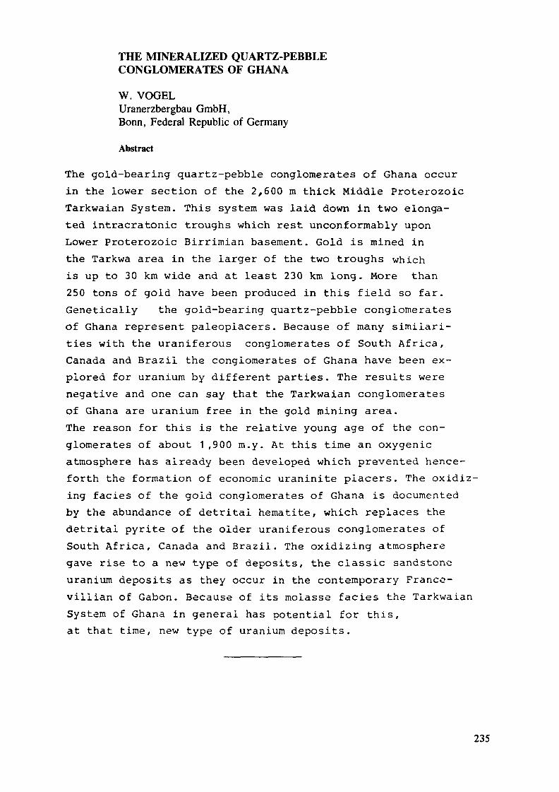
THE MINERALIZED QUARTZ-PEBBLECONGLOMERATES OF GHANA
W. VOGELUranerzbergbau GmbH,Bonn, Federal Republic of Germany
Abstract
The gold-bearing quartz-pebble conglomerates of Ghana occurin the lower section of the 2,600 m thick Middle ProterozoicTarkwaian System. This system was laid down in two elonga-ted intracratonic troughs which rest unconformably uponLower Proterozoic Birrimian basement. Gold is mined inthe Tarkwa area in the larger of the two troughs whichis up to 30 km wide and at least 230 km long. More than250 tons of gold have been produced in this field so far.Genetically the gold-bearing quartz-pebble conglomeratesof Ghana represent paleoplacers. Because of many similari-ties with the uraniferous conglomerates of South Africa,Canada and Brazil the conglomerates of Ghana have been ex-plored for uranium by different parties. The results werenegative and one can say that the Tarkwaian conglomeratesof Ghana are uranium free in the gold mining area.The reason for this is the relative young age of the con-glomerates of about 1 ,900 m.y. At this time an oxygenicatmosphere has already been developed which prevented hence-forth the formation of economic uraninite placers. The oxidiz-ing faciès of the gold conglomerates of Ghana is documentedby the abundance of detrital hematite, which replaces thedetritai pyrite of the older uraniferous conglomerates ofSouth Africa, Canada and Brazil. The oxidizing atmospheregave rise to a new type of deposits, the classic sandstoneuranium deposits as they occur in the contemporary France-villian of Gabon. Because of its molasse facies the TarkwaianSystem of Ghana in general has potential for this,at that time, new type of uranium deposits.
235
Introduction
One-tenth of the gold production of Ghana originates fromthe Precambrian quartz-pebble conglomerates of the Tark-waian System. The gold is of syngenetic origin and the con-glomerates represent paleoplacers. Despite many similari-ties with the uraniferous gold-bearing conglomerates ofSouth Africa, Brazil, and Canada, past exploration hasshown that the paleoplacers of Ghana are uranium free.The reason for this are discussed in this paper.
Regional Geology
The Tarkwaian System, containing the country's gold-bearingconglomerates, overlies the Lower Proterozoic BirrimianSystem (Fig. 1).
The Birrimian forms the eastern part of the West Africancraton and consists of a lower series of sediments and anupper series of greenstones. The flyschoid sediments andthe volcanics of the Birrimian System were deformed, meta-morphosed and intruded by syn- and posttectonic granitesduring the Eburnean orogeny about 1,800 m.y. ago. The Bir-rimian greenstones contain, especially in the vicinity ofthe younger Tarkwaian System, primary gold deposits. Famouslode mines are those of Obuasi, Bibiani, Konongo and Prestea.
Rocks of the Tarkwaian System lie discordantly on the Bir-rimian and outcrop in Ghana in two southwest-northeasttrending belts (Fig. 1).
The first belt occurs in west-central Ghana from near Beposiin Brong Ahafo Region to Banda Nkwatia in Northern Region.It is about 125 km long and up to 12 km wide.
The second belt, containing the gold-bearing conglomeratesas subject of this paper, stretches from Axim to Agogo whereit disappears below the younger (1,100 m.y.) Voitaian platformcover sediments.
236
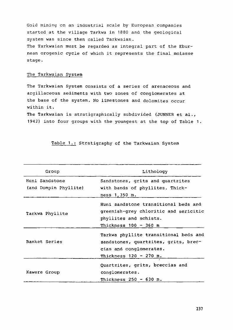
Gold mining on an industrial scale by European companiesstarted at the village Tarkwa in 1880 and the geologicalsystem was since then called Tarkwaian.The Tarkwaian must be regarded as integral part of the Ebur-nean erogenic cycle of which it represents the final molassestage.
The Tarkwaian System
The Tarkwaian System consists of a series of arenaceous andargillaceous sediments with two zones of conglomerates atthe base of the system. No limestones and dolomites occurwithin it.The Tarkwaian is stratigraphicaliy subdivided (JUNNER et al.,1942) into four groups with the youngest at the top of Table 1
Table 1.: Stratigraphy of the Tarkwaian System
Group LithoiogyHuni Sandstone(and Dompin Phyliite)
Sandstones, grits and quartziteswith bands of phyllites. Thick-ness 1 350 m. __ __
Tarkwa PhyliiteHuni sandstone transitional beds andgreenish-grey chloritic and sericiticphyliites and schists.Thickness 100 - 360 m
Banket SeriesTarkwa phyllite transitional beds andsandstones, quartzites, grits, brec-cias and conglomerates.Thickness 120 - 270 m.
Kawere GroupQuartzites, grits, breccias andconglomerates.Thickness 250 - 630 m.
237
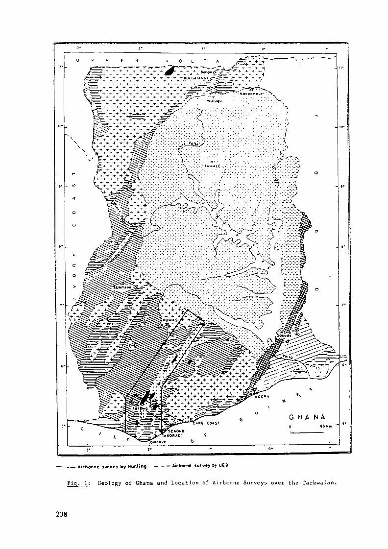
. . . . . . . . , . . . . . . . . . . . . .- ' '•'•'• •' •'•' '•' •'•' '•'•'•' '•' ' '• '
——— Airborne survey by Muntinç - - - Airborn« survey by UEB
Fig, l : Geology of Ghana and Location of Airborne Surveys over the Tarkwaian.
238
TABLE OF FORMATIONS
R E C E N T
T Ç R T l A R f
E O C E N E &C R E T A C E O U S
SEKONOIAN iA C C R A I A N(Devonian ">)
V O L T A I A N(Palaeozoic)
BUEM F O R M A T I O N(Upper Pf* - Cambrian)
T O G O S E R I E S
TAf t K W A I A N
UPPER BIRIMIAN
LOWER BIRIMIAN(Middle Pré-Combnonl
OAHOMEYANILower Pré- Cambrian!
BASIC INTRUSIVES
GRANITES(Middle Pre- Cambrian)
UnconsoliOoted sandclay and gravel
Red continental depositmainly ittnonrtic, sand,sandy clay and gravel
Mann* series of shale,sandstone, limestone
Sandstone, grit, conglomerate,arid
Quartzite, shot«, mudstone,conglomerate, limestone.orkose.
Shale, sandstone,arkose. lava.
Quartzite, phyilite,grit, conglomerate.
— Metamorphosed lavaE and pyroclostic rock.? Phyllit«, schist, tuff ana
Quartzite, shale, pfiyllite
^ Acidic and basic gneiss,schists and rnigmatites.
Gabbro doierite,rpidionte.
Granite and gronodiorite.
239

The Kawere Group comprises shallow water, greenish-grey,feldspathic quartzites, grits and conglomerates. The conglom-erates predominantly consist of closely packed pebbles ofsilicified Birimian greenstone and hornstone together withrare ones of jasper, quartz, quartz porphyry and Bimmianphyllite and schist in a matrix of quartz, feldspar, chlor-ite, carbonate, epidote and magnetite.
The fluviatile to littoral Banket series consists of basalquartzites and grits (footwall quartzites), the conglom-erate zone, and upper quartzites and grits (hanging-wallquartzites} .
The conglomerate zone comprises four conglomerate and brec-cia horizons, each of which is separated from the followingone by quartzites and grits:
- Breccia ReefQuartzite and Grit
- Middle ReefQuartzite and Grit
- Basal ReefQuartzite and Grit
- Sub-basal Reef
The breccia reef is characterized by alternating coarse tofine breccias containing large amounts of Birrimian phyl-lites and schist clasts which are 6 - 25 mm in length. Cross-bedded seams of hematite occur throughout the poorly sorteaseries. The reef is up to 20 m thick. The gold content islow ana exceeds rarely 1.5 grams per ton.
The middle reef consists of beds of conglomerates and brec-cia conglomerates. The majority of the pebbles consists ofquartz and very little of schist. The reef is up to 15 m thickand contains abundant hematite seams. The gold content variesbetween 1.5 to 2 grams per ton.
240
The basal reef is the most persistent conglomerate in thegold field and is by far the richest in gold. Generally,it is better sorted than the other reefs. The majority ofthe .pebbles is ellipsoidal and from 1.5 - 6.25 cm inlength. About 90% of the pebbles are of quartz and thematrix consists of quartz, black iron sand (hematite), se-ricite, chlorite, tourmaline, rutile, zircon, garnet andgold. Hematite occurs as disseminated grains and in theform of cross-bedded seams. The thickness of the reefvaries between 1.2 and 7 m and the gold content in thedifferent mines (Abosso, Adja Bippo, Abbontiakoon, Tarquah,Pepe, Fanti) between 3.5 and 14 grams per ton. As a rulethe gold values a highest and most persistent in well-sortedclosely packed hematite-rich quartz-pebble conglomeratesof moderate thickness. The bulk of the gold is intimatelyassociated with detrital hematite (JUNNER et al, 1942).
The sub-basal reef comprises conglomerates and pebbly gritsand is up to 40 m thick. The gold values are low.
The Tarkwa Phyllite consists of green and greenish-grey chlo-rite and sericite phyllites and schists which contain porphy-roblasts of chloritoid, magnetite or carbonate.
The Huni Sandstone is the uppermost and thickest formationof the Tarkwaian System. It consists of feldspathic quartziteswith bands of phyilite. The quartzites contain variable amountsof feldspar, sericite, chlorite, ferriferous carbonate andmagnetite.
The Tarkwaian System is associated with hypabyssal acidic tobasic igneous rocks which make up approximately 20% of thetotal thickness of the system. Most of them are in form ofconformable or slightly transgressive sills and a small per-centage occurs as dykes.
Fig. 2 shows the geology of the Tarkwa goldfield where thetotal thickness of the Tarkwaian-System reaches 2,600 m.
241
Although the Tarkwaian rests unconformably on the Birrimianit follows in general the strike and dip of the latter. Insome localities no angular unconformity can be observed bet-ween the Birrimian and Tarkwaian Systems (WOODFIELD, 1966).
The whole of the Tarkwaian was subjected to a low to mediumgrade dynamic metamorphism of the greenschist to almandine-amphibolite faciès.
The age of the Tarkwaian succesion itself has not been datedsatisfactory. However, its maximum age postdates the mini-mum age of 1 ,915 + 210 m.y. of the underlying Birrimian. Theminimum age of the Tarkwaian is according to HOLMES and CAHEN(1957) 1 ,645 m.y. In line with these information the Tark-waian was roughly laid down between 1,900 and 1,600 m.y. ago,an age which was also concluded by BAER (1980) .
Tectonically, the structure of the Tarkwa region consists ofsynciines and anticlines with axial planes striking N30° E(Fig. 2) and steep to overturned northwest limbs of the anti-clines .
Depositional Environment of the Banket Conglomerates
Because the various members of the Tarkwaian System gradeinto one another JUNNER et ai. (1942) believe that the wholesuccession must have been deposited as a continuous unit ina gradually sinking trough under water which became graduallydeeper.
There are no great lateral changes in faciès. However, theKawere and Banket conglomerates are thicker and better de-veloped on the south-eastern side of the trough where theBanket conglomerates are also richer in gold. This indicatesthat the principal source of the sediments was to the south-east.
According to JUNNER et al. (1942), cross-bedding, ripplemarking and the well sorted gold rich conglomerates in the
242
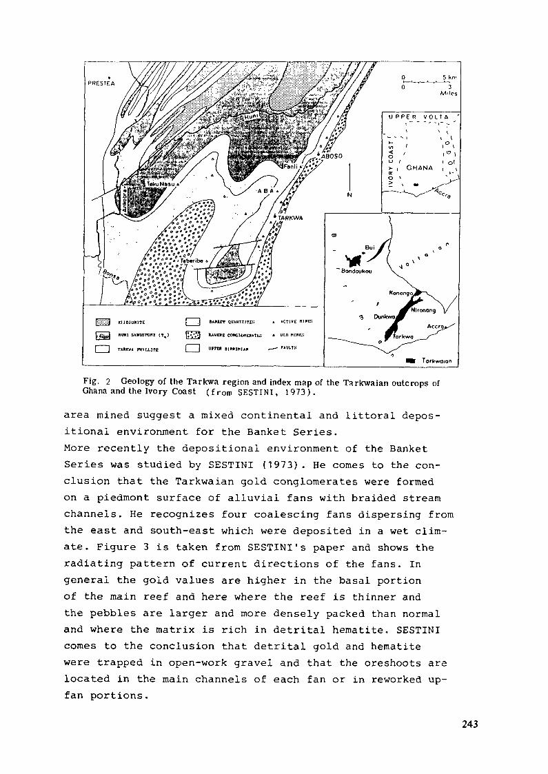
EMDJORITE | ,| »A1UCT QUAHTZITR » »CT1ÏE MIKES
»OUI S»DSTOHE (T,) ttvat COHGUXIEIUTU; » "Ml "l»f-:
[ ] T««™« miLLiTE | | »fra umini»
Fig. 2 Geology of the Tarkwa region and index map of the Tarkwaian outcrops ofGhana and the Ivory Coast ( f r o m SESTINI , 1973).
area mined suggest a mixed continental and littoral depos-itional environment for the Banket Series.More recently the depositional environment of the BanketSeries was studied by SESTINI (1973) . He comes to the con-clusion that the Tarkwaian gold conglomerates were formedon a piedmont surface of alluvial fans with braided streamchannels. He recognizes four coalescing fans dispersing fromthe east and south-east which were deposited in a wet clim-ate. Figure 3 is taken from SESTINI's paper and shows theradiating pattern of current directions of the fans. Ingeneral the gold values are higher in the basal portionof the main reef and here where the reef is thinner andthe pebbles are larger and more densely packed than normaland where the matrix is rich in detrital hematite. SESTINIcomes to the conclusion that detrital gold and hematitewere trapped in open-work gravel and that the oreshoots arelocated in the main channels of each fan or in reworked up-fan portions.
243
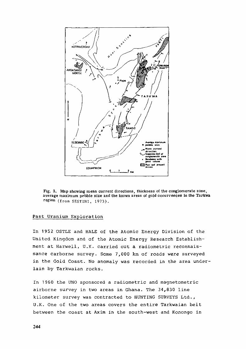
AKONTANSI /NORTH ' f
Fig. 3. Map showing mean current directions, thickness of the conglomerate zone,average maximum pebble size and the known areas of gold occurrences in the Tarkwaregion ( f r o m SESTINI , 1 9 7 3 ) .
Past Uranium Exploration
In 1952 OSTLE and HALE of the Atomic Energy Division of theUnited Kingdom ana of the Atomic Energy Research Establish-ment at Harwell, U.K. carried out a radiometric reconnais-sance carborne survey. Some 7,000 km of roads were surveyedin the Gold Coast. No anomaly was recorded in the area under-lain by Tarkwaian rocks.
In 1960 the UNO sponsored a radiometric and magnetometricairborne survey in two areas in Ghana. The 34,830 linekilometer survey was contracted to HUNTING SURVEYS Ltd.,U.K. One of the two areas covers the entire Tarkwaian beltbetween the coast at Axim in the south-west and Konongo in
244

the north-east (Fig. 1). The total count scintillometerused had a detector of 260 cubic centimeters. Flight lineswere parallel to the strike of the Tarkwaian. The averageground clearance was about 200 m. Weak anomalies were re-corded in the Tarkwa area. But a ground check within atriangle formed by Fanti village, Bogoso and the FantiAboso road section showed that the anomalies were causedby the higher radiometric background of the Tarkwa phyliite.
In 1969 URANERZBERGBAU-GMBH of F. R. Germany carried out amagnetometric and spectrometric airborne (and carborne)survey over the Tarkwa area (Fig. 1) . Flight lines wereoriented normal to the strike of the Tarkwaian. A 1,530cubic centimeter detector was used and flight altitude aver-aged 150 m. As in the previous survey by HUNTING no anomalieswere recorded in the area underlain by the gold-bearing Ban-ket conglomerates.
In 1970 the same company carried out a radiometric surveyin the abandoned Pepe open pit mine and in the A.D.B. under-ground mine. In both mines the Banket conglomerates are ex-cellent exposed. They show a low background radioactivity ofalmost constant intensity. A hydrogeochemical survey onsamples from mine and surface water yielded also negativeresults.
Comparison of the Gold-bearing Conglomerates of Ghana withthe Gold- and/or Uranium-bearing Conglomerates of South-Africa, Canada and Brazil
Economic concentrations of gold and/or uranium in Precambrianquartz-pebble conglomerates occur outside Ghana in SouthAfrica, Canada and Brazil.The genesis of gold and uranium in the conglomerates is ex-plained by two controversial groups: the hydrothermalistsand the placerists. Today the hydrothermal theory is moreor less rejected and the majority of authors (RAMDOHR; 1958;PRETORIUS, 1976; MINTER, 1978) describe the mineralizedconglomerates as paleoplacers. According to this concept
245
the heavy minerals gold, uraninite and pyrite were trans-ported and deposited as detritai grains at a time whenan anoxygenic, reducing environment prevailed. The sourcerocks for gold were greenstones and for uraninite granitesin the catchments of the alluvial fan-braided stream systems.
The conglomerates of the Witwatersrand of South Africaare best described by PRETORIUS (1976 and 1981) and HINTER(1976 and 1978). Impressive 38,000 tons of gold and morethan 100,000 tons of U^Og have been mined from this basin.The Lower Proterozoic Witwatersrand succession rests upon theArchean Kaapvaal craton and the mined gold reefs have agesbetween 2,800 and 2,700 m.y. The main ore minerals of thepyrite-rich conglomerates are gold, uraninite, branneriteand thuchoiite. The conglomerates were laid down as fluvialfan or fan deltas at the interface between a fluviatile systemand a lacustrine, or inland-sea system. The hydrocarbons ofthe conglomerates derived from algal mats which developedin near shore shallow water.
The uraniferous quartz-pebble conglomerates of the ElliotLake field in Canada belong to the Huronian Supergroup.About 130,000 tons of U.,08 were produced in this field.The Lower Proterozoic Matinenda Formation, hosting theuraniferous conglomerates, rests in the raining area directlyon Archean basement. The conglomerates are rich in pyriteand uranium occurs in the form of uraninite, brannerite andthuchoiite.Among other accessory matrix minerals monaziteis quite abundant and a rare earth intermediate concentratewas produced by the mines at times.It is believed that the con-glomerates were formed in a braided stream system in paleo-valleys which partly (Quirke mine) debouched into shallow-water (near shore) marine environment. The age of the Huron-ian Supergroup is between 2,200 and 2,500 m.y. and the ageof the uraniferous conglomerates is about 2,400 m.y.
In the Serra de Jacobina in Brazil quartz-pebble conglom-erates have been mined for gold in the past. Total goldproduction is estimated to be in the range of 25 tons. The
246
gold conglomerates occur in the Lower Proterozoic Serra doCorrego and Rio do Auro Formations of the Jacobina Group.The latter rests unconformabiy on the Archean Sao Franciscoera ton. The pyrite-rich conglomerates contain gold andminor uranium in the form of uraninite and brannerite. Theconglomerates were formed on fault-controlled alluvial fansin braided stream systems.
The gold conglomerates of South Africa, Canada and Brazilhave several parameters in common: they all are Lower Pro-terozoic in age, rest upon Archean basements of granitesand greenstones and are succeeded by Middle Proterozoiciron-formations (Lake Superior Region, U.S.A.; QuadrilateroFerriféro, Brazil and the Transvaal and northern Cape pro-vinces, South Africa). The iron-formations and red-beds indic-ate a change in the atmosphere from anoxygenic to oxygenic.
Table 2 summarizes the main characteristics of the Wit-watersrand, Elliot Lake, Serra da Jacobina and Tarkwagold and/or uranium fields.
Remarkable is the uniform depositional environment orfaciès of the four conglomerates: they all were laid downin braided-stream systems on alluvial fans preferable atthe interface with lakes or inland-seas.However, apart from the common facies, the gold conglomeratesof Ghana exhibit three very distinct characteristics whichdistinguish them from the other Precambrian conglomerateoccurrences.- the conglomerates of Ghana are Middle Proterozoic andnot Lower Proterozoic in age
- the Tarkwaian System, containing the conglomerates, restson a Lower Proterozoic and not on an Archean basement
- the conglomerates contain hematite instead of pyrite andare free of minerals which are stable in a reducing environ-ment .
247

Uranium Potential
As shown on Table 2, the gold conglomerates of Ghana weredeposited during the Middle Proterozoic at a time when anoxygenic atmosphere already existed. This fact is welldocumented by the abundance of detrital hematite and thegeneral red-bed appearance of the Banket conglomerates inoutcrops (e.g. Pepe open pit mine) . Under oxidizing con-ditions uraninite in detrital form will not survive transportover longer distance and repeated redeposition through re-working and by no means will form economic concentrations.The Tarkwa gold-bearing conglomerates of Ghana, therefore,do not have a potential for the paleoplacer type of uraniumdeposits.
However, the development of an oxygenic atmosphere at theend of the Lower Proterozoic created the necessary con-ditions for the appearance of a new type of uranium de-posits in the earth history; the classic sandstone uraniumdeposits controlled by redox processes.
The first economic deposits of this type already occur inthe Middle Proterozoic Francevillian of Gabon which isconsidered a time-equivalent to the Tarkwaian system.Favoured by the molasse faciès the Tarkwaian System ofGhana in general has a potential for sandstone type uraniumdeposits. Prospective would be the area to the north-westof the Tarkwa goldfieid where the conglomerates grade intosandstones ( downdip of the paieoslope) and the area under-lain by the Huni sandstone.
248
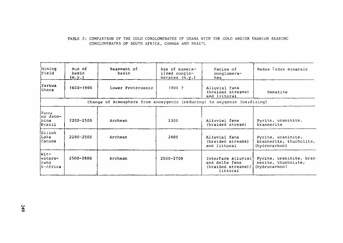
TABLE 2: COMPARISON OF THE GOLD CONGLOMERATES OF GHANA WITH THE GOLD AND/OR URANIUM BEARINGCONGLOMERATES OF SOUTH AFRICA, CANADA AND BRAZIL
MiningField
TarkwaGhana
Acje ofbasin(m.y . )
1600-1900
Basement ofbasin
Lower Proterozoic
Age of minera-lized conglo-merates (m.y.)
1900 ?
Faciès ofconglomera-tes
Alluvial fans(braided streams)and littoral
Redox Index minerals
Hematite
Change of Atmosphere from anoxygenic (reducing) to oxygenic (oxidizing)
Serrade Jaco-binaBrazilElliotLakeCanada
Wit-waters-randS-Africa
2200-2500
2200-2500
2500-2800
Archean
Archean
Archean
2300
2400
2500-2700
Alluvial fans(braided stream)
Alluvial fans(braided streams)and littoral
Interface alluvialand delta fans(braided streams)/
littoral
Pyrite, uraninite,brannerite
Pyrite, uraninite,brannerite, thucholite,(hydrocarbon)
Pyrite, uraninite, bran-nerite, thucholite,(hydrocarbon )
to
REFERENCES
ADAMEK, P., 1976: Raw material prospecting. Report to theGovernment of Ghana. International AtomicEnergy Agency, Vienna (unpublished).
ASIHENE, K.A.B., and BARNING, K., 1975: A contribution tothe stratigraphy of the Birimian Systemof Ghana, West Africa. Geological Surveyof Ghana, Report No. 75/5.
BAER, P. 1977: Geologische Entwicklung der jungpraekambrisch-altpalaeozoischen Schichtfolgen im süd-lichen Randgebiet des Volta-Beckens (Ghana,W. Afrika). Giessener Geologische SchriftenNr. 12, Giessen.
BAER, H.P. 1980: Structural Evolution of Precambrian to lowerPaleozoic Fold Belts in West Africa (Ghana)and their Continuation in NE-Brazil.UNESCO, Abidjan.
BANSON, J.K.A., 1974: The prospecting of uranium and thoriumin the Republic of Ghana. Unpublished Reportof Ghana, Geological Survey. Uranium andThorium file.
BATES, D.A., 1952: Radiometrie survey. Report of the Directorof Geological Survey for the year 1951-52,p. 8 .
COETZEE, F., 1965: Distribution and grain-size of gold, urani-nite, pyrite and certain other heavy mineralsin gold-bearing reefs of the Witwatersrandbasin. Trans. Geoi. Soc. S. Africa, 68,p. 61-68
DAVIDSON, C.F., 1965: The mode of origin of banket ore-bodies.Trans. Inst. Min. Metall., 74, p. 319-338.
250
DAVIDSON, C.F. & BOWIE, S.H.U., 1951: On thuchoiite and relatedhydrocarbon-uraninite complexes. Bull.Geol. Surv. G.B.3, 1- 18.
HALLBAUER, O.K., 1975: The plant origin of the Witwatersrandcarbon. Minerals Sei. Engng. , 7,111-131.
GRANDSTATT, D.E., 1980: Origin of uraniferous conglomerates atElliot Lake, Canada and Witwatersrand,South Africa: Implications for oxygenin the Precambrian atomosphere-Precambrian Research, 13.
HIRST, T., 1938: The geology of the Tarkwa goldfield and adjacentcountry. Gold Coast Geoi. Survey, Bull.10, 24 p.
HUGHES, C.J., 1963: The Geology of the 1/4 Field Sheet No. 26.
HUNTING SURVEYS Ltd., 1961: Airborne Geophysical Survey of twoareas in Ghana. Government of Ghana,Geological Survey Dept., Report.
JEFFERY, W.G., 1962: The structural and economic geology of the areabetween Abbontiakoon and Fanti South mines,Tarkwa goldfield, Ghana. Ghana State GoldMining Corp., Unpubi. rept.
JUNNER, N.R., 1935: Gold in the Gold Coast. Gold Coast Geoi. Sur-vey, Mem. 4.
JUNNER, N.R., HIRST, T., SERVICE, H., 1942: The Tarkwa goldfieid.Mem. Gold Coast Geol. Survey, 6, 75 p.
KESSE, G.O., 1978: The existence of uranium deposits in Ghana.Geological Survey Department Ghana,Accra (unpublished).
251
KESSE, G.O., 1982: The Minerai Resources of Ghana. GeologicalSurvey Department Ghana, Accra (un-published) .
LIEBENBERG, W.R., 1955: The occurrence and origin of gold andradioactive materials in the Wit-watersrand system, the Dominion Reef,the Ventersdorp Contact Reef and theBlack Reef. Trans.geol.Soc.S. Afr.,58, 101-227.
HINTER, W.E., 1970: Gold distribution related to the sedimentologyof a Precambrian Witwatersrand conglom-erate, South Africa, as outlined bymoving average analysis. Econ. Geol.,£5, p. 963-969.
HINTER, W.E., 1976: Detritai gold, uraninite and pyrite and con-centrations related to sedimentologyin the precambrian Vaal Reef placer,Witwatersrand, South Africa: Econ. Geol.,v. 71, p. 157-175.
HINTER, W.E., 1978: A sedimentological synthesis of placer gold,uranium and pyrite concentrations in Pro-terozoic Witwatersrand sediments, in Miail,A.D., ed., Fluvial sedimentology: Calgary,Canadian Soc. Petroleum Geologists, p.801-829.
Ntiamoah-Agyakwa, Y., 1978: The Tarkwaian Group of Ghana. Notes onstratigraphy, Evolution and Correlation.4. Conference sur la Géologie de l'Afriqueet symposium, Lomé.
252
PRETORIUS, D.A., 1966: Conceptual geologic models in the explor-ation for gold mineralization in the Wit-watersrand basin. Univ. Witwatersrand Geol.Research Unit, Inf. Circular 17, 86p.;"Symposium on mathematical statistics andcomputer application to ore evaluations",Spec. Publ., J.S. Africa Inst. Min. Metall,p. 225-266 (1966) .
PRETORIUS, D.A., 1976: The nature of the Witwatersrand gold-uraniumdeposits, in Wolf, K.H., Handbook of strat-abound and stratiform ore deposits, v. 7:Amsterdam, Elsevier, p. 29-88.
PRETORIUS, D.A., 1981: Gold and uranium in quartz-pebble conglom-erates. Inform. Circ. Econ. Geol. Res. Unit,Univ. Witwatersrand, 151, 18 pp.
RAMOS, J.R. de ANDRADE, 1977: Where Brazil's uranium lies. NuclearActive, 17, 22-25.
RAMDOHR, P., 1958: New observations on the ores of the Witwaters-rand in South Africa and their genetic signi-ficance. Trans. Geol. Soc. S. Africa, £1_(Annexurel), 50 p.
ROZHKOV, I.S., 1967: The gold-bearing conglomerates of the Precam-brian deposits of Tarkwa. Geoi. Geofiz. Akad,Nauk SSSR, Sib. Otd., ]_, p. 60-74.
SESTINI, G., 1971: Palaeocurrents and exploration for gold in theTarkwaian of Ghana. 15th ann. Rept. Res.Inst. Afr. Geol., Univ. Leeds, p. 23-25.
SESTINI, G., 1976: Sedimentoiogy of a paieoplacer. The gold-bearingTarkwaian of Ghana, in Amstutz, G.G., andBernard, A. Eds., Ores in sediments: Heidel-berg, Springer Verlag, p. 275-305.
253
SIMPSON, P.R., and BOWLES, J.F.W., 1977: Uranium mineralizationof the Witwatersrand and DominionReef systems. Phil. Trans. R. Soc.Lond., A, 286, 527-548.
URANERZBERGBAU-GMBH, 1972: The Prospecting for uranium and thoriumin the Republic of Ghana. Final Report(unpublished).
WHITELAW, O.A.L., 1929: The geological and mining features of theTarkwa-Abosso goidfieid. Mem. GoldCoast Geol. Survey, ]_, 46 p.
WOODFIELD, P.D., 1966: The Geology of 1/4 Field Sheet No. 91.Fumso N.W. Geological Survey BulletinNr. 30, Accra.
254
URANIUM DISTRIBUTION AND REDISTRIBUTIONIN A SUITE OF FRESH AND WEATHEREDPRE-WITWATERSRAND AND WITWATERSRANDCONGLOMERATES FROM SOUTH AFRICA
M. MEYER, R. SAAGERInstitute of Mineralogy and Petrology,Universität Köln,Köln, Federal Republic of Germany
V. KOPPELInstitute of Crystallography and Petrology,Federal Institute of Technology,Zurich, Switzerland
Abstract
Uranium anlyses of fresh and weathered Precambrian uraniferousconglomerate samples revealed that the weathered material suffered con-siderable uranium depletion. Alpha-spectometric and gamma-spectrometricinvestigations as well as uranium leaching tests were carried out on thesamples. They indicated that in weathered conglomerates only insigni-ficant amounts of uranium are still available for supergene redistri-bution and that the bulk of the uranium was removed very early in theweathering history of the rocks. Consequently, gamma- and alpha-spectrometric measurements do not yield useful informations on the ori-ginal uranium content of the weathered rocks. However, lead isotope ana-lysis was found to give good estimates of the fresh-rock uranium tenorof weathered conglomerates. This method is not sensitive to recent ura-nium redistributions and in geologic terranes similar to the ones in-vestigated it provides a helpful tool in the exploration for uraniumdeposits.
Introduction
Under oxidizing low temperature conditions in the weathering environmentthe uranyl ion (U02) + constitutes the dominant stable form of uranium.Depending on prevailing Eh-pH conditions and on availability of suitablecations the uranyl ion forms soluble or insoluble complexes andaccordingly uranium can be depleted or accumulated in weathered rocks.This behaviour which might affect the uranium content of weatheredrocks, therefore, could influence geochemical exploration data to aconsiderable extent. It is for instance known that surface outcrops ofPrecambrian uraniferous quartz-pebble conglomerates carry lower uraniumcontents than their unweathered equivalents (Saager et al. 1981; Meyeret al. 1983).
255
The present study was undertaken to test the applicability of variousanalytical methods for the evaluation of the fresh-rock uranium grade ofweathered conglomerates. One hundred and forty-three samples from pre-Witwatersrand and Witwatersrand sedimentary rocks, collected in SouthAfrica, were studied by ore microscopy, gamma-spectrometry, alpha-spectrometry, neutron activation analysis, and lead isotope analysis.
Sample Descriptions
Thirteen samples were garnered from supergenically altered conglomerateoutcrops of three pre-Witwatersrand sedimentary deposits:
(i) the approximately 3300 Ma 1973) old Hoodies Group of theSwaziland Supergroup,
(ii) the roughly 3000 Ma old Pongola Supergroup, and(iii) the Uitkyk Formation which is considered to be part of the
Pietersburg Group. The age of the Uitkyk Formation , however, isstill disputed and compared either with that of the Moodies orthat of the Dominion Group (i.e. 2800 Ma).
One hundred and thirty samples originate from the approximately 2700 Maold West Rand Group (i.e. the former Lower Witwatersrand Succession). Inaddition to weathered surface material (78 samples), fresh core material(52 samples) was available. A geologic sketch map of the northeasternpart of South Africa, showing the 9 sampled localities, is given inFigure 1.
All investigated samples invariably suffered lower greenschist facièsmetamorphic overprint and the studied rocks, in fact, should be termedmeta-conglomerates.
Microscopic studies of weathered conglomerates revealed the totalabsence of non-refractory uranium minerals and indicated that pyrite,which in these samples was originally the most abundant detritalmineral, is altered to limonite/hematite aggregates. Uranium bearingminerals still present are allogenic zircon and monazite. From the workcarried out by Thiel et al. (1979) on similar rocks it is known thaturanium is furthermore present as adsorptions on carbonaceous matter, onsecondary Fe-Ti oxihydroxides and phyllosilicates.
256
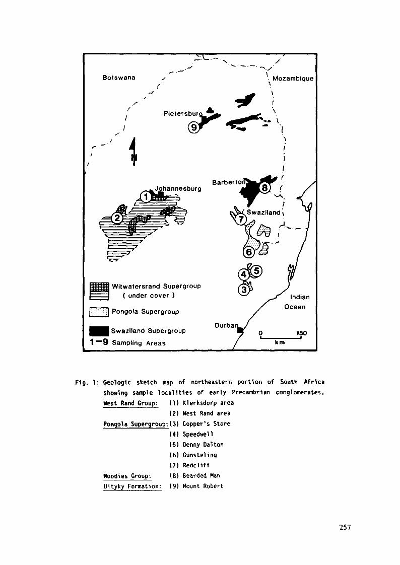
Botswana . Mozambique
Pietersburburg^^ ^^<sr < -
JohannesburgBarberto
Witwatersrand Supergroup( under cover )
[;::i|!|i;i] Pongola Supergroup
Swaziland Supergroup
1 ~~9 Sampling Areas
Durbakm
Fig. 1: Geologic sketch map of northeastern portion of South Africashowing sample localities of early Precambrian conglomerates.West Rand Group: (1) Klerksdorp area
(2) West Rand areaPongola Supergroup:(3) Copper's Store
(4) Speedwell(6) Denny Da1 ton(6) Gunsteling(7) Redcliff
Hoodies Group: (8) Bearded ManUityky Formation: (9) Mount Robert
257
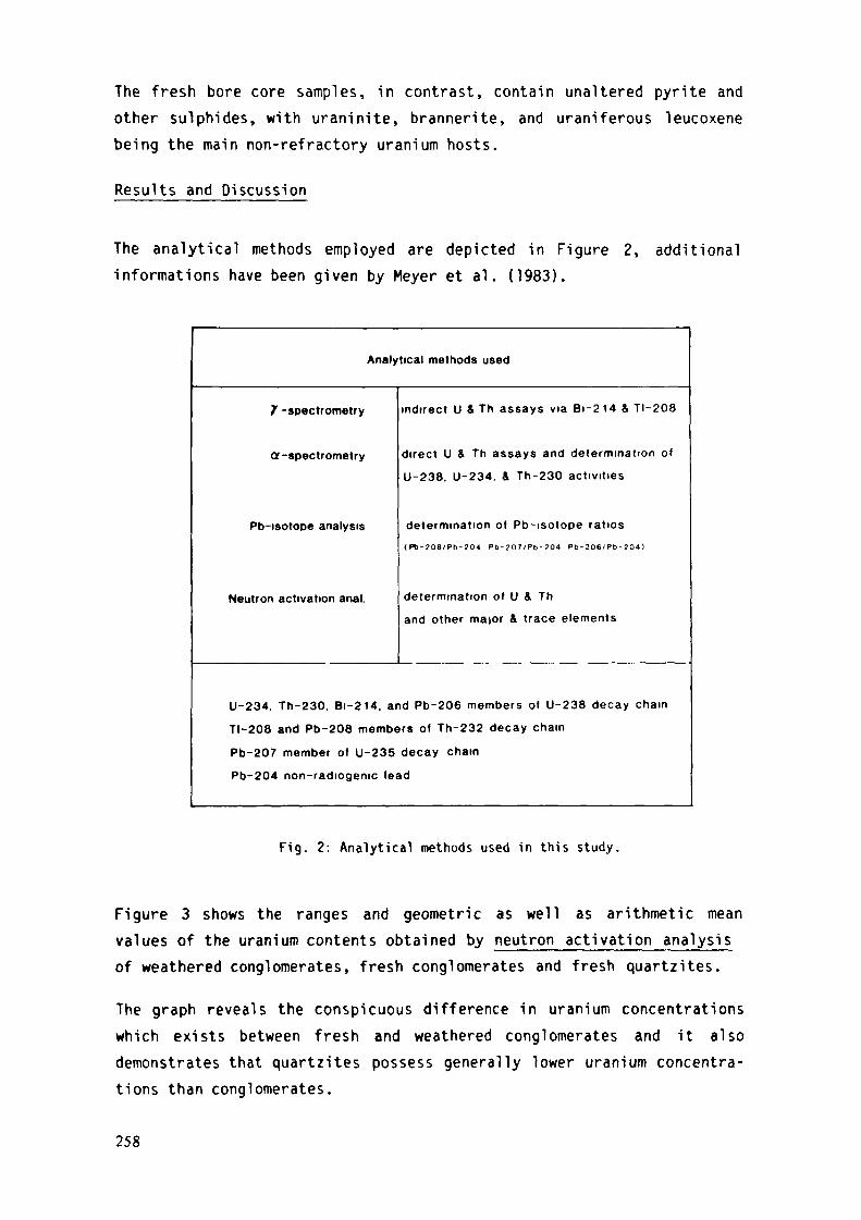
The fresh bore core samples, in contrast, contain unaltered pyrite andother sulphides, with uraninite, brannerite, and uraniferous leucoxenebeing the main non-refractory uranium hosts.
Results and Discussion
The analytical methods employed are depicted in Figure 2, additionalinformations have been given by Meyer et al. (1983).
Analytical methods used
7 -spectrometry
Cr-spectrometry
Pb-isotope analysis
Neutron activation anal.
indirect U & Th assays via Bi-214 & TI-208
direct U & Th assays and determination of
U-238, U-234, & Th-230 activities
determination of Pb-isotope ratios(P6 -208 /PD-204 P b - 2 0 7 / P b - 2 0 4 Pb-206 /Pb- 204)
determination of U 4 Th
and other maior & trace elements
U-234, Th-230, Bi-214, and Pb-206 members of U-238 decay chain
TI-208 and Pb-208 members of Th-232 decay chain
Pb-207 member of U-235 decay chain
Pb-204 non-radiogenic lead
Fig. 2: Analytical methods used in this study.
Figure 3 shows the ranges and geometric as well as arithmetic meanvalues of the uranium contents obtained by neutron activation analysisof weathered conglomerates, fresh conglomerates and fresh quartzites.
The graph reveals the conspicuous difference in uranium concentrationswhich exists between fresh and weathered conglomerates and it alsodemonstrates that quartzites possess generally lower uranium concentra-tions than conglomerates.
258
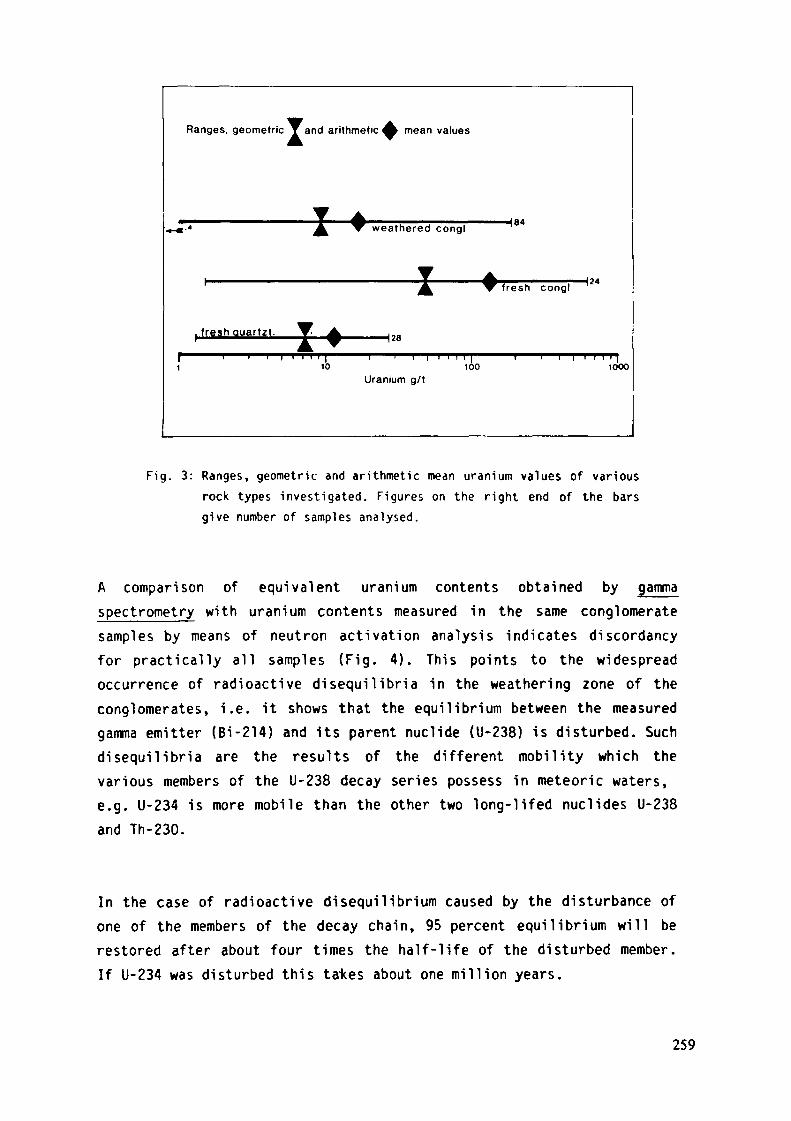
Ranges, geometric ^and arithmetic A mean values
, fresh Quartzt.
weathered congl-184
f resh conglH 24
H 28
10 100Uranium g/t
1000
Fig. 3: Ranges, geometric and arithmetic mean uranium values Of various
rock types investigated. Figures on the right end of the barsgive number of samples analysed.
A comparison of equivalent uranium contents obtained by gammaspectrometry with uranium contents measured in the same conglomeratesamples by means of neutron activation analysis indicates discordancyfor practically all samples (Fig. 4). This points to the widespreadoccurrence of radioactive disequilibria in the weathering zone of theconglomerates, i.e. it shows that the equilibrium between the measuredgamma emitter (Bi-214) and its parent nuclide (U-238) is disturbed. Suchdisequilibria are the results of the different mobility which thevarious members of the U-238 decay series possess in meteoric waters,e.g. U-234 is more mobile than the other two long-lifed nuclides U-238and Th-230.
In the case of radioactive disequilibrium caused by the disturbance ofone of the members of the decay chain, 95 percent equilibrium will berestored after about four times the half-life of the disturbed member.If U-234 was disturbed this tafces about one million years.
259
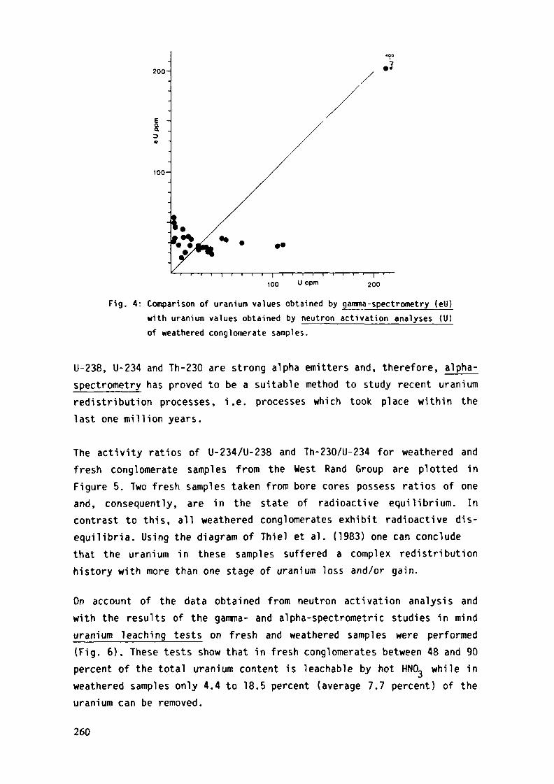
200-
aa3
100-
.i?
100 U ppm 200
Fig. 4: Comparison of uranium values obtained by gamma-spectrometry (ell)with uranium values obtained by neutron activation analyses (U)of weathered conglomerate samples.
U-238, U-234 and Th-230 are strong alpha emitters and, therefore, alpha-spec trometr y has proved to be a suitable method to study recent uraniumredistribution processes, i.e. processes which took place within thelast one million years.
The activity ratios of U-234/U-238 and Th-230/U-234 for weathered andfresh conglomerate samples from the West Rand Group are plotted inFigure 5. Two fresh samples taken from bore cores possess ratios of oneand, consequently, are in the state of radioactive equilibrium. Incontrast to this, all weathered conglomerates exhibit radioactive dis-equilibria. Using the diagram of Thiel et al. (1983) one can concludethat the uranium in these samples suffered a complex redistributionhistory with more than one stage of uranium loss and/or gain.
On account of the data obtained from neutron activation analysis andwith the results of the gamma- and alpha-spectrometric studies in minduranium leaching tests on fresh and weathered samples were performed(Fig. 6). These tests show that in fresh conglomerates between 48 and 90percent of the total uranium content is Teachable by hot HNO., while inweathered samples only 4.4 to 18.5 percent (average 7.7 percent) of theuranium can be removed.
260
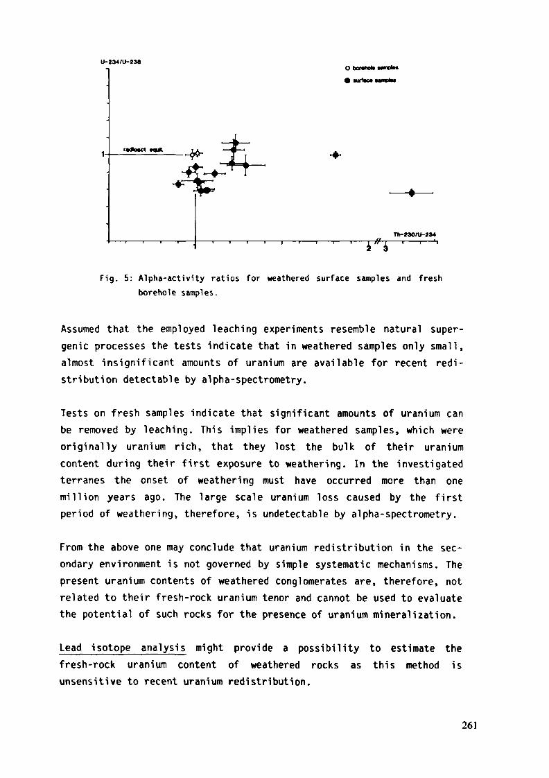
U-234/U-238O barahob
• Mjrfac« umpfes
1 4" i 'Fig. 5: Alpha-activity ratios for weathered surface samples and fresh
borehole samples.
Assumed that the employed leaching experiments resemble natural super-genie processes the tests indicate that in weathered samples only small,almost insignificant amounts of uranium are available for recent redi-stribution detectable by alpha-spectrometry.
Tests on fresh samples indicate that significant amounts of uranium canbe removed by leaching. This implies for weathered samples, which wereoriginally uranium rich, that they lost the bulk of their uraniumcontent during their first exposure to weathering. In the investigatedterranes the onset of weathering must have occurred more than onemillion years ago. The large scale uranium loss caused by the firstperiod of weathering, therefore, is undetectable by alpha-spectrometry.
From the above one may conclude that uranium redistribution in the sec-ondary environment is not governed by simple systematic mechanisms. Thepresent uranium contents of weathered conglomerates are, therefore, notrelated to their fresh-rock uranium tenor and cannot be used to evaluatethe potential of such rocks for the presence of uranium mineralization.
Lead isotope analysis might provide a possibility to estimate thefresh-rock uranium content of weathered rocks as this method isunsensitive to recent uranium redistribution.
261
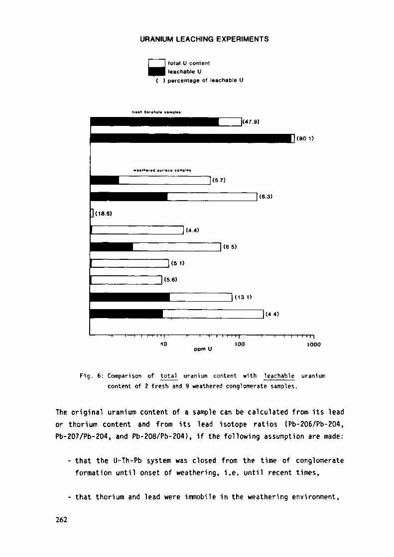
URANIUM LEACHING EXPERIMENTS
y total U contentleachable U
( ) percentage of leachable U
tr»»h borchol« ••mpl«>
(90 1)
ppm U
l1000
Fig. 6: Comparison of total uranium content with Teachable uraniumcontent of 2 fresh and 9 weathered conglomerate samples.
The original uranium content of a sample can be calculated from its leador thorium content and from its lead isotope ratios (Pb-206/Pb-204,Pb-207/Pb-204, and Pb-208/Pb-204), if the following assumption are made:
- that the U-Th-Pb system was closed from the time of conglomerateformation until onset of weathering, i.e. until recent times,
- that thorium and lead were immobile in the weathering environment,
262

- that the time t of sedimentary deposition of the conglomerates isknown, and
- that an appropriate common lead correction is chosen.
If time t is not known it can be chosen by assuming an age (t ) onassgeologic reasoning or by calculating an age with the help of lead-lead(tPb-207/Pb-206 > °r th°ri^-lead (tpb-208/Th-232 >
Fresh-rock uranium contents of weathered conglomerates can be calculatedby the following two equations:
(1) U-238 = (Pb-206/Pb-204) - (Pb-206/Pb-204)——————————-——————————i x Pb-204X8t(e 8 -1)
where: (Pb-206/Pb-204)m = measured isotopic ratio of weathered rock(Pb-206/Pb-204) = isotopic ratio of rock at time t (common
lead correction)X§ = decay constant of U-238
Pb-204 = measured non radiogenic lead in rockt = time of conglomerate formation
It should be noted that equation (1) implies that the lead isotopes werehomogenized close to the time of conglomerate formation or that thecrystallization of the detrital uranium carriers does not differappreciably from time t. Furthermore, equation (1) shows that thecalculated uranium concentration is affected by possible recent leadgains or losses. In the present study the common lead correction wasbased on the lead evolution model of Stacey 4 Kramers (1975), however,the inaccurate choice of (Pb-206/Pb-204)t has only little influence onthe final result because most of the measured samples possess a fairamount of radiogenic lead. Of more importance is the right choice of t,as the calculated uranium values are sensitive to small changes of t.Meyer et al. (1983) showed that a change from 2700 Ma to 3000 Ma willdecrease the calculated uranium concentration by 12 percent.
263
(2) U-238 = Th-232 x (Pb-206/Pb-208) xr
.*•*-,where: {Pb-206/Pb-208)r = isotopic ratio of radiogenic Pb-206 and
Pb-208 generated in the sample since time t= decay constant of Th-232
Th-232 = measured thorium content of rock
In this case the calculated uranium value is influenced by recentthorium gains or losses, however, it is not affected by recent changesof the lead content of the rock. The choice of time t is less criticalin the second equation than in the first one and a change of t from2700 Ma to 3000 Ma will decrease the calculated uranium content by only2 percent.
In both equations uranium does not occur on the right hand side and,therefore, recent uranium losses caused by weathering have no effect onthe calculated uranium values. However, the reliability of thecalculated uranium values depends on the closed system behaviour forU-Th-Pb between the time t and the onset of weathering. Existence ofopen system conditions can be detected by comparing the assumed ageof the rock with its calculated Pb-207/Pb-206 and Pb-208/Th-232 ages.
Figure 7 reveals that only for a few samples the assumption of closedsystem behaviour is fullfilled. For instance most samples from the WestRand Group display open system behaviour and show the following trend:
assumed sedimentary age > lead-lead age > thorium-lead age
This trend suggests that the lead isotopic composition was influencedafter deposition of the West Rand Group sediments, possibly by theintrusion of the Bushveld Complex, and that either lead was lost orthorium gained by the system.
For the fresh samples from bore cores it is safe to assume that theU-Th-Pb system was not disturbed by supergene weathering. Therefore, thesamples from the West Rand Group must have suffered their lead loss orthorium gain between time t and onset of weathering (10 to 100 Ma ago).
264
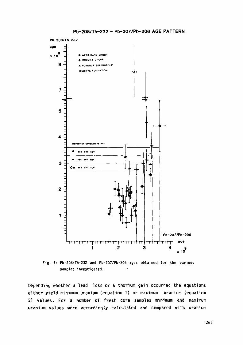
Pb-208/Th-232 - Pb-207/Pb-206 AGE PATTERN
Pb-208/Th-232
age
x 109 _
8-
WEST RAND GROUP
MOOOIES GROUP
A PONGOLA SUPERGROUP
OUITKYK FORMATION
Pb-207/Pb-206
Fig. 7: Pb-208/Th-232 and Pb-207/Pb-206 ages obtained for the varioussamples Investigated.
Depending whether a lead loss or a thorium gain occurred the equationseither yield minimum uranium (equation 1) or maximum uranium (equation2) values. For a number of fresh core samples minimum and maximumuranium values were accordingly calculated and compared with uranium
265
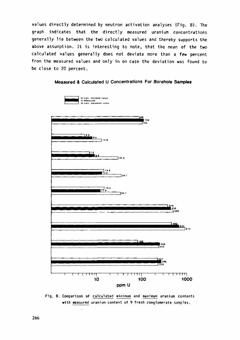
values directly determined by neutron activation analyses (Fig. 8). Thegraph indicates that the directly measured uranium concentrationsgenerally lie between the two calculated values and thereby supports theabove assumption. It is interesting to note, that the mean of the twocalculated values generally does not deviate more than a few percentfrom the measured values and only in on case the deviation was found tobe close to 20 percent.
Measured & Calculated U Concentrations For Borehole Samples
U-calc minimum valueU measuredU-calc maximum value
T89fM 109
1104
15 .5
17.0
J 30 6
14 aD 35 7
I37B4363 506
Jsio
• 249J243
TM7•§266J230
I I I 1 I |
10n i i i i i 11
100ppm U
i i i i 1 1 1 11000
Fig. 8: Comparison of calculated mi nimum and maximum uranium contentswith measured uranium content of 9 fresh conglomerate samples.
266

The history of the U-Th-Pb system of weathered samples is morecomplex because it normally has suffered a recent disturbance. Acomparison of the ages ( t ass , t pb.2o7/Pb-206' tPb-208/Th-232 ) wi11
often indicate, how the system was disturbed and, consequently, the agepattern is a helpful guide to evaluate the calculated original uraniumconcentrations. Six patterns can be distinguished:
* ass l Pb-207/Pb-206 ** -208/^-232
The measured and assumed ages are concordant which indicates thatthe U-Th-Pb system was closed between the time of lead isotopehomogenization and onset of weathering, and that the time of leadisotope homogenization was not much different from the time ofconglomerate deposition. It further shows that thorium and leadwere not affected by supergene alteration. The calculated uraniumvalues, therefore, are close to the fresh-rock uranium contents ofthe conglomerates.
t ass > t Pb-207/Pb-206 ~ t Pb-206/Th-232
The calculated ages are concordant but lower than the assumed age.This may indicate that the two measured ages were completely resetor that t _cc is wrong. Therefore, the best estimate for the05 Scalculated uranium value is obtained by inserting the measured agesinto the two equations.
ass Pb-207/Pb-206 > Pb-208/Th-232
This pattern indicates open system behaviour with a thorium gain ora lead loss possibly also during weathering. In view of the factthat lead has higher supergene mobility than thorium, equation (2)using the lead-lead age should be employed for the calculation ofthe fresh-rock uranium content.
(4) l ass "* * Pb-207/Pb-206 t Pb-208/Th-232
This pattern points to severe disturbances of the Th-Pb system.Because of the concordancy between t ass and t pb-207/Pb-206 a 1eadgain seems to be unlikely and, therefore, only a thorium loss
267
should be assumed and equation (1) used for the calculation of thefresh-rock uranium tenor.
(5) t *" t > tass Pb-207/Pb-206 Pb-208/Th-232Severe disturbances of the Th-Pb system are also reflected by thispattern, however, it is uncertain whether a lead loss or thoriumgain (recently or in the past) or both occurred. Consequently, onlyequation (1) can be used which yields a minimum calculated uraniumvalue.
Pb-207/Pb-206 ass Pb-208/Th232This pattern reveals severe disturbance of the U-Th-Pb systembefore onset of weathering, and a recent thorium loss ore lead gaincannot be ruled out. Assuming that lead has a higher supergenemobility than thorium calculation of the fresh-rock uranium contentmust be carried out with equation (2) and using t for time tass
Most of the samples from the West Rand Group follow age pattern (3) andthose from the Pongola Supergroup age pattern (1). The age patterns ofthe samples from the Uitkyk Formation and from the Hoodies Group varymore randomly.
Figure 9 shows for a number of weathered samples the fresh-rock uraniumcontents (best estimates calculated according to the rules discussed inthe above 6 cases), the actual measured uranium contents (measured byneutron activation analysis), and the differences between the twouranium values. These differences are equal to the theoretical uraniumlosses suffered by the samples during weathering. It should be notedthat only one sample deviates from the general pattern and shows atheoretical uranium gain.
The recognized theoretical uranium losses resemble closely the uraniumlosses inflicted by leaching of fresh samples (Fig. 6). In addition inTable 1 the measured uranium contents of fresh bore core samples arecompared with calculated uranium values of weathered conglomeratesamples . Each of the compared sample pairs originates from one par-ticular stratigraphie horizon.
268
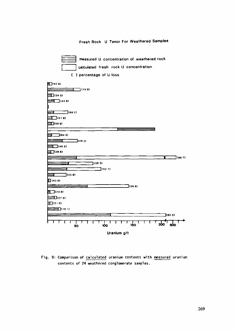
Fresh Rock U Tenor For Weathered Samples
measured U concentration of weathered rock
calculated fresh rock U concentration
( ) percentage of U loss
9)
1(199)
^1(345)
3 1(439)
(692 )
](64 9)
_J(49 3)
HJ(46 5)
3~l(36 8)
J(8« 7)
1(38 5)
1(52 7)
1(55 9)
(4 3 8)
T~l(708)
( 2 7 6 )
6)
1(16 1)
J(38 8)
J<60.5)
*Tl l | l l l i | i l l l T I50 K>O 150
Uranium g/t
' ' ' '2*0
Fig. 9: Comparison of calculated uranium contents with measured uraniumcontents of 24 weathered conglomerate samples.
269
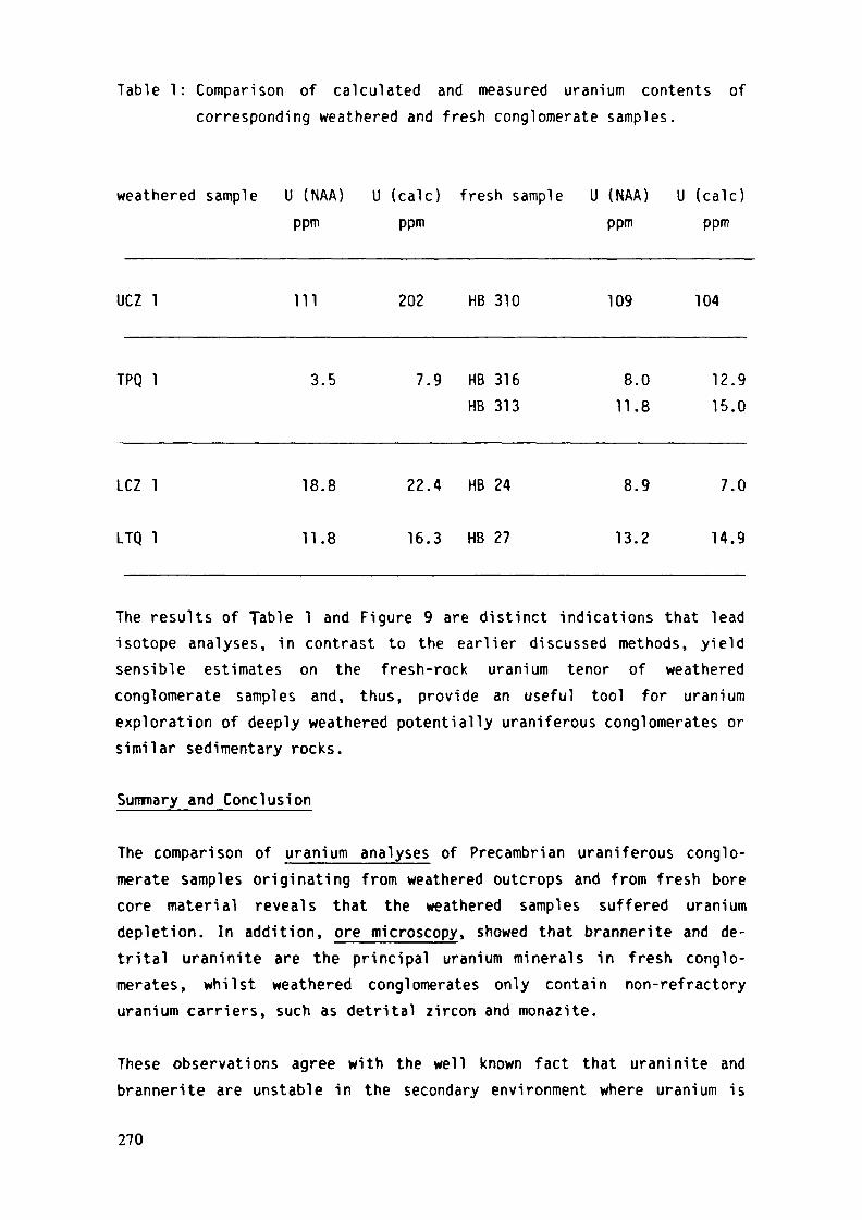
Table 1: Comparison of calculated and measured uranium contents ofcorresponding weathered and fresh conglomerate samples.
weathered sample U (NAA) U (cale) fresh sample U (NAA) U (cale)ppm ppm ppm ppm
UCZ 1 111 202 HB 310 109 104
TPQ 1 3.5 7.9 HB 316
HB 313
8.0
11.8
12.9
15.0
LCZ 1 18.8 22.4 HB 24 8.9 7.0
LTQ 1 11.8 16.3 HB 27 13.2 14.9
The results of Table 1 and Figure 9 are distinct indications that leadisotope analyses, in contrast to the earlier discussed methods, yieldsensible estimates on the fresh-rock uranium tenor of weatheredconglomerate samples and, thus, provide an useful tool for uraniumexploration of deeply weathered potentially uraniferous conglomerates orsimilar sedimentary rocks.
Summary and Conclusion
The comparison of uranium analyses of Precambrian uraniferous conglo-merate samples originating from weathered outcrops and from fresh borecore material reveals that the weathered samples suffered uraniumdepletion. In addition, ore microscopy, showed that brannerite and de-trital uraninite are the principal uranium minerals in fresh conglo-merates, whilst weathered conglomerates only contain non-refractoryuranium carriers, such as detrital zircon and monazite.
These observations agree with the well known fact that uraninite andbrannerite are unstable in the secondary environment where uranium is
270
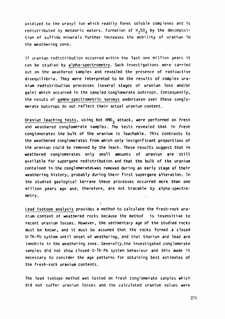
oxidized to the uranyl ion which readily forms soluble complexes and isredistributed by meteoric waters. Formation of H-SO. by the decomposi-tion of sulfide minerals further increases the mobility of uranium inthe weathering zone.
If uranium redistribution occurred within the last one million years itcan be studied by alpha-spectrometry. Such investigations were carriedout on the weathered samples and revealed the presence of radioactivedisequilibria. They were interpreted to be the results of complex ura-nium redistribution processes (several stages of uranium loss and/orgain) which occurred in the sampled conglomerate outcrops. Consequently,the resuts of gamma-spectrometric surveys undertaken over these conglo-merate outcrops do not reflect their actual uranium content.
Uranium leaching tests, using hot HNO- attack, were performed on freshand weathered conglomerate samples. The tests revealed that in freshconglomerates the bulk of the uranium is leachable. This contrasts tothe weathered conglomerates from which only insignificant proportions ofthe uranium could be removed by the leach. These results suggest that inweathered conglomerates only small amounts of uranium are stillavailable for supergene redistribution and that the bulk of the uraniumcontained in the conglomerates was removed during an early stage of theirweathering history, probably during their first supergene alteration. Inthe studied geological terrane these processes occurred more than onemillion years ago and, therefore, are not tracable by alpha-spectro-metry.
Lead isotope analysis provides a method to calculate the fresh-rock ura-nium content of weathered rocks because the method is insensitive torecent uranium losses. However, the sedimentary age of the studied rocksmust be known, and it must be assumed that the rocks formed a closedU-Th-Pb system until onset of weathering, and that thorium and lead areimmobile in the weathering zone. Generally,the investigated conglomeratesamples did not show closed U-Th-Pb system behaviour and this made itnecessary to consider the age patterns for obtaining best estimates ofthe fresh-rock uranium contents.
The lead isotope method was tested on fresh conglomerate samples whichdid not suffer uranium losses and the calculated uranium values were
271
found to be in good agreement with directly measured uranium contents.For a number of weathered samples the calculated fresh-rock uraniumtenor indicates the occurrence of supergene uranium losses which are ofthe same magnitude as the uranium losses caused by experimental leachingof fresh conglomerate samples.
In addition calculated fresh-rock uranium contents of weatheredconglomerates were compared with the uranium contents of fresh sampleswhich were collected from the identical sedimentary horizon as theweathered samples. These comparisons showed close agreement of thevalues.
It is furthermore concluded that uranium redistribution in the secondaryenvironment is not governed by systematic processes. This means that theoriginal uranium contents of now weathered conglomerates cannot beestimated by simple extrapolations using gamma- and alpha-spectrometricmethods. Lead isotope technique proved to be the only method yieldinguseable estimates of the fresh-rock uranium contents of weatheredglomerates. The method, albeit expensive, can therefore be recommendedfor exploration purposes as it might help to cut drilling costs 1ndeeply weathered terranes underlain by potentially uranium bearing con-glomerates.
Acknowlcdgements
The authors are indebted to Dr. R.P. Viljoen, Johannesburg, formerly ofthe J.C.I. Fundamental Research Unit in Randfontein, for his invaluableassistance during the field work of this study and for many helpful dis-cussions. The Deutsche Forschungsgemeinschaft (DFG), Bonn, financed partof this study by grants Sa 210-8/10.
References
Meyer, M., Saager, R., and Koppel, V. (1983): Radionuclide techniquesand lead isotope analyses as tools in uranium exploration. ICAM81, Proc. of 1st Int. Congr. Applied. Mineralogy, Johannesburg.de Villiers, J.P.R. and Cowthorn, P.A. (eds.), Geol. Soc. S. Afr.Spec. Pub!. #7.
272
Saager, R., Thiel, K., Hennig, G.J., and Bangert, U. (1982): Uraniumredistribution in weathered conglomerates of the early Precam-brian Pongola Supergroup, South Africa. Journ. Geochem. Expl.,15, 233-249.
Stacey, J.S., and Kramers, J.D. (1975): Approximation of terrestriallead isotope evolution by a two stage model. Earth. Planet. Sei.Lett., 26, 207-221.
Thiel, K., Saager, R., and Muff, R. (1979): Distribution of uranium inearly Precambrian gold-bearing conglomerates of the KaapvaalCraton, South Africa: a review of a case study for the appli-cation of fission track micromapping of uranium. Minerals. Sei.Engng., 11, 225-245.
Thiel, K., Vorwerk, R., Saager, R., and Stupp, H.D. (1983): U-235fission tracks and U-238 series disequilibria as a means to studyrecent mobilisation of uranium in Archaean pyritic conglomerates.Earth Planet. Sei. Lett, (in press).
273
MINERALOGICAL CHANGES IN WITWATERSRANDPLACER URANIUM DURING PROTEROZOICWEATHERING, WELKOM GOLDFffiLD, SOUTH AFRICA
W.E.L. MINIERCape Town University,Cape TownC.E. FEATHER, C.W. GLATTHAARAnglo American Research Laboratories,Crown Mines
South Africa
Abstract
T h e E l d o r a d o p a l e o s u r f a c e m a r k s t h e last m a j o r p e r i o d o f e r o s i o n i nthe W i t w a t e r s r a n d succession in the W e l k o m g o l d f i e l d . F l u v i a l andd e b r i s - f l o w pediments on this surface conta in placer concentrates thatw e r e u l t i m a t e l y d e r i v e d by the repeated e r o s i o n o f s u b c r o p p i n gplacers , w h i c h occur w i t h i n a sequence of o n l a p p i n g f o r m a t i o n s ,sepa ra t ed by u n c o n f o r m i t i e s , near the sou the rn m a r g i n of the basin.A u t o r a d l o g r a p h s of core d r i l l e d t h r o u g h the p e d i m e n t i n d i c a t e thatu r a n i u m m i n e r a l i z a t i o n i s a s s o c i a t e d w i t h d e t r i t a l p y r i t ea c c u m u l a t i o n s on the Eldorado paleosurface. This mine ra l i za t ion occursas f l u v i a l bed load concen t ra tes t ha t w e r e deposi ted in sha l l owpaleochannels, and w i t h conglomerat ic d iamict i tes . Compar ison ofheavy m i n e r a l assemblages in crushed concentrates of the subcroppingp l a c e r s w i t h those f r o m t h e E ldorado p e d i m e n t , i n d i c a t e s t h a t t t h esu i t e of heavy m i n e r a l s is the same; a l l three v a r i e t i e s of py r i t eshow d e t r i t a l r o u n d i n g , i n c l u d i n g secondary p y r i t e tha t o r i g i n a l l yf o r m e d in s i t u in the older placers; ke rogen p a r t i c l e s appear to berounded a l l o g e n i c g r a i n s o f b roken c o l u m n a r ke rogen de r ived f r o merosion of older placers; u ran in i te is very sparse and occurs as rareinclusions in the rounded kerogen grains and even more rarely as freea l logen ic g r a i n s ; there is extensive evidence of a l t e r a t i o n becausethe u r a n i u m occurs p r e d o m i n a n t l y as b r a n n e r i t e and u r a n i f e r o u sleucoxene. The ra r i ty of uranin i te indicates that most of the grainsof tha t m i n e r a l were destroyed d u r i n g r e w o r k i n g and exposure to theelements on a fan pediment. The destruction could have been due to theo x i d a t i o n of t e t rava len t u r a n i u m to h e x a v a l e n t u r a n i u m by a w e a k l yoxidis ing atmosphere.
275

1.0 INTRODUCTION
All the most important Witwatersrand placers are contained within thefluvially dominated upper part of the Witwatersrand Supergroup, whichhas been renamed the Central Rand Group. This group is comprised ofnumerous tectono-gene11 c sedimentary packages separated byunconformities (Fig 1). The packages are composed almost entirely ofarenites, with minor gravel faciès, and were deposited in alluvial fanand alluvial plain environments.
2000 m -
1000 m -
n -
a0
(5T3C03
CE
"cô»-c00
£ a.<i) 3c 9O O)£1 -Q>_ 3r-
O)
E §"W O0) ~c
™w0-5
Formation orsynlhem
Eldorado
AandenkSpes Bon«Dagbreek
Harmony /
Welkom
SI Helena
Virginia
a •
•«
...
••*<#**>.<
AJU
...
'
. .•
Placers
EA
RosedaleAandenk
LeaderBasal/Steyn
Intermediate
CommonageAda May
Figure 1 Stratigraphy of the Central Rand Group in the Welkomgoldfield showing the numerous tectonogenetic sedimentary packagesand associated placers .
The Central Rand arenites vary in colour from brownish, with asericitic matrix, to more mature light grey with very little sericitein the matrix. These compositional changes are thought to reflectchanges from ephemeral to more perennial flow conditions^. Placerconcentrates generally occur in very mature scour-based pebble lag andgravel-bar deposits, overlain by trough cross-bedded quartz-arenites.These placer sediments are always located on degradation surfaces,either on the basal unconformity of a genetic sedimentary package(Fig. 1) or on retrenched degradation surfaces within such packages2.
276
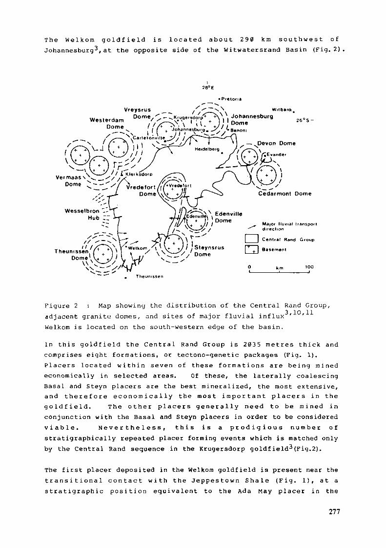
T h e W e l k o m g o l d f i e l d i s loca ted a b o u t 2 9 0 k m s o u t h w e s t o fJohannesburg-*, at the opposite side of the Wi twate r s rand Basin (Fig. 2)
WesterdamDome
VreysrusDome
/
28° E
• Pretoria
~^\\ , Johannesburgj ' ' Dom«
+ Johannesburg. J^'/«Benonj-l l . ^~-^iinC' —f\
Heidelberg
Witbank
26°S-
Wesselbron _-Hub :;
Major fluvial transportdirection
|___I Central Rand Group
100
Theunissen
Map showing the distribution of the Central Rand Group,adjacent granite domes, and sites of major f luvia l i n f l u x ' 'Figure 2adjacentWelkom is located on the south-western edge of the basin.
In t h i s g o l d f i e l d the C e n t r a l Rand G r o u p i s 2035 me t r e s t h i c k andcomprises e ight f o r m a t i o n s , or tectono-genetic packages (Fig. 1).P l a c e r s located w i t h i n seven o f these f o r m a t i o n s a r e b e i n g m i n e deconomical ly in selected areas. Of these, the la te ra l ly coalescingBasal and Steyn placers are the best mine ra l i z ed , the most extensive,a n d t h e r e f o r e e c o n o m i c a l l y t h e m o s t i m p o r t a n t p l a c e r s i n t h eg o l d f i e l d . The o t h e r p lacers g e n e r a l l y need to be m i n e d inconjunct ion wi th the Basal and Steyn placers in order to be consideredv i a b l e . N e v e r t h e l e s s , t h i s i s a p r o d i g i o u s n u m b e r o fstrat igraphical ly repeated placer fo rming events which is matched onlyby the Central Rand sequence in the Krugersdorp goldfield3(Fig.2) .
The f i r s t placer deposited in the Welkom goldfield is present near thet r a n s i t i o n a l c o n t a c t w i t h the J e p p e s t o w n S h a l e ( F i g . 1 ) , a t as t r a t i g r a p h i e p o s i t i o n e q u i v a l e n t to the Ada May placer in the
277
Kle rksdo rp g o l d f i e l d ^ . I t i s m i n e r a l i z e d p r e d o m i n a n t l y w i t h u r a n i u mand m i n o r a m o u n t s o f go ld . The placer i s u n e v e n l y d i s t r i b u t e d andg e n e r a l l y deeply b u r i e d . I t appears t o r e p r e s e n t t he i n i t i a lp r o g r a d a t i o n of a l l u v i a l f a n s into the area.
A p r o g r a d i n g sequence f r o m d i s t a l t o p r o x i m a l p l ace r s , d e p o s i t e d byf l u v i a l processes at the top of the St. He lena f a n , and at the base oft h e o v e r l y i n g W e l k o m f a n , i s r e f e r r e d t o c o l l e c t i v e l y a s t h eI n t e r m e d i a t e p l a c e r zone . They f o r m e d in response to t e c t o n i s m andcompr ise u r a n i u m - b e a r i n g conglomera te zones in close p r o x i m i t y to eachother .
The B a s a l and S t e y n p lace r s a t the top o f the W e l k o m F o r m a t i o nr e p r e s e n t t e r m i n a l g r a v e l s i n t w o c o a l e s c i n g sheets tha t t oge the rcover 4 0 0 k m 2 a n d c o n t a i n s i g n i f i c a n t c o n c e n t r a t i o n s o f g o l d a n du r a n i u m . They are considered to be the resul t of channel processest h a t r e t r e n c h e d t he t op o f t he W e l k o m f a n . They d i s p l a y bo thp r o x i m a l and d is ta l character is t ics .
This f l u v i a l sequence is in te r rup ted by a 20-met re t h i c k debr i s f l o wcomplex that was der ived f r o m near the po in t of basin closure in thesouth and i s k n o w n as the H a r m o n y F o r m a t i o n . F l u v i a l a c t i v i t y w i t h i nt h i s c o m p l e x h a s e roded d i s c r e t e b r a i d e d c h a n n e l w a y s t h r o u g h t o t h eb u r i e d S t e y n p l a c e r , w h i c h w a s then l o c a l l y r e w o r k e d t o p r o d u c e t h egold and u r a n i u m bea r ing Saaiplaas placer".
The Leader placer, at the base of the Dagbreek fan-de l ta F o r m a t i o n 7
then e n t e r e d the d e p o s i t o r y f r o m the w e s t as a r e s p o n s e to r e n e w e dtectonisrrt . It is compr i sed of a number of gold- and u r a n i u m - b e a r i n gcong lomera t i c lobes and probably covers 200 k m 2 . At this t i m e , d u r i n gwhat appears to have been a period of basin-wide epierogenesis, f a n saround the m a r g i n of the basin transgressed, deposit ing f i n i n g - u p w a r dsequences that collectively produced a widespread s t r a t ig raph ie shalemarker .
The T u r f f o n t e i n Subgroup above this m a r k e r (Fig. 1) represents renewedshr inkage of the basin, w i t h coarse a l luv ia l fans encroaching f r o m al lmargins . In the Welkom go ldf ie ld , the last three impor tan t placersformed du r ing this t ime. The B placer is a p redominan t ly gold-bear ingplacer at the base of the tectonically induced Spes Bona sedimentarysequence. P r o x i m a l placer c o n g l o m e r a t e s a r e c o n f i n e d t o d i s c r e t echanne l s , g e n e r a l l y less than two met res deep, that eroded in to thef ine-gra ined shale/siltstone of the Dagbreek Format ion 2 .
278
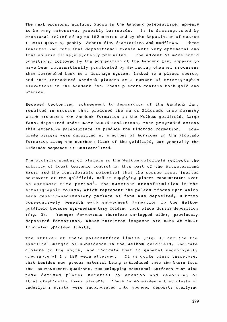
The next e ros ional sur face , k n o w n as the Aandenk pa leosur face , appearsto be v e r y e x t e n s i v e , p r o b a b l y b a s i n w i d e . I t i s d i s t i n g u i s h e d bye r o s i o n a l r e l i e f of up to 100 m e t r e s and by the d e p o s i t i o n of coarsef l u v i a l g rave l s , pebbly deb r i s - f l ow d i a m i c t i t e s and m u d f l o w s . Thesef e a t u r e s i n d i c a t e that d e p o s i t i o n a l e v e n t s w e r e v e r y e p h e m e r a l a n dt h a t a n a r i d c l i m a t e p r o b a b l y p r e v a i l e d . T h e a d v e n t o f m o r e h u m i dcondi t ions , fo l lowed by the agg rada t ion of the Aandenk f a n , appears toh a v e been i n t e r m i t t e n t l y p u n c t u a t e d b y d e g r a d i n g c h a n n e l processesthat retrenched back to a d r a i n a g e system, l inked to a placer source,and t h a t i n t r o d u c e d A a n d e n k p lace rs a t a n u m b e r of s t r a t i g r a p h i ee l e v a t i o n s i n t h e A a n d e n k f a n . These p l a c e r s c o n t a i n b o t h go ld a n du r a n i u m .
R e n e w e d t e c t o n i s m , s u b s e q u e n t t o d e p o s i t i o n o f t h e A a n d e n k f a n ,r e s u l t e d i n e r o s i o n t h a t p roduced t h e m a j o r E l d o r a d o u n c o n f o r m i t yw h i c h t runca tes the A a n d e n k F o r m a t i o n in the W e l k o m g o l d f i e l d . Largef a n s , depos i t ed u n d e r m o r e h u m i d c o n d i t i o n s , then p r o g r a d e d acrossth is ex tens ive pa leosur face to produce the Eldorado F o r m a t i o n . Low-grade placers were deposited at a number of hor izons in the E ldoradoF o r m a t i o n a long the no r the rn f l a n k of the go ld f i e ld , but genera l ly theEldorado sequence is u n m i n e r a l i z e d .
T h e p r o l i f i c n u m b e r o f p l ace r s i n t h e W e l k o m g o l d f i e l d r e f l e c t s t h eac t iv i ty of local tectonic control in this part of the W i t w a t e r s r a n dB a s i n a n d t h e c o n s i d e r a b l e p o t e n t i a l t h a t t h e source a r e a , loca tedsouthwest of the goldf ie ld , had in supplying placer concentrates overa n e x t e n d e d t i m e p e r i o d ^ . T h e n u m e r o u s u n c o n f o r m i t i e s i n t h es t r a t i g r a p h i e c o l u m n , w h i c h represen t t h e p a l e o s u r f a c e s upon w h i c heach g e n e t i c - s e d i m e n t a r y package of f a n s was depos i ted , subcropc o n s e c u t i v e l y beneath each subsequen t f o r m a t i o n in the W e l k o mg o l d f i e l d because syn-sedimentary fo ld ing took place dur ing deposition(Fig. 3). Younger fo rma t ions there fore on-lapped older, previouslydepos i ted f o r m a t i o n s , whose th i ckness isopachs a re zero a t t he i rt runcated upfolded l imits.
T h e s t r i k e s o f t he se p a l e o s u r f a c e l i m i t s ( F i g . 4 ) o u t l i n e t h es y n c l i n a l m a r g i n o f s u b s i d e n c e i n t h e W e l k o m g o l d f i e l d , i n d i c a t ec losu re t o t he s o u t h , and i n d i c a t e t h a t i n g e n e r a l u n c o n f o r m i t yg r a d i e n t s of 1 : 100 w e r e a t t a i n e d . I t is q u i t e c lear t h e r e f o r e ,that besides new placer m a t e r i a l being introduced into the basin f r o mthe southwestern quad ran t , the o n l a p p i n g eros ional sur faces mus t alsoh a v e d e r i v e d p l ace r m a t e r i a l b y e r o s i o n a n d r e w o r k i n g o fs t r a t i g r a p h i c a l l y lower placers. There is no evidence that clasts ofu n d e r l y i n g s t r a t a were incorporated in to younger deposi ts over ly ing
279
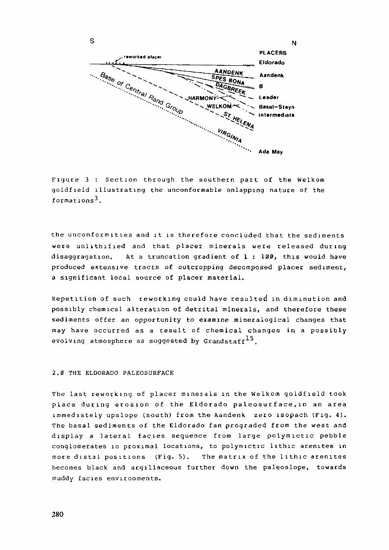
N
, reworked placerPLACERS
Eldorado
'- Ada May
F i g u r e 3 : Sec t i on t h r o u g h the s o u t h e r n p a r t of the W e l k o mg o l d f i e l d i l l u s t r a t i n g the u n c o n f o r m a b l e on lapp ing na tu re of theformat ions -* .
t he u n c o n f o r m i t i e s and i t i s t h e r e f o r e conc luded t ha t the s e d i m e n t sw e r e u n l i t h i f i e d and tha t placer m i n e r a l s w e r e released d u r i n gdisaggraga t ion . At a t runcat ion gradient of 1 : 100, this would baveproduced extensive tracts of outcropping decomposed placer sediment,a s ign i f i can t local source of placer material .
R e p e t i t i o n of such r e w o r k i n g could have resu l ted in d i m i n u t i o n andpossibly chemical a l terat ion of detrital minera ls , and therefore thesesediments o f f e r an opportuni ty to examine minera log ica l changes thatmay have occur red as a r e su l t of chemica l changes in a poss ib lyevolving atmosphere as suggested by Grandstaff
2.0 THE ELDORADO PALEOSURFACE
The last r e w o r k i n g o f p lacer m i n e r a l s i n the W e l k o m g o l d f i e l d tookp l a c e d u r i n g e r o s i o n o f t h e E l d o r a d o p a l e o s u r f a c e , i n a n a r e ai m m e d i a t e l y ups lope ( s o u t h ) f r o m t h e A a n d e n k zero i sopach (F ig . 4 ) .The basa l s e d i m e n t s o f the E ldo rado fan p rograded f r o m the west andd i s p l a y a l a t e r a l f a c i è s sequence f r o m l a rge p o l y m i c t i c pebbleconglomerates in p r o x i m a l locations, to po lymic t i c l i th ic arenites inm o r e d i s t a l p o s i t i o n s (F ig . 5 ) . T h e m a t r i x o f t h e l i t h i c a r e n i t e sbecomes black and argillaceous fur ther down the paleoslope, towardsmuddy facies e n v i r o n m e n t s .
280
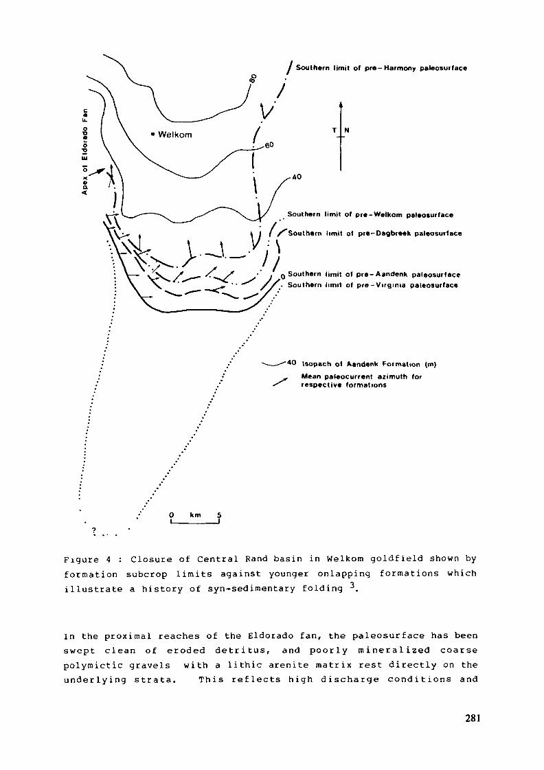
/ Southern limit of pré-Harmony paleosurface
Southern limit of pre-Welkom paleosurface
/ / /''Southern limit o( pre-Oagbreek paleosurface
, Q Southern limit of pre-Aandenk paleosurface/ / , • Southern limit of pre-Virginia paleosurface
-40 Isopach of Aandenk Formation (m)
Mean paleocurrent azimuth forrespective formations
km
Figure 4 : Closure of Central Rand basin in Welkora go ld f i e ld shown byf o r m a t i o n subcrop l imi t s against younger on lapp ing f o r m a t i o n s wh ichi l lus t ra te a h i s to ry of syn-sedimentary fo ld ing 3.
In the p r o x i m a l reaches of the Eldorado fan , the paleosurface has beenswept c lean of eroded d e t r i t u s , and p o o r l y m i n e r a l i z e d coarsepo lymic t i c gravels w i t h a l i th ic areni te m a t r i x rest directly on theu n d e r l y i n g s t r a t a . T h i s r e f l e c t s h i g h d i s c h a r g e c o n d i t i o n s a n d
281
Aandenk Formation Isopachs
Rosedale Member Isopachs
Pebble Isopleths of largest claslsin Rosedale Member (phi un i ts )
Placer - pediment preserved
80m
Figure 5 : Geometry of Eldorado fan .shown by isopach contours andpebble size isopleths superimposed over the pediment containing erodedplacer concentrates.
dilution of eroded detritus by new sediment entering the basin. Inmore distal reaches of the Eldorado fan, where transport power wasinsufficient to move coarse gravel, and where muddy sedimentsaccumulated, there is eroded detritus resting on the paleosurface as apediment. It does not contain the polymictic clastic assemblage thatis characteristic of the Eldorado sediments and is unlike the brownishquartz-wacke of the Aandenk Formation (Fig. 5),The Eldorado pediment was intersected in an early borehole, VDHl,which was referred to by Baines8 (p.311) in 1949 as the "uncorrelatedreef1. It was subsequently intersected in a number of other boreholesand became known as the Gold Estates Leader^. The pediment iscomposed of two faciès types. The first comprises thin, scour-based,
282
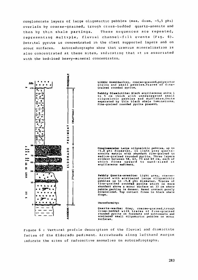
conglomerate layers of large oligomictic pebbles (max. d iam. -5,5 phi)o v e r l a i n by coarse -gra ined , t r o u g h cross-bedded quar tz -a ren i te andt h e n b y t h i n sha l e p a r t i n g s . These s e q u e n c e s a r e r e p e a t e d ,r e p r e s e n t i n g m u l t i p l e , f l u v i a l c h a n n e l - f i l l e v e n t s ( F i g . 6 ) .Detri tal pyrite is concentrated in the clast supported layers and onscour surfaces. Au to rad iographs show that u r a n i u m m i n e r a l i z a t i o n isalso c o n c e n t r a t e d a t these sites, i n d i c a t i n g t h a t i t i s a s soc ia tedw i t h the bed-load heavy-minera l concentrates.
oa«ocoo
Litbic Arenite:Grey, coarse-grained/polymicticg r a i n s a n d s m a l l pebbles .Traces o f f i n e -grained rounded pyrite.
Pebbly Dlavictite: Black argillaceous units 1to 5 cm t h i c k w i t h u n s e g r e g a t e d s m a l lo l i g o m i c t i c pebbles and mud f l a k e s . O n 11 sseparated by th in black shale l a m i n a t i o n s .Fine-grained rounded pyrite present.
Conglomerate: Large o l igomict ic pebbles, up to-5 ,0 phi d iameter , in l i g h t grey quartz -arenite matrix with abundant f ine-grained tom e d i u m - g r a i n e d rounded pyri te . Three layersevident between 50, 63, 73 and 88 cm, each ofw h i c h f i n e s u p w a r d t o s a n d - s i z e d o cargillaceous sediment.
Pebbly Quartm-arenlte: L i g h t grey , coarse-grained w i t h scat tered l a r g e o l i g o m i c t i cpebbles up to -5,0 phi diameter. Traces off i n e - g r a i n e d rounded pyc i te w h i c h is moreabundant above a scour surface at 33 cm wherepebble packing is denser. Basal contact poorlymineral ized. Top contact f ines to black shaledrape.
Unconformity:Quartx-WBCke: Grey, coarse-grained,troughcross-bedded w i t h traces o f f i n e - g r a i n e drounded pyrite on foresets and bottomsets andscattered small ol igomictic pebbles on scoursurfaces.
F i g u r e 6 : Ver t ica l p r o f i l e descr ip t ion of the f l u v i a l and d i a m i c t i t ef a c i è s o f t h e E l d o r a d o p e d i m e n t . A r r o w h e a d s a l o n g l e f t h a n d m a r g i nindicate the sites of r ad ioac t ive anomal ies on a u t o r a d i o g r a p h s .
283
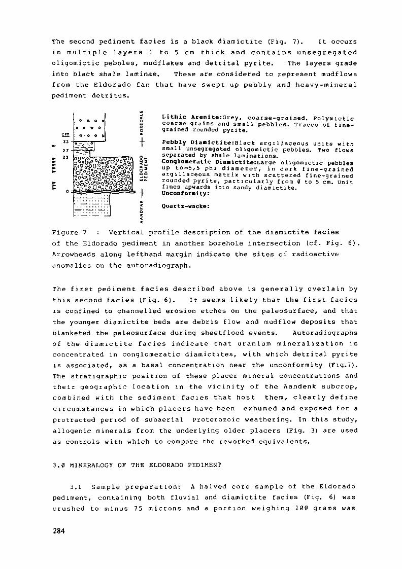
The second pediment facies is a black d iamic t i t e (Fig. 7). It occursin m u l t i p l e l a y e r s 1 to 5 cm t h i c k and c o n t a i n s u n s e g r e g a t e do l igomic t i c pebbles, mudf l akes and det r i ta l pyri te . The layers gradein to black shale laminae. These are considered to represent m u d f l o w sf r o m the E l d o r a d o f an tha t have swept up pebbly and h e a v y - m i n e r a lpediment de t r i tus .
Lithic Atenite:Grey, coarse-grained. P o l y m i c t i ccoarse g r a i n s and s m a l l pebbles. Traces of f i n e -grained rounded pyrite.
Pebbly Diamict i te :Black a r g i l l a c e o u s un i t s w i t hsmall unsegregated o l i gomic t i c pebbles. Two f lowsseparated by shale laminations .Conglomeratic Diaaictite:Large o l i g o m i c t i c pebblesu p to-5,5 p h i d i a m e t e r , i n d a r k f i n e - g r a i n e da r g i l l a c e o u s m a t r i x w i t h scattered f i n e - g r a i n e drounded p y r i t e , p a r t i c u l a r l y f r o m 0 to 5 cm. U n i tf ines upwards into sandy d i a m i c t i t e .Unconformity:
Quartz-wacke:
Figure 7 : Vertical profile description of the diamictite faciesof the Eldorado pediment in another borehole intersection (c f . Fig. 6).Arrowheads along lefthand margin indicate the sites of radioactiveanomalies on the autoradiograph.
The f i r s t p e d i m e n t f ac i e s desc r ibed above i s g e n e r a l l y o v e r l a i n byt h i s second f a c i e s ( F i g . 6 ) . I t seems l i k e l y tha t the f i r s t f a c i e sis conf ined to channelled erosion etches on the paleosurface, and thatthe younger d i a m i c t i t e beds are debris f l o w and m u d f l o w deposits thatblanketed the paleosurface d u r i n g sheetflood events. Autoradiographso f t h e d i a m i c t i t e f a c i e s i n d i c a t e tha t u r a n i u m m i n e r a l i z a t i o n i sconcentrated in conglomerat ic d i a m i c t i t e s , w i t h wh ich de t r i t a l pyr i t eis associated, as a basal concentrat ion near the unconfo rmi ty (Fig.7).The s t r a t ig raph ie posi t ion of these placer m i n e r a l concentrations andt h e i r g e o g r a p h i c l oca t ion in the v i c i n i t y o f the A a n d e n k subc rop ,c o m b i n e d w i t h t h e s e d i m e n t f ac i e s tha t host t h e m , c l e a r l y d e f i n ec i r c u m s t a n c e s in w h i c h p l ace r s h a v e been e x h u m e d and exposed for aprot racted per iod of subae r i a l P ro t e rozo ic wea the r ing . In this study,a l logenic m i n e r a l s f r o m the unde r ly ing older placers (Fig. 3) are usedas controls w i t h wh ich to compare the r e w o r k e d equivalents.
3.0 M I N E R A L O G Y OF THE ELDORADO P E D I M E N T
3.1 S a m p l e p r e p a r a t i o n : A ha lved core s a m p l e of the E l d o r a d opediment , con ta in ing both f l u v i a l and d i a m i c t i t e fac ies (Fig. 6) wasc r u s h e d to m i n u s 75 m i c r o n s and a p o r t i o n w e i g h i n g 100 g r a m s was
284
des l i raed to r e m o v e the l i gh t f i n e - g r a i n e d f r a c t i o n . The r e m a i n d e rwas separa ted in to three f r a c t i o n s by u s i n g heavy l i q u i d s w i t hs p e c i f i c g r a v i t i e s of 2 ,50 and 2 ,85 respec t ive ly . Pa r t s of thesef r a c t i o n s w e r e then se t in r e s i n and po l i shed fo r m i c r o s c o p i ce x a m i n a t i o n in r e f l e c t e d l i g h t . The r e m a i n d e r o f these f r a c t i o n swere analysed for u r a n i u m content by an X-ray fluorescence method.
A u t o r a d i o g r a p h s of two h a l f - c o r e s (F igs . 6 and 7) were recorded tod e t e r m i n e t h e g e n e r a l d i s t r i b u t i o n p a t t e r n o f t h e u r a n i u mm i n e r a l i z a t i o n . This involved keeping the cores in contact w i t h A g f aG e v a e r t S t r u c t u r i x D-10-P X - r a y f i l m fo r an e x p o s u r e pe r iod o f 14days. Although this method is effective in locating discrete radio-active particles, it is not suitable for establ ishing the presence ofvery f i n e l y divided u r a n i u m . Thin 3 mm slices of core were cut f r o mradioact ive sites and polished for microscopic examina t ion .
3.2 Mineralogy of Crushed Sample.X-ray d i f f r a c t i o n analysis , supplemented by microscopic examinat ion ,ind ica ted that q u a r t z i s the p r e d o m i n a n t m i n e r a l cons t i tuent .Pyrophylli te is next in order of abundance followed by minor and tracea m o u n t s of ore m i n e r a l s . The d o m i n a n t ore m i n e r a l s are pyr i te ,leucoxene, chromite and zircon. These, andthe minor ore minera lsrecogn ised are l isted in Table 1.
TABLE ^
Relative Abundances of Heavy Mineralsin Eldorado Pediment
Mineral Mass Percent
Pyrite 82,2Leucoxene 11»7Chromite 3,0Zircon 1,5Arsenopyrite 1,0Brannerite 0,4Cobaltite/Gersdorffite 0,4Chalcopyrite 0,4Uraniferous kerogen 0,1Galena TrUraninite TrGold Tr
285
T h i s s u i t e o f m i n e r a l s , w i t h t h e e x c e p t i o n o f c e r t a i n g e n e t i cd i f f e r e n c e s displayed by the pyr i te g ra ins , is very s i m i l a r to thosein an ave rage W i t w a t e r s r a n d orebody1 2 . The d i s t r i b u t i o n of u r a n i u mbetween the three spec i f i c g r a v i t y f r a c t i o n s i s listed in Table I I .
3.2.1 The SG f r a c t i o n less than 2 .5 .S i x p e r c e n t o f t h e t o t a l u r a n i u m i s c o n t a i n e d w i t h i n t h i s f r a c t i o n .I t i s p robab ly associated w i t h f r a g m e n t s o f kerogen. F i n e l y d i v i d e ds i l i ceous m a t e r i a l i s a lso con t a ined in t h i s f r a c t i o n .
3 . 2 . 2 Sl imes and the SG f r a c t i o n between 2.5 and 2.85.Microscop ic e x a m i n a t i o n supp lemented b y X - r a y d i f f r a c t i o n ana lys i si n d i c a t e s t h a t these t w o f r a c t i o n s a r e composed m o s t l y o f q u a r t z ,m i n o r pyrophyl l i t e and t race amoun t s of en t r a ined and included pyr i t ea n d l e u c o x e n e . A l t h o u g h 3 5 p e r c e n t o f t h e t o t a l u r a n i u m i sconcentra ted in these f r a c t i o n s no u r a n i u m - b e a r i n g m i n e r a l s could bei d e n t i f i e d . I t i s be l ieved that f i n e l y d ivided b ranne r i t e associatedw i t h s i l i c e o u s c o n s t i t u e n t s , a n d . u r a n i u m a d s o r b e d b y c l ay m i n e r a l s ,account for most of the u r a n i u m .
TABLE ll_
Distribution of Uranium in Different Density Fractions
S . G . F r a c t i o n Percent Site of U r a n i u m
Less than 2 ,5 6,1 In ke rogen
2 ,5 to 2 , 8 5 2 0 , 0 I n s i l i c a t e p a r t i c l e s a n dadsorbed on c lay m i n e r a l s .
G r e a t e r than 2 , 8 5 58,5 As heavies and in silicates,
Slimes less than 10 microns 15,4 Adsorbed on clay minerals oras finely divided brannerite.
3.2.3 The SG fraction greater than 2,85.Fifty-eight percent of the total uranium is contained in thisfraction. Only three particles of uraniferous kerogen were observed.Most of the uranium is in brannerite.
286

3 .3 A u t o r a d i o g r a p h sThe result of autoradiographs of the two borehole cores studied are
i l l u s t r a t e d in F i g u r e s 6 and 7. The r a d i o a c t i v e s i tes recorded arelocated i n p y r i t e c o n c e n t r a t e s i n t h e m a t r i x o f c l a s t - s u p p o r t e dconglomerate layers , p a r t i c u l a r l y on the i r scoured basal sur faces andthe w i n n o w e d t op s u r f a c e s . Lesser a m o u n t s a r e associa ted w i t hp y r i t i c c ross-bedding. R a d i o a c t i v e sites in the pebbly d i a m i c t i t eappear to be scattered in the m a t r i x near the basal layer. Elsewherein the vert ical prof i le , the sediment is pract ica l ly barren.
3.4 Polished Slides.
3.4.1 Pyr i te
Three f o r m s o f a l l o g e n i c p y r i t e w e r e obse rved . T h e f i r s t t w o h a v ebeen descr ibed b e f o r e by R a m d o h r 1 3 , and Ut t e r 1 4 . They are r o u n dcompact pyr i te (Fig. 8A) and round porous to concret ionary or layeredp y r i t e (F ig . 8B). The l a t t e r a re u s u a l l y l a r g e r than the compactv a r i e t y . T h e t h i r d f o r m d i s p l a y s i d i o m o r p h i c o u t l i n e s a n d occurseither as skeletal crystals w i th f i n e lacy cubic g rowth textures (Fig.8 C ) , o r a s l a r g e c o m p a c t e u h e d r a l - s h a p e d c r y s t a l s . In m o s tW i t w a t e r s r and o r e s t h i s v a r i e t y is a u t h i g e n i c and p r o b a b l yc r y s t a l l i z e d after burial of the s e d i m e n t s . In theE l d o r a d o p e d i m e n t h o w e v e r , t h i s v a r i e t y o f p y r i t e e x h i b i t s v a r y i n gdegrees of roundness, occurs in g r a i n sizes between 0,05 and 5,0 mm indiamete r . In many instances the g r a i n s are f r a g m e n t a l in appearance.These features are interpreted as evidence of r e w o r k i n g .
3 . 4 . 2 . U r a n i f e r o u s KerogenT h e u r a n i f e r o u s k e r o g e n occurs a s r o u n d e d a g g r e g a t e s ( F i g . 8 D ) a n dve ry r a r e l y a s i r r e g u l a r jagged pa r t i c l es . They v a r y in d i a m e t e rbe tween 0 ,05 mm and 0 , 0 2 mm and a re p a r t i c u l a r l y p r e v a l e n t i n t hed i a m i c t i t e f a c i è s in F i g u r e 7 . These pa r t i c les could representbroken f r a g m e n t s of co lumnar kerogen found in the subcropping placers.Rare , unal tered g r a i n s of u r a n i n i t e occur enclosed in the kerogen butmost o f t h e u r a n i f e r o u s m a t e r i a l i d e n t i f i e d i n a s s o c i a t i o n w i t h t h ekerogen was essent ia l ly branner i te .
3 .4 .3 U r a n i n i t e
In the e i g h t po l i shed sec t ions e x a m i n e d on ly f o u r we l l preservedg r a i n s o f u r a n i n i t e were i d e n t i f i e d . In a l l o the r cases theu r a n i n i t e was ex tens ive ly al tered to b r a n n e r i t e .
287
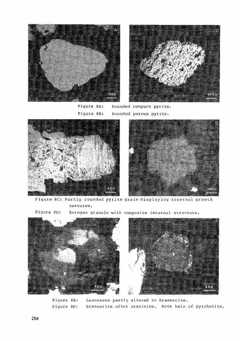
Figure 8A: Rounded compact pyrite.Figure 8B: Rounded porous pyrite.
mmmmmmmmmsmmmmmmmmmmmmmmmmarmymnmmffmmmmmamF i g u r e 8 C : P a r t l y rounded p y r i t e g r a i n d i s p l a y i n g i n t e r n a l g r o w t h
textures.Figure 8D: Kerogen granule wi th composite internai structure.
Figure 8E: Leucoxene par t ly altered to Branner i te .F igure 8F: B r a n n e r i t e a f te r u r a n i n i t e . Note halo of pyr rho t i t e .
288
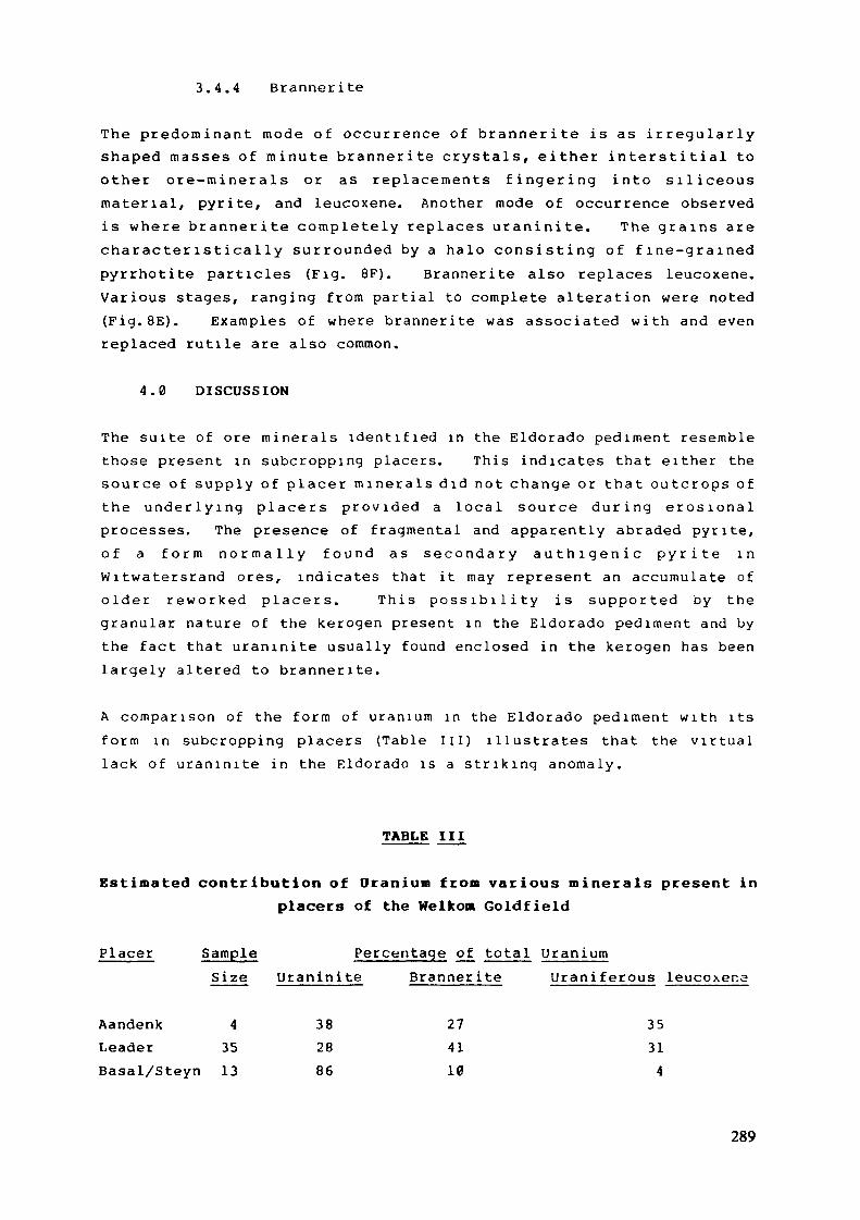
3 .4 .4 Branne r i t e
The p r e d o m i n a n t mode of occur rence of b r a n n e r i t e is as i r r e g u l a r l yshaped masses of m i n u t e b r a n n e r i t e c rys ta l s , e i ther i n t e r s t i t i a l toother o r e - m i n e r a l s or as r ep lacemen t s f i n g e r i n g in to s i l i c e o u smater ia l , pyrite, and leucoxene. Another mode of occurrence observedi s where b r a n n e r i t e comple t e ly replaces u r a n i n i t e . The g r a i n s a rec h a r a c t e r i s t i c a l l y s u r r o u n d e d by a ha lo c o n s i s t i n g of f i n e - g r a i n e dpyr rho t i t e particles (Fig. 8F). Branne r i t e also replaces leucoxene.Various stages, r ang ing f r o m par t ia l to complete a l terat ion were noted( F i g . B E ) . Examples of where b ranner i t e was associated w i t h and evenreplaced rut i le are also common.
4 .0 DISCUSSION
The su i te of ore m i n e r a l s i den t i f i ed in the Eldorado pediment resemblethose present in subcropping placers. This indicates that e i ther thesource of supply of p lace r m i n e r a l s d id not change or tha t o u t c r o p s ofthe u n d e r l y i n g p lacers p r o v i d e d a local source d u r i n g e r o s i o n a lprocesses. The presence of f r agmen ta l and apparently abraded pyr i t e ,o f a f o r m n o r m a l l y f o u n d a s s e c o n d a r y a u t h i g e n i c p y r i t e i nW i t w a t e r s r a n d ores, indicates that i t may represent an accumula te ofo lde r r e w o r k e d p lacers . T h i s p o s s i b i l i t y i s s u p p o r t e d by theg r a n u l a r na tu re of the kerogen present in the Eldorado pediment and bythe fac t that u r a n i n i t e u sua l l y found enclosed in the kerogen has beenla rge ly al tered to b ranner i t e .
A compar i son of the f o r m of u r a n i u m in the Eldorado pediment w i t h i tsf o r m in subcropping placers (Table I I I ) i l lus t ra tes that the v i r t u a llack of u r a n i n i t e in the E ldorado is a s t r i k i n g a n o m a l y .
TABLE III
Estimated contribution of Uranium from various minerals present inplacers of the Welkom Goldfield
Placer Sample Percentage of total U r a n i u mSize U r a n i n i t e Branner i te U r a n i ferous leucoxena
Aandenk 4 38 27 35Leader 35 28 41 31Basal/Steyn 13 86 10 4
289
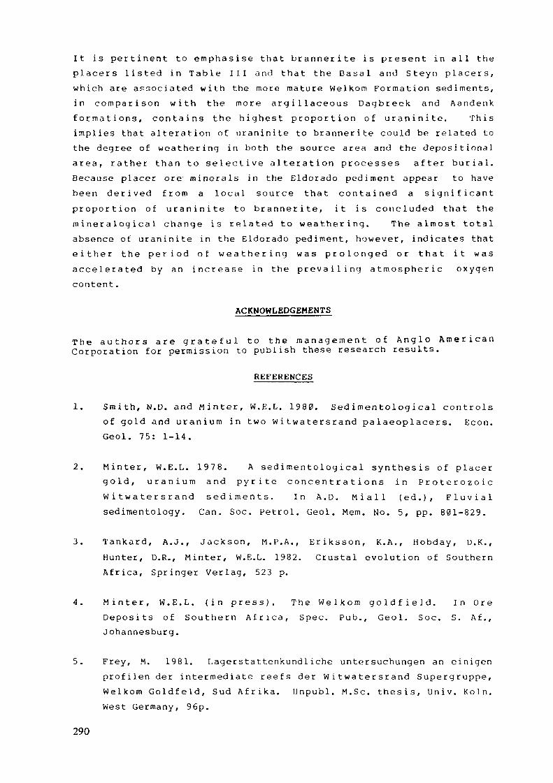
I t i s p e r t i n e n t to e m p h a s i s e t h a t b r a n n e r i t e i s p r e s e n t in a l l t hep l a c e r s l i s t e d i n T a b l e I I I a n d t h a t t h e B a s a l a n d S t e y n p l a c e r s ,w h i c h a r e associa ted w i t h t h e more m a t u r e W e l k o m F o r m a t i o n s e d i m e n t s ,i n c o m p a r i s o n w i t h t h e m o r e a r g i l l a c e o u s D a g b r e e k a n d A a n d e n kf o r m a t i o n s , c o n t a i n s t h e h i g h e s t p r o p o r t i o n o f u r a n i n i t e . T h i si m p l i e s tha t a l t e r a t i o n of u r a n i n i t e to b r a n n e r i t e could be re la ted tothe degree of w e a t h e r i n g in both the source a rea and the depos i t i ona la r e a , r a t h e r t h a n t o s e l e c t i v e a l t e r a t i o n p rocesses a f t e r b u r i a l .Because placer ore m i n e r a l s in the E ldo rado p e d i m e n t appear to havebeen d e r i v e d f r o m a loca l source t h a t c o n t a i n e d a s i g n i f i c a n tp r o p o r t i o n o f u r a n i n i t e t o b r a n n e r i t e , i t i s c o n c l u d e d t ha t t h em i n e r a logica1 change is r e l a t ed to w e a t h e r i n g . The a l m o s t total
absence of u r a n i n i t e in the E ldorado ped imen t , h o w e v e r , ind ica tes thate i t h e r t h e p e r i o d o f w e a t h e r i n g w a s p r o l o n g e d o r t h a t i t w a sa c c e l e r a t e d b y a n i n c r e a s e i n t h e p r e v a i l i n g a t m o s p h e r i c o x y g e ncontent .
ACKNOWLEDGEMENTS
T h e a u t h o r s a r e g r a t e f u l t o t h e m a n a g e m e n t o f A n g l o A m e r i c a nCorpo ra t i on for permiss ion to p u b l i s h these research results.
REFERENCES
1. S m i t h , N .D. and M i n t e r , W . E . L . 1980. Sed i m e n to log i cal c o n t r o l sof gold and u r a n i u m in two W i t w a t e r s r a n d pa laeop lace r s . Econ .Geol. 75: 1-14.
2. M i n t e r , W . E . L . 1978. A s e d i m e n t o l o g i c a l s y n t h e s i s of p l ace rg o l d , u r a n i u m a n d p y r i t e c o n c e n t r a t i o n s i n P r o t e r o z o i cW i t w a t e r s r a n d s e d i m e n t s . I n A . D . M i a l l ( e d . ) , F l u v i a lsedimentology. Can. Soc. Petrol . Geol. Mem. No. 5, pp. 801-829.
3 . T a n k a r d , A.J . , J a c k s o n , M . P . A . , E r i k s s o n , K . A . , H o b d a y , O . K . ,H u n t e r , D.R., M i n t e r , W.E.L. 1982. C r u s t a l evo lu t ion of Sou the rnA f r i c a , Spr inger Ver lag , 523 p.
4 . M i n t e r , W . E . L . ( i n p r e s s ) . T h e W e l k o m g o l d f i e l d . I n O r eD e p o s i t s o f S o u t h e r n A f r i c a , Spec. P u b . , Geol . Soc. S . A f . ,Johannesburg .
5. Frey, M. 1981. L a g e r s t a t t e n k u n d l i c h e U n t e r s u c h u n g e n an e in igenp r o f i l e n d e r i n t e r m e d i a t e r e e f s d e r W i t w a t e r s r a n d S u p e r g r u p p e ,W e l k o m G o l d f e l d , S u d A f r i k a . U n p u b l . M.Se . t he s i s , U n i v . K ö l n .West G e r m a n y , 96p.
290
6 . B u c k , S.G. 1983. The S a a i p l a a s Q u a r t z i t e M e m b e r : a b r a i d e dsystem of gold- and u r a n i u m - b e a r i n g channel placers w i t h i n theP r o t e r o z o i c W i t w a t e r s r a n d S u p e r g r o u p o f S o u t h A f r i c a . I n J .D.Col l inson and J . L e w i n (Eds.) Modern and Anc ien t F l u v i a l Systems,Spec. Pub. In t . Ass. Sediment . 6, pp. 549-562.
7 . K i n g s l e y , C.S. ( i n p r e s s ) . T h e D a g b r e e k F a n D e l t a : a n a l l u v i a lto p r o d e l t a sequence in the W e l k o m g o l d f i e l d , W i t w a t e r s r a n d .
Can. Ass. Pet. Geol .
8. B a i n e s , V. 1949 . The g e o l o g y of the O d e n d a a l s r u s g o l d f i e l d inr e l a t i o n to. t ha t of the K l e r k s d o r p D i s t r i c t , and notes on thec o r r e l a t i o n of the U p p e r D i v i s i o n of the W i t w a t e r s r a n d S y s t e m .Trans . Geol . Soc. S. Af. 52, pp. 301-320.
9. W i n t e r , H. de la R e y , 1964. The geo logy of the V i r g i n i a Sec t ionof the Orange Free State Goldf ie lds . In S.H. Haugh ton (ed.) Thegeology of some ore deposits in Southern A f r i c a .
10. P r e t o n u s , D.A. 1974. The s t r u c t u r a l b o u n d a r y be tween theK a a p v a a l a n d S o n a m a c r u s t a l p r o v i n c e s . Econ . Geol . Res. U n i tU n i v . Wi twa te r s rand I n f . Circ . No . 88 .
11. H u t c h i s o n , R . I . 1975. The W i t w a t e r s r a n d Sys t em as a mode l ofs e d i m e n t a t i o n i n a n i n t r a c r a t o n i c b a s i n . U n p u b l . D.Sc. thes i s ,U n i v . Orange Free State, B loemfon te in .
12. F e a t h e r , C.E. and K o e n , G .M. 1975. The m i n e r a l o g y of theW i t w a t e r s r a n d Reefs . M i n e r a l s Sei. E n g n g . 7 : 189-224.
1 3 . R a m d o h r , P . 1959. N e w o b s e r v a t i o n s o n t h e o r e s o f t h eW i t w a t e r s r a n d i n S o u t h A f r i c a . A n n e x , t o T r a n s . G e o l . S .A f r . , 61 : 50p.
14. U t t e r , T. 1977. M o r p h o l o g y and geochemis t ry of pyr i tes f r o m theUpper W i t w a t e r s r a n d System of the K l e r k s d o r p G o l d f i e l d . Chamberof M i n e s Research Repor t 8/77, J o h a n n e s b u r g , 48p.
15. Grands t a f f , D . E . 1980. Origin of uraniferous conglomerates atElliot Lake, Canada and Witwatersrand, South Afr ica : Implicationsfor oxygen in Precambrian atmosphere. Precambrian Research 13 :1 - 26.
291

INTERPRETATION OF ALPHA- AND GAMMA-SPECTROMETRIC DATA FROM PRECAMBRIANCONGLOMERATES - A CASE STUDY FROM THEDENNY DALTON URANIUM PROSPECT,NORTHERN ZULULAND, SOUTH AFRICA
R. SAAGER, H.D. STUPPMineralogisch-Petrographisches InstitutR. VORWERK, K. THIEL, G.J. HENNIG*Institut für Kernchemie
Universität Köln,Köln, Federal Republic of Germany
Abstract
During uranium exploration of early Precambrian conglomerates, theincorrect interpretation of gamma-spectrometric data obtained fromweathered outcrops resulted in a costly follow-up and drilling programmewhich eventually had to be abandoned because of disappointing results.Subsequently, detailed alpha-spectrometric and additional gamma-spectro-metric studies were carried out and, at first, yielded contradictoryinformation. Recent uranium loss apparently was reflected by e-U/Uratios exceeding unity whereas U-234/U-238 ratios which also exceededunity suggested recent uranium addition. Reconciliation of the data wasachieved by considering Ra-226 addition during the last 10 years.Measurements of radium activities substantiated this suggestion.For "old" ( ^> 2 mio. years) uranium mineralizations, this case studydemonstrated that e-U/U ratios which exceed unity not always can beconsidered a result of recent (less than 10 ^years old) uranium loss,but may also be caused by recent (less than 10 years old) addition ofradium. It is, therefore, suggested that a combination of alpha- andgamma-spectrometry can help to reduce exploration costs if recent super-gene addition of radium cannot be ruled out.
Introduction
Ouartz-pebble conglomerates of early Precambrian age, which are potent-ially uranium bearing, occur in many areas of the Kaapvaal Craton ofsouthern Africa. In addition to the important conglomerates of theWitwatersrand basin which are exploited for gold and uranium, suchsedimentary rocks are also present in geologically older depositories.The best known are:
* Present address: Bundesanstalt für Geowissenschaften und Rohstoffe, Hannover, Federal Republic ofGermany.
293
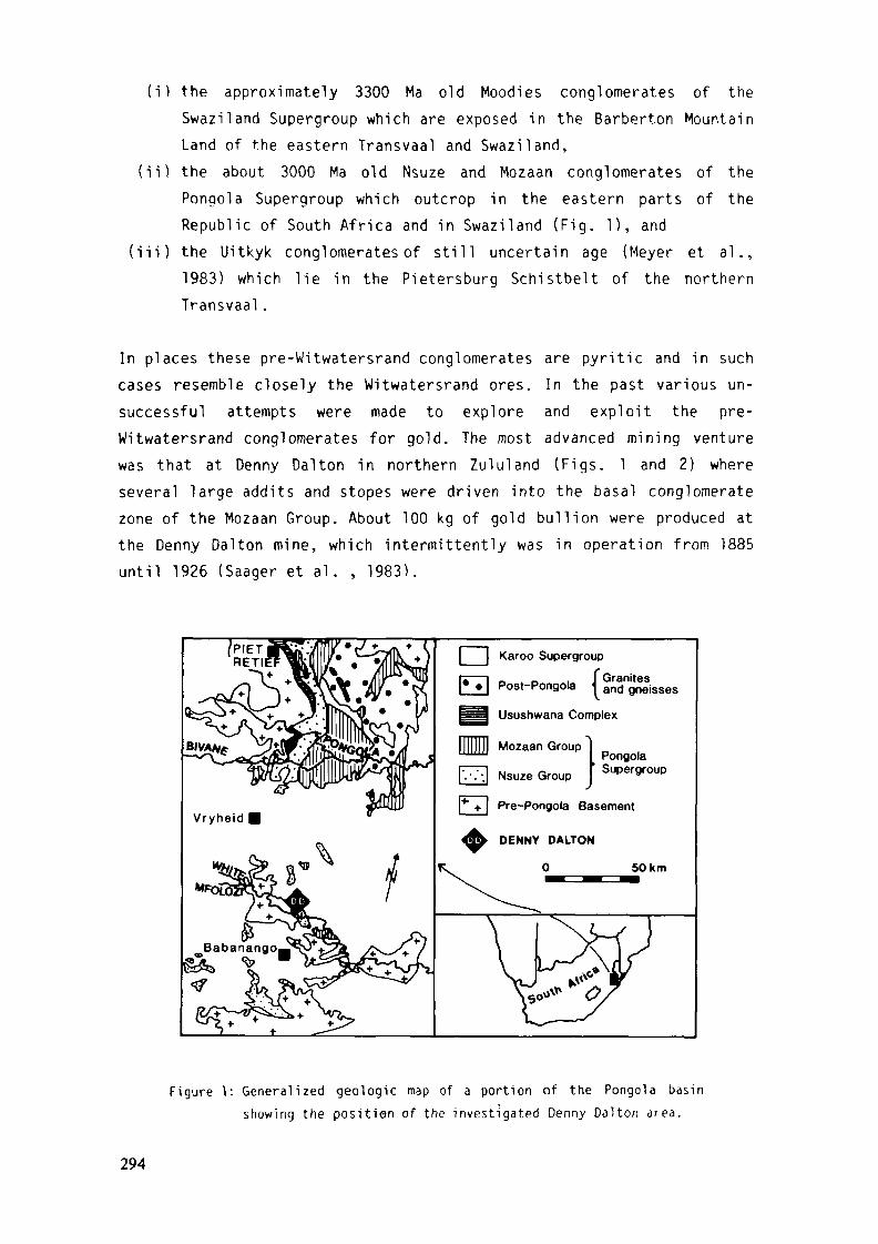
(i) the approximately 3300 Ma old Moodies conglomerates of theSwaziland Supergroup which are exposed in the Barberton MountainLand of the eastern Transvaal and Swaziland,
(ii) the about 3000 Ma old Nsuze and Mozaan conglomerates of thePongola Supergroup which outcrop in the eastern parts of theRepublic of South Africa and in Swaziland (Fig. 1), and
(iii) the Uitkyk conglomerates of still uncertain age (Meyer et al.,1983) which lie in the Pietersburg Schistbelt of the northernTransvaal.
In places these pre-Witwatersrand conglomerates are pyritic and in suchcases resemble closely the Witwatersrand ores. In the past various un-successful attempts were made to explore and exploit the pre-Witwatersrand conglomerates for gold. The most advanced mining venturewas that at Denny Dalton in northern Zululand (Figs. 1 and 2) whereseveral large addits and stopes were driven into the basal conglomeratezone of the Mozaan Group. About 100 kg of gold bullion were produced atthe Denny Dalton mine, which intermittently was in operation from 1885until 1926 (Saager et al. , 1983).
[ I Karoo Supergroup
_ „ . f GranitesPost-Pongola and gneisses
Usushwana Complex
Mozaan Group
Nsuze GroupPongolaSupergroup
*I* +. | Pre-Pongola Basement
50km
Figure 1: Generalized geologic map of a portion of the Pongola basinshowing the position of the investigated Denny Dalton area.
294
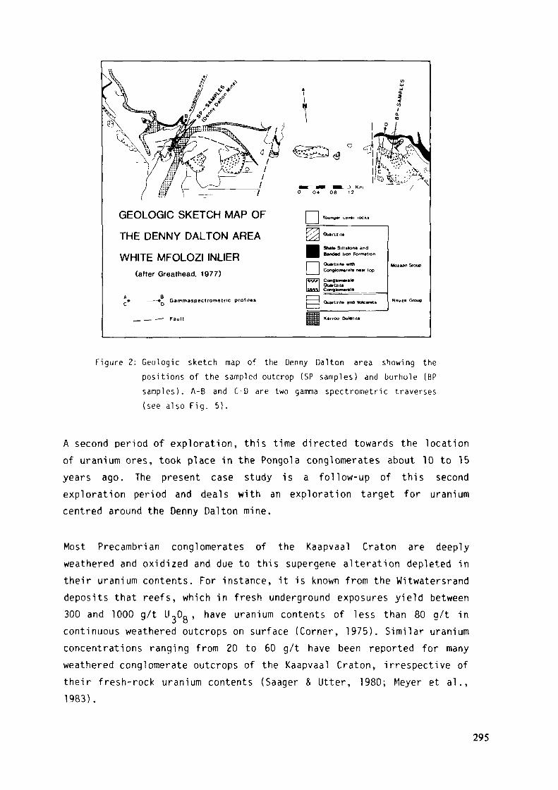
GEOLOGIC SKETCH MAP OF
THE DENNY DALTON AREA
WHITE MFOLOZI INLIER(after Greathead, 1977)
DYounger cow rocks
DSh»l« Sillslon« andB*nd*d Iron Formation
Quart 1.1* withConglomérat« raw top
ConglomerateOuartzrt«ConglonwT.it« _
Gammaspectrometric profilas Ouaftzita and Volcanc»
_ — .—- Fault Karroo Dol«fit«
Figure 2: Geologic sketch map of the Denny Dalton area showing thepositions of the sampled outcrop (SP samples) and borhole (BPsamples). A-B and C-D are two gamma spectrometric traverses(see also Fig. 5).
A second period of exploration, this time directed towards the locationof uranium ores, took place in the Pongola conglomerates about 10 to 15years ago. The present case study is a follow-up of this secondexploration period and deals with an exploration target for uraniumcentred around the Denny Dalton mine.
Most Precambrian conglomerates of the Kaapvaal Craton are deeplyweathered and oxidized and due to this supergene alteration depleted intheir uranium contents. For instance, it is known from the Witwatersranddeposits that reefs, which in fresh underground exposures yield between300 and 1000 g/t UoOg, have uranium contents of less than 80 g/t incontinuous weathered outcrops on surface (Corner, 1975). Similar uraniumconcentrations ranging from 20 to 60 g/t have been reported for manyweathered conglomerate outcrops of the Kaapvaal Craton, irrespective oftheir fresh-rock uranium contents (Saager & Utter, 1980; Meyer et al.,1983).
295

On account of the above feature it is virtually impossible to assess theore potential of conglomerates based on the results of direct uraniumanalyses obtained from weathered samples. Furthermore, radioactivedisequilibria are often encountered in the secondary environmentrendering gamma- spectrometric readings difficult to evaluate, andequivalent uranium (e-U) values very often lead to over- orunderestimations of the actual uranium contents present.
At Denny Dalton in situ gamma-spectrometric surveys yielded equivalenturanium (e-U) values of more than 1000 g/t, however, determinations ofthe actual U.,0R contents of the exposed Denny Dalton conglomerates gavemuch lower values in the range of 50 to 100 g/t (M.P. Strydom, personalcommunication). This suggested disequilibrium in the U-238 decay seriesand was interpreted to be a result of recent uranium removal byweathering processes. Therefore, it was thought that payable uraniumconcentrations occur in the unweathered conglomerates and exploratorydrilling was undertaken, which eventually yielded disappointing results.
Subsequent alpha-spectrometric evaluations of U-234/U-238 and Th-230/U-238 ratios and fission track studies of conglomerate samples fromweathered Denny Dalton conglomerates indicated the existence of acomplex uranium redistribution history (Thiel et al., 1983).
Aim of the present study was to unravel the contradictory informationsobtained by the exploration work and subsequent geochemical studieswhich were carried out by Saager et al. (1981), Thiel et al. (1983),Stupp et al. (1983), and others. Accordingly, more detailed alpha- andgamma- spectrometric investigations on samples originating from anoutcrop at Denny Dalton and from an exploration borehole sunk in itsvicinity (Figs. 2 and 3) were undertaken. The two rock suites aredifferently affected by weathering and oxidation but can be strati-graphically correlated with each other. They, thus, are well suited forthe investigation of radioactive disequilibria conditions (Fig. 3).
Sample localities
The rocks of the Pongola Supergroup in the Denny Dalton area form partof the so-called White Mfolozi Inlier (Fig. 2). It contains the
296
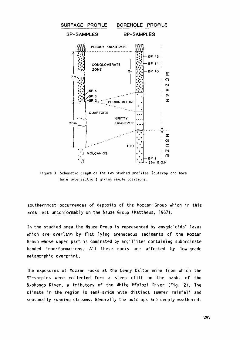
SURFACE PROFILE BOREHOLE PROFILE
SP-SAMPLES BP-SAMPLES
1
7
1
t
30
<
ri*° ft
* ** o
*°o
^m —
« 0 00 0
° ° 0
o*e„
«ôVo oe
o °e
• — •> — .
m
A AA
A fl
A
A A
->>_
PEBBLY QUARTZITE
2m
1/SP 4
/ _ _ , - - - 'xSP 3 _ _ . _ - - • " "^aP.?,;;--"' PUDDINGSTONE
QUARTZITE
GRITTYi QUARTZITE
_.--- ' ""^.-'"
^.~~'f
- -"
.---" TUFF
VOLCANICS
B:•£• °.°•°o *
o o°o0 0
o °0 O 0
0 00 0 0
O 00 0 0
BO 0.
•
-
....
Y YY
Y YY
VY
Y YY
Y YY
Y Y•-^J
!— BP 12
— BP 11
— BP 10
'
— BP 1-- 26m EC
^0M1>^^
*
•z.COcNm
).H
Figure 3. Schematic graph of the two studied profiles (outcrop and borehole intersection) giving sample positions.
southernmost occurrences of deposits of the Mozaan Group which in thisarea rest unconformably on the Nsuze Group (Matthews, 1967).
In the studied area the Nsuze Group is represented by amygdaloidal lavaswhich are overlain by flat lying arenaceous sediments of the MozaanGrouo whose upper part is dominated by argillites containing subordinatebanded iron-formations. All these rocks are affected by low-grademetamorphic overprint.
The exposures of Mozaan rocks at the Denny Dalton mine from which theSP-samples were collected form a steep cliff on the banks of theNxobongo River, a tributory of the White Mfolozi River (Fig. 2). Theclimate in the region is semi-aride with distinct summer rainfall andseasonally running streams. Generally the outcrops are deeply weathered.
297
The base of the sampled outcrop is formed by some 30 m of quartziticsandstone which is overlain by a 7 m wide zone of conglomerates. Thezone commences with an approximately 2 m thick clast-supported basalconglomerate becoming matrix-supported towards the hanging. Roundedpyrite, measuring up to 1 cm in diameter, occur in layers within thefirst 50 cm of the basal conglomerate. Towards the hanging wall pyriteis more disseminated and occasionally is concentrated on foresets ofcross-beddings. The pebbles of the conglomerates attain diameters of upto 170 mm and consist predominantly of vein quartz and to minor amountsof quartzite and chert. A 10 m thick quartzite zone, containing scat-tered vein-quartz pebbles, of up to 20 mm in diameter, overlies theconglomerates and, in turn, is overlain by alternating conglomerate andquartzite horizons.
Gamma-spectrometric measurements, taken across the main workings atDenny Dalton, yielded e-U_00 values reaching 1200 g/t and e-Th00 tenorsJ O C .of up to 160 g/t in the basal conglomerate horizon (Saager & Utter,1980). Anomalous equivalent uranium values were also recognized in theother conglomerate zones of the hanging wall (Fig. 2 and 5).
Much lower actual uranium (U) values found in the conglomeratessuggested disequilibrium in the U-238 decay chain and were interpretedto be a result of recent uranium loss caused by weathering. Accordingly,it was assumed that payable uranium mineralization is present below thewatertable and a drilling programme was initiated by the explorationcompany.
Drill core material (BP-samples) originating from a 26 m deep boreholesituated on farm Mount Sophia, about 7 km east-southeast of Denny Daltonmine (Fig. 2), was made available by Southern Sphere Exploration Co. Atits base the borehole intersected tuffs belonging to the Nsuze Group.Upwards they are followed by a 3 m thick zone of gritty quartzite andpuddingstone, a quartzite containing scattered quartz pebbles of up to 7cm in diameter (Fig. 3). The hanging wall of the puddingstone is formedby a 3 m thick pyritic conglomerate zone whose pebbles consisit of veinquartz, quartzite and chert. This conglomerate zone is correlated withthe basal conglomerate zone exposed at Denny Dalton (Fig. 3).
298
A gamma-spectrometric traverse measured by Saager & Utter (1980) nearthe drilling site of the studied borehole yielded much lower e-U_0 and
6 oe-ThO values than the traverse measured at Denny Dalton (Fig. 5).
For the present study samples were taken across the footwall quartziteand the basal conglomerate zone of the Mozaan Group. The sample stationsof the surface profile (SP-samples) as well as the positions of thesamples taken from the bore core (BP-samples) are shown on Figure 3.
Mineragraphic descriptions
Gangue minerals
The matrix of the studied samples is composed of tightly intergrownquartz and sericite. Quartz is often recrystallized. In weatheredsamples limonite occurs as additional matrix component.
Sericitization of quartz is widespread in all samples and occasionallysericite pseudomorphs after feldspar can be recognized. The shape of thequartz grains of the sand-sized fraction is subangular whereas clasts ofdiameters of more than 2 mm tend to be subrounded.
Ore Minerals
In the conglomerate samples of both sampled localities pyrite forms themost abundant ore mineral. It is present as detrital rounded and as insitu formed subidiomorphic to idiomorphic grains. In the samples of thesurface profile supergene alteration of pyrite is ubiquitous whereas inthe drill core samples only some of the samples are affected byweathering. The alteration products of the sulfides in both cases arelimonite/hematite aggregates.
Compared with the sporadic presence of zircon, monazite, and rutile inthe SP-samples, these detrital components are more abundant in the drillcore samples.Other ore minerals present are, in order of decreasingabundance, chromite, arsenopyrite, chalcopyrite, pyrrhotite, galena,gersdorffite, and gold.
299

It is remarkable that neither the conglomerates at Denny Dalton, whichexhibited high equivalent uranium values, nor the supposedly unweatheredconglomerates intersected by the borehole contain uraninite, thorite,brannerite or any other uranium minerals.
Experimental Procedures and Results
General aspects of gamma- and alpha-spectrometry of radioactive chains
The daughter nuclides of the U-238 decay series are mainly alphaemitters (Fig. 4) and, consequently, gamma-spectrometry can only be per-formed using adequate gamma emitters, which in practice generally areBi-214 or Pb-214. The measurement of uranium concentration bygamma-spectrometry, therefore, is an indirect method and the calculateduranium values are equilvalent (e-U) values which only correspond withthe actual uranium values present if the studied U-238 decay chain is ina state of radioactive equilibrium.
ELEMENT ATOMICNUMBER
Uraraum 92
PreiacMiium 91
Thorium 90
Acumum 89
Radium 88
Frarv.pum 87
Radon 86
Astatina 86
Polonium 84
Bomuth 83
Laad 82
•>-u «>»u2.48 x 10*y 4.81 > 10*r
/ fr. /J m "°Th *«-Th' 8.0 « 10*v 24.1d
./"•Ra
1622y/
"*Rn3.828 d
J
"•Po "*Po „.p.138.3d 1.58,10-. 305m
/ >»B, / ' B, // S.02d / 19.7m /
"•Ph » *™k VÄ »rm
Figure 4: U-238 series decay chain (according to Levinson & Coetzee,1978).
Fractionation of the daughter nuclides of U-238 takes place in the sec-ondary environment and is a result of chemical and physical processeswhich have been described and explained by a number of authors (e.g.Rosholt et al. 1963; Cherdyntsev, 1971; Kigoshi, 1971; Fleischer &Raabe, 1978; Thiel et al., 1983). The parent nuclides of Bi-214
300
possessing the longest half-lifes are U-234, Th-230, Ra-226, and Rn-222(Fig. 4). For this reason these four nuclides are best suited for thealpha- spectrometric investigaton of fractionation dynamics in the U-238decay series.
If the U-238 decay chain is disturbed and, therefore, not in a state ofradioactive equilibrium it takes about four times the half-life of themost long-lived disturbed nuclide to restore 95% equilibrium (Hambleton-Jones, 1978). For instance, U-234 is the daughter nuclide in the U-238decay chain with the longest half-life (2.4 x 10 a) and if this memberhas been removed or added to the system it takes about one million yearsto restore near equilibrium conditions. Consequently, if an uraniumsystem was closed during the last one million years, i.e. during recenttimes, the U-234/U-238 ratios measured by alpha-spectrometry will beunity.
Analytical methods
The pulverized and homogenized bulk conglomerate samples containingapproximately 50 ug of uranium were dissolved in HF/HN03 at boilingtemperatures. After spiking the sample solutions with U-232, separationof uranium was carried out by means of ion exchange columns. Finally,the uranium was electroplated onto stainless steel discs and the alpha-activities measured with Si-surface barrier detectors employing themethod described by Hennig (1979). Alpha-spectrometry was also employedto determine the actual uranium (U) contents of the samples.
Gamma-spectrometric measurements were performed with the aid of ananticompton spectrometer giving excellent peak-to-background ratios.Prior to measuring, the samples were kept for three weeks in sealedcontainers to avoid the probability of radioactive disequilibrium causedby the escape of Rn-222. The equivalent uranium (e-U) contents weremeasured using the charcteristic 1,764 MeV-line of Bi-214. Measuringtime per sample was 24 hours. A typical gamma-spectrum is shown inFigure 6.
For the in situ gamma-spectrometric survey a Chemtron II digital channelspectrometer was employed. Calibration and measuring procedures werethose described by Meyer et al. (1983).
301
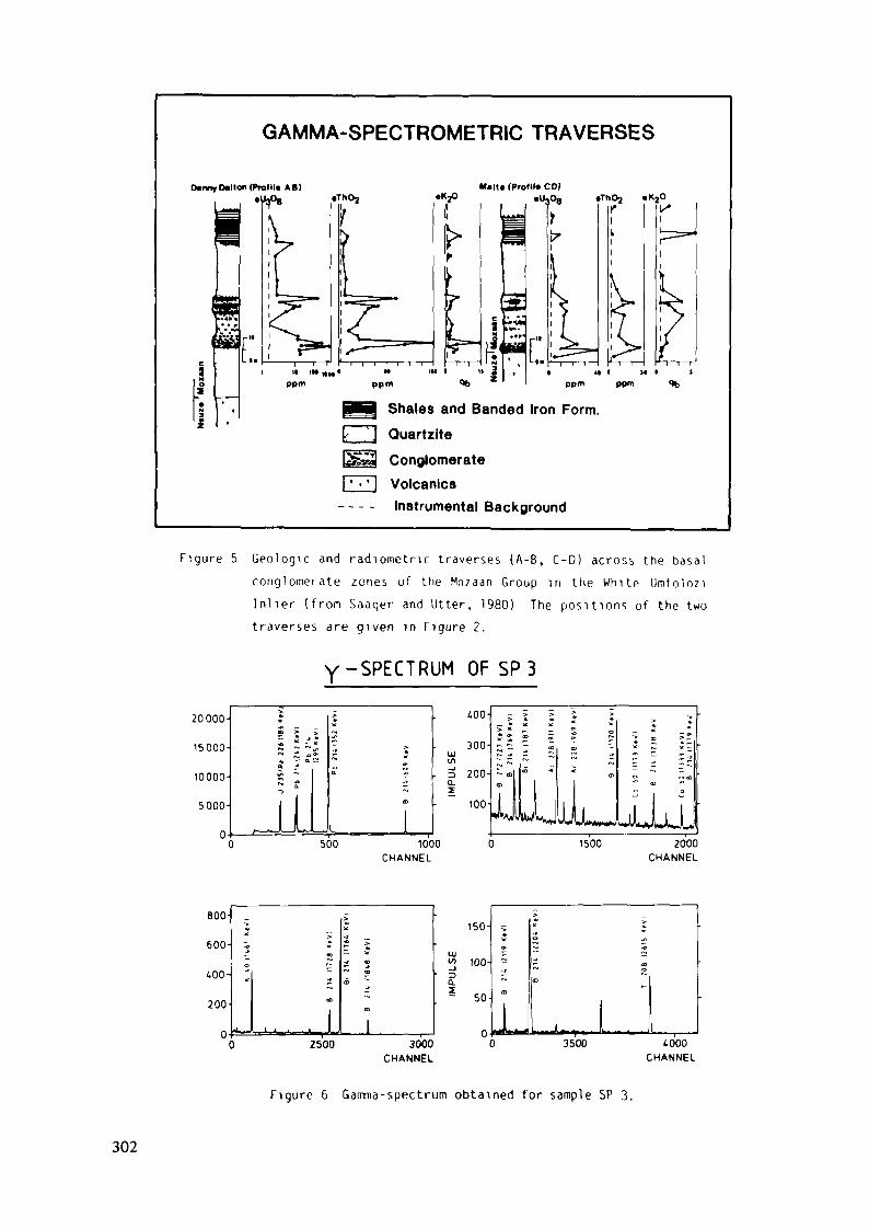
GAMMA-SPECTROMETRIC TRAVERSES
D»nny dlton (ProlM. AB) Malt« (Profil* CO)
Shales and Banded Iron Form.""1 Quartzite
ConglomerateJ Volcanics
Instrumental Background
Figure 5 Geologic and radiometric traverses (A-B, C-D) across the basalconglomerate zones of the Mozaan Group in the White Umfoloziinlier (from Saager and Utter, 1980) The positions of the twotraverses are given in Figure 2.
y-SPECTRUM OF SP 320000-
15000-
10000-
5000-
0(
800-
600-
400-
200-
0
>4iM-O —
S Ï4b ** ^s H «•» — a.« ^i/> ^
~ s
JL.)
^•0
3
>***s<»
a
a
l
«c
>
D
400-
300-LU
. o 200-az
100-
~ m | ™ '" a> o ~ oa>
" I I * " •
• ^WlJjJjjL.500 1000 0 1500 2000
CHANNEL CHANNEL
I J - - Jl
>
<D
CD
j QD
ID
2500 3000CHANNEL
150-
UJ•» 100-
a.- 50-
0
m -J *
L ,, .. . I0 3500 4000
CHANNEL
Figure 6 Gamma-spectrum obtained for sample SP 3.
302
Results
The results of the laboratory and field measurements are shown in Table1 and Figures 5 and 7. Standard deviations (s) of the results obtainedfrom the employed radiometric techniques are:
- alpha spectrometry actual uranium content (U): s < 3%U-234/U-238: s < 0.1%
- gamma spectrometry equivalent uranium content (e-U): s •< 10/c
From Table 1 it is apparent that the uranium contents (U) of the drillcore samples (BP 10, BP 11, BP 12), generally, are distinctly higherthan the uranium contents (U) of stratigraphically corresponding samplesfrom the Denny Dalton outcrop (SP 2, SP 3, SP 4). For the surfacesamples this concentration gradient might suggest a supergene loss ofuranium due to weathering.
Table 1 also reveals that the high equivalent uranium (e-U) values ofthe basal conglomerate zone at Denny Dalton, which first were recognizedby gamma-spectrometric traverses (Figs. 2 and 5), are also confirmed bylaboratory measurements (samples SP 2 and SP 3). Direct assays of theuranium concentrations (U) of these samples, however, yielded much lowervalues and, consequently, resulted in high e-U/U ratios of about 8(Table 1).
Interpretations
Comparison of the equivalent (e-U) and actual (U) uranium contents ofsamples SP 2 and SP 3 collected at the conglomerate outcrop, accordingto common interpretations, points to a severe recent loss of uranium dueto weathering. Sample SP 4 which was collected from a weakly mineralizedconglomerate layer in the hanging of samples SP 2 and SP 3, on the otherhand, exhibits almost identical e-U and U values. This probably is areflection of the fact that in this sample most of the uranium isassociated with refractory uranium bearing minerals (monazite, zircon)and very little with phyllosilicates or oxihydroxides.
303
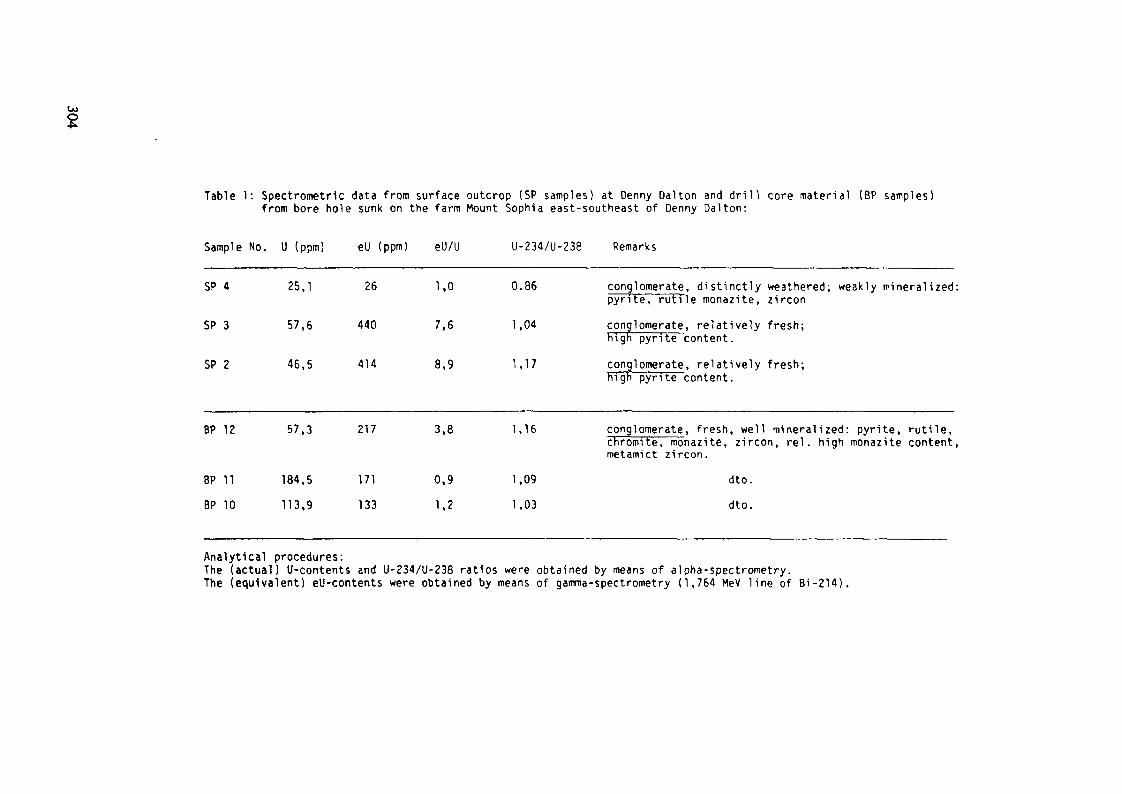
OJ
Table l : Spectrometric data from surface outcrop (SP samples) at Denny Dalton and dr i l l core material (BP samples)from bore hole sunk on the farm Mount Sophia east-southeast of Denny Dalton:
Sample No. U (ppm) eU (ppm) eU/U U-234/U-238 Remarks
SP 4
SP 3
SP 2
BP 12
BP 11BP 10
25,1
57,6
46,5
57,3
184,5113,9
26
440
414
217
171133
1,0
7,6
8,9
3,8
0,91,2
0.86
1,04
1,17
1,16
1,091,03
conglomerate, distinctly weathered; weakly mineralized:pyrite, rutile monazite, zirconconglomerate, relatively fresh;high pyrite content.conglomerate, relatively fresh;high pyrite content .
conglomerate, fresh, well mineralized: pyrite, rutile,chromite, monazite, zircon, rel . high monazite content,metamict zircon.
dto.dto.
Analytical procedures:The (actual) U-contents and U-234/U-238 ratios were obtained by means of alpha-spectrometry.The (equivalent) eU-contents were obtained by means of gamma-spectrometry (1,764 MeV line of Bi-214).
Although it originates from the drill core, sample BP 12 shows an e-U/Uratio of 3.8 and, therefore, a similar trend as the two surface samplesSP 2 and SP 3. The reason for this might be that sample BP 12, being theupermost sample obtained from the drill core, was also affected byweathering and, in this case, suffered a supergene uranium loss.Contrasting with this, samples BP 10 and BP 11 have e-U/U ratios closeto unity (0.9 and 1.2) and this agrees with an origin from generallyunweathered drill core material.
The U-234/U-238 activity ratios of the two drill core samples BP 10 andBP 11 display near equilibrium conditions (1.08 and 1.03). This accordswith the e-U/U ratios recognized for these two samples and underlinesthe observation that they were barely affected by weathering. Sample SP4, which is weakly mineralized but distinctly weathered, has aU-234/U-238 ratio of 0.86 implying uranium removal within the last 10years, albeit such a process is not apparent from its e-U/U ratio (1.0)which rather points to equilibrium conditions.
Of special interest are samples SP 2, SP 3 (both from the outcrop), andBP 12 (from the drill core) which are weathered to varying degrees. Thesamples possess U-234/U-238 ratios larger than unity (1.04, 1.17, 1.16),suggesting recent uranium addition and, at the same time, show largee-U/U ratios (7.6, 8.9, 3.8) which, on the other hand, indicate recenturanium loss. These contradicting evidences can be reconciled iffractionation in the U-238 decay series other than that separating U-234from U-238 is contemplated for the observed equilibria conditions.
As mentioned above, e-U values are obtained by measuring the gammaactivity of Bi-214 and this activity is essentially determined byRa-226, the closest precurser of Bi-214 with a resonable long (1622 y)half-life (see Fig. 5). Ra-226 has a high specific activity and,therefore, small additions or removals of it are sufficient toinfluence the Bi-214 gamma readings in a significant way. On account ofthis, recent changes in the radium concentrations, induced for instanceby weathering processes, may well be the reason for the conflictingresults (uranium loss versus uranium gain) obtained from the conven-tional interpretation of the e-U/U and U-234/U-238 ratios of samples SP2, SP 3, and BP 12.
305
Levinson & Coetzee (1978) commented on the fractionation of Ra-226 inthe U-238 decay series. They pointed out that radium does not readilyenter the lattice of uranium minerals and in the weathering environment,therefore, is preferentially accessible to leaching solutions. Radium asa member of the alkaline-earth group differs geochemically from allother nuclides in the U-238 decay chain which enhances the possibilitiesfor its fractionation. Radium, which possesses geochemical behaviourssimilar to those of barium, however, should be immobile as a sulphate.In natural environments this is usually not the case and Levinson &Coetzee (1978) explain it by the fact that in waters radium, generally,is of extremely low abundance and that, consequently, the saturationvalue of RaSO. in water, although being very low, is almost neverattained.
Factors controlling the mobility of radium are processes involving co-precipitation and adsorption on iron and manganese oxihydroxides and onphyllosilicates, and according to Dyck (1975): "Radium will move longdistances by successive adsorptions and desorptions on the walls ofwater channels even at very low concentrations and with time anappreciable radium concentration will build up. This build-up becomesparticularly noticeable at the mouth of springs where iron andmanganese precipitate upon oxidation coprecipitating radium".
Bearing the above explanations and the climatic as well as hydrologieconditions at the Denny Dalton prospect in mind, a recent build-up ofradium for instance in the relatively permeable basal conglomerate zoneoverlying a relatively impermeable thick quartzite horizon (Figs. 3 and5), is viable.
The normalized net gamma-activities of Bi-214 (Fig. 7a) and the sum ofthe normalized net gamma-activities of U-235 and Ra-226 (Fig. 7b) wereplotted against the normalized absolute uranium (U) contents of theinvestigated samples. As the energy peaks of U-235 and Ra-226 in thegamma spectrum lie very close to each other (Fig. 6), a discriminationof the gamma-activities of the two nuclides is not possible. However,oU-235 has a much longer half-life (7.04 x 10 a) compared with that ofRa-226 (1622 a) and, consequently, the contribution of U-235 to the sumof the gamma activities of the two nuclides is low and for practicalreasons can be neglected.
306
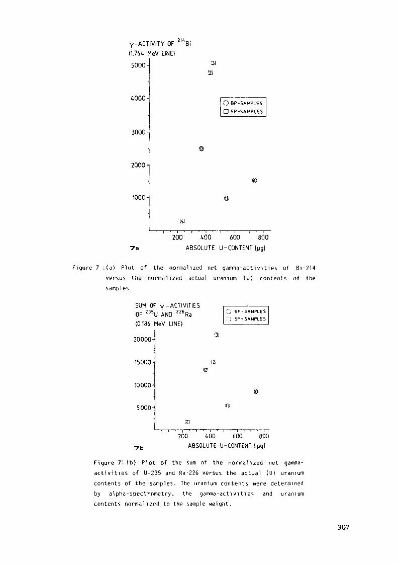
Y-ACTIVITY OF 2UBi(1.764 MeV LINE)
5000-
WOO-
3000^
2000-
1000-
[2J
[2
200 400 600 8007a ABSOLUTE U-CONTENT [pg]
Figure 7 : ( a ) Plot of the normalized net gamma-act iv i t ies of Bi -214versus the normalized actual uranium (U) contents of thesamples.
SUM OF y-ACTIVITIESOF 235U AND 226Ra(0.186 MeV LINE)
20000-
15000-
10000-
5000-
I2J
©
5)
200 400 600 8007b ABSOLUTE U-CONTENT [pg]
Figure 7'. (b) Plot of the sum of the normalized net gamma-ac t iv i t ies of U-235 and Ra-226 versus the actual (U) uraniumcontents of the samples. The uranium contents were determined
by alpha-spectrometry, the gamma-act iv i t ies and uranium
contents normal ized to the sample weight.
307

It is significant that in both plots (Figs. 7a and 7b) the samplesdisplay the same configurations. Especially samples SP 2, SP 3, and BP12, which possess high e-U/U ratios, are conspicuous by their highgamma-activities of Bi-214. It demonstrates that in these three samplesthis feature has to be attributed to a recent build-up of Ra-226, aparent of Bi-214, and that the high e-U/U ratios found in samples SP 2,SP 3, and BP 12 may be explained to be a result of Ra-226 additionduring the last 10 years.
Another process leading to enhanced e-U/U ratios, it requires recentaccumulation of uranium having a U-234/U-238 ratio greater than unity,was proposed by Hambelton-Jones (1978). However, this process is onlyrelevant for less than 2 x 10 years old, uranium mineralizations andis not applicable for the investigated Precambrian conglomerates.
Summary and Conclusions
Recent substantial uranium loss of up to 400 ppm indicated by thecomparison of actual uranium (U) with equivalent (e-U) values of samplesfrom weathered Mozaan conglomerates of the Denny Dal ton area in Zululandwere found to be not in agreement with their U-234/U-238 ratios. Theseratios, ranging from 1.04 to 1.17, on the contrary point to recentaddition of uranium brought about by supergene processes. Such additionswhich are economically insignificant occur as admixtures on secondarymineral phases.
In addition, mineralogical studies showed for fresh and weatheredconglomerate samples, originating from an outcrop and a strati-graphically correlative bore hole intersection, absence of uraninite,thorite, brannerite or any other uranium minerals. This feature alsomilitates against recent substantial uranium removal and, furthermore,might suggest that the Mozaan conglomerates at Denny Dalton, althoughpyritic, are generally devoid of detrital uranium minerals. Similarobservations were reported for other outcrops of pyritic Pongolaconglomerates by Saager et al. (1982).
308
Careful evaluation of the radio-spectrometric data of the Denny Daltonsamples allowed the reconciliation of the apparently contradicting dataof the e-U/U and U-234/U-238 values as they revealed that the recognized5high equivalent (e-U) values are a result of less than 10 years oldaddition of Ra-226. This nuclide is the closest long-lived parent ofBi-214 and small additions of Ra-226 are sufficient to enhance the gammareadings of Bi-214 significantly. The exact source of the Ra-226 isunknown, but it is envisaged to originate from leached uraniummineralization situated upstream of the Denny Dalton prospect. The factthat not all of the studied samples experienced gain of Ra-226 impliesthat the migration and redistribution mechanisms of radium are extremelycomplex. Similar observations were also made for uranium since not allof the weathered conglomerate samples exhibit U-234/U-238 ratios >• 1(Thiel et al., 1983).
This case study clearly demonstrated that for "old" (more than 2 mio.years old) uranium mineralization e-U/U ratios 1 are not always aresult of recent (less than 10 years old) uranium loss, but may alsobe caused by recent (less than 10 years old) addition of Ra-226. Thestudy also showed that a combination of alpha-and gamma-spectrometric investigations enable to unravel the reasons forradioactive disequilibria conditions and might allow to decide whethere-U/U ratios > 1 are caused by recent uranium loss or radium gain.These results allow the conclusion that a combination of alpha- andgamma- spectrometric studies may help to reduce drilling and follow-upcosts during the initial stages of an uranium exploration programme ifrecent Ra-226 addition cannot be excluded.
Acknowledgements
The writers wish to acknowledge Southern Sphere Exploration CompanyLtd., Johannesburg, for providing core logs and the drill core materialused for this study. Helpful information on the Denny Dalton prospectwas also obtained from Mr. P.M. Strydom, Anglo American ExplorationOffice, Klerksdorp, and from Prof. P.E. Matthews, University of Durban.Financially the studies were supported by the Deutsche Forschungsgemein-schaft (DFG) through grants # Sa 210-8/10.
309
References
Cherdyntsev, V.V. (1971): Uranium-234. Israel Program for ScientificTranslations. Jerusalem, 231 pp.
Corner, B. (1979): Quantitative gamma scintillometry and spectrometry inuranium exploration. Training course on radiometric prospectingtechniques. Atomic Energy Board, Pelindaba. Lecture 6, 17 pp.
Dyck, W. (1975): Geochemistry applied to uranium exploration. Uraniumexploration 75. Geol. Surv. Canada Paper 75-26, 33-47.
Fleischer, R.L., and Raabe, O.G. (1978): Recoiling alpha-emitting nucleimechanisms for uranium series disequilibrium. Geochim. CosmochimActa 42, 7, 973-978.
Hambleton-Jones, B.B. (1978): Theory and practice of geochemical pro-specting of uranium. Minerals Sei. Engng., 10, 182-197.
Hennig. G.J. (1979) Beiträge zur Th-230/U-234-Altersbestimmung vonHöhlensintern sowie ein Vergleich der erzielten Ergebnisse mitanderen Absolutdatierungsmethoden. Ph.D. Thesis, Univ. Köln, 173PP.
Kigoshi, K. (1971): Alpha recoil Th-234: dissolution into water and theU-238/U-234 disequilibrium in nature. Science, 173, 47-48.
Levinson, A.A. and Coetzee, G.L. (1978): Implications of disequilibriumin the exploration for uranium ores in the surficial environmentusing radiometric techniques - A review. Minerals Sei. Engng.,10, 1, 19-27.
Matthews, P.E. (1967): The pre-Karroo formations of the White UmfoloziInlier, northern Natal. Trans. Geol. Soc. S. Afr. 70, 33-39.
Meyer, M., Saager, R.. and Koppel, V. (1983): Radionuclide techniquesand lead isotope analyses as tools in uranium exploration. ICAM81, Proc. of 1st Int. Congr. Applied. Mineralogy, Johannesburg,de Villiers, J.P.R. and Cowthorn, P.A. (eds.), Geol. Soc. S. Afr.Spec. Publ. £7.
Rosholt, J.N., Shields, W.R., and Garner, E.L. (1963): Isotopicfractionation of uranium in sandstone. Science, 139, 224-226.
Saager, R. and Utter, T. (1980): Geological and radiometric invest-igations of gold placer occurrences in conglomerates of thePongola Supergroup. Unpubl. rept., Univ. Köln, 27 pp.
Saager, R., Thiel, K., Hennig, G.J., and Bangert, U. (1982): Uraniumredistribution in weathered conglomerates of the early Precam-brian Pongola Supergroup, South Africa. Journ. Geochem. Expl.,15, 233-249.
310
Saager, R., Meyer, M., and Utter, T. (1983): Pre-Witwatersrand andWitwatersrand conglomerates in South Africa: a mineralogical com-parison and bearings on the genesis of gold-uranium placers, in:G.C. Amstutz et al", (eds.) Ore Genesis - The State of the Art.Springer Verlag, Heidelberg, 38-55.
Saager, R., Stupp, H.D., Utter, T., and Matthey, H.O. (1984): Geologicaland mineralogical notes on placer occurrences in some conglo-merates of the Pongola Supeergroup. Geol. Soc. S. Afr. Spec.Publ . "Ore Deposits Volume", in press.
Stupp, H.D., Saager, R., Thiel, K., and Vorwerk, R. (1984) Thorium anduranium fission track studies of conglomerates from pyriticplacer-type deposits. ICAM 84, Conference Proceedings, TMS-AIME,in press.
Thiel, K., Vorwerk, R., Saager, R., and Stupp, H.D. (1983): U-235fission tracks and U-238 series disequilibria as a means to studyrecent mobilisation of uranium in Archaean pyritic conglomerates.Earth Planet. Sei. Lett, (in press).
311

HEAVY MINERAL DISTRIBUTION ANDGEOCHEMISTRY RELATED TO SEDIMENTARY FACIESVARIATION WITHIN THE URANIFEROUSINTERMEDIATE REEFS PLACERS,WITWATERSRAND SUPERGROUP, SOUTH AFRICA
M. FREY, R. SAAGERInstitute of Mineralogy and Petrology,Universität Köln,Köln, Federal Republic of GermanyS.G. BUCK*Department of Geology,Anglo American Corporation of South Africa Ltd,Welkom, South Africa
Abstract
The Intermediate Reefs placers of the Precambrian Central Rand Group,Welkom goldfield, comprise interbedded quartz arenites, quartz wackes,and pyritic U-Au bearing quartz pebble conglomerates which currently areof subeconomic potential. On lithological grounds the Intermediate Reefsare subdivided into two members. The present investigations showed thatthe lower member is developed as a mature placer which accumulated in anerennial braided stream environment, and the upper one as immaturesedimentary deposits which were accumulated under ephemeral conditions.Geochemical and mineragraphic studies reveal that for the IntermediateReefs zone, brannerite is the principal uranium carrier and that thegold/uranium ratio is low when compared to other reefs of the Welkomgoldfield. The studies, furthermore, show that the two members of theIntermediate Reefs differ in the relative abundance of their detritalminerals. It is suggested that these differences are caused by differinglithologies in the respective provenance terrenes rather than byvariations of the prevailing sedimentary processes. The subeconomic oregrade of the Intermediate Reefs is attributed to: (i) lack of economicminerals in their sedimentary source, (ii) absence of reworkable wellmineralized placers in their footwall, and (iii) inadequate hydraulicconditions preventing the efficient accumulation of uraninite and gold.
INTRODUCTION AND GEOLOGICAL SETTING
The Au-U placer deposits contained in the rudaceous sediments of theProterozoic Witwatersrand Supergroup, South Africa, are generallyconsidered to have formed in a braided-stream environment at thefluvial/lacustrine interface (Pretorias, 1975; Winter, 1978; Smith &Minter, 1980; Buck, 1983; and others). According to Pretorius (1975)
* Present address: Sedimentological Research Laboratory, University of Reading, Whiteknights, Reading,RG6 2AB Great-Britain.
313
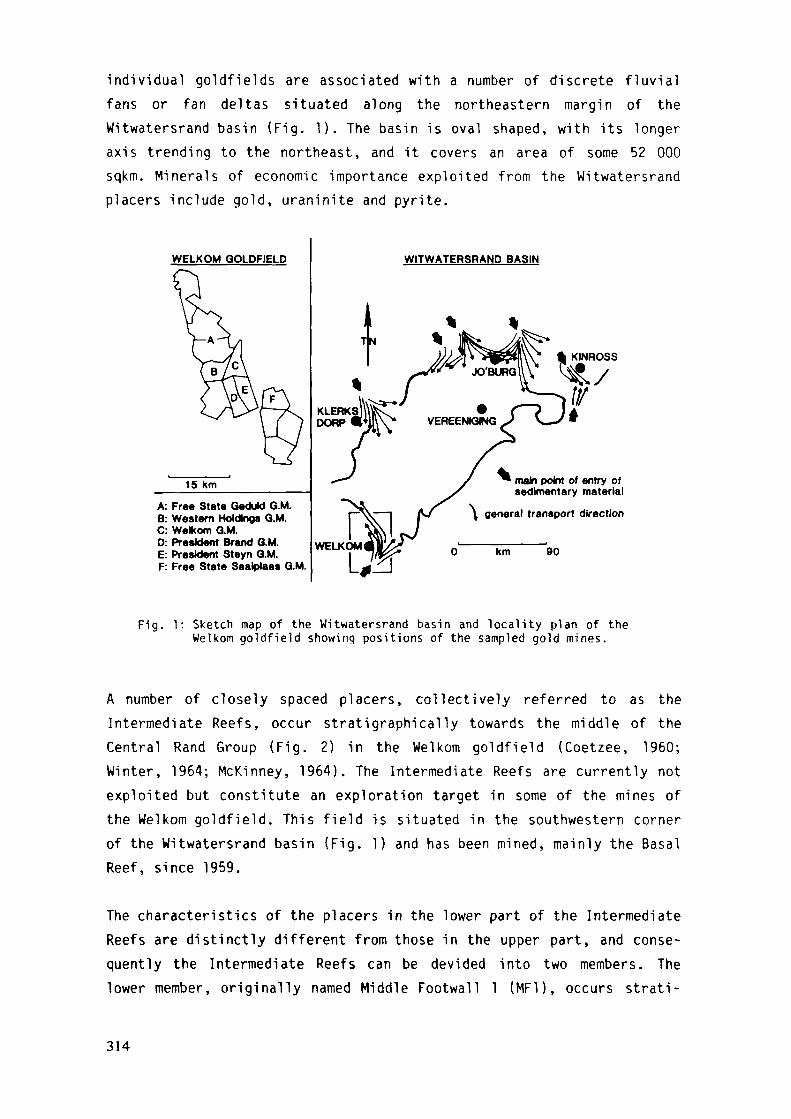
individual goldfields are associated with a number of discrete fluvialfans or fan deltas situated along the northeastern margin of theWitwatersrand basin (Fig. 1). The basin is oval shaped, with its longeraxis trending to the northeast, and it covers an area of some 52 000sqkm. Minerals of economic importance exploited from the Witwatersrandplacers include gold, uraninite and pyrite.
WELKOM QOLDFIELD
15 Km
A: Free State Geduld G.M.B: Western Holding« Q.M.C: Wefcom Q.M.0: President Brand G.M.E: President Steyn Q.M.F: Free State Saalplaas G.M.
WITWATERSRAND BASIN
\
main point of entry ofsedimentary material
general transport direction
WELKOM km 90
Fig. 1: Sketch map of the Witwatersrand basin and locality plan of theWelkom goldfield showing positions of the sampled gold mines.
A number of closely spaced placers, collectively referred to as theIntermediate Reefs, occur stratigraphically towards the middle of theCentral Rand Group (Fig. 2) in the Welkom goldfield (Coetzee, I960;Winter, 1964; McKinney, 1964). The Intermediate Reefs are currently notexploited but constitute an exploration target in some of the mines ofthe Welkom goldfield. This field is situated in the southwestern cornerof the Witwatersrand basin (Fig. 1) and has been mined, mainly the BasalReef, since 1959.
The characteristics of the placers in the lower part of the IntermediateReefs are distinctly different from those in the upper part, and conse-quently the Intermediate Reefs can be devided into two members. Thelower member, originally named Middle Footwall l (MF1), occurs strati-
314

graphically towards the top of the St. Helena Formation, and the uppermember, or formerly known as the Upper Footwall 4 (UF4), is similar tothe sediments of the Welkom Formation and is considered to be its basaldeposits (Fig. 2).
This paper describes and compares the sedimentological, mineralogicaland geochemical characteristics of the placers of the two members anddiscusses the inferences which can be made concerning the composition oftheir provenance areas, their environments of deposition and thecontrols on mineralization.
STRATIGRAPHIC COLUMN OFTHE CENTRAL RAND GROUP
WELKOM AREA
2000m_
1500m
1000m
500m
Om
VS5-*
'A'-*'B'-*
Leader-*Basal^*
UpperIntermediate
Lower
Commonage-
^v — ;V V V• a •0 * 0
0 0 9
0 0 0
« » •
• • o
0 • 0
• A • • O
H™~S"R
• ~~»
• • A A I
t 0 O O t»a o« o
oo a 04
j Q-
VENTERSDORP GROUP
Eldorado-
Aandenk-
Dagbreek-— Harmony-
Welkom-
St Helena-
Virgmia-
Jeppestown
Formation
Shale
oŒ.O
ZLUO
Fig. 2' Stratigraphie column of the Central Rand Group in the Welkomgoldfield depicting the stratigraphical position of theIntermediate Reefs and other placers.
315
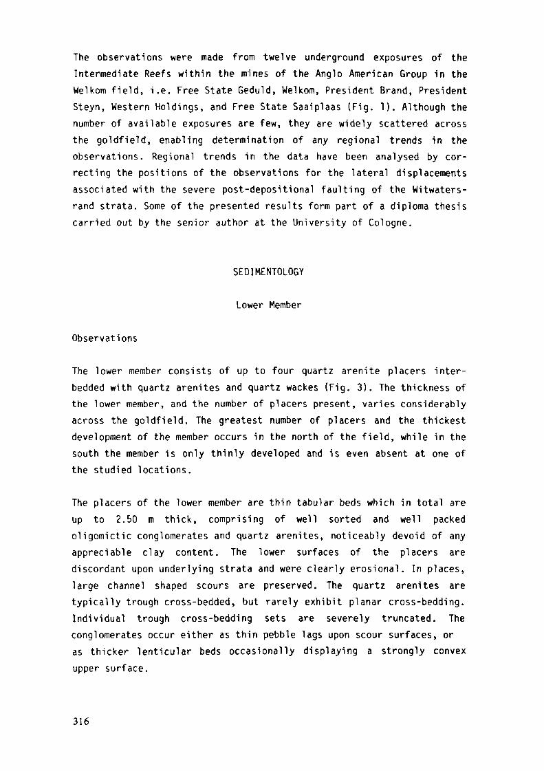
The observations were made from twelve underground exposures of theIntermediate Reefs within the mines of the Anglo American Group in theWelkom field, i.e. Free State Geduld, Welkom, President Brand, PresidentSteyn, Western Holdings, and Free State Saaiplaas (Fig. 1). Although thenumber of available exposures are few, they are widely scattered acrossthe goldfield, enabling determination of any regional trends in theobservations. Regional trends in the data have been analysed by cor-recting the positions of the observations for the lateral displacementsassociated with the severe post-depositional faulting of the Witwaters-rand strata. Some of the presented results form part of a diploma thesiscarried out by the senior author at the University of Cologne.
SEDIMENTOLOGY
Lower Member
Observations
The lower member consists of up to four quartz arenite placers inter-bedded with quartz arenites and quartz wackes (Fig. 3). The thickness ofthe lower member, and the number of placers present, varies considerablyacross the goldfield. The greatest number of placers and the thickestdevelopment of the member occurs in the north of the field, while in thesouth the member is only thinly developed and is even absent at one ofthe studied locations.
The placers of the lower member are thin tabular beds which in total areup to 2.50 m thick, comprising of well sorted and well packedoligomictic conglomerates and quartz arenites, noticeably devoid of anyappreciable clay content. The lower surfaces of the placers arediscordant upon underlying strata and were clearly erosional. In places,large channel shaped scours are preserved. The quartz arenites aretypically trough cross-bedded, but rarely exhibit planar cross-bedding.Individual trough cross-bedding sets are severely truncated. Theconglomerates occur either as thin pebble lags upon scour surfaces, oras thicker lenticular beds occasionally displaying a strongly convexupper surface.
316
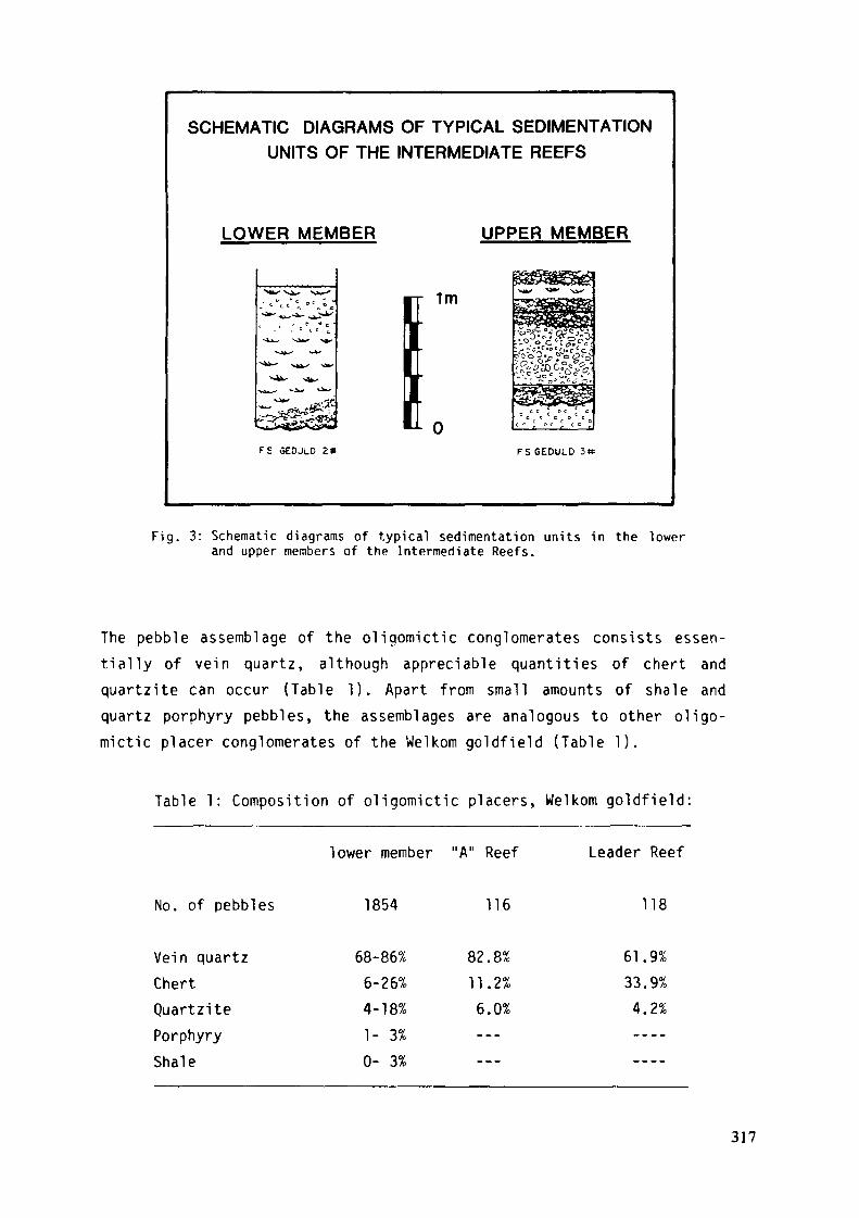
SCHEMATIC DIAGRAMS OF TYPICAL SEDIMENTATIONUNITS OF THE INTERMEDIATE REEFS
LOWER MEMBER UPPER MEMBER
1m
F£ GEOJLD 2» FS GEDULD
Fig. 3: Schematic diagrams of typical sedimentation units in the lowerand upper members of the Intermediate Reefs.
The pebble assemblage of the oligomictic conglomerates consists essen-tially of vein quartz, although appreciable quantities of chert andquartzite can occur (Table 1). Apart from small amounts of shale andquartz porphyry pebbles, the assemblages are analogous to other oligo-mictic placer conglomerates of the Welkom goldfield (Table 1).
Table 1: Composition of oligomictic placers, Welkom goldfield:
lower member "A" Reef Leader Reef
No. of pebbles 1854 116 118
Vein quartzChertQuartzitePorphyryShale
68-86%6-26%4-18%1- 3%0- 3%
82.8%11.2%6.0%---_ _ _
61.9%33.9%
4.2%
317

The assemblage of the sand-sized fraction consists predominantly ofrecrystallized quartz grains, exhibiting triple junction contacts,together with minor amounts of sulphides, chlorite, zircon, anatase, andtourmaline.
The variation in the mean size of the ten largest vein quartz pebblesfor the placers of the lower member are shown in Figure 4. The isoplethsreveal a radial distribution centered about the western margin ofWestern Holdings, with pebble size decreasing eastward by 2.9 cm over adistance of 12 km. In contrast the distribution of palaeocurrents, asdetermined from trough cross-bedding, are depicted in Figure 5. Aunimodal distribution, dominated by the southeasterly transportdirection is apparent.
WELKOM GOLDFIELDDISPERSAL PATTERN OF THE MEAN
PEBBLE SIZE M THE INTERMEDIATE REEFS
UPPER MEMBER
Fiq. 4: Dispersal pattern of the mean pebble s ize of the ten largestvein quartz pebbles in the lower member ( left hand side) andupper member (right hand side) of the Intermediate Reefs. Themean values at each observation point are given in centimetres.
Interpretation
The type of l i thofacies present, the fining-up faciès sequence, and theunimodal distribution of palaeocurrents, are all consistent with afluvial environment of deposition for the placers of the lower member(Walker & Cant, 1979). The morphology of the conglomerate beds resemble
318
channel lag and gravel braid-bar deposits (Rust, 1972), while the troughcross-bedded and planar cross-bedded quartz arenites are the deposits ofsand dunes and sand braid-bars, respectively (Smith, 1970; Cant, 1978).The tabular nature of the placers, their channel scoured bases, andtheir simple faciès sequences, are similar to recent alluvial depositsdescribed from sandy braided streams (Smith, 1970-, Cant, 1978; Mia l l ,1977).
The fining-up sequence of faciès, commonly draped by shale, suggestsprogressively more passive sedimentation achieved by lateral migrationof the braid-channels (Walker & Cant, 1979). The highly winnowed natureof the placer sediments, together with an abundance of troughcross-bedding, is consistent with deposition from braided streams of aperennial nature (Rust, 1978).
The palaeocurrent data defines the braided stream system as having flownin a southeasterly direction across the goldfield. However, the pebblesize data suggests an easterly dipping fluvial plain, with the sedimentbeing radially distributed from a source lying to the southwest ofWestern Holdings. This conflicting evidence is interpreted as revealingthe superimposition of two separate drainage systems. The easterlydrainage system supplied the coarse detritus, which was then reworked byperennial streams of the southeasterly flowing braided fluvial system.
Upper Member
Observations
The upper member is a complex deposit comprising an interbedding oflenticular beds of conglomerate, pebbly quartz arenites, pebbly quartzwackes, trough and planar cross-bedded quartz arenites and quartzwackes, massive quartz wackes and shales (Fig. 3).
The conglomerates, arenites and wackes are extremely variable and rangefrom several centimetres to over l m in thickness. The conglomeratesvary from well sorted to poorly sorted, and neighbouring conglomeratebeds can consist of very differently sized pebbles. There is no obviousvertical sequence of the lithofacies, and shale drapes can occur on con-glomerate, arenite and wacke beds. Although there are no clearly
319
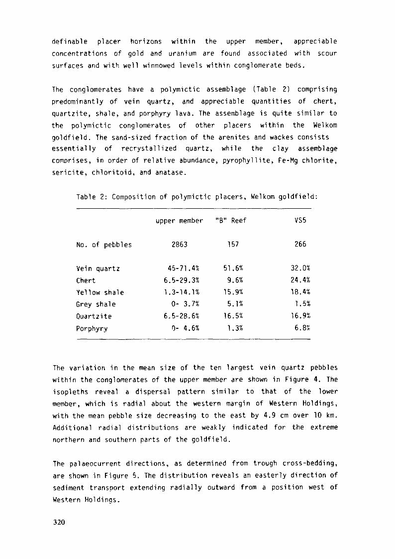
definable placer horizons within the upper member, appreciableconcentrations of gold and uranium are found associated with scoursurfaces and with well winnowed levels within conglomerate beds.
The conglomerates have a polymictic assemblage (Table 2) comprisingpredominantly of vein quartz, and appreciable quantities of chert,quartzite, shale, and porphyry lava. The assemblage is quite similar tothe polymictic conglomerates of other placers within the Welkomgoldfield. The sand-sized fraction of the arenites and wackes consistsessentially of recrystallized quartz, while the clay assemblagecomprises, in order of relative abundance, pyrophyllite, Fe-Mg chlorite,sericite, chloritoid, and anatase.
Table 2: Composition of polymictic placers, Welkom goldfield:
upper member "B" Reef VS5
No. of pebbles 2863 157 266
Vein quartzChertYellow shaleGrey shaleOuartzitePorphyry
45-71.4%6.5-29.3%1.3-14.1%0- 3.7%
6.5-28.6%0- 4.6%
51.6%9.6%
15.9%5.1%
16.5%1.3%
32.0%24.4%18.4%1.5%
16.9%6.8%
The variation in the mean size of the ten largest vein quartz pebbleswithin the conglomerates of the upper member are shown in Figure 4. Theisopleths reveal a dispersal pattern similar to that of the lowermember, which is radial about the western margin of Western Holdings,with the mean pebble size decreasing to the east by 4.9 cm over 10 km.Additional radial distributions are weakly indicated for the extremenorthern and southern parts of the goldfield.
The palaeocurrent directions, as determined from trough cross-bedding,are shown in Figure 5. The distribution reveals an easterly direction ofsediment transport extending radially outward from a position west ofWestern Holdinqs.
320
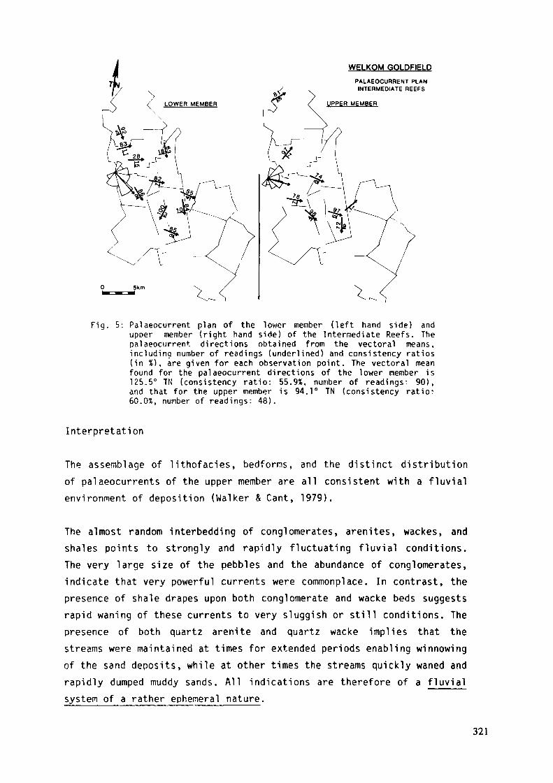
WELKOM GOLDFELDPALAEOCURRENT PLANINTERMEDIATE REEFS
UPPER MEMBER
Fig. 5: Palaeocurrent plan of the lower member (left hand side) andupper member (right hand side) of the Intermediate Reefs. Thepalaeocurrent. directions obtained from the vectoral means,including number of readings (underlined) and consistency ratios(in %), are given for each observation point. The vectoral meanfound for the palaeocurrent directions of the lower member is125.5° TN (consistency ratio: 55.9%, number of readings: 90),and that for the upper member is 94.1° TN (consistency ratio:60.0%, number of readings: 48).
Interpretation
The assemblage of lithofacies, bedforms, and the distinct distributionof palaeocurrents of the upper member are all consistent with a fluvialenvironment of deposition (Walker & Cant, 1979).
The almost random interbedding of conglomerates, arenites, wackes, andshales points to strongly and rapidly fluctuating fluvial conditions.The very large size of the pebbles and the abundance of conglomerates,indicate that very powerful currents were commonplace. In contrast, thepresence of shale drapes upon both conglomerate and wacke beds suggestsrapid waning of these currents to very sluggish or still conditions. Thepresence of both quartz arenite and quartz wacke implies that thestreams were maintained at times for extended periods enabling winnowingof the sand deposits, while at other times the streams quickly waned andrapidly dumped muddy sands. All indications are therefore of a fluvialsystem of a rather ephemeral nature.
321
The similarity of the radial distributions of the palaeocurrents andvariation in pebble-size are interpreted to define a fan shaped fluvialsystem entering the goldfield to the west of Western Holdings, withother alluvial fans possibly occurring to the north and south of thegoldfield. The relatively large size of the pebbles, and their rapiddecrease in size down the palaeosurface, suggest a rather steep gradientof the palaeoslope.
Similar sedimentary sequences to that of the upper member have beendescribed from the deposits of modern proximal braided streams havingrather ephemeral flow conditions (Church & Gilbert, 1975). The facièsassociations of these types of braided rivers have been classified asthe Scott type by Mi all (1977).
GEOCHEMISTRY
Thirty-three samples from the Intermediate Reefs were analyzed by meansof X-ray fluorescenze for Ti, Zr, Cr, and U, and by means of atomicadsorption spectroscooy for Au, Ni, and Cu. The results of theseinvestigations are given in Table 3.
The atomic adsorption analyses were carried out at standard conditionsusing graphite vessel technique on a Perkin Elmer model 400 instrument.All values obtained for Ni and Cu lie above the limits of detection,whereas three samples had Au concentrations which lie below the limit ofdetection (i.e. 0.3 ppm Au). XRF analyses were undertaken on a Philipssoectrograph model PW 1540 employing a tungsten target. U was determinedusing the L^ spectral line, consequently, the limit of detection forU308 was relatively high (i.e. 50 ppm u^Og). For all XRF determinationsthe tungsten tube radiation was found to be an adequate internalstandard.
Ti, Cr, and Zr were analysed because in the Witwatersrand conglomerateschromite, zircon and Ti phases (rutile, leucoxene) are among the mostabundant heavy minerals (Feather & Koen, 1975). Of importance is fur-thermore the fact that the studied 3 elements can unequivocally berelated to these heavy minerals.
322
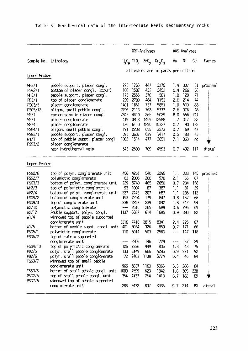
Table 3: Geochemical data of the Intermediate Reefs sedimentary rocks
Sample No. Lithology
Lower MarberW3/1FSG2/1VtC/1PB2/1FSG3/5FSG5/12W2/1V2/1W2/4PSG4/1PSG2/1Wl/1F5S3/2
pebble support, placer congl.bottom of placer congl . (scour)pebble suoport. placer conql.top of placer conglomerateplacer conglomerateoligom. small pebble congl.carbon seam in placer congl .placer conglomerateplacer conglomerateoligom. small pebble congl.pebble support, placer congl.top of pebble supot. placer congl.placer conglomeratenear hydrothermal vein
XRF-Analyses AAS-AnalysesU 0 TiO, ZrtL Cr.OL Au Ni Cu FacièsOO C. L. L. J
all values are in parts per million
275102173239140122%78434191261913931862543
1755158726552789165121134410381861102238363715142500
44742237046472776386514591895655629477709
33752453581115358515777502912588153273273141736514593
1.0.1.2.1.2.8.1.0.0.0.7.0.
4400060777517
33726612921450037655631719069188363492
31 proximal6371448348241821334743
\,»117 distal
Upper fintierFSG2/6FSG2/7FSG3/3WH2/3W2/4FSG9/2FSG9/3W2/10W2/12Wl/4Vfl/5FSG5/1FSG5/2F5G4/10PB2/5PB2/6F5S3/7FSS3/6PSG2/5PSG2/6
top of polym. congl omerate unitpolymictic conglomeratebottom of polym. conglomerate unittop of polymictic conglomeratebottom of polym. conglomerate unitbottom of conglomerate unittop of conglomerate unitpolymictic conglomeratePebble support, polym. congl.wirmcwed top of pebble supportedconglomerate unitbottom of pebble supot. congl. unitpolymictic conglomeratetop of matrix supportedconglomerate unittop of polymictic conglomeratepolym. small pebble conglomeratepolym. small pebble conglomeratewinnowed top of small pebbleconglomerate unitbottom of small pebble congl. unittop of small pebble congl. unitwinnowed top of pebble supportedcongl omerate unit
4566322993227193238—11373216401110—125133729661089354288
42612005674010072472229428932615558774163034501423052336314924036837459941373432
54020046587207179239265614281532650314644966611381160623764837
329557026503876878471042589168583418592560729805428557745065184214103936
1.2.0.1.1.0.1.3.0.2.0.----1.0.0.3.1.0.
11711886947--394567
0.7
33365234812851572422%380225171147574322146266305182214
145 proximal6715629112669469828766118297592848423889 1r80 distal
323

The normalized values of the Ti, Cr, Zr analyses were plotted in a-ZrO?-Cr?0_ triangular diagram (Fig. 6). With respect to the TiOkratios the plot reveals a general grouping of the data points intodistinctive fields for the lower and upper members (Fig. 6). Thisgrouping reflects differences in the relative abundance of chromite andTi phases in the two members. Such differences may be indicative oflithological differences in the provenance terranes as has been pointedout by Hirdes & Saager (1983) who carried out a similar investigation inthe Kimberley Reef placer of the Evander goldfield. Alternatively,erosional processes in the source area, grain size differences of thedetrital minerals, and diagenetic and/or metamorphic effects in thedepositional environment may influence the composition of the studiedsuite of heavy minerals (van Andel, 1959).
A conspicuous feature of all samples is the low proportion of ZrO 2- Thesamples from the upper member exhibit slightly lower C^O^/ZrC^ ratiosthan those of the lower member. High C^Og/ZrC^ ratios have been alsoobserved in the placer sediments of the Kimberley Reef of the Evandergoldfield by Hirdes & Saager (1983). These authors concluded that such a
Cr203
TiO2 ZrO2
Fig. 6: Relationship between Cr^ 0,, TiO - and Zr02 in the IntermediateReefs.Conglomerates of the lower member: triangles.Conglomerates of the upper member: circles.
324

geochemical trend points to a source area dominated by ultramafic/maficrocks. The few samples from the lower member which differ from theobserved general trend originate from sampling sites where the lowermember has been contaminated by sediments of the upper member.
Au and U were analysed to help to establish the economic potential ofthe Intermediate Reefs placers and to ascertain whether downcurrentgradients of the Au/U^Og ratios exist. Such gradients were recognized inother Witwatersrand placers by Winter (1978) and Smith & Minter (1980)who attributed them to changing sorting mechanisma for gold and urani-nite in a changing flow field. However, the explanations given by Minter(1978) and Smith and Minter (1980) do not take into account that in theWitwatersrand ores gold and uranium are not only present in the form ofdiscrete gold particles and uraninite but occur also associated withother phases, i.e. inclusions of gold in detrital sulphides (Frey,1981), redistributed uranium admixed with Ti phases or secondary phyllo-silicates (Thiel et al., 1979). Due to the erratic lUOg and low as wellas erratic Au concentrations found in the investigated suite of samplesno systematic trends of the Au/U^Og ratios were observed. In accordancewith earlier observations, reported by Coetzee (1960), the investigatedIntermediate Reefs samples possess low gold and. at the same time,relatively high uranium tenor.
Ni and Cu were analysed to investigate possible associations of Ni andCu minerals with gold. Such associations have been reported by a numberof investigators (Ramdohr, 1955; Feather & Koen, 1975; and others). Nosignificant correlations could be found for the pair Ni-Au or the pairCu-Au.
ORE MINERALOGY
The suite of ore minerals recognized in the Intermediate Reefs is rathercomplex and comprises essentially of 19 minerals (Frey, 1981) whichinclude pyrite, chromite, zircon, leucoxene, brannerite, arsenopyrite,cobaltite, pyrrhotite. carbonaceous matter, uraninite, chalcooyrite,sphalerite, rutile, galena, gersdorffite, gold, marcasite, molybdenite,and ilmenite (order of abundance).
325
The minerals occur largely in the conglomerate matrix and on averagemake up about 5% of the total placers. Pyrite is the most abundant heavymineral, and accounts for about 90% of the ore mineral assemblage.Visible concentrations of heavy minerals were recognized upon scoursurfaces, within the foreset laminae and trough scours of cross-beddedsediments, clearly demonstrating the detrital nature of these minerals.
As it is the case with all other Witwatersrand placers the ore mineralsof the Intermediate Reefs can be divided into allogenic (detrital) andauthigenic (in situ emplaced) minerals. The authigenic minerals areremobilized constituents formed as a result of diagenesis and/ormetamorphic overprint of the sediments and cannot be taken as evidencefor epigenetic ore formation (Mellor, 1916: Ramdohr, 1955-, Liebenberg,1955; Saager, 1973; Feather & Koen, 1975; and many others).
In the following only some of the more important and to the presentpaper relèvent observations are reported. Detailed descriptions aregiven elsewhere (Prey. 1981).
Pyrite is present in the three types reported for other Witwatersrandplacers by Ramdohr (1955) and Saager (1970), namely (i) as allogeniccompact rounded grains, (ii) as round porous grains, and (iii) as authi-genic often euhedral constituents (Figs. 7 to 9). Compact rounded pyritecontains primary inclusions of chalcopyrite, pyrrhotite, sphalerite,pentlandite, molybdenite and galena. In addition primary gold inclu-sions, which in other reefs are rare features (Saager, 1970; Oberthür,1983), were encountered in a relatively large number of compact detritalpyrite grains.
Chromite, zircon, arsenopyrite. and cobaltite occur as rounded detritalcomponents which often are cataclastically shattered. In rare casesallogenic rutile and molybdenite were also detected. Noteworthy is theobservation that the lower member carries higher concentrations ofarsenop.yrite and cobaltite than the upper member.
Uranium is present in brannerite, leucoxene, carbonaceous matter, anduraninite. By far the most important uranium carrier in the IntermediateReefs is brannerite, a fact which must be taken into consideration inthe case that Intermediate Reefs ores are investigated for metallurgicalpurposes.
326
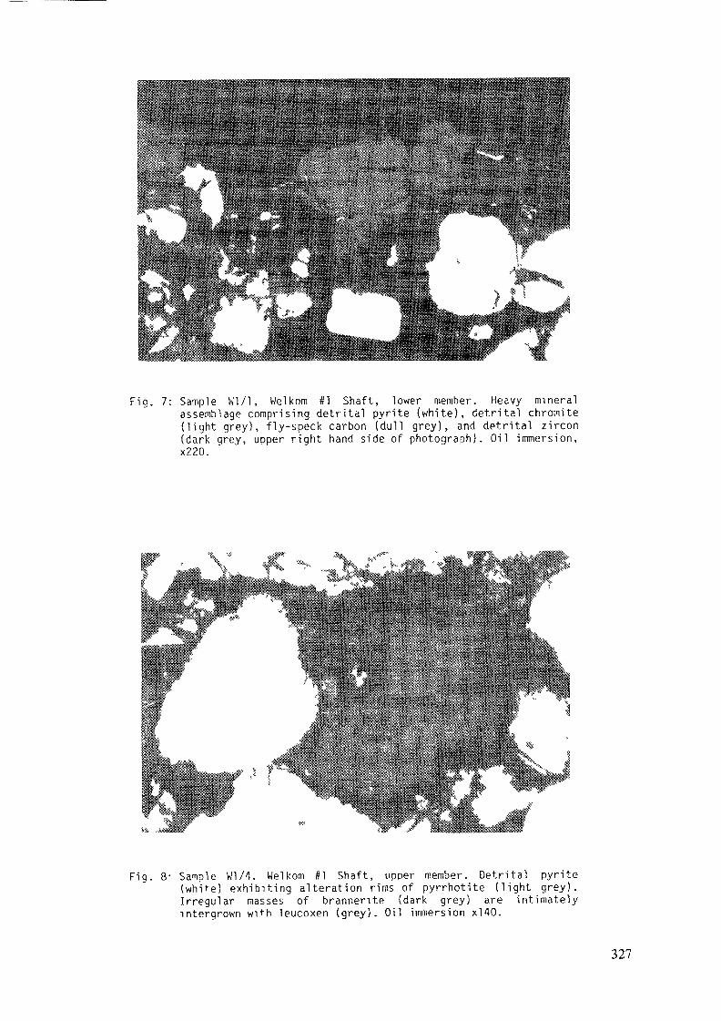
Fig. 7: Sample Wl/1, Welkom #1 Shaft, lower member. Heavy mineralassemblage comprising detrital pyrite (white), detrital chromite(light grey), fly-speck carbon (dull grey), and detrital zircon(dark grey, upper right hand side of photograph). Oil immersion,x220.
Fig. 8- Sample k'1/4, Welkom #1 Shaft, upper member. Detrital pyrite(white) exhibiting alteration rims of pyrrhotite (light grey).Irregular masses of brannerite (dark grey) are intimatelyintergrown with leucoxen (grey). Oil immersion x!40.
327
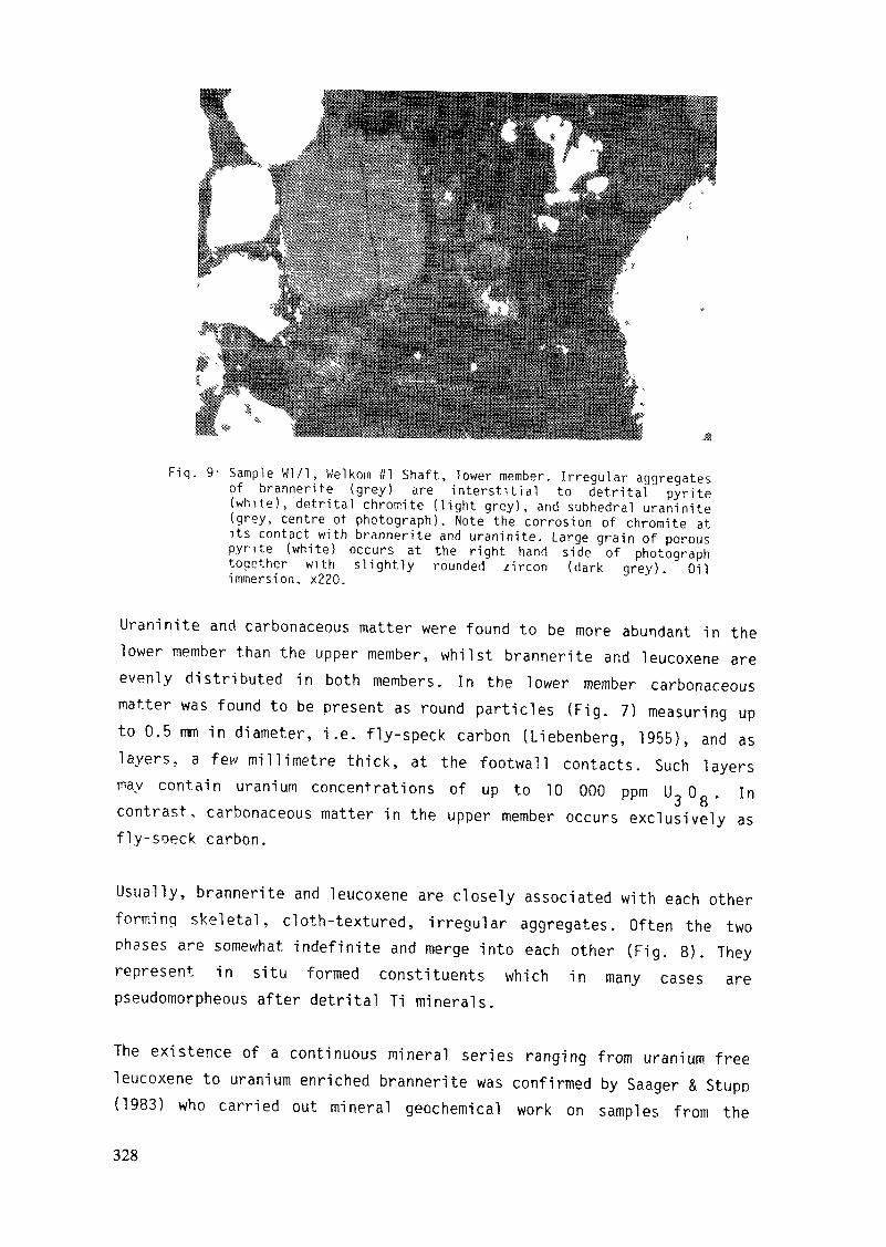
Fiq. 9 - Sample W l /1 , Welkom #1 Shaft, lower member. Irregular aggregatesof brannerite (grey) are interstitial to detrital pyrite(white), detrital chromite (light grey), and subhedral uraninite(grey, centre of photograph). Note the corrosion of chromite atits contact with brannerite and uraninite. Large grain of porouspyrite (white) occurs at the right hand side of photographtogether with slightly rounded zircon (dark grey). Oilimmersion, x220.
Uraninite and carbonaceous matter were found to be more abundant in thelower member than the upper member, whilst brannerite and leucoxene areevenly distributed in both members. In the lower member carbonaceousmatter was found to be present as round particles (Fig. 7) measuring upto 0.5 mm in diameter, i.e. fly-speck carbon (Liebenberg, 1955), and aslayers, a few millimetre thick, at the footwall contacts. Such layersinav contain uranium concentrations of up to 10 000 ppm U 0 0 0 . In
O Ocontrast, carbonaceous matter in the upper member occurs exclusively asfly-soeck carbon.
Usually, brannerite and leucoxene are closely associated with each otherforming skeletal, cloth-textured, irregular aggregates. Often the twophases are somewhat indefinite and merge into each other (Fig. 8). Theyrepresent in situ formed constituents which in many cases arepseudomorpheous after detrital Ti minerals.
The existence of a continuous mineral series ranging from uranium freeleucoxene to uranium enriched brannerite was confirmed by Saager & Stupo(1983) who carried out mineral geochemical work on samples from the
328
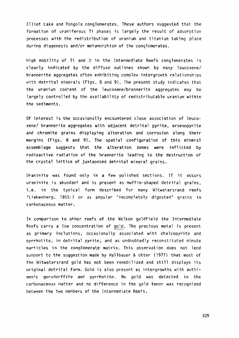
Elliot Lake and Pongola conglomerates. These authors suggested that theformation of uraniferous Ti phases is largely the result of adsorptionprocesses with the redistribution of uranium and titanium taking placeduring diagenesis and/or metamorphism of the conglomerates.
High mobility of Ti and U in the Intermediate Reefs conglomerates isclearly indicated by the diffuse outlines shown by many leucoxene/brannerite aggregates often exhibiting complex intergrowth relationshipswith detrital minerals (Figs. 8 and 9). The present study indicates thatthe uranium content of the leucoxene/brannerite aggregates may belargely controlled by the availability of redistributable uranium withinthe sediments.
Of interest is the occasionally encountered close association of leuco-xene/ brannerite aggregates with adjacent detrital pyrite, arsenopyriteand chromite grains displaying alteration and corrosion along theirmargins (Figs. 8 and 9). The spatial configuration of this mineralassemblage suggests that the alteration zones were inflicted byradioactive radiation of the brannerite leading to the destruction ofthe crystal lattice of juxtaposed detrital mineral grains.
Uraninite was found only in a few polished sections. If it occursuraninite is abundant and is present as muffin-shaped detrital grains,i.e. in the typical form described for many Witwatersrand reefs'Liebenberg. 1955:) or as angular "incompletely digested" grains incarbonaceous matter.
In comparison to other reefs of the Welkom goldfield the IntermediateReefs carry a low concentration of gold. The precious metal is presentas primary inclusions, occasionally associated with chalcopyrite andpyrrhotite, in detrital pyrite, and as undoubtedly reconstituted minuteparticles in the conglomerate matrix. This observation does not lendsuoport to the suggestion made by Hallbauer & Utter (1977) that most ofthe Witwatersrand gold has not been remobilized and still displays itsoriginal detrital form. Gold is also present as intergrowths with authi-genic gersdorffite and pyrrhotite. No gold was detected in thecarbonaceous natter and no difference in the gold tenor was recognizedbetween the two members of the Intermediate Reefs.
329
DISCUSSION AND CONCLUSIONS
Lithology and sedimentary structures of the placer deposits of theIntermediate Reefs indicate the presence of the following main types oflithofacies (nomenclature after Miall 1977): pebble lags, massiveconglomerate (Gm), trough cross-bedded quartz arenite (St), planarcross-bedded quartz arenite (Sp), and shale drapes (M). Theselithofacies are typical of modern braided river deposits (Miall, 1977)and indicate the sedimentary environment in which the Intermediate Reefsdeposits were laid down.
For the lower member the measurements of the various sedimentologicalparameters yielded conflicting results on the orientation of the fluvialplain. Palaeocurrent directions indicate sedimentary transport to thesoutheast. The dispersial pattern obtained from pebble size data, on theother hand, indicate a fluvial plane dipping towards the east and a mainpoint of entry of sedimentary material lying southwest of WesternHoldings (Figs. 4 and 5).
It is concluded that two major drainage systems existed duringdeposition of the lower member, one dispersing to the east and a secondone flowing to the southeast. The slow downcurrent decrease in pebblesize and the mature character of the placers of the lower member indi-cate a shallow palaeoslope and thorough reworking of the sediment. Thesefeatures can be correlated with perennial drainage in a humid climate.The mature character of the placers may reflect winnowing resulting fromthe superimposition of two drainage systems or, alternatively, it simplymay reflect the compositional differences of the source area of thesedinents.
The radial distribution of palaeocurrent trends for the upper membercorrelates well with te dispersal patterns of the mean pebble size. Thispoints to the existence of shifting braided-stream systems upon analluvial fan with a main point of entry lying southwest of WesternHoldings (Figs. 4 and 5).
The more rapid decrease of the pebble sizes in the upper member,connared to the lower member, indicates steeper palaeoslope conditions
330
during deposition of the sediments of the upper member. A steeppalaeoslope may be the result of active basin edge tectonics leading tostrong denudation in the hinterland and rapid deposition by ephemeralstreams in the depository. Such sedimentary conditions are also inaccord with the observed rapid variation of the lithofacies of the uppernember.
The geochemical data revealed that the lower member has a higherCr2U3/Ti02 ratio than the upper nember (Fig. 6), which might beexplained in the following two ways:
1. Leucoxene aggregates, formed by alteration of detrital Ti minerals.constitute the most common Ti phase within the Intermediate Reefs.Because of their adsorptive properties for redistributed migratinguranium, U-Ti phases (brannerite and uraniferous leucoxene) are themost abundant U minerals in the placers.
If one assumes that leucoxene formed early during the diagenetichistory of the sediments (Dimanche & Bartholomé, 1976) it followsthat prolonged sedimentary reworking leads to a depletion ratherthan to a concentration of these fragile alteration products, whichmust result in the depletion of the TiU2 content in the deposits.Therefore, the higher Cr^Qj/TiC^ ratio found for the lower membercan be explained as a result of the prolonged reworking which thisplacer suffered as indicated by its oligomict character and itsgeneral high degree of maturity.
2. The different Cr^/TiC^ ratios found for the two members maysimply be an effect of differences in the lithological compositionof the provenance terrane of the sediments. Such lithologicaldifferences may for instance be the result of increased tectonicactivity which occurred during deposition of the upper member alongthe edge of the sedimentary basin.
The second explanation is envisaged to be more probable because ofmineralogical (different arsenopyrite, cobaltite content) and additionalslight geochemical differences (ZrOp concentration) which exist betweenthe two Intermediate Reefs members.
331
In spite of the different sedimentary maturity shown by the two members,both placers exhibit qualitatively only slight differences in theirheavy mineral spectrum. It is a spectrum of detrital sulphides andresidual heavy minerals (chromite, zircon, rutile). This is probably anindication that the maturity of the rocks was largely controlled byphysical processes, while that of the heavy minerals by chemicalprocesses.
Although the lithology of the Intermediate Reefs does not differmarkedly from that of better mineralized reefs of the Welkom goldfield,they currently can only be classed as subeconomical deposits. This isattributed to one or a combination of the following points:
- lack of economic minerals (gold, uraninite) in the provenanceterrane of the sediments.
- absence of reworkable well mineralized placers in the footwall ofthe Intermediate Reefs zone which could have contributed economicminerals, i.e. absence of a local supply of gold and U mineralsduring the accumulation of the Intermediate Reefs sediments: alleconomic reefs in the welkom goldfield occur in the hangingwall ofthe Intermediate Reefs.
- inadequate hydraulic conditions preventing efficient accumulation ofparticulate gold. A considerable proportion of the gold present inthe Intermediate Reefs is present as primary inclusions in detritalsulphides and this proportion may considerably exceed that found inother Witwatersrand reefs.
ACKNOWLEDGEMENTSThe authors wish to thank the Anglo American Corporation of South Africafor providing access to their mines in the welkom area and for permis-sion to publish this paper. Thanks are also due to the various minegeologists and especially to R.G.S. McLennan, chief geologist AngloAmerican Corporation, for providing invaluable assistance during theunderground work at Welkom. Prof. W.E.L. Minter, University of Capetown,reviewed an early draft of part of this study and his suggestions weremost usefull. Financial assistance in form of a travelling grant to M.Frey was obtained from the Deutsche Akademische Auslanddienst (DAAD),Bonn.332

REFERENCES
Buck, S.G.(1983): The Saaiplaas Quartzite Member: a braided system ofgold and uranium bearing channel placers within the ProterozoicWitwatersrand Supergroup of South Africa. Spec. Pub!. In. Ass.Sediment. 6, 549-562
Cant, D.vl. (1978): Development of a faciès model for sandy braided riversedimentation: comparison of the South Saskatchewan River andBattery Point Formation. In: Miall, A.D. (ed.) Fluvial Sedi-mentology. Mem. Can. Soc. Petrol. Geol., 627-640.
Church, M.. and Gilbert, R. (1975): Proglacial fluvial and lacustrinesediments. Soc. Econ. Paleontol. Mineral. Spec. Publ. 23, 22-100.
Coetzee,C.B. (1960): The geology of the Orange Free State goldfield.S.A. Geol. Surv. Mem. 49, 198 pp.
Dimanche, F., and Bartholomé, P. (1976): The alteration of ilmenite insediments. Minerals. Sei. Engng., 8, 187-201.
Feather, C.E., and Koen, G.M. (1975): The mineralogy of theWitwatersrand reefs. Minerals. Sei. Engng., 7, 189-224.
Frey, M. (1981): Lagerstättenkundliche Untersuchungen an einigen Pro-filen der Intermediate Reefs der Witwatersrand Supergruppe, Welkorr,Goldfeld, Südafrika. Unpubl. diploma thesis, Universität Köln, 114pp.
Hallbauer, D.K., and Utter, T. (1977): Geochemical and morphologicalcharacteristics of gold particles from recent river deposits andthe fossil placers of the Witwatersrand. Min. Dep. 12, 293-306.
Hirdes, W., and Saager, R. (1983) The Protorozoic Kimberley Reef Placerin the Evander Goldfield, Witwatersrand, South Africa. MonographSeries Min. Deposits. 20, 101 pp.
Liebenberg, W.R. (1955): The occurrence of gold and radioactive mineralsin the Witwatersrand System, the Dominion Reef, the VentersdorpContact Reef and the Black Reef. Trans, geol. Soc. S. Afr. 58,101-223.
McKinney, J.S. (1964): Geology of the Anglo American Group mines in theWelkom area, Orange Free State Goldfield. In: Haughton, S.J. (ed.)The geology of some ore deposits in southern Africa. Vol. 1.451-506.
Mellor, E.T.U916): The conglomerates of the Witwatersrand. Trans. Inst.Min. Met. 25, 226-348.
Miall, A.D. (1977): A review of the braided-river depositionalenvironment. Earth Science Reviews 13, 1-62.
Minter, W.E.L. (1978): A sedimentological synthesis of placer gold-uran-ium and pyrite concentrations in Proterozoic Witwatersrandsediments.In: Miall, A.D. (ed.) Fluvial Sedimentology. Can. Soc.Petr. Geol. Mem. 5, 801-829.
333
Oberthiir, T. (1983): Metal logenetisehe Überlegungen zur Bildung desCarbon Leader Reef, Carletonville Goldfeld, Witwatersrand,Südafrika. Unpubl. Ph.D. thesis, Univ. Köln, 241 pp.
Pretorius, D.A. (1975) The depositional environment of the Witwatersrandgoldfields: a chronological review of speculations and obser-vations. Minerals Sei. Engng. 7, 18-47.
Ramdohr. P. (1955): Neue Beobachtungen an Erzen des Witwatersrandes inSüdafrika und ihre genetische Bedeutung. Abhandl. Akad. Wiss.Berlin, Klasse Math. Natw. 43 pp.
Rust. B.R. (1972): Structure and process in a braided river. Sedimento-logy 18, 221-246.
Rust, B.R. (1978): Depositional models for braided alluvium. In: Miall,A.D. (ed.) Fluvial Sedimentology. Mem. Can. Soc. Petr. Geol. 5,605-626.
Saager. R. (1970): Structure in pyrite from the Basal Reef in the OrangeFree State Goldfield. Trans. Geol. Soc. S. Afr. 73, 30-46.
Saager, R. (1973): Geologische und geochemische Untersuchungen anprimären und sekundären Goldvorkommen im frühen PräkambriumSüdafrikas. Ein Beitrag zur Deutung der primären Herkunft desGoldes in der Witwatersrand-Lagerstätte. Habil. Schrift., Univ.Heidelberg, 150 pp.
Saager, R., and Stupp, H.D. (1983): U-Ti phases from Precambrian quartz-pebble conglomerates of the Elliot Lake area, Canada, and thePongola basin, South Africa. Tscherm. Min. Petr. Mitt., in press.
Smith, N.D. (1970): The braided stream depositional environment:comoarison of the Platte River with some Silurian clastic rocks,north-central Appalachians. Bull. Geol. Soc. Am. 81, 2993-3014.
Smith, N.D., and Minter, W.E.L. (1980): Sedimentological controls ofgold and uranium in two Witwatersrand palaeoplacers. Econ. Geol.75. 1-14
Thiel, K., Saager, R., and Muff, R. (1979): Distribution of uranium inearly Precambrian gold bearing conglomerates of the KaapvaalCraton, South Africa: a review of a case study for the applicationof fission track micromapping of uranium. Minerals. Sei. Engng.11, 225-248.
Van Andel, B.H. (1959): Reflections on the interpretation of heavymineral analyses. J. Sediment. Petr. 29, 153-163.
Walker, R.G., and Cant, D.J. (1979): Sandy fluvial systems. In: Walker,R.G. (éd.) Faciès Models. Geosci. Can., 1, 23-32.
Winter, H. de la R. (1964): The geology of the northern section of theOrange Free State Goldfield. In: Haughton, S.J. (ed.) The geologyof some ore deposits of southern Africa, vol. 1, 507-548.
334

PALEOCURRENT AND LITHOLOGICAL FACIESCONTROL OF URANIUM AND GOLD MINERALISATIONIN THE WTTWATERSRAND CARBON LEADER PLACER,CARLETONVILLE GOLDFIELD, SOUTH AFRICA
S.G. BUCK*Department of Geology,Anglo American Corporation of South Africa Ltd,WelkomW.E.L. MINTERCape Town University,Cape TownSouth Africa
Abstract
The Carbon Leader placer in the Carletonville goldfield is a pebbly quartz-arenite that occupies numerous low-sinuosity channelways which trend down asoutherly paleoslope. The placer sediment is distinctively grey andsiliceous in comparison with the bounding lithologies both above and belowthe orebody. The most common faciès sequence established by Markov analysisconsists of an irregular scoured base overlain by oligomictic lag conglomerates,which grade upward into quartz-arenites, quartz-wackes, and finally into shales.The sequences are repeated several times in the thicker placer sequences andare interpreted as fluvial. The channels are up to 2 metres deep, 500 metreswide, and can be traced over distances of more than 2 kilometres. Theyrepresent the erosional etches caused by a fluvial degradation that truncatedthe underlying sediments and produced an angular unconformity that has anerosional gradient of approximately 1:100. This represents an almost planarregional paleosurface that covers 400 km2.
The uniform distribution of the Carbon Leader placer across such an extensivesurface indicates that it was deposited upon a very wide fluvial plain byeither a large network of streams or by a small network of streams thatmigrated widely. The incidence of large deep channels is distinctlyconcentrated at two positions, located 12 kilometres apart on the easternand western preserved parts of the paleosurface. These two positions areconsidered to represent major influx positions and the drainage patternsoutlined diverge radially from both of them.
* Present address: Sedimentological Research Laboratory, University of Reading, Whiteknights, Reading,RG6 2AB Great-Britain.
335
The sites of uranium and gold concentration correlate well with each otherand are associated with linear zones of thick placer accumulations inchannelways, particularly where the cumulative thickness of conglomerate isgreater. Mineral concentrations associated with thin placer accumulationsindicate areas where higher stream-power prevailed. The mineralisationdecreases westwards, across the goldfield, and is related to the nature ofthe host sediment, which contains less gravel and more immature sedimentwestwards. These sedimentary changes are related to differences in fluvialconditions that are thought to have been prevalent in the various channel-ways that transversed the paleoslope. Besides being geographically separate,these channels may have been active at different times when conditionsaffecting mineral supply and concentration were not the same. Thedifferences noted indicate that deeper, more active channels, probablyoccupied by perennial streams, deposited more, coarser, and bettermineralised placer sediment down the eastern part of the detailed study area.In contrast to this, channelways down the western part of the detailed studyarea were probably occupied by more ephemeral streams that deposited lessgravel, more sand, and more immature, poorly mineralised, sediment.The same conclusion is reached by analysing the uranium-gold ratio patternacross the detailed study area. In this instance, ratios exceeding 12demarcate the immature western part of this area. High ratios also definedistal faciès and these clearly indicate that the data in the southwesternpart of the detailed study area are on the margin of a distal environmentin which the uranium content will be higher than that encountered furtherupslope. Such positive correlation between sedimentary and mineralisationtrends clearly illustrates the detrital nature of the deposit.
1.0 INTRODUCTION
The Carbon Leader orebody in the Carletonville Goldfield is one of therichest gcld-bearing placers ever mined in the Witwatersrand basin. Theaverage in-situ gold grade over much of the area is 20 grams per metricton. The Carbon Leader rests upon a regular angular unconformity near thebase of the Central Rand Group, and is preserved over an area of 400 km2.This paleosurface strikes at 075°TN, parallel to the basin edge, and dipssoutheast at 20° into the basin. It was truncated by Ventersdorp andTransvaal erosional events after a history of tectonic folding and tiltingwith the result that the placer now subcrops beneath these supergroups along
336
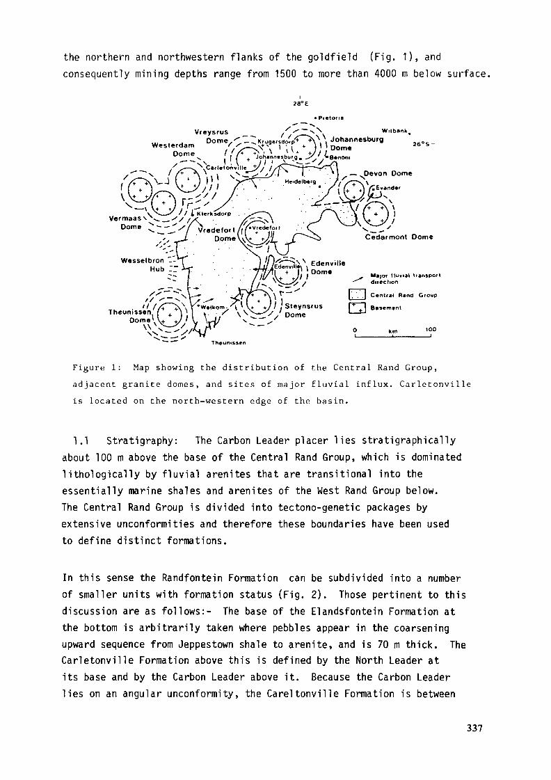
the northern and northwestern flanks of the goldfield (Fig. 1), andconsequently mining depths range from 1500 to more than 4000 m below surface.
i28°E
WilbanhJohannesburgDom«
/ iB.non,^ "^ '
Major lluvial 1r*n>pot1direction
Theunissen
Figure 1: Map showing the distribution of the Central Rand Group,adjacent granite domes, and sites of major fluvial influx. Carletonvi1 leis located on the north-western edge of the basin.
1.1 Stratigraphy: The Carbon Leader placer lies stratigraphicallyabout TOO m above the base of the Central Rand Group, which is dominatedlithologically by fluvial arenites that are transitional into theessentially marine shales and arenites of the West Rand Group below.The Central Rand Group is divided into tectono-genetic packages byextensive unconformities and therefore these boundaries have been usedto define distinct formations.
In this sense the Randfontein Formation can be subdivided into a numberof smaller units with formation status (Fig. 2). Those pertinent to thisdiscussion are as follows:- The base of the Elandsfontein Formation atthe bottom is arbitrarily taken where pebbles appear in the coarseningupward sequence from Jeppestown shale to arenite, and is 70 m thick. TheCarletonville Formation above this is defined by the North Leader atits base and by the Carbon Leader above it. Because the Carbon Leaderlies on an angular unconformity, the Careltonville Formation is between
337
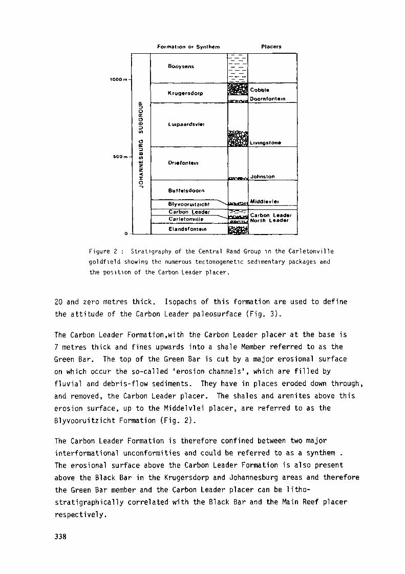
Formation or Synthem Placers
lOOOm-
500m-
O -
RG
S
UB
GR
OU
PH
AN
NE
SB
U
O-3
Booysens
Luipaardsvlei
On«font«m
Butfelsdoorn
Blyvooruitzicht ^v-Carbon LeaderCarletonville ^""-
Elandsfomem
-_— -
jl llmrvro**
^&H
f3>r*l>^
BCfcBHJ
T>-_- _nrmtjnflffl1*T'TSl|
Cobbl«Doornfontem
Livingstone
Johnston
Middlevlei
North L«ader
Figure 2 : Stratigraphy of the Central Rand Group in the Carletonvillegoldfield showing the numerous tectonogenetic sedimentary packages andthe position of the Carbon Leader placer.
20 and zero metres thick. Isopachs of this formation are used to definethe attitude of the Carbon Leader paleosurface (Fig. 3).
The Carbon Leader Formation,with the Carbon Leader placer at the base is7 metres thick and fines upwards into a shale Member referred to as theGreen Bar. The top of the Green Bar is cut by a major erosional surfaceon which occur the so-called 'erosion channels', which are filled byfluvial and debris-flow sediments. They have in places eroded down through,and removed, the Carbon Leader placer. The shales and arenites above thiserosion surface, up to the Middelvlei placer, are referred to as theBlyvooruitzicht Formation (Fig. 2).
The Carbon Leader Formation is therefore confined between two majorinterformational unconformities and could be referred to as a synthem .The erosional surface above the Carbon Leader Formation is also presentabove the Black Bar in the Krugersdorp and Johannesburg areas and thereforethe Green Bar member and the Carbon Leader placer can be litho-stratigraphically correlated with the Black Bar and the Main Reef placerrespectively.
338
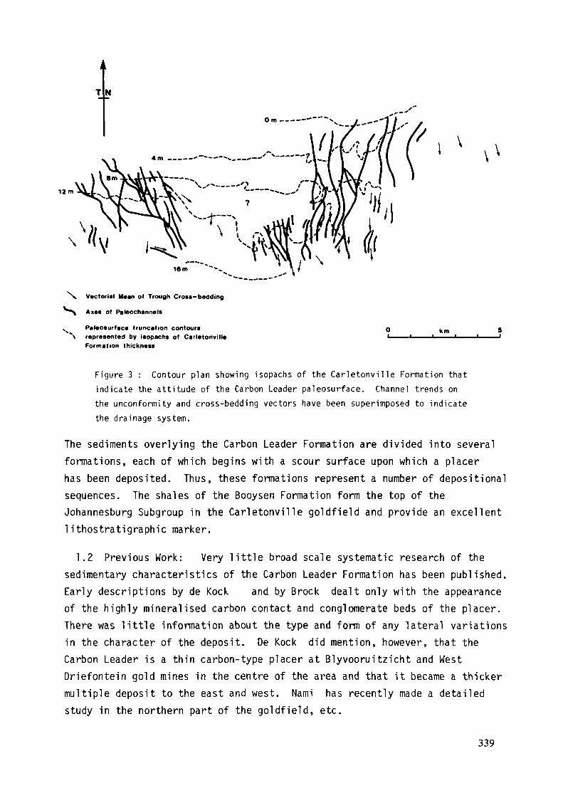
12 m
N. Vector!»! Mean of Trough Croîs-bedding
^^ Axas of Paleochannals
K Paleosurface truncation contour**\ represented by isopachs of Carletonville
Formation thickness
km
Figure 3 : Contour plan showing isopachs of the Carletonvil le Formation thatindicate the attitude of the Carbon Leader paleosurface. Channel trends onthe unconformity and cross-bedding vectors have been superimposed to indicatethe drainage system.
The sediments overlying the Carbon Leader Formation are divided into severalformations, each of which begins with a scour surface upon which a placerhas been deposited. Thus, these formations represent a number of depositionalsequences. The shales of the Booysen Formation form the top of theJohannesburg Subgroup in the Carletonville goldfield and provide an excellentlithostratigraphic marker.
1.2 Previous Work: Very little broad scale systematic research of thesedimentary characteristics of the Carbon Leader Formation has been published.Early descriptions by de Kock and by Brock dealt only with the appearanceof the highly mineralised carbon contact and conglomerate beds of the placer.There was little information about the type and form of any lateral variationsin the character of the deposit. De Kock did mention, however, that theCarbon Leader is a thin carbon-type placer at Blyvooruitzicht and WestDriefontein gold mines in the centre of the area and that it became a thickermultiple deposit to the east and west. Nami has recently made a detailedstudy in the northern part of the goldfield, etc.
339

1.3 Method: The sedimentological observations discussed in this paper-were made between 1975 and 1979. Approximately 4500 metres of undergroundexposure was examined in 145 stope panels and 407 sedimentological sectionswere recorded from a 'central area' measuring 7 km along strike by 3 km downdip. With this data-set as a standard, scattered observations were thenmade at widely spaced locations where unmined exposures were accessible.Several locations were revisited after a period of mining to establishthree-dimensional aspects of particular features. Mining records compiledduring the past 20 years were also analysed and data concerning placerthickness, mineralization, and stratigraphy extracted. These data werethen integrated with the underground observations and a regionaldepositional model synthesized.
2.0 SEDIMENTOLOGY
2.1 Vertical Profile. The Carbon Leader placer represents the basalpebbly-arenite part of a sedimentary sequence that extends up into theGreen Bar member. The thickness of this sequence varies from 150 to 500 cm.,although comprised of numerous sedimentary units, each representing aseparate depositional event, the total sequence represents a single phaseof aggradation. The profile illustrated in Figure 4 illustrates a basal scourincised into the underlying Carletonville Formation arenites. This scoursurface undulates and defines very subtle channel-like depressions.
cm.900 -i_ _ _
800 -
600 -
400 -
200 H
0 -
Green Bar
Rice Pebble
Placer Zone
Figure 4 : Vert ical profile through the Carbon Leader Formation.
340
The zone of placer sediments, which comprises the lower part of the CarbonLeader Formation, is therefore thicker in the depressions. This zone iscomposed of mature oligomictic small-pebble conglomerates and grey quartz-arenites mineralized with allogenic pyrite and other less abundant detritalminerals such as zircon, chromite, uraninite and gold. The top of thisplacer sediment zone is essentially planar and is defined by a changefrom the mature grey coloured quartz-arenites to less mature, poorlymineralized, greenish grey arenites. This distinction has enabled one toprepare isopachs of the placer sediment layer. The overlying, less maturearenites occur in a number of cosets that are either planar or troughcross-bedded. The coset bases are scour surfaces marked in rare instancesby small-pebble lags. The tops of the cosets are commonly draped by thingreenish-brown shale layers. This shaly material is a fine-grained facièsequivalent of the arenite and a precursor of the Green Bar shale.The top of the arenite sequence, immediately below the Green Bar shale,is marked by dark grey, well sorted, coarse-grained granular and grittyarenite which is generally mineralized with authigenic pyrite. Thisis referred to locally as the 'rice pebble marker1. It is overlain bythe uniformly thick chloritoid-rich shale and siltstone of the Green Barmember.
2.2 Areal Geometry: From thicknesses intersected in boreholes, theCarbon Leader Formation appears to be an essentially tabular deposit overan area of 400 km2 in the present mining area of the Carletonvillegoldfield. The contact between the Carbon Leader Formation arenitesand the Green Bar member is planar where examined in underground exposuresand this, in addition to the winnowed nature of the 'rice pebble marker1and the horizontal lamination of the Green Bar sediments, leads one toconclude that the depositional surface was regionally planar. Only theplacer sediment zone in the Carbon Leader Formation is fully exposedunderground and therefore isopachs of this unit constructed from under-ground observations and mining records are used to define the depositionaldistribution pattern. The range in thickness of this zone is from zeroto 200 cm and changes are very gradual. However, repeated observationsat localities where changes occurred revealed lateral continuity thatdefined broad shallow channels with wide interchannel areas (Fig. 5).These features could be interpreted from mining sample records and acompilation of such data, with underground control, indicates a clearlydefined system of linear to slightly sinuous channelways that trendsouthwards, across the central area that was examined in detail (Fig. 6).
341

W*.Ni
Placer gnvel faciès
Placar tand factea
High grado mineratization
Figure 5 : Block diagram of numerous panels in a longwall stope illustrating the 3-dimensional exposureof the Carbon Leader placer. Better mineral ized faciès are located in channels at this locality.
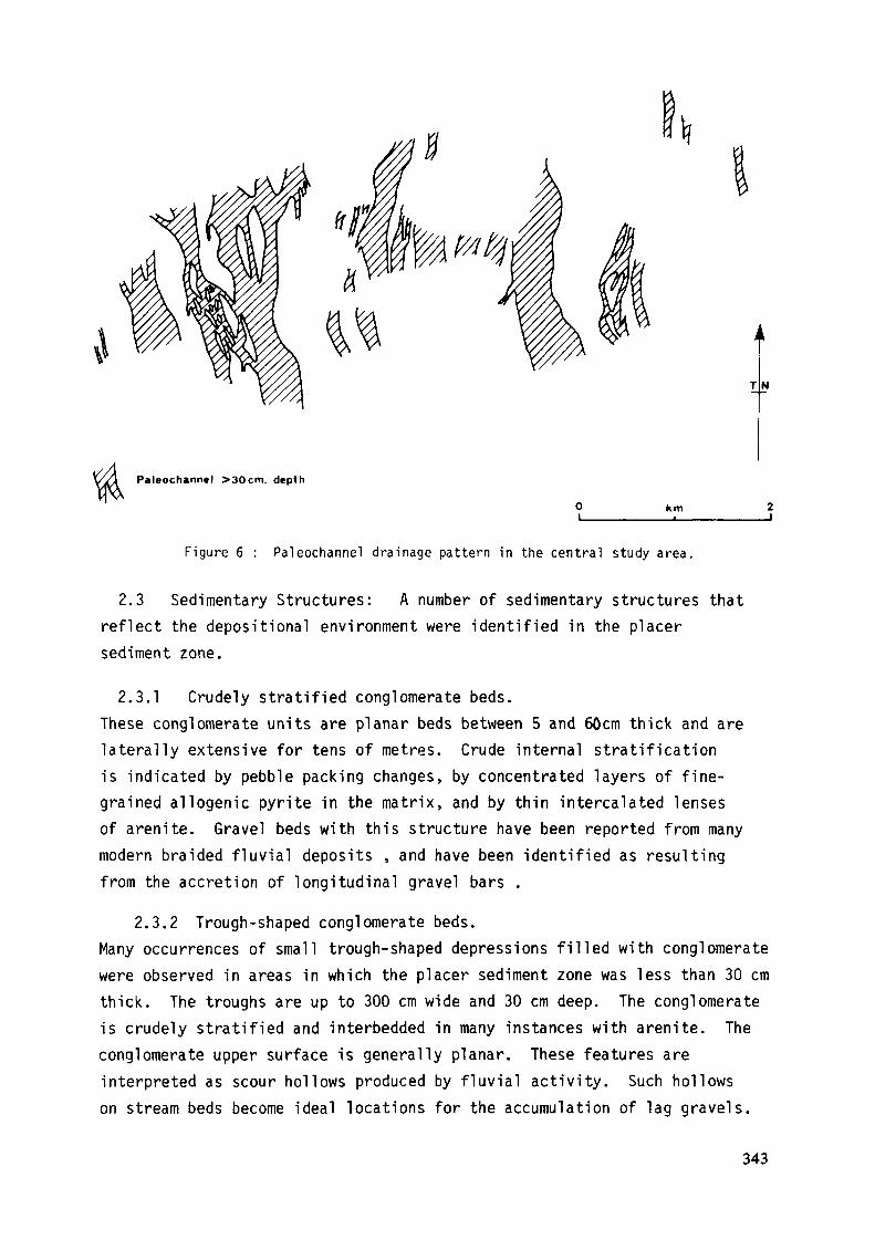
Paleochannel >30cm. depth
km
Figure 6 : Paleochannel drainage pattern in the central study area.
2.3 Sedimentary Structures: A number of sedimentary structures thatreflect the depositional environment were identified in the placersediment zone.
2.3.1 Crudely stratified conglomerate beds.These conglomerate units are planar beds between 5 and 60cm thick and arelaterally extensive for tens of metres. Crude internal stratificationis indicated by pebble packing changes, by concentrated layers of fine-grained allogenic pyrite in the matrix, and by thin intercalated lensesof arenite. Gravel beds with this structure have been reported from manymodern braided fluvial deposits , and have been identified as resultingfrom the accretion of longitudinal gravel bars .
2.3.2 Trough-shaped conglomerate beds.Many occurrences of small trough-shaped depressions filled with conglomeratewere observed in areas in which the placer sediment zone was less than 30 cmthick. The troughs are up to 300 cm wide and 30 cm deep. The conglomerateis crudely stratified and interbedded in many instances with arenite. Theconglomerate upper surface is generally planar. These features areinterpreted as scour hollows produced by fluvial activity. Such hollowson stream beds become ideal locations for the accumulation of lag gravels.
343
2.3.3 Convex-upward conglomerate beds.Thin conglomerate layers up to 20 cm thick occur in areas where the placersediment zone is very thin. They have a planar base and a convex uppersurface, are several metres long and thin out laterally to layers only afew centimetres thick. These features are interpreted as small gravel barsthat accumulated under fluvial conditions in braided stream environments.Their small amplitude, together with the thin surrounding lag deposits,indicate that they were deposited in areas of minimal sedimentation.
2.3.4 Trough-shaped pebbly arenite beds.Scour hollows, in some instances deeper than 30 cm, occur filled withcross-bedded pebbly arenite. The fill tends to grade from pebblyarenite to arenite with only scattered pebbles. The troughs may occurwithin the placer sediment zone or eroded into the underlyingCarletonville Formation arenites.
These features are interpreted as a normal product of scour behindmigrating dune bedforms, the cross-bedded sediment representing thepreserved basal part of the dune after it had migrated downstream.The change from very pebbly to scattered pebbles higher in the dune isthought to represent a progressive decrease in the hydraulic energy ofthe environment.
2.3.5 Trough cross-bedded arenite beds.Quartz-arenite is dominant in the Carbon Leader Formation in the formof trough cross-bedded sets. The sets may be single up to 30 cm thickor grouped in cosets up to 90 cm thick. Each set exhibits a scoop-shapedbasal contact scoured into the underlying sediment. The foresets arecurved in both plan and section and the tops of all sets are truncatedby the basal scour surface of the overlying set. Allogenic heavy-mineralconcentrations occur on foreset planes.
These are well known structures that form in channels where turbulentcurrents are transporting sand as bedload. Heavy mineral concentrationson foresets are common and are thought to represent slight variations inthe hydraulic regime which causes mineral grain separate and concentration.
2.3.6 Planar cross-bedded quartz-arenite beds.Planar cross-bedding is rare in the placer sediment zone. Sets are up to60 cm high and extend laterally for up to 10 metres. In most examplesobserved they had been deposited into channel depressions. Reactivation
344
surfaces and trough cross-bedded intrasets were observed in the sets.Planar cross-bedding is much more common in the less mature arenites abovethe placer sediment zone in the Carbon Leader Formation.Planar cross-bedded sands are common to several environments, includingfluvial, aeolian and marine. However, the association of planar cross-bedding with trough cross-bedded intrasets, heavy mineral concentrations,and conglomerate beds, indicates that a fluvial setting was more likely.Smith has reported planar cross-bedded units similar to these in modernPlatte River sediments which were the product of migrating transversebars in sandy braided-stream reaches.
2.3.7 Plane-bedded quartz-arenite beds.Plane (horizontal) bedding is not a common sedimentary structure in theCarbon Leader Formation. Where developed, they are impressivelymineralized with allogenic pyrite concentrations. The horizontallylaminated beds are composed of medium to coarse-grained arenite, areup to 15 cm thick, and are laterally continuous for up to 5 metres.The detrital pyrite forms discrete laminae within the plane beds andcommonly give way laterally to arenite laminae. Because of the fluvialassociation, these units are considered to have been deposited by shallowfast-running water.
2.3.8 Shale drapes.Thinly laminated shale beds occur throughout the Carbon Leader Formationbut are rarely observed in the placer sediment zone. At two locationswhere this was observed the placer sediment zone was unusually thick(120 cm), containing several repetitions of the faciès sequence: scour,lag conglomerate, quartz-arenite. The shale layers occurred draped acrossthe top of the arenite in some of these sequences. They were up to 15 mmthick and continued laterally for 20 metres at one particular location.Elsewhere, an overlying scour surface truncated the shale drapes.
Shales are deposited from suspension and since they occur as the finaldeposit in a faciès sequence that represents decreasing currentvelocities they are interpreted as the final sediments deposited duringa fluvial event. Several shale drapes therefore indicate repeatedfluvial events.
2.4. Lithofacies: Because broad scale changes in the gold anduranium content of the Carbon Leader placer are known to occur it was
345
thought that subtle sedimentary differences in the depositionalenvironment may exist. This premise was tested by designating placersediment with distinctive lithology or structure to different lithofaciesand by examining the lithofacies sequence recorded at 407 sites by usingMarkov Analysis .
2.4.1 C - Kerogen.Fossil plant material occurs: on scour surfaces as small flat scatteredpatches less than 2 mm in diameter (fly speck carbon); as thin layersbetween 1 and 7 mm thick, which exhibit a vertical fibrous texture; asmultiple layers which enclose pebbles and sand particles; as scatteredgranules in the sediment matrix, representing locally eroded fragments.Gold particles commonly coat or are located between the carbon fibres.
2.4.2 Gl - Lag-Conglomerates.Thin conglomerate layers, usually less than 5 cm thick, occur on scoursurfaces within and at the base of the placer sediment zone. Theyrepresent basal lags of the overlying arenites. These lags are usuallyassociated with abundant allogenic pyrite.
2.4.3 Gm - Massive Conglomerates.These refer to layers of conglomerate that are greater than 5 cm thick.They may lie upon a scour surface, or beneath one. The pebbles are wellpacked (clast supported) and allogenic pyrite may be abundant in thematrix. The top surface of the gravel may be planar, convex or concave.Bedding is usually crudely horizontal or massive.
2.4.4 Gp - Cross-bedded Pebbly Arenite.This faciès contains pebbles scattered on the foresets and scouredbottomsets of trough and planar cross-bedded arenite. Allogenicpyrite is associated on the same pebbly surface.
2.4.5 Gms - Matrix-supported Conglomerate.In this faciès the pebbles are supported by an arenite matrix in aloosely packed conglomerate.
2.4.6 Sh and St - Horizontal Trough Cross-bedded Quartz-arenite.Mature arenites are common in the placer sediment zone. They may bewhite, light grey or pale green in colour. Allogenic pyrite occursconcentrated on foresets, scour surfaces and planar laminations.
346
2.4.7 Sy, Sg and Sd - Quartz-wackes.Immature arenites coloured yellow, green or dark grey, contain clayminerals and represent muddy sands. They may be planar or cross-bedded and are poorly mineralized with allogenic pyrite.
2.4.8 Fh - Horizontally Laminated Shale.Yellow, green or brown shales displaying thin horizontal laminationoccur draped over arenite beds in the placer sediment zone.
2.4.9 Ss - Shallow Scours.Broad shallow scours may truncate the previously deposited sediments.They occur at the bases of conglomerate beds or cosets of troughcross-bedded quartz-arenite.
2.4.10 Sfw - Footwall.This denotes the angular unconformity scour surface at the base of theCarbon Leader Formation.
2.4.11 Shw - Hangingwall.This denotes Carbon Leader Formation arenites immediately above theplacer sediment zone.
Lithofacies sequences from the entire data set were analysed usingMarkov analysis to establish a norm. Then sets of data selected fromareas that have different concentrations of allogenic minerals wereanalysed the same way and compared with the norm.
The results of this faciès analysis, shown in Table 1, indicates thatthe Carbon Leader placer in the detailed study area is characterizedby a faciès sequence comprising: basal scour surface (Sfw), representingthe angular unconformity; a lag conglomerate (Gl), commonly associatedwith a layer of kerogen (C); mature trough cross-bedded quartz arenites(St); a scour surface (Ss) truncating the top of the quartz-arenite;clast-supported massive conglomerates (Gm); hangingwall of placer zone(Shw).Less commonly, lag (Gl) and massive conglomerates (Gm) pass directlyupwards into immature dark quartz-wackes (Sd) and hangingwall arenites(Shw). The lithofacies sequence Ss - Gl - St is commonly repeatedseveral times in thicker placer sediment zone profiles.
347
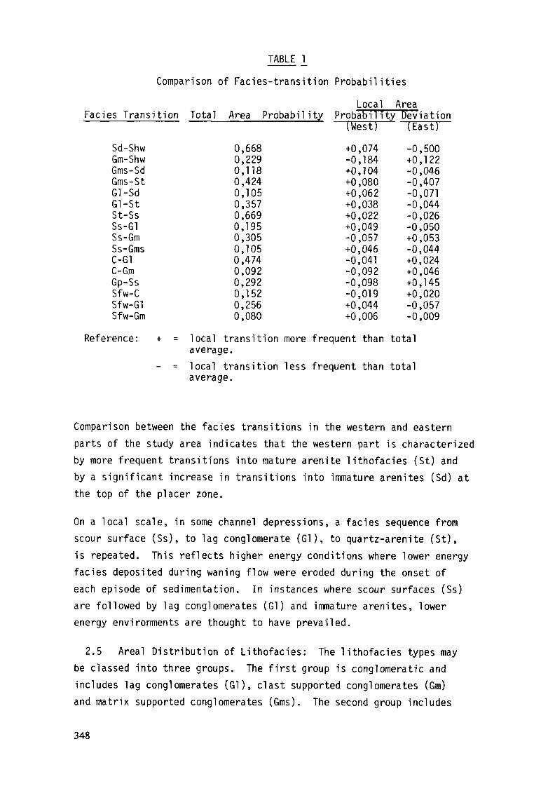
TABLE !_Comparison of Faciès-transition Probabilities
Local AreaFaciès Transition Total Area Probability Probability DeViation
( W e s t ) ( E a s t )Sd-Shw 0,668 +0,074 -0,500Gm-Shw 0,229 -0,184 +0,122Gms-Sd 0,118 +0,104 -0,046Gms-St 0,424 +0,080 -0,407Gl-Sd 0,105 +0,062 -0,071Gl-St 0,357 +0,038 -0,044St-Ss 0,669 +0,022 -0,026Ss-Gl 0,195 +0,049 -0,050Ss-Gm 0,305 -0,057 +0,053Ss-Gms 0,105 +0,046 -0,044C-G1 0,474 -0,041 +0,024C-Gm 0,092 -0,092 +0,046Gp-Ss 0,292 -0,098 +0,145Sfw-C 0,152 -0,019 +0,020Sfw-Gl 0,256 +0,044 -0,057Sfw-Gm 0,080 +0,006 -0,009
Reference: + = local transition more frequent than totalaverage.
- = local transition less frequent than totalaverage.
Comparison between the faciès transitions in the western and easternparts of the study area indicates that the western part is characterizedby more frequent transitions into mature arenite lithofacies (St) andby a significant increase in transitions into immature arenites (Sd) atthe top of the placer zone.
On a local scale, in some channel depressions, a faciès sequence fromscour surface (Ss), to lag conglomerate (Gl), to quartz-arenite (St),is repeated. This reflects higher energy conditions where lower energyfaciès deposited during waning flow were eroded during the onset ofeach episode of sedimentation. In instances where scour surfaces (Ss)are followed by lag conglomerates (Gl) and immature arenites, lowerenergy environments are thought to have prevailed.
2.5 Areal Distribution of Lithofacies: The lithofacies types maybe classed into three groups. The first group is conglomeratic andincludes lag conglomerates (Gl), clast supported conglomerates (Gm)and matrix supported conglomerates (Gms). The second group includes
348
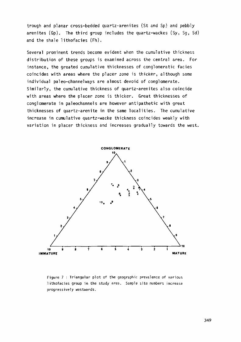
trough and planar cross-bedded quartz-arenites (St and Sp) and pebblyarenites (Gp). The third group includes the quartz-wackes (Sy, Sg, Sd)and the shale lithofacies (Fh).Several prominent trends become evident when the cumulative thicknessdistribution of these groups is examined across the central area. Forinstance, the greated cumulative thicknesses of conglomeratic facièscoincides with areas where the placer zone is thicker, although someindividual paleo-channelways are almost devoid of conglomerate.Similarly, the cumulative thickness of quartz-arenites also coincidewith areas where the placer zone is thicker. Great thicknesses ofconglomerate in paleochannels are however antipathetic with greatthicknesses of quartz-arenite in the same localities. The cumulativeincrease in cumulative quartz-wacke thickness coincides weakly withvariation in placer thickness and increases gradually towards the west.
CONGLOMERATE
»101 0 9 8 7 6 5 4 3 2 1
IMMATURE MATURE
Figure 7 : Triangular plot of the geographic prevalence of various
l i thofacies group in the study area. Sample site numbers increaseprogressively westwards.
349
A triangular plot of these three groups of lithofacies indicates thatthe proportion of conglomeratic and quartz-arenite lithofacies do notvary significantly across the area, but that an increase in thequartz-wacke lithofacies towards the west is distinct. This impliesthat a greater frequency of low energy faciès is preserved towards thewest.
2.6. Paleocurrents. Paleocurrent directions were measured bycombining placer geometry, derived from isopachs, with cross-beddingmeasurements which confirmed the orientation and provided an azimuthto the distribution pattern. Only trough cross-bedded foresets weremeasured. Their definition is dependent on grain size, colour, andmineralogical sorting in the cross-bedded sets but this is in someinstances too faint to discern readily and consequently the datadensity is low.
The vectorial means of ninety measurements indicates that transport inthe central area was unimodal at 181°TN, with a consistency ratio of87 percent. Measurements in the western part of the area indicate apaleocurrent distribution to the south, whereas in the eastern partof the area the flow was to the southwest (Fig. 3). If flow in bothareas was contemporaneous it would have converged to the south.Alternatively, flow may have switched from southwest to south duringaggradation.
3.0 MINERALIZATION
A moving-average trend-surface analysis of the gold and uranium contentof the Carbon Leader placer in the central study area displays apattern of assymetrical anomalies elongated towards the south andsouthwest. Axial traces drawn through the positive gold anomaliesdescribe a dendroidal pattern that closely resembles axial traces drawnthrough positive uranium anomalies (Figs. 8 and 9).
High-grade anomalies also coincide with linear patterns of thicker placer,and with large cumulative thicknesses of conglomeratic lithofacies.High grades in thin placer areas are interpreted from the lithofaciessequence to have been high energy areas, probably similar to Nami'sinterchannel 'Sub-Facies A'.
350

km
Higher-grade gold trends
: • • : : • Area of belter gold mineralization
I 1 Area of poorer gold mineralization
Figure 8 : Generalised moving-average trend surface plan of gold contentin the Carbon Leader in the central study area with superimposed axialtraces drawn through the highest positive anomalies.
\
*~J Higher-gride uranium trends
ijfffol Area of better uranium mineralisation
I- " -I Area of poorer uranium mineralisation
Figure 9 : Generalised mo v.ing-average trend surface plan of uranium
content in the Carbon Leader in the central study area with superimposedaxial traces drawn through the highest positive anomalies.
351
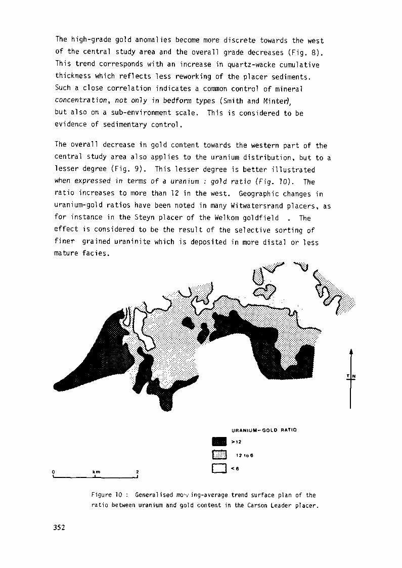
The high-grade gold anomalies become more discrete towards the westof the central study area and the overall grade decreases (Fig. 8).This trend corresponds with an increase in quartz-wacke cumulativethickness which reflects less reworking of the placer sediments.Such a close correlation indicates a common control of mineralconcentration, not only in bedform types (Smith and Minter),but also on a sub-environment scale. This is considered to beevidence of sedimentary control.
The overall decrease in gold content towards the western part of thecentral study area also applies to the uranium distribution, but to alesser degree (Fig. 9). This lesser degree is better illustratedwhen expressed in terms of a uranium : gold ratio (Fig. 10). Theratio increases to more than 12 in the west. Geographic changes inuranium-gold ratios have been noted in many Witwatersrand placers, asfor instance in the Steyn placer of the Welkom goldfield . Theeffect is considered to be the result of the selective sorting offiner grained uraninite which is deposited in more distal or lessmature faciès.
URANIUM-GOLD RATIO
km
12 to 6
<6
Figure 10 : Generalised mo'v ing-average trend surface plan of theratio between uranium and gold content in the Carson Leader placer.
352

4.0 CONCLUSIONS
The Carbon Leader placer sediments are interpreted as the final lagconcentrations deposited on a degradation surface within an aggradingfluvial fan sequence, produced by a climatic change to wetterconditions. In many respects the Carbon Leader placer resembles theVaal Reef placer and is consequently classified as a Transgressiveplacer.
Channels on the degradation surface were broad and shallow and hadlow sinuosities. They contain placer sediment in which longitudinalgravel bars, channel-lag gravel armours, channel dunes, and transversebars are preserved. Kerogen is associated with gravel armouredsurfaces in situations considered to have been occupied by shallowperennial streams.
An analysis of the regional drainage pattern indicates that there weretwo main influx points, 12 kilometres apart, from which drainageradiated. The incidence of less mature placer lithofacies increaseswestwards and is reflected by the uranium-gold ratio which increasesfrom six in the east to twelve in the west.
On a local scale gold and uranium mineralization correlates well andtheir distribution indicates sedimentary control.
ACKNOWLEDGEMENTS
The authors are grateful to the management of Anglo American Corporationfor permission to publish these research results.
353

A REVIEW OF URANIUM-BEARING MINERALS INTHE DOMINION AND WITWATERSRAND PLACERS
C.E. FEATHER, C.W. GLATTHAARAnglo American Research Laboratories,Crown Mines, South Africa
Abstract
The raineraiogical, geocheraical and metallurgical properties of theuranium-bearing minerals in the Proterozoic Dominion Group andWitwatersrand Super-Group are reviewed. New information, from theauthors' recent investigations, is included.
Near the base of the Dominion Group (2 800 Ma), there are twoeconomically important conglomerate horizons known as the Lower Reef andthe Upper Reef. The conglomerates consist of quartz pebbles in a fine-grained matrix of quartz, garnet, sericite, leucoxene, biotite, chloriteand over forty ore minerals which include thirteen uranium-bearingconstituents.
Uraninite and its alteration products are most abundant, and completelyunaltered grains are very rare. The alteration products include brannerite,uranothorite, coffinite and orangite. Monazite, euxenite, zircon andtraces of allanite and uraniferous kerogen contribute minor amounts ofuranium.
The overall assemblage is generally refractory to conventionaluranium extraction processes, and chemically rigorous procedures, suchas high pressure - high temperature leaching, are advisable.
The economically important reefs of the Witwatersrand Super-Group(2 300-2 800 Ma) occur in the Upper Division. They range from coarsepebble conglomerates in the proximal zones to quartzites in the mostdistal zones. The pebbles consist mainly of well rounded quartz, chertand quartzite fragments, set in a matrix of finer grainedquartz, phyllosilicates (sericite, pyrophyllite, chlorite and chloritoid),and more than seventy ore minerals.
The significant uranium-bearing minerals are uraninite, which maybe intimately associated with carbon (kerogen), and its U-Ti a]terationproducts including brannerite. Zircon, raonazite, uranothorite, xenotime
355
and coffinite contribute uranium in rauch lesser amounts. Significantconcentrations of uranium ( > 500 ppm) have been found to occur in thephyllosilicates within concretionary pyrite nodules and within thematrix in lenticles formed of argillaceous constituents. As a result ofthis association, and of the finely divided nature of the U-Ti-minerals,the slimes fraction generated by milling of the ore may contain significantconcentrations of uranium.
The uranium-bearing mineral assemblage differs from reef to reef inthe same mining area, and within the same stratigraphie horizon over awide area.
Conventional oxidising acid leaching of typical Witwatersrand oreachieves about 80 per cent recovery. Free grains of uraninite undergorapid dissolution, and phyllosilicates which contain uranium are amenableto leaching. Occlusion of finely divided uraninite in kerogen, and ofU-Ti-minerals in quartz, phyllosilicates, pyrite and leucoxene, are theprincipal modes of occurrence of uranium in residues. Improved recoveriesare achieved by high pressure - high temperature leaching.
"1.0 INTRODUCTION
According to the Chamber of Mines of South Africa , theconglomerates and gravel "reefs" of the Dominion Group and WitwatersrandSuper-Group contain 89% of South Africa's uranium resources. Gradesvary from 100 to 400 g/t U_00 in the Witwatersrand reefs, to over 2 000 g/tJ Oin the Dominion reefs. Numerous papers have been published on theuranium-bearing minerals, and this report serves to review these findings,and includes more recent work undertaken at the authors' laboratories.
2.0 GEOLOGICAL SETTING
The geology and origins of the Dominion Group and WitwatersrandSuper-Group have been discussed elsewhere ' ' ' and will not bedetailed here.
The Dominion Group outcrops in the southwestern Transvaal(Figure 1), and has been assigned an age of 2 800 Ma. Resting
356
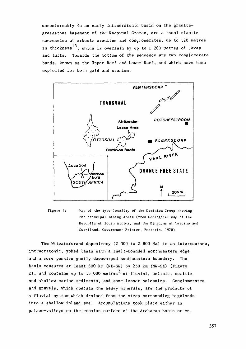
unc.onformably in an early Intracratonlc basin on the granite-greenstone basement of the Kaapvaal Craton, are a basal clasticsuccession of arkosic arenites and conglomerates, up to 120 metres
13in thickness , which is overlain by up to 1 200 metres of lavasand tuffs. Towards the bottom of the sequence are two conglomeratebands, known as the Upper Reef and Lower Reef, and which have beenexploited for both gold and uranium.
VENTERSDORP
T R A N S V A A L
.Location (
'« Johanne»-burg
t SOUTH AFRICA
OTTOSDAL
Dominion R««fsK\V£*
O R A N G E F R E E S T A T E
N
f L20km
Figure 1: Map of the type locality of the Dominion Group showingthe principal mining areas (from Geological map of theRepublic of South Africa, and the Kingdoms of Lesotho andSwaziland, Government Printer, Pretoria, 1970).
The Witwatersrand depository (2 300 to 2 800 Ma) is an intermontane,intracratonic, yoked basin with a fault-bounded northwestern edgeand a more passive gently downwarped southeastern boundary. Thebasin measures at least 600 km (NE-SW) by 250 km (NW-SE) (Figure2), and contains up to 15 000 metres of fluvial, deltaic, neriticand shallow marine sediments, and some lesser volcanics. Conglomeratesand gravels, which contain the heavy minerals, are the products ofa fluvial system which drained from the steep surrounding highlandsinto a shallow inland sea. Accumulations took place either inpalaeo-valleys on the erosion surface of the Archaean basin or on
357
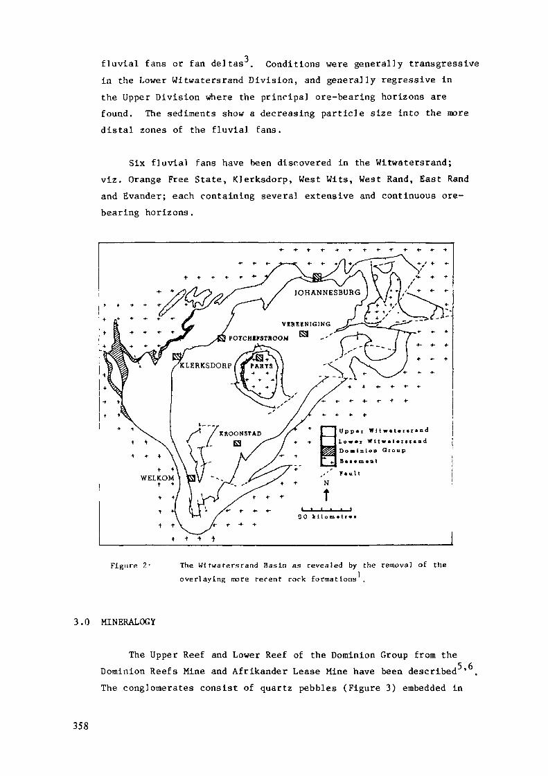
fluvial fans or fan deltas . Conditions were general]y transgressivein the Lower Witwatersrand Division, and generally regressive inthe Upper Division where the principal ore-bearing horizons arefound. The sediments show a decreasing particle size into the moredistal zones of the fluvial fans.
Six fluvial fans have been discovered in the Witwatersrand;viz. Orange Free State, Klerksdorp, West Wits, West Rand, East Randand Evander; each containing several extensive and continuous ore-bearing horizons.
JOHANNESBURG
V E H C E N I G I N GESPOTCHirSTnOOM
KLERKSDORP I ff PARTS
U p p « i W 11 w« I • r • r • nd
L o w « i Wl I w« I • r n«ndD o m i n i o n G r o u p
50 k i l o r n « t [•«
Figure 2- The Wi twa te r s r and Basin as revealed by the removal of the
over laying more recent rock formations .
3.0 MINERALOGY
The Upper Reef and Lower Reef of the Dominion Group from theDominion Reefs Mine and Afrikander Lease Mine have been described5,6The conglomerates consist of quartz pebbles (Figure 3) embedded in
358
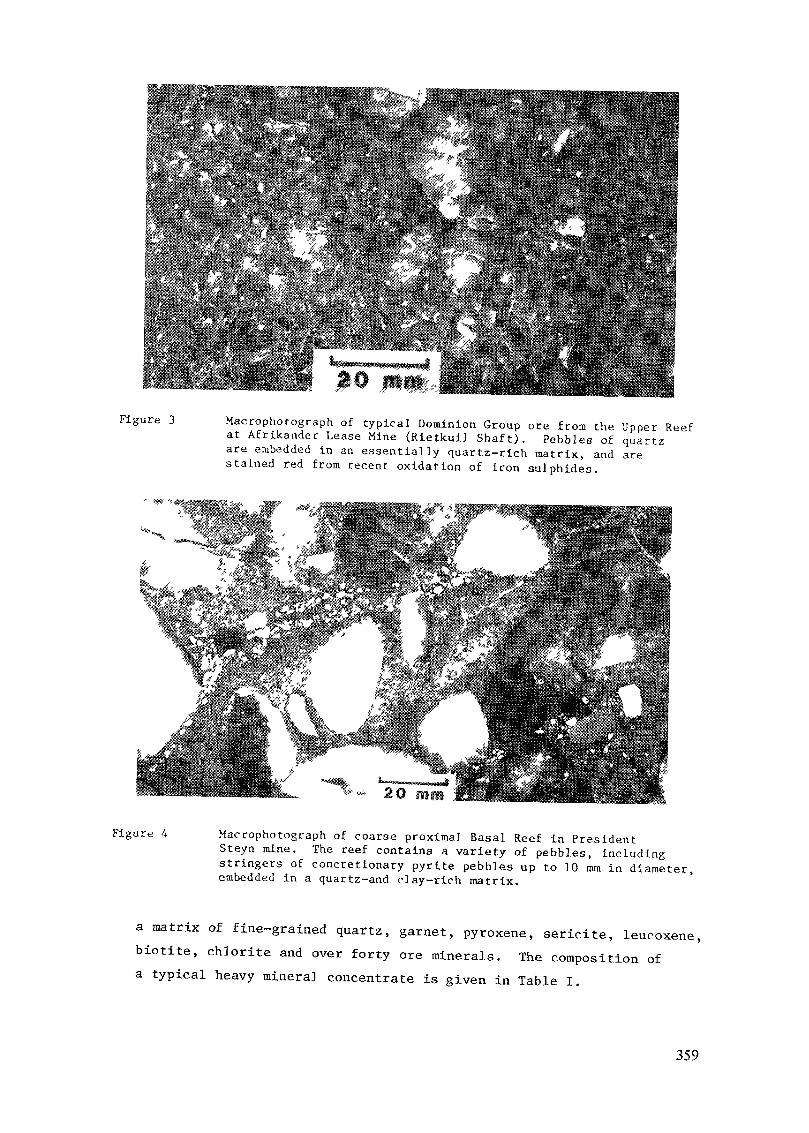
Figure 3 Macrophotograph of typical Dominion Group ore f rom the Upper Reefat Afr ikander Lease Mine (Rietkuil Shaf t ) . Pebbles of quartzare embedded in an essential ly quartz-rich matrix, and arestained red f r o m recent oxidation of iron sulphides.
Figure 4 Macrophotograph of coarse proximal Basal Reef in PresidentSteyn mine. The reef contains a variety of pebbles, includingstringers of concretionary pyrite pebbles up to 10 mm in diameter,embedded in a quartz-and clay-rich matrix.
a matrix of fine-grained quartz, garnet, pyroxene, sericite, leucoxene,biotite, chlorite and over forty ore minerals. The composition of
a typical heavy minera] concentrate is given in Table I.
359
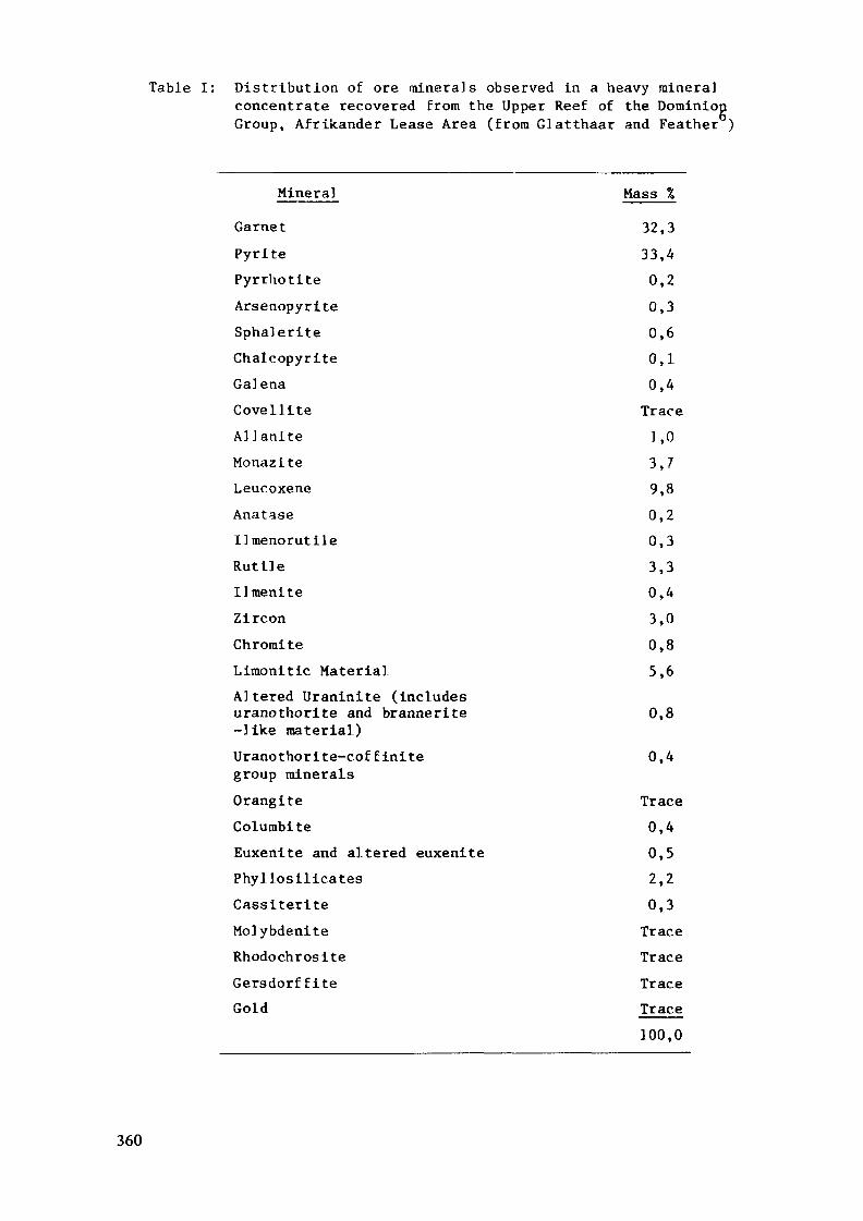
Table I: Distribution of ore minerals observed in a heavy mineralconcentrate recovered from the Upper Reef of the DominionGroup, Afrikander Lease Area (from Glatthaar and Feather )
MineralGarnetPyritePyrrhotiteArsenopyriteSphaleriteChalcopyriteGal enaCovelliteAllaniteMonaziteLeucoxeneAnataseIImenorutileRutileIlmeniteZirconChromiteLimonitic MaterialAltered Uraninite (includesuranothorite and brannerite-like material)Uranothorite-coffinitegroup mineralsOrangiteColumbiteEuxenite and altered euxenitePhyllosilicatesCassiteriteMolybdeniteRhodochrositeGersdorf fiteGold
Mass %32,333,40,20,30,60,10,4Trace1,03,79,80,20,33,30,43,00,85,6
0,8
0,4
360

Pyrite, garnet, pyroxene and leucoxene are the most commonheavy minerals, followed by monazite, zircon, minor amounts of non-radioactive oxides, various sulphide minerals, and radioactiveconstituents. By using the electron microprobe, allanite, ilmenorutile,tapiolite, anatase and uraniferous kerogen have been describedrecently .
In the Witwatersrand, the conglomerate reefs consist of well-rounded pebbles, constituting up to 70% of the volume of the rock.The pebbles vary considerably in size, the larger ones averagingabout 50 mm across and are generally well rounded (Figure 4).20 mm is the more usual size, and the smaller pebbles are somewhatmore angular. In the distal zones, the rudites grade into gravelsand coarse sands (Figure 5).
The pebbles consist mainly of vein quartz - white, grey,opalescent, blue, or black - accompanied by variable but lesserquantities of pebbles of chert, jasper, quartzite, quartz porphyry,and metamorphic rock.
Figure 5: Maorophotograph of the Basa] Reef ia President Steyn mine, fivekilometres downstream from the site of the sample shown in FigureA. The more distal zones show a marked decrease in pebble size,better sorting, we]1-developed cross-bedding, and often anincrease in the concentration of uranium.
361

The matrix is compact, consisting essentially of secondaryquartz, and lesser amounts of sericite, pyrophyllite, muscovite,
i t,1
chlorite, leucoxene, and over 70 ore minerals (Table II) . Kaoliniteand dolomite have also been observed
The principal heavy mineral is pyrite, believed to be of atleast three generations: 1) a compact rounded pyrite of detritalorigin, 2) concretionary porous rounded nodular pyrite believedto have formed at the time of deposition, and 3) secondary authigenicpyrite which formed subsequent to burial and which is frequentlyhypidiomorphic or idiomorphic. Uraniferous kerogen and otherradioactive minerals are next in abundance, followed by gold,zircon, chromite, arsenopyrite, and rare cobaltite, platinum groupminerals (Ir, Os-rich), apatite, magnetite, garnet, and diamond,all of allogenic origin. Rare authigenic minerals include gersdorffite,sphalerite, chalcopyrite, pentlandite and a variety of very raresulphides, arsenides and antimonides .
4.0 URANIUM-BEARING CONSTITUENTS
4.1 Dominion Group
Thirteen radioactive constituents have been identified5,6,8,9,10,11^ of „hich uraninite and its alteration products(uranous titanates (including brannerite), uranothorite,coffinite and orangite) are most abundant. Monazite, euxenite,zircon, allanite and uraniferous kerogen are also present.Uranium-bearing columblte and its alteration betafite, havealso been described .
The modes of occurrence and habits of the uraniferousconstituents are as follows:
4.1.1 Uraninite grains occur in fairly thin layers in thereefs, parallel to bedding , and locally in clusters 'The grains are generally rounded, (Figure 6) average80 micrometres in diameter , and are considered to be ofdetrital origin. The uraninite contains varying amountsof thorium (av. 2,63% TM 6), and is believed to have
362
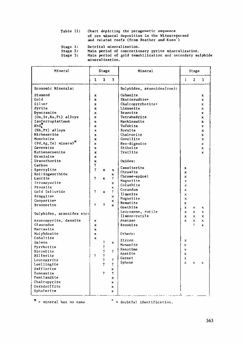
Table II: Chart depleting the paragenetic sequenceof ore mineral deposition in the Witwatersrandand related reefs (from Feather and Koen )
Stage 1: Detrital mineralization.Stage 2: Main period of concretionary pyrite mineralization.Stage 3: Main period of gold remobilization and secondary sulphide
mineralization.
Mineral
Economic Minerals:DiamondGoldSilverPyriteDyscraalte(Os,Ir,Ru,Pt) alloysIsoferroplatinumRhS*(Rh.Pt) alloysMicheneriteMonchelte(Pd,Ag,Te) mineral'*GeverslteRuthenarsenlteUranlnlteUranothoriteCarbon
i SperryliteHollingworthiteLauriteStromeyerlteProusiteGold TellurldeBraggite-t-Cooperlte+BrannerlteSulphides, arsenides etc:Arsenopyrlte, danaiteGlaucodotMarcaslteMolybdeniteCobaltlteGalenaPyrrhotiteNiccoliteMilleriteLeucopyriteLoellinglteSaffloriteTennanltePentlanditeChalcopyriteGersdorf fiteSphalerite
Stage1 2 3
XXXXXXXXX
Mineral
Sulphides, arsenides(con) :CubaniteSkutterudite+Chalcopyrrhotite+LinnaeiteBravoiteTetrahedrlteMackinawiteTucekiteBornlte
x j Chalcocitex CovelllteXXXXX1? x x
X? X ?
XX
? X ?XX
? ? X
XXXXX
? X?? ?
? ?? ?? ?
X? ?
XXXX
Neo-digenlteStibnlteTroll iteOxides:CassiterlteChromiteChrome-spinelMagnetiteColumbiteCorundum11 raenlteMagnetiteHematiteGoethiteLeocoxene, rutileIlmeno-rutileAnataseBrookite
Others:ZirconMonaziteXe no timeApatiteGarnetSphene
Stage
1 2 3
xxXXXXXXXXXXXX
XXXXXXXXXX X XX X XX X XX X X
? X
XXXXXX X X
mineral has no name =• doubtful Identification.
363
PHOTOMICROGRAPHS OF DOMINION GROUP OREFigure 6: Typical grain of uraninite, with inclusions of galena (light grey)
and a dark alteration rim of brannerite. (Oil immersion, Upper Reef,Rietkui] Shaft, Afrikander Lease Mine).
Figure 7: Uraninite (light grey) altered to brannerite (mid grey) and uranothorite(dark grey). The alteration products have completely replaced thesite of the original uraninite grain. (Oil immersion, Upper Reef,Rietkuil Shaft, Afrikander Lease Mine).
Figure 8: Uranothorite completely replacing uraninite and containing minuteparticles of galena. (Oil immersion, Upper Reef, Rietkuil Shaft,Afrikander Lease Mine).
Figure 9: Brannerite completely replacing uraninite and containing galena(Oil immersion, Upper Reef, Rietkui] Shaft, Afrikander Lease Mine).
been derived from pegmatitic or granitic terrains.Cracks and holes within the grains are invariably filledwith galena of radiogenic origin, and the grains arefrequently altered and sometimes partly or wholly replacedby secondary uraniferous minerals (Figure 7),
364
4.1.2 Uranothorite is the most common of the alterationproducts ' ' ' (Figure 8) and is invariably associatedwith any remaining uraninite. It has low reflectivity,and contains inclusions of galena similar to those foundin uraninite. After heating of selected mineral grains,X-ray diffraction patterns for thorianite ' , thoriteand coffinite have been obtained. Electron microprobestudies have shown that the grains form a continuoussolid solution series from USiO. to ThSiO,. Thorium4 4values are frequently much greater than in parent uraninite,and sometimes exceed those of uranium (Table III). It ispossible that, relative to thorium, uranium has beenleached preferentially from uraninite, leaving residualalteration products enriched in thorium.
4.1.3 Brannerite was first described by Taylor et a] ,and has been referred to as brannerite-1ike material and
C Quraniferous leucoxene ' by others. It yields an X-raydiffraction pattern with difficulty, but electron microprobeanalyses confirm its presence. Brannerite is thought tobe the product of the combined alteration of uraniniteand ilmenite. It occurs either as a border surroundingand fingering into uraninite grains (Figure 7), oftencompletely replacing uraninite (Figure 9), or occurs asirregularly shaped masses interstitial to other matrixconstituents. The finely divided crystals are highlyvariable in chemical composition and physical characteristics,and ideally, should be referred to as uranium titanatesor U-Ti-minerals.
4.1.4 Coffinite is distinguished from uranothorite by itsrelatively large grain size (up to 2,5 mm diameter). Thegrains have large random galena inclusions (Figure 10).In contrast, uranothorite has a sugary texture with veryfinely dispersed galena particles. Coffinite contains alittle thorium (av. 3,06% ThO )6.
365
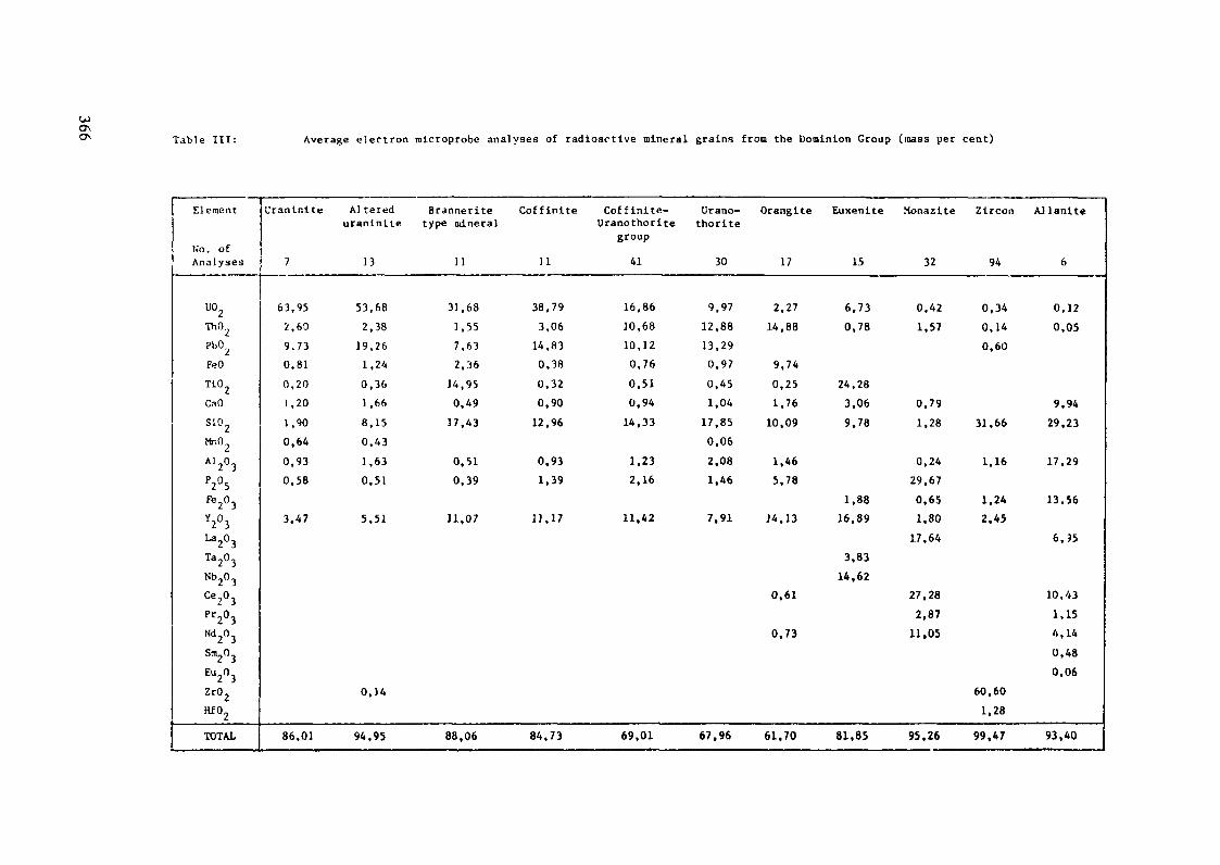
0\ Table III: Average electron microprobe analyses of radioactive mineral grains from the Dominion Group (mass per cent)
Element
No. ofAnalyses
uo2ThO
PbO.,
FeO
Ti02
CaO
sio2Mr.O
AJ2°3P2°5Fe2°3Y2°3La2°3Ta2°3Nb203
Ce2°3Pr2°3Nd —0 -*
Sm_0 ~
Eu2°3Zr02
Hf02
TOTAL
Uraninite
7
63,952,609.730,810,201,201,900,64
0,930,58
3.47
86,01
Al tereduraninite
13
53,682,38
19,261,240,361 ,668,150,431,630.51
5,51
0,14
94,95
Branneritetype mineral
11
31,681,557,632,36
14,950,49
17,43
0.510,39
11,07
88,06
Coff in i t e Coffinite-Uranothorite
group
11 41
38,79 16,863,06 10,68
14.83 10,120,38 0,760,32 0,510,90 0,94
12,96 14,33
0,93 1,231,39 2,16
13,17 11,42
84,73 69,01
Urano-thorite
30
9,9712,8813,290,970,451,04
17,850,062,081,46
7,91
67,96
Orangite
17
2,2714,88
9,740,251,76
10,09
1,465,78
14,13
0,61
0,73
61,70
Euxenite
15
6,730,78
24,283,069.78
1.8816,89
3.8314,62
81,85
Monazite
32
0,421,57
0,791,28
0,2429,670,651,80
17,64
27,282,87
11,05
95,26
Zircon
94
0,340,140,60
31.66
1,16
1.242.45
60,601,28
99,47
AJ Unite
6
0,120,05
9,9429,23
17,29
13,56
6.95
10.431,154,140,480,06
93,40
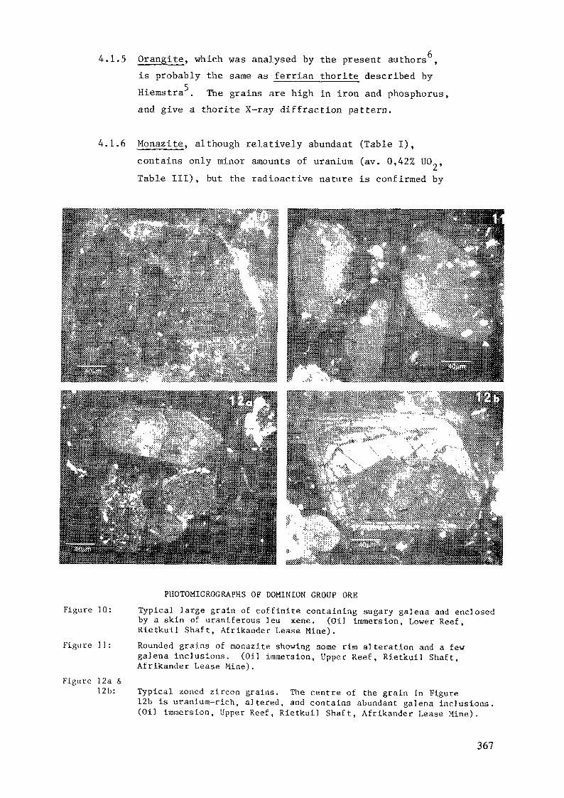
4.1.5 Orangite, which was analysed by the present authors ,is probably the same as ferrian thorite described by
Hiemstra . The grains are high in iron and phosphorus,and give a thorite X-ray diffraction pattern.
4.1.6 Monazite, although relatively abundant (Table I),
contains only minor amounts of uranium (av. 0,42% UO ,
Table III), but the radioactive nature is confirmed by
Figure 10:
Figure ]]
Figure 12a &12b:
PHOTOMICROGRAPHS OF DOMINION GROUP ORE
Typica] large grain of cof f in l te containing sugary galena and enclosedby a skin of uraniferous leu xene. (Oil Immersion, Lower Ree f ,Rietkuil Sha f t , Af r ikander Lease Mine).
Rounded grains of monazite showing some rim alteration and a fewgalena inclusions. (Oil immersion, Upper Reef , Rietkuil Shaft ,Afrikander Lease Mine).
Typical zoned zircon grains. The centre of the grain in Figure12b is uranium-rich, a l tered, and contains abundant galena inclusions.(Oil immersion, Upper Reef , Rietkuil Sha f t , Afrikander Lease Mine).
367
the presence of galena as tiny particles concentratedalong the periphery of the raonazite grains. Unalteredgrains measure 130 to 250 micrometres in diameter (Figure11). Alteration and corrosion are common, however, tothe extent where only small areas are still recognizablein a cloudy galena-rich matrix.
4.1.7 Zircon, also relatively abundant, occurs mainly aszoned grains (Figure 12) of very low uranium content(about 0,3% UO ), but rare metamict grains have been
14found to contain up to a few per cent U0„. Hendriksnoted that zircon from the Dominion Reef had been appreciablyaffected by metamorphic activity after burial, to theextent that, in one sample he studied, the median grainsize had been reduced by 76 per cent. The grains werefound to be partially replaced by quartz, pyrite,titaniferous minerals, uraninite, and finely dividedmaterials.
4.1.8 Allanite (Figure 13) in the Dominion Group has beenrecorded recently by Glatthaar and Feather . In heavyconcentrates of samples from Afrikander Lease Mine, itoccurs as a minor constituent (about one per cent), andcontains a little uranium (av. 0,12% UO ) . The materialwas found to be acicular and largely unaltered, occurringin close association with sulphides, either attached oras intergrowths.
4.1.9 Euxenite ' (Figure 14) occurs as relatively largegrains up to 530 micrometres in diameter and has beendescribed as the alteration product of columbite. Althoughrare in the conglomerates (less than 0,5 per cent), itcontains up to 7 per cent UO . Most authors reportdifficulties in obtaining good X-ray diffraction patterns,but electron microprobe analyses approximate to euxenite(Table III).
Euxenite may itself be altered , and the alterationproduct is characterised by fine remnants resemblingleucoxene, and enclosing galena.
368
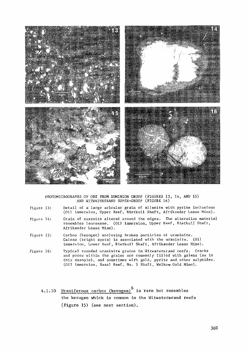
PHOTOMICROGRAPHS OF ORE FRO« DOMINION GROUP (FIGURES 13, 14, AND 15)AND WITWATERSRAND SUPER-GROUP (FIGURE 16)
Figure 13: Detail of a large aclcular grain of allanite with pyrite inclusions(Oil immersion, Upper Reef, Rietkuil Shaft, Afrikander Lease Mine).
Figure 14: Grain of euxenite altered around the edges. The alteration materialresembles leucoxene. (Oil immersion, Upper Reef, Rietkuil Shaft,Afrikander Lease Mine).
Figure 15: Carbon (kerogen) enclosing broken particles of uraninite.Galena (bright spots) is associated with the uraninite. (Oilimmersion, Lower Reef, Rietkuil Shaft, Afrikander Lease Mine).
Figure 16: Typical rounded uraninite grains in Witwatersrand reefs. Cracksand pores within the grains are commonly filled with galena (as inthis example), and sometimes with gold, pyrite and other sulphides.(Oil immersion, Basal Reef, No. 3 Shaft, Welkora Gold Mine).
4.1.10 Uraniferous carbon (kerogen) is rare but resemblesthe kerogen which is common in the Witwatersrand reefs(Figure 15) (see next section).
369
4.2 Witwatersrand Super-Group
The principal uranium-bearing constituents in the Witwatersrandreefs are uraninite, as free grains and enclosed in carbon(kerogen), and its alteration products, brannerite and uraniferousleucoxene. Argillaceous constituents can also contain appreciableamounts of uranium. Lesser uranium-bearing minerals includezircon, tnonazite, coffinite and uranothorite.
Recent investigations continue to favour a detritalorigin for the uraninite, with successive and variable degreesof reworking of the uranium. During deposition, mats oflichen-like flora helped to gravity concentrate the heavymineral constituents, and appear to have disintegrated some ofthe uraninite. During one or more subsequent periods ofmetamorphic activity, the uraninite was recrystallised and/orwas altered, forming uranous titanates by reaction with titanium-bearing solutions. Absorption of uranium by clay mineralscould have occurred from the time of deposition to the lastmetamorphic reworking at about 1 800 m.y. ago.
4.2.1 Uraninite. After Cooper's discovery in 1923 of uraninitein heavy mineral concentrates from Witwatersrand gold
8 ISmines, the mineral was not studied again in detail 'until after the Second World War. Most investigatorshave considered it to be of allogenic origin. It occursmainly as isolated grains (Figure 16), and sometimes asclusters or stringers, close to the footwall contact ofthe reefs, or on false footwalls within them. The mineralis well sorted with a grain size range of 50 to 160 pm(average 75 jam), and occurs in association with otherheavy constituents. In reefs where it has undergonelittle alteration, e.g. in the Main Reefs Group, it is byfar the principal uranium-bearing constituent .
Although the grains are invariably well-rounded, subhedraland euhedral grains are not uncommon , and may representoriginally allogenic rounded grains which were recrystallizedduring metamorphism after burial. Recrystal]ization haspurged radiogenic lead, and the grains now give, by ion
370
microprobe, U/Pb ages of about 1 800 Ma , which coincideswith the last stages of Bushveld magmatism.
Uraninite grains may be coated by phyllosilicates, exsolvedgalena, and, more rarely, by gersdorffite and gold.Alteration products such as brannerite and coffinitecommonly enclose or replace the grains.
According to microprobe analyses, Witwatersranduraninite contains 67,2% UO and 3,' ThO„ on average(Table IV). The ThO /UO ratio is highly variable (Figure17), suggesting that the grains have a multiple origin in
17 19granitic and pegmatitic terrain ' , and could not havebeen of low temperature hydrothermal origin, as thethorium values are too high.
Table IV: Average electron microprobe analyses ofuranium-bearing constituents in the Witwatersrand
21(from Feather )
uo2Th02Pb02FeOTi02CaOSi02TOTAL
Uraninite
Free grains
67,23,9
23,61,00,20,6n.d.
96,5
In carbon
69,53,2
22,80,50,20,7n.d.
96,9
Brannerite
36,02,711,7
31,90,58,0
94,9
n.d. = not determined.
4.2.2 Uraniferous carbon. The columnar carbon (kerogen) in thereefs is considered to be the fossil remains of an
18ancient lichen . It is intimately associated withuraninite with which it occupies the sites of deposition(Figure 18). The carbon appears to have infiltrated
371
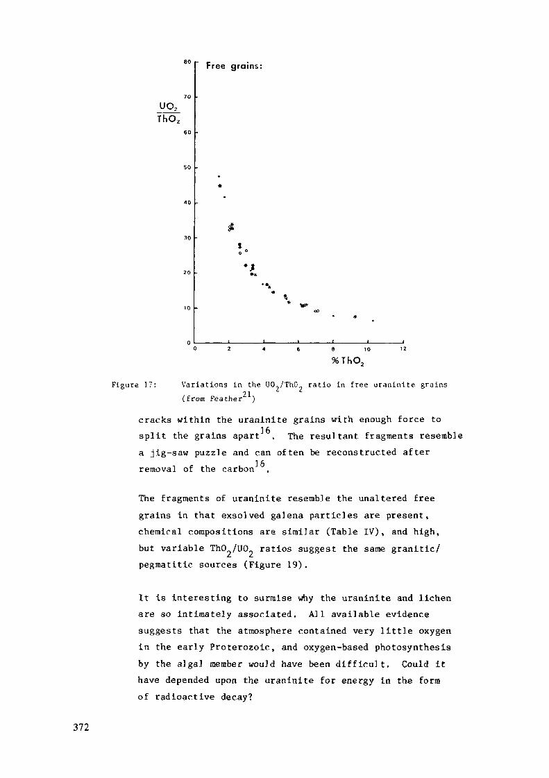
80
uo.Th02
60
50
30
Free grains:
•J**
Figure 17:
8 10
%ThO,
Variations in the UO /ThO rat io in free uranin i te grains21( f r o m Feather )
cracks within the uraninite grains with enough force tosplit the grains apart . The resultant fragments resemblea jig-saw puzzle and can often be reconstructed afterremoval of the carbon
The fragments of uraninite resemble the unaltered freegrains in that exsolved galena particles are present,chemical compositions are similar (Table IV), and high,but variable ThO /UCL ratios suggest the same granitic/pegmatitic sources (Figure 19).
It is interesting to surmise why the uraninite and lichenare so intimately associated. All available evidencesuggests that the atmosphere contained very little oxygenin the early Proterozoic, and oxygen-based photosynthesisby the algal member would have been difficult. Could ithave depended upon the uraninite for energy in the formof radioactive decay?
372
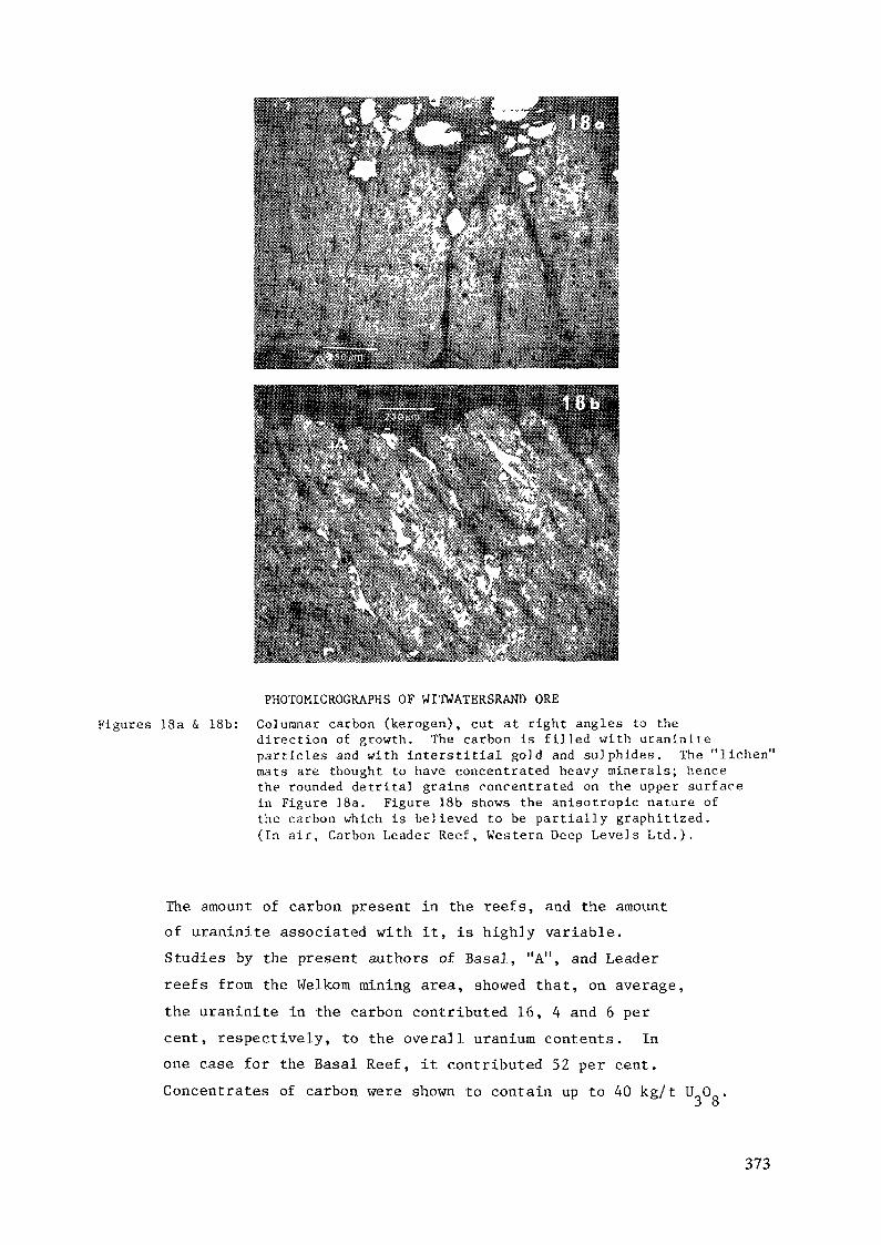
Figures ]8a & 18b:
PHOTOMICROGRAPHS OF WITWATERSRAND ORE
Columnar carbon (kerogen), cut at right angles to thedirection of growth. The carbon is f i l led with uranini teparticles and with interstitial gold and sulphides. The "lichen"mats are thought to have concentrated heavy minerals; hencethe rounded detrital grains concentrated on the upper surfacein Figure 18a. Figure 18b shows the anisotropic nature ofthe carbon which is believed to be part ial ly graphitized.(In a ir , Carbon Leader Reef , Western Deep Levels L t d . ) '
The amount of carbon present in the reefs, and the amountof uraninite associated with it, is highly variable.
Studies by the present authors of Basal, "A", and Leader
reefs from the Welkom mining area, showed that, on average,
the uraninite in the carbon contributed 16, 4 and 6 per
cent, respectively, to the overall uranium contents. In
one case for the Basal Reef, it contributed 52 per cent.
Concentrates of carbon were shown to contain up to 40 kg/1 U 0 .3 8
373
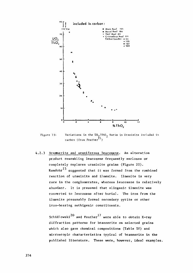
Included in carbon :(174 1)1
UO2
ThO260
40
• Main Reef 151* Basal Reel 184- Vool Reel 25• Crillaalkop Reef 171
Carbon Leader : • 34o 135* 167x 169
Figure 19:
8 10%ThO,
Variations in the U0,/Th09 Ratio in Uraninite included in21carbon (from Feather )
4.2.3 Brannerite and uraniferous leucoxene. An alterationproduct resembling leucoxene frequently encloses orcompletely replaces uraninite grains (Figure 20).Ramdohr suggested that it was formed from the combinedreaction of uraninite and i]menite. Ilmenite is veryrare in the conglomerates, whereas leucoxene is relativelyabundant. It is presumed that allogenic ilmenite wasconverted to leucoxene after burial. The iron from theilmenite presumably formed secondary pyrite or otheriron-bearing authigenic constituents.
Schidlowski and Feather were able to obtain X-raydiffraction patterns for brannerite on selected grainswhich also gave chemical compositions (Table IV) andmicroscopic characteristics typical of brannerite in thepublished literature. These were, however, idea] examples.
374
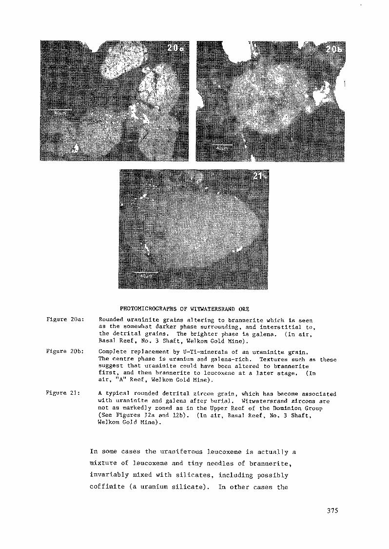
PHOTOMICROGRAPHS OF WITWATERSRAND OREFigure 20a: Rounded uraninite grains altering to brannerite which is seen
as the somewhat darker phase surrounding, and interstitial to,the detrital grains. The brighter phase is galena. (In air.Basal Reef, No. 3 Shaft, Welkom Gold Mine).
Figure 20b: Complete replacement by U-Ti-minerals of an uraninite grain.The centre phase is uranium and galena-rich. Textures such as thesesuggest that uraninite could have been altered to branneritefirst, and then brannerite to leucoxene at a later stage. (Inair, "A" Reef, Welkom Gold Mine).
Figure 21: A typical rounded detrital zircon grain, which has become associatedwith uraninite and galena after burial. Witwatersrand zircons arenot as markedly zoned as in the Upper Reef of the Dominion Group(See Figures 12a and 12b). (In air, Basal Reef, No. 3 Shaft,Welkom Gold Mine).
In some cases the uraniferous leucoxene is actually amixture of leucoxene and tiny needles of brannerite,invariably mixed with silicates, including possiblycoffinite (a uranium silicate). In other cases the
375
uranous titanates may vary considerably in chemicalcomposition and physical characteristics.
Smits has suggested that if the ratio of UO to TiO„exceeds unity, the occurrences should be called brannerite,and that those with a ratio of less than unity should becalled uraniferous leucoxene. The species with higheruranium contents form massive microcrystalline aggregatesor spindle-shaped crystals . They display a lowerreflectance than that of uraninite, and the dark-reddishbrown to very dusky red internal reflections of brannerite,Where the ratio is low, the grains display an earthyhabit, a light bluish-grey reflectance and internalreflections, thus resembling leucoxene.
Uraniferous leucoxene may occur discretely, or on themargin of brannerite. Smits suggests that the formerhas formed after burial as an intermediate reactionproduct of brannerite with acidic pore solutions. Thiswould require that the uraninite alters to branneritefirst, and the brannerite is subsequently attacked bypore solutions forming uraniferous leucoxene.
Because of the complexity of the chemical and physicalcharacteristics of the brannerite and uraniferousleucoxene, the term U-Ti-minerals will be used hereafterto describe them as a group.
U-Ti-minerals are most common in the West Witwatersrand,where in some reefs, e.g. the Vaal Reef, they may be themost abundant uranium-bearing minerals present.
In testwork carried out by the present authors, it wasfound that, on average, U-Ti-minerals in a suite of "A.",Leader, and Basal Reef samples from the Welkom areacontributed 65, 72 and 14 per cent, respectively, to theoverall uranium contents in the samples.
Colours used by Smits are from the Rock-Color chart prepared bythe Rock-Color Chart Committee in 1963.
376

The uranium-bearing assemblage differs, therefore, fromreef to reef within the same mining area, and, byexamination of a large number of samples from a varietyof sources it was found that the assemblage varies withinthe same stratigraphie, horizon, as well. Many factorshave contributed, and include, surface exposure duringtransport before burial, reworking of old channels,differences in roetamorphic grade after burial (depth,absence or presence of dykes, fault zones, etc.)» weatheringon palaeosols, and weathering under present day conditions.
4.2.4 The importance of uranium in phyllosilicates has12 24only been noted recently ' , by using the fission track
technique and extraction testwork. Fine disseminationsof uranium, with point concentrations exceeding 500 ppm,were found to occur in clay minerals in concretionarypyrite nodules and in lenticles formed of clay minerals.
12Simpson and Bowles believe that this is evidence thaturanium was in solution at the time of deposition, andthat it was adsorbed by clay constituents below thesediment-water line under reducing conditions after
O /burial. Feather and Snegg have shown that, aftermilling of a brannerite-rich sample from the Orange FreeState, the slimes fraction may contain about 38% of theuranium in the ore (see Table VI). The slimes are composedmainly of phyllosilicates, but finely divided branneritemay be present also.
4.2.5 Zircon is a fairly ubiquitous allogenic constituent(Figure 21) in hydraulic equivalence with uraninite and
22chromite . Most of the grains are pinkish and zoned,but radioactive grains are also common, containing minutespecks of radiogenic galena. Zircon may be partially,
22frequently extensively, or even completely alteredPyrite may mould itself onto and enclose the altered
23grains . Zircons in quartz pebbles have also been23observed . The uranium content of the zircons is very
low, and the mineral contributes an insignificant amountof uranium to the reefs.
377
4.2.6 Monazlte is rare in the Witwatersrand. Itoccurs as very rare grains and as minute euhedral crystals
21in detrita] uraninite grains . It is an insignificantcontributor to the uranium contents of the reefs.
4.2.7 Xenotime has been identified as rare grains8 15accompanying zircon ' . It occurs as roundish and
prismatic grains which are probably radioactive , butcontributes very little to the overall uranium contentsof the reefs. Xenotime (or churchite) has also been
12reported to occur as a tenuous ph;columnar kerogen. It is very rare.
12reported to occur as a tenuous phase interstitial to
5.0 ORIGIN OF THE URANIUM-BEARING CONSTITUENTS
Most investigators support the view that the detrital uranium-bearing minerals in the Dominion and Witwatersrand sediments werederived from granitic and/or pegmatitic source terrains associatedwith the Ancient granite-greenstone belts, and were transportedunder reducing atmospheric conditions. During and after burial theuraninite was broken down, to varying degrees, by physical andchemical processes. Smits has shown that, as the ancient "lichen1
grew, it physically broke up uraninite grains, forcing the fragmentsapart. Also, there is much evidence of chemical alteration andreaction. Thiel et ai. have concluded from their study of themicro-distribution of uranium, that mobilisation of the uraniumtook place after burial during and/or after a period of regionalmetamorphisra.
12Simpson and Bowl es , among others, refute the need for areducing atmosphere during weathering, transportation and deposition.
•y fThere are present day examples , in extremely cold climates, whereuraninite and pyrite are being removed from rocks by mechanicalprocesses, and then are being transported hundreds of kilometresdownstream. Simpson and Bowl es believe that some of the uraninitewas decomposed at the time of deposition, by oxidation of uraniumfrom the tetravalent to the hexavalent state. The soluble uraniumwas disseminated into carbon, was adsorbed by clay minerals, andreacted to form secondary U-Ti-minerals. Investigations being
378
carried out by the present authors support this view. Uraninite ispractically absent on well developed palaeosols within the Witwatersrandsequence. Instead only secondary uranium-bearing minerals andother forms of disseminated uranium could be found.
It is probable that all these processes played a role inconcentrating the economic minerals in the reefs. The DominionGroup and Witwatersrand Supergroup were deposited over a considerablespan of time (up to 1 000 Ma), during which the provenance terraincould have undergone significant geological changes, and there wereprobably areas of pre-concentration which were acted upon by geologicalprocesses, and which were later eroded away and washed into theDominion and Witwatersrand basins. Thus the uranium-bearing mineralscould have had a complex history before reaching their finaldepository.
6.0 EXTRACTIVE METALLURGY
6.1 Dominion Group Ores
The Dominion Group reefs have been worked from time to timefor their uranium content. The overall mineral assemblage isgenerally refractory to uranium-extraction processes, andchemically rigorous procedures are recommended . High pressure(about 1 400 kPa) - high temperature (up to 170°C) leachingcan achieve over 85% recovery.
Glatthaar and Feather have reported on high pressure - hightemperature testwork on ore from the Upper Reef in the AfrikanderLease Area. On comminution of the ore, 43% of the uraniumreported to slimes fraction ( < 10 jum), with lesser amounts inthe 2,5 to 2,85 S.G. and >2,85 S.G. fractions (see Table V).The only visible uranium-bearing minerals were in the >2,85 S.G.fraction. In this fraction of the Head sample, altereduraninite (including brannerite), the uranothorite-coffinitegroup of minerals, euxenite, monazite and zircon contributed77, 12, 6, 3 and 1,7 per cent, respectively, to the overalluranium content.
379
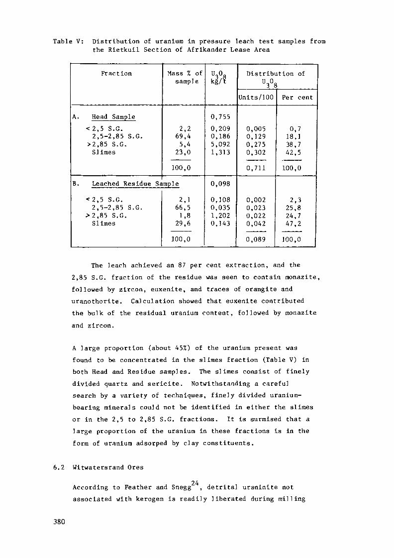
Table V: Distribution of uranium in pressure leach test samples fromthe Rietkuil Section of Afrikander Lease Area
Fraction
A. Head Sample
< 2,5 S.G.2,5-2,85 S.G.
>2,85 S.G.Slimes
B. Leached Residue Sa
< 2 , 5 S.G.2,5-2,85 S.G.
>2 ,85 S.G.Slimes
Mass % ofsample
2 , 269,4
5,423,0
100,0
imp le
2,166,51,8
29,6
100,0
ui°akgV?
0,755
0,2090,1865,0921,313
0,098
0,1080,0351,2020,143
Distribution ofU3°8
Units/100
0,0050,1290,2750,302
0,711
0,0020,0230,0220,042
0,089
Per cent
0,718,138,742,5
100,0
2,325,824,74 7 , 2
100,0
The leach achieved an 87 per cent extraction, and the2,85 S.G. fraction of the residue was seen to contain monazite,followed by zircon, euxenite, and traces of orangite anduranothorite. Calculation showed that euxenite contributedthe bulk of the residual uranium content, followed by monaziteand zircon.
A large proportion (about 45%) of the uranium present wasfound to be concentrated in the slimes fraction (Table V) inboth Head and Residue samples. The slimes consist of finelydivided quartz and sericite. Notwithstanding a carefulsearch by a variety of techniques, finely divided uranium-bearing minerals could not be identified in either the slimesor in the 2,5 to 2,85 S.G. fractions. It is surmised that alarge proportion of the uranium in these fractions is in theform of uranium adsorped by clay constituents.
6.2 Witwatersrand Ores
24According to Feather and Snegg , detrital uraninite notassociated with kerogen is readily liberated during milling
380
and few physical characteristics of the mineral inhibitdissolution during conventional dilute sulphuric acid leaching
25(free acidity 0,1N) in the presence of ground crude pyrolusitéas an oxidant. Temperatures of 55 to 65 C are maintainedduring the leach. Before leaching, uraninite may be con-centrated by gravity techniques.
Being non-wetting, carbon (kerogen) particles tend to float24during milling thereby avoiding fine grinding . The carbon
particles enclose uraninite and protect the latter from leaching.Also the admixture results in a variable density which makesgravity concentration difficult, but the carbon may be frothfloated. Pressure leaching tends to break down the more flakycarbon, thereby exposing more uraninite for extraction.
Apart from forming encrustations on, or partly or whollyreplacing uraninite grains, U-Ti-minerals are commonly seeninfiltrating neighbouring quartz, leucoxene, phyllosilicates
24and sulphide grains . Upon milling, a substantial proportionof the U-Ti-minerals are not liberated, but remain intimatelyassociated with these common gangue minerals, and therebyresist chemical attack.
Uranium associated with phyllosilicates is believed to be24relatively readily extracted. In an extraction test , in
which a head sample was split into a slimes fraction andcoarser fractions, the slimes fraction responded best (84%-Table VI).
Examination of many conventional sulphuric acid leach residues24has led Feather and Snegg to conclude that, in addition to
uraninite enclosed in carbon, U-Ti-rainera]s are invariably themost abundant uranium-bearing minerals in plant tailings.
Pressure leaching (about 1400 kPa, 170 C) can improve recoveryfrom 80% by conventional leaching to over 95%. Hosts such aspyrite react, and phyllosilicates disintegrate, therebyliberating further U-Ti-mineral particles for dissolution.Examination of pressure leach residues showed that residual
381
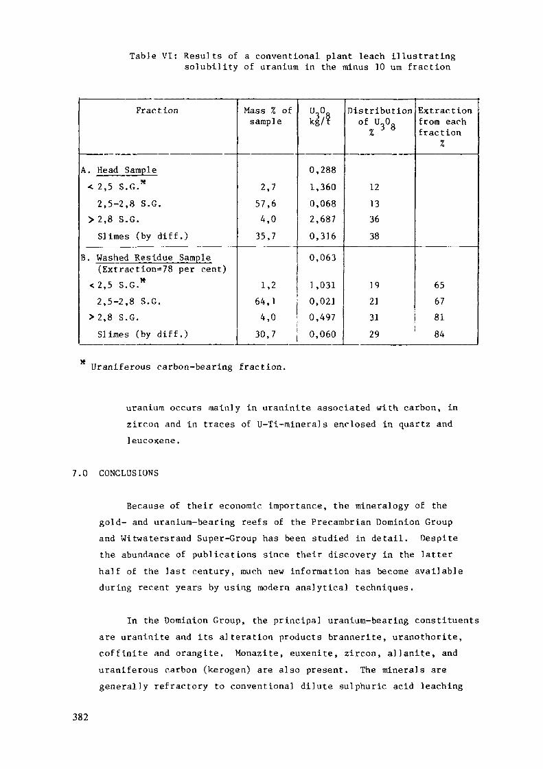
Table VI: Results of a conventional plant leach illustratingsolubility of uranium in the minus 10 urn fraction
Fraction
A. Head Sample< 2,5 S.G.*2,5-2,8 S.G.
> 2,8 S.G.Slimes (by diff.)
B. Washed Residue Sample(Extraction=78 per cent)
<2,5 S.G.*2,5-2,8 S.G.
> 2,8 S.G.Slimes (by diff.)
Mass % ofsample
2,757,64,0
35,7
1,264,14,030,7
UAkg/?
0,2881,3600,0682,6870,3160,063
1,0310,0210,4970,060
Distribution°f,U3°8
«>
12133638
19213129
Extractionfrom eachfraction
%
65678184
Uraniferous carbon-bearing fraction.
uranium occurs mainly in uraninite associated with carbon, inzircon and in traces of U-Ti-minerals enclosed in quartz andleucoxene.
7.0 CONCLUSIONS
Because of their economic, importance, the mineralogy of thegold- and uranium-bearing reefs of the Precambrian Dominion Groupand Witwatersrand Super-Group has been studied in detail. Despitethe abundance of publications since their discovery in the latterhalf of the last century, much new information has become availableduring recent years by using modern analytical techniques.
In the Dominion Group, the principal uranium-bearing constituentsare uraninite and its alteration products brannerite, uranothorite,coffinite and orangite. Monazite, euxenite, zircon, allanite, anduraniferous carbon (kerogen) are also present. The minerals aregenerally refractory to conventional dilute sulphuric acid leaching
382
under oxidizing conditions, but high pressure-high temperatureleaching can achieve a good extraction ("~85%), with euxenite,monazite and zircon as the main uranium-bearing constituents of thetail ings.
The main uranium-bearing constituents in the Witwatersrandreefs are uraninite, which may be intimately associated withcarbon (kerogen), and U-Ti-minera]s ranging from brannerite to onlyslightly uraniferous leucoxene. Zircon, monazite, xenotime,coffinite and uranothorite contribute insignificant amounts ofuranium to the ores. The minerals respond well to conventionaldilute sulphuric acid leaching (80% extraction), and pressureleaching achieves over 95% recovery. In the residues, uraniumoccurs intimately associated with carbon, or in U-Ti-mineralsenclosed by gangue constituents.
8.0 ACKNOWLEDGEMENTS
The authors would like to thank the Consulting Geologist(Gold and Uranium Division) and the Management Committee of theTechnical Director's Office, Anglo American Corporation of S.A.Ltd., and the Management of the Anglo American Research Laboratories,for their support and permission to publish this paper.
9.0 REFERENCES
1. Chamber of Mines of South Africa, "Uranium", PRO Series No.262, 20 pp. (1982).
2. Pretorius, D.A., "The Nature of the Witwatersrand gold-uraniumdeposits", in Wolf, K.H., ed., "Handbook of stratabound andstratiform ore deposits", vol. 7, Amsterdam, Elsevier, 29-88(1976).
3. Pretorius, D.A., "Gold and Uranium in quartz-pebble conglomerates",Econ. Geol. 75th Anniversary vol., 117-138 (1981).
383
4. S. Afr. Committee for Stratigraphy, comp. L.E. Kent, Stratigraphyof South Africa, Part 1: :Lithostratigraphy of the Republic ofSouth Africa, South West Africa/Namibia, and the Republics ofBophuthatswana, Transkei and Venda", Geological Surv. of S.Afr. Handbook 8, Government Printer, Pretoria (1980).
5. Hiemstra, S.A., "The Mineralogy and Petrology of the uraniferousconglomerate of the Dominion Reefs Mine, Klerksdorp area",Trans, geol . Soc. S. Afr., 7J_, 1-66 (1968).
6. Glatthaar, C.W., and Feather, C.E., Predicting the hydrometal lurgic.alrecovery of uranium by mineralogical mass balance study of theuranium-bearing minerals in Dominion Reef, South Africa".Int. Conf. Appl. Miner. (ICAM84), Los Angeles (1984), inpress.
7. Feather, C.E., and Koen, G.M., "Mineralogy of the WitwatersrandReefs", Minerals. Sc. Engng. , _7_, 189-224 (1975).
8. Liebenberg, W.R., "The Occurrence and Origin of Gold andRadio-active Minerals in the Witwatersrand System, the DominionReef, the Ventersdorp Contact Reef and the Black Reef," Trans,geol. Soc. S. Afr., 58_ 101-254 (1955).
9. Malan, S.P., "The Petrology and Mineralogy of the Rocks of theDominion Reef System near Klerksdorp," Unpublished M.Sc.Thesis, University of the Witwatersrand (1959).
10. Ortlepp, R.J., "On the Occurrence of Uranothorite in theDominion Reef," Trans, geol. Soc. S.Afr., 55, 197-202, (1962).
11. Taylor, K., Bowie, S.H.U., and Hörne, J.E.T., "Radio-activeMinerals in the Dominion Reef," Min. Mag., Lond., 107, 329-332, (1962).
12. Simpson, P.R., and Bowles, J.F.W., "Uranium Mineralization ofthe Witwatersrand and Dominion Reef Systems," Phil. Trans. R.Soc. Lond., A286, 527-548, (1977).
384
13. Watchorn, M.B., "Continental Sedimentation and Volcanism inthe Dominion Group of the Western Transvaal : A review" Trans,geol. Soc. S. Afr., 84_, 67-73 (1981).
14. Hendriks, L.P., "Quantitative evidence of the a]teration ofzircon grains in the Dominion Reef," Trans, geol. Soc. S.Afr., j67, 211-218, (1964).
15. Ramdohr, P., "New observations on the ores of the Witwatersrandin South Africa and their genetic significance," Trans, geol.Soc. S. Afr., Annexure to 6J_, 50 p. (1958), translation ofpaper, in German, published in Abh. Dt. Akad. Wiss., Jb. No.5, (1954).
16. Smits, G., "Some aspects of the uranium mineralization ofWitwatersrand Sediments of the early Proterozoic," PrecambrianResearch, Proterozoic 83 volume, in press.
17. Feather, C.E., "Some aspects of Witwatersrand mineralization,with special reference to uranium minerals," in "Genesis ofuranium- and gold-bearing Precambrian quartz-pebble conglomerates,"U.S. Geol. Surv. Prof. Papers 1161-A-BB, Q1-Q23, (1981).
18. Hallbauer, D.K., "The plant origin of Witwatersrand carbon",Minerals Sc. Engng, 7_, 111-131, (1975).
19. Grandstaff, D.E., "Mioroprobe analyses of uranium and thoriumin uraninite from the Witwatersrand, South Africa, and BlindRiver, Ontario, Canada," Trans, geol. Soc. S.Afr., 77, 291-294, (1974).
20. Schidlowski, M., "Beitrage Zur Kenntnis der RadioaktivenBestandteile der Witwatersrand-Konglomerate, II : Branneritund 'Uranpecherzgeister1," N. Jb. Miner., Abh., 105, 310-324(1966).
21. Feather, C.E. , "Studies on the mineralogy and geochemistry ofthe Witwatersrand Super-Group", Ph. D. Thesis, University ofCape Town (1976) (Unpublished).
385
22. Koen G.M., "The genetic significance of the size distributionof uraninite in Witwatersrand bankets", Trans, geol. Soc. S.Afr., 64_, 23-54, (1961).
23. Viljoen, R.P., "The Composition of the Main Reef and Main ReefLeader conglomerate horizons in the North-eastern part of theWitwatersrand Basin", Econ. Geol. Res. Unit, Univ. Witwatersrand,Johannesburg, Inform, circ. No. 40 (1967).
24. Feather, C.E., and Snegg, J.A., "The role of brannerite in therecovery of uranium from Witwatersrand Reefs", Trans, geol.Soc. S. Afr., 8j_, 255-260 (3978).
25. "Significance of mineralogy in the development of flowsheetsfor processing uranium ores", Int. Atom. Energy Agency, Vienna,Technical Report Series No. 196, (1980).
26. Smits, G., "The Occurrence of Uranium in the WitwatersrandBasin", S. Afr. Atomic Energy Board Tech. Note 300, 103 pp.(1981).
27. Thiel, K., Saager, R. , and Muff, R., "Distribution of Uraniumin early Precambrian Gold-bearing conglomerates of the KaapvaalCraton, South Africa : A review of a case study for theapplication of fission track micromapping of uranium", MineralsSc. Engng, 11, 225-245 (1979).
386
GEOLOGY AND EXPLORATION HISTORY OFPRECAMBRIAN QUARTZ-PEBBLE CONGLOMERATESIN WESTERN AUSTRALIA
J.D. CARTER, R.D. GEEGeological Survey of Western Australia,Perth, Western AustraliaAustralia
Abstract
Pyritic quartz-pebble conglomerates occur in a numberof the Precambrian sedimentary sequences in WesternAustralia. However it is only those occurrences at thehigher stratigraphie levels within the Pilbara Block, andthe lowermost stratigraphie levels of the superposedHamersley Basin that provide any encouragement foreconomic concentrations of uranium and gold.
In the PiIbara-Hamersley region, si 1iciclasticsequences in the Gorge Creek Group are associated with theprogressive cratonisation of the Pilbara Block, whereasother prospective sequences are associated with thetransgression over the Pilbara Block by the lowerFortescue Group during Hamersley Basin deposition. Theseprocesses took place in the time period between 3.0 and2.6 b.y. Some analogies with the uranium and gold bearingsequences of Elliot Lake and the Witwatersrand have beenrecognnised for at least three decades, during which timesome 40 exploration programmes have been undertaken. Mostprogrammes have been directed at the Hardey Sandstone ofthe lower Fortecue Group, but some more recently haveaimed at the Lalla Rookh Sandstone of the Gorge CreekGroup.
387
The Hardey Sandstone is confined to earlydepositional sub-basins. Within these sub-basins thereaccumulated basalt sheets, and pyritic feldspathicsandstone sequences, the latter containing many beds ofpyritic quartz-pebble conglomerate. Explorationprogrammes directed at these conglomerates in theNullagine/ Marble Bar and West Pilbara Sub-basins haveencountered U-^Og values of around 1 000 ppm. Uraniumoccurs as fine uraninite grains in thucholite pellets, andas an uraniferous phase which is probably brannerite indetrital anatase grains. Another mineralised horizonoccurs at a higher stratigraphie level, above the KylenaBasalt, but stratigraphically below the first mostextensive carbonate member of the Fortescue Group.Conglomerate in this higher unit contains compositedetrital grains of illite, uraninite, galena andcoffinite, but no thucholite has been identified.
Although there has been some minor gold productionfrom the Fortescue Group conglomerates, the knownuraniferous pyritic conglomerates are virtually devoid ofgold. Despite the evident similarities with the Rand,three geological factors may down-grade the Fortescue as agold province; firstly the covering of potential sourcerocks (greenstones) early in the erosion of the basement,and secondly the prolific basalt sheets that may haveprevented winnowing and reworking of prograding clasticsequences, and thirdly the absence of mature drainagesystems needed to rework gold bearing sediments.
388
INTRODUCTION
It is now over thirty years since the similarity ofsome sedimentary sequences in Western Australia with theclassic Witwatersrand and Elliot Lake sequences hasstimulated exploration for uraniferous and auriferousquartz-pebble conglomerates in this State. During thattime some 40 exploration programmes, some involvingdiamond drilling, have been mounted but without success.
Large amounts of valuable geological, geophysicaland geochemical exploration data are now available on theopen-file system of the Geological Survey of WesternAustralia. This would not normally be published, but areview of the data provides the best perspective foroutlining the exploration history of quartz-pebbleconglomerates in this State. A review of information onuranium exploration placed in the open-file which includesearly operations on quartz-pebble.conglomerates isprovided in Carter (1981). It is not possible tobibliographically index these data, however by way ofacknowledgement, the following companies are noted ashaving made useful contributions to testing the quartz-pebble conglomerate model:
Alcoa of Australia (WA) LtdAnaconda Australia IncAsarco (Australia) Pty LtdBroken Hill Pty Co LtdCarpentaria Exploration Co Pty LtdCRA Exploration Pty LtdCominco Exploration Pty Ltd
389

Esso Australia LtdInternational Nickel Australia LtdMarathon Petroleum Australia LtdOtter Exploration NLWestern Mining Corporation Ltd
Also during those thirty years the Geological Surveyhas completed systematic regional mapping of thePrecambrian terrains. These studies have established thetectonic and stratigraphie framework, and served toidentify possible analogues of the favoured tectonicmodels for quartz-pebble palaeoplacers. The most populartectonic environment has been in cratonic sedimentarysequences of the early Proterozoic where they overlieArchaean granite-greenstone terrains. Consequently, it isthe arenaceous sequences of the lower Fortescue Groupwhich form a cratonic cover over the Archaean PilbaraBlock that have attacted most exploration interest.Epiclastic sequences at a high stratigraphie level withinthe Pilbara Block that probably reflect a progressivecratonisation of the crust, have also been investigated.
To a lesser extent all sequences containing knownquartz-pebble conglomerates, whether or not they beobviously related to regional unconformities over Archaeancratons have been explored.
This review therefore draws upon various sources ofdata, and complements the large amount of "grass roots"type geological exploration that has been undertaken inrecent years.
390
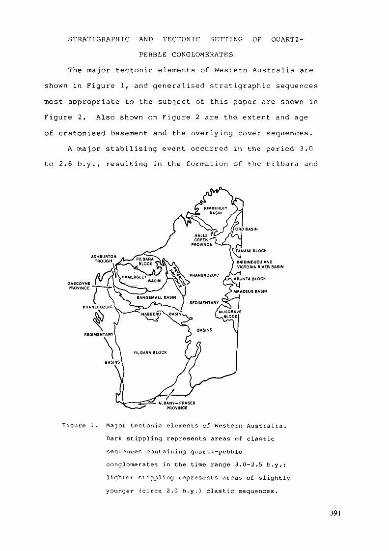
STRATIGRAPHIC AND TECTONIC SETTING OF QUARTZ-
PEBBLE CONGLOMERATES
The major tectonic elements of Western Australia areshown in Figure 1, and generalised stratigraphie sequencesmost appropriate to the subject of this paper are shown inFigure 2. Also shown on Figure 2 are the extent and ageof cratonised basement and the overlying cover sequences.
A major stabilising event occurred in the period 3.0to 2.6 b.y., resulting in the formation of the Pilbara and
ASHBURTONTROUGH
ORD BASIN
TANAMI BLOCK
BIRRINDUOU ANDVICTORIA RIVER BASIN
ARUNTA BLOCK
NAMADEUS BASIN
ALBANY-FRASERPROVINCE
Figure 1. Major tectonic elements of Western Australia.Dark stippling represents areas of clasticsequences containing quartz-pebbleconglomerates in the time range 3.0-2.5 b.y.;lighter stippling represents areas of slightlyyounger (circa 2.0 b.y.) clastic sequences.
391
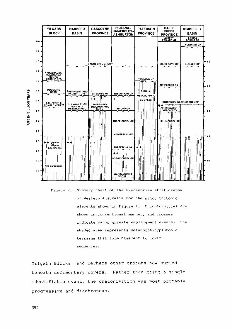
C/]E
Zo
06 -
08 -
1 0 -
_
1 2 -
1 4 -
_
1 6 -
.
1 fl —lu
20 -
22 -
24 -
-
26 -_
28 -
30 -
-
32-
YILGARNBLOCK
BADGERADDABILLERANGA
MOORACARDUPGPS
— u — u — u ——
WOODLINEBEDS
KALUWEERIECONGLOMERATE
| !
+ + graniteYllgarn
greenstones
Old paragneiss
NABBERU GASBASIN PRC
BANGEN—— u — u — u —— — er—
EARAHEEDY AND +PADBURYGPS MT J/
—— u —— u —— <J —— TTV"
GLENGARRY GP MOPEAK HILL META
METAMORPHIC 1 S—— u — u — u —— '••nur-
„
-M-
l i
H' +
i
?JTpE HAPMLEBRASRLAEY- £™°JWINCE ASHBURTON PROVINCE
1ALL GROUP-TJ — u —— — u — u — u — — u — u — u —
YENEENA GPpïrrRUDALL
\MES FM BRESNAHAN GPVTHV-T^I —— U —— U —— V —— METAMORPHIC
M ' + COMPLEX
IRISSEY
JITEI WYLOO GP"X if*" TV ' ' "*" ' " —— V —— \j (j
TUREE CREEK GPj
1
HAMERSLEY GP
FORTESCUE GP + +1 1 1 ' y — u — u —
GORGE CREEK GP
1 !
WARRAWOONA1 , GROUP 1, 1 , , , TU —— n — i
CRAELEK KIMBBAE"
PROVINCE BASI^ALBERT LOUIS/
EDWARD GP DOWNS
KUNIAND—— u — u —
CARR BOYD GP GLIDDEN—— U — u —— u —— —— u — u —
MT PARKER SS
KIMBERLEY BASIN SEOUENC+^H~TrvmM ' u u
WHITEWATEH, | , VOLCANICS,
HALLS CREEC GPi
i li
i
i
.EY1k3P
GP•u —— '
- 10GP
-
-
- 1 5
.
.
;E-u ——
- 20
.
l -25
.
•
- 30
•
_
Figure 2. Summary chart of the Precambr ian s t ra t ig raphy
of Western Aus t r a l i a for the major tectonic
elements shown in Figure 1. U n c o n f o r m i t i e s are
shown in conventional manne r , and crosses
indica te major g r an i t e emplacement events. The
shaded area represents metamorphic /p lu tonic
te r ra ins that form basement to cover
sequences.
Y i l g a r n Blocks, and perhaps other cratons now bu r i ed
beneath sed imen ta ry covers. R a t h e r t h a n being a s ingle
i d e n t i f i a b l e event , the c ra ton i sa t ion was most probably
progressive and diachronous .
392
This diffuse event was followed by the formation ofthe earliest cratonic cover sequences having both fluvialand marine characteristics. Not all of these fall intothe popularly acclaimed time band of 2.6-2.2 b.y. for thedevelopment of uraniferous, auriferous quartz-pebbleconglomerates.
Other tectonic zones, for reasons not wellunderstood, retained continued mobility, and are nowexpressed as mobile belts (Gee, 1979a). These generatedtheir cratonic covers at much younger times. In generalthese younger cratonic covers are characterised by marinesandstone, shale and carbonate, and could be describedloosely as red beds.
Figure 2 is based largely on the review by Gee (1980)to which the reader is referred for details of agecontrols. The main change since then is the substantialdownward revision of the age of the Hamersley Basinsequence, whose deposition has now been shown to havecommenced as early as 2.78 b.y., and extended toat least 2.49 b.y. (see Trendall, 1983, for a full reviewof the geochronology of the Hamersley Basin). The revisedage of the Fortescue Group has been confirmed by recentisotopic data, some of which is noted by Blake (1984a).The most definitive age is a model lead age of 2.78 b.y.from galena in amygdales in Kylena Basalt (Richards andBlockley, in press).
This revision serves to bring the Fortescue Groupinto age equivalence with the Witwatersrand Supergroupwhich is constrained by 2.8 and 2.63 b.y. (SACS, 1980).
393

The Fortescue Group is now significantly older than theHuronian which is constrained by 2.5 and 2.115 b.y.(Robertson, 1983).
It is evident from Figure 2 that the Fortescue andHamersley Groups have no outcropping equivalents anywherein Western Australia, and in fact occupy a uniquestratigraphie and tectonic position. Traditionally theFortescue Group has been taken to mark the stabilisationof the Archaean crust, a concept recently reaffirmed byBlake (1984a, 1984b) who further quotes data suggestingthat stabilisation took place over an interval of 130 m.y.However Trendall (1983), noting the occurrence ofstratigraphically high siliciclastics in the Gorge CreekGroup, and the coincidence of structures in basement andcover, argues that the Fortescue Group should beconsidered as presenting merely a stage in the progressivestabilisation of the evolving crust.
It is evident that the Fortescue Group should not beconsidered as a simple cratonic cover sequence over aregionally planar unconformity, as the Huronian Supergroupis commonly envisaged on the Canadian Shield.Considerable irregularity existed in the palaeosurfaceupon which the Fortescue Group was deposited. Hickman(1983) interpreted it as undulating hills of granite andvalleys.of greenstones, with initial deposition in valleysand encroaching progressively on to granite uplands. Onthe basis of sedimentation styles, Blake (1984a) andBlight (in press) appealed to early faulting as a controlon sedimentation. A tectonic environment involving activeerosion, block faulting, volcanism, fluvial
394
transportation, and deposition in intermontane basinsseems likely for the early Fortescue Group.
Cover sequences around the other major craton, theYilgarn Block, are poorly dated, but few are likely to beolder than 2.0 b.y. Not only are they much younger thanthe Fortescue Group, but they seem to post-date thestabilisation of basement by at least 500 m.y. In mostcases the basal beds are shallow marine sequences onsmooth unconformities. These sequences have so far failedto reveal any pyritic quartz-pebble conglomerates. Howeversections within the Glengarry Group in the western NabberuBasin contain fluvial arenaceous sequences with chert-pebble conglomerate that developed in a riftingenvironment (Gee, 1979b). Although some of these bedscontain small gold deposits, a placer origin has not beenestablished, and no pyritic beds have been identified.
Pyrite-rich beds occur in the Peak Hill MetamorphicSuite, whose relationship to the Glengarry Group isuncertain. These rocks are either metamorphosedequivalents of the Glengarry Group, or stratigraphicallybeneath it. These rocks have been important producers ofgold, for example the Peak Hill mining district producedover 8 000 kg.
The cratonic cover sequences in the Kimberley Basin,of age about 1.9 b.y. also contain conglomerate zoneswhich have been explored using the pyritic quartz-pebbleconglomerate model. However no true fluvial quartz-pebblefaciès have been found, and all appear to be polymictic
395
shore-line deposits. Despite intensive search, no uraniumconcentrations have been identified. These operationshave been reviewed by Carter (1976).
PYRITIC CONGLOMERATE OUTSIDE THE PILBARA
- HAMERSLEY REGION
NABBERU BASIN
The pyritic conglomerates and associated rocks in thePeak Hill Metamorphic Suite occur over an area of lessthan 20 km . An exploration programme which included 10drill holes totalling over 1 000 m tested the sequence forgold and uranium palaeoplacers. One hole sited over anoutcrop of pyritic quartz-pebble conglomerate proved morethan 80 m of pyritic quartzite and conglomerate andobtained gold values of 2.2 ppm over 0.3 m and 1.3 ppmover 1 m. Pyrite is accompanied by minor chalcopyrite.The best uranium analysis was 30 ppm U-^Og . The modeof occurrence of uranium was not described.
OUTLIERS ON THE YILGARN BLOCK
An outlier of 330 km in the southeastern part ofthe Yilgarn Block, of gently dipping shale and sandstonecomprises the Woodline Beds. The sequence is about 240m thick and the lower part of some 148 m is described aspyritic quartzite and shale with thin beds ofconglomerate.
From a diamond and percussion drilling programme some270 samples were analysed for gold and uranium but mostresults lay near or below the limits of detection. Thebest uranium analysis was 47 ppm U^0g and for gold,
396
0.32 ppm. The source of uranium which is containedwithin shales was not determined, and no unequivocaldetrital pyrite was identified. In fact no true quartz-pebble conglomerates are present.
An exposure of conglomerate and sandstoneunconformably overlies granite near Kaluweerie Hill in thenorth-central part of the Yilgarn Block. It has beeninterpreted as a fluvial deposit (Allchurch and Bunting,1976). It contains traces of secondary carnotite but doesnot contain quartz-pebble conglomerate.
HALLS CREEK PROVINCE
To the Saunders Creek Formation are assigned theoldest conglomerates of the Halls Creek Group the age ofwhich is uncertain but thought likely to be older than2 000 m.y. The formation is about 190 m thick, andconsists of quartz greywacke, shale and radioactiveconglomerate beds. The rocks outcrop around domes,
2over areas of less than 15 km .Two small drilling programmes were undertaken,
and one diamond drill hole, 223 m in depth, intersectedseveral pyrite intervals. The best uranium analysis was1 300 ppm U-jOg over 0.1 m but the majority of resultsfell below 40 ppm U30g over 2 m. The best goldanalysis was 0.2 ppm over 2 m. The radioactive mineralthorogummite was identified, but no detrital pyrite.
PYRITIC CONGLOMERATE OF THE GORGE CREEK GROUP
STRATIGRAPHY AND SEDIMENTATION
The Gorge Creek Group, of age about 3.0 b.y., is apredominantly siliciclastic sequence with minor basalt,
397
up to five km in thickness occurring at higherstratigraphie levels within the Pilbara Block. Itunconformably overlies the volcanogenic greenstones thatform the main substrate of the Pilbara Block, and Hickman(1983) interprets the depositional basins to have evolvedfrom earlier volcanogenic basins that became laterallyrestricted due to continued rise of domal granitoids.During this process the granitoids were unroofed and shedabundant quartzose-feldspathic detritus into the basinsalong with detritus from earlier sequences. These basinsshould therefore be considered as yoked basins.
Two faciès are recognised in the siliciclastics, afluvial sandstone-conglomerate faciès (Lalla RookhSandstone) and a turbidite trough faciès known as theMosquito Creek Formation (Hickman, 1983). In the shallow-water faciès Eriksson (1979) identified featuresattributable to the upper and lower portions of a braidedalluvial plain, and it is the latter environment of theLalla Rookh Sandstone that produced sandstone withinterbedded quartz-pebble conglomerate. The main basinsof deposition are shown on Figure 3.
EXPLORATION IN THE LALLA ROOKH SANDSTONE
Only a small number of exploration programmes havepursued a pyritic palaeoplacer model for the Lalla RookhSandstone, and to date little information is available.The sandstones are reported as well sorted, andfeldspathic, with pyrite concentrated on foreset beddingplanes. Both polymictic and oligomictic quartz-pebbleconglomerates occur, the latter carrying up to 15%buckshot pyrite.
398
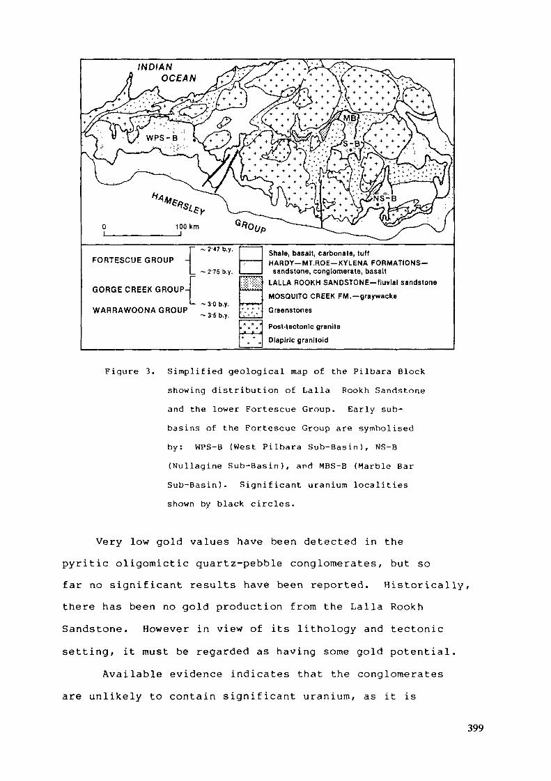
INDIANOCEAN
FORTESCUE GROUP -
GORGE CREEK GROUP-
WARRAWOONA GROUP
. 2'47 b.y.
' 2-75 b.y.
-3-0 b.y.- 3-5 b.y.
Shale, basalt, carbonate, tuffHARDY—MT.ROE—KYLENA FORMATIONS—
sandstone, conglomerate, basaltLALLA ROOKH SANDSTONE-lluvlal sandstone
MOSQUITO CREEK FM.-graywacke
Greenstones
Post-tectonic graniteDiaplric granitoid
Figure 3. S impl i f ied geological map of the Pi lbara Block
showing d i s t r ibu t ion of Lalla Rookh Sandstone
and the lower Fortescue Group. Ear ly sub-
basins of the Fortescue Group are symbolised
by: WPS-B (West Pi lbara S u b - B a s i n ) , NS-B
( N u l l a g i n e S u b - B a s i n ) , and MBS-B (Marb le Bar
Sub-Bas in ) . S i g n i f i c a n t u r a n i u m localities
shown by black circles.
Very low gold values have been detected in the
pyr i t i c oligomictic quartz-pebble conglomerates, but so
far no s ign i f ican t results have been reported. His to r i ca l ly ,
there has been no gold production f rom the Lalla Rookh
Sandstone. However in view of its l i thology and tectonic
set t ing, it must be regarded as hav ing some gold po ten t i a l .
Avai lable evidence indicates that the conglomerates
are un l ike ly to contain s i g n i f i c a n t u r a n i u m , as it is
399
probable that the only source of uranium enrichment,the post-tectonic "tin granites", had not intrudedat this stage (Hickman, 1983). Values foruranium are either low or not detected, and surfaceradioactivity can be ascribed to thorium minerals.
PYRITIC CONGLOMERATE OF THE LOWER FORTESCUE GROUPEXPLORATION HISTORY
The only gold occurrences in the lower Fortescue Groupthat have actually been mined are in sporadic pyriticconglomerates at its base. These are invariably close togold occurrences in the underlying greenstones of thePilbara Block. Early in the century a little gold wasproduced from the Just-in-Time and Tassy Queen mines, afew kilometres southwest of Marble Bar. Gold was won alsofrom the conglomerate at Beatons Creek near Nullagine.
In 1955, Enterprise Exploration Pty Ltd firstconducted ground scintillometer traverses based on thesimilarity of these conglomerates with the uranium-bearingconglomerates of Elliot Lake, Canada. In the same yearthe Australian Bureau of Mineral Resources flew areconnaissance scintillograph survey over the east Pilbararegion.
No further exploration activity is known until 1968when large exploration operations began. The generalapproach was to employ airborne surveys to locateanomalies, and follow-up with ground radioactivitysurveys, geological mapping and drilling. However, by1982 when uranium operations had largely ceased, noeconomic deposit of uranium had been identified although anumber of significant drill hole intersections were made.400

Very high uranium and gold values from surface rock-chip samples were commonly obtained. Values in excess of4 000 ppm U-^Og and up to 6 ppm gold are mentioned inreports but analyses of drill core from correspondinghorizons reveal values generally below 500 ppm U-,Ogand gold in little more than trace amounts. This
surface enrichment of uranium is readily explained.Pyrite when oxidised, produces acid weathering conditionsin which ultimately limonite is formed. Uranium ismobilised during hydrolitic reactions accompanying theformation of limonite and the metal is concentrated bycoprecipitation with hydrous iron oxides.
A weakness in some exploration work is the failure todetermine the mode of occurrence of uranium responsiblefor high values, and only two operators report the mode ofoccurrence of the metal. Some of the uranium assay iscontributed by common heavy mineral résistâtes such asmonazite, xenotime and zircon. The mineralogy ofuraniferous drill core from the clastic unit above theKylena Basalt was determined by the Western AustraliaGovernment Chemical Laboratories.
EARLY SUB-BASINS OF THE FORTESCUE GROUP
In this paper the term lower Fortescue Group refers tothose units shown on Figure 4, which extend up to the baseof the first regionally extensive unit - namely theTumbiana Formation. The Tumbiana Formation is a marinetuff - carbonate unit containing abundant stromatolites,below which the lower Fortescue Group is confined to
401
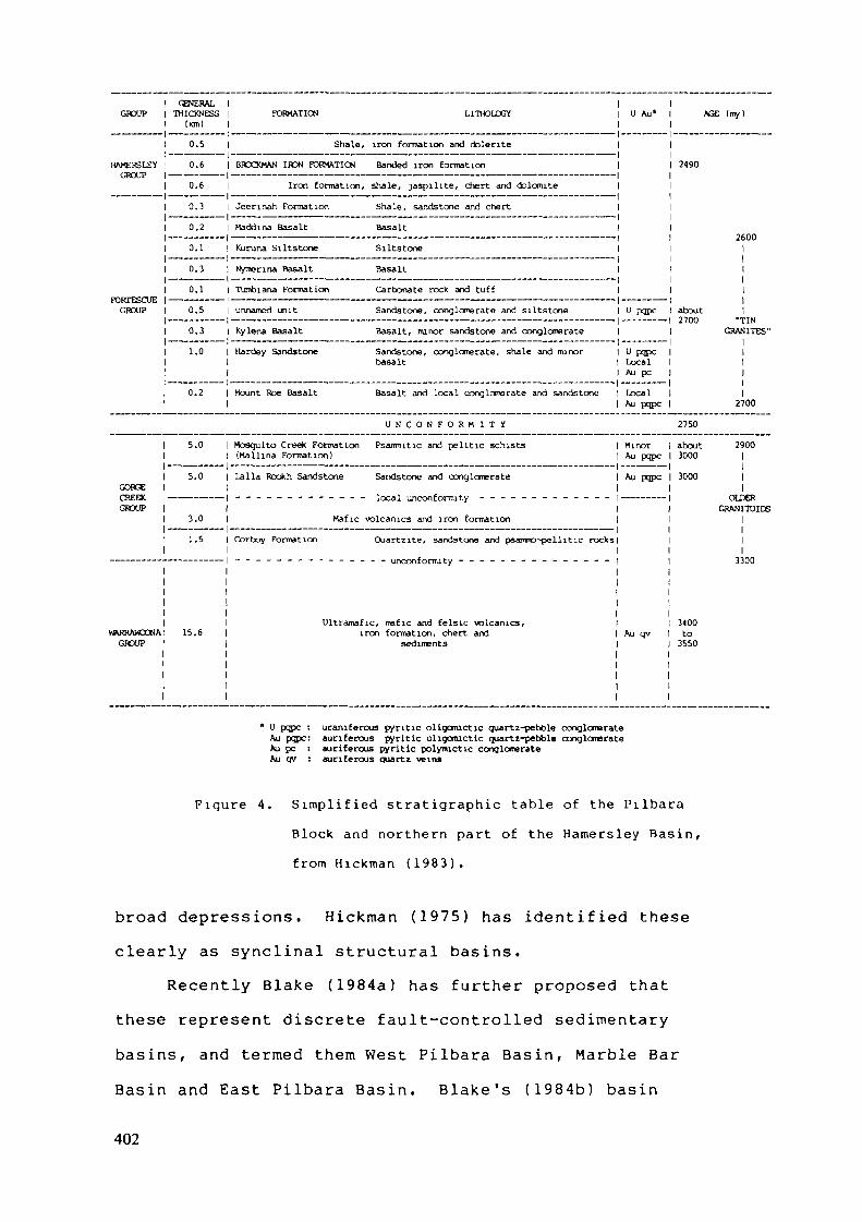
GROUP
HAMERS LEY
GROUP
GORGE
GROUP
WARRAWCCNAGROUP
GHJERALTHICKNESS
(km)
0.5
0.6
0.6
0.3
0.2
0.1
0.3
0.1
0.5
0.3
1.0
0.2
5.0
5.0
3.0
1.5
15.6
FORMATION LITHOLOGY
Shale, iron formation and dolente
BROCKMAN IRON FORMATION Banded iron formation
Iron formation, shale, jaspllite, chert and dolomite
Jeerinah Fornation Shale, sandstone and chert
Maddina Basalt Basalt
Kuruna Siltstone Siltstone
Nymenna Basalt Basalt
Tumbiana Formation Carbonate rock and t u f f
unnamed unit Sandstone, conglomerate and Siltstone
Kylena Basalt Basalt, minor sandstone and conglomerate
Hardey Sandstone Sandstone, conglomerate, shale and minorbasalt
Mount Roe Basalt Basalt and local conglomerate and sandstone
U N C O N F O R M I T Y
Mosquito Creek Formation Psamiutic and politic schists(Kallina Formation)
Lalla Rookh Sandstone Sandstone and conglomerate
Mafic volcanics and iron formation
Corboy Formation Quartzite, sandstone and psanro-pellitic rocks
Ultramafic, mafic and felslc vrolcanics,iron formation, chert and
sediments
U Au*
U pqpc
U pqpcLocalAu pc
LocalAu pqpc
MinorAu pope
Au pqpc
Au qv
AGE (my)
2490
2600
about
GRANITES"
2700
2750
about 29003000
13000 I
1OLDER
GRANITOIDS1111
3300
3400to
3550
" U pqpc : uraniEerous pyritic oligonuctic quartz-pebble conglomerateAu pqpc: auriferous pyritic oligomictic quartz-pebble conglomerateAu pc : auriferous pyritic polymictic conglomerateAu qv : auriferous quartz veins
Figure 4. S i m p l i f i e d s t r a t ig raph ie table of the Pi lbara
Block and no r the rn part of the Hamers ley Bas in ,
f rom H i c k m a n (1983) .
broad depressions. Hickman (1975 ) has iden t i f i ed these
clearly as synclinal s tructural basins.
Recently Blake (1984a ) has fu r the r proposed that
these represent discrete faul t-control led sedimentary
bas ins , and termed them West Pi lbara Bas in , Marble Bar
Basin and East Pilbara Bas in . B l a k e ' s ( 1 9 8 4 b ) basin
402
nomenclature is largely followed in this paper, howeverhis Nullagine structural sub-basin of the East PilbaraBasin is described separately and referred to as theNulagine Sub-Basin. Furthermore we use the term sub-bas in
rather than bas in, as they seem to be early components ofthe major depositional basin of the Fortescue andHamersley Groups, in the sense of Trendall (1983).
NULLAGINE SUB-BASIN
Stratigraphy and LithologyThis fan-shaped basin is more than 60 km in length.
To the north it is bounded by greenstone belts andgranitoid batholiths and in the south it opens into theHamersley Basin (Fig. 3). The lower part of the FortescueGroup is represented by
Kylena Basalt : extensive basalt flows(up to 300 m)
Hardey Sandstone : in places it rests directly(probably about 300 upon the Pilbara Block; it ism in the southwest intruded by a dacite porphyry,of the sub-basin) the Spinaway Porphyry towards
its baseMount Roe Basalt : basalt flows confined to(up to 50 m) palaeovalleys
Radioactive conglomerates in the Hardey Sandstone wereexplored for uranium and gold in the southwest part of thesub-basin along a strike length of more than 20 km ofgently southward dipping sediments. Most if not all ofthe prospective parts of the formation were tested bydiamond drilling.
403
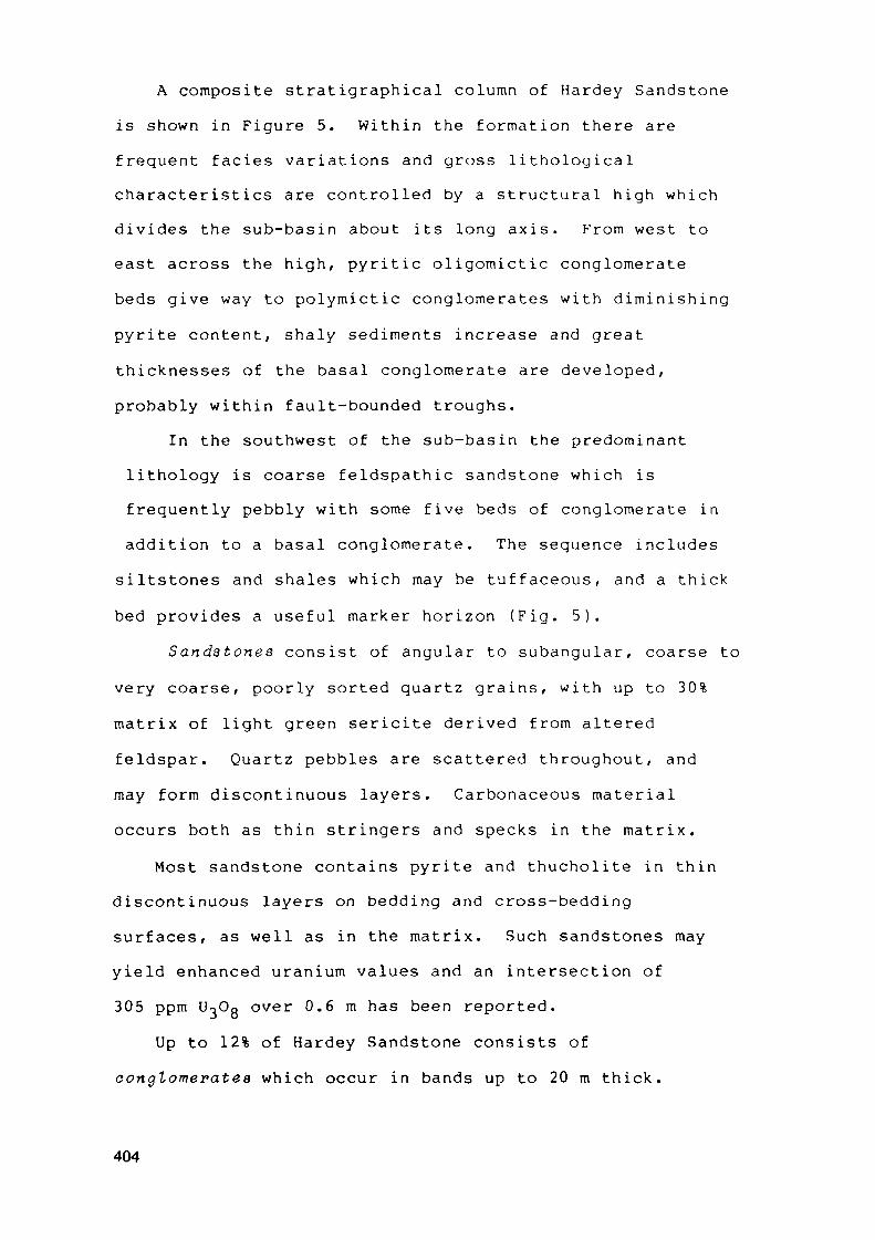
A composite stratigraphical column of Hardey Sandstoneis shown in Figure 5. Within the formation there arefrequent faciès variations and gross lithologicalcharacteristics are controlled by a structural high whichdivides the sub-basin about its long axis. From west toeast across the high, pyritic oligomictic conglomeratebeds give way to polymictic conglomerates with diminishingpyrite content, shaly sediments increase and greatthicknesses of the basal conglomerate are developed,probably within fault-bounded troughs.
In the southwest of the sub-basin the predominantlithology is coarse feldspathic sandstone which isfrequently pebbly with some five beds of conglomerate inaddition to a basal conglomerate. The sequence includes
siltstones and shales which may be tuffaceous, and a thickbed provides a useful marker horizon (Fig. 5).
Sandstones consist of angular to subangular, coarse tovery coarse, poorly sorted quartz grains, with up to 30%matrix of light green sericite derived from alteredfeldspar. Quartz pebbles are scattered throughout, andmay form discontinuous layers. Carbonaceous materialoccurs both as thin stringers and specks in the matrix.
Most sandstone contains pyrite and thucholite in thindiscontinuous layers on bedding and cross-beddingsurfaces, as well as in the matrix. Such sandstones mayyield enhanced uranium values and an intersection of305 ppm U-jOo over 0.6 m has been reported.
Up to 12% of Hardey Sandstone consists ofconglomerates which occur in bands up to 20 m thick.
404
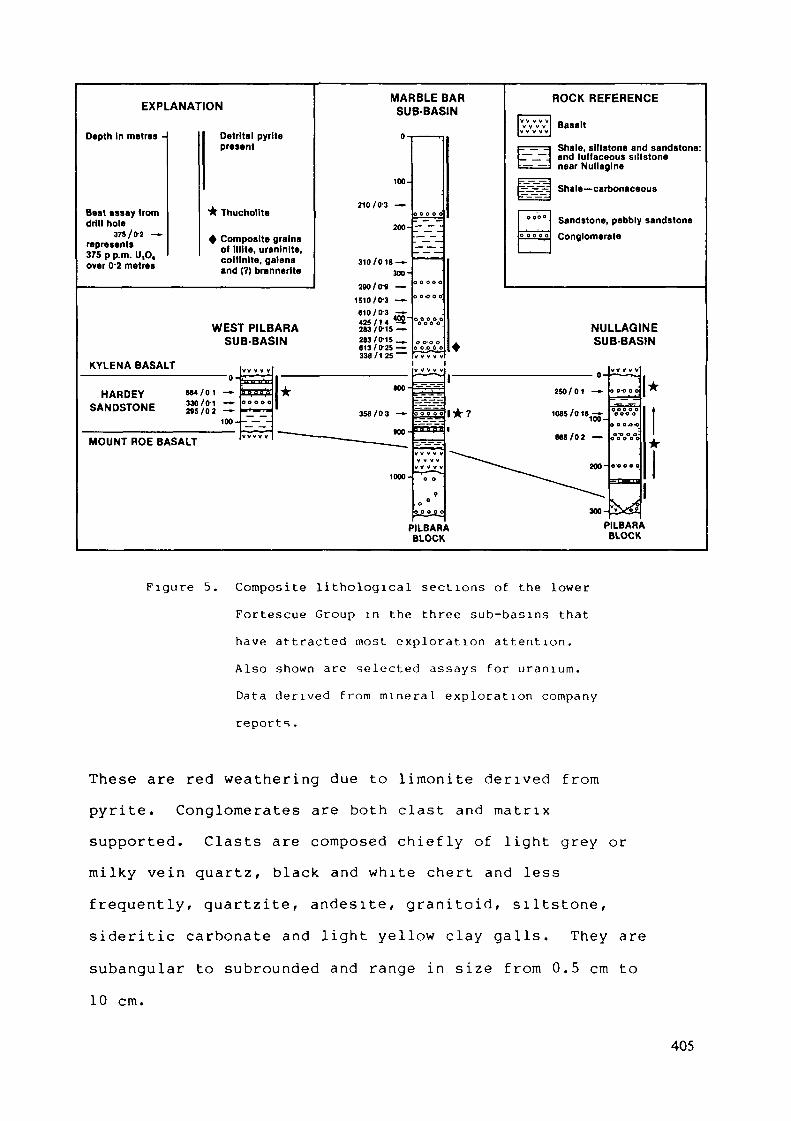
EXPLANATION
Depth In metres -
Best assay fromdrill hole
375/0-2 —represents375 p p.m. U,0,over 0-2 metres
Oetrltal pyritepresent
* Thuchollte
+ Composite grainsof Illite, uranlnlte,cottlnlte, galenaand (?) brannerlte
MARBLE BARSUB-BASIN
ROCK REFERENCE
Basalt
Shale, siltstone and sandstone:and tuffaceous siltstonenear Nullagine
Jr£3£j1£ Shale—carbonaceous
Sandstone, pebbly sandstoneConglomerate
KYLENA BASALT
HARDEYSANDSTONE
»64/01 -—
2*5/02 ——
MOUNT ROE BASALT
WEST PILBARASUB-BASIN
NULLAGINESUB-BASIN
100- - — -
PILBARABLOCK
PILBARABLOCK
Figure 5. Composite l i thological sections of the lower
Fortescue Group in the three sub-basins tha t
have a t t rac ted most explora t ion a t t e n t i o n .
Also shown are selected assays for u r a n i u m .
Data de r ived f r o m m i n e r a l exp lo ra t ion company
reports.
These are red weather ing due to l imoni te der ived f r o m
pyri te. Conglomerates are both clast and m a t r i x
supported. Clasts are composed c h i e f l y of l i gh t grey or
mi lky vein q u a r t z , black and w h i t e chert and less
f requen t ly , qua r t z i t e , andés i te , g r a n i t o i d , s i l t s tone,
s ideri t ic carbonate and l ight yellow clay gal ls . They are
subangular to subrounded and range in size f rom 0.5 cm to
10 cm.
405
The matrix is formed of poorly sorted quartz andfeldspar grains with a high proportion of sericitelending green colours to the rocks. In some cases up to60% carbonaceous material occurs in the matrix. Pyriteand thucholite commonly occur as disseminations and asconcentrations around quartz grains. Buckshot pyrite ofdetrital origin ranges from 0.2 to 2 mm in diameter andtypically has abraded and pitted surfaces. Thucholitepellets are less abundant and usually smaller than pyritegrains.
Siltstones and shales occur as thin partings and thickbeds of grey-green rock that incorporates minor finevolcanoclastic sediments. A 20-metre thick tuffaceoussilty shale occurs in the upper part of the formation,and is a useful marker horizon. Uranium values of up to80 ppm U-jOg have been recorded from the shales.
The composition of sandstones and conglomeratesindicates derivation from both a granitic'and quartziteprovenance. Sedimentary features point tofluvial deposition from a largely southerly source ofsediment. Some explorers also believe that parts of thesequence contain intertidal and estuarine sediments.
Mode of Occurrence of UraniumIn most anlayses from drill core, thorium values are
low indicating that resistate minerals such as monazitedo not contribute significantly to the uranium content.Although high uranium values (such as 1085 ppm U^Ogwere obtained by drilling, no detrital uraninite grainshave been identified. Cominco Exploration Pty Ltddescribe results of investigations as follows:
406
"Uranium occurs as fine uraninite inclusions incarbonaceous pellets within the conglomerate matrix.The bulk of the pyritic conglomerate sectionsexamined contained the following heavy mineralassemblage :
Pyrite, rounded, up to 2 mm diameter, withchalcopyrite, pyrrhotite, and possibly ilmeniteinclusions.Carbonaceous pellets, up to 1 mm diameter,containing fine inclusions of uraninite, pyriteand occasionally veinlets of chalcopyrite.Anatase-quartz intergrowth.Monazite-zircon-xenotime."
Petrographical and mineralogical work reported byMarathon Petroleum Australia Ltd, is quoted below:
"Thucolite pellets contain fine inclusions mainly ofgalena and thorite (ThSiO^). The thorite containsminor uranium, almost certainly as partialsubstitution of Th, not as a specific phase.Persistent detrital accessory grains of cellularanatase carry minute (1 to 3 micron) grains of auraniferous phase, almost certainly brannerite.These are the only two modes of occurrences ofuranium identified by this investigation. Detailedexamination failed to reveal any gold."
Pyrite ranges in size from 0.3 to 1.5 mm and forms upto 10% of individual samples. Some grains enclosechalcopyrite and pyrrhotitte. Pyrite is essentiallyrounded and detrital, though authigenic growth probablyaccounts for some large euhedral crystals.
Thuaholite consists of subrounded pellets of compactcarbonaceous material, consistently with a diameter ofabout 1 mm. Pellets contain minute inclusions of galena,thorite and chalcopyrite. Like pyrite, these pellets aredetrital but less abundant.
Zircon is a common accessory being up to 2%. Anelectron micro-probe of a grain showed i't to be devoid ofuranium and thorium.
407

Anatase also a common detrital accessory, has anaverage size of 0.2 mm and an average abundance of 1%.Anatase grains contain minute (1 to 3 micron) inclusionsof a uraniferous phase, probably brannerite but possiblythough less likely, uraninite. Marathon also report asfollows:
"There is a direct correlation between theand Pb abundance of carbon (thucholite) pellets.Also these pellets appear to be more abundant insamples which also contain more abundant pyrite andquartzose pebbles.The grains of detrital zircon and cellular anatasealso appear to be more abundant in samplescontaining most pyrite and thucholite pellets.In samples which contain relatively abundant lithicclasts, the quartzose pebbles (and the accessoryphases) appear to be relatively less abundant."
MARBLE BAR SUB-BASIN
Stratigraphy and LithologyThis hour-glass shaped basin extends approximately 50
km from north to south, and is enclosed by granitoidbatholiths and greenstone belts (Fig. 3). The lowerFortescue Group stratigraphy is represented by:
unnamed unit : coarse sandstone and(475 m) conglomerate with minor
siItstoneKylena Basalt : basaltic and andesitic flows(up to 300 m)Hardey Sandstone : shale, siltstone and fine(163 m) sandstone with minor coarse
sandstone and conglomerate
408
Mount Roe Basalt : mainly basalt with basal and(up to 150 m) intraflow conglomerate, sandstone
and shale
Exploration in the Mount Roe BasaltDiscontinuous beds of pyritic polymictic and
oligomictic quartz-pebble conglomerate, and pyriticsandstone occur below the basalt flows, in fluvialchannels cut into the basement. These may attainthicknesses of 100 m. They have been explored for goldand uranium, but analyses were very low.
Exploration in the Hardey SandstoneStratigraphy of the Hardey Sandstone, derived from a
drill hole section is shown in Figure 5, where it is seenthat the gross lithology of shale, siltstone, finesandstone and minor conglomerate contrasts with thelargely coarse sandstone and conglomerate of the NullagineSub-basin. By way of comparison however, the uraniferousconglomerate and overlying shaly sequence may correspondto the principal uraniferous conglomerate and tuffaceoussiltstone "marker horizon" of the Nullagine Sub-basin.
Three coarsening-upward sequences of shale,siltstone, feldspathic sandstone and minor conglomeratewere established by diamond drilling. The conglomeratebeds are usually only one metre in thickness, but are ofgood oligomictic quartz-pebble conglomerate with pebblesaveraging 1.5 cm in diameter, and containing abundantbuckshot pyrite.
409
At a locality in the centre of the Marble Bar Sub-basin, known as Shady Camp Well, particular attention wasgiven to a bed of oligomictic quartz-pebble conglomeratewith buckshot pyrite which yielded at the surface 590 ppmU-jOg and 3.85 ppm gold. However follow-up closespaced rock chip sampling at 25 m intervals recorded fewgold values greater than 1 ppm and in a majority ofsamples gold was either very low or not detected.A diamond drill hole in this bed made an intersection of356 ppm UjOg over 0.3 m and a maximum gold value ofonly 0.6 ppm. The mode of occurrence of uranium in thisdrill core is not known. Certain high surface uraniumanalyses are accompanied by high thorium and rare earthelement values, indicating that some uranium is bound upin resistate minerals such as monazite and xenotime.
Ten kilometres to the north east of the Shady CampWell area, two coarsening-upward sequences of shale,sandstone and conglomerate have been explored. Anexploratory shaft (6.1 m deep) exposed a metre of flat-lying conglomerate immediately below Kylena Basalt andbottomed in sandstone. Best values of 33 ppm U-^Og and0.07 ppm Au were returned from analyses of the shaftsamples.
No detailed investigation was made of the occurrenceof uranium in the Hardey Sandstone, but an electron probeof a green arkosic sandstone from the Shady Camp Welllocality showed finely disseminated grains (2-3 microns)of an unidentified uranium mineral associated withphosphorus, occurring both in lead-bearing graphite grainsand along narrow fractures containing pyrite. These
410
graphite grains are probably metamorphosed thucholiteparticles and thus, as in the Nullagine Sub-basin, uraniumis likely to occur at least in part as fine uraniniteinclusions in carbonaceous pellets.
Exploration above the Kylena BasaltIn the southern part of the Marble Bar Sub-basin near
Limestone Well, a thick sequence of sandstone,conglomerate and minor shale is preserved in a fault-
2bounded basin some 70 km in area. Formerly these rockswere thought to be a sedimentary sequence intercalatedwithin Kylena Basalt and are shown on maps as "KylenaBasalt: sandstone and grit" (Hickman and Lipple, 1978).
Detailed mapping and drilling have demonstrated thatthe sequence occupies channels cut into Kylena Basalt, is475 m thick, and is not overlain by basalt. Thissequence, as yet, has no convenient lithostratigraphicname.
The unit was tested for palaeoplacers during threeexploration programmes, two of which included diamonddrilling. High uranium intersections were made but goldvalues were insignificant. Curiously the high uraniumvalues obtained by Alcoa of Australia (shown on Figure 5)were not reproduced during subsequent analyses when valuesas low as 10-50% of the originals were obtained. Thereason for these discrepancies is not known.International Nickel Aust Ltd however obtained 613 ppmU3°8 over 0.25 m in a drill hole sited close to anAlcoa hole with an initial value of 1300 ppm U-^Og over2.75 m (not shown on Fig. 5). It is felt therefore that
411
the high Alcoa values could have substance, but theseclearly need to be treated with caution.
Hunting Geology and Geophysics (Australia) Pty Ltd ina report for Marathon Petroleum Australia Ltd provide thefollowing comprehensive account of this unnamed unit.
Lower Sequence (205 m). Pyritic, coarse pebblyfeldspathic sandstone and pyritic conglomerate fill atleast three palaeochannels in Kylena Basalt. Trough crossbedding points to deposition in a fluvial environment.
Middle Sequence (90 m). Poorly bedded and poorlysorted feldspathic sandstone, and carbonaceous siltstone,shale and rare tuff apparently represent rapidsedimentation in shallow water due to basin subsidencepossibly caused by graben-type fault movement. There isan unconformable relationship with the lower sequence atone locality. Pyrite is rare.
Upper Sequence (180 m). Very coarse feldspathicsandstone and conglomerate, with trough cross beddingdemonstrate a return to fluvial deposition. The sequenceis a monotonous succession of very coarse feldspathicsandstone containing some nine intervals of laterallypersistent pyritic polymictic and olgomictic quartz-pebbleconglomerate. Detrital grains of pyrite are locallyabundant in thin bands.
The sandstone which makes up the greater part of thesequences is feldspathic and contains detrital pyrite.Thucholite has not been identified in the sandstone or inany other rock types. The best (but qualified) uraniumintersection of 1 510 U^Og was made in pyritic,coarse, pebbly, feldspathic sandstone.
412

Conglomerate which makes up to 5% of the sequences,mostly consists of pebbles and cobbles of vein quartz andchert. A uraniferous zone near the base of the lowersequence was in a matrix-supported greenish greyconglomerate with subrounded 2 cm clasts of quartz andchert, and a matrix largely of green illitic clay, alteredfeldspar, mica, quartz grains, and detrital pyrite grainsup to 2 mm in diameter. Pyrite forms 5% of theconglomerate matrix.
Mode of occurrence of uraniumInteresting uranium intersections were made in 3 drill
holes in the lower sequence (see Fig. 5) but nosignificant gold values were found either at the surface orin drill holes. Core from a subsequent drill hole ofInternational Nickel Australia Ltd obtained 613 ppmU-jOg, 831 ppm Th and 0.018 ppm Au over 0.25 m, andcontained conspicuous bands of heavy minerals. Thesebands consist of detrital pyrite and small amounts ofmolybdenite, galena, chalcopyrite, zircon, monazite,xenotime, tourmaline and composite radioactive grains.Monazite contains significant amounts of thorium, andxenotime carries thorium and a small amount of uranium.
The major sources of radioactivity are in small (up to100 microns) composite grains of two types. One consistsof intergrowths of illite, uraninite and galena, and thesecond, an intergrowth of illite, coffinite, uraninite andgalena. Titanium is abundant in both types and may be
present as brannerite. Uraninite is "earthy" but showsremnant cleavage traces indicating an original crystalline
413
nature. Other radioactive sources, not positivelyidentified, include uranium- and thorium-rich biotite asinclusions in quartz grains, and uranium-rich coatings onzircon.
This mineralogical composition points to a primarysource of a uranium-enriched granite or pegmatite whichcontained intergrowths of uraninite and feldspar.Coffinite may have formed by alteration of uraninite orcould be a primary mineral.
WEST PILBARA SUB-BASIN
Stratigraphy and LithologyExploration for uranium and gold has been undertaken at
several localities in the Pyramid region some 200 km westof the Marble Bar Sub-basin. Here the lower FortescueGroup forms a broad embayment onto the Pilbara Block, afeature that probably represents an early sub-basin of theHamersley Basin. The stratigraphie sequence consists ofMount Roe Basalt, restricted to palaeodepressions, followedby Hardey Sandstone, Kylena Basalt and Cooya Pooya Dolerite.
Exposures of Hardey Sandstone near Coorbeelie River26 km south east of Pyramid were the principal scene ofexploration which included 3 separate drilling programmes.
2The formation outcrops over an area of about 10 km , andonly 120 m of conglomeratic sandstone is present, the upperpart of the formation having been removed by erosionfollowing the intrusion of Cooya Pooya Dolerite.
Coarse feldspathic sandstone and conglomerate aregenerally similar in composition and pyrite content to
414
those in the Nullagine Sub-basin, and they also displayfluvial sedimentary structures.
Three conglomeratic intervals occur within whichindividual beds range up to 3 m thick. Abundant detritalpyrite, sometimes 10% of the total matrix, is found in thinwavy layers. Pale green sericite after feldsparconstitutes 5% of some rocks. Carbonaceous grains presumedto be thucholite have been noted in the middle of the threeconglomerate intervals (Fig. 5).
Uranium Exploration ResultsThe principal uranium intersections were made in
conglomerates, the best being 684 ppm U-jOg over 0.1 m(Fig. 5). Drilling has demonstrated that down-dipextensions of the uraniferous conglomerates are extensivelydisrupted by intrusions of dolerite. No significant goldvalues were obtained.
No mineralogical investigation of the mode ofoccurrence of uranium at Coorbeelie River is known to havebeen made. Marathon Petroleum Australia Ltd reportedthucholite in the middle conglomerate interval associatedwith disseminated pyrite and clay galls - an associationseen often in Nullagine conglomerates. It is most likelytherefore that part of the uranium occurs as fine inclusionsof uraninite in thucholite or as partial substitutions ofthorium in thorite. Such are the modes of occurrence ofuranium in thucholite pellets in the Nullagine Sub-basin.
EXPLORATION IN OTHER AREAS OF THE HAMERSLEY BASIN
Exploration operations in the Hardey Sandstone havebeen carried out in the large complex embayments of the
415
eastern Pilbara that are not obviously interpreted as earlyfluvial basins. None of these operations yield informationadding usefully to the foregoing descriptions.
Blight (in press) describes the lithology andsedimentology of the lower Fortescue Group in the southernpart of the Hamersley Basin where the formation is exposedaround four basement granitoid domes. The common rock typesare coarse-grained arkosic sandstone, fine-grained quartzsandstone and shale. Beds of quartz-pebble conglomerateoccur near the base, some of which are pyritic andradioactive. The best assay is 29 ppm u"30g, 370 ppm Thand less than 0.2 ppm Au.
Blight (in press) concludes that sediments werederived from a near source to the southeast, and as noidentified gold source areas are known to lie in thatdirection, he considered the southern Hamersley Basin tohave low economic potential.
DISCUSSIONTHE NATURE OF PYRITE
A notable feature of the conglomerates in the GorgeCreek and lower Fortescue Group is the large quantity ofdetrital pyrite (invariably accompanied by authigenicpyrite) and the absence of magnetite. The rounded nature ofpyrite, and its distribution on bedding and cross beddingplanes demonstrate its detrital origin. Clearly, there wasan era of pyritic sand movement over an eroding basement, inthe period between about 3.0 and 2.6 b.y., as there has beenin other parts of the world. Pyrite must have been derivedin part from underlying greenstones and the development of
416
pyrite palaeoplacers demonstrates that drainage regimes ofLalla Rookh Sandstone and lower Fortescue Group times wereefficient in concentrating available heavy minerals.Magnetite from source rocks below the Fortescue Groupapparently failed to survive in this erosion andtransportation event presumably as a result of theirsulphidation and transformation into pyrite with theformation of brannerite (Houston and Karlstrom, 1979, p.52). However, detrital brannerite (a mineral unlikely tosurvive transport) has not been identified in the lowerFortescue Group.
GOLD OCCURRENCES
Although gold placers are present in the lowerFortescue Group, no economically significant deposits havebeen identified in pyritic conglomerates. No historicalgold production is recorded from the Lalla Rookh Sandstoneand as this part of northwestern Australia has beenthoroughly searched for nearly a century, it is unlikelythat obvious economic concentrations at the surface havebeen overlooked.
Over 17 000 kg of gold have been produced from thegreenstones of the Warrawoona Group. In view of thissubstantial mineralization in the Warrawoona Group and thefact that erosional regimes produced palaeoplacers ofdetrital pyrite presumably from these rocks in Lalla RookhSandstone and lower Fortescue Group times, the paucity ofgold in the younger rocks is puzzling. Obviously, non-auriferous rocks such as granitoids were source rocks formost of the Lalla Rookh Sandstone and Fortescue Group
417
sediments (which in part were derived from the older, gold-poor elastics). Perhaps when the pyrite-rich sandstonesand conglomerates were depositing, gold sources in theWarrawoona Group were not exposed. An additional factormay he the continual lingering of the unstable tectonicregime as indicated by volcanism and graben-style faulting,which prevented the fluvial reworking of sediment on thescale required to concentrate gold.
URANIUM OCCURRENCES
Concentrations of uranium within Hardey Sandstone andthe similar rocks at the top of the Kylena Basalt are highwhen considered against the generally unpromising sourcerocks now exposed in the Pilbara Block, which apart fromthe "tin granites" are rather uranium poor. Evidently somegranitic sources were exposed, since uraninite travelledwithin granitic fragments to deposit in palaeoplacers alongwith pyrite and other heavy minerals. No uraninite hasbeen identified in the "tin granites", and illite-uraninitegrains in the lower Fortescue Group may have eroded fromuranium-enriched upper levels of intrusions such as thoseof Moolyella and Spear Hill.
Most uranium in the Hardey Sandstone is found indetrital thucholite pellets as fine uraninite inclusions,within thorite grains carrying minor uranium, and asdetrital anatase containing brannerite. This suitesuggests mineralization of the "modified placer" (Houstonand Karlstrom, 1979, p. 43) with uranium moving as veryfine particles, and possibly also in solution. Algalcolonies probably existed in some areas during the
418
deposition of the lower Fortescue Group, for stromatolitesare abundant in the Tumbiana Formation which overliesKylena Basalt. Algal colonies could have concentrateduranium by both mechanical filtration of particles andbiochemical precipitation of solutes. Subsequent erosionaldestruction of the colonies would have produced thucholitepellets. Brannerite in anatase could form as a result ofreplacement of titanium by uranium from solution.
A striking feature of uranium mineralization in theHardey Sandstone shown in Figure 5, is the generalsimilarity of levels of uranium concentration attained inthe Nullagine and West Pilbara Sub-basins. The richesturaniferous interval at Nullagine represented by theuraniferous conglomerate immediately below the maintuffaceous siltstone unit is the middle of threeuraniferous conglomerates. This episode may be reflectedby the prominent middle conglomerate at Coorbeelie Riverthat also returned best uranium values.
In the Marble Bar Sub-basin where the gross lithologydiffers, the best uranium value is lower than those ofNullagine and West Pilbara regions. However, this bestvalue occurs in a conglomerate underlying a thick shalysequence. Stratigraphie equivalence of themain mineralised layers between the three sub-basins is apossibility that cannot be evaluated on available data.
Uraninite in the arenaceous sequence at the top of theKylena Formation travelled in granitoid detritus to formpalaeoplacers with pyrite and other heavy minerals. Nolarge palaeoplacers of illite-uraninite detritals have beenidentified so far and as suggested to explain the general
419
paucity of gold, this may be due to tectonic instabilityrelated to graben-style faulting in the Marble Bar Sub-basin which may not have allowed fluvial environments todevelop for any length of time. However, the uraniumpotential of this sequence, particularly the lower part hasnot been adequately determined, and this warrantsexploration attention.
APPLICATION OF THE QUARTZ-PEBBLE CONGLOMERATE MODEL
Although there are obvious comparisons, the sub-economic levels of uranium and gold distinguish the pyriticconglomerates of northwestern Australia from similar rocksin South Africa and Canada. Houston and Karlstrom (1979,p. 69) set out a preferred exploration model formetalliferous quartz-pebble conglomerates based uponfeatures of known economic placer deposits. These featuresdefine constraints which are discussed below in respect tothe Lalla Rookh Sandstone and lower Fortescue Group.
Age constraints for gold bearing placers from about3.0 b.y. onwards, and for uraniferous conglomeratesfrom 2.8 b.y. to about 2.0 b.y., incorporate ageranges of pyritic conglomerates of the Pilbara-Hamersley region.Source area constraints: for uranium, a period of K-rich granite emplacement within the age range 3.0 to2.5 b.y.; for gold and detrital pyrite, earlygreenstone belts with some gold mineralisation. Boththese constraints are met.Stratigraphie constraints: favourable early cratonicsequences of sandstone, conglomerate and shale with
420
minor proportions of volcanic rocks. Theserequirements are in part met. However, in the lowerFortescue Group, basalts compose about 0.5 km of the2 km thick sequence up to the base of TumbianaFormation. As noted previously, tectonic instabilityand widespread basalt eruptions may have interferredwith the development of extensive fluvial environmenton the scales needed to produce economicconcentrations of uranium and gold.Sedimentological constraints call for a fluvialdeltaic environment with braided river characteristicsproducing fining-upward sequences. The latter are notobviously developed in the Pilbara region wherecoarsening upward sequences are found (e.g. HardeySandstone in the Marble Bar Sub-basin) though mostother sedimentological features are found in pyriticconglomerates of the Pilbara region.Lithologie characteristics of colour, composition(generally), textural maturity and sericite arelargely met, although the degree of sorting is notadvanced in the Fortescue Group sandstones.Mineralogical Characteristics. Pyrite, thorium-bearing minerals (e.g. monazite, thorite and xenotime)and thucholite are present in the PiIbara-Hamersleyregion. Gold, even though in minor quantities, ispresent in fossil placers in the basal part of HardeySandstone conglomerate reefs. However, mostimportantly detrital uraninite, the most commonuranium mineral of the model, has not been identifiedin matrices of lower Fortescue Group conglomerates.
421
It occurs only as minute crystals in thucholitepellets. Uraniferous thorite and coffinite, andprobably brannerite, are however present. Despite thisencouragement, the uranium content of lower FortescueGroup conglomerates rarely achieves the content ofore-grade conglomerates - between 1 000 and 1 500ppm.In broad tectonic setting the Lalla Rookh Sandstone
relates more closely to the Witwatersrand Supergroup,whereas the lower Fortescue resembles the Canadian HuronianSupergroup. However chronologically the lower FortescueGroup is very close to the Witwatersrand, and significantlyolder than the Huronian. Clearly the quartz-pebbleconglomerates of the Pilbara-Hamersley region have featuresindicative of deposition in a reducing environment at a timeof low atmospheric oxygen levels, before the advent of thefirst global hematitic red beds.
Basins of deposition for both the Lalla Rookh and thelower Fortescue have features which invite comparison withthe intermontane, yoked, fault-bounded Witwatersrand basin,as proposed by Pretorius (1981). However detailedsedimentological studies have not yet been concluded whichwould enable closer comparisons to be drawn.
ACKNOWLEDGEMENTS
The authors acknowledge discussions with colleagues,particularly A H Hickman, P Harrison and S L Lipple. SEM,X-ray diffraction and microprobe work was done by R M Clarkeof the Mineral Science Laboratory of the Western Australian
422
Government Chemical Laboratories. L Ford drafted thefigures. The Director of the Geological Survey of WesternAustralia is thanked for his encouragement of this paper.T.S. Blake is thanked for an early preview of his Naturepaper.
REFERENCES
Allchurch, P.D., and J.A. Bunting, 1976: The KaluweerieConglomerate: a Proterozoic fluviatile sediment fromthe northeast Yilgarn Block, Western Australia.Western Australia Geological Survey Annual Report,1975, p.83-87.
Blake, T.S., 1984a: Evidence for stabilisation of thePilbara Block, Australia. Nature, 307, p.171-173.
Blake, T.S., 1984b: The lower Fortescue Group of theNorthern Pilbara Craton, stratigraphy andpalaeogeography. In Muhling, J.R., Groves, D.I.,Blake, T.S. (eds) Archaean and Proterozoic Basins ofthe Pilbara: Evolution and mineralization potential.University Extension Service Publication No..9,University of Western Australia.
Blight, D.F., (in press): Economic potential of the lowerFortescue Group and adjacent units in the SouthernHamersley Basin: A Study of Depositional Environments.Western Australia Geological Survey Report.
Carter, J.D., 1976: Recent exploration for uranium in theKimberley region. Geological Survey of WesternAustralia, Annual Report, 1975, p.95-107.
423
Carter, J.D., 1981: Uranium exploration in WesternAustralia. West. Australia Geol. Survey Rec. 1981/6.
Eriksson, K.A., 1981: Archaean Platform-to-Troughsedimentation, East Pilbara Block, Australia, inArchaean Geology, Spec. Publs Geological Society ofAustralia, No.7, p.235-44.
Gee, R.D., 1980: Summary of the Precambrian stratigraphy ofWestern Australia. Western Australia Geological SurveyAnnual Report, 1979, p.85-90.
Gee, R.D., 1979a: Structure and tectonic style of theWestern Australian Shield: Tectonophysics 58, p.327-368.
Gee, R.D., 1979b: The Geology of the Peak Hill area:Western Australia Geological Survey Annual Report 1978,p.21-31.
Grey, K., 1982: Aspects of Proterozoic stromatolitebiostratigraphy in Western Australia. PrecambrianResearch v.18, p.347-365.
Hickman, A.H., 1975: Nullagine, W.A. Western AustraliaGeological Survey 1:250 000 Geol. Series Explan. Notes.
Hickman, A.H., 1983: Geology of the Pilbara Block and itsenvirons. Western Australia Geological SurveyBulletin 127.
Hickman, A.H., and Lipple, S.J., 1978: Marble Bar, W.A.,Western Australia Geological Survey 1:250 000 Geol.Series Explanatory Notes.
424
Houston, R.S., and Karlstrom, K.E., 1979: Uranium-bearingquartz-pebble conglomerates: Exploration Model andUnited States Resource Potential. U.S. Department ofEnergy Grand Junction Office, Colorado ContractNo.E-l-76-C-14-1664.
Pretorius, D.A., 1981: Gold and uranium in quartz pebbleconglomerates: Univ. of Witwatersrand Econ. Geol. Res.Inst. Inf. Circ. No.151.
Richards, J.R., and J.G-. Blockley, (in press): The base ofthe Fortescue Group, Western Australia: Furthergalena lead isotope evidence on its age. GeologicalSociety of Australia Journal.
Robertson, J.A., 1983: Huronian geology and the Blind Riveruranium deposits: Ontario Geological Survey, Open FileReport 5430.
South African Committee for Stratigraphy (SACS), 1980: Part1 (Comp L.E. Kent): Lithostratigraphy of the Republicof South Africa. Hanb geol. Surv. South Africa 8.
Trendall, A.F., 1983: The Hamersley Basin, in Trendall A.F.and Morris, R.C. (eds) "Iron-Formation: facts andproblems" Elsevier, Amsterdam.
425
SEDIMENTOLOGY, ORIGIN AND GOLD POTENTIALOF THE LATE ARCHEAN LALLA ROOKH BASIN,EAST PILBARA BLOCK, WESTERN AUSTRALIA
B. KRAPEZDepartment of Geology,University of Western Australia,Nedlands, Western Australia
R.G. FURNELLAnaconda Australia Inc.,West Perth, Western AustraliaAustralia
Abstract
Terrigenous clastic sequences comprising the Lalla Rookh Formation restwith angular unconformity on the 3,550 - 3,000 Myr granitoid-greenstone terrainof the east Pilbara block. Outcrop of the Lalla Rookh Formation is confined toan elongate structural basin with dimensions of 50 km x 12 km that is bounded byhigh-angle faults and unconformities with older supracrustal rocks and youngerC£ 2,800 Myr old metasedimentary rocks. The results of a sedimentologic basinanalysis suggest that the configuration of the original depository was similarto the present structural basin. Basin development and subsequent deformationof the basin fill were controlled by strike slip faulting in an intracratonicsetting.
The basin fill, attaining a maximum preserved thickness of 3,000 m,consists of five depositional faciès; 1) alluvial-fan and talus-slope;2) braided-stream; 3) flood-plain; 4) fan-delta; and 5) lacustrine.Braided-stream deposits define the depositional axis of the basin and includevarious proximal-conglomerate to distal-sandstone assemblages. Alateral-sandstone faciès forms a "channel-bounding levee" adjacent to aconglomeratic core-zone in proximal deposits. The dominant dispersal-system forthe braided-stream faciès was longitudinal, parallel to a major boundary fault.Alluvial-fan and talus-slope faciès are developed adjacent to the basin margins.
427
Detrital heavy-mineral concentrations, predominantly pyrite and chromite,are largely confined to specific faciès in the braided-stream deposits.Significant heavy-mineral concentrations are located in: 1) stacked sequences ofproximal core-zone conglomerates; 2) specific beds of conglomerate in stackedsequences of proximal to medial core-zones; 3} telescoped sequences ofconglomerates in proximal to distal core-zones; 4) specific beds in stackedsequences of distal sandstones; 5) stacked "levee" sequences of sandstonelateral to proximal core-zones; and 6) basal diamictites of debris-flow originin alluvial-fan faciès. Potentially economic gold placers are developed onlow-angle, intraformational unconformities.
The basin analysis indicates that broad exploration targets for gold-pyriteplacers can be identified by recognising suitable faciès and faciès assemblages.Specific targets are delineated using geochemistry which identifies anomalousconcentrations of heavy minerals and sulphides. Two lines of evidence suggestthat there is low potential to develop gold placers in the Lalla RookhFormation: the lack of conclusive evidence that it post-dates a majormetamorphic, tectonic and mineralisation event, and the anomalously lowgold-potential of Pilbara greenstones.
INTRODUCTION
The worlds' major source of gold, and a significant source of uranium, isin "early Proterozoic-platform", (Houston and Karlstrom, 1979), fluvialquartz-pebble conglomerates, of both Archaean and Proterozoic age. Some clasticsuccessions in Archaean greenstone-belts are sedimentologically identical to"early Proterozoic-platform" successions. This similarity is reflected in thediscovery of gold-placers in sedimentary sequences within some greenstone belts(Anhaeusser, 1976; Muff and Saager, 1979). These greenstone belt placers are
428
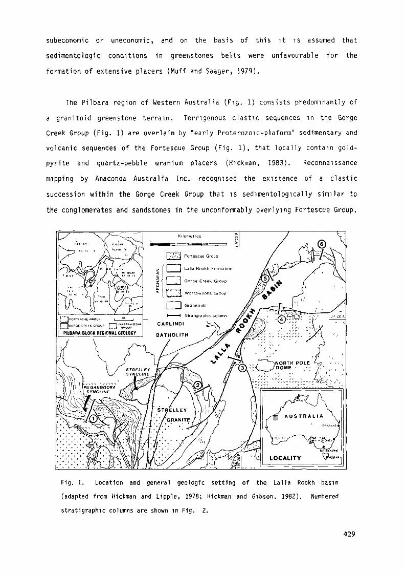
subeconomic or uneconomic, and on the basis of this it T s assumed thatsedimentologlc conditions in greenstones belts were unfavourable for theformation of extensive placers (Muff and Saager, 1979).
The Pilbara region of Western Australia (Fig. 1) consists predominantly ofa granitoid greenstone terrain. Terrigenous clastic sequences in the GorgeCreek Group (Fig. 1) are overlain by "early Proterozoic-plaform" sedimentary andvolcanic sequences of the Fortescue Group (Fig. 1), that locally contain gold-pyrite and quartz-pebble uranium placers (Hickman, 1983). Reconnaissancemapping by Anaconda Australia Inc. recognised the existence of a clasticsuccession within the Gorge Creek Group that is sedimentologically similar tothe conglomerates and sandstones in the unconformably overlying Fortescue Group.
PILBARA BLOCK REGIONAL GEOLOGY
Fig. 1. Location and general geologic setting of the Lalla Rookh basin(adapted from Hickman and Lipple, 1978; Hickman and Gibson, 1982). Numberedstratigraphie columns are shown in Fig. 2.
429
This clastic succession has potential for gold-pyrite placers because itunconformably overlies both the lower metavolcanic and upper metasedimentarysequence of the greenstone belt.
GEOLOGIC SETTING
The regional geology of the Pilbara is dominated by ovoid granite-gneissbodies with intervening greenstone belts (Fig. 1). The greenstones compriseshallowly dipping to tightly folded metavolcanic and metasedimentary sequencesthat are mainly of low internal strain and metamorphosed to lower greenschistfaciès (Barley j^t aï_ ., 1979). Both metamorphic grade and intensity ofdeformation in the greenstone sequences generally increase toward granite-gneisscontacts. Hickman (1983) proposed that the greenstones formed a regionallycontinuous sequence with only minor disconformities and unconformities. Theproblem of an original basement to the greenstone is unresolved. Bettenay et al(1981) have shown that the tectonic setting of granite-gneiss domes has been somodified by post-greenstone deformation and intrusive events, that evidence forearlier relationships is equivocal. Available geochronology is insufficient toresolve this basement controversy as older greenstones and gneisses have bothyielded ages between 3,400 Myr and 3,550 Myr (Hamilton et aj_., 1981; Bickle e_taK, 1983).
The greenstone sequence is divided into the lower, predominantlymetavolcanic Warrawoona Group, and overlying metasedimentary rocks of the GorgeCreek Group (Lipple, 1975). The Warrawoona Group consists of tholeiitic andkomatiitic lava sequences, and chemically distinct felsic dominated volcanic andvolcaniclastic rocks of calc-alkaline affinity (Barley et aj_., 1979). The GorgeCreek Group consists of conglomerate, sandstone, shale, iron-formation,tholeiitic and high-magnesium basalts, and dolerite and gabbro sills (Fig. 2).Mapping to the northeast and southwest of the Lalla Rookh Syncline (Fig. 1) byAnaconda (unpublished data) has shown that the contact between the Warrawoona
430

and Gorge Creek Groups 1s in part faulted and in part an unconformity. Recentwork within the Strelley and Pilgangoora Synclines (Fig. 1) has also shown thecontact to be an unconformity (H.R. Wilhelmij, pers. comm., 1983); this lendssupport to the arguement for a regional unconformity (e.g. Fitton et al 1975).
5-
1-
0J
6
'\ „-''" v
°Z--°-
i—~~_rv.~~-r-Z-IH L>
~-~-z~:I-2-d-I
;° ":
' ~x^'
M&'
•
Lalla RookhFormation
CleavervilleFormation
^ CorboyFormation
WarrawoonaGroup
0.DOCCoUJ
o
8
Conglomerates, sandstones and shales
Iron Formation, ferruginous sandstones and shales
Banded cherts tt + îl Mafic and ultramaflc sills Basalts
Fig. 2. Lithostratigraphic columns of the upper greenstone, metasechmentarysequence in the general vicinity of the Lalla Rookh basin, (adapted from Hickmanand Lipple, 1978; Fleming, 1982; Hickman, 1983). Refer to Fig. 1 for columnlocations.
Lipple (1975) proposed a three fold division of the Gorge Creek Group,which was later modified by Hickman (1984), into the Corboy, Cleaverville andLalla Rookh Formations (Fig. 2). Eriksson (1981, 1982a), utilising thisregional framework, concluded that the Gorge Creek Group was deposited in asingle craton-wide sedimentary basin, which developed on a passive, Atlantictype rifted continental margin. Mapping by Anaconda (unpublished data) andFleming (1982) has shown that the Lalla Rookh Formation, within its type area ofthe Lalla Rookh Syncline (Lipple, 1975), is unconformable on the remainder ofthe Gorge Creek Group (hereafter referred to as the lower Gorge Creek Group).
431
tipple (1975) and Hickman (1983) recognised the existence of this unconformity,but interpreted it to be of local significance only. However, structural,stratigraphie and sedimentologic interpretations (Krapez, in prep) indicate thatthe Lalla Rookh Formation, within the type area, was developed and deformedwithin a local basin that post-dated the lower Gorge Creek Group. Thestratigraphie term Lalla Rookh Formation should, therefore, be restricted inusage to the type area of the Lalla Rookh Syncline (Fig. 1) and not used as aPilbara-wide correlative until the same geologic relationships can be shown withthe lower Gorge Creek Group elsewhere.
Stratigraphie correlation between the Pilgangoora and Lalla Rookh Synclines(Fig. 2) shows the presence of a post-Cleavervilie, pre-Lalla Rookh clasticsequence. This sequence consists of conglomerates, sandstones, and shales thatwere deposited as turbidities on submarine fans (Eriksson, 1982b). In the LallaRookh Syncline, the Lalla Rookh Formation consists of conglomerates andsandstones that were deposited by braided streams (Eriksson, 1981). Recent work(Krapez, in prep; H.R. Wilhelmij, pers. comm., 1983) demonstrates that these twosequences are not chrono-facies equivalents as argued by Eriksson (1981, 1982a).
Exploration focussed on the Lalla Rookh Formation within the Lalla RookhBasin, although the basal Fortescue Group was also investigated. The LallaRookh basin is bounded by high-angle faults and unconformities with theWarrawoona Group, the lower Gorge Creek Group and the Fortescue Group (Fig. 1).The northwestern basin margin fault (hereafter referred to as the main boundaryfault abbreviated to MBF) which trends northeast-southwest (Fig. 1), is clearlyvisible on Landsat imagery. The MBF and associated faults, some of whichcontain ultramafic bodies intruded along them, can be traced southwards for 45km in the greenstone belts. Offsets of the Gorge Creek and Warrawoona Groupssouthwest of the basin suggest sinistral slip movement on the MBF and associatedfaults (Fig. 1). The southeastern margin fault south of the basin also shows asinistral strike-slip displacement (Fig. 1). An east-west orientated normalfault forms a basin re-entrant along the central part of the southeastern margin(Fig. 1).
432
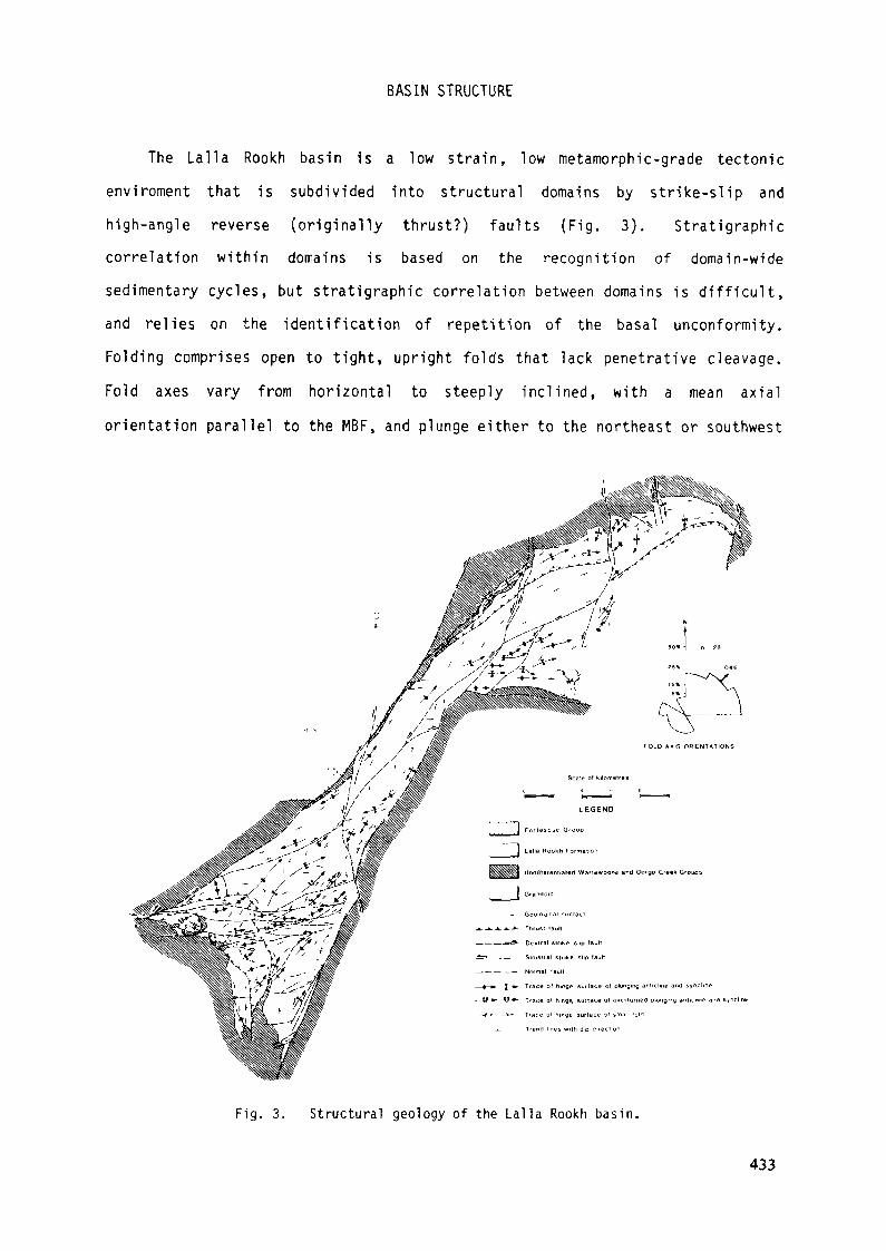
BASIN STRUCTURE
The Lalla Rookh basin is a low strain, low metamorphic-grade tectonicenviroment that is subdivided into structural domains by strike-slip andhigh-angle reverse (originally thrust?) faults (Fig. 3). Stratigraphiecorrelation within domains is based on the recognition of domain-widesedimentary cycles, but stratigraphie correlation between domains is difficult,and relies on the identification of repetition of the basal unconformity.Folding comprises open to tight, upright folds that lack penetrative cleavage.Fold axes vary from horizontal to steeply inclined, with a mean axialorientation parallel to the MBF, and plunge either to the northeast or southwest
Fig. 3. Structural geology of the Lalla Rookh basin.
433
(Fig. 3). A preliminary interpretation of the patterns of faulting and foldingwithin the basin (Fig. 3) suggests that basin deformation conforms to astructural model involving simple shear between strike-slip faults (see Harding,1974; Reading, 1980).
BASIN AGE
There has been no absolute age determination on the Lalla Rookh Formation,nor is there any unequivocal age for the formation relative to dated intrusiveor basement granitoids. The maximum age for the formation is ^a_ 3,450 Myr,based on the best estimates of the age of the Warrawoona Group (Pidgeon, 1978a;Hamilton _et jfL , 1981). The oldest granitic rocks in the east Pilbara are of aequivalent age to the Warrawoona Group (see Pidgeon, 1978b; Williams et al.,1983; Bickle e± a]_., 1983). The minimum age for the formation is £a_ 2,770 Myr,based on the best estimate of the Fortescue Group (Pidgeon, pers. comm. in Blake1984). Indirect evidence suggests that it is younger than, or synchronous with,late tectonic granitoids which range from ca_ 3,300 to 2,900 Myr (unpublisheddata, D.W.A.; N.J. McNaughton, pers. comm. 1983). These granitoids areinterpreted to be the probable source of detrital K-feldspar in the Gorge CreekGroup (see Eriksson, 1981).
BASIN STRATIGRAPHY
The maximum observed thickness of the Lalla Rookh Formation is 3,000 m,measured in northeastern and southwestern domains. The true maximum thicknessis unknown because of unresolved tectonic repetition, or elimination within thebasin, and the unconformable nature of the upper contact with the FortescueGroup. Basin fill thickness is asymmetric. Maximum thicknesses are adjacent tothe northwestern margin, decreasing to 1,000 m towards the southeastern margin.
The basin fill is dominated by sandstones which make up at least 85% of thetotal sequence. Conglomeates make up the major proportion of the remainder inthe southwestern half of the basin, whereas mudrocks are more abundant in thenortheast.
434
Lithostratigaphic mapping of the basin has been accomplished by identifyinglithofacies assemblages that are interpreted as depositional faciès. Severaltypes of sedimentary deposits are present (Fig. 4). The depositional faciès aearranged into stacked sedimentary packages, consisting mainly of braided-streamconglomerates and sandstones, that attain a maximum thickness of 200 m.Conglomerate packages fine upward and laterally into sandstone packages. Eachpackage has an erosional base and lies with slight angular discordance on theunderlying package. Telescoped sequences of conglomerates also record a variantof these basin wide cycles. They are strike and dip-persistent beds
10 m thick and also lie on a previous package with slight angular discordance.They are internally complex with numerous scour-surfaces and lenticularsandstones. These conglomerates record multiple, intraformational reworking ofan initial flood deposit.
Fig. 4. Distribution of depositional faciès in the Lalla Rookh basin. Arrowsindicate inferred directions of major sediment input.
PROVENANCE
Modal compositions of the Lalla Rookh Formation are presented in Fig. 5.Basal sections immediately overlying basement are lithic conglomerates andsandstones. Lithic components include: quartzite (metasandstone);iron-formation; chert (massive and laminated); silicified mafic-volcanic
435
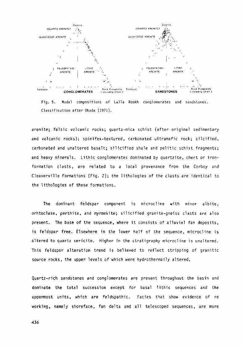
(QUARTZ ARENITE)
QUARTZOSE ARENITE
(QUARTZ ABENITE)
QUARTZOSE ARENITE /.;** /
Feldspar
» FELDSPATHIC LITHIC \
ARENITE ARENITE ' •'<
Rock Fragments FeldsparCONGLOMERATES ( including Chert )
, FELDSPATHIC LITHIC
ARENITE ARENITE
Rock FragmentsSANDSTONES ( including Chert )
Fig. 5. Modal compositions of Lalla Rookh conglomerates and sandstones.Classification after Okada (1971).
arenite; felsic volcanic rocks; quartz-mica schist (after original sedimentaryand volcanic rocks); spinifex-textured, carbonated ultramafic rock; silcified,carbonated and unaltered basalt; silicified shale and pelitic schist fragments;and heavy minerals. Lithic conglomerates dominated by quartzite, chert or iron-formation clasts, are related to a local provenance from the Corboy andCleaverville Formations (Fig. 2); the lithologies of the clasts are identical tothe lithologies of these formations.
The dominant feldspar component is microcline with minor albite,orhtoclase, perthite, and myrmekite; silicified granite-gneiss clasts are alsopresent. The base of the sequence, where it consists of alluvial fan deposits,is feldspar free. Elsewhere in the lower half of the sequence, microcline isaltered to quartz sericite. Higher in the stratigraphy microcline is unaltered.This feldspar alteration trend is believed to reflect stripping of graniticsource rocks, the upper levels of which were hydrothermal!y altered.
Quartz-rich sandstones and conglomerates are present throughout the basin anddominate the total succession except for basal lithic sequences and theuppermost units, which are feldspathic. Faciès that show evidence of reworking, namely shoreface, fan delta and all telescoped sequences, are more
436
quartz rich than the stratigraphically equivalent fluvial faciès. The quartzcomponent comprises various vein quartz varieties as pebbles, as well as variousmonocrystalline and polycrystalline grains; recrystallisation and overgrowthsare ubiquitous.
The phyllosilicate matrix of sericite-chlorite-pyrophyllite is alteredoriginal clay matrix. Diagenetic carbonates, ankeritic-dolomite and siderite,are present in some mudrocks, being preferentially conentrated on horizontal-,inclined- and cross-laminae and on scour bases, suggesting an originalpermeability control on carbonate diagenesis. Poor crystallinity of illite, andits presence instead of sericite, in some mudrocks, is additonal evidence of thelow grade of metamorphism.
In summary, vertical trends of provenance within the total stratigraphyinclude a change from lithic to quartzose to feldspathic sandstones.Additionally, microcline changes from altered to unaltered up stratigraphy.Superimposed on these variations are the effects of local provenance inbasin-margin, alluvial-fan faciès, which are more marked in basal sections. Thetrends are related to different provenances and dispersal systems. A moreregional trend towards a feldspathic composition suggests greater erosion ofgranitic terrain.
SEDIMENTOLOGY
Depositional faciès.
Depositional faciès, interpreted from both vertical and lateral lithofaciesassemblages, have a complex original distribution with abrupt lateral variationsfrom one type to another (Fig. 4). Recognition criteria, descriptions of thelithofacies and lithofacies codes (Table 1), lithofaceis assemblages (Fig. 6),and the interpretative framework presented here are based on the results of thebasin analysis (Krapez, in prep.).
437
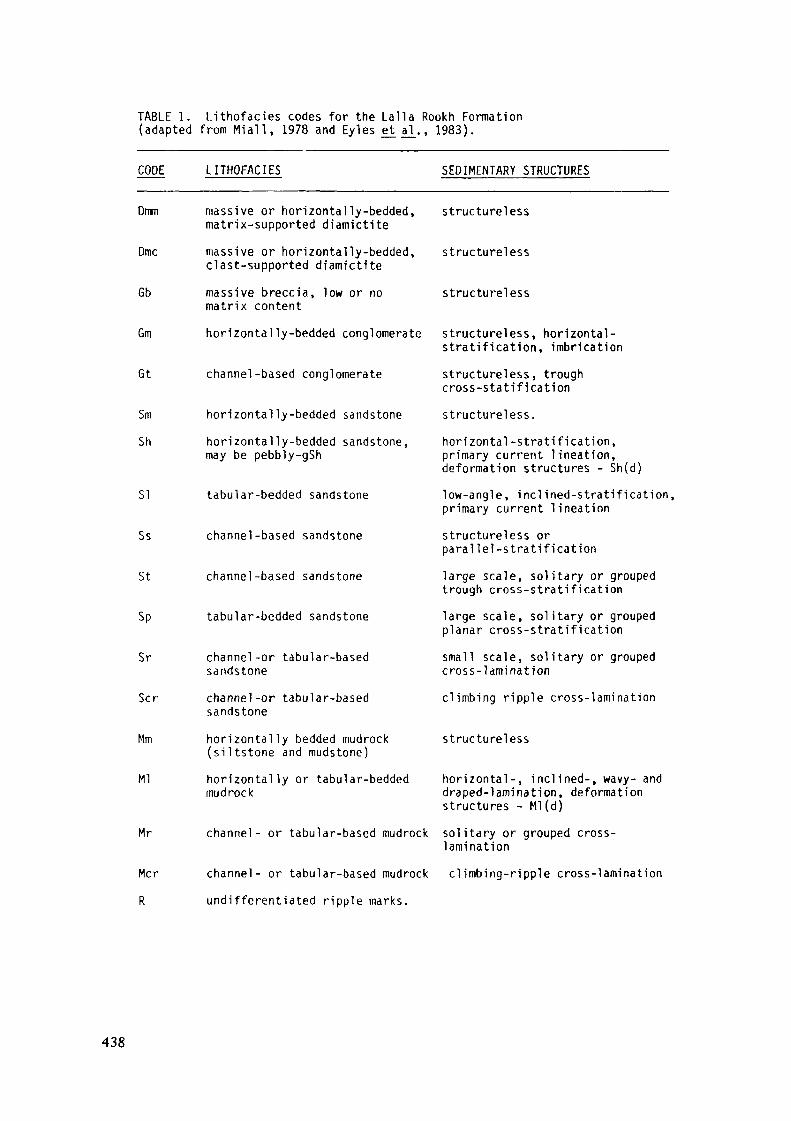
TABLE 1. Lithofacies codes for thé Lalla Rookh Formation(adapted from Miall, 1978 and Eyles e_t al., 1983).
CODE LITHOFACIES SEDIMENTARY STRUCTURES
Dmm massive or horizontally-bedded,matrix-supported diatnictite
Dmc massive or horizontally-bedded,clast-supported diamictite
Gb massive breccia, low or nomatrix content
Gm horizontally-bedded conglomerate
Gt channel-based conglomerate
Sm horizontally-bedded sandstoneSh horizontally-bedded sandstone,
may be pebbly-gSh
SI tabular-bedded sandstone
Ss channel-based sandstone
St channel-based sandstone
Sp tabular-bedded sandstone
Sr channel-or tabular-basedsandstone
Scr channel-or tabular-basedsandstone
Mm horizontally bedded mudrock(siltstone and mudstone)
Ml horizontally or tabular-beddedmudrock
Mr channel- or tabular-based mudrock
Mcr channel- or tabular-based mudrockR undifferentiated ripple marks.
structureless
structureless
structureless
structureless, horizontal-stratification, imbricationstructureless, troughcross-statificationstructureless.horizontal-stratification,primary current lineation,deformation structures - Sh(d)low-angle, inclined-stratification,primary current lineationstructureless orparallei-stratificationlarge scale, solitary or groupedtrough cross-stratificationlarge scale, solitary or groupedplanar cross-stratificationsmall scale, solitary or groupedcross-laminationclimbing ripple cross-lamination
structureless
horizontal-, inclined-, wavy- anddraped-lamination, deformationstructures - Ml(d)solitary or grouped cross-laminationclimbing-ripple cross-lamina tion
438
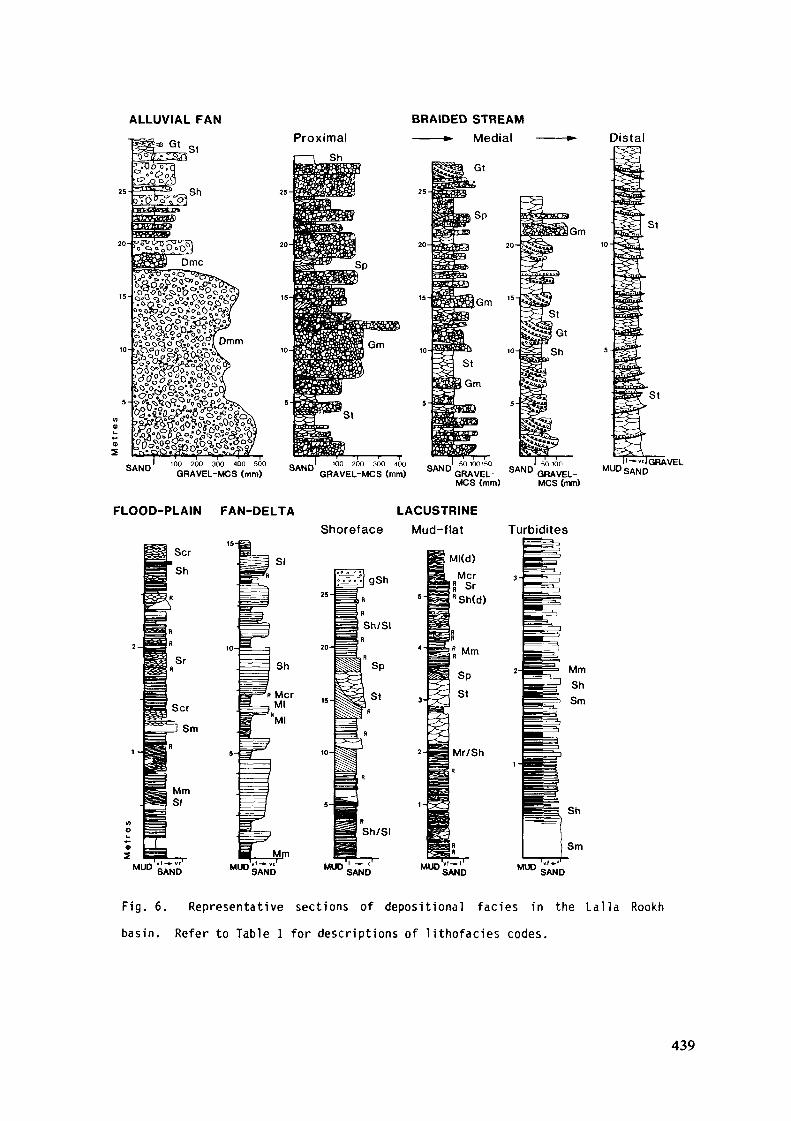
ALLUVIAL FAN
Gt
BRAIDED STREAMMedial Distal
SAND 100 200 300 400 500GRAVEL-MCS (mm) SAND
GRAVEL-MCS (mm) SAND GRAVEL-MCS (mm)
SAND GRAVEL-MCS (mm)
. I'~"1 GRAVELMUDSAND
FLOOD-PLAIN FAN-DELTA
Sr
LACUSTRINEShoreface Mud-flat
Ml(d)
Turbidites
Sh/SI
MUD SAND
Sh/SI
MUD
Mr/Sh
Sh
Sm
SAND MUD SA 'D
Fig. 6. Representative sections of depositional faciès in the Lalla Rookhbasin. Refer to Table 1 for descriptions of lithofacies codes.
439
Alluvial-fan faciès are localised on the basin margins or are structurallyemplaced into the basin by thrust fautls (Fig. 4). Alluvial-fan faciès consistchiefly of diamictites (faciès Dmm, Fig. 6) representing conglomeratic debris-flow and mud-flow deposits. Talus-slope deposits are represented by very thick(max. 20 m) breccias (faciès Gb) along the southwestern and northwestern marginsof the basin. Matrix-supported diamictites and breccias pass stratigraphicallyupwards and laterally into clast-supported, fluvially reworked deposits (facièsDmc-Sh couplets, Fig. 6).
Braided-stream deposits, which dominate the sedimentary fill (Fig. 4) passlaterally and up stratigarphy, from proximal conglomerates to distal sandstones(Fig. 6). Proximal to medial sequences have been distinguished by changes inmean maximum clast sizes, from 100 mm for proximal coarse conglomerates, to50-100 mm for proximal medium conglomerates and 50 mm for medial fineconglomerates. In conglomerate assemblages, faciès Gm represents longitudinalgravel bars, and associated faciès Sh, Sp and St represent bar-top sands, bar-edge sands and laterally equivalent, channel-sands, respectively (Rust, 1978).Faciès Gt in medial assemblages represents gravel dunes and channel fills (Rust,1978). In sandstone assemblages, facies-St cosets represent sand dunes inaggrading channels (Cant, 1978).
In the proximal, braided-stream setting a lateral, across-stream, variationhas been observed from a core of stacked faciès Gm to stacked Gm-Sh couplets.These couplets interfinger laterally with faciès Sh and Ss forming a"channel-bounding levee" which in turn passes laterally to stacked-facies St(Fig. 7). This lateral variation suggests that the braided streams consisted ofa core faciès (Boothroyd and Nummedal, 1978), which was the site of the mostactive bar and channel processes. Lateral migration of faciès is limited and"levees" are vertically stacked at core zone margins.
Flood-plain deposits of interbedded fine and very fine sandstones, andmudrocks interfinger laterally with distal braided-stream sandstones. In thenortheastern half of the basin, they interfinger with fan-delta and lacustrinedeposits (Fig. 4). Faciès Sh and SI form the dominant deposits, but faciès Sr,
440
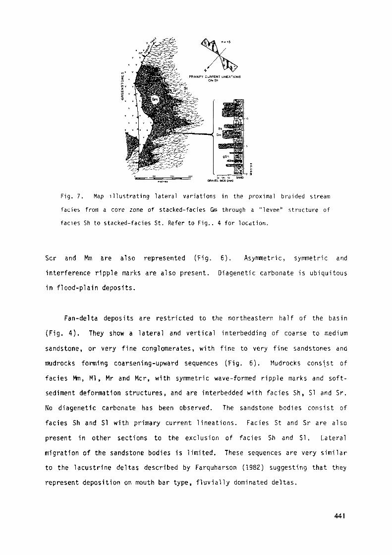
ORAVEL-MCS (im)
Fig. 7. Map i l lustrating lateral variations in the proximal braided stream
faciès from a core zone of stacked-facies Gm through a "levee" structure of
faciès Sh to stacked-facies St. Refer to Fig.. 4 for location.
Scr and Mm are also represented (Fig. 6). Asymnetric, symmetric and
interference ripple marks are also present. Diagenetic carbonate is ubiquitous
in flood-plain deposits.
Fan-delta deposits are restricted to the northeastern half of the basin
(Fig. 4). They show a lateral and vertical interbedding of coarse to medium
sandstone, or very fine conglomerates, with fine to very fine sandstones and
mudrocks forming coarsening-upward sequences (Fig. 6). Mudrocks consist of
faciès Mm, Ml, Mr and Mcr, with symmetric wave-formed ripple marks and soft-
sediment deformation structures, and are interbedded with fac iès Sh, SI and Sr.
No diagenetic carbonate has been observed. The sandstone bodies cons is t of
faciès Sh and SI with primary current l ineations. Faciès St and Sr are a lso
present in other sections to the exclusion of faciès Sh and SI. Lateral
migration of the sandstone bodies is limited. These sequences are very similar
to the lacustrine deltas described by Farquharson (1982) suggesting that they
represent deposition on mouth bar type, fluvially dominated deltas.
441

Lacustrine deposits are present in the northeastern portion of the basin(Fig. 4). Several subenvironments have ben distinguished (Fig. 6). Shorefacedeposits consist of faciès Sh and SI with primary current lineations andsymmetric wave-formed ripple marks. Other faciès present include channel -filling St sets and large, solitary sets of Sp which possibly representdeposition in Gilbert-type fan-delta channels (Farquharson, 1982). Shorefacefaciès are vertically stacked (max. 50 m). Mud flat deposits consist of acomplex interbedding of faciès Sh, Sr, Ml, Mm and Mcr with cross-cuttingchannel-fills of faciès St. Asymmetric, symmetric and interference, current andwave-formed ripple marks, and mudcracks are present on bedding surfaces. Soft-sediment deformation structures, ball and pillow structures, synsedimentarymicro-faults, mud volcanoes, dewatering pipes and bedding parallel fluidsationstructures are present in the mudrocks. These structures record the combinedeffects of rapid sediment overloading and earthquake shock (Hempton and Dewey,1983). Diagenetic carbonate is ubiquitous, and kerogen-rich laminae are alsopresent in the mudrocks. Deeper water (below wave base) lacustrine deposits arepoorly exposed but they appear to consist of two types: rhythmicallyinterlaminatd siltstones and claystones of faciès Ml, and fining upwardassemblages of faciès Sm-Sh-Mm representing thinly bedded turbidites. Theturbidite units range from 5 to 25 cm in thickness and grade from fine, orpebbly medium sandstones to massive mudrocks. No diagenetic carbonate have beenobserved in deeper water deposits.
Maximum clast size.
The largest observed clasts are located along the southwestern flank of thebasin, where boulders of chert and orthoquartzite up to 2 m long are present indiamictites, and along the northern margin of the basin where one boulder oforthoquartzite 5 m long was found in basal breccias (Fig. 8). These largeboulders represent blocks from the Corboy and Cleaverville Formations that slidor slumped down the uplifted basin margins. Maximim clast sizes are high along
442
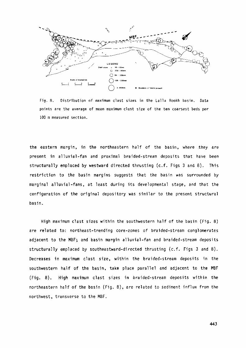
Boulder* > 1 metre prêtent
Fig. 8. Distribution of maximum clast sizes in the Lalla Rookh basin. Data
points are the average of mean maximum clast size of the ten coarsest beds per
100 m measured section.
the eastern margin, in the northeastern half of the basin, where .they are
present in alluvial-fan and proximal braided-stream deposits that have been
structurally emplaced by westward directed thrusting (c.f. Figs 3 and 8). This
restriction to the basin margins suggests that the basin was surrounded by
marginal alluvial-fans, at least during its developmental stage, and that the
configuration of the original depository was similar to the present structural
basin.
High maximum clast sizes within the southwestern half of the basin (Fig. 8)
are related to: northeast-trending core-zones of braided-stream conglomerates
adjacent to the MBF; and basin margin alluvial-fan and braided-stream deposits
structurally emplaced by southeastward-directed thrusting (c.f. Figs 3 and 8).
Decreases in maximum clast s ize, within the braided-stream deposits in the
southwestern half of the basin, take place parallel and adjacent to the MBF
(Fig. 8). High maximum clast sizes in braided-stream deposits within the
northeastern half of the basin (Fig. 8), are related to sediment influx from the
northwest, transverse to the MBF.
443
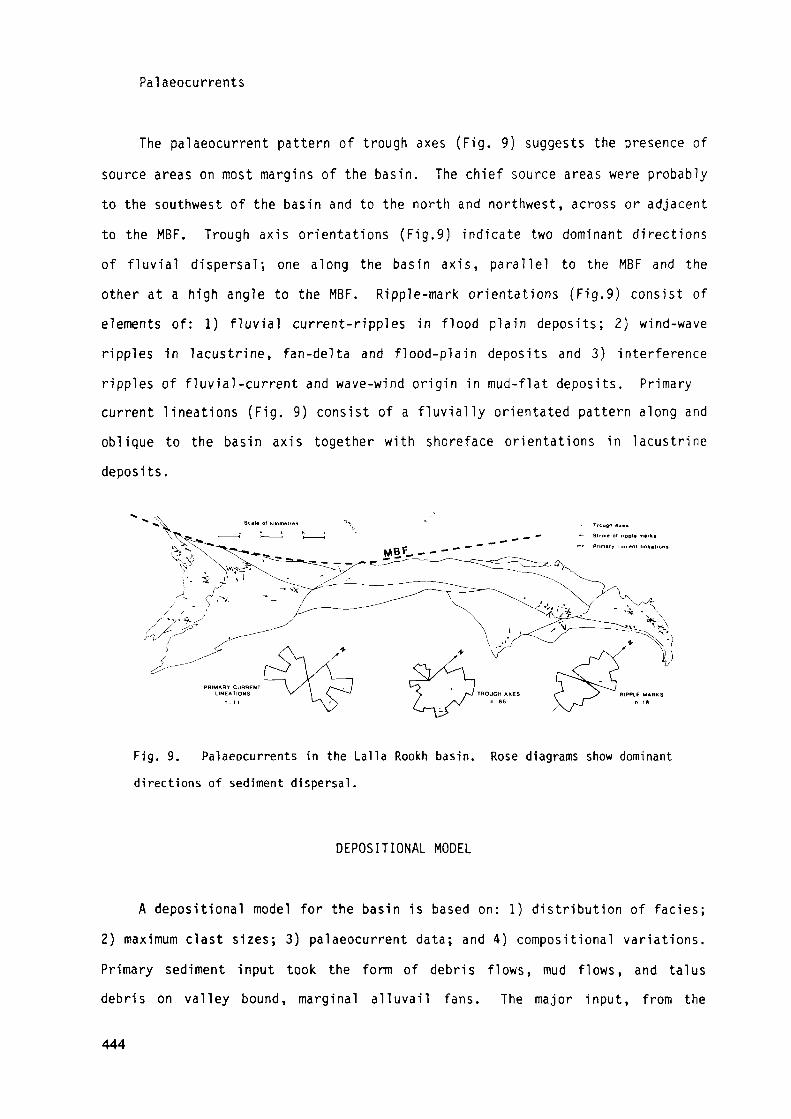
Palaeocurrents
The palaeocurrent pattern of trough axes (Fig. 9} suggests the presence ofsource areas on most margins of the basin. The chief source areas were probablyto the southwest of the basin and to the north and northwest, across or adjacentto the MBF. Trough axis orientations (Fig.9) indicate two dominant directionsof fluvial dispersal; one along the basin axis, parallel to the MBF and theother at a high angle to the MBF. Ripple-mark orientations (Fig.9) consist ofelements of: 1) fluvial current-ripples in flood plain deposits; 2) wind-waveripples in lacustrine, fan-delta and flood-plain deposits and 3) interferenceripples of fluvial-current and wave-wind origin in mud-flat deposits. Primarycurrent lineations (Fig. 9) consist of a fluvially orientated pattern along andoblique to the basin axis together with shoreface orientations in lacustrinedeposits.
RIPPLE MARKS
Fig. 9. Palaeocurrents in the Lalla Rookh basin. Rose diagrams show dominantdirections of sediment dispersal.
DEPOSITIONAL MODEL
A depositional model for the basin is based on: 1) distribution of faciès;2) maximum clast sizes; 3) palaeocurrent data; and 4) compositional variations.Primary sediment input took the form of debris flows, mud flows, and talusdebris on valley bound, marginal alluvail fans. The major input, from the
444

Southwest margin, was reworked by a braided stream flowing northeastwards alongthe basin axis (Fig. 10). Marginal input tranverse to the MBF in the southernhalf of the basin brought in sufficiently coarse debris to deflect the mainstream to the east, as reflected in the eastward-directed palaeocurrent pattern(Fig. 9). In the northeastern half of the basin distal portions of the mainstream interacted with a tributary stream network flowing transverse to thebasin margin. Sediment from both the longitudinal and transverse stream wastransported into a lake via fan delta complexes adjacent to extensive mud-flats(Fig. 10). Turbidity currents were generated by hyperpycnal flow, where the fandeltas entered into the lake, when stream discharges and/or lake levels werehigh.
Fig. 10. Depositional model for the Lalla Rookh basin.
TECTONIC FRAMEWORK
Miall (1982) proposed models for alluvial basin fill architecture whichrely on identification of the drainage pattern in proximal, medial and distalportions of the basin. Major criteria are whether the rivers are longitudinalor transverse to the main tectonic elements, and the nature of rivertermination, whether lake margin or delta. Using Miall's classification (hisTable 10), the dominant basin-fill pattern of the Lalla Rookh basin wastransverse fan-longitiudinal river-lake margin, with secondary patterns of
445
transverse fan transverse braidplain-lake margin, and transverse fan delta-lakemargin (Miall's models 1, 2 and 6). A second classification (Miall, 1982, hisTable 11), relating basin fill models to tectonic models, shows that thesebasin- fill patterns are present in intermontane grabens, and small pull-apartand fault-flank depression basins along strike slip fault zones.
Within the Lalla Rookh basin, evidence for syntectonic depositionassociated with active fault-margins is seen in the distribution of alluvial-fandeposits, and the abundant soft-sediment deformation structures in fine-graineddeposits. Stratigraphie and sedimentologic evidence that suggests a strike-slipfault model for basin, development includes: 1) intraformational, low angleunconformities; 2) great stratigraphie thickness relative to small basin area;3) the elongate shape of the basin parallel to the MBF; 4) basin-fill asymmetryof stratigraphy and faciès; 5) vertical stacking and limited lateral migrationof facies; and 6) the dominance of longitudinal in-filling (Reading, 1980; Steeland Gloppen, 1980; Hempton e£ a]_., 1983). The tectonic setting of the LallaRookh basin is apparently similar to that of small basins associated with strikeslip faults (e.g. Crowell, 1974a, 1974b, McLaughlin and Nilsen, 1982; Hempton et.aK , 1983).
To conclude, it is suggested that marginal strike-slip faulting controlledsource-area relief, the subsequent geometry of the depositional facies, andhence the overall configuration of the Lalla Rookh basin. The basin appears tohave initially formed as an east west depression along a northeast-trendingfault-zone. The basin was enclosed, at least during its developmental stage,and evidently evolved in a intracratonic setting.
BASIN MINERALISATION
Exploration Philosophy
The choice of the Lalla Rookh basin as a target for placer gold pyritedeposits was made following the recognition of a major unconformity at the baseof the Lalla Rookh Formation. The project evolved beyond initial theoretical
446
considerations when reconnaissance exploration discovered detrital sulphidemineralisation in outcropping conglomerates. Drilling targets were chosen fromthe results of geochemical sampling and field observations of mineralisationmade during 1:5,000 scale mapping. Potentially economic placers were chosen onthe basis of above average concentrations of detrital sulphides, high values ofCr, Ni, Cu, Co, Pb, Zn, Fe, and Ti, and anomalous values of Au.
Placer Mineralisation
Heavy-mineral concentrations are present in both conglomerates andsandstones. Pyrite is the most abundant heavy mineral although chromite is alsopresent in appreciable concentations. The coarsest clasts of pyrite, up to 2 cmdiameter, were observed in alluvial-fan and proximal braided-stream assemblages,decreasing to 1 mm or less in medial and distal braided stream assembalges.Chromite is restricted to grains approximately 1 mm in diameter. Pyrite isdisseminated in diamictites (Figs 11-1 and 11-2) and either concentrated onhorizontal-stratification (Figs 11-3 and 11-4) or disseminated (Fig. 11-5) inbraided-stream conglomerates. Pyrite and chromite concentrations are presenton, but not restricted to, basal scour-surfaces. Pyrite and chromiteconcentrations were observed: throughout beds of faciès Dmm and Dmc; throughoutstacked sequences of faciès Gm; within specific beds of faciès Gm and Gt instacked sequences; and in all faciès in telescoped sequences. Fine pyrite andchromite in sandstones are concentrated on horizontal-laminae in faciès Sh,(Fig. 11-6), on parallel-laminae in faciès Ss, and on scour bases and foresetsin faciès St (Figs 11-7 and 11-8) within braided-stream and lateral "levee"assemblages. Many of the conglomerates and sandstones, particularly in medialbraided-stream assemblages, are radioactive although uranium values, from bothsurface outcrop and drill core, are low ( 15ppm) in all samples.
Pyrite is altered to limonite at outcrop and grain morphologies areindistinguishable. Rounded detrital pyrite in drill core consists of several
447
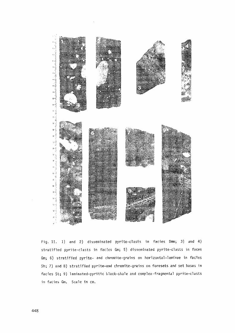
Fig. 11. 1) and 2) disseminated pyrite-clasts in fades Dim; 3) and 4)
stratified pyrite-clasts in faciès Gm; 5) disseminated pyrite-clasts in faces
Gm; 6) stratified pyrite- and chromite-grains on horizontal-laminae in faciès
Sh; 7) and 8) stratified pyrite-and chromite-grains on foresets and set bases in
faciès St; 9) laminated-pyritic black-shale and complex-fragmental pyrite-clasts
in faciès Gm. Scale in cm.
448
types including massive, concentrically zoned, fragmented (with or withoutseptarian structures), laminated, framboidal and porous varieties (Fig. 11);euhedral pyrite is also present. The range of morphologies is very similar tothat of syngenetic pyrite in Archaean black shales (W.O. Batt, pers. cornn.,1983); the presence of pyritic black-shale clasts (Fig. 11-9) is consistent withsuch an interpretation. Although pyrite concentrations are associated withconglomerates they are not necessarily associated with quartz-pebbleconglomerates. The coarsest pyrite is associated with basal diamictites thatwere derived from the Cleaverville Formation (Fig. 2), suggesting thatsulphide-facies iron formation (silicified pyritic black shale?) was a majorsource of pyrite. This interpretation diminishes the potential for gold placersas no significant gold mineralisation has been recorded from the CleavervilleFormation. Coarse grains of detrital chromite were probably derived fromlayered ultramafic intrusions because chromite grains up to 1 mm diameter arenot consistent with a provenance from mafic/ultramafic volcanics (Groves, etal., 1977). Jervis (1983) has identified coarse chromite grains (0.5-1 mm) in anultramafic layered intrusion in the lower Gorge Creek Group at Soansville (Fig1), suggesting that similar intrusions are a probable source of chromite in theLalla Rookh Formation.
Preliminary results of geochemical sampling were encouraging. Mostconglomerates and some sandstone beds recorded Au anomalies, but only a few bedswere of economic interest. High values of Cr, up to 6,000 ppm, were recorded insome conglomerates. Drilling results were disappointing because no economicallyexploitable placers were discovered. Geochemical results were very similar tothose on surface. Low Au values were associated with significant concentrationsof pyrite in drill core. Encouraging results were obtained from proximal coarseconglomerates, with above average Au values spread over 180 m of stackedsequences of faciès Gm.
In summary, detrital heavy mineral concentrations, primarily of pyrite andchromite, are largely confined to braided-stream, and alluvial-fan faciès.
449

Placers with the most gold potential are related to the main northeast-trendingcore-zone (braided stream, Fig. 10) in the southwestern half of the basin, butseveral marginally derived diamictites and conglomerates are also pyrite-rich.Interest is still focussed on the area because the full potential of the basinhas yet to be assessed.
Exploration Model
Exploration for gold-pyrite deposits within the Lalla Rookh basin hasoutlined the following criteria relevant to a general exploration model for suchdeposits in Archaean greenstone-belts. There should be no constraint onabsolute age of placer development, nor on sedimentologic grounds, should therebe any reason why the upper, clastic-sequences in greenstone belts have lesspotential than "early Proterozoic-platform" sequences.
The preferred tectonic setting for placer development in "earlyProterozoic- platform" successions is based on the Witwatersrand model, whichimplies an epeirogenic control on basin formation and sedimentation (lankard e±ai., 1982). Epeirogenic control is believed to have resulted inintraformational unconformities, fining-upward sequences and multiple reworkingto produce economic placers. However, fault-controlled basins can also producesynsedimentary tilting and reworking, and hence the potential to developeconomic placers on low angle, intraformational unconformities. For example,very rich gold placers in the Venterspost Formation overlying the WitwatersrandSupergroup were deposited in fault controlled basins (Minter, 1978; Krapez,1980; Tankard et al., 1982). The epeirogenic model should therefore beconsidered as one of a number of tectonic models rather than the preferredmodel.
Results of the basin analysis on the Lalla Rookh basin confirm that themost favourable depositional environment for gold-pyrite placers is a braided-
450
stream environment, with the most potential being in longitudinal-bar gravelsand gravel channel-fills. Recognition of a core-zone faciès within the braidedstream environment provides a faciès interpretation of the "pay streak" conceptin Witwatersrand-type deposits and focusses attention on the need to recognisecore zones due to their obvious economic potential. Basal units of finingupward sequences appear to have the most potential, particularly if they aretelescoped. Coarse conglomerates and vertically stacked sequences of braided-stream deposits may also hold gold potential, as they do in the VenterspostFormation (Krapez, 1980), the Beatons Creek Conglomerate of the Fortescue Group(T.S. Blake, pers. comm., 1983) and the Cenozoic deposits of the MagdalenaValley in Colombia (Van Houten and Travis, 1968; Henley and Adams, 1979).Diamictites, deposited by debris flows or as reworked debris flows, on alluvailfans or as pediment mantles, have the potential to be auriferous if they werederived from high-grade gold sources, as they were in the Venterspost Formation(Krapez, 1980). While it is true that the reworking of older placers willproduce economic gold placers (Henley and Adams, 1979), there is no doubt that,given rich gold-sources, economic placers will develop regardless of basinsetting, tectonic control, depositional environment or even depositionalprocess.
The major constraint on gold-pyrite placer development is the timing ofsedimentation relative to the evolution and exposure of potential gold-sources.The logical source of gold for placer deposits is from gold mineralisationwithin the greenstone belts. Knowledge of the timing of this mineralisation,and the crustal depths at which it formed, are vital considerations in theprediction of suitable provenance areas at any given time in basin evolution.Although there have been no detailed genetic studies of gold mineralisation inthe greenstone sequences of the east Pilbara, recent studies in the YilgarnBlock (Groves e£ aK, 1984; Phillips and Groves, 1983) indicate that many, ifnot all, gold lodes were deposited from metamorphic fluids in structural sitespenecontemporaneously with prograde metamorphism. Such mineralisation was
451
deposited at relatively high tempera turres (ca 350-450°C) and high pressures (ca1-2 kbar), indicating formation at considerable depths in greenstone sequences.Thus, prospective placers must post date this metamorphic event, which isassociated with one or more phases of upright folding and granitoid emplacement.Prospective clastic sequences must therefore lie with angular unconformity onsignificantly eroded earlier granitoid-greenstone terrain. Most clasticsequences in greenstone belts have undergone multiple deformation eventscomparable to those in the greenstones (e.g. at Barberton, see Ramsay, 1963),and lie on greenstone sequences of comparable metamorphic grade.
The Lalla Rookh Formation is unconformable on older greenstones andsedimentary sequences, and appears to post-date at least one fold generation inthe lower Gorge Creek Group. Clasts in the conglomerates indicate thatsedimentation post-dated an earlier alteration (silicification, sericitisationand carbonation) in the greenstone sequences, and also post-dated a metamorphicfoliation in deformed, intrusive granitoids and felsic schists adjacent toand/or intercalated within a terrain similar to the Shaw Batholith (Fig 1).There is however, no unequivocal evidence for a major metamorphic hiatus priorto deposition of the Lalla Rookh Formation, as there is apparently no markedcontrast in metamorphic grade between it and the underlying lithologies, and nodemonstrably high metamorphic-grade lithologies present in clasts.
Finally, the known gold-production from potential source-rocks, in thiscase greenstone sequences, can be used as a regional guide to exploration.Greenstone belts are normally highly anomalous in gold content. For example,calculations of gold production in terms of surface area of exposed greenstonesindicate the following: Eastern Goldfields Province, Western Australia - 32kgAu/km2, Murchison and Southern Cross Provinces, Western Australia - 16kgAu/km2, Zimbabawe - 72 kgAu/km2, Barberton Mountains Land, South Africa - 50kgAu/km2 (Krapez and Groves, in press). In contrast, the Pilbara has produced1 kgAu/km2 of greenstone, despite good exposure and excellent exploration
452
conditions. This could reflect a genuine lack of gold mineralisation, dueperhaps to early alteration and/or tectonic style of the east Pilbara (e.g.Groves e_t a]_., 1984), or lack of exposure of suitably deep levels of greenstonein which gold deposits are present. In either case, the data suggest thatPilbara greenstones have an anomalously low-gold concentration for a greenstoneterrain. The final conclusion must be that the Pilbara basically has a poorpotential to develop major gold placers in either clastic sequences in thegreeenstone belts or in "early Proterozoic-platform" sequences.
CONCLUSIONS
The results of exploration in the Lalla Rookh basin provide a case historyfor future exploration of other potentially interesting basins. All theobtainable geologic data has been integrated in a multidisciplarybasin-analysis. The results have provided insights, not only into the geologicconditions necessary to develop Archaean gold-pyrite placers, but also into thestratigraphie, sedimentologic and tectonic setting of late clastic sequences ingreenstone belts of the Pilbara. It is hoped that these results may be usefullyapplied to other Archaean basins and greenstone-belts.
The main conclusion to be drawn from the investigation is that the primarycontrolling factor in generating economic gold-placers in greenstone belts isthe timing of exposure of primary gold-mineralisation. With regards to thegreenstone belts of the Pilbara, a second limiting factor is the -low overallprimary gold-potential of the greenstone. Other criteria, such as basintectonic setting, dispersal systems, depositional environments, depositionalprocesses or fine details of placer channel-morphology, are important only whena gold-rich provenance is proven.
ACKNOWLEDGEMENTS
One of us (B.K) gladly acknowledges the receipt of a field grant forlogistic support from Anaconda Australia Inc., financial support from anAustralian National University Ph.D. Scholarship, and a Commonwealth of
453
Australia Postgraduate Research Award; logistic support from the University ofWestern Australia; and academic supervision from David Groves (at U.W.A.) andLew Gustafson (formerly at A.N.U). Doug Dünnet, Peter Walker, Jim Cran and MikeBanks are acknowledged for their geologic input into the project. Themanuscript was improved by David Groves, Warren Batt and Tim Blake. The paperis published with the permission of Anaconda Australia Inc.
REFERENCES
ANHAEUSSER, C.R. (1976) The nature and distribution of Archaeangold-mineralization in southern Africa. Miner. Sei. Eng., 8, 46-84.
BARLEY, M.E., DUNLOP, O.S.R., GLOVER, J.E. & GROVES, D.I. (1979) Sedimentaryevidence for an Archaean shallow-water volcanic-sedimentary faciès, easternPilbara Block, Western Australia. Earth Planet. Sei. Lett.. 43, 74-84.
BETTENAY, L.F., BICKLE, M.J., BOULTER, C.A., GROVES, D.I., MORANT, P., BLAKE,T.S. & JAMES, B.A. (1981) Evolution of the Shaw Bathol ith - an Archaeangranitoid-gneiss dome in the eastern Pilbara, Western Australia. Geol. Soc.Aust., Spec. Pub!, 7, 361-372.
BICKLE, M.J., BETTENEY, L.F., BARLEY, M.E., CHAPMAN, H.J., GROVES, D.I.,CAMPBELL, I.H., & DE LAETER, J.R. (1983) A 3500 Ma plutonic and volcaniccalc-alkaline province in the Archaean east Pilbara Block. Contrib.Mineral. Petrol.. 84, 25-35.
BLAKE, T.S. (1984) Evidence for stabilization of the Pilbara Block, Australia.Nature. 307, 721-723.
BOOTHROYD, J.C. & NUMMEDAL, D. (1978). Proglacial braided outwash; a model forhumid alluvial-fan deposits. Can. Soc. Pet.Geol.,Mem., 5, 641-668.
454
CANT, D.J. (1978) Development of a faciès model for sandy braided riversedimentation: comparison of the South Saskatchewan River and the BatteryPoint Formation. Can. Soc. Pet. Geol., Memo., 5, 627-639.
CROWELL, J.C. (1974a) Sedimentation along the San Andreas Fault, California.Soc. Econ. Paleontol. Mineral., Spec. Pub!., 19, 292-303.
CROWELL, J.C. (1974b) Origin of Late Cenozoic basins in southern California.Soc Econ. Paleontol. Mineral.. Spec. Pub!., 22, 190-204
ERIKSSON, K.A. (1981) Archaean platform-to-trough sedimentation, east PilbaraBlock, Western Australia. Geol. Soc. Aust., Spec. Publ. 7, 235-244.
ERIKSSON, K.A. (1982a) Sedimentation patterns in the ßarberton Mountain Land,South Africa, and the Pilbara Block, Australia; evidence for Archaeanrifted continental margins. Tectonophysics, 91, 179-193.
ERIKSSON, K.A. (1982b) Geometry and internal characteristics of Archaeansubmarine channel deposits, Pilbara Block, Western Australia. J. Sediment.Petrol.. 52, 383-393.
EYLES, N., EYLES, C.H. & MIALL, A.D. (1983) Lithofacies types and verticalprofile models; an alternative approach to the description andenvironmental interpretation of glacial diamict and diamictite sequences.Sedimentology. 30, 393-410.
FARQUHARSON, G.W. (1982) Lacustrine deltas in a Mesozoic alluvial sequence fromCamp Hill, Antarctica. Sedimentology. 29, 717-725.
FITTON, M.J., HORWITZ, R.C. & SILVESTER, G. (1975) Stratigraphy of the EarlyPrecambrian in the west Pilbara, Western Australia. CSIRO MaterialsResearch Laboratories, Division of Mineralogy Report FP11.
455
FLEMING, B.S. (1982) The sedimentology structure and stratigraphy of the GorgeCreek Group, northern Lai la Rookh Syncline, eastern Pilbara. UnpublishedB.Sc. Hons thesis, Uni v of West. Aust., Perth.
GROVES, D.I., BARRETT, P.M., BINNS, R.A. & MCQUEEN, K.G. (1977) Spinel phasesassociated with metamorphosed volcanic-type iron-nickel sulfide ores fromWestern Australia. Econ. Geol., 72, 1224-1244.
GROVES, D.I., PHILLIPS, G.N., HO, S.E., HENDERSON, C.A., CLARK, M.E. & WOARD,G.M. (1984) Controls on distribution of Archaean hydrothermal gold depositsin Western Australia. Geol. Soc. Zimbabwe, Spec. Pub!., 1, 689-712
HAMILTON, P.O., EVENSEN, N.M., O'NIONS, R.K., GILKSON, A.Y. & HICKMAN, A.H.(1981) Sm-Nd dating of the North Star Basalt, Warrawoona Group, PilbaraBlock, Western Australia. Geol. Soc. Aust., Spec. Pub!., 7, 187-192.
HARDING, T.P. (1974) Petroleum traps associated with wrench faults. Am. Assoc.Pet. Geol.. Bull., 58, 1290-1304.
HEMPTON, M.R. & DEWEY, J.F. (1983) Earthquake - induced deformational structuresin young lacustrine sediments, East Anatolian Fault, southeast Turkey.Tectonophysics,, 98, T7-T14.
HEMPTON, M.R., DÜNNE, L.A. & DEWEY, J.F. (1983) Sedimentation in an activestrike-slip basin, southeastern Turkey. J. Geol., 91, 401-412.
HENLEY, R.W. & ADAMS, J. (1979) On the evolution of giant gold placers. Inst.Min. Metall., Trans., 88, B41-50.
HICKMAN, A.H. (1983) Geology of the Pilbara Block and its environs. West. Aust.Geol. Surv., Bull., 127.
456
HICKMAN, A.H. & GIBSON, D.L. (1982) Port Hedland - Bedout Island,Western Austrlaia - 1:250,000 Geological Series. West. Aust. Geol. Surv.,Explan. Notes.
HICKMAN, A.H. & LIPPLE, S.L (1978) Marble Bar, Western Australia - 1:250,000Geological Series, West. Aust. Geol. Surv., Explan. Notes.
HOUSTON, R.S. & KARLSTROM, K.E. (1979) Uranium-bearing quartz-pebbleconglomerates: exploration model and United States resource potential.U.S. Pep. Energy, Univ. of Wyoming, Laramie.
JERVIS, M. (1984) Petrology, chemistry and petrogenesis of two layeredintrusions near Soansville, in the east Pilbara Block, Western Australia.Upublished B.Sc Hons thesis, Univ. of West. Aust., Perth.
KRAPEZ, B. (1980). A sedimentological study of the Ventersdorp Contact Reef atEast Driefontein Gold Mine, Carletonvi I le, South Africa. UnpublishedM.Sc. thesis, Univ. of the Witwatersrand, Johannesburg.
KRAPEZ, B. (in prep). Basin analysis and economic potential of the Lalla RookhFormation: a late Archaean fault-bound clastic sequence, east PilbaraBlock, Western Australia. Ph.D. thesis, Univ of West. Aust., Perth.
KRAPEZ, B. & GROVES D.I. (in press) Gold mineralisation potential of Archaeanclastic sequences in the east Pilbara Block, Western Australia. In:Archaean and Proterozoic Basins of the Pilbara, Western Australia:Evolution and Mineralization Potential (Ed. by J.R. Muhling, D.I. Groves& T.S. Blake). Univ. West. Aust. Geol. Pep. & Extension Service, Pub!. 9.
LIPPLE, S.L. (1975) Definitions of new and revised stratigraphie units of theeastern Pilbara Region. West Aust. Geol. Surv., Ann. Rept. for 1974.58-63.
457
McLAUGHLIN, R.J. & NILSEN, T.H. (1982) Neogene non-marine sedimentation andtectonics in small pull-apart basins of the San Andreas fault system,Sonoma County, California. Sedimentology, 29, 865-876.
MIALL, A.D. (1978) Lithofacies types and vertical profile models in braidedrivers: a summary. Can. Soc. Pet. Geol., Mem., 5, 597-604.
MIALL, A.D. (1982) Analysis of fluvial depositional systems. Am. Assoc. Pet.Geol., Education Course Note Series, 20.
MINTER, W.E.L. (1978) A sedimentological synthesis of placer gold, uranium andpyrite concentrations in Proterozoic Witwatersrand sediments. Can. Soc.Pet. Geol.. Mem.. 5, 801-829.
MUFF, R. & SAAGER, R. (1979) Pétrographie and mineragraphic investigations ofthe Archaean gold placer at Mount Robert in the Pietersburg greenstonebelt, northern Transvaal. Geol. Soc. S. Afr., Spec. Pub!., 6, 23-31
OAKDA, H. (1971) Classification of sandstone: analysis and proposal. J. Geol.,79, 509-525.
PHILLIPS, G.N. & GROVES, D.I. (1983) The nature of Archaean gold-bearing fluidsas deduced from gold deposits of Western Australia. J. Geol. Soc. Aust.,30, 25-39.
PIDGEON, R.T. (1978a) 3450 m.y. old volcanics in the Archaean layered greenstonesuccession of the Pilbara Block, Western Australia. Earth Planet. Sei.Lett., 37, 421-428.
458
PIDGEON, R.T. (1978b) Geochronological investigations of granite batholiths ofthe Archaean granite greenstone terrain of the Pilbara Block, WesternAustralia. Proceedings 1978 Archaean Geochemistry Conference, Toronto,Univ. of Toronto, 360-362.
RAMSAY, J.G. (1963) Structural investigations in the Barberton Mountain Land,eastern Transvaal. Geol. Soc. S. Afr., Trans, 66. 353-401.
READING, H.G. (1980) Characteristics and recognition of strike-slip faultsystems. Int. Assoc. Sedimentol., Spec. Pub!., 4, 7-26.
RUST, B.R. (1978) Depositional models for braided alluvium. Can. Soc. Pet.Geol.. Mem., 5, 605-625.
STEEL, R.J. & GLOPPEN, T.G. (1980) Late Caledonian (Devonian) basin formation,western Norway: signs of strike-slip tectonics during infilling. Int.Assoc. Sedimentol, Spec Pub!., 4, 79-103.
TANKARD, A.O... JACKSON, M.P.A., ERIKSSON, K.A., HOBDAY, O.K., HUNTER, D.R. &MINTER, W.E.L., (1982) Crustal Evolution of Southern Africa. SpringerVerlag, New York.
VAN HOUTEN, F.B. & TRAVIS, R.B. (1968) Cenozic deposits, upper Magdalena Valley,Colombia. Am. Assoc. Pet. Geol., Bull., 52, 675-702.
WILLIAMS, I.S., PAGE, R.W., FROUDE, D., FOSTER, J.J. & COMPSTON, W. (1983) Earlycrustal components in the Western Australian Archaean: Zircon U-Pb ages byion microprobe analysis from the Shaw Batholith and Narryer metamorphicbelt. Geol. Soc. Aust. Abstr. Ser. 9, 169-171.
459
Copyright © 2022 FDOKUMEN