Oppenheim conjecture for pairs consisting of a linear form and a quadratic form
Upload
khangminh22Category
view
2download
0
TRANSMITTALS TOTO AGENCIES FOR COMMENTS ONDEVELOPMENT PROJECTS WITH THE CITY OF MERIDIAN
Mayor Tammy de Weerd
City Council Members: Keith Bird
Joe Borten
Charles Rountree
David Zaremba
To ensure that your comments and recommendations will be considered bythe Meridian Planning and Zoning Commission please submit your
comments and recommendations to Meridian City Hall
Attn: Jaycee Holman, City Clerk, by: May 26, 2015
Transmittal Date: May 12, 2015 File No.: PP 15- 008
Hearing Date: June 4, 2015
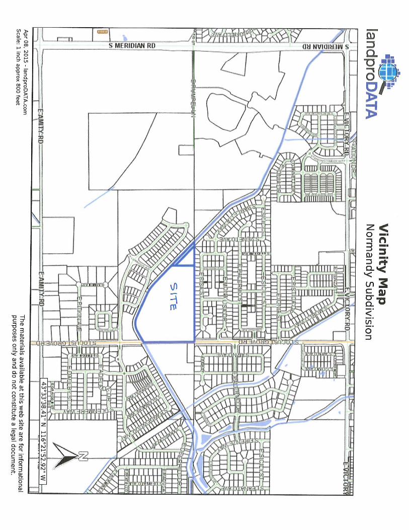
Request: Public Hearing: Preliminary Plat approval consisting of 110 building lotsand 9 common lots on 26. 93 acres of land in an R-8 zoning district forNormandv Subdivision
By: SchultzLocation of Property or Project: 4145 S. Locust Grove Road
Ryan Fitzgerald ( No FP)
Gregory Wilson ( No FP) Steven Yearsley ( No FP) Patrick Oliver (No FP)
Rhonda McCarvel ( No FP)
Tammy de Weerd, MayorCity CouncilSanitary ServicesBuilding Department/ Rick JacksonFire Department
Police Department
City AttorneyCity Public WorksCity PlannerParks Department
T Economic Dev.
Your Concise Remarks:
Meridian School District
Meridian Post Office
Ada County Highway DistrictAda County Development ServicesCentral District Health
COMPASS
Nampa Meridian Irrig. DistrictSettlers Irrig. DistrictIdaho Power CompanyQwest
Intermountain Gas Co.
Idaho Transportation Dept.
Ada County Ass. Land RecordsDowntown Projects:
Meriden Development Corp. Historical Preservation Comm.
South of RR / SW Meridian:
NW Pipeline
New York Irrigation District
Boise- Kuna Irrigation District
Boise Project Board of Control/ Tim Page
City Clerk' s Office • 33 E. Broadway Avenue, Meridian, ID 83642Phone 208- 888-4433 • Fax 208-888-4218 * www.meridiancity.org

E IDIAN- IOAFlO
Planning DivisionDEVELOPMENT REVIEW APPLICATION
STAFF USE ONLY: 1
Filenutname:. t.
V—I - M- AN b1A/1
File number( s): Q Ir.
Assigned Planner: Related files: AZ- o(a- O(o't
Type of Review Requested ( check all that apply) Accessory Use Planned Unit Development
Administrative Design Review Preliminary PlatAlternative Compliance Private Street
Annexation and Zoning Property Boundary AdjustmentCertificate ofZoning. Compliance Rezone
Comprehensive Plan Map Amendment Short Plat
Comprehensive Plan Text Amendment Time Extension:
Conditional Use Permit Director/ Commission/ Council (circle one) Conditional Use Modification UDC Text Amendment
Director/Commission (circle one) Vacation:
Development Agreement Modification Director/ Council (circle one)
Final Plat Variance
Final Plat Modification Other
Applicant Information
Applicant name: Schultz Development Phone: ( 208) 880-1695Applicant address: PO Box 1115 E • 1. [email protected]
City: Meridianmat .
State: ID Zip: 83680
Applicant' s interest in property: Own Rent Optioned Mother Representative
Owner name: James D. Patterson
Owner address: 9362 W. Wichita Street
City: Boise
Phone: ( 208) 870-5993
Email: jim_ [email protected]
State: ID Zip: 83709
Agent/Contact name (e. g., architect, engineer, developer, representative): Matt SchultzFirm name: Schultz Development Phone: ( 208) 880- 1695
Owner address: PO Box 1115 Email: [email protected]
Oily. Meridian State: ID Zip: 83680
Primary contact is: O Applicant Owner + Agent/Contact
Subject Property Information
Location/ street address: 4145 S. Locust Grove Road Township, range, section: 3N 1 E Sec 30Assessor' s parcel number( s): S1130427850, S1130427800 Total acreage: 26.93 Zoning district: R-8
5 11-.,, 044, 300
Community Development Planning Division 33 E. Broadway Avenue, Ste. 102 Meridian,. Idaho 83642Phone: 208- 884- 5533 Fax: 208-888. 6854 www.meridiancit yLorp/olanning
I- ( Rev. 06112/ 2014)

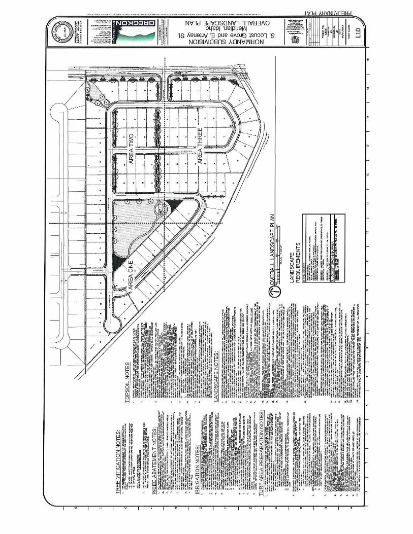
Project/subdivisionname: Normandy Subdivision
General description of proposed project/request: 110 Residential Lots and 9 Common Lots in an existingR-8 zone. Previously Approved Preliminary Plat had 110 Residential Lots ( PP -06-065)
Proposed zoning district(s): R-8Acres of each zone proposed: 26.93
Type ofuse proposed (check all that apply):
0 Residential Office Commercial Employment Industrial Other
Who will own & maintain the pressurized irrigation system in this development? NMID
Which irrigation district does this property lie within? NMIDPrimary irrigation source: NMID Secondary: CitySquare footage of landscaped areas to be irrigated (if primary or secondary point of connection is City water): 132, 020 SF
Residential Project Summary (if applicable)
Number of residential units: 110 Number of building lots: 110Number of common lots: 9 Number of other lots: NA
Proposed number of dwelling units (for multi -family developments only):
1 bedroom: 2- 3 bedrooms: 4 or more bedrooms:
Minimum square footage of structure (excl. garage): 1300-2800 SF Maximum building height: 35' Minimum property size ( s.t): 5;259 -SF 5, 1 Q SF Average property size ( s.f.): 6-,&2" F
Gross density (Per UDC 11 - IA -1): 4. 1 DU/AC Net density ( Per UDC I I- IA- 1): -&.+ DU/AC ( p
Acreage of qualified open space: 2.8 Acres Percentage ofqualified open space: 10.4%
Type and calculations of qualified open space provided in acres (Per UDC 11 - 3G -3B): 2 AC park and pathwaysand 1/ 2 Locust Grove Buffer
Amenities provided with this development (if applicable): 2 ac park with playground and connecting paths
Type of dwelling(s) proposed: + Single-family Detached Single-family Attached Townhouse
Duplex Multi -family Vertically Integrated Other
Non-residential Project Summary (ifapplicable)
Number ofbuilding lots: _
Gross floor area proposed:
Hours of operation ( days and hours):
Total number of parking spaces provided:
Authorization
Print applicant name: Matt Schultz
Applicant signature:
Common lots: Other lots:
Existing (if applicable):
Building height:
Number of compact spaces provided:
Date:
Community Development Planning Division 33 E. Broadway Avenue, Ste. 102 Meridian, Idaho 83642Phone: 208- 884- 5533 Fax: 208- 888- 6854 www.mcridiancitv.orc/planning
2- ( Rev. 06/12/2014)
oiSIS SF

May 4, 2015
City of MeridianPlanning and Zoning Commission and City Councilc/o City ofMeridian Planning Department33 E. Broadway AvenueMeridian, ID 83642
KE: Normandy SubdivisionPreliminary Plat Applications
Dear Commissioners and City Council Members:
On behalf of Schultz Development, LLC please accept this application for a preliminary platfor the Normandy Subdivision located at 4145 S. Locust Grove Avenue. We are requestinga preliminary plat for 110 building lots and 9 common lots on 26.93 acres in an existing R-8zone.
Zoning
The property was annexed in the City of Meridian with R-8 zoning (AZ 06- 064) on March27, 2007 with an accompanying preliminary plat (PP 06-065) for the original NormandySubdivision. The preliminary plat has expired, however, the R-8 zoning remains on theproperty.
The Meridian Comprehensive Plan and Future Land Use Map indicate Medium DensityResidential (MDR) with a density range of 4 to 8 dwelling per acre for this area. Theproposed density for the Normandy Subdivision is 4. 1 units per acre. Existing subdivisionswith R-8 zoning are located immediately north and south of the property.
Sewer Service
The Normandy Subdivision will be serviced by an existing 12 -inch sewer main in LocustGrove Road and 8 -inch main located in the Chatsworth Subdivision to the north.
Water Service
The Normandy Subdivision will be serviced by an existing 12 -inch sewer main in LocustGrove Road and 8 -inch main located in the Chatsworth Subdivision to the north.
Pressure Irrigation
Primary pressure irrigation will be provided by Nampa -Meridian Irrigation District (NMID) via a new pump station in the SE corner of the site at the Ridenbaugh Canal.

Roadways and Storm Drainage
The site is immediately accessible by S. Locust Grove Road and S. Picasso Avenue withadequate access for 110 lots. ACHD will not require a new Traffic Impact Study beyond theoriginal approval for 110 lots in 2007 in a similar configuration.
The City of Meridian Fire Department has approved a 33 -foot -wide (back to back of curb) within a 45' right-of-way for this site.
Storm drainage will be mitigated by an underground seepage bed in accordance with ACHDdesign criteria located in the parking lot area. The attached geotechnical evaluationindicates groundwater below 10 feet on the northern portion of the site where seepage bedswill be located.
Subdivision Design — Special Features
The Normandy Subdivision includes a centrally located 1. 8 acre park including aplayground amenity and interconnecting landscaped pathways are designed for directpedestrian access to Locust Grove Road in 2 locations leading directly to the park.
Architecture
We have attached photos of a housing products similar to those proposed for the NormandySubdivision with varied front facades and quality finishes that will fit on 50' wide lots (2 -cargarage) and 60' wide lots ( 3 -car garage) with home sizes ranging from 1, 300 SF — 2,800 SF.
Variances
The site design for the Normandy Subdivision exceeds the minimum requirements of the R- 8 zoning ordinance and no variances are requested with this application.
Summary
The proposed preliminary plat application for the Normandy Subdivision carefullyconsidered all aspects of the Meridian Zoning Ordinance, the Meridian Comprehensive Plan, site location, surrounding neighborhoods, and the housing market in Meridian to develop ahigh-quality residential development that exceeds. We respectfully request your approval ofthese applications.
Sincerely,
Matt Schultz
Schultz Development LLC
Attachments: Preliminary Plat ApplicationSubmittal Fee

A Pimmaer Cornps,
PIONEER TITLE COMPANYOF ADA COUNTY
8151 W. Rifleman Ave 7 Boise, Idaho 83704 I ( 208) 377- 2700
WARRANTY DEEDINDIVIDUAL)
FOR VALUE RECEIVED JOHN DARREL STIKES, AKA JOHN STIKES, AN UNMARRIED PERSON
Granmr , does hereby grant, bargain, sell and convey unto JAMES DARE PATTERSON, AN UNMARRIEDPERSON
the Grantee , whose current address is: 9362 W. WICHITA STREET, BOISE-, ID 83709the following described real property in ADA County, Smteofidnho, moreparticulary, described asfollows, to -wit: -
SEE ATTACHED " EXHIBIT A", WHICH BY THIS REFERENCE BECOMES A PART HEREOF, ANDWH. GFf- d3—CO [`PRISED OF ONE ( 1) PAGB.
RESERVING IN JON DARREL STIKES A LIFE ESTATE IN, AND THE USE AND ENJOYMENT OF, THE RESIDENCE HO BE AND BARN SITUATE ON THE ABOVE DESCRIBED PREMISES, DURING THELIFETIME OP JO DARREL STIKES.
RECORDED• REDUEST OF
ACJ. DAVID NAV4A4JBOISE, IDAHO FEEa DEPUTY
vl.ef,#01 999SP29 PH 4! 23 98093218
rf,
A-p IV - J A1j ! 5,3A
TO HAVE AND TO HOLD the said premises, with their appurtenances unto the said Grantee , and Grantee hairsand assigns forever. And the said Granmr dors hereby covenant to and with the said Grantee , deorestor is theowner in in simple of said premises; that said premises are free from all encumbrances, EXCEPT those to which thisconveyance is expressly made subject and those made, suffered or dune by the Grantee ; and subject to reacrvations,
restrictions, dedications, easements, rights of way and Agreements, ( if any) of record, and general taxes and assessments, includes irrigation and utility assessmeals, ( ifany) for the current year, which are notyet due and payable, and that Grantor
will warrant And defend the same from all lawful claims whatsoever. -
Doled: September 29, 29, 1998
J N// DtREL STIKES v
STATE OF IDAHO , CRunty of ADA , M.
On this -- 29_110y Of,_ E.ey6Amher , in die year of 1998 , before me PENNY R COMES
aurally appeared JOHN
BARRELRTTKanotary public, per -
RF ,
IrnowaRf' ' red t, me to be the pemmr -,,• hose name _ I n subscribed to the within instrument, andrjnlaelsdedged o tlmewt he_ extcd thu same.
s. y OCthJ - t) t d:
Not
z. a 7 o Rest
My Commission EKPITM: 85(94/ 00
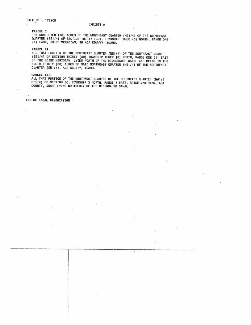
FILE NO.: 172205
EXHIBIT A
PARCEL I
THE NORTH TEN ( 10) ACRES OF THE NORTHEAST QUARTER ( NEI 14) OF THE SOUTHEASTQUARTER ( SE1/ 4) OF SECTION THIRTY ( 30), TOWNSHIP THREE ( 3) NORTH, RANGE ONE
1) EAST, BOISE MERIDIAN, IN AOA COUNTY, IDAHO.
PARCEL II
ALL THAT PORTION OF THE NORTHEAST QUARTER ( NEI/ 4) OF THE SOUTHEAST QUARTERSEI/ 4) OF SECTION THIRTY ( 30) TOWNSHIP THREE ( 3) NORTH, RANGE ONE ( 1) EAST
OF THE BOISE MERIDIAN, LYING NORTH OF THE RIDENDAUGH CANAL AND BEING IN THESOUTH THIRTY ( 30) ACRES OF SAID NORTHEAST QUARTER ( NE1/ 4) OF THE SOUTHEASTQUARTER ( SE1/ 4), AOA COUNTY, IDAHO.
PARCEL III:
ALL THAT PORTION OF THE NORTHWEST QUARTER OF THE SOUTHEAST QUARTER ( NW1/ 4SEI/ 4) OF SECTION 30, TOWNSHIP 3 NORTH, RANGE 1 EAST, BOISE MERIDIAN, ADACOUNTY, IDAHO LYING NORTHERLY OF THE RIOENBAUGH CANAL.
END OF LEGAL DESCRIPTION -

QPioneerfiflekGill H G BEYOND
703 S. Americana, Suite 1201 Boise
Idaho 8770p2/'( 208744
0,10
289011 w6I1t*
ADA COUNTY REDOROEn J. DAVID HAVARRO AMOUNT 6. 00 SBOISE IDAHO 01111/ 08 OZ20 PMDEPUTY VI ItlAllen Illllflllllllllll(IllilllllllllllllllRECORDEO- REOUEST OF
108003555Pioneer
WARRANTY DEED
For Value Received Grizzly Land Company LLC, an Idaho Limited Liability company
hereinafter referred Inn Greater, does hereby grant, bargain, sell, warrant and convey unto
James D. Patterson, a single person
heremnfter referred to as Granter, whose current address is 9362 W. Wichita Street, Boise, ID 837Q9
not L. Blosch
the following described premises, to -wit:
Notary Public ofIDAHO
SEE EXHIBIT A ATTACHED HERETO AND MADE A PART HEREOF.
Residing at Boise, IdahoCommission expires: March 17, 2011
Tax Parcel No. SI 130427800
To HAVE AND TO HOLD the said premises, with their appurtenances unto the said Grantee, his heirs
and assigns forever. And ilio said Grantor does hereby covenant to and with the said Grantee, that Grantoris the owner in fee simple ofsaid premises; that said premises are free from all encumbrances except currentyears taxes, levies, and assessments, and except U.S. Patent reservations, restrictions, easements ofrecord, and easements visible upon the premises, and that Grantor will warrant and defend the same from all claimswhatsoever.
Dated: January 9, 2008
Grizzly Land Company LLC
BY: vMatthew Schultz, Manager
STATE OF IDAHO, County of ADA, ss
O" On this 111th day of January, in the year of200B, before me Janet L. Blosch, a notary public, personally
v uppuared Mauhew Sehulrz, known or identified to ha manager of the member( s)/ maoger( s) in a
limited liability company, of Grizzly Land Company, LLC and the member(s)[ manoger(s) whosubscribed said limited liability company name so the foregoing instrument, and acknowledged to methat he executed the same in said limited liability company name.
epouatouer°°p°
eL'oaL01p,
o° o ° not L. Blosch
pOBLAC` 9 Notary Public ofIDAHOResiding at Boise, Idaho
Commission expires: March 17, 2011
Page 1 of 212111312014 1 real Ain

EXHIBIT APareel2, Northwest Parcel of Proposed Normandy Subdivision
Aparcel of land being a portion of the Northwest quarter of Ile Southeast quarter of Section 30, Township 3 North, Range 1 East of the Boise Meridian, Ada County, Idaho, being moreparticularly described as follows: Commencing at the Northeast comer arthe Southeast quarter ( East quarter comer) of Section 30, Township 3 North, Range 1 East, Boise Meridian, Thence South 89143' 55" West 1311 AS feet to the Northeast comer ofthe Northwest quarter of theSnutheast quarter, the REAL POINT OF BEGINNING ofthis description; Thence South 001 19' 19" East 332, 37 feel along the East line ofsaid Northwest quarter oftheSoutheast quarter to a point on the North right ofway ofthe Ridenbaugh Canal; Thence North 45"43143" West 473. 86 feet along the North right of way of the Ridcnhaugh CanalIn a point on the North line of the Southeast quarter ofsaid Section 30;
Thence North 89°43' 55' East 337,44 ( eat along said North line to the REAL POINT OFBEGINNING.
Page 2 of 212/ 10/ 2014 10; 51 AM

DESCRIPTION FOR
NORMANDY SUBDIVISION
PRELIMINARY PLAT
A PARCEL OF LAND BEING A PORTION OF THE NORTH M2 OF THE SOUTHEAST QUARTEROF SECTION 30, TOWNSHIP 3 NORTH, RANGE 1 EAST OF THE BOISE MERIDIAN, ADACOUNTY, IDAHO, BEING MORE PARTICULARLY DESCRIBED AS FOLLOWS:
BEGINNING AT THE NORTHEAST CORNER OF THE SOUTHEAST QUARTER (EASTQUARTER CORNER) OF SECTION 30, TOWNSHIP 3 NORTH, RANGE 1 EAST, BOISEMERIDIAN;
THENCE SOUTH 00030' 10" EAST, 827.00 FEET ALONG THE EAST LINE OF SAID SECTION 30TO A POINT ON THE CENTERLINE OF THE RIDENBAUGH CANAL;
ALONG SAID CENTERLINE OF THE RIDENBAUGH CANAL THE FOLLOWING COURSES ANDDISTANCES:
THENCE SOUTH 60017' 32" WEST, 229.26 FEET TO THE BEGINNING OF A CURVE TO THERIGHT;
THENCE 235. 04 FEET ALONG SAID CURVE TO THE RIGHT, SAID CURVE HAVING A RADIUSOF 250.00 FEET, A DELTA ANGLE OF 53° 52' 04" AND A CHORD BEARING SOUTH 87° 13' 34" WEST 226.48 FEET TO A POINT ON TANGENCY;
THENCE NORTH 65050' 24" WEST, 417. 14 FEET TO THE BEGINNING OF A CURVE TO THERIGHT;
THENCE 260.02 FEET ALONG SAID CURVE TO THE RIGHT, SAID CURVE HAVING A RADIUSOF 750.00 FEET, A DELTA ANGLE OF 19°51' 51", AND A CHORD BEARING NORTH 55° 54' 29" WEST 226.48 FEET TO A POINT OF TANGENCY;
THENCE NORTH 45058' 33" WEST, 984.99 FEET TO A POINT ON THE NORTH LINE OF THESAID SOUTHEAST QUARTER;
THENCE LEAVING THE CENTERLINE OF THE RIDENBAUGH CANAL AND ALONG SAIDNORTH LINE NORTH 89043' 55" EAST, 1720.72 FEET TO THE REAL POINT OF BEGINNING.
CONTAINS AN AREA OF 26.93 ACRES, MORE OR LESS

STATE OF IDAHO
COUNTY OF ADA
AFFIDAVIT OF LEGAL INTEREST
name) ry ( address)
kc S110!7city) ( state)
being first duly sworn upon, oath, depose and say:
That I am the record owner of the property described on the attached, and I grant mypermission to:
name) ( address) ,
n t that pr . to submit the accompanying applications pertatnmg to that pro erty.
2. I agree to indemnify, defend and hold the City of Meridian and its employees harmlessfrom any claim or liability resulting from any dispute as to the statements containedherein or as to the ownership of the property which is the subject of the application.
3. I hereby grant permission to City of Meridian staff to enter the subject property for thepurpose of site inspections related to processing ,said application(s).
Dated thisi_day of , 20 h S7
Signature)
SUBSCRIBED AND SWORN to before me the day and year first above written.
Notary Public for Idaho) tiyOTARy
Residing at:
My Commission Expires: S 3i / 9V °©
ly2W OF1101# 04
Community Development Planning Division 33 E. Broadway Avenue, Ste. 102 Meridian, Idaho 83642Phone: 208- 884-5533 Fax: 208. 888- 6854 www. meridiancitv.ora/ olarmuie

Project/Subdivision Name: 1\/ nrm11_, Applicant(s)/Contact(s): 1A,1 trn
City Staff: 11 , p, RAI", 6-- F. Location: U 41;15 Jr- / cc;.
Comprehensive Plan FLUM Designation:
Design Guidelines Development Context: Existing Use: FProposed Use: SAg, 194105 k, Surrounding Uses: iP Ps,0w-hal , a Street Buffer(s) and/or Land Use BuffersOpen Space/Amenities/ Pathways: / d,"
Access/Stub Streets/ Street System: 2,KkSewer & Water Service:
Waterways/ Floodplain/ Topography/RazaHistory: 4Z-C&- 0& 41 no on) Additional Meeting Notes:*- f- rwfrE
F Rcsunal- c6ovV it
CITY OF MERIDIANPRE -APPLICATION MEETING NOTES
Urban Urban/ Suburban
Existing Zoning: _ Proposed Zoning:
or
Date: IZ--Ifv / N
Size of Property: 21
Suburban Rural
re re,"ez d, c - iv
Note: A Traffic Impact Study (TIS) will be required by ACHD for large commercial projects and any residential development with over 100 units. Toavoid unnecessary delays & expedite the hearing process, applicants are encouraged to submit the TIS to ACHD prior to submitting their applicationto the City. Not having ACHD comments and/or conditions on large projects may delay hearing(s) at the City. Please contact Mindy Wallace at 387- 6178 or Christy Little at 387-6144 at ACHD forinformation in regard to a TIS, conditions, impact fees and process.
J
Other Agencies/ Departments to Contact:
Ada County Highway Dist. ( ACHD) Nampa Meridian Irrigation Dist. (NMID) Public Works DepartmentIdaho Transportation Dept. ( ITD) Settler's Irrigation District Building DepartmentRepublic Services Police Department Parks DepartmentCentraf District Health Department Fire Department Other:
Application(s) Required:
Administrative Design Review Conditional Use Permit Modification/ Transfer RezoneAlternative Compliance Development Agreement Modification Short PlatAnnexation Final Plat Time Extension - Council
City Council Review Final Plat Modification UDC Text Amendment
Comprehensive Plan Amendment- Map Planned Unit Development VacationComprehensive Plan Amendment - Text Preliminary Plat VarianceConditional Use Permit Private Street Other
Notes: 1) Applicants are required to hold a neighborhood meeting in accord with UDC 11 -5A -5C priorto submittal of an application requiring a publichearing (except fora vacation or short plat); and 2) All applicants for permits requiring a public hearing shall post the site with a public hearing noticein accord with UDC 11 -5A -5D. 3 ( except for UDC text amendments, Comp Plan text amendments, and vacations). The information provided duringthis meeting is based on current UDC requirements and the Comprehensive Plan. Any subsequent changes to the UDC and/or Comp Plan mayaffect your submittal andlor application. This pre -application meeting shall be valid for four (4) months.

NEIGHBORHOOD MEETING
NORMANDY SUBDIVISION REZONE AND PRELIMINARY PLAT
CITY HALL, CONFERENCE ROOM A
APRIL 7, 2015 at 6: 00 PM
7.
8.
9.
10.
H.
12.
13.
14.
15.
16.
17.
18.
Name Address Phone # E-mail
1. t- M, dj1 Lsa
eo- 1 io`?5 Sew 7c Ye-
@ cQ• ed . cam2.. C P5, s" r,) t2oS E Pa, S4. 3o3- StrA'`/ csoj Ei SWs-, 4hPcJcnal., 4
3. Dh'Y f ,% Pl NNS%–' 3g iADlf 4YT iTG B'Ho7/f7dB i/Nvl< iiSs iG,
4. VVlLCl V et / i-ilf%(cJ
5. 441- 0, 5. ocurf Gror
6.
7.
8.
9.
10.
H.
12.
13.
14.
15.
16.
17.
18.
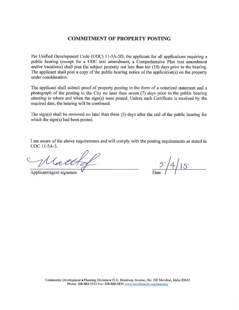
COMMITMENT OF PROPERTY POSTING
Per Unified Development Code ( UDC) 11 -5A -5D, the applicant for all applications requiring apublic hearing ( except for a UDC text amendment, a Comprehensive Plan text amendmentand/ or vacations) shall post the subject property not less than ten ( 10) days prior to the hearing. The applicant shall post a copy of the public hearing notice of the application(s) on the propertyunder consideration.
The applicant shall submit proof of property posting in the form of a notarized statement and aphotograph of the posting to the City no later than seven ( 7) days prior to the public hearingattesting to where and when the sign(s) were posted. Unless such Certificate is received by therequired date, the hearing will be continued.
The sign(s) shall be removed no later than three ( 3) days after the end of the public hearing forwhich the sign( s) had been posted.
I am aware of the above requirements and will comply with the posting requirements as stated inUDC 11- 5A-5.
Applicant/agent signature VDale
Community Development Planning Division a 33 E. Broadway Avenue, Ste. 102 Meridian, Idaho 83642Phone: 208- 884-5533 Fax: 208- 888- 6854 www.meridiancitv.org/planning

E 1 IDIAM--- o
Community Development
Parcel Verification
Date: 3/ 12/ 15
Meridian City Hall, Suite 102
33 E. Broadway AvenueMeridian, Idaho 83642
208. 887. 2211
The parcel information below has been researched and verified as correct by the City of MeridianCommunity Development Department.
Project Name: Normandy Subdivision
Parcel Number(s): S1130427850 (. 513 Acres)
51130427800 ( 1. 287 Acres)
S1130417300 ( 23. 5 Acres)
T/ R/ S: 3N 1E 30
Property Owner: James Patterson
9362 W. Wichita St.
Boise, ID 83709
Address Verification Rev: 04/ 23/ 12
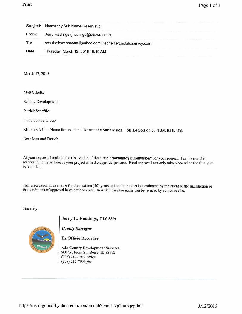
Subject: Normandy Sub Name Reservation
From: Jerry Hastings ahastings@adaweb. net)
To: [email protected]; [email protected];
Date: Thursday, March 12, 2015 10:49 AM
March 12, 2015
Matt Schultz
Schultz Development
Patrick Scheffler
Idaho Survey Group
RE: Subdivision Name Reservation: " Normandy Subdivision" SE 114 Section 30, T3N, RIE, BM.
Dear Matt and Patrick,
Page I of 3
At your request, I updated the reservation of the name " Normandy Subdivision" for your project. I can honor thisreservation only as long as your project is in the approval process. Final approval can only take place when the final platis recorded.
This reservation is available for the next ten ( 10) years unless the project is terminated by the client or the jurisdiction orthe conditions of approval have not been met. In which case the name can be re -used by someone else.
Sincerely,
Jerry L. Hastings, PLS 5359
County Surveyor
Ex Officio Recorder
Ada County Development Services200 W. Front St., Boise, ID 83702208) 287-7912 office
208) 287-7909far
https://us-mg6.mail.yaboo.com/neo/ launch?.rand=7p2mtbecpthO3 3/ 12/ 2015

ED
PICASSOAVEdY _
am -
f I n
V __ o
1 1 IR 1 1 to I
I 1 I IT, I 1 I I Ix 1 - F
1 1 lu I t I I Irk 1 c
f 11 i i i i i
S. VFACgAEAVE
J'i
Y
I 1
I I lu 1 1 I
Ek
jF lit
I I I 1 1
I 1 I 1 I gY I y I I I - I
J
GLOWST6RWER0. _
l g 6-f
iio4

JNIN33NI9N3 N9
Jg g fik ON
to
s°11jg 531$° IN JIM Rg Iwo @j wrap@p®
yyeis him gi
nigS @i! T gig; ss # a
211kkg ® j®j
y_ 6 F sF_ aF_ afi• Ir
I
AN ` "' 6 ^ iF.': F 8 : F° 8F "". aF
gryry$$'' eF $ F_ a•
6 ,
r
t I
ipB
pr1 _
m. 8 j . a6 g6 xH fi 6g gfi j 6 § 60816\§ F iF I£, u \
pjd6•_ g"_ g '!`- - g'- ° a9'-!' g'- g'- g' 8Li
ALO ,, ,5
6 _ 6Jy' e >, as
gf/`/
rer•
g s
aal •3 I oa ' i
J{
o
4 sk
Qa
NV -1d 3dVOSONV- 1-'-' VH3A0 _ Ai' OiEij © yePI' UeiPueyVm.$,$
Q tloFo
a
RS ' lS /}suauV ' 3 Pus ana9 lsnoo . S fi a fi
N0IS1A1denS AGNVWHON 8
i
1W
wy =
OR
z
W z w¢ !
a ' 05
ee 4tlyg$
n11,%P051 [ I 6wi
@$tgS sa : j+€$Pn¢ Qzge
20e 16ja
p41Mg11 X0i. RIP; a
z £ dkA@9@ aybyAtlgO$ `R i ¢
Sgqqq€piSl$
yapt- tHFI#$$ap3 g9Yi6llgi@a¢l65ld}£ g $
yl1.. 1 1@q$¢$$ l(§
6
p k$ 3ekE3e@i4@elsaAk33`$ 5? a pd g e s . da} 9
@ 9 $ q@§ $ Fx 8 3 a k to € $ H i$ z ° eq
Z i g8 a i s8 OR.&_ li ¢ es @ s
11p, 51yR3° Y@ _ y. F O ggs
p
eF R (g§§
k - tlp y F- Ems€ €}! Qy3 } e f: 80pg 3 gt AO z d E C t SH I' £& iy}@ $ § , gg eaz .—
ise@ e a} s x qa@} n$ Y4 R E stlA & 9 $
z ° e
11z 55g e3$ P w ` $ R`
dsz $ gga@E
yea$ $ $ gy B $ $ P Fg
ynp & ffi sAf@ E e $° 8 & E 5fd 9ps¢ E mq Jilt a fe J g ew ky
O $ ky( i d c @ @yzgytl by{Aqq4q . R$ gC tla: i € gyp€ [ 8S@ 5555 jj@ k £ ® yy33 3- d cqq y Y L $ 6A $ B
Z 3 F38F•° d5p rt`}. { B [ L [ 6 p@44 F6 } A k 39 y QdC` S Atl
iIIR @$
eo-aa m n E £ iflg$"X61 sg Yg $ k zppSqqR @k Q$ Ee 4 yy& 3 !
B4 Q I 3yya 1 4yy a n€ R
gak,y {
j
48tr F e £ s $}
6se>}$£ isS
qqXd ..' 2 a 8 e£ 4gyS i$ g5Y
w@§ zk kE w ? 8€€§: n lli4 SS4ii9ek@F€ a 4§
@ d ils a@'$yn a
if49< ea $ g< a €< a ?$ e$$ 3 E8iy.

3NO V3liV - NVId 3dVOSONVI
oooyspl ' uelplaW:::?
x 4:oIN
lS BUOIIV 3 pue anaO ; snool -S dJNOISIAICIens AONVVgHON Al 8-1
21113311$ 319 3NIlHJ1V11
441133H5335 3NIl11J1tl11
O !
m
U
plQ
m
v u
a
w .
AAV OSSVOld" S
m
U
plQ
E
w
OAAL V3HV - NVId 3dVOSUNVI _ sx s m - fij 0 UPI ' uEIPllovq2 fl F affy._.
1S eu911V ' 3 Pue ana0 ;spool SNOISIAI(IsnS) IONVV4HON
TlSH
I
I
I
Igg
s@l $ f
U3 5
Q X 4WJ aW
g '
IlliI
a
IMill3
F za R
ZWU' p
WJ
os' rgogg00000000
IllsIImilia,.,
lEf II1 II jx1
I1 4Q IX
I/
e
I
I
I
I
Igg
s@l $ f
U3 5
Q X 4WJ aW
g '
IlliI
a
IMill3
F za R
ZWU' p
WJ
os' rgogg00000000
OJIR1.2
zsale#- NV] wwamm«
2 _«}$
Pui1) 1 _
m« ` /ƒ} § NOIsn6 mwmm k \

E
w
Ws(
7
W
7g oz
mw
w` Z
Ja
h
STV -LAG 3dVOSONVloyepl ' Uelpliavy
IS AeuauV .3 pue enoig lsnoo-1 • SNOISIAI08f1S AONVWlION
D
1


Sonya Watters
Subject: FW: RE: meridian email
From: Matthew Schultz
Sent: Monday, May 04, 2015 12: 06 PMTo: Sonya Watters; Bill ParsonsSubject: Fw: RE: meridian email
Bill and Sonya .... I just submitted Normandy and not knowing who will do it ... see below for ACHD email.
I owe you house pies and I have a color landscape plan I will forward as well.
HOTill FV
Matt Schultz
1208) 880- 1695
From:" Mindy Wallace" < Mwallace@achdidaho. org> Date:Mon, May 4, 2015 at 11: 25 AMSubject:RE: meridian email
Matt,
A traffic impact study is not required for this application. Please let me know if you have any other questions.
Mindy
Mindy Wallace, AICP
Planner III
Ada County Highway District
208) 387- 6178

Bob J. Arnold, PE
208-440- 6276 Fax 208- 323- 7866
Matt Schultz, PE
RMR Consulting, Inc. 2127 S. Alaska WayMeridian, ID 83642
Dear Matt:
Civil Engineering
Geotechnical Engineering
Materials Testing & Inspection Services
of 2
Re: Proposed Normandy Subdivision4145 South Locust GroveMeridian, Idaho 83642
As per your request, I have reviewed the available groundwater data for yourproposed Normandy Subdivision located at 4145 South Locust Grove Road, MeridianIdaho. Well logs from the Idaho Department of Water Resources were reviewed forSection 30, R3N, T1 E, where the subject property is located. Of the fifty plus well logsreviewed; only one indicates a static water elevation of less than ten feet below thesurface, (well list attached).
On October 2, 2006, seven test pits were excavated as a part of a geotechnicalinvestigation. Groundwater was encountered in four of the seven test pits at between6.5 and 7.5 feet below the existing ground surface. Groundwater was contacted in thetest pits that were excavated near the Ridenbaugh Canal. Test pits along the northproperty boundary were excavated to ten feet deep and observed to be dry with noevidence of historical groundwater contact.
The test pits revealed the native shallow soils to be clays, silts, and cementedsilts, sand and gravel mixtures, and sand pockets located at shallow depths. Basedupon the researched data, your project appears to be geotechnical feasible. Forpreliminary design and budgeting purposes a depth to groundwater of greater than 6. 5' and an allowable foundation bearing pressure of up to 1500 psf may be used.
This opportunity to be of service is appreciated. The completed report will bedelivered as soon as the soils testing labwork is completed.
Bob J. Arnold, PE 8717 Craydon Drive Boise, Idaho 83704

Bob J. Arnold, PECivil Engineering
Geotechnical EngineeringMaterials Testing & Inspection Services
208-440- 6276 Fax 208-323- 7866 boarnoldpe@msn. comNovember 30, 2006
Idaho Department of Water ResourcesListing of Driller Reports - Sec 30, R3N, TIE
Page 2 of 2
Bob J. Arnold, PE 8717 Craydon Drive Boise, Idaho 83704

Subject: RE: Normandy Subdivision ROW
From: Perry Palmer (ppalmer@meridiancity. org)
To: [email protected];
Date: Tuesday, April 7, 2015 11: 01 AM
Matt,
The 33 foot BOC is fine as long as the curbs are rolled curbs. Otherwise it would be a 34 foot BOC.
Perry
Perry Palmer, Deputy Chief of Fire Prevention
Meridian Fire Department
208-888- 1234
Dedication, Loyalty, Tradition
CONFIDENTIALITY NOTICE:
Page 1 of 2
This email and any files transmitted with it are confidential and privileged and intended for receipt and use solely by the individual or entitynamed in this email transmission. Ifyou are not the intended recipient, be advised that you have received this email in error, and that any use, dissemination, forwarding, printing, disclosure, copying, distribution or the taking ofany action in reliance on the contents of this information isstrictly prohibited. Please notify the sender immediately that you have received this message in error and destroy this message.
https:// us-mg6.mail.yahoo.corn/neo/ launch?.rand=fDde6tk4gaarf 4/ 7/2015

From: Matthew Schultz
Sent: Monday, April 06, 2015 9:40 PMTo: Perry Palmer; Chad KinkelaSubject: Normandy Subdivision ROW
Hi Perry,
Page 2 of 2
we are doing a project called Normandy on Locust Grove just north of Reflection Ridge .... can youplease confirm that 33' Back of Curb to Back of Curb is OK? we are doing a 45' ROW with 5' attached sidewalk on each side an another foot behind the sidewalk for the property pins. We will besubmitting the preliminary plat later this month.
thanks!
Matt Schultz, PE
Schultz Development LLC
208) 880-1695
https:// us-mg6.mail.yahoo.com/neo/ launch?.rand=fUde6tk4gaarf 4/7/2015


Hearing Date: 4& A, 2015
File No.: PP -15- 008
Project Name: Normandy Subdivision
Request: Request for preliminary plat consisting of 110 building lots and 9 common lots on26.93 acres of land in an R-8 zoning district, by Schultz Development.
Location: The site is located at 4145 S. Locust Grove Road, in the SE'/ a of Section 30, Township3N, Range IE.
Copyright © 2022 FDOKUMEN