County Special Permit No. 199 and Preliminary Plat No. 03001
27
LINCOLN CITY/LANCASTER COUNTY PLANNING STAFF REPORT P.A.S.#: Prairie Creek Estates Community Unit Plan Date: March 5, 2003 Co Special Permit #199, Preliminary Plat 03001 SCHEDULED PLANNING COMMISSION MEETING: DATE: March 19, 2003 Note: This is a combined staff report for related items. This report contains a single background and analysis section for all items. However, there are separate conditions provided for each individual application. PROPOSAL: A Community Unit Plan and Preliminary Plat to create 9 lots. WAIVER REQUEST: Waivers of subdivision requirements of street trees, street lighting, landscape screens, sidewalks, cul-de-sac length and block length. Zoning adjustments to lot frontage and lot access to a street. LAND AREA: 150.46 acres, more or less. CONCLUSION: This plat and the listed waivers generally conform with the Comprehensive Plan and adopted Regulations. RECOMMENDATION: County Special Permit #199 Conditional Approval Preliminary Plat # 03001 Conditional Approval WAIVER REQUESTS - block length along the north, south, east and west Approval - sidewalk Approval - landscape screens Approval - street lights Approval - street trees Approval - cul de sac length Approval - lot frontage Approval - frontage and access to a street Approval GENERAL INFORMATION: LEGAL DESCRIPTION: A portion of Lot 2 I. T. located in the SW 1/4 of Section 34, T10N, R8E of the 6th P.M., Lancaster County, Nebraska; metes and bounds description attached. LOCATION: S.148 th Street and Van Dorn Street
-
Upload
khangminh22 -
Category
Documents
-
view
0 -
download
0
Transcript of County Special Permit No. 199 and Preliminary Plat No. 03001

LINCOLN CITY/LANCASTER COUNTY PLANNING STAFF REPORT
P.A.S.#: Prairie Creek Estates Community Unit Plan Date: March 5, 2003Co Special Permit #199, Preliminary Plat 03001
SCHEDULED PLANNING COMMISSION MEETING: DATE: March 19, 2003
Note: This is a combined staff report for related items. This report contains a single background andanalysis section for all items. However, there are separate conditions provided for each individualapplication.
PROPOSAL: A Community Unit Plan and Preliminary Plat to create 9 lots. WAIVER REQUEST: Waivers of subdivision requirements of street trees, street lighting,landscape screens, sidewalks, cul-de-sac length and block length. Zoning adjustments to lot frontage and lot access to a street.
LAND AREA: 150.46 acres, more or less.
CONCLUSION: This plat and the listed waivers generally conform with the ComprehensivePlan and adopted Regulations.
RECOMMENDATION: County Special Permit #199 Conditional ApprovalPreliminary Plat # 03001 Conditional Approval
WAIVER REQUESTS
- block length along the north, south, east and west Approval - sidewalk Approval - landscape screens Approval- street lights Approval- street trees Approval- cul de sac length Approval- lot frontage Approval- frontage and access to a street Approval
GENERAL INFORMATION:
LEGAL DESCRIPTION: A portion of Lot 2 I. T. located in the SW 1/4 of Section 34, T10N,R8E of the 6th P.M., Lancaster County, Nebraska; metes and bounds description attached.
LOCATION: S.148th Street and Van Dorn Street

Prairie Creek Estates Community Unit Plan CO SP #199, PP 03001 2
APPLICANT: Nebraska Prairie L. L. C. P.O. Box 336Bennet, NE 68317(402) 770-7707
OWNER: Mark E. Shiers and Karri L. Shiers, husband and wife, as joint tenants7331 S. 29th StreetLincoln, NE 68516(402) 420-7331
Nebraska Prairie L. L. C. A Nebraska Limited Liability CompanyP.O. Box 336Bennet, NE 68317(402) 770-7707
CONTACT: Brian D. Carstens and Associates601 Old Cheney Road, Suite C Lincoln, NE 68512(402) 434-2424
EXISTING ZONING: AG Agricultural.
EXISTING LAND USE: Agriculture.
SURROUNDING LAND USE AND ZONING:
North: Agriculture, scattered acreages, zoned AGSouth: Agriculture and a native prairie, zoned AGEast: Agriculture and acreages, zoned AGWest Agriculture and two dwellings, zoned AG
ASSOCIATED APPLICATIONS: County Special Permit # 199 and Preliminary Plat #03001are related.
HISTORY: Changed from AA Rural and Public Use to AG Agricultural in the 1979 zoningupdate.
COMPREHENSIVE PLAN SPECIFICATIONS: The 2025 Plan shows this as Agriculture.This is outside the Lincoln Growth Tiers.

Prairie Creek Estates Community Unit Plan CO SP #199, PP 03001 3
Currently, acreage development has occurred under two development scenarios: AG - Agricultural District
(minimum of 20 acres per lot area) and AGR - Agricultural Residential District (minimum of 3 acres per lot
area) with the possibility in both AG and AGR zoning districts of clustering units together in order to preserve
more open space and agricultural areas and/or receive additional density bonuses under a community unit
development. The complex issue of acreage development and other public objectives requires a large array
of land use strategies (pg F 70)
Acknowledge the “Right to Farm” and preserve areas for agricultural productions throughout the county by
designating specific areas in advance for rural residential so as to limit areas of potential conflict between
farms and acreages (pg F 70)
Retain the current overall density of 32 dwellings per square mile (20 acre) for all agriculturally zoned land.
Provide for an ability to divide two 3 acre lots per “40” acre parcel with conditions and administrative review
and right of appeal. This would allow more flexibility for parcel size while retaining the overall density and
assist in retaining farmable units of land. (F 70)
Provide more bonuses and a lower threshold size (not below nominal 40 acres) for the proven technique of
“cluster” development using the Community Unit Plan. This technique has been successful in providing
flexibility while preserving both farmland and environmental resources at the same time. (F71)
UTILITIES: There is no public sewer available. Individual waste disposal is proposed. Thisis in the Lancaster County Rural Water District #1 and Rural Water is proposed. TOPOGRAPHY: This is generally rolling land, draining to the southwest.
TRAFFIC ANALYSIS: 148th is a paved County road. Van Dorn Street is gravel county road.Van Dorn is not shown for future improvement.
PUBLIC SERVICE: This is in the Eagle Rural Fire District, Waverly School District # 145 andNorris Public Power District.
REGIONAL ISSUES: Expansion of the acreage areas. Clustering to preserve farm land.
ENVIRONMENTAL CONCERNS: There are no identified Historic resources, However, thehistoric Levitt house has been moved from the Veterans Hospital site at 70th and “O” Streetto the farmstead site on this parcel. There are conditions and agreements with the StateHistorical Society in regard to the building. The soil rating is 6.0 on a scale of 1-10 where 1-4is prime soil. This is not prime soil. There are drainage ways through the site from northeastto southwest and an NRD dam under construction in the northeast. There is FEMA floodplainshown. The drainage ways through the sited are wooded. There are fresh water wetlands onthis site.
AESTHETIC CONSIDERATIONS: n/a

Prairie Creek Estates Community Unit Plan CO SP #199, PP 03001 4
ALTERNATIVE USES: Continued farming or up to 7 dwellings on 20 acre parcels (8 with thefarmstead.
ANALYSIS:
1. This request is for a Special Permit for a Community Unit Plan and a Preliminary Platfor 9 acreage residential lots. A gravel private street is proposed and a commonprivate drive for two lots. A 20 % dwelling unit bonus is requested for preservation offarm land.
2. The acreage lots are proposed to wrap around the lake and generally stay out of thewooded area and tillable area. The distance away from the historic house also helpspreserve the character of the setting of that resource.
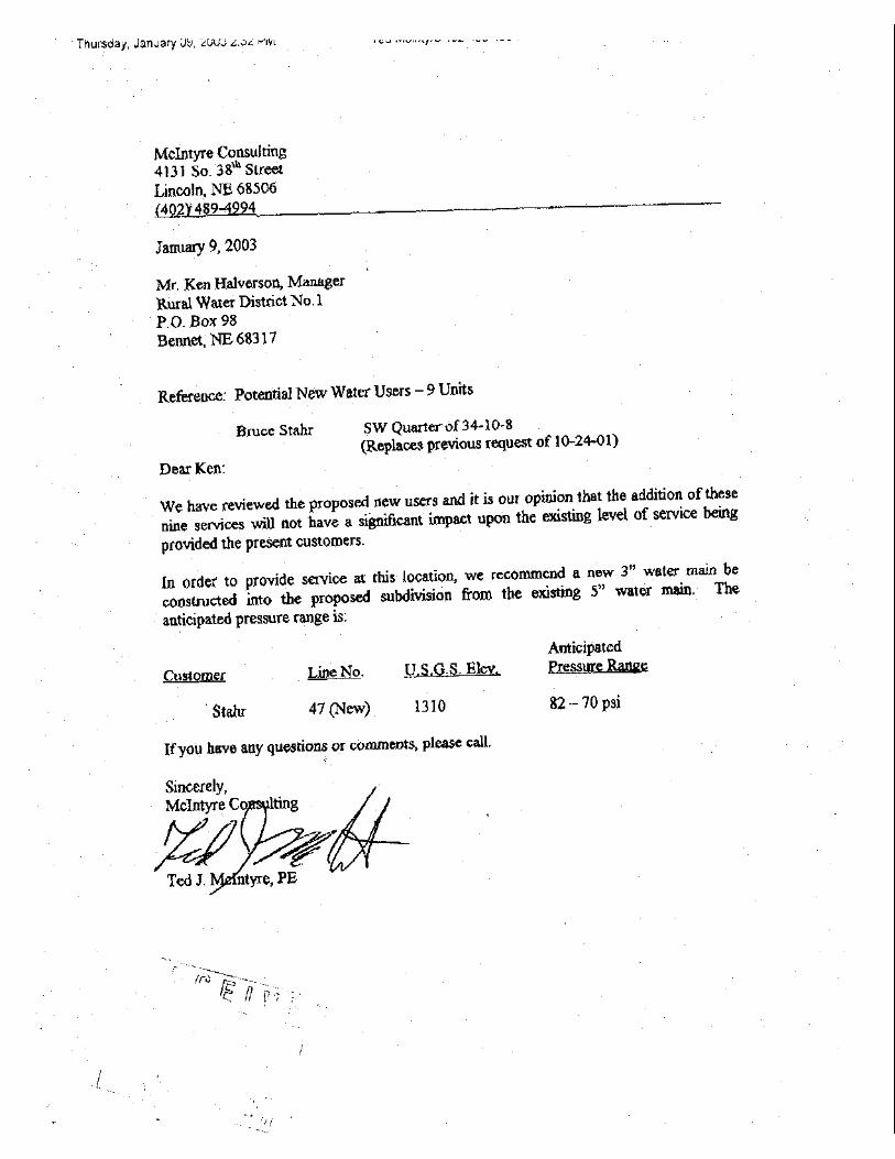
3. Public water and individual sewage disposal are proposed. The lots are large enoughfor lagoons if percolation will not support a septic system. The Rural Water Districtindicates adequate capability (see attached memo from the Water District Engineerdated January 9, 2003).
4. This request is in general conformance with the Comprehensive Plan.
5. The applicant is requesting waivers to street lighting, street trees, landscape screens,and sidewalks. These waivers are consistent with the agricultural nature of thesubdivision and the provisions of the County regulations. The area is not to beannexed by the city at this time. The existing farm land, dam and proposed acreagesprovide storm water detention equivalent to the Lincoln standards.
6. The applicant is requesting a waiver of the block length along the north, south, east andwest of the plat. The applicant is requesting waivers to cul-de-sac length in excess of1,000. The waivers are reasonable considering the nature and use of the land forfarming, existing dam, wooded area and topography, however, the extension of S.154th Court to the east is highly desirable for additional development to the east, nearthe lake. Waiver to frontage on a street is requested to allow Lots 7 and 8 to becreated in the northeast corner of the parcel and use a common drive around the damand lake. The applicant is requesting an adjustment of lot frontage for lots 6,7,8 and 9.Given the unique lay of this land, trees and lake, the historic house and within theflexibility provided by the Community Unit Plan, these adjustments appear appropriate.
7. The density calculations for the project are as follows;
150.46 acres + 2.65 acres of ROW = 153.02 acres153.02 acres at 1 dwelling per 20 acres = 7.651 dwellings20% bonus requested X 1.20 = 9.18 dwellings permitted

Prairie Creek Estates Community Unit Plan CO SP #199, PP 03001 5
Requested 9 units
8. There is one potential conflicting farm use noted on the field survey, a small farm cattleoperation on the northeast corner of 148th and ‘A’ street, one half mile away. No otherconflicting farm uses, such as feedlots, were noted in the immediate area.
9. The County Engineer’s letter of February 12, 2003 notes the following;
1). Dedication of 60' right-of-way along East Van Dorn.
2) Dedication of 10' along South 148th Street.
3) All streets and roads to be constructed and surfaced to LancasterCounty standards.
4) Access shall be relinquished along South 148th Street and Van DornStreet except for South 154th Street Court and existing farm access toremain. Should an existing farm access be used for any other purpose,it shall be relinquished and removed. General Notes 12 and 13 need tobe modified.
5) The private roadway providing access to Lots 7 and 8 needs to beabove the 100 year flood plain to ensure ingress/egress during floodconditions.
6) General Note 14 refers to FEMA flood plain elevations that do not applysince the NRD pond is backing up to a higher elevation.
7) General Note 11 should include an access easement over the privatedriveway.
8) A culvert is needed under the private driveway at its intersection with thecul-de-sac of South 154th Court.
9) The culvert at Station 4+ 20 on the private driveway is shown on theGrading Plan as 48". The culvert calculations show a 42" pipe. Inaddition, the runoff quantity appears low using the rational method.
10) A typical grading cross-section should be shown for the privatedriveway.
10. The Health Department notes in their memo dated February 18, 2003;
Prairie Creek Estates Community Unit Plan CO SP #199, PP 03001 6
A) The developer proposes the use of individual on-site wastewater treatmentsystems. These soils have severe limitations for standard soil absorptionsystems. Non-standard systems or lagoons may be necessary. Each of thelots meets the minimum requirement lot size of 3 acres or more. The actualbuild-able area on several of these lots is less than 50% of the lot size due toflood plain, easement, and right of way issues. Standard or Non-standard soilabsorption systems cannot be located in a flood plain. In addition, a reservearea equal to the size of the original system is required. If standard or non-standard soil absorption systems are utilized, the LLCHD will require detailedsite plans for each lot prior to issuing on-site wastewater treatment systempermits. Meeting space and set-back requirements on these lots will bedifficult. LLCHD will not issue on-site wastewater treatment system permits ifadequate information is not available to demonstrate that the requirements ofChapter 4.10 Design Standards will be met. The use of lagoons may allow forflexibility in lot planning. Lagoons may be located in the flood plain provided thetop of the dike is at least one foot above the flood plain. Elevation readingswould be required for issuing wastewater permits if the lagoon is to be locatedin the flood plain. The bottom of a lagoon must be at least 2 feet above thehighest seasonal groundwater level. The bottom of a soil absorption trenchmust be at least 4 feet above the highest seasonal groundwater level.
B) The water supply is proposed to be either Lancaster County Rural Water orindividual wells. Based on LLCHD information the use of individual wells maypresent both water quantity and water quality issues.
C) Existing Farmstead: The developer notes they are in the process of splittingoff a 6 acre parcel as soon as the house meets minimum housing and electricalcodes. Based on LLCHD staff reports, the LLCHD will require the replacementof the existing treatment system. Adequate area exists on this parcel for theinstallation of a lagoon if standard or non-standard soil absorption systems arenot feasible.
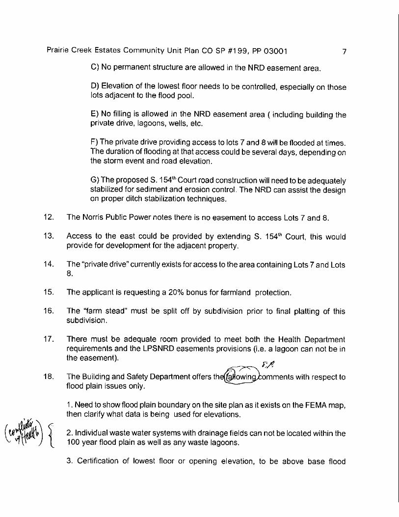
11. The Lower Platte South NRD notes in a memo dated February 14, 20003;
A) Flood pool elevation of the NRD flood control structure (Stevens Creek A9-6)is 278.50, and not 1268.0. The normal (lake) water level is 1268.0
B) We have no objection to relocating our 30' wide access easement to adifferent “acceptable” location.
C) No permanent structure are allowed in the NRD easement area.

Prairie Creek Estates Community Unit Plan CO SP #199, PP 03001 7
D) Elevation of the lowest floor needs to be controlled, especially on those lotsadjacent to the flood pool.
E) No filling is allowed in the NRD easement area ( including building theprivate drive, lagoons, wells, etc.
F) The private drive providing access to lots 7 and 8 will be flooded at times.The duration of flooding at that access could be several days, depending on thestorm event and road elevation.
G) The proposed S. 154th Court road construction will need to be adequatelystabilized for sediment and erosion control. The NRD can assist the design onproper ditch stabilization techniques.
12. The Norris Public Power notes there is no easement to access Lots 7 and 8.
13. Access to the east could be provided by extending S. 154th Court, this would providefor development for the adjacent property.
14. The “private drive” currently exists for access to the area containing Lots 7 and Lots 8.
15. The applicant is requesting a 20% bonus for farmland protection.
16. The “farm stead” must be split off by subdivision prior to final platting of thissubdivision.
17. There must be adequate room provided to meet both the Health Departmentrequirements and the LPSNRD easements provisions (i.e. a lagoon can not be in theeasement).
18. The Building and Safety Department offers the fallowing comments with respect toflood plain issues only.
1. Need to show flood plain boundary on the site plan as it exists on the FEMA map,then clarify what data is being used for elevations.
2. Individual waste water systems with drainage fields can not be located within the100 year flood plain as well as any waste lagoons.
3. Certification of lowest floor or opening elevation, to be above base flood elevation,must be submitted to this office prior to framing inspection approval.

Prairie Creek Estates Community Unit Plan CO SP #199, PP 03001 8
CONDITIONS FOR SPECIAL PERMIT #199:
Site Specific:
1. After the applicant completes the following instructions and submits the documents andplans to the Planning Department office and the plans are found to be acceptable, theapplication will be scheduled on the County Board's agenda: (NOTE: Thesedocuments and plans are required by resolution or design standards.)
1.1 Make the corrections requested by the County Engineer in his letter ofFebruary 12, 2003.
1.2 Make the revisions required by the LPSNRD in there letter of February 14,2003.
1.3 Show a street (private road) extension from S. 154th to the east property line.
1.4 Revise the plat to show the pool and flood plain elevations.
1.5 Indicate on the plat the minimum opening elevation for the building on each lot.
1.6 Show and note the access to South 148th Street for Lot 9.
1.7 Show the easements requested by Norris Public Power.
1.8 Show the location and easement for the rural water to serve lots 7,8 and 9.
1.9 Show the revisions requested by the Building and Safety Department memodated March 5, 2003.
1.10 Show revisions to reflect the waste disposal concerns raised in the HealthDepartment letter dated February 18, 2003.
2. This approval permits 9 single family lots.
General:
3. Before receiving building permits:
3.1 The permittee is to submit a revised site plan and the plan is found to beacceptable.

Prairie Creek Estates Community Unit Plan CO SP #199, PP 03001 9
3.2 The permittee is to submit six prints and a permanent reproducible final siteplan as approved by the County Board.
3.3 The construction plans are to comply with the approved plans.
3.4 The final plat(s) is/are approved by the County Board.
3.5 The required easements as shown on the site plan are recorded with theRegister of Deeds.
3.6. The County Board approves associated requests:
3.6.1 Prairie Creek Estates Preliminary Plat #03001.
3.6.2 A waiver to the sidewalk, street lights, landscape screen, and street treerequirements since the area is of larger lots, a rural/agriculture natureand the subdivision will not be annexed.
3.6.3 A modification to the requirements of the land subdivision resolution topermit a block length in excess of 1320' along the north, south, east andwest perimeter of this subdivision and to permit a cul-de-sac length inexcess of 1,000 feet.
3.7 The County Engineer has approved:
3.7.1 An agreement for street maintenance.
STANDARD CONDITIONS:
4. The following conditions are applicable to all requests:
4.1 Before occupying this Community Unit Plan all development and constructionis to comply with the approved plans.
4.2 Before occupying this Community Unit Plan, City/County Health Department isto approve the water and waste water systems.
4.3 All privately-owned improvements, including private roadways, are to bepermanently maintained by the owner or an appropriately establishedhomeowners association approved by the County Attorney.

Prairie Creek Estates Community Unit Plan CO SP #199, PP 03001 10
4.4 The site plan accompanying this permit shall be the basis for all interpretationsof setbacks, yards, locations of buildings, location of parking and circulationelements, and similar matters.
4.5 This resolution's terms, conditions, and requirements bind and obligate thepermittee, its successors and assigns.
4.6 The County Clerk is to file a copy of the resolution approving the permit and theletter of acceptance with the Register of Deeds. The Permittee is to pay therecording fee.
CONDITIONS FOR PRELIMINARY PLAT #03001:
Site Specific:
1. After the subdivider completes the following instructions and submits the documentsand plans to the Planning Department office, the preliminary plat will be scheduled onthe City Council/County Board agenda: (NOTE: These documents and plans arerequired by resolution or design standards.)
1.1 Make the corrections requested by the County Engineer in his letter of February 12, 2003.
1.2 Make the revisions required by the LPSNRD in there letter of February 14,2003.
1.3 Show a street (private roadway ) extension from S. 154th to the east propertyline.
1.4 Revise the plat to show the pool and flood plain elevations.
1.5 Indicate on the plat the minimum opening elevation for the building on each lot.
1.6 Show and note the access to South 148th Street for Lot 9.
1.7 Show the easements requested by Norris Public Power.
1.8 Show the location and easement for the rural water to serve lots 7,8 and 9.
1.9 Show the revisions requested by the Building and Safety Department memodated March 5, 2003.

Prairie Creek Estates Community Unit Plan CO SP #199, PP 03001 11
1.10 Show revisions to reflect the waste disposal concerns raised in the HealthDepartment letter dated February 18, 2003.
2. The County Board approves associated requests:
2.1 County Special Permit # 199 for the Community Unit Plan.
2.2 A waiver to sidewalk, street paving, street lights, landscape screen, and streettree requirements since the area is of larger lots, a rural nature and thesubdivision will not be annexed.
2.3 A modification to the requirements of the land subdivision ordinance to permita block length in excess of 1320' along the north, south, east and westperimeter of this subdivision and to permit a cul-de-sac in excess of 1,000 feetin length.
General:
3. Final Plats will be scheduled on the Planning Commission agenda after:
3.1 Streets, water facilities, drainage facilities, temporary turnarounds andbarricades, and street name signs have been completed.
3.2 The subdivider has signed an agreement that binds the subdivider, itssuccessors and assigns:
3.2.1 To submit to the County Engineer an erosion control plan.
3.2.2 To protect the remaining trees on the site during construction anddevelopment.
3.2.3 To submit to lot buyers and home builders a copy of the soil analysis.
3.2.4 To complete the private improvements shown on the preliminary plat.
3.2.5 To maintain the outlots and private improvements on a permanent andcontinuous basis. However, the subdivider may be relieved anddischarged of this maintenance obligation upon creating in writing apermanent and continuous association of property owners who would beresponsible for said permanent and continuous maintenance. Thesubdivider shall not be relieved of such maintenance obligation until thedocument or documents creating said property owners association havebeen reviewed and approved by the County Attorney and filed of recordwith the Register of Deeds.

Prairie Creek Estates Community Unit Plan CO SP #199, PP 03001 12
3.2.6 To relinquish the right of direct vehicular access to Van Dorn Streetexcept for S. 154th Street and to 148th Street except for two farmaccess to Outlot C. and one residential access for lot 9.
3.2.7 To comply with the provisions of the Land Subdivision Resolutionregarding land preparation.
3.2.8 To insure all building openings will be one foot above the 100 year floodelevation or spillway elevation, whichever is greater.
Prepared by:
Michael V. DeKalb AICPPlanner
F:\FILES\Planning\PC\PERMITS\COSP\COSP199prairiecreek.md.wpd

County Preliminary Plat #03001County Special Permit #199Prairie Creek EstatesS. 148th & Van Dorn Sts.
Lincoln City - Lancaster County Planning Dept.1999 aerial
.m:\plan\arcview\03_pp\pp03001a
Area of Applicatiion
Van Dorn St.
S. 1
48th
St.

County Preliminary Plat #03001County Special Permit #199Prairie Creek EstatesS. 148th & Van Dorn Sts.
Lincoln City - Lancaster County Planning Dept.
One Square MileSec. 34 T10N R8E
.’A’ St.
Van Dorn St.
S. 1
48th
St.
S. 1
62nd
St.
m:\plan\arcview\03_pp\pp03001
Area of ApplicatiionVan Dorn St.
S. 1
48th
St.
Zoning:
Zoning Jurisdiction Lines
City Limit Jurisdiction
R-1 to R-8AGAGRR-CO-1O-2O-3R-TB-1B-2B-3B-4B-5H-1H-2H-3H-4I-1I-2I-3P
Residential DistrictAgricultural DistrictAgricultural Residential DistrictResidential Convervation DistrictOffice DistrictSuburban Office DistrictOffice Park DistrictResidential Transition DistrictLocal Business DistrictPlanned Neighborhood Business DistrictCommercial DistrictLincoln Center Business DistrictPlanned Regional Business DistrictInterstate Commercial DistrictHighway Business DistrictHighway Commercial DistrictGeneral Commercial DistrictIndustrial DistrictIndustrial Park DistrictEmployment Center DistrictPublic Use District