MINOR REVISION PRELIMINARY PLAT APPLICATION ...
16
MINOR REV PRELIMINARY PLAT APPLICATION & CHECKLIST 1 Adopted 01/27/2022 Project Name: File #: (City will assign) MINOR REVISION PRELIMINARY PLAT APPLICATION & CHECKLIST AN APPOINTMENT IS REQUIRED TO SUBMIT A MINOR REVISION PRELIMINARY PLAT APPLICATION. INCOMPLETE APPLICATIONS WILL NOT BE ACCEPTED. Please contact the Planning Department at 512-528-2771 or [email protected] to schedule an appointment. All fees are required to be verified prior to scheduling the submittal meeting. GENERAL INFORMATION • A Minor Revision Preliminary Plat is a revision to the preliminary plat that meets the following criteria. A Minor Revision MAY NOT: 1. Modify a waiver or variance or result in a new waiver or variance; 2. Reduce any conservation easement, common area, green space, or other open space or park improvements of the approved Preliminary Plat; 3. Have a negative impact on property outside the Preliminary Plat; 4. Require notice and a public hearing under Section 212.015, Tex. Local Gov’t Code, as amended, or 5. Increase the number of dwelling units by more than 5%. A Minor Revision MAY: 1. Change the street layout. 2. Increase the number of lots to the extent allowed herein. 3. Modify a subdivision to accommodate a change in use resulting from rezoning or land acquisition through eminent domain. The Planning Director may determine that other changes similar in scope and effect to those described above are minor revisions. • If an update to the TIA is necessary, please coordinate a scoping meeting with the City Engineer prior to submittal for review. • If an amendment to the phasing plan is proposed, it needs to be approved prior to the submittal of the preliminary plat. • Is this property located in Leander’s ETJ in Williamson County? Yes No • Is this property located within the Liberty Hill Wholesale Wastewater Service Area? Yes No • Which school district is this property located in? LISD LHISD INSTRUCTIONS • Fill out the following application and checklist completely prior to submission. • Current applications and City ordinances may be found on the City’s website (www.leandertx.gov) or at City Hall. • The applicant is required to attend a Pre-Development Meeting prior to the submittal of the application or request/receive a Due Diligence Report. This requirement may be waived if the Director of Development Services deems that it is not necessary. Please contact the Planning Department to schedule the meeting by emailing [email protected]. • If changes to the street names are proposed, contact both Travis and Williamson Counties to verify the proposed street names. Provide documentation confirm that they names are approved and reserved. Street names may not be duplicated in either database. o http://www.wilco.org/CountyDepartments/GIS/Addressing/tabid/203/language/en-US/Default.aspx links to the Williamson County Address Search Page (Please check current names and all reserved street names for all jurisdictions). o https://data.austintexas.gov/Public-Safety/911-Addressing-Street-Name-Master-List/kumu-nbtd links to the City of Austin 911 Addressing Street Name Master List o Compliance with geometry and other considerations incorporate portions of the Austin and Travis County Street Name Standards are available at http://www.austintexas.gov/sites/default/files/files/Planning/Applications_Forms/street-naming-standards.pdf • Please refer to the “Submittal Schedule” for submittal deadlines (http://www.leandertx.gov). • If the property is located within the ETJ of Travis County, concurrent review of the application is required with Travis County.
-
Upload
khangminh22 -
Category
Documents
-
view
0 -
download
0
Transcript of MINOR REVISION PRELIMINARY PLAT APPLICATION ...
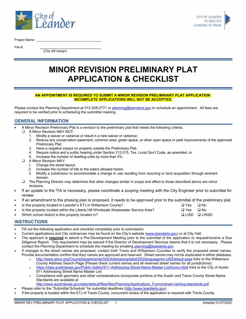
MINOR REV PRELIMINARY PLAT APPLICATION & CHECKLIST 1 Adopted 01/27/2022
Project Name: File #: (City will assign)
MINOR REVISION PRELIMINARY PLAT APPLICATION & CHECKLIST
AN APPOINTMENT IS REQUIRED TO SUBMIT A MINOR REVISION PRELIMINARY PLAT APPLICATION.
INCOMPLETE APPLICATIONS WILL NOT BE ACCEPTED. Please contact the Planning Department at 512-528-2771 or [email protected] to schedule an appointment. All fees are required to be verified prior to scheduling the submittal meeting. GENERAL INFORMATION • A Minor Revision Preliminary Plat is a revision to the preliminary plat that meets the following criteria.
A Minor Revision MAY NOT: 1. Modify a waiver or variance or result in a new waiver or variance; 2. Reduce any conservation easement, common area, green space, or other open space or park improvements of the approved
Preliminary Plat; 3. Have a negative impact on property outside the Preliminary Plat; 4. Require notice and a public hearing under Section 212.015, Tex. Local Gov’t Code, as amended, or 5. Increase the number of dwelling units by more than 5%.
A Minor Revision MAY: 1. Change the street layout. 2. Increase the number of lots to the extent allowed herein. 3. Modify a subdivision to accommodate a change in use resulting from rezoning or land acquisition through eminent
domain. The Planning Director may determine that other changes similar in scope and effect to those described above are minor
revisions. • If an update to the TIA is necessary, please coordinate a scoping meeting with the City Engineer prior to submittal for
review. • If an amendment to the phasing plan is proposed, it needs to be approved prior to the submittal of the preliminary plat. • Is this property located in Leander’s ETJ in Williamson County? Yes No • Is this property located within the Liberty Hill Wholesale Wastewater Service Area? Yes No • Which school district is this property located in? LISD LHISD
INSTRUCTIONS • Fill out the following application and checklist completely prior to submission. • Current applications and City ordinances may be found on the City’s website (www.leandertx.gov) or at City Hall. • The applicant is required to attend a Pre-Development Meeting prior to the submittal of the application or request/receive a Due
Diligence Report. This requirement may be waived if the Director of Development Services deems that it is not necessary. Please contact the Planning Department to schedule the meeting by emailing [email protected].
• If changes to the street names are proposed, contact both Travis and Williamson Counties to verify the proposed street names. Provide documentation confirm that they names are approved and reserved. Street names may not be duplicated in either database.
o http://www.wilco.org/CountyDepartments/GIS/Addressing/tabid/203/language/en-US/Default.aspx links to the Williamson County Address Search Page (Please check current names and all reserved street names for all jurisdictions).
o https://data.austintexas.gov/Public-Safety/911-Addressing-Street-Name-Master-List/kumu-nbtd links to the City of Austin 911 Addressing Street Name Master List
o Compliance with geometry and other considerations incorporate portions of the Austin and Travis County Street Name Standards are available at http://www.austintexas.gov/sites/default/files/files/Planning/Applications_Forms/street-naming-standards.pdf
• Please refer to the “Submittal Schedule” for submittal deadlines (http://www.leandertx.gov). • If the property is located within the ETJ of Travis County, concurrent review of the application is required with Travis County.
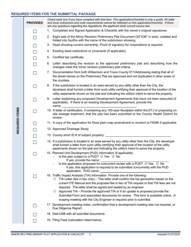
MINOR REV PRELIMINARY PLAT APPLICATION & CHECKLIST 2 Adopted 01/27/2022
REQUIRED ITEMS FOR THE SUBMITTAL PACKAGE
REQ
UIR
ED IT
EMS
PROVIDED Check each box if you have complied with that item. This application/checklist is only a guide. All state and local ordinances and code requirements cannot be reflected on this application/checklist. If there are any questions regarding the regulations, the applicant shall consult source law.
1. Completed and Signed Application & Checklist with the owner’s original signatures.
2. Eight sets of the Minor Revision Preliminary Plat Document (24”X36” in size), collated and folded into fourths with the name of the subdivision showing.
3. Deed showing current ownership. Proof of signatory for corporations is required.
4. Existing deed restrictions or covenants (if applicable).
5. Certified tax certificate.
6. Letter describing the revision to the approved preliminary plat and describing how the changes meet the minor revision preliminary plat criteria.
7. Documentation from both Williamson and Travis County 911/Addressing stating that all of the street names on the Preliminary Plat are approved and not duplicated in other areas of the counties.
8. If the subdivision is located in an area served by any utility other than the City, the developer shall furnish a letter from such utility certifying their approval of the location of the utility easements shown on the plat and indicating the utility's intent to serve the property.
9. Letter explaining any proposed Development Agreements that have not been executed (if applicable). If there is an existing Development Agreement, provide the name:___________________________________________.
10. A letter of certification, if containing any 100-year floodplain within the ETJ or proposing on-site sewage treatment, that the plat has been submitted to the County Health District for review.
11. A copy of the application for flood plain map amendment or revision to FEMA if applicable.
12. Approved Drainage Study.
13. County short ID # of subject property:
14. If a subdivision is located in an area served by any utility other than the City, the developer shall furnish a letter from such utility certifying their approval of the location of the utility easements shown on the plat and indicating the utility's intent to serve the property.
15. Planned Unit Development (PUD) information (if applicable) - Is this plan subject to a PUD? Yes No
If yes, provide the name: ________________________________________ - Is this application proposed for concurrent review with a PUD? Yes No
If yes, this application is required to be submitted concurrently with the PUD application. PUD name: __________________________________________
16. Traffic Impact Analysis (TIA) information. Provide one of the following: TIA Letter (fee in lieu only) – This letter shall confirm the trip generation based on the
current ITE Manual and the proposed fee in lieu of TIA request or that TIA fees are not required. The letter shall be signed and sealed by an engineer.
Approved TIA – Provide the approved TIA or if an update is proposed provide the Submittal Form and associated documents for review. This form is available online. A scoping meeting with the City Engineer is required prior to submittal.
17. Development meeting notes, confirmation that a development meeting was not required, or Due Diligence Report.
18. Disk/USB with all submittal documents.
19. Filing Fees (calculation listed below).
MINOR REV PRELIMINARY PLAT APPLICATION & CHECKLIST 3 Adopted 01/27/2022
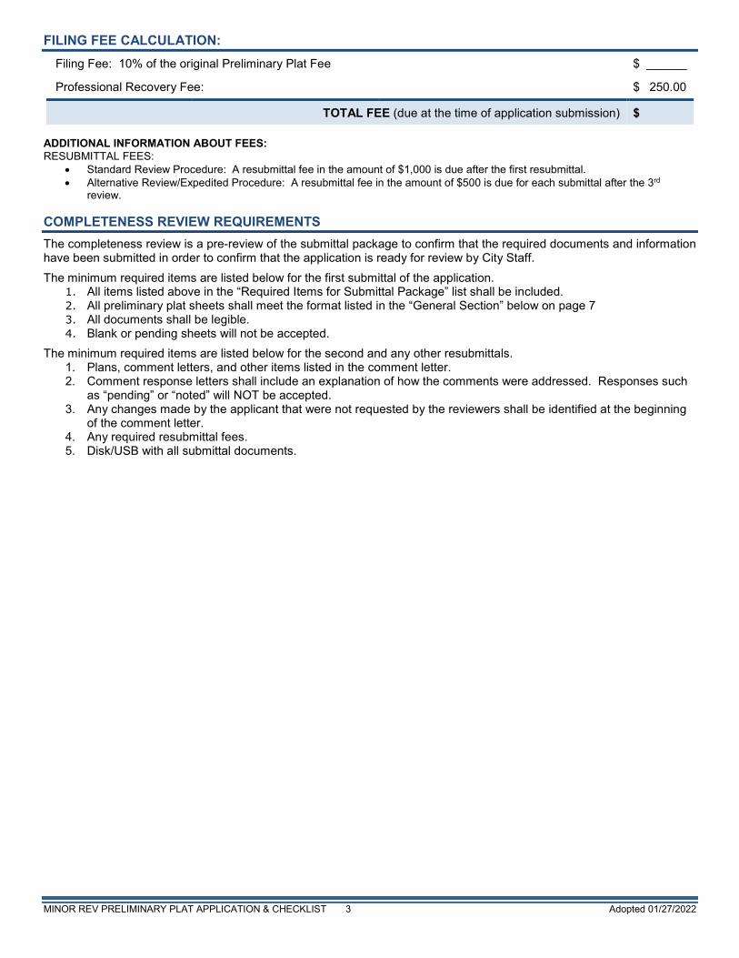
FILING FEE CALCULATION: Filing Fee: 10% of the original Preliminary Plat Fee $ ______
Professional Recovery Fee: $ 250.00
TOTAL FEE (due at the time of application submission) $ ADDITIONAL INFORMATION ABOUT FEES: RESUBMITTAL FEES:
• Standard Review Procedure: A resubmittal fee in the amount of $1,000 is due after the first resubmittal. • Alternative Review/Expedited Procedure: A resubmittal fee in the amount of $500 is due for each submittal after the 3rd
review. COMPLETENESS REVIEW REQUIREMENTS The completeness review is a pre-review of the submittal package to confirm that the required documents and information have been submitted in order to confirm that the application is ready for review by City Staff. The minimum required items are listed below for the first submittal of the application.
1. All items listed above in the “Required Items for Submittal Package” list shall be included. 2. All preliminary plat sheets shall meet the format listed in the “General Section” below on page 7 3. All documents shall be legible. 4. Blank or pending sheets will not be accepted.
The minimum required items are listed below for the second and any other resubmittals. 1. Plans, comment letters, and other items listed in the comment letter. 2. Comment response letters shall include an explanation of how the comments were addressed. Responses such
as “pending” or “noted” will NOT be accepted. 3. Any changes made by the applicant that were not requested by the reviewers shall be identified at the beginning
of the comment letter. 4. Any required resubmittal fees. 5. Disk/USB with all submittal documents.
MINOR REV PRELIMINARY PLAT APPLICATION & CHECKLIST 4 Adopted 01/27/2022
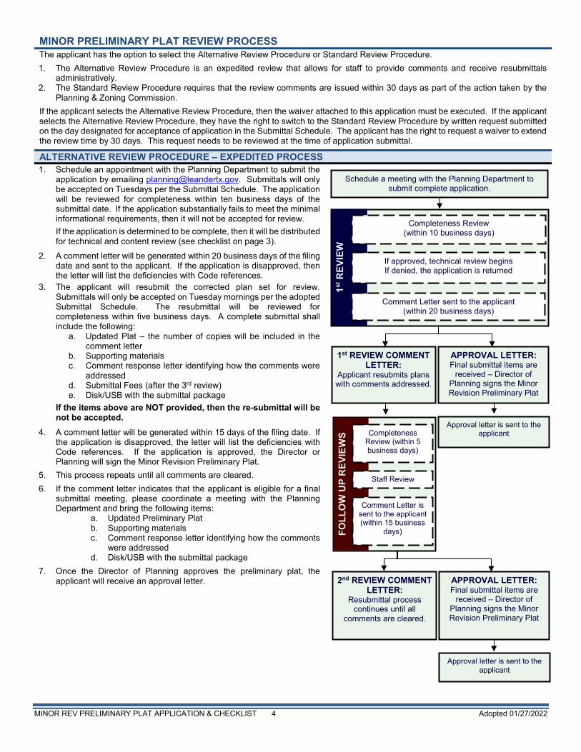
MINOR PRELIMINARY PLAT REVIEW PROCESS The applicant has the option to select the Alternative Review Procedure or Standard Review Procedure. 1. The Alternative Review Procedure is an expedited review that allows for staff to provide comments and receive resubmittals
administratively. 2. The Standard Review Procedure requires that the review comments are issued within 30 days as part of the action taken by the
Planning & Zoning Commission. If the applicant selects the Alternative Review Procedure, then the waiver attached to this application must be executed. If the applicant selects the Alternative Review Procedure, they have the right to switch to the Standard Review Procedure by written request submitted on the day designated for acceptance of application in the Submittal Schedule. The applicant has the right to request a waiver to extend the review time by 30 days. This request needs to be reviewed at the time of application submittal.
ALTERNATIVE REVIEW PROCEDURE – EXPEDITED PROCESS 1. Schedule an appointment with the Planning Department to submit the
application by emailing [email protected]. Submittals will only be accepted on Tuesdays per the Submittal Schedule. The application will be reviewed for completeness within ten business days of the submittal date. If the application substantially fails to meet the minimal informational requirements, then it will not be accepted for review. If the application is determined to be complete, then it will be distributed for technical and content review (see checklist on page 3).
2. A comment letter will be generated within 20 business days of the filing date and sent to the applicant. If the application is disapproved, then the letter will list the deficiencies with Code references.
3. The applicant will resubmit the corrected plan set for review. Submittals will only be accepted on Tuesday mornings per the adopted Submittal Schedule. The resubmittal will be reviewed for completeness within five business days. A complete submittal shall include the following:
a. Updated Plat – the number of copies will be included in the comment letter
b. Supporting materials c. Comment response letter identifying how the comments were
addressed d. Submittal Fees (after the 3rd review) e. Disk/USB with the submittal package
If the items above are NOT provided, then the re-submittal will be not be accepted.
4. A comment letter will be generated within 15 days of the filing date. If the application is disapproved, the letter will list the deficiencies with Code references. If the application is approved, the Director or Planning will sign the Minor Revision Preliminary Plat.
5. This process repeats until all comments are cleared. 6. If the comment letter indicates that the applicant is eligible for a final
submittal meeting, please coordinate a meeting with the Planning Department and bring the following items:
a. Updated Preliminary Plat b. Supporting materials c. Comment response letter identifying how the comments
were addressed d. Disk/USB with the submittal package
7. Once the Director of Planning approves the preliminary plat, the applicant will receive an approval letter.
APPROVAL LETTER: Final submittal items are
received – Director of Planning signs the Minor Revision Preliminary Plat
Schedule a meeting with the Planning Department to submit complete application.
Approval letter is sent to the applicant
1st REVIEW COMMENT LETTER:
Applicant resubmits plans with comments addressed.
FOLL
OW
UP
REV
IEW
S
Comment Letter is sent to the applicant (within 15 business
days)
Staff Review
Completeness Review (within 5 business days)
1st R
EVIE
W
Completeness Review (within 10 business days)
Comment Letter sent to the applicant (within 20 business days)
If approved, technical review begins If denied, the application is returned
2nd REVIEW COMMENT LETTER:
Resubmittal process continues until all
comments are cleared.
APPROVAL LETTER: Final submittal items are
received – Director of Planning signs the Minor Revision Preliminary Plat
Approval letter is sent to the applicant
MINOR REV PRELIMINARY PLAT APPLICATION & CHECKLIST 5 Adopted 01/27/2022
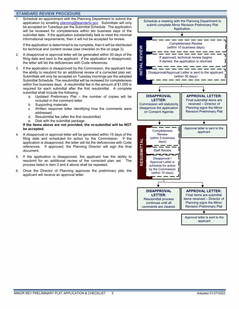
STANDARD REVIEW PROCEDURE 1. Schedule an appointment with the Planning Department to submit the
application by emailing [email protected]. Submittals will only be accepted on Tuesdays per the Submittal Schedule. The application will be reviewed for completeness within ten business days of the submittal date. If the application substantially fails to meet the minimal informational requirements, then it will not be accepted for review. If the application is determined to be complete, then it will be distributed for technical and content review (see checklist on the on page 3).
2. A disapproval or approval letter will be generated within 30 days of the filing date and sent to the applicant. If the application is disapproved, the letter will list the deficiencies with Code references.
3. If the application is disapproved by the Commission, the applicant has the ability to resubmit for an additional review of a corrected plan set. Submittals will only be accepted on Tuesday mornings per the adopted Submittal Schedule. The resubmittal will be reviewed for completeness within five business days. A resubmittal fee in the amount of $1,000 is required for each submittal after the first resubmittal. A complete submittal shall include the following:
a. Updated Preliminary Plat – the number of copies will be included in the comment letter
b. Supporting materials c. Written response letter identifying how the comments were
addressed d. Resubmittal fee (after the first resubmittal) e. Disk with the submittal package
If the items above are not provided, the re-submittal will be NOT be accepted.
4. A disapproval or approval letter will be generated within 15 days of the filing date and scheduled for action by the Commission. If the application is disapproved, the letter will list the deficiencies with Code references. If approved, the Planning Director will sign the final document.
5. If the application is disapproved, the applicant has the ability to resubmit for an additional review of the corrected plan set. The process listed in item 3 and 4 above shall be repeated.
6. Once the Director of Planning approves the preliminary plat, the applicant will receive an approval letter.
APPROVAL LETTER: Final submittal items are
received – Director of Planning signs the Minor Revision Preliminary Plat
Schedule a meeting with the Planning Department to submit complete Minor Revision Preliminary Plat
Application.
Approval letter is sent to the applicant
DISAPPROVAL LETTER:
Commission will statutorily disapprove the application
on Consent Agenda
RES
UB
MIT
TAL
Disapproval / Approval Letter is
schedule for action by the Commission
(within 15 days)
Staff Review
Completeness Review
(within 5 business days)
INIT
IAL
REV
IEW
Completeness Review (within 10 business days)
Disapproval/Approval Letter is sent to the applicant (within 30 days)
If approved, technical review begins If denied, the application is returned
DISAPPROVAL LETTER:
Resubmittal process continues until all
comments are cleared.
APPROVAL LETTER: Final items are submittal
items received – Director of Planning signs the Minor Revision Preliminary Plat
Approval letter is sent to the applicant
MINOR REV PRELIMINARY PLAT APPLICATION & CHECKLIST 6 Adopted 01/27/2022
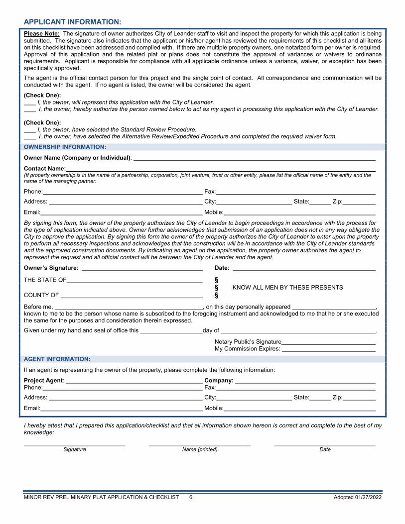
APPLICANT INFORMATION: Please Note: The signature of owner authorizes City of Leander staff to visit and inspect the property for which this application is being submitted. The signature also indicates that the applicant or his/her agent has reviewed the requirements of this checklist and all items on this checklist have been addressed and complied with. If there are multiple property owners, one notarized form per owner is required. Approval of this application and the related plat or plans does not constitute the approval of variances or waivers to ordinance requirements. Applicant is responsible for compliance with all applicable ordinance unless a variance, waiver, or exception has been specifically approved.
The agent is the official contact person for this project and the single point of contact. All correspondence and communication will be conducted with the agent. If no agent is listed, the owner will be considered the agent.
(Check One): I, the owner, will represent this application with the City of Leander. I, the owner, hereby authorize the person named below to act as my agent in processing this application with the City of Leander. (Check One): I, the owner, have selected the Standard Review Procedure. I, the owner, have selected the Alternative Review/Expedited Procedure and completed the required waiver form.
OWNERSHIP INFORMATION:
Owner Name (Company or Individual):
Contact Name: (If property ownership is in the name of a partnership, corporation, joint venture, trust or other entity, please list the official name of the entity and the name of the managing partner.
Phone: Fax:
Address: City: State: Zip:
Email: Mobile:
By signing this form, the owner of the property authorizes the City of Leander to begin proceedings in accordance with the process for the type of application indicated above. Owner further acknowledges that submission of an application does not in any way obligate the City to approve the application. By signing this form the owner of the property authorizes the City of Leander to enter upon the property to perform all necessary inspections and acknowledges that the construction will be in accordance with the City of Leander standards and the approved construction documents. By indicating an agent on the application, the property owner authorizes the agent to represent the request and all official contact will be between the City of Leander and the agent.
Owner’s Signature: Date: THE STATE OF § § KNOW ALL MEN BY THESE PRESENTS COUNTY OF § Before me, , on this day personally appeared , known to me to be the person whose name is subscribed to the foregoing instrument and acknowledged to me that he or she executed the same for the purposes and consideration therein expressed.
Given under my hand and seal of office this day of . Notary Public's Signature My Commission Expires:
AGENT INFORMATION:
If an agent is representing the owner of the property, please complete the following information:
Project Agent: Company: Phone: Fax:
Address: City: State: Zip:
Email: Mobile:
I hereby attest that I prepared this application/checklist and that all information shown hereon is correct and complete to the best of my knowledge: Signature Name (printed) Date
MINOR REV PRELIMINARY PLAT APPLICATION & CHECKLIST 7 Adopted 01/27/2022
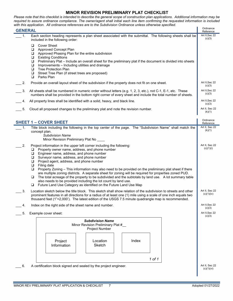
MINOR REVISION PRELIMINARY PLAT CHECKLIST Please note that this checklist is intended to describe the general scope of construction plan applications. Additional information may be required to assure ordinance compliance. The owner/agent shall initial each line item confirming the requested information is included with this application. All ordinance references are to the Subdivision Ordinance unless otherwise specified.
GENERAL Ordinance Reference
___ 1. Each section heading represents a plan sheet associated with the submittal. The following sheets shall be included in the following order:
Cover Sheet Approved Concept Plan Approved Phasing Plan for the entire subdivision Existing Conditions Preliminary Plat – Include an overall sheet for the preliminary plat if the document is divided into sheets Improvements – Including utilities and drainage Tree Protection Plan Street Tree Plan (if street trees are proposed) Parks Plan
Art II,Sec 22 (c)(3)
___ 2. Provide an overall layout sheet of the subdivision if the property does not fit on one sheet. Art II,Sec 22 (c)(3)
___ 3. All sheets shall be numbered in numeric order without letters (e.g. 1, 2, 3, etc.), not C-1, E-1, etc. These numbers shall be provided in the bottom right corner of every sheet and include the total number of sheets.
Art II,Sec 22 (c)(3)
___ 4. All property lines shall be identified with a solid, heavy, and black line. Art II,Sec 22 (c)(3)
___ 5. Cloud all proposed changes to the preliminary plat and note the revision number. Art II, Sec 22 (k)(1)
SHEET 1 – COVER SHEET Ordinance Reference
___ 1. Title block including the following in the top center of the page. The “Subdivision Name” shall match the concept plan.
Subdivision Name Minor Revision Preliminary Plat No ____
Art II, Sec 22 (k)(1)
___ 2. Project information in the upper left corner including the following: Property owner name, address, and phone number Engineer name, address, and phone number Surveyor name, address, and phone number Project agent, address, and phone number Filing date Property Zoning – This information may also need to be provided on the preliminary plat sheet if there
are multiple zoning districts. A separate sheet for zoning will be required for properties zoned PUD. The total acreage of the property to be subdivided and the subtotals by land use. A lot summary table
also needs to be provided including the lot count by land use. Future Land Use Category as identified on the Future Land Use Map
Art II, Sec 22 (c)(1)(i)
___ 3. Location sketch below the title block. This sketch shall show relation of the subdivision to streets and other prominent features in all directions for a radius of at least one (1) mile using a scale of one inch equals two thousand feet (1”=2,000’). The latest edition of the USGS 7.5 minute quadrangle map is recommended.
Art II, Sec 22 (c)(1)(iv)
___ 4. Index on the right side of the sheet name and number. Art II,Sec 22 (c)(3)
___ 5. Example cover sheet:
Art II,Sec 22 (c)(3)
___ 6. A certification block signed and sealed by the project engineer.
Art II, Sec 22 (c)(1)(vi)
Subdivision Name Minor Revision Preliminary Plat #__
Project Number
1 of 1
Location Sketch
Index
Project Information
MINOR REV PRELIMINARY PLAT APPLICATION & CHECKLIST 8 Adopted 01/27/2022
___ 7. Include the following signature block in the upper left corner.
APPROVED BY: Robin M. Griffin, AICP, Executive Director of Development Services Date
Art II, Sec 22 (k)(4)
___ 8. Note identifying the proposed changes. Art II, Sec 22 (k)(1)
___ 9. Provide any recommendations from the approved TIA (if applicable) Art II,Sec 22 (c)(3)
___ 10. Include the draft plat notes
General Plat Notes:
This subdivision is wholly contained within the current corporate limits of the City of Leander, Texas. (inside City only)
County
This subdivision is wholly contained with the Extra Territorial Jurisdiction of the City of Leander, Texas. (ETJ only)
County
No lot in this subdivision shall be occupied until connected to the City of Leander water distribution and wastewater collection facilities.
Art I, Sec 8 (b)
A Building Permit is required from the City of Leander prior to construction of any building or site improvements on any lot in this subdivision. (inside City only)
Art I, Sec 8 (b)
No buildings, fences, landscaping or other structures are permitted within drainage easements shown except as approved by the City of Leander Public Works Department.
Art III, Sec 46 (b)
Property owner shall provide for access to drainage easements as may be necessary and shall not prohibit access by the City of Leander.
Art III, Sec 46 (b)
All easements on private property shall be maintained by the property owner or his or her assigns.
In addition to the easement shown hereon, a ten (10’) foot wide public utility easement is dedicated along and adjacent to all right-of-way and a two and a half (2.5’) foot wide public utility easement is dedicated along all side lot lines.
Art II, Sec 24 (c)(6)(vi)
No portion of this tract is within a flood hazard area as shown on the Flood Insurance Rate Map Panel # _____ for Williamson Co., effective ___(Date)___.
Code of Ordinances Art
3.10
Building setbacks not shown hereon shall comply with the most current zoning ordinance of the City of Leander. Additional residential garage setbacks may be required as listed in the current zoning ordinance. (inside City only)
Art II, Sec 24 (c)(6)(vii)
Sidewalks shall be installed on both sides of [insert street name(s)] and the subdivision side of [insert street name(s)]. Those sidewalks not abutting a residential, commercial or industrial lot (including sidewalks along street frontages of lots proposed for schools, churches, park lots, detention lots, drainage lots, landscape lots, or similar lots), sidewalks on arterial streets to which access is prohibited, sidewalks on double frontage lots on the side to which access is prohibited, and all sidewalks on safe school routes shall be installed when the adjoining street is constructed.
Art II, Sec 24 (c)(6)(vii)
All utility lines must be located underground. Art III, Sec 47
This plat conforms to the Preliminary Plat approved by the Planning & Zoning Commission on _________ (Insert Approval Date)
Art II, Sec 24 (a) (2)
Approval of this final plat does not constitute the approval of variances or waivers to ordinance requirements.
Art II, Sec 20 (j)
___ 1. Non-Residential & Multi-Family Plat Notes:
All drive lanes, fire lanes, and driveways within this subdivision shall provide for reciprocal access for ingress and egress to all other lots within the subdivision and to adjacent properties.
Art III, Sec 42 (h)
Traffic Impact Analysis Note: At the time of site development permit, the applicant will provide a payment to the City in lieu of
a traffic impact analysis (TIA), unless a TIA for the entire development indicates that average daily trips are estimated below 2,000.
OR Include items required by the TIA as a plat note.
Code of Ordinances 10.03.003
___ 2. Single-Family & Two Family Plat Notes:
No driveway shall be constructed closer than 50' or 60% of parcel frontage, whichever is less, to the ROW of an intersecting local or collector street or 100' or 60% of parcel frontage, whichever is less, to the ROW of an intersecting arterial street.
Transportation Criteria Manual
5.3.1 J
MINOR REV PRELIMINARY PLAT APPLICATION & CHECKLIST 9 Adopted 01/27/2022
The HOA will own and maintain the following lots: ___ Art IV, Sec 61(d)
The HOA bylaws are recorded in the Official Public Records of ____County, Texas under document number ______.
Art IV, Sec 61(d)
The homeowners association is required to mow and maintain landscaping in the open channels, detention and water quality areas.
Art III, Sec 41 (a)
The City accepts and maintains drainage and water quality improvements contained in open channels, detention and water quality areas. (which should be contained in a drainage easement).
Art III, Sec 41 (a)
If single family or two family residential lots are proposed to back or side up to an arterial street, the following is provided: A landscape lot is provided between the lot(s) and the specified roadway. Such landscape lot is at least ten (10) feet wide: (the following note is included on the plat)
For every six hundred (600) square feet of area in the landscape lot (#) , two (2) shade trees (two-inch caliper or larger) and four (4) shrubs (five gallon container size or larger) shall be planted and maintained. Two ornamental trees per shade tree may be substituted for up to fifty percent of the shade trees if desired. A six-foot privacy fence, but no higher than three feet within twenty five feet of an intersecting street, shall be constructed with the subdivision improvements at the common lot line between the landscape lot and the single-family or two-family lots. The fence is required to be constructed of one or more of the following materials: brick, stone, cast stone, stucco, factory tinted (not painted) split-faced concrete masonry unit, or other similar material approved by the Director of Planning. In addition to the materials listed above, textured pre-cast concrete (e.g. WoodCrete) is also permitted when the privacy fence is adjacent to collectors. All columns are required to have concrete footings. The landscape lot is required to be maintained by a private association.
Composite Zoning
Ordinance
Art VI, Sec 8
SHEET 2 – APPROVED CONCEPT PLAN Ordinance Reference
___ 1. Provide the approved concept plan. Art II, Sec 22 (c)(1)
SHEET 3 – APPROVED PHASING PLAN Ordinance Reference
___ 2. Provide the approved phasing plan for the subdivision. Demonstrate that this submittal is in compliance with the plan.
Art 13.12 of the code of ordinances
SHEET 4 – EXISTING CONDITIONS Ordinance Reference
___ 1. The existing property lines of the land being subdivided, including bearings and distances, of the land being subdivided. Property lines shall be drawn sufficiently wide to provide easy identification.
Art II, Sec 22 (c)(2)(i)
___ 2. The location of existing water courses, dry creek beds, wells, sinkholes and other similar topographic features. Art II, Sec 22 (c)(2)(ii)
___ 3. Centerline of water courses, creeks, existing drainage structures and other pertinent data shall be shown. Art II, Sec 22 (c)(2)(iii)
___ 4. Areas subject to flooding delineating the regulatory one hundred (100) year floodplain, and any other floodplains identified in the City’s Master Drainage Plan.
Art II, Sec 22 (c)(2)(iv)
___ 5. Topographic data indicating two (2) foot contour intervals for slopes up to 10%and five (5) foot contour intervals for slopes exceeding 10%. The contoured area shall extend outward from the property boundary for a distance of two hundred (200) feet.
Art II, Sec 22 (c)(2)(v)
___ 6. Locations, sizes and descriptions of all existing utilities, including but not limited to wastewater lines, lift stations, wastewater and storm sewer manholes, water lines, water storage tanks, and wells within the subdivision, and/or adjacent thereto.
Art II, Sec 22 (c)(2)(vi)
___ 7. Location, dimensions, names and descriptions of all existing or recorded streets, alleys, reservations, railroads, easements or other public rights-of-way within or near the subdivision.
Art II, Sec 22 (c)(2)(vii)
___ 8. Survey ties locating adjacent intersecting streets/driveways and median breaks to determine compliance with alignment or off-set requirements on a boundary street within a distance of one thousand (1,000) feet of the subdivision boundary.
Art II, Sec 22 (c) (2) (vii)
___ 9. Survey ties at no less than three hundred (300) foot intervals across boundary streets indicating existing ROW width/location (unless such ROW was dedicated by plat).
Art II, Sec 22 (c) (2) (vii)
___ 10. The location of City limit lines and/or extra-territorial jurisdiction, as depicted on the City’s most recent base map, if either traverses the subdivision or is contiguous to the subdivision boundary.
Art II, Sec 22 (c) (2) (viii)
___ 11. Watershed information is provided (if applicable): Art III, Sec 41
MINOR REV PRELIMINARY PLAT APPLICATION & CHECKLIST 10 Adopted 01/27/2022
Watershed information is provided (if applicable): Lake Travis watershed report provided to LCRA. Edward’s recharge zone report provided to TCEQ. Edward’s contributing zone report provided to TCEQ.
___ 12. Identify all required Buffer Zones. Art III, Sec 49
SHEET 5 – PRELIMINARY PLAT Ordinance Reference
___ 1. The date, scale (1”=100), and north indicator. Art II, Sec 22 (c)(1)(iii)
___ 2. The owners’ names, deed or plat references and property lines for adjacent property as determined by the most recent tax rolls for all properties located within two hundred (200) feet of the subdivision boundary.
Art II, Sec 22 (c)(1)(v)
___ 3. Provide a table including the street name and linear feet. Art II, Sec 22 (c)(2)(vii)
___ 4. Provide a secondary access for all subdivisions greater than thirty (30) lots unless otherwise approved by the Fire Department. The secondary access shall be constructed in accordance with the current Fire Code and City Standard Details and Specifications.
Art III, Sec 42 (i)
___ 5. Identify the zoning of the property. A separate sheet may be required for PUD. Art II, Sec 22 (2)(ix)
___ 6. Numbers to identify each lot and block. Art III, Sec 45
___ 7. The lengths of each proposed property line of all lots. The area of each non-rectangular lot shall be provided. Art III, Sec 45 (b)(1)
___ 8. Information showing that the proposed subdivision complies with the Transportation Criteria Manual street design standards including intersection sight distance, minimum horizontal curve radii, tangent spacing between curves, intersection spacing, ROW widths, curb return radii, etc.
TCM
___ 9. Proposed final plat section boundaries within the preliminary plat if more than one section is proposed. Art II, Sec 22 (c)(1)(ii)
___ 10. Except for SFR zoning districts, residential blocks do not exceed a perimeter length of three thousand five hundred (3,500) feet, and residential blocks in SFR zoning districts do not exceed a perimeter length of six thousand (6,000) feet unless City staff approves longer blocks where unusual conditions are found such as steep slopes or other restrictive topography, floodplains, public land, railroad tracks, freeways, tollways, existing adjacent development or other similar features.
Art III, Sec 45 (a)
___ 11. Blocks along arterial streets and blocks containing or proposed to contain primarily commercial or industrial uses do not exceed a perimeter length of four thousand five hundred (4,000) feet unless City staff approves longer blocks where unusual conditions are found such as steep slopes or other restrictive topography, floodplains, public land, railroad tracks, freeways, tollways, existing adjacent development or other similar features.
Art III, Sec 45 (a)
___ 12. Blocks are wide enough to accommodate two tiers of lots except for blocks adjacent to major streets, railroads, waterways or other topographical features prohibiting a second lot tier.
Art III, Sec 45 (a)
___ 13. If inside the City, lot sizes and dimensions as well as proposed use are in conformance with the Composite Zoning Ordinance. Lots to be served by septic systems shall be a minimum of one acre in area if on a public water supply, two acres if served by an on-site private well, located in areas with steep topography, floodplain, or other natural features, and conform to the County or LCRA regulations based on percolation tests and soil analysis.
Art III, Sec 45 (b)(2)
___ 14. No lot has a lot line intersection of less than forty-five (45) degrees. Art III, Sec 45 (b)(7)
___ 15. All lots front on a public roadway. Art III, Sec 45 (b)(8)
___ 16. Lots are arranged so that all lots face similar lots across the street. Art III, Sec 45 (b)(9)(ii)
___ 17. Wherever feasible, single family and two family residential lots are oriented so that the rear line of a lot is not the side lot line of another lot.
Art III, Sec 45 (b)(9)(ii)
___ 18. There are no single family or two family double frontage lots except where one of the frontages is to an arterial street.
Art III, Sec 45 (b)(10)
___ 19. Single family and two family residential corner lots on unequal class streets have access only to the street with the lower classification and a note is shown on the plat prohibiting access to the other street.
Art III, Sec 45 (b)(11)
___ 20. “Flag” lots are not proposed unless there are no other reasonable alternatives and they meet the following conditions:
Driveways would be located no closer than permitted by the Transportation Criteria Manual. The minimum width of the flag lot is no less than twenty five (25) feet. The narrow portion of the lot is dedicated as a common driveway access easement. No more than two “flag” lots are located side by side. The Fire Chief has no objection to the lot layout.
Art III, Sec 45 (b)(8)
MINOR REV PRELIMINARY PLAT APPLICATION & CHECKLIST 11 Adopted 01/27/2022
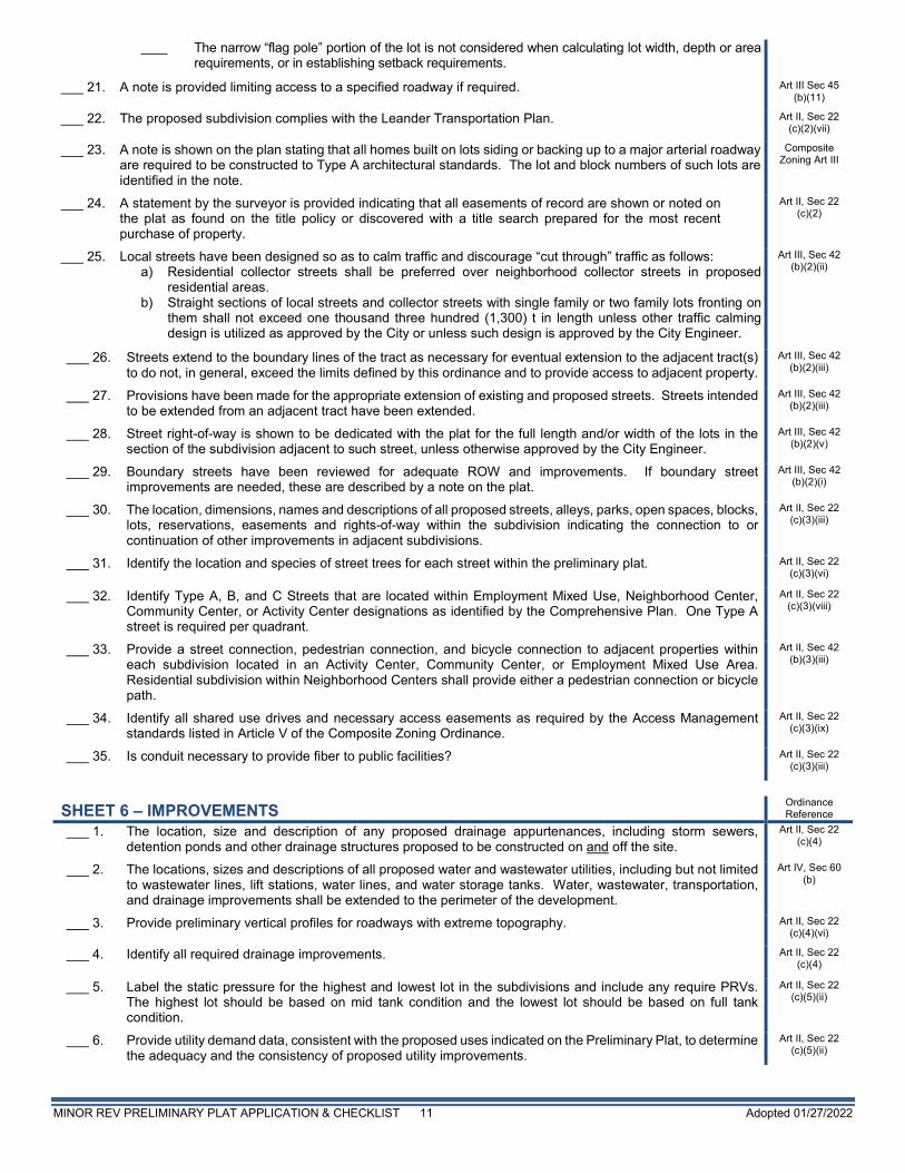
The narrow “flag pole” portion of the lot is not considered when calculating lot width, depth or area requirements, or in establishing setback requirements.
___ 21. A note is provided limiting access to a specified roadway if required. Art III Sec 45 (b)(11)
___ 22. The proposed subdivision complies with the Leander Transportation Plan. Art II, Sec 22 (c)(2)(vii)
___ 23. A note is shown on the plan stating that all homes built on lots siding or backing up to a major arterial roadway are required to be constructed to Type A architectural standards. The lot and block numbers of such lots are identified in the note.
Composite Zoning Art III
___ 24. A statement by the surveyor is provided indicating that all easements of record are shown or noted on the plat as found on the title policy or discovered with a title search prepared for the most recent purchase of property.
Art II, Sec 22 (c)(2)
___ 25. Local streets have been designed so as to calm traffic and discourage “cut through” traffic as follows: a) Residential collector streets shall be preferred over neighborhood collector streets in proposed
residential areas. b) Straight sections of local streets and collector streets with single family or two family lots fronting on
them shall not exceed one thousand three hundred (1,300) t in length unless other traffic calming design is utilized as approved by the City or unless such design is approved by the City Engineer.
Art III, Sec 42 (b)(2)(ii)
___ 26. Streets extend to the boundary lines of the tract as necessary for eventual extension to the adjacent tract(s) to do not, in general, exceed the limits defined by this ordinance and to provide access to adjacent property.
Art III, Sec 42 (b)(2)(iii)
___ 27. Provisions have been made for the appropriate extension of existing and proposed streets. Streets intended to be extended from an adjacent tract have been extended.
Art III, Sec 42 (b)(2)(iii)
___ 28. Street right-of-way is shown to be dedicated with the plat for the full length and/or width of the lots in the section of the subdivision adjacent to such street, unless otherwise approved by the City Engineer.
Art III, Sec 42 (b)(2)(v)
___ 29. Boundary streets have been reviewed for adequate ROW and improvements. If boundary street improvements are needed, these are described by a note on the plat.
Art III, Sec 42 (b)(2)(i)
___ 30. The location, dimensions, names and descriptions of all proposed streets, alleys, parks, open spaces, blocks, lots, reservations, easements and rights-of-way within the subdivision indicating the connection to or continuation of other improvements in adjacent subdivisions.
Art II, Sec 22 (c)(3)(iii)
___ 31. Identify the location and species of street trees for each street within the preliminary plat. Art II, Sec 22 (c)(3)(vi)
___ 32. Identify Type A, B, and C Streets that are located within Employment Mixed Use, Neighborhood Center, Community Center, or Activity Center designations as identified by the Comprehensive Plan. One Type A street is required per quadrant.
Art II, Sec 22 (c)(3)(viii)
___ 33. Provide a street connection, pedestrian connection, and bicycle connection to adjacent properties within each subdivision located in an Activity Center, Community Center, or Employment Mixed Use Area. Residential subdivision within Neighborhood Centers shall provide either a pedestrian connection or bicycle path.
Art II, Sec 42 (b)(3)(iii)
___ 34. Identify all shared use drives and necessary access easements as required by the Access Management standards listed in Article V of the Composite Zoning Ordinance.
Art II, Sec 22 (c)(3)(ix)
___ 35. Is conduit necessary to provide fiber to public facilities? Art II, Sec 22 (c)(3)(iii)
SHEET 6 – IMPROVEMENTS Ordinance Reference
___ 1. The location, size and description of any proposed drainage appurtenances, including storm sewers, detention ponds and other drainage structures proposed to be constructed on and off the site.
Art II, Sec 22 (c)(4)
___ 2. The locations, sizes and descriptions of all proposed water and wastewater utilities, including but not limited to wastewater lines, lift stations, water lines, and water storage tanks. Water, wastewater, transportation, and drainage improvements shall be extended to the perimeter of the development.
Art IV, Sec 60 (b)
___ 3. Provide preliminary vertical profiles for roadways with extreme topography. Art II, Sec 22 (c)(4)(vi)
___ 4. Identify all required drainage improvements. Art II, Sec 22 (c)(4)
___ 5. Label the static pressure for the highest and lowest lot in the subdivisions and include any require PRVs. The highest lot should be based on mid tank condition and the lowest lot should be based on full tank condition.
Art II, Sec 22 (c)(5)(ii)
___ 6. Provide utility demand data, consistent with the proposed uses indicated on the Preliminary Plat, to determine the adequacy and the consistency of proposed utility improvements.
Art II, Sec 22 (c)(5)(ii)
MINOR REV PRELIMINARY PLAT APPLICATION & CHECKLIST 12 Adopted 01/27/2022
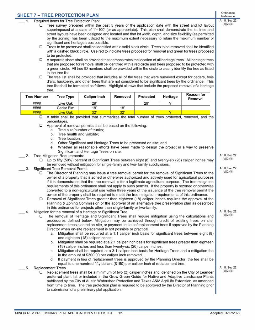
SHEET 7 – TREE PROTECTION PLAN Ordinance Reference
___ 1. Required Items for Tree Protection Plan: Tree survey prepared within the past 5 years of the application date with the street and lot layout
superimposed at a scale of 1”=100’ (or as appropriate). This plan shall demonstrate the lot lines and street layouts have been designed and located and that lot width, depth, and size flexibility (as permitted by the zoning) has been utilized to the maximum extent necessary to retain the maximum number of significant and heritage trees possible.
Trees to be preserved shall be identified with a solid black circle. Trees to be removed shall be identified with a dashed black circle. Use red to indicate trees proposed for removal and green for trees proposed to be protected.
A separate sheet shall be provided that demonstrates the location of all heritage trees. All heritage trees that are proposed for removal shall be identified with a red circle and trees proposed to be protected with a green circle. All tree ID numbers shall be provided within the circle to clearly identify the tree as listed in the tree list.
The tree list shall be provided that includes all of the trees that were surveyed except for cedars, bois d’arc, hackberry, and other trees that are not considered to be significant trees by the ordinance. This tree list shall be formatted as follows. Highlight all rows that include the proposed removal of a heritage tree.
Tree Number Tree Type Caliper Inch Removed Protected Heritage Reason for Removal
#### Live Oak 29” 29” Y #### Cedar Elm 18” 18” #### Live Oak 32” 32” Y A table shall be provided that summarizes the total number of trees protected, removed, and the
percentages. Approval of removal permits shall be based on the following:
a. Tree size/number of trunks; b. Tree health and viability; c. Tree location; d. Other Significant and Heritage Trees to be preserved on site; and e. Whether all reasonable efforts have been made to design the project in a way to preserve
Significant and Heritage Trees on site.
Art II, Sec 22 (c)(2)(iii)
___ 2. Tree Mitigation Requirements: Up to fifty (50%) percent of Significant Trees between eight (8) and twenty-six (26) caliper inches may
be removed without mitigation for single-family and two- family subdivisions.
Art II, Sec 22 (c)(2)(iii)
___ 3. Significant Tree Removal Permit The Director of Planning may issue a tree removal permit for the removal of Significant Trees to the
owner of a property that is zoned or otherwise authorized and actively used for agricultural purposes if it is demonstrated that the tree removal is for a legitimate agricultural purpose. The tree mitigation requirements of this ordinance shall not apply to such permits. If the property is rezoned or otherwise converted to a non-agricultural use within three years of the issuance of the tree removal permit the owner of the property shall be required to meet the tree mitigation requirements of this ordinance.
Removal of Significant Trees greater than eighteen (18) caliper inches requires the approval of the Planning & Zoning Commission or the approval of an alternative tree preservation plan as described in this ordinance for projects other than single-family or two-family.
Art II, Sec 22 (c)(2)(iii)
___ 4. Mitigation for the removal of a Heritage or Significant Tree The removal of Heritage and Significant Trees shall require mitigation using the calculations and
procedures defined below. Mitigation may be achieved through credit of existing trees on site, replacement trees planted on-site, or payment-in-lieu of replacement trees if approved by the Planning Director when on-site replacement is not possible or practical.
a. Mitigation shall be required at a 1:1 caliper inch basis for significant trees between eight (8) and eighteen (18) caliper inches.
b. Mitigation shall be required at a 2:1 caliper inch basis for significant trees greater than eighteen (18) caliper inches and less than twenty-six (26) caliper inches.
c. Mitigation shall be required at a 3:1 caliper inch basis for Heritage Trees and a mitigation fee in the amount of $300.00 per caliper inch removed.
d. If payment in lieu of replacement trees is approved by the Planning Director, the fee shall be equal to one hundred fifty dollars ($150) per caliper inch of replacement tree.
Art II, Sec 22 (c)(2)(iii)
___ 5. Replacement Trees Replacement trees shall be a minimum of two (2) caliper inches and identified on the City of Leander
preferred plant list or included in the Grow Green Guide for Native and Adaptive Landscape Plants published by the City of Austin Watershed Protection and Texas A&M AgriLife Extension, as amended from time to time. The tree protection plan is required to be approved by the Director of Planning prior to submission of a preliminary plat application.
Art II, Sec 22 (c)(2)(iii)
MINOR REV PRELIMINARY PLAT APPLICATION & CHECKLIST 13 Adopted 01/27/2022
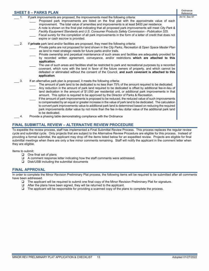
SHEET 8 – PARKS PLAN Ordinance Reference
___ 1. If park improvements are proposed, the improvements meet the following criteria: Proposed park improvements are listed on the final plat with the approximate value of each
improvement. The total value of amenities and improvements is at least $400 per residence. A note is shown on the final plat indicating that all proposed park improvements will meet City Park &
Facility Equipment Standards and U.S. Consumer Products Safety Commission - Publication 325. Fiscal surety for the completion of all park improvements in the form of a letter of credit that does not
expire or cash escrow is provided. ___ 2. If private park land and/or facilities are proposed, they meet the following criteria:
Private parks are not proposed for land shown in the City Parks, Recreation & Open Space Master Plan as land to meet strategic needs for future parks and/or trails.
Private ownership and perpetual maintenance of such areas and facilities are adequately provided for by recorded written agreement, conveyance, and/or restrictions which are attached to this application.
The use of such areas and facilities shall be restricted to park and recreational purposes by a recorded covenant, which runs with the land in favor of the future owners of property, and which cannot be defeated or eliminated without the consent of the Council, and such covenant is attached to this application.
___ 3. If an alternative park plan is proposed, it meets the following criteria: The amount of park land to be dedicated is no less than 75% of the amount required to be dedicated. Any reduction in the amount of park land required to be dedicated is offset by additional fee-in-lieu of
land dedication in the amount of $1,050 per residential unit, or additional park improvements in that amount. This option is required to be approved by the Director of Parks & Recreation.
If the amount of park improvements is proposed to be reduced, the reduced value of such improvements is compensated by an equal or greater increase in the value of park land to be dedicated. The calculation to convert park improvements value to additional park land is determined based on reducing the required park improvements dollar value by not more than the fee in-lieu dollar value of the additional park land to be dedicated.
___ 4. Provide a phasing table demonstrating compliance with the Ordinance
Art IV, Sec 61
FINAL SUBMITTAL REVIEW – ALTERNATIVE REVIEW PROCEDURE To expedite the review process, staff has implemented a Final Submittal Review Process. This process replaces the regular review cycle and submittal cycle. Only projects that are subject to the Alternative Review Procedure are eligible for this process. Instead of providing a formal submittal, the applicant may drop off the items listed below for an expedited review. Projects are eligible for final submittal meetings when there are only a few minor comments remaining. Staff will notify the applicant in the comment letter when they are eligible. Items to submit:
One final set of plans A comment response letter indicating how the staff comments were addressed. Disk/USB including the submittal documents
FINAL APPROVAL In order to complete the Minor Revision Preliminary Plat process, the following items will be required to be submitted after all comments have been addressed.
The applicant will be required to submit one final copy of the Minor Revision Preliminary Plat for signature. After the plans have been signed, they will be returned to the applicant. The applicant will be responsible for providing a scanned copy of the plans to complete the process.
MINOR REV PRELIMINARY PLAT APPLICATION & CHECKLIST 14 Adopted 01/27/2022
CONFLICT OF INTEREST DISCLOSURES Please submit at the time of submission of application and update disclosures within 7 business days after the date of an event that would make a statement in the questionnaire incomplete or inaccurate. ARTICLE 9.05, CITY CODE OF ORDINANCES – CODE OF ETHICS: http://z2codes.franklinlegal.net/franklin/Z2Browser2.html?showset=leanderset Ethics Ordinance – Disclosure Statements
The City’s Ethics Ordinance requires persons seeking to enter discretionary contracts with the City or appearing before the City Council or another City board or body to disclose certain relationships and conflicts of interest. The relevant sections of the Ethics Ordinance are set forth below. The Ethics Ordinance can be found in Article 9.05, Chapter 9 of the City’s Code of Ordinances at the above link.
Sec. 9.05.007 Persons doing business with the city
(a) Persons seeking discretionary contracts. (1) For the purpose of assisting the city in the enforcement of provisions contained in this article, an individual or business
entity seeking a discretionary contract from the city is required to disclose in connection with a proposal for a discretionary contract any conflict of interest. This is set forth in sections 9.05.004 and 9.05.005 of this article. Further, the individual or business entity agree to abide by the same ethical standards as set forth for public servants in this article.
(2) Subsection (a) of this section will become a permanent footnote on documents contained in city bid packets for discretionary contracts.
(b) Disclosure of conflicts of interest by persons appearing before a board or city body. A person appearing before any city board or other city body for the purpose of doing business with the city shall disclose to that board or body any facts known to such person which may show or establish that:
(1) An employee or officer of the city that advises or makes presentations to the board or city body; or (2) Any member of the board or city body;
has or may have a conflict of interest pursuant to chapter 171, Tex. Loc. Gov’t. Code, or an interest which would violate the ethical standards set forth in this article, if he or she were to participate in the processing or consideration of the subject matter.
Sec. 9.05.009(f) Disclosure by persons appearing before a city body. Any person who appears before any city body who has had business dealings within the preceding 12-month period involving one or more transactions of five hundred dollars ($500.00) or more each quarter, or for a total of twenty-five hundred dollars ($2,500.00) or more, within the preceding 12-month period with a councilmember, commissioner, or business entity in which a councilmember or commissioner has a substantial interest, shall disclose such business dealings at the time of the appearance. Any person who shall intentionally or knowingly fail to make the aforesaid disclosure shall be guilty of a misdemeanor and shall be fined in accordance with this article.
Do Not Write Below – Staff Use Only Accepted for Processing by: Date:
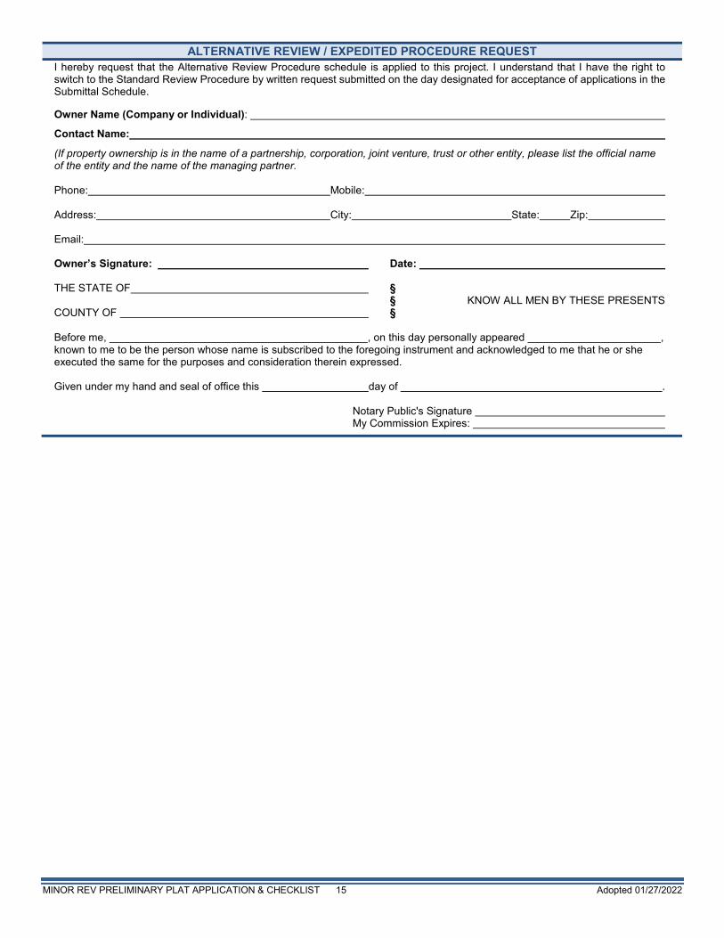
MINOR REV PRELIMINARY PLAT APPLICATION & CHECKLIST 15 Adopted 01/27/2022
ALTERNATIVE REVIEW / EXPEDITED PROCEDURE REQUEST I hereby request that the Alternative Review Procedure schedule is applied to this project. I understand that I have the right to switch to the Standard Review Procedure by written request submitted on the day designated for acceptance of applications in the Submittal Schedule. Owner Name (Company or Individual):
Contact Name:
(If property ownership is in the name of a partnership, corporation, joint venture, trust or other entity, please list the official name of the entity and the name of the managing partner. Phone: Mobile: Address: City: State: Zip: Email: Owner’s Signature: Date: THE STATE OF § § KNOW ALL MEN BY THESE PRESENTS COUNTY OF § Before me, , on this day personally appeared , known to me to be the person whose name is subscribed to the foregoing instrument and acknowledged to me that he or she executed the same for the purposes and consideration therein expressed. Given under my hand and seal of office this day of . Notary Public's Signature My Commission Expires:
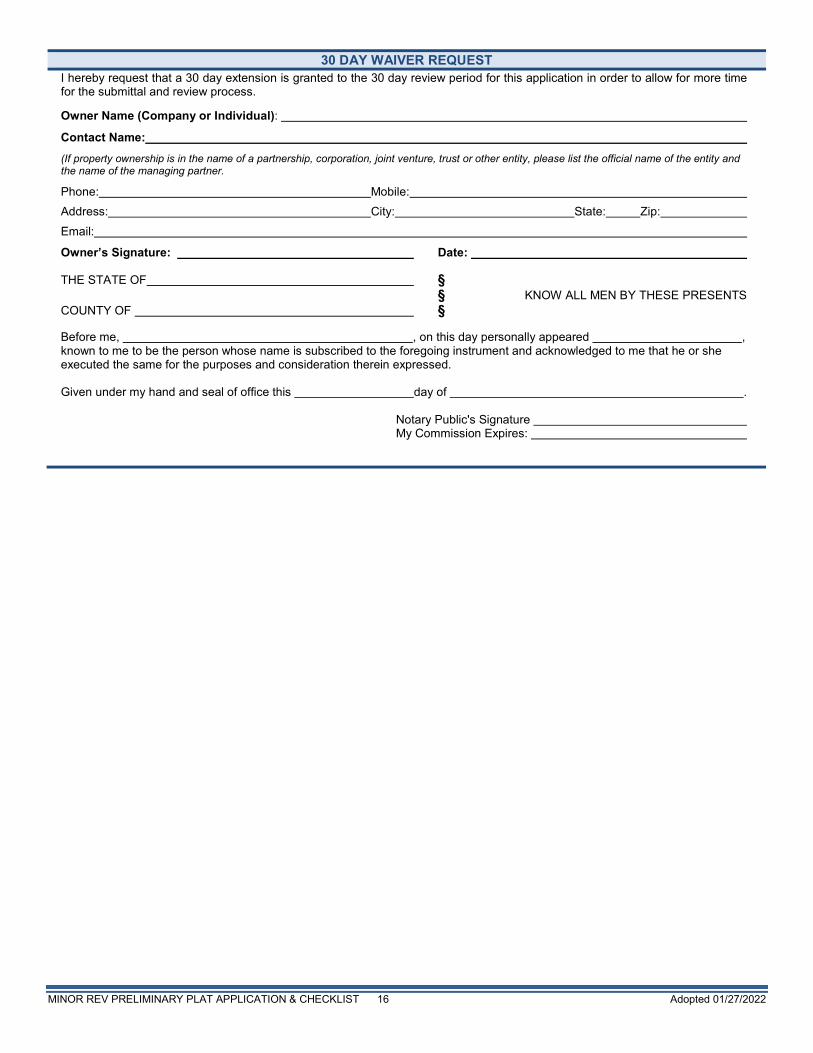
MINOR REV PRELIMINARY PLAT APPLICATION & CHECKLIST 16 Adopted 01/27/2022
30 DAY WAIVER REQUEST
I hereby request that a 30 day extension is granted to the 30 day review period for this application in order to allow for more time for the submittal and review process. Owner Name (Company or Individual):
Contact Name:
(If property ownership is in the name of a partnership, corporation, joint venture, trust or other entity, please list the official name of the entity and the name of the managing partner.
Phone: Mobile:
Address: City: State: Zip:
Email:
Owner’s Signature: Date: THE STATE OF § § KNOW ALL MEN BY THESE PRESENTS COUNTY OF § Before me, , on this day personally appeared , known to me to be the person whose name is subscribed to the foregoing instrument and acknowledged to me that he or she executed the same for the purposes and consideration therein expressed. Given under my hand and seal of office this day of . Notary Public's Signature My Commission Expires: