Pre-Feasibility Report - Environmental Clearance
46
1 Public Works Department, Mining and Monitoring Division , Water Resources Department Trichy-1 FORM-I (I) Basic information Sl.No Item Details 1 Name of the project Proposed project of Quarrying river sand in U/S and D/S of Kattalai Bed Regulator in Cauvery river over an extent of 196.25 Ha.in Trichy District of Tamil Nadu. 2 S.No.in the Schedule 1 (a) 3 Proposed capacity/area /length/tonnage to be Handled/command area/lease area/number of wells to be drilled Proposed Area – 196.25 Hec Proposed Capacity As per calculation sheet = 15,01,247 M 3 - 4 New/Expansion/Modernization New 5 Existing capacity/ Area etc., Existing Area – 476.16 Hec Existing Capacity As per calculation sheet = 15,01,247 M 3 Reserve to a depth of 6 M = 2,85,69,600 M 3 Total = 3,00,70,847 M 3 Approved Quantity = 15,01,247 M 3 Mined Quantity = 5,54,813 M 3 Balance Quantity = 9,46,434 M 3 6 Category of project i.e. ’A’ or ‘B’ A 7 Does it attract the general condition? If yes , please specify. No. Doesn’t attract any items mentioned in the general conditions. 8 Does it attract the specific condition? If yes , please specify. No. Doesn’t attract the specific conditions 9 Location River Cauvery at Mile 83/3+50m. to 85/6+50m. Plot/Survey/Khasra No. SF No 293 of Sriramasamudram / SF No 288 of Silaipillaiya puttur. Village Sriramasamuthiram / Silaipillaya puttur
-
Upload
khangminh22 -
Category
Documents
-
view
3 -
download
0
Transcript of Pre-Feasibility Report - Environmental Clearance

1
Public Works Department, Mining and Monitoring Division ,
Water Resources Department Trichy-1
FORM-I
(I) Basic information
Sl.No Item Details
1 Name of the project
Proposed project of Quarrying river sand in U/S and D/S of Kattalai Bed Regulator in Cauvery river over an extent of 196.25 Ha.in Trichy District of Tamil Nadu.
2 S.No.in the Schedule 1 (a)
3
Proposed capacity/area /length/tonnage to be Handled/command area/lease area/number of wells to be drilled
Proposed Area – 196.25 Hec Proposed Capacity As per calculation sheet = 15,01,247 M3 -
4 New/Expansion/Modernization New
5 Existing capacity/ Area etc.,
Existing Area – 476.16 Hec Existing Capacity As per calculation sheet = 15,01,247 M3 Reserve to a depth of 6 M = 2,85,69,600 M3
Total = 3,00,70,847 M3 Approved Quantity = 15,01,247 M3 Mined Quantity = 5,54,813 M3
Balance Quantity = 9,46,434 M3
6 Category of project i.e. ’A’ or ‘B’ A
7 Does it attract the general condition? If yes , please specify.
No. Doesn’t attract any items mentioned in the general conditions.
8 Does it attract the specific condition? If yes , please specify.
No. Doesn’t attract the specific conditions
9
Location River Cauvery at Mile 83/3+50m. to 85/6+50m.
Plot/Survey/Khasra No. SF No 293 of Sriramasamudram / SF No 288 of Silaipillaiya puttur.
Village Sriramasamuthiram / Silaipillaya puttur

2
Public Works Department, Mining and Monitoring Division ,
Water Resources Department Trichy-1
Tehsil Thottiyam District Trichy State Tamilnadu
10 Nearest railway station/airport along with distance in Km.
Mayanur Railway Station 1 Km
11 Nearest Town ,City, District Headquarters along with distance in Km.
Karur – 21 Km,Trichy -65Km,Namakkal-36KM
12 Village Panchayats, Zilla Parishad, Municipal Sriramasamuthiram, / Silaipillayar puttur Trichy District(DRDA)
13 Name of the applicant Er. S.Ramamoorthy,B.E., M.B.A.
14 Registered Address Executive Engineer, PWD/WRD, Mining and Monnitoring Division, Subramaniapuram Trichy-20
15
Address for correspondence: Executive Engineer, PWD/WRD, Mining and Monnitoring Division, Subramaniapuram Trichy-20 [email protected]
Name Designation(Owner/Partner/CEO) Address Pincode E-Mail Telephone No. Fax No.
16
Details of Alternative Sites examined, if any. Location of these sites should be shown on a topo sheet
Does not arise
17 Interlinked Projects Does not arise
18 Whether separate application of Interlinked project has been submitted?
No
19 If Yes , Date of submission Does not arise
20 If no, Reason Does not arise
21
Whether the proposal involves approval/ clearance under: if yes, details of the same and their status to be given.
(a)The proposed site is located in Government river poramboke. Hence, the project doesn’t attract the Forest (Conservation) Act 1980.

3
Public Works Department, Mining and Monitoring Division ,
Water Resources Department Trichy-1
(a) The Forest(Conservation)Act,1980?
(b) The Wildlife(Protection)Act 1972?
(c) The C.R.Z.Notification, 1991?
(b)There is no wild life within 10Km. radius from the project site area under the Wildlife(protection)Act1972. (c)The quarry is located around 200 km away from Bay of Bengal. Hence , the project doesn’t attract the C.R.Z. Notification,1991.
22
Whether there is any Government order/ Policy relevant/relating to the site?
As per G.O (Ms) No. 95/ Industries (MMC.I)/ Dept.Dt:01.10.2003 the sand quarrying is under taken, only by the government through a single department, namely the Public Works Department.
23 Forest land involved(hectares) No. The proposed site is located in Government river poramboke.
24
Whether there is any litigation pending against the project and/or land in which the project is propose to be set up? (a) Name of the Court (b) Case No. (c) Orders/directions of the court,if any and its relevance with the proposed project
There is no litigation pending against this project.

4
Public Works Department, Mining and Monitoring Division ,
Water Resources Department Trichy-1
(I)Activity 1.Construction, operation or decommissioning of the Project involving actions, which will
cause physical changes in the locality (topography, land use, changes in water bodies, etc.)
S.No. Information/Checklist confirmation Yes/
No
Details thereof (with approximate quantities /rates, wherever possible) with source of information data
1.1
Permanent or temporary change in land use, land cover or topography including increase in intensity of land use (with respect to local land use plan)
No There is no permanent or temporary change in land use. The Project land site is classified as Govt. river Poramboke land.
1.2 Clearance of existing land, vegetation and buildings? No
Since it is a sand quarry project on the riverbed, there is no necessity for clearance of existing land and building .Clearing the bushes and scrubs are only involved.
1.3 Creation of new land uses? No Not necessary for new land use, since the project involves sand quarry operation only.
1.4 Pre-construction investigations e.g. bore houses, soil testing? No
Not applicable. Since excess deposit of sand is proposed to quarry to make the river hydrologically safe.
1.5 Construction works? No No, the scope of any construction work does not arise in this project.
1.6 Demolition works? No No, the scope of demolition work does not arise in this project.
1.7 Temporary sites used for construction works or housing of construction workers?
No No housing facility will be provided for the labourers as people in the nearby villages will be employed.

5
Public Works Department, Mining and Monitoring Division ,
Water Resources Department Trichy-1
1.8 Above ground buildings, structures or earthworks including linear structures, cut and fill or excavations
No The project does not involve any construction process.
1.9 Underground works including mining or tunneling? No
Quarrying is proposed in the surface of the river bed.
1.10 Reclamation works? Yes It will be get reclamation naturally by subsequent deposit of sand during flow water.
1.11 Dredging? No Not Applicable
1.12 Offshore structures? No Not Applicable
1.13 Production and manufacturing processes? Yes
1. Temporary approach roads formed to connect the existing road and quarry site by using sand and bio-degradable materials. 2. Necessary temporary pipes provided to allow the existing stream flow without any obstructions. 3. 6 nos of Poclains (earth excavators) will be used to load the sand into the tippers/lorries /trucks. 4. The tippers/lorries/trucks will convey the excavated sand outside the quarry site.
1.14 Facilities for storage of goods or materials? No
Excavated sand is not stacked at the site. It will be conveyed to the Government sand depot in Mayanur Village.
1.15 Facilities for treatment or disposal of solid waste or liquid effluents? No
No wastewater will be generated from the quarrying process.
1.16 Facilities for long term housing of operational workers?
No No housing facility will be provided, as labourers from the nearby villages will be employed for the mining operation

6
Public Works Department, Mining and Monitoring Division ,
Water Resources Department Trichy-1
1.17 New road, rail or sea traffic during construction or operation? No
Temporary approach roads will be formed to reach each survey numbers connecting the existing road and quarry site by using sand and bio-degradable materials.
1.18
New road, rail, air water borne or other transport infrastructure including new or altered routes and stations, ports, airports etc?
No The existing transport facilities in the project area will be utilized.
1.19 Closure or diversion of existing transport routes or infrastructure leading to changes in traffic movements?
No The project will not cause any changes in the existing traffic movements.
1.20 New or diverted transmission lines or pipelines? No
The project does not involve diversion of transmission / pipe lines.
1.21 Impoundment, damming, culverting, realignment or other changes to the hydrology of watercourses or aquifers?
No Providing temporary pipes for the moments of truck without affecting the flow of water in the river bed.
1.22 Stream crossings Yes Necessary temporary pipes will be provided to allow the existing stream flow without any obstructions.
1.23 Abstraction or transfers of water form ground or surface waters?
No
The minimum discharge from the Mettur dam for drinking water supply is ensured throughout the year. The change in ground water will not occur due to this project.
1.24 Changes in water bodies or the land surface affecting drainage or run-off?
No There will not be any changes in the water bodies or the land surface affecting drainage or run-off.

7
Public Works Department, Mining and Monitoring Division ,
Water Resources Department Trichy-1
1.25 Transport of personnel or materials for construction, operation or decommissioning?
No
Since there is no construction or decommissioning involved in this project, there is no need of transport of personnel or materials. Only few personnel are required for operation of Poclains and formation and maintenance of approach roads. These personnel will be using their own conveyance.
1.26 Long-term dismantling or decommissioning or restoration works? No
No Long-term dismantling or decommissioning is involved in this project. The river bed gets its reclamation during flood.
1.27 Ongoing activity during decommissioning which could have an impact on the environment?
No
No. Since it is reclaimed naturally.
1.28 Influx of people to an area in either temporarily or permanently? No
Only the laborers working in the site and the drivers of the shunting vehicles will be entering the site on temporary basis during the quarry operating time.(7.00 am to 5.00 pm)
1.29 Introduction of alien species? No Not Applicable
1.30 Loss of native species or genetic diversity? No
Quarrying sand in the surface of river bed is proposed. Hence no loss of native species or genetic diversity will occur
1.31 Any other actions?
No
1) Temporary approach roads formed to connect the existing road and quarry site by using sand and bio-degradable materials. 2) Necessary temporary pipes provided to allow the existing stream flow without any obstructions.

8
Public Works Department, Mining and Monitoring Division ,
Water Resources Department Trichy-1
3) 6 nos of Poclains (earth excavators) will be used to load the sand into the tippers/lorries /trucks. 4) No Long-term dismantling or decommissioning is involved in this project. The river bed gets its reclamation during irrigation and flood. Hence the proposed mining project will not have any significant impact on the environment.

9
Public Works Department, Mining and Monitoring Division ,
Water Resources Department Trichy-1
2. Use of Natural resources for construction or operation of the Project (such as land, water, materials or energy, especially any resources which are non-renewable or in short supply):
S.No. Information/checklist confirmation
Yes/
No
Details thereof (with approximate quantities /rates, wherever possible) with source of information data
2.1 Land especially undeveloped or agricultural land (ha)
No The mining area of 196.25 Ha. is earmarked as classified, Govt river Poramboke land.
2.2 Water (expected source & competing users) unit: KLD
Yes The water requirement of 300 Liters/day only for drinking purpose can be met through hand pumps in the nearby area.
2.3 Minerals (MT) No Not applicable
2.4 Construction material – stone, aggregates,
and / soil (expected source – MT)
No The proposed project is a mining process and does not use any construction materials
2.5 Forests and timber (source – MT) No Nil.
2.6 Energy including electricity and fuels (source, competing users) Unit: fuel (MT), energy (MW)
Yes Diesel used as a fuel for Poclains (Earth excavators) – 450 litres/poclain/day
2.7 Any other natural resources (use appropriate standard units)
No Nil

10
Public Works Department, Mining and Monitoring Division ,
Water Resources Department Trichy-1
3. Use, storage, transport, handling or production of substances or materials, which
could be harmful to human health or the environment or raise concerns about actual or
perceived risks to human health.
S.No.
Information/Checklist confirmation
Yes/No
Details thereof (with approximate quantities/rates, wherever possible) with source
of information data
3.1 Use of substances or materials, which are hazardous (as per MSIHC rules) to human health or the environment (flora, fauna, and water supplies)
No No hazardous materials will be used in this project
3.2 Changes in occurrence of disease or affect disease vectors (e.g. insect or water borne diseases)
No The flow of water in the river is continuous .Since there is no stagnation of water. Hence, this question does not arise.
3.3 Affect the welfare of people e.g. by changing living conditions?
No The project will provide direct and indirect employment and thereby improve the economic standard of people in the surrounding village. Besides that, nearly 85% of the revenue from quarrying operation is given to local panchayat for its social and infrastructure development.
3.4 Vulnerable groups of people who could be affected by the project e.g. hospital patients, children, the elderly etc.,
No The conveyed sand is properly covered by using tarpaulins, leading roads to the quarries are wetted frequently to avoid dust. Hence vulnerable groups of people will not be affected.
3.5 Any other causes No NIL

11
Public Works Department, Mining and Monitoring Division ,
Water Resources Department Trichy-1
4. Production of solid wastes during construction or operation or decommissioning
(MT/month)
S.No.
Information/Checklist confirmation
Yes/No
Details thereof (with approximate quantities/rates, wherever possible) with source of information data
4.1 Spoil, over burden or mine wastes No No Waste from the project will be generated.
4.2 Municipal waste (domestic and or commercial wastes) No Not Applicable
4.3 Hazardous wastes (as per Hazardous Waste Management Rules)
No The proposed project will not produce any hazardous waste.
4.4 Other industrial process wastes No Not Applicable
4.5 Surplus product No Not Applicable
4.6 Sewage sludge or other sludge from effluent treatment
No Not Applicable
4.7 Construction or demolition wastes No Not Applicable
4.8 Redundant machinery or equipment No Not applicable.
4.9 Contaminated soils or other materials No Poclains are used to load the sand in the vehicles. The repair and service works of these machineries are done outside. There is no possibility of oil spillage. Even though there is any sudden leakage that waste will be disposed properly into the outside approved landfill.

12
Public Works Department, Mining and Monitoring Division ,
Water Resources Department Trichy-1
4.10 Agricultural wastes No Not Applicable
4.11 Other solid wastes No The proposed project will not produce any solid waste
5. Release of pollutants or any hazardous, toxic or noxious substances to air (Kg/hr)
S.No.
Information/Checklist confirmation
Yes/No
Details thereof (with approximate quantities/rates, wherever possible) with source of information data
5.1 Emissions from combustion of fossil fuels from stationary or mobile sources
Yes Well maintained Tractors/ Truck/lorries /Poclains will be used to transport sand
5.2 Emissions from production processes No Not Applicable
5.3 Emissions from materials handling including storage or transport
No The fine particles in the sand will be washed away by the flowing water, so there will not be any emission during handling. Periodical wetting of approaches will be carried out to avoid any dust generation during transport.
5.4 Emissions from construction activities including plant and equipment
No Since the Machineries and the Vehicles used are authorized by Regional Transport Authority, the emission is within the allowable limits.
5.5 Dust or odours from handling of materials including construction materials, sewage and waste
No The project will not have any dust (or) odours. since it involves sand quarry operation only.

13
Public Works Department, Mining and Monitoring Division ,
Water Resources Department Trichy-1
5.6 Emissions from incineration of waste No Does not arise
5.7 Emissions from burning of waste in open air (e.g. slash materials, construction debris)
No Nil
5.8 Emissions from any other sources No Nil
6. Generation of Noise and Vibration, and Emissions of Light and Heat:
S.No.
Information/Checklist confirmation
Yes/No
Details thereof (with approximate quantities /rates, wherever possible) with source of information data with source of information data
6.1 From operation of equipment e.g. engines, ventilation plant, crushers
Yes While operating the Poclains (earth cutting machinery) creating noise within the allowable limit
6.2 From industrial or similar processes No Not Applicable
6.3 From construction or demolition No Not Applicable
6.4 From blasting or piling
No The project is a shallow sand mining project and does not involve blasting
6.5 From construction or operational traffic
Yes This project is having operational traffic for loading the sand. This will be regulated to avoid noise and emissions.

14
Public Works Department, Mining and Monitoring Division ,
Water Resources Department Trichy-1
6.6 From lighting or cooling systems No Not Applicable
6.7 From any other sources No Not Applicable.
7. Risks of contamination of land or water from releases of pollutants into the ground or into sewers, surface waters, groundwater, coastal waters or the sea:
S.No.
Information/Checklist confirmation
Yes/No
Details thereof (with approximate quantities/rates, wherever possible) with source of information data
7.1
From handling, storage, use or spillage of hazardous materials
No
This project is quarrying the sand. Poclains and the loaded vehicles are certified by the Regional transport officers regularly. It is ensured in the loading contractor’s agreement.
7.2 From discharge of sewage or other effluents to water or the land (expected mode and place of discharge)
No
No scope of domestic wastewater generated from the site.
7.3 By deposition of pollutants emitted to air or into the land or into water
No This project is not having any pollutants emitted to air/land/water.
7.4
From any other sources
No
As efficient management plan is proposed for the project, it will not have any significant impact on the surrounding environment.
7.5 Is there a risk of long term build up of pollutants in the environment from these sources?
No Not Applicable

15
Public Works Department, Mining and Monitoring Division ,
Water Resources Department Trichy-1
8. Risk of accidents during construction or operation of the Project, which could affect human health or the environment
S.No.
Information/Checklist confirmation
Yes/No
Details thereof (with approximate quantities/rates, wherever possible) with source of information data
8.1 From explosions, spillages, fires etc from storage, handling, use or production of hazardous substances
Yes Possibility of accidents during handling. Only properly insured vehicles will be allowed.
8.2 From any other causes
No Only shoals are proposed to quarry for the project, hence it will not cause any risk due to blasting or subsidence.
8.3 Could the project be affected by natural disasters causing environmental damage (e.g. floods, earthquakes, landslides, cloudburst etc)?
Yes
Necessary precautions will be taken during the flood and Quarry operation will be stopped .
9. Factors which should be considered (such as consequential development) which
could lead to environmental effects or the potential for cumulative impacts with other existing or planned activities in the locality.
S. No.
Information/Checklist confirmation
Yes/No
Details thereof (with approximate quantities/rates, wherever possible) with source of information data
9.1 Lead to development of supporting., Utilities, ancillary development or development
stimulated by the project which could have impact on the environment e.g.:
No
The project will not lead to development of supporting utilities since existing roads will be used for transport of sand

16
Public Works Department, Mining and Monitoring Division ,
Water Resources Department Trichy-1
• Supporting infrastructure (roads, power supply, waste or waste water treatment, etc.)
• housing development
• extractive industries
• supply industries
• other
No
Poclains are used for lifting of sand
9.2 Lead to after-use of the site, which could have an impact on the environment
Yes The excavated sand area will be refilled during next irrigation and flood season
9.3 Set a precedent for later developments No Not arise.
9.4 Have cumulative effects due to proximity to other existing or planned projects with similar effects
No Only sand quarry operation is going to take. No other negative impact.
(III)Environmental Sensitivity
S.No. Areas Name/
Identity
Aerial distance (within 15 km.)
Proposed project location boundary
1 Areas protected under international conventions, national or local legislation for their ecological, landscape, cultural or other related value
No As per government records, there are no Ecological landscape, cultural or other related value areas in 15km radius.
2 Areas which are important or sensitive No As per forest records and also ministry of

17
Public Works Department, Mining and Monitoring Division ,
Water Resources Department Trichy-1
for ecological reasons - Wetlands, watercourses or other water bodies, coastal zone, biospheres, mountains, forests
environment and forest notification, there are no sensitive water bodies, coastal zone, biospheres, national parks, sanctuaries, reserve forest in 10 km radius from proposed project site
3 Areas used by protected, important or sensitive species of flora or fauna for breeding, nesting, foraging, resting, over wintering, migration
No No Significant Species
4 Inland, coastal, marine or underground waters
No There is no Inland, coastal, marine or underground waters around the site.
5 State, National boundaries No Pondichery the nearest state is located at 240 Km away from the site.
6 Routes or facilities used by the public for access to recreation or other tourist, pilgrim areas
No Not Applicable
7 Defence installations No Not Applicable
8 Densely populated or built-up area No Karur Town ,densely populated or built-up area is 21 Km from project site
9 Areas occupied by sensitive man-made land uses (hospitals, schools, places of worship, community facilities)
Yes Primary school, village temples and primary health centers surrounding the proposed site are well away.{kindly refer pre-feasibilty report para 4(viii) page-43}
10 Areas containing important, high quality or scarce resources
No There is no high quality or scarce resources near the site.
18
Public Works Department, Mining and Monitoring Division ,
Water Resources Department Trichy-1
(ground water resources, surface resources, forestry, agriculture, fisheries, tourism, minerals)
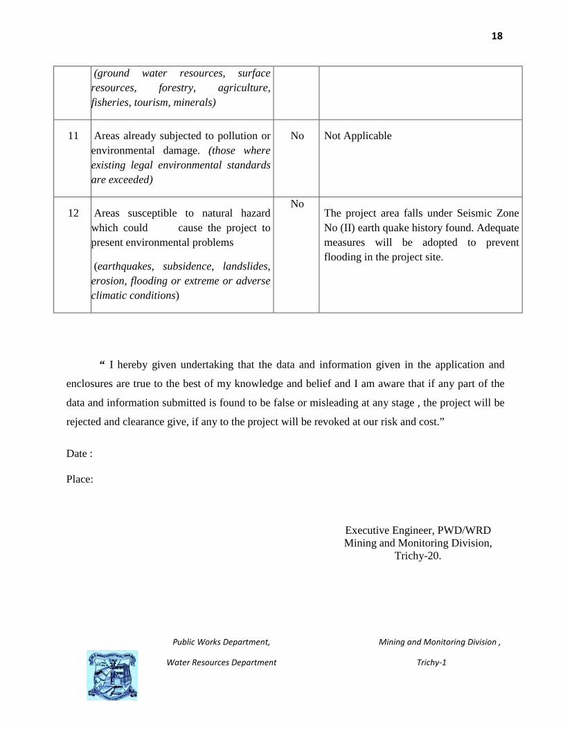
11 Areas already subjected to pollution or environmental damage. (those where existing legal environmental standards are exceeded)
No Not Applicable
12 Areas susceptible to natural hazard which could cause the project to present environmental problems
(earthquakes, subsidence, landslides, erosion, flooding or extreme or adverse climatic conditions)
No The project area falls under Seismic Zone No (II) earth quake history found. Adequate measures will be adopted to prevent flooding in the project site.
“ I hereby given undertaking that the data and information given in the application and
enclosures are true to the best of my knowledge and belief and I am aware that if any part of the
data and information submitted is found to be false or misleading at any stage , the project will be
rejected and clearance give, if any to the project will be revoked at our risk and cost.”
Date :
Place:
Executive Engineer, PWD/WRD Mining and Monitoring Division,
Trichy-20.

19
Public Works Department, Mining and Monitoring Division ,
Water Resources Department Trichy-1
Pre-Feasibility Report
1. Executive Summary of the Project:
The interlinking of river is the vision of our Tamilnadu State Government and
play a role model for entire Nation. It is widely accepted that the interlinking of
river is the need of the hour.
To fulfill the vision, our State Government is taking the pioneering effort
to link the river Agniyar, Southvellar, Manimutharu, Vaigai, Gundaru with River
Cauvery in first phase by constructing the Kattalai Barrage across Cauvery river
at Mayanur village, Krishnarayapuram Taluk of Karur district.
It would serve the intra-state river linking plan to provide water to
parched districts in the south Tamilnadu. Excess water during floods in the
Cauvery could be diverted to the parched areas in the southern districts by
linking the Agniyaru, Koraiyaru, Manimutharu, Vaigai and Gundaru.
Construction of Barrage at Kattalai is an important inevitable in linking
rivers in the southern peninsula which was proposed by National water
development agency (NWDA).
Based on that, the Government of Tamilnadu sanctioned an amount of
Rupees 165 Cores for the construction of Barrage across the River Cauvery at
250 Meters downstream of existing Kattalai bed regulator in Mayanur village of
Krishnarayapuram taluk in Karur district of Tamil Nadu in G.O.Ms.No.116
PW(N2) Dept dated: 09.05.2008 under Accelerated Irrigation Benefit Programme.
Continuous deposition of sand on the upstream and downstream of
Kattalai old bed regulator which is situated 250 meters, upstream side of new

20
Public Works Department, Mining and Monitoring Division ,
Water Resources Department Trichy-1
barrage on the river Cauvery has caused serious problem for the very existence
of bed regulator itself . This envisages danger mark for the bed regulator.
In November 2005 , torrential downpour and flooding of the Amaravathi
river which is confluence in river Cauvery 2 Kms upstream side of the old bed
regulator have left a trail of devastation on the karur district's infrastructure.
Highways and water supply schemes, a portion of the new Amaravathy bridge
and erosion of gravel under railway tracks near Mayanur are some of the scars
left behind by nature's fury.
Two huge breaches in the bund of the South Bank Canal near Mayanur
left gaping holes for 50 meters in each place. Flood waters coming in waves
breached the bunds of Cauvery river.
In this circumstances, the construction of new barrage across river
Cauvery, 250 meters downstream side of old Kattalai bed regulator is nearing its
completion. It is proposed to store 1.04 TMC of water to a height of 5 meters
above the sill.
The vision of this project is,
• To quarry the sand shoals through quarrying in U/S and D/S of
newly constructed barrage above the sill. The removal of sand will
restore the storage capacity ie 1.04 TMC of water during non Mettur
season in upstream side and to increase the functional efficiency of
discharging the maximum flood in downstream side.
• To influence the better recharge of sandy bed by storing water
during non Mettur season. It will be useful for number of existing

21
Public Works Department, Mining and Monitoring Division ,
Water Resources Department Trichy-1
and proposed drinking water schemes during summer season when
the flow in the river is minimum.
• To ensure the proper gradient of river.
• To protect the flood bank by restoring the flood carrying capacity.
• To make available the sand in the open market at a reasonable
price.
• To optimize the use of the natural resources.
• Augmentation of the revenue to the State exchequer by quarrying
the sand instead of spending huge amount to remove sand
shoals.
2. Introduction of the Project / Background Information:-
i) Identification of Project and Project Proponent.
Tamil Nadu Public Works Department, pioneer in all branch of
Engineering, is the custodian of rivers and water bodies in the state. Public
Works Department creates, maintains and protects all irrigation systems
including the rivers. Periodical maintenance including desilting of the
drains/canals is carried out to maintain the functional efficiency including the
carrying capacity of the canal. But in rivers flood protection works are carried
out by increasing top level of bund and protecting the sides of bund with
revetment.
The removal of sand shoals was never carried out in rivers due to the cost
constraints. Therefore, prolonged deposition for decades and more, the level of
river bed has increased and reduced the carrying capacity.

22
Public Works Department, Mining and Monitoring Division ,
Water Resources Department Trichy-1
Whenever floods and consequent damages occurred, it was resorted to
increase the bund level to restore the carrying capacity of rivers. It was never
thought of desilting the river due to the enormous cost it require and the
problem of ways and means to dispose the deposited sand. This situation led to
an unnatural phenomenon of Cauvery river running in embankment. In
majority of the stretches the adjacent field levels are lower than the bed of river.
Consequence of this change in river regime and reduction in carrying capacity of
the river, the shoals in the rivers, divert the flow of water resulting in bund
erosion and consequent breaches which leads to loss of property and lives.
Solution to the above problem is to remove the shoals in the river by
expending huge amount. Alternatively, the economical solution to this problem
is to mine the sand to remove the shoals. This option would yield net revenue to
the state exchequer apart from making available the important construction
material for infrastructure development at a reasonable price to the common
people.
The quarrying of sand in Government poromboke lands and private patta
lands had been entrusted to private agencies by the revenue department after
concluding a lease agreement with them. This process was in practice upto
August 2002.
As per G.O No. 46/Industries (MMC1) Department, Dt: 25.09.2002, a high
level committee had been constituted to conduct a survey of rivers and river
beds in the state with reference to sand quarry. The high level committee
concluded that.
a) Even though several rules on sand mining exist, illegal quarrying of sand is
out of control. Authority for regulating sand mining is vested with different

23
Public Works Department, Mining and Monitoring Division ,
Water Resources Department Trichy-1
organization such as, State Geology and Mining Department, Revenue
Department and Public Works Department. Hence, implementation and
monitoring of rules and regulation regarding sand quarrying are not effective.
This important task of sand mining therefore, should be entrusted to a
SINGLE AGENCY.
1. The observations and conclusions of the High Level Committee clearly
indicate the emergent need for the framework for regulation of sand quarrying in
the State in Public interests.
2. Hence, detailed discussions were held by Government at various levels.
After taking cognizance of the pernicious practice of unsustainable over
exploitation of sand in the State, it was decided in Public interest that the
quarrying of sand in Government poramboke lands and private patta lands by
private agencies will cease to be effective with immediate effect and sand
quarrying henceforth will be undertaken only by the Government through a
single department namely the Public Works Department. In order to meet the
above requirement, suitable amendment to the Tamil Nadu Minor Mineral
Concession Rules, 1959 is necessary.
b) After taking note of the indiscriminate quarrying in the river systems of
Tamilnadu, by the private lessees, the Government has taken the initiatives
on public interest to operate the sand quarries to ensure,
Uninterrupted free flow of water in the river by removing the shoal
formations which are the impediments to the free flow in rivers.
Elimination of indiscriminate and unscientific Sand Quarrying by the
private lessees.

24
Public Works Department, Mining and Monitoring Division ,
Water Resources Department Trichy-1
Uninterrupted supply of sand to the common public at affordable prices
for reducing the construction cost,
Curtailing the Environmental degradation, finally
Augmentation of the revenue to the State exchequer.
To achieve the above, the Government in its order vide G.O.Ms.No. 95,
Industries (MMC-1) Department, Dt. 01.10.2003 has seized the sand quarrying
in Govt. poramboke and private patta lands and undertaken sand quarry work
only by the Government through single department namely Public Works
Department. Accordingly, the Tamilnadu Government issued amendment
introducing Rule 38-A, of the Tamil Nadu Minor Mineral Concession Rules,
whereby all existing leases for quarrying sand in Government lands and
permissions granted in Ryotwari lands ceased to be effective with effect from
2.10.2003 and the right to quarry sand in the State vests with the Government.
Government had taken a policy decision to cancel all the sand quarry
leases and to vest the same with the Government vide Rule 38-A of Tamil Nadu
Minor Mineral Concession Rules, 1959 in G.O.Ms.No.95, Industries (MMC.I)
Department dated 1.10.2003. Accordingly, sand Quarrying operations are
being carried out in the Cauvery and Coleroon rivers from October 2003 in
Karur, Tiruchy, Perambalur, Ariyalur, Pudukkottai, Thanjavur, Thiruvarur and
Nagapattinam districts. Initially, 54 sand quarries were approved by the
Government and the sand was sold at a price of Rs.1000/- per lorry load
containing 2 units (200C.ft.). Subsequently, the price of sand was reduced to
Rs.600/- per 2 unit lorry load. The reduced price came in to effect from
19.06.2004.

25
Public Works Department, Mining and Monitoring Division ,
Water Resources Department Trichy-1
The District Collectors are empowered vide G.O.Ms.No: 110 / PW (C.P-2)
department, dt.06.07.2006 to approve new sand quarries which are identified by
the PWD.
From 01.06.2008, according to the instruction of G.O. MS. No 178, PW (I.
Spl - 2) Dept. Dt.31.05.2008 and Principal Secretary’s instruction vide Lr. No
20502 / I.Spl – 2 / 2008 / dt: 21.08.2008, 3 units and 2 units of sand has been
loaded according to the capacity of lorries following the Motor Vehicle Act 1988.
Based on the above instructions, the concerned Executive Engineers with
their field staff will identify the quarry site considering the availability of sand
deposits and humps, approach to the site, existing infrastructures, water head
works and cross masonry works etc. After selecting the site, proposals will be
sent to the concerned District Collectors. The District Collectors will instruct the
Executive Engineer, TWAD Board, Assistant Director (Mines) and Revenue
Divisional officer concerned to conduct a joint inspection. After getting the joint
inspection reports, the District Collectors will issue orders to quarry sand in
that particular place.
Sand sales are properly accounted for and sand quarries are frequently
inspected by higher officials of PWD. Illicit quarrying is being checked in
coordination with Revenue Department, Police Department, Transport
Department, State Geology and Mining Department.
In order to comply the order of the Hon’ble Supreme Court dated
27.02.12 mentioned in office memorandum of MOEF dated 18.05.12, that all
mining projects of minor minerals including their renewal, irrespective of the
size of the lease would hence forth require prior environment clearance.

26
Public Works Department, Mining and Monitoring Division ,
Water Resources Department Trichy-1
Based on that this application is meritoriously processed and the District
Collector Trichy passed an order vide Rc.No.291/Kanimam/2013 dated
18.06.13 to obtain an approval for mining plan and Environmental clearance
from the MOEF Notification 2006.The mining plan has been prepared by
Registered Qualified Person and got approved by the Assistant Directors (Mines)
of Trichy District.
The area applied to quarry is a Government poramboke land maintained
by Public Works Department in survey Field No. 293 of Sriramasamdram
village, and survey Field No. 288 of Silaipillaiya puthur village, of Thottiam
taluk, Trichy district.
The modified mining plan has been approved by the Assistant Director
Geology and Mining vide letter No. Rc.No.291/Mines/2013 dated 28.05.2018.
Hence this project of removing sand for functional efficiency of the river
and to provide drinking water facilities to cater the nearby districts is significant
for the state and country and hence the approval may be considered on priority
basis.
The applicant is the Executive Engineer, Public Works Department,
Mining and Monitoring Division, Trichy, Tamil Nadu State who is the monitoring
officer of mining activity including the river Cauvery river. In addition to the
above duty, the Executive Engineer will also identify the sand deposits on the
river bed and operate the sand quarry as per the amendment of Rule 38A in
Tamil Nadu Minor Mineral Concession Rules, 1959 after getting approval from
the District collectors concerned.

27
Public Works Department, Mining and Monitoring Division ,
Water Resources Department Trichy-1
The Environment Clearance obtained from the Ministry of Environment, Forests
and Climate Change under Category ‘A’ vide GoI, MoEF & CC., Lr No. J-
11015/343/2013-IA.II(M) dated 14.05.2015.
The District Collector Trichy granted permission vide R.C.No. 291/
Kanimam/2013 dated 19.11.2015. The Sriramasamudram / Silaipillayaputhur
sand quarry in Thottiyam Taluk of Trichy District was commenced on
07.12.2015. The quantity excavated for Sriramasamudram / Silaipillayaputhur
sand quarry as on 31.03.2018 is 5,54,813 Cum out of 15,01,247 M3.
The amendment in Environmental Clearance is required for additional three
years for the following reasons:
i) In Environmental clearance orders, the life of mine is given as three years. The
Sriramasamudram / Silaipillayaputhur Sand quarry was commenced only on
07.12.2015.
ii) The balance quantity of 8,40,775M3 in Sriramasamudram / Silaipillayaputhur
Sand quarry Sriramasamudram block V & Silaipillayaputhur block IV need to
be quarried in order to restore the original capacity of the Mayanur barrage of
1.05 TMC across the Cauvery river.
iii) The flow in the river Cauvery during irrigation season and monsoon hindered
the sand quarry operation and was unable to quarry the approved quantity.
iv) The State Government has issued an order on lifting the earlier order for
judicious usage of Poclains ie., two Poclains per site and permit more number of
Poclains taking into account the factors mentioned in the sustainable sand
mining Guidelines, 2016 and Environment Authority permit more number of
Poclains for usage in sand quarries on a case to case basis, vide G.O.(2D) No.21
Industries (MMC-I) Department dated 02.06.2017.
28
Public Works Department, Mining and Monitoring Division ,
Water Resources Department Trichy-1
v) In view of the above facts, the modified mining plan is herewith prepared for
further period of three years for remaining quantity propose to mine for a period
of three years with usage of six number of Poclains each in the above two
projects.
(ii) Brief Description of Nature of the Project:
The construction of new barrage to transfer the surplus water of 5.40
Thousand Million Cubic feet (TMC) in river Cauvery, during flood season to
water deficit areas. Besides that the storage of water up to 1.04 Thousand
Million cubic feet (TMC) during the Non Mettur Monsoon season will be useful
for increasing the ground water table around the places. It also aims to increase
the irrigation commandability of the South Bank Canal, Kattalai High Level
Channel, New Kattalai High Level Channel and the Krishnarayapuram Channel
which are all branch off the Cauvery river at this bed regulator.
The construction of barrage across the river Cauvery is nearing its
completion. One old bed regulator is situated 250 Meters away from the new
barrage in the upstream side. The old bed regulator was constructed during
1934. Since the bed regulator was constructed across the river, the huge sand
depositions (shoals) are formed above the sill in the upstream and downstream
of the new structure. To increase the storage capacity of the new barrage to a
height of 5 Meter above the sill and to restore the discharge capacity in
downstream, it is necessary to remove the sand shoal up to sill level before the
functioning of the new barrage.
Solution to the above problem is to remove the shoals in the river by
spending huge amount. Alternatively, the economic solution to this problem is
to mine the sand to remove the shoals. This option would yield net revenue to
the State exchequer apart from making available the important construction
29
Public Works Department, Mining and Monitoring Division ,
Water Resources Department Trichy-1
material for infrastructure development at a reasonable price to the common
people.
(iii) Need for the project and its importance to the country or region:
(a) The main need of the project is to quarry the sand shoals in U/S
and D/S of newly constructed barrage above the sill. The removal of sand will
restore the storage capacity i.e. 1.04 TMC of water during non Mettur season in
upstream side and to increase the functional efficiency of discharging the
maximum flood in downstream side.
(b) It is important to remove the shoals in U/S and D/S of the barrage
to store the excess water. It influences the better recharge of sandy bed. It will
be useful for number of existing and proposed drinking water schemes during
summer season when the flow in the river is minimum. There are number of
existing and proposed infiltration wells to tap the subsurface water for drinking
water schemes in U/s and D/s of barrage. It is estimated that the tapping of
subsurface water in this chainage of river is about 135 MLD. The surrounding
and nearby districts like karur, Dindigul which are rain shadow districts having
annual rainfall is about 630 mm only which is much below the state and
National average. The proposed project will improve the sub surface water
potential in this chainage during summer and benefit nearly 22 lakhs people up
to District of Madurai which is 150 km away.
(c) To make available the sand in the open market at a reasonable price.
(d) To ensure the proper gradient of river.
(e) To optimize the use of the natural resources.
(f) Augmentation of the revenue to the State exchequer.

30
Public Works Department, Mining and Monitoring Division ,
Water Resources Department Trichy-1
(iv) Demand-Supply Gap:-
The sand is being sold directly to needy customers after getting the cost
through Demand Draft. The demand of sand for various construction activities
in and around districts is met through various sand quarries functioning in the
river bed.
(v) Import Vs Indigenous production:-
The permit slip for selling the sand is issued within the State of Tamil
Nadu only. As per the Rule 38B of Tamil Nadu Minor Mineral Concession Rule
1959, transport of sand outside the state not to be made.
(vi) Export Possibility:-
As per the Rule 38B of Tamil Nadu Minor Mineral Concession Rule 1959,
transport of sand outside the state not to be made.
(vii) Domestic/Export Markets:-
The needy customers within the State of Tamil Nadu can directly
purchase sand through lorry/truck after paying the cost of sand to TNPWD.
(viii) Employment Generation (Direct and Indirect) due to the project:
The sand is the important construction material. It plays an important
role in the infrastructure development in the State. In the interest of public, the
quarrying of sand in the State was undertaken by the State Government
through Public Works Department. The River Cauvery and Coleroon has
abundant reserves of sand and supplies the need for the construction activities
in nearly fifteen districts in western and southern part of Tamil Nadu. It
indirectly generates employment for millions of people in construction industry,
transportation and other allied industries.

31
Public Works Department, Mining and Monitoring Division ,
Water Resources Department Trichy-1
In Public Works Department, Assistant Engineer will be in charge of
quarry operation. The Assistant Executive Engineer and Executive Engineer will
monitor the operation periodically in addition to their regular duties.
The total direct employment potential is 36 persons. The persons
employed in each unit falls in different village is as follows.
Technically Skilled
1. PWD Engineers : 1 No.
Total : 1 No.
Skilled
1. Excavator Operators : 6 Nos.
2. Co-operator : 6 Nos.
Total : 12 Nos.
Semi-Skilled
1. Supervisors / clerks : 4 Nos.
Un-Skilled
1. Helpers : 16 Nos.
2. Watchman : 4Nos.
3. Office boy : 2 Nos.
Total : 22 Nos.
In this project, there are two operating units will function independently
and falls under the different revenue villages. Hence, the proposed total direct
employment generation is 36 persons.

32
Public Works Department, Mining and Monitoring Division ,
Water Resources Department Trichy-1
3. Project Description
(i) Type of project :
This project is to desilt the shoals which have accumulated over a long
period of time, these accumulated shoals has not been removed due to cost
constrained. This accumulated shoals has decreased the functional efficiency
of the barrage.
The sand quarrying is undertaken only by the Government through a
single department namely the Public Works Department in the State. Hence, the
project to desilt the shoals is proposed to do through mining operation without
incurring expenditure to Government. It augments the revenue to the State
exchequer.
(ii) Location:
The kattalai barrage across Cauvery is 85 mile below the Mettur
Reservoir Project between Mayanur village, Krishnarayapuram taluk of karur
district and Silaipillaya Puthur village, Thottiyam taluk of Trichy District in
Tamil Nadu state. The proposed quarry area lies in the Survey of India Topo.
sheet No 58J/1, covered two villages namely Silaipillaya Puthur,
Sriramasamudram in Trichy district.
The details of the land covered by the area are as follows.
District
Taluk
Village
Khasba No/Plot No/Block
range / felling series etc.,
Area in Hec.
Ownership/ Occupancy
Trichy Thottiyam Silaipillayar
puttur SF.No.288
D/s 46.80 Government River Poremboke Land U/s 55.50

33
Public Works Department, Mining and Monitoring Division ,
Water Resources Department Trichy-1
Trichy Thottiyam Sriramasam
uthiram SF.No.293 U/s 93.95
Government River Poremboke Land
Total = 196.25
The above area lies in the coordinates of
Latitude Longitude
NW - 10 ◦57’46.0”N 78◦12’28.9” E
NE- 10 ◦58’11.4”N 78◦14’21.7” E
SW- 10 ◦57’29.4”N 78◦12’28.5” E
SE- 10 ◦57’57.5”N 78◦14’28.0” E (iii) Details of alternate sites considered and the basis of selecting the
proposed sites:
To increase the functional efficiency of the newly constructed barrage,
the project to quarry the prolonged deposits of sand shoals. The removal of
shoals will reclamate the river bed and will not cause any negative impact on
the Environment. Since, it is the project based mining, the question of selecting
the alternate site does not arise.
(iv) Size or Magnitude of operaton:
The total extent of project area is 196.25 ha in u/s and d/s of newly
constructed Kattalai barrage falls in two villages namely Sillaipillaya Puthur,
and Sriramasamudram village. It is proposed to deploy six poclains of each
survey number falls in different revenue villages. The maximum deployment of
heavy machinery is only 6 for this project.
The common public who intends to purchase the sand can directly receive
the sand in lorry/truck after paying the reasonable cost. The temporary paths

34
Public Works Department, Mining and Monitoring Division ,
Water Resources Department Trichy-1
for movement of lorries/trucks will be formed using biodegradable materials like
sugarcane leaves, nanals etc. The temporary pipes in the pathway will be
provided for lean flow of water. The two operational units in either side of the
barrage are having different approaches to main road. Hence, the movement of
vehicle will not cause much hardship to local public. In general the proposed
quarry of sand, the operation is simple, scientific and systematic under the
direct supervision of PWD officials.
(v) Project description with process details
The project proponent intents to quarry the excess sand shoals in river
bed to make it hydrologically safe. The excess sand shoals will scoop from river
bed using poclains and loading in to the public carrier vehicles directly.
Flow Diagram
Directly scooping of sand shoals on the river bed using poclains
Loading directly in to the GPS fitted shunting Lorries/Trucks which are
carrying sand to the Government sand depot.
Transported to needy customers from Government sand depot

35
Public Works Department, Mining and Monitoring Division ,
Water Resources Department Trichy-1
(vi) Raw material required along with estimated quantity likely source, marketing area of final product, Mode of transport of raw material and finished products:
The excess sand shoals deposited on river bed will be scooped out using
poclains and loading in to the public carrier vehicles directly. Hence , raw
material required and finished products does not arise.
(vii) Resources optimization/recycling and reuse envisaged in the
project, if any, should be briefly outlined:
The excess sand shoals deposited on river bed will be scooped out using
poclains and loading in to the public carrier vehicles directly. Hence reuse and
recycling does not arise.
(viii) Availability of water its source, Energy/ power requirement and
source should be given:
The requirement of water will be for drinking and domestic needs for
the labours, which will be around 100 liters/day and 300 liters/day . This
quantity can be met through hand pumps in the nearby areas. As the quarrying
operations are carried out during day time, there won’t be any requirement of
power. The consumption of HSD by poclains during its operation is minimum.
(ix) Quantity of wastes to be generated (liquid and solid) and scheme
for their Management/disposal:
The excess sand shoals deposited above river bed will be scooped out,
using poclains and loading in to the public carrier vehicles directly. Hence,
wastes to be generated do not arise.
(x) Schematic representations of the feasibility drawing which give
information of EIA purpose:
The final EIA report already submitted.

36
Public Works Department, Mining and Monitoring Division ,
Water Resources Department Trichy-1
4. Site Analysis:
(i) Connectivity:-
The proposed Kattalai Sand quarry site is well
connected with roads to other parts of state. In southern side ie., Mayanur
village,the Karur-Trichy National Highway(NH67) and the Karur-Trichy railway
line are just a kilometer away. In northern side ie., Silaipillaya Puthur village
and Sriramasamudram village, the Salem-Trichy State Highway(SH-25) is 12
KM away and it is well connected to the Quarry site through village roads. The
nearest railway Station is Mayanur which is a kilometer away from the site.
Airport is also available at Trichy, 65 Kilo meters away from the project area.
Obtaining Further Extension of Three years in
Precise Area Communication.
Getting Approval of
Modified Mining Plan.
Submission of Form-I & Pre feasibility
Report along with Approved mining Plan
Amendment in Environmental Clearance

37
Public Works Department, Mining and Monitoring Division ,
Water Resources Department Trichy-1
The environmental setting of the proposed mining area is given in Table
Table 1.1 Environmental Setting of the Site
Sl No Particulars Details
1 Site Latitude 10 ◦57’46.0”,10 ◦58’11.4”,10 ◦57’29.4”,10 ◦57’57.5” N
2 Site Longitude 78◦12’28.9”,78◦14’21.7”,78◦12’28.5”,78◦14’28.0” E
3 Present land use at the site
Government River Poromboke
4 Nearest Highway NH 67 in southern side, SH-25 in northern side.
5 Nearest Railway
station Mayanur
6 Nearest Airport Trichy – 65 KM
7 Nearest Town/City Karur -21Km,Kulithalai-20Km,Musiri-25Km
8 Hills / Valleys Nil
9 Topography Plain
10 Archaeologically important places
Nil within 10 km
11 Reserved or Protected Forests
Nil.
12 National parks / Wildlife sanctuaries
Nil within 10km
13 Seismicity Site area falls in seismic zone –II
14 Water source Surface and subsurface water
15 Defense installations
Nil within 10km
16 Nearest port Tuticorin

38
Public Works Department, Mining and Monitoring Division ,
Water Resources Department Trichy-1
(ii) Land Form, Land use and Land ownership:-
The proposed area is river bed under the control of Public Works
Department and land is classified as river poramboke.
(iii) Topography:-
The area lies in the Survey of India Topo Sheet No. 58 J/1. The proposed
site is on the river bed of Cauvery. The entire overburden shoals to the height of
0.76m above the river bed. The applicant’s intention is to quarry the river sand
from Cauvery river bed to make them hydrologically safe.
(iv) Existing land use pattern:-
The proposed area is river bed. The overburden sand shoals above river
bed are to quarry to make river section hydrologically safe.
(v) Existing infrastructure:-
The proposed site is the barrage across Cauvery. The Permanent section
office of Public Works Department is existed to maintain barrage, to monitor the
flow in river and to operating the shutters. Hence, the Public Works Department
is already having a well trained staffs and equipments under the supervision of
Assistant Engineer.
(vi) Soil Classification:-
The proposed site is on the river bed, the entire overburden shoals to
the height of 0.76m above the river bed is purely sand. The sand shoals above
the river bed are to quarry to make the river section hydrologically safe. There
is no top soil/over burden or Mineral rejects. The study of bore well details

39
Public Works Department, Mining and Monitoring Division ,
Water Resources Department Trichy-1
reveals that the average depth of sand available in the river bed is 7 meters in
upstream and 6meters in downstream.
(vii) Climatic data from secondary sources:-
The climate of the area is moderate and receives maximum share of
its rainfall during North East monsoon. The “All weather station” is installed
and maintained at Mayanur by the Public Works Department, Hydrology
Division to record the various parameters of climatic condition. The maximum
temperature recorded in this area is 41oC during May and least temperature
recorded is 16oC in the month of January.
The maximum winds speed is about 10.1km per hour which is recorded in
the month of August and minimum wind speed is about 1.4km per hour recorded
in the month of December.
The maximum relative humidity is 96% in April and minimum relative
humidity is 51% in November recorded in the year.
(viii) Social Infrastructure available:-
The proposed project site bounded by Mayanur village in south eastern
side,Kattalai village in south western side, silaipillaya Puthur village in north
eastern side and Sriramasamudram village in north western side. In the above
villages, the following salient social infrastructures are available within radius of
2Km.
1. Mayanur Panchayat office.
2. Mayanur Railway Station.
3. Temple at Mayanur village and Sriramasamudram village..
4. Renganathapuram panchayat office.

40
Public Works Department, Mining and Monitoring Division ,
Water Resources Department Trichy-1
5. Silaipillaya Puthur Panchayat office.
6. Sriramasamudram Panchayat office.
7. Public Health center at Mayanur and Sriramasamudram village.
8. High School, Mayanur
9. Middle School, Sriramasamudram.
10. Middle School, Silaipillaiyaputhur.
5. Planning Brief:
This project is to intent to scoop the excess deposited sand from the river
bed to make the river hydrologically safe. The process of mining the sand is
simple i.e. loading of sand directly to the consumer vehicle with the help of
poclains. The project site is covered with few bushes which are normally seen in
any river bed.
No human settlements are located within half a kilometer radius of the
area of this project. The total population of surrounding four villages is
15,832.The temporary sanitary and water supply arrangement will be provided.
The temporary shed will be provided for site office with resting area. The proper
safety measures will be taken for the safety of the workers by providing helmets,
hand gloves, masks and first aid facilities. The existing public roads
approaching to site will be used. Out of collecting the cost of sand Rs. 800.00
per 2 unit, Rs. 680.00 will be remitted to the local panchayat administration to
improve the socio-economic development of the village.
6. Proposed infrastructure
This project is to intent to scoop the excess deposited sand from the river
bed to make the river hydrologically safe. The project site is covered with few

41
Public Works Department, Mining and Monitoring Division ,
Water Resources Department Trichy-1
bushes which are normally seen in any river bed. Out of collecting the cost of
sand Rs. 800.00 per 2 units, Rs. 680.00 will be remitted to the local panchayat
administration to improve the socio-economic development of the village. In this,
the local panchayat will be recommended for developing the green belt in the
available vacant poramboke lands.
The temporary sanitary and water supply arrangement for drinking will
be provided. The necessary soak pit arrangement will be made away from flood
bank to safely discharge the effluent from temporary toilet. The temporary shed
will be provided for site office with resting area. The proper safety measures will
be taken for the safety of the workers by providing helmets, hand gloves, masks
and first aid facilities.
The existing public roads approaching to The temporary sanitary
and water supply arrangement for drinking are provided. The necessary soak pit
arrangement are made away from flood bank to safely discharge the effluent
from temporary toilet. The temporary shed is provided for site office with resting
area. The proper safety measures have been taken for the safety of the workers
by providing helmets, hand gloves, masks and first aid facilities.
The existing public roads approaching to quarry site are used. The
quarry operation hours are between 7am to 5pm in day time. Power Supply has
been obtained.
7. Rehabilitation and Resettlement(R&R) plan
This project is to intent to scoop the excess deposited sand from the
river bed to make the river hydrologically safe. Since the project site is river
bed, no human settlements are located within half a kilometer radius of the
area of this project.
42
Public Works Department, Mining and Monitoring Division ,
Water Resources Department Trichy-1
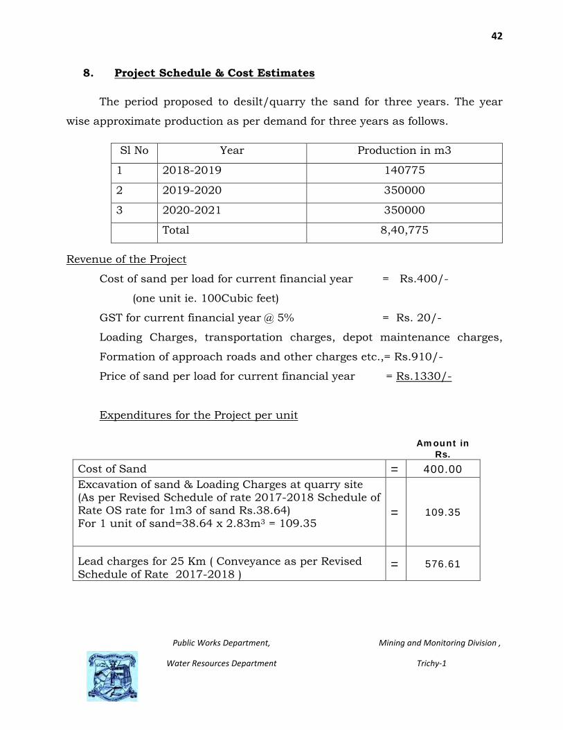
8. Project Schedule & Cost Estimates
The period proposed to desilt/quarry the sand for three years. The year
wise approximate production as per demand for three years as follows.
Sl No Year Production in m3
1 2018-2019 140775
2 2019-2020 350000
3 2020-2021 350000
Total 8,40,775
Revenue of the Project
Cost of sand per load for current financial year = Rs.400/-
(one unit ie. 100Cubic feet)
GST for current financial year @ 5% = Rs. 20/-
Loading Charges, transportation charges, depot maintenance charges,
Formation of approach roads and other charges etc.,= Rs.910/-
Price of sand per load for current financial year = Rs.1330/-
Expenditures for the Project per unit
Amount in Rs.
Cost of Sand = 400.00 Excavation of sand & Loading Charges at quarry site (As per Revised Schedule of rate 2017-2018 Schedule of Rate OS rate for 1m3 of sand Rs.38.64) For 1 unit of sand=38.64 x 2.83m3 = 109.35
= 109.35
Lead charges for 25 Km ( Conveyance as per Revised Schedule of Rate 2017-2018 )
= 576.61

43
Public Works Department, Mining and Monitoring Division ,
Water Resources Department Trichy-1
Loading charges at sand depot to Consumer Vehicle (As per Revised Schedule of rate 2017-2018 for 1m3 of sand Rs.27.37) For 1 unit of sand=27.37 x 2.83m3 = 77.46
= 77.46
Provision for Formation of Katcha Road and its maintenance at quarry. = 36.70
Provision for Fixing of Boundary Pillars at quarry. = 1.90
Provision for Temporary Rest shed, Toilet and Sanitary arrangements at quarry.
= 1.50
Provision for Protection Arrangements at quarry. = 0.40
Provision for Online payment such as Monitoring and tracking the vehicles etc., at quarry.
= 4.60
Provision for Labour to Maintaining the sand quarry Such as regulating the traffic, Monitoring the entry and exit of vehicles etc., at quarry.
= 7.40
Provision for water supply arrangements at quarry . = 0.38
Provision for Advertisement charges at quarry. = 1.10
Provision for Furniture arrangements for site office at quarry. = 0.20
Provision for Electrical arrangements including Deposit at quarry. = 0.15
Provision for Safety equipment’s like Helmets, Jackets, Goggles, earplugs, first aid kits, Boots and Masks etc at quarry .
= 0.13
Provision for Fixing of GPS tracking System and Computers at quarry site. = 1.56
Provision for current consumption charges per annum at quarry. = 0.25

44
Public Works Department, Mining and Monitoring Division ,
Water Resources Department Trichy-1
Provision for Stationeries like Printing paper, Register and Maintenance of computer and printer per annum at quarry .
= 0.18
Provision for Preparation of Mining Plan including Form I Pre-Feasibility Report at quarry. = 0.65
Provision for One time Processing charges to SEIAA for scrutinizing the sand quarry proposal at quarry. = 0.50
Provision for Consent fees for TNPCB Under Air and Water Act at quarry. = 0.35
provision for flora fauna, Air test, Water test, Videos, Photographic charges and Documentation charges at quarry.
= 1.20
Provision for EMP Cost at quarry. = 0.50
Provision for Awareness program at quarry.. = 0.65
Provision for CCTV at quarry. = 0.75
Provision Rest shed at depot. = 1.57
Provision for track formation at depot. = 5.77
Provision for Sprinkling of water at depot. = 2.13
provision for Fencing at depot site = 3.12
Provision for Drop gate at depot. = 0.26
Provision for water supply and Sanitary arrangements at depot. = 0.50
Provision for External Electrical Installation arrangements at depot. = 1.20

45
Public Works Department, Mining and Monitoring Division ,
Water Resources Department Trichy-1
Provision for Maintaining the Depot Such as regulating the traffic, Monitoring the entry and exit of vehicles etc.,at depot..
= 8.65
Provision for Online payment charges at depot. = 4.00
Provision for Lease Rent for Depot = 3.50
Provision for CCTV Camera and Public Audio system at depot. = 1.56
Provision for Safety equipment’s like Helmets, Jackets, Goggles, earplugs, first aid kits, Boots and Masks etc., at Depot
= 0.25
Provision for Furniture arrangements for site office at Depot = 0.20
Provision for current consumption charges per annum at Depot = 0.35
Provision for Stationeries like 3'' Thermal Printer Paper Roll, Data Card, Printing paper, Register and Maintenance of computer and printer per annum at Depot
= 0.50
Advertisement charges at Depot = 1.20
Provision for Documentation charges at Depot = 0.84
Provision for Unforeseen item and Contingencies for quarry and depot. = 3.45
GST @ 5% = 66.50
1330.00
Cost of Sand / unit = 1330.00
EMP. Budget
Socio-economic development fund given to the
Concern village panchayat =Rs.339.60/unit

46
Public Works Department, Mining and Monitoring Division ,
Water Resources Department Trichy-1
Lump sum provision for providing water supply
and sanitary arrangements = Rs. 15.00Lakhs
Recurring charges for maintaining the water supply
and sanitary arrangements = Rs. 3.00Lakh.
Purchasing of safety kits like helmets, Gloves
Masks , first aid kits etc., = Rs. 3.00Lakh
Provision for monitoring
water and air quality = Rs. 3.00Lakh
9. Analysis of proposal (Final Recommendations)
Out of collecting the cost of sand Rs. 400.00 per unit, Rs. 339.60 will be
remitted to the local panchayat administration to improve the socio-economic
development of the village. It is almost the total cost of the project will be given
by the State Government to concern village panchayat as a Corporate Social
Responsibility while operating the sand quarry.
The fund will be used to develop the social infrastructures like
constructing the community hall, improving the road, providing drinking water
facilities, improving drainage facilities, improving minor irrigation systems,
improving the health system in village panchayat, improving the education
infrastructure facilities, developing the green belts in available poromboke land
and other facilities to the village panchayat. It is necessary to say that the State
Government is voluntarily fixed this amount to ensure the CSR to local people
while operating the sand quarry.
Executive Engineer, PWD/WRD
Mining and Monitoring Division,
Trichy-20.