Usos hidráulicos urbanos en el Alto Guadiana en la Edad Media: Calatrava la Vieja
Upload
independentCategory
view
1download
0
Postglacial sea-level rise and sedimentary response in the Guadiana
Estuary, Portugal/Spain border
T. Boski a,*, D. Moura a, C. Veiga-Pires a, S. Camacho a, D. Duarte a,D.B. Scott b, S.G. Fernandes a
aCIMA-Centro de Investigac�ao Marinha e Ambiental, FCMA, Universidade do Algarve, Campus de Gambelas, 8000 Faro, PortugalbCentre of Marine Geology, Dalhousie University, Halifax, Nova Scotia, Canada
Accepted 2 November 2001
Abstract
The study of sedimentological features, foraminifera and molluscan fauna in samples recovered from four rotary boreholes
permitted, after 14C dating, the first assessment of the post-glacial transgression in Guadiana River Estuary. The Holocene
sequence is underlain by coarse sediments from delta fan enclosing continental swamp deposits dated 16980 year BP. The
Holocene sedimentary sequence was deposited either directly on this delta fan gravels or on top of fluvial sands deposited
probably between 11000 and 10000 yr BP. An accelerated phase of the estuary infilling by clayey sediments containing the salt
marsh foraminifer Trochammina, began ca. 9800 year BP, when sea level was about 39 m below present. Between 7500 and
7000 year BP, the central part of the estuary started to accommodate coarser sediments, partially introduced from the continental
shelf. The first phase of Holocene sea-level rise at a rate of 0.85 m/century terminated ca. 6500 year BP. Since then, lagoonal
sediments in the vicinity of the estuary have been enclosed behind sand spits and predominantly sandy sedimentation was
initiated within the estuary. After a second phase of slower rise at the rate of 0.3 m/century, which lasted until ca. 5000 year BP,
the sea approached the present level. D 2002 Elsevier Science B.V. All rights reserved.
Keywords: Holocene; Transgression; Estuary; Infilling; Foraminifera; Gulf of Cadiz
1. Introduction
Due to rapid sedimentation during the most recent
postglacial transgression, estuarine sedimentary re-
cords offer excellent opportunities to study the se-
quence of events which have led to the present
morphology of the coast. There are several published
studies dealing with the Spanish portion of the Gulf of
Cadiz estuarine valley infilling during the Holocene.
The Guadalete Holocene sequences were studied by
Dabrio et al. (1995) and Goy et al. (1996). Borrego et
al. (1993) discussed results of a study on an infilling
sequence in the Piedras Estuary. Dabrio et al. (2000)
presented the most recent synthesis of a regional
overview, based on new material from boreholes and
trenches in Tinto–Odiel Estuary, Guadalete Estuary
and San Pedro Estuary. To date, the most comprehen-
sive work on the recent distribution of sedimentary
facies in the terminal stretch of Guadiana was pub-
lished by Morales (1997). However, no data have yet
0037-0738/02/$ - see front matter D 2002 Elsevier Science B.V. All rights reserved.
PII: S0037 -0738 (01 )00270 -6
* Corresponding author. Fax: +351-89-818-353.
E-mail address: [email protected] (T. Boski).
www.elsevier.com/locate/sedgeo
Sedimentary Geology 150 (2002) 103–122

been published about the deep structure of Guadiana
valley infill. This paper fills that gap with a discussion
based on the interpretation of sedimentological re-
cords, macro and micro paleontological data, and 14C
dates. This dataset was gathered from four continu-
ously cored boreholes that were drilled in the area of
Guadiana River estuary in 1997 and that samples the
complete sequence of sediments accumulated since the
Last Glacial Maximum. This study embraces the
Holocene history of the terminal segment of this ma-
jor river course.
2. Geographic and geological setting
The Algarve is the southernmost region of Portugal.
It covers 5019 km2 and embraces three geomorpho-
logical zones (Fig. 1). The Hercynian mountains in the
north which belong to the Hesperic Massif are essen-
tially composed of shales and graywackes. The central
zone is occupied by Jurassic and Cretaceous forma-
tions, composed essentially of limestones, marls and
dolomitic limestones, strongly karstified. The south-
ward littoral fringe is dominated by clastic limestones
and siliciclastic sediments, respectively dated from
Miocene and Plio-Pleistocene. The Algarve Basin
started to form in the Late Triassic during the early
phase of North Atlantic opening, under E–W to ENE–
WSW distensional regime (Pereira, 1992). The present
morphology of the continental shelf has been shaped
since the Neogene (Mougenot, 1988). The shelf evo-
lution since the Tortonian, involved switching from
carbonate reef to terrigenous sedimentation, in semi-
graben structures, leading to the accumulation of tens
of meters of sands, (Moura and Boski, 1999) exposed
along the cliff shores between Albufeira and Faro.
These cliffs exhibit marked contemporary erosion
which in some places results in up to 10 m/year of
shore retreat (Correia et al., 1996) and is a major
source of sand to the Ria Formosa barrier system.
Guadiana is one of the most important rivers on
Iberian Peninsula, whose total length is 730 km of
which the last 200 km forms a natural border between
Portugal and Spain (Fig. 2). In this section, the river
bed is cut into the Hercynian basement consisting of
Carboniferous schists and graywackes and follows
N–S path defined during Quaternary (Vidal et al.,
1993). The resistance offered by the basement rocks
to the river erosion, defines the pattern of the bedrock
river valley which is narrow and deep: 600 m wide
and about 70 m deep below mean sea level, ca. 7 km
inland from the mouth. According to Borrego et al.
(1993), these characteristics distinguish Guadiana
Estuary from the other estuaries in the Guadalquivir
Basin, which are cut into soft non-consolidated Plio-
Pleistocene sediments, resulting in broader and shal-
lower structures. Only the terminal 5 km of the river
valley is underlain by Cretaceous and Jurassic lime-
stones which enabled a broader opening of the estu-
ary, accommodating the extensive salt marshes on
both sides of the inlet.
From the hydrographic point of view, the estuary,
like others in the Gulf of Cadiz, experience a mesotidal
regime (Morales, 1997). The predominant southwest
waves are responsible for the eastward longshore
current and sediment transport towards the east (Bet-
tencourt, 1994; Granja et al., 1984). The accretion of
drifting sands in the proximity of the main channel
mouth which are continuously reworked by wave
action, has led to the formation of the highly mobile
washover banks and to the fast migration of the
estuarine channels. The volume of sand deposited be-
hind the groin constructed in 1958 aiming to shelter the
river mouth, is approximately 5.6� 106 m3 (accreted
area = 2.07 km2; average thickness 2.7 m). This gives
an accumulation rate of ca. 176� 105 m3 year1, which
is almost identical to the rate proposed by Cuena (in
Morales, 1997). The retention of drifting sands by the
groin on one hand and the retention of terrigenous
material by more than 40 major dams constructed in
the Guadiana drainage basin on the other hand, creates
the present sediment-starved situation and has caused
erosion of the longshore barriers and spits, sheltering
lagoons and salt marshes to the east in Spain, which
were formed since the mid-Holocene stabilisation of
mean sea level.
3. Material and methods
The rotary drillings were carried out by means
of WIRTH Bo drilling rig operated by Portuguese
Geological Survey (IGM). The location of the drill-
ing sites is marked on Fig. 2 and detailed in Table 1.
The borehole walls were protected by steel casing
and the cores were recovered into plastic 6V coreline
T. Boski et al. / Sedimentary Geology 150 (2002) 103–122104

Fig. 1. Location map of the study area in the Southern Iberian Peninsula. The principal morphostructural units are adapted from Ribeiro (1979).
T. Boski et al. / Sedimentary Geology 150 (2002) 103–122 105

Fig. 2. IRS satellite panchromatic image of the Guadiana Estuary. Letters indicate basement rocks of the estuarine valley; P—Palaeozoic
substratum , M—Mesozoic substratum. A–B is the line of profile shown in Fig. 9. CM1, CM2, CM3 and CM4 are the sites of boreholes.
T. Boski et al. / Sedimentary Geology 150 (2002) 103–122106

k(Rocbore) tube. Recovery ranged from 60% (sands)
to 100% (clays) with the average being 85%.
The cores were further sectioned in two halves. One
halve was archived and another sampled. The standard
description of a core includes granulometry, macrosco-
pic sedimentary structures and colour (according to
Munsell chart). Shells of macrofauna were handpicked.
Despite the fact that most of the mollusc remains in the
sedimentary column exhibited a variable state of deg-
radation due to taphonomic processes, in several sandy
layers, extraction of well-preserved identifiable speci-
mens was possible. These were used for dating pur-
poses. The sediment, peat and wood samples taken for
dating were all kept at � 20 jC and freeze dried before
being sent to the commercial laboratories which are
referred in Table 2. Organic matter samples were taken
always from the central part of the cores in order to
avoid contamination.
Samples for microplankton analyses were sieved
through 63- and 500-Am sieves after decanting organic
debris. After sieving, samples with a high content of
sand were dried and the sediment was sprinkled into
carbon tetrachloride to float off the foraminifera. Sam-
ples with high content of organic matter or with ex-
tremely high total numbers of foraminifera were
divided with a modified plankton splitter (Scott and
Table 2
Information about 14C datings
Borehole sample
number
Lab. code Depth
(cm)
14C age (BP) d13Cx(PDB)
Cal BP
age
Material Method
laboratory
CM1
CM1.1 GX-25447 824 5020F 310 1.1 5837 C. glaucum h radiometric
CM1.2 GX-25448 1712 6210F 220 (� 25.9) 7155 peat h radiometric
CM1.3 UtC-8376 1860 6210F 40 2.08 7175 C. edule AMS
CM1.4 SAC-1534 2127 7590F 100 20 8848 C. angulata h radiometric
CM1.5 GX-25449 2850 8430F 380 na 9420 C. glaucum h radiometric
CM1.6 UTC-9691 3606 9500F 70 na 10765 C. glaucum AMS
CM2
CM2.1 Beta-128887 200 3040F 100 (� 27.3) 2986 peat h radiometric
CM2.2 Beta-128886 715 5950F 190 0.4 6794 A. tuberculata h radiometric
CM2.3 SAC-1536 854 10130F 200 (� 5.98) 11348 shell remains h radiometric
CM3
CM3.1 GX-25421 459 3300F 160 3598 C. angulata h radiometric
CM3.2 GX-25452 960 6710F 120 1.6 7594 C. angulata h radiometric
CM3.3 GX-25453 1452 7080F 200 0.7 7936 C. angulata h radiometric
CM3.4 GX-25454 2690 9470F 250 (� 22.9) 10738 wood h radiometric
CM4
CM4.1 GX-25455 300 6200F 340 1.6 7159 V. nux h radiometric
CM4.2 SAC-1536 575 5640F 90 (� 0.31) 6437 S. plana h radiometric
CM4.3 GX-25456 1175 6250F 250 1.4 7208 C. gibba h radiometric
CM4.4 GX-25457 2434 16980F 100 (� 28.5) 19836 organic matter h radiometric
CM1, CM2 and CM3 drill sites are at elevations between 0 and 1 m above MSL and were not taken into account. CM4 drill site elevation was at
4-m elevation and was reduced to MSL.
Laboratory codes: GX—Geochron Laboratories, Cambridge, MA, USA; SAC—Instituto Tecnologico e Nuclear, Lisboa, Portugal; UTC—
Institut Royal du Patrimoine Artistique, Brussels, Belgium.
Table 1
Geographical and UTM coordinates of cored boreholes drilled in the
area of Guadiana River Estuary
Borehole Geographical coordinates UTM coordinates (295)
Latitude Longitude x y
CM1 37j13V13WN 007j25V05WW 0640242 4121463
CM2 37j11V08WN 007j27V12WW 0636728 4117881
CM3 37j12V06WN 007j25V10WW 0639536 4119918
CM4 37j11V04WN 007j26V02WW 0638348 4116019
T. Boski et al. / Sedimentary Geology 150 (2002) 103–122 107
Hermelin, 1993). The splitter divides the sample into
eight equal parts, and in some cases reported here, 1/8
of the sample was sufficient for a good statistical base
(300–400 individuals). The processed samples were
then examined under binocular microscope in a grid-
ded circular counting tray.
Grain size analyses were carried out after carbonate
elimination with 10% HCl. The samples were sieved
through a 250-Am sieve and the fractions < 250 Amwere analysed in a Malvern Mastersizer Microplus
instrument using filtered water with 1 g of Calgon per
litre, added to avoid flocculation of clay minerals.
Several non-cored rotary drillings carried out before
1986 by the Junta Autonoma de Estradas (National
Road Administration), prior to the construction of the
International Guadiana Bridge, allowed the extrapola-
tion of the depth of the limits between the described
sedimentary bodies and of the bedrock channel within
the profile A–B.
4. Results—borehole descriptions
4.1. Borehole CM1
The most landward CM1 borehole which is located
in the tidally active salt marsh near Castro Marim
reached bedrock at the depth of 42 m. The following
lithological units, were distinguished from bottom to
top (Fig. 3).
4.1.1. Unit I (�42.2 to �39.1 m)
This pebbly layer is deposited directly on the
paleozoic basement shales, where 80% of the particles
are moderately rounded quartz and quartzite pebbles
and 20% are platy graywackes and shales. Roundness
and higher abundance of quartz in relation to the
substratum, indicates recycling of this material from
surface deposits, known regionally under the term of
‘‘ranas’’. Ranas are coarse Pliocene–Pleistocene de-
posits that cover wide areas of the Pliocene plantation
surface of the Iberian Peninsula. This origin is attrib-
uted to gravity flows during an arid climatic phase
and/or to periods of tectonic uplift (Martin-Serrano
and Molina, 1989; Cabral, 1995).
According to the results of non-cored geotechnical
drilling (JAE, 1986 unpublished) ca. 700m north CM1,
this unit attains a thickness of 46 m in the deepest part
of the valley, where the Carboniferous basement was
reached at 70 m depth.
4.1.2. Unit II (�39.1 to �20.6 m)
The gravelly unit is overlain from 39.1 m depth
upwards, by a monotonous sequence mostly com-
posed of grey muds (5Y,3/1), sporadically interlayered
with decimetre-thick layers of grey fine sand of
similar hue, preserving flaser structures. Within the
muddy layers, centimetre-scale bioclastic horizons,
mud balls and vegetal remains frequently occur. Root
remnants present in the highest part of this unit are
preserved.
Cerastoderma glaucoma and Crassostrea angu-
lata individual valves were recovered from sandy
layers for dating (samples CM1.4, CM1.5 and
CM1.6, Fig. 3 and Table 2). As said, most of the
well-preserved shells were found within sandy layers.
This would indicate that variation of faunal density
and/or diversity was due to their differential preser-
vation controlled by the chemical conditions within
the sedimentary matrix (Walker and Goldstein, 1999;
Aguirre and Farinati, 1999). This unit contains the
highest number of bivalve species of this core and the
identified (Table 3) specimens are characteristic of the
intertidal zone. Gastropod shells are better preserved
than the bivalves and are an important component of
the bioclastic mass.
The foraminifera assemblage near the bottom,
between 38.40 and 27.20 m, is characterised by the
highest individual numbers but the lowest numbers of
species. The populations are almost entirely composed
by Trochammina spp. inner linings or poorly pre-
served tests of this species. From 27.20 m to the top of
the sedimentary unit which is marked by an erosion
surface, both diversity and density are drastically re-
duced showing few or no foraminifera (Fig. 4).
4.1.3. Unit III (�20.6 to �18.7 m)
This unit comprises a fining upwards sequence
beginning with medium sand (5Y,3/1) with lenticular
clay intercalations of the same hue and channel
bioclastic levels. The medium sandy facies is over-
lain by fine sand and yellowish clay, and is charac-
teristic of a tidal flat environment (Trentesaux et al.,
1999).
Mollusc remains show a high stage of dissolution
and therefore were not dated.
T. Boski et al. / Sedimentary Geology 150 (2002) 103–122108

Fig. 3. Stratigraphic column from borehole CM1 and the inferred depositional environments. Depth referred to the borehole mouth elevated at 1 m
above MSL.
T. Boski et al. / Sedimentary Geology 150 (2002) 103–122 109

Table 3
Macrofauna identified in boreholes CM1, CM3 and CM4
T. Boski et al. / Sedimentary Geology 150 (2002) 103–122110

Fig. 4. Foraminifera abundance plots in the sediments from boreholes CM1, CM2, CM3, CM4 and their ecological interpretation. The points refer to the centre of sampled interval.
T.Boski
etal./Sedimentary
Geology150(2002)103–122
111

The foraminiferal assemblage consists of various
calcareous species and is dominated by Haynesina
depressula and Ammonia beccarii plus several species
of Elphidium, ranging from 7 to 24 species per sample.
4.1.4. Unit IV (�18.7 to �16.2 m)
This unit is entirely composed of clay with sandy
bioclastic levels from which C. edule valves were
taken for dating (sample CM1.3, Fig. 3 and Table 2).
The list of all identified molluscs as well as the inferred
environments are presented in the Table 3.
The lower part, consists of black clay (2.5Y,3/1)
with peat interlayered by reddish, millimetre-thick clay
laminae. The presence of rootlet traces below the peat
laminae and lack of any evidence of erosion proves
their undoubtedly autochthonous origin. They could
form in a brackish environment of semiconfined ponds
occasionally invaded by fresh water carrying reddish
Fe oxide stained clay. Such ponds can be observed at
present in several places on the western side of the
estuary. One sample of peat (CM1.2, Fig. 3 and Table
2) was taken for dating. In this segment, the examined
samples showed few or no foraminifera.
4.1.5. Unit V (�16.2 to 0 m)
The sedimentary sequence between 16.2 m and the
top of the borehole is sand dominated. In this sequence,
six sub-units were discerned, each one showing a
fining upward trend from medium or fine sand to silty
sand, silt and clay with root and vegetal remains. The
contacts between these sub-units are sharp, erosive. In
the fine sandy layers, flaser structures were observed.
Vegetal remains graded from dissipated in a mineral
matrix to accumulated in peaty centimetre-thick hori-
zons. This repeated pattern was occasionally interrup-
ted by centimetre-thick coarse sandy layers. Mollusc
assemblages were similar to the previous sedimento-
logical units (Table 3), with C. edule being more
frequent and with four new bivalve species not found
in the preceding unit. In few samples, the bioclastic
fraction composed mostly of bivalves and gastropods
represented ca. 70% of the > 0.250 mm fraction and
also contained skeletal fragments of echinoderms and
sponges. Well preserved valves of C. glaucum were
taken for dating (sample CM1.1, Fig. 3 and Table 3).
In the uppermost and lowermost parts of this unit,
the foraminifera assemblage is poor both in individual
numbers and/or species. However, samples from the
intervals 13.60 to 12.70 m and 10.60 to 9.37 m,
contained a significant number of calcareous species
although they are not more than 10% of total. The
assemblage is dominated by H. depressula and A.
beccarii.
The upper part of this unit, starting at 1.7 m is
anthropogenic soil.
4.2. Borehole CM2
CM2 is the shortest core among the four collected.
It reached the Mesozoic substratum at 10.56 m depth.
It is located in a confined sector of the estuary close to
a subsidiary tidal channel of Guadiana. The area is
occupied at present by the artificial salt ponds and
according to XVII and XVI century maps was a part
of a barrier and dune sheltered water way, which
connected the Guadiana Estuary to the Ria Formosa
Lagoon to the west. In the sedimentary column, three
sedimentological units (Fig. 5) were distinguished.
This core contained high average total numbers of
individual foraminifera, ranging from 0 to 3248 indi-
viduals per 10 cm3.
4.2.1. Unit I (�10.5 to �9.9 m)
Above the Jurassic limestone substratum lies a 0.60
m pebbly layer with two different lithologies. Close to
the bottom, the autochthonous pebbles consist entirely
of limestone, while the upper pebbles of this sedimen-
tological unit consist of well-rounded quartzite and
graywacke fragments supported by a sandy matrix.
4.2.2. Unit II (�9.9 to �8.4 m)
This interval is composed of dark grey (2.5/10Y)
micaceous fine sand, moderately to poorly sorted,
containing a few quartz and schist pebbles and milli-
metre-scale laminae of silt. The upper 30 cm is
composed of fine sand containing eroded bioclasts, in-
terlayered with clay. The samples observed in this unit
was barren of foraminifera both carbonate and aggluti-
nated and the very scarce shells were unidentifiable,
due to their bad state of preservation. In the absence of
identifiable mollusc skeletons, shell debris were used
for dating (sample CM2.3, Fig. 5 and Table 2).
4.2.3. Unit III (�8.4 to 0 m)
The uppermost segment, which begins at 8.4 m
depth and continues to the surface, is a monotonous
T. Boski et al. / Sedimentary Geology 150 (2002) 103–122112

dark clay (5Y,3/1) sequence, rich in plant remains.
Layers enriched in bivalve shells were observed.
Sample CM2.2, (Fig. 4 and Table 2) used for dating
was a valve of Acanthocardia tuberculata.
The uppermost level dated in this profile was a peat
layer (sample CM2.1, Fig. 5 and Table 2) that probably
accumulated in an ephemeral brackish pond. Such
semiconfined ponds exist in several areas of the present
estuary and accumulate fresh water during the rainy
period (October–May), drying in the summer.
From the top of the previous unit at 8.54 m, to 3.40
m, average values of foraminifera fauna were over
2000, dominated by A. beccarii andH. depressulawith
significant percentages of Elphidium spp. In the most
superficial 2.50 m of the core, foraminiferal assem-
blage contained a low number fauna of seven individ-
uals dominated by Trochammina spp.
4.3. Borehole CM3
This borehole is located about 3 km south of CM1,
as well as close to the main estuarine channel (Fig. 2
and Table 1) and within the salt marsh affected
sporadically by spring tides. The paleozoic substratum
was reached at the depth of 36 m. Analyses of
sedimentological facies distingue four units (Fig. 6),
in which 20 samples were examined in terms of their
foraminifera content. Total numbers of individuals
ranged from 0 to 3328 per 10 cm3 of sediment and
corresponded to 0 and 20 species, respectively. The
macrofauna is reported in Table 3.
4.3.1. Unit I (�36 to �30.8 m)
Shales and graywackes are overlain by a 5-m-thick
gravelly layer. Lithologically, 80% of the pebbles and
cobbles are quartz and quarzitic and 20% are gray-
wackes and shale fragments. Their external features
are identical to those described in CM1 borehole.
4.3.2. Unit II (�30.8 to �16.5 m)
Overlying the gravelly layer, is 14.3 m of organic
matter-rich dark grey clay (5Y,3/1) with plant detritus
and bioclasts. Molluscs (Table 3) were in general
poorly preserved due to the advanced stage of dis-
solution of their skeletons, however, few specimen
could be identified. A 5-cm-long piece of well pre-
served wood was found in this clay and was used for
dating (sample CM3.4, Fig. 6 and Table 2).
The lowermost samples of this unit between 31.0
and 21.0 m, contained fauna of agglutinated foramin-
ifera species dominated by inner linings of Trocham-
mina spp. In the upper portion from 21.0 to 16.5 m,
foraminifera were calcareous, dominated by A. bec-
carii and H. depressula (at 18.15 m) and by Discorbis
spp., Elphidium spp. and Quinqueloculina spp. in the
other samples.
Fig. 5. Stratigraphic column from borehole CM2 and the inferred depositional environments. Depth referred to the borehole mouth elevated
at 1 m above MSL.
T. Boski et al. / Sedimentary Geology 150 (2002) 103–122 113
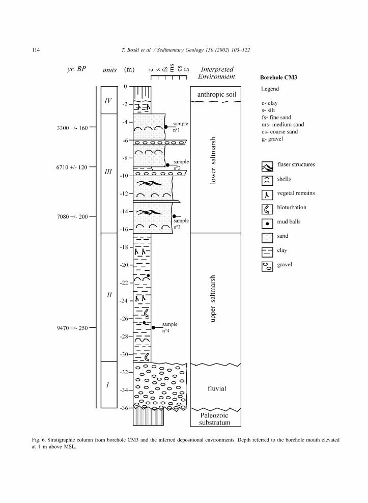
Fig. 6. Stratigraphic column from borehole CM3 and the inferred depositional environments. Depth referred to the borehole mouth elevated
at 1 m above MSL.
T. Boski et al. / Sedimentary Geology 150 (2002) 103–122114

4.3.3. Unit III (�16.5 to �3.8 m)
The sediments, similar to those observed in unit III
in borehole CM1, range from dark (5Y,5/1) medium
sand to fine sand exhibiting flaser structures, with
occasional centimetre-scale gravel layers.
The mollusc skeletons are better preserved than in
the underlying horizon and consequently 12 species of
bivalves could be identified pointing to sedimentary
environments summarized in Table 3. The dated
samples CM3.1, CM3.2 and CM3.3 (Fig. 6 and Table
2) are all C. angulata individual valves.
The foraminiferal fauna is calcareous, dominated
by A. beccarii and H. depressula at 4.8, 6.9 and 16.4
m and by Discorbis spp., Elphidium spp. and Quin-
queloculina spp. in the remaining samples of this unit.
4.3.4. Unit IV (�3.8 to 0 m)
The top 3.8 m of the core consists of a black clay
with plant remains. The foraminiferal assemblage is
dominated by the agglutinated species Trochammina
spp. and Ammobaculites sp.
4.4. Borehole CM4
The borehole CM4 was situated in the Monte
Gordo dune field close to the shoreline and is 5 m
above the MSL (Fig. 2 and Table 1). Five sedimento-
logical units were distinguished in the sedimentary
column overlying the Paleozoic substratum at 36 m
depth (Fig. 7). The foraminifera were examined in 24
samples, of which several were barren. However, the
samples showing foraminifera revealed the highest
numbers ranging from 325 to 4000 individuals per
10 cm3 and it is the only one containing offshore
planktonic species.
4.4.1. Unit I (36–32.2 m)
The layer overlying directly the Palaeozoic sub-
stratum consists of quartz, graywack and shale pebbles
that are mostly discoidal, up to 9-cm long with scarce,
poorly preserved mollusc remains.
4.4.2. Unit II (32.2–28.8 m)
This unit composed of dark grey (5Y,5/2) silts and
silty clays interlayered with more ferruginous ones
(10YR, 5/4). Only agglutinated foraminifera were
found and the assemblage was dominated by Trocha-
mina spp.
4.4.3. Unit III (28.8–25 m)
This unit is a 3.6-m-thick complex sequence of cen-
timetre-scale layers of sand, silt and clay. Fine mica-
ceous sand layers exhibit frequent burrows resulting
from bioturbation, filled with reddish clayey sediment.
Dark clay levels contain abundant vegetal remains and
in few cases had peaty appearance. No foraminifera
were observed.
4.4.4. Unit IV (25–19.1 m)
This unit begins with a 30-cm gravelly layer
followed by 1.5 m of sands grading to a 4-m-thick
gravel bed barren of any fauna remains. The
pebbles, granulometry and mineralogy is analogous
to the basal gravel level, mostly quartz and quartz-
itic.
Peat from a discrete 3-cm layer was taken for
dating (sample CM4.4, Fig. 7 and Table 2).
4.4.5. Unit V (19.1–15.8 m)
This unit comprises fine, hardened laminated mica-
ceous sands and silts with frequent ferruginous
patches. In the upper part, a thick calcrete level was
observed. This unit was barren of fauna.
4.4.6. Unit VI (15.8–2.4 m)
This unit begins with a 20-cm gravel layer
grading to medium sand rich in mollusc shells
(Table 3). The bivalve shells, which frequently be-
long to offshore species, make up to 50% of the
sediment mass. Samples CM4.1, CM4.2 and CM4.3
(Fig. 7 and Table 2) taken for dating are, respec-
tively: Venus nux, Scrobicularia plana and Corbula
gibba.
Between 15.7 and 12.2 m, are two clayey layers
separated by 1.1m of sand rich in shells. The lower clay
level exudes a sulphurous smell and is barren in fauna,
probably due to carbonate dissolution. In the upper clay
level, the foraminifera fauna is rich in calcareous
species, mostly Ammonia, Elphidium, Haynesina and
in smaller proportion Discorbis, Quinqueloculina,
Glabratella and Brizalina species. Planktonic foramin-
ifera were abundant.
4.4.7. Unit VII (2.4 to surface)
This unit comprises medium well sorted sands with
root fragments and plant debris but contains no fauna
remains.
T. Boski et al. / Sedimentary Geology 150 (2002) 103–122 115

Fig. 7. Stratigraphic column from borehole CM4 and the inferred depositional environments. Depth referred to the borehole mouth elevated
at 4 m above MSL.
T. Boski et al. / Sedimentary Geology 150 (2002) 103–122116
5. Discussion
5.1. Micropaleontology
In the uppermost sections of all cores, except where
they are barren (core CM1, CM4), there is a short
section of salt marsh as indicated by the presence of
Trochammina spp. (e.g. Scott and Medioli, 1986). In
the middle sections, there are a variety of calcareous
faunas with typical estuarine faunas in the two cores
(CM1 and CM3) farthest up the estuary and more
diverse faunas in the cores closer to the sea; in the
seawardmost core 4, there are frequent planktonic
species indicating direct transport from offshore into
this area. However, in the lowermost sections of three
out of four cores, there is a typical salt marsh fauna
with Trochammina spp. but usually only inner linings,
unlike the surface counterparts of this fauna where the
whole test is preserved. This succession represents a
standard transgressional depositional sequence where
the first marine deposits are upper marsh sediments as
the sea first impinges on the shore. As a consequence
of the overriding of the marsh by the rising sea, the
subtidal estuarine deposits form as it is indicated by the
diverse calcareous faunas. There is no indication of a
low salinity estuarine sequence between the marsh and
estuarine assemblages. The only core not showing this
sequence is CM2, because it is situated in the area of
shallow-lying Jurassic substratum, where an environ-
mentally abbreviated and a less diverse sedimentary
sequence was deposited. The importance of the marsh
faunas is that they can provide an accurate sea-level
curve for this site, at least where the marsh units are
present (Scott and Medioli, 1978, 1986).
The marsh units near the top of CM2 and 3 were
not closely dated but there are some limits that could
be inferred from comparison with the area of CM3. In
the latter, there is a date of 3300 year BP at 4.6 m
which is about 1 m below the marsh unit at 3.5 m. In
CM2 (where no erosional surfaces were observed),
there is a date of 3080 year BP 50 cm above the marsh
unit at 2.5 m. Apparently, sea level was established
close about its present level ca. 3000 year BP, if one
considers a necessary correction for the compaction of
sediments. In the lower sections of cores CM 1 and 3,
both situated in the immediate vicinity of the principal
estuarine channel, the units close to the marsh sequen-
ces were dated 8430 year BP at 28.5 m (core CM1)
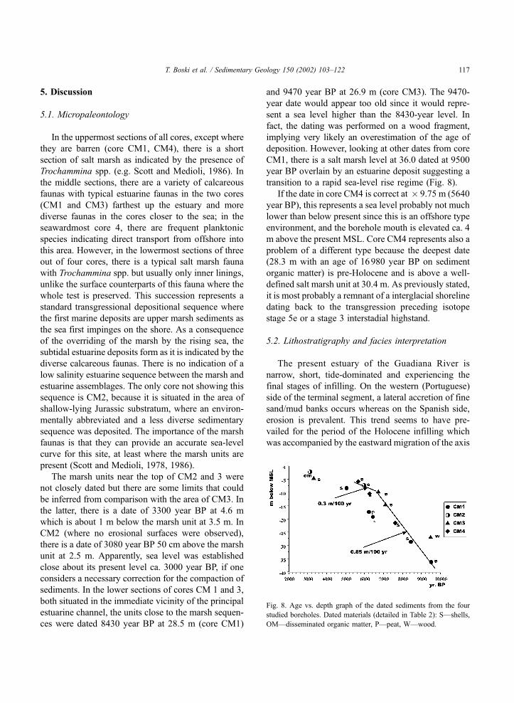
and 9470 year BP at 26.9 m (core CM3). The 9470-
year date would appear too old since it would repre-
sent a sea level higher than the 8430-year level. In
fact, the dating was performed on a wood fragment,
implying very likely an overestimation of the age of
deposition. However, looking at other dates from core
CM1, there is a salt marsh level at 36.0 dated at 9500
year BP overlain by an estuarine deposit suggesting a
transition to a rapid sea-level rise regime (Fig. 8).
If the date in core CM4 is correct at � 9.75 m (5640
year BP), this represents a sea level probably not much
lower than below present since this is an offshore type
environment, and the borehole mouth is elevated ca. 4
m above the present MSL. Core CM4 represents also a
problem of a different type because the deepest date
(28.3 m with an age of 16980 year BP on sediment
organic matter) is pre-Holocene and is above a well-
defined salt marsh unit at 30.4 m. As previously stated,
it is most probably a remnant of a interglacial shoreline
dating back to the transgression preceding isotope
stage 5e or a stage 3 interstadial highstand.
5.2. Lithostratigraphy and facies interpretation
The present estuary of the Guadiana River is
narrow, short, tide-dominated and experiencing the
final stages of infilling. On the western (Portuguese)
side of the terminal segment, a lateral accretion of fine
sand/mud banks occurs whereas on the Spanish side,
erosion is prevalent. This trend seems to have pre-
vailed for the period of the Holocene infilling which
was accompanied by the eastward migration of the axis
Fig. 8. Age vs. depth graph of the dated sediments from the four
studied boreholes. Dated materials (detailed in Table 2): S—shells,
OM—disseminated organic matter, P—peat, W—wood.
T. Boski et al. / Sedimentary Geology 150 (2002) 103–122 117

of the principal estuarine channel, leading to the
observed asymmetry in the incision of the river valley
(Fig. 9). During the Last Glacial Maximum, when
mean sea level in the Gulf of Cadiz was ca. 120 m
lower than present (Hernandez-Molina et al., 1994),
Guadiana River reached the peak of its eroding
capacity. The deepest part of the valley was probably
eroded into the gravels deposited during Isotope Stage
(IS) 3 (Dabrio et al., 2000), down to the Paleozoic
substratum, 80 m below the present MSL. All four
boreholes crossed the gravelly level composed mostly
of recycled quartz pebbles from Plio-Pleistocene ranas
and fragments of the basement rocks. However, the
data from non-cored boreholes indicate that these
coarse sediments that may reach 35-m thickness,
contain frequent intercalations of finer sediments, a
fact also confirmed by geotechnical tests done before
the bridge construction.
In borehole CM4, the two pebbly units are sepa-
rated by very compact oxidized, clearly fresh water
swamp/fluvial series dated at 16980 year BP on the
organic debris, whose isotopic composition (d13C =
� 28.5x) points clearly to a terrestrial origin (Fogel
and Cifuentes, 1993). This suggests that the gravelly
river fan that was deposited on a narrow coastal plain
experienced at least two phases of accretion, the last
probably during the 16000–13000 year BP period of
rapid sea-level rise (Dias et al., 2000). Different depths
of the gravel surface observed in the studied boreholes
reflects either irregularities of paleorelief (Otvos,
1995) and/or the existence of buried terrace systems
produced during lowstand periods (VanWagoner et al.,
1988). The upper gravel level in borehole CM4,
separated by fine sediments bearing traces of subaerial
exposure, may be a remnant of a prograding delta fan/
braided plain, that was reworked during transgression
into a beach ridge (Einsele, 1992) permitting a later
anchoring of the coastal sand bar. There is no clear
evidence of the retention of finer, sandy sediments in
the study area prior to about 10000–11000 year BP,
except in borehole CM2 (unit II) and CM4 (unit V). In
the former, a 1-m layer of fine, moderately sorted
micaceous sand overlaying the basal gravels was dated
to 10130 year BP on few remains of shells that were
not identifiable. Neither calcareous nor agglutinated
estuarine microfauna, was observed in that layer, thus
post-depositional dissolution of marine fauna should
be ruled out. Therefore, by taking into consideration
the observed mineralogy, we considered this sand to be
deposited in a fluvial environment of a small tributary
of the main valley. The same origin is attributed to the
identical micaceous, laminated fauna, barren sand
from borehole CM4, which yielded no datable items.
Unpublished data on sediment infill of a small tribu-
tary (ca. 2 km NW from borehole CM1) gave a 14C age
of 10990 year BP on wood fragments recovered also
from similar fluvial micaceous sand layer overlying
basal gravels at a depth of 48 m. This figure is
consistent with Younger Dryas sea level proposed for
the Iberian shelf by Dias et al. (2000). Consequently, it
seems that the transition from highly energetic fluvial
conditions observed in the terminal segment of Guadi-
ana valley at the end of Pleistocene time to the low-
energy central zone of the estuary in the Holocene, left
a thin sandy layer deposited in the inner estuary sensu
Darlymple et al. (1992). The relatively narrow shelf
(ca. 20 km of the Guadiana mouth) did not permit a
more important accumulation of transgressive sands
within the inner estuary, which otherwise would occur
during spatially more extended approach of the shore-
line and a stronger tidal influence (Fitzgerald et al.,
2000). The scarcity of sands marking the beginning of
the Holocene transgression was observed also in other
estuaries of the Gulf of Cadiz by Dabrio et al. (2000).
The age at which the estuarine marsh sediment started
to cover the fluvial series may be obtained from
extrapolation of the depth/age relation of three deepest
datings in bore hole CM1, to the depth of the gravel
surface. This proceeding was applied within predom-
inantly clayey lithological unit II, embracing two fine
to medium sand layers, which are not confined by
sharp erosional surfaces. Consequently the continuity
of sedimentation of the unit could be assumed. The
regression line calculated from these three depth/age
relationships has a squared Pearson correlation coef-
ficient r2 = 0.997, yielding the compacted sediment
accumulation rate = 0.85 m/century and the rate of
sea level rise above 1 m/century. The regression line
points to the beginning of Holocene sedimentation at a
depth of 39 m, which is within the range of sea level
values proposed for the Iberian Continental Margin by
Dias et al. (2000).
Notwithstanding the observed lithological differ-
ences, the Holocene sedimentary infill observed in
boreholes CM1 and CM3 record two distinct sedimen-
tary facies with a boundary in the approximate time-
T. Boski et al. / Sedimentary Geology 150 (2002) 103–122118
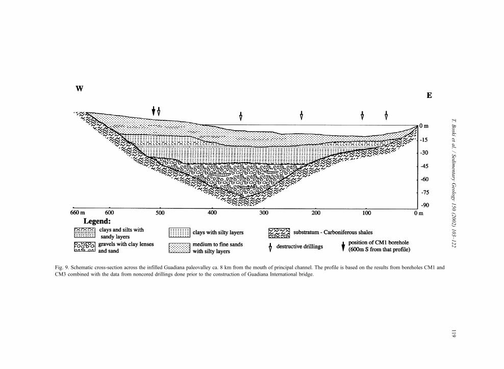
Fig. 9. Schematic cross-section across the infilled Guadiana paleovalley ca. 8 km from the mouth of principal channel. The profile is based on the results from boreholes CM1 and
CM3 combined with the data from noncored drillings done prior to the construction of Guadiana International bridge.
T.Boski
etal./Sedimentary
Geology150(2002)103–122
119

span from 6200 to 7080 year BP, respectively. In CM1,
the boundary is set at 16.2 m depth. It separates a
sequence of rhythmic, finning-up series (unit V) inter-
preted as a point bar facies, from the lower, mostly
clayey, bioturbated facies (unit II to IV). In the latter,
dissipated vegetal fragments, mud balls, and frequent
flaser structures point to an upper intertidal flat envi-
ronment, under continuous influence of tidal currents.
Reddish clayey layers observed in this unit indicate an
occasional supply of materials rich in ferruginous
pigments, eroded from Plio-Pleistocene formations
cropping out along Algarve–Andaluzia coasts (Boski
et al., 1999). In fact during the transgression, the
drowned fluvial valleys have received alternating
fluxes of fluvial and estuarine material as a conse-
quence of an interplay between the rates of sea-level
rise, sediment supply and accommodation space
(Miall, 1996; Muto and Steel, 2000). Likewise due
to the fast sea-level rise in the corresponding period,
the fine sediment load could be effectively trapped and
fixed (Wood et al., 1993) by the salt marsh vegetation
which itself could maintain a constant position in
relation to the tidal flooding. The reported discrete
centimetre-scale peaty levels indicate the recurrence of
brackish/fresh water conditions that most probably
occurred in semiconfined ponds. Numerous traces of
rootlets indicate that these patches of peat are in situ.
In borehole CM2, unit III is interpreted as an upper
marsh, composed almost exclusively of clay deposited
in a confined lagoon environment sheltered by the sand
spit to the south, occupied at present by Monte Gordo
dune field. The lack of any observable discontinuity
within this unit indicates that these conditions pre-
vailed throughout the entire period of deposition, i.e.
since ca. 7000 year BP. The latter figure was obtained
from extrapolation of sedimentation rate between two
dated levels 2780 year BP at 4.2 m depth and 5950 year
BP at 7.1 m depth. The 30 hand auger drillholes
(Santos and Boski, 2000) that were acquired over a
surface of about 1 km2 around CM2, have showed that
unit III is laterally homogenous, composed entirely of
clayey–silty sediments enclosing levels of well pre-
served valves of C. edule, Ruditapes decussates and
other species that were mentioned above.
Sediments drilled between 31.2 and 16.5 m (unit II)
in borehole CM3, belong to a remarkably homoge-
neous facies of clays, very rich in vegetal remains with
some bioclastic deposits from channel lags. These
facies are typical for confined marshes developed
within the reaches of the central estuarine basin where
agglutinated foraminifera species dependent on fine
sediment, account for almost 100% of the entire
assemblage. The two 14C dates so far obtained (9470
year BP at 26.9 and 7080 year BP at 14.5 m point once
more to conditions of rising sea level at an accelerated
pace of 0.6–1 m per century. Lithofacies from 16.4 to
1.5 m depth, are mostly fine sand with frequent
channel lags, indicating a shift to an environment of
increasing tidal energy. The observed replacement of
the upper marsh foraminifera by lower marsh species
(Gehrels and Plassche, 1999) ca. 7500–7000 year BP,
must have occurred when the sea-level rise became
faster than marsh accretion. Combining these figures
(considering the sediment compaction) with the recent
dating of the submerged rocky shore ridges on
Algarve shelf by Teixeira (1999) that indicate sea
level of � 20 m below the present at 7400 year BP
and � 11 m below the present at 5860 year BP,
suggests that shelf sands became an important com-
ponent of the estuarine infill between 6500 and 7000
year BP. According to Zazo et al. (1994) in that period,
the first phase (H1) of barrier progradation along the
Gulf of Cadiz coasts began, which enabled the enclos-
ing of coastal lagoons (Bettencourt, 1994). The sim-
plified synthetic section through the sedimentary fill
of the estuarine valley obtained from the lithological
columns in boreholes CM1 and CM3 and noncored
drillings is shown in Fig. 9.
Of the four cores considered, the sedimentary
column of the CM4 borehole is certainly the most
complex. Two gravel units (I and IV) enclose the salt
marsh sediments (unit II) overlain by a swamp/creek
laminated and hardened deposit (unit III) that experi-
enced prolonged subaerial exposure inferred from
presence of carbonate nodules and oxidized levels.
Further to the west in the Gulf of Cadiz, in the
Estuaries of Tinto, -Odiel and Guadalete Rivers, sim-
ilar sequences were attributed to highstands during the
isotope stage (IS) V, ca. 128000 year BP (Zazo, 1999)
or to the IS III highstand (Dabrio et al., 2000), ca.
25000–30000 year BP. The first evidence of marine
sedimentation in predominantly sandy unit VI is the
shell rich, gravel layer at 15.2 m. The existing datings
6250 year BP at � 15.2 m, 5640 year BP at � 9.7 m
and 6200 year BP at � 7 m point to (with all necessary
reserves imposed by the highly dynamic environment)
T. Boski et al. / Sedimentary Geology 150 (2002) 103–122120
rapid accretion of a coastal bar. The uppermost 3 m of
sands are barren of any fauna at macro- and micro-
scopic scale and contain abundant floral remains, thus
their deposition occurred in a subaerial environment of
the coastal dune system. Assuming that the period of
the Upper Holocene was characterised by a relatively
stable sea level (Dias et al., 2000), the final stage of
infilling of the estuary could be a consequence of
anthropic activities (mainly deforestation in the drain-
age basin), as it was deduced from archaeological
sources (Chester and James, 1991) and the navigation
maps published from XVI Century onwards (Morales,
1997).
6. Conclusions
Four cored boreholes were drilled through the entire
sequence of Quaternary sediments on the Portuguese
side of the terminal segment of Guadiana River.
The presented analyses of paleofacies inferred from
sedimentological and paleontological features of the
sediments deposited in the terminal part of Guadiana
fluvial paleovalley, is a first attempt to establish the
sequence of events that led to the formation of the
Guadiana River estuary in its present form. The valley
was incised in Carboniferous rocks to a depth attain-
ing � 80 m below the present mean sea level. Gravelly
delta fan sediments that were described also in other
estuaries to the west in the Gulf of Cadiz, line the
bedrock valley during early phases of transgression.
These accumulated after or during previous high
stands, most probably during the isotopic stages 5
and 3.
To its end, the fluvial phase in terminal part of
Guadiana Valley left on top of the gravels a thin veneer
of fine micaceous sands lain ca. 11000–10000 year
BP. An accelerated phase of infilling of the estuary by
clayey sediments, containing the salt marsh foramini-
fer Trochammina, began at ca. 9800 year BP when the
sea level was about 39 m below the present. Between
7500 and 7000 year BP, the central part of the estuary
started to accommodate coarser sediments, partially
introduced from the shelf, whereas in marginal lagoons
clay deposition continued. Sedimentation also seems
to have kept pace with sea level here as indicated by the
thick salt marsh succession. At ca. 6500 year BP, the
phase of fast sea-level rise (over 1 m/century) termi-
nated, leading to enclosing of lagoonal bodies behind
sand spits in the vicinity of the estuary and to predom-
inantly sandy sedimentation within the estuary. The sea
level close to the present was attained at about 5000
year BP after a period of slower rise (below 0.5 m/
century). Navigation maps indicate that since XVI
Century the water area within the estuary was steadily
decreasing.
Acknowledgements
This research was financed by European Union
INTERREG II programme, DISIPOL Project (Sedi-
ment Dynamics and Pollutant Dissipation in Guadiana
River Estuary) and is a Centre for Marine and
Environmental Research (CIMA) contribution to
UNESCO IGCP 437 project. We are grateful to the
anonymous editorial reviewers and Charles H. Fletch-
er (University of Hawaii), who provided many useful
suggestions that have considerably improved both
content and style of the manuscript.
References
Aguirre, M.L., Farinati, E.A., 1999. Taphonomic processes affecting
late Quaternary molluscs along the coastal area of Buenos Aires
Province (Argentina, Southwestern Atlantic). Palaeogeogr., Pa-
laeoclimatol., Palaeoecol. 149, 283–304.
Bettencourt, P., 1994. Les Environnements Sedimentaires de la Cote
Sotavento (Algarve, Sud Portugal) et leur Evolution Holocene et
Actuelle. PhD thesis, Univ. Bordeaux, Bordeaux, 413 pp.
Borrego, J., Morales, J.A., Pendon, J.G., 1993. Holocene filling of
an estuarine lagoon along the mesotidal coast of Huelva: The
Piedras River mouth, southwestern Spain. J. Coast. Res. 9,
242–254.
Boski, T., Moura, D., Machado, L.M., Bebianno, J.M., 1999. Trace
metals in the coastline of Algarve I—associations, origins, and
remobilization of natural component. Bol. Inst. Esp. Oceanogr.
15, 74–81.
Cabral, J., 1995. Neotectonica de Tras-os Montes oriental. Bol. Soc.
Geol. Port., Lisboa 24, 193–197.
Chester, D.K., James, P.A., 1991. Holocene Alluviation in the Al-
garve, southern Portugal; case for an anthropogenic cause. J.
Archaeol. Sci. 18, 73–87.
Correia, F., Dias, J.A., Boski, T., Ferreira, O., 1996. The retreat of
the Eastern Quarteira cliffed coast (Portugal) and its possible
causes. In: Jones, P.S., Healy, M.G., Williams, A.T. (Eds.), Stud-
ies in Coastal Management. Samara Publ., Cardigan, UK, pp.
129–136.
Dabrio, C.J., Goy, J.L., Lario, J., Zazo, C., Borja, F., Gonzalez, A.,
T. Boski et al. / Sedimentary Geology 150 (2002) 103–122 121

1995. The Guadalete Estuary during the Holocene times (Bay
of Cadiz, Spain). Mediterranean and Black Sea Shorelines
(INQUA) Newsletter 17, 19–22.
Dabrio, C.J., Zazo, C., Goy, J.L., Sierro, F.J., Borja, F., Lario, J.,
Gonzalez, J.A., Flores, J.F., 2000. Depositional history of es-
tuarine infill during the last postglacial transgression (Gulf of
Cadiz, Southern Spain). Marine Geology 162, 381–404.
Darlymple, R.W., Zaitlin, B.A., Boyd, R., 1992. Estuarine facies
models: conceptual basis and stratigraphic implicatios. J. Sedi-
ment. Petrol. 62, 1130–1146.
Dias, J.M.A., Boski, T., Rodrigues, A., Magalhaes, F., 2000. Coast
line evolution in Portugal since the last glacial maximum until
present—a synthesis. Mar. Geol. 170, 177–186.
Einsele, G., 1992. Sedimentary Basins. Evolution, Facies and Sedi-
ment Budget. Springer, Berlin, 628 pp.
Fitzgerald, D.M., Buynevich, I.V., Fenster, M.S., McKinlay, P.A.,
2000. Sand dynamics at the mouth of a rock-bound tide-domi-
nated estuary. Sediment. Geol. 131, 25–49.
Fogel, M.L., Cifuentes, L.A., 1993. Isotope fractionation during
primary production. In: Engel, M.H., Macko, P.L. (Eds.), Or-
ganic Geochemistry. Plenum, New York, 860 pp.
Gehrels, W.R., Plassche, O., 1999. The use of Jadammina macres-
cens (Brady) and Balticammina pseudomacrescens Bronni-
mann, Lutze and Whittaker (Protozoa: Foraminiferida) as sea-
level indicators. Palaeogeogr., Palaeoclimatol., Palaeoecol. 149,
89–101.
Goy, J.L., Zazo, C., Somoza, L., Dabrio, C.J., Lario, J., Borja, F.,
Sierro, F.J., Flores, J.A., 1996. Global and reginal factors con-
trolling changes of coastlines in South Iberia (Spain) during
Holocene. Quat. Sci. Rev. 15, 773–780.
Granja, H., Froidefond, J.-M., Pera, T., 1984. Processus d’evolution
morpho-sedimentaire de la Ria Formosa (Portugal). Bull. Inst.
Geol. Bassin Aquitaine, Bordeaux 36, 37–50.
Hernandez-Molina, F.J., Somoza, L., Rey, J., Pomar, L., 1994. Late
Pleistocene–Holocene sediments on the Spanish continental
shelves: a model for very high-resolution sequence stratigraphy.
Mar. Geol. 120, 129–174.
Martin-Serrano, A., Molina, E., 1989. Montes de Toledo y Extrem-
adura; mapa del Cuaternario de Espana. Instituto Tecnologico
Geominero de Espana, Madrid.
Miall, A.D., 1996. The Geology of Fluvial Deposits. Springer, Ber-
lin, 582 pp.
Morales, J.A., 1997. Evolution and facies architecture of the mes-
otidal Guadiana River delta (S.W. Spain–Portugal). Mar. Geol.
138, 127–148.
Mougenot, D., 1988. Geologie de la Marge Portuguese. These de
Dotorat detat es Sciences Naturelles, Paris, 257 pp.
Moura, D., Boski, T., 1999. Unidades litostratigraficas do Plioceni-
co e Plistocenico no Algarve. Comun. Inst. Geol. Min. 86, 85–
106.
Muto, T., Steel, R.J., 2000. The accommodation concept in se-
quence stratigraphy: some dimensional problems and possible
redefinition. Sediment. Geol. 130, 1–10.
Otvos, E.G., 1995. Multiple Pliocene –Quaternary marine high-
stands, Northeast Gulf costal plain—fallacies and facts. J. Coast.
Res. 11, 984–1002.
Pereira, A.R., 1992. A Geomorfologia da Margem Continental Por-
tuguesa e a Interdependencia das Plataformas Continental e Li-
toral. Centro de Estudos Geograficos, Linha de Acc�ao de
Geografia Fısica, Rel. No. 30, Lisboa, 85 pp.
Ribeiro, A., Antunes, M.T., Ferreira, M.P., Rocha, R.B., Soares,
A.F., Almeida, F., Carvalho, D., Monteiro, J.M., 1979. Introduc-
tion a la Geologie Generale du Portugal. Servic�os Geologigos dePortugal, Lisboa, 114 pp.
Santos, A., Boski, T., 2000. The comparison of Holocene sedimen-
tary infill in the two areas of contrasted sedimentary dynamic
of Guadiana Estuary. In: Carvalho, S.G., Gomes, V.M., Pinto,
T.F. (Eds.), Os Esuarios de Portugal e os Planos de Bacia Hi-
drografica. Eurocoast Association Portugal, Lisboa, pp. 45–53.
Scott, D.B., Hermelin, J.O.R., 1993. A device for precision splitting
of micropaleontological samples in liquid suspension. J. Pale-
ontol. 67, 151–154.
Scott, D.B., Medioli, F.S., 1978. Vertical zonations of marsh fora-
minifera as accurate indicators of former sea-levels. Nature 272,
528–531.
Scott, D.B., Medioli, F.S., 1986. Foraminifera as sea-level indica-
tors. International Correlation Programme, Project 61. In: van de
Plassche, O. (Ed.), Sea-level Research: A Manual for the Col-
lection and Evaluation of Data. Geo Books, Norwich, UK, pp.
435–456.
Teixeira, S.B., 1999. Contribuic�ao para o conhecimento da evoluc�aodo litoral de Quarteira (Algarve-Portugal) nos ultimos 8000
anos. Al-Ulya, 1–20.
Trentesaux, A., Stolk, A., Berne, S., 1999. Sedimentology and strat-
igraphy of a tidal sand bank in the southern North Sea. Mar.
Geol. 159, 253–272.
Van Wagoner, J.C., Posamatier, H.W., Mitchum, R.M., Vvail, P.R.,
Sarg, J.F., Loutit, T.S., Hardenbol, J., 1988. An overview of the
fundamentals of sequence stratigraphy and key definitions. In:
Wilgus, C.K., Hastings, B.S., Kendall, C.G., Posamatier, H.W.,
Ross, C.A., van Wagoner, J.C. (Eds.), Sea Level Changes: An
Integrated Approach. Soc. Econ. Paleontol. Mineral. Spec.
Publ., vol. 42, pp. 39–45.
Vidal, J.R., Caceres, L.M., Ramirez, A.R., 1993. Modelo evolutivo
da rede fluvial Cuaternaria en el suroeste de la peninsula Iberica.
Actas 3a Reuniao do Quaternario Iberico, Universidade de
Coimbra, Coimbra, 93–96.
Walker, S.E., Goldstein, S.T., 1999. Taphonomic tiering: experi-
mental field taphonomy of molluscs and foraminifera above
and below the sediment–water interface. Palaeogeogr., Palae-
oclimatol., Palaeoecol. 149, 283–304.
Wood, L.J., Etheridge, F.G., Schumm, S.A., 1993. The effects of
rate of base-level fluctuation on coastal plain, shelf and slope
depositional systems: an experimental approach. Spec. Publ. Int.
Assoc. Sedimentol. 18, 43–53.
Zazo, C., 1999. Interglacial sea levels. Quaternary international.
Quat. Int. 55, 101–113.
Zazo, C., Goy, J.L., Somoza, L., Dabrio, C.J., Belluomini, G., Im-
prota, S., Lario, J., Bardaji, T., Silva, P.G., 1994. Holocene
sequence of sea level fluctuations in relation to climatic trends
in the Atlantic–Mediterranean Linkage Coast. J. Coast. Res. 10
(4), 933–945.
T. Boski et al. / Sedimentary Geology 150 (2002) 103–122122
Copyright © 2022 FDOKUMEN