
Sedimentary Rocks - West Virginia Geological and Economic ...
50
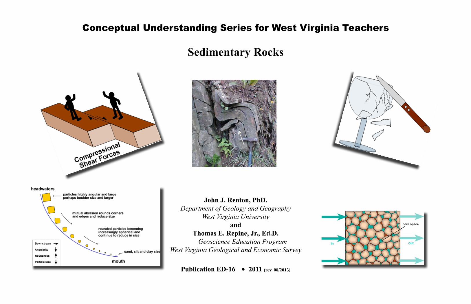
Conceptual Understanding Series for West Virginia Teachers Sedimentary Rocks John J. Renton, PhD. Department of Geology and Geography West Virginia University and Thomas E. Repine, Jr., Ed.D. Geoscience Education Program West Virginia Geological and Economic Survey Publication ED-16 2011 (rev. 08/2013) pore space •
-
Upload
khangminh22 -
Category
Documents
-
view
0 -
download
0
Transcript of Sedimentary Rocks - West Virginia Geological and Economic ...
i
Conceptual Understanding Series for West Virginia Teachers
Sedimentary Rocks
John J. Renton, PhD.Department of Geology and Geography
West Virginia Universityand
Thomas E. Repine, Jr., Ed.D. Geoscience Education Program
West Virginia Geological and Economic Survey
Publication ED-16 2011 (rev. 08/2013)
pore space
•

i
Foreword
Consider these three words: shale, sandstone, and limestone. Chances are you know something about them. But do you know enough to comfortably present them to your students as new nomenclature? Now consider these two words: stress and strain. Could you comfortably include these concepts in any discussion related to mountains built of shale, sandstone, and limestone? I believe professional educators, at any level, are continually looking for methods and materials to improve their content presentation. This does not necessarily imply additional content. It may be a search for something as simple as a better way to explain, a clearer illustration, or an insightful way to respond to student questions. One way of doing this is by increasing background subject knowledge. Some refer to this as pedagogical content knowledge. In this discussion with Jack, I hope you will discover connections you never imagined, tidbits that will interest your students, and ideas that will strengthen your ability to educate. Our responsibility is to present you with the information needed to have a minimal operational awareness of sedimentary rocks. Notice I did not say teach. That is your responsibility. Only by conceptually comprehending more than your students will you be able to effectively decide what information you can use, need to use, and must use for your students’ sake. When I presented this idea to Jack he responded with an interesting visual analogy: “If the amount of content material you must teach your students is the size of a softball, then your understanding of that content better be the size of a beach ball.” This may explain why this discussion on sedimentary rocks may seem rather extensive to some. Why you may ask, do I need to know about sedimentary rocks? More importantly, why do I need to know something about stress and strain? The short answer is that, as a West Virginian, you live in a place made almost exclusively of sedimentary rock. Therefore, it seems only fair that you should understand these rocks, how they were formed, and how their deformation became the foundation of today’s landscapes. The facts, opinions, and illustrations expressed herein are Jack’s. My contribution to this effort has been to make Jack re-imagine how the material is presented. Any technical errors or undue wordiness generated by this process is my doing. Be aware that other geologists may have different opinions or different ways of presenting the same material. This is just the nature of science. Do not dwell on it. This work has been reviewed by teacher-editors with extensive backgrounds obtained through participation in the now-defunct WV Geologic Survey’s RockCamp Progam. Thank you for a job well done.
Michele Adams, Berkeley County Schools Angela McKeen, Fairmont State University Sue Alkire, Hampshire County Schools Sheba Kendig, Braxton County Schools Tim Butcher, West Virginia Departmart of Education Paula Waggy, Pendleton County Schools (retired) Mary Sue Burns, Pocahontas County Schools Cindy Wandling, Putnam County Schools Pam Casto, NASA IV and V Karen Williams, Randolph County Schools
Many thanks to Dr. Deb Hemler, Professor of Geoscience Education, Fairmont State University and West Virginia Geological Survey geologists Jim Britton, Barnes Nugent, and Jeanne Sutton for their time in reviewing this text and offering suggestions. Betty Schleger has, as usual, been the person most responsible for actually getting this project completed. Artwork, page layout, reviewing, and making suggestions that result in concrete forward movement all exist within her formidable skill set. I thank her for her continued patience. If you have comments on this product, please contact me.
Tom RepineWest Virginia Geological [email protected]

1
Conceptual Understanding Series for West Virginia Science Teachers
(or How We Teach It)
Sedimentary RocksCONTENTS
Foreword ....................................................................................................................... i Contents ....................................................................................................................... 1Part I: Origin of Sedimentary Rocks ............................................................................. 2 Origin of Sandstones ............................................................................................... 4 Origin of Limestones ................................................................................................ 8 Origin of Shales ..................................................................................................... 13 Origin of Coals ....................................................................................................... 21 Sedimentary Rock Summary ................................................................................. 26
Part II: Deformation of Sedimentary Rocks ................................................................ 28 Strength ................................................................................................................. 28 Applied Force (Stress) ........................................................................................... 29 Strain (Deformation) .............................................................................................. 30 Elastic Strain ....................................................................................................... 30 Example of Elastic Deformation of Sedimentary Rocks ..................................... 32 Plastic Deformation ............................................................................................. 34 Examples of Plastic Deformation of Sedimentary Rocks .................................... 35 Brittle Deformation .............................................................................................. 39 Examples of Brittle Deformation of Sedimentary Rocks ..................................... 41 Additional Brittle Deformation Structures ............................................................ 42 Brittle vs. Plastic Deformation in Sedimentary Rocks ............................................ 45 History Lesson: Architecture, Rocks, Stress, and Strain ....................................... 47 Final Thoughts ....................................................................................................... 48 Additional Materials ............................................................................................... 48

2
Part I: Origin of Sedimentary Rocks
We hope you have read our previous book Conceptual Understanding Series: Plate Tectonics. During this discussion we will refer to material covered in that book. This installment is the second part of a spiraling geology curriculum which will culminate with an in-depth look at some of Earth’s most interesting mountains. Many mountains are made of deformed sedimentary rocks. In this book we will briefly cover the origin of common sedimentary rocks, how they deform, and what structures their deformation may create. Understanding this material will significantly enhance your ability to comprehend and use our future books. We will begin with an exploratory activity. Figure 1 was taken along a railroad track in Preston County, West Virginia during the early 1920s. The rocks still look like this today. Try to answer the following questions about the rocks shown in the photograph:
1. Are these igneous, metamorphic, or sedimentary rocks?
2. Use a highlighter to trace the pattern made by a few layers of the rock in the photograph. (Caution: Make sure to follow the same layer at all times!)
3. Do these rocks obey the Law of Originial Horizontality we presented in the our plate tectonics book?
4. Are you still confident that your answer to question 1 is valid? Explain.
5. Do you normally think of rocks as being hard and brittle? Can you suggest some mechanism that would explain the apparent folding of these rock layers?
Figure 1

3
What are the three major rock types?
Answer: Sedimentary, igneous, and metamorphoric
Sandstone
Coal
Shale
Correctly answering the previous questions is not our point at this time. Our goal is to make you think about what you are seeing. Now that you’re tuned in, let’s look at a few more photographs. The picture in Figure 2 shows a group of teachers examining the sandy sediment of a stream point bar. Figure 3 shows a sequence of horizontal sedimentary rocks exposed in a surface coal mine. From bottom to top (Law of Superposition!) you can see beds (layers) of shale, coal, and sandstone. The thin coal is overlain by a very thick layer of sandstone. Just to see if you are really looking at the photograph, do you notice the straight, nearly vertical lines and sharp, nearly ninety degree angles between the exposed faces of the sandstone? These lines and angles are created by weathering along geologic fractures called joints. We will explain joints later in our discussion. Figure 4 shows a geologist standing in front of very deformed layers of sedimentary rock. The Law of Original Horizontality, covered in our previous book, states that sedimentary rocks form and occur as horizontal layers unless they have been deformed. We think it is safe to assume that the rocks in the lower picture have been most definitely deformed. Sedimentary rocks dominate West Virginia. So much so, that we take them for granted. However, these seemingly common rocks provide many of the resources needed for modern economies and societal development. More importantly, sedimentary rocks, and what happens to them over geologic time, are pivotal in shaping local, regional, and global geology and geography.
Figure 2
Figure 3
Figure 4

4
The most well-known and commonly occurring sedimentary rocks are shales, sandstones, and limestones. Abundant reference texts document how each of these rocks form. Our mission is more limited and focused. For those with no prior knowledge and those with limited knowledge we wish to provide a classroom-useful introduction to the origin of each of the three major sedimentary rocks. We will begin with sandstone, one rock with which you might already be familiar.
Origin of Sandstones
We all have heard of and used the term “sandstone.” Although most folks think they can describe a sandstone, more often than not the characteristics they use are not actually those that define a sandstone. When used correctly, sandstone is a technical term geologists employ to describe the size of the particles that make up a sedimentary rock. Thus the term “sandstone” means a rock made of sand-sized particles. Just how big are sand-sized particles? This is the second reason most descriptions fail. If we consider the various sizes of sediments produced by the physical weathering of older pre-existing rocks, sand-size actually describes particles that range in diameter from 1/16 mm to 2 millimeters (Figure 5). Within the sand-sized category, terms such as “fine-grained” and “coarse-grained” are used to provide a more specific idea of particle size. Thus, we can have a fine-grained sandstone, a medium-grained sandstone, or a coarse-grained sandstone. A close examination of a large piece of sandstone will help you visualize this distinction since it will probably consist of sand particles of varying sizes. It is important for the geologist to look at and describe each layer in order to accurately document the rock. While the name sandstone does not specify particle composition, it is true that all sandstones are composed of particles predominantly of the mineral quartz. Where does the quartz come from? Most of it is produced by the chemical weathering of the granite rocks in Earth’s crust. Some of it comes from the physical weathering of older pre-existing sandstones. In either case, quartz itself is basically immune to chemical weathering. Any released quartz grains are free to be carried off, mainly by streams, to the ocean. Once deposited along the edge of the ocean (maybe as part of a river-mouth delta), waves, longshore currents, and tides throw some of the grains up onto the land to provide you the sandy beach on which you play. Quartz sand is also deposited in the channels and along the banks of the rivers flowing to the ocean. Over geologic time, these river deposits may form multiples layers containing sandstones of differing grain sizes as the ongoing process of erosion sorts the various sizes.
Sandstone represents only about 20% of all sedimentary rocks present on Earth’s crust.
Rock fragments have no upper limit. However, their lower limit is about sand-size. Can you suggest a reason for this? Remember that a rock, even a sandstone that is 90% quartz, is still a mixture of minerals. If weathering reduces the rock to below sand-size, the particles actually start to become more mineral fragments than rock fragments.
Silicon = SiSilica = SiO2Silicate minerals contain SiO2Silicate ion = (SiO4)
4-
Why is quartz not attacked by chemical weathering? Student’s often respond by claiming quartz is too hard. The response is informative because it shows they are confusing physical weathering with chemical weathering. The two agents of chemical weathering are dissolved oxygen and dissolved carbon dioxide (carbonic acid). Quartz will not react with dissolved oxygen because it is already fully oxidized SiO2. There is no such chemical as SiO3. When silica (SiO2) goes into solution, it is in the form of an anion (SiO4)
4-. Because ions of like charge do not react with each other, the silicate anion will not react with the bicarbonate anion (HCO3)
-.
Figure 5
5
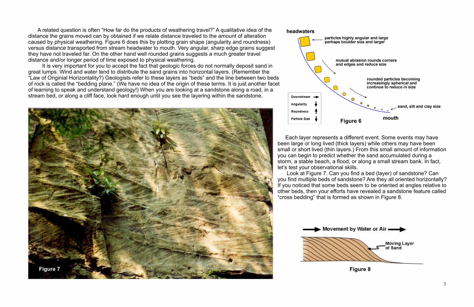
A related question is often “How far do the products of weathering travel?” A qualitative idea of the distance the grains moved can by obtained if we relate distance traveled to the amount of alteration caused by physical weathering. Figure 6 does this by plotting grain shape (angularity and roundness) versus distance transported from stream headwater to mouth. Very angular, sharp edge grains suggest they have not traveled far. On the other hand well rounded grains suggests a much greater travel distance and/or longer period of time exposed to physical weathering. It is very important for you to accept the fact that geologic forces do not normally deposit sand in great lumps. Wind and water tend to distribute the sand grains into horizontal layers. (Remember the “Law of Originial Horizontality?) Geologists refer to these layers as “beds” and the line between two beds of rock is called the “bedding plane.” (We have no idea of the origin of these terms. It is just another facet of learning to speak and understand geology!) When you are looking at a sandstone along a road, in a stream bed, or along a cliff face, look hard enough until you see the layering within the sandstone.
Each layer represents a different event. Some events may have been large or long lived (thick layers) while others may have been small or short lived (thin layers.) From this small amount of information you can begin to predict whether the sand accumulated during a storm, a stable beach, a flood, or along a small stream bank. In fact, let’s test your observational skills. Look at Figure 7. Can you find a bed (layer) of sandstone? Can you find multiple beds of sandstone? Are they all oriented horizontally? If you noticed that some beds seem to be oriented at angles relative to other beds, then your efforts have revealed a sandstone feature called “cross bedding” that is formed as shown in Figure 8.
Figure 6
Figure 7 Figure 8

6
The photograph in Figure 9 is the same one used on the previous page in Figure 7. The solid black lines mark just a few of the many bedding planes within this sandstone. The dashed black lines show just a few of the many cross beds. Did you find beds and cross beds? More importantly, do you think you can use them to tell a story of what happened? These beds and cross beds are in a quartz-rich, medium-grained to coarse-grained, sandstone. It is approximately 300 million years old. The heavy solid lines approximate the tops and bottoms of individual beds (layers) of sandstone. The dashed lines illuminate a few of the bed-confined cross beds. Note each sandstone bed tends to cut off or terminate underlying cross beds. This suggests that newer (younger) events removed some amount of pre-existing (older) material. Cross beds provide clues that reveal the direction the sand sized particles were being transported by a stream, an ocean current, or the wind, before the entire mass was buried and lithified (converted into a rock). Using this process, geologists have determined that most of West Virginia’s 300 million year old sandstones, like the one pictured in Figure 9, were formed from the quartz-rich sand that accumulated in meandering stream channels flowing from southeast to northwest. We know the stream was meandering because of the change in the direction in which crossbeds slope. By observing and measuring the grains of many sandstones we can deduce that 300 million years ago many of West Virginia’s rivers and streams originated in a highland (mountain) region located to the southeast and that the streams were flowing into an inland sea located to the northwest whose shoreline was located in Ohio. That’s a lot to know from such a seemingly insignificant observation! Why are we assuming water? Why is this not an example of a sand dune? Quartz grains in water are somewhat cushioned from each other as they are jostled about during erosion. On the other hand, wind blown quartz grains lack a fluid cushion and so they directly strike each other. The end result is that each sand grain becomes pitted in the same way that sand blasting frosts a pane of window glass. A microscopic look at the sand grains in the pictured sandstone reveals that none of them are frosted, therefore we can assume transport by water.
Figure 9

7
pore space
So far we have seen that the processes of weathering, erosion, and deposition play major roles is constructing accumulations of loose sand. The obvious questions are:“How does the loose sand become the rock we call sandstone?”, “What holds the sediment particles together?”, and “How does that happen?” Imagine a shoe box full of golf balls. Is all of the box filled by the golf balls? Not really! Forty-seven percent of the box is empty space between golf balls. When talking about rocks, geologists refer to these open spaces around sand grains as pores (Figure 10). Pore space allows for the movement of fluids among the individual grains. These fluids include groundwater, natural gas, and oil. Groundwater contains many kinds of dissolved minerals. A few of the most common ones are quartz (SiO2), calcite (CaCO3), and iron in the form of the mineral hematite (Fe2O3). When the water is highly saturated with minerals, the minerals will tend to come out of solution and precipitate (grow crystals) within the pore spaces. In Figure 10 you can see that as the ground water (dark blue arrows) flows into and through the accumulated sand grains, it encounter numerous pore spaces. These pore spaces provide the perfect location for the accumulation growth of precipitated minerals (red deposits). The fact that the existing water has lost some of its dissolved mineral content is shown by the lighter blue arrows. In much the same way that mortar holds bricks together, these mineral accumulations become the mortar that binds the individual sand grains together to make the rock we call sandstone. We refer to this geologic process as “cementation.” Since the number and sizes of pore spaces can vary with grain size and because the movement and mineral saturation of water varies, the sand grains are not necessarily uniformly cemented together. Just like in a badly mortared brick wall, some parts of the rock may be held together more tightly than other parts. You are seeing the outcome of this situation when you see naturally occurring pockets or holes in sandstone or when you see different pieces of sandstone react very differently to the same weathering processes. Just like we added adjectives to suggest grain size, a geologist will also add adjectives to describe how the sand grains are cemented together. For example, a sandstone cemented with quartz is a siliceous sandstone. A sandstone cemented by the mineral calcite would be a calcareous sandstone. One held together by iron oxide would be called a ferruginous sandstone. As a result, a geologist can transmit more information by more explicitly classifying a sandstone as a “calcareous, fine-grained, sandstone” rather than just a sandstone.
Weathering is the physical or chemical breakdown of existing rock by ice, wind, and water.
Erosion is the transport of weathered particles by ice, wind, or water.
Interesting nugget: When packed together, perfectly spherical shaped objects of any size will always have 47% pore space.
Why does the groundwater move? Gravity. The water wants to go down slope if at all possible and pressure due to the weight of overlaying sediments also forces it along.
Cement does not always fill all available pore spaces. Water, oil, and natural gas can be trapped within the available openings. There is a common misconception that fluids occur in underground pools. Admittedly, the oil drillers’ slang does reinforce this notion. However, there are no underground “pools” of oil.
The term “siliceous” comes from the silicon in quartz.
Ferum (Fe) is Latin for iron. From this we get “ferruginous” meaning “iron bearing.”
Figure 10

8
Find a waterfall in West Virginia and there is a very good chance that the water is falling over an exposed layer of sandstone (Figure 11). Contrary to popular opinion, sandstones are not “harder” than other rocks. However, because of their composition, sandstones are most often more resistant to physical and chemical weathering. For this reason, sandstones usually stand out in relief as a ledge, ridge top, or dominant rock layer. Sandstones are however, susceptible to physical weathering. For example. the cyclic repetitions of freezing and thawing caused by frost wedging widens naturally occurring fractures until gravity pulls the pieces apart. With the coming of the spring rains many of these detached rocks fall and are deposited along lower slopes. (This is a great time to go rock and fossil collecting.) Sandstones are also of economic importance. Over the long history of the petroleum industry more oil and gas has been stored in and produced from sandstones than any other type of reservoir rock. Also, the sand used to make the high quality glass for the Mount Palomar Telescope mirror was
quarried near Berkeley Springs from a unit called the Oriskany Sandstone which is 100% quartz..
Origin of Limestones
Figure 12 shows a group of teachers learning how to measure a physical characteristic of rocks. If you look in the background, just above their heads, you will see several layers of limestone. Note the rounded appearance of the weathered rocks.In humid climates, like West Virginia, chemical
weathering caused by the natural carbonic acid in rain water tends to remove sharp edges from limestones. To understand limestones, you need to know something of their origins. We have already stated that naturally occurring carbonic acid plays a role in the weathering of limestone. Does it play any role in its formation? Let’s find out.
The water at Blackwater Falls flows over a sandstone of the Pottsville Group (Figure 11).
In other places, like Niagra Falls, limestone is the rock making the waterfall.
Hardness is a term used for minerals, as in the Moh’s Hardness Scale. This scale and the idea of hardness should not be applied to rocks which are mixtures of minerals.
Limestones make up only 10% of the sedimentary rock found in Earth’s crust.
Limestone is a rock composed of calcite and other minerals and materials. The mineral calcite has the chemical formula of CaCO3.
Both calcite and limestone vigorously “fizz” when a drop of 5-10% diluted solution of hydrochloric is applied (Figure 13, fizzing is shown by the whitish bubbles at bottom). The fizzing is caused by the release of carbon dioxide. Another chemistry integration!
Carbonic acid is weak. Carbonated beverages contain carbonic acid.
Figure 11
Figure 12
Figure 13
9
During the weathering process many different materials are taken into solution by the universal solvent known as water. As a result, elemental components such as calcium (Ca), magnesium (Mg), sodium (Na), and potassium (K) are carried off to the ocean. Of these elements, calcium is involved in the formation of limestone. To really understand how limestones form (so you can explain it to someone else), you need to know something of its chemical origins. Remember, there is no need for you, or anyone, to memorize equations, but going through them in a simple step-like fashion will provide you with a more thorough appreciation of how the rocks we call limestone form. It is also a good way to practice your skills of science integration. The process begins as chemical weathering release material from pre-existing rocks. The two chemicals that play a dominant role in the process of making limestone are dissolved carbonic acid and dissolved oxygen. Of the two, carbonic acid is most important to the formation of limestone. So, your first question should be, “Where does the carbonic acid come from?” Normal rain water contains dissolved atmospheric carbon dioxide (CO2). As rain becomes ground water, it acquires additional carbon dioxide released by the decay of once living animal and plant material. Equation 1 illustrates the production of carbonic acid (H2CO3) when carbon dioxide and water interact:
Equation 1 CO2 + H2O H2CO3 Although we are calling it carbonic acid at this point, the H2CO3 is not really an acid. Why? The actual acid is the free hydrogen ion (H+) which is nothing more than a free proton. Which means that acid is really protons! Where do these free ions come from? Positively charged free hydrogen ions are produced by a process called dissociation. (Think of the root meaning of the word dissociate.) Dissociation of carbonic acid produces two ions: a positively charged hydrogen ion (H+) and negatively charged bicarbonate ion (HCO3)
-. This is illustrated in Equation 2:
Equation 2 H2CO3 H+ + (HCO3)
-
If we now combine Equations 1 and 2, the outcome is shown in Equation 3:
Equation 3 CO2 + H2O H2CO3 H+ + (HCO3)-
Notice the double arrows? Once again, this implies the reaction can operate in either direction and, once again, temperature is our controlling factor. Can you figure out which direction Equation 3 favors in cold water? In cold water, the equation goes from left to right. In warm water, Equation 3 will operate from right to left. Why? Because all gases are more soluble in cold water than in warm water. Our goal in this section is to provide a real explanation of how limestone forms. To do that, we need the chemistry. But, beyond that, why are we spending time on chemical reactions that operate one direction in cold water and the opposite direction in warm water? Might it be that the formation of limestone is dependent on water temperature?
Do you know the purpose of the double-headed arrow? It indicates that the reaction can go in either direction. In our case, what determines the direction of the reaction? Temperature! Cold water drives the reaction to the right to form carbonic acid. Warm water drives the reaction to the left resulting in the breakdown of carbonic acid into water and carbon dioxide.
Can you place Equation 1 in the context of your daily life? It controls your favorite carbonated beverage. If kept cold, the beverage stays carbonated (stays to the right as H2CO3). If allowed to warm, the reaction moves from right to left and the carbonic acid decomposes into water and carbon dioxide. As the CO2 is released into the surrounding atmosphere your beverage becomes nothing more than flat, colored water. Another chemistry in action tidbit!
Remember, the hydrogen ion (H+) is what makes acids acidic. An important characteristic of carbonic acid is that it doesn’t like to break down or dissociate to form ions; it would rather stay together as H2CO3. As a result, not many hydrogen ions are formed. For this reason carbonic acid is a very weak acid. The bottom line is that all water on land is a dilute solution of carbonic acid.

10
If you agreed with the last statement on the previous page, you’re right. But how does the limestone form? First, you need to remind yourself that limestone is a rock. Rocks are composed of minerals. The dominant mineral found in limestone is calcite. So, to explain how limestone forms we first need to figure out from where the calcite comes from. We can begin by examining Equation 4:
Equation 4 Ca2+ +2(HCO3)- CaCO3 + H+ + (HCO3)
-
Notice the CaCO3? This is the chemical formula for the mineral calcite. Note the double arrow implying the reaction can work in either direction. We have established that the major variable in the operational direction of our equations is water temperature. The question to be answered is “Does the formation of calcite require cold or warm water?” (You have a 50-50 chance of getting it right.) Did you pick warm water as your answer? Congratulations! In warm water Equation 4 operates from left to right forming the mineral calcite (CaCO3) along with the free hydrogen ion and carbonic acid. Since calcite is the dominant mineral in limestone we know now that warm water is the preferred environment for the formation of limestones. From now on the term “limestone” should make you think of the presence, long ago, of a geologically warm water environment. Did you pick cold water? If so, sorry, you are incorrect. In cold water, Equation 4 operates from right to left and, in the process, carbonic acid dissociates (dissolves) any calcite into a calcium ion and a bicarbonate ion. Cold water is not a great place for making the mineral calcite and the rock limestone. Now we are ready to discuss the formation of the rock limestone. Where on Earth would you expect limestones to form today? What environment is required? According to the chemistry, we need to be in a situation where Equation 4 will operate from left to right to generate calcite. This can be done in geographical areas where cold ocean water, saturated with calcium and bicarbonate ions, is driven into shallow, near-shore environments where the water can be warmed by solar energy (Figure 14a). In these warm environments, calcite is produced to the point that the water becomes supersaturated with calcite. Once this point is reached, calcite mineral crystals will begin to precipitate out and accumulate on the bottom as a whitish colored mud. If this mud is buried, the water is driven off, and the mud compressed, it will eventually become a dense fine-grained chemical limestone. As illustrated by Figure 14b, there is another way to generate calcite. While this is often referred to as the “biological method” it should more accurately be termed the biochemical process since it is chemistry driven by living organisms. Certain marine animals such as coral, gastropods, clams, oysters, and a few plants, possess mechanisms that remove the calcium and bicarbonate ions from ocean water. These are then used to form the mineral calcite which they use to fabricate shells and external coatings. Upon death, the shells fall to the ocean bottom. If they are buried and compressed they will become a biochemical limestone. Biochemical limestones can be easily differentiated from chemical limestones by the presence of fossil remains. Of the two types of limestones, biochemical limestones dominate. Because of the warm water requirement, most limestones form in the shallow ocean waters between the Tropics of Cancer and Capricorn. In Florida you can watch limestone forming in the warm shallow waters of Florida Bay (Figure 15). According to the geological mantra that “the present is the key to the past” finding places where limestone forms today provides valuable clues as to what ancient environments were like. Dependence on a warm-water environment means that almost anytime you see a limestone, you can interpret the original environment of formation as a shallow portion of the ocean characterized by warm water. Thus, while driving around West Virginia, if you see a 300 million year old limestone containing fossils you are probably right in
Figure 14a
Figure 14b
Figure 15

11
suggesting that the area was once occupied by a warm body of water. Are you beginning to see how geologists figure out what ancient environments were like? As we complete our brief introduction into limestone, here are two topics for you to ponder:
1. Why do biochemical limestones form in clear, silt-free waters. Hint: Many of the animals and plants are bottom dwellers.2. Have you ever wondered why collecting sea shells is a waste of time along the far northern coasts of North America?
Figure 16 shows a small piece of a 300 million year old biochemical limestone from West Virginia. The numerous gray colored items are fossilized animals called brachiopods. How do we know it’s limestone? Acid test! The whitish area above the tip of the dropper bottle is fizzing as a result of an acid test. The fossil that is completely surrounded by the reaction is a larger brachiopod of a different species.
Figure 17 shows limestone composed almost entirely of fossilized remains. The multiple doughnut-looking fossils are pieces of a bottom-dwelling animal called a crinoid. Broken pieces of bivalve-like animals called brachiopods are also present. The fact that many of the fossils are broken suggests deposition or transport by water in an environment with a higher than normal energy level. Think of a beach, delta, or very active tidal zone.
Answers:
1. Suspended sediments are detrimental to the animals’ ability to survive.
2. Think back to the cold water chemical process. The increased presence of cold water explains why shells become fewer, smaller, and less diverse as one goes northward along the Atlantic and Pacific coastlines. Very few shelled animals can survive the influence of the cold Arctic waters. The best shell-collecting in the United States is along the warm, shallow Gulf waters of the Florida Keys. The dependence on warm water for the formation of limestones explains why there are so many carbonate geologists. In order to complete their understanding of limestone formation, they must visit places such as the Bahamas and Cancun!
Disarticulated crinoid segments
Two connected crinoid segments
Brachiopods (note faint lines)
Figure 16
Figure 17
12
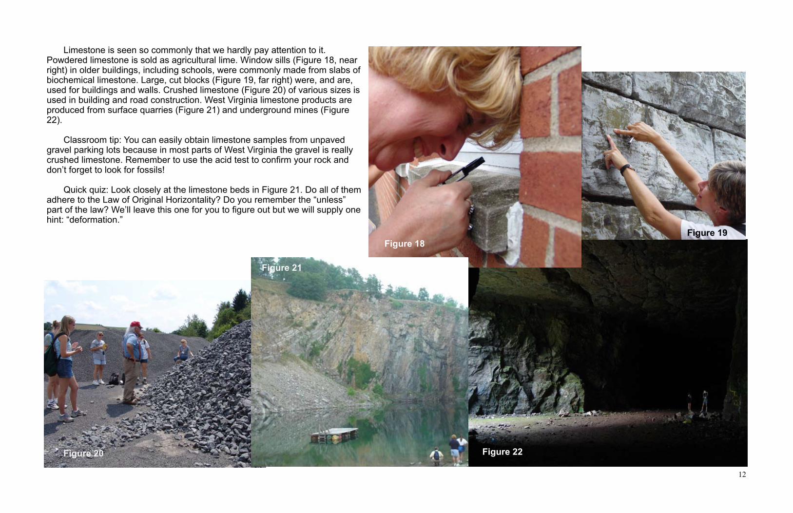
Limestone is seen so commonly that we hardly pay attention to it. Powdered limestone is sold as agricultural lime. Window sills (Figure 18, near right) in older buildings, including schools, were commonly made from slabs of biochemical limestone. Large, cut blocks (Figure 19, far right) were, and are, used for buildings and walls. Crushed limestone (Figure 20) of various sizes is used in building and road construction. West Virginia limestone products are produced from surface quarries (Figure 21) and underground mines (Figure 22).
Classroom tip: You can easily obtain limestone samples from unpaved gravel parking lots because in most parts of West Virginia the gravel is really crushed limestone. Remember to use the acid test to confirm your rock and don’t forget to look for fossils!
Quick quiz: Look closely at the limestone beds in Figure 21. Do all of them adhere to the Law of Original Horizontality? Do you remember the “unless” part of the law? We’ll leave this one for you to figure out but we will supply one hint: “deformation.”
Figure 18Figure 19
Figure 20 Figure 22
Figure 21

13
Origin of Shales
If you have been paying attention to the sidebar you may have noted we have provided a percentage of Earth’s total sedimentary rocks that are sandstone, limestone, and shale. Those data alone (go back and find it!) explains the vast amounts of shale seen in highway road cuts. The more important question is “Why are shales so abundant?” The simple answer is clay minerals. Clay minerals are the major component of the rock we call shale. More importantly, clay minerals are the most abundant product of the chemical weathering of most of the major rock-forming silicate minerals. With names like kaolinite (Figure 23), montmorillonite, and illite, clay mineral crystals and particles have the appearance of tiny flat
flakes. The sheet-like structure of the clay minerals is the reason shales have their definitive thin layers. If you have a mineral kit, you might be inclined to pick up a specimen of a mica mineral, such as biotite or muscovite, and call it a clay mineral. You’re reasoning might be that because the mica is a flat sheet, just like a clay mineral is supposed to be, that is must be an example of a clay mineral. Unfortunately, you would be wrong to make (or teach) this assumption. The clay minerals and the mica minerals are similar in that they both are “silicate” minerals and that they both occur as flat sheet-like structures but they are totally different minerals. Mica minerals like biotite and muscovite are produced during the cooling or crystallization of molten magma and lava. (We are going to talk about this in the next book.) In fact, a mica can weather into a clay mineral. Clay minerals, on the other hand, are the product of the chemical weathering of existing silicate-rich rocks.
Particle size is another distinguishing characteristic of clay minerals. They are extremely small! At less than 1/256th of a millimeter in diameter they are invisible to the naked eye. In fact, it would require a scanning electron microscope to clearly see them. For the adventurous type you can identify a shale by rubbing a small piece of the sample against your front teeth. If you feel any grit, it is not a shale.
To refocus, this section is about shale. Shale is formed from mud (Figure 24). What is the connection between mud, clay minerals, and shale? Have you ever really considered the composition of mud? Its just regolith and water. For our purposes regolith is a synonym for soil. Regolith is a product of weathering. As such, it contains an abundance of clay minerals. Clay minerals, either whole crystals or flakes, mix with water and soil to form mud.
Shales account for 70% of all sedimentary rocks found in Earth’s crust. For this reason alone, your knowledge of them should be broadened.
The mineral mica is included in many basic mineral kits. Even though it is a silicate mineral with a sheet-like appearance, it is not a clay mineral.
You may have heard a coal miner use the term slate to describe the rock in the roof of a coal mine. Geologically, slate is a metamorphic rock formed by the low level metamorphism of shale. In West Virginia, the miners’ “slate” is referencing the shales that commonly overlie coal beds. When exposed by the underground mining process, these shales will quickly decompose and weaken. In these instances, roof bolting is commonly used to stabilize the shales to inhibit roof falls.
Figure 25 shows weathered dark-gray to black shale. Note how it breaks into small “platy” pieces. If you were to dig enough to expose a fresh surface the very thin layering would be very evident.
Figure 23
Figure 24
Figure 25

14
To illustrate how mud might be transformed into shale, pick up a handful of mud, make a fist and squeeze it as hard as you can (Figure 26). The first thing you will observe is water pouring out from your fist. Once the water stops flowing, open your fist (Figure 27). What you have done is to model the compaction portion of the lithification process. What you have made is a “proto-shale” (proto means almost). The only difference between the proto-shale in your hand and the shales you see along the road is that the mud has been subjected to greater pressures. Which means what? It means that more of the water between the particles has been removed. And this, in turn, allows the clay particles to be pressed together much more tightly. Eventually they will stick together to form the rock we call shale. Let’s explore what happens when clay particles are compacted. When first deposited (Figure 28a) the clay mineral particles are randomly oriented within the mud. As the mud is buried and subjected to pressures from overlying deposits, the deposit begins to undergo vertical compression. Two events control how thin the compacted material will become. First, the overlying weight physically dewaters the material by squeezing out any water trapped between adjacent particles. A good analogy for this is squeezing a wet sponge. In the figures below this process is represented by the outward pointing blue lines. You also demonstrated this process when you squeezed the handful of mud. At the same time this is occurring, the clay particles begin to reorient themselves (Figure 28b). Why do they do this? Like any object, they are trying to find the best way to deal with the applied outside force. The best way for flat clay particles to maintain maximum stability against the compressive force is to rotate so that they are oriented perpendicular to the direction of the compressive force (Figure 28c). You can demonstrate this process by using the sidebar activity. Clay particle orientation is critical to the formation of shale because it allows for the formation of the thin, parallel, beds that give shale its defining fissile nature.
Compaction that forms the rock shale is accomplished by the weight of overlying deposits. According to the Law of Superposition are the overlying layers older or younger than the shale?
Answer:
How do the clay minerals orient themselves? Try this demonstration. Take a coin and hold it by the edges between your first finger and thumb. Now increase the pressure on the coin. Eventually, the coin will rotate and become oriented with your fingers on the flat surfaces. The coin surfaces are now oriented perpendicular to the direction of the maximum compressive forces (your fingers). The clay mineral flakes do the same thing.
Figure 26
Figure 27
Figure 28a Figure 28b Figure 28c
Younger

15
If we allow our squeezed mud to dry it will probably become nothing more than a pile of loose clay particles. With that in mind, think about this: “What holds the rock shale together?” In sandstones we discussed various cementing agents that hold the sand grains together. Do shales have cementing agents that hold the clay mineral particles together? Well, in some cases, yes. You can find calcareous shales. But, for our purposes, the way clay particles bind to their neighbor is a function of chemical bonding that far exceeds an introductory discussion. For now, the important point is that the bonds between the layers or sheets of clays are strong enough to hold the particles together but not strong enough to offer significant resistance to physical weathering. Here’s a way to demonstrate the bond strength in shales. Hit a piece with a hammer. What happened? Well, it depends where you hit it. If you hit it at right angles to the bedding plane it may have shattered, it may have crumbled, or maybe nothing happened. However, if you use a chisel to hit it parallel to its bedding planes (Figure 29) it more than likely split into thin sheets of various sizes (Figure 30). You have just illustrated what geologists call the fissile nature of shale. When we combine the loose bond between clay mineral flakes with the reorientation of the flakes themselves, we have a rock that can be easily split into thin layers and weathers easily into very small pieces. Where do clay minerals, formed as weathering products, accumulate? Once they have been formed by chemical weathering, the clay minerals are carried off by streams making their way to the ocean. Remember, we are talking about paleo-environments so the streams and oceans may not be one of our current ones! Clay minerals constitute the major component of the suspended load of streams. A crystal-clear mountain stream has virtually no suspended load while the modern day Ohio River carries a large suspended load. Streams with large suspended loads are muddy. For example, of the total load carried by the Mississippi River into the Gulf of Mexico, 68% is via suspended load. During a flood event, even a mountain stream can become muddy as it transports a larger than normal suspended sediment load.
Fissile is a term used to describe a rock that splits easily into thin sheets.
There are always exceptions to any statement. What happens if the clay mineral flakes, for whatever reason, get stuck at random angles? If they do not attain parallel alignment the rock will not be fissile. In this case, we call it a mudstone. Rocks that are truly shales have parallel oriented beds that are thinner than 6mm (1/4 inch). Shales typically split into thin layers or sheets while mudstones split into thick slabs.
Figure 29
Figure 30
16
Some of the fine-grained sediments may be deposited and accumulate on adjacent floodplains if the suspended load is carried over the stream bank during floods. Many of the shales found throughout central and western West Virginia formed in this way. One particularly important outcome of this action is agriculture. The clay mineral content of floodplain deposits have made the soils that develop from clay-rich deposits ideal for farming. In addition. the normal meandering nature of the stream will eventually pick up most of the deposited clay material and carry it to the ocean where currents spread it over the nearby ocean floor. Many of the shales observed in the more rugged eastern part of the State formed from muds that were deposited in the ocean. A commonly asked question is “Why is the term clay used to describe the smallest particle size when particle sizes have no compositional connotation?” In general, particle sizes larger than clay can consist of a variety of different mineral types. For example, sand-sized particles can consist of rock fragments, quartz, and feldspar. In contrast, the smallest particle size consists primarily of clay minerals. Because the clay size category consists primarily of clay minerals, when names were first assigned to the various particle sizes it was decided to name the smallest particle size “clay.” In summary, when using the term “clay”, one must indicate whether the term is referring to a particle size or a type of mineral. Muds are mixtures of clay minerals and water while shales and mudstones are rocks consisting primarily of clay minerals.
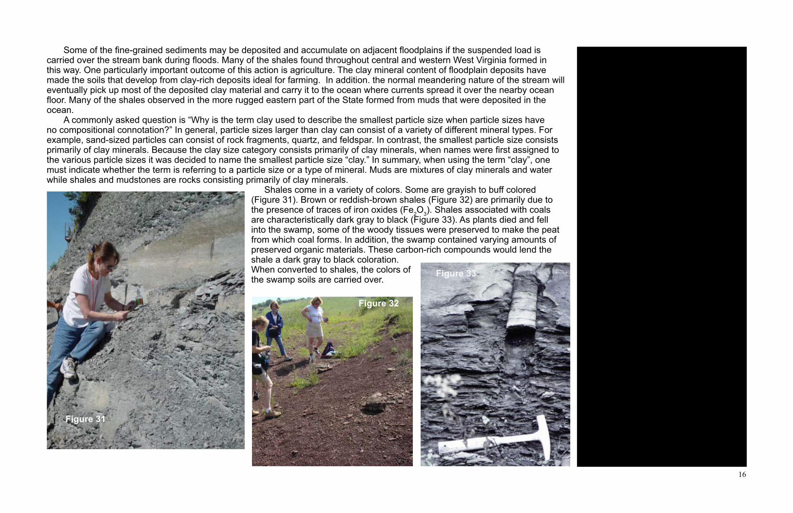
Shales come in a variety of colors. Some are grayish to buff colored (Figure 31). Brown or reddish-brown shales (Figure 32) are primarily due to the presence of traces of iron oxides (Fe2O3). Shales associated with coals are characteristically dark gray to black (Figure 33). As plants died and fell into the swamp, some of the woody tissues were preserved to make the peat from which coal forms. In addition, the swamp contained varying amounts of preserved organic materials. These carbon-rich compounds would lend the shale a dark gray to black coloration. When converted to shales, the colors of the swamp soils are carried over.
An interesting type of shale/mudstone deserves special comment and reveals how geologists are able to determine ancient environments. This is the paleosol (old soil). The shale underneath a coal bed can be considered a paleosol because it was a growth zone for plants. We know this because root structures have been discovered within many paleosols. While you might think that a soil zone, no matter its age, should be black, many paleosols are red. The coloration is attributed to iron oxidation when the soil was exposed to cyclic periods of rain and drought millions of years ago.
Figure 31
Figure 32
Figure 33

17
Some, not all, of West Virginia’s shales contain abundant fossils. Figure 34 shows two fossil gastropods (snails) in a dark gray shale. The larger fossil is about 2.5 cm (1 inch) at its widest point. Figure 35 shows the preserved track made by a different gastropod as it moved through mud containing a small amount of fine-grained sand particles. Apparent large grain size is due to magnification of image. Both shales are about 300 million years old.
Trackways and other “trace fossils” provide much information about life in a geologically younger West Virginia. Figure 36 shows a preserved two meter long trackway of a large animal walking across a muddy site 300 million years ago. The mud eventually became shale. From the size and spacing of the tracks, the animal is estimated to be a 30-50 cm long amphibian. A good modern analogy would be a large salamander. Fossils of plants, stems, twigs, and leaves are common in West Virginia shales associated with coals (Figure 37). Such fossils suggest growth in a swamp or similar terrestrial environment.
Figure 34
Figure 36
Figure 37
Figure 35
18
A volcanic ash fall associated with the the Fire Clay coal bed has been dated to 311,000,000 years old (plus or minus a million years or so) using radiometric techniques. This unit is found throughout portions of southern West Virginia. Using this knowledge and the simple geologic column above can you determine in which geologic group/formation the Fire Clay coal bed is placed?
Answer:Fire Clay = Pottsville Group/Kanawha Fm.
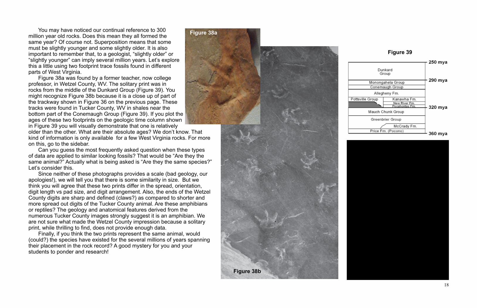
You may have noticed our continual reference to 300 million year old rocks. Does this mean they all formed the same year? Of course not. Superposition means that some must be slightly younger and some slightly older. It is also important to remember that, to a geologist, “slightly older” or “slightly younger” can imply several million years. Let’s explore this a little using two footprint trace fossils found in different parts of West Virginia. Figure 38a was found by a former teacher, now college professor, in Wetzel County, WV. The solitary print was in rocks from the middle of the Dunkard Group (Figure 39). You might recognize Figure 38b because it is a close up of part of the trackway shown in Figure 36 on the previous page. These tracks were found in Tucker County, WV in shales near the bottom part of the Conemaugh Group (Figure 39). If you plot the ages of these two footprints on the geologic time column shown in Figure 39 you will visually demonstrate that one is relatively older than the other. What are their absolute ages? We don’t know. That kind of information is only available for a few West Virginia rocks. For more on this, go to the sidebar. Can you guess the most frequently asked question when these types of data are applied to similar looking fossils? That would be “Are they the same animal?” Actually what is being asked is “Are they the same species?” Let’s consider this. Since neither of these photographs provides a scale (bad geology, our apologies!), we will tell you that there is some similarity in size. But we think you will agree that these two prints differ in the spread, orientation, digit length vs pad size, and digit arrangement. Also, the ends of the Wetzel County digits are sharp and defined (claws?) as compared to shorter and more spread out digits of the Tucker County animal. Are these amphibians or reptiles? The geology and anatomical features derived from the numerous Tucker County images strongly suggest it is an amphibian. We are not sure what made the Wetzel County impression because a solitary print, while thrilling to find, does not provide enough data. Finally, if you think the two prints represent the same animal, would (could?) the species have existed for the several millions of years spanning their placement in the rock record? A good mystery for you and your students to ponder and research!
Figure 38a
Figure 38b
Figure 39
19
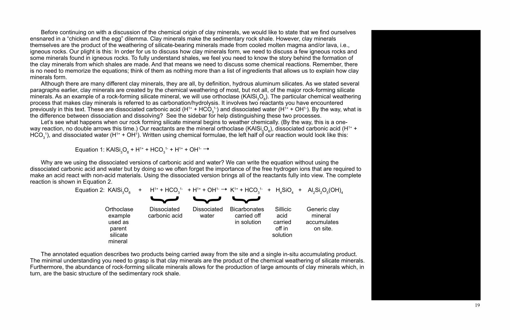
Before continuing on with a discussion of the chemical origin of clay minerals, we would like to state that we find ourselves ensnared in a “chicken and the egg” dilemma. Clay minerals make the sedimentary rock shale. However, clay minerals themselves are the product of the weathering of silicate-bearing minerals made from cooled molten magma and/or lava, i.e., igneous rocks. Our plight is this: In order for us to discuss how clay minerals form, we need to discuss a few igneous rocks and some minerals found in igneous rocks. To fully understand shales, we feel you need to know the story behind the formation of the clay minerals from which shales are made. And that means we need to discuss some chemical reactions. Remember, there is no need to memorize the equations; think of them as nothing more than a list of ingredients that allows us to explain how clay minerals form. Although there are many different clay minerals, they are all, by definition, hydrous aluminum silicates. As we stated several paragraphs earlier, clay minerals are created by the chemical weathering of most, but not all, of the major rock-forming silicate minerals. As an example of a rock-forming silicate mineral, we will use orthoclase (KAlSi3O8). The particular chemical weathering process that makes clay minerals is referred to as carbonation/hydrolysis. It involves two reactants you have encountered previously in this text. These are dissociated carbonic acid (H1+ + HCO3
1-) and dissociated water (H1+ + OH1-). By the way, what is the difference between dissociation and dissolving? See the sidebar for help distinguishing these two processes. Let’s see what happens when our rock forming silicate mineral begins to weather chemically. (By the way, this is a one-way reaction, no double arrows this time.) Our reactants are the mineral orthoclase (KAlSi3O8), dissociated carbonic acid (H1+ + HCO3
1), and dissociated water (H1+ + OH1). Written using chemical formulae, the left half of our reaction would look like this:
Equation 1: KAlSi3O8 + H1+ + HCO31- + H1+ + OH1- 4
Why are we using the dissociated versions of carbonic acid and water? We can write the equation without using the dissociated carbonic acid and water but by doing so we often forget the importance of the free hydrogen ions that are required to make an acid react with non-acid materials. Using the dissociated version brings all of the reactants fully into view. The complete reaction is shown in Equation 2. Equation 2: KAlSi3O8 + H1+ + HCO3
1- + H1+ + OH1- 4 K1+ + HCO31- + H4SiO4 + Al2Si2O5(OH)4
Orthoclase Dissociated Dissociated Bicarbonates Sillicic Generic clay example carbonic acid water carried off acid mineral used as in solution carried accumulates parent off in on site. silicate solution mineral
The annotated equation describes two products being carried away from the site and a single in-situ accumulating product. The minimal understanding you need to grasp is that clay minerals are the product of the chemical weathering of silicate minerals. Furthermore, the abundance of rock-forming silicate minerals allows for the production of large amounts of clay minerals which, in turn, are the basic structure of the sedimentary rock shale.
Is the term “major rock forming silicate” new to you? Do you know, or remember, the common denominator used to classify silicate minerals? Silicate can refer to SiO4
4- (ionic form) or SiO2 (molecular form). All of the major rock forming silicate minerals contain the element silicon.
Orthoclase is only one of the many minerals we could have selected from the feldspar mineral family.
We talked about carbonic acid in the limestone discussion.
Disassociated and dissolved are often used interchangeably. Chemical dissociation is the mechanism by which acid molecules come apart to form free hydrogen ions. Free hydrogen ions give an acid its acidic characteristics. On the other hand, dissolve refers to the process by which water-soluble materials go into solution. Sugar dissolves in your tea. Also, when ionic compounds dissolve, they dissociate into the ions of which they are composed.
} } }

20
For those with interest in the entire chemical reaction, the product side of Equation 2 requires three steps.
Step 1: K1+ + HCO31- 4 KHCO3
Potassium is removed from the orthoclase and carried away from the weathering site. This is accomplished when the bicarbonate ion (HCO3)
1- reacts with the orthoclase potassium ion (K1+) forming K1+(HCO3)1-. This new bicarbonate, like all
bicarbonates, is water soluble. Once formed and taken into solution, the potassium and bicarbonate ions are carried off to the ocean.
Step 2: 4H1+ + Si4+ + 4O2- 4 H4SiO4
The acid ions (H1+) from the dissociated carbonic acid and the water get together and take some of the silicon (Si) and some of the oxygen from the orthoclase. This reaction forms silicic acid (H4SiO4) which will not dissociate further and is even weaker than carbonic acid. The silicic acid is carried off in solution to the ocean.
Step 3: (OH1-) + available aluminum and whatever remains of the silicon and oxygen 4 Al2Si2O5(OH)4
At this point all that remains of the reactants are the hydroxyl ions (OH1-) and whatever is left of the aluminum, silicon, and oxygen from the original orthoclase lattice. These components combine to produce Al2Si2O5(OH)4 which is not carried off. Instead, this material accumulates at the reaction site. We now need to ask you what is this accumulating material? How would you describe Al2Si2O5(OH)4 in words? Go back a few paragraphs to find the answer or look at the side bar. Al2Si2O5(OH) is a hydrous aluminum silicate. In other words, as we stated on the previous page, it is the generic formula for a clay mineral. Congratulations! You just made a clay mineral by chemically weathering the rock forming silicate mineral orthoclase. The outcome of this process should not be taken lightly. At the sake of repeating ourselves, the fact that clay minerals are the end product of the chemical weathering of all but two of the major rock-forming silicate minerals explains why shales make up 70% of all sedimentary rocks. Now you know everything there is to know about shales. Not really, but we hope you appreciate this humble rock more. Some will consider the material we just presented too technical. We believe deeper background knowledge is a signal of the master educator. This does not imply that we think you must teach all of it to your students. Pick what you need and, at some future date, revisit these pages. You may find you want to add a little more information to your presentation. Now that we have issued our statement on pedagogical content knowledge, we will move on to coal, our final “sedimentary rock.” The quotations should be a clue that we have some reservations about that classification.
Components with charge superscripts means that it is in solution as an ion. Ions must be in solution; they cannot be held in your hand. Please note that the previous sentence states you can’t hold a sodium ion in your hand. It does not say anything about the fact that a sodium ion exists in its ionic form in, for example, a halite (salt)crystal lattice
Except for quartz, the major rock-forming silicate minerals contain varying amounts of sodium (Na1+), potassium (K1+), calcium (Ca2+), and magnesium (Mg2+). These elements are removed from various mineral crystals by the bicarbonate ion (HCO3)
1-. to form varying bicarbonate compounds. Because bicarbonates are water soluble, they are carried off in solution, eventually to the ocean.
Al2Si2O5(OH)4 is the generic formula for clay minerals. All clay minerals are hydrous aluminum silicates.
The two silicate minerals that do not produce clay minerals by chemical weathering are olivine and quartz. Olivine does not contain any aluminum (Al) and therefore cannot be involved in a reaction whose end product is an aluminum silicate. Quartz will not react with oxygen or carbon dioxide. It remains behind to provide the materials needed for the formation of sandstones.
21
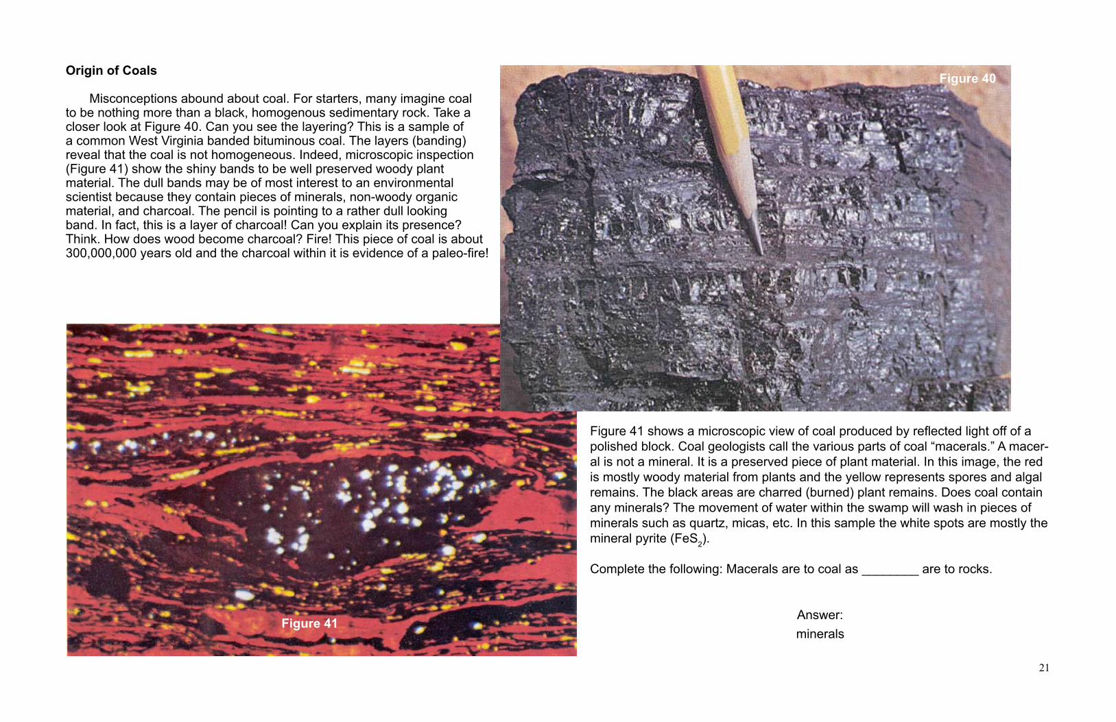
Figure 41 shows a microscopic view of coal produced by reflected light off of a polished block. Coal geologists call the various parts of coal “macerals.” A macer-al is not a mineral. It is a preserved piece of plant material. In this image, the red is mostly woody material from plants and the yellow represents spores and algal remains. The black areas are charred (burned) plant remains. Does coal contain any minerals? The movement of water within the swamp will wash in pieces of minerals such as quartz, micas, etc. In this sample the white spots are mostly the mineral pyrite (FeS2).
Complete the following: Macerals are to coal as ________ are to rocks.
Answer:
Origin of Coals Misconceptions abound about coal. For starters, many imagine coal to be nothing more than a black, homogenous sedimentary rock. Take a closer look at Figure 40. Can you see the layering? This is a sample of a common West Virginia banded bituminous coal. The layers (banding) reveal that the coal is not homogeneous. Indeed, microscopic inspection (Figure 41) show the shiny bands to be well preserved woody plant material. The dull bands may be of most interest to an environmental scientist because they contain pieces of minerals, non-woody organic material, and charcoal. The pencil is pointing to a rather dull looking band. In fact, this is a layer of charcoal! Can you explain its presence? Think. How does wood become charcoal? Fire! This piece of coal is about 300,000,000 years old and the charcoal within it is evidence of a paleo-fire!
Figure 40
Figure 41minerals

22
Although the photomicrograph in Figure 41 on Page 21 shows that coal does contain some minerals, these minerals are not essen-tial building blocks in the formation of coal. Therefore, we can say that coal is not formed by a “mixture of minerals.”
The origin of coal’s variable nature is related to the variable nature of the environment in which it forms. Most of us have heard that coal’s origin is closely tied to dead plants that accumulated in paleo-swamps. (A good place to start a coal discussion is to place this before your students in the form of a question.) To be specific, we are talking about a swamp, not a marsh. A swamp (Figure 42a) contains large plants such as trees. A marsh (Figure 42b) is dominated by grasses. Coal-forming peat will only form in low-pH, fresh water swamps. The acidic nature of such swamps inhibits the microbal activity that is primarily responsible for the decomposition of the accumulating plant debris. At slightly higher ph levels, such as those found in brackish water, microbal activity causes the decay of any accumulated plant material. For example, due to the chemistry of its water, no coal will ever be produced by plant material in the southern Everglades. At best, in geologic time, only a black shale will be produced. Why? Because all of the plant material will decompose due to microbal activity that occurs within the southern Everglades brackish water. Want another misconception we hear all the time? West Virginia has 117 named coal beds. This is true. However, there is no place in the State were you can drill a vertical hole and penetrate all 117 coal beds. What does this imply geologically? Think it through before you read the next paragraph. Contrary to popular folklore, coal beds are not continuous bodies. In other words, the notion that “If it’s under my neighbor’s property, it must be beneath mine” is not always true. Within any swamp there are areas of differing drainage patterns, plant accumulation, and water depth. Some areas of the swamp were dominated by woody plants while others were not. These, among other variations, may produce a coal bed that exhibits significant lateral changes in quality and thickness. Part of our rationale for our presentation style is to make you think as you read. All too often we, and students, blindly accept the printed word as 100% factual. This problem can be magnified by the huge amounts of both good and bad electronically published data, text, and illustrations. Efforts to oversimplify often lead to misconceptions, erroneous implications, or outright mistakes. When these are transmitted to the student, misconceptions become ingrained in both teachers and students. For example, most believe they can define coal as a sedimentary rock. Is this what you teach? Are we saying it is wrong? Not exactly! But, a closer look at the topic reveals room for sufficient attitude readjustment. Provocative Coal Fact #1
Several pages earlier we listed sandstone, limestone, and shale as sedimentary rocks but did not include coal? Did you catch this? Why did we omit coal? Your textbook calls it a sedimentary rock. In fact, nearly every K-12, college textbook, and online reference considers coal a sedimentary rock. Is this what you learned? Those who classify coal as a sedimentary rock probably do so because it is found intimately associated with sedimentary rocks. At first glance this may seem reasonable based on what we see in West Virginia’s numerous highway roadcuts. However, let’s just say that we have a problem accepting “classification by association”. Using that kind of logic, must we consider a layer of the basalt to be a sedimentary rock if we find it embedded within a sequence of sedimentary rocks? No, basalt it is still an igneous rock!
Provocative Coal Fact #2
Is coal a sedimentary rock? This is going to require us to examine some definitions. The 4th edition of the Glossary of Geology defines a sedimentary rock as “a rock resulting from the consolidation of loose sediment that has accumulated in layers...” Is coal composed of sediment? No, it is not. Can, and did, some sediment wash into coal swamps? Of course. But sediment, if retained, represents added impurities with the plant accumulation, not the true nature of the coal itself. The same source defines sediment as “solid fragmental material that originates from weathering of rocks and is transported or deposited
Figure 42a
Figure 42b

23
What about anthracite coal? Anthracite coal fits the definition of a metamorphic rock. The last step in the conversion of bituminous coal to anthracite actually requires very high temperatures and pressures found in places like tectonic subduction zones.
A domed peat mass (Figure 43a) generally produces coals that are relatively low in sulfur and produce low amounts of ash when burned. In contrast, peat in a poorly-drained, low-relief, planar swamp (Figure 43b) is less readily exposed to the weathering and erosional impact of acidic rain water. As a result, less mineral matter is removed, increasing the sulfur and ash content of the coal bed.
by air, water, or ice, or that accumulates by other natural agents, such as chemical precipitation from solution or secretion by organisms, and that forms layers on the Earth’s surface at ordinary temperatures...” Is coal formed from fragmental material that originates from weathered rocks? No, it is not. Is it the product of transport or deposition by air, water, or ice? Not really, unless you argue that the plant material accumulates in water. Admittedly, the definition does mention “other natural agents” and some might be inclined to apply this to coal. Finally, does coal “form layers on the Earth’s surface at ordinary temperatures”? If you have ever taught, correctly, the sequence of plant material to peat, to bituminous to anthracite then you must reject the notion of “ordinary temperatures’.
Provocative Coal Fact #3 We know, without a doubt, that coal is predominantly formed from mostly woody tissues of plants. If we continue our examination of the definition of a sedimentary rock, we find that the Glossary incorporates the definition of sediment to state that a sedimentary rock “consists of mechanically formed fragments of older rock transported from its source and deposited in water or from air or ice or a chemical rock formed by precipitation from a solution or an organic rock consisting of the remains or secretions of plants or animals. Have you noticed that we had to dig a long way into the definition to find anything that remotely associates with coal?
Provocative Coal Fact #4
After all of this we need to ask an even more simplistic question: “Is coal a rock of any kind?” Referring once again to our trusty Glossary, we find that a rock is defined as “an aggregate of one or more minerals, e.g., granite, shale, marble.” Is coal a mixture of minerals? Minerals are defined as a natural occurring, solid, inorganic substance with a reasonably definite chemical composition and crystal structure. Coal is made of macerals representing various plant parts. If we stop here, coal is not a rock! But, let’s look more closely. The Glossary’s definition of a rock continues by stating that a rock is also “...a body of undifferentiated mineral matter, e.g., obsidian, or solid organic materials, e.g. coal. Finally! It took us four steps but we at least found out that coal is a rock!
Provocative Coal Fact #5
What if, just for the sake of argument, you felt a strong need to have your students place coal within the rock classification scheme of sedimentary, igneous, or metamorphic? We have already seriously questioned it being a sedimentary rock. You are now reduced to two options. Is it an igneous rock? An igneous rock is one that “forms from the cooling and solidification of magma and/or lava”. This definition eliminates calling coal an igneous rock. Coal does not resemble the material from which it originated. Clearly, the accumulated plant material has been altered. Does this imply that coal is a metamorphic rock? What does this sound like? Strange as it may seem, using simplistic definitions, it may be more accurate to describe coal as a metamorphic rock. Clearly, one type of coal is a product of metamorphic processes—anthracite. Is it appropriate to consider peat and bituminous coals as the products of lower-temperature metamorphism? The process of coalification requires a change from plant tissue to coal by the application of heat, pressure, and chemically active fluids? Sounds like metamorphism! If you are going to force Jack and I to place coal within the existing three-part rock classification scheme, we are going to have to call coal a metamorphic rock.
Figure 43b
Figure 43a

24
Have we deliberately tried to confuse you? Honestly, yes! Actually we are trying to get you to think more deeply. Must you teach that coal is a metamorphic rock? You don’t need to but it is a great example of the true complexity of geologic understanding. From an educators perspective, a closer look at simple stuff sometimes requires us to reconsider what we think we already know. Additionally, a closer look sometimes reveals the complexity, and danger, of oversimplification. Since each student must construct their own understanding of what is being taught to them and, more importantly, each student’s understanding must evolve as knowledge is processed, our advice is to use this little example as a way to demonstrate why you, the teacher, must sometimes provide more facts, than they, the learner, feels are necessary. It could also be employed to help students understand why scientists use precisely defined terminology. At worst, it is a way of showing them how much we take for granted.
Coalification “Why does coal form?” We have heard this question posed many times. The why part could be problematic but we can explain how coal forms. This discussion is often initiated by the student who asks “Why doesn’t the plant material just rot away?” We have already touched upon the chemistry of the water but now is a good time to take a closer look. First off, some of the plant material does rot. In fact, even under the best conditions half of the accumulated plant tissue is either “eaten” by microbes or decomposes due to physical degradation. In a swamp, plant accumulation rates exceed decomposition rates only when: (1) the swamp water possess a low amount of dissolved oxygen, and (2) the swamp water is acidic such that it inhibits microbial activity that would normally decompose the plants. The way plant matter accumulates plays a significant role in the chemistry of the swamp. Domed peats (Figure 43a) form when water chemistry permits plant accumulation to outpace rotting. A well-drained, high-relief, domed swamp allows for easy percolation of daily acidic rainwater. The percolating water leaches out much of the trapped mineral matter. These kinds of peat eventually become the low-ash, low-sulphur coals found in West Virginia’s southern coal fields. On the other hand, planar peats (Figure 43b) develop in regions of seasonal rainfall where both acidic rainfall and more neutral or slightly alkaline groundwater keep the acidity (pH) of swamp at a level where microbal activity more effectively balances accumulation versus rotting. As a result, thinner coal beds are formed. Furthermore, because there is much less leaching away of mineral matter, planar coals are higher in ash and sulphur. West Virginia’s northern coalfields contain many coal beds that formed in this way. Remember, you are teaching geologic processes! So, how long did it take to accumulate a peat deposit? Or, how much peat is required to make a foot of coal? We can get an idea of the geologic longevity of coal swamps through a simple mathematics exercise. In this process we must use the geologists’ “compaction ratio.” This is a simple mathematical ratio of plant material to coal thickness. Unfortunately there is some discussion over the preferred ratio. For our example we will use a 10:1 ratio. This means that every meter of coal requires ten meters of accumulated peat. Use the provided data to answer the following two questions:
Question 1: Using our 10:1 compaction ratio how much peat would have been needed to ultimately produce a 3 meter (10 feet) thick coal bed? Try it yourself before reading on.
Answer: Using the 10:1 ratio means that 30 meters of peat would be required for a three meter thick coal bed. Perhaps you are now getting some idea of the accumulation and compaction and burial process. How can you make room for 30 meters of plant material? New additions constantly press older layers down into the muddy swamp bottom where it is covered by the preserving water.

25
Question 2 : How long did it take to accumulate the 30 meters of plant material? Let’s assume the plant material accumulated at an average rate of 1mm per year.
Answer: First we need to convert meters to millimeters. One meter contains 1,000 millimeters, therefore 30 meters is 30,000 mm. Using our assumed accumulation rate of 1mm per year, 30,000 years would be required to accumulate the plant material. Our calculation assumes continuous accumulation, which was probably not the case because of weather and climatic fluctuations. Nevertheless, the exercise does provide an idea of peat swamp longevity. Geologically speaking, peat swamps are not long-lived events. When swamps die they are inundated with various kinds of sediments. Sediment accumulation is critically important because it buries the accumulated peat mass. Even with relatively shallow burial the peat becomes subjected to heat. At this point we would like to ask you to speculate on the heat. Where does it comes from? Earth’s “geothermal gradient” means that the temperature increases with depth below Earth’s surface. Even a relatively shallow peat burial depth of several hundred meters of sediments will generate temperatures comparable to those used in a home oven set at 250OC (480OF). While it is being heated, the buried peat is also being compressed by the weight of younger overlying sediment. The pressure generated by this weight is not overly high. We know this because laboratory tests have shown that high pressures actually inhibit the coalification process. Subjected to geologic pressure, warmed by the geothermal gradient, and with chemically active ground water moving through it, the peat is converted into lignite (also called brown coal). The process may continue, turning the lignite into sub-bituminous coal and bituminous coal. The metamorphism of bituminous coal to anthracite coal requires much higher temperature and pressures such as those encountered in zones of subduction. Word of warning: Do not confuse the time required for plant accumulation with the significantly longer geologic periods required for coal formation. Coal is extracted using both underground (Figure 44) and surface (Figure 45) mining techniques. The primary determinants for the type of mine is coal bed thickness, depth to coal beneath the surface, and economics. The geologist in Figure 46 is using a two meter (six feet) ruler to measure the thickness of the coal bed in the entrance to an abandoned underground coal mine. Note the large block of sandstone above the coal (and the geologist’s head!)
Figure 48
Figure 46
Figure 45Figure 44

26
Sedimentary Rock Summary This completes our brief introduction to sedimentary rocks. We have left out a lot but our goal is to provide you with a basic understanding. This is critical because in the next several sections we will be discussing how seemingly solid and rigid layers of sedimentary rock are deformed into structures such as folds and faults. Before proceeding, however, we would like to offer you two chances to apply some of your newly acquired knowledge. Figure 47 is a photograph of a vertical sequence of rock visible along a southern West Virginia highway. Unfortunately, this photograph lacks an easily recognizable scale. Bad geologist! To help out, the tree stump is about 0.75 meters (2 feet) long. Clues as to the nature of the rock being pointed to are provided by the captions along the left side of the photograph. Using the photo and the captions respond to these questions:
1. Can you use the descriptors to identify the beds of shale, limestone, sandstone, and coal?
2. Is the tree stump older or younger than the limestone? Can you cite a reason for your response?
3. Can you recall the number we have been repeatedly using for the approximate age for many of West Virginia’s sedimentary rocks?
A note on the tree stump: Modern trees had not yet evolved 300 million years ago. The tree that made the stump in Figure 47 had a core of soft, pithy material surrounded by a woody outer casing. When the tree died, the center quickly rotted away (Figure 48) leaving a hollow shell. A good analogy to explain this to students is a drinking straw. Eventually transported sediment filled the empty shell. (Think jello mold.) The sediment filled shell became a rock, producing a replica of the inside of the tree’s bark. Most of West Virginia’s “petrified” tree fossils are really sediment filled casts. The sequence of limestone to coal swamp in the upper part of the photograph indicates that change in sea level gradually occurred.
PLANT REMAINS
FISSLE, REDDISH
QUARTZ SAND-SIZED PARTICLES
“TREE” STUMP
ABUNDANT CALCITE & FOSSILS
PLANT REMAINS
FISSLE, BLACK
Figure 47 Figure 48
Answers:
1. Plant remains = coal fissile = black and red shale quartz sand-sized particles = sandstone calcite and fossils = limestone.
2. The tree stump is above the limestone. Therefore, according to Law of Superposition, it must be geologically younger than the limestone.
3. 300,000,000 years is a good average age to remember for West Virginia’s sedimentary rocks.

27
What was once a marine environment was replaced with one that deposited coarser-grained sand particles that later became sandstone. Does the tree stump represent a log that was swept into the area or did it grow there? How could you argue either case? Let’s begin with position. The stump is vertical. Much like it would be in its growth position. One would expect a log that was floated in to be laying in a more horizontal position. Now, look at the base of the stump. Does it have a widening diameter suggestive of a root spreading zone? The correct answer is not the point of this small exercise. The process of doing the science is what counts. Whatever answer you go with (No, we not going to tell you right or wrong, both are plausible if argued well) the hollow tree became a fossil because it was filled with sediment that eventually preserved its shape. Because the sediment was dominated by sand-sized particles we now see a fossil of part of the tree and that fossil is made of sandstone. Above the sand, finer grained material was deposited in the area, probably on a flood plain along a stream or near the mouth of a stream. This environment created a soil zone which supported plant growth. How do we know this? As these plants died they accumulated into a peat mass that eventually became the thin coal bed labeled “plant remains” near the top of the photograph. Geologists use the just applied process to “read” the rocks and develop an explanation of what happened and in what sequence. The important thing to remember, and to teach, is that this sequence represents a change in environments in one location over geologic time. Think dynamically. Do not get locked into static time. Any vertical column of rock represents change over time. One way to enhance your ability to teach such ideas is to relate them to your discussion about climate change. The only difference is that the rocks hold the clues to deciphering how climate changed 300 million years ago. This leads to another irksome habit of the novice geologist. When asked to identify a sedimentary rock, the invariably try to “make” it into either a sandstone, limestone, or shale. This is really prevalent right after concept development work on sedimentary rocks. However, do you think nature works that cleanly? Seriously, would one particle size be present to the exclusion of all others in all cases? No way. Since the uninitiated learner sees the geological world much neater than it truly is the idea of using the terms shale, sandstone, and limestone as descriptive adjectives is never considered. Let’s take a brief look at how this can really simplify the naming of sedimentary rocks. Care to hazard a guess as to what a geologist might call a shale containing a substantial amount of sand-sized particles? How about a sandy shale? What would a shaly sandstone be? To test your skill, name the following sedimentary rocks:
A. This sedimentary rock is fissile and it fizzes. Neither a pure shale nor a pure limestone it could be called a ________________.
B. This sedimentary rock also fizzes, but it contains some sand-sized particles. It might be called a _________________.
C. This sedimentary rock is thinly bedded and predominantly composed of sand-sized particles. We could call this a __________.
The use of sedimentary rock names as both nouns and adjectives opens up all kind of possibilities when describing and naming these rocks. It also provides additional clues as to what the environment was like when the sediments were deposited. A limestone would form in warm, shallow water but maybe a hurricane came through and dumped some sand in the lime mud? Who knows for sure? The important thing is that this is a plausible explanation and the ability to develop such ideas makes studying rocks a lot more fun!
Answers
A. It could be a shaly limestone or a limey shale. The root name describes the more dominant characteristic.Therefore, a shaly limestone is a limestone with very thin layers like a shale. For those who need to know, geologists do use shaly limestone but more often than not prefer to use the name “calcareous shale” instead of limey shale. Calcareous refers to the presence of the mineral calcite.
B. Sandy limestone.
C. Shaly sandstone.
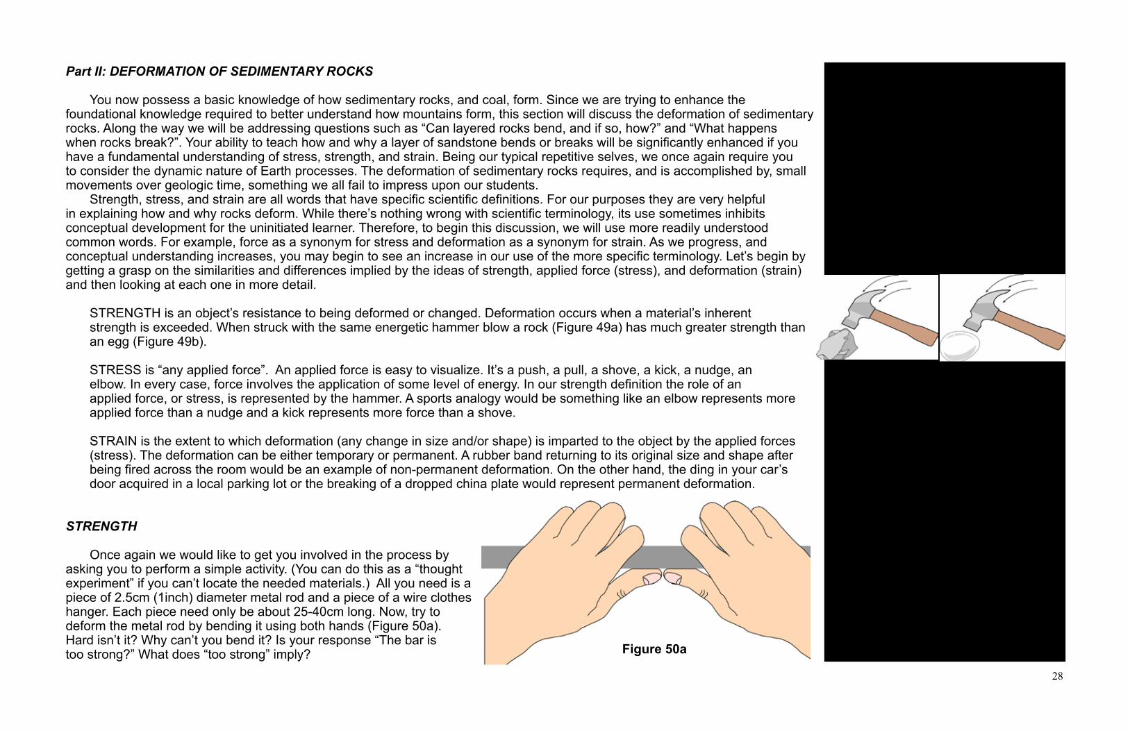
28
Part II: DEFORMATION OF SEDIMENTARY ROCKS
You now possess a basic knowledge of how sedimentary rocks, and coal, form. Since we are trying to enhance the foundational knowledge required to better understand how mountains form, this section will discuss the deformation of sedimentary rocks. Along the way we will be addressing questions such as “Can layered rocks bend, and if so, how?” and “What happens when rocks break?”. Your ability to teach how and why a layer of sandstone bends or breaks will be significantly enhanced if you have a fundamental understanding of stress, strength, and strain. Being our typical repetitive selves, we once again require you to consider the dynamic nature of Earth processes. The deformation of sedimentary rocks requires, and is accomplished by, small movements over geologic time, something we all fail to impress upon our students. Strength, stress, and strain are all words that have specific scientific definitions. For our purposes they are very helpful in explaining how and why rocks deform. While there’s nothing wrong with scientific terminology, its use sometimes inhibits conceptual development for the uninitiated learner. Therefore, to begin this discussion, we will use more readily understood common words. For example, force as a synonym for stress and deformation as a synonym for strain. As we progress, and conceptual understanding increases, you may begin to see an increase in our use of the more specific terminology. Let’s begin by getting a grasp on the similarities and differences implied by the ideas of strength, applied force (stress), and deformation (strain) and then looking at each one in more detail.
STRENGTH is an object’s resistance to being deformed or changed. Deformation occurs when a material’s inherent strength is exceeded. When struck with the same energetic hammer blow a rock (Figure 49a) has much greater strength than an egg (Figure 49b).
STRESS is “any applied force”. An applied force is easy to visualize. It’s a push, a pull, a shove, a kick, a nudge, anelbow. In every case, force involves the application of some level of energy. In our strength definition the role of an applied force, or stress, is represented by the hammer. A sports analogy would be something like an elbow represents more applied force than a nudge and a kick represents more force than a shove.
STRAIN is the extent to which deformation (any change in size and/or shape) is imparted to the object by the applied forces (stress). The deformation can be either temporary or permanent. A rubber band returning to its original size and shape after being fired across the room would be an example of non-permanent deformation. On the other hand, the ding in your car’s door acquired in a local parking lot or the breaking of a dropped china plate would represent permanent deformation.
STRENGTH
Once again we would like to get you involved in the process by asking you to perform a simple activity. (You can do this as a “thought experiment” if you can’t locate the needed materials.) All you need is a piece of 2.5cm (1inch) diameter metal rod and a piece of a wire clothes hanger. Each piece need only be about 25-40cm long. Now, try to deform the metal rod by bending it using both hands (Figure 50a). Hard isn’t it? Why can’t you bend it? Is your response “The bar is too strong?” What does “too strong” imply?
Strength is the ability to withstand applied force without deformation.
Stress is any applied force (energy) Strain is deformation causing change in size and/or shape.
Figure 50a
Figure 49a Figure 49b

29
Classroom activity requiring a steel rod and a coat hanger wire.
This activity can be used later to help students explain why thicker rock units deformed differently than thinner ones.
Stress is applied force
Fundamentally, there are only two types of stress: pull and push
Pull apart = tensionPush = compression
Trying to ascertain the true nature of an applied force can be difficult and counter intuitive. Consider socks. Socks require the application of tensional forces even though we pull them on. The sock moving in one direction resists being pulled over your foot moving in the opposing just like the blue arrows in Figure 5`. In plate tectonics the term tension was used to describe the forces pulling a large landmass apart to create new and smaller continents. It was also used in our discussion of opening oceans. In those instances we used the term “rifting.”
Now bend the coat hanger wire (Figure 50b). Relatively easy isn’t it? The rod and the wire are both made of steel. Which requires the application of more force before it will deform? If you were strong enough could you deform the rod? Yes, but it requires more energy. Applied Force (Stress)
How many different forms of force have you applied to objects since waking up this morning? List a few in your head before you continue reading. Stumped? How about pulling a drawer open, closing the same drawer, lifting a coffee cup, spreading jelly on a piece of toast, or picking up a book bag? These are all examples of applying force. Using these ideas, we can expand our discussion a little and talk about what happens when forces pull or push upon sedimentary rocks. Although pull is a perfectly good word, most geologists prefer the term “tension” rather than the word “pull.” An object is placed under tension when the applied forces act away from each other (Figure 51, blue arrows). Tension is the force you apply when opening a drawer. Do you agree? Think about it. You pull the knob toward you, but where is the opposite acting force? If you know the “principle of equal and opposite reactions” this implies that the drawer “pulls” the other way away to resist the motion. These directions mirror those shown by the blue arrows in Figure 51. Therefore the stress is tensional. What about the gold and red arrows in Figure 51? These are compressive, or pushing, forces. Compression is the force that closed the drawer (you pushed it in to close it). Two continents being pushed together are the product of compressive tectonic
forces. Compression occurs when forces act toward each other. Sometimes the applied forces act directly opposite from each other (Figure 51, gold arrows). Other times they do not (Figure 51, red arrows). The two ways in which compressive forces can be applied must be understood because one will produce a significantly different outcome from the other. Let’s look at the two variations and their potential outcomes. The gold arrows in Figure 51 represent the action of non-rotational compressive forces. They are non-rotational because the opposing forces are operating in direct line to each other. Can you think of some practical examples of non-rotational compressive forces? A head-on car collision is an example of non-rotational compression. How about the forces that exist between you and the chair in which you are sitting? Or, between your hand and the drawer you were pushing closed this morning. The contact between a baseball bat and a baseball that results in a line drive is an example of non-rotational compressive force at work. The red set of arrows in Figure 51 illustrate how forces align to produce rotational compression. Think of the blades of a pair of scissors passing each
Figure 50b
Figure 51

30
Many rotational examples require relative motions. For example, while removing a bottle’s screw-on cap you may actually turn the cap and the bottle in opposite directions. Or, you may hold one stationary and turn the other. The applied forces and the rotational compressive outcomes are the same in both cases.
Three types of strain (deformation):1. ElASTic2. ?3. ?Elastic response is always the first response to stress.
other as they cut a piece of paper. (Ever wonder why they are also called “shears?”) This is sometimes referred to as “shear force” because the forces are not directly opposite each other. These forces explain why the object being acted upon will try to rotate. However, whether an object subjected to rotational compression will actually rotate depends on the object. Certainly turning a doorknob or removing a twist-top cap from a bottle are obvious examples of rotational compression. However, so is spreading a blob of jam across the surface of a slice of bread because as the knife goes in one direction the bread goes in the other direction. The foul ball or the pop-up that results from an off-center contact between a bat and baseball are outcomes of rotational compressive forces. In the next section we are going to explore three kinds of deformation (strain) that can be induced by stress. Before moving on take a few moments to reflect and mentally digest what you have just read. Also, speculate what might happen if non-rotational and/or rotational forces (stress) were to act upon layers of sedimentary rocks?
Strain (Deformation) How do sedimentary rocks respond to stress (applied force)? Put more technically, what types of strain (deformation) do sedimentary rocks employ to accommodate stress? The response of sedimentary rocks to stress is the basis for a sub-specialty of geology called structural geology that describes and measures the deformation of rocks. What kind of force(s) could deform sedimentary rocks hundreds or even thousands of feet thick? If you suggest the movement of tectonic plates give yourself a pat on the back! When plates collide rocks in the area undergo compressive stress (force). When plates rift apart, rocks must deal with tensional forces. In either case, any sedimentary rock in the impacted area must endure truly enormous forces. Depending on the specific force experienced, the sedimentary rock can bend or break. A sedimentary rock will undergo deformation only when its strength wall has been scaled by some applied force. Deformation means that the rock will either change its size, shape, or both. When sedimentary rocks react to stress, their most common visual clue is some type of reorientation of their original horizontal layering. Due to the geologic time element we can not see such events as they happen. Indeed, they are occurring in many parts of the world as you read this. Therefore we need to develop some analogies that help us envision what is happening. With this in mind, think about deforming a series of different objects of your choice. Do they deform in the same way? Do some return to their original shape while others do not? Do some break? Strain due to applied force, whether in our analogs or in the rocks themselves, can be classified as elastic, plastic, or brittle. In the following pages we will discuss each of these in turn and provide at least one geologic example of the described deformation. We hope this arrangement will help you better understand some of the features you see in sedimentary rocks. We will begin with the deformation (strain) you are most apt to replicate using a classroom activity, elastic strain.
Elastic Strain
Elastic means “springing back”. Elastic deformation is very forgiving. If you apply enough force (stress) to overcome the strength wall the object will undergo elastic deformation. In other words, you retain the opportunity to change your mind because, by removing the applied force, the material will return to its original size and/or shape. The deformation is not permanent. The
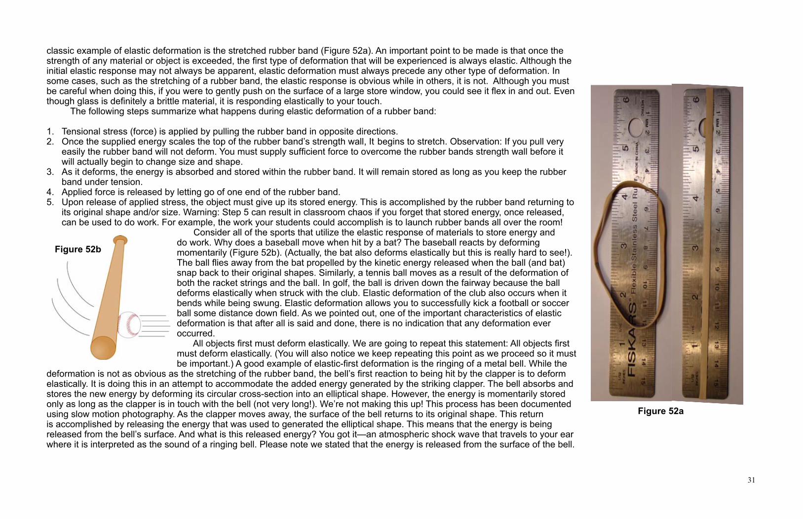
31
classic example of elastic deformation is the stretched rubber band (Figure 52a). An important point to be made is that once the strength of any material or object is exceeded, the first type of deformation that will be experienced is always elastic. Although the initial elastic response may not always be apparent, elastic deformation must always precede any other type of deformation. In some cases, such as the stretching of a rubber band, the elastic response is obvious while in others, it is not. Although you must be careful when doing this, if you were to gently push on the surface of a large store window, you could see it flex in and out. Even though glass is definitely a brittle material, it is responding elastically to your touch. The following steps summarize what happens during elastic deformation of a rubber band:
1. Tensional stress (force) is applied by pulling the rubber band in opposite directions. 2. Once the supplied energy scales the top of the rubber band’s strength wall, It begins to stretch. Observation: If you pull very
easily the rubber band will not deform. You must supply sufficient force to overcome the rubber bands strength wall before it will actually begin to change size and shape.
3. As it deforms, the energy is absorbed and stored within the rubber band. It will remain stored as long as you keep the rubber band under tension.
4. Applied force is released by letting go of one end of the rubber band.5. Upon release of applied stress, the object must give up its stored energy. This is accomplished by the rubber band returning to
its original shape and/or size. Warning: Step 5 can result in classroom chaos if you forget that stored energy, once released, can be used to do work. For example, the work your students could accomplish is to launch rubber bands all over the room!
Consider all of the sports that utilize the elastic response of materials to store energy and do work. Why does a baseball move when hit by a bat? The baseball reacts by deforming momentarily (Figure 52b). (Actually, the bat also deforms elastically but this is really hard to see!). The ball flies away from the bat propelled by the kinetic energy released when the ball (and bat) snap back to their original shapes. Similarly, a tennis ball moves as a result of the deformation of both the racket strings and the ball. In golf, the ball is driven down the fairway because the ball deforms elastically when struck with the club. Elastic deformation of the club also occurs when it bends while being swung. Elastic deformation allows you to successfully kick a football or soccer ball some distance down field. As we pointed out, one of the important characteristics of elastic deformation is that after all is said and done, there is no indication that any deformation ever occurred. All objects first must deform elastically. We are going to repeat this statement: All objects first must deform elastically. (You will also notice we keep repeating this point as we proceed so it must be important.) A good example of elastic-first deformation is the ringing of a metal bell. While the
deformation is not as obvious as the stretching of the rubber band, the bell’s first reaction to being hit by the clapper is to deform elastically. It is doing this in an attempt to accommodate the added energy generated by the striking clapper. The bell absorbs and stores the new energy by deforming its circular cross-section into an elliptical shape. However, the energy is momentarily stored only as long as the clapper is in touch with the bell (not very long!). We’re not making this up! This process has been documented using slow motion photography. As the clapper moves away, the surface of the bell returns to its original shape. This return is accomplished by releasing the energy that was used to generated the elliptical shape. This means that the energy is being released from the bell’s surface. And what is this released energy? You got it—an atmospheric shock wave that travels to your ear where it is interpreted as the sound of a ringing bell. Please note we stated that the energy is released from the surface of the bell.
Figure 52a
Figure 52b
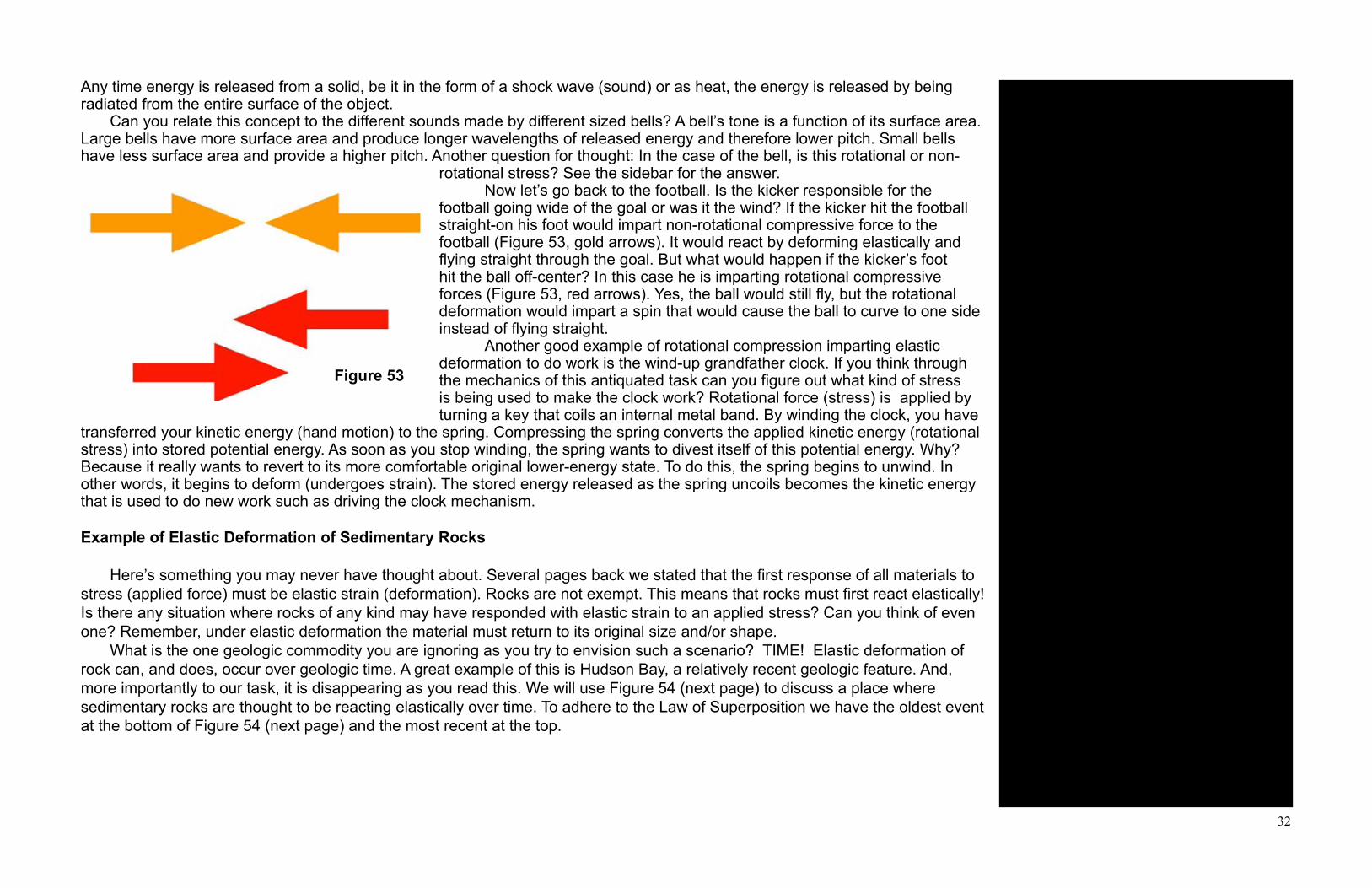
32
Deformation caused by elastic strain is reversible.
The actual ringing noise you hear from a bell is caused by the surface release of stored energy produced by elastic strain (deformation.)
A ringing bell is an example of non-rotational force (stress).
The well-placed bunt, the pop-up, the foul ball, the hooked field goal attempt, and the sliced golf drive are all examples of applied rotational force.
The concepts of stress and strain are related to the process of doing work.
First response to stress is elastic strain. Even rocks must obey this principle.
Deformation of sedimentary rocks requires the application of stress and strain over geologic time.
Any time energy is released from a solid, be it in the form of a shock wave (sound) or as heat, the energy is released by being radiated from the entire surface of the object. Can you relate this concept to the different sounds made by different sized bells? A bell’s tone is a function of its surface area. Large bells have more surface area and produce longer wavelengths of released energy and therefore lower pitch. Small bells have less surface area and provide a higher pitch. Another question for thought: In the case of the bell, is this rotational or non-
rotational stress? See the sidebar for the answer. Now let’s go back to the football. Is the kicker responsible for the football going wide of the goal or was it the wind? If the kicker hit the football straight-on his foot would impart non-rotational compressive force to the football (Figure 53, gold arrows). It would react by deforming elastically and flying straight through the goal. But what would happen if the kicker’s foot hit the ball off-center? In this case he is imparting rotational compressive forces (Figure 53, red arrows). Yes, the ball would still fly, but the rotational deformation would impart a spin that would cause the ball to curve to one side instead of flying straight. Another good example of rotational compression imparting elastic deformation to do work is the wind-up grandfather clock. If you think through the mechanics of this antiquated task can you figure out what kind of stress is being used to make the clock work? Rotational force (stress) is applied by turning a key that coils an internal metal band. By winding the clock, you have
transferred your kinetic energy (hand motion) to the spring. Compressing the spring converts the applied kinetic energy (rotational stress) into stored potential energy. As soon as you stop winding, the spring wants to divest itself of this potential energy. Why? Because it really wants to revert to its more comfortable original lower-energy state. To do this, the spring begins to unwind. In other words, it begins to deform (undergoes strain). The stored energy released as the spring uncoils becomes the kinetic energy that is used to do new work such as driving the clock mechanism.
Example of Elastic Deformation of Sedimentary Rocks
Here’s something you may never have thought about. Several pages back we stated that the first response of all materials to stress (applied force) must be elastic strain (deformation). Rocks are not exempt. This means that rocks must first react elastically! Is there any situation where rocks of any kind may have responded with elastic strain to an applied stress? Can you think of even one? Remember, under elastic deformation the material must return to its original size and/or shape. What is the one geologic commodity you are ignoring as you try to envision such a scenario? TIME! Elastic deformation of rock can, and does, occur over geologic time. A great example of this is Hudson Bay, a relatively recent geologic feature. And, more importantly to our task, it is disappearing as you read this. We will use Figure 54 (next page) to discuss a place where sedimentary rocks are thought to be reacting elastically over time. To adhere to the Law of Superposition we have the oldest event at the bottom of Figure 54 (next page) and the most recent at the top.
Figure 53

33
Figure 54 Hudson Bay is underlain by rocks of the Earth’s lithosphere. Beneath the lithosphere is the more mobile, plastic asthenosphere of Earth’s upper mantle. Plastic in this sense means it can flow. Two million years ago, during the Great Ice Age, an ice sheet began to form over the present location of Hudson Bay (Figure 54A). This continental ice sheet extended northward to the Arctic Ocean, eastward to the Atlantic Ocean, westward to the foothills of the Rocky Mountains, and southward to the present location of the Ohio and Missouri rivers. At its height, the ice could have been as much as 20,000 feet thick. This much ice represents a tremendous amount of weight. Can you speculate on how the Earth’s lithosphere would react to such a massive load? (Try the activity mentioned in the sidebar.) Your simplistic response to the question might be that the lithospheric rocks under the ice sheet were depressed downward (Figure 54C-D) as the overlying weight of snow increased. This deformation occurred in response to the stress (force) applied by the weight of the ice. This stress also caused the underlying asthenosphere to deform by flowing outward (arrows) to accommodate the depressed lithospheric rocks. Over time this process formed a gigantic bowl that filled with ice (Figure 54B-D). When the ice melted (about 10,000 years ago) the bowl filled with water creating the Hudson Bay! (Figure 54E-G). Can you define the type of strain (deformation) that occurred? Although the sedimentary rocks of the lithosphere were deformed they seem to be returning to their original shape. If, in the not too distant geologic future the rocks do resume their original shape, what does this say about the future of Hudson Bay? Without the benefit of traveling to the future we can only speculate. You, though, should consider what might be plausible and what might not. To date, rocks in the vicinity of Hudson Bay show no evidence of being broken as they were bowed down. Since the rocks were not broken the strain was not of the brittle type. This means Hudson Bay represents either elastic or plastic deformation. How can we figure out which one is most likely? Once again we must include the geologic time aspect because our answer depends on a slow but constant event that has been ongoing for the past 10,000 years. If, during that time, the rocks underlying the ice sheet deformed plastically we would be wise to consider Hudson Bay a permanent feature. If, on the other had, the rocks deformed elastically, the rocks should be slowly rebounding to their original horizontal attitude. This would suggest that Hudson Bay is a geologically ephemeral feature. Are there any facts available to support either assumption? Surprisingly, yes, there are! Geologists have documented that the sedimentary rocks under Hudson Bay are rising, or rebounding, at the rate of about a 0.3 meters (1 foot) per century. These data confirm that the sedimentary rock deformation is elastic and that, if the process continues, Hudson Bay will one day no longer exist.
Teachable moment: Is a cubic foot of frozen water (ice) heavier or lighter than a cubic foot of water? Why does ice float? It’s a density thing!
The density of various forms of water.salt water 1.03 g/cm3 (64.08 lb/ft3)pure water 1.00 g/cm3 (62.4 lb/ft3)ice 0.92 g/cm3 (57.4 lb/ft3)
Classroom activity. Have students calculate the weight of a column of ice that is 20,000 feet thick and one foot square. Or think of it as stack of 20,000 one-foot cube of ice.
Mental model for Hudson Bay elastic rebound: Think of a swimmer lying on a raft. The bottom of the raft bends under the swimmer’s body until the swimmer gets off of the raft. In this analogy, the swimmer is the ice, the raft bottom is the crustal rock and the water is the asthenosphere.
Math exercise: If we consider the maximum depth of Hudson Bay to be about 200 meters and the rebound rate to be 0.3 meters per century, when might Hudson Bay disappear?
Geologists call the elastic deformation of Hudson Bay “isostatic rebound.” You can demonstrate the process by adding and removing weight from a floating piece of wood.
A
B
D
E
F
G
C

34
Plastic Deformation
In plate tectonics the term “plastic” is used to describe a solid that flows like a liquid. As often happens, a single word can have different meanings. In this current discussion about stress and strain, plastic strain refers to permanent deformation without breaking. We can approach this concept by asking why a molded object retains its new shape? Why doesn’t it bounce back to its original shape when you are finished? We can explore these questions most easily if you have a ball of modeling clay, homemade playdough, or similar commercially available product. If you’re into food, a thin bar of chocolate (no almonds!) will come in handy. Hold a ball of the playdough in the palm of your hand (Figure 55a). Now, very gently squeeze and release. How does it respond? If you really pay attention you will feel it responding elastically. This is not a large reaction, but it does occur. If you have not squeezed too hard, the playdough will return to its original shape as soon as you release the stress induced by your fingers. Now squeeze the ball as tightly as you can. As you squeeze you will feel the playdough deforming as it moves into all of the crooks and crannies inside your clenched fist (Figure 55b). The energy (compressive stress) supplied by your fingers easily exceeds the playdough’s strength wall. It has also far exceeded its elastic limit. What happens when you open your fist? First off, opening your hand releases the compressive stress. Does the play dough return to its original shape? It does not. Instead, it retains an accurate model of the inside of your fist (Figure 55c). Why does this happen? See the sidebar for the answer. The following outline provides a step-by-step analysis of the play dough’s plastic strain (deformation).
1. Fist applies compressive stress is to the play dough. 2. Once the play dough’s strength wall is surmounted, the play dough deforms elastically. 3. Once the play dough’s very low elastic limit is exceeded, it begins to deform plastically. 4. When the stress is released (fist is opened), the play dough remains permanently deformed because all of the applied energy has been consumed.
Figure 55c
Figure 55b
Figure 55a
Three types of strain:1. elastic2. PlASTic3. ?
Some view plastic deformation as occurring because a material “flowed.” In a way, it acts like a viscous liquid.
What do we mean by “elastic limit”? The amount of energy that can be stored during the elastic phase of deformation is defined as its elastic limit. As the elastic limit is exceeded, then, and only then, will the material deform by either plastic or brittle deformation. Every object, even our clay, has a limit as to how much energy it can store during the elastic phase of deformation. This limit is called the elastic limit. Once exceeded, the object will not return to its original shape.
Answer: Playdough or modeling clay is the ideal medium for this activity because of their very low strength and a plastic response to stress that exceeds the elastic limit. As a result, both will retain what ever shape you impart. All of the applied energy generated by the fist has been consumed in rearranging the physical relationship between the individual clay particles. When the stress is released, there is no energy left to restore the clay to its original shape. The clay has experienced plastic deformation and is now permanently deformed.
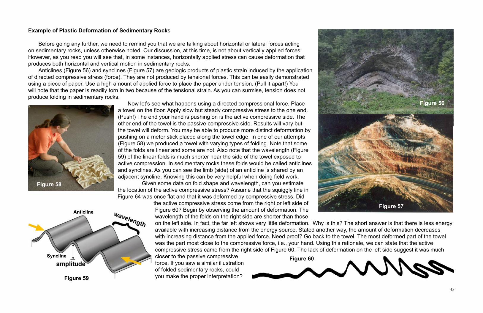
35
Example of Plastic Deformation of Sedimentary Rocks
Before going any further, we need to remind you that we are talking about horizontal or lateral forces acting on sedimentary rocks, unless otherwise noted. Our discussion, at this time, is not about vertically applied forces. However, as you read you will see that, in some instances, horizontally applied stress can cause deformation that produces both horizontal and vertical motion in sedimentary rocks. Anticlines (Figure 56) and synclines (Figure 57) are geologic products of plastic strain induced by the application of directed compressive stress (force). They are not produced by tensional forces. This can be easily demonstrated using a piece of paper. Use a high amount of applied force to place the paper under tension. (Pull it apart!) You will note that the paper is readily torn in two because of the tensional strain. As you can surmise, tension does not produce folding in sedimentary rocks.
Now let’s see what happens using a directed compressional force. Place a towel on the floor. Apply slow but steady compressive stress to the one end. (Push!) The end your hand is pushing on is the active compressive side. The other end of the towel is the passive compressive side. Results will vary but the towel will deform. You may be able to produce more distinct deformation by pushing on a meter stick placed along the towel edge. In one of our attempts (Figure 58) we produced a towel with varying types of folding. Note that some of the folds are linear and some are not. Also note that the wavelength (Figure 59) of the linear folds is much shorter near the side of the towel exposed to active compression. In sedimentary rocks these folds would be called anticlines and synclines. As you can see the limb (side) of an anticline is shared by an adjacent syncline. Knowing this can be very helpful when doing field work. Given some data on fold shape and wavelength, can you estimate the location of the active compressive stress? Assume that the squiggly line in Figure 64 was once flat and that it was deformed by compressive stress. Did
the active compressive stress come from the right or left side of Figure 60? Begin by observing the amount of deformation. The wavelength of the folds on the right side are shorter than those on the left side. In fact, the far left shows very little deformation. Why is this? The short answer is that there is less energy available with increasing distance from the energy source. Stated another way, the amount of deformation decreases with increasing distance from the applied force. Need proof? Go back to the towel. The most deformed part of the towel was the part most close to the compressive force, i.e., your hand. Using this rationale, we can state that the active compressive stress came from the right side of Figure 60. The lack of deformation on the left side suggest it was much closer to the passive compressive force. If you saw a similar illustration of folded sedimentary rocks, could you make the proper interpretation?
Figure 57
Figure 58
Figure 60Syncline
Anticline
Figure 59
Figure 56

36
A. From the East because Valley and Ridge rocks are clearly more deformed and faulted than those of the Appalachian Plateau.
B. The various anticlines and synclines are the products of the plastic strain of sedimentary rocks.
C. The amount of strain (deformation)decreases as the rocks become more distant from the applied eastern stress. Refer back to Figure 60 for visual clues.
D. No. Mountains and valleys are modern geographic features formed by weathering and erosion. Anticlines and synclines are geologically old features formed by deformation of pre-existing rocks. For example, Germany Valley is actually a geologic anticline (Figure 63). The colored areas show rocks of various ages. The top outline is the current topography of the valley.
Figure 61
Figure 62
Figure 63
Colliding continental plates produce enough compressive stress, over a long period of time, to plastically deform sedimentary rocks into anticlines and synclines. By mapping and measuring these folds geologists can determine where the collision might have occurred and how far any given point was from that collision. In many ways, it is much like reconstructing a car accident. Figure 65 is a no-scale intended cartoon of the surface and subsurface geology along a west-to-east line from Morgantown to the Atlantic Coast. The names of the various physiographic provinces correspond to those shown in Figure 62. A physiographic province is an area with similar geology and geography. Try these questions before looking to the sidebar for help.
A. Was the force (stress) that caused the deformation of the shown sedimentary rocks coming form the East or the West? B. Can you point to instances of plastic strain in the shown sedimentary rocks?C. Can you give a reason why the folds differ in the Valley and Ridge, High Appalachian Plateau, and Low Appalachian Plateau
Provinces?D. Stretch knowledge. Although we have not discussed this concept is a mountain always an anticline and is a valley always a syncline?

37
Figure 65
Figure 64
Fold amplitude is a measure of the vertical distance between a fold crest and its corresponding trough.
Remember: slow movement over geologic time can produce massive change.
Faults are fractures in rock along which there has been measurable vertical and/or horizontal movement.
A lateral progressive change from symmetrical to asymmetrical to overturned to recumbent folding documents a progressive increase in the amount of strain and the direction from which the compressive stress was applied.
A fold is called recumbent when the axial plane approaches horizontal.
By now you know that the plastic deformation of sedimentary rock will produce folds. By categorizing and classifying the types of observed folding, geologists can get a good idea of the amount of energy and the direction of the applied stress. We can use this knowledge to further unravel the mechanics of Figure 61. On the previous page we used fold wavelength to identify the locations of active vs. passive compressive stress. Fold amplitude (Figure 64) is also a measure of the amount of applied compressional force. In West Virginia’s Plateau Provinces the sedimentary rock layers appear to be horizontal. In fact, these layered rocks are folded into very low-amplitude, long-wavelength symmetric anticlines and synclines. Your close examination of Figure 65 should have revealed that the anticlines and synclines become increasingly more asymmetric as you travel through the Valley and Ridge Province and on to Harpers Ferry. Putting this in everyday words we can say that when going from west to east, West Virginia’s folded sedimentary rocks progressively become more deformed as they change from symmetrical to asymmetrical to overturned to recumbent folds (Figure 65). This is additional evidence that the active compressive force came from the east while the passive compressive force was to the west. We can conclude that traveling east across West Virginia is bringing us closer to source of applied energy. For this reason, geologists believe that the site of the active plate collision that deformed West Virginia’s sedimentary rocks approximately 250,000,000 years ago was located to the east and southeast of West Virginia. By this point we are hoping you are asking yourself why sedimentary rocks deform plastically? In other words, why don’t the layers just break? Before we answer that question we need to discuss brittle deformation. Then we can do a little comparing and contrasting to see why some layered rocks bend while others break.
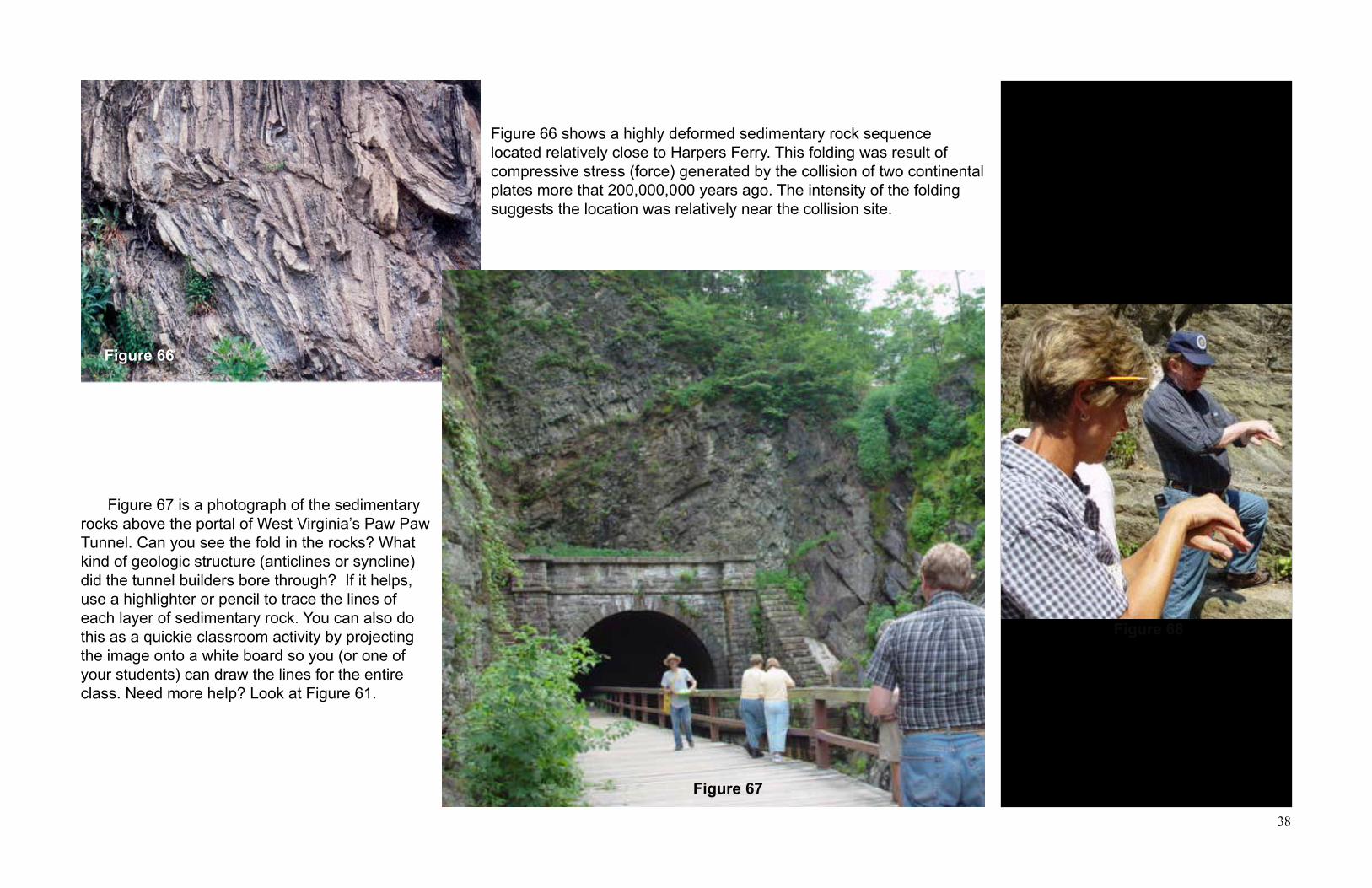
38
Figure 66
Figure 68
Figure 67
Useful mnemonic devices:1. Anthill for anticline2. “A” for arch and anticline3. Smiley face for syncline
Jack (Figure 68) providing a clue as to the type of plastic deformation (anticline or syncline) seen in the sedimentary rocks in Figure 67. Remember, deformation is the change in size and/or shape, not the shape itself.
Figure 66 shows a highly deformed sedimentary rock sequence located relatively close to Harpers Ferry. This folding was result of compressive stress (force) generated by the collision of two continental plates more that 200,000,000 years ago. The intensity of the folding suggests the location was relatively near the collision site.
Figure 67 is a photograph of the sedimentary rocks above the portal of West Virginia’s Paw Paw Tunnel. Can you see the fold in the rocks? What kind of geologic structure (anticlines or syncline) did the tunnel builders bore through? If it helps, use a highlighter or pencil to trace the lines of each layer of sedimentary rock. You can also do this as a quickie classroom activity by projecting the image onto a white board so you (or one of your students) can draw the lines for the entire class. Need more help? Look at Figure 61.

39
BRITTLE DEFORMATION
Did you notice we did not tell you how much energy to apply to the rubber band when we asking you to demonstrate elastic strain? We suspect you already have a feeling that there must be a limit as to how much energy the rubber band could handle before breaking. Did you get carried away and break the rubber band? Your reward for breaking the rubber band was a snap on the fingers and a practical demonstration of something called elastic limit. Elastic limit is the maximum amount of stress (applied force) that any volume of a material can store during the elastic phase of deformation. Once the material’s elastic limit is exceeded, and only after the elastic limit is exceeded, the material responds by non-elastic strain. Let’s pull out the rubber band again. Begin by applying tensional stress (pull it apart). At first it deforms with ease. Continue to apply tensional force. At some point it becomes increasingly more difficult to stretch the rubber band. Eventually you reach a point where you sense the rubber band will stretch no farther. In essence, the rubber band is saying “You’ve reached my elastic limit.” But let’s be brave! Continue to apply tensional force until the rubber band does break. Watch out for smarting finger tips! The breaking of the rubber band demonstrates the idea of elastic limit. More critically, brittle deformation occurs. The word “brittle” is used to mean easily broken or fragile. But why do brittle things break? They break because they have absorbed more energy than they can store internally. We have previously stated that all objects first deform elastically, even if we cannot see them do so. If a brittle object’s elastic limit is reached, continued application of energy will exceed its ability to store it. The object must react by relieving the excess energy. In other words, it will break. But, why does it break into pieces? How does this disperse the energy? Can you provide an explanation? Let’s consider a glass goblet. You are making a toast at a wedding, meeting, etc. To gain everyone’s attention, you smartly rap the goblet with your knife. A clear ringing tone is heard by everyone. They become quiet in order to hear your prophetic words of wisdom. Now, imagine the same wedding, meeting, etc. but this time you’re having a bad day. You hit the goblet with an unbridled amount of exuberance. What happens this time? More importantly, how much do you owe the restaurant to replace their goblet? Let’s examine each scenario from the aspect of deformation. Figure 69 illustrates the first scenario where the goblet acts much like a bell. It responds by elastic strain and returns the applied energy as a ringing tone. Note that, as is the case with any bell, the energy was released from the surface of the goblet. However, in the second case, you strike the goblet a little too hard (Figure 70) and provide more energy than the goblet can store. Since the glass in the goblet can not deform plastically, like clay, it must find a way to rid itself of the excess energy. Can you suggest how it does so? It breaks! Why does it break?
Types of strain:
1. elastic 2. plastic 3. BRiTTlE
Activity: Use rubber band to demonstrate elastic limit and brittle deformation.
Reminder: Stress is applied force Strain is deformation
Making a glass goblet ring—or not!
Figure 69

40
Until the elastic limit is reached, the surface area of the goblet would have been sufficient to allow the release of all of the stored energy. But having exceeded the elastic limit, there is now more energy to be released than the amount of available surface area will allow. Nevertheless, the energy must be released! What is needed is more surface area. To create more surface area, the goblet breaks. Now in addition to the original surface area, the breaking of the goblet has added the surface area of the edges of the broken pieces. The number of pieces the goblet will break into is a function of how much energy has to be released. If the elastic limit is barely exceeded, the goblet will just crack. At the other extreme, it will break into smithereens to create sufficient surface area to allow the release of a large amount of stored energy. With the sound of breaking glass still reverberating in our minds, let’s summarize what happens during brittle deformation. Remember, the goblet must first undergo elastic strain (deformation). This occurs in steps 1-6.
1. Compressive force (stress) is applied to the goblet by striking it with the knife. 2. Goblet absorbs the applied energy. 3. Goblet begins to undergo strain and top begins to deforms from circular to elliptical shape. 4. As goblet deforms, energy is being stored within the goblet. 5. Applied stress is released after knife is removed from the goblet.6. Upon release of applied stress the goblet must give up its stored energy. This is accomplished by the surface vibration of the goblet which produces shock waves we hear as the sound of a ringing bell.
To examine how the goblet reacts to brittle strain we must add steps 7-11:
7. Additional energy is supplied to reach and exceed the goblet’s elastic limit.8. Once the elastic limit is exceeded the surface area of the goblet must increase to accommodate the additional energy. 9. Having exceeded its elastic limit, the goblet breaks in order to create the additional surface area needed to get rid of both the stored and excess energy10. Energy is released from newly-enlarged surface area provided by the edges of the numerous broken pieces. 11. The characteristic sound of breaking glass is simply due to the fact that, rather than having a single ringing bell, we now have a number of “bells” all of different size and shape with each giving off their own tone. The sound of breaking glass is due to the intermingling of all of those different tones.
Figure 70
Why objects break!
Energy release and surface area are related. Breaking is a mechanism that allows objects to create more surface area. More surface area helps dissipate the excessive absorbed energy. By breaking, objects increase the amount of surface area available to disperse excess stress. Increased stress requires an increased surface area. In other words, the harder you hit the more pieces you get!
Please note we are limiting our discussion to sedimentary rocks.

41
Examples of Brittle Deformation of Sedimentary Rocks
Can you name a geologic feature formed by brittle strain? You’re right—a fault! If you were to ask student’s to describe a geologic fault, the one they would most likely describe is the normal fault shown in Figure 71. Since we are continually trying to encourage you to apply the discussed concepts, now we would like to ask if you can identify what kind of stress (compression or tension) would produce a normal fault?
Normal faults are indicators of tensional forces at work. Plate tectonic’s divergent (pull apart) plate margins are loaded with normal faults in places like rift zones, rift valleys, linear oceans, and the summits of oceanic ridges. If you look at Figure 72 you will notice that one of the interesting facets of normal faults is that they cause extension of Earth’s crust. Since we know extensional tectonics is not causing Earth’s overall circumference to increase there must be places where the crust is being compressed! Faults that produce a shortening of Earth’s crust are caused by tectonic compressive forces. These are
the thrust or reverse faults (Figure 73). Equally interesting is the fact that thrust faults are associated with highly deformed, folded rocks. Your first response to this should be “How can that work if folding is plastic deformation and faulting is brittle deformation?” From our plastic deformation discussion you know that sedimentary rocks will fold as long as they can plastically consume the energy of the applied stress. However, in the case of the extreme non-symmetric folds, the fold cores become very tight and compacted. This compaction severely restricts movement. If the stress continues, these compacted layers become unable to deal with the energy by deforming plastically. What happens? They break! At some point the rocks must eventually rid themselves of the excess energy. Just like the glass goblet, they break to create the additional surface area needed to
accommodate dispersal of the excess energy. The outcome of the breaking process produces the characteristic movement that defines the fracture as a thrust or reverse fault. Due to this process, thrust faults are invariably found in overturned and recumbent folds (Figure 74). So far our two fault types have been relegated to the effects of relative vertical motion of the rocks on each side of a fault. Simply stated, one side moves only up or down relative to the other because the compressional or tensional forces are operating in a non-rotational pattern.
Fault plane
AA
Figure 71
Figure 72
Figure 73
Figure 74
Answer: It is a normal fault caused by tensional stress. Note the indicated fault plane and the relative motion of layer A. Compare this motion to that shown in Figure 72.
A region characterized by multiple parallel normal faults is said to represent extensional tectonics. The Basin and Range Province of Nevada is an excel-lent example.
A thrust fault is caused by non-rotational compressive stress. Note the arrows pointing directly at each other in Figure 73. Globally, they are associated with convergent plate margins and zones of subduction.
A slight variation of the thrust fault is the reverse fault. They both form in the same way but the reverse fault can actually allow one section of rock to slide above and over another section. In these situations, older rocks are on top of younger rocks. This is why the Law of Superposition contains the phrase “unless deformed.”

42
However, there are instances where rotational compressive forces cause brittle deformation that imparts horizontal or lateral movement to the rocks along the fault plane. These are called strike-slip faults. Figure 75a and 75b illustrates the two kinds of strike-slip faults. Can you figure out how they differ from each other? The answer is in the next two paragraphs. How does rotational compression cause a strike-slip fault if the rocks move along a vertically oriented fault? It works because the rocks do not move up or down on either side of the fault. Instead they slide parallel to the fault itself, a direction that is also parallel to the applied compressive force direction. If you look at Figure 75a or 75b you will see that the offset motion is indicated by the arrows. Go back to Figure 51 to prove to yourself that this is rotational compression. Were you able to figure out how the strike-slip fault in Figure 75a differs from that shown in 75b? A strike-slip fault is described as being either right-lateral or left-lateral. To determine the right- or left-handedness of the fault consider which way the other side moved relative to you. No matter which side of the fault you are on in Figure 75a the person on the other side appears to have moved to your right. In Figure 75b the apparent motion is always to your left. Note that it makes no difference from which side of the fault you look. Do you know of any large strike-slip faults? We bet you do. The famous San Andreas Fault of California is a right-hand strike-slip fault.
Additional Brittle Deformation Structures
Brittle strain produces more than just faults in rocks. It also creates vertical fractures that are one of the most commonly seen geologic features in West Virginia’s rocks. These features are not faults because there has been no measurable rock movement on either side of the fissure. Instead, they are called joints. Joints are not necessarily the result of brittle deformation caused by tectonic forces. Joints can also form when tension is released. In our discussion we wish to emphasize tectonically formed and controlled joints. Figure 76 was taken looking downward at the top of a bed of sedimentary rock. The numerous straight lines are joints which extend vertically downward into the rock. A close look will reveal multiple parallel joints. The dotted lines identify two intersecting joints. The possible direction from which the maximum compression force that formed the joints can be estimated using the midpoint of the acute angle formed by intersecting joints. In Figure 76, the two black arrows show the approximate direction of the non-rotational compressive force. Note that by itself these data do not differentiate between active or passive compressive force. Additional field work would be required to answer that question.
Figure 75a
Figure 75b
Joints are fractures in the rocks along which there has been no measurable move-ment. They are very common and abun-dant yet there is no consensus as to exactly how they form. They most likely form when the amount of applied energy just slightly exceeds the sedimentary rock’s elastic limit.
Joints in igneous rocks are usually contrac-tion features related to the cooling of the molten rock.
Joints
Figure 76
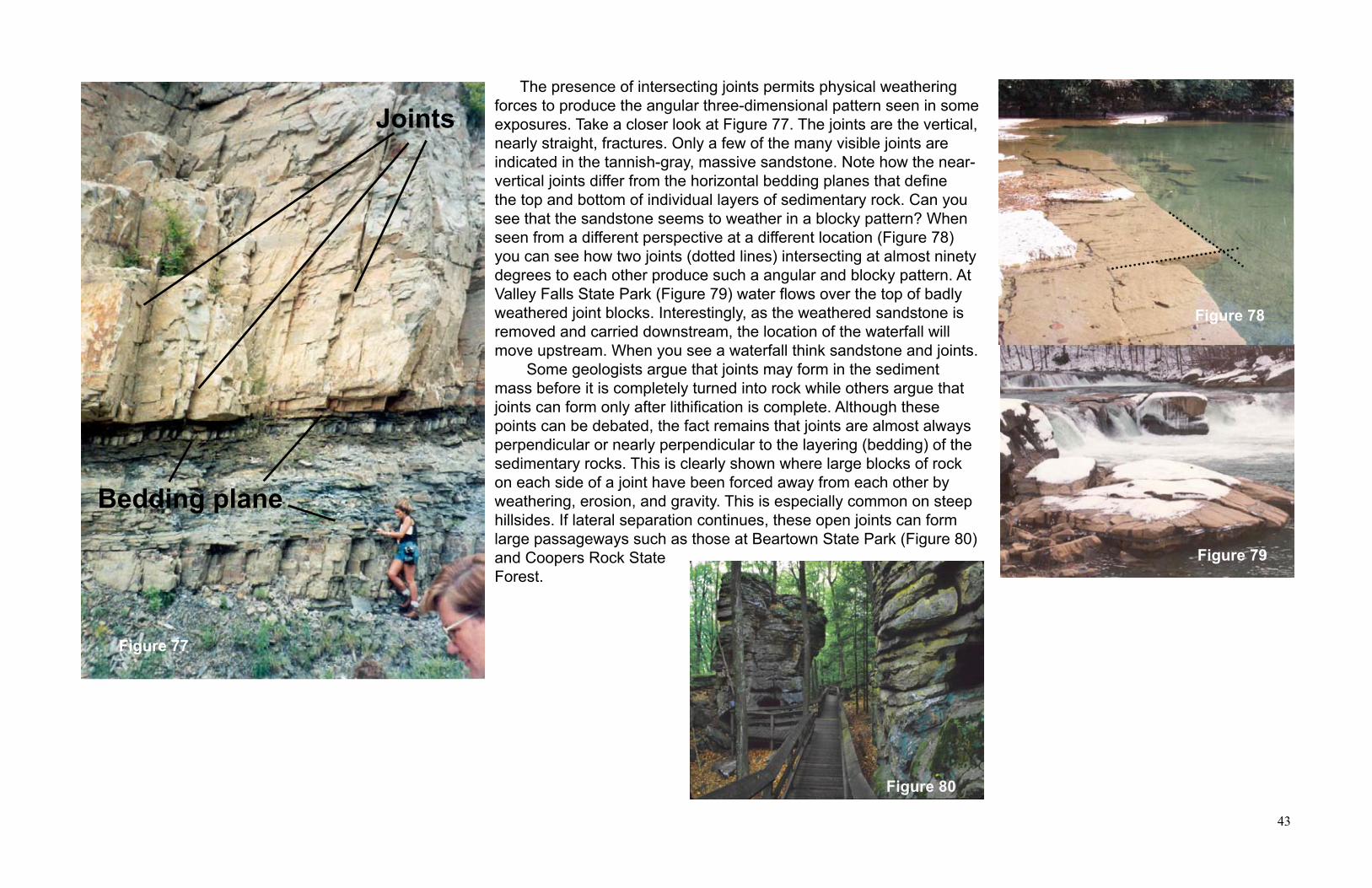
43
The presence of intersecting joints permits physical weathering forces to produce the angular three-dimensional pattern seen in some exposures. Take a closer look at Figure 77. The joints are the vertical, nearly straight, fractures. Only a few of the many visible joints are indicated in the tannish-gray, massive sandstone. Note how the near-vertical joints differ from the horizontal bedding planes that define the top and bottom of individual layers of sedimentary rock. Can you see that the sandstone seems to weather in a blocky pattern? When seen from a different perspective at a different location (Figure 78) you can see how two joints (dotted lines) intersecting at almost ninety degrees to each other produce such a angular and blocky pattern. At Valley Falls State Park (Figure 79) water flows over the top of badly weathered joint blocks. Interestingly, as the weathered sandstone is removed and carried downstream, the location of the waterfall will move upstream. When you see a waterfall think sandstone and joints. Some geologists argue that joints may form in the sediment mass before it is completely turned into rock while others argue that joints can form only after lithification is complete. Although these points can be debated, the fact remains that joints are almost always perpendicular or nearly perpendicular to the layering (bedding) of the sedimentary rocks. This is clearly shown where large blocks of rock on each side of a joint have been forced away from each other by weathering, erosion, and gravity. This is especially common on steep hillsides. If lateral separation continues, these open joints can form large passageways such as those at Beartown State Park (Figure 80)and Coopers Rock State Forest.
Joints
Bedding plane
Figure 77
Figure 78
Figure 79
Figure 80
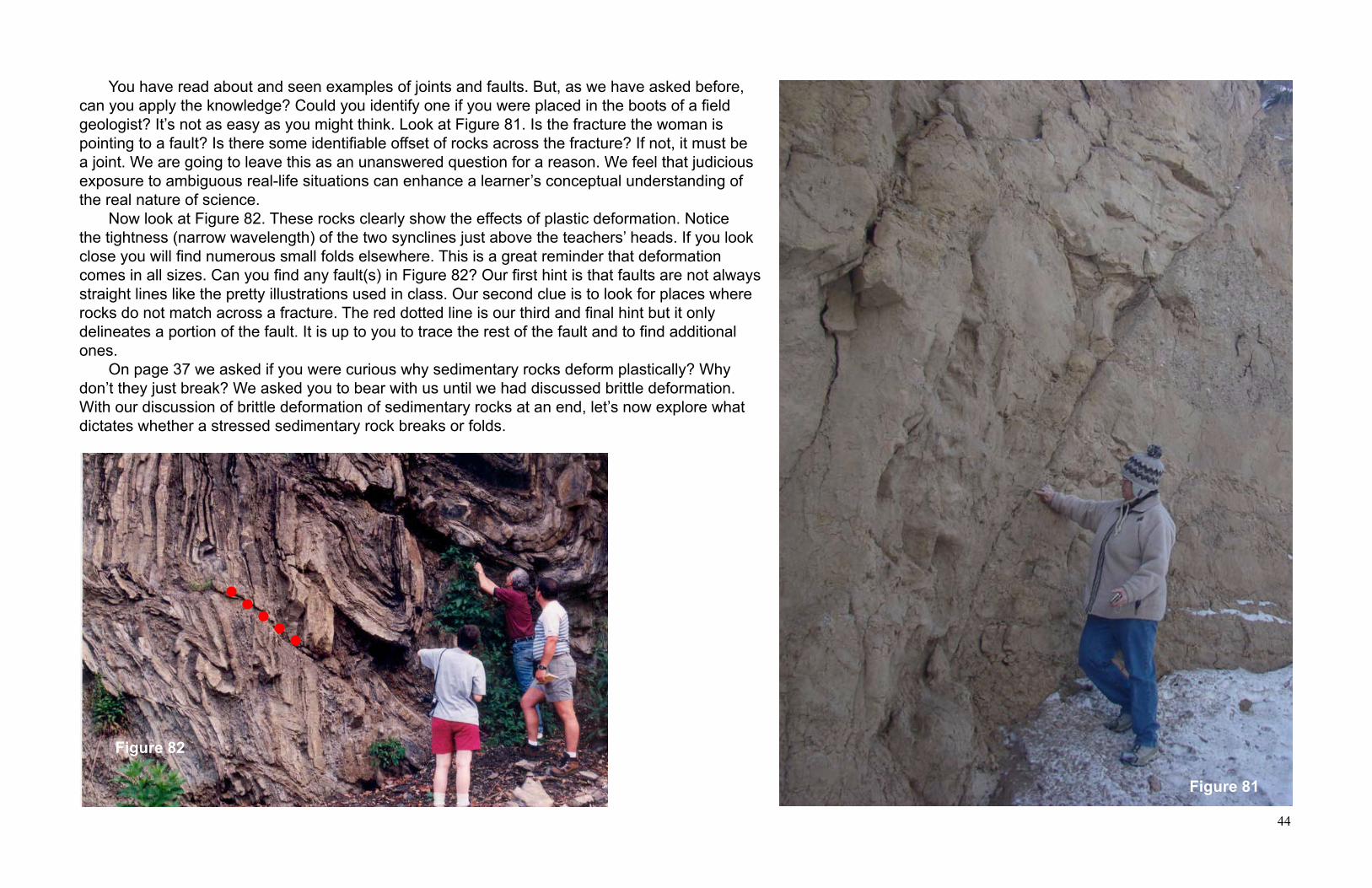
44
Figure 81
Figure 82
You have read about and seen examples of joints and faults. But, as we have asked before, can you apply the knowledge? Could you identify one if you were placed in the boots of a field geologist? It’s not as easy as you might think. Look at Figure 81. Is the fracture the woman is pointing to a fault? Is there some identifiable offset of rocks across the fracture? If not, it must be a joint. We are going to leave this as an unanswered question for a reason. We feel that judicious exposure to ambiguous real-life situations can enhance a learner’s conceptual understanding of the real nature of science. Now look at Figure 82. These rocks clearly show the effects of plastic deformation. Notice the tightness (narrow wavelength) of the two synclines just above the teachers’ heads. If you look close you will find numerous small folds elsewhere. This is a great reminder that deformation comes in all sizes. Can you find any fault(s) in Figure 82? Our first hint is that faults are not always straight lines like the pretty illustrations used in class. Our second clue is to look for places where rocks do not match across a fracture. The red dotted line is our third and final hint but it only delineates a portion of the fault. It is up to you to trace the rest of the fault and to find additional ones. On page 37 we asked if you were curious why sedimentary rocks deform plastically? Why don’t they just break? We asked you to bear with us until we had discussed brittle deformation. With our discussion of brittle deformation of sedimentary rocks at an end, let’s now explore what dictates whether a stressed sedimentary rock breaks or folds.
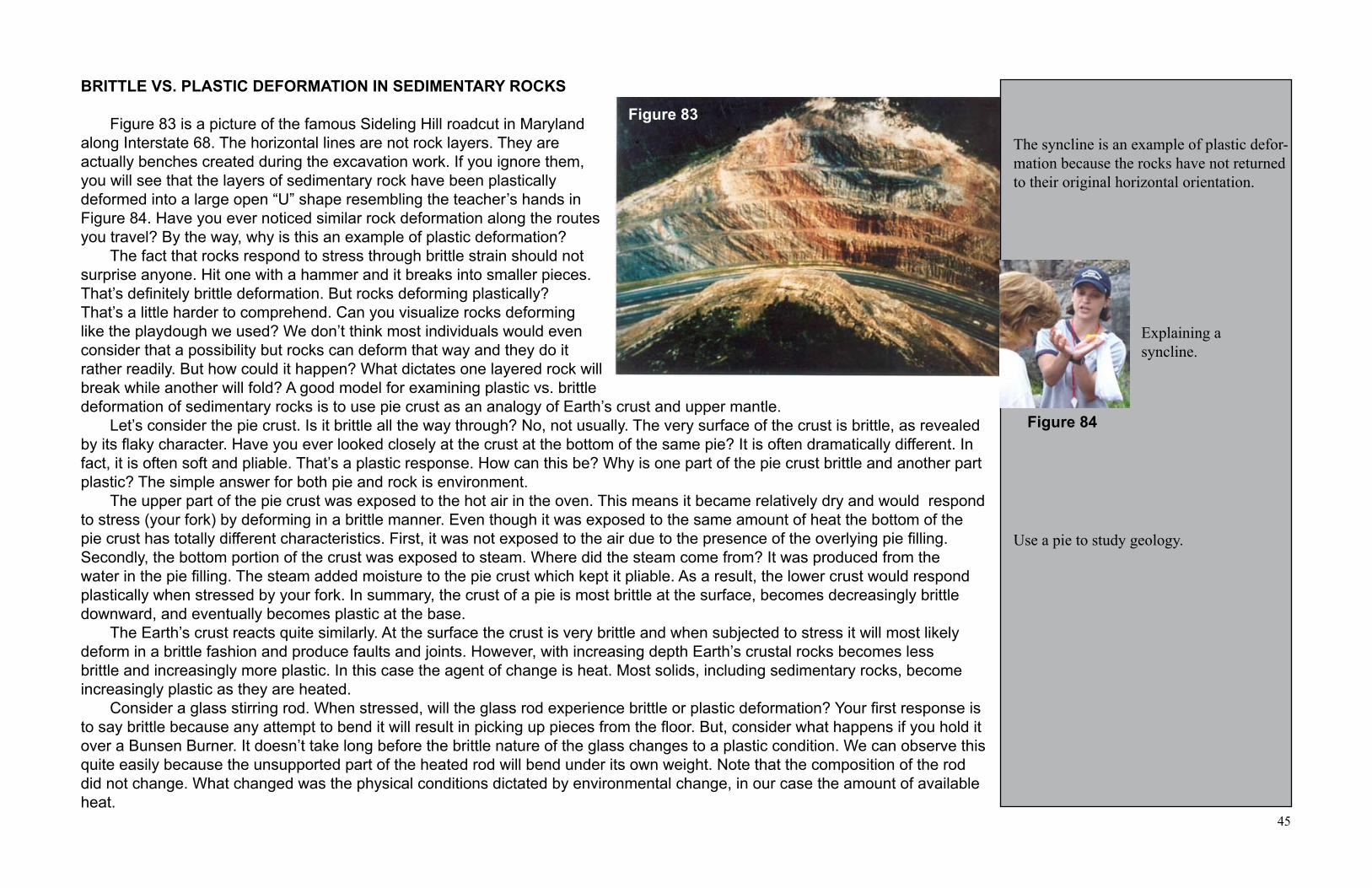
45
Figure 84
The syncline is an example of plastic defor-mation because the rocks have not returned to their original horizontal orientation.
Explaining a syncline.
Use a pie to study geology.
BRITTLE VS. PLASTIC DEFORMATION IN SEDIMENTARY ROCKS Figure 83 is a picture of the famous Sideling Hill roadcut in Maryland along Interstate 68. The horizontal lines are not rock layers. They are actually benches created during the excavation work. If you ignore them, you will see that the layers of sedimentary rock have been plastically deformed into a large open “U” shape resembling the teacher’s hands in Figure 84. Have you ever noticed similar rock deformation along the routes you travel? By the way, why is this an example of plastic deformation? The fact that rocks respond to stress through brittle strain should not surprise anyone. Hit one with a hammer and it breaks into smaller pieces. That’s definitely brittle deformation. But rocks deforming plastically? That’s a little harder to comprehend. Can you visualize rocks deforming like the playdough we used? We don’t think most individuals would even consider that a possibility but rocks can deform that way and they do it rather readily. But how could it happen? What dictates one layered rock will break while another will fold? A good model for examining plastic vs. brittle deformation of sedimentary rocks is to use pie crust as an analogy of Earth’s crust and upper mantle. Let’s consider the pie crust. Is it brittle all the way through? No, not usually. The very surface of the crust is brittle, as revealed by its flaky character. Have you ever looked closely at the crust at the bottom of the same pie? It is often dramatically different. In fact, it is often soft and pliable. That’s a plastic response. How can this be? Why is one part of the pie crust brittle and another part plastic? The simple answer for both pie and rock is environment. The upper part of the pie crust was exposed to the hot air in the oven. This means it became relatively dry and would respond to stress (your fork) by deforming in a brittle manner. Even though it was exposed to the same amount of heat the bottom of the pie crust has totally different characteristics. First, it was not exposed to the air due to the presence of the overlying pie filling. Secondly, the bottom portion of the crust was exposed to steam. Where did the steam come from? It was produced from the water in the pie filling. The steam added moisture to the pie crust which kept it pliable. As a result, the lower crust would respond plastically when stressed by your fork. In summary, the crust of a pie is most brittle at the surface, becomes decreasingly brittle downward, and eventually becomes plastic at the base. The Earth’s crust reacts quite similarly. At the surface the crust is very brittle and when subjected to stress it will most likely deform in a brittle fashion and produce faults and joints. However, with increasing depth Earth’s crustal rocks becomes less brittle and increasingly more plastic. In this case the agent of change is heat. Most solids, including sedimentary rocks, become increasingly plastic as they are heated. Consider a glass stirring rod. When stressed, will the glass rod experience brittle or plastic deformation? Your first response is to say brittle because any attempt to bend it will result in picking up pieces from the floor. But, consider what happens if you hold it over a Bunsen Burner. It doesn’t take long before the brittle nature of the glass changes to a plastic condition. We can observe this quite easily because the unsupported part of the heated rod will bend under its own weight. Note that the composition of the rod did not change. What changed was the physical conditions dictated by environmental change, in our case the amount of available heat.
Figure 83

46
Figure 85
Classroom demo using glass stirring rod: caution required!!
Geothermal gradient means that with depth Earth’s crustal rocks become more plastic.
Answer: 360oC/ 25OC/km = 14.4km.
The plastic deformation that folds rocks probably occurs at significant depths below the surface. We only see folds because weathering and erosion have removed the younger concealing rocks.
Little known geology factoid: Rocks fold into anticlines. Synclines are a by-product of the process or making an anticline. Think about the towel we used earlier. Did it deform downward into the floor? When sedimentary rocks are stressed by a compressive force a weak layer often acts as a sliding zone. The rocks are pushed into folds just like the towel sliding over the floor. This sliding zone is called a detachment zone or decollment. The small black arrows in Figure 86 show the direction of movement along some of the major decollments in the Seneca Rocks area of West Virginia. A portion of the once horizontal Tuscarora Sandstone (yellow) has been deformed into what we now see as the vertical cliff face of Seneca Rocks. The blue dashed line represents the anticline that was removed by erosion as motion along the decollment shifted the rocks upward. Note that the eroded anticline is now a geographic valley.
Figure 86
What does heating a glass rod over a Bunsen Burner have to do with the brittle vs. plastic deformation of sedimentary rocks? Very simple: the change in heat. As you go deeper into Earth’s crust the temperature rises. This downward increase in heat is called the geothermal gradient. A good question would be “At what depth do the rocks become hot enough to allow them to begin to respond plastically as shown in Figure 85?” We can use a simplistic, but viable, method for answering that question by employing a characteristic of the mineral quartz. Geologists consider the depth at which plastic deformation begins to be the depth at which the mineral quartz becomes plastic. Why quartz? Simply because it is a major component of most of Earth’s continental crust.
Experimental data indicates that quartz begins to achieve plasticity at a temperature of about 360oC. If we use an average geothermal gradient of 25OC/km, what depth within Earth’s crust must we descend to generate a temperature of 360OC? See the sidebar for the answer then read the next paragraph several times. You may find a new way to conceptually understand how and why sedimentary rocks deform. Using the geothermal gradient, we can conclude that brittle strain dominates sedimentary rocks residing in the uppermost 14-15 kilometers (about 9 miles) of Earth’s crust. However, deeper than this the incidence of fractures will diminish as plastic strain (deformation) becomes increasingly prevalent. The most significant point to be made here is that the geologic plastic deformation of sedimentary rocks must occur, and did occur, only at great depths within Earth, not near the surface. How is it then that you can drive along roadways and see folded rocks such as those shown in Figure 86? The only answer can be that tens of thousands of feet of overlying rock have been removed by weathering and erosion!

47
Figure 87
Figure 88
Figure 89a Figure 89b Figure 89c
HISTORY LESSON: ARCHITECTURE, ROCKS, STRESS, AND STRAIN.
The fundamental understanding that rocks are very strong under compression but weak under tension has been known since ancient times. Ancient architects may not have used the same terminology we use today but they understood, and where in some cases limited by their ability to master compression versus tension. A brief historical lesson is useful in illustrating this point.
Figure 87 is a photograph of ruins of the Greek Parthenon. What is the most prominent aspect of this building? Answer: Columns, and lots of them. Actually this property is characteristic of most ancient Greek buildings.
Of course, the next question is: “Why did the Greeks use so many columns?” Maybe they just liked the aesthetic grandeur provided by so much stone. The real reason is that they did not know how to overcome the inherent weakness of rocks under tension. Their technique for handling the load of a roof or additional floor was to support large cut stones called lintels with columns. They knew, probably from experience, that if the distance between adjacent columns got too great, the lintel would sag under its own weight, let alone the weight of anything placed above it, and break. As a result, the columns had to be relatively close together. Hence, structures using lots of columns. But, why did the lintel sag? Consider the basic engineering aspects of this construction method. As shown in Figure 88, each end of a lintel is supported by a column. This places the lintel under rotational compression. Why is it rotational compression? Note the offset position of the red arrows. Since the weight of the lintel is unsupported in the middle, if the space between the columns is too great the tensional forces within the rock exceed its elastic limit and the lintel breaks. You can illustrate the problem with Greek architecture using a classroom pencil. Hold the pencil between your fists. Press down slightly on the center of the pencil with your thumbs (Figure 89a). Note the similar arrangement of the red arrows in Figure 88 and 89a. You are subjecting the part of the pencil under your thumbs to rotational compression. Now, start to push down harder on the pencil with your thumbs. Eventually, the pencil will break and the broken ends will come away from each other (Figure 89b and 89c). This occurs because, internally, the pencil was under tension caused by the applied force (stress) of your thumbs.
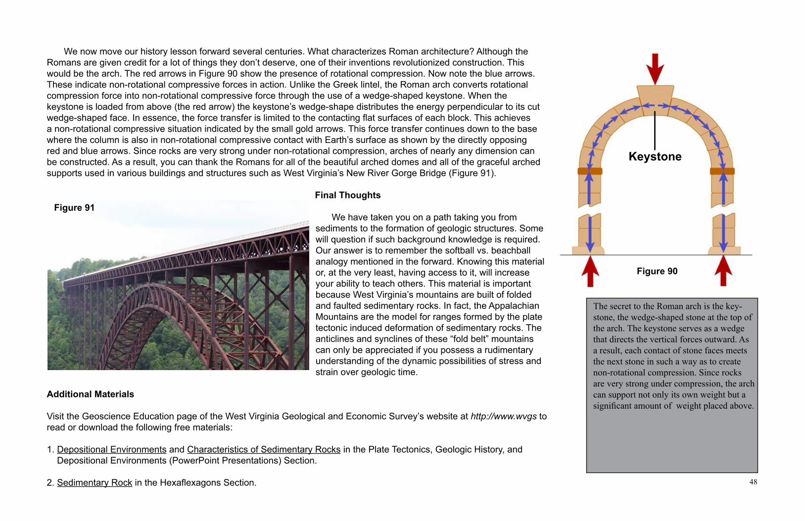
48
Figure 90
The secret to the Roman arch is the key-stone, the wedge-shaped stone at the top of the arch. The keystone serves as a wedge that directs the vertical forces outward. As a result, each contact of stone faces meets the next stone in such a way as to create non-rotational compression. Since rocks are very strong under compression, the arch can support not only its own weight but a significant amount of weight placed above.
Keystone
Figure 91
We now move our history lesson forward several centuries. What characterizes Roman architecture? Although the Romans are given credit for a lot of things they don’t deserve, one of their inventions revolutionized construction. This would be the arch. The red arrows in Figure 90 show the presence of rotational compression. Now note the blue arrows. These indicate non-rotational compressive forces in action. Unlike the Greek lintel, the Roman arch converts rotational compression force into non-rotational compressive force through the use of a wedge-shaped keystone. When the keystone is loaded from above (the red arrow) the keystone’s wedge-shape distributes the energy perpendicular to its cut wedge-shaped face. In essence, the force transfer is limited to the contacting flat surfaces of each block. This achieves a non-rotational compressive situation indicated by the small gold arrows. This force transfer continues down to the base where the column is also in non-rotational compressive contact with Earth’s surface as shown by the directly opposingred and blue arrows. Since rocks are very strong under non-rotational compression, arches of nearly any dimension can be constructed. As a result, you can thank the Romans for all of the beautiful arched domes and all of the graceful arched supports used in various buildings and structures such as West Virginia’s New River Gorge Bridge (Figure 91).
Final Thoughts
We have taken you on a path taking you from sediments to the formation of geologic structures. Some will question if such background knowledge is required. Our answer is to remember the softball vs. beachball analogy mentioned in the forward. Knowing this material or, at the very least, having access to it, will increase your ability to teach others. This material is important because West Virginia’s mountains are built of folded and faulted sedimentary rocks. In fact, the Appalachian Mountains are the model for ranges formed by the plate tectonic induced deformation of sedimentary rocks. The anticlines and synclines of these “fold belt” mountains can only be appreciated if you possess a rudimentary understanding of the dynamic possibilities of stress and strain over geologic time.
Additional Materials
Visit the Geoscience Education page of the West Virginia Geological and Economic Survey’s website at http://www.wvgs to read or download the following free materials:
1. Depositional Environments and Characteristics of Sedimentary Rocks in the Plate Tectonics, Geologic History, and Depositional Environments (PowerPoint Presentations) Section.
2. Sedimentary Rock in the Hexaflexagons Section.