Padre Antonio, a geochemical discovery of an ultra-rich copper target hosted within...
64
The Padre Antonio Copper Project Huehuetenango, Guatemala For: Creso Resources Inc. 1325-1801 McGill College Ave, Montreal, Quebec H3A 2N4 Canada By Ricardo A. Valls, P. Geo., M. Sc July 20 th , 2007
-
Upload
independent -
Category
Documents
-
view
0 -
download
0
Transcript of Padre Antonio, a geochemical discovery of an ultra-rich copper target hosted within...

The Padre Antonio Copper Project Huehuetenango, Guatemala
For:
Creso Resources Inc. 1325-1801 McGill College Ave,
Montreal, Quebec H3A 2N4 Canada
By
Ricardo A. Valls, P. Geo., M. Sc
July 20th, 2007

2

3
Ricardo A. Valls, P. Geo., M. Sc. Valls Geoconsultant
The Padre Antonio Copper Project
Huehuetenango, Guatemala. Toronto, Ontario July 20th, 2007
4
MMMeeennnttteee eeettt MMMaaallleeeooo……… aaannnddd CCCooommmpppuuuttteeerrrsss... ISBN 1-89664-32-6
Production: Creso Resources Inc. Editing: Somerset Parker. Design and layout: Ricardo A. Valls Photos and illustrations: Ricardo A. Valls, Julio Roberto Perez, Julio Luna.
Copyright © 2007 Creso Resources Inc., All rights reserved
No part of this publication may be reproduced or used in any form or by any
means - graphic, electronic, or mechanical, including photocopying, recording,
taping, or information storage and retrieval systems without written
permission of the Client, Creso Resources Inc., for whom this report was written.
Cette publication est disponible en anglais seulement. Esta publicación está disponible sólo en Inglés.
P.O.D.
Picture in the cover. Second pit at the Padre Antonio license, intersecting the zone of secondary enrichment of copper. Picture in the back. Satellite image of the exploration license PG-1 south of the exploration license of Padre Antonio.

5
Table of Contents Summary ......................................................................................................................................... 9 Introduction................................................................................................................................... 11 Relience on Other Experts ............................................................................................................ 12 Property Description and Location ............................................................................................... 13 Accessibility, Climate, Local Resources, Infraestructure and Physiography ............................... 15
Accessibility and Physiography................................................................................................ 15 Climate...................................................................................................................................... 16 Local Resources and Infrastructure .......................................................................................... 16
History........................................................................................................................................... 17 Geological Setting......................................................................................................................... 18
Regional Geology ..................................................................................................................... 18 Local Geology........................................................................................................................... 23
Deposit Types ............................................................................................................................... 24 Sedimentary Copper Deposits................................................................................................... 24
Capsule Description .............................................................................................................. 24 Tectonic Settings................................................................................................................... 24 Depositional Environment/Geological Setting ..................................................................... 24 Age of Mineralization ........................................................................................................... 24 Host/Associated Rock Types ................................................................................................ 24 Deposit Form ........................................................................................................................ 24 Texture/Structure .................................................................................................................. 25 Ore Mineralogy (Principal and subordinate ......................................................................... 25 Gangue Mineralogy (Principal and subordinate................................................................... 25 Alteration Mineralogy........................................................................................................... 25 Weahering ............................................................................................................................. 25 Ore Controls.......................................................................................................................... 25 Associated Deposit Types..................................................................................................... 25 Genetic Models ..................................................................................................................... 26 Exploration Guides ............................................................................................................... 26 Economic Factors.................................................................................................................. 26 Economic Limitations........................................................................................................... 26 Importance ............................................................................................................................ 27
Copper Porphyde ...................................................................................................................... 27 Form.......................................................................................................................................... 27 Petrology of the Host Rocks ..................................................................................................... 27 Hydrothermal Alteration........................................................................................................... 27 Hypogene Mineralization.......................................................................................................... 28 Vertical Extent of Porphyry Bodies.......................................................................................... 29 Genesis...................................................................................................................................... 30
Mineralization ............................................................................................................................... 31 Exploration.................................................................................................................................... 32 Drilling.......................................................................................................................................... 38 Sampling Method and Approach .................................................................................................. 39

6
Sample Preparation, Analyses, and Security ................................................................................ 40 Data Verification........................................................................................................................... 41 Adjacent Properties....................................................................................................................... 42 Mineral Processing and Metallurgical Testing ............................................................................. 43 Mineral Resources and Mineral Reserves Estimates .................................................................... 44 Other Relevant Data and Information........................................................................................... 45 Interpretation and Conclusions ..................................................................................................... 46 Recommendations......................................................................................................................... 47
Proposed Budget ....................................................................................................................... 47 References..................................................................................................................................... 48 Additional Requirements for Technical Reports on Development Properties and Production Properties ...................................................................................................................................... 49 Date and Signature Page ............................................................................................................... 50 Appendix I. Assay of Massive Chalcopyrite ................................................................................ 52 Appendix II. Assays of Discovery Samples. ................................................................................ 53 Appendix III. XRF results of zones of alteration.......................................................................... 56 Appendix IV. Certificate of BSi ................................................................................................... 61 Appendix V. Certificate of SGS. .................................................................................................. 62

7
List of Figures Figure 1. Location of the Padre Antonio copper project in Huehuetenango, Guatemala. Each square in the map to the left represents one square kilometer. ................................................................... 13 Figure 2. Regional relief of the Huehuetenango District. ......................................................................... 15 Figure 3. Regional geological map of Guatemala. ................................................................................... 19 Figure 4. Scheme of the Geological Evolution of Central Guatemala. .................................................... 20 Figure 5. Regional geology of the Huehuetenango area (see legend in Fig. 3). ....................................... 21 Figure 6. Stratigraphic column of the studied area. .................................................................................. 22 Figure 7. Outcrop of a tonalitic intrusive near Padre Antonio license...................................................... 23 Figure 8. Current working geological model of the Padre Antonio license. ............................................ 23 Figure 9. Typical hydrothermal alteration zoning patterns in a copper porphyry deposit........................ 27 Figure 10. Principal zones of sulphide mineralization for porphyry copper deposits. ............................. 28 Figure 11. Model of the vertical extent of porphyry bodies. .................................................................... 29 Figure 12. Massive chalcopyrite associated to a quartz vein unearthed by a 7 meter pit over a copper anomaly at Padre Antonio license................................................................................................. 31 Figure 13. Discovery sampling location. The red square represents the location of the discovery pit. ............................................................................................................................................................. 32 Figure 14. Photograph of the discovery pit in Padre Antonio. ................................................................ 33 Figure 15. Satellite interpretation of alterations within the Huehuetenango District. .............................. 33 Figure 16. Geologist Julio Roberto Pérez measures the geochemical signature of an alteration zone using a portable XRF pistol.............................................................................................................. 34 Figure 17. Carrot model of the mineralization at Padre Antonio according to the SP survey.................. 35 Figure 18. Results of the SGH survey over Padre Antonio. ..................................................................... 36 Figure 19. Cluster analysis for copper over the central area of Padre Antonio license. ........................... 37 Figure 20. Location of mines in the vicinity of Huehuetenango. ............................................................. 42 Figure 21. Location of alteration zones. ................................................................................................... 60 List of Table Table 1. Coordinates of the exploration license Padre Antonio in Huehuetenango, Zone 15.................. 14 Table 2. Results of the independent sampling at Padre Antonio. ............................................................. 41 Table 3. Characteristics of the mines in Huehuetenango.......................................................................... 42 Table 4. Proposed budget for 2007. .......................................................................................................... 47 Table 5. Maximum results from the XRF................................................................................................. 58 Table 6. Minimum results from the XRF................................................................................................. 59

8

9
Summary The Padre Antonio Project is located in western Guatemala, specifically, east of the village of Santa Eulalia in the Huehuetenango Department. This property is held by Creso Resources Inc., under the Exploration License No. LEXR-702. The property has an area of 24 km2 in rugged terrain, which range in elevation between 2,000 and 2,500 meters (AMSL).
The main access to the property from Guatemala City is through 246 km of reasonably kept highway CA-1 to the city of Huehuetenango. From Huehuetenango one travels north for another 87 kms to the village of Santa Eulalia, passing through Chiantla, La Capellanía, San Juan Ixcoy and Soloma.
Temperatures are pleasant through most the year ranging from 25 to 30º C during the summer and 15 to 25º C during the winter months.
There is little mining tradition in the Santa Eulalia area. The Padre Antonio Project was discovered by an Italian immigrant turned prospector after he organized a stream sediment sampling of the Tziquiná river that crosses the area. Near the highest copper value samples, located almost at the centre of the license, Mr. Bruno Montuori then organized the digging of a 7 meters pit that found massive chalcopyrite and abundant secondary copper minerals.
Creso Resources Inc of Montreal, Canada, bought the mining rights from Mr. Mortuori early in 2005. In mid 2005 Creso completed a self potential (S.P.) survey over one square kilometer around the discovery pit and a soil sampling survey for the same area. The SP survey discovered four vertical conductors around 70 meters in diameters and at least 75 meters in depth. The geochemical soil survey confirmed the S.P. results. Based on these results Creso has initially extended the original area of license to an exploration license of 70 square kilometers and one reconnaissance licenses of 504 square kilometers.
The regional geology of the Huehuetenango area belongs to that of the North American Plate in spite that it is bounded, to the south, by a sequence of active faults (Polochic, Río Negro, etc.) that represent the North American – Caribbean Plate boundary.
The oldest rocks in the region are metamorphic Paleozoic schist of the Chuacús Series, Pelagic shales and mudstones are then deposited over the metamorphic basement during the Carboniferous and massive carbonates are subsequently deposited over the pelagic sediments during the Permian. At the end of the Permian, there is a hiatus of approximately 51 million years. Uplifting and possibly the first interplate tectonism resulted in the abduction of the oldest ophiolitic belt (Huehuetenango ophiolites) of the region.
During the Upper Jurassic more carbonates of the Todos Santos Fm. are deposited. The Upper Cretaceous, and Lower Tertiary periods are tectonically very active with the deposition of clastic and volcanoclastic deposits and the intrusion of granitic rocks. Also during these periods, occurs the emplacement of several of the ophilitic complexes of Central Guatemala.
Locally, sandstones with interbedded of limestone are in fault contact with slates to the north of the Tziquiná River which occupies the trace of the fault. The discovery mineralization is contained entirely within the volcano-sedimentary unit. Our working model proposes the existence of a sedimentary type deposit in the area. The vertical pipe-like zones of conductivity discovered by the self-potential (SP) survey done by Creso, are interpreted as mineralized

10
vertical breccias pipes controlled by the presence of a reduction environment and organic material.
The soil survey done at 100x100 m spacing in the previously cut geophysical grid and a Soil Gas Hydrocarbon (SGH) testing of the same area was carried out. The soil survey confirmed the presence of localized anomalous copper zones. These anomalous Cu zones are however displaced downslope which is normal in steep tropical weathering environments.
The limited exploration work done at the Santa Eulalia region and the preliminary work done by Creso Resources does not entitle us to speak of quantities, resource, much less reserves, however the evidence thus far obtained, points out towards what may result in a very interesting discovery of a new mining camp.
It is recommended that the soil sampling grid be extended along strike to search for further high copper soil anomalies. Also, an IP (dipole-dipole?) survey may help to further define the lower configuration of the vertical zones of conductivities and one “discovery” diamond drill holes should be drill in each of the zones at different elevation to test the ore shoots or breccias pipe interpretation.

11
Introduction At the request of Mr. P.R. Gauthier, Chairman of Creso Resources Inc. (The Client), a report has been prepared by P. Geo. Ricardo Valls of Valls Geoconsultant to present an evaluation of this Client’s project in Guatemala.
The author visited the license in several occasions since the acquisition of the property to the date of this report for field work and has personally mapped most of the area, as well as organized and/or participated in all stages of the field work in the area. All coordinates in this report correspond to the NAD 27 Central American datum.
The author used data from previous exploration studies conducted by Transmetales Ltda. (Transmetales), Cominco Resources International Limited (CRIL), Nichromet Guatemala, S.A. (NG), and other companies.
We have adhered to the metric system and all the costs are expressed in US dollars.

12
Relience on Other Experts This technical report represents the professional opinion Ricardo A. Valls, P. Geo. from Valls Geoconsultant for Creso Resources Inc. The purpose of the current report is to provide an independent Technical Report of the copper SEDEX mineralization of the Padre Antonio exploration license, in conformance with the standards required by NI 43-101 and Form 43-101F. The author has conducted land status evaluations and is satisfied regarding property status and legal title to the project. The opinions expressed herein are based on data and information supplied by, or gathered from Guatemala Copper, S.A and reflects the opinion of the author.
This document has been prepared based on a scope of work agreed with Creso resources Inc. and is subject to inherent limitations in light of the scope of work, the methodology, and procedures used. This document is meant to be read as a whole, and portions thereof should not be read or relied upon unless in the context of the whole. This document is written for the sole and exclusive benefit of Creso Resources Inc.
The author has relied, and believes that he has a reasonable basis to rely, upon the following individuals who have contributed the geological, legal, and environmental information stated in this report, as noted below:
Lic. Claudia Godínez, Lawyer.
Ing. Otto Galicia, Senior geologist of Guatemala Copper, S.A.
Ing. Julio Roberto Pérez, former geologist for Guatemala Copper, S.A.
Ing. Julio Luna, former geologist of the previous owner of the license, Universidad de San Marcos, Guatemala.
Finally, the reader should notice the signature date of this report, which is basically the cut-off date for the information that is included in the present technical report.

13
Property Description and Location The present report cover the exploration license Padre Antonio folder number LEXR-702 of the Client in Guatemala, in the Municipality of Santa Eulalia in Huehuetenango (Fig. 1).
Figure 1. Location of the Padre Antonio copper project in Huehuetenango, Guatemala. Each square in the map to the left represents one square kilometer. The municipality of Santa Eulalia limits to the north with San Mateo Ixtatán and Barillas of the Huehuetenango Department to the east with Chajul and Nebaj (Quiché Department) and to the south with Soloma y San Rafael la Independencia (Huehuetenango Department).
It takes almost a day to travel by car from Guatemala City to the town of Huehuetenango. From there, one travels north for about 6 km to the village of Chiantla, and then another 15 km north to La Capellanía. Another 40 km north take us to San Juan Ixcoy, then another 13 km to Soloma, and then another 13 km to the village of Santa Eulalia.
There are no mine workings, tailing ponds, or waste deposits in the vicinity of the licenses. To the extend known, the licenses are not subjected to any kind of environmental liabilities. With the exception of the government fees and a 2% NSR royalty to Mr. Montuori, there are no

14
royalties, back-in rights, payments, or any other agreements and encumbrances to which the license is subject.
All the necessary reports and fees have been presented and paid to the Guatemalan government; therefore no other permits are currently needed to continue to conduct work within the licenses.
The present limits of each of this property follow in the Table 1. Table 1. Coordinates of the exploration license Padre Antonio in Huehuetenango, Zone 15.
Corner UTM E UTM N
1 662,000 1745500
2 670,000 1745500
3 670,000 1742500
4 662,000 1742500
Based on the results obtained from the preliminary exploration work, Creso has applied for an exploration license of 70 square kilometers to the south, and one reconnaissance licenses of 504 square kilometers around the original license.

15
Accessibility, Climate, Local Resources, Infraestructure and Physiography
Accessibility and Physiography As shown in Fig. 2, the Client’s licenses are located within a rolling country covered with tropical vegetation and elevations varying from 1000 to 4000 meters a.s.l. within the Sierra de Cuchumatanes.
Figure 2. Regional relief of the Huehuetenango District. Accesses to all of the Client’s licenses are through paved roads in reasonably good shape combined with dirt roads that can be traveled by 4x4 all year around. A trip by car from Guatemala City to Huehuetenango may sometimes take a full day, and another half day to get from Huehuetenango to the area of the project. Although the distances are not large, the terrain is very rugged and the roads are full of very tight bends, which force a rather slow speed while traveling there.

16
Climate The tropical climate of the region, with an average precipitation of 2500 mm per year, allows for all-year-round operations.
The average annual precipitation is between 2,065 to 3,900 mm. The raining season goes from May to October, been dry during the remaining months.
Temperatures during the wet season are more moderate and it is a common practice to carry out the majority of the field work during the months of May to October. During the winter months, the temperatures range between 12.5º and 18.6º centigrade, whereas during the wet season it ranges between 20º to 30º centigrade.
Local Resources and Infrastructure The Client has all the mining rights for exploration operations in the area. There is no abundance of electrical power in the area, and personnel for mining activities are difficult to find.
Within the main license of the Client, suitable places for potential tailing storage can be found, as well as a place for the location of a modular pilot plant to process the ore.
17
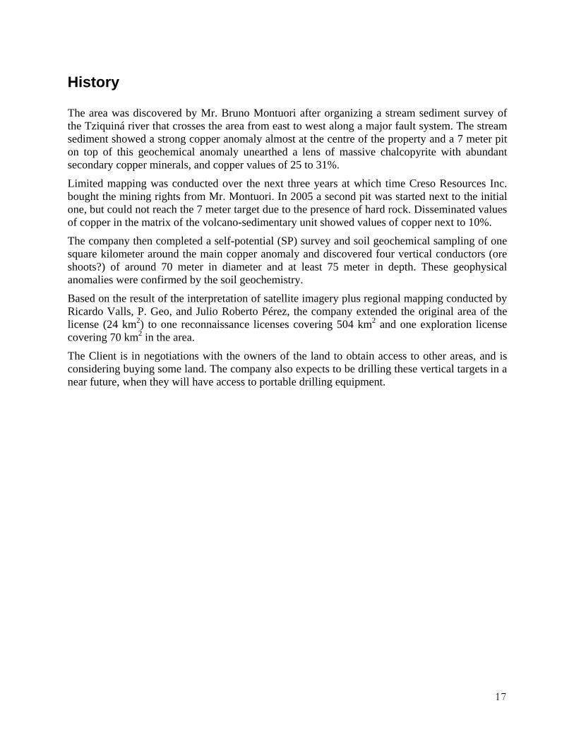
History The area was discovered by Mr. Bruno Montuori after organizing a stream sediment survey of the Tziquiná river that crosses the area from east to west along a major fault system. The stream sediment showed a strong copper anomaly almost at the centre of the property and a 7 meter pit on top of this geochemical anomaly unearthed a lens of massive chalcopyrite with abundant secondary copper minerals, and copper values of 25 to 31%.
Limited mapping was conducted over the next three years at which time Creso Resources Inc. bought the mining rights from Mr. Montuori. In 2005 a second pit was started next to the initial one, but could not reach the 7 meter target due to the presence of hard rock. Disseminated values of copper in the matrix of the volcano-sedimentary unit showed values of copper next to 10%.
The company then completed a self-potential (SP) survey and soil geochemical sampling of one square kilometer around the main copper anomaly and discovered four vertical conductors (ore shoots?) of around 70 meter in diameter and at least 75 meter in depth. These geophysical anomalies were confirmed by the soil geochemistry.
Based on the result of the interpretation of satellite imagery plus regional mapping conducted by Ricardo Valls, P. Geo, and Julio Roberto Pérez, the company extended the original area of the license (24 km2) to one reconnaissance licenses covering 504 km2 and one exploration license covering 70 km2 in the area.
The Client is in negotiations with the owners of the land to obtain access to other areas, and is considering buying some land. The company also expects to be drilling these vertical targets in a near future, when they will have access to portable drilling equipment.

18
Geological Setting
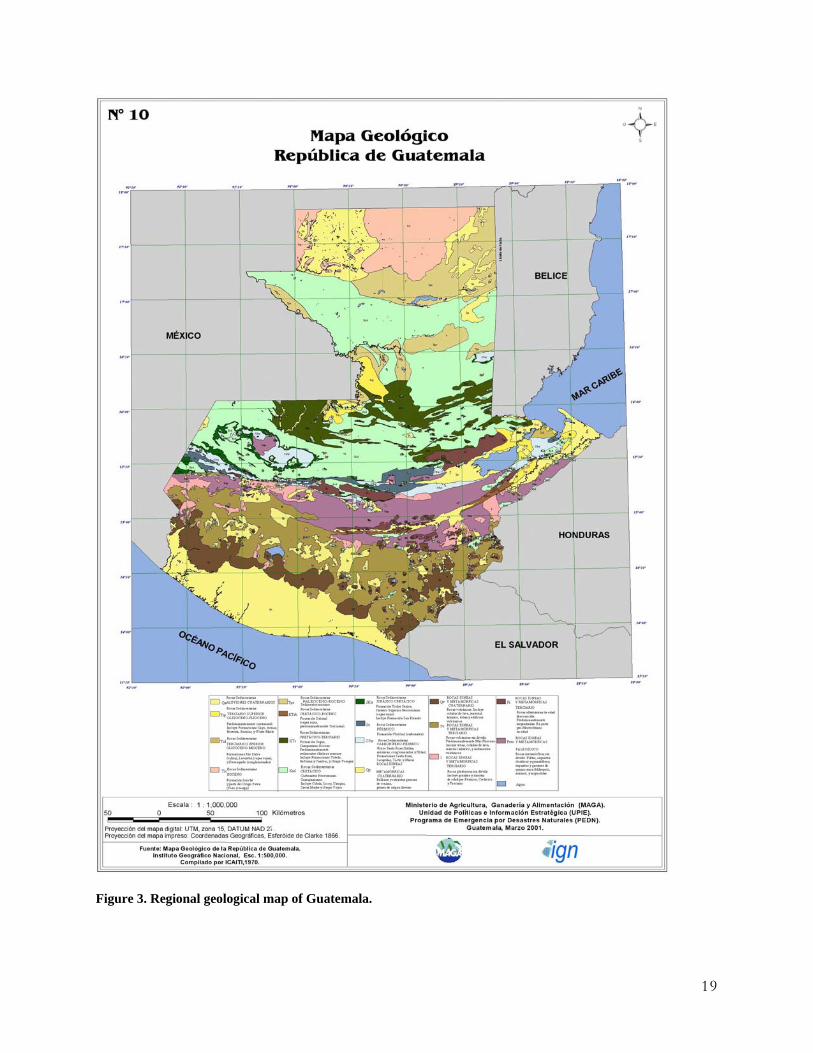
Regional Geology A map of the regional geology of Guatemala is presented in Fig. 3. The oldest rocks in the region are Paleozoic. They are mainly composed by schists and other metamorphic rocks of the Pre-Permian Chuacús Series (Fig. 4-A). Around 300 million years ago, during the Carboniferous, a deposition of marine sediments and conglomerates near the beach was followed by sandstones and shales at greater depths (Santa Rosa Group). Simultaneously, granitic and dioritic batholiths intruded the Paleozoic basement (Fig. 4-B).
During the upper Jurassic to the Lower Cretaceous Period, deposition of limestones and other carbonate rocks occurred (Todos Santos Formation). A hiatus of nearly 51 million years during the Triassic Period is present, when the sea retreated and no significant deposition occurred (Fig. 4-C).
Exposure of these rocks to oxidizing conditions in a tropical environment may account for the formation of the Upper Jurassic red beds (Pindell, 1994).
The Upper Cretaceous to Lower Tertiary Periods were very active, with the deposition of more clastic sediments, volcanoclastic deposits (Jalomáx Fm.), and the intrusion of granitic, dioritic, and ultramafic bodies corresponding to the Ixcoy, Cobán, Campur, and Verapaz Fms., and the Petén group. So far, five ophiolitic events that occurred along the major Polochic and Motagua Faults have been identified (Fig 4-D). These ultramafic bodies average 80 km in length and 0.2 to 20 km in width. They are generally formed by an heterogenic mix of websterites, lherzolites and dunites, with subordinate amounts of basalts and gabbros. Seawater and a heat source associated with the subduction event created a perfect environment to start the serpentinization of these rocks.
The Paleocene and Eocene Periods witnessed the deposition of more marine sediments, mainly conglomerates, near the shores and sandstones and shales at greater depths (Subinal Fm.). During the Eocene Period more red beds were formed, which indicates another period of sea-regression. This hiatus is characteristic of the entire Caribbean Plate (Fig. 4-E).
The Holocene formations are represented by Quaternary alluvial and deluvial material as well as by lavas and tuffs from active volcanoes (Guastatoya, Toledo, Desempeño, Lacantun, Caribe, Río Dulce, and other younger formations, Fig. 4-F).
19
Figure 3. Regional geological map of Guatemala.

20
Figure 4. Scheme of the Geological Evolution of Central Guatemala.

21
Figure 5 shows a regional geology of the Huehuetenango area, based mostly on airphoto interpretation.
0 50 100 Km
Figure 5. Regional geology of the Huehuetenango area (see legend in Fig. 3). Finally, Fig. 6 shows a preliminary stratigraphic column for the area, compiled from Millan, S. M. (1985) and the mapping efforts of P. Geo. Ricardo Valls. Undoubtedly, the stratigraphic column will change as we gain a better understanding of the geology of the area.

22
Figure 6. Stratigraphic column of the studied area.

23
Local Geology Only limited local mapping has been conducted to date, mostly by P. Geo. Ricardo Valls. The most important point was the discovery of a large tonalitic intrusive that could be the source of mineralization in the area (Fig. 7).
Figure 7. Outcrop of a tonalitic intrusive near Padre Antonio license. The current working geological model for the Padre Antonio license is shown in Fig. 8.
Figure 8. Current working geological model of the Padre Antonio license. Locally, sandstones with interbedded clays toped by limestones are in a fault contact with slates to the north of the Tziquiná River which occupies the trace of the fault. The discovery mineralization is contained entirely within the volcano-sedimentary unit associated to a highly tectonized zone in a reducing environment. The vertical pipe-like zones of conductivity discovered by the self-potential (SP) survey done by the Client are interpreted as mineralized breccias pipes.

24
Deposit Types
Sedimentary Copper Deposits
Capsule Description Stratabound disseminations of native copper, chalcocite, bornite and chalcopyrite in a variety of continental sedimentary rocks including black shale, sandstone and limestone. These sequences are typically underlain by, or interbedded with, redbed sandstones with evaporite sequences. Sulphides are typically hosted by grey, green or white strata.
Tectonic Settings Predominantly rift environments located in both intracontinental and continental-margin settings; they can also occur in continental-arc and back- arc settings.
Depositional Environment/Geological Setting The characteristic presence of redbed and evaporite sequences points to deposition of sediments in a hot, arid to semi-arid paleoclimate near the paleoequator. The host rocks are produced in a variety of local anoxic depositional environments, including deltaic sediments, Sabkha-type lagoonal carbonate basins or high intertidal mudflats, and shallow “coal basins”.
Age of Mineralization Proterozoic or younger; Middle Proterozoic, Permian and early Mesozoic most favourable ages.
Host/Associated Rock Types Most deposits are hosted by pale gray to black shale, but some are found in sandstone, siltstone, limestone, silt-rich dolomite, laminated carbonate units (sabkha origin) and quartzites. Favourable horizons contain reactive organic matter or sulphur. Algal mats, mudcracks and scour-and-fill structures indicative of shallow-water deposition are common. Local channel- conglomerate beds sometimes contain wood fragments. The associated sequence includes redbed sediments, evaporites and sometimes volcanics. In many cases the rift-related layered rocks rest unconformably on older basement rocks.
Deposit Form Orebodies are generally conformable with the bedding, although in detail ore may transgress bedding at low angles and is typically more transgressive near the margins of the deposit. Mineralized horizons are from tens of centimetres to several metres thick (rarely more than 5 m); they are often contained within broader zones of anomalous copper values. Tabular ore zones extend laterally for kilometres to tens of kilometres. Less commonly the deposits are elongate lobes. Some deposits have a C-shaped, “roll front” configuration in cross-section. Common lateral and/or vertical zoning is from hematite (barren) > chalcocite > bornite > chalcopyrite > pyrite, or from a chalcocite-bornite core grading to chalcopyrite with peripheral galena and sphalerite.

25
Texture/Structure Sulphides are fine grained and occur as disseminations, concentrated along bedding, particularly the coarser grained fractions, or as intergranular cement. Sharp-walled cracks or veinlets (< 1 cm thick, < than a metre in length) of chalcopyrite, bornite, chalcocite, galena, sphalerite or barite with calcite occur in some deposits, but are not an important component of the ore. Pyrite can be framboidal or colloform. Cu minerals often replace pyrite grains, framboids and nodules; less commonly they form pseudomorphs of sulphate nodules or blade-shaped gypsum/anhydrite grains. They also cluster around carbonaceous clots or fragments.
Ore Mineralogy (Principal and subordinate Chalcocite, bornite and chalcopyrite; native copper in some deposits. Pyrite is abundant in rocks outside the ore zones. Enargite, digenite, djurleite, sphalerite, galena, tennantite, native silver with minor Co-pyrite and Ge minerals. In many deposits carrollite (CuCo2S4) is a rare mineral, however, it is common in the Central African Copperbelt.
Gangue Mineralogy (Principal and subordinate Not well documented; in several deposits carbonate, quartz and feldspar formed synchronously with the ore minerals and exhibit zonal patterns that are sympathetic with the ore minerals. They infill, replace or overgrow detrital or earlier authigenic phases.
Alteration Mineralogy Lateral or underlying reduced zones of green, white or grey colour in redbed successions. In the Montana deposits these zones contain chlorite, magnetite and/or pyrite. Barren, hematite-rich, red zones grade into ore in the Kupferschiefer. Kupferschiefer ore hosts also show elevated vitrinite reflectances compared to equivalent stratigraphic units.
Weahering Surface exposures may be totally leached or have malachite and azurite staining. Near surface secondary chalcocite enrichment is common.
Ore Controls Most sediment-hosted Cu deposits are associated with the sag phase of continental rifts characterized by deposition of shallow-water sediments represented by redbed sequences and evaporites. These formed in hot, arid to semi-arid paleoclimates which normally occur within 20-30° of the paleoequator. Hostrocks are typically black, grey or green reduced sediments with disseminated pyrite or organics. The main control on fluid flow from the source to redoxcline is primary permeability within specific rock units, commonly coarse-grained sandstones. In some districts deposits are located within coarser grained sediments on the flanks of basement highs. Growth faults provide local controls in some deposits (e.g., Spar Lake).
Associated Deposit Types Sandstone U, volcanic redbed Cu, Kipushi Cu-Pb-Zn, evaporite halite, sylvite, gypsum and anhydrite, and natural gas (mainly CH4) in Poland.

26
Genetic Models Traditionally these deposits have been regarded as syngenetic, analogous to sedex deposits or late hydrothermal epigenetic deposits. Currently most researchers emphasize a two-stage diagenetic model. Carbonaceous shales, sandstones and limestones deposited in reducing, shallow subaqeuous environments undergo diagenesis which converts the sulphur in these sediments to pyrite. At a later stage during diagenesis, saline low-temperature brines carrying copper from a distant source follow permeable units, such as oxidized redbed sandstones, until they encounter a reducing unit. At this point a redoxcline is established with a cuperiferous zone extending “downstream” until it gradually fades into the unmineralized, often pyritic, reducing unit. The source of the metals is unresolved, with possible choices including underlying volcanic rocks, labile sediments, basement rocks or intrusions.
Exploration Guides
Geochemical Signature
Elevated values of Cu, Ag, Pb, Zn and Cd are found in hostrocks, sometimes with weaker Hg, Mo, V, U, Co and Ge anomalies. Dark streaks and specks in suitable rocks should be analysed as they may be sulphides, such as chalcocite.
Geophysical Signature
Weak radioactivity in some deposits.
Other Exploration Guides
Deposits often occur near the transition from redbeds to other units which is marked by the distinctive change in colour from red or purple to grey, green or black. The basal reduced unit within the stratigraphy overlying the redbeds will most often carry the highest grade mineralization.
Economic Factors
Typical Grade and Tonnage
Average deposit contains 22 Mt grading 2.1 % Cu and 23 g/t Ag (Mosier et al., 1986). Approximately 20% of these deposits average 0.24 % Co. The Lubin deposit contains 2600 Mt of >2.0% Cu and ~ 30-80 g/t Ag. Spar Lake pre-production reserves were 58 Mt grading 0.76% Cu and 54 g/t Ag. Montanore contains 134.5 Mt grading 0.74% Cu and 60 g/t Ag, while Rock Creek has reserves of 143.7 Mt containing 0.68 % Cu and 51 g/t Ag.
Economic Limitations These relatively thin horizons require higher grades because they are typically mined by underground methods. The polymetallic nature and broad lateral extent of sediment-hosted Cu deposits make them attractive.

27
Importance These deposits are the second most important source of copper world wide after porphyry Cu deposits. They are an interesting potential exploration target in British Columbia, although there has been no production from sediment-hosted Cu deposits in the province. The stratigraphy that hosts the Spar Lake, Montanore and Rock Creek deposits in Montana extends into British Columbia where it contains numerous small sediment-hosted Cu-Ag deposits.
Copper Porphyde Porphyry copper deposits provide more than 50% of the World’s copper from over 100 producing mines.
Form Typical porphyry copper deposits are cylindrical, stock-like composite masses having elongate outcrops, 1.5 x 2 km in diameter, with an outer shell of medium to coarse grained equigranular rock and a core of similar composition that is porphyritic.
Petrology of the Host Rocks The most common ore hosts are felsic plutonic rocks ranging in composition from quartz monzonite to tonalites.
Hydrothermal Alteration Lowell and Guilbert (1970) were the first to document alteration associated with porphyry copper deposits. They suggested that four alteration halos were often present, roughly centered on the porphyry stock (Fig. 9):
Figure 9. Typical hydrothermal alteration zoning patterns in a copper porphyry deposit.

28
Potassic Zone. Always present. Characterized by secondary K-spar, biotite and/or chlorite replacing primary K-spar, plagioclase, and mafics. Minor sericite may be present.
Phyllic Zone. Not always present. Characterized by vein quartz, sericite, pyrite, and minor chlorite, illite and rutile replacing K-spar and biotite.
Argillic Zone. Not always present. Characterized by the clay minerals kaolinite and montmorillonite with minor disseminated pyrite. Plagioclase is strongly altered, K-spar remains unaffected, and biotite is usually chloritized.
Propylitic Zone. Always present. Characterized by chlorite, calcite, and minor epidote. Mafic minerals are highly altered and plagioclase less so.
At depth all zones are thought to merge into a single quartz-K-spar-sericite-chlorite assemblage.
Hypogene Mineralization Ore is mostly found in three settings:
• totally within the host stock;
• partially in the stock and partially within the country rocks;
• within the country rocks only.
The ore body itself is usually a steep walled cylinder, but tabular to flat conical deposits are also known. The ore occurs as disseminations or stockwork veins with typical grades of 0.6% Cu and 0.2 % Au with lesser silver, zinc, and molybdenum. Mineralization is strongly zoned. The zones have been characterized as follows (Fig. 10):
Figure 10. Principal zones of sulphide mineralization for porphyry copper deposits.

29
Inner Zone. Coincides with the potassic alteration zone. Generally, it is several hundred meters in diameter. Relatively low sulfide content, but molybdenum is higher than anywhere else in the deposit. Pyrite is 2-5% and py/cp ratio is about 3:1. Mineralization is disseminated rather than stockwork.
Ore Zone. – The ore zone lies roughly at the potassic-phyllic boundary. Pyrite is 5-10% and py/cp ratio is about 2.5:1. The main ore mineral is chalcopyrite that occurrs as stockwork veinlets. Other ore minerals include bornite, enargite, and chalcocite.
Pyrite Zone. It includes much of the phyllic and argillic (if present) zones. Pyrite is quite high (10-15%) and py/cp ratio is about 15:1. Mineralization occurs both as veins and disseminations. Many additional exotic sulfide phases begin to show up.
Outer Zone. It coincides with the propylitic zone. Pyrite is minor and copper mineralization is rare. Sphalerite and galena are common, but usually sub-ore grade. Mineralization approaches true veins.
Breccia Zones. They are often major ore carriers in the porphyry system. The breccia zones have very high grades (2-5% Cu) and can occur both in the porphyry and in the country rock. They may be formed by hydrothermal activity, gravitational collapse, or late explosive volcanism.
Vertical Extent of Porphyry Bodies It has been suggested that porphyry deposits are associated with small, high level stocks and subaerial calc-alkaline volcanism. Thus, the pluton itself is overlain by a stratovolcano (Fig. 11). Propylitic alteration extends upward into the volcano. Other alteration zones close on themselves and die out in the subsurface. In general, this model attempts to show that the porphyry copper deposit is part of a larger system that includes higher-level epithermal precious metal deposits.
Figure 11. Model of the vertical extent of porphyry bodies.

30
Genesis The most striking feature of a typical porphyry system is its size. The hydrothermal solutions permeate not only the parent intrusive, but also the country rock. It is thought that the host intrusives are emplaced at shallow depth (0.5-2 km). As crystallization of the intrusive begins, the vapor pressure in the magma chamber rises, as does the streaming of incompatible elements into the vapor phase. When the vapor pressure exceeds the confining pressure of the overlying rocks, retrograde boiling ensues. A rapidly boiling liquid separates from the silicate melt, eventually overcoming the tensile strength of the rock.
This causes the extensive stockwork brecciation. (Example: water at 2 Kb pressure and 5000C would increase in volume by at least 10% due to boiling). Further, boiling is an endothermic reaction requiring heat that is taken up from the magma as the escaping vapor expands, thus rapidly lowering the temperature of the magma chamber and producing the central porphyritic textured intrusive body.

31
Mineralization
The geological environment of the Huehuetenango region is favorable for the location of Sedimentary type of copper, lead, and zinc deposits. The Company expects to find copper porphyde type of mineralization within the limits of the licenses. So far, the most interesting discovery lies north of Santa Eulalia village, where they have intersected in a 7 meters handmade pit, massive chalcopyrite associated with quartz veining (Fig. 12) and abundant disseminated secondary copper mineralization (bornite, coveline, cubanite, etc) in the matrix of the volcano- sedimentary unit that hosts the chalcopyrite.
Figure 12. Massive chalcopyrite associated to a quartz vein unearthed by a 7 meter pit over a copper anomaly at Padre Antonio license. An assay done to this massive chalcopyrite at the SGS labs resulted in 20.7% Cu. The assay certificate of SGS Laboratories is shown in Appendix 1.
A self-potential (SP) survey done by Consulting Geophysicist Juan Pablo Ligorria in May 2005 found several pipe-like vertical zones of conductivity as can be seen in Fig. 16. We interpreter that the chalcopyrite found in the pit corresponds to one of these vertical pipe-like zones of conductivity.
The complete report on the SP survey of the Padre Antonio Project (in Spanish language) is included in appendix 4.
Disseminated secondary copper sulphides intersected by the pit above the massive chalcopyrite may correspond to supergene enrichment.
Evidently this far the information that we have in the Padre Antonio Project, points towards a deposit model that is best typified by the sedimentary type rather than the porphyry type deposits.

32
Exploration The padre Antonio Project was discovered as a result of a limited active sediment survey done by Mr. Bruno Montuori. Some thirteen (13) samples were taken and send for assaying to BSi, Inc., laboratory. Multielement ICP and AA finished Fire Assay was used to analyze these samples. The results of the assays can be found in Appendix II and the sample location in Figure 13.
Figure 13. Discovery sampling location. The red square represents the location of the discovery pit. A seven (7) meter handmade pit found at the bottom massive chalcopyrite and secondary copper minerals (chalcocite, conellite, barnite, etc) above the massive primary mineralization. When the writer visited the site the pit was half full of water so it was not possible to observe the primary mineralization. Fig. 14 shows a photography of the pit. Notice the oxidized yellowish layer above and the volcanoclastic (sandstone) with disseminate secondary copper minerals. A quartzose brecciated material follows just above the water.
Creso Resources, Inc. of Montreal purchased the mining rights from Mr. Montuori and started gathering all available information on the geology and mining potential of the area.

33
Figure 14. Photograph of the discovery pit in Padre Antonio. Photogrametric and satellite image interpretation were commissioned to SatPhoto Inc. resulting in multiple alteration zones in the surroundings of the Padre Antonio Project (Fig. 15). Armed with a portable XRF pistol, geologists Ricardo Valls and Julio Pérez systematically tested the alteration zones near the Padre Antonio Project as shown in Fig. 16.
Figure 15. Satellite interpretation of alterations within the Huehuetenango District.

34
Many of the targets have been field checked by the client´s geologists and field determinations using the portable XRF equipment has confirmed the presence of copper, lead, zinc as well as traces of gold in surface samples. Photos of four of these zones of alteration with location coordinates and XRF results are included in Appendix III.
Figure 16. Geologist Julio Roberto Pérez measures the geochemical signature of an alteration zone using a portable XRF pistol. The Self-Potential survey of a 1 square kilometer around the pit that intersected the massive chalcopyrite identified several vertical conductors (ore shoots?) that correspond on surface with zone of incipient brecciation and a significant decrease in the grain size of the volcano-sedimentary unit (Fig. 17).

35
Figure 17. Carrot model of the mineralization at Padre Antonio according to the SP survey.
The SP survey was done by geophysicist Juan Pablo Ligorría during May of 2005. This survey found four vertical zones of conductivity deeper than 100 meters. Zone of conductivity A coincides with the discovery pit so it is deduced that the conductivity seems to be caused by primary sulphides. We have adopted Steven E. Bushnell (1988) breccia pipe model described in his paper “Mineralization at Cananea, Sonora, Mexico and the paragenesis and zoning of Breccia Pipes in Quartzofeldspathic Rocks (sic)” to explain the zones of conductivity.
Using the same grid the Client conducted a soil survey and a Soil Gas Hydrocarbon (SGH) test of the same area. The SGH results (Fig. 18) confirmed the presence of these vertical anomalies.

36
N
0 200 400 m
Figure 18. Results of the SGH survey over Padre Antonio.
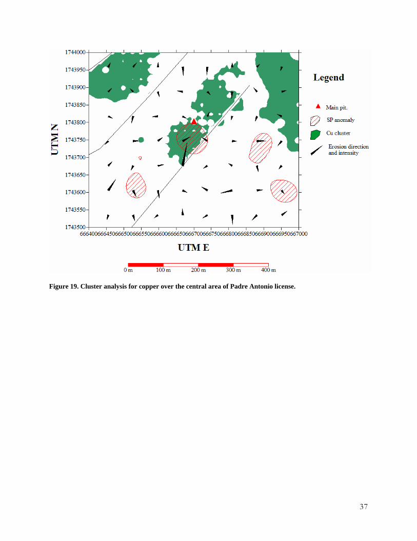
The soil survey was extremely useful for mapping and for confirming the geophysical targets. As you can see on Fig. 19, all the anomalies of the cluster analysis identifying copper targets are displaced downslope, but correspond unequivocally to the geophysical targets. Mobile elements such as Copper and Zinc are often displaced by topographic effects and ground water in tropical environments.
37
Figure 19. Cluster analysis for copper over the central area of Padre Antonio license.

38
Drilling
No drilling has been yet done at the projects, however the Client is planning to do the drilling
recommended in this report.

39
Sampling Method and Approach
All samples for the soil survey were taken from a standard depth of 10 cm using a shovel. The instrument was cleaned between samples. Samples weighting up to 500 grams were placed in properly marked Zipplog plastic bags and delivered by truck to BSi Laboratories in Guatemala for standard preparation and analysis.
Pulps were later on send to SGS Laboratories for the SGH study.

40
Sample Preparation, Analyses, and Security
Samples were prepared at BSi Laboratories in Guatemala, a lab with all the necessary certifications and the necessary equipment for this task. Analyses were completed at Reno by the same lab. The SGH study was conducted at SGS Laboratories in Canada. Both labs have the necessary certifications (Appendixes 5 and 6). Normal measures for the labeling, transportation, and handling of the samples was conducted by technical personnel with many years of experience on these activities.

41
Data Verification The author had the opportunity to test repeatedly the presence of mineralization in the area and in the main pit (which is now closed). Table 2 shows the results of three chanel samples taken from a second pit, located 2 metre east of the first one, as well as one additional sample (Sample number GG-1) which was collected from the bottom of the first pit by geologist Julio Luna in 2006. Sample GG-1 was analysed bt SGS Laboratories in Canada. Results of these samples are presented in Table 2. Table 2. Results of the independent sampling at Padre Antonio. Sample Cu, ppm Zn, ppm Au, g/t Ag, g/t As, ppm Mo, ppm S, %Meter 2 52.6 54,00 > 5 0.1 8,00 1.1 0.07Meter 3 4,00 34,00 > 5 0.1 4,00 0.6 0.17Meter 4 2440.8 97,00 > 5 1,00 34,00 27.8 2.58GG-1 268000,00 > 500 0.15 5.2 > 20 N.D. 26.7
These four grab sample results clearly demonstrate that there is copper and gold mineralization present in interesting and potentially significant tenors at the Padre Antonio property. The results do confirm the highly anomalous nature of the copper mineralization in the area, as reported by Julio Luna (2001) and Creso (2005).
While the author received sample GG-1 from Julio Luna, it is clear that the mineralization in it is geologically congruent with the type of deposit we expect to find in the area and therefore the author has no reason to believe that the sample did not come from the main pit.

42
Adjacent Properties The area of Huehuetenango has been known before for the presence of some lead-zinc-silver mines and copper showings. The location of these mines is shown in Figure 20 and Table 3 gives the characteristics of these mines.
Figure 20. Location of mines in the vicinity of Huehuetenango.
Table 3. Characteristics of the mines in Huehuetenango.
43
Mineral Processing and Metallurgical Testing This section is not applicable at this time.
44
Mineral Resources and Mineral Reserves Estimates This section is not applicable at this time.

45
Other Relevant Data and Information This section is not applicable at this time.

46
Interpretation and Conclusions
Let us summarize the evidence available from the Padre Antonio Project that will help the Client on investing in such a project. First, we have anomalous high copper values in sediment samples within the project area. Second, a seven (7) meter pit, hand dug at the location of the highest copper value, found chalcopyrite and disseminated secondary copper minerals. Third, a self-potential survey done over one square kilometer with the pit at the center, showed four (4) pipe-like zones of conductivity (The pit where the chalcopyrite was found is directly above the pipe-like zone of conductivity “A”). Forth, a SGH hydrocarbon survey confirmed the copper nature of the geophysical anomalies. Fifth, the interpretation of the satellite images clearly shows a large area of hydrothermal alteration that has been field tested by the author.
All the above summarized evidence, points out toward a sedimentary type of copper deposit that have pipe-like mineralized under the volcanoclastic unit in fault contact with the slates.
47
Recommendations
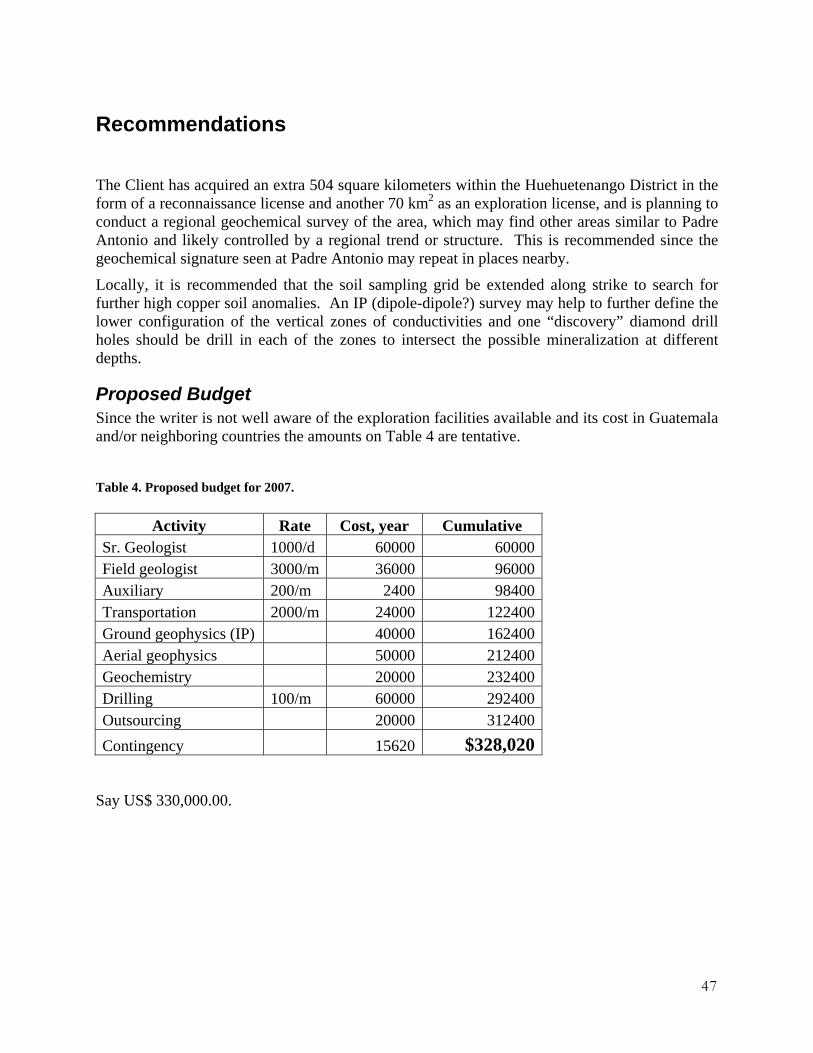
The Client has acquired an extra 504 square kilometers within the Huehuetenango District in the form of a reconnaissance license and another 70 km2 as an exploration license, and is planning to conduct a regional geochemical survey of the area, which may find other areas similar to Padre Antonio and likely controlled by a regional trend or structure. This is recommended since the geochemical signature seen at Padre Antonio may repeat in places nearby.
Locally, it is recommended that the soil sampling grid be extended along strike to search for further high copper soil anomalies. An IP (dipole-dipole?) survey may help to further define the lower configuration of the vertical zones of conductivities and one “discovery” diamond drill holes should be drill in each of the zones to intersect the possible mineralization at different depths.
Proposed Budget Since the writer is not well aware of the exploration facilities available and its cost in Guatemala and/or neighboring countries the amounts on Table 4 are tentative.
Table 4. Proposed budget for 2007.
Activity Rate Cost, year Cumulative Sr. Geologist 1000/d 60000 60000Field geologist 3000/m 36000 96000Auxiliary 200/m 2400 98400Transportation 2000/m 24000 122400Ground geophysics (IP) 40000 162400Aerial geophysics 50000 212400Geochemistry 20000 232400Drilling 100/m 60000 292400Outsourcing 20000 312400Contingency 15620 $328,020
Say US$ 330,000.00.

48
References Lowell, J.D. and Guilbert, J.M. “Lateral and Vertical Alteration -- Mineralization Zoning in Porphyry Ore Deposits.” Econ. Geology 65.4 (1970): 373-408. Republished in its entirety in Hutchison and Ross Benchmark Volumes edited by W.C. Lacy on Exploration Geology (1982).
Luna, Julio R. et al (c. 2001), Geological and Mining Report on the “Padre Antonio” exploration license, Santa Eulalia, Huehuetenango, Guatemala.
Ministry of Energy, Mines and Petroleum Resources of British Columbia, Canada, 2007, Deposit Types/Mineral Deposit Profiles, Sedimented-hosted Cu deposits, http://www.em.gov.bc.ca/Mining/Geolsurv/MetallicMinerals/MineralDepositProfiles/profiles/e04.htm
Pindell, James L., 1994, Evolution of the Gulf of Mexico and the Caribbean. Caribbean Geology: An introduction.
Valls Alvarez, R. A., 2005. Reporte Anual. Tercer Año de Exploración en Padre Antonio, 20 pp, MEM of Guatemala.
Valls Alvarez, R.A., 2007. Geology and Geochemical Evolution of the Ophiolitic Belts in Guatemala. A Field Guide to Nickel Bearing Laterite, Valls Geoconsultant, ISBN 1-896664-26-1, 219 pp,

49
Additional Requirements for Technical Reports on Development Properties and Production Properties This section is not applicable.

50
Date and Signature Page
To Accompany the Report titled “The Padre Antonio Copper Project Huehuetenango, Guatemala”
for Creso Resources Inc. July 20th, 2007
I, Ricardo A. Valls, P. Geo, do hereby certify that: 1. I am currently employed as a consultant by: Nichromet Extraction Inc. 2500-120 Adelaide Street West, Toronto, Ontario, Canada M5H 1T1 2. I am a Professional Geologist in the Provinces of Quebec and Ontario, member of the
Ordre des Géologues du Québec under the category of Geologist (416), as well as a member of the Association of Professional Geoscientists of Ontario (0160), the Geological Association of Canada (A6129), the Mineralogical Association of Canada, the Association of Exploration Geochemistry, the International Association of Applied Geochemistry, the Prospectors and Developers Association of Canada, the Canadian Institute of Mining, Metallurgy, and Petroleum, the Prospectors and Developers Association of Canada, the Society of Economic Geologists, and the Asociación de Ingenieros de Minas, Metalurgistas y Geólogos de México.
3. I graduated 1983 from the Moscow Institute of Mineral Prospecting in Moscow, Russia, with a degree in Mining Engineer and Geologist, and in the same year I obtained the degree of M.Sc. in Economic Geology, and I have practiced my profession continuously for 24 years.
4. Since 1983 I have been involved in various projects world-wide (Canada, United States, Africa, Russia, Argentina, Haiti, Cuba, and Central America.). Projects included regional reconnaissance to local mapping, diamond drilling and RC-drilling programs, open pit and underground mapping, geochemical sampling and other exploration techniques pertaining to the study of Nickel-Cobalt Laterite deposits, and the search for diamonds, P.G.M., R.E.E., gold, silver, base metals, industrial minerals, oil & gas, and other magmatic, hydrothermal, porphyritic, VMS and SEDEX ore deposits.
5. I have read the definition of “qualified person” set out in National Instrument 43-101 (“NI 43-101") and certify that by reason of my education, affiliation with a professional association (as defined in NI 43-101) and past work experience, I fulfill the requirements to be a “qualified person” for the purpose of NI 43-101.

51
6. I am presently a Consulting Geologist and have been so since September, 1983. 7. Since 2006, I have visited the area described in this report in several occasions for the
purpose of geological mapping, examination of pits, resampling to verify the presence of Nickel-Cobalt mineralization, verify survey coordinates of pits, and to review and collect necessary information to complete this report.
8. I am responsible for the preparation of the technical report titled The Padre Antonio Copper Project Huehuetenango, Guatemala and dated on July 20th, 2007 (the “Technical Report”) relating to the studied area.
9. I have had prior involvement with the licenses that are the subject of the Technical Report.
10. In the disclosure of information relating to permitting, legal, title and related issues I have personally confirmed the claims of the Client with respect to the ownership of the license.
11. In the disclosure of environmental and related issues I have relied, and believes that he has a reasonable basis to rely, on information provided to me by personnel from Guatemala Copper, S.A.
12. I am not aware of any material fact or material change with respect to the subject matter of this technical report which is not reflected in the report, the omission to disclose which would have made this technical report misleading.
13. I am a Qualified Person for Creso Resources Inc. in accordance with the application of Section 1.5 of NI 43-101.
14. I have read NI 43-101, the CIM definitions and guidelines for Mineral Resources Estimation and Form 43-101F1, and the Technical Report has been prepared in compliance with that instrument, guidelines, and form.
15. I consent to the filing of the Technical Report with any stock exchange and other regulatory authority and any publication by them, including electronic publication in the public company files on its web site accessible to the public, of the Technical Report.
Dated this 20 Day of July, 2007. _________________________________ Signature of Qualified Person (s) Ricardo A. Valls Name of Qualified Person

52
Appendix I. Assay of Massive Chalcopyrite

53
Appendix II. Assays of Discovery Samples. Sample Au Ag Al As B Ba Bi Ca Cd Co
ppb ppm % ppm ppm ppm Ppm % ppm ppm MPA-001 13 -0.1 0.9 -2 21 49 5 0.55 1.4 7 MPA-002 15 -0.1 0.85 4 29 48 5 0.38 1.7 8 MPA-003 5 -0.1 0.92 6 31 63 5 0.11 1.8 10 MPA-004 8 -0.1 0.89 14 34 22 4 0.16 2 13 MPA-005 9 -0.1 0.58 -2 53 31 4 0.07 2.6 6 MPA-006 4 -0.1 0.82 -2 23 55 4 0.12 1.4 7 MPA-009 3 0.2 0.87 3 20 126 -1 2.14 1.3 8 MPA-010 20 2.4 0.34 17 39 21 6 10 2.8 180 MPA-015 14 -0.1 0.16 -2 173 39 10 0.05 7.8 2 M01A 25 -0.1 0.87 61 49 155 38 0.32 12.2 445 M01B 11 -0.1 1.23 26 25 60 19 1.2 5.4 137 M02A 4 -0.1 1.73 10 21 34 10 0.31 3.4 15 M02B 4 -0.1 1.07 2 20 25 8 0.46 3 10 M03A -2 -0.1 0.96 2 16 99 6 0.33 1.7 9 M03B 26 -0.1 1 3 17 104 6 0.81 1.7 10 M04A 22 -0.1 2.2 7 23 53 12 0.19 4 15 M04B 10 -0.1 2.19 7 22 41 11 0.19 3.7 14 M05A 10 -0.1 1.16 -2 17 73 6 0.36 1.9 9 M05B 21 -0.1 1.05 -2 16 63 5 0.62 1.6 7 M08A 24 -0.1 0.52 15 13 42 4 2.29 1.3 12 M08B 33 -0.1 0.41 5 19 35 10 5.21 3.2 4 M09A 21 -0.1 0.38 5 13 36 3 10 0.6 3 M09B 7 -0.1 0.59 -2 13 30 3 2.36 0.9 4

54
Sample Cr Cu Fe Hg K La Mg Mn Mo Na
ppm ppm % ppm % ppm % ppm ppm % MPA-001 101 10 1.27 -1 0.43 4 0.45 351 10 0.01 MPA-002 49 18 1.84 -1 0.42 -2 0.35 376 2 0.01 MPA-003 34 18 1.94 -1 0.35 4 0.33 408 2 -0.01 MPA-004 25 13 2.08 -1 0.29 -2 0.35 144 1 -0.01 MPA-005 47 8 3.1 -1 0.46 5 0.46 173 8 -0.01 MPA-006 59 11 1.48 -1 0.53 3 0.34 338 5 -0.01 MPA-009 25 86 1.23 -1 0.71 3 1.33 509 -1 0.03 MPA-010 7 4338 2.48 -1 0.42 -2 2.19 1808 35 0.03 MPA-015 4 -1 6.53 -1 0.15 -2 0.03 196 -1 -0.01 M01A 44 8705 7.49 -1 -0.01 3 0.28 5498 12 0.01 M01B 21 819 4.75 -1 0.44 -2 0.66 1075 2 0.01 M02A 40 55 3.83 -1 0.34 -2 0.62 364 -1 0.01 M02B 64 18 3.51 -1 0.31 -2 0.44 379 5 0.01 M03A 82 18 2.36 -1 0.37 5 0.47 140 2 -0.01 M03B 114 14 2.28 -1 0.43 5 0.43 142 9 0.01 M04A 29 40 4.02 -1 0.33 -2 0.59 521 -1 0.02 M04B 25 22 3.85 -1 0.31 -2 0.62 333 -1 0.02 M05A 91 2 2.53 -1 0.52 14 0.83 770 2 0.01 M05B 73 18 2.12 -1 0.5 10 0.9 313 5 0.01 M08A 43 37 1.66 -1 0.47 -2 0.29 294 2 0.01 M08B 47 33 3.2 -1 0.76 -2 1.39 1184 4 0.02 M09A 12 4 0.95 -1 1.96 -2 0.76 297 -1 0.01 M09B 64 1 1.37 -1 0.5 5 1.51 509 5 0.01

55
Sample Ni P Pb Sn Se St Ti Th V W Zn
ppm ppm ppm ppm ppm ppm % ppm ppm ppm ppm MPA-001 15 194 9 -2 -2 8 -0.01 -0.5 15 -1 37 MPA-002 25 233 6 -2 -2 7 -0.01 -0.5 7 -1 34 MPA-003 27 254 8 -2 -2 6 -0.01 -0.5 10 -1 44 MPA-004 26 258 10 -2 -2 5 -0.01 -0.5 6 -1 42 MPA-005 15 114 6 -2 -2 -2 -0.01 -0.5 17 -1 27 MPA-006 19 162 4 -2 -2 5 -0.01 -0.5 9 -1 29 MPA-009 21 197 4 -2 -2 9 -0.01 -0.5 9 -1 32 MPA-010 32 132 30 -2 -2 31 -0.01 -0.5 -2 -1 66 MPA-015 -1 103 4 -2 -2 -2 0.02 -0.5 17 -1 5 M01A 117 448 84 2 -2 15 -0.01 6.4 10 -1 93 M01B 53 428 47 -2 -2 16 -0.01 1.3 10 -1 47 M02A 31 443 3 -2 -2 11 -0.01 -0.5 14 -1 37 M02B 21 268 2 -2 -2 12 -0.01 0.6 9 1 28 M03A 22 294 3 -2 -2 10 -0.01 -0.5 15 -1 36 M03B 22 271 3 2 -2 11 -0.01 -0.5 16 1 31 M04A 35 402 2 -2 -2 29 -0.01 0.8 18 -1 53 M04B 37 367 3 -2 -2 30 -0.01 -0.5 18 -1 48 M05A 19 217 4 -2 -2 11 -0.01 -0.5 18 -1 38 M05B 16 313 1 -2 -2 12 -0.01 -0.5 12 -1 33 M08A 12 315 2 -2 -2 45 -0.01 -0.5 4 -1 17 M08B 8 490 1 -2 -2 193 -0.01 0.7 4 -1 8 M09A 6 223 -1 -2 -2 387 -0.01 -0.5 3 -1 8 M09B 9 231 -1 -2 -2 14 -0.01 -0.5 8 -1 17

56
Appendix III. XRF results of zones of alteration.
Granitoid Pologua UTM E: 0660273 UTM N: 1661774 Elevation: 2763 m 317,318,319
Alteration zone with argillites (I) UTM E: 0637335 UTM N: 1751997 Elevation: 1007 m 321- green alteration 322- purple alteration
Red soil alteration from Cobán limestones in contact with altered lutites. (II) UTM E: 0642755 UTM N: 1753760 Elevation: 1662 m 323

57
Red soils (III) UTM E: 0643485 UTM N: 1753530 Elevation: 1781 m 324- red soil 325- alteration zone
Alteration zone (IV) UTM E: 0645457 UTM N: 1753214 Elevation: 2014 m 326,- purple colour 327- green colour 328- green-yellowish colour
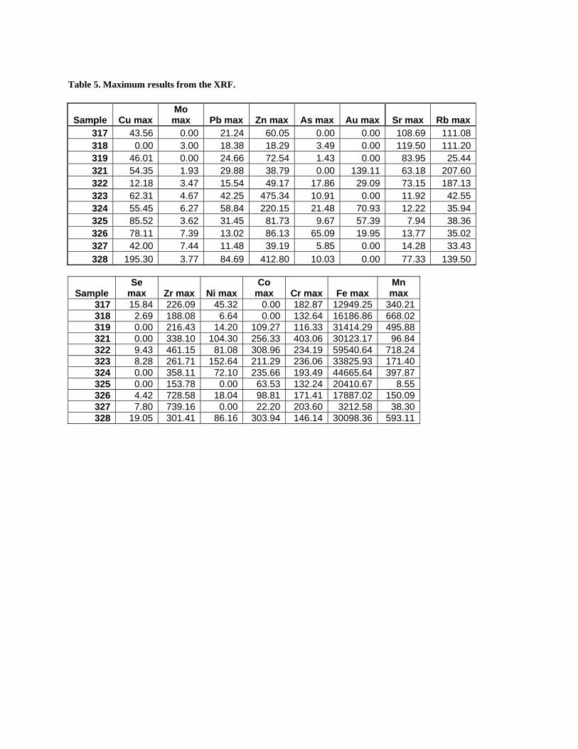
Table 5. Maximum results from the XRF.
Sample Cu max Mo max Pb max Zn max As max Au max Sr max Rb max
317 43.56 0.00 21.24 60.05 0.00 0.00 108.69 111.08318 0.00 3.00 18.38 18.29 3.49 0.00 119.50 111.20319 46.01 0.00 24.66 72.54 1.43 0.00 83.95 25.44321 54.35 1.93 29.88 38.79 0.00 139.11 63.18 207.60322 12.18 3.47 15.54 49.17 17.86 29.09 73.15 187.13323 62.31 4.67 42.25 475.34 10.91 0.00 11.92 42.55324 55.45 6.27 58.84 220.15 21.48 70.93 12.22 35.94325 85.52 3.62 31.45 81.73 9.67 57.39 7.94 38.36326 78.11 7.39 13.02 86.13 65.09 19.95 13.77 35.02327 42.00 7.44 11.48 39.19 5.85 0.00 14.28 33.43328 195.30 3.77 84.69 412.80 10.03 0.00 77.33 139.50
Sample Se
max Zr max Ni max Co
max Cr max Fe max Mn max
317 15.84 226.09 45.32 0.00 182.87 12949.25 340.21 318 2.69 188.08 6.64 0.00 132.64 16186.86 668.02 319 0.00 216.43 14.20 109.27 116.33 31414.29 495.88 321 0.00 338.10 104.30 256.33 403.06 30123.17 96.84 322 9.43 461.15 81.08 308.96 234.19 59540.64 718.24 323 8.28 261.71 152.64 211.29 236.06 33825.93 171.40 324 0.00 358.11 72.10 235.66 193.49 44665.64 397.87 325 0.00 153.78 0.00 63.53 132.24 20410.67 8.55 326 4.42 728.58 18.04 98.81 171.41 17887.02 150.09 327 7.80 739.16 0.00 22.20 203.60 3212.58 38.30 328 19.05 301.41 86.16 303.94 146.14 30098.36 593.11

59
Table 6. Minimum results from the XRF. Sample Cu Mo Pb Zn As Au Ni Zr
317 8.10 0.00 8.35 24.73 0.00 0.00 0.00 208.48318 0.00 0.00 2.87 0.00 0.00 0.00 0.00 167.59319 7.90 0.00 11.41 33.80 0.00 0.00 0.00 198.41321 8.21 0.00 13.78 0.00 0.00 9.45 0.00 315.12322 0.00 0.00 0.00 4.59 0.00 0.00 433.70323 11.42 0.86 23.54 408.42 0.00 0.00 36.68 238.52324 9.17 2.60 41.01 167.91 7.02 0.00 0.00 334.98325 41.18 0.57 16.48 38.51 0.00 0.00 0.00 136.65326 34.93 3.39 43.62 51.29 0.00 0.00 699.95327 3.66 3.60 1.72 0.00 0.00 0.00 711.47328 140.63 0.23 63.91 352.80 0.00 0.00 0.00 278.77
Sample Co Cr Fe Mn Sr Rb Se
317 0.00 41.50 12577.51 216.60 101.26 102.76 2.07 318 0.00 0.00 15692.32 489.81 110.23 101.11 0.00 319 0.00 0.00 30819.72 335.28 77.02 20.32 0.00 321 33.35 195.56 29478.20 0.00 56.27 194.63 0.00 322 0.00 0.00 58581.16 479.87 65.32 173.98 0.00 323 0.00 19.51 33057.96 0.00 7.55 35.02 0.00 324 0.00 0.00 43879.97 206.85 8.23 29.41 0.00 325 0.00 0.00 19894.64 0.00 4.49 32.02 0.00 326 0.00 6.61 17410.50 18.85 9.89 29.00 0.00 327 0.00 57.81 3000.05 0.00 10.55 27.86 0.00 328 76.27 0.00 29442.70 404.81 69.74 128.59 0.60

Figure 21. Location of alteration zones.

61
Appendix IV. Certificate of BSi

62
Appendix V. Certificate of SGS.

63

64
The Padre Antonio Copper Project Huehuetenango, Guatemala
Creso Resources Inc.
1325-1801 McGill College Ave, Montreal, Quebec H3A 2N4
Canada
Limited edition: 10 units