integrated methods for the determinations of corrosivity, aging

REPORT ON THE HISTORICAL ANDARCHEAOLOGICAL SURVEY FOR THEMELTON EAST STRUCTURE PLAN STUDYAREA_
Gary Vines
Melbourne's Living Museum of the West Inc.P.O. Box 60 Highpoint City 3032
September1990
1

CONTENTS
1. BACKGROUND
1.1 Study area
2. ENVIRONMENT
2.1 Volcanic Plains2.2 Water courses
3. ARCHAEOLOGICAL CONTEXT
3.1 Previous archaeological work3.2 Sites previously recorded in the study area3.2 Sites previously recorded in the study area3.3 Regional context3.4 Western Region Aboriginal site prediction model3.5 Historical context
4. ETHNOHISTORY AND HISTORY
4.1 Aborigines4.2 Europeans
5. SURVEY METHOD
6. SURVEY RESULTS
6. 1 Site location6. 1. 1 Aboriginal Sites6.1.2 Historical sites
7. DISCUSSION
7.i Site location7.2 Site significance
8. CONCLUSION
REFERENCES
APPENDIX A Extracts of 1:5000 MMBW plans showing Aboriginal andhistoric sites recorded in this study.
2

1. BACKGROUND
As part of the first stage of a local structure plan of theMelton East area, the consultant was employed by GutteridgeHaskins and Davey Pty Ltd to make an assessment of the historicaland archaeological resources within the study area. This was tobe a preliminary survey involving a review of literature relatingto the study area and a brief field survey to identify in greaterdetail the European and Aboriginal sites in the study area.
The consultant completed a review of literature relating to thestudy area including the previous archaeological survey reportsprepared for the Victoria Archaeological Survey. Additional fieldsurvey was completed which resulted in the recording of anadditional seven aboriginal sites and several features relatingto early European settlement of of the area. The aborigianlsites have not yet been al located numbers from the VictoriaArchaeological Survey Site Register and so have been giveninterim numbers pending registration.
The existing site prediction model for aboriginal sites wasestablished in several previous studies forms the basis forfurther survey and delineation of areas of archaeologicalsensitivity. The Aboriginal sites recorded in this study areconsistent with the pattern of previously recorded sites and theestablished predictive model.
1.1 Study area
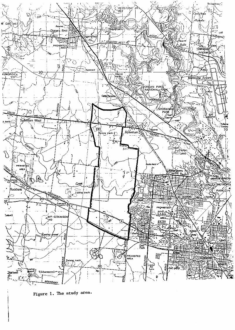
The study area is bounded on the south by the Ballarat railwayline; on the west by Clarke's Road, Managham's Road, CrownAllotmant 15 section B, the residential subdivision south ofKeilor Melton Road and the high voltage transmission line; on thenorth by the natural watershed and Bendigo railway line; and onthe east by boundary of the shire of Melton. The study area isshown on Fig. i.
3
KORORorr..b.
~+-~2-'-. J •iJf
• : j,
'_!/~S.~:::!
\,IJ ,
I. \
~.
..
..
,
--! ~- ----.,:
Qee/< i-J_ _.L
:r.,---
j". : (
Figure 1. The study area.
2. ENVIRONMENT
The study area comprises two main landscape units: the Volcanicplains and the drainage lines or watercourses. These landscapeunits have been established on the basis of geology,physiography, soil formation, vegetation, fauna and hydrology.These factors are relevant in assessing the pre-Europeanenvironment and resources available to Aboriginal occupants.Landscape units in the study area are shown in Fig 2.
2.1 Volcanic Plains
The volcanic plains of Melbourne's West were formed between 1 and5 million years ago by effusive eruption from many lava vents.Evidence of these flows can be seen in ridges which were formedby lava tongues and low conical mounds around the vents. Althoughno eruption points are within the study area the point known asRutland Square immediately to the north was such a vent and isresponsible for the general sDuth facing slope. Irregularities inthe surface of the lava flows formed depression swamps whileerosion on slopes and higher ground resulted in a rocky groundsurface where harder material resisted erosion. (Rosengren 1986)
The original vegetation of the area can be reconstructed fromsurveyor's maps and a few areas of remnant vegetation. Thisevidence suggests that the volcanic plains in the study area wereoriginally thinly wooded, possibly supporting isolated stands ofCasuarina with Eucalyptus camaldulensis along the watercouses.The plains were, however, predominantly covered in tal I grassessuch as Themeda australis (Kangaroo grass) and Stipa spp. (Speargrass). (McDougall 1987)
These plains provided Aborigines with staple foods such asMicroseris scapigera (Murnong or Yam Daisy) as wei I as edibleroots, leaves and fruit from plans associated with the sparsewoodland. Cumbungi and ephemeral swamp dwelling species may havebeen exploited on a seasonal basis. Game was attracted by theabundant grass land and in particular by fresh growth whichAborigines are said to have promoted by seasonal burning (firestick farming) Animals included kangaroos, wombats, smallmarsupials and reptiles. The swamps were the habitat of eels,fish and numerous water birds.
4

Figure 2. Landscape units in the study area.
I
IiII
:::r:U1
\.:;::::./ w If':::::::::-::::1- _o 0:::
I-..J
W
-1 1/ I"
Volcanic PlainsWater Courses
-- l ~~--- -- ;:
(
I (
•

2~2 Yater courses
The principal water course through the study area is KororoitCreek. Tributaries of the creek branch off to the north atregular intervals. The main branch has many permanent waterholeswhile the tributaries are usually dry except during and shortlyafter rainfal I.
The Creek has eroded a shallow, narrow valley about 20 metresdeep. Rock outcrops are common along the valley sides and smal Iareas of alluvial soil are evident in wider parts of the creekval ley.
Riparian species along the creek banks provided considerableresources for Aborigines. Some species of reed and bul1rush couldbe processed for food and reeds also provided material fortools and implements, such as string or binding for haftingspear~~ Fish t freshwater mussels, waterbirds and small mammalswould have provided a rich food resource. Suitable stone forfashioning tools was available in isolated outcrops such as thesilcrete deposits in nearby Green Gul ley and in Sydenham Park.Silcrete wag a common raw material in many artifact scatters inthe study area. Other material such as quartz and quartzite wasavailable from creek and river pebbles. (duCross 1990, Rosengren1986)

3. ARCHAEOLOGICAL CONTEXT
3.1 Previous archaeological work
Until early 1989 very little systematic archaeological survey hadbeen carried out in the study area or on the Keilar or WerribeePlains. Since then archaeological surveys have been carried outin conjunction with proposed developments and a regional study ofMelton, Werribee and Bacchus Marsh. Chance finds by interestedamateurs are also recorded for the general area. Since some typesof Aboriginal artifacts are highly visible and have a percievedvalue (eg. ground edge axe heads) and the lesser artifacts suchas flakes are highly visible due to their contrasting colour andtexture among the monotonous basalt of the plain, it is likelythat many artifacts have already been removed from the easilyacessible sites. Collection of disturbance of of artifacts orarchaeological materials is now il legal without a permit underthe Archaeological and Aboriginal Relics Act 1972. Previouslysurveyed sections of the study area are shown in Fig. 5.
3.2 Sites previously recorded in the study area
Until the current survey a total of 35 sites had been recorded inthe study area. These sites consist of 22 artifact scatters ofvarying size and 11 isolated artifacts close to the KororoitCreek VAS ~ 7822/118,187,230-254,342,396-401. The majority ofthese sites were found as a result of very intensiveinvestigations along the section of the creek on the eastern-mostedge of the study area. Two sites were located on tributaries ofKororoit Creek (VAS 7822/402-3). All previously recorded sitesoccurred in the water courses landscape unit.
A systematic survey of a proposed subdivision for residential useimmediately west of Robinson's Rd. revealed that one site (VAS~7822/118) previously recorded by Presland, (1983) was moreextensive and significant than first thought. Detailed recordinghas demonstrated that the artifacts were exceptional because ofthe clustering and discrete concentration of archaeologicalmaterial (Egloff 1988). Egloff also noted that the majority ofartifacts were not flaked on site, as he recorded only a smallnumber of cores and debitage flakes. The site dates from around5,000 to 2,000 years ago or more recent and a Subinella undulatashel I was present, 15 km from the coast.
Stage 2 and Stages 3 to 7 of this development were also surveyed,(du Cros 1989c) resulting in an additional 25 sites being recorded(VAS ~7822/230-354) These varied from large artifact scatterswith extensivs manufacturing floors to isolated artifacts.
6

3.3 Regional context
A number of major studies have been conducted in the vicinity ofthe study area which provide a clear regional context for thearchaeological and historical sites in the study area.
In 196Z The Mel~RHFn~ "~tFRDRIJt~n AF~~ ~HF¥~¥ W~~ Hn~~Ft~~~n ~¥the Victoria Archaeological Survey to assess the remainingarchaeological resources within the metropolitan area. Extendingto the western boundary of the Melton East study area, the studylocated 19 sites along Kororoit Creek between Forest St. Albionand Robinson's Rd. Deer Park. (VAS #762Z/I00-118) (Presland 1983)
The second phase of the Melbourne Metropolitan survey covered theShires of Bacchus Marsh and Melton and the City of Werribee.(du Cros 1989a). This was a large scale survey which covered theMelton East area. Seven sites were located along Kororoit Creekin or near the study area including some flaked glassdemonstrating that the sites contemporaneous with EuropeanSettlement, ie. contact sites. Other sites recorded more distantfrom the study area included silcrete quarries for the rawmaterial used by Aborigines to fassion their tools and extensiveartifacts scatters on the higher ground of several volcaniceruption points such as Mt. Cottrell. (du Cross 1989a)
A survey of the Albion Explosive Factory site downstream of thestudy area on Kororoit Creek revealed a further 11 artifactscatters on the banks of Kororoit and Jones Creeks (VAS#7622/331-341), (Vines 1988). Therefore a total of 62 sites havebeen identified on Kororoit Creek between Ardeer and Rockbank.
Archaeological work along the nearby Maribyrnong Valley hasrevealed a large number of sites on the river banks and up thevalley escarpment. These have been found in small isolatedsurveys (Keys and Keys 1977; du Cros and Goulding 1989) and twolarge projects for the Board of Works (Bell and Presland 1977;Rhodes and du Cros 1969).
Site recording and a watching brief for the Keilor By-passresulted in the recording of two sites on the top of the val leyescarpment (VAS #7822/67,68) and at the southern end of Brimbankpark a large site was recorded as part of the Metropolitan RingRoad (VAS #7822/268) (du Cros and Goulding 1989).
The Upper Maribyrnong River Study (Rhodes and du Cros 1989) hasrecently located 50 sites (VAS #7822/346-395) including 44artifact scatters, Z scarred trees and 4 quarries. Among thesesites were well preserved artefact manUfacturing floors andcampsites. Four silcrete quarries hav8 also been recorded belowthe Maribyrnong Valley escarpment (VAS #7822/371,381,391,396)with one site having a spectaCUlar collection of all grades andcolours of silcrete.
Well known excavations on the Maribyrnong River terraces haveuncovered evidence of very early human actiVity. In 1940 a skillwas discovered by a quarry worker and was dated to 15,000 uearsbefore present which was considered a very early date for anAustralian site at the time (Simmons 1978)
7
Near by on Dry Creek, a trubutary of the Maribyrnong, Dr Gal Iusbegan excavation of river sediments in the 1960s which revealedevidence of occupation dating back nearly 30,000 years (Presland1983) The artifacts Gal Ius unearthed were associated with remainsof extinct fauna.
Another more recent site in Green Gully was excavated andrevealed an Aboriginal burial dated to about 6460 years ago.Mulvaney 1970; Wright 1979) The artifacts associated with thisburial were similar to those fram anotther late Holocene burialsite on the Werribee River. (du Cros 1989a) These sites appear torepresent an earlier quartz artifact industry in the region whichlater gave way to a "mixed" industry employing quartz, quartzitesilcrete and other materials. This industry is typical of themore recent surface scatters found throughout the region(Fullagar 1980).
3.4 Western Region Aboriginal site prediction model
From the several studies carried out in the region over the lastfew years a predictive madel for site location has beenestablished. SUbsequent testing of this model through furthersurvey and excavation has fundamentally supported the model. Thepredictions include:
i. Burials, artifacts scatters, isolated artifacts andscarred trees wil I be found on river or creek flats, terraces orslopes within 100 metres of a major watercourse. ie. wherepermanent water is found.
2. Artifact sc~tters, isolated artifacts and scarredtrees are likely to be found close to larege or permanent swampsand lakes on the volcanic plains.
3. Sources or outcrops of silcrete and metamorphic stoneare likely to have been quarried by Aborigines, if they wereexposed 150 years or more age.
4. Fresh water shel I middens are likely along theterraces of the major rivers ie. where no ploughing ofdisturbance has occurred.
5. Sites with extensive sub-surface archaeologicaldeposits are most likely in areas with best preseervation indepositional rather than erosional environments, ego in caves,rock shelters or undisturbed river terraces.
6. Conta~t sites are most likely to be located close toold homesteads of provisioning points. However, it is likely thatsome Aboriginal groups wantin to avoid European contact campedsome distance away in remote or isolated places.
8

3.5 Historical context
Parts of the study area retain a rich resource of earlyhi~t~fip.l ~it~~ f.l.t.d tg the beginnings of European settlementand the pastoral industry in the Port Phil lip District. Somelimited study of these area has been carried out by members oflocal historical societies, the National Trust of Victoria, andthe Living Museum of the West.
Of particular interest is the area along Kororoit Creek whererelics of early settlement survive in abundance near the studyarea. To the west are the Pastoral Properties of "Rockbank" and"Deanside". Rockbank was the home station and later Pre-emptiveRight of William Cross Yuille and later became the Rockbank Innon one of the alternative roads to Ballarat and in its last yearsof habitation was the home of the Beatty family after whomBeatty's Road is named.
Deanside was the principal station of W.J.T. Clarke in the regionwhere 20,000 sheep were shorn in a single year. The bluestoneshearing shed, staff quarters and outbuildings stil I stand.(Starr 1985) The legacy of Clarke remains in many otherstructures such as the ubiquitous dry stone walls which wereconstructed from the i840s or 50s. In many cases these wallsdemonstrate the skil Is of professional wall builders from Britainand they mark the early property boundaries or are part ofholding pens and farm yards. (Vines 1990)
To the east of the study area, Deer Park supported a smallfarming community from the mid nineteenth century with theAustralian Lithofracteur works (now ICI), the Hunt Club Hotel,Mt. Derrimut Station, St. John's Church of England, the Deer ParkState School and the remains of the Opie's and Burnside's farmsattesting to the fortunes of this township before the expansionof the suburbs.
Large parts of the outer western suburbs have been devoted to themunitions industry. ICI and Albion explosives vactories, theRavenhall and Truganina Explosives reerves, and severalcommunications bases ring the study area. AI I but the ICI factorywere established around the time of World War Two. This area waschosen because of the availability of large areas of landconvenient to transport but sufficiently isolated from heavilypopulated areas for reasons of safety.To the North, the route to the Bendigo goldfields has produced afew structures such as the Diggers Rest Hotel, Sydenham Stationand the railway line. (Vines i989) Taylor's "Overnewton Estate"featured a gothic castle for a homestead which survives.Rockbank, Deanside and Overnewton are classified by the NationalTrust and/or the Historic BUildings Council.
9

4- • ETHNOHISTORY AND HISTORY
4.1 Aborigines
Aboriginal population is difficult to assess but early accountssuggest that there were originally around 1000 Aboriiginalpeople in the area around Melbourne (Cannon 1982a) Thomas'census in the early nineteenth century indicates that each tribeaveraged between 100 and 200 people (Presland 1983). These tribeswere classified according to their language groups into the KulinNation which inc~uded al I speakers of what is now classified as"The Eastern Kul in Language", the Bunerong, Wurundjeri (orWoiwurung) and Taungurong who inhabited the area aroundMelbourne. It also included two groups who spoke the "WesternKulin Language, the Wathaurung and Jajowrong. The study area islocated within the Wurundjeri tribal territory (Pres land 1983; duCros 1989a).
Early settlers noted that Aboriginal groups to the west ofMelbourne chose camp sites close to rivers and creeks and thatthe rivers often were used as travelling routes <Parker in Cannon1982a; Addis in James 1983), Parker called these areas "theirordinary place of resort" where Aboriginal groups would utilizetheir most abundant sources of food (Parker in Cannon 1982a:693).It is therefore likely that archaeological evidence of these campsites such as artifact scatters, refuse middens and scarred treeswill be found close to permanent sources of water.
European occupation of the area began with the arrival of membersof the Port Phil lip Association. Prior to this some contact hadbeen made between Aborigines and Europeans which was usuallyamiable, but it was with the permanent settlement andintroduction of vasts flocks of sheep that friction was createdbetween the two CUltures. Competition with sheep which overgrazed and destroyed much of the native pasture led to the lossof Aborinines principal sources of food and introduced diseases,arsenic-laced flour and shooting took a heavy toll on theAboriginal population of the Keilor plains so that by the midnineteenth century the few survivors had been taken to Coranderkand other stations and missions away from their traditionallands (Popp 1979; Presland 1983; Barwick 1984; du Cros 1988).
4.2 Europeans
The land west of the Maribyrnong was already well known when thefirst permanent European settlers arrived. Grimes had climbed tothe top of the bank of the river in 1803 and viewed "an opengrassy plan - without timber - as far as the eye could reach."Hume and Hovell passed by in 1824 and Batman visited the districtin 1835 (Vines 1988).
The first settlers were allocated portions of Batmans 50-called"Treaty lands" with Messrs Cottrell and Collicott taking theportions which cover the study area. This occupation was illegaland rectified in 1838-40 when grazing licences were introduced,Governor Latrobe was sent to Melbourne and systematic survey ofland was commenced. At this stage Cotterell and Collicot hadaquired leases elsewhere and James Pinkerton, William Taylor andWilliam Cross Yuil Ie had the largest pastoral runs in the area.
10

Most of the land in the study area was sold at auction between1850 and 1854 at a time when the gold rushes were at their peakand land speculation was rife.
W.J.T. Clarke, who was the richest man in Australia and one ofthe largest land owners, and William Taylor took up the vastmajority of allotments as part of their estates in Rockbank andKeilor respectively. Clarke built a mansion at Sunbury and had amassive bluestone shearing shed at Rockbank marking the extremesof his possession. Taylor's home "Overnewton" was built on thewestern outskirts of Keilor township.
Other buyers at these sales such as Weaver, Evans, Monahan,O'Neil, etc. appear to have been merely speculating on land. Someheld properties elsewhere, but most seem to have been Melbournebusinessmen. In the north of the study area, J. Mooney and J,Robertson had substantial holdings of several thousand acreseach. Apart from these large grazing properties there were a fewmore intensive mixed farms near Deer Park (originally known asKororoit Creek).
Thomas Opie from Cornwall, his wife and later son Thomas, and Benand John Opie had a substantial dairy farm of which a bluestonedairy survives outside of the study area to the east ofRobinson's Rd. He was one of the area's prominent citizens andwas on the Roads Board in 1860. James Christie held land betweenBallarat Rd. and the railway which was also run as a dairy farmnamed Stony Park. He was a native of Scotland and was also on theBraybrook Shire Board (Sutherland 1888; Popp 1979).
11

Surviving shed" and stone ..ai Is or Ople'. dairy on lIobln"on lIoad.
In th. ea Iy 2,)th c ..ntury th. arl. pa.toral prop.rtl ...... r.brok.n up ,or Clos.r s.ttl •••nt 5eh••••. Kuch of th. Land own.dby ~lllla. Taylor "a. pureha••d by th. Gov.rn••nt and r ••old a •••ail fa, ••. Th. le,aey of these .eh•••• survive. In th. pr•••ntlayout of property boundar I •• and ••al I tleber hoe•• teads.
Ab.ndon.~nt of ho.... t".d. and con.olld.tlon of prop.rtl •• hasb•• n the •• jor .It.ratlon to the land.c.p. In the .Id and lat.t ...ntieth century. Th..... 11 lar •• creat.d by th. elo.erI.ttlll~.nt Ich,,~e. h.. v" been .... lll .. m.t.d to form ,"Oro ocono.lcalunit ...nd the I .. rll" Plutor.1 properties hav" "Itoll.therdisappeared In f .. "our of ••ch.. nlzed elwed farelnll. Howev"r. th"char.ct". Of th. rllllion h.l ,e.alned lund•••nt.lly unchanlled fro.It. pa"l"'al .nd rur.l natu'. until the very r.cent lepact ofluburban develop.ent.
FIIUre. 3 .nd ,. .ho.. the .tudy are. in .el.tlon to Orilinalproperty o ..ner. In the parl.h pilOn. for K.rlbyrnoni and Oerrleut.nd th" tOPOlr.phlc Intor.atlon of the 1930'. Ordn.nce .urvey.

(318 . I . 26)
3~/..ar~. ,.
o
IorS.cB
314. .'J.
,"" r .' ,n
""
r_'A '"
JJ
o
w;
"0
~
I15
".
"
o
..l,Sy,~"
nco O.:J
I•. Ktn;9as j:' ':is
,
"6J r::2:;~.
113 . .1 .l:'""" .....,."',
CI/J{,j.Ld.l
,)09 ..3
,
'~ ,
1 'JJ!Cz,Wft.QJ\-
u",~n
JOJ,. 1 :14<~. "H'
~ ",jllcc·... ••..C
B
"
11t""'C.........~
l/"~\~"~li).'''·'-~I3==®=r~b=,,=='''·''~~I~,
"..~r I I(17.",.,) ~. t.t-'~
27.5. I 28
HI I
,.
"
J
..
.,
I L~!~:;t !~~~~:'c_,~~~~:o:~-:~~o_
llPI.lh.u J1V.TJw~,";; ~.'.S s,. ':'~':JMu-u"n.
~,". ., ~"
:,....,
••..
"
"H IUJ9,.raldu,s."
184 0 /8
Ii'
,
"
.".,
..;J I'll.j 9r:rald.~-,_il
c •
J.T.Cltr~_,1_UI~~.O.O 1,l"',0.(}
IIf-----,---·-~ ---
"
"
328.:J.3b
)
1808.0.2(;
"
, ;~··t
'- .,-./
13
'0
,\
\c.carRtu. (.H,.13<').....-\Ill. D. J7 ~
191.0 (}
•
,
'117.0.0
"'-.,
3 ..S......
rFHU9.":.:.IJR 2 70
A
Il'"J1'~~(~. 0.0
•
c
WA[Cr<J.>~~!.
230.0 0
,27
o
J
Ii.
71• IIt'"f.l pr.u-f~ ~ SJ
,"."'.0 7110.0
:2
Figure 3. Parish of Maribyrnong and DerriJDut Plans of allotments

, i,.L,
Figure 4. 1930s topographic survey plans, Melbourne and Sunbury Sheets.,-

s. SURVEY METHOD
The field work was carried out between the 17th and 23rd ofSeptember 1990 fol lowing completion of a literature search ofprevious studies and a brief assessment of aerial photographs andmaps of the area. Three areas were selected along Kororoit Creekwhich had a potential for reasonable ground visibility and sitepreservation and additional areas were surveyed on anopportunistic basis, ie. where places with good ground visibilitywhere found by chance. The survey units were chosen to complementthe previous surveys of the area and were also selected in orderto test the predictive model for aboriginal sites in the WesternRegion.
The survey was conducted on foot by walking 10 metre widetransects. Visibility constraints had a major influence onsurvey units resulting in predominantly linear surveys whichfol lowed dirt tracks, ploughed firebreaks, animal pads or erodedslopes and gul lies.
Other areas which presented ground bared due to ploughing, stockactivity, burning or other disturbance were also examined.Undisturbed ground was usually densely covered in vegetation suchas pasture or native grasses, spring growth making visibilityextremely low, in some areas (0-2%). In the few areas wherevegetation was not prolific, Visibility could be as high as 100%.The survey units provided approximately 1% coverage. However ifal I previous survey in the study area is taken into account thanabout iO to 1~ percent of the area has now been examined. Figure5 shows survey units in previous studies and the current study.
13

G,. I
(' .'/ •....
...
.".~ ...
oI-l
W / .•=---~
~
,,
.r:--F--"-{}
1989 Deer Park archaeological area1989 Western Region Survey1990 Sydenham Corridor1990 Melton East Structure Plan
Figure 5. Surveyed Units fromall studies in the area.
~.,~~'~- - __ Iz1j~J----
_____. ---.f--.~'"
.:,
.-

6. SURVEY RESULTS
During the course of the survey 7 Aboriginal sites were locatedcomprising four artifact scatters, two isolated finds and an areaof artifacts eroding out of a bank.
6.1 Site location
All but one Aboriginal site were located along Kororoit Creekwithin 100 metres of the stream. In the area opposite the largeDeer Park site uncovered in 1988-9 (du Cros 1989b Egloff 1988)only a single isolated artifact was uncovered. However, thisarea did not demonstrate the degree of erosion or disturbancenoted on the south side of the creek so the lack of finds maysimply reflect the poor visibility.
On the western edge of the study area sites were found on bothbanks of the creek where surface visibility was good within iOOmetres of the water. In each case the section of creek near thesites contained large permanent waterholes.
6.1.1 Aboriginal Sites
The location of Aboriginal sites in and around the study arearecorded in previous surveys and the present study are shown inFig. 6. The fol lowing are summary descriptions of the Aboriginalsites recorded in the survey. Site numbers are interim pendingallocation of registry numbers by the Victoria ArchaeologicalSurvey.
Site AB 1.
An extensive scatter of artifacts on the south side of KororoitCreek along an eroded track leading down from a ruined farmcomplex to the creek. The artifacts were generally disturbed andmost of the topsoil had been eroded indicating that the artifactsmay have been transported some distance. The site coveredapproximately 100 square metres at about 30 metres from thecreek. Average density was about 1 artifact per 3 sq. m.Visibility in this area is up to 100%. As the site is adjacent toa European site there is a considerable amount of other culturalmaterial recognizable as of late 19th and early to mid 20thcentury date. This is broken glass and ceramic, metal fragmentsand building materials. There is potential for this site to havecharacteristics of contact sites such as flaked glass artifactsalthough none were found. (see du Cros 1989a)
Artifact raw material included red - brown silcretes, fine greypink silcretes, quarts and quartzite. Nearly all artifacts wereflakes with very few cores or debitage.
14

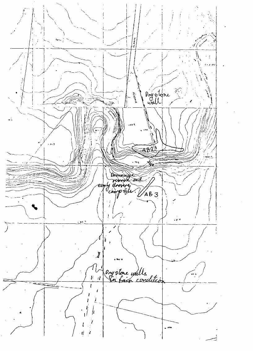
Site AB 2.
On the North side of Kororoit Creek east of Monaghan's Road alonga ploughed firebreak running paral lei with the fenceline and thecreek. The site was about 30 m from the creek at the top of thesloping bank. A large range of materials were evident includingfine mottled grey and pink silcrete, coarse grained orangesilcrete, quartz and quartzite. Of particular note were two large(c. 150mm diam.) quartz cores. The density of the artifacts wasabout 1 per square metre over an area of about 30 square metres.
SIte AB 3. OpposIte AB 2
A smal I numbe"r at artifacts were found in the cutting on theeastern edge of Clarkes road about 200 metres south of the ford.They were of similar materials to AS 2.
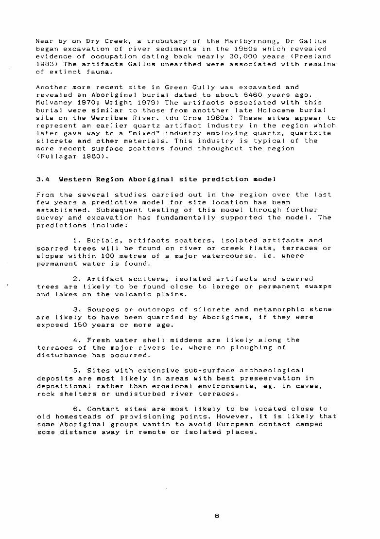
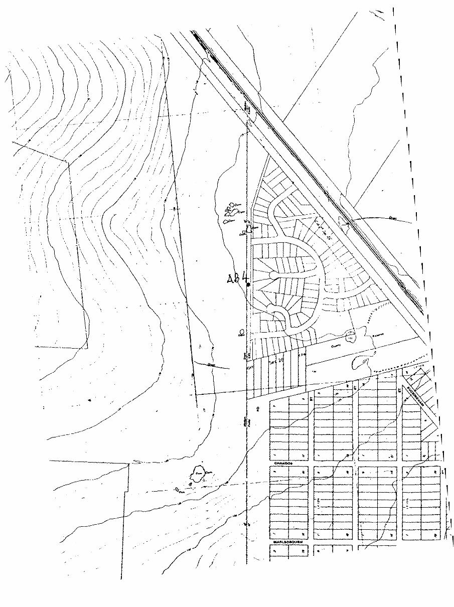
Site AB 4.
A single isolated artifact along a trail bike track north west ofAlbert Road about 115 m. beyond a clump of pine trees. This was afine grained mottled grey sicrete flake with edge retouch. Itappears to have been broken and was probably a discarded thum-na il scraper.
SIte AB 5.
A single smat 1 core of fine grained grey silcrete in an erodedarea under boxthorn bushes at the top of the valley slope. Thesite is in the north bank of Kororoit Creek about 50 m. from thewater near a large (for Kororoit Creek) a1luvial terrace andopposite the large Deer Park sites (VAS 7822/246-8).
Site AB 6.
On the south bank of the Kororoit Creek an extensive but difusescatter of artifacts between 10 and 30 m. from the waters edge.Again there is a range of materials including fine and coursesilcretes of several colours, quartz and quartzite. The siteestends along the sloping side of the creek val ley with a densityof about 1 artifact per 5 square metres.
Site AB 7.
A few course grained silcrete flakes were found eroding out ofthe edge of a vary small (c.l0 square metres) alluvial terrace.These artifacts may represent a secondary deposition ofcultural material, or considering the generally undisturbednature of parts of the creek in this area, they may be in anin-situ, deposit.
15

-." i'/
). \
,-
Figure 6. Sites recorded in the study area.
."

,t 11 L tlOl ~ artifact
Sit... liB 2. selection of artifacts

SItt' A .. lIt'y <lop'
SiLt' AD 2. ~ larat' quarL~ cores

t AP 1. $l'lection of artifact!l
Site AB 3. General view. artifacu found on rIght of track.
Site AB 4. sjn~l~ isolut~d ~rtifact found on trail biketrack
Site A8 6. ~lection of artifacts found Oyer a wide area

rt' All 1. lUrt'rt' an if l found t'Todin _ crt'll ll\k

6.1.2 Historical sites
The following are a selection of historic sites chosen toillustrate the range of surviving structures in the study area.They are typical of the types of structures in the regiongenerally. Figure 7. shows the location of historical featuresrecorded in the survey.
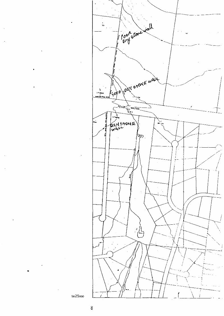
H 1. Strathlea.
This farmhouse is believed to be the home of members of the Opiefamily in the late 19th century. The present homestead appearsto date from the i890s along with a number of outbuildings. Itretains several dry stone wal Is in good condition. AlongRobinson's Rd. is a low double wal I which is well built andretains its split timber post fencing. Along Ballarat Rd. a walof massive boulders which retains its original split post andthree wire fence, is in much poorer condition. Sugar gumplantations on Ballarat Rd. and in clumps on the farm recal I thereforestations schemes of the 1930s. There are also scatteredpine trees and along the drive a double row of cypresses appearto be more recent.
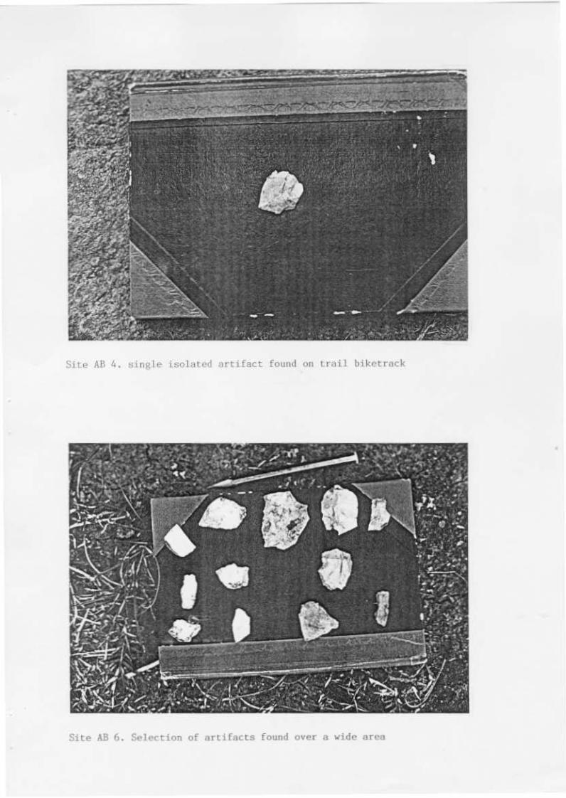
H 2. Rockbank Middle Rd. farm ruins.
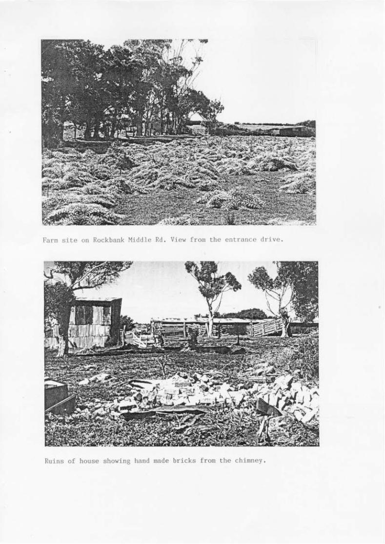
This site is in a poor state of preservation but has some unusualfeatures such as the cobble stone entrance drive and bush timbermachinery shed. This corrugated iron clad shed has lengths offorked tree trunks as the main posts and other bush timbers. Along low shed. which may have once been a milking shed is also ofrough bush timber construction. The farm house which would havebeen timber, is gone, but a pil~ of hand made bricks marks itsoriginal position and suggests an a early date for the building.Another shed which may have been a dairy recently burnt down.This has a bluestone pitcher floor. Cobbled yards and bluestonefoundations were also observed around the site as was theunderground tank. Old sugar gums and pines, typical of farms inthe region, are planted around the farm and stock yards.
Rockbank Middle Road retains it bluestone cobbled base and drystone wal Is on either side. It is a well preserved example of amid to late 19th century country road. The cobble stoneconstruction used large stones along the edges and to provide astable foundation. These were covered over with Rm~ll~f AtRn~A
with extra attention given to providing two smooth tracks wherethe wagon wheels ran, the centre being more rough. The road wouldoriginally have been finished with a smooth wearing surface ofsand or gravel.
H 3. Clarkes Rd. ford and water reserve.
Anecdotal evidence suggests that the small reserve straddling thecreek on Clarke's Road was intended as a stopping point fordrovers bringing sheep to Melbourne markets. Until recently astone shelter was said to have survived here. The ford is formedof large basalt cobblestones which have been recently concretedover.
The road takes a deliberate turn at this reserve to descend intothe creek valley. Cuttings have been made along the hillside anda second track runs around to the north of the reserve.Aboriginal artifacts at this site demonstrate the suitability of
16

the area for camping for both European and Aboriginal occupants.
Dry stone wallsexamples but inlarge stones on
H 4. Westlands
leading up to both sides of the reserve are goodgeneral ly poo~ condition. The use of particularlythe section to the north east is notable.
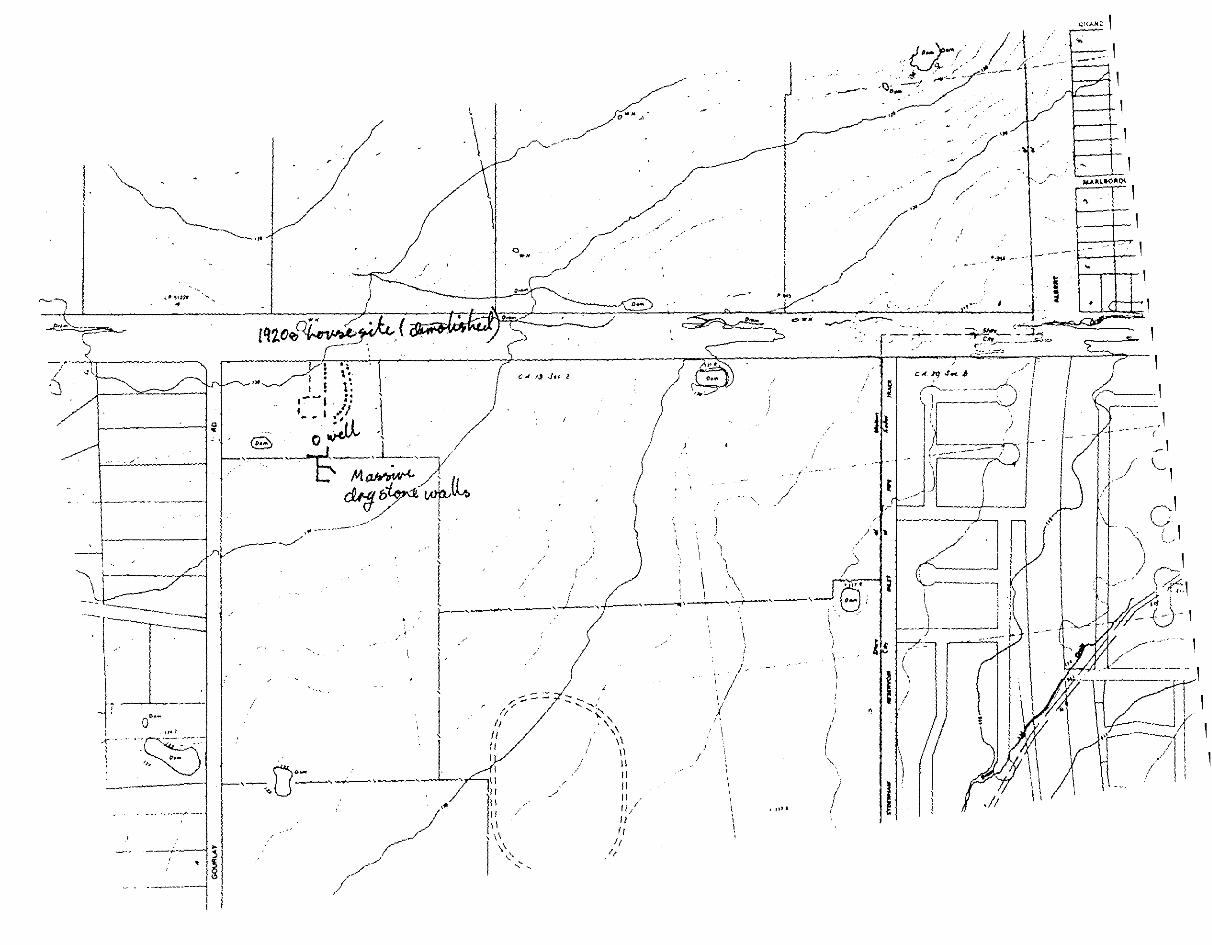
A 1920s homestead with a particularly well preserved drystone wallunder pine trees along Taylors Road. This homestead is a typicalexample of the type of farms created by the Closer SettlementActs of 1904 and subsequent amendments. The allotments aregenerally of from 100 to 300 acres and were designed to createsmall communities in rural areas in order to alleviate a shortageof land and housing. The house is timber and with a brickchimney, typical of the simpler styles of the 1920s. A very wellpreserved dry stone wal I at the front of the property has beenprotected by cypress trees. The wal I is low with split post andwire fencing to raise the height but is finely constructed withan even copi ng.
Several blocks along Taylor's Rd. feature exotic plantings alongfence lines, near houses, stock sheds and yards and around dams.Agave, agapanthus, cypress, pines and various gums appear to datefrom the 1920s as part of the development of the propertiesfollowing the Closer Settlement Scheme land sales.
H 5. Gourley's Rd. Farm site
On the corner of Keilor Melton Rd. and Gourley's Road is anotherCloser settlement property originally selected by E.J. Giggins inthe early 1920s. Here the house and farm buildings area gone butthe effort which has gone into creating the farm can still beseen in the ruins as well as the stone paved driveway and paths,wells, garden beds, tree plantings, fences and dry stone walls.A group of exceedingly wide stone walls lie just south of thehouse and appear to have been created as consumption walls to useup stone cleared from the fields (see Vines 1990)
H 6. Dalgook
This property is an isolated Edwardian farmhouse on a rise behindthe Sydenham reservoir. It retains a fine low dry stone wallaround the farm buildings. The stone was probably moved aconsiderable distance since very little fieldstone was observedon the property. Originally selected by H. Fitzgerald it is nowone of the more substantial farming properties and has preservedsome of its rural isolation as a consequence of being at the endof a dead end road.
H 7. Beatty's/Kellor Helton farm
This farm, again created from the land sales under the CloserSettlement Scheme has a short length of tall dry stone wal I nearits entrance and a fine planting of cypress trees. Otherwise itis typical of the small holdings from the 1920s in the area,perhaps better preserved than most.
17

H 8. Drovers Hut
This may be one of the most significant of the historical sitesin the region. Little is known of its backgrond apart from itforming part of an early pre-emptive right which was later resoldunder closer settlement. A fallen dry stone wall extends forabout 200 metres paral leI with the creek and has old boxthornplantings. Another shorter line of wal ling and boxthorn behindthis encloses a large area of what may have been a holdingpaddock for sheep.
Hut foundations measuring about 5 by 5 metres are to the south ofthis wal I about 10 metres from the top of the val ley slope.Squared bluestone blocks and two large basalt threshold stoneswith mortises for door jambs suggest this was originally asubstantial building.
There is a diffuse spread of cultural material with some ceramicsand glass from the mid to late 19th century. Stone and concretefoundations north of the hut site may have been part of a sheepdrafting race. Between this and the hut are a pair of largestones placed upright in the stone wal I to form gate posts.
Sugar gums and cypress trees are probably of more recent datethan the structures. About 300 metres east of the hut site arethe remnants of other stone walls and on the opposite side of thecreek downstream of this site is a long length of stone wal Ifoundation which may have been an intake for the sheep yards orpossibly a retaining wal I or embankment for a level track alongthe creek bank.
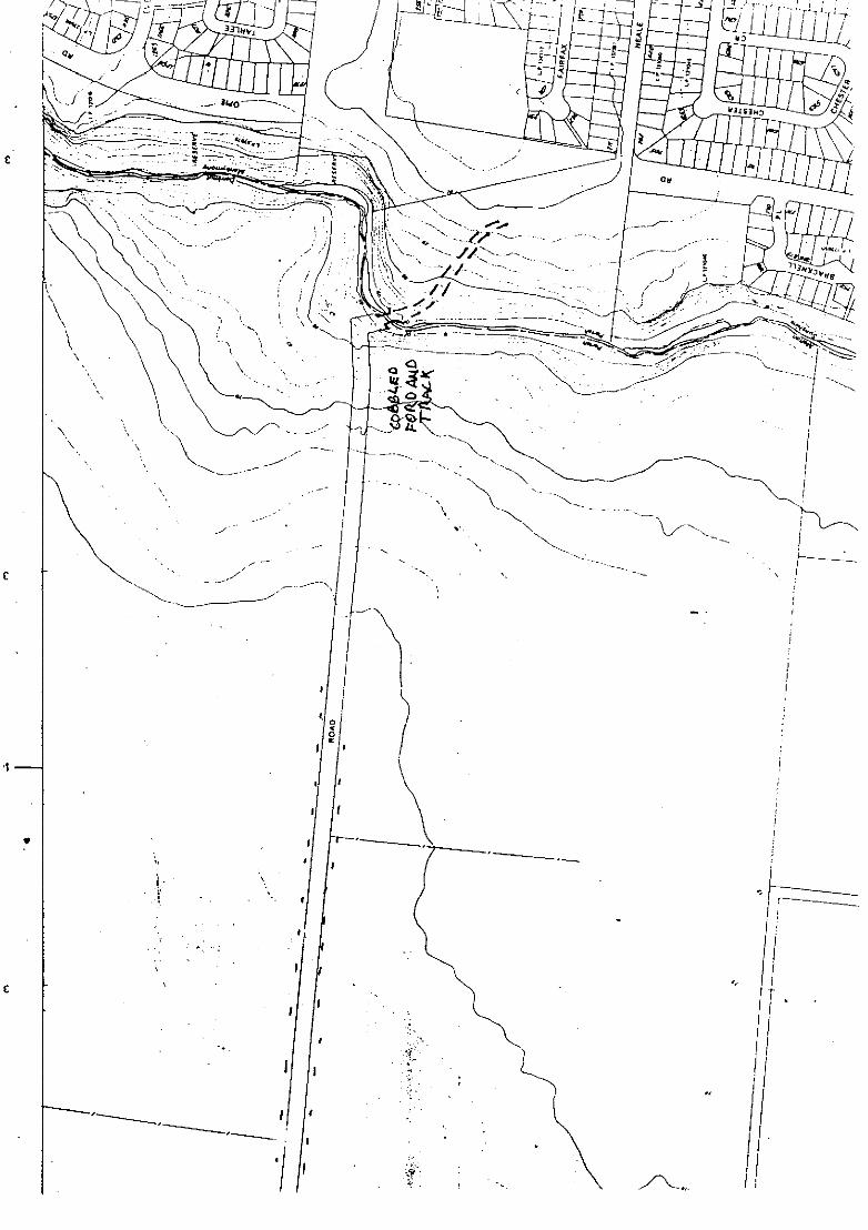
H 9. Neal Rd. ford
This is a cobblestone ford within a drainage reserve similar tothat on Clarke's Rd. The road to the east winds down a basaltpaved track to the creek while that on the west climbs steeply upthe creek bank. The route of the road was altered in 1907 whenthe section from the end of the cobbled stones on Rockbank MiddleRoad was realigned from a rather odd circuit to the north.Evidence of this survives on the west bank of the creek.
It is very likely that this was an early route to the WesternDistrict pastoral properties. possibly predating the gold rushesand the land surveys. The odd al lignments suggest the surveysaccomodated an existing route.
18

:r:Ul
/-" /;"' ".'
o 0
C; -IJA!Jio:Jl(
,·zct (!:=.~o 00:: -------"------
I--.J
W .___-::------
::t'
- t----!
-,
,
-j.-~+__--_+---+_'f..__=_.~_+I+_'_1--(j
Figure 7. Historical features in the study area.
- - -I-

Struhlea. Vi_ rr_ lobin_'s Il..-d shovl."& dry sl.<:Jne vall and piaes.
StrnthlCil. Vi_ [ra. 1Ia118r"t 1M.
Fum site On Rockbank Middle Rd. Vie>l from the entrance drive.
Ruins of house sho>ling hand IlIade bricks from the chi",ney.
Rockbank middle far~. Bush timber barn
Cobbled drive""y looking south

Cobbled se<:t1on or Rockbank Kiddie Road.
Cln,-ke's Road. note stone "nils lind re-nunls of hawthorn hcdSCB

Clarke's Road ford. not~ cobblestones
Stone "all on north east of ford

.,Westland.. homestead, TaylQr's R<>ad
• _. . - -,--,",~
Dry stone 11311 at ;"cstlands.

Dry stone wall under cypress trees ncar ~est1ands, Taylor's ~oad.
Detail of dry stone willI near ~'estlllnds

Small d"", "ear "St."lbans Park" farm on Taylor's Road. Note e~otic plants •
."""':'....,.,..•. '..,-;.., , ,r''' :', ~ ..~.~., " ..,
.-
F.xotic plants including Agave and Agallanthus near "StAlbans Park"

1920~ furmlwu"" on Taylor's Rd.
Trl ...c<.l boxrhQrn hedge" on taylor's Rd. farm.

Ruins of f"nl on Gollrle~'s (lnd Kellor 'leltotl Roads. Note mature (lUKor gums
•
Massive dry slone valls behind ruined fsr. house, [ellor-Helton Rd.

Dry stone "aU lit "Park Hilt" corner of Ke!lor...-.'lelton ""d Beatty's ROllds.
"Dl1Lgook" hQftlestead at end of Peck's Rd.

7. DISCUSSION
7.1 Site location
The aboriginal sites recorded in the study area from the currentand previous surveys conform with the predictive model statedabove in section 3.4. Most sites were predictably found alongKororoit Creek indicating the importance of that ecosystem forwater and food resourceS4
The European sites predominantly reflect the two phases of thepastoral industry common to much of the Western Region. The earlyroads and fence lines demonstrate the original surveys andalienation of the land from the Crown as large pastoral estateswere amassed by sqatters such as William Clarke. The dry stonewalls, which are the most common man-made structure associatedwith the early grazing industry are particularly evocative ofthis period.
The second period was when small farms were established onapproximately 100 to 300 acre allotments under the CloserSettlement Schemes of the early twentieth century. The physicalevidence of this period survives in a few homesteads and farmbuildings of the 1920s, lines of pine trees planted aswindbreaks, abandoned farm bUildings and ruins of homesteads aswell as the remnants of garden plantings and farm fencing, sheeppens, stock dams etc4
7.2 Site significance
The Aboriginal sites are of a similar extent, context and stateof preservation as others found in the area in the past. Whilemany 0: the sites are not of high significance individually theyal I contribute to our understanding of the pattern of Aboriginalsettlement of the area and so contribute to the generalsignificance of sites in the study area.
The European sites are typical of what might be found inundeveloped rural land on the fringe of Melbourne. However,considering the early date of settlement of this region there isgreater significance attached to the basic infrastructure ofroads and fences which in some cases may go back to the earliestyears of settlement in the Port Phillip District. The flDrover'sHut Site" is of high significance as an example of the earlypastoral industry as are the fords at Clarke's Road and DealeRoad. The Ruined farm on Rockbank Middle Road is potentially ofhigh significance as it is possible a very early farming site.Archaeological excavation may be productive at both this and theDrover's Hut site.
s. CONCLUSION
The cultural landscape of the study area and the Western Regionin general is substantially intact and demonstrates much of thecharacter of Aboriginal and European history in the area.Although degraded, the physical remains such as Aboriginalcamping sites, European settler's farms, stone fences and otherstructures provide a valuable resource for the interpretation ofthe history of the area and the enrichment of future development.
19
"[
"··l:.~r-~~ ~\~"?-".. '.
. r;
L-..
• /'1/'
--1 ------ --- z ~.. w0 0::: /
Il- )' /"
I I-I (/)
~._-_._._-- w/ .•~I. :t:• ° 70 -10
•
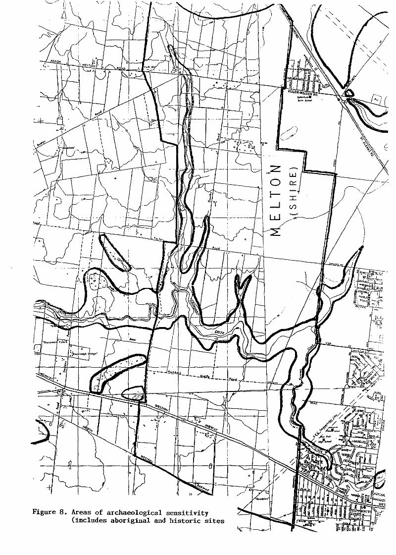
Figure 8. Areas of archaeological sensitivity(includes aboriginal and historic sites
jo }'"
o
'.... ---:: ~,

REFERENCES
Barwick, D.
Bell, D. &
Presland
Cannon, M.
du Cros, H.
du Cros, H.
du Cros, H.
du Cros, H.
duCross, H.
du Cros, H. &
liR!.JIIHng, M.
Egloff, B.
Fullagar, R.
James, K.N.
Ke~'s, C. W. &.Keys, N.
McDougall, K.
Popp, E.
Presland, G.
1984
1977
1982a
1988
1989a
1989b
1989c
1990
1989
1988
1980
1983
1977
1987
1979
1983
Mapping the Past: An Atlas of AboriginalClans. Aboriginal History 8 (2):100-131
Archaeological Survey Report, MaribyrnongMetropolitan Park. VAS Occasional ReportNo. 10.
Aboriginals of Port Phi II ip. HistoricalRecords of Victoria, Foundation Series 2A
An Archaeological Survey of the UpperYarra Val ley and Dandenong Ranges. UpperYarra Val ley and Dandenong RangesAuthority, Lilydale
An Archaeological Survey of the MelbourneMetropolitan Western Region. Report toVictoria Archaeological Survey
Werribee Corridor Study, Reportto Victoria Archaeological Survey
Deer Park Archaeological Survey Stage 2and Stages 3-7, Report to VictoriaArchaeological Survey
The Sydenham Corridor: A CulturalHeritage Study, Report to the VictoriaArchaeological Survey
An Archaeological Survey of theMetropolitan Ring Road from Laverton
North to Tul lamarine, MelbourneReport to Road Construction Authority
Deer Park Aboriginal Site ArchaeologicalInvestigations, Report to VictoriaArchaeological Survey
The Werribee River Project, Report toVictoria Archaeological Survey
Werribee: The First 100 Years, WerribeeHistorical Society
Unpublished notes on a Maribyrnong RiverSurvey. Victoria Archaeological Surveysite files.
Sites of Botanical Interest in theMelbourne Region, Report to Departmentof Conservation, Forests and Lands.
Glimpses of Early Sunshine, SunshineHistorical Society
An Archaeological Survey of MelbourneMetropolitan Area, VAS Occasional ReportSeries No. 15.
20

Rhodes, D. &du Cr·Cls .• H
Rosengren, N.
Simmons, S.
Starr, K.
1986
1980
1985
Upper Maribyrnong River Study, Report toVictoria Archaeological Survey
Sites of Geological and GeomorphologicalSignificance in the Western Region ofMelbourne, Department of ConservationForests and Lands
Melton Burial Report. Report to VictoriaArchaeological Survey
Melton: Plains of Promise, Melton ShireCouncil
Sutherland, A. 1886 Victoria and its Metropolis
Vines, G.
Vines, G.
1988
1989
Albion Explosives Factory Heritage Study,Draft Report to Ministry for Planning andEnvironment ..
Western Region Industrial Heritage StudyMelbourne's Living Museum of the West ..
Vines, G. 1990 Built to Last: An historicalarchaeological survey of dryin Melbournes Western Region.Museum of the West.
21
andstone wallsLiving

r-----.;...-~---_ _.-....-..r ~.::: ',.,-.' .;--=".., '--.. --~ . ~~'.
FORM D ,r•
.,,-~- 1Victoria
Archaeological and Aboriginal Relics Preservation Act 1972
ARCHAEOLOGICAL AND ABORIGINAL RELICS PRESERVATION REGULATIONS 1973
Notification of intention to carry out a survey
I/~ the undersigned give notice that I/~ intend to undertake a
survey of Aboriginal sites in the area described as
and shown cross-hatched on the attached map and further that it is
my/wf1! intention to conduct the survey between 4- 1 7/1990
and :bl /0/1990
NAME '1Afl..Y VIA/6
* Strike out whichever is not applicable
Persons about to commence surveys of Aboriginal sites should note that
it is their responsibility to ensure that the requisite permissions
are obtained to enter upon freehold land for the purpose of conducting
surveys of Aboriginal sites, and note further, that the Minister and
all officers of the Crown shall not be responsible for any damages,
claims, writs or other actions that may be brought against them in
connection with this survey of Aboriginal sites.

APPENDIX A.
EXTRACTS OF 1;5,000 MMBW PLANS SHOWING LOCATION OFABORIGINAL AND HISTORIC SITES RECORDED DURING THE SURVEY.

.\
oo~
NoM
l,f\
\
\
8oNo'1
\
- ---_ .. _.
/
0~~
0
'"
\• I
I
\/!
~-_/
, .. I
I.- I-• ( f-l--.
\I
i
i i
It
/(
i
f
Ii
. ,,'1
.... , /
/
" ', "'\:-
, ". ,\I \\, 1\
IIIIIIII ,11/IIII
/ ///
l
.\/II
/
,"
._-- ...,
" /\
--~
-~l===--:~
I . ".1 !
r"'~-
.,\ -.
---
5825000
",---
..:..'
\
---_.- -------_. -- -----
-/-...---- ------_/
.----
I
L
I
J/:
I,;
'. jI III .
I I, !IIIIIIIII
"""--
'-
,.\
(\,I I'II. /
\
." ~-
,/ .I
" .~"-_ .. -- "
./'
'.
;,
!"I
,\
\\
\\\\
\
,
\\ \
•
(
'I
(

./
/~I/ "'-I,
;
/ 1
1
1
1
1
/ 1
\/ /' /1
/ / "I~ . --7/--
!
.1\ ..//
I)-
// '
/
./..
-- .'
"
/
!I
i/
/
//
•
"
,~ /
JI!I
II
\/\
\\.I.. -- .
I'I'~ !
;:Ii"
IIII.-
I,r.

1
1
1
1
1
1
II< It C1G' 1
1
1
1
1.;l005()() 1
1
1
1
1
1
1
1
1
1
1,0'000 1
1
1
1
1
1
1
1
1
1
1
-~-,
II.•.~
" .~, "
'.

\,,,
/(\
<.
"•
<'.
".
./'" - ' ---.,.----~~J .-. -- ;- -
Il, '
,~
-
__ I-, --
11I
,,I,
. IIJ
[--,I ------ --
. ..
//.
I"I".!
+ l' ~
---------..,
I,
,J,,,1
r' !l ---"
I I
I /
j(
\
"-
\
,---~:
- -------~\I
II I
/,It.. . !
I·
) 1 I
II ./
, -
•
- ---- --- ,
,,---- -----------~."..'.:..'--..:¥--..:.)
q J~ \1
1~
1,
1t
1•
1
1
1
1
1
1
1
1
1
1
1
1
~-----~ 1
1
1
1
" 1'1''\ 1
1
./1.,<..,.. 1
1
1
1
'1
•
I ",,'..........'~/
.,/
/
•
p:3....."o.."... ~"'to ' ~ t. I ~ .
~- .
! .1....
r,
.' !
,
/ / , /I .
/ ./1' I
,I
\\,
\,
" \\ \
\
//'
/'.<
/
7
", ..i '. I.. ,: \ \
, !

"
I
iI
.', ,,, i\
\ '--\
ii \
~I \ \
l\. "-\,
, \-..,
, ,
\, "-
r'
\ ", ,
; \
\ "-
,J, ~,'-'
"-~"
I, )1' i:LI
I ·/
1 / /llh1/', ,
•
" /I'''j ~- ,-J' f
,/ "--
" ,i
", ~ ,-. ,- I,
.' ,
\,
\ '~
"-"-
',"' '-. - ............. " I \> .... c::--~._~ '-",-, ' '
\? .... ....................~....{ ... ... ""'-,
..... , ~- I\
,\
, ' ..."
... '"\
'" -. \' , f,'., "' ~J "-
\,
,
,
"- ....'~" \
."',,~,
,-~--~
i ,,~,
- ~._. : .\" -~---"'~
""\\
302500
303000
302000

301000
el' I
-~., -
i'.~'-,.,
'"\
\ • I
,,
't,
\~'j .
D I.•
\I (
\(0\, - " ,
I,
,~'\\
\i % ,,I
I <:-',-...{\
.~
\ ,
o
(\\'\ '.
\
•
•. !l\; I
i· I/ ,J
/
302000

Copyright © 2022 FDOKUMEN