Pollen evidence for variations in the southern margin of the westerly winds in SW Patagonia over the...
10
Pollen evidence for variations in the southern margin of the westerly winds in SW Patagonia over the last 12,600 years Rodrigo Villa-Martínez a, ⁎ , Patricio I. Moreno a,b a Centro de Estudios del Cuaternario, Avenida Bulnes 01890, Punta Arenas, Chile b Institute of Ecology and Biodiversity and Departamento de Ciencias Ecológicas, Facultad de Ciencias, Universidad de Chile, Chile Received 21 November 2006 Available online 14 September 2007 Abstract We report pollen and charcoal records from Vega Ñandú (∼ 51°0′S, 72°45′W), a small mire located near the modern forest-steppe ecotone in Torres del Paine National Park, southern Chile. The record shows an open landscape dominated by low shrubs and herbs between 12,600 and 10,800 cal yr BP, under cold and relatively humid conditions. Nothofagus experienced frequent, large-amplitude oscillations between 10,800 and 6800 cal yr BP, indicating recurrent transitions between shrubland/parkland environments, under warm and highly variable moisture conditions. A sustained increase in Nothofagus started at 6800 cal yr BP, punctuated by step-wise increases at 5100 and 2400 cal yr BP, implying further increases in precipitation. We interpret these results as indicative of variations in the amount of precipitation of westerly origin, with prominent increases at 6800, 5100, and 2400 cal yr BP. These pulses led to peak precipitation regimes during the last two millennia in this part of SW Patagonia. Our data suggest variations in the position and/or strength of the southern margin of the westerlies, most likely linked to variations in the extent and/or persistence of sea ice and sea-surface temperature anomalies in the Southern Ocean. Over the last two centuries the record shows a forest decline and expansion of Rumex acetosella, an exotic species indicative of European disturbance. © 2007 University of Washington. All rights reserved. Keywords: Paleoclimate; Holocene; Torres del Paine; Southern Westerlies; SW Patagonia Introduction The westerly wind belt is an important component of the atmospheric circulation of the Southern Hemisphere, supplying the winter- or year-round precipitation from subtropical to sub- antarctic latitudes, respectively. Variations in the latitudinal position and intensity of the westerlies at seasonal and inter- annual scales cause important changes in the precipitation at the western coast of South America. These variations are controlled by high-latitude conditions and the strength and/or position of the Subtropical Anticyclone in the SE Pacific sector (Miller, 1976; Aceituno et al., 1993). South America is the only landmass in the Southern Hemisphere that intersects the entire westerly wind belt continuously. Within this region, the western coast and Andean regions of Patagonia (40°–54°S) are the only areas affected by the permanent influence of the westerly wind belt, which constitutes the primary control on the composition and distribution of the regional biota (Pisano, 1974; Miller, 1976; Weischet, 1985; Endlicher and Santana, 1988). Previous discussion on the glacial–interglacial history of the southern westerlies in the Pacific coast of South America has centered on paleoclimate records located at or near its northern margin (Veit, 1996; Lamy et al., 2001; Jenny et al., 2002; Villa- Martínez et al., 2003; Moreno, 2004). Paleoclimatic reconstruc- tions based on pollen and chironomid records from small, closed-basin lakes in NW Patagonia (41°–46°S) have docu- mented changes in the latitudinal position of the northern margin of westerlies (Moreno, 2004; Massaferro et al., 2005). These studies found a multi-millennial trend in westerly activity, which includes a southward displacement of the westerlies between ∼ 10,500 and 7500 cal yr BP, followed by a northward shift and intensification after ∼ 7000 cal yr BP. Seismic stratigraphy, sedimentology, and geomorphological studies in Lago Cardiel (49°S), located in the eastern Andean Available online at www.sciencedirect.com Quaternary Research 68 (2007) 400 – 409 www.elsevier.com/locate/yqres ⁎ Corresponding author. E-mail address: [email protected] (R. Villa-Martínez). 0033-5894/$ - see front matter © 2007 University of Washington. All rights reserved. doi:10.1016/j.yqres.2007.07.003
Transcript of Pollen evidence for variations in the southern margin of the westerly winds in SW Patagonia over the...
Available online at www.sciencedirect.com
(2007) 400–409www.elsevier.com/locate/yqres
Quaternary Research 68
Pollen evidence for variations in the southern margin of the westerly winds inSW Patagonia over the last 12,600 years
Rodrigo Villa-Martínez a,⁎, Patricio I. Moreno a,b
a Centro de Estudios del Cuaternario, Avenida Bulnes 01890, Punta Arenas, Chileb Institute of Ecology and Biodiversity and Departamento de Ciencias Ecológicas, Facultad de Ciencias, Universidad de Chile, Chile
Received 21 November 2006Available online 14 September 2007
Abstract
We report pollen and charcoal records from Vega Ñandú (∼51°0′S, 72°45′W), a small mire located near the modern forest-steppe ecotone inTorres del Paine National Park, southern Chile. The record shows an open landscape dominated by low shrubs and herbs between 12,600 and10,800 cal yr BP, under cold and relatively humid conditions. Nothofagus experienced frequent, large-amplitude oscillations between 10,800 and6800 cal yr BP, indicating recurrent transitions between shrubland/parkland environments, under warm and highly variable moisture conditions. Asustained increase in Nothofagus started at 6800 cal yr BP, punctuated by step-wise increases at 5100 and 2400 cal yr BP, implying furtherincreases in precipitation. We interpret these results as indicative of variations in the amount of precipitation of westerly origin, with prominentincreases at 6800, 5100, and 2400 cal yr BP. These pulses led to peak precipitation regimes during the last two millennia in this part of SWPatagonia. Our data suggest variations in the position and/or strength of the southern margin of the westerlies, most likely linked to variations inthe extent and/or persistence of sea ice and sea-surface temperature anomalies in the Southern Ocean. Over the last two centuries the record showsa forest decline and expansion of Rumex acetosella, an exotic species indicative of European disturbance.© 2007 University of Washington. All rights reserved.
Keywords: Paleoclimate; Holocene; Torres del Paine; Southern Westerlies; SW Patagonia
Introduction
The westerly wind belt is an important component of theatmospheric circulation of the Southern Hemisphere, supplyingthe winter- or year-round precipitation from subtropical to sub-antarctic latitudes, respectively. Variations in the latitudinalposition and intensity of the westerlies at seasonal and inter-annual scales cause important changes in the precipitation at thewestern coast of South America. These variations are controlledby high-latitude conditions and the strength and/or position ofthe Subtropical Anticyclone in the SE Pacific sector (Miller,1976; Aceituno et al., 1993). South America is the onlylandmass in the Southern Hemisphere that intersects the entirewesterly wind belt continuously. Within this region, the westerncoast and Andean regions of Patagonia (40°–54°S) are the only
⁎ Corresponding author.E-mail address: [email protected] (R. Villa-Martínez).
0033-5894/$ - see front matter © 2007 University of Washington. All rights reservdoi:10.1016/j.yqres.2007.07.003
areas affected by the permanent influence of the westerly windbelt, which constitutes the primary control on the compositionand distribution of the regional biota (Pisano, 1974; Miller,1976; Weischet, 1985; Endlicher and Santana, 1988).
Previous discussion on the glacial–interglacial history of thesouthern westerlies in the Pacific coast of South America hascentered on paleoclimate records located at or near its northernmargin (Veit, 1996; Lamy et al., 2001; Jenny et al., 2002; Villa-Martínez et al., 2003; Moreno, 2004). Paleoclimatic reconstruc-tions based on pollen and chironomid records from small,closed-basin lakes in NW Patagonia (41°–46°S) have docu-mented changes in the latitudinal position of the northernmargin of westerlies (Moreno, 2004; Massaferro et al., 2005).These studies found a multi-millennial trend in westerlyactivity, which includes a southward displacement of thewesterlies between ∼10,500 and 7500 cal yr BP, followed bya northward shift and intensification after ∼7000 cal yr BP.Seismic stratigraphy, sedimentology, and geomorphologicalstudies in Lago Cardiel (49°S), located in the eastern Andean
ed.
401R. Villa-Martínez, P.I. Moreno / Quaternary Research 68 (2007) 400–409
slopes of central Patagonia, indicate a transgressive lakesequence that led to a deep lake with prominent shorelines55 m above the modern elevation between ∼10,800 and7500 cal yr BP, followed by a lake-level drop and onset of anoscillatory trend with moderate high stands over the last7000 years (Gilli et al., 2001, 2005). Because Lago Cardiel islocated east of the Andean range, it is likely that past lake-levelfluctuations resulted from multiple factors, including enhancedmoisture from westerly, Atlantic, and polar outbreak sources.The large size of the lake and its catchment area (370 and4500 km2, respectively) pose an additional difficulty whendeciphering the paleoclimate history based on fossil pollen data,as palynological records from large lakes integrate multiplesignals of past vegetation change across geographic andclimatic space, and thus yield a blurred picture of vegetationchanges at fine- and meso-scales (Markgraf et al., 2003).
Because very few paleoclimate records from SW Patagoniahave attempted to reconstruct the deglacial and postglacialhistory of the southern margin of the westerly winds, we set outto investigate this problem by means of paleovegetation recordsin the Torres del Paine area of SW Patagonia. Detailed pollenanalysis on sediment cores obtained from a small, closed-basinsite in an area affected solely by precipitation of westerly originprovides an interesting means of exploring past changes at aclimate-sensitive vegetation boundary: the forest-steppe eco-tone. Thus, it is expected that past variations in the strength and/or position of the southern westerlies drove changes in thisimportant vegetation and climate benchmark. Because smallclosed-basin sites maximize the local environmental signal,they yield palynological/paleoclimate data with high spatial andtemporal resolution that minimize the averaging or integrationof extralocal signals. Small lakes and bogs are ideal for exam-ining the temporal evolution of specific vegetation and climaticsettings, in particular the highly sensitive forest-steppe ecotonein SW Patagonia.
The data from Vega Ñandú allow assessment of the follow-ing questions: What were the timing and direction of vegetationchanges in SW Patagonia throughout the Holocene? Didvegetation changes occur in a gradual or abrupt manner? Howdid the southern margin of the westerlies vary during theHolocene? Did the southern margin of the westerlies vary inconcert (timing, direction) with its northern margin during theHolocene?
Study area
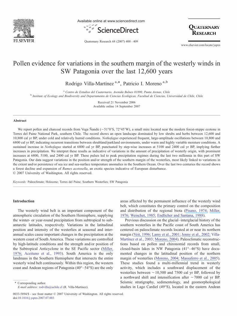
The climate of southern Patagonia (50°–54°S, Fig. 1) ischaracterized by the permanent dominance of the westerlywinds and the strong west–east precipitation gradient resultingfrom the rain shadow of the Andes cordillera. Annual preci-pitation at sea level on the Pacific coast reaches 7000 mm, whileon the eastern Andean slopes precipitation declines abruptly to350 mm within ∼100 km (Miller, 1976; Romero, 1985). Thedistribution of plant communities in southern Patagonia closelyfollows this precipitation gradient (Fig. 1); consequently, thewestern side of the Andean Range is dominated by MagellanicMoorland communities and Magellanic evergreen forest,
whereas east of the Andes the vegetation is characterized bywinter-deciduous Nothofagus forests, which merge with thePatagonian steppe towards the east.
Vega Ñandú (50°55′58″S; 72°45′55″W; 200 m elevation)is a small mire located in the NE sector of Torres del PaineNational Park, between Laguna Amarga and L. Azul (Fig. 1).The mire lies on a narrow E–W oriented ravine that runsperpendicular to the Río Paine valley, about 50 m above thevalley floor, near the ecotone between Nothofagus-dominatedforests and the Patagonian steppe. The climate in Torres delPaine has been described as transandean (Pisano, 1974), whichcorresponds to a transition between the extremely wet oceanicclimates on the western coast and the arid, strongly continentalclimates east of the Andes. The principal characteristic of thisclimate is the abrupt eastward decline of the mean annualprecipitation from 1000 to 400 mm (Fig. 1). The mean annualtemperature in the Torres del Paine area is 6 °C (Pisano,1974).
The distribution of the vegetation reflects the transitionalcharacter of the local climate in the Torres del Paine area. Thefollowing plant communities were described and mapped byPisano (1974) along a west–east transect:
(1) Magellanic Deciduous Forests correspond to a low-density forest dominated almost exclusively by thewinter-deciduous Nothofagus pumilio (Nothofagaceae)and occur where the annual precipitation is N750 mm. Inhumid sectors (N850 mm/yr), N. pumilio forms mixedforests with the evergreen tree N. betuloides. In areas withimpeded drainage, N. pumilio commonly intermingleswith N. antarctica. The species-poor shrub stratumdevelops only near the forest edges; dominant taxa areBerberis ilicifolia (Berberidaceae), Ribes magellanicus(Saxifragaceae), Chiliotrichum diffusum (Asteraceae),Escallonia serrata, E. rubra (Escalloniaceae), Maytenusdisticha (Celastraceae), and Embothrium coccineum (Pro-teaceae). The herbaceous understory is dominated byAcaena ovalifolia (Rosaceae), Ozmorhiza obtusa (Apia-ceae), Cardamine glacialis (Brassicaeae), and the fernBlechnum penna-marina (Blechnaceae).
(2) Pre-Andean shrublands are considered transitional com-munities between the forest and the steppe. These shrub-lands occur where the mean annual precipitation rangesbetween 400 and 700 mm. Arid sections are dominated byMulinum spinosum (Apiaceae), Anarthrophyllum desi-deratum, Adesmia boronoides (Papilionaceae), Ribes cu-cullatum, Discaria serratifolia (Rhamnaceae), Nardo-phyllum obtusifolium, Baccharis magellanica, Seneciopatagonicus (Asteraceae), and Berberis buxifolia (Berber-idaceae). Other herbs associated with this unit are Acaenaintergerrima, Festuca gracillima (Poaceae), Gamochaetanivalis (Asteraceae), and Valeriana carnosa (Valerania-ceae). Humid areas (∼700 mm/yr) are dominated bymesophytic shrublands featuring Escallonia rubra, Ades-mia boronoides, Discaria serratifolia, Berberis empetri-folia, and Pernettya mucronata (Ericaceae), along withsmall trees such as Embothrium coccineum, Maytenus
Figure 1. (A) Map of southern Patagonia showing the spatial distribution of major vegetation units (modified after Gajardo, 1993; Luebert and Pliscoff, 2006; Pisano,1992), and isohyets (modified after Miller, 1976; Romero, 1985). The open square shows the location of Torres del Paine National Park. (B) Topographic map of studyarea showing the location of Vega Ñandú in Torres del Paine National Park. The contour interval is 100 m.
402 R. Villa-Martínez, P.I. Moreno / Quaternary Research 68 (2007) 400–409
magellanica, and N. pumilio. Common herbs are Acaenalucida, Adesmia pumila, Apium australe (Apiaceae),Phacelia magallanica (Hydrophyllaceae), Cerastiumarvense (Caryophyllaceae), Festuca gracillima, Azorellacaespitosa (Apiaceae), and Valeriana carnosa.
(3) Patagonian steppe occurs in lowland areas where the meanannual precipitation is b400 mm. The dominant species isFestuca gracillima, along with F. magallanica, Stipabrevipes,Bromus unioloides (Poaceae), Acaena argentea,A. intergerrima, A. pinnatifida (Rosaceae), Adesmia pu-mila (Papilionaceae), and Arjona patagonica (Santala-
ceae). Adesmia boronoides, B. buxifolia, B. empetrifolia(Berberidaceae), C. diffusum, Baccharis magallanica(Asteraceae), Mulinum spinosum, and Verbena tridens(Verbenaceae) are common shrubs in this unit.
(4) Andean desert is found above the Nothofagus forests; itincludes small patches of N. pumilio and dwarf shrubs,such as Escallonia rubra and Ribes cucullatum. Theherbaceous understory is dominated by Acaena magalla-nica, Pernettya pumila (Ericaceae), Empetrum rubrum(Empetraceae), Senecio skottbergii (Asteraceae), Leu-ceria leonthopodioides (Asteraceae), Perezia megalantha
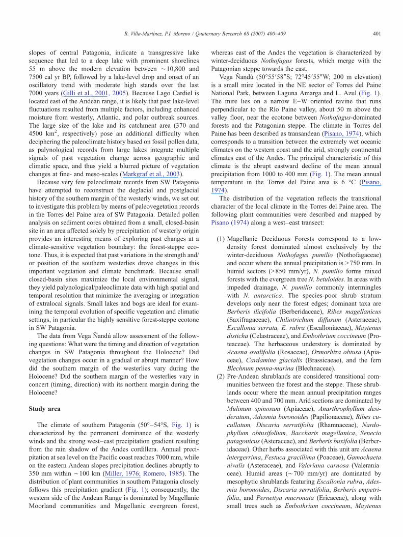
Figure 2. Age-depth curve from cores PS0304A and PS0405RCA1 showing thelinear interpolation age model applied to the calibrated radiocarbon dates.Horizontal error bars represent± two standard deviations. The age modelincludes the dates we obtained for the same tephras in the Lago Guanaco record.The hatched pattern indicates the position of tephra layers. See main text andFigure 4 captions for more details.
403R. Villa-Martínez, P.I. Moreno / Quaternary Research 68 (2007) 400–409
(Asteraceae), Nassauvia lagascae (Asteraceae), Agrostiscanina (Poaceae), and Festuca pyrogea.
Methods
We obtained multiple, overlapping sediment cores from thedeepest part of the Vega Ñandú mire using a 5-cm-diametermodified Livingstone piston corer (Wright, 1967). A 5-cm-diameter Russian corer was used to retrieve the upper meter of thesedimentary sequence. The stratigraphy of the core was charac-terized by lithological descriptions, X-radiographs, and loss-on-ignition analysis following overnight drying at 105 °C. Sequen-tial burns at 550 °C (2 h) and 925 °C (4 h) in a muffle furnacewere performed to determine organic and carbonate content,respectively (Bengtsson and Enell, 1986; Heiri et al., 2001).
The chronology of the sediment cores is controlled by tenAMS radiocarbon dates and chronostratigraphic correlation oftephra layers also found in nearby sites (Table 1, Fig. 1).Radiocarbon dates were converted to calendar years beforepresent (cal yr BP) using the CALIB 5.01 program (Stuiver etal., 1998). We developed a linear interpolation model based onthe calibrated radiocarbon ages to assign interpolated calendarages to the pollen levels (Fig. 2).
We analyzed 170 palynological levels throughout thesediment cores with a mean deposition time of 34 yr/cm, andan average time resolution of 72 yr between samples. A constantvolume (2 cc) of sediment was processed for pollen and char-coal analysis using standard techniques (KOH, HF and Ace-tolysis; Faegri and Iversen, 1989). Lycopodium spore tablets(Stokmarr, 1971) were added to the sediment samples to allowcalculation of charcoal accumulation rates. The concentrateswere mounted on pollen slides using silicon oil (2000 cs) andwere analyzed at 400× and 1000× magnification using a LeicaDMLB2 stereomicroscope.
The basic pollen sum for each level includes at least 300pollen grains of terrestrial origin. Percentages of aquatic andfern taxa were calculated from a supersum that included thebasic pollen sum, the sum aquatic/paludal taxa, and the sumPteridophytes. The pollen zones were defined with the aid of a
Table 1AMS 14C dates and calibrated ages from core PS0304A
CAMS # Core Depth(cm)
14C yr BP±1 S.D.
98826 (*) PS0303AT4 31 2015±30124602 PS0304AT1 67 2305±35107056 (*) PS0404AT2 111 4545±50114971 PS0304AT1 144 5035±3599123 PS0304AT2 170 5750±40114972 PS0304AT2 249 7770±6098836 PS0304AT3 276 8530±4098835 PS0304AT3 313 9310±4099122 PS0304AT3 313 9430±3598834 PS0304AT3 349 9615±45107005 PS0304AT4 399 10,395±4598833 PS0304AT4 399 10,555±40
The asterisk indicates the radiocarbon dates obtained for the same tephras in the La
Constrained Incremental Sum of Squares (CONISS) clusteranalysis (Grimm, 1987). The rate-of-change parameter (square-chord distance) was calculated to quantify the magnitude/rapidity of vegetation changes by smoothing the pollen per-centage data with a five-point moving average and interpolat-ing pollen samples at regular 75-yr intervals. For the CONISSand the rates-of-change analyses we used all terrestrial pollentaxa ≥2% (excluding Pteridophytes), with percentages recal-culated based on that sum (Jacobson et al., 1987). The basalclayey sediments (1088–400 cm) contained extremely lowpollen concentrations and, hence, were not suited for high-resolution pollen analysis. Microscopic charcoal particles werecounted in pollen slides along with their pollen and sporecontent. The abundance of charcoal is expressed as accumula-tion rates, determined by standardizing the concentration databy depositional time.
δ13C Cal yr BP(median probability)
2σ range
−27.17 1910 1826–1990−25 2235 2150–2340−26.83 5147 4894–5312−25 5703 5650–5840−25 6478 6410–6530−25 8490 8454–8540−27 9491 9470–9520−27 10,426 10,300–10,510−25 10,601 10,520–10,665−27 10,923 10,760–11,070−25 12,273 12,160–12,380−27 12,594 12,400–12,695
go Guanaco record.
404 R. Villa-Martínez, P.I. Moreno / Quaternary Research 68 (2007) 400–409
Results
Stratigraphy
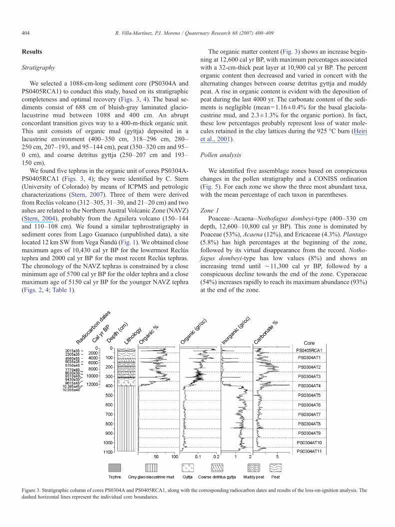
We selected a 1088-cm-long sediment core (PS0304A andPS0405RCA1) to conduct this study, based on its stratigraphiccompleteness and optimal recovery (Figs. 3, 4). The basal se-diments consist of 688 cm of bluish-gray laminated glacio-lacustrine mud between 1088 and 400 cm. An abruptconcordant transition gives way to a 400-m-thick organic unit.This unit consists of organic mud (gyttja) deposited in alacustrine environment (400–350 cm, 318–296 cm, 280–250 cm, 207–193, and 95–144 cm), peat (350–320 cm and 95–0 cm), and coarse detritus gyttja (250–207 cm and 193–150 cm).
We found five tephras in the organic unit of cores PS0304A-PS0405RCA1 (Figs. 3, 4); they were identified by C. Stern(University of Colorado) by means of ICPMS and petrologiccharacterizations (Stern, 2007). Three of them were derivedfrom Reclús volcano (312–305, 31–30, and 21–20 cm) and twoashes are related to the Northern Austral Volcanic Zone (NAVZ)(Stern, 2004), probably from the Aguilera volcano (150–144and 110–108 cm). We found a similar tephrostratigraphy insediment cores from Lago Guanaco (unpublished data), a sitelocated 12 km SW from Vega Ñandú (Fig. 1). We obtained closemaximum ages of 10,430 cal yr BP for the lowermost Reclústephra and 2000 cal yr BP for the most recent Reclús tephras.The chronology of the NAVZ tephras is constrained by a closeminimum age of 5700 cal yr BP for the older tephra and a closemaximum age of 5150 cal yr BP for the younger NAVZ tephra(Figs. 2, 4; Table 1).
Figure 3. Stratigraphic column of cores PS0304A and PS0405RCA1, along with thedashed horizontal lines represent the individual core boundaries.
The organic matter content (Fig. 3) shows an increase begin-ning at 12,600 cal yr BP, with maximum percentages associatedwith a 32-cm-thick peat layer at 10,900 cal yr BP. The percentorganic content then decreased and varied in concert with thealternating changes between coarse detritus gyttja and muddypeat. A rise in organic content is evident with the deposition ofpeat during the last 4000 yr. The carbonate content of the sedi-ments is negligible (mean=1.16±0.4% for the basal glaciola-custrine mud, and 2.3±1.3% for the organic portion). In fact,these low percentages probably represent loss of water mole-cules retained in the clay lattices during the 925 °C burn (Heiriet al., 2001).
Pollen analysis
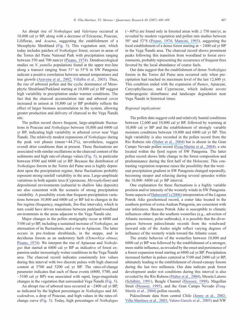
We identified five assemblage zones based on conspicuouschanges in the pollen stratigraphy and a CONISS ordination(Fig. 5). For each zone we show the three most abundant taxa,with the mean percentage of each taxon in parentheses.
Zone 1Poaceae–Acaena–Nothofagus dombeyi-type (400–330 cm
depth, 12,600–10,800 cal yr BP). This zone is dominated byPoaceae (53%), Acaena (12%), and Ericaceae (4.3%). Plantago(5.8%) has high percentages at the beginning of the zone,followed by its virtual disappearance from the record. Notho-fagus dombeyi-type has low values (8%) and shows anincreasing trend until ∼11,300 cal yr BP, followed by aconspicuous decline towards the end of the zone. Cyperaceae(54%) increases rapidly to reach its maximum abundance (93%)at the end of the zone.
corresponding radiocarbon dates and results of the loss-on-ignition analysis. The
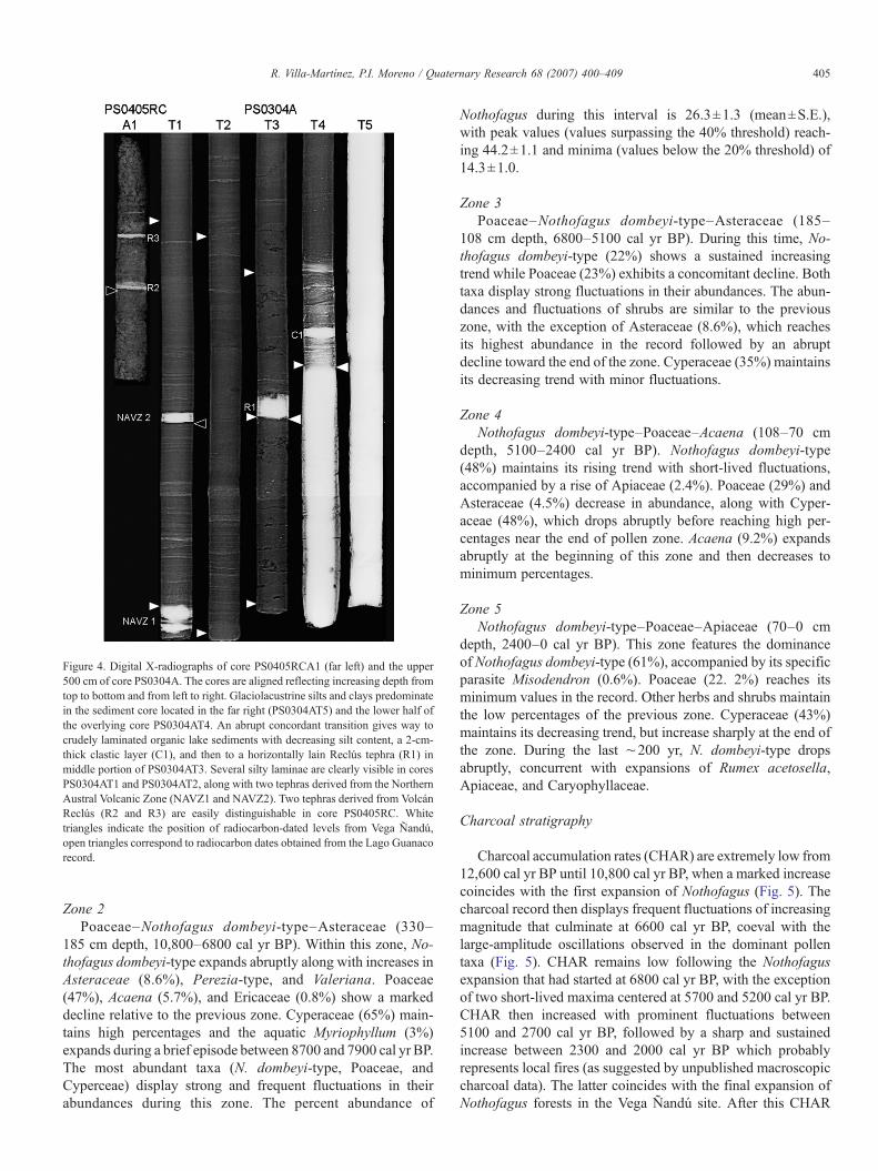
Figure 4. Digital X-radiographs of core PS0405RCA1 (far left) and the upper500 cm of core PS0304A. The cores are aligned reflecting increasing depth fromtop to bottom and from left to right. Glaciolacustrine silts and clays predominatein the sediment core located in the far right (PS0304AT5) and the lower half ofthe overlying core PS0304AT4. An abrupt concordant transition gives way tocrudely laminated organic lake sediments with decreasing silt content, a 2-cm-thick clastic layer (C1), and then to a horizontally lain Reclús tephra (R1) inmiddle portion of PS0304AT3. Several silty laminae are clearly visible in coresPS0304AT1 and PS0304AT2, along with two tephras derived from the NorthernAustral Volcanic Zone (NAVZ1 and NAVZ2). Two tephras derived from VolcánReclús (R2 and R3) are easily distinguishable in core PS0405RC. Whitetriangles indicate the position of radiocarbon-dated levels from Vega Ñandú,open triangles correspond to radiocarbon dates obtained from the Lago Guanacorecord.
405R. Villa-Martínez, P.I. Moreno / Quaternary Research 68 (2007) 400–409
Zone 2Poaceae–Nothofagus dombeyi-type–Asteraceae (330–
185 cm depth, 10,800–6800 cal yr BP). Within this zone, No-thofagus dombeyi-type expands abruptly along with increases inAsteraceae (8.6%), Perezia-type, and Valeriana. Poaceae(47%), Acaena (5.7%), and Ericaceae (0.8%) show a markeddecline relative to the previous zone. Cyperaceae (65%) main-tains high percentages and the aquatic Myriophyllum (3%)expands during a brief episode between 8700 and 7900 cal yr BP.The most abundant taxa (N. dombeyi-type, Poaceae, andCyperceae) display strong and frequent fluctuations in theirabundances during this zone. The percent abundance of
Nothofagus during this interval is 26.3±1.3 (mean±S.E.),with peak values (values surpassing the 40% threshold) reach-ing 44.2±1.1 and minima (values below the 20% threshold) of14.3±1.0.
Zone 3Poaceae–Nothofagus dombeyi-type–Asteraceae (185–
108 cm depth, 6800–5100 cal yr BP). During this time, No-thofagus dombeyi-type (22%) shows a sustained increasingtrend while Poaceae (23%) exhibits a concomitant decline. Bothtaxa display strong fluctuations in their abundances. The abun-dances and fluctuations of shrubs are similar to the previouszone, with the exception of Asteraceae (8.6%), which reachesits highest abundance in the record followed by an abruptdecline toward the end of the zone. Cyperaceae (35%) maintainsits decreasing trend with minor fluctuations.
Zone 4Nothofagus dombeyi-type–Poaceae–Acaena (108–70 cm
depth, 5100–2400 cal yr BP). Nothofagus dombeyi-type(48%) maintains its rising trend with short-lived fluctuations,accompanied by a rise of Apiaceae (2.4%). Poaceae (29%) andAsteraceae (4.5%) decrease in abundance, along with Cyper-aceae (48%), which drops abruptly before reaching high per-centages near the end of pollen zone. Acaena (9.2%) expandsabruptly at the beginning of this zone and then decreases tominimum percentages.
Zone 5Nothofagus dombeyi-type–Poaceae–Apiaceae (70–0 cm
depth, 2400–0 cal yr BP). This zone features the dominanceof Nothofagus dombeyi-type (61%), accompanied by its specificparasite Misodendron (0.6%). Poaceae (22. 2%) reaches itsminimum values in the record. Other herbs and shrubs maintainthe low percentages of the previous zone. Cyperaceae (43%)maintains its decreasing trend, but increase sharply at the end ofthe zone. During the last ∼200 yr, N. dombeyi-type dropsabruptly, concurrent with expansions of Rumex acetosella,Apiaceae, and Caryophyllaceae.
Charcoal stratigraphy
Charcoal accumulation rates (CHAR) are extremely low from12,600 cal yr BP until 10,800 cal yr BP, when a marked increasecoincides with the first expansion of Nothofagus (Fig. 5). Thecharcoal record then displays frequent fluctuations of increasingmagnitude that culminate at 6600 cal yr BP, coeval with thelarge-amplitude oscillations observed in the dominant pollentaxa (Fig. 5). CHAR remains low following the Nothofagusexpansion that had started at 6800 cal yr BP, with the exceptionof two short-lived maxima centered at 5700 and 5200 cal yr BP.CHAR then increased with prominent fluctuations between5100 and 2700 cal yr BP, followed by a sharp and sustainedincrease between 2300 and 2000 cal yr BP which probablyrepresents local fires (as suggested by unpublished macroscopiccharcoal data). The latter coincides with the final expansion ofNothofagus forests in the Vega Ñandú site. After this CHAR

Figure 5. Percent pollen diagram for selected plant taxa from Vega Ñandú, accumulation rate curve of microscopic charcoal particles, and results of the rate-of-changeanalysis. The dashed lines indicate major changes in pollen stratigraphy.
406 R. Villa-Martínez, P.I. Moreno / Quaternary Research 68 (2007) 400–409
maximum, the abundance values decrease abruptly and remainlow over the last 2000 yr.
Discussion
The pollen record from Vega Ñandú shows the dominanceof shrubs (Ericaceae) and herbs (Poaceae, Acaena, Asteraceae,Plantago, Valeriana, and Phacelia) and absence of forestindicators between 12,600 and 10,800 cal yr BP. Modernvegetation surveys indicate that Ericaceae and Valeriana arecommon in pre-Andean shrublands, while Poaceae, Asteraceae,and Acaena are components both of steppe and pre-Andeanshrublands (Pisano, 1974). Although the high percentagevalues of Poaceae are characteristic of the Patagonian steppe(Mancini, 1993), the presence and significant abundance ofEricaceae, Valeriana, and Caryophyllaceae suggest dominanceof pre-Andean shrublands. This vegetation unit occurs in areas
of Torres del Paine National Park where mean annualprecipitation values surpass 400 mm (Pisano, 1974). Hence,we interpret this pollen assemblage as an open landscapedominated by pre-Andean shrubland-type vegetation underrelatively humid and cold climate conditions. The prevalence ofa lacustrine environment, attested by the deposition of lami-nated gyttja in the site between 12,600 and 11,000 cal yr BP, isconsistent with this interpretation. An increase of organicmatter, paludal taxa (Cyperaceae), and deposition of peatbetween 11,000 and 10,600 cal yr BP suggest a drop in lakelevel, probably in response to lower effective moisture drivenby a rise in temperature. The microscopic charcoal record ex-hibits extremely low values between 12,600 and 10,800 cal yrBP (Fig. 5), suggesting low fire activity in a sparsely vegetatedlandscape. Low biomass accumulation and/or fuel discontinuitymay have prevented the occurrence of frequent and widespreadfires.
407R. Villa-Martínez, P.I. Moreno / Quaternary Research 68 (2007) 400–409
An abrupt rise of Nothofagus and Valeriana occurred at10,800 cal yr BP, along with a decrease of Ericaceae, Poaceae,Liliflorae, and Acaena, suggesting the establishment of aMesophytic Shrubland (Fig. 5). This vegetation unit, whichtoday includes patches of Nothofagus forest, occurs in areas ofthe Torres del Paine National Park with precipitation rangingbetween 550 and 700 mm/yr (Pisano, 1974). Dendroecologicalstudies on N. pumilio populations found at the upper tree-linealong a transect ranging from 51° to 55°S in SW Patagoniaindicate a positive correlation between annual temperatures andtree growth (Aravena et al., 2002; Villalba et al., 2003). Thus,the rise of arboreal pollen and the cyclic dominance of Meso-phytic Shrubland/Parkland starting at 10,800 cal yr BP suggesthigh variability in precipitation under warmer conditions. Thefact that the charcoal accumulation rate and arboreal coverincreased in unison at 10,800 cal yr BP probably reflects theeffect of larger biomass accumulation in the system, allowinggreater production and delivery of charcoal to the Vega Ñandúsite.
The pollen record shows frequent, large-amplitude fluctua-tions in Poaceae and Nothofagus between 10,800 and 6800 calyr BP, indicating high variability in arboreal cover near VegaÑandú. The relatively modest expansions of Nothofagus duringthe peak wet phases (mean=44.2%), nevertheless, suggestoverall drier conditions than at present. These fluctuations areassociated with similar oscillations in the charcoal content of thesediments and high rate-of-change values (Fig. 5), in particularbetween 8500 and 6600 cal yr BP. Because the distribution ofNothofagus forests in the Torres del Paine area is highly depen-dent upon the precipitation regime, these fluctuations probablyrepresent strong rainfall variability in the area. Large-amplitudevariations in both aquatic taxa (Cyperaceae,Myriophyllum) anddepositional environments (subaerial to shallow lake deposits)are also consistent with the scenario of strong precipitationvariability. A possibility exists that frequent precipitation varia-tions between 10,800 and 6800 cal yr BP led to changes in thefire regime (frequency, magnitude, fire-free intervals), which inturn could have driven transitions between parkland/woodlandenvironments in the areas adjacent to the Vega Ñandú site.
Major changes in the pollen stratigraphy occur at 6800 and5100 cal yr BP, including a sustained increase of Nothofagus, anattenuation of its fluctuations, and a rise in Apiaceae. The latteroccurs in pre-Andean shrublands, in the steppe, and indeciduous forests as an understory herb (Ozmorhiza obtusa;Pisano, 1974). We interpret the rise of Apiaceae and Nothofa-gus that started at 6800 cal yr BP as indicative of forest ex-pansion under increasingly wetter conditions in the Vega Ñandúarea. The charcoal record indicates consistently low valuesduring this interval with two discrete pulses with high charcoalcontent at 5700 and 5200 cal yr BP. The rates-of-changeparameter indicates that each of these events (6800, 5700, and~5100 cal yr BP) was associated with rapid, large-magnitudechanges in the vegetation that surrounded Vega Ñandú (Fig. 5).
An abrupt rise of arboreal taxa occurred at ~2400 cal yr BP,as indicated by the highest percentages in Nothofagus and Mi-sodendron, a drop of Poaceae, and high values in the rates-of-change curve (Fig. 5). Today, high percentages of Nothofagus
(∼60%) are found only in forested areas with ≥750 mm/yr, asrevealed by modern vegetation and pollen rain studies between50° and 52°S (Pisano, 1974; Mancini, 1993), suggesting thelocal establishment of a dense forest starting at∼2400 cal yr BPin the Vega Ñandú area. The charcoal record shows prominentpeaks following this transition from woodland to forest envi-ronments, probably representing the occurrence of frequent firesfavored by the local abundance of coarse fuels.
Our data suggest that the establishment of dense Nothofagusforests in the Torres del Paine area occurred only when pre-cipitation had reached its maximum level of the last 12,600 yr.This condition ended with the expansion of Rumex, Apiaceae,Caryophyllaceae, and Cyperaceae, which indicate severeanthropogenic disturbance and landscape degradation nearVega Ñandú in historical times.
Regional implications
The pollen data suggest cold and relatively humid conditionsbetween 12,600 and 10,800 cal yr BP, followed by warming at10,800 cal yr BP and the establishment of strongly variablemoisture conditions between 10,800 and 6800 cal yr BP. Thishigh variability is also recorded in the pollen record from theRío Rubens site (Huber et al., 2004) but is absent in the GranCampo Nevado pollen record (Fesq-Martin et al., 2004), a sitelocated within the fjord region of SW Patagonia. The latterpollen record shows little change in the forest composition andpredominance during the first half of the Holocene. This con-trasting vegetation response raises the possibility that the west–east precipitation gradient in SW Patagonia changed repeatedly,becoming steeper and relaxing during several episodes withinthe 10,800–6800 cal yr BP interval.
One explanation for these fluctuations is a highly variableposition and/or intensity of the westerly winds in SW Patagonia.Some aspects of Haberzettl's (2006) interpretation of the LagunaPotrok Aike geochemical record, a crater lake located in thesouthern portion of extra-Andean Patagonia, are consistent withour inferences. Because Potrok Aike is susceptible to climaticinfluences other than the southern westerlies (e.g., advection ofAtlantic moisture, polar outbreaks), it is possible that the diver-gences between paleoclimate records from the windward/leeward side of the Andes might reflect varying degrees ofinfluence of the westerly winds toward the Atlantic coast.
The erratic behavior of the westerlies between 10,800 and6800 cal yr BP was followed by the establishment of a stronger,more stable influence, as revealed by the onset and persistence ofa forest expansion trend starting at 6800 cal yr BP. Precipitationincreased further in pulses centered at 5100 and 2400 cal yr BP,ultimately leading to the establishment of closed-canopy forestsduring the last two millennia. Our data indicate peak forestdevelopment under wet conditions during this interval is alsorevealed by the Río Rubens (Huber et al., 2004), Meseta Latorre(Schäbitz, 1991), Beagle Channel (Heusser, 1998), MagellanStrait (Heusser, 1995), and the Gran Campo Nevado (Fesq-Martin et al., 2004) pollen records.
Paleoclimate data from central Chile (Jenny et al., 2002;Villa-Martínez et al., 2003; Valero-Garcés et al., 2005) and NW
408 R. Villa-Martínez, P.I. Moreno / Quaternary Research 68 (2007) 400–409
Patagonia (Moreno and León, 2003; Moreno, 2004) show astrong negative anomaly in westerly activity between ∼10,500and 7600 cal yr BP, followed by prominent increases inprecipitation in pulses centered at 7600, 6800, and 5700 cal yrBP. On the contrary, lake-level data from Lago Cardiel show astrong positive anomaly between ∼11,000 and 7500 cal yr BP,followed by a fluctuating sequence of moderately high lake-level stands over the last ∼7000 yr. Gilli et al. (2005) alluded tothe onset of a dominant and permanent influence of the westerlywinds in Lago Cardiel at 6800 cal yr BP, based on the inferenceof a dominant lake current system that led to the formation of asediment drift and conspicuous changes in magnetic suscept-ibility in several lake sediment cores.
The multi-millennial pattern of westerly activity inferred fromVega Ñandú matches the timing and direction of NW Patagonianpaleoclimate records, and is opposite to the timing of maximumlake levels in Lago Cardiel. This emerging pattern of contrastingprecipitation anomalies, across and along the Patagonian Andes,poses an interesting paleoclimate puzzle. We propose three likelyexplanations: (i) the maximum strength of the southern westerlieswas focused between 46° and 49°S during the interval between∼11,000 and∼7500 cal yr BP (supplying the moisture to sustainthe high lake levels in Lago Cardiel), and then expanded bothnorth- and southward. (ii) The southern westerlies shifted southof 51°S during the same interval, and then expanded northwardcausing forest expansion at Vega Ñandú, the establishment of apermanent current and sediment drift in Lago Cardiel, and the re-expansion of hygrophilous rainforests in NW Patagonia. Underthis scenario, the high lake levels in Lago Cardiel between∼11,000 and ∼7500 cal yr BP would be related to moisturesources different from the southern westerlies. (iii) The westerliesgenerally weakened with no major latitudinal shifts, along withincreased advection of humid Atlantic air masses to the easternAndean slopes of central Patagonia.
Ice core records from Antarctica show various timing,directions, and frequencies of temperature change throughoutthe Holocene. Despite the vast heterogeneity among individualsites, it is possible to recognize a common cooling trend startingat ∼8000 cal yr BP (Masson et al., 2000). Marine records fromthe Atlantic sector of the Southern Ocean and Palmer Deep, amarine basin adjacent to the Antarctic Peninsula, indicate highsea-surface temperatures and limited sea ice extent/persistencebetween ∼7000 and 5500 cal yr BP (Hodell et al., 2001;Leventer et al., 2002; Sjunneskog and Taylor, 2002; Taylor andSjunneskog, 2002).These conditions ended at ∼6200 cal yr BPor ∼5500 cal yr BP with the onset of a cooling trend (Nielsen etal., 2004) and increased discharge of iceberg-rafted detritus inthe South Atlantic sector of the Southern Ocean (Hodell et al.,2001). Altogether these data indicate that cooling in theAntarctic interior, along with sea-ice expansion and sea-surfacecooling in the Southern Ocean, may have increased the pole-to-equator temperature and pressure gradients, forcing a northwardshift or an intensification of the westerly wind belt startingsometime between 8000 and 5500 cal yr BP. A concomitantweakening of the South Pacific Anticylone over the sameinterval could have favored the equatorward penetration of thewesterly winds up to the subtropical latitudes of central Chile.
Conclusions
The high-resolution pollen record from Vega Ñandú pro-vides evidence for past changes in the position and compositionof the forest/steppe ecotone in the Torres del Paine area.Changes in this sensitive boundary in SW Patagonia mainlyreflect variations in the amount of westerly moisture that spillseastward through trans-Andean environments. The Vega Ñandúpalynological record suggests the following:
(1) Pre-Andean shrubland taxa dominated between 12,600and 10,800 cal yr BP under cold and relatively humidclimate conditions. At the end of this interval Nothofagusexpanded abruptly, suggesting a warming event at thebeginning of the Holocene.
(2) Frequent and large-magnitude fluctuations in Nothofagusoccurred between 10,800 and 6800 cal yr BP, suggestingrepeated transitions between parkland/woodland environ-ments driven by strong changes in westerly precipitation.
(3) A highly variable negative anomaly in westerly precipita-tion occurred between 10,800 and 6800 cal yr BP. Thetemporal coherence with paleohydrological estimatesfrom NWand central Patagonia suggests that the westerlywind belt either focused between 46° and 49°S or shiftedsouth of 51°S.
(4) Nothofagus started a multi-millennial expansion trend at6800 cal yr BP, driven by the stabilization and prominentincrease in westerly precipitation. Subsequent pulses at5100 and 2400 cal yr BP led to the establishment ofclosed-canopy forests during the last two millennia.
(5) An abrupt decline of Nothofagus forests and expansion ofRumex acetosella started at∼200 cal yr BP in response tolandscape degradation caused by European settlers inhistorical times.
Acknowledgments
This research was funded by Fondecyt grants #1040204 and1070991, National Geographic Society #7416-03, CEQUA, andthe Institute of Ecology and Biodiversity (ICM P02-051). Weare indebted to C.M. Moy and T. Guilderson from LawrenceLivermore National Laboratory for their contribution to thedevelopment of the radiocarbon chronology shown in thispaper. We thank Charles Stern for analysis on tephras and A.Abarzúa, R. Flores, C. Latorre, and J. P. Francois for fieldassistance. We also thank Corporación Nacional Forestal forpermission to work and collect samples in Torres del PaineNational Park, and Myriam Pastene (Clínica Bellolio) forfacilities to obtain the digital X radiographs. We are grateful toF. Schäbitz, W. Oswald, and an anonymous reviewer for theirconstructive comments to the original manuscript.
References
Aceituno, P., Fuenzalida, H., Rosenbluth, 1993. Climate along the extratropicalwest coast of South America. In: Mooney, Fuentes, Kromberg (Eds.), EarthSystems Responses to Global Change. Academic Press, pp. 61–70.
409R. Villa-Martínez, P.I. Moreno / Quaternary Research 68 (2007) 400–409
Aravena, J.C., Lara, A., Wolodarsky-Franke, A., Villalba, R., Cuq, E., 2002.Tree-ring growth patterns and temperature reconstruccion from Nothofaguspumilio (Fagaceae) forests at the upper tree line of southern ChileanPatagonia. Revista Chilena de Historia Natural 75, 361–376.
Bengtsson, L., Enell, M., 1986. Chemical analysis. In: Berglund, B.E. (Ed.),Handbook of Palaeoecology and Palaeohydrology. John Wiley and Sons,pp. 423–451.
Endlicher, W., Santana, A., 1988. El clima del sur de la Patagonia y sus aspectosecológicos. Un siglo de mediciones climatológicas en Punta Arenas. Analesdel Instituto de la Patagonia, Serie Ciencias Naturales 18, 57–86.
Faegri, K., Iversen, J., 1989. Textbook of Pollen Analysis. JohnWiley and Sons.Fesq-Martin, M., Friedmann, A., Peters, M., Behrmann, J., Kilian, R., 2004.
Late-glacial and Holocene vegetation history of the Magellanic rain forest insouthwestern Patagonia, Chile. Vegetation History and Archaeobotany 13,249–255.
Gajardo, R., 1993. La Vegetación Natural de Chile: Clasificación Y distribucióngeográfica. Editoral Universitaria, Santiago, Chile.
Gilli, A., Anselmetti, F.S., Ariztegui, D., Bradbury, J.P., Kelts, K.R., Markgraf,V., McKenzie, J.A., 2001. Tracking abrupt climate change in the SouthernHemisphere: a seismic stratigraphic study of Lago Cardiel, Argentina (49 S).Terra Nova 13, 443–448.
Gilli, A., Ariztegui, D., Anselmetti, F.S., McKenzie, J.A., Markgraf, V., Hajdas,I., McCulloch, R.D., 2005. Mid-Holocene strengthening of the SouthernWesterlies in South America—Sedimentological evidences from LagoCardiel, Argentina (498S). Global and Planetary Change 49, 75–93.
Grimm, E., 1987. CONISS: a fortran 77 program for stratigraphicallyconstrained cluster analysis by the method of incremental sum of squares.Computers and Geosciences 13, 13–35.
Haberzettl, T., 2006. Late Quaternary hydrological variability in SoutheasternPatagonia—45,000 years of terrestrial evidence from Laguna Potrok Aike.Unpublished PhD thesis. University of Bremen.
Heiri, O., Lotter, A., Lenmcke, G., 2001. Loss on ignition as a method forestimating organic and carbonate content in sediments: reproducibility andcomparability of results. Journal of Paleolimnology 25, 101–110.
Heusser, C.J., 1995. Three Late Quaternary pollen diagrams from southernPatagonia and their paleoecological implications. Palaeogeography, Palaeo-climatology, Palaeoecology 118, 1–24.
Heusser, C.J., 1998. Deglacial paleoclimate of the American sector of theSouthern Ocean: Late Glacial-Holocene records from the latitude of CanalBeagle (55°S). Argentine Tierra del Fuego. Palaeogeography, Palaeoclima-tology, Palaeoecology 141, 277–301.
Hodell, D.A., Shemesh, A., Crosta, X., Kanfoush, S., Charles, C., Guilderson,T., 2001. Abrupt cooling of Antarctic surface water and sea ice expansion inthe South Atlantic sector of the Southern Ocean at 5000 cal yr B.P.Quaternary Research 56, 191–198.
Huber, U.M., Markgraf, V., Schäbitz, F., 2004. Geographical and temporaltrends in Late Quaternary fire histories of Fuego-Patagonia, South America.Quaternary Science Reviews 23, 1079–1097.
Jacobson, G.L.J., Webb, T.I., Grimm, E.C., 1987. Patterns and rates ofvegetation change during the deglaciation of eastern North America. In:Ruddiman,W.F., Wright, H.E.J. (Eds.), North America During Deglaciation.The Geology of North America. Geological Society of America, Boulder,CO, USA, pp. 277–288.
Jenny, B., Valero-Garcés, B., Villa-Martínez, R., Urrutia, R., Geyh, M., Veit, H.,2002. Evidence for an early to mid-Holocene aridity in Central Chile (34°S)related to the Southern Westerlies: The Laguna Aculeo record. QuaternaryResearch 58, 160–170.
Lamy, F., Hebbelm, D., Rohl, U., Wefer, G., 2001. Holocene rainfall variabilityin southern Chile: a marine record of latitudinal shifts of the southernwesterlies. Earth and Planetary Science Letters 185, 369–382.
Leventer, A., Domack, E., Barkoukis, A., McAndrews, B., Murray, J., 2002.Laminations from the Palmer Deep: A diatom-based interpretation.Palaeoceanography 17, 8002. doi:10.1029/2001PA000624.
Luebert, F., Pliscoff, P., 2006. Sinopsis Bioclimática y Vegetacional de Chile.Editorial Universitaria, Santiago, Chile.
Mancini, M.V., 1993. Recent pollen spectra from forest and steppe of SouthArgentina: a comparison with vegetation and climate data. Review ofPalaeobotany and Palynology 77, 129–142.
Markgraf, V., Bradbury, J.P., Schwalb, A., Burns, S.J., Stern, C., Ariztegui, D.,Gilli, A., Anselmetti, F.S., Stine, S., Maidana, N., 2003. Holocene palaeo-climates of southern Patagonia: limnological and environmental history ofLago Cardiel, Argentina. The Holocene 11, 581–591.
Massaferro, J., Brooks, S.J., Haberle, S.G., 2005. The dynamics of chironomidassemblages and vegetation during the Late Quaternary at Laguna Facil,Chonos Archipelago, southern Chile. Quaternary Science Reviews 24,2510–2522.
Masson, V., Vimeux, F., Jouzel, J., Morgan, V., Delmotte, M., Ciais, P., Hammer,C., Johnsen, S., Lipenkov, V.Y., Mosley-Thompson, E., Petit, J.-R., Steig,E.J., Stievenard, M., Vaikmae, R., 2000. Holocene climate variability inAntarctica based on 11 ice-core isotopic records. Quaternary Research348–358.
Miller, J., 1976. The climate of Chile. In: Schwerdtfeger, W. (Ed.), Climates ofCentral and South America. Elsevier, Amsterdam, pp. 113–145.
Moreno, P.I., 2004. Millennial-scale climate variability in northwest Patagoniaduring the last 15,000 yr. Journal of Quaternary Science 19, 35–47.
Moreno, P.I., León, A.L., 2003. Abrupt vegetation changes during the lastglacial to Holocene transition in mid-latitude South America. Journal ofQuaternary Science 18, 787–800.
Nielsen, S.H.H., Koç, N., Crosta, X., 2004. Holocene climate in the Atlanticsector of the Southern Ocean: Controlled by insolation or oceaniccirculation? Geology 32, 317–320.
Pisano, E., 1974. Estudio Ecológico de la Región continental sur del áreaAndino-Patagónica II: Contribución a la fitogeografía de la zona del ParqueNacional Torres del Paine. Anales del Instituto de la Patagonia 5, 59–104.
Pisano, E., 1992. Sectorización fitogeográfica del archipielago sud patagonico-fueguino. V: Sintaxonomia y distribución de las unidades de vegetaciónvascular. Anales del Instituto de la Patagonia 21, 6–33.
Romero, H., 1985. Geografía de los climas. Instituto Geografico Militar,Santiago de Chile.
Schäbitz, F., 1991. Holocene vegetation and climate in southern Santa Cruz,Argentina. Bamberger Geographische Schriften 11, 235–244.
Sjunneskog, C., Taylor, F., 2002. Postglacial marine diatom record of the PalmerDeep, Antarctic Peninsula (ODP Leg 178, Site 1098) 1. Total diatomabundance. Palaeoceanography 17. doi:10.1029/2000PA000563.
Stern, C., 2004. Active Andean volcanism: its geologic and tectonic setting.Revista Geológica de Chile 31, 161–206.
Stern, C., 2007. Holocene tephrochronology record of large explosiveeruptions in the southernmost Patagonian Andes. Bulletin of Volcanology.doi:10.1007/S00445-007-0148-Z.
Stokmarr, J., 1971. Tablets with spores in absolute pollen analysis. Pollen etSpores 13, 615–621.
Stuiver, M., Reimer, P.J., Bard, E., Beck, J.W., Burr, G.S., Hughen, K.A., Kromer,B., McCormac, F.G., v.d. Plicht, J., Spurk, M., 1998. INTCAL98Radiocarbon Age Calibration, 24,000–0 cal BP. Radiocarbon 40, 1041–1083.
Taylor, F., Sjunneskog, C., 2002. Postglacial marine diatom record of the PalmerDeep, Antarctic Peninsula (ODP Leg 178, Site 1098) 2. Diatomassemblages. Palaeoceanography 17, 8001. doi:10.1029/2000PA000564.
Valero-Garcés, B., Jenny, B., Rondanelli, M., Delgado-Huertas, A., Burns, S.J.,Veit, H., Moreno, A., 2005. Palaeohydrology of Laguna de Tagua Tagua(34° 30′S) and moisture fluctuations in Central Chile for the last 46000 yr.Journal Quaternary Science 20, 1–17.
Veit, H., 1996. Southern westerlies during the Holocene deduced fromgeomorphological and pedological studies in the Norte Chico. Palaeogeo-graphy, Palaeoclimatology, Palaeoecology 3, 107–119.
Villa-Martínez, R., Villagrán, C., Jenny, B., 2003. The last 7500 cal yr B.P. ofwesterly rainfall activity in Central Chile inferred from a high resolutionpollen record from Laguna de Aculeo (lat. 34°S). Quaternary Research 60,284–293.
Villalba, R., Lara, A., Boninsegna, J., Masiokas, M., Delgado, S., Aravena, J.C.,Roig, F.A., Schmelter, A., Wolodarsky-Franke, A., Ripalta, A., 2003. Large-scale temperature changes across the Southern Andes: 20th -centuryvariations in the context of the past 400 years. Climatic Change 59, 177–232.
Weischet, W., 1985. Climatic constraints for the development of the far south ofLatin America. GeoJournal 11, 17–87.
Wright, H.T., 1967. A square rod piston sampler for lake sediments. Journal ofSedimentary Petrology 37, 975–976.