Ocean model validation of the NASA scatterometer winds
15
JOURNAL OF GEOPHYSICAL RESEARCH, VOL. 104,NO. C5, PAGES 11,359-11,373, MAY 15, 1999 Ocean model validation of the NASA scatterometer winds M. A. Verschell, x and M. A. Bourassa Center for Ocean-Atmospheric Prediction Studies, Florida StateUniversity, Tallahassee D. E. Weissman Department of Engineering, Hofstra University, Hempstead, NewYork J. J. O'Brien Center for Ocean-Atmospheric Prediction Studies, Florida StateUniversity, Tallahassee Abstract. The suitability of basin-scale, satellite-based scatterometer winds for forcing of numerical ocean models is examined using a reduced gravity, primitive equation model of the tropical Pacific Ocean. Three. surface forcing fields are validated in a comparison of upperlayerthickness (ULT) from the ocean model with observed sealeveldata. The forcing fields are the Florida State University observed winds, winds derived from the NASA Scatterometer (NSCAT), and stresses derived directly from NSCAT. The sealeveldata sets are the World Ocean Circulation Experiment"fast"sealeveldata set from islandmeasurements and sealevelanomalies from TOPEX/POSEIDON. Results of this comparison demonstrate that while the three model resultsare qualitatively similar, the results are quantitatively better when forcing with the NSCAT derived stresses. This is particularly true in the eastern tropical Pacific and in convergent zones where forcing withthe NSCAT stresses can lead to large differences in ULT (> 40 m) compared with results from the other two wind products. 1. Introduction One of the firstapplications envisioned for the NASA Scatterometer (NSCAT) was to record high-resolution fields of oceanic surfacewinds that could provide more detailed and accurateforcingfor ocean models. The accuracy of NSCAT winds has been assessed in sev- eralcomparisons to point observations: research vessels [Bourassa et al., 1997], fixed buoys (H. C. Graber and N. Ebuchi, Universityof Miami, personal communica- tion, 1996; M. H. Freilichand R. S. Dunbar, Oregon State University, personal communication, 1997; M. J. Carusoet al., Evaluationof scatterometer winds us- ingbquatorial Pacific buoy observations, manuscript in preparation, 1997), anddrifting buoys (P. P. Niilerand R. F. Milliif, University of California, San Diego, per- sonal communication, 1996). Accuracy in both sped and direction is much better than the engineering re- quirements developed for such applications [Bourassa •Now at Laboratory for Hydrospheric Processes, NASA Goddard SpaceFlight Center, Greenbelt,Maryland Copyright 1999 by the American Geophysical Union. Paper number 1998JC900105. 0148-0227/99/1998JC900105509.00 et al., 1997]. NSCATobservations have also been used to derive surface stresses [ Weissman et al., 1994;Weiss- matt, 1998], which are more closely related to surface forcing thanwinds. In thisstudy, the utility of NSCAT windsand stresses in forcing ocean models is examined with an upper ocean model. This is oneof the first val- idations of NSCAT winds with an ocean model, as well as the first comparison of NSCAT stresses and windsin forcing an oceanmodel. Ocean models have often been used to compare var- iouswind forcing functions. Before the availability of scatterometer winds, comparisons were being made be- tween both observation and model-derived wind fields. For example, Busalacchi et al. [1990] used a linear model of the tropical Pacific Ocean to compare the Florida State University (FSU) subjective analysis winds,the University of Hawaii subjective analysis winds, andthe Fleet Numerical Oceanography Center (FNOC) oper- ationalanalysis winds. Rienecker et al. [1996] used a quasi-geostrophic modelof the north Atlantic to com- pare wind fieldsfrom the Comprehensive Ocean-At- mosphere Data Set (COADS), the Goddard Earth Ob- serving System(GEOS), m•d the Special Sensor Mi- crowave/Imager (SSM/I). Manyother researchers have alsousednumericalmodelsto compare different forcing 11,359
Transcript of Ocean model validation of the NASA scatterometer winds

JOURNAL OF GEOPHYSICAL RESEARCH, VOL. 104, NO. C5, PAGES 11,359-11,373, MAY 15, 1999
Ocean model validation of the NASA scatterometer winds
M. A. Verschell, x and M. A. Bourassa Center for Ocean-Atmospheric Prediction Studies, Florida State University, Tallahassee
D. E. Weissman
Department of Engineering, Hofstra University, Hempstead, New York
J. J. O'Brien
Center for Ocean-Atmospheric Prediction Studies, Florida State University, Tallahassee
Abstract. The suitability of basin-scale, satellite-based scatterometer winds for forcing of numerical ocean models is examined using a reduced gravity, primitive equation model of the tropical Pacific Ocean. Three. surface forcing fields are validated in a comparison of upper layer thickness (ULT) from the ocean model with observed sea level data. The forcing fields are the Florida State University observed winds, winds derived from the NASA Scatterometer (NSCAT), and stresses derived directly from NSCAT. The sea level data sets are the World Ocean Circulation Experiment "fast" sea level data set from island measurements and sea level anomalies from TOPEX/POSEIDON. Results of this comparison demonstrate that while the three model results are qualitatively similar, the results are quantitatively better when forcing with the NSCAT derived stresses. This is particularly true in the eastern tropical Pacific and in convergent zones where forcing with the NSCAT stresses can lead to large differences in ULT (> 40 m) compared with results from the other two wind products.
1. Introduction
One of the first applications envisioned for the NASA Scatterometer (NSCAT) was to record high-resolution fields of oceanic surface winds that could provide more detailed and accurate forcing for ocean models. The accuracy of NSCAT winds has been assessed in sev- eral comparisons to point observations: research vessels [Bourassa et al., 1997], fixed buoys (H. C. Graber and N. Ebuchi, University of Miami, personal communica- tion, 1996; M. H. Freilich and R. S. Dunbar, Oregon State University, personal communication, 1997; M. J. Caruso et al., Evaluation of scatterometer winds us- ing bquatorial Pacific buoy observations, manuscript in preparation, 1997), and drifting buoys (P. P. Niiler and R. F. Milliif, University of California, San Diego, per- sonal communication, 1996). Accuracy in both sped and direction is much better than the engineering re- quirements developed for such applications [Bourassa
•Now at Laboratory for Hydrospheric Processes, NASA Goddard Space Flight Center, Greenbelt, Maryland
Copyright 1999 by the American Geophysical Union.
Paper number 1998JC900105. 0148-0227/99/1998JC900105509.00
et al., 1997]. NSCAT observations have also been used to derive surface stresses [ Weissman et al., 1994; Weiss- matt, 1998], which are more closely related to surface forcing than winds. In this study, the utility of NSCAT winds and stresses in forcing ocean models is examined with an upper ocean model. This is one of the first val- idations of NSCAT winds with an ocean model, as well as the first comparison of NSCAT stresses and winds in forcing an ocean model.
Ocean models have often been used to compare var- ious wind forcing functions. Before the availability of scatterometer winds, comparisons were being made be- tween both observation and model-derived wind fields.
For example, Busalacchi et al. [1990] used a linear model of the tropical Pacific Ocean to compare the Florida State University (FSU) subjective analysis winds, the University of Hawaii subjective analysis winds, and the Fleet Numerical Oceanography Center (FNOC) oper- ational analysis winds. Rienecker et al. [1996] used a quasi-geostrophic model of the north Atlantic to com- pare wind fields from the Comprehensive Ocean-At- mosphere Data Set (COADS), the Goddard Earth Ob- serving System (GEOS), m•d the Special Sensor Mi- crowave/Imager (SSM/I). Many other researchers have also used numerical models to compare different forcing
11,359

11,360 VERSCHELL ET AL.: OCEAN MODEL VALIDATION OF NSCAT
fields [e.g., Landsteiner et al., 1990; Huang and $hukla, 1996; Kirtman and De Witt, 1997; Liu et al., 1996].
The advent of scatterometer winds for use in numeri-
cal models was greatly anticipated, and a number of re- searchers used numerical models to examine the impact of scatterometer-based forcing fields. Milliff et al. [1996] used a high-resolution quasi-geostrophic model of the North Atlantic Ocean to compare model solutions when one of the forcing fields was an ideal synthetic scat- terometer wind field. Other studies looked specifically at determining the effects of using European Remote Sensing 1 (ERS-1) scatterometer and NSCAT forcing fields prior to the availability of these fields /Barnlet et al., 1991; Boukthir et al., 1992; Barnlet et al., 1994]. The effect of scatterometer winds on atmospheric mod- els and analysis has also been looked at [e.g., Ingleby and Bromley, 1991; $toffelen and Cats, 1991; Thepaut et al., 1993; Alpers et al., 1998; Liu et al., 1998].
Since prolonged scatterometer observations have not been available for long, there are very few studies that use numerical models for validation. Fu and Chao [1997] used a global ocean general circulation model (OGCM) to compare two wind products: operational analysis from the National Center for Environmental Predic-
tion (NCEP) and scatterometer observations made by ERS-1. The authors determined that the model sea
level compared best with TOPEX/POSEIDON sea level (TPSL) when forced by the ERS-1 scatterometer winds. Hackett and Busalacchi [1997] used a linear model of the tropical Pacific Ocean to compare model sea level with TPSL when the model was forced by NSCAT winds, SSM/I winds, and FSU winds. It was deter- mined that both satellite products produced better re- sults than the subjectively analyzed FSU field. Z. Yu et al. (Validation of NSCAT winds using an ocean model with application to the onset of the 1997-1998 E1 Nifio, unpublished manuscript, 1998) used an ocean model to compare both "synthetic" and "true" NSCAT winds with European Centre for Medium-Range Weath- er Forecasts (ECMWF) winds and compared the results with observations from the Tropical Atmosphere Ocean (TAO) buoy array. Despite large differences in the forc- ing fields, they found little difference when comparing modeled 20øC isotherm depth with the TAO observed isotherm depth. There has also been some limited use of ocean models in comparing NSCAT winds with other wind products. E.C. Hackert and A.J. Busalacchi (NASA Goddard Space Flight Center, personal com- munication, 1998) compared FSU, SSM/I, and NSCAT products in a nonlinear multilayer, upper ocean sigma coordinate model of the tropical Pacific coupled to an atmospheric mixed layer model. Wind forcing was used in both the ocean model as a body force and in the at- mospheric model as an input to the heat equation, and the authors examined various combinations of the wind
products in each of the two parts. They found that all three wind products produced good results on their own (i.e., each product input to both the oceanic and
atmospheric component) but that all did better when NSCAT winds were used in the heat equation. Last, Chen et al. [this issue] examined the impact of NSCAT winds on the Lamont model's ability to forecast the 1997/1998 E1 Nifio. They found that when forcing the Lamont Doherty Earth Observatory model with FSU winds, they failed to correctly hindcast this event; how- ever, when the model was forced with NSCAT winds, they were able to obtain a good hindcast.
The NSCAT observation period, 8.5 months from mid-October through the end of June 1997, could repre- sent the only period in recent decades when the short- comings of ocean model results cannot be largely at- tributed to poor observations of surface forcing. Typi- cally, ocean models are "forced" by winds that are im- plicitly converted to stresses; however, there is not a one-to-one relationship between stress and wind speed [e.g., Liu et al., 1979; Smith, 1988; Bourassa et al., 1999]. The relationship is complicated by atmospheric stability [Liu et al., 1979; Smith, 1988], sea state [Smith et al., 1992; Donelan et al., 1997; Bourassa et al., 1999], and surface currents [Chou, 1993]. The physics involv- ing radar backscatter is surface relative; consequently, NSCAT winds should be surface relative, which removes the complications due to surface currents. Nevertheless, differences in forcing due to atmospheric stability and sea state are substantial.
A reduced gravity ocean model of the tropical Pacific Ocean is used to investigate the differences in results due to forcing with NSCAT stresses versus winds from both NSCAT and FSU winds. These results are verified
with sea level height observations from island stations and the TOPEX/POSEIDON altimeter. First, we de- scribe the various forcing fields used. Then, we give a brief description of the ocean model and the exper- iments. Next, the results of comparing output from the experiments with observational data are presented. Last, we discuss these results and make suggestions for the future use of scatterometer observations in ocean
modeling.
2. Description of Wind Forcing Data Sets
Forcing fields are binned on a 1øxl ø grid and bilin- early interpolated to a 0.25 ø resolution. FSU pseu- dostress fields are developed from ship observations; they are independent of NSCAT satellite observations. The NSCAT pseudostress and stress vectors are month- ly averages based solely on NSCAT observations.
2.1. FSU Pseudostress
The FSU pseudostress for the Pacific Ocean [$tricherz et al., 1992] is a subjective analysis of in situ ship wind observations. Pseudostress 7•r is the product of the vector wind velocity U and the scalar wind speed W. Pseudostress is particularly useful in regions where the winds are such that the drag coefficient has little de-

VEILSCHELL ET AL.: OCEAN MODEL VALIDATION OF NSCAT 11,361
pendence on wind speed. In these regions the stress is approximately proportional to the pseudostress. The FSU pseudostress is a monthly average for the extended equatorial regions of the India•l and Pacific Oceans. This pseudostress product is commonly used to spin up equatorial ocean models. Common usage makes the FSU pseudostresses an excellent standard for compari- SOIl.
Ocean models are forced by stress rather than wind velocity or pseudostress. The conversion from pseu- dostress to stress 7' is
7' = pCD(W)•., (1)
where p is the density of air and Ct>(W) is the wind speed dependent drag coefficient. The drag coefficient's dependence on wind speed is often parameterized as weak [Large and Pond, 1981; Smith, 1980]; however, the recent modeling developments of Bourassa et al. [1999] and obserx,•tions of Dupuis et al. [1997] indicate changes in the neutral CD of roughly 60% within the range of 3 < 14/'10 < 7 m s -1 (where W•0 is the wind speed at 10 m). The drag coefficient used herein is chosen for con- sistency with stresses determined from National Data Buoy Center (NDBC) buoy wind observations during the calibration/validation period for NSCAT, as well as similarity to those in wide use [Smith,, 1988].
2.2. NASA Scatterometer
NSCAT is an active microwave sensor that measures
the strength of the return signal backscattered off water waves. The wavelength of the microwaves is chosen to interact (Bragg scatter) with short water waves. The characteristics (density and steepness) of these waves are dependent on wind speed and respond quickly to changes in wind. The satellite was in a low Earth (po- lar) orbit, with sensors scanning to front, side, and back of each side of the satellite. As the satellite progressed in its orbit, areas covered by the forebeams were soon scanned by the trailing beams. A set of spatially col- located backscatter observations from each of the three
NSCAT antennas is used to determine the magnitude and direction of the wind. The magnitude of the stress is determined from the fore and aft antennas, and the direction is treated as equal to the wind direction (a more detailed stress algorithm is under development). The coverage is excellent, with 77% coverage in a day and near 90% of the ice-free oceans in 2 days, •dth ap- proximately a 25-km resolution. Over a month, there are typically 400 to 480 wind observations within 1øx1 ø grid cells that are entirely outside the land mask.
2.2.1. NSCAT winds. Scatterometer observa-
tions of backscatter from capillary waves are usually used to produce near-surface wind vectors. In the case of NSCAT these winds are calibrated to a ref-
erence height of 10 m U•0. A preliminary calibra- tion/validation comparison [Bourassa et al., 1997] of in- dividual NSCAT winds to winds observed on research
vessels found that the wind speeds were accurate to 1.6 m s -1 and 14 ø for correctly selected ambiguities, with approximately 90% correct ambiguity selection. The high density of these highly accurate observations sug- gests that NSCAT winds should be extremely useful in forcing ocean models.
The downside of using NSCAT winds is that they are "equivalent neutral winds" (U10EN), rather than the actual winds (U10). The stratification of the boundary layer affects equivalent neutral winds in a different man- ner than actual winds (in fact, they are equivalent only for neutral stratification). The differences can easily be explained with the equation for the modified log-wind profile:
U(z) - Usf c - •- In -- ½ (z, zo, L) , (2) ZO --
where Usf c is the metal wind speed near the surface (typically assumed to equal the surface current), u. is the friction velocity, k is yon Karman's constant,, z is the height above the local mean surface (10 In in this case), z0 is the roughness length, 4) is a function of atmospheric stability, and the measure of atmospheric stability is the Monin-Obukhov scale length L. Equivalent neutral wind has a similar form and uses the same values of u. and z0; however, the stability term •b is set to zero [Tang and Liu, 1996]. Hence the differences between U10EN and U•0 are stability dependent:
(z, zo, I,) U10EN -U•o - k " (3)
Conversion of the NSCAT winds (or pseudostresses) to stresses (equation (1)) relies on many assumptions, including neutral atmospheric stability and the drag co- efficient's dependence on wind speed. There can be substantial errors in the calculated stress if the strat-
ification is nonneutral (CD has a strong dependence on atmospheric stability [Liu et al., 1979; Smith, 1988]) and if the sea state assumptions in the prescribed drag co- eiticient differ substantially from the actual conditions [Smith, et al., 1992; Donelan et al., 1997; Bourassa et al., 1999]. The drag coefficient used with the NSCAT winds is identical to that used with the FSU pseudostresses.
2.2.2. NSCAT stresses. The magnitude of the NSCAT stresses is determined directly from the NSCAT backscatter 'iWeissman et al., 1994] rather than from the NSCAT winds. The direction of the stress is as-
sumed to be equal to that of the NSCAT wind. In prac- tice, the friction velocity is determined rather than the stress; however, the relation between stress and friction velocity is much more direct than the relation between equivalent neutral wind and stress:
r = plu, lu,. (4)
The advantage of this product is that the friction ve- locity, and hence the stress, is sensitive to atmospheric stability and sea state; that is, the NSCAT stress algo- rithm is based on observations of stress rather than wind

11,362 VERSCHELL ET AL.- OCEAN MODEL VALIDATION OF NSCAT
observations converted to stresses. Hence the NSCAT
stresses do not suffer from the same systematic errors that arise from the shortcomings of a drag coefficient parameterization. Since ocean models are forced by stress rather than winds, this product is likely to be more useful in forcing ocean models.
The downside of this stress product is that the model function for stress has been validated with far fewer
observations than the wind model function. The rela-
tive importance of the strengths and weaknesses of this product is unknown. This study is a first test of the gridded NSCAT stress product.
3. Description of Model Because of the short time series of the NSCAT winds
data set (i.e., October 1996 to June 1997), the prob- lem of model adjustment necessitates the use of a sim- ple, limited region numerical model. Model adjustment is the period of numerical integration required for the model to fully equilibrate to the physical forcing and "forget" the initial state. Use of a tropical ocean model decreases the period of model adjustment. This is be- cause waves (typically Kelvin and Rossby waves), the primary adjustment mechanism, propagate faster near the equator. In addition, the spin-up (described in sec- tion 4) is also designed to reduce the amount of model adjustment required.
The model used in this work is a primitive equation 1-1/2 layer, reduced gravity, nonlinear, hydrodynamic ocean transport model of the tropical Pacific Ocean. The model is formulated in spherical coordinates on an Arakawa C grid [Mesinger and Arakawa, 1976]. The model is numerically integrated on a sphere in the re- gion 124øE to 74øW and from 20øS to 25øN. The hori- zontal resolution is 0.25 ø in both longitude and latitude between like variables.
The model has a realistic coastline geometry includ- ing major islands, with a no-slip boundary condition. The time integration is a leapfrog scheme, with a for- ward difference scheme being used every 77th time step to eliminate the computational mode (an artifact of the time-differencing scheme). The diffusive terms are com- puted using a DuFort-Frankel method [Garcia, 1994]. An open boundary condition is applied to the northern and southern boundaries of the model region [Camer- lengo and O'Brien, 1980]. In addition, a mass entrain- ment scheme is used to prevent layer surfacing, and a mass conservation routine is applied every 2 model days to offset mass flux through the open boundaries. A full description of the model is given by Kamachi and O'Brien [1995].
4. Experiments
As mentioned in section 3, the model was spun up in a manner designed to reduce the effects of model adjust- ment. First, the model was forced from rest for 20 years
with the Florida State University monthly mean clima- tology pseudostresses (constructed from monthly means for the period 1961-1992) [Stricherz et al., 1992]. The climatological pseudostresses (as well as all other pseu- dostress data sets used in this research) are multiplied by a wind speed dependent Co [Smith, 1988]. Next, the model was forced with the FSU monthly mean pseu- dostresses for the period equivalent to January 1990 to September 1996. Last, each of the three separate exper- iments was forced for an additional month with a forcing field that smoothly transitioned between the September 1996 FSU monthly mean pseudostresses to the October 1996 forcing fields of that experiment.
The model was then forced from October 1996 to
June 1997 with one of the following wind sets: (1) FSU monthly mean pseudostresses with wind speed variable Co (7•rFSU), (2) NSCAT monthly mean pseudostresses with wind speed variable CD (•rNSCAT), or (3) Weiss- man [1998] monthly mean wind stresses (7'•SCAT). The quality of forcings is evaluated in comparisons of mod- eled upper layer thickness (ULT) to observations of is- land sea level (ISL) and TOPEX/POSEIDON sea level
5. Results
5.1. Comparison With Island Sea Level Data
Monthly average model fields of ULT were compared to monthly average island sea level (ISL) data at 16 lo- cations from the World Ocean Circulation Experiment (WOCE) "fast" sea level data set maintained by the University of Hawaii Sea Level Center (Table 1; Fig- ure 1). The islands were chosen based on three criteria: location between 124øE-74øW and 10øS-10øN; colloca- tion with location of valid ULT; and data available for October 1996 through June 1997, with no missing val- ues.
Note that the reduced gravity model we a. re using does not explicitly calculate sea level; however, ULT is a reasonable proxy for this IRebert et al., 1985]. Changes in model upper layer depth reflect changes in both ther- toocline depth and sea level height. Sea level height and ULT can be approximately related by
• - •, (5) Pw
where • is model sea level elevation, Pw is the water density in the upper layer, Apw is the difference in den- sity between the upper layer and the layer below, and h is the layer thickness. To account for this complication, ULT and ISL (as well as TPSL in the next section) are •11 compared as normal deviates:
3• i -- 3• zi - (0)
where zi is the value of the norma. l deviate, xi is the original value, • is the time mean of the variable at

VERSCHELL ET AL' OCEAN MODEL VALIDATION OF NSCAT 11,363
Table 1. Names and Locations of Island Sea Level (ISL) Data Time Series
Island Name Location Longitu de Latitu de
Baltra Galapagos Ecuador 90.285øW 0.435ø S Betio Kiribati 172.935 ø E 1.358 ø N Christmas Island Kiribati 157.477 ø W 1.985 ø N Funaf•ti Tuvalu 179.195øE 8.525øS Honiara Solomon Islands 159.957ø E 9.425ø S Kanton Kiribati 171.718øW 2.810øS
Kapingamarangi Federated States of Micronesia 154.777øE 1.098øN Kwaj aJein Marshall island 167.733ø E 8.733øN Majuro Marshall Islands 171.373 ø E 7.107 ø N Malakal Belau 134.463 ø E 7.330 ø N Nauru Nauru 166.905øE 0.528øS
Penrhyn Cook Islands 158.053 ø W 8.977 ø S Pohnpei Federated States of Micronesia 158.233øE 6.983øN Santa Cruz Galapagos Ecuador 90.312øW 0.753øS Yap Fd. St. Micronesia 138.133øE 9.517øN Lombrum Papua New Guinea 147.367øE 2.033øS
Data are from World Ocean Circulation Experiment "fast" sea level data set.
each spatial location, and a• is the stm•dard deviation of the variable at each spatial location.
Comparisons of ULT with ISL are done using cross correlations (R•y) and root-mean-square (rms) differ- ences. ULT time series from the three experiments were cross correlated with ISL time series using the following equation:
N _ i--1 Rxy - • xiYi N•
2 /¾•2)(z/N_1 y• /¾•2)] 1/2' (7)
where Rxy is the cross correlation between the two time series; xi is the ULT time series; Yi is the ISL time series; x, y are the mean values of the two time series; and N is the number of points in the two time series. Since we are using normal deviates (mean=O), (7) simplifies to
The rms differences were c•culated using
Kanton
I I I I
Christmas
Penrhyn
I I I I
Baltra
Sant•
140øE 180'::' 1 40øW 100øW
Figure 1. Names and locations of island sea level (ISL) data time series (from the World Ocean Circulation Experiment "fast" sea level data set).

11,364 VERSCHELL ET AL.' OCEAN MODEL VALIDATION OF NSCAT
12ON , I I I I I I
8øN
4øN
o
4øS
8øS
12øS
1 40øE 180 ø 1 40øW 100øW
Figure 2. Cross correlation Rxy results between upper lawyer thickness (uI:r) for three different experiments and ISL data. Histograms at each island location show (from left to right) the relative cross correlation for pseudostress from Florida State University (FSU) data •Trsu, pseudostress from NASA Scatterometer (NSCAT) data 7•TrqSCAT, and stress from NSCAT data 7'rqSC^W. Scale at right of each histogram is in increments of 0.2 in the range (-1.0,1.0).
12ON I I I
I!ll •o•
I I I I
I I I
1 40øE 1 80 ø 1 40øW 100øW
Figure 3. Root-mean-square (rms) results between ULT for three different experiments and ISL data. Histograms at each island location show (from left to right) the relative cross correlation for 7•rsu, 7•rr•SC^W, and 7'rqSC^W. Scale at right of each histogram is in increments of 0.4 in the range (0.0,2.0).

VERSCHELL ET AL.: OCEAN MODEL VALIDATION OF NSCAT 11,365
Table 2. Cross Correla. tion Rxy and root-mean-square (rms) Difference Values Between Model Upper Layer Thickness (ULT) for Three Different Experiments and ISL Data
Island Name 7•FSU •:)rNSCAT 7.NSCAT
R• y rms Rzy rms Rx y rms
Baltra 0.91 0.42 0.83 0.57 0.88 0.49 Betio 0.46 1.03 0.27 1.19 0.70 0.76 Christmas Island -0.33 1.61 -0.45 1.68 -0.27 1.57 Fun afu ti -0.68 1.81 -0.53 1.73 -0.46 1.69 Honiara 0.81 0.62 0.89 0.47 0.77 0.67 Kanton 0.43 1.06 0.17 1.27 0.61 0.87
Kapingamar angi 0.77 0.66 0.66 0.81 0.92 0.39 K waj alein -0.37 1.63 0.00 1.40 -0.18 1.52 Lombrum 0.79 0.64 0.76 0.68 0.87 0.50
Majuro 0.76 0.69 0.90 0.45 0.64 0.84 M alakal 0.28 1.19 0.08 1.34 0.25 1.21 Nauru 0.56 0.93 0.41 1.07 0.75 0.70
Penrhyn -0.47 1.69 -0.14 1.49 0.19 1.25 Pohnpei 0.17 1.27 0.54 0.95 0.15 1.29 Santa Cruz 0.91 0.41 0.84 0.56 0.89 0.46
Yap 0.76 0.69 0.80 0.62 0.58 0.91 Overall mean 0.36 1.02 0.38 1.02 0.45 0.95
rms - • Z (xi- yi) 2. (9) i--1
Rxy and rms results for each experiment are shown in Figures 2 and 3, respectively, and Table 2. Confidence limits are not reported owing to the extremely short time series available [Sciremammano, F., Jr., 1979].
Looking first at the overall statistics for comparison, the results for 7•rsu and 7•rNSC^T are approximately the same for Rzy and are identical for rms. The overall means for 7.•SC^T are better in both Rxy and rms. If we somewhat arbitrarily choose values of Rxy • 0.40 and rms • 1.00 as indications of good agreement with observational data, then only 7.NSC•tT gives good basin- wide results.
Using the above definition of good agreement with observational data, the pattern of agreement at the indi- vidual island locations is generally consistent. All three experiments show poor results at Christmas Island, Fu- nafuti, Kwajalein, Malakal, and Penrhyn; 7'NSC^T is not in agreement with observational data at Betio and Kanton, while 7•rrsu and 7•rNSC^T do poorly at Pohn- pei.
The scarcity of islands in the eastern tropical Pacific Ocean precludes making any general statements about differences between the eastern and western basins, even though the results at Baltra and Santa Cruz are ar- guably the best. It is probably better to say that, with the exception of Christmas Island, the model is bet- ter at reproducing the observed data in the equatorial waveguide.
There are enough islands (especially in the western basin) to look at latitudinal differences. Averaging Rxy and rms into three latitudinal bands (3øS-3øN, 6øS -
6øN, 10øS-10øN; see Table 3) shows that all the forcing products produce good results near the equator (note that there are no islands located between 3 ø and 6 ø and
that this band is left in only for consistency with the re- sults from TOPEX/POSEIDON comparisons). Again, 7'NSC^T is in much better agreement than the other two forcing functions, although 7•rrSU is better tha.n •rNSCAT near the equator.
5.2. Comparison With TOPEX/POSEIDON Sea Level Anomaly
ULT from the three experiments was also compared with monthly averaged fields of sea level anomaly from TOPEX/POSEIDON (TPSL)[Busalacchi et al., 1994]. The same comparisons as for island sea level were made, namely, R•.y and rms (equations (8) and (9)). The re- sults of these are shown in Table 4 and Plates I a,nd 2
(for Rzy and rms, respectively). Since scarcity of data is not a problem with TPSL, an additional table (Ta- ble 5) with R•y and rms averaged into three longitudinal bands is also given.
Data of average Rzy and rms over three latitudinal bands for TPSL (Table 4) show the same pattern as
Table 3. The R•y and rms Values Between ULT for Three Different Experiments and ISL Data Averaged Into Three Latitudinal Bands
L atitu de 7 • rFSU •C• r NSCAT 7' NSC AT
Range R•u rms Rxy rms R•y rms
3øS-3øN 0.56 0.84 0.44 0.98 0.67 0.72 6øS-6øN 0.56 0.84 0.44 0.98 0.67 0.72
10øS-10øN 0.36 1.02 0.38 1.02 0.46 0.94

11,366 VERSCHELL ET AL.- OCEAN MODEL VALIDATION OF NSCAT
12øN
8ON
4ON
0 o
4os
8oS
12øS
12øN
8ON
4ON
0 o
4oS
8os
12øS
12øN
8ON
4ON
0 o
4o$
8os
12os
(o)
140øE 180 ø 140øW 100øW (b) • , , • , , ,
140øE 100øW (c) i i i
140øE
180 ø 140øW I I I
ß
.
180 ø 140øW 100øW
0.6
0.2
-0.2
-0.6
-1
0.6
0.2
-0.2
-0.6
-1
0.6
0.2
-0.2
-0.6
-1
Plate 1. The Rxy results between ULT for three different experiments and TOPEX/POSEIDON sea level (TPSL) data, showing Rxy between (a) ?•rFsu and TPSL, (b) ?•r•SCAT and TPSL, and (c) 3'NSCAT and TPSL.
12øN
8ON
4ON
0 o
4oS
8oS
12øS
12øN
8ON
4ON
0 o
4oS
8os
12øS
(c) 12øN
8ON
4ON
0 o
4oS
8os
12øS
(0) ! i I I I I I
140øE (b) i
180 ø i
140øW !
. ,
140øE 180 ø 140øW I I I ! !
140øE 180 ø 140øW
100øW i
100øW .
100øW
2
1.6
1.2
0.8
0.4
0
1.6
1.2
0.8
0.4
1.6
1.2
0.8
0.4
Plate 2. The rms results between ULT for three different experiments and TPSL data, showing nns between (a) ?•Fsu and TPSL, (b) ?•r•SCAT and TPSL, and (c) 3'r•SC^T and TPSL.

VERSCHELL ET AL.: OCEAN MODEL VALIDATION OF NSCAT 11,367
(o)
20øN
10øN
0 o
10øS
20øS
20*N ß
10*N
0 ø
10øS
20øS
(c)
20øN
100N .
0 o
't 10øS -
140øE 180 ø 1400W 1000W I I I I I
1400E 180 ø 1400W 100øW
...
20øS -- i I ...... • 140øE 180 ø 14-OøW 100øW
0.14
0.1
0.06
0.02
-0.02
-0.06
0.14
0.1
0.06
0.02
-0.02
-0.06
0.14
0.1
0.06
0.02
-0.02
-0.06
Plate 3. Difference in means for the three wind products (dyn cm-2). (a) Stress based on 7•rNSCAT minus stress based on 7•Trsu; (b) •'NSCAT minus stress based on 7•rrsu; and (c) 7'NSCAT minus stress based on •TNSCAT-
12øN
8øN
4øN
0 o
4os
8øS
12øS
(•) 12øN
8ON
4ON
0 o
4ø$
8ø$ -
12•S
(c) 12*N
80N .
4ON .
0 ø .
40S
8oS
12øS
1400E 180 ø 1400W 100øW
1400E
I ........ I ....... ! I I ................... [ .........
80* 140øW 100*W
I I I I
140øE 180 ø 1400W 100øW
50
30
10
-10
-30
-50
50
30
10
-10
-30
-50
50
30
10
-10
-30
-50
Plate 4. Difference in mean ULT for model results forced by the three wind products, showing ULT from (a) 7•SC^T minus ULT from 7•rsu, (b) •'•SC^T minus ULT from T'•rsu, and (c) •'•SC^T minus ULT from 7•SC^.T.

11,368 VERSCHELL ET AL.: OCEAN MODEL VALIDATION OF NSCAT
Table 4. The R•y and rms Values Between ULT for Three Different Experiments and TOPEX/POSEIDON Sea Level (TPSL) Data Averaged Into Three Latitudi- nal Bands
Latitude 7•FSU •t:•rNSCAT 7'NSCAT
Range R• rms R• rms R• rms
3øS-3øN 0.67 0.75 0.60 0.82 0.71 0.69 6øS-6øN 0.61 0.81 0.58 0.84 0.69 0.69
10øS-10øN 0.50 0.90 0.50 0.90 0.50 0.87
for ISL (Table 3), though they are much clearer for TPSL since there are data between 3 ø and 6 ø. Again, •'NSCAT shows the best agreement with observations in the two bands closest to the equator, but there is not much difference between the three experiments between 10øS-10øN. Correlation for 7•rrSU is much better than 7•rNSCAT for 3øS-3øN and only slightly better for 6øS - 6øN. Results for R.y and rms are nearly identical, with the exception of •'NSCAT for 10øS-10øN, where rms is slightly better than for 7•rrSU and 7•rNSCAT, while Rzy is identical for all three experiments.
Agreement in the eastern Pacific is better for all three experiments, followed by the western Pacific, with the worst agreement in the central Pacific (Table 5). Sur- prisingly, while •'NSCAT shows better agreement than the two pseudostress experiments in the western and central Pacific, the agreement is worse in the eastern Pacific. There is virtually no difference in the results for R•y and rms.
Plates 1 and 2, for R•y and rms, support the results shown in Tables 4 and 5. There are large areas of good results (high correlation and low rms variability) in the east and west and smaller areas of good results in the central Pacific. The areas of better agreement are, in general, closer to the equator. Additional features can be seen in Plates 1 and 2. In the northeastern and north
central Pacific, two bands of low Rzy/high rms can be seen (one band in Plate lc). In the southeastern Pacific a single patch of poor agreement can be seen, which be- comes two patches in the south central Pacific. In the northwestern Pacific, outside of the equatorial waveg- uide, there is another large patch of poor agreement.
The southeastern patch and the northernmost band in the northeastern Pacific are likely caused by a first baroclinic mode Rossby wave, a remnant of the model adjustment due to experiment startup. The region in the northwest is probably due to two factors: the Min- danao eddy region and the lack of Indo-Pacific through- flow [Vetscheil et al., 1995]. The band of poor agree- ment in the east that is closer to the equator is likely related to the Intertropical Convergence Zone (ITCZ), while the second band in the south central Pacific is pos- sibly linked to the the South Pacific Convergence Zone (spcz). The band of poor agreement that is coincident with the ITCZ is not present in the TNSCAT results
(Plates lc and 2c), showing that this convergence zone is better resolved by this forcing field.
5.3. Comparison With TOPEX/POSEIDON at Island Locations
One last set of comparisons was done; Rzy and rms values were calculated between the three experiments and TPSL at locations coincident with the ISL loca-
tions (Table 6, Figures 4 and 5). Not surprisingly, as the overall Rzy between ISL and TPSL is 0.91, the results for TPSL at island locations are similar to ISL results.
Using the criteria for good agreement that were given for ISL (Rzy > 0.40, rms< 1.00), the three forcing fields have the largest deviations for TPSL at the same loca- tions as for ISL, namely, Christmas Island, Funafuti, Kwajalein, Malakal, Penrhyn, and Pohnpei. Generally, the results for TPSL at island locations are better than
ISL, with the exception of Kanton. Those islands with the largest differences between
ISL and TPSL (in Rzy and/or rms), namely, Betio, Christmas Island, Kapingamarangi, Nauru, Penrhyn, and Pohnpei, are also, in general, the locations where there are the largest differences between ISL and TPSL at island locations.
Looking at the Rzy and r,ns statistics in the three lat- itudinal bands for TPSL at island locations (Table 7) and comparing this with Table 3 for ISL, the improve- ment that comes from comparing with TPSL is easily seen, especially in the :k3 ø band near the equator. This is especially true with the two 7• experiments, but the •'NSCAT is also improved significantly.
6. Discussion
This paper reports on one of the first attempts to use a numerical ocean model to validate scatterome-
ter winds, namely the NASA Scatterometer (NSCAT). It is also the first to compare the effects of forcing an ocean model with both stresses and winds determined
from scatterometer backscatter. The other purpose of this research was to investigate the potential of using the high temporal and spatial resolution of NSCAT in forcing ocean models. Satellite scatterometers provide the only source of high-resolution-observed vector wind fields of near global coverage (over water).
Table 5. The R•y and rms Values Between ULT for Three Different Experiments and TPSL Data Averaged Into Three Longitudinal Bands for 10øS-10øN
Longitude
Range
•rFSU •rNSCAT •NSCAT
R• rms R• rms R• rms
124øE-178øE 0.45 0.96 0.47 0.94 0.51 0.89 178øE-128øW 0.40 0.99 0.39 1.00 0.45 0.93 128øW-74øW 0.65 0.75 0.63 0.76 0.57 0.78

VERSCHELL ET AL.: OCEAN MODEL VALIDATION OF NSCAT 11,$69
Table 6. The Rxy and rms Values Between ULT for Three Different Experiments and TPSL Data at Island Locations
Island Name ']•rFSU •:•rNSCAT T'NSCA T Island Data
Rx y rms Rxy rms Rx y rms Rx y rms
Baltra 0.88 0.48 0.84 0.56 0.92 0.39 0.97 0.25 Betio 0.72 0.73 0.57 0.92 0.80 0.63 0.91 0.42 Christmas Island 0.22 1.23 0.13 1.30 0.38 1.10 0.60 0.89 Funafuti -0.62 1.78 -0.44 1.68 -0.35 1.62 0.93 0.36 Honiara 0.74 0.72 0.84 0.55 0.80 0.63 0.98 0.22 Kanton 0.62 0.86 0.33 1.15 0.75 0.70 0.96 0.29
K apingam ar angi 0.82 0.59 0.76 0.68 0.86 0.53 0.92 0.41 K waj alein -0.42 1.66 0.01 1.39 -0.19 1.52 0.99 0.14 Majuro 0.75 0.70 0.90 0.45 0.66 0.82 0.99 0.11 Malakal 0.33 1.14 0.10 1.33 0.19 1.26 0.97 0.23 Nauru 0.83 0.57 0.77 0.67 0.84 0.56 0.78 0.65
Penrhyn -0.30 1.59 -0.09 1.46 0.16 1.28 0.85 0.53 Pohnpei 0.16 1.28 0.41 1.07 0.04 1.37 0.89 0.45 Santa Cruz 0.89 0.47 0.84 0.55 0.92 0.39 0.98 0.19
Yap 0.66 0.82 0.76 0.69 0.58 0.90 0.96 0.28 Overall mean 0.42 0.98 0.45 0.96 0.49 0.91 0.91 0.30
For reference, the cross-correlation and root-mean-square values between TPSL and ISL data are also given.
A high-resolution nonlinear, reduced gravity model is run with three forcing fields: FSU pseudostress 7•rrsu, NSCAT pseudostresses 7•rNSCAT, and NSCAT wind stresses 7'NSC^T. In comparing ULT with island sea level, the results are better with the model forced by
7'NSCAT, with 7•-FSU giving slightly better but similar results to 7•NSCAT. The pattern of,nodel/observation- al agreement with the island sea level is consistent over the basin. Since the FSU and NSCAT forcing prod- ucts are independently derived, this is probably more
8øN
4øN
o
4øS
8øS
12øS I I I I , I 1 40øE 180 ø 1 40øW 100øW
Figure 4. The Rx u results between ULT for three different experiments and TPSL data (at island locations). Histograms at each island location show (from left to right) the relative cross correlation for 7•FSU, 7•NSCAT, 7'NSCAT, and for reference Rxy between TPSL and ISL. Scale at right of each histogram is in increments of 0.2 in the range (-1.0,1.0).

11,370 VERSCHELL ET AL.: OCEAN MODEL VALIDATION OF NSCAT
12ON I
t,,t.i lil.i 8øN t!!.i !tlI
I I I I
I I
140øE 180 ø 140øW
I
100ow
Figure 5. The rms results between ULT for three different experiments and TPSL data (at island locations). Histograms at each island location show (from left, to right) the relative cross correlation for 7•rrsu, 7•r•SCAT, 7'•SCAT, and for reference rms between TPSL and ISL. Scale at right of each histogram is in increments of 0.4 in the range (0.0,2.0).
indicative of limitations in the model and in the limited
length of wind data than in problems with the wind sets themselves.
Next, the model was compared against sea level a- nomaly from TOPEX/POSEIDON. Again, while the results from 7'r•SC^T are better than the two pseu- dostress experiments, the patterns (as shown in Plates 1 and 2) are retnarkably similar.
The difference between the model results is small and
possibly not significant when forced by NSCAT and FSU pseudostresses. Those differences that are seen are partially due to differences in magnitude between winds (for the FSU product) and equivalent neutral winds (for the NSCAT product). Equivalent neutral winds are greater in areas of unstable air and smaller in areas of stable air; however, the changes a. re much larger in areas of stable air.
The model forced with NSCAT stresses gives better results in the convergence zones (ITCZ and SPCZ) than the model forced with either of the other two wind prod- ucts. The cause of this improvement is not expected to be local. The mean sea levels in these areas are not
forced by the local winds; they result from a balance of the forcings in the areas around the convergence zones. The extent of the areas responsible for forcing these mean sea levels is unknown and may be better iden- tified in future works. There are several factors that
could contribute to the improvements in these regions. One factor is a better treatment of the dependence of stress on atmospheric stability. Another factor is the wind speed dependence of the drag coefficient used to convert the pseudostresses to stresses. A recent model for air-sea fluxes [Bourassa et al., 1999] has shown that the Smith [1988] drag coefficient can underestimate the
Table 7. The Rzy and rms Values Between ULT for Three Different Experiments and TPSL at Island Locations, Averaged into Three Latitudinal Bands
Latitude 7•FSU •t:•rNSCAT •'NSCAT Island Data
Range R•y rms R•y rms R•y rms R•y rms
3øS-3øN 0.71 0.71 0.61 0.83 0.78 0.61 0.87 0.44 6øS-6øN 0.71 0.71 0.61 0.83 0.78 0.61 0.87 0.44
10øS-10øN 0.42 0.97 0.45 0.96 0.49 0.91 0.91 0.36
For reference, Rxy and rms values between TPSL and ISL data are also given.

VERSCHELL ET AL.: OCEAN MODEL VALIDATION OF NSCAT 11,371
stress for moderate wind speeds (• 2 • 14•0 • 7 m s -•). The majority of tropical wind observations fall within this range. Drag coefficients determined from buoy winds and NSCAT stresses support the wind speed dependency shown in the Bourassa et al. [1999] model (D. E. Weissman, Hofstra University, personal commu- nication, 1998). The conditions for which both factors would lead to improvements certainly exist within the study region; it is likely that both these factors lead to the improved forcing field.
The physical reasons behind these different results can also be examined by an intercomparison of the three wind products (Plate 3), as well as an intercompar- ison of the resulting ULT fields from these products (Plate 4). The most obvious difference between the wind products is that the NSCAT stresses are of larger magnitude than the stresses derived from the NSCAT
--2 and FSU pseudostresses, approximately 0.03 dyn cm larger. The NSCAT and FSU pseudostresses are of roughly the same magnitude overall. The physical ex- planation for this difference between the NSCAT stress- es and stresses based on NSCAT and FSU pseudostress- es is the lack of physics appropriate for moderate wind speeds in the drag coefficient used in converting pseu- dostress to stress, which does not consider the dom- inance of capillary wave related stresses for Ulo ( 7 m s -•. The effect of the larger magnitude of the NSCAT stresses can be easily seen in the ULT differ- ence plots (Pla. te 4). The ULT in the eastern Pacific is much shallower when forced by NSCAT stresses than by either of the two pseudostress products, consistent with the large 1997/1998 E1 Nifio-Southern Oscillation warm event. This is similar to the results found by Chen et al. [this issue]. Another clear difference be- tween the NSC AT stresses and the other two wind prod- ucts is the strength of the Central American mountain- gap winds over the Isthmus of Tehuantepec (Tehuan- tepecers). While the area of this region is relatively small (• 5 ø x 5ø), the influence of the Tehuantepecers is large. Rxy (Plate 1) and rms (Plate 2) in the whole northeast corner of the basin show that ULT from the
model forced by NSCAT stresses does not compare as well with TOPEX/POSEIDON as do the ULT fields from the model forced by either of the pseudostress products. This is probably due to a shortcoming of the ocean model.
As mentioned previously, another area of significant difference is in, and particularly around, convergent zones, where both the NSCAT products have greater stresses than the FSU product (Plate 3). This results in better agreement in these region for the NSCAT prod- ucts as compared to the FSU product. This difference can be seen in the upper central portion of each panel in Plate 4. Plates 4a and 4b show large differences in this area between the NSCAT products and the FSU product, while Plate 4c shows little difference between the NSCAT products.
The most important result of this research is the corn-
parison of NSCAT winds and stresses. The modeled sea level heights were a better match to observations when the model was forced with 7'•SC^T rather than wind products. Previous research, none with an ocean model, has determined that the signal from the ERS-1 scat- terometer is more closely correlated to wind stress than wind speed [Askari et al., 1993; O•ler, 1994; Colton et al., 1995]. Our results strongly suggest that the same conclusions can be made about NSCAT backscatter.
Further studies are required to determine if this result holds for most ocean models. Nevertheless, these results indicate that 7'•SC^T provides better forcing fields.
This result has a significant consequence for ocean modeling. Most, if not all, ocean models are forced by wind stresses, and a large uncertainty in the forcing is the conversion of wind speed (or pseudostress) into wind stress (equation (1)). Using pseudostress in an ocean model requires the calculation and/or parameter- ization of p and CD(W). The usual practice in ocean models has been to parameterize both, with p being much better known and having less variability. On the other hand, CD(W) is usually represented as a con- stant, and this creates a large source of error in ocean modeling. The use of wind stresses removes the un- certainty resulting from the determination of CD(I,V) and leaves only the uncertainty from the determina- tion of p. Thus, with the planned future scatterometer missions (e.g., QuikSCAT, SeaWinds), more attention should be focused on the stress-like character of scat- terometer backscatter.
A final question related to scatterometer winds and numerical modeling is the availability of winds of higher temporal resolution. At the time of this study there were no gridded wind productss covering the entire NSCAT period at a temporal resolution greater than monthly. In addition, the ocean model used in this study is tuned to monthly mean forcing and would not be expected to return good results from higher tem- poral forcing. Research into the consequences of us- ing higher temporal resolution winds is currently being conducted using the recently available research quality NSCAT wind products with temporal resolution as high as 4 times per day.
Acknowledgments. Partial funding for this project is from the NASA JPL NSCAT project (contracts 957649 and 980646). COAPS receives its base funding from ONR's Secretary of Navy Grant to James J. O'Brien. Island sea level data come from the World Ocean Circulation Experi- ment (WOCE) "fast" sea level data set and were obtained by anonymous ftp from the University of Hawaii Sea Level Center. All graphics were prepared using ferret, a free-ware graphical data analysis package available from the Thermal Modeling and Analysis Project (TMAP) at NOAA/PMEL in Seattle, Washington.
References
Alpers, W., U. Pahl, and G. Gross, Katabatic wind fields in coastal axeas studied by ERS-1 synthetic aperture radar
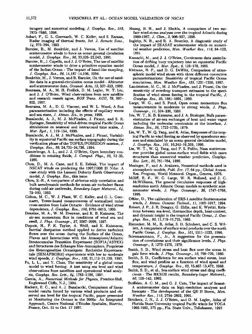
11,372 VEILSCHELL ET AL.: OCEAN MODEL VALIDATION OF NSCAT
imagery and numerical modeling, J. Geophys. Res., 103, 7875-7886, !998.
Askari, F., G. L. Geernaeft, W. C. Keller, and S. Raman, Radar imaging of thermal fronts, Int. J. Remote $ens., 14•, 275-294, 1993.
Barnier, B., M. Boukthir, and J. Verron, Use of satellite •atterometer winds to force an ocean general circulation model, J. Geophys. Res., 96, 22,025-22,042, 1991.
Barnier, B., J. Capella, and J. J. O'Brien, The use of satellite •atterometer winds to drive a primitive equation model of the Indian-Ocean - The impact of band-like sampling, J. Geophys. Res., 99, 14,187-14,196, 1994.
Boukthir, M., J. Verron, and B. Barnier, On the use of satel- lite data in a general-circulation ocean model - Altimeter and scatterometer data, Oceanok Acta, 15, 507-523, 1992.
Bourassa, M. A., M. H. Freilich, D. M. Legler, W. T. Liu, and J. J. O'Brien, •Vind observations from new satellite and research vessels agree, EO$ Trans. A GU, 78, 597- 602, 1997.
Bourassa, M. A., D. G. Vincent, and W. L. Wood, A flux parameterization including the effects of capillary waves and sea state, J. Atmos. $ci., in press, 1999.
Busalacchi, A. J., M. J. McPhaden, J. Picaut, and S. R. Springer, Sensitivity of wind-driven tropical Pacific Ocean simulations on seasonal and interannual time scales, J. Mar. $yst., 1, 119-154, 1990.
Busalacchi, A. J., M. J. McPhaden, and J. Picaut, Variabil- ity in equatorial Pacific sea surface topography during the verification phase of the TOPEX/POSEIDON mission, J. Geophys. Res., 99, 24,725-24,738, 1994.
Camerlengo, A. L., and J. J. O'Brien, Open boundary con- ditions in rotating fluids, J. Cornput. Phys., 35, 12-35, 1980.
Chen, D., M. A. Cane, and S. E. Zebiak, The impact of NSCAT winds on predicting the 1997/1998 E1 Nifio: A case study with the Lamont Doherty Earth Observatory model, J. Geophys. Res., this issue.
Chou, S.-H., A comparison of airborne eddy correlation and bulk aerodynamic methods for ocean-air turbulent fluxes during cold-air outbreaks, Boundary-Layer Meteorol., 6•, 75-100, 1993.
Colton, M. C., W. J. Plant, W. C. Keller, and G. L. Geer- naert, Tower-based measurements of normalized radar cross-section from Lake Ontario - Evidence of wind stress
dependence, J. Geophys. Res., I00, 8791-8813, 1995. Donelan, M. A., W. M. Drennan, and K. B. Katsaros, The
air-sea momentum flux in conditions of wind sea and
swell, J. Phys. Oceanogr., 27, 2087-2099, 1997. Dupuis, H., P. K. Taylor, A. Weill, and K. Katsoaros,
Inertial dissipation method applied to derive turbulent fluxes over the ocean during the Surface of the Ocean, Fluxes and Interactions with the Atmosphere/Atlantic Stratocumulus Transition Experiment (SOFIA/ASTEX) and Structures des Echanges Mer-Atmosphere, Proprietes des Heterogeneities Oceaniques: Recherche Experimen- tale (SEMAPHORE) experiments with low to moderate wind speeds, J. Geophys. Res., 102, 21,115-21,129, 1997.
Fu, L. L., and Y. Chao, The sensitivity of a global ocean model to wind forcing: A test using sea level and wind observations from satellites and operational wind analy- sis, Geophys. Res. Left., ϥ, 1783-1786, 1997.
Garcia, A., Numerical Methods for Physics, Prentice-Hall, Englewood Cliffs, N.J., 1994.
Hackert, E. C., and A. J. Busalacchi, Comparison of linear model results forced by various wind products and ob- served sea level for the tropical Pacific, paper presented at Monitoring the Oceans in the 2000s: An Integrated Approach, Centre National d'Etudes Spatiales, Biarritz, France, Oct. 15 to Oct. 17 1997.
Huang, B. H., and J. Shukla, A comparison of two sur- face wind stress analyses over the tropical Atlantic during 1980-1987, J. Clim., 9, 906-927, 1996.
Ingleby, N. B., and R. A. Bromley, A diagnostic study of the impact of SEASAT scatterometer winds on numeri- cal weather prediction, Mon. Weather Rev., 119, 84-103, 1991.
Kamachi, M., and J. J. O'Brien, Continuous data assimila- tion of drifting buoy trajectory into an equatorial Pacific Ocean model, J. Mar. $yst., 6, 159-178, 1995.
Kirtman, B. P., and D. G. DeWitt, Comparison of atmo- spheric model wind stress with three different convective parameterizations: Sensitivity of tropical Pacific Ocean simulations, Mon. Weather Rev., 125, 1231-1250, 1997.
Landsteiner, M. C., M. J. McPhaden, and J. Picatit, On the sensitivity of sverdrup transport estimates to the speci- fication of wind stress forcing in the tropical Pacific, J. Geophys. Res., 95, 1681-1691, 1990.
Large, W. G., and S. Pond, Open ocean momentum flux measurements in moderate to strong winds, J. Phys. Oceanogr., 11, 324-336, 1981.
Liu, W. T., K. B. Katsaros, and J. A. Businger, Bulk param- eterization of air-sea exchanges of heat and water vapor including the molecular constraints at the interface, J. Atmos. Sci., 36, 1722-1735, 1979.
Liu, W. T., W. Q. Tang, and R. Atlas, Responses of the trop- ical Pacific to wind forcing as observed by spaceborne sen- sors and simulated by an ocean general circulation model, J. Geophys. Res., 101, 16,345-16,359, 1996.
Liu, W. T., W. Q. Tang, and P.S. Polito, Nasa scatterom- eter provides global ocean-surface wind fields with more structures than numerical weather prediction, Geophys. Res. Left., 25, 761-764, 1998.
Mesinger, F., and A. Arakawa, Numerical methods used in atmospheric models, Publ. Set. 17, 64 pp., Global Atmos. Res. Prograln, ¾Vorld Meteorol. Organ., Geneva, 1976.
Milliif, R. F., W. G. Large, W. R. Holland, and J. C. McWilliams, The general circulation responses of high- resolution north Atlantic Ocean models to synthetic scat- terometer winds, J. Phys. Oceanogr., 26, 1747-1768, 1996.
Offiler, D., The calibration of ERS-1 satellite Scatterometer winds, J. Atmos. Oceanic Technol., 11, 1002-1017, 1994.
Rebert, J.P., J. R. Donguy, G. Eldin, and K. Wyrtki, Rela- tions between sea-level, thermocline depth, heat-content, and dynamic height in the tropical Pacific Ocean, J. Geo- phys. Res., 90, 11,719-11,725, 1985.
Rienecker, M. M., R. Atlas, S. D. Schubert, and C. S. Wil- lett, A comparison of surface wind products over the north Pacific Ocean, J. Geophys. Res., 101, 1011-1023, 1996.
Sciremammano, F., Jr., A suggestion for the presenta- tion of correlations and their significance levels, J. Phys. Oceanogr., 9, 1273-1276, 1979.
Smith, S. D., Wind stress and heat flux over the ocean in gale force winds, J. Phys. Oceanogr., 10, 790-726, 1980.
Smith, S. D., Coefficients for sea surface wind stress, heat flux, and wind profiles as a function of wind speed and temperature, J. Geophys. Res., 93, 15,467-15,472, 1988.
Smith, S. D., et al., Sea-surface wind stress and drag coeffi- cients- The HEXOS results, Boundary-Layer Meteorok, 60, 109-142, 1992.
Stoffelen, A. C. M., and G. J. Cats, The impact of Seasar- A scatterometer data on high-resolution analyses and forecasts - The development of the QE II Storm, Mon. Weather Rev., 119, 2794-2802, 1991.
Stricherz, J. N., J. J. O'Brien, and D. M. Leglet, Atlas of Florida State University tropical Pacific winds for TOGA 1966-1985, 275 pp., Fla. State Univ., Tallahassee, 1992.

VERSCHELL ET AL.: OCEAN MODEL VALIDATION OF NSCAT 11,373
Tang, W. Q., and W. T. Liu, Equivalent neutral wind, Publ. 96-17, Jet Propul. Lab., Pasadena, Calif., 1996.
Thepaut, J. N., R. N. Hoffman, and P. Courtier, Interactions of dynamics and observations in a 4-dimensional varia- riohal assimilation, Mon. Weather Rev., 121, 3393-3414, 1993.
Versehell, M. A., J. C. Kindle, and J. J. O'Brien, Effects of Indo-Pacific throughflow on the upper tropical Pacific and Indian Oceans, J. Geophys. Res., 100, 18,409-18,420, 1995.
Weissman, D. E., Satellite scatterometer (NSCAT) studies of ocean surface stress using a direct model in near coastal regions, paper presented at the Ninth Conference on Inter- action of the Sea and Atmospheres, Am. Meteorol. Soc., Phoenix, Arizona, 1998.
Weissman, D. E., K. L. Davidson, R. A. Brown, C. A. Friehe, and F. Li, The relationship between the microwave radar
cross section and both wind speed and stress: Model func- tion studies using Frontal Air-Sea Interaction Experiment data, J. Geophys. Res., 99, 10,087-10,108, 1994.
"M. A. Bourassa and J. J. O'Brien, Center for Ocean- Atmospheric Prediction Studies, Florida State University, Tallahassee, FL, 32306.
M. A. Vetscheil, Laboratory for Hydrospheric Processes, NASA Goddard Space Flight Center, Code 970, Greenbelt, MD, 20771. ([email protected]. gov)
D. E. Weissman, Departraent of Engineering, Hofstra Uni- versity, Hempstead, New York, 11549.
(Received March 20, 1998; revised October 16, 1998; accepted December 9, 1998.)