Planning Board Worksession No.1-Transportation and Staging
28
Planning Board Worksession No.1-Transportation and Staging
-
Upload
khangminh22 -
Category
Documents
-
view
5 -
download
0
Transcript of Planning Board Worksession No.1-Transportation and Staging

Planning Board Worksession No.1-Transportation and Staging
Planning Board Worksession No.1: Transportation and Staging
Public Hearing: January 12, 2017
Public Record Closes: January 26, 2017

3
Sector Plan Area and Policy Areas
North Bethesda Policy Area
Twinbrook Policy Area
City of Rockville
White Flint Sector Plan

4
Adequacy Standards
Critical Lane Volume (CLV)
Highway Capacity Manual (HCM) Delay
HCM
Volume-to-
Capacity
Equivalent
Policy Area HCM Avg
Vehicle Delay
Standard
(secs/vehicle)
CLV Congestion
Standard
0.97 North Bethesda 71 N/A
1.13 White Flint 120 N/A
1.13 Twin brook 120 N/A
2016 - 2020 Subdivision Staging Policy Intersection Congestion
Standards
5
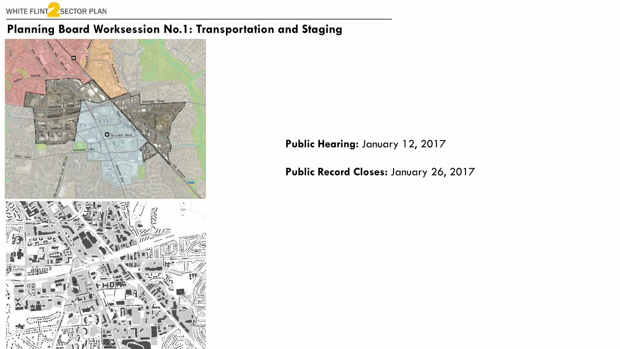
Plan Area Intersections and Existing CLVID
CLV
Standard E-W Road N-S Road
2015 Existing CLV
AM PM
1 1,550 Montrose Road East Jefferson Street
710 962
2 1,550 Montrose Parkway East Jefferson Street
1,058 1,221
3 1,800 Rollins Avenue MD 355
972 1,138
4 1,800
Twinbrook
ParkwayChapman Avenue
840 1,035
5 1,550 Bou Avenue MD 355
971 1,170
6 1,800 Bou Avenue Chapman Avenue
575 766
7 1,800 Montrose Road Hoya Street
561 578
8 1,800 Montrose Parkway Hoya Street
548 685
9 1,800
Executive
BoulevardOld Georgetown Road
1,224 1,019
11 1,800 Nicholson Lane Old Georgetown Road
1,067 1,121
13 1,800 Montrose Parkway MD 355
672 640
14 1,800
Old Georgetown
RoadMD 355
1,206 1,347
15 1,800 Marinelli Road MD 355
887 933
16 1,800 Nicholson Lane MD 355
1,072 1,310
18 1,800 Randolph Road Nebel Street
854 1,145
19 1,550 Randolph Road Parklawn Drive
1,144 1,174
21 1,550 Randolph Road Gaynor Road
1,120 1,192
22 1,800 Nicholson Lane Nebel Street
830 906
23 1,550
Boiling Brook
ParkwayParklawn Drive
1,124 858
24 1,550
Boiling Brook
ParkwayRocking Horse Road
1,021 882

6
Existing Conditions Vehicle/Capacity Ratio

7
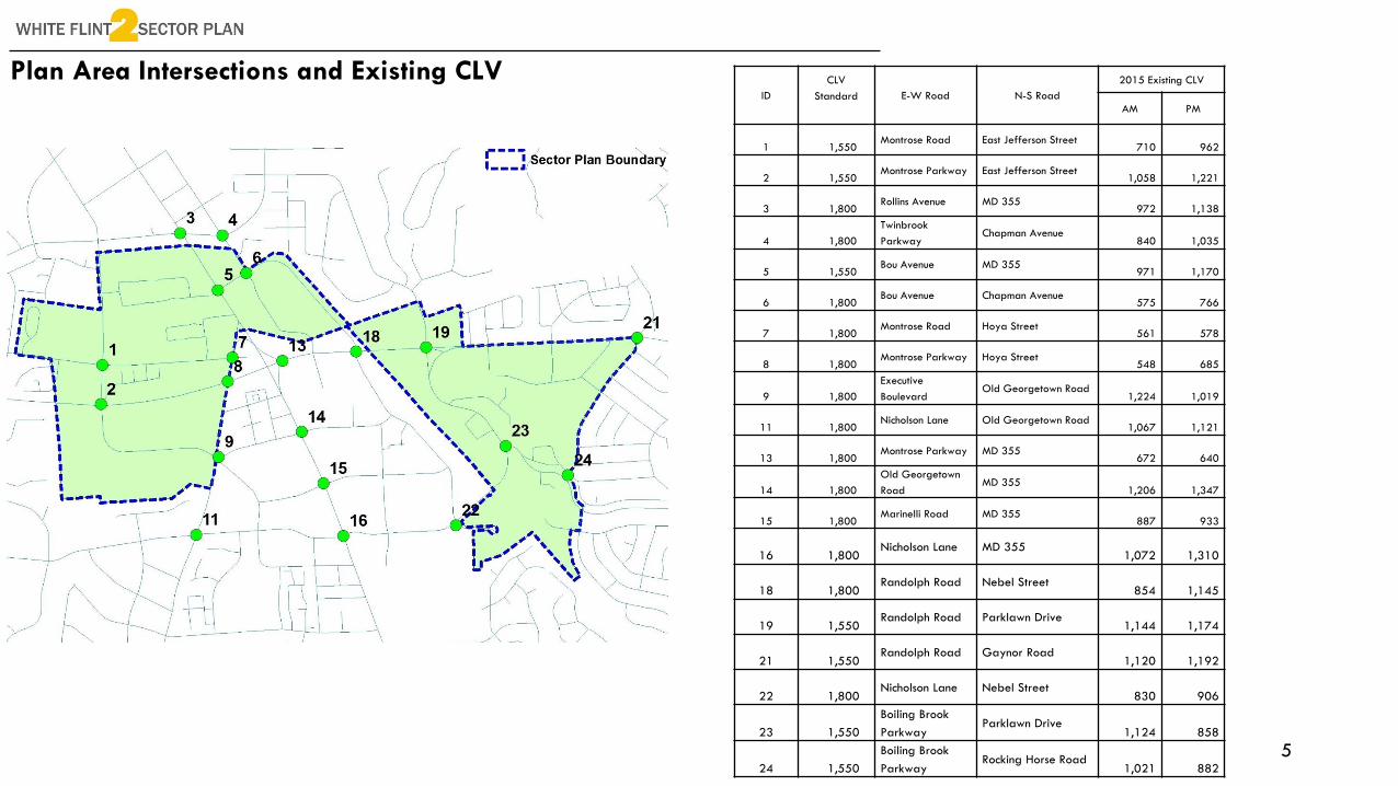
Local Area Transportation Review Modeling
2010 base year and 2040 horizon year
Transportation improvements (both highway and transit) reflected in the region’s
Constrained Long Range Plan (CLRP), a fiscally constrained transportation network.
No geometric/operational local intersection improvements
No Bus Rapid Transit (BRT)
No Non-Auto Driver Mode Share (NADMS) goal/target applied
White Flint II and Rock Spring Sector Plan scenarios evaluated concurrently

8
Local Area Transportation Review Modeling
In support of the transportation analysis for the Plan area, the following assumptions were applied:
Outside the Plan study areas, regional growth reflecting the MWCOG Cooperative Forecast (Round 8.3)
White Flint Transportation Projects
o White Flint District West Workaround (No.501506)
o White Flint West: Transportation (No.501116)
o White Flint District East: Transportation (No.501204)
o White Flint Traffic Analysis and Mitigation (No.501202)
Land use data consistent with that assumed in support of the White Flint Traffic Operations Analysis Report
released by Stantec (2014)
New 300 household development plan at the WMAL Radio Tower site
o New 300 households and corresponding population were added to existing land use inputs in TAZ 3748
(WMAL Radio Tower site located between I-270 Spur and I-495 Beltway).
Montrose Parkway East
New I-270 Spur HOV ramps on the south side of the Westlake Terrace Bridge in Rock Spring Sector Plan area.

9
Local Area Transportation Review Modeling
ID
CLV
Standa
rdE-W Road N-S Road
2040 Alternative 1 2040 Alternative 2 2040 Alternative 3
AM PM AM PM AM PM
1 1,550 Montrose Road East Jefferson Street
732 1,118 773 1,170 784 1,185
2 1,550 Montrose Parkway East Jefferson Street
1,068 1,149 1,096 1,178 1,098 1,189
3 1,800 Rollins Avenue MD 355
1,171 1,297 1,175 1,302 1,175 1,305
4 1,800 Twinbrook Parkway Chapman Avenue
1,159 1,322 1,136 1,323 1,142 1,328
5 1,550 Bou Avenue MD 355
1,289 1,573 1,301 1,588 1,303 1,587
6 1,800 Bou Avenue Chapman Avenue
826 921 814 973 804 924
7 1,800 Montrose Road Hoya Street
911 941 960 963 968 984
8 1,800 Montrose Parkway Hoya Street
976 1,161 999 1,167 1,008 1,170
9 1,800 Executive Boulevard Old Georgetown Road
1,629 1,632 1,637 1,633 1,632 1,634
11 1,800 Nicholson Lane Old Georgetown Road
1,621 1,660 1,624 1,678 1,624 1,666
13 1,800 Montrose Parkway MD 355
1,424 1,206 1,437 1,207 1,446 1,214
14 1,800 Old Georgetown Road MD 355
1,395 1,412 1,395 1,411 1,400 1,415
15 1,800 Marinelli Road MD 355
1,151 1,329 1,163 1,330 1,201 1,307
16 1,800 Nicholson Lane MD 355
1,221 1,581 1,226 1,583 1,231 1,608
18 1,800 Randolph Road Nebel Street
998 1,251 984 1,262 997 1,278
19 1,550 Randolph Road Parklawn Drive
1,195 1,586 1,209 1,616 1,217 1,670
21 1,550 Randolph Road Gaynor Road
1,080 1,202 1,085 1,207 1,090 1,212
22 1,800 Nicholson Lane Nebel Street
1,133 1,356 1,151 1,355 1,199 1,427
23 1,550 Boiling Brook Parkway Parklawn Drive
1,155 1,454 1,164 1,470 1,188 1,507
24 1,550 Boiling Brook Parkway Rocking Horse Road
1,135 990 1,154 1,000 1,150 996
Intersection CLVs within the Study area that exceed the
applicable policy area congestion standard are highlighted
in red.
10
Local Area Transportation Review Modeling
Alternative 3

11
2010 White Flint Sector Plan Staging

12
Draft Plan StagingThe proposed framework for staging in this Plan is established by a critical factor: the Plan area’s adjacency to the 2010 White Flint Sector Plan area and its staging plan requirements. The proximity of the White Flint Sector Plan and the White Flint 2 Plan areas is demonstrated by the extension of both Rockville Pike (MD 355) and Executive Boulevard through both Plan areas and the proximity of the White Flint Metro Station to both Plan areas.
The staging framework is guided by the following principles:
Ensure an adequate level of development or tax contributions to help fund new infrastructure.
Balance the infrastructure needs and requirements between both White Flint plan areas.
Address the infrastructure needs for White Flint 2, including public facilities to support new
development.
Limiting the free rider effect where properties in White Flint 2 benefit from new infrastructure
in the 2010 White Flint Sector Plan area.
Development in the core of the 2010 White Flint Sector Plan, which is near to the Metro Station
and along Rockville Pike, should be prioritized before periphery properties are developed.
Realignment of Parklawn Drive Rockville Pike BRT
Protected Bikeways
Second White Flint Metro Entrance
Parks and Open Space Non-Auto Driver Mode Share

13
Draft Plan Staging
Several important pre-staging items are considered for the draft White Flint 2 Sector Plan.
The Planning Board should expand the existing White Flint Sector Plan Implementation
Advisory Committee to include property owners, residents and other stakeholders from the
White Flint 2 Sector Plan area.
The Planning Board should expand the White Flint Sector Plan biennial monitoring report to
include staging recommendations in this Plan.
Prior to approval of any new development in the Plan area, the following actions must be taken:
Amend the North Bethesda Policy Area to create a new Local Area Transportation Review
(LATR) Policy Area for the White Flint 2 Sector Plan area, within six months of adopting the
Sectional Map Amendment (SMA).
Within 12 months of adopting the Sectional Map Amendment (SMA), determine if a public
financing mechanism will be established to fund public infrastructure recommended for the
White Flint 2 Sector Plan area.
The Planning Board must create a staging allocation procedure for new development in the
Plan area or modify the existing White Flint Sector Plan Implementation Guidelines.

14
Draft Plan StagingPhase 1 Phase 2 Phase 3
Residential: 1,800 dwelling units
Non-Residential: 900,000 square feet
Residential: 1,800 dwelling units
Non-Residential: 900,000 square feet
Residential: 2,338 dwelling units
Non-Residential: 1,189,857 square feet
Achieve 27% Non-Automotive Driver Mode Share (NADMS)
for the Plan area.
Fund the Executive Boulevard and East Jefferson protected
bikeway.
Fund and complete the design study for Rockville Pike Bus
Rapid Transit (BRT) that will be coordinated with SHA,
MCDOT, M-NCPPC and the City of Rockville.
Complete the implementation of Western Workaround,
including the realignment of Executive Boulevard, Towne Road
and Old Georgetown Road (MD 187) for vehicular travel.
Fund the roadway realignment of Parklawn Drive and
Randolph Road.
Montgomery County Public Schools (MCPS) must evaluate the
need for a new elementary school within the Walter Johnson
cluster and determine how and when a new elementary
school will be programmed.
Maryland Department of Transportation (MDOT) must conduct
a feasibility study for an infill MARC station along the
Brunswick Line and determine if a MARC station should be
located in the Plan area.
The Planning Board must assess that the Sector Plan is
achieving its goals and that all the infrastructure items for this
Stage 1 are completed, prior to proceeding to Stage 2.
Achieve 35% Non-Automotive Driver Mode Share (NADMS)
for the Plan area.
Fund a shuttle or circulator that serves the Plan area,
adjacent to residential communities, and Metro station
areas.
Fund the acquisition or dedication of a new public park for
the plan area.
Construct streetscape improvements, sidewalk improvements,
and bikeways for substantially all of the street frontage
within one-quarter mile of the Metro station: Old
Georgetown Road, Marinelli Road and Nicholson Lane.
Fund the second entrance to the White Flint Metro Station.
The Planning Board must assess that the Sector Plan is
achieving its goals and that all the infrastructure items for
Stage 2 are completed, prior to proceeding to Stage 3.
Achieve 42% Non-Automotive Driver Mode Share
(NADMS) for the Plan area.
Fund and implement the Parklawn Drive Shared Use
Path.
Montgomery County Public Schools (MCPS) must
construct an elementary school for the Walter
Johnson School Cluster or determine how elementary
school needs will be addressed for the Cluster.
Construct a new MARC station, if MDOT determines
that a MARC station will be located within the plan
area.

15
Transportation Infrastructure
2010 White Flint
Sector Plan
Western Workaround
Complete the implementation of Western Workaround, including the realignment of Executive Boulevard, Towne Road and Old Georgetown Road (MD 187) for vehicular travel.

16
Transportation Infrastructure
MD 355 Corridor BRT

17
Transportation Infrastructure: Roadway Realignment
Loehmann’s Plaza
Montrose Parkway
Fund the roadway realignment of Parklawn Drive and Randolph Road.

18
White Flint Metro Station Northern Entrance
Northern entrance images from WMATA 2010 Access Study
Estimated Cost (2011): $35 million
Northern Entrance Concept

19
MARC
MARC
MARC
1992
North
Bethesda
Master
Plan
2010
White
Flint
Sector
Plan

20
MARC
2008 MTA Technical Review for a MARC indicated that:
Either site (Montouri or Nicholson Court) would not provide
direct access to the existing Metro stations.
The spacing of existing MARC stations is already closer than
desired.
The addition of a new station would increase travel time
and potentially decrease individual station ridership for
other stations along the Brunswick Line.
It is recommended that if the new White Flint Station is to
be added, the Garrett Park MARC Station should be
removed to ensure optimum system efficiency.

21
MARC
Maryland Department of Transportation (MDOT) must conduct a feasibility study for an infill MARC station along the Brunswick Line and determine if a MARC station should be located in the Plan area.
MARC Growth and Investment Plan (September 2007)
Brunswick Line: 2020-2029 Long Term Potential (MARC Growth and Investment Plan 2013 to 2050)
3 main tracks, Barnesville Hill
Add another new Montgomery County station or expand an existing station
Point of Rocks platform expansion providing access to Frederick branch and improved facilities
Parking facility expansions as deemed necessary
o Germantown Parking Garage
Brunswick parking lot – additional access point
Duffields – potential new station at Northport
Brunswick Maintenance service facility expansion

22
NADMSNon-Auto Driver Mode Share (NADMS) is the percentage of trips to work by modes other than the single-
occupant automobile, including transit, carpool/vanpool, biking/walking and telecommuting.
The overall North Bethesda/Garrett Park Master Plan Area NADMS goal is 39 percent.
White Flint 2 Sector Plan Draft Plan
2015 Estimate: 21.3 percent (during the Plan creation)
Phasing Requirement
Phase 1: 27 percent
Phase 2: 35 percent
Phase 3: 42 percent
2010 White Flint Sector Plan
2005 Estimate: 26 percent (during the Plan creation)
2014 Estimate: 31.7 percent
Phasing Requirement
Phase 1: 34 percent
Phase 2: 42 percent
Phase 3: 50 percent (employees)/51 percent (residents)White Flint Sector Plan
Bethesda CBD: 38 percent (2015)
Silver Spring: 53 percent (2015)Performance Review of Transportation Management Districts (OLO Report 2016-9)-July 2016

23
Staging: Executive Boulevard and East Jefferson
Recommendation: Executive Boulevard
Recommendation: East Jefferson
Existing: Executive Boulevard
Existing: East Jefferson
Fund the Executive Boulevard and East Jefferson protected bikeway.

24
Staging: Public Schools
Phase 1
Montgomery County Public Schools (MCPS) must evaluate the need for a new elementary school within the Walter Johnson cluster and determine how and when a new elementary school will be programmed.
Phase 3
Montgomery County Public Schools (MCPS) must construct an elementary school for the Walter Johnson School Cluster or determine how elementary school needs will be addressed for the Cluster.
Walter Johnson School Cluster

25
Staging: Public Schools
* Projections from 2036 to 2046 assume complete build-out of Kensington and White Flint sector plans and proposed housing not
associated with these sector plans. Market conditions and the pace of redevelopment of existing properties could change the
number of units built and the timing of full build-out. Most master plans never reach full build-out.
**The projection for 2046 is considered peak enrollment. However, the projection for 2046 does
not include Rock Spring Master Plan, Grosvenor Strathmore and White Flint 2 Sector Plan, as housing unit counts are not finalized at
this time. The longer the forecast period, the more error is possible. It is considered equally
likely for enrollment to come in below the numbers as it is for enrollment to exceed them.

26
Staging: Public Schools
* Projections from 2036 to 2046 assume complete build-out of Kensington and White Flint sector plans and proposed housing not
associated with these sector plans. Market conditions and the pace of redevelopment of existing properties could change the number of
units built and the timing of full build-out. Most master plans never reach full build-out.
**The projection for 2046 is considered peak enrollment. However, the projection for 2046 does not include Rock Spring Master Plan,
Grosvenor Strathmore and White Flint 2 Sector Plan, as housing unit counts are not finalized at this time. The longer the forecast period,
the more error is possible. It is considered equally likely for enrollment to come in below the numbers as it is for enrollment to exceed them.

27
Staging: Public Schools
*Assumes 90 percent of new residential development will be multifamily mid-rise or higher
and 10 percent as townhouses.
Elementary School Middle School High School
White Flint 2 Sector
Plan in the Walter
Johnson Cluster *
295 125 157
White Flint 2 Sector
Plan in the
Downcounty
Consortium *
73 30 39
2010 White Flint
Sector Plan in the
Walter Johnson Cluster
410 380 321

28
Upcoming Worksession
February 9, 2017: Land Use and Zoning (Part I)