PLAN 1010 FINAL PAPER
22
Gustavo LaRotta PLAN 1010 Community Analysis 11/30/2014 San Juan, Puerto Rico: A Community Analysis Introduction Puerto Rico, La Isla de Encanto (translated island of enchantment), lies in the Caribbean Sea with its capital, San Juan in the Northern part of the island. The first settlement on the island of Puerto Rico was Caparra, founded in 1508 by Juan Ponce de León, a Spanish explorer and conquistador best remembered for his supposed quixotic quest for the fountain of youth in Florida. San Juan, with its strategic port location, provided the Spanish a perfect place to settle and defend itself from pirates. Nowadays, San Juan is a booming tourist destination. The historic Old San Juan along with its famous castle, El Morro, are UNESCO World Heritage Sites. American tourists flock to San Juan to experience a piece of the Caribbean without the need for a visa, as Puerto Rico is considered American soil. The old section of the city is home to cultural monuments such as museums, colonial-era buildings and churches. This, along with its beautiful beaches and booming nightlife make San Juan the place to be for many tourists. Economically, San Juan is the home port for many major
-
Upload
independent -
Category
Documents
-
view
1 -
download
0
Transcript of PLAN 1010 FINAL PAPER

Gustavo LaRotta
PLAN 1010 Community Analysis
11/30/2014
San Juan, Puerto Rico: A Community Analysis
Introduction
Puerto Rico, La Isla de Encanto (translated island of
enchantment), lies in the Caribbean Sea with its capital, San Juan in
the Northern part of the island. The first settlement on the island of
Puerto Rico was Caparra, founded in 1508 by Juan Ponce de León, a
Spanish explorer and conquistador best remembered for his supposed
quixotic quest for the fountain of youth in Florida. San Juan, with
its strategic port location, provided the Spanish a perfect place to
settle and defend itself from pirates. Nowadays, San Juan is a booming
tourist destination. The historic Old San Juan along with its famous
castle, El Morro, are UNESCO World Heritage Sites. American tourists
flock to San Juan to experience a piece of the Caribbean without the
need for a visa, as Puerto Rico is considered American soil. The old
section of the city is home to cultural monuments such as museums,
colonial-era buildings and churches. This, along with its beautiful
beaches and booming nightlife make San Juan the place to be for many
tourists. Economically, San Juan is the home port for many major
cruise ships and is among the most important ports in the Caribbean.1
This paints a rosy picture of the city when in fact, upon further
research, San Juan suffers from urban sprawl, traffic, lack of green
spaces, financing issues and building/environmental decay. The San
Juan that the tourists see, albeit beautiful, has been in steady
decline and threatens the economic viability of the region. Because of
all this, change must be made. This paper will focus on identifying
the problems within the city of San Juan, demonstrating the current
choices for healing, and then offering my point of view, applying my
knowledge of urban planning to make recommendations.
Planning Issues
The Puerto Rico Planning Board was founded in 1942 as part of
the New Deal and served as the central authority on planning issues.
Much like in the US, development in post WW II Puerto Rico was
designed to dependent on the car for transportation, leading to
sprawl. However, during the 1970’s the local governments gained more
autonomy with regards to planning within their jurisdictions. This may
seem like a victory for the local governments, but made collaboration
1 Minister, Christopher. "The History of San Juan, Puerto Rico." About. N.p., n.d. Web. 28 Nov. 2014. <http://latinamericanhistory.about.com/od/caribbeancities/p/sanjuan.htm>.

between cities very difficult. Thus, this leads to the current problem
of the difficulty on deciding on planning methods and a disintegration
with other areas of Puerto Rico.2 Along with that, “planning and
environmental assessment is done using a lengthy and unpredictable
evaluation process”3. However, the government recently created the
Office for Land Use Planning in response to the current
inefficiencies.
Many of the problems in San Juan are outlined in the Walkable
City plan, in my opinion the best view of the future of San Juan. The
fact that historical landmarks are becoming hidden from view with the
construction of new buildings threaten the historical integrity of the
region. Run down neighborhoods such as La Perla suffer from building
decay and a lack of integration with the rest of the city. Over 30% of
the city is underserved by public transit. Over 8% of the city’s
Isleta (Small Island on the northernmost tip of San Juan connected to
the mainland by bridge) is vacant, including over a mile of oceanfront
land. The over 77,000 cars that enter the Isleta every day exceeds its
capacity for cars, leading to traffic and congestion. 18% of the 2 "Portal De La Junta De Planificacion De Puerto Rico." Portal De La Junta De Planificacion De Puerto Rico. N.p., n.d. Web. 26 Nov. 2014. <http://www.jp.gobierno.pr/>.3 Martinuzzi, Sebastian, William A. Gould, and Olga M. Ramos Gonzalez. "Land development, land use, and urban sprawl in Puerto Rico integrating remote sensing and population census data." Landscape and Urban Planning 79.3 (2007): 288-297. Pg 2.

coastline, much of it facing the ocean, is under serious threat of
erosion due to the wave action of the ocean. 43% of the buildings in
the Isleta are considered decaying and of the 7.5 miles of coastline,
only 30% is accessible by the public. Finally, the pedestrian
experience is miserable, characterized by a disconnection with open
spaces and sidewalks that are in poor condition, with few crosswalks
and even fewer areas of shade.4
Basic elements of transportation are in decay as well, as
outlined below5:
Need for new right or left turn lanes and intersection channelization or to improve or extend existing turn lanes and channelization
Significant pavement deficiencies (poor drainage, potholes, uneven pavement)
Insufficient roadway lighting or lack of lighting
Insufficient pavement markings or lack of markings
Deficient traffic signs or lack of essential signing
4Di Mambro, Antonio and Santini, Jorge. "Walkable City San Juan." Issuu. N.p., n.d. Web. 25 Nov. 2014. <http://issuu.com/sanjuannews/docs/finalreportsummary_walkablecity_july3-final>.5 The Strategic Planning Office of the Puerto Rico Highway and Transportation Authority Department of Transportation and Public Works, comp. “San Juan Urbanized Area – 2030 Long Range Transportation Plan.”(2010). The Policy Committee of the Metropolitan Planning Organization. Web. 25 Nov. 2014. <http://www.dtop.gov.pr/pdf/JANUARY_2011_FINAL_SJUA_2030_LRTP_Feb4_2011.pdf>. Pg 83

Inadequate or poorly coordinated traffic signals or lack of needed signalization
Capacity constraints and hazardous conditions resulting from reduction in number of traffic lanes or obstacles immediately adjacent to traffic lanes
Visual obstructions caused by illegal signs, foliage, and other roadside features
Need for installation or replacement of median or roadside safetybarriers
As is evident, vast changes must be made to make the simple experience
of transportation not only more enjoyable and tolerable, but safe so
as to avoid unneeded accidents, crashes and fatalities.
Green infrastructure or urban vegetation, are vital to any
city, because of their critical roles in “mitigating urban heat island
and climate change, and for their provision of multiple ecosystem
services and aesthetics”.6
6 Ramos-González, O. M. 2014. The green areas of San Juan, Puerto Rico. Ecology and Society 19(3): 21.http://dx.doi.org/10.5751/ES-06598-190321 . Pg 1.

As we can see, the urban area of San Juan is severely lacking any
green space. This image was constructed using satellite technology and
was part of a study that concluded that of 20 cities in the US, San
Juan ranked only above Miami, New York and Chicago, bustling urban
centers. This is something that must change in order to enhance the
quality of life for not only the tourists, but the locals as well in
an effort to bring wildlife back into the city to interact with
humans.

7
There has also been a documented environmental noise problem within
the urban space of San Juan. After a study conducted by the Puerto
Rico Environmental Quality Board, it is fair to conclude that through
the day, sound levels remained fairly high (63 decibels) until late
into the night (11 pm) and reach a low of 58 decibels around 3 am.
These levels could be considered dangerously high since the World
Health Organization says that most people are moderately annoyed by
levels above 50 decibels and seriously annoyed by levels around 55
decibels.8 Noise pollution is clearly a serious problem that must be
fixed because of the “numerous adverse effects on personal health and
community”.9 Thus I believe that it is vital to introduce noise
reduction measures which begins with the measurement and analysis of 7 Ramos-González pg 4.8 Alomar, Osvaldo, Wanda Cruz-Vizcarrondo, Olga Vinas-Curiel, and Jose Alicea-Pou. "Monitoring of the Environmental Noise Level in San Juan, Puerto Rico." (n.d.): n. pag. Print. URL: http://www.bvsde.paho.org/bvsAIDIS/PuertoRico29/alicea.pdf . Pg 4.9 Alomar pg 4
data followed by the introduction of a committee dedicated to
implementing measures to reduce noise so as to promote a higher
quality of life for those in the area, visitors or permanent
residents.
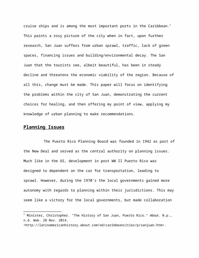
The problems of sprawl are also clear as low density developments
are beginning to characterize the urban form of San Juan. This, along
with almost complete reliance on the automobile for transportation
lead to the weakening of the urban center of San Juan.
10
As mentioned in the study by Martinuzzi, many of the productive
agricultural lands have been transformed into urban areas around the
area of San Juan and even forest reserves have come under human
pressure.11 As you can tell by the graph below, San Juan ranks last in 10 Martinuzzi, Sebastian, William A. Gould, and Olga M. Ramos Gonzalez. "Land development, land use, and urban sprawl in Puerto Rico integrating remote sensing and population census data." Landscape and Urban Planning 79.3 (2007): 288-297. Pg 8.
11 Martinuzzi, Sebastian, William A. Gould, and Olga M. Ramos Gonzalez. "Land development, land use, and urban sprawl in Puerto Rico integrating remote sensing and population census data." Landscape and Urban Planning 79.3 (2007): 288-297. Pg 2.

population density with other cities in the world with similar
population numbers. This illustrates a major problem for development
for the city of San Juan, heavily pointing to the idea of land use
reform for the local government. Other problems for San Juan include
its energy consumption and the need for renewable sources of energy.
Currently, electricity prices are 73% greater than in the US which
clearly affects quality of life, as air conditioning is mostly
available within the bedrooms and turned on only when it is time to
sleep in an effort to save money. Thus, cheaper, more sustainable
options would be welcomed with open arms on the island and at the same
time reduce the ecological footprint of San Juan.

12
Along with these physical problems San Juan suffers from, San
Juan also experiences much financial trouble. A major obstacle to
mending these wounds and developing San Juan is the financing needed
to develop the city. Currently, the city and the island overall is
struggling financially. One can see the subpar creditworthiness of
Puerto Rico with how the rates paid on its municipal bonds are
strikingly high, something that is seen when a debtor is not in good
financial position to repay the loan.13
12 Martinuzzi, Sebastian, William A. Gould, and Olga M. Ramos Gonzalez. "Land development, land use, and urban sprawl in Puerto Rico integrating remote sensing and population census data." Landscape and Urban Planning 79.3 (2007): 288-297. Pg 2.13 "Puerto Rico Munis: Risks Increase - Fidelity.com." Puerto Rico Munis: Risks Increase - Fidelity.com. N.p., 01 Aug. 2014. Web. 27 Nov. 2014. <https://www.fidelity.com/viewpoints/investing-ideas/puerto-rico-munis-isks-

Recommendations
Currently in discussion are four major plans and visions for
the future of San Juan. The first of these is the Economically
Sustainable City. This view is the dominant view from the state’s main
agencies and focuses on the strategy of regionalizing key areas on the
island based on their economic and social overlaps as well as
capitalizing on their strengths. It emphasizes a participative focus
and that the people are to decide with their choices how resources are
to be allocated.14 The second plan is called the Livable City. This
plan emphasizes the marginal social and ecological aspects of the
city. The end goal of this view is to recover the city and make it
livable, efficient, orderly, safe, beautiful and accessible to those
who have been marginalized in the past. It defines itself against past
unsustainable urban patterns of sprawl as committed to the
revitalization and conservation of land resources.15 The third vision
increase>.
14 Muñoz-Erickson, T. A. 2014. Multiple pathways to sustainability in the city: the case of San Juan, Puerto Rico. Ecology and Society 19(3): 2.http://dx.doi.org/10.5751/ES-06457-190302 pg 4.15 See note 14 above

is the Ecologically Sustainable City. This plan values the
sustainability of the natural ecological systems. No institution
specifically endorses this view, but has risen to the surface of
discussion by way of communal discourses and actions of NGOs. Key
ideas include the connectivity amongst the different and unique
ecological systems and the vision of a city with a reduced ecological
footprint, with great connectivity and aesthetically pleasing16. The
final view of the city is the one that I hold to be the best option
for the future of San Juan, the Modern City. Also known as the
Walkable City, this plan is a reflection of the aspirations of former
Mayor Jorge Padilla and calls for the redevelopment and revitalization
of the main urban cores. This vision emphasizes making the city
visible, attractive and modern and new so as to promote external
investment critical to the economic development of the city. Although
highly ambitious, I believe that with teamwork among the different
levels of government and community, that this vision will give the
city and the island as a whole something that it has yearned for,
something to be proud of. This sense of identification and connection
with something of their own will lead to an enhanced sense of
community and connection, ideally leading to an economic and social
revitalization of not only San Juan, but Puerto Rico as a whole. Thus,
16 See note 14 above

the redevelopment of San Juan, if done well, will have effects
throughout the entire island, affecting multiple communities and is
indeed much larger than the geographical lines that separate San Juan
from its neighboring municipalities.
The Walkable City plan is keen on capitalizing on the
positives San Juan has to offer while eliminating the negatives
outlined previously. Among the positives is the fact that San Juan has
a vibrant culture complete with exquisite cuisine and Latin music. Its
historic heritage is to be emphasized, as over 600 years of history is
to be celebrated. Its topography allows access to wonderful views of
the ocean and other landmarks and its quality of open spaces allows
for the potential for a great pedestrian experience. Many of its
weaknesses can be identified as strengths, as the existence of
building decay and vacant plots of land allow for a redefinition and
rededication of that land to new, vibrant developments. The potential
for success is clearly there for San Juan.
The Walkable City plan proposes 10 strategic actions in order
to realize the vision of the Walkable City. They are outlined below.17
17 Di Mambro, Antonio and Santini, Jorge. "Walkable City San Juan." Issuu. N.p., n.d. Web. 25 Nov. 2014. <http://issuu.com/sanjuannews/docs/finalreportsummary_walkablecity_july3-final>. Pg 14.

1. Introduce integrated public transit system2. Implement state of the art public realm3. Establish pedestrian waterfront loop4. Pedestrianize old San Juan5. Revitalize rundown neighborhoods6. Protect the Isleta from erosion and sea level rise7. Protect and celebrate Isleta’s historical assets8. Develop and integrate north and south waterfronts9. Diversity and repopulate the Isleta10. Expand and diversify Isleta’s tourist
assets
Above is a great visual summary of the changes the Walkable City Plan
plans to introduce.
18 Di Mambro, Antonio and Santini, Jorge. "Walkable City San Juan." Issuu. N.p., n.d. Web. 25 Nov. 2014. <http://issuu.com/sanjuannews/docs/finalreportsummary_walkablecity_july3-final>. Pg 15

Bearing in mind the page limit for this paper, I will only examine in
detail Strategic Action 1, 2, 3, 5 and 6.
The introduction of an integrated public transit system is
very much important as only 5% of workers use mass transit to get to
work.19 The major problem with introducing this is that Mass transit is
very difficult in high crime environments. This is because people
often don’t want to associate themselves with strangers who may be
criminals. Another problem is that of race, lower-class individuals
are dark skinned and white upper-class citizens may shy away from
public transit if it means associating who those of different classes.
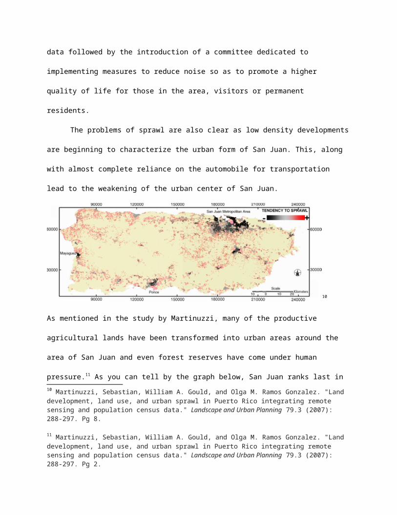
Another key development is to extend the current public transit system
Tren Urbano (translated Urban Train) to Old San Juan as depicted
below. Currently no mass transit system services the Isleta (where Old
San Juan is) nor the international airport, which is out of view in
this image and off to the right past San Jose Lake. Another novel idea
is to bring in the use of water taxis to escape the congested traffic
that currently ails San Juan. A direct route following the blue arrow
is one possible water taxi route that can take advantage of the
existing waterway and take passengers to the Isleta.
19 "Puerto Rico 2025." Stakeholders' Plan for Achieving Puerto Rico 2025 Vision (n.d.): n. pag. Web. <http://gis.jp.pr.gov/Externo_Econ/Programa%20de%20Planificaci%C3%B3n%20Econ%C3%B3mica%20y%20Social/2004.09-PR_2025_Ingles_(Sep-2004).pdf>.
20
The proposed extension of the Tren Urbano will be a light rail system,
as opposed to the Tren Urbano with utilizes an elevated bus system.
This light rail system will be easier to install and will introduce
much needed public transit in the Isleta, which will in turn make it
more sustainable and also walkable. As you can see below, the dotted
lines on the water are proposed water taxi zones and one can also see
the stops the light rail system will make on the Isleta. This, in
conjunction with pedestrianizing San Juan, can make this area a hub
for commerce and social life.
20 Freemark, Yonah. "San Juan Unveils Plan for "Walkable City," Hopes for Light Rail on Isleta." The Transport Politic RSS. N.p., 16 July 2010. Web. 25 Nov. 2014.
21
Strategic Actions 2 and 3 are very much intertwined and will
be critical aspects of creating a modern, beautiful, walkable San
Juan. Creating a state of the art public realm mandates many levels of
creativity. One of the best features of the current proposal is to
connect the currently disconnected north and south water fronts of the
Isleta by way of green corridors.22 By doing this, this fixes the
problem of the lack of green space and provides the potential to
invite wildlife back into the public realm. This, in conjunction with
noise reduction measures can lead to a unique area in San Juan, where
both human and wildlife are able to interact. Another aspect of this
proposal is to make the Isleta’s gateways memorable and beautiful.
21 Di Mambro, Antonio and Santini, Jorge. "Walkable City San Juan." Issuu. N.p., n.d. Web. 25 Nov. 2014. <http://issuu.com/sanjuannews/docs/finalreportsummary_walkablecity_july3-final>. Pg 17.22 Di Mambro, Antonio and Santini, Jorge. "Walkable City San Juan." Issuu. N.p., n.d. Web. 25 Nov. 2014. <http://issuu.com/sanjuannews/docs/finalreportsummary_walkablecity_july3-final>. Pg 19.
Currently, driving onto the Isleta has been a painful experience due
to the number of on ramps and congestion of cars. This area is denoted
above by the arrows and is where the Isleta is connected by bridges to
the mainland. A beautiful area here will help make the driving
experience more tolerable and demarcate this historic region from the
rest of the city. Along with that, those that live within the Isleta
can identify with this monument as the entrance to their home and
their community.
Strategic action 3 is my favorite aspect, as it is the aspect
that will transform San Juan into a regional social and cultural hub.
The establishment of a pedestrian waterfront loop filled with open
areas, green infrastructure, monuments, shops and restaurants can come
to define the new San Juan. Finally, the wonderful views of the ocean
can be capitalized in “boardwalk” fashion for the community. One’s
imagination can only start to think of the possibilities for this.
Bicycle tours, already prevalent in San Juan, will only get increased
participants with the introduction of a beautiful waterfront loop and
increase the health of the community.23 Aside that, parks for children,
amphitheaters for musicians and more can truly elevate San Juan to an
international hub of travel and local source of relaxation, 23 Gwenn. "Take a Bicycle Tour in Old San Juan." Puerto Rico Day Trips Take a Bicycle Tour in Old San Juan Comments. Puerto Rico Day Trips, 21 Sept. 2013. Web. 26 Nov. 2014. <http://www.puertoricodaytrips.com/rent-the-bicycle/>.

entertainment and social gathering. It is in this pedestrian loop that
I sense the mix and manifestation of culture, music, food and people
that San Juan and Puerto Rico has to offer.
24
Strategic Action 5 calls upon the revitalization of rundown
neighborhoods, among these, the famous barrio (Spanish for
neighborhood) La Perla (translated the pearl). Seen below, La Perla
occupies the area to the right of the green space in the middle of the
image. As one can see, La Perla, albeit a slum, lies on highly
valuable real estate. This is something that I believe must be
capitalized. Instead of forcing the individuals to move out, I suggest
that the state government buy the lands from these peoples at high 24 Di Mambro pg 24.

prices to incentivize the people to sell. Not only will this allow the
government or an external third party to redevelop the land, but will
also allow the impoverished people in La Perla a financial boost to
help their families get out of poverty.
25
Strategic Action 6 employs the use of sustainability that is also
deeply intertwined with the creation of the pedestrian waterfront
loop. To protect the coastline from erosion and sea level rise, the
implementation of protective coastal reefs will limit erosion along
the northern coastline storm surge barriers along the northeastern and
northwestern ends of the Isleta will protect is from sea level rise.
These precautions to the viability of the substantial investments the
creation of the waterfront loop will entail and serve as a commitment
to the decision to make San Juan a destination spot for tourists and
locals. Another good idea would be to integrate the existing vibrant
25 Calderon, Jean Martin. "Safety Perception and Tourism Potential in the Informal Neighborhood of" La Perla", San Juan, Puerto Rico." IJSSTH 1.4 (2013):1-23. Pg 6.

oceanic ecosystem with the populace by introducing methods and
ideology from Blue Urbanism.
In addition to these strategic actions, I would also recommend to
create a renewable energy plant especially in the JFK area of San Juan
from methane from the neighboring landfill.26 Another cool idea to help
with the integration of nature in the community is to introduce
ecotourism into the area with the creation of jogging trails, bike
paths and parks designed to welcome wildlife. Ecotourism has the
potential to be real popular in San Juan due to the temperate weather
the region has year around. The introduction of ecotourism would be
working towards a local biophillic community, one where both humans
and nature coexist. Along with this, it also promotes health among the
local community, leading to a higher quality of life.
Conclusion
I have much pride in the recent developments in planning a
vision for my hometown of San Juan, Puerto Rico. However, I realize
that much work, cooperation and dedication is needed to make this
vision of San Juan possible. My city is one full of potential and
promise and it is sad that the current situation was allowed to get to
26 Santini, Jorge. "San Juan: The Economic Engine of Puerto Rico." (n.d.): n. pag. Print. URL: http://www.camarapr.org/presentaciones/British/9-British_Santini.pdf

the point that it is today. The disintegration of the urban form of
San Juan has led to a style of living that is simply unsustainable.
Although the visions of my community are positive, action must be done
quickly in order to better the quality of living for those currently
living there so as to prevent them from moving out. A buzz in the city
must be created to get the community behind this movement. Most
importantly, financing these projects will require creativity and
potentially partnerships with third parties. Whatever has to be done
must be done to alleviate the current situation and it is my hope that
my people back home will welcome these ideas with open hands. If
achieved, this vision will transform San Juan and Puerto Rico into an
international hub in the Caribbean and lead to the economic vitality
of a region that recently has been hurting greatly as a result of the
recent recession in the US.