A Review of Techniques for RSS-Based Radiometric Partial ...

Cumulative Issue #162 March 2012 ISSN 0274-6338
http://www.grss-ieee.org/menu.taf?menu=Publications&detail=newsletter Editor: Lorenzo Bruzzone

10 IEEE Geoscience and Remote Sensing Society Newsletter • March 2012
FEATURE
A MODEL FOR THE SCIENTIFIC EXPLOITATION OF EARTH OBSERVATION MISSIONS:
THE ESA RESEARCH AND SERVICE SUPPORTP.G. Marchetti1, G. Rivolta2, S. D’Elia1, J. Farres1, N. Gobron3, G. Mason1
1European Space Agency – ESRIN Via Galileo Galilei I-00044 Frascati, Italy2Logica D GmbH, Rheinstrasse 95 – D-64295 Darmstadt, Germany
3Joint Research Centre Via E. Fermi 1 I-21020 Ispra, Italy
1. OverviewThe European Space Agency (ESA) is developing five new
missions called Sentinels specifically for the operational
needs of the joint European Commission-ESA Global
Monitoring for Environment and Security (GMES) pro-
gramme [1]. In the coming Sentinel era, Earth Observation
community will be challenged by the significant increase of
storage and processing capacity needs. Whilst the yearly
growth rate of the data archives of ESA’s largest Earth
Observation mission, ENVISAT, has been in the range of
some hundreds of terabytes, the growth rate for the Sentinel
missions’ data will be one order of magnitude higher.
The Sentinel missions’ measurements have a scientific po-
tential which goes well beyond the products offered by opera-
tional services. In order to foster the realization of such scien-
tific potential, straight access to data and adequate processing
resources shall be made available to the Earth Observation
community. In this paper we propose the “ESA Research and
Service Support” model, successfully experimented in the En-
visat era, as foundation for supporting the Earth Observation
research in the Sentinel data exploitation era. Starting from
the theoretical basis of the Research and Service Support
model, the paper provides some concrete examples of support
to science, introduces tools and services that can support EO
scientists in developing applications on the basis of identified
science product requirements, and the integration of informa-
tion from the Sentinel type missions with existing and planned
science missions.
The idea behind the proposed model is that the realization
of the scientific potential of future EO operational missions
can be nurtured by selectively extending approach, technical
environments and tools that cover different aspects of the sci-
ence data exploitation, given that the generation of scientific
value-added products requires several pre-conditions and fol-
lows a number of steps which are not necessarily sequential.
Being this paper an introduction to the proposed “Research
and Service Support” model it focuses on two high level sci-
entific needs: the capability to generate and test algorithms;
and the capability to perform near real time processing of
multi-source Earth Observation mission data.
2. MotivationGenerating and testing algorithms relying on a cooperative
environment where scientists can share and benefit from each
other’s work, find already published algorithms, combine,
modify and exploit them, whilst maintaining full control and
intellectual property rights of their work, would ease the pro-
ductivity of any scientific community.
In particular, for the Earth Observation (EO) communi-
ty, the requirement to perform near real-time processing of
multi-source EO mission data entails the capability to access
resources able to run the processing of large amounts of Earth
Observation data.
The availability of a service providing support tools and
environments enabling the possibility to generate scientific
products designed around specific requirements is an impor-
tant element for successful exploitation of the scientific poten-
tial of Sentinel missions.
The ESA Research and Service Support (RSS) service in-
troduced in this paper, has been designed to the aim of provid-
ing on one hand the resources said above, and on the other
hand ensuring that the research process is effectively and ef-
ficiently followed.
In order to clarify the scope of RSS, it is worth to com-
pare it with the one of another significant service aimed at
supporting the EO scientific process: the NASA’s Giovanni
(see http://disc.sci.gsfc.nasa.gov/giovanni). Giovanni is a web
based application oriented to data visualization and statistical
analysis over a number of large Earth Observation datasets;
hence aiming at an end-to-end tool for supporting scientific
work.
RSS has a different ambition, offering a front-end for data
access and processing, relying on software tools made avail-
able by ESA for local data analysis at the user desk. ESA
provided EO software toolboxes are available at http://earth.

IEEE Geoscience and Remote Sensing Society Newsletter • March 2012 11
esa.int/resources/softwaretools/. This approach is particularly
adequate for those users who have started their work locally
on their workstations with some data samples and want to
“scale up” to massive data processing or wide service expo-
sure. Also, many users rely on the RSS for the pre-processing
of large data amounts, leaving their experimental tasks to run
locally at their own labs.
3. Challenges and Support ModelsAfter the launch of the European Remote Sensing satellites
ERS-1 and ERS-2 in the nineties, the large growth of Earth
Observation data availability, started less than a decade ago
with the launch of the Environmental Satellite—ENVISAT
and more recently with the Earth Explorer science and
research missions [2], has opened new great opportunities for
performing Earth Observation science. The plans of new
ESA missions indicate 5-10 times more data to be acquired
and archived in next 10-15 years. On the other side since 2004
the total number of ESA approved EO research projects, has
been strongly growing. Such trends suggest that EO research-
ers’ capability might be challenged by the possible limitation
of infrastructural resources available within their research
centres. The demand on research centres to follow the growth
in storage and processing capacity might represent one of the
major barriers for EO scientists to perform high quality
research with the large amounts of data which the new mis-
sions will make available in the coming years. The Sentinel
missions planned within the European global monitoring for
environment and security programme—GMES, will be
operational from 2013 onwards [1], [3]. The exploitation of
the scientific potential of these new types of missions would
imply significant investments on research infrastructures,
which may be a huge challenge for performing EO research.
Identifying challenges and removing barriers have already
been demonstrated to be effective ways to make easier EO re-
search. In the last few years, indeed, EO data online availabil-
ity and simplified EO data user registration have undoubtedly
sustained the growth in the number of EO research projects
performed on ESA missions. Such results suggest that remov-
ing the challenge of a fast growing storage and processing
capability from the scientists’ owned research infrastructure
might enable a growing number of EO research projects and
an enhanced capability to perform science over a large scale of
geospatial and Earth Observation data and global phenomena.
In addition it is recognised that holding regular EO work-
shops and symposia not only stimulates the networking and
exchange of ideas, but is a key driver for stimulating research.
Such activities on one hand enable scientists to access relevant
information and resources, and on the other hand reinforce
the sense of EO research community, consequently activating
new research initiatives and the exploration of possible co-
operation and other synergies.
Therefore, it can be said that an effective and efficient ser-
vice of support to EO researchers should provide them with
adequate processing capability and allow users to be part of a
community with access to information and resources.
We have designed the Research and Service Support (RSS)
service architecture to empower scientists with solutions to
the two challenges above identified. As part of ESA’s Earth
Observation Ground Segment Department, the RSS service
has the mission to provide tools and services that support the
EO community in exploiting EO data, the researchers in de-
veloping applications and the service providers in generating
value-added information.
The service makes available to EO researchers (from re-
search centres, universities, or even industry) resources for
their EO research. “Resources” means processing capacity,
such as a Grid environment (with online access to EO data
from ESA and non-ESA missions) [4] where RSS users can
test a new algorithm on large datasets, improve and validate
it, re-iterating this process until the scientific goal is achieved.
RSS processing environment and other RSS resources avail-
able for supporting EO researchers is described in the follow-
ing sections.
The approach used to tailor the RSS service is to follow
the scientist’s viewpoint within a generic scientific research
process and to provide support where data access, storage and
processing may hinder the scientific research process. For the
purpose of describing the RSS service, the scientific research
process can be conveniently separated in different sub-pro-
cesses or steps. The effort related to some of such steps can be
drawn from other sources, when available.
We base our model for the generic scientific research pro-
cess on the high level requirement that science needs to grow
and progress. For that purposes theories need to be tested - as
indicated in the classical work of Popper about the growth
of scientific knowledge [5]. Popper makes reference to the
method of learning by trial and error. He places it in the con-
text of the progress of science, seen as the possibility to test
a theory, to refute it, and even to know before a theory has
ever undergone an empirical test, to say whether, provided it
passes certain specified tests, it would be an improvement on
other theories.
What is important to remark here is that for a theory the
criterion of potential satisfactoriness is the testability of the theory. This means that is possible in general to compare the
severity of the tests and even to define a measure of the sever-
ity of the tests.
As a matter of fact in our work we address only one of the
“three requirements for the growth of knowledge” [5], pp.326.
We disregard here the aspect of theory unification (e.g. New-
ton’s theory superseding and unifying Kepler’s and Galileo’s
theories) as we support the development of theories within the
EO domain. For the sake of completeness we must say that
we therefore disregard here Popper’s formalisation of the link

12 IEEE Geoscience and Remote Sensing Society Newsletter • March 2012
between probability and content of a theory, which is useful
in particular to address the theory unification, as well as to
describe the probability of a theory being corroborated on the
base of previous knowledge. We are in fact interested in the
day to day work of scientists in the EO domain where small
improvements to existing theories are as well important.
Popper defines (ibid. page 548) a high level process for the
evolution of the theories:
P1"TT"EE"P2 (1)
on which we base our EO research support model visualised
in figure 1 above.
In the above process (1): P1 is the problem from which we
start, TT are the tentative theories by which we try to solve
the problem, EE is the process (critical analysis, experiment
or test) which we use to verify the theories, and P2 is the new
problem which emerges as consequence of the knowledge
growth sustained by the process of scientific discovery. Our
research support model—described below—supports another
important requirement from Popper’s work that is that new
theories should be independently testable.
So expanding from the high level process (1) described
above, a generic research process could be schematized as in
the left panel of Figure 1.
In the central panel we highlight the sub-processes where
RSS can have a support role by providing resources to EO
scientists. Three phases can be distinguished.
The first phase of the research process is composed of three
steps going from open questions to hypothesis formulation.
The first step, addressing the selection and definition of the
scientific question to deal with, initiates the process. The sec-
ond step represents the sub-process aiming at gathering, orga-
nizing and evaluating available information, in order for the
scientist to formulate the hypothesis in the successive third
step. In this phase, RSS can contribute playing the role of in-
formation/resources provider.
The core phase is composed by steps four to six. In
the fourth and fifth sub-processes, experiment and data
analysis, respectively, RSS can provide a very significant
support. The experiment, that in the case of EO research
means data processing, can be supported by RSS not only
by means of the mentioned Grid processing environment,
but also, above all, by making available resources and ser-
vices such as support to algorithm development, algorithm
integration, product access and delivery. The data analysis
step can be also supported by RSS by providing specific
reference data sets, processors and tools, in order for the
researcher to confirm or re-formulate the hypothesis in the
successive sixth step.
Scientist/Research Centre
Question Definition
Available Informationand Resources Study
Hypotesis Formulation
Info/ResourcesProvided by RSS
Question Definition
ESA’s RSS service RSS resources
Hypotesis Formulation
RSS Process EO Data andDelivers Processing Results
RSS Supports Data Analysis
Also via RSS
Perform Experimentand Collect Results
Analyse Data
Data Interpretationand Conclusions
Data Interpretationand Conclusions
• Hypotesis Confirmation• Possibe new Hypothesis
• Hypotesis Confirmation• Possibe new Hypothesis
• Reference Data Sets• Processors and Tools
• E-collaboration (Join and Share)• Reference Data Sets• Web (Map/Feature/Coverage) Server
• Support Algorithm Development• Algorithm Integration• Processing• Product Access (Processing Output)
• E-collaboration (Join and Share)• Reference Data Sets• Web (Map/Feature/Coverage) Server
Results Publication
Fin
alP
hase
Cor
eP
hase
Initi
alP
hase
Figure 1. Research Process and RSS service.

IEEE Geoscience and Remote Sensing Society Newsletter • March 2012 13
Finally, the third phase regards the results publication. The
concept of publication of results may go well beyond the pub-
lishing of scientific paper. It is linked to the networking need
identified above. This sub-process can also benefit from RSS
resources such as the Join&Share environment for e-collabo-
ration, the Reference Data Sets (RDS) and the map and raster
data publishing environments.
Such environments allow the scientist to network, communi-
cate and publish the results, in addition to the usual channels, shar-
ing knowledge, information and data within the EO community.
Considering the near future EO research scenario, it can be
said that the process of furthering science will more and more
require access to terabytes of data that will be produced daily
by the Sentinel type missions and to petabytes of data accu-
mulated in the long run. The issue of moving around terabytes
or petabytes of data, has been the subject of a wide effort in
information technology leading to developments in Grid and
cloud computing. The basis for such approaches is the goal of
exploiting computing resources such that the processing capa-
bility of each computing node is always utilized and comput-
ing resources are optimised. Making science in the Earth Ob-
servation domain in the Sentinel era will require moving and
storing terabytes or petabytes of data that will imply signifi-
cant cost, often unaffordable for small research centres. This
is the reason why models of data processing which minimise
the data access issue have shown to be successful.
4. The Current Research and Service Support The recent history of the RSS service support via the Grid
Processing On Demand (G-POD) [6], lists a lot of examples
of algorithms developed by principal investigators for their
science purposes, which have reached a much wider use
beyond the initial community and use case. Examples based
on MERIS products from the medium-spectral resolution,
imaging spectrometer on board of the ENVISAT Satellite are:
• The MERIS Global Vegetation Index (MGVI), on
demand, i.e. the Photosynthetically Active Radiation
algorithm over a user-defined aggregation period of time
and with 1 km resolution area of interest [7];
• The AeroMeris product, designed to extract all the infor-
mation provided by MERIS Level 2 for a small area in an
easily accessible format. To this end the user can specify
area and time of interest, and obtain several files with all
the information available in the Level 2 MERIS product;
• MERIS Level 3 water, land and atmosphere products
like e.g.
• Chlorophyll Concentration for the open ocean [8];
• The aerosol optical thickness at 443 nm and the ang-
strom coefficient;
• Albedo16-days averaged maps of spectral and broad-
band albedos at a spatial resolution of 0.05° # 0.05°;
• Water vapour over clear sky.
As an example of the general process of algorithm devel-
opment, test and deployment over processing on demand envi-
ronment, the MGVI case is reported in the following section.
4.1 MERIS Global Vegetation Index: A Success Story The contribution of the Research and Service Support to the
exploitation of EO missions’ scientific potential is demon-
strated via the success story of the development of MERIS
derived products based on the Fraction of Absorbed
Photosynthetically Active Radiation (FAPAR) algorithm,
developed and owned by the Joint Research Centre, which
expresses the fraction of incoming solar radiation useful for
photosynthesis that is actually absorbed by vegetation. RSS
supported the process of algorithm development, test and
deployment over a general purpose processing on demand
environment dedicated to the scientific exploitation of EO
data generated by ESA missions, as well as the provision of
tools and environments in support to that process.
The FAPAR value is estimated from daily MERIS spec-
tral measurements in the blue, red and near-infrared bands
acquired at the top of the atmosphere using a physically based
approach [7] and [9].
The MERIS land Level 2 product is operationally provided
in the Space Oblique Mercator (SOM) projection at the re-
duced resolution, i.e. at 1.2 km spatial resolution. Establishing
long term time series of remote sensing geophysical products,
that are relevant for environmental applications at regional or
global scale, allows the production of Level 3 products. These
latter correspond to lower temporal composite, e.g. 10-day or
monthly period, and/or at a lower spatial resolution relevant
for carbon or climate modelling communities. The spatially
aggregated land products are therefore produced to be directly
used for regional or global scale land analysis.
The time composite algorithm is based on the selection
of the day over the time compositing period (10 consecutive
days or 1 month) that corresponds to the most representative
value of FAPAR, [10]. In order to make such temporal com-
posite, a code has been developed and its executable imple-
mented in the G-POD facility to produce daily products in a
rectangular grid which are then used to make either 10-day
or monthly products. Figure 2 shows an example of results
over Europe from daily to 10-day products. The products are
systematically produced and delivered via FTP at the Service
Support Environment portal (http://services.eoportal.org/) on
near real time.
The lower resolution products like the global ones at 0.5 # 0.5
degrees are produced by spatially aggregating 1.2 km products
over a low spatial resolution window (the same or a different
geographical window). The code searches for all pixels (e.g. the
input pixels at 1.2 km) that are located in each grid cell of the
new geographical region (output window). These pixels are then
combined together by applying an operator to their values.
14 IEEE Geoscience and Remote Sensing Society Newsletter • March 2012
The algorithm of aggregation implements two operators:
• computation of the mean, standard deviation, number of
samples and
• computation of the median;
The averaged values refer mostly to the geophysical mea-
surements, like the FAPAR and associated values and the medi-
an values are used when the geometry of measurements (such as
the sun and observation zenith and azimuth angles) are reported.
These global products correspond to the demo level 3 products
that are automatically published at http://earth.eo.esa.int/level3/
meris-level3/ and have been used in the scientific community for
monitoring the state of land surfaces, see [11] and [12].
Similarly to the MGVI, other projects which have been
supported and hosted by G-POD are: Flood Monitoring [13];
Aerosol Properties [14]; Volcano Monitoring [15]; Fire detec-
tion [16] and many other fields like Land Surface Tempera-
ture, Aerosol Optical Depth, Land cover classification and
Alga Monitoring.
5. Use Cases
5.1 Research and Science Use CaseWithin this use case a scientist principal investigator has
the objective of performing scientific activity along the
lines of the process modelled by Figure 1. We will concen-
trate here on a subset of high level requirements where RSS
support can help to maximise the results, reducing the
effort at the researcher side. They can be summarised in
following needs:
• to be able to concentrate on algorithm development;
• to access (or easily create) a validation data set (possibly
with heterogeneous data, as well as with many and very
diverse data takes);
• to perform several processing runs against the validation
data set in order to tune and validate the algorithm;
• to get continuous feedback on the ongoing work and
issues encountered by the community of peers.
Once these steps are completed and the algorithm vali-
dated, the scientist would like to see the result of the work
systematically applied on past data (bulk data access) and /
or fresh data.
In support to the above mentioned scientific needs a 5-level
service model has been defined, ranging from Basic Science
Support Services up to support to Product Validation, and fur-
ther to Production and Service Support. A detailed description
of the proposed support is provided in section 7. Such model
is implemented via the Research and Service Support service
introduced in section 4.
Figure 2. Example of production of 10-day FAPAR using G-POD environment.
IEEE Geoscience and Remote Sensing Society Newsletter • March 2012 15
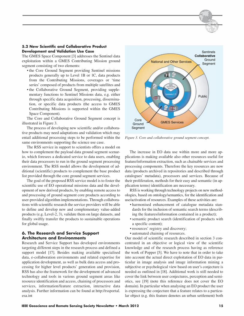
5.2 New Scientific and Collaborative Product Development and Validation Use CaseThe GMES Space Component [3] addresses the Sentinel data
exploitation within a GMES Contributing Mission ground
segment consisting of two elements:
• the Core Ground Segment providing Sentinel missions
products generally up to Level 1B or 1C, data products
from the Contributing Missions, coverages or ‘time
series’ composed of products from multiple satellites and
• the Collaborative Ground Segment, providing supple-
mentary functions to Sentinel Missions data, e.g. either
through specific data acquisition, processing, dissemina-
tion, or specific data products (the access to GMES
Contributing Missions is supported within the GMES
Space Component).
The Core and Collaborative Ground Segment concept is
illustrated in Figure 3.
The process of developing new scientific and/or collabora-
tive products may need adaptations and validation which may
entail additional processing steps to be performed within the
same environments supporting the science use case.
The RSS service in support to scientists offers a model on
how to complement the payload data ground segment scenar-
io, which foresees a dedicated service to data users, enabling
their data processors to run in the ground segment processing
environment. The RSS model allows the development of ad-
ditional (scientific) products to complement the base product
list provided through the core ground segment services.
The goal of the proposed RSS service model is to foster the
scientific use of EO operational missions data and the devel-
opment of new derived products, by enabling remote access to
and processing of ground segment core products according to
user-provided algorithm implementations. Through collabora-
tions with scientific research the service providers will be able
to define and develop new and complementary value-added
products (e.g. Level-2, 3), validate them on large datasets, and
finally swiftly transfer the products to sustainable operations
for global usage.
6. The Research and Service Support Architecture and EnvironmentsResearch and Service Support has developed environments
targeting different steps in the research process and defined a
support model [17]. Besides making available specialised
data, e-collaboration environments and related expertise for
application development, as well as bulk data access and pro-
cessing for higher level products’ generation and provision,
RSS has also the framework for the development of advanced
technology and tools in various ground segment areas like
resource identification and access, chaining of processors and
services, information/feature extraction, interactive data
analysis. Further information can be found at http://rssportal.
esa.int
The increase in EO data use within more and more ap-
plications is making available also other resources useful for
feature/information extraction, such as chainable services and
processing components. Therefore the key resources are now
data (products archived in repositories and described through
catalogues’ metadata), processors and services. Because of
their proliferation, methods for their easy and semantic (in ap-
plication terms) identification are necessary.
RSS is working through technology projects on new method-
ologies, based on ontology/semantics, for the identification and
use/activation of resources. Examples of these activities are:
• harmonised enhancement of catalogue metadata stan-
dards for the inclusion of semantic search terms (describ-
ing the features/information contained in a product);
• semantic product search (identification of products with
a specific content);
• resources’ registry and discovery;
• automated chaining of resources.
Our model of scientific research described in section 3 con-
centrated in an objective or logical view of the scientific
knowledge and of the research process having as reference
the work of Popper [5]. We have to note that in order to take
into account the actual direct exploitation of EO data in par-
ticular in image analysis and image information mining a
subjective or psychological view based on user’s conjecture is
needed as outlined in [18]. Additional work is still needed to
cover the link between user conjectures, perception and semi-
otics, see [19] (note this reference does not cover the EO
domain). In particular when analysing an EO product the user
is expressing the conjecture that a feature relates to a particu-
lar object (e.g. this feature denotes an urban settlement) both
SentinelsCollaborative
GroundSegment
Public
GMES Services
National and Other Services
CoreGround
Segment
Figure 3. Core and collaborative ground segment concept.

16 IEEE Geoscience and Remote Sensing Society Newsletter • March 2012
the subjective perception and classification aspects play a
role. Such approach falls within the scope of knowledge-
based information mining.
The possibility to interactively analyse entire image col-
lections for searching features to be defined by the user in-
teractively, is relevant from an application point of view and
scientifically very attractive. Research has been performed
and prototypes developed aimed at permitting to interactively
search and tag (label) large or well characterised areas (fea-
tures) within an entire collection of images.
A knowledge-based information mining approach is there-
fore substantially different from the model we propose in sec-
tion 3, as it includes an ingestion phase (unsupervised), during
which all the images of the collections are processed to auto-
matically extract Primitive Features (like spectral, texture or
geometric information) [18], and an interactive phase (super-
vised), where the user can train the system through positive or
negative feedbacks on sample images, apply the trained “feature
label” to the entire collection. The user can as well define (la-
bel) the semantic image content which is linked (e.g. by Bayes-
ian networks [20]) to a completely unsupervised content-index.
Based on this stochastic link, the user can query the archive for
relevant images and obtain a probabilistic classification of the
entire image archive as an intuitive information representation.
7. Support Model for the Defined Use-CasesFrom our point of view, in order to support the two use cases
described in sections 5.1 and 5.2, we have as well to take into
account the need to ensure that:
• the routine production of EO products for operational
services is not affected by research and science activi-
ties, nor by the development of new or higher level
products;
• the objectives long term archiving and data preservation
of EO data are fulfilled within the context of a cost effec-
tive architecture, and in particular that the data access
and processing for scientific purposes is efficient.
The consequences of the above high level requirements
and objectives are that:
• algorithm development is made easy and validation is
supported;
• reference datasets are available to the communities;
• a dedicated processing and re-processing environment
shall be available to the science users and the service
developers.
In order to implement these statements RSS has developed
a specific service model. Such model, intended for supporting
the research process described in Figure 1 in its different steps
and phases, is schematized in the following Figure 4.
The model is organized in 5 levels, from A to E: Basic Sci-
ence Services, Development Support Services, and Processing
Support Services, Support to Product Validation, and Produc-
tion and Service Support.
The first level, or A, Production and Service Support, en-
compasses the access to EO Data through standard Query-
Order services and to free Toolboxes for EO Data Processing.
These services are used over the full research process from the
first step Available Information Study (see Figure 1).
The second level, Development Support Services, covers
the access to EO resources and toolboxes/processing compo-
nents for algorithm development and test. These services are
employed during the Hypotheses Formulation step for the pre-
paratory work leading to the Perform Experiment and Collect
Data step. This type of service is provided through specialized
facilities and applications supporting software development
and re-use, data management, processor testing.
The third level, Processing Support Services, includes the
access to Grid and/or Cloud Computing resources [21], en-
abling mass data processing and collection of results. These
services are required during the Perform Experiment and Col-
lect Data step. Processing and data handling needs are typi-
cally very high and concentrated in time; hence the service
model foresees the use of a shared (and scalable) facility.
Level D, Support to Product Validation, foresees the pro-
vision of reference data like ground truth or independently
produced products and related processing resources required
to conduct the validation. These services are essential to es-
tablish the quality of the processing and a pre-requisite for any
collaborative product.
The last level, or level E, Production and Service Support,
covers the configuration of new services allowing the system-
atic data processing in near real time and/or on long time se-
ries. Also covers the management of user access to the new
services and the possibility of service orchestration. These
Production andService Support
DevelopmentSupportServices
ProcessingSupportServices
Basic ScienceServices
Support toProduct
Validation
E
D
A
C
B
Figure 4. The 5-level RSS research process support model.

IEEE Geoscience and Remote Sensing Society Newsletter • March 2012 17
services are linked to the Publish Results activity, when the
research has been concluded and the results are made avail-
able to the community.
Although ESA already provides Research and Service
Support for most of the activities/levels described above, these
services will need to evolve in line with the future needs. In
particular, the following challenges should be addressed:
• Enhance Data Management and Processing capabilities
by one order of magnitude in line with Sentinel data
volumes;
• Cover activities of the research process which are little
supported like the product validation;
• Support innovative technologies such as efficient data
base technology for product time series, very large paral-
lel computing devices, etc.
8. Research and Service Support: Future Evolution The RSS model described above has been successfully
experimented in the ENVISAT era. A fundamental question
to answer is: how shall RSS evolve to confirm and if possible
increase its value for science in the Sentinel era? To answer
this question it needs to be considered that Sentinel type mis-
sions pose three important challenges to RSS service:
i. Large Data Volumes in the Order of 2TeraBytes a DayData Management at RSS is critical to a good service and
requires fast access to (almost) all the data products gener-
ated. This is currently achieved by three sourcing modalities:
copying rolling archives, caching data from on-line archives
and moving off-line data on-line. Nowadays, the proportion
is roughly 70-10-20 for the three modalities. Considering the
data volumes from future EO operational missions, the pro-
portion is expected to evolve towards a 20-70-10. That is,
off-line archives will tend to be replaced by on-line archives
and, due to the data volumes involved, copy from other
archives will not be affordable. Instead, intelligent caching
over large on-line archives is to be foreseen. Therefore topics
currently under research and development are:
• Optimization of data circulation for caching purposes:
data granularity, network configuration, seeding strategy;
• Caching strategies based on use-patterns, trying to
“guess” which data will be requested next.
Simple precursors have been developed to bridge the ESA
Grid Processing On-Demand (G-POD) environment with
MERIS Catalogue and Inventory data source and various FTP
repositories at ESA facilities.
ii. Growing Importance of Multi-Temporal AnalysisAs a result of the systematic data acquisitions over long time
periods (>20 years) and with high revisiting rates (<5 days),
demands on time-series analysis will grow.
Optimizing data organization and retrieval/access to EO ar-
chive for such usage will be a challenge. Database techniques
associated with Services for publishing raster data are being
introduced in RSS for this purpose.
iii. Very Large Processing RequirementsCurrent processing architecture is based on a private Grid-
processing paradigm.
This architecture has provided sufficient processing power
over many years with very significant scalability and versa-
tility. However, compelled by the very large processing re-
quirements and, at the same time, by the advent of large cloud
computing facilities, the architecture has recently evolved in
the following direction:
• Virtualization of all local hosting infrastructures, in par-
ticular Grid working nodes;
• Deployment of cloud computing resources on the Grid;
• Location of large storing services for dissemination pur-
poses.
This trend will lead in the coming years to the hosting of
RSS environments over cloud computing facilities which will
provide global scalability potential.
9. ConclusionsThe ESA RSS service presented in this paper has success-
fully supported EO research and applications development
during the last years, by making available processing capac-
ity on online data and ensuring that the research process is
effectively and efficiently followed.
As a matter of fact, RSS has over time acquired the ex-
pertise required to develop advanced environments in support
to science and research - also included e-collaboration - in
the development of applications, using not only EO products.
These operational environments permit cost and time reduc-
tion for the design and implementation of new algorithmic
solutions. Moreover, algorithms can also be run noticeably
faster than at the researcher site (e.g. hours versus days) using
huge data sets available online.
RSS environments permit to support the key phases in the
research process also through the competence of the operation-
al team, with scientific background and large experience both
in the infrastructure and in the interaction with researchers.
Passing from the Envisat era to the Sentinel era will pose
three main challenges to RSS: increased data volumes, grow-
ing importance of multi-temporal analysis and increased
processing requirements. In response to each of these chal-
lenges RSS is defining adequate solutions, such as new stor-
age strategy, new environments covering emerging needs and
new processing strategy (e.g. based on virtualization, cloud
computing).
ESA is willing to continue, and expand this support also to
the Sentinel era, where scientific and collaborative products

18 IEEE Geoscience and Remote Sensing Society Newsletter • March 2012
are a challenge and at the same time an opportunity for a more
complete utilisation of the huge amount of data becoming
available.
References[1] J. Aschbacher, T. Beer, A. Ciccolella, M. P. Milagro & E.
Paliouras, GMES Space Component: status and challenges,
ESA Bulletin no. 142, May 2010
[2] G., Megie, C.J. Readings, The Earth Explorer Missions—
Current Status (2000) Earth Observation Quarterly, July
2000.
[3] Liebig, V., Ashbacker, J., Kohlhammer, G., Zobl, R.,
(2007) GMES global monitoring for environment and secu-
rity: The second European flagship in space, ESA Bulletin,
No. 130, May 2007.
[4] I. Foster, C. Kesselman, The Grid: Blueprint for a New
Computing Infrastructure The Elsevier Series in Grid Computing, 1998
[5] K. Popper, (1963) Conjectures and Refutations, Routledge
reprinted 2010, pp. 290–338
[6] J. Farres, E. Mathot, S. Pinto, G-POD: A Collaborative
Environment for Earth Observation at the European Space
Agency, Proceedings of the ESA Living Planet Symposium,
Bergen, Norway. Special Publication SP-686 on CD-ROM, ESA Publications Division, European Space Agency,
Noordwijk, The Netherlands, 2010
[7] N. Gobron, B. Pinty, M.M. Verstraete, and Y. Govaerts,
The MERIS Global Vegetation Index (MGVI): Description
and Preliminary Application. International Journal of Remote Sensing, 20, 1917–1927, 1999
[8] J. F. R. Gower & S. A. King: Distribution of floating
Sargassum in the Gulf of Mexico and the Atlantic Ocean
mapped using MERIS, International Journal of Remote
Sensing, 32:7, 1917–1929, 2011
[9] N. Gobron, B. Pinty, O. Aussedat, M. Taberner, O. Faber, F.
Mélin, T. Lavergne, M. Robustelli, P. Snoeij, Uncertainty
Estimates for the FAPAR Operational Products Derived from
MERIS—Impact of Top-of-Atmosphere Radiance Uncertainties
and Validation with Field Data. Remote Sensing of Environment, 112(4), 1871–1883. Special issue: Remote Sensing Data Assimilation. Edited by Loew, A, 2008
[10] O. Aussedat, N. Gobron, B. Pinty, and M. Taberner,
MERIS Level 3 Land Surface Time Composite—Product
File Description. Institute for Environment and Sustainability,
EUR Report n. 22165 EN, 1–20, 2006
[11] N. Gobron, A.S. Belward, B. Pinty, W. Knorr Monitoring
Biosphere Vegetation 1998-2009. Geophysical Research Letters, 37, L15402. DOI: 10.1029/2010GL043870, 2010
[12] M. Jung, M. Reichstein, P. Ciais, S. I. Seneviratne, J.
Sheffield, G. Bonan, A. Cescatti, J. Chen, R.A.M. de Jeu, A.
J. Dolman, (Han), W. Eugster, D. Gerten, D. Gianelle, N.
Gobron, N., & al. Recent Decline in the Global Land
Evapotranspiration Trend Due to Limited Moisture Supply.
Nature, 467(7318), 951–954, 2010
[13] R. Cossu, E. Schoepfer, P. Bally, L. Fusco, Near real-
time SAR-based processing to support flood monitoring.
Journal of Real-Time Image Processing, 4(3), 205–218,
2009
[14] A. Kokhanovsky, G. de Leeuw, Determination of
Atmospheric Aerosol Properties over Land using Satellite
Measurements. American Meteorological Society, 235.
DOI:10.1175/2008BAMS2669.1, 2009
[15] M. Manunta, F. Casu, R. Cossu, L. Fusco, S. Guarino, R.
Lanari, G. Mazzarella, and E. Sansosti, E. Volcano deforma-
tion analysis based an on-demand DInSAR-GRID system:
the SBAS-GPOD solution, Geophysical Research Abstracts, Vol. 11, EGU2009-9766, 2009
[16] M. Diagne, Drame C. Ferrao P.G. Marchetti, S. Pinto, G.
Rivolta, Multisource Data Integration for Fire Risk Management:
The Local Test of a Global Approach, IEEE Geoscience and Remote Sensing Letters, Vol 7. No.1, January 2010, 93–97, 2010
[17] S. D’Elia, P.G. Marchetti, Y. Coene, S. Smolders, A.
Colapicchioni and C. Rosati, Architecture and Services for
Computational Intelligence in Remote Sensing, (pp. 61–97) in
Computational Intelligence for Remote Sensing, Grana M.,
Duro, R. J. (Ed.), Springer, 2008
[18] M. Datcu, H. Daschiel, A. Pelizzari, M. Quartulli, A.
Galoppo, A. Colapicchioni, M. Pastori, K. Seidel, P.G.
Marchetti, S. D’Elia (2003) Information Mining in Remote
Sensing Image Archives—Part A: System Concepts IEEE Transactions on Geoscience and Remote Sensing Vol. 41, No.
12, December 2003, 2923–2935, 2003
[19] U. Eco, Kant and the Platypus, Random House, 2000
[20] M. Datcu, K. Seidel, and M. Walessa, “Spatial informa-
tion retrieval from remote sensing images. Part I: Information
theoretical perspective,” IEEE Trans. Geosci. Remote Sensing, vol. 36, pp. 1431–1445, Sept. 1998.
[21] M. Ambrust, A. Fox, R. Griffith, A.D. Joseph, R. Katz,
A. Konwinski, G. Lee, D. Patterson, A. Rabkin, I. Stoica, M.
Zaharia, A View of Cloud Computing. communications of the acm, April 2010, vol. 53, no. 4
Copyright © 2022 FDOKUMEN